MAR 19680137: FORT VERMILION - Alberta...
7
MAR 19680137: FORT VERMILION Received date: Dec 31, 1968 Public release date: Jan 01, 1970 DISCLAIMER By accessing and using the Alberta Energy website to download or otherwise obtain a scanned mineral assessment report, you (“User”) agree to be bound by the following terms and conditions: a) Each scanned mineral assessment report that is downloaded or otherwise obtained from Alberta Energy is provided “AS IS”, with no warranties or representations of any kind whatsoever from Her Majesty the Queen in Right of Alberta, as represented by the Minister of Energy (“Minister”), expressed or implied, including, but not limited to, no warranties or other representations from the Minister, regarding the content, accuracy, reliability, use or results from the use of or the integrity, completeness, quality or legibility of each such scanned mineral assessment report; b) To the fullest extent permitted by applicable laws, the Minister hereby expressly disclaims, and is released from, liability and responsibility for all warranties and conditions, expressed or implied, in relation to each scanned mineral assessment report shown or displayed on the Alberta Energy website including but not limited to warranties as to the satisfactory quality of or the fitness of the scanned mineral assessment report for a particular purpose and warranties as to the non-infringement or other non-violation of the proprietary rights held by any third party in respect of the scanned mineral assessment report; c) To the fullest extent permitted by applicable law, the Minister, and the Minister’s employees and agents, exclude and disclaim liability to the User for losses and damages of whatsoever nature and howsoever arising including, without limitation, any direct, indirect, special, consequential, punitive or incidental damages, loss of use, loss of data, loss caused by a virus, loss of income or profit, claims of third parties, even if Alberta Energy have been advised of the possibility of such damages or losses, arising out of or in connection with the use of the Alberta Energy website, including the accessing or downloading of the scanned mineral assessment report and the use for any purpose of the scanned mineral assessment report so downloaded or retrieved. d) User agrees to indemnify and hold harmless the Minister, and the Minister’s employees and agents against and from any and all third party claims, losses, liabilities, demands, actions or proceedings related to the downloading, distribution, transmissions, storage, redistribution, reproduction or exploitation of each scanned mineral assessment report obtained by the User from Alberta Energy. Alberta Mineral Assessment Reporting System
Transcript of MAR 19680137: FORT VERMILION - Alberta...
MAR 19680137: FORT VERMILION Received date: Dec 31, 1968 Public release date: Jan 01, 1970 DISCLAIMER By accessing and using the Alberta Energy website to download or otherwise obtain a scanned mineral assessment report, you (“User”) agree to be bound by the following terms and conditions: a) Each scanned mineral assessment report that is downloaded or otherwise obtained from Alberta
Energy is provided “AS IS”, with no warranties or representations of any kind whatsoever from Her Majesty the Queen in Right of Alberta, as represented by the Minister of Energy (“Minister”), expressed or implied, including, but not limited to, no warranties or other representations from the Minister, regarding the content, accuracy, reliability, use or results from the use of or the integrity, completeness, quality or legibility of each such scanned mineral assessment report;
b) To the fullest extent permitted by applicable laws, the Minister hereby expressly disclaims, and is released from, liability and responsibility for all warranties and conditions, expressed or implied, in relation to each scanned mineral assessment report shown or displayed on the Alberta Energy website including but not limited to warranties as to the satisfactory quality of or the fitness of the scanned mineral assessment report for a particular purpose and warranties as to the non-infringement or other non-violation of the proprietary rights held by any third party in respect of the scanned mineral assessment report;
c) To the fullest extent permitted by applicable law, the Minister, and the Minister’s employees and agents, exclude and disclaim liability to the User for losses and damages of whatsoever nature and howsoever arising including, without limitation, any direct, indirect, special, consequential, punitive or incidental damages, loss of use, loss of data, loss caused by a virus, loss of income or profit, claims of third parties, even if Alberta Energy have been advised of the possibility of such damages or losses, arising out of or in connection with the use of the Alberta Energy website, including the accessing or downloading of the scanned mineral assessment report and the use for any purpose of the scanned mineral assessment report so downloaded or retrieved.
d) User agrees to indemnify and hold harmless the Minister, and the Minister’s employees and agents against and from any and all third party claims, losses, liabilities, demands, actions or proceedings related to the downloading, distribution, transmissions, storage, redistribution, reproduction or exploitation of each scanned mineral assessment report obtained by the User from Alberta Energy.
Alberta Mineral Assessment Reporting System

FINAL GEOLOGICAL REPORT SULPHUR PROSPECTING PERMIT NO. 171
FORT VERMILION AREA S INTRODUCTION
ECONOMIC MINERALS FU REPORT N©.
-fIF-t7/Z,)
Sulphur Prospecting Permit Number 171 comprising 19,840 acres was issued with effective date of February 21, 1968.
A thorough study with respect to sulphur occurrences on the permit has been conducted both on a regional and on a local basis, the details of which are briefly outlined below.
..
LOCATION
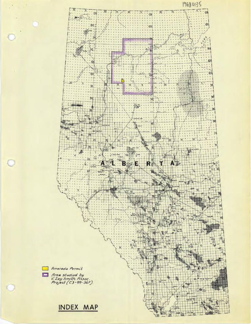
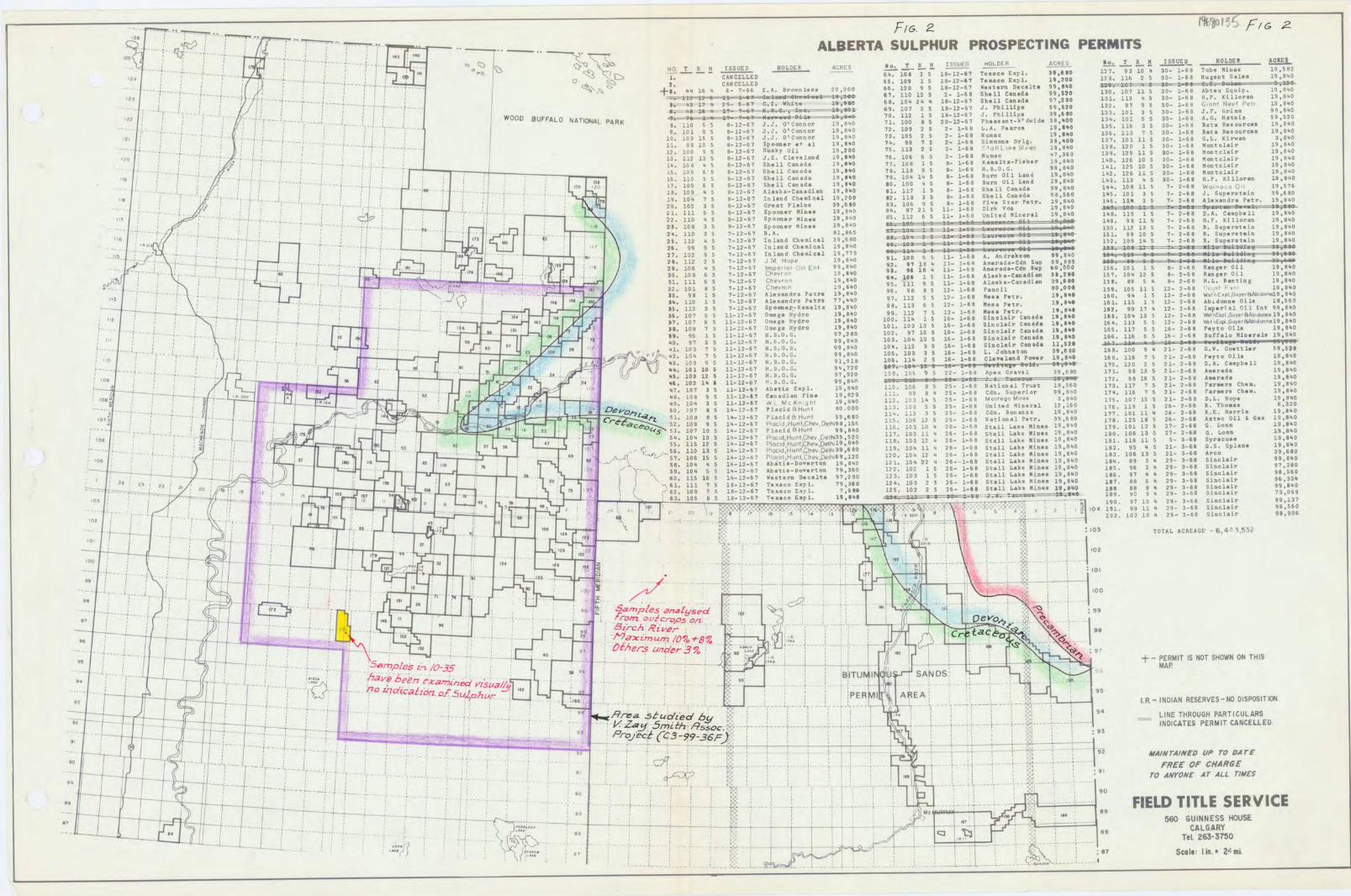
The Sulphur Permit is located in Twps. 97 and 98, Rge. 13 WSM, and is approximately 60 miles due south of Fort Vermilion in north central Alberta. The permit lies several miles southwest of the main body of sulphur permits, none of which have reported any production of sulphur on a commercial basis.
The permit lies in the Buffalo Head Hills north of Bison Lake at an elevation of 1,900 - 2,200 feet above sea level and is drained to the northeast by the Peace River via the Buffalo River and several small tributary streams. (See Index Map).
Natural vegetation consists mostly of variable patches of evergreen with some deciduous growth, and considerable deadfall and muskeg.
EVALUATION FOR SULPHUR
Subsurface Geology
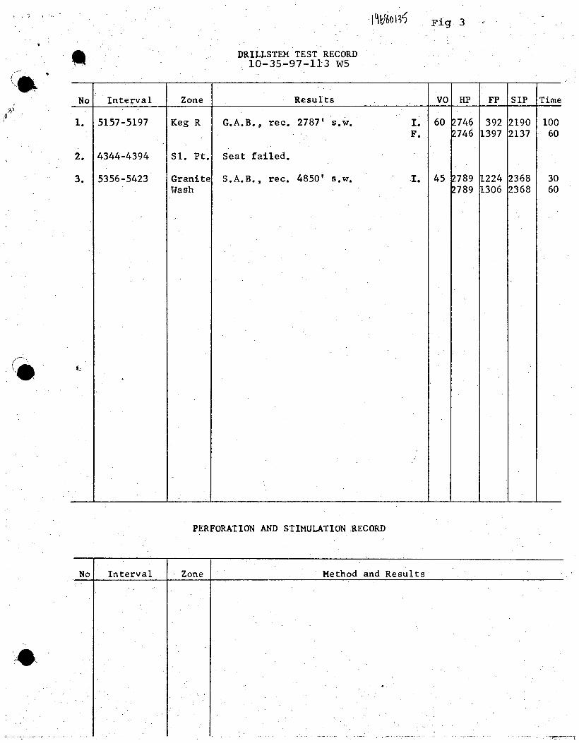
A test well, Amerada Cr. Talbot 10-35, drilled on Sulphur Permit 171 in Lsd. 10-35-97-113 W5, was spudded on January 17, 1968 and was abandoned at 5423 feet in the Precambrian on February 21, 1968. The well was drilled at a cost of $204,031.42 to assist in evaluating the lands for sulphur as well as for gas and oil. No cores were cut, however, two tests were completed - one in the Keg River, the other in the "Granite Wash" recovering 2,787 feet and 4,850 feet of salt water respectively. (Fig. 2 & 3)
In an attempt to determine the possible origin or route of migration of the surficial sulphur and/or sulphurous waters, all available borehole cuttings from the well were carefully examined with respect to sulphur content.
Photographic Study
Aerial photographs covering the area were obtained and studied in detail for small areas lacking vegetation, light. colored areas surrounding potholes and other features which, by comparison with areas of known sulphur occurrences on the Birch
. River and on the north flank of the Buffalo Head Hills, were thought to be characteristic of sulphur deposits or springs.
I,tJ1EXzAi, .i-i,-i,ur NO. 760515

-2-
Si•ace Geology
•A trip, by a company geologist, to the Fort Vermilion area on February 9, 1968 and inspection of several outcrops there encouraged the undertaking of a large scale regional study which was contracted to V. Zay Smith and Associates. At a total cost of $2,750.00 that company conducted a two-phased study of an area covering the bulk of the sulphur permitsTwps. 92 - 101, Rges. 1 - 17 W5.
The first phase, completed in June 1968 dealt primarily with regional structural geology, physiography, stratigraphy and research of sulphur occurrences and origins.
The results of the work in Phase I was presented in a written report along with maps at a scale 1" = 2 miles which showed all localities of interest with respect to sulphur.
Phase II, completed in August 1968, was a continuation of the study involving field work and a limited drilling program to thoroughly inspect all favourable areas revealed through Phase I. These results were presented on the same maps which were accompanied by chemical analysis of samples taken in the field, photographs of several pertinent localities, and a written report.
CONCLUSIONS
. With the results of the above evaluation of Sulphur Prospecting Permit #171 in hand it has been concluded that the occurrence of sulphur in the Fort Vermilionarea is erratic), disseminated, often of poor quality and not economically commercial at this time. Specifically on permit #171, the studies have revealed no facts to indicate that sulphur exists in commerical quantities.
K. L. Fneips Geological Department
S September 24, 1968 KLP:sh
11610
7'c3o'J Ferm
,qj-ea 5Q'I?d b3 /?oc.
Frqjèc/(C3-99-36F).
U
Ft&. 2 jfH' F/& 2
ALBERTA SULPHUR PROSPECTING PERMITS
- --- ; ! -.-
c:• !2_L L Issuzr K I. ER C P HOLDER
. I • - p Q i:: i..
CANCELLED -- 2 5 1-1-6 icoE1. 1g.II 127. 3 10 . 30- 1-6 1obt Ursl
64. 109
...... - - : : -- e, t.
CANCELL ED ". 10 1 18i2- 1SCQ 1I* 1hISflt •''
- - -L.a : I : +*. •4 1 6- 7- L.A. 711 OOO 1 8 - 12-67 W.t.rfl Deceits .' .p
! LI -. 1 L__ 67 I1 12 S 2- 1-6 Shill Canada ° 17 L 3 £LP. 19O
-. -j.,-- 1, - a 17 - G. 1. White ai.v 1 2 12 hI11 131. L13 5 3- 1-6 H.P.
: I -Q$-:- • L--------=--4*,S '. 107 2 1-12-67 5. PhilLips °- L- GOril Reuf rPr 1.94O
-.- . ; . •1 : WOOD BUFFALO Yj PARK
TU I r_. OL 7O 112 1 S 1I7 3 Ph!11LI 39 SO 13. X 3 o- L-SO s.r. rN
-.- - - - : - : : : I. -j2-7 JJ. 1. S 2-L?-6 Ph..It'diI 3O
- ---- ----- ------------ : : i . 101 -12-7 .J.J. D'Cn- 7. 2 S ~ - L-8 L.a. PsCI 5. 11 S 30. 1-Se b&RsioiiaI IS U2 0
-- : ' - ---------- --- -- ,- ----------- - ------- II. B 1 2- -6S C
S 40 O -- t -i---- :-- :
.2. 1O 9 5 0-12-67 liUlky QL1 7$ 13 2 2- 1- IaIILrk Mn- 138. L20 . S - 1-8 lt1air
: : / T ----------- U. 11? 13 $ - -? .1. E. Clev el and £9 • I4 76. 1 5 2- 1-6 hi••c 13 1S 11 $ O- 1-6 Mt]ai
-- - ---------- , - I : - l. 1O -12-67 SsL1 Can ad a 77. 1O I S - L-8
1. 126 10 S 3- Mot1.Ir19 B4400
"• - , - - LS. 19 -12-7 Sh.]J B. XiS - 1-Se B . O.G. • 4O I1. 1 7 O S 3V- -H flntc1aLr
11 S S-.2-6 Sh.0 I1,IO 7. LO. 14 S - 1-6k B.. OIL Land 1.SO 1b2. 12 U 30- 1- ont1L 19,8
------------- : •
1'7. 1O -12-7 .p11 Canadi 19,I 10. iO 5 - 1- Oil Land 1.3. 113 . S 3- J- H.P. Xi19
-- -- : f ---• : . 10 8.1?-7 A Is" i- Ca n dilr. 1,hO 01. 117 1 5 18 ShSki CIT4 *8 1 S 7- 2-6 O 9.75 IS
, : ---- --- ------------ L' 7 S e.-2-? n1.T C)iC51 1 43 .2CO 12. uS - h.11 Cn4U 1_ 1 S 7- 2- 3. pitit.L 39.c
--. - I : : - ? 1 a s -12-S7 FI-iflI 3. D6 ri,. Str F.r. 1- I S 7 1andri P.tr. 1 8C
--, : ----
I_ : 1. 111 ,
11- 18 1rk YoI A7
- --------------- - 2. UO S-12-€7 s u.. i- Un!tsd KLFr1 1 • 'S j. ii - 2-15 g
t F 2 1B 3 S 67 Spooner Mil - UL t •- J. 9 11 S I P I Uori -9
; lic 3 5 1 12 7 B A Di 65 -- - ' ° -1 68 ! SupSZtSfl 19,8 40
- - - . ---,---- -: ----- : I 2 12 s 7.12-7 InL.d Ch.11
*' • -•-- IS1. 99 1E 7- -H R. S,.ittin
- -- : -- - - - - ". q ?-12-G7 ln1ad Ch..!c1 LI I IS --.. t • 1 a i5 101 1 5 7- 7-5! . PsrstuIn
•
27. 1O S 7-12-67 Intend Ch..LL •- ).L . U- - S 1.---- _ _ *11 -!---• 14J, lOS --SU
- - - ---- - --------- ! - -" 2. 11 ? S 7-L-7 J M HQ
'°° 6 U- 1-SB A. -
--,- -------- - --- - - - - ?. 16 7-1-5 lOeri O
I ii- 1 I jiLL-
S -1-S7 C%r' 1g.lo I. S 11- 1- .ra-Cdn 1- 1 I 5 D1. 19.SO11
--. - - - : . j----- • L. 111 6 5 7-2-67
ca 0%. 1 5 11- 1- nai' 1 12 $ 0- 2-6 RsnI I1111
37. 1O3 S 7-12-67 Crpi' 19.S'Q 11- ]-6P 9 • II L5. H.L. 3ant 19 • O
33. U 1 5 -12-67 ?.rl 11 I.Q g 12- -6 Ps 11 o.00. ci i i- -a - n c.-
I______L_ ----- -
,. . , , 12- 1I. 0 .
". 1L3 3 5 7-17-67 19,I J3 ' ' F.tr. 1,,S, 16L. US 1 5 1-2- 2-6 01 IV
- : - -. .,______J____j_ : - - - •1 U fl. _ø1 S S 11-17-67 Ilytho U2 7 5 12- -6 I• ?atP. 1S.I 17. 1' L2 -€ I.iri1 L1 ftT
- - ' ) S 11-17 OflSI Hyro 19.0 11 S i 1- 1 9 I I3. ICQ i- 12 -6
- - u. 1€ •1 1-1-1 Hydra 19.I 101. 1D 13 la - 1-6 Li1iir 1t.SI I-J3 5 12 2-
- - ---- - ., . , ,
I. % 1 S 11-?-67 ILILO.G. 7 • 2 10 7 O 1 Sh"1UL7 C45 xi..'. 2S5. 117 S 16- 2-b PIyt 0111
-------- -__J : - - - - : " . 97 S 11-12-7 KLJ.G- 103. 1Q lé S 1- -6S SLnL1 anII 1I.I* 16S. E S 2-
'f 610 l!.i-a1.
- --------- -- : - -- - U4 -•1. L 7 S U- L2-67 IlOa. 112 3 5 if.- 1-8 Si1.iL .ids 1.2I
1 -tU
- ! ---- - - : .6- L. JohTlt 21- Gost!Ls -
F-- -- ---- -- ------ - ---- - :
: - - . . , _ Pa..r i.eo ig. ii , 21- 2- P.yto Oi-1.a d
109 - : -
M.1i, -I• -1S4 7 • 12 2 5 21- 2- D.A. 1 11 .840
t-•-- - - - - .• •1 • - -1 . i S 1-12-7 1 • 1O - 1-1 171. j- S 1--2-68
- - -4-- - - - I - - - 1. 102 1 $ 11-2-67 ------- " ? A.sr.I.
- - 7 -t-- -r- •' ! ! • j- I ' 1 S i1-2-41 AbIt1 Cnp1 LAO. 106 5 25- -6B lutiii1 Trust 17. 11? 7 21 28 F.r.,i 1.PQ
..- ie S 11-2-17 Cld4 £1 111. e 4 2- 1-68 Cdn. $upi • 3 1 -7_ 11 7 21- 2-6e F armers Che m . 19 .640
-- -- ----------;___ - - - • --- -- - L
3 U-I-67 Wt MtKn-t 112 1 5 - 1-6 HPI• 175. 107 3 S 21 2-8 .L op.
: - . -- - - .
De-0, . 107 • S j-12-5 iaci4UHiV'1 S 2 1-6 ()ild MLs1 !2.1 im. ii 1 2- 2-6 1- flu 0 10
--- - '- 1 C.,- I•L 1•-L2.7 P1.c11Hr'l 6 113 3 5 5- 1-6B Cdn ioi 11 26- 2-SO E. l'Ii 19
-- - - - -
•p - Cd0 ?. 109 S J)-12-S7 NitCL1 Ptr. j ia 5 ?6- 2- AtI 01] Gun
is s4o
€ : --- - ----- 1._ ' r - '° 1'.-U-7 r1idHuI 4O Stall L& 10I L S 2 26S D. Loan
40
- FJ • - . - 5. 10 5 1-12-? P1HunIC
17 103 26- 1- Olin 19 • O io i 5 1- .
11- - - - - l • - - , • " I -
5. 11 12 P.-U-7 H.irChe Ddfl4.° 1Q 12 ' 2 1B S it 11 lak. NLii 1L ii - 3- Sy ra c us e
- c- - - -----------
5. 110 13 5 1-12-b7 1. I Sti1 L&P Nihil 9 5 5 2- -8 G.S. 1
, -t---- r- - -- Ic ' , I .1 . -- .-- . j16 1 1q-1-67 1?D. 1 12 • - 1-GS StaH Liki •Iis i3 I 2 1- 36 Arco 39 go
-- - - I - ,' '- - ". 1 • S 14-l2-b Ab.-tL.-wsrton
121 10 2 . ?--1--A £t11 Lake 1ual 29- -s si.1&Lr 9 11 ano
~ -------- - . - - 59. 1O S S 1'.-1-f.7 Abat-poy.rtoc 7.3O t11 L.k. iui.0 i 96 2 • 2- 3- S1n1.ir
-- - - 2 : s - • : o - o. us 16 1-12-67 sitez Pa1ta 97.2O 23. 1 X S 2 1 5 ! ti11 1.II4 97 I 2 3 0 SCL1T .26
- - - - - - ! - , . - 1_ 111 ? S 18-1-1 Tiao 12. 13 ? S 26- 1-6w StI1 Lake Kinli 19 • O iii S s 2-
, - - -------- I , ii - -I, - ?. 1ø 5 Le-.2-7 Tex a co Ep1. 1.61S 12S. LQ 2 ~ StiU L.. Rinse 1I B • I 3$ ioCaLr
- - - - . - • '
1 c 1é-1?-S1 Txc £p3. Ink51F
: - • ., -.z:---- : • ----. - • -- - - -- \ - - - --- - - - - 19* 7 D - 3- SLc1I g43
I r I °• , •>'_ S 4 3 - ? IO 1L 9 X 29 3 ce 5LL1r S 5O
---- I -- - l -- -::
•,- \ - - ------- 121o ~ 1 1r.1sLr 101
-- ! . ! • 1 • , !! . .-------. •• . - . -
--------
L• 4( j-: -- . : . -
I
103 ?TL ACREA GE 16 , 4 153
- ; !• j 4 : - .- . !----------: .: II - .7 - . - .
: ' --- is .. -:- ; : • -'-U .
I - 4-
so T
j r
go
9.flP/e5 l-7alySed 2
I ,
! . -- - -- - - - .•
(i,nl OC1 rcop oz -
99 evo
9 - - --
- :
: ! - : , rLmIIVI8Z
•
Oes1/aer3 w_ E •'s
II 5 mp/es 10-_3F - -j- - 4-t-
IS NO SHOWN ON THIS
94 4 - - -
MAP
VIP r •
7? e.,?7u-?ec2/ VISU3// ,•
0 I UIVI • D
93 c:; •-- -
P?o ?c/c4tto,z ot,; -i
PER
M I - -
;------------ L------ - -r- -_4 .* : -
I.R - INDIAN RESERVES NO DISPOSITION
- ---- - - -- - - ----------------------------------- 9 - --s- -.-- i':: 54o'rd 6y I I ' 1
° LINE THROUGH PARTICULARS
-------------------
MAIN
INDICATES PERMIT CANCELLED
- - - - - If-c/et:C(C3-9935E) / 93
.:
;AED To:: FE FREE OF CHARGE
II 7----r--------t------ - - -
4" -
F -
•'ALJ -.:: - - :9
ro4FffoNeAr ALL t/MFS
FIELD TITLE SERVICE 560 GUINNESS HOUSE
CALGARY on 14
-S7
I TeL 263-3750
Io
io6 Fig 3
DRILLSTEM TEST RECORD 10-35-97-113 W5
PERFORATION AND STIMULATION RECORD

th
TP. 97
TP. 98
SULPHUR PROSPECTING PERMIT No. 171
I I I I I I I I I I
I I I I I I I I I
- - - - I- - - - - I- -
I I I I I I I I I I
- - - - - + ----- ~ -
I I I I I I I I I I
AMERADA PETROLEUM CORPORATION, BRITANNIA BLDG., 703 - 6th. AVENUE S.W., CALGARY, ALBERTA.
DATE OF ISSUE- FEBRUARY 21,1968 AREA- 19,840 ACRES.
R.13 R . 12 w.5 M.


![...ILO FRANCISCO THEISEN INES ARTNER IRACEMA ESTEVES DO NTOS IRACEMA FRANCISCA DE Qt.] IRENE BARROS DE LIMA IRENE COSTA DE LIM IRENE RODRIGUE o RGES IRENI VIEIRA D ISABEL DE OLI co](https://static.fdocuments.us/doc/165x107/5e8b4780428e7a753e07dd86/-ilo-francisco-theisen-ines-artner-iracema-esteves-do-ntos-iracema-francisca.jpg)