MapInfo · 2019-12-01 · Pitney Bowes ® MapInfo Pro v2019 November 2019 3 of 4 Turn your data...
4
Pitney Bowes MapInfo ® Pro v2019 November 2019 1 of 4 Data sheet MapInfo ® Pro v2019 Location adds complexity to many decisions, and mistakes are too expensive for a “trial and error” approach. That’s why it’s critical to use a full-featured desktop mapping solution to prepare data for web mapping applications and create presentation quality maps. MapInfo Pro v2019 is the “all in one” solution for location analytics with powerful new query capabilities, crisp vector graphics in layouts and an expanded window on the world via the MapInfo Marketplace. MapInfo Pro helps you create a model of your world so that you can simulate different alternatives to guide your actions. The free MapInfo ® Pro Viewer extends this power to non-technical users, and map publishing templates speed up your work while ensuring a professional appearance. Explore. A description of your environment must be created by gathering information about the key components, how they interact, and the metrics for success and failure. MapInfo Pro is an interactive tool that lets a user bring in data and visualise it on a map with symbols, themes and labels and overlay multiple datasets to see patterns that would not be visible otherwise. For example, the success of a wireless network depends upon the optimal placement of devices in the field and the infrastructure to support it including service technicians and account managers. Model. A model is a representation of a specific environment or situation in which you make location-based decisions. Building and maintaining models is expensive. MapInfo Pro helps you manage and visualise data in one place. Through our solution, customer data is integrated with maps, demographics and then combined with powerful querying and modeling tools. This enables your models to be built and tested much more quickly and inexpensively than real world decisions. Over time, they can dramatically improve the return on investment in location decisions. Act. A model must be made available to decision-makers in order for them to act decisively and deliver maximal value. By taking analysts’ insights, proper modeling is delivered to the decision-makers in a way that is actionable and impactful. MapInfo Pro enables you to build and distribute the tools to support good decisions. A picture may be worth a thousand words, but you still need to know which pictures and which thousand words to present to the decision-maker to help them succeed. Software & Data Location Intelligence “MapInfo Pro v2019 is the bridge from the familiar past to the exciting future of location analytics. It delivers the capabilities that experienced users depend on and new functionality that will help both new and advanced users.” — Ross Owens Location Intelligence Specialist, Spatial Insights
Transcript of MapInfo · 2019-12-01 · Pitney Bowes ® MapInfo Pro v2019 November 2019 3 of 4 Turn your data...

Pitney Bowes MapInfo® Pro v2019 November 2019 1 of 4
Data sheet
MapInfo® Pro v2019Location adds complexity to many decisions, and mistakes are too expensive for a “trial and error” approach.
That’s why it’s critical to use a full-featured desktop mapping solution to prepare data for web mapping applications and create presentation quality maps. MapInfo Pro v2019 is the “all in one” solution for location analytics with powerful new query capabilities, crisp vector graphics in layouts and an expanded window on the world via the MapInfo Marketplace.
MapInfo Pro helps you create a model of your world so that you can simulate different alternatives to guide your actions. The free MapInfo® Pro Viewer extends this power to non-technical users, and map publishing templates speed up your work while ensuring a professional appearance.
Explore.A description of your environment must be created by gathering information about the key components, how they interact, and the metrics for success and failure. MapInfo Pro is an interactive tool that lets a user bring in data and visualise it on a map with symbols, themes and labels and overlay multiple datasets to see patterns that would not be visible otherwise.
For example, the success of a wireless network depends upon the optimal placement of devices in the field and the infrastructure to support it including service technicians and account managers.
Model.A model is a representation of a specific environment or situation in which you make location-based decisions. Building and maintaining models is expensive. MapInfo Pro helps you manage and visualise data in one place. Through our solution, customer data is integrated with maps, demographics and then combined with powerful querying and modeling tools. This enables your models to be built and tested much more quickly and inexpensively than real world decisions. Over time, they can dramatically improve the return on investment in location decisions.
Act.A model must be made available to decision-makers in order for them to act decisively and deliver maximal value. By taking analysts’ insights, proper modeling is delivered to the decision-makers in a way that is actionable and impactful. MapInfo Pro enables you to build and distribute the tools to support good decisions. A picture may be worth a thousand words, but you still need to know which pictures and which thousand words to present to the decision-maker to help them succeed.
Software & DataLocation Intelligence
“ MapInfo Pro v2019 is the bridge from the familiar past to the exciting future of location analytics. It delivers the capabilities that experienced users depend on and new functionality that will help both new and advanced users.”
— Ross Owens Location Intelligence Specialist, Spatial Insights
Pitney Bowes MapInfo® Pro v2019 November 2019 2 of 4
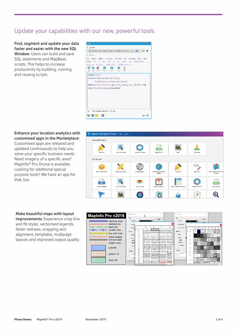
Update your capabilities with our new, powerful tools.
Find, segment and update your data faster and easier with the new SQL Window: Users can build and save SQL statements and MapBasic scripts. This helps to increase productivity by building, running and reusing scripts.
Enhance your location analytics with customised apps in the Marketplace: Customised apps are released and updated continuously to help you solve your specific business needs. Need imagery of a specific area? MapInfo® Pro Drone is available. Looking for additional special purpose tools? We have an app for that, too.
Make beautiful maps with layout improvements: Experience crisp line and fill styles, vectorised legends, faster redraws, snapping and alignment, templates, multipage layouts and improved output quality.

Pitney Bowes MapInfo® Pro v2019 November 2019 3 of 4
Turn your data into insights using the new heat mapping available within MapInfo Pro: Start with any file of people, places, or things and visualise the density of the locations as “hot spots” that help you make better decisions. For more power, upgrade to MapInfo® Pro Advanced and work with all kinds of raster data using the fast, highly compressed MRR format.
Automate — or customise your business processes — with more programming support: New support has been added for .NET and Python providing more powerful extensions to MapInfo Pro. MapBasic has also been enhanced with many new commands.
Step up to the 64-bit version of MapInfo Pro: If you’re still using a 32-bit version such as 12.5, you are missing out on the last four years of improvements that help you do your job faster and better.
“ When public safety is at issue, reliability and accuracy are paramount. For 20 years, we have used MapInfo Pro to create and maintain our addressing system. In 2016, we moved to the 64-bit interface and after just 3 weeks, we were back to full productivity. With all the new features, it was well worth the move.”
— Alfonso Garrido, Cameron County, TX, Emergency Communication District 9-1-1, GIS Coordinator
Visit our web page for details to learn how your company will greatly benefit through the upgrade: pitneybowes.com/au/mapinfo-pro-upgrade

Pitney Bowes MapInfo® Pro v2019 November 2019 4 of 4
Pitney Bowes, the Corporate logo and MapInfo are trademarks of Pitney Bowes Inc. or a subsidiary. All other trademarks are the property of their respective owners. © 2019 Pitney Bowes Inc. All rights reserved.
For more information, visit us online: pitneybowes.com/au/mapinfo-pro-v2019
Location-based decisions: Explore, model and act with confidence.Make the move to MapInfo® Pro v2019 and join the MapInfo community. Together, we’ll take a new, exciting journey as we collaborate to improve the future of mapping analytics.
SpecificationsMapInfo Pro v2019
• Windows 7 (64-bit SP1)• Windows 8.1 (64-bit)• Windows 10 (64-bit)• Windows 2012 Server R2
(64-bit only)• Windows 2012 Server R2
(64-bit with XenApp 7.5)• Windows 2019 Server (64-bit)• Windows 2019 Server
(64-bit with XenApp)
Data compatibility• Common PC files:
- Microsoft® Excel- Access- DBF- CSV and delimited ASCII text files
Relational and spatial databases:• Oracle®
• Microsoft® SQL Server• PostGIS• SQLite• ODBC compliant databases• OGC GeoPackage (new in v16.0)
Spatial data:• AutoCAD® DXF/DWG• SHP• DGN• GML• KML
And more• Maps and imagery:
- WMTS (new in v16.0)- WMS- WFS (version 2.0 support added)- CSW- Aerial images- Satellite images- Scanned paper maps- Microsoft® Bing maps
19SWS06023_ANZ
United States800 327 [email protected]
Europe/United Kingdom+44 (0)800 840 [email protected]
Canada800 268 [email protected]
Australia/Asia Pacific1800 227 [email protected]