Malaysia (Peninsular) National topographic city plans
27
Page 9 Page 2 Page 8 Page 1 Page 7 Page 3 Page 6 Page 5 Page 4 Page 11 Page 15 Page 19 Page 16 Page 20 Page 17 Page 21 Page 18 Page 10 Page 14 Page 12 Page 24 Page 26 Page 23 Page 25 Page 22 Page 13 Esri, HERE, DeLorme, MapmyIndia, © OpenStreetMap contributors, and the GIS user community Malaysia (Peninsular) National topographic city plans Contains full (with border/legend) / raw (not geo-referenced) and Geographic (Lat/Long) WGS84 cropped / collarless DRGs (Digital Raster Graphics -- geo-referenced color scans of topographic maps) of Town Plan maps of peninsular Malaysia. Published in 2014. File format for raw scans: 400 dpi 8-bit (256 color) .tif. File format for DRGs: GeoTiff. Path to file: \\MIL\DataCollection_restricted\MIL\6737_m3s_var_.l3 I Index to Map Sheets Index Key 0 40 80 20 Miles 1:3,300,000 Scale of this index:
Transcript of Malaysia (Peninsular) National topographic city plans

Page 9
Page 2
Page 8
Page 1
Page 7
Page 3 Page 6Page 5Page 4
Page 11
Page 15
Page 19
Page 16
Page 20
Page 17
Page 21Page 18
Page 10
Page 14
Page 12
Page 24
Page 26
Page 23
Page 25
Page 22
Page 13
Esri, HERE, DeLorme, MapmyIndia, © OpenStreetMap contributors, andthe GIS user community
Malaysia (Peninsular) National topographic city plansContains full (with border/legend) / raw (not geo-referenced) and Geographic (Lat/Long) WGS84 cropped / collarless DRGs (Digital Raster Graphics -- geo-referenced color scans of topographic maps) of Town Plan maps of peninsular Malaysia. Published in 2014.File format for raw scans: 400 dpi 8-bit (256 color) .tif. File format for DRGs: GeoTiff.Path to file: \\MIL\DataCollection_restricted\MIL\6737_m3s_var_.l3
IIndex to Map Sheets
Index Key0 40 8020 Miles 1:3,300,000Scale of this index:

KangarChanglunArau
Universiti Utara Malaysia
Padang Besar
Esri, HERE, DeLorme, MapmyIndia, © OpenStreetMapcontributors, and the GIS user community
Index to Map SheetsPage 1 of 26
9
2
8
1
7
3 654
11
15
19
16
20
17
2118
10
14
12
24
26
23
25
22
13
Esri, HERE, DeLorme,MapmyIndia, © OpenStreetMapcontributors, and the GIS usercommunity
LegendScale of Sheets
1:3,0001:5,0001:7,5001:10,0001:12,500
Location Map
I
Malaysia (Peninsular) National topographic city plansContains full (with border/legend) / raw (not geo-referenced) and Geographic (Lat/Long) WGS84 cropped / collarless DRGs (Digital Raster Graphics -- geo-referenced color scans of topographic maps) of Town Plan maps of peninsular Malaysia. Published in 2014.File format for raw scans: 400 dpi 8-bit (256 color) .tif. File format for DRGs: GeoTiff.Path to file: \\MIL\DataCollection_restricted\MIL\6737_m3s_var_.l3
0 10 205 Miles 1:6,000,000Scale of this index:

Kuala Terengganu (H)
Esri, HERE, DeLorme, MapmyIndia, © OpenStreetMapcontributors, and the GIS user community
Index to Map SheetsPage 2 of 26
9
2
8
1
7
3 654
11
15
19
16
20
17
2118
10
14
12
24
26
23
25
22
13
Esri, HERE, DeLorme,MapmyIndia, © OpenStreetMapcontributors, and the GIS usercommunity
LegendScale of Sheets
1:3,0001:5,0001:7,5001:10,0001:12,500
Location Map
I
Malaysia (Peninsular) National topographic city plansContains full (with border/legend) / raw (not geo-referenced) and Geographic (Lat/Long) WGS84 cropped / collarless DRGs (Digital Raster Graphics -- geo-referenced color scans of topographic maps) of Town Plan maps of peninsular Malaysia. Published in 2014.File format for raw scans: 400 dpi 8-bit (256 color) .tif. File format for DRGs: GeoTiff.Path to file: \\MIL\DataCollection_restricted\MIL\6737_m3s_var_.l3
0 10 205 Miles 1:6,000,000Scale of this index:

Sungai Petani
Esri, HERE, DeLorme, MapmyIndia, © OpenStreetMapcontributors, and the GIS user community
Index to Map SheetsPage 3 of 26
9
2
8
1
7
3 654
11
15
19
16
20
17
2118
10
14
12
24
26
23
25
22
13
Esri, HERE, DeLorme,MapmyIndia, © OpenStreetMapcontributors, and the GIS usercommunity
LegendScale of Sheets
1:3,0001:5,0001:7,5001:10,0001:12,500
Location Map
I
Malaysia (Peninsular) National topographic city plansContains full (with border/legend) / raw (not geo-referenced) and Geographic (Lat/Long) WGS84 cropped / collarless DRGs (Digital Raster Graphics -- geo-referenced color scans of topographic maps) of Town Plan maps of peninsular Malaysia. Published in 2014.File format for raw scans: 400 dpi 8-bit (256 color) .tif. File format for DRGs: GeoTiff.Path to file: \\MIL\DataCollection_restricted\MIL\6737_m3s_var_.l3
0 10 205 Miles 1:6,000,000Scale of this index:

Baling
Esri, HERE, DeLorme, MapmyIndia, © OpenStreetMapcontributors, and the GIS user community
Index to Map SheetsPage 4 of 26
9
2
8
1
7
3 654
11
15
19
16
20
17
2118
10
14
12
24
26
23
25
22
13
Esri, HERE, DeLorme,MapmyIndia, © OpenStreetMapcontributors, and the GIS usercommunity
LegendScale of Sheets
1:3,0001:5,0001:7,5001:10,0001:12,500
Location Map
I
Malaysia (Peninsular) National topographic city plansContains full (with border/legend) / raw (not geo-referenced) and Geographic (Lat/Long) WGS84 cropped / collarless DRGs (Digital Raster Graphics -- geo-referenced color scans of topographic maps) of Town Plan maps of peninsular Malaysia. Published in 2014.File format for raw scans: 400 dpi 8-bit (256 color) .tif. File format for DRGs: GeoTiff.Path to file: \\MIL\DataCollection_restricted\MIL\6737_m3s_var_.l3
0 10 205 Miles 1:6,000,000Scale of this index:

Tanah Merah
Rantau Panjang (A) & (B)
Esri, HERE, DeLorme, MapmyIndia, © OpenStreetMapcontributors, and the GIS user community
Index to Map SheetsPage 5 of 26
9
2
8
1
7
3 654
11
15
19
16
20
17
2118
10
14
12
24
26
23
25
22
13
Esri, HERE, DeLorme,MapmyIndia, © OpenStreetMapcontributors, and the GIS usercommunity
LegendScale of Sheets
1:3,0001:5,0001:7,5001:10,0001:12,500
Location Map
I
Malaysia (Peninsular) National topographic city plansContains full (with border/legend) / raw (not geo-referenced) and Geographic (Lat/Long) WGS84 cropped / collarless DRGs (Digital Raster Graphics -- geo-referenced color scans of topographic maps) of Town Plan maps of peninsular Malaysia. Published in 2014.File format for raw scans: 400 dpi 8-bit (256 color) .tif. File format for DRGs: GeoTiff.Path to file: \\MIL\DataCollection_restricted\MIL\6737_m3s_var_.l3
0 10 205 Miles 1:6,000,000Scale of this index:
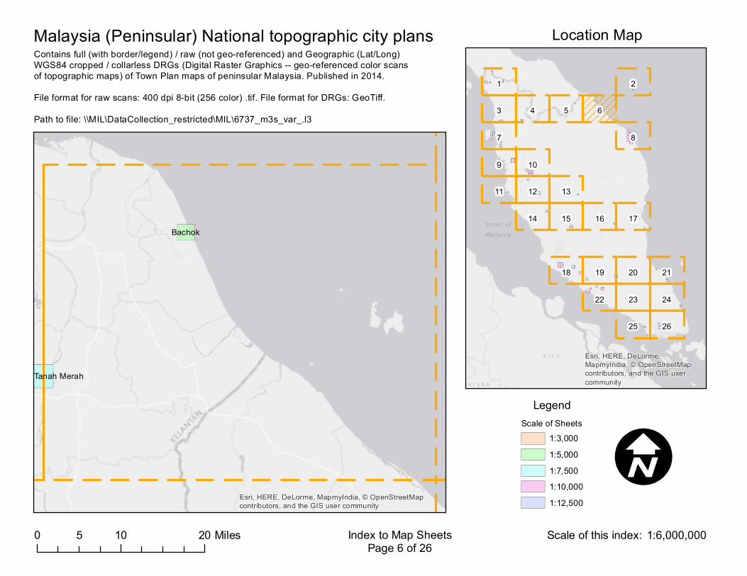
Bachok
Tanah Merah
Esri, HERE, DeLorme, MapmyIndia, © OpenStreetMapcontributors, and the GIS user community
Index to Map SheetsPage 6 of 26
9
2
8
1
7
3 654
11
15
19
16
20
17
2118
10
14
12
24
26
23
25
22
13
Esri, HERE, DeLorme,MapmyIndia, © OpenStreetMapcontributors, and the GIS usercommunity
LegendScale of Sheets
1:3,0001:5,0001:7,5001:10,0001:12,500
Location Map
I
Malaysia (Peninsular) National topographic city plansContains full (with border/legend) / raw (not geo-referenced) and Geographic (Lat/Long) WGS84 cropped / collarless DRGs (Digital Raster Graphics -- geo-referenced color scans of topographic maps) of Town Plan maps of peninsular Malaysia. Published in 2014.File format for raw scans: 400 dpi 8-bit (256 color) .tif. File format for DRGs: GeoTiff.Path to file: \\MIL\DataCollection_restricted\MIL\6737_m3s_var_.l3
0 10 205 Miles 1:6,000,000Scale of this index:

(B)(C)
Bukit Mertajam
Sungai Petani
Bayan Lepas
Nibong Tebal
George Town (A)
Parit Buntar Bandar Bahari
Sungai Bakap
Esri, HERE, DeLorme, MapmyIndia, © OpenStreetMapcontributors, and the GIS user community
Index to Map SheetsPage 7 of 26
9
2
8
1
7
3 654
11
15
19
16
20
17
2118
10
14
12
24
26
23
25
22
13
Esri, HERE, DeLorme,MapmyIndia, © OpenStreetMapcontributors, and the GIS usercommunity
LegendScale of Sheets
1:3,0001:5,0001:7,5001:10,0001:12,500
Location Map
I
Malaysia (Peninsular) National topographic city plansContains full (with border/legend) / raw (not geo-referenced) and Geographic (Lat/Long) WGS84 cropped / collarless DRGs (Digital Raster Graphics -- geo-referenced color scans of topographic maps) of Town Plan maps of peninsular Malaysia. Published in 2014.File format for raw scans: 400 dpi 8-bit (256 color) .tif. File format for DRGs: GeoTiff.Path to file: \\MIL\DataCollection_restricted\MIL\6737_m3s_var_.l3
0 10 205 Miles 1:6,000,000Scale of this index:

(I)
(F)
(A)
(E)
(B) (C)
(D)
(G)
Kuala Terengganu
Esri, HERE, DeLorme, MapmyIndia, © OpenStreetMapcontributors, and the GIS user community
Index to Map SheetsPage 8 of 26
9
2
8
1
7
3 654
11
15
19
16
20
17
2118
10
14
12
24
26
23
25
22
13
Esri, HERE, DeLorme,MapmyIndia, © OpenStreetMapcontributors, and the GIS usercommunity
LegendScale of Sheets
1:3,0001:5,0001:7,5001:10,0001:12,500
Location Map
I
Malaysia (Peninsular) National topographic city plansContains full (with border/legend) / raw (not geo-referenced) and Geographic (Lat/Long) WGS84 cropped / collarless DRGs (Digital Raster Graphics -- geo-referenced color scans of topographic maps) of Town Plan maps of peninsular Malaysia. Published in 2014.File format for raw scans: 400 dpi 8-bit (256 color) .tif. File format for DRGs: GeoTiff.Path to file: \\MIL\DataCollection_restricted\MIL\6737_m3s_var_.l3
0 10 205 Miles 1:6,000,000Scale of this index:
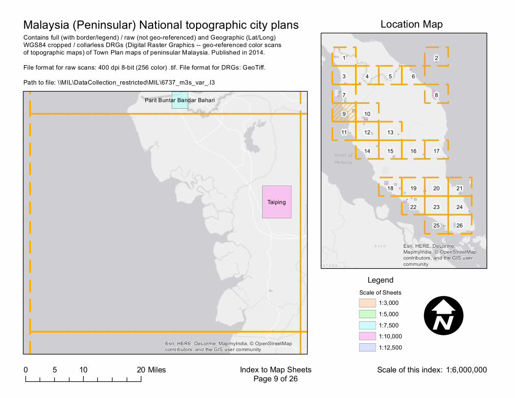
Taiping
Parit Buntar Bandar Bahari
Esri, HERE, DeLorme, MapmyIndia, © OpenStreetMapcontributors, and the GIS user community
Index to Map SheetsPage 9 of 26
9
2
8
1
7
3 654
11
15
19
16
20
17
2118
10
14
12
24
26
23
25
22
13
Esri, HERE, DeLorme,MapmyIndia, © OpenStreetMapcontributors, and the GIS usercommunity
LegendScale of Sheets
1:3,0001:5,0001:7,5001:10,0001:12,500
Location Map
I
Malaysia (Peninsular) National topographic city plansContains full (with border/legend) / raw (not geo-referenced) and Geographic (Lat/Long) WGS84 cropped / collarless DRGs (Digital Raster Graphics -- geo-referenced color scans of topographic maps) of Town Plan maps of peninsular Malaysia. Published in 2014.File format for raw scans: 400 dpi 8-bit (256 color) .tif. File format for DRGs: GeoTiff.Path to file: \\MIL\DataCollection_restricted\MIL\6737_m3s_var_.l3
0 10 205 Miles 1:6,000,000Scale of this index:

(K)
(B)
(D)(C)
Ipoh (A)
Batu GajahEsri, HERE, DeLorme, MapmyIndia, © OpenStreetMapcontributors, and the GIS user community
Index to Map SheetsPage 10 of 26
9
2
8
1
7
3 654
11
15
19
16
20
17
2118
10
14
12
24
26
23
25
22
13
Esri, HERE, DeLorme,MapmyIndia, © OpenStreetMapcontributors, and the GIS usercommunity
LegendScale of Sheets
1:3,0001:5,0001:7,5001:10,0001:12,500
Location Map
I
Malaysia (Peninsular) National topographic city plansContains full (with border/legend) / raw (not geo-referenced) and Geographic (Lat/Long) WGS84 cropped / collarless DRGs (Digital Raster Graphics -- geo-referenced color scans of topographic maps) of Town Plan maps of peninsular Malaysia. Published in 2014.File format for raw scans: 400 dpi 8-bit (256 color) .tif. File format for DRGs: GeoTiff.Path to file: \\MIL\DataCollection_restricted\MIL\6737_m3s_var_.l3
0 10 205 Miles 1:6,000,000Scale of this index:

Lumut
Esri, HERE, DeLorme, MapmyIndia, © OpenStreetMapcontributors, and the GIS user community
Index to Map SheetsPage 11 of 26
9
2
8
1
7
3 654
11
15
19
16
20
17
2118
10
14
12
24
26
23
25
22
13
Esri, HERE, DeLorme,MapmyIndia, © OpenStreetMapcontributors, and the GIS usercommunity
LegendScale of Sheets
1:3,0001:5,0001:7,5001:10,0001:12,500
Location Map
I
Malaysia (Peninsular) National topographic city plansContains full (with border/legend) / raw (not geo-referenced) and Geographic (Lat/Long) WGS84 cropped / collarless DRGs (Digital Raster Graphics -- geo-referenced color scans of topographic maps) of Town Plan maps of peninsular Malaysia. Published in 2014.File format for raw scans: 400 dpi 8-bit (256 color) .tif. File format for DRGs: GeoTiff.Path to file: \\MIL\DataCollection_restricted\MIL\6737_m3s_var_.l3
0 10 205 Miles 1:6,000,000Scale of this index:

(D)(C)
Tapah
Batu Gajah
Esri, HERE, DeLorme, MapmyIndia, © OpenStreetMapcontributors, and the GIS user community
Index to Map SheetsPage 12 of 26
9
2
8
1
7
3 654
11
15
19
16
20
17
2118
10
14
12
24
26
23
25
22
13
Esri, HERE, DeLorme,MapmyIndia, © OpenStreetMapcontributors, and the GIS usercommunity
LegendScale of Sheets
1:3,0001:5,0001:7,5001:10,0001:12,500
Location Map
I
Malaysia (Peninsular) National topographic city plansContains full (with border/legend) / raw (not geo-referenced) and Geographic (Lat/Long) WGS84 cropped / collarless DRGs (Digital Raster Graphics -- geo-referenced color scans of topographic maps) of Town Plan maps of peninsular Malaysia. Published in 2014.File format for raw scans: 400 dpi 8-bit (256 color) .tif. File format for DRGs: GeoTiff.Path to file: \\MIL\DataCollection_restricted\MIL\6737_m3s_var_.l3
0 10 205 Miles 1:6,000,000Scale of this index:

Kuala Lipis
Esri, HERE, DeLorme, MapmyIndia, © OpenStreetMapcontributors, and the GIS user community
Index to Map SheetsPage 13 of 26
9
2
8
1
7
3 654
11
15
19
16
20
17
2118
10
14
12
24
26
23
25
22
13
Esri, HERE, DeLorme,MapmyIndia, © OpenStreetMapcontributors, and the GIS usercommunity
LegendScale of Sheets
1:3,0001:5,0001:7,5001:10,0001:12,500
Location Map
I
Malaysia (Peninsular) National topographic city plansContains full (with border/legend) / raw (not geo-referenced) and Geographic (Lat/Long) WGS84 cropped / collarless DRGs (Digital Raster Graphics -- geo-referenced color scans of topographic maps) of Town Plan maps of peninsular Malaysia. Published in 2014.File format for raw scans: 400 dpi 8-bit (256 color) .tif. File format for DRGs: GeoTiff.Path to file: \\MIL\DataCollection_restricted\MIL\6737_m3s_var_.l3
0 10 205 Miles 1:6,000,000Scale of this index:

Slim River
Esri, HERE, DeLorme, MapmyIndia, © OpenStreetMapcontributors, and the GIS user community
Index to Map SheetsPage 14 of 26
9
2
8
1
7
3 654
11
15
19
16
20
17
2118
10
14
12
24
26
23
25
22
13
Esri, HERE, DeLorme,MapmyIndia, © OpenStreetMapcontributors, and the GIS usercommunity
LegendScale of Sheets
1:3,0001:5,0001:7,5001:10,0001:12,500
Location Map
I
Malaysia (Peninsular) National topographic city plansContains full (with border/legend) / raw (not geo-referenced) and Geographic (Lat/Long) WGS84 cropped / collarless DRGs (Digital Raster Graphics -- geo-referenced color scans of topographic maps) of Town Plan maps of peninsular Malaysia. Published in 2014.File format for raw scans: 400 dpi 8-bit (256 color) .tif. File format for DRGs: GeoTiff.Path to file: \\MIL\DataCollection_restricted\MIL\6737_m3s_var_.l3
0 10 205 Miles 1:6,000,000Scale of this index:

Bentong
Esri, HERE, DeLorme, MapmyIndia, © OpenStreetMapcontributors, and the GIS user community
Index to Map SheetsPage 15 of 26
9
2
8
1
7
3 654
11
15
19
16
20
17
2118
10
14
12
24
26
23
25
22
13
Esri, HERE, DeLorme,MapmyIndia, © OpenStreetMapcontributors, and the GIS usercommunity
LegendScale of Sheets
1:3,0001:5,0001:7,5001:10,0001:12,500
Location Map
I
Malaysia (Peninsular) National topographic city plansContains full (with border/legend) / raw (not geo-referenced) and Geographic (Lat/Long) WGS84 cropped / collarless DRGs (Digital Raster Graphics -- geo-referenced color scans of topographic maps) of Town Plan maps of peninsular Malaysia. Published in 2014.File format for raw scans: 400 dpi 8-bit (256 color) .tif. File format for DRGs: GeoTiff.Path to file: \\MIL\DataCollection_restricted\MIL\6737_m3s_var_.l3
0 10 205 Miles 1:6,000,000Scale of this index:

Maran
Esri, HERE, DeLorme, MapmyIndia, © OpenStreetMapcontributors, and the GIS user community
Index to Map SheetsPage 16 of 26
9
2
8
1
7
3 654
11
15
19
16
20
17
2118
10
14
12
24
26
23
25
22
13
Esri, HERE, DeLorme,MapmyIndia, © OpenStreetMapcontributors, and the GIS usercommunity
LegendScale of Sheets
1:3,0001:5,0001:7,5001:10,0001:12,500
Location Map
I
Malaysia (Peninsular) National topographic city plansContains full (with border/legend) / raw (not geo-referenced) and Geographic (Lat/Long) WGS84 cropped / collarless DRGs (Digital Raster Graphics -- geo-referenced color scans of topographic maps) of Town Plan maps of peninsular Malaysia. Published in 2014.File format for raw scans: 400 dpi 8-bit (256 color) .tif. File format for DRGs: GeoTiff.Path to file: \\MIL\DataCollection_restricted\MIL\6737_m3s_var_.l3
0 10 205 Miles 1:6,000,000Scale of this index:

Pekan
Esri, HERE, DeLorme, MapmyIndia, © OpenStreetMapcontributors, and the GIS user community
Index to Map SheetsPage 17 of 26
9
2
8
1
7
3 654
11
15
19
16
20
17
2118
10
14
12
24
26
23
25
22
13
Esri, HERE, DeLorme,MapmyIndia, © OpenStreetMapcontributors, and the GIS usercommunity
LegendScale of Sheets
1:3,0001:5,0001:7,5001:10,0001:12,500
Location Map
I
Malaysia (Peninsular) National topographic city plansContains full (with border/legend) / raw (not geo-referenced) and Geographic (Lat/Long) WGS84 cropped / collarless DRGs (Digital Raster Graphics -- geo-referenced color scans of topographic maps) of Town Plan maps of peninsular Malaysia. Published in 2014.File format for raw scans: 400 dpi 8-bit (256 color) .tif. File format for DRGs: GeoTiff.Path to file: \\MIL\DataCollection_restricted\MIL\6737_m3s_var_.l3
0 10 205 Miles 1:6,000,000Scale of this index:

(B)
(D)(C)
Klia (A)
Seremban
Rembau
Esri, HERE, DeLorme, MapmyIndia, © OpenStreetMapcontributors, and the GIS user community
Index to Map SheetsPage 18 of 26
9
2
8
1
7
3 654
11
15
19
16
20
17
2118
10
14
12
24
26
23
25
22
13
Esri, HERE, DeLorme,MapmyIndia, © OpenStreetMapcontributors, and the GIS usercommunity
LegendScale of Sheets
1:3,0001:5,0001:7,5001:10,0001:12,500
Location Map
I
Malaysia (Peninsular) National topographic city plansContains full (with border/legend) / raw (not geo-referenced) and Geographic (Lat/Long) WGS84 cropped / collarless DRGs (Digital Raster Graphics -- geo-referenced color scans of topographic maps) of Town Plan maps of peninsular Malaysia. Published in 2014.File format for raw scans: 400 dpi 8-bit (256 color) .tif. File format for DRGs: GeoTiff.Path to file: \\MIL\DataCollection_restricted\MIL\6737_m3s_var_.l3
0 10 205 Miles 1:6,000,000Scale of this index:

Jasin
Segamat
Tampin Pulau Sebang
Esri, HERE, DeLorme, MapmyIndia, © OpenStreetMapcontributors, and the GIS user community
Index to Map SheetsPage 19 of 26
9
2
8
1
7
3 654
11
15
19
16
20
17
2118
10
14
12
24
26
23
25
22
13
Esri, HERE, DeLorme,MapmyIndia, © OpenStreetMapcontributors, and the GIS usercommunity
LegendScale of Sheets
1:3,0001:5,0001:7,5001:10,0001:12,500
Location Map
I
Malaysia (Peninsular) National topographic city plansContains full (with border/legend) / raw (not geo-referenced) and Geographic (Lat/Long) WGS84 cropped / collarless DRGs (Digital Raster Graphics -- geo-referenced color scans of topographic maps) of Town Plan maps of peninsular Malaysia. Published in 2014.File format for raw scans: 400 dpi 8-bit (256 color) .tif. File format for DRGs: GeoTiff.Path to file: \\MIL\DataCollection_restricted\MIL\6737_m3s_var_.l3
0 10 205 Miles 1:6,000,000Scale of this index:

Segamat
Esri, HERE, DeLorme, MapmyIndia, © OpenStreetMapcontributors, and the GIS user community
Index to Map SheetsPage 20 of 26
9
2
8
1
7
3 654
11
15
19
16
20
17
2118
10
14
12
24
26
23
25
22
13
Esri, HERE, DeLorme,MapmyIndia, © OpenStreetMapcontributors, and the GIS usercommunity
LegendScale of Sheets
1:3,0001:5,0001:7,5001:10,0001:12,500
Location Map
I
Malaysia (Peninsular) National topographic city plansContains full (with border/legend) / raw (not geo-referenced) and Geographic (Lat/Long) WGS84 cropped / collarless DRGs (Digital Raster Graphics -- geo-referenced color scans of topographic maps) of Town Plan maps of peninsular Malaysia. Published in 2014.File format for raw scans: 400 dpi 8-bit (256 color) .tif. File format for DRGs: GeoTiff.Path to file: \\MIL\DataCollection_restricted\MIL\6737_m3s_var_.l3
0 10 205 Miles 1:6,000,000Scale of this index:

Mersing
Padang Endau
Esri, HERE, DeLorme, MapmyIndia, © OpenStreetMapcontributors, and the GIS user community
Index to Map SheetsPage 21 of 26
9
2
8
1
7
3 654
11
15
19
16
20
17
2118
10
14
12
24
26
23
25
22
13
Esri, HERE, DeLorme,MapmyIndia, © OpenStreetMapcontributors, and the GIS usercommunity
LegendScale of Sheets
1:3,0001:5,0001:7,5001:10,0001:12,500
Location Map
I
Malaysia (Peninsular) National topographic city plansContains full (with border/legend) / raw (not geo-referenced) and Geographic (Lat/Long) WGS84 cropped / collarless DRGs (Digital Raster Graphics -- geo-referenced color scans of topographic maps) of Town Plan maps of peninsular Malaysia. Published in 2014.File format for raw scans: 400 dpi 8-bit (256 color) .tif. File format for DRGs: GeoTiff.Path to file: \\MIL\DataCollection_restricted\MIL\6737_m3s_var_.l3
0 10 205 Miles 1:6,000,000Scale of this index:

Muar
Jasin
Tangkak
Melaka Air Keroh
Melaka Air Keroh insert
Esri, HERE, DeLorme, MapmyIndia, © OpenStreetMapcontributors, and the GIS user community
Index to Map SheetsPage 22 of 26
9
2
8
1
7
3 654
11
15
19
16
20
17
2118
10
14
12
24
26
23
25
22
13
Esri, HERE, DeLorme,MapmyIndia, © OpenStreetMapcontributors, and the GIS usercommunity
LegendScale of Sheets
1:3,0001:5,0001:7,5001:10,0001:12,500
Location Map
I
Malaysia (Peninsular) National topographic city plansContains full (with border/legend) / raw (not geo-referenced) and Geographic (Lat/Long) WGS84 cropped / collarless DRGs (Digital Raster Graphics -- geo-referenced color scans of topographic maps) of Town Plan maps of peninsular Malaysia. Published in 2014.File format for raw scans: 400 dpi 8-bit (256 color) .tif. File format for DRGs: GeoTiff.Path to file: \\MIL\DataCollection_restricted\MIL\6737_m3s_var_.l3
0 10 205 Miles 1:6,000,000Scale of this index:

Yong Peng
Esri, HERE, DeLorme, MapmyIndia, © OpenStreetMapcontributors, and the GIS user community
Index to Map SheetsPage 23 of 26
9
2
8
1
7
3 654
11
15
19
16
20
17
2118
10
14
12
24
26
23
25
22
13
Esri, HERE, DeLorme,MapmyIndia, © OpenStreetMapcontributors, and the GIS usercommunity
LegendScale of Sheets
1:3,0001:5,0001:7,5001:10,0001:12,500
Location Map
I
Malaysia (Peninsular) National topographic city plansContains full (with border/legend) / raw (not geo-referenced) and Geographic (Lat/Long) WGS84 cropped / collarless DRGs (Digital Raster Graphics -- geo-referenced color scans of topographic maps) of Town Plan maps of peninsular Malaysia. Published in 2014.File format for raw scans: 400 dpi 8-bit (256 color) .tif. File format for DRGs: GeoTiff.Path to file: \\MIL\DataCollection_restricted\MIL\6737_m3s_var_.l3
0 10 205 Miles 1:6,000,000Scale of this index:

Kg Sedili Besar
Mersing
Esri, HERE, DeLorme, MapmyIndia, © OpenStreetMapcontributors, and the GIS user community
Index to Map SheetsPage 24 of 26
9
2
8
1
7
3 654
11
15
19
16
20
17
2118
10
14
12
24
26
23
25
22
13
Esri, HERE, DeLorme,MapmyIndia, © OpenStreetMapcontributors, and the GIS usercommunity
LegendScale of Sheets
1:3,0001:5,0001:7,5001:10,0001:12,500
Location Map
I
Malaysia (Peninsular) National topographic city plansContains full (with border/legend) / raw (not geo-referenced) and Geographic (Lat/Long) WGS84 cropped / collarless DRGs (Digital Raster Graphics -- geo-referenced color scans of topographic maps) of Town Plan maps of peninsular Malaysia. Published in 2014.File format for raw scans: 400 dpi 8-bit (256 color) .tif. File format for DRGs: GeoTiff.Path to file: \\MIL\DataCollection_restricted\MIL\6737_m3s_var_.l3
0 10 205 Miles 1:6,000,000Scale of this index:

Kukup
Pontian Kechil
Esri, HERE, DeLorme, MapmyIndia, © OpenStreetMapcontributors, and the GIS user community
Index to Map SheetsPage 25 of 26
9
2
8
1
7
3 654
11
15
19
16
20
17
2118
10
14
12
24
26
23
25
22
13
Esri, HERE, DeLorme,MapmyIndia, © OpenStreetMapcontributors, and the GIS usercommunity
LegendScale of Sheets
1:3,0001:5,0001:7,5001:10,0001:12,500
Location Map
I
Malaysia (Peninsular) National topographic city plansContains full (with border/legend) / raw (not geo-referenced) and Geographic (Lat/Long) WGS84 cropped / collarless DRGs (Digital Raster Graphics -- geo-referenced color scans of topographic maps) of Town Plan maps of peninsular Malaysia. Published in 2014.File format for raw scans: 400 dpi 8-bit (256 color) .tif. File format for DRGs: GeoTiff.Path to file: \\MIL\DataCollection_restricted\MIL\6737_m3s_var_.l3
0 10 205 Miles 1:6,000,000Scale of this index:

(E)
(B)
(D)
(C)Johor Bahru (A)
Esri, HERE, DeLorme, MapmyIndia, © OpenStreetMapcontributors, and the GIS user community
Index to Map SheetsPage 26 of 26
9
2
8
1
7
3 654
11
15
19
16
20
17
2118
10
14
12
24
26
23
25
22
13
Esri, HERE, DeLorme,MapmyIndia, © OpenStreetMapcontributors, and the GIS usercommunity
LegendScale of Sheets
1:3,0001:5,0001:7,5001:10,0001:12,500
Location Map
I
Malaysia (Peninsular) National topographic city plansContains full (with border/legend) / raw (not geo-referenced) and Geographic (Lat/Long) WGS84 cropped / collarless DRGs (Digital Raster Graphics -- geo-referenced color scans of topographic maps) of Town Plan maps of peninsular Malaysia. Published in 2014.File format for raw scans: 400 dpi 8-bit (256 color) .tif. File format for DRGs: GeoTiff.Path to file: \\MIL\DataCollection_restricted\MIL\6737_m3s_var_.l3
0 10 205 Miles 1:6,000,000Scale of this index: