Blasts from the past impacting on Peninsular Malaysia
6
Bulletin of the Geological Society of Malaysia 54 (2008) 97 – 102, doi: 10.7186/bgsm2008016 Blasts from the past impacting on Peninsular Malaysia H.D. TJIA 1 & ROS FATIHAH HJ. MUHAMMAD 2 1 Institute for Environment & Development (LESTARI), Universiti Kebangsaan Malaysia, 43500 Bangi, Selangor, Malaysia E-mail address: [email protected] 2 Department of Geology, University of Malaya, 50603 Kuala Lumpur, Malaysia Abstract— At the Plio-Pleistocene transition, three large volcanic centres in the Bukit Barisan, Sumatera, began producing voluminous amounts of felsic tephra and pyroclastic flows. Field evidence at two of the centres suggests not one but multiple paroxysmal events spanning periods of up to almost 2 million years. At Toba (now Danau Toba, northern Sumatera) perhaps four such events occurred between 1.9 Ma and about 30 ka ago. The centres are marked by several hundred metres thick of ignimbrite, pyroclastic tuff flows, and air-fall tephra. All three eruption centres should be classed in the top rank of the Volcanic Explosivity Index (VEI). Air-fall tuff has been identified at more than a dozen localities throughout Peninsular Malaysia as far east as the middle Lebir river, Kelantan, and in the upper Terengganu river reaches. Thicknesses are in the one-metre range. Recently all these Malaysian tephra have been attributed to one “Toba eruption” and assigned a 70-75 ka age ignoring the possibility of origins from the other two volcanic centres and brushing aside findings of detailed fieldwork and publications of pre-World War II vintage. Recently we studied the volcanic eruptives of the Maninjau volcanic centre in the Minang Highlands, western Sumatera, and here too evidence of multiple eruptions is present. Keywords: distal tephra, multiple eruptions, Maninjau, Toba BACKGROUND In the Late Miocene-Early Pliocene all along the western side of Sumatera the Bukit Barisan began to rise principally as result of the Indian Ocean-Australian plate convergence with Sundaland. Since the Early Quaternary paroxysmal, volcanic eruptions of the katmaian type have occurred along the entire mountain range producing huge volumes of felsic/ rhyolitic ash, the latest event taking place 30 000 years ago. The ash has been “identified” from localities in Sri Lanka and India in the west and to the east of Sumatera in Peninsular Malaysia and part of the South China Sea. In Sumatera Quaternary felsic ash is associated with gigantic volcanic cauldrons known as Toba (northern Sumatera), Maninjau (central Sumatera), and Ranau (southern Sumatera) .Outside the Bukit Barisan dated Quaternary rhyolite also covers vast tracts of Lampung (southern Sumatera, Figures 1a and 1b). Despite clear field evidence of multiple volcanic blasts having occurred in multiple volcanic regions of Sumatera, newer publications have attributed all near-surficial ash from India to the South China Sea, including Peninsular Malaysia, to Toba as the single source. The same papers also promoted a single paroxysmal volcanic event at around 75 000 years. This event has been used to suggest a much earlier human migration into this part of the world and a hypothesis (using mitochondrial DNA) that the human race was almost wiped out by the catastrophe. This communication is in part a brief review of existing (but forgotten?) knowledge and our 2008 field observations in the Maninjau area of Sumatera. TOBA CAULDRON, NORTH SUMATERA This huge volcano-tectonic depression, the Toba Cauldron, has attracted interest from geoscientists as far back as the later part of the 19th century. At present Danau (lake) Toba occupies the central part of a crustal culmination 100 km long and 31 km wide. The lake proper is 87 km long and 26 km wide and with the Samosir peninsula included, the region covers a 1776.5 square kilometre (Figure 3). The so called Toba Tuffs consist of rhyolitic pyroclastics that blankets 20 000 to 30 000 square kilometre area. A comprehensive summary of observations by numerous previous researchers and van Bemmelen’s own studies were discussed by van Bemmelen (1949). Significant results of newer work were published by Nishimura (as editor and as writer, 1980). Kusnaeny (1978) and Yokoyama et al. (1980) classified the ignimbrite samples as rhyolite. Throughout Peninsular Malaysia light-coloured volcanic ash has been seen as near-surface deposits. Most have been considered air-fall deposit, some probably reworked. The ash became a significant time marker as it is associated with Kota Tampan palaeolithic stone tools. As the only Quaternary volcanic expression in the peninsula consists of basaltic lava in the Bukit Jabor area to the north of Kuantan, the obvious connection of the ash has been the erstwhile Toba volcanic centre in northern Sumatera. The distance to ash deposits in the Peninsula ranges from 250 km to over 400 km (Figure 1). Stauffer et al. (1980), re-published radiocarbon dates of material associated with rhyolitic ash at Ampang and at Serdang, both located at the outskirts of
Transcript of Blasts from the past impacting on Peninsular Malaysia
Bulletin of the Geological Society of Malaysia 54 (2008) 97 – 102, doi: 10.7186/bgsm2008016
Blasts from the past impacting on Peninsular Malaysia
H.D. Tjia1 & Ros FaTiHaH Hj. MuHaMMaD2
1Institute for Environment & Development (LESTARI), Universiti Kebangsaan Malaysia, 43500 Bangi, Selangor, Malaysia
E-mail address: [email protected] of Geology, University of Malaya,
50603 Kuala Lumpur, Malaysia
Abstract— At the Plio-Pleistocene transition, three large volcanic centres in the Bukit Barisan, Sumatera, began producing voluminous amounts of felsic tephra and pyroclastic flows. Field evidence at two of the centres suggests not one but multiple paroxysmal events spanning periods of up to almost 2 million years. At Toba (now Danau Toba, northern Sumatera) perhaps four such events occurred between 1.9 Ma and about 30 ka ago. The centres are marked by several hundred metres thick of ignimbrite, pyroclastic tuff flows, and air-fall tephra. All three eruption centres should be classed in the top rank of the Volcanic Explosivity Index (VEI).Air-fall tuff has been identified at more than a dozen localities throughout Peninsular Malaysia as far east as the middle Lebir river, Kelantan, and in the upper Terengganu river reaches. Thicknesses are in the one-metre range. Recently all these Malaysian tephra have been attributed to one “Toba eruption” and assigned a 70-75 ka age ignoring the possibility of origins from the other two volcanic centres and brushing aside findings of detailed fieldwork and publications of pre-World War II vintage. Recently we studied the volcanic eruptives of the Maninjau volcanic centre in the Minang Highlands, western Sumatera, and here too evidence of multiple eruptions is present.
Keywords: distal tephra, multiple eruptions, Maninjau, Toba
BACKGROUND
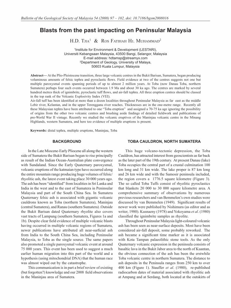
In the Late Miocene-Early Pliocene all along the western side of Sumatera the Bukit Barisan began to rise principally as result of the Indian Ocean-Australian plate convergence with Sundaland. Since the Early Quaternary paroxysmal, volcanic eruptions of the katmaian type have occurred along the entire mountain range producing huge volumes of felsic/rhyolitic ash, the latest event taking place 30 000 years ago. The ash has been “identified” from localities in Sri Lanka and India in the west and to the east of Sumatera in Peninsular Malaysia and part of the South China Sea. In Sumatera Quaternary felsic ash is associated with gigantic volcanic cauldrons known as Toba (northern Sumatera), Maninjau (central Sumatera), and Ranau (southern Sumatera) .Outside the Bukit Barisan dated Quaternary rhyolite also covers vast tracts of Lampung (southern Sumatera, Figures 1a and 1b). Despite clear field evidence of multiple volcanic blasts having occurred in multiple volcanic regions of Sumatera, newer publications have attributed all near-surficial ash from India to the South China Sea, including Peninsular Malaysia, to Toba as the single source. The same papers also promoted a single paroxysmal volcanic event at around 75 000 years. This event has been used to suggest a much earlier human migration into this part of the world and a hypothesis (using mitochondrial DNA) that the human race was almost wiped out by the catastrophe.
This communication is in part a brief review of existing (but forgotten?) knowledge and our 2008 field observations in the Maninjau area of Sumatera.
TOBA CAULDRON, NORTH SUMATERA
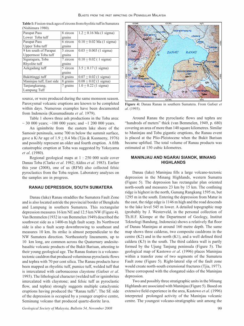
This huge volcano-tectonic depression, the Toba Cauldron, has attracted interest from geoscientists as far back as the later part of the 19th century. At present Danau (lake) Toba occupies the central part of a crustal culmination 100 km long and 31 km wide. The lake proper is 87 km long and 26 km wide and with the Samosir peninsula included, the region covers a 1776.5 square kilometre (Figure 3). The so called Toba Tuffs consist of rhyolitic pyroclastics that blankets 20 000 to 30 000 square kilometre area. A comprehensive summary of observations by numerous previous researchers and van Bemmelen’s own studies were discussed by van Bemmelen (1949). Significant results of newer work were published by Nishimura (as editor and as writer, 1980). Kusnaeny (1978) and Yokoyama et al. (1980) classified the ignimbrite samples as rhyolite.
Throughout Peninsular Malaysia light-coloured volcanic ash has been seen as near-surface deposits. Most have been considered air-fall deposit, some probably reworked. The ash became a significant time marker as it is associated with Kota Tampan palaeolithic stone tools. As the only Quaternary volcanic expression in the peninsula consists of basaltic lava in the Bukit Jabor area to the north of Kuantan, the obvious connection of the ash has been the erstwhile Toba volcanic centre in northern Sumatera. The distance to ash deposits in the Peninsula ranges from 250 km to over 400 km (Figure 1). Stauffer et al. (1980), re-published radiocarbon dates of material associated with rhyolitic ash at Ampang and at Serdang, both located at the outskirts of
H.D. Tjia & Ros FaTiHaH Hj. MuHaMMaD
Geological Society of Malaysia, Bulletin 54, November 200898
Kuala Lumpur, and suggested the ash was in the 30 000 to 36 000 years range. It was pointed out that until today two outstanding issues have not been resolved. Paraphrased the following was highlighted.
(a) Field workers familiar with the Toba region agree that multiple eruptions had taken place to produce a total of more than 500 m thick rhyolitic tuffs. Yet, so far only a single ash deposit has been encountered in Peninsular Malaysia. The majority of recent publications attribute a seventy thousand plus year age to “rhyolitic” ash collected from the Indian Ocean floor near Sri Lanka and also on the South China Sea from a single gigantic Toba eruption. Comparisons have been made with similar extreme volcanic catastrophes such as the Yellowstone region, United States of America and Rotorua-Taupo of New Zealand. The newer researchers (among them Rose & Chesner, 1987) choose to ignore the significance of the widely available published records of multiple eruptions having taken place in the Toba region. The information on Toba in van Bemmelen’s (1949) monumental volumes on the geology of Indonesia was not used. In spite of its advanced age this particular publication is still a standard reference.
(b) In Toba, the 30 ka ash is under-represented while in the Peninsula at over 500 km distance, rhyolitic ash may still be a metre thick. In the mountainous Toba region the friability of this young material caused it to have been severely eroded?
(c) We would like to add a third issue. Satellite image of ash plume of the great 1991 Pinatubo eruption, Philippines, showed it travelling in a straight and narrow belt due west for several hundreds of kilometres. The ash from the smaller Galunggung eruption of 1982-1983 in West Java also travelled in the stratosphere in a distinct narrow belt in SSW direction (Plate 15b in Katili & Sudradjat, 1984). The ash in the Sri Lanka region in the west and that in the South China Sea, both attributed to the same Toba eruption in recent articles, could hardly have originated from the same
Figure 1: a) Quaternary rhyolitic ash production centres in Sumatera. The Aekgadang locality was mentioned by Nishimura (1980). b) Felsic/rhyolitic ash locations in Peninsular Malaysia. Modified after Stauffer et al. (1980), with additions.
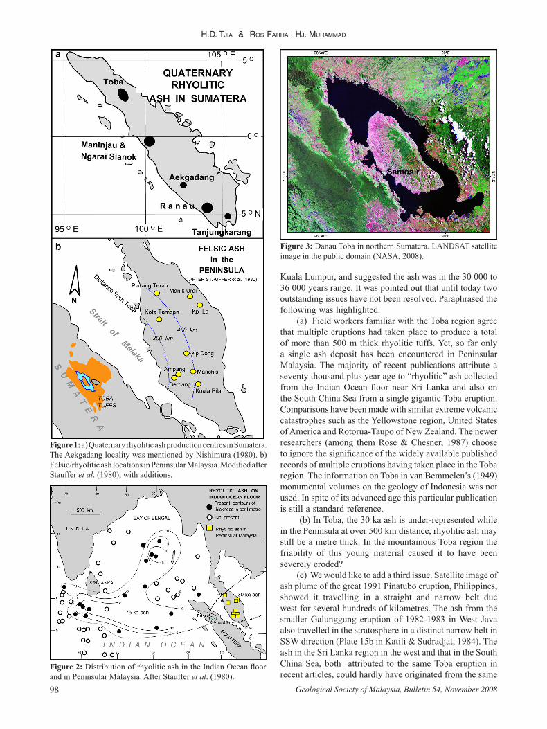
Figure 2: Distribution of rhyolitic ash in the Indian Ocean floor and in Peninsular Malaysia. After Stauffer et al. (1980).
Figure 3: Danau Toba in northern Sumatera. LANDSAT satellite image in the public domain (NASA, 2008).
BlasTs FRoM THe pasT iMpacTing on peninsulaR Malaysia
99Geological Society of Malaysia, Bulletin 54, November 2008
source, or were produced during the same monsoon season. Paroxysmal volcanic eruptions are known to be completed within days. Numerous examples have been documented from Indonesia (Kusumadinata et al. 1979).
Table 1 shows three ash productions in the Toba area: ~ 30 000 years; ~100 000 years; and ~1 200 000 years.
An ignimbrite from the eastern lake shore of the Samosir peninsula, some 700 m below the summit surface, gave a K/Ar age of 1.9 + 0.4 Ma (Tjia & Kusnaeny, 1976) and possibly represent an older and fourth eruption. A fifth catastrophic eruption at Toba was suggested by Yokoyama et al. (1980).
Regional geological maps at 1 : 250 000 scale cover Danau Toba (Clarke et al. 1982; Aldiss et al. 1983). Earlier this year (2008), one of us (RFM) also collected felsic pyroclastics from the Toba region. Laboratory analyses on the samples are in progress.
RANAU DEPRESSION, SOUTH SUMATERA
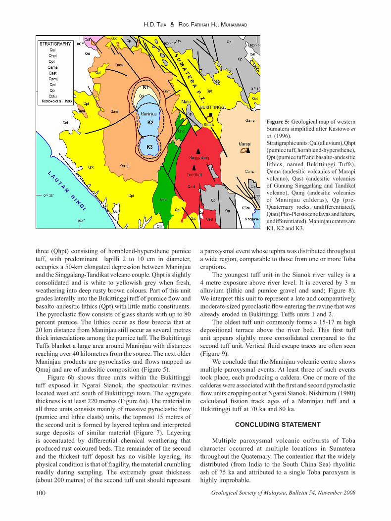
Danau (lake) Ranau straddles the Sumatera Fault Zone and is also located astride the provincial border of Bengkulu and Lampung in southern Sumatera. This rectangular depression measures 16 km NE and 12.5 km NW (Figure 4). Van Bemmelen (1932 in van Bemmelen 1949) described the southwest side as a 1400-m high fault scarp. Its Northwest side is also a fault scarp downthrowing to southeast and measures 10 km. Its strike is almost perpendicular to the NW Sumatera direction. Northeasterly lineaments, up to 10 km long, are common across the Quaternary andesite-basaltic volcanic products of the Bukit Barisan, attesting to their young geological age. The Ranau feature is a volcano-tectonic cauldron that produced voluminous pyroclastic flows and tephra with 70 per cent silica. The Ranau products have been mapped as rhyolitic tuff, pumice tuff, welded tuff that is intercalated with carbonaceous claystone (Gafoer et al. 1993). The lithological character (welded tuff or ignimbrites intercalated with claystone; and felsic tuff as pyroclastic flow, and tephra) strongly suggests multiple cataclysmic eruptions having produced the “Ranau tuffs”. The SE side of the depression is occupied by a younger eruptive centre, Seminung volcano that produced quartz-diorite lava.
Around Ranau the pyroclastic flows and tephra are “hundreds of meters” thick (van Bemmelen, 1949, p. 680) covering an area of more than 140 square kilometres. Similar to Maninjau and Toba gigantic eruptions, the Ranau event is placed at the Plio-Pleistocene when the Bukit Barisan became uplifted. The total volume of Ranau products was estimated at 150 cubic kilometres.
MANINJAU AND NGARAI SIANOK, MINANG HIGHLANDS
Danau (lake) Maninjau fills a large volcano-tectonic depression in the Minang Highlands, western Sumatra (Figure 5). The depression has rectangular plan oriented north-south and measures 23 km by 15 km. The confining ridge is highest in the north, Gunung Rangkang 1595 m, but 1295 m in the south. Entering the depression from Matur in the east, the ridge edge is 1146 m high and the road descends to the lake level 545 m lower. A detailed topographic map (probably by J. Westerveld, in the personal collection of Th.H.F. Klompe at the Department of Geology, Institut Teknologi Bandung, Indonesia) shows a relatively flat floor of Danau Maninjau at around 160 metre depth. The same map shows three calderas, two composite cauldrons in the centre (K2) and in the north (K1), and a well defined third caldera (K3) in the south. The third caldera wall is partly formed by the Ujung Tanjung peninsula (Figure 5). The geological map of Kastowo et al. (1996) places Maninjau within a transfer zone of two segments of the Sumatera Fault zone (Figure 5). Right-lateral slip of the fault zone would create north-south extensional fractures (Tjia, 1977). These correspond with the elongated sides of the Maninjau depression.
Two and possibly three stratigraphic units in the Minang Highlands are associated with Maninjau (Figure 5). Based on extensive field experience in the area, Kastowo et al. (1996) interpreted prolonged activity of the Maninjau volcanic centre. The youngest volcano-stratigraphic unit among the
Figure 4: Danau Ranau in southern Sumatera. From Gafoer et al. (1993).
Table 1: Fission-track ages of zircons from rhyolitic tuff in Sumatera (Nishimura 1980).Parapat PassLower Toba tuff
8 zircon grains
1.2 + 0.16 Ma (1 sigma)
Parapat PassUpper Toba tuff
6 zircon grains
0.10 + 0.02 Ma (1 sigma)
9 km south of ParapatUppermost Toba tuff
5 zircon grains
0.03 + 0.003 (1 sigma)
Siguragura, TobaRhyolite tuff
7 zircon grains
0.10 + 0.02 ( 1 sigma)
Aekgadang tuff 5 zircon grains
3.5 + 0.17 (1 sigma)
Bukittinggi tuff 8 grains 0.07 + 0.02 (1 sigma)Maninjau tuff, East side 8 grains 0.08 + 0.02 (1 sigma)Tanjungkarang, Lampung Tuff
7 grains 1.0 + 0.22 (1 sigma)
H.D. Tjia & Ros FaTiHaH Hj. MuHaMMaD
Geological Society of Malaysia, Bulletin 54, November 2008100
three (Qhpt) consisting of hornblend-hypersthene pumice tuff, with predominant lapilli 2 to 10 cm in diameter, occupies a 50-km elongated depression between Maninjau and the Singgalang-Tandikat volcano couple. Qhpt is slightly consolidated and is white to yellowish grey when fresh, weathering into deep rusty brown colours. Part of this unit grades laterally into the Bukittinggi tuff of pumice flow and basalto-andesitic lithics (Qpt) with little mafic constituents. The pyroclastic flow consists of glass shards with up to 80 percent pumice. The lithics occur as flow breccia that at 20 km distance from Maninjau still occur as several metres thick intercalations among the pumice tuff. The Bukittinggi Tuffs blanket a large area around Maninjau with distances reaching over 40 kilometres from the source. The next older Maninjau products are pyroclastics and flows mapped as Qmaj and are of andesitic composition (Figure 5).
Figure 6b shows three units within the Bukittinggi tuff exposed in Ngarai Sianok, the spectacular ravines located west and south of Bukittinggi town. The aggregate thickness is at least 220 metres (Figure 6a). The material in all three units consists mainly of massive pyroclastic flow (pumice and lithic clasts) units, the topmost 15 metres of the second unit is formed by layered tephra and interpreted surge deposits of similar material (Figure 7). Layering is accentuated by differential chemical weathering that produced rust coloured beds. The remainder of the second and the thickest tuff deposit has no visible layering, its physical condition is that of fragility, the material crumbling readily during sampling. The extremely great thickness (about 200 metres) of the second tuff unit should represent
Figure 5: Geological map of western Sumatera simplified after Kastowo et al. (1996).Stratigraphic units: Qal (alluvium), Qhpt (pumice tuff, hornblend-hypersthene), Qpt (pumice tuff and basalto-andesitic lithics, named Bukittinggi Tuffs), Qama (andesitic volcanics of Marapi volcano), Qast (andesitic volcanics of Gunung Singgalang and Tandikat volcano), Qamj (andesitic volcanics of Maninjau calderas), Qp (pre-Quaternary rocks, undifferentiated), Qtau (Plio-Pleistocene lavas and lahars, undifferentiated). Maninjau craters are K1, K2 and K3.
a paroxysmal event whose tephra was distributed throughout a wide region, comparable to those from one or more Toba eruptions.
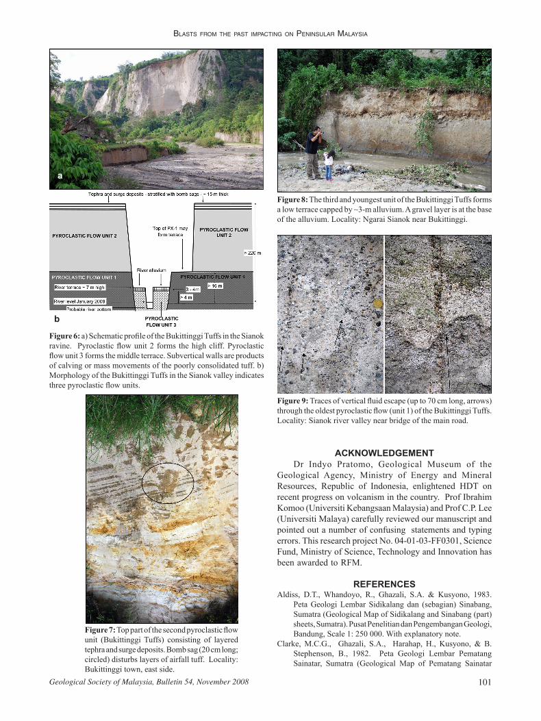
The youngest tuff unit in the Sianok river valley is a 4 metre exposure above river level. It is covered by 3 m alluvium (lithic and pumice gravel and sand; Figure 8). We interpret this unit to represent a late and comparatively moderate-sized pyroclastic flow entering the ravine that was already eroded in Bukittinggi Tuffs units 1 and 2.
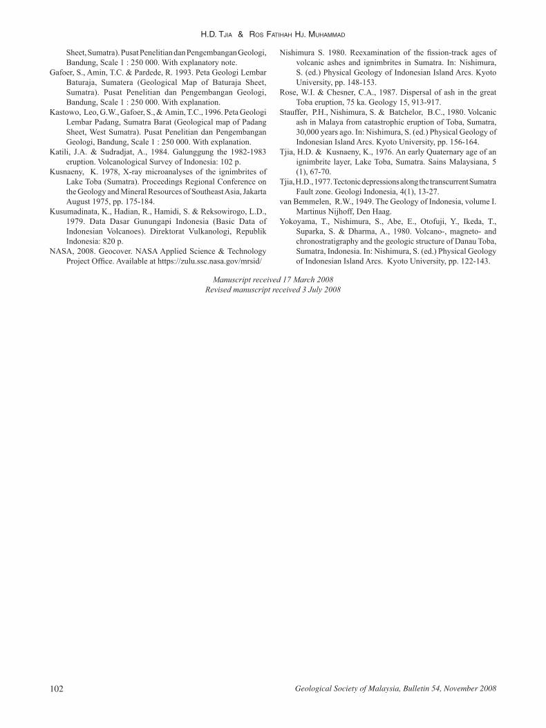
The oldest tuff unit commonly forms a 15-17 m high depositional terrace above the river bed. This first tuff unit appears slightly more consolidated compared to the second tuff unit. Vertical fluid escape traces are often seen (Figure 9).
We conclude that the Maninjau volcanic centre shows multiple paroxysmal events. At least three of such events took place, each producing a caldera. One or more of the calderas were associated with the first and second pyroclastic flow units cropping out at Ngarai Sianok. Nishimura (1980) calculated fission track ages of a Maninjau tuff and a Bukittinggi tuff at 70 ka and 80 ka.
CONCLUDING STATEMENT
Multiple paroxysmal volcanic outbursts of Toba character occurred at multiple locations in Sumatera throughout the Quaternary. The contention that the widely distributed (from India to the South China Sea) rhyolitic ash of 75 ka and attributed to a single Toba paroxysm is highly improbable.
BlasTs FRoM THe pasT iMpacTing on peninsulaR Malaysia
101Geological Society of Malaysia, Bulletin 54, November 2008
Figure 9: Traces of vertical fluid escape (up to 70 cm long, arrows) through the oldest pyroclastic flow (unit 1) of the Bukittinggi Tuffs. Locality: Sianok river valley near bridge of the main road.
Figure 6: a) Schematic profile of the Bukittinggi Tuffs in the Sianok ravine. Pyroclastic flow unit 2 forms the high cliff. Pyroclastic flow unit 3 forms the middle terrace. Subvertical walls are products of calving or mass movements of the poorly consolidated tuff. b) Morphology of the Bukittinggi Tuffs in the Sianok valley indicates three pyroclastic flow units.
a
b
Figure 7: Top part of the second pyroclastic flow unit (Bukittinggi Tuffs) consisting of layered tephra and surge deposits. Bomb sag (20 cm long; circled) disturbs layers of airfall tuff. Locality: Bukittinggi town, east side.
Figure 8: The third and youngest unit of the Bukittinggi Tuffs forms a low terrace capped by ~3-m alluvium. A gravel layer is at the base of the alluvium. Locality: Ngarai Sianok near Bukittinggi.
ACKNOWLEDGEMENTDr Indyo Pratomo, Geological Museum of the
Geological Agency, Ministry of Energy and Mineral Resources, Republic of Indonesia, enlightened HDT on recent progress on volcanism in the country. Prof Ibrahim Komoo (Universiti Kebangsaan Malaysia) and Prof C.P. Lee (Universiti Malaya) carefully reviewed our manuscript and pointed out a number of confusing statements and typing errors. This research project No. 04-01-03-FF0301, Science Fund, Ministry of Science, Technology and Innovation has been awarded to RFM.
REFERENCESAldiss, D.T., Whandoyo, R., Ghazali, S.A. & Kusyono, 1983.
Peta Geologi Lembar Sidikalang dan (sebagian) Sinabang, Sumatra (Geological Map of Sidikalang and Sinabang (part) sheets, Sumatra). Pusat Penelitian dan Pengembangan Geologi, Bandung, Scale 1: 250 000. With explanatory note.
Clarke, M.C.G., Ghazali, S.A., Harahap, H., Kusyono, & B. Stephenson, B., 1982. Peta Geologi Lembar Pematang Sainatar, Sumatra (Geological Map of Pematang Sainatar
H.D. Tjia & Ros FaTiHaH Hj. MuHaMMaD
Geological Society of Malaysia, Bulletin 54, November 2008102
Manuscript received 17 March 2008Revised manuscript received 3 July 2008
Sheet, Sumatra). Pusat Penelitian dan Pengembangan Geologi, Bandung, Scale 1 : 250 000. With explanatory note.
Gafoer, S., Amin, T.C. & Pardede, R. 1993. Peta Geologi Lembar Baturaja, Sumatera (Geological Map of Baturaja Sheet, Sumatra). Pusat Penelitian dan Pengembangan Geologi, Bandung, Scale 1 : 250 000. With explanation.
Kastowo, Leo, G.W., Gafoer, S., & Amin, T.C., 1996. Peta Geologi Lembar Padang, Sumatra Barat (Geological map of Padang Sheet, West Sumatra). Pusat Penelitian dan Pengembangan Geologi, Bandung, Scale 1 : 250 000. With explanation.
Katili, J.A. & Sudradjat, A., 1984. Galunggung the 1982-1983 eruption. Volcanological Survey of Indonesia: 102 p.
Kusnaeny, K. 1978, X-ray microanalyses of the ignimbrites of Lake Toba (Sumatra). Proceedings Regional Conference on the Geology and Mineral Resources of Southeast Asia, Jakarta August 1975, pp. 175-184.
Kusumadinata, K., Hadian, R., Hamidi, S. & Reksowirogo, L.D., 1979. Data Dasar Gunungapi Indonesia (Basic Data of Indonesian Volcanoes). Direktorat Vulkanologi, Republik Indonesia: 820 p.
NASA, 2008. Geocover. NASA Applied Science & Technology Project Office. Available at https://zulu.ssc.nasa.gov/mrsid/
Nishimura S. 1980. Reexamination of the fission-track ages of volcanic ashes and ignimbrites in Sumatra. In: Nishimura, S. (ed.) Physical Geology of Indonesian Island Arcs. Kyoto University, pp. 148-153.
Rose, W.I. & Chesner, C.A., 1987. Dispersal of ash in the great Toba eruption, 75 ka. Geology 15, 913-917.
Stauffer, P.H., Nishimura, S. & Batchelor, B.C., 1980. Volcanic ash in Malaya from catastrophic eruption of Toba, Sumatra, 30,000 years ago. In: Nishimura, S. (ed.) Physical Geology of Indonesian Island Arcs. Kyoto University, pp. 156-164.
Tjia, H.D. & Kusnaeny, K., 1976. An early Quaternary age of an ignimbrite layer, Lake Toba, Sumatra. Sains Malaysiana, 5 (1), 67-70.
Tjia, H.D., 1977. Tectonic depressions along the transcurrent Sumatra Fault zone. Geologi Indonesia, 4(1), 13-27.
van Bemmelen, R.W., 1949. The Geology of Indonesia, volume I. Martinus Nijhoff, Den Haag.
Yokoyama, T., Nishimura, S., Abe, E., Otofuji, Y., Ikeda, T., Suparka, S. & Dharma, A., 1980. Volcano-, magneto- and chronostratigraphy and the geologic structure of Danau Toba, Sumatra, Indonesia. In: Nishimura, S. (ed.) Physical Geology of Indonesian Island Arcs. Kyoto University, pp. 122-143.