Magino Gold Project Project Description Report Executive Summary · 2013-07-18 · Magino Gold...
40
Magino Gold Project Project Description Report Executive Summary SLR Ref: 200.03005-00004 July 8, 2013 Version 1.0
Transcript of Magino Gold Project Project Description Report Executive Summary · 2013-07-18 · Magino Gold...

Magino Gold Project
Project Description Report
Executive Summary
SLR Ref: 200.03005-00004
July 8, 2013
Version 1.0

Magino Gold Project
Project Description Report
Executive Summary
Prepared for:
Prodigy Gold, Inc. Box 209, 3 Dree Road Dubreuilville, Ontario
P0S 1B0
Prepared by:
SLR Consulting (Canada) Ltd. Suite 101, 260 Town Centre Blvd.
Markham, Ontario L3R 8H8, Canada
Magino Gold Project – Project Description
Executive Summary i July 2013
EXECUTIVE SUMMARY
ACRONYMS ................................................................................................................................ III
ES.1 INTRODUCTION ............................................................................................................ 1
ES.2 PROJECT INFORMATION ............................................................................................ 4
ES.3 REGULATORY REQUIREMENTS ................................................................................ 7
ES.4 FIRST NATIONS AND MÉTIS ....................................................................................... 9
ES.5 CONSULTATION ........................................................................................................... 9
ES.6 PROJECT DESCRIPTION ........................................................................................... 11
ES.7 PROJECT ALTERNATIVES ........................................................................................ 19
ES.8 ENVIRONMENTAL SETTING ..................................................................................... 19
ES.9 CULTURAL AND ARCHAEOLOGICAL ...................................................................... 24
ES.10 POTENTIAL ENVIRONMENTAL EFFECTS ............................................................... 25
Magino Gold Project – Project Description
Executive Summary ii July 2013
FIGURES
Figure ES1 – Project Location
Figure ES2 – Project Facilities
Figure ES3 – Project Schedule
Figure ES4 – Simplified Gold Extraction Process
Figure ES5 – Project Facility at Final Stage of Mining
Figure ES6 – Catchment Areas
Figure ES7 – Environmental Data Collection Program
APPENDICES
Appendix ES-A – Glossary
Appendix ES-B – Preliminary List of Required Approvals and Permits
Magino Gold Project – Project Description
Executive Summary iii July 2013
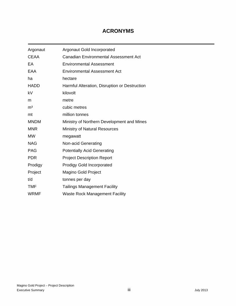
ACRONYMS
Argonaut Argonaut Gold Incorporated
CEAA Canadian Environmental Assessment Act
EA Environmental Assessment
EAA Environmental Assessment Act
ha hectare
HADD Harmful Alteration, Disruption or Destruction
kV kilovolt
m metre
m³ cubic metres
mt million tonnes
MNDM Ministry of Northern Development and Mines
MNR Ministry of Natural Resources
MW megawatt
NAG Non-acid Generating
PAG Potentially Acid Generating
PDR Project Description Report
Prodigy Prodigy Gold Incorporated
Project Magino Gold Project
t/d tonnes per day
TMF Tailings Management Facility
WRMF Waste Rock Management Facility

Magino Gold Project – Project Description
Executive Summary 1 July 2013
EXECUTIVE SUMMARY
ES.1 INTRODUCTION
Background
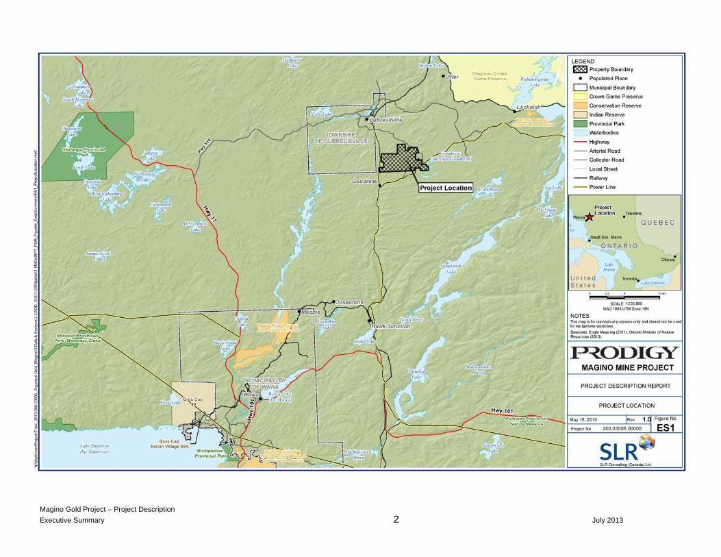
Prodigy Gold Incorporated (Prodigy) proposes to develop the Magino Gold Project (“Project”), situated at a past-producing mine site, as a brownfield project. The Project is located in Northern Ontario in Finan Township within the Robinson Superior Treaty area. It lies approximately 40 km northeast (70 km by road) of Wawa and approximately 14 km southeast of the township of Dubreuilville (Figure ES1).
The Project area is located within the Territorial District of Algoma. It is centered at UTM 689049E 5351422N (NAD 83 Zone 16U). The land, including sub-surface rights, is owned by the provincial Crown. Current dispositions for the Project include 57 claims and 119 claim units that constitute the Project boundary.
The Project involves the mining of up to approximately 60 million tonnes (Mt) of ore and approximately 160 Mt of waste rock from an open pit in the same location as the past-producing underground mine.
Prodigy, a wholly-owned subsidiary of Argonaut Gold Incorporated (Argonaut), is obtaining leases to the land within the Project boundary. Argonaut Gold is a successful Canadian gold mining company with two operating mines and two advanced development projects. It has an experienced management team with wide-ranging expertise in mining operations, from exploration through development and closure. Project proponent:
Contact for Environmental Assessment Purposes: Prodigy Gold Incorporated - Attention: Michelle Tanguay Box 209, 3 Dree Road
Dubreuilville, Ontario P0S 1B0 [email protected]
Corporate contacts: Peter C. Dougherty President and Chief Executive Officer Curtis K. Turner Corporate Development Officer Argonaut Gold Incorporated 9604 Prototype Court Reno, NV 89521 [email protected]
Magino Gold Project – Project Description
Executive Summary 2 July 2013
Magino Gold Project – Project Description
Executive Summary 3 July 2013

Magino Gold Project – Project Description
Executive Summary 4 July 2013
There are no regional environmental studies that may be relevant in the context of the proposed Project. Prodigy is committed to minimizing adverse environmental impacts and ensuring that socio-economic benefits to the local area are realized. To ensure long-term durability and stability, Prodigy is taking long-term closure objectives into account during the development of plans and designs.
Prodigy is committed in executing, developing, and operating the Project in a safe manner with the goal of zero harm to personnel or adverse impact to health.
Executive Summary
This document summarizes the information contained in the full-length Project Description Report (PDR) available on the Federal and Provincial government sites. Readers are requested to consult the PDR in the event they require additional details or specifics not included in this summary.
ES.2 PROJECT INFORMATION
The gold deposit at the Project was first discovered in 1917 and was mined by underground methods from 1935-42 and again from 1987-92. Prodigy initiated project planning activities in 2011 to reactivate development and gold production operations. Prodigy was acquired by Argonaut in December 2012.
The past-producing mine is currently classed as “temporarily suspended” under the Ontario Mining Act. Additional closure measures are still required.
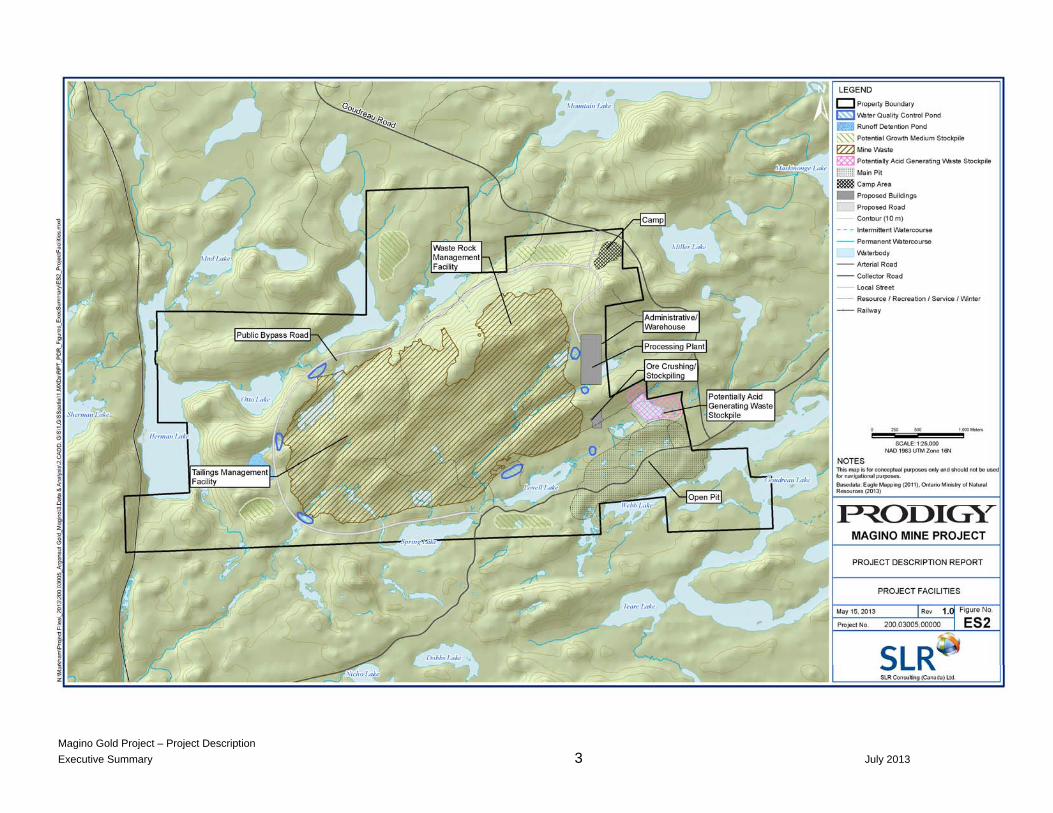
Project facilities will include an open pit, a primary ore crusher, a conveyor, a crushed ore stockpile, a process plant to extract the gold, a low-grade ore stockpile, waste rock and tailings management facilities, explosives magazines, camp accommodations, administration offices, laboratory facilities, non-mining waste facilities, maintenance facilities, and warehouses (Figure ES2).
Infrastructure development will include relocating a local public road and powerline, constructing internal haul and access roads, a substation, step-down transformers, and water supply and sewage treatment systems.
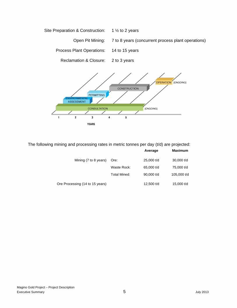
The Project is expected to extend over an approximately 20-year period. It is anticipated it will take approximately two years to complete the Environmental Assessment (EA) and permitting processes (Figure ES3). The development plan for the Project is shown below. High-grade ore will be processed during the open pit mining phase, and low-grade ore will be temporarily stockpiled and subsequently processed to extend the operating period of the process plant to 14 or 15 years.
Magino Gold Project – Project Description
Executive Summary 5 July 2013
Site Preparation & Construction: 1 ½ to 2 years
Open Pit Mining: 7 to 8 years (concurrent process plant operations)
Process Plant Operations: 14 to 15 years
Reclamation & Closure: 2 to 3 years
The following mining and processing rates in metric tonnes per day (t/d) are projected:
Average Maximum
Mining (7 to 8 years) Ore:
Waste Rock:
Total Mined:
25,000 t/d
65,000 t/d
90,000 t/d
30,000 t/d
75,000 t/d
105,000 t/d
Ore Processing (14 to 15 years) 12,500 t/d 15,000 t/d

Magino Gold Project - Project Description
Executive Summary 6 July 2013

Magino Gold Project - Project Description
Executive Summary 7 July 2013
The Project area is on land owned by the provincial Crown, which includes sub-surface rights. Current dispositions for the Project include 7 leased parcels, 7 patented claims, and 57 mining claims as described below.
Magino Project Dispositions
DISPOSITION TYPE NUMBER CLAIM NUMBERS
Leases – Mining Rights Only 1 722481
Leases – Mining and Surface Rights
6 581951, 581948, 581949, 581950, 581952, 581953
Patents – Surface and Mining Rights
7 2048, 2049, 2050, 2051, 2052, 2053, 2102
Mining Claims 57 1110086, 1118352, 1174399, 1174400, 1174401, 1174849, 1234858, 1235583, 1235584, 4218043, 4218044, 698646, 698647, 698648, 698649, 698650, 698651, 698652, 698653, 698654, 698655, 698656, 698657, 698660, 698661, 698662, 698664, 698665, 698666, 698667, 698668, 698669, 711129, 809963, 809967, 809968, 809969, 809970, 809971, 809972, 827520, 841257, 841258, 841259, 841270, 847804, 847805, 847806, 847807, 847814, 4262081, 4262082, 4262085, 4218037, 4218038, 4218052, 711133, 884901
ES.3 REGULATORY REQUIREMENTS
Federal, provincial and municipal requirements, as well as those of the First Nations and the Métis are described below. A preliminary list of the approvals and permits that will be required is provided in Appendix ES-B to this document. Federal
The PDR is intended to meet the requirements of both the Canadian Environmental Assessment Agency (the Agency) and the Province of Ontario in order to initiate the environmental review process. The Project will be subject to federal legislative requirements in addition to those administered by provincial and municipal agencies. It is anticipated that a number of permits, licenses, and other authorizations will be required prior to the commencement of construction.
The Agency is the federal decision-making and coordinating authority for projects regulated under the Canadian Environmental Assessment Act (CEAA). The Agency will review the PDR and, upon acceptance, conduct a public review and comment period.

Magino Gold Project - Project Description
Executive Summary 8 July 2013
It is anticipated that the Project will be considered a Designated Project under CEAA and as such will require a Federal EA. Pursuant to Section 15(b) of the Regulations, the Project will include the, “construction, operation, decommissioning and abandonment of a metal mill with an ore input capacity of 4,000 t/d or more.” Additionally, pursuant to Section 15(c) of the Regulations, the Project is considered a “Designated Project” as it will involve the “construction, operation, decommissioning and abandonment of a gold mine, other than a placer mine, with an ore production capacity of 600 t/d or more”. Pursuant to Section 8 of the Regulations, the total groundwater extractions will exceed the 200,000 cubic metres/year trigger for a “Designated Project” under CEAA. No Federal financial support is proposed or anticipated for the Project.
The Project is situated on lands administered by the Ontario Ministry of Natural Resources (MNR). No federal lands will be used for the purpose of carrying out the Project. There will be no environmental changes to federal land, provincial land, other than the one specified, or outside of Canada as a result of this Project. Provincial
Mining projects requiring provincial approvals and permits from a provincial ministry, municipality, or designated public body are subject to the requirements of the Environmental Assessment Act (EA), unless explicitly exempt. Although mining activities in and of themselves are not subject to a provincial EAA, activities associated with mining such as the construction of access roads and power transmission lines often trigger a provincial Class EA to be undertaken by the proponent.
Provincial EA processes can proceed through either an Individual EA or several Class EAs. Prodigy has submitted a request to enter into an agreement with the Ontario Ministry of the Environment to conduct a voluntary Individual Environmental Assessment. In order for the Project to commence mining operations, a certified Closure Plan and associated Financial Assurances will also need to be in place.
In Ontario, the Ministry of Northern Development and Mines (MNDM) is the lead ministry responsible for coordinating the process leading to the issuance of all provincial mineral development permits. MNDM has developed a “One Window” coordination process to facilitate the permitting and approvals process.
The Government of Ontario will assess the Project to determine the Crown’s obligations to consult with Aboriginal communities. As lead ministry, the MNDM has coordinating responsibility for this consultation and will also ensure other ministries with approval or permitting requirements are involved.
Municipal
The Project site is located within Ontario Regulation #102/89 Zoning Order for the Territorial District of Algoma. Under Section 9(d) of the Order, mining, including pits, quarries, and wayside pits or quarries, is considered a permitted use. Finan Township is an “unorganized” township and therefore is not subject to municipal laws or municipal zoning designations.

Magino Gold Project - Project Description
Executive Summary 9 July 2013
However, there may be specific infrastructure components that may overlap with the township regulatory requirements, for example, non-mining waste disposal. Prodigy is working with the township to identify these specific components and develop plans to collaborate on these aspects.
ES.4 FIRST NATIONS AND MÉTIS
The Prodigy development occurs entirely within the Robinson-Superior Treaty area. The Michipicoten and Pic Mobert First Nations are the two Aboriginal groups with Aboriginal treaty rights in the vicinity of the Project. The Michipicoten First Nation reserve is located approximately 50 kilometers south and the Pic Mobert First Nation reserve is situated approximately 100 kilometers northwest of the Project.
The Canadian Environmental Assessment Agency (the Agency) has identified the following Aboriginal Groups as potentially impacted by the project and is requesting Prodigy Gold engage with these groups during the environmental assessment process:
• Michipicoten First Nation – Contacted by Prodigy in February 2012;
• Missanabie Cree First Nation – Contacted by Prodigy in August 2011;
• Métis Nation of Ontario – Contacted by Prodigy in June 2012;
• Pic Mobert First Nation; and
• Red Sky Métis Independent Nation.
ES.5 CONSULTATION
To date, the focus of the consultation program has been on undertaking a preliminary assessment of potential Treaty and asserted Aboriginal right holders. As such, there have been a series of meetings (as listed below) with the Michipicoten First Nation, the Missanabie Cree and the Métis Nation of Ontario in an attempt to understand which, if any potential aboriginal/treaty rights are at play.
In recent correspondence with the Agency, they requested that the Red Sky Independent Métis Nation as well as the Pic Mobert First Nation be included, as appropriate, in Prodigy’s consultation program.
Prodigy’s consultation to date has been somewhat tempered by the fact that the Michipicoten First Nation are the aboriginal group nearest the project and they hold aboriginal treaty rights under the Robinson Superior Treaty.
Magino Gold Project - Project Description
Executive Summary 10 July 2013
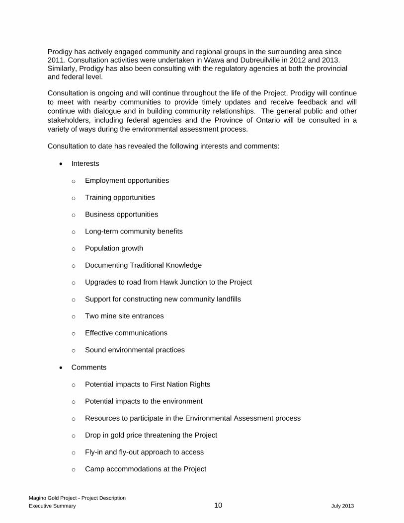
Prodigy has actively engaged community and regional groups in the surrounding area since 2011. Consultation activities were undertaken in Wawa and Dubreuilville in 2012 and 2013. Similarly, Prodigy has also been consulting with the regulatory agencies at both the provincial and federal level.
Consultation is ongoing and will continue throughout the life of the Project. Prodigy will continue to meet with nearby communities to provide timely updates and receive feedback and will continue with dialogue and in building community relationships. The general public and other stakeholders, including federal agencies and the Province of Ontario will be consulted in a variety of ways during the environmental assessment process.
Consultation to date has revealed the following interests and comments:
Interests
o Employment opportunities
o Training opportunities
o Business opportunities
o Long-term community benefits
o Population growth
o Documenting Traditional Knowledge
o Upgrades to road from Hawk Junction to the Project
o Support for constructing new community landfills
o Two mine site entrances
o Effective communications
o Sound environmental practices
Comments
o Potential impacts to First Nation Rights
o Potential impacts to the environment
o Resources to participate in the Environmental Assessment process
o Drop in gold price threatening the Project
o Fly-in and fly-out approach to access
o Camp accommodations at the Project

Magino Gold Project - Project Description
Executive Summary 11 July 2013
Prodigy is considering the above interests and comments, which include the following:
A jobs description table will be made available.
Prodigy encourages accommodations for operational workers in local communities, however, it believes a camp will still be needed since the number of workers will be large compared to the existing population of surrounding communities.
Prodigy has studied upgrading or rebuilding a road from Hawk Junction to the Project and concluded it is not as viable as the roads identified, since it would increase environmental impacts as well as costs and involve potentially complex landowner negotiations.
Argonaut, Prodigy’s parent company, has indicated it is financially robust and the Project is still economically viable at a lower gold price.
ES.6 PROJECT DESCRIPTION
Mining and Processing
The open pit will be located in the south-eastern corner of the Project area (Figure ES2). The side slopes of the pit will be benched to provide for stability as well as space for the construction of mine truck access ramps and roads.
A summary of the primary Project components of the mine, process facilities, and infrastructure are as follows:

Magino Gold Project - Project Description
Executive Summary 12 July 2013
Summary of Project Components1
Project Component Description
Open Pit Mine One primary pit. Approx. 300 m depth, 85 ha, 220 Mt of ore.
Low Grade Ore Stockpile Adjacent to Processing Plant. 30 Mt, 45 ha footprint. Will be removed by the end of the operational period.
Waste Rock Management Facility North-west of pit. 160 Mt, 145 ha footprint.
Potentially Acid Generating (PAG) Management Facility2
North of pit. 12 ha. Lined facility.
Processing Plant North of open pit. 15 ha footprint, 2,500 t/d, Carbon in Leach.
Tailings Management Facility (TMF) West of open pit. 60 Mt, 285 ha, slurry deposition.
Explosives Storage Area South-west of pit.
Makeup Water Intake and Pipeline Drainage area and lakes to the north of the WRMF.
Make-up Water Wells and Pipelines Within the Project Area.
Site Power Algoma Power Inc. Line from Wawa; upgraded as necessary.
Project Access Roads Local haul and access roads between pit, process plant, waste rock and tailings management facilities, and the camp.
Public Roads New road through Project area to replace existing road access across pit.
Camp Approximately 6 ha area to north of Process Plant.
m = metres Mt=million tonnes
ha = hectares
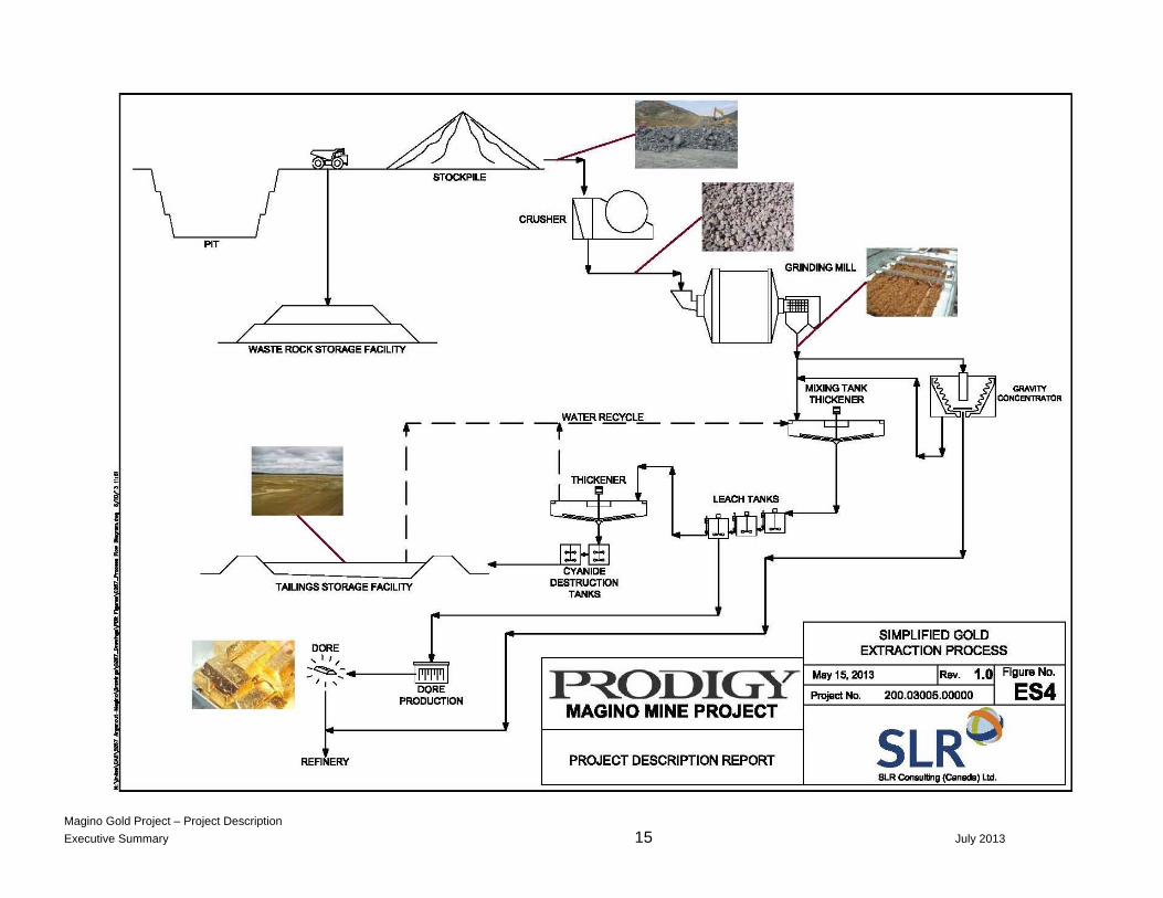
Mining will be conducted by drilling and blasting zones of the ore and using mine shovel or excavator and mine haul trucks to remove the blasted material. Mined ore to be processed in the plant will be transported to the primary crusher; while the low-grade ore will be placed in a stockpile for future processing.
The waste rock will be conveyed to the WRMF or to the TMF for constructing the embankment of the containment area. (Figure ES2). It is anticipated that mining will be conducted year round in two 12-hour shifts per day.
Approximately 97 percent of the waste rock is anticipated to be non-acid generating (NAG) based on static Acid-Base Accounting testing. The remaining approximately three percent of PAG waste rock will be segregated and stored in a separate facility, close to the pit rim (Figure ES2).
1 All dimensions and sizes are preliminary and subject to change during the Environmental Assessment and design
process. 2 PAG = Potentially Acid Generating waste rock.

Magino Gold Project - Project Description
Executive Summary 13 July 2013
Surface diversion ditches will be provided, as necessary, around the outside of the WRMF to minimize any surface water run-on impacted by mine operations. Runoff from un-reclaimed waste rock surfaces and disturbed areas will be routed through detention ponds to allow suspended solids to settle out before the water is either discharged under a permit, or recycled to the plant or the TMF for re-use in the process plant or used for controlling dust.
Gold will be recovered using an industry standard process plant applying proven technology. Gold extraction from the ore will include primary crushing, grinding, cyanide leaching, and gold recovery. Together with the agitated leaching process and a gravity separation circuit, both the Carbon-in-Pulp circuit method, as well as possibly the Carbon-in-Solution method will be used to extract gold from the ore (Figure ES4). These processes are expected to recover between 90 to 94 percent of the available gold.
Tailings will be treated to destroy cyanide before being discharged to the TMF. Prodigy will become a signatory to the “International Code for Management of Cyanide at Gold Mining Operations” prior to the Project becoming operational. This code contains a far reaching and comprehensive set of principles, standards of practice and financial assurance requirements. It also provides for independent professional audits of the signatory companies. Adoption of the code provides for rigorous operating practices and a high level of human health and environmental protection.
The Project will include comprehensive water management systems that will: (1) collect and detain runoff impacted by construction and mining operations to allow sediment to settle out before discharge and (2) collect seepage and water that accumulates in the pit and pump these to the TMF or the process plant for re-use or treatment prior to discharge. Sufficient storage capacity will be provided in the TMF and specially constructed water quality control ponds to prevent discharges of impacted waters during extreme wet periods.
The Project will remove groundwater from the future pit, resulting in a lowering of adjacent groundwater levels. To the extent groundwater is pumped from wells to supplement the surface water supplies, local lowering of groundwater levels will occur around these wells. Pursuant to Section 8 of the Regulations, the total groundwater extractions will exceed the 200,000 cubic metres/year trigger for a “Designated Project” under CEAA.
The open pit will be dewatered as mining proceeds downward using sump pumps and pipelines, and possibly extraction wells drilled into the pit walls as well. When mining starts, groundwater extraction will gradually increase with mining depth and reach a maximum of between 3,000 and 4,000 m3/day (or 1,000,000 to 1,500,000 m3/year). This extraction rate will cause a lowering of groundwater levels immediately adjacent to the pit rim and out to approximately a few hundred metres, based on preliminary three dimensional groundwater modeling.
The treated tailings will be disposed of as slurry behind an impermeable barrier; part of the embankment constructed with waste rock. Water that is collected in the TMF will be recycled back to the process plant. Figure ES5 provides an illustration of the Project after approximately seven years of operation, and at the completion of the mining phase.
Fuels, explosives and re-agents (processing chemicals and additives) will be required in the day-to-day operation of the mine and process plant. The handling of these materials will be in

Magino Gold Project - Project Description
Executive Summary 14 July 2013
accordance with strict corporate, provincial and federal health and safety protocols, environmental regulations and industry best practices. Environmental Management Systems will include emergency procedures established to mitigate the unlikely event of any chemical, fuel, and explosive incidents.
Magino Gold Project – Project Description
Executive Summary 15 July 2013

Magino Gold Project – Project Description
Executive Summary 16 July 2013
Infrastructure
The main access to the Project is from Highway 17 (Trans-Canada Highway) via Highway 519 and Goudreau Road. Highways 17 and 519 are paved roads operated and maintained by the Ontario Ministry of Transportation (Figure ES1). The Project can be accessed via a 14 km, all-weather gravel road (Goudreau Road), travelling south from Dubreuilville. Goudreau Road will be used primarily to support mine operations including transport of operations personnel, supplies and equipment to the Project. Transport of gold Doré bars from the Project will be via the above mentioned roads. Vehicles are likely to include buses, personal vehicles (cars, pick-up trucks, etc.), tractor-trailers, and armoured vehicles.
Heavier loads, particularly during the construction of the Project, may be brought in by the Northern Bypass Road (also referred to as Road 48) that extends from the east side of Dubreuilville southwards to the Project (Figure ES1). This Northern Bypass Road has a bridge capable of supporting heavier loads (evidently up to 65 tonnes) over the Magpie River in the Dubreuilville area.
To improve reliability for the anticipated increase in traffic and loading, Goudreau Road and possibly the Northern Bypass Road will require upgrading, which may include gravel re-surfacing, repairs to the cable guide rails, ditching and culvert improvements, and re-alignment to reduce sharp corners and steep grades.
A new seven to eight km-long public by-pass road will be constructed to the northwest and west of the mine, to allow for independent vehicle access from Dubreuilville to the settlement of Goudreau (Figure ES2). This road will replace the current public road that passes through the Project pit area.
New service roads, internal to the Project site, with the capacity to accommodate two-way traffic will be constructed to connect the process plant, the office/maintenance/warehouse complex, the mine camp facilities, explosives storage facility, and the TMF. An internal mine haul road that can accommodate mine trucks will also be required.
The maximum power needs of the Project are estimated to be approximately 30 megawatts (MW). The existing single-circuit 44 kilovolt (kV) power line from Wawa will need to be upgraded to accommodate this additional load. In addition, the power line across the area where the pit is be excavated will have to be relocated. A new substation will be located close to the grinding circuits where most of the required power will be consumed. Alternatives for delivering the additional power to the Project, as well as alternative routes for the power lines needed to be relocated away from the pit area, are currently being evaluated in consultation with Algoma Power Inc.

Magino Gold Project – Project Description
Executive Summary 17 July 2013
Magino Gold Project – Project Description
Executive Summary 18 July 2013
Fresh water will be required during the start-up of the process plant and TMF. Thereafter makeup water for the plant and potable water for the facilities will be required on an ongoing basis during operations. The start-up water will be obtained from water that is impounded naturally within the TMF when the initial retaining embankment is constructed, from the existing tailings facility, and from local lakes that have adequate capacity. Start-up water required is estimated to be in the order of 250,000 to 500,000 cubic metres (m3).
Make-up water requirements (fresh water that is required in addition to the re-cycled water) are estimated to be approximately 5,000 m3/day (1.8 million m3 per year) during the early years of Project operations when there is limited water available from the pit. As the pit expands, more recycled water will become available and the need for make-up water will be reduced. By year seven of the Project when the pit becomes fully developed and captures the maximum amount of groundwater and precipitation there will potentially be an average surplus of approximately 2,000 m3/day (0.7 million m3 per year).
Approximately 100 m3/day of potable water will be required for operations personnel, at the camp, the mine and the process plant. This supply will be obtained from local lakes and/or groundwater wells in the Project area and will be filtered and treated before use. It is estimated that between 80 and 100 m3/day of waste water may be generated at the facility. Waste water will be treated before discharge using packaged treatment plants. Septic tanks and leach fields may also be used for smaller isolated sources of waste water. Sludge generated at the waste water treatment plants will be disposed of off-site, or on site in the topsoil stockpiles.
Aggregate sources will be needed for concrete manufacturing; the TMF’s filter zones, subsurface drains, road beds, foundations, erosion protection measures, and other infrastructure uses. To the maximum extent possible, the required aggregate will be obtained from areas that will be disturbed for the mine development, i.e. predominantly from the pit area and the footprint of the waste rock and tailings management facilities.
Non-mining waste management will be set up to handle solid, inert and hazardous waste material. Solid waste such as food scraps, cardboard, plastics, metal tins, glass, scrap metal, wood and paper, will be separated on site and will either be recycled, re-used or composted. Inert waste, such as bricks, concrete, lumber and drywall will either be recycled off site or managed on site by disposal within the WRMF. Hazardous waste will be collected, temporarily stored on site and the transported to a permitted hazardous waste disposal facility.
Closure Plan
Closure of the Project will take place after processing of ore (including low grade ore) is completed. Closure will include allowing the pit to fill with water as a lake and reclaiming (soil covered and vegetated) the waste rock and tailings management facilities. For safety, a fence will be constructed around the perimeter of the pit until it has filled. Littoral zones and aquatic habitat will be created by a combination of infill and reduction of angles of the upper benches around the outer rim of the pit once the lake levels stabilize.
The process plant, buildings and infrastructure provided for the mine will be removed, except for those facilities which could have beneficial use after mine closure. To the extent practicable,
Magino Gold Project – Project Description
Executive Summary 19 July 2013
closure activities and site reclamation will be conducted concurrently during the operational period.
Cleared areas will be reclaimed using stockpiled organic and topsoil material as a growth medium, followed by re-vegetation through a combination of native seed application and the planting of native shrub and tree species. On-site roads that are no longer required for site maintenance and reclamation activities will be deactivated and reclaimed. Surfaces will be ripped to reduce compaction and prepared for re-vegetation.
A Closure Plan will be submitted in accordance with the Mining Act and Mine Rehabilitation Code of Ontario.
Groundwater and surface water monitoring will continue after closure until it can be demonstrated that the closure activities have met targets and closure will be sustainable. Since pit closure may take several decades or more, the time period for the monitoring of pit levels and quality may be extended. Active maintenance, such as the repair of erosion damage, replacement of vegetation as necessary, etc. will continue for several years until site conditions stabilize.
ES.7 PROJECT ALTERNATIVES
The following project alternatives will be evaluated as part of the environmental assessment process:
Alternative configurations and deposition methods for the WRMF.
Filtering, truck transport and stacking of dried tailings instead of slurry deposition.
Alternative conventional gold extraction methods such as Carbon-in-Leach.
The addition of a rail siding near Dubreuilville to facilitate rail transportation in addition to road transportation.
On closure of the mine, the relocation and disposal of the PAG waste rock in the bottom of the pit lake and closure of the surface of the TMF as a wetlands, rather than a re-vegetated soil surface.
ES.8 ENVIRONMENTAL SETTING
Physical Environment
The Project is located in the geological Wawa Subprovince of the Canadian Shield. The topography of the area is characterized by low ridges and hills up to 50 m high, flanked by generally flat areas of glacial outwash, swamps, and numerous lakes and bogs. Organic deposits are found in association with bogs and fens. Shrubs, spruce trees, rushes, horsetails,

Magino Gold Project – Project Description
Executive Summary 20 July 2013
sedges, Labrador tea and Sphagnum moss are typically present in various combinations in the wetlands within the Project area. The area is free of permafrost.
The climate is humid continental. The average annual temperature is estimated to be +2oC with average monthly minimum and maximums of -15oC and +15oC respectively. The mean annual precipitation is preliminarily estimated to be 815 mm, with approximately 70 percent falling as rain and the rest as snow.
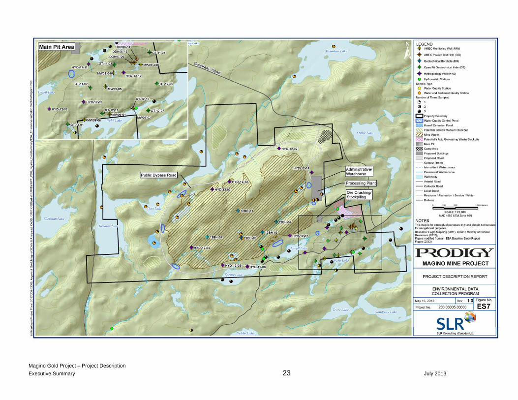
Approximately 18 lakes are located within the McVeigh, Webb-Goudreau and Herman lake watersheds within or adjacent to the Project area. This includes Dreany Lake, which is a reference area outside the Project area (used for comparison purposes in the EA). Surface flows to the north of the Project, from the Dreany Lake area, as well as McVeigh Creek, which drains the central portion of the Project, flow to the west and then southwards. These flows drain through Herman Lake to Lake Superior by way of the Magpie River. The Webb and Goudreau lake systems, located along the southern boundary of the Project, drain to the east and then to the south via the Michipicoten River to Lake Superior. Hydrometric stations were installed in October 2011 to monitor surface water flows or lake levels in the vicinity of the Project area. (Figure ES6).
Lakes, streams, the existing tailings facility ponds and groundwater seeps have been sampled since October 2011 and an extensive record of water quality has been documented. Sediment quality has been determined for several lakes and streams as part of the baseline studies. Figure ES7 provides an overview of the environmental data collection program performed last year and which is continuing in 2013.
Groundwater levels are typically near surface, varying up to five metres deep. In some low lying areas, groundwater levels occur at the surface. Groundwater sampling was initiated in late 2012 and is being conducted in concert with surface water quality sampling to examine the relationship between the two. No private water supply wells are present in the watersheds hosting the Project.
Groundwater migration mimics topography and generally occurs from the higher elevations in the east and central part of the Project area towards lower elevations to the west, north and south. The open pit mine is on the south flank of this groundwater “mound”.
Biological Environment
Mixed forest dominates the landscape, with secondary conifer occurrence. Hardwood trees in the area are largely composed of trembling aspen and white birch, with balsam poplar occurring on more moist areas. Conifer species common to the area include black spruce, white spruce, balsam fir, and jack pine. Fire is a dominant driver of natural renewal, followed by wind and insects.
Wetlands, which are largely associated with the drainage patterns are 58 percent organic (swamps, fens and bogs on organic soils), with the remainder being marsh and thicket swamps on inorganic substrates. The swamps are characterized by black spruce with tamarack and balsam fir, speckled alder, which is often dominant, red-osier dogwood, sweet gale and dwarf birch.

Magino Gold Project – Project Description
Executive Summary 21 July 2013
Bogs are dominated by black spruce with lesser amounts of balsam fir and tamarack. Fens are dominated by stunted tamarack and black spruce and a slightly more nutrient-rich mix of sedges and herbs. Lichen and bryophytes include reindeer lichen and coral lichens.
The background review identified the potential for 48 rare species, however no rare plants or vegetation communities have been located.
The wildlife baseline study is still ongoing. Once the baseline study has been completed, suitable long-term monitoring protocols will be developed for use during the Project construction and operations phases. Coordination and input from the MNR and First Nations will be sought during the development of these environmental monitoring plans.
Aquatic baseline studies were undertaken in 2011 and 2012 and cover physical habitat characteristics, algae, zooplankton, benthic invertebrates, forage and predator fish and fish tissue contaminant studies in the lakes and streams of the Project area.
There are no known commercial fisheries in the area. Recreational fishing occurs at Goudreau and Herman lakes where there are cottages or camps, and also at Otto, Dreany and Mountain lakes.
The preliminary bird surveys identified 86 species of birds within the regional study area, which extends beyond the Project area. Of these, 71 are listed under the Migratory Birds Convention Act. Species such as grouse, several owls, chickadees, jays, finches, Common Raven, and the Red-breasted Nuthatch (20 in total) are resident.

Magino Gold Project – Project Description
Executive Summary 22 July 2013
Magino Gold Project – Project Description
Executive Summary 23 July 2013

Magino Gold Project – Project Description
Executive Summary 24 July 2013
Socio-economic Conditions
Two communities potentially affected by the proposed Project include the Township of Dubreuilville (population of over 600) and the Municipality of Wawa in the Algoma District. Two other communities situated in the Algoma District include the Township of White River, which is 93 km northeast of Wawa, and the small community of Hawk Junction, which is approximately 30 km northeast of Wawa (Figure ES1). The closest community in the neighbouring Sudbury District is the Township of Chapleau, which is approximately 50 km east of Wawa. It is expected that the Project will draw workers principally from Dubreuilville and Wawa, the closest service communities.
In addition to the communities in the local and regional study areas, the area surrounding the Project includes uninhabited and abandoned settlements; cottages and cabins seasonally occupied by local and regional residents, outfitters and hunting and fishing lodges, as well as space for a variety of recreational pursuits.
These communities were established at the turn of the 19th century with the construction of the railroad and when resource development projects began moving into the area. However, by the end of the Second World War there was a decline in the resource sector and many residents began moving away from these small communities. Today, there are no permanent residences left in these communities, but several retain their original structures. Within the region surrounding the Project area, five ‘abandoned’ settlements have been identified:
Goudreau
Lochalsh
Dalton Station
Dalton Mills
Michipicoten Harbour
Goudreau is still a location used for summer homes and a base for logging operations. Michipicoten Harbour (adjacent to Michipicoten First Nation) was once used as a deep water port.
ES.9 CULTURAL AND ARCHAEOLOGICAL
The Project area is a brownfield site with many years of both mining and associated development such as power lines, buildings and roads, resulting in low potential for the discovery of new cultural sites. An archaeological assessment was started in 2012 and completed in June, 2013. Prodigy will ensure that protocols are established in support of the Ontario Heritage Act, including local First Nations requirements to protect cultural resources at all stages of mine development.
Magino Gold Project – Project Description
Executive Summary 25 July 2013
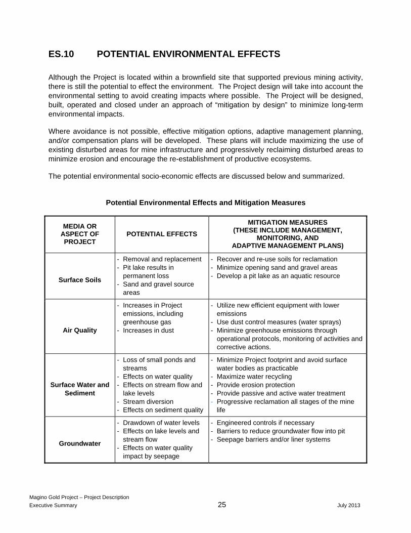
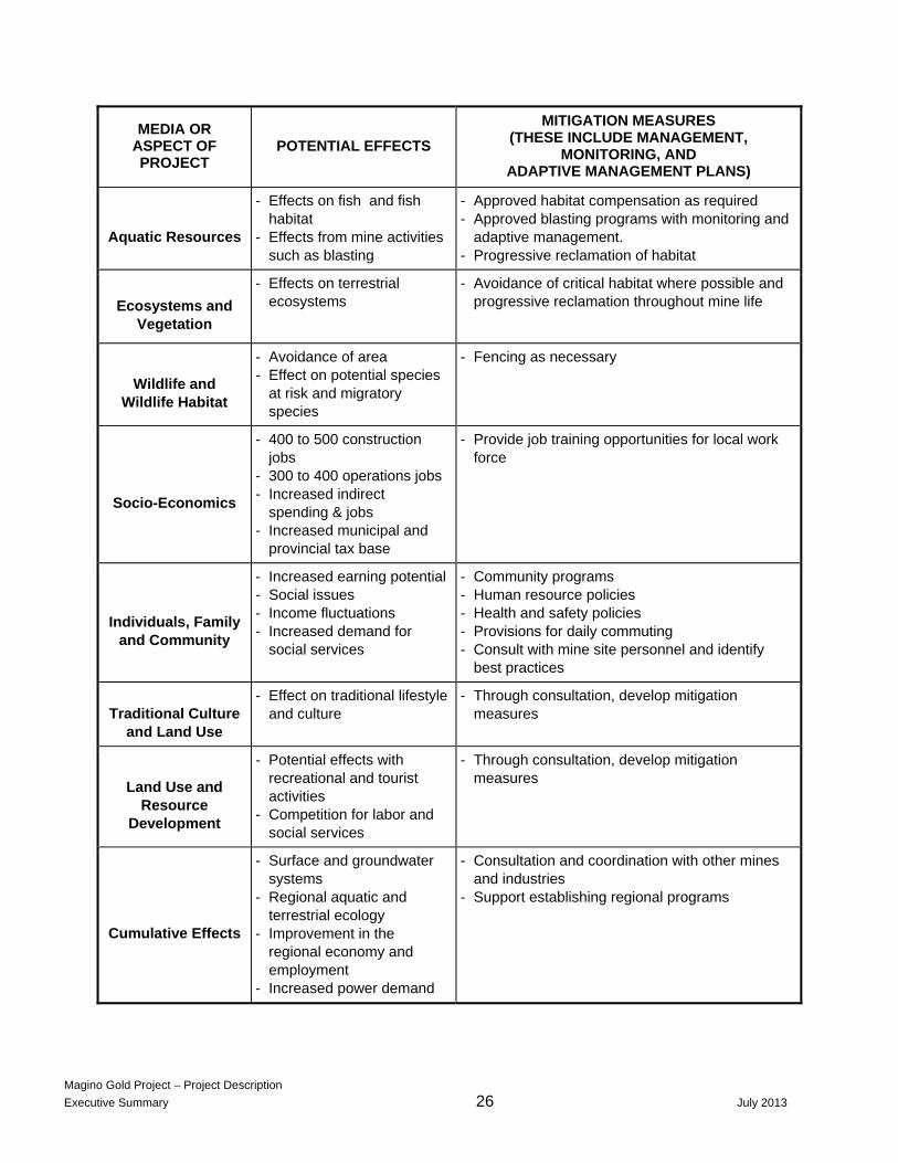
ES.10 POTENTIAL ENVIRONMENTAL EFFECTS
Although the Project is located within a brownfield site that supported previous mining activity, there is still the potential to effect the environment. The Project design will take into account the environmental setting to avoid creating impacts where possible. The Project will be designed, built, operated and closed under an approach of “mitigation by design” to minimize long-term environmental impacts.
Where avoidance is not possible, effective mitigation options, adaptive management planning, and/or compensation plans will be developed. These plans will include maximizing the use of existing disturbed areas for mine infrastructure and progressively reclaiming disturbed areas to minimize erosion and encourage the re-establishment of productive ecosystems.
The potential environmental socio-economic effects are discussed below and summarized.
Potential Environmental Effects and Mitigation Measures
MEDIA OR ASPECT OF PROJECT
POTENTIAL EFFECTS
MITIGATION MEASURES (THESE INCLUDE MANAGEMENT,
MONITORING, AND ADAPTIVE MANAGEMENT PLANS)
Surface Soils
- Removal and replacement - Pit lake results in
permanent loss - Sand and gravel source
areas
- Recover and re-use soils for reclamation - Minimize opening sand and gravel areas - Develop a pit lake as an aquatic resource
Air Quality
- Increases in Project emissions, including greenhouse gas
- Increases in dust
- Utilize new efficient equipment with lower emissions
- Use dust control measures (water sprays) - Minimize greenhouse emissions through
operational protocols, monitoring of activities and corrective actions.
Surface Water and Sediment
- Loss of small ponds and streams
- Effects on water quality - Effects on stream flow and
lake levels - Stream diversion - Effects on sediment quality
- Minimize Project footprint and avoid surface water bodies as practicable
- Maximize water recycling - Provide erosion protection - Provide passive and active water treatment - Progressive reclamation all stages of the mine
life
Groundwater
- Drawdown of water levels - Effects on lake levels and
stream flow - Effects on water quality
impact by seepage
- Engineered controls if necessary - Barriers to reduce groundwater flow into pit - Seepage barriers and/or liner systems
Magino Gold Project – Project Description
Executive Summary 26 July 2013
MEDIA OR ASPECT OF PROJECT
POTENTIAL EFFECTS
MITIGATION MEASURES (THESE INCLUDE MANAGEMENT,
MONITORING, AND ADAPTIVE MANAGEMENT PLANS)
Aquatic Resources
- Effects on fish and fish habitat
- Effects from mine activities such as blasting
- Approved habitat compensation as required - Approved blasting programs with monitoring and
adaptive management. - Progressive reclamation of habitat
Ecosystems and Vegetation
- Effects on terrestrial ecosystems
- Avoidance of critical habitat where possible and progressive reclamation throughout mine life
Wildlife and Wildlife Habitat
- Avoidance of area - Effect on potential species
at risk and migratory species
- Fencing as necessary
Socio-Economics
- 400 to 500 construction jobs
- 300 to 400 operations jobs - Increased indirect
spending & jobs - Increased municipal and
provincial tax base
- Provide job training opportunities for local work force
Individuals, Family and Community
- Increased earning potential - Social issues - Income fluctuations - Increased demand for
social services
- Community programs - Human resource policies - Health and safety policies - Provisions for daily commuting - Consult with mine site personnel and identify
best practices
Traditional Culture and Land Use
- Effect on traditional lifestyle and culture
- Through consultation, develop mitigation measures
Land Use and Resource
Development
- Potential effects with recreational and tourist activities
- Competition for labor and social services
- Through consultation, develop mitigation measures
Cumulative Effects
- Surface and groundwater systems
- Regional aquatic and terrestrial ecology
- Improvement in the regional economy and employment
- Increased power demand
- Consultation and coordination with other mines and industries
- Support establishing regional programs

Magino Gold Project – Project Description
Executive Summary 27 July 2013
Physical and Biological Environment
The natural area that will be disturbed by the footprint of the Project is reduced because of the presence of already impacted areas from the historic mining activities. Site preparation and construction activities will involve grubbing, removal and stockpiling of topsoil.
Development of the Project will involve drainage and fill of several small ponds and streams to facilitate the construction of mine-related facilities. The Project has the potential to affect aquatic resources, specifically fish, fish habitat, and water quantity and quality within the mine footprint area. This will include five or six undammed lakes and parts of a small unnamed lake which will be removed to accommodate the WRMF and TMF. Removal of these lakes, or parts of them, represents removal of fish habitat and displacement of fish from the four lakes that supported fish. No sport fish species were captured from these lakes during sampling events.
Re-routing of natural drainage courses within the McVeigh Creek and Webb-Goudreau watersheds will also be required. A portion of McVeigh Creek may be realigned to accommodate the WRMF and TMF. Care will be taken to design a stable channel to convey water and maintain fish habitat and passage in other water bodies to the extent practicable. Compensation plans will be developed and implemented as required to satisfy the Fisheries Act and Fisheries and Oceans Canada habitat policy.
Blasting vibrations may have the potential to harm or kill fish, fish eggs, or larvae. Fisheries and Oceans Canada blasting guidelines will be applied to protect fish and fish habitat. In addition, sensitive fish species (e.g., Brook Trout) are known to occur downstream in McVeigh Creek and care will be exercised to protect them.
Alteration to the drainage network as a result of mine construction, operation and closure may alter hydrology and negatively affect aquatic species and functions. A hydrology study will quantify and evaluate hydrological effects in detail. This study will form the basis for a water management plan to protect the environment while providing sufficient operational water supply.
All stages of the Project include activities that may potentially affect wildlife and wildlife habitat. However, given the large expanse of similar habitat in surrounding areas, changes introduced by the Project are not considered significant to the viability of wildlife populations.
Migratory birds in the Project area have been studied to see if they would be sensitive to disturbance in their environment. They represent a species that are of management concern, potentially important to First Nations and/or listed under the ESA 2007. The preliminary bird surveys identified 86 species of birds within the Project are and its surroundings. Of these, 71 are listed under the Migratory Birds Convention Act. Based on the outcome of these studies, these birds would be sensitive to disturbance. The results of these field studies will assist in identifying significant wildlife habitats.
Construction of the pit will alter surface water flows by diverting some shallow groundwater away from streams, lakes and wetlands into the pit. The pit will become a sink resulting in groundwater flowing from the surrounding area towards it. This will result in lowering of the water table surrounding the pit. Mining activities are not expected to negatively affect

Magino Gold Project – Project Description
Executive Summary 28 July 2013
groundwater quality as the open pit will not discharge to groundwater. Groundwater pathways to local surface waters will be restored when the pit has filled as a lake after closure.
Makeup water will be withdrawn within the requirements to protect fish habitat, as well as under the regulation of a Permit to Take Water from the Ontario Ministry of the Environment. There will be a water surplus during the latter stages of mine operation, which will be discharged to the receiving environment under the regulation of an Environmental Compliance Approval from the Ontario Ministry of the Environment at a rate that does not significantly alter the natural hydrologic regime. In the event that excess water falls short of meeting discharge requirements, an active water treatment plant may be required.
Water impacted by mining activities typically contains elevated levels of suspended solids and dissolved metals and salts, as well as nitrate and ammonia that are associated with blasting activities. The standards to be applied to site discharge are yet to be determined, but will, at a minimum, need to meet the Metal Mine Effluent Regulations and the requirements of the provincial Environmental Compliance Approval. Ambient water quality standards (federal and provincial), site-specific water quality objectives, or background concentrations will also have to be met in the receiving streams and lakes.
It is expected that air emissions from the Project will include mobile sources, stationary sources, and fugitive emissions. A baseline air and climate study has been initiated and an air quality monitoring program, which will be established prior to any site preparation and construction activities and will continue through the life of the Project.
Air dispersion modelling is being conducted in order to identify appropriate control measures and prevent unacceptable risks.
Fugitive dust management will be a component of the management plans and monitoring for effectiveness of controls (blast management, application of dust suppressants, watering of roads and placement of stockpiles) will be evaluated regularly.
Emission reduction or abatement technology will be employed where possible. It is expected that operations will continually be optimized to minimize fuel consumption. The Project will likely have emissions that require reporting to the Federal National Greenhouse Gas Inventory and it will also adhere to the provincial Greenhouse Gas Emissions Reporting Regulations.
Major sources of noise will include blasting and mobile equipment operations (particularly backing up alarm systems) and to a lesser extent the larger fixed processing equipment such as that used for crushing and milling. Baseline noise levels will be evaluated and noise modeling will be conducted to improve the engineering and design of the site.
A comprehensive environmental monitoring program will be designed to monitor air quality, surface and groundwater quality, and key terrestrial and aquatic habitats during construction, operation and after closure of the mine. The collected data will be compared to established standards or Project-specific target values to determine whether any unexpected environmental impacts could occur. The monitoring plans will also include a description of the adaptive management response actions and contingencies that would be implemented in the event that trends toward exceedances were observed.
Magino Gold Project – Project Description
Executive Summary 29 July 2013
Socio-Economics and Land Use
Potential effects to individuals and communities may be influenced by youth employment opportunities, changes in income levels and spending patterns, work periods spent away from home and the capacity of community based services to accommodate increased demands for services. As the Project proceeds plans will need to be developed address potential negative effects and would include community programs supported by the Project, human resources and safety policies, training, and provision for daily commuting to workers’ homes.
It is noted that the development of the Project will directly affect a relatively small geographical area in relation to the general region. Effects to traditionally significant areas are not likely, given that historic mining has occurred near the Project. Potential Project-related effects on Treaty interests will be assessed through appropriate consultation.
There will be little effect on non-traditional land and resources. Considerations during implementation of the Project include; competition for labour with other resource projects, effect on recreational activities and tourism, and increased use of access roads. Since the Project is not located near any parks or wildlife reserves, no effects to these are anticipated. Mitigation measures that will be considered include co-ordination of transport activities with other users to minimize interference.
There are no known habited dwellings in the Project area and the ownership and use of the two to three, apparently unoccupied, structures in the area is being investigated.
During the construction phase, the workforce needed is estimated to be between 400 and 500. The company intends to fill as many of these positions locally as possible. During the operations phase, it is estimated that approximately 300 to 400 positions will be required. In addition, indirect jobs are also anticipated through increased spending in the region. Tax revenue will be generated at the municipal, provincial and federal levels. The mine will also create indirect opportunities for local and regional businesses to participate in construction, maintenance and logistics. It is anticipated that an increase in direct and indirect employment will benefit the region.

Magino Gold Project – Project Description
Executive Summary 30 July 2013
APPENDIX ES-A: Glossary
Acid Rock Drainage When rock surfaces containing sulphides (sulfur compounds) are
exposed to air and rain/snow, a reaction can occur with the elements in the rock resulting in acidification of the water run-off, which in turn causes metals and various salts to dissolve in the water, potentially causing environmental harm.
Benthic Organisms without backbones that live in or on the bottom sediments of Invertebrates rivers, streams and lakes. Bog Peat-covered areas or peat-filled depressions with a high water table and
a surface carpet of mosses, chiefly sphagnum. The water table is at or near the surface in the spring, and slightly below during the remainder of the year. Bogs are generally highly acidic and low in biodiversity.
Brownfield Abandoned or underused industrial and commercial facilities available for
re-use. Bryophytes A division of nonflowering land plants divided into three classes: mosses,
liverworts, and hornworts. Carbon-in-Pulp An extraction technique for recovery of gold. The gold is dissolved into a
cyanide solution and then extracted by absorption onto carbon particles that are passed through the mixture.
Carbon-in-Leach A method of recovering gold and silver from fine ground ore by
simultaneous dissolution and adsorption of the precious metals onto fine carbon in an agitated tank of ore solids/solution slurry.
Carbon-in-Solution A similar technique as described above, except the gold is first dissolved
by the cyanide solution which is then passed through tanks filled with carbon particles.
Cyanide Code A voluntary initiative for the gold mining industry and the producers and
transporters of cyanide used in gold mining. The code is intended to complement an operation’s existing regulatory requirements.
Diorite A granular igneous (volcanic) rock. Doré A doré bar is a semi-pure alloy of gold and silver, usually created at the
site of a mine. It is then transported to a refinery for further purification. Fen Carbon accumulating wetlands (either peat or marl), or wetlands on
carbonate substrates, with a persistent groundwater supply and characterized by indicator plant and moss species with low tree cover.

Magino Gold Project – Project Description
Executive Summary 31 July 2013
Igneous Rock Igneous (volcanic) rock is formed through the cooling and solidification of magma or lava. Igneous rock may form with or without crystallization, either below the surface as intrusive (plutonic) rocks or on the surface as extrusive (volcanic) rocks.
Leaching The extraction of certain materials from a carrier into a liquid. Lichen A complex plantlike organism made up of an alga and fungus growing in
symbiotic association on a solid surface, like a rock. Littoral The part of a sea, lake or river that is close to the shore and often
includes extensive areas of wetland. Low-grade ore The portion of mined ore with a lower gold content. Metamorphic The original rock is subjected to heat (temperatures greater than 150°C to
200°C) and pressure causing profound physical and/or chemical change. Metavolcanic A type of metamorphic rock produced by a volcano, either as lava or
tephra, and subjected to high pressures and temperatures, causing the rock to recrystallize.
Ore Blasted rock up to one meter in size containing gold. Organic Soils formed from decaying plant matter in environments where Deposits accumulation exceeds decomposition; peat. Peat Organic soil. Process Plant Facilities including buildings, grinding mills, pipes, tanks, chemical feed,
and electrical and control systems used to extract the gold from the ore. Robinson Superior The Robinson Treaty for the Lake Superior region, commonly called Treaty Robinson Superior Treaty, was entered into agreement on September 7,
1850, at Sault Ste. Marie, Ontario between Ojibwe Chiefs inhabiting the Northern Shore of Lake Superior from Pigeon River to Batchawana Bay, and The Crown.
Sediment A naturally occurring material that is broken down by processes of
weathering and erosion and is subsequently transported by the action of wind, water, or ice.
Slurry A thin, sloppy fluid mixture of a pulverized solid with a liquid; often used
as a convenient way of handling solids in bulk. Slurries behave in some ways like thick fluids, flowing under gravity and being capable of being pumped if not too thick.
Substrate A surface on which an organism grows or is attached.

Magino Gold Project – Project Description
Executive Summary 32 July 2013
Tailings The materials left over after the extraction and separation of valuable material from non-valuable material of an ore/rock.
Wetlands A land area that is saturated with water, either permanently or seasonally,
such that it takes on the characteristics of a distinct ecosystem.

Magino Gold Project – Project Description
Executive Summary 33 July 2013
APPENDIX ES-B: Preliminary List of Required Approvals and Permits
FEDERAL
Regulatory Agency Possible Applicability to the Project
Canadian Environmental Assessment Agency
Environmental Assessment of mine site development with federal interest
Department of Fisheries and Oceans Canada
Fish habitat protection at water crossings, dams, dykes, and diversions
MMER Wastewater systems effluent regulations
Minimizes Harmful Alteration, Disruption or Destruction (HADD) for water-related development activities
Environment Canada
Waste management requirements
Spill and leak prevention from petroleum products and allied petroleum products tanks and dispensers
Reporting of on-site substances such as ammonia, cyanide, etc.
Tailings Impoundment area approval for potential fish impacts in natural water bodies
Effluent discharge requirements for ongoing compliance and effects monitoring
Species at risk and habitat protection in the Project area
Preventing harm to migratory birds, nests or eggs, or waters frequented by migratory birds
Assessment to protect historical, archaeological, paleontological, or architectural sites
Natural Resources Canada Licensing for explosives use and storage
Permits for explosives transportation, importation, purchase, and possession
Transport Canada
Emergency response assistance plan
Accidental release and imminent accidental release report requirements
Maximum allowable explosives quantity in a road vehicle
Transpiration permit requirements
Approvals for in-water work or infrastructure crossing navigable waters
Canadian Heritage Exporting permit for mineral specimens
Magino Gold Project – Project Description
Executive Summary 34 July 2013
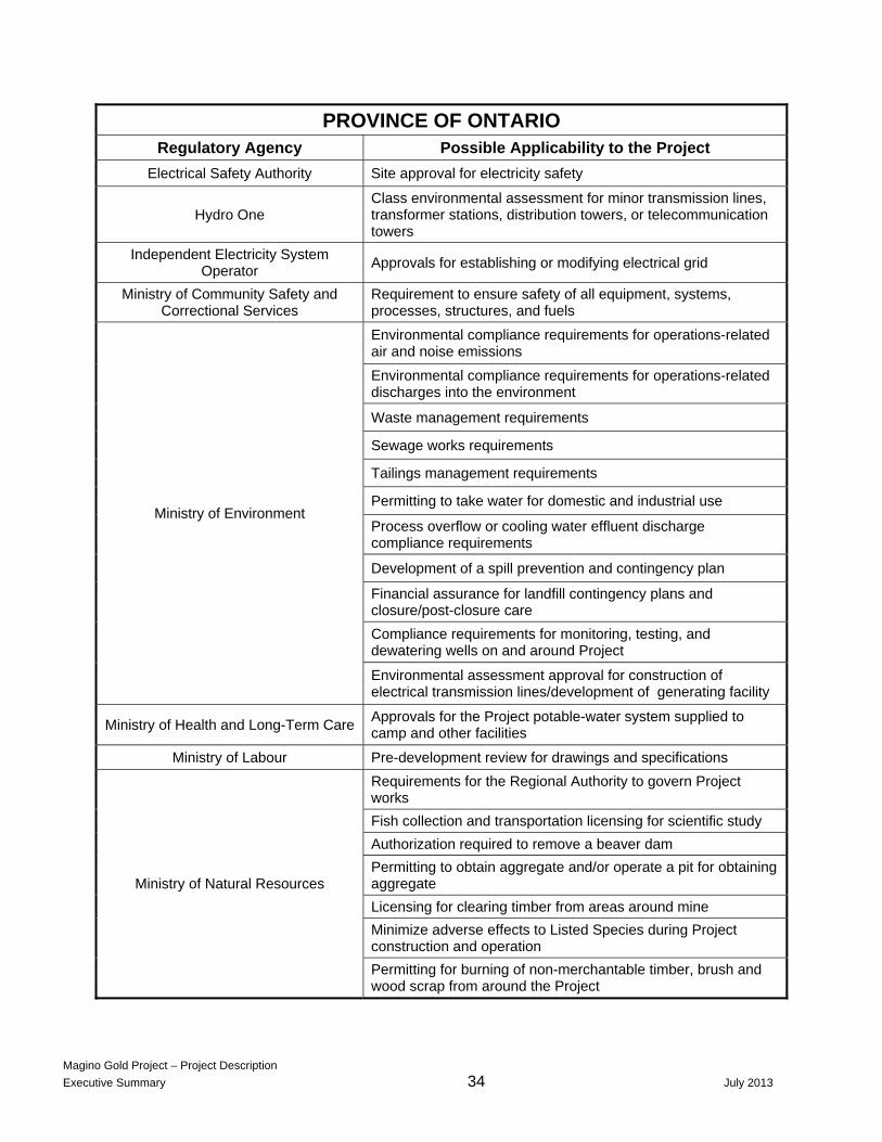
PROVINCE OF ONTARIO Regulatory Agency Possible Applicability to the Project
Electrical Safety Authority Site approval for electricity safety
Hydro One Class environmental assessment for minor transmission lines, transformer stations, distribution towers, or telecommunication towers
Independent Electricity System Operator
Approvals for establishing or modifying electrical grid
Ministry of Community Safety and Correctional Services
Requirement to ensure safety of all equipment, systems, processes, structures, and fuels
Ministry of Environment
Environmental compliance requirements for operations-related air and noise emissions
Environmental compliance requirements for operations-related discharges into the environment
Waste management requirements
Sewage works requirements
Tailings management requirements
Permitting to take water for domestic and industrial use
Process overflow or cooling water effluent discharge compliance requirements
Development of a spill prevention and contingency plan
Financial assurance for landfill contingency plans and closure/post-closure care
Compliance requirements for monitoring, testing, and dewatering wells on and around Project
Environmental assessment approval for construction of electrical transmission lines/development of generating facility
Ministry of Health and Long-Term Care Approvals for the Project potable-water system supplied to camp and other facilities
Ministry of Labour Pre-development review for drawings and specifications
Ministry of Natural Resources
Requirements for the Regional Authority to govern Project works
Fish collection and transportation licensing for scientific study
Authorization required to remove a beaver dam
Permitting to obtain aggregate and/or operate a pit for obtaining aggregate
Licensing for clearing timber from areas around mine
Minimize adverse effects to Listed Species during Project construction and operation
Permitting for burning of non-merchantable timber, brush and wood scrap from around the Project

Magino Gold Project – Project Description
Executive Summary 35 July 2013
Ministry of Natural Resources continued
Approval required for the construction of a dam/culvert installation, tailings dam, or causeway
Approval for construction of dams, dykes or diversions including tailings dams
Permitting prior to constructing a building or water crossing road, dredge or fill shore lands or removal of aquatic vegetation on public land
Land use permitting for right to occupy public lands for an authorized purpose (10 yrs or less)
License of occupation for right to occupy public lands for an authorized purpose (up to 20 years)
Work permit for movement of heavy equipment to and from a work site not served by an existing road
Work permit for Construction of radio communications equipment
Class environmental assessment for disposition of Crown resources, conversion of existing land tenure, forfeiture, or surrender of titles and mine hazard rehabilitation activities at abandoned mine sites
Ministry of Northern Development and Mines
Closure plan approval
Operational policy for consultation
Class environmental assessment for forest management activities
Class environmental assessment for disposition of Crown resources, access roads, shoreline stabilization, or fisheries habitat management
Notice of project status, closure plan and consultation with Aboriginal groups
Public Notice requirements to the Director of Mine Rehabilitation
Ministry of Transportation
Entrance permit requirements for constructing an entrance or access to a provincial highway and encroachment permit requirements for works at a provincial right-of-way.
Major permits to erect and refurbish buildings on site and land use
Class environmental assessment for facility construction adjacent to or on a provincial highway
Ontario Energy Board Transmission line construction requirements
Ontario Ministry of Tourism, Culture and Sport
Archaeological assessment requirements