
Luogo del mito, bosco sacro per i poeti latini, terra di ...groves of the Piana di Mattinata are...
36
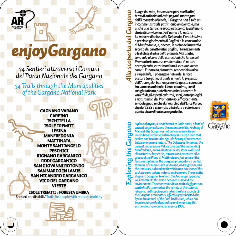
Luogo del mito, bosco sacro per i poeti latini, terra di antichissimi culti pagani, montagna dell’Arcangelo Michele, il Gargano non è solo un incommensurabile patrimonio ambientale, ma anche una terra che evoca e racconta la millenaria storia di convivenza tra l’uomo e la natura. La miniera di selce della Defensola, l’antichissimo e prezioso giacimento di Paglicci o le zone umide di Manfredonia, e, ancora, le pietre dei muretti a secco o dei caratteristici pagliai, i terrazzamenti o le distese di ulivi della piana di Mattinata, sono solo alcune delle espressioni che fanno del Promontorio un caso emblematico di natura antropizzata, e testimoniano il secolare lavoro con cui l’uomo ha plasmato, rendendolo unico e irripetibile, il paesaggio naturale. Il ricco pastore Gargano, al quale si rivela la presenza dell’Arcangelo, ben rappresenta questo connubio tra uomo e ambiente. L’eroe eponimo, con il suo gigantismo, sintetizza simbolicamente la varietà degli aspetti culturali, sacri, antropologici e naturalistici del Promontorio, efficacemente simboleggiati anche dal marchio dell’Ente Parco, che dal 1995 è chiamato a tutelare e valorizzare questa straordinaria area protetta. A place of myths, a wood sacred to Latin poets, a land of ancient pagan cults and the mountain of the Archangel Michael: the Gargano is not only an area with an incredible environmental heritage but also a land that evokes and narrates the age-old history of coexistence between man and nature. The Defensola flint mine, the ancient and precious Palace cave and the wetlands of Manfredonia, not to mention the dry stone walls and characteristic haystacks, terraces and extensive olive groves of the Piana di Mattinata are just some of the features that make the Gargano promontory a perfect example of a man-made landscape, bearing witness to the centuries-old work with which man has shaped this exclusive and unique natural environment. The wealthy shepherd Gargano, to whom the Archangel appeared, well represents this union between man and the environment. The eponymous hero, with his gigantism, symbolically summarises the variety of the cultural, religious, anthropological and naturalistic aspects of the Gargano promontory, effectively symbolised also by the trademark of the Park Institution, which has been in charge of safeguarding and enhancing this extraordinary protected area since 1995. enjoyGargano Alla scoperta del Gargano Exploring the Gargano 34 Sentieri attraverso i Comuni del Parco Nazionale del Gargano 34 Trails through the Municipalities of the Gargano National Park CAGNANO VARANO CARPINO ISCHITELLA ISOLE TREMITI LESINA MANFREDONIA MATTINATA MONTE SANT’ANGELO PESCHICI RIGNANO GARGANICO RODI GARGANICO SAN GIOVANNI ROTONDO SAN MARCO IN LAMIS SAN NICANDRO GARGANICO VICO DEL GARGANO VIESTE ISOLE TREMITI e FORESTA UMBRA Sentieri per disabili / Trails for people with reduced mobility
Transcript of Luogo del mito, bosco sacro per i poeti latini, terra di ...groves of the Piana di Mattinata are...
Luogo del mito, bosco sacro per i poeti latini, terra di antichissimi culti pagani, montagna dell’Arcangelo Michele, il Gargano non è solo un incommensurabile patrimonio ambientale, ma anche una terra che evoca e racconta la millenaria storia di convivenza tra l’uomo e la natura.La miniera di selce della Defensola, l’antichissimo e prezioso giacimento di Paglicci o le zone umide di Manfredonia, e, ancora, le pietre dei muretti a secco o dei caratteristici pagliai, i terrazzamenti o le distese di ulivi della piana di Mattinata, sono solo alcune delle espressioni che fanno del Promontorio un caso emblematico di natura antropizzata, e testimoniano il secolare lavoro con cui l’uomo ha plasmato, rendendolo unico e irripetibile, il paesaggio naturale. Il ricco pastore Gargano, al quale si rivela la presenza dell’Arcangelo, ben rappresenta questo connubio tra uomo e ambiente. L’eroe eponimo, con il suo gigantismo, sintetizza simbolicamente la varietà degli aspetti culturali, sacri, antropologici e naturalistici del Promontorio, efficacemente simboleggiati anche dal marchio dell’Ente Parco, che dal 1995 è chiamato a tutelare e valorizzare questa straordinaria area protetta.
A place of myths, a wood sacred to Latin poets, a land of ancient pagan cults and the mountain of the Archangel Michael: the Gargano is not only an area with an incredible environmental heritage but also a land that evokes and narrates the age-old history of coexistence between man and nature. The Defensola flint mine, the ancient and precious Palace cave and the wetlands of Manfredonia, not to mention the dry stone walls and characteristic haystacks, terraces and extensive olive groves of the Piana di Mattinata are just some of the features that make the Gargano promontory a perfect example of a man-made landscape, bearing witness to the centuries-old work with which man has shaped this exclusive and unique natural environment. The wealthy shepherd Gargano, to whom the Archangel appeared, well represents this union between man and the environment. The eponymous hero, with his gigantism, symbolically summarises the variety of the cultural, religious, anthropological and naturalistic aspects of the Gargano promontory, effectively symbolised also by the trademark of the Park Institution, which has been in charge of safeguarding and enhancing this extraordinary protected area since 1995.
enjoyGargano
Alla
scop
erta
del G
arga
no E
xplo
ring t
he G
arga
no
34 Sentieri attraverso i Comuni del Parco Nazionale del Gargano34 Trails through the Municipalities
of the Gargano National Park
CAGNANO VARANOCARPINO
ISCHITELLAISOLE TREMITI
LESINAMANFREDONIA
MATTINATAMONTE SANT’ANGELO
PESCHICIRIGNANO GARGANICO
RODI GARGANICOSAN GIOVANNI ROTONDO
SAN MARCO IN LAMISSAN NICANDRO GARGANICO
VICO DEL GARGANOVIESTE
ISOLE TREMITI e FORESTA UMBRASentieri per disabili / Trails for people with reduced mobility

LEGENDA KEY
RECOMMENDATIONSRACCOMANDAZIONIAprire e richiudere eventuali cancelli costruiti per la regolamentazione del pascolo allo stato brado.Evitare di sporgersi sulle scogliere strapiombanti.Sentiero 29:L’accesso alla riserva integrale, pur consentito per motivi di studio e per escursioni naturalistiche, può avere luogo solo previo permesso scritto da rilasciarsi da parte dell’ufficio forestale di Umbra.Sentieri 33 e 34:Percorsi di andata e ritorno per disabili motori e ipovedenti, di interesse naturalistico e paesaggistico, con un dislivello da 807 a 780 m
Please open and close any gates built to control grazing in the wild.Avoid leaning over overhanging cliffs.Trail 29:Access to the integral reserve, although permitted for study purposes and nature excursions, is only permitted with the prior written consent of the Foresta Umbra forestry office.Trails 33 and 34:Return routes of naturalistic and scenic interest, with a difference in altitude from 807 to 780 m, for people with reduced mobility or visual impairment.
ORIGINI GEOLOGICHE E ORME DI DINOSAURI
GEOLOGICAL ORIGINS AND DINOSAUR FOOTPRINTS
CULTO MICAELICO E vIA SACRA
SHRINE OF ST. MICHAEL AND SACRED ROUTE
AREA ARCHEOLOGICA ARCHAEOLOGICAL SITE
EqUITURISMO EqUESTRIAN TOURISM
PERCORSO PEDONALE FOOTPATHCICLOvIA CYCLE PATHPER DISAbILI WHEELCHAIR ACCESS
CENTRO STORICO HISTORIC CENTRECENTRO MINORE OINSEDIAMENTO RURALE
MINOR CENTRE OR RURAL SETTLEMENT
PAESAGGIO DI PARTICOLARE RILEvANzA
LANDSCAPE OF SPECIAL INTEREST
PAESAGGIO CARSICO E HAbITAT COSTIERO
KARST LANDSCAPE AND COASTAL HAbITAT
PAESAGGIO CARSICO KARST LANDSCAPETORRI COSTIERE E FORTIFICAzIONI
COASTAL TOWERS AND FORTS
AvIFAUNA E zONE UMIDE
bIRDLIFE AND WETLANDS
PERCORSO NATURALISTICO
NATURE TRAILOASI AGRUMARIA E PRODUzIONI TIPICHE
CITRUS GROvE AND LOCAL PRODUCE
Questo KIT è dotato di contenuti di realtà aumentata che potranno essere visti attraverso l’App “EnjoyGargano”, scaricabile gratuitamente da Google Play ® o App Store ®.Scegli la sezione di realtà aumentata AR e poi seleziona KIT dal menu. La app attiva automaticamente la fotocamera del tuo smartphone o tablet. Ora punta sulle singole schede, attendi alcuni istanti e potrai visualizzare ulteriori informazioni.
This KIT contains some multimedia contents in augmented reality mode. You can show them through your smartphone o tablet.Download the free app “EnjoyGargano” from Google Play ® o App Store®. Look for Augmented Reality through the AR menu and tap on KIT option. The camera will be automatically activated. At this point, You can focus on any page of the Kit to show additional information.

Scenic nature trail (with return route)
difficoltà difficulty
tempo percorrenza duration
lunghezza2,2 km circa, solo andata
distanceabout 2.2 km,
one way
Evidenze ambientali e culturali
Environmental and cultural attractions
2 ore circa, andata e ritorno a piedi
about 2 hours,return route on foot
Sentiero di andata e ritorno, naturalistico e paesaggistico
Si parte in corrispondenza di una diramazione al km 0,750 della ex strada consortile “Cagnano Varano-Gioffo”. Il primo tratto del percorso segue una pista sterrata, anche carrabile, che attraversa uliveti secolari. Proseguendo sulla pista sterrata e tralasciando la diramazione per Monte Tudisco, si giunge, dopo 250 m dalla partenza, all’interno di una cava dismessa. Da questo punto il percorso se-gue in salita un’antica mulattiera con caratteristico fondo in “acciottolato”. In questo primo tratto si in-contrano lungo il percorso le “stazioni” di una “Via crucis”. Dopo 2,2 Km si giunge, percorrendo anche un breve tratto della strada asfaltata, al punto panoramico della “Madonnina”, così denomina-to dalla popolazione locale per la presenza di una statua della Madonna. L’area, raggiungibile anche per mezzo di una strada asfaltata, è stata attrezza-ta per la sosta anche di persone diversabili. Lungo il percorso boschetti di roverelle, lecci, cerri, aceri, carpini, ornielli e Terebinto. Muovendosi in silenzio ci si può imbattere nella ghiandaia e nel colombac-cio, oppure sentire il canto del picchio verde. Più comune osservare, nelle ore più calde del giorno, il volteggiare di coppie di Poiana. Lungo il percorso, tracce della presenza di cinghiale, volpe, faina e, più raro, del Capriolo. Punti di interesse nelle vicinanze sono la panoramica cima di Monte Tudisco.
Cagnano Varano -Madonnina
Cagnano Varano -Madonnina
The trail starts at a fork in the road, at km 0.750 of the “Cagnano Varano-Gioffo” private consor-tium road. The first stretch of the trail goes along a dirt road, also accessible to vehicles, which passes through centuries-old olive groves. Con-tinuing along the dirt road and ignoring the fork to Monte Tudisco, you arrive, after 250m from the start, inside an abandoned quarry. From here, the trail continues uphill along an ancient mule track with a characteristic “cobblestone” surface. This first stretch of the trail features the “stations” of a “Via Crucis” (Way of the Cross). After 2.2km, tak-ing a short stretch of asphalt road, you get to the scenic viewpoint of the “Madonnina”, so called by the local inhabitants due to the presence of a statue of the Virgin Mary. The area, which can also be reached via an asphalt road, is equipped also for people with reduced mobility. Along the trail there are woods with downy oaks, holm oaks, Turkey oaks, maples, hornbeams, the South Euro-pean flowering ash and the terebinth. By moving around silently, you will be able to see a jay or a wood pigeon, or hear a green woodpecker sing. In the hottest hours of the day, pairs of common buz-zards can often be seen hovering in the air. Along the way, it is easy to spot traces of the presence of wild boars, foxes, stone martens and, more rarely, roe deer. One of the places of interest in the area is the scenic mountaintop of Monte Tudisco.
CAGNANO VARANO CAGNANO VARANO
1 1

difficoltà difficulty
tempo percorrenza duration
Evidenze ambientali e culturali
Environmental and cultural attractions
about 2 hours, return route on foot
2 ore circa, andata e ritorno a piedi
distanceabout 3.2 km,
one way
Scenic nature trail (with return route)
with a difference in altitude from
110 to 409 m
lunghezza3,2 km circa, solo andata
Sentiero di andata e ritorno, naturalistico e paesaggistico con un dislivello da 110 a 409 m
22
Si parte dalla periferia di Cagnano V., lasciando la Strada Provinciale n. 43 “Cagnano Varano-San Giovanni Rotondo”. Il primo tratto del percorso se-gue una stradina, che attraversa campi coltivati ed uliveti delimitati dai tipici muretti in pietra a secco. Dopo 1,3 Km, si giunge, alla base di un versante. Da questo punto il percorso segue in salita un’antica mulattiera con caratteristico fondo in “acciottola-to” o scavato nella roccia tufacea.. Dopo ulteriori 2 Km si giunge, attraversando la strada asfaltata prima indicata, al punto di arrivo rappresentato da una postazione panoramica della località “Costa di Manfredonia”, in prossimità di un’antica cister-na per la raccolta dell’acqua piovana. L’area, rag-giungibile anche per mezzo della strada asfaltata, è stata attrezzata per la sosta. Da questo punto parte un’altro itinerario per la Valle Sbaccio. Lun-go il percorso boschetti di roverelle, aceri, carpini, ornielli e Terebinto. Muovendosi in silenzio ci si può imbattere nella ghiandaia e nel colombaccio, oppure sentire il canto del picchio verde. Più comu-ne osservare, nelle ore più calde del giorno, il vol-teggiare di coppie di Poiana o del Corvo imperiale. Punti di interesse nelle vicinanze sono l’area arche-ologica della località Giardenera, con antichi ipogei paleocristiani visitabili solo con guide esperte del posto, ed il tipico e ben conservato centro storico di Cagnano Varano.
Cagnano Varano - Costa di Manfredonia
Cagnano Varano - Costa di Manfredonia
The trail starts from the outskirts of Cagnano Var-ano, leaving the SP 43 provincial road, also known as the “Cagnano Varano-San Giovanni Rotondo” road. The first stretch of the trail goes along a nar-row road, which passes through cultivated fields and olive groves bordered by characteristic dry stone walls. After 1.3km, you get to the foot of a mountain slope. From here, the trail continues uphill along an ancient mule track with a charac-teristic “cobblestone” surface or dug into the tuf-faceous rock. After another 2km, by crossing the asphalt road mentioned above, you get to the ar-rival point, namely, the scenic viewpoint of “Costa di Manfredonia”, near an ancient tank where rain-water is collected. This area, which can also be reached via the asphalt road, is equipped as a rest area. From here, another itinerary begins, which leads to the Valle Sbaccio. Along the trail, there are small woods of downy oaks, maples, hornbeams, the South European flowering ash and terebinth. By moving around silently, you will be able to see a jay or a wood pigeon, or hear a green woodpecker sing. In the hottest hours of the day, pairs of com-mon buzzards or common ravens can often be seen hovering in the air. Places of interest nearby include the archaeological site of Giardenera, with its an-cient early Christian underground sites, which can be visited only with local expert guides, and the characteristic, well-preserved historic centre of Cagnano Varano.
CAGNANO VARANO CAGNANO VARANO

difficoltà difficulty
tempo percorrenza duration
Evidenze ambientali e culturali
Environmental and cultural attractions
about 1 hour, return route on foot
distanceabout 1.4 km,
one way
Scenic nature trail (with return route)
with a difference in altitude from
133 to 243 m
1 ora circa, andata e ritorno a piedi
lunghezza1,4 km circa, solo andata
Sentiero di andata e ritorno, naturalistico e paesaggistico con un dislivello da 133 a 243 m
33Carpino - Poggio Pastromele
Carpino - Poggio Pastromele
CARpINO CARpINO
Si parte da Piazza del Popolo da dove, aggirando la chiesa di San Cirillo, si imbocca Via Santa Croce che si segue, sempre in salita, per 500 metri circa fino alla periferia del paese ed alle pendici di Poggio Pa-stromele. Da questo punto il sentiero si inerpica, fra prati e un giovane rimboschimento, verso l’affasci-nante pianoro sommitale di Poggio Pastromele. Da questo punto lo sguardo spazia a 360° fra il Lago di Varano ed il retrostante mare nel quale si intrave-dono le Isole Tremiti, fra il sottostante paese ed i vasti uliveti che lo circondano, fra i monti delle aree interne e le valli che li solcano. Di particolare effetto i tramonti, quando il sole arrossa le acque del lago di Varano. Il percorso attraversa praterie steppiche ed un giovane rimboschimento dove si possono osservare numerose orchidee ed altre rarità bota-niche nonchè interessanti macchie dello spinoso Paliuro o Marruca. Per quanto riguarda la fauna, fra gli arbusti si nascondono Occhiocotto, merli e frin-guelli, nei prati allodole ed altri passeriformi. Facile scorgere, nelle ore più calde del giorno, il volteggia-re delle poiane.Punto di interesse la chiesetta rurale di Santa Cro-ce, risalente al 1700 circa.
The trail starts from Piazza del Popolo, passes by the church of San Cirillo and takes you into Via San-ta Croce, which goes uphill for about 500m until it reaches the outskirts of the village and the hillside of Poggio Pastromele. From here, the trail climbs up among meadows and a recently reforested area, to the charming plain at the top of Poggio Pastromele. From here, you can enjoy a 360-degree view of Lake Varano, the sea behind it with the Tremiti islands, the village below and the extensive olive groves surrounding it, as well as the mountains in the in-land areas and the valleys that run through them. This place is known for its spectacular sunsets, when the sun reddens the waters of Lake Varano. The trail goes through steppe grasslands and a recently reforested area, where many orchids and other rare botanical species can be observed, as well as interesting clumps of spiny Jerusalem thorn or Christ’s thorn. As for the wildlife, the Sardinian warbler, blackbirds and chaffinches hide among shrubs, whereas skylarks and other passerines can be seen in meadows. In the hottest hours of the day, common buzzards can often be seen hovering in the air. A place of interest is the rural church of Santa Croce, dating back to about 1700.

difficoltà difficulty
tempo percorrenza duration
Evidenze ambientali e culturali
Environmental and cultural attractions
about 4 hours,return route on foot
distanceabout 5.2 km,
one way
Sentiero di andata e ritorno, naturalistico e paesaggisticocon un dislivello da 138 a 714 m
Scenic nature trail (with return route)
with a difference in altitude from
138 to 714 m
4 ore circa, andata e ritorno a piedi
lunghezza5,2 km circa, solo andata
44Carpino - Coppa tre confini
Carpino - Coppa tre confini
CARpINO CARpINO
Si parte da Piazza del Popolo da dove si imbocca la SP 50 per Monte Sant’Angelo. Dopo circa 1 km, in corrispondenza del segnale stradale con la scritta “Carpino”, si svolta a sinistra seguendo, fra uliveti, una stradina che si inerpica, costeggiando mas-serie e “piscine” e con numerosi punti panorami-ci, verso la cima di Monte d’Iorio (568 m s.l.m.), raggiunto il quale il percorso s’inoltra man mano sempre più nel bosco, seguendo linee di cresta fino a giungere a Coppa dei tre Confini (714 m s.l.m.) così denominata poichè qui si incontrano i vertici dei confini comunali di Carpino, Ischitella e Vico del Gargano. Il percorso, oltre agli uliveti del primo tratto, attraversa praterie, boschetti di Roverella e carpini, cerrete con Farnetto fino a giungere alle fa-mose faggete garganiche della riserva biogenetica statale “Bosco di Ischitella e Carpino”. In primave-ra le rare orchidee garganiche colorano i prati ed il margine del bosco. Di particolare interesse la fauna osservabile fra cui la Ghiandaia, il Colombaccio, il Rigogolo oppure si può ascoltare il verso del Picchio verde o il tamburellare di altri picchi sui tronchi. Più comune scorgere, nelle ore più calde del giorno, il volteggiare di coppie di Poiana o vedere lo sfreccia-re dello Sparviero o dell’Astore. Lungo il percorso, tracce della presenza di cinghiale, volpe, faina e, più rari, del Capriolo e del Lupo.
The trail starts from Piazza del Popolo, where you take the SP 50 provincial road to Monte Sant’Angelo. After about 1km, at the road sign for “Carpino”, turn left following a narrow road uphill that runs through olive groves, passing by farm-houses and “pools” with many scenic viewpoints, towards the mountain peak of Monte d’Iorio (568 metres above sea level). From here, the trail gradu-ally leads further into the wood, following ridge lines until you get to Coppa dei Tre Confini (714 metres above sea level), so called because this is where the highest parts of the municipalities of Carpino, Ischitella and Vico del Gargano converge. The trail crosses olive groves along the first section and then grassland, small woods of downy oaks and hornbeams, Turkey oak woods with Italian oaks, eventually taking you to the beech woods of the “Bosco di Ischitella e Carpino”, a renowned na-tional biogenetic reserve in the Gargano region. In spring, the rare orchids of the Gargano colourfully dot the meadows and the edge of the woods. The local wildlife is of special interest and includes jays, wood pigeons and the golden oriole. The green woodpecker can be heard singing, and other wood-peckers hammering on tree trunks. In the hottest hours of the day, pairs of common buzzards can of-ten be seen hovering in the air, and sparrow hawks or northern goshawks can be observed sweeping by. Along the way, it is easy to spot traces of the presence of wild boars, foxes, stone martens and, more rarely, roe deer and wolves.
difficoltà difficulty
tempo percorrenza duration
Evidenze ambientali e culturali
Environmental and cultural attractions
Scenic nature trail (with return route)
with a difference in altitude from
95 to 422 m
about 5 hours, return route on foot
distanceabout 8.7 km,
one way
5 ore circa, andata e ritorno a piedi
lunghezza8,7 km circa, solo andata
Sentiero di andata e ritorno, naturalistico e paesaggistico,con un dislivello da 95 a 422 m
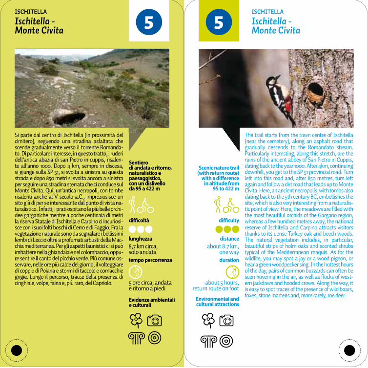
55Ischitella - Monte Civita
Ischitella - Monte Civita
ISChITELLA ISChITELLA
Si parte dal centro di Ischitella (in prossimità del cimitero), seguendo una stradina asfaltata che scende gradualmente verso il torrente Romanda-to. Di particolare interesse, in questo tratto, i ruderi dell’antica abazia di san Pietro in cuppis, risalen-te all’anno 1000. Dopo 4 km, sempre in discesa, si giunge sulla SP 51, si svolta a sinistra su questa strada e dopo 850 metri si svolta ancora a sinistra per seguire una stradina sterrata che ci conduce sul Monte Civita. Qui, un’antica necropoli, con tombe risalenti anche al V secolo a.C., impreziosisce un sito già di per se interessante dal punto di vista na-turalistico. Infatti, i prati ospitano le più belle orchi-dee garganiche mentre a poche centinaia di metri la riserva Statale di Ischitella e Carpino ci incuriosi-sce con i suoi folti boschi di Cerro e di Faggio. Fra la vegetazione naturale sono da segnalare i bellissimi lembi di Leccio oltre a profumati arbusti della Mac-chia mediterranea. Per gli aspetti faunistici ci si può imbattere nella ghiandaia e nel colombaccio, oppu-re sentire il canto del picchio verde. Più comune os-servare, nelle ore più calde del giorno, il volteggiare di coppie di Poiana e stormi di taccole e cornacchie grigie. Lungo il percorso, tracce della presenza di cinghiale, volpe, faina e, più raro, del Capriolo.
The trail starts from the town centre of Ischitella (near the cemetery), along an asphalt road that gradually descends to the Romandato stream. Particularly interesting, along this stretch, are the ruins of the ancient abbey of San Pietro in Cuppis, dating back to the year 1000. After 4km, continuing downhill, you get to the SP 51 provincial road. Turn left into this road and, after 850 metres, turn left again and follow a dirt road that leads up to Monte Civita. Here, an ancient necropolis, with tombs also dating back to the 5th century BC, embellishes the site, which is also very interesting from a naturalis-tic point of view. Here, the meadows are filled with the most beautiful orchids of the Gargano region, whereas a few hundred metres away, the national reserve of Ischitella and Carpino attracts visitors thanks to its dense Turkey oak and beech woods. The natural vegetation includes, in particular, beautiful strips of holm oaks and scented shrubs typical of the Mediterranean maquis. As for the wildlife, you may spot a jay or a wood pigeon, or hear a green woodpecker sing. In the hottest hours of the day, pairs of common buzzards can often be seen hovering in the air, as well as flocks of west-ern jackdaws and hooded crows. Along the way, it is easy to spot traces of the presence of wild boars, foxes, stone martens and, more rarely, roe deer.
difficoltà difficulty
tempo percorrenza duration
Evidenze ambientali e culturali
Environmental and cultural attractions
about 3 hours,return route on foot
distanceabout 4 km,
one way
Scenic nature trail (with return route)
with a difference in altitude from
7 to 1 m
3 ore circa, andata e ritorno a piedi
lunghezza4 km circa, solo andata
Sentiero di andata e ritorno, naturalistico e paesaggisticocon un dislivello da 7 a 1 m
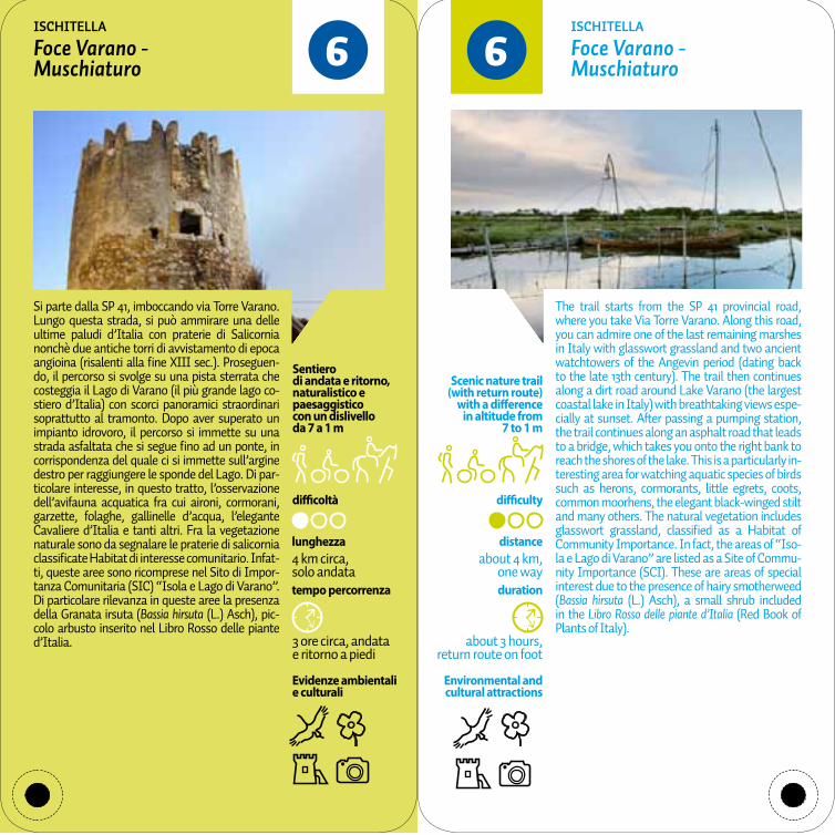
66Foce Varano - Muschiaturo
Foce Varano - Muschiaturo
ISChITELLA ISChITELLA
Si parte dalla SP 41, imboccando via Torre Varano. Lungo questa strada, si può ammirare una delle ultime paludi d’Italia con praterie di Salicornia nonchè due antiche torri di avvistamento di epoca angioina (risalenti alla fine XIII sec.). Proseguen-do, il percorso si svolge su una pista sterrata che costeggia il Lago di Varano (il più grande lago co-stiero d’Italia) con scorci panoramici straordinari soprattutto al tramonto. Dopo aver superato un impianto idrovoro, il percorso si immette su una strada asfaltata che si segue fino ad un ponte, in corrispondenza del quale ci si immette sull’argine destro per raggiungere le sponde del Lago. Di par-ticolare interesse, in questo tratto, l’osservazione dell’avifauna acquatica fra cui aironi, cormorani, garzette, folaghe, gallinelle d’acqua, l’elegante Cavaliere d’Italia e tanti altri. Fra la vegetazione naturale sono da segnalare le praterie di salicornia classificate Habitat di interesse comunitario. Infat-ti, queste aree sono ricomprese nel Sito di Impor-tanza Comunitaria (SIC) “Isola e Lago di Varano”. Di particolare rilevanza in queste aree la presenza della Granata irsuta (Bassia hirsuta (L.) Asch), pic-colo arbusto inserito nel Libro Rosso delle piante d’Italia.
The trail starts from the SP 41 provincial road, where you take Via Torre Varano. Along this road, you can admire one of the last remaining marshes in Italy with glasswort grassland and two ancient watchtowers of the Angevin period (dating back to the late 13th century). The trail then continues along a dirt road around Lake Varano (the largest coastal lake in Italy) with breathtaking views espe-cially at sunset. After passing a pumping station, the trail continues along an asphalt road that leads to a bridge, which takes you onto the right bank to reach the shores of the lake. This is a particularly in-teresting area for watching aquatic species of birds such as herons, cormorants, little egrets, coots, common moorhens, the elegant black-winged stilt and many others. The natural vegetation includes glasswort grassland, classified as a Habitat of Community Importance. In fact, the areas of “Iso-la e Lago di Varano” are listed as a Site of Commu-nity Importance (SCI). These are areas of special interest due to the presence of hairy smotherweed (Bassia hirsuta (L.) Asch), a small shrub included in the Libro Rosso delle piante d’Italia (Red Book of Plants of Italy).

difficoltà difficulty
tempo percorrenza duration
Evidenze ambientali e culturali
Environmental and cultural attractions
Scenic circular nature trail
with a difference in altitude from
23 to 93 m
distanceabout 2.75 km
about 1.5 hours, on foot
1,5 ore circa, a piedi
lunghezza2,75 km circa
Sentiero ad anello, naturalistico e paesaggisticocon un dislivello da 23 a 93 m
77Perimetrale San Domino
Perimeter route of the island of San Domino
ISOLE TREMITI ISOLE TREMITI
Si parte dalla periferia dell’abitato di San Domino inoltrandosi subito nella pineta del versante sud. Subito si incontrano le prime deviazioni che scen-dono nelle calette dove è possibile fare il bagno o riposarsi al sole. Dopo un km un breve sentiero ci consente di godere dall’alto la Grotta delle Viole. Continuando ancora si arriva al bivio per il Colle dell’Eremita. Da questo punto si prosegue in disce-sa o pianura transitando nei pressi di un percorso ginnico per poi giungere al punto di partenza. Il percorso attraversa una delle più belle pinete di Pino d’Aleppo d’Italia, caratterizzata da un denso sottobosco costituito dai tipici elementi sempre-verdi della Macchia mediterranea. Nel versante nord anche rari nuclei di Leccio. Da visitare la mac-chia ad Euforbia arborea nei pressi del faro. Ai mar-gini del bosco spesso si può osservare l’endemico Fiordaliso delle Tremiti oltre a orchidee ed altre ra-rità botaniche. Di particolare interesse la fauna os-servabile, portandosi sui margini delle scogliere, fra cui la Berta maggiore, la Berta minore, il Gabbiano reale e il Rondone. Più raro scorgere, nelle ore più calde del giorno, il volteggiare del Falco della regina o del Falco pellegrino.
The trail starts from the outskirts of the village of San Domino and immediately enters the pine for-est on the southern side. You soon get to the first forks that lead down to coves, where you can swim or relax and sunbathe. After one kilometre, a short path offers a view overlooking the Grotta delle Viole. Continuing, you arrive at a fork to Colle dell’Eremita. From here, continue downhill or on the plain, passing close to a fitness trail, until you get back to the starting point. The trail crosses one of Italy’s most beautiful Aleppo pine forests, char-acterised by dense undergrowth featuring the typi-cal evergreen plants of the Mediterranean maquis. On the northern slope, rare groups of holm oaks can be seen. The tree spurge scrub near the light-house is worth a visit. On the edge of the wood, it is easy to spot the native cornflower of the Tremiti islands, as well as orchids and other rare botanical species. The local wildlife is particularly interest-ing, which can be observed on the cliff edges, and includes the Scopoli’s shearwater, the Yelkouan shearwater, the yellow-legged gull and the com-mon swift. In the hottest hours of the day, instead, it is more rare to see the Eleonora’s falcon or the peregrine falcon hovering in the air.

difficoltà difficulty
tempo percorrenza duration
Evidenze ambientali e culturali
Environmental and cultural attractions
about 1.5 hours, return route on foot
distanceabout 2 km,
one way
Scenic nature and historical trail
(with return route) with a difference
in altitude from 5 to 69 m
1,5 ore circa, andata e ritorno a piedi
lunghezza2 km circa, solo andata
Sentiero di andata e ritorno, storico, naturalistico e paesaggistico,con un dislivello da 5 a 69 m
88Porto San Nicola - Cimitero
Porto San Nicola - Cemetery
ISOLE TREMITI ISOLE TREMITI
Si parte dal porto dell’Isola di San Nicola salendo subito lungo l’unica via di accesso all’abitato forti-ficato. Dopo aver attraversato le varie porte delle mura fortificate si sbuca su un pianoro da dove si possono godere numerosi scorci panoramici. Pro-seguendo, si entra nel castello dove si trova la chie-sa di Santa Maria a mare (1045 d.C.) con l’annessa abbazia. Proseguendo ancora, dopo aver costeg-giato due bellissimi porticati, si passa attraverso il valico della “Tagliata” e si giunge su un altro piano-ro, quasi del tutto disabitato, dove si può visitare un’antica necropoli e la presunta tomba dell’eroe greco Diomede. Continuando seguendo il sentie-ro verso est si giunge prima al cimitero libico, dove sono sepolti i deportati libici negli anni 1911-1912, per poi scendere verso il cimitero delle Isole Tremiti. Il percorso, dopo la parte abitata, attraversa una bellissima Macchia mediterranea, caratterizzata da grandi cespugli dei tipici elementi semprever-di quali Lentisco, Mirto, Rosmarino, Fillirea, cisti nonchè l’Euphorbia arborea che perde le foglie in estate. Lungo il percorso spesso si può osservare l’endemico Fiordaliso delle Tremiti oltre a orchidee ed altre rarità botaniche. Di particolare interesse la fauna osservabile, portandosi sui margini delle sco-gliere, fra cui la Berta maggiore, la Berta minore, il Gabbiano reale e il Rondone. Più raro scorgere, nel-le ore più calde del giorno, il volteggiare del Falco della regina o del Falco pellegrino.
The trail starts from the harbour of the island of San Nicola and immediately goes up along the only road that leads to the fortified village. After going through the various gates of the fortified walls, you will get to a plain where you can enjoy many pano-ramic views. The trail then continues and enters the castle, which houses the church of Santa Maria a Mare (1045 AD) and the adjoining abbey. Then, after passing two beautiful porticoes, the trail goes through the “Tagliata” Pass, which leads to anoth-er plain that is almost entirely uninhabited, where you can find interesting sights such as an ancient necropolis and the presumed tomb of the Greek hero Diomedes. From here, the path that goes eastwards leads to the Libyan cemetery, where the Libyans, deported in the years 1911-1912, are buried, before descending towards the cemetery of the Tremiti islands. After the inhabited part, the trail goes through the beautiful Mediterranean maquis, characterised by large bushes of typical evergreen plant species such as mastic, myrtle, rosemary, phillyrea, the sage-leaved rock rose, as well as the tree spurge, which sheds its leaves in the summer. Along the trail, it is easy to spot the native corn-flower of the Tremiti islands, as well as orchids and other rare botanical species. The local wildlife is particularly interesting, which can be observed on the cliff edges, including the Scopoli’s shearwater, the Yelkouan shearwater, the yellow-legged gull and the common swift. In the hottest hours of the day, instead, it is more rare to see the Eleonora’s falcon or the peregrine falcon hovering in the air.

difficoltà difficulty
tempo percorrenza duration
Evidenze ambientali e culturali
Environmental and cultural attractions
Scenic nature and historical trail
(with return route) with a difference
in altitude from 14 to 0 m
about 6 hours, return route on foot
distanceabout 13.9 km,
one way
6 ore circa, andata e ritorno a piedi
lunghezza13,9 km circa, solo andata
Sentiero di andata e ritorno, storico, naturalistico e paesaggistico,con un dislivello da 14 a 0 m
99Torre Fortore - Torre Scampamorte
Torre Fortore - Torre Scampamorte
LESINA LESINA
Dalla Torre Fortore ci si dirige in direzione est attraver-sando il centro abitato di Marina di Lesina per giun-gere fino al ponte che attraversa il canale della Foce Acquarotta. Da questo punto inizia il “Bosco Isola”, un’area naturalistica costiera fra le più integre d’Italia. Essa si sviluppa su una lunga e stretta striscia di sab-bia che separa il mare dalla laguna di Lesina. Il sentie-ro, costituito da una pista sabbiosa, si inoltra in modo sinuoso in questo paradiso naturalistico, incrociando diverse deviazioni che consentono di dirigersi verso il mare o verso la laguna. Di particolare interesse gli affioramenti della falda (quì denominate “Fantine”) che formano stagni intorno ai quali la vegetazione cambia repentinamente. Il percorso termina, subito dopo aver attraversato la vecchia foce Sant’Andrea, in corrispondenza dei ruderi della Torre Scampamorte. L’itinerario consente di conoscere più di venti tipologie di vegetazione fra le quali prevale la gariga a Rosmari-no, Eriche, Corbezzolo e Cisti, e la macchia mediterra-nea a Leccio, Fillirea, Alaterno e Lentisco. Tra le altre specie più rare c’è Il Cisto di Clusius (Cistus clusii Dunal) che è una specie rarissima inserita nella Lista Rossa delle Piante d’Italia. Per gli aspetti faunistici si segnala la presenza del nidificante e coloratissimo Gruccione.
From the Torre Fortore, the trail goes eastwards through the town centre of Marina di Lesina until it reaches a bridge crossing the Foce Acquarotta canal. This is where the “Bosco Isola” begins, a coastal area of naturalistic interest, and one of the most untouched in Italy, formed by a long, narrow strip of sand that separates the sea from the Lesina lagoon. The trail, which comprises a sandy trail, un-winds along this naturalistic paradise, passing sev-eral forks that lead to the sea or the lagoon. Partic-ularly interesting are the outcrops of groundwater (called “Fantine”) that form ponds around which the vegetation abruptly changes. The trail ends right after crossing the old mouth of Sant’Andrea, near the ruins of the Torre Scampamorte. This itinerary allows visitors to discover more than 20 types of plant species, including, above all, the garrigue, rosemary, heather, the strawberry tree (arbutus unedo), sage-leaved rock roses, as well as the Mediterranean maquis with holm oaks, philly-rea, Mediterranean buckthorn and mastic. Among the rare species, the rarest is the Cistus clusii dunal, (white-flowered shrub), included in the Libro Rosso delle piante d’Italia (Red Book of Plants of Italy). As for the local wildlife, it includes the presence of the nest-building, highly colourful European bee-eater.

difficoltà difficulty
tempo percorrenza duration
Evidenze ambientali e culturali
Environmental and cultural attractions
about 1 hour, return route on foot
distanceabout 3.0 km,
one way
Scenic nature trail (with return route)
with a difference in altitude from
3 to 0 m
1 ora circa, andata e ritorno a piedi
lunghezza3,0 km circa, solo andata
Sentiero di andata e ritorno, naturalistico e paesaggistico,con un dislivello da 3 a 0 m
1010Torre Fortore - Foce del Fortore
Torre Fortore - Foce del Fortore
LESINA LESINA
Interessante percorso naturalistico da Torre For-tore fino alla foce del fiume Fortore che si snoda all’interno del rimboschimento di Pino d’Aleppo “Longara”. Il Sito di Importanza Comunitaria, compreso nel Parco Naz.le del Gargano, è ubicato lungo la direttrice naturale delle rotte migratorie dell’avifauna. Dalla Torre Fortore ci si dirige in dire-zione ovest lungo le piste di servizio del rimboschi-mento. Diverse deviazioni consentono di raggiun-gere facilmente la spiaggia. Dopo 2,2 km i percorso segue proprio la battigia fino a giungere alla foce del fiume Fortore. Itinerario particolarmente rilas-sante sia per la facilità sia per gli aromi di resina e di macchia mediterranea, di lembi di praterie alofile e di vegetazione palustre. Di grande interesse na-turalistico la foce del fiume Fortore. Per gli aspetti faunistici si segnala la presenza del Pettirosso, dell’Occhiocotto, del Merlo ma soprattutto della fauna acquatica fra cui aironi, garzette, limicoli e anatidi. Fra i mammiferi il tasso e la volpe. Fra i rettili sia la Testuggine terrestre che la Testuggine palustre.
An interesting nature trail that starts from the Torre Fortore and takes you to the mouth of the river Fortore, going through the Aleppo pine refor-estation area of “Longara”. The Site of Community Importance, part of the Gargano National Park, is located along the natural line of the birdlife migra-tory routes. From the Torre Fortore, the trail heads west along the service routes of the reforestation area. The beach is within easy reach thanks to sev-eral forks along the trail. After 2.2km, the trail fol-lows the shoreline as far as the mouth of the river Fortore. It is a particularly relaxing itinerary, since it is easy and filled with the aromas of the Mediter-ranean maquis and resins, and strips of halophile grasslands and marsh vegetation. The mouth of the river Fortore is of great naturalistic interest. The local wildlife includes robins, the Sardinian warbler, blackbirds and, especially, the presence of aquatic birdlife including herons, little egrets, waders and the anatidae family. Mammals comprise badgers and foxes, whereas reptiles include the Hermann’s tortoise and the European pond turtle.
difficoltà difficulty
tempo percorrenza duration
Evidenze ambientali e culturali
Environmental and cultural attractions
Scenic nature and historical trail
(with return route) with a difference
in altitude from50 to 483 m
distanceabout 4.6 km,
one way
about 3.5 hours, return route on foot
3,5 ore circa, andata e ritorno a piedi
lunghezza4,6 km circa, solo andata
Sentiero di andata e ritorno, storico, naturalistico e paesaggistico,con un dislivello da 50 a 483 m
1111Manfredonia - Pulsano
Manfredonia - Pulsano
MANfREDONIA MANfREDONIA
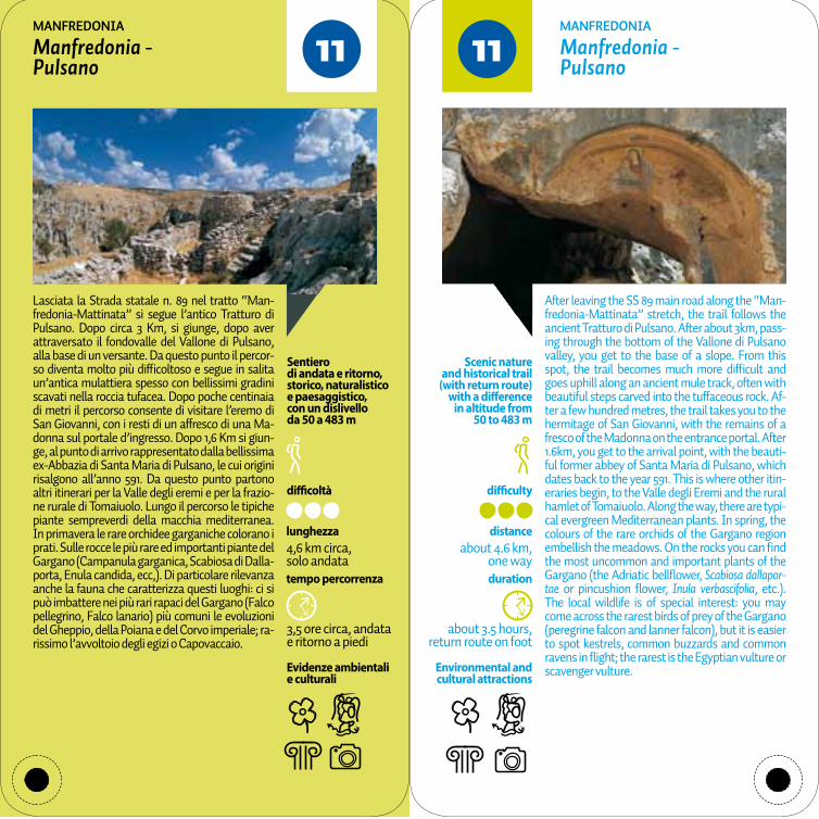
Lasciata la Strada statale n. 89 nel tratto “Man-fredonia-Mattinata” si segue l’antico Tratturo di Pulsano. Dopo circa 3 Km, si giunge, dopo aver attraversato il fondovalle del Vallone di Pulsano, alla base di un versante. Da questo punto il percor-so diventa molto più difficoltoso e segue in salita un’antica mulattiera spesso con bellissimi gradini scavati nella roccia tufacea. Dopo poche centinaia di metri il percorso consente di visitare l’eremo di San Giovanni, con i resti di un affresco di una Ma-donna sul portale d’ingresso. Dopo 1,6 Km si giun-ge, al punto di arrivo rappresentato dalla bellissima ex-Abbazia di Santa Maria di Pulsano, le cui origini risalgono all’anno 591. Da questo punto partono altri itinerari per la Valle degli eremi e per la frazio-ne rurale di Tomaiuolo. Lungo il percorso le tipiche piante sempreverdi della macchia mediterranea. In primavera le rare orchidee garganiche colorano i prati. Sulle rocce le più rare ed importanti piante del Gargano (Campanula garganica, Scabiosa di Dalla-porta, Enula candida, ecc,). Di particolare rilevanza anche la fauna che caratterizza questi luoghi: ci si può imbattere nei più rari rapaci del Gargano (Falco pellegrino, Falco lanario) più comuni le evoluzioni del Gheppio, della Poiana e del Corvo imperiale; ra-rissimo l’avvoltoio degli egizi o Capovaccaio.
After leaving the SS 89 main road along the “Man-fredonia-Mattinata” stretch, the trail follows the ancient Tratturo di Pulsano. After about 3km, pass-ing through the bottom of the Vallone di Pulsano valley, you get to the base of a slope. From this spot, the trail becomes much more difficult and goes uphill along an ancient mule track, often with beautiful steps carved into the tuffaceous rock. Af-ter a few hundred metres, the trail takes you to the hermitage of San Giovanni, with the remains of a fresco of the Madonna on the entrance portal. After 1.6km, you get to the arrival point, with the beauti-ful former abbey of Santa Maria di Pulsano, which dates back to the year 591. This is where other itin-eraries begin, to the Valle degli Eremi and the rural hamlet of Tomaiuolo. Along the way, there are typi-cal evergreen Mediterranean plants. In spring, the colours of the rare orchids of the Gargano region embellish the meadows. On the rocks you can find the most uncommon and important plants of the Gargano (the Adriatic bellflower, Scabiosa dallapor-tae or pincushion flower, Inula verbascifolia, etc.). The local wildlife is of special interest: you may come across the rarest birds of prey of the Gargano (peregrine falcon and lanner falcon), but it is easier to spot kestrels, common buzzards and common ravens in flight; the rarest is the Egyptian vulture or scavenger vulture.

difficoltà difficulty
tempo percorrenza duration
Evidenze ambientali e culturali
Environmental and cultural attractions
about 2.5 hours, return route on foot
distanceabout 3.5 km,
one way
Scenic nature and historical trail
(with return route) with a difference in
altitude from 474 to 550 m
2,5 ore circa, andata e ritorno a piedi
lunghezza3,5 km circa, solo andata
Sentiero di andata e ritorno, storico, naturalistico e paesaggistico,con un dislivello da 474 a 550 m
1212Tomaiuolo - Pulsano Tomaiuolo - PulsanoMANfREDONIA MANfREDONIA
Si parte in corrispondenza di una diramazione al km 10 (circa) della Strada provinciale n. 57 “Manfre-donia-San Salvatore”. Il primo tratto del percorso segue una strada asfaltata che dopo 1,5 Km circa, giunge al centro abitato della frazione rurale di Tomaiuolo, antico centro agro-zootecnico sorto in prossimità di un tratturo della Transumanza. Da questo punto il percorso segue un’antica mulat-tiera in gran parte delimitata su entrambi i lati da bellissimi muretti in pietra a secco che la separano da campi abbandonati o aree a pascolo. In seguito il percorso scende nella Valle Mattina, la attraver-sa e poi la segue parallelamente immergendosi in un bel bosco di Leccio. Dopo 1 km il percorso si immette su una pista sterrata molto panoramica e dopo un ulteriore 1 Km si giunge, al punto di ar-rivo rappresentato dalla bellissima ex-Abbazia di Santa Maria di Pulsano. Il paesaggio è dominato prima da boschetti e piante isolate di Roverella, poi il bosco sempreverde di Leccio e poi le tipiche piante sempreverdi della macchia mediterranea. In primavera le rare orchidee garganiche colorano i prati. Sulle rocce le più rare ed importanti piante del Gargano (Campanula garganica, Scabiosa di Dalla-porta, Enula candida, Ginestra di San Michele ecc.). Di particolare rilievo anche la fauna con i più rari rapaci del Gargano (Falco pellegrino, Falco lanario) più comuni le evoluzioni del Gheppio, della Poiana e del Corvo imperiale; rarissimo l’avvoltoio degli egizi o Capovaccaio.
The trail starts from a fork about 10 km along the “Manfredonia-San Salvatore” or SP 57 provincial road. The first stretch of the trail follows an asphalt road, which, after about 1.5 km, leads to the centre of the rural hamlet of Tomaiuolo, an ancient agri-cultural and farming village built near a sheep track used for transhumance. From here, the trail follows an ancient mule track, largely bordered on both sides by picturesque dry stone walls that separate it from abandoned fields and pasture land. The trail then descends towards the Valle Mattina, crosses it and then runs parallel to it, passing through a charming holm oak forest. After 1 kilometre, the trail leads into a dirt road with spectacular scenic views. After another kilometre, you get to the arriv-al point, where the beautiful former abbey of Santa Maria di Pulsano is situated. At first, the landscape is dominated by woods and isolated downy oaks, then by an evergreen holm oak forest and, finally, the typical evergreen plants of the Mediterranean maquis. In spring, the colours of the rare orchids of the Gargano region embellish the meadows. On the rocks you can find the most uncommon and im-portant plants of the Gargano (Adriatic bellflower, Scabiosa dallaportae or pincushion flower, Inula verbascifolia, broom of San Michele etc.). The local wildlife is of special interest: you may come across the rarest birds of prey of the Gargano (peregrine falcon and lanner falcon), but it is easier to spot kestrels, common buzzards and common ravens in flight; the rarest is the Egyptian vulture or scaven-ger vulture.

difficoltà difficulty
tempo percorrenza duration
Evidenze ambientali e culturali
Environmental and cultural attractions
2 ore circa, andata e ritorno a piedi
about 2 hour, return route on foot
distanceabout 2.3 km,
one way
Scenic nature trail (with return route)
with a difference in altitude from
162 to 0 m
lunghezza2,3 km circa, solo andata
Sentiero di andata e ritorno, naturalistico e paesaggistico,con un dislivello da 162 a 0 m
1313Mergoli - Vignanotica
Mergoli - Vignanotica
MATTINATA MATTINATA
Si parte dalla SP 53 inoltrandosi subito in un sen-tiero attrezzato che si immerge nella bassa Mac-chia mediterranea da dove subito lo sguardo può spaziare nel sottostante mare impreziosito dai faraglioni di baia della Zagare. Proseguendo fra uliveti e pinete si incontrano due aree di sosta pri-ma di inoltrarsi nella pineta vera e propria da dove inizia la discesa verso la spettacolare spiaggia di Vignanotica, una delle più affascinanti spiagge del Gargano dalle bianche e strapiombanti falesie. Il percorso attraversa una delle più belle pinete di Pino d’Aleppo d’Italia, caratterizzata da un denso sottobosco costituito dai tipici elementi sempre-verdi della Macchia mediterranea. Nei versanti più freschi anche rari nuclei di Leccio. Ai margini del bo-sco spesso si possono osservare orchidee ed altre rarità botaniche. Di particolare interesse la fauna osservabile, portandosi sui margini delle scoglie-re, tra cui il Rondone. Tra le fronde si nascondono Occhiocotto e fringuelli. Più raro scorgere, nelle ore più calde del giorno, il volteggiare e le picchiate del Falco pellegrino.
The trail starts from the SP 53 provincial road and immediately leads onto a well-equipped path im-mersed in the low Mediterranean maquis, offering a panoramic view of the sea below embellished by the sea stacks of the bay of Zagare. The trail con-tinues through olive groves and pine forests, where two rest areas are situated before entering the pine forest and where the descent begins towards the spectacular beach of Vignanotica. With its white overhanging cliffs, it is one of the most charming beaches of the Gargano promontory. The trail runs through one of Italy’s most beautiful Aleppo pine forests, characterised by dense undergrowth fea-turing the typical evergreen plants of the Mediter-ranean maquis. On the cooler slopes, rare stretches of holm oaks can be seen. On the edge of the wood, it is easy to see orchids and other rare botanical species. The local wildlife is particularly interesting, including the common swift, which can be seen on the edge of the cliffs. The Sardinian Warbler and chaffinches hide among tree branches. In the hot-test hours of the day, instead, it is more difficult to spot the peregrine falcon hovering in the air and swooping by.

difficoltà difficulty
tempo percorrenza duration
Evidenze ambientali e culturali
Environmental and cultural attractions
about 2 hours,return route on foot
Scenic nature and historical trail
(with return route) with a difference
in altitude from 236 to 0 m
distanceabout 2.6 km,
one way
2 ore circa, andata e ritorno a piedi
lunghezza2,6 km circa, solo andata
Sentiero di andata e ritorno, storico, naturalistico e paesaggistico,con un dislivello da 236 a 0 m
1414Monte Saraceno - Mattinata (spiaggia)
Monte Saraceno - Mattinata (beach)
MATTINATA MATTINATA
Si parte dalla SS 89 Dir.1 (Bivio La Cavola) inol-trandosi subito in una pista sterrata che, prima a mezza costa e poi in cresta, si immerge nella bas-sa Macchia mediterranea e nuclei di Pino d’Aleppo con costanti stupendi panorami verso il paese di Mattinata. Si prosegue costeggiando tre collinette, su tratti quasi pianeggianti fino a giungere, dopo 1 km, nell’area archeologica di Monte Saraceno dove si può visitare un’affascinante necropoli di oltre 500 tombe risalente a più di 2500 anni fa. Poco più avanti i ruderi di postazioni della prima guerra mon-diale. Qui il panorama spazia a 360° fra il mare ed il Gargano. Proseguendo si comincia, con uno stretto sentiero pedonale, una ripida discesa avendo come visuale il mare. Dopo circa 300 metri il percorso diventa gradualmente pianeggiate ampliandosi anche nella larghezza, svoltando in direzione nord verso la spettacolare e ciottolosa spiaggia di Mat-tinata dove si giunge dopo un altro km. Il percorso attraversa la classica vegetazione mediterranea e belle pinete di Pino d’Aleppo. Ai margini del bosco spesso si possono osservare numerose orchidee ed altre rarità botaniche. Di particolare interesse la fauna osservabile tra cui il Rondone. Tra le fronde si nascondono Occhiocotto e fringuelli. Più raro scor-gere, nelle ore più calde del giorno, il volteggiare e le picchiate del Falco pellegrino.
The trail starts from the SS 89 Dir. 1 (La Cavola junc-tion) that immediately leads to a dirt road, which, first halfway up the slope and then on a ridge, is immersed in the low Mediterranean maquis and stretches of Aleppo pine trees, offering plenty of spectacular views of the town of Mattinata. The trail continues passing three hills, along almost flat stretches until, after 1 kilometre, you get to the archaeological site of Monte Saraceno, where you can visit a fascinating necropolis with more than 500 tombs dating back to over 2,500 years ago. A little further on you can find the ruins of World War I artillery batteries. Here, you can enjoy a 360-de-gree view of the sea and the Gargano. Continuing, the trail goes along a narrow pedestrian path with a steep descent overlooking the sea. After about 300 metres, it gradually becomes flatter and wider, turning north after another kilometre and taking you to the spectacular pebbly beach of Mattinata. The trail passes through traditional Mediterra-nean vegetation and beautiful Aleppo pine forests. On the edge of the wood, it is easy to spot orchids and other rare botanical species. The local wildlife is particularly interesting, for example the com-mon swift. The Sardinian Warbler and chaffinches hide among tree branches. In the hottest hours of the day, instead, it is more difficult to spot the per-egrine falcon hovering in the air and swooping by.

difficoltà difficulty
tempo percorrenza duration
Evidenze ambientali e culturali
Environmental and cultural attractions
about 4 hours,return route on foot
distanceabout 5.7 km,
one way
Scenic nature trail (with return route)
with a difference in altitude from
718 to 162 m
4 ore circa, andata e ritorno a piedi
lunghezza5,7 km circa, solo andata
Sentiero di andata e ritorno, naturalistico e paesaggistico,con un dislivello da 718 a 162 m
1515Monte Sant’Angelo - Vallone Scannamogliera - Macchia
Monte Sant’Angelo - Vallone Scannamogliera - Macchia
MONTE SANT’ANGELO MONTE SANT’ANGELO
Si parte, in discesa, dal centro abitato di Monte Sant’Angelo (in fondo a via Sant’Antonio abate). Il percorso segue un’antica mulattiera, di grande interesse storico poichè utilizzata dai pellegrini che fin dal 5° secolo si recavano in pellegrinaggio nella grotta dell’Arcangelo Michele. Dopo 600 m si giun-ge in corrispondenza di un bivio. A sinistra si prose-gue lungo una linea di cresta per giungere dopo un altro Km, alla interessante chiesa ipogea di “Ognis-santi”, visitabile solo su prenotazione presso guide esperte locali, ma di grande interesse anche visi-tando solo l’esterno. Tornati al bivio precedente si svolta a sinistra e si scende lungo la valle “Scan-namogliera” per un percorso molto interessante che rappresenta uno dei tipici valloni rupestri del versante meridionale del Gargano. Dopo 3,2 Km si giunge al punto di arrivo rappresentato dal centro rurale di Macchia, frazione di Monte S. Angelo. Il paesaggio è prima caratterizzato da pascoli e cam-pi abbbandonati delimitati dai tipici muretti in pie-tra a secco, ma si incontrano anche orti terrazzati o le tipiche piante sempreverdi della macchia medi-terranea. In primavera le rare orchidee garganiche colorano i prati. Sulle rocce le più rare ed importanti piante del Gargano; nell’ultimo tratto i tipici uliveti terrazzati. Lungo il percorso può capitare di vedere i più rari rapaci del Gargano (Falco pellegrino, Falco lanario); più comuni le evoluzioni del Gheppio, della Poiana e del Corvo imperiale; rarissimo l’avvoltoio degli egizi o Capovaccaio ma anche tracce della presenza di volpe, faina e gatto selvatico.
The trail starts downhill from the town centre of Monte Sant’Angelo (at the end of Via Sant’Antonio Abate). It goes along an ancient mule track of great historical interest, used since the 5th century by pilgrims travelling to the cave of Saint Michael the Archangel. After 600 metres, you get to a junction. On the left, the trail continues along a ridgeline, and after 1 kilometre you get to the interesting un-derground church of “Ognissanti”, which can be visited only by booking with local expert guides. Its exterior is also worth a visit. After heading back to the previous fork and turning left, the trail takes you down the Valle Scannamogliera along a very inter-esting path, which is one of the typical deep rocky valleys on the southern side of the Gargano. After 3.2km, you get to the arrival point and the rural centre of Macchia, a hamlet of Monte Sant’Angelo. At first, the landscape features pastures and aban-doned fields bordered by characteristic dry stone walls, terraced orchards or the typical evergreen plants of the Mediterranean maquis. In spring, the colours of the rare orchids of the Gargano em-bellish the meadows. The most uncommon and important plants of the Gargano can be found on rocks; along the last stretch, there are typical ter-raced olive groves. Along the way, you may come across uncommon birds of prey of the Gargano (peregrine falcon and lanner falcon), but it is easier to see kestrels, common buzzards and common ra-vens in flight. The uncommon species include the Egyptian vulture or scavenger vulture, but traces of the presence of foxes, stone martens and wildcats can also be found.

difficoltà difficulty
tempo percorrenza duration
Environmental and cultural attractions
Evidenze ambientali e culturali
about 30 minutes, return route on foot
distanceabout 0.3 km,
one way
Scenic nature and historical trail
(with return route) with a difference
in altitude from468 to 389 m
30 minuti circa, andata e ritorno a piedi
lunghezza0,3 km circa, solo andata
Sentiero di andata e ritorno, storico, naturalistico e paesaggistico,con un dislivello da 468 a 389 m
1616Abbazia di Pulsano - Eremo San Nicola di Mira
Abbey of Pulsano - Hermitage of San Nicola di Mira
MONTE SANT’ANGELO MONTE SANT’ANGELO
Si tratta di un sentiero storico-naturalistico dai panorami mozzafiato che consente di spaziare con lo sguardo sulla valle degli eremi e sul golfo di Manfredonia. Si parte dalla bellissima ex-Abbazia di Santa Maria di Pulsano. Il percorso segue inizial-mente un’antica mulattiera, poi una serie di gradini scavati nella roccia, di grande interesse storico poi-chè realizzati ed utilizzati dai monaci eremiti che per centinaia d’anni utilizzarono le grotte di questi luoghi come eremi nei quali pregare in isolamento. Dopo 300 metri si giunge ai ruderi dell’eremo di San Nicola di Mira. Da evidenziare come il percorso at-traversa versanti rupestri con sparsi cespugli della macchia mediterranea, le rare orchidee gargani-che e le più rare ed importanti piante del Gargano (Campanula garganica, Scabiosa di Dallaporta, Enula candida, ecc,). Con un po’ di attenzione si possono osservare i più rari rapaci del Gargano (Falco pellegrino, Falco lanario) più comuni le evo-luzioni del Gheppio, della Poiana e del Corvo impe-riale; rarissimo l’avvoltoio degli egizi o Capovacca-io. Lungo il percorso, tracce della presenza di volpe, faina e del gatto selvatico.
A nature and historical trail with breathtaking views across the Valle degli Eremi (valley of the hermitages) and the Gulf of Manfredonia. The trail starts from the beautiful former abbey of Santa Maria di Pulsano. At first, it goes along an ancient mule track, and then up a series of steps carved into the rock, which are of great historical interest since they were made and used by hermit monks who, for hundreds of years, used the caves in this area as retreats to pray in seclusion. After 300 metres, you get to the ruins of the hermitage of San Nicola di Mira. In particular, the trail crosses rocky mountain slopes and the scattered shrubs of the Mediterra-nean maquis, featuring rare orchids and the most uncommon and important plants of the Gargano (Adriatic bellflower, Scabiosa dallaportae or pincush-ion flower, Inula verbascifolia, etc.). By observing carefully, you can spot uncommon birds of prey of the Gargano (peregrine falcon and lanner falcon), but it is easier to see kestrels, common buzzards and common ravens in flight. The uncommon spe-cies include the Egyptian vulture or scavenger vul-ture. Along the way, traces of the presence of foxes, stone martens and wildcats can also be found.
difficoltà difficulty
tempo percorrenzaduration
Evidenze ambientali e culturali
Environmental and cultural attractions
about 4.5 hours, on foot.
2.5 hours by MTB
distanceabout 13 km
Scenic circular nature trail
(with return route) with a difference in
altitude from80 to 591 m
4,5 ore circa, a piedi. 2,5 ore in mtb
lunghezza13 km circa
Sentiero ad anello, naturalistico e paesaggistico,con un dislivello da 80 a 591 m
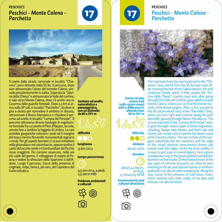
1717Peschici - Monte Calena - Parchetto
Peschici - Monte Calena - Parchetto
pESChICI pESChICI
Si parte dalla strada comunale in località “Chia-nara”, poco distante dalla SS 89. Il percorso, dopo aver attraversato l’alveo del torrente Calena, pro-cede prevalentemente in salita. Superata la “pisci-na della Chiesa” e attraversata la Valle del confine, si sale verso Monte Calena, dove c’è anche una ex Caserma delle guardie forestali. Dopo 1,5 km si ar-riva sulla SP 528, in località “Parchetto”, da dove si gira a destra per riprendere il sentiero in discesa, attraversare il Bosco Manatecco e chiudere il per-corso ad anello in località “Lampia del Principe”. Il percorso attraversa diverse tipologie di vegetazio-ne forestale fra cui pinete di Pino d’Aleppo, leccete, cerrete fino a lambire la faggeta di Umbra. Le rare orchidee garganiche colorano i prati ed il margine del bosco mentre Roverelle monumentali segnano i crinali. Per gli aspetti faunistici ci si può imbattere nella ghiandaia e nel colombaccio, oppure sentire il canto del picchio verde o il tamburellare del Picchio rosso maggiore. Più comune osservare, nelle ore più calde del giorno, il volteggiare di coppie di Po-iana o vedere lo sfrecciare dello Sparviero o dell’A-store. Lungo il percorso, tracce della presenza di cinghiale, volpe, faina e, più raro, del Capriolo e del Gatto selvatico.
The trail starts from the municipal road in the “Chi-anara” area, not far from the SS 89 main road. Af-ter crossing the bed of the Calena stream, the trail continues mostly uphill. It then passes the “Pis-cina della Chiesa” country road and, after going through the Valle del Confine, goes uphill towards Monte Calena, where you can find the former bar-racks of the forest rangers. After 1.5 km, you get to the SP 528 provincial road, in the “Parchetto” area, where you turn right and continue along the path downhill, passing through Bosco Manatecco. The circular trail ends in the “Lampia del Principe” area. It goes through various types of forest vegetation, including Aleppo pine forests and holm oak and Turkey oak woods until it reaches the beech wood of the Foresta Umbra. The rare orchids of the Gar-gano colourfully dot the meadows and the edge of the wood, whereas monumental downy oak woods mark the ridges. As for the local wildlife, it is easy to spot a jay or a wood pigeon, hear a green woodpecker sing or the great spotted woodpecker hammer on tree trunks. In the hottest hours of the day, pairs of common buzzards can often be seen hovering in the air, and sparrow hawks or northern goshawks can also be seen sweeping by. Along the way, traces of the presence of wild boars, foxes, stone martens and, more rarely, of roe deer and wildcats can also be found.

difficoltà difficulty
tempo percorrenza duration
Evidenze ambientali e culturali
Environmental and cultural attractions
about 1.5 hours, return route on foot
distanceabout 4.2 km,
one way
Scenic nature trail (with return route)
with a difference in altitude from
169 to 303 m
1,5 ore circa, andata e ritorno a piedi
lunghezza4,2 km circa, solo andata
Sentiero di andata e ritorno, naturalistico e paesaggistico,con un dislivello da 169 a 303 m
1818Madonna di Loreto - Coppo dei fossi
Madonna di Loreto - Coppo dei fossi
pESChICI pESChICI
Si parte dalla chiesa rurale della Madonna di Lore-to, eretta dai pescatori peschiciani per una grazia ricevuta, seguendo una stradina prima asfaltata e poi sterrata, inizialmente quasi parallela alla SP 52. Il percorso si sviluppa con una serie di saliscendi e sinuose curve fra terreni seminativi, uliveti, pinete e macchia mediterranea, nei quali si aprono scor-ci panoramici sia verso il mare sia verso le colline dell’interno fino a giungere all’area archeologica di Coppo dei fossi. Fra la vegetazione naturale è da segnalare la bellissima pineta di Pino d’Aleppo che ammanta queste colline nonchè i verdi e profu-mati lembi di Macchia mediterranea. In primavera le rare orchidee garganiche colorano i prati ed il margine del bosco. Per gli aspetti faunistici risulta essere molto importante lo svernamento di silvidi e turdidi nonchè l’occasionale avvistamento del falco Lodolaio. Tra i mammiferi è da segnalare la presenza del Gatto selvatico e di rettili quali Biacco, Ramarro occidentale e Testuggine terrestre. Dopo il tramonto si può sentire la civetta, il barbagianni o il gufo comune. Più comune osservare, nelle ore più calde del giorno, il volteggiare di coppie di Po-iana e stormi di taccole e cornacchie grigie. Lungo il percorso, tracce della presenza di cinghiale, volpe, faina e riccio.
The trail starts from the rural church of Madonna di Loreto, built as an ex-voto by the fishermen of Pe-schici. It goes along a narrow asphalt road, which then becomes a dirt road, at first almost parallel to the SP 52 provincial road. The trail comprises a series of uphill and downhill stretches and sinu-ous bends through arable land, olive groves, pine forests and Mediterranean maquis. It offers scenic views of the sea and of the hills inland, taking you to the archaeological site of Coppo dei Fossi. The natural vegetation includes the beautiful Aleppo pine forest, which covers these hills, and scented green strips of Mediterranean maquis. In spring, the rare orchids of the Gargano colourfully dot the meadows and the edge of the woods. As for the local wildlife, this area is important as a wintering ground for passerines such as Sylviid warblers and thrushes, and the Eurasian hobby can also be oc-casionally spotted. You may also see mammals, such as wildcats, as well as reptiles including the green whip snake, the Western green lizard and the Hermann’s tortoise. After sunset, the little owl, the barn owl and the long-eared owl can be heard. In the hottest hours of the day, pairs of common buz-zards and flocks of western jackdaws and hooded crows can often be seen hovering in the air. Along the way, traces of the presence of wild boars, foxes, stone martens and hedgehogs can also be found.

difficoltà difficulty
tempo percorrenza duration
Evidenze ambientali e culturali
Environmental and cultural attractions
about 3 hours, return route on foot,
2 hours by MTB
distanceabout 3.7 km,
one way
Scenic, nature and historical trail
(with return route) with a difference
in altitude from580 to 164 m
3 ore circa, andata e ritorno a piedi, 2 ore in mtb
lunghezza3,7 km circa, solo andata
Sentiero di andata e ritorno, storico, naturalistico e paesaggistico,con un dislivello da 580 a 164 m
1919Rignano Garganico - Madonna di Cristo
Rignano Garganico - Madonna di Cristo
RIGNANO GARGANICO RIGNANO GARGANICO
Il sentiero segue un’antica mulattiera di interesse storico religioso poichè ancora oggi utilizzata per l’annuale pellegrinaggio che gli abitanti di Rignano G. fanno nella giornata del martedì dopo Pasqua. Si parte dal centro di Rignano Garganico per imboc-care poi l’antico sentiero, caratterizzato, in molti tratti da selciato e gradini in pietra. Si prosegue, sempre in discesa, fino alla meta, attraversando in alcuni punti la strada provinciale SP 22. Lungo il percorso alcune diramazioni consentono sia di raggiungere spettacolari punti panoramici, sia di visitare antiche masserie fortificate (Masseria Pa-lagano, Masseria Paglicci). Il percorso termina in corrispondenza dell’antica (anno 1000) chiesa ru-rale della Madonna di Cristo. Accanto ai seminativi terrazzati del primo tratto, delimitati dai tipici mu-retti in pietra a secco, il percorso attraversa versanti a pascolo, con rari alberi di lecci, ornielli, e bagolari, nonchè arbusti della macchia mediterranea quali lentischi, filliree, olivastri e ginestre. In primavera le rare orchidee garganiche colorano questi pascoli. Con un po di fortuna ci si può imbattere nei più rari rapaci del Gargano (Falco pellegrino, Falco lanario) più comuni le evoluzioni del Gheppio, della Poia-na e del Corvo imperiale. Lungo il percorso, tracce della presenza di volpe, faina e, più raro, del gatto selvatico.
The trail follows an ancient mule track of histori-cal and religious interest, still used today by the inhabitants of Rignano Garganico for their annual pilgrimage, which takes place on the Tuesday af-ter Easter Sunday. The trail starts from the town centre of Rignano Garganico and then leads onto an old path, with cobblestones and stone steps along several stretches. It then continues downhill towards the arrival point, crossing the SP 22 pro-vincial road at some points. Along the trail, several forks lead to spectacular panoramic viewpoints and ancient fortified manor farms (Masseria Palagano and Masseria Paglicci). The trail ends near the an-cient rural church of the Madonna di Cristo (dating back to the year 1000). Along the first stretch, the trail passes through terraced arable land, bordered by characteristic dry stone walls, and then crosses mountain slopes of pasture land, where you can see rare holm oaks, the South European flowering ash and the Mediterranean hackberry, as well as shrubs typical of the Mediterranean maquis, such as mastic, phillyrea, wild olive trees and brooms. In spring, the rare orchids of the Gargano colourfully dot the meadows. With a bit of luck, you may spot the uncommon birds of prey of the Gargano (pere-grine falcon and lanner falcon), but it is easier to see kestrels, common buzzards and common ravens in flight. Along the way, traces of the presence of foxes, stone martens and, more rarely, of wildcats can also be found.
difficoltà difficulty
tempo percorrenza duration
Evidenze ambientali e culturali
Environmental and cultural attractions
about 4 hours, return route on foot,
2 hours by MTB
distanceabout 9.5 km,
one way
Scenic nature trail (with return route)
with a difference in altitude from
660 to 380 m
4 ore circa, andata e ritorno a piedi, 2 ore in mtb
lunghezza9,5 km circa, solo andata
Sentiero di andata e ritorno, naturalistico e paesaggistico,con un dislivello da 660 a 380 m
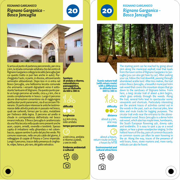
2020Rignano Garganico - Bosco Jancuglia
Rignano Garganico - Bosco Jancuglia
RIGNANO GARGANICO RIGNANO GARGANICO
Si arriva al punto di partenza percorrendo, per circa 5 km, la strada comunale asfaltata che dal centro di Rignano Garganico collega la località Jancuglia (per cui questo tratto si può fare anche in auto). Par-cheggiata l’auto, si parte, in discesa, attraversando seminativi abbandonati. Dopo 600 m si entra nel Bosco Jancuglia, una bellissima lecceta comunale che ammanta i versanti digradanti verso il sotto-stante Santuario di Stignano. Da questo punto par-te un lungo percorso ad anello, circa 4,2 km, che si snoda completamente in bosco. Lungo il percorso alcune diramazioni consentono sia di raggiungere spettacolari punti panoramici, sia di accorciare l’iti-nerario. Di particolare interesse le antiche testimo-nianze delle attività praticate in passato nel bosco, quali aie carbonili, fornaci per la calce, mulattiere per l’esbosco della legna. Il percorso ad anello si chiude in corrispondenza dell’entrata nel bosco innanzi indicata. Il Bosco Jancuglia è caratterizzato da una fitta lecceta nella quale sono presenti anche aceri, carpini, ornielli, roverelle e terebinti. Spesso capita di imbattersi nella ghiandaia e nel colom-baccio, oppure sentire il canto del picchio verde. Più comune osservare, nelle ore più calde del giorno, il volteggiare di coppie di Poiana e Corvo imperiale. Lungo il percorso, tracce della presenza di cinghia-le, volpe, faina e, più raro, del gatto selvatico.
The starting point can be reached by going about 5km along the municipal asphalt road that leads from the town centre of Rignano Garganico to Jan-cuglia (you can also get here by car). After parking your car, follow the trail downhill, passing through abandoned arable land. After 600 metres, the trail enters Bosco Jancuglia, a beautiful municipal holm oak wood that covers the mountain slopes that go down to the sanctuary of Stignano below. From here, a long circular trail of about 4.2km begins, which goes entirely through the woods. Along the trail, several forks lead to spectacular scenic viewpoints and shortcuts. Particularly interesting are the ancient traces of activities carried out in the woods in the past, such as charcoal piles, lime kilns and mule tracks for logging purposes. The circular trail ends near the entrance to the above-mentioned wood. Bosco Jancuglia is a dense holm oak wood, which also has maple trees, hornbeams, the South European flowering ash, downy oaks and terebinths. It is easy to spot a jay or a wood pigeon, or hear a green woodpecker singing. In the hottest hours of the day, pairs of common buzzards or common ravens can often be seen hovering in the air. Along the way, traces of the presence of wild boars, foxes, stone martens and, more rarely, wildcats can also be found.

difficoltà difficulty
tempo percorrenza duration
Evidenze ambientali e culturali
Environmental and cultural attractions
about 4 hours, return route on foot
distanceabout 5.8 km,
one way
Scenic nature trail (with return route)
with a difference in altitude from
56 to 310 m
4 ore circa, andata e ritorno a piedi
lunghezza5,8 km circa, solo andata
Sentiero di andata e ritorno, naturalistico e paesaggistico,con un dislivello da 56 a 310 m
2121Rodi Garganico - Sorgente di Canneto
Rodi Garganico - Sorgente di Canneto (Canneto spring)
RODI GARGANICO RODI GARGANICO
Si parte dal centro di Rodi Garganico (strada comu-nale Croce), seguendo la stessa strada, in salita e in mezzo alla famosa oasi agrumaria, fino alla SP 51b che si attraversa per continuare su una stradina che attraversa bellissimi uliveti fino ai rilievi di Cop-pa Ceccasole. Da qui si scende attraversando lembi di pineta e lecceta fino a reincontrare la SP 51b che si attraversa per risalire sui rilievi di Coppa di Ma-saniello da dove si scende fino alla meta costituita dalla sorgente di Canneto. Qui oltre alla sorgente, al lavatoio ed agli agrumeti, anche la Chiesetta della Madonna di Canneto e ruderi di un mulino ad acqua. Fra la vegetazione naturale è da segnalare la bellissima pineta di Pino d’Aleppo che ammanta queste colline nonchè i verdi e profumati lembi di Macchia mediterranea. In primavera le rare orchi-dee garganiche colorano i prati ed il margine del bosco. Per gli aspetti faunistici risulta essere molto importante lo svernamento di silvidi e turdidi non-chè l’occasionale avvistamento del falco Lodolaio. Tra i mammiferi è da segnalare la presenza del Gatto selvatico e di rettili quali Biacco, Ramarro occidentale e Testuggine terrestre. Più comune os-servare, nelle ore più calde del giorno, il volteggiare di coppie di Poiana e stormi di taccole e cornacchie grigie. Lungo il percorso, tracce della presenza di cinghiale, volpe, faina e riccio.
The trail starts from the town centre of Rodi Gar-ganico, taking the Strada Comunale Croce road up-hill and passing through the renowned Oasi Agru-maria (citrus grove), all the way up to the SP 51b provincial road. Cross this road and continue along a lane that goes through beautiful olive groves un-til you get to the Coppa Ceccasole hill. From here, the trail goes downhill through strips of pine for-ests and holm oak woods, taking you back to the SP 51b provincial road. Cross the road to go back up the Coppa di Masaniello hills and then down to the arrival point, i.e. the Canneto spring. Here, you can find not only the spring, a wash house and citrus groves but also the small church of Madonna di Canneto and the ruins of a water mill. The natural vegetation includes a beautiful Aleppo pine forest, which covers these hills, with green scented spots of Mediterranean maquis. In spring, the rare or-chids of the Gargano colourfully dot the meadows and the edge of the woods. As for the local wildlife, this area is important as a wintering ground for pas-serines such as Sylviid warblers and thrushes, and the Eurasian hobby can also be occasionally spot-ted. You may see mammals, such as wildcats and reptiles including the green whip snake, the West-ern green lizard and the Hermann’s tortoise. In the hottest hours of the day, pairs of common buzzards and flocks of Western jackdaws and hooded crows can often be seen hovering in the air. Along the way, traces of the presence of wild boars, foxes, stone martens and hedgehogs can also be found.

difficoltà difficulty
tempo percorrenza duration
Evidenze ambientali e culturali
Environmental and cultural attractions
about 2 hours,return route on foot
2 ore circa, andata e ritorno a piedi
distanceabout 2.7 km,
one way
Scenic nature trail (with return route)
with a difference in altitude from
32 to 2 m
lunghezza2,7 km circa, solo andata
Sentiero di andata e ritorno, naturalistico e paesaggistico,con un dislivello da 32 a 2 m
2222Rodi Garganico - Contrada Mascherizzo - Molino di mare
Rodi Garganico - Contrada Mascherizzo - Molino di mare
RODI GARGANICO RODI GARGANICO
Si parte dal centro di Rodi Garganico (SS 89, Con-trada Petrara), seguendo una stradina asfaltata che a mezza costa si snoda in mezzo alla famosa oasi agrumaria, in un paesaggio unico fra coltiva-zioni di agrumi, delimitati da filari frangivento di Leccio o Alloro, e scorci sul mare. Di particolare bel-lezza i “casini” ovvero case rurali, spesso a più pia-ni, che abbelliscono queste contrade. Tra antiche ed alte mura di cinta si attraversano le località Pe-trara e Mascherizzo fino a giungere, in prossimità del mare, sulla SS 89. Qui sorge un antico Mulino ad acqua denominato “Molino di mare”, oggi adibito a residenza privata, dove c’è anche una fermata delle ferrovie del Gargano. Fra la vegetazione naturale sono da segnalare i bellissimi lembi di pineta di Pino d’Aleppo e di Leccio oltre a profumati arbusti della Macchia mediterranea. In primavera le rare orchi-dee garganiche colorano i prati ed il margine del bo-sco. Per gli aspetti faunistici molto importante è lo svernamento di silvidi e turdidi nonchè l’occasiona-le avvistamento del falco Lodolaio. Tra i mammiferi sono comuni la volpe, la faina, la donnola mentre fra i rettili il Biacco, il Ramarro occidentale e la Te-stuggine terrestre. Più comune osservare, nelle ore più calde del giorno, il volteggiare di coppie di Poia-na o stormi di gabbiani.
The trail starts from the town centre of Rodi Gar-ganico (SS 89 main road near Contrada Petrara), and follows an asphalt road, which, halfway up the slope, goes through the renowned Oasi Agrumaria (citrus grove). Here you can enjoy a unique land-scape of citrus crops, bordered by rows of holm oaks and laurel that provide protection from the wind, and sea views. Rural houses, called “casini”, often with several floors, are a charming addition to the landscape. The trail passes through Pet-rara and Mascherizzo with ancient high bound-ary walls, and takes you closer to the sea, to the SS 89 main road. Here, an ancient water mill called “Molino di Mare” is situated, now a private residence, as well as a station along the Gargano railway line. The natural vegetation includes a beautiful Aleppo pine forest, which covers these hills, and green, scented spots of Mediterranean maquis. In spring, the rare orchids of the Gargano colourfully dot the meadows and the edge of the woods. As for the local wildlife, this area is impor-tant as a wintering ground for passerines such as Sylviid warblers and thrushes, and the Eurasian hobby can also be occasionally spotted. You may see mammals such as foxes, stone martens and weasels, and reptiles including the green whip snake, the western green lizard and the Her-mann’s tortoise. In the hottest hours of the day, pairs of common buzzards or flocks of seagulls can often be seen hovering in the air.

difficoltà difficulty
tempo percorrenza duration
Evidenze ambientali e culturali
Environmental and cultural attractions
about 2.5 hours, return route on foot,
1.5 hours by MTB
distanceabout 3 km,
one way
Scenic nature trail (with return route)
with a difference in altitude from
722 to 979 m
2,5 ore circa, andata e ritorno a piedi, 1,5 ore in mtb
lunghezza3 km circa, solo andata
Sentiero di andata e ritorno, naturalistico e paesaggistico,con un dislivello da 722 a 979 m
2323Convento Clarisse - Monte Castellana
Convento Clarisse - Monte Castellana
SAN GIOVANNI ROTONDO SAN GIOVANNI ROTONDO
Si parte dal convento delle monache Clarisse, raggiungibile con una strada comunale asfaltata che dai luoghi di San Pio, si inerpica sul versante di Monte Castellana. Si tratta di una rete di sentieri che consentono di visitare l’intero versante sovra-stante il centro abitato di San Giovanni Rotondo e dei luoghi di San Pio, in particolare. Il percorso si svolge interamente su sentieri di servizio realizzati negli anni ‘60 in occasione dei lavori di rimboschi-mento voluti da Padre Pio, oppure su antiche mu-lattiere preesistenti.Di particolare effetto scenico gli attraversamenti delle valli (Valle scura, Valle bella) o gli spettaco-lari punti panoramici (Monte Castellana). Dopo i rimboschimenti di conifere del primo tratto, bellis-simi boschi con i tipici alberi di caducifoglie, come roverelle, cerri, aceri, carpini, ornielli, sorbi. In pri-mavera le rare orchidee garganiche colorano i prati ed il margine del bosco. Nel sottobosco, ciclamini, viole, pungitopo, anemoni, gigli, narcisi e asparagi selvatici. Fra gli animali che si possono incontrare, è facile vedere la ghiandaia e il colombaccio, op-pure sentire il canto del picchio verde. Più comune osservare, nelle ore più calde del giorno, il volteg-giare di coppie di Poiana. Lungo il percorso, tracce della presenza di cinghiale, volpe, faina e, più raro, del Capriolo.
The trail starts from the Convento delle Monache Clarisse (Convent of the Poor Clares), reached along a municipal asphalt road that leads from the places of Padre Pio up to the mountain slope of Monte Castellana. A network of trails allows you to visit the entire mountainside above the town centre of San Giovanni Rotondo and, in particu-lar, the places of San Pio. This trail entirely follows service routes made in the 1960s at the time of re-forestation work commissioned by Padre Pio, or goes along pre-existing ancient mule tracks. Valley crossing points (Valle Scura and Valle Bella) offer special scenic landscapes, along with spectacular panoramic viewpoints (Monte Castellana). After passing a reforestation area of conifers along the first stretch, you get to beautiful woods with typi-cal deciduous trees, such as downy oaks, Turkey oaks, maples, hornbeams, the South European flowering ash and mountain-ash. In spring, the rare orchids of the Gargano colourfully dot the meadows and the edge of the woods. In the un-dergrowth, cyclamens, violets, butcher’s broom, anemones, lilies, daffodils and wild asparagus can be found. As for the local wildlife, it is easy to spot a jay or wood pigeon, or hear a green woodpecker sing. In the hottest hours of the day, pairs of com-mon buzzards can often be seen hovering in the air. Along the way, traces of the presence of wild boars, foxes, stone martens and, more rarely, of roe deer can also be found.
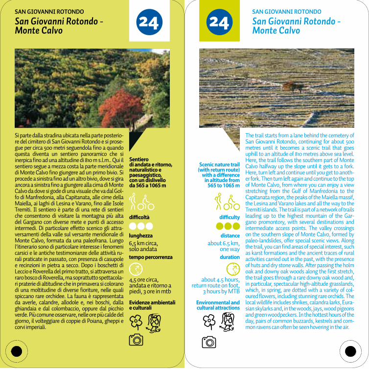
difficoltà difficulty
tempo percorrenza duration
Evidenze ambientali e culturali
Environmental and cultural attractions
Scenic nature trail (with return route)
with a difference in altitude from
565 to 1065 m
about 4.5 hours,return route on foot,
3 hours by MTB
distanceabout 6.5 km,
one way
4,5 ore circa, andata e ritorno a piedi, 3 ore in mtb
lunghezza6,5 km circa, solo andata
Sentiero di andata e ritorno, naturalistico e paesaggistico,con un dislivello da 565 a 1065 m
2424San Giovanni Rotondo - Monte Calvo
San Giovanni Rotondo - Monte Calvo
SAN GIOVANNI ROTONDO SAN GIOVANNI ROTONDO
Si parte dalla stradina ubicata nella parte posterio-re del cimitero di San Giovanni Rotondo e si prose-gue per circa 500 metri seguendola fino a quando questa diventa un sentiero panoramico che si inerpica fino ad una altitudine di 810 m s.l.m.. Qui il sentiero segue a mezza costa la parte meridionale di Monte Calvo fino giungere ad un primo bivio. Si procede a sinistra fino ad un altro bivio, dove si gira ancora a sinistra fino a giungere alla cima di Monte Calvo da dove si gode di una visuale che va dal Gol-fo di Manfredonia, alla Capitanata, alle cime della Maiella, ai laghi di Lesina e Varano, fino alle Isole Tremiti. Il sentiero è parte di una rete di sentieri che consentono di visitare la montagna più alta del Gargano con diverse mete e punti di accesso intermedi. Di particolare effetto scenico gli attra-versamenti della valle sul versante meridionale di Monte Calvo, formata da una paleofrana. Lungo l’itinerario sono di particolare interesse i fenomeni carsici e le antiche testimonianze delle attività ru-rali praticate in passato, con presenza di casupole e recinzioni in pietra a secco. Dopo i boschetti di Leccio e Roverella del primo tratto, si attraversa un raro bosco di Roverella, ma soprattutto spettacola-ri praterie di altitudine che in primavera si colorano di una moltitudine di diverse fioriture, nelle quali spiccano rare orchidee. La fauna è rappresentata da averle, calandre, allodole e, nei boschi, dalla ghiandaia e dal colombaccio, oppure dal picchio verde. Più comune osservare, nelle ore più calde del giorno, il volteggiare di coppie di Poiana, gheppi e corvi imperiali.
The trail starts from a lane behind the cemetery of San Giovanni Rotondo, continuing for about 500 metres until it becomes a scenic trail that goes uphill to an altitude of 810 metres above sea level. Here, the trail follows the southern part of Monte Calvo halfway up the slope until it gets to a fork. Here, turn left and continue until you get to anoth-er fork. Then turn left again and continue to the top of Monte Calvo, from where you can enjoy a view stretching from the Gulf of Manfredonia to the Capitanata region, the peaks of the Maiella massif, the Lesina and Varano lakes and all the way to the Tremiti islands. The trail is part of a network of trails leading up to the highest mountain of the Gar-gano promontory, with several destinations and intermediate access points. The valley crossings on the southern slope of Monte Calvo, formed by paleo-landslides, offer special scenic views. Along the trail, you can find areas of special interest, such as karst formations and the ancient traces of rural activities carried out in the past, with the presence of huts and dry stone walls. After passing the holm oak and downy oak woods along the first stretch, the trail goes through a rare downy oak wood and, in particular, spectacular high-altitude grasslands, which, in spring, are dotted with a variety of col-oured flowers, including stunning rare orchids. The local wildlife includes shrikes, calandra larks, Eura-sian skylarks and, in the woods, jays, wood pigeons and green woodpeckers. In the hottest hours of the day, pairs of common buzzards, kestrels and com-mon ravens can often be seen hovering in the air.

difficoltà difficulty
tempo percorrenza duration
Evidenze ambientali e culturali
Environmental and cultural attractions
about 2 hours on foot, 1 hour by MTB
distanceabout 5.7 km
Scenic circular nature trail
(with return route) with a difference
in altitude from 696 to 880 m
2 ore circa a piedi, 1 ora in mtb
lunghezza5,7 km circa
Sentiero ad anello, naturalistico e paesaggistico,con un dislivello da 696 a 880 m
2525Convento San Matteo - Fajarama
Convento San Matteo - Fajarama
SAN MARCO IN LAMIS SAN MARCO IN LAMIS
Si parte dal Convento di San Matteo e si prosegue su una strada comunale asfaltata fino all’ingresso nella Valle della Fajarama. Lungo l’itinerario sono di particolare interesse le antiche testimonianze delle attività praticate in passato nel bosco, quali aie carbonili, fornaci per la calce, neviere e mulattie-re per l’esbosco della legna. Seguendo le indicazio-ni si può raggiungere la sede Agesci nei pressi della quale vi sono aree attrezzate anche per disabili. Il percorso attraversa prima pioppeti e poi bellissimi boschi di alto fusto con i tipici alberi di caducifoglie submontane, come roverelle, cerri, aceri, carpini, ornielli, sorbi. Nelle vicinanze anche un piccolo nu-cleo di Faggio. In primavera le rare orchidee garga-niche colorano i prati ed il margine del bosco. Nel sottobosco, ciclamini, viole, pungitopo, anemoni, gigli e narcisi ma anche arbusti di Nespolo selvati-co, Corniolo, Nocciolo e rari agrifogli. Di particolare interesse la fauna osservabile fra cui il Picchio rosso mezzano che si nutre e scava i suoi nidi sui pioppi. Ci si può imbattere anche nella Ghiandaia e nel Colombaccio, nel Rigogolo oppure sentire il canto del Picchio verde. Sugli arbusti di nocciolo si può osservare il Moscardino. Lungo il percorso, tracce della presenza di cinghiale, volpe, faina e, più raro, del Capriolo.
The trail starts from the convent of San Matteo and continues along a municipal asphalt road to the en-trance to the Valle della Fajarama. Particularly in-teresting, along the route, are the ancient traces of activities carried out in the woods in the past, such as charcoal piles, lime kilns and mule tracks for log-ging purposes. Following the directions, you get to the Agesci (Italian scouts and guides association) headquarters, with adjacent areas also equipped for people with reduced mobility. At first, the trail goes through poplar woods, followed by beautiful woods with tall submontane deciduous trees, such as downy oaks, Turkey oaks, maples, hornbeams, the South European flowering ash and the moun-tain-ash. Nearby, there is also a clump of beech trees. In spring, the rare orchids of the Gargano colourfully dot the meadows and the edge of the woods. In the undergrowth, there are cyclamen, violets, butcher’s brooms, anemones, lilies and daffodils, as well as shrubs such as the wild medlar, Cornelian cherry, common hazel and rare holly. The local wildlife is of great interest and you may see a middle spotted woodpecker feeding and digging its nests on poplars. It is also easy to spot a jay, a wood pigeon, a golden oriole or hear a green woodpecker sing. On hazelnut shrubs, you may spot the hazel dormouse. Along the way, traces of the presence of wild boars, foxes, stone martens and, more rarely, of roe deer can also be found.
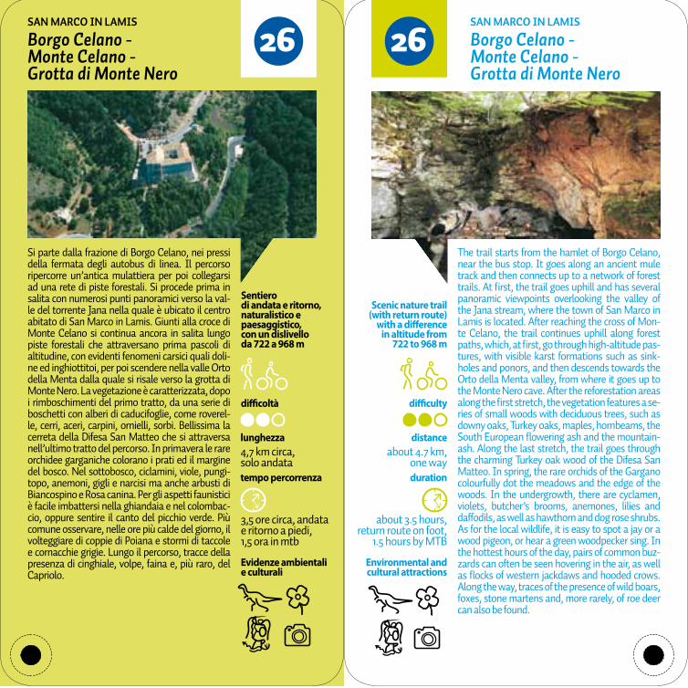
difficoltà difficulty
tempo percorrenza duration
Evidenze ambientali e culturali
Environmental and cultural attractions
Scenic nature trail (with return route)
with a difference in altitude from
722 to 968 m
distanceabout 4.7 km,
one way
about 3.5 hours, return route on foot,
1.5 hours by MTB
3,5 ore circa, andata e ritorno a piedi, 1,5 ora in mtb
lunghezza4,7 km circa, solo andata
Sentiero di andata e ritorno, naturalistico e paesaggistico,con un dislivello da 722 a 968 m
2626Borgo Celano - Monte Celano - Grotta di Monte Nero
Borgo Celano - Monte Celano - Grotta di Monte Nero
SAN MARCO IN LAMIS SAN MARCO IN LAMIS
Si parte dalla frazione di Borgo Celano, nei pressi della fermata degli autobus di linea. Il percorso ripercorre un’antica mulattiera per poi collegarsi ad una rete di piste forestali. Si procede prima in salita con numerosi punti panoramici verso la val-le del torrente Jana nella quale è ubicato il centro abitato di San Marco in Lamis. Giunti alla croce di Monte Celano si continua ancora in salita lungo piste forestali che attraversano prima pascoli di altitudine, con evidenti fenomeni carsici quali doli-ne ed inghiottitoi, per poi scendere nella valle Orto della Menta dalla quale si risale verso la grotta di Monte Nero. La vegetazione è caratterizzata, dopo i rimboschimenti del primo tratto, da una serie di boschetti con alberi di caducifoglie, come roverel-le, cerri, aceri, carpini, ornielli, sorbi. Bellissima la cerreta della Difesa San Matteo che si attraversa nell’ultimo tratto del percorso. In primavera le rare orchidee garganiche colorano i prati ed il margine del bosco. Nel sottobosco, ciclamini, viole, pungi-topo, anemoni, gigli e narcisi ma anche arbusti di Biancospino e Rosa canina. Per gli aspetti faunistici è facile imbattersi nella ghiandaia e nel colombac-cio, oppure sentire il canto del picchio verde. Più comune osservare, nelle ore più calde del giorno, il volteggiare di coppie di Poiana e stormi di taccole e cornacchie grigie. Lungo il percorso, tracce della presenza di cinghiale, volpe, faina e, più raro, del Capriolo.
The trail starts from the hamlet of Borgo Celano, near the bus stop. It goes along an ancient mule track and then connects up to a network of forest trails. At first, the trail goes uphill and has several panoramic viewpoints overlooking the valley of the Jana stream, where the town of San Marco in Lamis is located. After reaching the cross of Mon-te Celano, the trail continues uphill along forest paths, which, at first, go through high-altitude pas-tures, with visible karst formations such as sink-holes and ponors, and then descends towards the Orto della Menta valley, from where it goes up to the Monte Nero cave. After the reforestation areas along the first stretch, the vegetation features a se-ries of small woods with deciduous trees, such as downy oaks, Turkey oaks, maples, hornbeams, the South European flowering ash and the mountain-ash. Along the last stretch, the trail goes through the charming Turkey oak wood of the Difesa San Matteo. In spring, the rare orchids of the Gargano colourfully dot the meadows and the edge of the woods. In the undergrowth, there are cyclamen, violets, butcher’s brooms, anemones, lilies and daffodils, as well as hawthorn and dog rose shrubs. As for the local wildlife, it is easy to spot a jay or a wood pigeon, or hear a green woodpecker sing. In the hottest hours of the day, pairs of common buz-zards can often be seen hovering in the air, as well as flocks of western jackdaws and hooded crows. Along the way, traces of the presence of wild boars, foxes, stone martens and, more rarely, of roe deer can also be found.
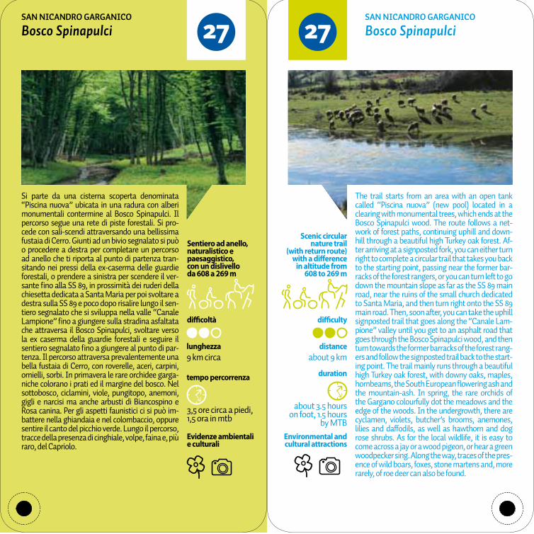
difficoltà difficulty
tempo percorrenza duration
Evidenze ambientali e culturali
Environmental and cultural attractions
about 3.5 hours on foot, 1.5 hours
by MTB
distanceabout 9 km
Scenic circular nature trail
(with return route) with a difference
in altitude from 608 to 269 m
3,5 ore circa a piedi, 1,5 ora in mtb
lunghezza9 km circa
Sentiero ad anello, naturalistico e paesaggistico,con un dislivello da 608 a 269 m
2727Bosco Spinapulci Bosco SpinapulciSAN NICANDRO GARGANICO SAN NICANDRO GARGANICO
Si parte da una cisterna scoperta denominata “Piscina nuova” ubicata in una radura con alberi monumentali contermine al Bosco Spinapulci. Il percorso segue una rete di piste forestali. Si pro-cede con sali-scendi attraversando una bellissima fustaia di Cerro. Giunti ad un bivio segnalato si può o procedere a destra per completare un percorso ad anello che ti riporta al punto di partenza tran-sitando nei pressi della ex-caserma delle guardie forestali, o prendere a sinistra per scendere il ver-sante fino alla SS 89, in prossimità dei ruderi della chiesetta dedicata a Santa Maria per poi svoltare a destra sulla SS 89 e poco dopo risalire lungo il sen-tiero segnalato che si sviluppa nella valle “Canale Lampione” fino a giungere sulla stradina asfaltata che attraversa il Bosco Spinapulci, svoltare verso la ex caserma della guardie forestali e seguire il sentiero segnalato fino a giungere al punto di par-tenza. Il percorso attraversa prevalentemente una bella fustaia di Cerro, con roverelle, aceri, carpini, ornielli, sorbi. In primavera le rare orchidee garga-niche colorano i prati ed il margine del bosco. Nel sottobosco, ciclamini, viole, pungitopo, anemoni, gigli e narcisi ma anche arbusti di Biancospino e Rosa canina. Per gli aspetti faunistici ci si può im-battere nella ghiandaia e nel colombaccio, oppure sentire il canto del picchio verde. Lungo il percorso, tracce della presenza di cinghiale, volpe, faina e, più raro, del Capriolo.
The trail starts from an area with an open tank called “Piscina nuova” (new pool) located in a clearing with monumental trees, which ends at the Bosco Spinapulci wood. The route follows a net-work of forest paths, continuing uphill and down-hill through a beautiful high Turkey oak forest. Af-ter arriving at a signposted fork, you can either turn right to complete a circular trail that takes you back to the starting point, passing near the former bar-racks of the forest rangers, or you can turn left to go down the mountain slope as far as the SS 89 main road, near the ruins of the small church dedicated to Santa Maria, and then turn right onto the SS 89 main road. Then, soon after, you can take the uphill signposted trail that goes along the “Canale Lam-pione” valley until you get to an asphalt road that goes through the Bosco Spinapulci wood, and then turn towards the former barracks of the forest rang-ers and follow the signposted trail back to the start-ing point. The trail mainly runs through a beautiful high Turkey oak forest, with downy oaks, maples, hornbeams, the South European flowering ash and the mountain-ash. In spring, the rare orchids of the Gargano colourfully dot the meadows and the edge of the woods. In the undergrowth, there are cyclamen, violets, butcher’s brooms, anemones, lilies and daffodils, as well as hawthorn and dog rose shrubs. As for the local wildlife, it is easy to come across a jay or a wood pigeon, or hear a green woodpecker sing. Along the way, traces of the pres-ence of wild boars, foxes, stone martens and, more rarely, of roe deer can also be found.

difficoltà difficulty
tempo percorrenza duration
Evidenze ambientali e culturali
Environmental and cultural attractions
about 1 hour,return route on foot
distanceabout 2.1 km,
one way
Scenic nature trail (with return route)
with a difference in altitude from
3 to 0 m
1 ora circa, andata e ritorno a piedi
lunghezza2,1 km circa, solo andata
Sentiero di andata e ritorno, naturalistico e paesaggistico,con un dislivello da 3 a 0 m
2828Torre Mileto - Torre di Calarossa
Torre Mileto - Torre di Calarossa
SAN NICANDRO GARGANICO SAN NICANDRO GARGANICO
Si tratta di un bel sentiero costiero, non attrezzato, storico-naturalistico che si sviluppa a pochi me-tri dal mare. Si parte dalla bellissima e restaurata Torre Mileto, le cui origini risalgono all’anno 1500, che ospita un centro visite del Parco Nazionale del Gargano. Il percorso segue un piccolo sentiero che si sviluppa fa scogli e macchia mediterranea fino a giungere ai ruderi di Torre Calarossa, altra torre costiera di avvistamento militare del 1500; qui la spiaggetta di Calarossa invita ad un bagno ristoratore. In lontananza, nel mare, si vedono chiaramente le Isole Tremiti. Da evidenziare come il percorso attraversa aree rocciose con sparsi ce-spugli della macchia mediterranea, come lentischi, filliree, ginepri, alaterni e olivastri, alcuni anche con caratteristiche di monumentalità. Di particolare effetto scenico le forme da vento assunte da questi arbusti. In primavera le rare orchidee garganiche colorano i prati. Per gli aspetti faunistici si segnala la presenza del Gabbiano reale, Beccapesci, Sterna, Mignattini. Più comuni le evoluzioni verso le aree interne del Gheppio e della Poiana. Lungo il percor-so, tracce della presenza di volpe, faina e, più raro, del gatto selvatico.
It is a beautiful unequipped historical and scenic nature trail along the coast, just a few metres away from the sea. It starts from the magnificent reno-vated Torre Mileto, dating back to the year 1500. The tower houses one of the visitor centres of the Gargano National Park. The trail follows a narrow path that runs through the rocks and the Mediter-ranean maquis, until it reaches the ruins of Torre Calarossa, another coastal military watchtower dated 1500. Here, the small beach of Calarossa is the ideal place for a refreshing swim. In the dis-tance, in the sea, the Tremiti islands can be clearly seen. In particular, the trail passes through rocky areas with the scattered shrubs of the Mediter-ranean maquis, such as mastic, phillyrea, juniper, Mediterranean buckthorn and wild olive, some of which are quite monumental in size. Some of these shrubs have been shaped by the wind with remark-able scenic effects. In spring, the rare orchids of the Gargano colourfully dot the meadows. The local wildlife includes the yellow-legged gull, the Sand-wich tern, the black tern and black terns. Inland kestrels and common buzzards can often be seen hovering in the air. Along the way, traces of the presence of foxes, stone martens and, more rarely, of wildcats can be found.
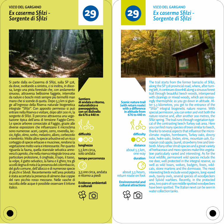
difficoltà difficulty
tempo percorrenza duration
Evidenze ambientali e culturali
Environmental and cultural attractions
about 3,5 hours, return route on foot
distanceabout 5.5 km,
one way
Scenic nature trail (with return route)
with a difference in altitude from
676 to 440 m
3,5 ore circa, andata e ritorno a piedi
lunghezza5,5 km circa, solo andata
Sentiero di andata e ritorno, naturalistico e paesaggistico,con un dislivello da 676 a 440 m
2929Ex caserma Sfilzi - Sorgente di Sfilzi
Ex caserma Sfilzi - Sorgente di Sfilzi
VICO DEL GARGANO VICO DEL GARGANO
Si parte dalla ex-Caserma di Sfilzi, sulla SP 528, da dove, svoltando a sinistra, ci si inoltra, in disce-sa, lungo una pista forestale che, con andamento sinuoso, attraversa bellissime faggete, interrotte da radure o boschi misti sempre più termofili man mano che si scende di quota. Dopo 5,3 km si giun-ge all’ingresso della Riserva naturale biogenetica integrale “Sfilzi”. Con apposito permesso si può entrare nella Riserva e visitare, dopo altri 200 m, la sorgente di Sfilzi. Il percorso attraversa una vege-tazione tipica dell’area di tensione Faggio-Cerro. Le specie arboree consociate al Faggio, grazie alle diverse esposizioni che influenzano il microclima sono numerose: aceri, carpini, cerro, roverella, lec-cio, tiglio, olmo, sorbo, melastro, alloro, corbezzolo e terebinto. Molte altre specie arbustive ed un ricco corteggio di specie erbacee e muscinee, rendono la vegetazione molto varia e interessante. Per quanto riguarda la fauna, quella stanziale selvatica anno-vera il capriolo, che nella riserva integrale trova una particolare protezione, il cinghiale, il lupo, il tasso, la volpe, il gatto selvatico, la faina e il ghiro; tra gli uccelli degna di nota è la presenza del colombaccio, del gufo comune, dell’allocco e di numerose specie di picchi e Silvidi. Recentemente nell’area protetta è stata accertata la presenza di almeno due coppie del raro picchio rosso mezzano. Nelle vasche di raccolta delle acque è possibile osservare il tritone italico.
The trail starts from the former barracks of Sfilzi, along the SP 528 provincial road, where, after turn-ing left, it continues downhill along a sinuous forest trail through beautiful beech woods, interspersed with clearings or mixed woods, which are increas-ingly thermophilic as you go down in altitude. Af-ter 5.3 kilometres, you get to the entrance of the “Sfilzi” integral biogenetic nature reserve. With special permission, you can enter and visit both the nature reserve and, after another 200 metres, the Sfilzi spring. The trail runs through vegetation typi-cal of the contrasting beech-Turkey oak area. Here you can find many species of trees similar to beech, thanks to several aspects that influence the micro-climate: maples, hornbeams, Turkey oaks, downy oaks, holm oaks, linden, elms, mountain-ash, Eu-ropean crab apple, laurel, strawberry tree and tere-binth. Many other shrub species and a great variety of herbaceous and moss species make this vegeta-tion particularly varied and interesting. As for the local wildlife, permanent wild species include the roe deer, well protected in the integral reserve, as well as wild boars, wolves, badgers, foxes, wild-cats, stone martens and the dormouse. The most interesting birds include wood pigeons, long-eared owls, tawny owls, several species of woodpeckers and Sylviid warblers. Recently, in the protected area, two pairs of rare middle spotted woodpeckers have been spotted. The Italian newt can be seen in water collection tanks.
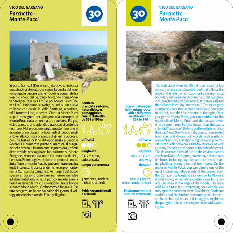
difficoltà difficulty
tempo percorrenza duration
Evidenze ambientali e culturali
Environmental and cultural attractions
about 5 hours, return route on foot
distanceabout 8.6 km,
one way
Scenic nature trail (with return route)
with a difference in altitude from
569 to 196 m
5 ore circa, andata e ritorno a piedi
lunghezza8,6 km circa, solo andata
Sentiero di andata e ritorno, naturalistico e paesaggistico,con un dislivello da 569 a 196 m
3030Parchetto - Monte Pucci
Parchetto - Monte Pucci
VICO DEL GARGANO VICO DEL GARGANO
Si parte S.S. 528 (Km 14+450) da dove si imbocca una stradina sterrata che segue la cresta del rilie-vo sul quale decorre anche il confine comunale fra Peschici e Vico del Gargano, toccando prima Mon-te Stregone (221 m s.l.m.) e poi Monte Pucci (196 m s.l.m.). L’itinerario si svolge, quindi su un rilievo collinare che divide la Valle Santiago, a sinistra, ed il torrente Ulse, a destra. Giunti a Monte Pucci si può proseguire per giungere alla necropoli di Monte Pucci e alla omonima torre costiera. Più giù, vicino al mare, uno splendido trabucco si protende nel mare. Nel procedere lungo questo itinerario si incontreranno dapprima boschetti di Leccio misti a Roverella con ricca presenza di ginestra odorosa, poi una fustaia di Pino d’Aleppo mista a Leccio e Roverella e numerose piante di marruca al margi-ne della strada. Un ambiente segnato dagli effetti distruttivi del passaggio del fuoco ritorna su Monte Stregone, ricoperto da una fitta macchia di cisti, Lentisco, Fillirea e giovani piante di pino e di Leccio. Sulla Torre di monte Pucci si può ammirare una fra le più interessanti piante endemiche del promonto-rio: la Campanula garganica. Ai margini del bosco spesso si possono osservare numerose orchidee ed altre rarità botaniche. Di particolare interesse la fauna osservabile tra cui il Rondone. Tra le fronde si nascondono Merlo, Occhiocotto e fringuelli. Più raro scorgere, nelle ore più calde del giorno, il vol-teggiare e le picchiate del Falco pellegrino.
The trail starts from the SS 528 main road (at km 14+450), where you take a dirt road that follows the ridge of the relief, which also marks the municipal boundary between Peschici and Vico del Gargano, including first Monte Stregone (221 metres asl) and then Monte Pucci (196 metres asl). The route goes along a hilly area that separates the Valle Santiago, to the left, and the Ulse stream, to the right. Once you get to Monte Pucci, you can continue to the necropolis of Monte Pucci and the coastal tower of the same name. Further down, near the sea, a splendid “trabucco” (fishing platform) juts out into the sea. Along the way, initially you can see, mixed holm oak and downy oak woods with plenty of weaver’s broom, and then a high Aleppo pine for-est mixed with holm oaks and downy oaks, as well as many Christ’s thorn plants at the side of the trail. The destructive effect of fire on the environment is visible on Monte Stregone, covered by a dense area of shrubs including sage-leaved rock roses, mas-tic, phyllirea, young pine and holm oaks. On the tower of Monte Pucci, you can admire one of the most interesting native plants of the promontory: the Campanula Garganica (a unique bellflower). A wide variety of orchids and other rare plants can often be seen at the edge of the woods. The local wildlife is particularly interesting, for example you may spot the common swift. Blackbirds, Sardinian warblers and chaffinches hide among tree branch-es. In the hottest hours of the day, you might see the peregrine falcon hovering in the air and swoop-ing by.

difficoltà difficulty
tempo percorrenza duration
Evidenze ambientali e culturali
Environmental and cultural attractions
about 4 hours, return route on foot
distanceabout 6 km,
one way
Scenic nature trail (with return route)
with a difference in altitude from
611 to 322 m
4 ore circa, andata e ritorno a piedi
lunghezza6 km circa, solo andata
Sentiero di andata e ritorno, naturalistico e paesaggistico,con un dislivello da 611 a 322 m
3131Località Sagro - area archeologica San Salvatore
Località Sagro - area archeologica San Salvatore
VIESTE VIESTE
Si parte dal km 123,50 della SS 89, nella località “Sa-gro”. Arrivando da Vieste si svolta a sinistra in una stradina sterrata dove ci accoglie subito una gran-de cerro monumentale. Si prosegue attraversando le località “Femminamorta” e “Mediola”, anch’es-se caratterizzate da numerosi alberi monumen-tali, fino ad arrivare, dopo 3,8 km, alla Masseria la Sgarrazza, oggi adibita ad agriturismo. Si prosegue per altri 3,2 km fino a raggiungere la località San Salvatore, situata a 400 m sul livello del mare, il cui ambiente è molto suggestivo perchè caratterizzato dalla presenza di lastre calcaree, di ulivi contorti, fe-nomeni carsici come i cutini (depressioni del terre-no che raccolgono acque meteoriche), denominati il primo San Salvatore ed il secondo Lama la Vita ma, soprattutto, una vasta necropoli Dauna (VI- III sec a.C.) non attrezzata.Il percorso attraversa prima lembi di cerreta ma soprattutto pascoli con alberi sparsi e nuclei di roverelle, cerri, aceri, carpini, ornielli, sorbi. In pri-mavera le rare orchidee garganiche colorano i prati ed il margine del bosco. Di particolare interesse la fauna osservabile fra cui la Ghiandaia, il Colombac-cio, il Rigogolo e il Picchio verde. Più comune scor-gere, nelle ore più calde del giorno, il volteggiare di coppie di Poiana. Lungo il percorso, tracce della presenza di cinghiale, volpe, faina e, più raro, del Capriolo.
The trail starts from the SS 89 main road (at km 123.50), in Sagro. Coming from the direction of Vi-este, turn left into the dirt road, where you can im-mediately see a monumental Turkey oak tree. The trail then continues through Femminamorta and Mediola, which also feature many monumental trees, until, after 3.8 kilometres, you get to the Mas-seria la Sgarrazza, now an “agriturismo” (farm-house restaurant). The unequipped trail continues for another 3.2 kilometres as far as San Salvatore, located 400 metres above sea level, in a very pic-turesque setting, since it features limestone slabs, twisted olive trees, and karst formations such as two “cutini” (depressions that collect meteoric water), known as San Salvatore and Lama la Vita, as well as, an extensive archaeological site with a Daunian necropolis (6th-3rd century BC).The trail passes areas of Turkey oaks and, in par-ticular, meadows with scattered trees and clumps of downy oaks, Turkey oaks, maples, hornbeams, the South Flowering ash and mountain-ash. In spring, the rare orchids of the Gargano colourfully dot the meadows and the edge of the woods. The local wildlife is particularly interesting and includes jays, wood pigeons, golden orioles and green woodpeckers. In the hottest hours of the day, pairs of common buzzards can often be seen hovering in the air. Along the way, traces of the presence of wild boars, foxes, stone martens and, more rarely, of roe deer can also be found.
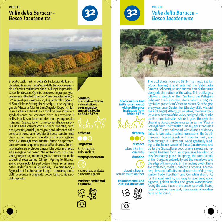
difficoltà difficulty
tempo percorrenza duration
Evidenze ambientali e culturali
Environmental and cultural attractions
about 4 hours, return route on foot
distanceabout 6.1 km,
one way
Scenic nature trail (with return route)
with a difference in altitude from
364 to 817 m
4 ore circa, andata e ritorno a piedi
lunghezza6,1 km circa, solo andata
Sentiero di andata e ritorno, naturalistico e paesaggistico,con un dislivello da 364 a 817 m
3232Valle della Baracca - Bosco Iacotenente
Valle della Baracca - Bosco Iacotenente
VIESTE VIESTE
Si parte dal km 116,10 della SS 89, lasciando la stra-da ed inoltrandosi nella Valle della Baracca seguen-do un’antica mulattiera che si sviluppa in prossimi-tà del fondovalle. Questo percorso segue per gran parte un tratto dell’itinerario “Sentiero dei pellegri-ni” lungo il quale ogni anno, il 29 settembre (giorno di San Michele Arcangelo) si svolge un pellegrinag-gio da Vieste a Monte Sant’Angelo. Dopo 3,5 km la mulattiera abbandona il fondovalle e s’inerpica gradualmente sul versante dove si attraversa il bellissimo Bosco Iacotenente fino a giungere alla “piscina” Gravaglione”. Il percorso attraversa pri-ma una bella cerreta con nuclei di roverelle, cerri, aceri, carpini, ornielli, sorbi, poi gradualmente dalla cerreta si passa alle faggete di Bosco Iacotenente che ci accompagnano fino alla piscina Gravaglione dove alcuni faggi monumentali fanno da spettaco-lare contorno a questo posto affascinante. In pri-mavera le rare orchidee garganiche colorano i prati ed il margine del bosco. Nel sottobosco, ciclamini, viole, pungitopo, anemoni, gigli e narcisi ma anche arbusti di rosa canina, Ginepri, Agrifoglio, Bianco-spino e Corniolo. Di particolare interesse la fauna osservabile fra cui la Ghiandaia, il Colombaccio, il Rigogolo e il Picchio verde. Lungo il percorso, tracce della presenza di cinghiale, volpe, faina e, più raro, del Capriolo.
The trail starts from the SS 89 main road (at km 116.10), leaving it and entering the Valle della Baracca, following an ancient mule track that runs alongside the bottom of the valley. This trail largely follows a stretch of the “Sentiero dei Pellegrini (Pilgrims’ trail) itinerary, along which a pilgrim-age takes place from Vieste to Monte Sant’Angelo every year on 29 September (the day of St. Michael the Archangel). After 3.5 kilometres, the mule track leaves the bottom of the valley and gradually climbs up the mountainside, where it goes through the charming Bosco Iacotenente as far as the “Piscina Gravaglione”. The trail then initially goes through a beautiful Turkey oak wood with clumps of downy oaks, Turkey oaks, maples, hornbeams, the South European flowering ash and mountain-ash, and then through a Turkey oak wood gradually lead-ing to the beech woods of Bosco Iacotenente and up to the Gravaglione pool, where several monu-mental beeches form an impressive backdrop to this fascinating place. In spring, the rare orchids of the Gargano colourfully dot the meadows and the edge of the woods. In the undergrowth, there are cyclamen, violets, butcher’s brooms, anemo-nes, lilies and daffodils but also shrubs of dog rose, juniper, holly, hawthorn and Cornelian cherry. As for the local wildlife, it is easy to spot jays, wood pigeons, golden orioles and green woodpeckers. Along the way, traces of the presence of wild boars, foxes, stone martens and, more rarely, of roe deer can also be found.

3333Baracconi - Laghetto d’Umbra
Baracconi - Laghetto d’Umbra
fORESTA UMBRA. Sentiero per disabili fORESTA UMBRA. Sentiero per disabili
Facile percorso naturalistico dalla località Barac-coni al laghetto d’Umbra, in territorio di Monte Sant’Angelo, nel cuore della Foresta Umbra. L’iti-nerario è stato appositamente realizzato con fondo stabilizzato e pannelli braille. Il percorso è facilitato da una staccionata e da piastrelle di orientamento. Di grande interesse naturalistico gli ambienti visita-bili costituiti dal bosco di Faggio e dal laghetto. Nel sottobosco, ciclamini, viole, pungitopo, anemoni, gigli e narcisi ma anche arbusti di Biancospino, Agrifoglio e Rosa canina. Per gli aspetti faunistici ci si può imbattere nella ghiandaia e nel colombaccio, oppure sentire il canto del picchio verde o il tambu-rellare del Picchio rosso maggiore. Tra le fronde si nascondono le cinciallegre e gli scriccioli, mentre dopo il tramonto si può sentire la civetta, il bar-bagianni, il gufo comune o l’Allocco. Più comune osservare, nelle ore più calde del giorno, il volteg-giare di coppie di Poiana o vedere lo sfrecciare dello Sparviero o dell’Astore. Lungo il percorso, tracce della presenza di cinghiale, volpe, faina e, più raro, del Capriolo e del Gatto selvatico. Fra i rettili osser-vabili il cervone, la biscia dal collare e la testuggine palustre. Fra gli anfibi il Rospo e la Raganella.
An easy nature trail from Baracconi to the small lake Umbra, in the territory of Monte Sant’Angelo, in the heart of the Foresta Umbra. The route has been specifically built with a stabilised surface and braille panels. For ease, a fence has been installed along the trail and special tiles for orientation. The places to visit are of great natural interest and include a beech wood and a small lake. In the un-dergrowth, there are cyclamen, violets, butcher’s brooms, anemones, lilies and daffodils but also shrubs of hawthorn, holly and dog rose. As for the local wildlife, it is easy to spot a jay or a wood pi-geon, hear a green woodpecker sing or the great spotted woodpecker hammer on tree trunks. Great tits and wrens hide among the foliage, whereas, after sunset, the little owl, barn owl, long-eared owl and tawny owl can be heard. In the hottest hours of the day, pairs of common buzzards can of-ten be seen hovering in the air, and sparrowhawks or northern goshawks can be seen sweeping by. Along the way, traces of the presence of wild boars, foxes, stone martens and, more rarely, of roe deer and wildcats can also be found. The reptiles you may spot include the four-lined snake, the grass snake and the European pond turtle, whereas am-phibians include the common toad and the Euro-pean tree frog.
Evidenze ambientali e culturali
tempo percorrenza
difficoltà
1 ora circa, andata e ritorno
lunghezza500 m circa, solo andata
Sentiero di andata e ritorno per disabili motori e ipovedenti, di interesse naturalistico e paesaggistico,con un dislivello da 807 a 780 m
difficulty
duration
distanceabout 500 m,
one way
about 1 hour, return route
Environmental and cultural attractions
Scenic nature trail (with return route)
for people with reduced mobility or visual impairment,
with a difference in altitude from
807 to 780 m
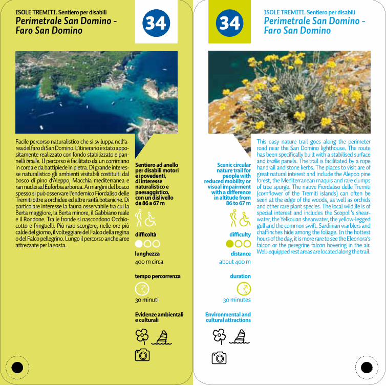
Evidenze ambientali e culturali
difficoltà
tempo percorrenza
30 minuti
lunghezza400 m circa
Sentiero ad anello per disabili motori e ipovedenti, di interesse naturalistico e paesaggistico,con un dislivello da 86 a 67 m
3434Perimetrale San Domino - Faro San Domino
Perimetrale San Domino - Faro San Domino
Facile percorso naturalistico che si sviluppa nell’a-rea del faro di San Domino. L’itinerario è stato appo-sitamente realizzato con fondo stabilizzato e pan-nelli braille. Il percorso è facilitato da un corrimano in corda e da battipiede in pietra. Di grande interes-se naturalistico gli ambienti visitabili costituiti dal bosco di pino d’Aleppo, Macchia mediterranea e rari nuclei ad Euforbia arborea. Ai margini del bosco spesso si può osservare l’endemico Fiordaliso delle Tremiti oltre a orchidee ed altre rarità botaniche. Di particolare interesse la fauna osservabile fra cui la Berta maggiore, la Berta minore, il Gabbiano reale e il Rondone. Tra le fronde si nascondono Occhio-cotto e fringuelli. Più raro scorgere, nelle ore più calde del giorno, il volteggiare del Falco della regina o del Falco pellegrino. Lungo il percorso anche aree attrezzate per la sosta.
This easy nature trail goes along the perimeter road near the San Domino lighthouse. The route has been specifically built with a stabilised surface and braille panels. The trail is facilitated by a rope handrail and stone kerbs. The places to visit are of great natural interest and include the Aleppo pine forest, the Mediterranean maquis and rare clumps of tree spurge. The native Fiordaliso delle Tremiti (cornflower of the Tremiti islands) can often be seen at the edge of the woods, as well as orchids and other rare plant species. The local wildlife is of special interest and includes the Scopoli’s shear-water, the Yelkouan shearwater, the yellow-legged gull and the common swift. Sardinian warblers and chaffinches hide among the foliage. In the hottest hours of the day, it is more rare to see the Eleonora’s falcon or the peregrine falcon hovering in the air. Well-equipped rest areas are located along the trail.
ISOLE TREMITI. Sentiero per disabili ISOLE TREMITI. Sentiero per disabili
Environmental and cultural attractions
30 minutes
duration
distanceabout 400 m
difficulty
Scenic circular nature trail for
people with reduced mobility or
visual impairment with a difference
in altitude from 86 to 67 m


![Dispensa testi latini e greci - Professoressa Orrù · PDF file2 2016-2017 [dispensa testi latini e greci] – classe v b latino seneca epistulae morales ad lucilium lettera xlvii.](https://static.fdocuments.us/doc/165x107/5a78ef387f8b9a4f1b8e9867/dispensa-testi-latini-e-greci-professoressa-orr-2016-2017-dispensa-testi-latini.jpg)