
“Lost Communities” of Virginia - Virginia Department
82
Virginia Department of Historic Resources Number 50 2006
Transcript of “Lost Communities” of Virginia - Virginia Department
Virginia Department of Historic ResourcesNumber 50 2006
Notes from the Director 3
Virginia Landmarks Register: 111 New Listings 5
Curator’s Corner: Artifacts from DHR’s Collections: 47The Origin of American Blue-and-Gray StonewareBy Robert Taft Kiser
Fort Monroe: “Bulwark of American Civilization and Freedom” 51By Michael Cobb
Oscar Micheaux, “Race Films,” and Roanoke’s Strand Theater 59By John Kern
Identifying the “Lost Communities” of Virginia 63By Terri Fisher
New Preservation Easements Protect 17 Historic Properties 70
47 New Historical Markers for Virginia’s Roadways 75
The Historic Rehabilitation Tax-Credit Program 78
Virginia Department of Historic Resources2801 Kensington AvenueRichmond, Virginia 23221
www.dhr.virginia.gov
Kathleen S. Kilpatrick, Director
Notes on Virginia is published annually by the Department of Historic Resources. Editor: Randall B. Jones. Special assistance in compiling the VLR entries provided by DHRhistorian Kelly Spradley-Kurwoski. Photographic research and technical assistance: AlisonSnow and DHR 2006 summer intern Lee Lovelace. Designer: Judy Rumble, Virginia Office ofGraphic Communications, Department of General Services. All photographs are from thedepartment’s archives, unless otherwise noted. Notes on Virginia is a free publication; to sub-scribe contact DHR. Recent issues, as well as this one, are posted on the department’s website.
Virginia Department of Historic ResourcesNumber 50 2006
2 Notes on Virginia 2006
Central Office:2801 Kensington AvenueRichmond, VA 23221(804) 367-2323(804) 367-2391 (fax)
Capital Regional Office:2801 Kensington AvenueRichmond, VA 23221(804) 367-2323(804) 367-2391 (fax)
Northern Regional Office:5357 Main StreetStephens City, VA 22655(540) 868-7030(540) 868-7033
Roanoke Regional Office:1030 Penmar Avenue SERoanoke, VA 24013(540) 857-7585(540) 857-7588 (fax)
Notes on Virginia was financed, in part,with federal funds from the U.S.Department of the Interior, through theDepartment of Historic Resources,Commonwealth of Virginia. Under TitleVI of the Civil Rights Act of 1964 andSection 504 of the Rehabilitation Act of1973, the U.S. Department of the Interiorprohibits discrimination on the basis ofrace, color, national origin, or disability inits federally assisted programs. If youbelieve that you have been discriminatedagainst in any program or activitydescribed herein, or if you desire furtherinformation, please write to the Office ofEqual Opportunity, U.S Department of theInterior, MS 5221 – 1949 C Street, NW,Washington, D.C. 20240. The contentsand opinions of this journal do not neces-sarily reflect the views or policies of theDepartment of the Interior, nor does anymention of trade names or commercialproducts constitute endorsement or rec-ommendations by the Department of theInterior. The Virginia Department ofHistoric Resources, in accordance withthe American Disabilities Act, will makethis publication available in Braille, largeprint, or audiotape upon request. Pleaseallow 4 to 6 weeks for delivery.
Virginia Historic Resources Board
Patrick H. Butler,Chairman, Alexandria
Helen T. Murphy,Vice-Chairman, Mt. Holly
John W. Braymer, RichmondJeanne S. Evans, Virginia BeachRachel O. Flynn, RichmondOra S. McCoy, AppomattoxAddison B. Thompson, Richmond
State Review Board Members
Warren R. Hofstra,Chairman, Winchester
Carl R. Lounsbury,Vice Chairman, Williamsburg
Ann Field Alexander, RoanokeBarbara Heath, Lynchburg Carl R. Lounsbury, Williamsburg Michael B. Newbill, Virginia BeachR. Madison Spencer, Charlottesville
The mission of the Department of Historic
Resources is to foster, encourage, and
support the stewardship and use of
Virginia’s significant architectural,
archaeological, and cultural resources.
Our Mission
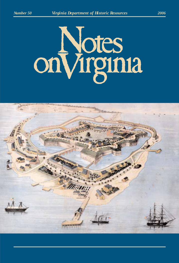
Cover image:
A birds-eye view of “Fortress Monroe”,
Virginia, February 1862. See page 51.
(Credit: Courtesy Casemate Museum,
Fort Monroe)
DHRDepartment of Historic Resources
The Department of Historic Resources is a proud partner of:
Notes on Virginia 2006 3
Notes from the DirectorKathleen S. Kilpatrick
As we publish this issue of Notes on Virginia in 2007, Jamestown’s 400th anniversary is well under-way, with activities ranging from the rededication of the State Capitol after its superb restoration, to avisit by Queen Elizabeth II, to exciting new exhibits at Jamestown Island, the site—as everyone readingthis surely must know—of the first permanent English settlement in North America.
Jamestown 2007 reveals that we have come of age in preservation. Grounded, literally, more in histo-ry than myth, this year’s anniversary crowns more than a decade of archaeological research and scholarlyinvestigation by APVA-Preservation Virginia and educational programming by both APVA and theJamestown-Yorktown Foundation that reposition Jamestown within our understanding of America’s story.Finally, the London Company’s fledgling Virginia settlement stands as the introductory chapter in thisnation’s founding, no longer relegated to a footnote. Its story encapsulates and forecasts central themes inAmerica’s history—representative governance; private enterprise and land ownership; individual rewardand self-renewal; and cultural and racial conflict and unity.
Jamestown’s revitalized, re-imagined story shows us, by example, not only the necessity but also thevalue of preservation. Sustained and successful preservation deepens and broadens our understanding ofhistory, and feeds a hunger for greater authenticity in our communities and even in our commemorationsof historic events. Jamestown-related programs in communities throughout the state reflect a seasonedsensibility that invites an unprecedented inclusiveness. Anniversary-affiliated activities, for instance, havebrought to the fore the stories of Virginia’s Indian community, whose ancestors—Virginia’s “FirstPeople”—were here at least 15,000 years before the English arrived.
Thus the Jamestown story is now also that of Werowocomoco, the Powhatan people’s capital whenEuropeans first arrived in Virginia. Located on the York River, just 15 miles away from Jamestown, andalready thousands of years old in 1607, Werowocomoco is now vanished except for archaeological ves-tiges. But those traces give us a greater understanding Virginia’s history long before, during, and immedi-ately after Jamestown’s settling. In June of 2006, this department—which has supported research atWerowocomoco for many years in cooperation with the site’s owners, Lynn and Bob Ripley, the VirginiaIndian community, and the College of William & Mary—listed it on the Virginia Landmarks Register (p. 44) and the National Register of Historic Places as a pre-Jamestown tribute to Virginia’s First People.
Comparing the anniversary of 2007 to 1957, the contrast is striking. Fifty years ago Jamestown ceremonies were mostly insular occasions limited by locale and race, where the fable of John Smith, andPocahontas and John Rolfe was pretty much the centerpiece. No wonder people long perceivedJamestown as just an interesting footnote in American history.
During the intervening 50 years, we have grown. Today Virginia is a national leader in historicpreservation, as its citizens and leaders reclaim and reinvest in the Commonwealth’s rich historic legacy.Our agency (and its predecessor, the Virginia Landmarks Commission) has played a vital role in this maturation process. In 2006, DHR celebrated its 40th anniversary and that of the National HistoricPreservation Act, national legislation in 1966 that called for a State Historic Preservation Office in everystate, a role this department serves in Virginia; that national act also established a broad-based preserva-tion ethic that guided the development of initiatives and programs, including the National Register ofHistoric Places (NRHP), which is administered in Virginia by DHR. In 1966 the Commonwealth also cre-ated the Virginia Landmarks Register, the state’s parallel program to the National Register. Now middleaged, both the state and national register programs remain robust, as can be seen in the following pageshighlighting 111 VLR and NRHP sites, a record-number of register listings for a single year. Such successindicates the program’s popularity, since private property owners and communities drive register listings.
4 Notes on Virginia 2006
Last year was also the 40th anniversary of the state’s preservation easement program (p. 70), a modelfor the nation of cost-effective stewardship of historic buildings, structures, sites, and landscapes. DHRnow administers easements, often in cooperation with the Virginia Outdoors Foundation, on 427 proper-ties. The visionary reach of this program was made vivid to me one evening late last year when, on behalfof this department, I signed easements on two extraordinary Virginia properties: Shirley Plantation, inCharles City County, Virginia’s first plantation (1613), and Bremo, in Fluvanna County, which includesone of America’s foremost works of Palladian-style architecture, Upper Bremo, completed in 1820. Whatbetter anniversary gift could Virginians ask for? The easement at Shirley preserves its historic core build-ings and 100 acres, the one at Bremo, its buildings as well as 1,500 acres. Those two easements capped ayear in which our department also obtained easements on The Breakthrough Battlefield (p. 70) andStratford Hall (p. 73), among 15 other outstanding places now protected against development, a gift thatwill pay forward for future generations.
When we consider Virginia’s leadership in preservation, it is important to note that this department isa non-regulatory agency. Our success depends on the voluntary actions of private landowners, organiza-tions, businessmen, and developers. We use a variety of tools, however, to encourage preservation; fore-most among them are tax-credit incentives for donating easements or rehabilitating historic buildings. TheGeneral Assembly in 1996 authorized the state’s rehabilitation tax-credit program (p. 78), which parallelsa similar federal program; these rehabilitation tax incentives have transformed and revitalized manyneighborhoods and historic downtowns, spurring economic development and renewing community prideby recycling buildings for adaptive reuse as retail, business, or residential spaces. The state programboosts the federal one, putting Virginia consistently among the top five states in the nation in as manyyears for federal tax-credit rehabilitation projects. Most recently, in March 2007, the National ParkService ranked Virginia second among all states for such rehabilitations in two distinct categories—“proposed” and “completed” projects—during fiscal year 2006, the second consecutive year Virginia hasattained the number two slot.
Virginia also encourages preservation leadership by example. And there is no better proof ofVirginia’s exemplary leadership—at the national level—than the restoration of our Jefferson-designedState Capitol, rededicated during an April ceremony. Careful interior and exterior refurbishing of theCapitol and its belowground expansion preserves this irreplaceable landmark while adapting it to serve21st-century needs. Our agency, which worked with the Department of General Services during the reno-vation, commends DGS, the General Assembly, and Governors Mark Warner and Timothy M. Kaine forproviding crucial leadership and vision in doing what is best for one of our most important landmarks.Earlier this year, DHR nominated the Capitol to the United Nation’s World Heritage Tentative List for (a first round) decision in 2008.
Preservation leadership—through the efforts of our department in collaboration with other agencies—extends as well to other state-owned sites. Beginning in 2005 and into 2006, DHR partnered with theDepartment of Conservation and Recreation to list on the state and national registers Virginia’s first-sixparks. The initiative commemorated the 70th anniversary of Virginia’s park system, opened in 1936. In2005 First Landing (now Seashore) and Westmoreland were the first parks listed; in 2006 we completedthe task by adding Douthat, Fairy Stone, Hungry Mother, and Staunton River (p. 45). Elsewhere, theOliver Hill (formerly the Finance) Building (p. 13), another outstanding state property, located on CapitolSquare, and recently brought from the brink of demolition to restoration, was listed on the two registers.
Stewardship of public property is very much at the heart of the future plans for Fort Monroe. It willbe returned to the Commonwealth by the U.S. Army through the Base Realignment and Closure nowunderway. DHR is hard at work in the BRAC process, engaged with various local, state, and federal agen-cies including the Army. This issue’s cover story discusses the history of this monumental landmark thatoversees Hampton Roads, which the current fort has guarded for nearly two centuries, as its predecessorsdid since as early as 1609.
(cont. on page 46)
Notes on Virginia 2006 5
Virginia Landmarks Register:111 New Listings
Between July 1, 2005 and June 30, 2006 (the state’s fiscal year), the Department of HistoricResources—or technically its two boards: the Board of Historic Resources and the State ReviewBoard—approved the addition of 111 new properties to the Virginia Landmarks Register. That’s a
record number of VLRs for one year. And it explains Virginia’s success nationally in listing properties onthe National Register of Historic Places, since nearly all properties listed on the VLR are forwarded to theNational Park Service for nomination to the National Register. A VLR property is rarely turned away bythe NPS, since the criteria used for the VLR are the same as those used for the National Register. In late2006, the National Park Service ranked Virginia first—for the second year in a row—among the 50 statesfor the number of historic districts it listed on the National Register during federal fiscal year 2006 (1 Oct.2005–30 Sept. 2006); the NPS also ranked the Commonwealth second nationwide for the combined totalof historic districts and individual properties listed on the National Register during the same period.
Since the General Assembly established the Virginia Landmarks Register in 1966, the recognition ofmore than 2,500 places to date has focused the public’s attention on Virginia’s spectacular historic legacy.The VLR is the state’s official list of places and structures important to understanding Virginia’s (and,hence, the nation’s) culture and history; the state register covers the full range of Virginia’s historicresources—from prehistoric times to, most recently, the 1950s. It features a broad assortment of individu-ally listed buildings, houses, bridges—even boats and a railroad car—and archaeological sites, as well asmore than 400 rural and urban historic districts that may include any number, variety, or combination ofstructures and other resources. This fabulous array of landmarks is evidenced in the recent VLR listingsprofiled in the pages that follow.
In recent years the Department of Historic Resources also has aimed to increase the public’s aware-ness of, and appreciation for the rich diversity inherent in Virginia’s historic legacy by listing on the stateand national registers important resources associated with African American, Virginia Indian, andwomen’s history, as well as that of other minority groups. (The department’s highway marker programhas undertaken a similar effort as well; see page 75.) Thus, of the 111 new VLR properties herein,24 recognize Virginia’s diverse historic legacy (as indicated by a ● ).
In addition to boosting public awareness of Virginia’s diverse legacy, the department also has encouraged improved stewardship by individuals, private organizations, and local governments and stateagencies of state-owned landmarks or other resources. Thus, the department has pushed in recent years tolist on the state register more state-owned properties such as the Oliver Hill Building (page 13) to encour-age improved stewardship. Of the 111 VLRs, eight are state owned (as noted by a ■ ).
The entries that follow are listed alphabetically and grouped according to the appropriate region asdetermined by the department’s four regional field offices in Richmond (the Capital Region), Roanoke,Newport News (the Tidewater Region), and Stephens City (the Northern Region). Each VLR profile isbased on information taken directly or in paraphrase from its nomination form. These forms are preparedby DHR staff, property owners, local officials, or paid consultants, and they are all available in a PDF format on the DHR website (www.dhr.virginia.gov). They include detailed architectural information andhistory about each historic property or resource and are wonderful resources in themselves for learningmore about Virginia’s history.
6 Notes on Virginia 2006
Capital Region
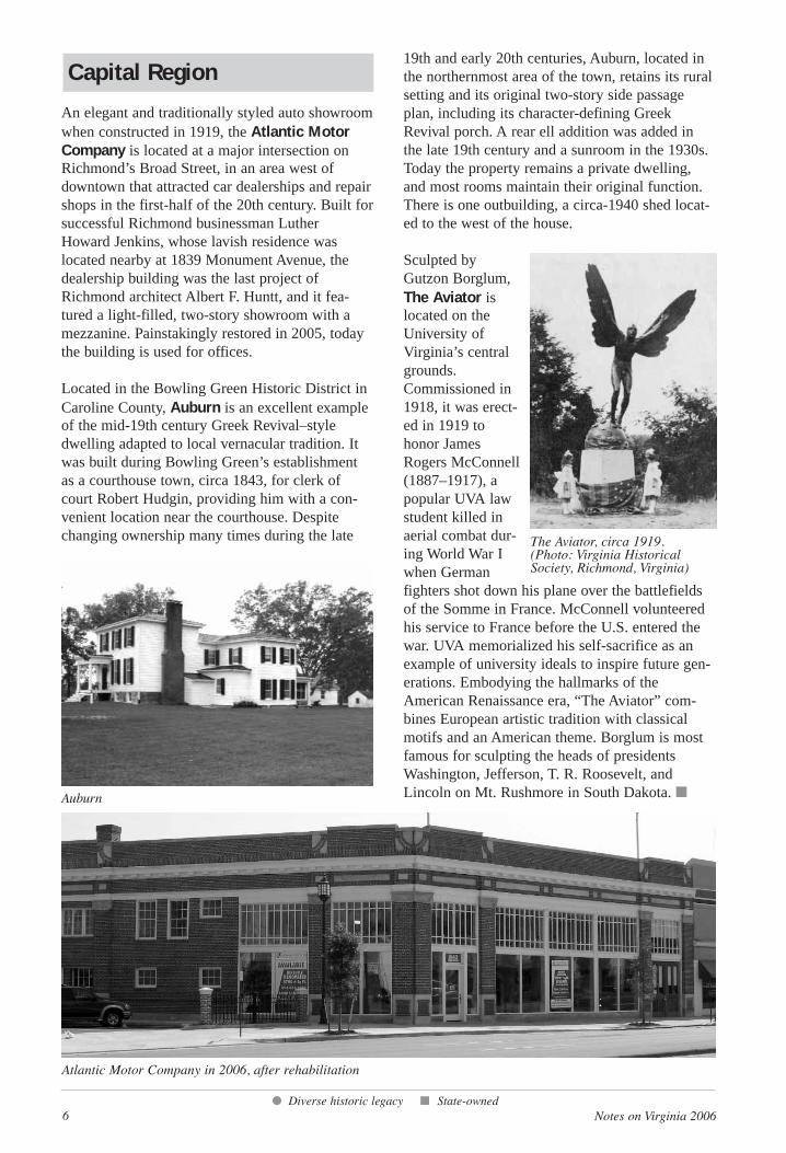
An elegant and traditionally styled auto showroomwhen constructed in 1919, the Atlantic MotorCompany is located at a major intersection onRichmond’s Broad Street, in an area west ofdowntown that attracted car dealerships and repairshops in the first-half of the 20th century. Built forsuccessful Richmond businessman Luther Howard Jenkins, whose lavish residence waslocated nearby at 1839 Monument Avenue, thedealership building was the last project ofRichmond architect Albert F. Huntt, and it fea-tured a light-filled, two-story showroom with amezzanine. Painstakingly restored in 2005, todaythe building is used for offices.
Located in the Bowling Green Historic District inCaroline County, Auburn is an excellent exampleof the mid-19th century Greek Revival–styledwelling adapted to local vernacular tradition. Itwas built during Bowling Green’s establishmentas a courthouse town, circa 1843, for clerk ofcourt Robert Hudgin, providing him with a con-venient location near the courthouse. Despitechanging ownership many times during the late
19th and early 20th centuries, Auburn, located inthe northernmost area of the town, retains its ruralsetting and its original two-story side passageplan, including its character-defining GreekRevival porch. A rear ell addition was added inthe late 19th century and a sunroom in the 1930s.Today the property remains a private dwelling,and most rooms maintain their original function.There is one outbuilding, a circa-1940 shed locat-ed to the west of the house.
Sculpted byGutzon Borglum,The Aviator islocated on theUniversity ofVirginia’s centralgrounds.Commissioned in1918, it was erect-ed in 1919 tohonor JamesRogers McConnell(1887–1917), apopular UVA lawstudent killed inaerial combat dur-ing World War Iwhen Germanfighters shot down his plane over the battlefieldsof the Somme in France. McConnell volunteeredhis service to France before the U.S. entered thewar. UVA memorialized his self-sacrifice as anexample of university ideals to inspire future gen-erations. Embodying the hallmarks of theAmerican Renaissance era, “The Aviator” com-bines European artistic tradition with classicalmotifs and an American theme. Borglum is mostfamous for sculpting the heads of presidentsWashington, Jefferson, T. R. Roosevelt, andLincoln on Mt. Rushmore in South Dakota. ■
● Diverse historic legacy ■ State-owned
Auburn
The Aviator, circa 1919. (Photo: Virginia HistoricalSociety, Richmond, Virginia)
Atlantic Motor Company in 2006, after rehabilitation
Notes on Virginia 2006 7
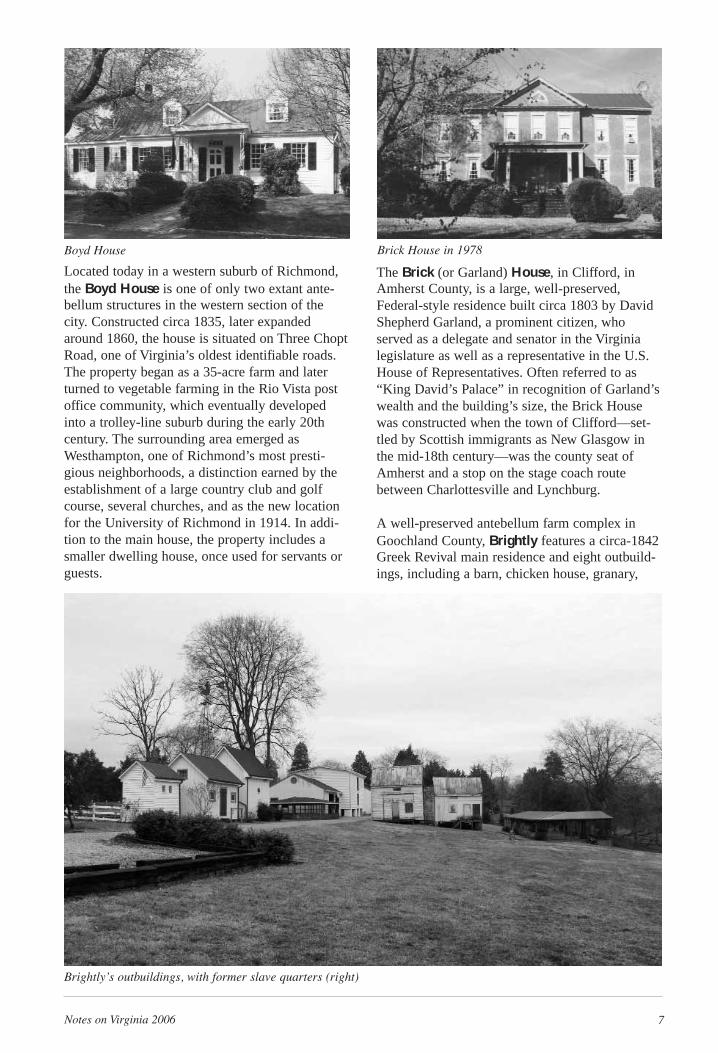
Located today in a western suburb of Richmond,the Boyd House is one of only two extant ante-bellum structures in the western section of thecity. Constructed circa 1835, later expandedaround 1860, the house is situated on Three ChoptRoad, one of Virginia’s oldest identifiable roads.The property began as a 35-acre farm and laterturned to vegetable farming in the Rio Vista postoffice community, which eventually developedinto a trolley-line suburb during the early 20thcentury. The surrounding area emerged asWesthampton, one of Richmond’s most presti-gious neighborhoods, a distinction earned by theestablishment of a large country club and golfcourse, several churches, and as the new locationfor the University of Richmond in 1914. In addi-tion to the main house, the property includes asmaller dwelling house, once used for servants orguests.
The Brick (or Garland) House, in Clifford, inAmherst County, is a large, well-preserved,Federal-style residence built circa 1803 by DavidShepherd Garland, a prominent citizen, whoserved as a delegate and senator in the Virginialegislature as well as a representative in the U.S.House of Representatives. Often referred to as“King David’s Palace” in recognition of Garland’swealth and the building’s size, the Brick Housewas constructed when the town of Clifford—set-tled by Scottish immigrants as New Glasgow inthe mid-18th century—was the county seat ofAmherst and a stop on the stage coach routebetween Charlottesville and Lynchburg.
A well-preserved antebellum farm complex inGoochland County, Brightly features a circa-1842Greek Revival main residence and eight outbuild-ings, including a barn, chicken house, granary,
Boyd House Brick House in 1978
Brightly’s outbuildings, with former slave quarters (right)
8 Notes on Virginia 2006
privy, well house, windmill, and a pair of slavedwellings linked by a common chimney. Thebuildings are within an area clearly defined bygateposts and a long privet hedge, and convey thesense of a “village,” the description applied tomany Virginia plantations in contemporaryaccounts. Built for George Harris, Brightly distin-guished itself from other James River plantationssuch as Tuckahoe and Howard’s Neck because itwas neither a huge riverfront estate nor owned bya wealthy planter. Harris was a local physician—aprofessional, not a planter—and Brightly a smallfarm located near the county’s courthouse village.Its two surviving frame slave dwellings revealmuch about the life of enslaved persons inGoochland during the late antebellum era.
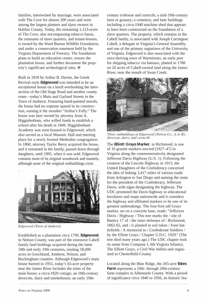
Clarkton Bridge, in Charlotte County, employsan efficient “Camelback” steel truss system for itsspan across the Staunton River. Erected in 1902by Virginia Bridge & Iron Co., of Roanoke,Clarkton is the only surviving metal truss bridgein Virginia built for highway use that is supportedby steel piers, once a common engineering prac-tice. Its name derives from the village of Clarkton,which began as a rail station and express office onthe Lynchburg and Durham (now Norfolk andWestern) Railroad on the large plantation ofThomas Clark. In 2005, the Virginia Departmentof Transportation, in association with the ClarktonBridge Alliance, rehabilitated the structure fornon-vehicular use. ■
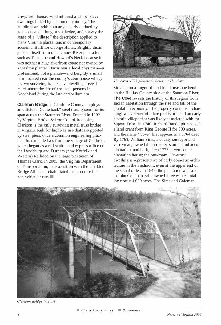
Situated on a finger of land in a horseshoe bendon the Halifax County side of the Staunton River,The Cove reveals the history of this region fromIndian habitation through the rise and fall of theplantation economy. The property contains archae-ological evidence of a late prehistoric and an earlyhistoric village that was likely associated with theSaponi Tribe. In 1740, Richard Randolph receiveda land grant from King George II for 500 acres,and the name “Cove” first appears in a 1764 deed.By 1768, William Sims, a county surveyor andvestryman, owned the property, started a tobaccoplantation, and built, circa 1773, a vernacularplantation house; the one-room, 11/2-storydwelling is representative of early domestic archi-tecture in the Piedmont, even at the upper end ofthe social order. In 1843, the plantation was soldto John Coleman, who owned three estates total-ing nearly 4,000 acres. The Sims and Coleman
● Diverse historic legacy ■ State-owned
The circa-1773 plantation house at The Cove
Clarkton Bridge in 1994
Notes on Virginia 2006 9
families, intertwined by marriage, were associatedwith The Cove for almost 200 years and wereamong the largest planters and slave owners inHalifax County. Today, the remaining 1,123-acresof The Cove, also encompassing tobacco barns,the remnants of slave quarters, and tenant-houses,is owned by the Ward Burton Wildlife Foundation,and under a conservation easement held by theVirginia Department of Forestry. The foundationplans to build an education center, restore theplantation house, and further document the prop-erty’s significant archeological sites. ●
Built in 1818 by Arthur B. Davies, the GreekRevival–style Edgewood was intended to be anexceptional house on a knoll overlooking the inter-section of the Old Stage Road and another countyroute—today’s Main and Garland Streets in theTown of Amherst. Featuring hand-painted murals,the house had no expense spared in its construc-tion, earning it the moniker “Arthur’s Folly.” Thehouse was later owned by attorney Jesse A.Higginbotham, who willed funds to establish aschool after his death in 1849. HigginbothamAcademy was soon housed in Edgewood, whichalso served as a local Masonic Hall and meetingplace for a newly formed Methodist congregation.In 1860, attorney Taylor Berry acquired the house,and it remained in the family, passed down throughdaughters, until 1995, when it was sold. Edgewoodcontains most of its original woodwork and mantels,although none of the original outbuildings exist.
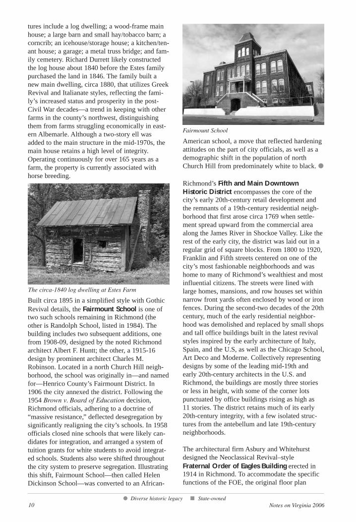
Established as a plantation circa 1790, Edgewood,in Nelson County, was part of the extensive Cabellfamily land holdings acquired during the latter18th and early 19th centuries, totaling 58,000acres in Goochland, Amherst, Nelson, andBuckingham counties. Although Edgewood’s mainhouse burned in 1955, today’s 65-acre propertynear the James River includes the ruins of themain house; a circa-1820 cottage; an 18th-centurydovecote, dairy and smokehouse; an early 19th-
century icehouse and corncrib; a mid-19th-centurybarn or granary; a cemetery, and later buildingsincluding a circa-1940 machine shed that appearsto have been constructed on the foundation of aslave quarters. The property, which remains in theCabell family, is associated with Joseph CarringtonCabell, a delegate to Virginia’s General Assembly,and one of the primary organizers of the Universityof Virginia. Edgewood is also associated with theonce-thriving town of Warminster, an early portfor shipping tobacco via bateaux, platted in 1788on 20 acres of Cabell-owned land along the JamesRiver, near the mouth of Swan Creek.
The Elliott Grays Marker, in Richmond, is oneof 16 granite markers erected (1927–47) inVirginia along the commemoratively designatedJefferson Davis Highway (U.S. 1). Following thecreation of the Lincoln Highway in 1913, theUnited Daughters of the Confederacy conceivedthe idea of linking 3,417 miles of various roadsfrom Arlington to San Diego and naming the routefor the president of the Confederacy, JeffersonDavis, with signs designating the highway. TheUDC promoted the Davis highway in educationalbrochures and maps nationwide and it considersthe highway and affiliated markers to be one of itsgreatest undertakings. The four-foot tall Graysmarker, set on a concrete base, reads: “JeffersonDavis / Highway / This tree marks the / site ofBattery 17 of / the inner defenses of / Richmond,1862-65, and / is planted in soil taken / from bat-tlefields / A memorial to / Confederate Soldiers /by the Elliott Grays / Chapter U.D.C. 1929.” (Thetree died many years ago.) The UDC chapter tookits name from Company I, 6th Virginia Infantry,The Elliott Grays, a Civil War militia unit organ-ized in Chesterfield County.
Located along the Blue Ridge, the 265-acre EstesFarm represents a 19th- through 20th-centuryfarm complex in Albemarle County. With a periodof significance circa 1840 to 1956, its historic fea-
Edgewood (Town of Amherst)
Three outbuildings at Edgewood (Nelson Co.; L to R):dovecote, dairy, and corncrib
10 Notes on Virginia 2006
tures include a log dwelling; a wood-frame mainhouse; a large barn and small hay/tobacco barn; acorncrib; an icehouse/storage house; a kitchen/ten-ant house; a garage; a metal truss bridge; and fam-ily cemetery. Richard Durrett likely constructedthe log house about 1840 before the Estes familypurchased the land in 1846. The family built anew main dwelling, circa 1880, that utilizes GreekRevival and Italianate styles, reflecting the fami-ly’s increased status and prosperity in the post-Civil War decades—a trend in keeping with otherfarms in the county’s northwest, distinguishingthem from farms struggling economically in east-ern Albemarle. Although a two-story ell wasadded to the main structure in the mid-1970s, themain house retains a high level of integrity.Operating continuously for over 165 years as afarm, the property is currently associated withhorse breeding.
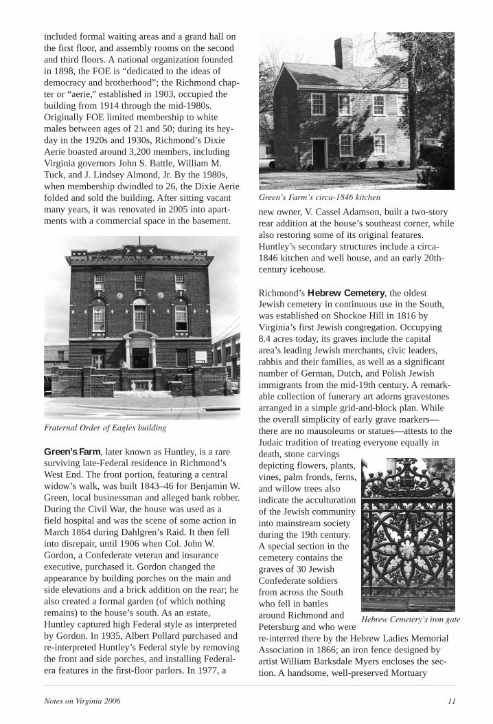
Built circa 1895 in a simplified style with GothicRevival details, the Fairmount School is one oftwo such schools remaining in Richmond (theother is Randolph School, listed in 1984). Thebuilding includes two subsequent additions, onefrom 1908-09, designed by the noted Richmondarchitect Albert F. Huntt; the other, a 1915-16design by prominent architect Charles M.Robinson. Located in a north Church Hill neigh-borhood, the school was originally in—and namedfor—Henrico County’s Fairmount District. In1906 the city annexed the district. Following the1954 Brown v. Board of Education decision,Richmond officials, adhering to a doctrine of“massive resistance,” deflected desegregation bysignificantly realigning the city’s schools. In 1958officials closed nine schools that were likely can-didates for integration, and arranged a system oftuition grants for white students to avoid integrat-ed schools. Students also were shifted throughoutthe city system to preserve segregation. Illustratingthis shift, Fairmount School—then called HelenDickinson School—was converted to an African-
American school, a move that reflected hardeningattitudes on the part of city officials, as well as ademographic shift in the population of northChurch Hill from predominately white to black. ●
Richmond’s Fifth and Main DowntownHistoric District encompasses the core of thecity’s early 20th-century retail development andthe remnants of a 19th-century residential neigh-borhood that first arose circa 1769 when settle-ment spread upward from the commercial areaalong the James River in Shockoe Valley. Like therest of the early city, the district was laid out in aregular grid of square blocks. From 1800 to 1920,Franklin and Fifth streets centered on one of thecity’s most fashionable neighborhoods and washome to many of Richmond’s wealthiest and mostinfluential citizens. The streets were lined withlarge homes, mansions, and row houses set withinnarrow front yards often enclosed by wood or ironfences. During the second-two decades of the 20thcentury, much of the early residential neighbor-hood was demolished and replaced by small shopsand tall office buildings built in the latest revivalstyles inspired by the early architecture of Italy,Spain, and the U.S, as well as the Chicago School,Art Deco and Moderne. Collectively representingdesigns by some of the leading mid-19th and early 20th-century architects in the U.S. andRichmond, the buildings are mostly three storiesor less in height, with some of the corner lotspunctuated by office buildings rising as high as 11 stories. The district retains much of its early20th-century integrity, with a few isolated struc-tures from the antebellum and late 19th-centuryneighborhoods.
The architectural firm Asbury and Whitehurstdesigned the Neoclassical Revival–style Fraternal Order of Eagles Building erected in1914 in Richmond. To accommodate the specificfunctions of the FOE, the original floor plan
● Diverse historic legacy ■ State-owned
The circa-1840 log dwelling at Estes Farm
Fairmount School
Notes on Virginia 2006 11
included formal waiting areas and a grand hall onthe first floor, and assembly rooms on the secondand third floors. A national organization foundedin 1898, the FOE is “dedicated to the ideas ofdemocracy and brotherhood”; the Richmond chap-ter or “aerie,” established in 1903, occupied thebuilding from 1914 through the mid-1980s.Originally FOE limited membership to whitemales between ages of 21 and 50; during its hey-day in the 1920s and 1930s, Richmond’s DixieAerie boasted around 3,200 members, includingVirginia governors John S. Battle, William M.Tuck, and J. Lindsey Almond, Jr. By the 1980s,when membership dwindled to 26, the Dixie Aeriefolded and sold the building. After sitting vacantmany years, it was renovated in 2005 into apart-ments with a commercial space in the basement.
Green’s Farm, later known as Huntley, is a raresurviving late-Federal residence in Richmond’sWest End. The front portion, featuring a centralwidow’s walk, was built 1843–46 for Benjamin W.Green, local businessman and alleged bank robber.During the Civil War, the house was used as afield hospital and was the scene of some action inMarch 1864 during Dahlgren’s Raid. It then fellinto disrepair, until 1906 when Col. John W.Gordon, a Confederate veteran and insuranceexecutive, purchased it. Gordon changed theappearance by building porches on the main andside elevations and a brick addition on the rear; healso created a formal garden (of which nothingremains) to the house’s south. As an estate,Huntley captured high Federal style as interpretedby Gordon. In 1935, Albert Pollard purchased andre-interpreted Huntley’s Federal style by removingthe front and side porches, and installing Federal-era features in the first-floor parlors. In 1977, a
new owner, V. Cassel Adamson, built a two-storyrear addition at the house’s southeast corner, whilealso restoring some of its original features.Huntley’s secondary structures include a circa-1846 kitchen and well house, and an early 20th-century icehouse.
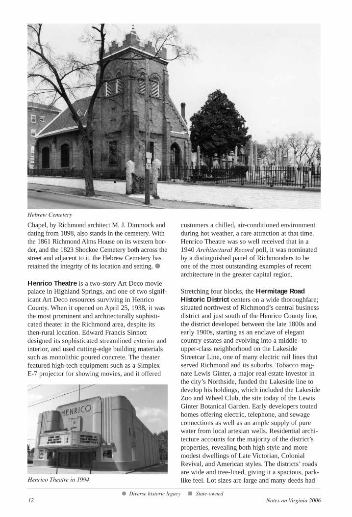
Richmond’s Hebrew Cemetery, the oldestJewish cemetery in continuous use in the South,was established on Shockoe Hill in 1816 byVirginia’s first Jewish congregation. Occupying8.4 acres today, its graves include the capitalarea’s leading Jewish merchants, civic leaders,rabbis and their families, as well as a significantnumber of German, Dutch, and Polish Jewishimmigrants from the mid-19th century. A remark-able collection of funerary art adorns gravestonesarranged in a simple grid-and-block plan. Whilethe overall simplicity of early grave markers—there are no mausoleums or statues—attests to theJudaic tradition of treating everyone equally indeath, stone carvingsdepicting flowers, plants,vines, palm fronds, ferns,and willow trees alsoindicate the acculturationof the Jewish communityinto mainstream societyduring the 19th century.A special section in thecemetery contains thegraves of 30 JewishConfederate soldiersfrom across the Southwho fell in battlesaround Richmond andPetersburg and who werere-interred there by the Hebrew Ladies MemorialAssociation in 1866; an iron fence designed byartist William Barksdale Myers encloses the sec-tion. A handsome, well-preserved Mortuary
Green’s Farm’s circa-1846 kitchen
Fraternal Order of Eagles building
Hebrew Cemetery’s iron gate
12 Notes on Virginia 2006
Chapel, by Richmond architect M. J. Dimmock anddating from 1898, also stands in the cemetery. Withthe 1861 Richmond Alms House on its western bor-der, and the 1823 Shockoe Cemetery both across thestreet and adjacent to it, the Hebrew Cemetery hasretained the integrity of its location and setting. ●
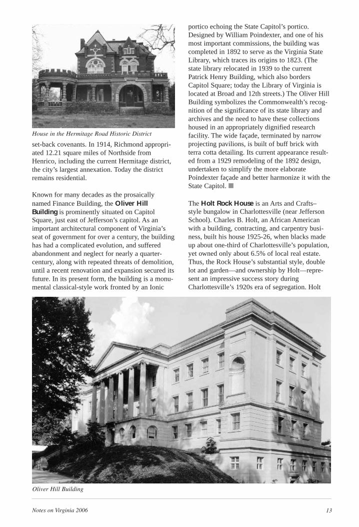
Henrico Theatre is a two-story Art Deco moviepalace in Highland Springs, and one of two signif-icant Art Deco resources surviving in HenricoCounty. When it opened on April 25, 1938, it wasthe most prominent and architecturally sophisti-cated theater in the Richmond area, despite itsthen-rural location. Edward Francis Sinnottdesigned its sophisticated streamlined exterior andinterior, and used cutting-edge building materialssuch as monolithic poured concrete. The theaterfeatured high-tech equipment such as a SimplexE-7 projector for showing movies, and it offered
customers a chilled, air-conditioned environmentduring hot weather, a rare attraction at that time.Henrico Theatre was so well received that in a1940 Architectural Record poll, it was nominatedby a distinguished panel of Richmonders to beone of the most outstanding examples of recentarchitecture in the greater capital region.
Stretching four blocks, the Hermitage RoadHistoric District centers on a wide thoroughfare;situated northwest of Richmond’s central businessdistrict and just south of the Henrico County line,the district developed between the late 1800s andearly 1900s, starting as an enclave of elegantcountry estates and evolving into a middle- toupper-class neighborhood on the LakesideStreetcar Line, one of many electric rail lines thatserved Richmond and its suburbs. Tobacco mag-nate Lewis Ginter, a major real estate investor inthe city’s Northside, funded the Lakeside line todevelop his holdings, which included the LakesideZoo and Wheel Club, the site today of the LewisGinter Botanical Garden. Early developers toutedhomes offering electric, telephone, and sewageconnections as well as an ample supply of purewater from local artesian wells. Residential archi-tecture accounts for the majority of the district’sproperties, revealing both high style and moremodest dwellings of Late Victorian, ColonialRevival, and American styles. The districts’ roadsare wide and tree-lined, giving it a spacious, park-like feel. Lot sizes are large and many deeds had
● Diverse historic legacy ■ State-owned
Hebrew Cemetery
Henrico Theatre in 1994
Notes on Virginia 2006 13
set-back covenants. In 1914, Richmond appropri-ated 12.21 square miles of Northside fromHenrico, including the current Hermitage district,the city’s largest annexation. Today the districtremains residential.
Known for many decades as the prosaicallynamed Finance Building, the Oliver HillBuilding is prominently situated on CapitolSquare, just east of Jefferson’s capitol. As animportant architectural component of Virginia’sseat of government for over a century, the buildinghas had a complicated evolution, and sufferedabandonment and neglect for nearly a quarter-century, along with repeated threats of demolition,until a recent renovation and expansion secured itsfuture. In its present form, the building is a monu-mental classical-style work fronted by an Ionic
portico echoing the State Capitol’s portico.Designed by William Poindexter, and one of hismost important commissions, the building wascompleted in 1892 to serve as the Virginia StateLibrary, which traces its origins to 1823. (Thestate library relocated in 1939 to the currentPatrick Henry Building, which also bordersCapitol Square; today the Library of Virginia islocated at Broad and 12th streets.) The Oliver HillBuilding symbolizes the Commonwealth’s recog-nition of the significance of its state library andarchives and the need to have these collectionshoused in an appropriately dignified researchfacility. The wide façade, terminated by narrowprojecting pavilions, is built of buff brick withterra cotta detailing. Its current appearance result-ed from a 1929 remodeling of the 1892 design,undertaken to simplify the more elaboratePoindexter façade and better harmonize it with theState Capitol. ■
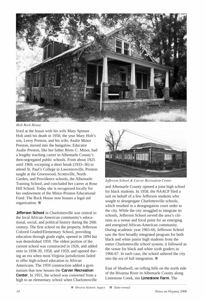
The Holt Rock House is an Arts and Crafts–style bungalow in Charlottesville (near JeffersonSchool). Charles B. Holt, an African Americanwith a building, contracting, and carpentry busi-ness, built his house 1925-26, when blacks madeup about one-third of Charlottesville’s population,yet owned only about 6.5% of local real estate.Thus, the Rock House’s substantial style, doublelot and garden—and ownership by Holt—repre-sent an impressive success story duringCharlottesville’s 1920s era of segregation. Holt
House in the Hermitage Road Historic District
Oliver Hill Building
14 Notes on Virginia 2006
lived at the house with his wife Mary SpinnerHolt until his death in 1950, the year Mary Holt’sson, Leroy Preston, and his wife, Asalie MinorPreston, moved into the bungalow. EducatorAsalie Preston, like her father Rives C. Minor, hada lengthy teaching career in Albemarle County’sthen-segregated public schools. From about 1925until 1969, excepting a short break (1933–36) toattend St. Paul’s College in Lawrenceville, Prestontaught at the Greenwood, Scottsville, NorthGarden, and Providence schools, the AlbemarleTraining School, and concluded her career at RoseHill School. Today she is recognized locally forher endowment of the Minor-Preston EducationalFund. The Rock House now houses a legal aidorganization. ●
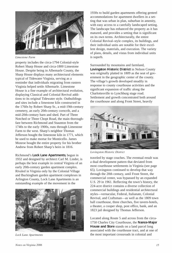
Jefferson School in Charlottesville was central tothe local African-American community’s educa-tional, social, and political history during the 20thcentury. The first school on the property, JeffersonColored Graded/Elementary School, providingeducation through grade eight, opened in 1894 butwas demolished 1959. The oldest portion of thecurrent school was constructed in 1926, and addedonto in 1938-39, 1958, and 1959, and opened dur-ing an era when most Virginia jurisdictions failedto offer high-school education to AfricanAmericans. The 1959 construction added a gym-nasium that now houses the Carver RecreationCenter. In 1951, the school was converted from ahigh to an elementary school when Charlottesville
and Albemarle County opened a joint high schoolfor black students. In 1958, the NAACP filed asuit on behalf of a few Jefferson students whosought to desegregate Charlottesville schools,which resulted in a desegregation court order tothe city. While the city struggled to integrate itsschools, Jefferson School served the area’s citi-zens as a venue and focal point for an emergingand energized African-American community.During academic year 1965-66, Jefferson Schoolsaw the first broadly integrated program for bothblack and white junior high students from theentire Charlottesville school system; it followed asthe venue for black and white sixth graders in1966-67. In each case, the school ushered the cityinto the era of full integration. ●
East of Shadwell, on rolling hills on the north sideof the Rivanna River in Albemarle County alongLimestone Creek, sits Limestone Farm. The
● Diverse historic legacy ■ State-owned
Jefferson School & Carver Recreation Center
Holt Rock House
1930s to build garden apartments offering genteelaccommodations for apartment dwellers in a set-ting that was urban in plan, suburban in amenity,with easy access to a carefully landscaped setting.The landscape has enhanced the property as it hasmatured, and provides a setting that is significanton its own terms. Architecturally, the entireColonial Revival–style complex, its buildings, andtheir individual units are notable for their excel-lent design, materials, and execution. The varietyof plans, details, and vistas from individual unitsis superb.
Surrounded by mountains and farmland,Lovingston Historic District in Nelson Countywas originally platted in 1809 as the seat of gov-ernment in the geographic center of the county.The village’s growth developed steadily inresponse to county courthouse activities and thesignificant expansion of traffic along theCharlottesville to Lynchburg stage road.Settlement and growth concentrated both aroundthe courthouse and along Front Street, heavily
traveled by stage couches. The eventual result wasa dual development pattern that deviated frommost courthouse settlements in Virginia (see page65). Lovingston continued to develop that waythrough the 20th century, until Front Street, thecommercial center, was bypassed by an expandedU.S. 29 in 1961. Reflecting the town’s history, the224-acre district contains a diverse collection ofcommercial buildings and residential architecturalstyles—vernacular, Federal, Italianate, ColonialRevival, and Craftsman—as well as the 1809 townhall courthouse, three churches, five tavern-hotels,a theater, a cooper shop, post office, bank, and an1823 jail designed by Thomas Jefferson.
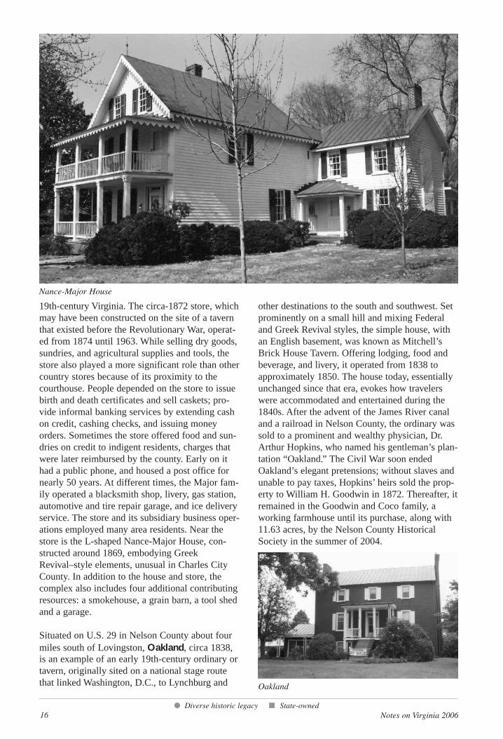
Located along Route 5 and across from the circa-1750 Charles City Courthouse, the Nance-MajorHouse and Store stands on a land parcel longassociated with the courthouse tract, and at one ofthe most important crossroads in colonial and
Notes on Virginia 2006 15
property includes the circa-1794 Colonial-styleRobert Sharp House and circa-1800 LimestoneHouse. Despite being in Albemarle County, theSharp House displays many architectural elementstypical of Tidewater Virginia, serving as areminder that individuals migrating from easternVirginia helped settle Albemarle. LimestoneHouse is a fine example of architectural evolution,displaying Classical and Colonial Revival addi-tions to its original Tidewater style. Outbuildingsand sites include a limestone kiln constructed inthe 1760s by Robert Sharp Sr., a mid-19th-centurycemetery, an early 20th-century corncrib, and amid-20th-century barn and shed. Part of ThreeNotched or Three Chopt Road, the main thorough-fare between Richmond and Staunton from the1740s to the early 1900s, runs through LimestoneFarm to the west. Sharp’s neighbor ThomasJefferson bought the limestone kiln in 1771, whichhe used to make mortar for Monticello. JamesMonroe bought the entire property for his brotherAndrew from Robert Sharp’s heirs in 1816.
Richmond’s Lock Lane Apartments, begun in1932 and designed by architect Carl M. Linder, isperhaps the best example in central Virginia of anearly 20th-century garden apartment complex.Rivaled in Virginia only by the Colonial Villageand Buckingham garden apartment complexes inArlington County, Lock Lane Apartments is anoutstanding example of the movement in the
Limestone Farm
Lock Lane Apartments
Lovingston Historic District
16 Notes on Virginia 2006
19th-century Virginia. The circa-1872 store, whichmay have been constructed on the site of a tavernthat existed before the Revolutionary War, operat-ed from 1874 until 1963. While selling dry goods,sundries, and agricultural supplies and tools, thestore also played a more significant role than othercountry stores because of its proximity to thecourthouse. People depended on the store to issuebirth and death certificates and sell caskets; pro-vide informal banking services by extending cashon credit, cashing checks, and issuing moneyorders. Sometimes the store offered food and sun-dries on credit to indigent residents, charges thatwere later reimbursed by the county. Early on ithad a public phone, and housed a post office fornearly 50 years. At different times, the Major fam-ily operated a blacksmith shop, livery, gas station,automotive and tire repair garage, and ice deliveryservice. The store and its subsidiary business oper-ations employed many area residents. Near thestore is the L-shaped Nance-Major House, con-structed around 1869, embodying GreekRevival–style elements, unusual in Charles CityCounty. In addition to the house and store, thecomplex also includes four additional contributingresources: a smokehouse, a grain barn, a tool shedand a garage.
Situated on U.S. 29 in Nelson County about fourmiles south of Lovingston, Oakland, circa 1838,is an example of an early 19th-century ordinary ortavern, originally sited on a national stage routethat linked Washington, D.C., to Lynchburg and
other destinations to the south and southwest. Setprominently on a small hill and mixing Federaland Greek Revival styles, the simple house, withan English basement, was known as Mitchell’sBrick House Tavern. Offering lodging, food andbeverage, and livery, it operated from 1838 toapproximately 1850. The house today, essentiallyunchanged since that era, evokes how travelerswere accommodated and entertained during the1840s. After the advent of the James River canaland a railroad in Nelson County, the ordinary wassold to a prominent and wealthy physician, Dr.Arthur Hopkins, who named his gentleman’s plan-tation “Oakland.” The Civil War soon endedOakland’s elegant pretensions; without slaves andunable to pay taxes, Hopkins’ heirs sold the prop-erty to William H. Goodwin in 1872. Thereafter, itremained in the Goodwin and Coco family, aworking farmhouse until its purchase, along with11.63 acres, by the Nelson County HistoricalSociety in the summer of 2004.
● Diverse historic legacy ■ State-owned
Oakland
Nance-Major House
Notes on Virginia 2006 17
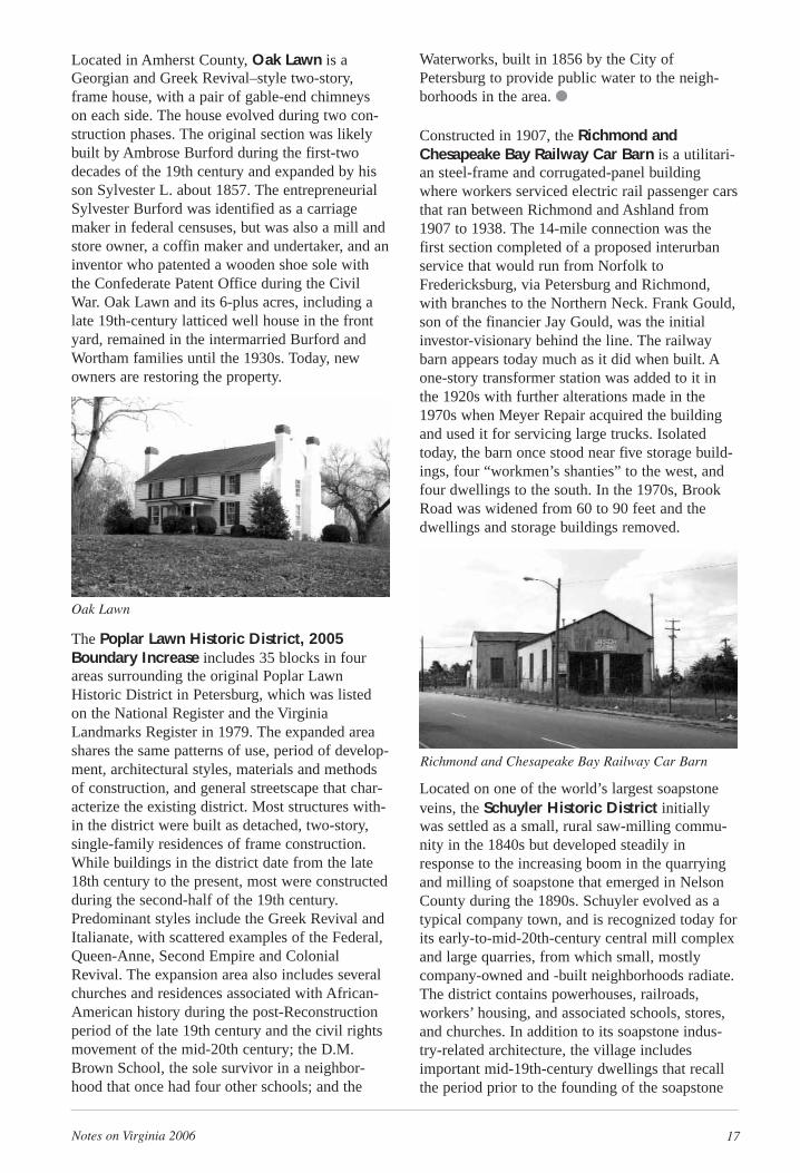
Located in Amherst County, Oak Lawn is aGeorgian and Greek Revival–style two-story,frame house, with a pair of gable-end chimneyson each side. The house evolved during two con-struction phases. The original section was likelybuilt by Ambrose Burford during the first-twodecades of the 19th century and expanded by hisson Sylvester L. about 1857. The entrepreneurialSylvester Burford was identified as a carriagemaker in federal censuses, but was also a mill andstore owner, a coffin maker and undertaker, and aninventor who patented a wooden shoe sole withthe Confederate Patent Office during the CivilWar. Oak Lawn and its 6-plus acres, including alate 19th-century latticed well house in the frontyard, remained in the intermarried Burford andWortham families until the 1930s. Today, newowners are restoring the property.
The Poplar Lawn Historic District, 2005Boundary Increase includes 35 blocks in fourareas surrounding the original Poplar LawnHistoric District in Petersburg, which was listedon the National Register and the VirginiaLandmarks Register in 1979. The expanded areashares the same patterns of use, period of develop-ment, architectural styles, materials and methodsof construction, and general streetscape that char-acterize the existing district. Most structures with-in the district were built as detached, two-story,single-family residences of frame construction.While buildings in the district date from the late18th century to the present, most were constructedduring the second-half of the 19th century.Predominant styles include the Greek Revival andItalianate, with scattered examples of the Federal,Queen-Anne, Second Empire and ColonialRevival. The expansion area also includes severalchurches and residences associated with African-American history during the post-Reconstructionperiod of the late 19th century and the civil rightsmovement of the mid-20th century; the D.M.Brown School, the sole survivor in a neighbor-hood that once had four other schools; and the
Waterworks, built in 1856 by the City ofPetersburg to provide public water to the neigh-borhoods in the area. ●
Constructed in 1907, the Richmond andChesapeake Bay Railway Car Barn is a utilitari-an steel-frame and corrugated-panel buildingwhere workers serviced electric rail passenger carsthat ran between Richmond and Ashland from1907 to 1938. The 14-mile connection was thefirst section completed of a proposed interurbanservice that would run from Norfolk toFredericksburg, via Petersburg and Richmond,with branches to the Northern Neck. Frank Gould,son of the financier Jay Gould, was the initialinvestor-visionary behind the line. The railwaybarn appears today much as it did when built. Aone-story transformer station was added to it inthe 1920s with further alterations made in the1970s when Meyer Repair acquired the buildingand used it for servicing large trucks. Isolatedtoday, the barn once stood near five storage build-ings, four “workmen’s shanties” to the west, andfour dwellings to the south. In the 1970s, BrookRoad was widened from 60 to 90 feet and thedwellings and storage buildings removed.
Located on one of the world’s largest soapstoneveins, the Schuyler Historic District initiallywas settled as a small, rural saw-milling commu-nity in the 1840s but developed steadily inresponse to the increasing boom in the quarryingand milling of soapstone that emerged in NelsonCounty during the 1890s. Schuyler evolved as atypical company town, and is recognized today forits early-to-mid-20th-century central mill complexand large quarries, from which small, mostly company-owned and -built neighborhoods radiate.The district contains powerhouses, railroads,workers’ housing, and associated schools, stores,and churches. In addition to its soapstone indus-try-related architecture, the village includesimportant mid-19th-century dwellings that recallthe period prior to the founding of the soapstone
Richmond and Chesapeake Bay Railway Car Barn
Oak Lawn
18 Notes on Virginia 2006
industry. Early on, the town’s proximity to theRockfish River and the James River and KanawhaCanal was also a contributing factor to its develop-ment. Schuyler is also associated with the writerEarle Hamner, who created the popular televisionseries “The Waltons” during the early 1970s.
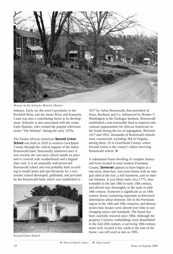
The former African-American Second UnionSchool was built in 1918 in western GoochlandCounty through the critical support of the JuliusRosenwald fund. Structurally unaltered since itwas erected, the one-story school stands on piersand is covered with weatherboard and a hippedslate roof. It is an unusually well-preservedRosenwald school and was probably built accord-ing to model plans and specifications for a two-teacher school developed, published, and providedby the Rosenwald fund, which was established in
1917 by Julius Rosenwald, then-president ofSears, Roebuck and Co. Influenced by Booker T.Washington at the Tuskegee Institute, Rosenwaldestablished a non-renewable fund to improve edu-cational opportunities for African Americans inthe South during the era of segregation. Between1917 and 1932, thousands of Rosenwald schoolswere constructed, including 364 in Virginia,among them, 10 in Goochland County, whereSecond Union is the county’s oldest survivingRosenwald school. ●
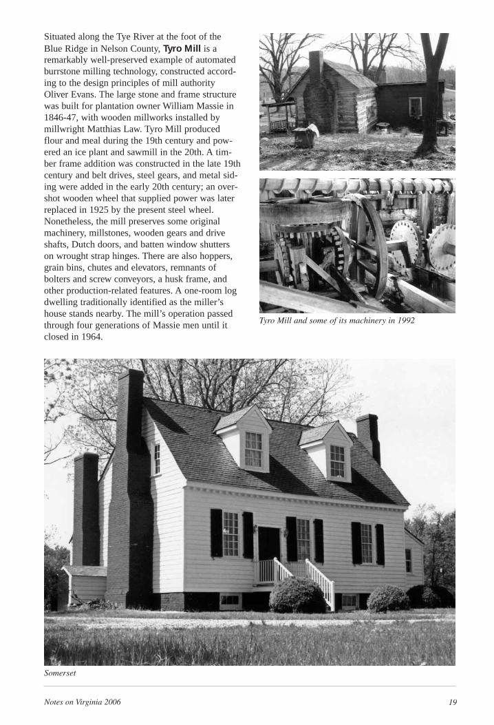
A substantial frame dwelling of complex historyand form located in rural western PowhatanCounty, Somerset appears to have begun as aone-story, three-bay, one-room house with an inte-gral shed at the rear, a full basement, and an inter-nal chimney. It was likely built circa 1775, thenextended in the late 18th to early 19th century,and altered very thoroughly in the early to mid-19th century. Somerset is significant as an 18th-century house containing important architecturalinformation about domestic life in the Powhatanregion in the 18th and 19th centuries, and demon-strates how houses were altered over time to suitchanging mores and standards. The house hasbeen carefully restored since 1984. Although theproperty’s historic outbuildings were demolishedin the mid-20th century, a surviving 18th-centurystone well, located a few yards to the east of thehouse, was still used as late as 1985.
● Diverse historic legacy ■ State-owned
Houses in the Schuyler Historic District
Second Union School
Notes on Virginia 2006 19
Situated along the Tye River at the foot of theBlue Ridge in Nelson County, Tyro Mill is aremarkably well-preserved example of automatedburrstone milling technology, constructed accord-ing to the design principles of mill authorityOliver Evans. The large stone and frame structurewas built for plantation owner William Massie in1846-47, with wooden millworks installed bymillwright Matthias Law. Tyro Mill producedflour and meal during the 19th century and pow-ered an ice plant and sawmill in the 20th. A tim-ber frame addition was constructed in the late 19thcentury and belt drives, steel gears, and metal sid-ing were added in the early 20th century; an over-shot wooden wheel that supplied power was laterreplaced in 1925 by the present steel wheel.Nonetheless, the mill preserves some originalmachinery, millstones, wooden gears and driveshafts, Dutch doors, and batten window shutterson wrought strap hinges. There are also hoppers,grain bins, chutes and elevators, remnants ofbolters and screw conveyors, a husk frame, andother production-related features. A one-room logdwelling traditionally identified as the miller’shouse stands nearby. The mill’s operation passedthrough four generations of Massie men until itclosed in 1964.
Tyro Mill and some of its machinery in 1992
Somerset
20 Notes on Virginia 2006
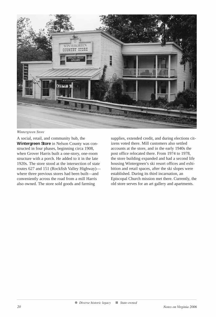
A social, retail, and community hub, theWintergreen Store in Nelson County was con-structed in four phases, beginning circa 1908,when Grover Harris built a one-story, one-roomstructure with a porch. He added to it in the late1920s. The store stood at the intersection of stateroutes 627 and 151 (Rockfish Valley Highway)—where three previous stores had been built—andconveniently across the road from a mill Harrisalso owned. The store sold goods and farming
supplies, extended credit, and during elections cit-izens voted there. Mill customers also settledaccounts at the store, and in the early 1940s thepost office relocated there. From 1974 to 1978,the store building expanded and had a second lifehousing Wintergreen’s ski resort offices and exhi-bition and retail spaces, after the ski slopes wereestablished. During its third incarnation, anEpiscopal Church mission met there. Currently, theold store serves for an art gallery and apartments.
● Diverse historic legacy ■ State-owned
Wintergreen Store
Notes on Virginia 2006 21
Northern Region
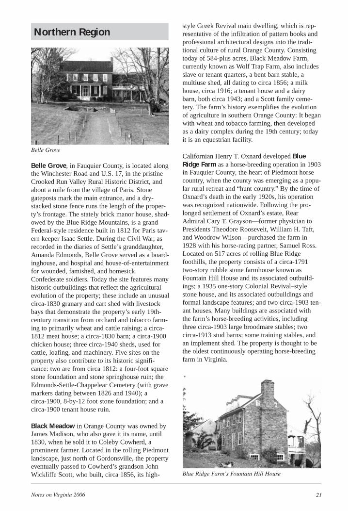
Belle Grove, in Fauquier County, is located alongthe Winchester Road and U.S. 17, in the pristineCrooked Run Valley Rural Historic District, andabout a mile from the village of Paris. Stonegateposts mark the main entrance, and a dry-stacked stone fence runs the length of the proper-ty’s frontage. The stately brick manor house, shad-owed by the Blue Ridge Mountains, is a grandFederal-style residence built in 1812 for Paris tav-ern keeper Isaac Settle. During the Civil War, asrecorded in the diaries of Settle’s granddaughter,Amanda Edmonds, Belle Grove served as a board-inghouse, and hospital and house-of-entertainmentfor wounded, famished, and homesickConfederate soldiers. Today the site features manyhistoric outbuildings that reflect the agriculturalevolution of the property; these include an unusualcirca-1830 granary and cart shed with livestockbays that demonstrate the property’s early 19th-century transition from orchard and tobacco farm-ing to primarily wheat and cattle raising; a circa-1812 meat house; a circa-1830 barn; a circa-1900chicken house; three circa-1940 sheds, used forcattle, loafing, and machinery. Five sites on theproperty also contribute to its historic signifi-cance: two are from circa 1812: a four-foot squarestone foundation and stone springhouse ruin; theEdmonds-Settle-Chappelear Cemetery (with gravemarkers dating between 1826 and 1940); a circa-1900, 8-by-12 foot stone foundation; and acirca-1900 tenant house ruin.
Black Meadow in Orange County was owned byJames Madison, who also gave it its name, until1830, when he sold it to Coleby Cowherd, aprominent farmer. Located in the rolling Piedmontlandscape, just north of Gordonsville, the propertyeventually passed to Cowherd’s grandson JohnWickliffe Scott, who built, circa 1856, its high-
style Greek Revival main dwelling, which is rep-resentative of the infiltration of pattern books andprofessional architectural designs into the tradi-tional culture of rural Orange County. Consistingtoday of 584-plus acres, Black Meadow Farm,currently known as Wolf Trap Farm, also includesslave or tenant quarters, a bent barn stable, amultiuse shed, all dating to circa 1856; a milkhouse, circa 1916; a tenant house and a dairybarn, both circa 1943; and a Scott family ceme-tery. The farm’s history exemplifies the evolutionof agriculture in southern Orange County: It beganwith wheat and tobacco farming, then developedas a dairy complex during the 19th century; todayit is an equestrian facility.
Californian Henry T. Oxnard developed BlueRidge Farm as a horse-breeding operation in 1903in Fauquier County, the heart of Piedmont horsecountry, when the county was emerging as a popu-lar rural retreat and “hunt country.” By the time ofOxnard’s death in the early 1920s, his operationwas recognized nationwide. Following the pro-longed settlement of Oxnard’s estate, RearAdmiral Cary T. Grayson—former physician toPresidents Theodore Roosevelt, William H. Taft,and Woodrow Wilson—purchased the farm in1928 with his horse-racing partner, Samuel Ross.Located on 517 acres of rolling Blue Ridgefoothills, the property consists of a circa-1791two-story rubble stone farmhouse known asFountain Hill House and its associated outbuild-ings; a 1935 one-story Colonial Revival–stylestone house, and its associated outbuildings andformal landscape features; and two circa-1903 ten-ant houses. Many buildings are associated withthe farm’s horse-breeding activities, includingthree circa-1903 large broodmare stables; twocirca-1913 stud barns; some training stables, andan implement shed. The property is thought to bethe oldest continuously operating horse-breedingfarm in Virginia.
Belle Grove
Blue Ridge Farm’s Fountain Hill House
22 Notes on Virginia 2006
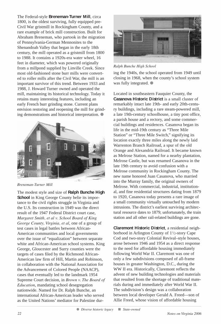
The Federal-style Breneman-Turner Mill, circa1800, is the oldest surviving, fully equipped pre-Civil War gristmill in Rockingham County, and arare example of brick mill construction. Built forAbraham Breneman, who partook in the migrationof Pennsylvania-German Mennonites to theShenandoah Valley that began in the early 18thcentury, the mill operated as a gristmill from 1800to 1988. It contains a 1920s-era water wheel, 16feet in diameter, which was powered originallyfrom a millpond supplied by Linville Creek. Sincemost old-fashioned stone burr mills were convert-ed to roller mills after the Civil War, the mill is animportant survivor of this trend. Between 1933 and1988, J. Howard Turner owned and operated themill, maintaining its historical technology. Today itretains many interesting features, including anearly French burr grinding stone. Current plansenvision restoring and reopening the mill for grind-ing demonstrations and historical interpretation. ●
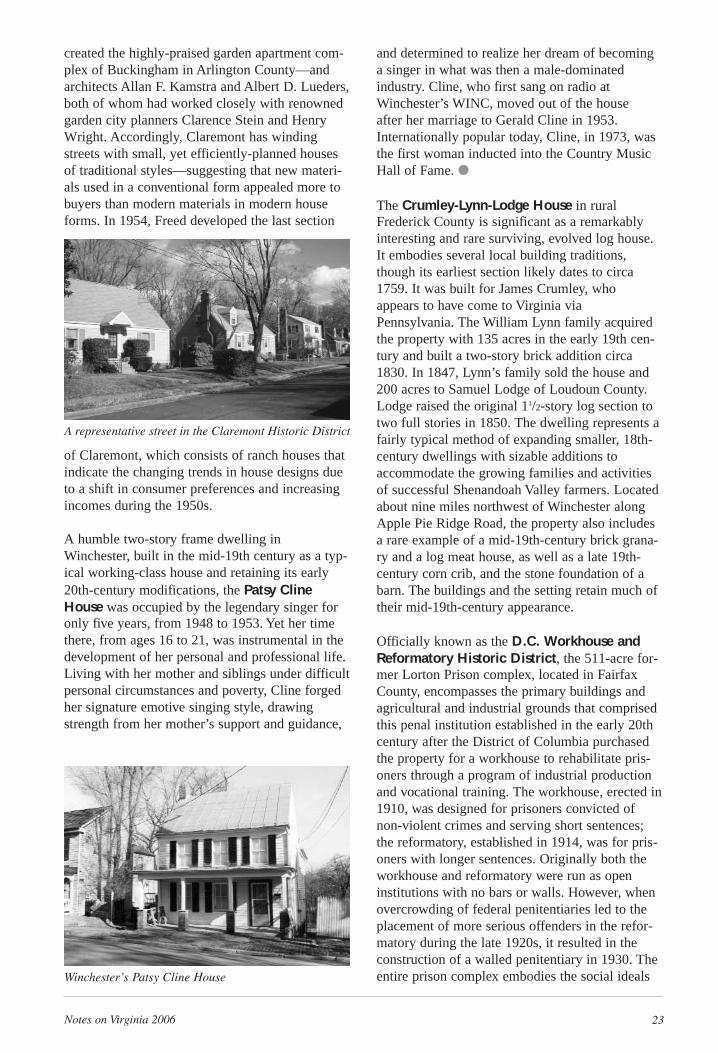
The modest style and size of Ralph Bunche HighSchool in King George County belie its impor-tance to the civil rights struggle in Virginia andthe U.S. Its construction in 1949 was the directresult of the 1947 Federal District court case,Margaret Smith, et al v. School Board of KingGeorge County, Virginia, et al, one of a group oftest cases in legal battles between African-American communities and local governmentsover the issue of “equalization” between separatewhite and African-American school systems. KingGeorge, Gloucester and Surry counties were thetargets of cases filed by the Richmond African-American law firm of Hill, Martin and Robinson,in collaboration with the National Association forthe Advancement of Colored People (NAACP),cases that eventually led to the landmark 1954Supreme Court decision, in Brown v. The Board ofEducation, mandating school desegregationnationwide. Named for Dr. Ralph Bunche, aninternational African-American leader who servedas the United Nations’ mediator for Palestine dur-
ing the 1940s, the school operated from 1949 untilclosing in 1968, when the county’s school systemwas fully integrated. ●
Located in southeastern Fauquier County, theCasanova Historic District is a small cluster ofremarkably intact late 19th- and early 20th-centu-ry buildings, including a rare steam-powered mill,a late 19th-century schoolhouse, a tiny post office,a parish house and a rectory, and some commer-cial buildings and residences. Casanova began itslife in the mid-19th century as “Three MileStation” or “Three Mile Switch,” signifying itslocation exactly three miles along the newly laidWarrenton Branch Railroad, a spur of the oldOrange and Alexandria Railroad. It became knownas Melrose Station, named for a nearby plantation,Melrose Castle, but was renamed Casanova in thelate 19th century to avoid confusion with aMelrose community in Rockingham County. Thenew name honored Juan Casanova, who marriedinto the Murray family, the original owners ofMelrose. With commercial, industrial, institution-al, and fine residential structures dating from 1879to 1920, Casanova today presents a rare image ofa small community virtually untouched by modernintrusions. The district’s earliest surviving architec-tural resource dates to 1879; unfortunately, the trainstation and all other rail-related buildings are gone.
Claremont Historic District, a residential neigh-borhood in Arlington County of 11/2-story CapeCod and two-story Colonial Revival–style houses,arose between 1946 and 1954 as a direct responseto the need for affordable housing immediatelyfollowing World War II. Claremont was one ofonly a few subdivisions composed of all-framehouses in greater Washington, D.C., during theWW II era. Historically, Claremont reflects theadvent of new building technologies and materialsthat resulted from the shortage of traditional mate-rials during and immediately after World War II.The subdivision’s design was a collaborationbetween local developer Gerald A. Freed—son ofAllie Freed, whose vision of affordable housing
● Diverse historic legacy ■ State-owned
Breneman-Turner Mill
Ralph Bunche High School
Notes on Virginia 2006 23
created the highly-praised garden apartment com-plex of Buckingham in Arlington County—andarchitects Allan F. Kamstra and Albert D. Lueders,both of whom had worked closely with renownedgarden city planners Clarence Stein and HenryWright. Accordingly, Claremont has windingstreets with small, yet efficiently-planned housesof traditional styles—suggesting that new materi-als used in a conventional form appealed more tobuyers than modern materials in modern houseforms. In 1954, Freed developed the last section
of Claremont, which consists of ranch houses thatindicate the changing trends in house designs dueto a shift in consumer preferences and increasingincomes during the 1950s.
A humble two-story frame dwelling inWinchester, built in the mid-19th century as a typ-ical working-class house and retaining its early20th-century modifications, the Patsy ClineHouse was occupied by the legendary singer foronly five years, from 1948 to 1953. Yet her timethere, from ages 16 to 21, was instrumental in thedevelopment of her personal and professional life.Living with her mother and siblings under difficultpersonal circumstances and poverty, Cline forgedher signature emotive singing style, drawingstrength from her mother’s support and guidance,
and determined to realize her dream of becominga singer in what was then a male-dominatedindustry. Cline, who first sang on radio atWinchester’s WINC, moved out of the house after her marriage to Gerald Cline in 1953.Internationally popular today, Cline, in 1973, wasthe first woman inducted into the Country MusicHall of Fame. ●
The Crumley-Lynn-Lodge House in ruralFrederick County is significant as a remarkablyinteresting and rare surviving, evolved log house.It embodies several local building traditions,though its earliest section likely dates to circa1759. It was built for James Crumley, whoappears to have come to Virginia viaPennsylvania. The William Lynn family acquiredthe property with 135 acres in the early 19th cen-tury and built a two-story brick addition circa1830. In 1847, Lynn’s family sold the house and200 acres to Samuel Lodge of Loudoun County.Lodge raised the original 11/2-story log section totwo full stories in 1850. The dwelling represents afairly typical method of expanding smaller, 18th-century dwellings with sizable additions toaccommodate the growing families and activitiesof successful Shenandoah Valley farmers. Locatedabout nine miles northwest of Winchester alongApple Pie Ridge Road, the property also includesa rare example of a mid-19th-century brick grana-ry and a log meat house, as well as a late 19th-century corn crib, and the stone foundation of abarn. The buildings and the setting retain much oftheir mid-19th-century appearance.
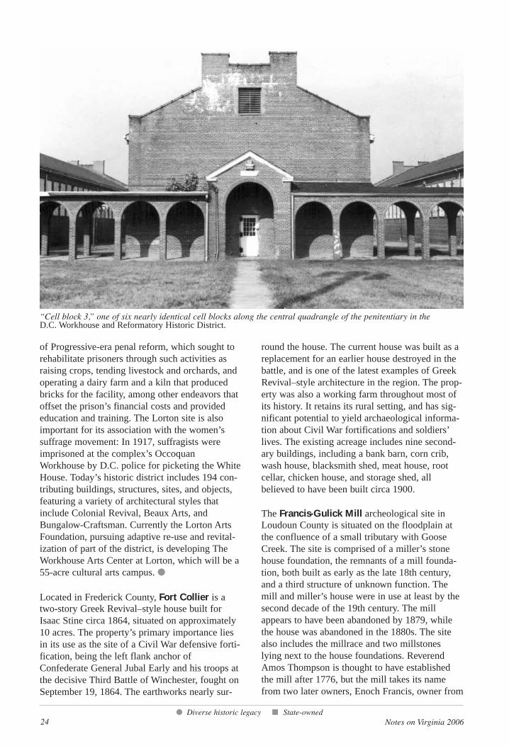
Officially known as the D.C. Workhouse andReformatory Historic District, the 511-acre for-mer Lorton Prison complex, located in FairfaxCounty, encompasses the primary buildings andagricultural and industrial grounds that comprisedthis penal institution established in the early 20thcentury after the District of Columbia purchasedthe property for a workhouse to rehabilitate pris-oners through a program of industrial productionand vocational training. The workhouse, erected in1910, was designed for prisoners convicted ofnon-violent crimes and serving short sentences;the reformatory, established in 1914, was for pris-oners with longer sentences. Originally both theworkhouse and reformatory were run as openinstitutions with no bars or walls. However, whenovercrowding of federal penitentiaries led to theplacement of more serious offenders in the refor-matory during the late 1920s, it resulted in theconstruction of a walled penitentiary in 1930. Theentire prison complex embodies the social ideals
A representative street in the Claremont Historic District
Winchester’s Patsy Cline House
24 Notes on Virginia 2006
of Progressive-era penal reform, which sought torehabilitate prisoners through such activities asraising crops, tending livestock and orchards, andoperating a dairy farm and a kiln that producedbricks for the facility, among other endeavors thatoffset the prison’s financial costs and providededucation and training. The Lorton site is alsoimportant for its association with the women’ssuffrage movement: In 1917, suffragists wereimprisoned at the complex’s OccoquanWorkhouse by D.C. police for picketing the WhiteHouse. Today’s historic district includes 194 con-tributing buildings, structures, sites, and objects,featuring a variety of architectural styles thatinclude Colonial Revival, Beaux Arts, andBungalow-Craftsman. Currently the Lorton ArtsFoundation, pursuing adaptive re-use and revital-ization of part of the district, is developing TheWorkhouse Arts Center at Lorton, which will be a55-acre cultural arts campus. ●
Located in Frederick County, Fort Collier is atwo-story Greek Revival–style house built forIsaac Stine circa 1864, situated on approximately10 acres. The property’s primary importance liesin its use as the site of a Civil War defensive forti-fication, being the left flank anchor ofConfederate General Jubal Early and his troops atthe decisive Third Battle of Winchester, fought onSeptember 19, 1864. The earthworks nearly sur-
round the house. The current house was built as areplacement for an earlier house destroyed in thebattle, and is one of the latest examples of GreekRevival–style architecture in the region. The prop-erty was also a working farm throughout most ofits history. It retains its rural setting, and has sig-nificant potential to yield archaeological informa-tion about Civil War fortifications and soldiers’lives. The existing acreage includes nine second-ary buildings, including a bank barn, corn crib,wash house, blacksmith shed, meat house, rootcellar, chicken house, and storage shed, allbelieved to have been built circa 1900.
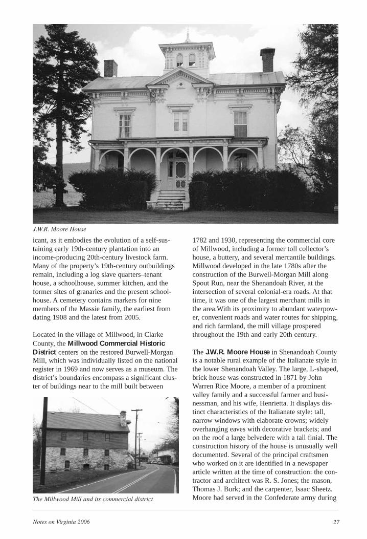
The Francis-Gulick Mill archeological site inLoudoun County is situated on the floodplain atthe confluence of a small tributary with GooseCreek. The site is comprised of a miller’s stonehouse foundation, the remnants of a mill founda-tion, both built as early as the late 18th century,and a third structure of unknown function. Themill and miller’s house were in use at least by thesecond decade of the 19th century. The millappears to have been abandoned by 1879, whilethe house was abandoned in the 1880s. The sitealso includes the millrace and two millstoneslying next to the house foundations. ReverendAmos Thompson is thought to have establishedthe mill after 1776, but the mill takes its namefrom two later owners, Enoch Francis, owner from
● Diverse historic legacy ■ State-owned
“Cell block 3,” one of six nearly identical cell blocks along the central quadrangle of the penitentiary in the D.C. Workhouse and Reformatory Historic District.
Notes on Virginia 2006 25
1817 to the 1830s, and James Gulick, owner from1850 to the 1860s. Since many mill sites alongGoose Creek are in poor condition or have beendestroyed, the Francis-Gulick Mill offers a uniqueopportunity to explore and expand our knowledgeof 19th-century mills in this region.
The Graffiti House, built circa 1858 on land bor-dering the Orange and Alexandria Railroad in thevillage of Brandy Station, in Culpeper County, hasplaster walls in three second-story rooms filledwith the names and comments of Union andConfederate soldiers, who alternately occupied thehouse during the Civil War. The frame house isthe only antebellum building with explicit CivilWar associations in Brandy Station, the scene ofthe war’s largest mounted cavalry fight. OtherVirginia dwellings listed on the state and nationalregisters also contain Civil War–era graffiti(including Ben Lomond, Prince William Co.;Blenheim, Fairfax Co.; and Riddick’s Folly,Suffolk), but the renderings in the Graffiti Houseare unusually extensive, covering most of thewalls of the second-floor rooms.
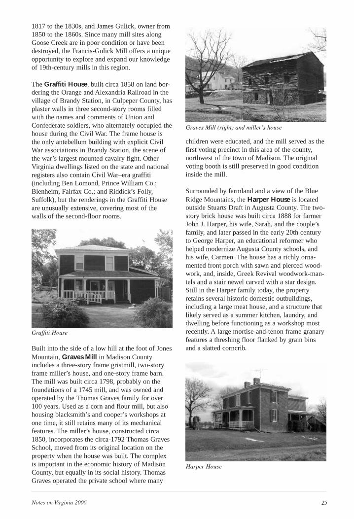
Built into the side of a low hill at the foot of JonesMountain, Graves Mill in Madison Countyincludes a three-story frame gristmill, two-storyframe miller’s house, and one-story frame barn.The mill was built circa 1798, probably on thefoundations of a 1745 mill, and was owned andoperated by the Thomas Graves family for over100 years. Used as a corn and flour mill, but alsohousing blacksmith’s and cooper’s workshops atone time, it still retains many of its mechanicalfeatures. The miller’s house, constructed circa1850, incorporates the circa-1792 Thomas GravesSchool, moved from its original location on theproperty when the house was built. The complexis important in the economic history of MadisonCounty, but equally in its social history. ThomasGraves operated the private school where many
children were educated, and the mill served as thefirst voting precinct in this area of the county,northwest of the town of Madison. The originalvoting booth is still preserved in good conditioninside the mill.
Surrounded by farmland and a view of the BlueRidge Mountains, the Harper House is locatedoutside Stuarts Draft in Augusta County. The two-story brick house was built circa 1888 for farmerJohn J. Harper, his wife, Sarah, and the couple’sfamily, and later passed in the early 20th centuryto George Harper, an educational reformer whohelped modernize Augusta County schools, andhis wife, Carmen. The house has a richly orna-mented front porch with sawn and pierced wood-work, and, inside, Greek Revival woodwork-man-tels and a stair newel carved with a star design.Still in the Harper family today, the propertyretains several historic domestic outbuildings,including a large meat house, and a structure thatlikely served as a summer kitchen, laundry, anddwelling before functioning as a workshop mostrecently. A large mortise-and-tenon frame granaryfeatures a threshing floor flanked by grain binsand a slatted corncrib.
Graffiti House
Graves Mill (right) and miller’s house
Harper House
26 Notes on Virginia 2006
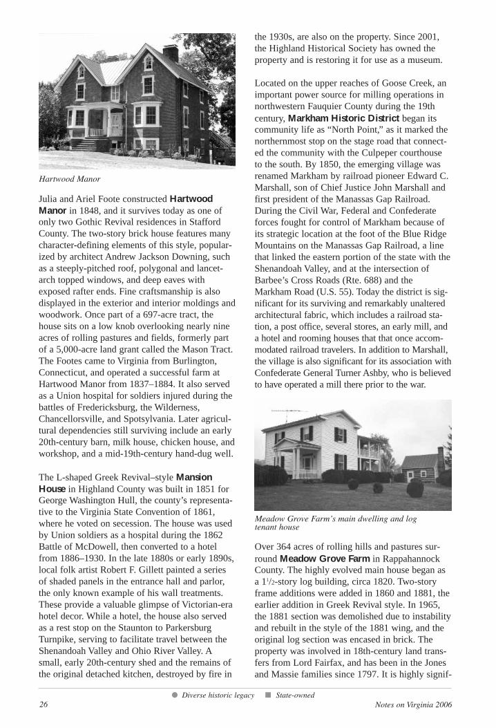
Julia and Ariel Foote constructed HartwoodManor in 1848, and it survives today as one ofonly two Gothic Revival residences in StaffordCounty. The two-story brick house features manycharacter-defining elements of this style, popular-ized by architect Andrew Jackson Downing, suchas a steeply-pitched roof, polygonal and lancet-arch topped windows, and deep eaves withexposed rafter ends. Fine craftsmanship is alsodisplayed in the exterior and interior moldings andwoodwork. Once part of a 697-acre tract, thehouse sits on a low knob overlooking nearly nineacres of rolling pastures and fields, formerly partof a 5,000-acre land grant called the Mason Tract.The Footes came to Virginia from Burlington,Connecticut, and operated a successful farm atHartwood Manor from 1837–1884. It also servedas a Union hospital for soldiers injured during thebattles of Fredericksburg, the Wilderness,Chancellorsville, and Spotsylvania. Later agricul-tural dependencies still surviving include an early20th-century barn, milk house, chicken house, andworkshop, and a mid-19th-century hand-dug well.
The L-shaped Greek Revival–style MansionHouse in Highland County was built in 1851 forGeorge Washington Hull, the county’s representa-tive to the Virginia State Convention of 1861,where he voted on secession. The house was usedby Union soldiers as a hospital during the 1862Battle of McDowell, then converted to a hotelfrom 1886–1930. In the late 1880s or early 1890s,local folk artist Robert F. Gillett painted a seriesof shaded panels in the entrance hall and parlor,the only known example of his wall treatments.These provide a valuable glimpse of Victorian-erahotel decor. While a hotel, the house also servedas a rest stop on the Staunton to ParkersburgTurnpike, serving to facilitate travel between theShenandoah Valley and Ohio River Valley. Asmall, early 20th-century shed and the remains ofthe original detached kitchen, destroyed by fire in
the 1930s, are also on the property. Since 2001,the Highland Historical Society has owned theproperty and is restoring it for use as a museum.
Located on the upper reaches of Goose Creek, animportant power source for milling operations innorthwestern Fauquier County during the 19thcentury, Markham Historic District began itscommunity life as “North Point,” as it marked thenorthernmost stop on the stage road that connect-ed the community with the Culpeper courthouseto the south. By 1850, the emerging village wasrenamed Markham by railroad pioneer Edward C.Marshall, son of Chief Justice John Marshall andfirst president of the Manassas Gap Railroad.During the Civil War, Federal and Confederateforces fought for control of Markham because ofits strategic location at the foot of the Blue RidgeMountains on the Manassas Gap Railroad, a linethat linked the eastern portion of the state with theShenandoah Valley, and at the intersection ofBarbee’s Cross Roads (Rte. 688) and theMarkham Road (U.S. 55). Today the district is sig-nificant for its surviving and remarkably unalteredarchitectural fabric, which includes a railroad sta-tion, a post office, several stores, an early mill, anda hotel and rooming houses that that once accom-modated railroad travelers. In addition to Marshall,the village is also significant for its association withConfederate General Turner Ashby, who is believedto have operated a mill there prior to the war.
Over 364 acres of rolling hills and pastures sur-round Meadow Grove Farm in RappahannockCounty. The highly evolved main house began asa 11/2-story log building, circa 1820. Two-storyframe additions were added in 1860 and 1881, theearlier addition in Greek Revival style. In 1965,the 1881 section was demolished due to instabilityand rebuilt in the style of the 1881 wing, and theoriginal log section was encased in brick. Theproperty was involved in 18th-century land trans-fers from Lord Fairfax, and has been in the Jonesand Massie families since 1797. It is highly signif-
● Diverse historic legacy ■ State-owned
Hartwood Manor
Meadow Grove Farm’s main dwelling and logtenant house
Notes on Virginia 2006 27
icant, as it embodies the evolution of a self-sus-taining early 19th-century plantation into anincome-producing 20th-century livestock farm.Many of the property’s 19th-century outbuildingsremain, including a log slave quarters–tenanthouse, a schoolhouse, summer kitchen, and theformer sites of granaries and the present school-house. A cemetery contains markers for ninemembers of the Massie family, the earliest fromdating 1908 and the latest from 2005.
Located in the village of Millwood, in ClarkeCounty, the Millwood Commercial HistoricDistrict centers on the restored Burwell-MorganMill, which was individually listed on the nationalregister in 1969 and now serves as a museum. Thedistrict’s boundaries encompass a significant clus-ter of buildings near to the mill built between
1782 and 1930, representing the commercial coreof Millwood, including a former toll collector’shouse, a buttery, and several mercantile buildings.Millwood developed in the late 1780s after theconstruction of the Burwell-Morgan Mill alongSpout Run, near the Shenandoah River, at theintersection of several colonial-era roads. At thattime, it was one of the largest merchant mills inthe area.With its proximity to abundant waterpow-er, convenient roads and water routes for shipping,and rich farmland, the mill village prosperedthroughout the 19th and early 20th century.
The J.W.R. Moore House in Shenandoah Countyis a notable rural example of the Italianate style inthe lower Shenandoah Valley. The large, L-shaped,brick house was constructed in 1871 by JohnWarren Rice Moore, a member of a prominentvalley family and a successful farmer and busi-nessman, and his wife, Henrietta. It displays dis-tinct characteristics of the Italianate style: tall,narrow windows with elaborate crowns; widelyoverhanging eaves with decorative brackets; andon the roof a large belvedere with a tall finial. Theconstruction history of the house is unusually welldocumented. Several of the principal craftsmenwho worked on it are identified in a newspaperarticle written at the time of construction: the con-tractor and architect was R. S. Jones; the mason,Thomas J. Burk; and the carpenter, Isaac Sheetz.Moore had served in the Confederate army during
J.W.R. Moore House
The Millwood Mill and its commercial district
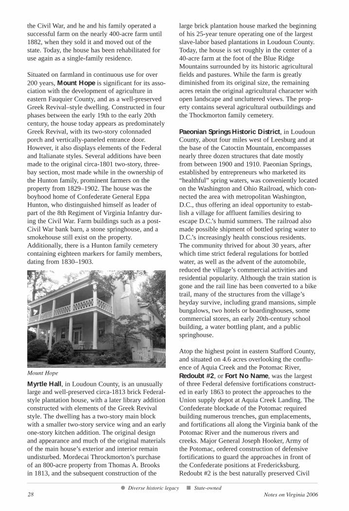
28 Notes on Virginia 2006
the Civil War, and he and his family operated asuccessful farm on the nearly 400-acre farm until1882, when they sold it and moved out of thestate. Today, the house has been rehabilitated foruse again as a single-family residence.
Situated on farmland in continuous use for over200 years, Mount Hope is significant for its asso-ciation with the development of agriculture ineastern Fauquier County, and as a well-preservedGreek Revival–style dwelling. Constructed in fourphases between the early 19th to the early 20thcentury, the house today appears as predominatelyGreek Revival, with its two-story colonnadedporch and vertically-paneled entrance door.However, it also displays elements of the Federaland Italianate styles. Several additions have beenmade to the original circa-1801 two-story, three-bay section, most made while in the ownership ofthe Hunton family, prominent farmers on theproperty from 1829–1902. The house was theboyhood home of Confederate General EppaHunton, who distinguished himself as leader ofpart of the 8th Regiment of Virginia Infantry dur-ing the Civil War. Farm buildings such as a post-Civil War bank barn, a stone springhouse, and asmokehouse still exist on the property.Additionally, there is a Hunton family cemeterycontaining eighteen markers for family members,dating from 1830–1903.
Myrtle Hall, in Loudoun County, is an unusuallylarge and well-preserved circa-1813 brick Federal-style plantation house, with a later library additionconstructed with elements of the Greek Revivalstyle. The dwelling has a two-story main blockwith a smaller two-story service wing and an earlyone-story kitchen addition. The original designand appearance and much of the original materialsof the main house’s exterior and interior remainundisturbed. Mordecai Throckmorton’s purchaseof an 800-acre property from Thomas A. Brooksin 1813, and the subsequent construction of the
large brick plantation house marked the beginningof his 25-year tenure operating one of the largestslave-labor based plantations in Loudoun County.Today, the house is set roughly in the center of a40-acre farm at the foot of the Blue RidgeMountains surrounded by its historic agriculturalfields and pastures. While the farm is greatlydiminished from its original size, the remainingacres retain the original agricultural character withopen landscape and uncluttered views. The prop-erty contains several agricultural outbuildings andthe Thockmorton family cemetery.
Paeonian Springs Historic District, in LoudounCounty, about four miles west of Leesburg and atthe base of the Catoctin Mountain, encompassesnearly three dozen structures that date mostlyfrom between 1900 and 1910. Paeonian Springs,established by entrepreneurs who marketed its“healthful” spring waters, was conveniently locatedon the Washington and Ohio Railroad, which con-nected the area with metropolitan Washington,D.C., thus offering an ideal opportunity to estab-lish a village for affluent families desiring toescape D.C.’s humid summers. The railroad alsomade possible shipment of bottled spring water toD.C.’s increasingly health conscious residents.The community thrived for about 30 years, afterwhich time strict federal regulations for bottledwater, as well as the advent of the automobile,reduced the village’s commercial activities andresidential popularity. Although the train station isgone and the rail line has been converted to a biketrail, many of the structures from the village’sheyday survive, including grand mansions, simplebungalows, two hotels or boardinghouses, somecommercial stores, an early 20th-century schoolbuilding, a water bottling plant, and a publicspringhouse.
Atop the highest point in eastern Stafford County,and situated on 4.6 acres overlooking the conflu-ence of Aquia Creek and the Potomac River,Redoubt #2, or Fort No Name, was the largestof three Federal defensive fortifications construct-ed in early 1863 to protect the approaches to theUnion supply depot at Aquia Creek Landing. TheConfederate blockade of the Potomac requiredbuilding numerous trenches, gun emplacements,and fortifications all along the Virginia bank of thePotomac River and the numerous rivers andcreeks. Major General Joseph Hooker, Army ofthe Potomac, ordered construction of defensivefortifications to guard the approaches in front ofthe Confederate positions at Fredericksburg.Redoubt #2 is the best naturally preserved Civil
● Diverse historic legacy ■ State-owned
Mount Hope
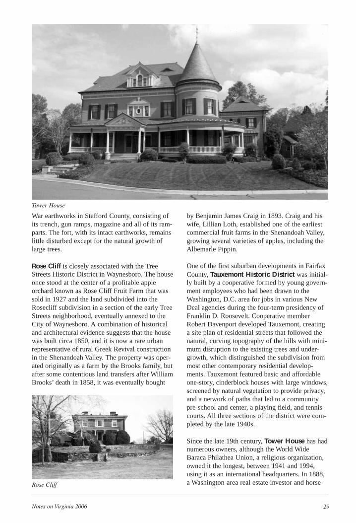
Notes on Virginia 2006 29
War earthworks in Stafford County, consisting ofits trench, gun ramps, magazine and all of its ram-parts. The fort, with its intact earthworks, remainslittle disturbed except for the natural growth oflarge trees.
Rose Cliff is closely associated with the TreeStreets Historic District in Waynesboro. The houseonce stood at the center of a profitable appleorchard known as Rose Cliff Fruit Farm that wassold in 1927 and the land subdivided into theRosecliff subdivision in a section of the early TreeStreets neighborhood, eventually annexed to theCity of Waynesboro. A combination of historicaland architectural evidence suggests that the housewas built circa 1850, and it is now a rare urbanrepresentative of rural Greek Revival constructionin the Shenandoah Valley. The property was oper-ated originally as a farm by the Brooks family, butafter some contentious land transfers after WilliamBrooks’ death in 1858, it was eventually bought
by Benjamin James Craig in 1893. Craig and hiswife, Lillian Loth, established one of the earliestcommercial fruit farms in the Shenandoah Valley,growing several varieties of apples, including theAlbemarle Pippin.
One of the first suburban developments in FairfaxCounty, Tauxemont Historic District was initial-ly built by a cooperative formed by young govern-ment employees who had been drawn to theWashington, D.C. area for jobs in various NewDeal agencies during the four-term presidency ofFranklin D. Roosevelt. Cooperative memberRobert Davenport developed Tauxemont, creatinga site plan of residential streets that followed thenatural, curving topography of the hills with mini-mum disruption to the existing trees and under-growth, which distinguished the subdivision frommost other contemporary residential develop-ments. Tauxemont featured basic and affordableone-story, cinderblock houses with large windows,screened by natural vegetation to provide privacy,and a network of paths that led to a communitypre-school and center, a playing field, and tenniscourts. All three sections of the district were com-pleted by the late 1940s.
Since the late 19th century, Tower House has hadnumerous owners, although the World WideBaraca Philathea Union, a religious organization,owned it the longest, between 1941 and 1994,using it as an international headquarters. In 1888,a Washington-area real estate investor and horse-Rose Cliff
Tower House
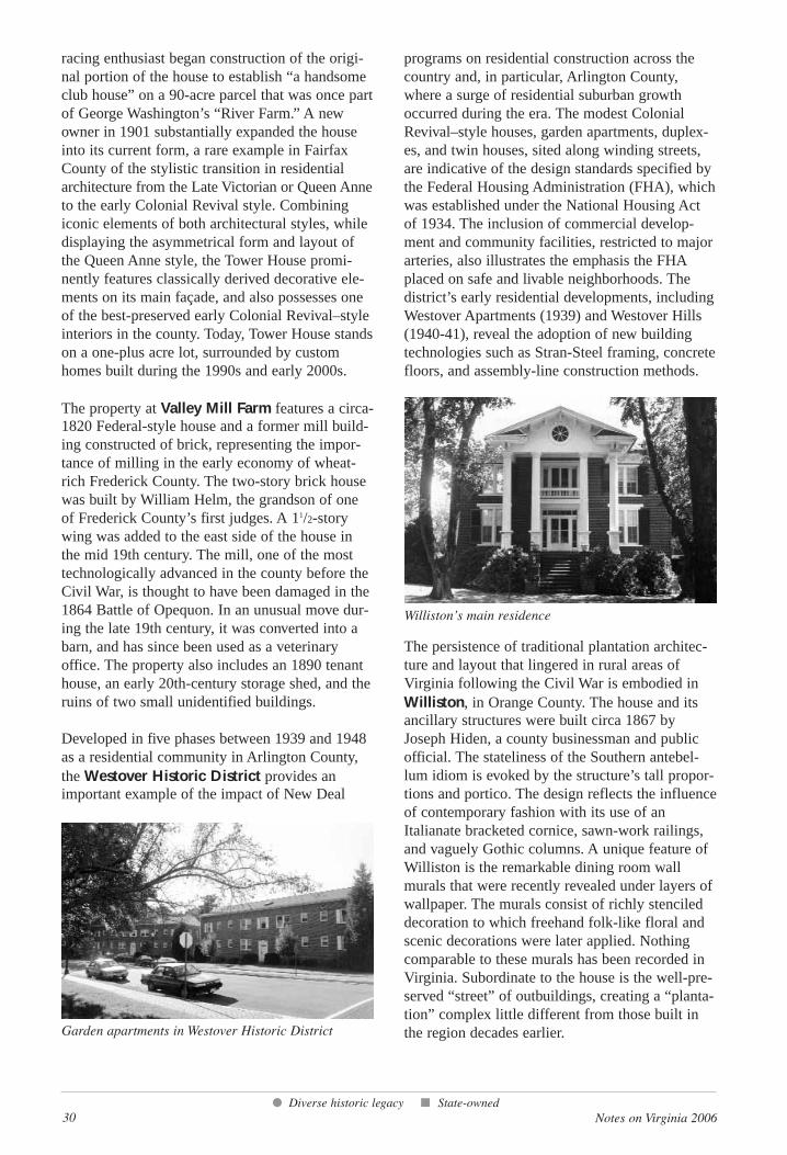
30 Notes on Virginia 2006
racing enthusiast began construction of the origi-nal portion of the house to establish “a handsomeclub house” on a 90-acre parcel that was once partof George Washington’s “River Farm.” A newowner in 1901 substantially expanded the houseinto its current form, a rare example in FairfaxCounty of the stylistic transition in residentialarchitecture from the Late Victorian or Queen Anneto the early Colonial Revival style. Combiningiconic elements of both architectural styles, whiledisplaying the asymmetrical form and layout ofthe Queen Anne style, the Tower House promi-nently features classically derived decorative ele-ments on its main façade, and also possesses oneof the best-preserved early Colonial Revival–styleinteriors in the county. Today, Tower House standson a one-plus acre lot, surrounded by customhomes built during the 1990s and early 2000s.
The property at Valley Mill Farm features a circa-1820 Federal-style house and a former mill build-ing constructed of brick, representing the impor-tance of milling in the early economy of wheat-rich Frederick County. The two-story brick housewas built by William Helm, the grandson of oneof Frederick County’s first judges. A 11/2-storywing was added to the east side of the house inthe mid 19th century. The mill, one of the mosttechnologically advanced in the county before theCivil War, is thought to have been damaged in the1864 Battle of Opequon. In an unusual move dur-ing the late 19th century, it was converted into abarn, and has since been used as a veterinaryoffice. The property also includes an 1890 tenanthouse, an early 20th-century storage shed, and theruins of two small unidentified buildings.
Developed in five phases between 1939 and 1948as a residential community in Arlington County,the Westover Historic District provides animportant example of the impact of New Deal
programs on residential construction across thecountry and, in particular, Arlington County,where a surge of residential suburban growthoccurred during the era. The modest ColonialRevival–style houses, garden apartments, duplex-es, and twin houses, sited along winding streets,are indicative of the design standards specified bythe Federal Housing Administration (FHA), whichwas established under the National Housing Actof 1934. The inclusion of commercial develop-ment and community facilities, restricted to majorarteries, also illustrates the emphasis the FHAplaced on safe and livable neighborhoods. Thedistrict’s early residential developments, includingWestover Apartments (1939) and Westover Hills(1940-41), reveal the adoption of new buildingtechnologies such as Stran-Steel framing, concretefloors, and assembly-line construction methods.
The persistence of traditional plantation architec-ture and layout that lingered in rural areas ofVirginia following the Civil War is embodied inWilliston, in Orange County. The house and itsancillary structures were built circa 1867 byJoseph Hiden, a county businessman and publicofficial. The stateliness of the Southern antebel-lum idiom is evoked by the structure’s tall propor-tions and portico. The design reflects the influenceof contemporary fashion with its use of anItalianate bracketed cornice, sawn-work railings,and vaguely Gothic columns. A unique feature ofWilliston is the remarkable dining room wallmurals that were recently revealed under layers ofwallpaper. The murals consist of richly stencileddecoration to which freehand folk-like floral andscenic decorations were later applied. Nothingcomparable to these murals has been recorded inVirginia. Subordinate to the house is the well-pre-served “street” of outbuildings, creating a “planta-tion” complex little different from those built inthe region decades earlier.
● Diverse historic legacy ■ State-owned
Garden apartments in Westover Historic District
Williston’s main residence
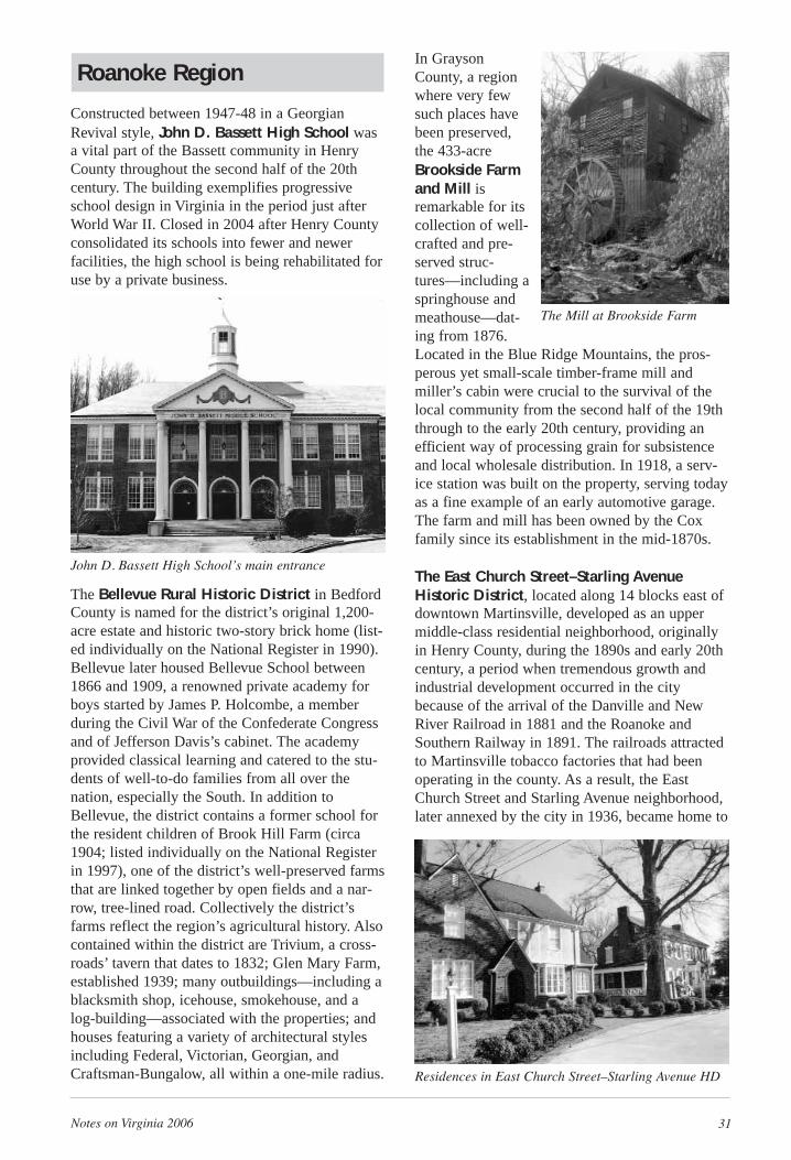
Notes on Virginia 2006 31
Roanoke Region
Constructed between 1947-48 in a GeorgianRevival style, John D. Bassett High School wasa vital part of the Bassett community in HenryCounty throughout the second half of the 20thcentury. The building exemplifies progressiveschool design in Virginia in the period just afterWorld War II. Closed in 2004 after Henry Countyconsolidated its schools into fewer and newerfacilities, the high school is being rehabilitated foruse by a private business.
The Bellevue Rural Historic District in BedfordCounty is named for the district’s original 1,200-acre estate and historic two-story brick home (list-ed individually on the National Register in 1990).Bellevue later housed Bellevue School between1866 and 1909, a renowned private academy forboys started by James P. Holcombe, a memberduring the Civil War of the Confederate Congressand of Jefferson Davis’s cabinet. The academyprovided classical learning and catered to the stu-dents of well-to-do families from all over thenation, especially the South. In addition toBellevue, the district contains a former school forthe resident children of Brook Hill Farm (circa1904; listed individually on the National Registerin 1997), one of the district’s well-preserved farmsthat are linked together by open fields and a nar-row, tree-lined road. Collectively the district’sfarms reflect the region’s agricultural history. Alsocontained within the district are Trivium, a cross-roads’ tavern that dates to 1832; Glen Mary Farm,established 1939; many outbuildings—including ablacksmith shop, icehouse, smokehouse, and alog-building—associated with the properties; andhouses featuring a variety of architectural stylesincluding Federal, Victorian, Georgian, andCraftsman-Bungalow, all within a one-mile radius.
In GraysonCounty, a regionwhere very fewsuch places havebeen preserved,the 433-acreBrookside Farmand Mill isremarkable for itscollection of well-crafted and pre-served struc-tures—including aspringhouse andmeathouse—dat-ing from 1876.Located in the Blue Ridge Mountains, the pros-perous yet small-scale timber-frame mill andmiller’s cabin were crucial to the survival of thelocal community from the second half of the 19ththrough to the early 20th century, providing anefficient way of processing grain for subsistenceand local wholesale distribution. In 1918, a serv-ice station was built on the property, serving todayas a fine example of an early automotive garage.The farm and mill has been owned by the Coxfamily since its establishment in the mid-1870s.
The East Church Street–Starling AvenueHistoric District, located along 14 blocks east ofdowntown Martinsville, developed as an uppermiddle-class residential neighborhood, originallyin Henry County, during the 1890s and early 20thcentury, a period when tremendous growth andindustrial development occurred in the citybecause of the arrival of the Danville and NewRiver Railroad in 1881 and the Roanoke andSouthern Railway in 1891. The railroads attractedto Martinsville tobacco factories that had beenoperating in the county. As a result, the EastChurch Street and Starling Avenue neighborhood,later annexed by the city in 1936, became home to
John D. Bassett High School’s main entrance
The Mill at Brookside Farm
Residences in East Church Street–Starling Avenue HD
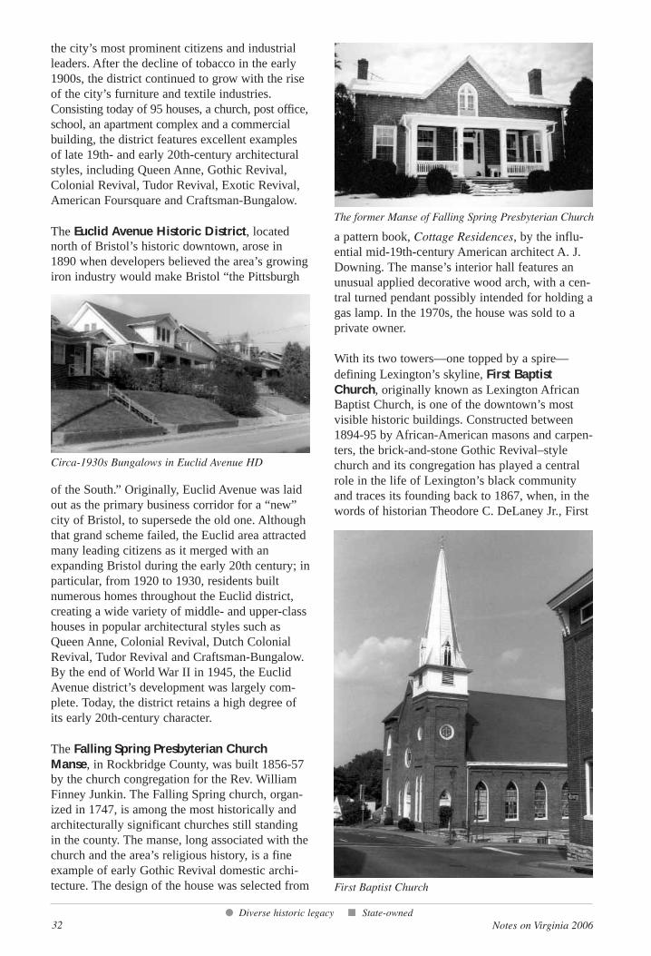
32 Notes on Virginia 2006
the city’s most prominent citizens and industrialleaders. After the decline of tobacco in the early1900s, the district continued to grow with the riseof the city’s furniture and textile industries.Consisting today of 95 houses, a church, post office,school, an apartment complex and a commercialbuilding, the district features excellent examplesof late 19th- and early 20th-century architecturalstyles, including Queen Anne, Gothic Revival,Colonial Revival, Tudor Revival, Exotic Revival,American Foursquare and Craftsman-Bungalow.
The Euclid Avenue Historic District, locatednorth of Bristol’s historic downtown, arose in1890 when developers believed the area’s growingiron industry would make Bristol “the Pittsburgh
of the South.” Originally, Euclid Avenue was laidout as the primary business corridor for a “new”city of Bristol, to supersede the old one. Althoughthat grand scheme failed, the Euclid area attractedmany leading citizens as it merged with anexpanding Bristol during the early 20th century; inparticular, from 1920 to 1930, residents builtnumerous homes throughout the Euclid district,creating a wide variety of middle- and upper-classhouses in popular architectural styles such asQueen Anne, Colonial Revival, Dutch ColonialRevival, Tudor Revival and Craftsman-Bungalow.By the end of World War II in 1945, the EuclidAvenue district’s development was largely com-plete. Today, the district retains a high degree ofits early 20th-century character.
The Falling Spring Presbyterian ChurchManse, in Rockbridge County, was built 1856-57by the church congregation for the Rev. WilliamFinney Junkin. The Falling Spring church, organ-ized in 1747, is among the most historically andarchitecturally significant churches still standingin the county. The manse, long associated with thechurch and the area’s religious history, is a fineexample of early Gothic Revival domestic archi-tecture. The design of the house was selected from
a pattern book, Cottage Residences, by the influ-ential mid-19th-century American architect A. J.Downing. The manse’s interior hall features anunusual applied decorative wood arch, with a cen-tral turned pendant possibly intended for holding agas lamp. In the 1970s, the house was sold to aprivate owner.
With its two towers—one topped by a spire—defining Lexington’s skyline, First BaptistChurch, originally known as Lexington AfricanBaptist Church, is one of the downtown’s mostvisible historic buildings. Constructed between1894-95 by African-American masons and carpen-ters, the brick-and-stone Gothic Revival–stylechurch and its congregation has played a centralrole in the life of Lexington’s black communityand traces its founding back to 1867, when, in thewords of historian Theodore C. DeLaney Jr., First
● Diverse historic legacy ■ State-owned
Circa-1930s Bungalows in Euclid Avenue HD
The former Manse of Falling Spring Presbyterian Church
First Baptist Church
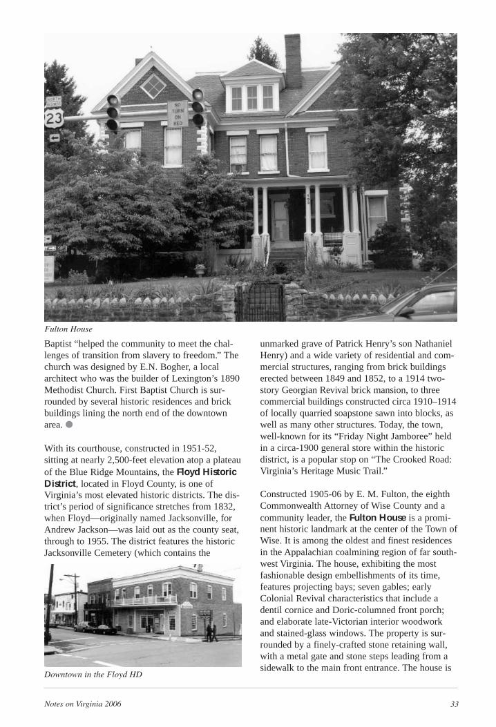
Notes on Virginia 2006 33
Baptist “helped the community to meet the chal-lenges of transition from slavery to freedom.” Thechurch was designed by E.N. Bogher, a localarchitect who was the builder of Lexington’s 1890Methodist Church. First Baptist Church is sur-rounded by several historic residences and brickbuildings lining the north end of the downtownarea. ●
With its courthouse, constructed in 1951-52,sitting at nearly 2,500-feet elevation atop a plateauof the Blue Ridge Mountains, the Floyd HistoricDistrict, located in Floyd County, is one ofVirginia’s most elevated historic districts. The dis-trict’s period of significance stretches from 1832,when Floyd—originally named Jacksonville, forAndrew Jackson—was laid out as the county seat,through to 1955. The district features the historicJacksonville Cemetery (which contains the
unmarked grave of Patrick Henry’s son NathanielHenry) and a wide variety of residential and com-mercial structures, ranging from brick buildingserected between 1849 and 1852, to a 1914 two-story Georgian Revival brick mansion, to threecommercial buildings constructed circa 1910–1914of locally quarried soapstone sawn into blocks, aswell as many other structures. Today, the town,well-known for its “Friday Night Jamboree” heldin a circa-1900 general store within the historicdistrict, is a popular stop on “The Crooked Road:Virginia’s Heritage Music Trail.”
Constructed 1905-06 by E. M. Fulton, the eighthCommonwealth Attorney of Wise County and acommunity leader, the Fulton House is a promi-nent historic landmark at the center of the Town ofWise. It is among the oldest and finest residencesin the Appalachian coalmining region of far south-west Virginia. The house, exhibiting the mostfashionable design embellishments of its time,features projecting bays; seven gables; earlyColonial Revival characteristics that include adentil cornice and Doric-columned front porch;and elaborate late-Victorian interior woodworkand stained-glass windows. The property is sur-rounded by a finely-crafted stone retaining wall,with a metal gate and stone steps leading from asidewalk to the main front entrance. The house is
Downtown in the Floyd HD
Fulton House
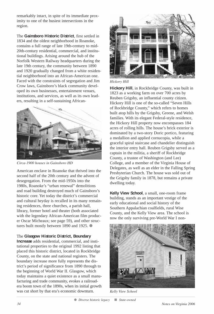
34 Notes on Virginia 2006
remarkably intact, in spite of its immediate prox-imity to one of the busiest intersections in theregion.
The Gainsboro Historic District, first settled in1834 and the oldest neighborhood in Roanoke,contains a full range of late 19th-century to mid-20th-century residential, commercial, and institu-tional buildings. Arising around the hub of theNorfolk Western Railway headquarters during thelate 19th century, the community between 1890and 1920 gradually changed from a white residen-tial neighborhood into an African-American one.Faced with the constraints of segregation and JimCrow laws, Gainsboro’s black community devel-oped its own businesses, entertainment venues,institutions, and services, as well as its own lead-ers, resulting in a self-sustaining African-
American enclave in Roanoke that thrived into thesecond half of the 20th century and the advent ofdesegregation. From the mid-1950s into the1980s, Roanoke’s “urban renewal” demolitionsand road building destroyed much of Gainsboro’shistoric core. Yet today the district’s commercialand cultural heyday is recalled in its many remain-ing residences, three churches, a parish hall,library, former hotel and theater (both associatedwith the legendary African-American film produc-er Oscar Micheaux; see page 59), and other struc-tures built mostly between 1890 and 1925. ●
The Glasgow Historic District, BoundaryIncrease adds residential, commercial, and insti-tutional properties to the original 1992 listing thatplaced this historic district, located in RockbridgeCounty, on the state and national registers. Theboundary increase more fully represents the dis-trict’s period of significance from 1890 through tothe beginning of World War II. Glasgow, whichtoday maintains a quiet existence as a small manu-facturing and trade community, evokes a railroad-era boom town of the 1890s, when its initial growthwas cut short by that era’s economic downturn.
Hickory Hill, in Rockbridge County, was built in1823 as a working farm on over 700 acres byReuben Grigsby, an influential county citizen.Hickory Hill is one of the so-called “Seven Hillsof Rockbridge County,” which refers to homesbuilt atop hills by the Grigsby, Greene, and Welshfamilies. With its elegant Federal-style residence,the Hickory Hill property now encompasses 184acres of rolling hills. The house’s brick exterior isdominated by a two-story Doric portico, featuringa medallion and applied cornucopia, while agraceful spiral staircase and chandelier distinguishthe interior entry hall. Reuben Grigsby served as acaptain in the militia, a sheriff of RockbridgeCounty, a trustee of Washington (and Lee)College, and a member of the Virginia House ofDelegates, as well as an elder in the Falling SpringPresbyterian Church. The house was sold out ofthe Grigsby family in 1878, but remains a privatedwelling today.
Kelly View School, a small, one-room framebuilding, stands as an important vestige of theearly educational and social history of theSouthern Appalachian coalfields, rural WiseCounty, and the Kelly View area. The school isnow the only surviving pre-World War I non-
● Diverse historic legacy ■ State-owned
Circa-1900 houses in Gainsboro HD
Hickory Hill
Kelly View School
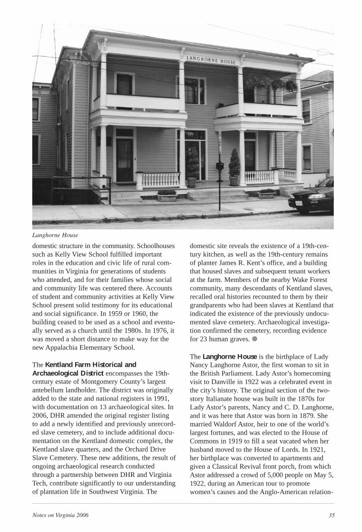
Notes on Virginia 2006 35
domestic structure in the community. Schoolhousessuch as Kelly View School fulfilled importantroles in the education and civic life of rural com-munities in Virginia for generations of studentswho attended, and for their families whose socialand community life was centered there. Accountsof student and community activities at Kelly ViewSchool present solid testimony for its educationaland social significance. In 1959 or 1960, thebuilding ceased to be used as a school and eventu-ally served as a church until the 1980s. In 1976, itwas moved a short distance to make way for thenew Appalachia Elementary School.
The Kentland Farm Historical andArchaeological District encompasses the 19th-century estate of Montgomery County’s largestantebellum landholder. The district was originallyadded to the state and national registers in 1991,with documentation on 13 archaeological sites. In2006, DHR amended the original register listingto add a newly identified and previously unrecord-ed slave cemetery, and to include additional docu-mentation on the Kentland domestic complex, theKentland slave quarters, and the Orchard DriveSlave Cemetery. These new additions, the result ofongoing archaeological research conductedthrough a partnership between DHR and VirginiaTech, contribute significantly to our understandingof plantation life in Southwest Virginia. The
domestic site reveals the existence of a 19th-cen-tury kitchen, as well as the 19th-century remainsof planter James R. Kent’s office, and a buildingthat housed slaves and subsequent tenant workersat the farm. Members of the nearby Wake Forestcommunity, many descendants of Kentland slaves,recalled oral histories recounted to them by theirgrandparents who had been slaves at Kentland thatindicated the existence of the previously undocu-mented slave cemetery. Archaeological investiga-tion confirmed the cemetery, recording evidencefor 23 human graves. ●
The Langhorne House is the birthplace of LadyNancy Langhorne Astor, the first woman to sit inthe British Parliament. Lady Astor’s homecomingvisit to Danville in 1922 was a celebrated event inthe city’s history. The original section of the two-story Italianate house was built in the 1870s forLady Astor’s parents, Nancy and C. D. Langhorne,and it was here that Astor was born in 1879. Shemarried Waldorf Astor, heir to one of the world’slargest fortunes, and was elected to the House ofCommons in 1919 to fill a seat vacated when herhusband moved to the House of Lords. In 1921,her birthplace was converted to apartments andgiven a Classical Revival front porch, from whichAstor addressed a crowd of 5,000 people on May 5,1922, during an American tour to promotewomen’s causes and the Anglo-American relation-
Langhorne House
36 Notes on Virginia 2006
ship. Astor’s emotionally charged visit was report-ed in newspapers nationwide. The house is alsoassociated with the early life of Astor’s sisterIrene Langhorne Gibson, the model for her hus-band Charles Dana Gibson’s artistic creation “TheGibson Girl.” The property is now partially dedicat-ed to interpreting the lives of Astor and Gibson. ●
Rock Run School, a one-story frame building,once served a rural African-American communityin Henry County from the early 1880s through themid-20th century. The building is a rare examplefrom the post-Reconstruction era of both a ruralschool as well as an early African-American pub-lic school. Although its condition has sufferedsomewhat, the school has not been altered overthe years in any substantial way. As such, its his-toric integrity is remarkable, and its potential forrestoration appears promising. ●
The siting, architecture, and interior layout of theseven-building complex Terrace Apartments inRoanoke embody Federal Housing Administrationguidelines derived largely from the Garden CityMovement, a design philosophy popularized inEurope following World War I. TerraceApartments was conceived and built by ownerPaul Wood and architect James F. Mactier in 1950to meet Roanoke’s demand for affordable housingduring the post-World WarII population surge when aninflux of laborers filled jobsin Roanoke’s thriving millsand factories. TerraceApartments provided efficient units in a park-likesetting so working-classfamilies could enjoy a suburban lifestyle. Thecomplex—representative ofthe “garden apartment”style of multiple-familyhousing commonly built in
the post-war period—complements the hilly land-scape and roadways to create distinctive working-class housing. Known originally as RoanokeApartments, the complex was the largest one inthe city when built and remains today among the10 largest in Roanoke. Currently TerraceApartments is home to many recent immigrants,leading some city residents to call it the mostdiverse community in Roanoke.
Shannon Cemetery is highly significant for itsassociation with ethnic history in Giles County,and for the diversity and quality of its memorialart. The cemetery occupies two adjacent ridgesoverlooking Big Walker Creek; one ridge containsthe graves of whites, the other ridge, those ofAfrican Americans. The white section was estab-lished by settler Thomas Reid Shannon, and itsearliest grave is said to be that of one of hisdaughters who died in 1781. The forms andartistry of the grave markers include uninscribedfieldstones; vernacular tombstones with stardesigns and other decorations thought to be thework of regional tombstone carver B.F. Spyker;and professionally carved marble and granitemonuments that signify the declining geographicisolation of Big Walker Creek Valley as trans-portation and roadways improved. The African-American section of the cemetery, with its rows of
● Diverse historic legacy ■ State-owned
Rock Run School, as it appeared when registered
Terrace Apartments
Shannon Cemetery and a gravestone detail
Notes on Virginia 2006 37
small fieldstone markers, was established in theearly 19th century. The only inscribed, thoughundated, tombstone in this section is for Harveyand Caroline Burks. The black section remained inuse until the early 1960s. ●
Springdale was built in 1812 near Lexington,originally as a three-part temple-wing-plan house,by Colonel John Jordan for Alexander Trimbleand his wife Martha Grigsby, of the prominentRockbridge County Grigsby family. Jordan, awell-known local entrepreneur and builder, hadbeen heavily influenced through his work withThomas Jefferson as a brick mason at Monticello.Springdale features a central front gable, contain-ing a stucco lunette at its center. On the interiorare elegant Federal-style mantels and paneledwainscoting. In the early 20th century, the originalone-story wings were raised one-half story, two-story back porches were added, the front porchwas rebuilt, and a kitchen was added. The proper-ty, alternately known as Holly Hill, is related his-torically to several other Rockbridge County hous-es built for the Grigsby family, including HickoryHill (page 34), Fancy Hill, and Cherry Hill.Springdale’s plan, however, is unusual among theother Grigsby houses, and it is the only knownconnection of the Grigsbys with Colonel Jordan.
The Neoclassical Revival–style R. L. StoneHouse overlooks downtown Bassett, nearMartinsville, and the Bassett furniture complex,the company that Stone co-founded. He purchasedthe land for the home in 1930, the same year thatBassett Furniture Company and its subsidiariestransformed into the furniture conglomerate ofBassett Furniture Industries, Inc. The house,which is dominated by a full-height entry porchwith a Classical pediment featuring Egyptianpapyrus–style capitals atop its columns, representsthe success of both Stone and his company, one ofAmerica’s most important and largest furniturecompanies of the 20th century. Because of the roleof Bassett Furniture in the growth of the town, R.L. Stone was an eminent leader in the community,especially during the 1930s and ‘40s. While it is
Springdale
R. L. Stone House
38 Notes on Virginia 2006
uncertain who specifically was the architect andbuilder of the Stone House, Stone likely influ-enced its design, as he was the most prominentbuilder in Bassett at that time. He lived in thehouse until his death in 1948, and the houseremained in the Stone family until 2005.
The Virginia Can Company was built in 1912 asthe first and largest manufacturer of tin cans inRoanoke, and sited along the then-newly estab-lished Virginia Railway line. It continued in thiscapacity until 1951, serving the robust agriculturaleconomy of the Roanoke Valley. The property wasthen bought and converted to a clothing factory in1952, and later bought by the S.H. HeironimusCompany for storage until recently. The complexconsists of three buildings, connected over time toform one building. Each building is notable for itsarchitectural elaboration, including accent tilesand decorative brickwork. Canning becameimmensely important in the Roanoke Valley in theearly 20th century, as the area expanded its agri-cultural production, and the Virginia Can Companyreflects this importance. It also stands as testamentto the development of Roanoke as a shipping cen-ter with the expansion of the railroad. Plans are inplace to rehabilitate the building for mixed use,including art studios, a restaurant, and retail space.
Erected circa 1895 by coal-camp residents andminers, the Virginia City Church, alone on a hill-side in Wise County, is the only surviving struc-ture from the once bustling mining community ofVirginia City. Built as a place of worship for mul-tiple denominations, the church also served as thecommunity’s first schoolhouse. A rectangular,
one-room edifice,measuring only 20 by 32 feet, thechurch faces southand has a weather-board bell tower anda small diamond-shaped window cen-tered on each gableend, with a Christiancross in the centerof the north gablewindow.
The sole resource added in the Walker’s CreekPresbyterian Church Boundary Increase is theWalker’s Creek Cemetery, the principal burialground for the surrounding Big Walker CreekValley. The cemetery originated in 1911 with theburial of Andrew Johnston Bane on what was thena meadow on his farm, donated by Bane’s wife,Nannie, for the cemetery to accompany Walker’sCreek Church. It contains a range of memorialtypes and styles typical of the 19th and early 20thcenturies. Low rectangular monuments of grayGeorgia granite predominate, most carved withsedate floral patterns and geometric borders. Afew white marble monuments date to early in thecemetery’s development. The most impressive ofthese is that of Civil War veteran Bane, carvedwith high-relief acanthus leaves at the corners.Next to it, the black granite monument of NannieBane is distinguished by a pediment cap and ArtNouveau floral carvings. The cemetery’s decora-tive motifs are conventional and include lambs(for the graves of infants and children), Masonicemblems, and a caduceus, the symbol of the medi-al profession.
● Diverse historic legacy ■ State-owned
Virginia Can Company
Virginia City Church
Notes on Virginia 2006 39
Tidewater Region
A three-story brick commercial building situatedin Exmore in Northampton County on the EasternShore, Benjamin’s Department Store, circa1910, is an example of department store com-merce from the early 20th century, meaning thebuilding’s form and general appearance is a rarityon the Eastern Shore. It was commissioned byExmore town-founder John W. Chandler, a localproduce broker and large county landholder, andoperated by Harry Benjamin, a member of a suc-cessful merchant family in the area during theearly 20th century, when the shore region’s econo-my was primarily agricultural and produce wasshipped via steamship to major northern ports.
Originally serving Union Church, a non-denomi-national chapel constructed by the City of Suffolkthat offered segregated services to whites andAfrican Americans, Cedar Hill Cemetery wasestablished in 1802 as a public cemetery. Initiallythe area around the chapel was used as a commu-nal burying ground for whites, blacks, andIndians. The chapel was removed in 1872 and thecemetery expanded to its current 25 acres by1910. Graves within the cemetery, which includethose of many prominent Suffolk citizens, reveal
varying types of mausoleums, tombstones, andtombs from the 19th and 20th centuries. Thecemetery continues today as a burying ground. ●
Built as a curb-service restaurant in 1947 inPortsmouth and later expanded, The Circle fea-tures a circle-shaped front façade with a neon signon its roof. Designed in the Moderne style, whichemphasizes curved surfaces and horizontal lines,the building’s original circular portion housed amain dining area and bar. A mural behind the bar,in the style of the era’s popular illustrator AlHirschfeld, shows caricatures of celebrities fromthe mid 20th century. The Circle, a rare exampleof Moderne architecture in Portsmouth, reflectsthe surging popularity and importance of the auto-mobile in American culture in the years immedi-ately following World War II.
Benjamin’s Department Store
The Circle and a detail from its interior mural
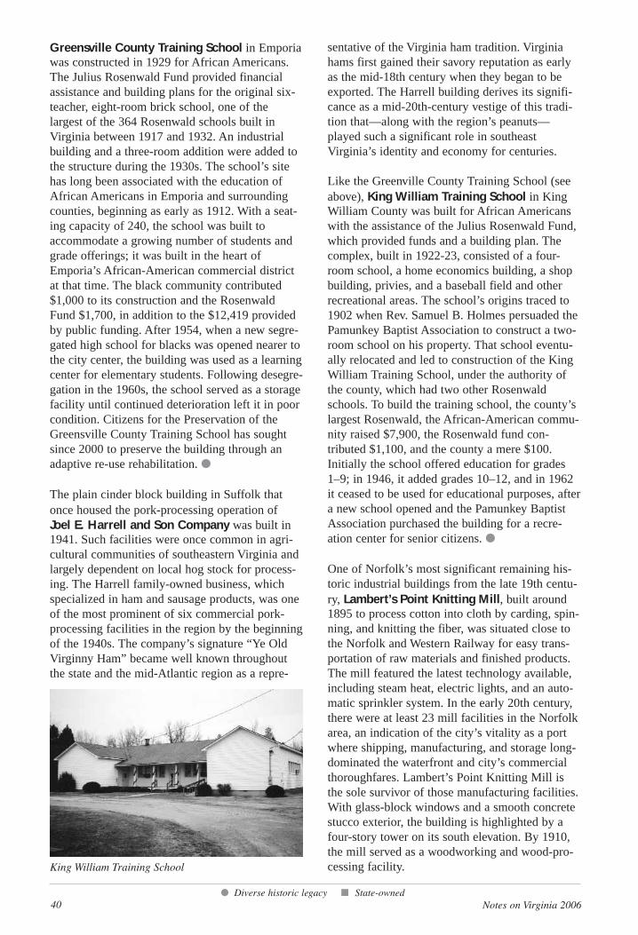
40 Notes on Virginia 2006
Greensville County Training School in Emporiawas constructed in 1929 for African Americans.The Julius Rosenwald Fund provided financialassistance and building plans for the original six-teacher, eight-room brick school, one of thelargest of the 364 Rosenwald schools built inVirginia between 1917 and 1932. An industrialbuilding and a three-room addition were added tothe structure during the 1930s. The school’s sitehas long been associated with the education ofAfrican Americans in Emporia and surroundingcounties, beginning as early as 1912. With a seat-ing capacity of 240, the school was built toaccommodate a growing number of students andgrade offerings; it was built in the heart ofEmporia’s African-American commercial districtat that time. The black community contributed$1,000 to its construction and the RosenwaldFund $1,700, in addition to the $12,419 providedby public funding. After 1954, when a new segre-gated high school for blacks was opened nearer tothe city center, the building was used as a learningcenter for elementary students. Following desegre-gation in the 1960s, the school served as a storagefacility until continued deterioration left it in poorcondition. Citizens for the Preservation of theGreensville County Training School has soughtsince 2000 to preserve the building through anadaptive re-use rehabilitation. ●
The plain cinder block building in Suffolk thatonce housed the pork-processing operation ofJoel E. Harrell and Son Company was built in1941. Such facilities were once common in agri-cultural communities of southeastern Virginia andlargely dependent on local hog stock for process-ing. The Harrell family-owned business, whichspecialized in ham and sausage products, was oneof the most prominent of six commercial pork-processing facilities in the region by the beginningof the 1940s. The company’s signature “Ye OldVirginny Ham” became well known throughoutthe state and the mid-Atlantic region as a repre-
sentative of the Virginia ham tradition. Virginiahams first gained their savory reputation as earlyas the mid-18th century when they began to beexported. The Harrell building derives its signifi-cance as a mid-20th-century vestige of this tradi-tion that—along with the region’s peanuts—played such a significant role in southeastVirginia’s identity and economy for centuries.
Like the Greenville County Training School (seeabove), King William Training School in KingWilliam County was built for African Americanswith the assistance of the Julius Rosenwald Fund,which provided funds and a building plan. Thecomplex, built in 1922-23, consisted of a four-room school, a home economics building, a shopbuilding, privies, and a baseball field and otherrecreational areas. The school’s origins traced to1902 when Rev. Samuel B. Holmes persuaded thePamunkey Baptist Association to construct a two-room school on his property. That school eventu-ally relocated and led to construction of the KingWilliam Training School, under the authority ofthe county, which had two other Rosenwaldschools. To build the training school, the county’slargest Rosenwald, the African-American commu-nity raised $7,900, the Rosenwald fund con-tributed $1,100, and the county a mere $100.Initially the school offered education for grades 1–9; in 1946, it added grades 10–12, and in 1962it ceased to be used for educational purposes, aftera new school opened and the Pamunkey BaptistAssociation purchased the building for a recre-ation center for senior citizens. ●
One of Norfolk’s most significant remaining his-toric industrial buildings from the late 19th centu-ry, Lambert’s Point Knitting Mill, built around1895 to process cotton into cloth by carding, spin-ning, and knitting the fiber, was situated close tothe Norfolk and Western Railway for easy trans-portation of raw materials and finished products.The mill featured the latest technology available,including steam heat, electric lights, and an auto-matic sprinkler system. In the early 20th century,there were at least 23 mill facilities in the Norfolkarea, an indication of the city’s vitality as a portwhere shipping, manufacturing, and storage long-dominated the waterfront and city’s commercialthoroughfares. Lambert’s Point Knitting Mill isthe sole survivor of those manufacturing facilities.With glass-block windows and a smooth concretestucco exterior, the building is highlighted by afour-story tower on its south elevation. By 1910,the mill served as a woodworking and wood-pro-cessing facility.
● Diverse historic legacy ■ State-owned
King William Training School
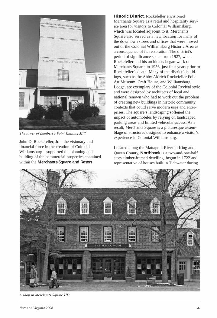
Notes on Virginia 2006 41
John D. Rockefeller, Jr.—the visionary and financial force in the creation of ColonialWilliamsburg—supported the planning and building of the commercial properties containedwithin the Merchants Square and Resort
Historic District. Rockefeller envisionedMerchants Square as a retail and hospitality serv-ice area for visitors to Colonial Williamsburg,which was located adjacent to it. MerchantsSquare also served as a new location for many ofthe downtown stores and offices that were movedout of the Colonial Williamsburg Historic Area asa consequence of its restoration. The district’speriod of significance spans from 1927, whenRockefeller and his architects began work onMerchants Square, to 1956, just four years prior toRockefeller’s death. Many of the district’s build-ings, such as the Abby Aldrich Rockefeller FolkArt Museum, Craft House, and WilliamsburgLodge, are exemplars of the Colonial Revival styleand were designed by architects of local andnational renown who had to work out the problemof creating new buildings in historic communitycontexts that could serve modern uses and enter-prises. The square’s landscaping softened theimpact of automobiles by relying on landscapedparking areas and limited vehicular access. As aresult, Merchants Square is a picturesque assem-blage of structures designed to enhance a visitor’sexperience in Colonial Williamsburg.
Located along the Mattaponi River in King andQueen County, Northbank is a two-and-one-halfstory timber-framed dwelling, begun in 1722 andrepresentative of houses built in Tidewater during
The tower of Lambert’s Point Knitting Mill
A shop in Merchants Square HD
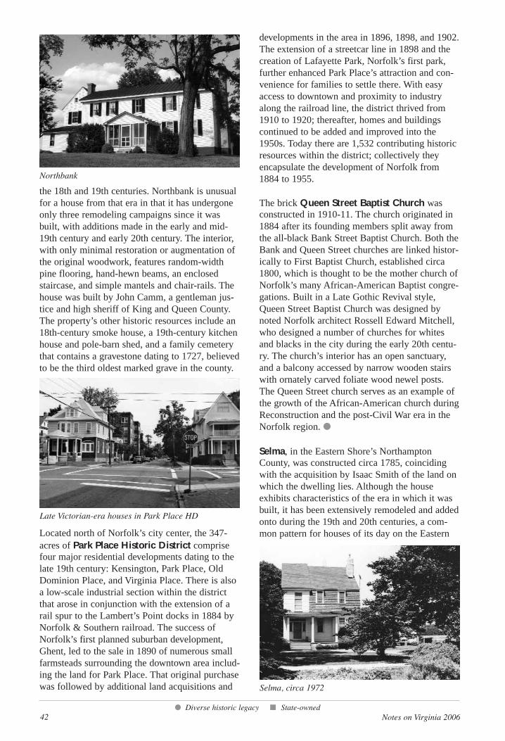
42 Notes on Virginia 2006
the 18th and 19th centuries. Northbank is unusualfor a house from that era in that it has undergoneonly three remodeling campaigns since it wasbuilt, with additions made in the early and mid-19th century and early 20th century. The interior,with only minimal restoration or augmentation ofthe original woodwork, features random-widthpine flooring, hand-hewn beams, an enclosedstaircase, and simple mantels and chair-rails. Thehouse was built by John Camm, a gentleman jus-tice and high sheriff of King and Queen County.The property’s other historic resources include an18th-century smoke house, a 19th-century kitchenhouse and pole-barn shed, and a family cemeterythat contains a gravestone dating to 1727, believedto be the third oldest marked grave in the county.
Located north of Norfolk’s city center, the 347-acres of Park Place Historic District comprisefour major residential developments dating to thelate 19th century: Kensington, Park Place, OldDominion Place, and Virginia Place. There is alsoa low-scale industrial section within the districtthat arose in conjunction with the extension of arail spur to the Lambert’s Point docks in 1884 byNorfolk & Southern railroad. The success ofNorfolk’s first planned suburban development,Ghent, led to the sale in 1890 of numerous smallfarmsteads surrounding the downtown area includ-ing the land for Park Place. That original purchasewas followed by additional land acquisitions and
developments in the area in 1896, 1898, and 1902.The extension of a streetcar line in 1898 and thecreation of Lafayette Park, Norfolk’s first park,further enhanced Park Place’s attraction and con-venience for families to settle there. With easyaccess to downtown and proximity to industryalong the railroad line, the district thrived from1910 to 1920; thereafter, homes and buildingscontinued to be added and improved into the1950s. Today there are 1,532 contributing historicresources within the district; collectively theyencapsulate the development of Norfolk from1884 to 1955.
The brick Queen Street Baptist Church wasconstructed in 1910-11. The church originated in1884 after its founding members split away fromthe all-black Bank Street Baptist Church. Both theBank and Queen Street churches are linked histor-ically to First Baptist Church, established circa1800, which is thought to be the mother church ofNorfolk’s many African-American Baptist congre-gations. Built in a Late Gothic Revival style,Queen Street Baptist Church was designed bynoted Norfolk architect Rossell Edward Mitchell,who designed a number of churches for whitesand blacks in the city during the early 20th centu-ry. The church’s interior has an open sanctuary,and a balcony accessed by narrow wooden stairswith ornately carved foliate wood newel posts.The Queen Street church serves as an example ofthe growth of the African-American church duringReconstruction and the post-Civil War era in theNorfolk region. ●
Selma, in the Eastern Shore’s NorthamptonCounty, was constructed circa 1785, coincidingwith the acquisition by Isaac Smith of the land onwhich the dwelling lies. Although the houseexhibits characteristics of the era in which it wasbuilt, it has been extensively remodeled and addedonto during the 19th and 20th centuries, a com-mon pattern for houses of its day on the Eastern
● Diverse historic legacy ■ State-owned
Northbank
Selma, circa 1972
Late Victorian-era houses in Park Place HD
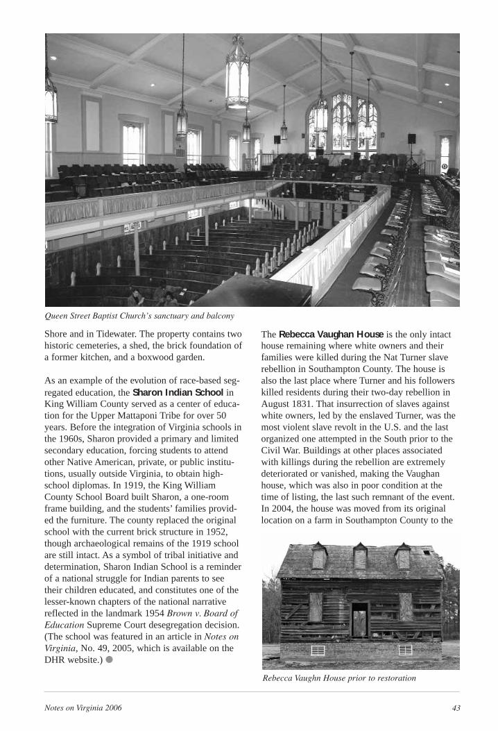
The Rebecca Vaughan House is the only intacthouse remaining where white owners and theirfamilies were killed during the Nat Turner slaverebellion in Southampton County. The house isalso the last place where Turner and his followerskilled residents during their two-day rebellion inAugust 1831. That insurrection of slaves againstwhite owners, led by the enslaved Turner, was themost violent slave revolt in the U.S. and the lastorganized one attempted in the South prior to theCivil War. Buildings at other places associatedwith killings during the rebellion are extremelydeteriorated or vanished, making the Vaughanhouse, which was also in poor condition at thetime of listing, the last such remnant of the event.In 2004, the house was moved from its originallocation on a farm in Southampton County to the
Notes on Virginia 2006 43
Shore and in Tidewater. The property contains twohistoric cemeteries, a shed, the brick foundation ofa former kitchen, and a boxwood garden.
As an example of the evolution of race-based seg-regated education, the Sharon Indian School inKing William County served as a center of educa-tion for the Upper Mattaponi Tribe for over 50years. Before the integration of Virginia schools inthe 1960s, Sharon provided a primary and limitedsecondary education, forcing students to attendother Native American, private, or public institu-tions, usually outside Virginia, to obtain high-school diplomas. In 1919, the King WilliamCounty School Board built Sharon, a one-roomframe building, and the students’ families provid-ed the furniture. The county replaced the originalschool with the current brick structure in 1952,though archaeological remains of the 1919 schoolare still intact. As a symbol of tribal initiative anddetermination, Sharon Indian School is a reminderof a national struggle for Indian parents to seetheir children educated, and constitutes one of thelesser-known chapters of the national narrativereflected in the landmark 1954 Brown v. Board ofEducation Supreme Court desegregation decision.(The school was featured in an article in Notes onVirginia, No. 49, 2005, which is available on theDHR website.) ●
Queen Street Baptist Church’s sanctuary and balcony
Rebecca Vaughn House prior to restoration
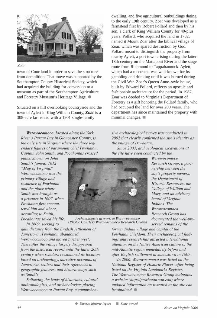
44 Notes on Virginia 2006
town of Courtland in order to save the structurefrom demolition. That move was supported by theSouthampton County Historical Society, whichhad acquired the building for conversion to amuseum as part of the Southampton Agricultureand Forestry Museum’s Heritage Village. ●
Situated on a hill overlooking countryside and thetown of Aylett in King William County, Zoar is a308-acre farmstead with a 1901 single-family
dwelling, and five agricultural outbuildings datingto the early 19th century. Zoar was developed as afarmstead first by Robert Pollard and then by hisson, a clerk of King William County for 40-plusyears. Pollard, who acquired the land in 1782,named it Mount Zoar after the biblical village ofZoar, which was spared destruction by God.Pollard meant to distinguish the property fromnearby Aylett, a port town arising during the latter18th century on the Mattaponi River and the stageroute from Richmond to Tappahannock. Aylett,which had a racetrack, was well-known for itsgambling and drinking until it was burned duringthe Civil War. Zoar’s Queen Anne–style house,built by Edward Pollard, reflects an upscale andfashionable architecture for the period. In 1987,Zoar was deeded to Virginia’s Department ofForestry as a gift honoring the Pollard family, whohad occupied the land for over 200 years. Thedepartment has since maintained the property with minimal changes. ■
● Diverse historic legacy ■ State-owned
Zoar
Werowocomoco, located along the YorkRiver’s Purtan Bay in Gloucester County, isthe only site in Virginia where the three leg-endary figures of paramount chief Powhatan,Captain John Smith, and Pocahontas crossedpaths. Shown on JohnSmith’s famous 1612“Map of Virginia,”Werowocomoco was theprimary village and residence of Powhatanand the place whereSmith was brought as a prisoner in 1607, whenPowhatan first encoun-tered him and where,according to Smith,Pocahontas saved his life.
In 1609, seeking togain distance from the English settlement ofJamestown, Powhatan abandonedWerowocomoco and moved further west.Thereafter the village largely disappearedfrom the historical record until the latter 20thcentury when scholars reexamined its locationbased on archaeology, narrative accounts ofJamestown settlers and their references togeographic features, and historic maps suchas Smith’s.
Following the leads of historians, culturalanthropologists, and archaeologists placingWerowocomoco at Purtan Bay, a comprehen-
sive archaeological survey was conducted in2002 that clearly confirmed the site’s identity asthe village of Powhatan.
Since 2003, archaeological excavations atthe site have been conducted by the
WerowocomocoResearch Group, a part-nership between thesite’s property owners,the Department ofHistoric Resources, theCollege of William andMary, and an advisoryboard of VirginiaIndians. TheWerowocomocoResearch Group has documented the well-pre-served remains of the
former Indian village and capital of thePowhatan chiefdom. Their archaeological find-ings and research has attracted internationalattention on the Native American culture of themid-Atlantic region immediately before andafter English settlement at Jamestown in 1607.
In 2006, Werowocomoco was listed on theNational Register of Historic Places, after beinglisted on the Virginia Landmarks Register. The Werowocomoco Research Group maintainsa website (http://powhatan.wm.edu) whereupdated information on research at the site canbe obtained. ●
Archaeologists at work at Werowocomoco (Photo: Courtesy Werowocomoco Research Group)
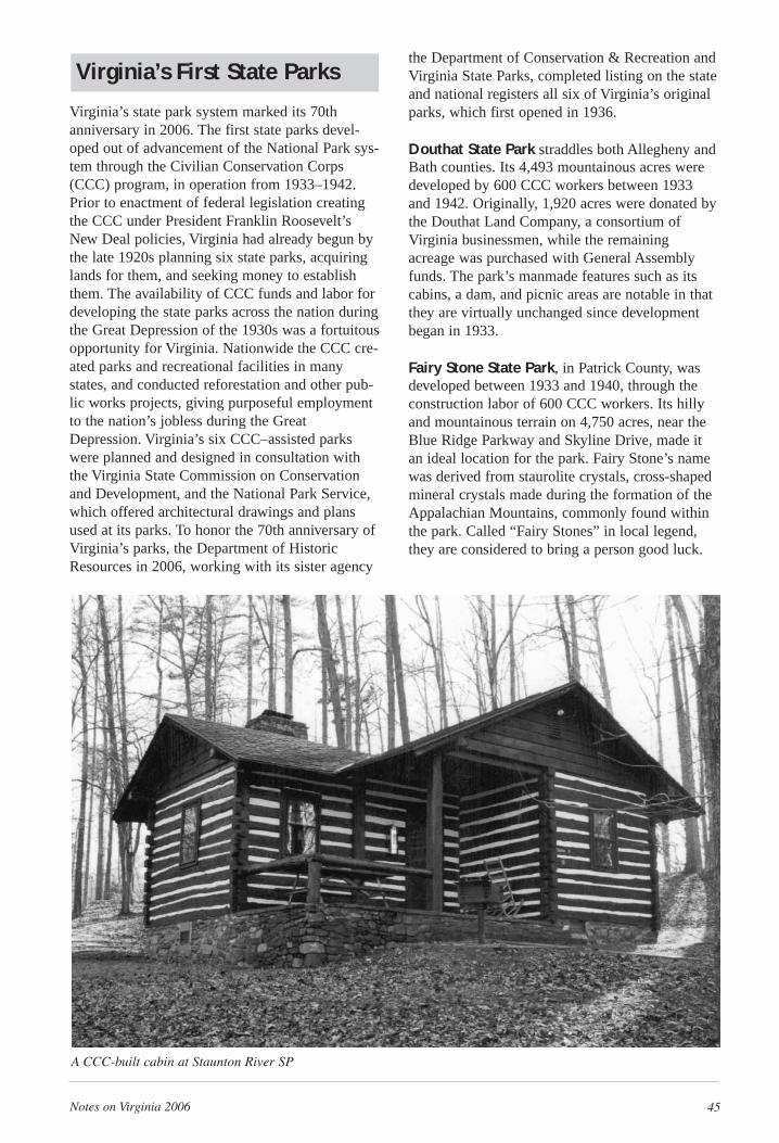
Notes on Virginia 2006 45
Virginia’s First State Parks
Virginia’s state park system marked its 70thanniversary in 2006. The first state parks devel-oped out of advancement of the National Park sys-tem through the Civilian Conservation Corps(CCC) program, in operation from 1933–1942.Prior to enactment of federal legislation creatingthe CCC under President Franklin Roosevelt’sNew Deal policies, Virginia had already begun bythe late 1920s planning six state parks, acquiringlands for them, and seeking money to establishthem. The availability of CCC funds and labor fordeveloping the state parks across the nation duringthe Great Depression of the 1930s was a fortuitousopportunity for Virginia. Nationwide the CCC cre-ated parks and recreational facilities in manystates, and conducted reforestation and other pub-lic works projects, giving purposeful employmentto the nation’s jobless during the GreatDepression. Virginia’s six CCC–assisted parkswere planned and designed in consultation withthe Virginia State Commission on Conservationand Development, and the National Park Service,which offered architectural drawings and plansused at its parks. To honor the 70th anniversary ofVirginia’s parks, the Department of HistoricResources in 2006, working with its sister agency
the Department of Conservation & Recreation andVirginia State Parks, completed listing on the stateand national registers all six of Virginia’s originalparks, which first opened in 1936.
Douthat State Park straddles both Allegheny andBath counties. Its 4,493 mountainous acres weredeveloped by 600 CCC workers between 1933and 1942. Originally, 1,920 acres were donated bythe Douthat Land Company, a consortium ofVirginia businessmen, while the remainingacreage was purchased with General Assemblyfunds. The park’s manmade features such as itscabins, a dam, and picnic areas are notable in thatthey are virtually unchanged since developmentbegan in 1933.
Fairy Stone State Park, in Patrick County, wasdeveloped between 1933 and 1940, through theconstruction labor of 600 CCC workers. Its hillyand mountainous terrain on 4,750 acres, near theBlue Ridge Parkway and Skyline Drive, made itan ideal location for the park. Fairy Stone’s namewas derived from staurolite crystals, cross-shapedmineral crystals made during the formation of theAppalachian Mountains, commonly found withinthe park. Called “Fairy Stones” in local legend,they are considered to bring a person good luck.
A CCC-built cabin at Staunton River SP

46 Notes on Virginia 2006
Hungry MotherState Park is locatedon 2,215 acres of theAllegheny Mountainsof Smyth County.Between 1933 and1941, 600 CCCworkers developedthe park, takingadvantage of itsmountainous terrainnear the JeffersonNational Forest andsituating it aroundmanmade HungryMother Lake. Thepark’s curious name originated from a nearbycreek named for an incident that occurred prior topermanent English settlement. Many versions ofthe story were collected in a 1936 booklet pub-lished by the Commission on Conservation andDevelopment, but they all include a hungry childcrying some form of “Hungry Mammy.”
Staunton River State Park, in Halifax County,sits at the confluence of the Dan and StauntonRivers. Its 1,299 acres were constructed by 400CCC workers between 1933 and 1938. The parkcaptures the spirit of the Southern Piedmontregion’s rolling hills and forests. In 1953 in orderto alleviate recurrent flooding, a dam was con-structed, resulting in the submersion of 300 acresof park land.
The other two original state parks, Seashore(First Landing) State Park, in Virginia Beach,and Westmoreland State Park, in WestmorelandCounty, were listed on the state and national regis-ters in 2005 and were profiled in Notes onVirginia, No. 49, 2005.
Notes from the Director(cont. from page 4)
Turning to another initiative, DHR in recent years has committed itself to expanding our state andnational registers to represent the full range of Virginia’s historic legacy. Twenty-four new VLRs profiledherein are the fruit of this effort. They include Ralphe Bunch High School, an important civil rights land-mark (p. 22); Richmond’s Hebrew Cemetery (p. 11); the Langhorne House in Danville, the girlhood homeof Lady Astor (p. 35); the Patsy Cline House in Winchester (p. 23), and the Gainsboro Historic District inRoanoke (p. 34), among others. An article by DHR historian John Kern, director of the Roanoke RegionalPreservation Office, tells about the years pioneering African American filmmaker Oscar Micheaux spentin the Gainsboro neighborhood, a once-thriving middle-class black residential and commercial district.
Many of the state’s new historical highway markers (p. 75) also reflect the department’s effort toshowcase Virginia’s diverse legacy. Of 47 new markers, 19 deal with significant people, places, andevents pertaining to African American or Virginia Indian history. This represents a welcome broadeningof the program’s coverage, and comes as we celebrate in 2007 the 80th anniversary of Virginia’s first his-torical markers. For this 80th milestone, DHR published an updated, revised edition of A Guidebook toVirginia’s Historical Markers through the University of Virginia Press. We also launched a new searchcomponent on our website (www.dhr.virginia.gov) allowing visitors to locate, map, and read each of themore than 2,200 markers scattered throughout the state. The website complements the book, whichremains a handy resource when traveling the state’s highways.
During this year of Jamestown, I am quick to remind people that anniversaries are always occur-ring—just as history is always happening—providing us an opportunity to take stock of where we havebeen, where we are, and where we are going. In this special year, I can report that the stewardship ofVirginia’s historic resources carries on with strength and vision. Although we face many significant chal-lenges approaching another major anniversary in 2011—the sesquicentennial of the start of the CivilWar—by all indications we are growing wiser when it comes to preserving our historic resources whilebalancing the needs of an expanding population and economy. We have, indeed, come of age.
A CCC picnic shelter atHungary Mother SP
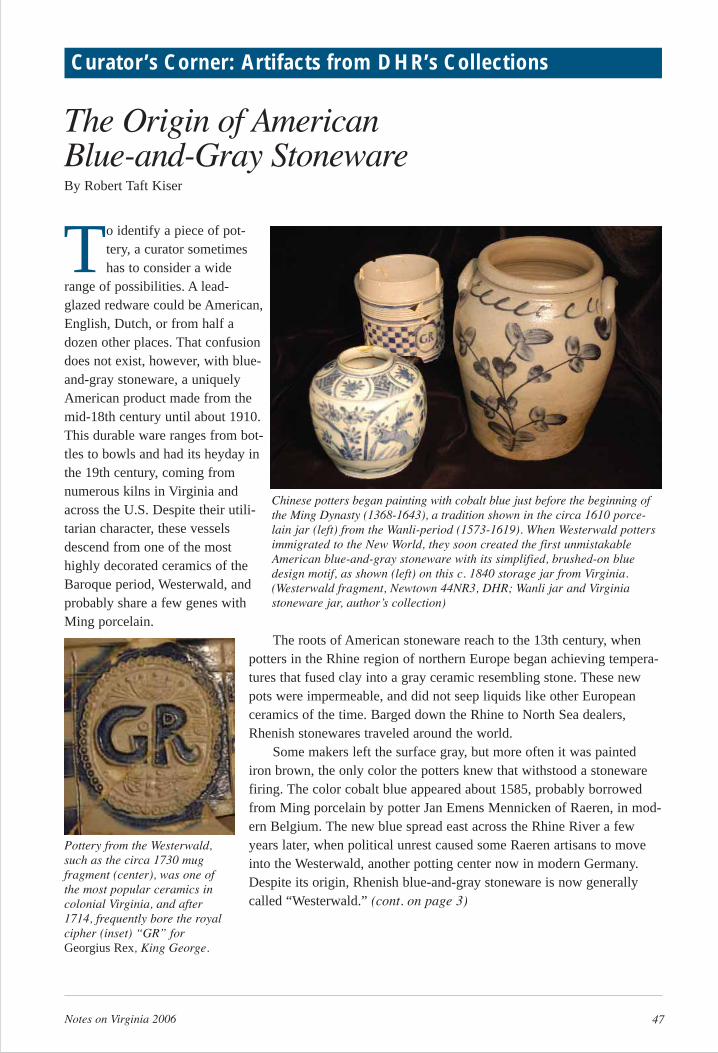
Notes on Virginia 2006 47
The Origin of American Blue-and-Gray StonewareBy Robert Taft Kiser
To identify a piece of pot-tery, a curator sometimeshas to consider a wide
range of possibilities. A lead-glazed redware could be American,English, Dutch, or from half adozen other places. That confusiondoes not exist, however, with blue-and-gray stoneware, a uniquelyAmerican product made from themid-18th century until about 1910.This durable ware ranges from bot-tles to bowls and had its heyday inthe 19th century, coming fromnumerous kilns in Virginia andacross the U.S. Despite their utili-tarian character, these vesselsdescend from one of the mosthighly decorated ceramics of theBaroque period, Westerwald, andprobably share a few genes withMing porcelain.
The roots of American stoneware reach to the 13th century, whenpotters in the Rhine region of northern Europe began achieving tempera-tures that fused clay into a gray ceramic resembling stone. These newpots were impermeable, and did not seep liquids like other Europeanceramics of the time. Barged down the Rhine to North Sea dealers,Rhenish stonewares traveled around the world.
Some makers left the surface gray, but more often it was paintediron brown, the only color the potters knew that withstood a stonewarefiring. The color cobalt blue appeared about 1585, probably borrowedfrom Ming porcelain by potter Jan Emens Mennicken of Raeren, in mod-ern Belgium. The new blue spread east across the Rhine River a fewyears later, when political unrest caused some Raeren artisans to moveinto the Westerwald, another potting center now in modern Germany.Despite its origin, Rhenish blue-and-gray stoneware is now generallycalled “Westerwald.” (cont. on page 3)
Curator’s Corner: Artifacts from DHR’s Collections
Chinese potters began painting with cobalt blue just before the beginning ofthe Ming Dynasty (1368-1643), a tradition shown in the circa 1610 porce-lain jar (left) from the Wanli-period (1573-1619). When Westerwald pottersimmigrated to the New World, they soon created the first unmistakableAmerican blue-and-gray stoneware with its simplified, brushed-on bluedesign motif, as shown (left) on this c. 1840 storage jar from Virginia.(Westerwald fragment, Newtown 44NR3, DHR; Wanli jar and Virginiastoneware jar, author’s collection)
Pottery from the Westerwald,such as the circa 1730 mugfragment (center), was one ofthe most popular ceramics incolonial Virginia, and after1714, frequently bore the royalcipher (inset) “GR” forGeorgius Rex, King George.
48 Notes on Virginia 2006
The first stonewares in Virginia includedthe popular Rhenish Bartmann(Bearded Man) jug, shown in this circa1640 fragment (left), also known as the“bellarmine.” Traveling empty, thesewere used to retail liquids from casks,with the face and molded medallionsserving as decoration as well as makingthe vessels easier to grip. About 1670British potters began producingstoneware, and by the 1690s theirbrown stoneware jugs, as shown in thiscirca 1710 fragment (right), replacedBartmänner in Virginia. (Bartmannfragment, River Creek 44YO67; English fragment, College Landing44WB3, DHR)
The circa 1635 Westerwald jug fragment(top center) found in Virginia Beach showsnew decorations introduced between 1575to 1585 and their similarity to Wanli porcelain (left, right, bottom). Recent workby the author theorizes that potter JanEmens Mennicken first translated Chinesepainting into three dimensions, and thendiscovered that he could borrow the bluepaint as well. (Credits: Westerwald fragment, DHR, 44VB48; Wanli periodporcelain, author’s collection)
Left: A Westerwald jar, circa 1750. Right: A New Jersey American blue-and-grayjar, circa 1780. Westerwald has incised patterns painted with blue, and as late asthe 20th century, the foot almost always had a grooved band filled with blue. Afterimmigrants from the Westerwald transplanted their blue-and-gray stoneware tradi-tion to the New World, they simplified the lines, making the pots heavier and moredurable, and although some incising was used, in most cases the potters splashed ontheir color freehand. (Courtesy of Sumpter Priddy. Photo: Gavin Ashworth)
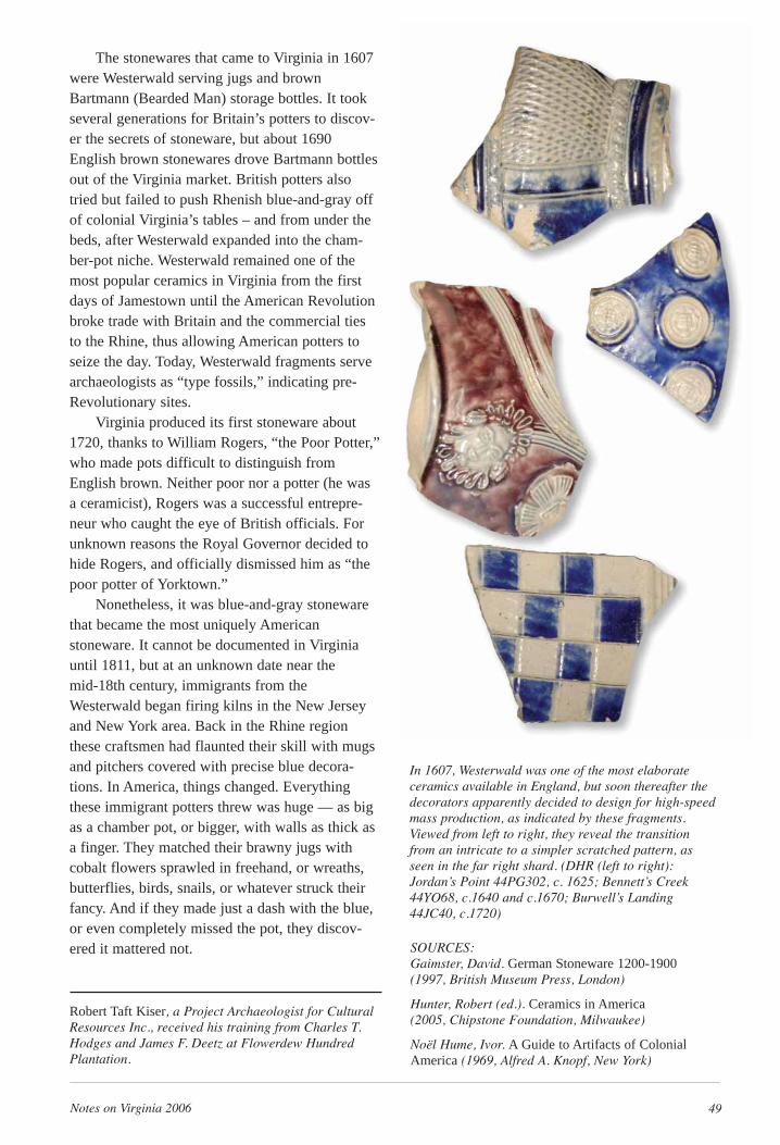
Notes on Virginia 2006 49
In 1607, Westerwald was one of the most elaborateceramics available in England, but soon thereafter thedecorators apparently decided to design for high-speedmass production, as indicated by these fragments.Viewed from left to right, they reveal the transitionfrom an intricate to a simpler scratched pattern, asseen in the far right shard. (DHR (left to right):Jordan’s Point 44PG302, c. 1625; Bennett’s Creek44YO68, c.1640 and c.1670; Burwell’s Landing44JC40, c.1720)
The stonewares that came to Virginia in 1607were Westerwald serving jugs and brownBartmann (Bearded Man) storage bottles. It tookseveral generations for Britain’s potters to discov-er the secrets of stoneware, but about 1690English brown stonewares drove Bartmann bottlesout of the Virginia market. British potters alsotried but failed to push Rhenish blue-and-gray offof colonial Virginia’s tables – and from under thebeds, after Westerwald expanded into the cham-ber-pot niche. Westerwald remained one of themost popular ceramics in Virginia from the firstdays of Jamestown until the American Revolutionbroke trade with Britain and the commercial tiesto the Rhine, thus allowing American potters toseize the day. Today, Westerwald fragments servearchaeologists as “type fossils,” indicating pre-Revolutionary sites.
Virginia produced its first stoneware about1720, thanks to William Rogers, “the Poor Potter,”who made pots difficult to distinguish fromEnglish brown. Neither poor nor a potter (he wasa ceramicist), Rogers was a successful entrepre-neur who caught the eye of British officials. Forunknown reasons the Royal Governor decided tohide Rogers, and officially dismissed him as “thepoor potter of Yorktown.”
Nonetheless, it was blue-and-gray stonewarethat became the most uniquely Americanstoneware. It cannot be documented in Virginiauntil 1811, but at an unknown date near the mid-18th century, immigrants from theWesterwald began firing kilns in the New Jerseyand New York area. Back in the Rhine regionthese craftsmen had flaunted their skill with mugsand pitchers covered with precise blue decora-tions. In America, things changed. Everythingthese immigrant potters threw was huge — as bigas a chamber pot, or bigger, with walls as thick asa finger. They matched their brawny jugs withcobalt flowers sprawled in freehand, or wreaths,butterflies, birds, snails, or whatever struck theirfancy. And if they made just a dash with the blue,or even completely missed the pot, they discov-ered it mattered not.
Robert Taft Kiser, a Project Archaeologist for CulturalResources Inc., received his training from Charles T.Hodges and James F. Deetz at Flowerdew HundredPlantation.
SOURCES: Gaimster, David. German Stoneware 1200-1900(1997, British Museum Press, London)
Hunter, Robert (ed.). Ceramics in America(2005, Chipstone Foundation, Milwaukee)
Noël Hume, Ivor. A Guide to Artifacts of ColonialAmerica (1969, Alfred A. Knopf, New York)
50 Notes on Virginia 2006
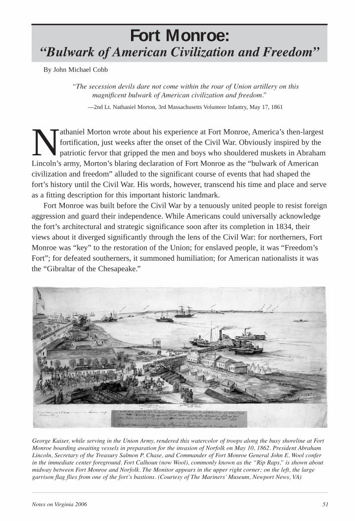
Notes on Virginia 2006 51
Fort Monroe: “Bulwark of American Civilization and Freedom”
By John Michael Cobb
“The secession devils dare not come within the roar of Union artillery on this magnificent bulwark of American civilization and freedom.”
—2nd Lt. Nathaniel Morton, 3rd Massachusetts Volunteer Infantry, May 17, 1861
Nathaniel Morton wrote about his experience at Fort Monroe, America’s then-largestfortification, just weeks after the onset of the Civil War. Obviously inspired by thepatriotic fervor that gripped the men and boys who shouldered muskets in Abraham
Lincoln’s army, Morton’s blaring declaration of Fort Monroe as the “bulwark of Americancivilization and freedom” alluded to the significant course of events that had shaped thefort’s history until the Civil War. His words, however, transcend his time and place and serveas a fitting description for this important historic landmark.
Fort Monroe was built before the Civil War by a tenuously united people to resist foreignaggression and guard their independence. While Americans could universally acknowledgethe fort’s architectural and strategic significance soon after its completion in 1834, theirviews about it diverged significantly through the lens of the Civil War: for northerners, FortMonroe was “key” to the restoration of the Union; for enslaved people, it was “Freedom’sFort”; for defeated southerners, it summoned humiliation; for American nationalists it wasthe “Gibraltar of the Chesapeake.”
George Kaiser, while serving in the Union Army, rendered this watercolor of troops along the busy shoreline at FortMonroe boarding awaiting vessels in preparation for the invasion of Norfolk on May 10, 1862. President AbrahamLincoln, Secretary of the Treasury Salmon P. Chase, and Commander of Fort Monroe General John E. Wool conferin the immediate center foreground. Fort Calhoun (now Wool), commonly known as the “Rip Raps,” is shown aboutmidway between Fort Monroe and Norfolk. The Monitor appears in the upper right corner; on the left, the large garrison flag flies from one of the fort’s bastions. (Courtesy of The Mariners’ Museum, Newport News, VA)
52 Notes on Virginia 2006
Early HistoryMore than 200 years before construction of
Fort Monroe, Capt. John Smith, while establishingthe Virginia Company of London’s settlement atJamestown in 1607, saw the importance of thesand spit that would become known as Old PointComfort, the future site of Fort Monroe.Positioned at the tip of a Virginia peninsulaformed by the James and York rivers, Old PointComfort—“a little isle fit for a castle,” as Smithdescribed it—was strategically located at the con-fluence of the Chesapeake Bay and HamptonRoads, the latter a natural harbor and outlet for theJames River and three secondary rivers, theHampton, Elizabeth, and Nansemond. Thesewaterways emptied into Hampton Roads, flowinginto the Chesapeake Bay and on to the AtlanticOcean.
Soon after settling Jamestown on the JamesRiver, Smith’s martial vision was first realizedwith the construction of Fort Algernon. A stock-ade mounted with seven pieces of artillery andgarrisoned by 40 men, Fort Algernon served as asentinel at the entrance to the Virginia Company’sJames River estuary domain. With a view of anypossible approaching Spanish ships, the locationalso was the last vestige of English presence onesaw from a sailing vessel departing Virginia.
After Fort Algernon had long vanished, FortGeorge, Virginia’s strongest fortification was con-structed on the site in the 1730s to guard againstFrench invasion. The fort was built of brick andsand, and Governor William Gooch reported in1736 that “no ship could pass it without runninggreat risks.” Unfortunately, Fort George was nomatch for a hurricane in 1749 that swept over thearea. Only rubble remained in the storm’s after-math and some frame buildings. It would beanother 70 years, and the birth of a new nation,before Fort Monroe replaced Fort George.
Fort Monroe ArisesRepeated incursions by foreign nations,
almost with impunity, necessitated the rise of permanent defensive bastions able to defendAmerica’s shore and interior. During the AmericanRevolution and the War of 1812 existing coastalfortifications proved ineffective against theBritish. In both conflicts the enemy pillaged many American port cities and towns includingHampton, Norfolk, and, most famously,Washington, D.C., in the latter war when theWhite House was burned.
The War of 1812 led President JamesMadison’s administration to begin the largest fed-eral building program in the young nation’s history
with creation of a system of masonry fortificationsto guard ports from Maine to the Gulf of Mexico.In the decades before the Civil War, Fort Monroeand 41 other forts were designed and constructedto significantly strengthen the coastal defenses.
The concept for the “magnificent bulwark ofAmerican freedom and civilization” that soimpressed Morton was developed by a renownedFrench engineer, Simon Bernard. On the recom-mendation of Revolutionary War hero Marquis deLafayette, Bernard, a former aide-de-camp toNapoleon Bonaparte, was appointed to draft plansfor coastal fortifications. A celebrated expert inmilitary architecture, Bernard was known for theDefenses of Antwerp. Just like Capt. John Smithbefore him, Bernard appreciated the strategicimportance of Old Point Comfort. There hedesigned “companion” forts, one named forPresident James Monroe and, less than a mileacross the channel on a stone island engineered ona shallow shoal, the other named after Secretaryof War John C. Calhoun. Forts Monroe andCalhoun (now Wool) were planned to create aseething crossfire for hostile vessels that mightattempt to enter Hampton Roads.
The Old Point Comfort site selected forMonroe was near a Jeffersonian-era lighthouse,which still stands today. The project commencedin late April 1817 when Col. Walter Armisteadstarted stockpiling granite stones for the fort froma quarry along the Potomac River. The Army’selite Corps of Engineers directed the fort’s con-struction, and Major Charles Gratiot served as thefirst of several engineers assigned to the project.By March 1819, with Gratiot supervising, workwas formally underway, with stone and brickmasons, carpenters, blacksmiths, and other labor-ers. Many of the men, skilled and unskilled, wereenslaved and, later in the construction, many wereconvict laborers. As the fort began to rise, theirregularly cut, massive granite stones gave thewalls a mosaic appearance. Over them, a swarmof workmen, cranes, and piles of stone and brick,all starkly silhouetted against the horizon, createdan impressive scene.
Capt. Mann P. Lomax, a native Virginian,leading Company G of the Third Artillery,marched into the unfinished fort on July 25, 1823,as Monroe’s first commander at the head of its firstgarrison. With the disciplined soldiers outfitted intheir brass-and-blue uniforms and the workmendressed in their worn-and-weathered clothes, eachgroup grasping the tools of their professions, itmust have been a curious scene. Lomax’s relativelysmall detachment of troops surely appeared swal-lowed up in the vast and open space of the fort’s
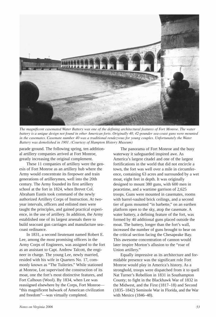
Notes on Virginia 2006 53
parade ground. The following spring, ten addition-al artillery companies arrived at Fort Monroe,greatly increasing the original complement.
These 11 companies of artillery were the gen-esis of Fort Monroe as an artillery hub where theArmy would concentrate its firepower and traingenerations of artillerymen, well into the 20thcentury. The Army founded its first artilleryschool at the fort in 1824, when Brevet Col.Abraham Eustis took command of the newlyauthorized Artillery Corps of Instruction. At two-year intervals, officers and enlisted men weretaught the principles, and gained practical experi-ence, in the use of artillery. In addition, the Armyestablished one of its largest arsenals there tobuild seacoast gun carriages and manufacture sea-coast ordinance.
In 1831, a second lieutenant named Robert E.Lee, among the most promising officers in theArmy Corps of Engineers, was assigned to the fortas an assistant to Capt. Andrew Talcott, the engi-neer in charge. The young Lee, newly married,resided with his wife in Quarters No. 17, com-monly known as “The Tuileries.” While stationedat Monroe, Lee supervised the construction of itsmoat, one the fort’s most distinctive features, andFort Calhoun (Wool). By 1834, when Lee wasreassigned elsewhere by the Corps, Fort Monroe—“this magnificent bulwark of American civilizationand freedom”—was virtually completed.
The panorama of Fort Monroe and the busywaterway it safeguarded inspired awe. AsAmerica’s largest citadel and one of the largestfortifications in the world that did not encircle atown, the fort was well over a mile in circumfer-ence, containing 63 acres and surrounded by a wetmoat, eight feet in depth. It was originallydesigned to mount 380 guns, with 600 men inpeacetime, and a wartime garrison of 2,625troops. Guns were mounted in casemates, roomswith barrel-vaulted brick ceilings, and a secondtier of guns mounted “in barbette,” on an earthenplatform open to the sky, atop the casemate. Awater battery, a defining feature of the fort, wasformed by 40 additional guns placed outside themoat. The battery, longer than the fort’s wall,increased the number of guns brought to bear onthe critical section facing the Chesapeake Bay.This awesome concentration of cannon wouldlater inspire Morton’s allusion to the “roar ofUnion artillery.”
Equally impressive as its architecture and for-midable presence was the significant role FortMonroe would play in America’s history. As astronghold, troops were dispatched from it to quellNat Turner’s Rebellion in 1831 in SouthamptonCounty; to fight in the Blackhawk War of 1832 inthe Midwest, and the First (1817–18) and Second(1835–1842) Seminole War in Florida, and the Warwith Mexico (1846–48).
The magnificent casemated Water Battery was one of the defining architectural features of Fort Monroe. The waterbattery is a unique design not found in other American forts. Originally 40, 42-pounder sea-coast guns were mountedin the casemates. Casemate number 40 was a traditional rendezvous for young couples. Unfortunately the WaterBattery was demolished in 1901. (Courtesy of Hampton History Museum)
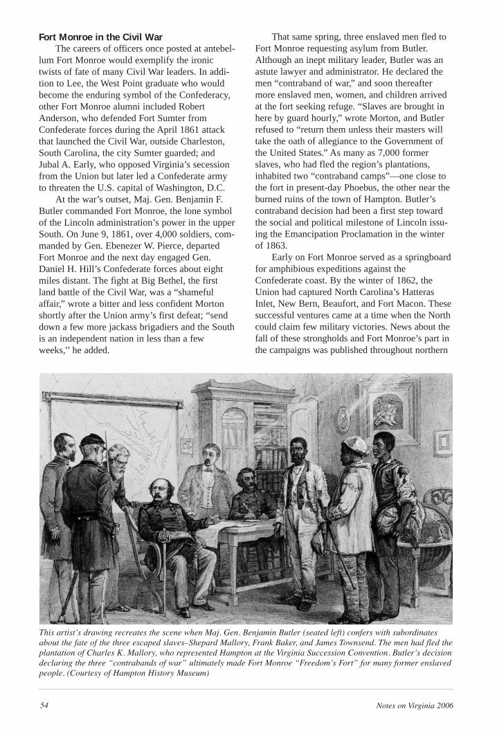
54 Notes on Virginia 2006
Fort Monroe in the Civil War The careers of officers once posted at antebel-
lum Fort Monroe would exemplify the ironictwists of fate of many Civil War leaders. In addi-tion to Lee, the West Point graduate who wouldbecome the enduring symbol of the Confederacy,other Fort Monroe alumni included RobertAnderson, who defended Fort Sumter fromConfederate forces during the April 1861 attackthat launched the Civil War, outside Charleston,South Carolina, the city Sumter guarded; andJubal A. Early, who opposed Virginia’s secessionfrom the Union but later led a Confederate armyto threaten the U.S. capital of Washington, D.C.
At the war’s outset, Maj. Gen. Benjamin F.Butler commanded Fort Monroe, the lone symbolof the Lincoln administration’s power in the upperSouth. On June 9, 1861, over 4,000 soldiers, com-manded by Gen. Ebenezer W. Pierce, departedFort Monroe and the next day engaged Gen.Daniel H. Hill’s Confederate forces about eightmiles distant. The fight at Big Bethel, the firstland battle of the Civil War, was a “shamefulaffair,” wrote a bitter and less confident Mortonshortly after the Union army’s first defeat; “senddown a few more jackass brigadiers and the Southis an independent nation in less than a fewweeks,’’ he added.
That same spring, three enslaved men fled toFort Monroe requesting asylum from Butler.Although an inept military leader, Butler was anastute lawyer and administrator. He declared themen “contraband of war,” and soon thereaftermore enslaved men, women, and children arrivedat the fort seeking refuge. “Slaves are brought inhere by guard hourly,” wrote Morton, and Butlerrefused to “return them unless their masters willtake the oath of allegiance to the Government ofthe United States.” As many as 7,000 formerslaves, who had fled the region’s plantations,inhabited two “contraband camps”—one close tothe fort in present-day Phoebus, the other near theburned ruins of the town of Hampton. Butler’scontraband decision had been a first step towardthe social and political milestone of Lincoln issu-ing the Emancipation Proclamation in the winterof 1863.
Early on Fort Monroe served as a springboardfor amphibious expeditions against theConfederate coast. By the winter of 1862, theUnion had captured North Carolina’s HatterasInlet, New Bern, Beaufort, and Fort Macon. Thesesuccessful ventures came at a time when the Northcould claim few military victories. News about thefall of these strongholds and Fort Monroe’s part inthe campaigns was published throughout northern
This artist’s drawing recreates the scene when Maj. Gen. Benjamin Butler (seated left) confers with subordinatesabout the fate of the three escaped slaves–Shepard Mallory, Frank Baker, and James Townsend. The men had fled theplantation of Charles K. Mallory, who represented Hampton at the Virginia Succession Convention. Butler’s decisiondeclaring the three “contrabands of war” ultimately made Fort Monroe “Freedom’s Fort” for many former enslavedpeople. (Courtesy of Hampton History Museum)
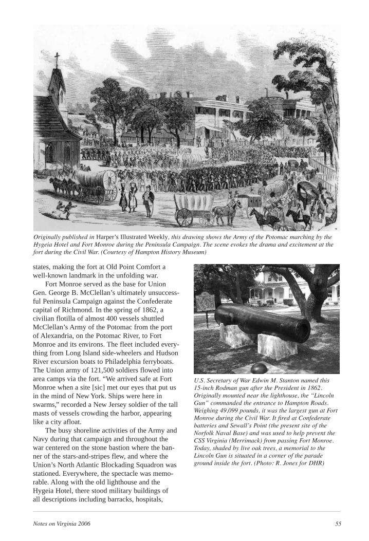
Notes on Virginia 2006 55
states, making the fort at Old Point Comfort awell-known landmark in the unfolding war.
Fort Monroe served as the base for UnionGen. George B. McClellan’s ultimately unsuccess-ful Peninsula Campaign against the Confederatecapital of Richmond. In the spring of 1862, acivilian flotilla of almost 400 vessels shuttledMcClellan’s Army of the Potomac from the portof Alexandria, on the Potomac River, to FortMonroe and its environs. The fleet included every-thing from Long Island side-wheelers and HudsonRiver excursion boats to Philadelphia ferryboats.The Union army of 121,500 soldiers flowed intoarea camps via the fort. “We arrived safe at FortMonroe when a site [sic] met our eyes that put usin the mind of New York. Ships were here inswarms,” recorded a New Jersey soldier of the tallmasts of vessels crowding the harbor, appearinglike a city afloat.
The busy shoreline activities of the Army andNavy during that campaign and throughout thewar centered on the stone bastion where the ban-ner of the stars-and-stripes flew, and where theUnion’s North Atlantic Blockading Squadron wasstationed. Everywhere, the spectacle was memo-rable. Along with the old lighthouse and theHygeia Hotel, there stood military buildings of all descriptions including barracks, hospitals,
Originally published in Harper’s Illustrated Weekly, this drawing shows the Army of the Potomac marching by theHygeia Hotel and Fort Monroe during the Peninsula Campaign. The scene evokes the drama and excitement at thefort during the Civil War. (Courtesy of Hampton History Museum)
U.S. Secretary of War Edwin M. Stanton named this 15-inch Rodman gun after the President in 1862.Originally mounted near the lighthouse, the “LincolnGun” commanded the entrance to Hampton Roads.Weighing 49,099 pounds, it was the largest gun at FortMonroe during the Civil War. It fired at Confederatebatteries and Sewall’s Point (the present site of theNorfolk Naval Base) and was used to help prevent theCSS Virginia (Merrimack) from passing Fort Monroe.Today, shaded by live oak trees, a memorial to theLincoln Gun is situated in a corner of the paradeground inside the fort. (Photo: R. Jones for DHR)
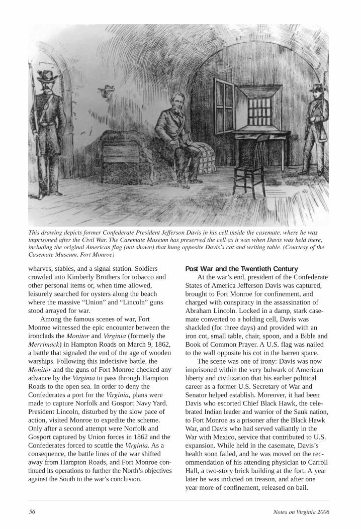
56 Notes on Virginia 2006
wharves, stables, and a signal station. Soldierscrowded into Kimberly Brothers for tobacco andother personal items or, when time allowed,leisurely searched for oysters along the beachwhere the massive “Union” and “Lincoln” gunsstood arrayed for war.
Among the famous scenes of war, FortMonroe witnessed the epic encounter between theironclads the Monitor and Virginia (formerly theMerrimack) in Hampton Roads on March 9, 1862,a battle that signaled the end of the age of woodenwarships. Following this indecisive battle, theMonitor and the guns of Fort Monroe checked anyadvance by the Virginia to pass through HamptonRoads to the open sea. In order to deny theConfederates a port for the Virginia, plans weremade to capture Norfolk and Gosport Navy Yard.President Lincoln, disturbed by the slow pace ofaction, visited Monroe to expedite the scheme.Only after a second attempt were Norfolk andGosport captured by Union forces in 1862 and theConfederates forced to scuttle the Virginia. As aconsequence, the battle lines of the war shiftedaway from Hampton Roads, and Fort Monroe con-tinued its operations to further the North’s objectivesagainst the South to the war’s conclusion.
Post War and the Twentieth CenturyAt the war’s end, president of the Confederate
States of America Jefferson Davis was captured,brought to Fort Monroe for confinement, andcharged with conspiracy in the assassination ofAbraham Lincoln. Locked in a damp, stark case-mate converted to a holding cell, Davis wasshackled (for three days) and provided with aniron cot, small table, chair, spoon, and a Bible andBook of Common Prayer. A U.S. flag was nailedto the wall opposite his cot in the barren space.
The scene was one of irony: Davis was nowimprisoned within the very bulwark of Americanliberty and civilization that his earlier politicalcareer as a former U.S. Secretary of War andSenator helped establish. Moreover, it had beenDavis who escorted Chief Black Hawk, the cele-brated Indian leader and warrior of the Sauk nation,to Fort Monroe as a prisoner after the Black HawkWar, and Davis who had served valiantly in theWar with Mexico, service that contributed to U.S.expansion. While held in the casemate, Davis’shealth soon failed, and he was moved on the rec-ommendation of his attending physician to CarrollHall, a two-story brick building at the fort. A yearlater he was indicted on treason, and after oneyear more of confinement, released on bail.
This drawing depicts former Confederate President Jefferson Davis in his cell inside the casemate, where he wasimprisoned after the Civil War. The Casemate Museum has preserved the cell as it was when Davis was held there,including the original American flag (not shown) that hung opposite Davis’s cot and writing table. (Courtesy of theCasemate Museum, Fort Monroe)
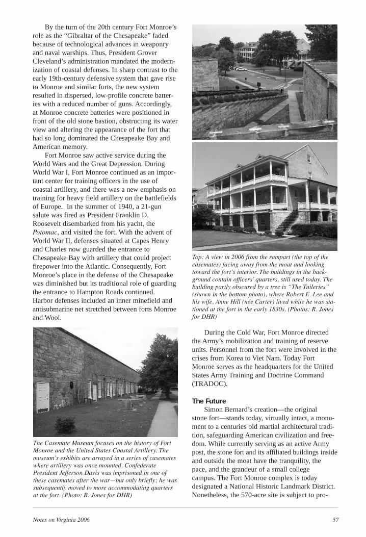
Notes on Virginia 2006 57
By the turn of the 20th century Fort Monroe’srole as the “Gibraltar of the Chesapeake” fadedbecause of technological advances in weaponryand naval warships. Thus, President GroverCleveland’s administration mandated the modern-ization of coastal defenses. In sharp contrast to theearly 19th-century defensive system that gave riseto Monroe and similar forts, the new systemresulted in dispersed, low-profile concrete batter-ies with a reduced number of guns. Accordingly,at Monroe concrete batteries were positioned infront of the old stone bastion, obstructing its waterview and altering the appearance of the fort thathad so long dominated the Chesapeake Bay andAmerican memory.
Fort Monroe saw active service during theWorld Wars and the Great Depression. DuringWorld War I, Fort Monroe continued as an impor-tant center for training officers in the use ofcoastal artillery, and there was a new emphasis ontraining for heavy field artillery on the battlefieldsof Europe. In the summer of 1940, a 21-gunsalute was fired as President Franklin D.Roosevelt disembarked from his yacht, thePotomac, and visited the fort. With the advent ofWorld War II, defenses situated at Capes Henryand Charles now guarded the entrance toChesapeake Bay with artillery that could projectfirepower into the Atlantic. Consequently, FortMonroe’s place in the defense of the Chesapeakewas diminished but its traditional role of guardingthe entrance to Hampton Roads continued. Harbor defenses included an inner minefield andantisubmarine net stretched between forts Monroeand Wool.
During the Cold War, Fort Monroe directedthe Army’s mobilization and training of reserveunits. Personnel from the fort were involved in thecrises from Korea to Viet Nam. Today FortMonroe serves as the headquarters for the UnitedStates Army Training and Doctrine Command(TRADOC).
The FutureSimon Bernard’s creation—the original
stone fort—stands today, virtually intact, a monu-ment to a centuries old martial architectural tradi-tion, safeguarding American civilization and free-dom. While currently serving as an active Armypost, the stone fort and its affiliated buildings insideand outside the moat have the tranquility, thepace, and the grandeur of a small college campus. The Fort Monroe complex is today designated a National Historic Landmark District.Nonetheless, the 570-acre site is subject to pro-
The Casemate Museum focuses on the history of FortMonroe and the United States Coastal Artillery. Themuseum’s exhibits are arrayed in a series of casemateswhere artillery was once mounted. ConfederatePresident Jefferson Davis was imprisoned in one ofthese casemates after the war—but only briefly; he wassubsequently moved to more accommodating quartersat the fort. (Photo: R. Jones for DHR)
Top: A view in 2006 from the rampart (the top of thecasemates) facing away from the moat and lookingtoward the fort’s interior. The buildings in the back-ground contain officers’ quarters, still used today. Thebuilding partly obscured by a tree is “The Tuileries”(shown in the bottom photo), where Robert E. Lee andhis wife, Anne Hill (née Carter) lived while he was sta-tioned at the fort in the early 1830s. (Photos: R. Jonesfor DHR)
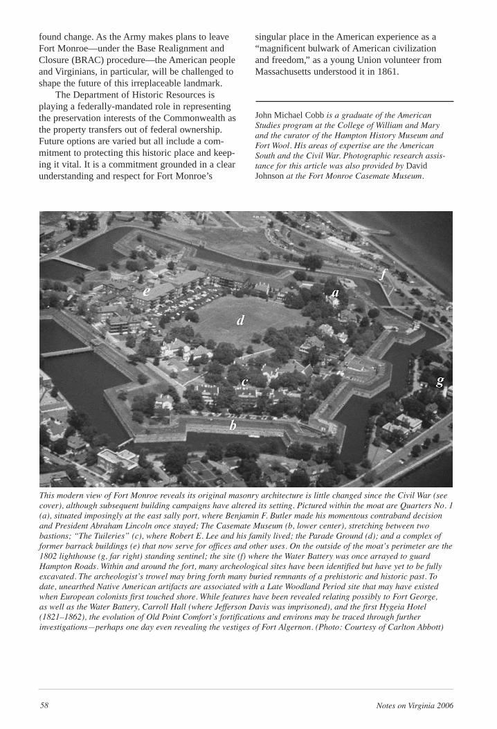
58 Notes on Virginia 2006
found change. As the Army makes plans to leaveFort Monroe—under the Base Realignment andClosure (BRAC) procedure—the American peopleand Virginians, in particular, will be challenged toshape the future of this irreplaceable landmark.
The Department of Historic Resources isplaying a federally-mandated role in representingthe preservation interests of the Commonwealth asthe property transfers out of federal ownership.Future options are varied but all include a com-mitment to protecting this historic place and keep-ing it vital. It is a commitment grounded in a clearunderstanding and respect for Fort Monroe’s
singular place in the American experience as a“magnificent bulwark of American civilization and freedom,” as a young Union volunteer fromMassachusetts understood it in 1861.
John Michael Cobb is a graduate of the AmericanStudies program at the College of William and Maryand the curator of the Hampton History Museum andFort Wool. His areas of expertise are the AmericanSouth and the Civil War. Photographic research assis-tance for this article was also provided by DavidJohnson at the Fort Monroe Casemate Museum.
This modern view of Fort Monroe reveals its original masonry architecture is little changed since the Civil War (seecover), although subsequent building campaigns have altered its setting. Pictured within the moat are Quarters No. 1(a), situated imposingly at the east sally port, where Benjamin F. Butler made his momentous contraband decisionand President Abraham Lincoln once stayed; The Casemate Museum (b, lower center), stretching between two bastions; “The Tuileries” (c), where Robert E. Lee and his family lived; the Parade Ground (d); and a complex offormer barrack buildings (e) that now serve for offices and other uses. On the outside of the moat’s perimeter are the1802 lighthouse (g, far right) standing sentinel; the site (f) where the Water Battery was once arrayed to guardHampton Roads. Within and around the fort, many archeological sites have been identified but have yet to be fullyexcavated. The archeologist’s trowel may bring forth many buried remnants of a prehistoric and historic past. Todate, unearthed Native American artifacts are associated with a Late Woodland Period site that may have existedwhen European colonists first touched shore. While features have been revealed relating possibly to Fort George,as well as the Water Battery, Carroll Hall (where Jefferson Davis was imprisoned), and the first Hygeia Hotel(1821–1862), the evolution of Old Point Comfort’s fortifications and environs may be traced through further investigations—perhaps one day even revealing the vestiges of Fort Algernon. (Photo: Courtesy of Carlton Abbott)
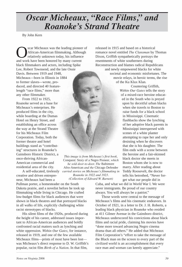
Notes on Virginia 2006 59
Oscar Micheaux was the leading pioneer ofAfrican-American filmmaking. Althoughrelatively unknown today, his influence
and work have been honored by many currentblack filmmakers and actors, including SpikeLee, Robert Townsend, and the late OssieDavis. Between 1919 and 1948,Micheaux—born in Illinois in 1884to former slaves—wrote, pro-duced, and directed 40 feature-length “race films,” more thanany other filmmaker.
From 1922 to 1925,Roanoke served as a base forMicheaux’s enterprises. Heproduced films in the city,while boarding at the DumasHotel on Henry Street, andestablishing an office acrossthe way at the Strand Theatrefor his Micheaux FilmCorporation. Today, both theformer theatre and hotelbuildings stand as “contribut-ing” structures in Roanoke’sGainsboro Historic District, aonce-thriving African-American commercial andresidential area of the city.
A self-educated, tirelesslycreative and driven entrepre-neur, Micheaux had been aPullman porter, a homesteader on the SouthDakota prairie, and a novelist before he took upfilmmaking while living in Chicago. He craftedlow-budget films for black audiences that wereshown in black theatres and that portrayed blacksin all walks of life, explicitly challenging whiteracist stereotypes of blacks.
His silent films of the 1920s, produced duringthe height of his career, addressed issues impor-tant to African-American audiences and boldlyconfronted racial matters such as lynching andwhite oppression. Within Our Gates, for instance,released in 1919, and one of the few availableMicheaux films—prints of most have been lost—was Micheaux’s direct response to D. W. Griffith’spopular, racist film Birth of a Nation. In that film,
released in 1915 and based on a historicalromance novel entitled The Clansman by ThomasDixon, Griffith sympathetically portrays theresentments of white southerners duringReconstruction and blames radical Republicans
and newly empowered blacks for whitesocietal and economic misfortunes. The
movie relays, in heroic terms, the riseof the Ku Klux Klan.
Countering Griffith,Within Our Gates tells the storyof a mixed-race heroine educat-ed in the South who is preyedupon by deceitful urban blackswhen she travels to Boston toraise funds for a black schoolin Mississippi. Cinematicflashbacks show the lynchingof her adoptive black parents inMississippi interspersed withscenes of a white planterattempting to rape her and onlydesisting when he discoversthat she is his daughter. Thefilm ends with a scene betweenthe heroine and a fair-skinnedblack doctor she meets inBoston whom she is now tomarry. After reading aboutTeddy Roosevelt, the doctortells his betrothed, “Never for-get what our people did in
Cuba, and what we did in World War I. We werenever immigrants. Be proud of our countryalways. You will always be a patriot.”
Those words were central to the message ofMicheaux’s films and his cinematic endeavors. InOctober of 1921, in a letter to Dr. J. H. Roberts, aleading black physician in Roanoke who residedat 411 Gilmer Avenue in the Gainsboro district,Micheaux underscored his convictions about blackfilms and racial pride, claiming his movies have“done more toward advancing Negro cinemadrama than all others.” He added that MicheauxFilm Corporation’s “effort to take the message ofthe Black man on the screen to every part of thecivilized world is an accomplishment that everyrace man and woman can keenly appreciate.”
Oscar Micheaux, “Race Films,” andRoanoke’s Strand Theatre
By John Kern
This image is from Micheaux’s first book,Conquest: Story of a Negro Pioneer, which
he sold door-to-door. The Baltimore Afro-American and the Chicago Defender
carried stories on Micheaux’s filmmaking inRoanoke in 1922 and 1923.
(Collection of Edward W. Barnett)
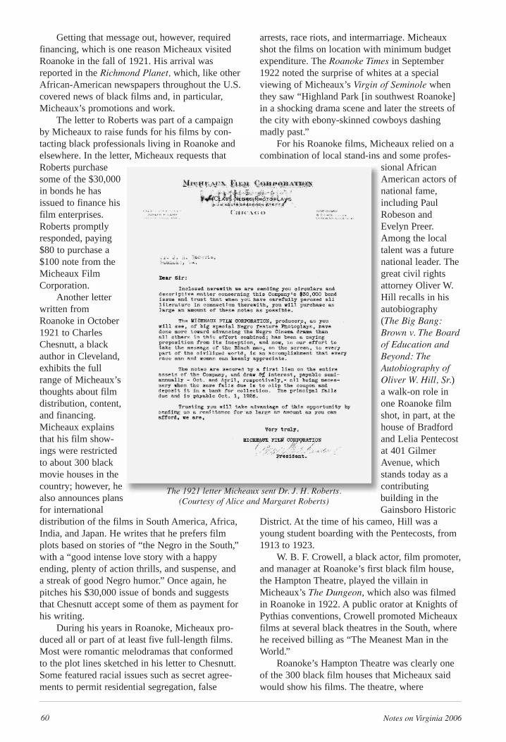
60 Notes on Virginia 2006
Getting that message out, however, requiredfinancing, which is one reason Micheaux visitedRoanoke in the fall of 1921. His arrival wasreported in the Richmond Planet, which, like otherAfrican-American newspapers throughout the U.S.covered news of black films and, in particular,Micheaux’s promotions and work.
The letter to Roberts was part of a campaignby Micheaux to raise funds for his films by con-tacting black professionals living in Roanoke andelsewhere. In the letter, Micheaux requests thatRoberts purchasesome of the $30,000in bonds he hasissued to finance hisfilm enterprises.Roberts promptlyresponded, paying$80 to purchase a$100 note from theMicheaux FilmCorporation.
Another letterwritten fromRoanoke in October1921 to CharlesChesnutt, a blackauthor in Cleveland,exhibits the fullrange of Micheaux’sthoughts about filmdistribution, content,and financing.Micheaux explainsthat his film show-ings were restrictedto about 300 blackmovie houses in thecountry; however, healso announces plansfor international distribution of the films in South America, Africa,India, and Japan. He writes that he prefers filmplots based on stories of “the Negro in the South,”with a “good intense love story with a happy ending, plenty of action thrills, and suspense, anda streak of good Negro humor.” Once again, hepitches his $30,000 issue of bonds and suggeststhat Chesnutt accept some of them as payment forhis writing.
During his years in Roanoke, Micheaux pro-duced all or part of at least five full-length films.Most were romantic melodramas that conformedto the plot lines sketched in his letter to Chesnutt.Some featured racial issues such as secret agree-ments to permit residential segregation, false
arrests, race riots, and intermarriage. Micheauxshot the films on location with minimum budgetexpenditure. The Roanoke Times in September1922 noted the surprise of whites at a specialviewing of Micheaux’s Virgin of Seminole whenthey saw “Highland Park [in southwest Roanoke]in a shocking drama scene and later the streets ofthe city with ebony-skinned cowboys dashingmadly past.”
For his Roanoke films, Micheaux relied on acombination of local stand-ins and some profes-
sional AfricanAmerican actors ofnational fame,including PaulRobeson andEvelyn Preer.Among the localtalent was a futurenational leader. Thegreat civil rightsattorney Oliver W.Hill recalls in hisautobiography (The Big Bang:Brown v. The Boardof Education andBeyond: TheAutobiography ofOliver W. Hill, Sr.)a walk-on role inone Roanoke filmshot, in part, at thehouse of Bradfordand Lelia Pentecostat 401 GilmerAvenue, whichstands today as acontributing building in theGainsboro Historic
District. At the time of his cameo, Hill was ayoung student boarding with the Pentecosts, from1913 to 1923.
W. B. F. Crowell, a black actor, film promoter,and manager at Roanoke’s first black film house,the Hampton Theatre, played the villain inMicheaux’s The Dungeon, which also was filmedin Roanoke in 1922. A public orator at Knights ofPythias conventions, Crowell promoted Micheauxfilms at several black theatres in the South, wherehe received billing as “The Meanest Man in theWorld.”
Roanoke’s Hampton Theatre was clearly oneof the 300 black film houses that Micheaux saidwould show his films. The theatre, where
The 1921 letter Micheaux sent Dr. J. H. Roberts. (Courtesy of Alice and Margaret Roberts)
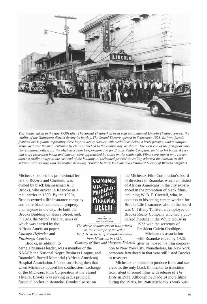
Notes on Virginia 2006 61
Micheaux penned his promotional let-ters to Roberts and Chesnutt, wasowned by black businessman A. F.Brooks, who arrived in Roanoke as amail carrier in 1890. By the 1920s,Brooks owned a life insurance companyand more black commercial propertythan anyone in the city. He built theBrooks Building on Henry Street, and,in 1923, the Strand Theatre, news ofwhich was carried by theAfrican-American papersChicago Defender andPittsburgh Courier.
Brooks, in addition tobeing a business leader, was a member of theNAACP, the National Negro Business League, andRoanoke’s Burrell Memorial (African-American)Hospital Association. It’s not surprising then thatwhen Micheaux opened the southeastern exchangeof the Micheaux Film Corporation at the StrandTheatre, Brooks was serving as his principalfinancial backer in Roanoke. Brooks also sat on
the Micheaux Film Corporation’s boardof directors in Roanoke, which consistedof African Americans in the city experi-enced in the promotion of black films,including W. B. F. Crowell, who, inaddition to his acting career, worked forBrooks Life Insurance; also on the boardwas C. Tiffany Tolliver, an employee ofBrooks Realty Company who had a pub-licized meeting in the White House in
1923 with the secretary ofPresident Calvin Coolidge.
Micheaux’s associationwith Roanoke ended by 1926,after he moved his film corpora-
tion to New York City. Nonetheless, his New Yorkcorporate letterhead in that year still listed Brooksas treasurer.
Micheaux continued to produce films and sur-vived as the only black filmmaker to transitionfrom silent to sound films with release of TheExile in 1931. Although he made 14 more filmsduring the 1930s, by 1940 Micheaux’s work was
This image, taken in the late 1930s after The Strand Theatre had been sold and renamed Lincoln Theatre, conveys thevitality of the Gainsboro district during its heyday. The Strand Theatre opened in September 1923. Its front facadefeatured brick quoins separating three bays; a heavy cornice with medallions below a brick parapet; and a marqueesuspended over the main entrance by chains attached to the central bay, as shown. The west end of the first-floor inte-rior contained offices for the Micheaux Film Corporation and for Brooks Realty Company, and a ticket booth. A sec-ond-story projection booth and balcony were approached by stairs on the south wall. Films were shown on a screenabove a shallow stage at the east end of the building. A garlanded pressed-tin ceiling adorned the interior, as didsidewall wainscoting with decorative detailing. (Photo: History Museum and Historical Society of Western Virginia)
The above announcement was printed on the envelope of the letter
Dr. J. H. Roberts of Roanoke receivedfrom Micheaux in 1921.
(Courtesy of Alice and Margaret Roberts)
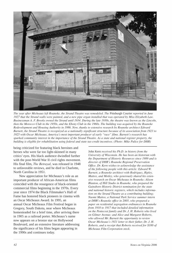
62 Notes on Virginia 2006
being criticized for featuring black heroines andheroes who were far too light-skinned in manycritics’ eyes. His black audience dwindled furtherwith the post-World War II civil rights movement.His final film, The Betrayal, was released in 1948to unfavorable reviews, and he died in Charlotte,North Carolina in 1951.
New appreciation for Micheaux’s role as animportant producer of African-American filmscoincided with the resurgence of black-orientedcommercial films beginning in the 1970s. Everyyear since 1974 the Black Filmmaker’s Hall ofFame has honored black pioneers in cinema withan Oscar Micheaux Award. In 1995, an annual Oscar Micheaux Film Festival began inGregory, South Dakota, near where Micheauxhomesteaded for a brief time, after arriving therein 1905 as a railroad porter. Micheaux’s namenow appears on a bronze star on HollywoodBoulevard, and an extensive literature addressingthe significance of his films began appearing inthe 1990s and continues today.
John Kern received his Ph.D. in history from theUniversity of Wisconsin. He has been an historian withthe Department of Historic Resources since 1989 and isdirector of DHR’s Roanoke Regional PreservationOffice. Dr. Kern wishes to acknowledge the assistanceof the following people with this article: Edward W.Barnett, a Roanoke architect with Rodriguez, Ripley,Mattox, and Motley, who generously shared his exten-sive research on Oscar Micheaux in Roanoke; AlisonBlanton, of Hill Studio in Roanoke, who prepared theGainsboro Historic District nomination for the stateand national historic registers, which includes informa-tion on the Strand Theatre as a contributing building;Naomi Mattos, a National Park Service summer internat DHR’s Roanoke office in 2005, who prepared apaper on residential segregation ordinances in Roanokefrom 1910 to 1917 that included detailed informationon the Pentecost family and Dr. J. H. Roberts who livedon Gilmer Avenue; and Alice and Margaret Roberts,who allowed Mr. Barnett the opportunity to reviewOscar Micheaux’s 1921 letter to their father, Dr. J. H.Roberts, and a receipt that Roberts received for $100 ofMicheaux Film Corporation stock.
The year after Micheaux left Roanoke, the Strand Theatre was remodeled. The Pittsburgh Courier reported in June1927 that the Strand walls were painted, and a new pipe organ installed that was operated by Miss Elizabeth Law.Businessman A. F. Brooks owned the Strand until 1934. During the late 1930s, the theatre was known as the Lincoln,then the Morocco Club in the 1950s, and the Ebony Club in the 1960s. The building was acquired by the RoanokeRedevelopment and Housing Authority in 1986. Now, thanks to extensive research by Roanoke architect EdwardBarnett, the Strand Theatre is recognized as a nationally significant structure because of its association from 1923 to1925 with Oscar Micheaux, America’s most important producer of early “race” films. Barnett’s research hassparked community interest in the importance of the Strand Theatre. As a state and national register property, thebuilding is eligible for rehabilitation using federal and state tax-credit incentives. (Photo: Mike Pulice for DHR)
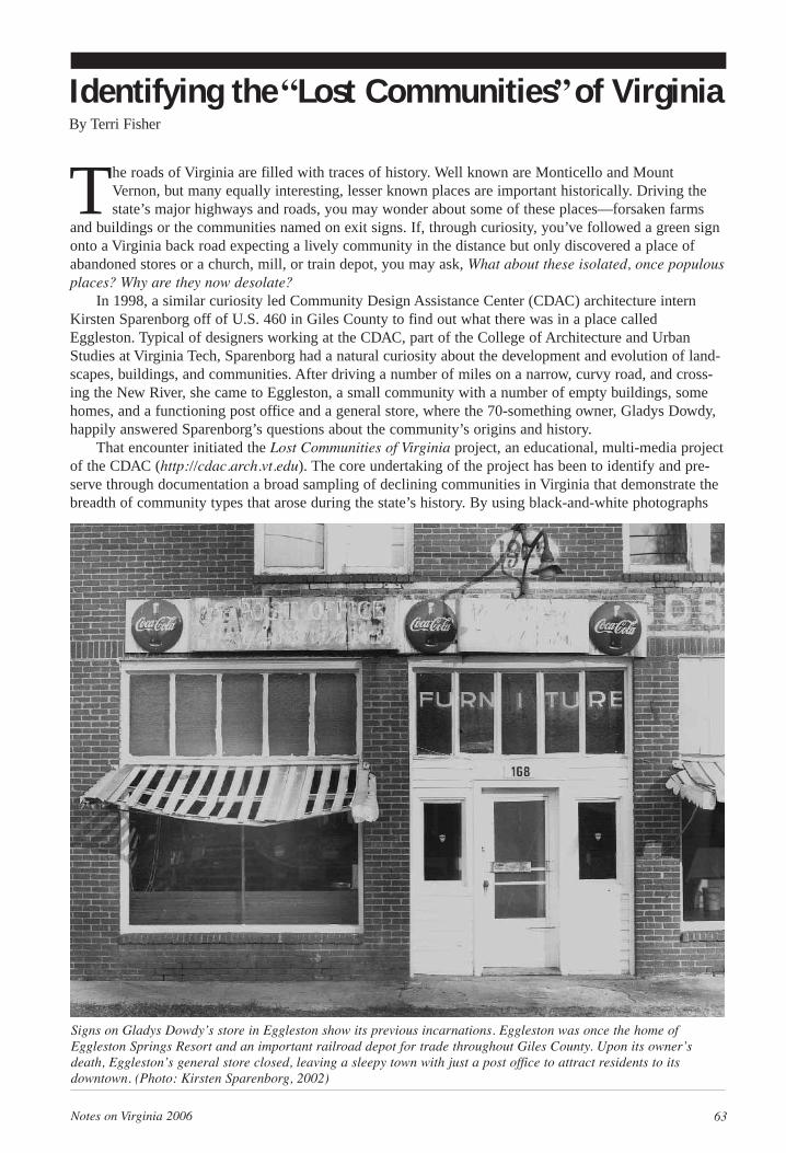
Notes on Virginia 2006 63
The roads of Virginia are filled with traces of history. Well known are Monticello and MountVernon, but many equally interesting, lesser known places are important historically. Driving thestate’s major highways and roads, you may wonder about some of these places—forsaken farms
and buildings or the communities named on exit signs. If, through curiosity, you’ve followed a green signonto a Virginia back road expecting a lively community in the distance but only discovered a place ofabandoned stores or a church, mill, or train depot, you may ask, What about these isolated, once populousplaces? Why are they now desolate?
In 1998, a similar curiosity led Community Design Assistance Center (CDAC) architecture internKirsten Sparenborg off of U.S. 460 in Giles County to find out what there was in a place calledEggleston. Typical of designers working at the CDAC, part of the College of Architecture and UrbanStudies at Virginia Tech, Sparenborg had a natural curiosity about the development and evolution of land-scapes, buildings, and communities. After driving a number of miles on a narrow, curvy road, and cross-ing the New River, she came to Eggleston, a small community with a number of empty buildings, somehomes, and a functioning post office and a general store, where the 70-something owner, Gladys Dowdy,happily answered Sparenborg’s questions about the community’s origins and history.
That encounter initiated the Lost Communities of Virginia project, an educational, multi-media projectof the CDAC (http://cdac.arch.vt.edu). The core undertaking of the project has been to identify and pre-serve through documentation a broad sampling of declining communities in Virginia that demonstrate thebreadth of community types that arose during the state’s history. By using black-and-white photographs
Identifying the“Lost Communities”of VirginiaBy Terri Fisher
Signs on Gladys Dowdy’s store in Eggleston show its previous incarnations. Eggleston was once the home ofEggleston Springs Resort and an important railroad depot for trade throughout Giles County. Upon its owner’sdeath, Eggleston’s general store closed, leaving a sleepy town with just a post office to attract residents to its downtown. (Photo: Kirsten Sparenborg, 2002)
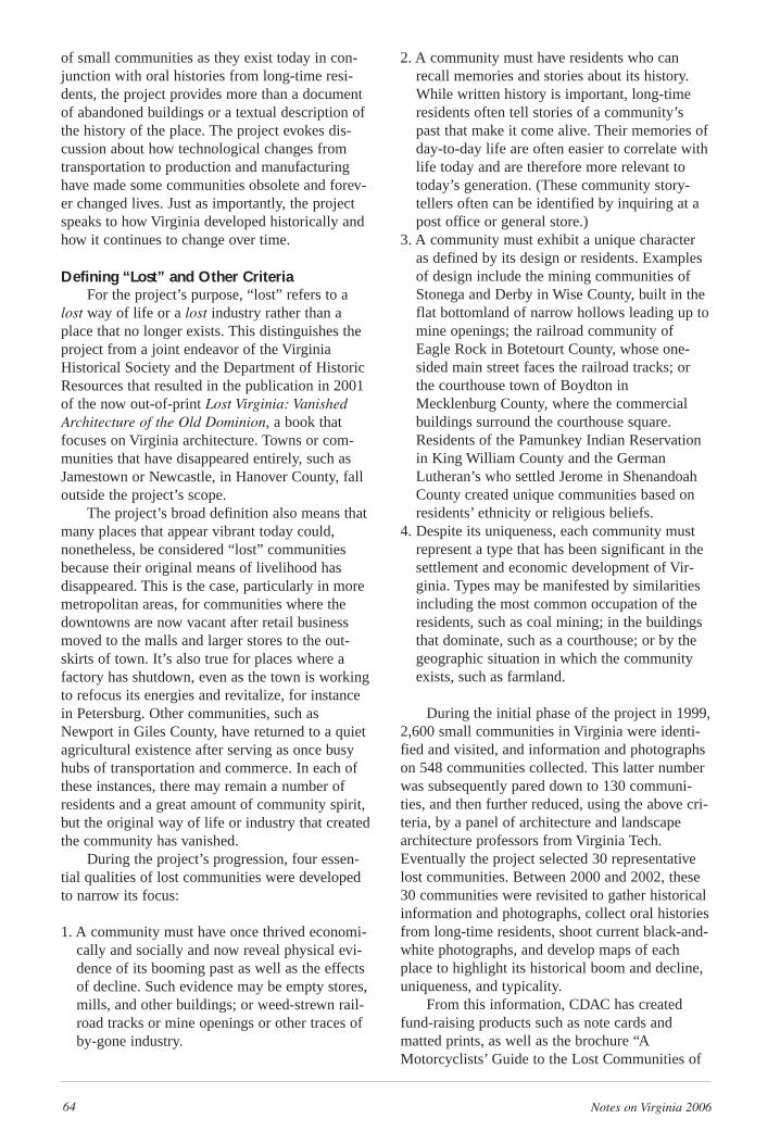
64 Notes on Virginia 2006
of small communities as they exist today in con-junction with oral histories from long-time resi-dents, the project provides more than a documentof abandoned buildings or a textual description ofthe history of the place. The project evokes dis-cussion about how technological changes fromtransportation to production and manufacturinghave made some communities obsolete and forev-er changed lives. Just as importantly, the projectspeaks to how Virginia developed historically andhow it continues to change over time.
Defining “Lost” and Other CriteriaFor the project’s purpose, “lost” refers to a
lost way of life or a lost industry rather than aplace that no longer exists. This distinguishes theproject from a joint endeavor of the VirginiaHistorical Society and the Department of HistoricResources that resulted in the publication in 2001of the now out-of-print Lost Virginia: VanishedArchitecture of the Old Dominion, a book thatfocuses on Virginia architecture. Towns or com-munities that have disappeared entirely, such asJamestown or Newcastle, in Hanover County, falloutside the project’s scope.
The project’s broad definition also means thatmany places that appear vibrant today could,nonetheless, be considered “lost” communitiesbecause their original means of livelihood has disappeared. This is the case, particularly in moremetropolitan areas, for communities where thedowntowns are now vacant after retail businessmoved to the malls and larger stores to the out-skirts of town. It’s also true for places where afactory has shutdown, even as the town is workingto refocus its energies and revitalize, for instancein Petersburg. Other communities, such asNewport in Giles County, have returned to a quietagricultural existence after serving as once busyhubs of transportation and commerce. In each ofthese instances, there may remain a number ofresidents and a great amount of community spirit,but the original way of life or industry that createdthe community has vanished.
During the project’s progression, four essen-tial qualities of lost communities were developedto narrow its focus:
1. A community must have once thrived economi-cally and socially and now reveal physical evi-dence of its booming past as well as the effectsof decline. Such evidence may be empty stores,mills, and other buildings; or weed-strewn rail-road tracks or mine openings or other traces ofby-gone industry.
2. A community must have residents who canrecall memories and stories about its history.While written history is important, long-timeresidents often tell stories of a community’spast that make it come alive. Their memories ofday-to-day life are often easier to correlate withlife today and are therefore more relevant totoday’s generation. (These community story-tellers often can be identified by inquiring at apost office or general store.)
3. A community must exhibit a unique characteras defined by its design or residents. Examplesof design include the mining communities ofStonega and Derby in Wise County, built in theflat bottomland of narrow hollows leading up tomine openings; the railroad community ofEagle Rock in Botetourt County, whose one-sided main street faces the railroad tracks; orthe courthouse town of Boydton inMecklenburg County, where the commercialbuildings surround the courthouse square.Residents of the Pamunkey Indian Reservationin King William County and the GermanLutheran’s who settled Jerome in ShenandoahCounty created unique communities based onresidents’ ethnicity or religious beliefs.
4. Despite its uniqueness, each community mustrepresent a type that has been significant in thesettlement and economic development of Vir-ginia. Types may be manifested by similaritiesincluding the most common occupation of theresidents, such as coal mining; in the buildingsthat dominate, such as a courthouse; or by thegeographic situation in which the communityexists, such as farmland.
During the initial phase of the project in 1999,2,600 small communities in Virginia were identi-fied and visited, and information and photographson 548 communities collected. This latter numberwas subsequently pared down to 130 communi-ties, and then further reduced, using the above cri-teria, by a panel of architecture and landscapearchitecture professors from Virginia Tech.Eventually the project selected 30 representativelost communities. Between 2000 and 2002, these30 communities were revisited to gather historicalinformation and photographs, collect oral historiesfrom long-time residents, shoot current black-and-white photographs, and develop maps of eachplace to highlight its historical boom and decline,uniqueness, and typicality.
From this information, CDAC has createdfund-raising products such as note cards and matted prints, as well as the brochure “AMotorcyclists’ Guide to the Lost Communities of
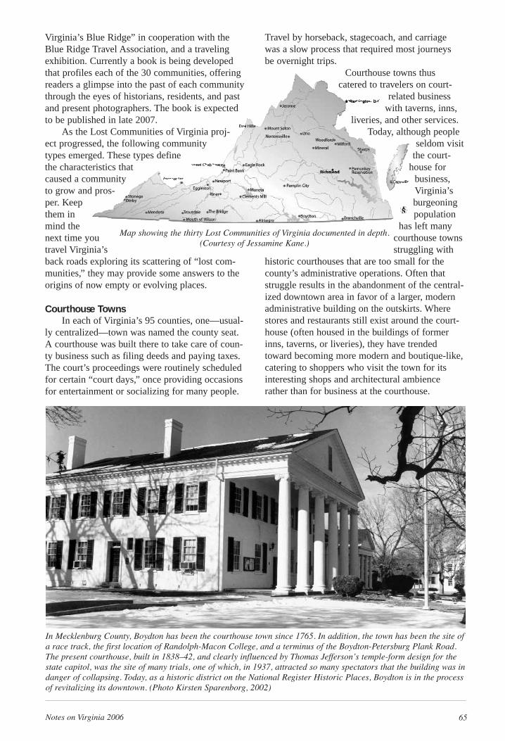
Notes on Virginia 2006 65
Virginia’s Blue Ridge” in cooperation with theBlue Ridge Travel Association, and a travelingexhibition. Currently a book is being developedthat profiles each of the 30 communities, offeringreaders a glimpse into the past of each communitythrough the eyes of historians, residents, and pastand present photographers. The book is expectedto be published in late 2007.
As the Lost Communities of Virginia proj-ect progressed, the following communitytypes emerged. These types definethe characteristics thatcaused a communityto grow and pros-per. Keepthem inmind thenext time youtravel Virginia’sback roads exploring its scattering of “lost com-munities,” they may provide some answers to theorigins of now empty or evolving places.
Courthouse TownsIn each of Virginia’s 95 counties, one—usual-
ly centralized—town was named the county seat.A courthouse was built there to take care of coun-ty business such as filing deeds and paying taxes.The court’s proceedings were routinely scheduledfor certain “court days,” once providing occasionsfor entertainment or socializing for many people.
Travel by horseback, stagecoach, and carriage was a slow process that required most journeys be overnight trips.
Courthouse towns thuscatered to travelers on court-
related businesswith taverns, inns,
liveries, and other services.Today, although people
seldom visitthe court-
house forbusiness,Virginia’sburgeoningpopulation
has left manycourthouse townsstruggling with
historic courthouses that are too small for thecounty’s administrative operations. Often thatstruggle results in the abandonment of the central-ized downtown area in favor of a larger, modernadministrative building on the outskirts. Wherestores and restaurants still exist around the court-house (often housed in the buildings of formerinns, taverns, or liveries), they have trendedtoward becoming more modern and boutique-like,catering to shoppers who visit the town for itsinteresting shops and architectural ambiencerather than for business at the courthouse.
In Mecklenburg County, Boydton has been the courthouse town since 1765. In addition, the town has been the site ofa race track, the first location of Randolph-Macon College, and a terminus of the Boydton-Petersburg Plank Road.The present courthouse, built in 1838–42, and clearly influenced by Thomas Jefferson’s temple-form design for thestate capitol, was the site of many trials, one of which, in 1937, attracted so many spectators that the building was indanger of collapsing. Today, as a historic district on the National Register Historic Places, Boydton is in the processof revitalizing its downtown. (Photo Kirsten Sparenborg, 2002)
Map showing the thirty Lost Communities of Virginia documented in depth.(Courtesy of Jessamine Kane.)
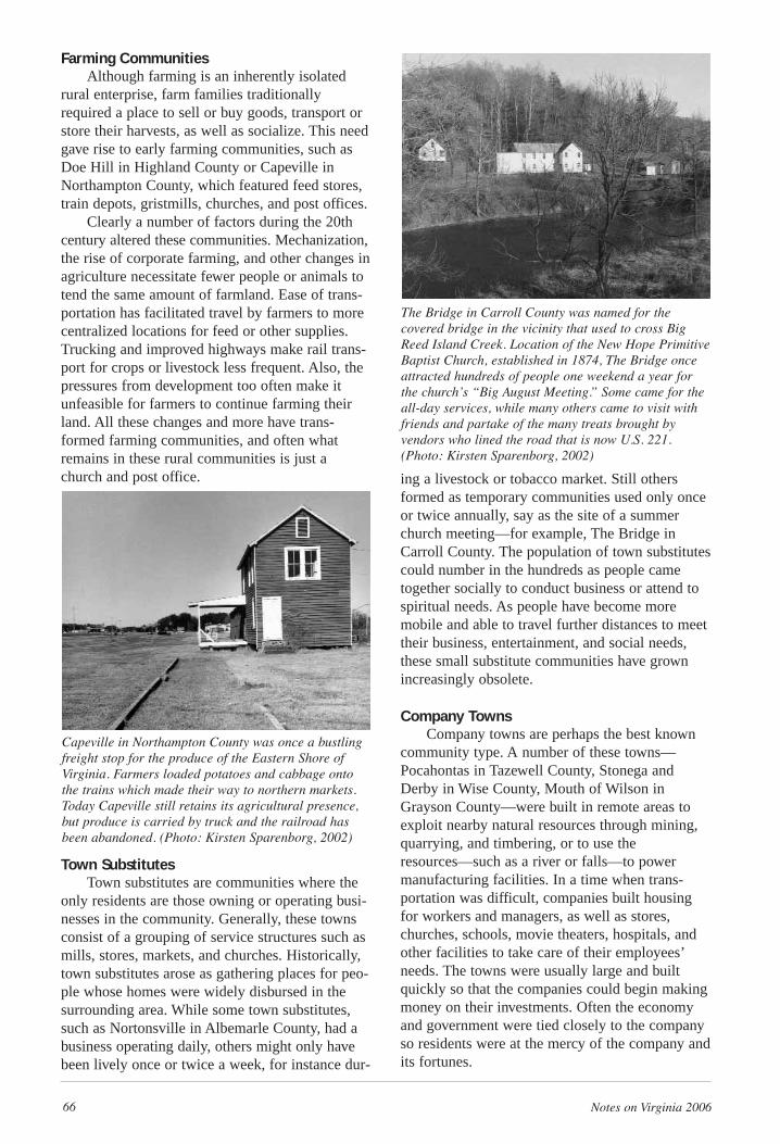
66 Notes on Virginia 2006
Farming CommunitiesAlthough farming is an inherently isolated
rural enterprise, farm families traditionallyrequired a place to sell or buy goods, transport orstore their harvests, as well as socialize. This needgave rise to early farming communities, such asDoe Hill in Highland County or Capeville inNorthampton County, which featured feed stores,train depots, gristmills, churches, and post offices.
Clearly a number of factors during the 20thcentury altered these communities. Mechanization,the rise of corporate farming, and other changes inagriculture necessitate fewer people or animals totend the same amount of farmland. Ease of trans-portation has facilitated travel by farmers to morecentralized locations for feed or other supplies.Trucking and improved highways make rail trans-port for crops or livestock less frequent. Also, thepressures from development too often make itunfeasible for farmers to continue farming theirland. All these changes and more have trans-formed farming communities, and often whatremains in these rural communities is just achurch and post office.
Town SubstitutesTown substitutes are communities where the
only residents are those owning or operating busi-nesses in the community. Generally, these townsconsist of a grouping of service structures such asmills, stores, markets, and churches. Historically,town substitutes arose as gathering places for peo-ple whose homes were widely disbursed in thesurrounding area. While some town substitutes,such as Nortonsville in Albemarle County, had abusiness operating daily, others might only havebeen lively once or twice a week, for instance dur-
ing a livestock or tobacco market. Still othersformed as temporary communities used only onceor twice annually, say as the site of a summerchurch meeting—for example, The Bridge inCarroll County. The population of town substitutescould number in the hundreds as people cametogether socially to conduct business or attend tospiritual needs. As people have become moremobile and able to travel further distances to meettheir business, entertainment, and social needs,these small substitute communities have grownincreasingly obsolete.
Company TownsCompany towns are perhaps the best known
community type. A number of these towns—Pocahontas in Tazewell County, Stonega andDerby in Wise County, Mouth of Wilson inGrayson County—were built in remote areas toexploit nearby natural resources through mining,quarrying, and timbering, or to use theresources—such as a river or falls—to powermanufacturing facilities. In a time when trans-portation was difficult, companies built housingfor workers and managers, as well as stores,churches, schools, movie theaters, hospitals, andother facilities to take care of their employees’needs. The towns were usually large and builtquickly so that the companies could begin makingmoney on their investments. Often the economyand government were tied closely to the companyso residents were at the mercy of the company andits fortunes.
Capeville in Northampton County was once a bustlingfreight stop for the produce of the Eastern Shore ofVirginia. Farmers loaded potatoes and cabbage ontothe trains which made their way to northern markets.Today Capeville still retains its agricultural presence,but produce is carried by truck and the railroad hasbeen abandoned. (Photo: Kirsten Sparenborg, 2002)
The Bridge in Carroll County was named for the covered bridge in the vicinity that used to cross BigReed Island Creek. Location of the New Hope PrimitiveBaptist Church, established in 1874, The Bridge onceattracted hundreds of people one weekend a year forthe church’s “Big August Meeting.” Some came for theall-day services, while many others came to visit withfriends and partake of the many treats brought by vendors who lined the road that is now U.S. 221.(Photo: Kirsten Sparenborg, 2002)
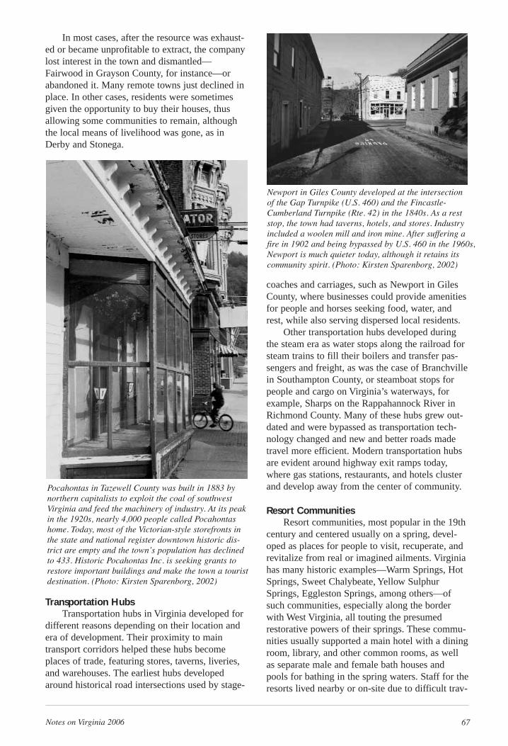
Notes on Virginia 2006 67
In most cases, after the resource was exhaust-ed or became unprofitable to extract, the companylost interest in the town and dismantled—Fairwood in Grayson County, for instance—orabandoned it. Many remote towns just declined inplace. In other cases, residents were sometimesgiven the opportunity to buy their houses, thusallowing some communities to remain, althoughthe local means of livelihood was gone, as inDerby and Stonega.
Transportation HubsTransportation hubs in Virginia developed for
different reasons depending on their location andera of development. Their proximity to maintransport corridors helped these hubs becomeplaces of trade, featuring stores, taverns, liveries,and warehouses. The earliest hubs developedaround historical road intersections used by stage-
coaches and carriages, such as Newport in GilesCounty, where businesses could provide amenitiesfor people and horses seeking food, water, andrest, while also serving dispersed local residents.
Other transportation hubs developed duringthe steam era as water stops along the railroad forsteam trains to fill their boilers and transfer pas-sengers and freight, as was the case of Branchvillein Southampton County, or steamboat stops forpeople and cargo on Virginia’s waterways, forexample, Sharps on the Rappahannock River inRichmond County. Many of these hubs grew out-dated and were bypassed as transportation tech-nology changed and new and better roads madetravel more efficient. Modern transportation hubsare evident around highway exit ramps today,where gas stations, restaurants, and hotels clusterand develop away from the center of community.
Resort CommunitiesResort communities, most popular in the 19th
century and centered usually on a spring, devel-oped as places for people to visit, recuperate, andrevitalize from real or imagined ailments. Virginiahas many historic examples—Warm Springs, HotSprings, Sweet Chalybeate, Yellow SulphurSprings, Eggleston Springs, among others—ofsuch communities, especially along the borderwith West Virginia, all touting the presumedrestorative powers of their springs. These commu-nities usually supported a main hotel with a diningroom, library, and other common rooms, as wellas separate male and female bath houses andpools for bathing in the spring waters. Staff for theresorts lived nearby or on-site due to difficult trav-
Pocahontas in Tazewell County was built in 1883 bynorthern capitalists to exploit the coal of southwestVirginia and feed the machinery of industry. At its peakin the 1920s, nearly 4,000 people called Pocahontashome. Today, most of the Victorian-style storefronts inthe state and national register downtown historic dis-trict are empty and the town’s population has declinedto 433. Historic Pocahontas Inc. is seeking grants torestore important buildings and make the town a touristdestination. (Photo: Kirsten Sparenborg, 2002)
Newport in Giles County developed at the intersection of the Gap Turnpike (U.S. 460) and the Fincastle-Cumberland Turnpike (Rte. 42) in the 1840s. As a reststop, the town had taverns, hotels, and stores. Industryincluded a woolen mill and iron mine. After suffering afire in 1902 and being bypassed by U.S. 460 in the 1960s,Newport is much quieter today, although it retains itscommunity spirit. (Photo: Kirsten Sparenborg, 2002)
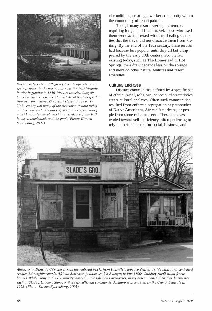
68 Notes on Virginia 2006
el conditions, creating a worker community withinthe community of resort patrons.
Though many resorts were quite remote,requiring long and difficult travel, those who usedthem were so impressed with their healing quali-ties that the travel did not dissuade them from vis-iting. By the end of the 19th century, these resortshad become less popular until they all but disap-peared by the early 20th century. For the fewexisting today, such as The Homestead in HotSprings, their draw depends less on the springsand more on other natural features and resortamenities.
Cultural EnclavesDistinct communities defined by a specific set
of ethnic, racial, religious, or social characteristicscreate cultural enclaves. Often such communitiesresulted from enforced segregation or persecutionof Native Americans, African Americans, or peo-ple from some religious sects. These enclavestended toward self-sufficiency, often preferring torely on their members for social, business, and
Sweet Chalybeate in Alleghany County operated as asprings resort in the mountains near the West Virginiaborder beginning in 1836. Visitors traveled long dis-tances to this remote area to partake of the therapeuticiron-bearing waters. The resort closed in the early 20th century, but many of the structures remain todayon this state and national register property, includingguest houses (some of which are residences), the bathhouse, a bandstand, and the pool. (Photo: KirstenSparenborg, 2002)
Almagro, in Danville City, lies across the railroad tracks from Danville’s tobacco district, textile mills, and gentrifiedresidential neighborhoods. African American families settled Almagro in late 1800s, building small wood-framehouses. While many in the community worked in the tobacco warehouses, many others owned their own businesses,such as Slade’s Grocery Store, in this self-sufficient community. Almagro was annexed by the City of Danville in1923. (Photo: Kirsten Sparenborg, 2002)
Notes on Virginia 2006 69
trade requirements, rather than on the outsiderswho shunned the community and its people.
Cultural enclaves are often limited by theirself-sufficiency. Moreover, as economic, political,or social situations change within and without thecommunity, its members may depart for otheropportunities despite cultural ties and group iden-tification with the place. Decreasing populationmay cause the enclave to decline economicallyand socially, leaving little in the way of business.
Life has changed in extraordinary ways sinceVirginia was first settled, and particularly sincethe 19th and early 20th century. Transportationhas gotten easier and faster; technology hasreduced the number of people needed to farm,mine, and mill; the population has grown, whilefamilies have scattered; greater disposable incomemake private transportation and entertainmentattainable for most people. While life has becomeeasier with new technologies, it has also becomemore complicated as people drive more miles andtry to fit in more activities.
Downtowns are often empty. The front porchof the store where townspeople once met infor-mally on Saturday evenings to play games andexchange gossip is now quiet. The theater wheremany townspeople saw their first movie or visitingentertainment may now be a pigeon roost. The
train depot where passenger trains once broughtthe excitement of visitors and news from thecities, now sits vacant as freight trains rush by.Even those communities are now different where astore, theater, and train depot continue to operate.As life has changed, communities have been lost.
The Lost Communities of Virginia project has receivedfunding from the Graham Foundation for AdvancedStudies in the Fine Arts, the Virginia Foundation for theHumanities, the College of Architecture and UrbanStudies at Virginia Tech, and private donations.Currently CDAC is raising additional funds to supportthe publication of a book entitled, Lost Communities ofVirginia. Contact CDAC to make a contribution orsponsor a book chapter. CDAC provides architecture,landscape architecture, interior design, and planningassistance to nonprofit organizations, communitygroups, and government agencies throughout theCommonwealth of Virginia that cannot afford the serv-ices of a private consultant.
Terri Fisher is the Outreach Coordinator for the CDACat Virginia Tech and is one of the authors of the forth-coming book Lost Communities of Virginia. Her inter-ests are in preservation and applications of greenarchitecture. She also volunteers at SmithfieldPlantation, an APVA/Preservation Virginia property inBlacksburg, and is rehabilitating a historic house in theonce-booming town of Narrows in Giles County.
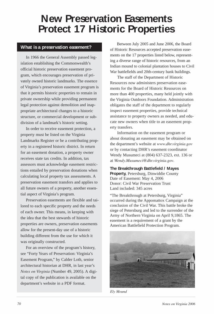
70 Notes on Virginia 2006
Between July 2005 and June 2006, the Boardof Historic Resources accepted preservation ease-ments on the 17 properties listed below, represent-ing a diverse range of historic resources, from anIndian mound to colonial plantation houses to CivilWar battlefields and 20th-century bank buildings.
The staff of the Department of HistoricResources now administers preservation ease-ments for the Board of Historic Resources onmore than 400 properties, many held jointly withthe Virginia Outdoors Foundation. Administrationobligates the staff of the department to regularlyinspect easement properties, provide technicalassistance to property owners as needed, and edu-cate new owners when title to an easement prop-erty transfers.
Information on the easement program orabout donating an easement may be obtained onthe department’s website at www.dhr.virginia.govor by contacting DHR’s easement coordinatorWendy Musumeci at (804) 637-2323, ext. 136 orat [email protected].
The Breakthrough Battlefield / MayesProperty, Petersburg, Dinwiddie CountyDate of Easement: May 4, 2006Donor: Civil War Preservation TrustLand included: 345 acres
“The Breakthrough at Petersburg, Virginia”occurred during the Appomattox Campaign at theconclusion of the Civil War. This battle broke thesiege of Petersburg and led to the surrender of theArmy of Northern Virginia on April 9,1865. Theeasement is a requirement of a grant by theAmerican Battlefield Protection Program.
New Preservation Easements Protect 17 Historic Properties
What is a preservation easement?
In 1966 the General Assembly passed leg-
islation establishing the Commonwealth’s
official historic preservation easement pro-
gram, which encourages preservation of pri-
vately owned historic landmarks. The essence
of Virginia’s preservation easement program is
that it permits historic properties to remain in
private ownership while providing permanent
legal protection against demolition and inap-
propriate architectural changes to a historic
structure, or commercial development or sub-
division of a landmark’s historic setting.
In order to receive easement protection, a
property must be listed on the Virginia
Landmarks Register or be a contributing prop-
erty in a registered historic district. In return
for an easement donation, a property owner
receives state tax credits. In addition, tax
assessors must acknowledge easement restric-
tions entailed by preservation donations when
calculating local property tax assessments. A
preservation easement transfers and applies to
all future owners of a property, another essen-
tial aspect of Virginia’s program.
Preservation easements are flexible and tai-
lored to each specific property and the needs
of each owner. This means, in keeping with
the idea that the best stewards of historic
properties are owners, preservation easements
allow for the present-day use of a historic
building different from the use for which it
was originally constructed.
For an overview of the program’s history,
see “Forty Years of Preservation: Virginia’s
Easement Program,” by Calder Loth, senior
architectural historian at DHR, in last year’s
Notes on Virginia (Number 49, 2005). A digi-
tal copy of the publication is available on the
department’s website in a PDF format.
Ely Mound
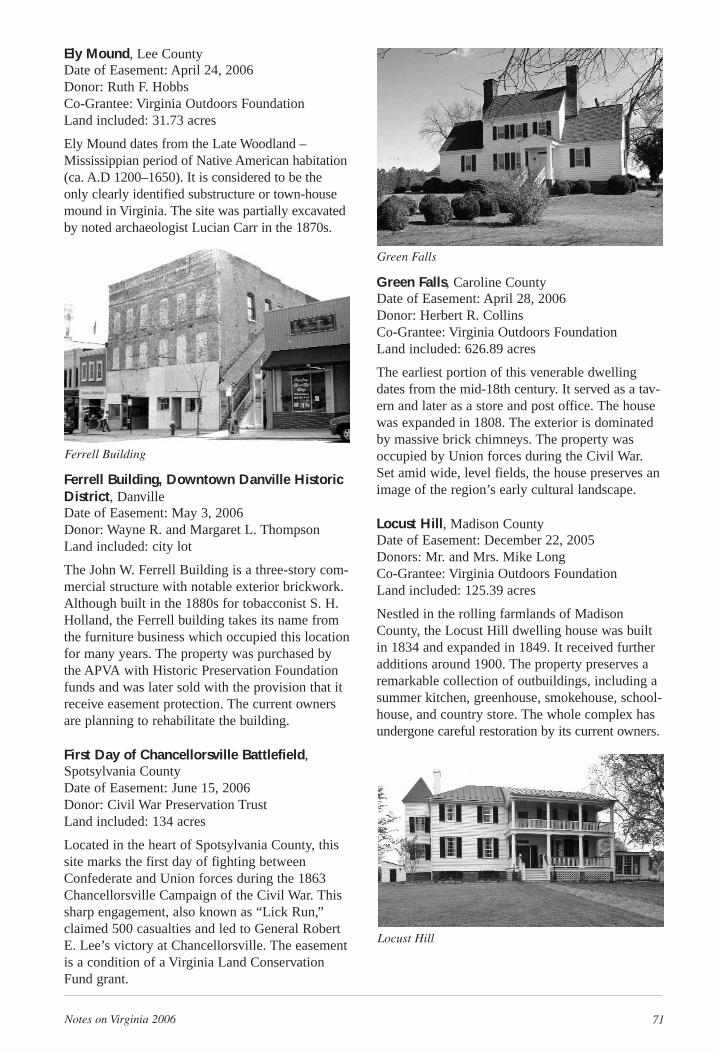
Notes on Virginia 2006 71
Ely Mound, Lee CountyDate of Easement: April 24, 2006Donor: Ruth F. HobbsCo-Grantee: Virginia Outdoors FoundationLand included: 31.73 acres
Ely Mound dates from the Late Woodland –Mississippian period of Native American habitation(ca. A.D 1200–1650). It is considered to be theonly clearly identified substructure or town-housemound in Virginia. The site was partially excavatedby noted archaeologist Lucian Carr in the 1870s.
Ferrell Building, Downtown Danville HistoricDistrict, DanvilleDate of Easement: May 3, 2006Donor: Wayne R. and Margaret L. ThompsonLand included: city lot
The John W. Ferrell Building is a three-story com-mercial structure with notable exterior brickwork.Although built in the 1880s for tobacconist S. H.Holland, the Ferrell building takes its name fromthe furniture business which occupied this locationfor many years. The property was purchased bythe APVA with Historic Preservation Foundationfunds and was later sold with the provision that itreceive easement protection. The current ownersare planning to rehabilitate the building.
First Day of Chancellorsville Battlefield,Spotsylvania CountyDate of Easement: June 15, 2006Donor: Civil War Preservation TrustLand included: 134 acres
Located in the heart of Spotsylvania County, thissite marks the first day of fighting betweenConfederate and Union forces during the 1863Chancellorsville Campaign of the Civil War. Thissharp engagement, also known as “Lick Run,”claimed 500 casualties and led to General RobertE. Lee’s victory at Chancellorsville. The easementis a condition of a Virginia Land ConservationFund grant.
Green Falls, Caroline CountyDate of Easement: April 28, 2006Donor: Herbert R. CollinsCo-Grantee: Virginia Outdoors FoundationLand included: 626.89 acres
The earliest portion of this venerable dwellingdates from the mid-18th century. It served as a tav-ern and later as a store and post office. The housewas expanded in 1808. The exterior is dominatedby massive brick chimneys. The property wasoccupied by Union forces during the Civil War.Set amid wide, level fields, the house preserves animage of the region’s early cultural landscape.
Locust Hill, Madison CountyDate of Easement: December 22, 2005Donors: Mr. and Mrs. Mike LongCo-Grantee: Virginia Outdoors FoundationLand included: 125.39 acres
Nestled in the rolling farmlands of MadisonCounty, the Locust Hill dwelling house was builtin 1834 and expanded in 1849. It received furtheradditions around 1900. The property preserves aremarkable collection of outbuildings, including asummer kitchen, greenhouse, smokehouse, school-house, and country store. The whole complex hasundergone careful restoration by its current owners.
Ferrell Building
Green Falls
Locust Hill
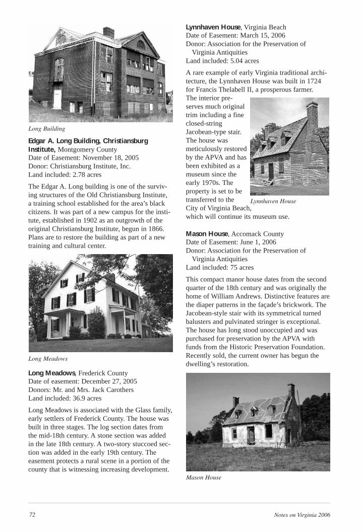
72 Notes on Virginia 2006
Edgar A. Long Building, ChristiansburgInstitute, Montgomery CountyDate of Easement: November 18, 2005Donor: Christiansburg Institute, Inc.Land included: 2.78 acres
The Edgar A. Long building is one of the surviv-ing structures of the Old Christiansburg Institute,a training school established for the area’s blackcitizens. It was part of a new campus for the insti-tute, established in 1902 as an outgrowth of theoriginal Christiansburg Institute, begun in 1866.Plans are to restore the building as part of a newtraining and cultural center.
Long Meadows, Frederick CountyDate of easement: December 27, 2005Donors: Mr. and Mrs. Jack CarothersLand included: 36.9 acres
Long Meadows is associated with the Glass family,early settlers of Frederick County. The house wasbuilt in three stages. The log section dates fromthe mid-18th century. A stone section was addedin the late 18th century. A two-story stuccoed sec-tion was added in the early 19th century. Theeasement protects a rural scene in a portion of thecounty that is witnessing increasing development.
Lynnhaven House, Virginia BeachDate of Easement: March 15, 2006Donor: Association for the Preservation of
Virginia AntiquitiesLand included: 5.04 acres
A rare example of early Virginia traditional archi-tecture, the Lynnhaven House was built in 1724for Francis Thelabell II, a prosperous farmer. The interior pre-serves much originaltrim including a fineclosed-stringJacobean-type stair.The house wasmeticulously restoredby the APVA and hasbeen exhibited as amuseum since theearly 1970s. Theproperty is set to betransferred to theCity of Virginia Beach,which will continue its museum use.
Mason House, Accomack CountyDate of Easement: June 1, 2006Donor: Association for the Preservation of
Virginia AntiquitiesLand included: 75 acres
This compact manor house dates from the secondquarter of the 18th century and was originally thehome of William Andrews. Distinctive features arethe diaper patterns in the façade’s brickwork. TheJacobean-style stair with its symmetrical turnedbalusters and pulvinated stringer is exceptional.The house has long stood unoccupied and waspurchased for preservation by the APVA withfunds from the Historic Preservation Foundation.Recently sold, the current owner has begun thedwelling’s restoration.
Long Building
Long Meadows
Mason House
Lynnhaven House
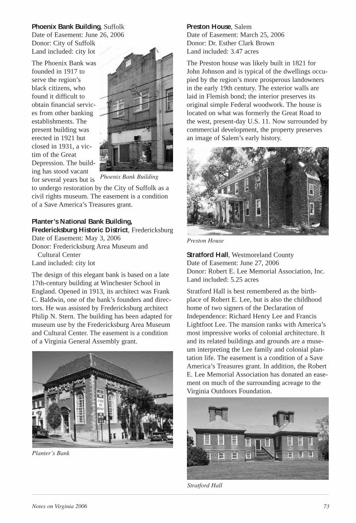
Notes on Virginia 2006 73
Phoenix Bank Building, SuffolkDate of Easement: June 26, 2006Donor: City of SuffolkLand included: city lot
The Phoenix Bank wasfounded in 1917 toserve the region’sblack citizens, whofound it difficult toobtain financial servic-es from other bankingestablishments. Thepresent building waserected in 1921 butclosed in 1931, a vic-tim of the GreatDepression. The build-ing has stood vacantfor several years but isto undergo restoration by the City of Suffolk as acivil rights museum. The easement is a conditionof a Save America’s Treasures grant.
Planter’s National Bank Building,Fredericksburg Historic District, FredericksburgDate of Easement: May 3, 2006Donor: Fredericksburg Area Museum and
Cultural CenterLand included: city lot
The design of this elegant bank is based on a late17th-century building at Winchester School inEngland. Opened in 1913, its architect was FrankC. Baldwin, one of the bank’s founders and direc-tors. He was assisted by Fredericksburg architectPhilip N. Stern. The building has been adapted formuseum use by the Fredericksburg Area Museumand Cultural Center. The easement is a conditionof a Virginia General Assembly grant.
Preston House, SalemDate of Easement: March 25, 2006Donor: Dr. Esther Clark BrownLand included: 3.47 acres
The Preston house was likely built in 1821 forJohn Johnson and is typical of the dwellings occu-pied by the region’s more prosperous landownersin the early 19th century. The exterior walls arelaid in Flemish bond; the interior preserves itsoriginal simple Federal woodwork. The house islocated on what was formerly the Great Road tothe west, present-day U.S. 11. Now surrounded bycommercial development, the property preservesan image of Salem’s early history.
Stratford Hall, Westmoreland CountyDate of Easement: June 27, 2006Donor: Robert E. Lee Memorial Association, Inc.Land included: 5.25 acres
Stratford Hall is best remembered as the birth-place of Robert E. Lee, but is also the childhoodhome of two signers of the Declaration ofIndependence: Richard Henry Lee and FrancisLightfoot Lee. The mansion ranks with America’smost impressive works of colonial architecture. Itand its related buildings and grounds are a muse-um interpreting the Lee family and colonial plan-tation life. The easement is a condition of a SaveAmerica’s Treasures grant. In addition, the RobertE. Lee Memorial Association has donated an ease-ment on much of the surrounding acreage to theVirginia Outdoors Foundation.
Phoenix Bank Building
Planter’s Bank
Preston House
Stratford Hall
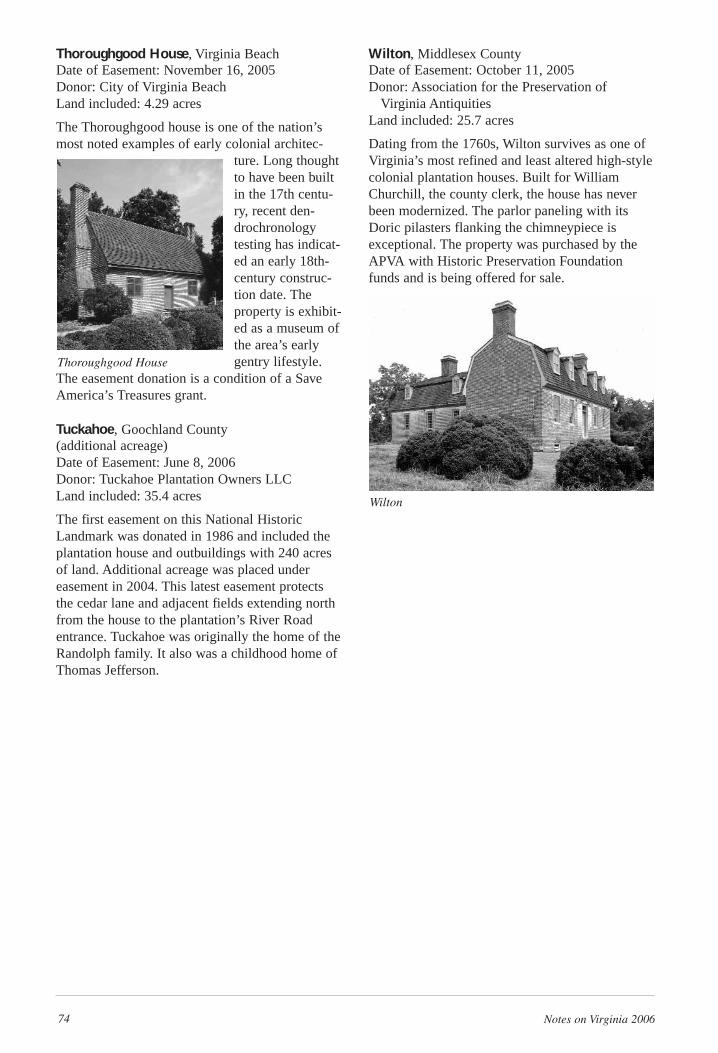
74 Notes on Virginia 2006
Thoroughgood House, Virginia BeachDate of Easement: November 16, 2005Donor: City of Virginia BeachLand included: 4.29 acres
The Thoroughgood house is one of the nation’smost noted examples of early colonial architec-
ture. Long thoughtto have been builtin the 17th centu-ry, recent den-drochronologytesting has indicat-ed an early 18th-century construc-tion date. Theproperty is exhibit-ed as a museum ofthe area’s earlygentry lifestyle.
The easement donation is a condition of a SaveAmerica’s Treasures grant.
Tuckahoe, Goochland County (additional acreage)Date of Easement: June 8, 2006Donor: Tuckahoe Plantation Owners LLCLand included: 35.4 acres
The first easement on this National HistoricLandmark was donated in 1986 and included theplantation house and outbuildings with 240 acresof land. Additional acreage was placed undereasement in 2004. This latest easement protectsthe cedar lane and adjacent fields extending northfrom the house to the plantation’s River Roadentrance. Tuckahoe was originally the home of theRandolph family. It also was a childhood home ofThomas Jefferson.
Wilton, Middlesex CountyDate of Easement: October 11, 2005Donor: Association for the Preservation of
Virginia AntiquitiesLand included: 25.7 acres
Dating from the 1760s, Wilton survives as one ofVirginia’s most refined and least altered high-stylecolonial plantation houses. Built for WilliamChurchill, the county clerk, the house has neverbeen modernized. The parlor paneling with itsDoric pilasters flanking the chimneypiece isexceptional. The property was purchased by theAPVA with Historic Preservation Foundationfunds and is being offered for sale.
Wilton
Thoroughgood House
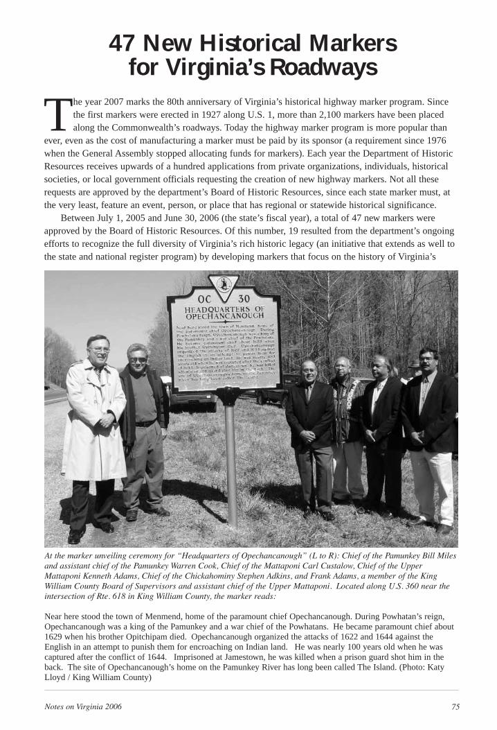
Notes on Virginia 2006 75
The year 2007 marks the 80th anniversary of Virginia’s historical highway marker program. Sincethe first markers were erected in 1927 along U.S. 1, more than 2,100 markers have been placedalong the Commonwealth’s roadways. Today the highway marker program is more popular than
ever, even as the cost of manufacturing a marker must be paid by its sponsor (a requirement since 1976when the General Assembly stopped allocating funds for markers). Each year the Department of HistoricResources receives upwards of a hundred applications from private organizations, individuals, historicalsocieties, or local government officials requesting the creation of new highway markers. Not all theserequests are approved by the department’s Board of Historic Resources, since each state marker must, atthe very least, feature an event, person, or place that has regional or statewide historical significance.
Between July 1, 2005 and June 30, 2006 (the state’s fiscal year), a total of 47 new markers wereapproved by the Board of Historic Resources. Of this number, 19 resulted from the department’s ongoingefforts to recognize the full diversity of Virginia’s rich historic legacy (an initiative that extends as well tothe state and national register program) by developing markers that focus on the history of Virginia’s
At the marker unveiling ceremony for “Headquarters of Opechancanough” (L to R): Chief of the Pamunkey Bill Milesand assistant chief of the Pamunkey Warren Cook, Chief of the Mattaponi Carl Custalow, Chief of the UpperMattaponi Kenneth Adams, Chief of the Chickahominy Stephen Adkins, and Frank Adams, a member of the KingWilliam County Board of Supervisors and assistant chief of the Upper Mattaponi. Located along U.S. 360 near theintersection of Rte. 618 in King William County, the marker reads:
Near here stood the town of Menmend, home of the paramount chief Opechancanough. During Powhatan’s reign,Opechancanough was a king of the Pamunkey and a war chief of the Powhatans. He became paramount chief about1629 when his brother Opitchipam died. Opechancanough organized the attacks of 1622 and 1644 against theEnglish in an attempt to punish them for encroaching on Indian land. He was nearly 100 years old when he wascaptured after the conflict of 1644. Imprisoned at Jamestown, he was killed when a prison guard shot him in theback. The site of Opechancanough’s home on the Pamunkey River has long been called The Island. (Photo: KatyLloyd / King William County)
47 New Historical Markers for Virginia’s Roadways

76 Notes on Virginia 2006
minorities and women. With this goal in mind, the Department of Historic Resources, the VirginiaHistorical Society, members of the Virginia Indian community, and black leaders and scholars are partnering with other historians and scholars to research and write new highway markers about AfricanAmerican and Virginia Indian history. Many of these new signs, shown in the list that follows, are fundedjointly by this department and VHS. The diversity initiative will extend as well to other ethnic and religious groups important to Virginia history such as the Scots-Irish and Germans who settled theShenandoah Valley.
In recognition of the 80th anniversary of the marker program, in early 2007 an updated and revised(third) edition of A Guidebook to Virginia’s Historical Markers was released by the University of VirginiaPress, which published the book in association with the Department of Historic Resources. Selling for$19.95, the book is a wonderful and handy resource for Virginia residents and visitors when traveling theCommonwealth’s roadways; it is engaging reading for armchair travelers as well. Currently the departmentis enhancing its website so that people will be able to search the entire collection of state markers by key-words and categories and see the markers displayed on a roadmap, along with other information associatedwith a marker’s particular topic. Together the new guidebook and website will offer Virginians and visi-tors an ideal complement of resources for exploring and learning more about the Commonwealth’s history.
For information on how to sponsor a new marker or for details about the program, please visit thedepartment’s website at www.dhr.virginia.gov or contact Francine Archer at the Department of HistoricResources, 2801 Kensington Avenue, Richmond, Virginia, 23221; or by phone at (804) 367-2323, ext. 120,or by e-mail at [email protected].
New Markers
Sponsored by private organizations, individuals, and localities:
Albemarle County Covesville Apple Industry . . . . . . . . . . . . . . . . . . . . . . . . . . . . GA-44Augusta County Augusta County Training School . . . . . . . . . . . . . . . . . . . . . . . W-231Fauquier County Brentmoor: The Spillman-Mosby House . . . . . . . . . . . . . . . . . C-92Hampton Deaf and Blind SchoolHenrico County Defenses of Richmond . . . . . . . . . . . . . . . . . . . . . . . . . . . . . . . PA-139
First Battle of Deep Bottom . . . . . . . . . . . . . . . . . . . . . . . . . . . PA-164Isle of Wight County Fort Huger . . . . . . . . . . . . . . . . . . . . . . . . . . . . . . . . . . . . . . . . . K-327
Zuni . . . . . . . . . . . . . . . . . . . . . . . . . . . . . . . . . . . . . . . . . . . . . . U-121King George County Eagle’s Nest . . . . . . . . . . . . . . . . . . . . . . . . . . . . . . . . . . . . . . . J-103Lancaster County Kilmarnock . . . . . . . . . . . . . . . . . . . . . . . . . . . . . . . . . . . . . . . . J-104
Lancaster Courthouse . . . . . . . . . . . . . . . . . . . . . . . . . . . . . . . . J-105 Lexington John Chavis . . . . . . . . . . . . . . . . . . . . . . . . . . . . . . . . . . . . . . . . I-24Loudoun County Loudoun Branch, Manassas Gap Railroad . . . . . . . . . . . . . . . . T-53Lynchburg Old City Cemetery . . . . . . . . . . . . . . . . . . . . . . . . . . . . . . . . . . Q-6-25Mecklenburg County Buffalo Springs . . . . . . . . . . . . . . . . . . . . . . . . . . . . . . . . . . . . . UL-7Montgomery County Virginia Tech Airport . . . . . . . . . . . . . . . . . . . . . . . . . . . . . . . . I-23Newport News Aviation Field Yorktown . . . . . . . . . . . . . . . . . . . . . . . . . . . . . . W-232
Endview . . . . . . . . . . . . . . . . . . . . . . . . . . . . . . . . . . . . . . . . . . W-230Richmond (city) Egyptian Building . . . . . . . . . . . . . . . . . . . . . . . . . . . . . . . . . . . SA-72
John Mitchell, Jr., “Fighting Editor” . . . . . . . . . . . . . . . . . . . . SA-73Washington County Col. Arthur Campbell . . . . . . . . . . . . . . . . . . . . . . . . . . . . . . . . K-328
John Campbell . . . . . . . . . . . . . . . . . . . . . . . . . . . . . . . . . . . . . K-61 Green Cove Station . . . . . . . . . . . . . . . . . . . . . . . . . . . . . . . . . . K-62
Westmoreland County Charles B. Smith: 99th Fighter Squadron (Tuskegee Airmen) . JT-21Williamsburg Indian School at the College of William and Mary . . . . . . . . . W-229Winchester Fort Loudoun . . . . . . . . . . . . . . . . . . . . . . . . . . . . . . . . . . . . . . Q-4-kWythe County Edith Bolling Wilson . . . . . . . . . . . . . . . . . . . . . . . . . . . . . . . . K-326
Notes on Virginia 2006 77
New Diversity Markers
Sponsored by DHR and VHS or by independent sponsors:
African American
Alexandria Franklin and Armfield Slave Office (1315 Duke Street). . . . . . E-131Falls Church Tinner Hill . . . . . . . . . . . . . . . . . . . . . . . . . . . . . . . . . . . . . . . . C-91Martinsville Fayette Street . . . . . . . . . . . . . . . . . . . . . . . . . . . . . . . . . . . . . . A-107New Kent County Green v. County School Board of New Kent County . . . . . . . . WO-38Petersburg Corling’s Corner . . . . . . . . . . . . . . . . . . . . . . . . . . . . . . . . . . . . QA-26Richmond (city) Jackson Ward . . . . . . . . . . . . . . . . . . . . . . . . . . . . . . . . . . . . . . SA-74Winchester John Kirby, Jazz Musician . . . . . . . . . . . . . . . . . . . . . . . . . . . . Q-4-jWythe County Wytheville Training School . . . . . . . . . . . . . . . . . . . . . . . . . . . K-325
Virginia Indian
Albemarle County Monacan Indian Village . . . . . . . . . . . . . . . . . . . . . . . . . . . . . . G-29
Charles City County Paspahegh Indians . . . . . . . . . . . . . . . . . . . . . . . . . . . . . . . . . . V-50
Fredericksburg Amoroleck Encounters John Smith . . . . . . . . . . . . . . . . . . . . . N-38
Henrico County Powhatan . . . . . . . . . . . . . . . . . . . . . . . . . . . . . . . . . . . . . . . . . . V-49
King William County Cockacoeske . . . . . . . . . . . . . . . . . . . . . . . . . . . . . . . . . . . . . . . OC-39
Headquarters of Opechancanough . . . . . . . . . . . . . . . . . . . . . . OC-30
Uttamusack . . . . . . . . . . . . . . . . . . . . . . . . . . . . . . . . . . . . . . . . OC-31
Richmond County Rappahannock Indians . . . . . . . . . . . . . . . . . . . . . . . . . . . . . . . JT-10
Richmond (city) Battle of Bloody Run . . . . . . . . . . . . . . . . . . . . . . . . . . . . . . . . SA-71
Richmond (city) Black Hawk (1767-1838) . . . . . . . . . . . . . . . . . . . . . . . . . . . . . SA-75
Stafford County Creek Delegation in Fredericksburg . . . . . . . . . . . . . . . . . . . . . J-102
New Replacement Markers
Sponsored by various organizations, individuals, or federal Transportation Enhancement Grant funds:
Albemarle County Albemarle County/Louisa County . . . . . . . . . . . . . . . . . . . . . . Z-151
Clarke County Carter Hall . . . . . . . . . . . . . . . . . . . . . . . . . . . . . . . . . . . . . . . . T-1
Lunenburg County Lunenburg County/Nottoway County . . . . . . . . . . . . . . . . . . . Z-45
Prince Edward County Campaign of 1781 . . . . . . . . . . . . . . . . . . . . . . . . . . . . . . . . . . F-72
History of Worsham . . . . . . . . . . . . . . . . . . . . . . . . . . . . . . . . . F-65
Prince George County Flowerdew Hundred . . . . . . . . . . . . . . . . . . . . . . . . . . . . . . . . . K-214
78 Notes on Virginia 2006
Among the best tools for encouraging preservation of historic properties are the federal and staterehabilitation tax credit programs, which remain among the most popular and successful programs administered by the Department of Historic Resources. Tellingly, in March of 2007
(as this publication was going to press), the National Park Service ranked Virginia second in the nationamong states for federal tax-credit rehabilitation projects proposed and completed between October 1,2005 and September, 30, 2006 (the federal fiscal year or FFY06). That was the second consecutive FFYthat Virginia achieved a second-place ranking. Specifically, during FFY06 the Department of HistoricResources certified completion of 109 federal projects in Virginia (all of which also applied the state taxcredit), with total expenses of $172,063,748, which represented $44 million more than in FFY05.
For many years now Virginia has consistently ranked in the top five states for proposed and complet-ed federal tax-credit rehab projects. Although the NPS figures exclude state tax credits for rehabilitations,the state program, which is the result of legislation passed by the General Assembly in 1997, clearlydrives and boosts the federal program. The main difference between the two incentives is that federal taxcredits can only be applied on income-producing properties. For the state program, in addition toincome-producing property, non-commercial property—such as a residence—that is individually listed onthe state register or that is certified as contributing to a historic district on the register is eligible for astate tax credit.
The federal and state tax credits are available for most of the work undertaken within a historic building, as well as certain “soft costs” including architects’ and consultants’ fees. The federal tax creditis 20 percent of qualified expenditures; the state tax credit, 25 percent. Thus, when state and federal credits are combined for approved projects, the total tax credit allowed on eligible expenses is 45 percent.Completed projects must meet the Secretary of the Interior’s Standards for Rehabilitation (or simply theStandards, for shorthand). This department’s tax-credit staff works diligently with property owners ortheir representatives in reviewing and providing advice on proposed projects to ensure that each one complies with the Standards.
Historic rehabilitations benefit communities in many ways. For instance, dollar for dollar, historicrehabilitation is one of the highest job-generating economic development options available, according toThe Economics of Historic Preservation by Donovan D. Rypkema. Typically, between 60 and 70 percentof the total cost for a rehab project goes toward labor, as compared to the 50 percent rule of thumb fornew construction. Typically, a rehab project puts more money back into a local economy than new con-struction does because rehabilitation contractors seek regional materials, suppliers, and skilled workers.
Moreover, recycling historic buildings also means reusing existing infrastructure and helps to lessentraffic congestion:
More than 40 percent of residents in older historic neighborhoods are within five miles of work.Less than one resident in four in new housing is that close to their place of employment. More thantwo-thirds of older and historic neighborhoods have an elementary school within one mile. Lessthan 40 percent of new construction does. More than 60% of houses in older and historic neighbor-hoods have shopping within one mile. Barely 40 percent of new houses do. Public transportation isavailable to residents in nearly 60 percent of older and historic neighborhoods. Three-quarters ofnew housing has no public transportation available nearby. (From “Historic Preservation andAffordable Housing: The Missed Connection” Forum Journal, Spring 2003, Vol. 17, No. 3.)
Aside from these benefits, there is the spirit of renewal one feels in reviving historic districts as people reclaim something of Virginia’s heritage, character, and sense of place.
For more information on pursuing a tax-credit rehabilitation project, contact Chris Novelli at theDepartment of Historic Resources at (804) 367-2323, ext. 100, or at [email protected].
The Historic Rehabilitation Tax Credit Program
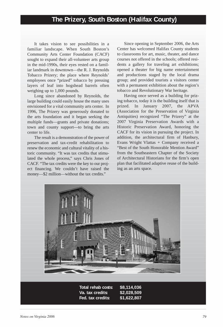
Notes on Virginia 2006 79
It takes vision to see possibilities in afamiliar landscape. When South Boston’sCommunity Arts Center Foundation (CACF)sought to expand their all-volunteer arts groupin the mid-1990s, their eyes rested on a famil-iar landmark in downtown—the R. J. ReynoldsTobacco Prizery; the place where Reynolds’employees once “prized” tobacco by pressinglayers of leaf into hogshead barrels oftenweighing up to 1,000 pounds.
Long since abandoned by Reynolds, thelarge building could easily house the many usesenvisioned for a vital community arts center. In1996, The Prizery was generously donated tothe arts foundation and it began seeking themultiple funds—grants and private donations;town and county support—to bring the artscenter to life.
The result is a demonstration of the power ofpreservation and tax-credit rehabilitation torenew the economic and cultural vitality of a his-toric community. “It was tax credits that stimu-lated the whole process,” says Chris Jones ofCACF. “The tax credits were the key to our proj-ect financing. We couldn’t have raised themoney—$2 million—without the tax credits.”
The Prizery, South Boston (Halifax County)
Since opening in September 2006, the ArtsCenter has welcomed Halifax County studentsto classrooms for art, music, theater, and dancecourses not offered in the schools; offered resi-dents a gallery for traveling art exhibitions;opened a theater for big name entertainmentand productions staged by the local dramagroup; and provided tourists a visitors centerwith a permanent exhibition about the region’stobacco and Revolutionary War heritage.
Having once served as a building for priz-ing tobacco, today it is the building itself that isprized. In January 2007, the APVA(Association for the Preservation of VirginiaAntiquities) recognized “The Prizery” at the2007 Virginia Preservation Awards with aHistoric Preservation Award, honoring theCACF for its vision in pursuing the project. Inaddition, the architectural firm of Hanbury,Evans Wright Vlattas + Company received a“Best of the South Honorable Mention Award”from the Southeastern Chapter of the Societyof Architectural Historians for the firm’s openplan that facilitated adaptive reuse of the build-ing as an arts space.
Total rehab costs: $8,114,036Va. tax credits: $2,028,509Fed. tax credits: $1,622,807
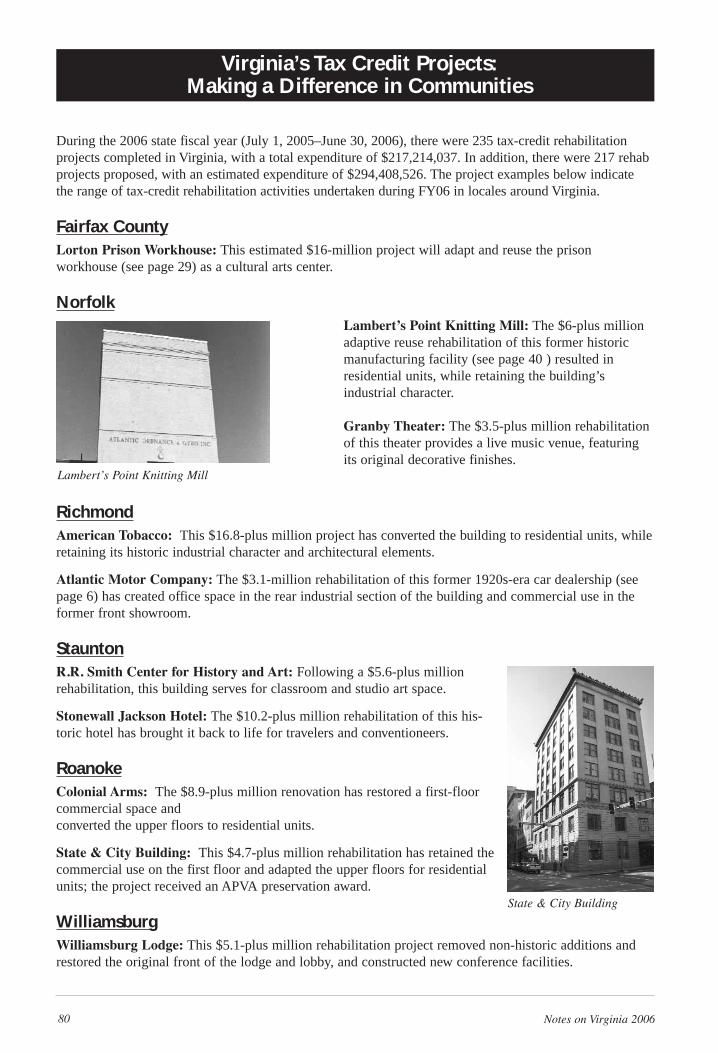
80 Notes on Virginia 2006
During the 2006 state fiscal year (July 1, 2005–June 30, 2006), there were 235 tax-credit rehabilitationprojects completed in Virginia, with a total expenditure of $217,214,037. In addition, there were 217 rehabprojects proposed, with an estimated expenditure of $294,408,526. The project examples below indicatethe range of tax-credit rehabilitation activities undertaken during FY06 in locales around Virginia.
Fairfax CountyLorton Prison Workhouse: This estimated $16-million project will adapt and reuse the prison workhouse (see page 29) as a cultural arts center.
NorfolkLambert’s Point Knitting Mill: The $6-plus millionadaptive reuse rehabilitation of this former historicmanufacturing facility (see page 40 ) resulted in residential units, while retaining the building’s industrial character.
Granby Theater: The $3.5-plus million rehabilitationof this theater provides a live music venue, featuringits original decorative finishes.
RichmondAmerican Tobacco: This $16.8-plus million project has converted the building to residential units, whileretaining its historic industrial character and architectural elements.
Atlantic Motor Company: The $3.1-million rehabilitation of this former 1920s-era car dealership (seepage 6) has created office space in the rear industrial section of the building and commercial use in the former front showroom.
StauntonR.R. Smith Center for History and Art: Following a $5.6-plus millionrehabilitation, this building serves for classroom and studio art space.
Stonewall Jackson Hotel: The $10.2-plus million rehabilitation of this his-toric hotel has brought it back to life for travelers and conventioneers.
RoanokeColonial Arms: The $8.9-plus million renovation has restored a first-floorcommercial space and converted the upper floors to residential units.
State & City Building: This $4.7-plus million rehabilitation has retained thecommercial use on the first floor and adapted the upper floors for residentialunits; the project received an APVA preservation award.
WilliamsburgWilliamsburg Lodge: This $5.1-plus million rehabilitation project removed non-historic additions andrestored the original front of the lodge and lobby, and constructed new conference facilities.
Virginia’s Tax Credit Projects: Making a Difference in Communities
Lambert’s Point Knitting Mill
State & City Building
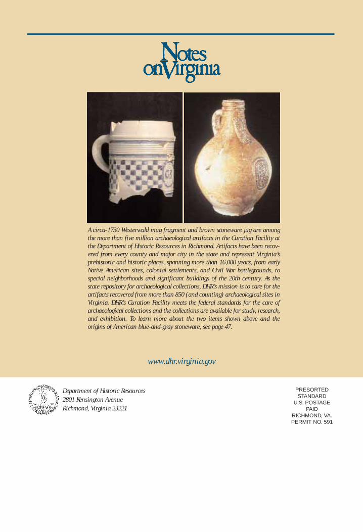
PRESORTEDSTANDARD
U.S. POSTAGEPAID
RICHMOND, VA.PERMIT NO. 591
Department of Historic Resources2801 Kensington AvenueRichmond, Virginia 23221
A circa-1730 Westerwald mug fragment and brown stoneware jug are amongthe more than five million archaeological artifacts in the Curation Facility atthe Department of Historic Resources in Richmond. Artifacts have been recov-ered from every county and major city in the state and represent Virginia’s prehistoric and historic places, spanning more than 16,000 years, from earlyNative American sites, colonial settlements, and Civil War battlegrounds, tospecial neighborhoods and significant buildings of the 20th century. As thestate repository for archaeological collections, DHR’s mission is to care for theartifacts recovered from more than 850 (and counting) archaeological sites inVirginia. DHR’s Curation Facility meets the federal standards for the care ofarchaeological collections and the collections are available for study, research,and exhibition. To learn more about the two items shown above and the origins of American blue-and-gray stoneware, see page 47.
www.dhr.virginia.gov


