Long Lake Gold Mine Rehabilitation Project€¦ · Long Lake Gold Mine Remediation 1 Ministry of...
75
Long Lake Gold Mine Remediation 1 Ministry of Northern Development and Mines Category C Environmental Assessment Long Lake Gold Mine Rehabilitation Project Geographic Township of Eden, Ontario August 2017
Transcript of Long Lake Gold Mine Rehabilitation Project€¦ · Long Lake Gold Mine Remediation 1 Ministry of...

Long Lake Gold Mine Remediation 1
Ministry of Northern Development and Mines Category C Environmental Assessment
Long Lake Gold Mine Rehabilitation Project Geographic Township of Eden, Ontario
August 2017
Long Lake Gold Mine Remediation 2
Contents 1. Project Description .............................................................................................................. 4
1.1 Project Background ...................................................................................................... 4
1.2 Project Rationale ......................................................................................................... 7
1.3 MNDM’s Class Environmental Assessment ................................................................. 8
2. Regional and Site Conditions .............................................................................................. 8
2.1 Natural Environment .................................................................................................... 8
2.1.1 Physiography ........................................................................................................ 8
2.1.2 Regional and Site Hydrology and Drainage .......................................................... 9
2.1.3 Ecology ................................................................................................................. 9
2.1.4 Protected Areas ...................................................................................................10
2.2 Socio-Economic Land Use ..........................................................................................11
2.2.1 Mineral Exploration ..............................................................................................11
2.2.2 Forestry ...............................................................................................................11
2.2.3 Recreational Land Use ........................................................................................13
2.3 Indigenous Communities.............................................................................................13
3. Studies Undertaken ...........................................................................................................14
3.1 Site Characterisation Report .......................................................................................14
3.2 Archaeological Assessment Report (Stages 1 and 2) .................................................15
3.3 Species at Risk Study .................................................................................................15
4. Environmental Effects ........................................................................................................16
4.3 Eden Township Forest Conservation Reserve ............................................................16
4.4 Atikameksheng Anishnawbek .....................................................................................16
4.5 Long Lake Residents ..................................................................................................16
4.6 Wetland Wildlife Habitat ..............................................................................................17
4.7 Socio-Economic Land Use ..........................................................................................17
4.8 Social/Cultural Significance .........................................................................................17
4.9 Advantages and Disadvantages of the Project ............................................................17
5. Mitigation Measures ...........................................................................................................18
6. Analyses of Alternatives .....................................................................................................20
6.3 Remediation Objectives ..............................................................................................20
6.4 Identification of Remediation Alternatives ...................................................................21
6.5 Evaluation of Remediation Alternatives .......................................................................22

Long Lake Gold Mine Remediation 3
6.6 Preferred Remediation Alternative ..............................................................................25
6.6.1 Selection of Preferred Remediation Alternative ....................................................25
6.6.2 Recommended Integrated Remediation Option ...................................................25
7. Screening and Project Categorization ................................................................................28
8. Consultation .......................................................................................................................28
8.3 Public Consultation .....................................................................................................29
8.3.1 Public Notification ................................................................................................29
8.3.2 Public Information Meetings .................................................................................29
8.4 Aboriginal Consultation ...............................................................................................29
8.4.1 First Nation Notification ........................................................................................29
8.4.2 Atikameksheng Anishnawbek Information Sessions ............................................30
8.5 Input Received and Responses ..................................................................................30
9. Future Effects Monitoring ...................................................................................................30
10. Detailed Design, and Planned Project Construction Schedule ........................................31
10.1 Access Upgrades ........................................................................................................31
10.2 Mobilization .................................................................................................................32
10.3 Phase 1 - Perimeter Ditches at TA-01 & Water Drainage Systems .............................33
10.4 Phase 2 - Clean-Up of Channel from TA-01 through Luke Creek up to Wetlands & Diversion of Luke Creek ........................................................................................................34
10.5 Phase 3 - Clean-Up of TA-02/TA-03 & Wetlands ........................................................34
10.6 Phase 4 – Clean-Up of the Long Lake Delta & Luke Creek Clean-Up & Decommissioning of the Diversion Ditch to Long Lake ..........................................................35
10.7 Phase 5 – Capping & Closure .....................................................................................36
10.8 Demobilization ............................................................................................................37
11. Approvals and Permits Required for the Project .............................................................37
12. References .....................................................................................................................38
13. Appendices ....................................................................................................................39
Long Lake Gold Mine Remediation 4
1. Project Description
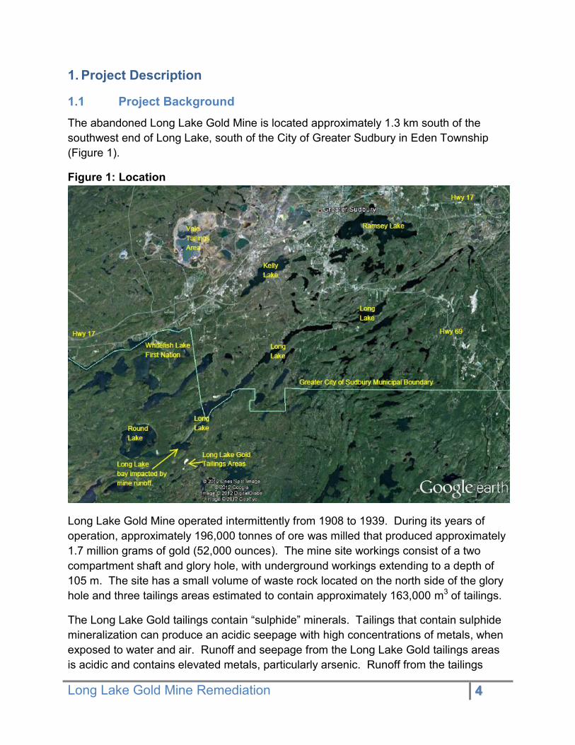
1.1 Project Background The abandoned Long Lake Gold Mine is located approximately 1.3 km south of the southwest end of Long Lake, south of the City of Greater Sudbury in Eden Township (Figure 1).
Figure 1: Location
Long Lake Gold Mine operated intermittently from 1908 to 1939. During its years of operation, approximately 196,000 tonnes of ore was milled that produced approximately 1.7 million grams of gold (52,000 ounces). The mine site workings consist of a two compartment shaft and glory hole, with underground workings extending to a depth of 105 m. The site has a small volume of waste rock located on the north side of the glory hole and three tailings areas estimated to contain approximately 163,000 m3 of tailings.
The Long Lake Gold tailings contain “sulphide” minerals. Tailings that contain sulphide mineralization can produce an acidic seepage with high concentrations of metals, when exposed to water and air. Runoff and seepage from the Long Lake Gold tailings areas is acidic and contains elevated metals, particularly arsenic. Runoff from the tailings

Long Lake Gold Mine Remediation 5
discharges into Luke Creek and the south end of Long Lake. Over the last 100 years tailings have eroded, which has resulted in significant quantities of tailings being deposited in Luke Creek and in Long Lake. A tailings “delta” has formed in Long Lake at the outlet of Luke Creek (Figure 2).
Figure 2: Tailings Delta in Long Lake and Luke Creek Wetland
Water quality in Long Lake has been monitored by MOECC staff since the mid-1970s. The results of a recent expansion in the surface water sampling program demonstrated that arsenic levels in the southwest end of Long Lake exceeded the Ontario Drinking Water Standard (ODWS) of 25 µg/L, and Health Canada’s guideline of 10 µg/L. In the fall of 2012, the Sudbury and District Health Unit issued a Drinking Water Advisory to property owners located in the affected area of the lake.
A Site Characterization Study completed by CH2M HILL Canada in 2014 determined that the primary contaminant sources of concern to Long Lake are:
1. The three tailings areas (TA-01, TA-02 and TA-03) and associated drainage paths
2. The fugitive tailings in Luke Creek and the receiving wetland and 3. The tailings in Long Lake.

Long Lake Gold Mine Remediation 6
Figure 3: Long Lake Gold Mine Site - Fugitive Tailings

Long Lake Gold Mine Remediation 7
The locations of tailings contamination is shown in Figure 3. Although there is waste rock on site as well as mine water discharging from the mine workings, neither the waste rock nor mine water were found to be significant sources of contamination.
Most of the arsenic in the submerged tailings in Long Lake is in a stable sulphide phase, with limited oxidation provided they remain submerged and not exposed to the atmosphere. Approximately 25 % of the arsenic in the Long Lake tailings has co-precipitated with ferric-hydroxide. Ferric hydroxide can dissolve into water under anoxic (low oxygen) conditions and remobilize arsenic in the process. However, sufficient oxygen concentrations within Long Lake and a low reduction potential within the Long Lake tailings delta, suggest that this is unlikely to happen. Submerged tailings were determined not to be significant source of dissolved arsenic to Long Lake (CH2M Hill, 2014).
The planned rehabilitation of the Long Lake Gold Mine site will involve the remediation of tailings areas (TA-01, TA-02 and TA-03) by creating a tailings impoundment within TA-01 and consolidate all tailings within this area. Surface water drainage will be re-established through footprints of TA-02 and TA-03, and around the new TA-01 Impoundment. Areas where the tailings were removed will be graded, covered and vegetated. Upon completing the consolidation of all fugitive tailings into the TA-01 tailing impoundment, the proposed impoundment will be capped with a cover design to isolate the encapsulated tailings from surface water infiltration to the maximum extent possible. The remediation of the Wetland and Luke Creek will involve a temporary diversion of mine drainage and Luke Creek flow (during low flow conditions) around the work areas (i.e. the tailings extraction areas) in order to excavate and relocate fugitive tailings from Luke Creek and the Wetland. Natural drainage conditions with Luke Creek will be re-established and the Wetland will be restored upon completion of the excavation work. The remediation of the Delta area will require the excavation/dredging of the tailings to a minimum depth of 2 m below the lake water level and relocating them to the TA-01 tailings impoundment. The remaining submerged tailings will be covered with a 150 mm protective layer of gravel to prevent their re-suspension. Shoreline erosion protection measures will be established (i.e. cobble riprap) and the natural shoreline restored to the extent possible.
1.2 Project Rationale The purpose of the proposed rehabilitation of the Long Lake Gold Mine is to minimize the migration of contaminants including arsenic from the contaminated soil and tailings associated with the mine site to Long Lake, Round Lake and other downstream

Long Lake Gold Mine Remediation 8
receivers. Once the contaminant source is removed, downstream receivers are expected to recover, with steady improvement to water quality and aquatic biota.
Although there are other contaminants leaching from the mine site, arsenic has been identified as the dominant contaminant and the main contaminant of concern. It is expected that reducing the arsenic concentrations will also reduce the levels of other contaminants leaching from the site.
1.3 MNDM’s Class Environmental Assessment The Long Lake Gold Mine Reclamation project is a discretionary rehabilitation activity subject to the Environmental Assessment Act; which is required to follow the processes prescribed in the Class Environmental Assessment (Class EA) for Activities of the Ministry of Northern Development and Mines under the Mining Act.
MNDM’s Class EA contributes to sustainable development by ensuring that MNDM’s activities that are under the Mining Act and which are subject to the Environmental Assessment Act are carried out in a manner that provides for long-term economic and environmental sustainability. It provides an effective process for screening, evaluating, and mitigating the potential environmental effects of activities within the class and it provides appropriate consultation opportunities to ensure that all potential environmental effects of a project are considered.
The Long Lake Gold Mine rehabilitation project screening, consultation and project review was carried out in accordance with the requirements for a Category “C” project under MNDM’s Class EA. Specifically, this document serves as Project Documentation required in Section 4.2.1.2 of the Class EA.
2. Regional and Site Conditions
2.1 Natural Environment
2.1.1 Physiography
The site is situated within the Southern Province of the Canadian Shield, south of the Sudbury Intrusive Complex. The dominant bedrock types reported in the area are metasedimentary rocks of the Huronian Supergroup. The east-northeast trending Wallingford fault is a major fault in the area. It straddles the western edge of the mine.
The morphology of the bedrock surface is dominated by bedrock knob forms with intervening, lower elevation areas. Relief on this landform is moderate, and the topography is rugged. The bedrock has a discontinuous cover of a sand, clay and

Long Lake Gold Mine Remediation 9
gravel till. The shorelines along Long Lake consist of a mix of rock outcrops, silty sands, and cobble rock (CH2M HILL, 2014).
The Long Lake Gold deposit is documented to have occurred within the Mississagi quartzite, in a location where it was cut by a large body of diorite. The mineralization at the site consisted of arsenopyrite-gold veins with silicification, albitization and sericitization as the dominant alteration around the veins. The ore mined was in the form of an arsenopyrite impregnation and veining within the quartzite.
2.1.2 Regional and Site Hydrology and Drainage
The site is located within the Whitefish River watershed, which is in the southern portion of the Nickel District Conservation Authority’s (NDCA’s) jurisdiction. The Whitefish River flows through a number of lakes before discharging to the North Channel of Lake Huron at Whitefish Falls.
Total annual precipitation (snowfall and rainfall) is an average of 902 mm. Of this total input, approximately 57 percent is evapo-transpirated, while the remaining is stored in the subsurface or discharges from the system. Evapotranspiration is highest from May to September, corresponding to the time of year with the lowest runoff. April has the highest runoff rate and water surplus as a result of the spring freshet and lower evapotranspiration rates due to preceding the onset of vegetation growth. Water surplus and deficit varies on a monthly basis; however, on an annual basis, the annual recharge rate within the watershed is 31.1 mm.
The major water feature onsite is Luke Creek, which enters the Site from the east, north of TA-01, and curves northward to enter Long Lake. Within the Site area, Luke Creek has low relief and forms a floodplain towards Long Lake. A large tailings fan/delta exists at the point where Luke Creek discharges into Long Lake (CH2M HILL, 2014).
Groundwater flow is generally shallow and follows the topography, migrating in a northerly direction towards Long Lake (CH2M HILL, 2014).
2.1.3 Ecology
Long Lake Gold Mine is located within Ecodistrict 5E-4 of Ecoregion 5E (Georgian Bay) (Hills 1959; Crins & Uhlig 2000). Vegetation in this region typically consists of Sugar maple (Acer saccharum), Yellow birch (Betula alleghaniensis), Eastern hemlock (Tsuga canadensis), and White pine (Pinus strobus) on fresh sites; White spruce (Picea glauca) and Balsam fir (Abies balsamea) on fresh clays and cooler valleys mixed with hardwoods at higher altitudes; and Black spruce (Picea mariana) and Tamarack (Larix laricina) in cold, wet areas. Extensive disturbance (i.e., forest cutting, forest fires and nickel smelting fumes) has occurred in this area, resulting in the destruction and/or reduction of many naturally occurring species. Presently, pioneer species such as

Long Lake Gold Mine Remediation 10
Trembling aspen (Populus tremuloides) and White birch (Betula papyrifera) occur, with only scattered occurrences of regional characteristic species.
The mine site itself contains a combination of forested lands dominated by Jack pine, Eastern hemlock, Black spruce, White spruce, Tamarack, Northern red oak (Quercus rubra), White birch and Trembling aspen. There are also many wetlands surrounding the tailings area and these include open marsh, some of the open marshes are slowly transitioning to graminoid meadow marsh and fens. Vegetation typically found in the marshes includes; Sphagnum moss (Sphaghnum sp.), Water lilies (Nymphaea sp.), and Duck weed (Lemnoideae sp.) while vegetation in the fens is dominated by Labrador tea (Ledum groenlandicum Oeder) and Sedge (Carex sp). Luke Creek and the wetland ecology downstream of the mine site are strongly influenced by the runoff and erosion from the upstream tailings areas.
The tailings area located at TA-01, 02 and 03 (Figure 2) contain no vegetation. Tailings areas TA-01 and 02 were capped with white sand in the early 1970s by Ministry of Labour in an effort to reduce exposure to arsenic through tailings dust.
Fish species that can be found in Long Lake include Lake trout (Salvelinus namaycush), Walleye (Stizostedion vitreum v.), Small-mouth bass (Micropterus dolomieu), Northern pike (Esox lucius), Yellow perch (Perca flavescens) and Common sucker (Catostomus spp). The lake was stocked with Lake trout and Small-mouth bass in the mid to late 1970s.
A number of bird, mammal, amphibian, and reptile species have been documented in the area (SNC-Lavalin 2015). Moose wintering areas have been identified in the area (OMNR 2004). Species designated as threatened under the Ontario Endangered Species Act occur in the area, including Blanding’s turtle (Emydoidea blandingii),
Massasauga (Sistrurus catenatus - Georgian Bay population), Eastern whip-poor-will (Caprimulgus vociferous), and Eastern or Algonquin wolf (Canis spp.). Species of Special Concern include Eastern Wood-Pewee (Contopus virens) and Snapping Turtle (Chelydra serpentine).
2.1.4 Protected Areas
The Eden Township Forest Conservation Reserve (C157) is a 145-ha provincially protected area closely situated northeast of the mine site. The conservation reserve represents the best example in the area of red pine and cedar dominated forest on a landscape of low hills, as well as a provincially significant representation of sparse coniferous forest on prehistoric lake sediments.
Road access to the tailings site is only available along the south side of Long Lake and through the Eden Township Forest Conservation Reserve, which includes Lakes End

Long Lake Gold Mine Remediation 11
Road and approximately 2 kilometres of road used by ATVs and off-road vehicles use (Figure 4). New roads are not permitted in the conservation reserve, but the maintenance and/or upgrading of existing roads are allowed. The road through the conservation reserve will need to be upgraded to enable large trucks and machinery to reach the site for the duration of the project. Access through the conservation reserve is the most cost-effective and reasonable approach for the undertaking.
2.2 Socio-Economic Land Use
2.2.1 Mineral Exploration
Based on the most recent assessment data (Ontario Mining Claim Data, The Provincial Recording Office, 2013), the Long Lake Mine Property consists of 23 unpatented, contiguous mining claims covering approximately 4,032 hectares (CH2M HILL Canada, 2014).
2.2.2 Forestry
The project area is located within the Sudbury Forest Management Unit. Historically, forestry was an important activity essential in the establishment and development of the area. Currently, there are no forestry operations in the immediate area. The Eden Township Forest Conservation Reserve has been has been withdrawn from the Sudbury Sustainable Forest License area, and timber cannot be harvested commercially with the conservation reserve.

Long Lake Gold Mine Remediation 12
Figure 4. Eden Township Forest Conservation Reserve
Long Lake Gold Mine Remediation 13
2.2.3 Recreational Land Use
A recreational trail passes through the site, off of the Lakes End Road access point to the north-northeast and crosses through TA-01. This trail is designated in the winter as a snowmobile trail named Broder Dill Snowmobile Association Trail #4 (OFSC trail C108D). Snowmobile and all-terrain vehicle use on other site access roads, in the tailings areas, and on the Long Lake Delta has been documented. Long Lake is adjacent to the site, which has a long history of recreational usage, including boating, fishing, and swimming.
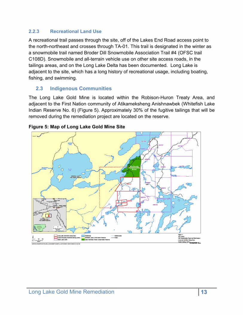
2.3 Indigenous Communities The Long Lake Gold Mine is located within the Robison-Huron Treaty Area, and adjacent to the First Nation community of Atikameksheng Anishnawbek (Whitefish Lake Indian Reserve No. 6) (Figure 5). Approximately 30% of the fugitive tailings that will be removed during the remediation project are located on the reserve.
Figure 5: Map of Long Lake Gold Mine Site
Long Lake Gold Mine Remediation 14
3. Studies Undertaken
3.1 Site Characterisation Report The Ministry retained CH2M HILL Canada Ltd. to develop a Site Characterization Report. CH2M HILL conducted a characterization field program of the site over two events, one in early July 2013 and one during late August 2013.
The leaching of tailings and transport by surface water was identified as a major pathway for arsenic migration to Long Lake. CH2M HILL generated a conceptual site model showing the three major sources of arsenic loading to Long Lake, including, the three tailings areas, the fugitive tailings, and the Long Lake Delta; all of which resulted in acidic drainage with elevated concentrations of arsenic being conveyed into mine drainage, downstream Luke Creek, and into Long Lake. In addition to these sources of arsenic, elevated concentrations of arsenic were found in surface water in the wetland near Long Lake.
CH2M HILL found that sources of arsenic loading to Long Lake vary seasonally. The study determined that during low flow, the majority of arsenic loading is from exposed fugitive tailings in Luke Creek, due to their interim exposure to atmospheric oxygen. While the tailings areas did not contribute substantially to arsenic loading to Long Lake during low flow, they are the source of the downstream fugitive tailings and are likely the highest contributor to arsenic loading during higher flows.
The study showed that most of the arsenic present in the tailings in the lake are present in the sulphide phase and should be stable as long as the submerged tailings remain underwater. About 25 percent of the arsenic was associated with the ferric hydroxide phase, which is not a concern as reducing conditions are not present in Long Lake. Exposure of the sulphide minerals to atmospheric weathering conditions will mobilize arsenic. Therefore, it was concluded that the seasonally exposed tailings in the Long Lake delta will need to be removed.
The Site Characterization Report determined that the three major sources of arsenic (tailings areas TA-01, TA-02 and TA-03, fugitive tailings and Long Lake Delta) require rehabilitation since:
They contribute the vast majority of arsenic entering Long Lake; 95% of the arsenic load in the case of August, 2013;
There is ongoing migration of arsenic from the tailings areas to the downstream fugitive tailings as the tailings areas are largely uncontained; and
Ultimately it will not be otherwise possible for the Ministry to meet its minimum objective of reducing the arsenic concentration within Long Lake to less than 10 µg/L.

Long Lake Gold Mine Remediation 15
3.2 Archaeological Assessment Report (Stages 1 and 2)
In 2014, URS Canada conducted a Stage 1-2 archaeological assessment of the Long Lake Gold Mine Site property located at the south end of Long Lake, in Eden Township, District of Sudbury, Ontario. The assessment was conducted by URS Canada on behalf of the Ministry of Northern Development and Mines (MNDM) in preparation for the future rehabilitation of portions of the subject property including remediation of previous mining impacts.
Stage 1 background research into the archaeological and land use history of the property indicated that it had moderate to high potential for containing archaeological remains. A property inspection was conducted on September 22nd, 2014 which indicated that portions of the subject property were seemingly undisturbed (approximately 20%) and could potentially contain archaeological resources. The remaining 80% of the subject property consists of disturbance related to mining activities, including tailings areas, waste rock piles, abandoned mine infrastructure foundations as well as service and access roads. Those areas that were not visibly disturbed, permanently wet or sloped were subject to a Stage 2 assessment between September 22nd and 26th 2014. No archaeological resources were recovered during the test pit survey of the property.
Given the results of this assessment, URS Canada makes the following recommendation(s):
1) Due to the presence of severe slope, low wet areas, heavy ground disturbance and the fact that no archaeological resources were found during the Stage 2 assessment, the subject property is deemed to no longer contain archaeological potential. It is therefore recommended that no further archaeological work is required for the portions of the subject property that will be affected by the remediation.
3.3 Species at Risk Study
The objective of the 2015 Species at Risk (SAR) field program was to complete the required assessment studies required to support the Ministry of Northern Development and Mines in their application for any Endangered Species Act (ESA) and/or Species at Risk Act permitting or registration, and subsequently to prepare any mitigation plans as necessary. The main SAR that were indicated for survey by the province are the Blanding’s Turtle (Emydoidea blandingii), Massasauga (Sistrurus catenatus), and the Eastern Whip-poor-will (Caprimulgus vociferus).
Over the course of the field investigations:

Long Lake Gold Mine Remediation 16
• Three (3) species of turtle were documented in the Project Area, including Blanding’s Turtle;
• Five (5) species of snake were documented in the Project Area, however, there was no evidence (e.g., individuals, sheds) of Massasauga detected within the Project Area; and,
• Five (5) individual Whip-poor-will were recorded within, or adjacent to, the Project Area.
Activities associated with the planned remediation of the Project Area may impact SAR and their habitats. Following the issuance of the final report on the extent of the tailings and associated contamination, and the proposed plan for site remediation, the potential impacts to SAR will be refined.
4. Environmental Effects The following environmental effects are taken from the project Class EA screening.
4.3 Eden Township Forest Conservation Reserve The project involves significantly upgrading the existing access road to the site, which passes through the conservation reserve. The improvement of the access road to the mine site is a large-scale addition of infrastructure to the Eden Township Forest Reserve, and necessary to the project implementation.
The project will require the frequent passage of large vehicles and equipment on Lakes End Road to reach the site. This increased traffic will result in wear and damage of this road.
Road upgrades will include a substantial widening of the corridor that will result in the removal of mature red pine and possibly some cedar trees, which are considered values of conservation interest within the conservation reserve.
4.4 Atikameksheng Anishnawbek The removal of fugitive tailings located within AA will have an effect on a limited part of the reservation area. Noise may be elevated during project implementation, although the community is unlikely to be exposed to these disturbances as the wetland is not located near any residential development.
4.5 Long Lake Residents Noise may be elevated during project implementation phase, including noise from dredging or excavation activities in Long Lake, as well as truck traffic both on site and along the south shore of Long Lake.

Long Lake Gold Mine Remediation 17
4.6 Wetland Wildlife Habitat The Long Lake remediation will have predominantly positive effects on the surrounding natural environment. The removal of contaminate-leaching fugitive tailings from Long Lake and Luke Creek will allow for the creation of healthy aquatic and shoreline habitat. By removing and consolidating these tailings into a single impoundment, surrounding terrestrial habitat will also be created. The seasonal activity of certain resident wildlife species may be disturbed by the project’s implementation.
Project implementation will involve the temporary deviation of Luke Creek for the duration of the clean-up, as well as change in the wetland form, from a fen to a marsh ecosystem.
The project has the potential for temporary sensory disturbance and loss of habitat connectivity to adjacent wetlands for Blanding’s turtles. The project activities may also temporarily disturb habitat that may be used by Eastern whip-poor-will and Massasauga rattlesnakes.
4.7 Socio-Economic Land Use The Long Lake Gold Mine site is located on Crown land. Recreational use of road access will be disrupted during construction to ensure public health and safety.
Although there are no on-going mining exploration activities occurring on the site, future endeavors will not be permitted to disturb rehabilitated areas without Director approval.
The project will benefit the local economy with employment opportunities for the reclamation work, as well as with the purchase of materials.
By reducing levels of contaminants in the area and consolidating the mine site’s hazards, health concerns will be addressed.
4.8 Social/Cultural Significance Atikameksheng Anishnawbek is immediately adjacent to mine site and the contamination does extend across reserve boundaries. There are no known sites of Aboriginal cultural significance within the project area.
An archaeological assessment concluded that there is low potential for archeological resources on the site. While there are potential heritage values on site (mine ruins), the project will not be impacting these structures.
4.9 Advantages and Disadvantages of the Project The advantages associated with the reclamation of the Long Lake Gold Mine site:
Long Lake Gold Mine Remediation 18
• An improvement in water quality in Long Lake in lien with provincial and deferral safe drinking water limits,
• The removal of tailings and soils will reduce contaminant loading in the ecosystem,
• Restoration of wetland to a marsh ecosystem has the potential to improve fish and wildlife productivity, and biodiversity, and
• Short-term benefits for the local economy
The disadvantages associated with the reclamation of the Long Lake Gold Mine site:
• Short-term increase in noise for the residents of Long Lake, • Temporary disruption in the public’s ability access to Crown land, • Removal of some trees that represent values of conservation interest in the Eden
Township Forest Conservation Reserve, and • Potential for short-term sensory disturbance and habitat damage of three species
at risk.
5. Mitigation Measures
The following proposed mitigation measures presented in Table 1 are recommended to ensure that any short-term disturbances caused by the Long Lake Gold Mine project are mitigated.
Table 1: Potential Negative Environmental Effects and Proposed Mitigation Measures
Potential Impact Mitigation
Road Improvement in Eden Township Forest Conservation Reserve
Heavy vehicles may damage privately-owned Lakes End Road
Road widening will result in the removal of some red pine and cedar
Consultation with local residents (who fund Lakes End Road).
Winter hauling to avoid extensive damage.
Repairing the damage caused by the additional traffic.
Agreement with MNRF that includes conditions which will minimize the loss of trees with the conservation reserve
Restricting access to improved road through installation of barriers such gates and/or physical barriers (boulders, Jersey barriers, etc.).

Long Lake Gold Mine Remediation 19
Removal of Tailings
Physical disruption of contaminated areas -
Disturbance of contaminated lakebed
Dust from tailings area
Consultation with Atikameksheng Anishnawbek community, Chief and council to share information and address concerns
Use of barriers such as silt curtains, sheet piling or other means to physically separate the dredging activity from the rest of the lake. Monitoring to confirm barrier effectiveness.
The excavated and transported tailings will be wet and not expected to produce dust. Dust mitigation measures will be applied, if needed.
Noise and Dust
Noise from dredging / excavation activities along lake shore may disturb adjacent property owners.
Noise and dust from the haulage of aggregates to site along area roads.
To be moderated by the implementation of timing restrictions for work hours, by the adherence to regional bylaws, where applicable
Exhaust mufflers will be used on all equipment. Where possible, operational activities will be relocated away from the lakeshore to provide a buffer zone.
MNDM is working to identify aggregate sources that are close to the work area to minimize haul distances. Trucks will be subject to MTO and municipal regulations and bylaws pertaining to noise, speed and tarping loads to reduce dust and noise issues. Timing restrictions will be applied to minimize disturbance of property owners along haul routes.
Wildlife and Habitat
Temporary disruption of shoreline and wetland habitats.
Potential for negative impacts to species at risk and their habitats
In general, the remediation project will improve ground and surface water quality, as well as soil quality, by lowering levels of arsenic and other contaminants migrating from the site.
An ecological restoration plan has been prepared that will enhance the wetland’s biodiversity.
A federal Species At Risk Act permit and provincial Endangered Species Act permit are required authorize impacts to species at risk. Permits conditions will include measures to avoid minimize

Long Lake Gold Mine Remediation 20
impacts through training, exclusion fencing, and timing restrictions.
Recreational Activities
Road use will be disrupted during construction.
Temporary snowmobile trail displacement.
Existing property owners on Lakes End Road will continue to have access to their properties. The Mine Access Road (road beyond the gate) will have restricted public access during the construction period.
Consultation with local residents/ cottagers/ snowmobile club - possible re-routing seasonal snowmobile routes away from the work site.
.
Archaeological and Cultural Resources
The potential for archaeological and/or cultural heritage resources in the project area is low based on the completion of a Stage 1 and 2 Archaeological Assessment for the site in 2014.
In the event of a potential discovery of an archaeological resource, work will be stopped and MTCS contacted.
6. Analyses of Alternatives
6.3 Remediation Objectives The remediation options evaluated in the Remedial Options Report (CH2M HILL, 2014) for the Long Lake project considered the following remediation objectives:
1. Reduce acidic drainage from leaching of tailings (surface water and groundwater/ porewater) that results in arsenic loading to Long Lake via the mine drainage and downstream Luke Creek either by: a. Source Control Options:
i. Minimize leaching of tailings by surface water and groundwater/pore water from the three tailings areas
ii. Remove source of fugitive tailings to prevent continued leaching of fugitive tailings/sediment in mine drainage and Luke Creek
b. Treatment Options (active and passive): i. Collect, convey and treat contaminated surface water and
groundwater/pore water from the three tailings areas

Long Lake Gold Mine Remediation 21
iii. Collect, convey and treat contaminated surface water in mine drainage and Luke Creek.
2. Prevent/Minimize transport of tailings: a. Minimize transport of tailings in the three tailings areas to downstream
mine drainage, Luke Creek and Long Lake Delta b. Prevent transport of fugitive tailings/ sediment to Long Lake Delta c. Reduce transport of fugitive tailings/sediment from Delta into Long Lake.
6.4 Identification of Remediation Alternatives For each of the three major sources of arsenic at the site, between four and seven remediation options were identified and evaluated. Based on the results of the site characterization, contaminant loading estimates, and Ministry requirements, CH2M HILL developed a range of feasible remediation alternatives.
Below are listed the considered remediation strategies and what they involve:
Consolidation, grade and cover of tailings on surface: • Excavating and consolidating tailings onto a portion of the site at an elevation that
would prevent tailings from being saturated by groundwater or surface water.
Grade in-place and cap/cover: • Re-locating surface water drainage from flowing over tailings areas to flowing
adjacent to tailings areas.
Consolidation and in-mine disposal: • Relocating tailings into the Glory Hole, shaft and underground workings on-site.
Would require study to evaluate extents of useable area in open pit glory hole/shaft/mine underground workings, as well as the chemical treatment of tailings to ensure material neutralization. May require temporary mine water displacement.
Subaqueous disposal of exposed tailings (delta only): • Relocating exposed tailings of delta into deeper waters of Long Lake that will be
submerged throughout the year (min. depth of 2 m below water surface). Therefore preventing seasonal water fluctuations and erosional effects to cause the mobility of arsenic.
Excavation and offsite relocation: • Relocating tailings to an offsite impoundment
Excavation and reprocessing (Gold Recovery): • Excavating, transporting and re-processing tailings offsite to recover remaining
gold content

Long Lake Gold Mine Remediation 22
Active treatment of downstream surface water: • Collecting, conveying and actively treating contaminated surface water and
groundwater/porewater; seepage and surface water are routed through treatment plant located downstream of tailings areas
Passive treatment of downstream surface water: • Collecting, conveying and passively treating contaminated surface water and
groundwater/porewater, potentially involving the construction of a treatment wetland, sulfate-reducing bioreactor, aerating, and addition of alkalinity; seepage and surface water are routed through treatment system
All presented remediation options above involve the temporary diversion of water from Long Lake during the project execution and comprise the re-establishment of water and local re-vegetation.
Alternative to the project: • “Do Nothing” Alternative was also considered, but was subsequently screened out
because it does not answer to the presented challenges.
6.5 Evaluation of Remediation Alternatives Remediation alternatives were evaluated separately for each of the three major sources of arsenic at the site to establish the best remedial solution for each source. Seven remediation alternatives were considered for the tailings areas, four remediation alternatives were considered for the fugitive tailings in the Luke Creek Floodplain, and five remediation alternatives were considered for the delta extending into Long Lake.
The alternative methods were evaluated on the following criteria:
• Feasibility of implementation and effectiveness • Required long-term care and maintenance • Longevity/permanence • Potential impacts to interested party concerns • Regulatory requirements • Cost of implementation • Long-term care and maintenance
The evaluation was based on applying criteria and used qualitative ratings to rate feasibility and to ensure site-wide compatibility.
The following table (Table 2) shows the results of the qualitative evaluation of the remediation options for each major source of arsenic, using the evaluation criterion presented above and presents the preferred options in green.

Long Lake Gold Mine Remediation 23
Table 2: Remediation Alternative Evaluation & Preferred Option (CH2M Hill 2014) Project Element
Remediation Alternative Rationale for Selection
Tailings Areas (TA-01, TA-02, TA-03)
Preferred Alternative: Consolidate and Cover Tailings Re-establish Drainage
This was the most feasible alternative, and has had proven success. Met Ministry requirements, and is expected to reduce acid rock drainage. Minor low-term maintenance would be required. Cost of implementation is moderate.
Grade and Cap/Cover Tailings In-place Re-establish Drainage
This alternative required multiple tailings covers, over a larger area. The additional capping and potential blasting of bedrock involved make this option more costly.
Relocate Tailings to Mine Re-establish Drainage
The indeterminate volume of space available within the underground workings of the mine makes this option’s success unpredictable. The unknown amount of water which has accumulated in the mine would have to be removed and processed, raising the project’s cost.
Re-Process Tailings Re-establish Drainage (Gold Recovery)
It is unlikely to find a purchaser/receiver to undertake the re-processing of the tailings as it is not economically viable (small amount of tailings with low-grade gold). The transportation of the contaminated materials would be costly and complicated, and will likely be objected the temporary and recipient sites.
Passive Treatment of Downstream Surface Water and Ground Water
Would not be effective as a stand-alone option. Processing facility would be located on WLFN and access would be difficult. Would involve extensive on-going care and costs. This alternative does not see to tailings removal.
Active Treatment of Downstream Surface Water and Ground Water
At optimal capability, this alternative could meet remediation requirements. It would involve a high cost of implementation, operation, and maintenance. This alternative does not see to tailings removal either.
Relocate Tailings Off-site
Finding a receiver to deposit the waste materials on their property is unlikely. Although this alternative would comply with the project requirements, it would introduce hazards in places affected by the tailings’ transportation and storage.
Luke Creek
Preferred Alternative: Relocate Fugitive
The nature of the wetlands area makes consolidation work difficult to execute. Would

Long Lake Gold Mine Remediation 24
Tailings to TA-01 Re-establish Luke Creek
consider work during winter-months. Would entail basic implementation costs and very low long-term maintenance.
Relocate Fugitive Tailings to Mine Re-establish Luke Creek
This process presents the same difficulties as the in-mine disposal of tailings areas TA-01, TA-02, and TA-03.
Grade and Cover Fugitive Tailings Re-locate Luke Creek
Engineering a way to by-pass Luke Creek would be complex and very costly. Capping the residual contaminated area would be extensive and would require more long-term maintenance.
Passive Treatment of Downstream Surface Water
This alternative would be challenging to implement as water flow varies throughout the year and is difficult to anticipate. Also, the processing plant would have to be established on Whitefish Lake First Nations land, introducing additional challenges. This option is not an effective stand-alone remediation strategy.
Long Lake Delta
Submerge Exposed Tailings Install Protective Layer
This simple alternative would substantially reduce the arsenic loading into Long Lake, with a sand cover that would prevent its subaqueous re-suspension. Regulations may not permit this type of construction in the lake. Concerns from of interested parties about lake dredging are expected.
Completely remove and relocate Tailings to TA-01 Install Protective Layer
Construction in Long Lake may prove problematic from a fugitive standpoint. Would need to have better awareness of the extents of both the volume of tailings in the delta and lake.
Completely Remove and Relocate Tailings to Mine Install Protective Layer
This remediation option presents the same difficulties as does the consolidation of the delta tailings to TA-01, but it would have the additional challenge of the indeterminate available space in the glory hole/ underground mine workings.
Preferred Alternative: Partially remove and relocate Tailings to TA-01 Retain submerged Tailings Install Protective Layer
This option is the most feasible remediation alternative for the Long Lake/Luke Creek delta. Although it requires study to delineate the extents of the delta’s tailings, it moderates the volume of tailings to consolidate and ensure a reliable way of inhibiting arsenic oxidation.
Partially Remove and Having the same moderated

Long Lake Gold Mine Remediation 25
Relocate Tailings to Mine Retain Submerged Tailings Install Protective Layer
challenges/advantages as the option directly above, but has the additional hindrance of the available volume for tailings within the mine’s underground workings.
6.6 Preferred Remediation Alternative
6.6.1 Selection of Preferred Remediation Alternative
From the remediation options evaluation, the chosen preferred remediation option for each area is as follows:
1. Tailings Areas: Consolidate Tailings to TA-01 and Cover / Re-establish Drainage 2. Luke Creek Floodplain: Relocate Fugitive Tailings to TA-01 / Re-establish Luke
Creek 3. Long Lake Delta: Partially Remove and Relocate Tailings to TA-01 / Retain
Submerged Tailings / Install Protective Layer
The selection of the preferred integrated remediation option was based on the outcome of the preferred remedial alternative for the Tailings Area, being the main source of arsenic. The evaluation process made it clear that source control options that minimize leaching or remove the source of fugitive tailings would also prevent/minimize transport of tailings, which made them the preferred treatment option.
Some remediation options were not considered to be feasible for meeting the remedial objectives (e.g. passive treatment) or applicable to all contaminant source areas (e.g. active treatment), but still have the potential to be incorporated into the integrated remedial solution as the design advances.
6.6.2 Recommended Integrated Remediation Option
The recommended integrated remediation alternative, as indicated by CH2M HILL in their remediation option development and evaluation, is to consolidate all major sources of arsenic on surface, namely the tailings in the indicated tailings areas and the fugitive tailings downstream. These tailings are to be relocated and contained with a perimeter berm to the northeast portion of TA-01, have the area graded, and construct a low permeability cap. The consolidated tailings would then be vegetated (Figure 6 and Figure 7).
The concept for each major source of arsenic is outlined as follows:
Tailings Areas (TA-01, TA-02 and TA-03)

Long Lake Gold Mine Remediation 26
Create a tailings impoundment within the TA-01 Tailings Area and consolidate all tailings within this area. The tailings impoundment will be constructed at an elevation that will isolate the tailings from groundwater.
Re-establish surface water drainage through footprints of TA-02 and TA-03, through the centralized mine site drainage channel of TA-01.
Divert clean runoff around the new TA-01 Tailings Impoundment using a diversion ditch to further isolate the tailings impoundment from site runoff.
Grade, cover and vegetate areas where the tailings were removed.
Luke Creek Flood Plain • Temporarily divert mine drainage and Luke Creek flow (Figure 6) • Excavate and relocate fugitive tailings from Luke Creek as well as the associated
flood plain and receiving wetland to the TA-01 tailings impoundment. • Grade, cover and vegetate the footprints of removed tailings. • Re-establish natural drainage conditions within Luke Creek and re-vegetate.
Long Lake Tailings Delta • Excavate/dredge tailings to a minimum of 2 m below Long Lake’s low water level
and relocate them to the TA-01 tailings impoundment. • Cover remaining submerged tailings with a protective layer of sand and gravel to
prevent their re-suspension. Provide shoreline erosion protection (cobble riprap) and vegetate to re-establish the natural shoreline to the extent possible.
Upon completing the consolidation of all fugitive tailings into the TA-01 tailing impoundment, the impoundment will be capped with a low permeability cover to isolate the encapsulated tailings from surface water infiltration to the maximum extent possible.

Long Lake Gold Mine Remediation 27
Figure 6: Consolidation of Tailings and Fugitive Tailings to TA-01
Figure 7: Rehabilitated Areas and Re-Established Surface Water Drainage

Long Lake Gold Mine Remediation 28
7. Screening and Project Categorization The Long Lake Gold Mine reclamation project has been assigned to Category “C” (Appendix A).
Category “C” projects are anticipated to have moderate potential environmental effects. With the use of specific planning, design and mitigation measures tailored to the requirements of the project are developed to help manage predictable and potentially negative environmental effects.
The anticipated level of public interest in regards to the clean-up of the fugitive tailings has been gauged to be moderate, in view of the following issues:
Approximately 800 to 1000 permanent and seasonal homes are located on Long Lake;
Fugitive tailings are located on Atikameksheng Anishnawbek reserve lands; and A Drinking Water Advisory has been issued by the Sudbury District Health Unit
to several property owners on the south bay of Long Lake because arsenic concentrations are above the ODWS.
The Category “C” also reflects the expectation that the proposed clean-up project will present a moderate potential environmental effect. The clean-up project will have a positive effect on the physical and biological environment of the site with its completion by reducing the arsenic in the natural area. However, it may temporarily have a negative impact on noise limits and on the habitat of Species at Risk during the implementation of the remediation work. The need to upgrade the access road to the project site (Lakes End Road) will affect the existing infrastructure in the Eden Township Conservation Reserve, and will generate additional traffic. This disturbance may impact recreational use to that part of the lake. These effects will be amended for with proper mitigation and correctional measures.
8. Consultation Effective and meaningful involvement of interested persons, including government ministries and agencies, members of the public and Indigenous communities, is an integral part of the Class EA process. Consultation efforts exceeded the minimal consultation requirements for a Category “C” project under MNDM’s Class EA (section 4.2.2).
Long Lake Gold Mine Remediation 29
8.3 Public Consultation
8.3.1 Public Notification
Public interest and concerns were addressed throughout the planning process by means of direct correspondence with individuals, public meetings and information releases. A list of the informative resources that have been sent and/or made available online by MNDM to interested groups and individuals can be found in the Appendices.
A 30-day Notice of Opportunity to Provide Input was sent to agencies and stakeholder and posted on MNDM’s webpage March 19, 2015. A information notice was also posted on the Environmental Registry EBR# 012-3676.
MNRF also provided the mail-out to their own list of resource licensee with instructions to contact MNDM should they want to be included on future communication.
8.3.2 Public Information Meetings
A public information meeting was delivered in Sudbury by MNDM, assisted by CH2M HILL, on November 27th, 2013.
In October 2014, MNDM provided an update to the Long Lake Stewardship Committee at their year-end meeting. .
April 28, 2016, MNDM and SNC Lavalin provide an update to MOECC, MNRF, and SDHU on the detailed design and planned site reclamation.
May 26, 2016, MNDM and SNC Lavalin provided a public information session to update stakeholders on the detailed design for the remediation of the site.
May 29, 2016, MNDM provided an update to the Long Lake Stewardship Committee.
MNDM will be providing an update to residents in the fall of 2017 prior to the awarding of the reclamation contract to update residents and listen to any concerns stakeholders may have.
Questions, comments and responses from the meetings, as recorded by MNDM, can be found in the Record of Consultation (see Appendix)
8.4 Aboriginal Consultation
8.4.1 First Nation Notification
Communications between MNDM and Atikameksheng Anishnawbek (AA) has been on-going throughout the project. MNDM sent out requests for permission any time work or sampling was to be conducted on the reservation, as well as invited representatives from the community to participate in site visits.
Long Lake Gold Mine Remediation 30
A list of the informative resources that were made available to AA can be found in the Appendices.
8.4.2 Atikameksheng Anishnawbek Information Sessions
An information session was held at the community centre in AA on December 16th, 2013. The presentation, questions and Ministry responses from the session have been made available at the Band Office.
In April 2015, MNDM provided an update to the community on the progress to date and planned detailed design work to be completed by SNC Lavalin as well as potential economic opportunities during the site reclamation.
In February 2016, MNDM provided an update at a Band Council Meeting to discuss the increased contamination identified in the Wetland area and reclamation options.
A community meeting was held July 20, 2017 to provide an update and seek feedback from residents on the proposed cleanup, alternatives for the Wetland area as well as economic opportunities.
MNDM have completed joint water sampling with Atikameksheng Anishnawbek staff in Round Lake since 2012. In September 2014, MNDM obtained a Band Council Resolution (BCR) to complete an Archaeological Assessment in conjunction with Atikameksheng Anishnawbek staff in the areas to be reclaimed. In the fall of 2014, MOECC completed a fish tissue sampling program in Round Lake in conjunction with Atikameksheng Anishnawbek staff to assess arsenic contamination of fish.
8.5 Input Received and Responses The questions and concerns of the public and area stakeholders were addressed from the project’s announcement in 2012. A Comment Summary Table describing the correspondence with the interested persons is attached to the Record of Consultation (Table 3, Appendix B).
9. Future Effects Monitoring Future effects monitoring will be conducted to ensure that the reclaimed site performs as is anticipated. Post reclamation monitoring will be completed to monitor the effectiveness of the TMA and Mill Site covers, the passive seepage treatment and the recovery of the surrounding water bodies and biota. Monitoring will also assess the physical stability of the site to confirm the robustness of the site re-vegetation, erosion issues and crown pillar stability.
Long Lake Gold Mine Remediation 31
A site monitoring program will be finalized upon completion of the remediation program. Monitored parameters will potentially include surface and groundwater, sediment, benthic, ground stability and vegetation assessments. The covers will require perpetual care and maintenance and the some form of site monitoring will continue in perpetuity.
10. Detailed Design, and Planned Project Construction Schedule The work schedule and sequencing of activities will be determined by the successful contractor. However, certain restoration activities will need to occur in the winter or summer conditions to be successful.
Prior to initiating any site work, access to the site including Lakes End Road and the mine access road will have to be widened and surfaced. Much of this work will take place within the Eden Township Conservation Reserve and the work will be completed in accordance with a Memorandum of Understanding (MOU) with MNRF. Site work will begin with the construction of the TA-01 impoundment area and bypass ditching. Flow through the lower reaches of Luke Creek, the Wetland and Long Lake will be managed by constructing a temporary diversion channel to direct Luke Creek around these areas. The diversion channel will need to be installed before work can begin on these areas.
Excavation work will, to the extent possible, start upstream at TA-02 and work downstream to Long Lake to prevent contamination from migrating through areas that have been reclaimed. The Wetland excavation work may be required to occur in the winter in order to take advantage of frozen ground conditions. Excavation of the TA-02, 03 areas can be done winter or summer. The dredging of Long Lake will have to be completed in the summer (during the ice free period).
All water that collects within active excavation areas will be treated before being discharged to the environment.
It is anticipated that the described reclamation activity can be completed over a 2.5 year period. The general sequence or stage of construction components/activities that will be provided in the tender documentation is described below.
10.1 Access Upgrades Target Dates:
Start: 2018-01-01
Completion: 2018-05-01
Detailed Description of Methodology:
Long Lake Gold Mine Remediation 32
Stage will involve the upgrading of site access roads including the Lakes End Road and the Mine Access Road. Activity will include
ROW tree removal and grubbing to a maximum width of 20 m on Lakes End Road and a maximum width of 15 m on the Mine Access Road
Red pine that are to be removed will be marked and approved by MNRF before removal.
Merchantable logs will be sorted and stacked. Other wood will be chipped and stockpiled for reclamation.
Grubbed material will be stockpiled for future reclamation.
All grubbing and tree clearing will take place outside of habitat windows (i.e. September to March) as outlined in the Environmental Specification.
Gravel will be supplied and placed to upgrade the road surface and provide additional fill as required.
The site access will be upgraded to allow the safe transport of approximately 10,000 truckloads of fill. Most of this work will be completed in the winter prior to the spring melt. Water management infrastructure including culverts, and erosion and sediment control features will be installed as needed.
Mobilization of equipment to site will begin as soon as the site access is passable.
10.2 Mobilization Target Dates
Start: 2018-03-1
Completion: 2018-05-30
Detailed Description of Methodology:
Stage will involve the mobilization of personnel and equipment to site. Activity will include
transport of people, equipment and supplies to site
establish site office, lunch room and washroom facilities, laydown area for equipment and supplies
establish power supply (generator), fuel storage and communications.
establish tire wash pad
installation of erosion and sediment control measures, water management measures and temporary water treatment

Long Lake Gold Mine Remediation 33
establish additional site access road to access reclamation areas (TA-02/03)
Site facilities and laydown area will be established in a location within TA-01 that provides Long Lake with a natural barrier to both sound and visual disturbance. Mobilization of the camp facilities and equipment will start as soon as the road is accessible.
Access to work areas will need to be constructed to facilitate the movement of equipment and supplies to areas such as TA-01/02/03, the Wetlands and Long Lake Delta.
Silt fencing and sediment control measures will be installed around work areas to prevent the migration of sediments and contaminated material off site.
Power generation and water treatment will be required to operate continuously during the construction period.
Mobilization may be suspended if conditions become soft or half load restrictions delay the larger pieces of equipment.
10.3 Phase 1 - Perimeter Ditches at TA-01 & Water Drainage Systems Target Dates:
Start: 2018-04-1
Completion: 2018-07-31
Detailed Description of Methodology:
installation of underdrain system at TA-01
construction of East and West ditches around TA-01
installation of water treatment plant at TA-01
construction of perimeter berms at TA-01 via cut and fill using contaminated material
berm lining construction with geomembrane and fill materials
Berms will be established to create an impoundment facility at TA-01 where contaminated material will be stockpiled.
Foundation preparation of the floor of the impoundment will include the installation of a drainage system to collect subsurface water and water that drains from the contaminated material. The drainage system will include the installation of a manhole as a final collection point before treatment and discharge to the environment.

Long Lake Gold Mine Remediation 34
Perimeter ditches are to be constructed to convey non-contact water around the impoundment at TA-01 for discharge to the environment. Perimeter ditches will be lined wherever they are not directly on bedrock.
Water treatment plant will be installed and begin treatment of water collected within the impoundment at TA-01, with treated water discharged to the perimeter ditches.
Equipment mufflers and sound barriers will be implemented around drilling equipment.
10.4 Phase 2 - Clean-Up of Channel from TA-01 through Luke Creek up to Wetlands & Diversion of Luke Creek
Target Dates:
Start: 18-07-01
Completion: 2018-09-30
Detailed Description of Methodology:
excavation/relocation of contaminated soils along channel connecting TA-01 with Luke Creek
backfill/restore grade along channel connecting TA-01 with Luke Creek with clean imported material
construction and commissioning of temporary diversion channel structure to divert flow in Luke Creek away from Wetlands
The channel connecting TA-01 with Luke Creek will be remediated in 30 m phases by pumping water around the 30 m work area, and progressively moving downstream.
A temporary diversion channel will be constructed upstream of the Wetlands which will be used to divert Luke Creek and discharge into Long Lake. Once the remediation work in Luke Creek has advanced to the diversion, it will be commissioned by installing a berm across Luke Creek to block flow into the Wetlands. The channel will be lined with a durable non-biodegradable Turf Reinforced Mat (TRM) which will be removed and disposed upon decommissioning of the channel.
10.5 Phase 3 - Clean-Up of TA-02/TA-03 & Wetlands Target Dates:
Start: 2018-10-01
Completion: 2019-03-01

Long Lake Gold Mine Remediation 35
Detailed Description of Methodology:
excavation of contaminated material at TA-02/03 and relocating it to TA-01
backfill and restore grade at TA-02/03 with clean material from off-site
restore drainage at TA-02/03
relocation of contaminated material from Wetlands to TA-01
restore drainage at Wetlands
Establish a temporary sump at TA-02/03 to collect contact water during excavation of contaminated material and pump contact water towards the sump within the impoundment at TA-01, where water will be collected before treatment and discharge to the environment.
Backfill and grade TA-02/03 with clean material from off-site and re-establish drainage before establishing flow towards perimeter drains around TA-01.
Relocate contaminated material from the Wetlands to TA-01. Backfill and grade with clean materials from off-site while re-establishing drainage through Wetlands.
10.6 Phase 4 – Clean-Up of the Long Lake Delta & Luke Creek Clean-Up & Decommissioning of the Diversion Ditch to Long Lake
Target Dates:
Start: 2019-07-01
Completion: 2019-10-15 (Dredging Option)
or
Start: 2018-12-01
Completion: 2019-03-15 (Excavation Option)
Detailed Description of Methodology:
installation of sediment barrier system in Long Lake
DREDGING OPTION
o preparation of the staging area for dredging operations
o supply and placement of geotubes within the designated laydown area at TA-01
o supply and placement of piping to convey dredged material to TA-01
o clean-up of Long Lake Delta via dredging
EXCAVATION OPTION

Long Lake Gold Mine Remediation 36
o preparation of the staging area for excavation operations
o excavate material from the Long Lake Delta during Winter 2018/2019 under frozen conditions for relocation by trucking to TA-01
backfill/restore onshore areas and re-establish access trail using clean material from off-site, as well as designated areas on the lake bed.
Establish a sediment barrier to prevent the migration of fine material beyond the work area in the Long Lake Delta. During work, fugitive material will be identified by ongoing turbidity monitoring, and any fugitive material will be contained and removed.
Establish sediment and erosion control around staging areas. Water collected from operations within the staging area will be treated before discharge to the environment.
Geotubes will be placed within the impoundment at TA-01 at the designated laydown area. Pipes originating at the staging area will feed the geotubes with contaminated dredgeate, which will be filtered within the geotubes while excess water will drain to collection sumps within the impoundment at TA-01 for treatment. If excavation is chosen as the preferred method, excavated materials will be placed within the impoundment at TA-01 in a similar fashion to the previous phases.
Work in submerged areas will be done where there is less than 2 m of water, as indicated by the most recent low-water elevation.
Onshore areas that were remediated will be backfilled with clean materials from off-site. Erosion protection will be placed along the shore and backfill materials will be placed at the designated areas on the lake bed.
Decommissioning of the temporary diversion channel by breaching the berm in Luke Creek and backfilling and then re-vegetating. The turf reinforcement mat will be disposed off-site.
10.7 Phase 5 – Capping & Closure Target Dates:
Start: 2019-05-01
Completion: 2019-08-31
Detailed Description of Methodology:
final grading and backfilling over the stockpile at TA-01
installation of impermeable lining system, including drainage to prevent ponding on top of the stockpile

Long Lake Gold Mine Remediation 37
placement of topsoil and re-vegetation
Regrade the surface of contaminated material of the stockpile at TA-01 to the final grades and lines and install final impermeable barrier system over the surface of the stockpile. Tie in with the existing barrier systems used over the perimeter berms.
During final capping work, establish a water collection area to ensure that no runoff from the stockpile flows into the perimeter ditches. Contact water shall be treated before discharge to the environment.
Topsoil will be placed on the surface of the entire stockpile as indicated in the design for vegetation.
10.8 Demobilization Target Dates:
Start: 2019-08-31
Completion: 2019-09-15
Detailed Description of Methodology:
All erosion control infrastructure, temporary buildings, fencing drainage culverts, etc. will be removed.
Temporary access roads not required for long term monitoring or site maintenance will be scarified and vegetated.
Temporary camp and office buildings and all related infrastructure will be removed.
Remaining material and all waste will be removed from site. Aggregate stock pile may remain onsite to facilitate future repairs to the covers.
Barriers and signage will be installed to limit vehicular access to the covers.
11. Approvals and Permits Required for the Project The following permits and authorizations are being obtained by MNDM or the successful Contractor:
Provincial Endangered Species Act: Work must comply with the conditions of the Endangered Species Act which includes timing restrictions, the installation of exclusion barriers around work areas, awareness and training programs, encounter and reporting protocols, and notification and reporting requirements.
Federal Species at Risk Act: Work must comply with the conditions of the Species at Risk Act; which includes timing restrictions, the installation of exclusion barriers around
Long Lake Gold Mine Remediation 38
work areas, awareness and training programs, encounter and reporting protocols, and notification and reporting requirements.
Fisheries and Oceans Canada – Destruction of Fish Habitat: DFO has confirmed that the described Work should not result in serious harm to fish or contravene the Species at Risk Act and therefore, no formal approval is required from the Program under the Fisheries Act or Species at Risk Act, provided described mitigation measures for the project are implemented and guidance available on the DFO website is followed.
Band Council Resolution – Atikameksheng Anishnawbek: Council approval will be obtained for the removal of contaminated material from the Wetland area located on the Reserve and for the importation of clean fill material used to restore the Wetland.
Archaeological Assessment Report: The Ministry of Tourism, Culture and Sport (MTCS) has confirmed that there are no archaeological values within the areas that will be disturbed by the reclamation work.
MNRF MNDM Memorandum of Understanding (MOU): An MOU has been developed that stipulates requirements for the upgrading of vehicular access through the Eden Township Conservation Reserve.
Obtaining the following permits and authorizations are the responsibly of the Contractor:
Environmental Compliance Approval (ECA): permitting for water treatment during construction is the responsibility of the Vendor.
Notice of Project: Vendor is responsible for filing Notice of Project with Ministry of Labour.
12. References “Site Characterization Report and Data Analyses – Long Lake Gold Mine Tailings Areas, Eden Township, Ontario”, CH2M Hill, January 2014
“Remedial Options Report - Long Lake Gold Mine Tailings Areas, Eden Township, Ontario”, CH2M Hill, April 2014
“Detailed Design Report: Detailed Design and Construction Management for the Remediation of the Long Lake Gold Mine Tailings”, SNC Lavalin, May 2017
“Wetland Restoration – Preliminary Conceptual Plan”, SNC Lavalin, May 2017
Long Lake Gold Mine Remediation 39
13. Appendices
Appendix A - Screening Criteria Table
Appendix B – Record of Consultation
Additional information and technical reports can be found on the project Weblink shown below:
Phase 1 Weblink – Site Characterization and Conceptual Remediation Plan – CH2M Hill 2014:
www.geologyontario.mndm.gov.on.ca/mines/data/abandoned_mines/2015-07-30_Weblink-Long_Lake_Gold.zip
Phase 2 Weblink – Detailed Design - SNC Lavalin 2017:
www.geologyontario.mndm.gov.on.ca/mines/data/abandoned_mines/2017-05-26_Weblink_Long_Lake_Gold.zip

cobber
Typewritten Text
Appendix A
cobber
Typewritten Text
cobber
Typewritten Text
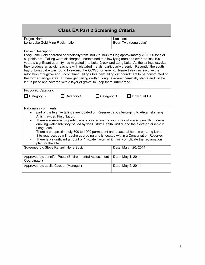
Class EA Part 2 Screening Criteria Project Name: Long Lake Gold Mine Reclamation
Location: Eden Twp (Long Lake)
Project Description: Long Lake Gold operated sporadically from 1908 to 1938 milling approximately 230,000 tons of sulphide ore. Tailing were discharged uncontained to a low lying area and over the last 100 years a significant quantity has migrated into Luke Creek and Long Lake. As the tailings oxydize they produce an acidic leachate with elevated metals, particularly arsenic. Recently, the south bay of Long Lake was found to exceed the ODWS for arsenic. Remediation will involve the relocation of fugitive and uncontained tailings to a new tailings impoundment to be constructed on the former tailings area. Submerged tailings within Long Lake are chemically stable and will be left in place and covered with a layer of gravel to keep them submerged.
Proposed Category:
Category B Category C Category D Individual EA
Rationale / comments: • part of the fugitive tailings are located on Reserve Lands belonging to Atikameksheng
Anishnawbek First Nation. - There are several property owners located on the south bay who are currently under a
drinking water advisory issued by the District Health Unit due to the elevated arsenic in Long Lake.
- There are approximately 800 to 1000 permanent and seasonal homes on Long Lake. - Site road access will require upgrading and is located within a Conservation Reserve. - There is a significant amount of "in-water" work which will complicate the reclamation
plan for the site. Screened by: Steve Reitzel, Nena Susic Date: March 20, 2014
Approved by: Jennifer Paetz (Environmental Assessment Coordinator)
Date: May 1, 2014
Approved by: Leslie Cooper (Manager) Date: May 2, 2014
1

Screening Criteria
1. Is there a potential environmental effect?
2. Is the known effect positive or negative?
3. Can the effect be mitigated using standard measures?
Description of Positive, Negative or Unknown Effect
Description of Mitigation Measures / Studies Required to Address Negative or Unknown Effects
Physical Environment Protected
areas / Areas of Natural and
Scientific Interest (ANSIs)
(overlapping or adjacent)
Yes Unknown Unknown Access through conservation reserve needs to be improved in order to access site.
Need to discuss with MNR.
First Nation Reserves
Yes Positive n/a Fugitive tailings on reserve will be included in this project.
Consultation with First Nation required.
Noise limits Yes Negative Yes Noise from trucks, dredging.
Adhere to noise bylaws.
Vibration limits No n/a n/a
Views / aesthetics
Yes Positive n/a Improved aesthetics once fugitive tailings removed.
Other (specify) n/a n/a n/a
Additional Information / comments: Access through CR – will need access restrictions (e.g., gating?) during project; access to site restricted at project completion.
2

Screening Criteria
1. Is there a potential environmental effect?
2. Is the known effect positive or negative?
3. Can the effect be mitigated using standard measures?
Description of Positive, Negative or Unknown Effect
Description of Mitigation Measures / Studies Required to Address Negative or Unknown Effects
Biological Environment Aquatic species or habitat
Yes Positive n/a Removal of fugitive tailings will improve habitat, etc.
Terrestrial species or habitat
Yes Positive n/a
Endangered Species / Species at risk or habitat
Yes Negative Unknown Potential for rattle snakes, blandings.
Further studies required – determine if endangered species present; will mitigate per MNR guidelines
Migratory bird species
No n/a n/a
Ground water - quality/quantity
Yes Positive n/a Purpose of project is to reduce arsenic in Long Lake.
Surface water - quality/quantity
Yes Positive n/a
Soils - contaminants, sedimentation, erosion
Yes Positive n/a
Wells / drinking water sources
Yes Positive n/a
Air quality No n/a n/a
Other (specify) n/a n/a n/a
3

Screening Criteria
1. Is there a potential environmental effect?
2. Is the known effect positive or negative?
3. Can the effect be mitigated using standard measures?
Description of Positive, Negative or Unknown Effect
Description of Mitigation Measures / Studies Required to Address Negative or Unknown Effects
Additional Information / comments:
Built / Structural Environment Infrastructure (roads, powerlines, pipelines, etc.)
Yes Negative Yes Increased traffic on Lakes End Road, which is maintained by local cottagers.
Mitigate through consultation with cottagers, use restrictions, maintenance and repairs.
Navigation routes
No n/a n/a
Seasonal or permanent residences
Yes Positive n/a Project will improve water quality and shoreline aesthetics, and will remove the health concern (drinking water).
Seasonal or permanent residences
Yes Negative Yes Project will (temporarily) create noise, dust and impacts/restrictions to recreational use.
Mitigate through consultation with cottagers, and meeting applicable noise/dust regulations if necessary.
Natural or human-made hazards
Yes Positive n/a The hazard is being rehabilitated/removed.
4

Screening Criteria
1. Is there a potential environmental effect?
2. Is the known effect positive or negative?
3. Can the effect be mitigated using standard measures?
Description of Positive, Negative or Unknown Effect
Description of Mitigation Measures / Studies Required to Address Negative or Unknown Effects
Other projects or activities (adjacent) – MNR stakeholders (BMA, trap line, etc.)
Unknown Unknown Yes Potential impacts on MNR stakeholders.
Will consult with any stakeholders in the area to address concerns. Will request MNR to distribute notice to stakeholders on MNDM’s behalf.
Additional Information / comments:
Social / Economic / Cultural Environment Archaeological resources
Yes Unknown Unknown Archaeological assessment required.
Built heritage resources / cultural heritage landscapes
No n/a n/a Cultural heritage screening indicates potential built heritage in the area but as MNDM is not disturbing any structures a CHER is not required. (Per email from MTCS to
5

Screening Criteria
1. Is there a potential environmental effect?
2. Is the known effect positive or negative?
3. Can the effect be mitigated using standard measures?
Description of Positive, Negative or Unknown Effect
Description of Mitigation Measures / Studies Required to Address Negative or Unknown Effects
J. Paetz Jan. 29, 2013).
Agricultural or forestry uses
No n/a n/a
Site(s) of Aboriginal cultural significance
No n/a n/a
Recreational uses
Yes Negative Yes Snowmobile club trail in the area.
MNDM is consulting with snowmobile club about moving the trail(s).
Tourism uses No n/a n/a
Industrial uses No n/a n/a
Local / regional economies or businesses
Yes Positive n/a Jobs, materials (supply)
Public health and safety
Yes Positive n/a Removal of fugitive tailings; improvement to drinking water quality in Long Lake.
First Nation land claims
No n/a n/a
Other (specify) Yes Negative Yes Staked mining claims at mine site. Can’t disturbed reclaimed works.
Consult with claim holder to address concerns.
Mining Claim Holder
Additional Information / comments:
6
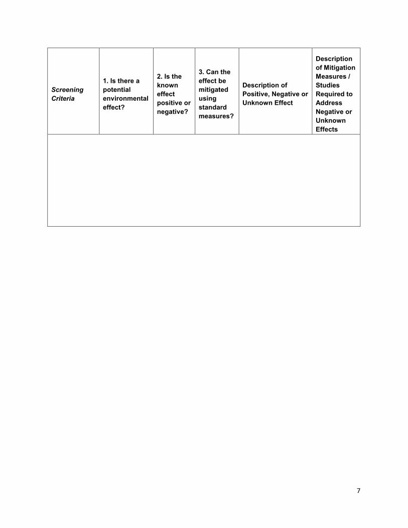
Screening Criteria
1. Is there a potential environmental effect?
2. Is the known effect positive or negative?
3. Can the effect be mitigated using standard measures?
Description of Positive, Negative or Unknown Effect
Description of Mitigation Measures / Studies Required to Address Negative or Unknown Effects
7

1 Ministry of Northern Development and Mines
Long Lake Mine Remediation Project: Record of Consultation
Project Description
Long Lake Gold mine operated intermittently from 1908 to 1937 and produced approximately 200,000 tonnes of tailings. The tailings were discharged directly to the environment without containment. The tailings have since eroded into Luke Creek and Long Lake. The tailings are acid generating and leach acidic water that is high in metal contamination, specifically arsenic. Recently Ministry sampling in the south end of Long Lake identified arsenic contamination above government drinking water limits.
The Ministry initiated a review of remediation alternatives to clean up the tailings area and has recommended a preferred option of relocating all fugitive tailings to a new containment facility to be constructed on site. The objective of the remediation plan is to reduce the arsenic concentration in Long Lake below the drinking water limit, such that water quality in the south bay of Long Lake approaches background conditions.
This Category C project is being carried out in accordance with the Class Environmental Assessment for MNDM’s Activities under the Mining Act (Class EA).
Consultation Plan
Planned stakeholder communication:
Winter 2015/16
Meet with stakeholders and Atikameksheng Anishnawbek to review findings of detailed delineation work and detailed remediation plans for the area
Review species at risk findings and BMP and mitigation plans. Review tentative clean up schedule Consider stakeholder and Indigenous comments on remediation plan. Review permitting with regulators.
Winter 2016/17
Review final design and schedule with stakeholders and Indigenous community members.
cobber
Typewritten Text
Appendix B
cobber
Typewritten Text

2 Ministry of Northern Development and Mines
Review business opportunities with Indigenous community members.
Winter 2017/18
Review remediation progress with stakeholders and Indigenous community members.
Consider comments and concerns. Provide updates to schedule and detailed design.
Continue to maintain and update Long Lake Gold Weblink and email circulation to update stakeholders and Indigenous community members on new project information.
Continue to update stakeholder and Indigenous community members and respond to their comments and concerns as required.
Interested Persons or Aboriginal Communities MNDM identified the following interested persons at the beginning of the planning process (Table 1).
Table 1: Interested Persons or Aboriginal Communities Type List Rationale for inclusion
Federal, Provincial, and Municipal Agencies
(blank)
(blank)
(blank)
(blank)
(blank)
(blank)
Aboriginal Affairs and Northern Development Canada
Regulatory Authority
Environment Canada Regulatory Authority
Health Canada Regulatory Authority
Ministry of the Environment and Climate Change, Sudbury District Office
Regulatory Authority
Ministry of Natural Resources and Forestry, Sudbury District Office
Regulatory Authority
cobber
Typewritten Text

3 Ministry of Northern Development and Mines
Type List Rationale for inclusion
City of Greater Sudbury Property abuts City and impacts Long Lake which is part of City.
Sudbury District Health Unit Regulatory Authority
Indigenous community or organization
Atikameksheng Anishnawbek (Whitefish Lake) First Nation
Affected First Nation
Interested Persons and Organizations
Mining Claim Holder Holds mining claims at/near the mine site.
Lakes End Property Owners Association:
Property owners on Long Lake impacted by the mine site.
Long Lake Stewardship Committee
Other property owners on Long Lake
Non-Governmental Organizations
Broder-Dill Snowmobilers Association
Operate trail through mine site area.
Member of Provincial Parliament (MPP)
France Gelinas, Area MPP Area MPP
Consultation and Engagement Activities
1.1 Notices MNDM provided notification on the proposed project from March 6 to April 19, 2015 (Notice of Opportunity to Provide Comment) and from August 25, 2017 to September 24, 2017 (Notice of Completion) (see Appendix).
1.2 Meetings Table 2 lists the meetings that were held during the consultation period.

4 Ministry of Northern Development and Mines
Table 2: Meetings Name Method of
Communication / Location
Date Comments
Long Lake Stewardship Committee
Presentation and briefing, Sudbury 02/25/2013
Shared results of arsenic sampling. Proposed remediation work.
Public Information Session
Presentation, Holiday Inn, Sudbury
11/27/2013
Consultant presented results of Site Characterization Study and discussed options for reclamation.
66 attendees
Long Lake Stewardship Committee
Meeting, Willet Green Miller Centre, Sudbury
06/12/2014 Update
Long Lake Stewardship Committee
Annual Meeting, Countryside Arena, Sudbury
10/29/2014 Update
Atikameksheng Anishnawbek
Presentation, Council Chamber, Whitefish Lake First Nation
04/27/2015
Community Meeting (3 persons attended including 1 councillor)
Inter-Ministry Meeting
Presentation, Willet Green Miller Centre, Sudbury
04/28/2016
Update to 20 attendees from MNDM and MNRF.
Public Information Session
Presentation, Holiday Inn,
05/26/2016 Project update with more design

5 Ministry of Northern Development and Mines
Name Method of Communication / Location
Date Comments
Sudbury details
46 attendees
Long Lake Stewardship Committee
Presentation, Copper Cliff Arena 05/29/2016
Project update with more design details
Laurentian University
Presentation, Laurentian University, Sudbury
11/17/2016 Project update with design details
Wavy Lake Roads Board
Meeting, Willet Green Miller Centre, Sudbury
06/06/2017 Project update, impacts to roads
Atikameksheng Anishnawbek, Land Resources Department
Meeting, Band Office, Whitefish Lake First Nation
07/05/2017
Update on wetland restoration, aggregate resources, and economic opportunities
Atikameksheng Anishnawbek
Presentation, Council Chamber, Whitefish Lake First Nation
07/27/2017
Project update including proposed wetland restoration type. Community Meeting (23 persons attended including 1 councillor)

6 Ministry of Northern Development and Mines
Comment Summary Table Provide a description of the comments received in correspondence from Aboriginal communities, government ministries and agencies, and other interested groups or individuals (Table 3). The description will include MNDM’s (or the third party or partner’s) response to the comments and how concerns were addressed.
Comments collected from Indigenous communities and organizations will be documented in a separate record of consultation.
Table 3: Comment Summary Table
Commenter Summary of Comments MNDM’s Response
General (Public) Assessment of Crown pillar stability.
Opportunity to place tailings in underground workings
Concerns for long-term physical stability of cover due to recreational vehicles.
Release of arsenic from lake bottom through sand cover.
Need for temporary water treatment during active remediation.
Opportunities for lower cost monitoring, research.
Long timelines for remediation.
Additional comments, questions and responses in Appendix II
Crown pillar has not been assessed. The underground workings beyond the pit are not near surface and not believed to represent a stability concern.
The quantity of tailings and contaminated soil exceeds the volume of mine workings.
Cover will require long-term care and maintenance.
Seepage from soil and tailings moved to the impoundment will be treated before being released to the environment.
Potential to engage Laurentian University.
Project work is subject weather and seasonal conditions. An
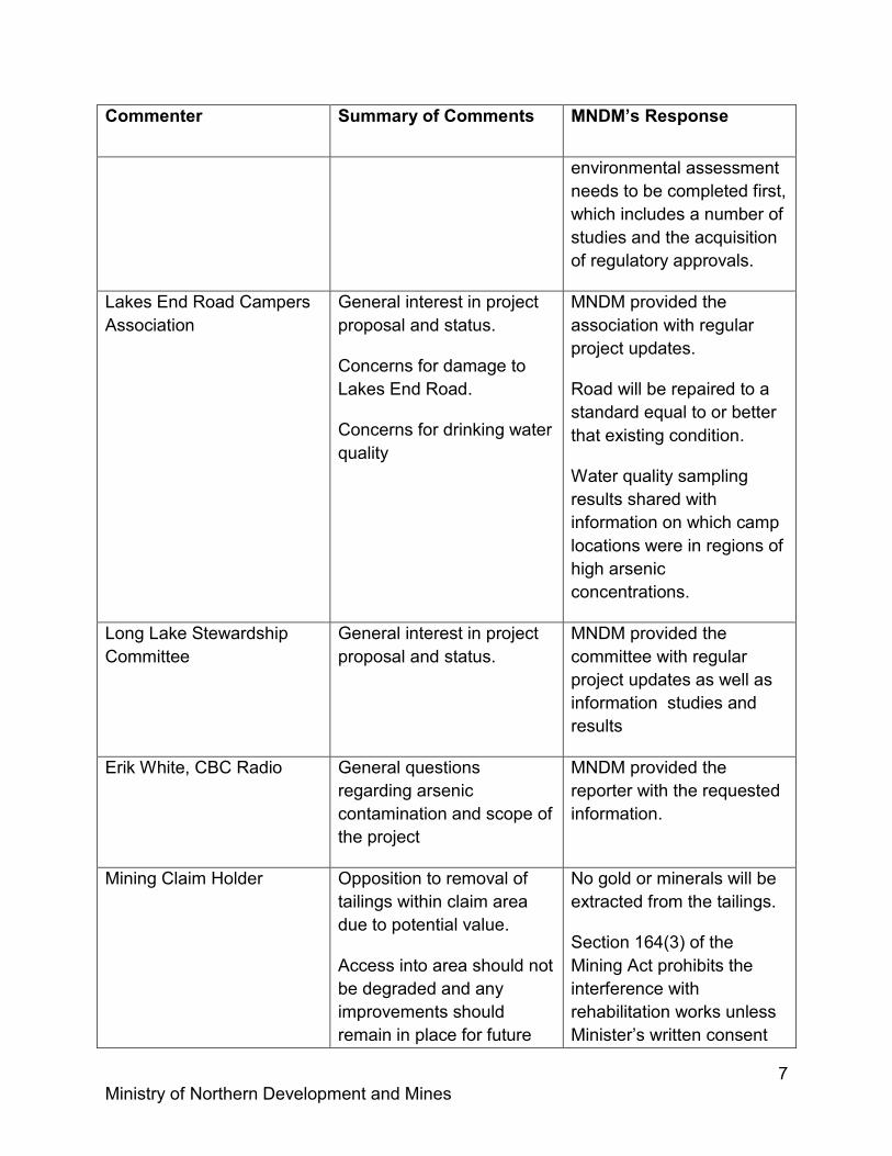
7 Ministry of Northern Development and Mines
Commenter Summary of Comments MNDM’s Response
environmental assessment needs to be completed first, which includes a number of studies and the acquisition of regulatory approvals.
Lakes End Road Campers Association
General interest in project proposal and status.
Concerns for damage to Lakes End Road.
Concerns for drinking water quality
MNDM provided the association with regular project updates.
Road will be repaired to a standard equal to or better that existing condition.
Water quality sampling results shared with information on which camp locations were in regions of high arsenic concentrations.
Long Lake Stewardship Committee
General interest in project proposal and status.
MNDM provided the committee with regular project updates as well as information studies and results
Erik White, CBC Radio General questions regarding arsenic contamination and scope of the project
MNDM provided the reporter with the requested information.
Mining Claim Holder Opposition to removal of tailings within claim area due to potential value.
Access into area should not be degraded and any improvements should remain in place for future
No gold or minerals will be extracted from the tailings.
Section 164(3) of the Mining Act prohibits the interference with rehabilitation works unless Minister’s written consent

8 Ministry of Northern Development and Mines
Commenter Summary of Comments MNDM’s Response
use. has been obtained.
Final road condition will depend on a number of considerations, including health and safety, protection and maintenance of the cap, and the access management of the Eden Township Forest Conservation Reserve.
Tom Brooke, M.Sc. Fisheries Biologist, Ontario Federation of Anglers and Hunters (OFAH)
Generally expressed support for the proposed project. OFAH recommended that a fisheries assessment be conducted in Luke Creek prior to remediation in order to measure success (i.e., by comparing fish species and overall productivity after work is complete).
OFAH also suggested that any upgrades to existing roads/trails should not result in roads new access restrictions (e.g., road decommissioning) for existing users once the project is complete.
Luke Creek has a pH of 3 and currently contains no fishery. Low flow (pool) areas within the creek are filled with tailings. Post reclamation water quality monitoring will be completed initially. Monitoring may be expanded to include ecological recovery should surface water quality results be encouraging.
The temporary upgrades to existing roads/trails for rehabilitation purposes will not result in new/permanent access.
Ministry of the Environment and Climate Change (MOECC)
MOECC suggested improvements to the project documentation and Notice of Opportunity to Comment in order to provide a better understanding of the
The requested information will be included in the project documentation that will accompany the Notice of Completion.

9 Ministry of Northern Development and Mines
Commenter Summary of Comments MNDM’s Response
screening results, potential environmental effects, etc.
MOECC also expressed an interest in reviewing the revised project documentation prior to its release with the Notice of Completion in order to provide a technical review of the document and resolve any outstanding issues.
Also, MOECC made several technical comments regarding the Class EA Requirements and information needs of the project.
In addition, MNDM advised MOECC that their technical questions will be addressed during the upcoming Detailed Design and Engineering phase of the remediation work.
Broder-Dill Snowmobilers Association
Expressed concern that the proposal refers to off road vehicles, but there is no specific mention of snowmobile trails.
The reference to off-road vehicles in the project summary describes the current limitations to accessing the mine site from Lakes End Road, not any recreational uses of the project site.
MNDM is aware of the snowmobile trail through the conservation reserve and the Broder-Dill Snowmobilers Association’s future plans to re-route it.
Stacey Laforest, Director, Environmental Health
SDHU considers MNDM’s preferred remediation plan
Turbidity and sediment will be controlled during the site

10 Ministry of Northern Development and Mines
Commenter Summary of Comments MNDM’s Response
Division, Sudbury and District Health Unit (SDHU)
to be an effective means of reducing arsenic concentration in south end of Long Lake.
SDHU requested that measures be implemented to ensure that tailings do not escape from remediation areas during remediation process. SDHU understands (based on previously presented information by MNDM) barriers will be set up to prevent contamination of lake area beyond tailings delta until tests confirm that water quality is satisfactory. SDHU recommends that these details be included in the detailed plan for proposed project.
SDHU suggested that planning should include consideration for long term potential impacts of climate change in the area (i.e., low water levels).
SDHU suggested that MNDM consider alternative materials (besides sand or gravel) for tailings containment as these may provide added protection from material erosion and tailings movement and
reclamation. MNDM will require a sedimentation control plan from the remediation contractor, prior to the initiation of the site remediation. MNDM will work with MNRF and MOEECC to ensure the measures proposed meet industry BMPs. During the site remediation, QAQC monitoring of the sediment control measures will be conducted to ensure the measures taken are effective and performing as designed.
Low water levels will be considered in establishing the extent of water cover over tailings that are to remain in Long Lake (if any are left at all).
Any tailings remaining in the lake will be armoured against erosion caused by waves, current and ice. The scour resistance of the material is determined through modelling of the potential tractive forces acting on the armouring. The details as to the type of armour covering, and the final water cover depth will be determined during the Detailed Design and

11 Ministry of Northern Development and Mines
Commenter Summary of Comments MNDM’s Response
exposure to air during periods of extremely low water levels. SDHU recommended that these details be included in the detailed plan for the proposed project.
SDHU recommended that MNDM considers long term monitoring of the tailings impoundment to ensure that future contamination does not occur.
SDHU recommends that the tailings impoundment area be designed to protect ground water.
Engineering phase of the remediation work.
The Ontario Regulation 240/00 of the Ontario Mining Act requires tailings impoundments to be monitored in accordance with the Canadian Dam Association Dam Safety Guidelines.
The reclamation program will be designed to prevent the off-site migration of contaminants from the mine site area. This will include the protection of groundwater.
Wavy Lake Roads Board Expressed concern with damage to roads.
Lakes End Road is currently not maintained by roads board because it is below MTO standard. Do not want to assume additional maintenance costs.
Road will be repaired to a standard equal to existing condition.
Lakes End Road will not be upgraded to a MTO standard.

12 Ministry of Northern Development and Mines
Appendix
Notice of Opportunity to Provide Input
Notice of Completion
Questions and Answers from November 26, 2013 Public Information Session
Questions and Answers from May 26, 2016 Public Information
Notice of Opportunity to Provide Input on a Category C Project
Class Environmental Assessment for Activities of the Ministry of Northern Development and Mines under the Mining Act
Long Lake Gold Mine Remediation Project
The Ministry of Northern Development and Mines (MNDM) invites you to comment on the MNDM's proposal to remediate the abandoned Long Lake Mine site in Sudbury, Ontario. Please see below for a map showing the project location (Figure 1).
This proposed Category C project is being carried out in accordance with the Class Environmental Assessment for MNDM’s Activities under the Mining Act (Class EA).
MNDM will also be cooperating with the Ministry of Natural Resources and Forestry (MNRF) to mitigate the potential environmental effects of a temporary upgrade to an existing access road through the Eden Township Forest Conservation Reserve.
MNDM is the lead ministry for consulting on, and coordinating, this proposed project. MNRF will participate in this Class EA process to ensure that Category B project evaluation requirements under the Class Environmental Assessment for Provincial Parks and Conservation Reserves are also considered.
A project summary for this proposed project is available at http://www.mndm.gov.on.ca/en/mines-and-minerals/mining-act/class-environmental-assessment-activities/long-lake-gold-remediation
You are invited to provide input and express any concerns about this proposed project. Comments must be received by April 19, 2015. For more information, or to submit comments on the project, please contact:
Steve Reitzel, P. Eng. Project Engineer 933 Ramsey Lake Road Sudbury, ON P3E 6B5 Ph: 705-670-5731 Fx: 705-670-5803 [email protected]
Please note that personal information provided in a submission (such as name, address, and telephone number) and your views and opinions are being collected by MNDM under the authority of the Environmental Assessment Act for the purpose of engaging in public consultation and making decisions regarding the project. The personal information may also be shared with the Environmental Approvals Branch of the Ministry of the Environment and Climate Change. The collection, use, and disclosure of this information are all governed by the Freedom of Information and
1

Protection of Privacy Act. Questions about the collection of this information should be directed to the contact listed above.
2

Figure 1: Project Location
3
1
Notice of Completion for a Category C Project Class Environmental Assessment for Activities of the Ministry of Northern
Development and Mines under the Mining Act
Long Lake Gold Mine Remediation Project
The Ministry of Northern Development and Mines (MNDM) has completed its assessment on the MNDM's proposal to remediate the abandoned Long Lake Mine site in Sudbury, Ontario. Please see below for a map showing the project location (Figure 1).
The Category C screening, consultation and planning was carried out in accordance with the Class Environmental Assessment for MNDM’s Activities under the Mining Act (Class EA).
A variety of rehabilitation options were considered by MNDM. The selected option will involve the relocation of all of the tailings into a new tailings impoundment to be constructed on an existing tailings area. The impoundment will be capped with a low permeability cover design to shed rainfall and snowmelt, preventing water from coming in contact with the encapsulated tailings. Tailings that are completely submerged within Long Lake are stable and do not produce acidity or leach metal contamination. Therefore, the preferred remediation plan is proposing that only the tailings with less than two meters of water cover be relocated to the tailings impoundment. Areas where tailings have been excavated would be graded and vegetated. Natural drainage channels, creek beds and a wetland will be restored in an effort to return the site to its natural state as much as possible.
MNDM is working to identify aggregate sources that are close to the project area in order to reduce haul distances. Trucks will be subject to MTO regulations and municipal by-laws that control dust and noise emissions. Timing restrictions will be applied to minimize disturbance to residents along haul routes.
Existing road access to the tailings site is only available along the south side of Long Lake and through the Eden Township Forest Conservation Reserve, which includes Lakes End Road and approximately 2 kilometres of road limited to ATVs and off-road vehicles use. Access through the conservation reserve is the most cost-effective and reasonable approach for the undertaking. New roads are not permitted in the conservation reserve, but the maintenance and/or upgrading of existing roads are allowed. The road through the conservation reserve will be upgraded to enable large trucks and machinery to reach the site for the duration of the project. MNDM will be

2
working with the Ministry of Natural Resources and Forestry to minimize impacts to values within the reserve, including red pine and cedar trees; and to ensure that Category B project evaluation requirements under the Class Environmental Assessment for Provincial Parks and Conservation Reserves are also considered. Upon completion of the work, the road will be returned to a condition that meets the management objectives for the conservation reserve while considering long-term access for mine site inspection, care and maintenance.
The project documentation for this proposed project is available at http://www.mndm.gov.on.ca/en/mines-and-minerals/mining-act/class-environmental-assessment-activities/long-lake-gold-remediation .
You are invited to bring any new information or concerns to MNDM by September 24, 2017. For any concerns that cannot be resolved in discussion with MNDM, interested persons may submit a Part II Order request (see Section 7.5 Part II Order Process of MNDM’s Class EA) to the Minister of the Environment and Climate Change requesting that the project be made subject to the individual environmental assessment requirements of the Environmental Assessment Act. Requests must be received by the Minister of the Environment and Climate Change by September 24, 2017 with a copy to MNDM.
To receive additional information, inspect the project file or submit new concerns regarding the project, please contact:
Eric Cobb, Environmental Planner Mine Rehabilitation, Inspections & Compliance Section, Ministry of Northern Development and Mines, 933 Ramsey Lake Road, Sudbury, ON I P3E 6B5 Phone: (705) 670-5624 Fax: (705) 670-5803
After September 24, 2017, if MNDM is satisfied that there are no outstanding concerns, the project will be implemented as planned without additional notice.
Please note that personal information provided in a submission (such as name, address, and telephone number) and your views and opinions are being collected by MNDM under the authority of the Environmental Assessment Act for the purpose of engaging in public consultation and making decisions regarding the project. The personal information may also be shared with the Environmental Approvals Branch of the Ministry of the Environment and Climate Change. The collection, use, and disclosure of this information are all governed by the Freedom of Information and Protection of Privacy Act. Questions about the collection of this information should be directed to the person listed above.

3
Figure 1: Project Location

Long Lake Gold Remediation – Public Information Session
Questions and Answers
November 27, 2013 at the Holiday Inn, Sudbury
(2013-11-27) Long Lake Public Information Session.docx Page 1
Qs and As recorded by MNDM. Answers edited for clarity and accuracy before distribution.
Q. What other chemicals were reviewed? A. The laboratory analyses looked at 48 different metals as well as general chemistry.
Although several metals were elevated in the runoff from the mine site, arsenic is the only contaminant that exceeds the drinking water limit in the receiver (Long Lake) and is the contaminant of concern for this study. Reclamation efforts to reduce arsenic levels will also reduce other contaminant concentrations as well.
Q. Was the lake bottom also sampled as well as the water? A. Three boreholes installed into the Long Lake delta were sampled. Q. Were fish sampled? A. MOE sampled fish tissue in September and October 2013. The results will be available
in the spring of 2014. Q. Does 2600 m3 delta volume extent include those underwater? A. No that is the extent of the tailings that are exposed above the water table based on the
August sampling period. Q. Did you use “their” volume estimate or did you use your own calculation when
looking at reclamation options? A. Tailings volume estimates from the previous study (AMEC 2007) were used to evaluate
reclamation option. Based on information collected, CH2M Hill believe the AMEC volume estimates are conservative i.e. AMEC has overestimated the volume of tailings present.
Statement: The bay is shallow and the area turns brown on a windy day. Response: OK Q. Is the glory hole draining at all? A. CH2M Hill - we did not look at this closely, but didn’t feel it was a substantial source of
contamination. Arsenic concentrations in the water in the Glory Hole (based on surface sampling) were 100 times lower than the runoff downstream of the tailings areas.
Q. Did you sample downstream from Long Lake? A. MNDM - We’ve sampled in Round lake, the LaVasse River and Lake Penage. Values in
Round Lake were as high as 10 ug/L as discussed earlier, the LaVasse River was similar to Round Lake. About 3 km into Penage Lake the arsenic concentration was 6 ug/L.
Q. You just proved what we have been trying to say, values fluctuate based on weather
conditions.

Long Lake Gold Remediation – Public Information Session
Questions and Answers
November 27, 2013 at the Holiday Inn, Sudbury
(2013-11-27) Long Lake Public Information Session.docx Page 2
A. That’s right. Wet weather brings more contaminants and tailings from the mine site. During dryer weather, as demonstrated by the CH2M Hill modelling, the fugitive tailings in Luke Creek are the larger contributor. Also, turbidity will result in higher arsenic levels. Sample preparation by the lab involves acidifying the sample. This strips arsenic and other metals from the suspended solids in the water and results in higher arsenic concentration reported than are actually dissolved in the water sample.
Statement: That’s two metres of water cover, which is a long way out in that shallow bay. Response: Yes Q. Where is the dividing line between Crown & FN land, is the wetland on FN land A. Yes. Q. Under reducing conditions you can get reductive dissolution of arsenic. Arsenic
behaves differently to most metals and under reducing conditions arsenic can be soluble.
A. CH2M Hill - Correct, however there is no evidence of reducing (i.e. low oxygen) conditions in the south basin of Long Lake. Dissolved Oxygen (DO) profiling, as well as arsenic and iron speciation sampling, by MOE and MNDM this summer looked for reduced conditions in the south basin of Long Lake There was no evidence of low DO conditions or reduced species of arsenic or iron present. Further details are provided in the Site Characterization Report.
Q. Was your firm able to do the work you wanted for the award price that you bid for the
project? A. CH2M Hill - Yes, we were able to complete the scope of work we proposed. Q. Wetlands are on FN land but were not part of the study A. A variety of sampling was collected in the wetland area including sediment profiling, two
cross sections, as well as surface water sampling. Fugitive tailings have been identified in the wetland and presented here. However, background sampling in the wetland has shown elevated arsenic concentrations, suggesting there may be more tailings further upstream. Additional delineation in the wetland area is required to clarify this.
Q. So will further work be done? A. Further delineation will be completed as part of the detailed design phase. Q. Are you working with the Federal government? A. MNDM - We have kept Health Canada in the loop as to our activities and results. We’ve
been in recent contact with INAC to discuss the implications of doing cleanup work on federal land.
Long Lake Gold Remediation – Public Information Session
Questions and Answers
November 27, 2013 at the Holiday Inn, Sudbury
(2013-11-27) Long Lake Public Information Session.docx Page 3
Q. How will you relate to FN, being that this is Federal land? A. MNDM - We will be meeting with FN in December. We have been keeping the band
informed of what we are doing. We’ve conducted joint sampling with band office staff and we are in touch with the associated federal agencies.
Q. Is there a reason for the different sampling dates in Round Lake? A. MNDM - Sampling was conducted jointly with band office staff on Round Lake. Q. Why variation between readings in Round Lake? A. Variations are due to seasonal and weather related fluctuations. Q. Has there been any analysis of fish spawning in that area? A. MNDM - Not as part of this study. Our focus has been on remediating the mine site.
The current assessment work and monitoring have been directed at identifying the contaminant sources and looking at ways to mitigate arsenic migration from these source areas.
Q. Would an ecological risk assessment go hand in hand with remediation? A. No, not necessarily. MNDM’s objective is to reduce the impact of the contaminants
leaching from the mine site and allow the lakes to recover on their own. Subsequent monitoring will be focused on demonstrating that the reclamation work has been effective in reducing contaminant concentrations to expected levels and the rate of recovery of impacted lakes.
Q. It’s been reported that there was $16M of gold on the site, and that the grade goes up
at depth A. CH2M collected 4 samples at various depths however grades and volumes were not high
enough to be economic. Had a discussion with Bachtech who were initially interested in project, but as time went on their interest diminished. Typically, proponents are looking for about 10 times more tailings than what Long Lake Gold has on site to make recover economically viable.
Q. Would the tailings cover just be sand and gravel? A. No the tailings would be encapsulated with a complex engineered cover. This would
typically include a compacted clay layer, or more likely a geosynthetic material such as high density polyethylene (HDPE), bitumous geomembrane (BGM), or a manufactured clay liner. These geosynthetic liners would be capped with 0.6 to 1 m of clean fill (soil) to support vegetation and protect the liner material.
Long Lake Gold Remediation – Public Information Session
Questions and Answers
November 27, 2013 at the Holiday Inn, Sudbury
(2013-11-27) Long Lake Public Information Session.docx Page 4
Q. Were any samples taken of the soil in Round Lake? A. There were no soil samples collected in Round Lake as part of this study. The AA
community is looking to complete study in Round and other area lakes to assess the overall ecological health of the lakes.
Q. How much control does the ministry have to reclaim this land? Will Sunrise Resources
still be able to explore? A. Once rehabilitation is completed, authorization from the MDNM Director is required to
disturb the rehabilitation measures. Any authorized disturbance would require a plan to rehabilitate the area when completed and financial assurance would have to be posted before the work could begin.
Q. Will Fisheries people be consulted? A. Yes. The detailed design phase of the cleanup will address permitting and requirements
for in-water work from the Department of Oceans and Fisheries. Q. Is this a complete fix? 50%? 75%? 100%? A. This will result in a significant improvement. Our goal and expectation is that water
quality in the receiving water bodies will no longer present a health or environmental risk. Monitoring will continue after reclamation to confirm the effectiveness of remedial measures that have been implemented.
Q. Will this result in the waters of Long Lake being within the acceptable level? A. That’s what we expect, but we will have to continue monitoring and determining
whether there is more work needed. Q. Once you consolidate the tailings what keeps it consolidated? A. The tailings will be encapsulated in a low permeability cover material such as high
density polyethylene (HDPE plastic), BGM, etc. Detailed engineering on the containment of the tailings is part of the next phase of work.
Q. Can you tell us the size of the wetland? A. Don’t remember size but it was measured and we can get that to you. Q. There is a group of LU students doing studies on what species should be planted on
disturbed lands at Long Lake Gold. Will you consult with them? A. Yes, we have been working with some of them and have their report on work completed
this summer.

Long Lake Gold Remediation – Public Information Session
Questions and Answers
November 27, 2013 at the Holiday Inn, Sudbury
(2013-11-27) Long Lake Public Information Session.docx Page 5
Q. How permanent will this rehab solution be? How many years will it last? A. The encapsulated tailings will require long-term maintenance and repair. Geosynthetic
covers such as HDPE do not last indefinitely, but are expected to last a few hundred years. Regular inspection and repair will ensure that the rehabilitation measures are permanent.
Q. This sounds like a unique problem. Has no one else ever had these problems? A. (CH2M Consultant) Acid mine drainage and metal leaching is not unique to Long Lake
Gold. I have had experiences all over the world on projects like this. MEND (Mine Environment Neutral Drainage) is a Canadian organization that coordinates research and case studies on remediation of mine sites across Canada. We have done similar work on the Deloro Mine site (near Peterborough) where arsenic is a problem.
Q. What will this cost? A. We will be looking at cost later in the project once the preferred option is selected. Cost
is one of 5 factors reviewed in determining the preferred option. Q. Why does MOE have Deloro as the lead and MNDM is the lead on this site? A. MOE holds/owns the Deloro site. Q. I have lived and swam in this water all my life what are the potential health effects? A. (SDHU) the current health concern for Long Lake is limited to the consumption of the
water. There is a risk that drinking or cooking with the lake water could have health impacts. The SDHU has issued an advisory that recommends residents in the south basin of Long Lake do not drink or prepare food with untreated lake water. The key risk is drinking. Swimming is not a major risk.
Q. How many years do you expect the levels to increase after rehab before you will see
improvements A. We are not expecting an increase in arsenic levels during the reclamation work.
Measures will be taken to isolate the work areas and to limit the disturbance to the surrounding areas. Monitoring will be required during dredging operations to ensure arsenic levels do not increase.
Q. Is there funding for the detailed design study? A. Yes Q. Is it worth continuing with sediment control? A. We have installed a rock check dam at the end of the tailing area which appears to be
effective is minimizing the migration of solids further downstream.
Long Lake Gold Remediation – Public Information Session
Questions and Answers
November 27, 2013 at the Holiday Inn, Sudbury
(2013-11-27) Long Lake Public Information Session.docx Page 6
Q. Arsenic values were probably worse previously. What would happen if nothing is done?
A. There is still a lot of arsenic remaining in the tailings and this will continue to migrate into Long Lake. The receiving water bodies cannot start to recover until the source of the arsenic is cleaned up.
Q. Does arsenic flush out or concentrate? A. Arsenic is expected to flush out of the lakes once the source of arsenic to the lakes (i.e.
the mine site) is removed. Q. Can the presentation be made available? A. Yes, we will be making the presentation available upon request. And we will give the
presentation to the Long Lake Stewardship Committee to post on their website. http://www.waldentoday.ca/files/_2013-11-27_LLGM_MNDM_Nov27_13_FINAL.pdf.
Q. Does this mean there are tailings at the entrance to Round Lake? A. No not to our knowledge. Arsenic concentrations measured in Round Lake at the outfall
from Long Lake, are comparable to Long Lake, which is expected. Q. Do the levels of arsenic in Round Lake mean there are tailings there? A. We have seen no evidence of tailings in Round Lake. We believe the arsenic in Round
Lake is due to the surface water discharge from Long Lake. Q. Will tailings continue to infiltrate through the cover once it’s remediated? A. The cover will prevent infiltration to the tailings and subsequently significantly reduce
seepage as well. The cover will be sloped to encourage precipitation to runoff and will be constructed of a low permeability material such as a geosynthetic, effectively encapsulating the tailings.
Q: Will you be doing bathymetry in the bay? A: The city has bathymetry for area lakes on their website and we have obtained this
information from them. However a more detailed assessment may have to be completed for the tailings delta to better estimate the volume of tailing Delta that will have to be removed to 2m below the lake level.
Q. How are tailings removed from lake? A. There are several methods such as dredging, excavation, slurry (suction). This will be
assessed as part of the detailed design work.

1
Long Lake Reclamation Project Open House, Holiday Inn, Regent Street, Sudbury
7 – 9 pm Thursday May 26, 2016
Questions and Answers
Q – During your investigation did you look at the bedrock hydrogeology?
A – Four monitoring wells were extended 3 m in to the bedrock under the TA-01 tailings area to assess permeability of the shallow bedrock. The bedrock permeability was measured at 10-4
cm/s. We have concerns that groundwater migration from the hills surrounding TA-01 could cause a groundwater mound under the cover, and potentially lift the tailings cover. A French drain is being installed in the floor of the new impoundment to relieve any groundwater pressures. Depending on the quantity and quality of the seepage, we are hoping to be able to treat it using passive treatment technologies.
Q – What kind of passive treatment?
A – The passive treatment would be in the form of a constructed wetland or permeable reactive barrier (PRB). The system would create “reduced” conditions be remove oxygen and cause change to the seepage chemistry such that the arsenic would precipitate as an arsenic sulphide.
The form of treatment will depend on the quantity and quality of seepage. In the short term, periodic active treatment of stored effluent may have to be treated in the short term. The assessment work for this has not taken place yet.
Q – To what standard do you have to treat the water before you release it into the lake.
A – The water quality standard for our effluent discharge will be determined in conjunction with the MOECC. We will need to assess the assimilative capacity of the receiver (i.e. Long Lake). MOECC will take into consideration the existing quality of the effluent, the duration and quantity of the discharge, and assess the overall benefit. We have allowed a year (2017-18) to put this and other permits in place.
Q – You mentioned you would be capping the lake sediments with clay?
A – The lake sediment will be capped with sand and gravel to prevent erosion. The intent is to keep any remaining contaminated sediment submerged.

2
Q – Some of the disturbed soil needs to settle – how does that affect the construction time?
A – We found that 50% of settlement within TA-01 tailings area is going to happen within 2 to 2.5 years. We will still have an additional 50% that will still take some time. We are looking at approximately 9 years for 100% of the settlement to occur.
We are looking at filling the impoundment over a 2 years period to so that we can achieve the initial 50% of the settlement before we cap the tailings. We will design the cap to absorb the remaining 50%. Settlement can cause the cap to pond water, or in a worst case scenario, tear the geotextile cover material.
Q – When you were looking at the options did you look at the fact that care and maintenance is for eternity… as well as on-going monitoring?…
A – Long term care and maintenance affects most of the options that are available to us. Even when we looked at removal, our experience with removing tailings and contaminated soils, is that you never get it all, which results in you returning to the site to pick up material that was missed.
Long term care and maintenance is costed by calculating the lump sump required today to generate enough interest (at 3% RR) to provide perpetual care and maintenance. This can then be compared to sites with little or no care and maintenance costs.
All options will require post remediation monitoring. Monitoring costs are small relative to the capital of C&M costs and typically would not drive the decision.
Q – Did you consider off site disposal?
A – we looked at it both from a gold recovery perspective and [didn’t actually say what the other perspective was] . It wasn’t a problem economically; it was a problem logistically. We would be paying on a per tonnes basis. We would be transferring the environmental liability to someone else and there has to be a benefit to do that.
Q – what would be the land classification – would it be considered a rehabilitated landfill site
A – it would be considered a rehabilitated works (?) [discussed protection, closure plans, directors discretion]. There are possibilities to reopen it (for mining) but you have to go through processes.
Q – does the ministry own the site?
A – the hazard belongs to the crown. There are two privately held surface rights.

3
Q – when you were talking about the tailing removing methodology, you talked about 2 options, excavating during winter and dredging during summer. Have you also talked of assessing the noise level, especially of the dredging during the summer?
A – we have a big list of advantages and disadvantages. We have set criteria, when we go out for the bidding, we will ask for the best solution and the ministry will select the best option. Noise would be part of that; noise would be significant. Air, dust, ground water, surface water.
There’s a variety of ways to cordon off the area. You can use a physical dam. The physical barrier, the sedimentation barrier… we would have monitoring and protocol in place. That would have to be part of the plan. The contractor has to isolate the area from the rest of the lake; there should be no cross contamination at all. [went into detail about quality assurance/ quality control, gave examples of other projects].
One of the reasons we are proposing to isolate Luke Creek is because there is too much water.
Q – what are the construction cost estimates at this point in time?
A – we only have a conceptual cost estimate at this time - $18M. We will do a detailed cost estimate that will not be released until we have awarded the project [explained why; so it doesn’t affect the bids].
Q – Can you make your PP presentation available to us.
A – will send out an email, will put this on a new weblink. If people have questions they can email us (MNDM, SNC Lavalin).
Q – there’s arsenic from a mine being cleaned up in Maddoc (?) by MOECC. Have you talked to them?
A. MOECC has been working on the Deloro site for a long time. We talk regularly. The site is quite different; it’s radioactive. So is the Agnew Lake site. Recently they did some work with water dams; Deloro had some problems with them. We certainly are familiar with that.
Q – can you tell us about the health effects of arsenic in water
A – the regulatory requirements are related to drinking water. [discussed levels] From our perspective we’re trying to meet the drinking water level. The health unit did send an advisory around that had an attachment that talked about the health effects of arsenic.
Q – [something about arsenic in a well at a school?]

4
A - that’s normal… We’re using drinking water limit as a guideline. The fish consumption guidelines also have limits…
Q – what areas of long lake are not fishable
A – it’s just at south bay MOECC compared the two populations [south end, Moxam landing?]… it’s at the very south end of long lake where the mine discharges. The other parts of the lake have no restrictions for arsenic.