London Borough of Brent Employment Land Study
112
Final Report London Borough of Brent Employment Land Study Prepared for: London Borough of Brent Prepared by: URS Corporation Limited February 2009
Transcript of London Borough of Brent Employment Land Study

Final Report
London Borough of Brent Employment Land Study
Prepared for:
London Borough
of Brent
Prepared by:
URS Corporation
Limited
February 2009

London Borough of Brent Employment Land Study February 2009 Final Report Issue No 1 49316012


LB Brent Employment Land Study
Final Report
February 2009
49316012
Project Title: London Borough of Brent Employment Land Study Report Title: Final Report Project No: 49316012 Status: Final Report Client Contact Name: Alexander Hearn Client Company Name: London Borough of Brent
Issued By: URS Economics and Development
St. George’s House, 2nd Floor St. George’s Road Wimbledon London SW19 4DR
Document Production/Approval Record
Issue No: 1 Name Signature Date Position
Anthony Batten 16/02/2009 Project Director
Prepared by
Elena Di Biase Jonathan Howells
16/02/2009
Project Manager Researcher
Checked by
Anthony Batten 16/02/2009 Project Director
Approved by
Rory Brooke 16/02/2009 Quality Control
Document Revision Record
Issue No Date Details of Revisions
1 01/08/2008 Draft Report
2 30/08/2008 Draft Report 2
3 10/09/2008 Final Draft Report
4 11/02/2009 Final Draft Report v2
5 16/02/2009 Final Report

LB Brent Employment Land Study
Final Report
February 2009
49316012
LIMITATION
URS Corporation Limited (URS) has prepared this Report for the sole use of London Borough of Brent in accordance with the Agreement under which our services were performed. No other warranty, expressed or implied, is made as to the professional advice included in this Report or any other services provided by us. This Report may not be relied upon by any other party without the prior and express written agreement of URS. Unless otherwise stated in this Report, the assessments made assume that the sites and facilities will continue to be used for their current purpose without significant change. The conclusions and recommendations contained in this Report are based upon information provided by others and upon the assumption that all relevant information has been provided by those parties from whom it has been requested. Information obtained from third parties has not been independently verified by URS, unless otherwise stated in the Report.
Where field investigations have been carried out, these have been restricted to a level of detail required to achieve the stated objectives of the services. The results of any measurements taken may vary spatially or with time and further confirmatory measurements should be made after any significant delay in using this Report.

LB Brent Employment Land Study
Final Report
February 2009 i
49316012
CONTENTS
Section Page No
ABBREVIATIONS........................................................................................................................ IV
1 INTRODUCTION.............................................................................................................. 1
1.1 Context ............................................................................................................................. 1 1.2 Relevant Policies.............................................................................................................. 2 1.3 Study Area........................................................................................................................ 6 1.4 Approach .......................................................................................................................... 6 1.5 Report Structure............................................................................................................... 7
2 QUANTITY, QUALITY AND CHARACTERISTICS OF EMPLOYMENT LAND............. 8
2.1 Introduction....................................................................................................................... 8 2.2 Total Supply of Designated Employment Land.............................................................. 10 2.3 Breakdown of Designated Employment Land................................................................ 17 2.4 Comparative Analysis of Employment Sites .................................................................. 18 2.5 Conclusions.................................................................................................................... 30
3 EMPLOYMENT LAND FORECASTS............................................................................ 31
3.1 Introduction..................................................................................................................... 31 3.2 Changes to Demand for Employment Land 2006-2016................................................. 32 3.3 Changes to Demand for Employment Land 2006-2026................................................. 33 3.4 Frictional Vacancy and Demand for Waste Land 2006-2026 ........................................ 34 3.5 Conclusions.................................................................................................................... 35
4 CONCLUSIONS AND SITE RECOMMENDATIONS.................................................... 36
4.1 Introduction..................................................................................................................... 36 4.2 Conclusions.................................................................................................................... 36 4.3 Site Recommendations .................................................................................................. 41
APPENDIX A: VACANT EMPLOYMENT LAND........................................................................ 53
APPENDIX B: DETAILED SITE SURVEY RESULTS................................................................ 55
APPENDIX C: SITE PLANS ....................................................................................................... 69
APPENDIX D: EMPLOYMENT LAND STUDY QUESTIONNAIRE ........................................... 84

LB Brent Employment Land Study
Final Report
February 2009 ii
49316012
CONTENTS
Section Page No
TABLE OF FIGURES
Figure 4-1: Former Northern Food site, BR01............................................................................. 70 Figure 4-2: Northfields Industrial Estate, BR02........................................................................... 70 Figure 4-3: Mount Pleasant/Beresford Avenue, BR03 ................................................................ 71 Figure 4-4: Woodside End/Sunleigh Road, BR04....................................................................... 71 Figure 4-5: Alperton House/Abercorn Commercial Centre, BR05 .............................................. 72 Figure 4-6: Minavil House Rosemont Road, BR06 ..................................................................... 72 Figure 4-7: Bridgewater-Road, BR07 .......................................................................................... 73 Figure 4-8: Athlon Road, BR08 ................................................................................................... 73 Figure 4-9: Alperton Lane, BR09................................................................................................. 74 Figure 4-10: Asiatic Carpets, BR10............................................................................................. 74 Figure 4-11: Cobbold Estate, BR11 ............................................................................................ 75 Figure 4-12: Sapcote Estate, BR12............................................................................................. 75 Figure 4-13: Artesian Close, BR13.............................................................................................. 76 Figure 4-14: Chancel House, BR14 ............................................................................................ 76 Figure 4-15: Capitol Industrial Park, BR15.................................................................................. 77 Figure 4-16: Sarena House, BR16 .............................................................................................. 77 Figure 4-17: Kingsbury Road Industrial Estate, BR17 ................................................................ 78 Figure 4-18: Neasden Lane North and South, BR 18 and BR19 respectively ............................ 78 Figure 4-19: Edgware Road Bus Garage, BR22......................................................................... 79 Figure 4-20: Twyford Tip, BR23 .................................................................................................. 79 Figure 4-21: Former Guinness Site, BR25 and First Central Site (not in Strategic Industrial Location) ...................................................................................................................... 80 Figure 4-22: Neasden SEA, BR26 .............................................................................................. 80 Figure 4-23: Wembley SEA, BR27.............................................................................................. 81 Figure 4-24: Staples Corner, BR28 ............................................................................................. 81 Figure 4-25, East Lane, BR29..................................................................................................... 82 Figure 4-26: Park Royal SEA, all surveyed sub-sites ................................................................. 83

LB Brent Employment Land Study
Final Report
February 2009 iii
49316012
CONTENTS
Section Page No
LIST OF TABLES
Table 2-1: LB Brent Total Quantum of Designated Employment Land, 2008............................. 10 Table 2-2: LB Brent Designated Employment Areas, 2008 ........................................................ 11 Table 2-3: Surveyed Sites within LB Brent’s SEAs, BEAs and LEAs ......................................... 13 Table 2-4: B1, B2 and B8 Land in Brent’s SEAs, BEAs and LEAs, 2008 ................................... 17 Table 2-5: Updated Vacant Land Situation at LB Brent SEAs and BEAs, 2008 ......................... 18 Table 2-6: Employment Sites with Good/Very Good Quality of Buildings................................... 20 Table 2-7: Employment Sites with Good/Very Good Quality of Environment and Public Realm .......................................................................................................................................... 21 Table 2-8: Employment Sites with Poor/Very Poor Quality of Buildings ..................................... 22 Table 2-9: Employment Sites with Poor/Very Poor Quality of Environment and Public Realm .......................................................................................................................................... 22 Table 2-10: Employment Sites with Adequate Servicing ............................................................ 24 Table 2-11: Employment Sites with Adequate Parking ............................................................... 25 Table 2-12: Employment Sites with Inadequate Servicing.......................................................... 26 Table 2-13: Employment Sites with Inadequate Parking ............................................................ 26 Table 2-14: Employment Sites with Good/Very Good Strategic Road Access ........................... 28 Table 2-15: Employment Sites with Good/Very Good Public Transport Access, 2007............... 29 Table 2-16: Employment Sites with Direct or Indirect Access to Waterways.............................. 30 Table 3-1: Gross and Net Employment Land Demand 2006-2016, Low .................................... 32 Table 3-2: Gross and Net Employment Land Demand 2006-2016, High ................................... 33 Table 3-3: Gross and Net Employment Land Demand 2006-2026, Low .................................... 34 Table 3-4: Gross and Net Employment Land Demand 2006-2026, High ................................... 34 Table 3-5: Employment Land Demand Forecast Summary ........................................................ 35 Table 4-1: Employment Land Supply and Demand, Low and High ............................................ 36 Table 4-2: Pipeline Supply by Use Class .................................................................................... 40 Table 4-3: Illustration of Employment Land Use Change............................................................ 48 Table 4-4: Updated Vacant Land Situation at LB Brent SEAs and BEAs in 2008 ...................... 54 Table 4-5: Summary of Site Survey Results – Site Information, Quality, and Services, Facilities and Amenities............................................................................................................... 56 Table 4-6: Summary of Site Survey Results – Neighbourhood Uses, and Development Constraints and Opportunities ..................................................................................................... 62 Table 4-7: Summary of Site Survey Description ......................................................................... 67

LB Brent Employment Land Study
Final Report
February 2009 iv
49316012
ABBREVIATIONS
BEAs Borough Employment Areas
DCLG Department for Communities and Local Government
DPD Development Plan Documents
ELDS Employment Land Demand Study
ELS Employment Land Study
GLA Greater London Authority
IBPs Industrial Business Parks
LB Brent London Borough of Brent
LDF Local Development Framework
LDS Local Development Scheme
LEAs Local Employment Areas
ODPM Office of the Deputy Prime Minister
PILs Preferred Industrial Locations
PPG Planning Policy Guidance
PPS Planning Policy Statements
PTAL Public Transport Accessibility Levels
SEAs Strategic Employment Areas
SIL Strategic Industrial Locations
SPD Supplementary Planning Documents
SPG Supplementary Planning Guidance
UDP Unitary Development Plan
VAT Value Added Tax
VOA Valuation Office Agency
LB Brent Employment Land Study
Final Report
February 2009 Page 1
49316012
1 INTRODUCTION
URS was commissioned in June 2008 by the London Borough of Brent to assess the quantity, quality and viability of employment land throughout the Borough.
This LB Brent Employment Land Study (LB Brent ELS) builds on and compliments the LB Brent Employment Land Demand Study (LB Brent ELDS) the URS itself undertook in 2006. The purpose of the additional work is threefold, providing an extension of the analysis of demand for employment land in the London Borough of Brent (LB Brent) up to 2026 from 2016, a reconciliation of the total supply and demand for employment land based on up-to-date 2007 information and a qualitative assessment of Strategic and Borough Employment Areas including recommendation on land use change and de/re-allocation of sites from or for employment uses.
The two reports together constitute an important piece of work that will guide future planning policy and decisions. Brent Council is progressing in the development of its Local Development Framework (LDF) and these studies will form part of the evidence base to support this Framework.
The methodology of this study is in line with ODPM/DCLG’s Guidance Notes on Employment Land Reviews (2004) which focuses on the B use class orders, that is B1 (Offices, Research and Development and Light Industry), B2 (General Industry) and B8 (Storage or Distribution). Additional guidance was provided by the ‘Industrial Capacity SPG’ (2008) and Draft PPS4 ‘Planning for Sustainable Economic Development’ (2007) as well as the ‘Recycling and Recovery Facilities – sites investigation in London (2005) and to investigate the potential of the analysed clusters to accommodate the demand for Waste facilities in the borough.
1.1 Context
In 2006 URS together with GVA Grimley were commissioned by the London Borough of Brent to undertake an employment land demand study to determine the level and type of demand for employment land in the London Borough of Brent (LB Brent).
The Core Strategy Preferred Options and Site Specific Allocations have undergone initial consultation in late 2006 – early 2007, and will be submitted for an Examination in Public (EIP) public consultation following examination by the Secretary of State in early 2009.
Planning Policy Guidance 12 (PPS12) ‘Local Spatial Planning’ requires Core Strategies and Development Planning Documents to be justifiable based on a ‘robust and credible evidence base’.
This LB Brent ELS is intended to be an addendum to the 2006 Employment Land Demand Study strengthening its role as evidence base to the LDF process. It aims at complimenting the LB Brent ELDS with additional qualitative assessment of designated employment land against a robust set of criteria accounting for physical opportunities

LB Brent Employment Land Study
Final Report
February 2009 Page 2
49316012
and constraints, sustainable development, and strategic planning factors. Based on revised projections of employment land demand to 2026, the study also aims at reconciling supply and demand for future employment uses and ultimately at suggesting a portfolio of sites that may either be retained in their current form, need intervention to improve their current conditions, or be reallocated or released to other uses. It also identifies sites that are suitable for accommodating waste and recycling uses.
1.2 Relevant Policies
Below we provide an outline of the policies and strategies relevant to employment and employment land in LB Brent. A more thorough review is provided in the London Borough of Brent Employment Land Demand Study (2006), Section 3. Here we summarise the relevant updated documents that have been issued since 2006 or are in the process of being completed at the national, regional and local level. We also provide more details on documents that specifically refer to Waste and Industrial Land.
1.2.1 National
PPS3: Housing
PPS3 was released in November 2006 and replaces the previous PPG3. The Government’s key housing policy goal is to ensure that everyone has the opportunity to live in a decent home, which they can afford, in a community where they want to live. The statement has four key objectives that include:
• To achieve a wide choice of high quality homes, both affordable and market housing, to address the requirements of the community;
• To widen opportunities for home ownership and ensure high quality housing for those who cannot afford market housing, in particular those who are vulnerable or in need;
• To improve affordability across the housing market, including by increasing the supply of housing; and
• To create sustainable, inclusive, mixed communities in all areas, both urban and rural.
The Statement identifies that to ensure effective use of land Local Planning Authorities should consider a range of incentives or interventions that could help to ensure that previously developed land is developed in line with market trajectories. This should include:
• Planning to address obstacles to the development of vacant and derelict sites and buildings, for example, use of compulsory purchase powers where that would help resolve land ownership or assembly issues;
• Considering whether sites that are currently allocated for industrial or commercial use could be more appropriately re-allocated for housing development; and

LB Brent Employment Land Study
Final Report
February 2009 Page 3
49316012
• Encouraging innovative housing schemes that make effective use of public sector previously developed land.
Draft PPS4: Planning for Sustainable Economic Development
In December 2007 the DCLG produced a Draft PPS4. The statement emphasises the important role that economic development plays in the planning process providing a policy framework for this at the regional and local levels. With respect to employment land, the statement emphasises the importance of flexibility in catering for the increasing diversity of businesses and jobs. In particular, it states that site allocations for B class uses should be flexible. It also states that, where possible, authorities need to identify and plan for new or emerging sectors likely to locate in the region/sub-region/local area or which the regional planning body or local planning authority wish to attract to the region or area, whilst maintaining flexibility to accommodate sectors not anticipated in the plan.
Further to this, the statement looks to separate certain types of industry from sensitive use classes that would be detrimental to amenity, a potential source of pollution or accidental hazard. The statement identifies the importance of the efficient and effective use of land and states that due to the increasing demands on the land available for development, local planning authorities should seek the most efficient and effective use of land and buildings, especially vacant or derelict buildings (including historic buildings). The key notion here is recognising the needs of a business. They should also take into account changing working patterns, economic data including price signals and the need for policies, which reflect local circumstances.
Finally, it states that all economic development should improve the quality of the environment in which it operates.
PPS10: Planning for Sustainable Waste Management
Published in July 2005 PPS10 requires that a broad range of sites including existing industrial estates should be considered when deciding where to locate new waste and recycling facilities. Effort should be made to locate waste processing facilities close to the producers of waste which are often those operating in existing business and industrial areas.
It also suggests that local waste planners should look for opportunities to locate complementary facilities together on appropriate sites. When identifying sites for waste management facilities PPS10 suggests that local waste planners assess sites using the following criteria:
• ‘The extent to which they support the policies in PPS10’; • The physical and environmental constraints on development, including
existing and proposed neighbouring land uses’;

LB Brent Employment Land Study
Final Report
February 2009 Page 4
49316012
• The cumulative effect of previous waste disposal facilities on the well-being of the local community, including any significant adverse impacts on environmental quality, social cohesion and inclusion or economic potential’;
• The capacity of existing and potential transport infrastructure to support the sustainable movement of waste, and products arising from resource recovery, seeking when practicable and beneficial to use modes other than road transport’; and
• Give priority to the re-use of previously-developed land, and redundant agricultural and forestry buildings and their curtilages’.
1.2.2 Regional
London Plan
The London Plan (February 2008 - Consolidated with Alterations since 2004) is the spatial strategy for Greater London spanning the next fifteen to twenty years. It sets out an integrated social, economic and environmental framework for the future development of London. The relevant policies are stated below.
An overall strategic policy of the Plan provides London boroughs with guidance on the development of their local plans and states that such strategies should:
• Focus retail, leisure, key commercial activity and services in suburban metropolitan, major, district and local town centres. Where such centres do not already have good levels of public transport accessibility and capacity, improvements should be promoted;
• Promote areas around suburban town centres that have good access by public transport and on foot to the town centre as appropriate for higher-density and mixed-use development including housing; and
• Improve the sustainability of suburban residential heartlands by promoting better access to centres, employment and community facilities, improving the public realm, making efficient use of space, and where appropriate, modernising or redeveloping the housing stock.
Further to this, the London Plan divides London into sub-regions to facilitate the implementation of its strategic policies. LB Brent forms part of the West London Sub-Region along with Hammersmith & Fulham, Ealing, Harrow, Hillingdon, Hounslow and Kensington and Chelsea. Policy 5F.1 in the Plan sets out a number of strategic priorities for West London and those particular to LB Brent and the region These priorities aim to:
• ‘Optimise the development of Opportunity Areas including the realisation of the potential of Wembley as a nationally and internationally significant sports, leisure and business location, co-ordinated with town centre regeneration and new housing’;
• ’Manage the re-use of surplus industrial land taking into account the need to accommodate additional waste management facilities’; and to

LB Brent Employment Land Study
Final Report
February 2009 Page 5
49316012
• Optimise the development of Opportunity Areas and Areas for Intensification, including Wembley and Park Royal/Willesden Junction.
The London Plan also defines the Strategic Industrial Location framework as ‘intended to reconcile the demand for, and supply of, productive industrial land in London’. The LB Brent hosts a portion of the Park Royal SIL, appointed as a mix of Industrial Business Park (IBP) and Preferred Industrial Locations1 (PIL). It further hosts East Lane, Staples Corner and Wembley (part), which are listed among the IBPs.
Industrial Capacity Supplementary Planning Guidance (SPG)
The document has been updated in March 2008 following the publication of the London Plan - Consolidated with Alterations since 2004. The Industrial Capacity SPG still identifies three categories for criteria based land transfer policies in London boroughs:
• Restricted Transfer – generally having a limited supply of employment sites requiring a restrictive approach to the transfer of industrial sites to other uses;
• Limited Transfer – generally having a greater supply of vacant industrial sites relative to demand and should generally take a more permissive approach to transfer; and
• Managed Transfer - generally having a greater supply of vacant industrial sites relative to demand and should generally take a more permissive approach to transfer.
Even in the 2008 version of the SPG the London Borough of Brent is categorised as a Borough for limited transfer.
The SPG suggests that when developing land transfer policies outside of the SIL framework and designated sites on proposals maps, boroughs should consider strategic factors, site characteristics and industrial demand factors for inclusion in such policies.
1.2.3 Local
Brent Local Development Framework
Brent Council is in the process of preparing their new Local Development Framework (LDF). In accordance with Section 15 of the Planning and Compulsory Purchase Act 2004, the Council has prepared a Local Development Scheme (LDS) that sets out the Council’s project plan for the production of documents, plans and policies that are to be included in the LDF by early 2009.
1 Industrial Business Parks are defined as areas for business requiring a high quality environment, whilst Preferred Industrial Locations are defined as areas for business with less demanding requirements.

LB Brent Employment Land Study
Final Report
February 2009 Page 6
49316012
The LDF will be a portfolio of Development Plan Documents (DPDs) and Supplementary Planning Documents (SPDs). Core components of the LDF will include:
• The LB Brent Core Strategy;
• Proposals Map;
• Site Specific Allocations;
• A Suite of Development Management Policies; and
• Waste Planning.
As discussed in Section 1.2 the Core Strategy Preferred Options and the Site Specific Allocation DPD will be submitted for an EIP in early 2009.
1.3 Study Area
The study area included the whole of LB Brent designated employment areas. A vast amount of such land is concentrated in the Strategic Employment Areas (SEAs) of Wembley and Park Royal - all of which are allocated for employment use within the LB Brent adopted Unitary Development Plan (UDP) (2004). In addition there are a number of Borough Employment Areas (BEAs), including East Lane and Staples Corner, predominantly hosting B2/B8 as well as B1 use classes and others clustered throughout the Borough, a number of which are less than five hectares in size. Other sites that ‘provide, or are capable of providing, local employment opportunities’ constitute the LB Brent’s Local Employment Areas (LEAs) and were identified for the LB Brent through the LB Brent’s Industrial Land Use Survey 2006 – these areas include sites ’on the fringes of Strategic and Borough Employment Areas, scattered large sites and a considerable number of smaller sites dispersed throughout the Borough including its residential areas’ (LB Brent UDP 2004). The survey of all LEAs did not form part of this study as the majority of sites are single premises, however the three largest LEAs were surveyed.
1.4 Approach
The 2006 LB Brent ELDS provided a comprehensive socio-economic and business profile of the Borough, a commercial property market overview, the analysis of employment land supply data, employment land demand forecast up to 2016 and a gap analysis to assess the potential excess or shortage of available allocated and unallocated employment land in the Borough.
This LB Brent Employment Land Study provides a number of additional research elements to enable the development of a comprehensive employment land strategy for the Borough. These are outlined in more detail below, and comprise:
• Extending the projections of employment land demand up to 2026 in line with the London Plan timeframe;

LB Brent Employment Land Study
Final Report
February 2009 Page 7
49316012
• A Comprehensive analysis of existing and future supply of employment land in the Borough, including:
• A land survey of Strategic and Borough Employment Areas and three Local Employment Areas to assess the quality and suitability of the identified employment land designations for their current use. This also identifies sites that should be protected, and maybe augmented, and sites that could potentially be released or reallocated to other uses;
• The analysis of current pipeline supply of employment permission in order to undertake a comprehensive comparison of supply with demand over the LDF plan period; and
• Overall comparison of employment land supply with forecast demand (gap analysis).
1.5 Report Structure
This report sets out our final findings and recommendations for employment land in LB Brent based on a comprehensive desk review of the existing evidence base, which comprises updated supply analysis; a field survey and appraisal of individual employment areas; consultation with relevant Council Officers; and a forecasting exercise.
The remainder of this report is structured as follows:
Section 2 sets out an analysis of the overall quantum of designated employment land in Brent, together with the key findings of the allocated employment area appraisals.
Section 3 sets out the updated employment land demand forecasts, highlighting trends in employment land growth /decline in the borough and setting out a balance of supply and demand. Our synthesis forecast approach takes historic completion rates as a base for forecasting future employment floor space demand and has been revised to cover the LDF planning period.
Section 4 presents conclusions and recommendations on retention and release of employment land sites.
Appendices show details on vacant land as recorded in 2006, survey results, plans for the surveyed employment areas and the survey proforma.

LB Brent Employment Land Study
Final Report
February 2009 Page 8
49316012
2 QUANTITY, QUALITY AND CHARACTERISTICS OF EMPLOYMENT LAND
2.1 Introduction
In this section we look at the current employment land supply. We consider the quantity and key characteristics of designated employment areas. Coupled with review of existing and emerging policy (Section 1), discussions with the client group, and findings from the 2006 ELDS this will help develop recommendations on future use and strategy up to 2026.
The 2006 Employment Land Demand Study presented an analysis of the total stock of employment land based on information from the 2006 Industrial Land Employment Survey by the LB Brent. In this section we rely on the same dataset to provide information on the quantity of designated employment land (as per the adopted UDP). This includes the full quantum of designated employment land – that is Strategic, Borough and Local employment land – which in total covers approximately 382 hectares (see Table 2-2).
The Council have since 2006 confirmed that LEAs, that is the employment land with least strategic importance in the Council’s designated employment land hierarchy, have been subject to extensive change of use and an internal review of the baseline has established that there are actually 63.6 hectares of LEAs as opposed to the 113 hectares as recorded in the 2006 ELDS. Therefore the revised baseline of land that is designated for employment use in this study is 382 hectares as opposed to 432 hectares as recorded in the 2006 report. It should be noted however that the baseline position from which the floorspace and associated land requirements have been derived remains the 249 hectares of actual sites within active employment uses2.
We present a summary of key findings from the field survey and desk research, as conducted in June 2008. We provide a comparative analysis based on key features explored through the survey of Strategic, Borough and Local Employment Areas. The full Employment Land Study Questionnaire is enclosed in Appendix D. The questionnaire covered a wide range of factors including: existing and predominant land uses, policy allocations; quality of the site; services, facilities and amenities; neighbourhood uses and negative impacts on the site; development constraints and opportunities as well as evidence of active marketing of sites for employment use. The full results from the survey are presented in Table 4-5 and Table 4-6 in Appendix B. These tables should be considered together with Table 4-7 which presents a qualitative description of the sites.
2 See Section 3 for a full discussion of the difference between designated employment land and land with active employment uses.

LB Brent Employment Land Study
Final Report
February 2009 Page 9
49316012
Our comparative analysis within this section covers the 35 surveyed employment sites accounting for all Strategic and Borough employment land (318 hectares) and key Local employment sites (totalling 4 hectares), which are incumbent on Major Opportunity Sites indicated on the adopted 2004 UDP Proposals map (and also the largest LEAs). The remaining LEAs not surveyed comprised predominantly small sites in B1, B2 and B8 employment use, often in the form of single premises. Survey of such premises was beyond the scope of this study.

LB Brent Employment Land Study
Final Report
February 2009 Page 10
49316012
2.2 Total Supply of Designated Employment Land
Brent Council currently classifies its employment land in three categories: Strategic Employment Areas (SEAs), Borough Employment Areas (BEAs) and Local Employment Areas (LEAs). The SEAs and BEAs are protected for employment use by the policies set out in the UDP.
Strategic Employment Areas
Brent’s SEAs are recognised as having significance to London as a whole and are identified as Preferred Industrial Location (PILs) or Industrial Business Parks (IBPs) in the London Plan. These designations are intended to meet the needs of different types of industry by providing a range of premises and environments. IBPs are intended for businesses requiring a high quality environment while PILs are for businesses with less demanding requirements.
Borough Employment Areas
Borough Employment Areas (BEAs) are considered well suited to retention for industrial use. These are generally larger sites providing a range of plot sizes and premises for a variety of business activities, including those with potential bad-neighbour uses. These sites do not have the same level of strategic accessibility but still have good access to main roads and transport links.
Local Employment Areas
Local Employment Sites are generally smaller sites scattered throughout residential areas but there are also a number of larger sites providing local employment opportunities. These sites have less strategic importance but are still fulfilling a function or meeting a demand within the community.
Table 2-1 below presents the total quantum of Brent’s designated employment land together with the source of information.
Table 2-1: LB Brent Total Quantum of Designated Employment Land, 2008
Designated Employment Area Total Size (Ha) Source SEAs 256 LB Brent Industrial Land Survey 2006
BEAs 62 LB Brent Industrial Land Survey 2006
LEAs 64 Revised information from LB Brent Industrial Land Survey 2006
Total 382
Table 2-2 identifies all the Borough’s designated employment areas by category. The table shows the total land within the employment areas, i.e. within SEAs, BEAs and LEAs.

LB Brent Employment Land Study
Final Report
February 2009 Page 11
49316012
For the purpose of the comparative analysis of employment areas we refer to each of the employment areas as ‘sites’. Larger employment areas, such as Park Royal, Wembley, Alperton, Church End, Honeypot Land and Neasden Lane have then been broken down to more distinctive sub-areas or ‘sites’. Table 2-2 also shows the number of such sub-areas that have been identified within each SEA and BEA for the purpose of the survey and that have therefore been surveyed and appraised. Plans for all the surveyed sites are enclosed in Appendix C.
Table 2-2: LB Brent Designated Employment Areas, 2008
Employment Area Total Size (Ha) % of Sub-total
Number of Surveyed Sites
within Employment
Areas Strategic Employment Areas
Park Royal 117 46% 8 Abbeydale 9 3% 1 Beresford 9 3% 1 East Lane 17 7% 1 Wembley 25 10% 2 Neasden 42 16% 1 Staples Corner 38 15% 1 Sub-total 256 100% 15
Borough Employment Areas Alperton 26 42% 6 Brentfield Road 4 7% 1 Church End 9 14% 3 Colindale 7 12% 1 Cricklewood 1 2% 1 Honeypot Lane (North & South) 5 8% 2 Kingsbury 6 10% 1 Neasden Lane 3 5% 2 Sub-total 62 100% 17
Local Employment Areas3 Within Main Industrial Estates 38 59% 1 Outside Main Industrial Estates 26 41% 2 Sub-total 64 100% 3
Total 382 35
Source: LB Brent Industrial Land Survey 2006, LB Brent 2008
3 As discussed in the main body of report, an internal review has confirmed LEAs have been subject to extensive change of use and an internal review of the baseline has established that there are actually 63.6 hectares as opposed to the 113 hectares as recorded in the 2006 Employment Land Demand Study.

LB Brent Employment Land Study
Final Report
February 2009 Page 12
49316012
In this section we will provide a summary of the comparative analysis for the surveyed SEAs, BEAs and LEAs.
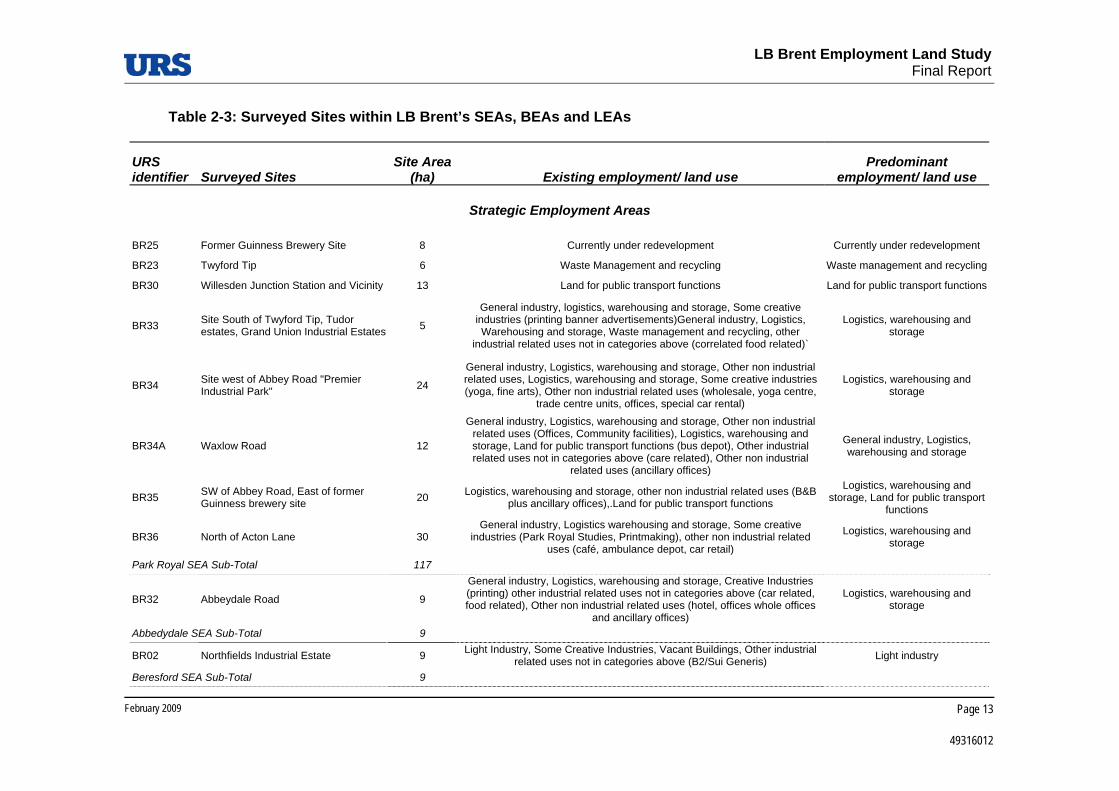
Table 2-3 lists all the 35 appraised sites within Brent’s designated employment areas, together with their size, existing land uses and predominant land use.
LB Brent Employment Land Study
Final Report
February 2009
Page 13
49316012
Table 2-3: Surveyed Sites within LB Brent’s SEAs, BEAs and LEAs
URS identifier Surveyed Sites
Site Area (ha) Existing employment/ land use
Predominant employment/ land use
Strategic Employment Areas
BR25 Former Guinness Brewery Site 8 Currently under redevelopment Currently under redevelopment
BR23 Twyford Tip 6 Waste Management and recycling Waste management and recycling
BR30 Willesden Junction Station and Vicinity 13 Land for public transport functions Land for public transport functions
BR33 Site South of Twyford Tip, Tudor estates, Grand Union Industrial Estates 5
General industry, logistics, warehousing and storage, Some creative industries (printing banner advertisements)General industry, Logistics, Warehousing and storage, Waste management and recycling, other
industrial related uses not in categories above (correlated food related)`
Logistics, warehousing and storage
BR34 Site west of Abbey Road "Premier Industrial Park" 24
General industry, Logistics, warehousing and storage, Other non industrial related uses, Logistics, warehousing and storage, Some creative industries (yoga, fine arts), Other non industrial related uses (wholesale, yoga centre,
trade centre units, offices, special car rental)
Logistics, warehousing and storage
BR34A Waxlow Road 12
General industry, Logistics, warehousing and storage, Other non industrial related uses (Offices, Community facilities), Logistics, warehousing and storage, Land for public transport functions (bus depot), Other industrial related uses not in categories above (care related), Other non industrial
related uses (ancillary offices)
General industry, Logistics, warehousing and storage
BR35 SW of Abbey Road, East of former Guinness brewery site 20 Logistics, warehousing and storage, other non industrial related uses (B&B
plus ancillary offices),.Land for public transport functions
Logistics, warehousing and storage, Land for public transport
functions
BR36 North of Acton Lane 30 General industry, Logistics warehousing and storage, Some creative
industries (Park Royal Studies, Printmaking), other non industrial related uses (café, ambulance depot, car retail)
Logistics, warehousing and storage
Park Royal SEA Sub-Total 117
BR32 Abbeydale Road 9
General industry, Logistics, warehousing and storage, Creative Industries (printing) other industrial related uses not in categories above (car related, food related), Other non industrial related uses (hotel, offices whole offices
and ancillary offices)
Logistics, warehousing and storage
Abbedydale SEA Sub-Total 9
BR02 Northfields Industrial Estate 9 Light Industry, Some Creative Industries, Vacant Buildings, Other industrial related uses not in categories above (B2/Sui Generis) Light industry
Beresford SEA Sub-Total 9

LB Brent Employment Land Study
Final Report
February 2009
Page 14
49316012
URS identifier Surveyed Sites
Site Area (ha) Existing employment/ land use
Predominant employment/ land use
BR29 East Lane 17 Logistics, warehousing and storage, Land for public transport functions (bus depot), Other industrial related uses not in categories above (care related),
Other non industrial related uses (ancillary offices)
Logistics, warehousing and storage
East Lane SEA Sub-Total 17
BR01 Former Northern Foods site 2 Other non industrial related uses (Vacant) Other non industrial related uses (vacant)
BR27 Rest of Wembley SEA 23 General industry, Logistics, Warehousing and storage, Waste management
and recycling, other industrial related uses not in categories above (correlated food related)`
Logistics, warehousing and storage
Wembley SEA Sub-Total 25
BR26 Neasden SEA 42 Light industry, Logistics, warehousing and storage, some creative industries,
Other industrial related uses not in categories above, Other non industrial related uses (Retail)
Logistics, warehousing and storage
Neasden SEA Sub-Total 42
BR28 Staples Corner 38 Logistics, warehousing and storage, Some creative industries (yoga, fine
arts), Other non industrial related uses (wholesale, yoga centre, trade centre units, offices, special car rental)
Logistics, warehousing and storage
Staples Corner SEA Sub-Total 38
SEAs Sub-Total 256
Borough Employment Areas
BR03 Mount Pleasant/Beresford Avenue 4 Light industry, Logistics, Warehousing and storage, Some creative
industries, Other industrial related uses not in categories above (B2/Sui Generis)
Other industrial related uses not in categories above (B2/Sui
Generis)
BR05 Alperton House/Abercorn Commercial Centre 2
General Industry, Logistics, Warehousing and Storage, Light Industry, Other industrial related uses not in categories above (office), Other non-industrial
related uses (retail)
Other non industrial related uses (Offices)
BR06 Minavil House/Rosemont Road 1 Light Industry, General Industry, Logistics, Warehousing and storage, Utilities, Some creative industries, Other non industrial related uses (school)
Logistics, warehousing and storage
BR07 Bridgewater Road 1 General Industry, Other non industrial related uses (retail) Land for public transport functions
BR08 Athlon Road 8 Light industry, General industry, Logistics, Warehousing and storage Logistics, warehousing and storage
BR09 Alperton Lane 10 General Industry, Warehousing and storage, Waste management and recycling, Other non industrial related uses (restaurant)
Logistics, warehousing and storage

LB Brent Employment Land Study
Final Report
February 2009
Page 15
49316012
URS identifier Surveyed Sites
Site Area (ha) Existing employment/ land use
Predominant employment/ land use
Alperton BEA Sub-Total 26
BR13 Artesian Close Industrial Estate 4 General Industry, Logistics, warehousing and storage utilities (power station), other non industrial related uses (retail) Utilities
Brentfield Road BEA Sub-Total 4
BR10 Asiatic Carpets/Dalmeyer Road 3 Light industry, General industry, Some creative industries, Other industrial related uses non in categories above (offices), Other non industrial related
uses (Retail), Logistics, Warehousing and Storage
Logistics, warehousing and storage
BR11 Cobbold Estate 3 Light industry, General, Logistics, warehousing and storage, Some creative
industries, Other industrial related uses not in categories above (offices), Other non industrial related uses (retail)
Logistics, warehousing and storage
BR12 Sapcote Trading Estate 3 Light industry, General industry, Logistics, warehousing and storage, Some
creative industries, Other industrial related uses not in categories above (office)
Logistics, warehousing and storage
Church End BEA Sub-Total 9
BR15 Capitol Industrial Park 7 Light industry, Utilities, logistics, Warehousing and storage, Other non industrial related uses (green spaces, hair and beauty, DIY)
Logistics, warehousing and storage
Colindale BEA Sub-Total 7
BR17 Kingsbury Road Industrial Estate 6 Light industry, Logistics, warehousing and storage, other industrial related uses not in categories to above (office), Some creative Industries Light industry
Kingsbury BEA Sub-Total 6
BR18 Neasden Lane North 2 Logistics, Warehousing and Storage, Other industrial related uses not in category above (B2/Sui Generis)
Logistics, Warehousing and Storage
BR19 Neasden Lane South 1 Logistics, Warehousing and Storage Logistics, Warehousing and Storage
Neasden Lane BEA Sub-Total 3
BR20 Honeypot Lane North 3 Logistics, Warehousing and Storage, Other industrial related uses not in
categories above (B2/Sui Generis), Other non industrial related uses (Offices, Retail)
Other industrial related uses not in categories above (B2/Sui
Generis)
BR21 Honeypot Lane South 2 General industry, Other industrial related uses not in categories above (B2/Sui Generis), Other non industrial related uses (offices and shops)
Other industrial related uses not in categories above (B2/Sui
Generis) Honeypot Lane BEA Sub-Total 5
BR22 Edgware Road Bus Garage 1 Land for public transport functions Land for public transport functions
Cricklewood Sub-Total 1
BEAs Sub-Total 62

LB Brent Employment Land Study
Final Report
February 2009
Page 16
49316012
URS identifier Surveyed Sites
Site Area (ha) Existing employment/ land use
Predominant employment/ land use
Local Employment Areas
BR04 Woodside End/Sunleigh Road 2 Other industrial related uses not in categories above (B2/Sui Generis), Light industry, Some creative industries
Other industrial related uses not in categories above (B2/Sui
Generis)
BR14 Chancel House 1 Other industrial related uses not in categories above (office) Other industrial related uses not in categories above (office)
BR16 Sarena House 1 Light industry, Utilities Light industry
LEAs Sub-Total 4
SURVEYED TOTAL 322
Non Surveyed LEAs Sub-Total4 60
GRAND TOTAL 382
Source: URS LB Brent Employment Land Study 2008
4 As discussed in the main body of the report, the remaining LEAs that were not surveyed comprised predominantly small sites in B1, B2 and B8 employment use, often in the form of single premises. Survey of such premises was beyond the scope of this study.

LB Brent Employment Land Study
Final Report
February 2009 Page 17
49316012
2.3 Breakdown of Designated Employment Land
As described in the 2006 LB Brent ELDS, the activities taking place on Brent’s designated employment areas cover a broad range of uses, as summarised in Table 2-4. More detail on vacant land is provided below and in Table 2-5
Table 2-4: B1, B2 and B8 Land in Brent’s SEAs, BEAs and LEAs, 20085
Land Use Area (Ha) B1 25 B2 105 B8 119 Total B1, B2 and B8 249 Vacant Land 17 Non B Use Class Activities: Retail, Residential and Other 116 Total 382
Source: URS LB Brent Employment Land Demand Study, LB Brent 2008
Totals may not add up due to rounding.
The 2006 LB Brent ELDS report highlighted a large amount of vacancy within the Borough’s SEAs and BEAs, totalling 48.6 hectares out of the 432 hectares of land recorded within employment allocations (see Table 2-1). Much of this vacancy was clustered in Park Royal, with 39.5 hectares concentrated among the former Guinness sites, Twyford Tip, and Waxlow Road, with a further 4.3 hectares in the East Lane Industrial Estate. The remainder of the vacant land was scattered among small sites, with only two of them being between 1 and 2 hectares and the rest being less than one hectare in size.
Information retrieved from the Council on implemented and unimplemented planning permissions shows that the current quantum of vacancy is considerably lower than 48.6 hectares. A summary of the analysis of the 2006 vacancy is presented in Table 2-5, and full details are set out in Table 4-4 in Appendix A.
5 As discussed the Council has advised on a number of changes in the data source, as a result the revised total quantum of designated employment land differs from the 432 hectares presented in the 2006 ELDS report.

LB Brent Employment Land Study
Final Report
February 2009 Page 18
49316012
Table 2-5: Updated Vacant Land Situation at LB Brent SEAs and BEAs, 2008
Site Area (Ha) Current vacant land (without any planning permission on site) 6
Vacant sites with planning permission 11
Vacant sites with planning permission, which fall outside the designated land boundaries 9
No longer vacant (as identified through updated LBB information in 2008) 22
Total 2006 Vacant Land 49
Source: LB Brent 2008
Totals may not add up due to rounding
As shown in Table 2-5 a large amount of the 48.6 hectares are either accounted have been developed since 2006. The 6.3 hectares of vacant land and those with outstanding planning permission have been recommended to accommodate additional demand for employment land (see Table 4-3).
2.4 Comparative Analysis of Employment Sites
This section offers an overview of the characteristics of the 35 surveyed sites within Brent’s designated employment areas, for which plans are enclosed in Appendix C. It present a snapshot of the quality of the surveyed sites against key criteria as outlined in Government guidance including the adequacy of services and facilities on site, and accessibility by private and public transport and waterways. These aspects are relevant to assess the suitability of employment uses for the surveyed sites, and therefore feed into the recommendations presented in Section 3 as does other research conducted. The listed sites are grouped by employment area6.
Other factors, for instance the presence of sensitive receptors (e.g. residential, education or health uses) in the neighbour or the impact that the surrounding sites may have on the surveyed site, are also important in driving recommendation on their future use.
Judgments are informed by all factors presented in Table 4-5, Table 4-6, and Table 4-7.
6 As discussed in Section 2.2, for the purpose of this comparative analysis we refer to each of the employment areas as ‘sites’. Larger employment areas, such as Park Royal, Wembley, Alperton, Church End, Honeypot Land and Neasden Lane have then been broken down to more distinctive sub-areas or ‘sites. The table also shows the number of such sub-areas that have been identified within each SEA and BEA for the purpose of the survey and that have therefore been surveyed and appraised. Please see Appendix C for the surveyed sites plans.

LB Brent Employment Land Study
Final Report
February 2009 Page 19
49316012
2.4.1 Quality
The quality of employment areas was assessed through site visits. Criteria used to assess this dimension include conditions of buildings and quality of the environment and public realm. Such features were not assessed for vacant sites or sites currently under construction.
Good/Very Good Employment Sites
Surveyed sites were deemed to be of good or very good quality if they hosted buildings in good or very good conditions, and/or if the quality of their environment was good or very good. Some of the sites were host to good quality buildings but poor quality environment, on occasions for instance there was poor pedestrian provision or poor landscaping but with recently refurbished premises. For this reason we present below the information for the two elements separately.
Good/Very Good Conditions of Buildings
To be designed as sites with buildings in good/very good conditions, the site areas had to fulfil the following conditions:
Very good – buildings in immaculate state, no signs of paint coming off, windows and window frames in very good condition, immediate surrounding/grounds well kept.
Good – buildings in good condition, small areas where paint might come off, etc., grounds in reasonable state.
50% or more of all the buildings were either good or very good in 27 of the surveyed sites, totalling approximately 286.0 ha of employment land. Those sites cover a variety of land uses, ranging from light industry, to offices, to storage and warehousing.
Table 2-6 summarises the information for all the sites.

LB Brent Employment Land Study
Final Report
February 2009 Page 20
49316012
Table 2-6: Employment Sites with Good/Very Good Quality of Buildings
URS Identifier Site
Designated Employment Area
Site Area (Ha)
BR05 Alperton House/Abercorn Commercial Centre Alperton BEA 1.8 BR06 Minavil House/Rosemont Road Alperton BEA 1.5 BR07 Bridgewater Road Alperton BEA 1.1 BR08 Athlon Road Alperton BEA 8.1 BR09 Alperton Lane Alperton BEA 9.8 BR13 Artesian Close Industrial Estate Brentfield Road BEA 4.4 BR10 Asiatic Carpets/Dalmeyer Road Church End BEA 3.1 BR11 Cobbold Estate Church End BEA 2.7 BR12 Sapcote Trading Estate Church End BEA 3.2 BR15 Capitol Industrial Park Colindale BEA 7.2 BR22 Edgware Road Bus Garage Cricklewood BEA 1.3 BR29 East Lane East Lane SEA 17.0 BR20 Honeypot Lane North Honeypot Lane BEA 3.0 BR17 Kingsbury Road Industrial Estate Kingsbury Road BEA 6.2 BR14 Chancel House LEA 0.9 BR18 Neasden Lane North Neasden Lane BEA 2.5 BR19 Neasden Lane South Neasden Lane BEA 0.8 BR26 Neasden SEA Neasden SEA 41.7 BR23 Twyford Tip Park Royal SEA 5.6 BR30 Willesden Junction Station and Vicinity Park Royal SEA 12.5
BR33 Site Section of Twyford Tip, Tudor estates, Grand Union Industrial Estates Park Royal SEA 4.8
BR34 Site East of Abbey Road "Premier Industrial Park" Park Royal SEA 23.7 BR34a Waxlow Road Park Royal SEA 11.9 BR35 SW of Abbey Road, East of former Guinness brewery site Park Royal SEA 19.8 BR36 North of Acton Lane Park Royal SEA 30.0 BR28 Staples Corner Staples Corner SEA 38.4 BR27 Rest of Wembley SEA Wembley SEA 23.1
Total 286.0
Source: URS LB Brent Employment Land Study 2008
Good/Very Good Quality of Environment
To be designated as sites with good/very good environment and quality of public realm, the sites had to fulfil the following conditions:
Very Good – the streets and the public realm within and surrounding the cluster are of very good quality. There is sufficient street lighting and no perceived personal safety issues. The business area is not polluted by noise or air pollution from neighbouring uses and/or heavy street traffic.
Good – the streets and public realm within and surrounding the business cluster are of good quality but it does not reach the ‘very good’ standard (some litter, street furniture shows signs of ageing, etc.). There are no perceived safety issues.

LB Brent Employment Land Study
Final Report
February 2009 Page 21
49316012
The quality of environment and public realm was good or very good in a total of 22 surveyed sites, covering approximately 262 hectares of employment land. Table 2-7 summarises the information for these sites.
Table 2-7: Employment Sites with Good/Very Good Quality of Environment and Public Realm
URS Identifier Site
Designated Employment Area
Site Area (Ha)
BR05 Alperton House/Abercorn Commercial Centre Alperton BEA 1.8 BR06 Minavil House/Rosemont Road Alperton BEA 1.5 BR08 Athlon Road Alperton BEA 8.1 BR09 Alperton Lane Alperton BEA 9.8 BR13 Artesian Close Industrial Estate Brentfield Road BEA 4.4 BR11 Cobbold Estate Church End BEA 2.7 BR15 Capitol Industrial Park Colindale BEA 7.2 BR29 East Lane East Lane SEA 17.0 BR17 Kingsbury Road Industrial Estate Kingsbury Road BEA 6.2 BR14 Chancel House LEA 0.9 BR18 Neasden Lane North Neasden Lane BEA 2.5 BR19 Neasden Lane South Neasden Lane BEA 0.8 BR26 Neasden SEA Neasden SEA 41.7 BR34 Site East of Abbey Road "Premier Industrial Park" Park Royal SEA 23.7 BR34a Waxlow Road Park Royal SEA 11.9 BR35 SW of Abbey Road, East of former Guinness brewery site Park Royal SEA 19.8 BR36 North of Acton Lane Park Royal SEA 30.0 BR33 Site Section of Twyford Tip, Tudor estates, Grand Union
Industrial Estates Park Royal SEA 4.8
BR23 Twyford Tip Park Royal SEA 5.6 BR28 Staples Corner Staples Corner SEA 38.4 BR27 Rest of Wembley SEA Wembley SEA 23.1
Total 261.8
Source: URS LB Brent Employment Land Study 2008
Poor/Very Poor Employment Sites
Poor/Very Poor Conditions of Buildings
The quality of buildings was poor or very poor in only six of the surveyed employment sites, listed below in Table 2-8. For the majority of these sites, such designation is attributable to the state of disrepair of existing buildings and lack of maintenance.

LB Brent Employment Land Study
Final Report
February 2009 Page 22
49316012
Sites BR01 (Former Northern Food Site) and BR25 (Former Guinness Brewery Site) were not assessed because the first was vacant and the latter was a site under construction.
Table 2-8: Employment Sites with Poor/Very Poor Quality of Buildings
URS Identifier Employment Area/Areas
Designated Employment Area
Site Area (Ha)
BR32 Abbeydale Road Abbeydale SEA 8.9 BR03 Mount Pleasant/Beresford Avenue Alperton BEA 3.7 BR02 Northfields Industrial Estate Beresford SEA 8.6 BR21 Honeypot Lane South Honeypot Lane BEA 1.9 BR04 Woodside End/Sunleigh Road LEA 2.0 BR16 Sarena House LEA 1.2
Total 26.1
Source: URS LB Brent Employment Land Study 2008
Poor/Very Poor Quality of Environment
The quality of the environment and public realm was poor or very poor in 11 of the surveyed sites, listed in Table 2-9 below. For the majority of these sites, such designation is attributable to the poor quality of the public realm, including evidence of fly-tipping and overgrown green spaces, and also to the poor condition of the internal road system with little attention paid to pedestrian access and movement.
Sites BR01 (Former Northern Food Site) was not assessed because vacant whereas construction works were ongoing on site BR25 (Former Guinness Brewery Site) and BR22 (Edgware Road Bus Garage).
Table 2-9: Employment Sites with Poor/Very Poor Quality of Environment and Public Realm
URS Identifier Employment Area/Areas
Designated Employment Area
Site Area (Ha)
BR12 Sapcote Trading Estate Church End BEA 3.2 BR30 Willesden Junction Station and Vicinity Park Royal SEA 12.5 BR07 Bridgewater Road Alperton BEA 1.1 BR20 Honeypot Lane North Honeypot Lane BEA 3.0 BR21 Honeypot Lane South Honeypot Lane BEA 1.9 BR10 Asiatic Carpets/Dalmeyer Road Church End BEA 3.1 BR32 Abbeydale Road Abbeydale SEA 8.9 BR02 Northfields Industrial Estate Beresford SEA 8.6 BR03 Mount Pleasant/Beresford Avenue Alperton BEA 3.7 BR16 Sarena House LEA 1.2 BR04 Woodside End/Sunleigh Road LEA 2.0
Total 49.2
Source: URS LB Brent Employment Land Study 2008

LB Brent Employment Land Study
Final Report
February 2009 Page 23
49316012
2.4.2 Services and Facilities
The quality of employment areas was assessed exclusively through site visits. Criteria used to assess this dimension include adequacy of servicing and parking within the surveyed sites.
Employment Sites with Adequate Provision
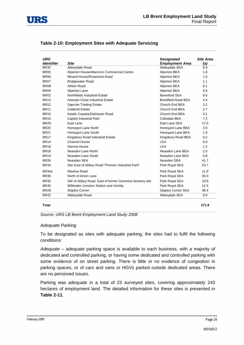
Adequate Servicing
To be designated as sites with adequate servicing, the site areas had to fulfil the following conditions:
Adequate – adequate loading and unloading space is available to each business, with a majority of dedicated loading bays as well as with some dedicated space but a majority of off-road/roadside loading bays. The internal layout of roads and loading spaces allow for easy manoeuvring of vans or HGVs. There are no perceived issues.
Servicing was deemed to be adequate in a total of 27 surveyed sites, covering approximately 272 hectares of employment land. The detailed information for these sites is presented in Table 2-10.
LB Brent Employment Land Study
Final Report
February 2009 Page 24
49316012
Table 2-10: Employment Sites with Adequate Servicing
URS Identifier Site
Designated Employment Area
Site Area (a)
BR32 Abbeydale Road Abbeydale SEA 8.9 BR05 Alperton House/Abercorn Commercial Centre Alperton BEA 1.8 BR06 Minavil House/Rosemont Road Alperton BEA 1.5 BR07 Bridgewater Road Alperton BEA 1.1 BR08 Athlon Road Alperton BEA 8.1 BR09 Alperton Lane Alperton BEA 9.8 BR02 Northfields Industrial Estate Beresford SEA 8.6 BR13 Artesian Close Industrial Estate Brentfield Road BEA 4.4 BR12 Sapcote Trading Estate Church End BEA 3.2 BR11 Cobbold Estate Church End BEA 2.7 BR10 Asiatic Carpets/Dalmeyer Road Church End BEA 3.1 BR15 Capitol Industrial Park Colindale BEA 7.2 BR29 East Lane East Lane SEA 17.0 BR20 Honeypot Lane North Honeypot Lane BEA 3.0 BR21 Honeypot Lane South Honeypot Lane BEA 1.9 BR17 Kingsbury Road Industrial Estate Kingsbury Road BEA 6.2 BR14 Chancel House LEA 0.9 BR16 Sarena House LEA 1.2 BR18 Neasden Lane North Neasden Lane BEA 2.5 BR19 Neasden Lane South Neasden Lane BEA 0.8 BR26 Neasden SEA Neasden SEA 41.7 BR34 Site East of Abbey Road "Premier Industrial Park" Park Royal SEA 23.7
BR34a Waxlow Road Park Royal SEA 11.9 BR36 North of Acton Lane Park Royal SEA 30.0 BR35 SW of Abbey Road, East of former Guinness brewery site Park Royal SEA 19.8 BR30 Willesden Junction Station and Vicinity Park Royal SEA 12.5 BR28 Staples Corner Staples Corner SEA 38.4 BR32 Abbeydale Road Abbeydale SEA 8.9
Total 271.9
Source: URS LB Brent Employment Land Study 2008
Adequate Parking
To be designated as sites with adequate parking, the sites had to fulfil the following conditions:
Adequate – adequate parking space is available to each business, with a majority of dedicated and controlled parking, or having some dedicated and controlled parking with some evidence of on street parking. There is little or no evidence of congestion in parking spaces, or of cars and vans or HGVs parked outside dedicated areas. There are no perceived issues.
Parking was adequate in a total of 23 surveyed sites, covering approximately 243 hectares of employment land. The detailed information for these sites is presented in Table 2-11.

LB Brent Employment Land Study
Final Report
February 2009 Page 25
49316012
Table 2-11: Employment Sites with Adequate Parking
URS Identifier Site
Designated Employment Area
Site Area (Ha)
BR34 Site East of Abbey Road "Premier Industrial Park" Park Royal SEA 23.7 BR34a Waxlow Road Park Royal SEA 11.9 BR26 Neasden SEA Neasden SEA 41.7 BR11 Cobbold Estate Church End BEA 2.7 BR05 Alperton House/Abercorn Commercial Centre Alperton BEA 1.8 BR06 Minavil House/Rosemont Road Alperton BEA 1.5 BR35 SW of Abbey Road, East of former Guinness brewery site Park Royal SEA 19.8 BR08 Athlon Road Alperton BEA 8.1 BR09 Alperton Lane Alperton BEA 9.8 BR36 North of Acton Lane Park Royal SEA 30.0 BR14 Chancel House LEA 0.9 BR17 Kingsbury Road Industrial Estate Kingsbury Road BEA 6.2 BR13 Artesian Close Industrial Estate Brentfield Road BEA 4.4 BR28 Staples Corner Staples Corner SEA 38.4 BR18 Neasden Lane North Neasden Lane BEA 2.5 BR29 East Lane East Lane SEA 17.0 BR12 Sapcote Trading Estate Church End BEA 3.2 BR07 Bridgewater Road Alperton BEA 1.1 BR20 Honeypot Lane North Honeypot Lane BEA 3.0 BR21 Honeypot Lane South Honeypot Lane BEA 1.9 BR10 Asiatic Carpets/Dalmeyer Road Church End BEA 3.1 BR02 Northfields Industrial Estate Beresford SEA 8.6 BR16 Sarena House LEA 1.2
Total 242.5
Source: URS LB Brent Employment Land Study 2008
Employment Sites with Inadequate Provision
Inadequate Servicing
Servicing appeared to be inadequate in five of the surveyed sites, totalling approximately 39 hectares of employment land. These sites are listed in Table 2-12 below. A common issue was the lack of adequate space, occasionally coupled with inadequate internal roads resulting in difficult manoeuvre for vehicles.
Sites BR01 (Former Northern Food Site) was not assessed because vacant whereas construction works were ongoing on site BR25 (Former Guinness Brewery Site) and BR22 (Edgware Road Bus Garage).

LB Brent Employment Land Study
Final Report
February 2009 Page 26
49316012
Table 2-12: Employment Sites with Inadequate Servicing
URS Identifier Employment Area/Areas
Designated Employment Area
Site Area (Ha)
BR33 Site Section of Twyford Tip, Tudor estates, Grand Union Industrial Estates Park Royal SEA 4.8
BR23 Twyford Tip Park Royal SEA 5.6 BR27 Rest of Wembley SEA Wembley SEA 23.1 BR03 Mount Pleasant/Beresford Avenue Alperton BEA 3.7 BR04 Woodside End/Sunleigh Road LEA 2.0
Total 39.2
Source: URS LB Brent Employment Land Study 2008
Inadequate Parking
Parking appeared to be inadequate on nine of the surveyed sites totalling approximately 40 hectares of employment land. These sites are listed in Table 2-13 below. Those sites showed a general lack of dedicated parking space, with mostly on street parking and little availability for the individual businesses.
Table 2-13: Employment Sites with Inadequate Parking
URS Identifier Employment Area/Areas
Designated Employment Area
Site Area (Ha)
BR15 Capitol Industrial Park Colindale BEA 7.2 BR19 Neasden Lane South Neasden Lane BEA 0.8 BR30 Willesden Junction Station and Vicinity Park Royal SEA 12.5 BR32 Abbeydale Road Abbeydale SEA 8.9
BR33 Site Section of Twyford Tip, Tudor estates, Grand Union Industrial Estates Park Royal SEA 4.8
BR23 Twyford Tip Park Royal SEA 5.6 BR27 Rest of Wembley SEA Wembley SEA 23.1 BR03 Mount Pleasant/Beresford Avenue Alperton BEA 3.7 BR04 Woodside End/Sunleigh Road LEA 2.0
Total 39.2
Source: URS LB Brent Employment Land Study 2008
2.4.3 Strategic Transport Access
The strategic transport accessibility of an employment area was determined predominantly through observation during site visits. Criteria used to assess this include strategic road access, access to public transport (desk research) and access to waterways.

LB Brent Employment Land Study
Final Report
February 2009 Page 27
49316012
Good/Very Good Employment Sites
Good/Very Good Strategic Road Access
Sites with good/very good strategic road access include those that can be accessed directly from the trunk road network.
33 of the surveyed sites were considered to have good/very good strategic road access. These total approximately 315 hectares employment land. Table 2-14 lists these sites.

LB Brent Employment Land Study
Final Report
February 2009 Page 28
49316012
Table 2-14: Employment Sites with Good/Very Good Strategic Road Access
URS identifier Address
Designated Employment Area Area (ha)
BR32 Abbeydale Road Abbeydale SEA 8.9 BR05 Alperton House/Abercorn Commercial Centre Alperton BEA 1.8 BR06 Minavil House/Rosemont Road Alperton BEA 1.5 BR07 Bridgewater Road Alperton BEA 1.1 BR08 Athlon Road Alperton BEA 8.1 BR09 Alperton Lane Alperton BEA 9.8 BR02 Northfields Industrial Estate Beresford SEA 8.6 BR13 Artesian Close Industrial Estate Brentfield Road BEA 4.4 BR12 Sapcote Trading Estate Church End BEA 3.2 BR11 Cobbold Estate Church End BEA 2.7 BR10 Asiatic Carpets/Dalmeyer Road Church End BEA 3.1 BR15 Capitol Industrial Park Colindale BEA 7.2 BR22 Edgware Road Bus Garage Cricklewood BEA 1.3 BR29 East Lane East Lane SEA 17.0 BR20 Honeypot Lane North Honeypot Lane BEA 3.0 BR21 Honeypot Lane South Honeypot Lane BEA 1.9 BR17 Kingsbury Road Industrial Estate Kingsbury Road BEA 6.2 BR14 Chancel House LEA 0.9 BR18 Neasden Lane North Neasden Lane BEA 2.5 BR19 Neasden Lane South Neasden Lane BEA 0.8 BR26 Neasden SEA Neasden SEA 41.7 BR34 Site East of Abbey Road "Premier Industrial Park" Park Royal SEA 23.7 BR34a Waxlow Road Park Royal SEA 11.9 BR36 North of Acton Lane Park Royal SEA 30.0 BR35 SW of Abbey Road, East of former Guinness brewery site Park Royal SEA 19.8 BR30 Willesden Junction Station and Vacinity Park Royal SEA 12.5
BR33 Site Section of Twyford Tip, Tudor estates, Grand Union Industrial Estates
Park Royal SEA 4.8
BR23 Twyford Tip Park Royal SEA 5.6 BR25 Former Guinness Brewery Site Park Royal SEA 8.4 BR28 Staples Corner Staples Corner SEA 38.4 BR27 Rest of Wembley SEA Wembley SEA 23.1
BR01 Former Northern Foods site Wembley SEA 1.7
Total 315.4
Source: URS LB Brent Employment Land Study 2008
Sites with poor/very poor strategic road access can be accessed only indirectly through local roads, and in many cases through residential areas.
Mount Pleasant/Beresford Avenue BEA, Sarena House and the Woodside End/Sunleigh Road were the only sites found to have poor access to the strategic road network.

LB Brent Employment Land Study
Final Report
February 2009 Page 29
49316012
Good/Very Good Public Transport Access
Access to public transport for employment clusters was assessed through PTAL (Public Transport Accessibility Levels) maps from 2007.
Sites that were considered to have good or very good access to public transport had PTALs (Public Transport Accessibility Levels) ranging from 4 to 6b7.Only nine sites achieved this level, adding up to approximately 28 hectares of employment land.
Most of the surveyed employment areas were however served by buses stopping generally within walking distance from the site.
Table 2-15: Employment Sites with Good/Very Good Public Transport Access, 2007
URS Identifier Site
Designated Employment Area
Site Area (ha)
BR05 Alperton House/Abercorn Commercial Centre Alperton BEA 1.8 BR06 Minavil House/Rosemont Road Alperton BEA 1.5 BR18 Neasden Lane North Neasden Lane BEA 2.5 BR12 Sapcote Trading Estate Church End BEA 3.2 BR07 Bridgewater Road Alperton BEA 1.1 BR20 Honeypot Lane North Honeypot Lane BEA 3.0 BR21 Honeypot Lane South Honeypot Lane BEA 1.9 BR19 Neasden Lane South Neasden Lane BEA 0.8 BR30 Willesden Junction Station and Vicinity Park Royal SEA 12.5
Total 28.3
Source: URS LB Brent Employment Land Study 2008
Access to Waterways
Seven of the surveyed sites had direct access to waterways and another five had indirect access totalling approximately 122 hectares of employment land. Table 2-16 lists these sites.
7 Employment clusters were allocated the PTAL level that they predominantly fell within.

LB Brent Employment Land Study
Final Report
February 2009 Page 30
49316012
Table 2-16: Employment Sites with Direct or Indirect Access to Waterways
URS Identifier Site
Designated Employment Area
Site Area (ha)
Direct Access BR32 Abbeydale Road Abbeydale SEA 8.9 BR02 Northfields Industrial Estate Beresford SEA 8.6 BR34 Site East of Abbey Road "Premier Industrial Park" Park Royal SEA 23.7 BR34a Waxlow Road Park Royal SEA 11.9 BR36 North of Acton Lane Park Royal SEA 30.0
BR33 Site Section of Twyford Tip, Tudor estates, Grand Union Industrial Estates Park Royal SEA 4.8
BR23 Twyford Tip Park Royal SEA 5.6 Indirect Access BR03 Mount Pleasant/Beresford Avenue Alperton BEA 3.7 BR05 Alperton House/Abercorn Commercial Centre Alperton BEA 1.8 BR06 Minavil House/Rosemont Road Alperton BEA 1.5 BR35 SW of Abbey Road, East of former Guinness brewery site Park Royal SEA 19.8 BR04 Woodside End/Sunleigh Road LEA 2.0
Total 122.3
Source: URS LB Brent Employment Land Study 2008
2.5 Conclusions
In this section we have provided an overview of the qualitative characteristics of Brent’s designated employment areas, that is the 318 hectares of land within SEA and BEA boundaries. We have also presented with evidence from three key LEAs, covering a total of 322 out of the overall 382 hectares of designated employment land.
The survey evidence suggests the majority of sites are suitable for their current use. However there are a number of sites where the quality of environment, buildings and internal layout pose a constraint to the existing industrial activities. In some cases poor strategic accessibility means industrial uses are likely to cause disruption to surrounding uses such as residential. In others the current employment use appears not to maximise the site potential, due to the low density uses in areas well served by public transport.
Appendix B provides information on a wider range of factors for each of the surveyed sites. This broader evidence base has been considered in conjunction with the findings of the employment land forecast exercise (see Section 3) and other considerations to inform a list of recommendations that will be presented in the Section 4.


LB Brent Employment Land Study Final Report
February 2009 Page 31
49316012
3 EMPLOYMENT LAND FORECASTS
3.1 Introduction
The employment land demand is based on three major strands of analysis:
• Forecasting changes to employment land demand as a result of employment
changes;
• Considering the optimal level of frictional vacancy for market efficiency; and
• Considering the demand for waste uses.
In Section 2.5 we present the findings from the analysis of employment land demand
in the context of the current stock of designated employment land in the Borough of
Brent.
The forecast of demand for employment land covers the B1, B2 and B8 sectors, as per
the ODPM ELR guidance note (2004). Analysis of LB Brent’s Industrial Land Use
Survey 2006 shows that within the 382 hectares of Brent’s designated employment
areas (see Section 2.2) the quantum of land hosting B1, B2 and B8 uses equals 249
hectares, as shown in Table 2-4. These 249 hectares of land in active employment
uses constitutes the basis on which the forecasts are calculated.
The forecasting exercise presented in this report reiterates the methodology followed in
the 2006 LB Brent Employment Land Demand Study. This involves adopting a
synthesised approach based on:
• Regional property market area floor space trends;
• Regional property market area employment forecasts based on macro-
economic forecasting; and
• Local factors.
The employment land demand forecasts have been extended to 2026 (from 2006)
based on the same per annum rates of change proposed in the 2006 LB Brent ELDS.
Updates to the regeneration programmes in the Borough since 2006 have been
assessed. It has not been deemed necessary to change the original forecast
assumptions. Data from 2006 was used to extend the demand forecast up to 2026,
rather than updated 2007 data. Given that this report builds upon the 2006 LB Brent
ELDS, it is considered appropriate to ensure consistency between the demand forecast
exercises undertaken in the two reports.
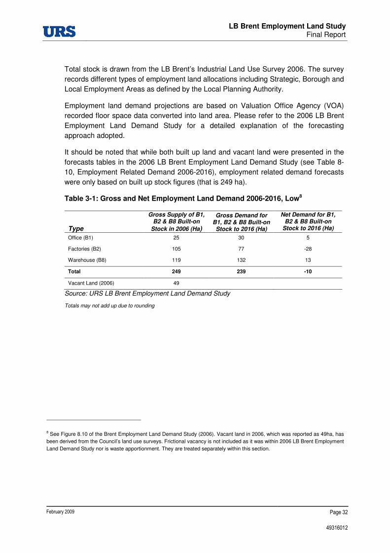
3.2 Changes to Demand for Employment Land 2006-2016
Table 3-1 and Table 3-2 present estimated gross employment land demand and net
change for B1, B2 and B8 employment uses up to 2016 as set out in 2006 LB Brent
Employment Land Demand Study (Table 8-10), for the low and high growth scenarios
respectively.
LB Brent Employment Land Study Final Report
February 2009 Page 32
49316012
Total stock is drawn from the LB Brent’s Industrial Land Use Survey 2006. The survey
records different types of employment land allocations including Strategic, Borough and
Local Employment Areas as defined by the Local Planning Authority.
Employment land demand projections are based on Valuation Office Agency (VOA)
recorded floor space data converted into land area. Please refer to the 2006 LB Brent
Employment Land Demand Study for a detailed explanation of the forecasting
approach adopted.
It should be noted that while both built up land and vacant land were presented in the
forecasts tables in the 2006 LB Brent Employment Land Demand Study (see Table 8-
10, Employment Related Demand 2006-2016), employment related demand forecasts
were only based on built up stock figures (that is 249 ha).
Table 3-1: Gross and Net Employment Land Demand 2006-2016, Low8
Type
Gross Supply of B1, B2 & B8 Built-on
Stock in 2006 (Ha)
Gross Demand for B1, B2 & B8 Built-on Stock to 2016 (Ha)
Net Demand for B1, B2 & B8 Built-on
Stock to 2016 (Ha)
Office (B1) 25 30 5
Factories (B2) 105 77 -28
Warehouse (B8) 119 132 13
Total 249 239 -10
Vacant Land (2006) 49
Source: URS LB Brent Employment Land Demand Study
Totals may not add up due to rounding
8 See Figure 8.10 of the Brent Employment Land Demand Study (2006). Vacant land in 2006, which was reported as 49ha, has
been derived from the Council’s land use surveys. Frictional vacancy is not included as it was within 2006 LB Brent Employment
Land Demand Study nor is waste apportionment. They are treated separately within this section.

LB Brent Employment Land Study
Final Report
February 2009 Page 33
49316012
Table 3-2: Gross and Net Employment Land Demand 2006-2016, High9
Type
Gross Supply of B1, B2 & B8 Built-on
Stock in 2006 (Ha)
Gross Demand for B1, B2 & B8 Built-on Stock to 2016 (Ha)
Net Demand for B1, B2 & B8 Built-on
Stock to 2016 (Ha) Office (B1) 25 32 7
Factories (B2) 105 80 -25
Warehouse (B8) 119 138 19
Total 249 250 1
Vacant Land (2006) 49
Source: URS LB Brent Employment Land Demand Study
Totals may not add up due to rounding.
3.3 Changes to Demand for Employment Land 2006-2026
The requirement is to accommodate the forecast demand for B1, B2 and B8 employment uses (which is net additional to the 249 hectares of built-on stock) up to 2026. As noted within our forecasting methodology in the 2006 Employment Land Demand Study, demand for employment land has been derived from net demand for employment floor space, which has then been converted to land using appropriate plot ratios (as per the ODPM ELR guidance note 2004). The net additional forecast demand for employment land/floor space can be accommodated on vacant and through redevelopment of existing sites.
Table 3-3 and Table 3-4 present an extension to the employment land demand forecasts up to 2026 for the low and high growth scenarios respectively. The baseline position from which the forecast demand for employment land has been made remains the total stock of actual B1, B2 & B8 land, as reported by the Council within their LB Brent’s Industrial Land Use Survey 2006 (see Section 2.2). These detailed surveys are carried out every two years by the Council and they record land use characteristics, specific occupiers and land occupied by such businesses and uses. At the time of writing the 2006 data remained the most up to date and accurate baseline data.
Table 3-3 and Table 3-4 present the gross supply and demand for employment up to 2026. They also show net demand, that is the net demand that needs accommodating in addition to the current B1, B2 and B8 stock.
9 See Figure 8.10 of the Brent Employment Land Demand Study (2006). Vacant land in 2006, which was reported as 49ha, has been derived from the Council’s land use surveys. Frictional vacancy is not included as it was within 2006 LB Brent Employment Land Demand Study nor is waste apportionment. They are treated separately within this section.

LB Brent Employment Land Study
Final Report
February 2009 Page 34
49316012
Table 3-3: Gross and Net Employment Land Demand 2006-2026, Low
Type
Gross Supply for B1, B2 & B8 Built-on
Stock in 2006 (Ha)
Gross Demand for B1, B2 & B8 Built-on Stock to 2026 (Ha)
Net Demand for B1, B2 & B8 Built-on
Stock to 2026 (Ha) Office (B1) 25 35 10
Factories (B2) 105 48 -57
Warehouse (B8) 119 145 26
Total 249 228 -21
Source: URS calculations 2008
Totals may not add up due to rounding, vacant land is accounted for in Section 3
Table 3-4: Gross and Net Employment Land Demand 2006-2026, High
Type
Gross Supply for B1, B2 & B8 Built-on
Stock in 2006 (Ha)
Gross Demand for B1, B2 & B8 Built-on Stock to 2026 (Ha)
Net Demand for B1, B2 & B8 Built-on
Stock to 2026 (Ha) Office (B1) 35 38 13
Factories (B2) 48 55 -50
Warehouse (B8) 145 157 38
Total 249 250 1
Source: URS calculations 2008
Totals may not add up due to rounding, vacant land is accounted for in Section 3
The net additional forecast demand for employment land/floor space can be accommodated on existing vacancy and through redevelopment of existing sites. Section 3.4 considers vacant land and pipeline in the context of supply and demand for employment uses.
3.4 Frictional Vacancy and Demand for Waste Land 2006-2026
Frictional vacancy is defined as the vacant land occurring as part of the normal land redevelopment process. As companies move within an area they free up existing premises they release land for new development. Frictional vacancy therefore accounts for the idle time passing between one occupier moving out of a site and a next one moving in, allowing a smooth functioning of the land market. Following URS research for the 2008 London Plan published in the London Industrial Land Release Benchmark report (URS, 2007), an appropriate amount for frictional vacancy is considered to be 5% of the forecasted quantum of land in B1, B2 and B8 uses10. Based on Table 3-3 and Table 3-4 an appropriate amount of frictional vacancy in Brent should be considered to be between 11 and 12 hectares up to 2026 (in the low and high scenarios respectively).
10 This differs from the 10% assumed in the 2006 ELDS report.

LB Brent Employment Land Study
Final Report
February 2009 Page 35
49316012
In addition to demand for employment land there is a requirement to accommodate waste uses. The Industrial Land Release Benchmarks (URS; 2007) provides a recommendation for Brent to allocate seven hectares between 2006 and 2021. This is phased as four hectares 2006-2011, 2 hectares 2011-2016 and one hectare 2016-2021. We assume here that a further hectare will be required 2021-2026 giving a total requirement for 8 hectares over the planning period 2006-2026.
3.5 Conclusions
The steps taken in the forecasting model here – giving consideration to change in demand for employment land; calculating the optimal vacant land requirement; and establishing the demand for waste uses – present a comprehensive forecast of employment land in LB Brent for the planning period 2006-2026. Table 3-5 below summarises these steps.
Table 3-5: Employment Land Demand Forecast Summary
Low Growth
Scenario High Growth
Scenario
B1, B2 & B8 Built-on Stock (2008) (249 Ha)
Plus Vacant Designated Employment Land (2008) (17 Ha) 266 266
Current Vacancy 2008 (Ha)11 -17 -17
Net Demand for B1, B2 & B8 Built-on Stock to 2026 (Ha) -21 +1
Frictional Vacancy to 2026 (Ha) +11 +13
Land Required for Waste to 2026 (Ha) +8 +8
Net Change in B1, B2 & B8 Built-on Stock 2006-2026 (Ha) -19 +5
Source: URS calculations 2008
Totals may not add up due to rounding.
In order to suggest solutions on how to meet the projected land requirements starting from existing designated employment land we rely on review of existing and emerging policy (Section 1), the evidence from our field surveys (Section 2), discussions with the client group, and findings from the 2006 Employment Land Demand Study.
In Section 4 we will draw conclusions and recommendations on how to reconcile future demand with existing supply of employment land.
11 See Table 2-5 for detailed account of the change in the stock of vacant land between 2006 and 2008.


LB Brent Employment Land Study
Final Report
February 2009 Page 36
49316012
4 CONCLUSIONS AND SITE RECOMMENDATIONS
4.1 Introduction
This section draws together the different strands of research in this Employment Land Study in a gap analysis and to form overall recommendations. The gap analysis discusses the difference between the current supply of employment land and the demand for employment land projected over the planning period. Recommendations are then introduced to address these findings and enable LB Brent to maximise the opportunities presented by the changing nature of the demand for employment land.
4.2 Conclusions
In Section 3 we set out the net additional forecast demand for employment land which is derived from floor space requirements. Table 4-1 below summarises the findings from Table 3-5 including net additional demand for B1, B2 and B8 uses and frictional land.
Table 4-1: Employment Land Supply and Demand, Low and High
Low Growth
Scenario High Growth
Scenario
B1, B2 & B8 Built-on Stock (2008) (249 Ha)
Plus Vacant Designated Employment Land (2008) (17 Ha) 266 266
Current Vacancy 2008 (Ha) -17 -17
Net Demand for B1, B2 & B8 Built-on Stock to 2026 (Ha) -21 +1
Frictional Vacancy to 2026 (Ha) +11 +13
Land required for Waste to 2026 (Ha) +8 +8
Gross Demand for B1, B2 & B8 designated 2026 (Ha) 247 271
Net Change in B1, B2 & B8 Built-on Stock 2006-2026 (Ha) -19 +5
Source: URS calculations 2008
As explained earlier in the report, the methodology used for forecasting future employment land requirements means that net change relates to B1, B2 and B8 land use stock (249 ha) plus existing vacant land designated for B use classes (17 ha) within designated employment areas. The net change for B use classes, including land for frictional vacancy and land to accommodate waste should therefore not relate to the total land figure of 382 ha which falls within designated employment areas, as a significant proportion of these areas include other uses such as retail, residential and

LB Brent Employment Land Study
Final Report
February 2009 Page 37
49316012
other developments. Therefore where designated employment land containing developments not categorised within the B use class classes is suggested for release from employment to other uses it needs to be considered in the context of supply and demand requirements for land uses in that category. For example where a site with B2 and retail use is suggested for reallocation to residential uses, the Council would need to make consideration of retail capacity requirements over the plan period as well as impacts of releasing B2 uses.
Table 4.3 suggests an illustrative re-allocation of land for and from active employment use (B1, B2 and B8). The figures for release or gain are suggested on the basis of land in actual B1, B2 and B8 uses.
This gap analysis looks at the forecast demand for employment land in the context of supply, including current vacant land as accounted for in Section 2.2.
B1 Land Use
Our forecast sets out that there is net demand to 2026 for approximately 10 to 13 hectares of land for B1 uses. This demand does not account for the large ‘strategic schemes expected to come forward at First Central and Quintain Stage 1 schemes at Park Royal and Wembley respectively. It is expected that the majority of occupiers of the floor space provided at these schemes will be ‘non-local’ in their origins i.e. multi-national corporations or London-wide operations, and floor space at these would therefore not be considered as satisfying local demand. The ‘localised’ demand, upon which the employment land demand forecasting is based, relates to the property market area relevant for Brent only12. Therefore whilst B1 floor space coming on stream as part of these schemes might satisfy a limited amount of ‘localised’ demand, the vast majority of the demand will stem from a different ‘non-local’ market, as described.
The financial and business services sectors, which would occupy B1 premises, account for a significant proportion of jobs in the LB Brent, 15.2% of total jobs in 2004. However, long-term trends indicate that employment in these sectors has been relatively stagnant since 1995, despite a 57% increase in business registrations (VAT) between 1995 and 2004.
With regards to supply, the 2006 LB Brent ELD Study analysis found that the majority of office stock is located in wards on the periphery of LB Brent and in the industrial areas. It was also noted overall, that low levels of office completions and take-ups imply that the office property market in Brent is more subdued than in other parts of the market region.
Nonetheless, the general trend toward more office based employment and less industrial employment implies that there will be some additional demand for office
12 As previously described in Section 3 this includes the LB of Barnet, Brent, Ealing, Harrow and Camden.
LB Brent Employment Land Study
Final Report
February 2009 Page 38
49316012
space in LB Brent over the course of the next planning period. Considering the high grade corporate nature of the two major office schemes in the pipeline, at First Central and Quintain Stage 1, it is expected that the revised forecasted demand for office space in the Borough is unlikely to be accommodated by these developments, although a component may be, due to its local nature and the different office specifications requirements. As such it is suggested that further land for office development should be identified, as set out in recommendations and R5 to R7.
However, there may be a gap with regards to smaller and more affordable units appropriate for SMEs and start-ups if no accommodation is made within the large-scale developments mentioned above.
Significant locations for B1 floor space are generally close to key public transport hubs/Underground stations and fall within defined regeneration areas, including Alperton and Church End.
Given these local conditions it is perhaps appropriate that further B1 floor space be provided, particularly as a component of employment-led mixed-use schemes, as suggested in the recommendations.
B2 Land Use
In the 2006 LB Brent ELD Study, it was found that employment in manufacturing in the LB Brent had decreased by approximately 29% in the period 1995-2004 - a reflection of wider national and sub-national trends in the sector. This contraction is further reflected in our updated forecast, which shows that there is net demand to 2026 for approximately -57 to -50 hectares of land for B2 use.
The declining demand for B2 employment sites up to 2026 is reflective of a progressive trend towards demand for B8 employment floor space in the SEAs.
In terms of supply, there is observed to be a large quantum of vacant floor space suitable for B2 land-use in the Borough, particularly in the Park Royal SEA, that would be able to accommodate new industrial start-ups. Similarly, floor space was observed to be available at smaller BEAs, indicating that both small and larger unit requirements could be fulfilled if demand was forthcoming.
In the 2006 LB Brent ELD Study it was assessed that there was a general oversupply of B2 employment land in the Borough, and the forecast demand outlined above for this type of land, to 2026, would appear to be further evidence of this surplus. There should therefore be a monitored re-allocation of B2 employment land to be allocated for B8 land-use and appropriate release of site, as set out in recommendation R2 of this report
B8 Land Use
Our forecast sets out that there is net demand to 2026 for approximately 26 to 38 hectares of land for B8 uses – an indication of the perceived buoyancy of the logistics,

LB Brent Employment Land Study
Final Report
February 2009 Page 39
49316012
warehousing and storage sector, both locally and regionally. Such a large quantum of demand would appear to be a continuation of a trend commented upon in the 2006 LB Brent ELD Study, where growth in warehousing floor space was observed to have been 56% during the period 1995-2004.
It can be said that a large proportion of the local demand for B8 floor space is already in the pipeline through outstanding permissions at the Former Heinz Factory and the Former Guinness Brewery site - all within the Park Royal SEA.
With regard to supply, it has been established through surveying that a wide range of available premises exist in the Borough, which are suitable for B8 use. At Park Royal SEA, there are a number of small vacant units suitable for B8 occupation, as well as larger ‘sheds’ such as those found at the recently developed Premier Park industrial estate. There is thus both second-hand and newly built floor space available for B8 land use. Other locations, such as the Kingsbury Road industrial estate, contain available B8 floor space of a generally high standard, which will be able to further satisfy local demand for B8 employment land.
As noted above, it will be recommended that the availability of B8 employment land be increased through action by the Council to ensure that B2 land use is monitored so that a gradual change in allocation of this land for B8 land uses takes place. This is to ensure that the forecasted demand for B8 floor space can be met in the Borough, up until 2026.
Pipeline Supply
Table 4-2 sets out known developments in the pipeline, that is applications for B1, B2 and B8 that have been granted full planning permission. Information on the development pipeline is derived from the LB Brent Planning Permission Monitoring Database, and includes outstanding planning permissions between 2005 and 2007.
Table 4-2 illustrates the net additional employment floor space by use class based on outstanding planning permissions, and the floor space converted to land using appropriate plot rations. Based on existing information it is expected that an additional 6 ha will be developed for B1 uses, 1.2 for B2 and 6.9 for B8. Following discussions with the Council recommendations on these sites are included in
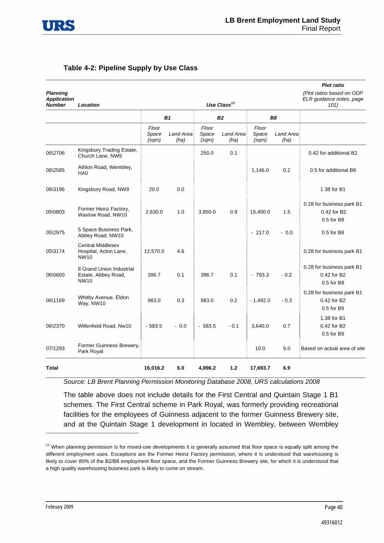
LB Brent Employment Land Study
Final Report
February 2009 Page 40
49316012
Table 4-2: Pipeline Supply by Use Class
Planning Application Number Location Use Class13
Plot ratio (Plot ratios based on ODP ELR guidance notes, page
101)
B1 B2 B8
Floor Space (sqm)
Land Area (ha)
Floor Space (sqm)
Land Area (ha)
Floor Space (sqm)
Land Area (ha)
06\2706 Kingsbury Trading Estate, Church Lane, NW9 250.0 0.1 0.42 for additional B2
06\2585 Athlon Road, Wembley, HA0 1,146.0 0.2 0.5 for additional B8
06\3196 Kingsbury Road, NW9 20.0 0.0 1.38 for B1
05\0803 Former Heinz Factory, Waxlow Road, NW10 2,630.0 1.0 3,850.0 0.9 15,400.0 1.5
0.28 for business park B1 0.42 for B2 0.5 for B8
05\2975 5 Space Business Park, Abbey Road, NW10 - 217.0 - 0.0 0.5 for B8
05\3174 Central Middlesex Hospital, Acton Lane, NW10
12,570.0 4.6 0.28 for business park B1
06\0600 8 Grand Union Industrial Estate, Abbey Road, NW10
396.7 0.1 396.7 0.1 - 793.3 - 0.2 0.28 for business park B1
0.42 for B2 0.5 for B8
06\1169 Whitby Avenue, Eldon Way, NW10 983.0 0.3 983.0 0.2 - 1,492.0 - 0.3
0.28 for business park B1 0.42 for B2 0.5 for B9
06\2370 Willenfield Road, Nw10 - 583.5 - 0.0 - 583.5 - 0.1 3,640.0 0.7 1.38 for B1 0.42 for B2 0.5 for B9
07/1293 Former Guinness Brewery, Park Royal 10.0 5.0 Based on actual area of site
Total 16,016.2 6.0 4,896.2 1.2 17,693.7 6.9
Source: LB Brent Planning Permission Monitoring Database 2008, URS calculations 2008
The table above does not include details for the First Central and Quintain Stage 1 B1 schemes. The First Central scheme in Park Royal, was formerly providing recreational facilities for the employees of Guinness adjacent to the former Guinness Brewery site, and at the Quintain Stage 1 development in located in Wembley, between Wembley
13 When planning permission is for mixed-use developments it is generally assumed that floor space is equally split among the different employment uses. Exceptions are the Former Heinz Factory permission, where it is understood that warehousing is likely to cover 80% of the B2/B8 employment floor space, and the Former Guinness Brewery site, for which it is understood that a high quality warehousing business park is likely to come on stream.
LB Brent Employment Land Study
Final Report
February 2009 Page 41
49316012
Stadium and the Northern Food site. Both the 2006 LB Brent Employment Land Demand Study (Recommendation 5) and the additional available information presented above suggest that such floor space is expected to cater for the needs of multinational corporations or London-wide operations, with a provision of 10.7 and 9 hectares of B1 office space respectively14. The land area expected to be in employment uses on those schemes has therefore not been included in the ‘localised’ demand. As described in the 2006 LB Brent ELDS (Section 6) the ‘localised’ demand, upon which the employment land demand forecasts are based, relate to the LB Brent and the local property market area that includes the LB of Barnet, Brent, Ealing, Harrow and Camden15.
4.3 Site Recommendations
As per the Government’s guidance notes on Employment Land Reviews (ODPM 2004), the below recommendations for employment land focus on suitability of employment clusters for the B use class sectors, drawing upon comprehensive research and analysis undertaken through previous sections of the report. Where sites are unsuitable for employment uses (as defined), it is not within the scope of this research, nor is it appropriate given the extent of work undertaken, to ‘recommend’ actual alternative land uses. Therefore we ‘suggest’ potential alternative or supporting appropriate potential uses such as enabling residential, in line with discussions with the Council about their aspirations for comprehensive regeneration.
Furthermore, research carried out by URS as part of the 2008 study commission ‘Employment Space in the Lower Lea valley’ (Workspace Report) on behalf of LTGDC, indicates that mixing B2 and residential land uses as part of mixed use areas generally does not work and this should be avoided. Where forthcoming masterplan schemes do promote both B2 and residential uses we would suggest that a clear demarcation is enforced between the two uses. We would suggest that the Council takes this into account when it takes forward recommendations into its’ Core Strategy and Site Allocations DPDs.
This section sets out the recommendations emerging from this study. An illustration of employment land use change is presented in the following table.
At the end of the section we briefly recall the recommendations from the 2006 LB Brent ELDS.
14 The Draft Park Royal Opportunity Area Planning Framework (2008) mentions that drinks multinational corporation Diageo is already occupying one of the buildings in First Central as its UK headquarters. The Quintain Stage 1 site, in Wembley, is considered by the Council as pivotal to the regeneration of Wembley. The development aims at shifting perceptions on Wembley as a global brand and location in which to invest (Draft Wembley Masterplan, 2008) by providing grade A office space benefiting from its proximity to Wembley Park Underground station.
15 The property market area does not coincide with the West London sub-region as set out in the London Plan 2008, which instead includes Hammersmith & Fulham, Brent, Ealing, Harrow, Hillingdon, Hounslow and Kensington and Chelsea.

LB Brent Employment Land Study
Final Report
February 2009 Page 42
49316012
R1 All current employment sites are to be retained for Employment Use, unless where stated in the recommendations below for release Protect LB Brent’s Strategic and Borough Employment Areas for industrial uses.
Justification
Gross demand for employment land within the Borough is expected to remain relatively strong until 2026, as set out in Section 3. Within this relatively strong demand for land there remains a demand for existing employment premises – this represents primarily a frictional vacancy demand for re-use of existing premises and land. This suggests that limited and carefully managed adjustments should be made in the net release of employment land through planning policy and allocations over this time period.
R2 Continued release of LEAs where there is thought to be detriment to neighbouring residential land uses Council to action the de-designation of land for employment use at LEAs where employment uses do or would result in unacceptable environmental problems or where there is no evidenced demand for employment premises on the site.
a. De-designate Woodside End/Sunleigh Road (URS identifier BR04) from employment use, potentially for residential-led development;
b. Re-designate employment land at Sarena House (URS identifier BR16) for employment-led (B1) development, potentially with enabling residential.
Justification
The employment land forecasts show an overall slight decline in the total demand for B1, B2 and B8 land (See Table 3-3 and Table 3-4) when the median between the high and scenarios is taken. There is however also a need to accommodate 8 hectares for waste uses, and to allow for frictional demand over the planning period. In the context of the current 266 hectares of built-on and vacant B1, B2 and B8 land stock this is expected to result in an oversupply of employment land by up to 19 hectares as shown in Table 4-1. It is therefore recommended that the Council take action by releasing a quantum of employment land in the region of 13 hectares within Brent’s LEAs.
The Council should therefore seek to de-designate employment land allocations at LEAs, where their continued occupation is of detriment to sensitive receptors in the local area. For instance, where B2 land uses are situated adjacent to residential areas, or health, or educational facilities, it may be appropriate to allow release of the land for residential or mixed-use schemes where suitable. The survey of all the LEAs, which constitute the lowest tier in the employment land hierarchy, was not within the scope of

LB Brent Employment Land Study
Final Report
February 2009 Page 43
49316012
this study. It is therefore recommended that this process should be controlled through analysis and revision as part of the Borough’s Annual Monitoring Review.
Sites recommended for release include two of the three surveyed LEAs:
a. The Woodside End/Sunleigh Road LEA (URS identifier BR04) is occupied by B2/Sui Generis units and surrounded by residential uses, with the exception of a short strip of land to the South West adjacent to the employment area at Mount Pleasant/Beresford Avenue. Very poor strategic road access, servicing, parking as well as high instance of dereliction and poor quality of building and environment result in detrimental effects on the neighbouring residential area.
b. The Sarena House LEA (URS identifier BR16) is occupied by a single-premise B2/B1 unit and surrounded by residential uses, including new developments along Grove Park. The site suffers from poor strategic road access as well as both poor quality buildings and environment. HGV and car traffic deriving from the site additionally results in detrimental effects on the neighbouring residential area.
R3 Manage a transition from B2 land use to B8 land use to reflect forecasted change in demand for employment land Council to oversee a transition of land-use from B2 to B8 uses in the SEAs and BEAs. Council to monitor and review this annually.
Justification
Whilst demand for B8 floor space is forecasted to be strong to 2026, demand for B2 floor space is expected to be declining, as a consequence of weakening in manufacturing employment both locally and regionally. It is therefore recommended that the Council take action to mitigate this by co-ordinating a shift in land-use from B2 to B8 in order that demand for the latter be adequately met. This process should be controlled through analysis and revision as part of the Borough’s Annual Monitoring Review. When demand for B2 employment land does arise, this may be accommodated in part within vacant premises at the larger SEAs, such as Park Royal, and smaller BEAs.
This transition includes the vacant land at East Lane BEA and vacant sites at Wembley SEA, Park Royal SEA and Alperton BEA. Such sites are located in good quality employment areas, predominantly occupied by B8 uses. As such it is suggested that the currently vacant plots are allocated to B8 uses, either for the building of entirely new premises (such as at East lane and Park Royal, where the size of the vacant plot is adequate to accommodate them) or for the expansion or redevelopment together with adjacent non-vacant premises. The Former Guinness Brewery site has already been granted planning permission for a B8 business park, which is in line with the recommendations.

LB Brent Employment Land Study
Final Report
February 2009 Page 44
49316012
R4 Waste and recycling facilities Intensify waste operations at Twyford Tip (URS identifier BR23). Allocate to waste and recycling operations additional sites, particularly the strip of land contained between the currently LB Brent operated waste facility and the North Circular Road and the vacant plot of land opposite the Former Guinness Brewery (URS identifier BR25), both at Park Royal SEA.
In overseeing the transition from B2 to B8 uses and vacant premises that become subsequently available, review adequate additional sites for waste and recycling operations ahead in the planning period, to accommodate any shortfall.
Justification
The demand forecast suggests a need for additional eight hectares of land allocated to waste and recycling operations up to 2026. Allocating the suggested additional sites and intensifying operations at Twyford Tip would result in an additional waste and recycling area in the region of three to five hectares. Additionally, this is in line with policy recommendations in the London Plan (Policies 4A.24 and 4A.27) on the retention of waste facilities on Strategic Industrial Locations.
Twyford Tip and the adjacent strip of land benefit from excellent strategic road access to the North Circular Road and direct access to the Grand Union Canal. The intensified site would require improved entrance and layout to address the poor manoeuvrability as well as inadequate parking provision. Both those sites and the vacant lot along Rainsford Road benefit from being surrounded by B2 and B8 uses, resulting in minimised negative impacts on sensitive receptors.
R5 Alperton and Beresford Avenue Promote the regeneration of the Alperton area whilst retaining and diversifying the employment base.
a. Re-designate Northfields Industrial Estate (URS identifier BR02) for employment-led (B1) development with enabling residential;
b. Re-designate employment land at Mount Pleasant/Beresford Avenue (URS identifier BR03) for employment-led (B1) development with enabling residential;
c. Re-designate employment land at Alperton House/Abercorn Commercial Centre and Bridgewater Road (URS identifier BR05) for employment-led mixed use which encourages more intensive B1 activities;

LB Brent Employment Land Study
Final Report
February 2009 Page 45
49316012
d. Re-designate the Western section Minavil House/Rosemont Road (URS identifier BR06) for employment-led (B1) mixed-use development to maximise regeneration opportunities.
Justification
The pipeline supply suggests a large part of the net local demand for B1 and B8 is likely to be satisfied up to 2026. The sites identified above share a number of features that make them suitable for employment-led mixed-use development, allowing for residential units to enable affordable managed workspace and possibly supporting the regeneration of the Alperton area.
Recommendation 2 in the 2006 LB Brent Employment Land Demand Study suggests restricting the release of industrial land to sites that appear inherently unsuitable and unviable for their existing use. Recommendation 3 further suggests giving favourable consideration to improving the existing stock. Recommendations 4 and 5 additionally encourage the protection of office uses in Strategic and Borough Employment Areas and the provision of premises for small and medium enterprises and start-ups.
The site-specific features of the above mentioned employment areas are summarised below.
a. The Northfields Industrial Estate in the Beresford Avenue SEA suffers from a poor quality environment, considerable vacancy and generally poor quality of buildings. While benefiting from the proximity to the North Circular Road, the current layout results in difficult access from Beresford Avenue only; although the site is bordered by the Grand Union Canal to the South only the thin strip of land adjacent to the Mount Pleasant/Beresford Avenue site appears adequately integrated with it. Additionally, the site is located opposite a recreation ground and a residential area and more residential units are located fronting the canal to the South of the site.
It is therefore suggested that the total quantum of employment floor space is retained as part of intensified employment area, with a transition from current B2/Sui Generis to B1 uses, and that residential uses could be introduced in the south western wedge alongside the canal and on the stretch of land adjacent to the Mount Pleasant/Beresford Avenue. Such new uses are dependent on improved direct access from the North Circular Road.
b. The Mount Pleasant site in the Alperton BEA is dominated by Sui Generis uses, including car and food related ones, with B1 offices predominantly alongside Beresford Avenue. The site suffers from poor servicing and lack of parking as well as poor quality internal roads and environment in general. The site is bordered by residential uses to the north, most of the west and south opposite the Grand Union Canal and access is only provided on Beresford Avenue alongside the residential area.

LB Brent Employment Land Study
Final Report
February 2009 Page 46
49316012
The potential conflict of uses with the surrounding residential areas, the lack of strategic road access and the direct access to the canal suggest the site is suitable for additional B1 uses and potentially residential alongside the canal to the south of the site. This is likely to support the full potential of regeneration in Alperton, in conjunction with recommendations 3 and 5a of this study.
c. Alperton House/Abercorn Commercial Centre and Bridgewater Road constitute two distinct sites within the Alperton BEA, divided by the busy Bridgewater Road. Alperton House/Abercorn Commercial Centre is bordered by residential to the North and the Grand Union Canal to the South, whilst the Bridgewater Road site is bordered by the busy Ealing Road to the South East, a recreational ground to the North East beyond rail tracks and residential to the North West. While the quality of environment and buildings is generally good at Alperton House/Abercorn Commercial Centre, the builders’ yard opposite Manor Farm Road as well as the retail units at the corner with Clifford road are under-utilising the excellent location close to the Underground station (Alperton). The Bridgewater Road site hosts a vacant and a derelict unit as well as a petrol station resulting in under-utilisation of employment land, suggesting the lack of demand for B2/B8 premises at this location.
It is therefore suggested that intensified B1 uses are encouraged as part of a comprehensive redevelopment to maximise excellent access to public transport. Enabling residential alongside the canal at Alperton House/Abercorn Commercial Centre and adjacent to existing residential on the Bridgewater Road site could be introduce to enable the employment-led intensification, including managed workspace for SMEs and start ups.
d. The Minavil House/Rosemont Road site appears physically divided. The Wharfside Estate constitutes a successful example of town-centre commercial space use, with high quality premises, good layout and good environment. The low-rise Minavil House and the South West of Rosemont Road display poorer quality of building and potentially poor use of available land. This section of the site, hosting a number of offices and a college, also suffers from poorer servicing and parking.
The apparent under-utilisation of the land at Minavil House and South West of Rosemont Road result in suggestion to intensify B1 uses with provision of additional employment floor space, with enabling residential potentially alongside the canal or at the upper floors. B1 and residential uses share similar locational characteristics, and the mix of uses could also retain current education uses. The type of B1 floor space demanded at this location could cater for SMEs and start-ups.

LB Brent Employment Land Study
Final Report
February 2009 Page 47
49316012
R6 Church End Maximise employment opportunities and reducing conflicts between land uses.
Re-designate the Asiatic Carpets/Dalmeyer Road site (URS identifier BR10) for employment-led (B1a, B1c) mixed use, with light industrial units and enabling residential uses.
Justification
Recommendation 5 in the 2006 LB Brent ELDS suggests encouraging provision of premises for SMEs and start-up businesses, highlighting the risk that their specific demand will not be met by major office schemes at Wembley and Park Royal. Additionally, the site appears now divided, with the Asiatic Carpet warehouse and MOT services to the West of site in disrepair and poor condition, and apparently recently refurbished small B1/B8 units to the East. The former shows poor environmental conditions, and appears to host low-density employment. Residential uses border the whole site, suggesting to avoid B2 and large B8 units which could have disruptive effects on the area.
It is therefore suggested that the Western wedge of the site is re-designated for B1, and particularly B1c, uses with enabling residential units introduced to the North West and West of the site.
R7 Honeypot Lane Maximise employment opportunities.
Re-designate the Honeypot Lane South site (URS identifier BR21) for employment-led mixed use, B1 units and enabling residential uses.
Justification
Recommendation 5 in the 2006 LB Brent ELDS suggests encouraging provision of premises for SMEs and start-up businesses, highlighting the risk that their specific demand will not be met by major office schemes at Wembley and Park Royal. Recommendation 4 further encourages the continuous protection of office uses in SEAs and BEAs. The site is currently occupied by low-rise B2 and Sui Generis uses, with offices at the front facing Honeypot Lane. The premises are predominantly of poor quality or in disrepair and the B2/Sui Generis uses are quite noisy, resulting in detrimental impacts on the neighbouring residential. The site could exploit its excellent location close to Queensbury Underground station.
It is therefore suggested that the site is re-designated for intensified B1 uses with enabling residential units introduced.

LB Brent Employment Land Study
Final Report
February 2009 Page 48
49316012
R8 Outstanding Planning Permission Allowing sites with outstanding planning permission to come forward where they result in an increase in B uses within employment designations.
Justification
Planning permissions have been granted for a number of small schemes throughout Brent’s SEAs and BEAs. These are shown in detail in Table 4-2 and total approximately 6 hectares of additional B1, 1.2 hectares of additional B2 and additional 1.1 hectare of B8 land. Discussions with the Council have confirmed these have been granted in line with current UDP policies and emerging supporting LDF policies. In addition, the site surveys have confirmed that these are suitable locations for the proposed employment uses.
The table below provides an illustrative breakdown of recommendations for release of employment land as suggested in Table 4-1 together with an illustration of possible re-allocation of designated B1, B2 and B8 employment land by site.
Table 4-3: Illustration of Employment Land Use Change
Recommendation Site/Area B1 B2 B8 Waste
LB Brent identified sites -10.0
Woodside End/Sunleigh Road (URS identifier BR04) R2 Continued release of LEAs
Sarena House (URS identifier BR16)
-3.2
LB Brent identified sites -25.0 +25.0
Vacant Land at Former Guinness Brewery Site
Vacant land at East Lane SEA
Vacant land at Fourth Way (Wembley SEA)
R3 Manage a transition from B2 to B8 of SEA and BEA land
Vacant Land at Manor Farm Road (Alperton BEA)
+9.5
LB Brent identified sites
Twiford Tip (URS identifier BR23)
R4 Waste and recycling facilities Vacant plot of land opposite
the Former Guinness Brewery (URS identifier BR25)
+8.0

LB Brent Employment Land Study
Final Report
February 2009 Page 49
49316012
Recommendation Site/Area B1 B2 B8 Waste
R5.a Alperton and Beresford Avenue Re-designate Northfields Industrial Estate (URS identifier BR02) for employment-led (B1) development with enabling residential
Re-designate Northfields Industrial Estate (URS
identifier BR02) +3.0 -6.5 +2.0
R5.b Alperton and Beresford Avenue Re-designate employment land at Mount Pleasant/Beresford Avenue (URS identifier BR03) for employment-led (B1) development with enabling residential
Mount Pleasant/Beresford Avenue (URS identifier BR03) +1.0 -3.5
R5.c Alperton and Beresford Avenue Re-designate employment land at Alperton House/Abercorn Commercial Centre and Bridgewater Road (URS identifier BR05) for employment-led mixed use which encourages more intensive B1 activities
Alperton House/Abercorn Commercial Centre and Bridgewater Road (URS
identifier BR05)
1 -0.5
R5.d Alperton and Beresford Avenue Re-designate the Western section Minavil House/Rosemont Road (URS identifier BR06) for employment-led (B1) mixed-use development to maximise regeneration opportunities.
Western section Minavil House/Rosemont Road (URS
identifier BR06) +0.3
R6 Church End Re-designate the Asiatic Carpets/Dalmeyer Road site (URS identifier BR10) for employment-led (B1a, B1c) mixed use, with light industrial units and enabling residential uses.
Asiatic Carpets/Dalmeyer Road (URS identifier BR10) +0.8 -1.5
R7 Honeypot Lane Maximise employment opportunities. Re-designate the Honeypot Lane South site (URS identifier BR21) for employment-led mixed use, B1 units and enabling residential uses.
Honeypot Lane South (URS identifier BR21) +0.5 -2.5
R8 Outstanding Planning Permissions +5.9 +1.2 +1.9
Total 12.4 -51.2 37.9 8
Source: URS calculations 2008
Totals may not add up due to rounding
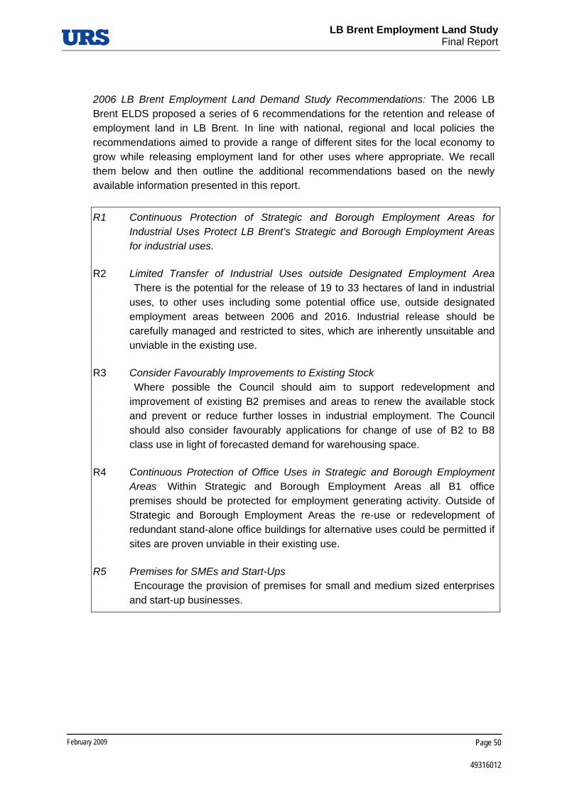
LB Brent Employment Land Study
Final Report
February 2009 Page 50
49316012
2006 LB Brent Employment Land Demand Study Recommendations: The 2006 LB Brent ELDS proposed a series of 6 recommendations for the retention and release of employment land in LB Brent. In line with national, regional and local policies the recommendations aimed to provide a range of different sites for the local economy to grow while releasing employment land for other uses where appropriate. We recall them below and then outline the additional recommendations based on the newly available information presented in this report.
R1 Continuous Protection of Strategic and Borough Employment Areas for Industrial Uses Protect LB Brent’s Strategic and Borough Employment Areas for industrial uses.
R2 Limited Transfer of Industrial Uses outside Designated Employment Area There is the potential for the release of 19 to 33 hectares of land in industrial uses, to other uses including some potential office use, outside designated employment areas between 2006 and 2016. Industrial release should be carefully managed and restricted to sites, which are inherently unsuitable and unviable in the existing use.
R3 Consider Favourably Improvements to Existing Stock Where possible the Council should aim to support redevelopment and improvement of existing B2 premises and areas to renew the available stock and prevent or reduce further losses in industrial employment. The Council should also consider favourably applications for change of use of B2 to B8 class use in light of forecasted demand for warehousing space.
R4 Continuous Protection of Office Uses in Strategic and Borough Employment Areas Within Strategic and Borough Employment Areas all B1 office premises should be protected for employment generating activity. Outside of Strategic and Borough Employment Areas the re-use or redevelopment of redundant stand-alone office buildings for alternative uses could be permitted if sites are proven unviable in their existing use.
R5 Premises for SMEs and Start-Ups Encourage the provision of premises for small and medium sized enterprises and start-up businesses.

LB Brent Employment Land Study
Final Report
February 2009 Page 51
49316012
R6 Monitoring The Council should continue to monitor changes of stock through planning permissions to ensure that sufficient land is available for economic growth. The Council maintains detailed information on the stock of premises and land within its designated and local employment sites and should continue to regularly update its Industrial Land Use Survey.

LB Brent Employment Land Study
Final Report
Appendix A: Vacant Employment Land

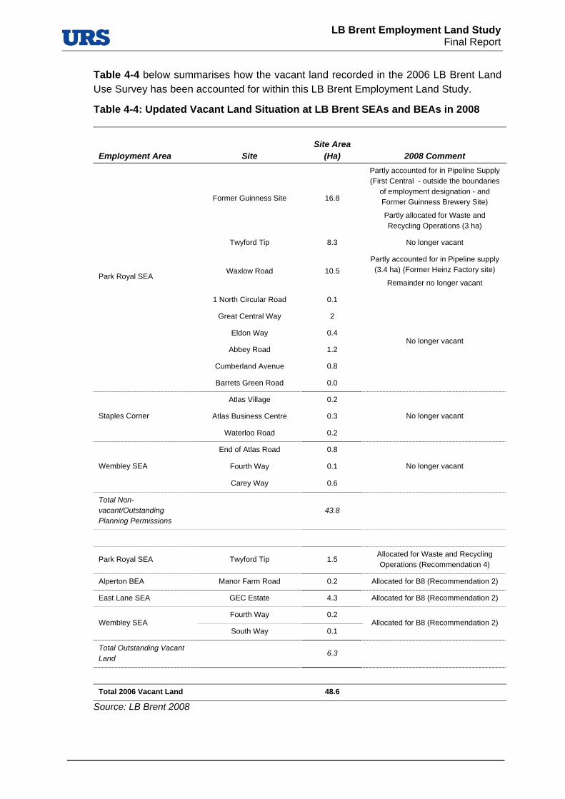
LB Brent Employment Land Study
Final Report
Table 4-4 below summarises how the vacant land recorded in the 2006 LB Brent Land Use Survey has been accounted for within this LB Brent Employment Land Study.
Table 4-4: Updated Vacant Land Situation at LB Brent SEAs and BEAs in 2008
Employment Area Site Site Area
(Ha) 2008 Comment
Former Guinness Site 16.8
Partly accounted for in Pipeline Supply (First Central - outside the boundaries
of employment designation - and Former Guinness Brewery Site)
Partly allocated for Waste and Recycling Operations (3 ha)
Twyford Tip 8.3 No longer vacant
Waxlow Road 10.5 Partly accounted for in Pipeline supply (3.4 ha) (Former Heinz Factory site)
Remainder no longer vacant
1 North Circular Road 0.1
Great Central Way 2
Eldon Way 0.4
Abbey Road 1.2
Cumberland Avenue 0.8
Park Royal SEA
Barrets Green Road 0.0
No longer vacant
Atlas Village 0.2
Atlas Business Centre 0.3 Staples Corner
Waterloo Road 0.2
No longer vacant
End of Atlas Road 0.8
Fourth Way 0.1 Wembley SEA
Carey Way 0.6
No longer vacant
Total Non-vacant/Outstanding Planning Permissions
43.8
Park Royal SEA Twyford Tip 1.5 Allocated for Waste and Recycling Operations (Recommendation 4)
Alperton BEA Manor Farm Road 0.2 Allocated for B8 (Recommendation 2)
East Lane SEA GEC Estate 4.3 Allocated for B8 (Recommendation 2)
Fourth Way 0.2 Wembley SEA
South Way 0.1 Allocated for B8 (Recommendation 2)
Total Outstanding Vacant Land
6.3
Total 2006 Vacant Land 48.6
Source: LB Brent 2008


LB Brent Employment Land Study
Final Report
Appendix B: Detailed Site Survey Results


LB Brent Employment Land Study
Final Report
Table 4-5: Summary of Site Survey Results – Site Information, Quality, and Services, Facilities and Amenities
URS Identifier Address
Area (Ha) Existing Employment use
Main Existing Employment Use
Type of site
Conditions of Building
(% of Total Number of Buildings on Site)Quality of
Environment Marketing
Activity
Facilities and
Amenities Servicing of Businesses
Adequate Servicing Parking Facilities
Adequate Parking
Very Good Good Poor
Very Poor
BR01 Former Northern Foods site
2 Other non-industrial related uses (Vacant) Other non-industrial
related uses (Vacant) SIL N/A N/A N/A N/A Good
Agents billboards (sold)
Poor N/A N/A N/A N/A
BR02 Northfields Industrial Estate
9 Light Industry, Some Creative Industries, Vacant
Buildings, Other industrial related uses not in categories above (B2/Sui Generis)
Light Industry SIL / BEA 0 40 40 20 Poor Premises for rent
sign Poor
Off road loading/unloading,
loading bays Yes Dedicated parking Adequate
BR03 Mount Pleasant/Beresford Avenue
4
Light Industry, Logistics, Warehousing and Storage, Some Creative Industries, Other
industrial related uses not in categories above (B2/Sui Generis)
Other industrial related uses not in categories above (B2/Sui Generis)
BEA 0 45 45 10 Poor Premises for rent
sign Poor
Road side loading/unloading
No Dedicated parking, on street parking
(mainly) Too little
BR04 Woodside End/Sunleigh Road
2 Light Industry, Some Creative Industries, Other industrial related uses not in categories above
(B2/Sui Generis)
Other industrial related uses not in categories above (B2/Sui Generis)
LEA 10 10 40 40 Very Poor None Poor Road side
loading/unloading No On street parking Too little
BR05
Alperton House/Abercorn Commercial Centre
2
General Industry, Logistics, Warehousing and Storage, Light Industry, Other industrial related
uses not in categories above (office), Other non-industrial related uses (retail)
Other non-industrial related uses (Offices)
BEA 10 80 10 0 Good Premises for rent
sign Very Good
Off road loading/unloading,
loading bays Yes
Dedicated parking, on street parking
(mainly) Adequate
BR06 Minavil House/Rosemont Road
1
Light Industry, General Industry, Logistics, Warehousing and Storage, Utilities, Some
Creative Industries, Other non industrial related uses (School)
Logistics, Warehousing and
Storage BEA 80 0 10 10 Very Good
Premises for rent sign
Very Good Loading bays Yes Dedicated parking Adequate
BR07 Bridgewater Road
1 General Industry, Other non-industrial related
uses (retail) Land for public
transport functions BEA 30 40 30 0 Poor
Premises for rent sign
Very Good Road side
loading/unloading, Off road loading/unloading
Yes Dedicated parking Adequate
BR08 Athlon Road 8 Light industry, General industry, Logistics,
Warehousing and Storage
Logistics, Warehousing and
Storage BEA 50 30 20 0 Very Good
Premises for rent sign
Very Good Loading bays Yes Dedicated parking Adequate

LB Brent Employment Land Study
Final Report
URS Identifier Address
Area (Ha) Existing Employment use
Main Existing Employment Use
Type of site
Conditions of Building
(% of Total Number of Buildings on Site)Quality of
Environment Marketing
Activity
Facilities and
Amenities Servicing of Businesses
Adequate Servicing Parking Facilities
Adequate Parking
Very Good Good Poor
Very Poor
BR09 Alperton Lane 10 General Industry, Logistics, Warehousing and Storage, Waste Management and Recycling, Other non-industrial related uses (restaurant)
Logistics, Warehousing and
Storage BEA 80 20 0 0 Very Good
Premises for rent sign
Poor Loading bays Yes Dedicated parking Adequate
BR10 Asiatic Carpets/Dalmeyer Road
3
Light Industry, General Industry, Some Creative Industries, Other industrial related uses non in categories above (offices), Other non-industrial related uses (Retail), Logistics, Warehousing
and Storage
Logistics, Warehousing and
Storage BEA 10 50 40 0 Poor
Premises for rent sign
Good Off road
loading/unloading, loading bays
Yes Dedicated parking, on street parking
(mainly) Adequate
BR11 Cobbold Estate 3
Light Industry, General Industry, Logistics, Warehousing and Storage, Some Creative
Industries, Other industrial related uses not in categories above (offices), Other non-industrial
related uses (retail)
Logistics, Warehousing and
Storage BEA 20 80 0 0 Good None Very Good
Off road loading/unloading,
loading bays Yes
Dedicated parking, on street parking
Adequate
BR12 Sapcote Trading Estate
3
Light industry, General industry, Logistics, Warehousing and Storage, Some Creative
Industries, Other industrial related uses not in categories above (office)
Logistics, Warehousing and
Storage BEA 50 30 0 20 Poor
Premises for rent sign
Very Good Off road
loading/unloading, loading bays
Yes
Dedicated parking, On street parking, Controlled parking zone/paid parking
Adequate
BR13 Artesian Close Industrial Estate
4 General Industry, Logistics, Warehousing and Storage, Utilities (power station), Other non-
industrial related uses (retail) Utilities BEA 20 50 30 0 Good None Poor
Off road loading/unloading,
loading bays Yes Dedicated parking Adequate
BR14 Chancel House 1 Other industrial related uses not in categories
above (office)
Other industrial related uses not in categories above
(office)
LEA 100 0 0 0 Very Good None Good N/A N/A Dedicated parking, On street parking
Adequate

LB Brent Employment Land Study
Final Report
URS Identifier Address
Area (Ha) Existing Employment use
Main Existing Employment Use
Type of site
Conditions of Building
(% of Total Number of Buildings on Site)Quality of
Environment Marketing
Activity
Facilities and
Amenities Servicing of Businesses
Adequate Servicing Parking Facilities
Adequate Parking
Very Good Good Poor
Very Poor
BR15 Capitol Industrial Park
7 Light industry, Utilities, logistics, Warehousing and Storage, Other non industrial related uses
(green spaces, hair and beauty, DIY)
Logistics, Warehousing and
Storage BEA / LEA 30 50 20 Good
Premises for rent sign
Very Good
Road side loading/unloading, Off
road loading/unloading, loading bays
Yes Dedicated parking, on street parking
Too little
BR16 Sarena House 1 Light Industry, Utilities Light Industry LEA 0 0 100 0 Poor None Very Good Off road
loading/unloading, Loading bays
Yes Dedicated parking Adequate
BR17 Kingsbury Road Industrial Estate
6
Light Industry, Logistics, Warehousing and Storage, Other industrial related uses not in categories to above (office), Some Creative
Industries
Light Industry BEA 90 0 0 10 Very Good Premises for rent
sign Good Loading bays Yes
Dedicated parking, On street parking
Adequate
BR18 Neasden Lane North
2 Logistics, Warehousing and Storage, Other industrial related uses not in category above
(B2/Sui Generis)
Logistics, Warehousing and
Storage BEA 80 0 20 0 Good
Premises for rent sign
Good Off road
loading/unloading, Loading bays
Yes Dedicated parking, On Street Parking
Adequate
BR19 Neasden Lane South
1 Logistics, Warehousing and Storage Logistics,
Warehousing and Storage
BEA 0 100 0 0 Good None Good Off road
loading/unloading Yes Dedicated parking Inadequate
BR20 Honeypot Lane North
3
Logistics, Warehousing and Storage, Other industrial related uses not in categories above (B2/Sui Generis), Other non-industrial related
uses (Offices, Retail)
Other industrial related uses not in categories above (B2/Sui Generis)
BEA 70 0 30 0 Poor Premises for rent
sign
Good (Morrison's adjacent)
Road side loading/unloading,
Loading bays Yes
Dedicated parking, On street parking
Adequate
BR21 Honeypot Lane South
2 General industry, Other industrial related uses
not in categories above (B2/Sui Generis), Other non industrial related uses (Offices and Retail)
Other industrial related uses not in categories above (B2/Sui Generis)
BEA 0 10 80 10 Poor None Good Off road
loading/unloading, loading bays
Yes Dedicated parking Adequate
BR22 Edgware Road Bus Garage
1 Land for public transport functions Land for public
transport functions BEA 50 50 N/A None Good N/A N/A N/A N/A

LB Brent Employment Land Study
Final Report
URS Identifier Address
Area (Ha) Existing Employment use
Main Existing Employment Use
Type of site
Conditions of Building
(% of Total Number of Buildings on Site)Quality of
Environment Marketing
Activity
Facilities and
Amenities Servicing of Businesses
Adequate Servicing Parking Facilities
Adequate Parking
Very Good Good Poor
Very Poor
BR23 Twyford Tip 6 Waste Management and recycling Waste management
and recycling SIL 0 100 0 0 Good None Very Poor Loading Bays No Dedicated Parking Too little
BR25 Former Guinness Brewery Site
8 Being developed Being developed SIL N/A N/A N/A N/A N/A Agents Billboards Very Poor N/A N/A N/A N/A
BR26 Neasden SEA 42
Light industry, Logistics, Warehousing and Storage, Some Creative Industries, Waste
Management and Recycling, Other industrial related uses not in categories above, Other non-
industrial related uses (retail)
Logistics, Warehousing and
Storage SIL 100 0 0 0 0 None Poor
Road side loading/unloading,
Loading bays Yes
Dedicated parking, On street parking,
Yellow/ Double yellow lines
Adequate
BR27 Wembley SEA 23 General industry, Logistics, Warehousing and Storage, Waste Management and Recycling
Logistics, Warehousing and
Storage SIL 20 75 5 0 Good
Premises for rent sign
Very Poor Road side loading/ unloading, Loading
bays No
Dedicated parking, On street parking
Too little
BR28 Staples Corner 38
Logistics, Warehousing and Storage, Some Creative Industries (yoga, fine arts), Other non-industrial related uses (wholesale, yoga centre,
special car rental)
Logistics, Warehousing and
Storage SIL 40 55 0 5 Good
Premises for rent sign
Good (pub and
convenience store)
Road side loading/unloading,
Loading bays Yes
Dedicated parking, On street parking
Adequate
BR29 East Lane 17
Logistics, Warehousing and Storage, Land for public transport functions (bus depot), Other
industrial related uses not in categories above (care related, offices)
Logistics, Warehousing and
Storage SIL 0 70 30 0 Very Good
Agent's billboards, Premises for rent
sign Very Good
Off road loading/unloading,
loading bays Yes
Dedicated parking, Controlled parking zone/paid parking
Adequate
BR30 Willesden Junction Station and Vicinity
13 Land for public transport functions Land for public
transport functions SIL 0 100 0 Poor None Very Good N/A N/A
Yellow/ double yellow lines
Too little

LB Brent Employment Land Study
Final Report
URS Identifier Address
Area (Ha) Existing Employment use
Main Existing Employment Use
Type of site
Conditions of Building
(% of Total Number of Buildings on Site)Quality of
Environment Marketing
Activity
Facilities and
Amenities Servicing of Businesses
Adequate Servicing Parking Facilities
Adequate Parking
Very Good Good Poor
Very Poor
BR32 Abbeydale Road
9
General Industry, Logistics, Warehousing and Storage, Some Creative Industries (printing) other industrial related uses not in categories
above (B2/Sui Generis car related, food related), Other non-industrial related uses (hotel)
Logistics, Warehousing and
Storage SIL 10 20 70 0 Poor
Agent's billboards, Premises for rent
sign Poor (café)
Roadside loading/ unloading, Loading
bays Yes
Dedicated parking, On street parking
Too little
BR33
Site Section of Twyford Tip, Tudor estates, Grand Union Industrial Estates
5 General Industry, logistics, Warehousing and Storage, Some Creative Industries (printing
banner advertisements)
Logistics, Warehousing and
Storage SIL 40 55 0 5 Good
Premises for rent sign
Poor Roadside loading/ unloading, Loading
bays No
Dedicated parking, On street parking
Too little
BR34
Site west of Abbey Road "Premier Industrial Park"
24 General industry, Logistics, Warehousing and
Storage, Other non-industrial related uses
Logistics, Warehousing and
Storage SIL 100 0 0 0 Very Good
Agent's billboards, Premises for rent
sign Poor
Roadside loading/ unloading, Loading
bays Yes
Dedicated parking, On street parking
Adequate
BR34A Waxlow Road 12 General industry, Logistics, Warehousing and
Storage, Other industrial related uses (offices) , Other non industrial related uses (fire station)
General Industry SIL 95 3 2 0 Very Good Premises for rent
sign Poor
Off road loading/unloading,
Loading bays Yes
Dedicated parking, On street parking,
Yellow/ double yellow lines,
Controlled parking zone/paid parking
Adequate
BR35
SW of Abbey Road, East of former Guinness brewery site
20 Logistics, Warehousing and Storage, Other non-
industrial related uses (B&B)
Logistics, Warehousing and
Storage SIL 90 8 2 0 Very Good
Agent's billboards, Premises for rent
sign Very poor
Roadside loading/ unloading, Loading
bays Yes
Dedicated parking, On street parking
Adequate
BR36 North of Acton Lane
30
General industry, Logistics Warehousing and Storage, Some Creative Industries (Park Royal
Studies, Printmaking), Other non-industrial related uses (café, ambulance depot, car retail)
Logistics, Warehousing and
Storage SIL 45 55 0 0 Very Good
Premises for rent sign
Poor (only a few cafes and bakeries along
Acton lane)
Roadside loading/ unloading, Loading
bays Yes
Dedicated Parking, On street parking
Adequate

LB Brent Employment Land Study
Final Report

LB Brent Employment Land Study
Final Report
Table 4-6: Summary of Site Survey Results – Neighbourhood Uses, and Development Constraints and Opportunities
URS Identifier Address
Area (Ha) Existing Employment Use on Site Bordering Neighbourhood Uses Impacts
Sensitive Receptors
Waste Facilities
Transformation Access
Topography
Ecological
Japanese
Knotweed
Contamination
All Predominant All Predominant Employment Use On Site Of Site Strategic
Road Public
transport Waterways
BR01 Former Northern Foods site
2 Other non-industrial related
uses (Vacant)
Other non-industrial related
uses (Vacant)
Transport, Industry and Business, Previously
Developed Land
Industry and Business
Light Industry, General Industry, Logistics,
Warehousing and Storage, Waste Management and
Recycling, Some Creative Industries
HGV traffic, Car
traffic None None
Within same neighbourhood
No Very Good Good No No No No No
BR02 Northfields Industrial Estate
9
Light Industry, Some Creative Industries, Vacant Buildings, Other industrial related uses
not in categories above (B2/Sui Generis)
Light Industry Transport, Residential, Industry and Business
Transport Light Industry Noise, AirHGV
traffic, Car traffic
Residential Areas
No No Very Good Very Good Direct Access No Yes No No
BR03 Mount Pleasant/Beresford Avenue
4 Light Industry, Logistics,
Warehousing and Storage, Some Creative Industries
Other industrial related uses not
in categories above (B2/Sui
Generis)
Residential, Community Services, Industry and
Business Residential
Light Industry, Logistics, Warehousing and Storage
Noise Car trafficSchools,
Residential Areas
No No Poor Very Good Direct Access No No No No
BR04 Woodside End/Sunleigh Road
2 Light Industry, Some Creative
Industries
Other industrial related uses not
in categories above (B2/Sui
Generis)
Transport, Residential, Industry and Business
Residential Light Industry None Noise, Smell
Schools, Residential
Areas No No Poor Very Good Direct Access No No No Yes
BR05
Alperton House/Abercorn Commercial Centre
2
General Industry, Logistics, Warehousing and Storage,
Light Industry, Other industrial related uses not in categories
above (office), Other non-industrial related uses (retail)
Other non-industrial related
uses (Offices)
Transport, Residential, Industry and Business
Transport
Land for public transport functions (bus depot) other non-industrial related uses
(retail)
Noise, Air, HGV
traffic, Car traffic
None Schools,
Residential Areas
No No Very Good Very Good Direct Access No No No No
BR06 Minavil House/Rosemont Road
1
Light Industry, General Industry, Logistics,
Warehousing and Storage, Utilities, Some Creative Industries, Other non industrial related uses
(School)
Logistics, Warehousing and
Storage
Transport, Retail, Industry and business
Transport
General industry, Logistics, Warehousing and Storage, Other industrial uses not in categories above (offices)
Noise, HGV
traffic, Car traffic
Car trafficSchools, Hospital
No No Very Good Very Good Direct Access No Yes No No
BR07 Bridgewater Road
1 General Industry, Other non-industrial related uses (retail)
Land for public transport functions
Transport, Residential, Community services, Retail, Industry and
Business
Transport
Logistics, Warehousing and Storage, Other
industrial uses not in categories above (offices), Other non-industrial related
uses (retail)
Noise, Air, HGV, Car
traffic Car traffic
Schools, Hospitals
No No Very Good Very Good No access No Yes No Yes
BR08 Athlon Road 8 Light industry, General
industry, Logistics, Warehousing and Storage
Logistics, Warehousing and
Storage
Recreation and Leisure, Residential, Retails,
Industry and Business Residential
General Industry, Logistics, Warehousing and Storage, Waste Management and
Recycling, Other non-industrial related uses
(fitness facility and
Car trafficAir, HGV
traffic, Car traffic
Residential Areas
Within same neighbourhood
No Very Good Very Good No access No Yes No No
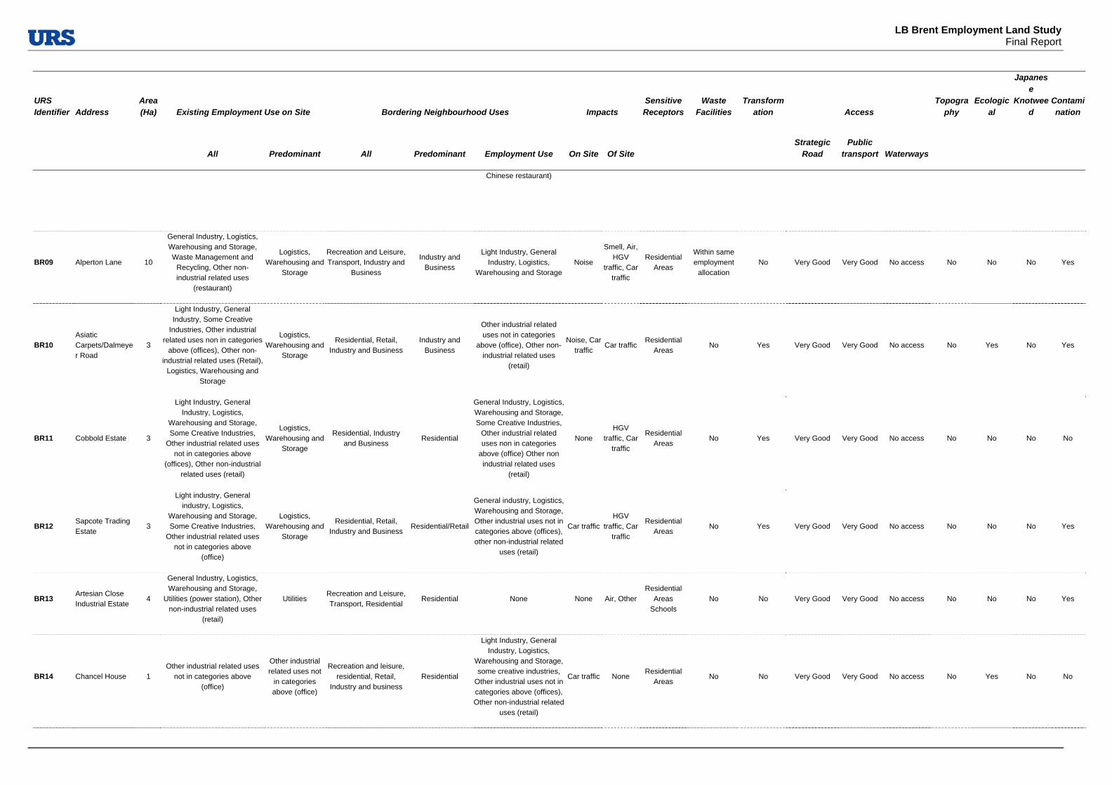
LB Brent Employment Land Study
Final Report
URS Identifier Address
Area (Ha) Existing Employment Use on Site Bordering Neighbourhood Uses Impacts
Sensitive Receptors
Waste Facilities
Transformation Access
Topography
Ecological
Japanese
Knotweed
Contamination
All Predominant All Predominant Employment Use On Site Of Site Strategic
Road Public
transport Waterways
Chinese restaurant)
BR09 Alperton Lane 10
General Industry, Logistics, Warehousing and Storage, Waste Management and
Recycling, Other non-industrial related uses
(restaurant)
Logistics, Warehousing and
Storage
Recreation and Leisure, Transport, Industry and
Business
Industry and Business
Light Industry, General Industry, Logistics,
Warehousing and StorageNoise
Smell, Air, HGV
traffic, Car traffic
Residential Areas
Within same employment
allocation No Very Good Very Good No access No No No Yes
BR10 Asiatic Carpets/Dalmeyer Road
3
Light Industry, General Industry, Some Creative
Industries, Other industrial related uses non in categories
above (offices), Other non-industrial related uses (Retail),
Logistics, Warehousing and Storage
Logistics, Warehousing and
Storage
Residential, Retail, Industry and Business
Industry and Business
Other industrial related uses not in categories
above (office), Other non-industrial related uses
(retail)
Noise, Car traffic
Car trafficResidential
Areas No Yes Very Good Very Good No access No Yes No Yes
BR11 Cobbold Estate 3
Light Industry, General Industry, Logistics,
Warehousing and Storage, Some Creative Industries,
Other industrial related uses not in categories above
(offices), Other non-industrial related uses (retail)
Logistics, Warehousing and
Storage
Residential, Industry and Business
Residential
General Industry, Logistics, Warehousing and Storage, Some Creative Industries,
Other industrial related uses non in categories
above (office) Other non industrial related uses
(retail)
None HGV
traffic, Car traffic
Residential Areas
No Yes Very Good Very Good No access No No No No
BR12 Sapcote Trading Estate
3
Light industry, General industry, Logistics,
Warehousing and Storage, Some Creative Industries,
Other industrial related uses not in categories above
(office)
Logistics, Warehousing and
Storage
Residential, Retail, Industry and Business
Residential/Retail
General industry, Logistics, Warehousing and Storage, Other industrial uses not in categories above (offices), other non-industrial related
uses (retail)
Car trafficHGV
traffic, Car traffic
Residential Areas
No Yes Very Good Very Good No access No No No Yes
BR13 Artesian Close Industrial Estate
4
General Industry, Logistics, Warehousing and Storage,
Utilities (power station), Other non-industrial related uses
(retail)
Utilities Recreation and Leisure, Transport, Residential
Residential None None Air, OtherResidential
Areas Schools
No No Very Good Very Good No access No No No Yes
BR14 Chancel House 1 Other industrial related uses
not in categories above (office)
Other industrial related uses not
in categories above (office)
Recreation and leisure, residential, Retail,
Industry and business Residential
Light Industry, General Industry, Logistics,
Warehousing and Storage, some creative industries,
Other industrial uses not in categories above (offices), Other non-industrial related
uses (retail)
Car traffic None Residential
Areas No No Very Good Very Good No access No Yes No No

LB Brent Employment Land Study
Final Report
URS Identifier Address
Area (Ha) Existing Employment Use on Site Bordering Neighbourhood Uses Impacts
Sensitive Receptors
Waste Facilities
Transformation Access
Topography
Ecological
Japanese
Knotweed
Contamination
All Predominant All Predominant Employment Use On Site Of Site Strategic
Road Public
transport Waterways
BR15 Capitol Industrial Park
7
Light industry, Utilities, logistics, Warehousing and
Storage, Other non industrial related uses (green spaces,
hair and beauty, DIY)
Logistics, Warehousing and
Storage
Transport, Residential, Retail
Residential Other non-industrial related uses (ASDA, petrol station)
Noise, Smell, Air,
HGV traffic, Car
traffic
Noise, Air, HGV
traffic, Car traffic
Residential Areas
No No Very Good Very Good No access No Yes No Yes
BR16 Sarena House 1 Light Industry, Utilities Light Industry Residential Community
Services, Retail Residential
Logistics, Warehousing and Storage (light
appliances imports and sales), Other non-industrial related uses (retail, school)
Noise, Air, HGV
traffic, Car traffic
HGV traffic, Car
traffic
Schools, Residential
Areas No Yes Poor Very Good No access No No No No
BR17 Kingsbury Road Industrial Estate
6
Light Industry, Logistics, Warehousing and Storage,
Other industrial related uses not in categories to above
(office), Some Creative Industries
Light Industry Residential, Recreation
and Leisure, Retail Residential None None
Noise, HGV
traffic, Car traffic
Residential Areas
No No Very Good Very Good No access No Yes No Yes
BR18 Neasden Lane North
2
Logistics, Warehousing and Storage, Other industrial
related uses not in category above (B2/Sui Generis)
Logistics, Warehousing and
Storage
Residential, Transport, Industry and Business
Residential Waste Management and
Recycling, Logistics, Warehousing and Storage,
Noise, Car traffic
Noise, HGV traffic
Residential Areas
Within same neighbourhood
Very Good Very Good No access No No No No
BR19 Neasden Lane South
1 Logistics, Warehousing and
Storage
Logistics, Warehousing and
Storage
Residential, Industry and Business
Transport Waste Management and
Recycling, Logistics, Warehousing and Storage
Noise, Smell, Air, Car traffic
Noise, HGV traffic
Residential Areas
Within same neighbourhood
Very Good Very Good No access No Yes No Yes
BR20 Honeypot Lane North
3
Logistics, Warehousing and Storage, Other industrial
related uses not in categories above (B2/Sui Generis), Other
non-industrial related uses (Offices, Retail)
Other industrial related uses not
in categories above (B2/Sui
Generis)
Recreation and Leisure, Transport, Residential,
Retail, Industry and Business
Residential Other non-industrial related
uses (Retail) None
HGV traffic, Car
traffic
Residential Areas
No No Very Good Very Good (Bus and
Tube) No access No Yes No No
BR21 Honeypot Lane South
2
General industry, Other industrial related uses not in
categories above (B2/Sui Generis), Other non industrial
related uses (Offices and Retail)
Other industrial related uses not
in categories above (B2/Sui
Generis)
Transport, Residential, Retail
Residential
Other industrial related uses not in categories
above, Other non-industrial related uses (Retail)
None Noise Residential
Areas No No Very Good Very Good No access No No No Yes
BR22 Edgware Road Bus Garage
1 Land for public transport
functions
Land for public transport functions
Residential, Retail, Industry and Business
Industry and Business
Other non-industrial related uses (Retail)
Car trafficNoise, HGV
Traffic
Residential Areas
No No Very Good Very Good No access Yes No No Yes
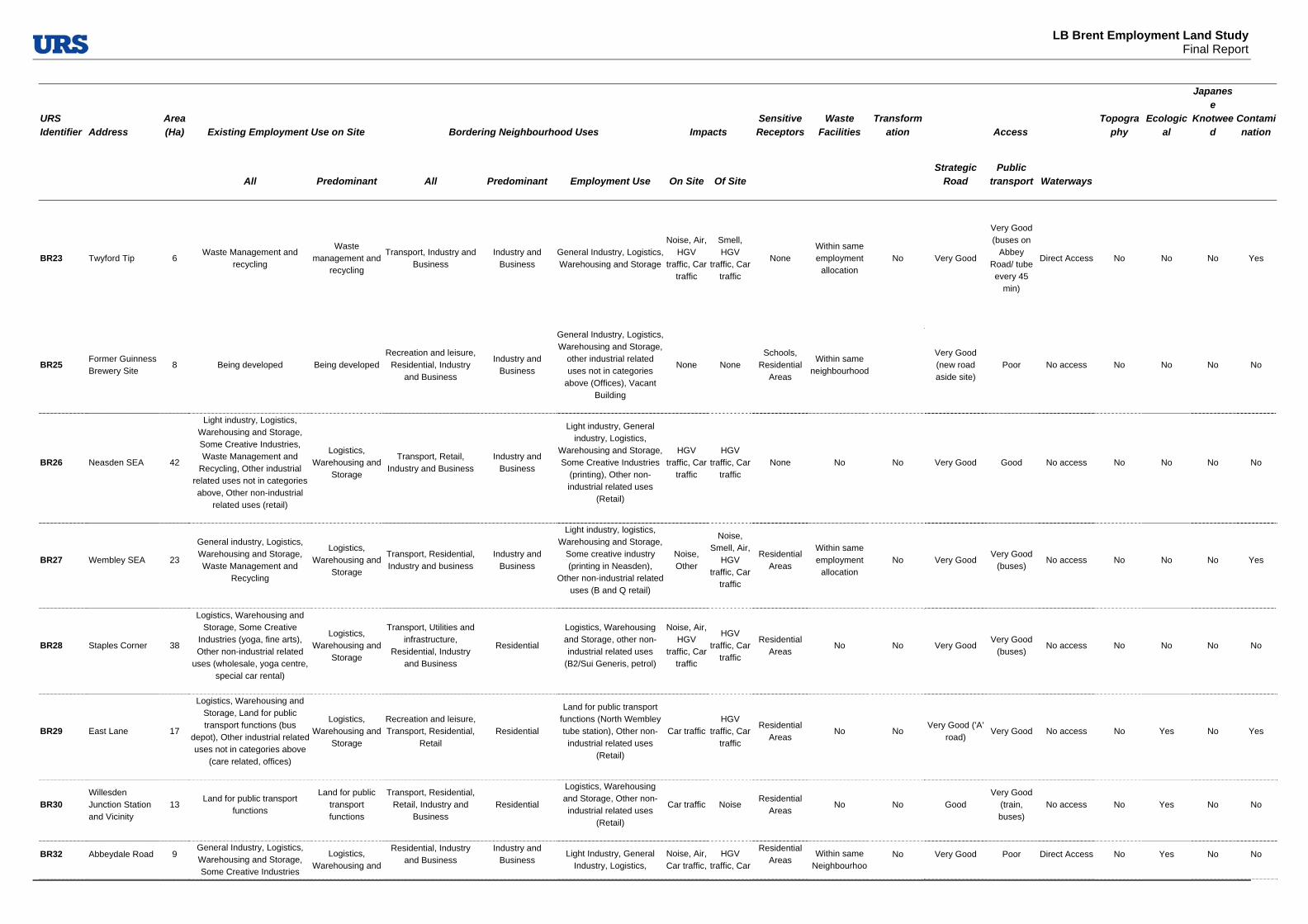
LB Brent Employment Land Study
Final Report
URS Identifier Address
Area (Ha) Existing Employment Use on Site Bordering Neighbourhood Uses Impacts
Sensitive Receptors
Waste Facilities
Transformation Access
Topography
Ecological
Japanese
Knotweed
Contamination
All Predominant All Predominant Employment Use On Site Of Site Strategic
Road Public
transport Waterways
BR23 Twyford Tip 6 Waste Management and
recycling
Waste management and
recycling
Transport, Industry and Business
Industry and Business
General Industry, Logistics, Warehousing and Storage
Noise, Air, HGV
traffic, Car traffic
Smell, HGV
traffic, Car traffic
None Within same employment
allocation No Very Good
Very Good (buses on
Abbey Road/ tube every 45
min)
Direct Access No No No Yes
BR25 Former Guinness Brewery Site
8 Being developed Being developed Recreation and leisure,
Residential, Industry and Business
Industry and Business
General Industry, Logistics, Warehousing and Storage,
other industrial related uses not in categories
above (Offices), Vacant Building
None None Schools,
Residential Areas
Within same neighbourhood
Very Good (new road aside site)
Poor No access No No No No
BR26 Neasden SEA 42
Light industry, Logistics, Warehousing and Storage, Some Creative Industries, Waste Management and
Recycling, Other industrial related uses not in categories above, Other non-industrial
related uses (retail)
Logistics, Warehousing and
Storage
Transport, Retail, Industry and Business
Industry and Business
Light industry, General industry, Logistics,
Warehousing and Storage, Some Creative Industries
(printing), Other non-industrial related uses
(Retail)
HGV traffic, Car
traffic
HGV traffic, Car
traffic None No No Very Good Good No access No No No No
BR27 Wembley SEA 23
General industry, Logistics, Warehousing and Storage, Waste Management and
Recycling
Logistics, Warehousing and
Storage
Transport, Residential, Industry and business
Industry and Business
Light industry, logistics, Warehousing and Storage,
Some creative industry (printing in Neasden),
Other non-industrial related uses (B and Q retail)
Noise, Other
Noise, Smell, Air,
HGV traffic, Car
traffic
Residential Areas
Within same employment
allocation No Very Good
Very Good (buses)
No access No No No Yes
BR28 Staples Corner 38
Logistics, Warehousing and Storage, Some Creative
Industries (yoga, fine arts), Other non-industrial related
uses (wholesale, yoga centre, special car rental)
Logistics, Warehousing and
Storage
Transport, Utilities and infrastructure,
Residential, Industry and Business
Residential
Logistics, Warehousing and Storage, other non-industrial related uses
(B2/Sui Generis, petrol)
Noise, Air, HGV
traffic, Car traffic
HGV traffic, Car
traffic
Residential Areas
No No Very Good Very Good
(buses) No access No No No No
BR29 East Lane 17
Logistics, Warehousing and Storage, Land for public transport functions (bus
depot), Other industrial related uses not in categories above
(care related, offices)
Logistics, Warehousing and
Storage
Recreation and leisure, Transport, Residential,
Retail Residential
Land for public transport functions (North Wembley tube station), Other non-
industrial related uses (Retail)
Car trafficHGV
traffic, Car traffic
Residential Areas
No No Very Good ('A'
road) Very Good No access No Yes No Yes
BR30 Willesden Junction Station and Vicinity
13 Land for public transport
functions
Land for public transport functions
Transport, Residential, Retail, Industry and
Business Residential
Logistics, Warehousing and Storage, Other non-industrial related uses
(Retail)
Car traffic Noise Residential
Areas No No Good
Very Good (train, buses)
No access No Yes No No
BR32 Abbeydale Road 9 General Industry, Logistics, Warehousing and Storage, Some Creative Industries
Logistics, Warehousing and
Residential, Industry and Business
Industry and Business
Light Industry, General Industry, Logistics,
Noise, Air, Car traffic,
HGV traffic, Car
Residential Areas
Within same Neighbourhoo
No Very Good Poor Direct Access No Yes No No

LB Brent Employment Land Study
Final Report
URS Identifier Address
Area (Ha) Existing Employment Use on Site Bordering Neighbourhood Uses Impacts
Sensitive Receptors
Waste Facilities
Transformation Access
Topography
Ecological
Japanese
Knotweed
Contamination
All Predominant All Predominant Employment Use On Site Of Site Strategic
Road Public
transport Waterways
(printing) other industrial related uses not in categories
above (B2/Sui Generis car related, food related), Other non-industrial related uses
(hotel)
Storage Warehousing and Storage None traffic d
BR33
Site Section of Twyford Tip, Tudor estates, Grand Union Industrial Estates
5
General Industry, logistics, Warehousing and Storage, Some Creative Industries
(printing banner advertisements)
Logistics, Warehousing and
Storage Industry and Business
Industry and Business
Logistics, Warehousing and Storage, Waste Management and
Recycling
HGV traffic, Car
traffic
HGV traffic, Car
traffic None
Within same employment
allocation No Very Good
Very Good (buses)
Direct Access No Yes No Yes
BR34
Site west of Abbey Road "Premier Industrial Park"
24
General industry, Logistics, Warehousing and Storage, Other non-industrial related
uses
Logistics, Warehousing and
Storage
Transport, Industry and Business
Industry and Business
General industry, Logistics, Warehousing and Storage, Waste Management and
Recycling
Noise, HGV
traffic, Car traffic
HGV traffic, Car
traffic None
Within same employment
allocation No Very Good
Very Good (buses)
Direct Access No No No No
BR34A Waxlow Road 12
General industry, Logistics, Warehousing and Storage,
Other industrial related uses (offices) , Other non industrial
related uses (fire station)
General Industry Transport, Industry and
Business Industry and
Business
General industry, Logistics, Warehousing and Storage,
Utilities, Other industrial related uses (offices) Other non-industrial related uses
(fire station)
Car traffic
Noise, Smell, HGV
traffic, Car traffic
None Within same employment
allocation No Very Good Good Direct Access No No No No
BR35
SW of Abbey Road, East of former Guinness brewery site
20 Logistics, Warehousing and
Storage, Other non- industrial related uses (B&B)
Logistics, Warehousing and
Storage
Industry and Business, Previously Developed
Land
Industry and Business
Logistics, Warehousing and Storage, Other non-industrial related uses
(hospital)
Noise, Car traffic
Noise, HGV
traffic, Car traffic
Hospitals Within same employment
allocation No Very Good
Very Good (buses)
Indirect Access
No Yes No No
BR36 North of Acton Lane
30
General industry, Logistics Warehousing and Storage, Some Creative Industries
(Park Royal Studies, Printmaking), Other non-
industrial related uses (café, ambulance depot, car retail)
Logistics, Warehousing and
Storage
Utilities and infrastructure (grid),
Community Services, Industry and Business, Previously Developed
Land
Industry and Business
General Industry, Logistics, Warehousing and Storage
None
Noise, HGV
traffic, Car traffic
Hospitals
Within the same
employment allocation
no Very Good Very Good
(buses) Direct Access No Yes No Yes

LB Brent Employment Land Study
Final Report
Table 4-7: Summary of Site Survey Description
URS Identifier Location Area (Ha) Site Description
BR01 Former Northern Foods site
2 Levelled site, good road network and proximity to bus network. Poor layout for sustainable modes of transports. Surrounded by predominantly B8 units.
BR02 Northfields Industrial Estate
9 Good strategic road access but not straightforward entry point and poor layout. Section hosting larger units fairly run-down, with stretch adjacent to site BR03
hosting smaller units at better standard.
BR03 Mount Pleasant/Beresford Avenue
4 Including a mix of uses, predominantly B2/Sui Generis. Offices to the Beresford Avenue side, mostly in good shape or recently refurbished and with low level of
vacancy. No strategic road access but bordered by the Grand Union canal to the South. Facing residential units along Beresford Avenue.
BR04 Woodside End/Sunleigh Road
2 Poorly maintained site, fairly secluded from main road with difficult entrance and
manoeuvrability inside the site itself. Surrounded by residential units and bordered by the Grand Union Canal to the South.
BR05
Alperton House/Abercorn Commercial Centre
2 Fairly well maintained site, with a mix of B1 and B8 uses, with very good public
transport connections (Alperton Underground station) and adjacent to canal. Low density uses to the West of site. Facing residential uses to the North.
BR06 Minavil House/Rosemont Road
1 Section facing Ealing Road hosting a variety of office spaces, including a college
providing computer training - section in poorer state and with poorer servicing facilities. Wharfside section to the North East including a mix of uses in premises of
high standard.
BR07 Bridgewater Road 1 Site with very good public transport access. Bus depot on site together with other low-density uses and a derelict plot.
BR08 Athlon Road 8 Site generally well maintained, connected and functionally laid out. Predominantly residential area to the East of Manor Farm Road. Hosting a variety of B8 uses.
BR09 Alperton Lane 10 Large site, generally well maintained environment and businesses. Hosting a variety of warehousing and general industry, including waste and construction
related.
BR10 Asiatic Carpets/Dalmeyer Road
3 Site hosting a mix of warehousing, light industry and offices (facing High Road). Poorer conditions on the Asiatic Carpets building and adjacent MOT services.
BR11 Cobbold Estate 3 Site hosting a mix of warehousing, light industry and offices to the East. Large
warehousing to the North, whilst small incubator units dominating the southern side, adjacent to a cemetery.
BR12 Sapcote Trading Estate
3 Small stretch of Chapman's Park well maintained, hosting a limited number of small light industrial units. Larger Sapcote Estate showing lower standards, suffering from some congestion and showing no clear boundaries with the residential units to the
East of site.
BR13 Artesian Close Industrial Estate
4 Predominantly occupied by power station, including chimneys and related works -
very well maintained, with evidence of improvement works to existing facilities. About 20% of the site occupied by trading estate, well serviced but low density and
with evidence of fly tipping.
BR14 Chancel House 1 Well-maintained office block, hosting Council related offices, with car park to the rear adjacent residential uses.
BR15 Capitol Industrial Park
7 Site hosting a variety of businesses, including B2/B8 uses, large retail (car sale), aswell as smaller B2 and office units.
BR16 Sarena House 1 Quite isolated as an industrial site, surrounded by A and residential uses, including some new and recent housing developments.
BR17 Kingsbury Road Industrial Estate
6 Well-maintained warehousing estate, with high quality buildings but significant amount of vacancy.
BR18 Neasden Lane 2 Well-maintained site. Two larger buildings in poor condition, with the remainder
being small units built to a high standard. Excellent underground and bus links from

LB Brent Employment Land Study
Final Report
North Neasden station.
BR19 Neasden Lane South
1 One occupier on-site (lorry park), good quality environment with trees lessening the visual impact of the site on its surroundings. . Excellent underground and bus links.
BR20 Honeypot Lane North
3 Large proportion of site occupied by two businesses - B&Q and a Builder's
Warehouse. Smaller B8/Sui Generis uses in poorer quality buildings. Large office building with vacancy observed. Well located next to main road and Queensbury
Underground Station
BR21 Honeypot Lane South
2 Small retailers, small warehouses and Sui Generis businesses with offices above retail uses. Poor environment, adequate servicing and parking. Well located close
to main road and Queensbury Underground Station
BR22 Edgware Road Bus Garage
1 Part of bus garage currently in-use with new garage and crew facility currently under construction on remainder of site
BR23 Twyford Tip 6 Site owned and maintained by Brent Council, used for recycling of household waste. Very good access from North Circular Road
BR25 Former Guinness Brewery Site
8 Site purchased for development and cleared, adequately fenced off. Construction not, visibly, commenced and evidence of active marketing by the developers.
BR26 Neasden SEA 42 SEA composed of an area of dispersed, generally large units, and smaller units at
the Brent Trading Estate. Very good condition of buildings and well-used workspace. Evidence of parking congestion particularly at the Brent Trading Estate
BR27 Wembley SEA 23 Large SEA composed mainly of larger warehousing units and a food processing
business, as well as some smaller Sui Generis/B8 premises. Good quality of environment, though little landscaping. Adequate parking and servicing.
BR28 Staples Corner 38 Large SEA containing a range of businesses occupying both large warehouses and
smaller B2/B8 units. Good environment although with lack of landscaping and adequate parking and servicing. Part of the site to the North of the North Circular
Road in use to JVC, with private access.
BR29 East Lane 17 Fairly large area containing a large bus depot, car servicing areas and B8 uses.
Gated entry and controlled parking. Evidence of landscaping and well used workspace. Close proximity to Underground Station
BR30 Willesden Junction Station and Vicinity
13 Train station, with land used for railway functions. Environment in need of some attention.
BR32 Abbeydale Road 9 Site entrances dominated by an office building and Travelodge in good condition.
Remainder or site predominantly occupied by B2/B8 ranging in quality from poor to good. Large vacant site at centre (Silverdale Centre). Poorly maintained area and
inadequate parking and servicing in places.
BR33
Site South of Twyford Tip, Tudor estates, Grand Union Industrial Estates
5 Range of small and medium size B2/B8 units, mostly in good or very good
condition. Severe lack of parking/ servicing areas at the Grand Union Industrial Estate. Well-used workspace and some vacancy observed.
BR34
Site East of Abbey Road "Premier Industrial Park"
24 Area predominantly occupied by large warehouse units, also available for industrial
use. Newly completed buildings in very good condition. Adequate servicing and parking and well landscaped area. Evidence of significant levels of vacancy.
BR34a Waxlow Road 12 Food processing hub dominated by McVities factory site and large oriental food business. Smaller trading estate also on site, still food dominated. Environment
very good, well laid-out and there is good use of workspace
BR35
SW of Abbey Road, East of Former Guinness Brewery Site
20 Area occupied mainly by warehouse units and small industrial premises. Generally very good quality buildings, with one still under construction. Adequate servicing
with evidence of some landscaping.
BR36 North of Acton Lane
30 Well-used site containing a range of small businesses, with buildings invariably in good/very good condition. Good quality environment, with parking and servicing
adequate for current uses.


LB Brent Employment Land Study
Final Report
Appendix C: Site Plans


LB Brent Employment Land Study
Final Report
Below are the site plans of 22 out of the 35 surveyed employment areas in LB Brent. The site plans cover all surveyed BEAs, LEAs, as well as parts of SEAs that can be identified as self-contained sites. The comprehensive plan for the Park Royal SEA, with URS Identifiers for surveyed site is also attached at the end.
Figure 4-1: Former Northern Food site, BR01
Figure 4-2: Northfields Industrial Estate, BR02
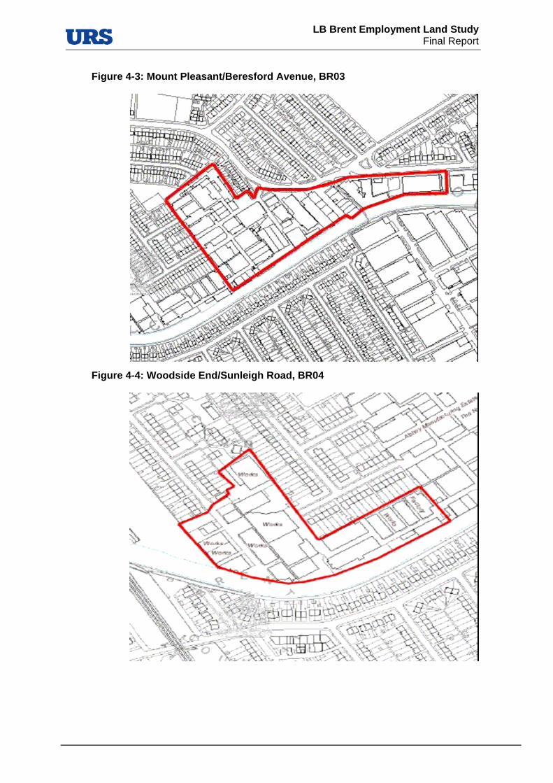
LB Brent Employment Land Study
Final Report
Figure 4-3: Mount Pleasant/Beresford Avenue, BR03
Figure 4-4: Woodside End/Sunleigh Road, BR04
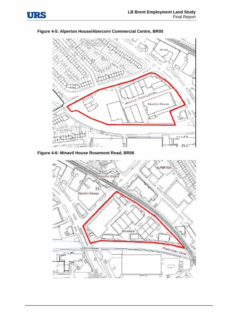
LB Brent Employment Land Study
Final Report
Figure 4-5: Alperton House/Abercorn Commercial Centre, BR05
Figure 4-6: Minavil House Rosemont Road, BR06
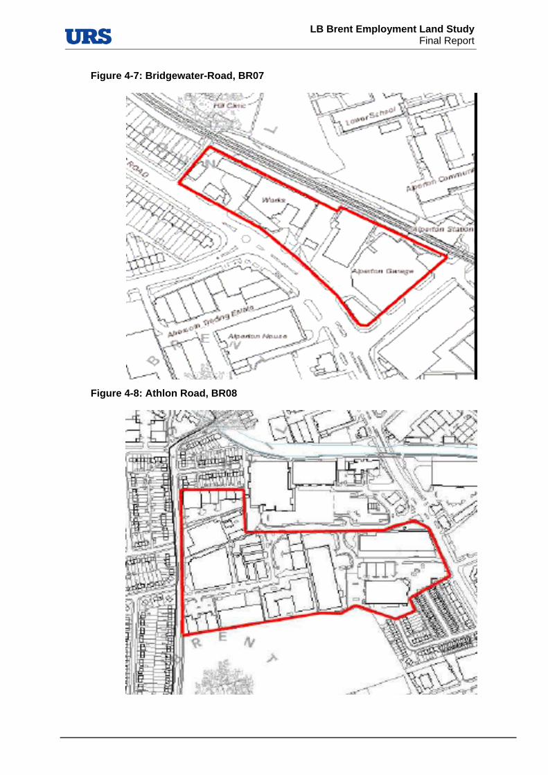
LB Brent Employment Land Study
Final Report
Figure 4-7: Bridgewater-Road, BR07
Figure 4-8: Athlon Road, BR08

LB Brent Employment Land Study
Final Report
Figure 4-9: Alperton Lane, BR09
Figure 4-10: Asiatic Carpets, BR10

LB Brent Employment Land Study
Final Report
Figure 4-11: Cobbold Estate, BR11
Figure 4-12: Sapcote Estate, BR12
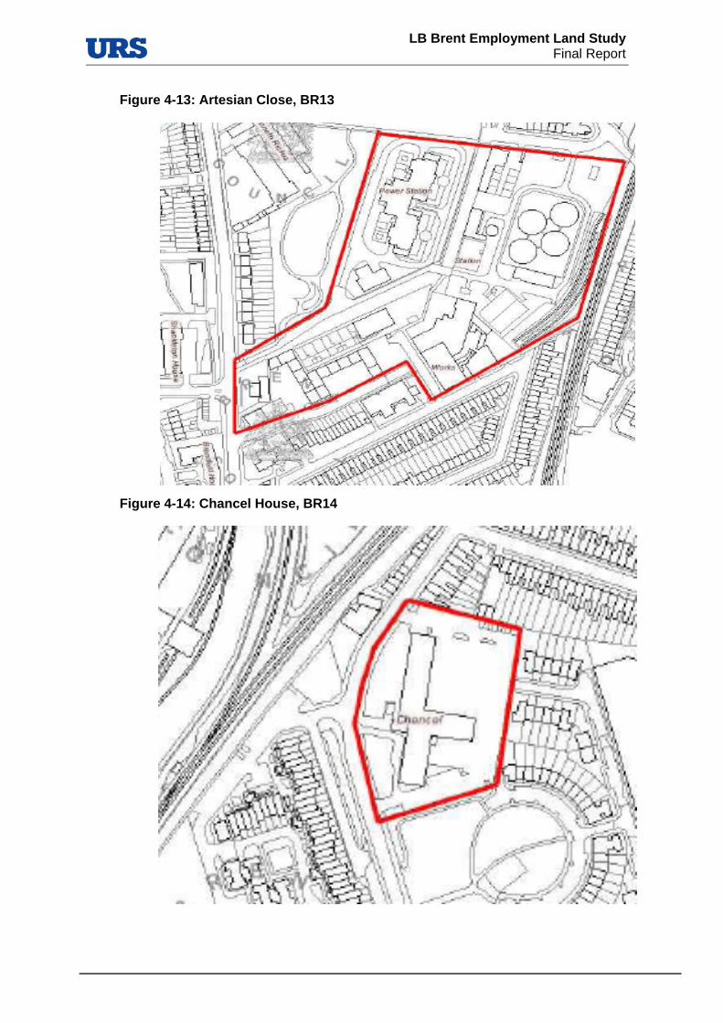
LB Brent Employment Land Study
Final Report
Figure 4-13: Artesian Close, BR13
Figure 4-14: Chancel House, BR14

LB Brent Employment Land Study
Final Report
Figure 4-15: Capitol Industrial Park, BR15
Figure 4-16: Sarena House, BR16

LB Brent Employment Land Study
Final Report
Figure 4-17: Kingsbury Road Industrial Estate, BR17
Figure 4-18: Neasden Lane North and South, BR 18 and BR19 respectively
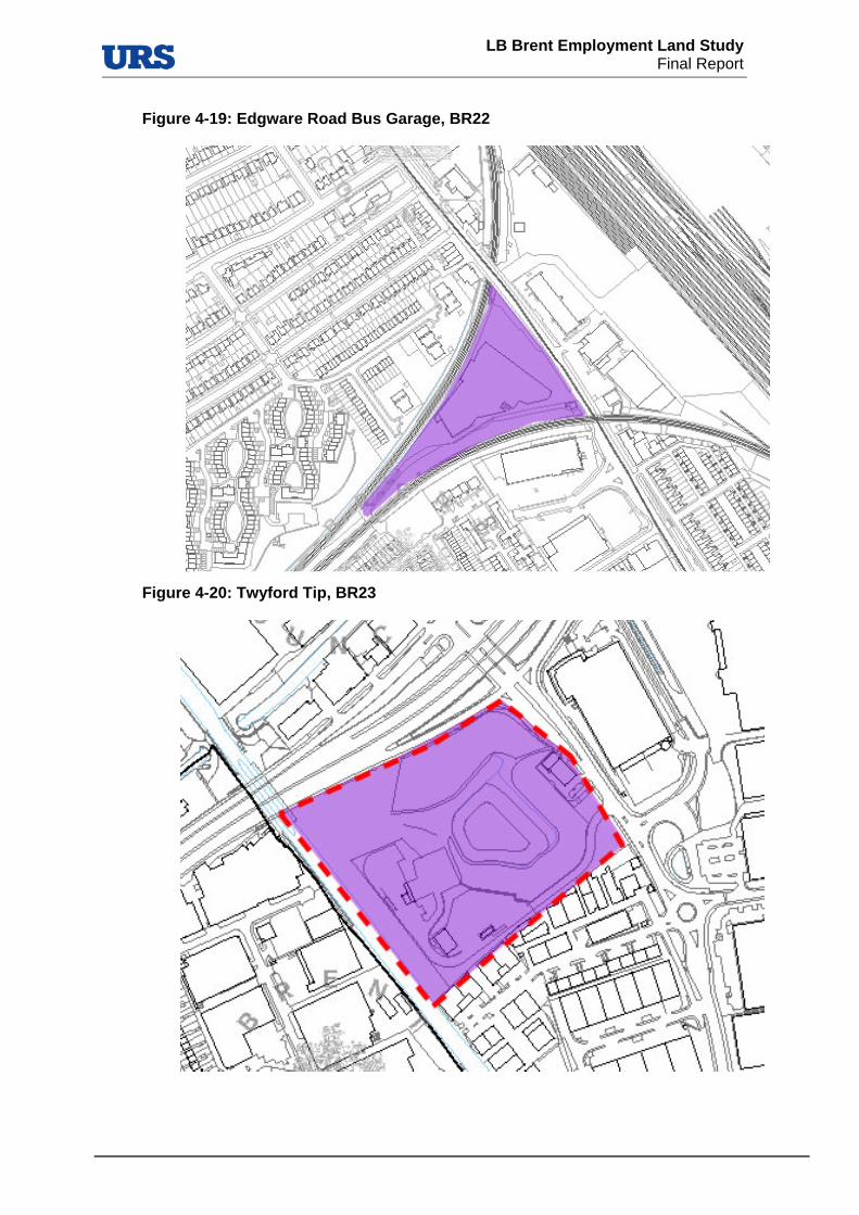
LB Brent Employment Land Study
Final Report
Figure 4-19: Edgware Road Bus Garage, BR22
Figure 4-20: Twyford Tip, BR23
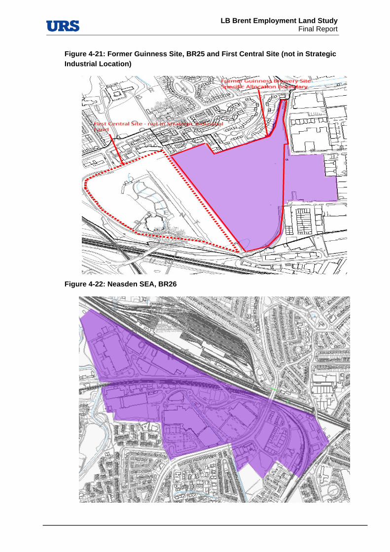
LB Brent Employment Land Study
Final Report
Figure 4-21: Former Guinness Site, BR25 and First Central Site (not in Strategic Industrial Location)
Figure 4-22: Neasden SEA, BR26

LB Brent Employment Land Study
Final Report
Figure 4-23: Wembley SEA, BR27
Figure 4-24: Staples Corner, BR28

LB Brent Employment Land Study
Final Report
Figure 4-25, East Lane, BR29

Figure 4-26: Park Royal SEA, all surveyed sub-sites

LB Brent Employment Land Study
Final Report
Appendix D: Employment Land Study Questionnaire


LB Brent Employment Land Study
Final Report
Data input by Initials…………………….. Date………………………….
EMPLOYMENT LAND DESIGNATIONS SITES:
SITE INFORMATION
URS site identifier
(Mail merge)
Location
(Mail merge)
Site area
(Mail merge)
Existing Employment use / Activity
(Multiple answers possible)
Light industry General industry Logistics, warehousing and storage Waste management and recycling Utilities Land for public transport functions Wholesale markets Some creative industries Other industrial related uses not in
categories to above Other non industrial related uses (please
make a note of type)
«Address»
«Area»
«URS_identifier»

LB Brent Employment Land Study
Final Report
Main existing Employment use / Activity
(Only one answer possible)
Light industry General industry Logistics, warehousing and storage Waste management and recycling Utilities Land for public transport functions Wholesale markets Some creative industries Other industrial related uses not in
categories to above Other non industrial related uses (please
make a note of type)
Type of site
(Only one answer possible)
Strategic Industrial Location Borough Employment Area Local Employment Area
Existing UDP site proposal
(Mail merge)
Is there a Site Specific Allocation (SSA)
(Mail merge)
On all the site On part of the site On site Adjacent to the site
Close to the site (Not adjacent but less than 100 metres) Outside the site More than 100 metres from the site
«Existing_UDP_proposal»

LB Brent Employment Land Study
Final Report
If there is a SSA (either on site or outside the site), then what are the aspirations of the Council for that site?
(Mail merge)
Developable area on site in percent …………%
This is an accumulation of identified and any unidentified vacant/derelict sites (inc. UDP allocations), in addition to any segments of developable/re-developable land we identify (intensification areas) – mark on map.
QUALITY
Condition of Buildings - % of buildings within site in:
(Only one answer possible)
Very Good …… % Good …… % Poor …… % Very Poor …… %
Quality of environment and public realm
(Only one answer possible)
Very Good Good Poor Very Poor
«SSA_Aspirations»
Always comments on quality of environment
Always comments on developable area

LB Brent Employment Land Study
Final Report
Signs of active marketing activity on site
(Only one answer possible)
Agent’s billboards Premises for rent sign None
SERVICES, FACILITIES AND AMENITIES
Access to facilities and amenities
(Only one answer possible)
Very Good Good Poor Very Poor
Servicing of businesses on site
(Multiple answers possible)
Road side loading/unloading Off road loading/unloading Loading bays
Servicing is adequate for the uses within the cluster
(Only one answer possible)
Yes No Don’t know
Parking facilities
(Multiple answers possible)
Dedicated parking On street parking Yellow / double yellow lines Red route Controlled parking zone/paid
parking
Always comment on servicing, reason for judgment on adequacy

LB Brent Employment Land Study
Final Report
Parking provision is
(Only one answer possible)
Adequate Too little Too much Don’t know
NEIGHBOURHOOD USES
What are the bordering neighbourhood uses?
(Multiple answers possible)
Agriculture and fisheries Forestry Minerals Recreation and leisure Transport Utilities and infrastructure Residential Community Services Retail Industry and business Previously developed Defence Unused land Other
What is the predominant bordering neighbourhood use?
(Only one answer possible)
Agriculture and fisheries Forestry Minerals Recreation and leisure Transport Utilities and infrastructure Residential Community Services Retail Industry and business Previously developed Defence Unused land Other
Always comment on parking provision, reason for judgment on adequacy

LB Brent Employment Land Study
Final Report
If there is any employment land in the bordering neighbourhood, please indicate below of which type
(Multiple answers possible)
Light industry General industry Logistics, warehousing and storage Waste management and recycling Utilities Land for public transport functions Wholesale markets Some creative industries Other industrial related uses not in
categories to above Other non industrial related uses (please
make a note of type)
What are the impacts of neighbouring sites on surveyed site?
(Multiple answers possible)
Noise Smell Air HGV traffic Car traffic Other None
What are the impacts of surveyed site on neighbouring sites?
(Multiple answers possible)
Noise Smell Air HGV traffic Car traffic Other None
Always comments on bad neighbourhood uses (except none)
Always comments on bad neighbourhood uses (except none)

LB Brent Employment Land Study
Final Report
Proximity to sensitive receptors:
(Multiple answers possible)
Schools Yes No Hospitals Yes No Residential Areas Yes No
Proximity to existing waste facilities:
(Only one answer possible)
Adjacent to Within same employment allocation Within same neighbourhood None
Is there any evidence of transformation/change in the neighbourhood?
(Only one answer possible)
(Evidence of active marketing in the area adjacent to the site - Agent’s billboards, Premises for rent sign; evidence of current or planned new development / redevelopment – Developers’ billboards, advert billboards; evidence of new developments including those which may have involved land-use changes. Please take pictures)
Yes No
- If yes, comment on it
- If yes to any of the above, comment on it
- If yes, comment on it

LB Brent Employment Land Study
Final Report
DEVELOPMENT CONSTRAINTS AND OPPORTUNITIES
Strategic road access (trunk roads) (Observation and desk based)
(Only one answer possible)
Very Good Good Poor Very Poor
Strategic access to public transport (Observation and desk based)
(Only one answer possible)
Very Good Good Poor Very Poor
Proximity to waterways (Observation and desk based)
(Only one answer possible)
Direct access Indirect access No access
Topography issues
(Only one answer possible)
Yes No
Ecological issues
(Only one answer possible)
Yes No
If yes, comments on topography and illustrate on map
If yes, comments on ecology and illustrate on map
LB Brent Employment Land Study
Final Report
Evidence of Japanese Knotweed (Visual assessment only)
(Only one answer possible)
Yes No
Evidence of potential contamination on site (Visual assessment only)
(Only one answer possible)
Yes No
Newly identified vacant/derelict site?
Mark on map, any temporary occupiers/ uses? ……………………………………………………………………………………………………..…………
Possibilities for intensification / redevelopment – opportunities for other land use aspirations or comprehensive regeneration (initial opinion)
REMARKS
General description of employment area
If yes, comments on Japanese Knotweed and illustrate on map – including:
- What is the approximate height of the plant
If yes, describe potential contamination and indicate on map
Always describe site, and include any comments you have
In which way, what are the options / how

LB Brent Employment Land Study
Final Report