London 26-27 January 2005
35
Achieving Network Enabled Achieving Network Enabled Capabilities through the Capabilities through the Definition, Understanding and Definition, Understanding and Dissemination of Metadata Dissemination of Metadata Olaf Østensen Olaf Østensen Chairman of ISO/TC 211 Geographic information/Geomatics Chairman of ISO/TC 211 Geographic information/Geomatics Norwegian Mapping and Cadastre Authority Norwegian Mapping and Cadastre Authority London London 26-27 January 2005 26-27 January 2005
-
Upload
alexis-frye -
Category
Documents
-
view
15 -
download
0
description
London 26-27 January 2005. Achieving Network Enabled Capabilities through the Definition, Understanding and Dissemination of Metadata. Olaf Østensen Chairman of ISO/TC 211 Geographic information/Geomatics Norwegian Mapping and Cadastre Authority. - PowerPoint PPT Presentation
Transcript of London 26-27 January 2005

Achieving Network Enabled Capabilities Achieving Network Enabled Capabilities through the Definition, Understanding through the Definition, Understanding
and Dissemination of Metadata and Dissemination of Metadata
Olaf ØstensenOlaf ØstensenChairman of ISO/TC 211 Geographic information/GeomaticsChairman of ISO/TC 211 Geographic information/Geomatics
Norwegian Mapping and Cadastre AuthorityNorwegian Mapping and Cadastre Authority
LondonLondon26-27 January 200526-27 January 2005

The fundament of geospatial The fundament of geospatial technology in the networked age …technology in the networked age …
INTEROPERABILITYINTEROPERABILITY
and metadata is necessary to achieve interoperabilityand metadata is necessary to achieve interoperability
– semantic interoperability (understanding the information)semantic interoperability (understanding the information)– technical interoperability (e.g. enabling interfaces to technical interoperability (e.g. enabling interfaces to
communicate)communicate)
MunicipalMunicipalServicesServices
TransportationTransportation
GovernmentGovernment
CadastreCadastre
UtilitiesUtilities
Network computing resources with OpenGIS interfaces
Natural ResourcesNatural Resources& Agriculture& Agriculture
Business LogisticsBusiness Logistics
Civil EngineeringCivil Engineering

What is metadata ?What is metadata ?
• ““Data about Data”Data about Data”
• ““provides information about the identification, the provides information about the identification, the extent, the quality, the spatial and temporal extent, the quality, the spatial and temporal schema, spatial reference, and distribution of schema, spatial reference, and distribution of digital geographic data”digital geographic data”
• Ensures the right data for the right purposeEnsures the right data for the right purpose
• Ensures that information is used correctlyEnsures that information is used correctly
Geospatial data has a long history using MetadataGeospatial data has a long history using Metadata

Title
Symbols
Identification
Scale
Accuracy
Producer
Navigation notices Referencesystem
Sources
Location
Date
Paper Maps
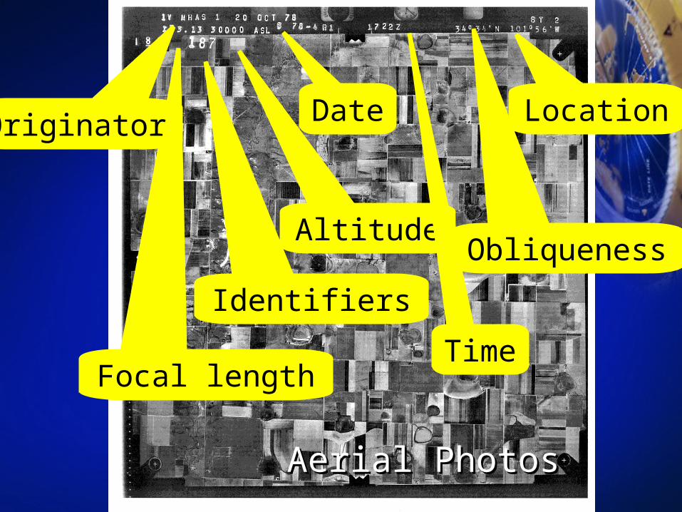
Identifiers
Altitude
Focal length
Date LocationOriginator
Obliqueness
Time
Aerial PhotosAerial Photos

If we do not know the If we do not know the metadata…metadata…
• how can we know the currency?how can we know the currency?
• how can we know the accuracy?how can we know the accuracy?
• how can we know the completeness?how can we know the completeness?
• ……..
• ……..
HOW CAN WE TRUST THE INFORMATION?HOW CAN WE TRUST THE INFORMATION?

Up to now …Up to now …
• we have known the producerwe have known the producer
• we have known the data serieswe have known the data series
• we had an overall view of currency, quality we had an overall view of currency, quality and completenessand completeness
with the networked services, all this is with the networked services, all this is changing …changing …

In the networked age …In the networked age …
• a vast amount of data that can be a vast amount of data that can be downloadeddownloaded
• more important, an enormous amount of more important, an enormous amount of geospatial services that we can connect togeospatial services that we can connect to
METADATA AND METADATA METADATA AND METADATA UNDERSTANDING BECOMES UNDERSTANDING BECOMES
MANDATORY!MANDATORY!

Metadata is necessaryMetadata is necessary
Service Awith interface
Service Bwith interface
Service Cwith interface
Service Zwith interface
…
a variety of content,a variety of content,reference and thematicreference and thematicdatadata
a rich set of functionalitya rich set of functionality- services- services
a variety a variety of appli-of appli-cationscations
Metadata - datasets
Metadata - services

Pleasantville
Pleasantville
Pleasantville
User EnvironmentUser Environment
• Understand the ModelUnderstand the Model– How features are representedHow features are represented– Connectivity Connectivity
• Understand the ContentUnderstand the Content– Why features are included or excludedWhy features are included or excluded
• Understand the Point-of-ViewUnderstand the Point-of-View– Business/CommercialBusiness/Commercial– Environmental/ScientificEnvironmental/Scientific– Military/Defense/IntelMilitary/Defense/Intel

Processing EnvironmentProcessing Environment
• Support user DecisionsSupport user Decisions– Identify multiple datasets within an applicationIdentify multiple datasets within an application– Know the good and bad areasKnow the good and bad areas– Merging data (which is the better data?)Merging data (which is the better data?)
• CurrentnessCurrentness• QualityQuality
• Support Computer ProcessingSupport Computer Processing– Application software functionsApplication software functions– Capabilities, accessCapabilities, access– Guide software through the dataGuide software through the data

Metadata - Supporting Geographic DataMetadata - Supporting Geographic Dataand Services Life Cycleand Services Life Cycle
Query, DiscoverQuery, Discover
4. Discover4. Discover MetadataMetadata
CatalogCatalog
2. Catalog2. Catalog
Publish ServicesPublish Services
3. Publish3. Publish
Catalog PortalCatalog Portal
ArchiveArchive
6. Archive6. Archive
End UserEnd User
5. Use/Access5. Use/AccessCreate Data andCreate Data and
ServicesServices
1. Create Content1. Create Content

Metadata perspectivesMetadata perspectives
• Why is metadata more important now?Why is metadata more important now?– Expansion in the use of Geographic InformationExpansion in the use of Geographic Information
• Proliferation of dataProliferation of data• Non-geographers using geospatial dataNon-geographers using geospatial data• The producer is not the userThe producer is not the user
– Geospatial data is imperfectGeospatial data is imperfect• A model, a “point of view”A model, a “point of view”• Assumptions, limitations, approximations, simplificationsAssumptions, limitations, approximations, simplifications
– Geospatial data is expensive Geospatial data is expensive • ReuseReuse• Data managementData management
• Why should it be standardized?Why should it be standardized?– Provide an understanding of data – around the Globe Provide an understanding of data – around the Globe
and across information communitiesand across information communities

ISO 19115:2003ISO 19115:2003

• a NGO based in Genevaa NGO based in Geneva
• established in 1947established in 1947
• the authorized publisher of global standardsthe authorized publisher of global standards
• published more than 14 000 standards (e.g. ISO published more than 14 000 standards (e.g. ISO 9000- and ISO 14000-series)9000- and ISO 14000-series)
• based upon national membership – 148 countries based upon national membership – 148 countries participateparticipate
ISO - ISO - the International Organization the International Organization for Standardizationfor Standardization

ISO 19115:2003ISO 19115:2003
ScopeScope
• ...the ...the schema required for schema required for describingdescribing geographic information geographic information and and services services
• ...information...information about the identification, the extent, the quality, the spatial about the identification, the extent, the quality, the spatial and temporal schema, spatial reference, and distribution of and temporal schema, spatial reference, and distribution of digital digital geographic datageographic data
• ...applicable...applicable to the to the cataloguingcataloguing of datasets, of datasets, clearinghouseclearinghouse activities, and activities, and the the full descriptionfull description of datasets for a of datasets for a wide range of geographic applicationswide range of geographic applications
• ……applicableapplicable to geographic to geographic datasetsdatasets, dataset , dataset seriesseries, and , and individual individual geographicgeographic features features and and attributesattributes
• ......may be usedmay be used for other forms of geographic data such as for other forms of geographic data such as map, charts, map, charts, textual documentstextual documents

ISO 19115:2003ISO 19115:2003
• Designed:Designed:– to support geographic information;to support geographic information;– to work with wider information technology standards to work with wider information technology standards
and practices;and practices;– to serve the global community, in a multi-national, to serve the global community, in a multi-national,
multi-language environment;multi-language environment;– based on a foundation of national, regional, and based on a foundation of national, regional, and
special information community standards and special information community standards and experiencesexperiences
• Developed through a rigorous, consensus ISO Developed through a rigorous, consensus ISO processprocess
• Provides a foundation for national, regional, and Provides a foundation for national, regional, and global interoperabilityglobal interoperability
Semantic Interoperability

ISO 19115:2003 ISO 19115:2003
Metadata applicationsMetadata applications
Metadata
Aggregate DataSet
DataSet
OtherAssociation
StereoMate
Series Initiative
PropertyType
FeatureType
FeatureAttribute
Feature
0..*
0..*
0..*
0..*0..*
0..*
1..*
0..*
1..*
0..*
0..*
1..*
Platform Sensor ProductionSeries

Recommended core metadata for geographic datasetsRecommended core metadata for geographic datasets
Dataset titleDataset title Dataset reference dateDataset reference date Dataset responsible partyDataset responsible party Geographic location of the Geographic location of the
dataset dataset (by four coordinates or by (by four coordinates or by geographic identifiers)geographic identifiers)
Dataset languageDataset language Dataset character setDataset character set Dataset topic categoryDataset topic category– Spatial ResolutionSpatial Resolution Abstract describing the datasetAbstract describing the dataset– Distribution formatDistribution format
– Additional extent information Additional extent information (vertical and temporal)(vertical and temporal)
– Spatial representation typeSpatial representation type– Reference systemReference system– Lineage statementLineage statement– On-line resourceOn-line resource– Metadata file identifierMetadata file identifier– Metadata standard nameMetadata standard name– Metadata standard versionMetadata standard version Metadata languageMetadata language Metadata character setMetadata character set Metadata point of contactMetadata point of contact Metadata time stampMetadata time stamp
MandatoryMandatory

Other metadata standards under Other metadata standards under workwork
• ISO/TS 19139 ISO/TS 19139 Geographic Information – Geographic Information – MetadataMetadata – – XML Schema SpecificationXML Schema Specification
• ISO 19115-2 ISO 19115-2 Geographic Information – Geographic Information – MetadataMetadata – Part 2 – Part 2 Extensions for Imagery Extensions for Imagery and Gridded Dataand Gridded Data

ISO 19115-2 ISO 19115-2 Geographic Information – Geographic Information – MetadataMetadata – Part 2 Extensions for Imagery and – Part 2 Extensions for Imagery and Gridded DataGridded Data
• ScopeScope– This International Standard This International Standard extendsextends ISO ISO
19115:2003 Geographic Information – Metadata 19115:2003 Geographic Information – Metadata by by defining the schema and additional metadatadefining the schema and additional metadata required for imagery and gridded datarequired for imagery and gridded data
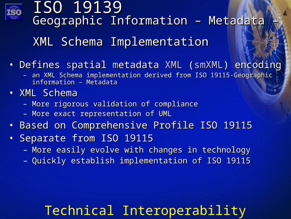
ISO 19139ISO 19139Geographic Information – Metadata – Geographic Information – Metadata – XML Schema ImplementationXML Schema Implementation
• Defines Defines sspatial patial mmetadata etadata XMLXML ( (smXMLsmXML) encoding) encoding– an XML Schema implementation derived from ISO 19115-Geographic information – an XML Schema implementation derived from ISO 19115-Geographic information –
MetadataMetadata
• XML SchemaXML Schema – More rigorous validation of complianceMore rigorous validation of compliance– More exact representation of UML More exact representation of UML
• Based on Comprehensive Profile ISO 19115 Based on Comprehensive Profile ISO 19115 • Separate from ISO 19115Separate from ISO 19115
– More easily evolve with changes in technologyMore easily evolve with changes in technology– Quickly establish implementation of ISO 19115Quickly establish implementation of ISO 19115
Technical Interoperability

Liaison Organizations and Related WorkLiaison Organizations and Related Work
ISO 19115:2003ISO 19115:2003
FGDC/NASAMetadata Remote Sensing Extensions
FGDC/NASAMetadata Remote Sensing Extensions
ISO19115 - 2 Imagery
Extensions
ISO19115 - 2 Imagery
Extensions
IHOS-57 Edition 4
IHOS-57 Edition 4
SMPTESMPTEJTC1/SC24ISO/IEC 12087-5 BIIF
JTC1/SC24ISO/IEC 12087-5 BIIF
CommercialSPOT
CommercialSPOT
ConsortiumIEEE
ISPRSWMO
ConsortiumIEEE
ISPRSWMO
National participation
National participation

Metadata PortalsMetadata Portals
• Portal – gateway, place of entryPortal – gateway, place of entry– ProducersProducers
• Advertise, expose productsAdvertise, expose products• Share information about holdingsShare information about holdings
– Provide an understanding of data and servicesProvide an understanding of data and services
– UsersUsers• Perform efficient searches by requirementsPerform efficient searches by requirements• Discover data and servicesDiscover data and services• Determine fitness for useDetermine fitness for use• Acquire access informationAcquire access information

What are users looking for?What are users looking for?
• DataData for use in GIS software for use in GIS software• GIS GIS ServicesServices - mapping, geoprocessing - mapping, geoprocessing• Geospatial Geospatial applicationsapplications• Planned data Planned data acquisitionsacquisitions• Events, Events, activitiesactivities and information and information
A metadata portal contains A metadata portal contains metadata for all of the abovemetadata for all of the above

Metadata and INSPIRE Metadata and INSPIRE Directive (proposal)Directive (proposal)
Article 7Article 7Member States shall establish and operate infrastructures for Member States shall establish and operate infrastructures for spatial information in accordance with this Directive.spatial information in accordance with this Directive.
Chapter IIChapter IIMetadataMetadataArticle 8Article 8
1. Member States shall ensure that metadata are created for 1. Member States shall ensure that metadata are created for spatial data sets and services, and that those metadata are spatial data sets and services, and that those metadata are kept up to date.kept up to date.2. Metadata shall include information on the following:2. Metadata shall include information on the following:…………3. Member States shall take the necessary measures to 3. Member States shall take the necessary measures to ensure that metadata are complete and of high quality.ensure that metadata are complete and of high quality.
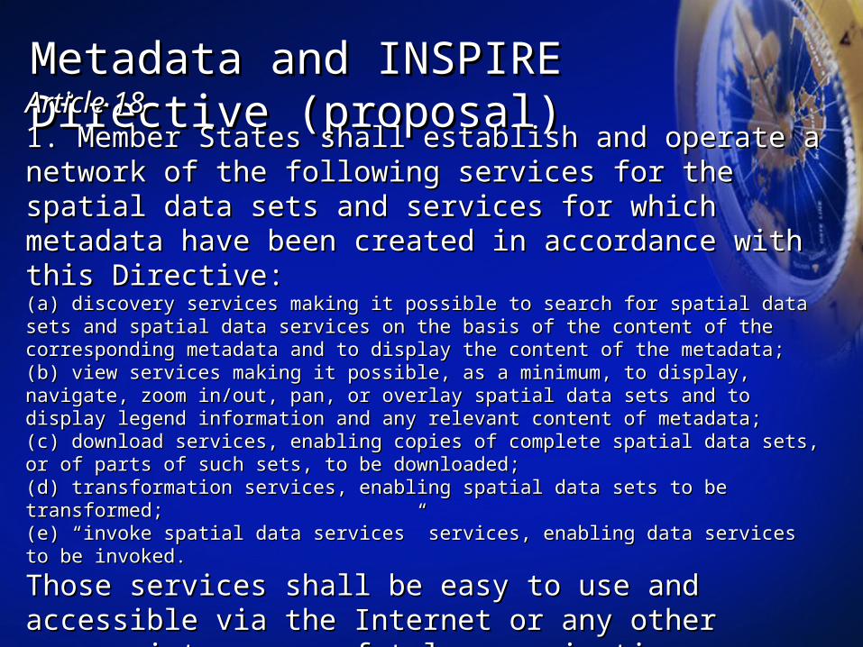
Metadata and INSPIRE Metadata and INSPIRE Directive (proposal)Directive (proposal)Article 18Article 181. Member States shall establish and operate a network of the 1. Member States shall establish and operate a network of the following services for the spatial data sets and services for following services for the spatial data sets and services for which metadata have been created in accordance with this which metadata have been created in accordance with this Directive:Directive:(a) discovery services making it possible to search for spatial data sets and spatial data (a) discovery services making it possible to search for spatial data sets and spatial data services on the basis of the content of the corresponding metadata and to display the content services on the basis of the content of the corresponding metadata and to display the content of the metadata;of the metadata;(b) view services making it possible, as a minimum, to display, navigate, zoom in/out, pan, or (b) view services making it possible, as a minimum, to display, navigate, zoom in/out, pan, or overlay spatial data sets and to display legend information and any relevant content of overlay spatial data sets and to display legend information and any relevant content of metadata;metadata;(c) download services, enabling copies of complete spatial data sets, or of parts of such sets, (c) download services, enabling copies of complete spatial data sets, or of parts of such sets, to be downloaded;to be downloaded;(d) transformation services, enabling spatial data sets to be transformed;(d) transformation services, enabling spatial data sets to be transformed;(e) “invoke spatial data services” services, enabling data services to be invoked.(e) “invoke spatial data services” services, enabling data services to be invoked.
Those services shall be easy to use and accessible via the Those services shall be easy to use and accessible via the Internet or any other appropriate means of telecommunication Internet or any other appropriate means of telecommunication available to the public.available to the public.
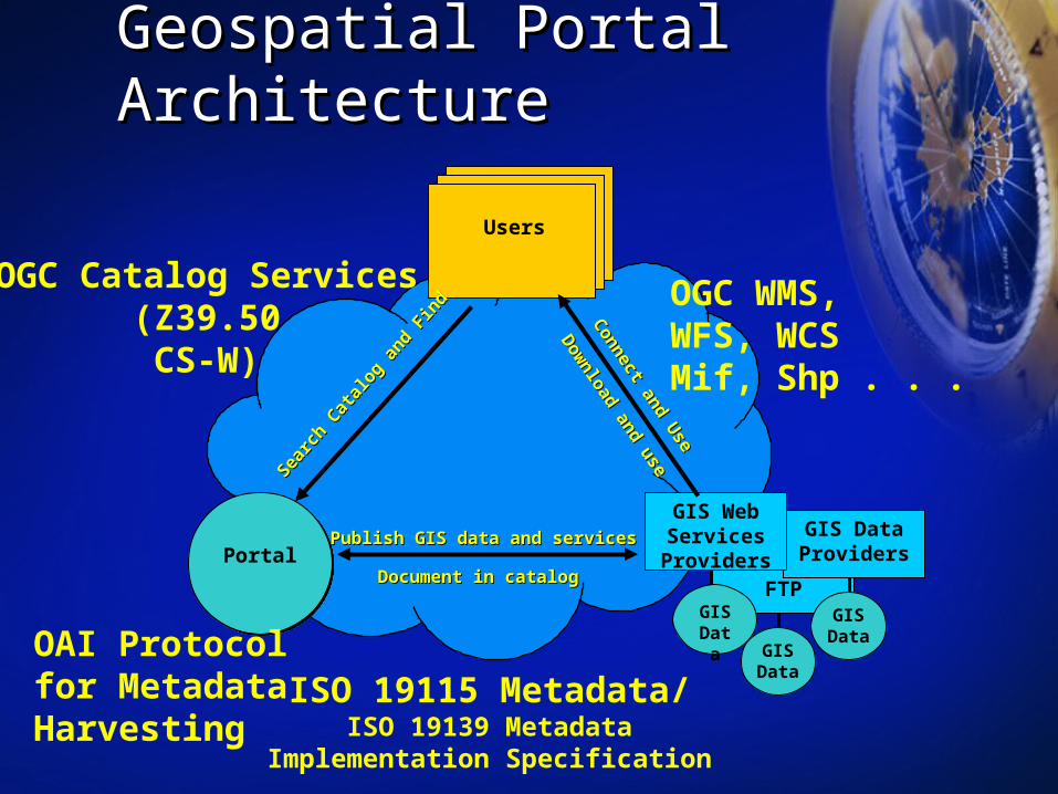
Geospatial Portal ArchitectureGeospatial Portal Architecture
FTP
GIS Data Providers
Users
GIS Data
GIS Web Services ProvidersPortal
Searc
h Cat
alog
and
Fin
d
Searc
h Cat
alog
and
Fin
d
Publish GIS data and servicesPublish GIS data and services
Document in catalog Document in catalog
Connect and U
se
Connect and U
se
Dow
nload and use
Dow
nload and use
GISData
GISData
OGC WMS,WFS, WCSMif, Shp . . .
OGC Catalog Services(Z39.50CS-W)
ISO 19115 Metadata/ISO 19139 Metadata
Implementation Specification
OAI Protocolfor MetadataHarvesting
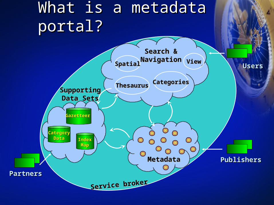
What is a metadata portal?What is a metadata portal?
UsersUsers
MetadataMetadata
PartnersPartners
PublishersPublishers
GazetteerGazetteer
IndexIndexMapMap
CategoryCategoryDataData
SpatialSpatial
ThesaurusThesaurus CategoriesCategories
ViewView
Search &Search &NavigationNavigation
SupportingSupportingData SetsData Sets
Service brokerService broker

Internet
Metadata Server
Metadata Server
AuthorAuthor
PublishPublish
DiscoverDiscover
Exposing MetadataExposing Metadata
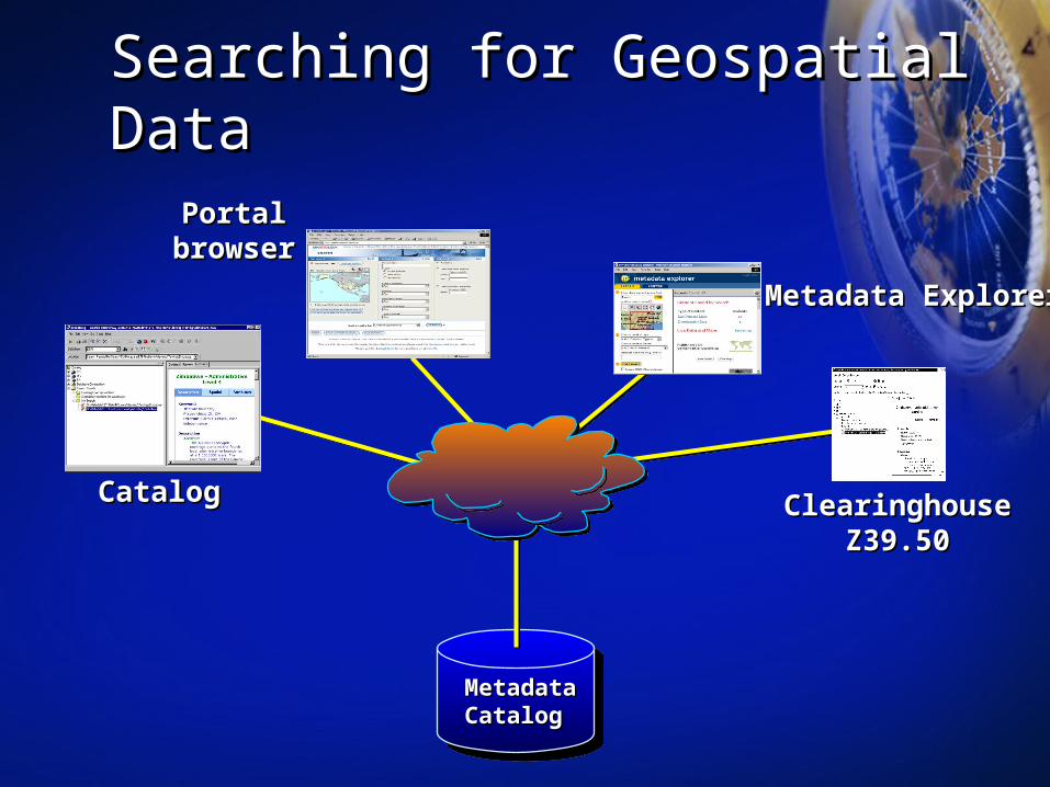
Searching for Geospatial Data Searching for Geospatial Data
Metadata Metadata CatalogCatalog
CatalogCatalog
Portal Portal browserbrowser
Clearinghouse Clearinghouse Z39.50Z39.50
Metadata ExplorerMetadata Explorer

Searching MetadataSearching MetadataThrough a PortalThrough a Portal

• ISO TC 211 is taking ISO TC 211 is taking the next stepsthe next steps– Expanding for imageryExpanding for imagery– Implementation specificationImplementation specification
• Technical interoperabilityTechnical interoperability
• Metadata PortalsMetadata Portals– Fast, direct accessFast, direct access– Increased & easy Increased & easy
participation participation – Key lifecycle componentKey lifecycle component– Standards based tools make Standards based tools make
it easyit easy
SummarySummaryISO MetadataISO Metadata
• Many flavors of Many flavors of interoperabilityinteroperability
• Metadata – a key factor Metadata – a key factor enabling interoperabilityenabling interoperability
• Essential for all aspects of Essential for all aspects of spatial data handlingspatial data handling– LocateLocate– EvaluateEvaluate– ExtractExtract– EmployEmploy
• Metadata in the ISO Metadata in the ISO 19115 standard19115 standard– Semantic interoperabilitySemantic interoperability– Provides a common Provides a common
understandingunderstanding– Expanded networksExpanded networks– Global InteroperabilityGlobal Interoperability

SummarySummary
• metadata supports assessment of information on the metadata supports assessment of information on the internetinternet
• metadata is necessary for connecting to network metadata is necessary for connecting to network services (e.g. wms, wfs, wcs, … )services (e.g. wms, wfs, wcs, … )
• metadata is a necessary – although not metadata is a necessary – although not sufficient – condition to trust information in the sufficient – condition to trust information in the networked environment!networked environment!

Thank you !Thank you !
… … also thanks to David Danko, project leader in metadata in also thanks to David Danko, project leader in metadata in ISO/TC 211 for providing input to this presentationISO/TC 211 for providing input to this presentation