
LIVE INTERACTIVE LEARNING @ YOUR DESKTOP October 12, 2011 Citizen Science Networks Presented by:...
75
LIVE INTERACTIVE LEARNING @ YOUR DESKTOP October 12, 2011 Citizen Science Networks Presented by: Henry Reges and James Zdrojewski
-
date post
21-Dec-2015 -
Category
Documents
-
view
213 -
download
0
Transcript of LIVE INTERACTIVE LEARNING @ YOUR DESKTOP October 12, 2011 Citizen Science Networks Presented by:...

LIVE INTERACTIVE LEARNING @ YOUR DESKTOP
October 12, 2011
Citizen Science Networks
Presented by: Henry Reges and James Zdrojewski

CoCoRaHS“Because every drop counts”

What is CoCoRaHS? An overview

CoCoRaHS is a grassroots, high-density, precipitation network.
It is made up of over 15,000 volunteers of all ages and backgrounds who take daily precipitation measurements in their own backyards each morning

4-inch diameterHigh capacity rain gauges
Aluminum foil-wrappedStyrofoam hail pads
Our volunteers are trained to assure accurate, high quality data
Once trained our volunteers collect data using low-cost measurement tools
In person trainings or via the Web

Just Precipitation!Just Precipitation!
Rain
SnowHail

Our volunteers report their daily observations on our interactive Web site:www.cocorahs.org

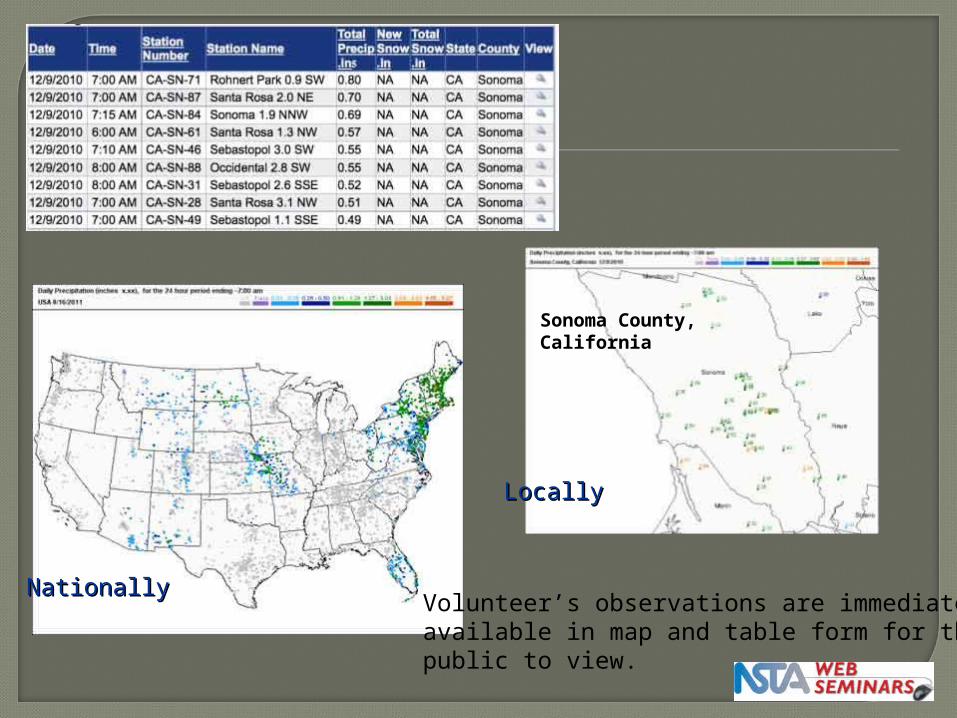
LocallyLocally
NationallyNationallyVolunteer’s observations are immediatelyavailable in map and table form for thepublic to view.
Sonoma County,California

9:49PM 9:58PM 10:08PM
Loveland Loveland Loveland
Ft. Collins Ft. Collins Ft. Collins
10:28PM
Severe Thunderstorm over Fort Collins, ColoradoMonday, July 20, 2009

Old Town
CSUHughes Stadium
Harmony
Interstate 25
Ted’s Place


A short history of CoCoRaHS


AA BB
1. The extreme local variations in rainfall possible from convective storms
2. The important role individuals can play in measuring, mapping and reporting precipitation.
Distance between A and B = 5 miles
A = 14.5 inchesB = 2.0 inches

1998 Today
A few dozen volunteers in Northern Colorado 15,000+ volunteers in all 50 states
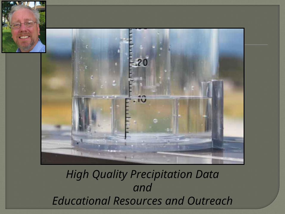
CoCoRaHS’s goal is to provide:
High Quality Precipitation Dataand
Educational Resources and Outreach

Rainfall DataRainfall Data
CoCoRaHS has quickly become the largest source of daily precipitation measurements in the United States

Rainfall can be extremely variable. With a dense network of rain gauges we hope to capture observations from that obscure storm.
0.00”
0.25”
0.00”

7.12” May 6, 2008, Comal, Texas
New Braunfels
San Antonio

Without CoCoRaHS data
With CoCoRaHS data
“With CoCoRaHS it’s like increasing the number of pixels on your digital camera.
You get a much clearer picture of where precipitation did and did not fall!”

In many cases radar doesn’t measure snow well, while
satellite-based products have many limitations.
With our local volunteers CoCoRaHS is providing additional “winter weather” measurement capabilities in many states across the country.
In some Colorado cities, there is approximately one CoCoRaHS observer per sq. mile.
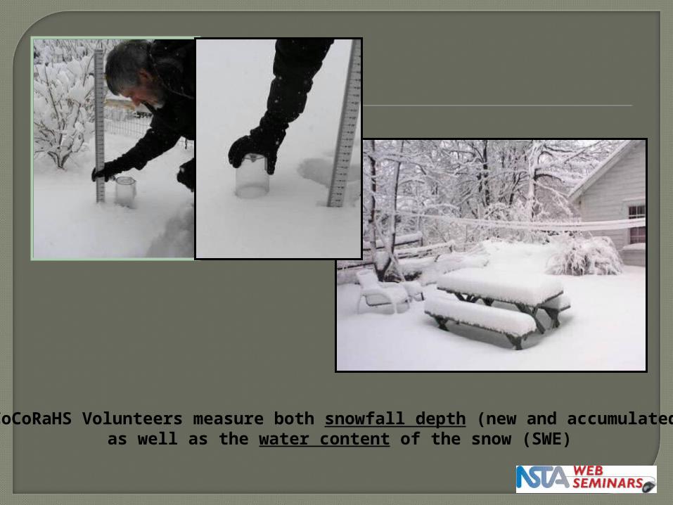
CoCoRaHS Volunteers measure both snowfall depth (new and accumulated)as well as the water content of the snow (SWE)

CoCoRaHS has become one of the largest repositories of hail data in the United States

“Helping to provide the public with a better understanding of weather and climate”
Educational Outreach Opportunities


Is CoCoRaHS data used? You bet !
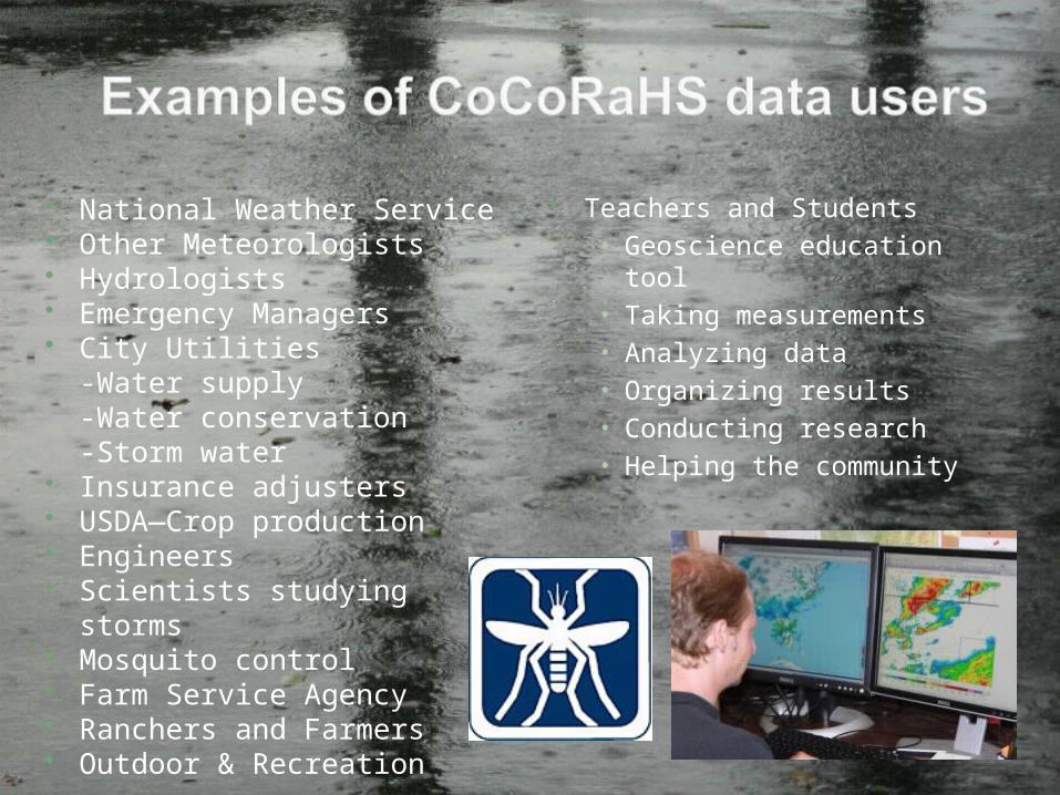
National Weather Service Other Meteorologists Hydrologists Emergency Managers City Utilities
-Water supply-Water conservation-Storm water
Insurance adjusters USDA—Crop production Engineers Scientists studying storms Mosquito control Farm Service Agency Ranchers and Farmers Outdoor & Recreation
Teachers and Students• Geoscience education tool• Taking measurements• Analyzing data• Organizing results• Conducting research• Helping the community

Improved Drought Awareness“Making citizens aware of how the lack of precipitation can impact they daily lives”
Citizens Reporting Drought Impacts

"We use the CoCoRaHS data in our post-storm summary to describe the overall impacts of a tropical cyclone event."
Dan Brown - National Hurricane Center2008 – Tropical Storm Fay

Precip data used to determine when to close shellfish beds

http://www.nrlmry.navy.mil/htdocs_dyn/PUBLIC/nexsat/pages/conus/nexsat_conus.html
Used in ground truthing satellite precipitation measurements
GROUND TRUTH

Significant Weather Reports
Hail Reports
Possible Flash Flood orSevere Thunderstorm
Warnings issued
Instant Snow Reports
DENCCRAHS
Additional “Real-Time” Reports

CoCoRaHS hopes to one day
achieve a network of . . .
one observer every square mile
in urban areas
one observer every 36 square miles
in rural areas

Educational Resources for Teachers and Students

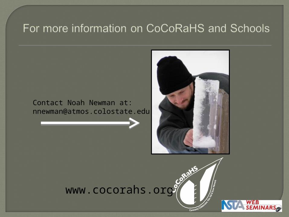
CoCoRaHS School Pilot Program

CoCoRaHS Schools Page

CoCoRaHS/4-H Lesson Plans

A Rain Gauge at every school in Colorado for 2012

What about weekends and summer reporting?
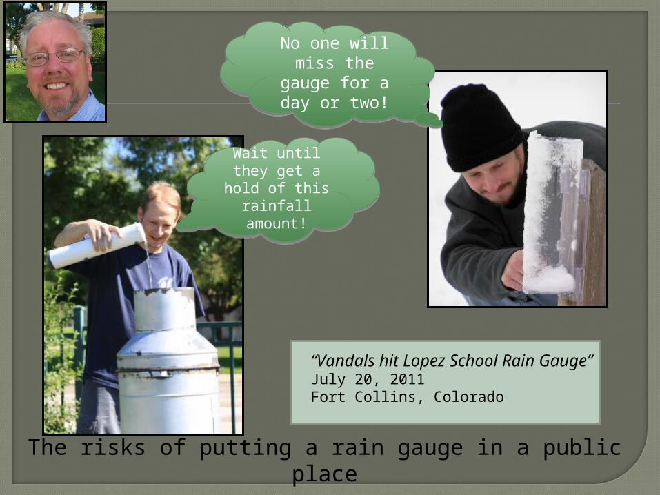
The risks of putting a rain gauge in a public place
“Vandals hit Lopez School Rain Gauge”July 20, 2011Fort Collins, Colorado
No one will miss the gauge
for a day or two!
No one will miss the gauge
for a day or two!
Wait until they get a hold of this rainfall
amount!
Wait until they get a hold of this rainfall
amount!

What’s ahead for CoCoRaHS?

Additional 20-30,000 new volunteersover the next five years.
Expand our volunteer base to newunreached audiences throughmobile device technology, social networking and targeted recruiting efforts.
Enhanced training through video and webinars to improve the connection between scientists and volunteers.
CoCoRaHS 2012- 2013

CoCoRaHS is a lowest common denominator that continues connections to scientists at universities, federal agencies and citizen-science networks all across the country.
Continue to seek collaborators/partners
Please let us know of interested parties !

AMS WeatherfestNew Orleans – January 21,
2012

www.cocorahs.org


National Weather ServiceCooperative Observer ProgramJim ZdrojewskiActing National Cooperative Program Manager
National Science Teachers Association - October 2011

Cooperative Observing ProgramWho’s idea was it?
•Thomas Jefferson conceived the notion of an all volunteer weather reporting network
•He personally maintained unbroken weather observation records from 1776 until just days before his death in 1816
50

Cooperative Observing ProgramOther Notables
• Prior to Thomas Jefferson’s notion of a volunteer weather network, the Reverend John Campanius Holm was the person in the American Colonies to take systematic weather observations in 1644
• Benjamin Franklin was also noted with his weather observations being used to make the first hurricane forecast
51

Cooperative Observing ProgramWhere was this heading?
•After the war of 1812, Post surgeons became official observers
•In 1874, observers were transferred to the Army Signal Corp and then finally to the US Weather Bureau
52

Cooperative Observing ProgramIt’s Official!•Congress passes The Organic Act of 1890
from request of President Benjamin Harrison•The Organic Act charged the Weather Bureau
with▫Providing weather and river forecasts and
warnings▫Dissemination of forecasts and warnings▫Reporting temperature, precipitation and river
conditions▫Taking of data necessary to establish and
record the climatic conditions of the United States
53

Cooperative Observing ProgramFast Forward To The Present
• Who are today’s Cooperative Observers▫They could be anyone…
Federal/State/Local Government Offices
People with special interests such as farming or construction or just plain interest in weather
Let’s not forget Mom & Pop…folks that are just interested in helping out
54

Cooperative Observing ProgramTypes of stations•There are almost 10,000 observing sites
today▫The “A” Network
Comprised of sites that the data are used for climate purposes
▫The “B” Network Comprised of sites that the data are used for
hydrological purposes▫The “C” Network
Comprised of sites that the data are used for other meteorological purposes
55

Cooperative Observing Program“A” Network Coverage
56

Cooperative Observing Program“B” Network Coverage
57

Cooperative Observing Program“C” Network Coverage
58

Cooperative Observing ProgramAll Network Stations
59

Let’s pause for questions from the audience

Cooperative Observing ProgramHow are they managed?•With so many sites it would be impossible
to manage the network from one location•Here at NWS Headquarters we maintain
oversight for the entire program▫This includes instruction on how to run the
program, making sure supply is stocked, planning for the future and more
•Offer assistance to the Regional offices
61

Cooperative Observing ProgramRegional Responsibility
62

Cooperative Observing ProgramRegional Responsibility
•At the Regional offices▫Help is given directly to the field office▫Plans and instruction from the National
office are administered to the field office▫Track performance within their Region
63

Cooperative Observing ProgramLocal Responsibility
64

Cooperative Observing ProgramLocal Responsibility•At the local field office
▫This is where hands get dirty▫The technicians are responsible for finding
or replacing observers in their respective area
▫They are also responsible for installing, and at times, removing observing equipment
▫They are also responsible for working with the observers by offering training, advice and just a pat on the back at times
65

Cooperative Observing ProgramLocal Responsibility•The field office is
the true heart in the management of the Cooperative Program
• It’s the work of the technicians that make or break the program in their area
66

Let’s pause for questions from the audience

Cooperative Observing ProgramWhat do we measure?•Precipitation
▫This includes rain, snow, hail and everything in between…generally if it was produced from a cloud, it gets measured
68

Cooperative Observing ProgramWhat do we measure?•Temperature
▫How warm has it been? It’s from stations like
these that get that information from
▫There are different types of temperature equipment from the older, manual equipment to newer electronic sensors
69

Cooperative Observing ProgramWhat do we measure?
•Other measurements taken▫We also measure
things like evaporation, soil temperature and river levels
▫Hourly precipitation is also measured
70

Cooperative Observing ProgramWhat’s next?
•Future plans for the Cooperative Program include updating of equipment▫We are currently working on;
Wireless temperature sensors Data loggers to record hourly measurements Soil thermometers
71

Cooperative Observing ProgramWhat Won’t Change?•THE OBSERVER!
▫There are no plans at looking to remove the observer from the observation process
▫Even in times of automation you will only get an accurate, full element observation from the observer
72
Thank you to the sponsor of tonight's Web Seminar:
This web seminar contains information about programs, products, and services offered by third parties, as well as links to third-party websites. The presence of a listing or such information does not constitute an endorsement by NSTA of a
particular company or organization, or its programs, products, or services.

http://learningcenter.nsta.org

National Science Teachers AssociationDr. Francis Q. Eberle, Executive Director
Zipporah Miller, Associate Executive Director Conferences and Programs
Al Byers, Assistant Executive Director e-Learning
LIVE INTERACTIVE LEARNING @ YOUR DESKTOP
NSTA Web SeminarsPaul Tingler, Director
Jeff Layman, Technical Coordinator