LIGHT LIST Volume V MISSISSIPPI RIVER SYSTEM V5.pdfLIGHT LIST Volume V MISSISSIPPI RIVER SYSTEM...
267
LIGHT LIST Volume V MISSISSIPPI RIVER SYSTEM Mississippi River and its navigable tributaries This /LJKW /LVW contains a list of lights, sound signals, buoys, daybeacons, and other aids to navigation. IMPORTANT THI6 /,*+7 /,67 SHOULD BE CORRECTED EACH WEEK FROM THE LOCAL NOTICES TO MARINERS OR NOTICES TO MARINERS AS APPROPRIATE. 2017 COMDTPUB P16502.5
Transcript of LIGHT LIST Volume V MISSISSIPPI RIVER SYSTEM V5.pdfLIGHT LIST Volume V MISSISSIPPI RIVER SYSTEM...

LIGHT LIST
Volume V
MISSISSIPPI RIVER SYSTEM Mississippi River and its
navigable tributaries
This contains a list of lights, sound signals, buoys, daybeacons, and other aids to navigation.
IMPORTANTTHI SHOULD BE CORRECTED
EACH WEEK FROM THE LOCAL NOTICES TO MARINERS OR NOTICES TO MARINERS AS
APPROPRIATE.
2017COMDTPUB P16502.5
60O
40O
20O
60O
50O
50O
40O
20O
MID
WA
Y I
SL
AN
DS
VO
L.
VI
PA
CIF
IC C
OA
ST
AN
D P
AC
IFIC
IS
LA
ND
S
LIM
ITS
OF
LIG
HT
LIS
TS
PU
BLIS
HE
D B
Y
U.S
. C
OA
ST
GU
AR
D80
O60
O100O
120O
140O
160O
180O
80O
60O
100O
120O
140O
160O
180O
VO
L.
IA
TL
AN
TIC
CO
AS
T(S
t. C
roix
Riv
er,
ME
to
Sh
rew
sbu
ry R
ive
r, N
J)
VO
L.
IIA
TL
AN
TIC
CO
AS
T(S
hre
wsb
ury
Riv
er,
NJ
to L
ittle
Riv
er,
SC
)
VO
L.
III
AT
LA
NT
IC C
OA
ST
(Litt
le R
ive
r, S
C t
o E
con
fina
Riv
er,
FL
)
VO
L.
VM
ISS
ISS
IPP
IR
IVE
R S
YS
TE
M
VO
L.
VII
GR
EA
T L
AK
ES
HA
WA
IIA
N I
SL
AN
DS
AID
S T
O N
AV
IGA
TIO
N M
AIN
TA
INE
D B
Y U
NIT
ED
ST
AT
ES
AT
OT
HE
R
PA
CIF
IC I
SL
AN
DS
AR
E I
NC
LU
DE
D O
N T
HE
PA
CIF
IC L
IST
Aid
s m
ain
tain
ed
at
Pu
ert
o R
ico
, V
irg
in I
sla
nd
s,
an
d G
ua
nta
na
mo
Ba
y
incl
ud
ed
in V
olu
me
III
.
VO
L.
IVG
UL
F C
OA
ST
(Eco
nfin
a R
ive
r, F
L t
o R
io G
ran
de
, T
X)
KGW KWG KWB KBW KWR KRW KRB KBR KGB KBG KGR KRG
BR "A" FI (2) 5s
FI (2) 5s
BR "C"
RW "N" Mo (A)
RW "A"
G "5"
DAYBEACON
LIGHTED UNLIGHTED
CAN
CAN
LIGHTED
AND/OR SOUND
MR SPHERICAL UNLIGHTED
AND/OR SOUND
NUN NUN DAYBEACON
LIGHTED BUOY LIGHTED BUOY
LIGHT
LIGHT
GR "U"
GREEN LIGHT ONLY
FLASHING (2)
FLASHING
OCCULTING
QUICK FLASHING
ISO
WHITE LIGHT ONLY
WHITE LIGHT ONLY
NW
W
Bn
GW
Bn
NBNGNR
BW
Bn
RW
Bn
GREEN LIGHT ONLY RED LIGHT ONLY
RW SP "B"
RW "N"
Y C "A"
Y N "C"
Y "A" Bn
Y "B" FI
FIXED
FLASHING
LIGHTED
SHAPE OPTIONAL--BUT SELECTED TO BE APPROPRIATE
FOR THE POSITION OF THE MARK IN RELATION TO THE
NAVIGABLE WATERWAY AND THE DIRECTION
OF BUOYAGE. UNLIGHTED
PLATE 1
YELLOW ONLY
GR "A" FI (2+1) G 6s
G "9" FI G 4s
"1" FI G 6s
GR C "S"
RG "B" FI (2+1) R 6s
R "8" FI R 4s
RG N "C"
R N "6"
R "2"
G C "9"
"2" FI R 6s
PORT SIDE ODD NUMBERED AIDS
ISOLATED DANGER NO NUMBERS - MAY BE LETTERED
DAYBOARDS - MAY BE LETTERED
PREFERRED CHANNEL NO NUMBERS - MAY BE LETTERED
PREFERRED CHANNEL NO NUMBERS - MAY BE LETTERED
STARBOARD SIDE EVEN NUMBERED AIDS
LATERAL SYSTEM AS SEEN ENTERING FROM SEAWARD
AIDS TO NAVIGATION HAVING NO LATERAL SIGNIFICANCE
U.S. AIDS TO NAVIGATION SYSTEM on navigable waters except Western Rivers
WHITE LIGHT ONLY MORSE CODE
Mo (A)
SAFE WATER NO NUMBERS - MAY BE LETTERED
RANGE DAYBOARDS - MAY BE LETTERED
SPECIAL MARKS - MAY BE LETTERED
RED LIGHT ONLY
FLASHING (2)
FLASHING
OCCULTING
QUICK FLASHING
ISO
PREFERRED
CHANNEL TO
STARBOARD
TOPMOST BAND
GREEN
COMPOSITE GROUP FLASHING (2+1) COMPOSITE GROUP FLASHING (2+1)
PREFERRED
CHANNEL TO
PORT
TOPMOST BAND
RED
RG "G"
9
9
C
WHITE WITH BLUE BAND
MAY SHOW WHITE
REFLECTOR OR LIGHT
MOORING
BUOY
UNITEDST
ATES COAST
GUARD
1790
Aids to Navigation marking the Intracoastal Waterway (ICW) display unique yellow symbols to distinguish them from aids marking other waters. Yellow triangles e aids should be passed by keeping them on the starboard (right) hand of the vessel. Yellow squares e aids should be passed by keeping them on the port (left) hand of the vessel. A yellow horizontal band ovides no lateral information, but simply identifies aids as marking the ICW.
INFORMATION AND REGULATORY MARKERS
WHEN LIGHTED, INFORMATION AND REGULATORY
MARKS MAY DISPLAY ANY WHITE LIGHT RHYTHM
EXCEPT QUICK FLASHING, Mo(A), AND FLASHING (2)
TYPICAL INFORMATION AND REGULATORY MARKS
EXPLAINATION MAY BE PLACED
OUTSIDE THE CROSSED DIAMOND
SHAPE, SUCH AS DAM, RAPIDS,
SWIM AREA, ETC.
THE NATURE OF DANGER MAY
BE INDICATED INSIDE THE
DIAMOND SHAPE, SUCH AS ROCK,
WRECK, SHOAL, DAM, ETC.
CONTROLLED AREA
DANGERBOAT EXCLUSION AREA
TYPE OF CONTROL IS INDICATED
IN THE CIRCLE, SUCH AS SLOW,
NO WAKE, ANCHORING, ETC.
SWIM AREA NO WAKE
ROCK SLOW
BUOY USED TO DISPLAY
REGULATORY MARKERS
INFORMATION MAY SHOW WHITE LIGHT
MAY BE LETTERED
FOR DISPLAYING INFORMATION
SUCH AS DIRECTIONS, DISTANCES,
LOCATIONS, ETC.
MULLET LAKE
BLACK RIVER
LIGHT
indicat
indicat
pr
2
4
6
87
5
3
1
3
3
2
2
2
2
2 2
1
3
1
3
REGION-B - by night
Preferred ChannelSecondary Channel
VISUAL BUOYAGE GUIDEREGION B - by day
Preferred ChannelSecondary Channel
INTRACOASTAL WATERWA
FICTITIOUS NAUTICAL CHART
BR FI (2) 5s
RW Bn
G "3"
G "3"
Iso R 6s
R N "2"
R "2"
R N "2"
G C "3"
"2" Iso R 6s
"2" FI R 4s
"1" Iso G 4s
QR
"1" FI (2) G 6s
R "2" Y
RW Mo (A)
RG FI (2+1) R 6s
G "1" Iso G 4s
G "5" FI (2) G 6s
G "7" FI G 4s
G "3" FI G 6s
R "2" FI R 6s
R "6" FI (2) R 6s
R "8" FI R 4s
R "4" Oc R 6s
G C "3"
UNITE
D
STATE S C OA
ST
GU
A
RD
1 7 9 0
PLATE 3

PASSING DAYBEACON CROSSING DAYBEACON
CANLIGHTED BUOY
WHITE LIGHT ONLYMAY BE LETTERED
EXPLAINATION MAY BE PLACED OUTSIDE THE CROSSED DIAMOND SHAPE, SUCH AS DAM, RAPIDS, SWIM AREA, ETC.
THE NATURE OF DANGER MAYBE INDICATED INSIDE THEDIAMOND SHAPE, SUCH AS ROCK, WRECK, SHOAL, DAM, ETC.
BUOY USED TO DISPLAYREGULATORY MARKERS
INFORMATION
CONTROLLEDAREA
DANGER
BOATEXCLUSIONAREA
MAY SHOW WHITE LIGHT MAY BE LETTERED
TYPE OF CONTROL IS INDICATEDIN THE CIRCLE, SUCH AS SLOW,NO WAKE, ANCHORING, ETC.
S WIM
FOR DISPLAYING INFORMATIONSUCH AS DIRECTIONS, DISTANCES,LOCATIONS, ETC.
MUL L E T L A K E
B L A C K R IV E R
A R E A NO W A K E
R OC K S L OW
DA NG E R
WHITE LIGHT ONLY
NB
CNG CNR
SHAPE: OPTIONAL--BUT SELECTED TO BE APPROPRIATEFOR THE POSITION OF THE MARK IN RELATION TO THENAVIGABLE WATERWAY AND THE DIRECTION OF BUOYAGE.
A
A
UNLIGHTED
LIGHT
B
LIGHTED
PASSING DAYBEACON
LIGHTED BUOY
MAY BE LIGHTED
NUNLIGHT
TR
FIXEDFLASHING
YELLOW ONLY
INFORMATION AND REGULATORY MARKERS WHEN LIGHTED, INFORMATION AND REGULATORY MARKS
MAY DISPLAY ANY LIGHT RHYTHM EXCEPT QUICK FLASHING, Mo(a) AND FLASHING (2)
NW
C
NY
PLATE 4
GREEN OR
FLASHINGISO
WHITE LIGHTS
OR R IG HT DE S C E NDING B A NK
RED OR
FLASHING (2) ISO
WHITE LIGHTS
OR L E F T DE S C E NDING B A NKMARK JUNCTIONS AND OBSTRUCTIONS COMPOSITE GROUP FLASHING (2+1)
PR E FE RR E D C HANNE L
WHITE WITH BLUE BAND
MAY SHOW WHITE REFLECTOR OR LIGHT
MOORINGBUOY
P R E F E R R E D C HA NNE LTO S TA R B OA R D
TOPMOST BAND GREEN FI (2+1) G
JG JR
P R E F E R R E D C HA NNE LTO P OR T
TOPMOST BAND RED
FI (2+1) R
CROSSING DAYBEACON
MILE BOARD
SG
BLACK-STRIPEDWHITE BUOY
123.5MILE BOARD
176.9
Used to indicate an obstruction to navigation, extends from the nearest shore to the buoy. Thismeans "do not pass between the buoy and the nearest shore." This aid is replacing the red and white striped buoy within the USWMS, but cannot be used until all red and white striped buoys on a waterway have been replaced.
MAY SHOW WHITE REFLECTOR OR QUICK FLASHING WHITE LIGHT
INL A ND (S TAT E ) WAT E R S OB S T R UC T ION MA R K
UNIT
ED
STAT E S CO AS
TG
UA
RD
1 7 9 0
A
23
LIGHT
PORT SIDE
on the Western River System
U.S. AIDS TO NAVIGATION SYSTEM
AS SEEN ENTERING FROM SEAWARDSTARBOARD SIDE
STATE WATERS
SPECIAL MARKS--MAY BE LETTERED
DAYBOARDS HAVING NO LATERAL SIGNIFICANCE
TYPICAL INFORMATION AND REGULATORY MARKS
LUMINOUS RANGE DIAGRAMThe nominal range given in this Light List is the maximum distance agiven light can be seen when the meteorological visibility is 10 nauticalmiles. If the existing visibility is less than 10 NM, the range at whichthe light can be seen will be reduced below its nominal range. And, ifthe visibility is greater than 10 NM, the light can be seen at greaterdistances. The distance at which a light may be expected to be seenin the prevailing visibility is called its luminous range.
This diagram enables the mariner to determine the approximateluminous range of a light when the nominal range and the prevailingmeteorological visibility are known. The diagram is entered from thebottom border using the nominal range listed in column 6 of this book.The intersection of the nominal range with the appropriate visibilitycurve (or, more often, a point between two curves) yields, by movinghorizontally to the left border, the luminous range.
CAUTIONWhen using this diagram it must be
remembered that:
1. The ranges obtained are approximate.2. The transparency of the atmosphere
may vary between observer and light.3. Glare from background lighting will
reduce the range that lights are sighted.4. The rolling motion of a vessel and/or
of a lighted aid may reduce the distancethat lights can be detected or identified.
250/76.2 18.5 300/91.4 20.3 350/106.7 21.9 400/121.9 23.4 450/137.2 24.8 500/152.4 26.2 550/167.6 27.4 600/182.9 28.7 650/198.1 29.8 700/213.4 31.0 800/243.8 33.1 900/274.3 35.11000/304.8 37.0
GEOGRAPHIC RANGE TABLEThe following table gives the approximate geographic range of visibility for an object which may be seen by an observer at sea level. It is
necessary to add to the distance for the height of any object the distance corresponding to the height of the observer's eye above sea level.
Height HeightHeight DistanceDistanceDistance
Feet / Meters Feet / Meters Feet / MetersNautical Miles (NM) Nautical Miles (NM) Nautical Miles (NM)
Height of object 65 feet= 9.4 NMHeight of observer 35 feet= 6.9 NMComputed geographic visibility= 16.3 NM
5/1.5 2.6 10/3.1 3.715/4.6 4.520/6.1 5.225/7.6 5.930/9.1 6.435/10.7 6.940/12.2 7.445/13.7 7.850/15.2 8.355/16.8 8.760/18.3 9.165/19.8 9.4
70/21.3 9.8 75/22.9 10.1 80/24.4 10.5 85/25.9 10.8 90/27.4 11.1 95/29.0 11.4100/30.5 11.7110/33.5 12.3120/36.6 12.8130/39.6 13.3140/42.7 13.8150/45.7 14.3200/61.0 16.5
Example: Determine the geographic visibility of an object, with a heightabove water of 65 feet, for an observer with a height of eye of 35 feet.
Enter above table;
C1
METEOROLOGICAL VISIBILITY(From International Visibility Code)
Code
0
1
2
3
4
5
6
7
8
9
Metric
less than 50 meters
50-200 meters
200-500 meters
500-1,000 meters
1-2 kilometers
2-4 kilometers
4-10 kilometers
10-20 kilometers
20-50 kilometers
greater than 50 km
Nautical(approximate)
less than 50 yards
50-200 yards
200-500 yards
500-1,000 yards
1,000-2,000 yards
1-2 nautical miles
2-5.5 nautical miles
5.5-11 nautical miles
11-27 nautical miles
greater than 27 nm
NOMINAL RANGE
LU
MIN
OU
S
RA
NG
EN
au
tica
l m
iles
(This
range m
ay b
e r
educed b
y the g
lare
of oth
er
lights
)
40
50
30
20
10
6
8
4
3
2
1
0.8
0.6
0.4
0.3
0.2
0.1
1 2 3 4 5 6 8 10 15 20 25 30 35 40
1
0
2
3
4
5
7
8
METEORLOGICAL VISIBILITY(From International Visibility Code)
50 yards
27 n
autical m
iles
11 nautical m
iles
5.5 nautical miles
2 nautical miles
1 nautical mile
1,000 yards
500 yards
200 yards
6
9
infin
ite v
isib
ility
Nautical MilesNOMINAL RANGE
LU
MIN
OU
S
RA
NG
E s
tatu
te m
iles
(This
range m
ay b
e r
educed b
y the g
lare
of oth
er
lights
)
40
50
30
20
10
6
8
4
3
2
1
0.8
0.6
0.4
0.3
0.2
0.11 2 3 4 5 6 8 10 15 20 25 30 40 4535
1
2
3
4
5
7
8
METEORLOGICAL VISIBILITY(From International Visibility Code)
50 yards
50 meters
1 statute mile
2 kilometers
2.5 statute miles
4 kilometers
0.5 statute mile
1 kilometers
500 yards
500 meters
200 yards
200 meters
6
infin
ite v
isib
ility
Statute Miles
0
6.5 statute miles
10 kilometers
13 statute m
iles
20 kilometers
31 s
tatu
te m
iles
50 kilo
mete
rs
9

This Page Intentionally Left Blank
TABLE OF CONTENTS
Light List Regions ......................................................................................................... Inside Front Cover
U.S. DGPS Sites........................................................................................................................................ i
USCG Contact Information ....................................................................................................................... ii
Preface .................................................................................................................................................... xi
Introduction ..............................................................................................................................................xii
x ix
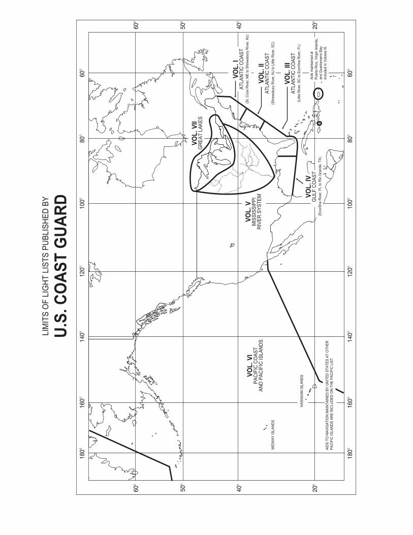
Allegheny River ................................................................................................................................................. 01 Arkansas Waterway - Verdigris River to Dardanelle Lock and Dam................................................................0Arkansas Waterway - Highway 7 Bridge to White River and Lower Mississippi River ................................... 12 Big Sandy, Canadian and Clinch Rivers ............................................................................................................ 20 Cumberland River .............................................................................................................................................. 2Green and Hiwassee Rivers ............................................................................................................................... 3Illinois Waterway - Chicago River to Henry, IL................................................................................................ 3Illinois Waterway - Henry Island to Upper Mississippi River ........................................................................... 49Kanawha River, Kaskaskia River, Lake Sakakawea, Lake Texoma,Little Tennessee River and Minnesota River .....................................................................................................Lower Mississippi River - Cairo, IL to Mouth of White River .........................................................................6Lower Mississippi River - Montgomery Point to Baton Rouge Bridge.............................................................7Upper Mississippi River - Minneapolis Harbor to Winona, MN.......................................................................7Upper Mississippi River - Winona, MN to Moline, IL ...................................................................................... 85Upper Mississippi River - Moline, IL to Grafton, IL.........................................................................................97Upper Mississippi River - Grafton, IL to Mouth of Ohio River ......................................................................108Missouri River -Sioux City, IA to Kansas City, MO.......................................................................................1 6Missouri River -Kansas City, MO to Upper Mississippi River .......................................................................125Monongahela River .......................................................................................................................................... 134Ohio River - Pittsburgh, PA to Parkersburg, WV............................................................................................141Ohio River - Parkersburg, WV to New Richmond, OH ..................................................................................148Ohio River - New Richmond, OH to Stephensport, KY..................................................................................155Ohio River - Stephensport, KY to Mississippi River....................................................................................... 162Ou chita-Black Waterway, Red River Waterway, St. Croix River and Lake St. Croix...................................1 9Tennessee River - Knoxville, TN to Guntersville, AL ....................................................................................180Tennessee River and Tennessee–Tombigbee Waterway ................................................................................. 201
INDEX ............................................................................................................................................................... Index 1
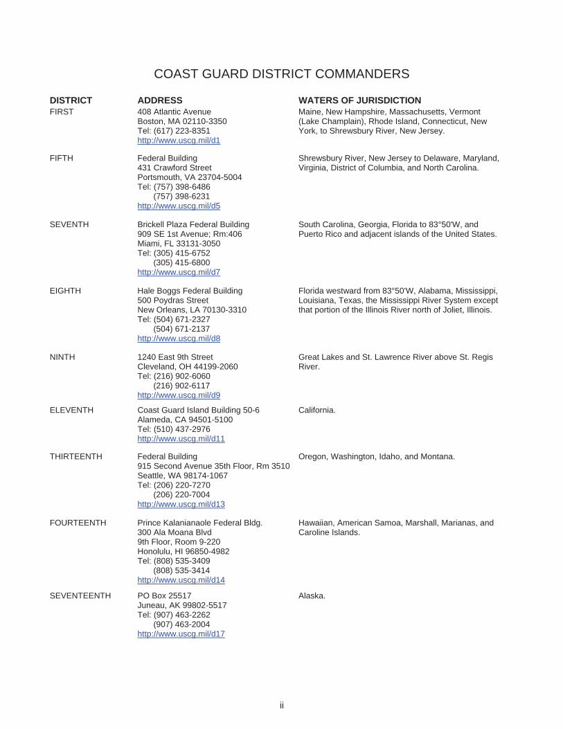
COAST GUARD DISTRICT COMMANDERS
DISTRICT ADDRESS WATERS OF JURISDICTION FIRST 408 Atlantic Avenue
Boston, MA 02110-3350 Tel: (617) 223-8351 http://www.uscg.mil/d1
Maine, New Hampshire, Massachusetts, Vermont (Lake Champlain), Rhode Island, Connecticut, New York, to Shrewsbury River, New Jersey.
FIFTH Federal Building431 Crawford Street Portsmouth, VA 23704-5004 Tel: (757) 398-6486
(757) 398-6231 http://www.uscg.mil/d5
Shrewsbury River, New Jersey to Delaware, Maryland, Virginia, District of Columbia, and North Carolina.
SEVENTH Brickell Plaza Federal Building 909 SE 1st Avenue; Rm:406 Miami, FL 33131-3050 Tel: (305) 415-6752
(305) 415-6800 http://www.uscg.mil/d7
South Carolina, Georgia, Florida to 83°50'W, and Puerto Rico and adjacent islands of the United States.
EIGHTH Hale Boggs Federal Building 500 Poydras Street New Orleans, LA 70130-3310 Tel: (504) 671-2327
(504) 671-2137http://www.uscg.mil/d8
Florida westward from 83°50'W, Alabama, Mississippi, Louisiana, Texas, the Mississippi River System except that portion of the Illinois River north of Joliet, Illinois.
NINTH 1240 East 9th Street Cleveland, OH 44199-2060 Tel: (216) 902-6060
(216) 902-6117 http://www.uscg.mil/d9
Great Lakes and St. Lawrence River above St. Regis River.
ELEVENTH Coast Guard Island Building 50-6 Alameda, CA 94501-5100 Tel: (510) 437-2976 http://www.uscg.mil/d11
California.
THIRTEENTH Federal Building915 Second Avenue 35th Floor, Rm 3510Seattle, WA 98174-1067 Tel: (206) 220-7270
(206) 220-7004 http://www.uscg.mil/d13
Oregon, Washington, Idaho, and Montana.
FOURTEENTH Prince Kalanianaole Federal Bldg. 300 Ala Moana Blvd 9th Floor, Room 9-220Honolulu, HI 96850-4982 Tel: (808) 535-3409
(808) 535-3414http://www.uscg.mil/d14
Hawaiian, American Samoa, Marshall, Marianas, and Caroline Islands.
SEVENTEENTH PO Box 25517 Juneau, AK 99802-5517 Tel: (907) 463-2262
(907) 463-2004 http://www.uscg.mil/d17
Alaska.
ii
iii
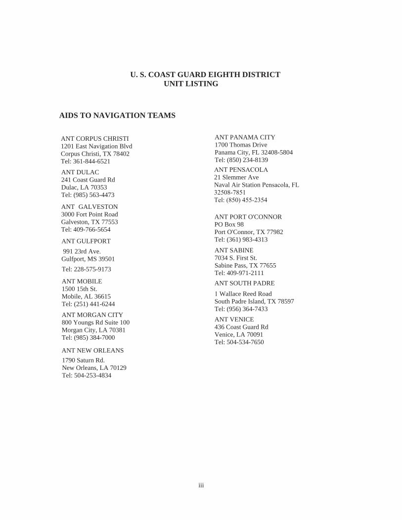
U. S. COAST GUARD EIGHTH DISTRICT UNIT LISTING
AIDS TO NAVIGATION TEAMS
ANT CORPUS CHRISTI 1201 East Navigation Blvd Corpus Christi, TX 78402 Tel: 361-844-6521
ANT DULAC241 Coast Guard Rd Dulac, LA 70353Tel: (985) 563-4473
ANT GALVESTON 3000 Fort Point Road Galveston, TX 77553 Tel: 409-766-5654
NT GULFPORT 991 23rd Ave. Gulfport, MS 39501
el: 228-575-9173
ANT MOBILE1500 15th St.Mobile, AL 36615Tel: (251) 441-6244
ANT MORGAN CITY 800 Youngs Rd Suite 100 Morgan City, LA 70381Tel: (985) 384-7000
ANT NEW ORLEANS1790 Saturn Rd.New Orleans, LA 70129Tel: 504-253-4834
ANT PANAMA CITY 1700 Thomas Drive Panama City, FL 32408-5804 Tel: (850) 234-8139
21 Slemmer AveNaval Air Station
ANT PORT O'CONNORPO Box 98Port O'Connor, TX 77982Tel: (361) 983-4313ANT SABINE7034 S. First St.Sabine Pass, TX 77655Tel: 409-971-2111 ANT SOUTH PADRE
Wallace Reed Road South Padre Island, TX 78597 Tel: (956) 364-7433 ANT VENICE436 Coast Guard RdVenice, LA 70091Tel: 504-534-7650
iv
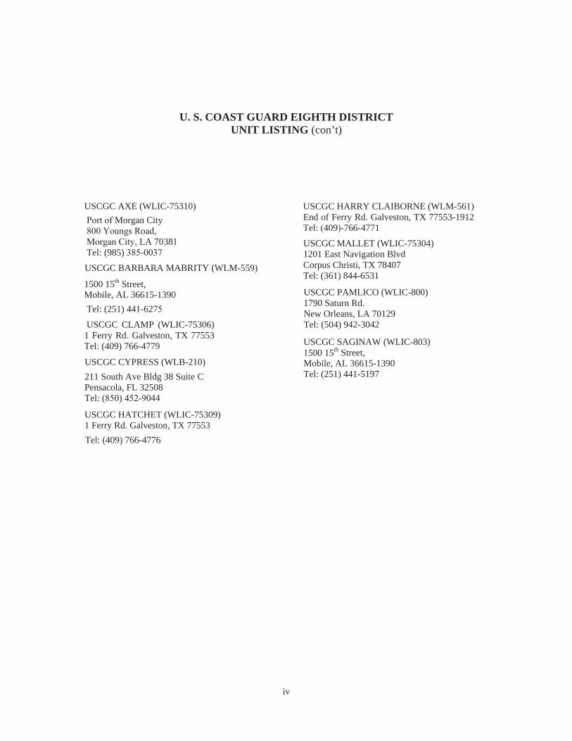
U. S. COAST GUARD EIGHTH DISTRICT UNIT LISTING (con’t)
USCGC AXE (WLIC-75310) Morgan City
LA 7038Tel: (985) -
USCGC BARBARA MABRITY (WLM-559)
1500 15th Street,Mobile, AL 36615-1390 Tel: (251) 441-627
USCGC CLAMP (WLIC-75306) 1 Ferry Rd. Galveston, TX 77553 Tel: (409) 766-4779
USCGC CYPRESS (WLB-210) 211 South Ave Bldg 38 Suite C Pensacola, FL 32508Tel: ( ) 4 -
USCGC HATCHET (WLIC-75309) 1 Ferry Rd. Galveston, TX 77553Tel: (409) 766-4776
USCGC HARRY CLAIBORNE (WLM-561) End of Ferry Rd. Galveston, TX 77553-1912 Tel: (409)-766-4771
USCGC MALLET (WLIC-75304)1201 East Navigation BlvdCorpus Christi, TX 78407Tel: (361) 844-6531
USCGC PAMLICO (WLIC-800)1790 Saturn Rd.New Orleans, LA 70129Tel: (504) 942-3042
USCGC SAGINAW (WLIC-803)500 15th Street,
Mobile, AL 36615-1390Tel: (251) 441-5197
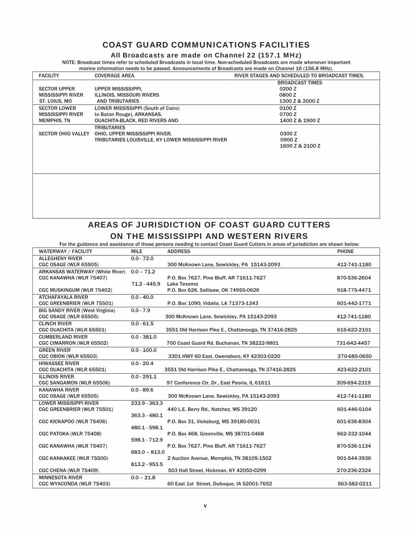
COAST GUARD COMMUNICATIONS FACILITIES All Broadcasts are made on Channel 22 (157.1 MHz)
NOTE: Broadcast times refer to scheduled Broadcasts in local time. Non-scheduled Broadcasts are made whenever important marine information needs to be passed. Announcements of Broadcasts are made on Channel 16 (156.8 MHz).
FACILITY COVERAGE AREA RIVER STAGES AND SCHEDULED TO BROADCAST TIMES. BROADCAST TIMES
SECTOR UPPER UPPER MISSISSIPPI, 0200 Z MISSISSIPPI RIVER ILLINOIS, MISSOURI RIVERS 0800 Z ST. LOIUS, MO AND TRIBUTARIES 1300 Z & 2000 Z
SECTOR LOWER LOWER MISSISSIPPI (South of Cairo) 0100 ZMISSISSIPPI RIVER to Baton Rouge), ARKANSAS, 0700 ZMEMPHIS, TN OUACHITA-BLACK, RED RIVERS AND 1400 Z & 1900 Z
TRIBUTARIESSECTOR OHIO VALLEY OHIO, UPPER MISSISSIPPI RIVER, 0300 Z
TRIBUTARIES LOUISVILLE, KY LOWER MISSISSIPPI RIVER 0900 Z1600 Z & 2100
AREAS OF JURISDICTION OF COAST GUARD CUTTERS ON THE MISSISSIPPI AND WESTERN RIVERS
For the guidance and assistance of those persons needing to contact Coast Guard Cutters in areas of jurisdiction are shown below:WATERWAY / FACILITY MILE ADDRESS PHONEALLEGHENY RIVER 0.0 - 72.0 CGC OSAGE (WLR 65505) 300 McKnown Lane, Sewickley, PA 15143-2093 412-741-1180 ARKANSAS WATERWAY (White River) 0.0 – 71.2 CGC KANAWHA (WLR 75407) P.O. Box 7627, Pine Bluff, AR 71611-7627 870-536-2604
71.2 - 445.9 Lake TexomaCGC MUSKINGUM (WLR 75402) P.O. Box 626, Sallisaw, OK 74955-0626 918-775-4471 ATCHAFAYALA RIVER 0.0 - 40.0 CGC GREENBRIER (WLR 75501) P.O. Box 1090, Vidalia, LA 71373-1343 601-442-1771 BIG SANDY RIVER (West Virginia) 0.0 - 7.9 CGC OSAGE (WLR 65505) 300 McKnown Lane, Sewickley, PA 15143-2093 412-741-1180 CLINCH RIVER 0.0 - 61.5 CGC OUACHITA (WLR 65501) 3551 Old Harrison Pike E., Chattanooga, TN 37416-2825 615-622-2101 CUMBERLAND RIVER 0.0 - 381.0 CGC CIMARRON (WLR 65502) 700 Coast Guard Rd, Buchanan, TN 38222-9801 731-642-4457GREEN RIVER 0.0 - 100.0 CGC OBION (WLR 65503) 3301 HWY 60 East, Owensboro, KY 42303-0220 270-685-0650HIWASSEE RIVER 0.0 - 20.4 CGC OUACHITA (WLR 65501) 3551 Old Harrison Pike E., Chattanooga, TN 37416-2825 423-622-2101 ILLINOIS RIVER 0.0 - 291.1 CGC SANGAMON (WLR 65506) 97 Conference Ctr. Dr., East Peoria, IL 61611 309-694-2319KANAWHA RIVER 0.0 - 89.6 CGC OSAGE (WLR 65505) 300 McKnown Lane, Sewickley, PA 15143-2093 412-741-1180 LOWER MISSISIPPI RIVER 233.9 - 363.3 CGC GREENBRIER (WLR 75501) 601-446-5104
363.3 - 480.1 CGC KICKAPOO (WLR 75406) 601-636-8304
480.1 - 598.1 CGC PATOKA (WLR 75408) 662-332-1044
598.1 - 712.9 CGC KANAWHA (WLR 75407) 870-536-1134
683.0 – 813.0 CGC KANKAKEE (WLR 75500) 901-544-3936
813.2 - 953.5 CGC CHENA (WLR 75409)
440 L.E. Berry Rd., Natchez, MS 39120
P.O. Box 31, Vicksburg, MS 39180-0031
P.O. Box 468, Greenville, MS 38701-0468
P.O. Box 7627, Pine Bluff, AR 71611-7627
2 Auction Avenue, Memphis, TN 38105-1502
503 Hall Street, Hickman, KY 42050-0299 270-236-2324MINNESOTA RIVER 0.0 – 21.8 CGC WYACONDA (WLR 75403) 60 East 1 Street, Dubuque, IA 52001-7652 563-582-0211
v
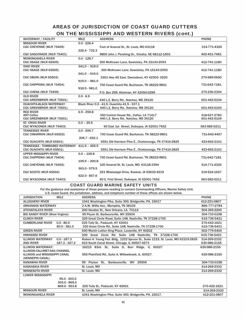
AREAS OF JURISDICTION OF COAST GUARD CUTTERS ON THE MISSISSIPPI AND WESTERN RIVERS (cont.)
WATERWAY / FACILITY MILE ADDRESS PHONEMISSOURI RIVER 0.0 - 226.4 CGC CHEYENNE (WLR 75405) 314-771-4325
226.4 - 732.3 CGC GASCONADE (WLR 75401)
Foot of Arsenal St., St. Louis, MO 63118
9800 John J. Pershing Dr., Omaha, NE 68112-1503 402-451-7681 MONONGAHELA RIVER 0.0 - 128.7 CGC OSAGE (WLR 65505) 300 McKnown Lane, Sewickley, PA 15143-2093 412-741-1180OHIO RIVER – .0 CGC OSAGE (WLR 65505) 300 McKnown Lane, Sewickley, PA 15143-2093 412-741-1180
341.0 – 919.0 CGC OBION (WLR 65503) 270-685-0650
919.0 – 981.0 CGC CHIPPEWA (WLR 75404) 731-642-7181
918.5 - 981.0 CGC CHENA (WLR 75409) 270-236-2324 OLD RIVER 0.0 - 6.9 CGC GREENBRIER (WLR 75501)
3301 Hwy 60 East, Owensboro, KY 42303-
700 Coast Guard Rd, Buchanan, TN 38222-9801
P.O. Box 299, Hickman, KY 42050-0299
440 L.E. Berry Rd., Natchez, MS 39120 601-442-5104 OUACHITA-BLACK WATERWAY Black River 0.0 - 41.5, Ouachita 41.5 - 337.1 CGC GREENBRIER (WLR 75501) 440 L.E. Berry Rd., Natchez, MS 39120 601-442-5104 RED RIVER 6.9 - 259.8
CGC GREENBRIER (WLR 75501) 350 Control House Rd., Colfax, LA 71417 440 L.E. Berry Rd., Natchez, MS 39120 601-442-5104
ST. CROIX RIVER 0.0 – 25.5 CGC WYACONDA (WLR 75403) 60 East 1st Street, Dubuque, IA 52001-7652 563-582-0211 TENNESSEE RIVER 0.0 - 206.7 CGC CIMARRON (WLR 65502) 700 Coast Guard Rd, Buchanan, TN 38222-9801 731-642-4457
206.7 - 652.1 CGC OUACHITA (WLR 65501) 3551 Old Harrison Pike E., Chattanooga, TN 37416-2825 423-662-2101TENNESSEE - TOMBIGBEE WATERWAY 411.9 – 455.5 CGC OUACHITA (WLR 65501) 3551 Old Harrison Pike E., Chattanooga, TN 37416-2825 423-662-2101 UPPER MISSISIPPI RIVER 0.0 – 109.8 CGC CHIPPEWA (WLR 75404) 731-642-7181
109.9 – 200.8 CGC CHEYENNE (WLR 75405) 314-771-4325
363.0 - 579.5 CGC SCIOTO (WLR 65504) 319-524-1657
522.0 - 857.6 CGC WYACONDA (WLR 75403)
700 Coast Guard Rd, Buchanan, TN 38222-9801
100 Arsenal St. St. Louis, MO. 63118-3394
221 Mississippi Drive, Keokuk, IA 52632-4219
60 E. First Street, Dubuque, IA 52001-7652 563-582-0211
COAST GUARD MARINE SAFETY UNITSFor the guidance and assistance of those persons needing to contact Commanding Officers; Marine Safety Unit,
U.S. Coast Guard, the jurisdiction, address, and telephone number of these offices are shown below. JURISDICTION MILE ADDRESS PHONE
ALLEGHENY RIVER 1041 Washington Pike, Suite 300, Bridgeville, PA. 15017 412-221-0807ARKANSAS WATERWAY 2 A.W. Willis Ave., Memphis, TN 38105 866-777-2784ATCHAFALAYA RIVER 200 Hendee St., New Orleans, LA. 70114 504-365-2200BIG SANDY RIVER (West Virginia) 95 Peyon St. Bar oursville, WV 25504 304-733 0198 CLINCH RIVER 220 Great Circle Road, Suite 148, Nashville, TN 37228-1700 615-736-5421 CUMBERLAND RIVER 0.0 - 80.0 225 Tully St., Paducah, KY 42001 270-442-1621
80.0 - 381.0 220 Great Circle Rd., Suite 148, Nashville, TN 37228-1700 615-736-5421 GREEN RIVER 600 Martin Luther King Place, Louisville, KY 4 202 502-779-5400
HIWASSEE RIVER 220 Great Circle Rd. Suite 148 Nashville, TN 37228-1700 615-736-5421 ILLINOIS WATERWAY 0.0 - 187.3 AND RIVER 187.3 - 327.2
Robert A. Young Fed. Bldg., 1222 Spruce St., Suite 1215, St. Louis, MO 63103-2835 314-269-2332 610 South Canal Street, Chicago, IL 60607-4573 630-986-2155
ILLINOIS WATERWAY: 630-986-2155 ILLINOIS-CALUMET-SAG CHANNEL
ILLINOIS and MISSISSIPPI CANAL
16215 83rd. St., Suite D, Burr Ridge, IL 60527
555 Plainfield Rd., Suite A, Willowbrook, IL. 60527. 630-986-2155 (HENNEPIN CANAL) KANAWHA RIVER 304-733-0198
KASKASKIA RIVER 314-269-2332 MINNESOTA RIVER
95 Peyton St., St. Louis, MO St. Louis, MO 314-269-2332
LOWER MISSISSIPPI 95.0 - 303.0 303.0 - 869.0 869.0 - 953.8 225 Tully St., Paducah, KY 42001 270-422-1621
MISSOURI RIVER St. Louis, MO 314-269-2332 MONONGAHELA RIVER 1041 Washington Pike, Suite 300, Bridgeville, PA. 15017. 412-221-0807
vi
ANT Colfax 318-627-2783
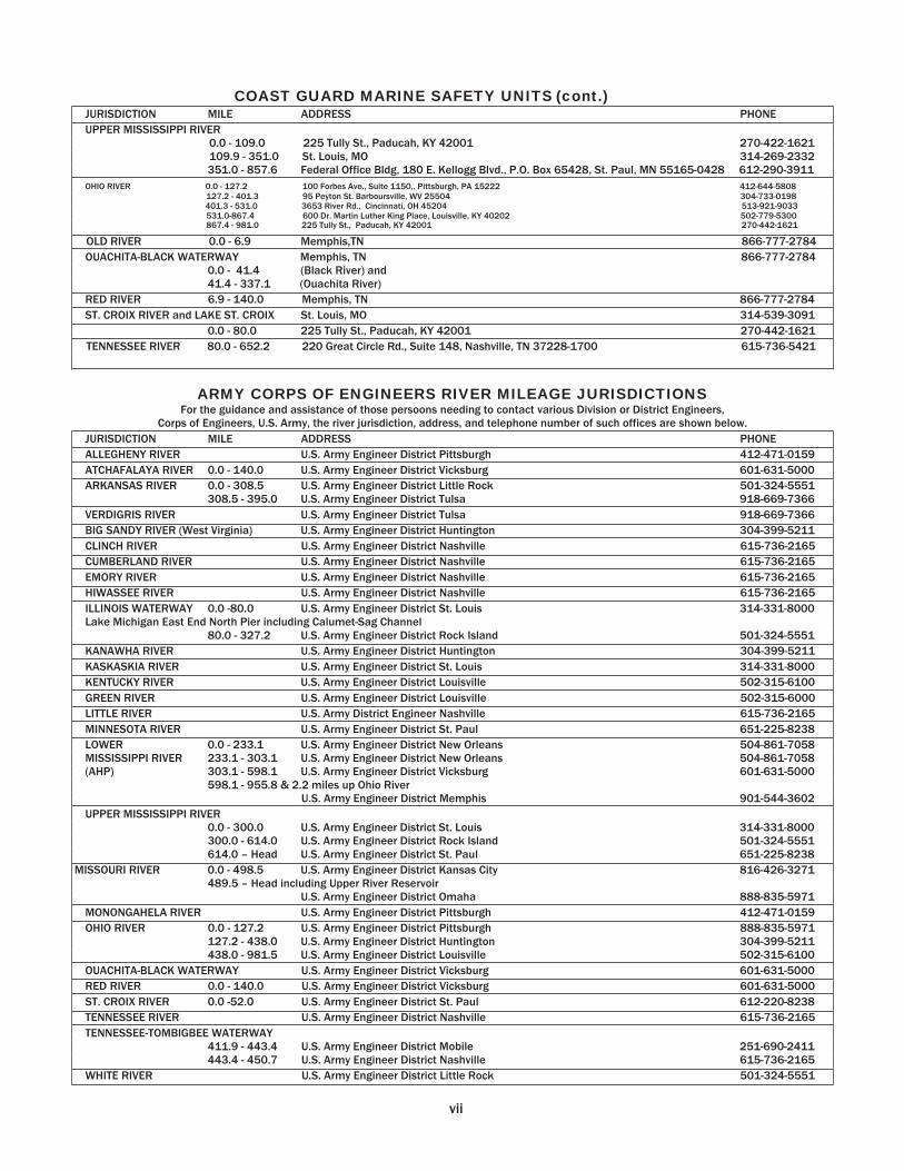
COAST GUARD MARINE SAFETY UNITS (cont.) JURISDICTION MILE ADDRESS PHONE
UPPER MISSISSIPPI RIVER0.0 - 109.0 225 Tully St., Paducah, KY 42001 270-422-1621 109.9 - 351.0 St. Louis, MO 314-269-2332 351.0 - 857.6 Federal Office Bldg, 180 E. Kellogg Blvd., P.O. Box 65428, St. Paul, MN 55165-0428 612-290-3911
OHIO RIVER 0.0 - 127.2 100 Forbes Ave., Suite 1150,. Pittsburgh, PA 15222 412-644-5808 127.2 - 401.3 95 Peyton St. Barboursville, WV 25504 304-733-0198
401.3 - 531.0 3653 River Rd., Cincinnati, OH 45204 513-921-9033 531.0-867.4 600 Dr. Martin Luther King Place, Louisville, KY 40202 502-779-5300867.4 - 981.0 225 Tully St., Paducah, KY 42001 270-442-1621
OLD RIVER 0.0 - 6.9 Memphis,TN 866-777-2784 OUACHITA-BLACK WATERWAY Memphis, TN 866-777-2784
0.0 - 41.4 (Black River) and 41.4 - 337.1 (Ouachita River)
RED RIVER 6.9 - 140.0 Memphis, TN 866-777-2784 ST. CROIX RIVER and LAKE ST. CROIX St. Louis, MO 314-539-3091
TENNESSEE RIVER 0.0 - 80.0 225 Tully St., Paducah, KY 42001 270-442-1621
220 Great Circle Rd., Suite 148, Nashville, TN 37228-1700 615-736-5421
ARMY CORPS OF ENGINEERS RIVER MILEAGE JURISDICTIONS For the guidance and assistance of those persoons needing to contact various Division or District Engineers,
Corps of Engineers, U.S. Army, the river jurisdiction, address, and telephone number of such offices are shown below. JURISDICTION MILE ADDRESS PHONE
ALLEGHENY RIVER U.S. Army Engineer District Pittsburgh 412-471-0159ATCHAFALAYA RIVER 0.0 - 140.0 U.S. Army Engineer District Vicksburg 601-631-5000 ARKANSAS RIVER 0.0 - 308.5 U.S. Army Engineer District Little Rock 501-324-5551
308.5 - 395.0 U.S. Army Engineer District Tulsa 918-669-7366VERDIGRIS RIVER U.S. Army Engineer District Tulsa 918-669-7366 BIG SANDY RIVER (West Virginia) U.S. Army Engineer District Huntington 304-399-5211CLINCH RIVER U.S. Army Engineer District Nashville 615-736-2165 CUMBERLAND RIVER U.S. Army Engineer District Nashville 615-736-2165 EMORY RIVER U.S. Army Engineer District Nashville 615-736-2165 HIWASSEE RIVER U.S. Army Engineer District Nashville 615-736-2165 ILLINOIS WATERWAY 0.0 -80.0 U.S. Army Engineer District St. Louis 314-331-8000 Lake Michigan East End North Pier including Calumet-Sag Channel
80.0 - 327.2 U.S. Army Engineer District Rock Island 501-324-5551KANAWHA RIVER U.S. Army Engineer District Huntington 304-399-5211 KASKASKIA RIVER U.S. Army Engineer District St. Louis 314-331-8000 KENTUCKY RIVER U.S. Army Engineer District Louisville 502-315-6100GREEN RIVER U.S. Army Engineer District Louisville 502-315-6000 LITTLE RIVER U.S. Army District Engineer Nashville 615-736-2165 MINNESOTA RIVER U.S. Army Engineer District St. Paul 651-225-8238
0.0 - 233.1 U.S. Army Engineer District New Orleans 504-861-7058LOWER MISSISSIPPI RIVER (AHP)
233.1 - 303.1 U.S. Army Engineer District New Orleans 504-861-7058303.1 - 598.1 U.S. Army Engineer District Vicksburg 601-631-5000 598.1 - 955.8 & 2.2 miles up Ohio River
U.S. Army Engineer District Memphis 901-544-3602UPPER MISSISSIPPI RIVER
0.0 - 300.0 U.S. Army Engineer District St. Louis 314-331-8000 300.0 - 614.0 U.S. Army Engineer District Rock Island 501-324-5551 614.0 – Head U.S. Army Engineer District St. Paul 651-225-8238
MISSOURI RIVER 0.0 - 498.5 U.S. Army Engineer District Kansas City 816-426-3271489.5 – Head including Upper River Reservoir
U.S. Army Engineer District Omaha 888-835-5971MONONGAHELA RIVER U.S. Army Engineer District Pittsburgh 412-471-0159 OHIO RIVER 0.0 - 127.2 U.S. Army Engineer District Pittsburgh 888-835-5971
127.2 - 438.0 U.S. Army Engineer District Huntington 304-399-5211 438.0 - 981.5 U.S. Army Engineer District Louisville 502-315-6100
OUACHITA-BLACK WATERWAY U.S. Army Engineer District Vicksburg 601-631-5000 RED RIVER 0.0 - 140.0 U.S. Army Engineer District Vicksburg 601-631-5000 ST. CROIX RIVER 0.0 -52.0 U.S. Army Engineer District St. Paul 612-220-8238 TENNESSEE RIVER U.S. Army Engineer District Nashville 615-736-2165
TENNESSEE-TOMBIGBEE WATERWAY 411.9 - 443.4 U.S. Army Engineer District Mobile 251-690-2411443.4 - 450.7 U.S. Army Engineer District Nashville 615-736-2165
WHITE RIVER U.S. Army Engineer District Little Rock 501-324-5551
vii
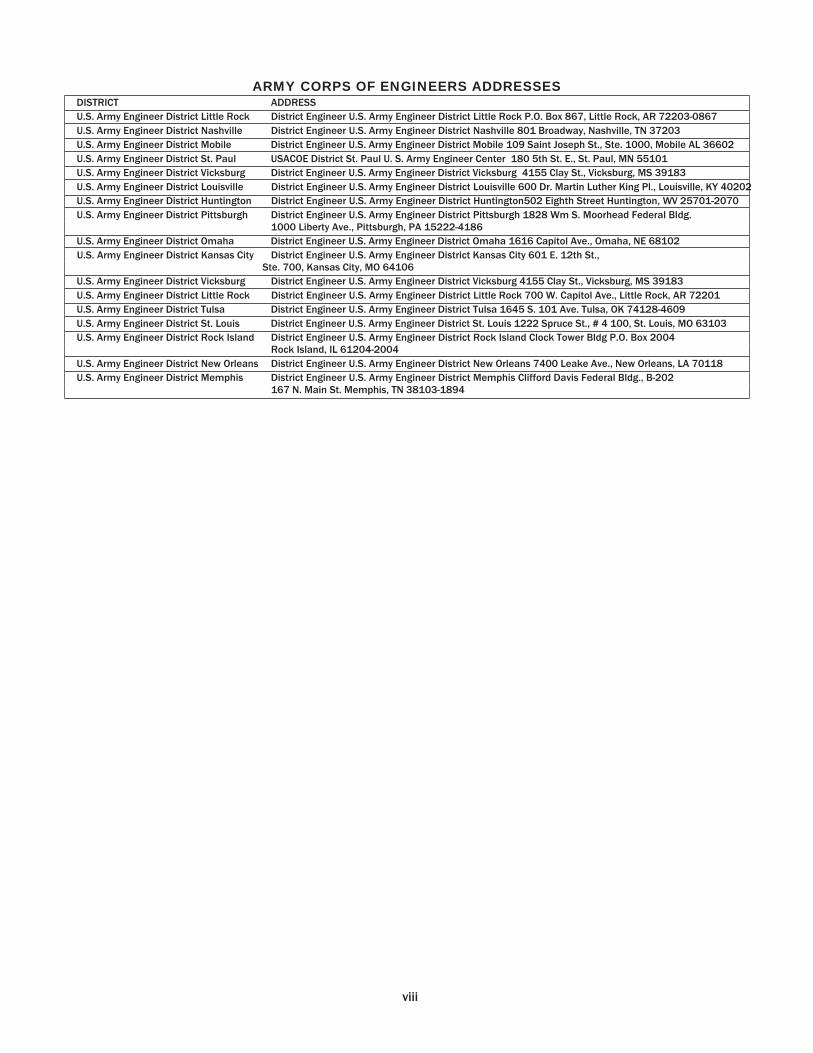
ARMY CORPS OF ENGINEERS ADDRESSES DISTRICT ADDRESS
U.S. Army Engineer District Little Rock District Engineer U.S. Army Engineer District Little Rock P.O. Box 867, Little Rock, AR 72203-0867 U.S. Army Engineer District Nashville District Engineer U.S. Army Engineer District Nashville 801 Broadway, Nashville, TN 37203U.S. Army Engineer District Mobile District Engineer U.S. Army Engineer District Mobile 109 Saint Joseph St., Ste. 1000, Mobile AL 36602 U.S. Army Engineer District St. Paul USACOE District St. Paul U. S. Army Engineer Center 180 5th St. E., St. Paul, MN 55101U.S. Army Engineer District Vicksburg District Engineer U.S. Army Engineer District Vicksburg 4155 Clay St., Vicksburg, MS 39183 U.S. Army Engineer District Louisville District Engineer U.S. Army Engineer District Louisville 600 Dr. Martin Luther King Pl., Louisville, KY 40202U.S. Army Engineer District Huntington District Engineer U.S. Army Engineer District Huntington502 Eighth Street Huntington, WV 25701-2070 U.S. Army Engineer District Pittsburgh District Engineer U.S. Army Engineer District Pittsburgh 1828 Wm S. Moorhead Federal Bldg.
1000 Liberty Ave., Pittsburgh, PA 15222-4186 U.S. Army Engineer District Omaha District Engineer U.S. Army Engineer District Omaha 1616 Capitol Ave., Omaha, NE 68102 U.S. Army Engineer District Kansas City District Engineer U.S. Army Engineer District Kansas City 601 E. 12th St.,
Ste. 700, Kansas City, MO 64106 U.S. Army Engineer District Vicksburg District Engineer U.S. Army Engineer District Vicksburg 4155 Clay St., Vicksburg, MS 39183 U.S. Army Engineer District Little Rock District Engineer U.S. Army Engineer District Little Rock 700 W. Capitol Ave., Little Rock, AR 72201U.S. Army Engineer District Tulsa District Engineer U.S. Army Engineer District Tulsa 1645 S. 101 Ave. Tulsa, OK 74128-4609U.S. Army Engineer District St. Louis District Engineer U.S. Army Engineer District St. Louis 1222 Spruce St., # 4 100, St. Louis, MO 63103 U.S. Army Engineer District Rock Island District Engineer U.S. Army Engineer District Rock Island Clock Tower Bldg P.O. Box 2004
Rock Island, IL 61204-2004 U.S. Army Engineer District New Orleans District Engineer U.S. Army Engineer District New Orleans 7400 Leake Ave., New Orleans, LA 70118 U.S. Army Engineer District Memphis District Engineer U.S. Army Engineer District Memphis Clifford Davis Federal Bldg., B-202
167 N. Main St. Memphis, TN 38103-1894
viii
307
308
254
819
233
1609 659
450
495
216 89 737
713
611
979
255
200
477
234
1003 569
684
538
724
560
910
376
727
531
353
1103 74
1287
1022 353
690
126
609
839
1197
394
340
904
540
902
745
581
580 92 219
824
798
696
1064 54 507
169
365
1087 699
769
623
854
643
996
461
419
616
438
1187 507
1373
1107 483
776
212
694
924
1282
54 511
541
509
351
581
187
302
220
433
404
306
671
341
508
564
367
694
700
376
233
855
250
606
101
813
223 45 795
383
979
714
484
386
182
301
534
889
565
487
563
405
527
241
248
166
483
458
356
725
287
454
510
312
748
646
429
283
801
304
656
121
759
276 99 849
329
1033 768
430
436
128
354
584
943
1052 926
160
1092 604
813
731
944
106
817
1088 851
1018
1074 876
184
1210 793
744
1366 667
1117 582
1324 640
466
1212 893
1397
1131 995
897
693
210
1045
1306
1050 892
683
728
448
321
970
945
843
1212 487 33 710
467
1235 801
916
770
956
791
1143 608
960
764
586
1336 159
1520
1255 586
923
359
841
1071
1430
767
1090 322
811
729
942
820
815
162
850
1017
1072 875
1110
1209 134
742
1364 641
1115 580
1322 286
464
286
891
470
205
993
894
691
716
1043 380
932
445
653
571
784 54 657
929
692
859
915
717
343
1051 633
584
1206 508
957
422
1164 481
306
1053 733
1237 972
835
737
533 51 885
1147
768
489
362
1010 986
884
1252 528
650
751
216
1276 11
895
781
127
483
111
83 649
1000 804
626
1376 521
1560
1295 97 963
399
882
1112
1470
489
407
620
498
493
484
528
695
750
553
787
887
189
420
1042 319
793
258
1000 36 142
608
569
792
527
671
573
369
394
721
702
128
731
707
604
973 38 415
261
273
996
607
677
531
763
552
904
370
511
525
347
1097 290
1281
1016 392
684
120
602
882
1191
649
624
522
891
166
288
389
146
914
480
595
449
635
470
822
287
639
443
265
1015 163
1199 934
264
602 38 520
750
1109
837
127
1104 770
937
993
795
1126
1129 808
209
1284 683
173
362
1242 656
478
1228 812
1412
1147 913 47 611
733
101
1322
711
982
745
912
968
770
289
1104 687
638
1259 561
1010 478
1218 534
360
1106 787
1291
1025 889
790
586
104
939
1200
977
643
810
866
668
1000
1002 681 73
1157 556
300
235
1115 529
351
1101 685
1285
1020 786 80 484
606
228
1195
1012
1179
1234
1037
1272
1371 296
904
1526 803
1277 742
1484 448
626
124
1053 308 43
1155
1057 853
878
1205 218
454
223
312
1035 646
716
570
801
590
943
408
473
564
385
1135 329
1320
1054 431
723
159
641
871
1229
677
434
1201 768
883
737
923
757
1110 575
927
730
553
1302 125
1487
1222 552
890
326
808
1038
1396
535
1257 869
939
793
1024 813
1166 631
250
786
608
1358 552
1543
1277 653
946
382
864
1094
1452
1060 334
741
595
489
615
968
433
785
588
410
1160 309
1345
1079 11
974
818
466
689
612
54
1394 977
927
1549 851
1300 765
1507 824
650
1395
1077
1580
1315
1178
1080 876
394
1228
1490
1075 929
155
949
1302 767
1119 922
745
1494 643
1679
1414 216
1082 518
1000
1230
1588
609
1230 508
981
447
1189 153
331
419
758
604
338
860
761
557
583
910
513
1084 483
373
162
1043 456
278
1028 612
1212 947
714
153
411
534
301
1122
1105
1457 922
1274
1078 900
1650 798
1834
1569 371
1237 673
1155
1385
1744
856
321
1063 355
205
927
632
1112 846
734
636
432
457
784
1021
535
1415 829
651
1401 985
1585
1320
1086 621
784
906 72
1495
881
294
116
867
450
1050 785
552
315
249
372
463
960
1036 85
816
08 801
1792
1527 90
311
95 631
1114
1344
1702
178
572
605
491
757
707
609
405
430
757
666
750
427
934
669
529
431
227
256
579
844
1177 185 81
1279
1181 977
1002
1329 94
1362
1096 42
776
520
168
391
312
71
265
1463
1365
1161
1187
1513 91
1198
1100 896
921
1248 17
5
866
302
785
1015
1373
564
686
148
1275
482
712
1071
835
1096
1423
1042
1127 738
788
1248
1275
1242
1089
1315 925
1036 954
305
1142 432
1409
1075
1242
1297
1100
1432
1434
1113 505
1589 987
132
666
1547 960
782
1532
1116
1717
1451
1218 352
916
1038 204
1626
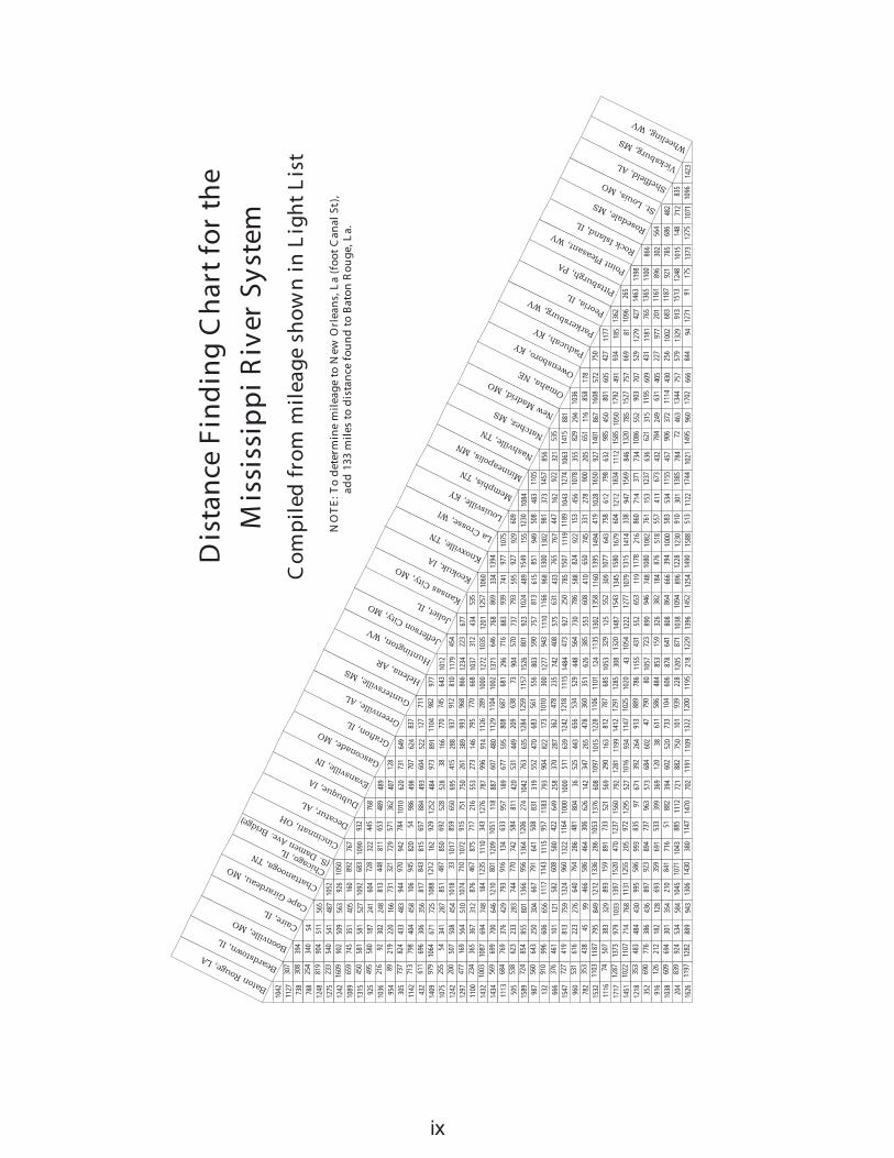
Chicago, IL(S. Damen Ave.
Bridge)
Baton Rouge, LA
Beardstown,IL Boonville,MO Caire,
ILCapeGirardeau, M
O
Chattanooga,TNCincin
nati, OH
Decatur, A
L Dubuque, IA Evansvil
le, IN Gasco
nade, MO
Grafton,IL Greenville
, AL Guntersville
, MS
Helena, AR Huntington, W
VJeffe
rsonCity, M
OJoliet
,ILKansasCity, M
OKeokuk, IA Knoxville
, TN LaCrosse, W
I Louisville,
KY Memphis,TN Minneapolis, MN
Nashville,TN Natch
ez, MS New Madrid, M
OOmaha, NE Owensboro,KY
Paducah, KY Parkersburg, W
VPeoria, IL
Pittsburgh, PA Point Pleasant, W
VRock Isl
and, IL Rosedale, M
S St. Louis, M
O Sheffield, AL Vicksburg, M
SWheeli
ng, WV
Mis
siss
ipp
iR
iver
Syst
em
Co
mp
iled
fro
mm
ilea
ge
sho
wn
inL
igh
tL
ist
NO
TE
:To
det
erm
ine
mil
eag
eto
New
Orl
ean
s,L
a(f
oo
tC
anal
St.)
,ad
d13
3m
iles
tod
ista
nce
fou
nd
toB
ato
nR
ou
ge,
La.
Dis
tan
ceF
ind
ing
Ch
art
for
the
vii
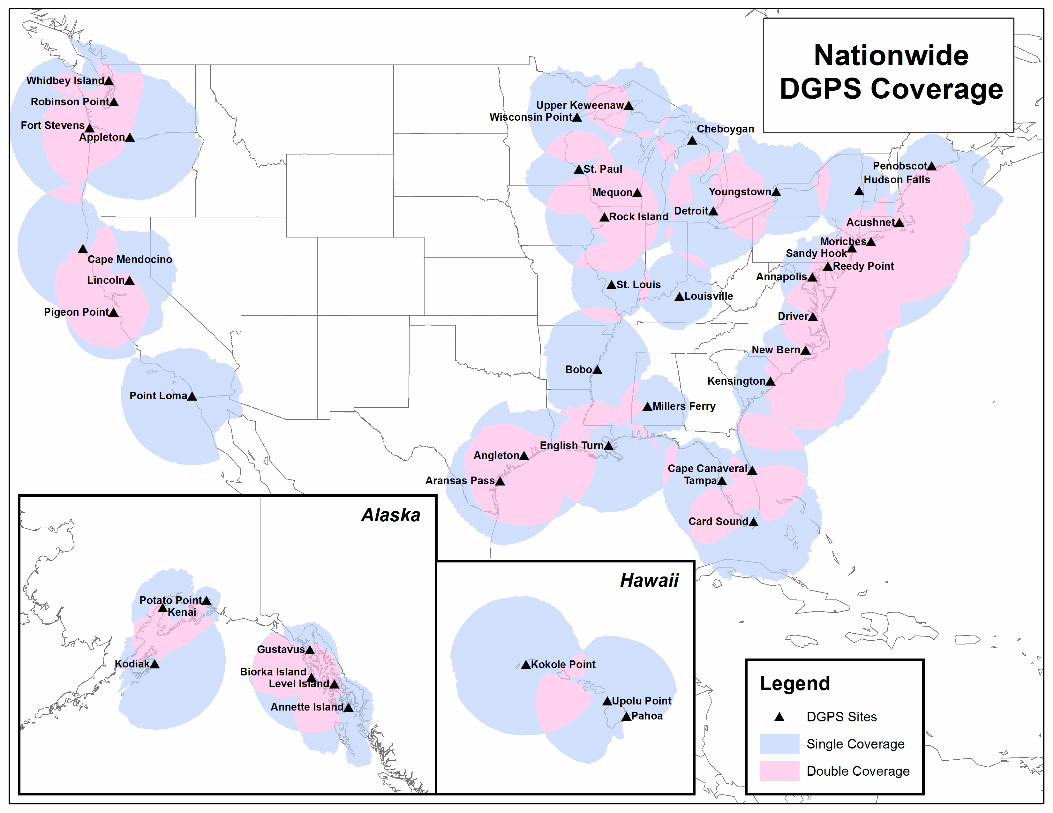
USCG NAVIGATION CENTER Navigation Information Service (NIS)
The U.S. Coast Guard Navigation Center (NAVCEN) is the official government source of information for civil users of the Global Positioning System (GPS). The Navigation Information Service (NIS) is available 24 hours a day, seven days a week, for all Radio Navigation and maritime related needs via phone, fax or e-mail. The NIS provides users the ability to access realtime or archived GPS, NDGPS, DGPS, and LNM information at http://www.navcen.uscg.gov, as well as subscribe to an auto-mated list service which enables users to receive GPS status messages and Notice to NAVSTAR User (NANU) messages via direct Internet e-mail.
The NAVCEN also disseminates GPS and DGPS safety advisory broadcast messages through USCG broadcast stations uti-lizing VHF-FM voice, HF-SSB voice, and NAVTEX broadcasts. The broadcasts provide the GPS and DGPS user in the marine environment with the current status of the navigation systems, as well as any planned/unplanned system outages that could affect GPS and DGPS navigational accuracy.
To comment on any of these services or ask questions about the service offered, contact the NAVCEN at:
Commanding Officer U.S. Coast Guard NAVCEN (NIS) MS 7310 7323 Telegraph Road Alexandria, VA 20598-7310 Phone: (703) 313-5900 FAX: (703) 313-5920 Internet: http://www.navcen.uscg.gov
This Light List is corrected through:
Eighth Coast Guard District Local Notice to Mariners No. 01 7
and through National Geospatial-Intelligence Agency (NGA) Notice to Mariners No. 01 7
The 2017 edition supersedes the 2016 edition.
RECORD OF CORRECTIONS
YEAR 2017 YEAR 20181........... 2........... 3........... 4........... 5........... 1........... 2........... 3........... 4........... 5...........
6........... 7........... 8........... 9........... 10......... 6........... 7........... 8........... 9........... 10.........
11......... 12......... 13......... 14......... 15......... 11......... 12......... 13......... 14......... 15.........
16......... 17......... 18......... 19......... 20......... 16......... 17......... 18......... 19......... 20.........
21......... 22......... 23......... 24......... 25......... 21......... 22......... 23......... 24......... 25.........
26......... 27......... 28......... 29......... 30......... 26......... 27......... 28......... 29......... 30.........
31......... 32......... 33......... 34......... 35......... 31......... 32......... 33......... 34......... 35.........
36......... 37......... 38......... 39......... 40......... 36......... 37......... 38......... 39......... 40.........
41......... 42......... 43......... 44......... 45......... 41......... 42......... 43......... 44......... 45.........
46......... 47......... 48......... 49......... 50......... 46......... 47......... 48......... 49......... 50.........
51......... 52......... 51......... 52.........
x
PREFACE
Lights and other marine aids to navigation, maintained by or under authority of the U.S. Coast Guard and located on the Mississippi River system are listed in this volume with aids listed consecutively for each river in the system. The rivers are listed in alphabetical order.
Included are all Coast Guard aids to navigation used for general navigation such as lights, sound signals, buoys, daybeacons, and other aids to navigation. Not included are some buoys having no lateral significance, such as special purpose, anchorage, fish net, and dredging.
Aids to Navigation Link: http://www.uscgboating.org
CAUTION: Mariners attempting to pass a buoy close aboard risk collision with a yawing buoy or with the obstruction, which the buoy marks. Mariners must not rely on buoys alone for determining their positions due to factors limiting buoy reliability.
PRIVATE AIDS TO NAVIGATION Included: Class I aids to navigation on marine structures or other works which the owners are legally obligated to establish, maintain, and operate as prescribed by the Coast Guard.
Included: Class II aids to navigation exclusive of Class I, located in waters used by general navigation.
Not included: Class III aids to navigation exclusive of Class I and Class II, located in waters not ordinarily used by general na- vigation.
This Light List is published annually and is intended to furnish more complete information concerning aids to na-vigation than can be conveniently shown on charts. This Light List is not intended to be used in place of charts or Coast Pilots. Charts should be consulted for the location of all aids to navigation. It may be dangerous to use aids to navigation without ref-erence to charts.
This list is corrected to the date of the notices to mariners shown on the title page. Changes to aids to navigation during the year are advertised in U.S. Coast Guard Local Notices to Mariners and National Geospatial-Intelligence Agency (NGA) Notices to Mariners. Important changes to aids to navigation are also broadcast through Coast Guard or Naval radio stations and NAVTEX. Mariners should keep their Light Lists, charts and other nautical publications corrected from these notices and should consult all notices issued after the date of publication of this Light List.
The electronic version of this publication is updated monthly and is available at. http://www.navcen.uscg.gov/index.php?pageName=lightLists
Reporting Private Aids to Navigation Discrepancies D8: http://www.uscg.mil/d8/waterways/PATON.Home.asp
IMPORTANT: A summary of corrections for this publication, which includes corrections from the dates shown on the title page to the date of availability, is advertised in the Local Notice to Mariners and the Notice to Mariners. These corrections must be applied in order to bring the Light List up-to-date. Additionally, this publication should be corrected weekly from the Local No-tices to Mariners or the Notices to Mariners, as appropriate.
Mariners and others are requested to bring any apparent errors or omissions in these lists to the attention of:
Commander (dpw) or USCG Navigation Center Eighth Coast Guard District Charting Branch 500 Poydras Street MS 7310 New Orleans, LA 70130-3396 7323 Telegraph Road [email protected] Alexandria, VA 20598-7310 Email: [email protected]
xi
xii
INTRODUCTION Light List Arrangement Aids to navigation on the Mississippi River System are listed in this volume. In addition, Bridges, Locks, and minor tributaries are also listed. Aids to navigation are arranged in downstream order for each river listed in the “contents”. The mileage of the aid to navigation determines its position in the list. The origin or mile zero, of most rivers is coincident with the river mouth. If otherwise, the origin point is named in the heading of the section. Aids to navigation are shown located on either the left or right bank when heading downstream, or as sometimes stated, on the “left descending” or the “right descending” bank. Names of aids to navigation are printed as follows to help distinguish at a glance the type of aid to navigation listed:
RIVER MOUTHS and CITIES Bridges, Locks, and Dams LIGHTS Lighted Buoys Daybeacons and Unlighted Buoys
Light List numbers are assigned to all Federal aids to navigation and many private aids to navigation for reference in the Light List. Aids to navigation are numbered by fives in accordance with their order of appearance in each volume of the Light List. Other numbers and decimal fractions are assigned where newly established aids to navigation are listed between previously numbered aids to navigation. The Light Lists are renumbered periodically to assign whole numbers to all aids to navigation. Description of Columns Column (1): Light List Number. Column (2): Name and location of the aid to navigation.
Note: A dash (-) is used to indicate the bold heading is part of the name of the aid to navigation. When reporting discrepancies or making references to such an aid to navigation in correspondence, the full name of the aid including the geographic heading, should be given.
Column (3): River mile. Column (4): Bank of river. Column (5): Characteristic of lighted aid to navigation. Column (6): Structure and dayboard description. Column (7): Remarks, including bridge clearances, lock dimensions, and private aid to
navigation identification. U.S. Coast Guard Light List Distribution U.S. regulations require that most commercial vessels maintain on board a currently corrected, copy or pertinent extract, of the U.S. Coast Guard Light Lists which are available for free and
xiii
are updated weekly on the Coast Guard Navigation Center’s website at http://www.navcen.uscg.gov/?pageName=lightLists. Commercially printed versions are also available, but the Coast Guard does not attest to their veracity or sanction such publications.
CHARTS & PUBLICATIONS Nautical Charts & Publications Nautical charts covering the coastal waters of the United States and its territories are published by the National Ocean Service (NOS). Up-to-date paper copies of NOS charts are available from NOS Certified Agents. A list of agents can be found at: http://www.nauticalcharts.noaa.gov/staff/print_agents.html. NOS also produces Raster Navigational Charts (RNC) and Electronic Navigational Charts (ENC). RNCs can be found at http://www.nauticalcharts.noaa.gov/mcd/Raster/index.htm. ENCs can be found at http://www.nauticalcharts.noaa.gov/mcd/enc/index.htm. Inland Electronic Navigational Charts (IENC) and chart books are published by the U.S. Army Corps of Engineers and are available online at http://www.agc.army.mil/Missions/Echarts.aspx. Tide Tables and Tidal Current Tables are no longer printed or distributed by NOS. NOS Tide and Tidal Current predictions are available online at http://tidesandcurrents.noaa.gov/tide_predictions.html. Commercially printed versions, using data provided by NOS, are also available. These products may be obtained from local stores that carry marine publications. Notices to Mariners Broadcast Notices to Mariners are made by the Coast Guard through Coast Guard radio stations. These notices, which are broadcast on VHF-FM, NAVTEX, and other maritime frequencies, are warnings that contain important navigational safety information. Included are reports of discrepancies and changes to aids to navigation, the positions of ice and derelicts, and other important hydrographic information. Radio stations broadcasting Notices to Mariners are listed in the National Ocean Service United States Coast Pilot and in the National Geospatial-Intelligence Agency publication Radio Navigational Aids (Publication No. 117). VHF-FM voice broadcast times can be found online at http://www.nws.noaa.gov/om/marine/vhfvoice.htm. Local Notices to Mariners (U.S. regional coverage) are another means which the Coast Guard disseminates navigational information for the United States, its territories, and possessions. A Local Notice to Mariners is issued by each Coast Guard district and is used to report changes and discrepancies to aids to navigation maintained by and under the authority of the Coast Guard. The Local Notice to Mariners also contain chart and Light List corrections, proposed aids to navigation projects open for public comment, ongoing waterway projects, bridge regulation changes, marine event information, and other concerns pertinent to the mariner. Local Notices to Mariners are essential to all navigators for the purposes of keeping charts, Light Lists, Coast Pilots, and other nautical publications up-to-date. These notices are published weekly and can be found online at http://www.navcen.uscg.gov/index.php?pageName=lnmMain. Mariners may register with the
xiv
Coast Guard Navigation Center to receive automatic notifications via email when new editions of the Local Notice to Mariners are available. Register at http://www.navcen.uscg.gov/?pageName=listServerForm. Vessels operating in ports and waterways in several districts will have to obtain the Local Notice to Mariners for each district. Notice to Mariners are prepared jointly by the National Geospatial-Intelligence Agency (NGA), the U.S. Coast Guard, and the National Ocean Service, and are published weekly by the NGA. The weekly Notice to Mariners advises mariners of important matters affecting navigational safety including new hydrographic discoveries, changes to aids to navigation, and foreign marine information. Also included are corrections to Light Lists, Coast Pilots, and Sailing Directions. This notice is intended for mariners and others who have a need for information related to oceangoing operations. Because it is intended for use by oceangoing vessels, many corrections that affect small craft navigation and associated waters are not included. Information concerning small craft is contained in the Coast Guard Local Notice to Mariners only. The weekly Notices to Marines may be found online at http://msi.nga.mil/NGAPortal/MSI.portal.
ATON DISCREPANCIES The Coast Guard does not keep the tens of thousands of aids to navigation comprising the U.S. Aids to Navigation System under simultaneous and continuous observation. Mariners should realize that it is impossible to maintain every aid to navigation operating properly and on its assigned position at all times. Therefore, for the safety of all mariners, any who discovers an aid to navigation that is either off station or exhibiting characteristics other than those listed in the Light Lists should promptly notify the nearest Coast Guard unit. Radio messages should be prefixed “COAST GUARD” and transmitted on VHF-FM channel 16 or directly to one of the U.S. Government radio stations listed in Chapter 3, Section 300L, Radio Navigation Aids (Publication No. 117). In addition to notifying the nearest Coast Guard unit by radio, a discrepant aid to navigation can be reported online at http://www.navcen.uscg.gov/?pageName=atonOutageReport.
U.S. AIDS TO NAVIGATION SYSTEM GENERAL The navigable waters of the United States are marked to assist navigation using the U.S. Aids to Navigation System, a system consistent with the International Association of Marine Aids to Navigation and Lighthouse Authorities (IALA) Maritime Buoyage System. The IALA Maritime Buoyage System is followed by most of the world’s maritime nations and improves maritime safety by encouraging conformity in buoyage systems worldwide. IALA buoyage is divided into two regions made up of Region A and Region B. All navigable waters of the United States follow IALA Region B, except U.S. possessions west of the International Date Line and south of 10° north latitude, which follow Region A. Lateral aids to navigation in Region A vary from those located within Region B. Non-lateral aids to navigation in Region A are the same as those used in Region B. Appropriate nautical charts and publications should be consulted to determine whether the Region A or Region B marking schemes are in effect for a given area. Aids to navigation are developed, established, operated, and maintained by the U.S. Coast Guard to accomplish the following:
1. Assist navigators in determining their position,
xv
2. Assist the navigator in determining a safe course, 3. Warn the navigator of dangers and obstructions, 4. Promote the safe and economic movement of commercial vessel traffic, and 5. Promote the safe and efficient movement of military vessel traffic, and cargo of
strategic military importance. The U.S. Aids to Navigation System is designed for use with nautical charts. Nautical charts portray the physical features of the marine environment, which include: soundings, landmarks, hazards to navigation, and aids to navigation. To best understand the purpose of a specific aid to navigation, mariners should consult the associated nautical chart, which illustrates the relationship of the aid to navigation to channel limits, obstructions, hazards to navigation, and to the aids to navigation system as a whole. Seasonal aids to navigation are placed into service, withdrawn, or changed at specified times of the year. The dates shown in the Light Lists are approximate and may vary due to adverse weather or other conditions. These aids will be changed on Electronic Navigational Charts (ENC) based on Light List dates and electronic navigation system settings. Mariners should maintain and consult suitable publications and navigation equipment depending on the vessel’s requirements. This shipboard navigation equipment is separate from the aids to navigation system, but is often essential to its use. The U.S. Aids to Navigation System is primarily a lateral system, which employs a simple arrangement of colors, shapes, numbers, and light characteristics to mark the limits of navigable routes. This lateral system is supplemented with non-lateral aids to navigation where appropriate. Federal aids to navigation consist of Coast Guard operated aids to navigation. The Coast Guard establishes, maintains, and operates a system of aids to navigation consisting of visual, audible, and electronic signals designed to assist the prudent mariner in the process of navigation. The U.S. Aids to Navigation System contains the following subsystems:
1. Intracoastal Waterway: The aids to navigation marking the Intracoastal Waterway are arranged geographically from north to south on the Atlantic Coast and generally east to west on the coast of the Gulf of Mexico. Red lights (if so equipped), even numbers, and red buoys or triangle shaped daymarks are located on the southbound/westbound starboard waterway boundary. Green lights (if so equipped), odd numbers, and green buoys or square shaped daymarks are on the southbound/westbound port waterway boundary.
2. Western Rivers: The Western Rivers System is employed on the Mississippi River
System, in addition to the Tennessee-Tombigbee Waterway and the Alabama, Atchafalaya, and Apalachicola-Chattahoochee-Flint River Systems. The Western Rivers System consists of the following characteristics:
a. Buoys are not numbered. b. Numbers on beacons do not have lateral significance, but rather indicate
mileage from a fixed point (normally the river mouth).
xvi
c. Diamond shaped non-lateral dayboards, red and white or green and white as appropriate, are used to indicate where the river channel crosses from one bank to the other.
d. Lights on green aids to navigation show a single-flash characteristic, which may be green or white.
e. Lights on red aids to navigation show a group-flash characteristic, which may be red or white.
f. Isolated danger marks are not used.
3. Bridge Markings: Bridges across navigable waters are marked with red, green and/or white lights for nighttime navigation. Red lights mark piers and other parts of the bridge. Red lights are also placed on drawbridges to show when they are in the closed position. Green lights are placed on drawbridges to show when they are in the open position. The location of these lights will vary according to the bridge structure. Green lights are also used to mark the centerline of navigable channels through fixed bridges. If there are two or more channels through the bridge, the preferred channel is also marked by three white lights in a vertical line above the green light. Red and green retro-reflective panels may be used to mark bridge piers and may also be used on bridges not required to display lights. Lateral red and green lights and dayboards may mark main channels through bridges. Adjacent piers are marked with fixed yellow lights when the main channel is marked with lateral aids to navigation. Centerlines of channels through fixed bridges may be marked with a safe water mark and an occulting white light when lateral marks are used to mark main channels. The centerline of the navigable channel through the draw span of floating bridges may be marked with a special mark. The mark will be a yellow diamond with yellow retro-reflective panels and may exhibit a yellow light that displays a Morse code “B” (a long flash followed by three short flashes). AIS-ATON and RACONs may be placed on the bridge structure to mark the centerline of the navigable channel through the bridge. Vertical clearance gauges may be installed to enhance navigation safety. The gauges are located on the right channel pier or pier protective structure facing approaching vessels. Clearance gauges indicate the vertical distance between “low steel” of the bridge channel span (in the closed to navigation position for drawbridges) and the level of the water, measured to the bottom of the foot marks, read from top to bottom. Drawbridges equipped with radiotelephones display a blue and white sign which indicates what VHF radiotelephone channels should be used to request bridge openings.
Private aids to navigation include aids to navigation that are either operated by private persons and organizations, or that are operated by states. Private aids to navigation are classified into three categories:

xvii
1. Class I: Aids to navigation on marine structures or other works which the owners are legally obligated to establish, maintain, and operate as prescribed by the U.S. Coast Guard.
2. Class II: Aids to navigation that, exclusive of Class I aids, are located in waters used by general navigation.
3. Class III: Aids to navigation that, exclusive of Class I and Class II aids, are located in waters not ordinarily used by general navigation.
Authorization for the establishment of a Class II or Class III private aid to navigation by the U.S. Coast Guard imposes no legal obligation that the aid actually be established and operated. It only specifies the location and operational characteristics of the aid for which the authorization was requested. Once the aid is established, however, the owner is legally obligated to maintain it in good working order and properly painted. Lights and sound signals on oil wells or other offshore structures in navigable waters are private aids to navigation and are generally not listed in the Light List unless they are equipped with a RACON. Where space allows, the structures are shown on the appropriate nautical charts. Information concerning the location and characteristics of those structures which display lights and sound signals not located in obstruction areas are published in Local and/or weekly Notices to Mariners. In general, during the nighttime, a series of white lights are displayed extending from the platform to the top of the derrick when drilling operations are in progress. At other times, structures are usually marked with one or more quick flashing white, red, or yellow lights, visible for at least one nautical mile during clear weather. Obstructions, which are a part of the appurtenances to the main structure, such as mooring piles, anchors, and mooring buoys, etc., are not normally lighted. In addition, some structures are equipped with a sound signal that produces a single two-second blast every 20 seconds. BUOYS, BEACONS, AND AIS-ATON The primary components of the U.S. Aids to Navigation System are buoys, beacons, and AIS-ATON. Buoys are floating aids to navigation used extensively throughout U.S. waters. They are moored to sinkers by varying lengths of chain and may shift due to sea conditions and other causes. Buoys may also be carried away, capsized, or sunk. Prudent mariners will not rely solely on any single aid to navigation, particularly floating aids. Buoy positions represented on nautical charts are approximate position only, due to the practical limitations of positioning and maintaining buoys and their sinkers in precise geographical locations. The position of buoys and beacons are indicated with a circle on the chart. The center of the symbol corresponds with the position of the aid. Positions of Federal aids to navigation are verified during periodic maintenance visits. Between visits, environmental conditions, including atmospheric and sea conditions, seabed slope and composition, may shift buoys off their charted positions. Buoys may also be dragged off station, sunk, or capsized by a collision with a vessel. Beacons are aids to navigation which are permanently fixed to the earth’s surface. They range from large lighthouses to small single-pile structures and may be located on land or in the water.
xviii
Lighted beacons are called lights; unlighted beacons are called daybeacons. Lighthouses are placed on shore or on marine sites and most often do not indicate lateral significance. Lighthouses with no lateral significance exhibit a white light. Beacons exhibit a daymark. For small structures, these are colored geometric shapes that make an aid to navigation readily visible and easily identifiable against background conditions. Generally, the daymark conveys to the mariner, during daylight hours, the same significance as the aid’s light or reflector does at night. The daymark of towers, however, consists of the structure itself. As a result, these daymarks do not infer lateral significance. Ranges are non-lateral aids to navigation composed of two beacons, which when the structures appear to be in line, assist the mariner in maintaining a safe course. The appropriate nautical chart must be consulted when using ranges to determine whether the range marks the centerline of the navigable channel and also what section of the range may be safely traversed. Ranges typically display rectangular dayboards of various colors and are generally, but not always lighted. Ranges may display lights during daylight and at night. When lighted, ranges may display lights of any color. Vessels should not pass fixed aids to navigation close aboard due to the danger of collision with rip-rap or structure foundations, or with the obstruction or danger being marked. Aids to Navigation (ATON) may be enhanced by the use of an automatic identification system (AIS). AIS is a maritime navigation safety communications protocol standardized by the International Telecommunication Union and adopted by the International Maritime Organization for the broadcast or exchange of navigation information between vessels, aircraft, and shore stations. AIS ATON can autonomously and at fixed intervals broadcast the name, position, dimensions, type, characteristics, and status from or concerning an aid to navigation. AIS ATON can be either real (physically fitted to an aid to navigation), synthetic (physically fitted somewhere other than to an aid to navigation) or virtual (physically nonexistent, but capable of being portrayed on AIS-capable displays). Note: A Real or Physical AIS ATON can actively monitor and report the health and position status of its host; while Synthetic AIS ATON broadcasted from ashore (i.e. NAIS) can be used to electronically augment the range or portrayal (i.e., on radar and ECDIS) of an existing aid to navigation. Although all existing AIS mobile devices can receive AIS ATON Reports and ASM messages, they may not readily appear on an AIS Minimal Keyboard Display or other shipboard navigational display systems (i.e., radar, ECDIS, ECS), which would require software updates to make these systems compliant with international navigation presentation standards (i.e., IEC 62288 (Ed. 2), IHO S-52 (Ed. 4.4.0)). AIS ATON can also be used to broadcast both laterally (e.g., Port Hand Mark) and non-laterally significant marine safety information (e.g., environmental data, tidal information, and navigation warnings). Note: AIS ATON stations broadcast their presence, identity (9-digit Marine Mobile Service Identity (MMSI) number), position, type, and status at least every three minutes or less via an AIS (ITU-R M.1371) message 21–AIS ATON Report. In addition to its AIS ATON Report, AIS ATON can broadcast significant marine safety information via Application Specific Messages (ASM), which are customized messages that can be used to broadcast additional aid
xix
information or other marine safety information (i.e., environmental conditions, wind speed and direction, tidal/current data, bridge air clearances, area notices, etc. They are identified by their: AIS message number (i.e. 6, 8, 25 or 26), Designated Area Code (DAC), Function Identifier (FI), and Version Number, e.g. U.S. Geographic Notice message: Msg# = 8, DAC = 367, FI = 22, Version = 2, and, denoted as 8/367.22.2. TYPES OF SIGNALS Lighted aids to navigation are, for the most part, equipped with daylight controls which automatically cause the light to operate during darkness and to be extinguished during daylight. These devices are not of equal sensitivity; therefore, all lights do not come on or go off at the same time. Mariners should ensure correct identification of aids to navigation during twilight periods when some lighted aids to navigation are lit while others are not. The lighting apparatus is serviced at periodic intervals to assure reliable operation, but there is always the possibility of a light being extinguished or operating improperly. The condition of the atmosphere has a considerable effect upon the distance at which lights can be seen. Sometimes lights are obscured by fog, haze, dust, smoke, or precipitation which may be present at the light, or between the light and the observer, and which is possibly unknown by the observer. Atmospheric refraction may cause a light to be seen farther than under ordinary circumstances. A light of low intensity will be easily obscured by unfavorable conditions of the atmosphere and little dependence can be placed on it being seen. For this reason, the intensity of a light should always be considered when expecting to sight it in reduced visibility. Haze and distance may reduce the apparent duration of the flash of a light. In some atmospheric conditions, white lights may have a reddish hue. Lights placed at high elevations are more frequently obscured by clouds, mist, and fog than those lights located at or near sea level. In regions where ice conditions prevail in the winter, the lantern panes of lights may become covered with ice or snow, which will greatly reduce the visibility of the lights and may also cause colored lights to appear white. The increasing use of brilliant shore lights for advertising, illuminating bridges, and other purposes, may cause marine navigational lights, particularly those in densely inhabited areas, to be outshone and difficult to distinguish from the background lighting. Mariners are requested to report such cases in order that steps may be taken to improve the conditions. The “loom” (glow) of a powerful light is often seen beyond the limit of visibility of the actual rays of the light. The loom may sometimes appear sufficiently sharp enough to obtain a bearing. At short distances, some flashing lights may show a faint continuous light between flashes. The distance of an observer from a light cannot be estimated by its apparent intensity. Always check the characteristics of lights in order to avoid mistaking powerful lights, visible in the distance, for nearby lights (such as those on lighted buoys) showing similar characteristics of low intensity. If lights are not sighted within a reasonable time after prediction, a dangerous situation may exist, requiring prompt resolution or action in order to ensure the safety of the vessel. The apparent characteristic of a complex light may change with the distance of the observer. For example, a light which actually displays a characteristic of fixed white varied by flashes of
xx
alternating white and red (the rhythms having a decreasing range of visibility in the order: flashing white, flashing red, fixed white) may, when first sighted in clear weather, show as a simple flashing white light. As the vessel draws nearer, the red flash will become visible and the characteristics will appear as alternating flashing white and red. Later, the fixed white light will be seen between the flashes and the true characteristic of the light will finally be recognized as fixed white, alternating flashing white and red (F W Al WR). If a vessel has considerable vertical motion due to pitching in heavy seas, a light sighted on the horizon may alternatively appear and disappear. This may lead the unwary to assign a false characteristic and hence, to error in its identification. The true characteristic will be evident after the distance has been sufficiently decreased or by increasing the height of eye of the observer. Similarly, the effect of wave motion on lighted buoys may produce the appearance of incorrect light phase characteristics when certain flashes occur, but are not viewed by the mariner. In addition, buoy motion can reduce the distance at which buoy lights are detected. Sectors of colored glass are placed in the lanterns of some lights in order to produce a system of light sectors of different colors. In general, red sectors are used to mark shoals or to warn the mariner of other obstructions to navigation or of nearby land. Such lights provide approximate bearing information, since observers may note the change of color as they cross the boundary between sectors. These boundaries are indicated in the Light List (Col. 8) and by dotted lines on charts. These bearings, as all bearings referring to lights, are given in true degrees from 000° to 359°, as observed from a vessel toward the light. Altering course on the changing sectors of a light or using the boundaries between light sectors to determine the bearing for any purpose is not recommended. Be guided instead by the correct compass bearing to the light and do not rely on being able to accurately observe the point at which the color changes. This is difficult to determine because the edges of a colored sector cannot be cut off sharply. On either side of the line of demarcation between white, red, or green sectors, there is always a small arc of uncertain color. Moreover, when haze or smoke is present in the intervening atmosphere, a white sector might have a reddish hue. The area in which a light can be observed is normally an arc with the light as the center and the range of visibility as the radius. However, on some bearings, the range may be reduced by obstructions. In such cases, the obstructed arc might differ with height of eye and distance. When adjoining land cuts off a light and the arc of visibility is given, the bearing on which the light disappears may vary with the distance of the vessel from which observed and with the height of eye. When the light is cut off by a sloping hill or point of land, the light may be seen over a wider arc by a vessel farther away than by one closer to the light. The arc drawn on charts around a light is not intended to give information as to the distance at which it can be seen. The arc indicates the bearings between which the variation of visibility or obstruction of the light occurs. Only aids to navigation with green or red lights have lateral significance and exhibit either flashing, quick flashing, group flashing, occulting, or isophase light rhythms. When proceeding in the conventional direction of buoyage, the mariner in IALA Region B, may see the following lighted aids to navigation: Green lights on aids to navigation mark port sides of channels and locations of wrecks or obstructions that must be passed by keeping these lighted aids to navigation on the port hand of
xxi
a vessel. Green lights are also used on preferred channel marks where the preferred channel is to starboard (i.e., aid to navigation left to port when proceeding in the conventional direction of buoyage). Red lights on aids to navigation mark starboard sides of channels and locations of wrecks or obstructions that must be passed by keeping these lighted aids to navigation on the starboard hand of a vessel. Red lights are also used on preferred channel marks where the preferred channel is to port (i.e., aid to navigation left to starboard when proceeding in the conventional direction of buoyage). White and yellow lights have no lateral significance. The shapes, colors, letters, and light rhythms may determine the purpose of aids to navigation exhibiting white or yellow lights. Most aids to navigation are fitted with retro reflective material to increase their visibility in darkness. Colored reflective material is used on aids to navigation that, if lighted, will display lights of the same color. Preferred channel marks exhibit a composite group-flashing light rhythm of two flashes followed by a single flash. Safe water marks exhibit a white Morse code “A” rhythm (a short flash followed by a long flash). Isolated danger marks exhibit a white flashing (2) rhythm (two flashes repeated regularly). Special marks exhibit yellow lights and exhibit a flashing or fixed rhythm. Information and regulatory marks exhibit a white light with any light rhythm except quick flashing, flashing (2) and Morse code “A.” For situations where lights require a distinct cautionary significance, as at sharp turns, sudden channel constrictions, wrecks, or obstructions, a quick flashing light rhythm will be used. Shapes are used to provide easy identification on certain unlighted buoys and dayboards on beacons. These shapes are laterally significant only when associated with laterally significant colors. In IALA Region B, cylindrical buoys (referred to as “can buoys”) and square dayboards mark the port side of a channel when proceeding from seaward. These aids to navigation are associated with solid green or green and red-banded marks where the topmost band is green. Conical buoys (referred to as “nun buoys”) and triangular dayboards mark the starboard side of the channel when proceeding from seaward. These aids to navigation are associated with solid red or red and green-banded marks where the topmost band is red. Unless fitted with topmarks; lighted, sound, pillar, and spar buoys have no shape significance. Their numbers, colors, and light characteristics convey their meanings. Dayboards throughout the U.S. Aids to Navigation System are described using standard designations that describe the appearance of each dayboard. A brief explanation of the designations and of the purpose of each type of dayboard in the system is given below, followed by a verbal description of the appearance of each dayboard type. Designations:

xxii
1. First Letter – Shape or Purpose C: Crossing (Western Rivers only) diamond-shaped, used to indicate the points at which
the channel crosses the river. J: Junction (square or triangle) used to mark (preferred channel) junctions or
bifurcations in the channel, or wrecks or obstructions which may be passed on either side; color of top band has lateral significance for the preferred channel.
K: Range (rectangular) when both the front and rear range dayboards are aligned on
the same bearing, the observer is on the azimuth of the range, usually used to mark the center of the channel.
M: Safe Water (octagonal) used to mark the fairway or middle of the channel. N: No lateral significance (diamond or rectangular) used for special purpose, warning,
distance, or location markers. S: Square used to mark the port side of channels when proceeding from seaward. T: Triangle used to mark the starboard side of channels when proceeding from
seaward.
2. Second Letter – Key Color
B – Black G – Green R – Red W – White Y – Yellow
3. Third Letter – Color of Center Stripe (Range Dayboards Only)
4. Additional Information after a (-)
-I: Intracoastal Waterway; a yellow reflective horizontal band on a dayboard; indicates the aid to navigation marks the Intracoastal Waterway.
-SY: Intracoastal Waterway; a yellow reflective square on a dayboard; indicates the aid
to navigation is a port hand mark for vessels traversing the Intracoastal Waterway. May appear on a triangular daymark where the Intracoastal Waterway coincides with a waterway having opposite conventional direction of buoyage.
-TY: Intracoastal Waterway; a yellow reflective triangle on a dayboard; indicates the aid
to navigation is a starboard hand mark for vessels traversing the Intracoastal Waterway. May appear on a square daymark where the Intracoastal Waterway coincides with a waterway having opposite conventional direction of buoyage.
Descriptions: CNG: Diamond-shaped dayboard divided into four diamond-shaped colored sectors with the sectors at the side corners white and the sectors at the top and bottom corners green, with green reflective diamonds at the top and bottom corners and white reflective diamonds in the side corners (Western Rivers only).
xxiii
CNR: Diamond-shaped dayboard divided into four diamond-shaped colored sectors with the sectors at the side corners white and the sectors at the top and bottom corners red, with red reflective diamonds at the top and bottom corners and white reflective diamonds in the side corners (Western Rivers only). JG: Dayboard bearing horizontal bands of green and red, green band topmost, with corresponding reflective borders. JG-I: Square dayboard bearing horizontal bands of green and red, green band topmost, with corresponding reflective borders and a yellow reflective horizontal band. JG-SY: Square dayboard bearing horizontal bands of green and red, green band topmost, with corresponding reflective borders and a yellow reflective square. JG-TY: Square dayboard bearing horizontal bands of green and red, green band topmost, with corresponding reflective borders and a yellow reflective triangle. JR: Dayboard bearing horizontal bands of red and green, red band topmost, with corresponding reflective borders. JR-I: Triangular dayboard bearing horizontal bands of red and green, red band topmost, with corresponding reflective borders and a yellow reflective horizontal band. JR-SY: Triangular dayboard bearing horizontal bands of red and green, red band topmost, with corresponding reflective borders and a yellow reflective square. JR-TY: Triangular dayboard bearing horizontal bands of red and green, red band topmost, with corresponding reflective borders and a yellow reflective triangle. KBG: Rectangular black dayboard bearing a central green stripe. KBG-I: Rectangular black dayboard bearing a central green stripe and a yellow reflective horizontal band. KBR: Rectangular black dayboard bearing a central red stripe. KBR-I: Rectangular black dayboard bearing a central red stripe and a yellow reflective horizontal band. KBW: Rectangular black dayboard bearing a central white stripe. KBW-I: Rectangular black dayboard bearing a central white stripe and a yellow reflective horizontal band. KGB: Rectangular green dayboard bearing a central black stripe. KGB-I: Rectangular green dayboard bearing a central black stripe and a yellow reflective horizontal band. KGR: Rectangular green dayboard bearing a central red stripe.
xxiv
KGR-I: Rectangular green dayboard bearing a central red stripe and a yellow reflective horizontal band. KGW: Rectangular green dayboard bearing a central white stripe. KGW-I: Rectangular green dayboard bearing a central white stripe and a yellow reflective horizontal band. KRB: Rectangular red dayboard bearing a central black stripe. KRB-I: Rectangular red dayboard bearing a central black stripe and a yellow reflective horizontal band. KRG: Rectangular red dayboard bearing a central green stripe. KRG-I: Rectangular red dayboard bearing a central green stripe and a yellow reflective horizontal band. KRW: Rectangular red dayboard bearing a central white stripe. KRW-I: Rectangular red dayboard bearing a central white stripe and a yellow reflective horizontal band. KWB: Rectangular white dayboard bearing a central black stripe. KWB-I: Rectangular white dayboard bearing a central black stripe and a yellow reflective horizontal band. KWG: Rectangular white dayboard bearing a central green stripe. KWG-I: Rectangular white dayboard bearing a central green stripe and a yellow reflective horizontal band. KWR: Rectangular white dayboard bearing a central red stripe. KWR-I: Rectangular white dayboard bearing a central red stripe and a yellow reflective horizontal band. MR: Octagonal dayboard bearing stripes of white and red, with a white reflective border. MR-I: Octagonal dayboard bearing stripes of white and red, with a white reflective border and a yellow reflective horizontal band. NB: Diamond-shaped dayboard divided into four diamond-shaped colored sectors with the sectors at the side corners white and the sectors at the top and bottom corners black, with a white reflective border. ND: Rectangular white mileage marker with black numerals indicating the mile number (Western Rivers only).
xxv
NG: Diamond-shaped dayboard divided into four diamond-shaped colored sectors with the sectors at the side corners white and the sectors at the top and bottom corners green, with a white reflective border. NL: Rectangular white location marker with an orange reflective border and black letters indicating the location. NR: Diamond-shaped dayboard divided into four diamond-shaped colored sectors with the sectors at the side corners white and the sectors at the top and bottom corners red, with a white reflective border. NW: Diamond-shaped white dayboard with an orange reflective border and black letters describing the information or regulatory nature of the mark. NY: Diamond-shaped yellow dayboard with yellow reflective border. SG: Square green dayboard with a green reflective border. SG-I: Square green dayboard with a green reflective border and a yellow reflective horizontal band. SG-SY: Square green dayboard with a green reflective border and a yellow reflective square. SG-TY: Square green dayboard with a green reflective border and a yellow reflective triangle. SR: Square red dayboard with a red reflective border. (IALA Region “A”) TG: Triangular green dayboard with a green reflective border. (IALA Region “A”) TR: Triangular red dayboard with a red reflective border. TR-I: Triangular red dayboard with a red reflective border and a yellow reflective horizontal band. TR-SY: Triangular red dayboard with a red reflective border and a yellow reflective square. TR-TY: Triangular red dayboard with a red reflective border and a yellow reflective triangle. These abbreviated descriptions are used in column (7) and may also be found on the illustrations of the U.S. Aids to Navigation System. Numbers are used to provide easy identification of aids to navigation. In IALA Region B, all solid red and solid green aids are numbered, with the exception of buoys located on the Western Rivers. Red aids to navigation have even numbers and green aids to navigation have odd numbers. The numbers for each increase from seaward when proceeding in the conventional direction of buoyage. Numbers are kept in approximate sequence on both sides of the channel by omitting numbers where necessary. Letters may be used to augment numbers when lateral aids to navigation are added to channels with previously completed numerical sequences. Letters will increase in alphabetical order from seaward, proceeding in the conventional direction of buoyage and are added to numbers as suffixes. Letters are not used for buoys on the Western Rivers.
xxvi
No other aids to navigation are numbered. Preferred channel, safe water, isolated danger, special marks, and information and regulatory aids to navigation may be lettered, but not numbered. Sound signal is a generic term used to describe aids to navigation that produce an audible signal designed to assist the mariner in periods of reduced visibility. These aids to navigation can be activated by several means (e.g., manually, remotely, or fog detector). The Coast Guard is replacing many fog detectors with mariner radio activated sound signals (MRASS). To activate, mariners key their VHF-FM radio a designated number of times on a designated VHF-FM channel. The sound signal is activated for a period of 15, 30, 45, or 60 minutes after which the activated assistance automatically turns off. In cases where a fog detector is in use, there may be a delay in the automatic activation of the signal. Additionally, fog detectors may not be capable of detecting patchy fog conditions. Sound signals are distinguished by their tone and phase characteristics. The devices producing the sound, e.g., diaphones, diaphragm horns, sirens, whistles, bells, or gongs determine tones. Phase characteristics are defined by the signal's sound pattern, i.e., the number of blasts and silent periods per minute and their durations. Sound signals sounded from fixed structures generally produce a specific number of blasts and silent periods each minute when operating. Sound signals installed on buoys are generally activated by the motion of the sea and therefore do not emit a regular signal characteristic. It is common, in fact, for a buoy to produce no sound signal when seas are calm. The characteristic of a sound signal is listed in column (8) of the Light List. If the sound signal is remotely activated, column (8) will contain the VHF-FM channel and number of times the VHF-FM radio should be keyed. All waterway users equipped with a VHF-FM radio may activate the sound signal, but they are not required to do so. Unless it is specifically stated that a sound signal "Operates continuously," or the signal is a bell, gong, or whistle on a buoy, it can be assumed that the sound signal only operates during times of fog, reduced visibility, or adverse weather. Caution: Mariners should not rely on sound signals to determine their position. Distance cannot be accurately determined by sound intensity. Occasionally, sound signals may not be heard in areas close to their location. Signals may not sound in cases where fog exists close to, but not at, the location of the sound signal. Radar Beacons (RACONS) are radar transponders that when triggered by an X-band radar produce a coded response from its location, which is portrayed radially as a series of dots and dashes on the triggering radar. Although RACONS may be used on both laterally significant and non-laterally significant aids to navigation, their signal should just be used for identification purposes only. RACONS have a typical output of 600 milliwatts and are considered a short range aid to navigation. Reception varies from a nominal range of 6 to 8 nautical miles when mounted on a buoy to as much as 17 nautical miles for a RACON mounted on a fixed structure. It must be understood that these nominal ranges are dependent upon many factors. The beginning of the RACON presentation occurs about 50 yards beyond the RACON position and will persist for a number of revolutions of the radar antenna (depending on its rotation rate). Distance to the RACON can be measured to the point at which the RACON flash begins, but the
xxvii
figure obtained will be greater than the vessel's distance from the RACON. This is due to the slight response delay in the RACON apparatus. Radar operators may notice some broadening or spoking of the RACON presentation when their vessel approaches closely to the source of the RACON. This effect can be minimized by adjusting the IF gain or sweep gain control of the radar. If desired, the RACON presentation can be virtually eliminated by operation of the FTC (fast time constant) controls of the radar. Radar Reflectors are special fixtures, incorporated into both lighted and unlighted aids to navigation, to enhance the reflection of radar energy. These fixtures help radar-equipped vessels to detect buoys and beacons, which are so equipped. However, they do not positively identify a radar target as an aid to navigation.
NAVIGATION SERVICES GLOBAL POSITIONING SYSTEM (GPS), DIFFERENTIAL GPS (DGPS), AND NATION-WIDE AUTOMATIC IDENTIFICATION SYSTEM (NAIS) Global Positioning System (GPS) is a satellite based navigation system, operated and controlled by the Department of Defense (DOD) under U.S. Air Force management, which provides precise, worldwide, three-dimensional navigation capabilities. The system was originally designed for military application; however, it is now available to all and used almost ubiquitously. The United States is committed to maintaining the availability of at least 24 operational GPS satellites, is six precise orbital planes, each of which complete a circular 10,900 nautical mile orbit of the earth once every 12 hours. Ideally, a minimum of four satellites will be visible from any position on the earth and will provide positions with a global horizontal accuracy within 3 meters, 95% percent of the time. Whenever possible, advance notice of when GPS satellites should not be used will be provided by the DOD and made available by the US Coast Guard through GPS status messages. The Navigation Center coordinates and manages the Civil GPS Service Interface Committee (CGSIC), which comprises members from U.S. and international private, government, and industry user groups. The CGSIC is the recognized worldwide forum for effective interaction between all civil GPS users and the U.S. GPS authorities.
At least three satellites are required for a two-dimensional solution, however, GPS does not provide integrity information and mariners should exercise extreme caution when using GPS in restricted waterways.
Differential GPS (DGPS) is an augmentation to the GPS signals. Each site corrects for small variations in the signals from each satellite that is in view at that time. Satellite signals can vary due to small changes in the satellite's circuitry and orbit and from changes caused by local weather conditions. Satellite corrections are transmitted to users via radio signals in the medium frequency band (285-325 kHz) previously used for marine radiobeacons. DGPS corrections and integrity information are transmitted using Minimum Shift Keying (MSK) modulation. The modulation data rate is usually 100 or 200 bits per second (bps), but can also be 50 bps. The range of DGPS transmissions is from 40 to 300 nautical miles.
DGPS was the first Federal radionavigation system capable of providing the 10-meter navigation service required for the Harbor Entrance and Approach phase of maritime navigation.
xxviii
DGPS provides integrity messages for signals from the GPS satellites, as well as DGPS position corrections, and typically provides position accuracy of 1-3 meters.
Each DGPS site has two reference stations (which calculate the differential corrections), two integrity monitors (which ensure the differential corrections are accurate), a transmitter, and equipment to communicate status information to and receive commands from the control station. Each transmitter and reference station has a unique identification number that permits users to determine which site/equipment is providing their differential corrections. As distance from the transmitting site increases, the small error in the differential corrections increases. The best accuracy is achieved when using the DGPS site closest to the user.
Information regarding the location of DGPS transmitters is given on the map labeled U.S. DGPS Sites & Identification Numbers on page i. Users can access additional information and DGPS statuses, submit questions, and provide comments via the Navigation Information Service’s website or by calling the Coast Guard Navigation Center DGPS watchstander at (703) 313-5902.
Navigation Information Service (NIS): The Coast Guard is the government interface for civil users of GPS and has established a Navigation Information Service (NIS) to meet the information needs of the civil user. The NIS is a Coast Guard entity that is manned 24 hours a day, 7 days a week, and is located at the Navigation Center (NAVCEN) in Alexandria, VA. It provides data broadcasts and on-line computer-based information services which are available 24 hours a day. The information provided includes present or future satellite outages, constellation changes, user instructions and tutorials, lists of service and receiver provides/users, and other GPS and DGPS related information.
Navigation Center Internet Service (www) website also offers an e-mail subscription service for GPS status messages, Notice Advisory to NAVSTAR Users (NANU) messages, Local Notice to Mariners, and Coast Guard Light List.
The NAVCEN disseminates GPS and DGPS safety advisory broadcast messages through USCG broadcast stations utilizing VHF-FM voice, HF-SSB voice, and NAVTEX broadcasts. The broadcasts provide the GPS and DGPS user in the marine environment with the current status of the navigation systems, as well as any planned/unplanned system outages that could affect GPS and DGPS navigational accuracy.
Nationwide Automatic Identification System (NAIS) consists of approximately 200 VHF receiver sites located throughout the coastal continental United States, inland rivers, Alaska, Hawaii, Puerto Rico, and Guam. NAIS couples AIS technology with a comprehensive network infrastructure to achieve ship-to-shore and shore-to-ship data transmission throughout the navigable waters of the United States. The system enables AIS-equipped vessels to receive important marine information such as safety and security messages, weather alerts, and electronic aids to navigation. NAIS is designed to collect safety and security data from AIS-equipped vessels in navigable waters of the United States and share that data with Coast Guard operators and other government and port partners. The primary goal of NAIS is to increase situational awareness through data dissemination via a network infrastructure, particularly focusing on improving maritime security, marine and navigational safety, search and rescue, and environmental protection services. Collected AIS data improves the safety of vessels and ports through collision avoidance and the safety of the nation through detection, identification, and
xxix
classification of vessels. NAIS broadcasts navigation enhancing safety related messages such as Synthetic AIS ATON Reports and Application Specific Messages.
For more information see: • AIS messages at www.navcen.uscg.gov/?pageName=AISMessages,• IMO Safety of Navigation Circular 289 and 290 regarding ASM’s at
www.navcen.uscg.gov/?pageName=AISReferences,• IALA AIS ASM Catalog at www.e-navigation.nl/asm, and• USCG Special Notice 14-02 regarding eATON at
www.navcen.uscg.gov/?pageName=AISFAQ#21.
To comment on any of these services or ask questions about the service offered, contact the NAVCEN at:
Commanding Officer U.S. Coast Guard Navigation Center 7323 Telegraph Road STOP 7310 Alexandria, VA 20598-7310 Phone: (703) 313-5900 Internet: http://www.navcen.uscg.gov

xxx
ABBREVIATIONS Various abbreviations are utilized in Broadcast Notices to Mariners, Local Notices to Mariners, on charts, and in the Light Lists. Refer to the following list. Light Characteristics Alternating AL Characteristic CHAR Composite Group-Flashing FL (2+1) Composite Group-Occulting OC (2+1) Continuous Quick-Flashing Q Eclipse EC Fixed and Flashing FFL Fixed F Group-Flashing FL (3) Group-Occulting OC (2) Interrupted Quick-Flashing IQ Isophase ISO Morse Code MO (A) Occulting OC Single-Flashing FL Sound Signal Characteristics Blast BL Every EV Seconds S Silent SI Colors* Black B Blue BU Green G Orange OR Red R White W Yellow Y *NOTE: Color refers to characteristics of aids to navigation only. Aids to Navigation Aeronautical Radiobeacon AERO RBN Automatic Identification System AIS Daybeacon DBN Destroyed DESTR Differential GPS DGPS Discontinued DISCONTD Established ESTAB Exposed Location Buoy ELB Extinguished EXT Fog Signal Station FOG SIG Light List Number LLNR
Light LT Lighted Bell Buoy LBB Lighted Buoy LB Lighted Gong Buoy LGB Lighted Horn Buoy LHB Lighted Whistle Buoy LWB Mariner Radio Activated Sound Signal MRASS Ocean Data Acquisition System ODAS Privately Maintained PRIV MAINTD Radar Reflector RA REF Radar Responder Beacon RACON Remote Radio Activated Sound Signal RRASS Single Point Mooring Buoy SPM Sound Signal SS Temporarily Replaced by Lighted Buoy TRLB Temporarily Replaced by Unlighted Buoy TRUB Topmark TMK Virtual AIS Aid to Navigation V-AIS Whistle WHIS Organizations Commander, Coast Guard District CCGD (#) Coast Guard CG Corps of Engineers USACE National Geospatial-Intelligence Agency NGA National Ocean Service NOS National Weather Service NWS Vessels Aircraft A/C Fishing Vessel F/V Liquefied Natural Gas Carrier LNG Motor Vessel (includes Steam Ship, Container Ship, Cargo Vessel, Tanker etc) M/V Pleasure Craft P/C Research Vessel R/V Sailing Vessel S/V Compass Directions North N
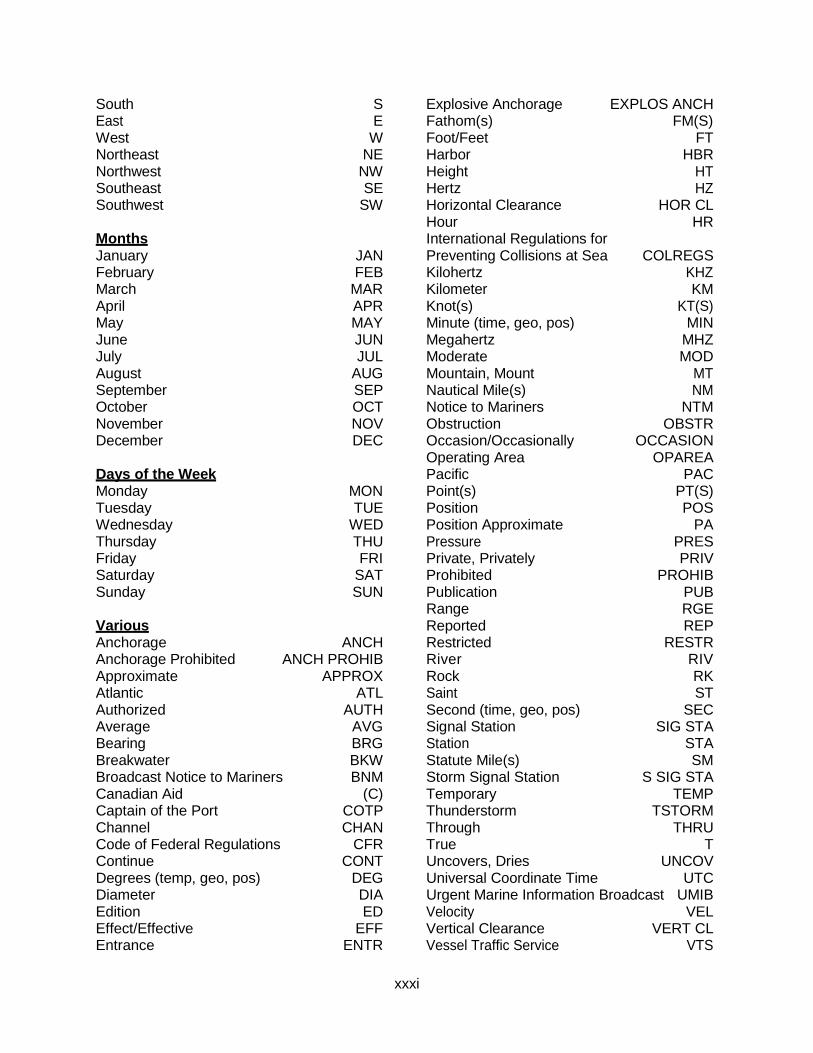
xxxi
South S East E West W Northeast NE Northwest NW Southeast SE Southwest SW Months January JAN February FEB March MAR April APR May MAY June JUN July JUL August AUG September SEP October OCT November NOV December DEC Days of the Week Monday MON Tuesday TUE Wednesday WED Thursday THU Friday FRI Saturday SAT Sunday SUN Various Anchorage ANCH Anchorage Prohibited ANCH PROHIB Approximate APPROX Atlantic ATL Authorized AUTH Average AVG Bearing BRG Breakwater BKW Broadcast Notice to Mariners BNM Canadian Aid (C) Captain of the Port COTP Channel CHAN Code of Federal Regulations CFR Continue CONT Degrees (temp, geo, pos) DEG Diameter DIA Edition ED Effect/Effective EFF Entrance ENTR
Explosive Anchorage EXPLOS ANCH Fathom(s) FM(S) Foot/Feet FT Harbor HBR Height HT Hertz HZ Horizontal Clearance HOR CL Hour HR International Regulations for Preventing Collisions at Sea COLREGS Kilohertz KHZ Kilometer KM Knot(s) KT(S) Minute (time, geo, pos) MIN Megahertz MHZ Moderate MOD Mountain, Mount MT Nautical Mile(s) NM Notice to Mariners NTM Obstruction OBSTR Occasion/Occasionally OCCASION Operating Area OPAREA Pacific PAC Point(s) PT(S) Position POS Position Approximate PA Pressure PRES Private, Privately PRIV Prohibited PROHIB Publication PUB Range RGE Reported REP Restricted RESTR River RIV Rock RK Saint ST Second (time, geo, pos) SEC Signal Station SIG STA Station STA Statute Mile(s) SM Storm Signal Station S SIG STA Temporary TEMP Thunderstorm TSTORM Through THRU True T Uncovers, Dries UNCOV Universal Coordinate Time UTC Urgent Marine Information Broadcast UMIB Velocity VEL Vertical Clearance VERT CL Vessel Traffic Service VTS
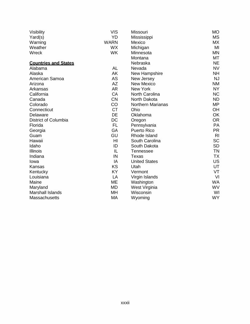
xxxii
Visibility VIS Yard(s) YD Warning WARN Weather WX Wreck WK Countries and States Alabama AL Alaska AK American Samoa AS Arizona AZ Arkansas AR California CA Canada CN Colorado CO Connecticut CT Delaware DE District of Columbia DC Florida FL Georgia GA Guam GU Hawaii HI Idaho ID Illinois IL Indiana IN Iowa IA Kansas KS Kentucky KY Louisiana LA Maine ME Maryland MD Marshall Islands MH Massachusetts MA
Missouri MO Mississippi MS Mexico MX Michigan MI Minnesota MN Montana MT Nebraska NE Nevada NV New Hampshire NH New Jersey NJ New Mexico NM New York NY North Carolina NC North Dakota ND Northern Marianas MP Ohio OH Oklahoma OK Oregon OR Pennsylvania PA Puerto Rico PR Rhode Island RI South Carolina SC South Dakota SD Tennessee TN Texas TX United States US Utah UT Vermont VT Virgin Islands VI Washington WA West Virginia WV Wisconsin WI Wyoming WY
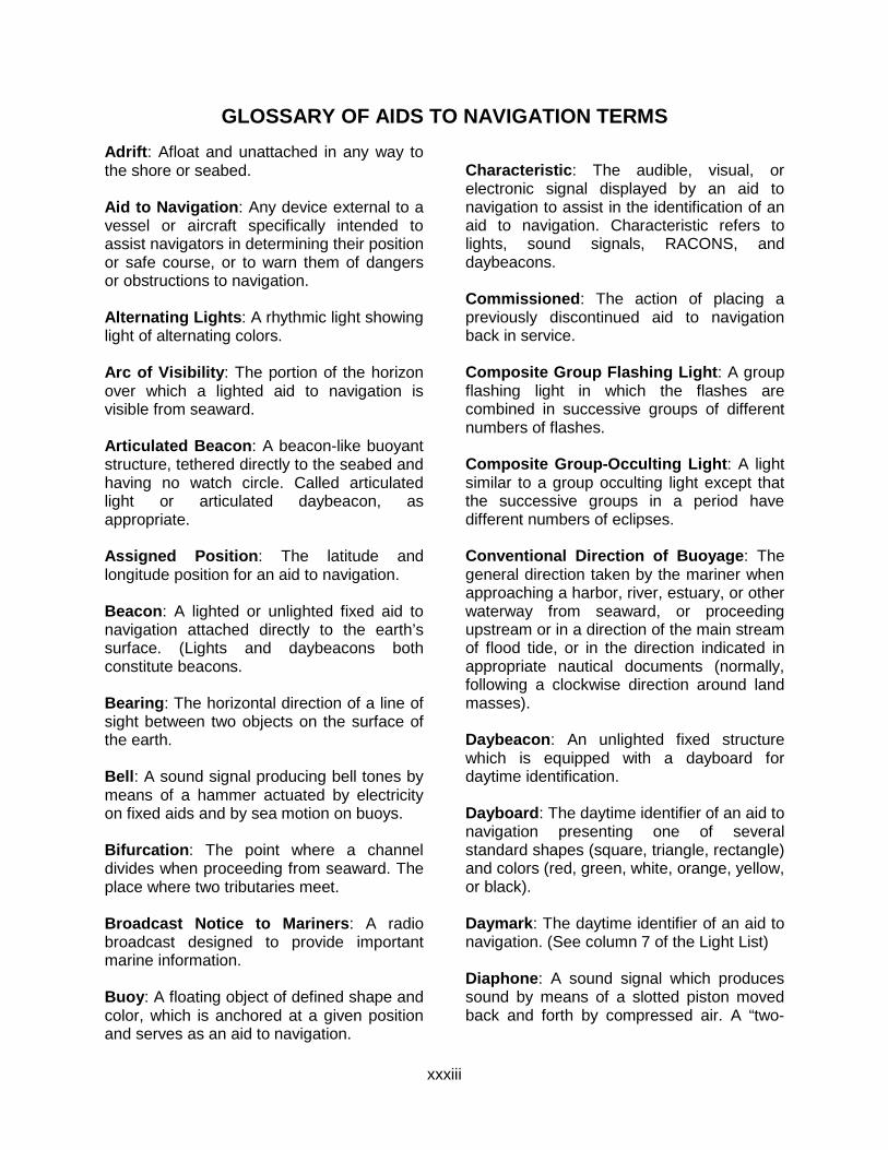
xxxiii
GLOSSARY OF AIDS TO NAVIGATION TERMS Adrift: Afloat and unattached in any way to the shore or seabed. Aid to Navigation: Any device external to a vessel or aircraft specifically intended to assist navigators in determining their position or safe course, or to warn them of dangers or obstructions to navigation. Alternating Lights: A rhythmic light showing light of alternating colors. Arc of Visibility: The portion of the horizon over which a lighted aid to navigation is visible from seaward. Articulated Beacon: A beacon-like buoyant structure, tethered directly to the seabed and having no watch circle. Called articulated light or articulated daybeacon, as appropriate. Assigned Position: The latitude and longitude position for an aid to navigation. Beacon: A lighted or unlighted fixed aid to navigation attached directly to the earth’s surface. (Lights and daybeacons both constitute beacons. Bearing: The horizontal direction of a line of sight between two objects on the surface of the earth. Bell: A sound signal producing bell tones by means of a hammer actuated by electricity on fixed aids and by sea motion on buoys. Bifurcation: The point where a channel divides when proceeding from seaward. The place where two tributaries meet. Broadcast Notice to Mariners: A radio broadcast designed to provide important marine information. Buoy: A floating object of defined shape and color, which is anchored at a given position and serves as an aid to navigation.
Characteristic: The audible, visual, or electronic signal displayed by an aid to navigation to assist in the identification of an aid to navigation. Characteristic refers to lights, sound signals, RACONS, and daybeacons. Commissioned: The action of placing a previously discontinued aid to navigation back in service. Composite Group Flashing Light: A group flashing light in which the flashes are combined in successive groups of different numbers of flashes. Composite Group-Occulting Light: A light similar to a group occulting light except that the successive groups in a period have different numbers of eclipses. Conventional Direction of Buoyage: The general direction taken by the mariner when approaching a harbor, river, estuary, or other waterway from seaward, or proceeding upstream or in a direction of the main stream of flood tide, or in the direction indicated in appropriate nautical documents (normally, following a clockwise direction around land masses). Daybeacon: An unlighted fixed structure which is equipped with a dayboard for daytime identification. Dayboard: The daytime identifier of an aid to navigation presenting one of several standard shapes (square, triangle, rectangle) and colors (red, green, white, orange, yellow, or black). Daymark: The daytime identifier of an aid to navigation. (See column 7 of the Light List) Diaphone: A sound signal which produces sound by means of a slotted piston moved back and forth by compressed air. A “two-
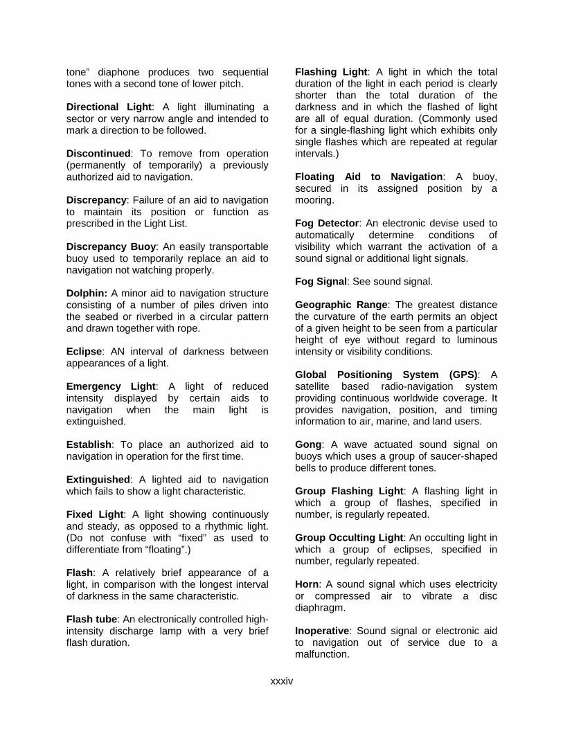
xxxiv
tone” diaphone produces two sequential tones with a second tone of lower pitch. Directional Light: A light illuminating a sector or very narrow angle and intended to mark a direction to be followed. Discontinued: To remove from operation (permanently of temporarily) a previously authorized aid to navigation. Discrepancy: Failure of an aid to navigation to maintain its position or function as prescribed in the Light List. Discrepancy Buoy: An easily transportable buoy used to temporarily replace an aid to navigation not watching properly. Dolphin: A minor aid to navigation structure consisting of a number of piles driven into the seabed or riverbed in a circular pattern and drawn together with rope. Eclipse: AN interval of darkness between appearances of a light. Emergency Light: A light of reduced intensity displayed by certain aids to navigation when the main light is extinguished. Establish: To place an authorized aid to navigation in operation for the first time. Extinguished: A lighted aid to navigation which fails to show a light characteristic. Fixed Light: A light showing continuously and steady, as opposed to a rhythmic light. (Do not confuse with “fixed” as used to differentiate from “floating”.) Flash: A relatively brief appearance of a light, in comparison with the longest interval of darkness in the same characteristic. Flash tube: An electronically controlled high-intensity discharge lamp with a very brief flash duration.
Flashing Light: A light in which the total duration of the light in each period is clearly shorter than the total duration of the darkness and in which the flashed of light are all of equal duration. (Commonly used for a single-flashing light which exhibits only single flashes which are repeated at regular intervals.) Floating Aid to Navigation: A buoy, secured in its assigned position by a mooring. Fog Detector: An electronic devise used to automatically determine conditions of visibility which warrant the activation of a sound signal or additional light signals. Fog Signal: See sound signal. Geographic Range: The greatest distance the curvature of the earth permits an object of a given height to be seen from a particular height of eye without regard to luminous intensity or visibility conditions. Global Positioning System (GPS): A satellite based radio-navigation system providing continuous worldwide coverage. It provides navigation, position, and timing information to air, marine, and land users. Gong: A wave actuated sound signal on buoys which uses a group of saucer-shaped bells to produce different tones. Group Flashing Light: A flashing light in which a group of flashes, specified in number, is regularly repeated. Group Occulting Light: An occulting light in which a group of eclipses, specified in number, regularly repeated. Horn: A sound signal which uses electricity or compressed air to vibrate a disc diaphragm. Inoperative: Sound signal or electronic aid to navigation out of service due to a malfunction.
xxxv
Interrupted Quick Flash: A quick flashing light in which the rapid alternations are interrupted at regular intervals by eclipses of long duration. Isolated Danger Mark: A mark erected on, or moored above or very near, an isolated danger which has navigable water all around it. Isophase Light: A rhythmic light in which all durations of light and darkness are equal. Junction: The point where a channel divides when proceeding seaward. The place where a distributary departs from the main stream. Lateral System: A system of aids to navigation in which characteristics of buoys and beacons indicate the sides of a channel or route relative to a Conventional Direction of Buoyage (usually upstream). Light: The signal emitted by a lighted aid to navigation. The illuminating apparatus used to emit the light signal. A lighted aid to navigation on a fixed structure. Light Sector: The arc over which a light is visible, described in degrees true, as observed from seaward towards the light. May be used to define distinctive color difference of two adjoining sectors, or an obscured sector. Lighted Ice Buoy (LIB): A lighted buoy without a sound signal, and designed to withstand the forces of shifting and flowing ice. Used to replace a conventional buoy when that aid to navigation is endangered by ice. Lighthouse: A lighted beacon of major importance. Local Notice to Mariners: A written document issued by each U.S. Coast Guard district to disseminate important information affecting aids to navigation, dredging, marine construction, special marine activities, and
bridge construction on waterways within that district. LORAN: An acronym for Long Range Navigation, is an electronic aid to navigation consisting of shore-based radio transmitters. The LORAN system enables users equipped with a LORAN receiver to determine their position quickly and accurately, day or night, in practically any weather. Luminous Range: The greatest distance a light can be expected to be seen given its nominal range and the prevailing meteorological visibility. Mark: A visual aid to navigation. Often called navigational mark, including floating marks (buoys) and fixed marks (beacons). Meteorological Visibility: The greatest distance at which a black object of suitable dimension could be seen and recognized against the horizon sky by day, or in case of night observations, could be seen and recognized if the general illumination were raised to the daylight level. Mileage Number: A number assigned to aids to navigation which gives the distance in sailing miles along the river from a reference point to the aid to navigation. The number is used principally in the Mississippi River System. Nominal Range: The maximum distance a light can be seen in clear weather (meteorological visibility of 10 nautical miles). Listed for all lighted aids to navigation except range lights, directional lights, and private aids to navigation. Occulting Light: A light in which the total duration of light in each period is clearly longer than the total duration of the darkness and in which the intervals of darkness (occultations) are all of equal duration. Commonly used for single occulting light which exhibits only single occultations which are repeated at regular intervals.
xxxvi
Ocean Data Acquisition System (ODAS): Certain very large buoys in deep water for the collection of oceanographic and meteorological information. All ODAS buoys are yellow in color and display a yellow light. Off Shore Tower: Monitored light stations built on exposed marine sites to replace lightships. Off Station: A floating aid to navigation that is not on its assigned position. Passing Light: A low intensity light which may be mounted on the structure of another light to enable the mariner to keep the latter light in sight when passing out of its beam during transit. Period: The interval of time between the commencement of two identical successive cycles of the characteristic of the light or sound signal. Pile: A long, heavy timber driven into the seabed or riverbed to serve as a support for an aid to navigation. Port Hand Mark: A buoy or beacon which is left to the port hand when proceeding in the “Conventional Direction of Buoyage”. Preferred Channel Mark: A lateral mark indicating a channel junction or bifurcation, or a wreck or other obstruction which after consulting a chart, may be passed on either side. Primary Aid to Navigation: An aid to navigation established for the purpose of making landfalls and coastwise passages from headland to headland. Quick Light: A light exhibiting very rapid regular alternations of light and darkness, normally 60 flashes per minute. RACON: A radar beacon which produces a coded response or radar paint, when triggered by a radar signal.
Radar: An electronic system designed to transmit radio signals and receive reflected images of those signals from a “target” in order to determine the bearing and distance to the “target”. Radar Reflector: A special fixture fitted to or incorporated into the design of certain aids to navigation to enhance their ability to reflect radar energy. In general, these fixtures will materially improve the aid to navigation for use by vessels with radar. Range: A line formed by the extension of a line connecting two charted points. Range lights: Two lights associated to form a range which often, but not necessarily, indicates the channel centerline. The front range light is the lower of the two, and nearer to the mariner using the range. The rear light is higher and further from the mariner. Rebuilt: A fixed aid to navigation, previously destroyed, which has been restored as an aid to navigation. Regulatory Marks: A white and orange aid to navigation with no lateral significance. Used to indicate a special meaning to the mariner, such as danger, restricted operations, or exclusion area. Relighted: An extinguished aid to navigation returned to its advertised light characteristics. Replaced: An aid to navigation previously off station, adrift, or missing, restored by another aid to navigation of the same type and characteristics. Replaced (temporarily): An aid to navigation previously off station, adrift, or missing restored by another aid to navigation of a different type and/or characteristic. Reset: A floating aid to navigation previously off station, adrift or missing, returned to its assigned position (station).
xxxvii
Rhythmic Light: A light showing intermittently with a regular periodicity.
Sector: See light sector.
Setting a Buoy: The act of placing a buoy on assigned position in the water.
Siren: A sound signal which uses electricity or compressed air to actuate either a disc or a cup shaped rotor.
Skeleton Tower: A tower, usually of steel, constructed of heavy corner members and various horizontal and diagonal bracing members.
Sound Signal: A device which transmits sound, intended to provide information to mariners during periods of restricted visibility and foul weather.
Starboard Hand Mark: A buoy or beacon which is left to the starboard hand when proceeding in the Conventional Direction of Buoyage.
Topmark: One or more relatively small objects of characteristic shape and color placed on aid to identify its purpose.
Traffic Separation Scheme: Shipping corridors marked by buoys which separate incoming from outgoing vessels. Improperly called SEA LANES.
Watching Properly: An aid to navigation on its assigned position exhibiting the advertised characteristics in all respects.
Whistle: A wave actuated sound signal on buoys which produces sound by emitting compressed air through a circumferential slot into a cylindrical bell chamber.
Winter Marker: An unlighted buoy without a sound signal, used to replace a conventional buoy when an aid to navigation is endangered by ice. Winter Light: A light which is maintained during those winter months when the regular light is extinguished. It is of lower candlepower than the regular light, but usually the same characteristic.
Withdrawn: The discontinuance of an aid to navigation or equipment on an aid to navigation during severe ice conditions or for the winter season.
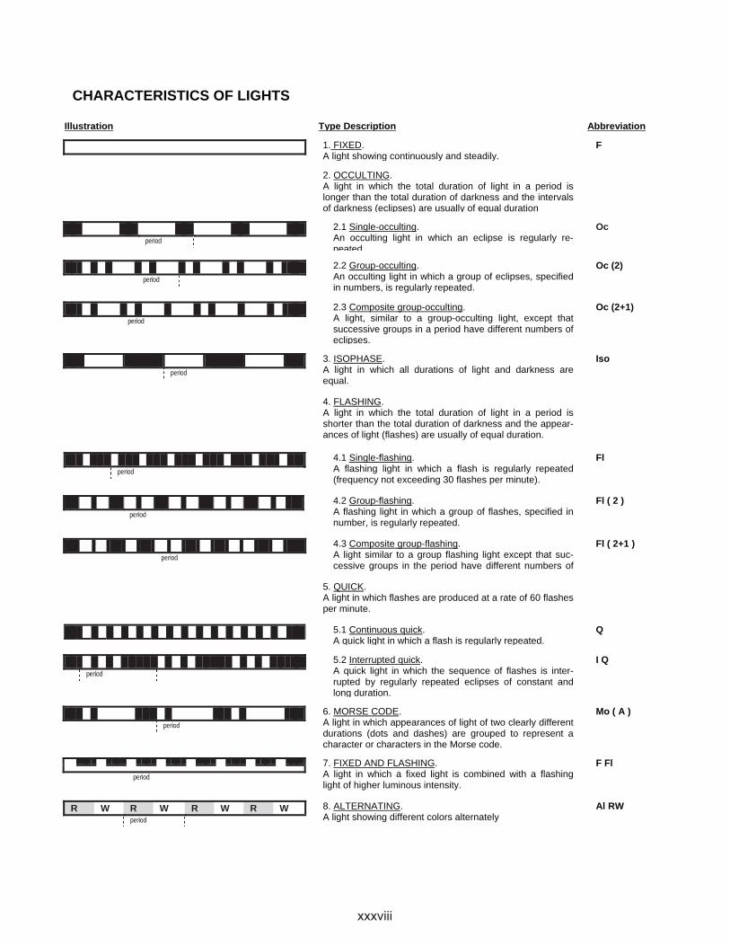
CHARACTERISTICS OF LIGHTS
Illustration Type Description Abbreviation
1. FIXED.A light showing continuously and steadily.
F
2. OCCULTING.A light in which the total duration of light in a period is longer than the total duration of darkness and the intervals of darkness (eclipses) are usually of equal duration
period
2.1 Single-occulting.An occulting light in which an eclipse is regularly re-peated.
Oc
period
2.2 Group-occulting.An occulting light in which a group of eclipses, specified in numbers, is regularly repeated.
Oc (2)
period
2.3 Composite group-occulting.A light, similar to a group-occulting light, except that successive groups in a period have different numbers of eclipses.
Oc (2+1)
period
3. ISOPHASE.A light in which all durations of light and darkness are equal.
Iso
4. FLASHING.A light in which the total duration of light in a period is shorter than the total duration of darkness and the appear-ances of light (flashes) are usually of equal duration.
period
4.1 Single-flashing.A flashing light in which a flash is regularly repeated (frequency not exceeding 30 flashes per minute).
Fl
period
4.2 Group-flashing.A flashing light in which a group of flashes, specified in number, is regularly repeated.
Fl ( 2 )
period
4.3 Composite group-flashing.A light similar to a group flashing light except that suc-cessive groups in the period have different numbers of
Fl ( 2+1 )
5. QUICK.A light in which flashes are produced at a rate of 60 flashes per minute.
5.1 Continuous quick.A quick light in which a flash is regularly repeated.
Q
period
5.2 Interrupted quick.A quick light in which the sequence of flashes is inter-rupted by regularly repeated eclipses of constant and long duration.
I Q
period
6. MORSE CODE.A light in which appearances of light of two clearly different durations (dots and dashes) are grouped to represent a character or characters in the Morse code.
Mo ( A )
period
7. FIXED AND FLASHING.A light in which a fixed light is combined with a flashing light of higher luminous intensity.
F Fl
R W R W R W R Wperiod
8. ALTERNATING.A light showing different colors alternately
Al RW
xxxviii
xxxix
RIVER DESCRIPTIONS Allegheny River The Allegheny River rises in north central Pennsylvania, flows in a northwesterly direction into southwestern New York, then flows back into Pennsylvania to Pittsburgh, where it joins the Monongahela River to form the Ohio River. The lower part of the river has been improved by the construction of locks and dams.
A channel depth of 9.0 feet is maintained throughout the pooled area which extends to mile 72.0 above East Brady, Pennsylvania. Channel depths above mile 72.0 may drop to as low as 1.0 to 2.0 feet during low water stages.
Big Sandy River The Big Sandy River is formed at Louisa, Kentucky by the confluence of the Tug and Levisa Forks, and flows in a northerly direction for 27.4 miles into the Ohio River at mile 317.0.
The present practical head of navigation is mile 7.2, with a channel depth of 9.0 feet maintained by the Army Corps of Engineers. Slack water from the Ohio River Greenup Pool extends up the Big Sandy River to mile 8.6.
This river, which forms a portion of the Kentucky-West Virginia border, should not be confused with an identically named river in northwestern Tennessee which flows into the Tennessee River at mile 67.0. See Tennessee River listing for information on Aids to Navigation on that waterway.
Canadian River The Canadian River is a navigable waterway of the United States from its mouth off the Arkansas River at approximate mile 355.1 to the head of navigation at mile 183.0. Lake Eufaula Dam is located near Briartown, Oklahoma.
xl
Clinch River The Clinch River rises in northwestern Virginia in Tazewell County and flows in a southwesterly direction for approximately 220.0 miles, joining the Tennessee River one mile below Kingston, Tennessee at mile 567.7.
From the mouth to mile 61.5, upstream from Clinton, Tennessee, a channel depth of 9.0 feet and a minimum width of 125.0 feet is provided and is marked with unlighted buoys and daymarks.
Cumberland River The Cumberland River is formed by the confluence of Poor and Clover Forks in the southeastern part of Kentucky flowing southwesterly into Tennessee, thence northwesterly into Kentucky and empties into the Ohio River near Smithland, Kentucky, 920.5 miles below Pittsburgh. The head of navigation is at mile 381.0 near Celina, Tennessee.
The present navigation project on the Cumberland River provides for a navigable depth of 9.0 feet from mile 0.0 to mile 308.0 and a depth of 6.0 feet from mile 308.0 to mile 381.0.
First and Second class safety landings are available for use in various locations on the Cumberland River. These landings are shown on U.S. Army Corps of Engineers river charts and are not listed within this publication.
Green River The river is navigated by commercial carriers from the mouth to mile 108.5 at Lock No. 3 near Skilesville, Kentucky. In this section, a channel 9.0 feet deep and 200.0 feet wide is maintained for the first 103.0 miles. Above that point to mile 149.0, a depth of 5.5 feet is maintained.
A navigable depth cannot be maintained from mile 108.5 to mile 167.9 at Lock No. 5 due to failure of Dam No. 4. Lock No. 4, Lock No. 5 and Lock No. 6 at mile 181.6 are closed to Navigation. Pleasure craft operate in the pools above to latter two dams.
Hiwassee River The Hiwassee River is a navigable tributary entering the Tennessee River in Chichamauga Reservoir at mile 499.4, approximately 35.0 miles from Chattanooga, Tennessee.
From the mouth to mile 20.4 upstream from Charleston, Tennessee, a channel depth of 9.0 feet and a minimum width of 200.0 feet is provided and is marked with unlighted buoys and daymarks.

xli
Illinois Waterway The Illinois Waterway rises in the vicinity of Chicago, Illinois and embraces improved natural waterways and canals to empty into the Upper Mississippi River at Grafton, Illinois. Through a controlling works, Lake Michigan waters enter the Chicago River flowing westerly. A branch of the waterway, the Calumet-Sag Channel, leaves the main waterway at mile 303.5 near Lemont, Illinois and proceeds southeasterly to join the Little Calumet, Calumet and the Grand Calumet Rivers, thus affording access to Lake Michigan at Calumet Harbor, Illinois.
In this publication, the waterway is described in its entirety with a channel depth of 9.0 feet provided throughout.
Aids to navigation for all branches of the waterway between Lake Michigan and Lockport Lock and Dam, mile 291.1, are under the jurisdiction of the Commander, Ninth Coast Guard District, Cleveland, Ohio.
Aids to navigation between Lockport Lock and Dam and the mouth of the Illinois River are under the jurisdiction of the Commander, Eighth Coast Guard District, New Orleans, Louisiana.
Vertical clearances under bridges between Lake Michigan and Lockport Lock and Dam are shown above low water datum (LWD), for Lake Michigan. Lesser clearances may prevail for a few hours after heavy rainfall in the Chicago area.
Kanawha River The Kanawha River is formed by the confluence of the New and Bauley Rivers in southwestern West Virginia. It flows in a northwesterly direction and empties into the Ohio River at Point Pleasant, West Virginia, 265.7 miles below Pittsburgh.
The river is pooled by dams. A channel depth of 9.0 feet is maintained throughout the improved section, to mile 90.6.
Kaskaskia River The Kaskaskia River is about 325.0 miles in length. It rises in Champain County, Illinois and flows in a southeasterly direction across Illinois and empties into the Upper Mississipper River, 117.4 miles above the mouth of the Ohio River.
xlii
The Army Corps of Engineers is presently improving the lower 50.0 miles of the river for navigation. After completion, a navigable channel of 9.0 feet deep by 225.0 feet wide will be available from the mouth of the river to Fayetteville, Illinois, project mile 36.2. The Coast Guard considers the Kaskaskia River to project mile 36.2. The present head of navigation is project mile 29.2.
Reflectorized mile markers (old river mileage) have been installed along portions of the waterway but are not individually listed in this publication.
Lake Texoma Lake Texoma is a navigable waterway of the United States located on the Red River at Denison Dam, mile 725.9, near Denison, Texas. The lake lies on the border of Texas and Oklahoma.
Little Tennessee River The Little Tennessee River is a navigable tributary formed in the Great Smokey Mountains flowing in a northerly direction. It enters the Tennessee River just downstream from Fort Loudon Dam. Telleco Dam, located at Little Tennessee River mile 0.3, is bypassed via a 1000 foot canal which joins Telleco and Fort Loudon reservoirs just upstream from each dam. A channel with a depth of 11.0 feet and width of 200.0 feet is provided from the entrance of the canal to mile 19.1 and maintained by the Army Corps of Engineers.
Lower Mississippi River The Lower Mississippi River is formed at Cairo, Illinois, by the confluence of the Upper Mississippi and Ohio Rivers, and flows southerly to empty into the Gulf of Mexico, 115.0 miles south of New Orleans, Louisiana, via Southwest Pass.
The origin or zero of the mileage system is the Head of Passes, 95.0 miles below New Orleans and 20.0 miles above the Gulf of Mexico via Southwest Pass. Cairo, Illinois, at the head of the river, is at mile 955.8 AHP (Above Head of Passes).
The river has been improved to provide a project depth of 12.0 feet above Baton Rouge, Louisiana, mile 232.5 to Cairo, Illinois, mile 955.8. A channel depth of at least 40.0 feet is provided below Baton Rouge, Louisiana. Channel depths of 9.0 feet are maintained during low water stages. There are no locks or dams.
xliii
Upper Mississippi River The Upper Mississippi River rises at Lake Itasca, Minnesota, and flows generally southward to join the Ohio River at Cairo, Illinois. The head of navigation is the Soo Line Railroad Bridge, mile 857.6 at Minneapolis Upper Harbor, Minnesota.
From the head of navigation to Lock and Dam No. 26, at Alton, Illinois, mile 203.1; the river is improved with locks and dams providing a project depth of 9.0 feet. Below Alton, Illinois to mile 0.0 at Cairo, Illinois a project depth of 9.0 feet is maintained by dredging when necessary.
Between mile 194.3 and mile 184.0, the open river Chain of Rocks Reach is bypassed by the Chain of Rocks Canal, containing Lock No. 27. The canal also has a project depth of 9.0 feet.
Minnesota River The Minnesota River rises in Big Stone Lake in west central Minnesota. It flows southeasterly, then northeasterly for 330.0 miles to enter the Upper Mississippi River opposite St. Paul, Minnesota.
From the mouth to mile 14.7, a channel with a depth of 9.0 feet and a general width of 150.0 feet is provided and maintained by the Army Corps of Engineers. From mile 14.7 to mile 21.8, a channel with a depth of 9.0 feet and a general width of 100.0 feet is provided and maintained by private interests. From mile 21.8 to mile 25.2, the river is in natural condition with a controlling depth of less than 3.0 feet and a width of about 50.0 feet.
Missouri River The Missouri River is formed in southwestern Montana by the confluence of the Jefferson, Madison and Gallatin Rivers at Three Forks, Montana. The river flows successively northerly and southeasterly for 2,315.2 miles (1960 mileage) to join the Mississippi River 15.3 miles above St. Louis, Missouri.
The present practical head of navigation is Sioux City, Iowa. Water released from upstream storage reservoirs permits regulation and maintenance of a 9-foot channel between Sioux City and the mouth of the river.
Portable daymarks without number boards are frequently relocated as channel conditions become known. These portable daymarks are not listed within this publication.
xliv
The commercial navigation season is normally open from late March to late November at Sioux City and from April 1 to December 1 at the mouth. Ice conditions and low water preclude navigation for the rest of the year.
Mariners are reminded that all lighted and floating aids to navigation are discontinued or removed from the Missouri River when the commercial navigation season has ended. Mariners will be notified in advance when the season opens and closes.
Monongahela River The Monongahela River is formed by the confluence of the West Fork and Tygart Rivers about one mile south of Fairmont, West Virginia. It flows in a northeasterly direction into southwestern Pennsylvania and then in a northerly direction to Pittsburgh, Pennsylvania where it joins the Allegheny River to form the Ohio River.
The river is pooled by dams. Channel depths of 9.0 feet are available up to the head of navigation, mile 128.7.
Ohio River The Ohio River is formed by the confluence of the Allegheny and Monongahela Rivers at Pittsburgh, Pennsylvania, mile 0.0, and flows generally southwestward for 981.0 miles, joining the Mississippi River at Cairo, Illinois.
Between Pittsburgh, Pennsylvania and Lock and Dam No. 53, mile 962.6, the river has been improved with locks and dams. Below mile 962.6, dredging is performed as required. This improvement and maintenance provide a project depth of 9.0 feet for the entire river.
Ouachita-Black Waterway The Ouachita-Black Waterway rises in the vicinity of Camden, Arkansas, and embraces improved natural waterways to the Lower Mississippi River at mile 304.0 AHP via the Red and Lower Old River. It also connects with the Gulf Intracoastal Waterway (West) via the Red River and Atchafalaya River.
The authorized navigation project provides a channel depth of 12.0 feet and a width of 125.0 feet on the Lower Old River (Red). The remainder of the Waterway provides a depth of 9.0 feet and a width of 100.0 feet.
xlv
Red River The Red River Waterway project provides a channel depth of 9.0 feet and a width of 200 feet for approximately 294 miles from the mouth of the Lower Old River at Lower Mississippi River mile 304.0 to the Caddo-Bossier Port Commission Light. The waterway consists of five locks and dams, and numerous cut-offs and bank re-alignments. The waterway is marked by aids to navigation to mile 211.4.
St. Croix River The St. Croix River rises in northwestern Wisconsin and flows in a southerly direction for approximately 164.0 miles, joining the Upper Misissippi River at Prescott, Wisconsin.
From the mouth to Stillwater, Minnesota, mile 24.5, the authorized navigation project provides a channel with a depth of 9.0 feet and a width of at least 300.0 feet during the navigation season. The river is closed by ice for about four months in the winter. Pool stage is provided by Dam No. 3, Upper Mississippi River, mile 796.9.
From Stillwater to Taylor Falls, a distance of 28.5 miles, the open channel is about 1.5 feet deep and 50.0 feet wide at low discharges.
Tennessee River The Tennessee River, which is formed by the confluence of the Holston and French Broad Rivers 5 miles above Knoxville, Tennessee, flows successively southwest, west and north through parts of Alabama, Mississippi, Tennessee, and Kentucky, to empty into the Ohio River at Paducah, Kentucky, 934.4 miles below Pittsburgh, Pennsylvania and 44.9 miles above Cairo, Illinois. Total length of the river is about 652.0 miles.
A navigable channel with a depth of 9.0 feet is provided from the mouth at Paducah, Kentucky to 652.0. Many tributaries of the Tennessee River have adequate depths of 9.0 feet. Approximate notes on navigability are shown for each stream buoyed by the Coast Guard.
Other tributary and secondary channels of the Tennessee River are buoyed by the Tennessee Valley Authority.
First and Second class safety landings are available for use in various locations on the Tennessee River. These landings are shown on the U.S. Army Corps of Engineers river charts and are not listed within this publication.
xlvi
Tennessee-Tombigbee Waterway The Tennessee-Tombigbee Waterway extends upstream from Demopolis, Alabama mile 217.0 via the Tombigbee River through the basin divide into the Yellow Creek Embayment of Pickwick Lake at mile 215.2 on the Tennessee River, which is mile 450.7 on the Tennessee-Tombigbee Waterway. This represents a total distance of 234.0 navigable miles which is comprised of river, canal, and divide sections. The river section (149.0 miles) extends up the Tombigbee River from Demopolis, Alabama to a point just south of Armory, Mississippi.
Ten locks and five dams improve the river, and depths of 9.0 feet are provided within the river section and 12.0 feet within the canal and divide sections.

This Page Intentionally Left Blank
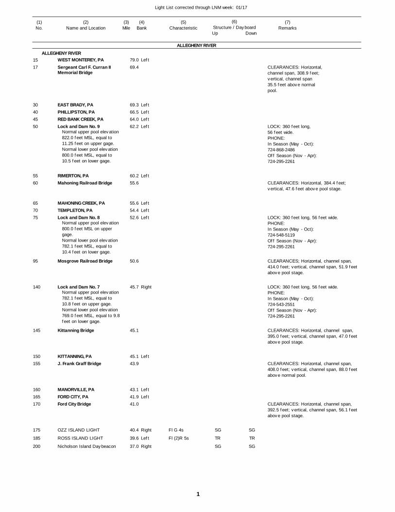
1
Light List corrected through LNM week: 01/17
(7)Remarks
(1)No.
(2)Name and Location
(3)Mile
(5)Characteristic
(4)Bank
(6)Structure / DayboardUp Down
WEST MONTEREY, PASergeant Carl F. Curran II Memorial Bridge
EAST BRADY, PAPHILLIPSTON, PARED BANK CREEK, PALock and Dam No. 9
RIMERTON, PAMahoning Railroad Bridge
MAHONING CREEK, PATEMPLETON, PALock and Dam No. 8
Mosgrove Railroad Bridge
Lock and Dam No. 7
Kittanning Bridge
KITTANNING, PAJ. Frank Graff Bridge
MANORVILLE, PAFORD CITY, PAFord City Bridge
OZZ ISLAND LIGHT
ROSS ISLAND LIGHT
Nicholson Island Daybeacon
ALLEGHENY RIVER
ALLEGHENY RIVERLeft
LeftLeftLeftLeft
Left
LeftLeftLeft
Right
Left
LeftLeft
Right
Left
Right
79.0
69.4
69.3 66.5 64.0 62.2
60.2 55.6
55.6 54.4 52.6
50.6
45.7
45.1
45.1 43.9
43.1 41.9 41.0
40.4
39.6
37.0
Normal upper pool elevation 822.0 feet MSL, equal to 11.25 feet on upper gage.Normal lower pool elevation 800.0 feet MSL, equal to 10.5 feet on lower gage.
Normal upper pool elevation 800.0 feet MSL on upper gage.Normal lower pool elevation 782.1 feet MSL, equal to 10.4 feet on lower gage.
Normal upper pool elevation 782.1 feet MSL, equal to 10.8 feet on upper gage.Normal lower pool elevation 769.0 feet MSL, equal to 9.8feet on lower gage.
Fl G 4s
Fl (2)R 5s
CLEARANCES: Horizontal, channel span, 308.9 feet; vertical, channel span 35.5 feet above normal pool.
LOCK: 360 feet long,56 feet wide.PHONE:In Season (May - Oct):724-868-2486Off Season (Nov - Apr):724-295-2261
CLEARANCES: Horizontal, 384.4 feet; vertical, 47.6 feet above pool stage.
LOCK: 360 feet long, 56 feet wide.PHONE:In Season (May - Oct):724-548-5119Off Season (Nov - Apr):724-295-2261
CLEARANCES; Horizontal, channel span, 414.0 feet; vertical, channel span, 51.9 feet above pool stage.
LOCK: 360 feet long, 56 feet wide.PHONE:In Season (May - Oct):724-543-2551Off Season (Nov - Apr):724-295-2261
CLEARANCES: Horizontal, channel span, 395.0 feet; vertical, channel span, 47.0 feet above pool stage.
CLEARANCES: Horizontal, channel span, 408.0 feet; vertical, channel span, 88.0 feet above normal pool.
CLEARANCES: Horizontal, channel span, 392.5 feet; vertical, channel span, 56.1 feet above pool stage.
1517
30404550
5560
657075
95
140
145
150155
160165170
175
185
200
SG
TR
SG
SG
TR
SG
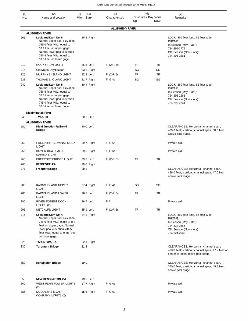
2
Light List corrected through LNM week: 01/17
(7)Remarks
(1)No.
(2)Name and Location
(3)Mile
(5)Characteristic
(4)Bank
(6)Structure / DayboardUp Down
Lock and Dam No. 6
ROCKY RUN LIGHT
Old Maids DaybeaconMURPHYS ISLAND LIGHT
THOMAS E. CLARK LIGHT
Lock and Dam No. 5
- MOUTH
Kiski Junction Railroad Bridge
FREEPORT TERMINAL DOCKLIGHTBOYER BOAT SALES MARINA LIGHTFREEPORT BRIDGE LIGHT
FREEPORT, PAFreeport Bridge
KARNS ISLAND UPPER LIGHTKARNS ISLAND LOWER LIGHTRIVER FOREST DOCK LIGHTS (2)METCALFS LIGHT
Lock and Dam No. 4
TARENTUM, PATarentum Bridge
Kensington Bridge
NEW KENSINGTON, PAWEST PENN POWER LIGHTS(2)DUQUESNE LIGHT COMPANY LIGHTS (2)
ALLEGHENY RIVER
ALLEGHENY RIVER
Kiskiminetas River
ALLEGHENY RIVER
Right
Left
RightLeft
Right
Right
Left
Left
Right
Right
Left
Right
Right
Left
Left
Left
Right
Right
LeftRight
Right
36.3
35.5
33.6 32.3
31.7
30.4
30.2
30.0
29.7
29.3
29.3
29.0 28.6
27.4
26.7
26.7
25.9
24.2
22.1 21.8
19.0
19.0 17.7
15.6
Normal upper pool elevation 769.0 feet MSL, equal to 10.9 feet on upper gage. Normal lower pool elevation 756.8 feet MSL, equal to 10.6 feet on lower gage.
Normal upper pool elevation 756.8 feet MSL, equal to 10.3 feet on upper gage. Normal lower pool elevation 745.0 feet MSL, equal to 10.5 feet on lower gage.
Normal upper pool elevation 745.0 feet MSL, equal to 8.3feet on upper gage. Normal lower pool elevation 734.5 feet MSL, equal to 9.75 feeton lower gage.
Fl (2)R 5s
Fl (2)R 5s
Fl G 4s
Fl G 6s
Fl G 6s
Fl (2)R 5s
Fl G 4s
Fl (2)R 5s
F R
Fl (2)R 5s
Fl G 6s
Fl G 6s
LOCK: 360 feet long, 56 feet wide. PHONE:In Season (May - Oct):724-295-3775Off Season (Nov - Apr):724-295-2261
LOCK: 360 feet long, 56 feet wide.PHONE:In Season (May - Oct):724-295-2261Off Season (Nov - Apr):724-295-2261
CLEARANCES: Horizontal, channel span, 400.0 feet; vertical, channel span, 50.0 feet above pool stage.
CLEARANCES: Horizontal, channel span, 426.0 feet; vertical, channel span, 47.0 feet above pool stage.
LOCK: 360 feet long, 56 feet wide.PHONE:In Season (May - Oct):724-224-2666Off Season (Nov - Apr):724-224-2666
CLEARANCES: Horizontal, channel span, 428.0 feet; vertical, channel span, 47.9 feet ofcenter of span above pool stage.
CLEARANCES: Horizontal, channel span, 350.0 feet; vertical, channel span, 49.8 feet above pool stage.
205
210
215225
235
240
245
250
253
255
260
265275
280
285
290
295
315
325330
350
355360
385
TR
SGTR
SG
TR
SG
TR
TR
TR
SGTR
SG
TR
SG
TR
TR
Private aid.
Private aid.
Private aid.
Private aid.
Private aid.
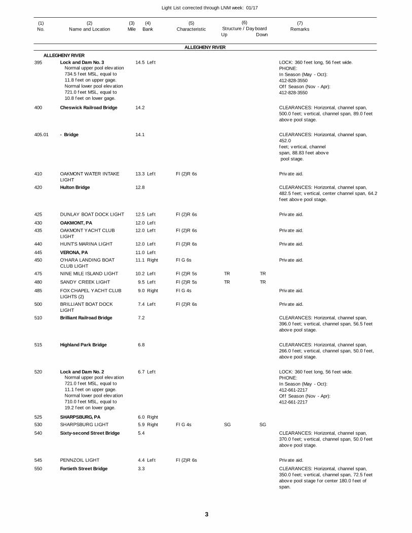
3
Light List corrected through LNM week: 01/17
(7)Remarks
(1)No.
(2)Name and Location
(3)Mile
(5)Characteristic
(4)Bank
(6)Structure / DayboardUp Down
Lock and Dam No. 3
Cheswick Railroad Bridge
- Bridge
OAKMONT WATER INTAKE LIGHTHulton Bridge
DUNLAY BOAT DOCK LIGHT
OAKMONT, PAOAKMONT YACHT CLUB LIGHTHUNT'S MARINA LIGHT
VERONA, PAO'HARA LANDING BOAT CLUB LIGHTNINE MILE ISLAND LIGHT
SANDY CREEK LIGHT
FOX CHAPEL YACHT CLUB LIGHTS (2)BRILLIANT BOAT DOCK LIGHTBrilliant Railroad Bridge
Highland Park Bridge
Lock and Dam No. 2
SHARPSBURG, PASHARPSBURG LIGHT
Sixty-second Street Bridge
PENNZOIL LIGHT
Fortieth Street Bridge
ALLEGHENY RIVER
ALLEGHENY RIVERLeft
Left
Left
LeftLeft
Left
LeftRight
Left
Left
Right
Left
Left
RightRight
Left
14.5
14.2
14.1
13.3
12.8
12.5
12.0 12.0
12.0
11.0 11.1
10.2
9.5
9.0
7.4
7.2
6.8
6.7
6.0 5.9
5.4
4.4
3.3
Normal upper pool elevation 734.5 feet MSL, equal to 11.8 feet on upper gage. Normal lower pool elevation 721.0 feet MSL, equal to 10.8 feet on lower gage.
Normal upper pool elevation 721.0 feet MSL, equal to 11.1 feet on upper gage. Normal lower pool elevation 710.0 feet MSL, equal to 19.2 feet on lower gage.
Fl (2)R 6s
Fl (2)R 6s
Fl (2)R 6s
Fl (2)R 6s
Fl G 6s
Fl (2)R 5s
Fl (2)R 5s
Fl G 4s
Fl (2)R 6s
Fl G 4s
Fl (2)R 6s
LOCK: 360 feet long, 56 feet wide. PHONE:In Season (May - Oct):412-828-3550Off Season (Nov - Apr):412-828-3550
CLEARANCES: Horizontal, channel span, 500.0 feet; vertical, channel span, 89.0 feet above pool stage.
CLEARANCES: Horizontal, channel span, 452.0 feet; vertical, channel span, 88.83 feet above pool stage.
CLEARANCES: Horizontal, channel span, 482.5 feet; vertical, center channel span, 64.2 feet above pool stage.
CLEARANCES: Horizontal, channel span, 396.0 feet; vertical, channel span, 56.5 feet above pool stage.
CLEARANCES: Horizontal, channel span, 266.0 feet; vertical, channel span, 50.0 feet, above pool stage.
LOCK: 360 feet long, 56 feet wide.PHONE:In Season (May - Oct):412-661-2217Off Season (Nov - Apr):412-661-2217
CLEARANCES: Horizontal, channel span, 370.0 feet; vertical, channel span, 50.0 feet above pool stage.
CLEARANCES: Horizontal, channel span, 350.0 feet; vertical, channel span, 72.5 feet above pool stage for center 180.0 feet of span.
395
400
405.01
410
420
425
430435
440
445450
475
480
485
500
510
515
520
525530
540
545
550
TR
TR
SG
TR
TR
SG
Private aid.
Private aid.
Private aid.
Private aid.
Private aid.
Private aid.
Private aid.
Private aid.
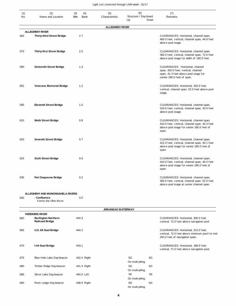
4
Light List corrected through LNM week: 01/17
(7)Remarks
(1)No.
(2)Name and Location
(3)Mile
(5)Characteristic
(4)Bank
(6)Structure / DayboardUp Down
Thirty-third Street Bridge
Thirty-first Street Bridge
Sixteenth Street Bridge
Veterans Memorial Bridge
Eleventh Street Bridge
Ninth Street Bridge
Seventh Street Bridge
Sixth Street Bridge
Fort Duquesne Bridge
- Confluence
Burlington Northern Railroad Bridge
U.S. 66 Dual Bridge
I-44 Dual Bridge
Blue Hole Lake Daybeacon
Timber Ridge Daybeacon
Silver Lake Daybeacon
Rock Ledge Daybeacon
ALLEGHENY RIVER
ALLEGHENY RIVER
ALLEGHENY AND MONONGAHELA RIVERS
ARKANSAS WATERWAY
VERDIGRIS RIVER
Right
Right
Left
Right
2.7
2.5
1.3
1.2
1.0
0.8
0.7
0.6
0.2
0.0
444.3
444.2
443.1
442.4
441.3
440.0
438.9
Forms the Ohio River.
On multi-piling.
On multi-piling.
On multi-piling.
On multi-piling.
CLEARANCES: Horizontal, channel span, 400.0 feet; vertical, channel span, 44.9 feet above pool stage.
CLEARANCES: Horizontal, channel span, 360.0 feet; vertical, channel span, 72.6 feet above pool stage for width of 180.0 feet.
CLEARANCES: Horizontal, channelspan, 420.0 feet; vertical, channel span, 41.3 feet above pool stage forcenter 180.0 feet of span.
CLEARANCES: Horizontal, 420.0 feet; vertical, channel span, 52.0 feet above pool stage.
CLEARANCES: Horizontal, channel span, 319.0 feet; vertical, channel span, 40.9 feet above pool stage.
CLEARANCES: Horizontal, channel span, 410.0 feet; vertical, channel span, 40.3 feet above pool stage for center 180.0 feet of span.
CLEARANCES: Horizontal, channel span, 422.0 feet; vertical, channel span, 40.1 feet above pool stage for center 180.0 feet of span.
CLEARANCES: Horizontal, channel span, 410.0 feet; vertical, channel span, 40.0 feet above pool stage for center 180.0 feet of span.
CLEARANCES: Horizontal, channel span, 400.0 feet; vertical, channel span, 52.0 feet above pool stage at center channel span.
CLEARANCES: Horizontal, 300.0 feet; vertical, 72.0 feet above navigation pool
CLEARANCES: Horizontal, 313.0 feet; vertical, 72.0 feet above minimum pool for mid250.0 feet of navigation span.
CLEARANCES: Horizontal, 188.5 feet; vertical, 71.5 feet above navigation pool.
565
570
590
591
595
615
620
625
635
640
660
665
670
675
680
685
690
SG
SG
TR
SG
SG
SG
TR
SG
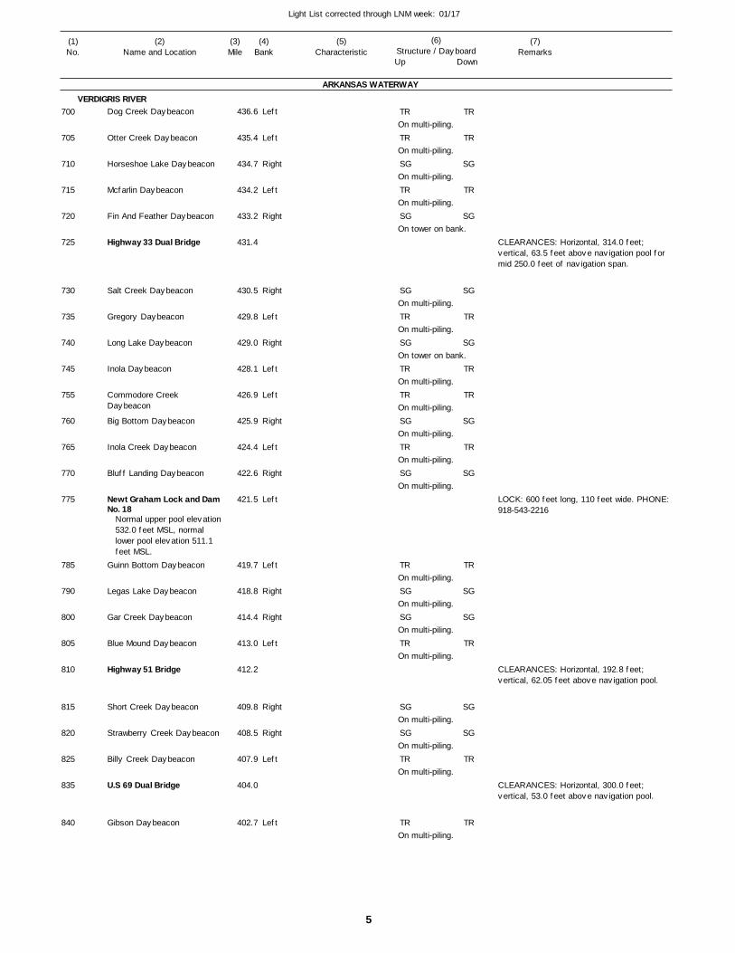
5
Light List corrected through LNM week: 01/17
(7)Remarks
(1)No.
(2)Name and Location
(3)Mile
(5)Characteristic
(4)Bank
(6)Structure / DayboardUp Down
Dog Creek Daybeacon
Otter Creek Daybeacon
Horseshoe Lake Daybeacon
Mcfarlin Daybeacon
Fin And Feather Daybeacon
Highway 33 Dual Bridge
Salt Creek Daybeacon
Gregory Daybeacon
Long Lake Daybeacon
Inola Daybeacon
Commodore Creek Daybeacon
Big Bottom Daybeacon
Inola Creek Daybeacon
Bluff Landing Daybeacon
Newt Graham Lock and DamNo. 18
Guinn Bottom Daybeacon
Legas Lake Daybeacon
Gar Creek Daybeacon
Blue Mound Daybeacon
Highway 51 Bridge
Short Creek Daybeacon
Strawberry Creek Daybeacon
Billy Creek Daybeacon
U.S 69 Dual Bridge
Gibson Daybeacon
ARKANSAS WATERWAY
VERDIGRIS RIVERLeft
Left
Right
Left
Right
Right
Left
Right
Left
Left
Right
Left
Right
Left
Left
Right
Right
Left
Right
Right
Left
Left
436.6
435.4
434.7
434.2
433.2
431.4
430.5
429.8
429.0
428.1
426.9
425.9
424.4
422.6
421.5
419.7
418.8
414.4
413.0
412.2
409.8
408.5
407.9
404.0
402.7
Normal upper pool elevation 532.0 feet MSL, normal lower pool elevation 511.1 feet MSL.
On multi-piling.
On multi-piling.
On multi-piling.
On multi-piling.
On tower on bank.
On multi-piling.
On multi-piling.
On tower on bank.
On multi-piling.
On multi-piling.
On multi-piling.
On multi-piling.
On multi-piling.
On multi-piling.
On multi-piling.
On multi-piling.
On multi-piling.
On multi-piling.
On multi-piling.
On multi-piling.
On multi-piling.
CLEARANCES: Horizontal, 314.0 feet; vertical, 63.5 feet above navigation pool for mid 250.0 feet of navigation span.
LOCK: 600 feet long, 110 feet wide. PHONE: 918-543-2216
CLEARANCES: Horizontal, 192.8 feet; vertical, 62.05 feet above navigation pool.
CLEARANCES: Horizontal, 300.0 feet; vertical, 53.0 feet above navigation pool.
700
705
710
715
720
725
730
735
740
745
755
760
765
770
775
785
790
800
805
810
815
820
825
835
840
TR
TR
SG
TR
SG
SG
TR
SG
TR
TR
SG
TR
SG
TR
SG
SG
TR
SG
SG
TR
TR
TR
TR
SG
TR
SG
SG
TR
SG
TR
TR
SG
TR
SG
TR
SG
SG
TR
SG
SG
TR
TR
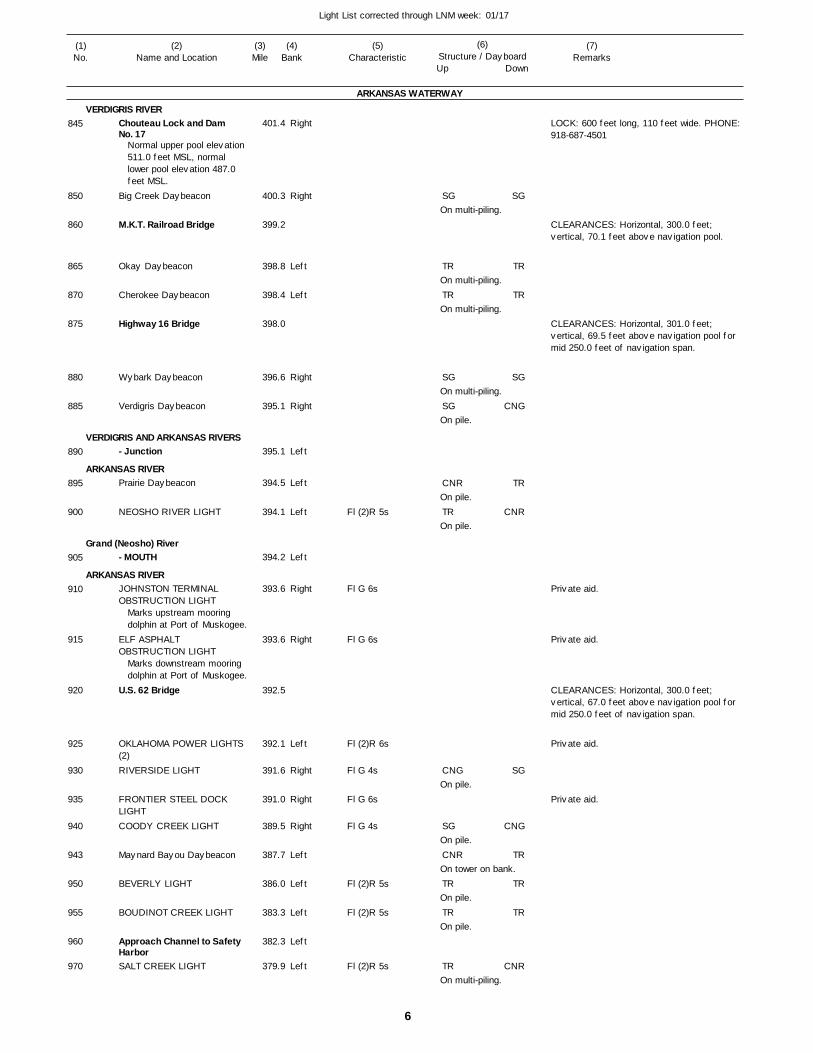
6
Light List corrected through LNM week: 01/17
(7)Remarks
(1)No.
(2)Name and Location
(3)Mile
(5)Characteristic
(4)Bank
(6)Structure / DayboardUp Down
Chouteau Lock and Dam No. 17
Big Creek Daybeacon
M.K.T. Railroad Bridge
Okay Daybeacon
Cherokee Daybeacon
Highway 16 Bridge
Wybark Daybeacon
Verdigris Daybeacon
- Junction
Prairie Daybeacon
NEOSHO RIVER LIGHT
- MOUTH
JOHNSTON TERMINAL OBSTRUCTION LIGHT
ELF ASPHALT OBSTRUCTION LIGHT
U.S. 62 Bridge
OKLAHOMA POWER LIGHTS (2)RIVERSIDE LIGHT
FRONTIER STEEL DOCK LIGHTCOODY CREEK LIGHT
Maynard Bayou Daybeacon
BEVERLY LIGHT
BOUDINOT CREEK LIGHT
Approach Channel to Safety HarborSALT CREEK LIGHT
ARKANSAS WATERWAY
VERDIGRIS RIVER
VERDIGRIS AND ARKANSAS RIVERS
ARKANSAS RIVER
Grand (Neosho) River
ARKANSAS RIVER
Right
Right
Left
Left
Right
Right
Left
Left
Left
Left
Right
Right
Left
Right
Right
Right
Left
Left
Left
Left
Left
401.4
400.3
399.2
398.8
398.4
398.0
396.6
395.1
395.1
394.5
394.1
394.2
393.6
393.6
392.5
392.1
391.6
391.0
389.5
387.7
386.0
383.3
382.3
379.9
Normal upper pool elevation 511.0 feet MSL, normal lower pool elevation 487.0 feet MSL.
Marks upstream mooring dolphin at Port of Muskogee.
Marks downstream mooring dolphin at Port of Muskogee.
Fl (2)R 5s
Fl G 6s
Fl G 6s
Fl (2)R 6s
Fl G 4s
Fl G 6s
Fl G 4s
Fl (2)R 5s
Fl (2)R 5s
Fl (2)R 5s
On multi-piling.
On multi-piling.
On multi-piling.
On multi-piling.
On pile.
On pile.
On pile.
On pile.
On pile.
On tower on bank.
On pile.
On pile.
On multi-piling.
LOCK: 600 feet long, 110 feet wide. PHONE: 918-687-4501
CLEARANCES: Horizontal, 300.0 feet; vertical, 70.1 feet above navigation pool.
CLEARANCES: Horizontal, 301.0 feet; vertical, 69.5 feet above navigation pool for mid 250.0 feet of navigation span.
CLEARANCES: Horizontal, 300.0 feet; vertical, 67.0 feet above navigation pool for mid 250.0 feet of navigation span.
845
850
860
865
870
875
880
885
890
895
900
905
910
915
920
925
930
935
940
943
950
955
960
970
SG
TR
TR
SG
SG
CNR
TR
CNG
SG
CNR
TR
TR
TR
SG
TR
TR
SG
CNG
TR
CNR
SG
CNG
TR
TR
TR
CNR
Private aid.
Private aid.
Private aid.
Private aid.
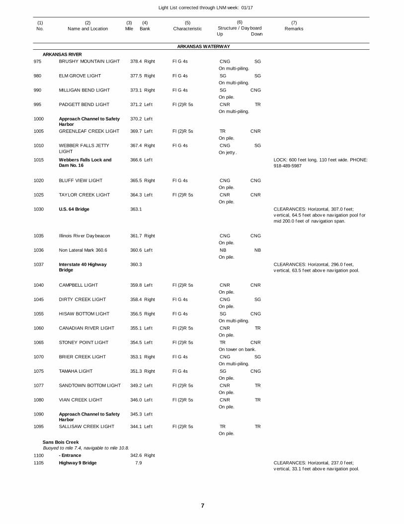
7
Light List corrected through LNM week: 01/17
(7)Remarks
(1)No.
(2)Name and Location
(3)Mile
(5)Characteristic
(4)Bank
(6)Structure / DayboardUp Down
BRUSHY MOUNTAIN LIGHT
ELM GROVE LIGHT
MILLIGAN BEND LIGHT
PADGETT BEND LIGHT
Approach Channel to Safety HarborGREENLEAF CREEK LIGHT
WEBBER FALLS JETTY LIGHT
Webbers Falls Lock and Dam No. 16
BLUFF VIEW LIGHT
TAYLOR CREEK LIGHT
U.S. 64 Bridge
Illinois River Daybeacon
Non Lateral Mark 360.6
Interstate 40 Highway Bridge
CAMPBELL LIGHT
DIRTY CREEK LIGHT
HISAW BOTTOM LIGHT
CANADIAN RIVER LIGHT
STONEY POINT LIGHT
BRIER CREEK LIGHT
TAMAHA LIGHT
SANDTOWN BOTTOM LIGHT
VIAN CREEK LIGHT
Approach Channel to Safety HarborSALLISAW CREEK LIGHT
- EntranceHighway 9 Bridge
ARKANSAS WATERWAY
ARKANSAS RIVER
Sans Bois CreekBuoyed to mile 7.4, navigable to mile 10.8.
Right
Right
Right
Left
Left
Left
Right
Left
Right
Left
Right
Left
Left
Right
Right
Left
Left
Right
Right
Left
Left
Left
Left
Right
378.4
377.5
373.1
371.2
370.2
369.7
367.4
366.6
365.5
364.3
363.1
361.7
360.6
360.3
359.8
358.4
356.5
355.1
354.5
353.1
351.3
349.2
346.0
345.3
344.1
342.6
7.9
Fl G 4s
Fl G 4s
Fl G 4s
Fl (2)R 5s
Fl (2)R 5s
Fl G 4s
Fl G 4s
Fl (2)R 5s
Fl (2)R 5s
Fl G 4s
Fl G 4s
Fl (2)R 5s
Fl (2)R 5s
Fl G 4s
Fl G 4s
Fl (2)R 5s
Fl (2)R 5s
Fl (2)R 5s
On multi-piling.
On multi-piling.
On pile.
On multi-piling.
On pile.
On jetty.
On pile.
On pile.
On pile.
On pile.
On pile.
On pile.
On multi-piling.
On pile.
On tower on bank.
On multi-piling.
On pile.
On pile.
On pile.
On pile.
LOCK: 600 feet long, 110 feet wide. PHONE: 918-489-5987
CLEARANCES: Horizontal, 307.0 feet; vertical, 64.5 feet above navigation pool for mid 200.0 feet of navigation span.
CLEARANCES: Horizontal, 296.0 feet, vertical, 63.5 feet above navigation pool.
CLEARANCES: Horizontal, 237.0 feet; vertical, 33.1 feet above navigation pool.
975
980
990
995
1000
1005
1010
1015
1020
1025
1030
1035
1036
1037
1040
1045
1055
1060
1065
1070
1075
1077
1080
1090
1095
11001105
CNG
SG
SG
CNR
TR
CNG
CNG
CNR
CNG
NB
CNR
CNG
SG
CNR
TR
CNG
SG
CNR
CNR
TR
SG
SG
CNG
TR
CNR
SG
CNG
CNR
CNG
NB
CNR
SG
CNG
TR
CNR
SG
CNG
TR
TR
TR
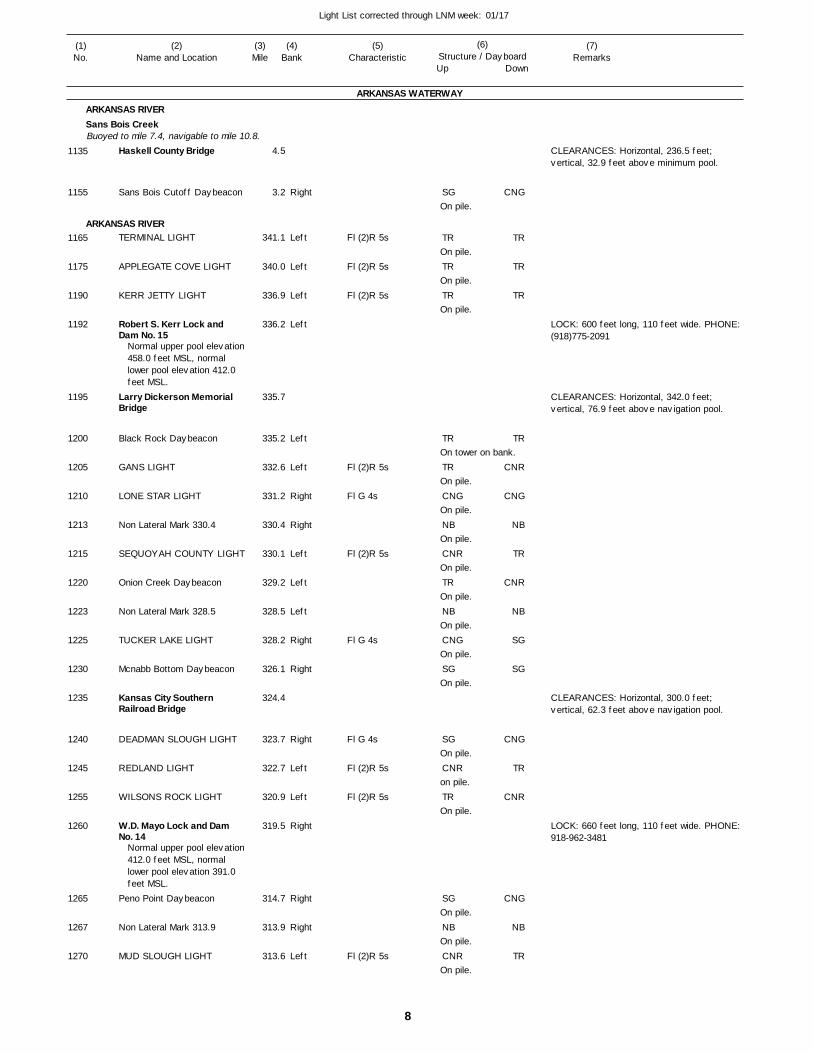
8
Light List corrected through LNM week: 01/17
(7)Remarks
(1)No.
(2)Name and Location
(3)Mile
(5)Characteristic
(4)Bank
(6)Structure / DayboardUp Down
Haskell County Bridge
Sans Bois Cutoff Daybeacon
TERMINAL LIGHT
APPLEGATE COVE LIGHT
KERR JETTY LIGHT
Robert S. Kerr Lock and Dam No. 15
Larry Dickerson Memorial Bridge
Black Rock Daybeacon
GANS LIGHT
LONE STAR LIGHT
Non Lateral Mark 330.4
SEQUOYAH COUNTY LIGHT
Onion Creek Daybeacon
Non Lateral Mark 328.5
TUCKER LAKE LIGHT
Mcnabb Bottom Daybeacon
Kansas City Southern Railroad Bridge
DEADMAN SLOUGH LIGHT
REDLAND LIGHT
WILSONS ROCK LIGHT
W.D. Mayo Lock and Dam No. 14
Peno Point Daybeacon
Non Lateral Mark 313.9
MUD SLOUGH LIGHT
ARKANSAS WATERWAY
ARKANSAS RIVERSans Bois Creek
ARKANSAS RIVER
Buoyed to mile 7.4, navigable to mile 10.8.
Right
Left
Left
Left
Left
Left
Left
Right
Right
Left
Left
Left
Right
Right
Right
Left
Left
Right
Right
Right
Left
4.5
3.2
341.1
340.0
336.9
336.2
335.7
335.2
332.6
331.2
330.4
330.1
329.2
328.5
328.2
326.1
324.4
323.7
322.7
320.9
319.5
314.7
313.9
313.6
Normal upper pool elevation 458.0 feet MSL, normal lower pool elevation 412.0 feet MSL.
Normal upper pool elevation 412.0 feet MSL, normal lower pool elevation 391.0 feet MSL.
Fl (2)R 5s
Fl (2)R 5s
Fl (2)R 5s
Fl (2)R 5s
Fl G 4s
Fl (2)R 5s
Fl G 4s
Fl G 4s
Fl (2)R 5s
Fl (2)R 5s
Fl (2)R 5s
On pile.
On pile.
On pile.
On pile.
On tower on bank.
On pile.
On pile.
On pile.
On pile.
On pile.
On pile.
On pile.
On pile.
On pile.
on pile.
On pile.
On pile.
On pile.
On pile.
CLEARANCES: Horizontal, 236.5 feet; vertical, 32.9 feet above minimum pool.
LOCK: 600 feet long, 110 feet wide. PHONE: (918)775-2091
CLEARANCES: Horizontal, 342.0 feet; vertical, 76.9 feet above navigation pool.
CLEARANCES: Horizontal, 300.0 feet; vertical, 62.3 feet above navigation pool.
LOCK: 660 feet long, 110 feet wide. PHONE: 918-962-3481
1135
1155
1165
1175
1190
1192
1195
1200
1205
1210
1213
1215
1220
1223
1225
1230
1235
1240
1245
1255
1260
1265
1267
1270
SG
TR
TR
TR
TR
TR
CNG
NB
CNR
TR
NB
CNG
SG
SG
CNR
TR
SG
NB
CNR
CNG
TR
TR
TR
TR
CNR
CNG
NB
TR
CNR
NB
SG
SG
CNG
TR
CNR
CNG
NB
TR
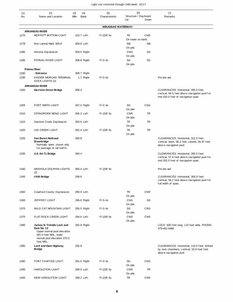
9
Light List corrected through LNM week: 01/17
(7)Remarks
(1)No.
(2)Name and Location
(3)Mile
(5)Characteristic
(4)Bank
(6)Structure / DayboardUp Down
MOFFETT BOTTOM LIGHT
Non Lateral Mark 309.8
Arkoma Daybeacon
POTEAU RIVER LIGHT
- EntranceKINDER MORGAN TERMINALDOCK LIGHTS (2)
Garrison Street Bridge
FORT SMITH LIGHT
STONORODE BEND LIGHT
Garrison Creek Daybeacon
LEE CREEK LIGHT
Van Buren Railroad Drawbridge
U.S. 64-71 Bridge
ARKHOLA DOLPHIN LIGHTS (2)I-540 Bridge
Crawford County Daybeacon
JEFFREY LIGHT
WILD CAT MOUNTAIN LIGHT
FLAT ROCK CREEK LIGHT
James N. Trimble Lock and Dam No. 13
Lock and Dam Highway Bridge
FORT CHAFFEE LIGHT
HAROLDTON LIGHT
NEW HAROLDTON LIGHT
ARKANSAS WATERWAY
ARKANSAS RIVER
Poteau River
ARKANSAS RIVER
Left
Left
Right
Right
Right
Right
Right
Left
Left
Left
Left
Left
Right
Right
Left
Right
Right
Left
Left
310.7
309.8
309.5
308.8
308.7
1.7
308.4
307.0
305.3
303.6
302.4
300.8
300.4
300.4
299.6
296.9
296.6
295.5
294.6
292.8
292.8
291.0
289.9
289.2
Normally open, closes only for passage of rail traffic.
Upper normal pool elevation 391.0 feet MSL, lower normal pool elevation 370.0 feet MSL.
Fl (2)R 5s
Fl G 4s
Fl G 6s
Fl G 4s
Fl (2)R 5s
Fl (2)R 5s
Fl (2)R 6s
Fl G 4s
Fl G 4s
Fl (2)R 5s
Fl G 4s
Fl (2)R 5s
Fl (2)R 5s
On tower on bank.
On pile.
On pile.
On pile.
On pile.
On pile.
On pile.
On pile.
On pile.
On pile.
On pile.
On pile.
On pile.
On pile.
CLEARANCES: Horizontal, 300.0 feet; vertical, 64.5 feet above navigation pool for mid 250.0 feet of navigation span.
CLEARANCES: Horizontal, 312.0 feet; vertical, open, 58.2 feet, closed, 26.97 feet above navigation pool.
CLEARANCES: Horizontal, 300.0 feet; vertical, 57.6 feet above navigation pool for mid 262.0 feet of navigation span.
CLEARANCES: Horizontal, 300.0 feet; vertical, 56.2 feet above navigation pool for full width of span.
LOCK: 600 feet long, 110 feet wide. PHONE: 479-452-0488
CLEARANCES: Horizontal, 110.0 feet, limited by lock chambers; vertical, 53.9 feet feet above navigation pool.
1275
1278
1280
1285
12901295
1300
1305
1310
1315
1320
1325
1330
1340
1345
1360
1365
1370
1375
1380
1385
1390
1395
1400
TR
NB
CNG
SG
SG
CNR
TR
TR
TR
CNG
SG
CNR
SG
CNR
TR
CNR
NB
SG
SG
CNG
TR
TR
TR
CNR
SG
CNG
CNR
CNG
TR
CNR
Private aid.
Private aid.
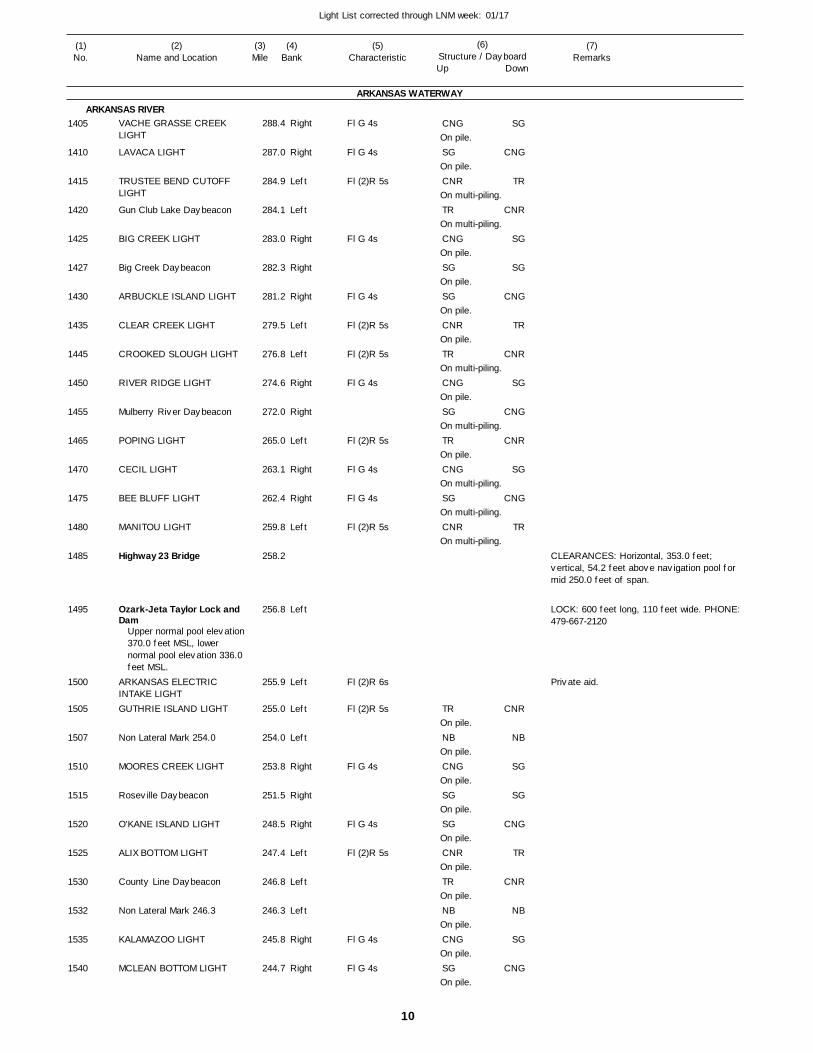
10
Light List corrected through LNM week: 01/17
(7)Remarks
(1)No.
(2)Name and Location
(3)Mile
(5)Characteristic
(4)Bank
(6)Structure / DayboardUp Down
VACHE GRASSE CREEK LIGHT
LAVACA LIGHT
TRUSTEE BEND CUTOFF LIGHT
Gun Club Lake Daybeacon
BIG CREEK LIGHT
Big Creek Daybeacon
ARBUCKLE ISLAND LIGHT
CLEAR CREEK LIGHT
CROOKED SLOUGH LIGHT
RIVER RIDGE LIGHT
Mulberry River Daybeacon
POPING LIGHT
CECIL LIGHT
BEE BLUFF LIGHT
MANITOU LIGHT
Highway 23 Bridge
Ozark-Jeta Taylor Lock and Dam
ARKANSAS ELECTRIC INTAKE LIGHTGUTHRIE ISLAND LIGHT
Non Lateral Mark 254.0
MOORES CREEK LIGHT
Roseville Daybeacon
O'KANE ISLAND LIGHT
ALIX BOTTOM LIGHT
County Line Daybeacon
Non Lateral Mark 246.3
KALAMAZOO LIGHT
MCLEAN BOTTOM LIGHT
ARKANSAS WATERWAY
ARKANSAS RIVERRight
Right
Left
Left
Right
Right
Right
Left
Left
Right
Right
Left
Right
Right
Left
Left
Left
Left
Left
Right
Right
Right
Left
Left
Left
Right
Right
288.4
287.0
284.9
284.1
283.0
282.3
281.2
279.5
276.8
274.6
272.0
265.0
263.1
262.4
259.8
258.2
256.8
255.9
255.0
254.0
253.8
251.5
248.5
247.4
246.8
246.3
245.8
244.7
Upper normal pool elevation 370.0 feet MSL, lower normal pool elevation 336.0 feet MSL.
Fl G 4s
Fl G 4s
Fl (2)R 5s
Fl G 4s
Fl G 4s
Fl (2)R 5s
Fl (2)R 5s
Fl G 4s
Fl (2)R 5s
Fl G 4s
Fl G 4s
Fl (2)R 5s
Fl (2)R 6s
Fl (2)R 5s
Fl G 4s
Fl G 4s
Fl (2)R 5s
Fl G 4s
Fl G 4s
On pile.
On pile.
On multi-piling.
On multi-piling.
On pile.
On pile.
On pile.
On pile.
On multi-piling.
On pile.
On multi-piling.
On pile.
On multi-piling.
On multi-piling.
On multi-piling.
On pile.
On pile.
On pile.
On pile.
On pile.
On pile.
On pile.
On pile.
On pile.
On pile.
CLEARANCES: Horizontal, 353.0 feet; vertical, 54.2 feet above navigation pool for mid 250.0 feet of span.
LOCK: 600 feet long, 110 feet wide. PHONE: 479-667-2120
1405
1410
1415
1420
1425
1427
1430
1435
1445
1450
1455
1465
1470
1475
1480
1485
1495
1500
1505
1507
1510
1515
1520
1525
1530
1532
1535
1540
CNG
SG
CNR
TR
CNG
SG
SG
CNR
TR
CNG
SG
TR
CNG
SG
CNR
TR
NB
CNG
SG
SG
CNR
TR
NB
CNG
SG
SG
CNG
TR
CNR
SG
SG
CNG
TR
CNR
SG
CNG
CNR
SG
CNG
TR
CNR
NB
SG
SG
CNG
TR
CNR
NB
SG
CNG
Private aid.
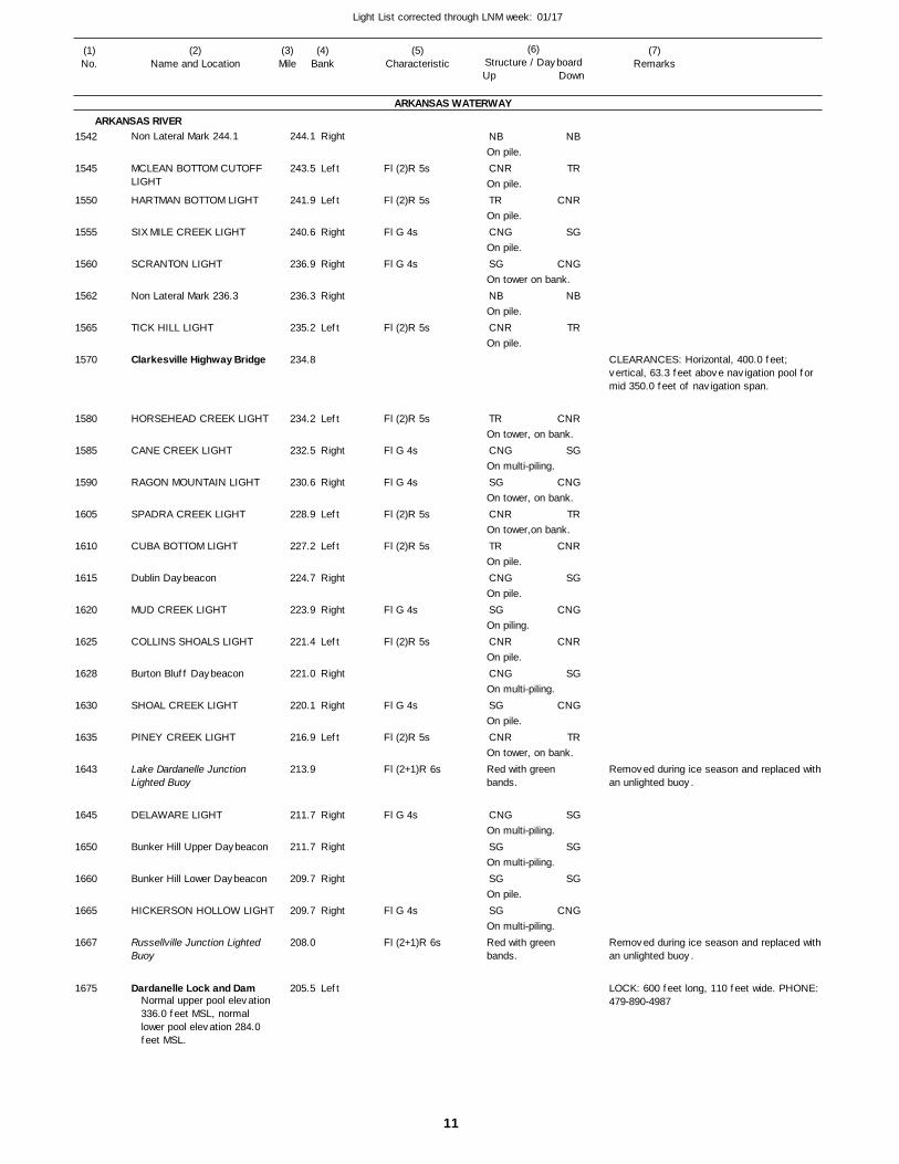
11
Light List corrected through LNM week: 01/17
(7)Remarks
(1)No.
(2)Name and Location
(3)Mile
(5)Characteristic
(4)Bank
(6)Structure / DayboardUp Down
Non Lateral Mark 244.1
MCLEAN BOTTOM CUTOFF LIGHT
HARTMAN BOTTOM LIGHT
SIX MILE CREEK LIGHT
SCRANTON LIGHT
Non Lateral Mark 236.3
TICK HILL LIGHT
Clarkesville Highway Bridge
HORSEHEAD CREEK LIGHT
CANE CREEK LIGHT
RAGON MOUNTAIN LIGHT
SPADRA CREEK LIGHT
CUBA BOTTOM LIGHT
Dublin Daybeacon
MUD CREEK LIGHT
COLLINS SHOALS LIGHT
Burton Bluff Daybeacon
SHOAL CREEK LIGHT
PINEY CREEK LIGHT
Lake Dardanelle Junction Lighted Buoy
DELAWARE LIGHT
Bunker Hill Upper Daybeacon
Bunker Hill Lower Daybeacon
HICKERSON HOLLOW LIGHT
Russellville Junction Lighted Buoy
Dardanelle Lock and Dam
ARKANSAS WATERWAY
ARKANSAS RIVERRight
Left
Left
Right
Right
Right
Left
Left
Right
Right
Left
Left
Right
Right
Left
Right
Right
Left
Right
Right
Right
Right
Left
244.1
243.5
241.9
240.6
236.9
236.3
235.2
234.8
234.2
232.5
230.6
228.9
227.2
224.7
223.9
221.4
221.0
220.1
216.9
213.9
211.7
211.7
209.7
209.7
208.0
205.5Normal upper pool elevation 336.0 feet MSL, normal lower pool elevation 284.0 feet MSL.
Fl (2)R 5s
Fl (2)R 5s
Fl G 4s
Fl G 4s
Fl (2)R 5s
Fl (2)R 5s
Fl G 4s
Fl G 4s
Fl (2)R 5s
Fl (2)R 5s
Fl G 4s
Fl (2)R 5s
Fl G 4s
Fl (2)R 5s
Fl (2+1)R 6s
Fl G 4s
Fl G 4s
Fl (2+1)R 6s
On pile.
On pile.
On pile.
On pile.
On tower on bank.
On pile.
On pile.
On tower, on bank.
On multi-piling.
On tower, on bank.
On tower,on bank.
On pile.
On pile.
On piling.
On pile.
On multi-piling.
On pile.
On tower, on bank.Red with green bands.
On multi-piling.
On multi-piling.
On pile.
On multi-piling.Red with green bands.
CLEARANCES: Horizontal, 400.0 feet; vertical, 63.3 feet above navigation pool for mid 350.0 feet of navigation span.
Removed during ice season and replaced with an unlighted buoy.
Removed during ice season and replaced with an unlighted buoy.
LOCK: 600 feet long, 110 feet wide. PHONE: 479-890-4987
1542
1545
1550
1555
1560
1562
1565
1570
1580
1585
1590
1605
1610
1615
1620
1625
1628
1630
1635
1643
1645
1650
1660
1665
1667
1675
NB
CNR
TR
CNG
SG
NB
CNR
TR
CNG
SG
CNR
TR
CNG
SG
CNR
CNG
SG
CNR
CNG
SG
SG
SG
NB
TR
CNR
SG
CNG
NB
TR
CNR
SG
CNG
TR
CNR
SG
CNG
CNR
SG
CNG
TR
SG
SG
SG
CNG
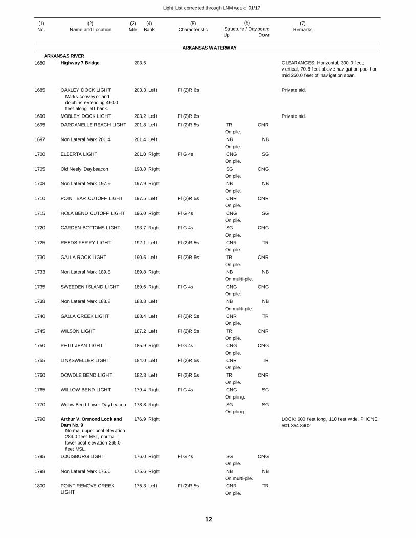
12
Light List corrected through LNM week: 01/17
(7)Remarks
(1)No.
(2)Name and Location
(3)Mile
(5)Characteristic
(4)Bank
(6)Structure / DayboardUp Down
Highway 7 Bridge
OAKLEY DOCK LIGHT
MOBLEY DOCK LIGHT
DARDANELLE REACH LIGHT
Non Lateral Mark 201.4
ELBERTA LIGHT
Old Neely Daybeacon
Non Lateral Mark 197.9
POINT BAR CUTOFF LIGHT
HOLA BEND CUTOFF LIGHT
CARDEN BOTTOMS LIGHT
REEDS FERRY LIGHT
GALLA ROCK LIGHT
Non Lateral Mark 189.8
SWEEDEN ISLAND LIGHT
Non Lateral Mark 188.8
GALLA CREEK LIGHT
WILSON LIGHT
PETIT JEAN LIGHT
LINKSWELLER LIGHT
DOWDLE BEND LIGHT
WILLOW BEND LIGHT
Willow Bend Lower Daybeacon
Arthur V. Ormond Lock and Dam No. 9
LOUISBURG LIGHT
Non Lateral Mark 175.6
POINT REMOVE CREEK LIGHT
ARKANSAS WATERWAY
ARKANSAS RIVER
Left
Left
Left
Left
Right
Right
Right
Left
Right
Right
Left
Left
Right
Right
Left
Left
Left
Right
Left
Left
Right
Right
Right
Right
Right
Left
203.5
203.3
203.2
201.8
201.4
201.0
198.8
197.9
197.5
196.0
193.7
192.1
190.5
189.8
189.6
188.8
188.4
187.2
185.9
184.0
182.3
179.4
178.8
176.9
176.0
175.6
175.3
Marks conveyor and dolphins extending 460.0 feet along left bank.
Normal upper pool elevation 284.0 feet MSL, normal lower pool elevation 265.0 feet MSL.
Fl (2)R 6s
Fl (2)R 6s
Fl (2)R 5s
Fl G 4s
Fl (2)R 5s
Fl G 4s
Fl G 4s
Fl (2)R 5s
Fl (2)R 5s
Fl G 4s
Fl (2)R 5s
Fl (2)R 5s
Fl G 4s
Fl (2)R 5s
Fl (2)R 5s
Fl G 4s
Fl G 4s
Fl (2)R 5s
On pile.
On pile.
On pile.
On pile.
On pile.
On pile.
On pile.
On pile.
On pile.
On pile.
On multi-pile.
On pile.
On multi-pile.
On pile.
On pile.
On pile.
On pile.
On pile.
On piling.
On piling.
On pile.
On multi-pile.
On pile.
CLEARANCES: Horizontal, 300.0 feet; vertical, 70.8 feet above navigation pool for mid 250.0 feet of navigation span.
LOCK: 600 feet long, 110 feet wide. PHONE: 501-354-8402
1680
1685
1690
1695
1697
1700
1705
1708
1710
1715
1720
1725
1730
1733
1735
1738
1740
1745
1750
1755
1760
1765
1770
1790
1795
1798
1800
TR
NB
CNG
SG
NB
CNR
CNG
SG
CNR
TR
NB
CNG
NB
CNR
TR
CNG
CNR
TR
CNG
SG
SG
NB
CNR
CNR
NB
SG
CNG
NB
CNR
SG
CNG
TR
CNR
NB
CNG
NB
TR
CNR
CNG
TR
CNR
SG
SG
CNG
NB
TR
Private aid.
Private aid.
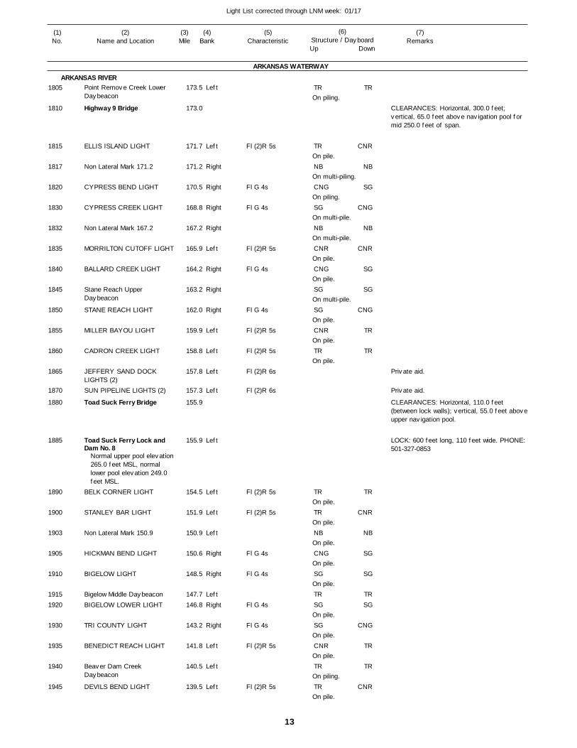
13
Light List corrected through LNM week: 01/17
(7)Remarks
(1)No.
(2)Name and Location
(3)Mile
(5)Characteristic
(4)Bank
(6)Structure / DayboardUp Down
Point Remove Creek Lower Daybeacon
Highway 9 Bridge
ELLIS ISLAND LIGHT
Non Lateral Mark 171.2
CYPRESS BEND LIGHT
CYPRESS CREEK LIGHT
Non Lateral Mark 167.2
MORRILTON CUTOFF LIGHT
BALLARD CREEK LIGHT
Stane Reach Upper Daybeacon
STANE REACH LIGHT
MILLER BAYOU LIGHT
CADRON CREEK LIGHT
JEFFERY SAND DOCK LIGHTS (2)SUN PIPELINE LIGHTS (2)
Toad Suck Ferry Bridge
Toad Suck Ferry Lock and Dam No. 8
BELK CORNER LIGHT
STANLEY BAR LIGHT
Non Lateral Mark 150.9
HICKMAN BEND LIGHT
BIGELOW LIGHT
Bigelow Middle DaybeaconBIGELOW LOWER LIGHT
TRI COUNTY LIGHT
BENEDICT REACH LIGHT
Beaver Dam Creek Daybeacon
DEVILS BEND LIGHT
ARKANSAS WATERWAY
ARKANSAS RIVERLeft
Left
Right
Right
Right
Right
Left
Right
Right
Right
Left
Left
Left
Left
Left
Left
Left
Left
Right
Right
LeftRight
Right
Left
Left
Left
173.5
173.0
171.7
171.2
170.5
168.8
167.2
165.9
164.2
163.2
162.0
159.9
158.8
157.8
157.3
155.9
155.9
154.5
151.9
150.9
150.6
148.5
147.7 146.8
143.2
141.8
140.5
139.5
Normal upper pool elevation 265.0 feet MSL, normal lower pool elevation 249.0 feet MSL.
Fl (2)R 5s
Fl G 4s
Fl G 4s
Fl (2)R 5s
Fl G 4s
Fl G 4s
Fl (2)R 5s
Fl (2)R 5s
Fl (2)R 6s
Fl (2)R 6s
Fl (2)R 5s
Fl (2)R 5s
Fl G 4s
Fl G 4s
Fl G 4s
Fl G 4s
Fl (2)R 5s
Fl (2)R 5s
On piling.
On pile.
On multi-piling.
On piling.
On multi-pile.
On multi-pile.
On pile.
On pile.
On multi-pile.
On pile.
On pile.
On pile.
On pile.
On pile.
On pile.
On pile.
On pile.
On pile.
On pile.
On pile.
On piling.
On pile.
CLEARANCES: Horizontal, 300.0 feet; vertical, 65.0 feet above navigation pool for mid 250.0 feet of span.
CLEARANCES: Horizontal, 110.0 feet (between lock walls); vertical, 55.0 feet above upper navigation pool.
LOCK: 600 feet long, 110 feet wide. PHONE: 501-327-0853
1805
1810
1815
1817
1820
1830
1832
1835
1840
1845
1850
1855
1860
1865
1870
1880
1885
1890
1900
1903
1905
1910
19151920
1930
1935
1940
1945
TR
TR
NB
CNG
SG
NB
CNR
CNG
SG
SG
CNR
TR
TR
TR
NB
CNG
SG
TRSG
SG
CNR
TR
TR
TR
CNR
NB
SG
CNG
NB
CNR
SG
SG
CNG
TR
TR
TR
CNR
NB
SG
SG
TRSG
CNG
TR
TR
CNR
Private aid.
Private aid.
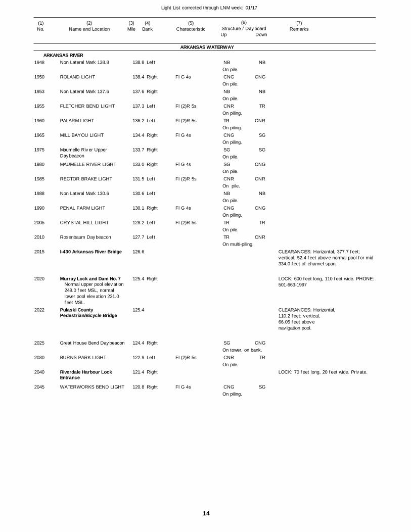
14
Light List corrected through LNM week: 01/17
(7)Remarks
(1)No.
(2)Name and Location
(3)Mile
(5)Characteristic
(4)Bank
(6)Structure / DayboardUp Down
Non Lateral Mark 138.8
ROLAND LIGHT
Non Lateral Mark 137.6
FLETCHER BEND LIGHT
PALARM LIGHT
MILL BAYOU LIGHT
Maumelle River Upper Daybeacon
MAUMELLE RIVER LIGHT
RECTOR BRAKE LIGHT
Non Lateral Mark 130.6
PENAL FARM LIGHT
CRYSTAL HILL LIGHT
Rosenbaum Daybeacon
I-430 Arkansas River Bridge
Murray Lock and Dam No. 7
Pulaski County Pedestrian/Bicycle Bridge
Great House Bend Daybeacon
BURNS PARK LIGHT
Riverdale Harbour Lock Entrance
WATERWORKS BEND LIGHT
ARKANSAS WATERWAY
ARKANSAS RIVERLeft
Right
Right
Left
Left
Right
Right
Right
Left
Left
Right
Left
Left
Right
Right
Left
Right
Right
138.8
138.4
137.6
137.3
136.2
134.4
133.7
133.0
131.5
130.6
130.1
128.2
127.7
126.6
125.4
125.4
124.4
122.9
121.4
120.8
Normal upper pool elevation 249.0 feet MSL, normal lower pool elevation 231.0 feet MSL.
Fl G 4s
Fl (2)R 5s
Fl (2)R 5s
Fl G 4s
Fl G 4s
Fl (2)R 5s
Fl G 4s
Fl (2)R 5s
Fl (2)R 5s
Fl G 4s
On pile.
On pile.
On pile.
On piling.
On piling.
On piling.
On pile.
On pile.
On pile.
On pile.
On piling.
On pile.
On multi-piling.
On tower, on bank.
On pile.
On piling.
CLEARANCES: Horizontal, 377.7 feet; vertical, 52.4 feet above normal pool for mid 334.0 feet of channel span.
LOCK: 600 feet long, 110 feet wide. PHONE: 501-663-1997
CLEARANCES: Horizontal, 110.2 feet; vertical, 66.05 feet above navigation pool.
LOCK: 70 feet long, 20 feet wide. Private.
1948
1950
1953
1955
1960
1965
1975
1980
1985
1988
1990
2005
2010
2015
2020
2022
2025
2030
2040
2045
NB
CNG
NB
CNR
TR
CNG
SG
SG
CNR
NB
CNG
TR
TR
SG
CNR
CNG
NB
CNG
NB
TR
CNR
SG
SG
CNG
CNR
NB
CNG
TR
CNR
CNG
TR
SG
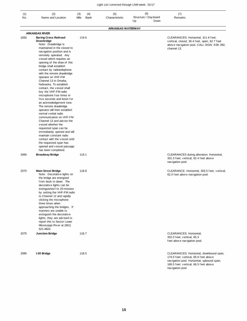
15
Light List corrected through LNM week: 01/17
(7)Remarks
(1)No.
(2)Name and Location
(3)Mile
(5)Characteristic
(4)Bank
(6)Structure / DayboardUp Down
Baring Cross Railroad Drawbridge
Broadway Bridge
Main Street Bridge
Junction Bridge
I-30 Bridge
ARKANSAS WATERWAY
ARKANSAS RIVER 119.6
119.1
118.8
118.7
118.5
Note: Drawbridge is maintained in the closed to navigation position and is remotely operated. Any vessel which requires an opening of the draw of this bridge shall establish contact by radiotelephone with the remote drawbridge operator on VHF-FM Channel 13 in Omaha, Nebraska. To establish contact, the vessel shall key the VHF-FM radio microphone four times in five seconds and listen for an acknowledgement tone. The remote drawbridge operator will then establish normal verbal radio communication on VHF-FM Channel 13 and advise the vessel whether the requested span can be immediately opened and will maintain constant radio contact with the vessel until the requested span has opened and vessel passage has been completed.
Note: Decorative lights on the bridge are energized from dusk to dawn. The decorative lights can be extinguished for 20-minutes by setting the VHF-FM radioto Channel 12 and rapidly clicking the microphone three times when approaching the bridges. If mariners are unable to extinguish the decorative lights, they are advised to report this to Sector Lower Mississippi River at (901) 521-4824.
CLEARANCES: Horizontal, 311.6 feet; vertical, closed, 30.4 feet, open, 62.7 feet above navigation pool. CALL SIGN: KSK 392, channel 13.
CLEARANCES during alteration: Horizontal, 331.3 feet; vertical, 62.4 feet above navigation pool.
CLEARANCE: Horizontal, 303.5 feet; vertical, 62.0 feet above navigation pool.
CLEARANCES: Horizontal, 332.0 feet; vertical, 65.3 feet above navigation pool.
CLEARANCES: Horizontal, downbound span, 174.5 feet; vertical, 65.6 feet above navigation pool. Horizontal, upbound span, 169.5 feet; vertical, 66.5 feet above navigation pool.
2055
2060
2070
2075
2085
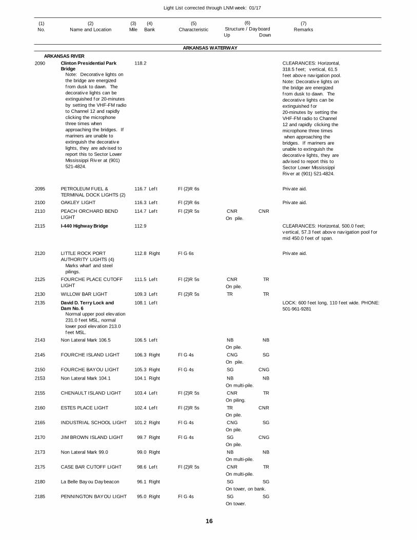
16
Light List corrected through LNM week: 01/17
(7)Remarks
(1)No.
(2)Name and Location
(3)Mile
(5)Characteristic
(4)Bank
(6)Structure / DayboardUp Down
Clinton Presidential Park Bridge
PETROLEUM FUEL & TERMINAL DOCK LIGHTS (2)OAKLEY LIGHT
PEACH ORCHARD BEND LIGHT
I-440 Highway Bridge
LITTLE ROCK PORT AUTHORITY LIGHTS (4)
FOURCHE PLACE CUTOFF LIGHT
WILLOW BAR LIGHT
David D. Terry Lock and Dam No. 6
Non Lateral Mark 106.5
FOURCHE ISLAND LIGHT
FOURCHE BAYOU LIGHT
Non Lateral Mark 104.1
CHENAULT ISLAND LIGHT
ESTES PLACE LIGHT
INDUSTRIAL SCHOOL LIGHT
JIM BROWN ISLAND LIGHT
Non Lateral Mark 99.0
CASE BAR CUTOFF LIGHT
La Belle Bayou Daybeacon
PENNINGTON BAYOU LIGHT
ARKANSAS WATERWAY
ARKANSAS RIVER
Left
Left
Left
Right
Left
Left
Left
Left
Right
Right
Right
Left
Left
Right
Right
Right
Left
Right
Right
118.2
116.7
116.3
114.7
112.9
112.8
111.5
109.3
108.1
106.5
106.3
105.3
104.1
103.4
102.4
101.2
99.7
99.0
98.6
96.1
95.0
Note: Decorative lights on the bridge are energized from dusk to dawn. The decorative lights can be extinguished for 20-minutes by setting the VHF-FM radioto Channel 12 and rapidly clicking the microphone three times when approaching the bridges. If mariners are unable to extinguish the decorative lights, they are advised to report this to Sector Lower Mississippi River at (901) 521-4824.
Marks wharf and steel pilings.
Normal upper pool elevation 231.0 feet MSL, normal lower pool elevation 213.0 feet MSL.
Fl (2)R 6s
Fl (2)R 6s
Fl (2)R 5s
Fl G 6s
Fl (2)R 5s
Fl (2)R 5s
Fl G 4s
Fl G 4s
Fl (2)R 5s
Fl (2)R 5s
Fl G 4s
Fl G 4s
Fl (2)R 5s
Fl G 4s
On pile.
On pile.
On pile.
On pile.
On multi-pile.
On piling.
On pile.
On pile.
On pile.
On multi-pile.
On multi-pile.
On tower, on bank.
On tower.
CLEARANCES: Horizontal, 318.5 feet; vertical, 61.5 feet above navigation pool.Note: Decorative lights on the bridge are energizedfrom dusk to dawn. The decorative lights can be extinguished for 20-minutes by setting the VHF-FM radio to Channel12 and rapidly clicking themicrophone three times when approaching the bridges. If mariners are unable to extinguish the decorative lights, they are advised to report this to Sector Lower Mississippi River at (901) 521-4824.
CLEARANCES: Horizontal, 500.0 feet; vertical, 57.3 feet above navigation pool for mid 450.0 feet of span.
LOCK: 600 feet long, 110 feet wide. PHONE: 501-961-9281
2090
2095
2100
2110
2115
2120
2125
2130
2135
2143
2145
2150
2153
2155
2160
2165
2170
2173
2175
2180
2185
CNR
CNR
TR
NB
CNG
SG
NB
CNR
TR
CNG
SG
NB
CNR
SG
SG
CNR
TR
TR
NB
SG
CNG
NB
TR
CNR
SG
CNG
NB
TR
SG
SG
Private aid.
Private aid.
Private aid.
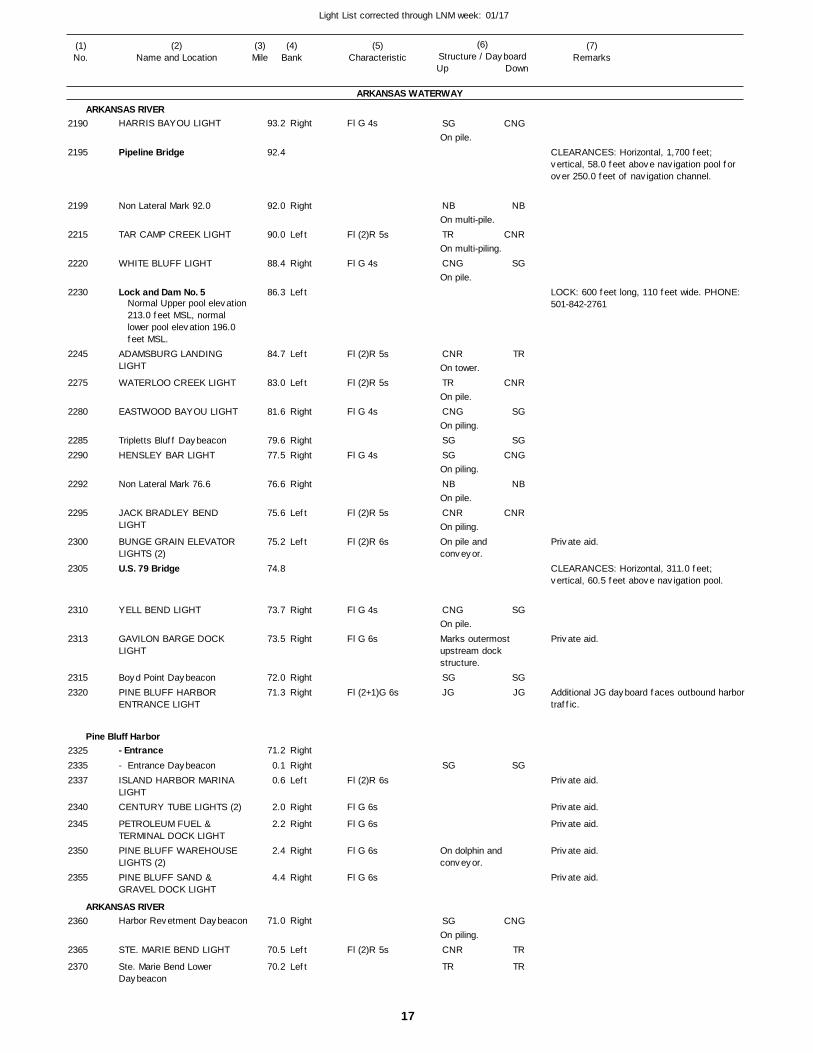
17
Light List corrected through LNM week: 01/17
(7)Remarks
(1)No.
(2)Name and Location
(3)Mile
(5)Characteristic
(4)Bank
(6)Structure / DayboardUp Down
HARRIS BAYOU LIGHT
Pipeline Bridge
Non Lateral Mark 92.0
TAR CAMP CREEK LIGHT
WHITE BLUFF LIGHT
Lock and Dam No. 5
ADAMSBURG LANDING LIGHT
WATERLOO CREEK LIGHT
EASTWOOD BAYOU LIGHT
Tripletts Bluff DaybeaconHENSLEY BAR LIGHT
Non Lateral Mark 76.6
JACK BRADLEY BEND LIGHT
BUNGE GRAIN ELEVATOR LIGHTS (2)U.S. 79 Bridge
YELL BEND LIGHT
GAVILON BARGE DOCK LIGHT
Boyd Point DaybeaconPINE BLUFF HARBOR ENTRANCE LIGHT
- Entrance- Entrance DaybeaconISLAND HARBOR MARINA LIGHTCENTURY TUBE LIGHTS (2)
PETROLEUM FUEL & TERMINAL DOCK LIGHTPINE BLUFF WAREHOUSE LIGHTS (2)PINE BLUFF SAND & GRAVEL DOCK LIGHT
Harbor Revetment Daybeacon
STE. MARIE BEND LIGHT
Ste. Marie Bend Lower Daybeacon
ARKANSAS WATERWAY
ARKANSAS RIVER
Pine Bluff Harbor
ARKANSAS RIVER
Right
Right
Left
Right
Left
Left
Left
Right
RightRight
Right
Left
Left
Right
Right
RightRight
Right
RightLeft
Right
Right
Right
Right
Right
Left
Left
93.2
92.4
92.0
90.0
88.4
86.3
84.7
83.0
81.6
79.6 77.5
76.6
75.6
75.2
74.8
73.7
73.5
72.0 71.3
71.2
0.1 0.6
2.0
2.2
2.4
4.4
71.0
70.5
70.2
Normal Upper pool elevation213.0 feet MSL, normal lower pool elevation 196.0 feet MSL.
Fl G 4s
Fl (2)R 5s
Fl G 4s
Fl (2)R 5s
Fl (2)R 5s
Fl G 4s
Fl G 4s
Fl (2)R 5s
Fl (2)R 6s
Fl G 4s
Fl G 6s
Fl (2+1)G 6s
Fl (2)R 6s
Fl G 6s
Fl G 6s
Fl G 6s
Fl G 6s
Fl (2)R 5s
On pile.
On multi-pile.
On multi-piling.
On pile.
On tower.
On pile.
On piling.
On piling.
On pile.
On piling.On pile and conveyor.
On pile.Marks outermost upstream dock structure.
On dolphin and conveyor.
On piling.
CLEARANCES: Horizontal, 1,700 feet; vertical, 58.0 feet above navigation pool for over 250.0 feet of navigation channel.
LOCK: 600 feet long, 110 feet wide. PHONE: 501-842-2761
CLEARANCES: Horizontal, 311.0 feet; vertical, 60.5 feet above navigation pool.
Additional JG dayboard faces outbound harbor traffic.
2190
2195
2199
2215
2220
2230
2245
2275
2280
22852290
2292
2295
2300
2305
2310
2313
23152320
232523352337
2340
2345
2350
2355
2360
2365
2370
SG
NB
TR
CNG
CNR
TR
CNG
SGSG
NB
CNR
CNG
SGJG
SG
SG
CNR
TR
CNG
NB
CNR
SG
TR
CNR
SG
SGCNG
NB
CNR
SG
SGJG
SG
CNG
TR
TR
Private aid.
Private aid.
Private aid.
Private aid.
Private aid.
Private aid.
Private aid.
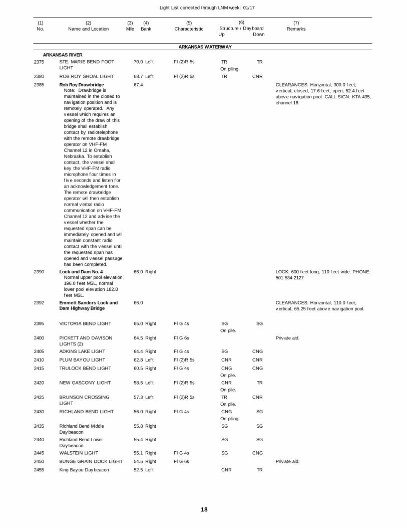
18
Light List corrected through LNM week: 01/17
(7)Remarks
(1)No.
(2)Name and Location
(3)Mile
(5)Characteristic
(4)Bank
(6)Structure / DayboardUp Down
STE. MARIE BEND FOOT LIGHT
ROB ROY SHOAL LIGHT
Rob Roy Drawbridge
Lock and Dam No. 4
Emmett Sanders Lock and Dam Highway Bridge
VICTORIA BEND LIGHT
PICKETT AND DAVISON LIGHTS (2)ADKINS LAKE LIGHT
PLUM BAYOU LIGHT
TRULOCK BEND LIGHT
NEW GASCONY LIGHT
BRUNSON CROSSING LIGHT
RICHLAND BEND LIGHT
Richland Bend Middle DaybeaconRichland Bend Lower DaybeaconWALSTEIN LIGHT
BUNGE GRAIN DOCK LIGHT
King Bayou Daybeacon
ARKANSAS WATERWAY
ARKANSAS RIVERLeft
Left
Right
Right
Right
Right
Left
Right
Left
Left
Right
Right
Right
Right
Right
Left
70.0
68.7
67.4
66.0
66.0
65.0
64.5
64.4
62.8
60.5
58.5
57.3
56.0
55.8
55.4
55.1
54.5
52.5
Note: Drawbridge is maintained in the closed to navigation position and is remotely operated. Any vessel which requires an opening of the draw of this bridge shall establish contact by radiotelephone with the remote drawbridge operator on VHF-FM Channel 12 in Omaha, Nebraska. To establish contact, the vessel shall key the VHF-FM radio microphone four times in five seconds and listen for an acknowledgement tone. The remote drawbridge operator will then establish normal verbal radio communication on VHF-FM Channel 12 and advise the vessel whether the requested span can be immediately opened and will maintain constant radio contact with the vessel until the requested span has opened and vessel passage has been completed.
Normal upper pool elevation 196.0 feet MSL, normal lower pool elevation 182.0 feet MSL.
Fl (2)R 5s
Fl (2)R 5s
Fl G 4s
Fl G 6s
Fl G 4s
Fl (2)R 5s
Fl G 4s
Fl (2)R 5s
Fl (2)R 5s
Fl G 4s
Fl G 4s
Fl G 6s
On piling.
On pile.
On pile.
On pile.
On pile.
On piling.
CLEARANCES: Horizontal, 300.0 feet; vertical, closed, 17.6 feet, open, 52.4 feet above navigation pool. CALL SIGN: KTA 435, channel 16.
LOCK: 600 feet long, 110 feet wide. PHONE: 501-534-2127
CLEARANCES: Horizontal, 110.0 feet; vertical, 65.25 feet above navigation pool.
2375
2380
2385
2390
2392
2395
2400
2405
2410
2415
2420
2425
2430
2435
2440
2445
2450
2455
TR
TR
SG
SG
CNR
CNG
CNR
TR
CNG
SG
SG
SG
CNR
TR
CNR
SG
CNG
CNR
CNG
TR
CNR
SG
SG
SG
CNG
TR
Private aid.
Private aid.
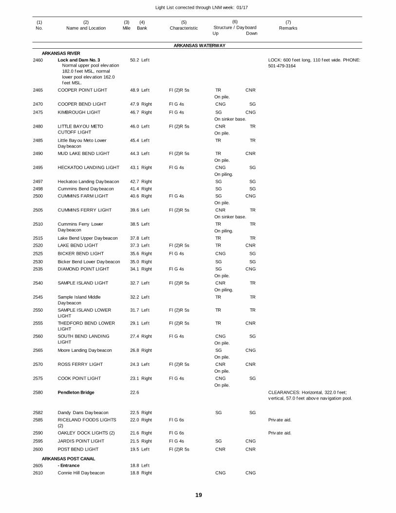
19
Light List corrected through LNM week: 01/17
(7)Remarks
(1)No.
(2)Name and Location
(3)Mile
(5)Characteristic
(4)Bank
(6)Structure / DayboardUp Down
Lock and Dam No. 3
COOPER POINT LIGHT
COOPER BEND LIGHT
KIMBROUGH LIGHT
LITTLE BAYOU METO CUTOFF LIGHT
Little Bayou Meto Lower DaybeaconMUD LAKE BEND LIGHT
HECKATOO LANDING LIGHT
Heckatoo Landing DaybeaconCummins Bend DaybeaconCUMMINS FARM LIGHT
CUMMINS FERRY LIGHT
Cummins Ferry Lower Daybeacon
Lake Bend Upper DaybeaconLAKE BEND LIGHT
BICKER BEND LIGHT
Bicker Bend Lower DaybeaconDIAMOND POINT LIGHT
SAMPLE ISLAND LIGHT
Sample Island Middle DaybeaconSAMPLE ISLAND LOWER LIGHTTHEDFORD BEND LOWER LIGHTSOUTH BEND LANDING LIGHT
Moore Landing Daybeacon
ROSS FERRY LIGHT
COOK POINT LIGHT
Pendleton Bridge
Dandy Dans DaybeaconRICELAND FOODS LIGHTS (2)OAKLEY DOCK LIGHTS (2)
JARDIS POINT LIGHT
POST BEND LIGHT
- EntranceConnie Hill Daybeacon
ARKANSAS WATERWAY
ARKANSAS RIVER
ARKANSAS POST CANAL
Left
Left
Right
Right
Left
Left
Left
Right
RightRightRight
Left
Left
LeftLeft
Right
RightRight
Left
Left
Left
Left
Right
Right
Left
Right
RightRight
Right
Right
Left
Left
Right
50.2
48.9
47.9
46.7
46.0
45.4
44.3
43.1
42.7 41.4 40.6
39.6
38.5
37.8 37.3
35.6
35.0 34.1
32.7
32.2
31.7
29.1
27.4
26.8
24.3
23.1
22.6
22.5 22.0
21.6
21.5
19.5
18.8
18.8
Normal upper pool elevation 182.0 feet MSL, normal lower pool elevation 162.0 feet MSL.
Fl (2)R 5s
Fl G 4s
Fl G 4s
Fl (2)R 5s
Fl (2)R 5s
Fl G 4s
Fl G 4s
Fl (2)R 5s
Fl (2)R 5s
Fl G 4s
Fl G 4s
Fl (2)R 5s
Fl (2)R 5s
Fl (2)R 5s
Fl G 4s
Fl (2)R 5s
Fl G 4s
Fl G 6s
Fl G 6s
Fl G 4s
Fl (2)R 5s
On pile.
On sinker base.
On pile.
On pile.
On piling.
On pile.
On sinker base.
On piling.
On pile.
On piling.
On pile.
On pile.
On pile.
On pile.
LOCK: 600 feet long, 110 feet wide. PHONE: 501-479-3164
CLEARANCES: Horizontal, 322.0 feet; vertical, 57.0 feet above navigation pool.
2460
2465
2470
2475
2480
2485
2490
2495
249724982500
2505
2510
25152520
2525
25302535
2540
2545
2550
2555
2560
2565
2570
2575
2580
25822585
2590
2595
2600
26052610
TR
CNG
SG
CNR
TR
TR
CNG
SGSGSG
CNR
TR
TRTR
CNG
SGSG
CNR
TR
TR
TR
CNG
SG
CNR
CNG
SG
SG
CNR
CNG
CNR
SG
CNG
TR
TR
CNR
SG
SGSG
CNG
TR
TR
TRCNR
SG
SGCNG
TR
TR
TR
CNR
SG
CNG
CNR
SG
SG
CNG
CNR
CNG
Private aid.
Private aid.
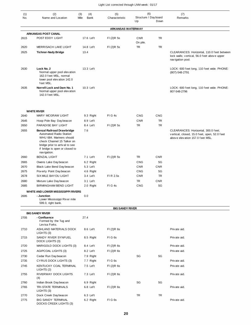
20
Light List corrected through LNM week: 01/17
(7)Remarks
(1)No.
(2)Name and Location
(3)Mile
(5)Characteristic
(4)Bank
(6)Structure / DayboardUp Down
POST EDDY LIGHT
MERRISACH LAKE LIGHT
Tichnor-Nady Bridge
Lock No. 2
Norrell Lock and Dam No. 1
MARY MCGRAW LIGHT
Hoop Pole Bay DaybeaconPARADISE BAY LIGHT
Benzal Railroad Drawbridge
BENZAL LIGHT
Owens Lake DaybeaconBlack Lake Bend DaybeaconPoverty Point DaybeaconSIX MILE BAYOU LIGHT
Mixture Lake DaybeaconBIRMINGHAM BEND LIGHT
- Junction
- Confluence
ASHLAND MATERIALS DOCKLIGHTS (3)SANDY RIVER SYNFUEL DOCK LIGHTS (3)MARIGOLD DOCK LIGHTS (3)
AGIPCOAL LIGHTS (3)
Cedar Run DaybeaconCYRUS DOCK LIGHTS (3)
KENTUCKY COAL TERMINALLIGHTS (2)RIVERWAY DOCK LIGHTS (4)Indian Brook DaybeaconTRI-STATE TERMINALS LIGHTS (3)Dock Creek DaybeaconBIG SANDY TERMINAL DOCKS CREEK LIGHTS (3)
ARKANSAS WATERWAY
ARKANSAS POST CANAL
WHITE RIVER
WHITE AND LOWER MISSISSIPPI RIVERS
BIG SANDY RIVER
BIG SANDY RIVER
Left
Left
Left
Left
Right
LeftLeft
Left
RightLeftRightLeft
LeftRight
Left
Right
Left
Left
RightRight
Left
Left
RightLeft
LeftRight
17.6
14.8
13.4
13.3
10.3
9.3
8.9 8.4
7.6
7.1
6.2 5.3 4.6 3.4
3.1 2.0
0.0
27.4
8.6
8.5
8.4
8.2
7.9 7.7
7.5
7.3
6.9 6.8
6.3 6.2
Normal upper pool elevation 162.0 feet MSL, normal lower pool elevation 142.0 feet MSL.
Normal upper pool elevation 142.0 feet MSL.
Automated Radio Station WHU 684. Mariners should check Channel 15 Talker on bridge prior to arrival to see if bridge is open or closed tonavigation.
Lower Mississippi River mile599.0, right bank.
Formed by the Tug and Levisa Forks.
Fl (2)R 5s
Fl (2)R 5s
Fl G 4s
Fl (2)R 5s
Fl (2)R 5s
Fl R 2.5s
Fl G 4s
Fl (2)R 6s
Fl G 6s
Fl (2)R 6s
Fl (2)R 6s
Fl G 6s
Fl (2)R 6s
Fl (2)R 6s
Fl (2)R 6s
Fl G 6s
On pile.
CLEARANCES: Horizontal, 110.0 feet betweenlock walls; vertical, 56.0 feet above upper navigation pool.
LOCK: 600 feet long, 110 feet wide. PHONE: (807)-548-2791
LOCK: 600 feet long, 110 feet wide. PHONE: 807-548-2796
CLEARANCES: Horizontal, 300.0 feet; vertical, closed, 15.0 feet, open, 52.0 feet above elevation 157.0 feet MSL.
2615
2620
2625
2630
2635
2640
26452650
2655
2660
2665267026752678
26802685
2695
2705
2710
2715
2720
2725
27302735
2745
2755
27602765
27702775
CNR
TR
CNG
CNRTR
TR
CNGCNRCNGCNR
TRCNG
SG
SG
TR
TR
TR
CNG
TRTR
CNR
SGCNR
SGTR
CNRSG
SG
SG
TR
Private aid.
Private aid.
Private aid.
Private aid.
Private aid.
Private aid.
Private aid.
Private aid.
Private aid.
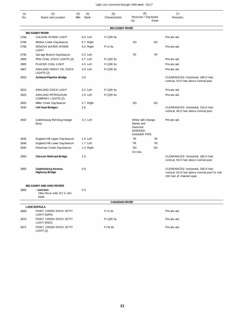
21
Light List corrected through LNM week: 01/17
(7)Remarks
(1)No.
(2)Name and Location
(3)Mile
(5)Characteristic
(4)Bank
(6)Structure / DayboardUp Down
CALGON INTAKE LIGHT
Whites Creek DaybeaconKENOVA WATER INTAKE LIGHTSavage Branch DaybeaconPEN COAL DOCK LIGHTS (2)
PLACER COAL LIGHT
ASHLAND HEAVY OIL DOCKLIGHTS (2)Ashland Pipeline Bridge
ASHLAND DOCK LIGHT
ASHLAND PETROLEUM COMPANY LIGHTS (2)Miller Creek DaybeaconI-64 Dual Bridges
Catlettsburg Refining Danger Buoy
England Hill Upper DaybeaconEngland Hill Lower DaybeaconPeterman Creek Daybeacon
Chessie Railroad Bridge
Catlettsburg-Kenova Highway Bridge
- Junction
PINEY CREEK ROCK JETTY LIGHT (GRN)PINEY CREEK ROCK JETTY LIGHT (RED)PINEY CREEK ROCK JETTY LIGHT (2)
BIG SANDY RIVER
BIG SANDY RIVER
BIG SANDY AND OHIO RIVERS
CANADIAN RIVER
LAKE EUFAULA
Left
RightRight
LeftLeft
Left
Left
Left
Left
Right
Left
LeftLeftRight
6.0
5.7 5.6
5.3 4.7
4.5
3.9
3.6
3.2
2.9
2.7 2.6
2.2
1.9 1.7 1.3
1.0
0.9
0.0Ohio River mile 317.0, left bank.
Fl (2)R 6s
Fl G 6s
Fl (2)R 6s
Fl (2)R 6s
Fl (2)R 6s
Fl (2)R 6s
Fl (2)R 6s
Fl G 6s
Fl (2)R 6s
Fl W 6s
White with Orange Bands and Diamond. WORDED:DANGER PIPE.
On tree.
CLEARANCES: Horizontal, 180.0 feet; vertical, 53.0 feet above normal pool.
CLEARANCES: Horizontal, 216.0 feet; vertical, 90.0 feet above normal pool.
CLEARANCES: Horizontal, 180.0 feet; vertical, 50.0 feet above normal pool.
CLEARANCES: Horizontal, 200.0 feet; vertical, 62.8 feet above normal pool for mid 150 feet of channel span.
2780
27852790
27952800
2805
2807
2810
2815
2820
28252830
2832
283528402845
2850
2855
2865
2869
2870
2871
SG
TR
SG
TRTRSG
SG
TR
SG
TRTRSG
Private aid.
Private aid.
Private aid.
Private aid.
Private aid.
Private aid.
Private aid.
Private aid.
Private aid.
Private aid.
Private aid.
22
Light List corrected through LNM week: 01/17
(7)Remarks
(1)No.
(2)Name and Location
(3)Mile
(5)Characteristic
(4)Bank
(6)Structure / DayboardUp Down
Veterans Memorial Bridge
EAGLE BEND MFG DOCK LIGHTS(4)Southern Railroad Bridge
CLINTON, TNU.S. 25 West Bridge
Louisville and Nashville Railroad Bridge
OAK RIDGE, TNEmory Valley DaybeaconUpper Chestnut Ridge DaybeaconLower Chestnut Ridge DaybeaconRacoon Valley Lower Daybeacon
Raccoon Valley Upper Daybeacon
Edgemor Bridge
Bull Run Upper DaybeaconBull Run DaybeaconWEST KNOX PUMPING STATION LIGHTBull Run Lower DaybeaconBlue Spring DaybeaconHaw Ridge Upper Daybeacon
Blue Springs Lower Daybeacon
Holt Island Upper DaybeaconHaw Ridge Daybeacon
Holt Island DaybeaconHolt Island Lower DaybeaconSolway Bridge
Old Solway Bridge Daybeacon
Solway Upper Daybeacon
Solway DaybeaconSolway Lower Daybeacon
Scarboro DaybeaconCopper Ridge DaybeaconRainer Knob Upper BuoyRainy Knob Lower Daybeacon
Beaver Creek Daybeacon
Hewitt Brance Daybeacon
CLINCH RIVER
CLINCH RIVER
Right
Right
RightLeftLeft
Right
Right
Left
RightRightLeft
RightRightLeft
Right
RightLeft
RightLeft
Left
Right
RightRight
LeftLeftRightLeft
Right
Right
66.4
61.5
59.3
59.0 58.7
51.4
51.0 49.5 49.1
48.9
48.1
48.7
48.0
47.1 46.7 46.2
45.8 45.6 45.2
45.2
44.7 44.7
44.3 43.9 43.6
43.3
42.8
42.6 41.7
41.6 41.1 41.0 40.8
39.6
39.2
Fl G 6s
Fl (2)R 6s
On pile.
On pile.
Marks raw water intake.
On pile.
On pile.
On pile.
On pile.
On pile.
On pile.
Green can.
On pile.
On pile.
On pile.
CLEARANCES: Horizontal, 204.0 feet; vertical, 39.3 feet above normal pool.
CLEARANCES: Horizontal, 133.8 feet; vertical, 33.6 feet above normal pool.
CLEARANCES: Horizontal, 212.0 feet; vertical, 50.1 feet above normal pool.
CLEARANCES: Horizontal, 182.0 feet; vertical, 37.02 feet above normal pool.
CLEARANCES: Horizontal, 203.5 feet; vertical, 35.2 feet above normal pool.
CLEARANCES: Horizontal, 256.0 feet; vertical, 43.0 feet above normal pool.
2873
2875
2880
28852890
2965
297529762977
2980
2982
2983
2985
299029932995
299730003002
3002.01
30033004
300530063010
3011
3012
30153017
3020302530263027
3030
3032
TRTR
SG
SG
TR
SGSG
SGSGTR
SG
SGTR
SGTR
TR
SG
SGSG
TRTR
TR
SG
SG
TRTR
SG
SG
TR
SGSG
SGSGTR
SG
SGTR
SGTR
TR
SG
SGSG
TRTR
TR
SG
SG
Private aid.
Private aid.
23
Light List corrected through LNM week: 01/17
(7)Remarks
(1)No.
(2)Name and Location
(3)Mile
(5)Characteristic
(4)Bank
(6)Structure / DayboardUp Down
Upper Mound Top Daybeacon
Mound Top DaybeaconLower Mound Top Daybeacon
Cruishank Bend DaybeaconDBO Straight Daybeacon
Hardin Valley DaybeaconGallaher Bend DaybeaconGallaher Bend Lower Daybeacon
Melton Hill Lock
Vanden Bulck Bridge
Chestnut Ridge DaybeaconHood Ridge DaybeaconDug Ridge DaybeaconPoplar Springs Valley DaybeaconSycamore DaybeaconGallaher Bridge
DEPARTMENT OF ENERGY INTAKE LIGHTSugar Grove DaybeaconYoung Creek DaybeaconBlackoak Ridge DaybeaconCenters Ferry DaybeaconCenters Ferry Highway Bridge
Junction Daybeacon
- EntranceTVA KINGSTON STEAM PLANT SKIMMER WALL LIGHT
Charity Daybeacon
Sam Rayburn Bridge
U. S. 70 Highway Bridge
- Junction
CLINCH RIVER
CLINCH RIVER
Emory River
CLINCH RIVER
CLINCH AND TENNESSEE RIVERS
Right
RightRight
LeftRight
RightLeftLeft
RightLeftLeftLeft
Left
Right
RightLeftRightLeft
Right
Right
Right
Right
37.5
37.4 37.1
36.9 36.4
34.1 32.9 32.5
23.1
21.7
17.9 17.1 16.9 16.0
15.7 14.0
13.2
7.6 6.7 5.6 4.8 4.6
4.5
4.4
1.9
3.3
2.4
2.3
0.0
Normal upper pool elevation 795.0 feet MSL, equal to 18.0 feet on upper gage.Normal lower pool elevation 741.0 feet MSL, equal to 19.0 feet on lower gage.
Tennessee River mile 567.7,right bank.
Fl G 6s
Fl G 6s
On pile.
On pile.
On pile.
Marks skimmer wall.
LOCK: 400 feet long, 75 feet wide. Normal lift 54.0 feet. PHONE: 615-986-2610
CLEARANCES: Horizontal, 212.0 feet; vertical, 44.0 feet above normal pool.
CLEARANCES: Horizontal, normal to channel, 266.7 feet; vertical, 43.3 feet above normal pool.
CLEARANCES: Horizontal, 292.0 feet; vertical, 43.28 feet above normal pool.
CLEARANCES: Horizontal, 283.5 feet; vertical, 51.2 feet above normal pool.
CLEARANCES: Horizontal, 276.0 feet; vertical, 39.9 feet above notmal pool.
303930403042
30453052
306030653075
3135
3140
3145315031553160
31653175
3180
31903195320032053210
3215
32203221
32353240
3245
3250
SGSGSG
SG
SGTRTR
TRTRTR
TR
SGTRSGTR
SG
SGSGSG
TRSG
SGTRTR
SG
TRTR
TR
SGTRSGTR
JG
SG
Private aid.
Private aid.
24
Light List corrected through LNM week: 01/17
(7)Remarks
(1)No.
(2)Name and Location
(3)Mile
(5)Characteristic
(4)Bank
(6)Structure / DayboardUp Down
USACE Debris River StructureDanger Mark
USACE RIVER DEBRIS COLLECTION STRUCTURE LIGHT
MONTICELLO WATER INTAKE LIGHT
- MOUTH
Henry Horton Highway Bridge
GAINSBORO PORT AUTHORITY LIGHTS (2)B. W. Stone Memorial Bridge
Frank G. Clement Bridge
Cordell Hull Lock and Dam
- MOUTH
Tennessee State Route 25 Bypass Bridge
Cordell Hull Highway Bridge
CARTHAGE, TNColeman-Winston Bridge
Nathan J. Harsh (SR10) Highway Bridge
- Entrance
GALLATIN PLANT DOCK LIGHTS (4)Double Island Daybeacon
CUMBERLAND RIVER
CUMBERLAND RIVER
Obey River
CUMBERLAND RIVER
Caney Fork River
CUMBERLAND RIVER
Bledsoe Creek
CUMBERLAND RIVER
Marked with seven nun and seven can buoys with a junction buoy at entrance.
Left
Left
Left
Left
Left
Left
Left
Right
Right
Right
Left
578.5
578.4
498.4
380.8
380.8
358.7
357.6
349.5
313.5
309.2
309.1
308.2
308.1 278.7
262.9
248.5
244.1
242.0
Rebird KY Site
Locking thru will be discontinued when tailwater reaches elevation 480.0 feetand when headwater reacheselevation 507.0 feet.
Fl (2)R 6s
Fl (2)R 6s
Fl (2)R 6s
Fl G 6s
NW mounted on upstream side KY Hwy. 204Bridge worded DANGER DEBRIS RIVER STRUCTURE AHEAD.On collection structure.
CLEARANCES: Horizontal, 270.0 feet; vertical, 58.0 feet above normal pool.
CLEARANCE: Horizontal, 322.0 feet, vertical 57.7 feet above normal pool.
CLEARANCES: Horizontal, 270.0 feet; vertical, 41.0 feet above normal pool.
LOCK: 400 feet long, 84 feet wide. PHONE: 615-735-2450
CLEARANCES; Horizontal 277.8 feet between channel pier; vertical 87.4 feet for mid-242 feet of channel span at normal pool, 80.9 feet above normal pool for full width of span.
CLEARANCES: Horizontal, channel span, 309.0 feet; vertical, channel span, 91.0 feet above normal pool.
CLEARANCES: Horizontal, channel span, 356.0 feet; vertical, channel span, 65.81 feet above normal pool.
CLEARANCES: Horizontal, 370.0 feet betweenright descending channel pier and left descending bank at normal pool; vertical, 59.43feet for mid-185 feet of channel span, 58.43 feet for full width of span, above normal pool.
3256
3258
3260
3265
3269
3300
3305
3320
3420
3440
3445
3455
34603480
3510
3545
3570
3580 TR CNR
Private aid.
Private aid.
Private aid.
Private aid.
Private aid.
25
Light List corrected through LNM week: 01/17
(7)Remarks
(1)No.
(2)Name and Location
(3)Mile
(5)Characteristic
(4)Bank
(6)Structure / DayboardUp Down
Gallatin Upper Daybeacon
Gallatin DaybeaconState Route 109 Gateway Bridge
SPENCER CREEK LIGHT
- Entrance
- Entrance
TVA TRANSMISSION TOWERS LIGHTS (2)TVA TRANSMISSION TOWERS LIGHTS (2)ABSTONS BLUFF LIGHT
- Entrance- YACHT CLUB DANGER BREAKWATER LIGHTS (2)- Yacht Club Entrance Daybeacon 1- Yacht Club Entrance Daybeacon 2
CAGES BEND LIGHT
LINDSLEY BEND LIGHT
SAUNDERSVILLE LIGHT
BLUE GRASS LIGHT
- Entrance
LINDSLEY ISLAND LOWER LIGHTUTILITY INTAKE LIGHT
NOKES BRANCH LIGHT
DRAKES CREEK LIGHT
- Entrance- MARINA LIGHT
- Marina Daybeacon
ROCK QUARRY LIGHT
LAKEWOOD MARINA LIGHTS(4)OLD HICKORY, TNOLD HICKORY LIGHT
OLD HICKORY INTAKE LIGHTPUMPING STATION LIGHT
DUPONT DOCK LIGHTS (2)
CUMBERLAND RIVER
CUMBERLAND RIVER
Station Camp Creek
Spencer Creek
CUMBERLAND RIVER
Cedar Creek
CUMBERLAND RIVER
Blue Grass Creek
CUMBERLAND RIVER
Drakes Creek
CUMBERLAND RIVER
Marked with one nun and two can buoys, with junction buoys at mouth of west fork.
Marked with two nun and six can buoys with a junction buoy at entrance.
Marked with two nun and two can buoys.
Marked with daymarks at miles 0.4 and 1.0, right bank, and three nun and two can buoys, with a junction buoy at entrance.
Marked with daybeacons on right bank, six nun and four can buoys.
Right
Right
Left
Right
Left
Right
Left
Right
Left
Left
Left
Left
Left
Right
Right
Right
Right
Left
Left
Left
Left
Right
Right
Right
Left
Left
LeftLeft
Left
Left
Left
240.6
239.6 239.5
236.8
236.7
236.4
235.7
235.7
235.0
233.3
233.3
233.3
233.3
232.6
229.2
228.6
227.6
227.5
225.6
225.2
224.3
222.7
222.1
1.0
1.0
221.4
219.9
219.5 219.4
219.0
218.2
218.0
Fl (2)R 5s
Fl G 6s
Fl (2)R 6s
Fl G 4s
Fl W 2.5s
Fl (2)R 5s
Fl G 4s
Fl G 4s
Fl W 4s
Fl (2)R 5s
Fl (2)R 6s
Fl (2)R 5s
Fl (2)R 5s
Fl G 6s
Fl (2)R 5s
Fl (2)R 6s
Fl (2)W 5s
Fl (2)R 6s
Fl (2)R 5s
Fl (2)R 6s
Marks ends of breakwater.SG on pile.
TR on pile.
SG on pile.
TR on pile.
CLEARANCES: Horizontal, channel span, 327.0 feet; vertical, channel span, 57.37 feet above normal pool.
Marks entrance to marina.
Marks entrance to marina.
358535903595
3600
3605
3615
3635
3640
3645
36503651
3651.01
3651.02
3655
3660
3665
3670
3675
3680
3685
3690
3695
37003705
3705.01
3720
3725
37303735
3740
3745
3750
CNGSG
TR
SG
TR
SG
SG
SG
CNR
TR
TR
TR
TR
TR
SG
TR
SG
TR
SG
SG
CNG
TR
TR
TR
TR
TR
TR
Private aid.
Private aid.
Private aid.
Private aid.
Private aid.
Private aid.
Private aid.
Private aid.
Private aid.
Private aid.
Private aid.

26
Light List corrected through LNM week: 01/17
(7)Remarks
(1)No.
(2)Name and Location
(3)Mile
(5)Characteristic
(4)Bank
(6)Structure / DayboardUp Down
Old Hickory Lock and Dam
Dual State 45 Highway Bridge
- MOUTH
JOHN HARTFORD LIGHT
Pennington Bend (Briley Parkway) Dual Bridge
OPRYLAND U.S.A LIGHTS (2)CAPTAIN EDGAR ALLEN POE LIGHTCumberland River Pedestrian Bridge
INTAKE CRIB LIGHT
Lewisburg and Northern Railroad Bridge
NASHVILLE WATER INTAKE LIGHTS (2)ERGON INC. LIGHTS (2)
HOLNAM DOCK LIGHTS (2)
Silliman Evans Memorial Bridge
KERR-MCGEE DOCK LIGHTS(2)COHEN TERMINAL LIGHTS (2)Gateway Boulevard Bridge
STEINER-LIFF DOCK LIGHTS(2)
CUMBERLAND RIVER
CUMBERLAND RIVER
Stones River
CUMBERLAND RIVER
Left
Left
Right
Left
Left
Left
Left
Left
Left
Left
Right
Right
216.2
212.1
205.9
200.7
199.9
197.5
196.6
196.4
194.0
193.8
193.8
193.3
192.5
191.7
191.5
191.5
191.3
191.2
Normal upper pool elevation 445 feet MSL, equal to 17.0 feet on upper gage. Normal lower pool elevation 385.0 feet MSL, equal to 13.0 feeton lower gage. Locking thru will be discontinued when tailwater reaches elevation 425.0 feet or when headwater reaches elevation447.0 feet.
Fl G 4s
Fl (2)R 6s
Fl (2)R 5s
Fl (2)R 6s
Fl (2)R 6s
Fl (2)R 6s
Fl (2)R 6s
Fl (2)R 6s
Fl G 6s
Fl G 6s
LOCK NO. 6: 400 feet long, 84 feet wide. PHONE: 615-847-3281
CLEARANCES: Horizontal, channel span, 307.0 feet; vertical, channel span, 93.0 feet above normal pool.
CLEARANCES: Horizontal, 300.0 feet; vertical, 77.5 feet above normal pool.
CLEARANCES: Horizontal,400 feet, verical,78.1 feet above normal pool.
CLEARANCES: Horizontal, channel span, 280.0 feet; vertical, channel span, 99.0 feet above normal pool.
CLEARANCES: Horizontal, channel span, 300.0 feet; vertical, channel span, 71.0 feet above normal pool.
CLEARANCES: Horizontal, 383.5 feet, vertical, 79.86 feet above normal pool.
3755
3760
3765
3770
3775
3780
3783
3784
3785
3790
3795
3800
3805
3810
3815
3820
3823
3825
SG
TR
SG
TR
Private aid.
Private aid.
Private aid.
Private aid.
Private aid.
Private aid.
Private aid.
Private aid.
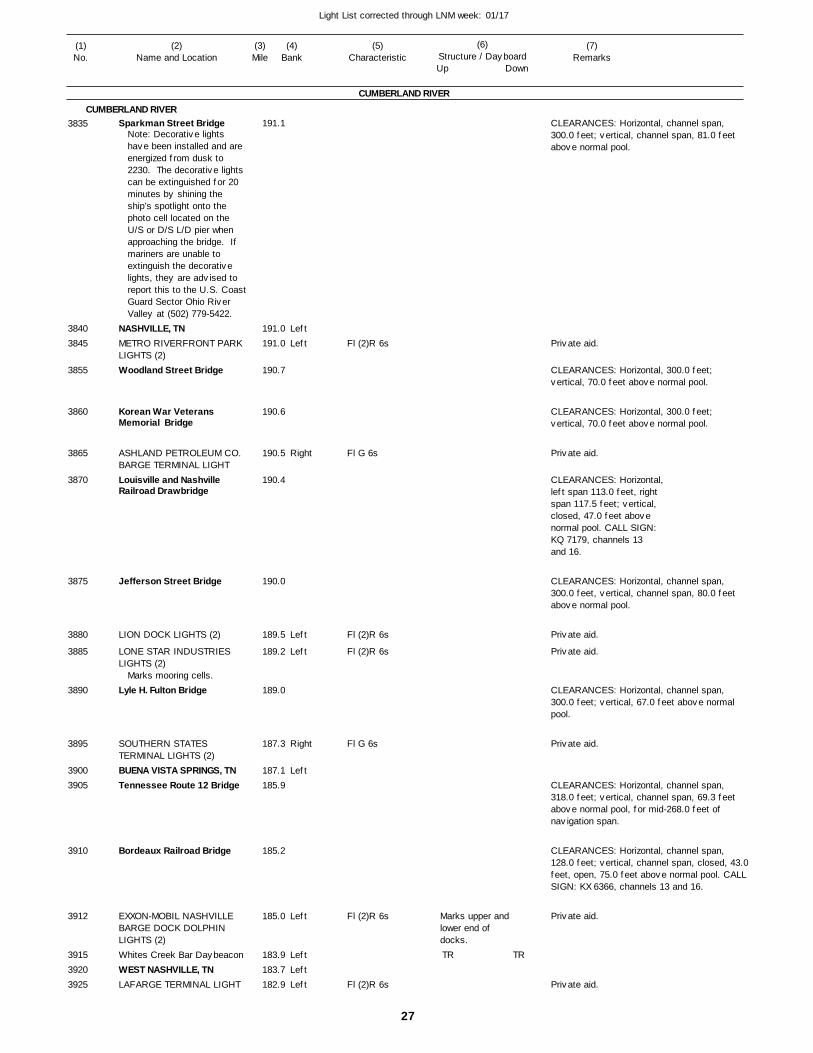
27
Light List corrected through LNM week: 01/17
(7)Remarks
(1)No.
(2)Name and Location
(3)Mile
(5)Characteristic
(4)Bank
(6)Structure / DayboardUp Down
Sparkman Street Bridge
NASHVILLE, TNMETRO RIVERFRONT PARK LIGHTS (2)Woodland Street Bridge
Korean War Veterans Memorial Bridge
ASHLAND PETROLEUM CO. BARGE TERMINAL LIGHTLouisville and Nashville Railroad Drawbridge
Jefferson Street Bridge
LION DOCK LIGHTS (2)
LONE STAR INDUSTRIES LIGHTS (2)
Lyle H. Fulton Bridge
SOUTHERN STATES TERMINAL LIGHTS (2)BUENA VISTA SPRINGS, TNTennessee Route 12 Bridge
Bordeaux Railroad Bridge
EXXON-MOBIL NASHVILLE BARGE DOCK DOLPHIN LIGHTS (2)Whites Creek Bar DaybeaconWEST NASHVILLE, TNLAFARGE TERMINAL LIGHT
CUMBERLAND RIVER
CUMBERLAND RIVER
LeftLeft
Right
Left
Left
Right
Left
Left
LeftLeftLeft
191.1
191.0 191.0
190.7
190.6
190.5
190.4
190.0
189.5
189.2
189.0
187.3
187.1 185.9
185.2
185.0
183.9 183.7 182.9
Note: Decorative lights have been installed and are energized from dusk to 2230. The decorative lights can be extinguished for 20 minutes by shining the ship’s spotlight onto the photo cell located on the U/S or D/S L/D pier when approaching the bridge. If mariners are unable to extinguish the decorative lights, they are advised to report this to the U.S. CoastGuard Sector Ohio River Valley at (502) 779-5422.
Marks mooring cells.
Fl (2)R 6s
Fl G 6s
Fl (2)R 6s
Fl (2)R 6s
Fl G 6s
Fl (2)R 6s
Fl (2)R 6s
Marks upper and lower end of docks.
CLEARANCES: Horizontal, channel span, 300.0 feet; vertical, channel span, 81.0 feet above normal pool.
CLEARANCES: Horizontal, 300.0 feet; vertical, 70.0 feet above normal pool.
CLEARANCES: Horizontal, 300.0 feet; vertical, 70.0 feet above normal pool.
CLEARANCES: Horizontal, left span 113.0 feet, rightspan 117.5 feet; vertical, closed, 47.0 feet above normal pool. CALL SIGN: KQ 7179, channels 13 and 16.
CLEARANCES: Horizontal, channel span, 300.0 feet, vertical, channel span, 80.0 feet above normal pool.
CLEARANCES: Horizontal, channel span, 300.0 feet; vertical, 67.0 feet above normal pool.
CLEARANCES: Horizontal, channel span, 318.0 feet; vertical, channel span, 69.3 feet above normal pool, for mid-268.0 feet of navigation span.
CLEARANCES: Horizontal, channel span, 128.0 feet; vertical, channel span, closed, 43.0feet, open, 75.0 feet above normal pool. CALLSIGN: KX 6366, channels 13 and 16.
3835
38403845
3855
3860
3865
3870
3875
3880
3885
3890
3895
39003905
3910
3912
391539203925
TR TR
Private aid.
Private aid.
Private aid.
Private aid.
Private aid.
Private aid.
Private aid.
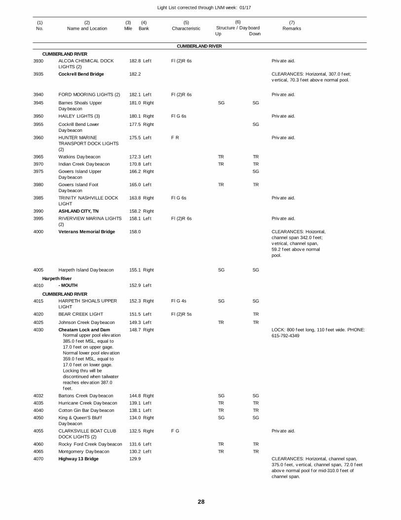
28
Light List corrected through LNM week: 01/17
(7)Remarks
(1)No.
(2)Name and Location
(3)Mile
(5)Characteristic
(4)Bank
(6)Structure / DayboardUp Down
ALCOA CHEMICAL DOCK LIGHTS (2)Cockrell Bend Bridge
FORD MOORING LIGHTS (2)
Barnes Shoals Upper DaybeaconHAILEY LIGHTS (3)
Cockrill Bend Lower DaybeaconHUNTER MARINE TRANSPORT DOCK LIGHTS (2)Watkins DaybeaconIndian Creek DaybeaconGowers Island Upper DaybeaconGowers Island Foot DaybeaconTRINITY NASHVILLE DOCK LIGHTASHLAND CITY, TNRIVERVIEW MARINA LIGHTS(2)Veterans Memorial Bridge
Harpeth Island Daybeacon
- MOUTH
HARPETH SHOALS UPPER LIGHTBEAR CREEK LIGHT
Johnson Creek DaybeaconCheatam Lock and Dam
Bartons Creek DaybeaconHurricane Creek DaybeaconCotton Gin Bar DaybeaconKing & Queen'S Bluff DaybeaconCLARKSVILLE BOAT CLUB DOCK LIGHTS (2)Rocky Ford Creek DaybeaconMontgomery DaybeaconHighway 13 Bridge
CUMBERLAND RIVER
CUMBERLAND RIVER
Harpeth River
CUMBERLAND RIVER
Left
Left
Right
Right
Right
Left
LeftLeftRight
Left
Right
RightLeft
Right
Left
Right
Left
LeftRight
RightLeftLeftRight
Right
LeftLeft
182.8
182.2
182.1
181.0
180.1
177.5
175.5
172.3 170.8 166.2
165.0
163.8
158.2 158.1
158.0
155.1
152.9
152.3
151.5
149.3 148.7
144.8 139.1 138.1 134.0
132.5
131.6 130.2 129.9
Normal upper pool elevation 385.0 feet MSL, equal to 17.0 feet on upper gage. Normal lower pool elevation 359.0 feet MSL, equal to 17.0 feet on lower gage. Locking thru will be discontinued when tailwater reaches elevation 387.0 feet.
Fl (2)R 6s
Fl (2)R 6s
Fl G 6s
F R
Fl G 6s
Fl (2)R 6s
Fl G 4s
Fl (2)R 5s
F G
CLEARANCES: Horizontal, 307.0 feet; vertical, 70.3 feet above normal pool.
CLEARANCES: Hoizontal,channel span 342.0 feet;vetrical, channel span,59.2 feet above normalpool.
LOCK: 800 feet long, 110 feet wide. PHONE: 615-792-4349
CLEARANCES: Horizontal, channel span, 375.0 feet, vertical, channel span, 72.0 feet above normal pool for mid-310.0 feet of channel span.
3930
3935
3940
3945
3950
3955
3960
396539703975
3980
3985
39903995
4000
4005
4010
4015
4020
40254030
4032403540404050
4055
406040654070
SG
TRTR
TR
SG
SG
TR
SGTRTRSG
TRTR
SG
SG
TRTRSG
TR
SG
SG
TR
TR
SGTRTRSG
TRTR
Private aid.
Private aid.
Private aid.
Private aid.
Private aid.
Private aid.
Private aid.
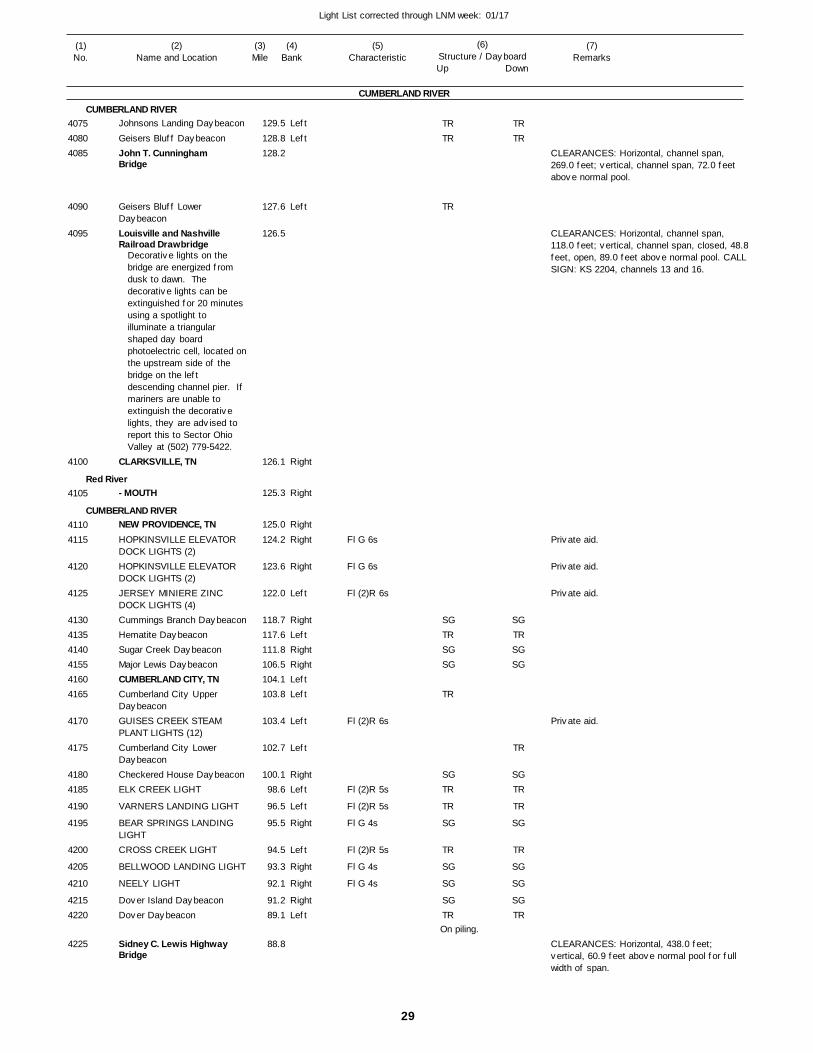
29
Light List corrected through LNM week: 01/17
(7)Remarks
(1)No.
(2)Name and Location
(3)Mile
(5)Characteristic
(4)Bank
(6)Structure / DayboardUp Down
Johnsons Landing Daybeacon
Geisers Bluff DaybeaconJohn T. Cunningham Bridge
Geisers Bluff Lower DaybeaconLouisville and Nashville Railroad Drawbridge
CLARKSVILLE, TN
- MOUTH
NEW PROVIDENCE, TNHOPKINSVILLE ELEVATOR DOCK LIGHTS (2)HOPKINSVILLE ELEVATOR DOCK LIGHTS (2)JERSEY MINIERE ZINC DOCK LIGHTS (4)Cummings Branch DaybeaconHematite DaybeaconSugar Creek DaybeaconMajor Lewis DaybeaconCUMBERLAND CITY, TNCumberland City Upper DaybeaconGUISES CREEK STEAM PLANT LIGHTS (12)Cumberland City Lower DaybeaconCheckered House DaybeaconELK CREEK LIGHT
VARNERS LANDING LIGHT
BEAR SPRINGS LANDING LIGHTCROSS CREEK LIGHT
BELLWOOD LANDING LIGHT
NEELY LIGHT
Dover Island DaybeaconDover Daybeacon
Sidney C. Lewis Highway Bridge
CUMBERLAND RIVER
CUMBERLAND RIVER
Red River
CUMBERLAND RIVER
Left
Left
Left
Right
Right
Right
Right
Right
Left
RightLeftRightRightLeftLeft
Left
Left
RightLeft
Left
Right
Left
Right
Right
RightLeft
129.5
128.8 128.2
127.6
126.5
126.1
125.3
125.0
124.2
123.6
122.0
118.7 117.6 111.8 106.5 104.1 103.8
103.4
102.7
100.1 98.6
96.5
95.5
94.5
93.3
92.1
91.2 89.1
88.8
Decorative lights on the bridge are energized from dusk to dawn. The decorative lights can be extinguished for 20 minutes using a spotlight to illuminate a triangular shaped day board photoelectric cell, located onthe upstream side of the bridge on the left descending channel pier. If mariners are unable to extinguish the decorative lights, they are advised to report this to Sector Ohio Valley at (502) 779-5422.
Fl G 6s
Fl G 6s
Fl (2)R 6s
Fl (2)R 6s
Fl (2)R 5s
Fl (2)R 5s
Fl G 4s
Fl (2)R 5s
Fl G 4s
Fl G 4s
On piling.
CLEARANCES: Horizontal, channel span, 269.0 feet; vertical, channel span, 72.0 feet above normal pool.
CLEARANCES: Horizontal, channel span, 118.0 feet; vertical, channel span, closed, 48.8feet, open, 89.0 feet above normal pool. CALLSIGN: KS 2204, channels 13 and 16.
CLEARANCES: Horizontal, 438.0 feet; vertical, 60.9 feet above normal pool for full width of span.
407540804085
4090
4095
4100
4105
41104115
4120
4125
413041354140415541604165
4170
4175
41804185
4190
4195
4200
4205
4210
42154220
4225
TRTR
TR
SGTRSGSG
TR
SGTR
TR
SG
TR
SG
SG
SGTR
TRTR
SGTRSGSG
TR
SGTR
TR
SG
TR
SG
SG
SGTR
Private aid.
Private aid.
Private aid.
Private aid.
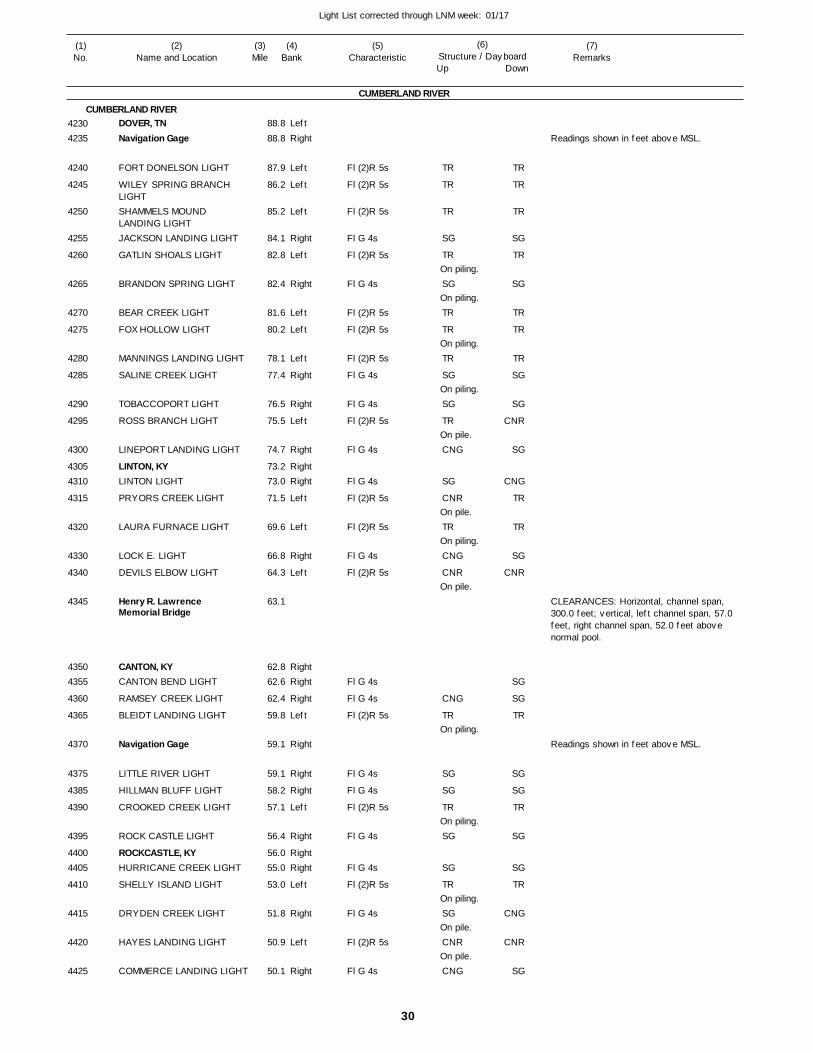
30
Light List corrected through LNM week: 01/17
(7)Remarks
(1)No.
(2)Name and Location
(3)Mile
(5)Characteristic
(4)Bank
(6)Structure / DayboardUp Down
DOVER, TNNavigation Gage
FORT DONELSON LIGHT
WILEY SPRING BRANCH LIGHTSHAMMELS MOUND LANDING LIGHTJACKSON LANDING LIGHT
GATLIN SHOALS LIGHT
BRANDON SPRING LIGHT
BEAR CREEK LIGHT
FOX HOLLOW LIGHT
MANNINGS LANDING LIGHT
SALINE CREEK LIGHT
TOBACCOPORT LIGHT
ROSS BRANCH LIGHT
LINEPORT LANDING LIGHT
LINTON, KYLINTON LIGHT
PRYORS CREEK LIGHT
LAURA FURNACE LIGHT
LOCK E. LIGHT
DEVILS ELBOW LIGHT
Henry R. Lawrence Memorial Bridge
CANTON, KYCANTON BEND LIGHT
RAMSEY CREEK LIGHT
BLEIDT LANDING LIGHT
Navigation Gage
LITTLE RIVER LIGHT
HILLMAN BLUFF LIGHT
CROOKED CREEK LIGHT
ROCK CASTLE LIGHT
ROCKCASTLE, KYHURRICANE CREEK LIGHT
SHELLY ISLAND LIGHT
DRYDEN CREEK LIGHT
HAYES LANDING LIGHT
COMMERCE LANDING LIGHT
CUMBERLAND RIVER
CUMBERLAND RIVERLeft
Right
Left
Left
Left
Right
Left
Right
Left
Left
Left
Right
Right
Left
Right
RightRight
Left
Left
Right
Left
RightRight
Right
Left
Right
Right
Right
Left
Right
RightRight
Left
Right
Left
Right
88.8
88.8
87.9
86.2
85.2
84.1
82.8
82.4
81.6
80.2
78.1
77.4
76.5
75.5
74.7
73.2 73.0
71.5
69.6
66.8
64.3
63.1
62.8 62.6
62.4
59.8
59.1
59.1
58.2
57.1
56.4
56.0 55.0
53.0
51.8
50.9
50.1
Fl (2)R 5s
Fl (2)R 5s
Fl (2)R 5s
Fl G 4s
Fl (2)R 5s
Fl G 4s
Fl (2)R 5s
Fl (2)R 5s
Fl (2)R 5s
Fl G 4s
Fl G 4s
Fl (2)R 5s
Fl G 4s
Fl G 4s
Fl (2)R 5s
Fl (2)R 5s
Fl G 4s
Fl (2)R 5s
Fl G 4s
Fl G 4s
Fl (2)R 5s
Fl G 4s
Fl G 4s
Fl (2)R 5s
Fl G 4s
Fl G 4s
Fl (2)R 5s
Fl G 4s
Fl (2)R 5s
Fl G 4s
On piling.
On piling.
On piling.
On piling.
On pile.
On pile.
On piling.
On pile.
On piling.
On piling.
On piling.
On pile.
On pile.
Readings shown in feet above MSL.
CLEARANCES: Horizontal, channel span, 300.0 feet; vertical, left channel span, 57.0 feet, right channel span, 52.0 feet above normal pool.
Readings shown in feet above MSL.
42304235
4240
4245
4250
4255
4260
4265
4270
4275
4280
4285
4290
4295
4300
43054310
4315
4320
4330
4340
4345
43504355
4360
4365
4370
4375
4385
4390
4395
44004405
4410
4415
4420
4425
TR
TR
TR
SG
TR
SG
TR
TR
TR
SG
SG
TR
CNG
SG
CNR
TR
CNG
CNR
CNG
TR
SG
SG
TR
SG
SG
TR
SG
CNR
CNG
TR
TR
TR
SG
TR
SG
TR
TR
TR
SG
SG
CNR
SG
CNG
TR
TR
SG
CNR
SG
SG
TR
SG
SG
TR
SG
SG
TR
CNG
CNR
SG
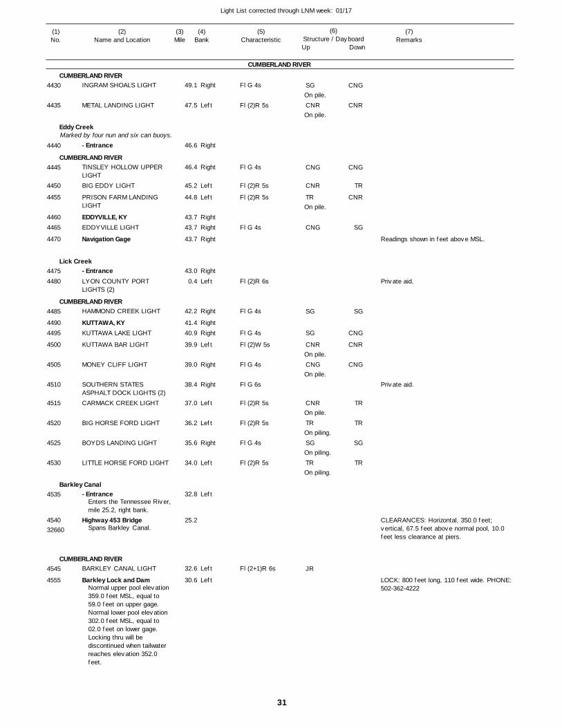
31
Light List corrected through LNM week: 01/17
(7)Remarks
(1)No.
(2)Name and Location
(3)Mile
(5)Characteristic
(4)Bank
(6)Structure / DayboardUp Down
INGRAM SHOALS LIGHT
METAL LANDING LIGHT
- Entrance
TINSLEY HOLLOW UPPER LIGHTBIG EDDY LIGHT
PRISON FARM LANDING LIGHT
EDDYVILLE, KYEDDYVILLE LIGHT
Navigation Gage
- EntranceLYON COUNTY PORT LIGHTS (2)
HAMMOND CREEK LIGHT
KUTTAWA, KYKUTTAWA LAKE LIGHT
KUTTAWA BAR LIGHT
MONEY CLIFF LIGHT
SOUTHERN STATES ASPHALT DOCK LIGHTS (2)CARMACK CREEK LIGHT
BIG HORSE FORD LIGHT
BOYDS LANDING LIGHT
LITTLE HORSE FORD LIGHT
- Entrance
Highway 453 Bridge
BARKLEY CANAL LIGHT
Barkley Lock and Dam
CUMBERLAND RIVER
CUMBERLAND RIVER
Eddy Creek
CUMBERLAND RIVER
Lick Creek
CUMBERLAND RIVER
Barkley Canal
CUMBERLAND RIVER
Marked by four nun and six can buoys.
Right
Left
Right
Right
Left
Left
RightRight
Right
Right
Left
Right
RightRight
Left
Right
Right
Left
Left
Right
Left
Left
Left
Left
49.1
47.5
46.6
46.4
45.2
44.8
43.7 43.7
43.7
43.0
0.4
42.2
41.4 40.9
39.9
39.0
38.4
37.0
36.2
35.6
34.0
32.8
25.2
32.6
30.6
Enters the Tennessee River,mile 25.2, right bank.
Spans Barkley Canal.
Normal upper pool elevation 359.0 feet MSL, equal to 59.0 feet on upper gage.Normal lower pool elevation 302.0 feet MSL, equal to 02.0 feet on lower gage.Locking thru will be discontinued when tailwater reaches elevation 352.0 feet.
Fl G 4s
Fl (2)R 5s
Fl G 4s
Fl (2)R 5s
Fl (2)R 5s
Fl G 4s
Fl (2)R 6s
Fl G 4s
Fl G 4s
Fl (2)W 5s
Fl G 4s
Fl G 6s
Fl (2)R 5s
Fl (2)R 5s
Fl G 4s
Fl (2)R 5s
Fl (2+1)R 6s
On pile.
On pile.
On pile.
On pile.
On pile.
On pile.
On piling.
On piling.
On piling.
Readings shown in feet above MSL.
CLEARANCES: Horizontal, 350.0 feet; vertical, 67.5 feet above normal pool, 10.0 feet less clearance at piers.
LOCK: 800 feet long, 110 feet wide. PHONE: 502-362-4222
32660
4430
4435
4440
4445
4450
4455
44604465
4470
44754480
4485
44904495
4500
4505
4510
4515
4520
4525
4530
4535
4540
4545
4555
SG
CNR
CNG
CNR
TR
CNG
SG
SG
CNR
CNG
CNR
TR
SG
TR
JR
CNG
CNR
CNG
TR
CNR
SG
SG
CNG
CNR
CNG
TR
TR
SG
TR
Private aid.
Private aid.
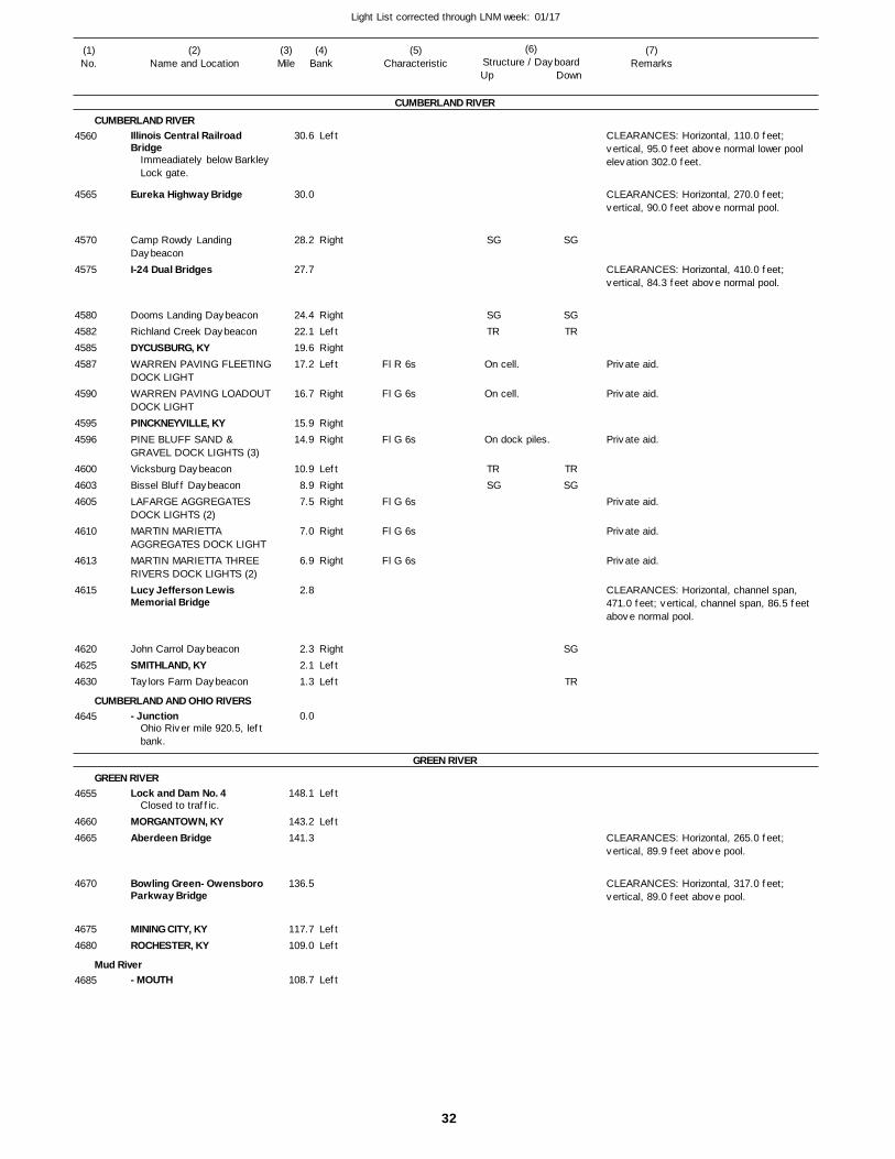
32
Light List corrected through LNM week: 01/17
(7)Remarks
(1)No.
(2)Name and Location
(3)Mile
(5)Characteristic
(4)Bank
(6)Structure / DayboardUp Down
Illinois Central Railroad Bridge
Eureka Highway Bridge
Camp Rowdy Landing DaybeaconI-24 Dual Bridges
Dooms Landing DaybeaconRichland Creek DaybeaconDYCUSBURG, KYWARREN PAVING FLEETINGDOCK LIGHTWARREN PAVING LOADOUTDOCK LIGHTPINCKNEYVILLE, KYPINE BLUFF SAND & GRAVEL DOCK LIGHTS (3)Vicksburg DaybeaconBissel Bluff DaybeaconLAFARGE AGGREGATES DOCK LIGHTS (2)MARTIN MARIETTA AGGREGATES DOCK LIGHTMARTIN MARIETTA THREE RIVERS DOCK LIGHTS (2)Lucy Jefferson Lewis Memorial Bridge
John Carrol DaybeaconSMITHLAND, KYTaylors Farm Daybeacon
- Junction
Lock and Dam No. 4
MORGANTOWN, KYAberdeen Bridge
Bowling Green- Owensboro Parkway Bridge
MINING CITY, KYROCHESTER, KY
- MOUTH
CUMBERLAND RIVER
CUMBERLAND RIVER
CUMBERLAND AND OHIO RIVERS
GREEN RIVER
GREEN RIVER
Mud River
Left
Right
RightLeftRightLeft
Right
RightRight
LeftRightRight
Right
Right
RightLeftLeft
Left
Left
LeftLeft
Left
30.6
30.0
28.2
27.7
24.4 22.1 19.6 17.2
16.7
15.9 14.9
10.9 8.9 7.5
7.0
6.9
2.8
2.3 2.1 1.3
0.0
148.1
143.2 141.3
136.5
117.7 109.0
108.7
Immeadiately below BarkleyLock gate.
Ohio River mile 920.5, left bank.
Closed to traffic.
Fl R 6s
Fl G 6s
Fl G 6s
Fl G 6s
Fl G 6s
Fl G 6s
On cell.
On cell.
On dock piles.
CLEARANCES: Horizontal, 110.0 feet; vertical, 95.0 feet above normal lower pool elevation 302.0 feet.
CLEARANCES: Horizontal, 270.0 feet; vertical, 90.0 feet above normal pool.
CLEARANCES: Horizontal, 410.0 feet; vertical, 84.3 feet above normal pool.
CLEARANCES: Horizontal, channel span, 471.0 feet; vertical, channel span, 86.5 feet above normal pool.
CLEARANCES: Horizontal, 265.0 feet; vertical, 89.9 feet above pool.
CLEARANCES: Horizontal, 317.0 feet; vertical, 89.0 feet above pool.
4560
4565
4570
4575
4580458245854587
4590
45954596
460046034605
4610
4613
4615
462046254630
4645
4655
46604665
4670
46754680
4685
SG
SGTR
TRSG
SG
SGTR
TRSG
SG
TR
Private aid.
Private aid.
Private aid.
Private aid.
Private aid.
Private aid.
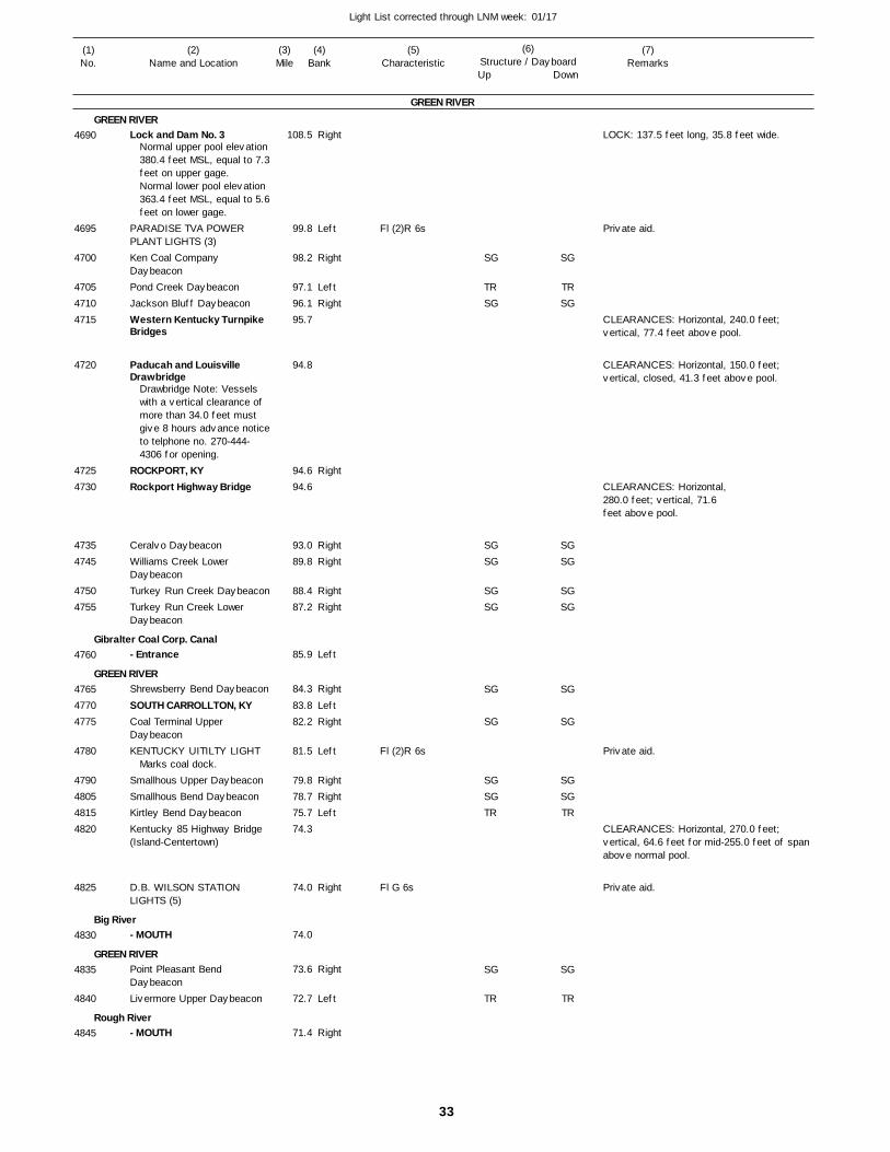
33
Light List corrected through LNM week: 01/17
(7)Remarks
(1)No.
(2)Name and Location
(3)Mile
(5)Characteristic
(4)Bank
(6)Structure / DayboardUp Down
Lock and Dam No. 3
PARADISE TVA POWER PLANT LIGHTS (3)Ken Coal Company DaybeaconPond Creek DaybeaconJackson Bluff DaybeaconWestern Kentucky Turnpike Bridges
Paducah and Louisville Drawbridge
ROCKPORT, KYRockport Highway Bridge
Ceralvo DaybeaconWilliams Creek Lower DaybeaconTurkey Run Creek DaybeaconTurkey Run Creek Lower Daybeacon
- Entrance
Shrewsberry Bend Daybeacon
SOUTH CARROLLTON, KYCoal Terminal Upper DaybeaconKENTUCKY UITILTY LIGHT
Smallhous Upper DaybeaconSmallhous Bend DaybeaconKirtley Bend DaybeaconKentucky 85 Highway Bridge (Island-Centertown)
D.B. WILSON STATION LIGHTS (5)
- MOUTH
Point Pleasant Bend DaybeaconLivermore Upper Daybeacon
- MOUTH
GREEN RIVER
GREEN RIVER
Gibralter Coal Corp. Canal
GREEN RIVER
Big River
GREEN RIVER
Rough River
Right
Left
Right
LeftRight
Right
RightRight
RightRight
Left
Right
LeftRight
Left
RightRightLeft
Right
Right
Left
Right
108.5
99.8
98.2
97.1 96.1 95.7
94.8
94.6 94.6
93.0 89.8
88.4 87.2
85.9
84.3
83.8 82.2
81.5
79.8 78.7 75.7 74.3
74.0
74.0
73.6
72.7
71.4
Normal upper pool elevation 380.4 feet MSL, equal to 7.3feet on upper gage. Normal lower pool elevation 363.4 feet MSL, equal to 5.6feet on lower gage.
Drawbridge Note: Vessels with a vertical clearance of more than 34.0 feet must give 8 hours advance noticeto telphone no. 270-444-4306 for opening.
Marks coal dock.
Fl (2)R 6s
Fl (2)R 6s
Fl G 6s
LOCK: 137.5 feet long, 35.8 feet wide.
CLEARANCES: Horizontal, 240.0 feet; vertical, 77.4 feet above pool.
CLEARANCES: Horizontal, 150.0 feet; vertical, closed, 41.3 feet above pool.
CLEARANCES: Horizontal, 280.0 feet; vertical, 71.6 feet above pool.
CLEARANCES: Horizontal, 270.0 feet; vertical, 64.6 feet for mid-255.0 feet of span above normal pool.
4690
4695
4700
470547104715
4720
47254730
47354745
47504755
4760
476547704775
4780
4790480548154820
4825
4830
4835
4840
4845
SG
TRSG
SGSG
SGSG
SG
SG
SGSGTR
SG
TR
SG
TRSG
SGSG
SGSG
SG
SG
SGSGTR
SG
TR
Private aid.
Private aid.
Private aid.
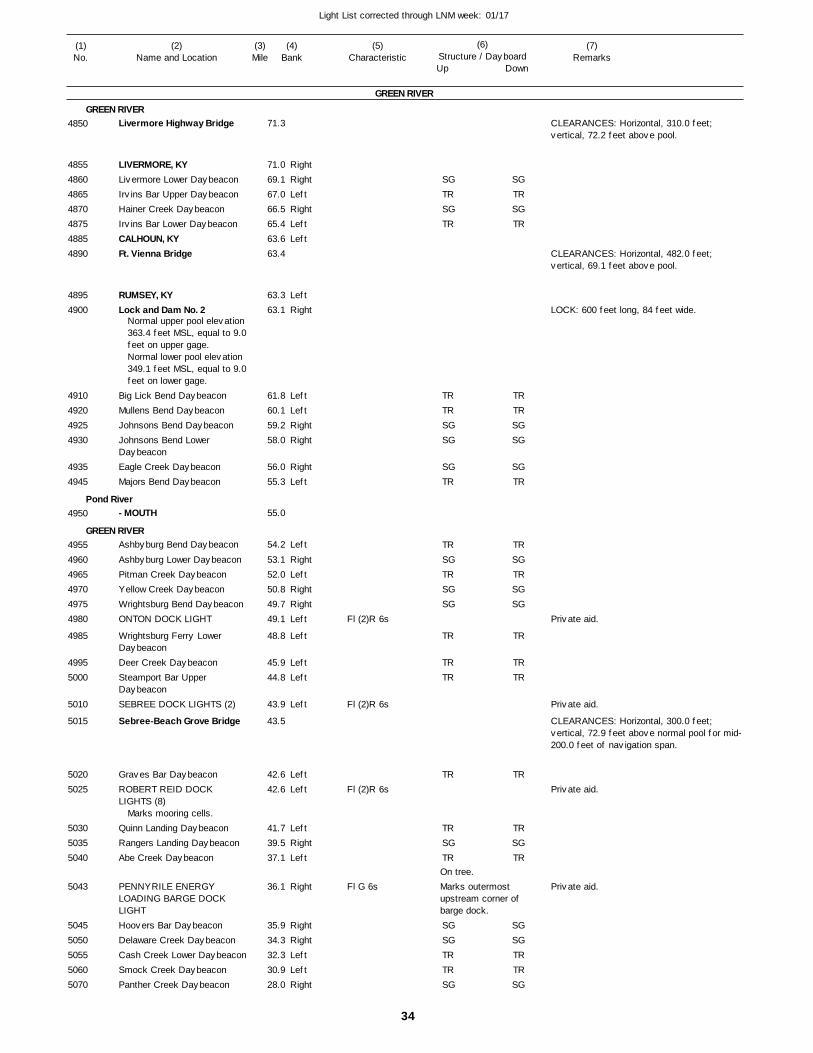
34
Light List corrected through LNM week: 01/17
(7)Remarks
(1)No.
(2)Name and Location
(3)Mile
(5)Characteristic
(4)Bank
(6)Structure / DayboardUp Down
Livermore Highway Bridge
LIVERMORE, KYLivermore Lower DaybeaconIrvins Bar Upper DaybeaconHainer Creek DaybeaconIrvins Bar Lower DaybeaconCALHOUN, KYFt. Vienna Bridge
RUMSEY, KYLock and Dam No. 2
Big Lick Bend DaybeaconMullens Bend DaybeaconJohnsons Bend DaybeaconJohnsons Bend Lower DaybeaconEagle Creek DaybeaconMajors Bend Daybeacon
- MOUTH
Ashbyburg Bend Daybeacon
Ashbyburg Lower DaybeaconPitman Creek DaybeaconYellow Creek DaybeaconWrightsburg Bend DaybeaconONTON DOCK LIGHT
Wrightsburg Ferry Lower DaybeaconDeer Creek DaybeaconSteamport Bar Upper DaybeaconSEBREE DOCK LIGHTS (2)
Sebree-Beach Grove Bridge
Graves Bar DaybeaconROBERT REID DOCK LIGHTS (8)
Quinn Landing DaybeaconRangers Landing DaybeaconAbe Creek Daybeacon
PENNYRILE ENERGY LOADING BARGE DOCK LIGHTHoovers Bar DaybeaconDelaware Creek DaybeaconCash Creek Lower DaybeaconSmock Creek DaybeaconPanther Creek Daybeacon
GREEN RIVER
GREEN RIVER
Pond River
GREEN RIVER
RightRightLeftRightLeftLeft
LeftRight
LeftLeftRightRight
RightLeft
Left
RightLeftRightRightLeft
Left
LeftLeft
Left
LeftLeft
LeftRightLeft
Right
RightRightLeftLeftRight
71.3
71.0 69.1 67.0 66.5 65.4 63.6 63.4
63.3 63.1
61.8 60.1 59.2 58.0
56.0 55.3
55.0
54.2
53.1 52.0 50.8 49.7 49.1
48.8
45.9 44.8
43.9
43.5
42.6 42.6
41.7 39.5 37.1
36.1
35.9 34.3 32.3 30.9 28.0
Normal upper pool elevation 363.4 feet MSL, equal to 9.0feet on upper gage.Normal lower pool elevation 349.1 feet MSL, equal to 9.0feet on lower gage.
Marks mooring cells.
Fl (2)R 6s
Fl (2)R 6s
Fl (2)R 6s
Fl G 6sOn tree.Marks outermost upstream corner ofbarge dock.
CLEARANCES: Horizontal, 310.0 feet; vertical, 72.2 feet above pool.
CLEARANCES: Horizontal, 482.0 feet; vertical, 69.1 feet above pool.
LOCK: 600 feet long, 84 feet wide.
CLEARANCES: Horizontal, 300.0 feet; vertical, 72.9 feet above normal pool for mid-200.0 feet of navigation span.
4850
4855486048654870487548854890
48954900
4910492049254930
49354945
4950
495549604965497049754980
4985
49955000
5010
5015
50205025
503050355040
5043
50455050505550605070
SGTRSGTR
TRTRSGSG
SGTR
TRSGTRSGSG
TR
TRTR
TR
TRSGTR
SGSGTRTRSG
SGTRSGTR
TRTRSGSG
SGTR
TRSGTRSGSG
TR
TRTR
TR
TRSGTR
SGSGTRTRSG
Private aid.
Private aid.
Private aid.
Private aid.
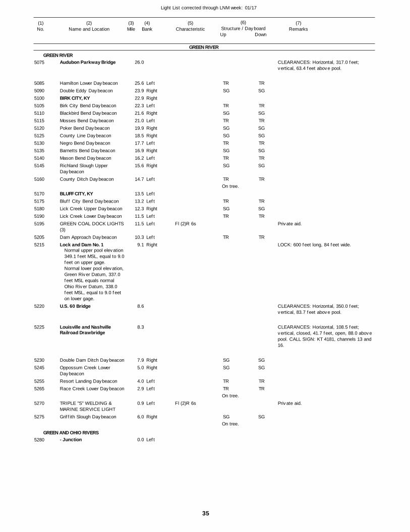
35
Light List corrected through LNM week: 01/17
(7)Remarks
(1)No.
(2)Name and Location
(3)Mile
(5)Characteristic
(4)Bank
(6)Structure / DayboardUp Down
Audubon Parkway Bridge
Hamilton Lower DaybeaconDouble Eddy DaybeaconBIRK CITY, KYBirk City Bend DaybeaconBlackbird Bend DaybeaconMosses Bend DaybeaconPoker Bend DaybeaconCounty Line DaybeaconNegro Bend DaybeaconBarnetts Bend DaybeaconMason Bend DaybeaconRichland Slough Upper DaybeaconCounty Ditch Daybeacon
BLUFF CITY, KYBluff City Bend DaybeaconLick Creek Upper DaybeaconLick Creek Lower DaybeaconGREEN COAL DOCK LIGHTS(3)Dam Approach DaybeaconLock and Dam No. 1
U.S. 60 Bridge
Louisville and Nashville Railroad Drawbridge
Double Dam Ditch DaybeaconOppossum Creek Lower DaybeaconResort Landing DaybeaconRace Creek Lower Daybeacon
TRIPLE "S" WELDING & MARINE SERVICE LIGHTGriffith Slough Daybeacon
- Junction
GREEN RIVER
GREEN RIVER
GREEN AND OHIO RIVERS
LeftRightRightLeftRightLeftRightRightLeftRightLeftRight
Left
LeftLeftRightLeftLeft
LeftRight
RightRight
LeftLeft
Left
Right
Left
26.0
25.6 23.9 22.9 22.3 21.6 21.0 19.9 18.5 17.7 16.9 16.2 15.6
14.7
13.5 13.2 12.3 11.5 11.5
10.3 9.1
8.6
8.3
7.9 5.0
4.0 2.9
0.9
6.0
0.0
Normal upper pool elevation 349.1 feet MSL, equal to 9.0feet on upper gage. Normal lower pool elevation,Green River Datum, 337.0 feet MSL equals normal Ohio River Datum, 338.0 feet MSL, equal to 9.0 feet on lower gage.
Fl (2)R 6s
Fl (2)R 6s
On tree.
On tree.
On tree.
CLEARANCES: Horizontal, 317.0 feet; vertical, 63.4 feet above pool.
LOCK: 600 feet long, 84 feet wide.
CLEARANCES: Horizontal, 350.0 feet; vertical, 83.7 feet above pool.
CLEARANCES: Horizontal, 108.5 feet; vertical, closed, 41.7 feet, open, 88.0 above pool. CALL SIGN: KT 4181, channels 13 and 16.
5075
508550905100510551105115512051255130513551405145
5160
51705175518051905195
52055215
5220
5225
52305245
52555265
5270
5275
5280
TRSG
TRSGTRSGSGTRSGTRSG
TR
TRSGTR
TR
SGSG
TRTR
SG
TRSG
TRSGTRSGSGTRSGTRSG
TR
TRSGTR
TR
SGSG
TRTR
SG
Private aid.
Private aid.
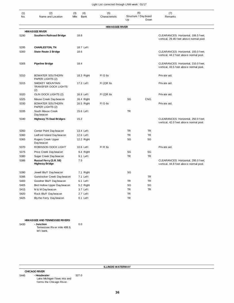
36
Light List corrected through LNM week: 01/17
(7)Remarks
(1)No.
(2)Name and Location
(3)Mile
(5)Characteristic
(4)Bank
(6)Structure / DayboardUp Down
Southern Railroad Bridge
CHARLESTON, TNState Route 2 Bridge
Pipeline Bridge
BOWATER SOUTHERN PAPER LIGHTS (2)SMOKEY MOUNTAIN TRANSFER DOCK LIGHTS (2)OLIN DOCK LIGHTS (2)
Mouse Creek DaybeaconBOWATER SOUTHERN PAPER LIGHTS (2)South Mouse Creek DaybeaconHighway 75 Dual Bridges
Center Point DaybeaconLedford Island DaybeaconRogers Creek Upper DaybeaconROBINSON DOCK LIGHT
Price Creek DaybeaconSugar Creek DaybeaconRussel Ferry (S.R. 58) Highway Bridge
Jewell Bluff DaybeaconGunstocker Creek DaybeaconGoodner Bluff DaybeaconBird Hollow Upper DaybeaconM & M DaybeaconRock Bluff DaybeaconBlythe Ferry Daybeacon
- Junction
- Headwater
HIWASSEE RIVER
HIWASSEE RIVER
HIWASSEE AND TENNESSEE RIVERS
ILLINOIS WATERWAY
CHICAGO RIVER
Left
Right
Left
Left
RightRight
Left
LeftLeftRight
Left
RightLeft
RightLeftLeftRightLeftLeftLeft
18.8
18.7 18.6
18.4
18.3
17.3
16.9
16.4 16.5
15.6
15.2
13.4 12.6 12.2
10.6
9.4 9.1 7.5
7.1 7.1 6.1 5.2 3.7 2.7 0.1
0.0
327.0
Tennessee River mile 499.9,left bank.
Lake Michigan flows into andforms the Chicago River.
Fl G 6s
Fl (2)R 6s
Fl (2)R 6s
Fl G 6s
Fl R 6s
CLEARANCES: Horizontal, 106.5 feet; vertical, 29.45 feet above normal pool.
CLEARANCES: Horizontal, 193.0 feet; vertical, 44.2 feet above normal pool.
CLEARANCES: Horizontal, 210.0 feet; vertical, 43.5 feet above normal pool.
CLEARANCES: Horizontal, 250.0 feet; vertical, 42.0 feet above normal pool.
CLEARANCES: Horizontal, 295.0 feet; vertical, 44.8 feet above normal pool.
5290
52955300
5305
5310
5315
5320
53255330
5335
5340
535053605365
5370
537553805386
5390539554005405541554205425
5430
5445
SG
TR
TRTRSG
SGTR
SG
TRSGTRTRTR
CNG
TRTRSG
SGTR
TRTRSGTR
Private aid.
Private aid.
Private aid.
Private aid.
Private aid.
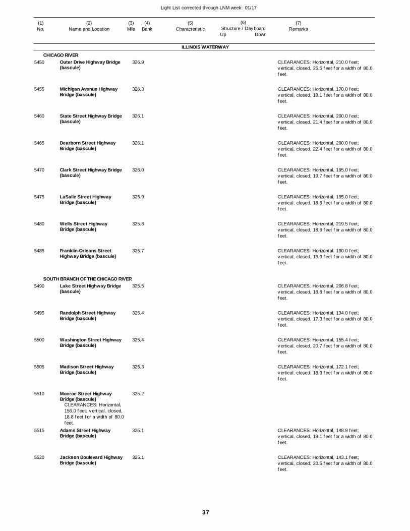
37
Light List corrected through LNM week: 01/17
(7)Remarks
(1)No.
(2)Name and Location
(3)Mile
(5)Characteristic
(4)Bank
(6)Structure / DayboardUp Down
Outer Drive Highway Bridge(bascule)
Michigan Avenue Highway Bridge (bascule)
State Street Highway Bridge(bascule)
Dearborn Street Highway Bridge (bascule)
Clark Street Highway Bridge(bascule)
LaSalle Street Highway Bridge (bascule)
Wells Street Highway Bridge (bascule)
Franklin-Orleans Street Highway Bridge (bascule)
Lake Street Highway Bridge (bascule)
Randolph Street Highway Bridge (bascule)
Washington Street Highway Bridge (bascule)
Madison Street Highway Bridge (bascule)
Monroe Street Highway Bridge (bascule)
Adams Street Highway Bridge (bascule)
Jackson Boulevard HighwayBridge (bascule)
ILLINOIS WATERWAY
CHICAGO RIVER
SOUTH BRANCH OF THE CHICAGO RIVER
326.9
326.3
326.1
326.1
326.0
325.9
325.8
325.7
325.5
325.4
325.4
325.3
325.2
325.1
325.1
CLEARANCES: Horizontal, 156.0 feet; vertical, closed, 18.8 feet for a width of 80.0feet.
CLEARANCES: Horizontal, 210.0 feet; vertical, closed, 25.5 feet for a width of 80.0 feet.
CLEARANCES: Horizontal, 170.0 feet; vertical, closed, 18.1 feet for a width of 80.0 feet.
CLEARANCES: Horizontal, 200.0 feet; vertical, closed, 21.4 feet for a width of 80.0 feet.
CLEARANCES: Horizontal, 200.0 feet; vertical, closed, 22.4 feet for a width of 80.0 feet.
CLEARANCES: Horizontal, 195.0 feet; vertical, closed, 19.7 feet for a width of 80.0 feet.
CLEARANCES: Horizontal, 195.0 feet; vertical, closed, 18.6 feet for a width of 80.0 feet.
CLEARANCES: Horizontal, 219.5 feet; vertical, closed, 18.6 feet for a width of 80.0 feet.
CLEARANCES: Horizontal, 190.0 feet; vertical, closed, 18.9 feet for a width of 80.0 feet.
CLEARANCES: Horizontal, 206.8 feet; vertical, closed, 18.8 feet for a width of 80.0 feet.
CLEARANCES: Horizontal, 134.0 feet; vertical, closed, 17.3 feet for a width of 80.0 feet.
CLEARANCES: Horizontal, 155.4 feet; vertical, closed, 20.7 feet for a width of 80.0 feet.
CLEARANCES: Horizontal, 172.1 feet; vertical, closed, 18.9 feet for a width of 80.0 feet.
CLEARANCES: Horizontal, 148.9 feet; vertical, closed, 19.1 feet for a width of 80.0 feet.
CLEARANCES: Horizontal, 143.1 feet; vertical, closed, 20.5 feet for a width of 80.0 feet.
5450
5455
5460
5465
5470
5475
5480
5485
5490
5495
5500
5505
5510
5515
5520
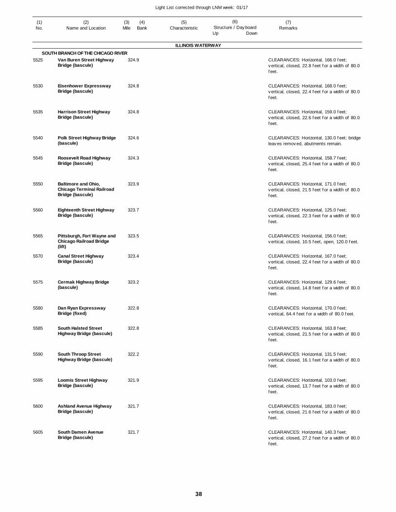
38
Light List corrected through LNM week: 01/17
(7)Remarks
(1)No.
(2)Name and Location
(3)Mile
(5)Characteristic
(4)Bank
(6)Structure / DayboardUp Down
Van Buren Street Highway Bridge (bascule)
Eisenhower Expressway Bridge (bascule)
Harrison Street Highway Bridge (bascule)
Polk Street Highway Bridge (bascule)
Roosevelt Road Highway Bridge (bascule)
Baltimore and Ohio, Chicago Terminal Railroad Bridge (bascule)
Eighteenth Street Highway Bridge (bascule)
Pittsburgh, Fort Wayne and Chicago Railroad Bridge (lift)
Canal Street Highway Bridge (bascule)
Cermak Highway Bridge (bascule)
Dan Ryan Expressway Bridge (fixed)
South Halsted Street Highway Bridge (bascule)
South Throop Street Highway Bridge (bascule)
Loomis Street Highway Bridge (bascule)
Ashland Avenue Highway Bridge (bascule)
South Damen Avenue Bridge (bascule)
ILLINOIS WATERWAY
SOUTH BRANCH OF THE CHICAGO RIVER 324.9
324.8
324.8
324.6
324.3
323.9
323.7
323.5
323.4
323.2
322.8
322.8
322.2
321.9
321.7
321.7
CLEARANCES: Horizontal, 166.0 feet; vertical, closed, 22.8 feet for a width of 80.0 feet.
CLEARANCES: Horizontal, 168.0 feet; vertical, closed, 22.4 feet for a width of 80.0 feet.
CLEARANCES: Horizontal, 159.0 feet; vertical, closed, 22.6 feet for a width of 80.0 feet.
CLEARANCES: Horizontal, 130.0 feet; bridge leaves removed, abutments remain.
CLEARANCES: Horizontal, 158.7 feet; vertical, closed, 25.4 feet for a width of 80.0 feet.
CLEARANCES: Horizontal, 171.0 feet; vertical, closed, 21.5 feet for a width of 80.0 feet.
CLEARANCES: Horizontal, 125.0 feet; vertical, closed, 22.3 feet for a width of 90.0 feet.
CLEARANCES: Horizontal, 156.0 feet; vertical, closed, 10.5 feet, open, 120.0 feet.
CLEARANCES: Horizontal, 167.0 feet; vertical, closed, 22.4 feet for a width of 80.0 feet.
CLEARANCES: Horizontal, 129.6 feet; vertical, closed, 14.8 feet for a width of 80.0 feet.
CLEARANCES: Horizontal, 170.0 feet; vertical, 64.4 feet for a width of 80.0 feet.
CLEARANCES: Horizontal, 163.8 feet; vertical, closed, 21.5 feet for a width of 80.0 feet.
CLEARANCES: Horizontal, 131.5 feet; vertical, closed, 16.1 feet for a width of 80.0 feet.
CLEARANCES: Horizontal, 103.0 feet; vertical, closed, 13.7 feet for a width of 80.0 feet.
CLEARANCES: Horizontal, 183.0 feet; vertical, closed, 21.6 feet for a width of 80.0 feet.
CLEARANCES: Horizontal, 140.3 feet; vertical, closed, 27.2 feet for a width of 80.0 feet.
5525
5530
5535
5540
5545
5550
5560
5565
5570
5575
5580
5585
5590
5595
5600
5605
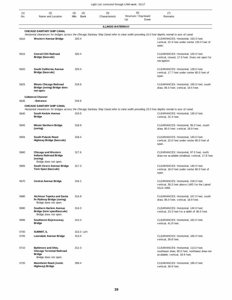
39
Light List corrected through LNM week: 01/17
(7)Remarks
(1)No.
(2)Name and Location
(3)Mile
(5)Characteristic
(4)Bank
(6)Structure / DayboardUp Down
Western Avenue Bridge
Conrail CSX Railroad Bridge (bascule)
South California Avenue Bridge (bascule)
Illinois Chicago Railroad Bridge (swing) Bridge does not open.
- Entrance
South Kedzie Avenue Bridge
Illinois Northern Bridge (swing)
South Pulaski Road Highway Bridge (bascule)
Chicago and Western Indiana Railroad Bridge (swing)
South Cicero Avenue BridgeTwin Span (bascule)
Central Avenue Bridge
Atchison Topeka and Santa Fe Railway Bridge (swing)
Southern Harlem Avenue Bridge (twin span/bascule)
Southwest Expressway Bridge
SUMMIT, ILLawndale Avenue Bridge
Baltimore and Ohio, Chicago Terminal Railroad Bridge
Mannheim Road (Justic Highway) Bridge
ILLINOIS WATERWAY
CHICAGO SANITARY SHIP CANAL
Collateral Channel
CHICAGO SANITARY SHIP CANAL
Horizontal clearances for bridges across the Chicago Sanitary Ship Canal refer to clear width providing 15.0 foot depths normal to axis of canal.
Horizontal clearances for bridges across the Chicago Sanitary Ship Canal refer to clear width providing 15.0 foot depths normal to axis of canal.
Left
320.4
320.4
320.0
319.6
319.6
319.5
318.9
318.4
317.6
317.3
316.2
314.8
314.0
313.3
313.3 313.0
312.3
309.4
Bridge does not open.
Bridge does not open.
Bridge does not open.
Bridge does not open.
CLEARANCES: Horizontal, 153.3 feet; vertical, 22.3 feet under center 120.0 feet of span.
CLEARANCES: Horizontal, 120.0 feet; vertical, closed, 17.0 feet. Does not open for navigation.
CLEARANCES: Horizontal, 128.0 feet; vertical, 17.7 feet under center 80.0 feet of span.
CLEARANCES: Horizontal, 100.0 feet; south draw, 85.0 feet; vertical, 19.5 feet.
CLEARANCES: Horizontal, 130.0 feet; vertical, 22.4 feet.
CLEARANCES: Horizontal, 95.0 feet, south draw, 80.0 feet; vertical, 18.9 feet.
CLEARANCES: Horizontal, 140.0 feet; vertical, 22.6 feet under center 80.0 feet of span.
CLEARANCES: Horizontal, 97.0 feet, north draw not available (shallow); vertical, 17.8 feet.
CLEARANCES: Horizontal, 140.0 feet; vertical, 18.0 feet under center 80.0 feet of span.
CLEARANCES: Horizontal, 218.0 feet; vertical, 39.3 feet above LWD for the Laked IGLD-1955.
CLEARANCES: Horizontal, 107.0 feet, south draw, 85.0 feet; vertical, 18.9 feet.
CLEARANCES: Horizontal, 140.0 feet; vertical, 23.3 feet for a width of 80.0 feet.
CLEARANCES: Horizontal, 162.0 feet; vertical, 41.8 feet.
CLEARANCES: Horizontal, 160.0 feet; vertical, 39.8 feet.
CLEARANCES: Horizontal, 113.0 feet, southeast draw, 90.0 feet, northwest draw not available; vertical, 18.9 feet.
CLEARANCES: Horizontal, 190.0 feet; vertical, 39.9 feet.
5610
5615
5620
5625
5635
5640
5645
5655
5660
5665
5670
5680
5690
5695
57005705
5710
5720
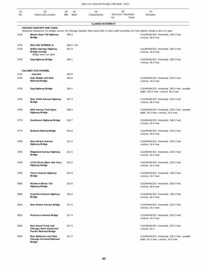
40
Light List corrected through LNM week: 01/17
(7)Remarks
(1)No.
(2)Name and Location
(3)Mile
(5)Characteristic
(4)Bank
(6)Structure / DayboardUp Down
Illinois State Toll Highway Bridge
WILLOW SPRINGS, ILWillow Springs Highway Bridge (swing)
Sag Highway Bridge
- JunctionGulf, Mobile and Ohio Railroad Bridge
Sag Highway Bridge
New 104th Avenue Highway Bridge
96th Avenue Twin Span Highway Bridge
Southwest Highway Bridge
Wabash Railrod Bridge
New Harlem Avenue Highway Bridge
Ridgeland Avenue Highway Bridge
127th Street (Burr Oak Ave.) Highway Bridge
Cicero Avenue Highway Bridge
Northern Illinois Toll Highway Bridge
Crawford Avenue Highway Bridge
New Kedzie Avenue Bridge
Francisco Avenue Bridge
New Grand Trunk and Chicago, Rock Island and Pacific Railroad Bridge
New Baltimore and Ohio Chicago Terminal Railroad Bridge
ILLINOIS WATERWAY
CHICAGO SANITARY SHIP CANAL
CALUMET-SAG CHANNEL
Horizontal clearances for bridges across the Chicago Sanitary Ship Canal refer to clear width providing 15.0 foot depths normal to axis of canal.
Left
309.3
308.5 307.9
304.1
303.5
303.8
304.2
307.3
308.4
310.7
310.8
311.5
312.5
314.2
314.9
315.6
316.0
317.0
317.4
317.5
317.5
Bridge does not open.
CLEARANCES: Horizontal, 240.0 feet; vertical, 39.6 feet.
CLEARANCES: Horizontal, 160.0 feet; vertical, 18.6 feet.
CLEARANCES: Horizontal, 160.0 feet; vertical, 39.4 feet.
CLEARANCES: Horizontal, 225.0 feet; vertical, 24.0 feet.
CLEARANCES: Horizontal, 250.0 feet, useablewidth, 225.0 feet; vertical, 39.4 feet.
CLEARANCES: Horizontal, 225.0 feet; vertical, 28.4 feet.
CLEARANCES: Horizontal, 225.0 feet, useablewidth, 60.0 feet; vertical, 24.6 feet.
CLEARANCES: Horizontal, 188.5 feet; vertical, 26.4 feet.
CLEARANCES: Horizontal, 225.0 feet; vertical, 43.9 feet.
CLEARANCES: Horizontal, 225.0 feet; vertical, 24.6 feet.
CLEARANCES: Horizontal, 225.0 feet; vertical, 24.4 feet.
CLEARANCES: Horizontal, 225.0 feet; vertical, 24.4 feet.
CLEARANCES: Horizontal, 199.0 feet; vertical, 24.5 feet.
CLEARANCES: Horizontal, 225.0 feet; vertical, 39.8 feet.
CLEARANCES: Horizontal, 199.4 feet; vertical, 26.4 feet.
CLEARANCES: Horizontal, 225.0 feet; vertical, 24.4 feet.
CLEARANCES: Horizontal, 225.0 feet; vertical, 24.4 feet.
CLEARANCES: Horizontal, 225.0 feet; vertical, 24.4.
CLEARANCES: Horizontal, 225.0 feet, useablewidth, 61.0 feet; vertical, 24.6 feet.
5725
57305735
5740
57455750
5755
5760
5765
5770
5775
5780
5785
5790
5795
5800
5805
5810
5815
5820
5825
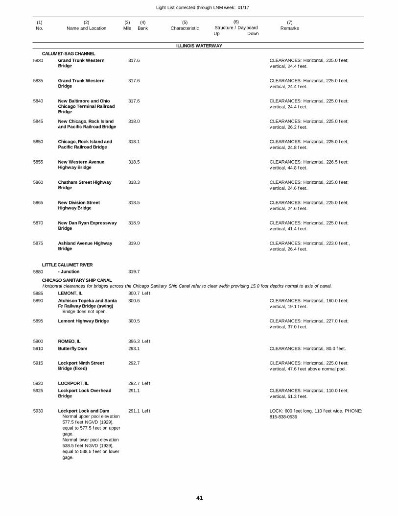
41
Light List corrected through LNM week: 01/17
(7)Remarks
(1)No.
(2)Name and Location
(3)Mile
(5)Characteristic
(4)Bank
(6)Structure / DayboardUp Down
Grand Trunk Western Bridge
Grand Trunk Western Bridge
New Baltimore and Ohio Chicago Terminal Railroad Bridge
New Chicago, Rock Island and Pacific Railroad Bridge
Chicago, Rock Island and Pacific Railroad Bridge
New Western Avenue Highway Bridge
Chatham Street Highway Bridge
New Division Street Highway Bridge
New Dan Ryan Expressway Bridge
Ashland Avenue Highway Bridge
- Junction
LEMONT, ILAtchison Topeka and Santa Fe Railway Bridge (swing)
Lemont Highway Bridge
ROMEO, ILButterfly Dam
Lockport Ninth Street Bridge (fixed)
LOCKPORT, ILLockport Lock Overhead Bridge
Lockport Lock and Dam
ILLINOIS WATERWAY
CALUMET-SAG CHANNEL
LITTLE CALUMET RIVER
CHICAGO SANITARY SHIP CANALHorizontal clearances for bridges across the Chicago Sanitary Ship Canal refer to clear width providing 15.0 foot depths normal to axis of canal.
Left
Left
Left
Left
317.6
317.6
317.6
318.0
318.1
318.5
318.3
318.5
318.9
319.0
319.7
300.7
300.6
300.5
396.3 293.1
292.7
292.7 291.1
291.1
Bridge does not open.
Normal upper pool elevation 577.5 feet NGVD (1929), equal to 577.5 feet on uppergage.Normal lower pool elevation 538.5 feet NGVD (1929), equal to 538.5 feet on lower gage.
CLEARANCES: Horizontal, 225.0 feet; vertical, 24.4 feet.
CLEARANCES: Horizontal, 225.0 feet; vertical, 24.4 feet.
CLEARANCES: Horizontal, 225.0 feet; vertical, 24.4 feet.
CLEARANCES: Horizontal, 225.0 feet; vertical, 26.2 feet.
CLEARANCES: Horizontal, 225.0 feet; vertical, 24.8 feet.
CLEARANCES: Horizontal, 226.5 feet; vertical, 44.8 feet.
CLEARANCES: Horizontal, 225.0 feet; vertical, 24.6 feet.
CLEARANCES: Horizontal, 225.0 feet; vertical, 24.6 feet.
CLEARANCES: Horizontal, 225.0 feet; vertical, 41.4 feet.
CLEARANCES: Horizontal, 223.0 feet;, vertical, 26.4 feet.
CLEARANCES: Horizontal, 160.0 feet; vertical, 19.1 feet.
CLEARANCES: Horizontal, 227.0 feet; vertical, 37.0 feet.
CLEARANCES: Horizontal, 80.0 feet.
CLEARANCES: Horizontal, 225.0 feet; vertical, 47.6 feet above normal pool.
CLEARANCES: Horizontal, 110.0 feet; vertical, 51.3 feet.
LOCK: 600 feet long, 110 feet wide. PHONE: 815-838-0536
5830
5835
5840
5845
5850
5855
5860
5865
5870
5875
5880
58855890
5895
59005910
5915
59205925
5930
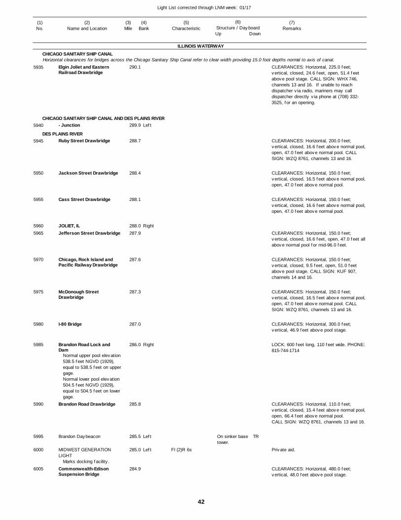
42
Light List corrected through LNM week: 01/17
(7)Remarks
(1)No.
(2)Name and Location
(3)Mile
(5)Characteristic
(4)Bank
(6)Structure / DayboardUp Down
Elgin Joliet and Eastern Railroad Drawbridge
- Junction
Ruby Street Drawbridge
Jackson Street Drawbridge
Cass Street Drawbridge
JOLIET, ILJefferson Street Drawbridge
Chicago, Rock Island and Pacific Railway Drawbridge
McDonough Street Drawbridge
I-80 Bridge
Brandon Road Lock and Dam
Brandon Road Drawbridge
Brandon Daybeacon
MIDWEST GENERATION LIGHT
Commonwealth-Edison Suspension Bridge
ILLINOIS WATERWAY
CHICAGO SANITARY SHIP CANAL
CHICAGO SANITARY SHIP CANAL AND DES PLAINS RIVER
DES PLAINS RIVER
Horizontal clearances for bridges across the Chicago Sanitary Ship Canal refer to clear width providing 15.0 foot depths normal to axis of canal.
Left
Right
Right
Left
Left
290.1
289.9
288.7
288.4
288.1
288.0 287.9
287.6
287.3
287.0
286.0
285.8
285.5
285.0
284.9
Normal upper pool elevation 538.5 feet NGVD (1929), equal to 538.5 feet on uppergage. Normal lower pool elevation 504.5 feet NGVD (1929), equal to 504.5 feet on lower gage.
Marks docking facility.
Fl (2)R 6s
On sinker base tower.
CLEARANCES: Horizontal, 225.0 feet; vertical, closed, 24.6 feet, open, 51.4 feet above pool stage. CALL SIGN: WHX 746, channels 13 and 16. If unable to reach dispatcher via radio, mariners may call dispatcher directly via phone at (708) 332-3525, for an opening.
CLEARANCES: Horizontal, 200.0 feet; vertical, closed, 16.6 feet above normal pool, open, 47.0 feet above normal pool. CALL SIGN: WZQ 8761, channels 13 and 16.
CLEARANCES: Horizontal, 150.0 feet; vertical, closed, 16.5 feet above normal pool, open, 47.0 feet above normal pool.
CLEARANCES: Horizontal, 150.0 feet; vertical, closed, 16.6 feet above normal pool, open, 47.0 feet above normal pool.
CLEARANCES: Horizontal, 150.0 feet; vertical, closed, 16.6 feet, open, 47.0 feet all above normal pool for mid-96.0 feet.
CLEARANCES: Horizontal, 150.0 feet; vertical, closed, 9.5 feet, open, 51.0 feet above pool stage. CALL SIGN: KUF 907, channels 14 and 16.
CLEARANCES: Horizontal, 150.0 feet; vertical, closed, 16.5 feet above normal pool, open, 47.0 feet above normal pool. CALL SIGN: WZQ 8761, channels 13 and 16.
CLEARANCES: Horizontal, 300.0 feet; vertical, 46.9 feet above pool stage.
LOCK: 600 feet long, 110 feet wide. PHONE: 815-744-1714
CLEARANCES: Horizontal, 110.0 feet; vertical, closed, 15.4 feet above normal pool, open, 66.4 feet above normal pool.CALL SIGN: WZQ 8761, channels 13 and 16.
CLEARANCES: Horizontal, 480.0 feet; vertical, 48.0 feet above pool stage.
5935
5940
5945
5950
5955
59605965
5970
5975
5980
5985
5990
5995
6000
6005
TR
Private aid.
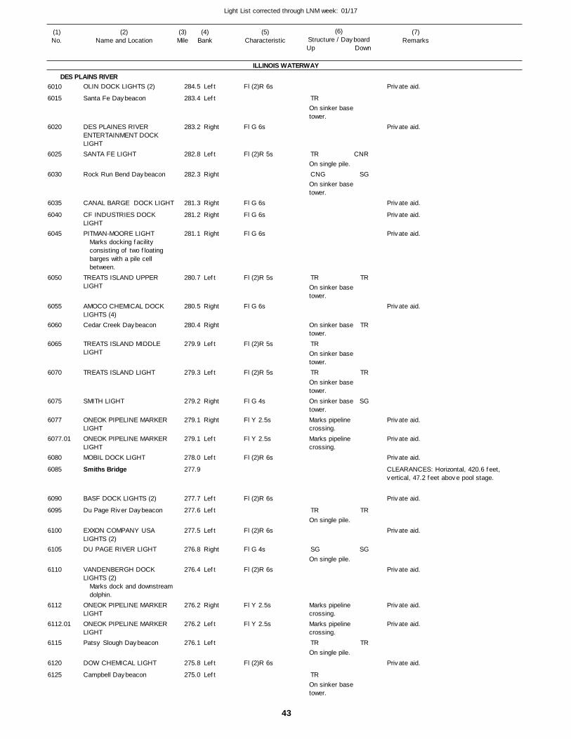
43
Light List corrected through LNM week: 01/17
(7)Remarks
(1)No.
(2)Name and Location
(3)Mile
(5)Characteristic
(4)Bank
(6)Structure / DayboardUp Down
OLIN DOCK LIGHTS (2)
Santa Fe Daybeacon
DES PLAINES RIVER ENTERTAINMENT DOCK LIGHTSANTA FE LIGHT
Rock Run Bend Daybeacon
CANAL BARGE DOCK LIGHT
CF INDUSTRIES DOCK LIGHTPITMAN-MOORE LIGHT
TREATS ISLAND UPPER LIGHT
AMOCO CHEMICAL DOCK LIGHTS (4)Cedar Creek Daybeacon
TREATS ISLAND MIDDLE LIGHT
TREATS ISLAND LIGHT
SMITH LIGHT
ONEOK PIPELINE MARKER LIGHTONEOK PIPELINE MARKER LIGHTMOBIL DOCK LIGHT
Smiths Bridge
BASF DOCK LIGHTS (2)
Du Page River Daybeacon
EXXON COMPANY USA LIGHTS (2)DU PAGE RIVER LIGHT
VANDENBERGH DOCK LIGHTS (2)
ONEOK PIPELINE MARKER LIGHTONEOK PIPELINE MARKER LIGHTPatsy Slough Daybeacon
DOW CHEMICAL LIGHT
Campbell Daybeacon
ILLINOIS WATERWAY
DES PLAINS RIVERLeft
Left
Right
Left
Right
Right
Right
Right
Left
Right
Right
Left
Left
Right
Right
Left
Left
Left
Left
Left
Right
Left
Right
Left
Left
Left
Left
284.5
283.4
283.2
282.8
282.3
281.3
281.2
281.1
280.7
280.5
280.4
279.9
279.3
279.2
279.1
279.1
278.0
277.9
277.7
277.6
277.5
276.8
276.4
276.2
276.2
276.1
275.8
275.0
Marks docking facility consisting of two floating barges with a pile cell between.
Marks dock and downstreamdolphin.
Fl (2)R 6s
Fl G 6s
Fl (2)R 5s
Fl G 6s
Fl G 6s
Fl G 6s
Fl (2)R 5s
Fl G 6s
Fl (2)R 5s
Fl (2)R 5s
Fl G 4s
Fl Y 2.5s
Fl Y 2.5s
Fl (2)R 6s
Fl (2)R 6s
Fl (2)R 6s
Fl G 4s
Fl (2)R 6s
Fl Y 2.5s
Fl Y 2.5s
Fl (2)R 6s
On sinker base tower.
On single pile.
On sinker base tower.
On sinker base tower.
On sinker base tower.
On sinker base tower.
On sinker base tower.On sinker base tower.Marks pipeline crossing.Marks pipeline crossing.
On single pile.
On single pile.
Marks pipeline crossing.Marks pipeline crossing.
On single pile.
On sinker base tower.
CLEARANCES: Horizontal, 420.6 feet, vertical, 47.2 feet above pool stage.
6010
6015
6020
6025
6030
6035
6040
6045
6050
6055
6060
6065
6070
6075
6077
6077.01
6080
6085
6090
6095
6100
6105
6110
6112
6112.01
6115
6120
6125
TR
TR
CNG
TR
TR
TR
TR
SG
TR
TR
CNR
SG
TR
TR
TR
SG
TR
SG
TR
Private aid.
Private aid.
Private aid.
Private aid.
Private aid.
Private aid.
Private aid.
Private aid.
Private aid.
Private aid.
Private aid.
Private aid.
Private aid.
Private aid.
Private aid.
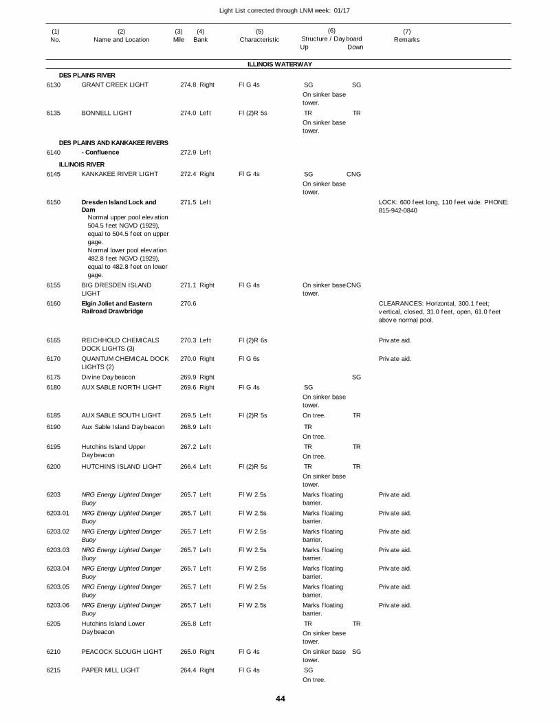
44
Light List corrected through LNM week: 01/17
(7)Remarks
(1)No.
(2)Name and Location
(3)Mile
(5)Characteristic
(4)Bank
(6)Structure / DayboardUp Down
GRANT CREEK LIGHT
BONNELL LIGHT
- Confluence
KANKAKEE RIVER LIGHT
Dresden Island Lock and Dam
BIG DRESDEN ISLAND LIGHTElgin Joliet and Eastern Railroad Drawbridge
REICHHOLD CHEMICALS DOCK LIGHTS (3)QUANTUM CHEMICAL DOCKLIGHTS (2)Divine DaybeaconAUX SABLE NORTH LIGHT
AUX SABLE SOUTH LIGHT
Aux Sable Island Daybeacon
Hutchins Island Upper Daybeacon
HUTCHINS ISLAND LIGHT
NRG Energy Lighted Danger BuoyNRG Energy Lighted Danger BuoyNRG Energy Lighted Danger BuoyNRG Energy Lighted Danger BuoyNRG Energy Lighted Danger BuoyNRG Energy Lighted Danger BuoyNRG Energy Lighted Danger BuoyHutchins Island Lower Daybeacon
PEACOCK SLOUGH LIGHT
PAPER MILL LIGHT
ILLINOIS WATERWAY
DES PLAINS RIVER
DES PLAINS AND KANKAKEE RIVERS
ILLINOIS RIVER
Right
Left
Left
Right
Left
Right
Left
Right
RightRight
Left
Left
Left
Left
Left
Left
Left
Left
Left
Left
Left
Left
Right
Right
274.8
274.0
272.9
272.4
271.5
271.1
270.6
270.3
270.0
269.9 269.6
269.5
268.9
267.2
266.4
265.7
265.7
265.7
265.7
265.7
265.7
265.7
265.8
265.0
264.4
Normal upper pool elevation 504.5 feet NGVD (1929), equal to 504.5 feet on uppergage. Normal lower pool elevation 482.8 feet NGVD (1929), equal to 482.8 feet on lower gage.
Fl G 4s
Fl (2)R 5s
Fl G 4s
Fl G 4s
Fl (2)R 6s
Fl G 6s
Fl G 4s
Fl (2)R 5s
Fl (2)R 5s
Fl W 2.5s
Fl W 2.5s
Fl W 2.5s
Fl W 2.5s
Fl W 2.5s
Fl W 2.5s
Fl W 2.5s
Fl G 4s
Fl G 4s
On sinker base tower.
On sinker base tower.
On sinker base tower.
On sinker base tower.
On sinker base tower.On tree.
On tree.
On tree.
On sinker base tower.Marks floating barrier.Marks floating barrier.Marks floating barrier.Marks floating barrier.Marks floating barrier.Marks floating barrier.Marks floating barrier.
On sinker base tower.On sinker base tower.
On tree.
LOCK: 600 feet long, 110 feet wide. PHONE: 815-942-0840
CLEARANCES: Horizontal, 300.1 feet; vertical, closed, 31.0 feet, open, 61.0 feet above normal pool.
6130
6135
6140
6145
6150
6155
6160
6165
6170
61756180
6185
6190
6195
6200
6203
6203.01
6203.02
6203.03
6203.04
6203.05
6203.06
6205
6210
6215
SG
TR
SG
SG
TR
TR
TR
TR
SG
SG
TR
CNG
CNG
SG
TR
TR
TR
TR
SG
Private aid.
Private aid.
Private aid.
Private aid.
Private aid.
Private aid.
Private aid.
Private aid.
Private aid.
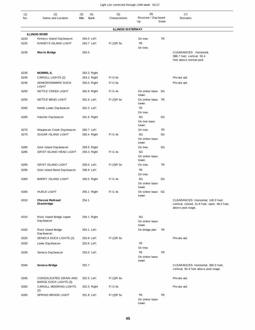
45
Light List corrected through LNM week: 01/17
(7)Remarks
(1)No.
(2)Name and Location
(3)Mile
(5)Characteristic
(4)Bank
(6)Structure / DayboardUp Down
Kinneys Island Daybeacon
KINNEYS ISLAND LIGHT
Morris Bridge
MORRIS, ILCARGILL LIGHTS (2)
ADM/GROWMARK DOCK LIGHTNETTLE CREEK LIGHT
NETTLE BEND LIGHT
Nettle Lower Daybeacon
Hatcher Daybeacon
Waupecan Creek DaybeaconSUGAR ISLAND LIGHT
Grist Island DaybeaconGRIST ISLAND HEAD LIGHT
GRIST ISLAND LIGHT
Grist Island Bend Daybeacon
BARRY ISLAND LIGHT
HUELE LIGHT
Chessie Railroad Drawbridge
Rock Island Bridge Upper Daybeacon
Rock Island Bridge DaybeaconSENECA DOCK LIGHTS (2)
Lewis Daybeacon
Seneca Daybeacon
Seneca Bridge
CONSOLIDATED GRAIN ANDBARGE DOCK LIGHTS (3)CARGILL MOORING LIGHTS (2)SPRING BROOK LIGHT
ILLINOIS WATERWAY
ILLINOIS RIVERLeft
Left
RightRight
Right
Right
Left
Left
Right
LeftRight
RightRight
Left
Left
Right
Right
Right
Left
Left
Left
Left
Left
Right
Left
264.0
263.7
263.5
263.3 263.2
263.0
262.8
262.6
262.3
261.6
260.7 260.4
259.5 259.3
259.0
258.9
256.0
255.1
254.1
254.1
254.1
253.8
253.6
253.0
252.7
252.5
252.5
251.8
Fl (2)R 5s
Fl G 6s
Fl G 6s
Fl G 4s
Fl (2)R 5s
Fl G 4s
Fl G 4s
Fl (2)R 5s
Fl G 4s
Fl G 4s
Fl (2)R 6s
Fl (2)R 6s
Fl G 6s
Fl (2)R 5s
On tree.
On tree.
On sinker base tower.On sinker base tower.
On tree.
On tree base tower.On tree.
On sinker base tower.On tree.
On sinker base tower.On tree.
On tree.
On sinker base tower.On sinker base tower.
On sinker base tower.On bridge pier.
On tree.
On sinker base tower.
On sinker base tower.
CLEARANCES: Horizontal,388.7 feet; vertical 50.4 feet above normal pool.
CLEARANCES: Horizontal, 140.0 feet; vertical, closed, 21.8 feet, open, 48.0 feet, above pool stage.
CLEARANCES: Horizontal, 360.0 feet; vertical, 50.4 feet above pool stage.
62206225
6230
62356240
6245
6250
6255
6260
6265
62706275
62806285
6290
6295
6300
6305
6310
6315
6320
6325
6330
6335
6340
6345
6350
6355
TR
TR
SG
SG
SG
TR
SG
SG
TR
TR
TR
TR
SG
TR
SG
TRSG
SG
TR
SG
SG
TR
TR
TR
Private aid.
Private aid.
Private aid.
Private aid.
Private aid.
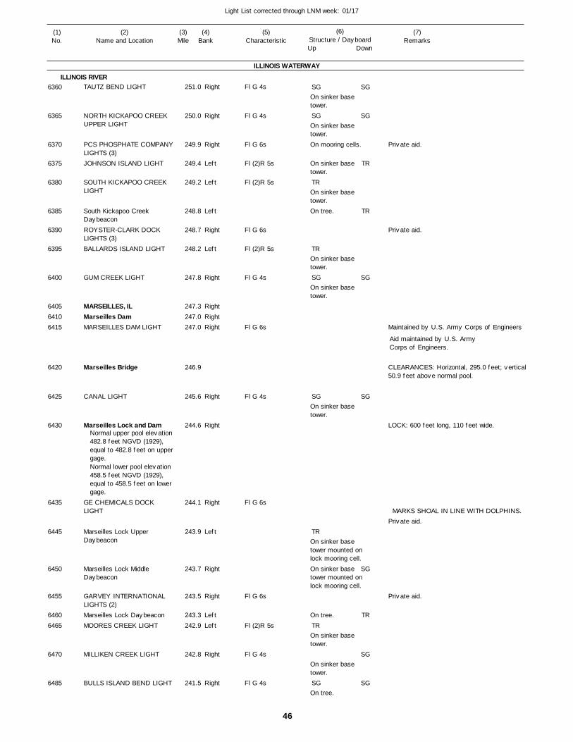
46
Light List corrected through LNM week: 01/17
(7)Remarks
(1)No.
(2)Name and Location
(3)Mile
(5)Characteristic
(4)Bank
(6)Structure / DayboardUp Down
TAUTZ BEND LIGHT
NORTH KICKAPOO CREEK UPPER LIGHT
PCS PHOSPHATE COMPANYLIGHTS (3)JOHNSON ISLAND LIGHT
SOUTH KICKAPOO CREEK LIGHT
South Kickapoo Creek DaybeaconROYSTER-CLARK DOCK LIGHTS (3)BALLARDS ISLAND LIGHT
GUM CREEK LIGHT
MARSEILLES, ILMarseilles DamMARSEILLES DAM LIGHT
Marseilles Bridge
CANAL LIGHT
Marseilles Lock and Dam
GE CHEMICALS DOCK LIGHT
Marseilles Lock Upper Daybeacon
Marseilles Lock Middle Daybeacon
GARVEY INTERNATIONAL LIGHTS (2)Marseilles Lock DaybeaconMOORES CREEK LIGHT
MILLIKEN CREEK LIGHT
BULLS ISLAND BEND LIGHT
ILLINOIS WATERWAY
ILLINOIS RIVERRight
Right
Right
Left
Left
Left
Right
Left
Right
RightRightRight
Right
Right
Right
Left
Right
Right
LeftLeft
Right
Right
251.0
250.0
249.9
249.4
249.2
248.8
248.7
248.2
247.8
247.3 247.0 247.0
246.9
245.6
244.6
244.1
243.9
243.7
243.5
243.3 242.9
242.8
241.5
Normal upper pool elevation 482.8 feet NGVD (1929), equal to 482.8 feet on uppergage. Normal lower pool elevation 458.5 feet NGVD (1929), equal to 458.5 feet on lower gage.
Fl G 4s
Fl G 4s
Fl G 6s
Fl (2)R 5s
Fl (2)R 5s
Fl G 6s
Fl (2)R 5s
Fl G 4s
Fl G 6s
Fl G 4s
Fl G 6s
Fl G 6s
Fl (2)R 5s
Fl G 4s
Fl G 4s
On sinker base tower.
On sinker base tower.On mooring cells.
On sinker base tower.
On sinker base tower.On tree.
On sinker base tower.
On sinker base tower.
On sinker base tower.
On sinker base tower mounted on lock mooring cell.On sinker base tower mounted on lock mooring cell.
On tree.
On sinker base tower.
On sinker base tower.
On tree.
Maintained by U.S. Army Corps of Engineers
CLEARANCES: Horizontal, 295.0 feet; vertical50.9 feet above normal pool.
LOCK: 600 feet long, 110 feet wide.
MARKS SHOAL IN LINE WITH DOLPHINS.
Aid maintained by U.S. ArmyCorps of Engineers.
6360
6365
6370
6375
6380
6385
6390
6395
6400
640564106415
6420
6425
6430
6435
6445
6450
6455
64606465
6470
6485
SG
SG
TR
TR
SG
SG
TR
TR
SG
SG
SG
TR
TR
SG
SG
SG
TR
SG
SG
Private aid.
Private aid.
Private aid.
Private aid.
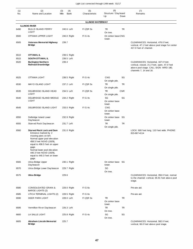
47
Light List corrected through LNM week: 01/17
(7)Remarks
(1)No.
(2)Name and Location
(3)Mile
(5)Characteristic
(4)Bank
(6)Structure / DayboardUp Down
BULLS ISLAND FERRY LIGHT
OTTAWA UPPER LIGHT
Veterans Memorial Highway Bridge
OTTAWA, ILSOUTH OTTAWA, ILBurlington Northern Railroad Drawbridge
OTTAWA LIGHT
MAYO ISLAND LIGHT
DELBRIDGE ISLAND HEAD LIGHT
DELBRIDGE ISLAND MIDDLELIGHT
DELBRIDGE ISLAND LIGHT
Delbridge Island Lower DaybeaconStarved Rock Daybeacon
Starved Rock Lock and Dam
Utica Bridge Upper DaybeaconUtica Bridge Lower Daybeacon
Utica Bridge
CONSOLIDATED GRAIN & BARGE LIGHTS (2)UTICA TERMINAL LIGHTS (2)
DEER PARK LIGHT
Vermillion River Daybeacon
LA SALLE LIGHT
Abraham Lincoln Memorial Bridge
ILLINOIS WATERWAY
ILLINOIS RIVERLeft
Right
RightLeft
Right
Left
Left
Right
Right
Right
Left
Right
Right
Right
Right
Right
Left
Left
Right
240.6
240.0
239.7
239.5 239.5 239.4
238.5
237.2
234.5
234.2
233.0
232.9
231.7
231.0
230.1
229.7
229.6
229.0
228.5
228.0
226.3
225.8
225.7
Entrance marked by 2 mooring piers on left.Normal upper pool elevation 458.5 feet NGVD (1929), equal to 458.5 feet on uppergage. Normal lower pool elevation 440.3 feet NGVD (1929), equal to 440.3 feet on lower gage.
Fl (2)R 5s
Fl G 4s
Fl G 4s
Fl (2)R 5s
Fl (2)R 5s
Fl G 4s
Fl G 4s
Fl G 6s
Fl G 6s
Fl (2)R 5s
Fl G 4s
On tree.On sinker base tower.
On single pile.
On single pile.
On single pile.
On sinker base tower.
On sinker base tower.On sinker base tower.
On single pile.
On sinker base tower.
On tree.
On sinker base tower.
On tree.
On tree.
CLEARANCES: Horizontal, 476.0 feet; vertical, 47.1 feet above pool stage for center 417.0 feet of channel.
CLEARANCES: Horizontal, 167.0 feet; vertical, closed, 21.2 feet, open, 47.0 feet above pool stage. CALL SIGN: WRD 180, channels 7, 14 and 16.
LOCK: 600 feet long, 110 feet wide. PHONE: 815-667-4114
CLEARANCES: Horizontal, 356.0 feet, normal to the channel; vertical, 65.91 feet above pool stage.
CLEARANCES: Horizontal, 582.0 feet; vertical, 66.0 feet above pool stage.
6490
6500
6505
651065156520
6525
6530
6535
6540
6545
6550
6555
6560
6565
6570
6575
6580
6585
6590
6595
6600
6605
TR
CNG
TR
TR
SG
CNG
TR
SG
TR
TR
SG
TR
CNG
SG
TR
CNR
SG
SG
TR
SG
TR
TR
SG
Private aid.
Private aid.
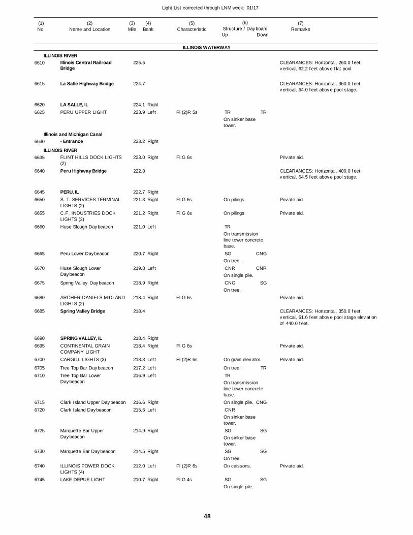
48
Light List corrected through LNM week: 01/17
(7)Remarks
(1)No.
(2)Name and Location
(3)Mile
(5)Characteristic
(4)Bank
(6)Structure / DayboardUp Down
Illinois Central Railroad Bridge
La Salle Highway Bridge
LA SALLE, ILPERU UPPER LIGHT
- Entrance
FLINT HILLS DOCK LIGHTS (2)Peru Highway Bridge
PERU, ILS. T. SERVICES TERMINAL LIGHTS (2)C.F. INDUSTRIES DOCK LIGHTS (2)Huse Slough Daybeacon
Peru Lower Daybeacon
Huse Slough Lower Daybeacon
Spring Valley Daybeacon
ARCHER DANIELS MIDLANDLIGHTS (2)Spring Valley Bridge
SPRING VALLEY, ILCONTINENTAL GRAIN COMPANY LIGHTCARGILL LIGHTS (3)
Tree Top Bar DaybeaconTree Top Bar Lower Daybeacon
Clark Island Upper DaybeaconClark Island Daybeacon
Marquette Bar Upper Daybeacon
Marquette Bar Daybeacon
ILLINOIS POWER DOCK LIGHTS (4)LAKE DEPUE LIGHT
ILLINOIS WATERWAY
ILLINOIS RIVER
Illinois and Michigan Canal
ILLINOIS RIVER
RightLeft
Right
Right
RightRight
Right
Left
Right
Left
Right
Right
RightRight
Left
LeftLeft
RightLeft
Right
Right
Left
Right
225.5
224.7
224.1 223.9
223.2
223.0
222.8
222.7 221.3
221.2
221.0
220.7
219.8
218.9
218.4
218.4
218.4 218.4
218.3
217.2 216.9
216.6 215.6
214.9
214.5
212.0
210.7
Fl (2)R 5s
Fl G 6s
Fl G 6s
Fl G 6s
Fl G 6s
Fl G 6s
Fl (2)R 6s
Fl (2)R 6s
Fl G 4s
On sinker base tower.
On pilings.
On pilings.
On transmission line tower concrete base.
On tree.
On single pile.
On tree.
On grain elevator.
On tree.
On transmission line tower concrete base.On single pile.
On sinker base tower.
On sinker base tower.
On tree.On caissons.
On single pile.
CLEARANCES: Horizontal, 260.0 feet; vertical, 62.2 feet above flat pool.
CLEARANCES: Horizontal, 360.0 feet; vertical, 64.0 feet above pool stage.
CLEARANCES: Horizontal, 400.0 feet; vertical, 64.5 feet above pool stage.
CLEARANCES: Horizontal, 350.0 feet; vertical, 61.6 feet above pool stage elevation of 440.0 feet.
6610
6615
66206625
6630
6635
6640
66456650
6655
6660
6665
6670
6675
6680
6685
66906695
6700
67056710
67156720
6725
6730
6740
6745
TR
TR
SG
CNR
CNG
TR
CNR
SG
SG
SG
TR
CNG
CNR
SG
TR
CNG
SG
SG
SG
Private aid.
Private aid.
Private aid.
Private aid.
Private aid.
Private aid.
Private aid.
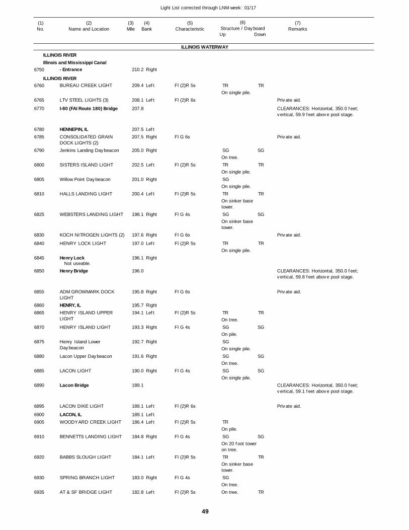
49
Light List corrected through LNM week: 01/17
(7)Remarks
(1)No.
(2)Name and Location
(3)Mile
(5)Characteristic
(4)Bank
(6)Structure / DayboardUp Down
- Entrance
BUREAU CREEK LIGHT
LTV STEEL LIGHTS (3)
I-80 (FAI Route 180) Bridge
HENNEPIN, ILCONSOLIDATED GRAIN DOCK LIGHTS (2)Jenkins Landing Daybeacon
SISTERS ISLAND LIGHT
Willow Point Daybeacon
HALLS LANDING LIGHT
WEBSTERS LANDING LIGHT
KOCH NITROGEN LIGHTS (2)
HENRY LOCK LIGHT
Henry Lock
Henry Bridge
ADM GROWMARK DOCK LIGHTHENRY, ILHENRY ISLAND UPPER LIGHT
HENRY ISLAND LIGHT
Henry Island Lower Daybeacon
Lacon Upper Daybeacon
LACON LIGHT
Lacon Bridge
LACON DIKE LIGHT
LACON, ILWOODYARD CREEK LIGHT
BENNETTS LANDING LIGHT
BABBS SLOUGH LIGHT
SPRING BRANCH LIGHT
AT & SF BRIDGE LIGHT
ILLINOIS WATERWAY
ILLINOIS RIVERIllinois and Mississippi Canal
ILLINOIS RIVER
Right
Left
Left
LeftRight
Right
Left
Right
Left
Right
Right
Left
Right
Right
RightLeft
Right
Right
Right
Right
Left
LeftLeft
Right
Left
Right
Left
210.2
209.4
208.1
207.8
207.5 207.5
205.0
202.5
201.0
200.4
198.1
197.6
197.0
196.1
196.0
195.8
195.7 194.1
193.3
192.7
191.6
190.0
189.1
189.1
189.1 186.4
184.8
184.1
183.0
182.8
Not useable.
Fl (2)R 5s
Fl (2)R 6s
Fl G 6s
Fl (2)R 5s
Fl (2)R 5s
Fl G 4s
Fl G 6s
Fl (2)R 5s
Fl G 6s
Fl (2)R 5s
Fl G 4s
Fl G 4s
Fl (2)R 6s
Fl (2)R 5s
Fl G 4s
Fl (2)R 5s
Fl G 4s
Fl (2)R 5s
On single pile.
On tree.
On single pile.
On single pile.
On sinker base tower.
On sinker base tower.
On single pile.
On tree.
On pile.
On single pile.
On tree.
On single pile.
On pile.
On 20 foot tower on tree.
On sinker base tower.
On tree.On tree.
CLEARANCES: Horizontal, 350.0 feet; vertical, 59.9 feet above pool stage.
CLEARANCES: Horizontal, 350.0 feet; vertical, 59.8 feet above pool stage.
CLEARANCES: Horizontal, 350.0 feet; vertical, 59.1 feet above pool stage.
6750
6760
6765
6770
67806785
6790
6800
6805
6810
6825
6830
6840
6845
6850
6855
68606865
6870
6875
6880
6885
6890
6895
69006905
6910
6920
6930
6935
TR
SG
TR
SG
TR
SG
TR
TR
SG
SG
SG
SG
TR
SG
TR
SG
TR
SG
TR
TR
SG
TR
TR
SG
SG
SG
SG
TR
TR
Private aid.
Private aid.
Private aid.
Private aid.
Private aid.

50
Light List corrected through LNM week: 01/17
(7)Remarks
(1)No.
(2)Name and Location
(3)Mile
(5)Characteristic
(4)Bank
(6)Structure / DayboardUp Down
Atchison Topeka and Santa Fe Railroad Bridge
Chillicothe Upper Daybeacon
CHILLICOTHE, ILChillicothe DaybeaconCHILLICOTHE ISLAND LIGHT
ROME, ILROME LIGHT
SAND POINT LIGHT
SAND POINT LOWER LIGHT
CIRCLE LIGHT
SPRING BAY LIGHT
SPRING BAY, ILBLUE CREEK POINT MIDDLELIGHT
BLUE CREEK POINT LOWERLIGHT
MOSSVILLE, ILDETWEILLER PARK LIGHT
DROLLS POINT UPPER LIGHT
DROLLS POINT LIGHT
PEORIA HEIGHTS LIGHT
PEORIA LAKE NARROWS LIGHTMcClugage Dual Bridge
MCCLUGGAGE BRIDGE LIGHT
AVERY LIGHT
LETOURNEAU POINT UPPERLIGHT
LETOURNEAU POINT LIGHT
EASTPORT MARINA LIGHT
EASTPORT MARINA LIGHT
- Entrance
ILLINOIS WATERWAY
ILLINOIS RIVER
Greater Peoria Riverboat Channel
Left
RightRightLeft
RightLeft
Right
Left
Right
Right
LeftLeft
Right
RightRight
Left
Right
Left
Right
Right
Left
Left
Right
Left
Left
Left
181.9
181.3
180.5 180.2 179.0
177.8 177.4
176.6
175.5
174.9
174.3
174.0 172.8
172.5
171.9 170.9
169.9
168.9
167.9
166.6
165.8
165.3
165.3
164.5
164.4
164.3
164.3
164.0
Fl (2)R 5s
Fl (2)R 5s
Fl G 4s
Fl (2)R 5s
Fl G 4s
Fl G 4s
Fl (2)R 5s
Fl G 4s
Fl G 4s
Fl (2)R 5s
Fl G 4s
Fl (2)R 5s
Fl G 4s
Fl G 4s
Fl (2)R 5s
Fl (2)R 5s
Fl G 4s
Fl (2)R 6s
Fl G 6s
On tree.
On tree.
On concrete tower on caisson.
On concrete tower on caisson.
On tower on caisson.
On 4 pile dolphin.
On 4 pile dolphin.
On 4 pile dolphin.
On 4 pile dolphin.
On 4 pile dolphin.
On tower on caisson.
On 4 pile dolphin.
On concrete tower on caisson.
On 4 pile dolphin.On sinker base tower
On 4 pile dolphin.
On tower on caisson.
On 3 pile dolphin.
On sinker base tower.
CLEARANCES: Horizontal, 360.0 feet; vertical, 58.8 feet above pool stage.
CLEARANCES: Horizontal,center span, 411.0 feet;vertical, 65.8 feetabove pool stage.
6945
6950
695569606965
69706975
6980
6985
6990
6995
70007010
7015
70207025
7030
7035
7040
7045
7050
7055
7060
7065
7070
7072
7072.1
7075
TR
TR
TR
SG
CNR
CNG
SG
TR
SG
CNG
TR
SG
TR
SG
CNR
CNR
CNG
TR
SGTR
TR
CNG
CNR
SG
CNG
TR
CNG
SG
TR
SG
TR
CNG
SG
CNR
TR
SG
Private aid.
Private aid.
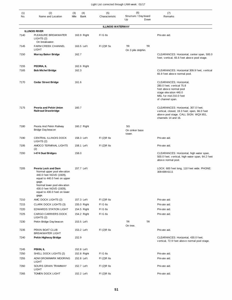
51
Light List corrected through LNM week: 01/17
(7)Remarks
(1)No.
(2)Name and Location
(3)Mile
(5)Characteristic
(4)Bank
(6)Structure / DayboardUp Down
PLEASURE BREAKWATER LIGHTS (2)
FARM CREEK CHANNEL LIGHT
Murray Baker Bridge
PEORIA, ILBob Michel Bridge
Cedar Street Bridge
Peoria and Pekin Union Railroad Drawbridge
Peoria And Pekin Railway Bridge Daybeacon
CENTRAL ILLINOIS DOCK LIGHTS (2)AMOCO TERMINAL LIGHTS (2)I-474 Dual Bridges
Peoria Lock and Dam
AMC DOCK LIGHTS (2)
CLARK DOCK LIGHTS (3)
EDWARDS STATION LIGHT
CARGO CARRIERS DOCK LIGHTS (2)Pekin Bridge Daybeacon
PEKIN BOAT CLUB BREAKWATER LIGHTPekin Highway Bridge
PEKIN, ILSHELL DOCK LIGHTS (2)
ADM GROWMARK MOORINGLIGHTSOURS GRAIN TRAMWAY LIGHTTOMEN DOCK LIGHT
ILLINOIS WATERWAY
ILLINOIS RIVERRight
Left
Right
Right
Left
Left
Left
Left
Right
Right
Right
Left
Left
LeftRight
Left
Left
Left
163.9
163.5
162.7
162.6 162.3
161.6
160.7
160.2
158.3
158.1
158.0
157.7
157.3
155.0
154.5
154.2
153.5
153.2
152.9
152.8 152.8
152.8
152.7
152.2
On breakwater.
Normal upper pool elevation 440.0 feet NGVD (1929), equal to 440.0 feet on uppergage.Normal lower pool elevation 430.0 feet NGVD (1929), equal to 430.0 feet on lower gage.
Fl G 6s
Fl (2)R 5s
Fl (2)R 6s
Fl (2)R 6s
Fl (2)R 6s
Fl G 6s
Fl G 6s
Fl G 6s
Fl (2)R 6s
Fl G 6s
Fl (2)R 6s
Fl (2)R 6s
Fl (2)R 6s
On 3 pile dolphin.
On sinker base tower.
On tree.
CLEARANCES: Horizontal, center span, 500.0 feet; vertical, 65.6 feet above pool stage.
CLEARANCES: Horizontal 309.9 feet, vertical 65.9 feet above normal pool.
CLEARANCES; Horizontal, 280.0 feet; vertical 75.8feet above normal poolstage elevation 440.0MSL for mid-210.0 feetof channel span.
CLEARANCES: Horizontal, 307.0 feet; vertical, closed, 19.3 feet; open, 66.0 feet above pool stage. CALL SIGN: WQX 651, channels 14 and 16.
CLEARANCES: Horizontal, high water span, 500.0 feet; vertical, high water span, 64.2 feet above normal pool.
LOCK: 600 feet long, 110 feet wide. PHONE: 309-699-6111
CLEARANCES: Horizontal, 430.0 feet; vertical, 72.9 feet above normal pool stage.
7140
7145
7150
71557165
7170
7175
7180
7190
7195
7200
7205
7210
7215
7220
7225
7230
7235
7240
72457250
7255
7260
7265
TR
SG
TR
TR
TR
Private aid.
Private aid.
Private aid.
Private aid.
Private aid.
Private aid.
Private aid.
Private aid.
Private aid.
Private aid.
Private aid.
Private aid.
52
Light List corrected through LNM week: 01/17
(7)Remarks
(1)No.
(2)Name and Location
(3)Mile
(5)Characteristic
(4)Bank
(6)Structure / DayboardUp Down
PEKIN ENERGY COMPANY LIGHTS (2)
MIDWEST GRAIN DOCK LIGHTS (2)Chicago & Northwestern Railroad Bridge (Pekin Railroad Bridge)
Pekin Daybeacon
Turkey Island Upper Upper DaybeaconADM GROWMARK MOORINGLIGHTS (3)Turkey Island Daybeacon
MACKANAW RIVER LIGHT
KINGSTON LANDING, ILKINGSTON LANDING LIGHT
CF INDUSTRIES DOCK LIGHTLANCASTER LANDING, ILLancaster Landing Daybeacon
Coon Hollow Island Daybeacon
Canton Landing Daybeacon
COPPERAS CREEK LOCK LIGHT
Lock Pond DaybeaconCopperas Creek Lock
Duck Island Daybeacon
SPRING LAKE SLOUGH LIGHTSpring Lake Slough Lower Daybeacon
WOODYARD LIGHT
LIVERPOOL LIGHT
FREEMAN COAL DOCK LIGHTS (3)LIVERPOOL, ILGARVEY MARINE DOCK LIGHTS (2)Thompson Lake Slough Daybeacon
Chautauqua Bend Daybeacon
Quiver Beach Daybeacon
ILLINOIS WATERWAY
ILLINOIS RIVERLeft
Left
Left
Left
Right
Right
Left
RightRight
Right
RightLeft
Left
Right
Right
LeftRight
Right
Left
Left
Right
Right
Right
RightRight
Right
Right
Left
151.7
151.4
151.2
150.9
149.4
149.4
148.5
147.3
145.6 145.5
145.4
144.1 143.2
140.9
139.0
136.9
136.9 136.8
135.7
134.0
133.9
132.0
129.5
128.5
128.0 127.0
125.8
123.6
122.8
Not useable.
Fl (2)R 6s
Fl (2)R 6s
Fl G 6s
Fl (2)R 5s
Fl G 4s
Fl G 6s
Fl G 4s
Fl (2)R 5s
Fl G 4s
Fl G 4s
Fl G 6s
Fl G 6s
On tree.On tree.
On tree.
On sinker base tower.
On sinker base tower.
On tree.
On tree.
On sinker base tower.
On sinker base tower.On tree.
On tree.On tree.
On tree.
On pile.
On tree.
On single pile.
On sinker base tower.
On tree.
MARKS WATER INTAKE.
CLEARANCES: Horizontal, 150.0 feet; vertical, closed, 34.3 feet, open, 73.3 feet above normal pool stage.
7270
7275
7280
7285
7290
7295
7300
7310
73207325
7330
73357340
7350
7355
7365
73707375
7380
7385
7390
7395
7405
7410
74157425
7430
7435
7440
TR
SG
TR
SG
TR
TR
SG
SG
CNG
TR
SG
SG
SG
SG
TR
CNR
TR
TR
SG
TR
TR
SG
TR
SG
TR
SG
SG
SG
TR
Private aid.Private aid.
Private aid.
Private aid.
Private aid.
Private aid.
53
Light List corrected through LNM week: 01/17
(7)Remarks
(1)No.
(2)Name and Location
(3)Mile
(5)Characteristic
(4)Bank
(6)Structure / DayboardUp Down
SIEBS LAKE LIGHT
HAVANA, ILCARGILL MOORING LIGHTS (2)CARGILL MOORING LIGHTS (2)ADM GROWMARK DOCK LIGHTS (2)Havana Highway Bridge
TABOR GRAIN DOCK LIGHTS (2)IMPERIAL VALLEY DOCK LIGHTS (2)DYNEGY MIDWEST MOORING CELL LIGHTS (6)Havana Daybeacon
DEVILS ELBOW UPPER LIGHT
Devils Elbow Lower Daybeacon
GRAND ISLAND HEAD LIGHT
Otter Creek DaybeaconGrand Island Daybeacon
ANDERSON LAKE LIGHT
GRAND ISLAND FOOT LIGHT
GRAND ISLAND BEND LIGHT
SHARP LANDING LIGHT
HICKORY ISLAND LIGHT
SANGAMON CHUTE UPPER LIGHT
Sangamon Chute Daybeacon
SANGAMON CHUTE LIGHT
BROWNING, ILSUGAR CREEK LIGHT
Sugar Creek Island DaybeaconSUGAR CREEK BAR LIGHT
FREDERICK, ILFREDERICK LIGHT
ADM GROWMARK LIGHTS (2)
ILLINOIS WATERWAY
ILLINOIS RIVERRight
LeftLeft
Left
Left
Left
Left
Left
Left
Right
Left
Left
RightLeft
Right
Left
Left
Right
Left
Right
Left
Left
RightRight
Left
Left
RightRight
Right
121.1
120.1 119.9
119.8
119.7
119.6
119.2
119.0
118.4
117.6
116.3
114.4
113.3
111.4 110.2
109.4
106.9
105.6
103.6
100.9
99.5
98.5
98.2
97.3 94.7
94.3
93.6
91.7 91.5
91.1
Fl G 4s
Fl (2)R 6s
Fl (2)R 6s
Fl (2)R 6s
Fl (2)R 6s
Fl (2)R 6s
Fl (2)R 6s
Fl G 4s
Fl (2)R 5s
Fl G 4s
Fl (2)R 5s
Fl (2)R 5s
Fl G 4s
Fl (2)R 5s
Fl G 4s
Fl (2)R 5s
Fl G 4s
Fl (2)R 5s
Fl G 4s
Fl G 6s
On single pile.
On tree.
On sinker base tower.
On tree.
On tree.
On tree.
On tree.
On single pile.
On sinker base tower.
On sinker base tower.
On single pile.
On sinker base tower.
On tree.
On sinker base tower.
On single pile.On tree.
On sinker base tower.
On single pile.
CLEARANCES: Horizontal, 350.0 feet; vertical, 68.4 feet above normal pool stage.
7445
74507455
7460
7465
7470
7475
7480
7485
7490
7495
7500
7505
75107515
7520
7525
7530
7535
7540
7545
7550
7555
75607565
7570
7575
75807585
7590
SG
TR
SG
TR
TR
SGTR
SG
TR
TR
SG
TR
SG
TR
TR
SG
TR
SG
SG
TR
SG
TR
TR
SGTR
SG
TR
TR
SG
TR
SG
TR
SG
TR
TR
SG
Private aid.
Private aid.
Private aid.
Private aid.
Private aid.
Private aid.
Private aid.
54
Light List corrected through LNM week: 01/17
(7)Remarks
(1)No.
(2)Name and Location
(3)Mile
(5)Characteristic
(4)Bank
(6)Structure / DayboardUp Down
Beardstown Railroad Bridge DaybeaconBeardstown Railroad Drawbridge
BEARDSTOWN, ILCARGILL DOCK LIGHTS (2)
Beardstown Bridge
GRAPE ISLAND LIGHT
Grape Island Lower DaybeaconCoal Creek Island Daybeacon
BRIGGS LANDING LIGHT
BEAVER DAM LIGHT
LA GRANGE LANDING, ILLa Grange Lock and Dam
Indian Creek Upper DaybeaconIndian Creek Lower Daybeacon
La Grange Lock Daybeacon
MOORES ISLAND LIGHT
Kamp Creek Lower Daybeacon
Wilson Island Daybeacon
MEREDOSIA TERMINAL DOCK LIGHTS (5)MEREDOSIA, ILMeredosia Bridge
CARGILL TERMINAL LIGHTS (2)PUBLIC SERVICE CO. DOCKLIGHTS (6)
ILLINOIS WATERWAY
ILLINOIS RIVERLeft
LeftLeft
Left
Left
Right
Right
Left
RightRight
Left
Left
Left
Right
Right
Right
Right
Left
Left
Left
89.3
88.8
88.5 88.2
87.9
87.0
86.4
85.5
84.1
82.3
80.3 80.2
78.8
78.4
76.9
75.9
74.5
73.0
71.7
71.3 71.3
71.2
70.6
Normal upper pool elevation 429.0 feet NGVD (1929), equal to 429.0 feet on uppergage. Normal lower pool elevation 419.6 feet NGVD (1929), equal to 419.6 feet on lower gage.
Fl (2)R 6s
Fl (2)R 5s
Fl G 4s
Fl (2)R 5s
Fl G 4s
Fl G 6s
Fl (2)R 6s
Fl (2)R 6s
On tree.
On tree.On tree.
On tree.
On skeleton base tower.
On sinker base tower.
On tree.
On tree.
On single pile.
On single pile.
On tree.
On tree.
CLEARANCES: Horizontal,300.0 feet; vertical, open, 68.5 feet, closed,19.6 feet above normalpool stage 429.0. Left in open positionexcept during passageof trains.CALL SIGN: KLU 801, channels 14 and 16.
CLEARANCES: Horizontal, 526.0 feet; vertical, 68.5 feet above pool stage.
LOCK: 600 feet long, 110 feet wide. PHONE: 217-225-3317
CLEARANCES: Horizontal, 554.7 feet; vertical, 72.0 feet above pool elevation 429.0 feet.
7600
7610
76157620
7625
7630
7635
7645
7650
7655
76657670
7680
7685
7690
7695
7700
7705
7710
77157720
7725
7730
TR
SG
SG
TR
TR
TR
SG
SG
SG
TR
TR
SG
TR
TR
TR
SG
SG
SG
Private aid.
Private aid.
Private aid.
Private aid.
55
Light List corrected through LNM week: 01/17
(7)Remarks
(1)No.
(2)Name and Location
(3)Mile
(5)Characteristic
(4)Bank
(6)Structure / DayboardUp Down
NATIONAL STARCH MOORING LIGHTROYSTER CLARK NITROGEN DOCK LIGHTS(2)Meredosia Island Daybeacon
Meredosia Lower Island DaybeaconMCGEES CREEK LIGHT
ADM GROWMARK GRAIN ELEVATOR LIGHTS (2)NAPLES, ILCONSOLIDATED GRAIN & BARGE TERMINAL LIGHTS (2)Mauvaise Terre Daybeacon
Valley City Bridge DaybeaconNorfolk and Western Railroad Drawbridge
Owens Daybeacon
GRIGGSVILLE LANDING, ILFA 480 Dual Bridges (Valley City Dual Bridges)
Big Blue Island Lower Daybeacon
Hulett DaybeaconBEVINGTON LIGHT
Bevington Daybeacon
Florence Highway Drawbridge
FLORENCE, ILCARGILL DOCK LIGHT
FLORENCE LIGHT
LITTLE BLUE LIGHT
MONTEZUMA, ILGLASGOW LANDING LIGHT
BEDFORD, ILPilot Peak Bend Daybeacon
Buckhorn Island Daybeacon
Van Geson Island Daybeacon
GRAND PASS BRIDGE UPPER LIGHT
ILLINOIS WATERWAY
ILLINOIS RIVERLeft
Left
Right
Right
Right
Left
LeftLeft
Left
Right
Right
Right
Right
LeftLeft
Left
RightRight
Right
Left
RightLeft
RightLeft
Right
Left
Right
70.0
69.5
69.4
68.5
66.6
66.2
65.6 64.8
62.8
62.7 61.4
61.0
60.9 60.2
57.8
57.5 56.6
56.4
56.0
55.7 55.3
55.0
53.8
50.1 50.0
48.5 47.8
46.1
44.9
44.1
Fl (2)R 6s
Fl (2)R 6s
Fl G 4s
Fl (2)R 6s
Fl (2)R 6s
Fl (2)R 5s
Fl G 6s
Fl G 4s
Fl (2)R 5s
Fl (2)R 5s
Fl G 4s
On tree.On tree.
On single pile.
On single pile.On single pile.
On tree.
On single pile.On pile.On pile.
On tree.
On sinker base tower.
On single pile.
On pile.
On pile.
On pile.
On tree.
On sinker base tower.
CLEARANCES: Horizontal, center, 300.6 feet; vertical, open, 78.4 feet, closed, 32.4 feet above normal pool stage elevation 419.9. CALL SIGN: KTR 857, channels 14 and 16.
CLEARANCES: Horizontal, 535.0 feet normal to axis of channel; vertical, 71.5 feet above normal lower pool for mid 474.0 feet.
CLEARANCES: Horizontal, 203.2 feet; vertical, 26.6 feet above normal pool closed, 83.4 feet above normal pool open.
7735
7740
7745
7750
7755
7760
77657770
7780
77857790
7795
78007805
7810
78157820
7825
7835
78407845
7850
7855
78607865
78707875
7880
7885
7890
SG
SG
TR
SG
SG
TR
SG
TR
TR
TR
SG
TR
SG
SG
SG
SG
TRTR
TR
TR
TR
SG
TR
SG
Private aid.
Private aid.
Private aid.
Private aid.
Private aid.
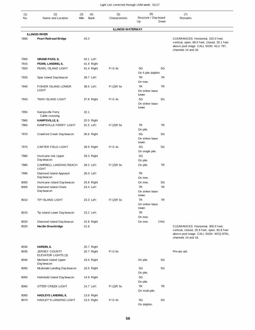
56
Light List corrected through LNM week: 01/17
(7)Remarks
(1)No.
(2)Name and Location
(3)Mile
(5)Characteristic
(4)Bank
(6)Structure / DayboardUp Down
Pearl Railroad Bridge
GRAND PASS, ILPEARL LANDING, ILPEARL ISLAND LIGHT
Spar Island Daybeacon
FISHER ISLAND LOWER LIGHT
TWIN ISLAND LIGHT
Kampsville Ferry
KAMPSVILLE, ILKAMPSVILLE FERRY LIGHT
Crawford Creek Daybeacon
CARTER FIELD LIGHT
Hurricane Isle Upper Daybeacon
CAMPBELL LANDING REACHLIGHTDiamond Island Appoach Daybeacon
Hurricane Island DaybeaconDiamond Island Chute Daybeacon
TIP ISLAND LIGHT
Tip Island Lower Daybeacon
Diamond Island DaybeaconHardin Drawbridge
HARDIN, ILJERSEY COUNTY ELEVATOR LIGHTS (3)Mortland Island Upper DaybeaconMcdonald Landing Daybeacon
Helmbold Island Daybeacon
OTTER CREEK LIGHT
HADLEYS LANDING, ILHADLEY'S LANDING LIGHT
ILLINOIS WATERWAY
ILLINOIS RIVER
LeftRightRight
Left
Left
Right
RightLeft
Right
Right
Right
Left
Left
RightLeft
Left
Left
Right
RightRight
Right
Right
Right
Left
RightRight
43.2
43.1 41.9 41.4
39.7
38.5
37.8
32.1
32.0 31.5
30.6
28.9
28.3
28.2
26.0
25.9 24.4
23.3
23.2
22.8 21.6
20.7 20.7
19.4
16.5
14.9
14.7
13.6 13.5
Cable crossing.
Fl G 4s
Fl (2)R 5s
Fl G 4s
Fl (2)R 5s
Fl G 4s
Fl (2)R 5s
Fl (2)R 5s
Fl G 6s
Fl (2)R 5s
Fl G 4s
On 5 pile dolphin.
On tree.
On sinker base tower.
On sinker base tower.
On pile.
On sinker base tower.
On single pile.
On pile.On pile.
On tree.On tree.
On sinker base tower.
On sinker base tower.
On tree.On tree.
On pile.
On pile.
On pile.
On multi-pile.
On dolphin.
CLEARANCES: Horizontal, 315.0 feet; vertical, open, 69.0 feet, closed, 20.1 feet above pool stage. CALL SIGN: KLU 797, channels 14 and 16.
CLEARANCES: Horizontal, 300.0 feet; vertical, closed, 25.9 feet, open, 82.8 feet above pool stage. CALL SIGN: WZQ 8761, channels 14 and 16.
7895
790079157920
7925
7940
7943
7955
79607965
7970
7975
7980
7985
7995
80008005
8010
8015
80208025
80308035
8040
8050
8055
8060
80658070
SG
TR
TR
SG
TR
SG
SG
SG
TR
TR
TR
TR
SG
SG
TR
SG
SG
TR
TR
SG
TR
SG
SG
TR
SGTR
TR
CNG
SG
SG
TR
SG
Private aid.
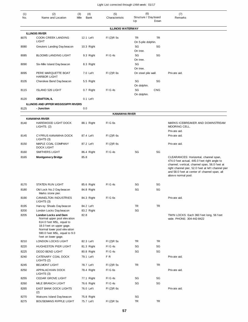
57
Light List corrected through LNM week: 01/17
(7)Remarks
(1)No.
(2)Name and Location
(3)Mile
(5)Characteristic
(4)Bank
(6)Structure / DayboardUp Down
COON CREEK LANDING LIGHT
Greuters Landing Daybeacon
BLOOMS LANDING LIGHT
Six-Mile Island Daybeacon
PERE MARQUETTE BOAT HARBOR LIGHTCherokee Bend Daybeacon
ISLAND 526 LIGHT
GRAFTON, IL
- Junction
HAREWOOD LIGHT DOCK LIGHTS. (2)
CYPRUS KANAWHA DOCK LIGHTS (3)MAPLE COAL COMPANY DOCK LIGHTSMITHERS LIGHT
Montgomery Bridge
STATEN RUN LIGHT
Old Lock No.2 Daybeacon
CANNELTON INDUSTRIES LIGHTS (3)Harvey Shoals DaybeaconLondon Locks DaybeaconLondon Locks and Dam
LONDON LOCKS LIGHT
HUGHESTON PIER LIGHT
DEGO BEND LIGHT
CATENARY COAL DOCK LIGHTS (2)BELMONT LIGHT
APPALACHIAN DOCK LIGHTS (3)CEDAR GROVE LIGHT
MILE BRANCH LIGHT
EAST BANK DOCK LIGHTS (2)Watsons Island DaybeaconBOUSEMANS RIPPLE LIGHT
ILLINOIS WATERWAY
ILLINOIS RIVER
ILLINOIS AND UPPER MISSISSIPPI RIVERS
KANAWHA RIVER
KANAWHA RIVER
Left
Right
Right
Right
Left
Right
Right
Left
Right
Left
Left
Right
Right
Right
Right
LeftRight
Left
Right
Right
Left
Left
Right
Right
Right
Left
RightLeft
12.1
10.3
9.3
8.3
7.0
5.5
0.7
0.1
0.0
88.1
87.4
87.2
86.4
85.8
85.6
84.8
84.3
84.2 83.2 82.8
82.3
81.3
80.8
79.1
78.7
78.4
77.1
76.6
76.0
75.8 75.7
Marks stone pier.
Normal upper pool elevation 614.0 feet MSL, equal to 18.0 feet on upper gage. Normal lower pool elevation 590.0 feet MSL, equal to 9.0feet on lower gage.
Fl (2)R 5s
Fl G 4s
Fl (2)R 6s
Fl G 4s
Fl G 6s
Fl (2)R 6s
Fl (2)R 6s
Fl G 4s
Fl G 4s
Fl G 6s
Fl (2)R 5s
Fl G 4s
Fl G 4s
F R
Fl (2)R 5s
Fl G 6s
Fl G 4s
Fl G 4s
Fl (2)R 6s
Fl (2)R 5s
On 5-pile dolphin.
On tree.
On tree.
On tree.On steel pile wall.
On dolphin.
On dolphin.
MARKS ICEBREAKER AND DOWNSTREAM MOORING CELL.
CLEARANCES: Horizontal, channel span, 474.0 feet actual, 445.0 feet right angle to channel; vertical, channel span, 56.0 feet at right channel pier, 52.0 feet at left channel pierand 58.0 feet at center of channel span, all above normal pool.
TWIN LOCKS: Each 360 feet long, 56 feet wide. PHONE: 304-442-8422
8075
8080
8085
8090
8095
8105
8115
8120
8125
8140
8145
8150
8160
8165
8170
8180
8190
819582008205
8210
8220
8225
8240
8245
8250
8255
8260
8265
82708275
TR
SG
SG
SG
SG
SG
SG
SG
SG
TRSG
TR
SG
SG
TR
SG
SG
SGTR
TR
SG
SG
SG
CNG
SG
SG
SG
TR
TR
SG
SG
TR
SG
SG
TR
Private aid.
Private aid.Private aid.
Private aid.
Private aid.
Private aid.
Private aid.
Private aid.
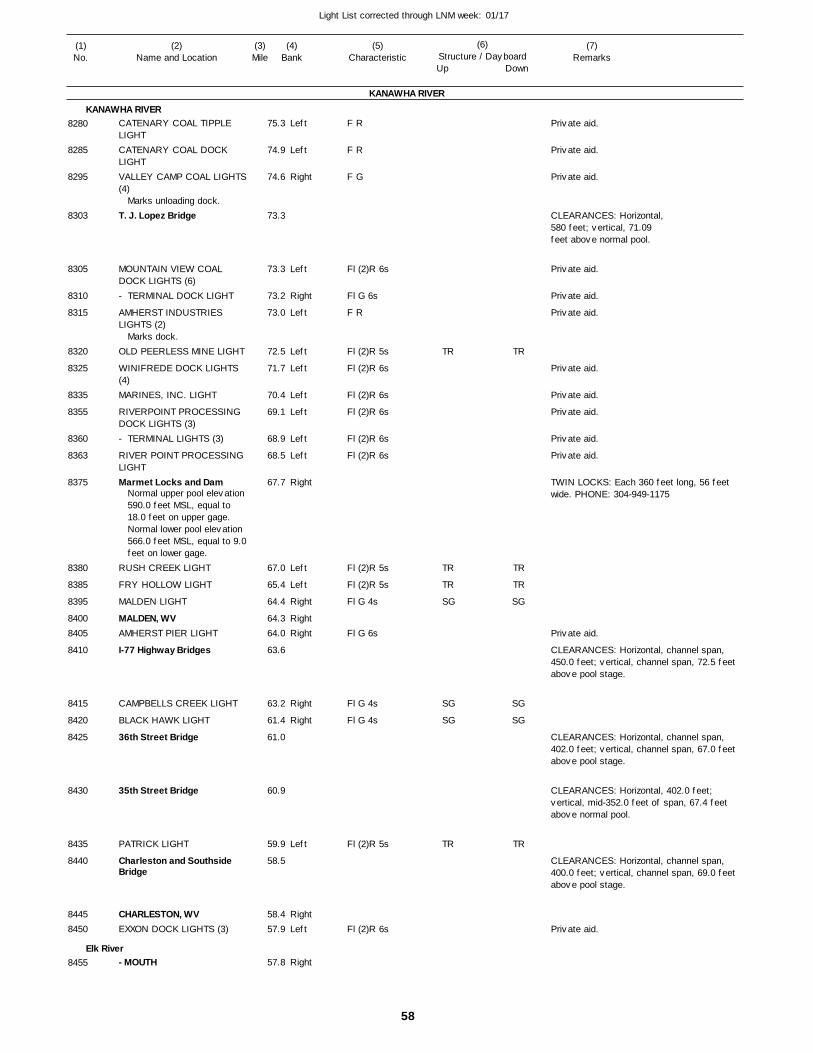
58
Light List corrected through LNM week: 01/17
(7)Remarks
(1)No.
(2)Name and Location
(3)Mile
(5)Characteristic
(4)Bank
(6)Structure / DayboardUp Down
CATENARY COAL TIPPLE LIGHTCATENARY COAL DOCK LIGHTVALLEY CAMP COAL LIGHTS(4)
T. J. Lopez Bridge
MOUNTAIN VIEW COAL DOCK LIGHTS (6)- TERMINAL DOCK LIGHT
AMHERST INDUSTRIES LIGHTS (2)
OLD PEERLESS MINE LIGHT
WINIFREDE DOCK LIGHTS (4)MARINES, INC. LIGHT
RIVERPOINT PROCESSING DOCK LIGHTS (3)- TERMINAL LIGHTS (3)
RIVER POINT PROCESSING LIGHTMarmet Locks and Dam
RUSH CREEK LIGHT
FRY HOLLOW LIGHT
MALDEN LIGHT
MALDEN, WVAMHERST PIER LIGHT
I-77 Highway Bridges
CAMPBELLS CREEK LIGHT
BLACK HAWK LIGHT
36th Street Bridge
35th Street Bridge
PATRICK LIGHT
Charleston and Southside Bridge
CHARLESTON, WVEXXON DOCK LIGHTS (3)
- MOUTH
KANAWHA RIVER
KANAWHA RIVER
Elk River
Left
Left
Right
Left
Right
Left
Left
Left
Left
Left
Left
Left
Right
Left
Left
Right
RightRight
Right
Right
Left
RightLeft
Right
75.3
74.9
74.6
73.3
73.3
73.2
73.0
72.5
71.7
70.4
69.1
68.9
68.5
67.7
67.0
65.4
64.4
64.3 64.0
63.6
63.2
61.4
61.0
60.9
59.9
58.5
58.4 57.9
57.8
Marks unloading dock.
Marks dock.
Normal upper pool elevation 590.0 feet MSL, equal to 18.0 feet on upper gage. Normal lower pool elevation 566.0 feet MSL, equal to 9.0feet on lower gage.
F R
F R
F G
Fl (2)R 6s
Fl G 6s
F R
Fl (2)R 5s
Fl (2)R 6s
Fl (2)R 6s
Fl (2)R 6s
Fl (2)R 6s
Fl (2)R 6s
Fl (2)R 5s
Fl (2)R 5s
Fl G 4s
Fl G 6s
Fl G 4s
Fl G 4s
Fl (2)R 5s
Fl (2)R 6s
CLEARANCES: Horizontal,580 feet; vertical, 71.09feet above normal pool.
TWIN LOCKS: Each 360 feet long, 56 feet wide. PHONE: 304-949-1175
CLEARANCES: Horizontal, channel span, 450.0 feet; vertical, channel span, 72.5 feet above pool stage.
CLEARANCES: Horizontal, channel span, 402.0 feet; vertical, channel span, 67.0 feet above pool stage.
CLEARANCES: Horizontal, 402.0 feet; vertical, mid-352.0 feet of span, 67.4 feet above normal pool.
CLEARANCES: Horizontal, channel span, 400.0 feet; vertical, channel span, 69.0 feet above pool stage.
8280
8285
8295
8303
8305
8310
8315
8320
8325
8335
8355
8360
8363
8375
8380
8385
8395
84008405
8410
8415
8420
8425
8430
8435
8440
84458450
8455
TR
TR
TR
SG
SG
SG
TR
TR
TR
TR
SG
SG
SG
TR
Private aid.
Private aid.
Private aid.
Private aid.
Private aid.
Private aid.
Private aid.
Private aid.
Private aid.
Private aid.
Private aid.
Private aid.
Private aid.

59
Light List corrected through LNM week: 01/17
(7)Remarks
(1)No.
(2)Name and Location
(3)Mile
(5)Characteristic
(4)Bank
(6)Structure / DayboardUp Down
Penzoil Water Intake Buoy
Spring Street Bridge
Dryden Street (NY Central Railroad) Bridge
I-77 Bridge
Washington Street Bridge
Lee Street Bridge
Quarrier Street Bridge
Virginia Street Bridge
Kanawha Boulevard Bridge
I-64 Bridge
Chessie Railroad Bridge
Patrick Street Bridge
UNION CARBIDE PUMP INTAKE STRUCTURE LIGHTS(2)UNION CARBIDE DOCK NO.5 LIGHTS (2)CHEVRON USA DOCK LIGHTS (2)UNION CARBIDE DOCK NO.4 LIGHTS (2)UNION CARBIDE DOCK NO.3 LIGHTS (2)UNION CARBIDE DOCK NO. 2 LIGHTUNION CARBIDE PUMPHOUSE LIGHTS (2)
KANAWHA RIVER
KANAWHA RIVERElk River
KANAWHA RIVER
Right
Left
Left
Right
Left
Right
Right
Left
57.8
1.1
1.0
0.9
0.4
0.3
0.2
0.1
0.0
57.7
56.8
56.3
55.9
55.8
55.5
55.4
55.2
55.1
55.1
Fl (2)R 6s
Fl (2)R 6s
Fl G 6s
Fl (2)R 6s
Fl G 6s
Fl G 6s
Fl (2)R 6s
White with orange bands.
Attached to water intake on Elk River left bank, mile 2.4.
CLEARANCES: Horizontal, 215.0 feet; vertical, 35.1 feet for mid 165.0 feet of navigation span above normal pool elevation 566.0 feet msl, 24.6 feet for mid 165.0 feet ofnavigation span above 2% flowline elevation 576.5 feet msl.
CLEARANCES: Horizontal, 200.8 feet; vertical, 34.8 feet above normal pool elevation.
CLEARANCES: Horizontal, 213.7 feet; vertical, 46.3 feet above normal pool elevation.
CLEARANCES: Horizontal, 206.5 feet; vertical, 35.4 feet above normal pool elevation.
CLEARANCES: Horizontal, 222 feet; vertical, 35 feet above normal pool elevation.
CLEARANCES: Horizontal, 215 feet; vertical, 34.6 feet above normal pool elevation.
CLEARANCES: Horizontal, 215 feet; vertical, 34.3 feet above normal pool elevation.
CLEARANCES: Horizontal, 210 feet; vertical, 35 feet above pool elevation.
CLEARANCES: Horizontal, channel span, 400.0 feet; vertical, 67.5 feet from right descending pier; 79.0 feet from left descending pier, above pool stage.
CLEARANCES: Horizontal, channel span, 405.0 feet; vertical, channel span, 69.7 feet above pool stage.
CLEARANCES: Horizontal, channel span, 400.0 feet; vertical, channel span, 66.1 feet above pool stage.
8460
8470
8470.25
8470.5
8471
8471.5
8472
8472.5
8473
8475
8485
8490
8495
8500
8510
8515
8520
8525
8530
Private aid.
Private aid.
Private aid.
Private aid.
Private aid.
Private aid.
Private aid.
Private aid.

60
Light List corrected through LNM week: 01/17
(7)Remarks
(1)No.
(2)Name and Location
(3)Mile
(5)Characteristic
(4)Bank
(6)Structure / DayboardUp Down
UNION CARBIDE DOCK NO.1 LIGHTS (2)BLAINES ISLAND LIGHT
SUN HARBOR MARINA LIGHTS (2)I-64 Bridge
Dunbar-South Charleston Bridge
UPTON CREEK LIGHT
INFIRMARY LIGHT
UNION CARBIDE DOCK LIGHTS (6)Dick Henderson Memorial Bridge
ST. ALBANS, WVCOAL RIVER LIGHT
GO-MART LIGHTS (2)
PEERLESS BLOCK DOCK LIGHTS (2)WRIGHT LIGHT
LITTLE SCARY LIGHT
Donald Legg Memorial Bridge
GREER INDUSTRIES LIGHTS(2)POCA RUN LIGHT
AMERICAN ELECTRIC JOHNAMOS PLANT SOUTH LIGHTS(15)RAYMOND CITY, WVAMERICAN ELECTRIC JOHNAMOS PLANT NORTH DOCK LIGHTS (3)CITY OF POCA PIER LIGHT
STEWARTS LIGHT
Little Guano Creek DaybeaconRED HOUSE LIGHT
WINFIELD, WVWinfield Bridge
Winfield Locks and Dam
VINTROUX LIGHT
MIDWAY LIGHT
KANAWHA RIVER
KANAWHA RIVERRight
Right
Right
Left
Right
Right
LeftLeft
Left
Left
Left
Left
Left
Right
Left
RightLeft
Right
Left
RightRight
Left
Right
Left
Right
54.9
54.5
54.2
53.2
52.1
51.3
50.1
49.1
46.2
45.8 45.4
45.2
44.8
44.4
42.5
41.9
40.8
39.6
39.2
39.0 38.6
38.4
38.1
33.6 32.9
32.3 32.1
31.1
28.3
26.9
Marks wharf.
Normal upper pool elevation 566.0 feet MSL, equal to 18.0 feet on upper gage. Normal lower pool elevation 538.0 feet MSL, equal to 9.0feet on lower gage.
Fl G 6s
Fl G 4s
Fl G 6s
Fl (2)R 5s
Fl G 4s
Fl G 6s
Fl (2)R 5s
F R
Fl (2)R 6s
Fl (2)R 5s
Fl (2)R 5s
Fl (2)R 6s
Fl G 4s
Fl (2)R 6s
Fl (2)R 6s
Fl G 6s
Fl (2)R 5s
Fl G 4s
Fl (2)R 5s
Fl G 4s
On piles.
CLEARANCES: Horizontal, 397.0 feet; vertical, 64.7 feet for the mid-361.5 feet of thenavigation span above pool stage.
CLEARANCES: Horizontal, channel span, 441.0 feet between piers at normal pool; vertical, mid-400.0 feet of channel span, 69.5 feet at center, 64.5 feet at outer limits, both atnormal pool.
CLEARANCES: Horizontal, channel span, 438.8 feet; vertical, channel span, 60.5 feet above pool stage.
CLEARANCES: Horizontal, channel span, 453.5 feet normal to flow of the river; vertical, channel span, 65.0 feet above pool stage.
CLEARANCES: Horizontal, channel span, 450.0 feet; vertical, channel span, 60.0 feet above pool.
TWIN LOCKS: Each 360 feet long, 56 feet wide.
8535
8540
8545
8565
8570
8575
8580
8585
8600
86058610
8615
8620
8625
8645
8655
8664
8670
8675
86808682
8685
8690
87108715
87208725
8730
8755
8765
SG
TR
SG
TR
TR
TR
SG
TR
SGSG
TR
SG
SG
TR
SG
TR
TR
TR
SG
TR
SGSG
TR
SG
Private aid.
Private aid.
Private aid.
Private aid.
Private aid.
Private aid.
Private aid.
Private aid.
Private aid.
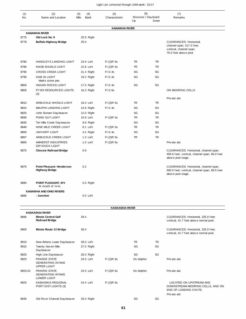
61
Light List corrected through LNM week: 01/17
(7)Remarks
(1)No.
(2)Name and Location
(3)Mile
(5)Characteristic
(4)Bank
(6)Structure / DayboardUp Down
Old Lock No. 9Buffalo Highway Bridge
HANDLEYS LANDING LIGHT
KNOB SHOALS LIGHT
CROSS CREEK LIGHT
DAM 10 LIGHT
INDIAN ROCKS LIGHT
PYXIS RESOURCES LIGHTS (3)
ARBUCKLE SHOALS LIGHT
MAUPIN LANDING LIGHT
Little Sixteen DaybeaconPOND GUT LIGHT
Ten Mile Creek DaybeaconNINE MILE CREEK LIGHT
JIM HOFF LIGHT
ARBUCKLE CREEK LIGHT
AMHERST INDUSTRIES DRYDOCK LIGHTChessie Railroad Bridge
Point Pleasant- Henderson Highway Bridge
POINT PLEASANT, WV
- Junction
Illinois Central Gulf Railroad Bridge
Illinois Route 13 Bridge
New Athens Lower DaybeaconTwenty-Seven Mile DaybeaconHigh Line DaybeaconPRAIRIE STATE GENERATING INTAKE UPPER LIGHTPRAIRIE STATE GENERATING INTAKE LOWER LIGHTKASKASKIA REGIONAL PORT DIST LIGHTS (3)
Old River Channel Daybeacon
KANAWHA RIVER
KANAWHA RIVER
KANAWHA AND OHIO RIVERS
KASKASKIA RIVER
KASKASKIA RIVER
Right
Left
Left
Right
Right
Right
Right
Left
Right
RightLeft
RightLeft
Right
Left
Left
Right
Left
LeftRight
RightLeft
Left
Left
Right
25.5
25.0
23.9
22.8
21.4
19.2
17.5
16.3
16.0
14.6
12.0 10.9
9.6 8.1
4.2
1.3
1.0
0.6
0.2
0.0
0.0
29.4
28.4
28.0 27.0
25.0 24.5
24.5
24.4
20.0
Marks stone pier.
At mouth of river.
Fl (2)R 5s
Fl (2)R 5s
Fl G 4s
Fl G 4s
Fl G 4s
Fl G 6s
Fl (2)R 5s
Fl G 4s
Fl (2)R 5s
Fl (2)R 5s
Fl G 4s
Fl (2)R 5s
Fl (2)R 6s
Fl (2)R 6s
Fl (2)R 6s
Fl (2)R 6s
On dolphin.
On dolphin.
CLEARANCES: Horizontal,channel span, 517.0 feet;vertical, channel span,75.0 feet above pool.
ON MOORING CELLS
CLEARANCES: Horizontal, channel span, 459.6 feet; vertical, channel span, 66.0 feet above pool stage.
CLEARANCES: Horizontal, channel span, 500.0 feet; vertical, channel span, 69.5 feet above pool stage.
CLEARANCES: Horizontal, 225.0 feet; vertical, 41.7 feet above normal pool.
CLEARANCES: Horizontal, 225.0 feet; vertical, 41.7 feet above normal pool.
LOCATED ON UPSTREAM AND DOWNSTREAM MOORING CELLS, AND ON END OF LOADING CHUTE.
87758778
8780
8785
8790
8795
8800
8805
8810
8815
88258830
88358840
8850
8857
8865
8870
8875
8880
8885
8895
8900
89108915
89208923
8923.01
8925
8930
TR
TR
SG
SG
SG
TR
SG
SGTR
SGTR
SG
TR
TRSG
SG
SG
TR
TR
SG
SG
SG
TR
SG
SGTR
SGTR
SG
TR
TRSG
SG
SG
Private aid.
Private aid.
Private aid.
Private aid.
Private aid.
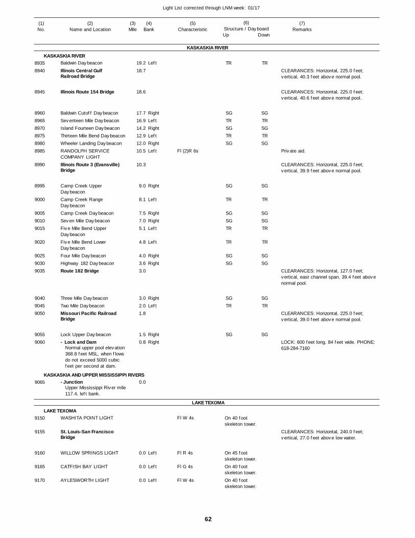
62
Light List corrected through LNM week: 01/17
(7)Remarks
(1)No.
(2)Name and Location
(3)Mile
(5)Characteristic
(4)Bank
(6)Structure / DayboardUp Down
Baldwin Daybeacon
Illinois Central Gulf Railroad Bridge
Illinois Route 154 Bridge
Baldwin Cutoff DaybeaconSeventeen Mile DaybeaconIsland Fourteen DaybeaconThirteen Mile Bend DaybeaconWheeler Landing DaybeaconRANDOLPH SERVICE COMPANY LIGHTIllinois Route 3 (Evansville) Bridge
Camp Creek Upper DaybeaconCamp Creek Range DaybeaconCamp Creek DaybeaconSeven Mile DaybeaconFive Mile Bend Upper DaybeaconFive Mile Bend Lower DaybeaconFour Mile DaybeaconHighway 182 DaybeaconRoute 182 Bridge
Three Mile DaybeaconTwo Mile DaybeaconMissouri Pacific Railroad Bridge
Lock Upper Daybeacon- Lock and Dam
- Junction
WASHITA POINT LIGHT
St. Louis-San Francisco Bridge
WILLOW SPRINGS LIGHT
CATFISH BAY LIGHT
AYLESWORTH LIGHT
KASKASKIA RIVER
KASKASKIA RIVER
KASKASKIA AND UPPER MISSISSIPPI RIVERS
LAKE TEXOMA
LAKE TEXOMA
Left
RightLeftRightLeftRightLeft
Right
Left
RightRightLeft
Left
RightRight
RightLeft
RightRight
Left
Left
Left
19.2
18.7
18.6
17.7 16.9 14.2 12.9 12.0 10.5
10.3
9.0
8.1
7.5 7.0 5.1
4.8
4.0 3.6 3.0
3.0 2.0 1.8
1.5 0.8
0.0
0.0
0.0
0.0
Normal upper pool elevation 368.8 feet MSL, when flows do not exceed 5000 cubic feet per second at dam.
Upper Mississippi River mile117.4, left bank.
Fl (2)R 6s
Fl W 4s
Fl R 4s
Fl G 4s
Fl W 4s
On 40 foot skeleton tower.
On 45 foot skeleton tower.On 40 foot skeleton tower.On 40 foot skeleton tower.
CLEARANCES: Horizontal, 225.0 feet; vertical, 40.3 feet above normal pool.
CLEARANCES: Horizontal, 225.0 feet; vertical, 40.6 feet above normal pool.
CLEARANCES: Horizontal, 225.0 feet; vertical, 39.9 feet above normal pool.
CLEARANCES: Horizontal, 127.0 feet; vertical, east channel span, 39.4 feet above normal pool.
CLEARANCES: Horizontal, 225.0 feet; vertical, 39.0 feet above normal pool.
LOCK: 600 feet long, 84 feet wide. PHONE: 618-284-7160
CLEARANCES: Horizontal, 240.0 feet; vertical, 27.0 feet above low water.
89358940
8945
896089658970897589808985
8990
8995
9000
900590109015
9020
902590309035
904090459050
90559060
9065
9150
9155
9160
9165
9170
TR
SGTRSGTRSG
SG
TR
SGSGTR
TR
SGSG
SGTR
SG
TR
SGTRSGTRSG
SG
TR
SGSGTR
TR
SGSG
SGTR
SG
Private aid.
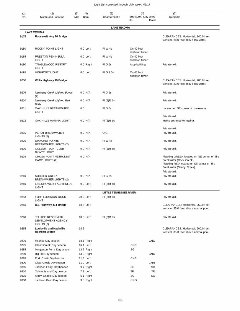
63
Light List corrected through LNM week: 01/17
(7)Remarks
(1)No.
(2)Name and Location
(3)Mile
(5)Characteristic
(4)Bank
(6)Structure / DayboardUp Down
Roosevelt Hwy 70 Bridge
ROCKY POINT LIGHT
PRESTON PENINSULA LIGHTTANGLEWOOD RESORT LIGHTHIGHPORT LIGHT
Willis Highway 99 Bridge
Newberry Creek Lighted Buoys(2)Newberry Creek Lighted Red BuoyOAK HILLS BREAKWATER LIGHT
OAK HILLS MARINA LIGHT
PEROT BREAKWATER LIGHTS (4)DIAMOND POINTE BREAKWATER LIGHTS (2)COLBERT BOAT CLUB BKWTR LIGHTCROSS POINT METHODIST CAMP LIGHTS (2)
SOLDIER CREEK BREAKWATER LIGHTS (2)EISENHOWER YACHT CLUBLIGHT
FORT LOUDOUN DOCK LIGHTU.S. Highway 411 Bridge
TELLICO RESERVOIR DEVELOPMENT AGENCY LIGHTS (2)Louisville and Nashville Railroad Bridge
Mcghee DaybeaconIsland Creek DaybeaconMorganton Ferry DaybeaconBig Hill DaybeaconFork Creek DaybeaconClear Creek DaybeaconJackson Ferry DaybeaconToliver Island DaybeaconAxley Chapel DaybeaconJackson Bend Daybeacon
LAKE TEXOMA
LAKE TEXOMA
LITTLE TENNESSEE RIVER
Left
Left
Right
Left
N/A
N/A
N/A
N/A
N/A
N/A
N/A
N/A
Left
Left
Left
Left
RightLeftRightRightLeftLeftRightLeftRightRight
0.0
0.0
0.0
0.0
0.0
0.0
0.0
0.0
0.0
0.0
0.0
0.0
0.0
0.0
20.2
18.8
18.8
18.6
18.1 16.1 13.7 13.0 11.3 11.0 9.7 7.2 6.1 3.5
Fl W 4s
Fl W 4s
Fl G 6s
Fl G 2.5s
Fl G 6s
Fl (2)R 6s
Fl G 6s
Fl (2)R 6s
Q G
Fl W 4s
Fl (2)R 6s
Fl G 6s
Fl (2)R 6s
Fl (2)R 6s
Fl (2)R 6s
On 40 foot skeleton tower.On 40 foot skeleton tower.Atop building.
On 40 foot skeleton tower.
CLEARANCES: Horizontal, 240.0 feet; vertical, 28.0 feet above low water.
CLEARANCES: Horizontal, 200.0 feet; vertical, 23.0 feet above low water.
Located on SE corner of breakwater.
Marks entrance to marina.
Flashing GREEN located on NE corner of Tire Breakwater (Rock Creek). Flashing RED located on SE corner of Tire Breakwater (Sandy Creek).
CLEARANCES: Horizontal, 250.0 feet; verticle, 35.0 feet above normal pool.
CLEARANCES: Horizontal, 200.0 feet; vertical, 35.3 feet above normal pool.
9175
9180
9185
9190
9195
9200
9205
9210
9211
9212
9215
9225
9230
9235
9240
9250
9253
9255
9260
9265
9270927592859290929593009305931093159330
CNRSG
CNR
SGTRSGCNG
CNG
CNG
CNRSGTRSG
Private aid.
Private aid.
Private aid.
Private aid.
Private aid.Private aid.
Private aid.
Private aid.
Private aid.Private aid.
Private aid.
Private aid.
Private aid.
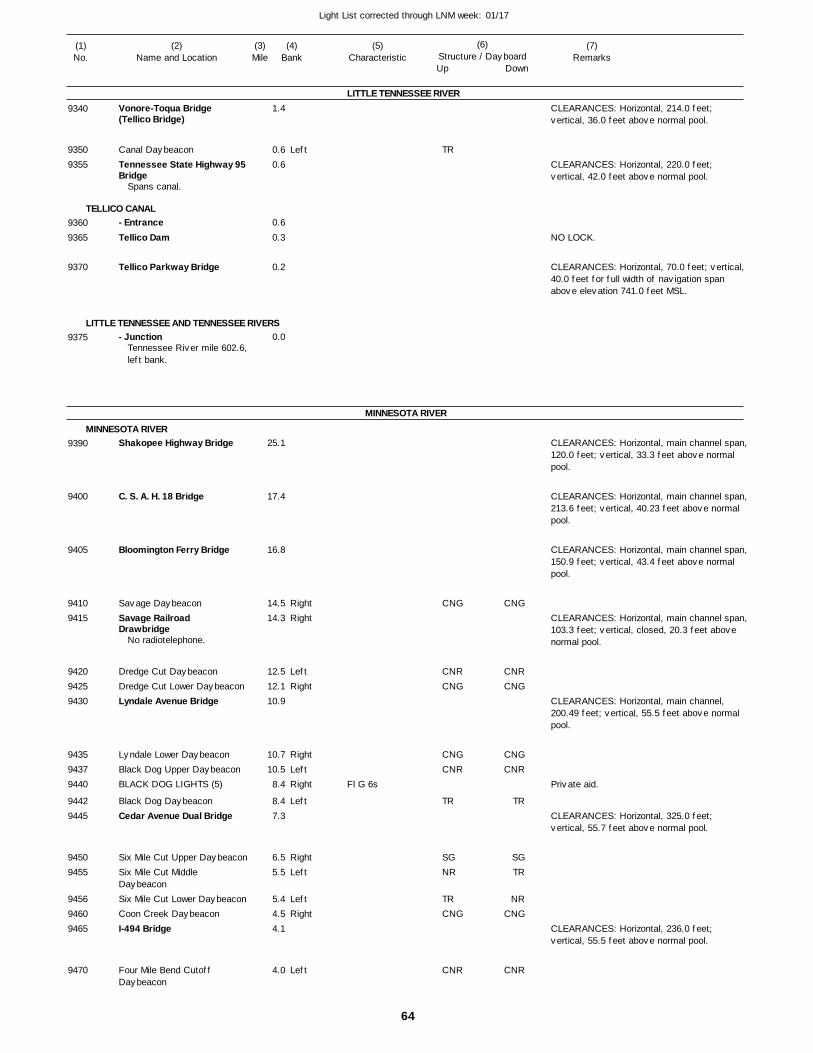
64
Light List corrected through LNM week: 01/17
(7)Remarks
(1)No.
(2)Name and Location
(3)Mile
(5)Characteristic
(4)Bank
(6)Structure / DayboardUp Down
Vonore-Toqua Bridge (Tellico Bridge)
Canal DaybeaconTennessee State Highway 95Bridge
- EntranceTellico Dam
Tellico Parkway Bridge
- Junction
Shakopee Highway Bridge
C. S. A. H. 18 Bridge
Bloomington Ferry Bridge
Savage DaybeaconSavage Railroad Drawbridge
Dredge Cut DaybeaconDredge Cut Lower DaybeaconLyndale Avenue Bridge
Lyndale Lower DaybeaconBlack Dog Upper DaybeaconBLACK DOG LIGHTS (5)
Black Dog DaybeaconCedar Avenue Dual Bridge
Six Mile Cut Upper DaybeaconSix Mile Cut Middle DaybeaconSix Mile Cut Lower DaybeaconCoon Creek DaybeaconI-494 Bridge
Four Mile Bend Cutoff Daybeacon
LITTLE TENNESSEE RIVER
TELLICO CANAL
LITTLE TENNESSEE AND TENNESSEE RIVERS
MINNESOTA RIVER
MINNESOTA RIVER
Left
RightRight
LeftRight
RightLeftRight
Left
RightLeft
LeftRight
Left
1.4
0.6 0.6
0.6
0.3
0.2
0.0
25.1
17.4
16.8
14.5 14.3
12.5 12.1 10.9
10.7 10.5 8.4
8.4 7.3
6.5 5.5
5.4 4.5 4.1
4.0
Spans canal.
Tennessee River mile 602.6,left bank.
No radiotelephone.
Fl G 6s
CLEARANCES: Horizontal, 214.0 feet; vertical, 36.0 feet above normal pool.
CLEARANCES: Horizontal, 220.0 feet; vertical, 42.0 feet above normal pool.
NO LOCK.
CLEARANCES: Horizontal, 70.0 feet; vertical, 40.0 feet for full width of navigation span above elevation 741.0 feet MSL.
CLEARANCES: Horizontal, main channel span,120.0 feet; vertical, 33.3 feet above normal pool.
CLEARANCES: Horizontal, main channel span,213.6 feet; vertical, 40.23 feet above normal pool.
CLEARANCES: Horizontal, main channel span,150.9 feet; vertical, 43.4 feet above normal pool.
CLEARANCES: Horizontal, main channel span,103.3 feet; vertical, closed, 20.3 feet above normal pool.
CLEARANCES: Horizontal, main channel, 200.49 feet; vertical, 55.5 feet above normal pool.
CLEARANCES: Horizontal, 325.0 feet; vertical, 55.7 feet above normal pool.
CLEARANCES: Horizontal, 236.0 feet; vertical, 55.5 feet above normal pool.
9340
93509355
93609365
9370
9375
9390
9400
9405
94109415
942094259430
943594379440
94429445
94509455
945694609465
9470
TR
CNG
CNRCNG
CNGCNR
TR
SGNR
TRCNG
CNR
CNG
CNRCNG
CNGCNR
TR
SGTR
NRCNG
CNR
Private aid.
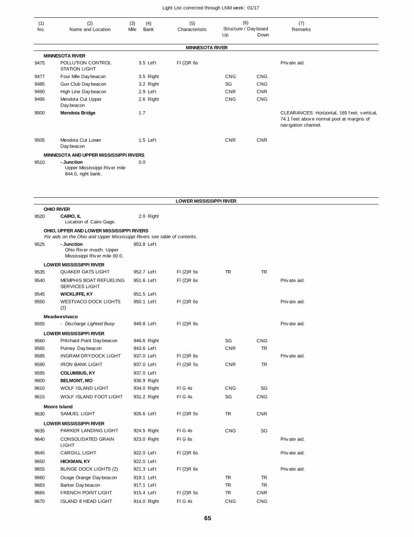
65
Light List corrected through LNM week: 01/17
(7)Remarks
(1)No.
(2)Name and Location
(3)Mile
(5)Characteristic
(4)Bank
(6)Structure / DayboardUp Down
POLLUTION CONTROL STATION LIGHTFour Mile DaybeaconGun Club DaybeaconHigh Line DaybeaconMendota Cut Upper DaybeaconMendota Bridge
Mendota Cut Lower Daybeacon
- Junction
CAIRO, IL
- Junction
QUAKER OATS LIGHT
MEMPHIS BOAT REFUELING SERVICES LIGHTWICKLIFFE, KYWESTVACO DOCK LIGHTS (2)
- Discharge Lighted Buoy
Pritchard Point Daybeacon
Putney DaybeaconINGRAM DRYDOCK LIGHT
IRON BANK LIGHT
COLUMBUS, KYBELMONT, MOWOLF ISLAND LIGHT
WOLF ISLAND FOOT LIGHT
SAMUEL LIGHT
PARKER LANDING LIGHT
CONSOLIDATED GRAIN LIGHTCARGILL LIGHT
HICKMAN, KYBUNGE DOCK LIGHTS (2)
Osage Orange DaybeaconBarker DaybeaconFRENCH POINT LIGHT
ISLAND 8 HEAD LIGHT
MINNESOTA RIVER
MINNESOTA RIVER
MINNESOTA AND UPPER MISSISSIPPI RIVERS
LOWER MISSISSIPPI RIVER
OHIO RIVER
OHIO, UPPER AND LOWER MISSISSIPPI RIVERS
LOWER MISSISSIPPI RIVER
Meadwestvaco
LOWER MISSISSIPPI RIVER
Moore Island
LOWER MISSISSIPPI RIVER
For aids on the Ohio and Upper Mississippi Rivers see table of contents.
Left
RightRightLeftRight
Left
Right
Left
Left
Left
LeftLeft
Left
Right
LeftLeft
Left
LeftRightRight
Right
Left
Right
Right
Left
LeftLeft
LeftLeftLeft
Right
3.5
3.5 3.2 2.9 2.6
1.7
1.5
0.0
2.0
953.8
952.7
951.6
951.5 950.1
949.8
946.6
943.6 937.0
937.0
937.0 936.9 934.0
931.2
926.6
924.5
923.0
922.0
922.0 921.3
919.1 917.1 915.4
914.0
Upper Mississippi River mile844.0, right bank.
Location of Cairo Gage.
Ohio River mouth. Upper Mississippi River mile 00.0.
Fl (2)R 6s
Fl (2)R 5s
Fl (2)R 6s
Fl (2)R 6s
Fl (2)R 6s
Fl (2)R 6s
Fl (2)R 5s
Fl G 4s
Fl G 4s
Fl (2)R 5s
Fl G 4s
Fl G 6s
Fl (2)R 6s
Fl (2)R 6s
Fl (2)R 5s
Fl G 4s
CLEARANCES: Horizontal, 165 feet; vertical, 74.1 feet above normal pool at margins of navigation channel.
9475
9477948594909495
9500
9505
9510
9520
9525
9535
9540
95459550
9555
956095659585
9590
959596009610
9615
9630
9635
9640
9645
96509655
966096639665
9670
CNGSGCNRCNG
CNR
TR
SGCNR
CNR
CNG
SG
TR
CNG
TRTRTR
CNG
CNGCNGCNRCNG
CNR
TR
CNGTR
TR
SG
CNG
CNR
SG
TRTR
CNR
CNG
Private aid.
Private aid.
Private aid.
Private aid.
Private aid.
Private aid.
Private aid.
Private aid.
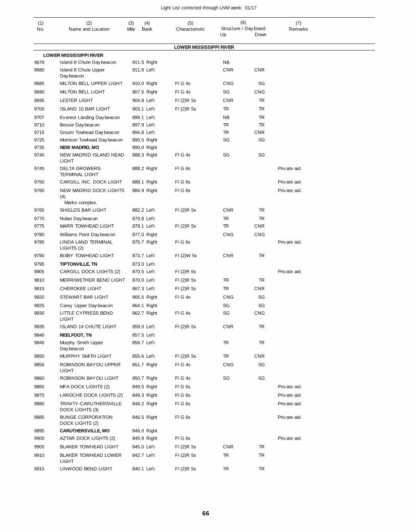
66
Light List corrected through LNM week: 01/17
(7)Remarks
(1)No.
(2)Name and Location
(3)Mile
(5)Characteristic
(4)Bank
(6)Structure / DayboardUp Down
Island 8 Chute Daybeacon
Island 8 Chute Upper DaybeaconMILTON BELL UPPER LIGHT
MILTON BELL LIGHT
LESTER LIGHT
ISLAND 10 BAR LIGHT
Everest Landing DaybeaconBessie DaybeaconGroom Towhead DaybeaconMorrison Towhead DaybeaconNEW MADRID, MONEW MADRID ISLAND HEADLIGHTDELTA GROWERS TERMINAL LIGHTCARGILL INC. DOCK LIGHT
NEW MADRID DOCK LIGHTS(4)
SHIELDS BAR LIGHT
Nolan DaybeaconMARR TOWHEAD LIGHT
Williams Point DaybeaconLINDA LAND TERMINAL LIGHTS (2)BIXBY TOWHEAD LIGHT
TIPTONVILLE, TNCARGILL DOCK LIGHTS (2)
MERRIWETHER BEND LIGHT
CHEROKEE LIGHT
STEWART BAR LIGHT
Carey Upper DaybeaconLITTLE CYPRESS BEND LIGHTISLAND 14 CHUTE LIGHT
REELFOOT, TNMurphy Smith Upper DaybeaconMURPHY SMITH LIGHT
ROBINSON BAYOU UPPER LIGHTROBINSON BAYOU LIGHT
MFA DOCK LIGHTS (2)
LAROCHE DOCK LIGHTS (2)
TRINITY-CARUTHERSVILLE DOCK LIGHTS (3)BUNGE CORPORATION DOCK LIGHTS (2)CARUTHERSVILLE, MOAZTAR DOCK LIGHTS (2)
BLAKER TOWHEAD LIGHT
BLAKER TOWHEAD LOWER LIGHTLINWOOD BEND LIGHT
LOWER MISSISSIPPI RIVER
LOWER MISSISSIPPI RIVERRight
Left
Right
Right
Left
Left
LeftLeftLeftRightRightRight
Right
Right
Right
Left
LeftLeft
RightRight
Left
LeftLeft
Left
Left
Right
RightRight
Left
LeftLeft
Left
Right
Right
Right
Right
Right
Right
RightRight
Left
Left
Left
911.5
911.6
910.0
907.5
904.8
903.1
899.1 897.9 894.8 890.5 890.0 888.3
888.2
888.1
884.9
882.2
879.8 878.1
877.0 875.7
873.7
873.0 870.5
870.0
867.3
865.5
864.1 862.7
859.0
857.5 856.7
855.6
851.7
850.7
849.5
849.3
848.2
846.5
846.0 845.9
845.0
842.7
840.1
Marks complex.
Fl G 4s
Fl G 4s
Fl (2)R 5s
Fl (2)R 5s
Fl G 4s
Fl G 6s
Fl G 6s
Fl G 6s
Fl (2)R 5s
Fl (2)R 5s
Fl G 6s
Fl (2)W 5s
Fl (2)R 6s
Fl (2)R 5s
Fl (2)R 5s
Fl G 4s
Fl G 4s
Fl (2)R 5s
Fl (2)R 5s
Fl G 4s
Fl G 4s
Fl G 6s
Fl G 6s
Fl G 6s
Fl G 6s
Fl G 6s
Fl (2)R 5s
Fl (2)R 5s
Fl (2)R 5s
96789680
9685
9690
9695
9700
970797109715972597359740
9745
9750
9760
9765
97709775
97809785
9790
97959805
9810
9815
9820
98259830
9835
98409845
9850
9855
9860
9865
9870
9880
9885
98959900
9905
9910
9915
NBCNR
CNG
SG
CNR
TR
NBTRTRSG
SG
CNR
TRTR
CNG
CNR
TR
TR
CNG
SGSG
CNR
TR
TR
CNG
SG
CNR
TR
TR
CNR
SG
CNG
TR
TR
TRTR
CNRSG
SG
TR
TRCNR
CNG
TR
TR
CNR
SG
SGCNG
TR
TR
CNR
SG
SG
TR
TR
TR
Private aid.
Private aid.
Private aid.
Private aid.
Private aid.
Private aid.
Private aid.
Private aid.
Private aid.
Private aid.
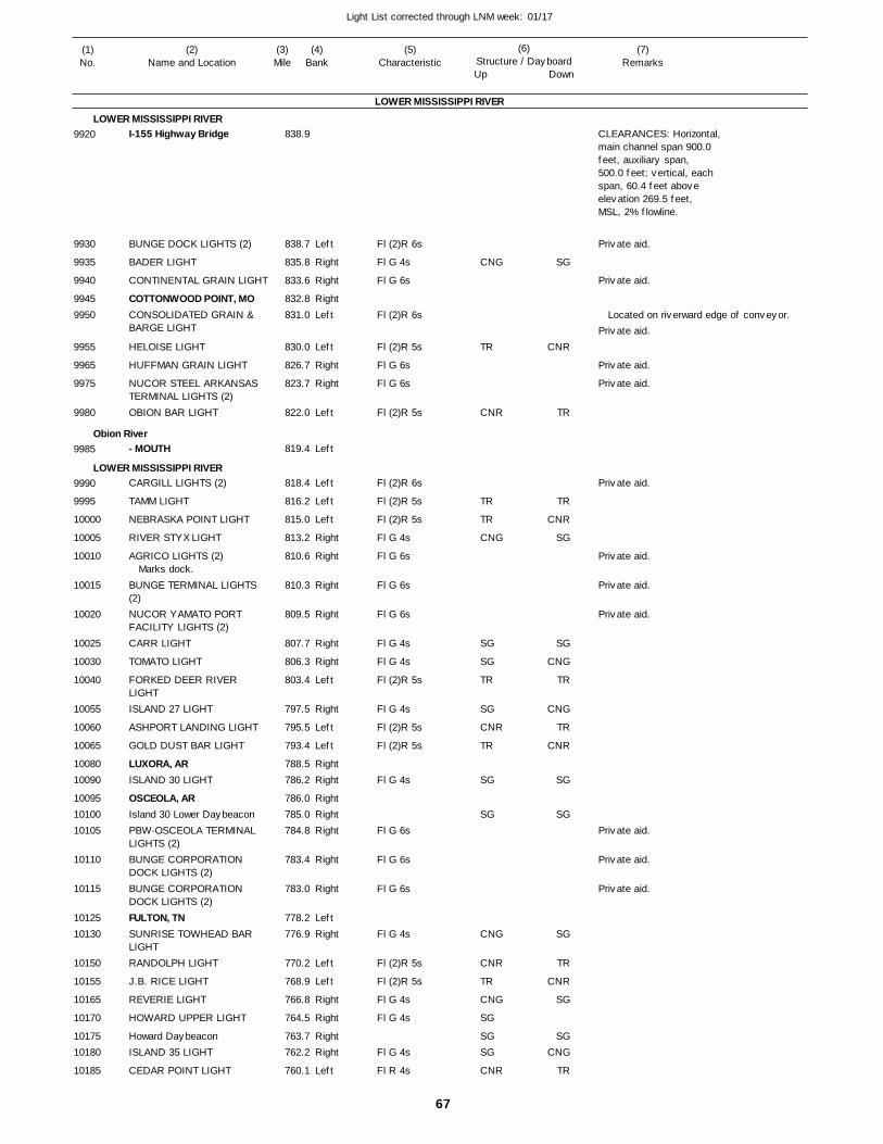
67
Light List corrected through LNM week: 01/17
(7)Remarks
(1)No.
(2)Name and Location
(3)Mile
(5)Characteristic
(4)Bank
(6)Structure / DayboardUp Down
I-155 Highway Bridge
BUNGE DOCK LIGHTS (2)
BADER LIGHT
CONTINENTAL GRAIN LIGHT
COTTONWOOD POINT, MOCONSOLIDATED GRAIN & BARGE LIGHT
HELOISE LIGHT
HUFFMAN GRAIN LIGHT
NUCOR STEEL ARKANSAS TERMINAL LIGHTS (2)OBION BAR LIGHT
- MOUTH
CARGILL LIGHTS (2)
TAMM LIGHT
NEBRASKA POINT LIGHT
RIVER STYX LIGHT
AGRICO LIGHTS (2)
BUNGE TERMINAL LIGHTS (2)NUCOR YAMATO PORT FACILITY LIGHTS (2)CARR LIGHT
TOMATO LIGHT
FORKED DEER RIVER LIGHTISLAND 27 LIGHT
ASHPORT LANDING LIGHT
GOLD DUST BAR LIGHT
LUXORA, ARISLAND 30 LIGHT
OSCEOLA, ARIsland 30 Lower DaybeaconPBW-OSCEOLA TERMINAL LIGHTS (2)BUNGE CORPORATION DOCK LIGHTS (2)BUNGE CORPORATION DOCK LIGHTS (2)FULTON, TNSUNRISE TOWHEAD BAR LIGHTRANDOLPH LIGHT
J.B. RICE LIGHT
REVERIE LIGHT
HOWARD UPPER LIGHT
Howard DaybeaconISLAND 35 LIGHT
CEDAR POINT LIGHT
LOWER MISSISSIPPI RIVER
LOWER MISSISSIPPI RIVER
Obion River
LOWER MISSISSIPPI RIVER
Left
Right
Right
RightLeft
Left
Right
Right
Left
Left
Left
Left
Left
Right
Right
Right
Right
Right
Right
Left
Right
Left
Left
RightRight
RightRightRight
Right
Right
LeftRight
Left
Left
Right
Right
RightRight
Left
838.9
838.7
835.8
833.6
832.8 831.0
830.0
826.7
823.7
822.0
819.4
818.4
816.2
815.0
813.2
810.6
810.3
809.5
807.7
806.3
803.4
797.5
795.5
793.4
788.5 786.2
786.0 785.0 784.8
783.4
783.0
778.2 776.9
770.2
768.9
766.8
764.5
763.7 762.2
760.1
Marks dock.
Fl (2)R 6s
Fl G 4s
Fl G 6s
Fl (2)R 6s
Fl (2)R 5s
Fl G 6s
Fl G 6s
Fl (2)R 5s
Fl (2)R 6s
Fl (2)R 5s
Fl (2)R 5s
Fl G 4s
Fl G 6s
Fl G 6s
Fl G 6s
Fl G 4s
Fl G 4s
Fl (2)R 5s
Fl G 4s
Fl (2)R 5s
Fl (2)R 5s
Fl G 4s
Fl G 6s
Fl G 6s
Fl G 6s
Fl G 4s
Fl (2)R 5s
Fl (2)R 5s
Fl G 4s
Fl G 4s
Fl G 4s
Fl R 4s
CLEARANCES: Horizontal,main channel span 900.0feet, auxiliary span,500.0 feet; vertical, eachspan, 60.4 feet aboveelevation 269.5 feet,MSL, 2% flowline.
Located on riverward edge of conveyor.
9920
9930
9935
9940
99459950
9955
9965
9975
9980
9985
9990
9995
10000
10005
10010
10015
10020
10025
10030
10040
10055
10060
10065
1008010090
100951010010105
10110
10115
1012510130
10150
10155
10165
10170
1017510180
10185
CNG
TR
CNR
TR
TR
CNG
SG
SG
TR
SG
CNR
TR
SG
SG
CNG
CNR
TR
CNG
SG
SGSG
CNR
SG
CNR
TR
TR
CNR
SG
SG
CNG
TR
CNG
TR
CNR
SG
SG
SG
TR
CNR
SG
SGCNG
TR
Private aid.
Private aid.
Private aid.
Private aid.
Private aid.
Private aid.
Private aid.
Private aid.
Private aid.
Private aid.
Private aid.
Private aid.

68
Light List corrected through LNM week: 01/17
(7)Remarks
(1)No.
(2)Name and Location
(3)Mile
(5)Characteristic
(4)Bank
(6)Structure / DayboardUp Down
CEDAR POINT LOWER LIGHTDEAN ISLAND LIGHT
Brandywine Chute Upper DaybeaconBRANDYWINE CHUTE LIGHTISLAND 39 LIGHT
CAPTAIN DANNY EVANS MEMORIAL LIGHTISLAND 40 FOOT LIGHT
REDMAN BAR LIGHT
FULLEN DOCK LIGHTS (2)
Sycamore Chute DaybeaconLUCY-WOODSTOCK TERMINAL LIGHTS (2)
- MOUTHI-40 Bridge
MEMPHIS, TN
- EntranceMonorail Bridge
MUD ISLAND PARK MARINA LIGHTS (2)I-40 Bridge
Auction Avenue Bridge
HARBOR TOWN MARINA LIGHTS (2)CARGILL DOCK LIGHT
LOWER MISSISSIPPI RIVER
LOWER MISSISSIPPI RIVER
Wolf River
Memphis Harbor (Wolf River)
Left
Right
Left
Left
Right
Right
Right
Right
Left
LeftLeft
Left
Left
Left
Right
Right
Left
757.8
755.0
752.7
751.1
750.2
746.5
744.9
742.0
740.5
740.3 739.0
738.6
736.7
736.0
736.0
0.5
0.7
0.8
1.3
1.5
2.6
Note: Decorative lights on the bridge are energized from dusk to dawn. The decorative lights can be extinguished for 15-minutes by setting your VHF-FM radio to Channel 28 and rapidly clicking the mic 3 times when approaching the bridge. If mariners are unable to extinguish the decorative lights, they are advised to report this to Sector Lower Mississippi River at (901) 521-4824.
Fl (2)R 5s
Fl G 4s
Fl (2)R 5s
Fl G 4s
Fl G 4s
Fl G 4s
Fl G 4s
Fl (2)R 6s
Fl (2)R 6s
Fl G 6s
Fl G 6s
Fl (2)R 6s
CLEARANCES: Horizontal, main chanel span, 870.0 feet; vertical, main channel span, 108.7 feet above zero on Memphis gage.
CLEARANCES: Horizontal, 300.0 feet; vertical, below bridge, 54.0 feet above high water; vertical, below monorail car, 42.1 feet above high water.
CLEARANCES: Horizontal, 330.0 feet; vertical, 53.5 feet above high water.
CLEARANCES: Horizontal, 261.0 feet; vertical, 33.5 feet above 1937 high water.
10190
10195
10205
10210
10215
10220
10225
10230
10235
1024010245
1025010255
10260
1026510270
10275
10280
10290
10295
10300
TR
CNG
CNR
TR
CNG
SG
SG
SG
CNR
CNR
CNG
TR
CNR
SG
SG
SG
CNG
TR
Private aid.
Private aid.
Private aid.
Private aid.
Private aid.
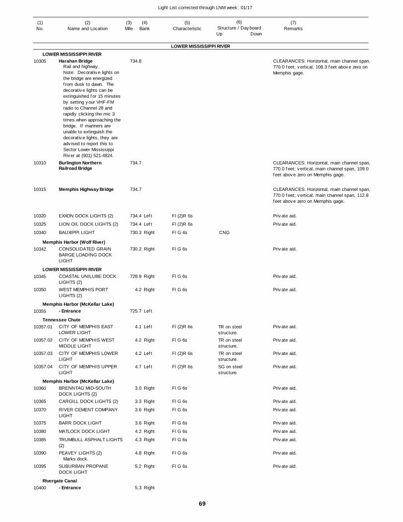
69
Light List corrected through LNM week: 01/17
(7)Remarks
(1)No.
(2)Name and Location
(3)Mile
(5)Characteristic
(4)Bank
(6)Structure / DayboardUp Down
Harahan Bridge
Burlington Northern Railroad Bridge
Memphis Highway Bridge
EXXON DOCK LIGHTS (2)
LION OIL DOCK LIGHTS (2)
BAUXIPPI LIGHT
CONSOLIDATED GRAIN BARGE LOADING DOCK LIGHT
COASTAL UNILUBE DOCK LIGHTS (2)WEST MEMPHIS PORT LIGHTS (2)
- Entrance
CITY OF MEMPHIS EAST LOWER LIGHT
CITY OF MEMPHIS WEST MIDDLE LIGHTCITY OF MEMPHIS LOWER LIGHTCITY OF MEMPHIS UPPER LIGHT
BRENNTAG MID-SOUTH DOCK LIGHTS (2)CARGILL DOCK LIGHTS (2)
RIVER CEMENT COMPANY LIGHTBARR DOCK LIGHT
MATLOCK DOCK LIGHT
TRUMBULL ASPHALT LIGHTS(2)PEAVEY LIGHTS (2)
SUBURBAN PROPANE DOCK LIGHT
- Entrance
LOWER MISSISSIPPI RIVER
LOWER MISSISSIPPI RIVER
Memphis Harbor (Wolf River)
LOWER MISSISSIPPI RIVER
Memphis Harbor (McKellar Lake)
Tennessee Chute
Memphis Harbor (McKellar Lake)
Rivergate Canal
Left
Left
Right
Right
Right
Right
Left
Left
Right
Left
Left
Right
Right
Right
Right
Right
Right
Right
Right
Right
734.8
734.7
734.7
734.4
734.4
730.3
730.2
728.9
4.2
725.7
4.1
4.2
4.2
4.7
3.0
3.3
3.6
3.6
4.2
4.3
4.8
5.2
5.3
Rail and highway.Note: Decorative lights on the bridge are energized from dusk to dawn. The decorative lights can be extinguished for 15 minutes by setting your VHF-FM radio to Channel 28 and rapidly clicking the mic 3 times when approaching the bridge. If mariners are unable to extinguish the decorative lights, they are advised to report this to Sector Lower Mississippi River at (901) 521-4824.
Marks dock.
Fl (2)R 6s
Fl (2)R 6s
Fl G 4s
Fl G 6s
Fl G 6s
Fl G 6s
Fl (2)R 6s
Fl G 6s
Fl (2)R 6s
Fl (2)R 6s
Fl G 6s
Fl G 6s
Fl G 6s
Fl G 6s
Fl G 6s
Fl G 6s
Fl G 6s
Fl G 6s
TR on steel structure.TR on steel structure.TR on steel structure.SG on steel structure.
CLEARANCES: Horizontal, main channel span,770.0 feet; vertical, 108.3 feet above zero on Memphis gage.
CLEARANCES: Horizontal, main channel span,770.0 feet; vertical, main channel span, 109.0 feet above zero on Memphis gage.
CLEARANCES: Horizontal, main channel span,770.0 feet; vertical, main channel span, 112.8 feet above zero on Memphis gage.
10305
10310
10315
10320
10325
10340
10342
10345
10350
10355
10357.01
10357.02
10357.03
10357.04
10360
10365
10370
10375
10380
10385
10390
10395
10400
CNG
Private aid.
Private aid.
Private aid.
Private aid.
Private aid.
Private aid.
Private aid.
Private aid.
Private aid.
Private aid.
Private aid.
Private aid.
Private aid.
Private aid.
Private aid.
Private aid.
Private aid.
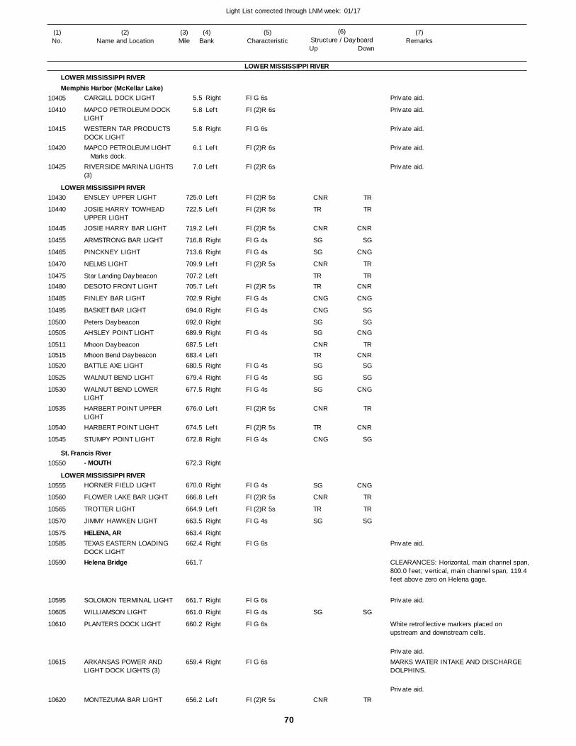
70
Light List corrected through LNM week: 01/17
(7)Remarks
(1)No.
(2)Name and Location
(3)Mile
(5)Characteristic
(4)Bank
(6)Structure / DayboardUp Down
CARGILL DOCK LIGHT
MAPCO PETROLEUM DOCK LIGHTWESTERN TAR PRODUCTS DOCK LIGHTMAPCO PETROLEUM LIGHT
RIVERSIDE MARINA LIGHTS (3)
ENSLEY UPPER LIGHT
JOSIE HARRY TOWHEAD UPPER LIGHTJOSIE HARRY BAR LIGHT
ARMSTRONG BAR LIGHT
PINCKNEY LIGHT
NELMS LIGHT
Star Landing DaybeaconDESOTO FRONT LIGHT
FINLEY BAR LIGHT
BASKET BAR LIGHT
Peters DaybeaconAHSLEY POINT LIGHT
Mhoon DaybeaconMhoon Bend DaybeaconBATTLE AXE LIGHT
WALNUT BEND LIGHT
WALNUT BEND LOWER LIGHTHARBERT POINT UPPER LIGHTHARBERT POINT LIGHT
STUMPY POINT LIGHT
- MOUTH
HORNER FIELD LIGHT
FLOWER LAKE BAR LIGHT
TROTTER LIGHT
JIMMY HAWKEN LIGHT
HELENA, ARTEXAS EASTERN LOADING DOCK LIGHTHelena Bridge
SOLOMON TERMINAL LIGHT
WILLIAMSON LIGHT
PLANTERS DOCK LIGHT
ARKANSAS POWER AND LIGHT DOCK LIGHTS (3)
MONTEZUMA BAR LIGHT
LOWER MISSISSIPPI RIVER
LOWER MISSISSIPPI RIVERMemphis Harbor (McKellar Lake)
LOWER MISSISSIPPI RIVER
St. Francis River
LOWER MISSISSIPPI RIVER
Right
Left
Right
Left
Left
Left
Left
Left
Right
Right
Left
LeftLeft
Right
Right
RightRight
LeftLeftRight
Right
Right
Left
Left
Right
Right
Right
Left
Left
Right
RightRight
Right
Right
Right
Right
Left
5.5
5.8
5.8
6.1
7.0
725.0
722.5
719.2
716.8
713.6
709.9
707.2 705.7
702.9
694.0
692.0 689.9
687.5 683.4 680.5
679.4
677.5
676.0
674.5
672.8
672.3
670.0
666.8
664.9
663.5
663.4 662.4
661.7
661.7
661.0
660.2
659.4
656.2
Marks dock.
Fl G 6s
Fl (2)R 6s
Fl G 6s
Fl (2)R 6s
Fl (2)R 6s
Fl (2)R 5s
Fl (2)R 5s
Fl (2)R 5s
Fl G 4s
Fl G 4s
Fl (2)R 5s
Fl (2)R 5s
Fl G 4s
Fl G 4s
Fl G 4s
Fl G 4s
Fl G 4s
Fl G 4s
Fl (2)R 5s
Fl (2)R 5s
Fl G 4s
Fl G 4s
Fl (2)R 5s
Fl (2)R 5s
Fl G 4s
Fl G 6s
Fl G 6s
Fl G 4s
Fl G 6s
Fl G 6s
Fl (2)R 5s
CLEARANCES: Horizontal, main channel span,800.0 feet; vertical, main channel span, 119.4 feet above zero on Helena gage.
White retroflective markers placed on upstream and downstream cells.
MARKS WATER INTAKE AND DISCHARGE DOLPHINS.
10405
10410
10415
10420
10425
10430
10440
10445
10455
10465
10470
1047510480
10485
10495
1050010505
105111051510520
10525
10530
10535
10540
10545
10550
10555
10560
10565
10570
1057510585
10590
10595
10605
10610
10615
10620
CNR
TR
CNR
SG
SG
CNR
TRTR
CNG
CNG
SGSG
CNRTRSG
SG
SG
CNR
TR
CNG
SG
CNR
TR
SG
SG
CNR
TR
TR
CNR
SG
CNG
TR
TRCNR
CNG
SG
SGCNG
TRCNR
SG
SG
CNG
TR
CNR
SG
CNG
TR
TR
SG
SG
TR
Private aid.
Private aid.
Private aid.
Private aid.
Private aid.
Private aid.
Private aid.
Private aid.
Private aid.
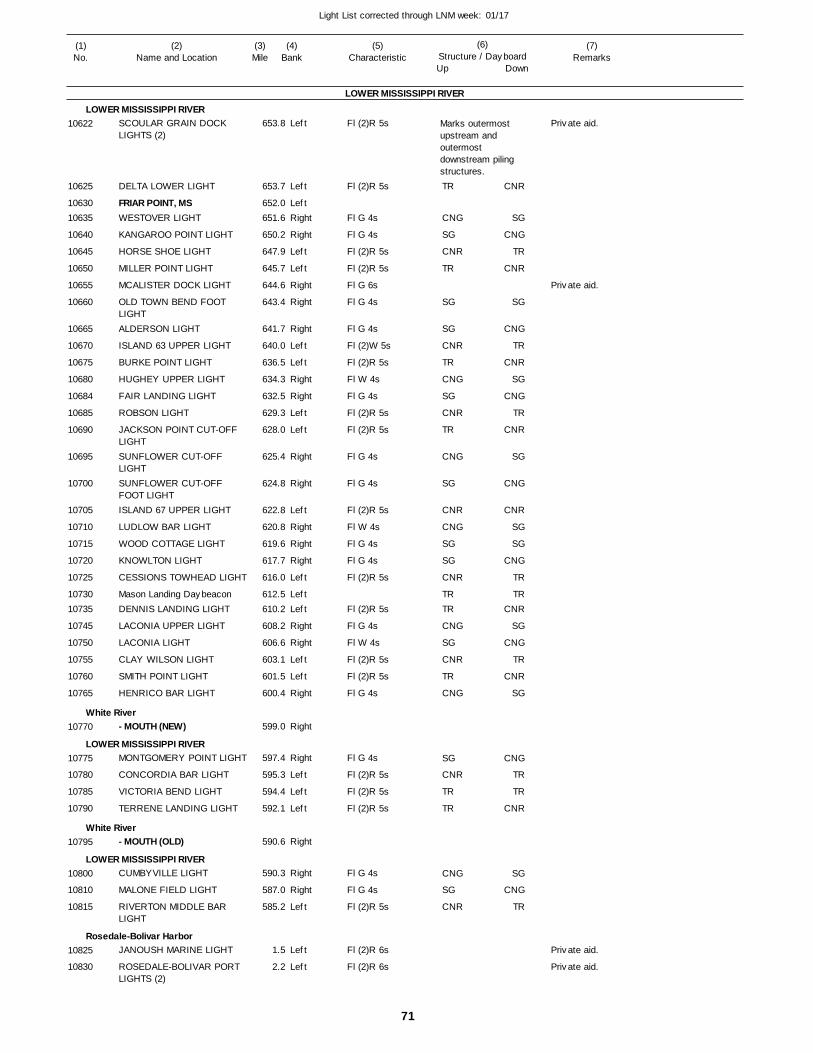
71
Light List corrected through LNM week: 01/17
(7)Remarks
(1)No.
(2)Name and Location
(3)Mile
(5)Characteristic
(4)Bank
(6)Structure / DayboardUp Down
SCOULAR GRAIN DOCK LIGHTS (2)
DELTA LOWER LIGHT
FRIAR POINT, MSWESTOVER LIGHT
KANGAROO POINT LIGHT
HORSE SHOE LIGHT
MILLER POINT LIGHT
MCALISTER DOCK LIGHT
OLD TOWN BEND FOOT LIGHTALDERSON LIGHT
ISLAND 63 UPPER LIGHT
BURKE POINT LIGHT
HUGHEY UPPER LIGHT
FAIR LANDING LIGHT
ROBSON LIGHT
JACKSON POINT CUT-OFF LIGHTSUNFLOWER CUT-OFF LIGHTSUNFLOWER CUT-OFF FOOT LIGHTISLAND 67 UPPER LIGHT
LUDLOW BAR LIGHT
WOOD COTTAGE LIGHT
KNOWLTON LIGHT
CESSIONS TOWHEAD LIGHT
Mason Landing DaybeaconDENNIS LANDING LIGHT
LACONIA UPPER LIGHT
LACONIA LIGHT
CLAY WILSON LIGHT
SMITH POINT LIGHT
HENRICO BAR LIGHT
- MOUTH (NEW)
MONTGOMERY POINT LIGHT
CONCORDIA BAR LIGHT
VICTORIA BEND LIGHT
TERRENE LANDING LIGHT
- MOUTH (OLD)
CUMBYVILLE LIGHT
MALONE FIELD LIGHT
RIVERTON MIDDLE BAR LIGHT
JANOUSH MARINE LIGHT
ROSEDALE-BOLIVAR PORT LIGHTS (2)
LOWER MISSISSIPPI RIVER
LOWER MISSISSIPPI RIVER
White River
LOWER MISSISSIPPI RIVER
White River
LOWER MISSISSIPPI RIVER
Rosedale-Bolivar Harbor
Left
Left
LeftRight
Right
Left
Left
Right
Right
Right
Left
Left
Right
Right
Left
Left
Right
Right
Left
Right
Right
Right
Left
LeftLeft
Right
Right
Left
Left
Right
Right
Right
Left
Left
Left
Right
Right
Right
Left
Left
Left
653.8
653.7
652.0 651.6
650.2
647.9
645.7
644.6
643.4
641.7
640.0
636.5
634.3
632.5
629.3
628.0
625.4
624.8
622.8
620.8
619.6
617.7
616.0
612.5 610.2
608.2
606.6
603.1
601.5
600.4
599.0
597.4
595.3
594.4
592.1
590.6
590.3
587.0
585.2
1.5
2.2
Fl (2)R 5s
Fl (2)R 5s
Fl G 4s
Fl G 4s
Fl (2)R 5s
Fl (2)R 5s
Fl G 6s
Fl G 4s
Fl G 4s
Fl (2)W 5s
Fl (2)R 5s
Fl W 4s
Fl G 4s
Fl (2)R 5s
Fl (2)R 5s
Fl G 4s
Fl G 4s
Fl (2)R 5s
Fl W 4s
Fl G 4s
Fl G 4s
Fl (2)R 5s
Fl (2)R 5s
Fl G 4s
Fl W 4s
Fl (2)R 5s
Fl (2)R 5s
Fl G 4s
Fl G 4s
Fl (2)R 5s
Fl (2)R 5s
Fl (2)R 5s
Fl G 4s
Fl G 4s
Fl (2)R 5s
Fl (2)R 6s
Fl (2)R 6s
Marks outermost upstream and outermost downstream piling structures.
10622
10625
1063010635
10640
10645
10650
10655
10660
10665
10670
10675
10680
10684
10685
10690
10695
10700
10705
10710
10715
10720
10725
1073010735
10745
10750
10755
10760
10765
10770
10775
10780
10785
10790
10795
10800
10810
10815
10825
10830
TR
CNG
SG
CNR
TR
SG
SG
CNR
TR
CNG
SG
CNR
TR
CNG
SG
CNR
CNG
SG
SG
CNR
TRTR
CNG
SG
CNR
TR
CNG
SG
CNR
TR
TR
CNG
SG
CNR
CNR
SG
CNG
TR
CNR
SG
CNG
TR
CNR
SG
CNG
TR
CNR
SG
CNG
CNR
SG
SG
CNG
TR
TRCNR
SG
CNG
TR
CNR
SG
CNG
TR
TR
CNR
SG
CNG
TR
Private aid.
Private aid.
Private aid.
Private aid.
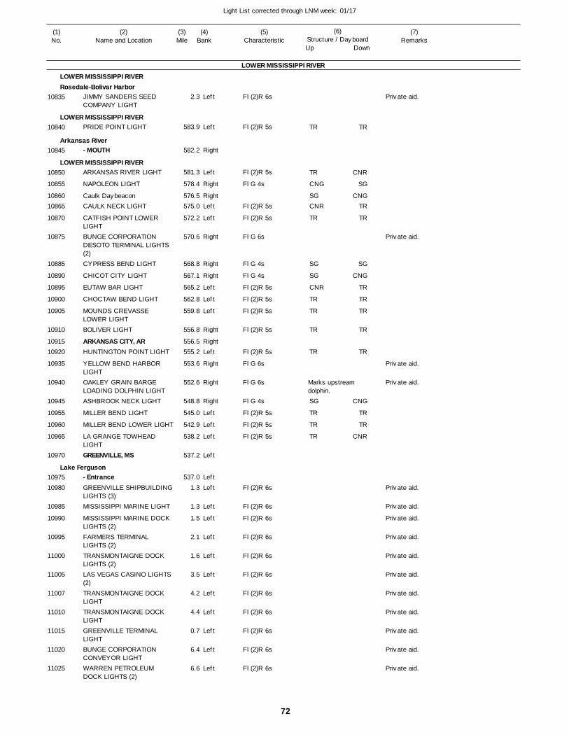
72
Light List corrected through LNM week: 01/17
(7)Remarks
(1)No.
(2)Name and Location
(3)Mile
(5)Characteristic
(4)Bank
(6)Structure / DayboardUp Down
JIMMY SANDERS SEED COMPANY LIGHT
PRIDE POINT LIGHT
- MOUTH
ARKANSAS RIVER LIGHT
NAPOLEON LIGHT
Caulk DaybeaconCAULK NECK LIGHT
CATFISH POINT LOWER LIGHTBUNGE CORPORATION DESOTO TERMINAL LIGHTS (2)CYPRESS BEND LIGHT
CHICOT CITY LIGHT
EUTAW BAR LIGHT
CHOCTAW BEND LIGHT
MOUNDS CREVASSE LOWER LIGHTBOLIVER LIGHT
ARKANSAS CITY, ARHUNTINGTON POINT LIGHT
YELLOW BEND HARBOR LIGHTOAKLEY GRAIN BARGE LOADING DOLPHIN LIGHTASHBROOK NECK LIGHT
MILLER BEND LIGHT
MILLER BEND LOWER LIGHT
LA GRANGE TOWHEAD LIGHTGREENVILLE, MS
- EntranceGREENVILLE SHIPBUILDINGLIGHTS (3)MISSISSIPPI MARINE LIGHT
MISSISSIPPI MARINE DOCK LIGHTS (2)FARMERS TERMINAL LIGHTS (2)TRANSMONTAIGNE DOCK LIGHTS (2)LAS VEGAS CASINO LIGHTS (2)TRANSMONTAIGNE DOCK LIGHTTRANSMONTAIGNE DOCK LIGHTGREENVILLE TERMINAL LIGHTBUNGE CORPORATION CONVEYOR LIGHTWARREN PETROLEUM DOCK LIGHTS (2)
LOWER MISSISSIPPI RIVER
LOWER MISSISSIPPI RIVERRosedale-Bolivar Harbor
LOWER MISSISSIPPI RIVER
Arkansas River
LOWER MISSISSIPPI RIVER
Lake Ferguson
Left
Left
Right
Left
Right
RightLeft
Left
Right
Right
Right
Left
Left
Left
Right
RightLeft
Right
Right
Right
Left
Left
Left
Left
Left
Left
Left
Left
Left
Left
Left
Left
Left
Left
Left
Left
2.3
583.9
582.2
581.3
578.4
576.5 575.0
572.2
570.6
568.8
567.1
565.2
562.8
559.8
556.8
556.5 555.2
553.6
552.6
548.8
545.0
542.9
538.2
537.2
537.0
1.3
1.3
1.5
2.1
1.6
3.5
4.2
4.4
0.7
6.4
6.6
Fl (2)R 6s
Fl (2)R 5s
Fl (2)R 5s
Fl G 4s
Fl (2)R 5s
Fl (2)R 5s
Fl G 6s
Fl G 4s
Fl G 4s
Fl (2)R 5s
Fl (2)R 5s
Fl (2)R 5s
Fl (2)R 5s
Fl (2)R 5s
Fl G 6s
Fl G 6s
Fl G 4s
Fl (2)R 5s
Fl (2)R 5s
Fl (2)R 5s
Fl (2)R 6s
Fl (2)R 6s
Fl (2)R 6s
Fl (2)R 6s
Fl (2)R 6s
Fl (2)R 6s
Fl (2)R 6s
Fl (2)R 6s
Fl (2)R 6s
Fl (2)R 6s
Fl (2)R 6s
Marks upstream dolphin.
10835
10840
10845
10850
10855
1086010865
10870
10875
10885
10890
10895
10900
10905
10910
1091510920
10935
10940
10945
10955
10960
10965
10970
1097510980
10985
10990
10995
11000
11005
11007
11010
11015
11020
11025
TR
TR
CNG
SGCNR
TR
SG
SG
CNR
TR
TR
TR
TR
SG
TR
TR
TR
TR
CNR
SG
CNGTR
TR
SG
CNG
TR
TR
TR
TR
TR
CNG
TR
TR
CNR
Private aid.
Private aid.
Private aid.
Private aid.
Private aid.
Private aid.
Private aid.
Private aid.
Private aid.
Private aid.
Private aid.
Private aid.
Private aid.
Private aid.
Private aid.
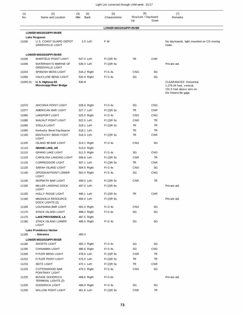
73
Light List corrected through LNM week: 01/17
(7)Remarks
(1)No.
(2)Name and Location
(3)Mile
(5)Characteristic
(4)Bank
(6)Structure / DayboardUp Down
U.S. COAST GUARD DEPOT GREENVILLE LIGHT
WARFIELD POINT LIGHT
WATERWAYS MARINE OF GREENVILLE LIGHTSPANISH MOSS LIGHT
VAUCLUSE BEND LIGHT
U. S. Highway 82 Mississippi River Bridge
ANCONIA POINT LIGHT
AMERICAN BAR LIGHT
LAKEPORT LIGHT
WALNUT POINT LIGHT
STELLA LIGHT
Kentucky Bend DaybeaconKENTUCKY BEND FOOT LIGHTISLAND 88 BAR LIGHT
GRAND LAKE, ARGRAND LAKE LIGHT
CAROLINA LANDING LIGHT
CORREGIDOR LIGHT
SARAH ISLAND LIGHT
OPOSSUM POINT LOWER LIGHTSKIPWITH BAR LIGHT
MILLER LANDING DOCK LIGHTHOLLY RIDGE LIGHT
MAGNOLIA RESOURCE DOCK LIGHTS (2)LOUISIANA BAR LIGHT
STACK ISLAND LIGHT
LAKE PROVIDENCE, LASTACK ISLAND LOWER LIGHT
- Entrance
SHORTS LIGHT
CHINAMAN LIGHT
FITLER BEND LIGHT
FITLER POINT LIGHT
SEITZ LIGHT
COTTONWOOD BAR POINTWAY LIGHTBUNGE GOODRICH TERMINAL LIGHTS (2)GOODRICH LIGHT
WILLOW POINT LIGHT
LOWER MISSISSIPPI RIVER
LOWER MISSISSIPPI RIVERLake Ferguson
LOWER MISSISSIPPI RIVER
Lake Providence Harbor
LOWER MISSISSIPPI RIVER
Left
Left
Left
Right
Right
Right
Left
Right
Left
Left
LeftLeft
Right
RightRight
Left
Left
Right
Right
Left
Left
Left
Left
Right
Right
RightRight
Right
Right
Left
Left
Left
Right
Right
Right
Left
2.0
537.0
536.0
534.2
532.9
530.8
528.6
527.7
525.0
522.5
519.1
518.1 516.3
514.1
513.0 511.5
508.8
507.1
504.5
502.4
499.0
497.0
495.1
494.4
491.0
488.2
487.5 485.5
483.4
482.2
480.6
478.6
475.0
472.1
470.2
468.6
466.9
461.6
F W
Fl (2)R 5s
Fl (2)R 6s
Fl G 4s
Fl G 4s
Fl G 4s
Fl (2)R 5s
Fl G 4s
Fl (2)R 5s
Fl (2)R 5s
Fl (2)R 5s
Fl G 4s
Fl G 4s
Fl (2)R 5s
Fl (2)R 5s
Fl G 4s
Fl G 4s
Fl (2)R 5s
Fl (2)R 6s
Fl (2)R 5s
Fl (2)R 6s
Fl G 4s
Fl G 4s
Fl G 4s
Fl G 4s
Fl G 4s
Fl (2)R 5s
Fl (2)R 5s
Fl (2)R 5s
Fl G 4s
Fl G 6s
Fl G 4s
Fl (2)R 5s
No dayboards, light mounted on CG moring tower.
CLEARANCES: Horizontal, 1,279.34 feet; vertical, 131.5 feet above zero onthe Greenville gage.
11030
11035
11040
11043
11050
11055.01
11070
11077
11080
11085
11090
1109511100
11105
1111011115
11120
11125
11130
11140
11145
11150
11155
11160
11165
11170
1117511180
11185
11190
11195
11200
11210
11215
11220
11225
11235
11245
TR
CNG
SG
SG
TR
CNG
CNR
TR
TRTR
CNG
SG
CNR
TR
CNG
SG
CNR
TR
CNG
SG
SG
SG
SG
CNR
TR
TR
CNG
SG
CNR
CNR
SG
SG
CNG
CNR
CNG
TR
TR
TRCNR
SG
CNG
TR
CNR
SG
CNG
TR
CNR
SG
SG
SG
SG
CNG
TR
TR
CNR
SG
SG
TR
Private aid.
Private aid.
Private aid.
Private aid.
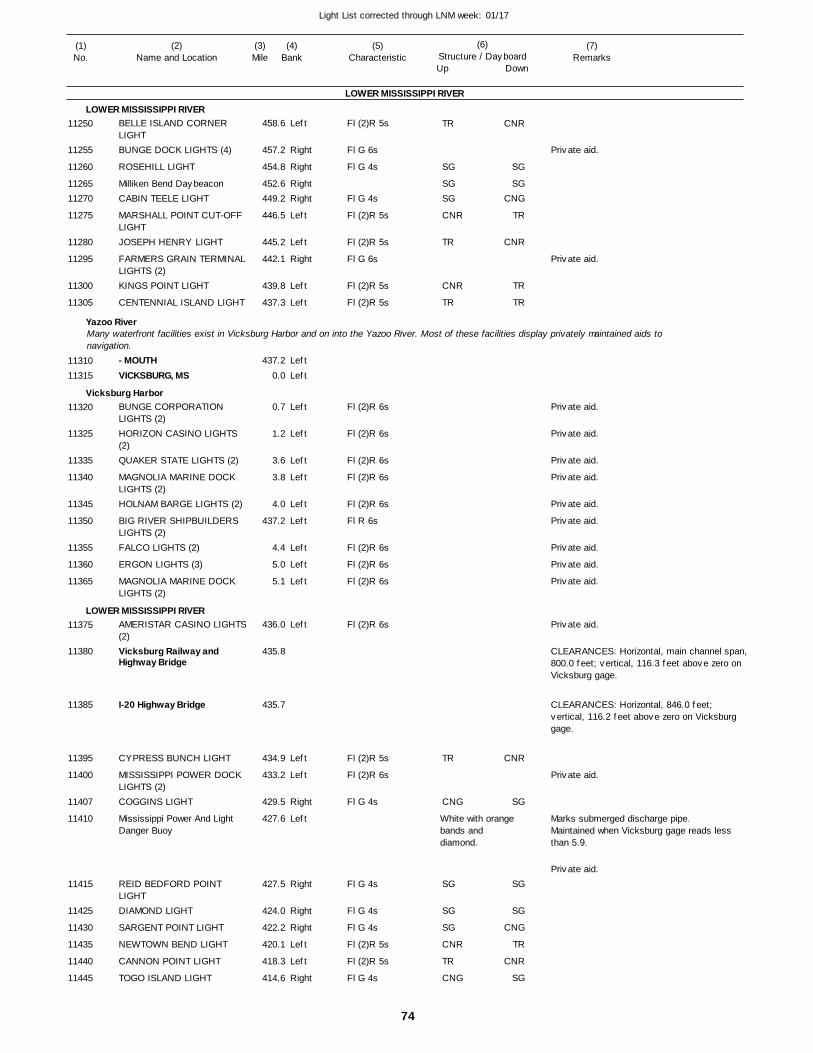
74
Light List corrected through LNM week: 01/17
(7)Remarks
(1)No.
(2)Name and Location
(3)Mile
(5)Characteristic
(4)Bank
(6)Structure / DayboardUp Down
BELLE ISLAND CORNER LIGHTBUNGE DOCK LIGHTS (4)
ROSEHILL LIGHT
Milliken Bend DaybeaconCABIN TEELE LIGHT
MARSHALL POINT CUT-OFF LIGHTJOSEPH HENRY LIGHT
FARMERS GRAIN TERMINALLIGHTS (2)KINGS POINT LIGHT
CENTENNIAL ISLAND LIGHT
- MOUTHVICKSBURG, MS
BUNGE CORPORATION LIGHTS (2)HORIZON CASINO LIGHTS (2)QUAKER STATE LIGHTS (2)
MAGNOLIA MARINE DOCK LIGHTS (2)HOLNAM BARGE LIGHTS (2)
BIG RIVER SHIPBUILDERS LIGHTS (2)FALCO LIGHTS (2)
ERGON LIGHTS (3)
MAGNOLIA MARINE DOCK LIGHTS (2)
AMERISTAR CASINO LIGHTS(2)Vicksburg Railway and Highway Bridge
I-20 Highway Bridge
CYPRESS BUNCH LIGHT
MISSISSIPPI POWER DOCK LIGHTS (2)COGGINS LIGHT
Mississippi Power And Light Danger Buoy
REID BEDFORD POINT LIGHTDIAMOND LIGHT
SARGENT POINT LIGHT
NEWTOWN BEND LIGHT
CANNON POINT LIGHT
TOGO ISLAND LIGHT
LOWER MISSISSIPPI RIVER
LOWER MISSISSIPPI RIVER
Yazoo River
Vicksburg Harbor
LOWER MISSISSIPPI RIVER
Many waterfront facilities exist in Vicksburg Harbor and on into the Yazoo River. Most of these facilities display privately maintained aids to navigation.
Left
Right
Right
RightRight
Left
Left
Right
Left
Left
Left
Left
Left
Left
Left
Left
Left
Left
Left
Left
Left
Left
Left
Left
Right
Left
Right
Right
Right
Left
Left
Right
458.6
457.2
454.8
452.6 449.2
446.5
445.2
442.1
439.8
437.3
437.2
0.0
0.7
1.2
3.6
3.8
4.0
437.2
4.4
5.0
5.1
436.0
435.8
435.7
434.9
433.2
429.5
427.6
427.5
424.0
422.2
420.1
418.3
414.6
Fl (2)R 5s
Fl G 6s
Fl G 4s
Fl G 4s
Fl (2)R 5s
Fl (2)R 5s
Fl G 6s
Fl (2)R 5s
Fl (2)R 5s
Fl (2)R 6s
Fl (2)R 6s
Fl (2)R 6s
Fl (2)R 6s
Fl (2)R 6s
Fl R 6s
Fl (2)R 6s
Fl (2)R 6s
Fl (2)R 6s
Fl (2)R 6s
Fl (2)R 5s
Fl (2)R 6s
Fl G 4s
Fl G 4s
Fl G 4s
Fl G 4s
Fl (2)R 5s
Fl (2)R 5s
Fl G 4s
White with orange bands and diamond.
CLEARANCES: Horizontal, main channel span,800.0 feet; vertical, 116.3 feet above zero on Vicksburg gage.
CLEARANCES: Horizontal, 846.0 feet; vertical, 116.2 feet above zero on Vicksburg gage.
Marks submerged discharge pipe. Maintained when Vicksburg gage reads less than 5.9.
11250
11255
11260
1126511270
11275
11280
11295
11300
11305
1131011315
11320
11325
11335
11340
11345
11350
11355
11360
11365
11375
11380
11385
11395
11400
11407
11410
11415
11425
11430
11435
11440
11445
TR
SG
SGSG
CNR
TR
CNR
TR
TR
CNG
SG
SG
SG
CNR
TR
CNG
CNR
SG
SGCNG
TR
CNR
TR
TR
CNR
SG
SG
SG
CNG
TR
CNR
SG
Private aid.
Private aid.
Private aid.
Private aid.
Private aid.
Private aid.
Private aid.
Private aid.
Private aid.
Private aid.
Private aid.
Private aid.
Private aid.
Private aid.
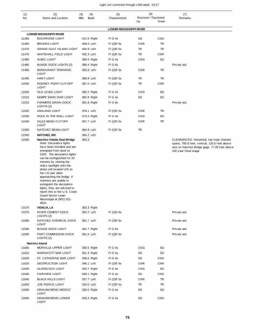
75
Light List corrected through LNM week: 01/17
(7)Remarks
(1)No.
(2)Name and Location
(3)Mile
(5)Characteristic
(4)Bank
(6)Structure / DayboardUp Down
BUCKRIDGE LIGHT
BROOKS LIGHT
GRAND GULF ISLAND LIGHT
WHITEHALL FIELD LIGHT
AUBIC LIGHT
BUNGE DOCK LIGHTS (2)
BONDURANT TOWHEAD LIGHTHART LIGHT
RODNEY POINT CUT-OFF LIGHTOLD LEVEE LIGHT
KEMPE SAND DIKE LIGHT
FARMERS GRAIN DOCK LIGHTS (2)ASHLAND LIGHT
HOLE IN THE WALL LIGHT
GILES BEND CUT-OFF LIGHTNATCHEZ BEAM LIGHT
NATCHEZ, MSNatchez-Vidalia Dual Bridge
VIDALIA, LARIVER CEMENT DOCK LIGHTS (2)NATCHEZ CHEMICAL DOCK LIGHTBUNGE DOCK LIGHT
PORT COMMISSION DOCK LIGHTS (2)
MORVILLE UPPER LIGHT
WARNICOTT BAR LIGHT
ST. CATHERINE BAR LIGHT
DESTRUCTION LIGHT
GLASSCOCK LIGHT
FAIRVIEW LIGHT
BLACK HILLS LIGHT
JOE PIERCE LIGHT
GRAHAM BEND MIDDLE LIGHTGRAHAM BEND LOWER LIGHT
LOWER MISSISSIPPI RIVER
LOWER MISSISSIPPI RIVER
Natchez Island
Right
Left
Left
Left
Right
Right
Left
Left
Left
Right
Right
Right
Left
Right
Left
Left
Left
RightLeft
Left
Right
Left
Right
Right
Right
Left
Right
Right
Left
Left
Right
Right
412.5
409.5
404.9
402.3
399.4
396.4
393.8
389.8
387.0
385.2
382.9
381.8
378.1
373.4
367.7
364.8
364.2 363.3
363.3 362.2
361.7
361.7
361.6
356.5
351.3
348.6
346.1
343.7
339.1
337.7
333.0
330.0
328.3
Note: Decorative lights have been installed and are energized from dusk to 0100. The decorative lights can be extinguished for 20 minutes by shining the ship’s spotlight onto the photo cell located U/S on the L/D pier when approaching the bridge. If mariners are unable to extinguish the decorative lights, they are advised to report this to the U.S. CoastGuard Sector Lower Mississippi at (901) 521-4824.
Fl G 4s
Fl (2)R 5s
Fl (2)R 5s
Fl (2)R 5s
Fl G 4s
Fl G 6s
Fl (2)R 5s
Fl (2)R 5s
Fl (2)R 5s
Fl G 4s
Fl G 4s
Fl G 6s
Fl (2)R 5s
Fl G 4s
Fl (2)R 5s
Fl (2)R 5s
Fl (2)R 6s
Fl (2)R 6s
Fl G 6s
Fl (2)R 6s
Fl G 4s
Fl G 4s
Fl G 4s
Fl (2)R 5s
Fl G 4s
Fl G 4s
Fl (2)R 5s
Fl (2)R 5s
Fl G 4s
Fl G 4s
CLEARANCES: Horizontal, two main channel spans, 785.8 feet; vertical, 125.6 feet above zero on Natchez Bridge gage. 77.09 feet above100 year flood stage.
11455
11460
11470
11475
11480
11485
11490
11495
11500
11505
11510
11515
11520
11530
11540
11550
1155511565
1157011575
11585
11590
11595
11605
11615
11620
11625
11630
11640
11645
11650
11660
11665
SG
CNR
TR
TR
CNG
CNR
TR
TR
CNG
SG
CNR
CNG
CNR
TR
CNG
SG
SG
CNR
CNG
SG
CNR
TR
SG
SG
CNG
TR
TR
CNR
SG
TR
TR
CNR
SG
SG
TR
SG
TR
SG
SG
CNG
CNR
SG
CNG
TR
TR
SG
CNG
Private aid.
Private aid.
Private aid.
Private aid.
Private aid.
Private aid.
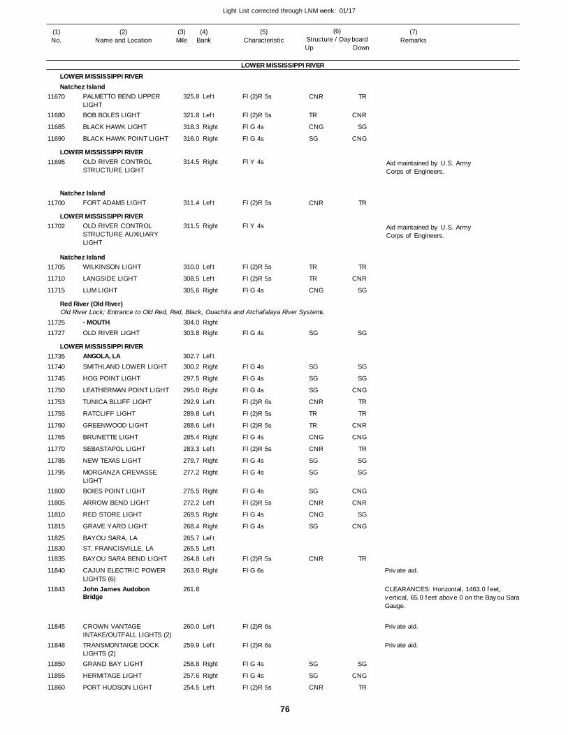
76
Light List corrected through LNM week: 01/17
(7)Remarks
(1)No.
(2)Name and Location
(3)Mile
(5)Characteristic
(4)Bank
(6)Structure / DayboardUp Down
PALMETTO BEND UPPER LIGHTBOB BOLES LIGHT
BLACK HAWK LIGHT
BLACK HAWK POINT LIGHT
OLD RIVER CONTROL STRUCTURE LIGHT
FORT ADAMS LIGHT
OLD RIVER CONTROL STRUCTURE AUXILIARY LIGHT
WILKINSON LIGHT
LANGSIDE LIGHT
LUM LIGHT
- MOUTHOLD RIVER LIGHT
ANGOLA, LASMITHLAND LOWER LIGHT
HOG POINT LIGHT
LEATHERMAN POINT LIGHT
TUNICA BLUFF LIGHT
RATCLIFF LIGHT
GREENWOOD LIGHT
BRUNETTE LIGHT
SEBASTAPOL LIGHT
NEW TEXAS LIGHT
MORGANZA CREVASSE LIGHTBOIES POINT LIGHT
ARROW BEND LIGHT
RED STORE LIGHT
GRAVE YARD LIGHT
BAYOU SARA, LAST. FRANCISVILLE, LABAYOU SARA BEND LIGHT
CAJUN ELECTRIC POWER LIGHTS (6)John James Audobon Bridge
CROWN VANTAGE INTAKE/OUTFALL LIGHTS (2)TRANSMONTAIGE DOCK LIGHTS (2)GRAND BAY LIGHT
HERMITAGE LIGHT
PORT HUDSON LIGHT
LOWER MISSISSIPPI RIVER
LOWER MISSISSIPPI RIVERNatchez Island
LOWER MISSISSIPPI RIVER
Natchez Island
LOWER MISSISSIPPI RIVER
Natchez Island
Red River (Old River)
LOWER MISSISSIPPI RIVER
Old River Lock; Entrance to Old Red, Red, Black, Ouachita and Atchafalaya River Systems.
Left
Left
Right
Right
Right
Left
Right
Left
Left
Right
Right
Right
Left
Right
Right
Right
Left
Left
Left
Right
Left
Right
Right
Right
Left
Right
Right
LeftLeftLeft
Right
Left
Left
Right
Right
Left
325.8
321.8
318.3
316.0
314.5
311.4
311.5
310.0
308.5
305.6
304.0
303.8
302.7
300.2
297.5
295.0
292.9
289.8
288.6
285.4
283.3
279.7
277.2
275.5
272.2
269.5
268.4
265.7 265.5 264.8
263.0
261.8
260.0
259.9
258.8
257.6
254.5
Fl (2)R 5s
Fl (2)R 5s
Fl G 4s
Fl G 4s
Fl Y 4s
Fl (2)R 5s
Fl Y 4s
Fl (2)R 5s
Fl (2)R 5s
Fl G 4s
Fl G 4s
Fl G 4s
Fl G 4s
Fl G 4s
Fl (2)R 6s
Fl (2)R 5s
Fl (2)R 5s
Fl G 4s
Fl (2)R 5s
Fl G 4s
Fl G 4s
Fl G 4s
Fl (2)R 5s
Fl G 4s
Fl G 4s
Fl (2)R 5s
Fl G 6s
Fl (2)R 6s
Fl (2)R 6s
Fl G 4s
Fl G 4s
Fl (2)R 5s
CLEARANCES: Horizontal, 1463.0 feet, vertical, 65.0 feet above 0 on the Bayou Sara Gauge.
Aid maintained by U.S. ArmyCorps of Engineers.
Aid maintained by U.S. ArmyCorps of Engineers.
11670
11680
11685
11690
11695
11700
11702
11705
11710
11715
1172511727
1173511740
11745
11750
11753
11755
11760
11765
11770
11785
11795
11800
11805
11810
11815
118251183011835
11840
11843
11845
11848
11850
11855
11860
CNR
TR
CNG
SG
CNR
TR
TR
CNG
SG
SG
SG
SG
CNR
TR
TR
CNG
CNR
SG
SG
SG
CNR
CNG
SG
CNR
SG
SG
CNR
TR
CNR
SG
CNG
TR
TR
CNR
SG
SG
SG
SG
CNG
TR
TR
CNR
CNG
TR
SG
SG
CNG
CNR
SG
CNG
TR
SG
CNG
TR
Private aid.
Private aid.
Private aid.
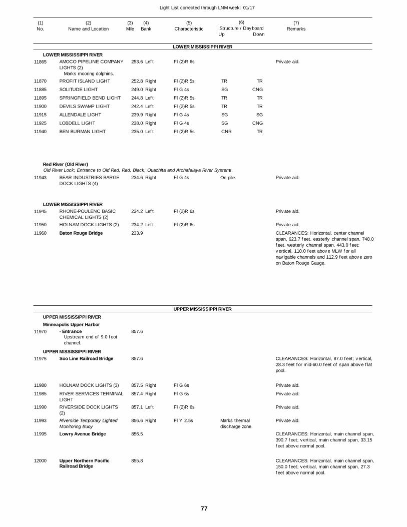
77
Light List corrected through LNM week: 01/17
(7)Remarks
(1)No.
(2)Name and Location
(3)Mile
(5)Characteristic
(4)Bank
(6)Structure / DayboardUp Down
AMOCO PIPELINE COMPANYLIGHTS (2)
PROFIT ISLAND LIGHT
SOLITUDE LIGHT
SPRINGFIELD BEND LIGHT
DEVILS SWAMP LIGHT
ALLENDALE LIGHT
LOBDELL LIGHT
BEN BURMAN LIGHT
BEAR INDUSTRIES BARGE DOCK LIGHTS (4)
RHONE-POULENC BASIC CHEMICAL LIGHTS (2)HOLNAM DOCK LIGHTS (2)
Baton Rouge Bridge
- Entrance
Soo Line Railroad Bridge
HOLNAM DOCK LIGHTS (3)
RIVER SERVICES TERMINALLIGHTRIVERSIDE DOCK LIGHTS (2)Riverside Temporary Lighted Monitoring BuoyLowry Avenue Bridge
Upper Northern Pacific Railroad Bridge
LOWER MISSISSIPPI RIVER
LOWER MISSISSIPPI RIVER
Red River (Old River)
LOWER MISSISSIPPI RIVER
UPPER MISSISSIPPI RIVER
UPPER MISSISSIPPI RIVERMinneapolis Upper Harbor
UPPER MISSISSIPPI RIVER
Old River Lock; Entrance to Old Red, Red, Black, Ouachita and Atchafalaya River Systems.
Left
Right
Right
Left
Left
Right
Right
Left
Right
Left
Left
Right
Right
Left
Right
253.6
252.8
249.0
244.8
242.4
239.9
238.0
235.0
234.6
234.2
234.2
233.9
857.6
857.6
857.5
857.4
857.1
856.6
856.5
855.8
Marks mooring dolphins.
Upstream end of 9.0 foot channel.
Fl (2)R 6s
Fl (2)R 5s
Fl G 4s
Fl (2)R 5s
Fl (2)R 5s
Fl G 4s
Fl G 4s
Fl (2)R 5s
Fl G 4s
Fl (2)R 6s
Fl (2)R 6s
Fl G 6s
Fl G 6s
Fl (2)R 6s
Fl Y 2.5s
On pile.
Marks thermal discharge zone.
CLEARANCES: Horizontal, center channel span, 623.7 feet, easterly channel span, 748.0feet, westerly channel span, 443.0 feet; vertical, 110.0 feet above MLW for all navigable channels and 112.9 feet above zero on Baton Rouge Gauge.
CLEARANCES: Horizontal, 87.0 feet; vertical, 28.3 feet for mid-60.0 feet of span above flat pool.
CLEARANCES: Horizontal, main channel span,390.7 feet; vertical, main channel span, 33.15 feet above normal pool.
CLEARANCES: Horizontal, main channel span,150.0 feet; vertical, main channel span, 27.3 feet above normal pool.
11865
11870
11885
11895
11900
11915
11925
11940
11943
11945
11950
11960
11970
11975
11980
11985
11990
11993
11995
12000
TR
SG
TR
TR
SG
SG
CNR
TR
CNG
TR
TR
SG
CNG
TR
Private aid.
Private aid.
Private aid.
Private aid.
Private aid.
Private aid.
Private aid.
Private aid.

78
Light List corrected through LNM week: 01/17
(7)Remarks
(1)No.
(2)Name and Location
(3)Mile
(5)Characteristic
(4)Bank
(6)Structure / DayboardUp Down
Broadway Avenue Bridge
New Plymouth Avenue Highway Bridge
MOORING CELL NO. 5 LIGHT
Upper Great Northern Railroad Bridge
Father Louis Hennepin Suspension Bridge
Third Avenue Highway Bridge
Upper St. Anthony Falls Lock & Dam
Stone Arch Railroad Bridge
MOORING CELL NO. 2 LIGHT
Lower St. Anthony Falls Lock & Dam
I-35 Highway Bridge
Cedar Avenue Highway Bridge
UNIVERSITY DOCK LIGHTS (3)MINNEAPOLIS, MNBurlington Northern City 9 Bridge
UPPER MISSISSIPPI RIVER
UPPER MISSISSIPPI RIVER
Right
Right
Right
Right
Left
Right
855.4
855.0
854.8
854.6
854.4
854.2
853.8
853.9
853.6
853.4
853.3
853.3
853.1
853.0 853.1
Fl G 6s
Fl G 6s
Fl (2)R 6s Marks mooring dock cells.
CLEARANCES: Horizontal, 229.0 feet; vertical, 27.8 feet above normal poolfor mid-176.0 feet channel span.
CLEARANCES: Horizontal, 253.0 feet; vertical, 26.6 feet above normal pool for mid-210 feet of main span.
CLEARANCES: Horizontal, main channel span,121.0 feet; vertical, main channel span, 24.1 feet above normal pool.
CLEARANCES: Horizontal, 483.3 feet; vertical, 34.3 feet above normal pool for entirespan.
CLEARANCES: Horizontal, main channel span,150.0 feet; vertical, main channel span, 23.3 feet abovenormal pool, at limits of navigation channel.
LOCK: 400 feet long, 56 feet wide. PHONE: 612-333-5336 A Restricted Operations Zone isin effect upstream and downstream of the lockfrom approximately Mile 854.4 to Mile 853.9. The zone is marked with Restricted Operation Buoys and Dayboards. The buoys are seasonal from Memeorial Day through Labor Day annually.
CLEARANCES: Horizontal, main channel span,56.0 feet; vertical, main channel span, 24.5 feet above normal pool.
LOCK: 400 feet long, 56 feet wide. PHONE: 612-332-3660 A Restricted Operations Zone isin effect upstream and downstream of the lockfrom approximately Mile 854.4 to Mile 853.9. The zone is marked with Restricted Operation Buoys and Dayboards. The buoys are seasonal from Memeorial Day through Labor Day annually.
CLEARANCES: Horizontal, 390.0 feet betweenleft pier and lock guide wall; vertical, 64.1 feet above normal pool, 20.0 feet from lock guide wall.
CLEARANCES: Horizontal,main channel span, 255.4feet; vertical, main channel span, 28.6 feet above normal pool, at limits of navigation channel.
CLEARANCES: Horizontal, main channel span,160.0 feet; vertical, main channel span, 39.4 feet above normal pool, at limits of navigation channel.
12010
12015
12020
12025
12030
12040
12045
12050
12055
12065
12070
12075
12080
1208512090
Private aid.
Private aid.
Private aid.
Private aid.
Private aid.
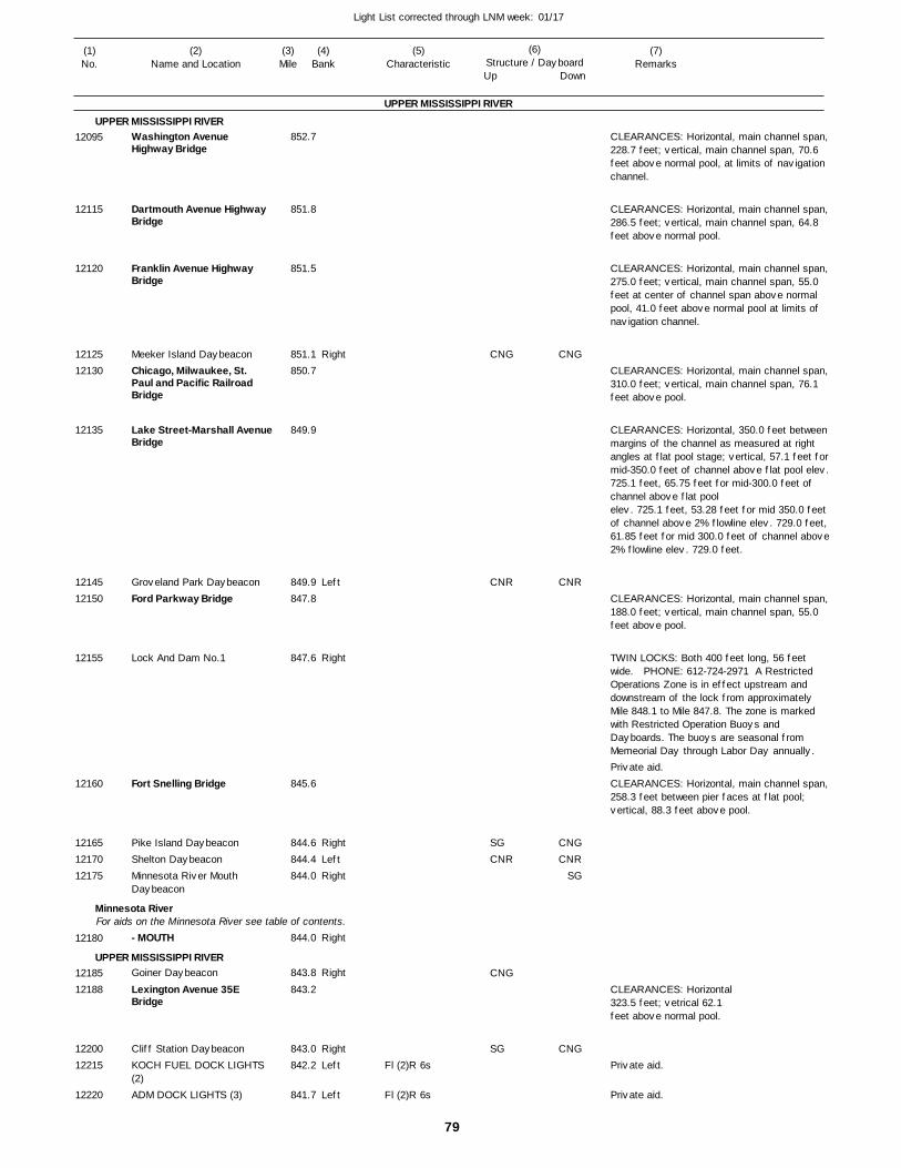
79
Light List corrected through LNM week: 01/17
(7)Remarks
(1)No.
(2)Name and Location
(3)Mile
(5)Characteristic
(4)Bank
(6)Structure / DayboardUp Down
Washington Avenue Highway Bridge
Dartmouth Avenue Highway Bridge
Franklin Avenue Highway Bridge
Meeker Island DaybeaconChicago, Milwaukee, St. Paul and Pacific Railroad Bridge
Lake Street-Marshall Avenue Bridge
Groveland Park DaybeaconFord Parkway Bridge
Lock And Dam No.1
Fort Snelling Bridge
Pike Island DaybeaconShelton DaybeaconMinnesota River Mouth Daybeacon
- MOUTH
Goiner Daybeacon
Lexington Avenue 35E Bridge
Cliff Station DaybeaconKOCH FUEL DOCK LIGHTS (2)ADM DOCK LIGHTS (3)
UPPER MISSISSIPPI RIVER
UPPER MISSISSIPPI RIVER
Minnesota River
UPPER MISSISSIPPI RIVER
For aids on the Minnesota River see table of contents.
Right
Left
Right
RightLeftRight
Right
Right
RightLeft
Left
852.7
851.8
851.5
851.1 850.7
849.9
849.9 847.8
847.6
845.6
844.6 844.4 844.0
844.0
843.8
843.2
843.0 842.2
841.7
Fl (2)R 6s
Fl (2)R 6s
CLEARANCES: Horizontal, main channel span,228.7 feet; vertical, main channel span, 70.6 feet above normal pool, at limits of navigation channel.
CLEARANCES: Horizontal, main channel span,286.5 feet; vertical, main channel span, 64.8 feet above normal pool.
CLEARANCES: Horizontal, main channel span,275.0 feet; vertical, main channel span, 55.0 feet at center of channel span above normal pool, 41.0 feet above normal pool at limits of navigation channel.
CLEARANCES: Horizontal, main channel span,310.0 feet; vertical, main channel span, 76.1 feet above pool.
CLEARANCES: Horizontal, 350.0 feet betweenmargins of the channel as measured at right angles at flat pool stage; vertical, 57.1 feet formid-350.0 feet of channel above flat pool elev.725.1 feet, 65.75 feet for mid-300.0 feet of channel above flat poolelev. 725.1 feet, 53.28 feet for mid 350.0 feet of channel above 2% flowline elev. 729.0 feet,61.85 feet for mid 300.0 feet of channel above2% flowline elev. 729.0 feet.
CLEARANCES: Horizontal, main channel span,188.0 feet; vertical, main channel span, 55.0 feet above pool.
TWIN LOCKS: Both 400 feet long, 56 feet wide. PHONE: 612-724-2971 A Restricted Operations Zone is in effect upstream and downstream of the lock from approximately Mile 848.1 to Mile 847.8. The zone is marked with Restricted Operation Buoys and Dayboards. The buoys are seasonal from Memeorial Day through Labor Day annually.
CLEARANCES: Horizontal, main channel span,258.3 feet between pier faces at flat pool; vertical, 88.3 feet above pool.
CLEARANCES: Horizontal323.5 feet; vetrical 62.1feet above normal pool.
12095
12115
12120
1212512130
12135
1214512150
12155
12160
121651217012175
12180
1218512188
1220012215
12220
CNG
CNR
SGCNR
CNG
SG
CNG
CNR
CNGCNR
SG
CNG
Private aid.
Private aid.
Private aid.

80
Light List corrected through LNM week: 01/17
(7)Remarks
(1)No.
(2)Name and Location
(3)Mile
(5)Characteristic
(4)Bank
(6)Structure / DayboardUp Down
ADM DOCK LIGHTS (2)
Omaha Railroad Drawbridge
Cherokee Heights DaybeaconSmith Avenue Highway Bridge
Wabasha Street Highway Bridge
Chicago and North WesternRailroad Drawbridge
Robert Street Highway Bridge
ST. PAUL, MN
ST. PAUL, MN
Lafayette Street Highway Bridge
FARM BUREAU DOCK LIGHT
PIGS EYE LIGHT
Belt Line Railroad Drawbridge
Kaposia DaybeaconRED ROCK UPPER LIGHT
I-494 Bridge
NEWPORT TERMINAL LIGHTS (2)
Newport Island Upper DaybeaconNewport Island Daybeacon
UPPER MISSISSIPPI RIVER
UPPER MISSISSIPPI RIVERLeft
Right
Left
Right
Right
RightLeft
Left
Right
Right
841.6
841.4
841.2 840.4
839.5
839.2
839.2
839.1
839.0
838.8
838.6
836.0
835.7
834.4 833.1
832.5
832.2
832.0
831.7
Marks waterfront facility.
(Sibley Street)
(Lamberts Landing)
Marks mooring facilities.
Fl (2)R 6s
Fl G 6s
Fl G 4s
Fl (2)R 5s
Fl (2)R 6s
On rock mound.
CLEARANCES: Horizontal, 160.0 feet, riverward draw only; vertical, closed, 22.3 feet above normal pool, 25.3 feet above zero gage.Mile 839.3. CALL SIGN: KUZ 545, channels 14and 16.
CLEARANCE: Horizontal, 492.0 feet; vertical, 63.0 feet above normal pool for mid-442.0 feetof span.
CLEARANCES: Horizontal, channel span, 316.0 feet; vertical at left descending pier face74.9 feet above pool, at right descending pier face 56.3 feet above pool, at center span 77.6feet above pool.
CLEARANCES: Horizontal, 158.0 feet betweensheer fences; vertical, open, 71.7 feet above normal pool, 74.7 feet above zero on this bridge gage; vertical, closed 25.1 feet above normal pool, 28.4 feet above zero on bridge gage. CALL SIGN: KUZ 546, channels 14 and 16.
CLEARANCES: Horizontal, main channel span,158.0 feet between sheer fences; vertical, 59.6 feet, 79.0 feet to right and left of center of channel span above normal pool; 62.6 feet above zero on Chicago and North Western Bridge gage.
CLEARANCES: Horizontal, main channel span,350.0 feet; vertical, main channel span, 59.6 feet above normal pool.
CLEARANCES: Horizontal, left channel span, 175.5 feet, right channel span, 174.58 feet; vertical, closed, 20.6 feet, open, 83.2 feet above normal pool. CALL SIGN: KUZ 544, channels 14 and 16.
CLEARANCES: Horizontal, main channel span,407.2 feet between pier faces; vertical, at center of channel span, 64.3 feet above flat pool and 45.68 feet above 1965 high water, and at pier faces, 63.2 feet above flat pool and 44.58 feet above 1965 high water.
12225
12230
1223512245
12250
12260
12265
12270
12275
12280
12285
12290
12295
1230512310
12315
12320
12325
12330
CNG
CNG
CNGCNR
CNG
CNG
CNG
CNGCNR
CNG
Private aid.
Private aid.
Private aid.
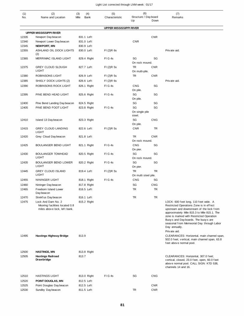
81
Light List corrected through LNM week: 01/17
(7)Remarks
(1)No.
(2)Name and Location
(3)Mile
(5)Characteristic
(4)Bank
(6)Structure / DayboardUp Down
Newport Daybeacon
Newport Lower DaybeaconNEWPORT, MNASHLAND OIL DOCK LIGHTS(2)MERRIMAC ISLAND LIGHT
GREY CLOUD SLOUGH LIGHT
ROBINSONS LIGHT
SHIELY DOCK LIGHTS (2)
ROBINSONS ROCK LIGHT
PINE BEND HEAD LIGHT
Pine Bend Landing DaybeaconPINE BEND FOOT LIGHT
Island 13 Daybeacon
GREY CLOUD LANDING LIGHTGrey Cloud Daybeacon
BOULANGER BEND LIGHT
BOULANGER TOWHEAD LIGHT
BOULANGER BEND LOWER LIGHT
GREY CLOUD ISLAND LIGHT
NININGER LIGHT
Nininger DaybeaconFreeborn Island Lower DaybeaconStrekfus DaybeaconLock And Dam No. 2
Hastings Highway Bridge
HASTINGS, MNHastings Railroad Drawbridge
HASTINGS LIGHT
POINT DOUGLAS, MNPoint Douglas DaybeaconSundby Daybeacon
UPPER MISSISSIPPI RIVER
UPPER MISSISSIPPI RIVERLeft
LeftLeftLeft
Right
Left
Left
Left
Right
Right
RightRight
Right
Left
Left
Right
Right
Right
Left
Right
RightLeft
LeftRight
Right
Right
LeftLeftLeft
831.1
831.0 830.9 830.0
829.4
827.7
826.9
826.6
826.1
825.6
824.5 823.8
823.3
822.6
821.8
821.1
820.5
820.2
819.4
818.1
817.8 816.5
816.1 815.2
813.9
813.8 813.7
813.0
812.5 812.5 811.5
Mooring facilities located 0.8miles above lock, left bank.
Fl (2)R 6s
Fl G 4s
Fl (2)R 5s
Fl (2)R 5s
Fl (2)R 6s
Fl G 4s
Fl G 4s
Fl G 4s
Fl (2)R 5s
Fl G 4s
Fl G 4s
Fl G 4s
Fl (2)R 5s
Fl G 4s
Fl G 4s
On rock mound.
On multi-pile.
On pile.
On pile.
On single pile steel.
On pile.
On rock mound.
On pier.
On rock mound.
On pier.
On multi steel pile.
LOCK: 600 feet long, 110 feet wide. A Restricted Operations Zone is in effect upstream and downstream of the lock from approximately Mile 815.3 to Mile 815.1. The zone is marked with Restricted Operation Buoys and Dayboards. The buoys are seasonal from Memeorial Day through Labor Day annually.
CLEARANCES: Horizontal, main channel span,502.0 feet; vertical, main channel span, 63.8 feet above normal pool.
CLEARANCES: Horizontal, 307.0 feet; vertical, closed, 23.0 feet, open, 60.0 feet above normal pool. CALL SIGN: KTD 538, channels 14 and 16.
12335123401234512355
12365
12375
12380
12385
12390
12395
1240012405
12410
12415
12420
12425
12430
12435
12445
12455
1246012465
1247012475
12495
1250012505
12510
125201252512530
CNR
SG
TR
TR
CNG
SG
SGSG
SG
CNR
TR
CNG
SG
SG
TR
CNG
SGTR
TR
SG
TR
CNR
SG
CNR
CNR
SG
SG
SGSG
CNG
TR
CNR
SG
SG
SG
TR
SG
CNGTR
TR
CNG
CNRCNR
Private aid.
Private aid.
Private aid.
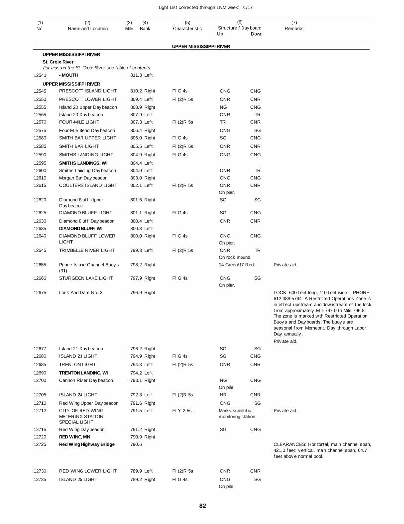
82
Light List corrected through LNM week: 01/17
(7)Remarks
(1)No.
(2)Name and Location
(3)Mile
(5)Characteristic
(4)Bank
(6)Structure / DayboardUp Down
- MOUTH
PRESCOTT ISLAND LIGHT
PRESCOTT LOWER LIGHT
Island 20 Upper DaybeaconIsland 20 DaybeaconFOUR-MILE LIGHT
Four-Mile Bend DaybeaconSMITH BAR UPPER LIGHT
SMITH BAR LIGHT
SMITHS LANDING LIGHT
SMITHS LANDINGS, WISmiths Landing DaybeaconMorgan Bar DaybeaconCOULTERS ISLAND LIGHT
Diamond Bluff Upper DaybeaconDIAMOND BLUFF LIGHT
Diamond Bluff DaybeaconDIAMOND BLUFF, WIDIAMOND BLUFF LOWER LIGHT
TRIMBELLE RIVER LIGHT
Priarie Island Channel Buoys (31)STURGEON LAKE LIGHT
Lock And Dam No. 3
Island 21 DaybeaconISLAND 23 LIGHT
TRENTON LIGHT
TRENTON LANDING, WICannon River Daybeacon
ISLAND 24 LIGHT
Red Wing Upper DaybeaconCITY OF RED WING METERING STATION SPECIAL LIGHTRed Wing DaybeaconRED WING, MNRed Wing Highway Bridge
RED WING LOWER LIGHT
ISLAND 25 LIGHT
UPPER MISSISSIPPI RIVER
UPPER MISSISSIPPI RIVERSt. Croix River
UPPER MISSISSIPPI RIVER
For aids on the St. Croix River see table of contents.Left
Right
Left
RightLeftLeft
RightRight
Left
Right
LeftLeftRightLeft
Right
Right
LeftLeftRight
Left
Right
Right
Right
RightRight
Left
LeftRight
Left
RightLeft
RightRight
Left
Right
811.3
810.2
809.4
808.9 807.9 807.3
806.4 806.0
805.5
804.9
804.4 804.0 803.0 802.1
801.6
801.1
800.4 800.3 800.0
799.3
798.2
797.9
796.9
796.2 794.9
794.3
794.2 793.1
792.3
791.6 791.5
791.2 790.9 790.6
789.9
789.2
Fl G 4s
Fl (2)R 5s
Fl (2)R 5s
Fl G 4s
Fl (2)R 5s
Fl G 4s
Fl (2)R 5s
Fl G 4s
Fl G 4s
Fl (2)R 5s
Fl G 4s
Fl G 4s
Fl (2)R 5s
Fl (2)R 5s
Fl Y 2.5s
Fl (2)R 5s
Fl G 4s
On pier.
On pier.
On rock mound.14 Green/17 Red.
On pier.
On pile.
Marks scientific monitoring station.
On pile.
LOCK: 600 feet long, 110 feet wide. PHONE:612-388-5794 A Restricted Operations Zone isin effect upstream and downstream of the lockfrom approximately Mile 797.0 to Mile 796.8. The zone is marked with Restricted Operation Buoys and Dayboards. The buoys are seasonal from Memeorial Day through Labor Day annually.
CLEARANCES: Horizontal, main channel span,421.0 feet; vertical, main channel span, 64.7 feet above normal pool.
12540
12545
12550
125551256512570
1257512580
12585
12590
12595126001261012615
12620
12625
126301263512640
12645
12655
12660
12675
1267712680
12685
1269012700
12705
1271012712
127151272012725
12730
12735
CNG
CNR
NGCNRTR
CNGSG
CNR
CNG
CNRCNGCNR
SG
SG
CNR
CNG
CNR
CNG
SGSG
CNR
NG
NR
CNG
SG
CNR
CNG
CNG
CNR
CNGTR
CNR
SGCNG
CNR
CNG
TRCNGCNR
SG
CNG
CNR
CNG
TR
SG
SGCNG
CNR
CNG
CNR
SG
CNG
CNR
SG
Private aid.
Private aid.
Private aid.
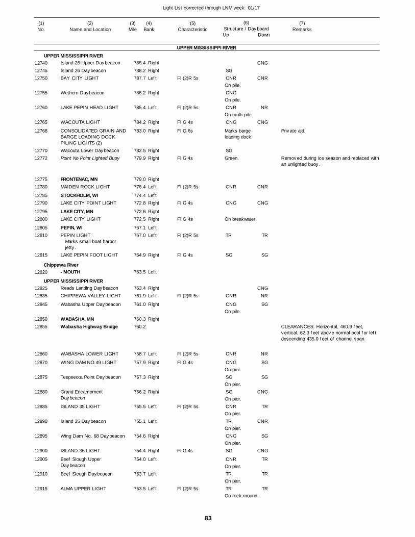
83
Light List corrected through LNM week: 01/17
(7)Remarks
(1)No.
(2)Name and Location
(3)Mile
(5)Characteristic
(4)Bank
(6)Structure / DayboardUp Down
Island 26 Upper Daybeacon
Island 26 DaybeaconBAY CITY LIGHT
Wethern Daybeacon
LAKE PEPIN HEAD LIGHT
WACOUTA LIGHT
CONSOLIDATED GRAIN ANDBARGE LOADING DOCK PILING LIGHTS (2)Wacouta Lower DaybeaconPoint No Point Lighted Buoy
FRONTENAC, MNMAIDEN ROCK LIGHT
STOCKHOLM, WILAKE CITY POINT LIGHT
LAKE CITY, MNLAKE CITY LIGHT
PEPIN, WIPEPIN LIGHT
LAKE PEPIN FOOT LIGHT
- MOUTH
Reads Landing Daybeacon
CHIPPEWA VALLEY LIGHT
Wabasha Upper Daybeacon
WABASHA, MNWabasha Highway Bridge
WABASHA LOWER LIGHT
WING DAM NO.49 LIGHT
Teepeeota Point Daybeacon
Grand Encampment Daybeacon
ISLAND 35 LIGHT
Island 35 Daybeacon
Wing Dam No. 68 Daybeacon
ISLAND 36 LIGHT
Beef Slough Upper Daybeacon
Beef Slough Daybeacon
ALMA UPPER LIGHT
UPPER MISSISSIPPI RIVER
UPPER MISSISSIPPI RIVER
Chippewa River
UPPER MISSISSIPPI RIVER
Right
RightLeft
Right
Left
Right
Right
RightRight
RightLeft
LeftRight
RightRight
LeftLeft
Right
Left
Right
Left
Right
Right
Left
Right
Right
Right
Left
Left
Right
Right
Left
Left
Left
788.4
788.2 787.7
786.2
785.4
784.2
783.0
782.5 779.9
779.0 776.4
774.4 772.8
772.6 772.5
767.1 767.0
764.9
763.5
763.4
761.9
761.0
760.3 760.2
758.7
757.9
757.3
756.2
755.5
755.1
754.6
754.4
754.0
753.7
753.5
Marks small boat harbor jetty.
Fl (2)R 5s
Fl (2)R 5s
Fl G 4s
Fl G 6s
Fl G 4s
Fl (2)R 5s
Fl G 4s
Fl G 4s
Fl (2)R 5s
Fl G 4s
Fl (2)R 5s
Fl (2)R 5s
Fl G 4s
Fl (2)R 5s
Fl G 4s
Fl (2)R 5s
On pile.
On pile.
On multi-pile.
Marks barge loading dock.
Green.
On breakwater.
On pile.
On pier.
On pier.
On pier.
On pier.
On pier.
On pier.
On pier.
On pier.
On rock mound.
Removed during ice season and replaced with an unlighted buoy.
CLEARANCES: Horizontal, 460.9 feet, vertical, 62.3 feet above normal pool for left descending 435.0 feet of channel span.
127401274512750
12755
12760
12765
12768
1277012772
1277512780
1278512790
1279512800
1280512810
12815
12820
1282512835
12845
1285012855
12860
12870
12875
12880
12885
12890
12895
12900
12905
12910
12915
SGCNR
CNG
CNR
CNG
SG
CNR
CNG
TR
SG
CNR
CNG
CNR
CNG
SG
SG
CNR
TR
CNG
SG
CNR
TR
TR
CNG
CNR
NR
CNG
CNR
CNG
TR
SG
CNGNR
SG
NR
SG
SG
CNG
TR
CNR
SG
CNG
TR
TR
TR
Private aid.
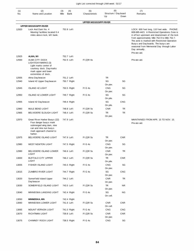
84
Light List corrected through LNM week: 01/17
(7)Remarks
(1)No.
(2)Name and Location
(3)Mile
(5)Characteristic
(4)Bank
(6)Structure / DayboardUp Down
Lock And Dam No. 4
ALMA, WIALMA CITY DOCK LIGHT/DAYMARKS (3)
Alma DaybeaconIsland 42 Upper Daybeacon
ISLAND 42 LIGHT
ISLAND 42 LOWER LIGHT
Island 42 Daybeacon
MULE BEND LIGHT
BELVIDERE SLOUGH LIGHT
Great River Harbor Buoys (22)
BELVIDERE ISLAND LIGHT
WEST NEWTON LIGHT
BELVIDERE ISLAND LOWER LIGHT
BUFFALO CITY UPPER LIGHT
FISHER ISLAND LIGHT
ZUMBRO RIVER LIGHT
Somerfield Island Upper Daybeacon
SOMERFIELD ISLAND LIGHT
MINNEISKA LANDING LIGHT
MINNEISKA, MNMINNEISKA LOWER LIGHT
MOUNT VERNON LIGHT
RICHTMAN LIGHT
CHIMNEY ROCK LIGHT
UPPER MISSISSIPPI RIVER
UPPER MISSISSIPPI RIVERLeft
LeftLeft
LeftRight
Right
Right
Right
Left
Left
Left
Left
Right
Left
Left
Right
Right
Left
Left
Right
RightLeft
Right
Left
Right
752.8
752.7 752.5
751.2 750.7
750.5
749.7
749.4
748.8
748.4
747.9
747.9
747.5
746.6
746.2
745.5
744.7
744.2
743.5
742.4
742.4 741.6
741.0
739.8
738.5
Mooring facilities located 0.4miles above lock, left bank.
Light marks center of courtesy dock. Daymarks mark upper and lower extremities of dock.
Four danger buoys mark submerged wing dam, nine can and nine nun buoys mark approach channel to harbor.
Fl (2)R 6s
Fl G 4s
Fl G 4s
Fl (2)R 5s
Fl (2)R 5s
Fl (2)R 5s
Fl G 4s
Fl (2)R 5s
Fl (2)R 5s
Fl G 4s
Fl G 4s
Fl (2)R 5s
Fl G 4s
Fl (2)R 5s
Fl G 4s
Fl (2)R 5s
Fl G 4s
On pier.
On pier.
On pile.
On pile.
On pier.
On pier.
On pier.
On pier.
On pile.
On pier.
On pier.
On pier.
On pier.
On cell.
On cell.
On pier.
LOCK: 600 feet long, 110 feet wide. PHONE:608-685-4421 A Restricted Operations Zone isin effect upstream and downstream of the lockfrom approximately Mile 752.9 to Mile 752.7. The zone is marked with Restricted Operation Buoys and Dayboards. The buoys are seasonal from Memeorial Day through Labor Day annually.
MAINTAINED FROM APR. 15 TO NOV. 15.
12920
1292512930
1293512940
12945
12950
12955
12960
12965
12970
12975
12980
12990
13000
13005
13015
13020
13030
13040
1305013060
13065
13070
13075
TRSG
CNG
SG
SG
CNR
TR
TR
CNG
CNR
TR
CNG
SG
CNR
TR
SG
CNR
CNG
CNR
CNG
SG
SG
SG
CNG
TR
TR
CNR
SG
TR
CNR
SG
CNG
TR
NR
NG
CNR
CNG
CNR
SG
Private aid.
Private aid.
Private aid.
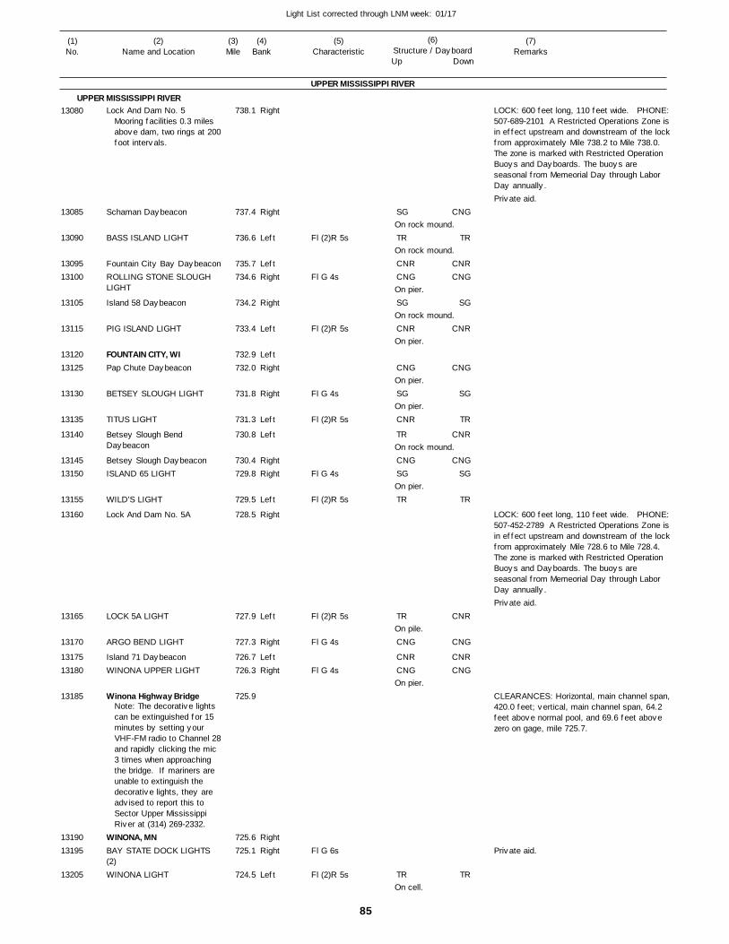
85
Light List corrected through LNM week: 01/17
(7)Remarks
(1)No.
(2)Name and Location
(3)Mile
(5)Characteristic
(4)Bank
(6)Structure / DayboardUp Down
Lock And Dam No. 5
Schaman Daybeacon
BASS ISLAND LIGHT
Fountain City Bay DaybeaconROLLING STONE SLOUGH LIGHT
Island 58 Daybeacon
PIG ISLAND LIGHT
FOUNTAIN CITY, WIPap Chute Daybeacon
BETSEY SLOUGH LIGHT
TITUS LIGHT
Betsey Slough Bend Daybeacon
Betsey Slough DaybeaconISLAND 65 LIGHT
WILD'S LIGHT
Lock And Dam No. 5A
LOCK 5A LIGHT
ARGO BEND LIGHT
Island 71 DaybeaconWINONA UPPER LIGHT
Winona Highway Bridge
WINONA, MNBAY STATE DOCK LIGHTS (2)WINONA LIGHT
UPPER MISSISSIPPI RIVER
UPPER MISSISSIPPI RIVERRight
Right
Left
LeftRight
Right
Left
LeftRight
Right
Left
Left
RightRight
Left
Right
Left
Right
LeftRight
RightRight
Left
738.1
737.4
736.6
735.7 734.6
734.2
733.4
732.9 732.0
731.8
731.3
730.8
730.4 729.8
729.5
728.5
727.9
727.3
726.7 726.3
725.9
725.6 725.1
724.5
Mooring facilities 0.3 miles above dam, two rings at 200foot intervals.
Note: The decorative lights can be extinguished for 15 minutes by setting your VHF-FM radio to Channel 28and rapidly clicking the mic 3 times when approaching the bridge. If mariners are unable to extinguish the decorative lights, they are advised to report this to Sector Upper Mississippi River at (314) 269-2332.
Fl (2)R 5s
Fl G 4s
Fl (2)R 5s
Fl G 4s
Fl (2)R 5s
Fl G 4s
Fl (2)R 5s
Fl (2)R 5s
Fl G 4s
Fl G 4s
Fl G 6s
Fl (2)R 5s
On rock mound.
On rock mound.
On pier.
On rock mound.
On pier.
On pier.
On pier.
On rock mound.
On pier.
On pile.
On pier.
On cell.
LOCK: 600 feet long, 110 feet wide. PHONE:507-689-2101 A Restricted Operations Zone isin effect upstream and downstream of the lockfrom approximately Mile 738.2 to Mile 738.0. The zone is marked with Restricted Operation Buoys and Dayboards. The buoys are seasonal from Memeorial Day through Labor Day annually.
LOCK: 600 feet long, 110 feet wide. PHONE:507-452-2789 A Restricted Operations Zone isin effect upstream and downstream of the lockfrom approximately Mile 728.6 to Mile 728.4. The zone is marked with Restricted Operation Buoys and Dayboards. The buoys are seasonal from Memeorial Day through Labor Day annually.
CLEARANCES: Horizontal, main channel span,420.0 feet; vertical, main channel span, 64.2 feet above normal pool, and 69.6 feet above zero on gage, mile 725.7.
13080
13085
13090
1309513100
13105
13115
1312013125
13130
13135
13140
1314513150
13155
13160
13165
13170
1317513180
13185
1319013195
13205
SG
TR
CNRCNG
SG
CNR
CNG
SG
CNR
TR
CNGSG
TR
TR
CNG
CNRCNG
TR
CNG
TR
CNRCNG
SG
CNR
CNG
SG
TR
CNR
CNGSG
TR
CNR
CNG
CNRCNG
TR
Private aid.
Private aid.
Private aid.
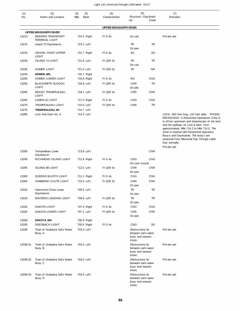
86
Light List corrected through LNM week: 01/17
(7)Remarks
(1)No.
(2)Name and Location
(3)Mile
(5)Characteristic
(4)Bank
(6)Structure / DayboardUp Down
MODERN TRANSPORT TERMINAL LIGHTIsland 73 Daybeacon
GRAVEL POINT UPPER LIGHTISLAND 74 LIGHT
HOMER LIGHT
HOMER, MNHOMER LOWER LIGHT
BLACKSMITH SLOUGH LIGHT
MOUNT TREMPEALEAU LIGHTLAMOILLE LIGHT
TREMPEALEAU LIGHT
TREMPEALEAU, WILock And Dam No. 6
Trempealeau Lower DaybeaconRICHMOND ISLAND LIGHT
ISLAND 88 LIGHT
QUEENS BLUFFS LIGHT
HAMMOND CHUTE LIGHT
Hammond Chute Lower Daybeacon
WINTERS LANDING LIGHT
DAKOTA LIGHT
DAKOTA LOWER LIGHT
DAKOTA, MNDRESBACH LIGHT
Town of Onalaska Safe Water Buoy A
Town of Onalaska Safe Water Buoy B
Town of Onalaska Safe Water Buoy C
Town of Onalaska Safe Water Buoy D
UPPER MISSISSIPPI RIVER
UPPER MISSISSIPPI RIVERRight
Left
Right
Left
Left
RightRight
Left
Left
Right
Left
LeftLeft
Left
Right
Left
Right
Left
Left
Left
Right
Left
RightRight
Left
Left
Left
Left
724.3
723.2
722.7
721.9
721.0
720.7 719.8
718.8
718.1
717.0
715.6
714.7 714.3
713.8
712.8
712.0
711.1
710.0
709.5
708.9
707.5
707.1
706.9 705.6
703.0
703.0
703.0
703.0
Fl G 6s
Fl G 4s
Fl (2)R 5s
Fl (2)R 5s
Fl G 4s
Fl (2)R 5s
Fl (2)R 5s
Fl G 4s
Fl (2)R 5s
Fl G 4s
Fl (2)R 5s
Fl G 4s
Fl (2)R 5s
Fl (2)R 5s
Fl G 4s
Fl (2)R 5s
Fl G 4s
On cell.
On pier.
On cell.
On pile.
On rock mound.
On pier.
On pier.
On pier.
On pier.
On pier.
Obstructions lie between safe waterbuoy and nearest shore.Obstructions lie between safe waterbuoy and nearest shore.Obstructions lie between safe waterbuoy and nearest shore.Obstructions lie between safe waterbuoy and nearest shore.
LOCK: 600 feet long, 110 feet wide. PHONE:608-534-6424 A Restricted Operations Zone isin effect upstream and downstream of the lockand the spillway on Lock 6 dam, from approximately Mile 714.2 to Mile 714.0. The Zone is marked with Restricted Operation Buoys and Dayboards. The buoys are seasonal from Memorial Day through Labor Day annually.
13210
13215
13220
13230
13235
1324013250
13255
13260
13265
13270
1327513280
13285
13290
13295
13300
13305
13310
13315
13320
13325
1333013335
13338
13338.01
13338.02
13338.03
TR
SG
TR
TR
NG
CNR
CNR
CNG
CNR
CNG
CNR
CNG
CNR
TR
TR
CNG
CNR
CNG
TR
SG
TR
NR
CNG
TR
CNR
CNG
TR
CNR
CNG
CNR
CNG
CNR
TR
TR
CNG
CNR
SG
Private aid.
Private aid.
Private aid.
Private aid.
Private aid.
Private aid.
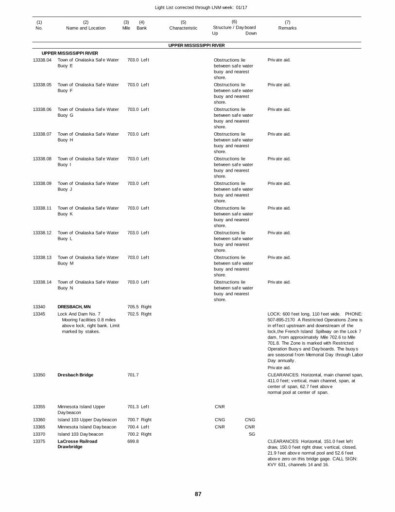
87
Light List corrected through LNM week: 01/17
(7)Remarks
(1)No.
(2)Name and Location
(3)Mile
(5)Characteristic
(4)Bank
(6)Structure / DayboardUp Down
Town of Onalaska Safe Water Buoy E
Town of Onalaska Safe Water Buoy F
Town of Onalaska Safe Water Buoy G
Town of Onalaska Safe Water Buoy H
Town of Onalaska Safe Water Buoy I
Town of Onalaska Safe Water Buoy J
Town of Onalaska Safe Water Buoy K
Town of Onalaska Safe Water Buoy L
Town of Onalaska Safe Water Buoy M
Town of Onalaska Safe Water Buoy N
DRESBACH, MNLock And Dam No. 7
Dresbach Bridge
Minnesota Island Upper DaybeaconIsland 103 Upper DaybeaconMinnesota Island DaybeaconIsland 103 DaybeaconLaCrosse Railroad Drawbridge
UPPER MISSISSIPPI RIVER
UPPER MISSISSIPPI RIVERLeft
Left
Left
Left
Left
Left
Left
Left
Left
Left
RightRight
Left
RightLeftRight
703.0
703.0
703.0
703.0
703.0
703.0
703.0
703.0
703.0
703.0
705.5 702.5
701.7
701.3
700.7 700.4 700.2 699.8
Mooring facilities 0.8 miles above lock, right bank. Limitmarked by stakes.
Obstructions lie between safe waterbuoy and nearest shore.Obstructions lie between safe waterbuoy and nearest shore.Obstructions lie between safe waterbuoy and nearest shore.Obstructions lie between safe waterbuoy and nearest shore.Obstructions lie between safe waterbuoy and nearest shore.Obstructions lie between safe waterbuoy and nearest shore.Obstructions lie between safe waterbuoy and nearest shore.Obstructions lie between safe waterbuoy and nearest shore.Obstructions lie between safe waterbuoy and nearest shore.Obstructions lie between safe waterbuoy and nearest shore.
LOCK: 600 feet long, 110 feet wide. PHONE:507-895-2170 A Restricted Operations Zone isin effect upstream and downstream of the lock,the French Island Spillway on the Lock 7 dam, from approximately Mile 702.6 to Mile 701.8. The Zone is marked with Restricted Operation Buoys and Dayboards. The buoys are seasonal from Memorial Day through LaborDay annually.
CLEARANCES: Horizontal, main channel span,411.0 feet; vertical, main channel, span, at center of span, 62.7 feet abovenormal pool at center of span.
CLEARANCES: Horizontal, 151.0 feet left draw, 150.0 feet right draw; vertical, closed, 21.9 feet above normal pool and 52.6 feet above zero on this bridge gage. CALL SIGN: KVY 631, channels 14 and 16.
13338.04
13338.05
13338.06
13338.07
13338.08
13338.09
13338.11
13338.12
13338.13
13338.14
1334013345
13350
13355
13360133651337013375
CNR
CNGCNR
CNGCNR
SG
Private aid.
Private aid.
Private aid.
Private aid.
Private aid.
Private aid.
Private aid.
Private aid.
Private aid.
Private aid.
Private aid.
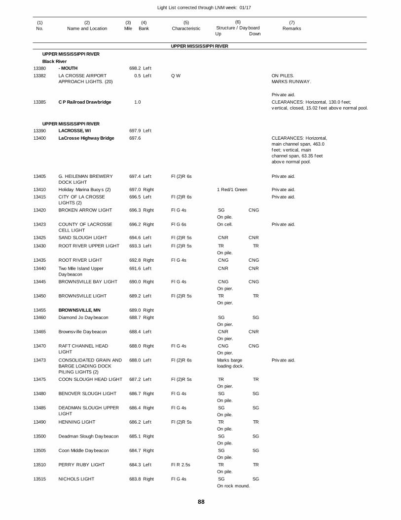
88
Light List corrected through LNM week: 01/17
(7)Remarks
(1)No.
(2)Name and Location
(3)Mile
(5)Characteristic
(4)Bank
(6)Structure / DayboardUp Down
- MOUTHLA CROSSE AIRPORT APPROACH LIGHTS. (20)
C P Railroad Drawbridge
LACROSSE, WILaCrosse Highway Bridge
G. HEILEMAN BREWERY DOCK LIGHTHoliday Marina Buoys (2)CITY OF LA CROSSE LIGHTS (2)BROKEN ARROW LIGHT
COUNTY OF LACROSSE CELL LIGHTSAND SLOUGH LIGHT
ROOT RIVER UPPER LIGHT
ROOT RIVER LIGHT
Two Mile Island Upper DaybeaconBROWNSVILLE BAY LIGHT
BROWNSVILLE LIGHT
BROWNSVILLE, MNDiamond Jo Daybeacon
Brownsville Daybeacon
RAFT CHANNEL HEAD LIGHT
CONSOLIDATED GRAIN ANDBARGE LOADING DOCK PILING LIGHTS (2)COON SLOUGH HEAD LIGHT
BENOVER SLOUGH LIGHT
DEADMAN SLOUGH UPPER LIGHT
HENNING LIGHT
Deadman Slough Daybeacon
Coon Middle Daybeacon
PERRY RUBY LIGHT
NICHOLS LIGHT
UPPER MISSISSIPPI RIVER
UPPER MISSISSIPPI RIVERBlack River
UPPER MISSISSIPPI RIVER
Left
Left
Left
Left
RightLeft
Right
Right
Left
Left
Right
Left
Right
Left
RightRight
Left
Right
Left
Left
Right
Right
Left
Right
Right
Left
Right
698.2
0.5
1.0
697.9
697.6
697.4
697.0 696.5
696.3
696.2
694.6
693.3
692.8
691.6
690.0
689.2
689.0 688.7
688.4
688.0
688.0
687.2
686.7
686.4
686.2
685.1
684.7
684.3
683.8
Q W
Fl (2)R 6s
Fl (2)R 6s
Fl G 4s
Fl G 6s
Fl (2)R 5s
Fl (2)R 5s
Fl G 4s
Fl G 4s
Fl (2)R 5s
Fl G 4s
Fl (2)R 6s
Fl (2)R 5s
Fl G 4s
Fl G 4s
Fl (2)R 5s
Fl R 2.5s
Fl G 4s
1 Red/1 Green
On pile.On cell.
On pile.
On pier.
On pier.
On pier.
On pier.
On pier.Marks barge loading dock.
On pier.
On pile.
On pile.
On pile.
On pile.
On pile.
On pile.
On rock mound.
ON PILES. MARKS RUNWAY.
CLEARANCES: Horizontal, 130.0 feet; vertical, closed, 15.02 feet above normal pool.
CLEARANCES: Horizontal,main channel span, 463.0feet; vertical, mainchannel span, 63.35 feetabove normal pool.
1338013382
13385
1339013400
13405
1341013415
13420
13423
13425
13430
13435
13440
13445
13450
1345513460
13465
13470
13473
13475
13480
13485
13490
13500
13505
13510
13515
SG
CNR
TR
CNG
CNR
CNG
TR
SG
CNR
CNG
TR
SG
SG
TR
SG
SG
TR
SG
CNG
CNR
TR
CNG
CNR
CNG
TR
SG
CNR
CNG
TR
SG
SG
TR
SG
SG
TR
SG
Private aid.
Private aid.
Private aid.Private aid.
Private aid.
Private aid.
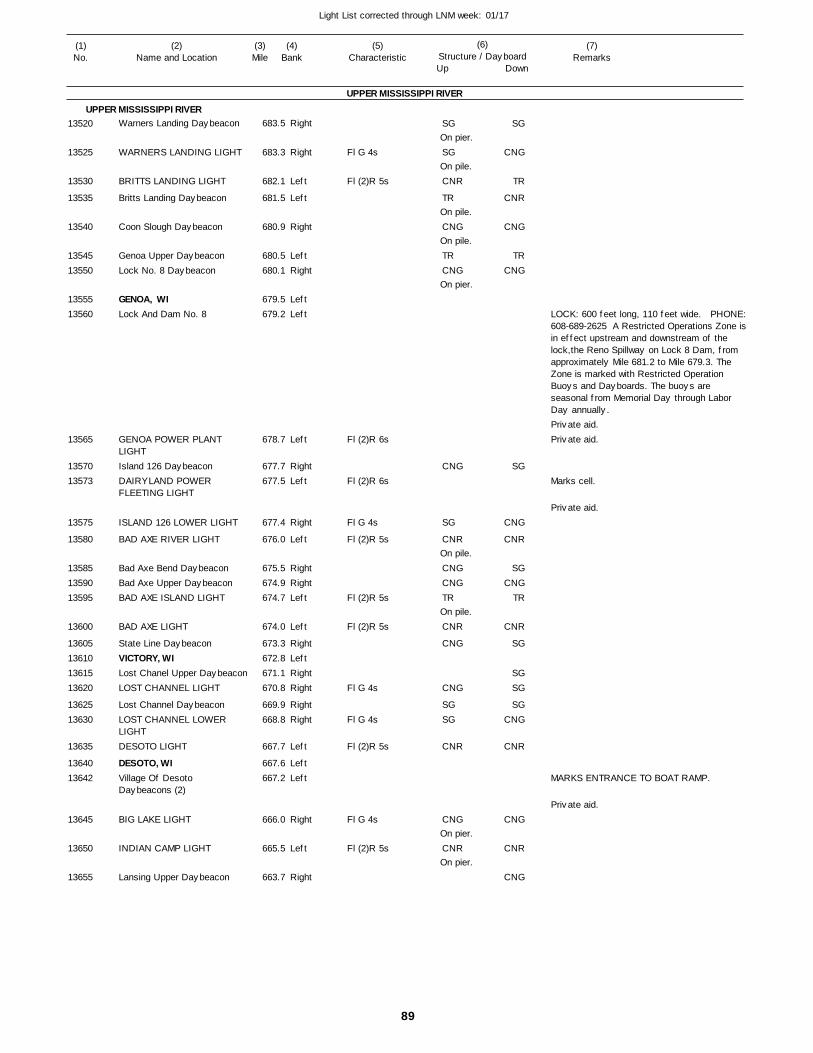
89
Light List corrected through LNM week: 01/17
(7)Remarks
(1)No.
(2)Name and Location
(3)Mile
(5)Characteristic
(4)Bank
(6)Structure / DayboardUp Down
Warners Landing Daybeacon
WARNERS LANDING LIGHT
BRITTS LANDING LIGHT
Britts Landing Daybeacon
Coon Slough Daybeacon
Genoa Upper DaybeaconLock No. 8 Daybeacon
GENOA, WILock And Dam No. 8
GENOA POWER PLANT LIGHTIsland 126 DaybeaconDAIRYLAND POWER FLEETING LIGHT
ISLAND 126 LOWER LIGHT
BAD AXE RIVER LIGHT
Bad Axe Bend DaybeaconBad Axe Upper DaybeaconBAD AXE ISLAND LIGHT
BAD AXE LIGHT
State Line DaybeaconVICTORY, WILost Chanel Upper DaybeaconLOST CHANNEL LIGHT
Lost Channel DaybeaconLOST CHANNEL LOWER LIGHTDESOTO LIGHT
DESOTO, WIVillage Of Desoto Daybeacons (2)
BIG LAKE LIGHT
INDIAN CAMP LIGHT
Lansing Upper Daybeacon
UPPER MISSISSIPPI RIVER
UPPER MISSISSIPPI RIVERRight
Right
Left
Left
Right
LeftRight
LeftLeft
Left
RightLeft
Right
Left
RightRightLeft
Left
RightLeftRightRight
RightRight
Left
LeftLeft
Right
Left
Right
683.5
683.3
682.1
681.5
680.9
680.5 680.1
679.5 679.2
678.7
677.7 677.5
677.4
676.0
675.5 674.9 674.7
674.0
673.3 672.8 671.1 670.8
669.9 668.8
667.7
667.6 667.2
666.0
665.5
663.7
Fl G 4s
Fl (2)R 5s
Fl (2)R 6s
Fl (2)R 6s
Fl G 4s
Fl (2)R 5s
Fl (2)R 5s
Fl (2)R 5s
Fl G 4s
Fl G 4s
Fl (2)R 5s
Fl G 4s
Fl (2)R 5s
On pier.
On pile.
On pile.
On pile.
On pier.
On pile.
On pile.
On pier.
On pier.
LOCK: 600 feet long, 110 feet wide. PHONE:608-689-2625 A Restricted Operations Zone isin effect upstream and downstream of the lock,the Reno Spillway on Lock 8 Dam, from approximately Mile 681.2 to Mile 679.3. The Zone is marked with Restricted Operation Buoys and Dayboards. The buoys are seasonal from Memorial Day through Labor Day annually.
Marks cell.
MARKS ENTRANCE TO BOAT RAMP.
13520
13525
13530
13535
13540
1354513550
1355513560
13565
1357013573
13575
13580
135851359013595
13600
13605136101361513620
1362513630
13635
1364013642
13645
13650
13655
SG
SG
CNR
TR
CNG
TRCNG
CNG
SG
CNR
CNGCNGTR
CNR
CNG
CNG
SGSG
CNR
CNG
CNR
SG
CNG
TR
CNR
CNG
TRCNG
SG
CNG
CNR
SGCNG
TR
CNR
SG
SGSG
SGCNG
CNR
CNG
CNR
CNG
Private aid.Private aid.
Private aid.
Private aid.
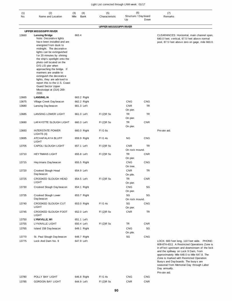
90
Light List corrected through LNM week: 01/17
(7)Remarks
(1)No.
(2)Name and Location
(3)Mile
(5)Characteristic
(4)Bank
(6)Structure / DayboardUp Down
Lansing Bridge
LANSING, IAVillage Creek DaybeaconLansing Daybeacon
LANSING LOWER LIGHT
LAFAYETTE SLOUGH LIGHT
INTERSTATE POWER LIGHTS (4)ATCHAFALAYA BLUFF LIGHTCAPOLI SLOUGH LIGHT
HEYTMANS LIGHT
Heytmans Daybeacon
Crooked Slough Head Daybeacon
CROOKED SLOUGH HEAD LIGHT
Crooked Slough Daybeacon
Crooked Slough Lower Daybeacon
CROOKED SLOUGH CUT LIGHT
CROOKED SLOUGH FOOT LIGHTLYNXVILLE, WILYNXVILLE LIGHT
Island 158 Daybeacon
St. Paul Slough DaybeaconLock And Dam No. 9
POLLY BAY LIGHT
GORDON BAY LIGHT
UPPER MISSISSIPPI RIVER
UPPER MISSISSIPPI RIVER
RightRightLeft
Left
Left
Right
Right
Left
Left
Right
Left
Left
Right
Right
Right
Left
LeftLeft
Right
RightLeft
Right
Left
663.4
663.2 662.2 661.3
661.0
660.3
660.0
659.9
657.1
655.8
655.5
654.9
654.5
654.1
653.7
653.0
652.0
651.1 650.4
649.1
648.7 647.9
646.8
644.9
Note: Decorative lights have been installed and are energized from dusk to midnight. The decorative lights can be extinguished for 20 minutes by shining the ship’s spotlight onto the photo cell located on the D/S L/D pier when approaching the bridge. If mariners are unable to extinguish the decorative lights, they are advised to report this to the U.S. CoastGuard Sector Upper Mississippi at (314) 269-2332.
Fl (2)R 5s
Fl (2)R 5s
Fl G 6s
Fl G 4s
Fl (2)R 5s
Fl (2)R 5s
Fl (2)R 5s
Fl G 4s
Fl (2)R 5s
Fl (2)R 5s
Fl G 4s
Fl (2)R 5s
On pier.
On pier.
On pier.
On rock mound.
On pier.
On tree.
On pile.
On pier.
On pier.
On rock mound.
On pier.
On pile.
CLEARANCES: Horizontal, main channel span,640.0 feet; vertical, 67.5 feet above normal pool, 87.5 feet above zero on gage, mile 663.0.
LOCK: 600 feet long, 110 feet wide. PHONE:608-874-4311 A Restricted Operations Zone isin effect upstream and downstream of the lockand the spillway on Lock 9 Dam, from approximately Mile 648.0 to Mile 647.8. The Zone is marked with Restricted Operation Buoys and Dayboards. The buoys are seasonal from Memorial Day through Labor Day annually.
13660
136651367513680
13685
13690
13693
13695
13705
13710
13715
13720
13725
13730
13735
13740
13745
1375013755
13765
1377013775
13780
13785
CNGCNR
TR
TR
NG
CNR
TR
CNG
CNR
TR
CNG
SG
SG
CNR
TR
CNG
SG
CNG
CNR
CNGTR
TR
CNR
CNG
TR
CNR
CNG
TR
CNR
SG
SG
CNG
TR
CNR
SG
CNG
CNG
CNR
Private aid.
Private aid.
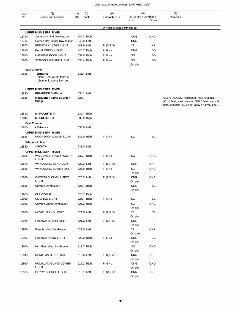
91
Light List corrected through LNM week: 01/17
(7)Remarks
(1)No.
(2)Name and Location
(3)Mile
(5)Characteristic
(4)Bank
(6)Structure / DayboardUp Down
Jackson Island Daybeacon
Gordon Bay Upper DaybeaconFRENCH VILLAGE LIGHT
PAINT CREEK LIGHT
HANGING ROCK LIGHT
SCROGUM ISLAND LIGHT
- Entrance
PRAIRIE DU CHIEN, WIMarquette-Prairie du Chien Bridge
MARQUETTE, IAMCGREGOR, IA
- Entrance
MCGREGOR LOWER LIGHT
- MOUTH
WISCONSIN RIVER MOUTH LIGHTWYALUSING BEND LIGHT
WYALUSING LOWER LIGHT
CATFISH SLOUGH UPPER LIGHT
Clayton Daybeacon
CLAYTON, IACLAYTON LIGHT
Clayton Lower Daybeacon
HOVIE ISLAND LIGHT
FRENCH ISLAND LIGHT
French Island Daybeacon
FRENCH TOWN LIGHT
Mcmillan Island Daybeacon
MCMILLAN BEND LIGHT
MCMILLAN ISLAND LOWER LIGHT
FERRY SLOUGH LIGHT
UPPER MISSISSIPPI RIVER
UPPER MISSISSIPPI RIVER
East Channel
UPPER MISSISSIPPI RIVER
East Channel
UPPER MISSISSIPPI RIVER
Wisconsin River
UPPER MISSISSIPPI RIVER
Right
LeftLeft
Right
Right
Right
Left
Left
RightRight
Left
Right
Left
Right
Left
Right
Left
Right
RightRight
Right
Left
Left
Left
Right
Right
Left
Right
Left
644.3
643.2 642.6
640.7
639.0
636.4
636.4
635.1
634.7
634.7 633.5
633.0
632.0
631.0
630.7
629.2
627.0
626.3
625.4
624.7 624.7
624.2
622.5
621.3
621.0
620.2
618.7
618.3
617.2
616.1
Note: Controlling depth of channel is about 8.0 feet.
Fl (2)R 5s
Fl G 4s
Fl G 4s
Fl G 4s
Fl G 4s
Fl G 4s
Fl (2)R 5s
Fl G 4s
Fl (2)R 5s
Fl G 4s
Fl (2)R 5s
Fl (2)R 5s
Fl G 4s
Fl (2)R 5s
Fl G 4s
Fl (2)R 5s
On pier.
On pier.
On pier.
On pier.
On pier.
On pier.
On pier.
On tree.
On pier.
On pier.
On pier.
On pier.
On pier.
CLEARANCES: Horizontal, main channel, 451.5 feet, east channel, 338.0 feet; vertical, both channels, 60.0 feet above normal pool.
137901379513800
13810
13815
13820
13825
1383013835
1384013845
13850
13855
13860
13865
13870
13885
13890
13895
1390513910
13915
13920
13925
13930
13935
13940
13945
13950
13955
CNGCNRTR
CNG
SG
SG
SG
SG
CNR
SG
CNR
CNG
SG
SG
TR
CNR
TR
CNG
SG
CNR
CNG
CNR
CNGTRNR
SG
SG
SG
SG
CNG
CNR
CNG
CNR
SG
SG
CNG
TR
TR
CNR
SG
CNG
CNR
CNG
CNR
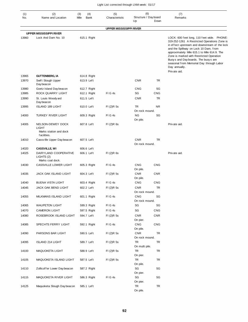
92
Light List corrected through LNM week: 01/17
(7)Remarks
(1)No.
(2)Name and Location
(3)Mile
(5)Characteristic
(4)Bank
(6)Structure / DayboardUp Down
Lock And Dam No. 10
GUTTENBERG, IASwift Slough Upper DaybeaconGoetz Island DaybeaconROCK QUARRY LIGHT
St. Louis Woodyard DaybeaconISLAND 189 LIGHT
TURKEY RIVER LIGHT
NELSON-DEWEY DOCK LIGHT
Cassville Upper Daybeacon
CASSVILLE, WIDAIRYLAND COOPERATIVE LIGHTS (2)
CASSVILLE LOWER LIGHT
JACK OAK ISLAND LIGHT
BUENA VISTA LIGHT
JACK OAK BEND LIGHT
MILKMANS ISLAND LIGHT
WAUPETON LIGHT
CAMERON LIGHT
ROSEBROOK ISLAND LIGHT
SPECHTS FERRY LIGHT
PARSONS BAR LIGHT
ISLAND 214 LIGHT
MAQUOKETA LIGHT
MAQUOKETA ISLAND LIGHT
Zollicoffer Lower Daybeacon
MAQUOKETA RIVER LIGHT
Maquoketa Slough Daybeacon
UPPER MISSISSIPPI RIVER
UPPER MISSISSIPPI RIVERRight
RightLeft
RightRight
Left
Left
Right
Left
Left
LeftLeft
Right
Left
Right
Left
Right
Right
Right
Left
Right
Left
Left
Left
Left
Right
Right
Left
615.1
614.8 613.9
612.7 612.1
611.5
610.0
609.3
607.8
607.5
606.6 606.1
605.3
604.3
603.4
602.2
601.1
599.3
597.5
594.7
592.1
590.5
589.7
588.9
587.5
587.2
586.3
585.1
Marks station and dock facilities.
Marks coal dock.
Fl G 4s
Fl (2)R 5s
Fl G 4s
Fl (2)R 6s
Fl (2)R 6s
Fl G 4s
Fl (2)R 5s
Fl G 4s
Fl (2)R 5s
Fl G 4s
Fl G 4s
Fl G 4s
Fl (2)R 5s
Fl G 4s
Fl (2)R 5s
Fl (2)R 5s
Fl (2)R 5s
Fl (2)R 5s
Fl G 4s
On rock mound.
On pile.
On rock mound.
On pile.
On pile.
On rock mound.
On rock mound.
On pier.
On pile.
On rock mound.
On multi pile.
On pier.
On pile.
On pier.
On pier.
On pile.
LOCK: 600 feet long, 110 feet wide. PHONE:319-252-1261 A Restricted Operations Zone isin effect upstream and downstream of the lockand the Spillway on Lock 10 Dam, from approximately Mile 615.1 to Mile 614.9. The Zone is marked with Restricted Operation Buoys and Dayboards. The buoys are seasonal from Memorial Day through Labor Day annually.
13960
1396513970
1398013985
13990
13995
14000
14005
14010
1402014025
14030
14035
14040
14045
14055
14065
14070
14080
14085
14090
14095
14100
14105
14110
14115
14125
CNR
CNGSG
CNR
TR
NG
CNR
CNG
CNR
CNG
CNR
CNG
SG
SG
CNR
CNG
CNR
TR
TR
TR
SG
SG
TR
TR
SGCNG
TR
NR
SG
TR
CNG
CNR
CNG
TR
SG
SG
CNG
CNR
CNG
TR
TR
TR
TR
SG
SG
TR
Private aid.
Private aid.
Private aid.
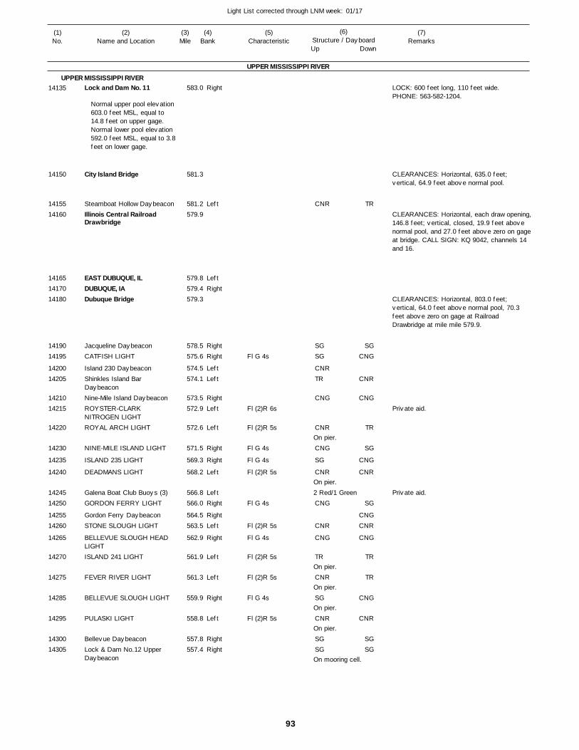
93
Light List corrected through LNM week: 01/17
(7)Remarks
(1)No.
(2)Name and Location
(3)Mile
(5)Characteristic
(4)Bank
(6)Structure / DayboardUp Down
Lock and Dam No. 11
City Island Bridge
Steamboat Hollow DaybeaconIllinois Central Railroad Drawbridge
EAST DUBUQUE, ILDUBUQUE, IADubuque Bridge
Jacqueline DaybeaconCATFISH LIGHT
Island 230 DaybeaconShinkles Island Bar DaybeaconNine-Mile Island DaybeaconROYSTER-CLARK NITROGEN LIGHTROYAL ARCH LIGHT
NINE-MILE ISLAND LIGHT
ISLAND 235 LIGHT
DEADMANS LIGHT
Galena Boat Club Buoys (3)GORDON FERRY LIGHT
Gordon Ferry DaybeaconSTONE SLOUGH LIGHT
BELLEVUE SLOUGH HEAD LIGHTISLAND 241 LIGHT
FEVER RIVER LIGHT
BELLEVUE SLOUGH LIGHT
PULASKI LIGHT
Bellevue DaybeaconLock & Dam No.12 Upper Daybeacon
UPPER MISSISSIPPI RIVER
UPPER MISSISSIPPI RIVERRight
Left
LeftRight
RightRight
LeftLeft
RightLeft
Left
Right
Right
Left
LeftRight
RightLeft
Right
Left
Left
Right
Left
RightRight
583.0
581.3
581.2 579.9
579.8 579.4 579.3
578.5 575.6
574.5 574.1
573.5 572.9
572.6
571.5
569.3
568.2
566.8 566.0
564.5 563.5
562.9
561.9
561.3
559.9
558.8
557.8 557.4
Normal upper pool elevation 603.0 feet MSL, equal to 14.8 feet on upper gage.Normal lower pool elevation 592.0 feet MSL, equal to 3.8feet on lower gage.
Fl G 4s
Fl (2)R 6s
Fl (2)R 5s
Fl G 4s
Fl G 4s
Fl (2)R 5s
Fl G 4s
Fl (2)R 5s
Fl G 4s
Fl (2)R 5s
Fl (2)R 5s
Fl G 4s
Fl (2)R 5s
On pier.
On pier.2 Red/1 Green
On pier.
On pier.
On pier.
On pier.
On mooring cell.
LOCK: 600 feet long, 110 feet wide.PHONE: 563-582-1204.
CLEARANCES: Horizontal, 635.0 feet; vertical, 64.9 feet above normal pool.
CLEARANCES: Horizontal, each draw opening,146.8 feet; vertical, closed, 19.9 feet above normal pool, and 27.0 feet above zero on gage at bridge. CALL SIGN: KQ 9042, channels 14 and 16.
CLEARANCES: Horizontal, 803.0 feet; vertical, 64.0 feet above normal pool, 70.3 feet above zero on gage at Railroad Drawbridge at mile mile 579.9.
14135
14150
1415514160
141651417014180
1419014195
1420014205
1421014215
14220
14230
14235
14240
1424514250
1425514260
14265
14270
14275
14285
14295
1430014305
CNR
SGSG
CNRTR
CNG
CNR
CNG
SG
CNR
CNG
CNR
CNG
TR
CNR
SG
CNR
SGSG
TR
SGCNG
CNR
CNG
TR
SG
CNG
CNR
SG
CNGCNR
CNG
TR
TR
CNG
CNR
SGSG
Private aid.
Private aid.
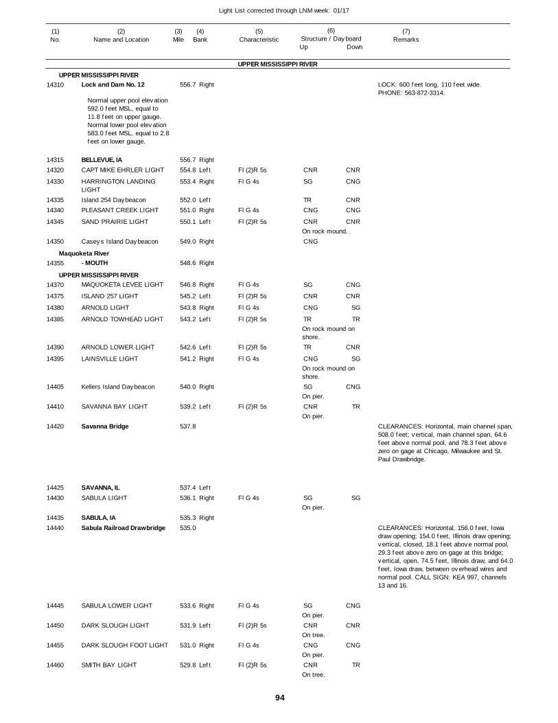
94
Light List corrected through LNM week: 01/17
(7)Remarks
(1)No.
(2)Name and Location
(3)Mile
(5)Characteristic
(4)Bank
(6)Structure / DayboardUp Down
Lock and Dam No. 12
BELLEVUE, IACAPT MIKE EHRLER LIGHT
HARRINGTON LANDING LIGHTIsland 254 DaybeaconPLEASANT CREEK LIGHT
SAND PRAIRIE LIGHT
Caseys Island Daybeacon
- MOUTH
MAQUOKETA LEVEE LIGHT
ISLAND 257 LIGHT
ARNOLD LIGHT
ARNOLD TOWHEAD LIGHT
ARNOLD LOWER LIGHT
LAINSVILLE LIGHT
Kellers Island Daybeacon
SAVANNA BAY LIGHT
Savanna Bridge
SAVANNA, ILSABULA LIGHT
SABULA, IASabula Railroad Drawbridge
SABULA LOWER LIGHT
DARK SLOUGH LIGHT
DARK SLOUGH FOOT LIGHT
SMITH BAY LIGHT
UPPER MISSISSIPPI RIVER
UPPER MISSISSIPPI RIVER
Maquoketa River
UPPER MISSISSIPPI RIVER
Right
RightLeft
Right
LeftRight
Left
Right
Right
Right
Left
Right
Left
Left
Right
Right
Left
LeftRight
Right
Right
Left
Right
Left
556.7
556.7 554.8
553.4
552.0 551.0
550.1
549.0
548.6
546.8
545.2
543.8
543.2
542.6
541.2
540.0
539.2
537.8
537.4 536.1
535.3 535.0
533.6
531.9
531.0
529.8
Normal upper pool elevation 592.0 feet MSL, equal to 11.8 feet on upper gauge. Normal lower pool elevation 583.0 feet MSL, equal to 2.8feet on lower gauge.
Fl (2)R 5s
Fl G 4s
Fl G 4s
Fl (2)R 5s
Fl G 4s
Fl (2)R 5s
Fl G 4s
Fl (2)R 5s
Fl (2)R 5s
Fl G 4s
Fl (2)R 5s
Fl G 4s
Fl G 4s
Fl (2)R 5s
Fl G 4s
Fl (2)R 5s
On rock mound.
On rock mound on shore.
On rock mound on shore.
On pier.
On pier.
On pier.
On pier.
On tree.
On pier.
On tree.
LOCK: 600 feet long, 110 feet wide.PHONE: 563-872-3314.
CLEARANCES: Horizontal, main channel span,508.0 feet; vertical, main channel span, 64.6 feet above normal pool, and 78.3 feet above zero on gage at Chicago, Milwaukee and St. Paul Drawbridge.
CLEARANCES: Horizontal, 156.0 feet, Iowa draw opening; 154.0 feet, Illinois draw opening; vertical, closed, 18.1 feet above normal pool, 29.3 feet above zero on gage at this bridge; vertical, open, 74.5 feet, Illinois draw, and 64.0feet, Iowa draw, between overhead wires and normal pool. CALL SIGN: KEA 997, channels 13 and 16.
14310
1431514320
14330
1433514340
14345
14350
14355
14370
14375
14380
14385
14390
14395
14405
14410
14420
1442514430
1443514440
14445
14450
14455
14460
CNR
SG
TRCNG
CNR
CNG
SG
CNR
CNG
TR
TR
CNG
SG
CNR
SG
SG
CNR
CNG
CNR
CNR
CNG
CNRCNG
CNR
CNG
CNR
SG
TR
CNR
SG
CNG
TR
SG
CNG
CNR
CNG
TR
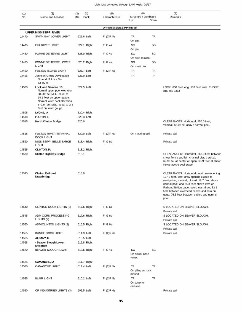
95
Light List corrected through LNM week: 01/17
(7)Remarks
(1)No.
(2)Name and Location
(3)Mile
(5)Characteristic
(4)Bank
(6)Structure / DayboardUp Down
SMITH BAY LOWER LIGHT
ELK RIVER LIGHT
POMME DE TERRE LIGHT
POMME DE TERRE LOWER LIGHT
FULTON ISLAND LIGHT
Johnson Creek Daybeacon
Lock and Dam No. 13
LYONS, IAFULTON, ILNorth Clinton Bridge
FULTON RIVER TERMINAL DOCK LIGHTMISSISSIPPI BELLE BARGE LIGHTCLINTON, IAClinton Highway Bridge
Clinton Railroad Drawbridge
CLINTON DOCK LIGHTS (2)
ADM CORN PROCESSING LIGHTS (2)
ADM/CLINTON LIGHTS (3)
BUNGE DOCK LIGHT
ALBANY, IL- Beaver Slough Lower EntranceBEAVER SLOUGH LIGHT
CAMANCHE, IACAMANCHE LIGHT
BLAIR LIGHT
CF INDUSTRIES LIGHTS (3)
UPPER MISSISSIPPI RIVER
UPPER MISSISSIPPI RIVERLeft
Right
Right
Right
Left
Left
Left
RightLeft
Left
Right
Right
Right
Right
Right
Left
LeftRight
Right
RightLeft
Left
Left
528.6
527.1
526.0
525.2
523.7
523.0
522.5
520.4 520.3 520.0
520.0
518.4
518.2 518.1
518.0
517.6
517.6
515.5
514.3
513.5 512.8
512.6
511.7 511.4
510.2
509.5
On end of Lock No.13 levee
Normal upper pool elevation 583.0 feet MSL, equal to 14.3 feet on upper gauge.Normal lower pool elevation 572.0 feet MSL, equal to 3.3feet on lower gauge.
Fl (2)R 5s
Fl G 4s
Fl G 4s
Fl G 4s
Fl (2)R 5s
Fl (2)R 6s
Fl G 6s
Fl G 6s
Fl G 6s
Fl G 6s
Fl (2)R 6s
Fl G 4s
Fl (2)R 5s
Fl (2)R 5s
Fl (2)R 6s
On pier.
On pier.
On rock mound.
On multi pile.
On mooring cell.
On sinker base tower.
On piling on rock mound.
On tower on caisson.
LOCK: 600 feet long, 110 feet wide. PHONE: 815-589-3313
CLEARANCES: Horizontal, 450.0 feet; vertical, 65.0 feet above normal pool.
CLEARANCES: Horizontal, 568.0 feet betweensheer fence and left channel pier; vertical, 69.9 feet at center of span, 63.9 feet at sheer fence above pool stage.
CLEARANCES: Horizontal, east draw opening, 177.5 feet, west draw opening closed to navigation; vertical, closed, 18.7 feet above normal pool, and 25.3 feet above zero on Railroad Bridge gage; open, east draw, 83.1 feet between overhead cables and zero on gage, 76.5 feet between cables and normal pool.
S LOCATED ON BEAVER SLOUGH.
S LOCATED ON BEAVER SLOUGH.
S LOCATED ON BEAVER SLOUGH.
14470
14475
14480
14485
14490
14495
14500
145051451014515
14518
14520
1452514530
14535
14540
14545
14550
14555
1456514568
14570
1457514580
14585
14590
TR
SG
SG
SG
TR
TR
SG
TR
TR
TR
SG
SG
SG
TR
TR
SG
TR
TR
Private aid.
Private aid.
Private aid.
Private aid.
Private aid.Private aid.
Private aid.
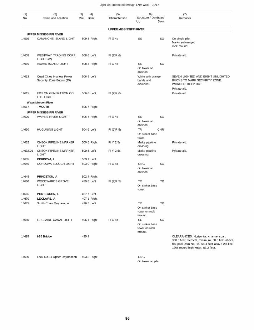
96
Light List corrected through LNM week: 01/17
(7)Remarks
(1)No.
(2)Name and Location
(3)Mile
(5)Characteristic
(4)Bank
(6)Structure / DayboardUp Down
CAMANCHE ISLAND LIGHT
WESTWAY TRADING CORP. LIGHTS (2)ADAMS ISLAND LIGHT
Quad Cities Nuclear Power Security Zone Buoys (15)
EXELON GENERATION CO. LLC. LIGHT
- MOUTH
WAPSIE RIVER LIGHT
HUGUNINS LIGHT
ONEOK PIPELINE MARKER LIGHTONEOK PIPELINE MARKER LIGHTCORDOVA, ILCORDOVA SLOUGH LIGHT
PRINCETON, IAWOODWARDS GROVE LIGHT
PORT BYRON, ILLE CLAIRE, IASmith Chain Daybeacon
LE CLAIRE CANAL LIGHT
I-80 Bridge
Lock No.14 Upper Daybeacon
UPPER MISSISSIPPI RIVER
UPPER MISSISSIPPI RIVER
Wapsipinicon River
UPPER MISSISSIPPI RIVER
Right
Left
Right
Left
Left
Right
Right
Left
Right
Left
LeftRight
RightLeft
LeftRightLeft
Right
Right
509.3
508.6
508.3
506.9
506.8
506.7
506.4
504.6
500.5
500.5
503.1 503.0
502.4 499.8
497.7 497.1 496.5
496.1
495.4
493.8
Fl G 4s
Fl (2)R 6s
Fl G 4s
Fl (2)R 6s
Fl G 4s
Fl (2)R 5s
Fl Y 2.5s
Fl Y 2.5s
Fl G 4s
Fl (2)R 5s
Fl G 4s
On tower on caisson.White with orange bands and diamond.
On tower on caisson.
On sinker base tower.Marks pipeline crossing.Marks pipeline crossing.
On tower on caisson.
On sinker base tower.
On sinker base tower on rock mound.
On sinker base tower on rock mound.
On tower on pile.
On single pile.Marks submergedrock mound.
SEVEN LIGHTED AND EIGHT UNLIGHTED BUOYS TO MARK SECURITY ZONE. WORDED: KEEP OUT.
CLEARANCES: Horizontal, channel span, 350.0 feet; vertical, minimum, 60.0 feet aboveflat pool Dam No. 14, 58.4 feet above 2% line.1965 record high water, 53.2 feet.
14595
14605
14610
14613
14615
14617
14620
14630
14632
14632.01
1463514640
1464514660
146651467014675
14680
14685
14690
SG
SG
SG
TR
CNG
TR
TR
SG
CNG
SG
SG
SG
CNR
SG
TR
TR
SG
Private aid.
Private aid.Private aid.
Private aid.
Private aid.
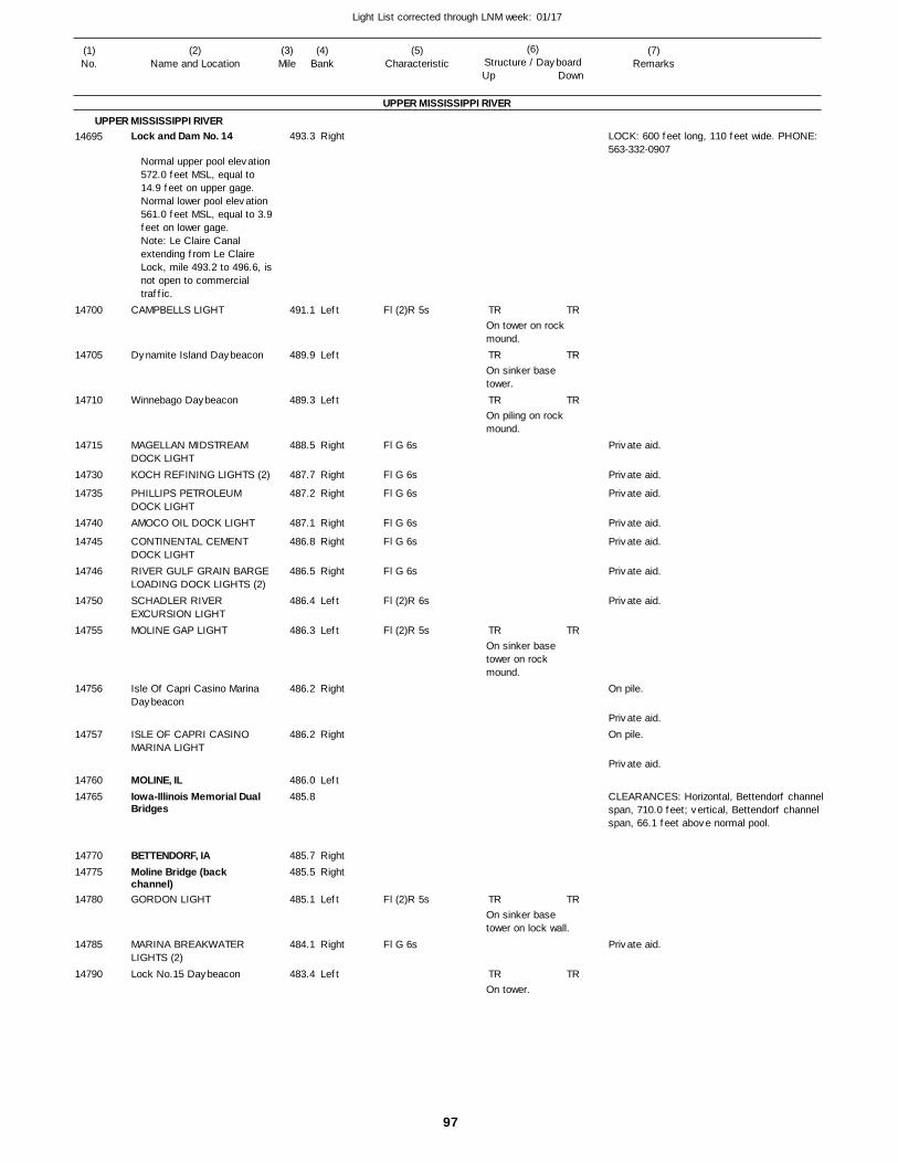
97
Light List corrected through LNM week: 01/17
(7)Remarks
(1)No.
(2)Name and Location
(3)Mile
(5)Characteristic
(4)Bank
(6)Structure / DayboardUp Down
Lock and Dam No. 14
CAMPBELLS LIGHT
Dynamite Island Daybeacon
Winnebago Daybeacon
MAGELLAN MIDSTREAM DOCK LIGHTKOCH REFINING LIGHTS (2)
PHILLIPS PETROLEUM DOCK LIGHTAMOCO OIL DOCK LIGHT
CONTINENTAL CEMENT DOCK LIGHTRIVER GULF GRAIN BARGE LOADING DOCK LIGHTS (2)SCHADLER RIVER EXCURSION LIGHTMOLINE GAP LIGHT
Isle Of Capri Casino Marina Daybeacon
ISLE OF CAPRI CASINO MARINA LIGHT
MOLINE, ILIowa-Illinois Memorial Dual Bridges
BETTENDORF, IAMoline Bridge (back channel)GORDON LIGHT
MARINA BREAKWATER LIGHTS (2)Lock No.15 Daybeacon
UPPER MISSISSIPPI RIVER
UPPER MISSISSIPPI RIVERRight
Left
Left
Left
Right
Right
Right
Right
Right
Right
Left
Left
Right
Right
Left
RightRight
Left
Right
Left
493.3
491.1
489.9
489.3
488.5
487.7
487.2
487.1
486.8
486.5
486.4
486.3
486.2
486.2
486.0 485.8
485.7 485.5
485.1
484.1
483.4
Normal upper pool elevation 572.0 feet MSL, equal to 14.9 feet on upper gage. Normal lower pool elevation 561.0 feet MSL, equal to 3.9feet on lower gage. Note: Le Claire Canal extending from Le Claire Lock, mile 493.2 to 496.6, isnot open to commercial traffic.
Fl (2)R 5s
Fl G 6s
Fl G 6s
Fl G 6s
Fl G 6s
Fl G 6s
Fl G 6s
Fl (2)R 6s
Fl (2)R 5s
Fl (2)R 5s
Fl G 6s
On tower on rock mound.
On sinker base tower.
On piling on rock mound.
On sinker base tower on rock mound.
On sinker base tower on lock wall.
On tower.
LOCK: 600 feet long, 110 feet wide. PHONE: 563-332-0907
On pile.
On pile.
CLEARANCES: Horizontal, Bettendorf channel span, 710.0 feet; vertical, Bettendorf channel span, 66.1 feet above normal pool.
14695
14700
14705
14710
14715
14730
14735
14740
14745
14746
14750
14755
14756
14757
1476014765
1477014775
14780
14785
14790
TR
TR
TR
TR
TR
TR
TR
TR
TR
TR
TR
TR
Private aid.
Private aid.
Private aid.
Private aid.
Private aid.
Private aid.
Private aid.
Private aid.
Private aid.
Private aid.
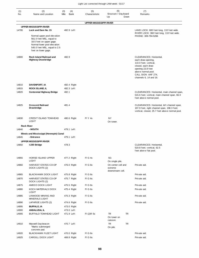
98
Light List corrected through LNM week: 01/17
(7)Remarks
(1)No.
(2)Name and Location
(3)Mile
(5)Characteristic
(4)Bank
(6)Structure / DayboardUp Down
Lock and Dam No. 15
Rock Island Railroad and Highway Drawbridge
DAVENPORT, IAROCK ISLAND, ILCentennial Highway Bridge
Crescent Railroad Drawbridge
CREDIT ISLAND TOWHEAD LIGHT
- MOUTH
- Entrance
I-280 Bridge
HORSE ISLAND UPPER LIGHT
HARVEST STATES CO-OP DOCK LIGHTS (2)
BLACKHAWK DOCK LIGHT
HARVEST STATES CO-OP DOCK LIGHTS (2)AMOCO DOCK LIGHT
KOCH MATERIALS DOCK LIGHTLINWOOD MINING AND MINERALS LIGHTLAFARGE LIGHTS (2)
BUFFALO, IAANDALUSIA, ILBUFFALO TOWHEAD LIGHT
Maxwell Daybeacon
BLACKHAWK FLEET LIGHT
CARGILL DOCK LIGHT
UPPER MISSISSIPPI RIVER
UPPER MISSISSIPPI RIVER
Rock River
Illinois and Mississippi (Hennepin) Canal
UPPER MISSISSIPPI RIVER
Left
RightLeft
Right
Left
Left
Right
Right
Right
Right
Right
Right
Right
Right
RightLeftLeft
Left
Right
Right
482.9
482.9
482.4 482.3 482.1
481.4
480.6
479.1
479.1
478.3
477.2
476.0
475.8
475.7
475.5
475.4
475.3
474.6
473.0 473.0 471.9
470.7
470.0
469.8
Normal upper pool elevation 561.0 feet MSL, equal to 18.5 feet on upper gage. Normal lower pool elevation 545.0 feet MSL, equal to 2.5feet on lower gage.
"Marks submerged concrete pad.
Fl Y 4s
Fl G 4s
Fl G 6s
Fl G 6s
Fl G 6s
Fl G 6s
Fl G 6s
Fl G 6s
Fl G 6s
Fl (2)R 5s
Fl G 6s
Fl G 6s
On tower.
On single pile.On center cell and extreme downstream cell.
On tower on caisson.
On pile.
LAND LOCK: 600 feet long, 110 feet wide. RIVER LOCK: 360 feet long, 110 feet wide. PHONE: 309-794-5266
CLEARANCES: Horizontal,each draw opening, 110.0 feet; vertical, closed, each draw opening 23.8 feet above normal pool.CALL SIGN: AAF 274,channels 6, 14 and 16.
CLEARANCES: Horizontal, main channel span,515.6 feet; vertical, main channel span, 66.0 feet above normal pool.
CLEARANCES: Horizontal, left channel span, 197.9 feet, right channel span, 198.3 feet; vertical, closed, 25.7 feet above normal pool.
CLEARANCES: Horizontal,519.8 feet; vertical, 62.5feet above flat pool.
14795
14800
148101481514820
14825
14830
14840
14845
14850
14855
14860
14865
14870
14875
14880
14885
14890
148951490014905
14910
14920
14925
NY
SG
TR
TR
TR
TR
Private aid.
Private aid.
Private aid.
Private aid.
Private aid.
Private aid.
Private aid.
Private aid.
Private aid.
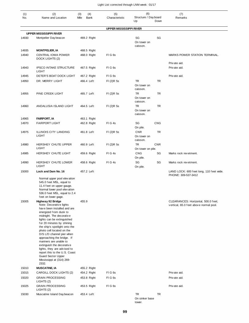
99
Light List corrected through LNM week: 01/17
(7)Remarks
(1)No.
(2)Name and Location
(3)Mile
(5)Characteristic
(4)Bank
(6)Structure / DayboardUp Down
Montpelier Daybeacon
MONTPELIER, IACENTRAL IOWA POWER DOCK LIGHTS (2)
IPSCO INTAKE STRUCTURE LIGHTDETER'S BOAT DOCK LIGHT
DR. MERRY LIGHT
PINE CREEK LIGHT
ANDALUSIA ISLAND LIGHT
FAIRPORT, IAFAIRPORT LIGHT
ILLINOIS CITY LANDING LIGHT
HERSHEY CHUTE UPPER LIGHT
HERSHEY CHUTE LIGHT
HERSHEY CHUTE LOWER LIGHT
Lock and Dam No. 16
Highway 92 Bridge
MUSCATINE, IACARGILL DOCK LIGHTS (2)
GRAIN PROCESSING LIGHTS (2)GRAIN PROCESSING LIGHTS (2)Muscatine Island Daybeacon
UPPER MISSISSIPPI RIVER
UPPER MISSISSIPPI RIVERRight
RightRight
Right
Right
Left
Left
Left
RightRight
Left
Left
Right
Right
Left
RightRight
Right
Right
Left
469.2
468.5 468.0
467.5
467.2
466.4
465.7
464.5
463.1 462.8
461.8
460.9
459.6
458.6
457.2
455.9
455.2 454.2
453.8
453.5
453.4
Normal upper pool elevation 545.0 feet MSL, equal to 11.4 feet on upper gauge.Normal lower pool elevation 536.0 feet MSL, equal to 2.4feet on lower gage.
Note: Decorative lights have been installed and are energized from dusk to midnight. The decorative lights can be extinguished for 20 minutes by shining the ship’s spotlight onto the photo cell located on the D/S L/D channel pier when approaching the bridge. If mariners are unable to extinguish the decorative lights, they are advised to report this to the U.S. CoastGuard Sector Upper Mississippi at (314) 269-2332.
Fl G 6s
Fl G 6s
Fl G 6s
Fl (2)R 5s
Fl (2)R 5s
Fl (2)R 5s
Fl G 4s
Fl (2)R 5s
Fl (2)R 5s
Fl G 4s
Fl G 4s
Fl G 6s
Fl G 6s
Fl G 6s
On tower on caisson.
On tower on caisson.
On tower on caisson.
On tower on caisson.
On pile.
On tower on caisson.
On tower on pile.
On pile.
On pile.
On sinker base tower.
MARKS POWER STATION TERMINAL.
Marks rock revetment.
Marks rock revetment.
LAND LOCK: 600 feet long, 110 feet wide. PHONE: 309-537-3412
CLEARANCES: Horizontal, 500.0 feet; vertical, 65.0 feet above normal pool.
14930
1493514940
14943
14945
14950
14955
14960
1496514970
14975
14980
14985
14990
15000
15005
1501015015
15020
15025
15030
SG
TR
TR
TR
SG
CNR
TR
CNG
SG
TR
SG
TR
TR
TR
CNG
TR
CNR
SG
SG
TR
Private aid.Private aid.
Private aid.
Private aid.
Private aid.
Private aid.
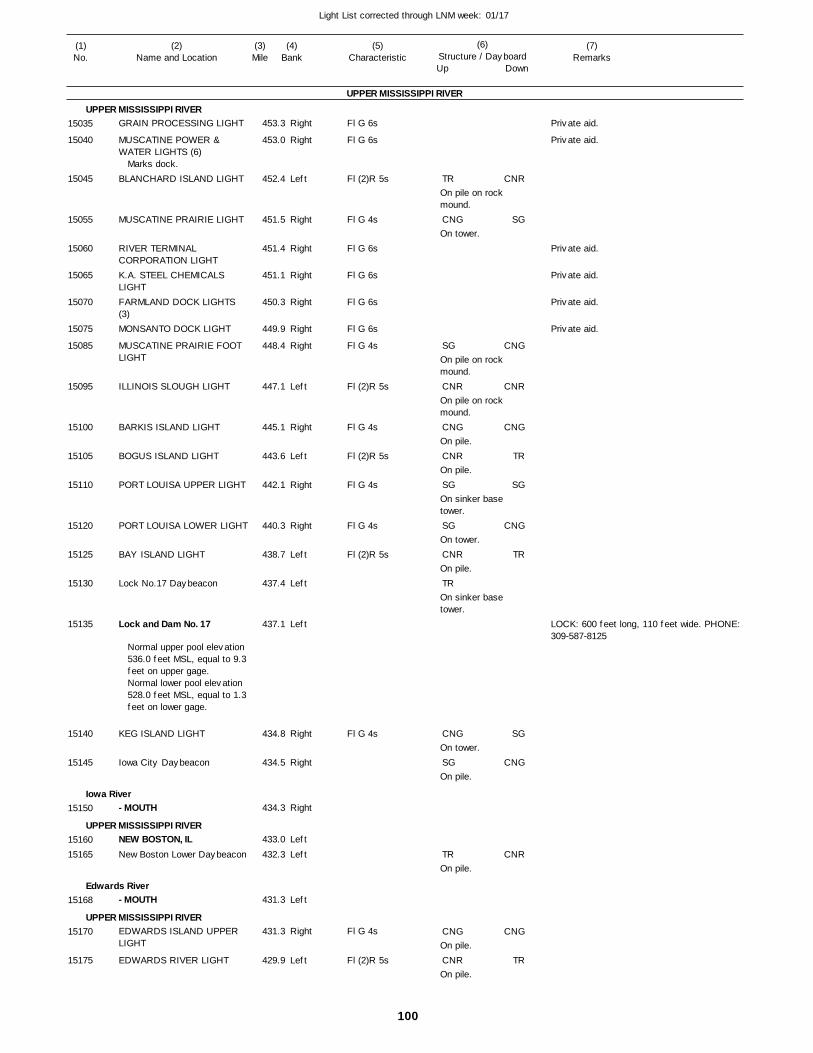
100
Light List corrected through LNM week: 01/17
(7)Remarks
(1)No.
(2)Name and Location
(3)Mile
(5)Characteristic
(4)Bank
(6)Structure / DayboardUp Down
GRAIN PROCESSING LIGHT
MUSCATINE POWER & WATER LIGHTS (6)
BLANCHARD ISLAND LIGHT
MUSCATINE PRAIRIE LIGHT
RIVER TERMINAL CORPORATION LIGHTK.A. STEEL CHEMICALS LIGHTFARMLAND DOCK LIGHTS (3)MONSANTO DOCK LIGHT
MUSCATINE PRAIRIE FOOT LIGHT
ILLINOIS SLOUGH LIGHT
BARKIS ISLAND LIGHT
BOGUS ISLAND LIGHT
PORT LOUISA UPPER LIGHT
PORT LOUISA LOWER LIGHT
BAY ISLAND LIGHT
Lock No.17 Daybeacon
Lock and Dam No. 17
KEG ISLAND LIGHT
Iowa City Daybeacon
- MOUTH
NEW BOSTON, ILNew Boston Lower Daybeacon
- MOUTH
EDWARDS ISLAND UPPER LIGHT
EDWARDS RIVER LIGHT
UPPER MISSISSIPPI RIVER
UPPER MISSISSIPPI RIVER
Iowa River
UPPER MISSISSIPPI RIVER
Edwards River
UPPER MISSISSIPPI RIVER
Right
Right
Left
Right
Right
Right
Right
Right
Right
Left
Right
Left
Right
Right
Left
Left
Left
Right
Right
Right
Left
Left
Left
Right
Left
453.3
453.0
452.4
451.5
451.4
451.1
450.3
449.9
448.4
447.1
445.1
443.6
442.1
440.3
438.7
437.4
437.1
434.8
434.5
434.3
433.0
432.3
431.3
431.3
429.9
Marks dock.
Normal upper pool elevation 536.0 feet MSL, equal to 9.3feet on upper gage. Normal lower pool elevation 528.0 feet MSL, equal to 1.3feet on lower gage.
Fl G 6s
Fl G 6s
Fl (2)R 5s
Fl G 4s
Fl G 6s
Fl G 6s
Fl G 6s
Fl G 6s
Fl G 4s
Fl (2)R 5s
Fl G 4s
Fl (2)R 5s
Fl G 4s
Fl G 4s
Fl (2)R 5s
Fl G 4s
Fl G 4s
Fl (2)R 5s
On pile on rock mound.
On tower.
On pile on rock mound.
On pile on rock mound.
On pile.
On pile.
On sinker base tower.
On tower.
On pile.
On sinker base tower.
On tower.
On pile.
On pile.
On pile.
On pile.
LOCK: 600 feet long, 110 feet wide. PHONE: 309-587-8125
15035
15040
15045
15055
15060
15065
15070
15075
15085
15095
15100
15105
15110
15120
15125
15130
15135
15140
15145
15150
1516015165
15168
15170
15175
TR
CNG
SG
CNR
CNG
CNR
SG
SG
CNR
TR
CNG
SG
TR
CNG
CNR
CNR
SG
CNG
CNR
CNG
TR
SG
CNG
TR
SG
CNG
CNR
CNG
TR
Private aid.
Private aid.
Private aid.
Private aid.
Private aid.
Private aid.
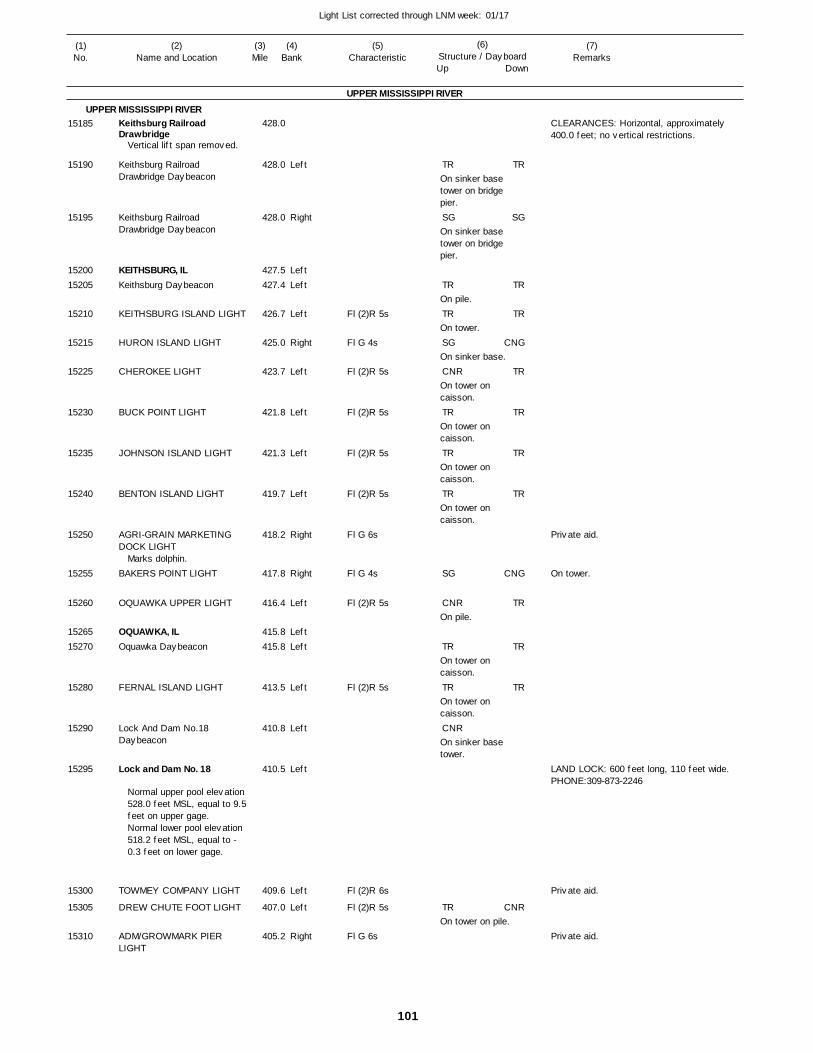
101
Light List corrected through LNM week: 01/17
(7)Remarks
(1)No.
(2)Name and Location
(3)Mile
(5)Characteristic
(4)Bank
(6)Structure / DayboardUp Down
Keithsburg Railroad Drawbridge
Keithsburg Railroad Drawbridge Daybeacon
Keithsburg Railroad Drawbridge Daybeacon
KEITHSBURG, ILKeithsburg Daybeacon
KEITHSBURG ISLAND LIGHT
HURON ISLAND LIGHT
CHEROKEE LIGHT
BUCK POINT LIGHT
JOHNSON ISLAND LIGHT
BENTON ISLAND LIGHT
AGRI-GRAIN MARKETING DOCK LIGHT
BAKERS POINT LIGHT
OQUAWKA UPPER LIGHT
OQUAWKA, ILOquawka Daybeacon
FERNAL ISLAND LIGHT
Lock And Dam No.18 Daybeacon
Lock and Dam No. 18
TOWMEY COMPANY LIGHT
DREW CHUTE FOOT LIGHT
ADM/GROWMARK PIER LIGHT
UPPER MISSISSIPPI RIVER
UPPER MISSISSIPPI RIVER
Left
Right
LeftLeft
Left
Right
Left
Left
Left
Left
Right
Right
Left
LeftLeft
Left
Left
Left
Left
Left
Right
428.0
428.0
428.0
427.5 427.4
426.7
425.0
423.7
421.8
421.3
419.7
418.2
417.8
416.4
415.8 415.8
413.5
410.8
410.5
409.6
407.0
405.2
Vertical lift span removed.
Marks dolphin.
Normal upper pool elevation 528.0 feet MSL, equal to 9.5feet on upper gage. Normal lower pool elevation 518.2 feet MSL, equal to -0.3 feet on lower gage.
Fl (2)R 5s
Fl G 4s
Fl (2)R 5s
Fl (2)R 5s
Fl (2)R 5s
Fl (2)R 5s
Fl G 6s
Fl G 4s
Fl (2)R 5s
Fl (2)R 5s
Fl (2)R 6s
Fl (2)R 5s
Fl G 6s
On sinker base tower on bridge pier.
On sinker base tower on bridge pier.
On pile.
On tower.
On sinker base.
On tower on caisson.
On tower on caisson.
On tower on caisson.
On tower on caisson.
On pile.
On tower on caisson.
On tower on caisson.
On sinker base tower.
On tower on pile.
CLEARANCES: Horizontal, approximately 400.0 feet; no vertical restrictions.
On tower.
LAND LOCK: 600 feet long, 110 feet wide. PHONE:309-873-2246
15185
15190
15195
1520015205
15210
15215
15225
15230
15235
15240
15250
15255
15260
1526515270
15280
15290
15295
15300
15305
15310
TR
SG
TR
TR
SG
CNR
TR
TR
TR
SG
CNR
TR
TR
CNR
TR
TR
SG
TR
TR
CNG
TR
TR
TR
TR
CNG
TR
TR
TR
CNR
Private aid.
Private aid.
Private aid.
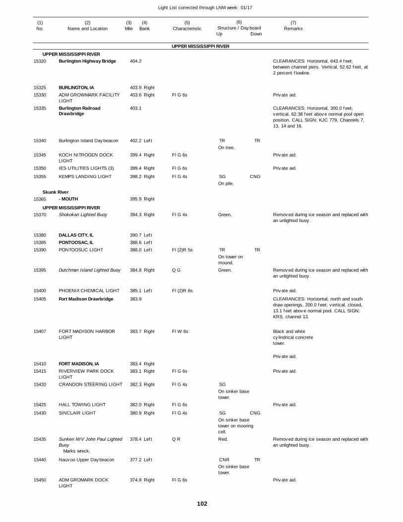
102
Light List corrected through LNM week: 01/17
(7)Remarks
(1)No.
(2)Name and Location
(3)Mile
(5)Characteristic
(4)Bank
(6)Structure / DayboardUp Down
Burlington Highway Bridge
BURLINGTON, IAADM GROWMARK FACILITY LIGHTBurlington Railroad Drawbridge
Burlington Island Daybeacon
KOCH NITROGEN DOCK LIGHTIES UTILITIES LIGHTS (3)
KEMPS LANDING LIGHT
- MOUTH
Shokokan Lighted Buoy
DALLAS CITY, ILPONTOOSAC, ILPONTOOSUC LIGHT
Dutchman Island Lighted Buoy
PHOENIX CHEMICAL LIGHT
Fort Madison Drawbridge
FORT MADISON HARBOR LIGHT
FORT MADISON, IARIVERVIEW PARK DOCK LIGHTCRANDON STEERING LIGHT
HALL TOWING LIGHT
SINCLAIR LIGHT
Sunken M/V John Paul LightedBuoy
Nauvoo Upper Daybeacon
ADM GROMARK DOCK LIGHT
UPPER MISSISSIPPI RIVER
UPPER MISSISSIPPI RIVER
Skunk River
UPPER MISSISSIPPI RIVER
RightRight
Left
Right
Right
Right
Right
Right
LeftLeftLeft
Right
Left
Right
RightRight
Right
Right
Right
Left
Left
Right
404.2
403.9 403.6
403.1
402.2
399.4
399.4
398.2
395.9
394.3
390.7 388.6 388.0
384.8
385.1
383.9
383.7
383.4 383.1
382.3
382.0
380.9
378.4
377.2
374.9
Marks wreck.
Fl G 6s
Fl G 6s
Fl G 6s
Fl G 4s
Fl G 4s
Fl (2)R 5s
Q G
Fl (2)R 6s
Fl W 6s
Fl G 6s
Fl G 4s
Fl G 6s
Fl G 4s
Q R
Fl G 6s
On tree.
On pile.
Green.
On tower on mound.Green.
On sinker base tower.
On sinker base tower on mooring cell.Red.
On sinker base tower.
CLEARANCES: Horizontal, 643.4 feet, between channel piers. Vertical, 52.62 feet, at 2 percent flowline.
CLEARANCES: Horizontal, 300.0 feet; vertical, 62.38 feet above normal pool open position. CALL SIGN: KJC 779, Channels 7, 13, 14 and 16.
Removed during ice season and replaced with an unlighted buoy.
Removed during ice season and replaced with an unlighted buoy.
CLEARANCES: Horizontal, north and south draw openings, 200.0 feet; vertical, closed, 13.1 feet above normal pool. CALL SIGN: KRS, channel 13.
Black and whitecylindrical concretetower.
Removed during ice season and replaced with an unlighted buoy.
15320
1532515330
15335
15340
15345
15350
15355
15365
15370
153801538515390
15395
15400
15405
15407
1541015415
15420
15425
15430
15435
15440
15450
TR
SG
TR
SG
SG
CNR
TR
CNG
TR
CNG
TR
Private aid.
Private aid.
Private aid.
Private aid.
Private aid.
Private aid.
Private aid.
Private aid.
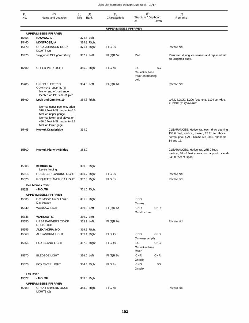
103
Light List corrected through LNM week: 01/17
(7)Remarks
(1)No.
(2)Name and Location
(3)Mile
(5)Characteristic
(4)Bank
(6)Structure / DayboardUp Down
NAUVOO, ILMONTROSE, IAORBA-JOHNSON DOCK LIGHTS (2)Waggoner PT Lighted Buoy
UPPER PIER LIGHT
UNION ELECTRIC COMPANY LIGHTS (3)
Lock and Dam No. 19
Keokuk Drawbridge
Keokuk Highway Bridge
KEOKUK, IA
HUBINGER LANDING LIGHT
ROQUETTE AMERICA LIGHT
- MOUTH
Des Moines River Lower Daybeacon
WARSAW LIGHT
WARSAW, ILURSA FARMERS CO-OP DOCK LIGHTALEXANDRIA, MOALEXANDRIA LIGHT
FOX ISLAND LIGHT
BLEDSOE LIGHT
FOX RIVER LIGHT
- MOUTH
URSA FARMERS DOCK LIGHTS (2)
UPPER MISSISSIPPI RIVER
UPPER MISSISSIPPI RIVER
Des Moines River
UPPER MISSISSIPPI RIVER
Fox River
UPPER MISSISSIPPI RIVER
Left
RightRight
Left
Right
Left
Right
Right
Right
Right
Right
Right
Left
LeftLeft
RightRight
Right
Left
Right
Right
Right
374.8
374.8 371.1
367.2
365.2
364.5
364.3
364.0
363.9
363.8
363.2
362.3
361.5
361.5
359.9
359.7 359.7
359.1 359.1
357.5
356.0
354.3
353.6
353.0
Marks end of ice fender located on left side of pier.
Normal upper pool elevation 518.2 feet MSL, equal to 0.0feet on upper gauge. Normal lower pool elevation 480.0 feet MSL, equal to 2.2feet on lower gage.
Levee landing.
Fl G 6s
Fl (2)R 5s
Fl G 4s
Fl (2)R 6s
Fl G 6s
Fl G 6s
Fl (2)R 5s
Fl (2)R 6s
Fl G 4s
Fl G 4s
Fl (2)R 5s
Fl G 4s
Fl G 6s
Red.
On sinker base tower on mooring cell.
On tree.
On structure.
On tower on pile.
On sinker base tower.
On pile.
On pile.
Removed during ice season and replaced with an unlighted buoy.
LAND LOCK: 1,200 feet long, 110 feet wide. PHONE:(319)524-2631
CLEARANCES: Horizontal, each draw opening,158.0 feet; vertical, closed, 25.2 feet above normal pool. CALL SIGN: KLG 365, channels 14 and 16.
CLEARANCES: Horizontal, 275.0 feet; vertical, 67.46 feet above normal pool for mid-245.0 feet of span.
154551546015470
15475
15480
15485
15490
15495
15500
15505
15515
15520
15528
15535
15540
1554515550
1555515560
15565
15570
15575
15577
15580
SG
CNG
CNR
CNG
SG
CNR
CNG
SG
CNR
CNG
CNG
CNR
SG
Private aid.
Private aid.
Private aid.
Private aid.
Private aid.
Private aid.
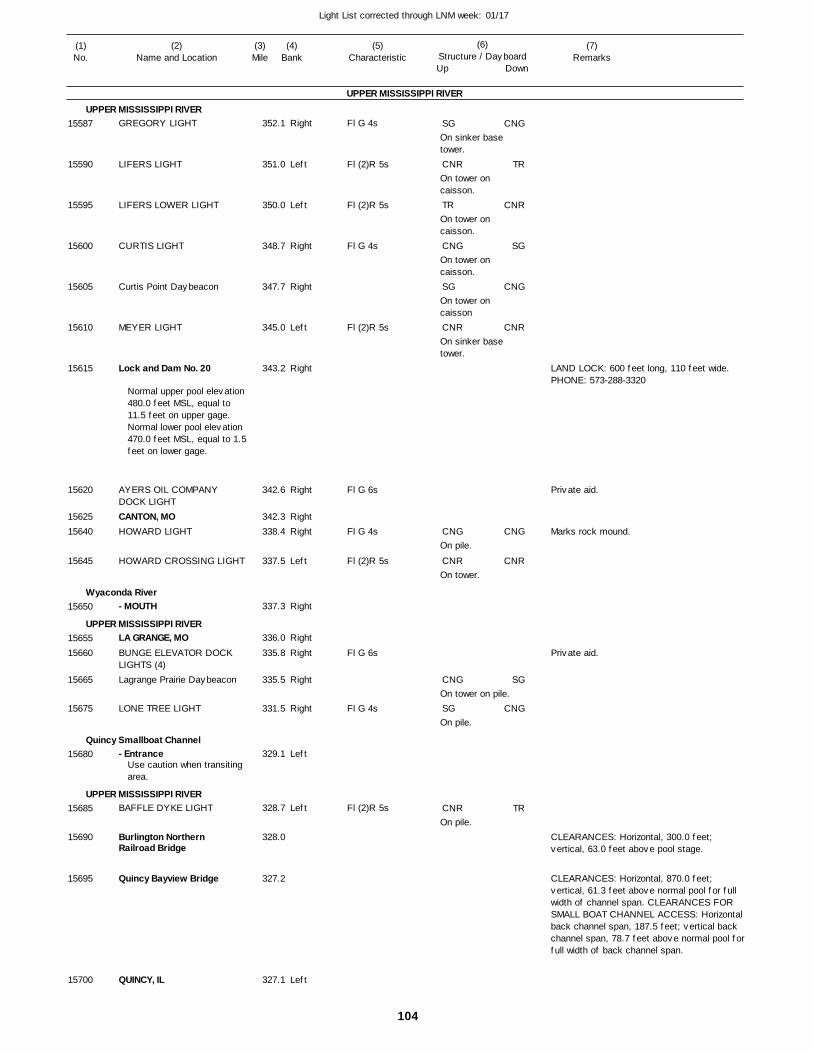
104
Light List corrected through LNM week: 01/17
(7)Remarks
(1)No.
(2)Name and Location
(3)Mile
(5)Characteristic
(4)Bank
(6)Structure / DayboardUp Down
GREGORY LIGHT
LIFERS LIGHT
LIFERS LOWER LIGHT
CURTIS LIGHT
Curtis Point Daybeacon
MEYER LIGHT
Lock and Dam No. 20
AYERS OIL COMPANY DOCK LIGHTCANTON, MOHOWARD LIGHT
HOWARD CROSSING LIGHT
- MOUTH
LA GRANGE, MOBUNGE ELEVATOR DOCK LIGHTS (4)Lagrange Prairie Daybeacon
LONE TREE LIGHT
- Entrance
BAFFLE DYKE LIGHT
Burlington Northern Railroad Bridge
Quincy Bayview Bridge
QUINCY, IL
UPPER MISSISSIPPI RIVER
UPPER MISSISSIPPI RIVER
Wyaconda River
UPPER MISSISSIPPI RIVER
Quincy Smallboat Channel
UPPER MISSISSIPPI RIVER
Right
Left
Left
Right
Right
Left
Right
Right
RightRight
Left
Right
Right
Right
Right
Right
Left
Left
Left
352.1
351.0
350.0
348.7
347.7
345.0
343.2
342.6
342.3 338.4
337.5
337.3
336.0
335.8
335.5
331.5
329.1
328.7
328.0
327.2
327.1
Normal upper pool elevation 480.0 feet MSL, equal to 11.5 feet on upper gage. Normal lower pool elevation 470.0 feet MSL, equal to 1.5feet on lower gage.
Use caution when transiting area.
Fl G 4s
Fl (2)R 5s
Fl (2)R 5s
Fl G 4s
Fl (2)R 5s
Fl G 6s
Fl G 4s
Fl (2)R 5s
Fl G 6s
Fl G 4s
Fl (2)R 5s
On sinker base tower.
On tower on caisson.
On tower on caisson.
On tower on caisson.
On tower on caisson
On sinker base tower.
On pile.
On tower.
On tower on pile.
On pile.
On pile.
LAND LOCK: 600 feet long, 110 feet wide. PHONE: 573-288-3320
Marks rock mound.
CLEARANCES: Horizontal, 300.0 feet; vertical, 63.0 feet above pool stage.
CLEARANCES: Horizontal, 870.0 feet; vertical, 61.3 feet above normal pool for full width of channel span. CLEARANCES FOR SMALL BOAT CHANNEL ACCESS: Horizontal back channel span, 187.5 feet; vertical back channel span, 78.7 feet above normal pool for full width of back channel span.
15587
15590
15595
15600
15605
15610
15615
15620
1562515640
15645
15650
1565515660
15665
15675
15680
15685
15690
15695
15700
SG
CNR
TR
CNG
SG
CNR
CNG
CNR
CNG
SG
CNR
CNG
TR
CNR
SG
CNG
CNR
CNG
CNR
SG
CNG
TR
Private aid.
Private aid.
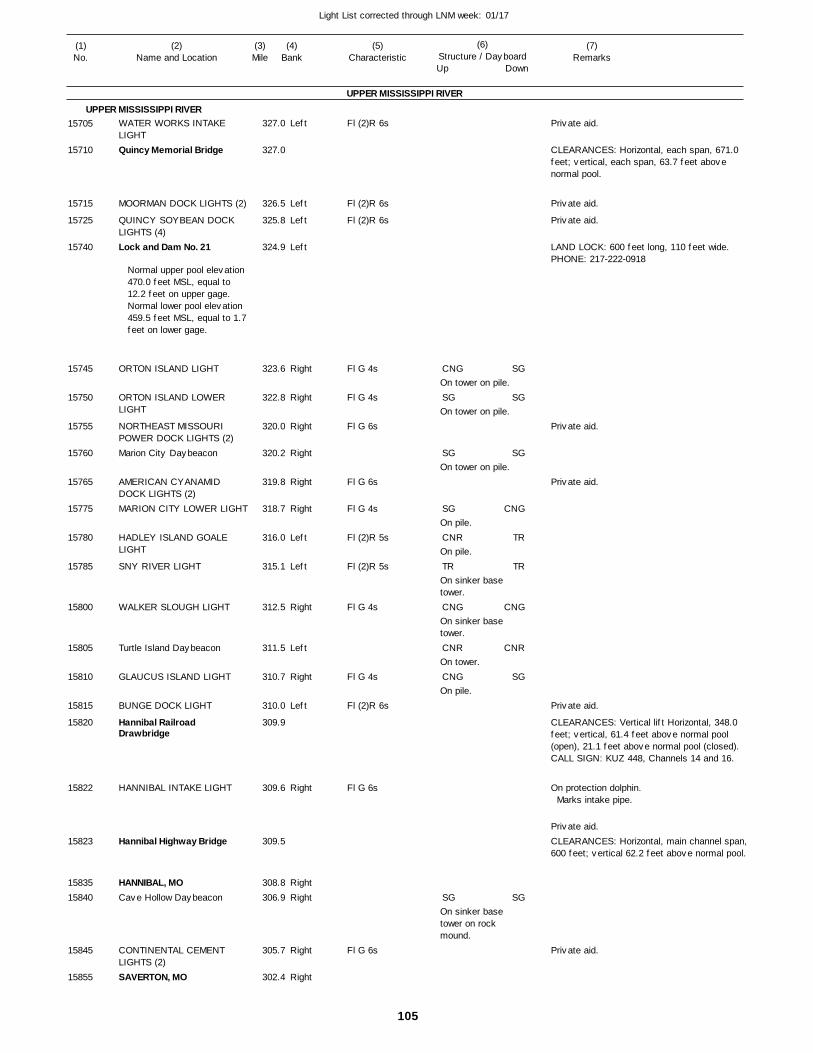
105
Light List corrected through LNM week: 01/17
(7)Remarks
(1)No.
(2)Name and Location
(3)Mile
(5)Characteristic
(4)Bank
(6)Structure / DayboardUp Down
WATER WORKS INTAKE LIGHTQuincy Memorial Bridge
MOORMAN DOCK LIGHTS (2)
QUINCY SOYBEAN DOCK LIGHTS (4)Lock and Dam No. 21
ORTON ISLAND LIGHT
ORTON ISLAND LOWER LIGHT
NORTHEAST MISSOURI POWER DOCK LIGHTS (2)Marion City Daybeacon
AMERICAN CYANAMID DOCK LIGHTS (2)MARION CITY LOWER LIGHT
HADLEY ISLAND GOALE LIGHT
SNY RIVER LIGHT
WALKER SLOUGH LIGHT
Turtle Island Daybeacon
GLAUCUS ISLAND LIGHT
BUNGE DOCK LIGHT
Hannibal Railroad Drawbridge
HANNIBAL INTAKE LIGHT
Hannibal Highway Bridge
HANNIBAL, MOCave Hollow Daybeacon
CONTINENTAL CEMENT LIGHTS (2)SAVERTON, MO
UPPER MISSISSIPPI RIVER
UPPER MISSISSIPPI RIVERLeft
Left
Left
Left
Right
Right
Right
Right
Right
Right
Left
Left
Right
Left
Right
Left
Right
RightRight
Right
Right
327.0
327.0
326.5
325.8
324.9
323.6
322.8
320.0
320.2
319.8
318.7
316.0
315.1
312.5
311.5
310.7
310.0
309.9
309.6
309.5
308.8 306.9
305.7
302.4
Normal upper pool elevation 470.0 feet MSL, equal to 12.2 feet on upper gage.Normal lower pool elevation 459.5 feet MSL, equal to 1.7feet on lower gage.
Fl (2)R 6s
Fl (2)R 6s
Fl (2)R 6s
Fl G 4s
Fl G 4s
Fl G 6s
Fl G 6s
Fl G 4s
Fl (2)R 5s
Fl (2)R 5s
Fl G 4s
Fl G 4s
Fl (2)R 6s
Fl G 6s
Fl G 6s
On tower on pile.
On tower on pile.
On tower on pile.
On pile.
On pile.
On sinker base tower.
On sinker base tower.
On tower.
On pile.
On sinker base tower on rock mound.
CLEARANCES: Horizontal, each span, 671.0 feet; vertical, each span, 63.7 feet above normal pool.
LAND LOCK: 600 feet long, 110 feet wide. PHONE: 217-222-0918
CLEARANCES: Vertical lift Horizontal, 348.0 feet; vertical, 61.4 feet above normal pool (open), 21.1 feet above normal pool (closed). CALL SIGN: KUZ 448, Channels 14 and 16.
On protection dolphin. Marks intake pipe.
CLEARANCES: Horizontal, main channel span,600 feet; vertical 62.2 feet above normal pool.
15705
15710
15715
15725
15740
15745
15750
15755
15760
15765
15775
15780
15785
15800
15805
15810
15815
15820
15822
15823
1583515840
15845
15855
CNG
SG
SG
SG
CNR
TR
CNG
CNR
CNG
SG
SG
SG
SG
CNG
TR
TR
CNG
CNR
SG
SG
Private aid.
Private aid.
Private aid.
Private aid.
Private aid.
Private aid.
Private aid.
Private aid.
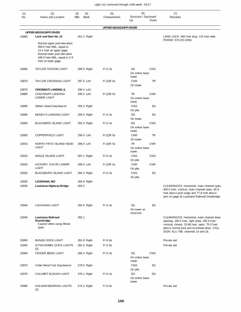
106
Light List corrected through LNM week: 01/17
(7)Remarks
(1)No.
(2)Name and Location
(3)Mile
(5)Characteristic
(4)Bank
(6)Structure / DayboardUp Down
Lock and Dam No. 22
TAYLOR STATION LIGHT
TAYLOR CROSSING LIGHT
CINCINNATI LANDING, ILCINCINNATI LANDING LOWER LIGHT
Gilbert Island Daybeacon
MUNDYS LANDING LIGHT
BLACKBIRD ISLAND LIGHT
COPPERFIELD LIGHT
NORTH FRITZ ISLAND HEADLIGHT
ANGLE ISLAND LIGHT
HICKORY CHUTE LOWER LIGHT
BLACKBURN ISLAND LIGHT
LOUISIANA, MOLouisiana Highway Bridge
LOUISIANA LIGHT
Louisiana Railroad Drawbridge
BUNGE DOCK LIGHT
DYNO-NOBEL DOCK LIGHTS(2)CRIDER BEND LIGHT
Crider Bend Foot Daybeacon
CALUMET SLOUGH LIGHT
HOLNAM MOORING LIGHTS (2)
UPPER MISSISSIPPI RIVER
UPPER MISSISSIPPI RIVERRight
Right
Left
LeftLeft
Right
Right
Right
Left
Left
Right
Left
Right
Right
Right
Right
Right
Right
Right
Right
Right
301.2
299.5
297.5
296.4 295.5
294.3
293.5
292.0
290.0
289.0
287.1
285.5
284.4
283.8 283.2
282.6
282.1
281.8
281.0
280.4
278.5
276.1
274.3
Normal upper pool elevation 459.5 feet MSL, equal to 13.4 feet on upper gage.Normal lower pool elevation 449.0 feet MSL, equal to 2.9feet on lower gage.
Caution when using Illinois span.
Fl G 4s
Fl (2)R 5s
Fl (2)R 5s
Fl G 4s
Fl G 4s
Fl (2)R 5s
Fl (2)R 5s
Fl G 4s
Fl (2)R 5s
Fl G 4s
Fl G 4s
Fl G 6s
Fl G 6s
Fl G 4s
Fl G 4s
Fl G 6s
On sinker base tower.
On tower.
On sinker base tower.
On pile.
On tower.
On sinker base tower.
On tower.
On sinker base tower.
On pile.
On pile.
On pile.
On tower on structure.
On sinker base tower.
On pile.
On sinker base tower.
LAND LOCK: 600 feet long, 110 feet wide. PHONE: 573-221-0294
CLEARANCES: Horizontal, main channel span,405.0 feet; vertical, main channel span, 65.9 feet above pool stage and 77.8 feet above zero on gage at Louisiana Railroad Drawbridge.
CLEARANCES: Horizontal, main channel draw opening, 195.0 feet, right draw, 195.4 feet; vertical, closed, 15.86 feet, open, 70.0 feet above normal pool and overhead wires. CALL SIGN: KLU 798, channels 14 and 16.
15860
15865
15870
1587515885
15890
15895
15900
15905
15910
15915
15920
15925
1593015935
15940
15945
15950
15955
15960
15970
15975
15985
SG
CNR
TR
CNG
SG
SG
CNR
TR
CNG
CNR
CNG
SG
SG
CNG
SG
CNG
TR
CNR
SG
SG
CNG
TR
CNR
CNG
CNR
SG
SG
CNG
SG
SG
Private aid.
Private aid.
Private aid.

107
Light List corrected through LNM week: 01/17
(7)Remarks
(1)No.
(2)Name and Location
(3)Mile
(5)Characteristic
(4)Bank
(6)Structure / DayboardUp Down
Clarksville Daybeacon
Lock and Dam No. 24
CLARKSVILLE, MOCLARKSVILLE LIGHT
AMARANTH ISLAND LIGHT
MULHERON FIELD LIGHT
RIP RAP LANDING UPPER LIGHT
DAGO POINT LIGHT
THOMAS CHUTE LIGHT
THOMAS CHUTE LOWER LIGHT
MOZIER LANDING, ILMOZIER LANDING LIGHT
HAMBURG, ILWESTPORT ISLAND LIGHT
BURR OAK LANDING LIGHT
ELSWOOD LOWER LIGHT
Sterling Landing Daybeacon
CHURCH CREEK LIGHT
TURNERS LANDING LIGHT
SANDY CREEK LIGHT
Bradley Island Daybeacon
UPPER MISSISSIPPI RIVER
UPPER MISSISSIPPI RIVERRight
Right
RightRight
Right
Right
Left
Left
Right
Right
LeftLeft
LeftRight
Left
Right
Right
Left
Left
Right
Right
273.8
273.4
273.1 272.0
269.2
267.0
265.0
263.9
262.7
262.1
260.3 260.2
258.6 255.9
254.4
252.6
250.5
249.0
246.8
245.3
241.9
Normal upper pool elevation 449.0 feet MSL, equal to 19.0 feet on upper gauge.Normal lower pool elevation 434.0 feet MSL, equal to 12.0 feet on lower gage.
Fl G 4s
Fl G 4s
Fl G 4s
Fl (2)R 5s
Fl (2)R 5s
Fl G 4s
Fl G 4s
Fl (2)R 5s
Fl G 4s
Fl (2)R 5s
Fl G 4s
Fl (2)R 5s
Fl (2)R 5s
Fl G 4s
On sinker base tower on end of wing dam.
On sinker base tower.
On sinker base tower.
On pile.
On tower.
On tower.
On sinker base tower.
On sinker base tower.
On tower on pile.
On sinker base tower.
On tower.
On sinker base tower.
On sinker base tower.
On pile.
On sinker base tower, on wingdam.
On pile.
On sinker base tower.
LOCK: 600 feet long, 110 feet wide. PHONE: 573-242-3524
15990
15995
1600016005
16007
16010
16015
16020
16025
16030
1603516040
1604516050
16055
16065
16070
16075
16080
16085
16090
SG
SG
SG
CNG
CNR
TR
CNG
SG
CNR
SG
CNR
SG
SG
CNR
TR
CNG
SG
SG
CNG
SG
CNG
TR
CNR
SG
CNG
CNR
CNG
CNR
SG
NG
TR
CNR
SG
SG
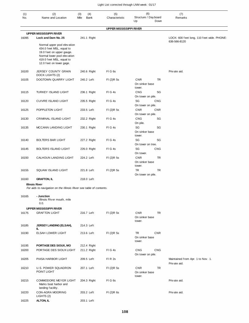
108
Light List corrected through LNM week: 01/17
(7)Remarks
(1)No.
(2)Name and Location
(3)Mile
(5)Characteristic
(4)Bank
(6)Structure / DayboardUp Down
Lock and Dam No. 25
JERSEY COUNTY GRAIN DOCK LIGHTS (2)DOGTOWN QUARRY LIGHT
TURKEY ISLAND LIGHT
CUIVRE ISLAND LIGHT
POPPLETON LIGHT
CRIMINAL ISLAND LIGHT
MCCANN LANDING LIGHT
BOLTERS BAR LIGHT
BOLTERS ISLAND LIGHT
CALHOUN LANDING LIGHT
SQUAW ISLAND LIGHT
GRAFTON, IL
- Junction
GRAFTON LIGHT
JERSEY LANDING (ELSAH), ILELSAH LOWER LIGHT
PORTAGE DES SIOUX, MOPORTAGE DES SIOUX LIGHT
PIASA HARBOR LIGHT
U.S. POWER SQUADRON POINT LIGHT
COMMODORE MEYER LIGHT
CON-AGRA MOORING LIGHTS (2)ALTON, IL
UPPER MISSISSIPPI RIVER
UPPER MISSISSIPPI RIVER
Illinois River
UPPER MISSISSIPPI RIVER
For aids to navigation on the Illinois River see table of contents.
Right
Right
Left
Right
Right
Left
Right
Right
Right
Right
Left
Left
Left
Left
Left
Left
RightRight
Left
Left
Right
Left
Left
241.1
240.6
240.2
236.1
235.5
233.5
232.2
230.1
227.2
226.0
224.2
221.8
218.0
216.7
214.3
213.6
212.4 211.2
209.5
207.1
204.3
203.2
203.1
Normal upper pool elevation 434.0 feet MSL, equal to 19.0 feet on upper gauge. Normal lower pool elevation 419.0 feet MSL, equal to 12.0 feet on lower gage.
Illinois River mouth, mile 0.0.
Marks boat harbor and landing facility.
Fl G 6s
Fl (2)R 5s
Fl G 4s
Fl G 4s
Fl (2)R 5s
Fl G 4s
Fl G 4s
Fl G 4s
Fl G 4s
Fl (2)R 5s
Fl (2)R 5s
Fl (2)R 5s
Fl (2)R 5s
Fl G 4s
Fl R 2s
Fl (2)R 5s
Fl G 6s
Fl (2)R 6s
On sinker base tower.
On tower on pile.
On tower on pile.
On tower on pile.
On pile.
On sinker base tower.
On tower on tree.
On tower.
On sinker base tower.
On tower on pile.
On sinker base tower.
On sinker base tower.
On tower on pile.
On sinker base tower.
LOCK: 600 feet long, 110 feet wide. PHONE: 636-566-8120
Maintained from Apr. 1 to Nov. 1.
16095
16100
16105
16115
16120
16125
16130
16135
16140
16145
16150
16155
16160
16165
16175
16185
16190
1619516200
16205
16210
16215
16220
16225
CNR
CNG
SG
CNR
CNG
SG
SG
SG
CNR
TR
CNR
TR
CNG
CNR
TR
SG
CNG
CNR
SG
SG
SG
CNG
TR
TR
TR
CNR
CNG
TR
Private aid.
Private aid.
Private aid.
Private aid.
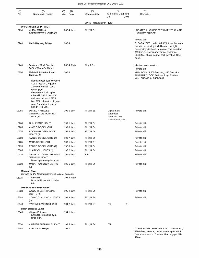
109
Light List corrected through LNM week: 01/17
(7)Remarks
(1)No.
(2)Name and Location
(3)Mile
(5)Characteristic
(4)Bank
(6)Structure / DayboardUp Down
ALTON MARINA BREAKWATER LIGHTS (3)
Clark Highway Bridge
Lewis and Clark Special Lighted Scientific Buoy A
Melvin E. Price Lock and Dam No. 26
DYNEGY MIDWEST GENERATION MOORING CELLS (2)
OLIN INTAKE LIGHT
AMOCO DOCK LIGHT
KOCH NITROGEN DOCK LIGHTS (3)AMOCO DOCK LIGHTS (4)
MERS DOCK LIGHT
REDCO DOCK LIGHTS (2)
CLARK OIL LIGHTS (3)
SIOUX CITY/NEW ORLEANS TERMINAL LIGHT
MARATHON DOCK LIGHTS (5)
- Junction
WOOD RIVER PIPELINE LIGHTS (2)CONOCO OIL DOCK LIGHTS (4)TYRONE LANDING LIGHT
- Upper Entrance
- UPPER ENTRANCE LIGHT
I-270 Canal Bridge
UPPER MISSISSIPPI RIVER
UPPER MISSISSIPPI RIVER
Missouri River
UPPER MISSISSIPPI RIVER
Chain of Rocks Canal
For aids on the Missouri River see table of contents.
Left
Right
Left
Left
Left
Left
Left
Left
Left
Left
Left
Left
Right
Left
Left
Left
Left
Left
202.4
202.4
202.4
200.8
199.6
199.1
199.0
198.8
198.7
198.1
197.8
197.2
197.0
196.6
195.3
195.2
194.9
194.2
194.1
193.5
192.1
Normal upper pool elevation 419.0 feet MSL, equal to 22.0 feet on Main Lock upper gage.Elevation of lock, upper mitre sill, 396.0 feet MSL and lower mitre sill 377.0 feet MSL, elevation of gage zero. Dam tailwater gage, 395.48 feet MSL.
Marks upstream pile cluster.
Missouri River mouth, mile 0.0.
Entrance is marked by a large sign.
Fl (2)R 6s
Fl Y 2.5s
Fl (2)R 6s
Fl (2)R 6s
Fl (2)R 6s
Fl (2)R 6s
Fl (2)R 6s
Fl (2)R 6s
Fl (2)R 6s
Fl (2)R 6s
F R
Fl (2)R 6s
Fl (2)R 6s
Fl (2)R 6s
Fl (2)R 5s
Fl (2)R 5s
Lights mark outermost upstream and downstream cells.
LOCATED IN CLOSE PROXIMITY TO CLARK HIGHWAY BRIDGE.
CLEARANCES: Horizontal, 670.0 feet betweenthe left descending trail dike and the right descending pier face, at normal pool elevation 419.0 m.s.l.; minimum vertical clearance, 66.36 feet above normal pool elevation 419.0 m.s.l.
Monitors water quality.
MAIN LOCK: 1,200 feet long, 110 feet wide. AUXILIARY LOCK: 600 feet long, 110 feet wide. PHONE: 618-462-1839
CLEARANCES: Horizontal, main channel span,350.0 feet; vertical, main channel span, 63.5 feet above zero on Chain of Rocks gage, Mile 190.4.
16230
16240
16245
16250
16255
16260
16265
16270
16280
16285
16295
16305
16310
16320
16325
16330
16340
16343
16345
16350
16353
TR
TR
TR
Private aid.
Private aid.
Private aid.
Private aid.
Private aid.
Private aid.
Private aid.
Private aid.
Private aid.
Private aid.
Private aid.
Private aid.
Private aid.
Private aid.

110
Light List corrected through LNM week: 01/17
(7)Remarks
(1)No.
(2)Name and Location
(3)Mile
(5)Characteristic
(4)Bank
(6)Structure / DayboardUp Down
- Highway Bridge
BULK SERVICE TERMINAL LIGHTBULK SERVICE TERMINAL LIGHTChain of Rocks Twin Locks No. 27
WESTERN DOCK LIGHTS (9)
- LOWER ENTRANCE LIGHT- Lower EntranceADM-GROWMARK DOCK LIGHTS (4)AMERICA'S CENTRAL PORT LOADING DOCK PILING LIGHTS (3)
Merchants Railroad Bridge
Lange-Stegmann Channel Buoys (6)
LANGE-STEGMANN FERTILIZER LIGHTS (2)McKinley Bridge
UNION ELECTRIC COAL DOCK LIGHTS (2)Stan Musial Veterans Memorial Bridge
ST. LOUIS TERMINAL LIGHT
CONTINENTAL CEMENT LIGHTS (2)BUNGE BARGE LOADING DOCK LIGHT
BUNGE BARGE LOADING DOCK LIGHT
BUNGE BARGE LOADING DOCK LIGHT
APEX OIL LIGHTS (2)
ILLINOIS AMERICAN WATERINTAKE LIGHTS (2)Martin L. King Memorial Bridge
UPPER MISSISSIPPI RIVER
UPPER MISSISSIPPI RIVERChain of Rocks Canal
Left
Left
Right
Right
LeftRight
Left
Right
Right
Left
Right
Right
Left
Left
Left
Right
Left
191.8
186.4
186.0
185.5
184.7
184.1
184.0 184.0
183.5
183.2
183.2
182.7
182.5
182.3
181.2
181.2
181.2
181.1
181.1
181.1
180.9
180.8
180.2
Three pairs of gated buoys marking privately dredged access channel.
Marks dock.
Fl (2)R 6s
Fl (2)R 6s
Fl G 6s
Fl G 4s
Fl G 6s
Fl (2)R 6s
Fl G 6s
Fl (2)R 6s
Fl G 6s
Fl G 6s
Fl (2)R 6s
Fl W 2.5s
Fl W 2.5s
Fl G 6s
Fl (2)R 6s
Marks upstream, midstream and downstream barge dock pilings.
Three green cans and three red nuns.
Marks outermost upstream mooring dolphin.Marks outermost middle mooring dolphin.Marks outermost downstream mooring dolphin.
Marks water intake structure.
CLEARANCES: Horizontal, main channel span,between pile protection dolphins, 348.0 feet; vertical clearances gage on piers.
EAST (MAIN LOCK): 1,200 feet long, 110 feet wide. WEST (AUXILIARY LOCK): 600 feet long, 110 feet wide.PHONE: 618-452-7107
CLEARANCES: Horizontal, center span, 505.0 feet, two side spans each 503.0 feet; vertical, 83.0 feet above zero on St. Louis gage.
DEPLOYED WHEN ST. LOUIS GAGE READS ZERO OR BELOW.
CLEARANCES: Horizontal, left span, 500.0 feet; vertical, 85.4 feet above zero on St. Louis gage.
CLEARANCES: Horizontal, 1394.6 feet; vertical, 92.4 feet above zero on the St. Louis Gauge.
CLEARANCES: Horizontal, center span 940.0 feet, side span 450.0 feet; vertical, 96.4 feet above zero of St. Louis gage.
16360
16365
16370
16375
16380
16385
1638716390
16400
16405
16410
16420
16425
16430
16435
16440
16445
16447
16447.01
16447.02
16450
16455
16460
SG SG
Private aid.
Private aid.
Private aid.
Private aid.
Private aid.
Private aid.
Private aid.
Private aid.
Private aid.
Private aid.
Private aid.
Private aid.
Private aid.
Private aid.
Private aid.
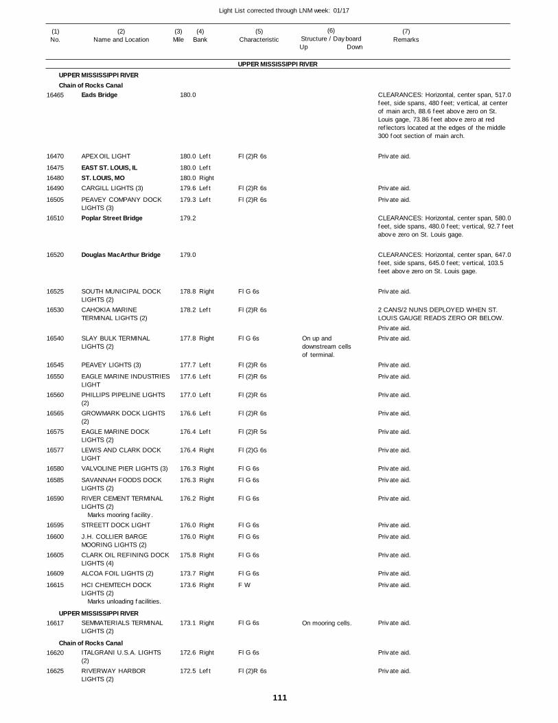
111
Light List corrected through LNM week: 01/17
(7)Remarks
(1)No.
(2)Name and Location
(3)Mile
(5)Characteristic
(4)Bank
(6)Structure / DayboardUp Down
Eads Bridge
APEX OIL LIGHT
EAST ST. LOUIS, ILST. LOUIS, MOCARGILL LIGHTS (3)
PEAVEY COMPANY DOCK LIGHTS (3)Poplar Street Bridge
Douglas MacArthur Bridge
SOUTH MUNICIPAL DOCK LIGHTS (2)CAHOKIA MARINE TERMINAL LIGHTS (2)
SLAY BULK TERMINAL LIGHTS (2)
PEAVEY LIGHTS (3)
EAGLE MARINE INDUSTRIESLIGHTPHILLIPS PIPELINE LIGHTS (2)GROWMARK DOCK LIGHTS (2)EAGLE MARINE DOCK LIGHTS (2)LEWIS AND CLARK DOCK LIGHTVALVOLINE PIER LIGHTS (3)
SAVANNAH FOODS DOCK LIGHTS (2)RIVER CEMENT TERMINAL LIGHTS (2)
STREETT DOCK LIGHT
J.H. COLLIER BARGE MOORING LIGHTS (2)CLARK OIL REFINING DOCKLIGHTS (4)ALCOA FOIL LIGHTS (2)
HCI CHEMTECH DOCK LIGHTS (2)
SEMMATERIALS TERMINAL LIGHTS (2)
ITALGRANI U.S.A. LIGHTS (2)RIVERWAY HARBOR LIGHTS (2)
UPPER MISSISSIPPI RIVER
UPPER MISSISSIPPI RIVERChain of Rocks Canal
UPPER MISSISSIPPI RIVER
Chain of Rocks Canal
Left
LeftRightLeft
Left
Right
Left
Right
Left
Left
Left
Left
Left
Right
Right
Right
Right
Right
Right
Right
Right
Right
Right
Right
Left
180.0
180.0
180.0 180.0 179.6
179.3
179.2
179.0
178.8
178.2
177.8
177.7
177.6
177.0
176.6
176.4
176.4
176.3
176.3
176.2
176.0
176.0
175.8
173.7
173.6
173.1
172.6
172.5
Marks mooring facility.
Marks unloading facilities.
Fl (2)R 6s
Fl (2)R 6s
Fl (2)R 6s
Fl G 6s
Fl (2)R 6s
Fl G 6s
Fl (2)R 6s
Fl (2)R 6s
Fl (2)R 6s
Fl (2)R 6s
Fl (2)R 5s
Fl (2)G 6s
Fl G 6s
Fl G 6s
Fl G 6s
Fl G 6s
Fl G 6s
Fl G 6s
Fl G 6s
F W
Fl G 6s
Fl G 6s
Fl (2)R 6s
On up and downstream cells of terminal.
On mooring cells.
CLEARANCES: Horizontal, center span, 517.0 feet, side spans, 480 feet; vertical, at center of main arch, 88.6 feet above zero on St. Louis gage, 73.86 feet above zero at red reflectors located at the edges of the middle 300 foot section of main arch.
CLEARANCES: Horizontal, center span, 580.0 feet, side spans, 480.0 feet; vertical, 92.7 feetabove zero on St. Louis gage.
CLEARANCES: Horizontal, center span, 647.0 feet, side spans, 645.0 feet; vertical, 103.5 feet above zero on St. Louis gage.
2 CANS/2 NUNS DEPLOYED WHEN ST. LOUIS GAUGE READS ZERO OR BELOW.
16465
16470
164751648016490
16505
16510
16520
16525
16530
16540
16545
16550
16560
16565
16575
16577
16580
16585
16590
16595
16600
16605
16609
16615
16617
16620
16625
Private aid.
Private aid.
Private aid.
Private aid.
Private aid.Private aid.
Private aid.
Private aid.
Private aid.
Private aid.
Private aid.
Private aid.
Private aid.
Private aid.
Private aid.
Private aid.
Private aid.
Private aid.
Private aid.
Private aid.
Private aid.
Private aid.
Private aid.
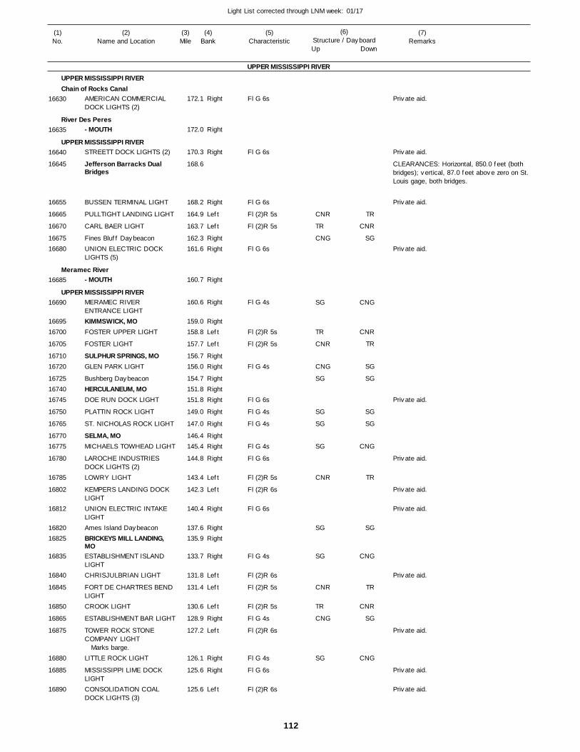
112
Light List corrected through LNM week: 01/17
(7)Remarks
(1)No.
(2)Name and Location
(3)Mile
(5)Characteristic
(4)Bank
(6)Structure / DayboardUp Down
AMERICAN COMMERCIAL DOCK LIGHTS (2)
- MOUTH
STREETT DOCK LIGHTS (2)
Jefferson Barracks Dual Bridges
BUSSEN TERMINAL LIGHT
PULLTIGHT LANDING LIGHT
CARL BAER LIGHT
Fines Bluff DaybeaconUNION ELECTRIC DOCK LIGHTS (5)
- MOUTH
MERAMEC RIVER ENTRANCE LIGHTKIMMSWICK, MOFOSTER UPPER LIGHT
FOSTER LIGHT
SULPHUR SPRINGS, MOGLEN PARK LIGHT
Bushberg DaybeaconHERCULANEUM, MODOE RUN DOCK LIGHT
PLATTIN ROCK LIGHT
ST. NICHOLAS ROCK LIGHT
SELMA, MOMICHAELS TOWHEAD LIGHT
LAROCHE INDUSTRIES DOCK LIGHTS (2)LOWRY LIGHT
KEMPERS LANDING DOCK LIGHTUNION ELECTRIC INTAKE LIGHTAmes Island DaybeaconBRICKEYS MILL LANDING, MOESTABLISHMENT ISLAND LIGHTCHRISJULBRIAN LIGHT
FORT DE CHARTRES BEND LIGHTCROOK LIGHT
ESTABLISHMENT BAR LIGHT
TOWER ROCK STONE COMPANY LIGHT
LITTLE ROCK LIGHT
MISSISSIPPI LIME DOCK LIGHTCONSOLIDATION COAL DOCK LIGHTS (3)
UPPER MISSISSIPPI RIVER
UPPER MISSISSIPPI RIVERChain of Rocks Canal
River Des Peres
UPPER MISSISSIPPI RIVER
Meramec River
UPPER MISSISSIPPI RIVER
Right
Right
Right
Right
Left
Left
RightRight
Right
Right
RightLeft
Left
RightRight
RightRightRight
Right
Right
RightRight
Right
Left
Left
Right
RightRight
Right
Left
Left
Left
Right
Left
Right
Right
Left
172.1
172.0
170.3
168.6
168.2
164.9
163.7
162.3 161.6
160.7
160.6
159.0 158.8
157.7
156.7 156.0
154.7 151.8 151.8
149.0
147.0
146.4 145.4
144.8
143.4
142.3
140.4
137.6 135.9
133.7
131.8
131.4
130.6
128.9
127.2
126.1
125.6
125.6
Marks barge.
Fl G 6s
Fl G 6s
Fl G 6s
Fl (2)R 5s
Fl (2)R 5s
Fl G 6s
Fl G 4s
Fl (2)R 5s
Fl (2)R 5s
Fl G 4s
Fl G 6s
Fl G 4s
Fl G 4s
Fl G 4s
Fl G 6s
Fl (2)R 5s
Fl (2)R 6s
Fl G 6s
Fl G 4s
Fl (2)R 6s
Fl (2)R 5s
Fl (2)R 5s
Fl G 4s
Fl (2)R 6s
Fl G 4s
Fl G 6s
Fl (2)R 6s
CLEARANCES: Horizontal, 850.0 feet (both bridges); vertical, 87.0 feet above zero on St. Louis gage, both bridges.
16630
16635
16640
16645
16655
16665
16670
1667516680
16685
16690
1669516700
16705
1671016720
167251674016745
16750
16765
1677016775
16780
16785
16802
16812
1682016825
16835
16840
16845
16850
16865
16875
16880
16885
16890
CNR
TR
CNG
SG
TR
CNR
CNG
SG
SG
SG
SG
CNR
SG
SG
CNR
TR
CNG
SG
TR
CNR
SG
CNG
CNR
TR
SG
SG
SG
SG
CNG
TR
SG
CNG
TR
CNR
SG
CNG
Private aid.
Private aid.
Private aid.
Private aid.
Private aid.
Private aid.
Private aid.
Private aid.
Private aid.
Private aid.
Private aid.
Private aid.
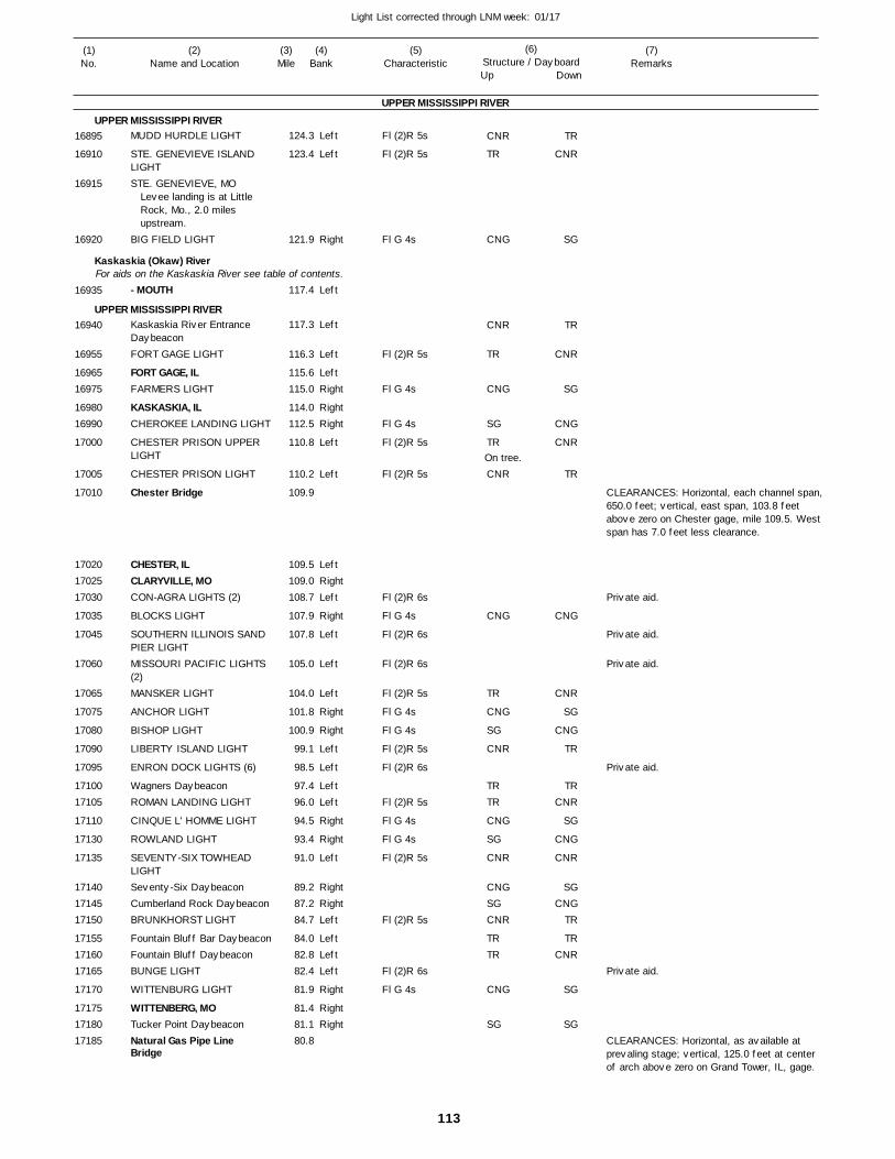
113
Light List corrected through LNM week: 01/17
(7)Remarks
(1)No.
(2)Name and Location
(3)Mile
(5)Characteristic
(4)Bank
(6)Structure / DayboardUp Down
MUDD HURDLE LIGHT
STE. GENEVIEVE ISLAND LIGHTSTE. GENEVIEVE, MO
BIG FIELD LIGHT
- MOUTH
Kaskaskia River Entrance DaybeaconFORT GAGE LIGHT
FORT GAGE, ILFARMERS LIGHT
KASKASKIA, ILCHEROKEE LANDING LIGHT
CHESTER PRISON UPPER LIGHT
CHESTER PRISON LIGHT
Chester Bridge
CHESTER, ILCLARYVILLE, MOCON-AGRA LIGHTS (2)
BLOCKS LIGHT
SOUTHERN ILLINOIS SAND PIER LIGHTMISSOURI PACIFIC LIGHTS (2)MANSKER LIGHT
ANCHOR LIGHT
BISHOP LIGHT
LIBERTY ISLAND LIGHT
ENRON DOCK LIGHTS (6)
Wagners DaybeaconROMAN LANDING LIGHT
CINQUE L' HOMME LIGHT
ROWLAND LIGHT
SEVENTY-SIX TOWHEAD LIGHTSeventy-Six DaybeaconCumberland Rock DaybeaconBRUNKHORST LIGHT
Fountain Bluff Bar DaybeaconFountain Bluff DaybeaconBUNGE LIGHT
WITTENBURG LIGHT
WITTENBERG, MOTucker Point DaybeaconNatural Gas Pipe Line Bridge
UPPER MISSISSIPPI RIVER
UPPER MISSISSIPPI RIVER
Kaskaskia (Okaw) River
UPPER MISSISSIPPI RIVER
For aids on the Kaskaskia River see table of contents.
Left
Left
Right
Left
Left
Left
LeftRight
RightRight
Left
Left
LeftRightLeft
Right
Left
Left
Left
Right
Right
Left
Left
LeftLeft
Right
Right
Left
RightRightLeft
LeftLeftLeft
Right
RightRight
124.3
123.4
121.9
117.4
117.3
116.3
115.6 115.0
114.0 112.5
110.8
110.2
109.9
109.5 109.0 108.7
107.9
107.8
105.0
104.0
101.8
100.9
99.1
98.5
97.4 96.0
94.5
93.4
91.0
89.2 87.2 84.7
84.0 82.8 82.4
81.9
81.4 81.1 80.8
Levee landing is at Little Rock, Mo., 2.0 miles upstream.
Fl (2)R 5s
Fl (2)R 5s
Fl G 4s
Fl (2)R 5s
Fl G 4s
Fl G 4s
Fl (2)R 5s
Fl (2)R 5s
Fl (2)R 6s
Fl G 4s
Fl (2)R 6s
Fl (2)R 6s
Fl (2)R 5s
Fl G 4s
Fl G 4s
Fl (2)R 5s
Fl (2)R 6s
Fl (2)R 5s
Fl G 4s
Fl G 4s
Fl (2)R 5s
Fl (2)R 5s
Fl (2)R 6s
Fl G 4s
On tree.
CLEARANCES: Horizontal, each channel span,650.0 feet; vertical, east span, 103.8 feet above zero on Chester gage, mile 109.5. West span has 7.0 feet less clearance.
CLEARANCES: Horizontal, as available at prevaling stage; vertical, 125.0 feet at center of arch above zero on Grand Tower, IL, gage.
16895
16910
16915
16920
16935
16940
16955
1696516975
1698016990
17000
17005
17010
170201702517030
17035
17045
17060
17065
17075
17080
17090
17095
1710017105
17110
17130
17135
171401714517150
171551716017165
17170
171751718017185
CNR
TR
CNG
CNR
TR
CNG
SG
TR
CNR
CNG
TR
CNG
SG
CNR
TRTR
CNG
SG
CNR
CNGSGCNR
TRTR
CNG
SG
TR
CNR
SG
TR
CNR
SG
CNG
CNR
TR
CNG
CNR
SG
CNG
TR
TRCNR
SG
CNG
CNR
SGCNG
TR
TRCNR
SG
SG
Private aid.
Private aid.
Private aid.
Private aid.
Private aid.
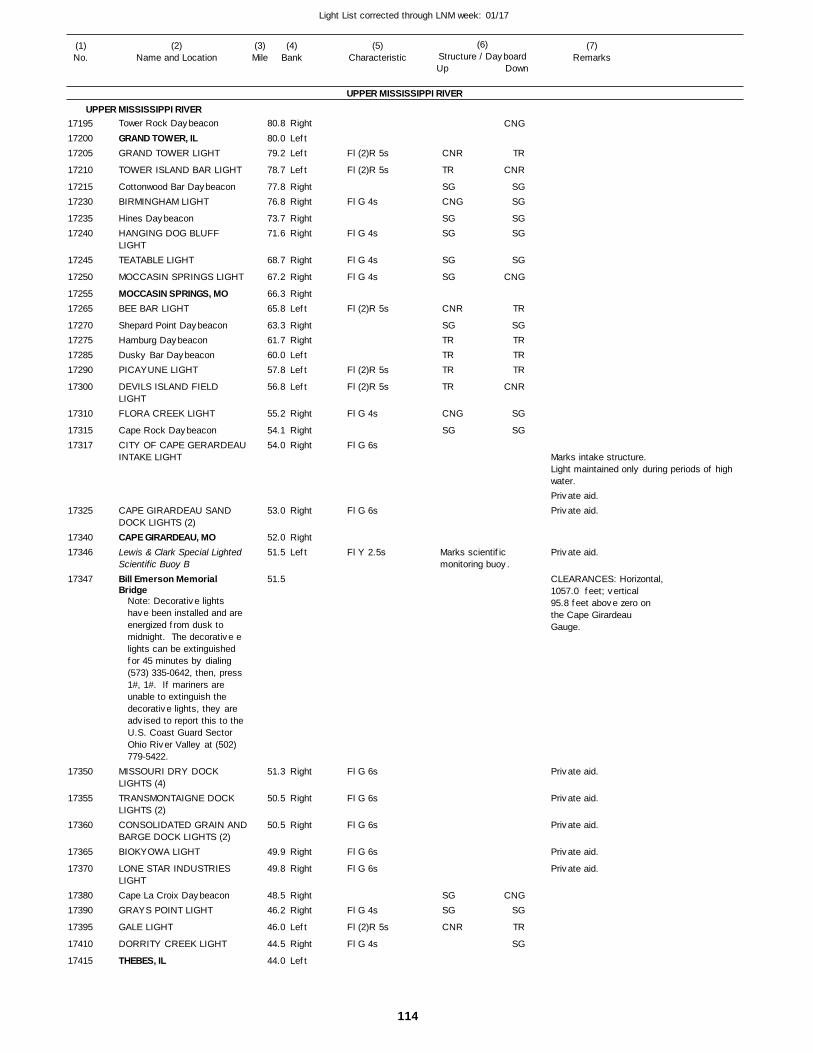
114
Light List corrected through LNM week: 01/17
(7)Remarks
(1)No.
(2)Name and Location
(3)Mile
(5)Characteristic
(4)Bank
(6)Structure / DayboardUp Down
Tower Rock Daybeacon
GRAND TOWER, ILGRAND TOWER LIGHT
TOWER ISLAND BAR LIGHT
Cottonwood Bar DaybeaconBIRMINGHAM LIGHT
Hines DaybeaconHANGING DOG BLUFF LIGHTTEATABLE LIGHT
MOCCASIN SPRINGS LIGHT
MOCCASIN SPRINGS, MOBEE BAR LIGHT
Shepard Point DaybeaconHamburg DaybeaconDusky Bar DaybeaconPICAYUNE LIGHT
DEVILS ISLAND FIELD LIGHTFLORA CREEK LIGHT
Cape Rock DaybeaconCITY OF CAPE GERARDEAUINTAKE LIGHT
CAPE GIRARDEAU SAND DOCK LIGHTS (2)CAPE GIRARDEAU, MOLewis & Clark Special Lighted Scientific Buoy BBill Emerson Memorial Bridge
MISSOURI DRY DOCK LIGHTS (4)TRANSMONTAIGNE DOCK LIGHTS (2)CONSOLIDATED GRAIN ANDBARGE DOCK LIGHTS (2)BIOKYOWA LIGHT
LONE STAR INDUSTRIES LIGHTCape La Croix DaybeaconGRAYS POINT LIGHT
GALE LIGHT
DORRITY CREEK LIGHT
THEBES, IL
UPPER MISSISSIPPI RIVER
UPPER MISSISSIPPI RIVERRight
LeftLeft
Left
RightRight
RightRight
Right
Right
RightLeft
RightRightLeftLeft
Left
Right
RightRight
Right
RightLeft
Right
Right
Right
Right
Right
RightRight
Left
Right
Left
80.8
80.0 79.2
78.7
77.8 76.8
73.7 71.6
68.7
67.2
66.3 65.8
63.3 61.7 60.0 57.8
56.8
55.2
54.1 54.0
53.0
52.0 51.5
51.5
51.3
50.5
50.5
49.9
49.8
48.5 46.2
46.0
44.5
44.0
Note: Decorative lights have been installed and are energized from dusk to midnight. The decorative e lights can be extinguished for 45 minutes by dialing (573) 335-0642, then, press 1#, 1#. If mariners are unable to extinguish the decorative lights, they are advised to report this to the U.S. Coast Guard Sector Ohio River Valley at (502) 779-5422.
Fl (2)R 5s
Fl (2)R 5s
Fl G 4s
Fl G 4s
Fl G 4s
Fl G 4s
Fl (2)R 5s
Fl (2)R 5s
Fl (2)R 5s
Fl G 4s
Fl G 6s
Fl G 6s
Fl Y 2.5s
Fl G 6s
Fl G 6s
Fl G 6s
Fl G 6s
Fl G 6s
Fl G 4s
Fl (2)R 5s
Fl G 4s
Marks scientific monitoring buoy.
Marks intake structure. Light maintained only during periods of high water.
CLEARANCES: Horizontal, 1057.0 feet; vertical 95.8 feet above zero onthe Cape GirardeauGauge.
171951720017205
17210
1721517230
1723517240
17245
17250
1725517265
17270172751728517290
17300
17310
1731517317
17325
1734017346
17347
17350
17355
17360
17365
17370
1738017390
17395
17410
17415
CNR
TR
SGCNG
SGSG
SG
SG
CNR
SGTRTRTR
TR
CNG
SG
SGSG
CNR
CNG
TR
CNR
SGSG
SGSG
SG
CNG
TR
SGTRTRTR
CNR
SG
SG
CNGSG
TR
SG
Private aid.Private aid.
Private aid.
Private aid.
Private aid.
Private aid.
Private aid.
Private aid.
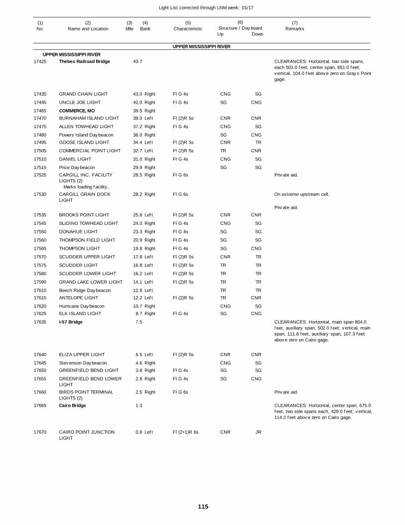
115
Light List corrected through LNM week: 01/17
(7)Remarks
(1)No.
(2)Name and Location
(3)Mile
(5)Characteristic
(4)Bank
(6)Structure / DayboardUp Down
Thebes Railroad Bridge
GRAND CHAIN LIGHT
UNCLE JOE LIGHT
COMMERCE, MOBURNAHAM ISLAND LIGHT
ALLEN TOWHEAD LIGHT
Powers Island DaybeaconGOOSE ISLAND LIGHT
COMMERCIAL POINT LIGHT
DANIEL LIGHT
Price DaybeaconCARGILL INC. FACILITY LIGHTS (2)
CARGILL GRAIN DOCK LIGHT
BROOKS POINT LIGHT
SLIDING TOWHEAD LIGHT
DONAHUE LIGHT
THOMPSON FIELD LIGHT
THOMPSON LIGHT
SCUDDER UPPER LIGHT
SCUDDER LIGHT
SCUDDER LOWER LIGHT
GRAND LAKE LOWER LIGHT
Beech Ridge DaybeaconANTELOPE LIGHT
Hurricane DaybeaconELK ISLAND LIGHT
I-57 Bridge
ELIZA UPPER LIGHT
Stevenson DaybeaconGREENFIELD BEND LIGHT
GREENFIELD BEND LOWER LIGHTBIRDS POINT TERMINAL LIGHTS (2)Cairo Bridge
CAIRO POINT JUNCTION LIGHT
UPPER MISSISSIPPI RIVER
UPPER MISSISSIPPI RIVER
Right
Right
RightLeft
Right
RightLeft
Left
Right
RightRight
Right
Left
Right
Right
Right
Right
Left
Left
Left
Left
LeftLeft
RightRight
Left
RightRight
Right
Right
Left
43.7
43.0
42.0
39.5 39.0
37.2
36.0 34.4
32.7
31.0
29.9 28.5
28.2
25.8
24.0
23.3
20.9
19.8
17.8
16.8
16.2
14.1
12.8 12.2
10.7 8.7
7.5
6.5
4.6 3.8
2.8
2.5
1.3
0.8
Marks loading facility.
Fl G 4s
Fl G 4s
Fl (2)R 5s
Fl G 4s
Fl (2)R 5s
Fl (2)R 5s
Fl G 4s
Fl G 6s
Fl G 6s
Fl (2)R 5s
Fl G 4s
Fl G 4s
Fl G 4s
Fl G 4s
Fl (2)R 5s
Fl (2)R 5s
Fl (2)R 5s
Fl (2)R 5s
Fl (2)R 5s
Fl G 4s
Fl (2)R 5s
Fl G 4s
Fl G 4s
Fl G 6s
Fl (2+1)R 6s
CLEARANCES: Horizontal, two side spans, each 501.0 feet, center span, 651.0 feet; vertical, 104.0 feet above zero on Grays Point gage.
On extreme upstream cell.
CLEARANCES: Horizontal, main span 804.0 feet, auxiliary span, 502.0 feet; vertical, main span, 111.8 feet, auxiliary span, 107.3 feet above zero on Cairo gage.
CLEARANCES: Horizontal, center span, 675.0 feet, two side spans each, 429.0 feet; vertical,114.2 feet above zero on Cairo gage.
17425
17435
17445
1746517470
17475
1748017495
17505
17510
1751517525
17530
17535
17545
17550
17560
17565
17570
17575
17580
17590
1761017615
1762017625
17635
17640
1764517650
17655
17660
17665
17670
CNG
SG
CNR
CNG
SGCNR
TR
CNG
SG
CNR
CNG
SG
SG
SG
CNR
TR
TR
TR
TRTR
CNGSG
CNR
CNGSG
SG
CNR
SG
CNG
CNR
SG
CNGTR
CNR
SG
SG
CNR
SG
SG
SG
CNG
TR
TR
TR
TR
TRCNR
SGCNG
CNR
SGSG
CNG
JR
Private aid.
Private aid.
Private aid.
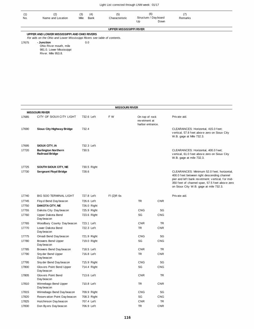
116
Light List corrected through LNM week: 01/17
(7)Remarks
(1)No.
(2)Name and Location
(3)Mile
(5)Characteristic
(4)Bank
(6)Structure / DayboardUp Down
- Junction
CITY OF SIOUX CITY LIGHT
Sioux City Highway Bridge
SIOUX CITY, IABurlington Northern Railroad Bridge
SOUTH SIOUX CITY, NESergeant Floyd Bridge
BIG SOO TERMINAL LIGHT
Floyd Bend DaybeaconDAKOTA CITY, NEDakota City DaybeaconUpper Dakota Bend DaybeaconWoodbury County DaybeaconLower Dakota Bend DaybeaconOmadi Bend DaybeaconBrowers Bend Upper DaybeaconBrowers Bend DaybeaconSnyder Bend Upper DaybeaconSnyder Bend DaybeaconGlovers Point Bend Upper DaybeaconGlovers Point Bend DaybeaconWinnebago Bend Upper DaybeaconWinnebago Bend DaybeaconReservation Point DaybeaconHutchinson DaybeaconDon Byers Daybeacon
UPPER MISSISSIPPI RIVER
UPPER AND LOWER MISSISSIPPI AND OHIO RIVERS
MISSOURI RIVER
MISSOURI RIVER
For aids on the Ohio and Lower Mississippi Rivers see table of contents.
Left
Left
Right
Left
LeftRightRightRight
LeftLeft
RightRight
LeftLeft
RightRight
Left
Left
RightRightLeftLeft
0.0
732.6
732.4
732.3 730.5
730.5 728.6
727.8
726.6 726.0 725.9 723.6
723.1 722.3
721.9 719.0
718.5 716.8
715.9 714.4
713.6
710.8
709.9 708.3 707.4 706.9
Ohio River mouth, mile 981.0. Lower Mississippi River. Mile 953.8.
F W
Fl (2)R 6s
On top of rock revetment at harbor entrance.
CLEARANCES: Horizontal, 415.0 feet; vertical, 57.8 feet above zero on Sioux City W.B. gage at Mile 732.3.
CLEARANCES: Horizontal, 400.0 feet; vertical, 61.0 feet above zero on Sioux City W.B. gage at mile 732.3.
CLEARANCES: Minimum 52.0 feet; horizontal, 400.0 feet between right descending channel pier and left bank revetment; vertical, for mid-350 feet of channel span, 57.5 feet above zeroon Sioux City W.B. gage at mile 732.3.
17675
17685
17690
1769517720
1772517730
17740
17745177501775517760
1776517770
1777517780
1778517790
1779517800
17805
17810
17815178201782517830
TR
CNGSG
CNRTR
CNGSG
CNRTR
CNGSG
CNR
TR
CNGSGCNRTR
CNR
SGCNG
TRCNR
SGCNG
TRCNR
SGCNG
TR
CNR
SGCNG
TRCNR
Private aid.
Private aid.
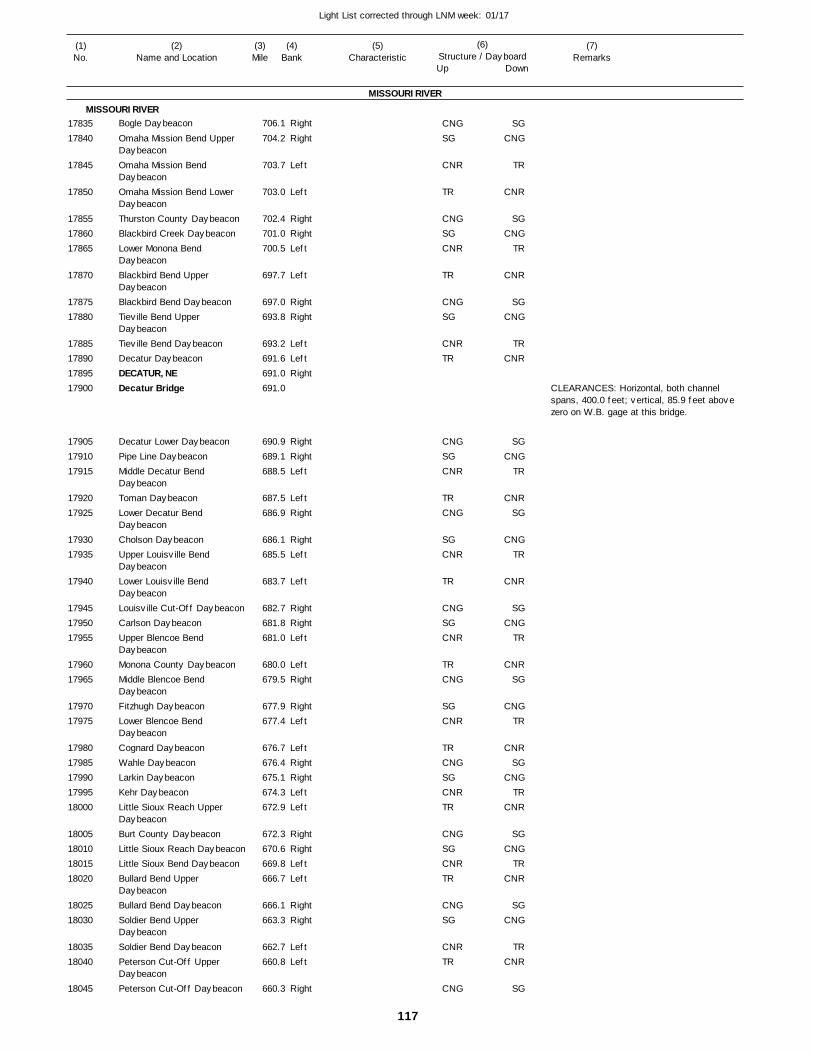
117
Light List corrected through LNM week: 01/17
(7)Remarks
(1)No.
(2)Name and Location
(3)Mile
(5)Characteristic
(4)Bank
(6)Structure / DayboardUp Down
Bogle Daybeacon
Omaha Mission Bend Upper DaybeaconOmaha Mission Bend DaybeaconOmaha Mission Bend Lower DaybeaconThurston County DaybeaconBlackbird Creek DaybeaconLower Monona Bend DaybeaconBlackbird Bend Upper DaybeaconBlackbird Bend DaybeaconTieville Bend Upper DaybeaconTieville Bend DaybeaconDecatur DaybeaconDECATUR, NEDecatur Bridge
Decatur Lower DaybeaconPipe Line DaybeaconMiddle Decatur Bend DaybeaconToman DaybeaconLower Decatur Bend DaybeaconCholson DaybeaconUpper Louisville Bend DaybeaconLower Louisville Bend DaybeaconLouisville Cut-Off DaybeaconCarlson DaybeaconUpper Blencoe Bend DaybeaconMonona County DaybeaconMiddle Blencoe Bend DaybeaconFitzhugh DaybeaconLower Blencoe Bend DaybeaconCognard DaybeaconWahle DaybeaconLarkin DaybeaconKehr DaybeaconLittle Sioux Reach Upper DaybeaconBurt County DaybeaconLittle Sioux Reach DaybeaconLittle Sioux Bend DaybeaconBullard Bend Upper DaybeaconBullard Bend DaybeaconSoldier Bend Upper DaybeaconSoldier Bend DaybeaconPeterson Cut-Off Upper DaybeaconPeterson Cut-Off Daybeacon
MISSOURI RIVER
MISSOURI RIVERRight
Right
Left
Left
RightRightLeft
Left
RightRight
LeftLeftRight
RightRightLeft
LeftRight
RightLeft
Left
RightRightLeft
LeftRight
RightLeft
LeftRightRightLeftLeft
RightRightLeftLeft
RightRight
LeftLeft
Right
706.1
704.2
703.7
703.0
702.4 701.0 700.5
697.7
697.0 693.8
693.2 691.6 691.0 691.0
690.9 689.1 688.5
687.5 686.9
686.1 685.5
683.7
682.7 681.8 681.0
680.0 679.5
677.9 677.4
676.7 676.4 675.1 674.3 672.9
672.3 670.6 669.8 666.7
666.1 663.3
662.7 660.8
660.3
CLEARANCES: Horizontal, both channel spans, 400.0 feet; vertical, 85.9 feet above zero on W.B. gage at this bridge.
1783517840
17845
17850
178551786017865
17870
1787517880
17885178901789517900
179051791017915
1792017925
1793017935
17940
179451795017955
1796017965
1797017975
1798017985179901799518000
18005180101801518020
1802518030
1803518040
18045
CNGSG
CNR
TR
CNGSGCNR
TR
CNGSG
CNRTR
CNGSGCNR
TRCNG
SGCNR
TR
CNGSGCNR
TRCNG
SGCNR
TRCNGSGCNRTR
CNGSGCNRTR
CNGSG
CNRTR
CNG
SGCNG
TR
CNR
SGCNG
TR
CNR
SGCNG
TRCNR
SGCNG
TR
CNRSG
CNGTR
CNR
SGCNG
TR
CNRSG
CNGTR
CNRSG
CNGTR
CNR
SGCNG
TRCNR
SGCNG
TRCNR
SG
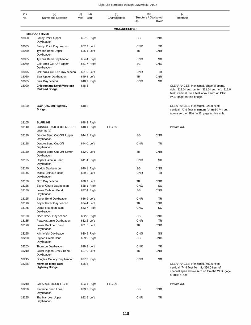
118
Light List corrected through LNM week: 01/17
(7)Remarks
(1)No.
(2)Name and Location
(3)Mile
(5)Characteristic
(4)Bank
(6)Structure / DayboardUp Down
Sandy Point Upper DaybeaconSandy Point DaybeaconTysons Bend Upper DaybeaconTysons Bend DaybeaconCalifornia Cut-Off Upper DaybeaconCalifornia Cut-Off DaybeaconBlair Upper DaybeaconBlair DaybeaconChicago and North WesternRailroad Bridge
Blair (U.S. 30) Highway Bridge
BLAIR, NECONSOLIDATED BLENDERS LIGHTS (2)Desoto Bend Cut-Off Upper DaybeaconDesoto Bend Cut-Off DaybeaconDesoto Bend Cut-Off Lower DaybeaconUpper Calhoun Bend DaybeaconDodds DaybeaconMiddle Calhoun Bend DaybeaconOtto DaybeaconBoyer Chute DaybeaconLower Calhoun Bend DaybeaconBoyer Bend DaybeaconBoyer River DaybeaconUpper Rockport Bend DaybeaconDeer Creek DaybeaconPottawattamie DaybeaconLower Rockport Bend DaybeaconKrimlofski DaybeaconPigeon Creek Bend DaybeaconThornton DaybeaconLower Pigeon Creek Bend DaybeaconDouglas County DaybeaconMormon Trails Dual Highway Bridge
LAFARGE DOCK LIGHT
Florence Bend Lower DaybeaconThe Narrows Upper Daybeacon
MISSOURI RIVER
MISSOURI RIVERRight
LeftLeft
RightRight
LeftLeftRight
RightRight
Right
Left
Left
Right
RightLeft
LeftRightRight
LeftLeftRight
RightLeftLeft
RightRight
LeftLeft
Right
Right
Right
Left
657.9
657.3 655.1
654.4 651.7
651.0 649.5 648.9 648.3
648.3
648.3 648.1
644.9
644.0
642.0
641.4
640.1 639.2
638.9 638.1 637.4
636.9 634.4 633.7
632.8 632.2 631.5
630.9 629.9
629.3 627.9
627.3 626.5
624.1
623.2
622.5
Fl G 6s
Fl G 6s
CLEARANCES: Horizontal, channel spans, right, 318.0 feet, center, 321.0 feet, left, 319.0feet; vertical, 64.7 feet above zero on Blair W.B. gage on this bridge.
CLEARANCES: Horizontal, 325.0 feet; vertical, 77.9 feet minimum for mid-274 feet above zero on Blair W.B. gage at this mile.
CLEARANCES: Horizontal, 402.5 feet; vertical, 74.9 feet for mid-350.0 feet of channel span above zero on Omaha W.B. gageat mile 615.9.
18050
1805518060
1806518070
18075180801808518090
18100
1810518110
18120
18125
18130
18135
1814018145
181501815518160
181651817018175
181801818518190
1819518200
1820518210
1821518225
18240
18250
18255
SG
CNRTR
CNGSG
CNRTRCNG
SG
CNR
TR
CNG
SGCNR
TRCNGSG
CNRTRCNG
SGCNRTR
CNGSG
CNRTR
CNG
SG
CNR
CNG
TRCNR
SGCNG
TRCNR
SG
CNG
TR
CNR
SG
CNGTR
CNRSG
CNG
TRCNR
SG
CNGTR
CNR
SGCNG
TRCNR
SG
CNG
TR
Private aid.
Private aid.
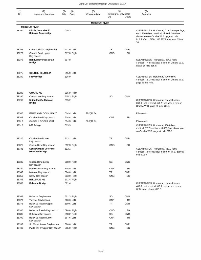
119
Light List corrected through LNM week: 01/17
(7)Remarks
(1)No.
(2)Name and Location
(3)Mile
(5)Characteristic
(4)Bank
(6)Structure / DayboardUp Down
Illinois Central Gulf Railroad Drawbridge
Council Bluffs DaybeaconCouncil Bend Upper DaybeaconBob Kerrey Pedestrian Bridge
COUNCIL BLUFFS, IAI-480 Bridge
OMAHA, NECarter Lake DaybeaconUnion Pacific Railroad Bridge
FARMLAND DOCK LIGHT
Omaha Bend DaybeaconCARGILL DOCK LIGHT
I-80 Bridge
Omaha Bend Lower DaybeaconGibson Bend DaybeaconSouth Omaha Veterans Memorial Bridge
Gibson Bend Lower DaybeaconManawa Bend DaybeaconManawa DaybeaconSarpy DaybeaconBELLEVUE, NEBellevue Bridge
Bellevue DaybeaconTreynor DaybeaconBellevue Reach Upper DaybeaconBellevue Reach DaybeaconSt Marys DaybeaconBellevue Reach Lower DaybeaconSt. Marys Lower DaybeaconPlatte River Upper Daybeacon
MISSOURI RIVER
MISSOURI RIVER
LeftRight
Left
RightRight
Left
LeftLeft
Left
Right
Right
LeftLeftRightRight
RightLeftLeft
RightRightLeft
LeftRight
618.3
617.9 617.0
617.0
615.9 615.9
615.9 615.3 615.2
614.4
614.4 614.3
613.9
613.1
612.3 612.1
608.9
608.0 604.6 603.9 601.4 601.4
601.3 600.3 599.6
598.8 598.2 597.6
596.6 595.9
Fl (2)R 6s
Fl (2)R 6s
CLEARANCES: Horizontal, four draw openings,each 236.0 feet; vertical, closed, 30.0 feet above zero on Omaha W.B. gage at mile 615.9. CALL SIGN: KD 2870, channels 13 and 16.
CLEARANCES: Horizontal, 484.8 feet;vertical, 77.4 feet above zero on Omaha W.B.gauge at mile 615.9.
CLEARANCES: Horizontal, 400.0 feet; vertical, 72.1 feet above zero on Omaha W.B. gage at this mile.
CLEARANCES: Horizontal, channel spans, 238.0 feet; vertical, 68.2 feet above zero on Omaha W.B. gage at mile 615.9.
CLEARANCES: Horizontal, 400.0 feet; vertical, 72.7 feet for mid-350 feet above zero on Omaha W.B. gage at mile 615.9.
CLEARANCES: Horizontal, 617.0 feet; vertical, 72.0 feet above zero on W.B. gage at mile 615.9.
CLEARANCES: Horizontal, channel spans, 400.0 feet; vertical, 67.0 feet above zero on W.B. gage at mile 615.9.
18260
1826518270
18272
1827518280
182851829018295
18300
1830518310
18315
18320
1832518332
18335
1834018345183501835518360
183651837018375
183801838518390
1839518400
TRCNG
SG
CNR
TR
CNG
SG
CNRTRCNG
SGCNRTR
CNGSGCNR
TRCNG
CNRSG
CNG
TR
CNR
SG
CNG
TRCNR
SG
CNGTR
CNR
SGCNG
TR
CNRSG
Private aid.
Private aid.
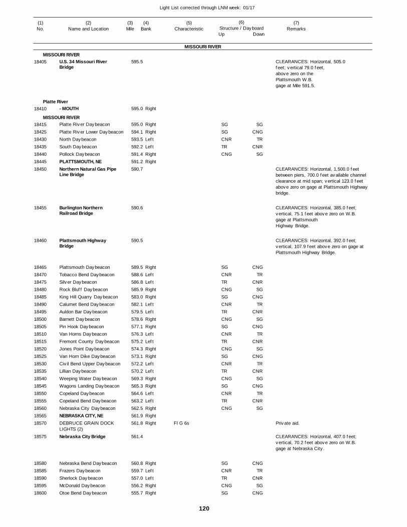
120
Light List corrected through LNM week: 01/17
(7)Remarks
(1)No.
(2)Name and Location
(3)Mile
(5)Characteristic
(4)Bank
(6)Structure / DayboardUp Down
U.S. 34 Missouri River Bridge
- MOUTH
Platte River Daybeacon
Platte River Lower DaybeaconNorth DaybeaconSouth DaybeaconPollock DaybeaconPLATTSMOUTH, NENorthern Natural Gas Pipe Line Bridge
Burlington Northern Railroad Bridge
Plattsmouth Highway Bridge
Plattsmouth DaybeaconTobacco Bend DaybeaconSilver DaybeaconRock Bluff DaybeaconKing Hill Quarry DaybeaconCalumet Bend DaybeaconAuldon Bar DaybeaconBarnett DaybeaconPin Hook DaybeaconVan Horns DaybeaconFremont County DaybeaconJones Point DaybeaconVan Horn Dike DaybeaconCivil Bend Upper DaybeaconLillian DaybeaconWeeping Water DaybeaconWagons Landing DaybeaconCopeland DaybeaconCopeland Bend DaybeaconNebraska City DaybeaconNEBRASKA CITY, NEDEBRUCE GRAIN DOCK LIGHTS (2)Nebraska City Bridge
Nebraska Bend DaybeaconFrazers DaybeaconSherlock DaybeaconMcDonald DaybeaconOtoe Bend Daybeacon
MISSOURI RIVER
MISSOURI RIVER
Platte River
MISSOURI RIVER
Right
Right
RightLeftLeftRightRight
RightLeftLeftRightRightLeftLeftRightRightLeftLeftRightRightLeftLeftRightRightLeftLeftRightRightRight
RightLeftLeftRightRight
595.5
595.0
595.0
594.1 593.5 592.2 591.4 591.2 590.7
590.6
590.5
589.5 588.6 586.8 585.9 583.0 582.1 579.5 578.6 577.1 576.3 575.2 574.3 573.1 572.2 570.2 569.3 565.3 564.6 563.2 562.5 561.9 561.8
561.4
560.8 559.7 557.0 556.2 555.7
Fl G 6s
CLEARANCES: Horizontal, 505.0 feet; vertical 79.0 feet, above zero on the Plattsmouth W.B. gage at Mile 591.5.
CLEARANCES: Horizontal, 1,500.0 feet between piers, 700.0 feet available channel clearance at mid span; vertical 123.0 feet above zero on gage at Plattsmouth Highway bridge.
CLEARANCES: Horizontal, 385.0 feet; vertical, 75.1 feet above zero on W.B.gage at Plattsmouth Highway Bridge.
CLEARANCES: Horizontal, 392.0 feet; vertical, 107.9 feet above zero on gage at Plattsmouth Highway Bridge.
CLEARANCES: Horizontal, 407.0 feet; vertical, 70.2 feet above zero on W.B. gage at Nebraska City.
18405
18410
18415184251843018435184401844518450
18455
18460
18465184701847518480184851849018495185001850518510185151852018525185301853518540185451855018555185601856518570
18575
1858018585185901859518600
SGSGCNRTRCNG
SGCNRTRCNGSGCNRTRCNGSGCNRTRCNGSGCNRTRCNGSGCNRTRCNG
SGCNRTRCNGSG
SGCNG
TRCNR
SG
CNGTR
CNRSG
CNGTR
CNRSG
CNGTR
CNRSG
CNGTR
CNRSG
CNGTR
CNRSG
CNGTR
CNRSG
CNG
Private aid.
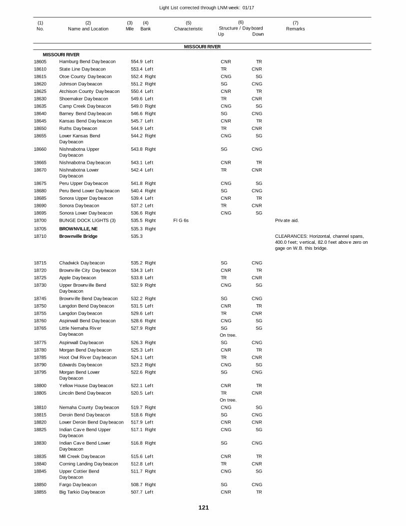
121
Light List corrected through LNM week: 01/17
(7)Remarks
(1)No.
(2)Name and Location
(3)Mile
(5)Characteristic
(4)Bank
(6)Structure / DayboardUp Down
Hamburg Bend Daybeacon
State Line DaybeaconOtoe County DaybeaconJohnson DaybeaconAtchison County DaybeaconShoemaker DaybeaconCamp Creek DaybeaconBarney Bend DaybeaconKansas Bend DaybeaconRuths DaybeaconLower Kansas Bend DaybeaconNishnabotna Upper DaybeaconNishnabotna DaybeaconNishnabotna Lower DaybeaconPeru Upper DaybeaconPeru Bend Lower DaybeaconSonora Upper DaybeaconSonora DaybeaconSonora Lower DaybeaconBUNGE DOCK LIGHTS (3)
BROWNVILLE, NEBrownville Bridge
Chadwick DaybeaconBrownville City DaybeaconApple DaybeaconUpper Brownville Bend DaybeaconBrownville Bend DaybeaconLangdon Bend DaybeaconLangdon DaybeaconAspinwall Bend DaybeaconLittle Nemaha River Daybeacon
Aspinwall DaybeaconMorgan Bend DaybeaconHoot Owl River DaybeaconEdwards DaybeaconMorgan Bend Lower DaybeaconYellow House DaybeaconLincoln Bend Daybeacon
Nemaha County DaybeaconDeroin Bend DaybeaconLower Deroin Bend DaybeaconIndian Cave Bend Upper DaybeaconIndian Cave Bend Lower DaybeaconMill Creek DaybeaconCorning Landing DaybeaconUpper Cottier Bend DaybeaconFargo DaybeaconBig Tarkio Daybeacon
MISSOURI RIVER
MISSOURI RIVERLeft
LeftRightRightLeftLeftRightRightLeftLeftRight
Right
LeftLeft
RightRightLeftLeftRightRight
Right
RightLeftLeftRight
RightLeftLeftRightRight
RightLeftLeftRightRight
LeftLeft
RightRightLeftRight
Right
LeftLeftRight
RightLeft
554.9
553.4 552.4 551.2 550.4 549.6 549.0 546.6 545.7 544.9 544.2
543.8
543.1 542.4
541.8 540.4 539.4 537.2 536.6 535.5
535.3 535.3
535.2 534.3 533.8 532.9
532.2 531.5 529.6 528.6 527.9
526.3 525.3 524.1 523.2 522.6
522.1 520.5
519.7 518.6 517.9 517.1
516.8
515.6 512.8 511.7
508.7 507.7
Fl G 6s
On tree.
On tree.
CLEARANCES: Horizontal, channel spans, 400.0 feet; vertical, 82.0 feet above zero on gage on W.B. this bridge.
1860518610186151862018625186301863518640186451865018655
18660
1866518670
186751868018685186901869518700
1870518710
18715187201872518730
1874518750187551876018765
1877518780187851879018795
1880018805
18810188151882018825
18830
188351884018845
1885018855
CNRTRCNGSGCNRTRCNGSGCNRTRCNG
SG
CNRTR
CNGSGCNRTRCNG
SGCNRTRCNG
SGCNRTRCNGSG
SGCNRTRCNGSG
CNRTR
CNGSGCNRCNG
SG
CNRTRCNG
SGCNR
TRCNR
SGCNG
TRCNR
SGCNG
TRCNR
SG
CNG
TRCNR
SGCNG
TRCNR
SG
CNGTR
CNRSG
CNGTR
CNRSGSG
CNGTR
CNRSG
CNG
TRCNR
SGCNGCNR
SG
CNG
TRCNR
SG
CNGTR
Private aid.
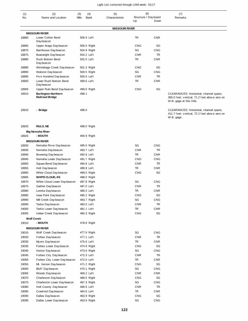
122
Light List corrected through LNM week: 01/17
(7)Remarks
(1)No.
(2)Name and Location
(3)Mile
(5)Characteristic
(4)Bank
(6)Structure / DayboardUp Down
Lower Cottier Bend DaybeaconUpper Arago DaybeaconBarnhouse DaybeaconBoatwright DaybeaconRush Bottom Bend DaybeaconWinnebago Creek DaybeaconWalston DaybeaconFive Hundred DaybeaconLower Rush Bottom Bend DaybeaconUpper Rulo Bend DaybeaconBurlington Northern Railroad Bridge
- Bridge
RULO, NE
- MOUTH
Nemaha River Daybeacon
Nemaha DaybeaconBrowning DaybeaconNemaha Lower DaybeaconSquaw Bend DaybeaconHolt DaybeaconWhite Cloud DaybeaconWHITE CLOUD, KSWhite Cloud Lower DaybeaconGaither DaybeaconLoretta DaybeaconIowa Point DaybeaconMill Creek DaybeaconTarkio DaybeaconTarkio Lower DaybeaconIndian Creek Daybeacon
- MOUTH
Wolf Creek Daybeacon
Forbes DaybeaconMyers DaybeaconForbes Lower DaybeaconHorton DaybeaconForbes City DaybeaconForbes City Lower DaybeaconMt. Vernon DaybeaconBluff DaybeaconWoods DaybeaconCharleston DaybeaconCharleston Lower DaybeaconHolt County DaybeaconCrawford DaybeaconDallas DaybeaconDallas Lower Daybeacon
MISSOURI RIVER
MISSOURI RIVER
Big Nemaha River
MISSOURI RIVER
Wolf Creek
MISSOURI RIVER
Left
RightRightLeftLeft
RightRightLeftLeft
Right
Right
Right
Right
LeftLeftRightLeftLeftRightRightRightLeftLeftRightRightLeftLeftRight
Right
Right
LeftLeftRightRightLeftLeftRightRightLeftRightRightLeftLeftRightRight
506.9
506.0 504.9 504.2 502.0
501.3 500.5 500.0 499.6
499.0 498.1
498.0
498.0
494.9
495.0
493.7 492.6 491.7 490.8 489.8 489.0 488.0 487.8 487.0 486.0 485.2 483.7 483.0 481.1 480.3
478.8
477.9
477.1 475.6 474.9 473.0 472.3 472.0 471.2 470.1 469.2 468.5 467.3 466.5 464.6 463.9 463.6
CLEARANCES: Horizontal, channel spans, 365.0 feet; vertical, 71.2 feet above zero on W.B. gage at this mile.
CLEARANCES: Horizontal, channel spans, 411.7 feet; vertical, 72.2 feet above zero on W.B. gage.
18860
18865188701887518880
18885188901889518900
1890518910
18915
18920
18925
18930189351894018945189501895518960189651897018975189801898518990189951900019005
19010
19015190201903019035190401904519050190551906019065190701907519080190851909019095
TR
CNGSGCNRTR
CNGSGCNRTR
CNG
SGCNRTRCNGCNRTRCNG
SGCNRTRCNGSGCNRTRCNG
SGCNRTRCNGSGCNRTRCNGSGCNRCNGSGCNRTRCNGSG
CNR
SGCNG
TRCNR
SGCNG
TRCNR
SG
CNGTR
CNRCNG
TRCNR
SG
CNGTR
CNRSG
CNGTR
CNRSG
CNGTR
CNRSG
CNGTR
CNRSG
CNGCNR
SGCNG
TRCNR
SGCNG

123
Light List corrected through LNM week: 01/17
(7)Remarks
(1)No.
(2)Name and Location
(3)Mile
(5)Characteristic
(4)Bank
(6)Structure / DayboardUp Down
Nodaway Daybeacon
- MOUTH
Ringot Daybeacon
Levee DaybeaconBurr Oak DaybeaconDillon Creek DaybeaconBon Ton DaybeaconCut-Off 52 DaybeaconPerry DaybeaconSt. Joseph DaybeaconST. JOSEPH RIVERBOAT PARTNERS LIGHT CASINO LIGHTST. JOSEPH, MOUnion Pacific Railroad Drawbridge
Missouri Route 36 Bridge
BARTLETT DOCK LIGHT
AG PROCESSING DOCK LIGHTS (2)ST. JOSEPH L & P DOCK LIGHTContrary DaybeaconPeter's Creek DaybeaconPalermo DaybeaconKenmore DaybeaconBuchanan DaybeaconGeary Bend DaybeaconStoney DaybeaconGeary Daybeacon
Geary Lower DaybeaconDoniphan Upper DaybeaconDoniphan DaybeaconRushville DaybeaconRUSHVILLE, MOMud Lake DaybeaconAtchison DaybeaconIndependence Creek DaybeaconATCHISON WATER INTAKE LIGHTAtchison Railroad Drawbridge
Amelia Earhart Memorial Bridge
ATCHINSON, KSAtchison Bend Daybeacon
MISSOURI RIVER
MISSOURI RIVER
Nodaway River
MISSOURI RIVER
Left
Left
Left
RightRightLeftLeftRightRightLeftLeft
Left
Left
Left
Left
LeftRightRightLeftLeftRightRightLeft
LeftRightRightLeftLeftLeftRightRight
Right
RightRight
462.6
462.9
459.5
458.6 455.2 454.7 452.1 451.5 450.1 449.1 449.0
448.2 448.2
447.9
446.6
446.2
445.9
443.0 442.3 438.9 438.1 435.2 434.6 433.1 432.1
431.6 431.0 429.2 428.6 427.5 425.4 424.9 423.7
423.3
422.5
422.5
422.4 422.1
Fl (2)R 6s
Fl (2)R 6s
Fl (2)R 6s
Fl (2)R 6s
Fl G 6s
Marks water intake.
On tree.
CLEARANCES: Horizontal, two draw openings, each 200.0 feet; vertical, closed, 31.5 feet above zero on gage at this bridge. CALL SIGN:KTD 403, channels 14 and 16.
CLEARANCES: Horizontal, 415.5 feet; vertical, 69.7 feet above gage at St. Joseph.
CLEARANCES: Horizontal, left descending drawspan, 155.0 feet, right descending drawspan, 156.5 feet; vertical, closed, 37.5 feet above zero on this gage. CALL SIGN: KTD 426, channels 14 and 16.
CLEARANCES: Horizontal, right channel span, 410.0 feet; vertical, 71.9 feet above zero on gage at this mile.
19100
19105
191101911519120191251913019135191401914519150
1915519160
19170
19175
19180
19185
1919519200192051921019215192201922519230
1923519240192451925019255192601926519270
19275
19280
19285
1929019295
CNR
TRCNGSGCNRTRCNGSGCNR
TRCNGSGCNRTRCNGSGCNR
TRCNGSGCNR
TRCNGSG
SG
TR
CNRSG
CNGTR
CNRSG
CNGTR
CNRSG
CNGTR
CNRSG
CNGTR
CNRSG
CNGTR
CNRSGSG
SG
Private aid.
Private aid.
Private aid.
Private aid.
Private aid.
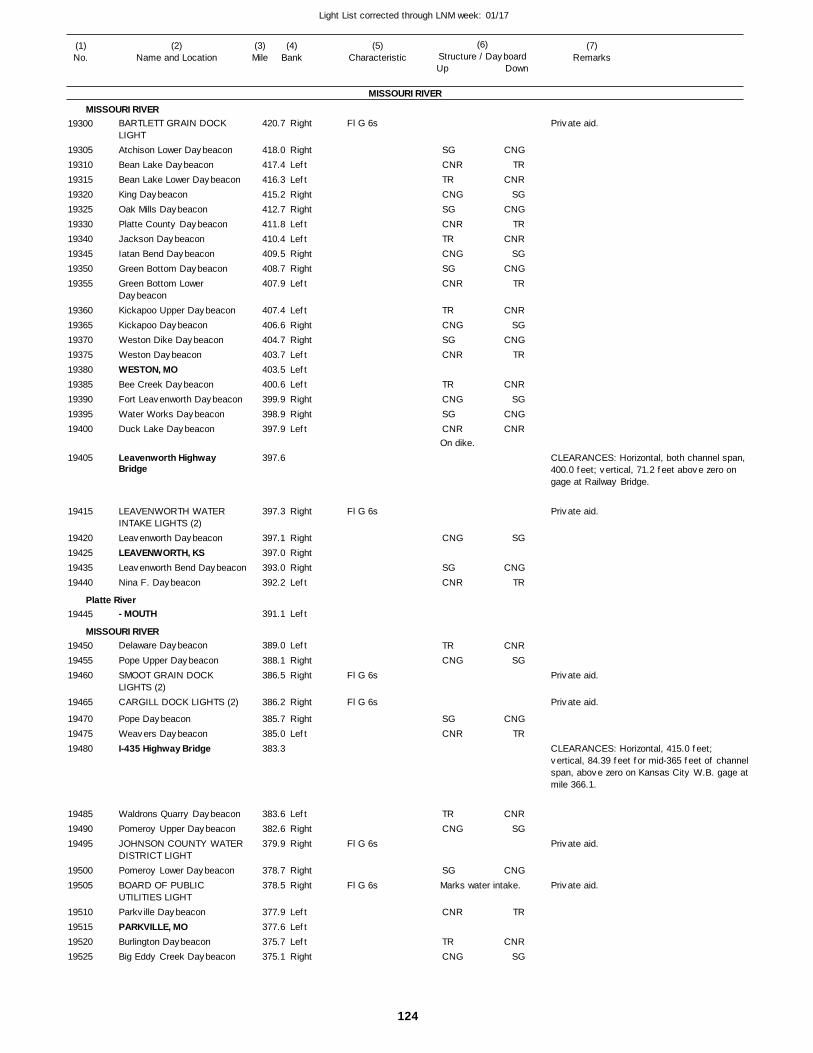
124
Light List corrected through LNM week: 01/17
(7)Remarks
(1)No.
(2)Name and Location
(3)Mile
(5)Characteristic
(4)Bank
(6)Structure / DayboardUp Down
BARTLETT GRAIN DOCK LIGHTAtchison Lower DaybeaconBean Lake DaybeaconBean Lake Lower DaybeaconKing DaybeaconOak Mills DaybeaconPlatte County DaybeaconJackson DaybeaconIatan Bend DaybeaconGreen Bottom DaybeaconGreen Bottom Lower DaybeaconKickapoo Upper DaybeaconKickapoo DaybeaconWeston Dike DaybeaconWeston DaybeaconWESTON, MOBee Creek DaybeaconFort Leavenworth DaybeaconWater Works DaybeaconDuck Lake Daybeacon
Leavenworth Highway Bridge
LEAVENWORTH WATER INTAKE LIGHTS (2)Leavenworth DaybeaconLEAVENWORTH, KSLeavenworth Bend DaybeaconNina F. Daybeacon
- MOUTH
Delaware Daybeacon
Pope Upper DaybeaconSMOOT GRAIN DOCK LIGHTS (2)CARGILL DOCK LIGHTS (2)
Pope DaybeaconWeavers DaybeaconI-435 Highway Bridge
Waldrons Quarry DaybeaconPomeroy Upper DaybeaconJOHNSON COUNTY WATER DISTRICT LIGHTPomeroy Lower DaybeaconBOARD OF PUBLIC UTILITIES LIGHTParkville DaybeaconPARKVILLE, MOBurlington DaybeaconBig Eddy Creek Daybeacon
MISSOURI RIVER
MISSOURI RIVER
Platte River
MISSOURI RIVER
Right
RightLeftLeftRightRightLeftLeftRightRightLeft
LeftRightRightLeftLeftLeftRightRightLeft
Right
RightRightRightLeft
Left
Left
RightRight
Right
RightLeft
LeftRightRight
RightRight
LeftLeftLeftRight
420.7
418.0 417.4 416.3 415.2 412.7 411.8 410.4 409.5 408.7 407.9
407.4 406.6 404.7 403.7 403.5 400.6 399.9 398.9 397.9
397.6
397.3
397.1 397.0 393.0 392.2
391.1
389.0
388.1 386.5
386.2
385.7 385.0 383.3
383.6 382.6 379.9
378.7 378.5
377.9 377.6 375.7 375.1
Fl G 6s
Fl G 6s
Fl G 6s
Fl G 6s
Fl G 6s
Fl G 6s
On dike.
Marks water intake.
CLEARANCES: Horizontal, both channel span, 400.0 feet; vertical, 71.2 feet above zero on gage at Railway Bridge.
CLEARANCES: Horizontal, 415.0 feet; vertical, 84.39 feet for mid-365 feet of channelspan, above zero on Kansas City W.B. gage atmile 366.1.
19300
19305193101931519320193251933019340193451935019355
193601936519370193751938019385193901939519400
19405
19415
19420194251943519440
19445
194501945519460
19465
194701947519480
194851949019495
1950019505
19510195151952019525
SGCNRTRCNGSGCNRTRCNGSGCNR
TRCNGSGCNR
TRCNGSGCNR
CNG
SGCNR
TRCNG
SGCNR
TRCNG
SG
CNR
TRCNG
CNGTR
CNRSG
CNGTR
CNRSG
CNGTR
CNRSG
CNGTR
CNRSG
CNGCNR
SG
CNGTR
CNRSG
CNGTR
CNRSG
CNG
TR
CNRSG
Private aid.
Private aid.
Private aid.
Private aid.
Private aid.
Private aid.
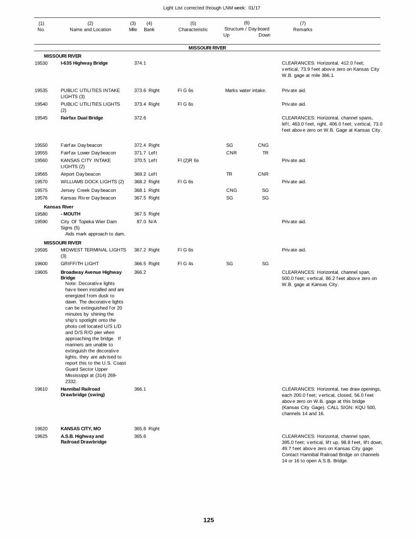
125
Light List corrected through LNM week: 01/17
(7)Remarks
(1)No.
(2)Name and Location
(3)Mile
(5)Characteristic
(4)Bank
(6)Structure / DayboardUp Down
I-635 Highway Bridge
PUBLIC UTILITIES INTAKE LIGHTS (3)PUBLIC UTILITIES LIGHTS (2)Fairfax Dual Bridge
Fairfax DaybeaconFairfax Lower DaybeaconKANSAS CITY INTAKE LIGHTS (2)Airport DaybeaconWILLIAMS DOCK LIGHTS (2)
Jersey Creek DaybeaconKansas River Daybeacon
- MOUTHCity Of Topeka Wier Dam Signs (5)
MIDWEST TERMINAL LIGHTS(3)GRIFFITH LIGHT
Broadway Avenue Highway Bridge
Hannibal Railroad Drawbridge (swing)
KANSAS CITY, MOA.S.B. Highway and Railroad Drawbridge
MISSOURI RIVER
MISSOURI RIVER
Kansas River
MISSOURI RIVER
Right
Right
RightLeftLeft
LeftRight
RightRight
Right
N/A
Right
Right
Right
374.1
373.6
373.4
372.6
372.4 371.7 370.5
369.2 368.2
368.1 367.5
367.5
87.0
367.2
366.5
366.2
366.1
365.8 365.6
Aids mark approach to dam.
Note: Decorative lights have been installed and are energized from dusk to dawn. The decorative lights can be extinguished for 20 minutes by shining the ship’s spotlight onto the photo cell located U/S L/D and D/S R/D pier when approaching the bridge. If mariners are unable to extinguish the decorative lights, they are advised to report this to the U.S. CoastGuard Sector Upper Mississippi at (314) 269-2332.
Fl G 6s
Fl G 6s
Fl (2)R 6s
Fl G 6s
Fl G 6s
Fl G 4s
Marks water intake.
CLEARANCES: Horizontal, 412.0 feet; vertical, 73.9 feet above zero on Kansas City W.B. gage at mile 366.1.
CLEARANCES: Horizontal, channel spans, left, 463.0 feet, right, 406.0 feet; vertical, 73.0feet above zero on W.B. Gage at Kansas City.
CLEARANCES: Horizontal, channel span, 500.0 feet; vertical, 86.2 feet above zero on W.B. gage at Kansas City.
CLEARANCES: Horizontal, two draw openings, each 200.0 feet; vertical, closed, 56.0 feet above zero on W.B. gage at this bridge (Kansas City Gage). CALL SIGN: KQU 500, channels 14 and 16.
CLEARANCES: Horizontal, channel span, 395.0 feet; vertical, lift up, 98.8 feet, lift down,49.7 feet above zero on Kansas City gage. Contact Hannibal Railroad Bridge on channels 14 or 16 to open A.S.B. Bridge.
19530
19535
19540
19545
195501955519560
1956519570
1957519576
1958019590
19595
19600
19605
19610
1962019625
SGCNR
TR
CNGSG
SG
CNGTR
CNR
SGSG
SG
Private aid.
Private aid.
Private aid.
Private aid.
Private aid.
Private aid.
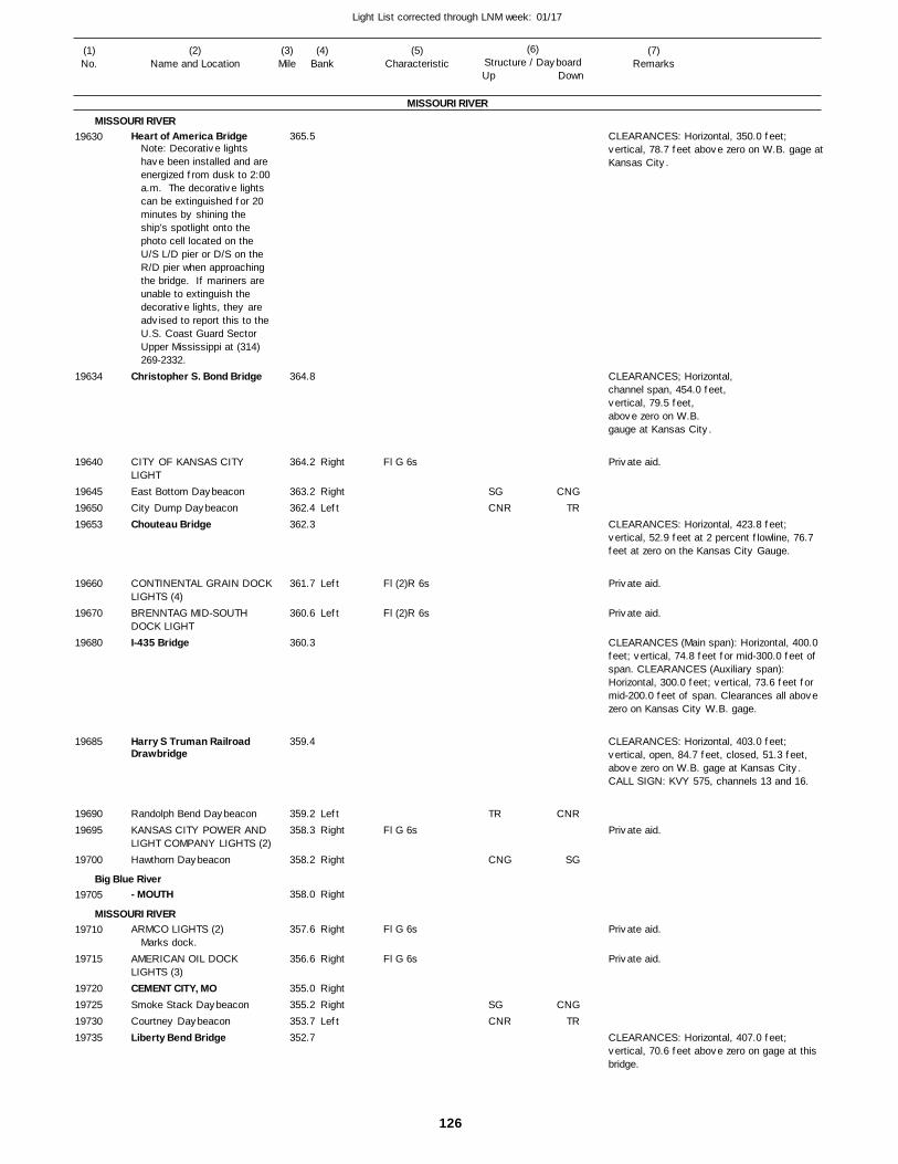
126
Light List corrected through LNM week: 01/17
(7)Remarks
(1)No.
(2)Name and Location
(3)Mile
(5)Characteristic
(4)Bank
(6)Structure / DayboardUp Down
Heart of America Bridge
Christopher S. Bond Bridge
CITY OF KANSAS CITY LIGHTEast Bottom DaybeaconCity Dump DaybeaconChouteau Bridge
CONTINENTAL GRAIN DOCKLIGHTS (4)BRENNTAG MID-SOUTH DOCK LIGHTI-435 Bridge
Harry S Truman Railroad Drawbridge
Randolph Bend DaybeaconKANSAS CITY POWER AND LIGHT COMPANY LIGHTS (2)Hawthorn Daybeacon
- MOUTH
ARMCO LIGHTS (2)
AMERICAN OIL DOCK LIGHTS (3)CEMENT CITY, MOSmoke Stack DaybeaconCourtney DaybeaconLiberty Bend Bridge
MISSOURI RIVER
MISSOURI RIVER
Big Blue River
MISSOURI RIVER
Right
RightLeft
Left
Left
LeftRight
Right
Right
Right
Right
RightRightLeft
365.5
364.8
364.2
363.2 362.4 362.3
361.7
360.6
360.3
359.4
359.2 358.3
358.2
358.0
357.6
356.6
355.0 355.2 353.7 352.7
Note: Decorative lights have been installed and are energized from dusk to 2:00 a.m. The decorative lights can be extinguished for 20 minutes by shining the ship’s spotlight onto the photo cell located on the U/S L/D pier or D/S on the R/D pier when approaching the bridge. If mariners are unable to extinguish the decorative lights, they are advised to report this to the U.S. Coast Guard Sector Upper Mississippi at (314) 269-2332.
Marks dock.
Fl G 6s
Fl (2)R 6s
Fl (2)R 6s
Fl G 6s
Fl G 6s
Fl G 6s
CLEARANCES: Horizontal, 350.0 feet; vertical, 78.7 feet above zero on W.B. gage at Kansas City.
CLEARANCES; Horizontal,channel span, 454.0 feet,vertical, 79.5 feet,above zero on W.B.gauge at Kansas City.
CLEARANCES: Horizontal, 423.8 feet; vertical, 52.9 feet at 2 percent flowline, 76.7 feet at zero on the Kansas City Gauge.
CLEARANCES (Main span): Horizontal, 400.0 feet; vertical, 74.8 feet for mid-300.0 feet of span. CLEARANCES (Auxiliary span): Horizontal, 300.0 feet; vertical, 73.6 feet for mid-200.0 feet of span. Clearances all above zero on Kansas City W.B. gage.
CLEARANCES: Horizontal, 403.0 feet; vertical, open, 84.7 feet, closed, 51.3 feet, above zero on W.B. gage at Kansas City. CALL SIGN: KVY 575, channels 13 and 16.
CLEARANCES: Horizontal, 407.0 feet; vertical, 70.6 feet above zero on gage at this bridge.
19630
19634
19640
196451965019653
19660
19670
19680
19685
1969019695
19700
19705
19710
19715
19720197251973019735
SGCNR
TR
CNG
SGCNR
CNGTR
CNR
SG
CNGTR
Private aid.
Private aid.
Private aid.
Private aid.
Private aid.
Private aid.
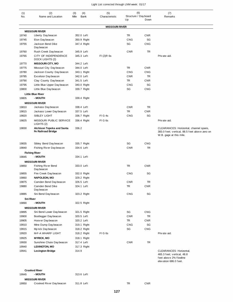
127
Light List corrected through LNM week: 01/17
(7)Remarks
(1)No.
(2)Name and Location
(3)Mile
(5)Characteristic
(4)Bank
(6)Structure / DayboardUp Down
Liberty Daybeacon
Eton DaybeaconJackson Bend Dike DaybeaconRush Creek DaybeaconCITY OF INDEPENDENCE DOCK LIGHTS (2)MISSOURI CITY, MOMissouri City DaybeaconJackson County DaybeaconExcelsior DaybeaconClay County DaybeaconLittle Blue Upper DaybeaconLittle Blue Daybeacon
- MOUTH
Jackass Daybeacon
Jackass Lower DaybeaconSIBLEY LIGHT
MISSOURI PUBLIC SERVICELIGHTS (2)Atchison Topeka and Santa Fe Railroad Bridge
Sibley Bend DaybeaconFishing River Daybeacon
- MOUTH
Fishing River Bend DaybeaconFire Creek DaybeaconNAPOLEON, MOCamden Bend DaybeaconCamden Bend Dike DaybeaconSni Bend Daybeacon
- MOUTH
Sni Bend Lower Daybeacon
Bootlegger DaybeaconHoover DaybeaconMine Dump DaybeaconMyrick DaybeaconM-F-A WHARF LIGHT
MYRICK, MOSunshine Chute DaybeaconLEXINGTON, MOLexington Bridge
- MOUTH
Crooked River Daybeacon
MISSOURI RIVER
MISSOURI RIVER
Little Blue River
MISSOURI RIVER
Fishing River
MISSOURI RIVER
Sni River
MISSOURI RIVER
Crooked River
MISSOURI RIVER
Left
RightRight
LeftLeft
LeftLeftRightLeftLeftRightRight
Right
Left
LeftRight
Right
RightLeft
Left
Left
RightRightLeftLeft
Right
Right
Right
LeftLeftRightRightRight
RightLeftRight
Left
Left
352.0
350.9 347.4
345.9 345.3
344.2 344.0 343.1 342.0 341.5 340.0 339.7
339.4
338.4
337.5 336.7
336.4
336.2
335.7 334.6
334.1
333.0
332.0 329.2 326.5 324.1
323.2
322.5
321.5
320.5 320.2 319.1 318.2 318.2
318.1 317.4 317.3 314.9
313.6
311.8
Fl (2)R 6s
Fl G 4s
Fl G 6s
Fl G 6s
CLEARANCES: Horizontal, channel spans, 383.0 feet; vertical, 88.5 feet above zero on W.B. gage at this mile.
CLEARANCES: Horizontal,465.3 feet; vertical, 48.8feet above 2% flowlineelevation 686.0 feet.
197401974519755
1976019765
19770197751978019785197901979519800
19805
198101981519820
19825
19830
1983519840
19845
19850
19855198601987519880
19885
19890
198951990019905199101991519920
19925199301994019941
19945
19950
TRCNGSG
CNR
TRCNGCNRTRCNGSG
CNRTRCNG
SGCNR
TR
CNG
CNRTR
CNG
SGCNRTRCNGSG
CNR
TR
CNRSG
CNG
TR
CNRCNG
TRCNR
SGCNG
TRCNR
SG
CNGTR
CNR
SG
TRCNR
SG
CNGTR
CNRSG
CNG
TR
CNR
Private aid.
Private aid.
Private aid.
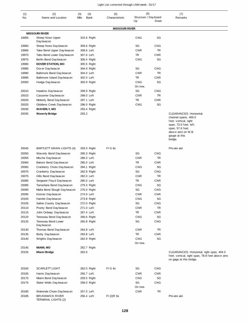
128
Light List corrected through LNM week: 01/17
(7)Remarks
(1)No.
(2)Name and Location
(3)Mile
(5)Characteristic
(4)Bank
(6)Structure / DayboardUp Down
Sheep Nose Upper DaybeaconSheep Nose DaybeaconTabo Bend Upper DaybeaconTabo Bend Lower DaybeaconBerlin Bend DaybeaconDOVER STATION, MODover DaybeaconBaltimore Bend DaybeaconBaltimore Island DaybeaconHodge Daybeacon
Hawkins DaybeaconCassener DaybeaconMoberly Bend DaybeaconGliddens Creek DaybeaconWAVERLY, MOWaverly Bridge
BARTLETT GRAIN LIGHTS (4)
Waverly Bend DaybeaconMische DaybeaconBakers Bend DaybeaconCranberry Chute DaybeaconCranberry DaybeaconHills Bend DaybeaconSergeant Floyd DaybeaconTamerlane Bend DaybeaconMalta Bend Slough DaybeaconKremer DaybeaconHamlet DaybeaconSaline County DaybeaconPrunty Bend DaybeaconJohn Ordway DaybeaconTeteseau Bend DaybeaconTeteseau Bend Lower DaybeaconThomas Bend DaybeaconBixby DaybeaconWrights Daybeacon
MIAMI, MOMiami Bridge
SCARLETT LIGHT
Harris DaybeaconMiami Bend DaybeaconSlater Wells Daybeacon
Wakenda Chute DaybeaconBRUNSWICK RIVER TERMINAL LIGHTS (2)
MISSOURI RIVER
MISSOURI RIVERRight
RightLeftLeftRightRightRightLeftLeftRight
RightLeftLeftRightRight
Right
RightLeftLeftRightRightLeftLeftRightRightLeftRightRightLeftLeftRightRight
LeftLeftRight
Right
Right
LeftRightRight
LeftLeft
310.6
309.6 308.6 307.6 306.4 305.5 304.9 304.0 302.0 300.9
299.9 299.0 297.1 296.0 293.4 293.2
293.0
290.3 289.3 285.0 284.1 282.8 282.0 280.0 279.3 276.0 274.9 273.8 272.0 271.0 267.4 266.6 265.8
264.8 263.8 262.9
262.7 262.6
262.0
260.7 259.5 258.0
257.0 256.4
Fl G 6s
Fl G 4s
Fl (2)R 6s
On tree.
On tree.
On tree.
CLEARANCES: Horizontal,channel spans, 400.0feet; vertical, rightspan, 73.0 feet, leftspan, 57.6 feet, above zero on W.B.gauge at thisbridge.
CLEARANCES: Horizontal, right span, 404.0 feet; vertical, right span, 78.8 feet above zero on gage at this bridge.
19955
199601996519970199751998019985199901999520000
200102001520020200252003020035
20045
20050200552006020065200702007520080200852009020095201002010520110201152012020125
201302013520140
2014520155
20160
201652017020175
2018020185
CNG
SGCNRTRCNG
SGCNRTRCNG
SGCNRTRCNG
SGCNRTRCNGSGCNRTRCNGSGCNRCNGSGCNRTRCNGSG
CNRTRCNG
SG
CNRCNGSG
CNR
SG
CNGTR
CNRSG
CNGTR
CNRSG
CNGTR
CNRSG
CNGTR
CNRSG
CNGTR
CNRSG
CNGCNR
SGCNG
TRCNR
SGCNG
TRCNR
SG
CNG
CNRSG
CNG
TR
Private aid.
Private aid.
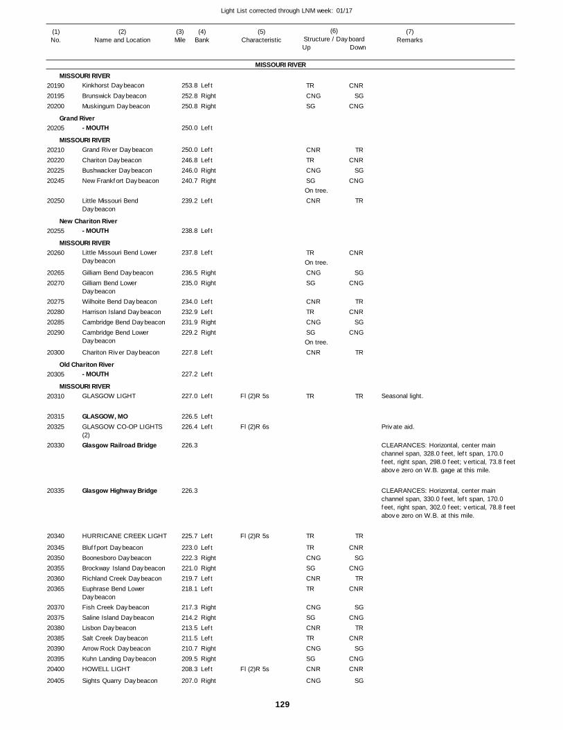
129
Light List corrected through LNM week: 01/17
(7)Remarks
(1)No.
(2)Name and Location
(3)Mile
(5)Characteristic
(4)Bank
(6)Structure / DayboardUp Down
Kinkhorst Daybeacon
Brunswick DaybeaconMuskingum Daybeacon
- MOUTH
Grand River Daybeacon
Chariton DaybeaconBushwacker DaybeaconNew Frankfort Daybeacon
Little Missouri Bend Daybeacon
- MOUTH
Little Missouri Bend Lower Daybeacon
Gilliam Bend DaybeaconGilliam Bend Lower DaybeaconWilhoite Bend DaybeaconHarrison Island DaybeaconCambridge Bend DaybeaconCambridge Bend Lower Daybeacon
Chariton River Daybeacon
- MOUTH
GLASGOW LIGHT
GLASGOW, MOGLASGOW CO-OP LIGHTS (2)Glasgow Railroad Bridge
Glasgow Highway Bridge
HURRICANE CREEK LIGHT
Bluffport DaybeaconBoonesboro DaybeaconBrockway Island DaybeaconRichland Creek DaybeaconEuphrase Bend Lower DaybeaconFish Creek DaybeaconSaline Island DaybeaconLisbon DaybeaconSalt Creek DaybeaconArrow Rock DaybeaconKuhn Landing DaybeaconHOWELL LIGHT
Sights Quarry Daybeacon
MISSOURI RIVER
MISSOURI RIVER
Grand River
MISSOURI RIVER
New Chariton River
MISSOURI RIVER
Old Chariton River
MISSOURI RIVER
Left
RightRight
Left
Left
LeftRightRight
Left
Left
Left
RightRight
LeftLeftRightRight
Left
Left
Left
LeftLeft
Left
LeftRightRightLeftLeft
RightRightLeftLeftRightRightLeft
Right
253.8
252.8 250.8
250.0
250.0
246.8 246.0 240.7
239.2
238.8
237.8
236.5 235.0
234.0 232.9 231.9 229.2
227.8
227.2
227.0
226.5 226.4
226.3
226.3
225.7
223.0 222.3 221.0 219.7 218.1
217.3 214.2 213.5 211.5 210.7 209.5 208.3
207.0
Fl (2)R 5s
Fl (2)R 6s
Fl (2)R 5s
Fl (2)R 5s
On tree.
On tree.
On tree.
Seasonal light.
CLEARANCES: Horizontal, center main channel span, 328.0 feet, left span, 170.0 feet, right span, 298.0 feet; vertical, 73.8 feet above zero on W.B. gage at this mile.
CLEARANCES: Horizontal, center main channel span, 330.0 feet, left span, 170.0 feet, right span, 302.0 feet; vertical, 78.8 feet above zero on W.B. at this mile.
201902019520200
20205
20210202202022520245
20250
20255
20260
2026520270
20275202802028520290
20300
20305
20310
2031520325
20330
20335
20340
2034520350203552036020365
20370203752038020385203902039520400
20405
TRCNGSG
CNRTRCNGSG
CNR
TR
CNGSG
CNRTRCNGSG
CNR
TR
TR
TRCNGSGCNRTR
CNGSGCNRTRCNGSGCNR
CNG
CNRSG
CNG
TRCNR
SGCNG
TR
CNR
SGCNG
TRCNR
SGCNG
TR
TR
TR
CNRSG
CNGTR
CNR
SGCNG
TRCNR
SGCNGCNR
SG
Private aid.
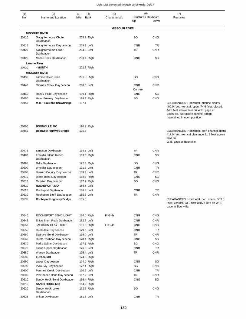
130
Light List corrected through LNM week: 01/17
(7)Remarks
(1)No.
(2)Name and Location
(3)Mile
(5)Characteristic
(4)Bank
(6)Structure / DayboardUp Down
Slaughterhouse Chute DaybeaconSlaughterhouse DaybeaconSlaughterhouse Lower DaybeaconMoon Creek Daybeacon
- MOUTH
Lamine River Bend DaybeaconThomas Creek Daybeacon
Rocky Point DaybeaconHaas Brewery DaybeaconM-K-T Railroad Drawbridge
BOONVILLE, MOBoonville Highway Bridge
Simpson DaybeaconFranklin Island Reach DaybeaconBells DaybeaconWheeler DaybeaconHoward County DaybeaconDiana Bend DaybeaconOverton DaybeaconROCHEPORT, MORocheport DaybeaconRocheport Bluff DaybeaconRocheport Highway Bridge
ROCHEPORT BEND LIGHT
Ships Stern Rock DaybeaconJACKSON CLAY LIGHT
Huntsdale DaybeaconSearcys Bend DaybeaconHunts Towhead DaybeaconPetite Saline DaybeaconLupus Upper DaybeaconWarren DaybeaconLUPUS, MOLupus DaybeaconPlow Boy DaybeaconPerchee Creek DaybeaconProvidence Bend DaybeaconSandy Hook Bend DaybeaconSANDY HOOK, MOSandy Hook Lower DaybeaconWilton Daybeacon
MISSOURI RIVER
MISSOURI RIVER
Lamine River
MISSOURI RIVER
Right
LeftLeft
Right
Right
Right
Left
RightRight
Right
LeftRight
RightLeftLeftRightRightLeftLeftLeft
Right
LeftRight
LeftLeftRightRightLeftLeftRightRightRightLeftLeftRightRightRight
Left
205.9
205.2 204.6
203.4
202.5
201.8
200.5
199.1 198.1 197.1
196.7 196.6
194.5 193.8
192.4 191.5 189.9 188.8 187.7 186.5 186.4 185.6 185.0
184.0
182.5 181.0
179.5 179.0 178.1 177.1 176.0 175.4 174.8 174.0 172.1 170.7 167.2 166.4 164.9 162.7
161.8
Fl G 4s
Fl G 4s
On tree.
CLEARANCES: Horizontal, channel spans, 400.0 feet; vertical, open, 74.6 feet, closed, 44.6 feet above zero on W.B. gage at Boonville. No radiotelephone. Bridge maintained in open position.
CLEARANCES: Horizontal, both channel spans417.0 feet; vertical clearance 81.9 feet above zero on W.B. gage at Boonville.
CLEARANCES: Horizontal, both spans, 533.0 feet; vertical, 73.0 feet above zero on W.B. gage at Boonville.
20410
2041520420
20425
20430
20435
20440
204452045020455
2046020465
2047520480
204952050020505205102051520520205252053020535
20540
2054520550
2055520560205652057020575205802058520590205952060020605206102061520620
20625
SG
CNRTR
CNG
SG
CNR
CNGSG
TRCNG
SGCNRTRCNGSG
CNRTR
CNG
CNRCNG
CNRTRCNGSGCNRTR
CNGSGCNRTRCNG
SG
CNR
CNG
TRCNR
SG
CNG
CNR
SGCNG
CNRSG
CNGTR
CNRSG
CNG
TRCNR
CNG
CNRCNG
TRCNR
SGCNG
TRCNR
SGCNG
TRCNR
SG
CNG
TR
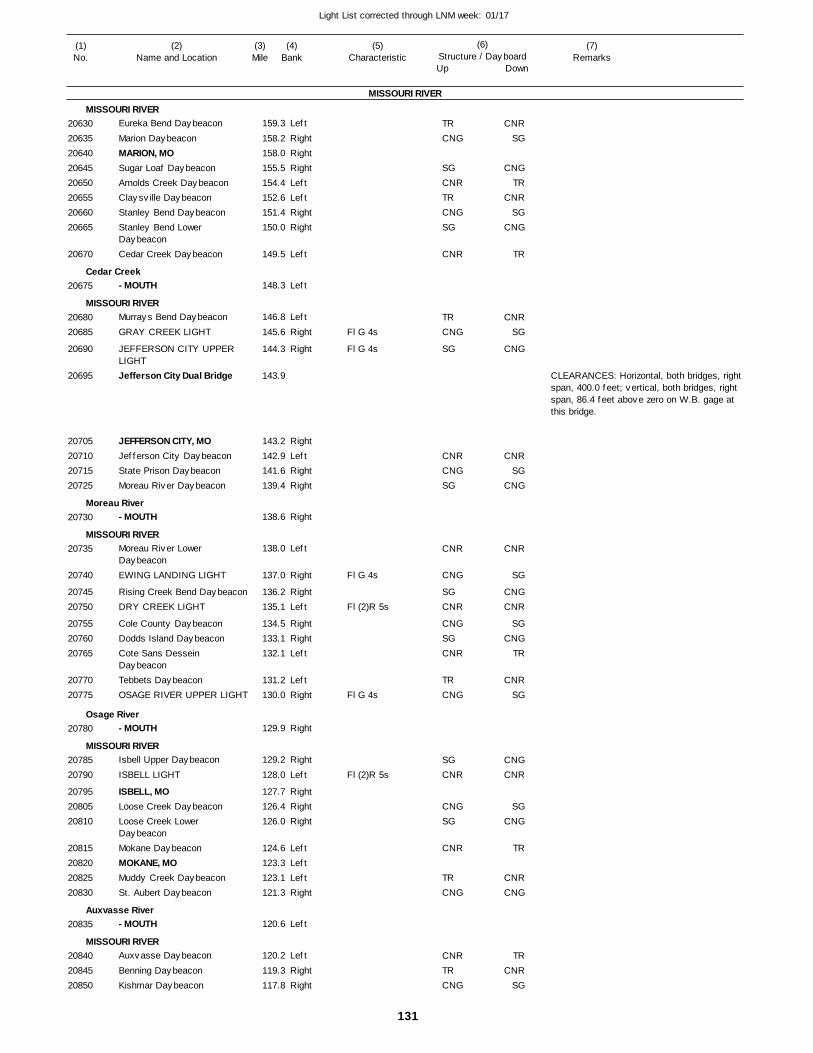
131
Light List corrected through LNM week: 01/17
(7)Remarks
(1)No.
(2)Name and Location
(3)Mile
(5)Characteristic
(4)Bank
(6)Structure / DayboardUp Down
Eureka Bend Daybeacon
Marion DaybeaconMARION, MOSugar Loaf DaybeaconArnolds Creek DaybeaconClaysville DaybeaconStanley Bend DaybeaconStanley Bend Lower DaybeaconCedar Creek Daybeacon
- MOUTH
Murrays Bend Daybeacon
GRAY CREEK LIGHT
JEFFERSON CITY UPPER LIGHTJefferson City Dual Bridge
JEFFERSON CITY, MOJefferson City DaybeaconState Prison DaybeaconMoreau River Daybeacon
- MOUTH
Moreau River Lower DaybeaconEWING LANDING LIGHT
Rising Creek Bend DaybeaconDRY CREEK LIGHT
Cole County DaybeaconDodds Island DaybeaconCote Sans Dessein DaybeaconTebbets DaybeaconOSAGE RIVER UPPER LIGHT
- MOUTH
Isbell Upper Daybeacon
ISBELL LIGHT
ISBELL, MOLoose Creek DaybeaconLoose Creek Lower DaybeaconMokane DaybeaconMOKANE, MOMuddy Creek DaybeaconSt. Aubert Daybeacon
- MOUTH
Auxvasse Daybeacon
Benning DaybeaconKishmar Daybeacon
MISSOURI RIVER
MISSOURI RIVER
Cedar Creek
MISSOURI RIVER
Moreau River
MISSOURI RIVER
Osage River
MISSOURI RIVER
Auxvasse River
MISSOURI RIVER
Left
RightRightRightLeftLeftRightRight
Left
Left
Left
Right
Right
RightLeftRightRight
Right
Left
Right
RightLeft
RightRightLeft
LeftRight
Right
Right
Left
RightRightRight
LeftLeftLeftRight
Left
Left
RightRight
159.3
158.2 158.0 155.5 154.4 152.6 151.4 150.0
149.5
148.3
146.8
145.6
144.3
143.9
143.2 142.9 141.6 139.4
138.6
138.0
137.0
136.2 135.1
134.5 133.1 132.1
131.2 130.0
129.9
129.2
128.0
127.7 126.4 126.0
124.6 123.3 123.1 121.3
120.6
120.2
119.3 117.8
Fl G 4s
Fl G 4s
Fl G 4s
Fl (2)R 5s
Fl G 4s
Fl (2)R 5s
CLEARANCES: Horizontal, both bridges, right span, 400.0 feet; vertical, both bridges, right span, 86.4 feet above zero on W.B. gage at this bridge.
2063020635206402064520650206552066020665
20670
20675
2068020685
20690
20695
20705207102071520725
20730
20735
20740
2074520750
207552076020765
2077020775
20780
2078520790
207952080520810
20815208202082520830
20835
208402084520850
TRCNG
SGCNRTRCNGSG
CNR
TRCNG
SG
CNRCNGSG
CNR
CNG
SGCNR
CNGSGCNR
TRCNG
SGCNR
CNGSG
CNR
TRCNG
CNRTRCNG
CNRSG
CNGTR
CNRSG
CNG
TR
CNRSG
CNG
CNRSG
CNG
CNR
SG
CNGCNR
SGCNG
TR
CNRSG
CNGCNR
SGCNG
TR
CNRCNG
TRCNR
SG
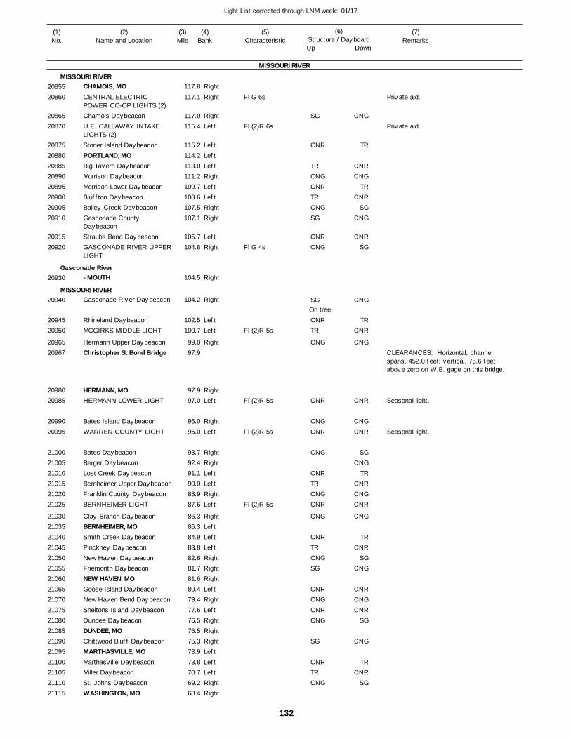
132
Light List corrected through LNM week: 01/17
(7)Remarks
(1)No.
(2)Name and Location
(3)Mile
(5)Characteristic
(4)Bank
(6)Structure / DayboardUp Down
CHAMOIS, MOCENTRAL ELECTRIC POWER CO-OP LIGHTS (2)Chamois DaybeaconU.E. CALLAWAY INTAKE LIGHTS (2)Stoner Island DaybeaconPORTLAND, MOBig Tavern DaybeaconMorrison DaybeaconMorrison Lower DaybeaconBluffton DaybeaconBailey Creek DaybeaconGasconade County DaybeaconStraubs Bend DaybeaconGASCONADE RIVER UPPER LIGHT
- MOUTH
Gasconade River Daybeacon
Rhineland DaybeaconMCGIRKS MIDDLE LIGHT
Hermann Upper DaybeaconChristopher S. Bond Bridge
HERMANN, MOHERMANN LOWER LIGHT
Bates Island DaybeaconWARREN COUNTY LIGHT
Bates DaybeaconBerger DaybeaconLost Creek DaybeaconBernheimer Upper DaybeaconFranklin County DaybeaconBERNHEIMER LIGHT
Clay Branch DaybeaconBERNHEIMER, MOSmith Creek DaybeaconPinckney DaybeaconNew Haven DaybeaconFriemonth DaybeaconNEW HAVEN, MOGoose Island DaybeaconNew Haven Bend DaybeaconSheltons Island DaybeaconDundee DaybeaconDUNDEE, MOChittwood Bluff DaybeaconMARTHASVILLE, MOMarthasville DaybeaconMiller DaybeaconSt. Johns DaybeaconWASHINGTON, MO
MISSOURI RIVER
MISSOURI RIVER
Gasconade River
MISSOURI RIVER
Right
Right
RightLeft
LeftLeftLeftRightLeftLeftRightRight
LeftRight
Right
Right
LeftLeft
Right
RightLeft
RightLeft
RightRightLeftLeftRightLeft
RightLeftLeftLeftRightRightRightLeftRightLeftRightRightRightLeftLeftLeftRightRight
117.8
117.1
117.0 115.4
115.2 114.2 113.0 111.2 109.7 108.6 107.5 107.1
105.7 104.8
104.5
104.2
102.5 100.7
99.0 97.9
97.9 97.0
96.0 95.0
93.7 92.4 91.1 90.0 88.9 87.6
86.3 86.3 84.9 83.8 82.6 81.7 81.6 80.4 79.4 77.6 76.5 76.5 75.3 73.9 73.8 70.7 69.2 68.4
Fl G 6s
Fl (2)R 6s
Fl G 4s
Fl (2)R 5s
Fl (2)R 5s
Fl (2)R 5s
Fl (2)R 5s
On tree.
CLEARANCES: Horizontal, channel spans, 452.0 feet; vertical, 75.6 feetabove zero on W.B. gage on this bridge.
Seasonal light.
Seasonal light.
2085520860
2086520870
2087520880208852089020895209002090520910
2091520920
20930
20940
2094520950
2096520967
2098020985
2099020995
210002100521010210152102021025
210302103521040210452105021055210602106521070210752108021085210902109521100211052111021115
SG
CNR
TRCNGCNRTRCNGSG
CNRCNG
SG
CNRTR
CNG
CNR
CNGCNR
CNG
CNRTRCNGCNR
CNG
CNRTRCNGSG
CNRCNGCNRCNG
SG
CNRTRCNG
CNG
TR
CNRCNG
TRCNR
SGCNG
CNRSG
CNG
TRCNR
CNG
CNR
CNGCNR
SGCNG
TRCNRCNGCNR
CNG
TRCNR
SGCNG
CNRCNGCNR
SG
CNG
TRCNR
SG
Private aid.
Private aid.
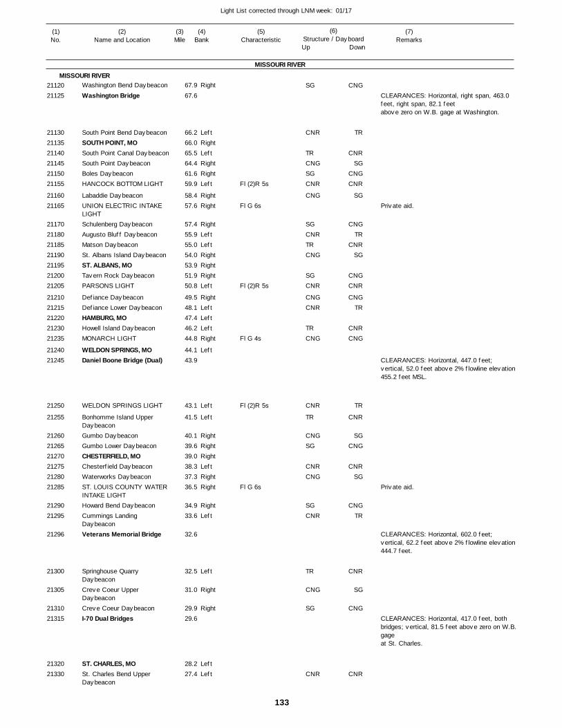
133
Light List corrected through LNM week: 01/17
(7)Remarks
(1)No.
(2)Name and Location
(3)Mile
(5)Characteristic
(4)Bank
(6)Structure / DayboardUp Down
Washington Bend Daybeacon
Washington Bridge
South Point Bend DaybeaconSOUTH POINT, MOSouth Point Canal DaybeaconSouth Point DaybeaconBoles DaybeaconHANCOCK BOTTOM LIGHT
Labaddie DaybeaconUNION ELECTRIC INTAKE LIGHTSchulenberg DaybeaconAugusto Bluff DaybeaconMatson DaybeaconSt. Albans Island DaybeaconST. ALBANS, MOTavern Rock DaybeaconPARSONS LIGHT
Defiance DaybeaconDefiance Lower DaybeaconHAMBURG, MOHowell Island DaybeaconMONARCH LIGHT
WELDON SPRINGS, MODaniel Boone Bridge (Dual)
WELDON SPRINGS LIGHT
Bonhomme Island Upper DaybeaconGumbo DaybeaconGumbo Lower DaybeaconCHESTERFIELD, MOChesterfield DaybeaconWaterworks DaybeaconST. LOUIS COUNTY WATER INTAKE LIGHTHoward Bend DaybeaconCummings Landing DaybeaconVeterans Memorial Bridge
Springhouse Quarry DaybeaconCreve Coeur Upper DaybeaconCreve Coeur DaybeaconI-70 Dual Bridges
ST. CHARLES, MOSt. Charles Bend Upper Daybeacon
MISSOURI RIVER
MISSOURI RIVERRight
LeftRightLeftRightRightLeft
RightRight
RightLeftLeftRightRightRightLeft
RightLeftLeftLeftRight
Left
Left
Left
RightRightRightLeftRightRight
RightLeft
Left
Right
Right
LeftLeft
67.9
67.6
66.2 66.0 65.5 64.4 61.6 59.9
58.4 57.6
57.4 55.9 55.0 54.0 53.9 51.9 50.8
49.5 48.1 47.4 46.2 44.8
44.1 43.9
43.1
41.5
40.1 39.6 39.0 38.3 37.3 36.5
34.9 33.6
32.6
32.5
31.0
29.9 29.6
28.2 27.4
Fl (2)R 5s
Fl G 6s
Fl (2)R 5s
Fl G 4s
Fl (2)R 5s
Fl G 6s
CLEARANCES: Horizontal, right span, 463.0 feet, right span, 82.1 feet above zero on W.B. gage at Washington.
CLEARANCES: Horizontal, 447.0 feet; vertical, 52.0 feet above 2% flowline elevation 455.2 feet MSL.
CLEARANCES: Horizontal, 602.0 feet; vertical, 62.2 feet above 2% flowline elevation 444.7 feet.
CLEARANCES: Horizontal, 417.0 feet, both bridges; vertical, 81.5 feet above zero on W.B.gage at St. Charles.
2112021125
211302113521140211452115021155
2116021165
21170211802118521190211952120021205
2121021215212202123021235
2124021245
21250
21255
212602126521270212752128021285
2129021295
21296
21300
21305
2131021315
2132021330
SG
CNR
TRCNGSGCNR
CNG
SGCNRTRCNG
SGCNR
CNGCNR
TRCNG
CNR
TR
CNGSG
CNRCNG
SGCNR
TR
CNG
SG
CNR
CNG
TR
CNRSG
CNGCNR
SG
CNGTR
CNRSG
CNGCNR
CNGTR
CNRCNG
TR
CNR
SGCNG
CNRSG
CNGTR
CNR
SG
CNG
CNR
Private aid.
Private aid.
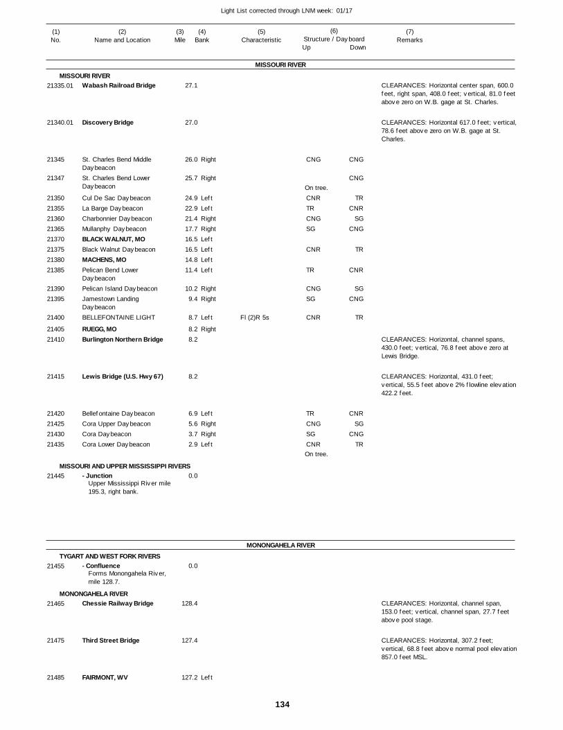
134
Light List corrected through LNM week: 01/17
(7)Remarks
(1)No.
(2)Name and Location
(3)Mile
(5)Characteristic
(4)Bank
(6)Structure / DayboardUp Down
Wabash Railroad Bridge
Discovery Bridge
St. Charles Bend Middle DaybeaconSt. Charles Bend Lower Daybeacon
Cul De Sac DaybeaconLa Barge DaybeaconCharbonnier DaybeaconMullanphy DaybeaconBLACK WALNUT, MOBlack Walnut DaybeaconMACHENS, MOPelican Bend Lower DaybeaconPelican Island DaybeaconJamestown Landing DaybeaconBELLEFONTAINE LIGHT
RUEGG, MOBurlington Northern Bridge
Lewis Bridge (U.S. Hwy 67)
Bellefontaine DaybeaconCora Upper DaybeaconCora DaybeaconCora Lower Daybeacon
- Junction
- Confluence
Chessie Railway Bridge
Third Street Bridge
FAIRMONT, WV
MISSOURI RIVER
MISSOURI RIVER
MISSOURI AND UPPER MISSISSIPPI RIVERS
MONONGAHELA RIVER
TYGART AND WEST FORK RIVERS
MONONGAHELA RIVER
Right
Right
LeftLeftRightRightLeftLeftLeftLeft
RightRight
Left
Right
LeftRightRightLeft
Left
27.1
27.0
26.0
25.7
24.9 22.9 21.4 17.7 16.5 16.5 14.8 11.4
10.2 9.4
8.7
8.2 8.2
8.2
6.9 5.6 3.7 2.9
0.0
0.0
128.4
127.4
127.2
Upper Mississippi River mile195.3, right bank.
Forms Monongahela River, mile 128.7.
Fl (2)R 5s
On tree.
On tree.
CLEARANCES: Horizontal center span, 600.0 feet, right span, 408.0 feet; vertical, 81.0 feet above zero on W.B. gage at St. Charles.
CLEARANCES: Horizontal 617.0 feet; vertical,78.6 feet above zero on W.B. gage at St. Charles.
CLEARANCES: Horizontal, channel spans, 430.0 feet; vertical, 76.8 feet above zero at Lewis Bridge.
CLEARANCES: Horizontal, 431.0 feet; vertical, 55.5 feet above 2% flowline elevation 422.2 feet.
CLEARANCES: Horizontal, channel span, 153.0 feet; vertical, channel span, 27.7 feet above pool stage.
CLEARANCES: Horizontal, 307.2 feet; vertical, 68.8 feet above normal pool elevation857.0 feet MSL.
21335.01
21340.01
21345
21347
2135021355213602136521370213752138021385
2139021395
21400
2140521410
21415
21420214252143021435
21445
21455
21465
21475
21485
CNG
CNRTRCNGSG
CNR
TR
CNGSG
CNR
TRCNGSGCNR
CNG
CNG
TRCNR
SGCNG
TR
CNR
SGCNG
TR
CNRSG
CNGTR
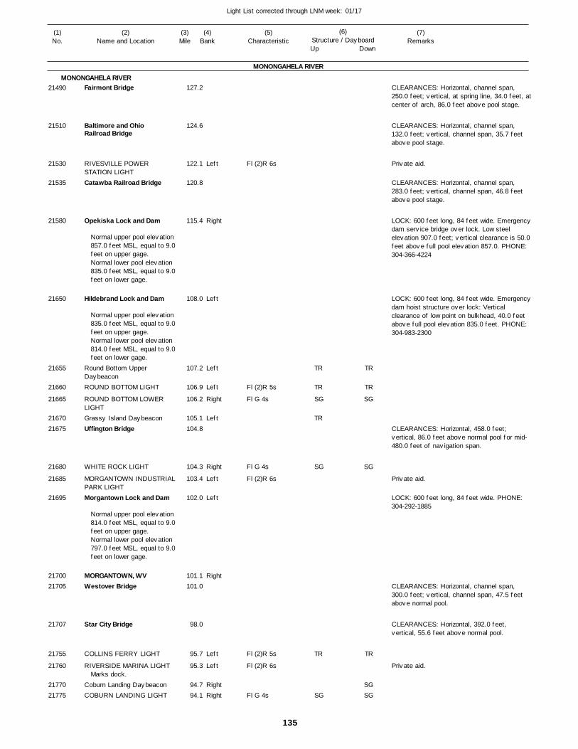
135
Light List corrected through LNM week: 01/17
(7)Remarks
(1)No.
(2)Name and Location
(3)Mile
(5)Characteristic
(4)Bank
(6)Structure / DayboardUp Down
Fairmont Bridge
Baltimore and Ohio Railroad Bridge
RIVESVILLE POWER STATION LIGHTCatawba Railroad Bridge
Opekiska Lock and Dam
Hildebrand Lock and Dam
Round Bottom Upper DaybeaconROUND BOTTOM LIGHT
ROUND BOTTOM LOWER LIGHTGrassy Island DaybeaconUffington Bridge
WHITE ROCK LIGHT
MORGANTOWN INDUSTRIALPARK LIGHTMorgantown Lock and Dam
MORGANTOWN, WVWestover Bridge
Star City Bridge
COLLINS FERRY LIGHT
RIVERSIDE MARINA LIGHT
Coburn Landing DaybeaconCOBURN LANDING LIGHT
MONONGAHELA RIVER
MONONGAHELA RIVER
Left
Right
Left
Left
Left
Right
Left
Right
Left
Left
Right
Left
Left
RightRight
127.2
124.6
122.1
120.8
115.4
108.0
107.2
106.9
106.2
105.1 104.8
104.3
103.4
102.0
101.1 101.0
98.0
95.7
95.3
94.7 94.1
Normal upper pool elevation 857.0 feet MSL, equal to 9.0feet on upper gage.Normal lower pool elevation 835.0 feet MSL, equal to 9.0feet on lower gage.
Normal upper pool elevation 835.0 feet MSL, equal to 9.0feet on upper gage.Normal lower pool elevation 814.0 feet MSL, equal to 9.0feet on lower gage.
Normal upper pool elevation 814.0 feet MSL, equal to 9.0feet on upper gage. Normal lower pool elevation 797.0 feet MSL, equal to 9.0feet on lower gage.
Marks dock.
Fl (2)R 6s
Fl (2)R 5s
Fl G 4s
Fl G 4s
Fl (2)R 6s
Fl (2)R 5s
Fl (2)R 6s
Fl G 4s
CLEARANCES: Horizontal, channel span, 250.0 feet; vertical, at spring line, 34.0 feet, atcenter of arch, 86.0 feet above pool stage.
CLEARANCES: Horizontal, channel span, 132.0 feet; vertical, channel span, 35.7 feet above pool stage.
CLEARANCES: Horizontal, channel span, 283.0 feet; vertical, channel span, 46.8 feet above pool stage.
LOCK: 600 feet long, 84 feet wide. Emergencydam service bridge over lock. Low steel elevation 907.0 feet; vertical clearance is 50.0 feet above full pool elevation 857.0. PHONE: 304-366-4224
LOCK: 600 feet long, 84 feet wide. Emergencydam hoist structure over lock: Vertical clearance of low point on bulkhead, 40.0 feet above full pool elevation 835.0 feet. PHONE: 304-983-2300
CLEARANCES: Horizontal, 458.0 feet; vertical, 86.0 feet above normal pool for mid-480.0 feet of navigation span.
LOCK: 600 feet long, 84 feet wide. PHONE: 304-292-1885
CLEARANCES: Horizontal, channel span, 300.0 feet; vertical, channel span, 47.5 feet above normal pool.
CLEARANCES: Horizontal, 392.0 feet, vertical, 55.6 feet above normal pool.
21490
21510
21530
21535
21580
21650
21655
21660
21665
2167021675
21680
21685
21695
2170021705
21707
21755
21760
2177021775
TR
TR
SG
TR
SG
TR
SG
TR
TR
SG
SG
TR
SGSG
Private aid.
Private aid.
Private aid.
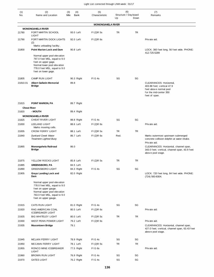
136
Light List corrected through LNM week: 01/17
(7)Remarks
(1)No.
(2)Name and Location
(3)Mile
(5)Characteristic
(4)Bank
(6)Structure / DayboardUp Down
FORT MARTIN SCHOOL LIGHTFORT MARTIN DOCK LIGHTS(2)
Point Marion Lock and Dam
CAMP RUN LIGHT
Albert Gallatin Memorial Bridge
POINT MARION, PA
- MOUTH
CHEAT RIVER LIGHT
LEELAND LIGHT
CROW FERRY LIGHT
Dunkard Creek Water Treatment Lighted Buoy
Monongahela Railroad Bridge
YELLOW ROCKS LIGHT
GREENSBORO, PAGREENSBORO LIGHT
Grays Landing Lock and Dam
CATS RUN LIGHT
RAG AMERICAN COAL ICEBREAKER LIGHTBIG WHITELEY LIGHT
WEST PENN POWER LIGHT
Masontown Bridge
MCLAIN FERRY LIGHT
MCCANN FERRY LIGHT
RONCO MINE ICEBREAKER LIGHTBROWN RUN LIGHT
GATES LIGHT
MONONGAHELA RIVER
MONONGAHELA RIVER
Cheat River
MONONGAHELA RIVER
Left
Left
Left
Right
Right
Right
Right
Left
Left
Left
Left
LeftRight
Right
Right
Left
Left
Left
Right
Left
Right
Right
Right
93.0
92.0
90.8
90.3
89.8
89.7
89.4
88.8
88.6
88.1
86.7
86.0
85.8
84.5 84.3
82.0
81.0
80.5
80.0
79.2
79.1
78.9
78.1
77.5
76.9
76.2
Marks unloading facility.
Normal upper pool elevation 797.0 feet MSL, equal to 9.0feet on upper gage. Normal lower pool elevation 778.0 feet MSL, equal to 9.0feet on lower gage.
Marks mooring cells.
Normal upper pool elevation 778.0 feet MSL, equal to 9.0feet on upper gauge. Normal upper pool elevation 763.0 feet MSL, equal to 9.0feet on upper gauge.
Fl (2)R 5s
Fl (2)R 6s
Fl G 4s
Fl G 4s
Fl (2)R 6s
Fl (2)R 5s
Fl (2)R 6s
Fl (2)R 5s
Fl G 4s
Fl G 4s
Fl (2)R 6s
Fl (2)R 5s
Fl (2)R 6s
Fl G 4s
Fl (2)R 5s
Fl G 6s
Fl G 4s
Fl G 4s
Red.
LOCK: 360 feet long, 56 feet wide. PHONE: 412-725-5289
CLEARANCES: Horizontal, 403.88 feet; vertical 47.9feet above normal poolfor the mid-center 350feet of span.
Marks outermost upstream submerged concrete collision dolphin at water intake.
CLEARANCES: Horizontal, channel span, 343.0 feet; vertical, channel span, 43.9 feet above pool stage.
LOCK: 720 feet long, 84 feet wide. PHONE: (724) 583-8304.
CLEARANCES: Horizontal, channel span, 427.0 feet; vertical, channel span, 63.43 feet above pool stage.
21780
21790
21800
21805
21810.01
21815
21820
21825
21830
21835
21840
21865
21875
2188521890
21905
21915
21920
21925
21930
21935
21945
21950
21955
21960
21970
TR
SG
SG
TR
TR
SG
SG
TR
SG
TR
SG
SG
TR
SG
SG
TR
TR
SG
SG
TR
SG
TR
SG
SG
Private aid.
Private aid.
Private aid.
Private aid.
Private aid.
Private aid.
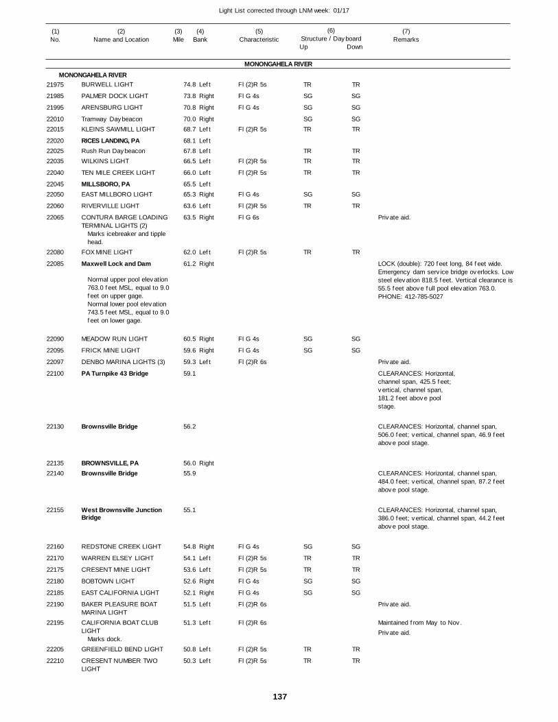
137
Light List corrected through LNM week: 01/17
(7)Remarks
(1)No.
(2)Name and Location
(3)Mile
(5)Characteristic
(4)Bank
(6)Structure / DayboardUp Down
BURWELL LIGHT
PALMER DOCK LIGHT
ARENSBURG LIGHT
Tramway DaybeaconKLEINS SAWMILL LIGHT
RICES LANDING, PARush Run DaybeaconWILKINS LIGHT
TEN MILE CREEK LIGHT
MILLSBORO, PAEAST MILLBORO LIGHT
RIVERVILLE LIGHT
CONTURA BARGE LOADING TERMINAL LIGHTS (2)
FOX MINE LIGHT
Maxwell Lock and Dam
MEADOW RUN LIGHT
FRICK MINE LIGHT
DENBO MARINA LIGHTS (3)
PA Turnpike 43 Bridge
Brownsville Bridge
BROWNSVILLE, PABrownsville Bridge
West Brownsville Junction Bridge
REDSTONE CREEK LIGHT
WARREN ELSEY LIGHT
CRESENT MINE LIGHT
BOBTOWN LIGHT
EAST CALIFORNIA LIGHT
BAKER PLEASURE BOAT MARINA LIGHTCALIFORNIA BOAT CLUB LIGHT
GREENFIELD BEND LIGHT
CRESENT NUMBER TWO LIGHT
MONONGAHELA RIVER
MONONGAHELA RIVERLeft
Right
Right
RightLeft
LeftLeftLeft
Left
LeftRight
Left
Right
Left
Right
Right
Right
Left
Right
Right
Left
Left
Right
Right
Left
Left
Left
Left
74.8
73.8
70.8
70.0 68.7
68.1 67.8 66.5
66.0
65.5 65.3
63.6
63.5
62.0
61.2
60.5
59.6
59.3
59.1
56.2
56.0 55.9
55.1
54.8
54.1
53.6
52.6
52.1
51.5
51.3
50.8
50.3
Marks icebreaker and tipple head.
Normal upper pool elevation 763.0 feet MSL, equal to 9.0feet on upper gage. Normal lower pool elevation 743.5 feet MSL, equal to 9.0feet on lower gage.
Marks dock.
Fl (2)R 5s
Fl G 4s
Fl G 4s
Fl (2)R 5s
Fl (2)R 5s
Fl (2)R 5s
Fl G 4s
Fl (2)R 5s
Fl G 6s
Fl (2)R 5s
Fl G 4s
Fl G 4s
Fl (2)R 6s
Fl G 4s
Fl (2)R 5s
Fl (2)R 5s
Fl G 4s
Fl G 4s
Fl (2)R 6s
Fl (2)R 6s
Fl (2)R 5s
Fl (2)R 5s
LOCK (double): 720 feet long, 84 feet wide. Emergency dam service bridge overlocks. Lowsteel elevation 818.5 feet. Vertical clearance is55.5 feet above full pool elevation 763.0. PHONE: 412-785-5027
CLEARANCES: Horizontal,channel span, 425.5 feet;vertical, channel span, 181.2 feet above pool stage.
CLEARANCES: Horizontal, channel span, 506.0 feet; vertical, channel span, 46.9 feet above pool stage.
CLEARANCES: Horizontal, channel span, 484.0 feet; vertical, channel span, 87.2 feet above pool stage.
CLEARANCES: Horizontal, channel span, 386.0 feet; vertical, channel span, 44.2 feet above pool stage.
Maintained from May to Nov.
21975
21985
21995
2201022015
220202202522035
22040
2204522050
22060
22065
22080
22085
22090
22095
22097
22100
22130
2213522140
22155
22160
22170
22175
22180
22185
22190
22195
22205
22210
TR
SG
SG
SGTR
TRTR
TR
SG
TR
TR
SG
SG
SG
TR
TR
SG
SG
TR
TR
TR
SG
SG
SGTR
TRTR
TR
SG
TR
TR
SG
SG
SG
TR
TR
SG
SG
TR
TR
Private aid.
Private aid.
Private aid.
Private aid.
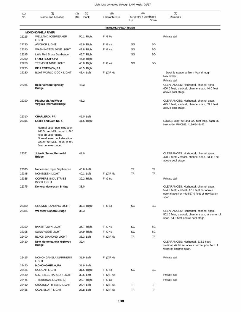
138
Light List corrected through LNM week: 01/17
(7)Remarks
(1)No.
(2)Name and Location
(3)Mile
(5)Characteristic
(4)Bank
(6)Structure / DayboardUp Down
WELLAND ICEBREAKER LIGHTANCHOR LIGHT
WASHINGTON MINE LIGHT
Little Red Stone DaybeaconFAYETTE CITY, PATREMONT MINE LIGHT
BELLE VERNON, PABOAT WORLD DOCK LIGHT
Belle Vernon Highway Bridge
Pittsburgh And West Virginia Railroad Bridge
CHARLEROI, PALocks and Dam No. 4
John K. Tener Memorial Bridge
Monessen Upper DaybeaconMONESSEN LIGHT
COPPERS INDUSTRIES DOCK LIGHTDonora-Monessen Bridge
CRUMMY LANDING LIGHT
Webster-Donora Bridge
BAKERTOWN LIGHT
SUNNYSIDE LIGHT
BLACK DIAMOND LIGHT
New Monongahela Highway Bridge
MONONGAHELA MARINERS LIGHTMONONGAHELA, PAMONGAH LIGHT
U.S. STEEL HARBOR LIGHT
- TERMINAL LIGHTS (2)
CINCINNATTI BEND LIGHT
COAL BLUFF LIGHT
MONONGAHELA RIVER
MONONGAHELA RIVERRight
Right
Right
RightRightRight
RightLeft
LeftRight
LeftLeft
Right
Right
Right
Right
Left
Left
LeftRight
Left
Right
Left
Left
50.1
48.9
47.8
46.7 46.0 45.0
43.5 43.4
43.3
43.2
42.0 41.5
41.0
40.6 40.1
39.2
38.0
37.4
36.3
35.7
34.9
33.3
32.4
31.9
31.9 31.5
30.5
28.7
28.4
27.8
Normal upper pool elevation 743.5 feet MSL, equal to 9.0feet on upper gage. Normal lower pool elevation 726.9 feet MSL, equal to 9.0feet on lower gage.
Fl G 6s
Fl G 4s
Fl G 4s
Fl G 4s
Fl (2)R 6s
Fl (2)R 5s
Fl G 6s
Fl G 4s
Fl G 4s
Fl G 4s
Fl (2)R 5s
Fl (2)R 6s
Fl G 4s
Fl (2)R 6s
Fl G 6s
Fl (2)R 5s
Fl (2)R 5s
Dock is seasonal from May through November.
CLEARANCES: Horizontal, channel span, 400.0 feet; vertical, channel span, 44.0 feet above pool stage.
CLEARANCES: Horizontal, channel span, 425.0 feet; vertical, channel span, 59.7 feet above pool stage.
LOCKS: 360 feet and 720 feet long, each 56 feet wide. PHONE: 412-684-8442
CLEARANCES: Horizontal, channel span, 478.0 feet; vertical, channel span, 53.11 feet above pool stage.
CLEARANCES: Horizontal, channel span, 594.0 feet; vertical, 47.0 feet for above normal pool for mid-557.0 feet of navigation span.
CLEARANCES: Horizontal, channel span, 502.0 feet; vertical, channel span, at center ofspan, 54.9 feet above pool stage.
CLEARANCES: Horizontal, 513.6 feet; vertical, 47.8 feet above normal pool for full width of channel span.
22215
22230
22240
222452225022260
2227522280
22285
22290
2231022315
22321
2233522345
22355
22375
22380
22385
22390
22395
22400
22410
22415
2242022425
22430
22445
22450
22455
SG
SG
SG
SG
TRTR
SG
SG
SG
TR
SG
TR
TR
SG
SG
SG
SG
TRTR
SG
SG
SG
TR
SG
TR
TR
Private aid.
Private aid.
Private aid.
Private aid.
Private aid.
Private aid.
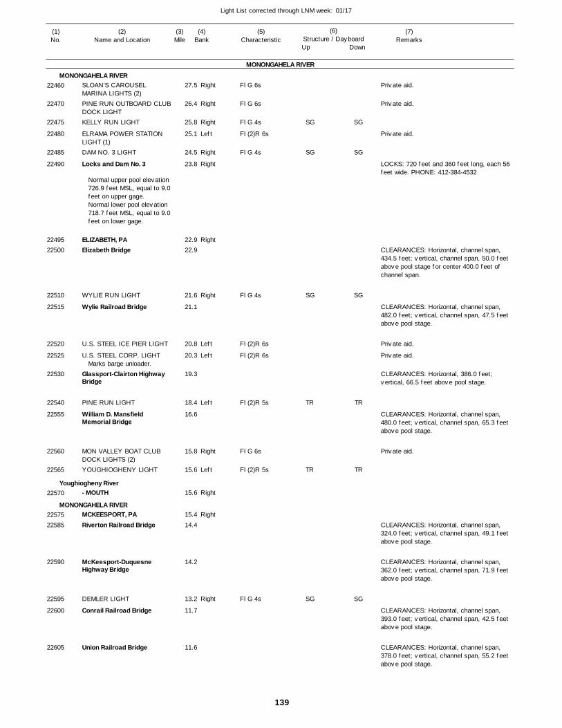
139
Light List corrected through LNM week: 01/17
(7)Remarks
(1)No.
(2)Name and Location
(3)Mile
(5)Characteristic
(4)Bank
(6)Structure / DayboardUp Down
SLOAN'S CAROUSEL MARINA LIGHTS (2)PINE RUN OUTBOARD CLUBDOCK LIGHTKELLY RUN LIGHT
ELRAMA POWER STATION LIGHT (1)DAM NO. 3 LIGHT
Locks and Dam No. 3
ELIZABETH, PAElizabeth Bridge
WYLIE RUN LIGHT
Wylie Railroad Bridge
U.S. STEEL ICE PIER LIGHT
U.S. STEEL CORP. LIGHT
Glassport-Clairton Highway Bridge
PINE RUN LIGHT
William D. Mansfield Memorial Bridge
MON VALLEY BOAT CLUB DOCK LIGHTS (2)YOUGHIOGHENY LIGHT
- MOUTH
MCKEESPORT, PARiverton Railroad Bridge
McKeesport-Duquesne Highway Bridge
DEMLER LIGHT
Conrail Railroad Bridge
Union Railroad Bridge
MONONGAHELA RIVER
MONONGAHELA RIVER
Youghiogheny River
MONONGAHELA RIVER
Right
Right
Right
Left
Right
Right
Right
Right
Left
Left
Left
Right
Left
Right
Right
Right
27.5
26.4
25.8
25.1
24.5
23.8
22.9 22.9
21.6
21.1
20.8
20.3
19.3
18.4
16.6
15.8
15.6
15.6
15.4
14.4
14.2
13.2
11.7
11.6
Normal upper pool elevation 726.9 feet MSL, equal to 9.0feet on upper gage.Normal lower pool elevation 718.7 feet MSL, equal to 9.0feet on lower gage.
Marks barge unloader.
Fl G 6s
Fl G 6s
Fl G 4s
Fl (2)R 6s
Fl G 4s
Fl G 4s
Fl (2)R 6s
Fl (2)R 6s
Fl (2)R 5s
Fl G 6s
Fl (2)R 5s
Fl G 4s
LOCKS: 720 feet and 360 feet long, each 56 feet wide. PHONE: 412-384-4532
CLEARANCES: Horizontal, channel span, 434.5 feet; vertical, channel span, 50.0 feet above pool stage for center 400.0 feet of channel span.
CLEARANCES: Horizontal, channel span, 482.0 feet; vertical, channel span, 47.5 feet above pool stage.
CLEARANCES: Horizontal, 386.0 feet; vertical, 66.5 feet above pool stage.
CLEARANCES: Horizontal, channel span, 480.0 feet; vertical, channel span, 65.3 feet above pool stage.
CLEARANCES: Horizontal, channel span, 324.0 feet; vertical, channel span, 49.1 feet above pool stage.
CLEARANCES: Horizontal, channel span, 362.0 feet; vertical, channel span, 71.9 feet above pool stage.
CLEARANCES: Horizontal, channel span, 393.0 feet; vertical, channel span, 42.5 feet above pool stage.
CLEARANCES: Horizontal, channel span, 378.0 feet; vertical, channel span, 55.2 feet above pool stage.
22460
22470
22475
22480
22485
22490
2249522500
22510
22515
22520
22525
22530
22540
22555
22560
22565
22570
2257522585
22590
22595
22600
22605
SG
SG
SG
TR
TR
SG
SG
SG
SG
TR
TR
SG
Private aid.
Private aid.
Private aid.
Private aid.
Private aid.
Private aid.
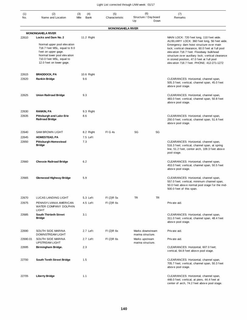
140
Light List corrected through LNM week: 01/17
(7)Remarks
(1)No.
(2)Name and Location
(3)Mile
(5)Characteristic
(4)Bank
(6)Structure / DayboardUp Down
Locks and Dam No. 2
BRADDOCK, PARankin Bridge
Union Railroad Bridge
RANKIN, PAPittsburgh and Lake Erie Railroad Bridge
SAM BROWN LIGHT
HOMESTEAD, PAPittsburgh-Homestead Bridge
Chessie Railroad Bridge
Glenwood Highway Bridge
LUCAS LANDING LIGHT
PENNSYLVANIA AMERICAN WATER COMPANY DOLPHINLIGHTSouth Thirtieth Street Bridge
SOUTH SIDE MARINA DOWNSTREAM LIGHTSOUTH SIDE MARINA UPSTREAM LIGHTBirmingham Bridge.
South Tenth Street Bridge
Liberty Bridge
MONONGAHELA RIVER
MONONGAHELA RIVERRight
Right
Right
Right
Left
Left
Left
Left
Left
11.2
10.6 9.6
9.3
9.3 8.6
8.2
7.5 7.3
6.2
5.9
5.3
4.5
3.1
2.7
2.7
2.3
1.5
1.1
Normal upper pool elevation 718.7 feet MSL, equal to 9.0feet on upper gage. Normal lower pool elevation 710.0 feet MSL, equal to 12.0 feet on lower gage.
Fl G 4s
Fl (2)R 5s
Fl (2)R 6s
Fl (2)R 6s
Fl (2)R 6s
Marks downstream marina structure.Marks upstream marina structure.
MAIN LOCK: 720 feet long, 110 feet wide. AUXILIARY LOCK: 360 feet long, 56 feet wide.Emergency dam hoist structure over main lock; vertical clearance, 60.0 feet at full pool elevation 718.7 feet. Floodway bulkhead structure over auxiliary lock; vertical clearancein stored position, 47.0 feet at full pool elevation 718.7 feet. PHONE: 412-271-1272
CLEARANCES: Horizontal, channel span, 505.3 feet; vertical, channel span, 45.0 feet above pool stage.
CLEARANCES: Horizontal, channel span, 483.0 feet; vertical, channel span, 50.8 feet above pool stage.
CLEARANCES: Horizontal, channel span, 250.0 feet; vertical, channel span, 51.6 feet above pool stage.
CLEARANCES: Horizontal, channel span, 516.3 feet; vertical, channel span, at spring line, 51.2 feet, center arch, 109.3 feet above pool stage.
CLEARANCES: Horizontal, channel span, 453.0 feet; vertical, channel span, 50.5 feet above pool stage.
CLEARANCES: Horizontal, channel span, 557.0 feet; vertical, minimum channel span, 50.0 feet above normal pool stage for the mid-500.0 feet of this span.
CLEARANCES: Horizontal, channel span, 311.0 feet; vertical, channel span, 48.4 feet above pool stage.
CLEARANCES: Horizontal, 607.0 feet; vertical, 64.8 feet above pool stage.
CLEARANCES: Horizontal, channel span, 705.7 feet; vertical, channel span, 50.3 feet above pool stage.
CLEARANCES: Horizontal, channel span, 448.0 feet; vertical, at piers, 44.4 feet at center of arch, 74.2 feet above pool stage.
22610
2261522620
22625
2263022635
22640
2264522650
22660
22665
22670
22675
22685
22690
22690.01
22695
22700
22705
SG
TR
SG
TR
Private aid.
Private aid.
Private aid.
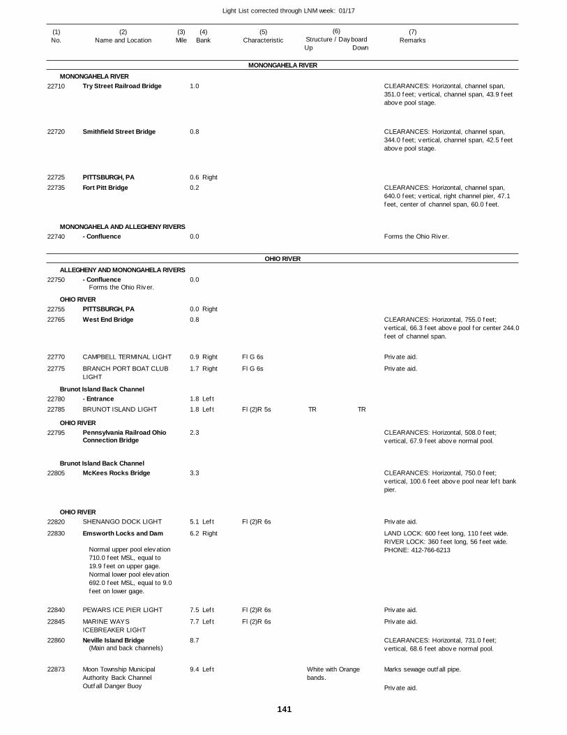
141
Light List corrected through LNM week: 01/17
(7)Remarks
(1)No.
(2)Name and Location
(3)Mile
(5)Characteristic
(4)Bank
(6)Structure / DayboardUp Down
Try Street Railroad Bridge
Smithfield Street Bridge
PITTSBURGH, PAFort Pitt Bridge
- Confluence
- Confluence
PITTSBURGH, PAWest End Bridge
CAMPBELL TERMINAL LIGHT
BRANCH PORT BOAT CLUB LIGHT
- EntranceBRUNOT ISLAND LIGHT
Pennsylvania Railroad OhioConnection Bridge
McKees Rocks Bridge
SHENANGO DOCK LIGHT
Emsworth Locks and Dam
PEWARS ICE PIER LIGHT
MARINE WAYS ICEBREAKER LIGHTNeville Island Bridge
Moon Township Municipal Authority Back Channel Outfall Danger Buoy
MONONGAHELA RIVER
MONONGAHELA RIVER
MONONGAHELA AND ALLEGHENY RIVERS
OHIO RIVER
ALLEGHENY AND MONONGAHELA RIVERS
OHIO RIVER
Brunot Island Back Channel
OHIO RIVER
Brunot Island Back Channel
OHIO RIVER
Right
Right
Right
Right
Left
Left
Left
Right
Left
Left
Left
1.0
0.8
0.6 0.2
0.0
0.0
0.0
0.8
0.9
1.7
1.8
1.8
2.3
3.3
5.1
6.2
7.5
7.7
8.7
9.4
Forms the Ohio River.
Normal upper pool elevation 710.0 feet MSL, equal to 19.9 feet on upper gage. Normal lower pool elevation 692.0 feet MSL, equal to 9.0feet on lower gage.
(Main and back channels)
Fl G 6s
Fl G 6s
Fl (2)R 5s
Fl (2)R 6s
Fl (2)R 6s
Fl (2)R 6s
White with Orange bands.
CLEARANCES: Horizontal, channel span, 351.0 feet; vertical, channel span, 43.9 feet above pool stage.
CLEARANCES: Horizontal, channel span, 344.0 feet; vertical, channel span, 42.5 feet above pool stage.
CLEARANCES: Horizontal, channel span, 640.0 feet; vertical, right channel pier, 47.1 feet, center of channel span, 60.0 feet.
Forms the Ohio River.
CLEARANCES: Horizontal, 755.0 feet; vertical, 66.3 feet above pool for center 244.0 feet of channel span.
CLEARANCES: Horizontal, 508.0 feet; vertical, 67.9 feet above normal pool.
CLEARANCES: Horizontal, 750.0 feet; vertical, 100.6 feet above pool near left bank pier.
LAND LOCK: 600 feet long, 110 feet wide. RIVER LOCK: 360 feet long, 56 feet wide. PHONE: 412-766-6213
CLEARANCES: Horizontal, 731.0 feet; vertical, 68.6 feet above normal pool.
Marks sewage outfall pipe.
22710
22720
2272522735
22740
22750
2275522765
22770
22775
2278022785
22795
22805
22820
22830
22840
22845
22860
22873
TR TR
Private aid.
Private aid.
Private aid.
Private aid.
Private aid.
Private aid.

142
Light List corrected through LNM week: 01/17
(7)Remarks
(1)No.
(2)Name and Location
(3)Mile
(5)Characteristic
(4)Bank
(6)Structure / DayboardUp Down
Coraopolis Bridge
MCPHERSON LIGHT
Sewickley Bridge
George Zerr DaybeaconDashields Locks and Dam
Moon Township Municipal Authority Outfall Danger Buoy
PHILLIPS POWER STATION LIGHTHUSSEY COPPER LIGHT
AMBRIDGE, PAAmbridge Aliquippa Bridge
- LIGHT
- LIGHT
ALIQUIPPA, PACONRAIL TERMINAL LIGHT
C. C. Bunton DaybeaconP & LE ICEBREAKER LIGHT
East Rochester-Monaca Bridge
ROCHESTSER, PARochester-Monaca Bridge
- MOUTHSHOBEN BOAT DOCK LIGHT
ROCKWALL HARBOR DOCK LIGHTS (2)RIVERSIDE DOCK LIGHT
Veterans Memorial Bridge
BEAVER VALLEY YACHT CLUB LIGHTS (2)
Pittsburgh and Lake Erie Railroad Bridge
OHIO RIVER
OHIO RIVER
BET-TECH
OHIO RIVER
Beaver River
OHIO RIVER
Right
LeftLeft
Left
Left
Right
Right
Left
Left
Left
Right
LeftLeft
Right
Right
Right
Left
Right
Right
9.6
10.9
11.8
12.2 13.3
14.2
15.3
15.3
16.0 16.8
18.5
18.9
20.0
21.0
22.5 23.3
24.3
25.1 25.2
25.4
0.1
0.5
1.0
1.5
2.0
25.7
Marks ice pier.
Marks dock.
Fl G 4s
Fl (2)R 6s
Fl G 6s
Fl (2)R 6s
Fl (2)R 6s
Fl G 6s
Fl (2)R 6s
Fl G 6s
Fl (2)R 6s
Fl G 6s
Fl G 6s
White with Orange bands.Worded: DANGER PIPE.
On pumphouse.
On icebreaker.
CLEARANCES: Horizontal, 345.0; vertical, 47.2 feet above normal pool.
CLEARANCES: Horizontal, 724.0 feet; vertical, 75.4 feet above pool.
LAND LOCK: 600 feet long, 110 feet wide. RIVER LOCK: 360 feet long, 56 feet wide. PHONE: 412-457-8430
MARKS SEWAGE OUTFALL PIPE.
CLEARANCES: Horizontal, 510.0 feet; vertical, 78.5 feet above pool.
CLEARANCES: Horizontal, 705.0 feet; vertical, 68.0 feet above pool at left channel pier.
CLEARANCES: Horizontal, 722.0 feet; vertical, 69.0 feet above normal pool for mid 633.0 feet of channel span.
CLEARANCES: Horizontal, 244.0 feet; vertical, 21.0feet abovenormal pool.
Maintained from Apr. to Nov.
CLEARANCES: Horizontal, 734.0 feet; vertical, 69.2 feet above pool.
22875
22890
22900
2291022915
22918
22920
22925
2293522940
22955
22960
2297522980
2298522990
22995
2300023005
2301023015
23020
23025
23027
23030
23035
SG
TR
TR
SG
TR
TR
Private aid.
Private aid.
Private aid.
Private aid.
Private aid.
Private aid.
Private aid.
Private aid.
Private aid.
Private aid.
Private aid.
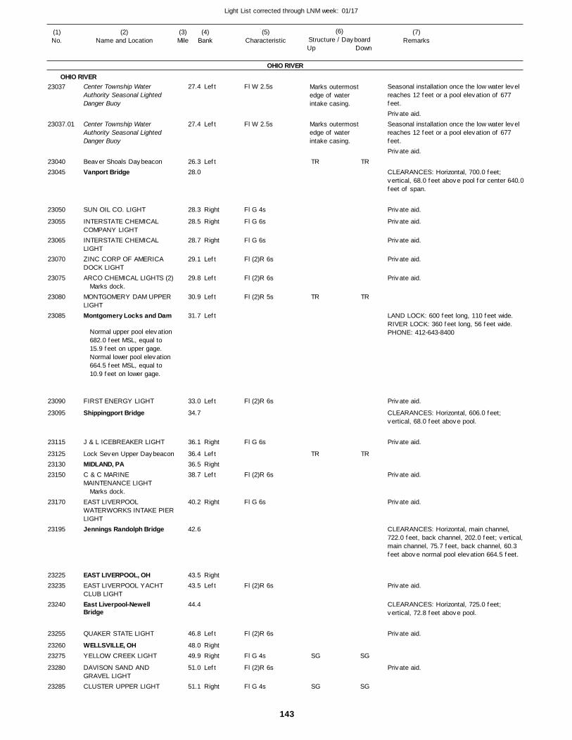
143
Light List corrected through LNM week: 01/17
(7)Remarks
(1)No.
(2)Name and Location
(3)Mile
(5)Characteristic
(4)Bank
(6)Structure / DayboardUp Down
Center Township Water Authority Seasonal Lighted Danger Buoy
Center Township Water Authority Seasonal Lighted Danger Buoy
Beaver Shoals DaybeaconVanport Bridge
SUN OIL CO. LIGHT
INTERSTATE CHEMICAL COMPANY LIGHTINTERSTATE CHEMICAL LIGHTZINC CORP OF AMERICA DOCK LIGHTARCO CHEMICAL LIGHTS (2)
MONTGOMERY DAM UPPER LIGHTMontgomery Locks and Dam
FIRST ENERGY LIGHT
Shippingport Bridge
J & L ICEBREAKER LIGHT
Lock Seven Upper DaybeaconMIDLAND, PAC & C MARINE MAINTENANCE LIGHT
EAST LIVERPOOL WATERWORKS INTAKE PIERLIGHTJennings Randolph Bridge
EAST LIVERPOOL, OHEAST LIVERPOOL YACHT CLUB LIGHTEast Liverpool-Newell Bridge
QUAKER STATE LIGHT
WELLSVILLE, OHYELLOW CREEK LIGHT
DAVISON SAND AND GRAVEL LIGHTCLUSTER UPPER LIGHT
OHIO RIVER
OHIO RIVERLeft
Left
Left
Right
Right
Right
Left
Left
Left
Left
Left
Right
LeftRightLeft
Right
RightLeft
Left
RightRight
Left
Right
27.4
27.4
26.3 28.0
28.3
28.5
28.7
29.1
29.8
30.9
31.7
33.0
34.7
36.1
36.4 36.5 38.7
40.2
42.6
43.5 43.5
44.4
46.8
48.0 49.9
51.0
51.1
Marks dock.
Normal upper pool elevation 682.0 feet MSL, equal to 15.9 feet on upper gage. Normal lower pool elevation 664.5 feet MSL, equal to 10.9 feet on lower gage.
Marks dock.
Fl W 2.5s
Fl W 2.5s
Fl G 4s
Fl G 6s
Fl G 6s
Fl (2)R 6s
Fl (2)R 6s
Fl (2)R 5s
Fl (2)R 6s
Fl G 6s
Fl (2)R 6s
Fl G 6s
Fl (2)R 6s
Fl (2)R 6s
Fl G 4s
Fl (2)R 6s
Fl G 4s
Marks outermost edge of water intake casing.
Marks outermost edge of water intake casing.
Seasonal installation once the low water level reaches 12 feet or a pool elevation of 677 feet.
Seasonal installation once the low water level reaches 12 feet or a pool elevation of 677 feet.
CLEARANCES: Horizontal, 700.0 feet; vertical, 68.0 feet above pool for center 640.0 feet of span.
LAND LOCK: 600 feet long, 110 feet wide. RIVER LOCK: 360 feet long, 56 feet wide. PHONE: 412-643-8400
CLEARANCES: Horizontal, 606.0 feet; vertical, 68.0 feet above pool.
CLEARANCES: Horizontal, main channel, 722.0 feet, back channel, 202.0 feet; vertical, main channel, 75.7 feet, back channel, 60.3 feet above normal pool elevation 664.5 feet.
CLEARANCES: Horizontal, 725.0 feet; vertical, 72.8 feet above pool.
23037
23037.01
2304023045
23050
23055
23065
23070
23075
23080
23085
23090
23095
23115
231252313023150
23170
23195
2322523235
23240
23255
2326023275
23280
23285
TR
TR
TR
SG
SG
TR
TR
TR
SG
SG
Private aid.
Private aid.
Private aid.
Private aid.
Private aid.
Private aid.
Private aid.
Private aid.
Private aid.
Private aid.
Private aid.
Private aid.
Private aid.
Private aid.
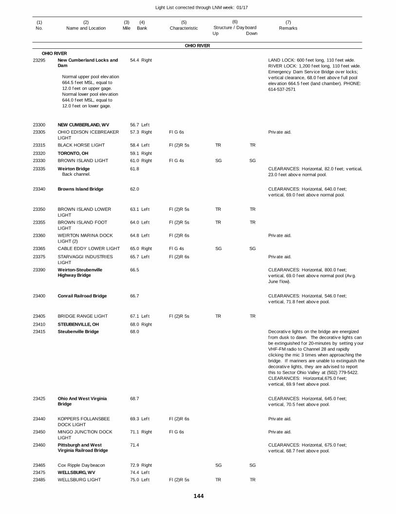
144
Light List corrected through LNM week: 01/17
(7)Remarks
(1)No.
(2)Name and Location
(3)Mile
(5)Characteristic
(4)Bank
(6)Structure / DayboardUp Down
New Cumberland Locks andDam
NEW CUMBERLAND, WVOHIO EDISON ICEBREAKER LIGHTBLACK HORSE LIGHT
TORONTO, OHBROWN ISLAND LIGHT
Weirton Bridge
Browns Island Bridge
BROWN ISLAND LOWER LIGHTBROWN ISLAND FOOT LIGHTWEIRTON MARINA DOCK LIGHT (2)CABLE EDDY LOWER LIGHT
STARVAGGI INDUSTRIES LIGHTWeirton-Steubenville Highway Bridge
Conrail Railroad Bridge
BRIDGE RANGE LIGHT
STEUBENVILLE, OHSteubenville Bridge
Ohio And West Virginia Bridge
KOPPERS FOLLANSBEE DOCK LIGHTMINGO JUNCTION DOCK LIGHTPittsburgh and West Virginia Railroad Bridge
Cox Ripple DaybeaconWELLSBURG, WVWELLSBURG LIGHT
OHIO RIVER
OHIO RIVERRight
LeftRight
Left
RightRight
Left
Left
Left
Right
Left
Left
Right
Left
Right
RightLeftLeft
54.4
56.7 57.3
58.4
59.1 61.0
61.8
62.0
63.1
64.0
64.8
65.0
65.7
66.5
66.7
67.1
68.0 68.0
68.7
69.3
71.1
71.4
72.9 74.4 75.0
Normal upper pool elevation 664.5 feet MSL, equal to 12.0 feet on upper gage. Normal lower pool elevation 644.0 feet MSL, equal to 12.0 feet on lower gage.
Back channel.
Fl G 6s
Fl (2)R 5s
Fl G 4s
Fl (2)R 5s
Fl (2)R 5s
Fl (2)R 6s
Fl G 4s
Fl (2)R 6s
Fl (2)R 5s
Fl (2)R 6s
Fl G 6s
Fl (2)R 5s
LAND LOCK: 600 feet long, 110 feet wide. RIVER LOCK: 1,200 feet long, 110 feet wide. Emergency Dam Service Bridge over locks; vertical clearance, 68.0 feet above full pool elevation 664.5 feet (land chamber). PHONE: 614-537-2571
CLEARANCES: Horizontal, 82.0 feet; vertical, 23.0 feet above normal pool.
CLEARANCES: Horizontal, 640.0 feet; vertical, 69.0 feet above normal pool.
CLEARANCES: Horizontal, 800.0 feet; vertical, 69.0 feet above normal pool (Avg. June flow).
CLEARANCES: Horizontal, 546.0 feet; vertical, 71.8 feet above pool.
Decorative lights on the bridge are energized from dusk to dawn. The decorative lights can be extinguished for 20-minutes by setting yourVHF-FM radio to Channel 28 and rapidly clicking the mic 3 times when approaching the bridge. If mariners are unable to extinguish thedecorative lights, they are advised to report this to Sector Ohio Valley at (502) 779-5422.CLEARANCES: Horizontal,675.0 feet;vertical, 69.9 feet above pool.
CLEARANCES: Horizontal, 645.0 feet; vertical, 70.5 feet above pool.
CLEARANCES: Horizontal, 675.0 feet; vertical, 68.7 feet above pool.
23295
2330023305
23315
2332023330
23335
23340
23350
23355
23360
23365
23375
23390
23400
23405
2341023415
23425
23440
23450
23460
234652347523485
TR
SG
TR
TR
SG
TR
SG
TR
TR
SG
TR
TR
SG
TR
SG
TR
Private aid.
Private aid.
Private aid.
Private aid.
Private aid.
145
Light List corrected through LNM week: 01/17
(7)Remarks
(1)No.
(2)Name and Location
(3)Mile
(5)Characteristic
(4)Bank
(6)Structure / DayboardUp Down
CARDINAL POWER PLANT LIGHTS (2)AMERICAN ELECTRIC CARDINAL PLANT COAL DOCK LIGHTS (3)Pike Island Locks and Dam
SISTERS LOWER LIGHT
WHEELING INTAKE PIER LIGHTMARTINS FERRY, OHNinth Street Highway Bridge
Wheeling Suspension Bridge
WHEELING, WVWHEELING ISLAND FOOT LIGHTI-470 Highway Bridge
R & F COAL DOCK LIGHT
CONSOLIDATION DOCK LIGHT
BENWOOD, WVBellaire Bridge
Chessie Railroad Bridge
BELLAIRE, OHBellaire Lower DaybeaconPULTNEY BEND LIGHT
WEGEE MINE LIGHT
Moundsville Highway Bridge
MOUNDSVILLE MARINA LIGHT
MOUNDSVILLE, WVOHIO EDISON DOCK LIGHTS(2)
PRIMA MARINA DOCK LIGHT
- AGGREGATES UPPER LIGHT
OHIO RIVER
OHIO RIVERRight
Right
Left
Right
Left
Right
LeftRight
Right
Left
Left
RightRightLeft
Right
Left
LeftRight
Left
Left
76.2
76.3
84.3
86.4
86.7
88.8 90.2
90.3
90.5 91.9
91.8
92.8
93.7
94.0 94.3
94.5
94.5 95.0 97.3
99.2
101.8
101.8
101.9 102.2
102.2
102.2
Normal upper pool elevation 644.0 feet MSL, equal to 12.0 feet on upper gage. Normal lower pool elevation 626.2 feet MSL, equal to 15.2 feet on lower gage.
Marks loading dock.
Marks loading facility.
Marks dock.
Marks unloading dock.
Marks docks.
Fl G 6s
Fl G 6s
Fl G 4s
Fl (2)R 6s
Fl G 4s
Fl G 6s
F R
Fl (2)R 5s
Fl G 4s
F W
Fl G 6s
F R
Fl (2)R 6s Marks outermost upstream dolphin.
LAND LOCK: 600 feet long, 110 feet wide. RIVER LOCK: 1,200 feet long, 110 feet wide. Emergency dam service bridge over locks; lowsteel elevation, 712.0 feet; vertical clearance, 68.0 feet above full pool elevation 644.0 feet. PHONE: 304-277-2240
CLEARANCES: Horizontal, 554.0 feet; vertical, 76.8 feet above pool.
CLEARANCES: Horizontal, 830.0 feet; vertical, 56.2 feet above pool for 300.0 feet toleft of center of channel span.
CLEARANCES: Horizontal, 761.87 feet; vertical, 70.9 feet above normal pool for mid-712.0 feet of navigation span.
CLEARANCES: Horizontal, 675.0 feet; vertical, 73.8 feet above pool elevation 626.2.
CLEARANCES: Horizontal, 320.0 feet; vertical, 73.2 feet above pool.
CLEARANCES: Horizontal, 877.0 feet; vertical, 69.0 feet above normal pool.
23490
23495
23520
23535
23540
2356023570
23575
2358523590
23595
23605
23615
2362523630
23635
236402365023655
23665
23675
23680
2368523695
23700
23702
SG
SG
SGTR
SG
SG
SG
SGTR
SG
Private aid.
Private aid.
Private aid.
Private aid.
Private aid.
Private aid.
Private aid.
Private aid.
Private aid.
146
Light List corrected through LNM week: 01/17
(7)Remarks
(1)No.
(2)Name and Location
(3)Mile
(5)Characteristic
(4)Bank
(6)Structure / DayboardUp Down
- AGGREGATES LOWER LIGHT
BAKER RUN LIGHT
BELLAIRE CORP. DOCK LIGHTPIPE CREEK LIGHT
HANLIN CHEMICALS DOCK LIGHTNARROW RUN LIGHT
Butter Run DaybeaconCAPTINA ISLAND LIGHT
HOG RUN LIGHT
POWHATAN, OHCONSOLIDATION COAL DOCK LIGHTOHIO VALLEY TRANSLOADING LIGHTKAMMER PLANT LIGHT
CRESSAP BEND LIGHT
OHIO POWER DOCK LIGHTS(2)CLINES BAR LIGHT
CLARINGTON, OHSUNFISH RIPPLE LIGHT
P P G RANNEY INTAKE LIGHTP P G INDUSTRIES LIGHT
P P G INDUSTRIES LIGHT
P P G INDUSTRIES LIGHT
P P G INDUSTRIES LIGHT
QUARTO MINING LIGHTS (2)
MILES DOCK LIGHT
MILES LIGHT
PROCTOR LANDING LIGHT
DOCK SIDE LIGHT
ORMET DOCK LIGHTS (3)
LITMAN LANDING LIGHT
Hannibal Locks and Dam
New Martinsville Bridge
MAGNOLIA BOATERS DOCK LIGHTVALLEY BOAT DOCK LIGHT
NEW MARTINSVILLE, WVSHADYSIDE RUN LIGHT
GLENN ROCK LIGHT
SARDIS BEND LIGHT
OHIO RIVER
OHIO RIVERLeft
Left
Right
Right
Left
Right
LeftLeft
Left
RightLeft
Right
Left
Right
Left
Left
RightRight
Left
Left
Left
Left
Left
Right
Left
Left
Left
Right
Right
Right
Right
Left
Right
LeftLeft
Left
Right
102.2
102.9
104.0
105.2
105.9
106.0
107.0 108.5
109.6
109.8 110.4
110.6
111.0
111.2
112.3
115.6
117.8 118.6
119.0
119.1
119.3
119.4
119.6
120.2
121.0
121.3
122.6
124.2
123.1
124.7
126.4
126.9
127.9
128.0
128.2 129.8
131.1
132.1
Marks waterfront facility.
Marks cell
Marks icebreaker.
Fl (2)R 6s
Fl (2)R 5s
F G
Fl W 4s
Fl (2)R 6s
Fl G 4s
Fl (2)R 5s
Fl (2)R 5s
Fl (2)R 6s
Fl G 6s
Fl (2)R 6s
Fl G 4s
Fl (2)R 6s
Fl (2)R 5s
Fl G 4s
Fl (2)R 6s
Fl (2)R 6s
Fl (2)R 6s
Fl (2)R 6s
Fl (2)R 6s
Fl G 6s
Fl (2)R 6s
Fl (2)R 6s
Fl (2)R 5s
Fl G 6s
Fl G 6s
Fl G 4s
Fl (2)R 6s
Fl G 6s
Fl (2)R 5s
Fl (2)R 5s
Fl G 4s
Marks outermost downstream dolphin.
One nun marks wall when it is covered with less than 10.0 feet of water.
MAIN LOCK: 1,200 feet long, 110 feet wide. AUXILIARY LOCK: 600 feet long, 110 feet wide. Emergency dam service bridge over locks: Low steel elevation 660.0 feet; vertical clearance, 691.0 feet above upper pool stage 623.0 feet. PHONE: 614-483-2305
CLEARANCES: Horizontal, 385 feet; minimum vertical clearance, 78 feet above normal pool in the right descending span.
23702.01
23705
23715
23720
23725
23730
2373523740
23745
2375023755
23760
23770
23775
23780
23785
2380023805
23811
23816
23820
23826
23831
23835
23840
23845
23850
23855
23860
23865
23875
23880
23885
23890
2389523920
23925
23930
TR
SG
SG
TRTR
TR
SG
TR
SG
TR
SG
TR
TR
SG
TR
SG
SG
TRTR
TR
SG
TR
SG
TR
SG
TR
TR
SG
Private aid.
Private aid.
Private aid.
Private aid.
Private aid.
Private aid.
Private aid.
Private aid.
Private aid.
Private aid.
Private aid.
Private aid.
Private aid.
Private aid.
Private aid.
Private aid.
Private aid.
Private aid.
Private aid.
147
Light List corrected through LNM week: 01/17
(7)Remarks
(1)No.
(2)Name and Location
(3)Mile
(5)Characteristic
(4)Bank
(6)Structure / DayboardUp Down
PADEN CITY, WVWITTEN TOWHEAD LIGHT
SISTERSVILLE LIGHT
SISTERSVILLE, WVCOCHRANSVILLE LIGHT
GENERAL ELECTRIC DOCK LIGHTS (2)CONSOLIDATED GAS TRANSMISSION CORP. LIGHTS (2)BENS RUN LIGHT
RIGGS LANDING LIGHT
SCHOOSTERS LANDING LIGHTFERGUSON LANE LIGHT
ST. MARYS, WVHi Carpenter Memorial Bridge
ST. MARYS BEND LIGHT
GORDON GREENE LIGHT
BROTHERS ISLAND UPPER LIGHTMONONGAHELA POWER COMPANY LIGHTS (3)MONONGAHELA POWER COMPANY LIGHTS (3)Willow Island Locks and Dam
CABOT DOCK LIGHT
BULL CREEK LIGHT
CARPENTER BAR LIGHT
Old Lock No. 17 Lower DaybeaconMARIETTA ISLAND LIGHT
I-77 Bridge
Williamstown-Marietta Bridge
MARIETTA, OHWILLIAMSTOWN, WV
- MOUTHCITY OF MARIETTA LIGHT
MARIETTA BOAT CLUB DOCK LIGHTS (2)
AMERICAN RIVER TERMINAL DOCK LIGHTASHLAND OIL COMPANY UPPER DOCK LIGHT
OHIO RIVER
OHIO RIVER
Muskingum River
OHIO RIVER
Left
Right
Left
LeftRight
Left
Left
Left
Left
Right
Right
Left
Left
Right
Left
Left
Left
Right
Left
Left
Left
Right
Right
RightLeft
Right
Left
Left
Right
Right
133.3
135.5
136.8
137.6 139.9
145.3
146.3
147.1
149.0
151.7
154.1
155.0 155.4
155.4
157.2
158.1
160.5
160.8
161.7
164.1
164.7
166.5
167.6
169.1
170.7
171.8
171.9 172.0
172.2
0.3
1.0
173.8
175.1
Marks dock.
Fl G 4s
Fl (2)R 5s
Fl G 4s
Fl (2)R 6s
Fl (2)R 6s
Fl (2)R 6s
Fl (2)R 5s
Fl G 4s
Fl G 4s
Fl (2)R 5s
Fl G 4s
Fl (2)R 5s
Fl (2)R 6s
Fl (2)R 6s
Fl (2)R 6s
Fl (2)R 5s
Fl (2)R 5s
Fl G 4s
F W
Fl (2)R 6s
Fl G 6s
F G
CLEARANCES: Horizontal, 880.0 feet; vertical, 69.9 feet above normal pool elevation602.2 feet.
Dam under construction. LAND LOCK: 600 feet long, 110 feet wide. RIVER LOCK: 1,200 feet long, 110 feet wide. PHONE: 614-374-8710 304-665-2520
CLEARANCE: Horizontal, 637.0 feet; vertical, 73.0 feet above pool at top of center span, 70.1 feet for entire width of channel span.
CLEARANCES: Horizontal, 635.0 feet, between piers. Vertical, 56.9 feet, at 2 percent flowline.
2393523940
23945
2395023960
23980
23985
24005
24010
24015
24020
2402524035
24040
24045
24050
24065
24070
24080
24090
24095
24100
24110
24120
24125
24130
2413524140
2414524155
24160
24170
24185
SG
TR
SG
TR
SG
SG
TR
SG
TR
TR
TR
SG
SG
SG
TR
SG
TR
SG
SG
TR
SG
TR
TR
TR
SG
SG
Private aid.
Private aid.
Private aid.
Private aid.
Private aid.
Private aid.
Private aid.
Private aid.
Private aid.
Private aid.
148
Light List corrected through LNM week: 01/17
(7)Remarks
(1)No.
(2)Name and Location
(3)Mile
(5)Characteristic
(4)Bank
(6)Structure / DayboardUp Down
ASHLAND OIL LOWER DOCKLIGHTPAR-MAR DOCK LIGHT
CHEVRON CHEMICAL COMPANY DOCK LIGHTMID OHIO VALLEY LIME DOCK LIGHTNEALE BARGE FLEETING LIGHTS (2)NEAL ISLAND LIGHT
Belpre-Parkersburg Highway Bridge
PENNZOIL UNITED DOCK LIGHTS (2)
BLENNERHASSET YACHT CLUB LIGHTS (3)
BELPRE, OHChessie Baltimore and OhioRailroad Bridge
Parkersburg-Belpre Highway Bridge
PARKERSBURG, WV
- MOUTH- Bridge
RAPPS RUN LIGHT
BLENNERHASSETT ISLAND HEAD LIGHTAMES RIPPLE LIGHT
KRATON POLYMERS DOCK LIGHTBlennerhassett Bridge
OHIO POWER DOCK LIGHTS(3)WASHINGTON WORKS INTAKE LIGHTLITTLE HOCKING LIGHT
GE PLASTICS DOCK LIGHT
DUNFEE RUN LIGHT
Newberry Bar DaybeaconMUSTAPHA ISLAND UPPER LIGHTMUSTAPHA ISLAND LOWER LIGHTATHENS BOAT & SKI CLUB LIGHT
OHIO RIVER
OHIO RIVER
Little Kanawha River
OHIO RIVER
Right
Right
Right
Right
Right
Right
Left
Right
Right
Left
Left
Left
Left
Left
Right
Right
Left
Right
Left
Right
LeftRight
Left
Right
175.5
175.7
176.6
177.1
178.0
181.8
183.4
183.6
183.6
184.2 184.3
184.4
184.5
184.6
2.0
184.6
186.0
187.6
188.6
189.0
189.6
190.3
191.3
191.4
192.9
194.0 195.8
198.5
199.0
Marks mooring facility.
Marks floating dock and marine railway.
Upstream side of left channel pier painted yellow.
Marks ski jump.
Fl G 6s
Fl G 6s
Fl G 6s
Fl G 6s
Fl G 6s
Fl G 4s
F R
F G
Fl (2)R 5s
Fl (2)R 5s
Fl (2)R 5s
Fl G 6s
F G
Fl (2)R 6s
Fl G 4s
Fl (2)R 6s
Fl G 4s
Fl G 4s
Fl R 4s
F W
CLEARANCES: Horizontal, 685.0 feet; vertical, 75.8 feet above pool at center, 72.8 feet above pool for center 485.0 feet of channel span.
CLEARANCES: Horizontal, 326.5 feet; vertical, 70.0 feet above pool.
CLEARANCES: Horizontal, 723.0 feet; vertical, 69.5 feet above normal pool for mid 673.0 feet of channel span.
CLEARANCES: Horizontal, 333.7 feet; vertical, 48.7 feet above normal pool.
CLEARANCES: Horizontal,868.0 feet; vertical,76.01 feet abovenormal pool.
Maintained from May to Oct.
24195
24200
24210
24215
24225
24265
24270
24275
24280
2428524290
24295
24300
2430524307
24315
24320
24325
24335
24337
24340
24345
24350
24355
24360
2436524375
24380
24385
SG
TR
TR
TR
SG
SG
TRSG
TR
SG
TR
TR
TR
SG
SG
TRSG
TR
Private aid.
Private aid.
Private aid.
Private aid.
Private aid.
Private aid.
Private aid.
Private aid.
Private aid.
Private aid.
Private aid.
Private aid.
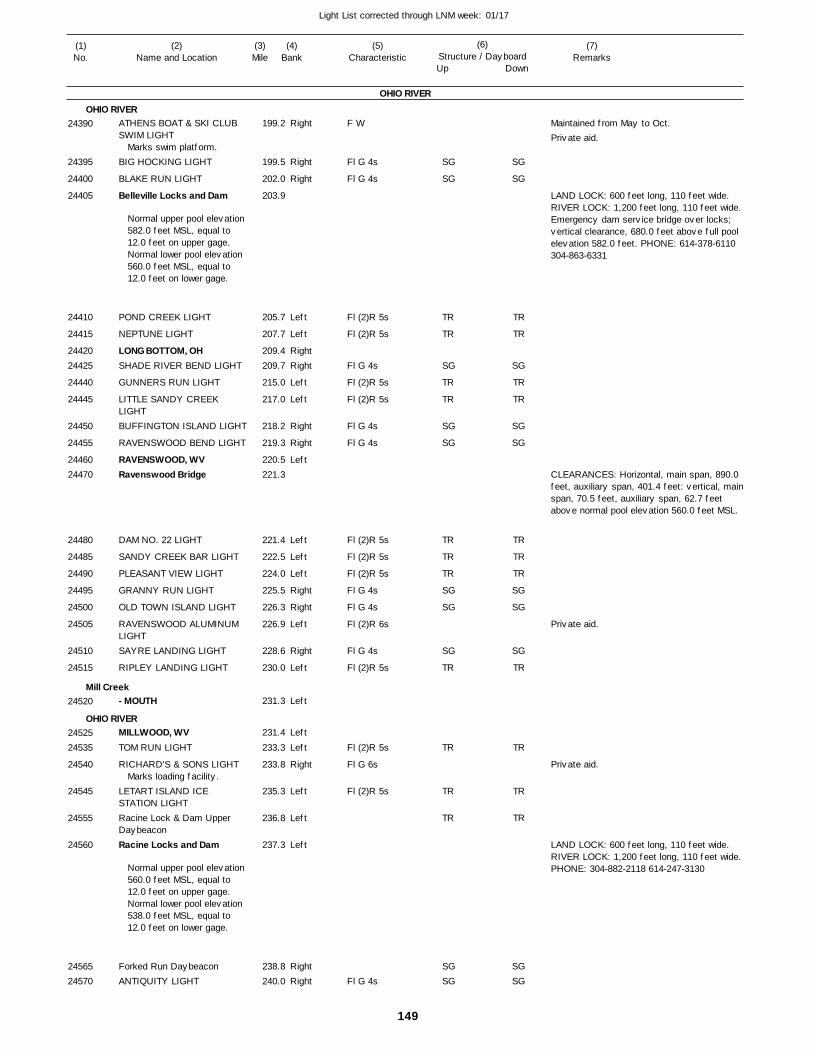
149
Light List corrected through LNM week: 01/17
(7)Remarks
(1)No.
(2)Name and Location
(3)Mile
(5)Characteristic
(4)Bank
(6)Structure / DayboardUp Down
ATHENS BOAT & SKI CLUB SWIM LIGHT
BIG HOCKING LIGHT
BLAKE RUN LIGHT
Belleville Locks and Dam
POND CREEK LIGHT
NEPTUNE LIGHT
LONG BOTTOM, OHSHADE RIVER BEND LIGHT
GUNNERS RUN LIGHT
LITTLE SANDY CREEK LIGHTBUFFINGTON ISLAND LIGHT
RAVENSWOOD BEND LIGHT
RAVENSWOOD, WVRavenswood Bridge
DAM NO. 22 LIGHT
SANDY CREEK BAR LIGHT
PLEASANT VIEW LIGHT
GRANNY RUN LIGHT
OLD TOWN ISLAND LIGHT
RAVENSWOOD ALUMINUM LIGHTSAYRE LANDING LIGHT
RIPLEY LANDING LIGHT
- MOUTH
MILLWOOD, WVTOM RUN LIGHT
RICHARD'S & SONS LIGHT
LETART ISLAND ICE STATION LIGHTRacine Lock & Dam Upper DaybeaconRacine Locks and Dam
Forked Run DaybeaconANTIQUITY LIGHT
OHIO RIVER
OHIO RIVER
Mill Creek
OHIO RIVER
Right
Right
Right
Left
Left
RightRight
Left
Left
Right
Right
Left
Left
Left
Left
Right
Right
Left
Right
Left
Left
Left
Left
Right
Left
Left
Left
RightRight
199.2
199.5
202.0
203.9
205.7
207.7
209.4 209.7
215.0
217.0
218.2
219.3
220.5 221.3
221.4
222.5
224.0
225.5
226.3
226.9
228.6
230.0
231.3
231.4
233.3
233.8
235.3
236.8
237.3
238.8 240.0
Marks swim platform.
Normal upper pool elevation 582.0 feet MSL, equal to 12.0 feet on upper gage. Normal lower pool elevation 560.0 feet MSL, equal to 12.0 feet on lower gage.
Marks loading facility.
Normal upper pool elevation 560.0 feet MSL, equal to 12.0 feet on upper gage. Normal lower pool elevation 538.0 feet MSL, equal to 12.0 feet on lower gage.
F W
Fl G 4s
Fl G 4s
Fl (2)R 5s
Fl (2)R 5s
Fl G 4s
Fl (2)R 5s
Fl (2)R 5s
Fl G 4s
Fl G 4s
Fl (2)R 5s
Fl (2)R 5s
Fl (2)R 5s
Fl G 4s
Fl G 4s
Fl (2)R 6s
Fl G 4s
Fl (2)R 5s
Fl (2)R 5s
Fl G 6s
Fl (2)R 5s
Fl G 4s
Maintained from May to Oct.
LAND LOCK: 600 feet long, 110 feet wide. RIVER LOCK: 1,200 feet long, 110 feet wide. Emergency dam service bridge over locks; vertical clearance, 680.0 feet above full pool elevation 582.0 feet. PHONE: 614-378-6110 304-863-6331
CLEARANCES: Horizontal, main span, 890.0 feet, auxiliary span, 401.4 feet: vertical, main span, 70.5 feet, auxiliary span, 62.7 feet above normal pool elevation 560.0 feet MSL.
LAND LOCK: 600 feet long, 110 feet wide. RIVER LOCK: 1,200 feet long, 110 feet wide. PHONE: 304-882-2118 614-247-3130
24390
24395
24400
24405
24410
24415
2442024425
24440
24445
24450
24455
2446024470
24480
24485
24490
24495
24500
24505
24510
24515
24520
2452524535
24540
24545
24555
24560
2456524570
SG
SG
TR
TR
SG
TR
TR
SG
SG
TR
TR
TR
SG
SG
SG
TR
TR
TR
TR
SGSG
SG
SG
TR
TR
SG
TR
TR
SG
SG
TR
TR
TR
SG
SG
SG
TR
TR
TR
TR
SGSG
Private aid.
Private aid.
Private aid.
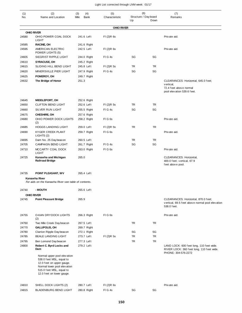
150
Light List corrected through LNM week: 01/17
(7)Remarks
(1)No.
(2)Name and Location
(3)Mile
(5)Characteristic
(4)Bank
(6)Structure / DayboardUp Down
OHIO POWER COAL DOCK LIGHTRACINE, OHAMERICAN ELECTRIC POWER LIGHTS (5)SIEGRIST RIPPLE LIGHT
SYRACUSE, OHSLIDING HILL BEND LIGHT
MINERSVILLE PIER LIGHT
POMEROY, OHThe Bridge of Honor
MIDDLEPORT, OHCLIFTON BEND LIGHT
SILVER RUN LIGHT
CHESHIRE, OHOHIO POWER DOCK LIGHTS(2)HOGGS LANDING LIGHT
KYGER CREEK PLANT LIGHTS (2)Dam No. 25 DaybeaconCAMPAIGN BEND LIGHT
MCCARTY COAL DOCK LIGHTKanawha and Michigan Railroad Bridge
POINT PLEASANT, WV
- MOUTH
Point Pleasant Bridge
O-KAN DRYDOCK LIGHTS (2)Two Mile Creek DaybeaconGALLIPOLIS, OHClarrion Ripple DaybeaconBEALE LANDING LIGHT
Ben Lomond DaybeaconRobert C. Byrd Locks and Dam
SHELL DOCK LIGHTS (2)
BLADENBURG BEND LIGHT
OHIO RIVER
OHIO RIVER
Kanawha River
OHIO RIVER
For aids on the Kanawha River see table of contents.
Left
RightLeft
Right
RightLeft
Right
Right
RightLeft
Right
RightRight
Left
Right
LeftRight
Right
Left
Left
Right
LeftRightRightLeft
LeftLeft
Left
Right
241.6
241.6 242.5
244.0
245.2 245.8
247.9
249.7 251.3
252.6 252.6
255.5
257.6 258.2
259.0
259.7
260.5 261.7
263.0
265.0
265.4
265.6
265.9
266.3
267.5 269.7 272.1 273.7
277.3 279.2
280.7
280.8
Normal upper pool elevation 538.0 feet MSL, equal to 12.0 feet on upper gauge.Normal lower pool elevation 515.0 feet MSL, equal to 12.0 feet on lower gauge.
Fl (2)R 6s
Fl (2)R 6s
Fl G 4s
Fl (2)R 5s
Fl G 4s
Fl (2)R 5s
Fl G 4s
Fl G 6s
Fl (2)R 5s
Fl G 6s
Fl G 4s
Fl G 6s
Fl G 6s
Fl (2)R 5s
Fl (2)R 6s
Fl G 4s
CLEARANCES: Horizontal, 645.0 feet; vertical, 72.4 feet above normal pool elevation 539.6 feet.
CLEARANCES: Horizontal,400.0 feet; vertical, 67.9feet above pool.
CLEARANCES: Horizontal, 870.0 feet; vertical, 69.5 feet above normal pool elevation538.0 feet.
LAND LOCK: 600 feet long, 110 feet wide. RIVER LOCK: 360 feet long, 110 feet wide. PHONE: 304-576-2272
24580
2458524595
24605
2461024615
24620
2462524632
2464524650
24660
2467524680
24685
24690
2469524705
24710
24725
24735
24740
24745
24755
24760247702478024785
2479524800
24810
24815
SG
TR
SG
TR
SG
TR
TRSG
TR
SGTR
TR
SG
SG
TR
SG
TR
SG
TR
TRSG
TR
SGTR
TR
SG
Private aid.
Private aid.
Private aid.
Private aid.
Private aid.
Private aid.
Private aid.
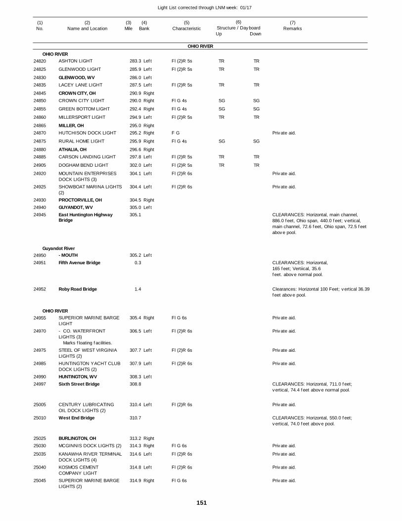
151
Light List corrected through LNM week: 01/17
(7)Remarks
(1)No.
(2)Name and Location
(3)Mile
(5)Characteristic
(4)Bank
(6)Structure / DayboardUp Down
ASHTON LIGHT
GLENWOOD LIGHT
GLENWOOD, WVLACEY LANE LIGHT
CROWN CITY, OHCROWN CITY LIGHT
GREEN BOTTOM LIGHT
MILLERSPORT LIGHT
MILLER, OHHUTCHISON DOCK LIGHT
RURAL HOME LIGHT
ATHALIA, OHCARSON LANDING LIGHT
DOGHAM BEND LIGHT
MOUNTAIN ENTERPRISES DOCK LIGHTS (3)SHOWBOAT MARINA LIGHTS(2)PROCTORVILLE, OHGUYANDOT, WVEast Huntington Highway Bridge
- MOUTHFifth Avenue Bridge
Roby Road Bridge
SUPERIOR MARINE BARGE LIGHT- CO. WATERFRONT LIGHTS (3)
STEEL OF WEST VIRGINIA LIGHTS (2)HUNTINGTON YACHT CLUB DOCK LIGHTS (2)HUNTINGTON, WVSixth Street Bridge
CENTURY LUBRICATING OIL DOCK LIGHTS (2)West End Bridge
BURLINGTON, OHMCGINNIS DOCK LIGHTS (2)
KANAWHA RIVER TERMINALDOCK LIGHTS (4)KOSMOS CEMENT COMPANY LIGHTSUPERIOR MARINE BARGE LIGHTS (2)
OHIO RIVER
OHIO RIVER
Guyandot River
OHIO RIVER
Left
Left
LeftLeft
RightRight
Right
Left
RightRight
Right
RightLeft
Left
Left
Left
RightLeft
Left
Right
Left
Left
Left
Left
Left
RightRight
Left
Left
Right
283.3
285.9
286.0 287.5
290.9 290.0
292.4
294.9
295.0 295.2
295.9
296.6 297.8
302.0
304.1
304.4
304.5 305.0 305.1
305.2
0.3
1.4
305.4
306.5
307.7
307.9
308.3 308.8
310.4
310.7
313.2 314.3
314.6
314.8
314.9
Marks floating facilities.
Fl (2)R 5s
Fl (2)R 5s
Fl (2)R 5s
Fl G 4s
Fl G 4s
Fl (2)R 5s
F G
Fl G 4s
Fl (2)R 5s
Fl (2)R 5s
Fl (2)R 6s
Fl (2)R 6s
Fl G 6s
Fl (2)R 6s
Fl (2)R 6s
Fl (2)R 6s
Fl (2)R 6s
Fl G 6s
Fl (2)R 6s
Fl (2)R 6s
Fl G 6s
CLEARANCES: Horizontal, main channel, 886.0 feet, Ohio span, 440.0 feet; vertical, main channel, 72.6 feet, Ohio span, 72.5 feet above pool.
CLEARANCES: Horizontal, 165 feet; Vertiical, 35.6 feet. above normal pool.
Clearances: Horizontal 100 Feet; vertical 36.39feet above pool.
CLEARANCES: Horizontal, 711.0 feet; vertical, 74.4 feet above normal pool.
CLEARANCES: Horizontal, 550.0 feet; vertical, 74.0 feet above pool.
24820
24825
2483024835
2484524850
24855
24860
2486524870
24875
2488024885
24905
24920
24925
249302494024945
2495024951
24952
24955
24970
24975
24985
2499024997
25005
25010
2502525030
25035
25040
25045
TR
TR
TR
SG
SG
TR
SG
TR
TR
TR
TR
TR
SG
SG
TR
SG
TR
TR
Private aid.
Private aid.
Private aid.
Private aid.
Private aid.
Private aid.
Private aid.
Private aid.
Private aid.
Private aid.
Private aid.
Private aid.
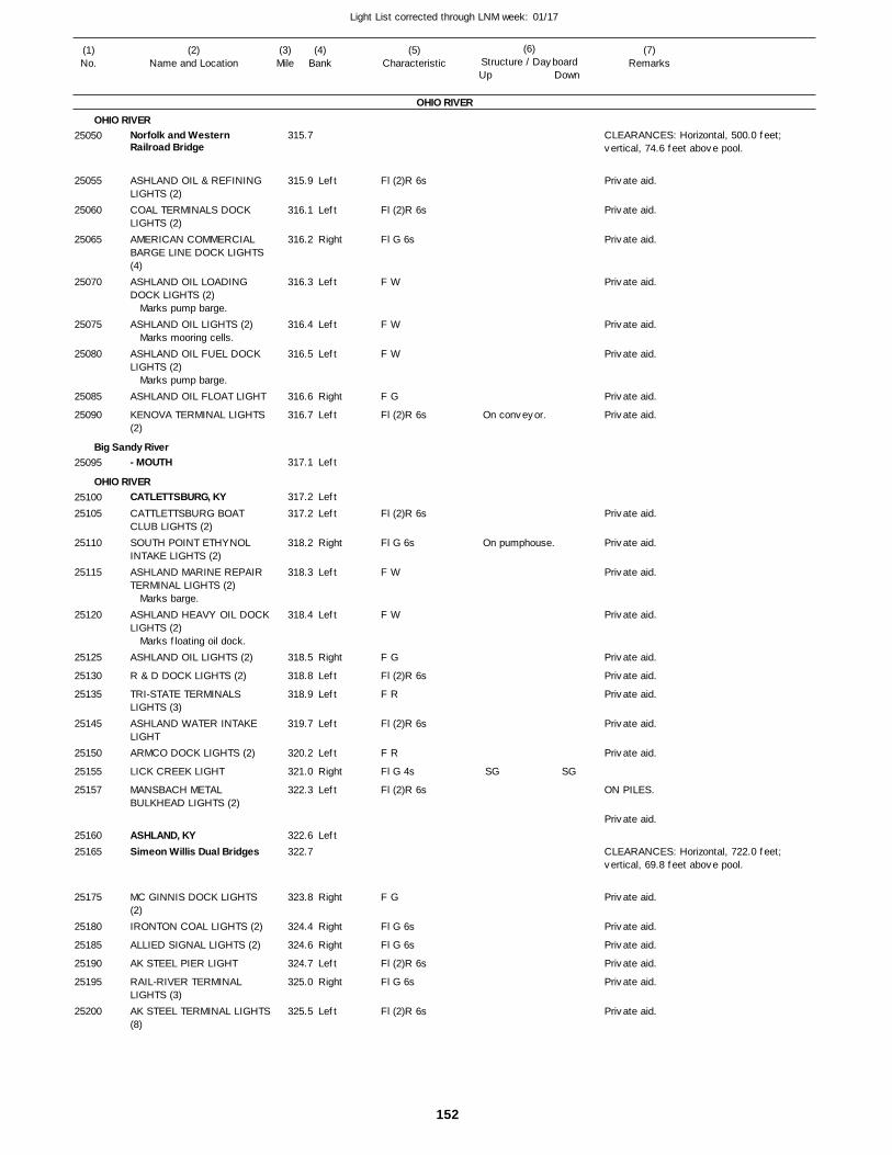
152
Light List corrected through LNM week: 01/17
(7)Remarks
(1)No.
(2)Name and Location
(3)Mile
(5)Characteristic
(4)Bank
(6)Structure / DayboardUp Down
Norfolk and Western Railroad Bridge
ASHLAND OIL & REFINING LIGHTS (2)COAL TERMINALS DOCK LIGHTS (2)AMERICAN COMMERCIAL BARGE LINE DOCK LIGHTS (4)ASHLAND OIL LOADING DOCK LIGHTS (2)
ASHLAND OIL LIGHTS (2)
ASHLAND OIL FUEL DOCK LIGHTS (2)
ASHLAND OIL FLOAT LIGHT
KENOVA TERMINAL LIGHTS (2)
- MOUTH
CATLETTSBURG, KYCATTLETTSBURG BOAT CLUB LIGHTS (2)SOUTH POINT ETHYNOL INTAKE LIGHTS (2)ASHLAND MARINE REPAIR TERMINAL LIGHTS (2)
ASHLAND HEAVY OIL DOCKLIGHTS (2)
ASHLAND OIL LIGHTS (2)
R & D DOCK LIGHTS (2)
TRI-STATE TERMINALS LIGHTS (3)ASHLAND WATER INTAKE LIGHTARMCO DOCK LIGHTS (2)
LICK CREEK LIGHT
MANSBACH METAL BULKHEAD LIGHTS (2)
ASHLAND, KYSimeon Willis Dual Bridges
MC GINNIS DOCK LIGHTS (2)IRONTON COAL LIGHTS (2)
ALLIED SIGNAL LIGHTS (2)
AK STEEL PIER LIGHT
RAIL-RIVER TERMINAL LIGHTS (3)AK STEEL TERMINAL LIGHTS(8)
OHIO RIVER
OHIO RIVER
Big Sandy River
OHIO RIVER
Left
Left
Right
Left
Left
Left
Right
Left
Left
Left
Left
Right
Left
Left
Right
Left
Left
Left
Left
Right
Left
Left
Right
Right
Right
Left
Right
Left
315.7
315.9
316.1
316.2
316.3
316.4
316.5
316.6
316.7
317.1
317.2
317.2
318.2
318.3
318.4
318.5
318.8
318.9
319.7
320.2
321.0
322.3
322.6 322.7
323.8
324.4
324.6
324.7
325.0
325.5
Marks pump barge.
Marks mooring cells.
Marks pump barge.
Marks barge.
Marks floating oil dock.
Fl (2)R 6s
Fl (2)R 6s
Fl G 6s
F W
F W
F W
F G
Fl (2)R 6s
Fl (2)R 6s
Fl G 6s
F W
F W
F G
Fl (2)R 6s
F R
Fl (2)R 6s
F R
Fl G 4s
Fl (2)R 6s
F G
Fl G 6s
Fl G 6s
Fl (2)R 6s
Fl G 6s
Fl (2)R 6s
On conveyor.
On pumphouse.
CLEARANCES: Horizontal, 500.0 feet; vertical, 74.6 feet above pool.
ON PILES.
CLEARANCES: Horizontal, 722.0 feet; vertical, 69.8 feet above pool.
25050
25055
25060
25065
25070
25075
25080
25085
25090
25095
2510025105
25110
25115
25120
25125
25130
25135
25145
25150
25155
25157
2516025165
25175
25180
25185
25190
25195
25200
SG SG
Private aid.
Private aid.
Private aid.
Private aid.
Private aid.
Private aid.
Private aid.
Private aid.
Private aid.
Private aid.
Private aid.
Private aid.
Private aid.
Private aid.
Private aid.
Private aid.
Private aid.
Private aid.
Private aid.
Private aid.
Private aid.
Private aid.
Private aid.
Private aid.
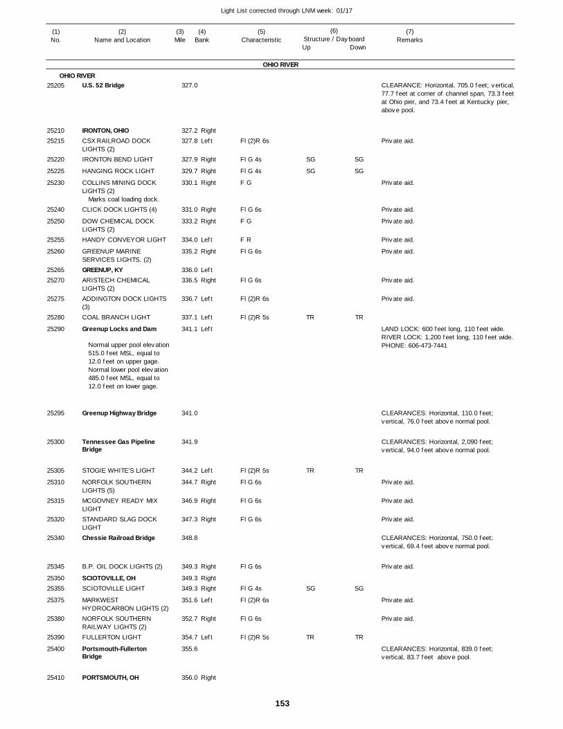
153
Light List corrected through LNM week: 01/17
(7)Remarks
(1)No.
(2)Name and Location
(3)Mile
(5)Characteristic
(4)Bank
(6)Structure / DayboardUp Down
U.S. 52 Bridge
IRONTON, OHIOCSX RAILROAD DOCK LIGHTS (2)IRONTON BEND LIGHT
HANGING ROCK LIGHT
COLLINS MINING DOCK LIGHTS (2)
CLICK DOCK LIGHTS (4)
DOW CHEMICAL DOCK LIGHTS (2)HANDY CONVEYOR LIGHT
GREENUP MARINE SERVICES LIGHTS. (2)GREENUP, KYARISTECH CHEMICAL LIGHTS (2)ADDINGTON DOCK LIGHTS (3)COAL BRANCH LIGHT
Greenup Locks and Dam
Greenup Highway Bridge
Tennessee Gas Pipeline Bridge
STOGIE WHITE'S LIGHT
NORFOLK SOUTHERN LIGHTS (5)MCGOVNEY READY MIX LIGHTSTANDARD SLAG DOCK LIGHTChessie Railroad Bridge
B.P. OIL DOCK LIGHTS (2)
SCIOTOVILLE, OHSCIOTOVILLE LIGHT
MARKWEST HYDROCARBON LIGHTS (2)NORFOLK SOUTHERN RAILWAY LIGHTS (2)FULLERTON LIGHT
Portsmouth-Fullerton Bridge
PORTSMOUTH, OH
OHIO RIVER
OHIO RIVER
RightLeft
Right
Right
Right
Right
Right
Left
Right
LeftRight
Left
Left
Left
Left
Right
Right
Right
Right
RightRight
Left
Right
Left
Right
327.0
327.2 327.8
327.9
329.7
330.1
331.0
333.2
334.0
335.2
336.0 336.5
336.7
337.1
341.1
341.0
341.9
344.2
344.7
346.9
347.3
348.8
349.3
349.3 349.3
351.6
352.7
354.7
355.6
356.0
Marks coal loading dock.
Normal upper pool elevation 515.0 feet MSL, equal to 12.0 feet on upper gage. Normal lower pool elevation 485.0 feet MSL, equal to 12.0 feet on lower gage.
Fl (2)R 6s
Fl G 4s
Fl G 4s
F G
Fl G 6s
F G
F R
Fl G 6s
Fl G 6s
Fl (2)R 6s
Fl (2)R 5s
Fl (2)R 5s
Fl G 6s
Fl G 6s
Fl G 6s
Fl G 6s
Fl G 4s
Fl (2)R 6s
Fl G 6s
Fl (2)R 5s
CLEARANCE: Horizontal, 705.0 feet; vertical, 77.7 feet at corner of channel span, 73.3 feet at Ohio pier, and 73.4 feet at Kentucky pier, above pool.
LAND LOCK: 600 feet long, 110 feet wide. RIVER LOCK: 1,200 feet long, 110 feet wide. PHONE: 606-473-7441
CLEARANCES: Horizontal, 110.0 feet; vertical, 76.0 feet above normal pool.
CLEARANCES: Horizontal, 2,090 feet;vertical, 94.0 feet above normal pool.
CLEARANCES: Horizontal, 750.0 feet;vertical, 69.4 feet above normal pool.
CLEARANCES: Horizontal, 839.0 feet; vertical, 83.7 feet above pool.
25205
2521025215
25220
25225
25230
25240
25250
25255
25260
2526525270
25275
25280
25290
25295
25300
25305
25310
25315
25320
25340
25345
2535025355
25375
25380
25390
25400
25410
SG
SG
TR
TR
SG
TR
SG
SG
TR
TR
SG
TR
Private aid.
Private aid.
Private aid.
Private aid.
Private aid.
Private aid.
Private aid.
Private aid.
Private aid.
Private aid.
Private aid.
Private aid.
Private aid.
Private aid.
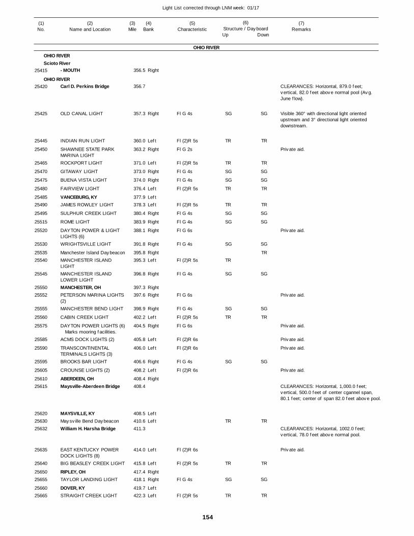
154
Light List corrected through LNM week: 01/17
(7)Remarks
(1)No.
(2)Name and Location
(3)Mile
(5)Characteristic
(4)Bank
(6)Structure / DayboardUp Down
- MOUTH
Carl D. Perkins Bridge
OLD CANAL LIGHT
INDIAN RUN LIGHT
SHAWNEE STATE PARK MARINA LIGHTROCKPORT LIGHT
GITAWAY LIGHT
BUENA VISTA LIGHT
FAIRVIEW LIGHT
VANCEBURG, KYJAMES ROWLEY LIGHT
SULPHUR CREEK LIGHT
ROME LIGHT
DAYTON POWER & LIGHT LIGHTS (6)WRIGHTSVILLE LIGHT
Manchester Island DaybeaconMANCHESTER ISLAND LIGHTMANCHESTER ISLAND LOWER LIGHTMANCHESTER, OHPETERSON MARINA LIGHTS (2)MANCHESTER BEND LIGHT
CABIN CREEK LIGHT
DAYTON POWER LIGHTS (6)
ACMS DOCK LIGHTS (2)
TRANSCONTINENTAL TERMINALS LIGHTS (3)BROOKS BAR LIGHT
CROUNSE LIGHTS (2)
ABERDEEN, OHMaysville-Aberdeen Bridge
MAYSVILLE, KYMaysville Bend DaybeaconWilliam H. Harsha Bridge
EAST KENTUCKY POWER DOCK LIGHTS (8)BIG BEASLEY CREEK LIGHT
RIPLEY, OHTAYLOR LANDING LIGHT
DOVER, KYSTRAIGHT CREEK LIGHT
OHIO RIVER
OHIO RIVERScioto River
OHIO RIVER
Right
Right
Left
Right
Left
Right
Right
Left
LeftLeft
Right
Right
Right
Right
RightLeft
Right
RightRight
Right
Left
Right
Left
Left
Right
Left
Right
LeftLeft
Left
Left
RightRight
LeftLeft
356.5
356.7
357.3
360.0
363.2
371.0
373.0
374.0
376.4
377.9 378.3
380.4
383.9
388.1
391.8
395.8 395.3
396.8
397.3 397.6
398.9
402.2
404.5
405.8
406.0
406.6
408.2
408.4 408.4
408.5 410.6 411.3
414.0
415.8
417.4 418.1
419.7 422.3
Marks mooring facilities.
Fl G 4s
Fl (2)R 5s
Fl G 2s
Fl (2)R 5s
Fl G 4s
Fl G 4s
Fl (2)R 5s
Fl (2)R 5s
Fl G 4s
Fl G 4s
Fl G 6s
Fl G 4s
Fl (2)R 5s
Fl G 4s
Fl G 6s
Fl G 4s
Fl (2)R 5s
Fl G 6s
Fl (2)R 6s
Fl (2)R 6s
Fl G 4s
Fl (2)R 6s
Fl (2)R 6s
Fl (2)R 5s
Fl G 4s
Fl (2)R 5s
CLEARANCES: Horizontal, 879.0 feet; vertical, 82.0 feet above normal pool (Avg. June flow).
Visible 360° with directional light oriented upstream and 3° directional light oriented downstream.
CLEARANCES: Horizontal, 1,000.0 feet; vertical, 500.0 feet of center cgannel span, 80.1 feet; center of span 82.0 feet above pool.
CLEARANCES: Horizontal, 1002.0 feet; vertical, 78.0 feet above normal pool.
25415
25420
25425
25445
25450
25465
25470
25475
25480
2548525490
25495
25515
25520
25530
2553525540
25545
2555025552
25555
25560
25575
25585
25590
25595
25605
2561025615
256202563025632
25635
25640
2565025655
2566025665
SG
TR
TR
SG
SG
TR
TR
SG
SG
SG
TR
SG
SG
TR
SG
TR
TR
SG
TR
SG
TR
TR
SG
SG
TR
TR
SG
SG
SG
TR
SG
SG
TR
SG
TR
TR
SG
TR
Private aid.
Private aid.
Private aid.
Private aid.
Private aid.
Private aid.
Private aid.
Private aid.
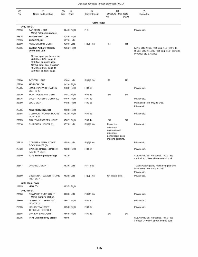
155
Light List corrected through LNM week: 01/17
(7)Remarks
(1)No.
(2)Name and Location
(3)Mile
(5)Characteristic
(4)Bank
(6)Structure / DayboardUp Down
BARGE-IN LIGHT
HIGGINSPORT, OHAUGUSTA, KYAUGUSTA BAR LIGHT
Captain Anthony Meldahl Locks and Dam
FOSTER LIGHT
MOSCOW, OHZIMMER POWER STATION LIGHTS (5)POINT PLEASANT LIGHT
JOLLY ROGER'S LIGHTS (2)
JUDD LIGHT
NEW RICHMOND, OHCLERMONT POWER HOUSE LIGHTS (5)EIGHT MILE CREEK LIGHT
CHS DOCK LIGHTS (2)
COUNTRY MARK CO-OP DOCK LIGHTS (2)CARGILL BARGE LOADING FACILITY LIGHTI-275 Twin Highway Bridge
ORSANCO LIGHT
CINCINNATI WATER INTAKEPIER LIGHT
- MOUTH
NEWPORT PUMP LIGHT
QUEEN CITY TERMINAL LIGHTS (3)LIQUID TRANSFER TERMINAL LIGHTS (2)DAYTON BAR LIGHT
I-471 Dual Highway Bridge
OHIO RIVER
OHIO RIVER
Little Miami River
OHIO RIVER
Right
RightLeftLeft
Right
Left
RightRight
Right
Right
Right
RightRight
Right
Left
Left
Right
Left
Left
Right
Left
Right
Right
Right
424.3
424.6 427.0 430.0
436.2
438.4
442.6 443.2
445.1
446.6
448.5
450.0 452.9
456.7
457.0
458.9
460.0
461.9
462.6
462.8
463.5
463.6
465.7
465.8
466.8
469.5
Marks marine breakwater.
Normal upper pool elevation 485.0 feet MSL, equal to 12.0 feet on upper gage. Normal lower pool elevation 455.0 feet MSL, equal to 12.0 feet on lower gage.
Marks pumping station.
F G
Fl (2)R 5s
Fl (2)R 5s
Fl G 6s
Fl G 4s
Fl G 6s
Fl G 6s
Fl G 6s
Fl G 4s
Fl (2)R 6s
Fl (2)R 6s
Fl G 6s
Fl Y 2.5s
Fl (2)R 6s
Fl (2)R 6s
Fl G 6s
Fl G 6s
Fl G 4s
Marks the outermost upstream and outermost downstream dock mooring dolphins.
On intake piers.
LAND LOCK: 600 feet long, 110 feet wide. RIVER LOCK: 1,200 feet long, 110 feet wide. PHONE: 513-876-2921
Maintained from May to Dec.
CLEARANCES: Horizontal, 700.0 feet; vertical, 81.1 feet above normal pool.
Marks water quality monitoring platform. Maintained from Sept. to Dec.
CLEARANCES: Horizontal, 704.0 feet; vertical, 78.9 feet above normal pool.
25670
256752568525690
25695
25700
2572025725
25730
25735
25750
2576525785
25805
25810
25815
25820
25840
25847
25850
25855
25860
25880
25885
25895
25905
TR
TR
SG
SG
SG
TR
TR
SG
SG
SG
Private aid.
Private aid.
Private aid.
Private aid.
Private aid.
Private aid.
Private aid.
Private aid.
Private aid.Private aid.
Private aid.
Private aid.
Private aid.

156
Light List corrected through LNM week: 01/17
(7)Remarks
(1)No.
(2)Name and Location
(3)Mile
(5)Characteristic
(4)Bank
(6)Structure / DayboardUp Down
Purple People Bridge
NEWPORT, KYTaylor-Southgate Bridge
CINCINNATI MARINA LIGHTS (3)
- MOUTH4th Street Bridge
Girl Scout Bridge
15th Street (C & O) RailroadBridge
L & N Railroad Bridge
Covington Pipeline Bridge
I-275 Dual Bridges
DAVID JOSEPH COMPANY LIGHTNEWPORT STEEL LIGHTS (6)
MIKE FINK LIGHT
CINCINNATI, OHCovington and Cincinnati Highway Bridge
COVINGTON, KYTHE WATERFRONT RESTAURANT LIGHTS (2)Chessie Railroad Bridge
U.S. 25 Bridge
Brent-Spence Highway Bridge
VIRGINIA BENNETT LIGHT
ACMS DOCK LIGHTS (2)
OHIO RIVER
OHIO RIVER
Licking River
OHIO RIVER
Left
Right
Left
Left
Left
Left
Right
LeftLeft
Left
Right
469.7
469.8 469.9
470.2
470.2
0.4
1.0
1.2
3.1
3.1
5.0
470.2
470.2
470.3
470.3 470.5
470.5 470.9
471.0
471.0
471.2
471.7
472.0
Marks barge.
Fl G 6s
Fl G 6s
Fl G 6s
F W
Fl (2)R 6s
Fl (2)R 5s
Fl G 6s
CLEARANCES: Horizontal,490.0 feet; vertical, 78.3feet at center of channelspan, 74.8 feet at Ohiopier and 74.7 feet atKentucky pier, abovenormal pool.
CLEARANCES: Horizontal, 832.0 feet; vertical, 74.6 feet above normal pool.
MAINTAINED FROM JUNE TO NOV. S
CLEARANCES: Horizontal, 240.0 feet; vertical, 64.2 feet above normal pool.
CLEARANCES: Horizontal, 276.4 feet; vertical, 64.19 feet above normal pool.
CLEARANCES: Horizontal, 188.0 feet; vertical, 66.8 feet above normal pool.
CLEARANCES: Horizontal, 152.7 feet; vertical, 45.1 feet above normal pool.
CLEARANCES: Horizontal, 213.0 feet; vertical, 66.1 feet above normal pool.
CLEARANCES: Horizontal, 262.0 feet; vertical, 60.2 feet above normal pool.
CLEARANCES: Horizontal, 1,004.0 feet; vertical, 77.4 feet at center of channel span, 73.9 feet for mid- 500.0 feet of channel span above normal pool.
CLEARANCES: Horizontal, 645.0 feet; vertical, 81.9 feet at center of channel span, 81.7 feet at Ohio pier, and 81.5 feet at Kentucky pier above pool.
CLEARANCES: Horizontal, 645.0 feet; vertical, 78.2 feet above normal pool.
CLEARANCES: Horizontal, 800.0 feet; vertical, 76.1 feet above pool.
25910
2592525930
25935
2594025941
25941.01
25941.02
25941.03
25941.04
25941.05
25945
25950
25960
2596525970
2597525990
25995
26000
26005
26007
26010
TR TR
Private aid.
Private aid.
Private aid.
Private aid.
Private aid.
Private aid.
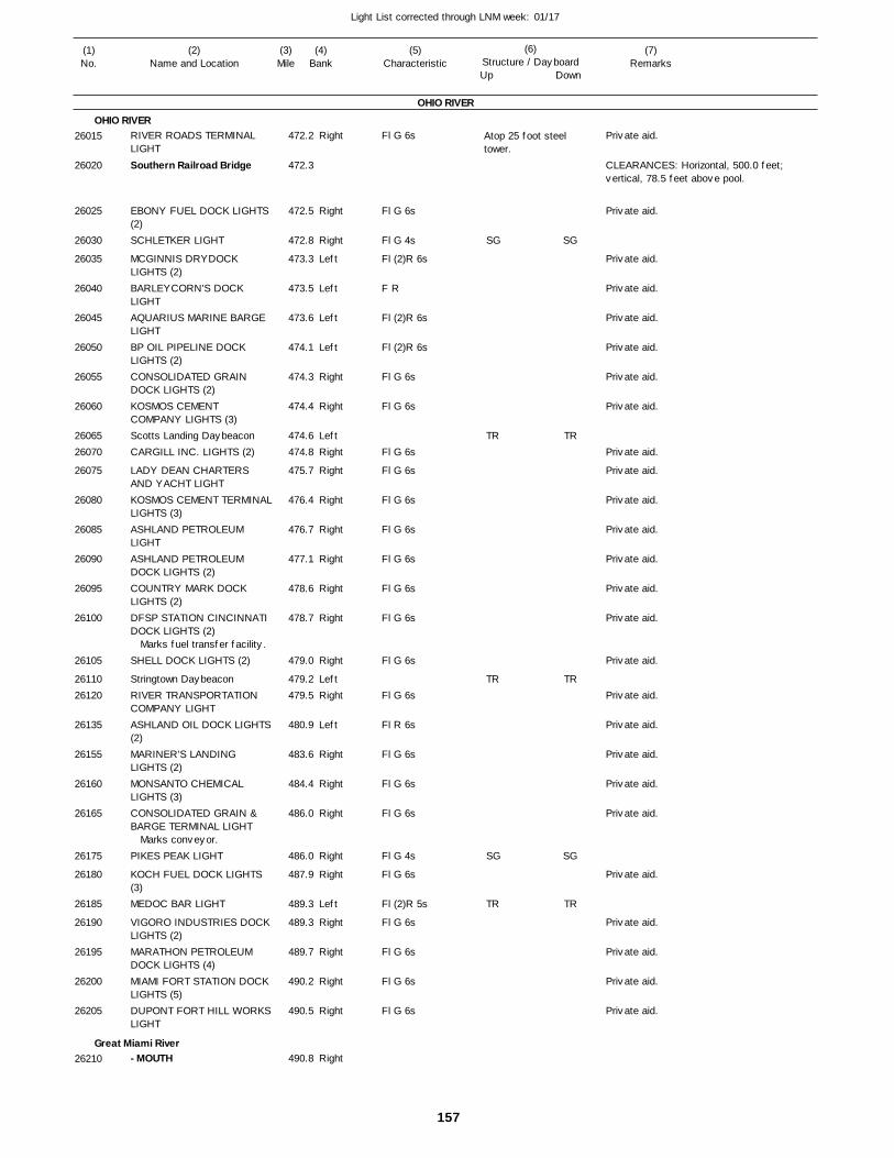
157
Light List corrected through LNM week: 01/17
(7)Remarks
(1)No.
(2)Name and Location
(3)Mile
(5)Characteristic
(4)Bank
(6)Structure / DayboardUp Down
RIVER ROADS TERMINAL LIGHT
Southern Railroad Bridge
EBONY FUEL DOCK LIGHTS (2)SCHLETKER LIGHT
MCGINNIS DRYDOCK LIGHTS (2)BARLEYCORN'S DOCK LIGHTAQUARIUS MARINE BARGE LIGHTBP OIL PIPELINE DOCK LIGHTS (2)CONSOLIDATED GRAIN DOCK LIGHTS (2)KOSMOS CEMENT COMPANY LIGHTS (3)Scotts Landing DaybeaconCARGILL INC. LIGHTS (2)
LADY DEAN CHARTERS AND YACHT LIGHTKOSMOS CEMENT TERMINALLIGHTS (3)ASHLAND PETROLEUM LIGHTASHLAND PETROLEUM DOCK LIGHTS (2)COUNTRY MARK DOCK LIGHTS (2)DFSP STATION CINCINNATI DOCK LIGHTS (2)
SHELL DOCK LIGHTS (2)
Stringtown DaybeaconRIVER TRANSPORTATION COMPANY LIGHTASHLAND OIL DOCK LIGHTS(2)MARINER'S LANDING LIGHTS (2)MONSANTO CHEMICAL LIGHTS (3)CONSOLIDATED GRAIN & BARGE TERMINAL LIGHT
PIKES PEAK LIGHT
KOCH FUEL DOCK LIGHTS (3)MEDOC BAR LIGHT
VIGORO INDUSTRIES DOCKLIGHTS (2)MARATHON PETROLEUM DOCK LIGHTS (4)MIAMI FORT STATION DOCK LIGHTS (5)DUPONT FORT HILL WORKSLIGHT
- MOUTH
OHIO RIVER
OHIO RIVER
Great Miami River
Right
Right
Right
Left
Left
Left
Left
Right
Right
LeftRight
Right
Right
Right
Right
Right
Right
Right
LeftRight
Left
Right
Right
Right
Right
Right
Left
Right
Right
Right
Right
Right
472.2
472.3
472.5
472.8
473.3
473.5
473.6
474.1
474.3
474.4
474.6 474.8
475.7
476.4
476.7
477.1
478.6
478.7
479.0
479.2 479.5
480.9
483.6
484.4
486.0
486.0
487.9
489.3
489.3
489.7
490.2
490.5
490.8
Marks fuel transfer facility.
Marks conveyor.
Fl G 6s
Fl G 6s
Fl G 4s
Fl (2)R 6s
F R
Fl (2)R 6s
Fl (2)R 6s
Fl G 6s
Fl G 6s
Fl G 6s
Fl G 6s
Fl G 6s
Fl G 6s
Fl G 6s
Fl G 6s
Fl G 6s
Fl G 6s
Fl G 6s
Fl R 6s
Fl G 6s
Fl G 6s
Fl G 6s
Fl G 4s
Fl G 6s
Fl (2)R 5s
Fl G 6s
Fl G 6s
Fl G 6s
Fl G 6s
Atop 25 foot steel tower.
CLEARANCES: Horizontal, 500.0 feet; vertical, 78.5 feet above pool.
26015
26020
26025
26030
26035
26040
26045
26050
26055
26060
2606526070
26075
26080
26085
26090
26095
26100
26105
2611026120
26135
26155
26160
26165
26175
26180
26185
26190
26195
26200
26205
26210
SG
TR
TR
SG
TR
SG
TR
TR
SG
TR
Private aid.
Private aid.
Private aid.
Private aid.
Private aid.
Private aid.
Private aid.
Private aid.
Private aid.
Private aid.
Private aid.
Private aid.
Private aid.
Private aid.
Private aid.
Private aid.
Private aid.
Private aid.
Private aid.
Private aid.
Private aid.
Private aid.
Private aid.
Private aid.
Private aid.
Private aid.
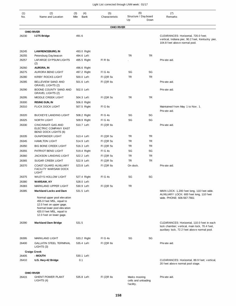
158
Light List corrected through LNM week: 01/17
(7)Remarks
(1)No.
(2)Name and Location
(3)Mile
(5)Characteristic
(4)Bank
(6)Structure / DayboardUp Down
I-275 Bridge
LAWRENCEBURG, INPetersburg DaybeaconLAFARGE GYPSUM LIGHTS (2)AURORA, INAURORA BEND LIGHT
KIRBY ROCKS LIGHT
BELLEVIEW SAND AND GRAVEL LIGHTS (2)BOONE COUNTY SAND ANDGRAVEL LIGHTS (2)MIDDLE CREEK LIGHT
RISING SUN, INFLICK DOCK LIGHT
BUCKEYE LANDING LIGHT
NORTH LIGHT
CINCINNATI GAS AND ELECTRIC COMPANY EAST BEND DOCK LIGHTS (6)GUNPOWDER LIGHT
HAMILTON LIGHT
BIG BONE CREEK LIGHT
PATRIOT BEND LIGHT
JACKSON LANDING LIGHT
SUGAR CREEK LIGHT
COAST GUARD AUXILIARY FACILITY WARSAW DOCK LIGHTWILEYS HOLLOW LIGHT
WARSAW, KYMARKLAND UPPER LIGHT
Markland Locks and Dam
Markland Dam Bridge
MARKLAND LIGHT
GALLATIN STEEL TERMINAL LIGHTS (3)
- MOUTHU.S. Hwy-42 Bridge
GHENT POWER PLANT LIGHTS (4)
OHIO RIVER
OHIO RIVER
Craigs Creek
OHIO RIVER
RightLeftRight
RightRight
Left
Left
Left
Left
RightRight
Right
Right
Left
Left
Left
Left
Right
Left
Left
Left
Right
LeftLeft
Left
Right
Left
Left
Left
491.6
493.0 494.6 495.5
496.6 497.2
500.0
501.6
502.0
504.3
506.0 507.5
508.2
509.9
510.7
513.4
514.9
516.3
519.4
522.2
522.9
523.8
527.4
528.0 530.9
531.5
531.5
533.2
535.4
530.1
0.1
535.8
Normal upper pool elevation 455.0 feet MSL, equal to 12.0 feet on upper gage. Normal lower pool elevation 420.0 feet MSL, equal to 12.0 feet on lower gage.
Fl R 6s
Fl G 4s
Fl (2)R 5s
Fl (2)R 6s
Fl (2)R 5s
Fl G 6s
Fl G 4s
Fl G 4s
Fl (2)R 6s
Fl (2)R 5s
Fl (2)R 5s
Fl (2)R 5s
Fl G 4s
Fl (2)R 5s
Fl (2)R 5s
Fl (2)R 6s
Fl G 4s
Fl (2)R 5s
Fl G 4s
Fl (2)R 6s
Fl (2)R 6s
.
On dock.
Marks mooring cells and unloadingfacility.
CLEARANCES: Horizontal, 720.0 feet; vertical, Indiana pier, 90.2 feet, Kentucky pier,104.8 feet above normal pool.
Maintained from May 1 to Nov. 1.
MAIN LOCK: 1,200 feet long, 110 feet wide. AUXILIARY LOCK: 600 feet long, 110 feet wide. PHONE: 606-567-7661
CLEARANCES: Horizontal, 110.0 feet in each lock chamber; vertical, main lock, 70.4 feet, auxiliary lock, 72.2 feet above normal pool.
CLEARANCES: Horizontal, 89.9 feet; vertical, 20 feet above normal pool stage.
26230
262452625526257
2626026275
26280
26285
26290
26295
2630026310
26320
26325
26330
26335
26345
26350
26355
26360
26365
26370
26375
2638026383
26385
26390
26395
26400
2640526410
26415
TR
SG
TR
TR
SG
SG
TR
TR
TR
SG
TR
TR
SG
TR
SG
TR
SG
TR
TR
SG
SG
TR
TR
TR
SG
TR
TR
SG
SG
Private aid.
Private aid.
Private aid.
Private aid.
Private aid.
Private aid.
Private aid.
Private aid.
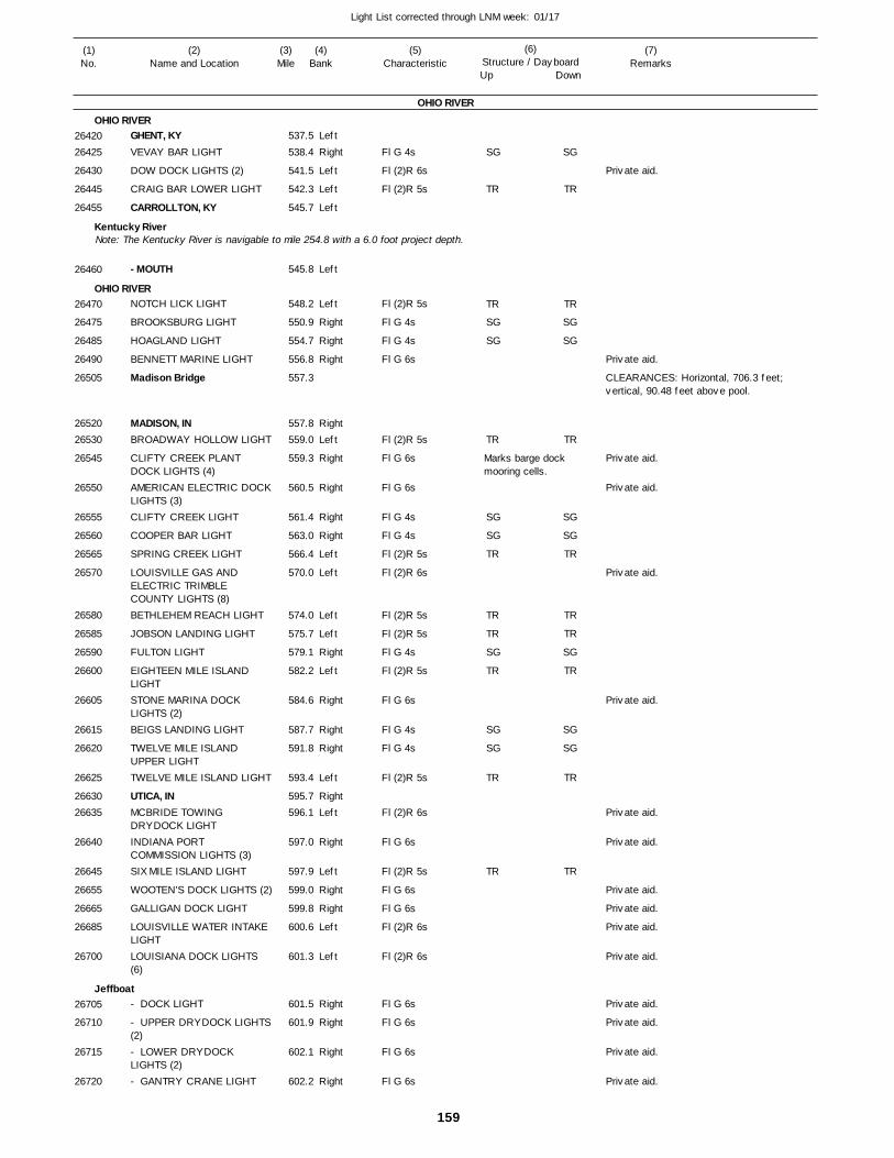
159
Light List corrected through LNM week: 01/17
(7)Remarks
(1)No.
(2)Name and Location
(3)Mile
(5)Characteristic
(4)Bank
(6)Structure / DayboardUp Down
GHENT, KYVEVAY BAR LIGHT
DOW DOCK LIGHTS (2)
CRAIG BAR LOWER LIGHT
CARROLLTON, KY
- MOUTH
NOTCH LICK LIGHT
BROOKSBURG LIGHT
HOAGLAND LIGHT
BENNETT MARINE LIGHT
Madison Bridge
MADISON, INBROADWAY HOLLOW LIGHT
CLIFTY CREEK PLANT DOCK LIGHTS (4)AMERICAN ELECTRIC DOCKLIGHTS (3)CLIFTY CREEK LIGHT
COOPER BAR LIGHT
SPRING CREEK LIGHT
LOUISVILLE GAS AND ELECTRIC TRIMBLE COUNTY LIGHTS (8)BETHLEHEM REACH LIGHT
JOBSON LANDING LIGHT
FULTON LIGHT
EIGHTEEN MILE ISLAND LIGHTSTONE MARINA DOCK LIGHTS (2)BEIGS LANDING LIGHT
TWELVE MILE ISLAND UPPER LIGHTTWELVE MILE ISLAND LIGHT
UTICA, INMCBRIDE TOWING DRYDOCK LIGHTINDIANA PORT COMMISSION LIGHTS (3)SIX MILE ISLAND LIGHT
WOOTEN'S DOCK LIGHTS (2)
GALLIGAN DOCK LIGHT
LOUISVILLE WATER INTAKE LIGHTLOUISIANA DOCK LIGHTS (6)
- DOCK LIGHT
- UPPER DRYDOCK LIGHTS(2)- LOWER DRYDOCK LIGHTS (2)- GANTRY CRANE LIGHT
OHIO RIVER
OHIO RIVER
Kentucky River
OHIO RIVER
Jeffboat
Note: The Kentucky River is navigable to mile 254.8 with a 6.0 foot project depth.
Left
Right
Left
Left
Left
Left
Left
Right
Right
Right
RightLeft
Right
Right
Right
Right
Left
Left
Left
Left
Right
Left
Right
Right
Right
Left
RightLeft
Right
Left
Right
Right
Left
Left
Right
Right
Right
Right
537.5
538.4
541.5
542.3
545.7
545.8
548.2
550.9
554.7
556.8
557.3
557.8 559.0
559.3
560.5
561.4
563.0
566.4
570.0
574.0
575.7
579.1
582.2
584.6
587.7
591.8
593.4
595.7 596.1
597.0
597.9
599.0
599.8
600.6
601.3
601.5
601.9
602.1
602.2
Fl G 4s
Fl (2)R 6s
Fl (2)R 5s
Fl (2)R 5s
Fl G 4s
Fl G 4s
Fl G 6s
Fl (2)R 5s
Fl G 6s
Fl G 6s
Fl G 4s
Fl G 4s
Fl (2)R 5s
Fl (2)R 6s
Fl (2)R 5s
Fl (2)R 5s
Fl G 4s
Fl (2)R 5s
Fl G 6s
Fl G 4s
Fl G 4s
Fl (2)R 5s
Fl (2)R 6s
Fl G 6s
Fl (2)R 5s
Fl G 6s
Fl G 6s
Fl (2)R 6s
Fl (2)R 6s
Fl G 6s
Fl G 6s
Fl G 6s
Fl G 6s
Marks barge dock mooring cells.
CLEARANCES: Horizontal, 706.3 feet; vertical, 90.48 feet above pool.
2642026425
26430
26445
26455
26460
26470
26475
26485
26490
26505
2652026530
26545
26550
26555
26560
26565
26570
26580
26585
26590
26600
26605
26615
26620
26625
2663026635
26640
26645
26655
26665
26685
26700
26705
26710
26715
26720
SG
TR
TR
SG
SG
TR
SG
SG
TR
TR
TR
SG
TR
SG
SG
TR
TR
SG
TR
TR
SG
SG
TR
SG
SG
TR
TR
TR
SG
TR
SG
SG
TR
TR
Private aid.
Private aid.
Private aid.
Private aid.
Private aid.
Private aid.
Private aid.
Private aid.
Private aid.
Private aid.
Private aid.
Private aid.
Private aid.
Private aid.
Private aid.
Private aid.
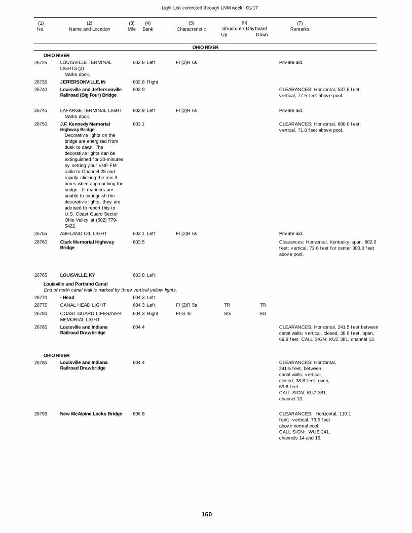
160
Light List corrected through LNM week: 01/17
(7)Remarks
(1)No.
(2)Name and Location
(3)Mile
(5)Characteristic
(4)Bank
(6)Structure / DayboardUp Down
LOUISVILLE TERMINAL LIGHTS (2)
JEFFERSONVILLE, INLouisville and JeffersonvilleRailroad (Big Four) Bridge
LAFARGE TERMINAL LIGHT
J.F. Kennedy Memorial Highway Bridge
ASHLAND OIL LIGHT
Clark Memorial Highway Bridge
LOUISVILLE, KY
- HeadCANAL HEAD LIGHT
COAST GUARD LIFESAVER MEMORIAL LIGHTLouisville and Indiana Railroad Drawbridge
Louisville and Indiana Railroad Drawbridge
New McAlpine Locks Bridge
OHIO RIVER
OHIO RIVER
Louisville and Portland Canal
OHIO RIVER
End of north canal wall is marked by three vertical yellow lights.
Left
Right
Left
Left
Left
Left
Left
Right
602.8
602.8 602.9
602.9
603.1
603.1
603.5
603.8
604.3
604.3
604.3
604.4
604.4
606.8
Marks dock.
Marks dock.
Decorative lights on the bridge are energized from dusk to dawn. The decorative lights can be extinguished for 20-minutes by setting your VHF-FM radio to Channel 28 and rapidly clicking the mic 3 times when approaching the bridge. If mariners are unable to extinguish the decorative lights, they are advised to report this to U.S. Coast Guard Sector Ohio Valley at (502) 779-5422.
Fl (2)R 6s
Fl (2)R 6s
Fl (2)R 6s
Fl (2)R 5s
Fl G 4s
CLEARANCES: Horizontal, 537.6 feet; vertical, 77.5 feet above pool.
CLEARANCES: Horizontal, 680.0 feet; vertical, 71.0 feet above pool.
Clearances: Horizontal, Kentucky span, 802.0 feet; vertical, 72.6 feet for center 300.0 feet above pool.
CLEARANCES: Horizontal, 241.5 feet betweencanal walls; vertical, closed, 38.8 feet, open, 69.8 feet. CALL SIGN: KUZ 381, channel 13.
CLEARANCES: Horizontal,241.5 feet, between canal walls; vertical, closed, 38.8 feet, open, 69.8 feet.CALL SIGN: KUZ 381,channel 13.
CLEARANCES: Horizontal, 110.1 feet; vertical, 73.6 feet above normal pool.CALL SIGN: WUE 241,channels 14 and 16.
26725
2673526740
26745
26750
26755
26760
26765
2677026775
26780
26785
26785
26793
TR
SG
TR
SG
Private aid.
Private aid.
Private aid.
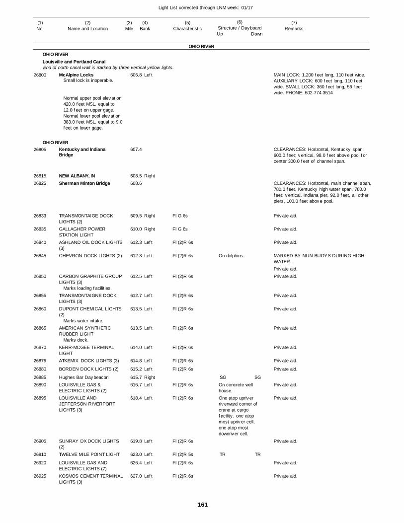
161
Light List corrected through LNM week: 01/17
(7)Remarks
(1)No.
(2)Name and Location
(3)Mile
(5)Characteristic
(4)Bank
(6)Structure / DayboardUp Down
McAlpine Locks
Kentucky and Indiana Bridge
NEW ALBANY, INSherman Minton Bridge
TRANSMONTAIGE DOCK LIGHTS (2)GALLAGHER POWER STATION LIGHTASHLAND OIL DOCK LIGHTS(3)CHEVRON DOCK LIGHTS (2)
CARBON GRAPHITE GROUPLIGHTS (3)
TRANSMONTAIGNE DOCK LIGHTS (3)DUPONT CHEMICAL LIGHTS (2)
AMERICAN SYNTHETIC RUBBER LIGHT
KERR-MCGEE TERMINAL LIGHTATKEMIX DOCK LIGHTS (3)
BORDEN DOCK LIGHTS (2)
Hughes Bar DaybeaconLOUISVILLE GAS & ELECTRIC LIGHTS (2)LOUISVILLE AND JEFFERSON RIVERPORT LIGHTS (3)
SUNRAY DX DOCK LIGHTS (2)TWELVE MILE POINT LIGHT
LOUISVILLE GAS AND ELECTRIC LIGHTS (7)KOSMOS CEMENT TERMINALLIGHTS (3)
OHIO RIVER
OHIO RIVERLouisville and Portland Canal
OHIO RIVER
End of north canal wall is marked by three vertical yellow lights.Left
Right
Right
Right
Left
Left
Left
Left
Left
Left
Left
Left
Left
RightLeft
Left
Left
Left
Left
Left
606.8
607.4
608.5 608.6
609.5
610.0
612.3
612.3
612.5
612.7
613.5
613.5
614.0
614.8
615.2
615.7 616.7
618.4
619.8
623.0
626.4
627.0
Small lock is inoperable.
Normal upper pool elevation 420.0 feet MSL, equal to 12.0 feet on upper gage. Normal lower pool elevation 383.0 feet MSL, equal to 9.0feet on lower gage.
Marks loading facilities.
Marks water intake.
Marks dock.
Fl G 6s
Fl G 6s
Fl (2)R 6s
Fl (2)R 6s
Fl (2)R 6s
Fl (2)R 6s
Fl (2)R 6s
Fl (2)R 6s
Fl (2)R 6s
Fl (2)R 6s
Fl (2)R 6s
Fl (2)R 6s
Fl (2)R 6s
Fl (2)R 6s
Fl (2)R 5s
Fl (2)R 6s
Fl (2)R 6s
On dolphins.
On concrete well house.One atop upriver riverward corner ofcrane at cargo facility, one atop most upriver cell, one atop most downriver cell.
MAIN LOCK: 1,200 feet long, 110 feet wide. AUXILIARY LOCK: 600 feet long, 110 feet wide. SMALL LOCK: 360 feet long, 56 feet wide. PHONE: 502-774-3514
CLEARANCES: Horizontal, Kentucky span, 600.0 feet; vertical, 98.0 feet above pool for center 300.0 feet of channel span.
CLEARANCES: Horizontal, main channel span,780.0 feet, Kentucky high water span, 780.0 feet; vertical, Indiana pier, 92.0 feet, all other piers, 100.0 feet above pool.
MARKED BY NUN BUOYS DURING HIGH WATER.
26800
26805
2681526825
26833
26835
26840
26845
26850
26855
26860
26865
26870
26875
26880
2688526890
26895
26905
26910
26920
26925
SG
TR
SG
TR
Private aid.
Private aid.
Private aid.
Private aid.Private aid.
Private aid.
Private aid.
Private aid.
Private aid.
Private aid.
Private aid.
Private aid.
Private aid.
Private aid.
Private aid.
Private aid.

162
Light List corrected through LNM week: 01/17
(7)Remarks
(1)No.
(2)Name and Location
(3)Mile
(5)Characteristic
(4)Bank
(6)Structure / DayboardUp Down
- MOUTH
WEST POINT, KYWEST POINT LIGHT
MOSQUITO CREEK LIGHT
OTTER CREEK LIGHT
ROCK HAVEN LIGHT
ROCK HAVEN LOWER LIGHT
ROCK RUN LIGHT
ARCH CHEMICALS DOCK LIGHTS (2)TOBACCO BEND LIGHT
CONSOLIDATED GRAIN & BARGE DOCK LIGHTS (2)
BRANDENBURG, KYMatthew E. Welsh Bridge
MAUCKPORT LIGHT
RICHARDSON LANDING LIGHTKOSMOS TERMINAL LIGHT
PARIS LANDING LIGHT
LEAVENWORTH, INIndian Hollow DaybeaconDEVILS BEND LIGHT
FREDONIA LIGHT
Schooner Point DaybeaconDIAMOND ROCK LIGHT
PECKINPAUGH BAR LIGHT
WOLF CREEK LIGHT
ALTON, INALTON BAR LOWER LIGHT
RONO LIGHT
BOONE HOLLOW LIGHT
CONCORDIA LIGHT
OIL CREEK LIGHT
CHENAULT REACH LIGHT
STEPHENSPORT BEND LIGHTSTEPHENSPORT LIGHT
STEPHENSPORT, KYHOLTS BAR LIGHT
PATES HOLLOW LIGHT
CLARENCE CARTER LIGHT
CLOVERPORT, KYHUDSON HILL LIGHT
HOG POINT LIGHT
MASONS LANDING LIGHT
OHIO RIVER
OHIO RIVERSalt River
OHIO RIVER
Left
Left
Left
Right
Left
Left
Left
Right
Left
Right
Left
Left
Left
Left
Left
Right
RightRightRight
Right
RightLeft
Right
Left
RightRight
Right
Left
Left
Right
Right
Left
Left
LeftRight
Right
Left
LeftLeft
Right
Right
629.9
630.0
629.8
634.6
636.5
637.0
637.9
641.3
643.8
644.3
645.0
646.1 647.8
648.9
652.7
654.1
659.2
664.1 665.1 666.0
667.4
669.1 670.6
675.4
677.3
679.0 680.4
682.9
684.9
686.4
691.7
696.8
699.4
700.9
701.0 704.3
705.4
708.2
711.1 713.3
717.2
718.8
Fl (2)R 5s
Fl G 4s
Fl (2)R 5s
Fl (2)R 5s
Fl (2)R 5s
Fl G 4s
Fl (2)R 6s
Fl G 4s
Fl (2)R 6s
Fl (2)R 5s
Fl (2)R 5s
Fl (2)R 6s
Fl G 4s
Fl G 4s
Fl G 4s
Fl (2)R 5s
Fl G 4s
Fl (2)R 5s
Fl G 4s
Fl G 4s
Fl (2)R 5s
Fl (2)R 5s
Fl G 4s
Fl G 4s
Fl (2)R 5s
Fl (2)R 5s
Fl G 4s
Fl G 4s
Fl (2)R 5s
Fl (2)R 5s
Fl G 4s
Fl G 4s
On pile cells.
Marks outermost upstream and outermost downstream dock dolphins.
On pile.
CLEARANCES: Horizontal, Kentucky span, 700.0 feet; vertical, 91.3 feet above pool
26935
2694026945
26950
26952
26955
26957
26960
26965
26970
26975
2698026990
27005
27015
27020
27025
270402704527047
27050
2705527060
27085
27090
2709527100
27105
27110
27115
27120
27125
27130
27135
2714027145
27150
27155
2716027170
27175
27180
TR
SG
TR
TR
TR
SG
SG
TR
TR
SG
SGSG
SG
SGTR
SG
TR
SG
SG
TR
TR
SG
SG
TR
TR
SG
SG
TR
TR
SG
SG
TR
SG
TR
TR
TR
SG
SG
TR
TR
SG
SGSG
SG
SGTR
SG
TR
SG
SG
TR
TR
SG
SG
TR
TR
SG
SG
TR
TR
SG
SG
Private aid.
Private aid.
Private aid.

163
Light List corrected through LNM week: 01/17
(7)Remarks
(1)No.
(2)Name and Location
(3)Mile
(5)Characteristic
(4)Bank
(6)Structure / DayboardUp Down
Cannelton Locks and Dam
HANCOCK BEND LOWER LIGHTLincoln Trails Bridge
HAWESVILLE, KYCANNELTON, INMAXON DOCK LIGHT
TELL CITY, INSOUTHWIRE COMPANY LIGHTS (5)
MUSSEL SHOAL LIGHT
BIG RIVERS ELEC CORP DOCK LIGHTS (12)
TROY, INANDERSON RIVER LIGHT
GAGE LANDING LIGHT
NEW HOPE UPPER DOCK LIGHTNEW HOPE LOWER DOCK LIGHTCORN ISLAND LIGHT
LEWISPORT, KYLEWISPORT BEND LIGHT
GRANDVIEW LIGHT
AMERICAN ELECTRIC POWER LIGHTS (7)William H. Natcher Bridge
ROCKPORT, INROCKPORT LIGHT
PUP CREEK LIGHT
BEELER ISLAND LIGHT
COAL RECOVERY SYSTEM LIGHTS (2)COAST GUARD MOORING LIGHTOWENSBORO WATER INTAKE LIGHTLAFARGE DOCK LIGHT
TRANSMONTAIGNE DOCK LIGHT
OWENSBORO GRAIN LIGHTS (2)
OHIO RIVER
OHIO RIVERRight
Left
LeftRightRight
RightLeft
Left
Left
RightRight
Right
Right
Right
Right
LeftLeft
Right
Right
Right
RightRight
Left
Right
Left
Left
Left
Left
Left
Left
720.7
722.5
723.7
723.9 724.0 726.4
727.0 727.3
729.5
728.5
730.9 731.5
733.3
729.5
736.0
736.4
737.9 738.5
742.2
744.7
745.6
747.2 747.3
749.7
751.7
751.7
754.2
755.7
755.7
754.8
755.8
Normal upper pool elevation 383.0 feet MSL, equal to 9.0feet on upper gage.Normal lower pool elevation 358.0 feet MSL, equal to 10.0 feet on lower gage.
Marks unloading facility.
Atop most riverward upstreamcorner of dock.
Fl (2)R 5s
F G
Fl (2)R 6s
Fl (2)R 5s
Fl (2)R 6s
Fl G 4s
Fl G 4s
Fl G 6s
Fl G 6s
Fl G 4s
Fl (2)R 5s
Fl G 4s
Fl G 6s
Fl G 4s
Fl (2)R 5s
Q G
Fl (2)R 6s
Fl R 2.5s
Fl (2)R 6s
Fl (2)R 6s
Fl (2)R 6s
Fl (2)R 6s
Marks unloading tower and mooring cells.
MAIN LOCK: 1,200 feet long, 110 feet wide. AUXILIARY LOCK: 600 feet long, 110 feet wide. PHONE: 812-547-2962
CLEARANCES: Horizontal, Indiana span, 800.0feet; vertical, 88.0 feet above pool.
CLEARANCES: Horizontal, 1100 feet; vertical,78.29 feet above normal pool.
27185
27190
27200
272102721527220
2722527230
27235
27240
2724527250
27260
27265
27270
27275
2728027285
27295
27300
27310
2732027325
27327
27332
27335
27357
27360
27365
27367
27375
TR
TR
SG
CNG
SG
TR
SG
SG
TR
SG
TR
TR
SG
CNG
CNG
CNR
SG
SG
CNR
SG
Private aid.
Private aid.
Private aid.
Private aid.
Private aid.
Private aid.
Private aid.
Private aid.
Private aid.
Private aid.
Private aid.

164
Light List corrected through LNM week: 01/17
(7)Remarks
(1)No.
(2)Name and Location
(3)Mile
(5)Characteristic
(4)Bank
(6)Structure / DayboardUp Down
Owensboro Highway Bridge (Glover Cary Bridge)
OWENSBORO MARINA DOCK LIGHTS (2)EXECUTIVE INN MARINA LIGHTS (2)OWENSBORO, KYOWENSBORO GRAIN BOOM LIGHTOWENSBORO RIVERPORT UPPER LIGHTOWENSBORO RIVERPORT LOWER LIGHT
OWENSBORO COAL DOCK LIGHTS (2)MILES ENTERPRISES CELL LIGHTBON HARBOR LIGHT
LITTLE HURRICANE LIGHT
GRISSOM LANDING LIGHT
FRENCH ISLAND LOWER LIGHTMIDWEST COAL MOORING CELL UPPER LIGHTMIDWEST COAL MOORING CELL LOWER LIGHT
Midwest Coal Daybeacon
SIGECO LIGHTS (2)
ALCOA DOCK LIGHTS (4)
Newburg Locks and Dam
NEWBURGH, INGREEN RIVER LIGHT
- MOUTH
U.S. 41 Dual Bridges
WATSON LANDING LIGHT
ROBERT MANN LIGHT
PORT AUTHORITY OF EVANSVILLE LST LANDING LIGHTWATER WORKS LIGHT
OHIO RIVER
OHIO RIVER
Green River
OHIO RIVER
For aids on the Green River see table of contents.
Left
Left
LeftLeft
Left
Left
Left
Left
Right
Right
Left
Right
Right
Right
Right
Left
Right
Right
RightLeft
Left
Left
Left
Right
Right
756.3
756.4
756.5
756.5 758.1
758.6
758.7
759.3
759.4
759.9
762.1
765.4
770.1
772.3
773.0
773.9
773.4
773.8
776.1
778.0 784.1
784.2
786.8
788.6
790.3
791.2
791.5
Marks terminal.
Normal upper pool elevation 358.0 feet MSL, equal to 10.0 feet on upper gage. Normal lower pool elevation 342.0 feet MSL, equal to 12.0 feet on lower gage.
F R
Fl (2)R 6s
Fl (2)R 6s
Fl (2)R 6s
Fl (2)R 6s
Fl (2)R 6s
Fl G 4s
Fl G 4s
Fl (2)R 5s
Fl G 4s
Fl G 6s
Fl G 6s
Fl (2)R 6s
Fl G 6s
Fl (2)R 5s
Fl (2)R 5s
Fl (2)R 5s
Fl G 4s
Fl G 4s
On cell.
On cell.
TR on pile.
On most upriver cell marking landing.
CLEARANCES: Horizontal, 730.0 feet; vertical, center of span, 83.7 feet, Indiana pier, 86.1 feet, Kentucky pier, 72.6 feet all above pool.
Entrance to Little Pigeon Creek.
Entrance to Little Pigeon Creek.
MAIN LOCK: 1,200 feet long, 110 feet wide. AUXILIARY LOCK: 600 feet long, 110 feet wide. PHONE: 812-853-8470
CLEARANCES: Horizontal, Kentucky channel span, 580.0 feet, Indiana highwater span, 600.0 feet from center pier to Indiana bank, between piers, 700.0 feet; vertical, Kentucky span, 84.5 feet, Indiana span, 88.7 feet for center 300.0 feet of channel span, center span, 89.3 feet above pool.
27395
27405
27410
2741527420
27425
27430
27435
27437
27440
27445
27450
27455
27457
27457.01
27457.02
27460
27465
27470
2747527490
27495
27505
27515
27520
27530
27540
SG
SG
TR
SG
TR
TR
TR
SG
SG
SG
TR
SG
TR
TR
TR
SG
Private aid.
Private aid.
Private aid.
Private aid.
Private aid.
Private aid.
Private aid.
Private aid.
Private aid.
Private aid.Private aid.
Private aid.
Private aid.
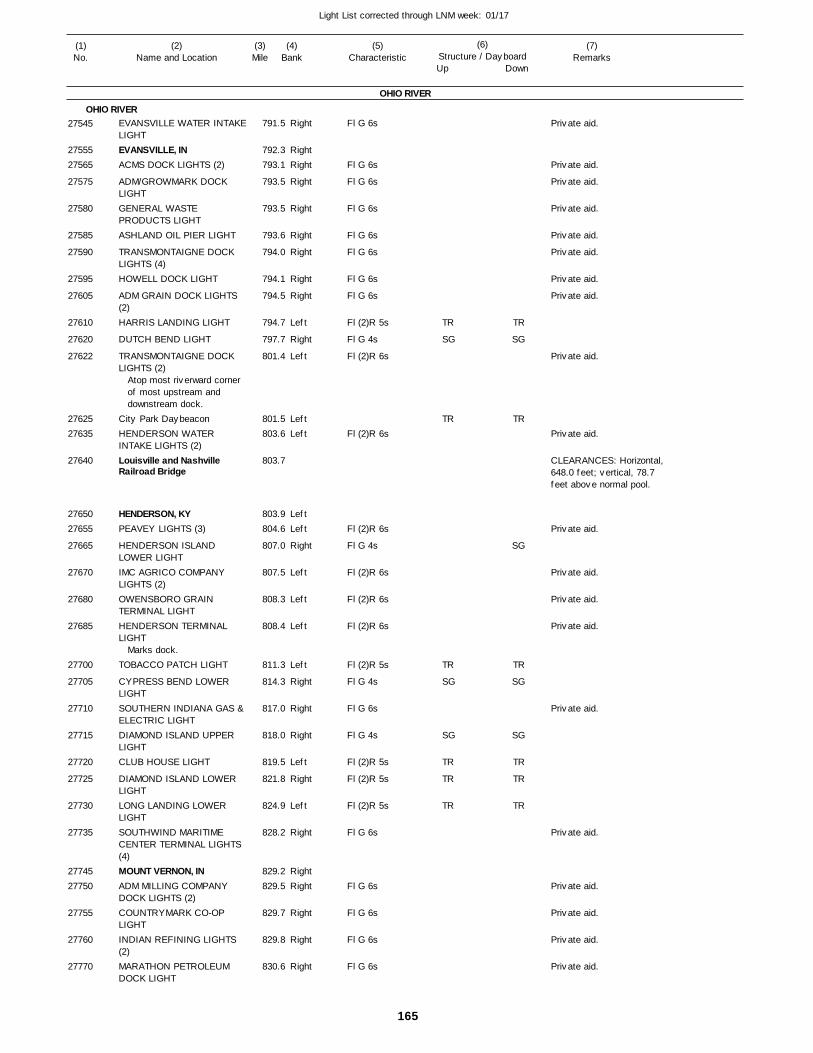
165
Light List corrected through LNM week: 01/17
(7)Remarks
(1)No.
(2)Name and Location
(3)Mile
(5)Characteristic
(4)Bank
(6)Structure / DayboardUp Down
EVANSVILLE WATER INTAKELIGHTEVANSVILLE, INACMS DOCK LIGHTS (2)
ADM/GROWMARK DOCK LIGHTGENERAL WASTE PRODUCTS LIGHTASHLAND OIL PIER LIGHT
TRANSMONTAIGNE DOCK LIGHTS (4)HOWELL DOCK LIGHT
ADM GRAIN DOCK LIGHTS (2)HARRIS LANDING LIGHT
DUTCH BEND LIGHT
TRANSMONTAIGNE DOCK LIGHTS (2)
City Park DaybeaconHENDERSON WATER INTAKE LIGHTS (2)Louisville and Nashville Railroad Bridge
HENDERSON, KYPEAVEY LIGHTS (3)
HENDERSON ISLAND LOWER LIGHTIMC AGRICO COMPANY LIGHTS (2)OWENSBORO GRAIN TERMINAL LIGHTHENDERSON TERMINAL LIGHT
TOBACCO PATCH LIGHT
CYPRESS BEND LOWER LIGHTSOUTHERN INDIANA GAS & ELECTRIC LIGHTDIAMOND ISLAND UPPER LIGHTCLUB HOUSE LIGHT
DIAMOND ISLAND LOWER LIGHTLONG LANDING LOWER LIGHTSOUTHWIND MARITIME CENTER TERMINAL LIGHTS (4)MOUNT VERNON, INADM MILLING COMPANY DOCK LIGHTS (2)COUNTRYMARK CO-OP LIGHTINDIAN REFINING LIGHTS (2)MARATHON PETROLEUM DOCK LIGHT
OHIO RIVER
OHIO RIVERRight
RightRight
Right
Right
Right
Right
Right
Right
Left
Right
Left
LeftLeft
LeftLeft
Right
Left
Left
Left
Left
Right
Right
Right
Left
Right
Left
Right
RightRight
Right
Right
Right
791.5
792.3 793.1
793.5
793.5
793.6
794.0
794.1
794.5
794.7
797.7
801.4
801.5 803.6
803.7
803.9 804.6
807.0
807.5
808.3
808.4
811.3
814.3
817.0
818.0
819.5
821.8
824.9
828.2
829.2 829.5
829.7
829.8
830.6
Atop most riverward cornerof most upstream anddownstream dock.
Marks dock.
Fl G 6s
Fl G 6s
Fl G 6s
Fl G 6s
Fl G 6s
Fl G 6s
Fl G 6s
Fl G 6s
Fl (2)R 5s
Fl G 4s
Fl (2)R 6s
Fl (2)R 6s
Fl (2)R 6s
Fl G 4s
Fl (2)R 6s
Fl (2)R 6s
Fl (2)R 6s
Fl (2)R 5s
Fl G 4s
Fl G 6s
Fl G 4s
Fl (2)R 5s
Fl (2)R 5s
Fl (2)R 5s
Fl G 6s
Fl G 6s
Fl G 6s
Fl G 6s
Fl G 6s
CLEARANCES: Horizontal,648.0 feet; vertical, 78.7feet above normal pool.
27545
2755527565
27575
27580
27585
27590
27595
27605
27610
27620
27622
2762527635
27640
2765027655
27665
27670
27680
27685
27700
27705
27710
27715
27720
27725
27730
27735
2774527750
27755
27760
27770
TR
SG
TR
TR
SG
SG
TR
TR
TR
TR
SG
TR
SG
TR
SG
SG
TR
TR
TR
Private aid.
Private aid.
Private aid.
Private aid.
Private aid.
Private aid.
Private aid.
Private aid.
Private aid.
Private aid.
Private aid.
Private aid.
Private aid.
Private aid.
Private aid.
Private aid.
Private aid.
Private aid.
Private aid.
Private aid.
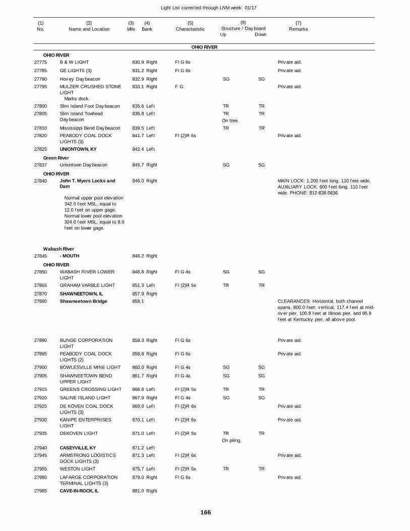
166
Light List corrected through LNM week: 01/17
(7)Remarks
(1)No.
(2)Name and Location
(3)Mile
(5)Characteristic
(4)Bank
(6)Structure / DayboardUp Down
B & W LIGHT
GE LIGHTS (3)
Hovey DaybeaconMULZER CRUSHED STONE LIGHT
Slim Island Foot DaybeaconSlim Island Towhead Daybeacon
Mississippi Bend DaybeaconPEABODY COAL DOCK LIGHTS (3)UNIONTOWN, KY
Uniontown Daybeacon
John T. Myers Locks and Dam
- MOUTH
WABASH RIVER LOWER LIGHTGRAHAM VARBLE LIGHT
SHAWNEETOWN, ILShawneetown Bridge
BUNGE CORPORATION LIGHTPEABODY COAL DOCK LIGHTS (2)BOWLESVILLE MINE LIGHT
SHAWNEETOWN BEND UPPER LIGHTGREENS CROSSING LIGHT
SALINE ISLAND LIGHT
DE KOVEN COAL DOCK LIGHTS (3)KANIPE ENTERPRISES LIGHTDEKOVEN LIGHT
CASEYVILLE, KYARMSTRONG LOGISTICS DOCK LIGHTS (3)WESTON LIGHT
LAFARGE CORPORATION TERMINAL LIGHTS (3)CAVE-IN-ROCK, IL
OHIO RIVER
OHIO RIVER
Green River
OHIO RIVER
Wabash River
OHIO RIVER
Right
Right
RightRight
LeftLeft
LeftLeft
Left
Right
Right
Right
Right
Left
Right
Right
Right
Right
Right
Left
Right
Left
Left
Left
LeftLeft
Left
Right
Right
830.9
831.2
832.9 833.1
835.6 836.8
839.5 841.7
842.4
845.7
846.0
848.2
848.8
851.3
857.9 858.1
858.3
858.8
860.0
861.7
866.8
867.9
869.0
870.1
871.0
871.2 871.3
875.7
879.0
881.0
Marks dock.
Normal upper pool elevation 342.0 feet MSL, equal to 12.0 feet on upper gage. Normal lower pool elevation 324.0 feet MSL, equal to 8.0feet on lower gage.
Fl G 6s
Fl G 6s
F G
Fl (2)R 6s
Fl G 4s
Fl (2)R 5s
Fl G 6s
Fl G 6s
Fl G 4s
Fl G 4s
Fl (2)R 5s
Fl G 4s
Fl (2)R 6s
Fl (2)R 6s
Fl (2)R 5s
Fl (2)R 6s
Fl (2)R 5s
Fl G 6s
On tree.
On piling.
MAIN LOCK: 1,200 feet long, 110 feet wide. AUXILIARY LOCK: 600 feet long, 110 feet wide. PHONE: 812-838-5836
CLEARANCES: Horizontal, both channel spans, 800.0 feet; vertical, 117.4 feet at mid-river pier, 100.8 feet at Illinois pier, and 95.9 feet at Kentucky pier, all above pool.
27775
27785
2779027795
2780027805
2781027820
27825
27837
27840
27845
27850
27855
2787027880
27890
27895
27900
27905
27915
27920
27925
27930
27935
2794027945
27955
27980
27985
SG
TRTR
TR
SG
SG
TR
SG
SG
TR
SG
TR
TR
SG
TRTR
TR
SG
SG
TR
SG
SG
TR
SG
TR
TR
Private aid.
Private aid.
Private aid.
Private aid.
Private aid.
Private aid.
Private aid.
Private aid.
Private aid.
Private aid.
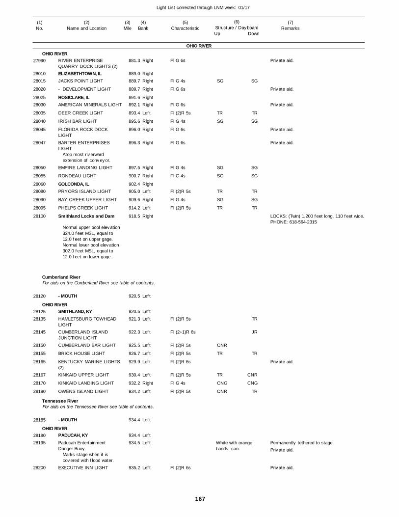
167
Light List corrected through LNM week: 01/17
(7)Remarks
(1)No.
(2)Name and Location
(3)Mile
(5)Characteristic
(4)Bank
(6)Structure / DayboardUp Down
RIVER ENTERPRISE QUARRY DOCK LIGHTS (2)ELIZABETHTOWN, ILJACKS POINT LIGHT
- DEVELOPMENT LIGHT
ROSICLARE, ILAMERICAN MINERALS LIGHT
DEER CREEK LIGHT
IRISH BAR LIGHT
FLORIDA ROCK DOCK LIGHTBARTER ENTERPRISES LIGHT
EMPIRE LANDING LIGHT
RONDEAU LIGHT
GOLCONDA, ILPRYORS ISLAND LIGHT
BAY CREEK UPPER LIGHT
PHELPS CREEK LIGHT
Smithland Locks and Dam
- MOUTH
SMITHLAND, KYHAMLETSBURG TOWHEAD LIGHTCUMBERLAND ISLAND JUNCTION LIGHTCUMBERLAND BAR LIGHT
BRICK HOUSE LIGHT
KENTUCKY MARINE LIGHTS (2)KINKAID UPPER LIGHT
KINKAID LANDING LIGHT
OWENS ISLAND LIGHT
- MOUTH
PADUCAH, KYPaducah Entertainment Danger Buoy
EXECUTIVE INN LIGHT
OHIO RIVER
OHIO RIVER
Cumberland River
OHIO RIVER
Tennessee River
OHIO RIVER
For aids on the Cumberland River see table of contents.
For aids on the Tennessee River see table of contents.
Right
RightRight
Right
RightRight
Left
Right
Right
Right
Right
Right
RightLeft
Right
Left
Right
Left
Left
Left
Left
Left
Left
Left
Left
Right
Left
Left
Left
Left
Left
881.3
889.0 889.7
889.7
891.6 892.1
893.4
895.6
896.0
896.3
897.5
900.7
902.4 905.0
909.6
914.2
918.5
920.5
920.5
921.3
922.3
925.5
926.7
929.9
930.4
932.2
934.2
934.4
934.4
934.5
935.2
Atop most riverwardextension of conveyor.
Normal upper pool elevation 324.0 feet MSL, equal to 12.0 feet on upper gage. Normal lower pool elevation 302.0 feet MSL, equal to 12.0 feet on lower gage.
Marks stage when it is covered with flood water.
Fl G 6s
Fl G 4s
Fl G 6s
Fl G 6s
Fl (2)R 5s
Fl G 4s
Fl G 6s
Fl G 6s
Fl G 4s
Fl G 4s
Fl (2)R 5s
Fl G 4s
Fl (2)R 5s
Fl (2)R 5s
Fl (2+1)R 6s
Fl (2)R 5s
Fl (2)R 5s
Fl (2)R 6s
Fl (2)R 5s
Fl G 4s
Fl (2)R 5s
Fl (2)R 6s
White with orange bands; can.
LOCKS: (Twin) 1,200 feet long, 110 feet wide. PHONE: 618-564-2315
Permanently tethered to stage.
27990
2801028015
28020
2802528030
28035
28040
28045
28047
28050
28055
2806028080
28090
28095
28100
28120
2812528135
28145
28150
28155
28165
28167
28170
28180
28185
2819028195
28200
SG
TR
SG
SG
SG
TR
SG
TR
CNR
TR
TR
CNG
CNR
SG
TR
SG
SG
SG
TR
SG
TR
TR
JR
TR
CNR
CNG
TR
Private aid.
Private aid.
Private aid.
Private aid.
Private aid.
Private aid.
Private aid.
Private aid.
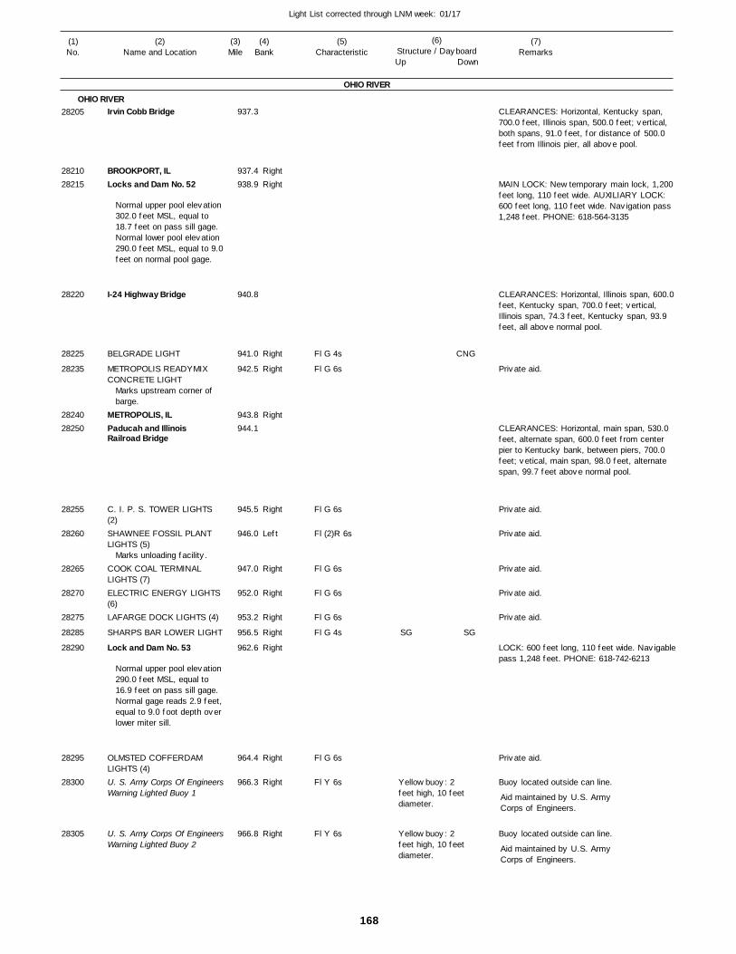
168
Light List corrected through LNM week: 01/17
(7)Remarks
(1)No.
(2)Name and Location
(3)Mile
(5)Characteristic
(4)Bank
(6)Structure / DayboardUp Down
Irvin Cobb Bridge
BROOKPORT, ILLocks and Dam No. 52
I-24 Highway Bridge
BELGRADE LIGHT
METROPOLIS READYMIX CONCRETE LIGHT
METROPOLIS, ILPaducah and Illinois Railroad Bridge
C. I. P. S. TOWER LIGHTS (2)SHAWNEE FOSSIL PLANT LIGHTS (5)
COOK COAL TERMINAL LIGHTS (7)ELECTRIC ENERGY LIGHTS (6)LAFARGE DOCK LIGHTS (4)
SHARPS BAR LOWER LIGHT
Lock and Dam No. 53
OLMSTED COFFERDAM LIGHTS (4)U. S. Army Corps Of EngineersWarning Lighted Buoy 1
U. S. Army Corps Of EngineersWarning Lighted Buoy 2
OHIO RIVER
OHIO RIVER
RightRight
Right
Right
Right
Right
Left
Right
Right
Right
Right
Right
Right
Right
Right
937.3
937.4 938.9
940.8
941.0
942.5
943.8 944.1
945.5
946.0
947.0
952.0
953.2
956.5
962.6
964.4
966.3
966.8
Normal upper pool elevation 302.0 feet MSL, equal to 18.7 feet on pass sill gage. Normal lower pool elevation 290.0 feet MSL, equal to 9.0feet on normal pool gage.
Marks upstream corner of barge.
Marks unloading facility.
Normal upper pool elevation 290.0 feet MSL, equal to 16.9 feet on pass sill gage.Normal gage reads 2.9 feet,equal to 9.0 foot depth over lower miter sill.
Fl G 4s
Fl G 6s
Fl G 6s
Fl (2)R 6s
Fl G 6s
Fl G 6s
Fl G 6s
Fl G 4s
Fl G 6s
Fl Y 6s
Fl Y 6s
Yellow buoy: 2 feet high, 10 feet diameter.
Yellow buoy: 2 feet high, 10 feet diameter.
CLEARANCES: Horizontal, Kentucky span, 700.0 feet, Illinois span, 500.0 feet; vertical, both spans, 91.0 feet, for distance of 500.0 feet from Illinois pier, all above pool.
MAIN LOCK: New temporary main lock, 1,200 feet long, 110 feet wide. AUXILIARY LOCK: 600 feet long, 110 feet wide. Navigation pass 1,248 feet. PHONE: 618-564-3135
CLEARANCES: Horizontal, Illinois span, 600.0 feet, Kentucky span, 700.0 feet; vertical, Illinois span, 74.3 feet, Kentucky span, 93.9 feet, all above normal pool.
CLEARANCES: Horizontal, main span, 530.0 feet, alternate span, 600.0 feet from center pier to Kentucky bank, between piers, 700.0 feet; vetical, main span, 98.0 feet, alternate span, 99.7 feet above normal pool.
LOCK: 600 feet long, 110 feet wide. Navigablepass 1,248 feet. PHONE: 618-742-6213
Buoy located outside can line.
Buoy located outside can line.
Aid maintained by U.S. ArmyCorps of Engineers.
Aid maintained by U.S. ArmyCorps of Engineers.
28205
2821028215
28220
28225
28235
2824028250
28255
28260
28265
28270
28275
28285
28290
28295
28300
28305
SG
CNG
SG
Private aid.
Private aid.
Private aid.
Private aid.
Private aid.
Private aid.
Private aid.
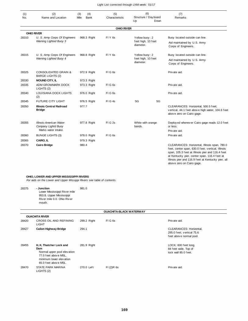
169
Light List corrected through LNM week: 01/17
(7)Remarks
(1)No.
(2)Name and Location
(3)Mile
(5)Characteristic
(4)Bank
(6)Structure / DayboardUp Down
U. S. Army Corps Of EngineersWarning Lighted Buoy 3
U. S. Army Corps Of EngineersWarning Lighted Buoy 4
CONSOLIDATED GRAIN & BARGE LIGHTS (2)MOUND CITY, ILADM GROWMARK DOCK LIGHTS (2)LOUISIANA DOCK LIGHTS (2)FUTURE CITY LIGHT
Illinois Central Railroad Bridge
Illinois-American Water Company Lightd Buoy
BUNGE LIGHTS (3)
CAIRO, ILCairo Bridge
- Junction
CROSS OIL AND REFINING LIGHTCalion Highway Bridge
H. K. Thatcher Lock and Dam
STATE PARK MARINA LIGHTS (2)
OHIO RIVER
OHIO RIVER
OHIO, LOWER AND UPPER MISSISSIPPI RIVERS
OUACHITA-BLACK WATERWAY
OUACHITA RIVER
For aids on the Lower and Upper Missippi Rivers see table of contents.
Right
Right
Right
RightRight
Right
Right
Right
Right
Right
Right
Right
Left
968.3
968.8
972.9
973.3 973.3
976.0
976.5
977.7
977.8
978.0
979.3 980.4
981.0
299.2
294.1
281.9
270.0
Marks water intake.
Lower Mississippi River mile953.8. Upper Mississippi River mile 0.0. Ohio River mouth.
Normal upper pool elevation 77.0 feet above MSL, minimum lower elevation 65.0 feet above MSL.
Fl Y 6s
Fl Y 6s
Fl G 6s
Fl G 6s
Fl G 6s
Fl G 4s
Fl G 2s
Fl G 6s
Fl G 6s
Fl (2)R 6s
Yellow buoy: 2 feet high, 10 feet diameter.
Yellow buoy: 2 feet high, 10 feet diameter.
White with orange bands.
Buoy located outside can line.
Buoy located outside can line.
CLEARANCES: Horizontal, 500.5 feet; vertical, 44.1 feet above high water, 104.6 feetabove zero on Cairo gage.
Deployed whenever Cairo gage reads 12.0 feetor less.
CLEARANCES: Horizontal, Illinois span, 780.0 feet, center span, 630.0 feet; vertical, Illinois span, 105.3 feet at Illinois pier and 116.4 feet at Kentucky pier, center span, 116.4 feet at Illinois pier and 116.9 feet at Kentucky pier, all above zero on Cairo gage.
CLEARANCES: Horizontal,295.0 feet; vertical 75.6feet above normal pool.
LOCK: 600 feet long,84 feet wide. Top oflock wall 85.0 feet.
Aid maintained by U.S. ArmyCorps of Engineers.
Aid maintained by U.S. ArmyCorps of Engineers.
28310
28315
28325
2833028335
28340
28345
28350
28355
28360
2836528370
28375
28420
28427
28455
28470
SG SG
Private aid.
Private aid.
Private aid.
Private aid.Private aid.
Private aid.
Private aid.
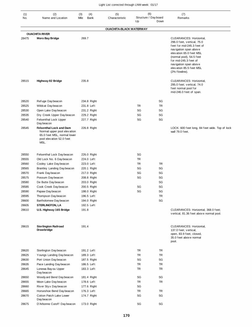
170
Light List corrected through LNM week: 01/17
(7)Remarks
(1)No.
(2)Name and Location
(3)Mile
(5)Characteristic
(4)Bank
(6)Structure / DayboardUp Down
Moro Bay Bridge
Highway 82 Bridge
Refuge DaybeaconWildcat DaybeaconOpen Lake DaybeaconDry Creek Upper DaybeaconFelsenthal Lock Upper DaybeaconFelsenthal Lock and Dam
Felsenthal Lock DaybeaconOld Lock No. 6 DaybeaconCooley Lake DaybeaconBrantley Landing DaybeaconFrank DaybeaconPossum DaybeaconDe Butte DaybeaconCook Creek DaybeaconPapaw DaybeaconThompson DaybeaconBartholomew DaybeaconSTERLINGTON, LAU.S. Highway 165 Bridge
Sterlington Railroad Drawbridge
Sterlington DaybeaconYoungs Landing DaybeaconPort Union DaybeaconPace Landing DaybeaconLonewa Bayou Upper DaybeaconWoodyard Bend DaybeaconMoon Lake DaybeaconRiver Styx DaybeaconHorseshoe Bend DaybeaconCotton Patch Lake Lower DaybeaconD'Arbonne Cutoff Daybeacon
OUACHITA-BLACK WATERWAY
OUACHITA RIVER
RightLeftRightRightRight
Right
RightLeftLeftRightRightRightRightRightRightLeftRightLeft
LeftLeftRightLeftLeft
RightLeftRightLeftRight
Right
269.7
235.8
234.8 231.8 231.2 229.2 227.7
226.8
226.0 224.0 223.0 220.1 217.0 208.8 203.0 200.5 198.0 196.5 194.0 192.5 191.8
191.4
191.2 189.3 187.5 186.5 183.3
181.4 178.6 177.6 176.3 174.7
173.0
Normal upper pool elevation 65.0 feet MSL, normal lower pool elevation 52.0 feet MSL.
CLEARANCES: Horizontal, 296.0 feet, vertical, 75.0 feet for mid-245.3 feet of navigation span above elevation 65.0 feet MSL (normal pool), 54.5 feetfor mid-245.3 feet ofnavigation span above elevation 85.5 feet MSL (2% flowline).
CLEARANCES: Horizontal, 295.0 feet; vertical, 74.0 feet normal pool for mid-246.0 feet of span.
LOCK: 600 feet long, 84 feet wide. Top of lockwall 79.0 feet.
CLEARANCES: Horizontal, 368.0 feet; vertical, 81.36 feet above normal pool.
CLEARANCES: Horizontal,137.0 feet; vertical, open, 83.9 feet, closed, 35.0 feet above normal pool.
28475
28515
2852028525285302853528540
28545
28550285552856028565285702857528580285852859028595286002860528610
28615
2862028625286302863528645
2865028655286602866528670
28675
TRSGSGSG
SGTRTRSGSGSG
SGSG
TRTRSGTRTR
SGTRSGTRSG
SG
SGTRSGSGSG
TRSGSGSGSGSGSGTRSG
TRTRSGTRTR
SGTR
TRSG
SG
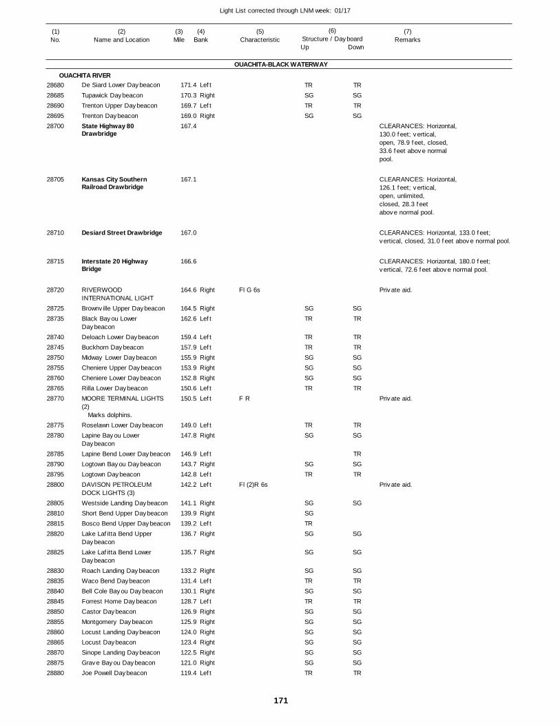
171
Light List corrected through LNM week: 01/17
(7)Remarks
(1)No.
(2)Name and Location
(3)Mile
(5)Characteristic
(4)Bank
(6)Structure / DayboardUp Down
De Siard Lower Daybeacon
Tupawick DaybeaconTrenton Upper DaybeaconTrenton DaybeaconState Highway 80 Drawbridge
Kansas City Southern Railroad Drawbridge
Desiard Street Drawbridge
Interstate 20 Highway Bridge
RIVERWOOD INTERNATIONAL LIGHTBrownville Upper DaybeaconBlack Bayou Lower DaybeaconDeloach Lower DaybeaconBuckhorn DaybeaconMidway Lower DaybeaconCheniere Upper DaybeaconCheniere Lower DaybeaconRilla Lower DaybeaconMOORE TERMINAL LIGHTS (2)
Roselawn Lower DaybeaconLapine Bayou Lower DaybeaconLapine Bend Lower DaybeaconLogtown Bayou DaybeaconLogtown DaybeaconDAVISON PETROLEUM DOCK LIGHTS (3)Westside Landing DaybeaconShort Bend Upper DaybeaconBosco Bend Upper DaybeaconLake Lafitta Bend Upper DaybeaconLake Lafitta Bend Lower DaybeaconRoach Landing DaybeaconWaco Bend DaybeaconBell Cole Bayou DaybeaconForrest Home DaybeaconCastor DaybeaconMontgomery DaybeaconLocust Landing DaybeaconLocust DaybeaconSinope Landing DaybeaconGrave Bayou DaybeaconJoe Powell Daybeacon
OUACHITA-BLACK WATERWAY
OUACHITA RIVERLeft
RightLeftRight
Right
RightLeft
LeftLeftRightRightRightLeftLeft
LeftRight
LeftRightLeftLeft
RightRightLeftRight
Right
RightLeftRightLeftRightRightRightRightRightRightLeft
171.4
170.3 169.7 169.0 167.4
167.1
167.0
166.6
164.6
164.5 162.6
159.4 157.9 155.9 153.9 152.8 150.6 150.5
149.0 147.8
146.9 143.7 142.8 142.2
141.1 139.9 139.2 136.7
135.7
133.2 131.4 130.1 128.7 126.9 125.9 124.0 123.4 122.5 121.0 119.4
Marks dolphins.
Fl G 6s
F R
Fl (2)R 6s
CLEARANCES: Horizontal,130.0 feet; vertical, open, 78.9 feet, closed, 33.6 feet above normal pool.
CLEARANCES: Horizontal,126.1 feet; vertical, open, unlimited, closed, 28.3 feet above normal pool.
CLEARANCES: Horizontal, 133.0 feet; vertical, closed, 31.0 feet above normal pool.
CLEARANCES: Horizontal, 180.0 feet; vertical, 72.6 feet above normal pool.
2868028685286902869528700
28705
28710
28715
28720
2872528735
28740287452875028755287602876528770
2877528780
28785287902879528800
28805288102881528820
28825
2883028835288402884528850288552886028865288702887528880
TRSGTRSG
SGTR
TRTRSGSGSGTR
TRSG
SGTR
SGSGTRSG
SG
SGTRSGTRSGSGSGSGSGSGTR
TRSGTRSG
SGTR
TRTRSGSGSGTR
TRSG
TRSGTR
SG
SG
SG
SGTRSGTRSGSGSGSGSGSGTR
Private aid.
Private aid.
Private aid.
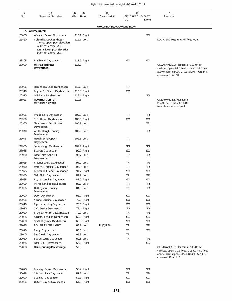
172
Light List corrected through LNM week: 01/17
(7)Remarks
(1)No.
(2)Name and Location
(3)Mile
(5)Characteristic
(4)Bank
(6)Structure / DayboardUp Down
Wheeler Bayou Daybeacon
Columbia Lock and Dam
Smithland DaybeaconMo Pac Railroad Drawbridge
Horseshoe Lake DaybeaconBayou De Chene DaybeaconOld Ferry DaybeaconGovernor John J. McKeithen Bridge
Prairie Lake DaybeaconT. J. Brown DaybeaconThompsons Bend Lower DaybeaconW. H. Hough Landing DaybeaconHough Bend Upper DaybeaconJohn Hough DaybeaconSquires DaybeaconLong Lake Sand Fill DaybeaconFredricksburg DaybeaconMarshall Landing DaybeaconBunker Hill Bend DaybeaconOak Bluff DaybeaconSpynx Landing DaybeaconPierce Landing DaybeaconCottingham Landing DaybeaconDuty DaybeaconYoung Landing DaybeaconPippen Landing DaybeaconJ.C. Davis DaybeaconShort Drive Bend DaybeaconAlligator Landing DaybeaconState Highway DaybeaconBOUEF RIVER LIGHT
Piney DaybeaconBig Creek DaybeaconBayou Louis DaybeaconLock No. 2 DaybeaconHarrisonburg Drawbridge
Bushley Bayou DaybeaconJ.B. Wardlaw DaybeaconBushley DaybeaconCutoff Bayou Daybeacon
OUACHITA-BLACK WATERWAY
OUACHITA RIVERRight
Left
Right
LeftRightRight
LeftRightLeft
Left
Left
RightRightLeft
LeftLeftRightLeftRightLeftLeft
RightRightRightRightLeftRightRightLeft
LeftLeftLeftRight
RightLeftRightRight
118.1
116.7
115.7 114.3
113.8 112.8 112.4 110.3
109.0 107.3 105.7
103.2
102.6
101.3 99.2 96.7
94.0 93.0 91.7 89.9 88.0 85.5 84.0
81.7 78.3 75.6 72.4 70.9 69.2 66.3 65.8
63.6 62.2 60.8 58.2 57.5
55.9 53.7 52.8 51.8
Normal upper pool elevation 52.0 feet above MSL, normal lower pool elevation 34.0 feet above MSL.
Fl (2)R 5s
LOCK: 600 feet long, 84 feet wide.
CLEARANCES: Horizontal, 156.0 feet; vertical, open, 94.0 feet, closed, 44.0 feet above normal pool. CALL SIGN: KCE 344, channels 6 and 16.
CLEARANCES: Horizontal,234.9 feet; vertical, 86.35feet above normal pool.
CLEARANCES: Horizontal, 140.0 feet; vertical, open, 71.9 feet, closed, 43.0 feet above normal pool. CALL SIGN: KJA 575, channels 13 and 16.
2888528890
2889528900
28905289102891528923
289252893028935
28940
28945
289502895528960
28965289702897528980289852899028995
2900029005290102901529020290252903029035
2904029045290502905529060
29070290752908029085
SG
TRSG
TRSG
TR
SGSGTR
TRTRSGTRSGTRTR
SGSGSGSGTRSGSGTR
TRTRTR
SGTRSGSG
SG
SG
SG
TRSGTR
TR
SGSGTR
TRTRSGTRSGTRTR
SGSGSGSGTRSGSGTR
TR
TRSG
SGTRSGSG
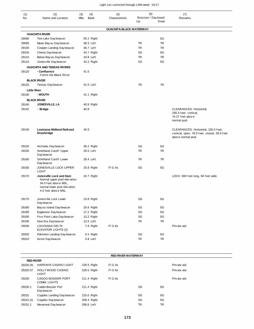
173
Light List corrected through LNM week: 01/17
(7)Remarks
(1)No.
(2)Name and Location
(3)Mile
(5)Characteristic
(4)Bank
(6)Structure / DayboardUp Down
Tew Lake Daybeacon
Mean Bayou DaybeaconCowpen Landing DaybeaconChena DaybeaconBelow Bayou DaybeaconJonesville Daybeacon
- Confluence
Tensas Daybeacon
- MOUTH
JONESVILLE, LA- Bridge
Louisiana Midland Railroad Drawbridge
Nicholas DaybeaconSmithland Cutoff Upper DaybeaconSmithland Cutoff Lower DaybeaconJONESVILLE LOCK UPPER LIGHTJonesville Lock and Dam
Jonesville Lock Lower DaybeaconBayou Island DaybeaconEaglenest DaybeaconFive Point Lake DaybeaconNew Era DaybeaconLOUISIANA DELTA ELEVATOR LIGHTS (2)Palmetto Landing DaybeaconAcme Daybeacon
HARRAHS CASINO LIGHT
HOLLYWOOD CASINO LIGHTCADDO BOSSIER PORT COMM. LIGHTSCaddo-Bossier Port DaybeaconCupples Landing DaybeaconCupples DaybeaconMorameal Daybeacon
OUACHITA-BLACK WATERWAY
OUACHITA RIVER
OUACHITA AND TENSAS RIVERS
BLACK RIVER
Little River
BLACK RIVER
RED RIVER WATERWAY
RED RIVER
Right
LeftLeftRightLeftRight
Left
Right
Right
RightLeft
Left
Right
Right
Right
RightRightRightLeftRight
RightLeft
Right
Right
Right
Right
RightRightLeft
50.2
48.3 46.7 44.7 43.8 42.2
41.5
41.5
41.1
40.9
40.8
40.5
36.2 29.5
28.4
25.8
24.7
23.8
20.6 17.2 13.2 12.6 7.9
5.5 0.8
228.5
228.5
211.4
211.4
210.0 209.4 208.6
Forms the Black River.
Normal upper pool elevation 34.0 feet above MSL, normal lower pool elevation 4.0 feet above MSL.
Fl G 4s
Fl G 6s
Fl G 4s
Fl G 6s
Fl G 6s
CLEARANCES: Horizontal,230.3 feet; vertical, 74.27 feet above normal pool.
CLEARANCES: Horizontal, 150.0 feet; vertical, open, 78.9 feet, closed, 28.9 feet above normal pool.
LOCK: 600 feet long, 84 feet wide.
290902909529100291052911029115
29120
29125
29130
2914029142
29145
2915029155
29160
29165
29170
29175
2918029185291902919529200
2920529210
29220.05
29220.07
29230
29230.1
2923129231.0129231.1
TRTRSGTRSG
TR
SGTR
TR
SG
SG
SGSGSGTR
SGTR
SG
SGSGTR
SGTRTRSGTRSG
TR
SGTR
TR
SG
SG
SGSGSGTR
SGTR
SG
SGSGTR
Private aid.
Private aid.
Private aid.
Private aid.
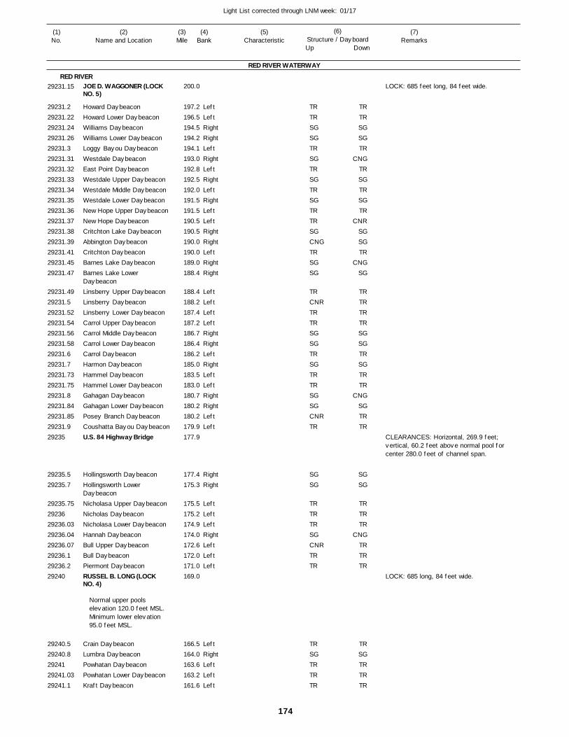
174
Light List corrected through LNM week: 01/17
(7)Remarks
(1)No.
(2)Name and Location
(3)Mile
(5)Characteristic
(4)Bank
(6)Structure / DayboardUp Down
JOE D. WAGGONER (LOCK NO. 5)
Howard DaybeaconHoward Lower DaybeaconWilliams DaybeaconWilliams Lower DaybeaconLoggy Bayou DaybeaconWestdale DaybeaconEast Point DaybeaconWestdale Upper DaybeaconWestdale Middle DaybeaconWestdale Lower DaybeaconNew Hope Upper DaybeaconNew Hope DaybeaconCritchton Lake DaybeaconAbbington DaybeaconCritchton DaybeaconBarnes Lake DaybeaconBarnes Lake Lower DaybeaconLinsberry Upper DaybeaconLinsberry DaybeaconLinsberry Lower DaybeaconCarrol Upper DaybeaconCarrol Middle DaybeaconCarrol Lower DaybeaconCarrol DaybeaconHarmon DaybeaconHammel DaybeaconHammel Lower DaybeaconGahagan DaybeaconGahagan Lower DaybeaconPosey Branch DaybeaconCoushatta Bayou DaybeaconU.S. 84 Highway Bridge
Hollingsworth DaybeaconHollingsworth Lower DaybeaconNicholasa Upper DaybeaconNicholas DaybeaconNicholasa Lower DaybeaconHannah DaybeaconBull Upper DaybeaconBull DaybeaconPiermont DaybeaconRUSSEL B. LONG (LOCK NO. 4)
Crain DaybeaconLumbra DaybeaconPowhatan DaybeaconPowhatan Lower DaybeaconKraft Daybeacon
RED RIVER WATERWAY
RED RIVER
LeftLeftRightRightLeftRightLeftRightLeftRightLeftLeftRightRightLeftRightRight
LeftLeftLeftLeftRightRightLeftRightLeftLeftRightRightLeftLeft
RightRight
LeftLeftLeftRightLeftLeftLeft
LeftRightLeftLeftLeft
200.0
197.2 196.5 194.5 194.2 194.1 193.0 192.8 192.5 192.0 191.5 191.5 190.5 190.5 190.0 190.0 189.0 188.4
188.4 188.2 187.4 187.2 186.7 186.4 186.2 185.0 183.5 183.0 180.7 180.2 180.2 179.9 177.9
177.4 175.3
175.5 175.2 174.9 174.0 172.6 172.0 171.0 169.0
166.5 164.0 163.6 163.2 161.6
Normal upper pools elevation 120.0 feet MSL. Minimum lower elevation 95.0 feet MSL.
LOCK: 685 feet long, 84 feet wide.
CLEARANCES: Horizontal, 269.9 feet; vertical, 60.2 feet above normal pool for center 280.0 feet of channel span.
LOCK: 685 long, 84 feet wide.
29231.15
29231.229231.2229231.2429231.2629231.329231.3129231.3229231.3329231.3429231.3529231.3629231.3729231.3829231.3929231.4129231.4529231.47
29231.4929231.529231.5229231.5429231.5629231.5829231.629231.729231.7329231.7529231.829231.8429231.8529231.929235
29235.529235.7
29235.752923629236.0329236.0429236.0729236.129236.229240
29240.529240.82924129241.0329241.1
TRTRSGSGTRSGTRSGTRSGTRTRSGCNGTRSGSG
TRCNRTRTRSGSGTRSGTRTRSGSGCNRTR
SGSG
TRTRTRSGCNRTRTR
TRSGTRTRTR
TRTRSGSGTR
CNGTRSGTRSGTR
CNRSGSGTR
CNGSG
TRTRTRTRSGSGTRSGTRTR
CNGSGTRTR
SGSG
TRTRTR
CNGTRTRTR
TRSGTRTRTR

175
Light List corrected through LNM week: 01/17
(7)Remarks
(1)No.
(2)Name and Location
(3)Mile
(5)Characteristic
(4)Bank
(6)Structure / DayboardUp Down
Smith Island Daybeacon
Smith Island Lower DaybeaconCampti Upper DaybeaconCampti DaybeaconCampti Middle DaybeaconSocot Revetment DaybeaconCampti Lower DaybeaconSocot Upper DaybeaconSocot Middle DaybeaconSocot DaybeaconSocot Lower DaybeaconGrand Ecore DaybeaconGrand Encore Lower DaybeaconGrand Ecore Highway Bridge
Tennessee Gas Transmission Pipeline Bridge
United Gas Pipeline Bridge
Ile Av Vaches DaybeaconIle Av Vaches Lower DaybeaconClarence DaybeaconClarence Cutoff DaybeaconBayou Fausse DaybeaconFausse DaybeaconNatchitoches DaybeaconNatchitoches Lower DaybeaconChoctaw DaybeaconLuella DaybeaconPoisson DaybeaconCadney DaybeaconCadney Lower DaybeaconSt. Maurice Upper DaybeaconSt. Maurice Middle DaybeaconSt. Maurice Lower DaybeaconSt. Maurice DaybeaconCadoche DaybeaconDunn Lake DaybeaconCognac DaybeaconKadesh Upper DaybeaconKadesh DaybeaconKadesh Lower DaybeaconDes Glaizes DaybeaconMontgomery Daybeacon
Bourdeaux Upper DaybeaconBourdeaux Lower DaybeaconEureka DaybeaconOddra Daybeacon
RED RIVER WATERWAY
RED RIVERRight
Right
LeftLeftLeftRightLeftRightRightRightLeftRightRight
RightRight
LeftRightLeftLeftRightRight
LeftLeftRightRightRightLeftLeftLeftLeftRightLeftLeftLeftLeftLeftRightLeft
RightRightLeftRight
160.8
159.7
159.5 158.6 158.4 156.8 156.8 156.5 155.6 155.3 153.8 152.9 152.3
152.1
151.9
151.6
151.0 150.7
150.0 148.8 148.1 147.6 147.4 147.0
146.9 145.8 145.2 143.6 143.2 142.7 141.8 140.8 140.0 139.7 137.9 137.2 134.8 134.4 134.0 133.7 132.2
131.1 129.7 127.7 125.9
On tree.
CLEARANCES: Horizontal, 368.0 feet; vertical, 71.3 feet above normal pool for center 200.0 feet of span.
CLEARANCES: Horizontal,1,520.0 feet; vertical, 81.5 feet above normal pool.
CLEARANCES: Horizontal,1,300.0 feet; vertical,70.3 feet above normal pool.
29241.229241.25
29241.329241.429241.4329241.4529241.4729241.529241.5329241.629241.6829241.729244
29245
29250
29255
29255.229255.3
29255.52925629256.129256.1529256.229256.25
29256.329256.429256.529256.629256.6529256.729256.829256.929256.952925729257.0129257.0529257.129257.329257.3529257.429257.5
29257.629257.729257.829257.9
SGSG
TRTRTRSGTRSGSGSGTRSGSG
SGSG
TRSGCNRTRCNGSG
CNRTRSGSGSGTRTRTRTRCNGTRTRTRTRTRCNGTR
SGSGTRSG
SGSG
TRTRTRSGTRSGSGSGTRSGSG
SGSG
TRCNGCNR
TRCNG
SG
TRTRSGSGSGTRTR
CNRTRSGTRTRTR
CNRTRSGTR
SGSGTRSG
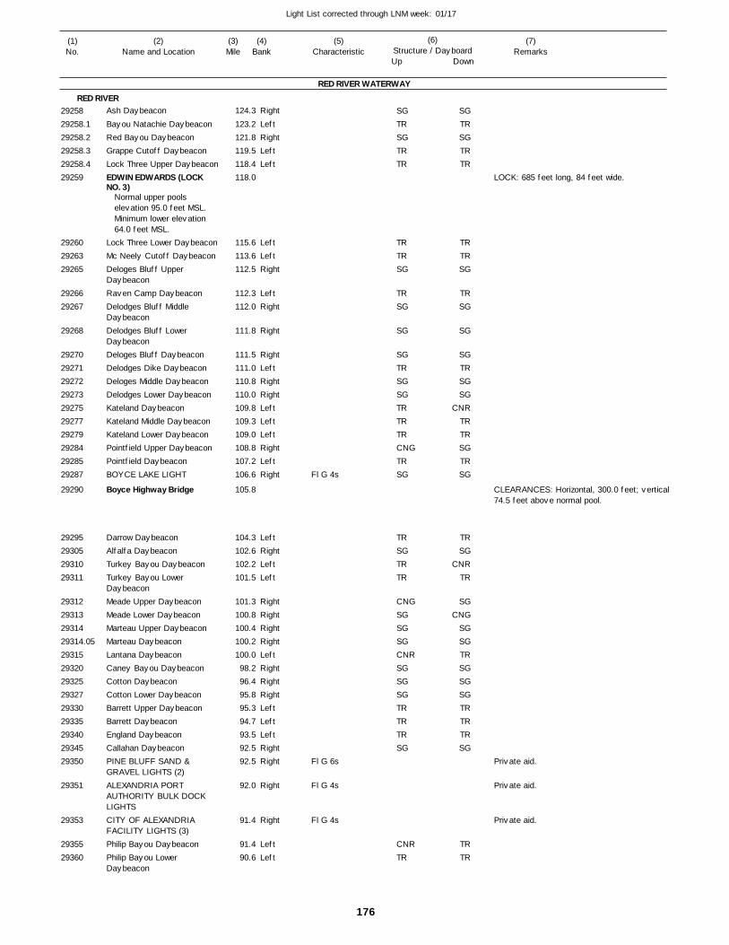
176
Light List corrected through LNM week: 01/17
(7)Remarks
(1)No.
(2)Name and Location
(3)Mile
(5)Characteristic
(4)Bank
(6)Structure / DayboardUp Down
Ash Daybeacon
Bayou Natachie DaybeaconRed Bayou DaybeaconGrappe Cutoff DaybeaconLock Three Upper DaybeaconEDWIN EDWARDS (LOCK NO. 3)
Lock Three Lower DaybeaconMc Neely Cutoff DaybeaconDeloges Bluff Upper DaybeaconRaven Camp DaybeaconDelodges Bluff Middle DaybeaconDelodges Bluff Lower DaybeaconDeloges Bluff DaybeaconDelodges Dike DaybeaconDeloges Middle DaybeaconDelodges Lower DaybeaconKateland DaybeaconKateland Middle DaybeaconKateland Lower DaybeaconPointfield Upper DaybeaconPointfield DaybeaconBOYCE LAKE LIGHT
Boyce Highway Bridge
Darrow DaybeaconAlfalfa DaybeaconTurkey Bayou DaybeaconTurkey Bayou Lower DaybeaconMeade Upper DaybeaconMeade Lower DaybeaconMarteau Upper DaybeaconMarteau DaybeaconLantana DaybeaconCaney Bayou DaybeaconCotton DaybeaconCotton Lower DaybeaconBarrett Upper DaybeaconBarrett DaybeaconEngland DaybeaconCallahan DaybeaconPINE BLUFF SAND & GRAVEL LIGHTS (2)ALEXANDRIA PORT AUTHORITY BULK DOCK LIGHTSCITY OF ALEXANDRIA FACILITY LIGHTS (3)Philip Bayou DaybeaconPhilip Bayou Lower Daybeacon
RED RIVER WATERWAY
RED RIVERRight
LeftRightLeftLeft
LeftLeftRight
LeftRight
Right
RightLeftRightRightLeftLeftLeftRightLeftRight
LeftRightLeftLeft
RightRightRightRightLeftRightRightRightLeftLeftLeftRightRight
Right
Right
LeftLeft
124.3
123.2 121.8 119.5 118.4 118.0
115.6 113.6 112.5
112.3 112.0
111.8
111.5 111.0 110.8 110.0 109.8 109.3 109.0 108.8 107.2 106.6
105.8
104.3 102.6 102.2 101.5
101.3 100.8 100.4 100.2 100.0 98.2 96.4 95.8 95.3 94.7 93.5 92.5 92.5
92.0
91.4
91.4 90.6
Normal upper pools elevation 95.0 feet MSL. Minimum lower elevation 64.0 feet MSL.
Fl G 4s
Fl G 6s
Fl G 4s
Fl G 4s
LOCK: 685 feet long, 84 feet wide.
CLEARANCES: Horizontal, 300.0 feet; vertical74.5 feet above normal pool.
2925829258.129258.229258.329258.429259
292602926329265
2926629267
29268
29270292712927229273292752927729279292842928529287
29290
29295293052931029311
29312293132931429314.05293152932029325293272933029335293402934529350
29351
29353
2935529360
SGTRSGTRTR
TRTRSG
TRSG
SG
SGTRSGSGTRTRTRCNGTRSG
TRSGTRTR
CNGSGSGSGCNRSGSGSGTRTRTRSG
CNRTR
SGTRSGTRTR
TRTRSG
TRSG
SG
SGTRSGSG
CNRTRTRSGTRSG
TRSG
CNRTR
SGCNG
SGSGTRSGSGSGTRTRTRSG
TRTR
Private aid.
Private aid.
Private aid.
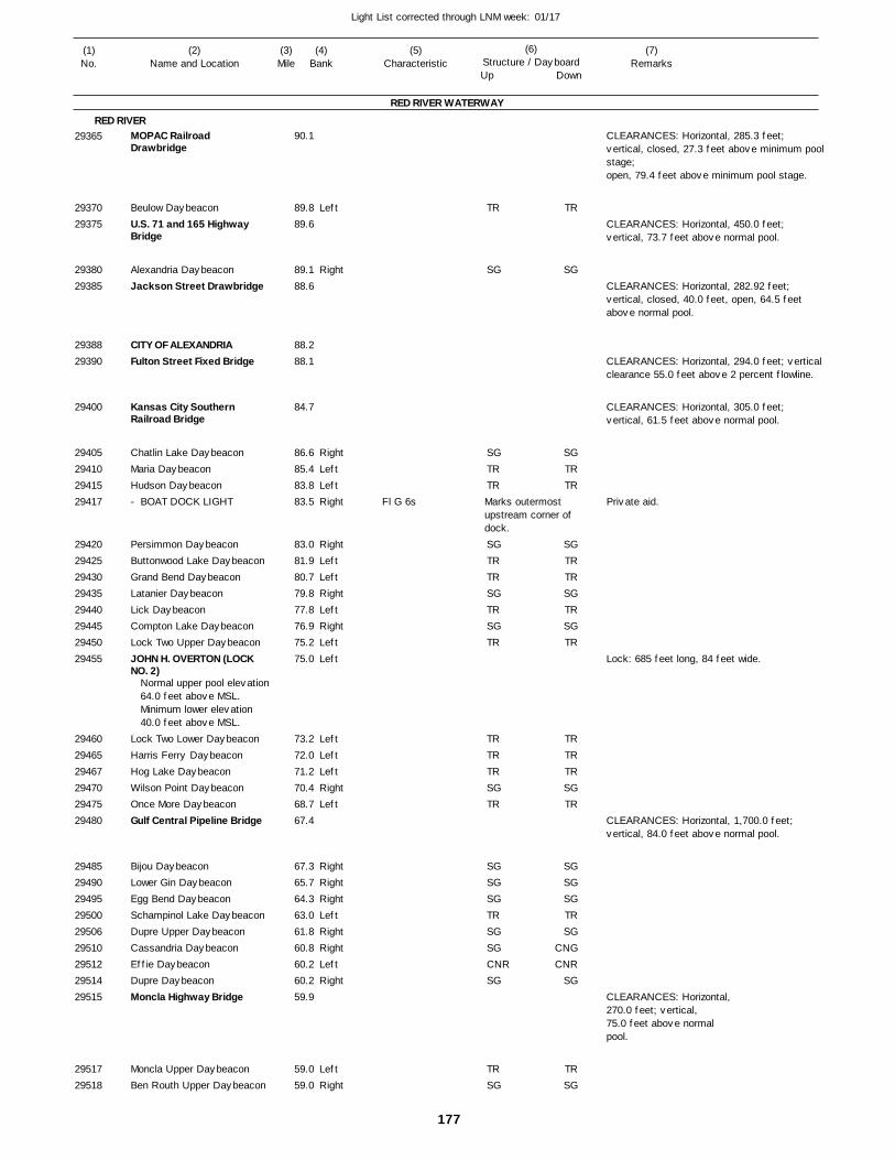
177
Light List corrected through LNM week: 01/17
(7)Remarks
(1)No.
(2)Name and Location
(3)Mile
(5)Characteristic
(4)Bank
(6)Structure / DayboardUp Down
MOPAC Railroad Drawbridge
Beulow DaybeaconU.S. 71 and 165 Highway Bridge
Alexandria DaybeaconJackson Street Drawbridge
CITY OF ALEXANDRIAFulton Street Fixed Bridge
Kansas City Southern Railroad Bridge
Chatlin Lake DaybeaconMaria DaybeaconHudson Daybeacon- BOAT DOCK LIGHT
Persimmon DaybeaconButtonwood Lake DaybeaconGrand Bend DaybeaconLatanier DaybeaconLick DaybeaconCompton Lake DaybeaconLock Two Upper DaybeaconJOHN H. OVERTON (LOCK NO. 2)
Lock Two Lower DaybeaconHarris Ferry DaybeaconHog Lake DaybeaconWilson Point DaybeaconOnce More DaybeaconGulf Central Pipeline Bridge
Bijou DaybeaconLower Gin DaybeaconEgg Bend DaybeaconSchampinol Lake DaybeaconDupre Upper DaybeaconCassandria DaybeaconEffie DaybeaconDupre DaybeaconMoncla Highway Bridge
Moncla Upper DaybeaconBen Routh Upper Daybeacon
RED RIVER WATERWAY
RED RIVER
Left
Right
RightLeftLeftRight
RightLeftLeftRightLeftRightLeftLeft
LeftLeftLeftRightLeft
RightRightRightLeftRightRightLeftRight
LeftRight
90.1
89.8 89.6
89.1 88.6
88.2 88.1
84.7
86.6 85.4 83.8 83.5
83.0 81.9 80.7 79.8 77.8 76.9 75.2 75.0
73.2 72.0 71.2 70.4 68.7 67.4
67.3 65.7 64.3 63.0 61.8 60.8 60.2 60.2 59.9
59.0 59.0
Normal upper pool elevation 64.0 feet above MSL. Minimum lower elevation 40.0 feet above MSL.
Fl G 6s Marks outermost upstream corner ofdock.
CLEARANCES: Horizontal, 285.3 feet; vertical, closed, 27.3 feet above minimum poolstage;open, 79.4 feet above minimum pool stage.
CLEARANCES: Horizontal, 450.0 feet; vertical, 73.7 feet above normal pool.
CLEARANCES: Horizontal, 282.92 feet; vertical, closed, 40.0 feet, open, 64.5 feet above normal pool.
CLEARANCES: Horizontal, 294.0 feet; verticalclearance 55.0 feet above 2 percent flowline.
CLEARANCES: Horizontal, 305.0 feet; vertical, 61.5 feet above normal pool.
Lock: 685 feet long, 84 feet wide.
CLEARANCES: Horizontal, 1,700.0 feet; vertical, 84.0 feet above normal pool.
CLEARANCES: Horizontal,270.0 feet; vertical, 75.0 feet above normal pool.
29365
2937029375
2938029385
2938829390
29400
29405294102941529417
2942029425294302943529440294452945029455
294602946529467294702947529480
294852949029495295002950629510295122951429515
2951729518
TR
SG
SGTRTR
SGTRTRSGTRSGTR
TRTRTRSGTR
SGSGSGTRSGSGCNRSG
TRSG
TR
SG
SGTRTR
SGTRTRSGTRSGTR
TRTRTRSGTR
SGSGSGTRSG
CNGCNR
SG
TRSG
Private aid.

178
Light List corrected through LNM week: 01/17
(7)Remarks
(1)No.
(2)Name and Location
(3)Mile
(5)Characteristic
(4)Bank
(6)Structure / DayboardUp Down
Ben Routh Lower Daybeacon
Vick Upper DaybeaconVick Lower DaybeaconJohnson Lake DaybeaconJohnson Bayou DaybeaconBarbin DaybeaconHadden Fort Middle A DaybeaconHadden Fort Middle B DaybeaconHadden Fort DaybeaconDerussey Dike DaybeaconHadden Fort Lower DaybeaconBrouillette Upper DaybeaconBrouillette DaybeaconSaline DaybeaconLake St. Agnes DaybeaconLock One Upper DaybeaconL.C. BOGGS (LOCK NO. 1)Larto DaybeaconLarto Middle DaybeaconLarto Bayou DaybeaconLorran Lake Upper DaybeaconLorran Lake Daybeacon- ENTRANCE LIGHT
Billiot DaybeaconPattons Lake DaybeaconThree Mile DaybeaconBlackwater DaybeaconRed Light Landing DaybeaconMiligan Bayou DaybeaconCatfish Bayou DaybeaconUpper Sunk Lake DaybeaconDry Cypress DaybeaconCross Lake DaybeaconDismal Swamp Upper DaybeaconDismal Swamp Daybeacon- Bay Upper DaybeaconBayou Cocodrie Upper DaybeaconBayou Cocodrie Daybeacon- Bay DaybeaconHog Pen Lake Upper DaybeaconHog Pen Lake DaybeaconGrassy Lake DaybeaconSmith Bay DaybeaconMorel Lake DaybeaconAlligator Bayou DaybeaconBlakewood Upper DaybeaconBlakewood DaybeaconGrand Bay DaybeaconOld River Outflow DaybeaconTimber Lake DaybeaconNaples Daybeacon
RED RIVER WATERWAY
RED RIVERRight
LeftLeftRightRightRightLeft
Left
RightRightLeft
RightLeftLeftRightLeft
LeftRightLeftRightLeftLeft
RightLeftRightLeftRightRightLeftLeftRightRightLeft
LeftRightLeft
LeftRightLeft
LeftRightRightLeftLeftRightRightLeftLeftLeftRight
58.7
57.1 54.6 54.2 53.6 53.2 52.1
52.5
51.9 50.8 50.5
49.9 49.1 47.6 46.1 44.7 44.0 39.0 38.5 37.9 36.4 35.1 34.2
33.7 32.4 31.7 30.8 30.2 29.2 28.2 27.1 26.4 25.3 24.7
24.2 23.7 23.0
21.8 20.7 20.4
19.9 19.1 15.7 15.0 13.8 12.9 12.2 11.6 10.6 8.2 7.1
Fl (2+1)R 6s
29519295252953029535295402954229547
29549
295502955229555
295602956529570295752958029585295952959729600296052961029618
2962529630296352964029645296502965529660296652967029675
296802968529690
296952970029703
2970529710297152972029725297302973529740297452975029755
SGTRTRCNGSGSGTR
TR
CNGSGTR
SGTRTRSGTR
TRCNGCNRSGTRJR
CNGCNRCNGCNRCNGSGCNRTRCNGSGCNR
TRCNGCNR
TRCNGCNR
TRCNGSGCNRTRCNGSGCNR
TRCNG
SGTRTRSG
CNGSGTR
TR
SGSGTR
SGTRTRSGTR
CNRCNG
TRSGTRJR
CNGCNRCNGCNR
SGCNG
TRCNR
SGCNG
TR
CNRCNG
TR
CNRCNG
TR
CNRSG
CNGTR
CNRSG
CNGTRTR
CNRSG
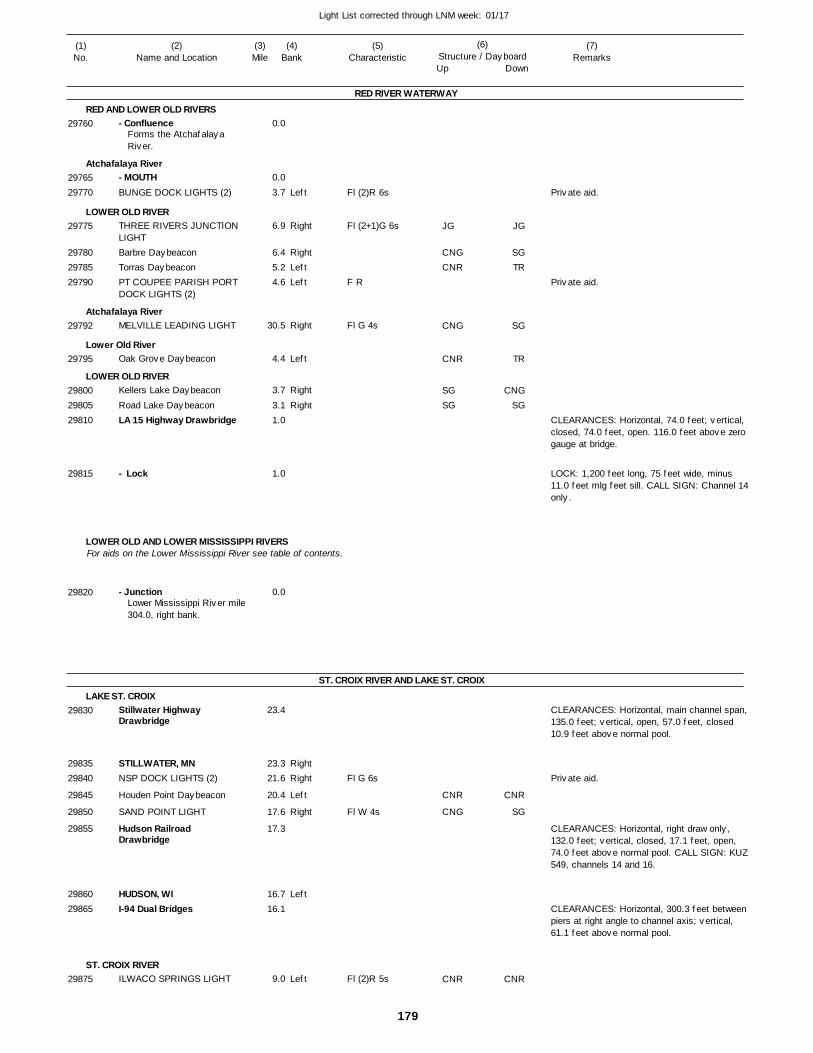
179
Light List corrected through LNM week: 01/17
(7)Remarks
(1)No.
(2)Name and Location
(3)Mile
(5)Characteristic
(4)Bank
(6)Structure / DayboardUp Down
- Confluence
- MOUTHBUNGE DOCK LIGHTS (2)
THREE RIVERS JUNCTION LIGHTBarbre DaybeaconTorras DaybeaconPT COUPEE PARISH PORT DOCK LIGHTS (2)
MELVILLE LEADING LIGHT
Oak Grove Daybeacon
Kellers Lake Daybeacon
Road Lake DaybeaconLA 15 Highway Drawbridge
- Lock
- Junction
Stillwater Highway Drawbridge
STILLWATER, MNNSP DOCK LIGHTS (2)
Houden Point Daybeacon
SAND POINT LIGHT
Hudson Railroad Drawbridge
HUDSON, WII-94 Dual Bridges
ILWACO SPRINGS LIGHT
RED RIVER WATERWAY
RED AND LOWER OLD RIVERS
Atchafalaya River
LOWER OLD RIVER
Atchafalaya River
Lower Old River
LOWER OLD RIVER
LOWER OLD AND LOWER MISSISSIPPI RIVERS
ST. CROIX RIVER AND LAKE ST. CROIX
LAKE ST. CROIX
ST. CROIX RIVER
For aids on the Lower Mississippi River see table of contents.
Left
Right
RightLeftLeft
Right
Left
Right
Right
RightRight
Left
Right
Left
Left
0.0
0.0
3.7
6.9
6.4 5.2 4.6
30.5
4.4
3.7
3.1 1.0
1.0
0.0
23.4
23.3 21.6
20.4
17.6
17.3
16.7 16.1
9.0
Forms the Atchafalaya River.
Lower Mississippi River mile304.0, right bank.
Fl (2)R 6s
Fl (2+1)G 6s
F R
Fl G 4s
Fl G 6s
Fl W 4s
Fl (2)R 5s
CLEARANCES: Horizontal, 74.0 feet; vertical, closed, 74.0 feet, open. 116.0 feet above zero gauge at bridge.
LOCK: 1,200 feet long, 75 feet wide, minus 11.0 feet mlg feet sill. CALL SIGN: Channel 14only.
CLEARANCES: Horizontal, main channel span,135.0 feet; vertical, open, 57.0 feet, closed 10.9 feet above normal pool.
CLEARANCES: Horizontal, right draw only, 132.0 feet; vertical, closed, 17.1 feet, open, 74.0 feet above normal pool. CALL SIGN: KUZ549, channels 14 and 16.
CLEARANCES: Horizontal, 300.3 feet betweenpiers at right angle to channel axis; vertical, 61.1 feet above normal pool.
29760
2976529770
29775
297802978529790
29792
29795
298002980529810
29815
29820
29830
2983529840
29845
29850
29855
2986029865
29875
JG
CNGCNR
CNG
CNR
SGSG
CNR
CNG
CNR
JG
SGTR
SG
TR
CNGSG
CNR
SG
CNR
Private aid.
Private aid.
Private aid.

180
Light List corrected through LNM week: 01/17
(7)Remarks
(1)No.
(2)Name and Location
(3)Mile
(5)Characteristic
(4)Bank
(6)Structure / DayboardUp Down
Kinnikinnic River Daybeacon
Kotz DaybeaconQUARRY LIGHT
Prescott Highway Drawbridge
Burlington Northern Santa Fe Railroad Drawbridge
PRESCOTT, WI
- Junction
SEA RAY BOATS LIGHT
BURKHART ENTERPRISES LIGHTS (2)
- Confluence
VOLUNTEER ASPHALT LIGHTS (2)
KNOXVILLE UTILITIES WATER INTAKE LIGHTSouth Knoxville Blvd Bridge
VOLUNTEER LANDING MARINA LIGHTS (5)SOUTHERN STATES ASPHALT LIGHTS (2)- BOAT COMPANY LIGHTS (2)KNOXVILLE, TNGay Street Bridge
Henley Bridge
ST. CROIX RIVER AND LAKE ST. CROIX
ST. CROIX RIVER
ST. CROIX AND UPPER MISSISSIPPI RIVERS
TENNESSEE RIVER
FRENCH BROAD RIVER
HOLSTON AND FRENCH BROAD RIVERS
TENNESSEE RIVER
Right
RightLeft
Left
Right
Right
Left
Right
Right
Left
Right
Right
6.5
5.0 3.8
0.3
0.2
0.1
0.0
3.0
0.4
0.0
651.5
649.2
648.7
648.0
647.9
647.8
647.7 647.7
647.4
Upper Mississippi River mile811.3, left bank.
Forms the Tennessee River,mile 652.2.
Marks dock.
Fl (2)R 5s
Fl G 6s
Fl G 6s
Fl (2)R 6s
Fl G 6s
Fl G 6s
Fl (2)R 6s
Fl G 6s
On mooring tripods.
CLEARANCES: Horizontal, 160.0 feet; vertical, 24.7 feet closed, at normal pool, 105.0 feet open at normal pool.
CLEARANCES: Horizontal,draw, 215.0 feet; vertical, closed, 20.4 feet, open, 60.4 feet above normal pool.CALL SIGN: KJC 782,channels 14 and 16.
CLEARANCES: Horizontal, 350.0 feet; vertical, 59.3 feet above normal pool for mid-300.0 feet of span.
CLEARANCES: Horizontal, 252.0 feet; vertical, height at center arch, 65.0 feet abovenormal pool.
CLEARANCES: Horizontal, 297.0 feet; vertical, height at center of arch, 89.0 feet above normal pool.
298802988229885
29890
29900
29905
29910
29925
29930
29935
29940
29945
29950
29967
29970
29975
2998029985
29990
CNGSGCNR
CNGSG
CNR
Private aid.
Private aid.
Private aid.
Private aid.
Private aid.
Private aid.
Private aid.

181
Light List corrected through LNM week: 01/17
(7)Remarks
(1)No.
(2)Name and Location
(3)Mile
(5)Characteristic
(4)Bank
(6)Structure / DayboardUp Down
Southern Railroad Bridge
CITYVIEW AT RIVERWALK DOCK LIGHTUNIVERSITY OF TENNESSEE LIGHTS (2)
CSX Railroad Bridge
James E. Karnes Bridge
PRESIDENTS BOAT DOCK LIGHTLOONEY LIGHT
Peter Blow Daybeacon
City Limit Daybeacon
Cherokee Daybeacon
KIRBY LIGHT
WILLIAMS LIGHT
KNOB CREEK LIGHT
Topside DaybeaconBADGETTS LIGHT
- MOUTH
LITTLE RIVER LIGHT
MOONEY LIGHT
JONES BEND LIGHT
STATE FARM LIGHT
CALLAHAN LIGHT
POST OAK LIGHT
Pellisippi Parkway Bridge
STORM CELLAR LIGHT
JACKSON BEND LIGHT
SINKING CREEK LIGHT
TENNESSEE RIVER
TENNESSEE RIVER
Little River
TENNESSEE RIVER
A channel depth of 11.0 feet is provided at minimum pool to Singleton, TN, and is buoyed to mile 1.2.
Left
Right
Right
Left
Left
Right
Right
Right
Left
Left
LeftLeft
Left
Right
Left
Right
Right
Left
Left
Left
Right
Right
647.3
647.2
647.2
646.6
645.1
643.8
643.0
641.7
641.2
640.8
639.8
638.9
637.9
636.9 636.5
635.6
634.8
633.9
632.7
632.0
631.4
630.4
630.1
629.0
628.0
627.3
Marks dock.
Fl (2)R 6s
Fl G 6s
Fl G 6s
Fl (2)R 5s
Fl G 4s
Fl (2)R 5s
Fl (2)R 5s
Fl (2)R 5s
Fl G 4s
Fl (2)R 5s
Fl G 4s
Fl G 4s
Fl (2)R 5s
Fl (2)R 5s
Fl (2)R 5s
Fl G 4s
Fl G 4s
On dock.
On piling.
On piling.
On piling.
On multi-piling.
On multi-piling.
On piling.
On piling.
On piling.
On piling.
On piling.
On piling.
On multi-piling.
CLEARANCES: Horizontal, between piers, 150.0 feet; vertical, 50.0 feet above normal pool.
CLEARANCES: Horizontal, between piers, 261.0 feet; vertical, 58.0 feet above normal pool.
CLEARANCES: Horizontal, between piers, 310.98 feet; vertical, 58.25 feet for mid 155.5 feet of channel span at normal pool, 56.93 feetabove normal pool for full width of span.
CLEARANCES: Horizontal, 460.0 feet; vertical, 75.6 feet above normal pool.
29995
29997
30000
30010
30020
30030
30035
30040
30045
30050
30055
30060
30065
3007030071
30075
30080
30085
30090
30095
30105
30110
30115
30125
30130
30135
TR
TR
SG
SG
SG
TR
TR
TRTR
SG
TR
SG
SG
TR
TR
TR
SG
SG
TR
TR
SG
SG
SG
TR
TR
TRTR
SG
TR
SG
SG
TR
TR
TR
SG
SG
Private aid.
Private aid.
Private aid.
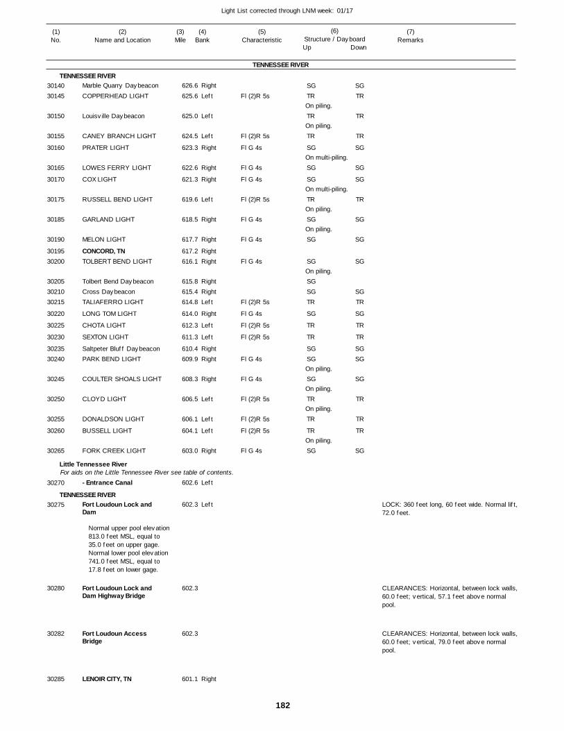
182
Light List corrected through LNM week: 01/17
(7)Remarks
(1)No.
(2)Name and Location
(3)Mile
(5)Characteristic
(4)Bank
(6)Structure / DayboardUp Down
Marble Quarry Daybeacon
COPPERHEAD LIGHT
Louisville Daybeacon
CANEY BRANCH LIGHT
PRATER LIGHT
LOWES FERRY LIGHT
COX LIGHT
RUSSELL BEND LIGHT
GARLAND LIGHT
MELON LIGHT
CONCORD, TNTOLBERT BEND LIGHT
Tolbert Bend DaybeaconCross DaybeaconTALIAFERRO LIGHT
LONG TOM LIGHT
CHOTA LIGHT
SEXTON LIGHT
Saltpeter Bluff DaybeaconPARK BEND LIGHT
COULTER SHOALS LIGHT
CLOYD LIGHT
DONALDSON LIGHT
BUSSELL LIGHT
FORK CREEK LIGHT
- Entrance Canal
Fort Loudoun Lock and Dam
Fort Loudoun Lock and Dam Highway Bridge
Fort Loudoun Access Bridge
LENOIR CITY, TN
TENNESSEE RIVER
TENNESSEE RIVER
Little Tennessee River
TENNESSEE RIVER
For aids on the Little Tennessee River see table of contents.
Right
Left
Left
Left
Right
Right
Right
Left
Right
Right
RightRight
RightRightLeft
Right
Left
Left
RightRight
Right
Left
Left
Left
Right
Left
Left
Right
626.6
625.6
625.0
624.5
623.3
622.6
621.3
619.6
618.5
617.7
617.2 616.1
615.8 615.4 614.8
614.0
612.3
611.3
610.4 609.9
608.3
606.5
606.1
604.1
603.0
602.6
602.3
602.3
602.3
601.1
Normal upper pool elevation 813.0 feet MSL, equal to 35.0 feet on upper gage. Normal lower pool elevation 741.0 feet MSL, equal to 17.8 feet on lower gage.
Fl (2)R 5s
Fl (2)R 5s
Fl G 4s
Fl G 4s
Fl G 4s
Fl (2)R 5s
Fl G 4s
Fl G 4s
Fl G 4s
Fl (2)R 5s
Fl G 4s
Fl (2)R 5s
Fl (2)R 5s
Fl G 4s
Fl G 4s
Fl (2)R 5s
Fl (2)R 5s
Fl (2)R 5s
Fl G 4s
On piling.
On piling.
On multi-piling.
On multi-piling.
On piling.
On piling.
On piling.
On piling.
On piling.
On piling.
On piling.
LOCK: 360 feet long, 60 feet wide. Normal lift,72.0 feet.
CLEARANCES: Horizontal, between lock walls,60.0 feet; vertical, 57.1 feet above normal pool.
CLEARANCES: Horizontal, between lock walls,60.0 feet; vertical, 79.0 feet above normal pool.
3014030145
30150
30155
30160
30165
30170
30175
30185
30190
3019530200
302053021030215
30220
30225
30230
3023530240
30245
30250
30255
30260
30265
30270
30275
30280
30282
30285
SGTR
TR
TR
SG
SG
SG
TR
SG
SG
SG
SGSGTR
SG
TR
TR
SGSG
SG
TR
TR
TR
SG
SGTR
TR
TR
SG
SG
SG
TR
SG
SG
SG
SGTR
SG
TR
TR
SGSG
SG
TR
TR
TR
SG
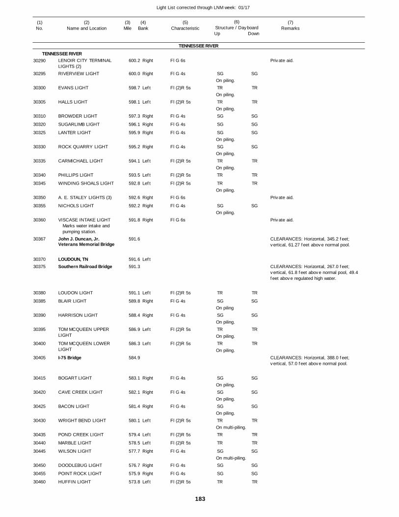
183
Light List corrected through LNM week: 01/17
(7)Remarks
(1)No.
(2)Name and Location
(3)Mile
(5)Characteristic
(4)Bank
(6)Structure / DayboardUp Down
LENOIR CITY TERMINAL LIGHTS (2)RIVERVIEW LIGHT
EVANS LIGHT
HALLS LIGHT
BROWDER LIGHT
SUGARLIMB LIGHT
LANTER LIGHT
ROCK QUARRY LIGHT
CARMICHAEL LIGHT
PHILLIPS LIGHT
WINDING SHOALS LIGHT
A. E. STALEY LIGHTS (3)
NICHOLS LIGHT
VISCASE INTAKE LIGHT
John J. Duncan, Jr. Veterans Memorial Bridge
LOUDOUN, TNSouthern Railroad Bridge
LOUDON LIGHT
BLAIR LIGHT
HARRISON LIGHT
TOM MCQUEEN UPPER LIGHT
TOM MCQUEEN LOWER LIGHT
I-75 Bridge
BOGART LIGHT
CAVE CREEK LIGHT
BACON LIGHT
WRIGHT BEND LIGHT
POND CREEK LIGHT
MARBLE LIGHT
WILSON LIGHT
DOODLEBUG LIGHT
POINT ROCK LIGHT
HUFFIN LIGHT
TENNESSEE RIVER
TENNESSEE RIVERRight
Right
Left
Left
Right
Right
Right
Right
Left
Left
Left
Right
Right
Right
Left
Left
Right
Right
Left
Left
Right
Right
Right
Left
Left
Left
Right
Right
Right
Left
600.2
600.0
598.7
598.1
597.3
596.1
595.9
595.2
594.1
593.5
592.8
592.6
592.2
591.8
591.6
591.6 591.3
591.1
589.8
588.4
586.9
586.3
584.9
583.1
582.1
581.4
580.1
579.4
578.5
577.7
576.7
575.9
573.8
Marks water intake andpumping station.
Fl G 6s
Fl G 4s
Fl (2)R 5s
Fl (2)R 5s
Fl G 4s
Fl G 4s
Fl G 4s
Fl G 4s
Fl (2)R 5s
Fl (2)R 5s
Fl (2)R 5s
Fl G 6s
Fl G 4s
Fl G 6s
Fl (2)R 5s
Fl G 4s
Fl G 4s
Fl (2)R 5s
Fl (2)R 5s
Fl G 4s
Fl G 4s
Fl G 4s
Fl (2)R 5s
Fl (2)R 5s
Fl (2)R 5s
Fl G 4s
Fl G 4s
Fl G 4s
Fl (2)R 5s
On piling.
On piling.
On piling.
On piling.
On piling.
On piling.
On piling.
On piling.
On piling
On piling.
On piling.
On piling.
On piling.
On piling.
On piling.
On multi-piling.
On multi-piling.
CLEARANCES: Horizontal, 345.2 feet; vertical, 61.27 feet above normal pool.
CLEARANCES: Horizontal, 267.0 feet; vertical, 61.8 feet above normal pool, 49.4 feet above regulated high water.
CLEARANCES: Horizontal, 388.0 feet; vertical, 57.0 feet above normal pool.
30290
30295
30300
30305
30310
30320
30325
30330
30335
30340
30345
30350
30355
30360
30367
3037030375
30380
30385
30390
30395
30400
30405
30415
30420
30425
30430
30435
30440
30445
30450
30455
30460
SG
TR
TR
SG
SG
SG
SG
TR
TR
TR
SG
TR
SG
SG
TR
TR
SG
SG
SG
TR
TR
TR
SG
SG
SG
TR
SG
TR
TR
SG
SG
SG
SG
TR
TR
TR
SG
TR
SG
SG
TR
TR
SG
SG
SG
TR
TR
TR
SG
SG
SG
TR
Private aid.
Private aid.
Private aid.
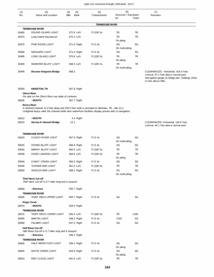
184
Light List corrected through LNM week: 01/17
(7)Remarks
(1)No.
(2)Name and Location
(3)Mile
(5)Characteristic
(4)Bank
(6)Structure / DayboardUp Down
ROUND ISLAND LIGHT
Long Island Daybeacon
PINE RIDGE LIGHT
NEEGARD LIGHT
LONG ISLAND LIGHT
WEBSTER BLUFF LIGHT
Decatur-Kingston Bridge
KINGSTON, TN
- MOUTH
- MOUTHHarvey H. Hannah Bridge
CLINCH RIVER LIGHT
STOWE BLUFF LIGHT
MARNY BLUFF LIGHT
HOOD LANDING LIGHT
CANEY CREEK LIGHT
TURNER BAR LIGHT
SHIELDS BAR LIGHT
- Entrance
THIEF NECK UPPER LIGHT
- MOUTH
THIEF NECK LOWER LIGHT
MARTIN LIGHT
PALMER LIGHT
- Entrance
HALF MOON FOOT LIGHT
WHITE CREEK LIGHT
RED CLOUD LIGHT
TENNESSEE RIVER
TENNESSEE RIVER
Clinch River
Emory River
TENNESSEE RIVER
Thief Neck Cut-off
TENNESSEE RIVER
Kings Creek
TENNESSEE RIVER
Half Moon Cut-off
TENNESSEE RIVER
For aids on the Clinch River see table of contents.
A minimum channel 11.0 feet deep and 100.0 feet wide is provided to Harriman, TN., mile 12.1. Unlighted buoys mark the channel while most waterfront facilities display private aids to navigation.
Thief Neck Cut-off is 0.7 miles long and is buoyed.
Half Moon Cut-off is 0.7 miles long and is buoyed.
Left
Left
Right
Right
Left
Left
Right
Right
Right
Right
Right
Left
Left
Right
Left
Right
Right
Right
Right
Left
Right
Right
Right
Right
Right
Left
572.9
572.3
571.9
571.0
570.8
569.0
568.2
567.8
567.7
4.4
12.1
567.6
566.8
565.0
564.6
562.0
561.0
558.2
555.7
555.7
553.0
550.4
548.2
547.5
546.2
546.2
543.9
541.6
Fl (2)R 5s
Fl G 4s
Fl G 4s
Fl (2)R 5s
Fl (2)R 5s
Fl G 4s
Fl G 4s
Fl (2)R 5s
Fl (2)R 5s
Fl G 4s
Fl (2)R 5s
Fl G 4s
Fl G 4s
Fl (2)R 5s
Fl G 4s
Fl G 4s
Fl G 4s
Fl G 4s
Fl (2)R 5s
On piling.
On multi-piling.
On piling.
On multi-piling.
On multi-piling.
On piling.
On multi-piling.
On piling.
On piling.
CLEARANCES: Horizontal, 424.0 feet; vertical, 57.1 feet above normal pool. Navigation gauge on bridge pier, readings showin feet above MSL.
CLEARANCES: Horizontal, 140.0 feet; vertical, 44.1 feet above normal pool.
30465
30470
30475
30480
30485
30490
30495
30500
30505
3051030515
30520
30525
30530
30535
30540
30545
30550
30560
30565
30570
30575
30585
30590
30595
30600
30605
30610
TR
TR
SG
SG
TR
TR
SG
SG
TR
TR
SG
TR
SG
SG
TR
CNG
SG
SG
SG
TR
TR
TR
SG
SG
TR
TR
SG
SG
TR
TR
SG
TR
SG
SG
CNR
SG
SG
SG
SG
TR
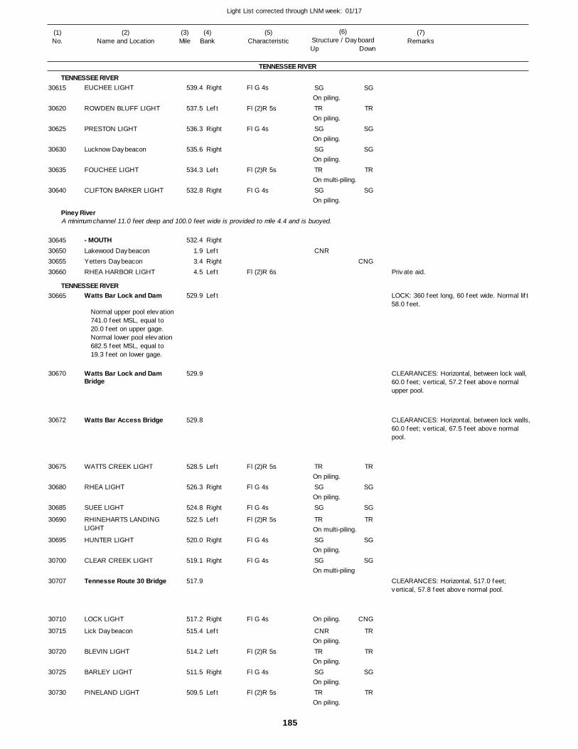
185
Light List corrected through LNM week: 01/17
(7)Remarks
(1)No.
(2)Name and Location
(3)Mile
(5)Characteristic
(4)Bank
(6)Structure / DayboardUp Down
EUCHEE LIGHT
ROWDEN BLUFF LIGHT
PRESTON LIGHT
Lucknow Daybeacon
FOUCHEE LIGHT
CLIFTON BARKER LIGHT
- MOUTHLakewood DaybeaconYetters DaybeaconRHEA HARBOR LIGHT
Watts Bar Lock and Dam
Watts Bar Lock and Dam Bridge
Watts Bar Access Bridge
WATTS CREEK LIGHT
RHEA LIGHT
SUEE LIGHT
RHINEHARTS LANDING LIGHT
HUNTER LIGHT
CLEAR CREEK LIGHT
Tennesse Route 30 Bridge
LOCK LIGHT
Lick Daybeacon
BLEVIN LIGHT
BARLEY LIGHT
PINELAND LIGHT
TENNESSEE RIVER
TENNESSEE RIVER
Piney River
TENNESSEE RIVER
A minimum channel 11.0 feet deep and 100.0 feet wide is provided to mile 4.4 and is buoyed.
Right
Left
Right
Right
Left
Right
Right
LeftRightLeft
Left
Left
Right
Right
Left
Right
Right
Right
Left
Left
Right
Left
539.4
537.5
536.3
535.6
534.3
532.8
532.4
1.9 3.4 4.5
529.9
529.9
529.8
528.5
526.3
524.8
522.5
520.0
519.1
517.9
517.2
515.4
514.2
511.5
509.5
Normal upper pool elevation 741.0 feet MSL, equal to 20.0 feet on upper gage. Normal lower pool elevation 682.5 feet MSL, equal to 19.3 feet on lower gage.
Fl G 4s
Fl (2)R 5s
Fl G 4s
Fl (2)R 5s
Fl G 4s
Fl (2)R 6s
Fl (2)R 5s
Fl G 4s
Fl G 4s
Fl (2)R 5s
Fl G 4s
Fl G 4s
Fl G 4s
Fl (2)R 5s
Fl G 4s
Fl (2)R 5s
On piling.
On piling.
On piling.
On piling.
On multi-piling.
On piling.
On piling.
On piling.
On multi-piling.
On piling.
On multi-piling
On piling.
On piling.
On piling.
On piling.
On piling.
LOCK: 360 feet long, 60 feet wide. Normal lift 58.0 feet.
CLEARANCES: Horizontal, between lock wall, 60.0 feet; vertical, 57.2 feet above normal upper pool.
CLEARANCES: Horizontal, between lock walls,60.0 feet; vertical, 67.5 feet above normal pool.
CLEARANCES: Horizontal, 517.0 feet; vertical, 57.8 feet above normal pool.
30615
30620
30625
30630
30635
30640
30645306503065530660
30665
30670
30672
30675
30680
30685
30690
30695
30700
30707
30710
30715
30720
30725
30730
SG
TR
SG
SG
TR
SG
CNR
TR
SG
SG
TR
SG
SG
CNR
TR
SG
TR
SG
TR
SG
SG
TR
SG
CNG
TR
SG
SG
TR
SG
SG
CNG
TR
TR
SG
TR
Private aid.
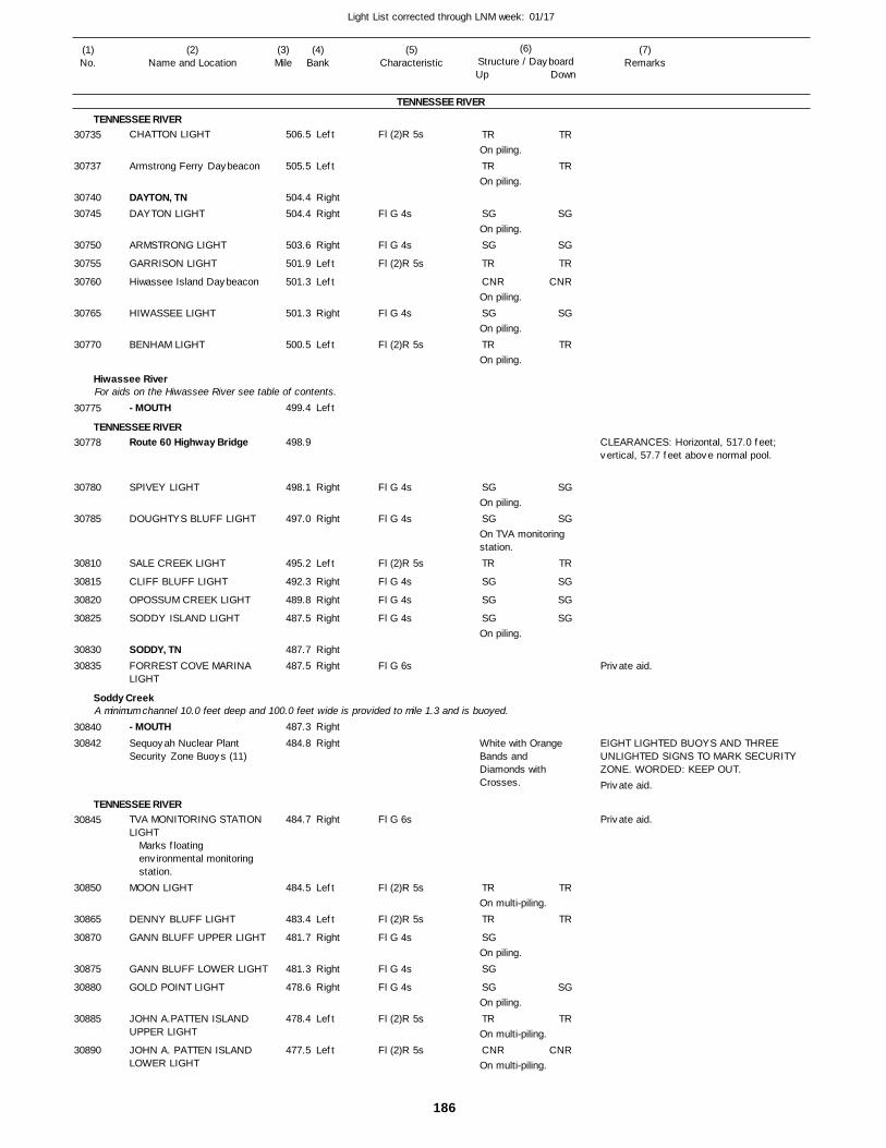
186
Light List corrected through LNM week: 01/17
(7)Remarks
(1)No.
(2)Name and Location
(3)Mile
(5)Characteristic
(4)Bank
(6)Structure / DayboardUp Down
CHATTON LIGHT
Armstrong Ferry Daybeacon
DAYTON, TNDAYTON LIGHT
ARMSTRONG LIGHT
GARRISON LIGHT
Hiwassee Island Daybeacon
HIWASSEE LIGHT
BENHAM LIGHT
- MOUTH
Route 60 Highway Bridge
SPIVEY LIGHT
DOUGHTYS BLUFF LIGHT
SALE CREEK LIGHT
CLIFF BLUFF LIGHT
OPOSSUM CREEK LIGHT
SODDY ISLAND LIGHT
SODDY, TNFORREST COVE MARINA LIGHT
- MOUTHSequoyah Nuclear Plant Security Zone Buoys (11)
TVA MONITORING STATION LIGHT
MOON LIGHT
DENNY BLUFF LIGHT
GANN BLUFF UPPER LIGHT
GANN BLUFF LOWER LIGHT
GOLD POINT LIGHT
JOHN A.PATTEN ISLAND UPPER LIGHT
JOHN A. PATTEN ISLAND LOWER LIGHT
TENNESSEE RIVER
TENNESSEE RIVER
Hiwassee River
TENNESSEE RIVER
Soddy Creek
TENNESSEE RIVER
For aids on the Hiwassee River see table of contents.
A minimum channel 10.0 feet deep and 100.0 feet wide is provided to mile 1.3 and is buoyed.
Left
Left
RightRight
Right
Left
Left
Right
Left
Left
Right
Right
Left
Right
Right
Right
RightRight
Right
Right
Right
Left
Left
Right
Right
Right
Left
Left
506.5
505.5
504.4 504.4
503.6
501.9
501.3
501.3
500.5
499.4
498.9
498.1
497.0
495.2
492.3
489.8
487.5
487.7 487.5
487.3
484.8
484.7
484.5
483.4
481.7
481.3
478.6
478.4
477.5
Marks floating environmental monitoring station.
Fl (2)R 5s
Fl G 4s
Fl G 4s
Fl (2)R 5s
Fl G 4s
Fl (2)R 5s
Fl G 4s
Fl G 4s
Fl (2)R 5s
Fl G 4s
Fl G 4s
Fl G 4s
Fl G 6s
Fl G 6s
Fl (2)R 5s
Fl (2)R 5s
Fl G 4s
Fl G 4s
Fl G 4s
Fl (2)R 5s
Fl (2)R 5s
On piling.
On piling.
On piling.
On piling.
On piling.
On piling.
On piling.
On TVA monitoring station.
On piling.
White with Orange Bands and Diamonds with Crosses.
On multi-piling.
On piling.
On piling.
On multi-piling.
On multi-piling.
CLEARANCES: Horizontal, 517.0 feet; vertical, 57.7 feet above normal pool.
EIGHT LIGHTED BUOYS AND THREE UNLIGHTED SIGNS TO MARK SECURITY ZONE. WORDED: KEEP OUT.
30735
30737
3074030745
30750
30755
30760
30765
30770
30775
30778
30780
30785
30810
30815
30820
30825
3083030835
3084030842
30845
30850
30865
30870
30875
30880
30885
30890
TR
TR
SG
SG
TR
CNR
SG
TR
SG
SG
TR
SG
SG
SG
TR
TR
SG
SG
SG
TR
CNR
TR
TR
SG
SG
TR
CNR
SG
TR
SG
SG
TR
SG
SG
SG
TR
TR
SG
TR
CNR
Private aid.
Private aid.
Private aid.
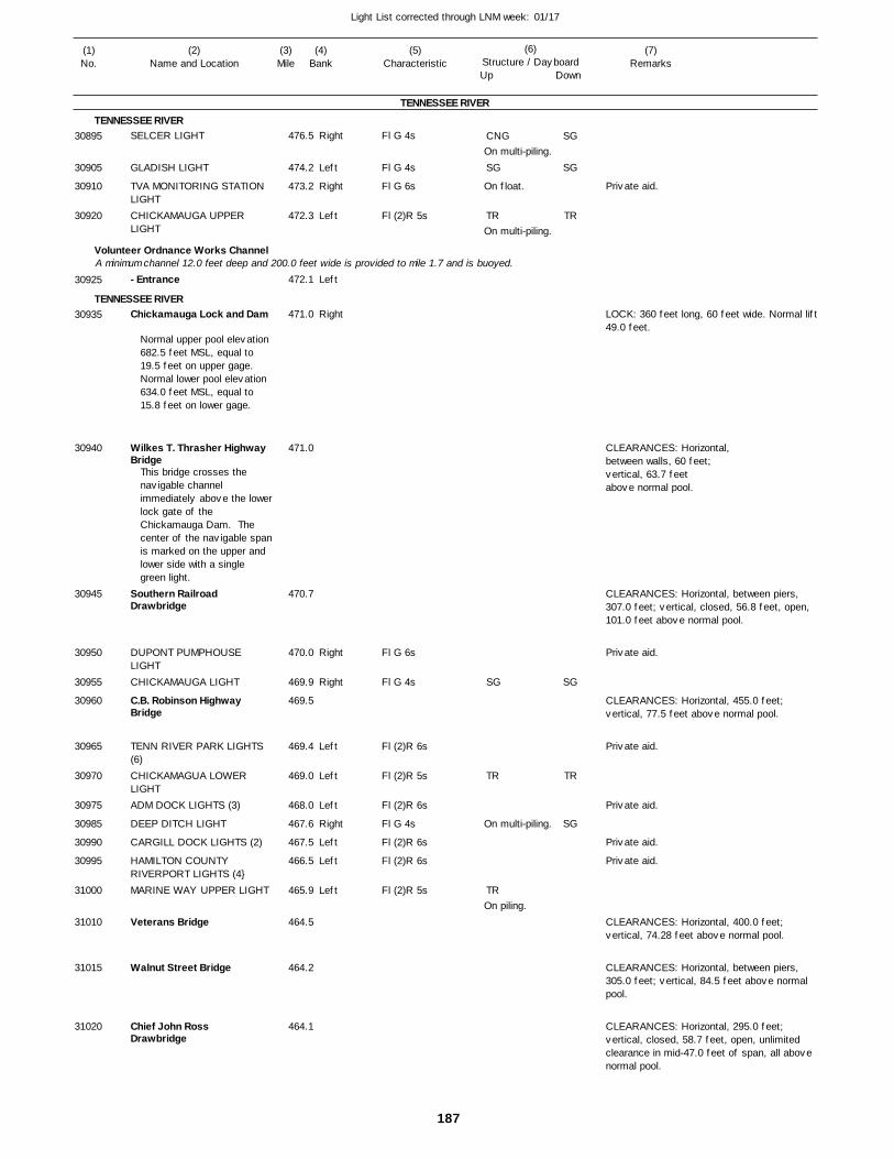
187
Light List corrected through LNM week: 01/17
(7)Remarks
(1)No.
(2)Name and Location
(3)Mile
(5)Characteristic
(4)Bank
(6)Structure / DayboardUp Down
SELCER LIGHT
GLADISH LIGHT
TVA MONITORING STATION LIGHTCHICKAMAUGA UPPER LIGHT
- Entrance
Chickamauga Lock and Dam
Wilkes T. Thrasher Highway Bridge
Southern Railroad Drawbridge
DUPONT PUMPHOUSE LIGHTCHICKAMAUGA LIGHT
C.B. Robinson Highway Bridge
TENN RIVER PARK LIGHTS (6)CHICKAMAGUA LOWER LIGHTADM DOCK LIGHTS (3)
DEEP DITCH LIGHT
CARGILL DOCK LIGHTS (2)
HAMILTON COUNTY RIVERPORT LIGHTS (4}MARINE WAY UPPER LIGHT
Veterans Bridge
Walnut Street Bridge
Chief John Ross Drawbridge
TENNESSEE RIVER
TENNESSEE RIVER
Volunteer Ordnance Works Channel
TENNESSEE RIVER
A minimum channel 12.0 feet deep and 200.0 feet wide is provided to mile 1.7 and is buoyed.
Right
Left
Right
Left
Left
Right
Right
Right
Left
Left
Left
Right
Left
Left
Left
476.5
474.2
473.2
472.3
472.1
471.0
471.0
470.7
470.0
469.9
469.5
469.4
469.0
468.0
467.6
467.5
466.5
465.9
464.5
464.2
464.1
Normal upper pool elevation 682.5 feet MSL, equal to 19.5 feet on upper gage. Normal lower pool elevation 634.0 feet MSL, equal to 15.8 feet on lower gage.
This bridge crosses the navigable channel immediately above the lowerlock gate of the Chickamauga Dam. The center of the navigable spanis marked on the upper and lower side with a single green light.
Fl G 4s
Fl G 4s
Fl G 6s
Fl (2)R 5s
Fl G 6s
Fl G 4s
Fl (2)R 6s
Fl (2)R 5s
Fl (2)R 6s
Fl G 4s
Fl (2)R 6s
Fl (2)R 6s
Fl (2)R 5s
On multi-piling.
On float.
On multi-piling.
On multi-piling.
On piling.
LOCK: 360 feet long, 60 feet wide. Normal lift 49.0 feet.
CLEARANCES: Horizontal,between walls, 60 feet;vertical, 63.7 feetabove normal pool.
CLEARANCES: Horizontal, between piers, 307.0 feet; vertical, closed, 56.8 feet, open, 101.0 feet above normal pool.
CLEARANCES: Horizontal, 455.0 feet; vertical, 77.5 feet above normal pool.
CLEARANCES: Horizontal, 400.0 feet; vertical, 74.28 feet above normal pool.
CLEARANCES: Horizontal, between piers, 305.0 feet; vertical, 84.5 feet above normal pool.
CLEARANCES: Horizontal, 295.0 feet; vertical, closed, 58.7 feet, open, unlimited clearance in mid-47.0 feet of span, all above normal pool.
30895
30905
30910
30920
30925
30935
30940
30945
30950
30955
30960
30965
30970
30975
30985
30990
30995
31000
31010
31015
31020
CNG
SG
TR
SG
TR
TR
SG
SG
TR
SG
TR
SG
Private aid.
Private aid.
Private aid.
Private aid.
Private aid.
Private aid.
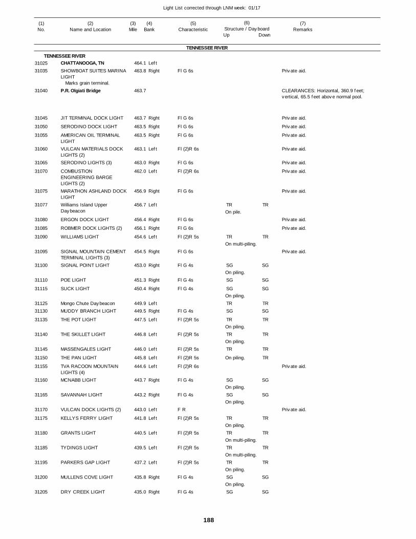
188
Light List corrected through LNM week: 01/17
(7)Remarks
(1)No.
(2)Name and Location
(3)Mile
(5)Characteristic
(4)Bank
(6)Structure / DayboardUp Down
CHATTANOOGA, TNSHOWBOAT SUITES MARINALIGHT
P.R. Olgiati Bridge
JIT TERMINAL DOCK LIGHT
SERODINO DOCK LIGHT
AMERICAN OIL TERMINAL LIGHTVULCAN MATERIALS DOCK LIGHTS (2)SERODINO LIGHTS (3)
COMBUSTION ENGINEERING BARGE LIGHTS (2)MARATHON ASHLAND DOCKLIGHTWilliams Island Upper Daybeacon
ERGON DOCK LIGHT
ROBMER DOCK LIGHTS (2)
WILLIAMS LIGHT
SIGNAL MOUNTAIN CEMENTTERMINAL LIGHTS (3)SIGNAL POINT LIGHT
POE LIGHT
SUCK LIGHT
Mongo Chute DaybeaconMUDDY BRANCH LIGHT
THE POT LIGHT
THE SKILLET LIGHT
MASSENGALES LIGHT
THE PAN LIGHT
TVA RACOON MOUNTAIN LIGHTS (4)MCNABB LIGHT
SAVANNAH LIGHT
VULCAN DOCK LIGHTS (2)
KELLYS FERRY LIGHT
GRANTS LIGHT
TYDINGS LIGHT
PARKERS GAP LIGHT
MULLENS COVE LIGHT
DRY CREEK LIGHT
TENNESSEE RIVER
TENNESSEE RIVERLeft
Right
Right
Right
Right
Left
Right
Left
Right
Left
Right
Right
Left
Right
Right
Right
Right
LeftRight
Left
Left
Left
Left
Left
Right
Right
Left
Left
Left
Left
Left
Right
Right
464.1
463.8
463.7
463.7
463.5
463.5
463.1
463.0
462.0
456.9
456.7
456.4
456.1
454.6
454.5
453.0
451.3
450.4
449.9 449.5
447.5
446.8
446.0
445.8
444.6
443.7
443.2
443.0
441.8
440.5
439.5
437.2
435.8
435.0
Marks grain terminal.
Fl G 6s
Fl G 6s
Fl G 6s
Fl G 6s
Fl (2)R 6s
Fl G 6s
Fl (2)R 6s
Fl G 6s
Fl G 6s
Fl G 6s
Fl (2)R 5s
Fl G 6s
Fl G 4s
Fl G 4s
Fl G 4s
Fl G 4s
Fl (2)R 5s
Fl (2)R 5s
Fl (2)R 5s
Fl (2)R 5s
Fl (2)R 6s
Fl G 4s
Fl G 4s
F R
Fl (2)R 5s
Fl (2)R 5s
Fl (2)R 5s
Fl (2)R 5s
Fl G 4s
Fl G 4s
On pile.
On multi-piling.
On piling.
On piling.
On piling.
On piling.
On piling.
On piling.
On piling.
On piling.
On multi-piling.
On multi-piling.
On piling.
On piling.
CLEARANCES: Horizontal, 360.9 feet; vertical, 65.5 feet above normal pool.
3102531035
31040
31045
31050
31055
31060
31065
31070
31075
31077
31080
31085
31090
31095
31100
31110
31115
3112531130
31135
31140
31145
31150
31155
31160
31165
31170
31175
31180
31185
31195
31200
31205
TR
TR
SG
SG
SG
TRSG
TR
TR
TR
SG
SG
TR
TR
TR
TR
SG
SG
TR
TR
SG
SG
SG
TRSG
TR
TR
TR
TR
SG
SG
TR
TR
TR
TR
SG
SG
Private aid.
Private aid.
Private aid.
Private aid.
Private aid.
Private aid.
Private aid.
Private aid.
Private aid.
Private aid.
Private aid.
Private aid.
Private aid.
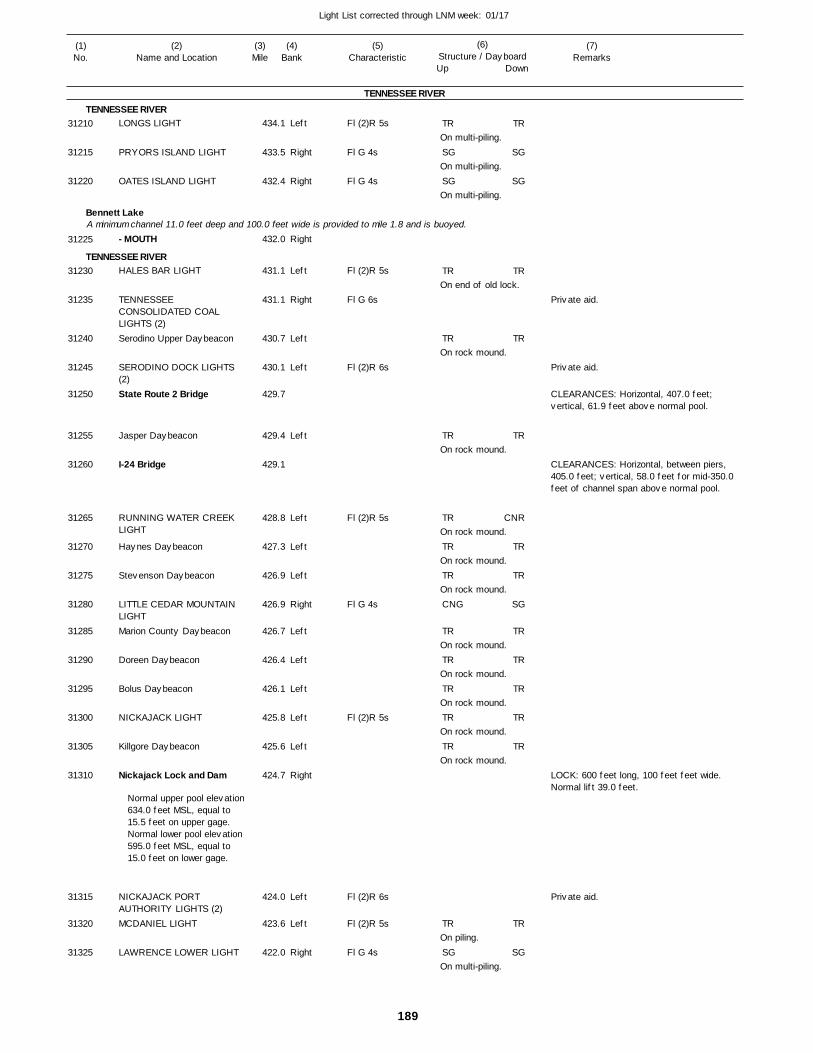
189
Light List corrected through LNM week: 01/17
(7)Remarks
(1)No.
(2)Name and Location
(3)Mile
(5)Characteristic
(4)Bank
(6)Structure / DayboardUp Down
LONGS LIGHT
PRYORS ISLAND LIGHT
OATES ISLAND LIGHT
- MOUTH
HALES BAR LIGHT
TENNESSEE CONSOLIDATED COAL LIGHTS (2)Serodino Upper Daybeacon
SERODINO DOCK LIGHTS (2)State Route 2 Bridge
Jasper Daybeacon
I-24 Bridge
RUNNING WATER CREEK LIGHT
Haynes Daybeacon
Stevenson Daybeacon
LITTLE CEDAR MOUNTAIN LIGHTMarion County Daybeacon
Doreen Daybeacon
Bolus Daybeacon
NICKAJACK LIGHT
Killgore Daybeacon
Nickajack Lock and Dam
NICKAJACK PORT AUTHORITY LIGHTS (2)MCDANIEL LIGHT
LAWRENCE LOWER LIGHT
TENNESSEE RIVER
TENNESSEE RIVER
Bennett Lake
TENNESSEE RIVER
A minimum channel 11.0 feet deep and 100.0 feet wide is provided to mile 1.8 and is buoyed.
Left
Right
Right
Right
Left
Right
Left
Left
Left
Left
Left
Left
Right
Left
Left
Left
Left
Left
Right
Left
Left
Right
434.1
433.5
432.4
432.0
431.1
431.1
430.7
430.1
429.7
429.4
429.1
428.8
427.3
426.9
426.9
426.7
426.4
426.1
425.8
425.6
424.7
424.0
423.6
422.0
Normal upper pool elevation 634.0 feet MSL, equal to 15.5 feet on upper gage. Normal lower pool elevation 595.0 feet MSL, equal to 15.0 feet on lower gage.
Fl (2)R 5s
Fl G 4s
Fl G 4s
Fl (2)R 5s
Fl G 6s
Fl (2)R 6s
Fl (2)R 5s
Fl G 4s
Fl (2)R 5s
Fl (2)R 6s
Fl (2)R 5s
Fl G 4s
On multi-piling.
On multi-piling.
On multi-piling.
On end of old lock.
On rock mound.
On rock mound.
On rock mound.
On rock mound.
On rock mound.
On rock mound.
On rock mound.
On rock mound.
On rock mound.
On rock mound.
On piling.
On multi-piling.
CLEARANCES: Horizontal, 407.0 feet; vertical, 61.9 feet above normal pool.
CLEARANCES: Horizontal, between piers, 405.0 feet; vertical, 58.0 feet for mid-350.0 feet of channel span above normal pool.
LOCK: 600 feet long, 100 feet feet wide. Normal lift 39.0 feet.
31210
31215
31220
31225
31230
31235
31240
31245
31250
31255
31260
31265
31270
31275
31280
31285
31290
31295
31300
31305
31310
31315
31320
31325
TR
SG
SG
TR
TR
TR
TR
TR
TR
CNG
TR
TR
TR
TR
TR
TR
SG
TR
SG
SG
TR
TR
TR
CNR
TR
TR
SG
TR
TR
TR
TR
TR
TR
SG
Private aid.
Private aid.
Private aid.
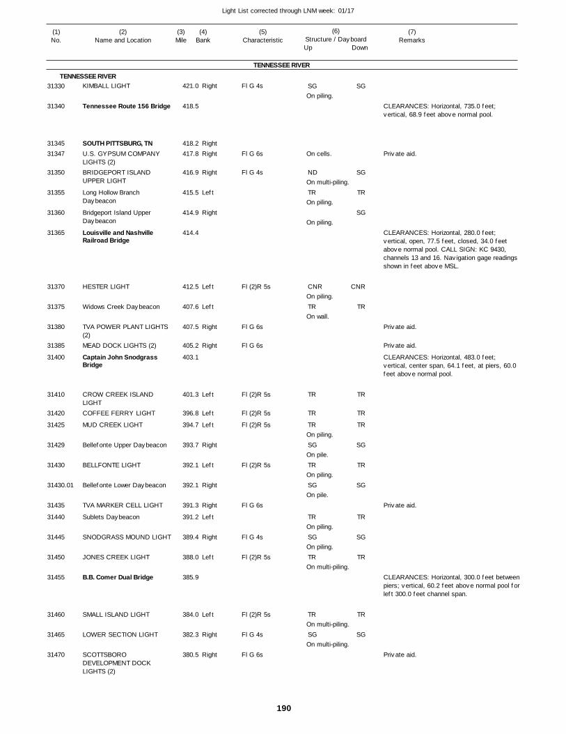
190
Light List corrected through LNM week: 01/17
(7)Remarks
(1)No.
(2)Name and Location
(3)Mile
(5)Characteristic
(4)Bank
(6)Structure / DayboardUp Down
KIMBALL LIGHT
Tennessee Route 156 Bridge
SOUTH PITTSBURG, TNU.S. GYPSUM COMPANY LIGHTS (2)BRIDGEPORT ISLAND UPPER LIGHT
Long Hollow Branch Daybeacon
Bridgeport Island Upper Daybeacon
Louisville and Nashville Railroad Bridge
HESTER LIGHT
Widows Creek Daybeacon
TVA POWER PLANT LIGHTS (2)MEAD DOCK LIGHTS (2)
Captain John Snodgrass Bridge
CROW CREEK ISLAND LIGHTCOFFEE FERRY LIGHT
MUD CREEK LIGHT
Bellefonte Upper Daybeacon
BELLFONTE LIGHT
Bellefonte Lower Daybeacon
TVA MARKER CELL LIGHT
Sublets Daybeacon
SNODGRASS MOUND LIGHT
JONES CREEK LIGHT
B.B. Comer Dual Bridge
SMALL ISLAND LIGHT
LOWER SECTION LIGHT
SCOTTSBORO DEVELOPMENT DOCK LIGHTS (2)
TENNESSEE RIVER
TENNESSEE RIVERRight
RightRight
Right
Left
Right
Left
Left
Right
Right
Left
Left
Left
Right
Left
Right
Right
Left
Right
Left
Left
Right
Right
421.0
418.5
418.2 417.8
416.9
415.5
414.9
414.4
412.5
407.6
407.5
405.2
403.1
401.3
396.8
394.7
393.7
392.1
392.1
391.3
391.2
389.4
388.0
385.9
384.0
382.3
380.5
Fl G 4s
Fl G 6s
Fl G 4s
Fl (2)R 5s
Fl G 6s
Fl G 6s
Fl (2)R 5s
Fl (2)R 5s
Fl (2)R 5s
Fl (2)R 5s
Fl G 6s
Fl G 4s
Fl (2)R 5s
Fl (2)R 5s
Fl G 4s
Fl G 6s
On piling.
On cells.
On multi-piling.
On piling.
On piling.
On piling.
On wall.
On piling.
On pile.
On piling.
On pile.
On piling.
On piling.
On multi-piling.
On multi-piling.
On multi-piling.
CLEARANCES: Horizontal, 735.0 feet; vertical, 68.9 feet above normal pool.
CLEARANCES: Horizontal, 280.0 feet; vertical, open, 77.5 feet, closed, 34.0 feet above normal pool. CALL SIGN: KC 9430, channels 13 and 16. Navigation gage readings shown in feet above MSL.
CLEARANCES: Horizontal, 483.0 feet; vertical, center span, 64.1 feet, at piers, 60.0 feet above normal pool.
CLEARANCES: Horizontal, 300.0 feet betweenpiers; vertical, 60.2 feet above normal pool forleft 300.0 feet channel span.
31330
31340
3134531347
31350
31355
31360
31365
31370
31375
31380
31385
31400
31410
31420
31425
31429
31430
31430.01
31435
31440
31445
31450
31455
31460
31465
31470
SG
ND
TR
CNR
TR
TR
TR
TR
SG
TR
SG
TR
SG
TR
TR
SG
SG
SG
TR
SG
CNR
TR
TR
TR
TR
SG
TR
SG
TR
SG
TR
TR
SG
Private aid.
Private aid.
Private aid.
Private aid.
Private aid.
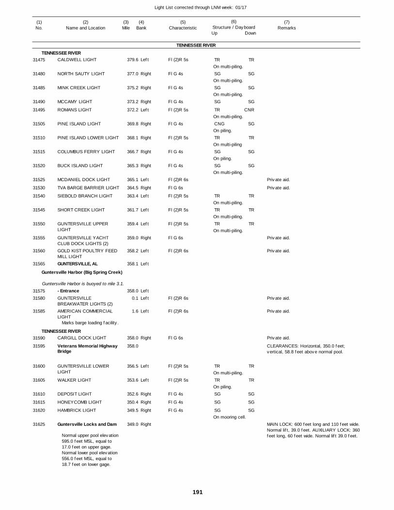
191
Light List corrected through LNM week: 01/17
(7)Remarks
(1)No.
(2)Name and Location
(3)Mile
(5)Characteristic
(4)Bank
(6)Structure / DayboardUp Down
CALDWELL LIGHT
NORTH SAUTY LIGHT
MINK CREEK LIGHT
MCCAMY LIGHT
ROMANS LIGHT
PINE ISLAND LIGHT
PINE ISLAND LOWER LIGHT
COLUMBUS FERRY LIGHT
BUCK ISLAND LIGHT
MCDANIEL DOCK LIGHT
TVA BARGE BARRIER LIGHT
SIEBOLD BRANCH LIGHT
SHORT CREEK LIGHT
GUNTERSVILLE UPPER LIGHT
GUNTERSVILLE YACHT CLUB DOCK LIGHTS (2)GOLD KIST POULTRY FEED MILL LIGHTGUNTERSVILLE, AL
- EntranceGUNTERSVILLE BREAKWATER LIGHTS (2)AMERICAN COMMERCIAL LIGHT
CARGILL DOCK LIGHT
Veterans Memorial Highway Bridge
GUNTERSVILLE LOWER LIGHT
WALKER LIGHT
DEPOSIT LIGHT
HONEYCOMB LIGHT
HAMBRICK LIGHT
Guntersville Locks and Dam
TENNESSEE RIVER
TENNESSEE RIVER
Guntersville Harbor (Big Spring Creek)
TENNESSEE RIVER
Guntersville Harbor is buoyed to mile 3.1.
Left
Right
Right
Right
Left
Right
Right
Right
Right
Left
Right
Left
Left
Left
Right
Left
Left
Left
Left
Left
Right
Left
Left
Right
Right
Right
Right
379.6
377.0
375.2
373.2
372.2
369.8
368.1
366.7
365.3
365.1
364.5
363.4
361.7
359.4
359.0
358.2
358.1
358.0
0.1
1.6
358.0
358.0
356.5
353.6
352.6
350.4
349.5
349.0
Marks barge loading facility.
Normal upper pool elevation 595.0 feet MSL, equal to 17.0 feet on upper gage. Normal lower pool elevation 556.0 feet MSL, equal to 18.7 feet on lower gage.
Fl (2)R 5s
Fl G 4s
Fl G 4s
Fl G 4s
Fl (2)R 5s
Fl G 4s
Fl (2)R 5s
Fl G 4s
Fl G 4s
Fl (2)R 6s
Fl G 6s
Fl (2)R 5s
Fl (2)R 5s
Fl (2)R 5s
Fl G 6s
Fl (2)R 6s
Fl (2)R 6s
Fl (2)R 6s
Fl G 6s
Fl (2)R 5s
Fl (2)R 5s
Fl G 4s
Fl G 4s
Fl G 4s
On multi-piling.
On multi-piling.
On multi-piling.
On multi-piling.
On piling.
On multi-piling
On piling.
On multi-piling.
On multi-piling.
On multi-piling.
On multi-piling.
On multi-piling.
On piling.
On mooring cell.
CLEARANCES: Horizontal, 350.0 feet; vertical, 58.8 feet above normal pool.
MAIN LOCK: 600 feet long and 110 feet wide. Normal lift, 39.0 feet. AUXILIARY LOCK: 360 feet long, 60 feet wide. Normal lift 39.0 feet.
31475
31480
31485
31490
31495
31505
31510
31515
31520
31525
31530
31540
31545
31550
31555
31560
31565
3157531580
31585
31590
31595
31600
31605
31610
31615
31620
31625
TR
SG
SG
SG
TR
CNG
TR
SG
SG
TR
TR
TR
TR
TR
SG
SG
SG
TR
SG
SG
SG
CNR
SG
TR
SG
SG
TR
TR
TR
TR
TR
SG
SG
SG
Private aid.
Private aid.
Private aid.
Private aid.
Private aid.
Private aid.
Private aid.
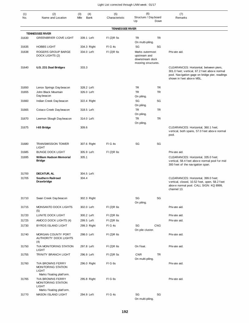
192
Light List corrected through LNM week: 01/17
(7)Remarks
(1)No.
(2)Name and Location
(3)Mile
(5)Characteristic
(4)Bank
(6)Structure / DayboardUp Down
GREENBRIER COVE LIGHT
HOBBS LIGHT
ROGERS GROUP BARGE DOCK LIGHTS (2)
U.S. 231 Dual Bridges
Lenox Springs DaybeaconJohn Black Mountain Daybeacon
Indian Creek Daybeacon
Cotaco Creek Daybeacon
Leemon Slough Daybeacon
I-65 Bridge
TRANSMISSION TOWER LIGHTBUNGE DOCK LIGHT
William Hudson Memorial Bridge
DECATUR, ALSouthern Railroad Drawbridge
Swan Creek Daybeacon
MONSANTO DOCK LIGHTS (5)LUNITE DOCK LIGHT
AMOCO DOCK LIGHTS (4)
BYRDS ISLAND LIGHT
MORGAN COUNTY PORT AUTHORITY DOCK LIGHTS (4)TVA MONITORING STATION LIGHTTRINITY BRANCH LIGHT
TVA BROWNS FERRY MONITORING STATION LIGHT
TVA BROWNS FERRY MONITORING STATION LIGHT
MASON ISLAND LIGHT
TENNESSEE RIVER
TENNESSEE RIVERLeft
Right
Left
LeftLeft
Right
Left
Left
Right
Left
Left
Right
Left
Left
Left
Right
Left
Left
Left
Right
Right
Left
339.1
334.3
334.0
333.3
328.2 326.0
322.4
318.5
314.0
309.6
307.6
305.9
305.1
304.5 304.4
302.3
302.0
300.2
299.5
299.3
298.0
297.8
296.9
296.0
295.8
294.9
Marks floating platform.
Marks floating platform.
Fl (2)R 5s
Fl G 4s
Fl (2)R 6s
Fl G 4s
Fl (2)R 6s
Fl (2)R 6s
Fl (2)R 6s
Fl (2)R 6s
Fl G 4s
Fl (2)R 6s
Fl (2)R 6s
Fl (2)R 5s
Fl G 6s
Fl G 6s
Fl G 4s
On multi-piling.
Marks outermost upstream and downstream dock mooring structures.
On piling.
On piling.
On piling.
On piling.
On piling.
On pile cluster.
On float.
On multi-piling.
On multi-piling.
CLEARANCES: Horizontal, between piers, 301.0 feet; vertical, 67.2 feet above normal pool. Navigation gage on bridge pier, readings shown in feet above MSL.
CLEARANCES: Horizontal, 360.1 feet; vertical, both spans, 57.0 feet above normal pool.
CLEARANCES: Horizontal, 335.0 feet; vertical, 58.4 feet above normal pool for mid 300 feet of the navigation span.
CLEARANCES: Horizontal, 399.0 feet; vertical, closed, 10.52 feet, open, 58.2 feet above normal pool. CALL SIGN: KQ 8999, channel 13.
31630
31635
31638
31640
3165031655
31660
31665
31670
31675
31680
31685
31695
3170031705
31710
31715
31720
31725
31730
31740
31750
31755
31760
31765
31770
TR
SG
TRTR
SG
TR
TR
SG
SG
SG
CNR
SG
TR
SG
TRTR
SG
TR
TR
SG
SG
CNG
TR
SG
Private aid.
Private aid.
Private aid.
Private aid.
Private aid.
Private aid.
Private aid.
Private aid.
Private aid.
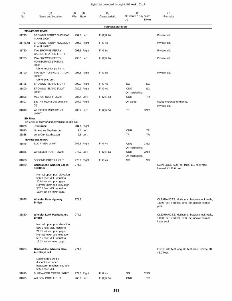
193
Light List corrected through LNM week: 01/17
(7)Remarks
(1)No.
(2)Name and Location
(3)Mile
(5)Characteristic
(4)Bank
(6)Structure / DayboardUp Down
BROWNS FERRY NUCLEAR PLANT LIGHTBROWNS FERRY NUCLEAR PLANT LIGHTTVA BROWNS FERRY GAGING STATION LIGHTTVA BROWNS FERRY MONITORING STATION LIGHT
TVA MONITORING STATION LIGHT
BROWNS ISLAND LIGHT
BROWNS ISLAND FOOT LIGHT
MELTON BLUFF LIGHT
Bay Hill Marina Daybeacons (2)
WHEELER MOMUMENT LIGHT
- EntranceLimestone DaybeaconLong Oak Daybeacon
ELK RIVER LIGHT
WHEELER POINT LIGHT
SECOND CREEK LIGHT
General Joe Wheeler Locks and Dam
Wheeler Dam Highway Bridge
Wheeler Lock Maintenance Bridge
General Joe Wheeler Dam Auxiliary Lock
BLUEWATER CREEK LIGHT
WILSON POOL LIGHT
TENNESSEE RIVER
TENNESSEE RIVER
Elk River
TENNESSEE RIVER
Elk River is buoyed and navigable to mile 4.8.
Left
Right
Right
Left
Right
Right
Right
Left
Right
Left
Right
LeftLeft
Right
Left
Right
Right
Left
294.0
294.0
293.5
293.5
293.5
292.7
289.9
287.4
287.0
286.2
284.1
2.0 2.8
282.8
278.2
275.8
274.9
274.9
274.9
274.9
272.3
268.9
Marks monitor platform.
Marks platform.
Normal upper pool elevation 556.0 feet MSL, equal to 20.0 feet on upper gage. Normal lower pool elevation 507.5 feet MSL, equal to 16.0 feet on lower gage.
Normal upper pool elevation 556.0 feet MSL, equal to 21.7 feet on upper gage. Normal lower pool elevation 507.5 feet MSL, equal to 16.2 feet on lower gage.
Locking thru will be discontinued when headwater reaches elevation555.0 feet MSL.
Fl (2)R 6s
Fl G 4s
Fl G 6s
Fl (2)R 6s
Fl G 6s
Fl G 4s
Fl G 4s
Fl (2)R 5s
Fl (2)R 5s
Fl G 4s
Fl (2)R 5s
Fl G 4s
Fl G 4s
Fl (2)R 5s
On multi-piling.
On barge.
On multi-piling.
On multi-piling.
Marks entrance to marina.
MAIN LOCK: 600 feet long, 110 feet wide. Normal lift 48.0 feet.
CLEARANCES: Horizontal, between lock walls,110.0 feet; vertical, 59.6 feet above normal pool.
CLEARANCES: Horizontal, between lock walls,110.0 feet; vertical, 57.6 feet above normal lower pool.
LOCK: 400 feet long, 60 feet wide. Normal lift 48.0 feet.
31775
31775.01
31780
31785
31790
31795
31800
31805
31807
31810
318203183031835
31845
31855
31860
31870
31875
31880
31885
31890
31895
SG
CNG
CNR
TR
CNRTR
CNG
CNR
SG
SG
CNR
SG
SG
TR
CNR
TRTR
CNG
CNR
SG
CNG
TR
Private aid.
Private aid.
Private aid.
Private aid.
Private aid.
Private aid.
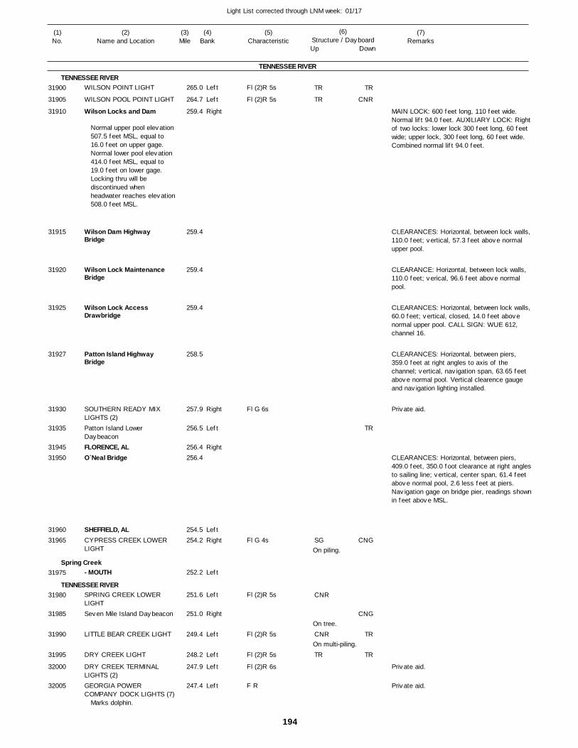
194
Light List corrected through LNM week: 01/17
(7)Remarks
(1)No.
(2)Name and Location
(3)Mile
(5)Characteristic
(4)Bank
(6)Structure / DayboardUp Down
WILSON POINT LIGHT
WILSON POOL POINT LIGHT
Wilson Locks and Dam
Wilson Dam Highway Bridge
Wilson Lock Maintenance Bridge
Wilson Lock Access Drawbridge
Patton Island Highway Bridge
SOUTHERN READY MIX LIGHTS (2)Patton Island Lower DaybeaconFLORENCE, ALO`Neal Bridge
SHEFFIELD, ALCYPRESS CREEK LOWER LIGHT
- MOUTH
SPRING CREEK LOWER LIGHTSeven Mile Island Daybeacon
LITTLE BEAR CREEK LIGHT
DRY CREEK LIGHT
DRY CREEK TERMINAL LIGHTS (2)GEORGIA POWER COMPANY DOCK LIGHTS (7)
TENNESSEE RIVER
TENNESSEE RIVER
Spring Creek
TENNESSEE RIVER
Left
Left
Right
Right
Left
Right
LeftRight
Left
Left
Right
Left
Left
Left
Left
265.0
264.7
259.4
259.4
259.4
259.4
258.5
257.9
256.5
256.4 256.4
254.5 254.2
252.2
251.6
251.0
249.4
248.2
247.9
247.4
Normal upper pool elevation 507.5 feet MSL, equal to 16.0 feet on upper gage. Normal lower pool elevation 414.0 feet MSL, equal to 19.0 feet on lower gage. Locking thru will be discontinued when headwater reaches elevation508.0 feet MSL.
Marks dolphin.
Fl (2)R 5s
Fl (2)R 5s
Fl G 6s
Fl G 4s
Fl (2)R 5s
Fl (2)R 5s
Fl (2)R 5s
Fl (2)R 6s
F R
On piling.
On tree.
On multi-piling.
MAIN LOCK: 600 feet long, 110 feet wide. Normal lift 94.0 feet. AUXILIARY LOCK: Rightof two locks: lower lock 300 feet long, 60 feet wide; upper lock, 300 feet long, 60 feet wide. Combined normal lift 94.0 feet.
CLEARANCES: Horizontal, between lock walls,110.0 feet; vertical, 57.3 feet above normal upper pool.
CLEARANCE: Horizontal, between lock walls, 110.0 feet; verical, 96.6 feet above normal pool.
CLEARANCES: Horizontal, between lock walls,60.0 feet; vertical, closed, 14.0 feet above normal upper pool. CALL SIGN: WUE 612, channel 16.
CLEARANCES: Horizontal, between piers, 359.0 feet at right angles to axis of the channel; vertical, navigation span, 63.65 feet above normal pool. Vertical clearence gauge and navigation lighting installed.
CLEARANCES: Horizontal, between piers, 409.0 feet, 350.0 foot clearance at right anglesto sailing line; vertical, center span, 61.4 feet above normal pool, 2.6 less feet at piers. Navigation gage on bridge pier, readings shownin feet above MSL.
31900
31905
31910
31915
31920
31925
31927
31930
31935
3194531950
3196031965
31975
31980
31985
31990
31995
32000
32005
TR
TR
SG
CNR
CNR
TR
TR
CNR
TR
CNG
CNG
TR
TR
Private aid.
Private aid.
Private aid.
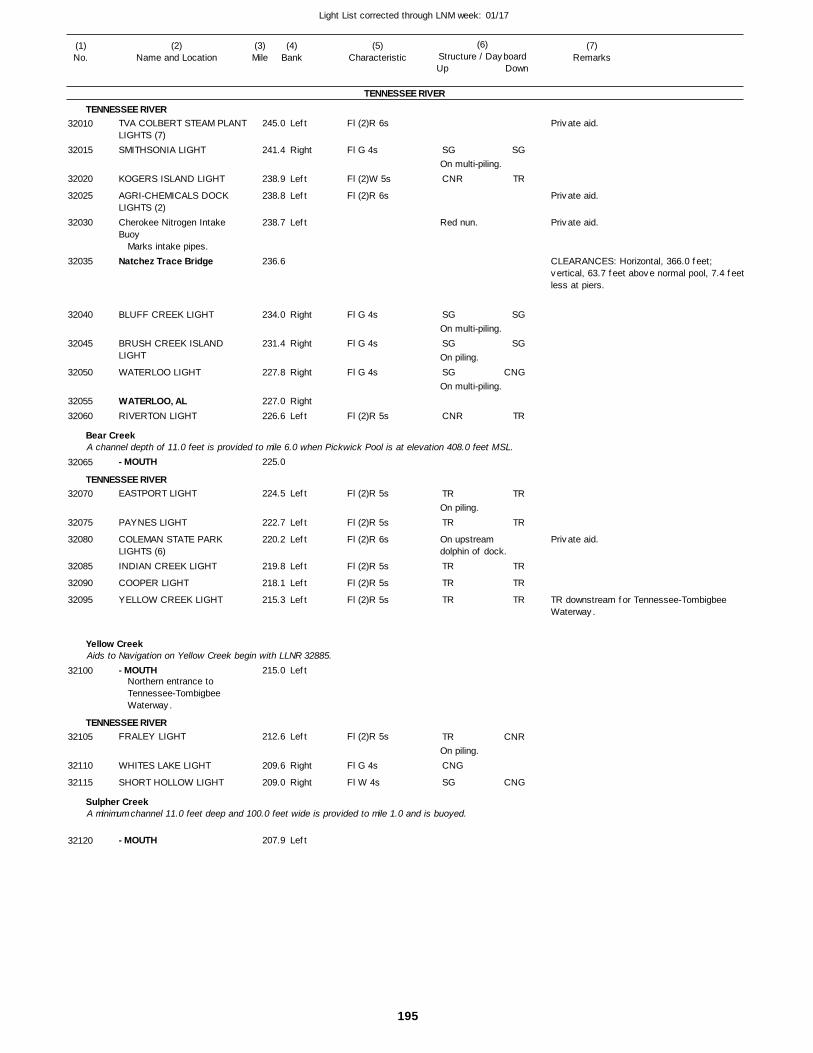
195
Light List corrected through LNM week: 01/17
(7)Remarks
(1)No.
(2)Name and Location
(3)Mile
(5)Characteristic
(4)Bank
(6)Structure / DayboardUp Down
TVA COLBERT STEAM PLANTLIGHTS (7)SMITHSONIA LIGHT
KOGERS ISLAND LIGHT
AGRI-CHEMICALS DOCK LIGHTS (2)Cherokee Nitrogen Intake Buoy
Natchez Trace Bridge
BLUFF CREEK LIGHT
BRUSH CREEK ISLAND LIGHT
WATERLOO LIGHT
WATERLOO, ALRIVERTON LIGHT
- MOUTH
EASTPORT LIGHT
PAYNES LIGHT
COLEMAN STATE PARK LIGHTS (6)INDIAN CREEK LIGHT
COOPER LIGHT
YELLOW CREEK LIGHT
- MOUTH
FRALEY LIGHT
WHITES LAKE LIGHT
SHORT HOLLOW LIGHT
- MOUTH
TENNESSEE RIVER
TENNESSEE RIVER
Bear Creek
TENNESSEE RIVER
Yellow Creek
TENNESSEE RIVER
Sulpher Creek
A channel depth of 11.0 feet is provided to mile 6.0 when Pickwick Pool is at elevation 408.0 feet MSL.
Aids to Navigation on Yellow Creek begin with LLNR 32885.
A minimum channel 11.0 feet deep and 100.0 feet wide is provided to mile 1.0 and is buoyed.
Left
Right
Left
Left
Left
Right
Right
Right
RightLeft
Left
Left
Left
Left
Left
Left
Left
Left
Right
Right
Left
245.0
241.4
238.9
238.8
238.7
236.6
234.0
231.4
227.8
227.0 226.6
225.0
224.5
222.7
220.2
219.8
218.1
215.3
215.0
212.6
209.6
209.0
207.9
Marks intake pipes.
Northern entrance to Tennessee-Tombigbee Waterway.
Fl (2)R 6s
Fl G 4s
Fl (2)W 5s
Fl (2)R 6s
Fl G 4s
Fl G 4s
Fl G 4s
Fl (2)R 5s
Fl (2)R 5s
Fl (2)R 5s
Fl (2)R 6s
Fl (2)R 5s
Fl (2)R 5s
Fl (2)R 5s
Fl (2)R 5s
Fl G 4s
Fl W 4s
On multi-piling.
Red nun.
On multi-piling.
On piling.
On multi-piling.
On piling.
On upstream dolphin of dock.
On piling.
CLEARANCES: Horizontal, 366.0 feet; vertical, 63.7 feet above normal pool, 7.4 feet less at piers.
TR downstream for Tennessee-Tombigbee Waterway.
32010
32015
32020
32025
32030
32035
32040
32045
32050
3205532060
32065
32070
32075
32080
32085
32090
32095
32100
32105
32110
32115
32120
SG
CNR
SG
SG
SG
CNR
TR
TR
TR
TR
TR
TR
CNG
SG
SG
TR
SG
SG
CNG
TR
TR
TR
TR
TR
TR
CNR
CNG
Private aid.
Private aid.
Private aid.
Private aid.
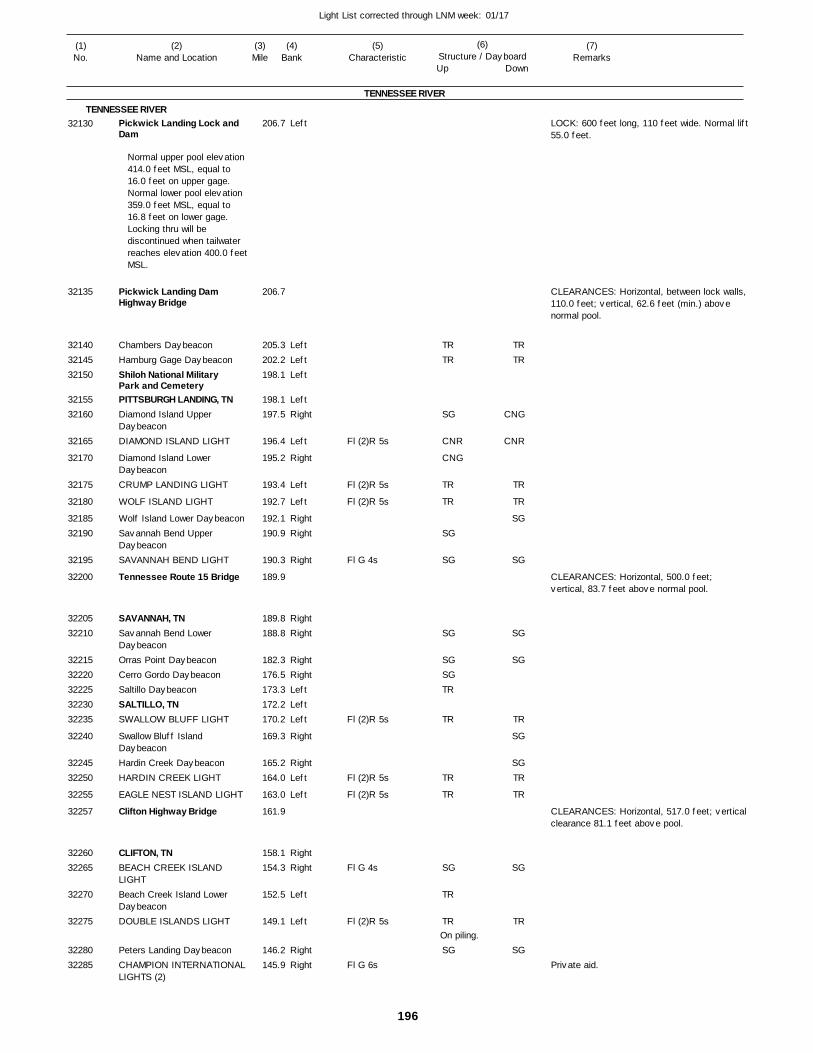
196
Light List corrected through LNM week: 01/17
(7)Remarks
(1)No.
(2)Name and Location
(3)Mile
(5)Characteristic
(4)Bank
(6)Structure / DayboardUp Down
Pickwick Landing Lock and Dam
Pickwick Landing Dam Highway Bridge
Chambers DaybeaconHamburg Gage DaybeaconShiloh National Military Park and CemeteryPITTSBURGH LANDING, TNDiamond Island Upper DaybeaconDIAMOND ISLAND LIGHT
Diamond Island Lower DaybeaconCRUMP LANDING LIGHT
WOLF ISLAND LIGHT
Wolf Island Lower DaybeaconSavannah Bend Upper DaybeaconSAVANNAH BEND LIGHT
Tennessee Route 15 Bridge
SAVANNAH, TNSavannah Bend Lower DaybeaconOrras Point DaybeaconCerro Gordo DaybeaconSaltillo DaybeaconSALTILLO, TNSWALLOW BLUFF LIGHT
Swallow Bluff Island DaybeaconHardin Creek DaybeaconHARDIN CREEK LIGHT
EAGLE NEST ISLAND LIGHT
Clifton Highway Bridge
CLIFTON, TNBEACH CREEK ISLAND LIGHTBeach Creek Island Lower DaybeaconDOUBLE ISLANDS LIGHT
Peters Landing DaybeaconCHAMPION INTERNATIONALLIGHTS (2)
TENNESSEE RIVER
TENNESSEE RIVERLeft
LeftLeftLeft
LeftRight
Left
Right
Left
Left
RightRight
Right
RightRight
RightRightLeftLeftLeft
Right
RightLeft
Left
RightRight
Left
Left
RightRight
206.7
206.7
205.3 202.2 198.1
198.1 197.5
196.4
195.2
193.4
192.7
192.1 190.9
190.3
189.9
189.8 188.8
182.3 176.5 173.3 172.2 170.2
169.3
165.2 164.0
163.0
161.9
158.1 154.3
152.5
149.1
146.2 145.9
Normal upper pool elevation 414.0 feet MSL, equal to 16.0 feet on upper gage. Normal lower pool elevation 359.0 feet MSL, equal to 16.8 feet on lower gage. Locking thru will be discontinued when tailwater reaches elevation 400.0 feetMSL.
Fl (2)R 5s
Fl (2)R 5s
Fl (2)R 5s
Fl G 4s
Fl (2)R 5s
Fl (2)R 5s
Fl (2)R 5s
Fl G 4s
Fl (2)R 5s
Fl G 6s
On piling.
LOCK: 600 feet long, 110 feet wide. Normal lift55.0 feet.
CLEARANCES: Horizontal, between lock walls,110.0 feet; vertical, 62.6 feet (min.) above normal pool.
CLEARANCES: Horizontal, 500.0 feet; vertical, 83.7 feet above normal pool.
CLEARANCES: Horizontal, 517.0 feet; verticalclearance 81.1 feet above pool.
32130
32135
321403214532150
3215532160
32165
32170
32175
32180
3218532190
32195
32200
3220532210
3221532220322253223032235
32240
3224532250
32255
32257
3226032265
32270
32275
3228032285
TRTR
SG
CNR
CNG
TR
TR
SG
SG
SG
SGSGTR
TR
TR
TR
SG
TR
TR
SG
TRTR
CNG
CNR
TR
TR
SG
SG
SG
SG
TR
SG
SGTR
TR
SG
TR
SGPrivate aid.
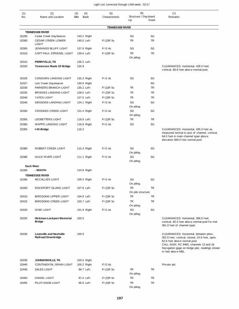
197
Light List corrected through LNM week: 01/17
(7)Remarks
(1)No.
(2)Name and Location
(3)Mile
(5)Characteristic
(4)Bank
(6)Structure / DayboardUp Down
Cedar Creek Daybeacon
CEDAR CREEK LOWER LIGHTJENNINGS BLUFF LIGHT
CAPT PAUL STRIEGEL LIGHT
PERRYVILLE, TNTennessee Route 20 Bridge
CONDORS LANDING LIGHT
Lick Creek DaybeaconPARKERS BRANCH LIGHT
BRODIES LANDING LIGHT
YATES LIGHT
DENSONS LANDING LIGHT
CROOKED CREEK LIGHT
LEDBETTERS LIGHT
SHIPPS LANDING LIGHT
I-40 Bridge
ROBERT CREEK LIGHT
DUCK RIVER LIGHT
- MOUTH
MCCALLIES LIGHT
ROCKPORT ISLAND LIGHT
BIRDSONG UPPER LIGHT
BIRDSONG CREEK LIGHT
DIXIE LIGHT
Hickman-Lockport MemorialBridge
Louisville and Nashville Railroad Drawbridge
JOHNSONVILLE, TNCONTINENTAL GRAIN LIGHT
SALES LIGHT
DANIEL LIGHT
PILOT KNOB LIGHT
TENNESSEE RIVER
TENNESSEE RIVER
Duck River
TENNESSEE RIVER
Right
Left
Right
Left
Left
Right
RightLeft
Left
Left
Right
Right
Left
Right
Right
Right
Right
Right
Left
Left
Left
Right
RightRight
Left
Left
Left
143.2
140.0
137.9
135.6
135.5 134.9
132.3
130.9 130.2
128.0
127.0
124.1
121.4
118.9
116.8
116.2
112.4
111.1
110.8
109.3
107.8
104.9
103.7
101.9
100.5
100.5
100.5 100.2
99.7
97.4
95.6
Fl (2)R 5s
Fl G 4s
Fl (2)R 5s
Fl G 4s
Fl (2)R 5s
Fl (2)R 5s
Fl (2)R 5s
Fl G 4s
Fl G 4s
Fl (2)R 5s
Fl G 4s
Fl G 4s
Fl G 4s
Fl G 4s
Fl (2)R 5s
Fl (2)R 5s
Fl (2)R 5s
Fl G 4s
Fl G 6s
Fl (2)R 5s
Fl (2)R 5s
Fl (2)R 5s
On piling.
On piling.
On piling.
On piling.
On piling.
On piling.
On pile structure.
On piling.
On piling.
On piling.
On piling.
CLEARANCES: Horizontal, 428.0 feet; vertical, 68.9 feet above normal pool.
CLEARANCES: Horizontal, 435.0 feet as measured normal to axis of channel, vertical, 64.0 feet in main channel span above elevation 359.0 feet normal pool.
CLEARANCES: Horizontal, 399.0 feet; vertical, 60.4 feet above normal pool for mid 361.0 feet of channel span.
CLEARANCES: Horizontal, between piers, 352.0 feet; vertical, closed, 24.6 feet, open, 62.6 feet above normal pool. CALL SIGN: KC 9465, channels 13 and 16. Navigation gage on bridge pier, readings shownin feet above MSL.
3229532300
32305
32310
3231532320
32325
3232732330
32335
32340
32345
32350
32355
32360
32365
32380
32385
32390
32395
32400
32410
32415
32420
32425
32430
3243532440
32445
32450
32455
SGTR
SG
TR
SG
TR
TR
TR
SG
SG
TR
SG
SG
SG
SG
TR
TR
TR
SG
TR
TR
TR
SGTR
SG
TR
SG
SGTR
TR
TR
SG
SG
TR
SG
SG
SG
SG
TR
TR
TR
SG
TR
TR
TR
Private aid.
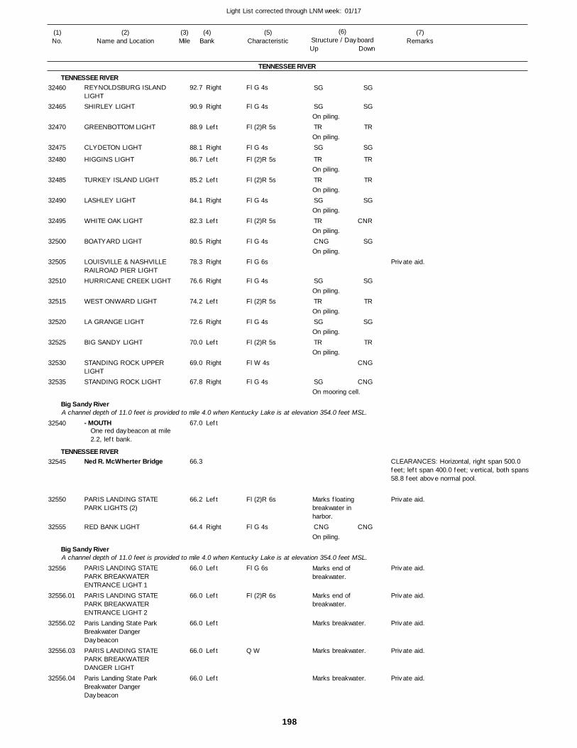
198
Light List corrected through LNM week: 01/17
(7)Remarks
(1)No.
(2)Name and Location
(3)Mile
(5)Characteristic
(4)Bank
(6)Structure / DayboardUp Down
REYNOLDSBURG ISLAND LIGHTSHIRLEY LIGHT
GREENBOTTOM LIGHT
CLYDETON LIGHT
HIGGINS LIGHT
TURKEY ISLAND LIGHT
LASHLEY LIGHT
WHITE OAK LIGHT
BOATYARD LIGHT
LOUISVILLE & NASHVILLE RAILROAD PIER LIGHTHURRICANE CREEK LIGHT
WEST ONWARD LIGHT
LA GRANGE LIGHT
BIG SANDY LIGHT
STANDING ROCK UPPER LIGHTSTANDING ROCK LIGHT
- MOUTH
Ned R. McWherter Bridge
PARIS LANDING STATE PARK LIGHTS (2)
RED BANK LIGHT
PARIS LANDING STATE PARK BREAKWATER ENTRANCE LIGHT 1PARIS LANDING STATE PARK BREAKWATER ENTRANCE LIGHT 2Paris Landing State Park Breakwater Danger DaybeaconPARIS LANDING STATE PARK BREAKWATER DANGER LIGHTParis Landing State Park Breakwater Danger Daybeacon
TENNESSEE RIVER
TENNESSEE RIVER
Big Sandy River
TENNESSEE RIVER
Big Sandy River
A channel depth of 11.0 feet is provided to mile 4.0 when Kentucky Lake is at elevation 354.0 feet MSL.
A channel depth of 11.0 feet is provided to mile 4.0 when Kentucky Lake is at elevation 354.0 feet MSL.
Right
Right
Left
Right
Left
Left
Right
Left
Right
Right
Right
Left
Right
Left
Right
Right
Left
Left
Right
Left
Left
Left
Left
Left
92.7
90.9
88.9
88.1
86.7
85.2
84.1
82.3
80.5
78.3
76.6
74.2
72.6
70.0
69.0
67.8
67.0
66.3
66.2
64.4
66.0
66.0
66.0
66.0
66.0
One red daybeacon at mile 2.2, left bank.
Fl G 4s
Fl G 4s
Fl (2)R 5s
Fl G 4s
Fl (2)R 5s
Fl (2)R 5s
Fl G 4s
Fl (2)R 5s
Fl G 4s
Fl G 6s
Fl G 4s
Fl (2)R 5s
Fl G 4s
Fl (2)R 5s
Fl W 4s
Fl G 4s
Fl (2)R 6s
Fl G 4s
Fl G 6s
Fl (2)R 6s
Q W
On piling.
On piling.
On piling.
On piling.
On piling.
On piling.
On piling.
On piling.
On piling.
On piling.
On piling.
On mooring cell.
Marks floating breakwater in harbor.
On piling.
Marks end of breakwater.
Marks end of breakwater.
Marks breakwater.
Marks breakwater.
Marks breakwater.
CLEARANCES: Horizontal, right span 500.0 feet; left span 400.0 feet; vertical, both spans 58.8 feet above normal pool.
32460
32465
32470
32475
32480
32485
32490
32495
32500
32505
32510
32515
32520
32525
32530
32535
32540
32545
32550
32555
32556
32556.01
32556.02
32556.03
32556.04
SG
SG
TR
SG
TR
TR
SG
TR
CNG
SG
TR
SG
TR
SG
CNG
SG
SG
TR
SG
TR
TR
SG
CNR
SG
SG
TR
SG
TR
CNG
CNG
CNG
Private aid.
Private aid.
Private aid.
Private aid.
Private aid.
Private aid.
Private aid.
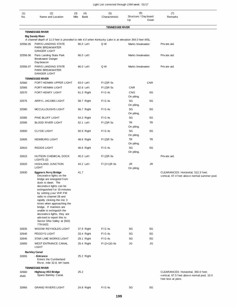
199
Light List corrected through LNM week: 01/17
(7)Remarks
(1)No.
(2)Name and Location
(3)Mile
(5)Characteristic
(4)Bank
(6)Structure / DayboardUp Down
PARIS LANDING STATE PARK BREAKWATER DANGER LIGHTParis Landing State Park Breakwater Danger DaybeaconPARIS LANDING STATE PARK BREAKWATER DANGER LIGHT
FORT HEIMAN UPPER LIGHT
FORT HEIMAN LIGHT
FORT HENRY LIGHT
ARRYL JACOBS LIGHT
MCCULLOUGHS LIGHT
PINE BLUFF LIGHT
BLOOD RIVER LIGHT
CLYDE LIGHT
NEWBURG LIGHT
REDDS LIGHT
HUTSON CHEMICAL DOCK LIGHTS (2)HIGHLAND JUNCTION LIGHT
Eggners Ferry Bridge
WIDOW REYNOLDS LIGHT
PEGGYS LIGHT
STAR LIME WORKS LIGHT
WEST ENTRANCE CANAL LIGHT
- Entrance
Highway 453 Bridge
GRAND RIVERS LIGHT
TENNESSEE RIVER
TENNESSEE RIVERBig Sandy River
TENNESSEE RIVER
Barkley Canal
TENNESSEE RIVER
A channel depth of 11.0 feet is provided to mile 4.0 when Kentucky Lake is at elevation 354.0 feet MSL.Left
Left
Left
Left
Left
Right
Right
Right
Right
Left
Right
Right
Right
Left
Left
Right
Right
Right
Right
Right
Right
66.0
66.0
66.0
63.0
62.6
61.3
58.7
56.7
54.3
52.1
50.9
48.6
46.6
45.0
44.2
41.7
37.9
33.4
29.1
25.4
25.2
25.2
24.8
Decorative lights on the bridge are energized from dusk to dawn. The decorative lights can be extinguished for 15-minutes by setting your VHF-FM radio to channel 28 and rapidly clicking the mic 3 times when approaching the bridge. If mariners are unable to extinguish the decorative lights, they are advised to report this to Sector Ohio Valley at (502) 779-5422.
Enters the Cumberland River, mile 32.8, left bank.
Spans Barkley Canal.
Q W
Q W
Fl (2)R 5s
Fl (2)R 5s
Fl G 4s
Fl G 4s
Fl G 4s
Fl G 4s
Fl (2)R 5s
Fl G 4s
Fl (2)R 5s
Fl G 4s
Fl (2)R 6s
Fl (2+1)R 6s
Fl G 4s
Fl G 4s
Fl G 4s
Fl (2+1)G 6s
Fl G 4s
Marks breakwater.
Marks breakwater.
Marks breakwater.
On piling.
On piling.
On piling.
On piling.
On piling.
On piling.
On piling.
On piling.CLEARANCES: Horizontal, 512.3 feet; vertical, 67.4 feet above normal summer pool.
CLEARANCES: Horizontal, 350.0 feet; vertical, 67.5 feet above normal pool, 10.0 feet less at piers.
4540
32556.05
32556.06
32556.07
32560
32565
32570
32575
32580
32585
32595
32600
32605
32610
32615
32620
32630
32635
32640
32645
32650
32655
32660
32665
CNR
CNG
SG
SG
SG
TR
SG
TR
SG
JR
SG
SG
SG
JG
SG
CNR
SG
SG
SG
SG
TR
SG
TR
SG
JR
SG
SG
SG
JG
SG
Private aid.
Private aid.
Private aid.
Private aid.
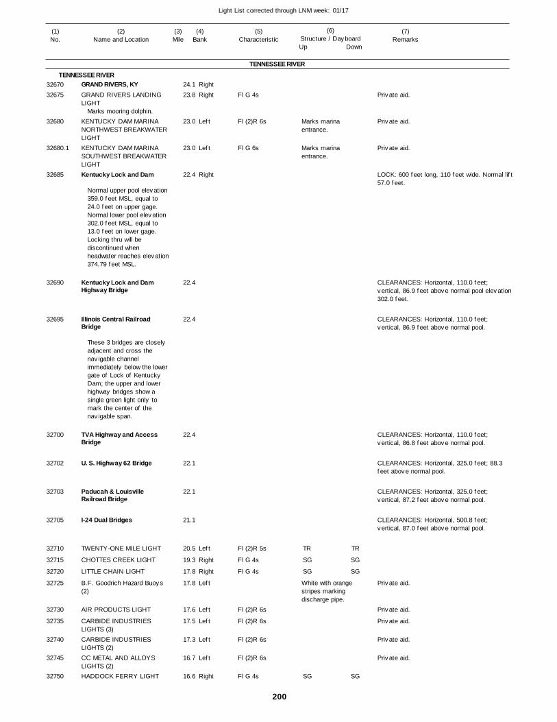
200
Light List corrected through LNM week: 01/17
(7)Remarks
(1)No.
(2)Name and Location
(3)Mile
(5)Characteristic
(4)Bank
(6)Structure / DayboardUp Down
GRAND RIVERS, KYGRAND RIVERS LANDING LIGHT
KENTUCKY DAM MARINA NORTHWEST BREAKWATER LIGHTKENTUCKY DAM MARINA SOUTHWEST BREAKWATER LIGHTKentucky Lock and Dam
Kentucky Lock and Dam Highway Bridge
Illinois Central Railroad Bridge
TVA Highway and Access Bridge
U. S. Highway 62 Bridge
Paducah & Louisville Railroad Bridge
I-24 Dual Bridges
TWENTY-ONE MILE LIGHT
CHOTTES CREEK LIGHT
LITTLE CHAIN LIGHT
B.F. Goodrich Hazard Buoys (2)
AIR PRODUCTS LIGHT
CARBIDE INDUSTRIES LIGHTS (3)CARBIDE INDUSTRIES LIGHTS (2)CC METAL AND ALLOYS LIGHTS (2)HADDOCK FERRY LIGHT
TENNESSEE RIVER
TENNESSEE RIVERRight
Right
Left
Left
Right
Left
Right
Right
Left
Left
Left
Left
Left
Right
24.1
23.8
23.0
23.0
22.4
22.4
22.4
22.4
22.1
22.1
21.1
20.5
19.3
17.8
17.8
17.6
17.5
17.3
16.7
16.6
Marks mooring dolphin.
Normal upper pool elevation 359.0 feet MSL, equal to 24.0 feet on upper gage. Normal lower pool elevation 302.0 feet MSL, equal to 13.0 feet on lower gage. Locking thru will be discontinued when headwater reaches elevation374.79 feet MSL.
These 3 bridges are closely adjacent and cross the navigable channel immediately below the lower gate of Lock of Kentucky Dam; the upper and lower highway bridges show a single green light only to mark the center of the navigable span.
Fl G 4s
Fl (2)R 6s
Fl G 6s
Fl (2)R 5s
Fl G 4s
Fl G 4s
Fl (2)R 6s
Fl (2)R 6s
Fl (2)R 6s
Fl (2)R 6s
Fl G 4s
Marks marina entrance.
Marks marina entrance.
White with orange stripes marking discharge pipe.
LOCK: 600 feet long, 110 feet wide. Normal lift57.0 feet.
CLEARANCES: Horizontal, 110.0 feet; vertical, 86.9 feet above normal pool elevation302.0 feet.
CLEARANCES: Horizontal, 110.0 feet; vertical, 86.9 feet above normal pool.
CLEARANCES: Horizontal, 110.0 feet; vertical, 86.8 feet above normal pool.
CLEARANCES: Horizontal, 325.0 feet; 88.3 feet above normal pool.
CLEARANCES: Horizontal, 325.0 feet; vertical, 87.2 feet above normal pool.
CLEARANCES: Horizontal, 500.8 feet; vertical, 87.0 feet above normal pool.
3267032675
32680
32680.1
32685
32690
32695
32700
32702
32703
32705
32710
32715
32720
32725
32730
32735
32740
32745
32750
TR
SG
SG
SG
TR
SG
SG
SG
Private aid.
Private aid.
Private aid.
Private aid.
Private aid.
Private aid.
Private aid.
Private aid.
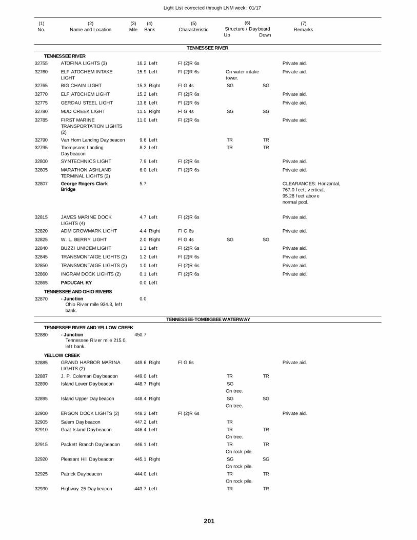
201
Light List corrected through LNM week: 01/17
(7)Remarks
(1)No.
(2)Name and Location
(3)Mile
(5)Characteristic
(4)Bank
(6)Structure / DayboardUp Down
ATOFINA LIGHTS (3)
ELF ATOCHEM INTAKE LIGHTBIG CHAIN LIGHT
ELF ATOCHEM LIGHT
GERDAU STEEL LIGHT
MUD CREEK LIGHT
FIRST MARINE TRANSPORTATION LIGHTS (2)Van Horn Landing DaybeaconThompsons Landing DaybeaconSYNTECHNICS LIGHT
MARATHON ASHLAND TERMINAL LIGHTS (2)George Rogers Clark Bridge
JAMES MARINE DOCK LIGHTS (4)ADM GROWMARK LIGHT
W. L. BERRY LIGHT
BUZZI UNICEM LIGHT
TRANSMONTAIGE LIGHTS (2)
TRANSMONTAIGE LIGHTS (2)
INGRAM DOCK LIGHTS (2)
PADUCAH, KY
- Junction
- Junction
GRAND HARBOR MARINA LIGHTS (2)J. P. Coleman DaybeaconIsland Lower Daybeacon
Island Upper Daybeacon
ERGON DOCK LIGHTS (2)
Salem DaybeaconGoat Island Daybeacon
Packett Branch Daybeacon
Pleasant Hill Daybeacon
Patrick Daybeacon
Highway 25 Daybeacon
TENNESSEE RIVER
TENNESSEE RIVER
TENNESSEE AND OHIO RIVERS
TENNESSEE-TOMBIGBEE WATERWAY
TENNESSEE RIVER AND YELLOW CREEK
YELLOW CREEK
Left
Left
Right
Left
Left
Right
Left
LeftLeft
Left
Left
Left
Right
Right
Left
Left
Left
Left
Left
Right
LeftRight
Right
Left
LeftLeft
Left
Right
Left
Left
16.2
15.9
15.3
15.2
13.8
11.5
11.0
9.6 8.2
7.9
6.0
5.7
4.7
4.4
2.0
1.3
1.2
1.0
0.1
0.0
0.0
450.7
449.6
449.0 448.7
448.4
448.2
447.2 446.4
446.1
445.1
444.0
443.7
Ohio River mile 934.3, left bank.
Tennessee River mile 215.0,left bank.
Fl (2)R 6s
Fl (2)R 6s
Fl G 4s
Fl (2)R 6s
Fl (2)R 6s
Fl G 4s
Fl (2)R 6s
Fl (2)R 6s
Fl (2)R 6s
Fl (2)R 6s
Fl G 6s
Fl G 4s
Fl (2)R 6s
Fl (2)R 6s
Fl (2)R 6s
Fl (2)R 6s
Fl G 6s
Fl (2)R 6s
On water intake tower.
On tree.
On tree.
On tree.
On rock pile.
On rock pile.
On rock pile.
CLEARANCES: Horizontal,767.0 feet; vertical, 95.28 feet above normal pool.
32755
32760
32765
32770
32775
32780
32785
3279032795
32800
32805
32807
32815
32820
32825
32840
32845
32850
32860
32865
32870
32880
32885
3288732890
32895
32900
3290532910
32915
32920
32925
32930
SG
SG
TRTR
SG
TRSG
SG
TRTR
TR
SG
TR
TR
SG
SG
TRTR
SG
TR
SG
TR
TR
SG
TR
TR
Private aid.
Private aid.
Private aid.
Private aid.
Private aid.
Private aid.
Private aid.
Private aid.
Private aid.
Private aid.
Private aid.
Private aid.
Private aid.
Private aid.
Private aid.
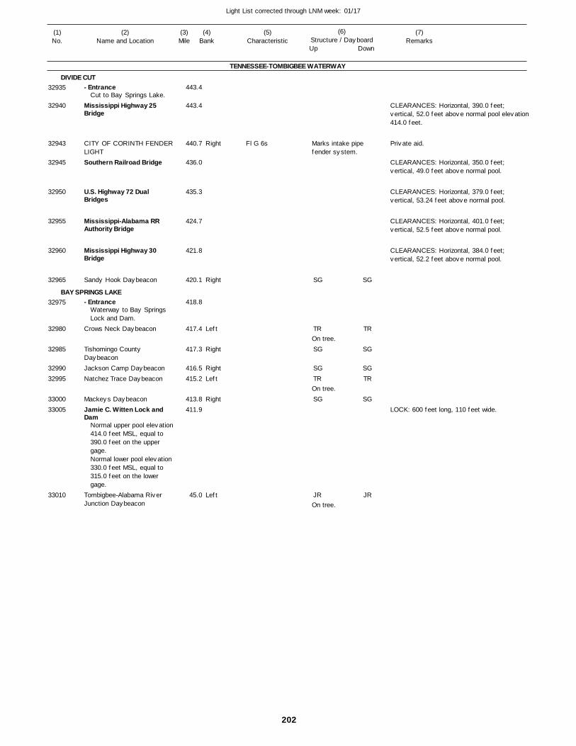
202
Light List corrected through LNM week: 01/17
(7)Remarks
(1)No.
(2)Name and Location
(3)Mile
(5)Characteristic
(4)Bank
(6)Structure / DayboardUp Down
- Entrance
Mississippi Highway 25 Bridge
CITY OF CORINTH FENDER LIGHTSouthern Railroad Bridge
U.S. Highway 72 Dual Bridges
Mississippi-Alabama RR Authority Bridge
Mississippi Highway 30 Bridge
Sandy Hook Daybeacon
- Entrance
Crows Neck Daybeacon
Tishomingo County DaybeaconJackson Camp DaybeaconNatchez Trace Daybeacon
Mackeys DaybeaconJamie C. Witten Lock and Dam
Tombigbee-Alabama River Junction Daybeacon
TENNESSEE-TOMBIGBEE WATERWAY
DIVIDE CUT
BAY SPRINGS LAKE
Right
Right
Left
Right
RightLeft
Right
Left
443.4
443.4
440.7
436.0
435.3
424.7
421.8
420.1
418.8
417.4
417.3
416.5 415.2
413.8 411.9
45.0
Cut to Bay Springs Lake.
Waterway to Bay Springs Lock and Dam.
Normal upper pool elevation 414.0 feet MSL, equal to 390.0 feet on the upper gage.Normal lower pool elevation 330.0 feet MSL, equal to 315.0 feet on the lower gage.
Fl G 6s Marks intake pipe fender system.
On tree.
On tree.
On tree.
CLEARANCES: Horizontal, 390.0 feet; vertical, 52.0 feet above normal pool elevation414.0 feet.
CLEARANCES: Horizontal, 350.0 feet; vertical, 49.0 feet above normal pool.
CLEARANCES: Horizontal, 379.0 feet; vertical, 53.24 feet above normal pool.
CLEARANCES: Horizontal, 401.0 feet; vertical, 52.5 feet above normal pool.
CLEARANCES: Horizontal, 384.0 feet; vertical, 52.2 feet above normal pool.
LOCK: 600 feet long, 110 feet wide.
32935
32940
32943
32945
32950
32955
32960
32965
32975
32980
32985
3299032995
3300033005
33010
SG
TR
SG
SGTR
SG
JR
SG
TR
SG
SGTR
SG
JR
Private aid.

INDEX OF CITIES, TOWNS AND LANDINGS ON THE MISSISSIPPI RIVER
⎯⎯⎯⎯⎯⎯⎯⎯⎯⎯⎯⎯⎯⎯⎯⎯⎯⎯⎯ ⎯⎯⎯⎯⎯⎯⎯⎯⎯⎯⎯⎯⎯⎯⎯⎯⎯⎯⎯Cities, Towns, and Cities, Towns, and
Landings Mile Bank River Landings Mile Bank River
⎯⎯⎯⎯⎯⎯⎯⎯⎯⎯⎯⎯⎯⎯⎯⎯⎯⎯⎯⎯⎯⎯⎯⎯ ⎯⎯⎯⎯⎯⎯⎯⎯⎯⎯⎯⎯⎯⎯⎯⎯⎯⎯⎯⎯⎯⎯⎯⎯
Index ii
A
Aberdeen, OH.............. 408.4 R Ohio
Albany, IL..................... 513.5 L Upper Miss
Alexandria, MO ............ 359.1 R Upper Miss
Aliquippa, PA............... 20.0 L Ohio
Alma, WI...................... 752.7 L Upper Miss
Alton, IL ....................... 203.1 L Upper Miss
Alton, IN....................... 679.0 R Ohio
Ambridge, PA .............. 16.0 R Ohio
Andalusia, IL................ 473.0 L Upper Miss
Angola, LA ................... 302.7 L Lower Miss
Arkanasas City, AR ..... 556.5 L Lower Miss
Ashland, KY................. 322.6 L Ohio
Ashland City, TN ......... 158.2 R Cumberland
Atchison, KS................ 422.4 R Missouri
Athalia, OH .................. 296.6 R Ohio
Augusta, KY................. 427.0 L Ohio
Aurora, IN .................... 496.6 R Ohio
B
Ba ........ L Lower Miss
B ........ L Be , IL............. 8.5 Illinois
Be ................. .5 R
Bell ......... .5 R
Belle ......... R
Bellevue, ................ . R
Bel ................ . R
Bel ................ . R
Be .............. 4. Ohio
Be , ........... . L
Be , ..........
B .............. . R
Black Walnut, MO ....... 16.5 L Missouri
Blair, NE ...................... 648.3 R Missouri
Bluff City, KY ............... 13.5 L Green
Boonville, MO............... 196.7 R Missouri
Braddock, PA............... 10.6 R Monongahela
Brandenburg, KY......... 646.1 L Ohio
Brickeys Mill Landing, MO 135.9 R Upper Miss
Brookport, IL ................ 937.4 R Ohio
Browning, IL................. 97.3 R Illinois
Brownville, NE ............. 535.3 R Missouri
Brownsville, MN........... 689.0 R Upper Miss
Brownsville, PA............ 56.0 R Monongahela
Buena Vista Springs, TN 187.1 L Cumberland
Buffalo, IA.................... 473.0 R Upper Miss
Burlington, IA ............... 403.9 R Upper Miss
Bulington, OH .............. 313.2 R Ohio
C
Cairo, IL ....................... R Lower Miss
..................................... 979.3 R Ohio
Calhoun, KY................. 63.6 L Green
Camanche, IA.............. 511.7 R Upper Miss
Cannelton, IN............... 724.0 R Ohio
Canton, KY .................. 62.8 R Cumberland
Canton, MO ................. 342.3 R Upper Miss
Cape Girardeau, MO ... 52.0 R Upper Miss
Carrollton, KY .............. 545.7 L Ohio
Carthage, TN............... 308.1 R Cumberland
Caruthersville, MO....... 846.0 R Lower Miss
Caseyville, KY.............. 871.2 L Ohio
Cassville, WI................ 606.6 L Upper Miss
Catlettsburg, KY........... 317.2 L Ohio
Cave-in-Rock, IL .......... 881.0 R Ohio
Cement City, MO ......... 355.0 R Missouri
Chamois, MO............... 117.8 R Missouri
Charlerio, PA................ 42.0 L Monongahela
Charleston, TN............. 18.7 L Hiwassee
Charleston, WV ........... 58.4 R Kanawha
Chattanooga, TN.......... 464.1 L Tennessee
Cheshire, OH............... 257.6 R Ohio
Chester, IL ................... 109.5 L Upper Miss
Chesterfield, MO.......... 39.0 R Missouri
Chicago, IL................... 320.0 Illinois
..................................... Waterway
Chillicothe, IL ............... 180.5 R Illinois
Cincinnati, OH.............. 470.3 R Ohio
Cincinnati Landing, IL .. 296.4 L Upper Miss
Clarington, OH ............. 117.8 R Ohio
Clarksville, MO............. 273.1 R Upper Miss
Clarksville, TN.............. 126.1 R Cumberland
Claryville, MO............... 109.0 R Upper Miss
Clayton, IA.................... 624.7 R Upper Miss
Clifton, TN.................... 158.1 R Tennessee
Clinton, IA .................... 518.2 R Upper Miss
Cl .............. .
......... . L
Columbus, KY.............. 937.0 L Lower Miss
Commerce, MO............ 39.5 R Upper Miss
Concord, TN ................ 617.2 R Tennessee
Cordova, IL................... 503.1 L Upper Miss
Cottonwood Point, MO . 832.8 R Lower Miss
Council Bluffs, IA ......... 615.9 L Missouri
Covington, KY .............. 470.5 L Ohio
Crown City, OH............ 290.9 R Ohio
Cumberland City, TN ... 104.1 L Cumberland
D
Dakota, MN .................. 706.9 R Upper Miss
Dakota City, NE............ 726.0 R Missouri
Dallas , IL............... 390.7 L Upper Miss
Davenport, IA ............... 482.4 R Upper Miss
Dayton, TN................... 504.4 R Tennessee
Decatur, AL.................. 304.5 L Tennessee
Decatur, NE ................. 691.0 R Missouri
DeSoto, WI .................. 667.6 L Upper Miss
Diamond Bluff, WI ....... 800.3 L Upper Miss
Donaldsonville, LA........ 175.3 R Lower Miss
Dover KY...................... 419.7 L Ohio
Dover, TN..................... 88.8 L Cumberland
Dover Station, MO........ 305.5 R Missouri
Dresback, MN .............. 705.5 R Upper Miss
Dubuque, IA................. 579.4 R Upper Miss
Dundee, MO................. 76.5 R Missouri
Dycusburg, KY............. 19.6 R Cumberland
E
East Brady, PA............. 69.3 L Allegheny
East Dubuque, IL ......... 579.8 L Upper Miss
East Liverpool, OH....... 43.5 R Ohio
East St. Louis, IL.......... 180.0 L Upper Miss
Eddyville, KY................ 43.7 R Cumberland
Elizabeth, PA ............... 22.9 R Monongahela
Elizabethtown, IL.......... 889.0 R Ohio
Evansville, IN ............... 792.3 R Ohio
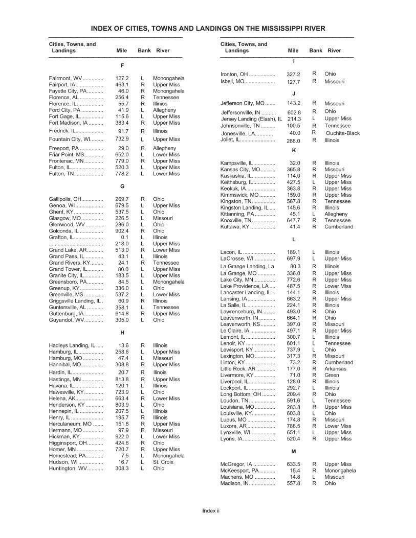
INDEX OF CITIES, TOWNS AND LANDINGS ON THE MISSISSIPPI RIVER
⎯⎯⎯⎯⎯⎯⎯⎯⎯⎯⎯⎯⎯⎯⎯⎯⎯⎯⎯ ⎯⎯⎯⎯⎯⎯⎯⎯⎯⎯⎯⎯⎯⎯⎯⎯⎯⎯⎯Cities, Towns, and Cities, Towns, and
Landings Mile Bank River Landings Mile Bank River
⎯⎯⎯⎯⎯⎯⎯⎯⎯⎯⎯⎯⎯⎯⎯⎯⎯⎯⎯⎯⎯⎯⎯⎯ ⎯⎯⎯⎯⎯⎯⎯⎯⎯⎯⎯⎯⎯⎯⎯⎯⎯⎯⎯⎯⎯⎯⎯⎯
Index iiii
F
Fairmont, WV.............. 127.2 L Monongahela
Fairport, IA................... 463.1 R Upper Miss
Fayette City, PA........... 46.0 R Monongahela
Florence, AL ................ 256.4 R Tennessee
Florence, IL.................. 55.7 R Illinios
Ford City, PA ............... 41.9 L Allegheny
Fort Gage, IL................ 115.6 L Upper Miss
Fort Madison, IA .......... 383.4 R Upper Miss
Fredrick, IL................... 91.7 R Illinois
Fountain City, WI......... 732.9 L Upper Miss
Freeport, PA ................ 29.0 R Allegheny
Friar Point, MS............. 652.0 L Lower Miss
Frontenac, MN............. 779.0 R Upper Miss
Fulton, IL...................... 520.3 L Upper Miss
Fulton, TN.................... 778.2 L Lower Miss
G
Gallipolis, OH............... 269.7 R Ohio
Genoa, WI................... 679.5 L Upper Miss
Ghent, KY.................... 537.5 L Ohio
Glasgow, MO............... 226.5 L Missouri
Glenwood, WV ............ 286.0 L Ohio
Golconda, IL ................ 902.4 R Ohio
Grafton, IL.................... 0.1 L Illinois
..................................... 218.0 L Upper Miss
Grand Lake, AR........... 513.0 R Lower Miss
Grand Pass, IL ............ 43.1 L Illinois
Grand Rivers, KY......... 24.1 R Tennessee
Grand Tower, IL........... L Upper Miss
Granite City, IL............. 183.5 L Upper Miss
Greensboro, PA........... 84.5 L Monongahela
Greenup, KY................ 336.0 L Ohio
Greenville, MS ............. 537.2 L Lower Miss
Griggsville Landing, IL . 60.9 R Illinois
Guntersville, AL ........... 358. L Tennessee
Guttenburg, IA ............. 614.8 R Upper Miss
Guyandot, WV............. 305.0 L Ohio
H
Hadleys Landing, IL ..... 13.6 R Illinois
Hamburg, IL................. 258.6 L Upper Miss
Hamburg, MO.............. 47.4 L Missouri
Hannibal, MO............... 308.8 R Upper Miss
Hardin, IL ..................... 20.7 R llinois
Hastings, MN............... 813.8 R Upper Miss
Havana, IL.................... 120.1 L Illinois
Hawesville, KY............. 723.9 L Ohio
Helena, AK................... 663.4 R Lower Miss
Henderson, KY ............ 803.9 L Ohio
Hennepin, IL ................ 207.5 L Illinois
Henry, IL ...................... 195.7 R Illinois
Herculaneum, MO ....... 151.8 R Upper Miss
Hermann, MO.............. 97.9 R Missouri
Hickman, KY................ 922.0 L Lower Miss
Higginsport, OH........... 424.6 R Ohio
Homer, MN .................. 720.7 R Upper Miss
Homestead, PA............ 7.5 L Monongahela
Hudson, WI ................. 16.7 L St. Croix
Huntington, WV........... 308.3 L Ohio
I
Ironton, OH .................. 327.2 R Ohio
Isbell, MO..................... 127.7 R Missouri
J
Jefferson City, MO....... 143.2 R Missouri
R OhioJeffersonville, IN .......... 602.8
Jersey Landing (Elash), IL 214.3 L Upper Miss
Johnsonville, TN .......... 100.5 R Tennessee
Joliet, IL........................ 288.0 Illinois
K
Kampsville, IL............... 32.0 R Illinois
Kansas City, MO.......... 365.8 R Missouri
Kaskaskia, IL................ 114.0 R Upper Miss
Keithsburg, IL............... 427.5 L Upper Miss
Keokuk, IA.................... 363.8 R Upper Miss
Kimmswick, MO........... 159.0 R Upper Miss
Kingston, TN................ 567.8 R Tennessee
Kingston Landing, IL .... 145.6 R Illinois
Kittanning, PA .............. 45.1 L Allegheny
Knoxville, TN................ 647.7 R Tennessee
Kuttawa, KY ................. 41.4 R Cumberland
L
Lacon, IL ...................... 189.1 L Illinois
LaCrosse, WI............... 697.9 L Upper Miss
La Grange Landing, La 80.3 R Illinois
La Grange, MO ............ 336.0 R Upper Miss
Lake City, MN............... 772.6 R Upper Miss
Lake Providence, LA .... 487.5 R Lower Miss
Lancaster Landing, IL... 144.1 R Illinois
Lansing, IA................... 663.2 R Upper Miss
La Salle, IL ................... 224.1 R Illinois
Lawrenceburg, IN......... 493.0 R Ohio
Leavenworth, IN ........... 664.1 R Ohio
Leavenworth, KS.......... 397.0 R Missouri
Le Claire, IA ................. 497.1 R Upper Miss
Lemont, IL .................... 300.7 L Illinois
Lenoir, KY .................... 601.1 L Tennessee
Lewisport, KY............... 737.9 L Ohio
Lexington, MO.............. 317.3 R Missouri
Linton, KY .................... 73.2 R Cumberland
Little Rock, AR ............. 177.0 R Arkansas
Livermore, KY............... 71.0 R Green
Liverpool, IL.................. 128.0 R Illinois
Lockport, IL .................. 292.7 L Illinois
Long Bottom, OH ......... 209.4 R Ohio
Loudon, TN.................. 591.6 L Tennessee
Louisiana, MO.............. 28 .8 R Upper Miss
Louisville, KY................ 603.8 L Ohio
Lupus, MO ................... 174.8 R Missouri
Luxora, AR ................... 788.5 R Lower Miss
Lynxville, WI................. 651.1 L Upper Miss
Lyons, IA...................... 520.4 R Upper Miss
M
McGregor, IA ............... 633.5 R Upper Miss
McKeesport, PA........... 15.4 R Monongahela
Machens, MO .............. 14.8 L Missouri
Madison, IN.................. 557.8 R Ohio
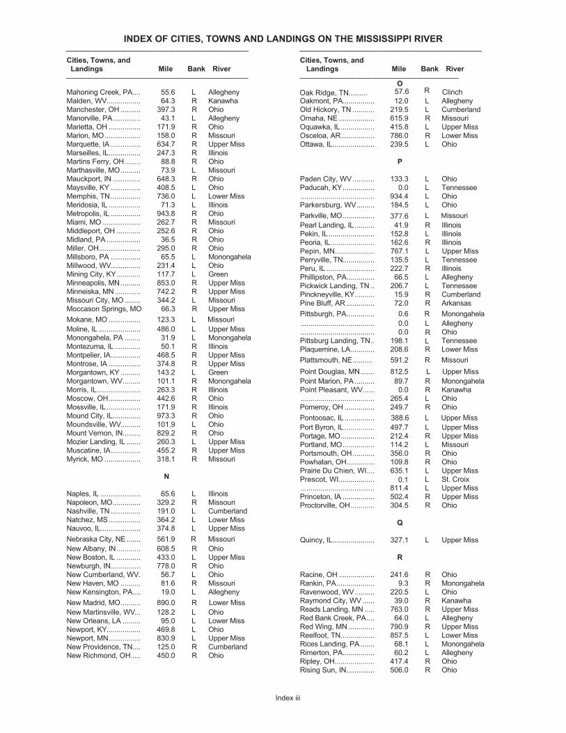
INDEX OF CITIES, TOWNS AND LANDINGS ON THE MISSISSIPPI RIVER
⎯⎯⎯⎯⎯⎯⎯⎯⎯⎯⎯⎯⎯⎯⎯⎯⎯⎯⎯ ⎯⎯⎯⎯⎯⎯⎯⎯⎯⎯⎯⎯⎯⎯⎯⎯⎯⎯⎯Cities, Towns, and Cities, Towns, and
Landings Mile Bank River Landings Mile Bank River
⎯⎯⎯⎯⎯⎯⎯⎯⎯⎯⎯⎯⎯⎯⎯⎯⎯⎯⎯⎯⎯⎯⎯⎯ ⎯⎯⎯⎯⎯⎯⎯⎯⎯⎯⎯⎯⎯⎯⎯⎯⎯⎯⎯⎯⎯
Index iii
Mahoning Creek, PA.... 55.6 L Allegheny
Malden, WV................. 64.3 R Kanawha
Manchester, OH .......... 397.3 R Ohio
Manorville, PA.............. 43.1 L Allegheny
Marietta, OH ................ 171.9 R Ohio
Marion, MO.................. 158.0 R Missouri
Marquette, IA ............... 634.7 R Upper Miss
Marseilles, IL................ 247.3 R Illinois
Martins Ferry, OH........ 88.8 R Ohio
Marthasville, MO.......... 73.9 L Missouri
Mauckport, IN .............. 648.3 R Ohio
Maysville, KY ............... 408.5 L Ohio
Memphis, TN............... 736.0 L Lower Miss
Meridosia, IL ................ 71.3 L Illinois
Metropolis, IL ............... 943.8 R Ohio
Miami, MO ................... 262.7 R Missouri
Middleport, OH ............ 252.6 R Ohio
Midland, PA ................. 36.5 R Ohio
Miller, OH..................... 295.0 R Ohio
Millsboro, PA ............... 65.5 L Monongahela
Millwood, WV............... 231.4 L Ohio
Mining City, KY............ 117.7 L Green
Minneapolis, MN.......... 853.0 R Upper Miss
Minneiska, MN............. 742.2 R Upper Miss
Missouri City, MO ........ 344.2 L Missouri
Moccason Springs, MO 66.3 R Upper Miss
Mokane, MO ................ 123.3 L Missouri
Moline, IL ..................... 486.0 L Upper Miss
Monongahela, PA ........ 31.9 L Monongahela
Montezuma, IL ............. 50.1 R Illinois
Montpelier, IA............... 468.5 R Upper Miss
Montrose, IA ................ 374.8 R Upper Miss
Morgantown, KY .......... 143.2 L Green
Morgantown, WV......... 101.1 R Monongahela
Morris, IL...................... 263.3 R Illinois
Moscow, OH................ 442.6 R Ohio
Mossville, IL ................. 171.9 R Illinois
Mound City, IL.............. 973.3 R Ohio
Moundsville, WV.......... 101.9 L Ohio
Mount Vernon, IN......... 829.2 R Ohio
Mozier Landing, IL ....... 260.3 L Upper Miss
Muscatine, IA............... 455.2 R Upper Miss
Myrick, MO .................. 318.1 R Missouri
N
Naples, IL .................... 65.6 L Illinois
Napoleon, MO.............. 329.2 R Missouri
Nashville, TN ............... 191.0 L Cumberland
Natchez, MS................ 364.2 L Lower Miss
Nauvoo, IL.................... 374.8 L Upper Miss
Nebraska City, NE ....... 561.9 R Missouri
New Albany, IN............ 608.5 R Ohio
New Boston, IL ............ 433.0 L Upper Miss
Newburgh, IN............... 778.0 R Ohio
New Cumberland, WV. 56.7 L Ohio
New Haven, MO .......... 81.6 R Missouri
New Kensington, PA.... 19.0 L Allegheny
New Madrid, MO.......... 890.0 R Lower Miss
New Martinsville, WV... 128.2 L Ohio
New Orleans, LA ......... 95.0 L Lower Miss
Newport, KY................. 469.8 L Ohio
Newport, MN................ 830.9 L Upper Miss
New Providence, TN.... 125.0 R Cumberland
New Richmond, OH..... 450.0 R Ohio
O
Oakmont, PA................ 12.0 L Allegheny
Old Hickory, TN ........... 219.5 L Cumberland
Omaha, NE .................. 615.9 R Missouri
Oquawka, IL................. 415.8 L Upper Miss
Osceloa, AR................. 786.0 R Lower Miss
Ottawa, IL..................... 239.5 L Ohio
P
Paden City, WV........... 133.3 L Ohio
Paducah, KY................ 0.0 L Tennessee
..................................... 934.4 L Ohio
Parkersburg, WV......... 184.5 L Ohio
Parkville, MO................ 377. L Missouri
Pearl Landing, IL.......... 41.9 R Illinois
Pekin, IL ....................... 152.8 L Illinois
Peoria, IL...................... 162.6 R Illinois
Pepin, MN.................... 767.1 L Upper Miss
Perryville, TN................ 135.5 L Tennessee
Peru, IL ........................ 222.7 R Illinois
Phillipston, PA.............. 66.5 L Allegheny
Pickwick Landing, TN .. 206.7 L Tennessee
Pinckneyville, KY.......... 15.9 R Cumberland
Pine Bluff, AR .............. 72.0 R Arkansas
Pittsburgh, PA.............. 0.6 R Monongahela
..................................... 0.0 L Allegheny
..................................... 0.0 Ohio
Pittsburg Landing, TN.. 198.1 Tennessee
Plaquemine, LA............ 208.6LR Lower Miss
Plattsmouth, NE.......... 591.2 R Missouri
Point Douglas, MN....... 812.5 L Upper Miss
Point Marion, PA .......... 89.7 R Monongahela
Point Pleasant, WV...... 0.0 R Kanawha
..................................... 265.4 L Ohio
Pomeroy, OH ............... 249.7 R Ohio
Pontoosac, IL ............... 388.6 L Upper Miss
Port Byron, IL ............... 497.7 L Upper Miss
Portage, MO................. 212.4 R Upper Miss
Portland, MO................ 114.2 L Missouri
Portsmouth, OH........... 356.0 R Ohio
Powhatan, OH.............. 109.8 R Ohio
Prairie Du Chien, WI.... 635.1 L Upper Miss
Prescot, WI.................. 0. L St. Croix
..................................... 811.4 L Upper Miss
Princeton, IA ................ 502.4 R Upper Miss
Proctorville, OH............ 304.5 R Ohio
Q
Quincy, IL..................... 327.1 L Upper Miss
R
Racine, OH .................. 241.6 R Ohio
Rankin, PA................... 9.3 R Monongahela
Ravenwood, WV.......... 220.5 L Ohio
Raymond City, WV ...... 39.0 R Kanawha
Reads Landing, MN ..... 763.0 R Upper Miss
Red Bank Creek, PA.... 64.0 L Allegheny
Red Wing, MN ............. 790.9 R Upper Miss
Reelfoot, TN................. 857.5 L Lower Miss
Rices Landing, PA ....... 68.1 L Monongahela
Rimerton, PA................ 60.2 L Allegheny
Ripley, OH.................... 417.4 R Ohio
Rising Sun, IN.............. 506.0 R Ohio
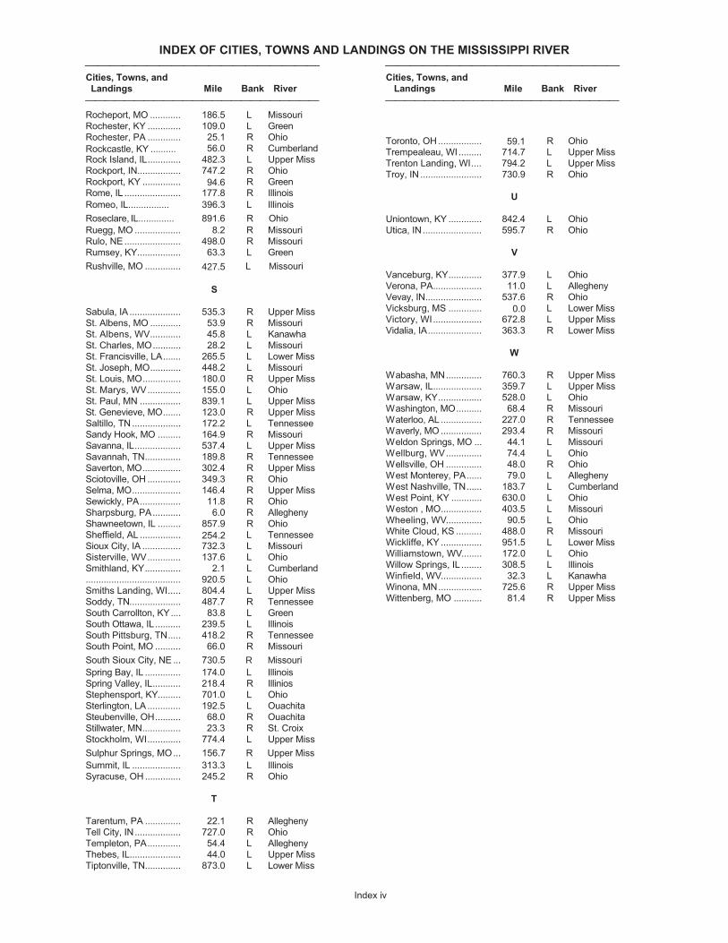
INDEX OF CITIES, TOWNS AND LANDINGS ON THE MISSISSIPPI RIVER
⎯⎯⎯⎯⎯⎯⎯⎯⎯⎯⎯⎯⎯⎯⎯⎯⎯⎯⎯ ⎯⎯⎯⎯⎯⎯⎯⎯⎯⎯⎯⎯⎯⎯⎯⎯⎯⎯⎯Cities, Towns, and Cities, Towns, and
Landings Mile Bank River Landings Mile Bank River
⎯⎯⎯⎯⎯⎯⎯⎯⎯⎯⎯⎯⎯⎯⎯⎯⎯⎯⎯⎯⎯⎯⎯⎯ ⎯⎯⎯⎯⎯⎯⎯⎯⎯⎯⎯⎯⎯⎯⎯⎯⎯⎯⎯⎯⎯⎯⎯⎯
Index iv
Rocheport, MO ............ 186.5 L Missouri
Rochester, KY ............. 109.0 L Green
Rochester, PA ............. 25.1 R Ohio
Rock astle, KY .......... 56.0 R Cumberland
Rock Island, IL............. 482.3 L Upper Miss
Rockport, IN................. 747.2 R Ohio
Rockport, KY ............... 94. R Green
Rome, IL ...................... 177.8 R Illinois
Ro , IL................ .
Rose .............. Ruegg, MO .................. 8.2 R Missouri
Rulo, NE ...................... 498.0 R Missouri
Rumsey, KY................. 63.3 L Green
Rushville, MO .............. 427. L Missouri
S
Sabula, IA .................... 535.3 R Upper Miss
St. Albens, MO ............ 53.9 R Missouri
St. Albens, WV............ 45.8 L Kanawha
St. Charles, MO........... 28.2 L Missouri
St. Francisville, LA....... 265.5 L Lower Miss
St. Joseph, MO............ 448.2 L Missouri
St. Louis, MO............... 180.0 R Upper Miss
St. Marys, WV............. 155.0 L Ohio
St. Paul, MN ................ 839.1 L Upper Miss
St. Genevieve, MO....... 123.0 R Upper Miss
Saltillo, TN ................... 172.2 L Tennessee
Sandy Hook, MO ......... 164.9 R Missouri
Savanna, IL.................. 537.4 L Upper Miss
Savannah, TN.............. 189.8 R Tennessee
Saverton, MO............... 302.4 R Upper Miss
Sciotoville, OH ............. 349.3 R Ohio
Selma, MO................... 146.4 R Upper Miss
Sewickly, PA................ 11.8 R Ohio
Sharpsburg, PA........... 6.0 R Allegheny
Shawneetown, IL ......... 857.9 R Ohio
Sheffield, AL ................ 25 . L Tennessee
Sioux City, IA ............... 732.3 L Missouri
Sisterville, WV............. 137.6 L Ohio
Smithland, KY.............. 2.1 L Cumberland
..................................... 920.5 L Ohio
Smiths Landing, WI..... 804.4 L Upper Miss
Soddy, TN.................... 487.7 R Tennessee
South Carrollton, KY.... 83.8 L Green
South Ottawa, IL.......... 239.5 L Illinois
South Pittsburg, TN..... 418.2 R Tennessee
South Point, MO .......... 66.0 R Missouri
South Sioux City, NE ... 730.5 R Missouri
Spring Bay, IL .............. 174.0 L Illinois
Spring Valley, IL........... 218.4 R Illinios
Stephensport, KY......... 701.0 L Ohio
Sterlington, LA ............. 192.5 L Ouachita
Steubenville, OH.......... 68.0 R Ouachita
Stillwater, MN............... 23.3 R St. Croix
Stockholm, WI............. 774.4 L Upper Miss
Sulphur Springs, MO... 156.7 R Upper Miss
Summit, IL ................... 313.3 L Illinois
Syracuse, OH .............. 245.2 R Ohio
T
Tarentum, PA .............. 22.1 R Allegheny
Tell City, IN.................. 727.0 R Ohio
Templeton, PA............. 54.4 L Allegheny
Thebes, IL.................... 44.0 L Upper Miss
Tiptonville, TN.............. 873.0 L Lower Miss
Toronto, OH ................. 59.1 R Ohio
Trempealeau, WI ......... 714.7 L Upper Miss
Trenton Landing, WI.... 794.2 L Upper Miss
Troy, IN ........................ 730.9 R Ohio
U
Uniontown, KY ............. 842.4 L Ohio
Utica, IN....................... 595.7 R Ohio
V
Vanceburg, KY............. 377.9 L Ohio
Verona, PA................... 11.0 L Allegheny
Vevay, IN...................... 537.6 R Ohio
Vicksburg, MS ............. L Lower Miss
Victory, WI................... 672.8 L Upper Miss
Vidalia, IA..................... 363.3 R Lower Miss
W
Wabasha, MN.............. 760.3 R Upper Miss
Warsaw, IL................... 359.7 L Upper Miss
Warsaw, KY................. 528.0 L Ohio
Washington, MO.......... 68.4 R Missouri
Waterloo, AL ................ 227.0 R Tennessee
Waverly, MO ................ 293.4 R Missouri
Weldon Springs, MO ... 44.1 L Missouri
Wellburg, WV.............. 74.4 L Ohio
Wellsville, OH .............. 48.0 R Ohio
West Monterey, PA...... 79.0 L Allegheny
West Nashville, TN...... 183.7 L Cumberland
West Point, KY ............ 630.0 L Ohio
Weston , MO................ 403.5 L Missouri
Wheeling, WV.............. 90.5 L Ohio
White Cloud, KS .......... 488.0 R Missouri
Wickliffe, KY ................ 951.5 L Lower Miss
Williamstown, WV........ 172.0 L Ohio
Willow Springs, IL ........ 308.5 L Illinois
Winfield, WV................ 32.3 L Kanawha
Winona, MN................. 725.6 R Upper Miss
Wittenberg, MO ........... 81.4 R Upper Miss
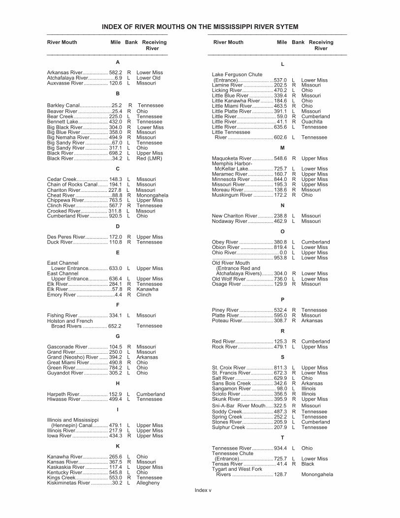
INDEX OF RIVER MOUTHS ON THE MISSISSIPPI RIVER SYTEM⎯⎯⎯⎯⎯⎯⎯⎯⎯⎯⎯⎯⎯⎯⎯⎯⎯⎯⎯⎯⎯⎯⎯ ⎯⎯⎯⎯⎯⎯⎯⎯⎯⎯⎯⎯⎯⎯⎯⎯⎯⎯⎯⎯⎯⎯⎯⎯⎯⎯River Mouth Mile Bank Receiving River Mouth Mile Bank Receiving
River River
⎯⎯⎯⎯⎯⎯⎯⎯⎯⎯⎯⎯⎯⎯⎯⎯⎯⎯⎯⎯⎯⎯⎯ ⎯⎯⎯⎯⎯⎯⎯⎯⎯⎯⎯⎯⎯⎯⎯⎯⎯⎯⎯⎯⎯⎯⎯⎯⎯⎯
Index v
A
Arkansas River.................. 582.2 R Lower MissAtchafalaya River...................6.9 L Lower OldAuxvasse River ................. 120.6 L Missouri
B
Barkley Canal.....................25.2 R TennesseeBeaver River ........................25.4 R OhioBear Creek ........................ 225.0 L TennesseeBennett Lake..................... 432.0 R TennesseeBig Black River.................. Lower MissBig Blue River ................... 358.0 R MissouriBig Nemaha River............. 494.9 R MissouriBig Sandy River ...................67.0 L TennesseeBig Sandy River ................ 317.1 L OhioBlack River ........................ 698.2 L Upper MissBlack River ...........................34.2 L Red (LMR)
C
Cedar Creek...................... 148.3 L MissouriChain of Rocks Canal....... 194.1 L MissouriChariton River................... 227. L MissouriCheat River ..........................8 R MonongahelaChippewa River................. 763.5 L Upper MissClinch River....................... 567.7 R TennesseeCrooked River................... 31 L MissouriCumberland River............. 920.5 L Ohio
D
Des Peres River................ 172.0 R Upper MissDuck River......................... 110.8 R Tennessee
E
East Channel Lower Entrance.............. 633.0 L Upper MissEast Channel Upper Entrance.............. 636.4 L Upper MissElk River............................ 284.1 R TennesseeElk River...............................57.8 R KanawhaEmory River ...........................4. R Clinch
F
Fishing River ..................... 334.1 L Missouriand Rivers ............... 652. Tennessee
G
Gasconade River .............. 104.5 R MissouriGrand River....................... 250.0 L MissouriGrand (Neosho) River ...... 394.2 L ArkansasGreat Miami River............. 490.8 R OhioGreen River....................... 784.2 L OhioGuyandot River ................. 305.2 L Ohio
H
Harpeth River...... ............. 152.9 L CumberlandHiwasse River ................... 499.4 L Tennessee
I
Illinois and Mississippi (Hennepin) Canal........... 479.1 L Upper MissIllinois River....................... 217.9 L Upper MissIowa River ......................... 434.3 R Upper Miss
K
Kanawha River.................. 265.6 L OhioKansas River..................... 367.5 R MissouriKaskaskia River ................ 117.4 L Upper MissKentucky River.................. 545.8 L OhioKings Creek....................... 553.0 R TennesseeKiskiminetas River ...............30.2 L Allegheny
L
Lake Ferguson Chute(Entrance)...................... 537. L Lower Miss
Lamine River .....................202.5 R MissouriLicking River...................... 470.2 L OhioLittle Blue River ................. 339.4 R MissouriLittle Kanawha River .........184.6 L OhioLittle Miami River............... 463.5 R OhioLittle Platte River ............... 391.1 L MissouriLittle River............................ 59.0 R CumberlandLittle River............................ 41.1 R OuachitaLittle River.......................... 635.6 L TennesseeLittle Tennessee River ................................ 602.6 L Tennessee
M
Maquoketa River ............... 548.6 R Upper MissMemphis Harbor-McKellar Lake.................. 725.7 L Lower Miss
Meramec River..................160.7 R Upper MissMinnesota River ................ 844.0 R Upper MissMissouri River....................195.3 R Upper MissMoreau River.....................138.6 R MissouriMuskingum River ..............172.2 R Ohio
N
New Chariton River...........238.8 L MissouriNodaway River.................. 462.9 L Missouri
O
Obey River ........................ 380.8 L CumberlandObion River ....................... 819.4 L Lower MissOhio River.............................. 0.0 L Upper Miss........................................... 953.8 L Lower MissOld River Mouth (Entrance Red and
Atchafalaya Rivers)........ 304.0 R Lower MissOld Wolf River ................... 73 L Lower MissOsage River ......................129.9 R Missouri
P
Piney River ........................ 532.4 R TennesseePlatte River........................ 595.0 R MissouriPoteau River...................... 308.7 R Arkansas
R
Red River...........................125.3 R CumberlandRock River......................... 479.1 L Upper Miss
S
St. Croix River ................... 811.3 L Upper MissSt. Francis River................ 672.3 R Lower MissSalt River ........................... 629.9 L OhioSans Bois Creek ............... 342.6 R ArkansasSangamon River ................. 98.0 L IllinoisScioto River ....................... 356.5 R IllinoisSkunk River ....................... 395.9 R Upper Miss
Sni-A-Bar River Mouth..... 322.5 R MissouriSoddy Creek...................... 487.3 R TennesseeSpring Creek .....................252.2 L TennesseeStones River......................205.9 L CumberlandSulphur Creek ...................207.9 L Tennessee
T
Tennessee River ............... 934.4 L OhioTennessee Chute (Entrance)........................ 725.7 L Lower MissTensas River ....................... 41.4 R BlackTygart and West Fork Rivers .............................128.7 Monongahela
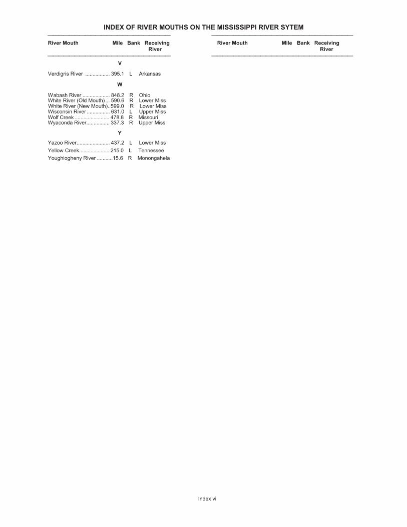
INDEX OF RIVER MOUTHS ON THE MISSISSIPPI RIVER SYTEM⎯⎯⎯⎯⎯⎯⎯⎯⎯⎯⎯⎯⎯⎯⎯⎯⎯⎯⎯⎯⎯⎯⎯ ⎯⎯⎯⎯⎯⎯⎯⎯⎯⎯⎯⎯⎯⎯⎯⎯⎯⎯⎯⎯⎯⎯⎯⎯⎯⎯River Mouth Mile Bank Receiving River Mouth Mile Bank Receiving
River River
⎯⎯⎯⎯⎯⎯⎯⎯⎯⎯⎯⎯⎯⎯⎯⎯⎯⎯⎯⎯⎯⎯⎯ ⎯⎯⎯⎯⎯⎯⎯⎯⎯⎯⎯⎯⎯⎯⎯⎯⎯⎯⎯⎯⎯⎯⎯⎯⎯⎯
Index vi
V
Verdigris River ................. 395.1 L Arkansas
W
Wabash River ................... 848.2 R OhioWhite River (Old Mouth) ... 590.6 R Lower Miss
Wisconsin River ................ 631.0 L Upper MissWolf Creek ........................ 478.8 R MissouriWyaconda River................ 337.3 R Upper Miss
Y
Yazoo River....................... 437.2 L Lower Miss
Yellow Creek..................... 215.0 L Tennessee
Youghiogheny River ...........15.6 R Monongahela
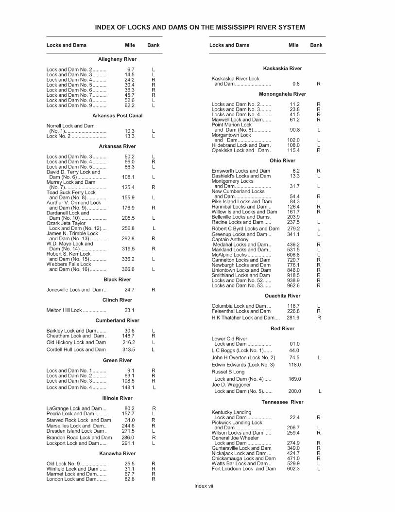
INDEX OF LOCKS AND DAMS ON THE MISSISSIPPI RIVER SYSTEM
Locks and Dams Mile Bank Locks and Dams Mile Bank
Index vii
Allegheny River
Lock and Dam No. 2 .......... 6.7 LLock and Dam No. 3.......... 14.5 LLock and Dam No. 4.......... 24.2 RLock and Dam No. 5.......... 30.4 RLock and Dam No. 6.......... 36.3 RLock and Dam No. 7.......... 45.7 RLock and Dam No. 8.......... 52.6 LLock and Dam No. 9.......... 62.2 L
Arkansas Post Canal
Norrell Lock and Dam (No. 1).............................. 10.3 LLock No. 2 ......................... 13.3 L
Arkansas River
Lock and Dam No. 3.......... 50.2 LLock and Dam No. 4.......... 66.0 RLock and Dam No. 5.......... 86.3 LDavid D. Terry Lock and Dam (No. 6) ..................... 108.1 LMurray Lock and Dam (No. 7).............................. 125.4 RToad Suck Ferry Lockand Dam (No. 8) .............. 155.9 L
Aurthur V. Ormond Lockand Dam (No. 9) .............. 176.9 R
Dardanell Lock and Dam (No. 10) ................... 205.5 LOzark Jeta Taylor Lock and Dam (No. 12).... 256.8 LJames N. Trimble Lockand Dam (No. 13) ............ 292.8 R
W.D. Mayo Lock and Dam (No. 14) ................... 319.5 RRobert S. Kerr Lockand Dam (No. 15) ............ 336.2 L
Webbers Falls Lockand Dam (No. 16) ............ 366.6 L
Black River
Jonesville Lock and Dam .. 24.7 R
Clinch River
Melton Hill Lock ................. 23.1
Cumberland River
Barkley Lock and Dam....... 30.6 LCheatham Lock and Dam . 148.7 R
Old Hickory Lock and Dam 216.2 LCordell Hull Lock and Dam 313.5 L
Green River
Lock and Dam No. 1 .......... 9.1 RLock and Dam No. 2 .......... 63.1 RLock and Dam No. 3.......... 108.5 R
Lock and Dam No. 4.......... 148.1 L
Illinois River
LaGrange Lock and Dam... 80.2 RPeoria Lock and Dam ........ 157.7 L
Starved Rock Lock and Dam 31.0 RMarseilles Lock and Dam.. 244.6 RDresden Island Lock Dam . 271.5 L
Brandon Road Lock and Dam 286.0 RLockport Lock and Dam..... 291.1 L
Kanawha River
Old Lock No. 9................... 25.5 RWinfield Lock and Dam ..... 31.1 RMarmet Lock and Dam....... 67.7 RLondon Lock and Dam....... 82.8 R
Kaskaskia River
Kaskaskia River Lockand Dam.......................... 0.8 R
Monongahela River
Locks and Dam No. 2........ 11.2 RLocks and Dam No. 3........ 23.8 RLocks and Dam No. 4........ 41.5 RMaxwell Lock and Dam...... 61.2 RPoint Marion Lockand Dam (No. 8)............. 90.8 L
Morgantown Lockand Dam........................ 102.0 L
Hildebrand Lock and Dam. 108.0 LOpekiska Lock and Dam . 115.4 R
Ohio River
Emsworth Locks and Dam 6.2 RDashield's Locks and Dam 13.3 LMontgomery Locksand Dam.......................... 31.7 L
New Cumberland Locksand Dam.......................... 54.4 R
Pike Island Locks and Dam 84.3 LHannibal Locks and Dam .. 126.4 RWillow Island Locks and Dam 161.7 RBelleville Locks and Dams. 203.9Racine Locks and Dam ..... 237.5 L
Robert C Byrd Locks and Dam 279.2 LGreenup Locks and Dam .. 341.1 LCaptain AnthonyMedahal Locks and Dam.. 436.2 RMarkland Locks and Dam.. 531.5 LMcAlpine Locks ................. 606.8 LCannelton Locks and Dam 720.7 RNewburgh Locks and Dam 776.1 RUniontown Locks and Dam 846.0 RSmithland Locks and Dam 918.5 RLocks and Dam No. 52...... 938.9 RLocks and Dam No. 53...... 962.6 R
Ouachita River
Columbia Lock and Dam ... 116.7 LFelsenthal Locks and Dam 226.8 R
H K Thatcher Lock and Dam.... 281.9 R
Red River
Lower Old River Lock and Dam ................. 01.0
L C Boggs (Lock No. 1)...... 44.0John H Overton (Lock No. 2) 74.5 L
Edwin Edwards (Lock No. 3) 118.0Russel B LongLock and Dam (No. 4) ..... 169.0
Joe D. Waggoner
Lock and Dam (No. 5)....... 200.0 L
Tennessee River
Kentucky Landing Lock and Dam ................. 22.4 RPickwick Landing Lockand Dam.......................... 206.7 L
Wilson Locks and Dam ..... 259.4 RGeneral Joe Wheeler Lock and Dam ................. 274.9 RGuntersville Lock and Dam 349.0 RNickajack Lock and Dam... 424.7 RChickamauga Lock and Dam 471.0 RWatts Bar Lock and Dam .. 529.9 LFort Loudoun Lock and Dam 602.3 L
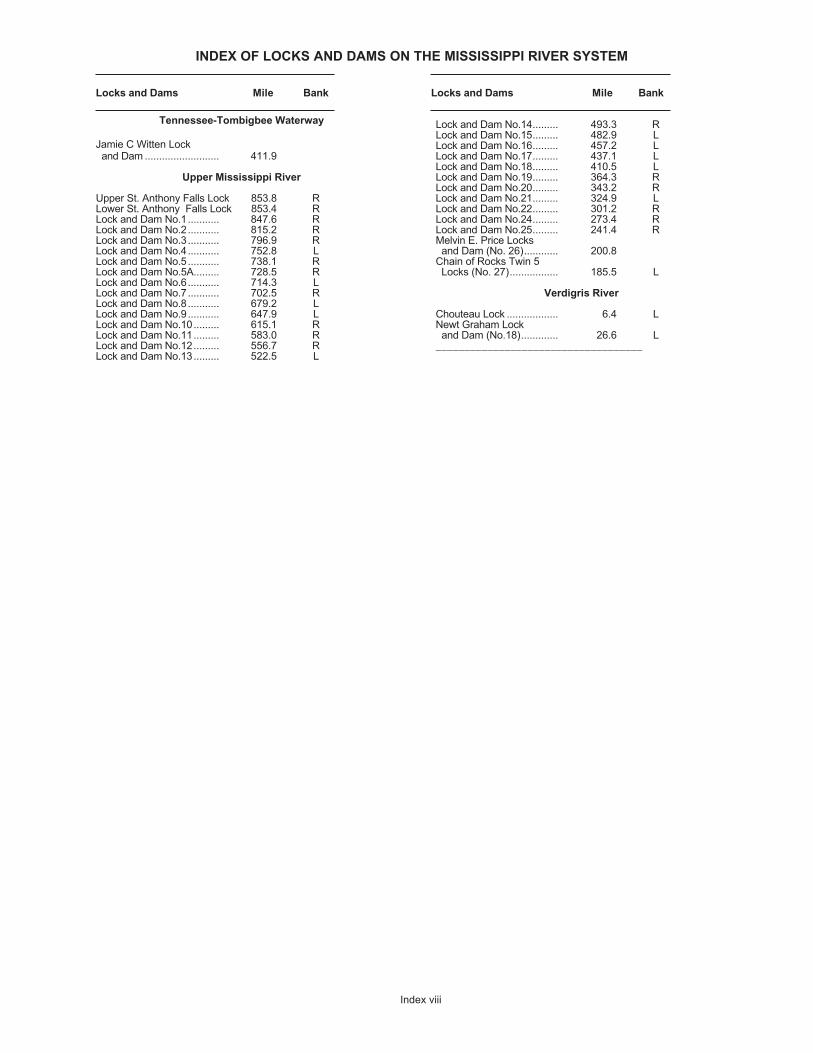
INDEX OF LOCKS AND DAMS ON THE MISSISSIPPI RIVER SYSTEM
Locks and Dams Mile Bank Locks and Dams Mile Bank
Index viii
Tennessee-Tombigbee Waterway
Jamie C Witten Lockand Dam .......................... 411.9
Upper Mississippi River
Upper St. Anthony Falls Lock 853.8 RLower St. Anthony Falls Lock 853.4 RLock and Dam No.1 ........... 847.6 RLock and Dam No.2 ........... 815.2 RLock and Dam No.3........... 796.9 RLock and Dam No.4........... 752.8 LLock and Dam No.5........... 738.1 RLock and Dam No.5A......... 728.5 RLock and Dam No.6........... 714.3 LLock and Dam No.7........... 702.5 RLock and Dam No.8........... 679.2 LLock and Dam No.9........... 647.9 LLock and Dam No.10......... 615.1 RLock and Dam No.11 ......... 583.0 RLock and Dam No.12 ......... 556.7 RLock and Dam No.13......... 522.5 L
Lock and Dam No.14......... 493.3 RLock and Dam No.15......... 482.9 LLock and Dam No.16......... 457.2 LLock and Dam No.17......... 437.1 LLock and Dam No.18......... 410.5 LLock and Dam No.19......... 364.3 RLock and Dam No.20......... 343.2 RLock and Dam No.21......... 324.9 LLock and Dam No.22......... 301.2 RLock and Dam No.24......... 273.4 RLock and Dam No.25......... 241.4 RMelvin E. Price Locksand Dam (No. 26)............ 200.8
Chain of Rocks Twin 5 Locks (No. 27)................. 185.5 L
Verdigris River
Chouteau Lock .................. 6.4 LNewt Graham Lockand Dam (No.18)............. 26.6 L
____________________________________
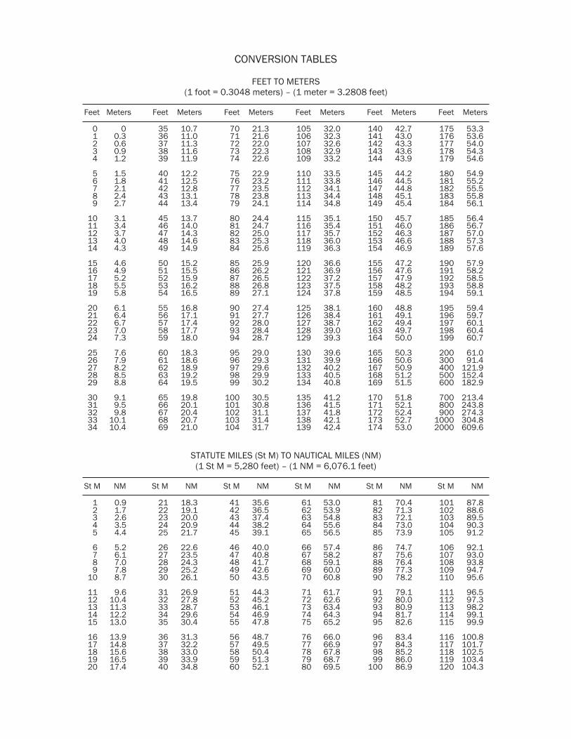
CONVERSION TABLES
FEET TO METERS(1 foot = 0.3048 meters) – (1 meter = 3.2808 feet)
Feet Meters Feet Meters Feet Meters Feet Meters Feet Meters Feet Meters
0 0 35 10.7 70 21.3 105 32.0 140 42.7 175 53.31 0.3 36 11.0 71 21.6 106 32.3 141 43.0 176 53.62 0.6 37 11.3 72 22.0 107 32.6 142 43.3 177 54.03 0.9 38 11.6 73 22.3 108 32.9 143 43.6 178 54.34 1.2 39 11.9 74 22.6 109 33.2 144 43.9 179 54.6
5 1.5 40 12.2 75 22.9 110 33.5 145 44.2 180 54.96 1.8 41 12.5 76 23.2 111 33.8 146 44.5 181 55.27 2.1 42 12.8 77 23.5 112 34.1 147 44.8 182 55.58 2.4 43 13.1 78 23.8 113 34.4 148 45.1 183 55.89 2.7 44 13.4 79 24.1 114 34.8 149 45.4 184 56.1
10 3.1 45 13.7 80 24.4 115 35.1 150 45.7 185 56.411 3.4 46 14.0 81 24.7 116 35.4 151 46.0 186 56.712 3.7 47 14.3 82 25.0 117 35.7 152 46.3 187 57.013 4.0 48 14.6 83 25.3 118 36.0 153 46.6 188 57.314 4.3 49 14.9 84 25.6 119 36.3 154 46.9 189 57.6
15 4.6 50 15.2 85 25.9 120 36.6 155 47.2 190 57.916 4.9 51 15.5 86 26.2 121 36.9 156 47.6 191 58.217 5.2 52 15.9 87 26.5 122 37.2 157 47.9 192 58.518 5.5 53 16.2 88 26.8 123 37.5 158 48.2 193 58.819 5.8 54 16.5 89 27.1 124 37.8 159 48.5 194 59.1
20 6.1 55 16.8 90 27.4 125 38.1 160 48.8 195 59.421 6.4 56 17.1 91 27.7 126 38.4 161 49.1 196 59.722 6.7 57 17.4 92 28.0 127 38.7 162 49.4 197 60.123 7.0 58 17.7 93 28.4 128 39.0 163 49.7 198 60.424 7.3 59 18.0 94 28.7 129 39.3 164 50.0 199 60.7
25 7.6 60 18.3 95 29.0 130 39.6 165 50.3 200 61.026 7.9 61 18.6 96 29.3 131 39.9 166 50.6 300 91.427 8.2 62 18.9 97 29.6 132 40.2 167 50.9 400 121.928 8.5 63 19.2 98 29.9 133 40.5 168 51.2 500 152.429 8.8 64 19.5 99 30.2 134 40.8 169 51.5 600 182.9
30 9.1 65 19.8 100 30.5 135 41.2 170 51.8 700 213.431 9.5 66 20.1 101 30.8 136 41.5 171 52.1 800 243.832 9.8 67 20.4 102 31.1 137 41.8 172 52.4 900 274.333 10.1 68 20.7 103 31.4 138 42.1 173 52.7 1000 304.834 10.4 69 21.0 104 31.7 139 42.4 174 53.0 2000 609.6
STATUTE MILES (St M) TO NAUTICAL MILES (NM)(1 St M = 5,280 feet) – (1 NM = 6,076.1 feet)
St M NM St M NM St M NM St M NM St M NM St M NM
1 0.9 21 18.3 41 35.6 61 53.0 81 70.4 101 87.82 1.7 22 19.1 42 36.5 62 53.9 82 71.3 102 88.63 2.6 23 20.0 43 37.4 63 54.8 83 72.1 103 89.54 3.5 24 20.9 44 38.2 64 55.6 84 73.0 104 90.35 4.4 25 21.7 45 39.1 65 56.5 85 73.9 105 91.2
6 5.2 26 22.6 46 40.0 66 57.4 86 74.7 106 92.17 6.1 27 23.5 47 40.8 67 58.2 87 75.6 107 93.08 7.0 28 24.3 48 41.7 68 59.1 88 76.4 108 93.89 7.8 29 25.2 49 42.6 69 60.0 89 77.3 109 94.7
10 8.7 30 26.1 50 43.5 70 60.8 90 78.2 110 95.6
11 9.6 31 26.9 51 44.3 71 61.7 91 79.1 111 96.512 10.4 32 27.8 52 45.2 72 62.6 92 80.0 112 97.313 11.3 33 28.7 53 46.1 73 63.4 93 80.9 113 98.214 12.2 34 29.6 54 46.9 74 64.3 94 81.7 114 99.115 13.0 35 30.4 55 47.8 75 65.2 95 82.6 115 99.9
16 13.9 36 31.3 56 48.7 76 66.0 96 83.4 116 100.817 14.8 37 32.2 57 49.5 77 66.9 97 84.3 117 101.718 15.6 38 33.0 58 50.4 78 67.8 98 85.2 118 102.519 16.5 39 33.9 59 51.3 79 68.7 99 86.0 119 103.420 17.4 40 34.8 60 52.1 80 69.5 100 86.9 120 104.3