LIGHT LIST Volume V MISSISSIPPI RIVER SYSTEM Front... · light list . volume v mississippi river...
63
LIGHT LIST Volume V MISSISSIPPI RIVER SYSTEM Mississippi River and its navigable tributaries This Light List contains a list of lights, buoys, daybeacons, and other aids to navigation. IMPORTANT THIS LIGHT LIST SHOULD BE CORRECTED EACH WEEK FROM THE LOCAL NOTICES TO MARINERS OR NOTICES TO MARINERS AS APPROPRIATE. 2018 COMDTPUB P16502.5
Transcript of LIGHT LIST Volume V MISSISSIPPI RIVER SYSTEM Front... · light list . volume v mississippi river...

LIGHT LIST
Volume V
MISSISSIPPI RIVER SYSTEM
Mississippi River and its navigable tributaries
This Light List contains a list of lights, buoys, daybeacons, and other aids to navigation.
IMPORTANT THIS LIGHT LIST SHOULD BE CORRECTED
EACH WEEK FROM THE LOCAL NOTICES TO MARINERS OR NOTICES TO MARINERS AS
APPROPRIATE.
2018 COMDTPUB
P16502.5

60O
40O
20O
60O
50O
50O
40O
20O
MID
WA
Y I
SL
AN
DS
VO
L.
VI
PA
CIF
IC C
OA
ST
AN
D P
AC
IFIC
IS
LA
ND
S
LIM
ITS
OF
LIG
HT
LIS
TS
PU
BLIS
HE
D B
Y
U.S
. C
OA
ST
GU
AR
D80
O60
O100O
120O
140O
160O
180O
80O
60O
100O
120O
140O
160O
180O
VO
L.
IA
TL
AN
TIC
CO
AS
T(S
t. C
roix
Riv
er,
ME
to
Sh
rew
sbu
ry R
ive
r, N
J)
VO
L.
IIA
TL
AN
TIC
CO
AS
T(S
hre
wsb
ury
Riv
er,
NJ
to L
ittle
Riv
er,
SC
)
VO
L.
III
AT
LA
NT
IC C
OA
ST
(Litt
le R
ive
r, S
C t
o E
con
fina
Riv
er,
FL
)
VO
L.
VM
ISS
ISS
IPP
IR
IVE
R S
YS
TE
M
VO
L.
VII
GR
EA
T L
AK
ES
HA
WA
IIA
N I
SL
AN
DS
AID
S T
O N
AV
IGA
TIO
N M
AIN
TA
INE
D B
Y U
NIT
ED
ST
AT
ES
AT
OT
HE
R
PA
CIF
IC I
SL
AN
DS
AR
E I
NC
LU
DE
D O
N T
HE
PA
CIF
IC L
IST
Aid
s m
ain
tain
ed
at
Pu
ert
o R
ico
, V
irg
in I
sla
nd
s,
an
d G
ua
nta
na
mo
Ba
y
incl
ud
ed
in V
olu
me
III
.
VO
L.
IVG
UL
F C
OA
ST
(Eco
nfin
a R
ive
r, F
L t
o R
io G
ran
de
, T
X)

KGW KWG KWB KBW KWR KRW KRB KBR KGB KBG KGR KRG
BR "A" FI (2) 5s
FI (2) 5s
BR "C"
RW "N" Mo (A)
RW "A"
G "5"
DAYBEACON
LIGHTED UNLIGHTED
CAN
CAN
LIGHTED
AND/OR SOUND
MR SPHERICAL UNLIGHTED
AND/OR SOUND
NUN NUN DAYBEACON
LIGHTED BUOY LIGHTED BUOY
LIGHT
LIGHT
GR "U"
GREEN LIGHT ONLY
FLASHING (2)
FLASHING
OCCULTING
QUICK FLASHING
ISO
WHITE LIGHT ONLY
WHITE LIGHT ONLY
NW
W
Bn
GW
Bn
NBNGNR
BW
Bn
RW
Bn
GREEN LIGHT ONLY RED LIGHT ONLY
RW SP "B"
RW "N"
Y C "A"
Y N "C"
Y "A" Bn
Y "B" FI
FIXED
FLASHING
LIGHTED
SHAPE OPTIONAL--BUT SELECTED TO BE APPROPRIATE
FOR THE POSITION OF THE MARK IN RELATION TO THE
NAVIGABLE WATERWAY AND THE DIRECTION
OF BUOYAGE. UNLIGHTED
PLATE 1
YELLOW ONLY
GR "A" FI (2+1) G 6s
G "9" FI G 4s
"1" FI G 6s
GR C "S"
RG "B" FI (2+1) R 6s
R "8" FI R 4s
RG N "C"
R N "6"
R "2"
G C "9"
"2" FI R 6s
PORT SIDE ODD NUMBERED AIDS
ISOLATED DANGER NO NUMBERS - MAY BE LETTERED
DAYBOARDS - MAY BE LETTERED
PREFERRED CHANNEL NO NUMBERS - MAY BE LETTERED
PREFERRED CHANNEL NO NUMBERS - MAY BE LETTERED
STARBOARD SIDE EVEN NUMBERED AIDS
LATERAL SYSTEM AS SEEN ENTERING FROM SEAWARD
AIDS TO NAVIGATION HAVING NO LATERAL SIGNIFICANCE
U.S. AIDS TO NAVIGATION SYSTEM on navigable waters except Western Rivers
WHITE LIGHT ONLY MORSE CODE
Mo (A)
SAFE WATER NO NUMBERS - MAY BE LETTERED
RANGE DAYBOARDS - MAY BE LETTERED
SPECIAL MARKS - MAY BE LETTERED
RED LIGHT ONLY
FLASHING (2)
FLASHING
OCCULTING
QUICK FLASHING
ISO
PREFERRED
CHANNEL TO
STARBOARD
TOPMOST BAND
GREEN
COMPOSITE GROUP FLASHING (2+1) COMPOSITE GROUP FLASHING (2+1)
PREFERRED
CHANNEL TO
PORT
TOPMOST BAND
RED
RG "G"
9
9
C
WHITE WITH BLUE BAND
MAY SHOW WHITE
REFLECTOR OR LIGHT
MOORING
BUOY
UNITEDST
ATES COAST
GUARD
1790
Aids to Navigation marking the Intracoastal Waterway (ICW) display unique yellow symbols to distinguish them from aids marking other waters. Yellow triangles e aids should be passed by keeping them on the starboard (right) hand of the vessel. Yellow squares e aids should be passed by keeping them on the port (left) hand of the vessel. A yellow horizontal band ovides no lateral information, but simply identifies aids as marking the ICW.
INFORMATION AND REGULATORY MARKERS
WHEN LIGHTED, INFORMATION AND REGULATORY
MARKS MAY DISPLAY ANY WHITE LIGHT RHYTHM
EXCEPT QUICK FLASHING, Mo(A), AND FLASHING (2)
TYPICAL INFORMATION AND REGULATORY MARKS
EXPLAINATION MAY BE PLACED
OUTSIDE THE CROSSED DIAMOND
SHAPE, SUCH AS DAM, RAPIDS,
SWIM AREA, ETC.
THE NATURE OF DANGER MAY
BE INDICATED INSIDE THE
DIAMOND SHAPE, SUCH AS ROCK,
WRECK, SHOAL, DAM, ETC.
CONTROLLED AREA
DANGERBOAT EXCLUSION AREA
TYPE OF CONTROL IS INDICATED
IN THE CIRCLE, SUCH AS SLOW,
NO WAKE, ANCHORING, ETC.
SWIM AREA NO WAKE
ROCK SLOW
BUOY USED TO DISPLAY
REGULATORY MARKERS
INFORMATION MAY SHOW WHITE LIGHT
MAY BE LETTERED
FOR DISPLAYING INFORMATION
SUCH AS DIRECTIONS, DISTANCES,
LOCATIONS, ETC.
MULLET LAKE
BLACK RIVER
LIGHT
indicat
indicat
pr

2
4
6
87
5
3
1
3
3
2
2
2
2
2 2
1
3
1
3
REGION-B - by night
Preferred ChannelSecondary Channel
VISUAL BUOYAGE GUIDEREGION B - by day
Preferred ChannelSecondary Channel
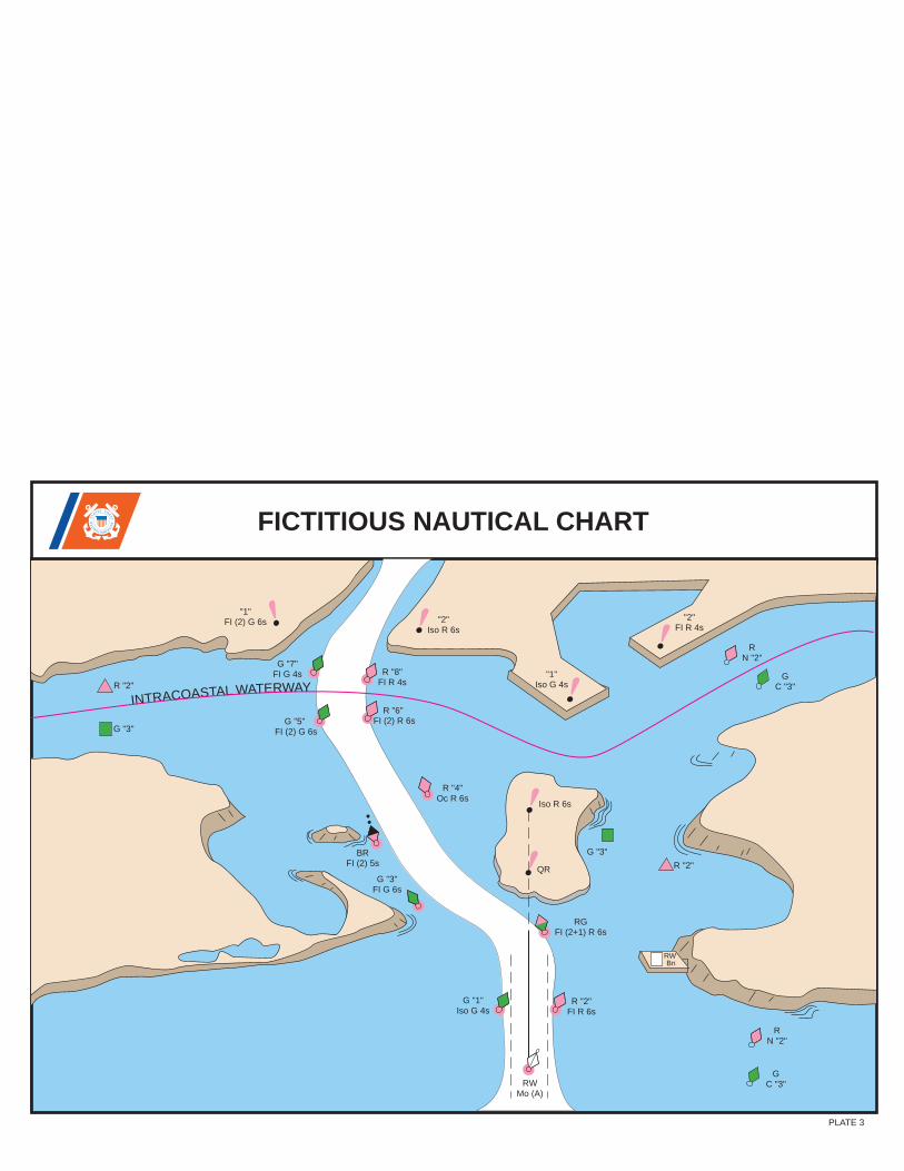
INTRACOASTAL WATERWA
FICTITIOUS NAUTICAL CHART
BR FI (2) 5s
RW Bn
G "3"
G "3"
Iso R 6s
R N "2"
R "2"
R N "2"
G C "3"
"2" Iso R 6s
"2" FI R 4s
"1" Iso G 4s
QR
"1" FI (2) G 6s
R "2" Y
RW Mo (A)
RG FI (2+1) R 6s
G "1" Iso G 4s
G "5" FI (2) G 6s
G "7" FI G 4s
G "3" FI G 6s
R "2" FI R 6s
R "6" FI (2) R 6s
R "8" FI R 4s
R "4" Oc R 6s
G C "3"
UNITE
D
STATE S C OA
ST
GU
A
RD
1 7 9 0
PLATE 3

PASSING DAYBEACON CROSSING DAYBEACON
CANLIGHTED BUOY
WHITE LIGHT ONLYMAY BE LETTERED
EXPLAINATION MAY BE PLACED OUTSIDE THE CROSSED DIAMOND SHAPE, SUCH AS DAM, RAPIDS, SWIM AREA, ETC.
THE NATURE OF DANGER MAYBE INDICATED INSIDE THEDIAMOND SHAPE, SUCH AS ROCK, WRECK, SHOAL, DAM, ETC.
BUOY USED TO DISPLAYREGULATORY MARKERS
INFORMATION
CONTROLLEDAREA
DANGER
BOATEXCLUSIONAREA
MAY SHOW WHITE LIGHT MAY BE LETTERED
TYPE OF CONTROL IS INDICATEDIN THE CIRCLE, SUCH AS SLOW,NO WAKE, ANCHORING, ETC.
S WIM
FOR DISPLAYING INFORMATIONSUCH AS DIRECTIONS, DISTANCES,LOCATIONS, ETC.
MUL L E T L A K E
B L A C K R IV E R
A R E A NO WAK E
R OC K S L OW
DA NG E R
WHITE LIGHT ONLY
NB
CNG CNR
SHAPE: OPTIONAL--BUT SELECTED TO BE APPROPRIATEFOR THE POSITION OF THE MARK IN RELATION TO THENAVIGABLE WATERWAY AND THE DIRECTION OF BUOYAGE.
A
A
UNLIGHTED
LIGHT
B
LIGHTED
PASSING DAYBEACON
LIGHTED BUOY
MAY BE LIGHTED
NUNLIGHT
TR
FIXEDFLASHING
YELLOW ONLY
INFORMATION AND REGULATORY MARKERS WHEN LIGHTED, INFORMATION AND REGULATORY MARKS
MAY DISPLAY ANY LIGHT RHYTHM EXCEPT QUICK FLASHING, Mo(a) AND FLASHING (2)
NW
C
NY
PLATE 4
GREEN OR
FLASHINGISO
WHITE LIGHTS
OR R IG HT DE S C E NDING B A NK
RED OR
FLASHING (2) ISO
WHITE LIGHTS
OR L E F T DE S C E NDING B A NKMARK JUNCTIONS AND OBSTRUCTIONS COMPOSITE GROUP FLASHING (2+1)
PR E FE RR E D C HANNE L
WHITE WITH BLUE BAND
MAY SHOW WHITE REFLECTOR OR LIGHT
MOORINGBUOY
P R E F E R R E D C HA NNE LTO S TA R B OA R D
TOPMOST BAND GREEN FI (2+1) G
JG JR
P R E F E R R E D C HA NNE LTO P OR T
TOPMOST BAND RED
FI (2+1) R
CROSSING DAYBEACON
MILE BOARD
SG
BLACK-STRIPEDWHITE BUOY
123.5MILE BOARD
176.9
Used to indicate an obstruction to navigation, extends from the nearest shore to the buoy. Thismeans "do not pass between the buoy and the nearest shore." This aid is replacing the red and white striped buoy within the USWMS, but cannot be used until all red and white striped buoys on a waterway have been replaced.
MAY SHOW WHITE REFLECTOR OR QUICK FLASHING WHITE LIGHT
INL A ND (S TAT E ) WAT E R S OB S T R UC T ION MA R K
UNIT
ED
STAT E S CO AS
TG
UA
RD
1 7 9 0
A
23
LIGHT
PORT SIDE
on the Western River System
U.S. AIDS TO NAVIGATION SYSTEM
AS SEEN ENTERING FROM SEAWARDSTARBOARD SIDE
STATE WATERS
SPECIAL MARKS--MAY BE LETTERED
DAYBOARDS HAVING NO LATERAL SIGNIFICANCE
TYPICAL INFORMATION AND REGULATORY MARKS

LUMINOUS RANGE DIAGRAMThe nominal range given in this Light List is the maximum distance agiven light can be seen when the meteorological visibility is 10 nauticalmiles. If the existing visibility is less than 10 NM, the range at whichthe light can be seen will be reduced below its nominal range. And, ifthe visibility is greater than 10 NM, the light can be seen at greaterdistances. The distance at which a light may be expected to be seenin the prevailing visibility is called its luminous range.
This diagram enables the mariner to determine the approximateluminous range of a light when the nominal range and the prevailingmeteorological visibility are known. The diagram is entered from thebottom border using the nominal range listed in column 6 of this book.The intersection of the nominal range with the appropriate visibilitycurve (or, more often, a point between two curves) yields, by movinghorizontally to the left border, the luminous range.
CAUTIONWhen using this diagram it must be
remembered that:
1. The ranges obtained are approximate.2. The transparency of the atmosphere
may vary between observer and light.3. Glare from background lighting will
reduce the range that lights are sighted.4. The rolling motion of a vessel and/or
of a lighted aid may reduce the distancethat lights can be detected or identified.
250/76.2 18.5 300/91.4 20.3 350/106.7 21.9 400/121.9 23.4 450/137.2 24.8 500/152.4 26.2 550/167.6 27.4 600/182.9 28.7 650/198.1 29.8 700/213.4 31.0 800/243.8 33.1 900/274.3 35.11000/304.8 37.0
GEOGRAPHIC RANGE TABLEThe following table gives the approximate geographic range of visibility for an object which may be seen by an observer at sea level. It is
necessary to add to the distance for the height of any object the distance corresponding to the height of the observer's eye above sea level.
Height HeightHeight DistanceDistanceDistance
Feet / Meters Feet / Meters Feet / MetersNautical Miles (NM) Nautical Miles (NM) Nautical Miles (NM)
Height of object 65 feet= 9.4 NMHeight of observer 35 feet= 6.9 NMComputed geographic visibility= 16.3 NM
5/1.5 2.6 10/3.1 3.715/4.6 4.520/6.1 5.225/7.6 5.930/9.1 6.435/10.7 6.940/12.2 7.445/13.7 7.850/15.2 8.355/16.8 8.760/18.3 9.165/19.8 9.4
70/21.3 9.8 75/22.9 10.1 80/24.4 10.5 85/25.9 10.8 90/27.4 11.1 95/29.0 11.4100/30.5 11.7110/33.5 12.3120/36.6 12.8130/39.6 13.3140/42.7 13.8150/45.7 14.3200/61.0 16.5
Example: Determine the geographic visibility of an object, with a heightabove water of 65 feet, for an observer with a height of eye of 35 feet.
Enter above table;
METEOROLOGICAL VISIBILITY(From International Visibility Code)
Code
0
1
2
3
4
5
6
7
8
9
Metric
less than 50 meters
50-200 meters
200-500 meters
500-1,000 meters
1-2 kilometers
2-4 kilometers
4-10 kilometers
10-20 kilometers
20-50 kilometers
greater than 50 km
Nautical(approximate)
less than 50 yards
50-200 yards
200-500 yards
500-1,000 yards
1,000-2,000 yards
1-2 nautical miles
2-5.5 nautical miles
5.5-11 nautical miles
11-27 nautical miles
greater than 27 nm
NOMINAL RANGE
LU
MIN
OU
S
RA
NG
EN
au
tica
l m
iles
(This
range m
ay b
e r
educed b
y the g
lare
of oth
er
lights
)
40
50
30
20
10
6
8
4
3
2
1
0.8
0.6
0.4
0.3
0.2
0.1
1 2 3 4 5 6 8 10 15 20 25 30 35 40
1
0
2
3
4
5
7
8
METEORLOGICAL VISIBILITY(From International Visibility Code)
50 yards
27 n
autical m
iles
11 nautical m
iles
5.5 nautical miles
2 nautical miles
1 nautical mile
1,000 yards
500 yards
200 yards
6
9
infin
ite v
isib
ility
Nautical MilesNOMINAL RANGE
LU
MIN
OU
S
RA
NG
E s
tatu
te m
iles
(This
range m
ay b
e r
educed b
y the g
lare
of oth
er
lights
)
40
50
30
20
10
6
8
4
3
2
1
0.8
0.6
0.4
0.3
0.2
0.11 2 3 4 5 6 8 10 15 20 25 30 40 4535
1
2
3
4
5
7
8
METEORLOGICAL VISIBILITY(From International Visibility Code)
50 yards
50 meters
1 statute mile
2 kilometers
2.5 statute miles
4 kilometers
0.5 statute mile
1 kilometers
500 yards
500 meters
200 yards
200 meters
6
infin
ite v
isib
ility
Statute Miles
0
6.5 statute miles
10 kilometers
13 statute m
iles
20 kilometers
31 s
tatu
te m
iles
50 kilo
mete
rs
9

This Page Intentionally Left Blank

TABLE OF CONTENTS
Light List Regions ......................................................................................................... Inside Front Cover
U.S. DGPS Sites ...................................................................................................................................... i
USCG Contact Information ...................................................................................................................... ii
Preface ............................................................................................................................................................... xi
Introduction ........................................................................................................................................................ xii
River Descriptions. ............................................................................................................................ xxxix
RIVERS Allegheny River ................................................................................................................................................ 01 Arkansas Waterway - Verdigris River to Dardanelle Lock and Dam ........................................................ 04 Arkansas Waterway - Highway 7 Bridge to White River and Lower Mississippi River .......................... 12 Big Sandy, Canadian and Clinch Rivers ...................................................................................................... 20 Cumberland River ............................................................................................................................................ 24 Green and Hiwassee Rivers .......................................................................................................................... 32 Illinois Waterway - Chicago River to Henry, IL ............................................................................................ 36 Illinois Waterway - Henry Island to Upper Mississippi River ...................................................................... 49 Kanawha River, Kaskaskia River, Lake Sakakawea, Lake Texoma........................................................ 56 Little Tennessee River and Minnesota River ...............................................................................................62 Lower Mississippi River - Cairo, IL to Mouth of White River...................................................................... 64 Lower Mississippi River - Montgomery Point to Baton Rouge Bridge..................................................... .70 Upper Mississippi River - Minneapolis Harbor to Winona, MN .................................................................76 Upper Mississippi River - Winona, MN to Moline, IL .................................................................................. 84 Upper Mississippi River - Moline, IL to Grafton, IL .....................................................................................95 Upper Mississippi River - Grafton, IL to Mouth of Ohio River ................................................................. 106 Missouri River -Sioux City, IA to Kansas City, MO .................................................................................. 114 Missouri River -Kansas City, MO to Upper Mississippi River ..................................................................123 Monongahela River ....................................................................................................................................... 132 Ohio River - Pittsburgh, PA to Parkersburg, WV ...................................................................................... 139 Ohio River - Parkersburg, WV to New Richmond, OH ............................................................................. 146 Ohio River - New Richmond, OH to Stephensport, KY ............................................................................153 Ohio River - Stephensport, KY to Mississippi River .................................................................................160 Ouachita-Black Waterway, Red River Waterway, St. Croix River and Lake St. Croix .........................167 Tennessee River - Knoxville, TN to Guntersville, AL .................................................................................177 Tennessee River and Tennessee–Tombigbee Waterway ....................................................................... 199
INDEX ................................................................................................................................................................Index 1

ii
COAST GUARD DISTRICT COMMANDERS
DISTRICT ADDRESS WATERS OF JURISDICTION FIRST 408 Atlantic Avenue
Boston, MA 02110-3350 Tel: (617) 223-8351 http://www.uscg.mil/d1
Maine, New Hampshire, Massachusetts, Vermont (Lake Champlain), Rhode Island, Connecticut, New York, to Shrewsbury River, New Jersey.
FIFTH Federal Building 431 Crawford Street Portsmouth, VA 23704-5004 Tel: (757) 398-6486
(757) 398-6231 http://www.uscg.mil/d5
Shrewsbury River, New Jersey to Delaware, Maryland, Virginia, District of Columbia, and North Carolina.
SEVENTH Brickell Plaza Federal Building 909 SE 1st Avenue; Rm:406 Miami, FL 33131-3050 Tel: (305) 415-6752
(305) 415-6800 http://www.uscg.mil/d7
South Carolina, Georgia, Florida to 83°50'W, and Puerto Rico and adjacent islands of the United States.
EIGHTH Hale Boggs Federal Building 500 Poydras Street New Orleans, LA 70130-3310 Tel: (504) 671-2327
(504) 671-2137 http://www.uscg.mil/d8
Florida westward from 83°50'W, Alabama, Mississippi, Louisiana, Texas, the Mississippi River System except that portion of the Illinois River north of Joliet, Illinois.
NINTH 1240 East 9th Street Cleveland, OH 44199-2060 Tel: (216) 902-6060
(216) 902-6117 http://www.uscg.mil/d9
ELEVENTH Coast Guard Island Building 50-6 Alameda, CA 94501-5100 Tel: (510) 437-2976 http://www.uscg.mil/d11
Great Lakes and St. Lawrence River above St. Regis River.
California.
THIRTEENTH Federal Building 915 Second Avenue 35th Floor, Rm 3510 Seattle, WA 98174-1067 Tel: (206) 220-7270
(206) 220-7004 http://www.uscg.mil/d13
Oregon, Washington, Idaho, and Montana.
FOURTEENTH Prince Kalanianaole Federal Bldg. 300 Ala Moana Blvd 9th Floor, Room 9-220 Honolulu, HI 96850-4982 Tel: (808) 535-3409
(808) 535-3414 http://www.uscg.mil/d14
SEVENTEENTH PO Box 25517 Juneau, AK 99802-5517 Tel: (907) 463-2262 (907) 463-2004 http://www.uscg.mil/d17
Hawaiian, American Samoa, Marshall, Marianas, and Caroline Islands.
Alaska.

iii
U. S. COAST GUARD EIGHTH DISTRICT UNIT LISTING
AIDS TO NAVIGATION TEAMS
ANT CORPUS CHRISTI 1201 East Navigation Blvd Corpus Christi, TX 78402 Tel: 361-844-6521
ANT DULAC 241 Coast Guard Rd Dulac, LA 70353 Tel: (985) 563-4473
ANT GALVESTON 3000 Fort Point Road Galveston, TX 77553 Tel: 409-766-5654
ANT GULFPORT 991 23rd Ave. Gulfport, MS 39501Tel: 228-575-9173
ANT MOBILE 1500 15th St. Mobile, AL 36615 Tel: (251) 441-6244
ANT MORGAN CITY 800 Youngs Rd Suite 100 Morgan City, LA 70381 Tel: (985) 384-7000
ANT NEW ORLEANS 1790 Saturn Rd. New Orleans, LA 70129 Tel: 504-253-4834
ANT PANAMA CITY 1700 Thomas Drive Panama City, FL 32408-5804 Tel: (850) 234-8139
ANT PENSACOLA 21 Slemmer Ave Naval Air Station Pensacola, FL 32508-7851 Tel: (850) 455-2354
ANT PORT O'CONNOR PO Box 98 Port O'Connor, TX 77982 Tel: (361) 983-4313
ANT SABINE 7034 S. First St. Sabine Pass, TX 77655 Tel: 409-971-2111
ANT SOUTH PADRE 1 Wallace Reed Road South Padre Island, TX 78597 Tel: (956) 364-7433
ANT VENICE 436 Coast Guard Rd Venice, LA 70091 Tel: 504-534-7650
iv
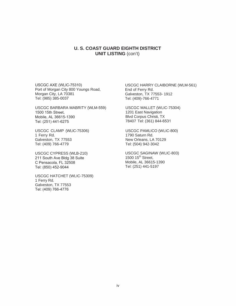
U. S. COAST GUARD EIGHTH DISTRICT UNIT LISTING (con’t)
USCGC AXE (WLIC-75310) Port of Morgan City 800 Youngs Road, Morgan City, LA 70381Tel: (985) 385-0037
USCGC BARBARA MABRITY (WLM-559)1500 15th Street,Mobile, AL 36615-1390 Tel: (251) 441-6275
USCGC CLAMP (WLIC-75306) 1 Ferry Rd. Galveston, TX 77553 Tel: (409) 766-4779
USCGC CYPRESS (WLB-210)211 South Ave Bldg 38 Suite C Pensacola, FL 32508 Tel: (850) 452-9044
USCGC HATCHET (WLIC-75309) 1 Ferry Rd. Galveston, TX 77553Tel: (409) 766-4776
USCGC HARRY CLAIBORNE (WLM-561) End of Ferry Rd. Galveston, TX 77553- 1912 Tel: (409)-766-4771
USCGC MALLET (WLIC-75304) 1201 East Navigation Blvd Corpus Christi, TX 78407 Tel: (361) 844-6531
USCGC PAMLICO (WLIC-800) 1790 Saturn Rd. New Orleans, LA 70129 Tel: (504) 942-3042
USCGC SAGINAW (WLIC-803) 1500 15th Street, Mobile, AL 36615-1390 Tel: (251) 441-5197

v
COAST GUARD COMMUNICATIONS FACILITIES All Broadcasts are made on Channel 22 (157.1 MHz)
NOTE: Broadcast times refer to scheduled Broadcasts in zulu time. Non-scheduled Broadcasts are made whenever important marine information needs to be passed. Announcements of Broadcasts are made on Channel 16 (156.8 MHz).
FACILITY COVERAGE AREA RIVER STAGES AND SCHEDULED TO BROADCAST S
SECTOR UPPER UPPER MISSISSIPPI, MISSISSIPPI RIVER ILLINOIS, MISSOURI RIVERS ST. LOIUS, MO AND TRIBUTARIES
BROADCAST TIMES 0200 Z 0800 Z 1300 Z2000 Z
0100 Z0700 Z1400 Z1900 Z
SECTOR OHIO TRIBUTARIES
OHIO, UPPER MISSISSIPPI RIVER, TRIBUTARIES LOUISVILLE, KY LOWER MISSISSIPPI RIVER
0300 Z0900 Z1600 Z2100 Z
AREAS OF JURISDICTION OF COAST GUARD CUTTERS ON THE MISSISSIPPI AND WESTERN RIVERS
For the guidance and assistance of those persons needing to contact Coast Guard Cutters in areas of jurisdiction are shown below: WATERWAY / FACILITY MILE ADDRESS PHONE ALLEGHENY RIVER 0.0 - 72.0 CGC OSAGE (WLR 65505) 300 McKnown Lane, Sewickley, PA 15143-2093 412-741-1180 ARKANSAS WATERWAY (White
0.0 – 71.2
CGC KANAWHA (WLR 75407) 870-536-2604 P.O. Box 7627, Pine Bluff, AR 71611-7627 71.2 - 445.9 Lake Texoma
P.O. Box 626, Sallisaw, OK 74955-0626 CGC MUSKINGUM (WLR 75402) 918-775-4471 ATCHAFAYALA RIVER 0.0 - 40.0 CGC GREENBRIER (WLR 75501) P.O. Box 1090, Vidalia, LA 71373-1343 601-442-1771 BIG SANDY RIVER (West Virginia) 0.0 - 7.9 CGC OSAGE (WLR 65505) 300 McKnown Lane, Sewickley, PA 15143-2093 412-741-1180 CLINCH RIVER 0.0 - 61.5 CGC OUACHITA (WLR 65501) 3551 Old Harrison Pike E., Chattanooga, TN 37416-2825 615-622-2101 CUMBERLAND RIVER 0.0 - 381.0 CGC CIMARRON (WLR 65502) 700 Coast Guard Rd, Buchanan, TN 38222-9801 731-642-4457 GREEN RIVER 0.0 - 100.0 CGC OBION (WLR 65503) 3301 HWY 60 East, Owensboro, KY 42303-0220 270-685-0650 HIWASSEE RIVER 0.0 - 20.4 CGC OUACHITA (WLR 65501) 3551 Old Harrison Pike E., Chattanooga, TN 37416-2825 423-622-2101 ILLINOIS RIVER 0.0 - 291.1 CGC SANGAMON (WLR 65506) 97 Conference Ctr. Dr., East Peoria, IL 61611 309-694-2319 KANAWHA RIVER 0.0 - 89.6 CGC OSAGE (WLR 65505) 300 McKnown Lane, Sewickley, PA 15143-2093 412-741-1180 LOWER MISSISIPPI RIVER 233.9 - 363.3 CGC GREENBRIER (WLR 75501) 440 L.E. Berry Rd., Natchez, MS 39120 601-446-5104
363.3 - 480.1 CGC KICKAPOO (WLR 75406) P.O. Box 31, Vicksburg, MS 39180-0031 601-636-8304
480.1 - 598.1 CGC PATOKA (WLR 75408) P.O. Box 468, Greenville, MS 38701-0468 662-332-1044
598.1 - 712.9 CGC KANAWHA (WLR 75407) P.O. Box 7627, Pine Bluff, AR 71611-7627 870-536-1134
683.0 – 813.0 CGC KANKAKEE (WLR 75500) 2 Auction Avenue, Memphis, TN 38105-1502 901-544-3936
813.2 - 953.5 CGC CHENA (WLR 75409) 503 Hall Street, Hickman, KY 42050-0299 270-236-2324 MINNESOTA RIVER 0.0 – 21.8 CGC WYACONDA (WLR 75403) 60 East 1st Street, Dubuque, IA 52001-7652 563-582-0211
SECTOR LOWER LOWER MISSISSIPPI (South of CairoMISSISSIPPI RIVER to Baton Rouge), ARKANSAS, MEMPHIS, TN OUACHITA-BLACK, RED RIVERS AND

vi
AREAS OF JURISDICTION OF COAST GUARD CUTTERS ON THE MISSISSIPPI AND WESTERN RIVERS (cont.)
WATERWAY / FACILITY MILE ADDRESS PHONE MISSOURI RIVER 0.0 - 226.4
314-771-4325 CGC CHEYENNE (WLR 75405) Foot of Arsenal St., St. Louis, MO 63118 226.4 - 73 2.3
CGC GASCONADE (WLR 75401) 9800 John J. Pershing Dr., Omaha, NE 68112-1503 402-451-7681 MONONGAHELA RIVER CGC OSAGE
0.0 - 128.7 300 McKnown Lane, Sewickley, PA 15143-2093 412-741-1180
OHIO RIVER 341.0 – 919.0 CGC OSAGE (WLR 65505) 300 McKnown Lane, Sewickley, PA 15143-2093 412-741-1180
341.0 – 919.0 CGC OBION (WLR 65503) 3301 Hwy 60 East, Owensboro, KY 42303- 0220 270-685-0650
919.0 – 981.0 CGC CHIPPEWA (WLR 75404) 700 Coast Guard Rd, Buchanan, TN 38222-9801 731-642-7181
918.5 - 981.0 CGC CHENA (WLR 75409) P.O. Box 299, Hickman, KY 42050-0299 270-236-2324 OLD RIVER 0.0 - 6.9 CGC GREENBRIER (WLR 75501) 440 L.E. Berry Rd., Natchez, MS 39120 601-442-5104 OUACHITA-BLACK WATERWAY Black River 0.0 - 41.5, Ouachita 41.5 - 337.1 CGC GREENBRIER (WLR 75501) 440 L.E. Berry Rd., Natchez, MS 39120 601-442-5104 RED RIVER 6.9 - 259.8 ANT Colfax 350 Control House Rd., Colfax, LA 71417 318-627-2783CGC GREENBRIER (WLR 75501) 440 L.E. Berry Rd., Natchez, MS 39120 601-442-5104 ST. CROIX RIVER 0.0 – 25.5 CGC WYACONDA (WLR 75403) 60 East 1st Street, Dubuque, IA 52001-7652 563-582-0211 TENNESSEE RIVER 0.0 - 206.7 CGC CIMARRON (WLR 65502) 700 Coast Guard Rd, Buchanan, TN 38222-9801 731-642-4457
206.7 - 652.1 CGC OUACHITA (WLR 65501) 3551 Old Harrison Pike E., Chattanooga, TN 37416-2825 423-662-2101 TENNESSEE - TOMBIGBEE WATERWAY 411.9 – 455.5 CGC OUACHITA (WLR 65501) 3551 Old Harrison Pike E., Chattanooga, TN 37416-2825 423-662-2101 UPPER MISSISIPPI RIVER 0.0 – 109.8 CGC CHIPPEWA (WLR 75404) 700 Coast Guard Rd, Buchanan, TN 38222-9801 731-642-7181
109.9 – 200.8 CGC CHEYENNE (WLR 75405) 100 Arsenal St. St. Louis, MO. 63118-3394 314-771-4325
363.0 - 579.5 CGC SCIOTO (WLR 65504) 221 Mississippi Drive, Keokuk, IA 52632-4219 319-524-1657
522.0 - 857.6 CGC WYACONDA (WLR 75403) 60 E. First Street, Dubuque, IA 52001-7652 563-582-0211
COAST GUARD MARINE SAFETY UNITS For the guidance and assistance of those persons needing to contact Commanding Officers; Marine Safety Unit,
U.S. Coast Guard, the jurisdiction, address, and telephone number of these offices are shown below. JURISDICTION MILE ADDRESS PHONE ALLEGHENY RIVER 1041 Washington Pike, Suite 300, Bridgeville, PA. 15017 412-221-0807 ARKANSAS WATERWAY 2 A.W. Willis Ave., Memphis, TN 38105 866-777-2784 ATCHAFALAYA RIVER 200 Hendee St., New Orleans, LA. 70114 504-365-2200 BIG SANDY RIVER (West Virginia) 95 Peyon St. Barboursville, WV 25504 304-733-0198 CLINCH RIVER 220 Great Circle Road, Suite 148, Nashville, TN 37228-1700 615-736-5421 CUMBERLAND RIVER 0.0 - 80.0 225 Tully St., Paducah, KY 42001 270-442-1621
80.0 - 381.0 220 Great Circle Rd., Suite 148, Nashville, TN 37228-1700 615-736-5421 GREEN RIVER 600 Martin Luther King Place, Louisville, KY 40202 502-779-5400 HIWASSEE RIVER 220 Great Circle Rd. Suite 148 Nashville, TN 37228-1700 615-736-5421 ILLINOIS WATERWAY 0.0 - 187.3 Rober
t A. Young Fed. Bldg., 1222 Spruce St., Suite 1215, St. Louis, MO 63103- 314-269-2332
AND RIVER 187.3 - 327.2 610 South Canal Street, Chicago, IL 60607-4573 630-986-2155 ILLINOIS WATERWAY: 16215 83rd. St., Suite D, Burr Ridge, IL 60527 630-986-2155 ILLINOIS-CALUMET-SAG CHANNEL ILLINOIS and MISSISSIPPI CANAL 555 Plainfield Rd., Suite A, Willowbrook, IL. 60527. 630-986-2155 (HENNEPIN CANAL) KANAWHA RIVER 95 Peyton St., Barboursville, WV 25504 304-733-0198 KASKASKIA RIVER St. Louis, MO 314-269-2332 MINNESOTA RIVER St. Louis, MO 314-269-2332 LOWER MISSISSIPPI
95.0 - 303.0 303.0 - 869.0 869.0 - 953.8 225 Tully St., Paducah, KY 42001 270-422-1621
MISSOURI RIVER St. Louis, MO 314-269-2332 MONONGAHELA RIVER 1041 Washington Pike, Suite 300, Bridgeville, PA. 15017. 412-221-0807

vii
COAST GUARD MARINE SAFETY UNITS (cont.) JURISDICTION MILE ADDRESS PHONE UPPER MISSISSIPPI RIVER
0.0 - 109.0 225 Tully St., Paducah, KY 42001 270-422-1621 109.9 - 351.0 St. Louis, MO 314-269-2332 351.0 - 857.6 Federal Office Bldg, 180 E. Kellogg Blvd., P.O. Box 65428, St. Paul, MN 55165-
612-290-3911
OHIO RIVER 0.0 - 127.2 100 Forbes Ave., Suite 1150,. Pittsburgh, PA 15222 412-644-5808 127.2 - 401.3 95 Peyton St. Barboursville, WV 25504 304-733-0198 401.3 - 531.0 3653 River Rd., Cincinnati, OH 45204 513-921-9033 531.0-867.4 600 Dr. Martin Luther King Place, Louisville, KY 40202 502-779-5300 867.4 - 981.0 225 Tully St., Paducah, KY 42001 270-442-1621
OLD RIVER 0.0 - 6.9 Memphis,TN 866-777-2784 OUACHITA-BLACK WATERWAY Memphis, TN 866-777-2784
0.0 - 41.4 (Black River) and 41.4 - 337.1 (Ouachita River)
RED RIVER 6.9 - 140.0 Memphis, TN 866-777-2784 ST. CROIX RIVER and LAKE ST. CROIX
St. Louis, MO 314-539-3091 0.0 - 80.0 225 Tully St., Paducah, KY 42001 270-442-1621
TENNESSEE RIVER 80.0 - 652.2 220 Great Circle Rd., Suite 148, Nashville, TN 37228-1700 615-736-5421
ARMY CORPS OF ENGINEERS RIVER MILEAGE JURISDICTIONS For the guidance and assistance of those persoons needing to contact various Division or District Engineers,
Corps of Engineers, U.S. Army, the river jurisdiction, address, and telephone number of such offices are shown below.
JURISDICTION MILE ADDRESS PHONE ALLEGHENY RIVER U.S. Army Engineer District Pittsburgh 412-471-0159 ATCHAFALAYA RIVER 0.0 - 140.0 U.S. Army Engineer District Vicksburg 601-631-5000 ARKANSAS RIVER 0.0 - 308.5 U.S. Army Engineer District Little Rock 501-324-5551
308.5 - 395.0 U.S. Army Engineer District Tulsa 918-669-7366 VERDIGRIS RIVER U.S. Army Engineer District Tulsa 918-669-7366 BIG SANDY RIVER (West Virginia) U.S. Army Engineer District Huntington 304-399-5211 CLINCH RIVER U.S. Army Engineer District Nashville 615-736-2165 CUMBERLAND RIVER U.S. Army Engineer District Nashville 615-736-2165 EMORY RIVER U.S. Army Engineer District Nashville 615-736-2165 HIWASSEE RIVER U.S. Army Engineer District Nashville 615-736-2165 ILLINOIS WATERWAY 0.0 - 80.0 U.S. Army Engineer District St. Louis 314-331-8000 Lake Michigan East End North Pier including Calumet-Sag Channel
80.0 - 327.2 U.S. Army Engineer District Rock Island 501-324-5551 KANAWHA RIVER U.S. Army Engineer District Huntington 304-399-5211 KASKASKIA RIVER U.S. Army Engineer District St. Louis 314-331-8000 KENTUCKY RIVER U.S. Army Engineer District Louisville 502-315-6100 GREEN RIVER U.S. Army Engineer District Louisville 502-315-6000 LITTLE RIVER U.S. Army District Engineer Nashville 615-736-2165 MINNESOTA RIVER U.S. Army Engineer District St. Paul 651-225-8238 LOWER 0.0 - 233.1 U.S. Army Engineer District New Orleans
U.S. Army Engineer District New MISSISSIPPI RIVER 233.1 - 303.1 Orleans (AHP) 303.1 - 598.1 U.S. Army Engineer District Vicksburg
598.1 - 955.8 & 2.2 miles up Ohio River U.S. Army Engineer District Memphis
504-861-7058 504-861-7058 601-631-5000
901-544-3602 UPPER MISSISSIPPI RIVER
U.S. Army Engineer District St. Louis 314-331-8000 0.0 - 300.0 300.0 - 614.0 U.S. Army Engineer District Rock Island 501-324-5551
614.0 - Head U.S. Army Engineer District St. Paul 651-225-8238 MISSOURI RIVER 0.0 - 498.5 U.S. Army Engineer District Kansas City
489.5 -Head including Upper River Reservoir U.S. Army Engineer District Omaha
816-426-3271
888-835-5971 MONONGAHELA RIVER U.S. Army Engineer District Pittsburgh 412-471-0159 OHIO RIVER 0.0 - 127.2 U.S. Army Engineer District Pittsburgh 888-835-5971
127.2 - 438.0 U.S. Army Engineer District Huntington 304-399-5211 438.0 - 981.5 U.S. Army Engineer District Louisville 502-315-6100
OUACHITA-BLACK WATERWAY U.S. Army Engineer District Vicksburg 601-631-5000 RED RIVER 0.0 - 140.0 U.S. Army Engineer District Vicksburg 601-631-5000 ST. CROIX RIVER 0.0 - 52.0 U.S. Army Engineer District St. Paul 612-220-8238 TENNESSEE RIVER U.S. Army Engineer District Nashville 615-736-2165 TENNESSEE-TOMBIGBEE WATERWAY
411.9 - 443.4 U.S. Army Engineer District Mobile 251-690-2411 443.4 - 450.7 U.S. Army Engineer District Nashville 615-736-2165
WHITE RIVER U.S. Army Engineer District Little Rock 501-324-5551
viii
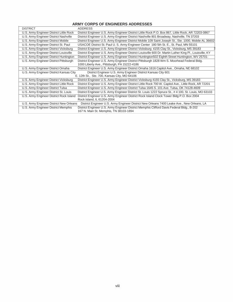
ARMY CORPS OF ENGINEERS ADDRESSES
2
DISTRICT ADDRESS U.S. Army Engineer District Little Rock District Engineer U.S. Army Engineer District Little Rock P.O. Box 867, Little Rock, AR 72203-0867 U.S. Army Engineer District Nashville District Engineer U.S. Army Engineer District Nashville 801 Broadway, Nashville, TN 37203 U.S. Army Engineer District Mobile District Engineer U.S. Army Engineer District Mobile 109 Saint Joseph St., Ste. 1000, Mobile AL 36602 U.S. Army Engineer District St. Paul USACOE District St. Paul U. S. Army Engineer Center 180 5th St. E., St. Paul, MN 55101 U.S. Army Engineer District Vicksburg District Engineer U.S. Army Engineer District Vicksburg 4155 Clay St., Vicksburg, MS 39183 U.S. Army Engineer District Louisville District Engineer U.S. Army Engineer District Louisville 600 Dr. Martin Luther King Pl., Louisville, KY 4020 U.S. Army Engineer District Huntington District Engineer U.S. Army Engineer District Huntington502 Eighth Street Huntington, WV 25701-
U.S. Army Engineer District Pittsburgh District Engineer U.S. Army Engineer District Pittsburgh 1828 Wm S. Moorhead Federal Bldg. 1000 Liberty Ave., Pittsburgh, PA 15222-4186
U.S. Army Engineer District Omaha District Engineer U.S. Army Engineer District Omaha 1616 Capitol Ave., Omaha, NE 68102 U.S. Army Engineer District Kansas City District Engineer U.S. Army Engineer District Kansas City 601
E. 12th St., Ste. 700, Kansas City, MO 64106 U.S. Army Engineer District Vicksburg District Engineer U.S. Army Engineer District Vicksburg 4155 Clay St., Vicksburg, MS 39183 U.S. Army Engineer District Little Rock District Engineer U.S. Army Engineer District Little Rock 700 W. Capitol Ave., Little Rock, AR 72201 U.S. Army Engineer District Tulsa District Engineer U.S. Army Engineer District Tulsa 1645 S. 101 Ave. Tulsa, OK 74128-4609 U.S. Army Engineer District St. Louis District Engineer U.S. Army Engineer District St. Louis 1222 Spruce St., # 4 100, St. Louis, MO 63103 U.S. Army Engineer District Rock Island District Engineer U.S. Army Engineer District Rock Island Clock Tower Bldg P.O. Box 2004
Rock Island, IL 61204-2004 U.S. Army Engineer District New Orleans District Engineer U.S. Army Engineer District New Orleans 7400 Leake Ave., New Orleans, LA 0118 U.S. Army Engineer District Memphis District Engineer U.S. Army Engineer District Memphis Clifford Davis Federal Bldg., B-202
167 N. Main St. Memphis, TN 38103-1894

USCG NAVIGATION CENTER Navigation Information Service (NIS)
The U.S. Coast Guard Navigation Center (NAVCEN) is the official government source of information for civil users of the Global Positioning System (GPS). The Navigation Information Service (NIS) is available 24 hours a day, seven days a week, for all Radio Navigation and maritime related needs via phone, fax or e-mail. The NIS provides users the ability to access real time or archived GPS, NDGPS, DGPS, and LNM information at http://www.navcen.uscg.gov, as well as subscribe to an auto- mated list service which enables users to receive GPS status messages and Notice to NAVSTAR User (NANU) messages via direct Internet e-mail.
The NAVCEN also disseminates GPS and DGPS safety advisory broadcast messages through USCG broadcast stations uti- lizing VHF-FM voice, HF-SSB voice, and NAVTEX broadcasts. The broadcasts provide the GPS and DGPS user in the marine environment with the current status of the navigation systems, as well as any planned/unplanned system outages that could affect GPS and DGPS navigational accuracy.
To comment on any of these services or ask questions about the service offered, contact the NAVCEN at:
Commanding Officer U.S. Coast Guard NAVCEN (NIS) MS 7310 7323 Telegraph Road Alexandria, VA 20598-7310 Phone: (703) 313-5900 FAX: (703) 313-5920 Internet: http://www.navcen.uscg.gov
This Light List is corrected through:
Eighth Coast Guard District Local Notice to Mariners No. 01/18
and through National Geospatial-Intelligence Agency (NGA) Notice to Mariners No. 01/18
The 2018 edition supersedes the 2017 edition.
RECORD OF CORRECTIONS
YEAR 2018 YEAR 2019 1........... 2........... 3........... 4........... 5........... 1........... 2........... 3........... 4........... 5...........
6........... 7........... 8........... 9........... 10......... 6........... 7........... 8........... 9........... 10.........
11......... 12......... 13......... 14......... 15......... 11......... 12......... 13......... 14......... 15.........
16......... 17......... 18......... 19......... 20......... 16......... 17......... 18......... 19......... 20.........
21......... 22......... 23......... 24......... 25......... 21......... 22......... 23......... 24......... 25.........
26......... 27......... 28......... 29......... 30......... 26......... 27......... 28......... 29......... 30.........
31......... 32......... 33......... 34......... 35......... 31......... 32......... 33......... 34......... 35.........
36......... 37......... 38......... 39......... 40......... 36......... 37......... 38......... 39......... 40.........
41......... 42......... 43......... 44......... 45......... 41......... 42......... 43......... 44......... 45.........
46......... 47......... 48......... 49......... 50......... 46......... 47......... 48......... 49......... 50.........
51......... 52......... 51......... 52.........
x

PREFACE
Lights and other marine aids to navigation, maintained by or under authority of the U.S. Coast Guard and located on the Mississippi River system are listed in this volume with aids listed consecutively for each river in the system. The rivers are listed in alphabetical order.
Included are all Coast Guard aids to navigation used for general navigation such as lights, sound signals, buoys, daybeacons, and other aids to navigation. Not included are some buoys having no lateral significance, such as special purpose, anchorage, fish net, and dredging.
Aids to Navigation Link: http://www.uscgboating.org
CAUTION: Mariners attempting to pass a buoy close aboard risk collision with a yawing buoy or with the obstruction, which the buoy marks. Mariners must not rely on buoys alone for determining their positions due to factors limiting buoy reliability.
PRIVATE AIDS TO NAVIGATION Included: Class I aids to navigation on marine structures or other works which the owners are legally obligated to establish, maintain, and operate as prescribed by the Coast Guard.
Included: Class II aids to navigation exclusive of Class I, located in waters used by general navigation.
Not included: Class III aids to navigation exclusive of Class I and Class II, located in waters not ordinarily used by general na- vigation.
This Light List is published annually and is intended to furnish more complete information concerning aids to na-vigation than can be conveniently shown on charts. This Light List is not intended to be used in place of charts or Coast Pilots. Charts should be consulted for the location of all aids to navigation. It may be dangerous to use aids to navigation without ref-erence to charts.
This list is corrected to the date of the notices to mariners shown on the title page. Changes to aids to navigation during the year are advertised in U.S. Coast Guard Local Notices to Mariners and National Geospatial-Intelligence Agency (NGA) Notices to Mariners. Important changes to aids to navigation are also broadcast through Coast Guard or Naval radio stations and NAVTEX. Mariners should keep their Light Lists, charts and other nautical publications corrected from these notices and should consult all notices issued after the date of publication of this Light List.
The electronic version of this publication is updated monthly and is available at. http://www.navcen.uscg.gov/index.php?pageName=lightLists
Reporting Private Aids to Navigation Discrepancies D8: http://www.uscg.mil/d8/waterways/PATON.Home.asp
IMPORTANT: A summary of corrections for this publication, which includes corrections from the dates shown on the title page to the date of availability, is advertised in the Local Notice to Mariners and the Notice to Mariners. These corrections must be applied in order to bring the Light List up-to-date. Additionally, this publication should be corrected weekly from the Local No-tices to Mariners or the Notices to Mariners, as appropriate.
Mariners and others are requested to bring any apparent errors or omissions in these lists to the attention of:
Commander (dpw) or USCG Navigation Center Eighth Coast Guard District Charting Branch 500 Poydras Street MS 7310 New Orleans, LA 70130-3396 7323 Telegraph Road [email protected] Alexandria, VA 20598-7310
Email: [email protected]
xi

xii
INTRODUCTION
Light List Arrangement
Aids to navigation on the Mississippi River System are listed in this volume. In addition, Bridges, Locks, and minor tributaries are also listed. Aids to navigation are arranged in downstream order for each river listed in the “contents”. The mileage of the aid to navigation determines its position in the list. The origin or mile zero, of most rivers is coincident with the river mouth. If otherwise, the origin point is named in the heading of the section. Aids to navigation are shown located on either the left or right bank when heading downstream, or as sometimes stated, on the “left descending” or the “right descending” bank.
Names of aids to navigation are printed as follows to help distinguish at a glance the type of aid to navigation listed:
RIVER MOUTHS and CITIES Bridges, Locks, and Dams LIGHTS Lighted Buoys Daybeacons and Unlighted Buoys
Light List numbers are assigned to all Federal aids to navigation and many private aids to navigation for reference in the Light List. Aids to navigation are numbered by fives in accordance with their order of appearance in each volume of the Light List. Other numbers and decimal fractions are assigned where newly established aids to navigation are listed between previously numbered aids to navigation. The Light Lists are renumbered periodically to assign whole numbers to all aids to navigation.
Description of Columns
Column (1): Light List Number.
Column (2): Name and location of the aid to navigation. Note: A dash (-) is used to indicate the bold heading is part of the name of the aid to navigation. When reporting discrepancies or making references to such an aid to navigation in correspondence, the full name of the aid including the geographic heading, should be given.
Column (3): River mile.
Column (4): Bank of river.
Column (5): Characteristic of lighted aid to navigation.
Column (6): Structure and dayboard description.
Column (7): Remarks, including bridge clearances, lock dimensions, and private aid to navigation identification.
U.S. Coast Guard Light List Distribution
U.S. regulations require that most commercial vessels maintain on board a currently corrected, copy or pertinent extract, of the U.S. Coast Guard Light Lists which are available for free and

xiii
are updated weekly on the Coast Guard Navigation Center’s website at http://www.navcen.uscg.gov/?pageName=lightLists. Commercially printed versions are also available, but the Coast Guard does not attest to their veracity or sanction such publications.
CHARTS & PUBLICATIONS
Nautical Charts & Publications Nautical charts covering the coastal waters of the United States and its territories are published by the National Ocean Service (NOS). Up-to-date paper copies of NOS charts are available from NOS Certified Agents. A list of agents can be found at: https://nauticalcharts.noaa.gov/charts/noaa-raster-charts.html#paper-nautical-charts. NOS also produces Raster Navigational Charts (RNC) and Electronic Navigational Charts (ENC). RNCs can be found at https://nauticalcharts.noaa.gov/charts/noaa-raster-charts.html. ENCs can be found at https://www.nauticalcharts.noaa.gov/charts/noaa-enc.html.
Inland Electronic Navigational Charts (IENC) and chart books are published by the U.S. Army Corps of Engineers and are available online at http://www.agc.army.mil/Missions/Echarts.aspx. Tide Tables and Tidal Current Tables are no longer printed or distributed by NOS. NOS Tide and Tidal Current predictions are available online at http://tidesandcurrents.noaa.gov/tide_predictions.html. Commercially printed versions, using data provided by NOS, are also available. These products may be obtained from local stores that carry marine publications.
Notices to Mariners
Broadcast Notices to Mariners are made by the Coast Guard through Coast Guard radio stations. These notices, which are broadcast on VHF-FM, NAVTEX, and other maritime frequencies, are warnings that contain important navigational safety information. Included are reports of discrepancies and changes to aids to navigation, the positions of ice and derelicts, and other important hydrographic information.
Radio stations broadcasting Notices to Mariners are listed in the National Ocean Service United States Coast Pilot and in the National Geospatial-Intelligence Agency publication Radio Navigational Aids (Publication No. 117). VHF-FM voice broadcast times can be found online at http://www.nws.noaa.gov/om/marine/vhfvoice.htm.
Local Notices to Mariners (U.S. regional coverage) are another means which the Coast Guard disseminates navigational information for the United States, its territories, and possessions. A Local Notice to Mariners is issued by each Coast Guard district and is used to report changes and discrepancies to aids to navigation maintained by and under the authority of the Coast Guard. The Local Notice to Mariners also contain chart and Light List corrections, proposed aids to navigation projects open for public comment, ongoing waterway projects, bridge regulation changes, marine event information, and other concerns pertinent to the mariner.
Local Notices to Mariners are essential to all navigators for the purposes of keeping charts, Light Lists, Coast Pilots, and other nautical publications up-to-date. These notices are published weekly and can be found online at http://www.navcen.uscg.gov/index.php?pageName=lnmMain. Mariners may register with the

xiv
Coast Guard Navigation Center to receive automatic notifications via email when new editions of the Local Notice to Mariners are available. Register at https://www.navcen.uscg.gov/?pageName=BulletinSubscription. Vessels operating in ports and waterways in several districts will have to obtain the Local Notice to Mariners for each district.
Notice to Mariners are prepared jointly by the National Geospatial-Intelligence Agency (NGA), the U.S. Coast Guard, and the National Ocean Service, and are published weekly by the NGA. The weekly Notice to Mariners advises mariners of important matters affecting navigational safety including new hydrographic discoveries, changes to aids to navigation, and foreign marine information. Also included are corrections to Light Lists, Coast Pilots, and Sailing Directions. This notice is intended for mariners and others who have a need for information related to oceangoing operations. Because it is intended for use by oceangoing vessels, many corrections that affect small craft navigation and associated waters are not included. Information concerning small craft is contained in the Coast Guard Local Notice to Mariners only. The weekly Notices to Marines may be found online at http://msi.nga.mil/NGAPortal/MSI.portal.
ATON DISCREPANCIES
The Coast Guard does not keep the tens of thousands of aids to navigation comprising the U.S. Aids to Navigation System under simultaneous and continuous observation. Mariners should realize that it is impossible to maintain every aid to navigation operating properly and on its assigned position at all times. Therefore, for the safety of all mariners, any who discovers an aid to navigation that is either off station or exhibiting characteristics other than those listed in the Light Lists should promptly notify the nearest Coast Guard unit. Radio messages should be prefixed “COAST GUARD” and transmitted on VHF-FM channel 16 or directly to one of the U.S. Government radio stations listed in Chapter 3, Section 300L, Radio Navigation Aids (Publication No. 117). In addition to notifying the nearest Coast Guard unit by radio, a discrepant aid to navigation can be reported online at http://www.navcen.uscg.gov/?pageName=atonOutageReport.
U.S. AIDS TO NAVIGATION SYSTEM
GENERAL The navigable waters of the United States are marked to assist navigation using the U.S. Aids to Navigation System, a system consistent with the International Association of Marine Aids to Navigation and Lighthouse Authorities (IALA) Maritime Buoyage System. The IALA Maritime Buoyage System is followed by most of the world’s maritime nations and improves maritime safety by encouraging conformity in buoyage systems worldwide. IALA buoyage is divided into two regions made up of Region A and Region B. All navigable waters of the United States follow IALA Region B, except U.S. possessions west of the International Date Line and south of 10° north latitude, which follow Region A. Lateral aids to navigation in Region A vary from those located within Region B. Non-lateral aids to navigation in Region A are the same as those used in Region B. Appropriate nautical charts and publications should be consulted to determine whether the Region A or Region B marking schemes are in effect for a given area.
Aids to navigation are developed, established, operated, and maintained by the U.S. Coast Guard to accomplish the following:
1. Assist navigators in determining their position,

xv
2. Assist the navigator in determining a safe course,3. Warn the navigator of dangers and obstructions,4. Promote the safe and economic movement of commercial vessel traffic, and5. Promote the safe and efficient movement of military vessel traffic, and cargo of
strategic military importance.
The U.S. Aids to Navigation System is designed for use with nautical charts. Nautical charts portray the physical features of the marine environment, which include: soundings, landmarks, hazards to navigation, and aids to navigation. To best understand the purpose of a specific aid to navigation, mariners should consult the associated nautical chart, which illustrates the relationship of the aid to navigation to channel limits, obstructions, hazards to navigation, and to the aids to navigation system as a whole. Seasonal aids to navigation are placed into service, withdrawn, or changed at specified times of the year. The dates shown in the Light Lists are approximate and may vary due to adverse weather or other conditions. These aids will be changed on Electronic Navigational Charts (ENC) based on Light List dates and electronic navigation system settings.
Mariners should maintain and consult suitable publications and navigation equipment depending on the vessel’s requirements. This shipboard navigation equipment is separate from the aids to navigation system, but is often essential to its use.
The U.S. Aids to Navigation System is primarily a lateral system, which employs a simple arrangement of colors, shapes, numbers, and light characteristics to mark the limits of navigable routes. This lateral system is supplemented with non-lateral aids to navigation where appropriate.
Federal aids to navigation consist of Coast Guard operated aids to navigation. The Coast Guard establishes, maintains, and operates a system of aids to navigation consisting of visual, audible, and electronic signals designed to assist the prudent mariner in the process of navigation.
The U.S. Aids to Navigation System contains the following subsystems:
1. Intracoastal Waterway: The aids to navigation marking the Intracoastal Waterwayare arranged geographically from north to south on the Atlantic Coast and generallyeast to west on the coast of the Gulf of Mexico. Red lights (if so equipped), evennumbers, and red buoys or triangle shaped daymarks are located on thesouthbound/westbound starboard waterway boundary. Green lights (if so equipped),odd numbers, and green buoys or square shaped daymarks are on thesouthbound/westbound port waterway boundary.
2. Western Rivers: The Western Rivers System is employed on the Mississippi RiverSystem, in addition to the Tennessee-Tombigbee Waterway and the Alabama,Atchafalaya, and Apalachicola-Chattahoochee-Flint River Systems. The WesternRivers System consists of the following characteristics:
a. Buoys are not numbered.b. Numbers on beacons do not have lateral significance, but rather indicate
mileage from a fixed point (normally the river mouth).

xvi
c. Diamond shaped non-lateral dayboards, red and white or green and white asappropriate, are used to indicate where the river channel crosses from onebank to the other.
d. Lights on green aids to navigation show a single-flash characteristic, whichmay be green or white.
e. Lights on red aids to navigation show a group-flash characteristic, which maybe red or white.
f. Isolated danger marks are not used.
3. Bridge Markings: Bridges across navigable waters are marked with red, greenand/or white lights for nighttime navigation. Red lights mark piers and other parts ofthe bridge. Red lights are also placed on drawbridges to show when they are in theclosed position. Green lights are placed on drawbridges to show when they are inthe open position. The location of these lights will vary according to the bridgestructure. Green lights are also used to mark the centerline of navigable channelsthrough fixed bridges. If there are two or more channels through the bridge, thepreferred channel is also marked by three white lights in a vertical line above thegreen light.
Red and green retro-reflective panels may be used to mark bridge piers and may also be used on bridges not required to display lights. Lateral red and green lights and dayboards may mark main channels through bridges. Adjacent piers are marked with fixed yellow lights when the main channel is marked with lateral aids to navigation.
Centerlines of channels through fixed bridges may be marked with a safe water mark and an occulting white light when lateral marks are used to mark main channels. The centerline of the navigable channel through the draw span of floating bridges may be marked with a special mark. The mark will be a yellow diamond with yellow retro-reflective panels and may exhibit a yellow light that displays a Morse code “B” (a long flash followed by three short flashes). AIS-ATON and RACONs may be placed on the bridge structure to mark the centerline of the navigable channel through the bridge.
Vertical clearance gauges may be installed to enhance navigation safety. The gauges are located on the right channel pier or pier protective structure facing approaching vessels. Clearance gauges indicate the vertical distance between “low steel” of the bridge channel span (in the closed to navigation position for drawbridges) and the level of the water, measured to the bottom of the foot marks, read from top to bottom.
Drawbridges equipped with radiotelephones display a blue and white sign which indicates what VHF radiotelephone channels should be used to request bridge openings.
Private aids to navigation include aids to navigation that are either operated by private persons and organizations, or that are operated by states. Private aids to navigation are classified into three categories:
1. Class I: Aids to navigation on marine structures or other works which the owners arelegally obligated to establish, maintain, and operate as prescribed by the U.S. CoastGuard.
2. Class II: Aids to navigation that, exclusive of Class I aids, are located in waters used bygeneral navigation.
3. Class III: Aids to navigation that, exclusive of Class I and Class II aids, are located inwaters not ordinarily used by general navigation.
Authorization for the establishment of a Class II or Class III private aid to navigation by the U.S. Coast Guard imposes no legal obligation that the aid actually be established and operated. It only specifies the location and operational characteristics of the aid for which the authorization was requested. Once the aid is established, however, the owner is legally obligated to maintain it in good working order and properly painted.
Lights and sound signals on oil wells or other offshore structures in navigable waters are private aids to navigation and are generally not listed in the Light List unless they are equipped with a RACON. Where space allows, the structures are shown on the appropriate nautical charts. Information concerning the location and characteristics of those structures which display lights and sound signals not located in obstruction areas are published in Local and/or weekly Notices to Mariners.
In general, during the nighttime, a series of white lights are displayed extending from the platform to the top of the derrick when drilling operations are in progress. At other times, structures are usually marked with one or more quick flashing white, red, or yellow lights, visible for at least one nautical mile during clear weather. Obstructions, which are a part of the appurtenances to the main structure, such as mooring piles, anchors, and mooring buoys, etc., are not normally lighted. In addition, some structures are equipped with a sound signal that produces a single two-second blast every 20 seconds.
BUOYS, BEACONS, AND AIS-ATON
The primary components of the U.S. Aids to Navigation System are buoys, beacons, and AIS- ATON.
Buoys are floating aids to navigation used extensively throughout U.S. waters. They are moored to sinkers by varying lengths of chain and may shift due to sea conditions and other causes. Buoys may also be carried away, capsized, or sunk. Prudent mariners will not rely solely on any single aid to navigation, particularly floating aids.
Buoy positions represented on nautical charts are approximate position only, due to the practical limitations of positioning and maintaining buoys and their sinkers in precise geographical locations. The position of buoys and beacons are indicated with a circle on the chart. The center of the symbol corresponds with the position of the aid.
Positions of Federal aids to navigation are verified during periodic maintenance visits. Between visits, environmental conditions, including atmospheric and sea conditions, seabed slope and composition, may shift buoys off their charted positions. Buoys may also be dragged off station, sunk, or capsized by a collision with a vessel.
Beacons are aids to navigation which are permanently fixed to the earth’s surface. They range from large lighthouses to small single-pile structures and may be located on land or in the water.
xvii

Lighted beacons are called lights; unlighted beacons are called daybeacons. Lighthouses are placed on shore or on marine sites and most often do not indicate lateral significance. Lighthouses with no lateral significance exhibit a white light.
Beacons exhibit a daymark. For small structures, these are colored geometric shapes that make an aid to navigation readily visible and easily identifiable against background conditions. Generally, the daymark conveys to the mariner, during daylight hours, the same significance as the aid’s light or reflector does at night. The daymark of towers, however, consists of the structure itself. As a result, these daymarks do not infer lateral significance.
Ranges are non-lateral aids to navigation composed of two beacons, which when the structures appear to be in line, assist the mariner in maintaining a safe course. The appropriate nautical chart must be consulted when using ranges to determine whether the range marks the centerline of the navigable channel and also what section of the range may be safely traversed. Ranges typically display rectangular dayboards of various colors and are generally, but not always lighted. Ranges may display lights during daylight and at night. When lighted, ranges may display lights of any color.
Vessels should not pass fixed aids to navigation close aboard due to the danger of collision with rip-rap or structure foundations, or with the obstruction or danger being marked.
Aids to Navigation (ATON) may be enhanced by the use of an automatic identification system (AIS). AIS is a maritime navigation safety communications protocol standardized by the International Telecommunication Union and adopted by the International Maritime Organization for the broadcast or exchange of navigation information between vessels, aircraft, and shore stations. AIS ATON can autonomously and at fixed intervals broadcast the name, position, dimensions, type, characteristics, and status from or concerning an aid to navigation. AIS ATON can be either real (physically fitted to an aid to navigation), synthetic (physically fitted somewhere other than to an aid to navigation) or virtual (physically nonexistent, but capable of being portrayed on AIS-capable displays).
Note: A Real or Physical AIS ATON can actively monitor and report the health and position status of its host; while Synthetic AIS ATON broadcasted from ashore (i.e. NAIS) can be used to electronically augment the range or portrayal (i.e., on radar and ECDIS) of an existing aid to navigation.
Although all existing AIS mobile devices can receive AIS ATON Reports and ASM messages, they may not readily appear on an AIS Minimal Keyboard Display or other shipboard navigational display systems (i.e., radar, ECDIS, ECS), which would require software updates to make these systems compliant with international navigation presentation standards (i.e., IEC 62288 (Ed. 2), IHO S-52 (Ed. 4.4.0)).
AIS ATON can also be used to broadcast both laterally (e.g., Port Hand Mark) and non-laterally significant marine safety information (e.g., environmental data, tidal information, and navigation warnings).
Note: AIS ATON stations broadcast their presence, identity (9-digit Marine Mobile Service Identity (MMSI) number), position, type, and status at least every three minutes or less via an AIS (ITU-R M.1371) message 21–AIS ATON Report. In addition to its AIS ATON Report, AIS ATON can broadcast significant marine safety information via Application Specific Messages (ASM), which are customized messages that can be used to broadcast additional aid
xviii

information or other marine safety information (i.e., environmental conditions, wind speed and direction, tidal/current data, bridge air clearances, area notices, etc. They are identified by their: AIS message number (i.e. 6, 8, 25 or 26), Designated Area Code (DAC), Function Identifier (FI), and Version Number, e.g. U.S. Geographic Notice message: Msg# = 8, DAC = 367, FI = 22, Version = 2, and, denoted as 8/367.22.2.
TYPES OF SIGNALS
Lighted aids to navigation are, for the most part, equipped with daylight controls which automatically cause the light to operate during darkness and to be extinguished during daylight. These devices are not of equal sensitivity; therefore, all lights do not come on or go off at the same time. Mariners should ensure correct identification of aids to navigation during twilight periods when some lighted aids to navigation are lit while others are not.
The lighting apparatus is serviced at periodic intervals to assure reliable operation, but there is always the possibility of a light being extinguished or operating improperly. The condition of the atmosphere has a considerable effect upon the distance at which lights can be seen. Sometimes lights are obscured by fog, haze, dust, smoke, or precipitation which may be present at the light, or between the light and the observer, and which is possibly unknown by the observer. Atmospheric refraction may cause a light to be seen farther than under ordinary circumstances.
A light of low intensity will be easily obscured by unfavorable conditions of the atmosphere and little dependence can be placed on it being seen. For this reason, the intensity of a light should always be considered when expecting to sight it in reduced visibility. Haze and distance may reduce the apparent duration of the flash of a light. In some atmospheric conditions, white lights may have a reddish hue. Lights placed at high elevations are more frequently obscured by clouds, mist, and fog than those lights located at or near sea level.
In regions where ice conditions prevail in the winter, the lantern panes of lights may become covered with ice or snow, which will greatly reduce the visibility of the lights and may also cause colored lights to appear white.
The increasing use of brilliant shore lights for advertising, illuminating bridges, and other purposes, may cause marine navigational lights, particularly those in densely inhabited areas, to be outshone and difficult to distinguish from the background lighting. Mariners are requested to report such cases in order that steps may be taken to improve the conditions.
The “loom” (glow) of a powerful light is often seen beyond the limit of visibility of the actual rays of the light. The loom may sometimes appear sufficiently sharp enough to obtain a bearing. At short distances, some flashing lights may show a faint continuous light between flashes.
The distance of an observer from a light cannot be estimated by its apparent intensity. Always check the characteristics of lights in order to avoid mistaking powerful lights, visible in the distance, for nearby lights (such as those on lighted buoys) showing similar characteristics of low intensity. If lights are not sighted within a reasonable time after prediction, a dangerous situation may exist, requiring prompt resolution or action in order to ensure the safety of the vessel.
The apparent characteristic of a complex light may change with the distance of the observer. For example, a light which actually displays a characteristic of fixed white varied by flashes of
xix

xx
alternating white and red (the rhythms having a decreasing range of visibility in the order: flashing white, flashing red, fixed white) may, when first sighted in clear weather, show as a simple flashing white light. As the vessel draws nearer, the red flash will become visible and the characteristics will appear as alternating flashing white and red. Later, the fixed white light will be seen between the flashes and the true characteristic of the light will finally be recognized as fixed white, alternating flashing white and red (F W Al WR).
If a vessel has considerable vertical motion due to pitching in heavy seas, a light sighted on the horizon may alternatively appear and disappear. This may lead the unwary to assign a false characteristic and hence, to error in its identification. The true characteristic will be evident after the distance has been sufficiently decreased or by increasing the height of eye of the observer.
Similarly, the effect of wave motion on lighted buoys may produce the appearance of incorrect light phase characteristics when certain flashes occur, but are not viewed by the mariner. In addition, buoy motion can reduce the distance at which buoy lights are detected.
Sectors of colored glass are placed in the lanterns of some lights in order to produce a system of light sectors of different colors. In general, red sectors are used to mark shoals or to warn the mariner of other obstructions to navigation or of nearby land. Such lights provide approximate bearing information, since observers may note the change of color as they cross the boundary between sectors. These boundaries are indicated in the Light List (Col. 8) and by dotted lines on charts. These bearings, as all bearings referring to lights, are given in true degrees from 000° to 359°, as observed from a vessel toward the light.
Altering course on the changing sectors of a light or using the boundaries between light sectors to determine the bearing for any purpose is not recommended. Be guided instead by the correct compass bearing to the light and do not rely on being able to accurately observe the point at which the color changes. This is difficult to determine because the edges of a colored sector cannot be cut off sharply. On either side of the line of demarcation between white, red, or green sectors, there is always a small arc of uncertain color. Moreover, when haze or smoke is present in the intervening atmosphere, a white sector might have a reddish hue.
The area in which a light can be observed is normally an arc with the light as the center and the range of visibility as the radius. However, on some bearings, the range may be reduced by obstructions. In such cases, the obstructed arc might differ with height of eye and distance. When adjoining land cuts off a light and the arc of visibility is given, the bearing on which the light disappears may vary with the distance of the vessel from which observed and with the height of eye. When the light is cut off by a sloping hill or point of land, the light may be seen over a wider arc by a vessel farther away than by one closer to the light.
The arc drawn on charts around a light is not intended to give information as to the distance at which it can be seen. The arc indicates the bearings between which the variation of visibility or obstruction of the light occurs.
Only aids to navigation with green or red lights have lateral significance and exhibit either flashing, quick flashing, group flashing, occulting, or isophase light rhythms. When proceeding in the conventional direction of buoyage, the mariner in IALA Region B, may see the following lighted aids to navigation:
Green lights on aids to navigation mark port sides of channels and locations of wrecks or obstructions that must be passed by keeping these lighted aids to navigation on the port hand of

xxi
a vessel. Green lights are also used on preferred channel marks where the preferred channel is to starboard (i.e., aid to navigation left to port when proceeding in the conventional direction of buoyage). Red lights on aids to navigation mark starboard sides of channels and locations of wrecks or obstructions that must be passed by keeping these lighted aids to navigation on the starboard hand of a vessel. Red lights are also used on preferred channel marks where the preferred channel is to port (i.e., aid to navigation left to starboard when proceeding in the conventional direction of buoyage).
White and yellow lights have no lateral significance. The shapes, colors, letters, and light rhythms may determine the purpose of aids to navigation exhibiting white or yellow lights.
Most aids to navigation are fitted with retro reflective material to increase their visibility in darkness. Colored reflective material is used on aids to navigation that, if lighted, will display lights of the same color.
Preferred channel marks exhibit a composite group-flashing light rhythm of two flashes followed by a single flash.
Safe water marks exhibit a white Morse code “A” rhythm (a short flash followed by a long flash).
Isolated danger marks exhibit a white flashing (2) rhythm (two flashes repeated regularly).
Special marks exhibit yellow lights and exhibit a flashing or fixed rhythm.
Information and regulatory marks exhibit a white light with any light rhythm except quick flashing, flashing (2) and Morse code “A.”
For situations where lights require a distinct cautionary significance, as at sharp turns, sudden channel constrictions, wrecks, or obstructions, a quick flashing light rhythm will be used.
Shapes are used to provide easy identification on certain unlighted buoys and dayboards on beacons. These shapes are laterally significant only when associated with laterally significant colors.
In IALA Region B, cylindrical buoys (referred to as “can buoys”) and square dayboards mark the port side of a channel when proceeding from seaward. These aids to navigation are associated with solid green or green and red-banded marks where the topmost band is green. Conical buoys (referred to as “nun buoys”) and triangular dayboards mark the starboard side of the channel when proceeding from seaward. These aids to navigation are associated with solid red or red and green-banded marks where the topmost band is red.
Unless fitted with topmarks; lighted, sound, pillar, and spar buoys have no shape significance. Their numbers, colors, and light characteristics convey their meanings.
Dayboards throughout the U.S. Aids to Navigation System are described using standard designations that describe the appearance of each dayboard. A brief explanation of the designations and of the purpose of each type of dayboard in the system is given below, followed by a verbal description of the appearance of each dayboard type.
Designations:

xxii
1. First Letter – Shape or Purpose
C: Crossing (Western Rivers only) diamond-shaped, used to indicate the points at whichthe channel crosses the river.
J: Junction (square or triangle) used to mark (preferred channel) junctions or bifurcations in the channel, or wrecks or obstructions which may be passed on either side; color of top band has lateral significance for the preferred channel.
K: Range (rectangular) when both the front and rear range dayboards are aligned on the same bearing, the observer is on the azimuth of the range, usually used to mark the center of the channel.
M: Safe Water (octagonal) used to mark the fairway or middle of the channel.
N: No lateral significance (diamond or rectangular) used for special purpose, warning, distance, or location markers.
S: Square used to mark the port side of channels when proceeding from seaward.
T: Triangle used to mark the starboard side of channels when proceeding from seaward.
2. Second Letter – Key Color
B – Black G – Green R – Red W – White Y – Yellow
3. Third Letter – Color of Center Stripe (Range Dayboards Only)
4. Additional Information after a (-)
-I: Intracoastal Waterway; a yellow reflective horizontal band on a dayboard; indicatesthe aid to navigation marks the Intracoastal Waterway.
-SY: Intracoastal Waterway; a yellow reflective square on a dayboard; indicates the aid to navigation is a port hand mark for vessels traversing the Intracoastal Waterway. May appear on a triangular daymark where the Intracoastal Waterway coincides with a waterway having opposite conventional direction of buoyage.
-TY: Intracoastal Waterway; a yellow reflective triangle on a dayboard; indicates the aid to navigation is a starboard hand mark for vessels traversing the Intracoastal Waterway. May appear on a square daymark where the Intracoastal Waterway coincides with a waterway having opposite conventional direction of buoyage.
Descriptions:
CNG: Diamond-shaped dayboard divided into four diamond-shaped colored sectors with the sectors at the side corners white and the sectors at the top and bottom corners green, with green reflective diamonds at the top and bottom corners and white reflective diamonds in the side corners (Western Rivers only).

xxiii
CNR: Diamond-shaped dayboard divided into four diamond-shaped colored sectors with the sectors at the side corners white and the sectors at the top and bottom corners red, with red reflective diamonds at the top and bottom corners and white reflective diamonds in the side corners (Western Rivers only).
JG: Dayboard bearing horizontal bands of green and red, green band topmost, with corresponding reflective borders.
JG-I: Square dayboard bearing horizontal bands of green and red, green band topmost, with corresponding reflective borders and a yellow reflective horizontal band.
JG-SY: Square dayboard bearing horizontal bands of green and red, green band topmost, with corresponding reflective borders and a yellow reflective square.
JG-TY: Square dayboard bearing horizontal bands of green and red, green band topmost, with corresponding reflective borders and a yellow reflective triangle.
JR: Dayboard bearing horizontal bands of red and green, red band topmost, with corresponding reflective borders.
JR-I: Triangular dayboard bearing horizontal bands of red and green, red band topmost, with corresponding reflective borders and a yellow reflective horizontal band.
JR-SY: Triangular dayboard bearing horizontal bands of red and green, red band topmost, with corresponding reflective borders and a yellow reflective square.
JR-TY: Triangular dayboard bearing horizontal bands of red and green, red band topmost, with corresponding reflective borders and a yellow reflective triangle.
KBG: Rectangular black dayboard bearing a central green stripe.
KBG-I: Rectangular black dayboard bearing a central green stripe and a yellow reflective horizontal band.
KBR: Rectangular black dayboard bearing a central red stripe.
KBR-I: Rectangular black dayboard bearing a central red stripe and a yellow reflective horizontal band.
KBW: Rectangular black dayboard bearing a central white stripe.
KBW-I: Rectangular black dayboard bearing a central white stripe and a yellow reflective horizontal band.
KGB: Rectangular green dayboard bearing a central black stripe.
KGB-I: Rectangular green dayboard bearing a central black stripe and a yellow reflective horizontal band.
KGR: Rectangular green dayboard bearing a central red stripe.
xxiv
KGR-I: Rectangular green dayboard bearing a central red stripe and a yellow reflective horizontal band.
KGW: Rectangular green dayboard bearing a central white stripe.
KGW-I: Rectangular green dayboard bearing a central white stripe and a yellow reflective horizontal band.
KRB: Rectangular red dayboard bearing a central black stripe.
KRB-I: Rectangular red dayboard bearing a central black stripe and a yellow reflective horizontal band.
KRG: Rectangular red dayboard bearing a central green stripe.
KRG-I: Rectangular red dayboard bearing a central green stripe and a yellow reflective horizontal band.
KRW: Rectangular red dayboard bearing a central white stripe.
KRW-I: Rectangular red dayboard bearing a central white stripe and a yellow reflective horizontal band.
KWB: Rectangular white dayboard bearing a central black stripe.
KWB-I: Rectangular white dayboard bearing a central black stripe and a yellow reflective horizontal band.
KWG: Rectangular white dayboard bearing a central green stripe.
KWG-I: Rectangular white dayboard bearing a central green stripe and a yellow reflective horizontal band.
KWR: Rectangular white dayboard bearing a central red stripe.
KWR-I: Rectangular white dayboard bearing a central red stripe and a yellow reflective horizontal band.
MR: Octagonal dayboard bearing stripes of white and red, with a white reflective border.
MR-I: Octagonal dayboard bearing stripes of white and red, with a white reflective border and a yellow reflective horizontal band.
NB: Diamond-shaped dayboard divided into four diamond-shaped colored sectors with the sectors at the side corners white and the sectors at the top and bottom corners black, with a white reflective border.
ND: Rectangular white mileage marker with black numerals indicating the mile number (Western Rivers only).

xxv
NG: Diamond-shaped dayboard divided into four diamond-shaped colored sectors with the sectors at the side corners white and the sectors at the top and bottom corners green, with a white reflective border.
NL: Rectangular white location marker with an orange reflective border and black letters indicating the location.
NR: Diamond-shaped dayboard divided into four diamond-shaped colored sectors with the sectors at the side corners white and the sectors at the top and bottom corners red, with a white reflective border.
NW: Diamond-shaped white dayboard with an orange reflective border and black letters describing the information or regulatory nature of the mark.
NY: Diamond-shaped yellow dayboard with yellow reflective border.
SG: Square green dayboard with a green reflective border.
SG-I: Square green dayboard with a green reflective border and a yellow reflective horizontal band.
SG-SY: Square green dayboard with a green reflective border and a yellow reflective square.
SG-TY: Square green dayboard with a green reflective border and a yellow reflective triangle.
SR: Square red dayboard with a red reflective border. (IALA Region “A”)
TG: Triangular green dayboard with a green reflective border. (IALA Region “A”)
TR: Triangular red dayboard with a red reflective border.
TR-I: Triangular red dayboard with a red reflective border and a yellow reflective horizontal band.
TR-SY: Triangular red dayboard with a red reflective border and a yellow reflective square.
TR-TY: Triangular red dayboard with a red reflective border and a yellow reflective triangle. These abbreviated descriptions are used in column (7) and may also be found on the illustrations of the U.S. Aids to Navigation System.
Numbers are used to provide easy identification of aids to navigation. In IALA Region B, all solid red and solid green aids are numbered, with the exception of buoys located on the Western Rivers. Red aids to navigation have even numbers and green aids to navigation have odd numbers. The numbers for each increase from seaward when proceeding in the conventional direction of buoyage. Numbers are kept in approximate sequence on both sides of the channel by omitting numbers where necessary.
Letters may be used to augment numbers when lateral aids to navigation are added to channels with previously completed numerical sequences. Letters will increase in alphabetical order from seaward, proceeding in the conventional direction of buoyage and are added to numbers as suffixes. Letters are not used for buoys on the Western Rivers.

No other aids to navigation are numbered. Preferred channel, safe water, isolated danger, special marks, and information and regulatory aids to navigation may be lettered, but not numbered.
Sound signal is a generic term used to describe aids to navigation that produce an audible signal designed to assist the mariner in periods of reduced visibility. These aids to navigation can be activated by several means (e.g., manually, remotely, or fog detector). The Coast Guard is replacing many fog detectors with mariner radio activated sound signals (MRASS). To activate, mariners key their VHF-FM radio a designated number of times on a designated VHF- FM channel. The sound signal is activated for a period of 15, 30, 45, or 60 minutes after which the activated assistance automatically turns off. In cases where a fog detector is in use, there may be a delay in the automatic activation of the signal. Additionally, fog detectors may not be capable of detecting patchy fog conditions.
Sound signals are distinguished by their tone and phase characteristics. The devices producing the sound, e.g., diaphones, diaphragm horns, sirens, whistles, bells, or gongs determine tones.
Phase characteristics are defined by the signal's sound pattern, i.e., the number of blasts and silent periods per minute and their durations. Sound signals sounded from fixed structures generally produce a specific number of blasts and silent periods each minute when operating. Sound signals installed on buoys are generally activated by the motion of the sea and therefore do not emit a regular signal characteristic. It is common, in fact, for a buoy to produce no sound signal when seas are calm.
The characteristic of a sound signal is listed in column (8) of the Light List. If the sound signal is remotely activated, column (8) will contain the VHF-FM channel and number of times the VHF- FM radio should be keyed. All waterway users equipped with a VHF-FM radio may activate the sound signal, but they are not required to do so. Unless it is specifically stated that a sound signal "Operates continuously," or the signal is a bell, gong, or whistle on a buoy, it can be assumed that the sound signal only operates during times of fog, reduced visibility, or adverse weather.
Caution: Mariners should not rely on sound signals to determine their position. Distance cannot be accurately determined by sound intensity. Occasionally, sound signals may not be heard in areas close to their location. Signals may not sound in cases where fog exists close to, but not at, the location of the sound signal.
Radar Beacons (RACONS) are radar transponders that when triggered by an X-band radar produce a coded response from its location, which is portrayed radially as a series of dots and dashes on the triggering radar. Although RACONS may be used on both laterally significant and non-laterally significant aids to navigation, their signal should just be used for identification purposes only.
RACONS have a typical output of 600 milliwatts and are considered a short range aid to navigation. Reception varies from a nominal range of 6 to 8 nautical miles when mounted on a buoy to as much as 17 nautical miles for a RACON mounted on a fixed structure. It must be understood that these nominal ranges are dependent upon many factors.
The beginning of the RACON presentation occurs about 50 yards beyond the RACON position and will persist for a number of revolutions of the radar antenna (depending on its rotation rate). Distance to the RACON can be measured to the point at which the RACON flash begins, but the
xxvi
xxvii
figure obtained will be greater than the vessel's distance from the RACON. This is due to the slight response delay in the RACON apparatus.
Radar operators may notice some broadening or spoking of the RACON presentation when their vessel approaches closely to the source of the RACON. This effect can be minimized by adjusting the IF gain or sweep gain control of the radar. If desired, the RACON presentation can be virtually eliminated by operation of the FTC (fast time constant) controls of the radar.
Radar Reflectors are special fixtures, incorporated into both lighted and unlighted aids to navigation, to enhance the reflection of radar energy. These fixtures help radar-equipped vessels to detect buoys and beacons, which are so equipped. However, they do not positively identify a radar target as an aid to navigation.
NAVIGATION SERVICES
GLOBAL POSITIONING SYSTEM (GPS), DIFFERENTIAL GPS (DGPS), AND NATION-WIDE AUTOMATIC IDENTIFICATION SYSTEM (NAIS)
Global Positioning System (GPS) is a satellite based navigation system, operated and controlled by the Department of Defense (DOD) under U.S. Air Force management, which provides precise, worldwide, three-dimensional navigation capabilities. The system was originally designed for military application; however, it is now available to all and used almost ubiquitously. The United States is committed to maintaining the availability of at least 24 operational GPS satellites, is six precise orbital planes, each of which complete a circular 10,900 nautical mile orbit of the earth once every 12 hours. Ideally, a minimum of four satellites will be visible from any position on the earth and will provide positions with a global horizontal accuracy within 3 meters, 95% percent of the time. Whenever possible, advance notice of when GPS satellites should not be used will be provided by the DOD and made available by the US Coast Guard through GPS status messages.
The Navigation Center coordinates and manages the Civil GPS Service Interface Committee (CGSIC), which comprises members from U.S. and international private, government, and industry user groups. The CGSIC is the recognized worldwide forum for effective interaction between all civil GPS users and the U.S. GPS authorities.
At least three satellites are required for a two-dimensional solution, however, GPS does not provide integrity information and mariners should exercise extreme caution when using GPS in restricted waterways.
Differential GPS (DGPS) is an augmentation to the GPS signals. Each site corrects for small variations in the signals from each satellite that is in view at that time. Satellite signals can vary due to small changes in the satellite's circuitry and orbit and from changes caused by local weather conditions. Satellite corrections are transmitted to users via radio signals in the medium frequency band (285-325 kHz) previously used for marine radiobeacons. DGPS corrections and integrity information are transmitted using Minimum Shift Keying (MSK) modulation. The modulation data rate is usually 100 or 200 bits per second (bps), but can also be 50 bps. The range of DGPS transmissions is from 40 to 300 nautical miles.
DGPS was the first Federal radionavigation system capable of providing the 10-meter navigation service required for the Harbor Entrance and Approach phase of maritime navigation.

xxviii
DGPS provides integrity messages for signals from the GPS satellites, as well as DGPS position corrections, and typically provides position accuracy of 1-3 meters.
Each DGPS site has two reference stations (which calculate the differential corrections), two integrity monitors (which ensure the differential corrections are accurate), a transmitter, and equipment to communicate status information to and receive commands from the control station. Each transmitter and reference station has a unique identification number that permits users to determine which site/equipment is providing their differential corrections. As distance from the transmitting site increases, the small error in the differential corrections increases. The best accuracy is achieved when using the DGPS site closest to the user.
Information regarding the location of DGPS transmitters is given on the map labeled U.S. DGPS Sites & Identification Numbers on page i. Users can access additional information and DGPS statuses, submit questions, and provide comments via the Navigation Information Service’s website or by calling the Coast Guard Navigation Center DGPS watchstander at (703) 313- 5902.
Navigation Information Service (NIS): The Coast Guard is the government interface for civil users of GPS and has established a Navigation Information Service (NIS) to meet the information needs of the civil user. The NIS is a Coast Guard entity that is manned 24 hours a day, 7 days a week, and is located at the Navigation Center (NAVCEN) in Alexandria, VA. It provides data broadcasts and on-line computer-based information services which are available 24 hours a day. The information provided includes present or future satellite outages, constellation changes, user instructions and tutorials, lists of service and receiver provides/users, and other GPS and DGPS related information.
Navigation Center Internet Service (www) website also offers an e-mail subscription service for GPS status messages, Notice Advisory to NAVSTAR Users (NANU) messages, Local Notice to Mariners, and Coast Guard Light List.
The NAVCEN disseminates GPS and DGPS safety advisory broadcast messages through USCG broadcast stations utilizing VHF-FM voice, HF-SSB voice, and NAVTEX broadcasts. The broadcasts provide the GPS and DGPS user in the marine environment with the current status of the navigation systems, as well as any planned/unplanned system outages that could affect GPS and DGPS navigational accuracy.
Nationwide Automatic Identification System (NAIS) consists of approximately 200 VHF receiver sites located throughout the coastal continental United States, inland rivers, Alaska, Hawaii, Puerto Rico, and Guam. NAIS couples AIS technology with a comprehensive network infrastructure to achieve ship-to-shore and shore-to-ship data transmission throughout the navigable waters of the United States. The system enables AIS-equipped vessels to receive important marine information such as safety and security messages, weather alerts, and electronic aids to navigation.
NAIS is designed to collect safety and security data from AIS-equipped vessels in navigable waters of the United States and share that data with Coast Guard operators and other government and port partners. The primary goal of NAIS is to increase situational awareness through data dissemination via a network infrastructure, particularly focusing on improving maritime security, marine and navigational safety, search and rescue, and environmental protection services. Collected AIS data improves the safety of vessels and ports through collision avoidance and the safety of the nation through detection, identification, and

xxix
classification of vessels. NAIS broadcasts navigation enhancing safety related messages such as Synthetic AIS ATON Reports and Application Specific Messages.
For more information see: • AIS messages at www.navcen.uscg.gov/?pageName=AISMessages,• IMO Safety of Navigation Circular 289 and 290 regarding ASM’s at
www.navcen.uscg.gov/?pageName=AISReferences,• IALA AIS ASM Catalog at www.e-navigation.nl/asm, and• USCG Special Notice 14-02 regarding eATON at
www.navcen.uscg.gov/?pageName=AISFAQ#21.
To comment on any of these services or ask questions about the service offered, contact the NAVCEN at:
Commanding Officer U.S. Coast Guard Navigation Center 7323 Telegraph Road STOP 7310 Alexandria, VA 20598-7310 Phone: (703) 313-5900 Internet: http://www.navcen.uscg.gov

xxx
ABBREVIATIONS
Various abbreviations are utilized in Broadcast Notices to Mariners, Local Notices to Mariners, on charts, and in the Light Lists. Refer to the following list.
Light Characteristics Alternating AL Characteristic CHAR Composite Group-Flashing FL (2+1) Composite Group-Occulting OC (2+1) Continuous Quick-Flashing Q Eclipse EC Fixed and Flashing FFL Fixed F Group-Flashing FL (3) Group-Occulting OC (2) Interrupted Quick-Flashing IQ Isophase ISO Morse Code MO (A) Occulting OC Single-Flashing FL
Sound Signal Characteristics Blast BL Every EV Seconds S Silent SI
Colors* Black B Blue BU Green G Orange OR Red R White W Yellow Y *NOTE: Color refers to characteristics of aidsto navigation only.
Aids to Navigation Aeronautical Radiobeacon AERO RBN Automatic Identification System AIS Daybeacon DBN Destroyed DESTR Differential GPS DGPS Discontinued DISCONTD Established ESTAB Exposed Location Buoy ELB Extinguished EXT Fog Signal Station FOG SIG Light List Number LLNR
Light LT Lighted Bell Buoy LBB Lighted Buoy LB Lighted Gong Buoy LGB Lighted Horn Buoy LHB Lighted Whistle Buoy LWB Mariner Radio Activated Sound Signal MRASS Ocean Data Acquisition System ODAS Privately Maintained PRIV MAINTD Radar Reflector RA REF Radar Responder Beacon RACON Remote Radio Activated Sound Signal RRASS Single Point Mooring Buoy SPM Sound Signal SS Temporarily Replaced by Lighted Buoy TRLB Temporarily Replaced by Unlighted Buoy TRUB Topmark TMK Virtual AIS Aid to Navigation V-AIS Whistle WHIS
Organizations Commander, Coast Guard District CCGD (#) Coast Guard CG Corps of Engineers USACE National Geospatial-Intelligence Agency NGA National Ocean Service NOS National Weather Service NWS
Vessels Aircraft A/C Fishing Vessel F/V Liquefied Natural Gas Carrier LNG Motor Vessel (includes Steam Ship, Container Ship, Cargo Vessel, Tanker etc) M/V Pleasure Craft P/C Research Vessel R/V Sailing Vessel S/V
Compass Directions North N

South S East E West W Northeast NE Northwest NW Southeast SE Southwest SW
Months January JAN February FEB March MAR April APR May MAY June JUN July JUL August AUG September SEP October OCT November NOV December DEC
Days of the Week Monday MON Tuesday TUE Wednesday WED Thursday THU Friday FRI Saturday SAT Sunday SUN
Various Anchorage ANCH Anchorage Prohibited ANCH PROHIB Approximate APPROX Atlantic ATL Authorized AUTH Average AVG Bearing BRG Breakwater BKW Broadcast Notice to Mariners BNM Canadian Aid (C) Captain of the Port COTP Channel CHAN Code of Federal Regulations CFR Continue CONT Degrees (temp, geo, pos) DEG Diameter DIA Edition ED Effect/Effective EFF Entrance ENTR
Explosive Anchorage EXPLOS ANCH Fathom(s) FM(S) Foot/Feet FT Harbor HBR Height HT Hertz HZ Horizontal Clearance HOR CL Hour HR International Regulations for Preventing Collisions at Sea COLREGS Kilohertz KHZ Kilometer KM Knot(s) KT(S) Minute (time, geo, pos) MIN Megahertz MHZ Moderate MOD Mountain, Mount MT Nautical Mile(s) NM Notice to Mariners NTM Obstruction OBSTR Occasion/Occasionally OCCASION Operating Area OPAREA Pacific PAC Point(s) PT(S) Position POS Position Approximate PA Pressure PRES Private, Privately PRIV Prohibited PROHIB Publication PUB Range RGE Reported REP Restricted RESTR River RIV Rock RK Saint ST Second (time, geo, pos) SEC Signal Station SIG STA Station STA Statute Mile(s) SM Storm Signal Station S SIG STA Temporary TEMP Thunderstorm TSTORM Through THRU True T Uncovers, Dries UNCOV Universal Coordinate Time UTC Urgent Marine Information Broadcast UMIB Velocity VEL Vertical Clearance VERT CL Vessel Traffic Service VTS
xxxi

Visibility VIS Missouri MO Yard(s) YD Mississippi MS Warning WARN Mexico MX Weather WX Michigan MI Wreck WK Minnesota MN
Montana MT Countries and States Nebraska NE Alabama AL Nevada NV Alaska AK New Hampshire NH American Samoa AS New Jersey NJ Arizona AZ New Mexico NM Arkansas AR New York NY California CA North Carolina NC Canada CN North Dakota ND Colorado CO Northern Marianas MP Connecticut CT Ohio OH Delaware DE Oklahoma OK District of Columbia DC Oregon OR Florida FL Pennsylvania PA Georgia GA Puerto Rico PR Guam GU Rhode Island RI Hawaii HI South Carolina SC Idaho ID South Dakota SD Illinois IL Tennessee TN Indiana IN Texas TX Iowa IA United States US Kansas KS Utah UT Kentucky KY Vermont VT Louisiana LA Virgin Islands VI Maine ME Washington WA Maryland MD West Virginia WV Marshall Islands MH Wisconsin WI Massachusetts MA Wyoming WY
xxxii

xxxiii
GLOSSARY OF AIDS TO NAVIGATION TERMS
Adrift: Afloat and unattached in any way to the shore or seabed.
Aid to Navigation: Any device external to a vessel or aircraft specifically intended to assist navigators in determining their position or safe course, or to warn them of dangers or obstructions to navigation.
Alternating Lights: A rhythmic light showing light of alternating colors.
Arc of Visibility: The portion of the horizon over which a lighted aid to navigation is visible from seaward.
Articulated Beacon: A beacon-like buoyant structure, tethered directly to the seabed and having no watch circle. Called articulated light or articulated daybeacon, as appropriate.
Assigned Position: The latitude and longitude position for an aid to navigation.
Beacon: A lighted or unlighted fixed aid to navigation attached directly to the earth’s surface. (Lights and daybeacons both constitute beacons.
Bearing: The horizontal direction of a line of sight between two objects on the surface of the earth.
Bell: A sound signal producing bell tones by means of a hammer actuated by electricity on fixed aids and by sea motion on buoys.
Bifurcation: The point where a channel divides when proceeding from seaward. The place where two tributaries meet.
Broadcast Notice to Mariners: A radio broadcast designed to provide important marine information.
Buoy: A floating object of defined shape and color, which is anchored at a given position and serves as an aid to navigation.
Characteristic: The audible, visual, or electronic signal displayed by an aid to navigation to assist in the identification of an aid to navigation. Characteristic refers to lights, sound signals, RACONS, and daybeacons.
Commissioned: The action of placing a previously discontinued aid to navigation back in service.
Composite Group Flashing Light: A group flashing light in which the flashes are combined in successive groups of different numbers of flashes.
Composite Group-Occulting Light: A light similar to a group occulting light except that the successive groups in a period have different numbers of eclipses.
Conventional Direction of Buoyage: The general direction taken by the mariner when approaching a harbor, river, estuary, or other waterway from seaward, or proceeding upstream or in a direction of the main stream of flood tide, or in the direction indicated in appropriate nautical documents (normally, following a clockwise direction around land masses).
Daybeacon: An unlighted fixed structure which is equipped with a dayboard for daytime identification.
Dayboard: The daytime identifier of an aid to navigation presenting one of several standard shapes (square, triangle, rectangle) and colors (red, green, white, orange, yellow, or black).
Daymark: The daytime identifier of an aid to navigation. (See column 7 of the Light List)
Diaphone: A sound signal which produces sound by means of a slotted piston moved back and forth by compressed air. A “two-

xxxiv
tone” diaphone produces two sequential tones with a second tone of lower pitch.
Directional Light: A light illuminating a sector or very narrow angle and intended to mark a direction to be followed.
Discontinued: To remove from operation (permanently of temporarily) a previously authorized aid to navigation.
Discrepancy: Failure of an aid to navigation to maintain its position or function as prescribed in the Light List.
Discrepancy Buoy: An easily transportable buoy used to temporarily replace an aid to navigation not watching properly.
Dolphin: A minor aid to navigation structure consisting of a number of piles driven into the seabed or riverbed in a circular pattern and drawn together with rope.
Eclipse: AN interval of darkness between appearances of a light.
Emergency Light: A light of reduced intensity displayed by certain aids to navigation when the main light is extinguished.
Establish: To place an authorized aid to navigation in operation for the first time.
Extinguished: A lighted aid to navigation which fails to show a light characteristic.
Fixed Light: A light showing continuously and steady, as opposed to a rhythmic light. (Do not confuse with “fixed” as used to differentiate from “floating”.)
Flash: A relatively brief appearance of a light, in comparison with the longest interval of darkness in the same characteristic.
Flash tube: An electronically controlled high- intensity discharge lamp with a very brief flash duration.
Flashing Light: A light in which the total duration of the light in each period is clearly shorter than the total duration of the darkness and in which the flashed of light are all of equal duration. (Commonly used for a single-flashing light which exhibits only single flashes which are repeated at regular intervals.)
Floating Aid to Navigation: A buoy, secured in its assigned position by a mooring.
Fog Detector: An electronic devise used to automatically determine conditions of visibility which warrant the activation of a sound signal or additional light signals.
Fog Signal: See sound signal.
Geographic Range: The greatest distance the curvature of the earth permits an object of a given height to be seen from a particular height of eye without regard to luminous intensity or visibility conditions.
Global Positioning System (GPS): A satellite based radio-navigation system providing continuous worldwide coverage. It provides navigation, position, and timing information to air, marine, and land users.
Gong: A wave actuated sound signal on buoys which uses a group of saucer-shaped bells to produce different tones.
Group Flashing Light: A flashing light in which a group of flashes, specified in number, is regularly repeated.
Group Occulting Light: An occulting light in which a group of eclipses, specified in number, regularly repeated.
Horn: A sound signal which uses electricity or compressed air to vibrate a disc diaphragm.
Inoperative: Sound signal or electronic aid to navigation out of service due to a malfunction.

xxxv
Interrupted Quick Flash: A quick flashing light in which the rapid alternations are interrupted at regular intervals by eclipses of long duration.
Isolated Danger Mark: A mark erected on, or moored above or very near, an isolated danger which has navigable water all around it.
Isophase Light: A rhythmic light in which all durations of light and darkness are equal.
Junction: The point where a channel divides when proceeding seaward. The place where a distributary departs from the main stream.
Lateral System: A system of aids to navigation in which characteristics of buoys and beacons indicate the sides of a channel or route relative to a Conventional Direction of Buoyage (usually upstream). Light: The signal emitted by a lighted aid to navigation. The illuminating apparatus used to emit the light signal. A lighted aid to navigation on a fixed structure.
Light Sector: The arc over which a light is visible, described in degrees true, as observed from seaward towards the light. May be used to define distinctive color difference of two adjoining sectors, or an obscured sector.
Lighted Ice Buoy (LIB): A lighted buoy without a sound signal, and designed to withstand the forces of shifting and flowing ice. Used to replace a conventional buoy when that aid to navigation is endangered by ice.
Lighthouse: A lighted beacon of major importance.
Local Notice to Mariners: A written document issued by each U.S. Coast Guard district to disseminate important information affecting aids to navigation, dredging, marine construction, special marine activities, and
bridge construction on waterways within that district.
LORAN: An acronym for Long Range Navigation, is an electronic aid to navigation consisting of shore-based radio transmitters. The LORAN system enables users equipped with a LORAN receiver to determine their position quickly and accurately, day or night, in practically any weather.
Luminous Range: The greatest distance a light can be expected to be seen given its nominal range and the prevailing meteorological visibility.
Mark: A visual aid to navigation. Often called navigational mark, including floating marks (buoys) and fixed marks (beacons).
Meteorological Visibility: The greatest distance at which a black object of suitable dimension could be seen and recognized against the horizon sky by day, or in case of night observations, could be seen and recognized if the general illumination were raised to the daylight level.
Mileage Number: A number assigned to aids to navigation which gives the distance in sailing miles along the river from a reference point to the aid to navigation. The number is used principally in the Mississippi River System.
Nominal Range: The maximum distance a light can be seen in clear weather (meteorological visibility of 10 nautical miles). Listed for all lighted aids to navigation except range lights, directional lights, and private aids to navigation.
Occulting Light: A light in which the total duration of light in each period is clearly longer than the total duration of the darkness and in which the intervals of darkness (occultations) are all of equal duration. Commonly used for single occulting light which exhibits only single occultations which are repeated at regular intervals.

xxxvi
Ocean Data Acquisition System (ODAS): Certain very large buoys in deep water for the collection of oceanographic and meteorological information. All ODAS buoys are yellow in color and display a yellow light.
Off Shore Tower: Monitored light stations built on exposed marine sites to replace lightships.
Off Station: A floating aid to navigation that is not on its assigned position.
Passing Light: A low intensity light which may be mounted on the structure of another light to enable the mariner to keep the latter light in sight when passing out of its beam during transit.
Period: The interval of time between the commencement of two identical successive cycles of the characteristic of the light or sound signal.
Pile: A long, heavy timber driven into the seabed or riverbed to serve as a support for an aid to navigation.
Port Hand Mark: A buoy or beacon which is left to the port hand when proceeding in the “Conventional Direction of Buoyage”.
Preferred Channel Mark: A lateral mark indicating a channel junction or bifurcation, or a wreck or other obstruction which after consulting a chart, may be passed on either side.
Primary Aid to Navigation: An aid to navigation established for the purpose of making landfalls and coastwise passages from headland to headland.
Quick Light: A light exhibiting very rapid regular alternations of light and darkness, normally 60 flashes per minute.
RACON: A radar beacon which produces a coded response or radar paint, when triggered by a radar signal.
Radar: An electronic system designed to transmit radio signals and receive reflected images of those signals from a “target” in order to determine the bearing and distance to the “target”.
Radar Reflector: A special fixture fitted to or incorporated into the design of certain aids to navigation to enhance their ability to reflect radar energy. In general, these fixtures will materially improve the aid to navigation for use by vessels with radar.
Range: A line formed by the extension of a line connecting two charted points.
Range lights: Two lights associated to form a range which often, but not necessarily, indicates the channel centerline. The front range light is the lower of the two, and nearer to the mariner using the range. The rear light is higher and further from the mariner.
Rebuilt: A fixed aid to navigation, previously destroyed, which has been restored as an aid to navigation. Regulatory Marks: A white and orange aid to navigation with no lateral significance. Used to indicate a special meaning to the mariner, such as danger, restricted operations, or exclusion area.
Relighted: An extinguished aid to navigation returned to its advertised light characteristics.
Replaced: An aid to navigation previously off station, adrift, or missing, restored by another aid to navigation of the same type and characteristics.
Replaced (temporarily): An aid to navigation previously off station, adrift, or missing restored by another aid to navigation of a different type and/or characteristic.
Reset: A floating aid to navigation previously off station, adrift or missing, returned to its assigned position (station).

xxxvii
Rhythmic Light: A light showing intermittently with a regular periodicity.
Sector: See light sector.
Setting a Buoy: The act of placing a buoy on assigned position in the water.
Siren: A sound signal which uses electricity or compressed air to actuate either a disc or a cup shaped rotor.
Skeleton Tower: A tower, usually of steel, constructed of heavy corner members and various horizontal and diagonal bracing members.
Sound Signal: A device which transmits sound, intended to provide information to mariners during periods of restricted visibility and foul weather.
Starboard Hand Mark: A buoy or beacon which is left to the starboard hand when proceeding in the Conventional Direction of Buoyage.
Topmark: One or more relatively small objects of characteristic shape and color placed on aid to identify its purpose.
Traffic Separation Scheme: Shipping corridors marked by buoys which separate incoming from outgoing vessels. Improperly called SEA LANES.
Watching Properly: An aid to navigation on its assigned position exhibiting the advertised characteristics in all respects.
Whistle: A wave actuated sound signal on buoys which produces sound by emitting compressed air through a circumferential slot into a cylindrical bell chamber.
Winter Marker: An unlighted buoy without a sound signal, used to replace a conventional buoy when an aid to navigation is endangered by ice. Winter Light: A light which is maintained during those winter months when the regular light is extinguished. It is of lower candlepower than the regular light, but usually the same characteristic.
Withdrawn: The discontinuance of an aid to navigation or equipment on an aid to navigation during severe ice conditions or for the winter season.

xxxviii
CHARACTERISTICS OF LIGHTS
Illustration Type Description Abbreviation
1. FIXED. F A light showing continuously and steadily.
2. OCCULTING.A light in which the total duration of light in a period is longer than the total duration of darkness and the intervals of darkness (eclipses) are usually of equal duration
2.1 Single-occulting. An occulting light in which an eclipse is regularly re- peated.
2.2 Group-occulting. An occulting light in which a group of eclipses, specified in numbers, is regularly repeated.
Oc
Oc (2)
2.3 Composite group-occulting. A light, similar to a group-occulting light, except that successive groups in a period have different numbers of eclipses.
3. ISOPHASE.A light in which all durations of light and darkness are equal.
Oc (2+1)
Iso
4. FLASHING.A light in which the total duration of light in a period is shorter than the total duration of darkness and the appear- ances of light (flashes) are usually of equal duration.
4.1 Single-flashing. Fl A flashing light in which a flash is regularly repeated (frequency not exceeding 30 flashes per minute).
4.2 Group-flashing. A flashing light in which a group of flashes, specified in number, is regularly repeated.
Fl ( 2 )
4.3 Composite group-flashing. A light similar to a group flashing light except that suc- cessive groups in the period have different numbers of
Fl ( 2+1 )
5. QUICK.A light in which flashes are produced at a rate of 60 flashes per minute.
5.1 Continuous quick. Q A quick light in which a flash is regularly repeated.
5.2 Interrupted quick. A quick light in which the sequence of flashes is inter- rupted by regularly repeated eclipses of constant and long duration.
6. MORSE CODE.A light in which appearances of light of two clearly different durations (dots and dashes) are grouped to represent a character or characters in the Morse code.
7. FIXED AND FLASHING.A light in which a fixed light is combined with a flashing light of higher luminous intensity.
8. ALTERNATING.A light showing different colors alternately
I Q
Mo ( A )
F Fl
Al RW
period
period
period
period
period
period
period
period
period
period
R W R W R W R W period

RIVER DESCRIPTIONS
Allegheny River The Allegheny River rises in north central Pennsylvania, flows in a northwesterly direction into southwestern New York, then flows back into Pennsylvania to Pittsburgh, where it joins the Monongahela River to form the Ohio River. The lower part of the river has been improved by the construction of locks and dams.
A channel depth of 9.0 feet is maintained throughout the pooled area which extends to mile 72.0 above East Brady, Pennsylvania. Channel depths above mile 72.0 may drop to as low as 1.0 to 2.0 feet during low water stages.
Big Sandy River The Big Sandy River is formed at Louisa, Kentucky by the confluence of the Tug and Levisa Forks, and flows in a northerly direction for 27.4 miles into the Ohio River at mile 317.0.
The present practical head of navigation is mile 7.2, with a channel depth of 9.0 feet maintained by the Army Corps of Engineers. Slack water from the Ohio River Greenup Pool extends up the Big Sandy River to mile 8.6.
This river, which forms a portion of the Kentucky-West Virginia border, should not be confused with an identically named river in northwestern Tennessee which flows into the Tennessee River at mile 67.0. See Tennessee River listing for information on Aids to Navigation on that waterway.
Canadian River The Canadian River is a navigable waterway of the United States from its mouth off the Arkansas River at approximate mile 355.1 to the head of navigation at mile 183.0. Lake Eufaula Dam is located near Briartown, Oklahoma.
xxxix

xl
Clinch River The Clinch River rises in northwestern Virginia in Tazewell County and flows in a southwesterly direction for approximately 220.0 miles, joining the Tennessee River one mile below Kingston, Tennessee at mile 567.7.
From the mouth to mile 61.5, upstream from Clinton, Tennessee, a channel depth of 9.0 feet and a minimum width of 125.0 feet is provided and is marked with unlighted buoys and daymarks.
Cumberland River The Cumberland River is formed by the confluence of Poor and Clover Forks in the southeastern part of Kentucky flowing southwesterly into Tennessee, thence northwesterly into Kentucky and empties into the Ohio River near Smithland, Kentucky, 920.5 miles below Pittsburgh. The head of navigation is at mile 381.0 near Celina, Tennessee.
The present navigation project on the Cumberland River provides for a navigable depth of 9.0 feet from mile 0.0 to mile 308.0 and a depth of 6.0 feet from mile 308.0 to mile 381.0.
First and Second class safety landings are available for use in various locations on the Cumberland River. These landings are shown on U.S. Army Corps of Engineers river charts and are not listed within this publication.
Green River The river is navigated by commercial carriers from the mouth to mile 108.5 at Lock No. 3 near Skilesville, Kentucky. In this section, a channel 9.0 feet deep and 200.0 feet wide is maintained for the first 103.0 miles. Above that point to mile 149.0, a depth of 5.5 feet is maintained.
A navigable depth cannot be maintained from mile 108.5 to mile 167.9 at Lock No. 5 due to failure of Dam No. 4. Lock No. 4, Lock No. 5 and Lock No. 6 at mile 181.6 are closed to Navigation. Pleasure craft operate in the pools above to latter two dams.
Hiwassee River The Hiwassee River is a navigable tributary entering the Tennessee River in Chichamauga Reservoir at mile 499.4, approximately 35.0 miles from Chattanooga, Tennessee.
From the mouth to mile 20.4 upstream from Charleston, Tennessee, a channel depth of 9.0 feet and a minimum width of 200.0 feet is provided and is marked with unlighted buoys and daymarks.

xli
Illinois Waterway The Illinois Waterway rises in the vicinity of Chicago, Illinois and embraces improved natural waterways and canals to empty into the Upper Mississippi River at Grafton, Illinois. Through a controlling works, Lake Michigan waters enter the Chicago River flowing westerly. A branch of the waterway, the Calumet-Sag Channel, leaves the main waterway at mile 303.5 near Lemont, Illinois and proceeds southeasterly to join the Little Calumet, Calumet and the Grand Calumet Rivers, thus affording access to Lake Michigan at Calumet Harbor, Illinois.
In this publication, the waterway is described in its entirety with a channel depth of 9.0 feet provided throughout.
Aids to navigation for all branches of the waterway between Lake Michigan and Lockport Lock and Dam, mile 291.1, are under the jurisdiction of the Commander, Ninth Coast Guard District, Cleveland, Ohio.
Aids to navigation between Lockport Lock and Dam and the mouth of the Illinois River are under the jurisdiction of the Commander, Eighth Coast Guard District, New Orleans, Louisiana.
Vertical clearances under bridges between Lake Michigan and Lockport Lock and Dam are shown above low water datum (LWD), for Lake Michigan. Lesser clearances may prevail for a few hours after heavy rainfall in the Chicago area.
Kanawha River The Kanawha River is formed by the confluence of the New and Bauley Rivers in southwestern West Virginia. It flows in a northwesterly direction and empties into the Ohio River at Point Pleasant, West Virginia, 265.7 miles below Pittsburgh.
The river is pooled by dams. A channel depth of 9.0 feet is maintained throughout the improved section, to mile 90.6.
Kaskaskia River The Kaskaskia River is about 325.0 miles in length. It rises in Champain County, Illinois and flows in a southeasterly direction across Illinois and empties into the Upper Mississipper River, 117.4 miles above the mouth of the Ohio River.
xlii
The Army Corps of Engineers is presently improving the lower 50.0 miles of the river for navigation. After completion, a navigable channel of 9.0 feet deep by 225.0 feet wide will be available from the mouth of the river to Fayetteville, Illinois, project mile 36.2. The Coast Guard considers the Kaskaskia River to project mile 36.2. The present head of navigation is project mile 29.2.
Reflectorized mile markers (old river mileage) have been installed along portions of the waterway but are not individually listed in this publication.
Lake Texoma Lake Texoma is a navigable waterway of the United States located on the Red River at Denison Dam, mile 725.9, near Denison, Texas. The lake lies on the border of Texas and Oklahoma.
Little Tennessee River The Little Tennessee River is a navigable tributary formed in the Great Smokey Mountains flowing in a northerly direction. It enters the Tennessee River just downstream from Fort Loudon Dam. Telleco Dam, located at Little Tennessee River mile 0.3, is bypassed via a 1000 foot canal which joins Telleco and Fort Loudon reservoirs just upstream from each dam. A channel with a depth of 11.0 feet and width of 200.0 feet is provided from the entrance of the canal to mile 19.1 and maintained by the Army Corps of Engineers.
Lower Mississippi River The Lower Mississippi River is formed at Cairo, Illinois, by the confluence of the Upper Mississippi and Ohio Rivers, and flows southerly to empty into the Gulf of Mexico, 115.0 miles south of New Orleans, Louisiana, via Southwest Pass.
The origin or zero of the mileage system is the Head of Passes, 95.0 miles below New Orleans and 20.0 miles above the Gulf of Mexico via Southwest Pass. Cairo, Illinois, at the head of the river, is at mile 955.8 AHP (Above Head of Passes).
The river has been improved to provide a project depth of 12.0 feet above Baton Rouge, Louisiana, mile 232.5 to Cairo, Illinois, mile 955.8. A channel depth of at least 40.0 feet is provided below Baton Rouge, Louisiana. Channel depths of 9.0 feet are maintained during low water stages. There are no locks or dams.

xliii
Upper Mississippi River The Upper Mississippi River rises at Lake Itasca, Minnesota, and flows generally southward to join the Ohio River at Cairo, Illinois. The head of navigation is the Soo Line Railroad Bridge, mile 857.6 at Minneapolis Upper Harbor, Minnesota.
From the head of navigation to Lock and Dam No. 26, at Alton, Illinois, mile 203.1; the river is improved with locks and dams providing a project depth of 9.0 feet. Below Alton, Illinois to mile 0.0 at Cairo, Illinois a project depth of 9.0 feet is maintained by dredging when necessary.
Between mile 194.3 and mile 184.0, the open river Chain of Rocks Reach is bypassed by the Chain of Rocks Canal, containing Lock No. 27. The canal also has a project depth of 9.0 feet.
Minnesota River The Minnesota River rises in Big Stone Lake in west central Minnesota. It flows southeasterly, then northeasterly for 330.0 miles to enter the Upper Mississippi River opposite St. Paul, Minnesota.
From the mouth to mile 14.7, a channel with a depth of 9.0 feet and a general width of 150.0 feet is provided and maintained by the Army Corps of Engineers. From mile 14.7 to mile 21.8, a channel with a depth of 9.0 feet and a general width of 100.0 feet is provided and maintained by private interests. From mile 21.8 to mile 25.2, the river is in natural condition with a controlling depth of less than 3.0 feet and a width of about 50.0 feet.
Missouri River The Missouri River is formed in southwestern Montana by the confluence of the Jefferson, Madison and Gallatin Rivers at Three Forks, Montana. The river flows successively northerly and southeasterly for 2,315.2 miles (1960 mileage) to join the Mississippi River 15.3 miles above St. Louis, Missouri.
The present practical head of navigation is Sioux City, Iowa. Water released from upstream storage reservoirs permits regulation and maintenance of a 9-foot channel between Sioux City and the mouth of the river.
Portable daymarks without number boards are frequently relocated as channel conditions become known. These portable daymarks are not listed within this publication.

xliv
The commercial navigation season is normally open from late March to late November at Sioux City and from April 1 to December 1 at the mouth. Ice conditions and low water preclude navigation for the rest of the year.
Mariners are reminded that all lighted and floating aids to navigation are discontinued or removed from the Missouri River when the commercial navigation season has ended. Mariners will be notified in advance when the season opens and closes.
Monongahela River The Monongahela River is formed by the confluence of the West Fork and Tygart Rivers about one mile south of Fairmont, West Virginia. It flows in a northeasterly direction into southwestern Pennsylvania and then in a northerly direction to Pittsburgh, Pennsylvania where it joins the Allegheny River to form the Ohio River.
The river is pooled by dams. Channel depths of 9.0 feet are available up to the head of navigation, mile 128.7.
Ohio River The Ohio River is formed by the confluence of the Allegheny and Monongahela Rivers at Pittsburgh, Pennsylvania, mile 0.0, and flows generally southwestward for 981.0 miles, joining the Mississippi River at Cairo, Illinois.
Between Pittsburgh, Pennsylvania and Lock and Dam No. 53, mile 962.6, the river has been improved with locks and dams. Below mile 962.6, dredging is performed as required. This improvement and maintenance provide a project depth of 9.0 feet for the entire river.
Ouachita-Black Waterway The Ouachita-Black Waterway rises in the vicinity of Camden, Arkansas, and embraces improved natural waterways to the Lower Mississippi River at mile 304.0 AHP via the Red and Lower Old River. It also connects with the Gulf Intracoastal Waterway (West) via the Red River and Atchafalaya River.
The authorized navigation project provides a channel depth of 12.0 feet and a width of 125.0 feet on the Lower Old River (Red). The remainder of the Waterway provides a depth of 9.0 feet and a width of 100.0 feet.

xlv
Red River The Red River Waterway project provides a channel depth of 9.0 feet and a width of 200 feet for approximately 294 miles from the mouth of the Lower Old River at Lower Mississippi River mile 304.0 to the Caddo-Bossier Port Commission Light. The waterway consists of five locks and dams, and numerous cut-offs and bank re-alignments. The waterway is marked by aids to navigation to mile 211.4.
St. Croix River The St. Croix River rises in northwestern Wisconsin and flows in a southerly direction for approximately 164.0 miles, joining the Upper Misissippi River at Prescott, Wisconsin.
From the mouth to Stillwater, Minnesota, mile 24.5, the authorized navigation project provides a channel with a depth of 9.0 feet and a width of at least 300.0 feet during the navigation season. The river is closed by ice for about four months in the winter. Pool stage is provided by Dam No. 3, Upper Mississippi River, mile 796.9.
From Stillwater to Taylor Falls, a distance of 28.5 miles, the open channel is about 1.5 feet deep and 50.0 feet wide at low discharges.
Tennessee River The Tennessee River, which is formed by the confluence of the Holston and French Broad Rivers 5 miles above Knoxville, Tennessee, flows successively southwest, west and north through parts of Alabama, Mississippi, Tennessee, and Kentucky, to empty into the Ohio River at Paducah, Kentucky, 934.4 miles below Pittsburgh, Pennsylvania and 44.9 miles above Cairo, Illinois. Total length of the river is about 652.0 miles.
A navigable channel with a depth of 9.0 feet is provided from the mouth at Paducah, Kentucky to 652.0.
Many tributaries of the Tennessee River have adequate depths of 9.0 feet. Approximate notes on navigability are shown for each stream buoyed by the Coast Guard.
Other tributary and secondary channels of the Tennessee River are buoyed by the Tennessee Valley Authority.
First and Second class safety landings are available for use in various locations on the Tennessee River. These landings are shown on the U.S. Army Corps of Engineers river charts and are not listed within this publication.
xlvi
Tennessee-Tombigbee Waterway The Tennessee-Tombigbee Waterway extends upstream from Demopolis, Alabama mile 217.0 via the Tombigbee River through the basin divide into the Yellow Creek Embayment of Pickwick Lake at mile 215.2 on the Tennessee River, which is mile 450.7 on the Tennessee-Tombigbee Waterway. This represents a total distance of 234.0 navigable miles which is comprised of river, canal, and divide sections. The river section (149.0 miles) extends up the Tombigbee River from Demopolis, Alabama to a point just south of Armory, Mississippi.
Ten locks and five dams improve the river, and depths of 9.0 feet are provided within the river section and 12.0 feet within the canal and divide sections.

This Page Intentionally Left Blank

INDEX OF CITIES, TOWNS AND LANDINGS ON THE MISSISSIPPI RIVER
⎯⎯⎯⎯⎯⎯⎯⎯⎯⎯⎯⎯⎯⎯⎯⎯⎯⎯⎯ ⎯⎯⎯⎯⎯⎯⎯⎯⎯⎯⎯⎯⎯⎯⎯⎯⎯⎯⎯Cities, Towns, and Cities, Towns, and
Landings Mile Bank River Landings Mile Bank River
⎯⎯⎯⎯⎯⎯⎯⎯⎯⎯⎯⎯⎯⎯⎯⎯⎯⎯⎯⎯⎯⎯⎯⎯ ⎯⎯⎯⎯⎯⎯⎯⎯⎯⎯⎯⎯⎯⎯⎯⎯⎯⎯⎯⎯⎯⎯⎯⎯
Index ii
A
Aberdeen, OH.............. 408.4 R Ohio
Albany, IL..................... 513.5 L Upper Miss
Alexandria, MO ............ 359.1 R Upper Miss
Aliquippa, PA............... 20.0 L Ohio
Alma, WI...................... 752.7 L Upper Miss
Alton, IL ....................... 203.1 L Upper Miss
Alton, IN....................... 679.0 R Ohio
Ambridge, PA .............. 16.0 R Ohio
Andalusia, IL................ 473.0 L Upper Miss
Angola, LA ................... 302.7 L Lower Miss
Arkanasas City, AR ..... 556.5 L Lower Miss
Ashland, KY................. 322.6 L Ohio
Ashland City, TN ......... 158.2 R Cumberland
Atchison, KS................ 422.4 R Missouri
Athalia, OH .................. 296.6 R Ohio
Augusta, KY................. 427.0 L Ohio
Aurora, IN .................... 496.6 R Ohio
B
Bayou Sara LA........ 265.7 L Lower Miss
Beardstown, IL........ 88.5 L IllinoisBedford, IL............. 48.5 R Illinois
Bellaire, OH................. 94.5 R OhioBelle Vernon, PA......... 43.5 R MonongahelaBellevue, IA ......... 556.7 R Upper MissBellevue, NE................ 601.4 R MissouriBelmont, MO................ 936.9 R Lower MissBelpre, OH................ 184.2 R OhioBenwood, WV.............. 94.0 L Ohio
Bernhaimer, MO........... 86.3 L MissouriBettendorf, IA .......... 485.7 R Upper MissBirk City, KY.............. 22.9 R GreenBlack Walnut, MO ....... 16.5 L Missouri
Blair, NE ...................... 648.3 R Missouri
Bluff City, KY ............... 13.5 L Green
Boonville, MO............... 196.7 R Missouri
Braddock, PA............... 10.6 R Monongahela
Brandenburg, KY......... 646.1 L Ohio
Brickeys Mill Landing, MO 135.9 R Upper Miss
Brookport, IL ................ 937.4 R Ohio
Browning, IL................. 97.3 R Illinois
Brownville, NE ............. 535.3 R Missouri
Brownsville, MN........... 689.0 R Upper Miss
Brownsville, PA............ 56.0 R Monongahela
Buena Vista Springs, TN 187.1 L Cumberland
Buffalo, IA.................... 473.0 R Upper Miss
Burlington, IA ............... 403.9 R Upper Miss
Bulington, OH .............. 313.2 R Ohio
C
Cairo, IL ....................... 2.0 R Lower Miss
..................................... 979.3 R Ohio
Calhoun, KY................. 63.6 L Green
Camanche, IA.............. 511.7 R Upper Miss
Cannelton, IN............... 724.0 R Ohio
Canton, KY .................. 62.8 R Cumberland
Canton, MO ................. 342.3 R Upper Miss
Cape Girardeau, MO ... 52.0 R Upper Miss
Carrollton, KY .............. 545.7 L Ohio
Carthage, TN............... 308.1 R Cumberland
Caruthersville, MO....... 846.0 R Lower Miss
Caseyville, KY.............. 871.2 L Ohio
Cassville, WI................ 606.6 L Upper Miss
Catlettsburg, KY........... 317.2 L Ohio
Cave-in-Rock, IL .......... 881.0 R Ohio
Cement City, MO ......... 355.0 R Missouri
Chamois, MO............... 117.8 R Missouri
Charlerio, PA................ 42.0 L Monongahela
Charleston, TN............. 18.7 L Hiwassee
Charleston, WV ........... 58.4 R Kanawha
Chattanooga, TN.......... 464.1 L Tennessee
Cheshire, OH............... 257.6 R Ohio
Chester, IL ................... 109.5 L Upper Miss
Chesterfield, MO.......... 39.0 R Missouri
Chicago, IL................... 320.0 Illinois
..................................... Waterway
Chillicothe, IL ............... 180.5 R Illinois
Cincinnati, OH.............. 470.3 R Ohio
Cincinnati Landing, IL .. 296.4 L Upper Miss
Clarington, OH ............. 117.8 R Ohio
Clarksville, MO............. 273.1 R Upper Miss
Clarksville, TN.............. 126.1 R Cumberland
Claryville, MO............... 109.0 R Upper Miss
Clayton, IA.................... 624.7 R Upper Miss
Clifton, TN.................... 158.1 R Tennessee
Clinton, IA .................... 518.2 R Upper Miss
Clinton, TN................ 57.0 R ClinchCloverport, KY............ 711.1 L OhioColumbus, KY.............. 937.0 L Lower Miss
Commerce, MO............ 39.5 R Upper Miss
Concord, TN ................ 617.2 R Tennessee
Cordova, IL................... 503.1 L Upper Miss
Cottonwood Point, MO . 832.8 R Lower Miss
Council Bluffs, IA ......... 615.9 L Missouri
Covington, KY .............. 470.5 L Ohio
Crown City, OH............ 290.9 R Ohio
Cumberland City, TN ... 104.1 L Cumberland
D
Dakota, MN .................. 706.9 R Upper Miss
Dakota City, NE............ 726.0 R Missouri
Dallas City, IL............... 390.7 L Upper Miss
Davenport, IA ............... 482.4 R Upper Miss
Dayton, TN................... 504.4 R Tennessee
Decatur, AL.................. 304.5 L Tennessee
Decatur, NE ................. 691.0 R Missouri
DeSoto, WI .................. 667.6 L Upper Miss
Diamond Bluff, WI ....... 800.3 L Upper Miss
Donaldsonville, LA........ 175.3 R Lower Miss
Dover KY...................... 419.7 L Ohio
Dover, TN..................... 88.8 L Cumberland
Dover Station, MO........ 305.5 R Missouri
Dresback, MN .............. 705.5 R Upper Miss
Dubuque, IA................. 579.4 R Upper Miss
Dundee, MO................. 76.5 R Missouri
Dycusburg, KY............. 19.6 R Cumberland
E
East Brady, PA............. 69.3 L Allegheny
East Dubuque, IL ......... 579.8 L Upper Miss
East Liverpool, OH....... 43.5 R Ohio
East St. Louis, IL.......... 180.0 L Upper Miss
Eddyville, KY................ 43.7 R Cumberland
Elizabeth, PA ............... 22.9 R Monongahela
Elizabethtown, IL.......... 889.0 R Ohio
Evansville, IN ............... 792.3 R Ohio

INDEX OF CITIES, TOWNS AND LANDINGS ON THE MISSISSIPPI RIVER
⎯⎯⎯⎯⎯⎯⎯⎯⎯⎯⎯⎯⎯⎯⎯⎯⎯⎯⎯ ⎯⎯⎯⎯⎯⎯⎯⎯⎯⎯⎯⎯⎯⎯⎯⎯⎯⎯⎯Cities, Towns, and Cities, Towns, and
Landings Mile Bank River Landings Mile Bank River
⎯⎯⎯⎯⎯⎯⎯⎯⎯⎯⎯⎯⎯⎯⎯⎯⎯⎯⎯⎯⎯⎯⎯⎯ ⎯⎯⎯⎯⎯⎯⎯⎯⎯⎯⎯⎯⎯⎯⎯⎯⎯⎯⎯⎯⎯⎯⎯⎯
Index iiii
F
Fairmont, WV.............. 127.2 L Monongahela
Fairport, IA................... 463.1 R Upper Miss
Fayette City, PA........... 46.0 R Monongahela
Florence, AL ................ 256.4 R Tennessee
Florence, IL.................. 55.7 R Illinios
Ford City, PA ............... 41.9 L Allegheny
Fort Gage, IL................ 115.6 L Upper Miss
Fort Madison, IA .......... 383.4 R Upper Miss
Fredrick, IL................... 91.7 R Illinois
Fountain City, WI......... 732.9 L Upper Miss
Freeport, PA ................ 29.0 R Allegheny
Friar Point, MS............. 652.0 L Lower Miss
Frontenac, MN............. 779.0 R Upper Miss
Fulton, IL...................... 520.3 L Upper Miss
Fulton, TN.................... 778.2 L Lower Miss
G
Gallipolis, OH............... 269.7 R Ohio
Genoa, WI................... 679.5 L Upper Miss
Ghent, KY.................... 537.5 L Ohio
Glasgow, MO............... 226.5 L Missouri
Glenwood, WV ............ 286.0 L Ohio
Golconda, IL ................ 902.4 R Ohio
Grafton, IL.................... 0.1 L Illinois
..................................... 218.0 L Upper Miss
Grand Lake, AR........... 513.0 R Lower Miss
Grand Pass, IL ............ 43.1 L Illinois
Grand Rivers, KY......... 24.1 R Tennessee
Grand Tower, IL........... 80.0 L Upper Miss
Granite City, IL............. 183.5 L Upper Miss
Greensboro, PA........... 84.5 L Monongahela
Greenup, KY................ 336.0 L Ohio
Greenville, MS ............. 537.2 L Lower Miss
Griggsville Landing, IL . 60.9 R Illinois
Guntersville, AL ........... 358.1 L Tennessee
Guttenburg, IA ............. 614.8 R Upper Miss
Guyandot, WV............. 305.0 L Ohio
H
Hadleys Landing, IL ..... 13.6 R Illinois
Hamburg, IL................. 258.6 L Upper Miss
Hamburg, MO.............. 47.4 L Missouri
Hannibal, MO............... 308.8 R Upper Miss
Hardin, IL ..................... 20.7 R llinois
Hastings, MN............... 813.8 R Upper Miss
Havana, IL.................... 120.1 L Illinois
Hawesville, KY............. 723.9 L Ohio
Helena, AK................... 663.4 R Lower Miss
Henderson, KY ............ 803.9 L Ohio
Hennepin, IL ................ 207.5 L Illinois
Henry, IL ...................... 195.7 R Illinois
Herculaneum, MO ....... 151.8 R Upper Miss
Hermann, MO.............. 97.9 R Missouri
Hickman, KY................ 922.0 L Lower Miss
Higginsport, OH........... 424.6 R Ohio
Homer, MN .................. 720.7 R Upper Miss
Homestead, PA............ 7.5 L Monongahela
Hudson, WI ................. 16.7 L St. Croix
Huntington, WV........... 308.3 L Ohio
I
Ironton, OH .................. 327.2 R Ohio
Isbell, MO..................... 127.7 R Missouri
J
Jefferson City, MO ....... 143.2 R Missouri
R OhioJeffersonville, IN .......... 602.8 Jersey Landing (Elash), IL 214.3 L Upper Miss
Johnsonville, TN .......... 100.5 R Tennessee
Joliet, IL........................ 288.0 R Illinois
K
Kampsville, IL............... 32.0 R Illinois
Kansas City, MO.......... 365.8 R Missouri
Kaskaskia, IL................ 114.0 R Upper Miss
Keithsburg, IL............... 427.5 L Upper Miss
Keokuk, IA.................... 363.8 R Upper Miss
Kimmswick, MO........... 159.0 R Upper Miss
Kingston, TN................ 567.8 R Tennessee
Kingston Landing, IL .... 145.6 R Illinois
Kittanning, PA .............. 45.1 L Allegheny
Knoxville, TN................ 647.7 R Tennessee
Kuttawa, KY ................. 41.4 R Cumberland
L
Lacon, IL ...................... 189.1 L Illinois
LaCrosse, WI............... 697.9 L Upper Miss
La Grange Landing, La 80.3 R Illinois
La Grange, MO ............ 336.0 R Upper Miss
Lake City, MN............... 772.6 R Upper Miss
Lake Providence, LA .... 487.5 R Lower Miss
Lancaster Landing, IL... 144.1 R Illinois
Lansing, IA................... 663.2 R Upper Miss
La Salle, IL ................... 224.1 R Illinois
Lawrenceburg, IN......... 493.0 R Ohio
Leavenworth, IN ........... 664.1 R Ohio
Leavenworth, KS.......... 397.0 R Missouri
Le Claire, IA ................. 497.1 R Upper Miss
Lemont, IL .................... 300.7 L Illinois
Lenoir, KY .................... 601.1 L Tennessee
Lewisport, KY............... 737.9 L Ohio
Lexington, MO.............. 317.3 R Missouri
Linton, KY .................... 73.2 R Cumberland
Little Rock, AR ............. 177.0 R Arkansas
Livermore, KY............... 71.0 R Green
Liverpool, IL.................. 128.0 R Illinois
Lockport, IL .................. 292.7 L Illinois
Long Bottom, OH ......... 209.4 R Ohio
Loudon, TN.................. 591.6 L Tennessee
Louisiana, MO.............. 283.8 R Upper Miss
Louisville, KY................ 603.8 L Ohio
Lupus, MO ................... 174.8 R Missouri
Luxora, AR ................... 788.5 R Lower Miss
Lynxville, WI................. 651.1 L Upper Miss
Lyons, IA...................... 520.4 R Upper Miss
M
McGregor, IA ............... 633.5 R Upper Miss
McKeesport, PA........... 15.4 R Monongahela
Machens, MO .............. 14.8 L Missouri
Madison, IN.................. 557.8 R Ohio
Jonesville, LA............ 40.0 R Ouchita-Black

INDEX OF CITIES, TOWNS AND LANDINGS ON THE MISSISSIPPI RIVER
⎯⎯⎯⎯⎯⎯⎯⎯⎯⎯⎯⎯⎯⎯⎯⎯⎯⎯⎯ ⎯⎯⎯⎯⎯⎯⎯⎯⎯⎯⎯⎯⎯⎯⎯⎯⎯⎯⎯Cities, Towns, and Cities, Towns, and
Landings Mile Bank River Landings Mile Bank River
⎯⎯⎯⎯⎯⎯⎯⎯⎯⎯⎯⎯⎯⎯⎯⎯⎯⎯⎯⎯⎯⎯⎯⎯ ⎯⎯⎯⎯⎯⎯⎯⎯⎯⎯⎯⎯⎯⎯⎯⎯⎯⎯⎯⎯⎯
Index iii
Mahoning Creek, PA.... 55.6 L Allegheny
Malden, WV................. 64.3 R Kanawha
Manchester, OH .......... 397.3 R Ohio
Manorville, PA.............. 43.1 L Allegheny
Marietta, OH ................ 171.9 R Ohio
Marion, MO.................. 158.0 R Missouri
Marquette, IA ............... 634.7 R Upper Miss
Marseilles, IL................ 247.3 R Illinois
Martins Ferry, OH........ 88.8 R Ohio
Marthasville, MO.......... 73.9 L Missouri
Mauckport, IN .............. 648.3 R Ohio
Maysville, KY ............... 408.5 L Ohio
Memphis, TN............... 736.0 L Lower Miss
Meridosia, IL ................ 71.3 L Illinois
Metropolis, IL ............... 943.8 R Ohio
Miami, MO ................... 262.7 R Missouri
Middleport, OH ............ 252.6 R Ohio
Midland, PA ................. 36.5 R Ohio
Miller, OH..................... 295.0 R Ohio
Millsboro, PA ............... 65.5 L Monongahela
Millwood, WV............... 231.4 L Ohio
Mining City, KY............ 117.7 L Green
Minneapolis, MN.......... 853.0 R Upper Miss
Minneiska, MN............. 742.2 R Upper Miss
Missouri City, MO ........ 344.2 L Missouri
Moccason Springs, MO 66.3 R Upper Miss
Mokane, MO ................ 123.3 L Missouri
Moline, IL ..................... 486.0 L Upper Miss
Monongahela, PA ........ 31.9 L Monongahela
Montezuma, IL ............. 50.1 R Illinois
Montpelier, IA............... 468.5 R Upper Miss
Montrose, IA ................ 374.8 R Upper Miss
Morgantown, KY .......... 143.2 L Green
Morgantown, WV......... 101.1 R Monongahela
Morris, IL...................... 263.3 R Illinois
Moscow, OH................ 442.6 R Ohio
Mossville, IL ................. 171.9 R Illinois
Mound City, IL.............. 973.3 R Ohio
Moundsville, WV.......... 101.9 L Ohio
Mount Vernon, IN......... 829.2 R Ohio
Mozier Landing, IL ....... 260.3 L Upper Miss
Muscatine, IA............... 455.2 R Upper Miss
Myrick, MO .................. 318.1 R Missouri
N
Naples, IL .................... 65.6 L Illinois
Napoleon, MO.............. 329.2 R Missouri
Nashville, TN ............... 191.0 L Cumberland
Natchez, MS................ 364.2 L Lower Miss
Nauvoo, IL.................... 374.8 L Upper Miss
Nebraska City, NE ....... 561.9 R Missouri
New Albany, IN............ 608.5 R Ohio
New Boston, IL ............ 433.0 L Upper Miss
Newburgh, IN............... 778.0 R Ohio
New Cumberland, WV. 56.7 L Ohio
New Haven, MO .......... 81.6 R Missouri
New Kensington, PA.... 19.0 L Allegheny
New Madrid, MO.......... 890.0 R Lower Miss
New Martinsville, WV... 128.2 L Ohio
New Orleans, LA ......... 95.0 L Lower Miss
Newport, KY................. 469.8 L Ohio
Newport, MN................ 830.9 L Upper Miss
New Providence, TN.... 125.0 R Cumberland
New Richmond, OH..... 450.0 R Ohio
O
Oakmont, PA................ 12.0 L Allegheny
Old Hickory, TN ........... 219.5 L Cumberland
Omaha, NE .................. 615.9 R Missouri
Oquawka, IL................. 415.8 L Upper Miss
Osceloa, AR................. 786.0 R Lower Miss
Ottawa, IL..................... 239.5 L Ohio
P
Paden City, WV........... 133.3 L Ohio
Paducah, KY................ 0.0 L Tennessee
..................................... 934.4 L Ohio
Parkersburg, WV......... 184.5 L Ohio
Parkville, MO................ 377.6 L Missouri
Pearl Landing, IL.......... 41.9 R Illinois
Pekin, IL ....................... 152.8 L Illinois
Peoria, IL...................... 162.6 R Illinois
Pepin, MN.................... 767.1 L Upper Miss
Perryville, TN................ 135.5 L Tennessee
Peru, IL ........................ 222.7 R Illinois
Phillipston, PA.............. 66.5 L Allegheny
Pickwick Landing, TN .. 206.7 L Tennessee
Pinckneyville, KY.......... 15.9 R Cumberland
Pine Bluff, AR .............. 72.0 R Arkansas
Pittsburgh, PA.............. 0.6 R Monongahela
..................................... 0.0 L Allegheny
..................................... 0.0 Ohio
Pittsburg Landing, TN.. 198.1 Tennessee
Plaquemine, LA............ 208.6
R L R Lower Miss
Plattsmouth, NE.......... 591.2 R Missouri
Point Douglas, MN....... 812.5 L Upper Miss
Point Marion, PA .......... 89.7 R Monongahela
Point Pleasant, WV...... 0.0 R Kanawha
..................................... 265.4 L Ohio
Pomeroy, OH ............... 249.7 R Ohio
Pontoosac, IL ............... 388.6 L Upper Miss
Port Byron, IL ............... 497.7 L Upper Miss
Portage, MO................. 212.4 R Upper Miss
Portland, MO................ 114.2 L Missouri
Portsmouth, OH........... 356.0 R Ohio
Powhatan, OH.............. 109.8 R Ohio
Prairie Du Chien, WI.... 635.1 L Upper Miss
Prescot, WI.................. 0.1 L St. Croix
..................................... 811.4 L Upper Miss
Princeton, IA ................ 502.4 R Upper Miss
Proctorville, OH............ 304.5 R Ohio
Q
Quincy, IL..................... 327.1 L Upper Miss
R
Racine, OH .................. 241.6 R Ohio
Rankin, PA................... 9.3 R Monongahela
Ravenwood, WV.......... 220.5 L Ohio
Raymond City, WV ...... 39.0 R Kanawha
Reads Landing, MN ..... 763.0 R Upper Miss
Red Bank Creek, PA.... 64.0 L Allegheny
Red Wing, MN ............. 790.9 R Upper Miss
Reelfoot, TN................. 857.5 L Lower Miss
Rices Landing, PA ....... 68.1 L Monongahela
Rimerton, PA................ 60.2 L Allegheny
Ripley, OH.................... 417.4 R Ohio
Rising Sun, IN.............. 506.0 R Ohio
Oak Ridge, TN......... 57.6 R Clinch

INDEX OF CITIES, TOWNS AND LANDINGS ON THE MISSISSIPPI RIVER
⎯⎯⎯⎯⎯⎯⎯⎯⎯⎯⎯⎯⎯⎯⎯⎯⎯⎯⎯ ⎯⎯⎯⎯⎯⎯⎯⎯⎯⎯⎯⎯⎯⎯⎯⎯⎯⎯⎯Cities, Towns, and Cities, Towns, and
Landings Mile Bank River Landings Mile Bank River
⎯⎯⎯⎯⎯⎯⎯⎯⎯⎯⎯⎯⎯⎯⎯⎯⎯⎯⎯⎯⎯⎯⎯⎯ ⎯⎯⎯⎯⎯⎯⎯⎯⎯⎯⎯⎯⎯⎯⎯⎯⎯⎯⎯⎯⎯⎯⎯⎯
Index iv
Rocheport, MO ............ 186.5 L Missouri
Rochester, KY ............. 109.0 L Green
Rochester, PA ............. 25.1 R Ohio
Rockcastle, KY .......... 56.0 R Cumberland
Rock Island, IL............. 482.3 L Upper Miss
Rockport, IN................. 747.2 R Ohio
Rockport, KY ............... 94.6 R Green
Rome, IL ...................... 177.8 R Illinois
Romeo, IL................ 396.3 L IllinoisRoseclare, IL.............. 891.6 R OhioRuegg, MO .................. 8.2 R Missouri
Rulo, NE ...................... 498.0 R Missouri
Rumsey, KY................. 63.3 L Green
Rushville, MO .............. 427.5 L Missouri
S
Sabula, IA .................... 535.3 R Upper Miss
St. Albens, MO ............ 53.9 R Missouri
St. Albens, WV............ 45.8 L Kanawha
St. Charles, MO........... 28.2 L Missouri
St. Francisville, LA....... 265.5 L Lower Miss
St. Joseph, MO............ 448.2 L Missouri
St. Louis, MO............... 180.0 R Upper Miss
St. Marys, WV............. 155.0 L Ohio
St. Paul, MN ................ 839.1 L Upper Miss
St. Genevieve, MO....... 123.0 R Upper Miss
Saltillo, TN ................... 172.2 L Tennessee
Sandy Hook, MO ......... 164.9 R Missouri
Savanna, IL.................. 537.4 L Upper Miss
Savannah, TN.............. 189.8 R Tennessee
Saverton, MO............... 302.4 R Upper Miss
Sciotoville, OH ............. 349.3 R Ohio
Selma, MO................... 146.4 R Upper Miss
Sewickly, PA................ 11.8 R Ohio
Sharpsburg, PA........... 6.0 R Allegheny
Shawneetown, IL ......... 857.9 R Ohio
Sheffield, AL ................ 254.2 L Tennessee
Sioux City, IA ............... 732.3 L Missouri
Sisterville, WV............. 137.6 L Ohio
Smithland, KY.............. 2.1 L Cumberland
..................................... 920.5 L Ohio
Smiths Landing, WI..... 804.4 L Upper Miss
Soddy, TN.................... 487.7 R Tennessee
South Carrollton, KY.... 83.8 L Green
South Ottawa, IL.......... 239.5 L Illinois
South Pittsburg, TN..... 418.2 R Tennessee
South Point, MO .......... 66.0 R Missouri
South Sioux City, NE ... 730.5 R Missouri
Spring Bay, IL .............. 174.0 L Illinois
Spring Valley, IL........... 218.4 R Illinios
Stephensport, KY......... 701.0 L Ohio
Sterlington, LA ............. 192.5 L Ouachita
Steubenville, OH.......... 68.0 R Ouachita
Stillwater, MN............... 23.3 R St. Croix
Stockholm, WI............. 774.4 L Upper Miss
Sulphur Springs, MO... 156.7 R Upper Miss
Summit, IL ................... 313.3 L Illinois
Syracuse, OH .............. 245.2 R Ohio
T
Tarentum, PA .............. 22.1 R Allegheny
Tell City, IN.................. 727.0 R Ohio
Templeton, PA............. 54.4 L Allegheny
Thebes, IL.................... 44.0 L Upper Miss
Tiptonville, TN.............. 873.0 L Lower Miss
Toronto, OH ................. 59.1 R Ohio
Trempealeau, WI ......... 714.7 L Upper Miss
Trenton Landing, WI.... 794.2 L Upper Miss
Troy, IN ........................ 730.9 R Ohio
U
Uniontown, KY ............. 842.4 L Ohio
Utica, IN....................... 595.7 R Ohio
V
Vanceburg, KY............. 377.9 L Ohio
Verona, PA................... 11.0 L Allegheny
Vevay, IN...................... 537.6 R Ohio
Vicksburg, MS ............. 0.0 L Lower Miss
Victory, WI................... 672.8 L Upper Miss
Vidalia, IA..................... 363.3 R Lower Miss
W
Wabasha, MN.............. 760.3 R Upper Miss
Warsaw, IL................... 359.7 L Upper Miss
Warsaw, KY................. 528.0 L Ohio
Washington, MO.......... 68.4 R Missouri
Waterloo, AL ................ 227.0 R Tennessee
Waverly, MO ................ 293.4 R Missouri
Weldon Springs, MO ... 44.1 L Missouri
Wellburg, WV.............. 74.4 L Ohio
Wellsville, OH .............. 48.0 R Ohio
West Monterey, PA...... 79.0 L Allegheny
West Nashville, TN...... 183.7 L Cumberland
West Point, KY ............ 630.0 L Ohio
Weston , MO................ 403.5 L Missouri
Wheeling, WV.............. 90.5 L Ohio
White Cloud, KS .......... 488.0 R Missouri
Wickliffe, KY ................ 951.5 L Lower Miss
Williamstown, WV........ 172.0 L Ohio
Willow Springs, IL ........ 308.5 L Illinois
Winfield, WV................ 32.3 L Kanawha
Winona, MN................. 725.6 R Upper Miss
Wittenberg, MO ........... 81.4 R Upper Miss
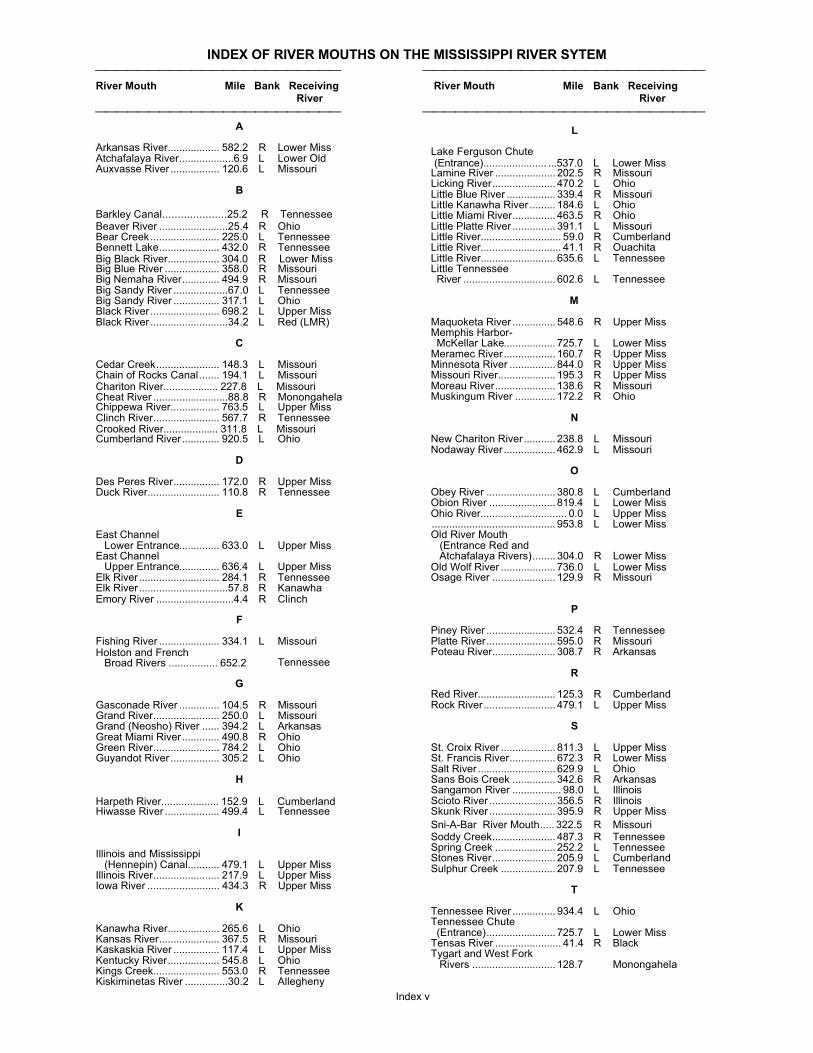
INDEX OF RIVER MOUTHS ON THE MISSISSIPPI RIVER SYTEM⎯⎯⎯⎯⎯⎯⎯⎯⎯⎯⎯⎯⎯⎯⎯⎯⎯⎯⎯⎯⎯⎯⎯ ⎯⎯⎯⎯⎯⎯⎯⎯⎯⎯⎯⎯⎯⎯⎯⎯⎯⎯⎯⎯⎯⎯⎯⎯⎯⎯River Mouth Mile Bank Receiving River Mouth Mile Bank Receiving
River River
⎯⎯⎯⎯⎯⎯⎯⎯⎯⎯⎯⎯⎯⎯⎯⎯⎯⎯⎯⎯⎯⎯⎯ ⎯⎯⎯⎯⎯⎯⎯⎯⎯⎯⎯⎯⎯⎯⎯⎯⎯⎯⎯⎯⎯⎯⎯⎯⎯⎯
Index v
A
Arkansas River.................. 582.2 R Lower MissAtchafalaya River...................6.9 L Lower OldAuxvasse River ................. 120.6 L Missouri
B
Barkley Canal.....................25.2 R TennesseeBeaver River ........................25.4 R OhioBear Creek ........................ 225.0 L TennesseeBennett Lake..................... 432.0 R TennesseeBig Black River.................. 304.0 R Lower MissBig Blue River ................... 358.0 R MissouriBig Nemaha River............. 494.9 R MissouriBig Sandy River ...................67.0 L TennesseeBig Sandy River ................ 317.1 L OhioBlack River ........................ 698.2 L Upper MissBlack River ...........................34.2 L Red (LMR)
C
Cedar Creek...................... 148.3 L MissouriChain of Rocks Canal....... 194.1 L MissouriChariton River................... 227.8 L MissouriCheat River ..........................88.8 R MonongahelaChippewa River................. 763.5 L Upper MissClinch River....................... 567.7 R TennesseeCrooked River................... 311.8 L MissouriCumberland River............. 920.5 L Ohio
D
Des Peres River................ 172.0 R Upper MissDuck River......................... 110.8 R Tennessee
E
East Channel Lower Entrance.............. 633.0 L Upper MissEast Channel Upper Entrance.............. 636.4 L Upper MissElk River............................ 284.1 R TennesseeElk River...............................57.8 R KanawhaEmory River ...........................4.4 R Clinch
F
Fishing River ..................... 334.1 L MissouriHolston and French
Broad Rivers ................. 652.2 Tennessee
G
Gasconade River .............. 104.5 R MissouriGrand River....................... 250.0 L MissouriGrand (Neosho) River ...... 394.2 L ArkansasGreat Miami River............. 490.8 R OhioGreen River....................... 784.2 L OhioGuyandot River ................. 305.2 L Ohio
H
Harpeth River.................... 152.9 L CumberlandHiwasse River ................... 499.4 L Tennessee
I
Illinois and Mississippi (Hennepin) Canal........... 479.1 L Upper MissIllinois River....................... 217.9 L Upper MissIowa River ......................... 434.3 R Upper Miss
K
Kanawha River.................. 265.6 L OhioKansas River..................... 367.5 R MissouriKaskaskia River ................ 117.4 L Upper MissKentucky River.................. 545.8 L OhioKings Creek....................... 553.0 R TennesseeKiskiminetas River ...............30.2 L Allegheny
L
Lake Ferguson Chute (Entrance)...................... ...537.0 L Lower MissLamine River .....................202.5 R MissouriLicking River...................... 470.2 L OhioLittle Blue River .................339.4 R MissouriLittle Kanawha River .........184.6 L OhioLittle Miami River............... 463.5 R OhioLittle Platte River ...............391.1 L MissouriLittle River............................ 59.0 R CumberlandLittle River............................ 41.1 R OuachitaLittle River.......................... 635.6 L TennesseeLittle Tennessee River ................................ 602.6 L Tennessee
M
Maquoketa River ............... 548.6 R Upper MissMemphis Harbor-McKellar Lake.................. 725.7 L Lower Miss
Meramec River..................160.7 R Upper MissMinnesota River ................ 844.0 R Upper MissMissouri River....................195.3 R Upper MissMoreau River.....................138.6 R MissouriMuskingum River ..............172.2 R Ohio
N
New Chariton River...........238.8 L MissouriNodaway River.................. 462.9 L Missouri
O
Obey River ........................380.8 L CumberlandObion River ....................... 819.4 L Lower MissOhio River.............................. 0.0 L Upper Miss........................................... 953.8 L Lower MissOld River Mouth (Entrance Red and
Atchafalaya Rivers)........304.0 R Lower MissOld Wolf River ................... 736.0 L Lower MissOsage River ......................129.9 R Missouri
P
Piney River ........................ 532.4 R TennesseePlatte River........................ 595.0 R MissouriPoteau River......................308.7 R Arkansas
R
Red River...........................125.3 R CumberlandRock River......................... 479.1 L Upper Miss
S
St. Croix River ................... 811.3 L Upper MissSt. Francis River................ 672.3 R Lower MissSalt River ........................... 629.9 L OhioSans Bois Creek ...............342.6 R ArkansasSangamon River ................. 98.0 L IllinoisScioto River .......................356.5 R IllinoisSkunk River .......................395.9 R Upper Miss
Sni-A-Bar River Mouth.....322.5 R MissouriSoddy Creek...................... 487.3 R TennesseeSpring Creek .....................252.2 L TennesseeStones River......................205.9 L CumberlandSulphur Creek ...................207.9 L Tennessee
T
Tennessee River ............... 934.4 L OhioTennessee Chute (Entrance)........................ 725.7 L Lower MissTensas River ....................... 41.4 R BlackTygart and West Fork Rivers .............................128.7 Monongahela

INDEX OF RIVER MOUTHS ON THE MISSISSIPPI RIVER SYTEM⎯⎯⎯⎯⎯⎯⎯⎯⎯⎯⎯⎯⎯⎯⎯⎯⎯⎯⎯⎯⎯⎯⎯ ⎯⎯⎯⎯⎯⎯⎯⎯⎯⎯⎯⎯⎯⎯⎯⎯⎯⎯⎯⎯⎯⎯⎯⎯⎯⎯River Mouth Mile Bank Receiving River Mouth Mile Bank Receiving
River River
⎯⎯⎯⎯⎯⎯⎯⎯⎯⎯⎯⎯⎯⎯⎯⎯⎯⎯⎯⎯⎯⎯⎯ ⎯⎯⎯⎯⎯⎯⎯⎯⎯⎯⎯⎯⎯⎯⎯⎯⎯⎯⎯⎯⎯⎯⎯⎯⎯⎯
Index vi
V
Verdigris River ................. 395.1 L Arkansas
W
Wabash River ................... 848.2 R OhioWhite River (Old Mouth) ... 590.6 R Lower Miss
Wisconsin River ................ 631.0 L Upper MissWolf Creek ........................ 478.8 R MissouriWyaconda River................ 337.3 R Upper Miss
Y
Yazoo River....................... 437.2 L Lower Miss
Yellow Creek..................... 215.0 L Tennessee
Youghiogheny River ...........15.6 R Monongahela
White River (New Mouth)..599.0 R Lower Miss

INDEX OF LOCKS AND DAMS ON THE MISSISSIPPI RIVER SYSTEM
Locks and Dams Mile Bank Locks and Dams Mile Bank
Index vii
Allegheny River
Lock and Dam No. 2 .......... 6.7 LLock and Dam No. 3 .......... 14.5 LLock and Dam No. 4.......... 24.2 RLock and Dam No. 5.......... 30.4 RLock and Dam No. 6.......... 36.3 RLock and Dam No. 7.......... 45.7 RLock and Dam No. 8.......... 52.6 LLock and Dam No. 9.......... 62.2 L
Arkansas Post Canal
Norrell Lock and Dam (No. 1).............................. 10.3 LLock No. 2 ......................... 13.3 L
Arkansas River
Lock and Dam No. 3 .......... 50.2 LLock and Dam No. 4.......... 66.0 RLock and Dam No. 5.......... 86.3 LDavid D. Terry Lock and Dam (No. 6) ..................... 108.1 LMurray Lock and Dam (No. 7).............................. 125.4 RToad Suck Ferry Lockand Dam (No. 8) .............. 155.9 L
Aurthur V. Ormond Lockand Dam (No. 9) .............. 176.9 R
Dardanell Lock and Dam (No. 10) ................... 205.5 LOzark Jeta Taylor Lock and Dam (No. 12).... 256.8 LJames N. Trimble Lockand Dam (No. 13) ............ 292.8 R
W.D. Mayo Lock and Dam (No. 14) ................... 319.5 RRobert S. Kerr Lockand Dam (No. 15) ............ 336.2 L
Webbers Falls Lockand Dam (No. 16) ............ 366.6 L
Black River
Jonesville Lock and Dam .. 24.7 R
Clinch River
Melton Hill Lock ................. 23.1
Cumberland River
Barkley Lock and Dam....... 30.6 LCheatham Lock and Dam . 148.7 R
Old Hickory Lock and Dam 216.2 LCordell Hull Lock and Dam 313.5 L
Green River
Lock and Dam No. 1 .......... 9.1 RLock and Dam No. 2 .......... 63.1 RLock and Dam No. 3 .......... 108.5 R
Lock and Dam No. 4.......... 148.1 L
Illinois River
LaGrange Lock and Dam... 80.2 RPeoria Lock and Dam ........ 157.7 L
Starved Rock Lock and Dam 31.0 RMarseilles Lock and Dam.. 244.6 RDresden Island Lock Dam . 271.5 L
Brandon Road Lock and Dam 286.0 RLockport Lock and Dam..... 291.1 L
Kanawha River
Old Lock No. 9................... 25.5 RWinfield Lock and Dam ..... 31.1 RMarmet Lock and Dam....... 67.7 RLondon Lock and Dam....... 82.8 R
Kaskaskia River
Jerry F. Costello Lockand Dam.......................... 0.8 R
Monongahela River
Locks and Dam No. 2........ 11.2 RLocks and Dam No. 3........ 23.8 RLocks and Dam No. 4........ 41.5 RMaxwell Lock and Dam...... 61.2 R 85.0 LPoint Marion Lockand Dam (No. 8)............. 90.8 L
Morgantown Lockand Dam........................ 102.0 L
Hildebrand Lock and Dam. 108.0 LOpekiska Lock and Dam . 115.4 R
Ohio River
Emsworth Locks and Dam 6.2 RDashield's Locks and Dam 13.3 LMontgomery Locksand Dam.......................... 31.7 L
New Cumberland Locksand Dam.......................... 54.4 R
Pike Island Locks and Dam 84.3 LHannibal Locks and Dam .. 126.4 RWillow Island Locks and Dam 161.7 RBelleville Locks and Dams. 203.9Racine Locks and Dam ..... 237.5 L
Robert C Byrd Locks and Dam 279.2 LGreenup Locks and Dam .. 341.1 LCaptain AnthonyMedahal Locks and Dam.. 436.2 RMarkland Locks and Dam.. 531.5 LMcAlpine Locks ................. 606.8 LCannelton Locks and Dam 720.7 RNewburgh Locks and Dam 776.1 RUniontown Locks and Dam 846.0 RSmithland Locks and Dam 918.5 RLocks and Dam No. 52...... 938.9 RLocks and Dam No. 53...... 962.6 R
Ouachita River
Columbia Lock and Dam ... 116.7 LFelsenthal Locks and Dam 226.8 R
H K Thatcher Lock and Dam.... 281.9 R
Red River
Lower Old River Lock and Dam ................. 01.0
L C Boggs (Lock No. 1)...... 44.0John H Overton (Lock No. 2) 74.5 L
Edwin Edwards (Lock No. 3) 118.0Russel B LongLock and Dam (No. 4) ..... 169.0
Joe D. Waggoner
Lock and Dam (No. 5)....... 200.0 L
Tennessee River
Kentucky Landing Lock and Dam ................. 22.4 RPickwick Landing Lockand Dam.......................... 206.7 L
Wilson Locks and Dam ..... 259.4 RGeneral Joe Wheeler Lock and Dam ................. 274.9 RGuntersville Lock and Dam 349.0 RNickajack Lock and Dam... 424.7 RChickamauga Lock and Dam 471.0 RWatts Bar Lock and Dam .. 529.9 LFort Loudoun Lock and Dam 602.3 L

INDEX OF LOCKS AND DAMS ON THE MISSISSIPPI RIVER SYSTEM
Locks and Dams Mile Bank Locks and Dams Mile Bank
Index viii
Tennessee-Tombigbee Waterway
Jamie C Witten Lockand Dam .......................... 411.9
Upper Mississippi River
Upper St. Anthony Falls Lock 853.8 RLower St. Anthony Falls Lock 853.4 RLock and Dam No.1 ........... 847.6 RLock and Dam No.2 ........... 815.2 RLock and Dam No.3 ........... 796.9 RLock and Dam No.4........... 752.8 LLock and Dam No.5........... 738.1 RLock and Dam No.5A......... 728.5 RLock and Dam No.6........... 714.3 LLock and Dam No.7........... 702.5 RLock and Dam No.8........... 679.2 LLock and Dam No.9........... 647.9 LLock and Dam No.10......... 615.1 RLock and Dam No.11 ......... 583.0 RLock and Dam No.12 ......... 556.7 RLock and Dam No.13 ......... 522.5 L
Lock and Dam No.14......... 493.3 RLock and Dam No.15......... 482.9 LLock and Dam No.16......... 457.2 LLock and Dam No.17......... 437.1 LLock and Dam No.18......... 410.5 LLock and Dam No.19......... 364.3 RLock and Dam No.20......... 343.2 RLock and Dam No.21......... 324.9 LLock and Dam No.22......... 301.2 RLock and Dam No.24......... 273.4 RLock and Dam No.25......... 241.4 RMelvin E. Price Locksand Dam (No. 26)............ 200.8
Chain of Rocks Twin 5 Locks (No. 27)................. 185.5 L
Verdigris River
Chouteau Lock .................. 6.4 LNewt Graham Lockand Dam (No.18)............. 26.6 L
White River
Montgomery Point Lock and Dam 0.5 R
______________________________________
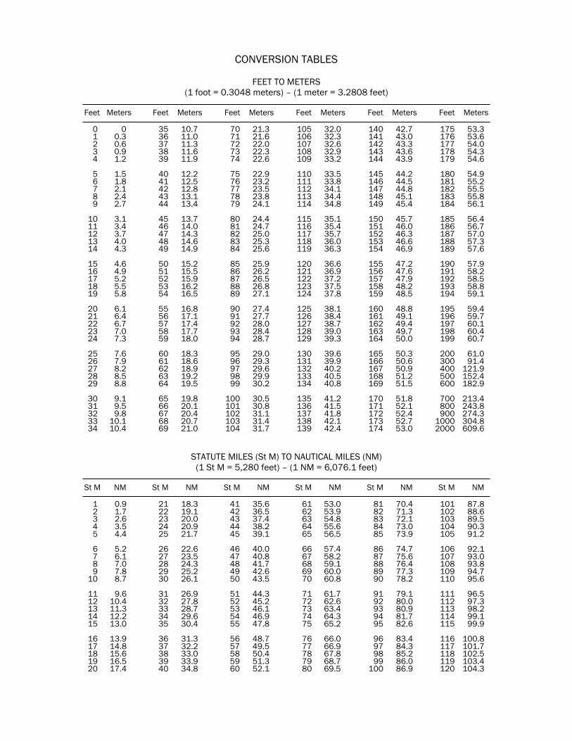
CONVERSION TABLES
FEET TO METERS(1 foot = 0.3048 meters) – (1 meter = 3.2808 feet)
Feet Meters Feet Meters Feet Meters Feet Meters Feet Meters Feet Meters
0 0 35 10.7 70 21.3 105 32.0 140 42.7 175 53.31 0.3 36 11.0 71 21.6 106 32.3 141 43.0 176 53.62 0.6 37 11.3 72 22.0 107 32.6 142 43.3 177 54.03 0.9 38 11.6 73 22.3 108 32.9 143 43.6 178 54.34 1.2 39 11.9 74 22.6 109 33.2 144 43.9 179 54.6
5 1.5 40 12.2 75 22.9 110 33.5 145 44.2 180 54.96 1.8 41 12.5 76 23.2 111 33.8 146 44.5 181 55.27 2.1 42 12.8 77 23.5 112 34.1 147 44.8 182 55.58 2.4 43 13.1 78 23.8 113 34.4 148 45.1 183 55.89 2.7 44 13.4 79 24.1 114 34.8 149 45.4 184 56.1
10 3.1 45 13.7 80 24.4 115 35.1 150 45.7 185 56.411 3.4 46 14.0 81 24.7 116 35.4 151 46.0 186 56.712 3.7 47 14.3 82 25.0 117 35.7 152 46.3 187 57.013 4.0 48 14.6 83 25.3 118 36.0 153 46.6 188 57.314 4.3 49 14.9 84 25.6 119 36.3 154 46.9 189 57.6
15 4.6 50 15.2 85 25.9 120 36.6 155 47.2 190 57.916 4.9 51 15.5 86 26.2 121 36.9 156 47.6 191 58.217 5.2 52 15.9 87 26.5 122 37.2 157 47.9 192 58.518 5.5 53 16.2 88 26.8 123 37.5 158 48.2 193 58.819 5.8 54 16.5 89 27.1 124 37.8 159 48.5 194 59.1
20 6.1 55 16.8 90 27.4 125 38.1 160 48.8 195 59.421 6.4 56 17.1 91 27.7 126 38.4 161 49.1 196 59.722 6.7 57 17.4 92 28.0 127 38.7 162 49.4 197 60.123 7.0 58 17.7 93 28.4 128 39.0 163 49.7 198 60.424 7.3 59 18.0 94 28.7 129 39.3 164 50.0 199 60.7
25 7.6 60 18.3 95 29.0 130 39.6 165 50.3 200 61.026 7.9 61 18.6 96 29.3 131 39.9 166 50.6 300 91.427 8.2 62 18.9 97 29.6 132 40.2 167 50.9 400 121.928 8.5 63 19.2 98 29.9 133 40.5 168 51.2 500 152.429 8.8 64 19.5 99 30.2 134 40.8 169 51.5 600 182.9
30 9.1 65 19.8 100 30.5 135 41.2 170 51.8 700 213.431 9.5 66 20.1 101 30.8 136 41.5 171 52.1 800 243.832 9.8 67 20.4 102 31.1 137 41.8 172 52.4 900 274.333 10.1 68 20.7 103 31.4 138 42.1 173 52.7 1000 304.834 10.4 69 21.0 104 31.7 139 42.4 174 53.0 2000 609.6
STATUTE MILES (St M) TO NAUTICAL MILES (NM)(1 St M = 5,280 feet) – (1 NM = 6,076.1 feet)
St M NM St M NM St M NM St M NM St M NM St M NM
1 0.9 21 18.3 41 35.6 61 53.0 81 70.4 101 87.82 1.7 22 19.1 42 36.5 62 53.9 82 71.3 102 88.63 2.6 23 20.0 43 37.4 63 54.8 83 72.1 103 89.54 3.5 24 20.9 44 38.2 64 55.6 84 73.0 104 90.35 4.4 25 21.7 45 39.1 65 56.5 85 73.9 105 91.2
6 5.2 26 22.6 46 40.0 66 57.4 86 74.7 106 92.17 6.1 27 23.5 47 40.8 67 58.2 87 75.6 107 93.08 7.0 28 24.3 48 41.7 68 59.1 88 76.4 108 93.89 7.8 29 25.2 49 42.6 69 60.0 89 77.3 109 94.7
10 8.7 30 26.1 50 43.5 70 60.8 90 78.2 110 95.6
11 9.6 31 26.9 51 44.3 71 61.7 91 79.1 111 96.512 10.4 32 27.8 52 45.2 72 62.6 92 80.0 112 97.313 11.3 33 28.7 53 46.1 73 63.4 93 80.9 113 98.214 12.2 34 29.6 54 46.9 74 64.3 94 81.7 114 99.115 13.0 35 30.4 55 47.8 75 65.2 95 82.6 115 99.9
16 13.9 36 31.3 56 48.7 76 66.0 96 83.4 116 100.817 14.8 37 32.2 57 49.5 77 66.9 97 84.3 117 101.718 15.6 38 33.0 58 50.4 78 67.8 98 85.2 118 102.519 16.5 39 33.9 59 51.3 79 68.7 99 86.0 119 103.420 17.4 40 34.8 60 52.1 80 69.5 100 86.9 120 104.3