Lec_13_Introduction to Remote Sensing (RS)
19
Fundamentals of Remote Sensing Prof. Dr. Sajid Rashid Ahmad [email protected] Atiqa Ijaz Khan _ Demonstrator [email protected]
-
Upload
atiqa-khan -
Category
Education
-
view
91 -
download
1
Transcript of Lec_13_Introduction to Remote Sensing (RS)

Fundamentals of Remote Sensing
Prof. Dr. Sajid Rashid Ahmad
Atiqa Ijaz Khan _ Demonstrator

• What is Remote Sensing?
• If you are reading this sentence, now you are doing Remote Sensing. In fact, anyinformation acquired from the object without touching is Remote Sensing.
• Remote sensing offers the ability to observe and collect data for large areas relativelyquickly, and is an important source of data for GIS. (Source: digimap)
Monday, March 30, 2015Institute of Geology, University of the Punjab
2

Remote Sensing
• “The art and science of obtaining information about an object withoutbeing in direct contact with the object” (Jensen 2000).
• The science (and art) of acquiring information about an object, withoutentering in contact with it, by sensing and recording reflected oremitted energy and processing, analyzing, and applying thatinformation.• Information usually gathered from spacecraft or an airplane.
• In from of aerial photographs to satellite images.
Monday, March 30, 2015Institute of Geology, University of the Punjab
3

Monday, March 30, 2015Institute of Geology, University of the Punjab
4
Eyes
Binoculars Digital Camera
Pigeon Cameras
1903

Monday, March 30, 2015Institute of Geology, University of the Punjab
5Types
Terrestrial RS
Optical 300nm – 3000nm
Thermal>3000nm-14,000nm
Microwave 1mm-1mCelestial RS

Monday, March 30, 2015Institute of Geology, University of the Punjab
6
HUMAN’s EYE
Rods (to see objects at night) = 7 million
Cones (to see colors) = 100 millionCAT’s EYE
Rods (to see objects at night) =~ 21 million
Cones (to see colors) =~ far less

Monday, March 30, 2015Institute of Geology, University of the Punjab
7
The basic principle of remote sensing is based upon the interaction ofelectromagnetic radiation with atmosphere and the earth. Electromagneticradiation reflected or emitted from an object is the usual source of remotesensing data.

Monday, March 30, 2015Institute of Geology, University of the Punjab
8Remote sensing is
concerned with the
measurement of EMR
returned by the earth’s
natural and cultural
features that first receive
energy from the sun or an
artificial source such as a
radar transmitter.
Visible light contains light
from 0.4 to 0.7 micrometers
Infrared light from 0.1
micrometers to 1 millimeter
Wavelength
Frequency
(how many times peak
passes per second)
Light - can be thought of as a wave in the 'electromagnetic field' of the universe
A wave can be characterized by its wavelength or its frequency
Blue green yellow red
1020 Hz 1018 Hz 1016 Hz 1014 Hz 1012 Hz 1010 Hz
1 pm 10pm 10 nm 1 micron 100 microns 1 mm 100 mm
vi-si-ble
Gamma Rays
X-Rays UV N. IR
Th.IR
Microwaves
Radar
TV FMRadiowaves
0.4 m 0.5 m 0.6 m 0.7 m
MidIR
Far IR

Monday, March 30, 2015Institute of Geology, University of the Punjab
9
Types of Remote Sensing
Passive Remote Sensing and Active Remote Sensing
Active Remote SensingPassive Remote Sensing
Remote sensing methods that provide
their own source of electromagneticRemote sensing of energy naturally
reflected or radiated from the terrain.
radiation to illuminate the terrain.
Radar is one example.
Own energy source
© 2008 Ko Ko Lwin
Monday, March 30, 2015Institute of Geology, University of the Punjab
10

Monday, March 30, 2015Institute of Geology, University of the Punjab
11
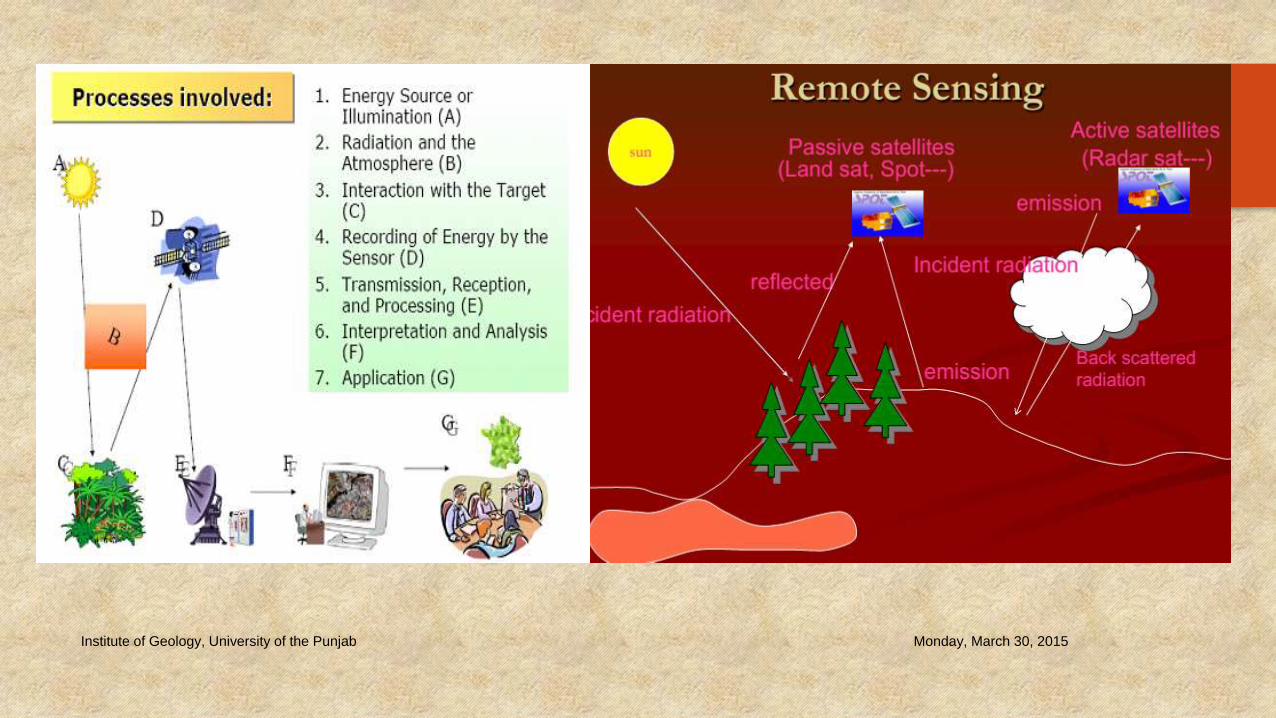
Components in Remote Sensing
Platform
The vehicle which carries a sensor. i.e. satellite, aircraft, balloon, etc...
Sensors
Device that receives electromagnetic radiation and converts it into a signal that can be
recorded and displayed as either numerical data or an image.
One platform can carry more than
one sensor. For example:Platform
Sensor
Platform Name Sensor Name
Landsat TM Thematic Mapper(Passive: Optical sensor)
Landsat ETM Enhanced Thematic Mapper(Passive: Optical sensor)
ALOS PRISM (Passive: Optical sensor) AVNIR-2 (Passive: Optical sensor) PALSAR (Active: Microwave sensor)

Monday, March 30, 2015
12
Remote Sensing and GIS Work Flow
Platform (satellite) DATA ACQUISITION
Data transmission
Ground receiving station &
data warehouseSun
Solar radiation from
the sun
Earth
1Example in optical Remote Sensing
DATA PROCESSING & ANALYSIS DATA PRE-PROCESSING
Atmospheric correction
Radiometric correction
Geometric correction
etc.Spatial data modeling along
with other GIS datasetAlgorithm development
Multi-spectral classification 23
© 2008 Ko Ko Lwin

Monday, March 30, 2015Institute of Geology, University of the Punjab
13
Examples
Landsat TM/ETMSPOT
ALOS
IKONOS
QuickBird
Earth rotation
Satellite orbit

Monday, March 30, 2015Institute of Geology, University of the Punjab
14Resolutions
SPATIAL
Smallest identifiable area as a discrete object in an image
SPECTRAL
No. of frequencies recorded = sensors
TEMPORAL
Time interval between measurements
RADIOMETRIC
Intensities identified by sensors

Monday, March 30, 2015Institute of Geology, University of the Punjab
15Serial
No.Satellites
Altitude
(km)Bands (µm) Multi-spectral (m)
Panchromati
c (m)
Thermal
(m)Purpose

Monday, March 30, 2015Institute of Geology, University of the Punjab
16

Monday, March 30, 2015Institute of Geology, University of the Punjab
17
Imagery and their price ranges

Monday, March 30, 2015Institute of Geology, University of the Punjab
18Imagery free of cost
Monday, March 30, 2015Institute of Geology, University of the Punjab
19


![[REMOTE SENSING] 3-PM Remote Sensing](https://static.fdocuments.us/doc/165x107/61f2bbb282fa78206228d9e2/remote-sensing-3-pm-remote-sensing.jpg)