Larne Area Plan 2010 - Mid and East Antrim Borough Council
112
Transcript of Larne Area Plan 2010 - Mid and East Antrim Borough Council

�
Contents Introduction 3
PoliciesandProposalsaffectingtheWholeBorough 13
Housing 14
Commerce 18
Industry 20
NaturalEnvironment 22
ManMadeEnvironment 26
Transportation 31
Utilities 36
Tourism 42
Recreation/OpenSpace 46
Minerals 48
LarneTown 50
LarneTownCentre 58
TheVillages 68
TheSmallerSettlements 82
TheCountryside 101
Appendices 103
AppendixI 104
AppendixII 109
Bibliography 110
Aknowledgements 111

�

Introduction
�

INTRODUCTION
The Larne Area Plan 2010 is a development plan prepared by the Department of Environment, Town and Country Planning Service, under the provisions of Part III of the Planning (NI) Order 1991.
It supersedes the provisions relating to the Larne Borough in the East Antrim Area Plan (1975-1995) and the Larne Rural Area Subject Plan. The East Antrim Area Plan was adopted by the Department in 1979 and provided the planning framework for both the Larne and Carrickfergus Borough Council Areas. Separate Area Plans have now been prepared for Larne and Carrickfergus Boroughs.
In accordance with Article 5 of the Planning (NI) Order 1991, notice was given to Larne Borough Council on 4 November 1993 that the Department intended to prepare a new development plan for Larne Borough. A Notice of Intention to prepare the plan was also published in the local press on 8 November 1993 and comments were invited from the public. Consultations were carried out with the Larne Borough Council, community groups, Government Departments and Agencies, Statutory Undertakers and other appropriate bodies.
In April 1995 the Department published the Larne Area Plan Preliminary Proposals for public consultation. The Department considered all comments received and in light of these published the Draft Larne Area Plan in January 1996. Following the receipt of objections to the Draft Plan the Department requested the Planning Appeals Commission to convene a Public Inquiry. The Public Inquiry was held in September/ November 1996 and the Planning Appeals Commission subsequently reported to the Department on their consideration of the objections. The Department has now considered the recommendations contained in the P.A.C. report and as appropriate has revised the written statement and maps of
the Plan. This document incorporates all these amendments and replaces all previous versions of the Larne Area Plan 2010. Full details of the Department's response to the P.A.C. recommendations are set out in the Larne Area Plan, Departmental Statement.
The Larne Area Plan was adopted by the Department in accordance with the provisions of Article 8 of the Planning (NI) Order 1991, in March 1998.
This document comprises the written statement of the Larne Area Plan which together with accompanying Maps sets out policies and proposals to guide development in the Larne Borough Council Area up to the year 2010.
In the event of a contradiction between the Written Statement and a map, the provisions of the Written Statement will prevail.
�

SUPPLEMENTS
Published together with the Plan are a number of supplementary documents containing technical information that was used in the preparation of the policies and proposals contained in the Plan.
Supplements published in support of the Plan are:
1. ACountrysideAssessment Supplement
The Planning Strategy for Rural Northern Ireland published in September 1993 (hereinafter referred to as the Rural Strategy) identifies the need to prepare Countryside Assessments as an essential part of the plan making process. These assessments have assisted in the categorisation of the countryside and in an examination of the ability of the landscape to absorb further development. They have also highlighted vulnerable landscapes and those under pressure from development. The Supplement consists of three elements:
• An analysis of the countryside in the Larne Borough Council Area.
• An assessment of historic parks, gardens and demesnes, sites of archaeological and historic interest and sites of nature conservation interest.
• An indication of development pressure and development constraints.
2. ATechnicalSupplement
To assist in the preparation of the Larne Area Plan, the Department carried out an assessment of the main social and
economic trends which would influence future land use requirements. The main elements of this assessment were:
Population Housing Employment and Industry Commerce/Offices Transportation Tourism Recreation/ Community Facilities Education Health and Social Services Retailing Community Facilities
3. AnEnvironmentalAppraisal Supplement
The Department is committed to the concept of sustainable development. Consequently the policies and proposals formulated in the Plan have been examined as to their impact on the environment as part of a continuous process and modified where necessary.
PURPOSEOFTHEPLAN
The purpose of the Plan is to inform the general public, Statutory Authorities, developers and other interested bodies of the policy framework and broad land use proposals which will be used to guide development up to the year 2010.
The Plan presents the Department's views on how best Larne Town and the other settlements can be developed for the benefit of all. It will indicate how new developments can be accommodated within the rural area without adversely affecting the landscape. The Plan provides only a framework and does not deal with matters of detail which will be resolved through the development control process.
�

REGIONALPOLICYCONTEXT
The strategic and regional policy framework for the Larne Area Plan is currently provided by Planning Policy Statements and the Rural Strategy. The provision of these publications apply within the Larne Borough Council Area. The Department also prepares and updates as necessary a set of Development Control Advice Notes.
APlanningStrategyforRural NorthernIreland
The Rural Strategy published in September 1993 contains a short section on overall strategy but essentially comprises a compendium of planning policies setting out on a topic basis the factors which the Department takes into account when reacting to development proposals. These policies currently apply to all of the Borough of Larne.
The Department has begun progressively to replace the Planning Strategy. The topic sections are currently being replaced by a series of Planning Policy Statements which will apply to the whole of Northern Ireland. In the meantime, the Planning Strategy will remain in force in respect of those topics not covered by Planning Policy Statements. The companion volume entitled “A Rural Design Guide for Northern Ireland”, which was issued in May 1994, will likewise continue in use.
PLANNINGPOLICYSTATEMENTS
Planning Policy Statements (PPS's) set out the policies of the Department of the Environment on different aspects of land use planning. Their contents will be taken into account in the preparation of development
plans and may also be material to decisions taken on individual planning applications and appeals. The Department has published 4 Planning Policy Statements to date –
PPS2 Planning and Nature Conservation, June 1997
PPS3 Development Control – Roads Considerations, May 1996
PPS4 Industrial Development, March 1997 PPS5 Retailing and Town Centres,
June 1997
One further PPS has been issued in Draft Form:
• PPS 1 General Principles, March 1997
PPSs may from time to time be revised to take account of changing circumstances, including experience gained through the development
planning and development control processes. Good practise guides may also be issued to illustrate how concepts contained in PPSs can best be implemented.
�

DevelopmentControlAdviceNotes
Development Control Advice Notes explain the criteria and technical standards which the Department considers when dealing with specific categories or particular aspects of development. These are listed in AppendixII.
Itshouldbenotedthatthe Departmentiscontinuously reviewingpoliciesandadvice.Itis thereforeadvisabletocontactthe DivisionalPlanningOfficetoascertain thecurrentrelevantpoliciesand supplementaryguidancewhichapply withinthePlanarea.
LOCALCONTEXT
The Potential for growth of Larne Town has been assessed and planning appraisals have been carried out for each village and smaller settlement. It is expected that the population of Larne Town will rise from the current 17,600 (approx.) to 19,000 (approx.) by the year 2010 and the population of the Borough from the current 29,419 (approx.) to 31,700 (approx.). As a consequence there will be a need within both Larne Town and the other settlements to include additional land for development purposes. This land will meet both the requirement for additional housing land resulting from an overall population increase and a reduction in the average size of households. It will also meet the needs of industry as currently assessed. Should a need for additional land be identified during the plan period the zoning of additional land will be considered in the light of the circumstances then pertaining. As this may require formal alteration of the plan the appropriate procedures will be introduced at that time.
The Larne Area Plan will, through its policies and proposals, seek to facilitate the physical, social and economic regeneration of the Borough. This will include the regeneration
of the rural economy and the revitalisation of rural towns and villages in order to make them more attractive places in which to live and work.
The Department is committed to the concept of sustainable development. The Policies and Proposals contained in the Larne Area Plan will therefore ensure that the needs of the present are met without compromising the ability of future generations to meet their needs.
The Planning Appraisals and Countryside Assessments have identified key issues affecting the Borough. These have been used to formulate the Department's Policies and Proposals.
KeyIssues
1. The needs of housing and industry for development land.
2. The potential for expansion of the villages and smaller settlements.
3. The existence of run down areas in Larne Town and other parts of the Borough.
�

4. The potential for tourist development throughout the Borough.
5. The quality of the natural and man-made heritage and its potential for enhancement.
6. Threats to vulnerable landscapes and wildlife habitats from inappropriate forms of development.
PLANAIM
THEAIMOFTHELARNEAREAPLANISTO CREATEURBANANDRURALENVIRONMENTS WHICHWILLMAKEAPOSITIVE CONTRIBUTIONTOANIMPROVEMENTINTHE QUALITYOFLIFEINTHEBOROUGH.
The Plan has the following objectives:
1. To identify sufficient suitable lands for future housing, industry, commerce, open space uses and community facilities and provide an element of choice in development opportunities particularly with regard to housing and employment.
2. To improve the quality of the urban environment by encouraging the regeneration of Larne Town Centre and the villages.
3. To identify and provide development opportunities of a suitable nature both urban and rural, throughout the Borough.
4. To protect features of the historic landscape in the Borough including archaeological sites and monuments and their settings, listed buildings and their settings and historic parks gardens and demesnes.
5. To protect areas of high landscape quality and open countryside.
6. To protect both designated sites and local sites of nature conservation interest.
7. To retain a clear distinction between urban areas and the open countryside by preventing urban sprawl and ribbon development.
8. To encourage the development of the Borough's tourist potential.
PLANSTRATEGY
ThePlanningStrategyfortheBoroughis toprovideopportunitiesfordevelopment inurbancentresbyensuringthatsufficient landisavailablefordevelopmentwithin eachwhichofferschoiceandvariety,taking accountofexistinginfrastructure.Itincludes theregenerationofLarneTownCentreand thevillages.Thestrategyprovidesthemain developmentopportunitiesinLarneTown andalsoprovidesfortheprotectionand enhancementoftheruralareathroughthe applicationofCountrysidePolicyAreasanda GreenBeltaroundLarne.
�

The major principle within the strategy is that new development is welcomed within the Borough and should be facilitated where possible, provided the type and scale of the proposals can be accommodated without detriment to the community or the natural or built environment.
Development limits have been used to define settlements and to prevent ribbon development and urban sprawl. In Larne Town specific land use zonings have been identified, although other uses ancillary to and compatible with the predominant use category may also be acceptable within these zones. In the villages and other settlements only land for open space has been zoned where appropriate. Applications to develop other sites in these settlements will be given favourable consideration provided the proposed use is compatible and can be visually integrated with the existing built up area.
TheSettlements
The development limit around Larne defines the inner edge of the Green Belt and in the other settlements it defines the inner edge of a Policy Area. The Plan indicates areas with potential for development in and around Larne and opportunities for improvement to the physical environment and range of facilities which exist in the town at present. The Town Centre in particular is the focus of attention for proposals to improve the physical environment.
Development opportunities are also provided in the six villages namely: Ballycarry, Ballygalley, Ballystrudder, Carnlough, Glenarm and Glynn where scope for development appropriate to the scale and character of each village and within a clearly defined development limit, will be permitted.
A number of smaller settlements have been designated which represent established groupings within the rural area. While they will remain essentially rural in character each has the ability to absorb, without detriment to their existing character, small groups of houses, single dwellings or other suitable land uses within a clearly defined development limit. These settlements are:
Browns Bay Garron Point Carnageer Glenoe Carnalbanagh Kilwaughter Carncastle Magheramorne Crosshill Mill Bay Deerpark Mounthill Drumcrow Mullaghboy Ferris Bay Raloo Feystown Straidkilly
TheCountryside
The final element in the strategy relates to the countryside. Within Larne Borough there is a diversity of landscapes ranging from inaccessible open moorland in the north to enclosed farmland to the south.
In response to the need to conserve the best of these differing environments and curtail unnecessary development the Department proposes a number of policy areas designed:
�

• to protect areas of countryside under pressure from development;
• to protect the visual amenity of areas of landscape quality; and
• to maintain the rural character of the countryside.
These policy areas are:
1. A Countryside Policy Area covering the undeveloped coast north of Larne.
2. Countryside Policy Areas covering:
• Antrim Coast and Glens Area of Outstanding Natural Beauty to the north of Larne;
• The Islandmagee Peninsula;
• The South Larne Area.
3. A Green Belt around Larne Town:
• to prevent the unrestricted sprawl of large built-up areas;
• to prevent neighbouring settlements from merging;
• to safeguard the surrounding countryside;
• to protect the setting of settlements; and
• to assist in urban regeneration.
�0

��

��

Policies&
Proposalsaffectingthe
WholeBorough
��

HOUSING Housing policies are aimed at ensuring that an adequate and continuous supply of housing land is available within the urban areas of the Borough to facilitate the provision of a range of housing opportunities to meet the accommodation needs of the community.
REGIONALPOLICYCONTEXT
The Department's regional development control policies for housing which apply in Larne Borough are currently set out in the Rural Strategy. This contains a range of policies for housing development within settlements and the Department's policies for houses in the countryside. It also includes policies for flats, residential caravans, mobile homes and house extensions.
Supplementary planning guidance is contained in Development Control Advice Note 2 “Multiple Occupancy” and Development Control Advice Note 8 “Small Unit Housing”.
The Department's “Layout of Housing Roads Design Guide” provides the guidelines which are currently applied in consideration of road layouts and related matters in proposed housing areas. This is currently under review and its replacement “New Residential Developments — Overall Design Character and Requirements for Access and Parking” was issued as a Consultation Draft in March 1997.
QualityInitiative
The Department is committed, through the Quality Initiative announced by the Minister for the Environment in January 1996, to raising the quality of new housing development. This will require a more sensitive and responsive approach by developers, one which respects the characteristics of individual sites and creates attractive new living standards in a sustainable manner. Similarly the
Department's initiative to encourage the use of alternatives to the private car will demand full consideration of the needs of pedestrians, cyclists and public transport in the design of housing layouts.
POLICIESandPROPOSALS
H1 Thedepartmenthaszoned145.2 hectaresoflandwithinthe developmentlimitforLarneTown.
It is estimated that over the Plan period some 2,370 new dwellings will be required in the Borough including approximately 1,335 new dwellings in Larne Town, 210 in the villages and the remaining 430 in the rural area.
In identifying new sites for housing the Department has taken into account the undeveloped land within the existing development limits and the need to provide a range and choice of sites.
Within Larne Town sites have been specifically zoned for housing purposes taking into account the capacity of the existing infrastructure, proximity to existing facilities, the need to conserve land and natural resources and the protection of our
��
man made heritage. Within the H2 remaining settlements there is a presumption in favour of housing development on sites within the limits of development, provided they meet normal planning criteria in relation to layout, access, design and landscaping. New housing development should seek to add to the quality of the built environment while at the same time minimising any adverse affect on both the natural and man made environments through site specific design and landscaping.
Housing need varies by dwelling size, type and tenure according to family needs, housing unfitness, household size, age, health, personal preference and financial circumstances. Of particular importance are the specialist needs of certain groups in society. The most significant of these are those on low incomes, the elderly and those suffering from mental and physical disabilities.
It is the intention of the Department to facilitate the provision of a range of house types to meet the housing needs of the community.
H3
TheDepartmentwillfacilitatethereuseforhousingpurposesofvacant orunderusedlandwithinexisting builtupareas. The redevelopment of existing derelict or under used sites within the urban area is essential if the best use is to be made of the existing facilities and communications network. Such sites are often centrally located and close to existing shops and amenities, so reducing the need for car journeys.
The development of infill or opportunity sites for housing will in general be dependent on the achievement of a satisfactory residential environment. This can be best achieved by the provision of a satisfactory layout, suitable access and car parking arrangements and a high standard of landscaping. Detailed landscaping plans must include a schedule of the proposed landscaping works and include the types and numbers of species, planting densities, details of the site/soil preparation and proposed post planting management. (See also policy H4.)
TheDepartmentwillnormally facilitatethere-use,renovationand sympatheticextensionofvacant dwellingsinthecountrysidefor residentialpurposes. Vacant rural dwellings represent a valuable resource. They often occupy mature, well-located sites the further development of which will not detract significantly from the amenity of the rural area.
��

It should be noted that planning permission is usually required for external alterations. Any extensions necessary to bring a dwelling up to modern standards will be expected to reflect the scale and design of the existing building.
This policy does not apply to dwellings which are abandoned and incapable of occupation without substantial renovation, if they are located in the Green Belt or any of the Countryside Policy Areas or if they require access onto the Protected Route Network (see Policy TR2). Moreover, it does not apply to any structures of a prefabricated nature, including those used as holiday homes. (see Policy COU 2).
H4 Newhousingdevelopmentwillbe expectedtomeetahighstandard ofdesignandlayoutandtoinclude detailedlandscapingproposals. The scale and density of new developments should respect the location and characteristics of the site such as topography and landscape features. Submissions should include measures to protect and enhance the best features of the existing vegetation together with planting proposals both for the boundaries of the site and for individual building plots. The layout of new developments will be required to meet the normal criteria in relation to layout, access and design. In addition within new suburban housing developments the Department will expect a normal rear garden depth of 10 m in the interests of amenity and privacy.
The Department has not set specific housing densities. However, development will be expected to take account of the character and density of adjoining developments, site characteristics, features and vegetation, although the density of adjoining developments should not be seen as the determining factor in the design of any adjacent new housing areas.
Developers will be encouraged to design imaginative and interesting layouts with a variety of house types and a range of densities. A high standard of landscaping will be expected with the provision of open space, amenity areas and pedestrian links to public footways. Development will be expected to be comprehensive rather than piecemeal.
��

H5 Withinnewhousingdevelopments developerswillbeexpectedto provideopenspacesufficientto accommodateinformalplayareas andareasofamenityopenspace.
The size and location of the open space to be provided will be the subject of discussion between the developer, the Department and Larne Borough Council at planning application stage. The size and location of such areas will depend on the scale of the proposed development and accessibility to other nearby play/amenity areas. The Larne West study(1) produced in conjunction with Larne Borough Council sets out the open space and landscaping requirements expected of development in this new green field area of the town.
All sites for open space use will be required to be properly drained and planted before being transferred to Larne Borough Council to ensure the proper future maintenance of such areas.
(1) LarneWestStudy1992(availablefromthe Ballymena Divisional Planning Office)
��
COMMERCE Larne Town is the main commercial centre in the Borough. It is a busy retail and general service centre serving the needs of the local population with a range of outlets selling convenience and durable goods and providing services. An analysis of the Town Centre indicates a stable shopping environment and evidence that the town is successful in drawing custom from outside the Borough. Although there is some evidence of vacancy within the town, this is not at a level which would cause concern with respect to the viability of the Town Centre.
Retailing outside the Town Centre is provided by a number of neighbourhood shopping centres serving local populations such as those at Doric Way, Upper Cairncastle Road and Seacliffe Road. There are in addition a number of individual corner type shops located throughout the urban area.
The villages in the Borough also serve as retail centres for their local hinterlands. Carnlough, Glenarm and Ballycarry are the strongest in terms of retail provision with each providing a range of convenience, durable and service facilities.
REGIONALPOLICYCONTEXT
The Department's regional development control policies for retailing which apply in Larne Borough are currently set out in PPS 5 “Retailing and Town Centres”, published in June 1996. The PPS contains policies for town centres and the full range of retail development proposals from regional shopping centres through to rural shops. It also includes policy on retail warehouses, factory outlets, petrol filling stations and addresses the assessment of major retail proposals.
The regional development control policies for offices which will apply in the Borough are currently set out in the Rural Strategy. This contains policies for office development and small office and business uses.
Supplementary planning guidance is contained in the following advice notes:
Development Control Advice Note 1 “Amusement Centres”;
Development Control Advice Note 3 “Bookmaking Offices”;
Development Control Advice Note 4 “Hot Food Bars”;
Development Control Advice Note 5 “Taxi Offices”;
Development Control Advice Note 6 “Restaurants and Cafes”; and
Development Control Advice Note 7 “Public Houses”.
��

POLICIESandPROPOSALS
COMM1 Majorretaildevelopmentsonsites outsidethecommercialcoreof LarneTownwillonlybepermitted ifitcanbereadilydemonstrated thatthedevelopmentwillmeet thefollowingcriteria:–
• will complement or meet existing deficiencies in the overall shopping provision;
• will not lead to a significant loss of investment in the town centre;
• will not threaten the vitality and viability of the commercial core or lead to an unacceptable reduction in the range of facilities and retail services;
• will not lead to an unreasonable or detrimental impact on amenity, traffic movement or road safety;
• will be provided to a high quality of design with adequate car parking;
• will be accessible to both public and private transport.
In general terms proposals for retail development which complement existing shopping or meet an existing deficiency in shopping provision will be favourably considered by the Department.
All proposals for new major retail developments must be accompanied by an assessment of the potential impact on town
centre retailing and traffic patterns.
COMM2 WithinLarneTownCentreand theotherurbancentresthe Departmentwillexpectallnew developmenttobedesignedtoa highstandard,sympathetictothe characterofthetown.
The central area of Larne has architectural characteristics in common with many towns in Northern Ireland. It is considered by the Department that this character should where possible be retained. In pursuit of this aim the Department published a Larne Town Centre design guide in 1994.(1) The guidelines outlined in the booklet will be applied to all new buildings and as appropriate to the renovation and refurbishment of existing buildings in the Town Centre. It will form the basis of the design criteria against which the design element of planning applications in the Town Centre will be judged.
It is also considered appropriate that the design of village shops, particularly shopfronts, should also be in keeping with the character and architecture of the settlement. Particular emphasis will be placed on proposals within existing or proposed Conservation Areas.
(1) LarneTownCentreDesignGuide1994 (availablefromBallymenaDivisionalPlanning Office.)
��

INDUSTRY While the level of unemployment in Larne Borough is slightly below the Northern Ireland average there is clearly in existence a pool of potential employees capable of supporting an expansion of industrial activity in the Borough.
The planning system has a role to play in creating conditions which will permit economic development to take place by ensuring that adequate land in the best and most suitable locations is available for a range of industrial and smaller business uses.
REGIONALPOLICYCONTEXT
The Department's regional development control policies for industry which apply in Larne Borough are currently set out in PPS 4 “Industrial Development”, published in March 1997. The PPS contains policies for the full range of industrial development proposals from homeworking through to industries of an offensive or hazardous nature. It includes policies on non industrial uses on zoned industrial land and the retention of existing industrial land and buildings. It also addresses rural enterprise and industrial projects in the countryside.
Supplementary planning guidance is contained in Development Control Advice Note 12 “Hazardous Substances”.
POLICIESandPROPOSALS
IN1 Landhasbeenallocatedtomeetfuture industrialneeds,71.15hectaresofland iszonedinLarneTownforindustrial purposes.
Large scale industrial uses will normally be accommodated in Larne Town. Land has therefore been allocated in the town to ensure that sufficient sites are available to meet future industrial needs. This zoned land includes land previously zoned at Ballyloran (4.2 hectares) and a large new site at Drumahoe (31.7 hectares) to cater for inward investment. The present industrial land within the town was felt to be insufficient to cater for such a possibility, consequently a large site lying adjacent to the existing dual carriageway at Millbrook has been zoned for industrial use.
The 71.15 hectares of zoned land in Larne Town also includes 35.25 hectares of land at Larne Harbour, including the Redlands estate, the adjacent lagoon, the area between the Harbour Highway and the access road to the Redlands Estate and the area to the east of Coastguard Road, north of the East Antrim Boatclub, to allow for
�0

IN2
the expansion of Harbour Associated Industry.
Anareaof11.42hectaresoflandhas
IN3 TheDepartmentwillrequirethatall industrialdevelopmentisdesignedtoa highstandardandproperlylandscaped.
beenzonedatBankRoadasamixed usedevelopmentsitetoaccommodate industrial,housingandleisureuses.
The Bank Road site because of its prime location on the southern approach to Larne and its attractive coastal setting with a backcloth of a rising wooded escarpment is considered suitable for a mixture of uses which would take advantage of the considerable potential of this site.
The site should be developed in a manner in which not less than 55% of the site be used for industrial purposes and not more than 35% for residential
The Department will require that all industrial development is carried out to a high standard to ensure that the development makes a positive contribution to the built environment. All industrial proposals will include landscaping schemes to help soften their visual impact and may include a buffer zone to existing uses. The loss of existing natural and man made features will be resisted.
Industrial buildings are by their nature practical in design. However this practicality does not preclude good design and the imaginative use of materials in the construction of such
purposes with the remainder for leisure and ancillary uses associated with a Marina type of development.
premises. Industrial buildings whether large or small scale need not be offensive to the eye.
In preparing proposals for this site public access to the waterfront and to the amenity areas to the west of the site must be accommodated. As the land is designated for a mixture of uses it is appropriate that there may be several access points to the development from the road. The number and position of such access points will need to be the subject of detailed discussion prior to the submission of a formal planning application on all or part of this land.
In addition, as the opportunity arises the Department will seek and encourage the environmental improvement of existing industrial estates/premises.
To ensure that development does not occur in a piecemeal fashion the Department will require the submission of an overall plan of a comprehensive design scheme for this land in association with any proposal to develop all or part of the site.
��

NATURALENVIRONMENT Larne Borough has a rich variety of landscapes ranging from the coastal environments and Larne Lough to the high open moorland of the Antrim Plateau cut in places by deep river valleys. Nature conservation has assumed greater importance in the latter part of the 20th century coinciding with an increased realisation of the vulnerability of the natural environment to inappropriate development and the consequences of the resulting environmental damage.
A series of Government Policy initiatives have been introduced and legislation enacted to implement the obligations of European Community directives and international agreements on nature conservation; namely the EC Wild Birds Directive (79/409/EEC) and the EC Directive on the Conservation of Natural Habitats and Wild Fauna and Flora (92/43/EEC), also the Ramsar Convention on Conservation of Internationally Important Wetlands. These oblige each member state to take special measures to protect and manage habitats and species.
The overall purpose of the Birds Directive is to provide for the protection, management and control of all wild bird species occurring naturally in the European territory of the member states. Annex 1 of the Directive
contains a list of particularly sensitive species for which special measures are to be taken to conserve their habitats. In particular, member states are required to classify the most suitable areas as Special Protection Areas (SPA). In that respect Swan Island in Larne Lough has been declared a Special Protection Area.
The main aim of the Habitats Directive is to promote the maintenance of biodiversity through the protection and management of natural habitats and species of community interest. This will be achieved through the designation of Special Areas of Conservation (SACs) - Garron Plateau is the subject of such a declaration. The Conservation (Natural Habitats etc.) Regulations (Northern Ireland) 1995 implements E.C. Directive 93/43/EEC on the Conservation of Natural Habitats and of Wild Fauna and Flora (the ‘Habitats Directive’) in Northern Ireland and includes provision for dealing with planning applications affecting European Sites. Under the terms of the Directives any development likely to adversely affect the integrity of a European Site (SPA or SAC) can only be carried out for imperative reasons of overriding public interest, including those of a social or economic nature.
��

In addition to those sites which are of national or international importance Larne has a range of natural and semi-natural habitats which the Department will seek to protect from the adverse impact of development. Of particular note in this respect are the blanket bog areas, the river corridors of the Glenarm, Glencloy and Glenoe rivers, many areas of broad leaved woodland and a range of other sites of local nature conservation interest. These sites are indicated on Map 2 with details of the sites listed in Appendix 1.
Larne Borough has a variety of wildlife habitats supporting a diversity of plant, bird and animal life. In recognition of the unique quality of the landscape of a large part of the Antrim Plateau and Coast the Department has designated the Antrim Coast and Glens Area of Outstanding Natural Beauty, (hereinafter referred to as 'the Antrim Coast and Glens A.O.N.B.). The purpose of such a designation is to protect and conserve the scenic qualities of the area and promote their enjoyment by the public through recognition of their natural assets.
The Department will seek to prevent development which would adversely affect areas of nature conservation importance and to take account of nature conservation interests in considering proposals for development. Countryside Assessments have been carried out as part of the
development plan process. These provide a foundation for environmental appraisal and highlight opportunities and constraints on development. They also identify the capacity of landscape areas to absorb further development and show how development could be integrated into its setting.
REGIONALPOLICYCONTEXT
The Department's regional development control policies for the Natural Environment which apply in Larne Borough are currently set out in PPS 2 “Planning and Nature Conservation”, published in June 1997 and in the Rural Strategy. The PPS contains policies for the hierarchy of sites of nature conservation importance. It also addresses trees and woodlands, the protection of species and peatlands. The Rural Strategy contains specific policies for Green Belts and Countryside Policy Areas.
POLICIESandPROPOSALS
NV1 TheDepartmentwillnotnormally permitdevelopmentwhichwould adverselyaffectareasofnature conservationimportanceandwillpay dueregardtonatureconservation issueswhenconsideringdevelopment proposalswhichmightadverselyaffect habitats,speciesorfeaturesworthyof conservation. Within Larne Borough there are ASSI's at Blackburn, Garron Plateau, Gortnagory, Larne Lough, Scawt Hill and Straidkilly Wood and Waterloo. In addition Larne Lough is a Special Protection Area which includes the Swan Island SPA and Ramsar Site, and Garron Plateau is a Special Area of Conservation. The Borough has 2 National Nature Reserves at Straidkilly and Swan Island. These areas will be
��

protected and development likely to adversely affect such sites will not normally be permitted. In addition development which would adversely affect other areas of nature conservation importance will also not normally be permitted.
The network of protected sites covers only a small proportion of the Borough. The survival of the full range of the Borough's flora, fauna, geological and physiographic features requires that nature conservation issues be fully considered in assessing planning applications generally. Consequently careful consideration will be given to the nature conservation implications of any development proposal where it is known that the proposal may threaten any significant feature of nature conservation value or adversely affect a site of local nature conservation interest.
NV2 TheDepartmenthasdesignateda CountrysidePolicyAreatocoverthe undevelopedcoasttothenorthof Larne. The Countryside Assessment of the coastal area concluded that the land most closely associated with the shore is considered to be of such importance
that any inappropriate development would severely affect the amenity of this valuable landscape. The Countryside Policy Area designation applies additional restrictions to new development to the extent that no new development will be permitted except:–
• where the proposed development is of such national or regional importance as to outweigh any potential detrimental impact to the coastal environment; and
• where no feasible alternative site exists within an existing urban area.
NV3 TheDepartmenthasdesignateda GreenBeltaroundLarneTown. The analysis of the Countryside Assessment has concluded that the rural area around Larne is under excessive pressure for development which is likely to alter its rural character. The Green Belt designation is intended to prevent urban sprawl into the countryside around Larne, protect the setting of the town and nearby settlements and assist in urban regeneration. Within this area the detailed Green Belt policies currently contained in the Rural Strategy will apply.
NV4 TheDepartmenthasdesignatedthe followingCountrysidePolicyAreasto cover:
• TheIslandmageePeninsula
• Thecountrysidetothesouth andsouthwestofLarneTown outsidetheGreenBelt.
• TheareacoveringtheAntrim CoastandGlensAreaof OutstandingNaturalBeauty.
��

The results of the Countryside Assessment have revealed that the Islandmagee Peninsula and the Countryside to the south and southwest of Larne town outside the Green Belt are under threat from excessive or inappropriate development which could adversely affect their rural character. The proposals for a Countryside Policy Area (CPA) for Islandmagee and one for the South Larne area will ensure that these areas are protected. The Antrim Coast and Glens A.O.N.B. to the north of Larne is a landscape of exceptional value which must be protected from inappropriate forms of development. The erection of a single poorly located or badly designed development may have a serious effect on this sensitive landscape. Consequently a Countryside Policy Area is considered appropriate for this area. Within all of these CPAs the detailed policies currently contained in the Rural Strategy will apply.
Additionally within the Antrim Coast and Glens A.O.N.B. detailed guidance on the siting and design of new buildings and additions to existing buildings is provided by the Antrim Coast and Glens A.O.N.B. Design Guide, in order to preserve the best of the man made environment in this sensitive area.
TREESANDHEDGEROWS
NV5TheDepartmentwillpromotemeasures whichwillprotectandenhance existingtreecoverandhedgerows. Trees and hedges make an important contribution to the visual amenity of the Borough in addition to supporting wildlife habitats and helping to integrate development
into the landscape. Trees and hedges within existing settlements and housing developments also contribute significantly to the urban landscape. In a situation where a tree of significance or a group of trees of significance are under threat the Department may make a Tree Preservation Order to afford them protection.
Landscaping schemes will be expected to accompany all planning applications to assist in the integration of new development into its surroundings and to supplement, enhance or replace existing vegetation. The Department will encourage, where possible, the retention of existing trees and hedges in the landscape in order to help integrate proposed new development.
In new housing developments the design and layout must take account of existing vegetation to be retained and indicate new planting. The Department will normally seek to ensure that development be kept outside the falling distance of existing trees and that new development does not damage existing tree root systems. Planning approvals will be conditioned to ensure that adequate protection is given to trees to be retained prior, during and after construction work.
��
MANMADEENVIRONMENTLarne Borough has a rich variety of archaeological sites, monuments, buildings and other structures providing evidence of human activity and the attraction of the Larne area for settlement from the earliest times to the present.
ARCHAEOLOGY
Archaeological remains can provide evidence of thousands of years of human activity and settlement. They are individually important and can have a group value as an area of historic landscape. Some are distinctive landmarks, others are scarcely visible except to the trained eye or are no longer visible above ground but survive beneath modern fields and settlements. They are fragile and vulnerable to damage and destruction and are a finite and diminishing resource which once destroyed cannot be replaced. Every archaeological site or monument which is damaged or destroyed means the loss of part of the record of our past.
In all cases the desirability of preserving an archaeological site or monument and its setting, whether scheduled or otherwise, is a material consideration in determining a planning application. The Department's policy in relation to archaeological sites is that development which would be likely to alter, damage or destroy individual sites or monuments, or result in inappropriate change to the settings of such sites, will not normally be permitted. In some cases it may be necessary for additional archaeological research or on-site evaluation, which may include excavation assessment, to be undertaken before a planning decision can be reached.
The Department is responsible for the identification, recording and protection of all known archaeological sites and historic monuments. This includes the taking of monuments into state care and their scheduling for protection. The work of scheduling is a continuous process and the fact that a site has not yet received statutory protection does not diminish its archaeological importance nor its significance as an element in the historic landscape.
Archaeological research continues and new and exciting discoveries are made. The discovery of archaeological remains which have not been previously known may represent a material change which can affect the nature of the development which will be permitted in respect of an area within a development limit, or within the countryside.
��

HISTORICBUILDINGSand CONSERVATIONAREAS
Larne Borough also contains many buildings of special architectural interest, important for their intrinsic value and for their contribution to the character and quality not only of settlements but also of the open countryside. The Department is responsible for the protection of historic buildings and will continue to give statutory protection to buildings of special architectural or historic interest and their settings. The list of special buildings will continue to grow as new buildings are identified through survey. In addition to listing individual buildings the Department has declared Conservation Areas in Glenarm and Carnlough in recognition of their historic and architectural importance.
It is inevitable that both the landscape and townscapes in Larne Borough will change over time. It is therefore important to respect
and protect our man made heritage for future generations.
REGIONALPOLICYCONTEXT
The Department's regional development control policies for the man made environment which apply in Larne Borough are currently set out in the Rural Strategy. This contains policies for archaeological sites and monuments, listed buildings, conservation areas and historic parks, gardens and demesne. There is also a range of design policies for townscape, buildings in the countryside and landscaping.
Supplementary planning guidance is contained in Development Control Advice Note 11 “Access for people with Disabilities”, while supplementary guidance for building in the countryside is contained in “A Design Guide for Rural Northern Ireland” published in May 1994.
��

POLICIESandPROPOSALS
MANEN1 TheDepartmentwillprotectareas ofSignificantArchaeological Interestfrominappropriate development.
The designation of the overall setting in which a number of individual and related monuments are located, or an area of historic landscape, as an Area of Significant Archaeological Interest, is intended to protect the individual sites or monuments and their setting from inappropriate development. An upland area containing a number of prehistoric and later archaeological sites and monuments in the townlands of Dunteige, Ballycoos, Drains Bog, Linford, Loughduff, Sallagh and Ballyhackett and known as Knockdhu, is designated as an Area of Significant Archaeological Interest. (map 1)
MANEN2 TheDepartmentwillprotectsites andthesettingsofmonuments instatecareorwhichmaybe takenintostatecare.Proposals fordevelopmentinthevicinityof thesemonumentswhichwouldbe likelytohaveanadverseaffecton thesitesortheirsettingswillnot bepermitted.Particularattention willbepaidtotheimpactofthe proposalon:–
1) the area of historic landscape in which the site or monument functioned
2) critical views of and from the site or monument
3) the access and public approaches to the site or monument
4) the understanding and enjoyment of the site or monument by visitors.
Larne Borough has at present two monuments in state care, Olderfleet Castle on Curran Point, Larne, the remains of a tower house and Ballylumford Dolmen, a portal tomb.
��

MANEN3 TheDepartmentwillconsider thedesignationofadditional ConservationAreasinLarne Boroughtosafeguardareas consideredtobeofhistoricand architecturalinterest.
The Department has designated two Conservation Areas, in Glenarm in 1978 and Carnlough in 1981, where it was felt that the historic and architectural character of the townscape was worthy of conservation. Such a designation also acts as a stimulus for economic regeneration and enhancement strategies were produced for both areas in 1991, followed by design guides in 1994.
These design guides emphasise the importance of consistent high standards of design. It is important to ensure that the unique character of these villages is protected and enhanced by new development and that all development complements the best of the existing built environment. Grant assistance is available for building works which contribute to the character of the Conservation Area.
The Department proposes to designate a further Conservation Area in Glenoe. It is considered that this settlement has a unique character by virtue of the existing buildings and surrounding land forms. The boundary of the proposed Conservation Area will be determined following further study and consultation with the Historic Buildings Council.
The Department also proposes to designate a Conservation Area in Raloo. This small settlement represents one of the few remaining 'clachan' settlements in East Antrim and is in danger of losing its form and structure through new development. Proposals for the settlement will be determined following further study and consultation with the Department's Environment and Heritage Service.
MANEN4 TheDepartmentwillprotectthe followinghistoricparks,gardens anddemesnesinLarneBorough:–
GarronPoint,GlenarmCastle, Carnfunnock,Drumalis, Magheramorne,RedHall, Kilwaughter.
Country Houses set in landscaped parkland or within demesnes are an important part of the landscape in Larne Borough. The Department has identified a number of these parks, gardens and demesnes which are considered to represent a significant historic and landscape resource.
��

Other parks, gardens and In an effort to increase public demesnes retain only some awareness of historic buildings elements of their original form. in need of restoration, the Ulster In the event of development Architectural Heritage Society being approved within these, in association with Environment the co-operation of developers Service publishes 'Buildings at in arranging the evaluation and Risk', a series of catalogues of recording of particular features or historic and important buildings landscaped areas may be sought, in Northern Ireland which appear so that knowledge of this part of to be under threat. This includes a our landscape heritage is not lost. number of buildings in the Larne
Borough which the Department MANEN5 TheDepartmentwillfacilitate would wish to see sympathetically
thesympatheticrestorationof restored. buildingsofhistoric/architectural interestparticularlywherethey areatriskfromderelictionor demolition.
�0

TRANSPORTATION
Larne Borough has a dispersed settlement pattern with relatively low population densities outside Larne Town. Consequently people tend to rely on the car for day to day transportation needs. However there are many people who remain dependent on public transport for access to services and facilities.
Public transport provision in Larne is principally the responsibility of Ulsterbus and NIR, both of whom review their services in the light of passenger requirements and the move towards greater use of public transport as opposed to the private car.
Concerns over the problems of traffic growth and its sustainability are increasingly important. There is a clear need to integrate environmental considerations into all transportation policy areas as a focus for sustainable development.
Developments in E.C. Policy have run in parallel with the emergence of a new directive for urban transport policy in the United Kingdom. 'Sustainable Development' – the U.K. Strategy, published in January 1994, acknowledges that “environmental policy in the U.K. is now inextricably bound up with E.C. Policy.” The Environment White Paper – “This Common Inheritance” published in 1990, looked at the relationship between travel demands and land use. Subsequent policy guidance by the Government urged Planning Authorities to introduce planning policies to encourage a reduction in the length and number of vehicle journeys.
Recent policy guidance does assert that the individual citizen must take greater responsibility for the environment and that ever increasing traffic growth will have unacceptable consequences for both the economy and the environment. For transport
��

users this responsibility involves changing travel habits with a view to reducing damage to the environment. It also means that society must accept that preserving the environment has a cost.
The Ministerial announcement in October 1995(1) involves a rethink of transportation policies in Northern Ireland with the purpose of achieving a better balance between the economy, the environment and individual freedom of choice. Seven underpinning principles for future transportation planning were set out:–
• theneedtominimise,wherepossible,the effectsoftransportontheenvironment;
• arecognitionthatitisnolongeracceptable toseektomeetthefulldemandsoffuture trafficgrowthsimplybybuildingroads, particularlyinurbanareas;
• animprovedpublictransportsystemwhich willincludebetterco-ordinationofbusand railservices;
• fullerintegrationoflanduseandtransport planning;
• amoreintegratedapproachtotransport planningandfunding;
• themaintenanceofgoodstrategictransport connectionsbothwithinNorthernIreland andbetweenNorthernIrelandandtherest ofEurope;
• arealisticassessmentofwhatisachievable, inboththeshortandmedium-term,having regardtotheavailabilityoffuturefinancial resourcesandchangingpublicattitudes.
(1) "TransportationinNorthernIreland-The WayForward"1995
These principles have set a new direction for transportation planning in Northern Ireland, the overall aim of which will be:–
• toreducewherepossibletheneedfortravel.
• encouragetheuseofalternativestothe privatecar.
• provideanefficient,safeandaccessible transportationsystemwhichoffersbetter choiceandreliabilityforallitsusers.
These aims can only be realised with the agreement and participation of the travelling public and management of the existing transport infrastructure in a way which optimises its use. Consequently the Department will seek to encourage people to consider options for travel that are more environmentally friendly than the private car, such as public transport, cycling and walking. It is the policy of the Department to assess proposals for major projects or new infrastructure against the objective to conserve the environment and protect amenity. It is proposed to protect the existing strategic transportation network and facilitate its improvement as resources permit.
��

In order to create an accessible environment for all, the needs of people with disabilities will be taken into consideration in the determination of planning applications for facilities to which the public have access. Where the Department has direct responsibility for works on the ground such as the layout of car parks, footpaths, environmental improvement and pedestrian priority schemes, projects will be required to meet the need for access for the disabled.
REGIONALPOLICYCONTEXT
The Department's strategy for transportation is currently set out in the document “Transportation in Northern Ireland – The Way Forward” issued in October 1995. Its overall aims are to reduce where possible the need to travel, to encourage the use of alternatives to the private car and to provide an efficient, safe and accessible transportation system which offers better choice and reliability for all its users.
In addition the Department's regional development control policies in respect of transportation matters which will apply in Larne Borough are currently set out in PPS 3 “Development Control : Roads Considerations” published in May 1996. The PPS sets out those matters which will be taken into account in determining planning applications involving development which affects the public road network and road safety. It includes policy on seeking contributions from developers for roads infrastructure works necessitated by such developments.
The Department's “Layout of Housing Roads - Design Guide” provides the guidelines which are currently applied in consideration of road layouts and related matters in proposed housing areas. This is currently under review and its replacement “New Residential Developments – Overall Design Character and Requirements for Access and Parking” was issued as a Consultation Draft in March 1997.
��
POLICIESandPROPOSALS
TR1 TheDepartmentwillfacilitatetraffic movementinLarneBoroughbythe provisionofnewroadsand/orroad improvementsasresourcespermit.
The Department is responsible for the provision and maintenance of the public road system within the Borough and will seek to maintain that network to meet local and broader strategic needs. The importance of the Larne-Belfast Road (T9) as a strategic Euroroute is recognised, the Department will continue to upgrade this road with the objective of improving the standard of safety and convenience for road users. The dualling of the T9 is in the Department's roads programme and will be undertaken as resources permit. The proposed Glynn bypass is also included in the Roads programme and again will be undertaken as and when resources permit. All such major road schemes will be subject to an environmental impact assessment and will be subject to environmental appraisal as part of the development plan process.
Minor road improvement schemes and traffic management works will be undertaken throughout the Plan period to address local problems including road widening, footway provision and junction improvements. The Department will continue to consult Larne Borough Council on schemes which are required and their prioritisation, accepting that this process of consultation provides the local community with the opportunity to make representations regarding the need for specific schemes. The Department will take all reasonable measures, such as landscaping, to ensure that the environmental impact of such schemes is minimised.
TR2 Theprotectedroutenetworkin LarneBoroughis:–
TheLarne–BelfastRoad(T9) TheCoastRoad,SouthofLarne(A2) TheLarne–BallymenaRoad(A36) TheBridgeEndRoad/IslandRoad
Ballycarry(B90).
The Department will restrict the formation of new accesses and control development which would lead to an intensification of the use of an existing access to these roads. The protected routes are defined as the inter urban sections of such roads, the urban areas being defined by the development limits of the particular settlements concerned.
��

TR3 Wherethenatureandscaleofa newdevelopmentislikelytohave asignificantimpactontheroad networktheDepartmentmay requirethesubmissionofaTraffic ImpactAssessmentinordertofully assesstheplanningapplication.
There are developments of a scale or type which would generate significant increases in the number of trips made on the existing transport network. In certain circumstances this additional demand may necessitate changes to the highway layout or public transport services. The primary purpose of the Traffic Impact Assessment is to inform the Department of the projected traffic impacts that would arise if the development were to be approved and to enable these projections to be taken into account in determining planning applications.
TR4 TheDepartmenthasoutlineda networkofdistributorroadsin theLarneWestStudytofacilitate housingdevelopmentinthisarea.(1)
Larne West represents a substantial area of land available for housing in Larne Town. As such there will be a requirement for major road infrastructure to facilitate access to the area for both private and public transport. The department in the Larne West Study has outlined the distributor road network and landscaping framework which will be used to co-ordinate development in this area.
(1) Larne West Storey DOE 1991.
TR5 TheDepartmentwillrequirethe provisionoffulloperationalcar parking..
This is necessary to ensure that an undue burden is not placed on the existing public car parking spaces. In addition the provision of non-operational car parking by developers will be assessed after consideration of the following:
• access and traffic management; • environmental impact; • level of car parking which can be
provided within the site being developed;
• the availability of adjacent parking;
• the acceptable level of local on-street car parking.
The Department may require developers who cannot provide adequate car parking on the site to contribute, by agreement, to the cost of public car parking in the vicinity.
The Department operates a number of car parks within the Borough which meet a variety of local needs. The use of these car parks will be monitored to ensure that the most effective use of this resource is made.
��

UTILITIES The provision of utilities within Larne Borough is the responsibility of a number of Government Departments, Larne Borough Council, statutory bodies and the private sector. The main services are water and sewerage, waste disposal, electricity and telecommunications. In the provision of new infrastructure requiring express planning consent, the need for such facilities will be balanced against the objective of conserving the environment and protecting amenity.
The Department will seek to ensure that all new facilities, including the provision of overhead cables are designed to a high standard and in an environmentally sensitive manner to ensure minimal disruption or interference which would be detrimental to the natural or man made environment, particularly in designated areas of landscape or townscape value. In relation to infrastructure costs it is Government Policy to require developers to bear all or part of additional infrastructure costs.
REGIONALPOLICYCONTEXT
The Department's regional development control policies for utilities which apply in Larne Borough are currently set out in “the Rural Strategy”. This contains policies for new infrastructure, major projects and infrastructure costs. It also addresses the issues of disposal or treatment of waste materials and development at risk from flooding or land instability and includes policies on overhead cables, renewable energy, telecommunications, and septic tanks.
WATERSUPPLY
The abstraction, treatment and supply of drinking water is the responsibility of the Departments Water Service. Subject to minor extensions and improvements the existing water supply network will be adequate to cater for the development proposals contained in the Plan.
SEWERAGESERVICES
In order to meet new E.C. regulations regarding water quality it is intended to invest a significant amount of capital to improve the existing sewerage systems in Larne Borough.
��

POLICIESandPROPOSALS
S1 TheDepartmenthasidentifieda locationforthesewagetreatment worksforLarneTown.
The Water Executive proposes to upgrade the sewerage facilities in Larne town by the construction of a new sewage treatment works. It is proposed to locate the new works adjacent to the Harbour Highway in what is now part of the existing lagoon. The works will be fully enclosed with sophisticated odour control facilities.
Associated with this work it is proposed that the existing pumping station at Drains Bay be upgraded, new pumping stations be provided in Larne Town at Murrayfield and Sandy Bay and two at Ballygalley. The existing treatment works at Blackcave and Glynn will also be replaced by pumping stations as part of this major programme of investment (see PU1).
S2 TheDepartmentwillfacilitatethe upgradingoftheexistingsewage treatmentworkswhichareatornear capacitybytheendoftheplanperiod.
There are existing sewage treatment works at:– Ballycarry Glynn Mounthill Ballystrudder Glenoe Crosshill Carnageer Carnalbanagh Mullaghboy
Several of these works are at or near capacity and it would be the intention of the Water Executive to upgrade such works during the Plan period, subject to finance being available.
There are at present no sewage treatment works serving the communities of Carnlough, Glenarm, Millbay, Browns Bay, Ferris Bay, Kilwaughter, Magheramorne and Ballygalley.
S3 TheDepartmentwillseektoensure thatplanningpermissionisnotgranted fordevelopmentwhichwouldsuffer lossofamenityfromsmellnuisanceon landwithin300mofamajorsewage treatmentworks.
When dealing with new developments in the proximity of a major treatment works the Department will have regard to the following:
• the nature and capacity of the treatment works.
• local topography.
• prevailing wind direction.
• screening and disposition of existing development.
• the nature of the proposed development.
• the precise position of the actual smell source within the boundary of the works.
• the advice of the Environmental Health Officer.
The acceptability of development adjacent to smaller sewage treatment works within the Borough will also be evaluated on the basis of these considerations.
��

DRAINAGE The Department of Agriculture (D.A.N.I.), Rivers Agency is responsible for drainage and will be consulted in relation to the following aspects of applications for development; susceptibility of land to flooding, discharge of storm water to watercourses and requirements with regard to designated watercourses.
In accordance with Government policy, DANI is committed to the introduction of procedures for the recovery of contributions towards the costs of drainage infrastructure improvement works. Such contributions may be expected from developers when an appropriate methodology is decided.
Whereas drainage works necessary to facilitate development may be identified as being viable, it is emphasised that their execution must be dependent on the availability of resources, bearing in mind competing priorities in Rivers Agency works programme.
POLICIESandPROPOSALS
DR1 Developmentwillnotnormallybe permittedinareasknowntobeat seriousriskfromflooding,coastal erosionorlandinstability.
Within Larne Borough there are no extensive areas of land subject to flooding from a major watercourse. However there are a number of localised flooding problems of varying significance, in particular at Drains Bay, Ballygalley, Millbrook and Ballycarry (see Ballycarry Village Statement). Storm water within areas zoned for development in the Plan can generally be accommodated by existing watercourse systems, subject to the approval of discharge points.
It is assumed that where improvement works are necessary to watercourses within or forming a boundary to development sites, such improvement works necessary
��

to facilitate storm run-off and enhance protection against flooding will be undertaken by developers themselves. Also in low-lying areas where waterlogging or flooding have been identified as being a problem, development levels will be set accordingly, following consultation with Rivers Agency at planning application stage.
DR2 Whereadesignatedwatercourse runsadjacenttoorthrougha developmentsitetheDepartment willrequiretheprovisionofa5m wideworkingstripalongatleast onebankofthewatercourse.The Departmentwillmonitorallnew developmentproposalstoensure thatstormwaterrunoffcanbe adequatelycateredforanddoes notcompoundexistingflooding problems.
It is considered important that access for maintenance purposes is retained to designated watercourses in order to reduce the risk of flooding within or adjacent to adjoining lands. In addition the risk of flooding can be increased by development within the catchment area of a watercourse. Consequently the monitoring of all new development with respect to potential flooding problems is important.
Where undesignated watercourses are to be left open through or adjacent to development, it is highly desirable that some provision be made for access to at least one bank for future maintenance by riparians.
��

WASTEDISPOSAL The management of waste is an essential community service. At present the predominant method of dealing with waste materials arising within the Borough is to dispose of them by landfilling however the lifespan of existing facilities is limited. New arrangements which may include facilities for recycling and recovery as well as the actual disposal of waste by landfilling or other means will require to be made within the timescale of the Plan.
It is not the purpose of this Plan to prescribe either the preferred methods of dealing with waste materials or specific sites for new facilities. These are matters to be determined by the producers or holders of waste in the context of land use planning policies and of future waste management policy in Northern Ireland. Future waste management policy will be informed and guided by the United Kingdom Strategy on Sustainable Development published in 1994 and a new Waste Management Strategy which is expected to be introduced in 1998/99 to ensure that Northern Ireland has legislative parity with the rest of the United Kingdom and to meet EC Directive requirements.
Larne Borough Council will continue to have a statutory responsibility for the collection of waste and will produce a Waste Management Strategy.
POLICIESandPROPOSALS
WD1 TheDepartmentindealingwith applicationsforplanningpermission forwastemanagementfacilities, willtakeintoaccountanyrelevant provisionsoftheCouncil'sWaste ManagementStrategy.
WD2 Planningpermissionwillnot normallybegrantedforthedisposal ofwastematerialswithinthe AntrimCoastandGlensA.O.N.B. Exceptionally,permissionmaybe grantedforlandfillingorlandraising projectsinvolvingtheuseofclay, sub-soilorotherinertmaterials(i.e. wasteswhichwillnotdecompose toreleasepollutants)thatare specificallyintendedtofacilitatethe reinstatementofquarriesorimprove landoflowagriculturalquality. Animportantconsiderationinthis regardisthatproposalswillhave tobecompatiblewithanyrelevant natureconservationinterests.Where permissionisgrantedconditions willbeimposedtocontrolthevisual appearance,height,shapeand reinstatementofthenewlandform created.
�0

ENERGY As part of an international drive to combat acid rain and reduce the emission of greenhouse gases there is a greater awareness of the environmental consequences of energy production and a growing emphasis on both energy conservation and renewable energy sources.
Government Policy in relation to energy is aimed at ensuring that the needs of society for energy are satisfied while at the same time ensuring that environmental damage is kept to a minimum. Consequently the Department will support initiatives aimed at reducing the demand for energy from fossil fuels.
Larne Borough has large areas of exposed upland. However much of the area is within the Antrim Coast and Glens A.O.N.B. and as such would not be considered suitable for the location of wind turbines.
NATURALGAS
Northern Ireland is now connected to the British natural gas supply system by a pipeline which crosses the Irish Sea from Stranraer to Islandmagee. From its landfall at Castle Robin a 3 km. high-pressure pipeline has been laid to a pressure reduction station at Ballylumford Power Station which is being converted to burn natural gas as the principal fuel in generating electricity. From Ballylumford a network of pipelines is being constructed to supply natural gas to industrial, commercial and domestic customers in Northern Ireland.
POLICIESANDPROPOSALS
E1 TheDepartmentwilltreatahigh pressurepipelineasahazardous installationwhichmayplace constraintsondevelopmentinits vicinity.
In determining any application to lay such a pipeline the Department will consider the consequences of the proposed pipeline route for the environment and for other types of development.
In determining applications to carry out development in the vicinity of a pipeline, public safety will be the Department's principal consideration. The Department will take into consideration the potential of the development proposed to cause damage to a pipeline, for example if the type of development will require explosives to be used. Consideration will also be given to the necessity to maintain a distance between a pipeline and the proposed development which will be safe in all foreseeable circumstances, taking into account the vulnerability of the proposed development in the event of any rupture of the pipeline.
��

TOURISM Larne Borough is one of the most scenically impressive areas of Northern Ireland and has the potential to attract larger numbers of tourists than already visit the Borough. The principal attractions of the Borough include the coast, the glens of Glencloy and Glenarm, the Islandmagee peninsula and the Antrim Coast and Glens A.O.N.B. which takes in a large part of the Borough to the north of Larne Town.
A number of tourist schemes have been developed in the Borough, for example Carnfunnock Country Park and at Browns Bay. Additional facilities will be concentrated in the main tourist nodes in the Borough namely:- Carnlough, Glenarm, Carnfunnock, Browns Bay, Portmuck and Larne Town. The Borough Council intends to upgrade and expand existing visitor facilities over the Plan period. Details of the proposals relating to particular settlements will be contained in the relevant settlement sections
Tourism makes an important contribution to the local economy and has the potential for considerable future growth. It is important however that the development of this potential does not take place at the expense of the natural and man made assets which the Borough possesses.
The Northern Ireland Tourist Board document, ‘Tourism in Northern Ireland – a Sustainable Approach’ sets out the principles of sustainable tourism which involves using resources in ways which do not deprive future generations of their availability or benefits. ‘Sustainability’ need not be at odds with economic growth as long as that growth is not achieved at the expense of the natural or man-made environment. The principles of sustainability will be applied by the Northern Ireland Tourist Board in assessing tourist proposals throughout Northern Ireland.
��

The promotion of tourism is the responsibility of Larne Borough Council which in addition to marketing tourism is also primarily responsible for the initiation and implementation of major tourist developments in the Borough, e.g. Carnfunnock Country Park. The Council also have a continuing programme to improve and upgrade existing visitor facilities in the Borough including proposals to reinstate the former Gobbins pathway system which has fallen into disrepair.
REGIONALPOLICYCONTEXT
The Department's regional development control policies for tourism which apply in Larne Borough are currently set out in the Rural Strategy. This contains policies for tourism development, tourism accommodation and the protection of tourism assets. It also addresses caravan and camping sites and advance directional signs.
��

POLICIESandPROPOSALS
T1 TheDepartmentwillprotectthe tourismresourcesofLarneBorough comprisedinthelandscapeandthe naturalandmanmadeenvironments frominappropriateformsof development.
It is essential for the future of tourism in the Borough that the development of tourist facilities does not damage the asset it is seeking to promote. The Countryside Policy Areas applicable in the Antrim Coast and Glens A.O.N.B., along the coast, and encompassing Larne Lough and the Islandmagee peninsula will help to protect such areas from development which is not considered T2
to be essential.
In considering proposals for development in these locations the Department will have regard to the potential impact on key environmental assets and the importance of their setting. All proposals for development will be assessed on their impact on such sites to ensure that the scenic quality of the locality is not compromised. The Antrim Coast to the north of Larne is considered to be the prime tourist asset in the Borough, consequently
specific guidance on tourism development in this sensitive location is provided. (See Policy COU3)
TheDepartmentwillnormally givefavourableconsiderationto theprovisionoftouristfacilities ortouristaccommodationby thesympatheticconversionor appropriateextensionofexisting buildingsandtherenovationof vacantbuildings.
There are a large number of vacant buildings, including dwellings in the countryside, which would be considered suitable for re-use as self catering holiday accommodation. The re-use of old buildings will provide an attractive tourist product while at the same time retaining part of the traditional settlement pattern in the Borough and providing a local source of income. The Glens of Antrim Rural and Community Development Association have taken the lead in this respect with the redevelopment of several sites at Straidkilly to the south of Carnlough. (See Part 3, Small Settlements.)
��
T3 TheDepartmentwillrequireall proposalsfortouristdevelopmentto respectthebasicprinciplesofgood designandlandscaping.Theyshould haveregardtothefollowing:–
(a) the topography and the natural and man-made features of the site.
(b) the scale and character of the proposal which should be appropriate for the setting.
(c) the careful use of materials and colour appropriate to the location.
(d) the impact on the residential amenity of surrounding properties.
(e) the requirements of people with disabilities or special needs.
Tourist developments will be expected to meet all the normal planning requirements associated with any development proposal including, access, car parking, satisfactory means of pollution control and the disposal of effluent.
Certain tourist developments will fall within the Planning (Assessment of Environmental Effects) Regulations (NI) 1989 (as amended) and in considering planning applications for such developments the Department may require the submission of an environmental statement.
��

RECREATION/OPENSPACE
The provision of adequate recreational, social and cultural facilities within Larne Borough is the statutory responsibility of Larne Borough Council. Other bodies who contribute to the provision and development of sport, recreation and open space facilities in the Borough include local sports clubs, education authorities, the Forestry Service of Department of Agriculture (DANI), the National Trust and the Northern Ireland Sports Council.
Larne is well served by a wide range of facilities catering for the needs of different groups including country parks, sports grounds, golf clubs, town parks, playgrounds and picnic sites.
Indoor recreation facilities are adequately catered for by the range of facilities provided by the Tower Leisure Centre which also includes a theatre in its range of provision.
REGIONALPOLICYCONTEXT
The Department's regional development control policies for recreation and open space which apply in Larne Borough are
currently set out in the Rural Strategy. This contains a range of policies for both existing and proposed recreational open spaces and amenity land within settlements and in the countryside. It also includes policies for indoor recreation facilities and water recreation uses.
POLICIESandPROPOSALS
R1 Asiteof3hectaresoflandiszonedfor openspaceinLarneTown.
5.50hectaresoflandiszonedforopen spaceinBallycarry.
The land zoned for recreation/open space use has been the subject of close consultation with Larne Borough Council who have the statutory responsibility for recreation provision. The land zoned is intended to cater for future recreation/open space demands. In addition proposals which would result in the loss of existing areas of public or private open space will normally be resisted.
��

Large scale recreational pursuits which rely primarily on the use of open land, such as golf courses, will in normal circumstances be approved in appropriate rural locations. The Department will also require the inclusion of open space as necessary in new housing areas (See Policy H5)
R2 TheDepartmentwillnormally givefavourableconsiderationto theprovisionofmorerecreational pathwaysbothintheurbanareaand tofacilitateaccesstothecountryside, includingtheretentionwherepossible ofexistingrightsofway.
It is proposed by Larne Borough Council to develop a footpath link from Larne Town Centre area along the valley of the Larne River and to develop pathway links from Linn Glen into the Antrim Coast and Glens A.O.N.B. to the north of Larne. Additional town/country pathways will be encouraged when opportunities arise.
It should be noted that rights of way represent an opportunity in this respect. In consultation with Larne Borough Council the Department will seek to ensure that public rights of way are not obstructed or destroyed by new development.
The reinstatement of the cliff walkway at the Gobbins is a major proposal which will be supported by the Department, subject to the protection of nature conservation interests.
R3 TheDepartmentwillnormallygive favourableconsiderationtothe provisionofwaterbasedrecreational facilitieswheresuchdevelopment wouldnothaveanunacceptable impactontheamenityoftheareaor leadtowaterpollution.
Proposals for the development of water based recreation facilities will be given favourable consideration subject to amenity considerations and pollution control measures being acceptable. The Department proposes to redevelop the old harbour at Glenarm in conjunction with Larne Borough Council (see Glenarm Village Proposals). This proposal is part of a larger scheme involving the redevelopment of the old limestone workings in the village and represents a major tourist/recreation opportunity which is supported by the Department.
R4 TheDepartmentwillnormallygive favourableconsiderationtothe provisionofbothinformalandformal openspacewithintheurbanareaof theBoroughandwhereappropriatein suitablerurallocations.
This policy will require developers to provide an element of informal open space within new housing layouts which the Borough Council will adopt and maintain subject to satisfactory provision. (See Policy H 5) In addition, the Department will look favourably on proposals for open space/recreational uses requiring open land in the rural area, such as country parks.
��

MINERALS The geology of Larne Borough is richer in minerals than present exploitation suggests. Historically, iron and bauxite ores were mined by means of adits excavated into valley sides throughout the area. Some of the old mine shafts remain but it is not considered likely that the deposits could be worked economically again.
Mineral extraction in the Borough presently consists of basalt quarried for road stone and building aggregates at Ballyrickard and Crosshill and Ulster White Limestone, commonly referred to as chalk, quarried at Glenarm and Kilwaughter. The chalk is used as a construction aggregate, as a filler in the manufacture of such diverse products as paints, plastics and cable wire, as agriculture lime and as an animal food additive.
Rock salt is known to underlie coastal areas from Larne Town southward into the Carrickfergus Borough where it has been mined around Kilroot throughout this century. Mining of rock salt requires, in addition to planning permission, a licence from the Department of Economic Development (NI) under the Mineral Development Act (NI) 1969. Licences are also required from that Department for the exploration or development of oil and gas under the Petroleum Production Act (NI) 1964. Exploration under licence for oil and gas is ongoing in Larne Borough.
There are extensive tracts of upland peat bog across the south Antrim Plateau but extraction for domestic fuel is limited in extent compared to other areas of upland peat in Northern Ireland. Machine cutting is not common in the area and is absent from the Garron Plateau.
REGIONALPOLICYCONTEXT
The Department's regional development control policies for minerals which apply in Larne Borough are currently set out in the Rural Strategy. This contains a range of policies for the control of mineral development taking into account environmental protection, visual amenity, public safety and traffic considerations. It also includes policies for mineral reserves, valuable minerals, areas of constraint on mineral development and restoration of mineral workings.
The Department's publication Planning Policy Statement 2 (PPS 2) - Planning and Nature Conservation contains policies for the protection of peatland sites. Government Policy on peat extraction is also expressed in "Conserving peatland in Northern Ireland - A Statement of Policy" and is supplemented by the policies contained in the Rural Strategy. The Department intends to update its policies on Minerals, including peat extraction, in a forthcoming Planning Policy Statement.
MN1 AreaofConstraintonMineral Development.
The Area of Constraint comprises those areas along the Coast Road, in the Glens and on that portion of the Garron Plateau which is within the Borough boundaries which are recognised as being the most scenically valuable parts of the Antrim Coast and Glens A.O.N.B. It also contains areas of considerable conservation value. In particular, the Department has declared the peat bogs of the Garron plateau to be an Area of Special Scientific Interest and is proposing an Area of Significant Archaeological Interest at Knockdhu. (See MAN EN 1.)
��

The limestone quarry at Munie Road, Glenarm is the only working quarry within the Area of Constraint. There will not be a presumption against further extension of this quarry but any proposal for its further development will be expected to give full recognition to the landscape sensitivity of the coast and glen and will only be permitted if the Department is satisfied that the landscape will not be adversely affected to any substantial degree.
MN2 Intheeventthathydrocarbon explorationidentifiesthepossibility ofcommerciallyviablereservesof oilorgas,applicationsforplanning permissiontosinkwellsforthe purposeofappraisingthenature orextentofthediscoverymaybe consideredinthecontextofthe longtermsuitabilityofthesitesfor productionpurposes.
MN3 TheDepartmentwillnotnormally approvecommercialpeatextraction fromsiteswhichhavebeendeclared AreasofSpecialScientificInterest (ASSI’s).
In locations outside ASSI’s planning permission for the extraction of peat will only be granted where there is little of recognised nature conservation value and where the amenity of the site, particularly within the Antrim Coast and Glens A.O.N.B. will not be compromised by the operations. Where peat extraction is likely to have a significant effect on the environment the Department may require the submission of an Environmental Statement with the planning application. Any consent granted to extract peat will include conditions to safeguard environmental
interests, which would include water quality, during the operation and rehabilitation of the site. It is the Departments intention to ensure that worked sites are rehabilitated to a satisfactory standard.
��

�0

LarneTown
��

LARNETOWN
POLICIESandPROPOSALS
Larne, which is the main town for the Borough of Larne, acts as a service centre for a large rural population stretching along the coast and glens. Through its port it serves as a major communication link with Great Britain and is the gateway to Northern Ireland for many visitors and tourists. The port also acts as a major freight distribution centre.
HOUSING
The Department has estimated that over the plan period there will be a need for approximately 1,335 new dwellings. To take account of this the Department has zoned land for housing, primarily at Larne West but also north of Ballycraigy Road and north of Ballyboley Road (see Larne Town Map No. 3).
The Department will require high standards of design and layout within all housing areas and will seek to protect the amenities of occupiers of any adjoining sites (see Plan Policy H4). The Department will also assess the need for open space provision as an integral part of such development in determining planning applications (see Plan Policy H5).
RESIDENTIALZONING
HO1 LarneWest–Asiteof110.7hectares hasbeenzonedtothewestofLarne. The development of housing land at Larne West will take place through a system of distributor roads. It is expected that developers will be responsible for providing that part of the distributor road within their sites. These distributor roads will be designed to be 7.3 m wide with 2 m footpaths and 3.5 m verges on either side. Direct house access will therefore only be from minor access roads. The layout and design of proposed new housing in Larne West should be discussed with the Department at an early stage.
HO2 BallycraigyRoad–Asiteof6.0 hectareshasbeenzonedadjacent totheexistinghousingfrontingthe road. The site offers the opportunity for small scale development designed to reflect its location at the urban/rural interface.
HO3 BlackcaveNorth–Asiteof15.6 hectareshasbeenzonedat BlackcaveNorth. Surrounded by existing developments, housing on this site will be expected to reflect the density and layout of existing developments.
HO4 BallyloranRoad–Asiteof10.2 hectareshasbeenzonedfor residentialuse. The site forms part of a large field the remainder of which will be zoned for school use.
��
HO5 WyncairnRoad–Asiteof2.69 hectareshasbeenzonedadjacentto WyncairnRoad. Housing on this site will be expected to reflect the density and layout of existing developments within the vicinity.
INDUSTRY
IND1 TheDepartmenthaszoned31.7 hectaresoflandatDrumahoefor industrialuse.Asmallareaofland, 4.2hectares,atBallyloranbehindthe existingfactories,isalsozonedfor industrialuse. This land is considered necessary to accommodate the expansion of existing industries and to cater for new inward investment. (See Plan Policy IN1.)
IND2 Atotalof35.25hectaresoflandat LarneHarbour. This includes the “Redlands” site, the adjacent lagoon, the area between the Harbour Highway and the access road to the Redlands Estate and the area east of Coastguard Road, north of the East Antrim Boat Club for harbour associated industry
IND3 Anareaof11.42hectaresoflandhas beenzonedformixeduseatBank Roadonthesouthernapproachto Larnealongthecoast. This site should be developed in a manner in which not less than 55% of the site be used for industrial purposes not more than 35% for residential purposes with the remainder for leisure and ancillary uses associated with a marina type of development. (See Plan Policy IN2)
��

OPENSPACE
OS1 Itisproposedtoprovide3hectares ofactiveopenspaceandadditional facilitiesatBallyloran.Landat Drumahoewhichwaspreviously zonedforindustryhasbeenacquired bytheBoroughCouncilandwillbe retainedforrecreationaluse. Active open space provision in Larne at present amounts to 9.5 hectares of land.
OS2 TheDepartmentwillrequire developerstoprovide comprehensiveareasofactiveopen spacewithintheirsitesbymeansof planningagreements. (SeePlanPolicyH5.) A developers brief has been prepared to assist those who may be involved in house building in the Larne West area. This sets down the Department's requirements in
relation to open space. These areas of open space will cater for the requirements of the expected new population and form an integral part of the development.
OS3 TheDepartmenthaszoned20 hectaresofpassiveopenspace withinLarneTown. This will include a new park at Craigyhill, land at Linn Glen, an amenity area at The Promenade, an area of open space at the Harbour Highway/Curran Road/Larne River, and extensions to the Curran Park and Larne River walkway. Existing passive open space will continue to be provided at Town Parks, Curran Park, Dixon Park, Smiley and Chaine Parks.
��

PUBLICUTILITIES
PU1 TheDepartmenthasidentifieda locationforanewsewagetreatment workstoserveLarneTownandthe surroundingarea. (SeePlanPolicyS1.)
The Water Executive will construct the proposed new works within the plan period. The proposed new treatment works will be situated to the west of the Redlands Industrial estate within the present lagoon. In addition the existing pumping station at Drains Bay will be upgraded and new pumping stations provided in Larne Town at Murrayfield and Sandy Bay. The existing sewage treatment works at Blackcave and Glynn will be replaced with pumping stations. These proposals represent a major investment in the Borough.
OS4 Theexistingopenspacefacilities withintheTownCentrewillbe upgradedusingplantingschemes, pavingandrefurbishmentofwalls andfences. Existing open space facilities are provided at, Smiley Park, Circular and Harbour Road roundabouts, Inver Gardens, Bank Road, Fair Hill, Meetinghouse Street and at First Larne Presbyterian Church.
OS5 TheDepartmentproposestoreserve areasofpassiveopenspaceatBlack CaveNorth,TappaghHillandLinn Glen. A number of open space areas exist within Larne Town which are important because of their amenity value or location. It is proposed to protect these sites from development and there will be a presumption against development in these locations.
��

CURRANPOINT
Curran Point is the first and last area seen by visitors entering and leaving Northern Ireland through the port of Larne. It is therefore important that the image of the area is improved and that the requirements of competing land uses are reconciled.
CRP1 TheDepartmenthaszonedanarea adjacenttotheexistingportfacilities whichwillallowtheHarbourCompany toexpandsouthwards. The successful development of Larne Harbour is important not only to Larne but to the economy of Northern Ireland. Opportunities have therefore to be provided to allow further development of the existing facilities.
CRP2 TheexistingmonumentatOlderfleet Castlewillbeprotectedfrom encroachingdevelopmentandits settingenhancedbytheprovisionof additionalopenspace. The Department considers that this historic monument should be protected and promoted to encourage a greater number of visitors to the area. (See Plan Policy MAN EN2.)
The Department does not wish to see a further deterioration in the physical environment on Curran Point particularly as this has the most direct effect on the quality of the housing environment. Consequently in dealing with all planning applications on Curran Point the quality of the proposals and their compatibility with existing land uses will be considered of paramount importance in order to arrest the decline in the physical environment on Curran Point. Consideration of the use of Comprehensive Development Area powers will be kept under review.
��

��

��

LarneTownCentre
��

LARNETOWNCENTRE
Historically Larne has developed around its port. The town centre and the commercial core today provide a wide range of administrative, educational, industrial and service facilities.
POLICIESandPROPOSALS
TC1 ATownCentreboundaryhas beenidentifiedwithinwhichuses compatiblewiththoseexistingwillbe acceptable. In order to protect the viability of the adjacent commercial core, only uses compatible with those existing will be acceptable. Appropriate uses may be defined as residential, retail services, hotels, restaurants, bars, banking, estate agents and other office uses. (See Town Centre Proposals Map No. 5.) Outside the town centre such uses will only be acceptable on appropriate sites and subject to the normal planning and environmental criteria. The Town Centre boundary encompasses a number of sub areas each with its own distinctive characteristics which will be respected.
TC2 TheDepartmentwillresistbothnew retailusesandchangesofuseof existingbuildingstoretailuseinthe areatothenorthofExchangeRoad, PoundStreetandVictoriaRoad.Other non-residentialusesmaybeacceptable dependingonthenatureofthe proposal. The area is one of mixed use including community services, residential, offices, open space and car parking. A major consideration in deciding planning applications will be the likely general effect generally on amenity and in particular residential amenity.
TC3 ThepropertiesfrontingRiverdale, extendingfromBridgeStreettoHigh StreetandintoPoundStreet,will bethesubjectofanEnvironmental ImprovementScheme,whichwill includepaintingschemes,plantingand paving. Riverdale contains three fifteen storey blocks of flats, is surrounded by roads and has a unique character. The area has a run down appearance at present and has suffered from a lack of investment. It contains a parade of shops, retail uses in a converted factory, and the main central government offices in the town.
�0

TC4 TheMarketYardtothesouthofthe townatGlynnRoadpresentsan opportunityfordevelopment.Itis proposedtorelocatethelivestock markettoamoreappropriatesitein thetown,whichmayincludezoned industrialland.Thepreciselocationwill beadetailedmattertobedetermined throughtheDevelopmentControl process.Thevarietymarketwillbe relocatedatBroadwayandalongPoint Street. Small retail units or alternatively residential development would be the most suitable uses for the vacated market yard.
The Glynn Road area has retained its traditional residential character assisted by a recent residential redevelopment at Meadow Park. It is considered that the essential character of the area should remain unaltered.
TC5 Itisproposedtoenhancethe appearanceofCircularRoadby landscapingtheexistingopenspace andtheroundabout. Circular Road is dominated by car parks and roads. The area is of mixed use containing some residential and industrial uses, the RUC station and the railway station. Applications for change of use from residential to non-residential may be acceptable depending on the nature of the proposal and the effect on residential amenity.
TC6 EnvironmentalImprovementSchemes areproposedatGlynnRoad,Larne River,PoundStreetandatCircular Road,FairHillandAgnewStreetcar parks. These will include painting schemes, planting, paving and refurbishment of walls and fences (see Town Centre Proposals Map No. 5).
Artist'simpressionofMarketYard
��

TC7 TheDepartmentwillresistapplications tochangetheuseofresidential propertiesinStationRoad. Station Road is expected to continue as an area of mainly residential properties in close proximity to the commercial core. The street contains a small number of commercial properties but is mainly residential in character. Consequently the Department is unlikely to approve any new retail developments in Station Road. (see Town Centre Proposals Map No. 5).
TC8 TheDepartmentwillresistthechange ofuseofresidentialpropertiestothe eastofCircularRoadbackingonto theRUCStationandafurtherterrace boundedbyQuayStreet,CircularRoad andCockleRow. Applications to change the use of these properties to office or retail use are unlikely to be approved. (See Town Centre Proposals Map No. 5).
TC9 Newbuildlargeandmediumsized officedevelopmentwillnotnormally bepermittedoutsidetheestablished TownCentre. Office development will continue to be concentrated within the established Town Centre to help reinforce the existing administrative and service function of the town. Large scale office development is defined as 200 sq. m. and medium scale as 60-200 sq. m.
COMMERCIALCORE
CC1 TheDepartmenthasdefineda CommercialCorewithinwhichallnew largescaleretaildevelopmentswillbe located. Larne Town represents the main concentration of shopping within the Borough. It is considered necessary that the vitality and viability of the town centre is maintained and where possible enhanced by the addition of new and attractive shopping facilities. The commercial core contains the main primary and secondary retailing areas of the town centre. Large scale retail developments will not normally be permitted elsewhere unless they meet a need which cannot be satisfied in the commercial core.
CC2 Anumberofschemesareproposed toimprovetheappearanceofthe CommercialCoretoattractbothpublic andprivateinvestment.Theseinclude:–
1. The comprehensive development of the vacant Laharna Hotel site and adjoining properties.
��

Artist's impression of Laharna Hotel site.
2. The development of the existing CC3 TheDepartmenthasidentifiedasiteat vacant sites on Main Street. (See Town theeasternendofthemainshopping Centre Proposals Map No. 5). streetwhereaComprehensive
DevelopmentAreaisproposed. 3. The redevelopment of the existing The site is dominated by the former rundown properties on the corner of Laharna Hotel. A mixture of uses, High Street/Pound Street. (See Town residential and commercial, will Centre Proposals Map No. 5). be acceptable in this location.
The Department will require any new buildings to be designed to acknowledge the visual importance and significance of the site.
��

CC4 Anumberofsiteshavebeenidentified forretailuse.Thesecomprisevacantor redundantpropertiesinMainStreet, HighStreetandPoundStreet. It is proposed to strengthen the commercial base of the town centre by the development of these sites for retail use. Proposals for retail outlets will be acceptable in these locations. These sites are indicated on the Town Centre Proposals Map (Map 5).
CC5 EnvironmentalImprovementSchemes areproposedalongthewholeofUpper MainStreetandMainStreet. Environmental improvement within the commercial core is vital if the town centre is to further develop. Improvements will include painting schemes, paving, street furniture and the re-routing of unsightly overhead wires. (See Town Centre Proposals Map No.5).
��
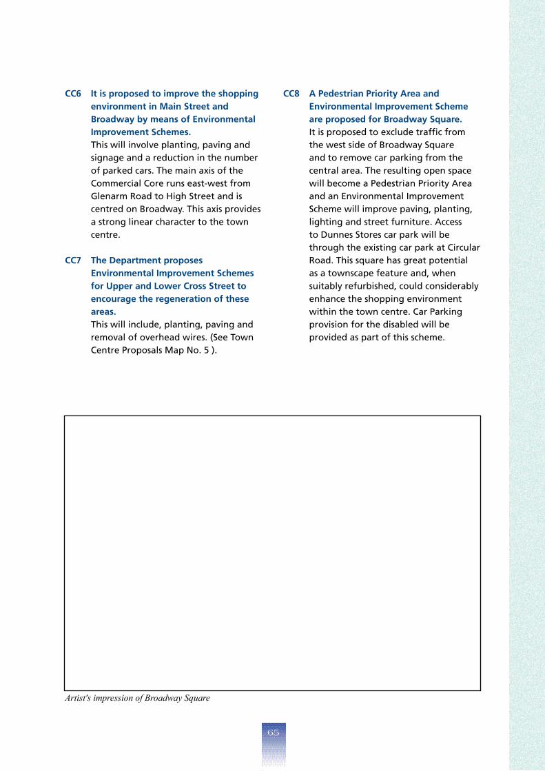
CC6 Itisproposedtoimprovetheshopping CC8 APedestrianPriorityAreaand environmentinMainStreetand BroadwaybymeansofEnvironmental
EnvironmentalImprovementScheme areproposedforBroadwaySquare.
ImprovementSchemes. It is proposed to exclude traffic from This will involve planting, paving and signage and a reduction in the number
the west side of Broadway Square and to remove car parking from the
of parked cars. The main axis of the central area. The resulting open space Commercial Core runs east-west from Glenarm Road to High Street and is
will become a Pedestrian Priority Area and an Environmental Improvement
centred on Broadway. This axis provides Scheme will improve paving, planting, a strong linear character to the town centre.
lighting and street furniture. Access to Dunnes Stores car park will be through the existing car park at Circular
CC7 TheDepartmentproposes EnvironmentalImprovementSchemes
Road. This square has great potential as a townscape feature and, when
forUpperandLowerCrossStreetto suitably refurbished, could considerably encouragetheregenerationofthese areas.
enhance the shopping environment within the town centre. Car Parking
This will include, planting, paving and provision for the disabled will be removal of overhead wires. (See Town Centre Proposals Map No. 5 ).
provided as part of this scheme.
Artist'simpressionofBroadwaySquare
��

CC9 Officedevelopmentatgroundfloor levelwillbeacceptableinprincipleat UpperandLowerCrossStreet,Dunluce Street,NarrowGaugeRoad,Quay StreetandAgnewStreet. This proposal will help to improve the local environment of these secondary shopping streets providing there is no concentration of non retail frontages. Proposals for other uses in these streets will be considered on their merits.
CC10 TheDepartmentwillacceptin principlethedevelopmentofoffice accommodationatupperfloorlevel alongtheprimaryshoppingfrontageat UpperMainStreetandMainStreet. There is at present 550 sq. m of vacant office space in the commercial core.
CC11 TheDepartmentwillcontroltheextent ofnon-retailuses,includingoffices,at groundfloorlevelalongtheprimary shoppingfrontageatUpperMain StreetandMainStreet. In order to retain the vitality of the town centre and provide a wide range of shopping opportunities it is important that prime retailing frontages at ground floor level are retained. Applications for change of use to local services or offices such as building society offices, banks and estate agents or to food uses may be acceptable, except where:
• the result will be a break up of the primary shopping frontages;
• a clustering of non-retail uses will be created;
• there would be a resultant domination of the overall area by non-retail uses.
CC12 TheDepartmentwillresistapplications forchangestotheuseofresidential propertiesatQuayStreetwithinthe CommercialCore. Residential properties on either side of the street lend life to the town centre. The Department considers it essential to the vitality of the town centre for these properties to remain in residential use.
��

��

��

TheVillages
��

BALLYCARRY Ballycarry is situated 10 kms south of Larne and west of the main Larne-Carrickfergus Road (A2) and had a 1991 population of 1010. The village developed historically in linear form with Main Street extending along the edge of an escarpment.
TheDepartmenthasdefinedadevelopment limitforthevillagewhichincludeslandto thenorthalongHillheadRoadasfarasthe PresbyterianChurchandthehallonthe oppositesideoftheroad. This will permit the consolidation of the existing settlement.
TheDepartmenthasincluded6.8hectares oflandtothenorthofWestStreetand7.02 hectaresoflandtothesouthofIslandRoad. This will facilitate small scale developments, offer variety and choice of sites and consolidate the village.
TheDepartmentproposestomake environmentalimprovementstoMainStreet. The street presents a rather run down image at present and it is proposed to improve this area by means of an Environmental Improvement Scheme as indicated on the Village Map. The scheme will include improvements to pavements, a painting scheme and removal of unsightly overhead wires.
Twoareasofopenspaceareproposedwithin thevillage. One site is located to the south of the settlement along the line of the escarpment and includes a stand of significant trees. The other area of open space is located to the east of Main Street and to the south of Island Road. (See Village Map.)
TheDepartmentintendstoprotectfrom developmentanareaidentifiedasbeingof considerablearchaeologicalsignificance. This area is located to the south of the village and within the development limit. It is defined by Bridgend Road, Manse Road and the Main Bentra Road. (See Village Map.)
Further archaeological remains associated with earlier settlement and with the site of the medieval church of Brakenberghe, identified as located to the rear of West Street and Main Street, may exist within the village. Developers should consult with the Department at the earliest opportunity to allow evaluation of any archaeological discovery. This will enable the formulation of a strategy to record the artefacts and the preparation of a programme of excavation if necessary.
Potential developers of any site within the village are advised to consult with the Department at an early stage of the design of their schemes as special drainage measures to deal with surface water run off will be required.
�0

��

BALLYGALLEY Ballygalley with a 1991 population of 496, is located 8 kms north of Larne on the Antrim Coast Road. Although it originally developed around the 17th century castle its function is now that of a dormitory settlement. The development of the village has been restricted by the surrounding topography, although a “ribbon” of dwellings has extended to the north west along the coast.
TheDepartmentproposesthatnofurther developmentofthesettlementwilltake place. The village has grown rapidly in recent years and some further approved land remains to be developed. The Department recognises that the village has reached its capacity for growth and will ensure the retention of its character.
Archaeological remains may exist within the development limit associated with earlier occupation of this area.
Developers should consult with the Department at the earliest opportunity to allow evaluation of any archaeological discoveries. This will enable the formulation of a strategy to record the artefacts and the preparation of a programme of excavation if necessary.
��

��

BALLYSTRUDDER Ballystrudder with a 1991 population of 750, is situated 2 kms from Whitehead at the southern end of the Islandmagee Peninsula, and has developed between Middle Road (B150) and Low Road (B190).
TheDepartmenthasincluded4.0hectares ofland,consideredtobesuitablefor development,betweenLowRoadandReids Road.Afurther2.23hectaresoflandtothe southofthesettlementbetweenMiddle RoadandBallystrudderRoadisalsoincluded withinthedevelopmentlimit. The settlement has experienced significant growth in recent years which has changed its character from rural to urban in form, although it still has a rural hinterland. Its function has now become a dormitory settlement for commuters. It is proposed to consolidate the settlement over the plan period, however some growth can be accommodated and suitable land has been identified.
��

��

CARNLOUGH Carnlough, with a population of 1493 in 1991, is situated 24 kms to the north of Larne on the Coast Road at the foot of Glencloy. The village developed originally around the harbour and later expanded following the arc of the bay.
The village lies within the Antrim Coast and Glens A.O.N.B. The old village core was designated a Conservation Area in January 1981. This recognised the original form of the settlement and the considerable number of listed buildings. (See Village Map.)
Includedwithintheproposedvillagelimitare severalsiteswhichareintendedtocaterfor itsfurtherdevelopment. Two potential development sites are located in the North of the village at Croft Road with a third in the south of the village with access from the Ballymena Road. The development site to the north of Croft Road has an elevated position and will be considered suitable for only single storey low density development of appropriate design in keeping with the character of the village.
TheremainderoftheLocalEnterprise DevelopmentUnitsitetotherearofCroft Roadwillbedevelopedforsmallscaleand compatibleindustrial/businessuses.(See VillageMap.)
Environmentalimprovementsareproposed atHurryHeadandtheHarbourArea. Carnlough has benefited from considerable regeneration work at Harbour Road and High Street through Environmental Improvement Schemes. Further proposals include the provision of tourist facilities at Harbour house and a railway to link the harbour with the derelict limestone quarry where a variety of activities will be provided for visitors.
Extensionstotheexistinglargestaticcaravan sitewithinthevillageortheprovisionof additionalsiteswillberesistedinorderto protecttheamenityofthevillage. There is a large static caravan site within the village which has reached its capacity. Carnlough is a popular tourist destination and possesses a hotel and several guest houses. Additional permanent tourist accommodation will be encouraged subject to satisfactory design.
WithintheConservationArea,all newdevelopmentwillbeexpectedto complementexistinggoodelevational treatmentandmakeapositivecontribution totheConservationAreaasawhole.The designofallnewbuildingsinrelationto scale,massandproportion,aswellasthe materialsandfinisheswillrequirecareful consideration.(1)
This may best be achieved by the use of traditional (vernacular) building forms and materials.
(1) Detailed guidance is contained in the CarnloughDesignGuide1994,availablefrom
the Ballymena Divisional Planning Office.
��

��

GLENARM Glenarm is situated 16 kms north of Larne on the Coast Road and had a population of approximately 621 in 1991. Glenarm has historically developed around the harbour. The older part of the village was designated a Conservation Area in March 1975. Glenarm Castle presents an important historical setting for the village and will provide self-catering tourist accommodation and limited public access to the Castle grounds. More recent development has resulted in a ribbon of development to the west along the Coast Road. The eastern side of the village is dominated by the existing Whiting Mill.
TheDepartmenthasidentifiedsitesforsmall scalesensitivedevelopmentandincluded additionallandwithinthedevelopmentlimit. The village is severely constrained by existing topography, the coast and by the nearby quarry.
Environmentalimprovementsare proposedforthevillageandwillinclude undergroundingthewirescapeandstreet lightingatAltmoreStreetandMarkStreet. Glenarm has benefited from Environmental Improvement Schemes at Toberwine Street, the Vennel and Castle Street.
TheDepartmentproposestoacquireand relocatetheWhitingMilltoasitewithinthe existingDemesneQuarryatMunieRoad.Itis alsoproposedtofurtherdeveloptheharbour followingtherelocationoftheMill.
The vacant Whiting Mill site will be used to develop tourist facilities for visitors and a touring caravan park. (See Village Map.) The development of the harbour will include repairing, upgrading and dredging of the harbour for tourist and commercial use. It is also proposed to upgrade the car park, bridges, river walkways and toilets. (See Village map)
Anewcommunitycentreisproposedat MunieRoad. This development will include the provision of a football pitch, bowling green and tennis courts, as well as a mountain bike track. The site will also include an area of open space. (See Village Map.)
WithintheConservationArea,all newdevelopmentwillbeexpectedto complementexistinggoodelevational treatmentandmakeapositivecontribution totheConservationAreaasawhole.The designofnewbuildingsinrelationtoscale, mass,proportion,aswellasthematerialsand finisheswillrequirecarefulconsideration.(1)
This may best be achieved by the use of traditional (vernacular) building forms and materials.
(1) Detailed guidance is contained in the Glenarm DesignGuide1994,availablefromthe
Ballymena Divisional Planning Office.
��

��

GLYNN Glynn is located 3 kms south of Larne on the main A2 Larne to Carrickfergus Road and had a population of approximately 384 in 1991. The village currently serves as a dormitory settlement mainly for Larne. Its physical development is restricted by the surrounding topography, the river, the railway and the coast.
TheDepartmentproposestoincludelandat LoughViewtothenorthwest,andalsoto thesouthofthevillage.Itisalsoproposed toincludeasmallpieceoflandbetween GlenburnRoadandGlynnRivertoallowfor roundingoff.(SeeVillageMap.) Potential for further development of the village within the current development limit is restricted by the shortage of available land. Archaeologicalremainsmayexistwithinthe
environsofStJohn'sChurch.Developers shouldconsultwiththeDepartmentatthe earliestopportunitytoallowevaluationof anyarchaeologicaldiscoveries. This will enable the formulation of a strategy to record the artefacts and the preparation of a programme of excavation if necessary.
DuringthePlanperioditisproposedto replacetheexistingsewageworkswith apumpingstationwhichwillallowthe transferofsewagetoLarne.
Aby-passschemeisproposedforthevillage duringthePlanperiod. This is listed as a road scheme.
�0

��

��

TheSmaller
Settlements
��
BROWNSBAY Located at the northern end of the Islandmagee peninsula Browns Bay is an attractive area consisting of a small bay with a good sandy beach, some residential properties and tourist related facilities. It is proposed to upgrade the existing facilities by providing a boating slipway and parking.
TheDepartmenthasdefinedadevelopment limitinordertoprotectthequalityofthe existingenvironment. Within this limit opportunities exist for the development of one or two appropriately designed single dwellings.
Archaeologicalremainsmayexistwithinthe developmentlimitassociatedwiththeearlier occupationofthisarea.(SeeSettlement Plan.) Developers should consult with the
Department at the earliest opportunity to allow evaluation of the archaeology of the site. This will enable the formulation of a strategy to record the artefacts and the preparation of a programme of excavation if necessary.
��

CARNAGEER TheDepartmenthasdefinedadevelopment limitforthesettlementinordertoprotect thequalityoftheexistingenvironment. Within this limit opportunities exist for the development of one or two appropriately designed single dwellings.
��
CARNALBANAGH Carnalbanagh consists of a small cluster of development to the north west of Larne at the head of the Glenarm River valley. Located at a cross-roads, the settlement has developed around a church and primary school.
TheDepartmentproposestoincludeasmall amountofadditionallandtothesouthofthe settlement. The inclusion of this land will allow for choice and variety of sites and take account of land not being readily available for development.
The Water Executive proposes to replace the existing sewage system on an adjacent site. The existing sewage works is at present overloaded.
��

CARNCASTLE Carncastle is situated 2 kms to the west of Ballygalley and consists of a cluster of development around the junction of the Carncastle and Ballygalley Roads. The development of the settlement has focused on three churches, halls and a public house. It has been and will continue to be constrained by the surrounding topography.
TheDepartmentproposestolimitthefurther expansionofCarncastleinordertoprotectits character. The location and scale of the settlement give it considerable character. There are a number of existing small infill sites suitable for development which are in keeping with the scale of the settlement.
��

CROSSHILL Crosshill consists of a small cluster of development around a cross-roads to the south of Larne near Glenoe. Some new development has taken place beside the public house. The focus of the settlement is the church and public house.
TheDepartmentproposesadevelopment limitforthesettlementwithinwhich opportunitiesexistforsuitablydesigned singledwellings. The further expansion of the settlement is restricted by the topography to the south, an existing operational quarry to the east and a high voltage electricity line to the west.
��

DEERPARK TheDepartmenthasdefined adevelopmentlimitfor thesettlementinorderto protectthequalityofthe existingenvironment. Within this limit opportunities exist for the development of one or two appropriately designed single dwellings.
DRUMCROW TheDepartmenthasdefined adevelopmentlimitfor thesettlementinorderto protectthequalityofthe existingenvironment. Within this limit opportunities exist for the development of one or two appropriately designed single dwellings.
��

FERRISBAY Ferris Bay consists of a small crescent shaped bay at the northern end of Islandmagee with some residential development and two sites containing static caravans.
Adevelopmentlimithasbeendrawnaround thesettlementwithinwhichdevelopment willbecontained. The Department considers that any further development at this location would seriously damage the local environment.
�0

FEYSTOWN TheDepartmenthasdefinedadevelopment limitforthesettlementinordertoprotect thequalityoftheexistingenvironment. Within this limit opportunities exist for the development of one or two appropriately designed single dwellings.
GARRONPOINT TheDepartmenthasdefined adevelopmentlimitforthe settlementinordertoprotect thequalityoftheexisting environment. Within this limit opportunities exist for the development of one or two appropriately designed single dwellings.
��

GLENOE Glenoe is situated 2 kms to the south of Larne at the head of the Glenoe Water valley. The settlement has developed on steeply sloping land which forms a natural barrier to development to the west and south.
TheDepartmentproposesthatawalkway andvisitorfacilitiesbedevelopedatGlenoe Waterfall. The waterfall and glen beside the settlement, which are in National Trust ownership, are an important scenic attraction.
LandoppositeGlenfallCottageshasbeen includedwithinthesettlementtoallowfor futuredevelopment. Further development is limited by the surrounding topography and the character of the settlement.
AConservationAreaisproposedwithinthe settlement. Glenoe has a unique character which the Department wishes to protect and enhance. The boundary of the proposed Conservation Area will be the subject of further study.
��

KILWAUGHTER Kilwaughter comprises a small cluster of development around a cross-roads on the A36 Larne-Ballymena Road. Close to the settlement is a hotel providing tourist facilities with a nearby main route into the Glens of Antrim.
TheDepartmentproposestolimitthescale ofdevelopmentofthesettlementinorderto retainitscharacter. A development limit has been drawn to allow sites for single dwellings at Deerpark Road.
The Water Executive intends to provide sewers within the settlement over the Plan period and facilities for the transfer of sewage to Larne.
��

MAGHERAMORNE Magheramorne is located 3 kms south of Glynn and essentially consists of three 'dispersed settlements' along the main A2 Shore Road and on the Ballypollard Road at Quintin Avenue. The settlement is dominated by the nearby disused quarry and cement works.
TheDepartmenthasdefinedadevelopment limitwhichwillaccommodatesmallscale developmentandallowforfurtherexpansion ofthesettlement. The proposed development limit is based on the cluster of development at Ballypollard Road which is focused on the existing church and church hall. Land has been included between Quintin Avenue and Ballypollard Road.
��

MILLBAY Mill Bay is located along the western coast of Islandmagee and consists of a small crescent shaped bay with development taking place along the road. This form of development has continued in recent years with a ribbon of development extending to the south. The settlement is focused on the bay and its setting.
TheDepartmentproposesadevelopment limitforthesettlement. This will contain land to accommodate sites for single dwellings without adversely affecting the essential character of the settlement or the surrounding rural area.
��

MOUNTHILL Mounthill consists of a small cluster of development around a cross-roads on the Raloo Road, south of Larne and 1.5 kms north of Crosshill. No formal development limit exists although some residential development has taken place around a small public authority estate.
TheDepartmentproposesadevelopment limitforthesettlement. Within the proposed limit for development sufficient land has been included to allow for further suitably designed single dwellings.
��
MULLAGHBOY Mullaghboy is situated 3 kms from the northern end of the Islandmagee peninsula. It comprises a “ribbon” of development on either side of the Mullaghboy Road (B150). The settlement is linear in form with no identifiable centre. A small housing estate has been developed at Ashvale Park in recent years and a caravan park is located at Portmuck Road.
TheDepartmentproposesadevelopment limitforthesettlementtoincludelandtothe northofthesettlementatPortmuckRoad andtothesouthatMullaghboyBungalows. There are a number of vacant sites existing within the development limit to allow for variety of choice and rounding off. Development in depth will be encouraged.
��

RALOO Raloo consists of a cluster of dwellings centred around a church and church hall accessed along an existing laneway.
TheDepartmentproposesadevelopment limitforthesettlement. Within this limit opportunities exist for suitably designed single dwellings which reflect the existing informal pattern of development.
TheDepartmentproposestodeclarethe settlementaConservationAreabasedonthe patternofdevelopment. The Department has recognised that the settlement form is consistent with that of a Clachan and may also satisfy the Scots definition of a cluster of farms with a church – a “kirkton”. In support of the designation of the Conservation Area, the Department will publish a design guide to assist those who may wish to carry out development within the settlement.
TheDepartmentwillresistanyproposals whichwillaffecttheessentialcharacterof thesettlement. It is considered that proposals including improvements to the access point and laneway, siting, design, materials and form of structure may seriously affect the essential character of the clachan. Guidance is available at present and prospective developers are advised to consult with the Divisional Planning Office before formulating proposals.
��

STRAIDKILLY Straidkilly is located approximately 1 mile south of Carnlough in an elevated position overlooking the bay. It consists of a number of existing and vacant/derelict properties, a number of which have recently been rebuilt for tourism purposes.
TheDepartmentproposestodefinea developmentlimitforthesettlementwithin whichopportunitiesexistforsuitably designedsingledwellings.
��

REGIONALPOLICYCONTEXT
The Department's regional development control policies for the countryside and coast which apply in the Larne Borough are currently set out in the various Planning Policy Statements published to date and in the Rural Strategy. Policies which address nature conservation, access considerations, shops, rural enterprises and other industrial projects in the countryside are set out in the Planning Policy Statements. The Rural Strategy contains a range of policies for a number of development types including agriculture, minerals, recreation, tourism development and houses in the countryside. In addition there are specific policies for Green Belts, Countryside Policy Areas and the coast. The Rural Strategy also provides the framework for considering development proposals within the countryside and establishes rural design principles.
Supplementary design guidance for building in the countryside is contained in “A Design Guide for Rural Northern Ireland” published in May 1994.
POLICIESandPROPOSALS
COU1 TheDepartmentwillprotect, conserveandenhancesensitive landscapes,accommodatethe needsofthefarmingcommunity andprotectvulnerableareas fromdevelopmentpressure.The Departmentthereforeproposes:–
1. ACountrysidePolicyAreafor theundevelopedcoastnorthof Larne.(SeePolicyNV2).
2. AGreenBeltaroundLarne.
(SeePolicyNV3). 3. ACountrysidePolicyArea
fortheAntrimCoastandGlens A.O.N.B.,theIslandmagee peninsulaandtheareatothe southofLarne.(SeePolicyNV4).
(All Policy Areas are shown on the District Strategy Map1)
COU2 Planningpermissionforthe replacementofprefabricated temporaryholidayhomeswith apermanentdwellingwillnot normallybeapproved.
TheDepartmentmayconsider thereplacementofagroupof adjacentdwellingswithasingle permanentdwellingsubject tothenormalplanningand environmentalcriteria.
�00

COU3 Inassessingdevelopment proposalstheDepartmentwill applytheprinciplescontained intheAntrimCoastandGlens A.O.N.B.DesignGuide.(1)
The Antrim Coast and Glens A.O.N.B. was designated in 1989 because of the scenic quality of the landscape and the appeal of the heritage of the dwellings built by past generations.
The Department intends to protect this heritage so that any new buildings are in harmony with the siting and design of traditional buildings. In so doing the Department will be conscious of the need to meet the requirements of modern living and also the availability of new construction techniques and materials.
(1) Detailed guidance is provided in the Antrim Coast and Glens Area of Outstanding Natural Beauty Design Guide 1989, available from the Ballymena Divisional Planning Office.
The Countryside
and Coast
�0�

�0�

Appendices
�0�

APPENDIXI
DESIGNATEDNATURECONSERVATIONSITES
Site A.S.S.I. S.P.A. S.A.C. Ramsar A.S.I. N.N.R. DESCRIPTION
Gortnagory X Colony of Nationally rare orchid, Irish Lady's Tresses (Spiranthes romanzoffiana ) at its only high altitude site in Northern Ireland.
Garron Plateau X X
Successional sequence of olivine basalt's and hyaloclastite. Presence of picrite-dolerite plug. Extensive oceanic blanket bog with upland oligotrophic lakes. Many rare plant species. Upland breeding birds.
Scawt Hill X (part of) Geology (see below)
Scart Hill & Sallagh Brae's X
Upland grassland habitats with rare plant species. Geological interest includes a dolerite plug and a magnificent amphitheatre with lava flows displayed.
Waterloo X Outstanding Mesozoic sequence fossil locality.
Larne Lough X X X Nationally significant for some species of wildfowl.
Black Burn X Karst development in Cretaceous chalk. Cave system with horizontal passages. Unique in Northern Ireland.
Straidkilly Wood X (NNR description below).
Straidkilly (part of) X Hazelwood developed on very steep east facing slope. Excellent spring ground flora.
Swan Island X X Nesting sites for terns. Owned by D.O.E. (NI) and managed by RSPB.
Ballycarry X Bird santuary; important for feeding/roosting/waders and wildfowl. Extensive salt marsh.
Carnlough X Exceptional geomorphological interest displaying phases of post glacial activity.
Islandmagee X Geological interest; Trias to Cretaceous sequence exposed at Blackhead. Excellent cliffs sections through Lower Basalts.
�0�

APPENDIXI NATURECONSERVATIONSITES
(RSPBANDULSTERWILDLIFETRUST)
MAP
REF. LOCATION DESCRIPTION
1 Garron Point Geological
2 Garron Escarpment PlantsBirds
3 Garron Plateau Bog/Birds
4 Loughan/Binabanan Wooded Scarp
5 Gortnagory A.S.S. I .
6 Campbelltown Quarry Plants
7 Glencloy Quarry Plants
8 Straidkil ly Point Plants/Butterfl ies
9 Straidkil ly Nature Reserve Woodland
10 Bannaghan Wet Meadows
11 Glenarm Demesne Parkland
12 Whitebay Escarpment Birds/Plants
13 Sugarloaf Escarpment Wooded Scarp
14 Glanarm Forest Forest
15 ReserveGlanarm Nature Woodland
16 Nature ReserveFeystown PlantsRare
17 Owencloghy Valley Woodland
18 Linford Water Plants
19 Scawt Hill Escarpments Plants
20 Ballycoos Heath Bog
21 Hil lYoungsRobin Plants
22 Knockdhu Escarpment Plants
23 Sallagh Braes Escarpment Plants/Birds
24 Sallagh Braes Heath Bog
25 Carnfunock Wood Woodland
26 Owencloghy Bog Bog
27 Cappanagh Wood BirdsRare
28 Star Bog Bog
29 Agnew's Hill Escarpment Plants
30 Kilwaughter Castle Estate Woodland
31 Larne Quarry Plants
32 BayBrown's Geology
33 Skernaghan Point Plants/Geology
34 Larne Lough EstuarineBirds,
34a North Glynn Gut Open Water
34b South Glynn Gut Open Water
34c Swan Is land & Blue Circle I s land BirdsRare
34d Ballycarry Estuary Estuarine
35 of MuckIsle Seabirds
36 I s landmagee Cliffs (Gobbins) Seabirds
37 Carnduff Woodland
38 RiverGlynn Woodland
39 HillGlynn Woodland
40 Glenoe Woodland
41 Ballyboley Forest Forestry/Rare Birds
42 Carndoo Woodland
43 Carndoo Marsh Butterfl ies
44 Hil l /Thorny Hil lTaits PlantsRare
�0�

APPENDIXI
Lakes
Woodland
Coastal
Geology
M A P
R E F . L O C A T I O N D E SC RI P T I O N
45 Loughnatrosk 3.5 ha Mid-altitude, nutrient poor, rocky stoney and silty sediments (Type 8)
46 Loughnabrick 1.25 ha Upland (>200m), large, with deep, rocky and stony basins. Notable plant species (Type 3).
47 Craigfad Lough
1.0 ha Bryophyte lakes, upland, base poor. Generally small, in peat and cut to the underlying acidic rock (Type 1).
48 Glynn Lagoon
Algae lakes, mainly man-made. Brackish lagoons are a priority habitat under EC legislation (Type 5).
49 Doonan Leap
Ground flora typical of Antrim basalts. Species rich with 2 notable species. Amenity value.
50 Drumnasole Largest semi-natural wood in Co. Antrim. Hazelwood on a steep basalt escarpment.
51 Deer Park Woods (Glenarm / Mill Bridge / Linford Water)
Good range of woodland types. Several rare plant species. High landscape value.
52 Glynn North Wood High landscape value. Semi-natural woodland on a steep basalt excarpment.
53 Glynn River Valley Hazelwood on a steep sided valley.
54 Glynn Hill High landscape value.
55 Carnfunnock High landscape value.
56 Fort Hill Well developed Ash / Beech woodland. High landscape value.
57 Craiganee High landscape value.
58 Sugar Loaf High landscape value.
59 Glenoe Ashwood (Alias Ballywillin Wood)
Ornithological potential appears high. High landscape value.
60 Mackeystown May have landscape value.
61 Red Hall May have landscape value.
62
Ringfad
Potentially high species diversity. Unusual shore type for East Antrim. Low peninsula of boulders on gravel and stones.
63 Barney's Point
Unusual community, dominated by a species of sponge. Indicative of currents of turbid water.
64 Gobbins Caves Caves are a relatively uncommon habitat along the Northern Ireland coast.
65 Cloghfin Port Shore. Outstanding Mesozoic sequence Fossil locality.
66 Gobbins Sea Cliff. Tertiary lava series mineralogical importance.
67 South Portmuck
Shore. Dolerite dyke metamorphic reaction with chalk. Lag tombolo gravel ridge.
68 Portmuck Shore. Excellent sequence through Hibernian Greensands.
�0�

APPENDIXI
Geology con't
M A P
R E F . L O C A T I O N D ES C RI P T IO N
69 McIlroys Port
Shore / cliff. Basalts with small vent and composite flow. Mineralogical importance. Raised beach features.
70 Browns Bay Shore. Poorly accreting foredunes on beach. Rare in area.
71 Ferris Bay - Barrs Point Shore. Ropey basalt surfaces with spatter cone. Raised beach features.
72 Barneys Point Shore. Fossiliferous Lias clay.
73 Redhall Estate. Dolerite sill. Ravine through chalk.
74 Magheramourne dump Shoreline. Fossiliferous recent estuarine clays.
75 Magheramourne Quarry Quarry. Section through Lower Basalt and Chalk. Mineralogical interest.
76 Glynn Hill Hill. Basalt varities. Mineralogical interest.
77 Banks Quay
Shore. Beach rich in fossil crinoids washed ashore from submerged lias outcrop.
78 Curran Point Shore. Recent raised spit.
79 Waterloo Shore / Cliff. Outstanding Mesozoic sequence - fossil locality.
80 Camels Hump Shoreline. Richly fossiliferous locality.
81 Ballygalley Head Cliff. Dolerite plug with jointing and marginal chalky agglomerate.
82 Ballygalley Shore Shore. Fossiliferous Lias clay.
83 Minnis Shore / cliff. Fossiliferous Lias clay. Recent landslip.
84 Minnis - Glenarm section
Cliff. Section through chalk and clay-with-flints. Paleo-Karst features. Mineralogical interest.
85 Straidkilly Shore. Fossiliferous Lias clay.
86 Glencloy Beach / fields. Raised beach deposits.
87 Carnlough Shore. Late glacial sequence.
88 Garron Headland Headland. Landslip feature and block fields.
89 Garron Point Shore. Glenarm chalk member - type locality.
90 Garron Point Shore. Galboly - Cloghstucan chalk member - type locality.
91 Garron Point Shore. Richly fossiliferous Lias clay.
92 Scawt Hill
Cliff / Hill. Dolerite plug. Chalk contact produced many rare and new skarn type minerals.
93 Sallagh Braes Cliff. Natural basalt amphitheatre.
94 Agnews Hill Cliff / Hill. Unusual basalt types.
95 Rory's Glen Ravine. Historical record of large cave.
96 Glenoe Ravine. Waterfalls.
97 Carneal River. Dolerite plug. Mineralogical interest.
�0�

APPENDIXI
OTHERSITESOFNATURECONSERVATIONSIGNIFICANCE
Blanket Bog
Grassland
Other
Bird Interest
M A P
R E F . L OC A T IO N D ES C RI P T IO N
Ballygawn, Scawt Hill Blanket Bog.
Knockdhu to Sallagh Braes Blanket Bog.
West of Cappanagh Wood Blanket Bog.
Fort Hill Unimproved grassland (and scattered scrub).
Leggan Rocks Series of disused chalk quarries, rich in limestone and ruderal species.
Larne Lough Nationally significant for some species of waterfowl.
Isle of Muck Breeding seabird colonies. Wintering population of Buzzard. Included in the Islandmagee ASI.
Gobbins Breeding Seabird Colonies.
Cappanagh / Agnews Areas Breeding raptors. Breeding Whinchat. Good area for Red Grouse and Curlew.
�0�

APPENDIXII
Planning Policy Statements and Development Control Advice Notes
The following Planning Policy Statements and Development Control Advice
notes are published by and available from the Planning Service:
Planning Policy Statements
PPS 2 Planning and Nature Conservation
PPS 3 Development Control: Roads Considerations
PPS 4 Industrial Development
PPS 5 Retailing and Town Centres
Development Control Advice Notes
1. Amusement Centres
2. Multiple Occupancy
3. Bookmaking Offices
4. Hot Food Bars
5. Taxi Offices
6. Restaurants and Cafes
7. Public Houses
8. Small Unit Housing in Existing Residential Areas
9. Residential and Nursing Homes
10. Environmental Impact Assessment
11. Access for People With Disabilities
12. Hazardous Substances
13. Creches, Day Nurseries and Pre-school Playgroups
�0�
BIBLIOGRAPHY
Antrim Coast and Glens, Area of Outstanding Natural Beauty, Department of the Environment for Northern Ireland, 1989.
Houses in Harmony with the Countryside, Department of the Environment for Northern Ireland, 1988.
Layout of Housing Roads Design Guide, Department of the Environment for Northern Ireland, 1988.
Nature Conservation and Planning, Department of the Environment for Northern Ireland, 1990.RSPB Planscan Northern Ireland, A Study of Development Plans in Northern Ireland, Royal Society for the Protection of Birds, 1993.
The Citizens Charter for Northern Ireland, Belfast HMSO, 1992.
This Common Inheritance, Britains Environmental Strategy, Command Paper, September 1990.
Tourism in Northern Ireland, An Indicative Plan, N.I.T.B., 1990.
R.S.P.B. (1995) Wildlife Impact, The Treatment of Nature Conservation in Environmental Assessment, The R.S.P.B., Sandy.
The Habitats Directive, How it will apply in Northern Ireland, Department of the Environment for Northern Ireland.
Larne West A Development Strategy, Department of the Environment for Northern Ireland, 1991.
Glens of Antrim Community Survey Report, Glens of Antrim Rural and Community Development Association, 1994.
The Conservation (Natural Habitats etc.) Regulations Northern Ireland 1995, Department of the Environment for Northern Ireland, A Guidance Note.
Future Strategy for Waste Management in Northern Ireland; a Consultative Document: Department of the Environment for Northern Ireland, March 1993.
Glenarm Village Conservation Area, Department of the Environment for Northern Ireland, 1978.
Carnlough Conservation Area, Department of the Environment for Northern Ireland, 1981.
Carnlough and Glenarm Enhancement Strategies, Department of the Environment for Northern Ireland, 1991.
Glenarm Design Guide, Department of the Environment for Northern Ireland, 1994. Carnlough Design Guide, Department of the Environment for Northern Ireland, 1994.
A Planning Strategy for Rural Northern Ireland, Department of the Environment for Northern Ireland, 1993.
Landscape Assessment Guidance, Countryside Commission Advisory Booklet, 1993.
Buildings at Risk, Vol. 2: Ulster Architectural Heritage Society, January 1995.
Proposed Glen at Linn Road, Larne: Department of the Environment for Northern Ireland, 1991.
��0

ACkNOWLEDGEMENTS
The Planning Service wishes to record its gratitude to all those who helped in the production of this book, including:
Visualisations of Larne Paul Gallagher, Londonderry
Photographs DOE Graphic Design Unit, Londonderry
Edgar Brown Photography, 15 Castle Street Richill
Photograph of Jetliner Larne Harbour Ltd
Base Maps Ordnance Survey of Northern Ireland Aerial Photographs Aerial photographs reproduced from
an Ordnance Survey aerial photograph with the permission of the Controller of Her Majesty’s Stationery Office, (c) Crown Copyright, Permit Number : 1130.
Design & Layout DOE Graphic Design Unit, Londonderry
ThePlanningTeam The Citizens Charter for Northern Ireland seeks to ensure that the public are aware of the personnel who are involved with the production of the Area Plan. Those chiefly involved in the production of the Larne Area Plan were (in alphabetical order):
S. Adams W. Cathcart D.T. Dowey (until July 1996) I. McAllister G.P. McCorry J.N. McNeill D.S. Stephens (until Nov. 1996)
Ballymena Divisional Planning Office County Hall Galgorm Road Ballymena BT42 1QF Tel: (01266) 653333 Fax: (01266) 662127 E-mail: [email protected].
���