
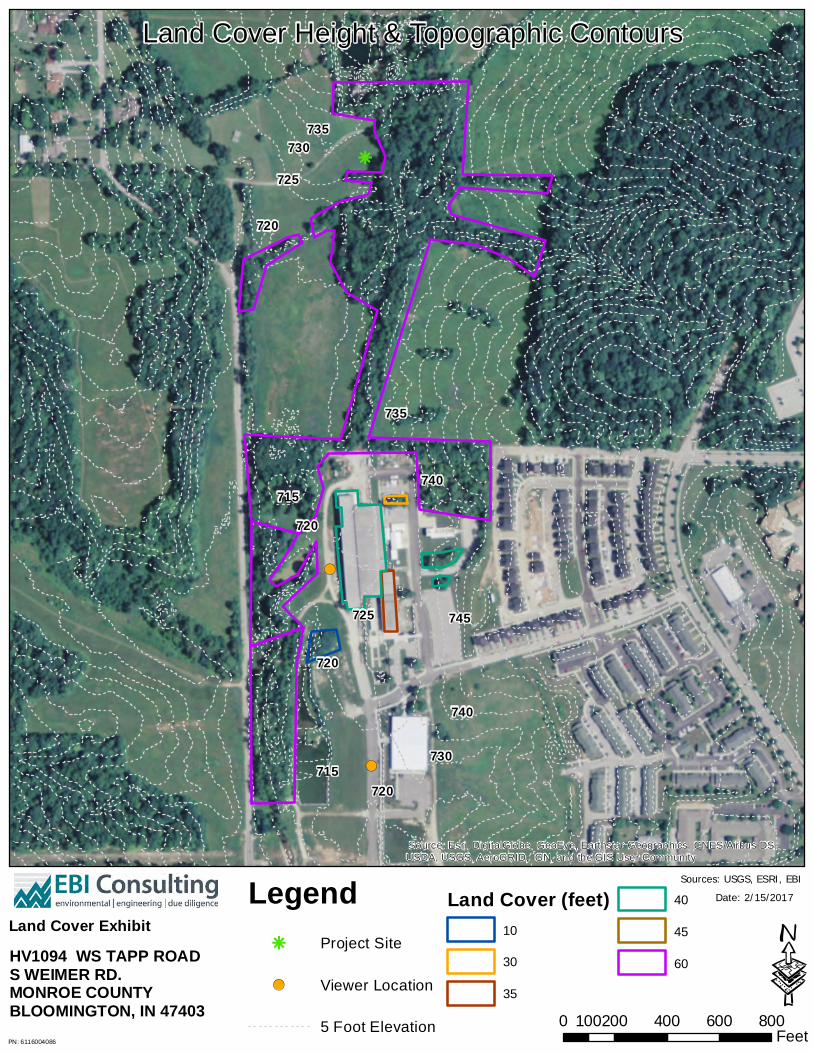
Land Cover Height & Topographic Contours
231
/ ! ( ! ( 735 730 725 720 715 720 715 720 730 740 745 740 735 720 725 Source: Esri, DigitalGlobe, GeoEye, Earthstar Geographics, CNES/Airbus DS, USDA, USGS, AeroGRID, IGN, and the GIS User Community 0 200 400 600 800 100 Feet · Date: 2/15/2017 Legend / Project Site ! ( Viewer Location 5 Foot Elevation Land Cover Height & Topographic Contours Sources: USGS, ESRI, EBI Land Cover (feet) 10 30 35 40 45 60 Land Cover Exhibit HV1094 WS TAPP ROAD S WEIMER RD. MONROE COUNTY BLOOMINGTON, IN 47403 PN: 6116004086
Transcript of Land Cover Height & Topographic Contours
/
!(
!(
735730
725
720
715
720
715720
730
740
745
740
735
720
725
Source: Esri, DigitalGlobe, GeoEye, Earthstar Geographics, CNES/Airbus DS,USDA, USGS, AeroGRID, IGN, and the GIS User Community
0 200 400 600 800100 Feet·
Date: 2/15/2017Legend/ Project Site
!( Viewer Location
5 Foot Elevation
Land Cover Height & Topographic Contours
Sources: USGS, ESRI, EBILand Cover (feet)
10
30
35
40
45
60
Land Cover ExhibitHV1094 WS TAPP ROADS WEIMER RD.MONROE COUNTYBLOOMINGTON, IN 47403PN: 6116004086

Line of Sight & Profile
Profiles include ground elevation plus assumed land cover values. Viewer height 5' 10". Tower height 195 feetDistance (feet)
1,5001,4001,3001,2001,1001,0009008007006005004003002001000
Eleva
tion (
Feet)
930920910900890880870860850840830820810800790780770760750740730720
Source: Esri, DigitalGlobe, GeoEye, Earthstar Geographics, CNES/Airbus DS,USDA, USGS, AeroGRID, IGN, and the GIS User Community
Source: Selected data from ESRI USGS and EBI.
0 500 1,000250Feet
·Date: 2/15/2017
SOUTH PROFILE 1ELEVATION WITH LAND COVER
PN: 6116004086
Tower
Tower is visible
Line of Sight
Land Cover (Tree Stands at 60 feet)
Viewer
Tower Visible Viewer Location
Viewer
Tower is visible

Line of Sight & Profile
Profile includes ground elevationplus assumed land cover. Viewer height 5' 8". Tower height 195 feet. Distance (feet)
2,2002,0001,8001,6001,4001,2001,0008006004002000
Eleva
tion (
feet)
920
900
880
860
840
820
800
780
760
740
720
Viewer
Tower is visible
Source: Esri, DigitalGlobe, GeoEye, Earthstar Geographics, CNES/Airbus DS,USDA, USGS, AeroGRID, IGN, and the GIS User Community
Source: Selected data from ESRI, USGS and EBI.
0 500 1,000250Feet
·Date: 2/15/2017
SOUTH PROFILE 2ELEVATION WITH LAND COVER
PN: 6116004086
Tower
Tower is visible
Line of Sight
Land Cover (Tree Stands at 60 feet)
Viewer
Land Cover (Building at 40 feet)
Tower Visible Viewer Location

UPS CampusShip: View/Print Label
1. Ensure there are no other shipping or tracking labels attached to your package. Select the
Print button on the print dialog box that appears. Note: If your browser does not support this function
select Print from the File menu to print the label.
2. Fold the printed label at the solid line below. Place the label in a UPS Shipping Pouch. If you do
not have a pouch, affix the folded label using clear plastic shipping tape over the entire label.
3. GETTING YOUR SHIPMENT TO UPS
Customers with a Daily Pickup
Your driver will pickup your shipment(s) as usual.
Customers without a Daily Pickup
Take your package to any location of The UPS Store®, UPS Access Point(TM) location, UPS Drop
Box, UPS Customer Center, UPS Alliances (Office Depot® or Staples®) or Authorized Shipping Outlet
near you. Items sent via UPS Return Services(SM) (including via Ground) are also accepted at Drop
Boxes. To find the location nearest you, please visit the Resources area of CampusShip and select
UPS Locations.
Schedule a same day or future day Pickup to have a UPS driver pickup all your CampusShip
packages.
Hand the package to any UPS driver in your area.
UPS Access PointTM UPS Access PointTM UPS Access PointTM
THE UPS STORE THE UPS STORE THE UPS STORE
101 MIDDLESEX TPKE 101 GREAT RD 405 WALTHAM ST
BURLINGTON ,MA 01803 BEDFORD ,MA 01730 LEXINGTON ,MA 02421
FOLD HERE
Page 1 of 1UPS CampusShip: Shipment Label
3/3/2017https://www.campusship.ups.com/cship/create?ActionOriginPair=default___PrintWindowPage&key=labelWind...


FCC Form FCC Wireless Telecommunications Bureau Approved by OMB 3060 – 1039
Notification Date: See instructions for File Number: public burden estimates
General Information 1) (Select only one) ( )
NE – New UA – Update of Application WD – Withdrawal of Application
2) If this application is for an Update or Withdrawal, enter the file number of the pending application currently on file. File Number:
Applicant Information
3) FCC Registration Number (FRN):
4) Name:
Contact Name
5) First Name: 6) MI: 7) Last Name: 8) Suffix:
9) Title:
Contact Information
10) P.O. Box: And /Or 11) Street Address:
12) City: 13) State: 14) Zip Code:
15) Telephone Number: 16) Fax Number:
17) E-mail Address:
Consultant Information
18) FCC Registration Number (FRN):
19) Name:
Principal Investigator
20) First Name: 21) MI: 22) Last Name: 23) Suffix:
24) Title:
Principal Investigator Contact Information
25) P.O. Box: And /Or 26) Street Address:
27) City: 28) State: 29) Zip Code:
30) Telephone Number: 31) Fax Number:
32) E-mail Address:
Horvath Towers, LLC
0013457312
Shauna Adair
Compliance Manager
312 W. Colfax Ave.
South Bend IN 46601
(574)237-0464 (574)217-4357
0016385759
EnviroBusiness Inc. d/b/a EBI Consulting (EBI 6116004086)
Tara Cubie
Senior Architectural Historian
6876 Susquehanna Trail South
York PA 17403
(339)234-2597
1 of 23
NE
620
FCC Form 620
New Tower (�NT� ) Submission Packet0007532961
7AM EST 11/03/2016
May 2014

Professional Qualification
33) Does the Principal Investigator satisfy the Secretary of the Interior’s Professional Qualification Standards? ( ) Yes ( ) No
34) Areas of Professional Qualification: ( ) Archaeologist ( ) Architectural Historian ( ) Historian ( ) Architect ( ) Other (Specify) __________________________________________________________________________________________
Additional Staff
35) Are there other staff involved who meet the Professional Qualification Standards of the Secretary of the Interior? ( ) Yes ( ) No
If “YES,” complete the following:
X
X
X
36) First Name: 37) MI: 38) Last Name: 39) Suffix:
40) Title:
41) Areas of Professional Qualification: ( ) Archaeologist ( ) Architectural Historian ( ) Historian ( ) Architect ( ) Other (Specify) ____________________________________________________________________________________________
Kiristen D Webb
X
Archaeologist
36) First Name: 37) MI: 38) Last Name: 39) Suffix:
40) Title:
41) Areas of Professional Qualification: ( ) Archaeologist ( ) Architectural Historian ( ) Historian ( ) Architect ( ) Other (Specify) ____________________________________________________________________________________________
James C Prichard
X Principle Investigator
Principle Investigator
2 of 23 FCC Form 620May 2014

Site Information Tower Construction Notification System
1) TCNS Notification Number: Site Information
2) Positive Train Control Filing Subject to Expedited Treatment Under Program Comment: ( ) Yes ( ) No
3) Site Name:
4) Site Address: 5) Detailed Description of Project: 6) City: 7) State: 8) Zip Code:
9) County/Borough/Parish:
10) Nearest Crossroads:
11) NAD 83 Latitude (DD-MM-SS.S): ( ) N or ( ) S
12) NAD 83 Longitude (DD-MM-SS.S): ( ) E or ( ) W Tower Information
13) Tower height above ground level (include top-mounted attachments such as lightning rods): ___________________ ( ) Feet ( ) Meters
14) Tower Type (Select One): ( ) Guyed lattice tower ( ) Self-supporting lattice ( ) Monopole ( ) Other (Describe):
Project Status
15) Current Project Status (Select One): ( ) Construction has not yet commenced ( ) Construction has commenced, but is not completed Construction commenced on: _______________ ( ) Construction has been completed Construction commenced on: _______________ Construction completed on: _______________
143449
WS Tapp Road / HV1094
S Weimer Rd.
Bloomington IN
MONROE
47403
39-08-38.9
086-33-37.4
X
X
60.7 X
�
3 of 23
X
X
FCC Form 620May 2014
Sudburg Lane and Weiner Road
6116004086; Proposed construction of a new telecommunications monopole and compound resulting in ground disturbance. Please see Attachment 4 of this filing for project design details.
X

Determination of Effect
14) Direct Effects (Select One): ( ) No Historic Properties in Area of Potential Effects (APE) ( ) No Effect on Historic Properties in APE ( ) No Adverse Effect on Historic Properties in APE ( ) Adverse Effect on one or more Historic Properties in APE
15) Visual Effects (Select One): ( ) No Historic Properties in Area of Potential Effects (APE) ( ) No Effect on Historic Properties in APE ( ) No Adverse Effect on Historic Properties in APE ( ) Adverse Effect on one or more Historic Properties in APE
4 of 23
X
X
FCC Form 620May 2014

Tribal/NHO Involvement
1) Have Indian Tribes or Native Hawaiian Organizations (NHOs) been identified that may attach religious and cultural significance to historic properties which may be affected by the undertaking within the APEs for direct and visual effects?
( ) Yes ( ) No
2a) Tribes/NHOs contacted through TCNS Notification Number: ___________________ Number of Tribes/NHOs: _________________ 2b) Tribes/NHOs contacted through an alternate system: Number of Tribes/NHOs: _________________
143449 25
X
0
Tribe/NHO Contacted Through TCNS
3) Tribe/NHO FRN:
4) Tribe/NHO Name:
Contact Name
5) First Name: 6) MI: 7) Last Name: 8) Suffix:
9) Title:
Dates & Response
10) Date Contacted ______________ 11) Date Replied _______________ ( ) No Reply ( ) Replied/No Interest ( ) Replied/Have Interest ( ) Replied/Other
Absentee-Shawnee Tribe of Indians of Oklahoma
09/29/2016
X
Ashley Brokeshoulder
THPO Specialist
Tribe/NHO Contacted Through TCNS
3) Tribe/NHO FRN:
4) Tribe/NHO Name:
Contact Name
5) First Name: 6) MI: 7) Last Name: 8) Suffix:
9) Title:
Dates & Response
10) Date Contacted ______________ 11) Date Replied _______________ ( ) No Reply ( ) Replied/No Interest ( ) Replied/Have Interest ( ) Replied/Other
Cherokee Nation
09/28/2016
X
Sheila BirdM
THPO
5 of 23 FCC Form 620May 2014
Tribal/NHO Involvement
1) Have Indian Tribes or Native Hawaiian Organizations (NHOs) been identified that may attach religious and cultural significance to historic properties which may be affected by the undertaking within the APEs for direct and visual effects?
( ) Yes ( ) No
2a) Tribes/NHOs contacted through TCNS Notification Number: ___________________ Number of Tribes/NHOs: _________________ 2b) Tribes/NHOs contacted through an alternate system: Number of Tribes/NHOs: _________________
143449 25
X
0
Tribe/NHO Contacted Through TCNS
3) Tribe/NHO FRN:
4) Tribe/NHO Name:
Contact Name
5) First Name: 6) MI: 7) Last Name: 8) Suffix:
9) Title:
Dates & Response
10) Date Contacted ______________ 11) Date Replied _______________ ( ) No Reply ( ) Replied/No Interest ( ) Replied/Have Interest ( ) Replied/Other
Chippewa Cree Tribe of the Rocky Boy's Reservation
09/28/2016 10/03/2016
X
Alvin Windy Boy Sr
THPO
Tribe/NHO Contacted Through TCNS
3) Tribe/NHO FRN:
4) Tribe/NHO Name:
Contact Name
5) First Name: 6) MI: 7) Last Name: 8) Suffix:
9) Title:
Dates & Response
10) Date Contacted ______________ 11) Date Replied _______________ ( ) No Reply ( ) Replied/No Interest ( ) Replied/Have Interest ( ) Replied/Other
Eastern Shawnee Tribe of Oklahoma
09/29/2016 09/29/2016
X
Travis Patton
TCNS Coordinator
6 of 23 FCC Form 620May 2014

Tribal/NHO Involvement
1) Have Indian Tribes or Native Hawaiian Organizations (NHOs) been identified that may attach religious and cultural significance to historic properties which may be affected by the undertaking within the APEs for direct and visual effects?
( ) Yes ( ) No
2a) Tribes/NHOs contacted through TCNS Notification Number: ___________________ Number of Tribes/NHOs: _________________ 2b) Tribes/NHOs contacted through an alternate system: Number of Tribes/NHOs: _________________
143449 25
X
0
Tribe/NHO Contacted Through TCNS
3) Tribe/NHO FRN:
4) Tribe/NHO Name:
Contact Name
5) First Name: 6) MI: 7) Last Name: 8) Suffix:
9) Title:
Dates & Response
10) Date Contacted ______________ 11) Date Replied _______________ ( ) No Reply ( ) Replied/No Interest ( ) Replied/Have Interest ( ) Replied/Other
Flandreau Santee Sioux Tribe
09/28/2016 09/28/2016
X
Garrie Kills a Hundred
THPO-Director
Tribe/NHO Contacted Through TCNS
3) Tribe/NHO FRN:
4) Tribe/NHO Name:
Contact Name
5) First Name: 6) MI: 7) Last Name: 8) Suffix:
9) Title:
Dates & Response
10) Date Contacted ______________ 11) Date Replied _______________ ( ) No Reply ( ) Replied/No Interest ( ) Replied/Have Interest ( ) Replied/Other
Forest County Potawatomi Community
09/29/2016
X
Michael LaRonge
THPO
7 of 23 FCC Form 620May 2014

Tribal/NHO Involvement
1) Have Indian Tribes or Native Hawaiian Organizations (NHOs) been identified that may attach religious and cultural significance to historic properties which may be affected by the undertaking within the APEs for direct and visual effects?
( ) Yes ( ) No
2a) Tribes/NHOs contacted through TCNS Notification Number: ___________________ Number of Tribes/NHOs: _________________ 2b) Tribes/NHOs contacted through an alternate system: Number of Tribes/NHOs: _________________
143449 25
X
0
Tribe/NHO Contacted Through TCNS
3) Tribe/NHO FRN:
4) Tribe/NHO Name:
Contact Name
5) First Name: 6) MI: 7) Last Name: 8) Suffix:
9) Title:
Dates & Response
10) Date Contacted ______________ 11) Date Replied _______________ ( ) No Reply ( ) Replied/No Interest ( ) Replied/Have Interest ( ) Replied/Other
Ho-Chunk Nation
09/28/2016
X
William Quackenbush
Tribal Historic Preservation Officer
Tribe/NHO Contacted Through TCNS
3) Tribe/NHO FRN:
4) Tribe/NHO Name:
Contact Name
5) First Name: 6) MI: 7) Last Name: 8) Suffix:
9) Title:
Dates & Response
10) Date Contacted ______________ 11) Date Replied _______________ ( ) No Reply ( ) Replied/No Interest ( ) Replied/Have Interest ( ) Replied/Other
Kaw Nation
09/29/2016
X
kenny wheeler
TCNS Administrator
8 of 23 FCC Form 620May 2014

Tribal/NHO Involvement
1) Have Indian Tribes or Native Hawaiian Organizations (NHOs) been identified that may attach religious and cultural significance to historic properties which may be affected by the undertaking within the APEs for direct and visual effects?
( ) Yes ( ) No
2a) Tribes/NHOs contacted through TCNS Notification Number: ___________________ Number of Tribes/NHOs: _________________ 2b) Tribes/NHOs contacted through an alternate system: Number of Tribes/NHOs: _________________
143449 25
X
0
Tribe/NHO Contacted Through TCNS
3) Tribe/NHO FRN:
4) Tribe/NHO Name:
Contact Name
5) First Name: 6) MI: 7) Last Name: 8) Suffix:
9) Title:
Dates & Response
10) Date Contacted ______________ 11) Date Replied _______________ ( ) No Reply ( ) Replied/No Interest ( ) Replied/Have Interest ( ) Replied/Other
Keweenaw Bay Indian Community
09/29/2016 10/05/2016
X
Gary Loonsfoot Jr
THPO
Tribe/NHO Contacted Through TCNS
3) Tribe/NHO FRN:
4) Tribe/NHO Name:
Contact Name
5) First Name: 6) MI: 7) Last Name: 8) Suffix:
9) Title:
Dates & Response
10) Date Contacted ______________ 11) Date Replied _______________ ( ) No Reply ( ) Replied/No Interest ( ) Replied/Have Interest ( ) Replied/Other
Lac du Flambeau Band of Lake Superior Chippewa Indians
09/29/2016 10/03/2016
X
Melinda YoungJ
THPO
9 of 23 FCC Form 620May 2014

Tribal/NHO Involvement
1) Have Indian Tribes or Native Hawaiian Organizations (NHOs) been identified that may attach religious and cultural significance to historic properties which may be affected by the undertaking within the APEs for direct and visual effects?
( ) Yes ( ) No
2a) Tribes/NHOs contacted through TCNS Notification Number: ___________________ Number of Tribes/NHOs: _________________ 2b) Tribes/NHOs contacted through an alternate system: Number of Tribes/NHOs: _________________
143449 25
X
0
Tribe/NHO Contacted Through TCNS
3) Tribe/NHO FRN:
4) Tribe/NHO Name:
Contact Name
5) First Name: 6) MI: 7) Last Name: 8) Suffix:
9) Title:
Dates & Response
10) Date Contacted ______________ 11) Date Replied _______________ ( ) No Reply ( ) Replied/No Interest ( ) Replied/Have Interest ( ) Replied/Other
Lac Vieux Desert Band of Lake Superior Chippewa Indians
09/28/2016 09/28/2016
X
Giiwegiizhigookway Martin Ms
THPO and NAGPRA Representative
Tribe/NHO Contacted Through TCNS
3) Tribe/NHO FRN:
4) Tribe/NHO Name:
Contact Name
5) First Name: 6) MI: 7) Last Name: 8) Suffix:
9) Title:
Dates & Response
10) Date Contacted ______________ 11) Date Replied _______________ ( ) No Reply ( ) Replied/No Interest ( ) Replied/Have Interest ( ) Replied/Other
Miami Tribe of Oklahoma
09/28/2016 09/28/2016
X
Diane Hunter
THPO
10 of 23 FCC Form 620May 2014

Tribal/NHO Involvement
1) Have Indian Tribes or Native Hawaiian Organizations (NHOs) been identified that may attach religious and cultural significance to historic properties which may be affected by the undertaking within the APEs for direct and visual effects?
( ) Yes ( ) No
2a) Tribes/NHOs contacted through TCNS Notification Number: ___________________ Number of Tribes/NHOs: _________________ 2b) Tribes/NHOs contacted through an alternate system: Number of Tribes/NHOs: _________________
143449 25
X
0
Tribe/NHO Contacted Through TCNS
3) Tribe/NHO FRN:
4) Tribe/NHO Name:
Contact Name
5) First Name: 6) MI: 7) Last Name: 8) Suffix:
9) Title:
Dates & Response
10) Date Contacted ______________ 11) Date Replied _______________ ( ) No Reply ( ) Replied/No Interest ( ) Replied/Have Interest ( ) Replied/Other
Omaha Tribe of Nebraska
09/29/2016 09/30/2016
X
Thomas Parker
THPO
Tribe/NHO Contacted Through TCNS
3) Tribe/NHO FRN:
4) Tribe/NHO Name:
Contact Name
5) First Name: 6) MI: 7) Last Name: 8) Suffix:
9) Title:
Dates & Response
10) Date Contacted ______________ 11) Date Replied _______________ ( ) No Reply ( ) Replied/No Interest ( ) Replied/Have Interest ( ) Replied/Other
Otoe-Missouria Tribe of Indians
09/29/2016 10/03/2016
X
Elsie Whitehorn
Tribal Historic Preservation Officer
11 of 23 FCC Form 620May 2014

Tribal/NHO Involvement
1) Have Indian Tribes or Native Hawaiian Organizations (NHOs) been identified that may attach religious and cultural significance to historic properties which may be affected by the undertaking within the APEs for direct and visual effects?
( ) Yes ( ) No
2a) Tribes/NHOs contacted through TCNS Notification Number: ___________________ Number of Tribes/NHOs: _________________ 2b) Tribes/NHOs contacted through an alternate system: Number of Tribes/NHOs: _________________
143449 25
X
0
Tribe/NHO Contacted Through TCNS
3) Tribe/NHO FRN:
4) Tribe/NHO Name:
Contact Name
5) First Name: 6) MI: 7) Last Name: 8) Suffix:
9) Title:
Dates & Response
10) Date Contacted ______________ 11) Date Replied _______________ ( ) No Reply ( ) Replied/No Interest ( ) Replied/Have Interest ( ) Replied/Other
Ottawa Tribe of Oklahoma
09/29/2016
X
Cheryl Stafford
EPA
Tribe/NHO Contacted Through TCNS
3) Tribe/NHO FRN:
4) Tribe/NHO Name:
Contact Name
5) First Name: 6) MI: 7) Last Name: 8) Suffix:
9) Title:
Dates & Response
10) Date Contacted ______________ 11) Date Replied _______________ ( ) No Reply ( ) Replied/No Interest ( ) Replied/Have Interest ( ) Replied/Other
Peoria Tribe of Indians of Oklahoma
09/28/2016
X
Logan PappenfortR
Special Projects Manager/NAGPRA
12 of 23 FCC Form 620May 2014

Tribal/NHO Involvement
1) Have Indian Tribes or Native Hawaiian Organizations (NHOs) been identified that may attach religious and cultural significance to historic properties which may be affected by the undertaking within the APEs for direct and visual effects?
( ) Yes ( ) No
2a) Tribes/NHOs contacted through TCNS Notification Number: ___________________ Number of Tribes/NHOs: _________________ 2b) Tribes/NHOs contacted through an alternate system: Number of Tribes/NHOs: _________________
143449 25
X
0
Tribe/NHO Contacted Through TCNS
3) Tribe/NHO FRN:
4) Tribe/NHO Name:
Contact Name
5) First Name: 6) MI: 7) Last Name: 8) Suffix:
9) Title:
Dates & Response
10) Date Contacted ______________ 11) Date Replied _______________ ( ) No Reply ( ) Replied/No Interest ( ) Replied/Have Interest ( ) Replied/Other
Pokagon Band of Potawatomi Indians
09/29/2016
X
Jason WesawS
THPO
Tribe/NHO Contacted Through TCNS
3) Tribe/NHO FRN:
4) Tribe/NHO Name:
Contact Name
5) First Name: 6) MI: 7) Last Name: 8) Suffix:
9) Title:
Dates & Response
10) Date Contacted ______________ 11) Date Replied _______________ ( ) No Reply ( ) Replied/No Interest ( ) Replied/Have Interest ( ) Replied/Other
Ponca Tribe of Indians of Oklahoma
09/28/2016 10/12/2016
X
Earl Howe III
Chairman
13 of 23 FCC Form 620May 2014
Tribal/NHO Involvement
1) Have Indian Tribes or Native Hawaiian Organizations (NHOs) been identified that may attach religious and cultural significance to historic properties which may be affected by the undertaking within the APEs for direct and visual effects?
( ) Yes ( ) No
2a) Tribes/NHOs contacted through TCNS Notification Number: ___________________ Number of Tribes/NHOs: _________________ 2b) Tribes/NHOs contacted through an alternate system: Number of Tribes/NHOs: _________________
143449 25
X
0
Tribe/NHO Contacted Through TCNS
3) Tribe/NHO FRN:
4) Tribe/NHO Name:
Contact Name
5) First Name: 6) MI: 7) Last Name: 8) Suffix:
9) Title:
Dates & Response
10) Date Contacted ______________ 11) Date Replied _______________ ( ) No Reply ( ) Replied/No Interest ( ) Replied/Have Interest ( ) Replied/Other
Prairie Band Potawatomi Nation
09/29/2016
X
Thomas Wabnum
Tribal Historical Cultural Preservation
Tribe/NHO Contacted Through TCNS
3) Tribe/NHO FRN:
4) Tribe/NHO Name:
Contact Name
5) First Name: 6) MI: 7) Last Name: 8) Suffix:
9) Title:
Dates & Response
10) Date Contacted ______________ 11) Date Replied _______________ ( ) No Reply ( ) Replied/No Interest ( ) Replied/Have Interest ( ) Replied/Other
Red Cliff Band of Lake Superior Chippewa Indians of Wisconsin
09/28/2016
X
Larry Balber
THPO
14 of 23 FCC Form 620May 2014

Tribal/NHO Involvement
1) Have Indian Tribes or Native Hawaiian Organizations (NHOs) been identified that may attach religious and cultural significance to historic properties which may be affected by the undertaking within the APEs for direct and visual effects?
( ) Yes ( ) No
2a) Tribes/NHOs contacted through TCNS Notification Number: ___________________ Number of Tribes/NHOs: _________________ 2b) Tribes/NHOs contacted through an alternate system: Number of Tribes/NHOs: _________________
143449 25
X
0
Tribe/NHO Contacted Through TCNS
3) Tribe/NHO FRN:
4) Tribe/NHO Name:
Contact Name
5) First Name: 6) MI: 7) Last Name: 8) Suffix:
9) Title:
Dates & Response
10) Date Contacted ______________ 11) Date Replied _______________ ( ) No Reply ( ) Replied/No Interest ( ) Replied/Have Interest ( ) Replied/Other
Red Lake Band of Chippewa Indians of Minnesota
09/28/2016 10/17/2016
X
Kade Ferris MSM
Tribal Archaeologist/THPO
Tribe/NHO Contacted Through TCNS
3) Tribe/NHO FRN:
4) Tribe/NHO Name:
Contact Name
5) First Name: 6) MI: 7) Last Name: 8) Suffix:
9) Title:
Dates & Response
10) Date Contacted ______________ 11) Date Replied _______________ ( ) No Reply ( ) Replied/No Interest ( ) Replied/Have Interest ( ) Replied/Other
Shawnee Tribe
09/29/2016 10/05/2016
X
Kim Jumper
THPO
15 of 23 FCC Form 620May 2014

Tribal/NHO Involvement
1) Have Indian Tribes or Native Hawaiian Organizations (NHOs) been identified that may attach religious and cultural significance to historic properties which may be affected by the undertaking within the APEs for direct and visual effects?
( ) Yes ( ) No
2a) Tribes/NHOs contacted through TCNS Notification Number: ___________________ Number of Tribes/NHOs: _________________ 2b) Tribes/NHOs contacted through an alternate system: Number of Tribes/NHOs: _________________
143449 25
X
0
Tribe/NHO Contacted Through TCNS
3) Tribe/NHO FRN:
4) Tribe/NHO Name:
Contact Name
5) First Name: 6) MI: 7) Last Name: 8) Suffix:
9) Title:
Dates & Response
10) Date Contacted ______________ 11) Date Replied _______________ ( ) No Reply ( ) Replied/No Interest ( ) Replied/Have Interest ( ) Replied/Other
Sisseton-Wahpeton Oyate of the Lake Traverse Reservation
09/29/2016 09/28/2016
X
Dianne Desrosiers
THPO & Tribal Anthropologist
Tribe/NHO Contacted Through TCNS
3) Tribe/NHO FRN:
4) Tribe/NHO Name:
Contact Name
5) First Name: 6) MI: 7) Last Name: 8) Suffix:
9) Title:
Dates & Response
10) Date Contacted ______________ 11) Date Replied _______________ ( ) No Reply ( ) Replied/No Interest ( ) Replied/Have Interest ( ) Replied/Other
Spirit Lake Nation
09/29/2016 09/28/2016
X
Erich Longie Dr
THPO
16 of 23 FCC Form 620May 2014

Tribal/NHO Involvement
1) Have Indian Tribes or Native Hawaiian Organizations (NHOs) been identified that may attach religious and cultural significance to historic properties which may be affected by the undertaking within the APEs for direct and visual effects?
( ) Yes ( ) No
2a) Tribes/NHOs contacted through TCNS Notification Number: ___________________ Number of Tribes/NHOs: _________________ 2b) Tribes/NHOs contacted through an alternate system: Number of Tribes/NHOs: _________________
143449 25
X
0
Tribe/NHO Contacted Through TCNS
3) Tribe/NHO FRN:
4) Tribe/NHO Name:
Contact Name
5) First Name: 6) MI: 7) Last Name: 8) Suffix:
9) Title:
Dates & Response
10) Date Contacted ______________ 11) Date Replied _______________ ( ) No Reply ( ) Replied/No Interest ( ) Replied/Have Interest ( ) Replied/Other
Wyandotte Nation
09/29/2016
X
Sherri Clemons
THPO
17 of 23 FCC Form 620May 2014

Other Tribes/NHOs Contacted
Tribe/NHO Information
1) FCC Registration Number (FRN):
2) Name:
Contact Name
3) First Name: 4) MI: 5) Last Name: 6) Suffix:
7) Title:
Contact Information
8) P.O. Box: And /Or 9) Street Address:
10) City: 11) State: 12) Zip Code:
13) Telephone Number: 14) Fax Number:
15) E-mail Address:
16) Preferred means of communication: ( ) E-mail ( ) Letter ( ) Both
Dates & Response
17) Date Contacted _______________ 18) Date Replied _______________ ( ) No Reply ( ) Replied/No Interest ( ) Replied/Have Interest ( ) Replied/Other
18 of 23 FCC Form 620 May 2014

Historic Properties Properties Identified
1) Have any historic properties been identified within the APEs for direct and visual effect? ( ) Yes ( ) No
2) Has the identification process located archaeological materials that would be directly affected, or sites that are of cultural or religious significance to Tribes/NHOs? ( ) Yes ( ) No
3) Are there more than 10 historic properties within the APEs for direct and visual effect? If “Yes”, you are required to attach a Cultural Resources Report in lieu of adding the Historic Property below. ( ) Yes ( ) No
Historic Property
4) Property Name:
5) SHPO Site Number:
Property Address
6) Street Address:
7) City: 8) State: 9) Zip Code:
10) County/Borough/Parish:
Status & Eligibility
11) Is this property listed on the National Register?
Source: _______________________________________________________________________________________ ( ) Yes ( ) No
12) Is this property eligible for listing on the National Register?
Source: _______________________________________________________________________________________ ( ) Yes ( ) No
13) Is this property a National Historic Landmark? ( ) Yes ( ) No
14) Direct Effects (Select One): ( ) No Effect on this Historic Property in APE ( ) No Adverse Effect on this Historic Property in APE ( ) Adverse Effect on this Historic Property in APE
15) Visual Effects (Select One): ( ) No Effect on this Historic Property in APE ( ) No Adverse Effect on this Historic Property in APE ( ) Adverse Effect on this Historic Property in APE
Woolery Stone Company
X
X
105-005-55001
2295 W. Tapp Road
Bloomington IN
MONROE
47403
IN SHPO
IN SHPO
X
X
X
X
X
X
19 of 23 FCC Form 620May 2014

Local Government Involvement
Local Government Agency
1) FCC Registration Number (FRN):
2) Name:
Contact Name
3) First Name: 4) MI: 5) Last Name: 6) Suffix:
7) Title:
Contact Information
8) P.O. Box: And /Or 9) Street Address:
10) City: 11) State: 12) Zip Code:
13) Telephone Number: 14) Fax Number:
15) E-mail Address:
16) Preferred means of communication: ( ) E-mail ( ) Letter ( ) Both
Dates & Response
17) Date Contacted _______________ 18) Date Replied _______________ ( ) No Reply ( ) Replied/No Interest ( ) Replied/Have Interest ( ) Replied/Other
Additional Information
19) Information on local government’s role or interest (optional):
City of Bloomington, Housing and Neighborhood Development
Nancy Hiestand
Program Manager Historic Preservation
100
Bloomington IN 47402
(812)349-3420
X
10/19/2016
X
20 of 23 FCC Form 620May 2014

Other Consulting Parties Other Consulting Parties Contacted
1) Has any other agency been contacted and invited to become a consulting party? ( ) Yes ( ) No
Consulting Party
2) FCC Registration Number (FRN):
3) Name:
Contact Name
4) First Name: 5) MI: 6) Last Name: 7) Suffix:
8) Title:
Contact Information
9) P.O. Box: And /Or 10) Street Address:
11) City: 12) State: 13) Zip Code:
14) Telephone Number: 15) Fax Number:
16) E-mail Address:
17) Preferred means of communication: ( ) E-mail ( ) Letter ( ) Both
Dates & Response
18) Date Contacted _______________ 19) Date Replied _______________ ( ) No Reply ( ) Replied/No Interest ( ) Replied/Have Interest ( ) Replied/Other
Additional Information
20) Information on other consulting parties’ role or interest (optional):
X
Monroe County History Center
To Whom It May Concern
202 E. 6th Street
Bloomington IN 47408
(812)332-2517
X
10/19/2016
X
21 of 23 FCC Form 620May 2014
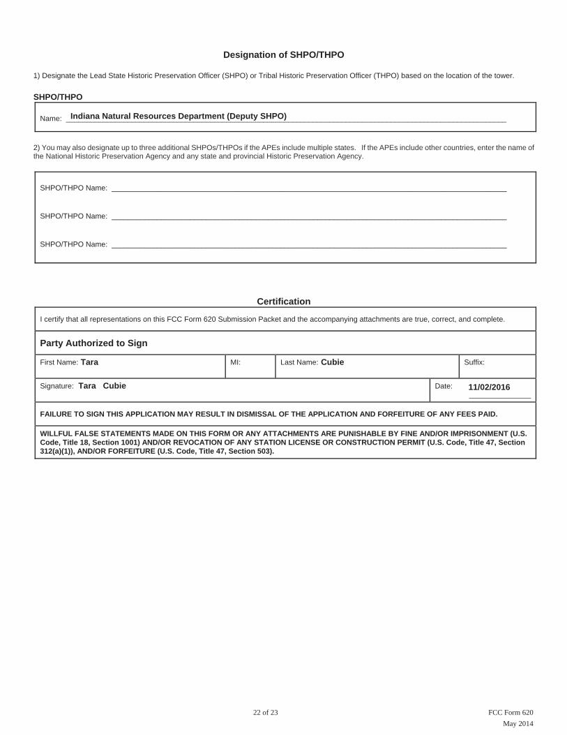
Designation of SHPO/THPO
1) Designate the Lead State Historic Preservation Officer (SHPO) or Tribal Historic Preservation Officer (THPO) based on the location of the tower.
SHPO/THPO
Name: ___________________________________________________________________________________________________________
2) You may also designate up to three additional SHPOs/THPOs if the APEs include multiple states. If the APEs include other countries, enter the name of the National Historic Preservation Agency and any state and provincial Historic Preservation Agency.
SHPO/THPO Name: ________________________________________________________________________________________________
SHPO/THPO Name: ________________________________________________________________________________________________
SHPO/THPO Name: ________________________________________________________________________________________________
Certification
I certify that all representations on this FCC Form 620 Submission Packet and the accompanying attachments are true, correct, and complete.
Party Authorized to Sign
First Name: MI: Last Name: Suffix:
Signature: Date: _______________
FAILURE TO SIGN THIS APPLICATION MAY RESULT IN DISMISSAL OF THE APPLICATION AND FORFEITURE OF ANY FEES PAID.
WILLFUL FALSE STATEMENTS MADE ON THIS FORM OR ANY ATTACHMENTS ARE PUNISHABLE BY FINE AND/OR IMPRISONMENT (U.S. Code, Title 18, Section 1001) AND/OR REVOCATION OF ANY STATION LICENSE OR CONSTRUCTION PERMIT (U.S. Code, Title 47, Section 312(a)(1)), AND/OR FORFEITURE (U.S. Code, Title 47, Section 503).
22 of 23 FCC Form 620
Indiana Natural Resources Department (Deputy SHPO)
Tara Cubie
11/02/2016Tara Cubie
May 2014

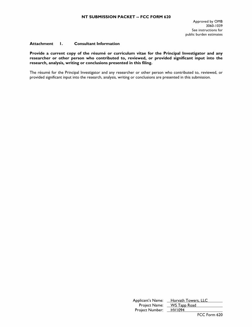
Attachments :
Type Description Date Entered
Photographs Attachment 02 11/01/2016 Map Documents Attachment 03 11/01/2016 Additional Site Information Attachment 04 11/01/2016 Area of Potential Effects Attachment 05 11/01/2016 Tribal/NHO Involvement Attachment 06 11/01/2016 Historic Properties for Direct Effects Attachment 07 11/01/2016 Historic Properties for Visual Effects Attachment 08 11/01/2016 Local Government Involvement Attachment 09 11/01/2016 Public Involvement Attachment 10 11/01/2016 State-Specific Forms Attachment 11 11/01/2016 Resumes/Vitae Attachment 01 11/01/2016
FCC Form 620May 2014
23 of 23
NT SUBMISSION PACKET -- FCC FORM 620 Approved by OMB
3060-1039 See instructions for
public burden estimates
Applicant’s Name: Horvath Towers, LLC Project Name: WS Tapp Road Project Number: HV1094
FCC Form 620
Attachment 1. Consultant Information Provide a current copy of the résumé or curriculum vitae for the Principal Investigator and any researcher or other person who contributed to, reviewed, or provided significant input into the research, analysis, writing or conclusions presented in this filing. The résumé for the Principal Investigator and any researcher or other person who contributed to, reviewed, or provided significant input into the research, analysis, writing or conclusions are presented in this submission.

Tara Cubie Architectural Historian
6876 Susquehanna Trail York, PA 17403
Phone: 339.234.2597
SUMMARY OF EXPERIENCE Tara Cubie has over 10 years of experience in historic preservation as an Architectural Historian and Preservation Specialist. In her career she has prepared numerous technical reports, including Historic Structure Reports and National Register Nominations, for highly visible and diverse projects. She has successfully worked with a number of stakeholders including National Park Cultural Resource and Maintenance Staff, National Park Service Partners, Non-Profit Organizations and the Public for positive project outcomes. Her extensive knowledge of Architectural history coupled with her research and writing skills have facilitated the successful completion of many restoration projects and publications. Recently, Tara served as the Historic Preservation Specialist for the National Capital Region of the NPS under a task agreement with the National Conference of State Historic Preservation Officers (NCSHPO). In this role she was tasked with writing Historic Structure Reports, managing the List of Classified Structure (LCS) architectural survey program, reviewing Section 106 projects under the National Park Service Programmatic Agreement, reviewing projects completed by A/E Contractors and serving as a consultant on restoration projects for compliance to the Secretary of Interior’s Standards for Historic Preservation She trained under the Historic Preservations Training Center’s PAST program, and learned hands on methods for historic preservation in Smoky Mountain National Park. She supervised two full time staff in addition to National Council for Historic Preservation Interns in the completion of the LCS survey. The LCS program exceeded the goal set by the NPS every year under her supervision. Her work has been presented at the Vernacular Architecture Forum Conference. RELEVANT PROJECT EXPERIENCE
Expert command of American history, architectural history, and urban development. Expert command of archival research methods, including the National Archives and Records
Administration (NARA) and the Library of Congress. Expert at writing architectural descriptions and evaluating integrity of historic resources. Training as Architectural Photographer. Skilled at evaluating primary and secondary sources of documentation and physical evidence
obtained through field surveys. Experienced at conducting field surveys. Experienced with NRHP nomination processes and guidelines. Expert in interpreting the Secretary of the Interior’s Standards. Cultural Resource Management consultation. A/E Design project review and management. Section 106 Review, according to National Park Service Programmatic Agreement. Approx.
65/projects a year. Trained in Section 106 and Section 4(F) New Regulations. Historic Structures Stabilization (HSS) National Park Service Project review and approval. Certified as a Contracting Officer’s Technical Representative for the National Park Service. Database and Program management. Experienced with Photoshop, InDesign, and Quark. Spanish, French and Russian language skills.

Tara Cubie Architectural Historian
6876 Susquehanna Trail York, PA 17403
Phone: 339.234.2597
EDUCATION 2005 M.S. Historic Preservation, Columbia University, New York, NY 2005 M.S. Urban Planning, Columbia University, New York, NY 2001 B.A. College of Wooster, Wooster, OH PUBLICATIONS Historic Structures Reports:
The Old Stone House, Rock Creek Park (NPS, 2011) The Poffenberger Barn, Antietam National Battlefield (NPS, 2010)
National Register and Local Nominations
Lewis House National Register Nomination, Lower Merion, PA (Determined Eligible, 2006)
Haverford Station Historic District (State Register, Approved by local Historic Review Board, 2008)
Bala Cynwyd Commercial Historic District (State Register, Approved by PHMC but not local board, 2006)
Surveys: List of Classified Structure (LCS) National Park Service Survey for C&O Canal 2007-2008 List of Classified Structure (LCS) National Park Service Survey for National Capital Parks East
and Prince William Forest Park 2010 List of Classified Structure (LCS) National Park Service Survey for National Mall and Rock
Creek Park 2011 List of Classified Structure (LCS) National Park Service Survey for Antietam National Battlefield
2009 Building survey inventory for Far West Side Historic District, New York, NY Building survey inventory of Upper West Side Historic Churches, New York, NY
Publications:
The Old Stone House Historic Structure Report (NPS Final Draft, to be published 2012) The Poffenberger Barn Historic Structure Report (NPS, 2011) The Mills of Mill Creek, Architectural Tour, Lower Merion, PA (2006) Architecture’s Historical Turn: Phenomenology and the Rise of the Post Modern (Book
Review) (CRM: The Journal of Heritage Stewardship Winter/Summer 2011) Vernacular Architecture Forum Presentation: Free Black Communities at the Terminus
of the Underground Railroad. Paper forthcoming. Newsletter Editor, Lower Merion Conservancy (2005-2006)

46
JAMES C. PRITCHARD, RPA Sr. Archaeologist EDUCATION AND TRAINING 2001 Masters of Applied Science. University of Canberra, Australia, (Cultural Heritage Management/Archaeological Heritage Management). 1991 Bachelor of Arts. Millsaps College (Sociology) PROFESSIONAL MEMBERSHIPS Register of Professional Archaeologists Society for American Archaeology American Foreign Academic Research (Research Associate) American Institute of Archaeology (Education Committee) Tennessee Council of Professional Archaeologists (Awards Committee) Kentucky Organization of Professional Archaeologists (Board) Society of American Military Engineers SELECTED REPORTS 2015 Site Examinations Conducted for Four Sites at the Birch Hill Dam Reservoir Area in the Towns of Templeton and Winchendon, Worcester County, Massachusetts. Phase I Cultural Resources Survey of the Former Chrisman Lands (Tax Map 57, Parcels 28.0 and 28.07) along Rocky Fork Road in Nolensville, Williamson County, Tennessee. Phase I Cultural Resources Survey in Support of a Proposed Drees Premier Homes Development at Beckwith Road in Mt. Juliet, Wilson County, Tennessee. Phase I Cultural Resources Investigations in Support of the Tap Root Hill PUD Subdivision in Williamson County, Tennessee. Phase I Cultural Resources Investigation at King’s Chapel Communities, Williamson County, Tennessee.

47
Phase I Archaeological Investigation of 96 Acres at the Ovation Development Site, Williamson County, Tennessee. Phase I Archaeological Investigation of 109 Acres at the Mill Creek/York Road Site, Williamson County, Tennessee. 2014 Phase I Archaeological Site Detection Survey of 5 Acres for the Proposed UK Trunk A Sewer Project in Lexington, Fayette County, Kentucky. Phase I Archaeological Survey of the Proposed Swamp Road Mitigation Bank #2, Rutherford County, Tennessee. Phase I Archaeological Survey of a Proposed Expansion at the T.J. Patterson Industrial Park, Hardin County, Kentucky. Phase IA Archaeological Investigations of 561 Acres at Camp Atterbury Joint Maneuver Training Center, Union and Harrison Townships, Bartholomew County, Indiana. Phase IA Archaeological Investigation of 410 Acres at the Former Camp Atterbury Cantonment Area, Camp Atterbury Joint Maneuver Training Center, Nineveh and Blue River Townships, Johnson County, Indiana. 2013 Phase Ia Archaeological Reconnaissance of the Proposed Hughes Barge Fleeting Project in Charlestown, Clark County, Indiana. Phase I Archaeological Survey of the Proposed Robinson Developments Project, Wilson County, Tennessee. Phase I Archaeological Survey of Five Trailhead Parking Facilities in Support of the Dawkins Line Rails to Trails Project in Johnson and Magoffin Counties, Kentucky. Phase I Archaeological Survey in Support of Rehabilitation and Extension of Martin Luther King Avenue in Hattiesburg, Forrest County, Mississippi. Phase I Archaeological Survey of 2,467 Acres at Fort Campbell in Montgomery County, Tennessee and Trigg County, Kentucky. 2012 Phase I Archaeological Survey of the Proposed Tennessee Stampings Mitigation, Sumner County, Tennessee. Phase I Cultural Resources Survey of an Interchange on SR 2 (US 72/Corridor V) at Moore’s Mill Road, Madison County, Alabama.

48
Phase I Archaeological Survey of the Proposed Emergency Management Center in Winchester, Clark County, Kentucky. Archaeological Reconnaissance in Support of a Half-Mile Reconstruction of CR-1127 (Straight Fork Road) from KY 59, Lewis County, Kentucky. Phase I Archaeological Survey in Support of the Proposed Cumberland Townhomes at 291 Old Scottsville Road in Bowling Green, Warren County, Kentucky. An Archaeological Assessment of the Proposed Elizabethtown Nature Park, Hardin County, Kentucky. Phase II Archaeological Evaluation of Four Sites at the Sabre Heliport, Ft. Campbell, Montgomery County, Tennessee. Intensive Phase I Archaeological Survey of the Lincoln Heritage House Site (Site 15HD848) at Freeman Lake Park in Elizabethtown, Hardin County, Kentucky. Phase I Archaeological Survey of the Proposed Radcliff Bypass Corridor, Hardin County, Kentucky. Phase I Archaeological Survey in Support of Development and Revitalization of Infantry Facilities in Hunting Areas 16, 21, 29, 77, and 83 at Fort Knox, Hardin and Bullitt Counties, Kentucky. Phase II Testing of Two Sites and Phase I Intensive Investigations at Eight Sites at Fort Knox, Bullitt, Hardin, and Meade Counties, Kentucky. Archaeological Survey of 453 Acres in Support of Endangered Species Work in Hunting Areas 79 and 95 at Fort Knox. Phase I Archaeological Survey of 974 Acres and Phase I Intensive Archaeological Survey of Four Known Sites at Fort Knox, Bullitt, Hardin, and Meade Counties, Kentucky. Phase I Archaeological Survey of 99 Acres in Hunting Areas 14 and 74, Cantonment Area 11, and Phase I Intensive Evaluation of Sites 15HD158, 15HD160, 15HD163, 15HD164, 15HD165, 15HD166 and 15HD500 at Fort Knox, Hardin County, Kentucky. Phase I Archaeological Survey of 193 Acres in Support of the Battle Area (BAX) Project at Baum Range, Fort Knox, Hardin County, Kentucky. A Phase I Archaeological Survey of 146 Acres in Hunting Areas 80 and 81 at Fort Knox,

49
Hardin County, Kentucky. Phase I and Phase I Intensive Archaeological Investigations at the Proposed Live Fire Breach Facility in Hunting Areas 87 and 88 at Fort Knox, Hardin County, Kentucky. 2011 Archaeological Reconnaissance of the Walker Boat Yard Marine Railway in McCracken County, Kentucky. Archaeological Assessment of 1 Acre Adjacent to the Buchanan Cemetery, 2905 Elm Hill Pike in Nashville, Davidson County, Tennessee. Phase I Archaeological Survey of Approximately 11 Acres for a Proposed Multi-Family Residential Development on Tunnel Hill Road in Elizabethtown, Hardin County, Kentucky. Big Four Approach Ramp (INDOT Des. No. 0710993): Site 12CL937 Phase Ic (Deep Testing) in Jeffersonville, Clark County, Indiana. A Phase I Archaeological Survey for the Proposed Parks at Vine Residential Development in Radcliff, Hardin County, Kentucky. Phase I Archaeological Survey of 390 Acres for Endangered Species Habitat Management Actions (Year 3) at Fort Knox, Hardin and Meade Counties, Kentucky. Phase I Archaeological Survey of 1641 Acres in Support of BRAC 2005: Newport Chemical Depot. Vermillion County, Indiana. Section 110 Survey of 38 Acres at the West Tennessee Mitigation Area, Weakley County, Tennessee. Section 110 Survey of 662 Acres at the St. Francis Basin Mitigation Area, Dunklin County, Missouri. Section 110 Survey of 2,038 Acres at the Cache River and Wapanocca Bayou Mitigation Areas, Monroe and Crittendon Counties, Arkansas. Archaeological Inventory for Endangered Species Management Habitat Actions – Year 2 at Fort Knox, Hardin County, Kentucky. Phase I Intensive and Phase II Investigations along the Ohio River Floodplain Terraces in Hunting Areas 1 and 6 at Fort Knox, Meade County, Kentucky.

50
2010 Phase I Archaeological Survey of Four Acres for the Proposed McCracken Joint Entry at the Paducah Sports Plex in McCracken County, Kentucky. Phase I Archaeological Investigations for the Proposed Zion Wireless Communications Tower in Zion, Henderson County, Kentucky. Phase I Archaeological Survey for the Proposed Puncheoncamp Surface Mine in McDowell County, West Virginia. Phase I Archaeological Investigations for the Proposed Carrollton DT Wireless Communications Tower in Carrollton, Carroll County, Kentucky. Phase I Archaeological Investigations for the Proposed Broad Run Interceptor Sewer Line Project in Louisville, Jefferson County, Kentucky. Cultural Resource Investigations of the Proposed Dry Branch Surface Mine in McDowell County, West Virginia. Phase II Archaeological and Historical Evaluation of Three Sites Located within the Footprint of a Proposed Quarry near Grand Rivers, Livingston County, Kentucky. Phase I Archaeological Investigations for the Proposed Fort Boone Sewer Line and Pump Station Improvement Project in Frankfort, Franklin County, Kentucky. Phase I Archaeological Investigations for a Proposed Borrow Area Near the City of Cynthiana, Harrison County, Kentucky. An Archaeological Reconnaissance for the Proposed Rorer Property Site in Harrison County, Kentucky. Archaeological Testing of Site 15McN142 at the Proposed McCracken County Consolidated High School Site in McCracken County, Kentucky. Phase I Archaeological Investigations of 421 Acres in Hunting Areas 11, 72, 73, 77, 89, and 90; and a Proposed Paintball Facility in Hardin and Meade Counties, Kentucky. A Phase I Archaeological Survey of 490 Acres in Hunting Areas 95 and 96 at Fort Knox, Bullitt County, Kentucky. Phase I Archaeological Survey of a Proposed Coal Mine Operation for Southbound Coal, LLC. Near the Community of Burke in Elliott County, Kentucky. Phase I Archaeological Survey for a Proposed Expansion of State Route 52 in Overton

51
County, Tennessee. Phase I Archaeological Survey of 1.44 Acre in Support of the Liberty Crossing Bridges Project in the City of Liberty, Casey County, Kentucky. Phase I Archaeological Survey in Support of WMU Proposed Sanitary Upgrades in Clark County, Kentucky. A Phase I Archaeological Survey for the Proposed Winchester Municipal Utilities Sewage Trunkline Extension at Lower Howards Creek in Winchester, Clark County, Kentucky. Phase I Intensive Archaeological and Historic Evaluation of 55 Sites Located at Fort Knox, Hardin, Meade, and Bullitt Counties, Kentucky. Section 106 and 110 Survey Results: Archaeological Investigations for Proposed Improvements to the Godman Airfield and at Dietz and Van Voorhis Housing at Fort Knox, Hardin County, Kentucky. Phase I Survey of 504 Acres at Camp Carlson, HA71, TA10, Rodger’s Hollow and a Proposed Convention Center at Fort Knox, Hardin, Meade and Bullitt Counties, Kentucky. Phase II Test Excavations of Site 15BU563 and Site 15BU624 at Fort Knox, Bullitt County, Kentucky. 2009 Phase I Archaeological Investigations for the Proposed Chestnut Street Emergency Response Tower in Berea, Madison County, Kentucky. Sections 106 and 110 Survey Results: A Phase I Archaeological Survey of 200 Acres at the West Point Air Strip at Fort Knox, Hardin County, Kentucky. Phase I Archaeological Investigations for a Proposed Emergency Response Tower in Berea, Madison County, Kentucky. Phase I Archaeological Investigations for the Proposed NB Emergency Response Tower in Richmond, Madison County, Kentucky. Phase I Archaeological Investigations of the Proposed Central Hardin 138-69 kV Substation and Taps in Hardin County, Kentucky. Phase I Archaeological Investigations for a Proposed Power Transmission Line Between Goose Rock and Big Creek in Clay County, Kentucky.

52
Phase I Archaeological Survey of 1200 Acres in Support of BRAC 2005: Newport Chemical Depot. Vermillion County, Indiana. Phase I Archaeological Survey of the Proposed Replacement of the James D. Hoskins Bridge Over the French Broad River and The Proposed Rerouting of State Route 92 in Jefferson County, Tennessee. 2008 Phase I Archaeological Survey of a Proposed Coal Mine Operation Near the Community of Fannin in Elliott County, Kentucky. Phase I Archaeological Survey of a Proposed Coal Mine Operation Near the Community of Mazie in Lawrence County, Kentucky. Still-Williams-Jenkins Cemetery Documentation in Williamson County, Tennessee. Phase I Archaeological Investigations of 218 Acres in Hunting Areas 17, 21 and 29 at Fort Knox, Bullitt and Hardin Counties, Kentucky. Myakkahatchee Creek Grant Project: Cultural Resource Overview and Reconnaissance in the City of North Port, Sarasota County, Florida. Phase I Cultural Resources Survey of the 277-Acre Retreat Tract in Liberty County, Georgia. Phase I Cultural Resources Investigations of the Walnut Meadow Branch Stream Mitigation in the City of Berea, Madison County, Kentucky. Cultural Resources Assessment of the Blessing Addendum to the Victoria, Texas Transmission Line in Jackson and Matagorda Counties, Texas. Cultural Resources Assessment of the Victoria, Texas Transmission Line in Goliad, Jackson, and Victoria Counties, Texas. Phase I Archaeological Survey of 471 Acres in Hunting Areas 80 and 112 at Fort Knox in Hardin County, Kentucky. Phase I Archaeological Investigations of 48 Acres in Hunting Area 79 at Fort Knox, Hardin County, Kentucky. Phase II NRHP Evaluation of Site 15MA250 at the Blue Grass Army Depot in Madison County, Kentucky. Cultural Resources Survey of the Macedonia Primary Extension Tract in Baker County,
53
Florida. Integrated Cultural Resources Management Plan for Blue Grass Army Depot in Madison County, Kentucky. Phase I Survey of 622 Acres and Phase I Intensive Archaeological Investigations at 29 Sites for Improvement in Various Training Areas at Fort Knox, Hardin, Meade, and Bullitt Counties, Kentucky. Phase I Intensive Archaeological Investigations at 36 Sites for ITAM Land Rehabilitation at Fort Knox, Hardin and Meade Counties, Kentucky. Phase I Intensive and Phase II Test Excavations in Support of the Range and FOB Improvements at Fort Knox in Bullitt, Meade, and Hardin Counties, Kentucky. Phase I Archaeological Survey of the Green County Mitigation Bank in Green County, Georgia. Phase I Archaeological Survey of the Proposed 880-Acre Southern Company Power Plant in Wayne County, Georgia. Phase I Archaeological Survey of 399 Acres at the Blue Grass Army Depot in Madison County, Kentucky. Principal Investigator. Phase II NRHP Evaluation of Site 15MA264 at the Blue Grass Army Depot in Madison County, Kentucky. Phase I Archaeological Survey and Phase II NRHP Evaluation of the Armuchee Sewer Project in Rome, Floyd County, Georgia. Phase III Data Recovery of the Town Creek Site (9BL129) in Baldwin County, Georgia. Phase III Data Recovery at the Savannah Lots Site (9CH1094) in Chatham County, Georgia. 2007 Phase II Archaeological and Historical Evaluation of Four Sites and Phase I Intensive Investigations at Two Sites, U.S. Army Garrison Fort Knox, Bullitt and Hardin Counties, Kentucky. Final Report of Findings: Phase I Archaeological Investigations of the Proposed 360-Acre Forward Operating Base in Training Area 2, U.S. Army Garrison Fort Knox, Hardin County, Kentucky.
54
Phase I Intensive Archaeological Survey Addendum Report: Phase I Archaeological Investigations of the Proposed 360-Acre Forward Operating Base in Training Area 2, U.S. Army Garrison Fort Knox, Hardin County, Kentucky. Live-Fire Access Road and Firing Points/Observation Points Addendum Report: Phase I Archaeological Investigations of the Proposed 360-Acre Forward Operating Base in Training Area 2, U.S. Army Garrison Fort Knox, Hardin County, Kentucky. Final Report of Findings: Phase I Archaeological Investigations of a Proposed 86-Acre Land Transfer in Training Area 3, U.S. Army Garrison Fort Knox, Hardin County, Kentucky. Phase I Archaeological Investigations of 15 Acres in Training Areas 5 and 8, U.S. Army Garrison Fort Knox, Hardin County, Kentucky. 2006 Phase I Cultural Resources Survey of Approximately 85 Acres in Support of the Proposed Madison Lake and Park, Madison County, Mississippi. Intensive Archaeological Survey of the Proposed Creighton Road Tract Development, Cherokee County, Georgia. Phase I Cultural Resources Survey in Support of 2005 BRAC Activities at the Bluegrass Army Depot. Intensive Archaeological Survey of the Proposed Bannister Creek Mitigation Bank along Bannister and Brewton creeks, Forsyth County, Georgia. Intensive Archaeological Survey of the Proposed Bannister Creek Mitigation Bank along Bannister and Brewton Creeks, Forsyth County, Georgia. Phase I Cultural Resources Survey of an Interchange on SR 2 (US 72/Corridor V) at Moore’s Mill Road, Madison County, Alabama. Phase I Cultural Resources Survey In Support of a Proposed Stream Relocation Within the Clear Lake Meadows Development, Sumner County, Tennessee. Phase I Intensive Cultural Resources Investigations of Approximately 150 Acres near the City of Newnan, Coweta County, Georgia: Newnan Crossing. 2005 Phase I Archaeological Survey of a Proposed Electric Utility Easement within the U.S. Army Garrison Fort Knox, Hardin, Meade, and Bullitt Counties, Kentucky.

55
Final Report of Findings: Phase I Archaeological Survey of 670 Acres in Support of a Proposed Lands Exchange Between Bi-County Solid Waste Management Systems and the U.S. Army Garrison Fort Campbell, Trigg County, Kentucky, and Stewart County, Tennessee. Phase I Archaeological Survey In Support of a Proposed Stream Relocation within the Mt. Juliet Commons Development, Wilson County, Tennessee. Intensive Archaeological Survey in Support of Proposed Residential Communities Initiative Developments (Areas O thru S) at Fort Leavenworth, Leavenworth County, Kansas. Intensive Archaeological Survey of Proposed Improvements at the Porterdale Waste Water Treatment Facility, Newton County, Georgia. 2004 Phase I Cultural Resources Investigations for the Proposed Buckeye Gulf Coast Pipelines, L.P. Toledo, Ohio, Hydrogen and Product Lines Project, Oregon Township, Lucas County, Ohio. Phase I Cultural Resources Investigations in Support of But/War-75-3.76/1.90 (Pid No. 24664). Phase I Archaeological Survey at 15 Riverside Drive, St. Clair Township, Butler County, Ohio. Phase I Cultural Resources Reconnaissance Survey of a Proposed Waterfowl Marsh at Salamonie Lake in Huntington County, Indiana. Cultural Resources Literature Review and Preliminary Photodocumentation for the STA/MAH/COL-62F/14F-39.18/0.00/0.00 (PID 4089) Transportation Planning Study, Stark, Mahoning, and Columbiana Counties, Ohio. Phase II National Register Evaluation of Archaeological Site 15Sh66, for Shelbyville Bypass, Item 5.326.00, Shelby County, Kentucky. 2003 Phase I Archaeological Investigations of the Proposed Whole Neighborhood Renewal at the Anderson Golf Course, U.S. Army Armor Center and Fort Knox, Hardin County, Kentucky. Final Report, Phase I Investigations in Training Area 18 and the Wilcox Range at the US Army Armor Center and Fort Knox in Bullitt County, Kentucky. Final Report, Phase II Investigations of Four Sites (15Bu311, 15Bu544, 15Bu551 and

56
15Bu560) Within the U.S. Army Armor Center and Fort Knox, Bullitt County, Kentucky. Predictive Model, Phase I Archaeological Investigation of the Anderson Golf Course at the U.S. Army Armor Center and Fort Knox, Hardin County, Kentucky. Addendum Report, Cultural Resources Investigations for the ANR Pipeline Coffee Creek Line Change Project. Phase I Archaeological Survey for the Proposed Washington Boulevard Extension (Millikin Woods Section) in the City of Hamilton, Hanover Township, Butler County, Ohio. Final Letter Report, Cultural Resources Background Research and Literature Review and Walkover Survey, Cincinnati/Northern Kentucky Airport South Airfield, Boone County, Kentucky. Final Report, Phase I Cultural Resources Investigations for the ANR Pipeline Coffee Creek Line Change Project. Final Addendum Report No. 4, Phase I Cultural Resources Investigations for an Eight-Acre Wetland Mitigation for the Proposed Texas Eastern Hanging Rock Lateral Pipeline Project, Lawrence and Scioto Counties, Ohio. 2002 Final Report, Phase I Cultural Resources Investigations for the ANR NIPSCO-Chesterton Interconnect, Jackson Township, Porter County, Indiana. Literature Search of High Priority Areas for the MAH-76-0.00 (PID 23676) I-76/80 Corridor Improvements Project, Medina, Summit, Portage, Mahoning, Trumbull Counties, Ohio. Phase I Cultural Resources Survey of the Proposed Tuscarawas Bridge, City of Barberton, Norton and Coventry Townships, Summit County, Ohio. Cultural Resources Literature Review in Support of the Environmental Assessment for the Washington Boulevard Extension (Millikin Woods Section), City of Hamilton, Hanover Township, Butler County, Ohio. Phase I Cultural Resources Investigations For Columbia Gas Transmission Corporation's Proposed Line A-5 Natural Gas Pipeline Replacement, Town of Tuxedo, Orange County, New York Phase I And II Cultural Resources Investigations At A Proposed Commercial Development Near Columbus, Bartholomew County, Indiana.

57
Phase I Cultural Resources Investigations for the Proposed NYSEG Elmira Natural Gas Pipeline, Big Flats and Horseheads, Chemung County, New York. Historic American Engineering Record, Sault Ste. Marie International Railroad Bridge, Sault Ste. Marie, Chippewa County, Michigan. Final Supplemental Phase I Cultural Resources Investigations and Phase II Archaeological Testing at Sites 33SC92, 33SC417, 33SC431, 33SC432, 33SC434, and 33SC457 for the Proposed Texas Eastern Hanging Rock Lateral Pipeline Project, Lawrence and Scioto Counties, Ohio. Predictive Model and Ground-Truthing Survey of the NASA Plum Brook Station, Perkins, Huron, Milan, and Oxford Townships, Erie County, Ohio. Addendum Report No. 3 Phase I Archaeological Investigations of Tract 6 for the Proposed South Point Industrial Park, Lawrence County, Ohio. Phase I Archaeological Survey for the Proposed Owensboro South Site Wireless Communication Tower, Utica, Daviess County, Kentucky. Addendum Report No. 1: Supplemental Data for the Completion of the Phase I Cultural Resources Investigations Report for the Proposed Texas Eastern Hanging Rock Lateral Pipeline Project, Lawrence and Scioto Counties, Ohio. Cultural Resources Investigations along Selected Alignments (Alignments A-I, A-II, and B-Ib) of the Proposed Ohio River Greenway Corridor, Floyd and Clark Counties, Indiana. Phase I Archaeological Investigations of Proposed Road Upgrades to US Route 131, a 15-Acre Roadside Park and Additional Road Upgrades in Grand Traverse and Wexford Counties, Michigan. 2001 Phase IA Archaeological Investigation of the Proposed I-71 Corridor Light Rail Transit, Hamilton County, Ohio. Phase I Cultural Resources Investigations of the East Sandusky Bay Hydrology Restoration Project In Erie County, Ohio. Port Arthur Public Archaeology Program (Australia) Report 2001. Port Arthur Public Archaeology Program (Australia): Evaluation of Archaeology Tours Report 2001.

58
Conservation Report: Museum of the Riverina, Wagga Wagga, New South Wales, Australia. 2000 The Heritage of the Ainslie Church of Christ (Australia). 1997 Preliminary Report of 1997 Field Season: Excavations of Structure 8, a Post Classic Mayan single-phase construction. 1996 Phase I Cultural Resources Investigations of Columbia Gas Transmission Corporation Proposed Market Expansion Project: Line 10240 Eagle Suction Loop, East Hempfield, Penn, Warwick, Manheim, West Earl, Earl, East Earl Townships, Lancaster County, Pennsylvania. Phase I Cultural Resources Investigations of Columbia Gas Transmission Corporation Market Expansion Coco "C" Storage Facility Project, Kanawha County, West Virginia. PAPERS AND POSTERS 2012 Geoarchaeological and Palynological Evidence of Late Mississippian Landscape Alternation along the Wapanocca Bayou, Arkansas, USA. Poster presented at the 2012 SAA Conference, April 18-22, Memphis, TN. 2011 Fort Knox Cultural Resources Management: Supporting Endangered Species Management and Ensuring Mission Readiness. Poster presented at the Sustaining Military Readiness Conference, July 25-28, Nashville, TN. 2011 Prehistory and Geoarchaeological Investigations along the Central Mississippi Valley: Recent Advances. 2011 A Change of View? Archaeological Investigations at the Lincoln Heritage House. Paper presented at the 2011 SHA Conference, January 9-11, Austin, TX. 2004 Of Privies and Hog Pits: Archaeobotany of Site 15Sh66. Paper Presented at the joint SEAC/MAC meetings, October 21-24, St. Louis, Missouri. 2003 Balancing registers thematically and the resultant conflicts between levels of significance: Some insights derived from a gaps analysis of the heritage of the Tasman Peninsula, Tasmania. Paper presented at the Fifth World Archaeology Congress, June 21-26, 2003, Catholic University, Washington, DC. 2002 Public Archaeology at the Port Arthur Historic Site, Tasmania, Australia. Paper presented at the Society for Historical Archaeology 2002 Conference: Celebrating the 300th Anniversary of Mobile’s Colonial Origins, January 10, 2002

59
PROFESSIONAL EXPERIENCE June 2015-Present-Sr. Archaeologist, Environmental Research Group, Baltimore, Maryland. June 2007-Present-Research Associate, American Foreign Academic Research, Davidson, North Carolina. February 2007-June 2015-Vice President, Brockington and Associates, Inc., Elizabethtown, Kentucky. February 2005-February 2007-Senior Archaeologist/Principal Investigator, Brockington and Associates, Inc., Various Locations January 2002- February 2005- Principal Investigator, Gray & Pape, Inc., Cincinnati, Ohio May 1995-January 2002- Archaeologist/Field Director, Gray & Pape, Inc., Cincinnati, Ohio May 1993-May 1995-Archaeologist, Earth Search, Inc., New Orleans, Louisiana May 1992-May1993-Archaeologist, Archaeology Mississippi, Inc., Jackson, Mississippi SELECTED PROJECTS AND PROJECT INVOLVEMENT 2015 Principal Investigator. Site Examinations Conducted for Four Sites at the Birch Hill Dam Reservoir Area in the Towns of Templeton and Winchendon, Worcester County, Massachusetts. Research Associate/Instructor. Belize Valley Archaeological Reconnaissance Archaeological Field School at the Site of Cahal Pech, Cayo District, Belize. Principal Investigator. Phase I Cultural Resources Survey of the Former Chrisman Lands (Tax Map 57, Parcels 28.0 and 28.07) along Rocky Fork Road in Nolensville, Williamson County, Tennessee. Principal Investigator. Phase I Cultural Resources Survey in Support of a Proposed Drees Premier Homes Development at Beckwith Road in Mt. Juliet, Wilson County, Tennessee. Principal Investigator. Phase I Cultural Resources Investigations in Support of the Tap Root Hill PUD Subdivision in Williamson County, Tennessee. Principal Investigator. Phase I Cultural Resources Investigation at King’s Chapel Communities, Williamson County, Tennessee. Principal Investigator. Phase I Archaeological Investigation of 96 Acres at the Ovation Development Site, Williamson County, Tennessee.
60
Principal Investigator. Phase I Archaeological Investigation of 109 Acres at the Mill Creek/York Road Site, Williamson County, Tennessee. 2014 Research Associate/Instructor. Belize Valley Archaeological Reconnaissance Archaeological Field School at the Site of Cahal Pech, Cayo District, Belize. Principal Investigator. Phase I Archaeological Site Detection Survey of 5 Acres for the Proposed UK Trunk A Sewer Project in Lexington, Fayette County, Kentucky. Principal Investigator. Phase I Archaeological Survey of the Proposed Swamp Road Mitigation Bank #2, Rutherford County, Tennessee. Principal Investigator. Phase I Archaeological Survey of a Proposed Expansion at the T.J. Patterson Industrial Park, Hardin County, Kentucky. Principal Investigator. Phase IA Archaeological Investigations of 561 Acres at Camp Atterbury Joint Maneuver Training Center, Union and Harrison Townships, Bartholomew County, Indiana. Principal Investigator. Phase IA Archaeological Investigation of 410 Acres at the Former Camp Atterbury Cantonment Area, Camp Atterbury Joint Maneuver Training Center, Nineveh and Blue River Townships, Johnson County, Indiana. 2013 Research Associate/Instructor. Belize Valley Archaeological Reconnaissance Archaeological Field School at the Site of Cahal Pech, Cayo District, Belize. Principal Investigator. Phase Ia Archaeological Reconnaissance of the Proposed Hughes Barge Fleeting Project in Charlestown, Clark County, Indiana. Principal Investigator. Phase I Archaeological Survey of the Proposed Robinson Developments Project, Wilson County, Tennessee. Principal Investigator. Phase I Archaeological Survey of Five Trailhead Parking Facilities in Support of the Dawkins Line Rails to Trails Project in Johnson and Magoffin Counties, Kentucky. Principal Investigator. Phase I Archaeological Survey in Support of Rehabilitation and Extension of Martin Luther King Avenue in Hattiesburg, Forrest County, Mississippi. Principal Investigator. Phase I Archaeological Survey of 2,467 Acres at Fort Campbell in Montgomery County, Tennessee and Trigg County, Kentucky. 2012 Research Associate/Instructor. Belize Valley Archaeological Reconnaissance

61
Archaeological Field School at the Site of Cahal Pech, Cayo District, Belize. Principal Investigator. Phase I Archaeological Survey of the Proposed Tennessee Stampings Mitigation, Sumner County, Tennessee. Principal Investigator. Phase I Cultural Resources Survey of an Interchange on SR 2 (US 72/Corridor V) at Moore’s Mill Road, Madison County, Alabama. Principal Investigator. Phase I Archaeological Survey of the Proposed Emergency Management Center in Winchester, Clark County, Kentucky. Principal Investigator. Archaeological Reconnaissance in Support of a Half-Mile Reconstruction of CR-1127 (Straight Fork Road) from KY 59, Lewis County, Kentucky. Principal Investigator. Phase I Archaeological Survey in Support of the Proposed Cumberland Townhomes at 291 Old Scottsville Road in Bowling Green, Warren County, Kentucky. Principal Investigator. An Archaeological Assessment of the Proposed Elizabethtown Nature Park, Hardin County, Kentucky. Principal Investigator. Phase II Archaeological Evaluation of Four Sites at the Sabre Heliport, Ft. Campbell, Montgomery County, Tennessee. Principal Investigator. Intensive Phase I Archaeological Survey of the Lincoln Heritage House Site (Site 15HD848) at Freeman Lake Park in Elizabethtown, Hardin County, Kentucky. Principal Investigator. Phase I Archaeological Survey of the Proposed Radcliff Bypass Corridor, Hardin County, Kentucky. Principal Investigator. Phase I Archaeological Survey in Support of Development and Revitalization of Infantry Facilities in Hunting Areas 16, 21, 29, 77, and 83 at Fort Knox, Hardin and Bullitt Counties, Kentucky. Principal Investigator. Phase II Testing of Two Sites and Phase I Intensive Investigations at Eight Sites at Fort Knox, Bullitt, Hardin, and Meade Counties, Kentucky. Principal Investigator. Archaeological Survey of 453 Acres in Support of Endangered Species Work in Hunting Areas 79 and 95 at Fort Knox. Principal Investigator. Phase I Archaeological Survey of 974 Acres and Phase I Intensive Archaeological Survey of Four Known Sites at Fort Knox, Bullitt, Hardin, and Meade

62
Counties, Kentucky. Principal Investigator. Phase I Archaeological Survey of 99 Acres in Hunting Areas 14 and 74, Cantonment Area 11, and Phase I Intensive Evaluation of Sites 15HD158, 15HD160, 15HD163, 15HD164, 15HD165, 15HD166 and 15HD500 at Fort Knox, Hardin County, Kentucky. Principal Investigator. Phase I Archaeological Survey of 193 Acres in Support of the Battle Area (BAX) Project at Baum Range, Fort Knox, Hardin County, Kentucky. Principal Investigator. A Phase I Archaeological Survey of 146 Acres in Hunting Areas 80 and 81 at Fort Knox, Hardin County, Kentucky. Principal Investigator. Phase I and Phase I Intensive Archaeological Investigations at the Proposed Live Fire Breach Facility in Hunting Areas 87 and 88 at Fort Knox, Hardin County, Kentucky. 2011 Research Associate/Instructor. Belize Valley Archaeological Reconnaissance Archaeological Field School at the Site of Cahal Pech, Cayo District, Belize. Principal Investigator. Archaeological Reconnaissance of the Walker Boat Yard Marine Railway in McCracken County, Kentucky. Principal Investigator. Archaeological Assessment of 1 Acre Adjacent to the Buchanan Cemetery, 2905 Elm Hill Pike in Nashville, Davidson County, Tennessee. Principal Investigator. Phase I Archaeological Survey of Approximately 11 Acres for a Proposed Multi-Family Residential Development on Tunnel Hill Road in Elizabethtown, Hardin County, Kentucky. Principal Investigator. Big Four Approach Ramp (INDOT Des. No. 0710993): Site 12CL937 Phase Ic (Deep Testing) in Jeffersonville, Clark County, Indiana. Principal Investigator. A Phase I Archaeological Survey for the Proposed Parks at Vine Residential Development in Radcliff, Hardin County, Kentucky. Principal Investigator. Phase I Archaeological Survey of 390 Acres for Endangered Species Habitat Management Actions (Year 3) at Fort Knox, Hardin and Meade Counties, Kentucky. Principal Investigator. Phase I Archaeological Survey of 1641 Acres in Support of BRAC 2005: Newport Chemical Depot. Vermillion County, Indiana.

63
Project Manager. Section 110 Survey of 38 Acres at the West Tennessee Mitigation Area, Weakley County, Tennessee. Project Manager. Section 110 Survey of 662 Acres at the St. Francis Basin Mitigation Area, Dunklin County, Missouri. Project Manager. Section 110 Survey of 2,038 Acres at the Cache River and Wapanocca Bayou Mitigation Areas, Monroe and Crittendon Counties, Arkansas. Principal Investigator. Archaeological Inventory for Endangered Species Management Habitat Actions – Year 2 at Fort Knox, Hardin County, Kentucky. Principal Investigator. Phase I Intensive and Phase II Investigations along the Ohio River Floodplain Terraces in Hunting Areas 1 and 6 at Fort Knox, Meade County, Kentucky. 2010 Research Associate/Instructor. Belize Valley Archaeological Reconnaissance Archaeological Field School at the Site of Cahal Pech, Cayo District, Belize. Principal Investigator. Phase I Archaeological Survey of Four Acres for the Proposed McCracken Joint Entry at the Paducah Sports Plex in McCracken County, Kentucky. Principal Investigator. Phase I Archaeological Investigations for the Proposed Zion Wireless Communications Tower in Zion, Henderson County, Kentucky. Principal Investigator. Phase I Archaeological Survey for the Proposed Puncheoncamp Surface Mine in McDowell County, West Virginia. Principal Investigator. Phase I Archaeological Investigations for the Proposed Carrollton DT Wireless Communications Tower in Carrollton, Carroll County, Kentucky. Principal Investigator. Phase I Archaeological Investigations for the Proposed Broad Run Interceptor Sewer Line Project in Louisville, Jefferson County, Kentucky. Principal Investigator. Cultural Resource Investigations of the Proposed Dry Branch Surface Mine in McDowell County, West Virginia. Principal Investigator. Phase II Archaeological and Historical Evaluation of Three Sites Located within the Footprint of a Proposed Quarry near Grand Rivers, Livingston County, Kentucky. Principal Investigator. Phase I Archaeological Investigations for the Proposed Fort Boone Sewer Line and Pump Station Improvement Project in Frankfort, Franklin County, Kentucky.

64
Principal Investigator. Phase I Archaeological Investigations for a Proposed Borrow Area Near the City of Cynthiana, Harrison County, Kentucky. Principal Investigator. An Archaeological Reconnaissance for the Proposed Rorer Property Site in Harrison County, Kentucky. Principal Investigator. Archaeological Testing of Site 15McN142 at the Proposed McCracken County Consolidated High School Site in McCracken County, Kentucky. Principal Investigator. Phase I Archaeological Investigations of 421 Acres in Hunting Areas 11, 72, 73, 77, 89, and 90; and a Proposed Paintball Facility in Hardin and Meade Counties, Kentucky. Principal Investigator. A Phase I Archaeological Survey of 490 Acres in Hunting Areas 95 and 96 at Fort Knox, Bullitt County, Kentucky. Principal Investigator. Phase I Archaeological Survey of a Proposed Coal Mine Operation for Southbound Coal, LLC. Near the Community of Burke in Elliott County, Kentucky. Principal Investigator. Phase I Archaeological Survey for a Proposed Expansion of State Route 52 in Overton County, Tennessee. Principal Investigator. Phase I Archaeological Survey of 1.44 Acre in Support of the Liberty Crossing Bridges Project in the City of Liberty, Casey County, Kentucky. Principal Investigator. Phase I Archaeological Survey in Support of WMU Propsosed Sanitary Upgrades in Clark County, Kentucky. Principal Investigator. A Phase I Archaeological Survey for the Proposed Winchester Municipal Utilities Sewage Trunkline Extension at Lower Howards Creek in Winchester, Clark County, Kentucky. Principal Investigator. Phase I Intensive Archaeological and Historic Evaluation of 55 Sites Located at Fort Knox, Hardin, Meade, and Bullitt Counties, Kentucky. Principal Investigator. Section 106 and 110 Survey Results: Archaeological Investigations for Proposed Improvements to the Godman Airfield and at Dietz and Van Voorhis Housing at Fort Knox, Hardin County, Kentucky. Principal Investigator. Phase I Survey of 504 Acres at Camp Carlso, HA71, TA10, Rodger’s Hollow and a Proposed Convention Center at Fort Knox, Hardin, Meade and

65
Bullitt Counties, Kentucky. Principal Investigator. Phase II Test Excavations of Site 15BU563 and Site 15BU624 at Fort Knox, Bullitt County, Kentucky. 2009 Research Associate/Instructor. Belize Valley Archaeological Reconnaissance Archaeological Field School at the Site of Cahal Pech, Cayo District, Belize. Principal Investigator. Phase I Archaeological Investigations for the Proposed Chestnut Street Emergency Response Tower in Berea, Madison County, Kentucky. Principal Investigator. Sections 106 and 110 Survey Results: A Phase I Archaeological Survey of 200 Acres at the West Point Air Strip at Fort Knox, Hardin County, Kentucky. Principal Investigator. Phase I Archaeological Investigations for a Proposed Emergency Response Tower in Berea, Madison County, Kentucky. Principal Investigator. Phase I Archaeological Investigations for the Proposed NB Emergency Response Tower in Richmond, Madison County, Kentucky. Principal Investigator. Phase I Archaeological Investigations of the Proposed Central Hardin 138-69 kV Substation and Taps in Hardin County, Kentucky. Principal Investigator. Phase I Archaeological Investigations for a Proposed Power Transmission Line Between Goose Rock and Big Creek in Clay County, Kentucky. Principal Investigator. Phase I Archaeological Survey of 1200 Acres in Support of BRAC 2005: Newport Chemical Depot. Vermillion County, Indiana. Principal Investigator. Phase I Archaeological Survey of the Proposed Replacement of the James D. Hoskins Bridge Over the French Broad River and The Proposed Rerouting of State Route 92 in Jefferson County, Tennessee. 2008 Research Associate/Instructor. Belize Valley Archaeological Reconnaissance Archaeological Field School at the Site of Cahal Pech, Cayo District, Belize. Principal Investigator. Phase I Archaeological Survey of a Proposed Coal Mine Operation Near the Community of Fannin in Elliott County, Kentucky. Principal Investigator. Phase I Archaeological Survey of a Proposed Coal Mine Operation Near the Community of Mazie in Lawrence County, Kentucky. Principal Investigator. Still-Williams-Jenkins Cemetery Documentation in Williamson

66
County, Tennessee. Principal Investigator. Phase I Archaeological Investigations of 218 Acres in Hunting Areas 17, 21 and 29 at Fort Knox, Bullitt and Hardin Counties, Kentucky. Principal Investigator. Myakkahatchee Creek Grant Project: Cultural Resource Overview and Reconnaissance in the City of North Port, Sarasota County, Florida. Principal Investigator. Phase I Cultural Resources Survey of the 277-Acre Retreat Tract in Liberty County, Georgia. Principal Investigator. Phase I Cultural Resources Investigations of the Walnut Meadow Branch Stream Mitigation in the City of Berea, Madison County, Kentucky. Principal Investigator. Cultural Resources Assessment of the Blessing Addendum to the Victoria, Texas Transmission Line in Jackson and Matagorda Counties, Texas. Principal Investigator. Cultural Resources Assessment of the Victoria, Texas Transmission Line in Goliad, Jackson, and Victoria Counties, Texas. Principal Investigator. Phase I Archaeological Survey of 471 Acres in Hunting Areas 80 and 112 at Fort Knox in Hardin County, Kentucky. Principal Investigator. Phase I Archaeological Investigations of 48 Acres in Hunting Area 79 at Fort Knox, Hardin County, Kentucky. Principal Investigator. Phase II NRHP Evaluation of Site 15MA250 at the Blue Grass Army Depot in Madison County, Kentucky. Principal Investigator. Cultural Resources Survey of the Macedonia Primary Extension Tract in Baker County, Florida. Principal Investigator. Integrated Cultural Resources Management Plan for Blue Grass Army Depot in Madison County, Kentucky. Principal Investigator. Phase I Survey of 622 Acres and Phase I Intensive Archaeological Investigations at 29 Sites for Improvement in Various Training Areas at Fort Knox, Hardin, Meade, and Bullitt Counties, Kentucky. Principal Investigator. Phase I Intensive Archaeological Investigations at 36 Sites for ITAM Land Rehabilitation at Fort Knox, Hardin and Meade Counties, Kentucky. Principal Investigator. Phase I Intensive and Phase II Test Excavations in Support of the

67
Range and FOB Improvements at Fort Knox in Bullitt, Meade, and Hardin Counties, Kentucky. Principal Investigator. Phase I Archaeological Survey of the Green County Mitigation Bank in Green County, Georgia. Principal Investigator. Phase I Archaeological Survey of the Proposed 880-Acre Southern Company Power Plant in Wayne County, Georgia. Principal Investigator. Phase I Archaeological Survey of 399 Acres at the Blue Grass Army Depot in Madison County, Kentucky. Principal Investigator. Phase II NRHP Evaluation of Site 15MA264 at the Blue Grass Army Depot in Madison County, Kentucky. Principal Investigator. Phase I Archaeological Survey and Phase II NRHP Evaluation of the Armuchee Sewer Project in Rome, Floyd County, Georgia. Principal Investigator. Phase III Data Recovery of the Town Creek Site (9BL129) in Baldwin County, Georgia. Project Archaeologist. Phase III Data Recovery at the Savannah Lots Site (9CH1094) in Chatham County, Georgia. 2007 Research Associate/Instructor. Belize Valley Archaeological Reconnaissance Archaeological Field School at the Site of Cahal Pech, Cayo District, Belize. Principal Investigator. Phase I Archaeological Survey of 764 Acres in Hunting Areas 80 and 112 at the U.S. Army Garrison Fort Knox in Meade and Hardin Counties, Kentucky. Principal Investigator. Phase II Archaeological Evaluation of Site 15MA250 at the Blue Grass Army Depot, Madison County, Kentucky. Principal Investigator. Phase II Archaeological and Historical Evaluation of Six Sites and Phase I Intensive re-visit/site update at Three Sites Located at the U.S. Army Garrison Fort Knox, Bullitt, Hardin, and Meade Counties, Kentucky. Principal Investigator. ITAM: Phase I Intensive Archaeological Investigations of 36 sites located at the U.S. Army Garrison Fort Knox in Meade and Hardin Counties, Kentucky. Principal Investigator. Phase I Intensive Archaeological Investigations of 30 sites and Phase I Archaeological Survey of Approximately 1000 Acres located at the U.S. Army

68
Garrison Fort Knox in Meade and Hardin Counties, Kentucky. Principal Investigator. Phase II Archaeological Evaluation of Site 15MA264 at the Blue Grass Army Depot, Madison County, Kentucky. Contract No. W22G1F-06-V-0218. Principal Investigator. Phase I Archaeological Survey of 399 Acres at the Blue Grass Army Depot, Madison County, Kentucky. Contract No. W22G1F-06-V-0218. Principal Investigator. A Phase I Archaeological Resources Survey of 880 Acres for the Southern Company Wayne County Power Plant Tract, Wayne County, Georgia. Principal Investigator. Intensive Archaeological Survey of 75 Acres in Support of a Proposed Mitigation Bank along Town Creek in Greene County, Georgia. Surveyor. Belize Valley Archaeological Reconnaissance, Institute of Archaeology, Belize under the direction of Dr. Jaime Awe. GIS land survey and mapping of Maya components at Cahal Pech and Baking Pot Sites, Cayo District, Belize. July to August 2007. Principal Investigator. Intensive Archaeological Survey of 2.5 Acres in Support of a Proposed School Bus Maintenance Facility Construction at Fort Leavenworth, Leavenworth County, Kansas. June to September 2007. Principal Investigator. Phase II Archaeological and Historical Evaluation of Four Sites and Phase I Intensive Investigations at Two Sites, U.S. Army Garrison Fort Knox, Bullitt and Hardin Counties, Kentucky. December 2005 to June 2007. Principal Investigator. Phase I Archaeological Investigations of 15 Acres in Training Areas 5 and 8, U.S. Army Garrison Fort Knox, Hardin County, Kentucky. February to May 2007. 2006 Principal Investigator. Phase I Archaeological Investigations of the Proposed 360-Acre Forward Operating Base in Training Area 2, U.S. Army Garrison Fort Knox, Hardin County, Kentucky. October 2006 to June 2007. Principal Investigator. Phase I Intensive Archaeological Survey of Three Sites for the Proposed 360-Acre Forward Operating Base in Training Area 2, U.S. Army Garrison Fort Knox, Hardin County, Kentucky. October 2006 to June 2007. Principal Investigator. Live-Fire Access Road and Firing Points/Observation Points Survey for the Proposed 360-Acre Forward Operating Base in Training Area 2, U.S. Army Garrison Fort Knox, Hardin County, Kentucky. October 2006 to June 2007. Principal Investigator. Phase I Archaeological Investigations of a Proposed 86-Acre Land

69
Transfer in Training Area 3, U.S. Army Garrison Fort Knox, Hardin County, Kentucky. October 2006 to January 2007. Principal Investigator, Phase I Cultural Resources Survey of Approximately 85 Acres in Support of the Proposed Madison Lake and Park, Madison County, Mississippi. January 2006. 2005 Principal Investigator, Phase I Cultural Resources Survey in Support of 2005 BRAC Activities at the Bluegrass Army Depot. April 2006. Project included metal detection survey of portions of the delineated Battle of Richmond. Principal Investigator, Intensive Archaeological Survey of the Proposed Bannister Creek Mitigation Bank along Bannister and Brewton creeks, Forsyth County, Georgia. April 2006. Principal Investigator, Phase I Archaeological Survey of a Proposed Electric Utility Easement within the U.S. Army Garrison Fort Knox, Hardin, Meade, and Bullitt Counties, Kentucky. May through August 2005. Principal Investigator, Intensive Archaeological Survey in Support of Proposed Residential Communities Initiative Developments (Areas O thru S) at Fort Leavenworth, Leavenworth County, Kansas. April to August 2005. Principal Investigator, Phase I Archaeological Survey of Two Proposed Rail Lines, Gypsum Dewatering Facility, and Limestone Ball Mill at Georgia Power's Plant Bowen, Bartow County, Georgia. March and April 2005. Principal Investigator, Phase I Archaeological Survey of 8 Acres at the Harmony Club, Putnam County, Georgia. March 2005. Principal Investigator, New Hope Road/Mooneyham Cemetery Delineation, Gwinnet County, Georgia. February 2005. Archaeological Delineation of nineteenth century rural cemetery. 2004 Principal Investigator, Phase I Archaeological Survey in Support of the HAM-Reading Road Railroad Grade Separation (HAM-CR456-0.15, PID 23062), City of Sharonville, Hamilton County, Ohio. October and November 2004. Principal Investigator, Phase I Archaeological Survey of 38 Acres within Training Area 7 at U.S. Army Garrison Fort Knox, Hardin County, Kentucky. September to December 2004. Project included identification and recordation of numerous historic military sites. Principal Investigator, Phase I cultural resources investigations for the proposed Buckeye

70
Gulf Coast Pipelines, L.P. Toledo, Ohio, Hydrogen and Product Lines Project located in Oregon Township, Lucas County, Ohio. August to November, 2004. Crew Chief, Class III Archaeological Inventory in Support of the Entrega Pipeline Project, Sweetwater, Carbon, Laramie, and Albany Counties, Wyoming. May through September, 2004. Principal Investigator, Phase I Archaeological Survey of Training Areas 2-17, U.S. Army Armor Center and Fort Knox, Fort Knox, Hardin County, Kentucky. March through December, 2004. Principal Investigator, BUT-WAR/I-75/3.76-1.90 (PID No. 24664), Butler and Warren Counties, Ohio. March through May 2004. Principal Investigator, Phase I Cultural Resources Reconnaissance Survey of a Proposed Waterfowl Marsh at Salamonie Lake in Huntington County, Indiana. March and April 2004. Principal Investigator, Phase I Archaeological Investigations for the Proposed Improvements to Home Road (DEL-CR 124-4.38; PID 75917) in Liberty Township, Delaware County, Ohio. January through March 2004. Principal Investigator, Supplemental Phase I Cultural Resources Investigations, WAR-132 Bridge Replacement and Road Improvements, Warren County, Ohio. December 2003 and January 2004. 2003 Archaeologist, Gray & Pape, Inc., Plase II National Register Evaluation of Archaeological Site 15Sh666, for Shelbyville Bypass, Item 5.326.00, Shelby County, Kentucky. October 2003 through January 2004. Project included detailed assessment of a 1790s thru 1970s farm. Principal Investigator, Gray & Pape, Inc., Phase I Archaeological Investigations of the Proposed Whole Neighborhood Renewal at the Anderson Golf Course, U.S. Army Armor Center and Fort Knox, Hardin County, Kentucky. September and October 2003. Project included documentation of the archaeological remains of the historic communities of Bloomington and New Stithton, Kentucky. Principal Investigator, Gray & Pape, Inc., Archaeological Survey for the Woodsdale Regional Park, Madison Township, Butler County, Ohio. June through August 2003. Archaeologist, Gray & Pape, Inc. Phase I Cultural Resources Survey Within Training Area 18 and the Wilcox Range at Fort Knox, Bullitt County, Kentucky. April 2003.

71
Archaeologist, Gray & Pape, Inc. Phase I Cultural Resources Survey for Proposed Expansions A and B at the Godman Airfield, Fort Knox, Hardin County, Kentucky. March 2003. Principal Investigator, Gray & Pape, Inc. Phase I Cultural Resources Survey for A Proposed 1575-Foot Pipeline Replacement, 3.5-Acre Storage Yard, and 0.4-Acre Temporary Parking Area in Liberty Township, Porter County, Indiana. February 2003. Principal Investigator, Gray & Pape, Inc. Phase I Archaeological Survey for the Proposed Washington Boulevard Extension (Millikin Woods Section) in the City of Hamilton, Hanover Township, Butler County, Ohio. February 2003. Principal Investigator, Gray & Pape, Inc. Walkover Survey, Cincinnati/Northern Kentucky Airport South Airfield, Boone County, Kentucky. January 2003. Archaeologist, Gray & Pape, Inc. Phase I Cultural Resources Investigations of the ANR Pipeline Coffee Creek Line Change Project, Porter County, Indiana. January 2003. 2002 Archaeologist, Gray & Pape, Inc. Cultural Resources Investigations of Lake White Dam, Pike County, Ohio. December 2002. Archaeologist, Gray & Pape, Inc. Phase III Data Recovery of Site 33HA733, Hamilton County, Ohio. November 2002 through January 2003. Archaeologist, Gray & Pape, Inc. Phase I Cultural Resources Investigations for the ANR NIPSCO-Chesterton Interconnect, Jackson Township, Porter County, Indiana. October and November 2002. Archaeologist, Gray & Pape, Inc. Phase I Cultural Resources Investigations for an Eight-Acre Wetland Mitigation for the Proposed Texas Eastern Hanging Rock Lateral Pipeline Project, Lawrence and Scioto Counties, Ohio. October 2002. Archaeologist, Gray & Pape, Inc. Phase Ia investigations for the environmental assessment of the Washington Boulevard Extension (Millikin Woods Section), Butler County, Ohio. September 2002. Archaeologist, Gray & Pape, Inc. Phase II testing of Sites 15BU544, 15BU551 and 15BU560 at the Fort Knox Military Reservation, Bullitt County, Kentucky. August 2002. Project included documentation and excavation of two historic charcoal kilns in Bullitt County, Kentucky. Archaeologist, Gray & Pape, Inc. Phase I Archaeological Investigations of 582 Acres (Training Areas 5, 6, 7, 8 and 9) at the Fort Knox Military Reservation, Hardin and Meade

72
Counties, Kentucky. July 2002. Archaeologist, Gray & Pape, Inc. Phase I Archaeological Investigations of Tract 6 for the Proposed South Point Industrial Park, Lawrence County, Ohio. March 2002. Archaeologist, Gray & Pape, Inc. Additional Phase I Cultural Resources Investigations for the Proposed Texas Eastern Hanging Rock Lateral Pipeline Project, Lawrence and Scioto Counties, Ohio. February 2002. Archaeologist, Gray & Pape, Inc. Phase II testing of Site 12B1325, Bartholomew County, Indiana. February 2002. 2001 Archaeologist, Gray & Pape, Inc. Phase I Cultural Resources Investigations for the Proposed Texas Eastern Hanging Rock Lateral Pipeline Project, Lawrence and Scioto Counties, Ohio. October and November 2001. Archaeologist, Gray & Pape, Inc. Phase I Archaeological Investigations of Proposed Upgrades to US Route 131, a 15-Acre Roadside Park and Additional Road Upgrades in Grand Traverse and Wexford Counties, Michigan (MDOT Job# 52691). September and October 2001. Cultural Heritage Consultant, Port Arthur Historic Site Management Authority, Tasmania, Australia. Development of Initial Phase of a Public Archaeology Program for the Port Arthur Historic Site. January and February 2001. Project included excavation and interpretation of convict period (1830-1877) remains. Field Director, Tetra Tech, Inc. Phase II NRHP testing of Sites 18CH160 and 18CH161. Blossom Point Proving Grounds Research Facility, Charles County, Maryland. January 2001. 2000 Field Director, Hardlines Design Company. Data Recovery of Site 36AL480. Allegany County, Pennsylvania. November and December 2000. Project included excavation and recordation of the Harmony Brick Factory. Field Director, Tetra Tech, Inc. Phase II NRHP testing of Sites 18CH155 and 18CH156. Blossom Point Proving Grounds Research Facility, Charles County, Maryland. June 2000. Senior Field Technician, Gray & Pape, Inc. Data Recovery of Site 33FR1189. Franklin County, Ohio. January 2000. 1999 Senior Field Technician, Midwestern Environmental Consultants, Inc. Data Recovery of Sites 33WY674 and 33WY783. Wyandot County, Ohio. November and December 1999.

73
Senior Field Technician, Midwestern Environmental Consultants, Inc. Phase I Cultural Resources Survey of 16 acres at Ravenna Munitions Depot, Ohio. October 1999. Senior Field Technician, Midwestern Environmental Consultants, Inc. Phase I Cultural Resources Survey of proposed "Fort to Port" Highway 24 widening. Defiance County, Ohio. October 1999. Senior Field Technician, Gray & Pape, Inc. Phase II testing of Site 33OT263. Middle Bass Island, Ottawa County, Ohio. October 1999. Senior Field Technician, Pan American Consultants, Inc. Phase I Cultural Resources Survey of Proposed MDOT25. Marion County, Mississippi. September 1999. Senior Field Director, Gray & Pape, Inc. Phase II testing of Site BRO-117. Broome County, New York. July and August 1999. Recorder/Student, Arizona Archaeological Society. Rock Art Recording Field School. Coconino National Forest, Anderson Pass, Arizona. June 1999. Senior Field Director, Gray & Pape, Inc. Phase I and II testing. Millennium Pipeline Project. Broome, Delaware, Sullivan, Orange and Rockland Counties, New York. April through June 1999. Project included detailed assessment of rural historic farmsteads. Senior Field Technician, Tetra Tech, Inc. Phase II NRHP testing of Site 18CH227. Blossom Point Proving Grounds Research Facility, Charles County, Maryland. March and April 1999. Senior Field Technician, Pan American Consultants, Inc. Phase III data recovery of Site 1EE491, Elmore County, Alabama. Excavation of a multi-component prehistoric site. February and March 1999. 1998 Senior Field Director, Gray & Pape, Inc. Phase II NRHP testing of Sites 11WI1636, 12PR1943, and 12PR1948. Vector Pipeline project. Will County, Illinois, and Porter County, Indiana. October through December 1998. Senior Field Director, Gray & Pape, Inc. GIS access road survey and Penmapping of Historical Resources for Millennium Pipeline project. Erie, Chautauqua, Cattaraugus, Allegany, Chemung, Tioga, Broome, Steuben, Delaware, Sullivan, Rockland, and Westchester Counties, New York, August through October 1998. Senior Field Technician, Tetra Tech, Inc. Phase II Testing of 2 sites on Iowa Army Ammunitions Plant, Middletown, Iowa, July 1998.

74
Senior Field Technician, Gray & Pape, Inc. Phase I Mississinewa Lake archaeological survey. Wabash, Grant, and Miami Counties, Indiana, May to July 1998. Senior Field Director, Gray & Pape, Inc. Phase I Vector Pipeline survey, Lake County, Indiana, May 1998. 1997 Crew Chief, Commonwealth Cultural Resources Group. Phase I pipeline survey, Kalamazoo County, Michigan, November and December 1997. Senior Field Director, Gray & Pape, Inc. Phase I 408-mile pipeline survey. Erie, Chautauqua, Cattaraugus, Allegany, Chemung, Tioga, Broome, Steuben, Delaware, Sullivan, Rockland, and Westchester Counties, New York, July through November 1997. Excavation Supervisor, Mayflower Project, College of Lake County Archaeological Field School. Supervision of block excavation of Post-Classic Maya structure. Mayflower Camp, Stann Creek District, Belize, Central America, May to July 1997. Senior Field Technician, Gray & Pape, Inc. Green River Lake Shoreline Survey. Adair, Casey, and Taylor Counties, Kentucky. April 1997. Senior Crew Chief, Gray & Pape, Inc. Phase II investigations of Corn Wet Milling Plant, Davies County, Indiana, April 1997. Field Technician, Commonwealth Cultural Resources Group. Phase I Cultural Resources Survey. Washington, Indiana. March 1997. Senior Crew Chief, Gray & Pape, Inc. Corn Wet Milling Plant Phase Ib Survey, Davies County, Indiana, February 1997. 1996 Senior Field Technician, Earth Search, Inc. Phase III Data Recovery of Wilton Plantation (16SJ20). Donaldsonville, Louisiana, November 1996 through February 1997. Senior Field Technician, Earth Search, Inc. Phase III Data Recovery of Orange Grove Plantation. Waggaman, Louisiana, October 1996. Field Technician, Archaeological Services-Western Wyoming College and Brigham Young University Office of Public Archaeology. Mitigation of Site 48SW10888 ("Hearth in Road" site) in support of the Seedskadee Land Exchange project. Project was conducted for the Bureau of Reclamation. Sweetwater County, Wyoming, July to October 1996. Field Technician, GAI Consultants. Phase III Data Recovery of Site 46WA128. Washington County, West Virginia, July 1996.

75
Senior Field Director, Gray & Pape, Inc. Phase I Pipeline Replacement and Retirement Survey, Kanawha County, West Virginia, June 1996. Senior Field Director, Gray & Pape, Inc. Phase I Survey, Gilmer County, West Virginia, May 1996. Senior Field Technician, Gray & Pape, Inc. 46KA294 Data Recovery, Kanawha County, West Virginia, April to May 1996. Senior Field Director, Gray & Pape, Inc. Phase I Survey, Gettysburg and New Holland, Pennsylvania, February to April 1996. Senior Field Technician, Earth Search, Inc. Phase III Birds Creek Data Recovery, Harrisonburg, Catahoula Parish, Louisiana, January 1996. 1995 Senior Field Director, Gray & Pape, Inc. Phase I Twenty-mile Survey of Line 10240 Eagle Suction and Discharge, Lancaster, Pennsylvania, October to December 1995. Senior Crew Chief, Gray & Pape, Inc. Phase I Seven-mile Survey of Line 10240 Gettysburg Suction, Gettysburg, Pennsylvania, September to October 1995. Senior Field Director, Gray & Pape, Inc. Line A-5 Construction Monitoring, Orange County, New York, September 1995. Senior Field Technician, Gray & Pape, Inc. Phase II testing of two sites at Blue Sky Park Road Bridge, Clermont, Ohio, August 1995. Senior Field Technician, Gray & Pape, Inc. Phase III Stuart Station Data Recovery, Adams County, Ohio, August 1995. Field Technician, Cultural Resource Analysts, Inc. Phase II Higbie Tavern Project, Lexington, Kentucky, August 1995. Senior Field Technician, Gray & Pape, Inc. Phase I survey of Jefferson National Forest Access Roads, Allegheny and Rock Bridge Counties, Virginia, July 1995. Senior Field Technician, Gray & Pape, Inc. Phase II testing of Line A Replacement, Madison County, Ohio, July 1995. Senior Field Technician, Gray & Pape, Inc. Phase II testing of the North Fork of the Hughes River Dam, Cairo, West Virginia, June 1995.

76
Surveyor, NSF granted Ek Balam project under the direction of Dr. William Ringle and Dr. George Bey. GIS land survey and mapping of Spanish Colonial and Formative Maya components of Ek Balam site, Ek Balam, Yucatan, Mexico, March to May 1995. Field Technician, Archaeological Consultants, Inc. Phase I wetlands replacement survey, Plant City, Florida, February 1995. Senior Technician, Earth Search, Inc. Phase III Data Recovery of a Spanish Colonial Period (Isleño) House Site, Jefferson Parish, Louisiana, January 1995. 1994 Field Technician, Cultural Resource Analysts, Inc. Falls Harbor Phase II investigations, Louisville, Kentucky, October to December 1994. Field Technician, Archaeological Consultants, Inc. Phase I wetlands replacement survey, Tampa, Florida, September 1994. Field Technician, Earth Search, Inc. Phase III Data Recovery at 16JE218, Jefferson Parish, Louisiana, June to August 1994. Lab Technician, Earth Search, Inc. Washing and sorting of artifacts recovered from Phase II testing of Troyville, Frogmore, DePrato, and Turtle Lake mound complexes, May 1994. Field Technician, Earth Search, Inc. Phase I survey of 45 miles of Highway 84 widening. Phase II testing of Troyville, Frogmore, DePrato, and Turtle Lake mound complexes, Jonesville, Catahoula Parish, Louisiana, March to May 1994. Lab Technician, Earth Search, Inc. Artifact analysis, washing and sorting of Historic New Orleans Collection Project, February to March 1994. Crew Chief, Earth Search, Inc. Phase I survey of Highway 8 widening project, Harrisonburg, Catahoula Parish, Louisiana, January 1994. 1993 Lab Technician, Earth Search, Inc. Flat glass and metal analysis, SURFER, LOTUS, data entry, December 1993. Field Technician, Earth Search, Inc. Cultural Resources Survey of EAPL Off-Site Borrow Areas, Levee Items E-64, E-76, and E84a, Iberville, Iberia, and Assumption Parishes, Louisiana, October to November 1993. Field Technician, Earth Search, Inc. Phase III Data Recovery of Orange Grove Plantation, Waggaman, Louisiana, October 1993. 1992 Excavations Supervisor, Millsaps College Archaeological Field School, Flowood

77
Mounds, Mississippi, June to July 1992. Crew Chief, Archaeology Mississippi, Inc. Phase II testing, Hinds and Rankin Counties, Mississippi, April to July 1992. 1991 Field Technician, Ek Balam Project. Reconnaissance, mapping, and ceramic analysis, Ek Balam, Yucatan, Mexico, May to August 1991.
78
Kiristen Webb Appalachian Archaeology, LLC
PO Box 984 Wooton, KY 41776
(606) 275-‐1425 [email protected] Education University of Florida, Gainesville, Florida M.A., Anthropology with an emphasis in Archaeology Graduated May 8, 2010 Sambaqui: Changes in Monumental Architecture along the Brazilian Coast in Response to Disruptions in Climate Patterns University of Kentucky, Lexington, Kentucky B.A., Anthropology with an emphasis in Archaeology Graduated May 5, 2006 Field Experience Phase I Surveys • June 30 – July 11, 2003 - UK-PAR, KY 90 Road Widening, Pulaski and Wayne
Counties, Kentucky Field Technician • June 14 – June 18, 2004 - UK-PAR, I-69 Henderson County, Kentucky Field Technician • November 29 – December 3, 2010 - UK-PAR, Christian County, Kentucky (15CH670
and 15CH671) Field Technician • February 16 – February 18, 2011 - UK-PAR, KYTC Barren County, Kentucky Field Technician • July 26 , 2011 – KAS, Jim Scutter Nature Preserve
Field Technician • October 21, 2011 – UK-PAR, KYTC Lincoln County, Kentucky
Field Technician
• October 24-28, 2011 – UK-PAR, Whitley County, Kentucky Coal Survey Field Technician
• December 2011 – February 2012 – Gray and Pape, Fort Campbell Military base Field Technician

79
• April 10, 2013 – Appalachian Archaeology, LLC., Proposed Veterans Cemetery, Leslie Co., KY Field Director
• June 5, 2013 - Appalachian Archaeology, LLC., Proposed water plant facility, Lee Co.,
VA Field Director
• September 22, 2015 - Appalachian Archaeology, LLC., Proposed cell tower location in Harlan Co., KY Field Director
• October 6, 2015 – Appalachian Archaeology, LLC., Proposed cell tower location in Morgan Co., KY Field Director
• October 13, 2015 - Appalachian Archaeology, LLC., Proposed cell tower location in Morgan Co., KY Field Director
• November 2, 2015 - Appalachian Archaeology, LLC., Proposed cell tower location near Trace Fork in Magoffin Co., KY Field Director
• November 2, 2015 - Appalachian Archaeology, LLC., Proposed cell tower location near Authurmabel in Magoffin Co., KY Field Director
• November 9, 2015 – Appalachian Archaeology, LLC., Proposed cell tower location near Hendricks in Magoffin Co., KY Field Director
• November 10, 2015 – Appalachian Archaeology, LLC., Proposed cell tower location near Wolf Coal in Breathitt Co., KY Field Director
• November 10, 2015 – Appalachian Archaeology, LLC., Proposed cell tower location near Copland in Breathitt Co., KY Field Director
• November 13, 2015 – Appalachian Archaeology, LLC., Proposed cell tower location near
Haddix in Breathitt Co., KY Field Director
• November 23, 2015 - Appalachian Archaeology, LLC., Proposed cell tower location near Gunlock in Magoffin Co., KY Field Director

80
• December 7, 2015 - Appalachian Archaeology, LLC., proposed cell tower location near Smith Creek in Morgan Co., KY Field Director
• December 30, 2015 - Appalachian Archaeology, LLC, proposed cell tower location near Moon in Morgan Co., KY Field Director
• January 18, 2016 - Appalachian Archaeology, LLC, proposed cell tower location near Galdia in Magoffin Co., KY Field Director
• April 22, 2016 - Appalachian Archaeology, LLC, proposed cell tower location near Waddy in Shelby Co., KY Field Director
• April 23, 2016 - Appalachian Archaeology, LLC, proposed cell tower location near Clearfield in Rowan Co., KY Field Director
• May 18, 2016 - Appalachian Archaeology, LLC, proposed cell tower location near Barbourville in Knox Co., KY Field Director
• May 19, 2016 - Appalachian Archaeology, LLC, proposed cell tower location near Indian Creek in Jackson Co., KY Field Director
• July 6, 2016 - Appalachian Archaeology, LLC, proposed cell tower location near Burning Fork in Magoffin Co., KY Field Director
• July 6, 2016 - Appalachian Archaeology, LLC, proposed cell tower location near Ezel in Morgan Co., KY Field Director
• July 29, 2016 - Appalachian Archaeology, LLC, proposed cell tower location near Rogers in Wolfe Co., KY Field Director
• September 9, 2016 - Appalachian Archaeology, LLC, proposed cell tower location in Humboldt, Gibson Co., TN Field Director
• September 27, 2016 - Appalachian Archaeology, LLC, proposed cell tower location in Elizabethtown, Hardin Co., KY Field Director
• October 4, 2016 - Appalachian Archaeology, LLC, proposed cell tower location in Loogootee, Martin Co., IN Field Director

81
• October 5, 2016 - Appalachian Archaeology, LLC, proposed cell tower location in
Bloomington, Monroe Co., IN Field Director
• October 6, 2016 - Appalachian Archaeology, LLC, proposed cell tower location in Oldenburg, Franklin Co., IN Field Director
• October 11, 2016 - Appalachian Archaeology, LLC, proposed cell tower location in Beefhide, Letcher and Pike Co., KY Field Director
Phase II • July 7 – July 11, 2003 - UK-PAR, Mammoth Cave National Park, Lincoln, Kentucky Field Technician • June 2 – July 31, 2009 Santa Catarina, Brazil Master’s Field Research • July 14 – July 28, 2010 - McBride Preservation The Hall at Camp Nelson, Jessamine County, Kentucky (15JS256) Field Technician • January 31 – February 7, 2011 - UK-PAR The Battle of Richmond Site, Madison County, Kentucky (15MA306) Field Technician • March 5-6, 2011 – KAS, Hunt-Morgan House Fayette County, Kentucky • May 23- 27, 2011 – UK-PAR, McConnell House Greenup County, Kentucky Field Technician • June 6-10, 2011 – UK-PAR, Trigg County, Kentucky (15TR1)
Field Technician
• July 5-11, 2014 – Appalachian Archaeology, LLC, Data collection for multiple prehistoric sites in Sumner Co., SC
Phase III • June 1 – July 15, 2005 - UK-PAR, Clark County, Kentucky Field Technician
82
• July 18 – August 19, 2005 - CCRG, Inc., Boone County, Kentucky (15BE200) Field Technician • May 10 – July 13, 2010 - UK-PAR, Estill County, Kentucky (15ES111) Field Technician • February 21 – April 29, 2011 – KAS, Eastern State Hospital Cemetery, Lexington,
Kentucky Field Technician
Laboratory Experience • August 23, 2003 – December 19, 2005 - UK-PAR, KAS, OSA
Lab Technician • August 16 – September 30, 2010 - UK-PAR, Estill County, Kentucky (15ES111)
Macro-‐botanical Analyst • October 1 – November 26, 2010 - UK-PAR, Leslie County, Kentucky (15LS205)
Macro-‐botanical Analyst • December 6, 2010 – December 11, 2011 - UK-PAR, Estill County, Kentucky (15ES111)
Lithic Analyst • January 17 – February 8, 2011 - UK-PAR, Monroe County, Kentucky (15MR65)
Lithic Analyst Publications 2004 Andrew Madsen, with contributions by Ann Wilkinson, Kiristen Bright, Rebecca Madsen, Myrisa Byrd, and Allison Hadley. Phase 1 Archaeological Survey for the New
Connector for KY17 at Highland Park, Kenton County, Kentucky (Item No. 6-‐350.00) (UK PAR Project No. 04-‐07).
2010 Bright, Kiristen. Changes in Monumental Architecture along the Brazilian
Coast in Response to Disruptions in Climate Patterns. Gainesville, FL; University of Florida.
2011 Phase I Archaeological Survey of Spot Improvements Along US 31E in Larue
County, Kentucky (Item No. 4-‐8504) (UKPAR Project No. 11-‐06). Phase I Archaeological Survey of Selected Segments Along US 41A in Christian
County, Kentucky (Item No. 2-‐311.10) (UKPAR Project No. 11-‐1). 2013 Phase I Archaeological Survey of a Proposed Water Treatment Facility in Lee
County, Virginia. Appalachian Archaeology, LLC.

83
Phase I Archaeological Survey of the Proposed Veterans Cemetery in Leslie County, Kentucky. Appalachian Archaeology, LLC.
2016 Phase I Archaeological Survey of the Proposed Clearfield Telecommunications Tower, Rowan County, Kentucky. Appalachian Archaeology, LLC.
Phase I Archaeological Survey of the Proposed Humboldt Telecommunications Tower, Gibson County, Tennessee. Appalachian Archaeology, LLC.
Professional Affiliations Register of Professional Archaeologists Kentucky Organization of Professional Archaeologists

NT SUBMISSION PACKET -- FCC FORM 620 Approved by OMB
3060-1039 See instructions for
public burden estimates
Applicant’s Name: Horvath Towers, LLC Project Name: WS Tapp Road Project Number: HV1094
FCC Form 620
Attachment 2. Site Information - Photographs You are required to provide photographs and maps as part of this filing. Additional site information can be provided in an optional attachment. Photograph Requirements: Except in cases where no Historic Properties were identified within the Areas of Potential Effects, submit photographs as described below. Photographs should be in color, marked so as to identify the project, keyed to the relevant map or text, and dated; the focal length of the lens and the height of the camera should be noted. The source of any photograph included but not taken by the Applicant or its consultant (including copies of historic images) should be identified on the photograph.
a. Photographs taken from the tower site should show views from the proposed location in all directions. The direction (e.g., north, south, etc.) should be indicated on each photograph, and, as a group, the photographs should present a complete (360 degree) view of the area around the communications tower or non-tower structure. b. Photographs of all listed and eligible properties within the Areas of Potential Effects. c. If any listed or eligible properties are visible from the proposed tower site, photographs looking at the site from each historic property. The approximate distance in feet (meters) between the site and the historic property should be included. If any listed or eligible properties are within the APE, photos looking at each historic property should be included.
Include aerial photos of the APE for visual effects, if available. There are a variety of publicly available websites that provide aerial photographs.
Please see the attached Photographs, taken on October 10, 2016, unless otherwise noted. A photograph location map is included within this attachment.

NT SUBMISSION PACKET -- FCC FORM 620 Approved by OMB
3060-1039 See instructions for
public burden estimates
Applicant’s Name: Horvath Towers, LLC Project Name: WS Tapp Road Project Number: HV1094
FCC Form 620
Photo Location Map 1
Arrow indicates the approximate location and direction in which the photograph was taken
8 5 7 6
Project Site 1
9 2 4
3 10
Subject Property

NT SUBMISSION PACKET -- FCC FORM 620 Approved by OMB
3060-1039 See instructions for
public burden estimates
Applicant’s Name: Horvath Towers, LLC Project Name: WS Tapp Road Project Number: HV1094
FCC Form 620
Woolery Stone Company (SHARGIS # 105-005-55001) - 2295 W Tapp Road, Bloomington, IN
Photo Location Map 2
Arrow indicates the approximate location and direction in which the photograph was taken
0.5 Mile APE-VE
Project Site
11
12
14
13
15-16

NT SUBMISSION PACKET -- FCC FORM 620 Approved by OMB
3060-1039 See instructions for
public burden estimates
Applicant’s Name: Horvath Towers, LLC Project Name: WS Tapp Road Project Number: HV1094
FCC Form 620
1. Looking north at the Project Site.
2. Looking east at the Project Site.
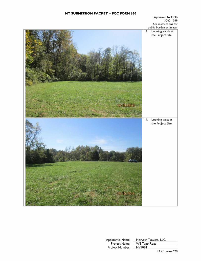
NT SUBMISSION PACKET -- FCC FORM 620 Approved by OMB
3060-1039 See instructions for
public burden estimates
Applicant’s Name: Horvath Towers, LLC Project Name: WS Tapp Road Project Number: HV1094
FCC Form 620
3. Looking south at the Project Site.
4. Looking west at the Project Site.
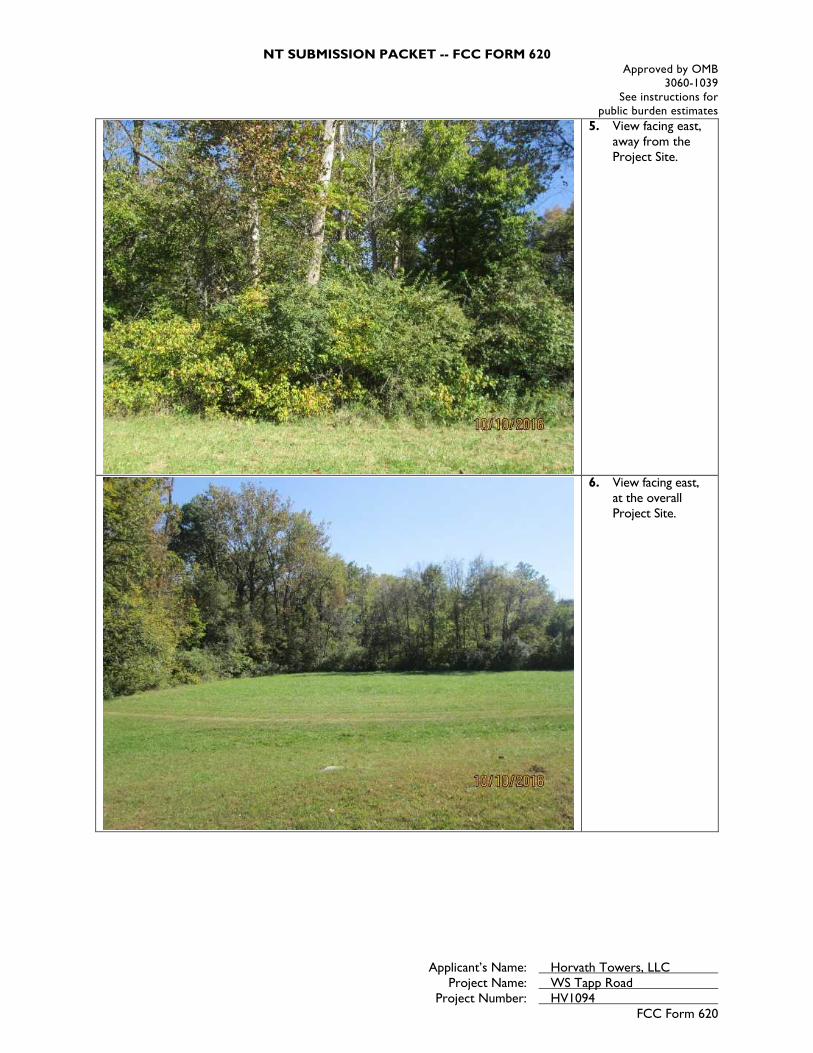
NT SUBMISSION PACKET -- FCC FORM 620 Approved by OMB
3060-1039 See instructions for
public burden estimates
Applicant’s Name: Horvath Towers, LLC Project Name: WS Tapp Road Project Number: HV1094
FCC Form 620
5. View facing east, away from the Project Site.
6. View facing east, at the overall Project Site.

NT SUBMISSION PACKET -- FCC FORM 620 Approved by OMB
3060-1039 See instructions for
public burden estimates
Applicant’s Name: Horvath Towers, LLC Project Name: WS Tapp Road Project Number: HV1094
FCC Form 620
7. View facing south, away from the Project Site.
8. View facing west, away from the Project Site.

NT SUBMISSION PACKET -- FCC FORM 620 Approved by OMB
3060-1039 See instructions for
public burden estimates
Applicant’s Name: Horvath Towers, LLC Project Name: WS Tapp Road Project Number: HV1094
FCC Form 620
9. View of proposed access/utility easement facing east.
10. View of proposed access/utility easement facing north.

NT SUBMISSION PACKET -- FCC FORM 620 Approved by OMB
3060-1039 See instructions for
public burden estimates
Applicant’s Name: Horvath Towers, LLC Project Name: WS Tapp Road Project Number: HV1094
FCC Form 620
11. 0.5 mile APE-VE west of the Project Site facing east towards the proposed undertaking.
12. 0.5 mile APE-VE north of the Project Site facing south towards the proposed undertaking.
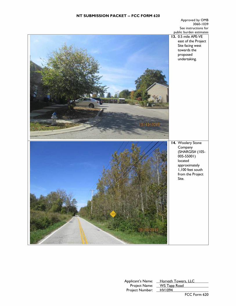
NT SUBMISSION PACKET -- FCC FORM 620 Approved by OMB
3060-1039 See instructions for
public burden estimates
Applicant’s Name: Horvath Towers, LLC Project Name: WS Tapp Road Project Number: HV1094
FCC Form 620
13. 0.5 mile APE-VE east of the Project Site facing west towards the proposed undertaking.
14. Woolery Stone Company (SHARGIS# (105-005-55001) located approximately 1,100 feet south from the Project Site.

NT SUBMISSION PACKET -- FCC FORM 620 Approved by OMB
3060-1039 See instructions for
public burden estimates
Applicant’s Name: Horvath Towers, LLC Project Name: WS Tapp Road Project Number: HV1094
FCC Form 620
15. View of Woolery Stone Company (SHARGIS# 105-005-55001) towards the Project Site.
16. Looking away from Woolery Stone Company (SHARGIS# (035-442-45095) towards the Project Site. The proposed undertaking at the Project Site may be minimally visible. (red arrow indicated location)

NT SUBMISSION PACKET -- FCC FORM 620 Approved by OMB
3060-1039 See instructions for
public burden estimates
Applicant’s Name: Horvath Towers, LLC Project Name: WS Tapp Road Project Number: HV1094
FCC Form 620
Attachment 3. Site Information - Map Requirements Include one or more 7.5-minute quad USGS topographical maps that: a. Identify the Areas of Potential Effects for both Direct and Visual Effects. If a map is copied from the original, include a key with name of quad and date. b. Show the location of the proposed collocation site and any new access roads or other easements including excavations. c. Show the locations of each property listed. d. Include keys for any symbols, colors, or other identifiers. e. Submit color maps whenever possible.
The following maps are attached to this report: Street Map (Figure 1) Topographic Map (Figure 2) Aerial Photograph (See Attachment 2, Photo Location Map)
Historic Resources Map

EBI GIS
Figure 1: Site Location Map
PN: 6116004086
Source: Selected data fromESRI, EBI & USGS
Date: 9/27/2016·
0 1,000 2,000 3,000500 Feet
Legend
Site Radius_̂ Project Site
at 250', 500', 1000' and ½ mile
HV1094 WS TAPP ROADS WEIMER RD.BLOOMINGTON, IN 47403

EBI GIS
Figure 2 - Topographic Map
PN: 6116004086
Source: Selected data fromESRI, EBI & USGS
Date: 9/27/2016·
0 1,000 2,000 3,000500 Feet
USGS 24K Quad: Bloomington, IN 1986
Legend
Site Radius_̂ Project Site
at 250', 500', 1000' and ½ mile
HV1094 WS TAPP ROADS WEIMER RD.BLOOMINGTON, IN 47403

Indiana Department of Natural Resources
es: Esri, DeLorme,
, USGS, Intermap,
Addresses
Cemeteries
Outstanding
Notable
Contributing
Non-Contributing
Demolished
UnknownI 1:8,988
Indiana Dept. of Natural ResourcesGeographic Information Systems
Map Coordinate System: WGS_1984_Web_Mercator_Auxiliary_Sphere
HV1094
Author:
Relative Scale

NT SUBMISSION PACKET -- FCC FORM 620 Approved by OMB
3060-1039 See instructions for
public burden estimates
Applicant’s Name: Horvath Towers, LLC Project Name: WS Tapp Road Project Number: HV1094
FCC Form 620
Attachment 4. Site Information – Additional Site Information Additional Site Information Recommendations: Describe any additional structures, access roads, utility lines, fences, easements, or other construction planned for the site in conjunction with the proposed wireless telecommunication facility. Use this attachment to provide additional details needed to present a full and accurate description of any construction activities that will take place to complete the installation. The Subject Property, located at S. Weimer Road, approximately 500± feet of the intersection of Weimer Road and Sudburg Lane, in Bloomington, Indiana, is situated within a predominantly agricultural and wooded area, with some limited residential and commercial development. Development dates from the mid-20th century through the present. The Subject Property consists of an approximately 80-acre lot that includes two irregular-shaped parcels improved with a single-family residence that was reportedly constructed in 1986, a storage shed and three structures that were reportedly constructed sometime in the early 1900s, agricultural land (i.e. pasture land), undeveloped wooded land, and a landscaped (i.e. mowed) grass field. The area of the proposed facility currently consists of a landscaped grass field. Horvath Towers, LLC proposes to construct a tower facility on the south-central portion of the Subject Property. The tower facility will include a 195-foot (199-foot with appurtenance) monopole tower and associated support equipment located within an 80-foot by 100-foot square-foot lease area. The tower will accommodate future antenna carriers and equipment within the compound. The compound will be surrounded by an 8-foot wood fence. Horvath Towers, LLC proposes to improve an existing access road from South Weimer Road to the tower facility. Utilities will follow the proposed access route. Site Plans/Lease Exhibits provided by Horvath Towers, LLC are included in this attachment.

DRAWN BY:CHECKED BY:DATE:
PODMEP9.22.16
SHEET NUMBER:
SHEET TITLE:
POD NUMBER: 16-10025
DOP
REV. DATE DESCRIPTION
PRELIMINARYNOT FOR
CONSTRUCTION
SITE INFORMATION:
HORVATH SITE NUMBER:
VERIZON WIRELESS SITE NAME:
TAPP ROADS. WEIMER ROAD
BLOOMINGTON, IN 47403MONROE COUNTY
HV1094
WS TAPP ROAD
ZONINGDRAWINGS
A 9.30.16 ISSUED FOR REVIEW
B 10.4.16 OLC COMMENTS
312 WEST COLFAX AVESOUTH BEND, IN 46601
NEW 195' MONOPOLEw/4' LIGHTNING ARRESTORTOTAL TOWER HEIGHT 199'
FROM CITY OF BLOOMINGTON INDIANA BUILDING, PLANNING, AND ZONING DEPARTMENT: 401 N MORTON ST, SUITE 130, BLOOMINGTON, IN 47404: TAKE W 7TH ST TO N ROGERS ST (0.2 MI). HEAD SOUTHON N MORTON ST TOWARD W 8TH ST (341 FT). TURN RIGHT ONTO W 7TH ST (0.1 MI). TAKE W BLOOMFIELD RD TO S WEIMER RD IN PERRY TOWNSHIP (2.0 MI). TURN LEFT ONTO N ROGERS ST (0.5 MI). TURNRIGHT ONTO W 2ND ST (0.7 MI). CONTINUE ONTO W BLOOMFIELD RD (0.9 MI). CONTINUE ON S WEIMER RD. DRIVE TO SUDBURG LN IN BLOOMINGTON (1.0 MI). TURN LEFT ONTO S WEIMER RD (0.8 MI).TURN LEFT TOWARD SUDBURG LN (423 FT). CONTINUE ONTO SUDBURG LN (0.1 MI).
FROM WEST SIDE MTSO: 1645 MIDWEST BLVD. INDIANAPOLIS, IN 46214: HEAD WEST ON MIDWEST BLVD (0.5 MI). TURN RIGHT ONTO W 21ST ST (0.6 MI). TURN RIGHT ONTO N GIRLS SCHOOL RD (1.0 MI). USETHE LEFT 2 LANES TO TURN LEFT ONTO 10TH ST (0.9 MI). TURN RIGHT ONTO THE INTERSTATE 465 S/INTERSTATE 74 E RAMP (0.3 MI). MERGE ONTO I-465 S/I-74 (9.2 MI). USE THE RIGHT LANE TO TAKE EXIT 4FOR IN-37 S/HARDING ST. (0.1 MI). USE THE RIGHT 2 LANES TO TURN RIGHT ONTO IN-37 S/HARDING ST (SIGNS FOR W THOMPSON RD) (46.5 MI). TURN LEFT ONTO W TAPP RD (0.6 MI). TURN LEFT ONTO SWEIMER RD (0.4 MI). CONTINUE STRAIGHT (423 FT). CONTINUE ONTO SUDBURG LN (0.1 MI). SITE WILL BE LOCATED ON RIGHT (SOUTH) SIDE OF ROAD.
ELECTRICALDUKE ENERGYADDRESS: 1100 W 2ND ST
BLOOMINGTON, IN 47403CONTACT: TBDPHONE: (800) 521-2232EMAIL: TBD
SURVEYORPOWER OF DESIGN GROUP, LLC11490 BLUEGRASS PARKWAYLOUISVILLE, KY 40299PHONE: (502) 437-5252
NOTE:ALL ITEMS WITHIN THESE CONSTRUCTION DOCUMENTS ARE BY TOWER OWNER'S GENERALCONTRACTOR AND HIS SUB-CONTRACTORS UNLESS NOTED AS (VZW GC) WHICH SHALL INCLUDE VERIZONWIRELESS GENERAL CONTRACTOR AND HIS SUB-CONTRACTORS. GENERALLY DESCRIBED BELOW:HORVATH COMMUNICATIONS SCOPE: INSTALL A NEW 195' MONOPOLE w/ 4' LIGHTNING ARRESTOR (TOTAL 199') INSTALL A NEW TOWER FOUNDATION SYSTEM INSTALL A NEW 70'X70' FENCED GRAVEL COMPOUND INSTALL A NEW SITE H-FRAME INSTALL A NEW ELECTRICAL SERVICE RUN TO SITE H-FRAME INSTALL A NEW GRAVEL ACCESS DRIVE NO WATER OR SEWAGE SERVICES RUN TO SITE INSTALL NEW TOWER & SITE GROUNDING SYSTEM INSTALL NEW VZW SUBSURFACE GROUNDING SYSTEM INSTALL A NEW 11'-6"x19'-6" CONCRETE EQUIPMENT/GENERATOR PAD INSTALL ELECTRICAL SERVICE CONDUIT WITH PULL TAPES FROM ATS ENCLOSURE STUB-UP TO UTILITY
H-FRAME INSTALL NEW CONDUITS WITH PULL TAPES FROM VZW ATS ENCLOSURE STUB-UP TO EQUIPMENT
ELECTRICAL PANEL STUB-UP INSTALL NEW CONDUITS WITH PULL TAPES FROM VZW ATS & EQUIPMENT ENCLOSURES STUB-UP TO
GENERATOR LOCATION INSTALL NEW CONDUITS WITH PULL TAPES FROM MAIN EQUIPMENT CABINET STUB-UP TO GROWTH
CABINET STUB-UP INSTALL (1) NEW "VERIZON WIRELESS ONLY" FIBER OPTIC CONDUIT WITH PULL TAPE AND TRACER
WIRE FROM VZW EQUIPMENT TO NEW "VERIZON WIRELESS ONLY" HAND HOLE OUTSIDE COMPOUND INSTALL (1) NEW "VERIZON WIRELESS ONLY" FIBER OPTIC CONDUIT WITH PULL TAPE FROM NEW
"VERIZON WIRELESS ONLY" HAND HOLE AND STUB UP AT FUTURE FIBER PEDESTAL LOCATION PERMANENT ELECTRIC POWER MUST BE AVAILABLE FOR VERIZON WIRELESS AT THE METER BASE
PRIOR TO THE SITE BEING RELEASED AS TENANT READY.VERIZON WIRELESS SCOPE (VZW GC): INSTALL A NEW 11'-6"x14'-9" PREFABRICATED CANOPY ON EXISTING CONCRETE PAD FOUNDATION INSTALL NEW 20KW DIESEL GENERATOR ON EXISTING CONCRETE FOUNDATION INSTALL VZW ICE BRIDGE AND FOUNDATIONS INSTALL VZW ANTENNA MOUNTING SUPPORT STRUCTURE ON TOWER INSTALL VZW ANTENNAS, LINES, COAX, GPS ANTENNAS AND RADIO EQUIPMENT INSTALL EXISTING SUBSURFACE GROUND LEADS TO VZW EQUIPMENT & FACILITIES INSTALL VZW ELECTRIC SERVICE CONDUCTORS FROM UTILITY H-FRAME TO VZW ATS ENCLOSURE INSTALL VZW GENERATOR CIRCUITS FROM VZW ATS & EQUIPMENT ENCLOSURES TO VZW
GENERATOR INSTALL (2) 1-1/4" & (1) 1" INNERDUCTS WITH PULL TAPES AND TRACER WIRE WITHIN OWNER
INSTALLED "VERIZON WIRELESS ONLY" FIBER OPTIC CONDUIT
ELECTRICAL UTILITY COORDINATIONIS NOT FINALIZED. DO NOT PROCEEDWITH CONSTRUCTION.
TAPP ROADHV1094
S. WEIMER ROADBLOOMINGTON, IN 47403
MONROE COUNTYTENANT: GTE MOBILENET OF INDIANA LIMITED PARTNERSHIP d/b/a VERIZON WIRELESS
WS TAPP ROAD
SITE
SITESITE
SHEET NUMBER DESCRIPTION
T-1 PROJECT INFORMATION, SITE MAPS, SHEET INDEX
B-1 TO B-1.4 SITE SURVEY
R-1 REVISION LOG
TOWER ELEVATION
TE-1 TOWER ELEVATION
CIVIL
C-1A OVERALL SITE PLANC-3 DETAILED SITE PLANC-4 DIMENSIONED SITE PLAN
SITE DETAILS
D-3 EQUIPMENT PAD & CANOPY ELEVATIONS (REFERENCEONLY)
D-5 PRELIMINARY BRIDGE DESIGNARCHITECTURAL
POWER OF DESIGN GROUP, LLC11490 BLUEGRASS PARKWAYLOUISVILLE, KY 40299PHONE: (502) 437-5252
PROJECT SUMMARY PROJECT DESCRIPTION CONSULTANT TEAM
AERIALLOCATION MAPVICINITY MAP
APPLICABLE CODES
HORVATH COMMUNICATIONS SITETAPP ROADSITE #: HV1094
VERIZON WIRELESS SITEWS TAPP ROADPROJECT#: 20141126383MARKET ID: BLOOMINGTONLOCATION CODE: 312019
SITE ADDRESSS. WEIMER ROADBLOOMINGTON, IN 47403MONROE COUNTYE911 ADDRESS: TBD
TOWER OWNERHORVATH COMMUNICATIONS312 W COLFAX AVESOUTH BEND, IN 46601CONTACT: JENNIFER A. SIROVICAPHONE: (574) 237-0464MOBILE: (574) 215-0620E-MAIL: [email protected]
PROPERTY OWNERHARVEY CRAIN SUDBURY &MARY CAROLYN SUDBURY1901 S WEIMER RD.BLOOMINGTON, IN 47403CONTACT: HARVEY CRAIN SUDBURYPHONE: (812) 272-9572
POLICEBLOOMINGTON POLICE DEPARTMENT220 E 3RD STBLOOMINGTON, IN 47408PHONE: (812) 339-4477
FIREBLOOMINGTON FIRE DEPARTMENTS YANCY LNBLOOMINGTON, IN 47404PHONE: (812) 332-9763
GENERAL INFORMATIONLATITUDE : 39° 08' 38.91" NLONGITUDE : 86° 33' 37.37" W1983 (NAD83)ELEVATION : 733.00' AMSL1988 (NAVD88)
HORVATH COMMUNICATIONSLEASE AREA
100'-0" x 100'-0"(10,000 SF)
PROJECTINFORMATION,
SITE MAPS,SHEET INDEX
T-1
ALL WORK AND MATERIALS SHALL BE PERFORMED AND INSTALLED IN ACCORDANCE WITHTHE CURRENT EDITIONS OF THE FOLLOWING CODES AS ADOPTED BY THE LOCALGOVERNING AUTHORITIES. NOTHING IN THESE PLANS IS TO BE CONSTRUCTED TO PERMITWORK NOT CONFORMING TO THESE CODES.
BUILDING CODE 2014 INDIANA BUILDING CODE (IBC 2012)STRUCTURAL CODE TIA/EIA-222 - REVISION GMECHANICAL CODE 2014 INDIANA MECHANICAL CODE (IMC 2012)PLUMBING CODE 2012 INDIANA PLUMBING CODE (IPC 2006)ELECTRICAL CODE 2008 NATIONAL ELECTRICAL CODE (NEC) - NFPA 70FIRE/LIFE SAFETY CODE 2014 INDIANA FIRE CODE (2012 IFC)ENERGY CODE 2010 INDIANA ENERGY CODE ASHRAE 90.1-200 (COMMERCIAL)GAS CODE 2014 INDIANA FUEL GAS CODE (IFGC 2012)
ACCESSIBILITY REQUIREMENTS:FACILITY IS UNMANNED AND NOT FOR HUMAN HABITATION. HANDICAPPED ACCESSREQUIREMENTS ARE NOT REQUIRED IN ACCORDANCE WITH THE 2009 IBC BUILDING CODE.
312 WEST COLFAX AVENUE
SOUTH BEND, IN46601

PARCEL ID: 53-08-07-100-001.005-009HARVEY CRAIN SUDBURY &MARY CAROLYN SUDBURY
INST. #2014005699(NORTH REMAINER PER PLAT
INST. #2014004467)
PARCEL ID:53-08-07-100-004.001-009HARVEY CRAIN SUDBURY &MARY CAROLYN SUDBURY
INST. #2014005698
S. WEIM
ER ROAD
PUBLIC RIGHT O
F WAY - W
IDTH UN
KNO
WN
APPROXIMATE FLOOD LINE -GRAPHIC PLOTTING ONLY,
NOT FIELD VERIFIED
ZONE: XZONE: AE
ZONE: AE
ZONE: X
733'
731'
729'
728'
727'
725'
724'
723'
PARCEL ID: 53-08-07-300-006.000-009PUBLIC INVESTMENT CORPORATION
BOOK 327, PG. 440
P.O.C.FOUND 5/8" REBAR IN THECENTER OF SECTION 7, TOWNSHIP8 NORTH, RANGE 1 WEST,MONROE COUNTY, INDIANA
PROPOSED LEASE AREA(8,000.000 S.F.)DETAIL SHEET B-1.1
PARCEL ID: 53-08-07-100-001.008-009HARVEY CRAIN SUDBURY &MARY CAROLYN SUDBURY
INST. #2014005700(SOUTH REMAINER PER PLAT
INST. #2014004467)
PARCEL ID: 53-08-07-400-008.099-009JOE KEMP CONSTRUCTION, LLC
INST. #2016010797
PARCEL ID: 53-08-07-400-006.000-009HARVEY CRAIN SUDBURY &MARY CAROLYN SUDBURY
INST. #2014005692(COMBINED TRACT PER PLAT
INST. #2014004467)
P.O.R.FOUND 5/8" REBARCAPPED "BRG"
FOUND 5/8" REBARCAPPED "BRG"
PROPOSED ACCESS &UTILITY EASEMENT "A"
(8,536.583 S.F.)DETAIL SHEET B-1.1
PROPOSED ACCESS &UTILITY EASEMENT "B"(21,412.464 S.F.)DETAIL SHEET B-1.1 & B-1.2
S. WEIM
ER ROAD
VARIABLE WIDTH PU
BLIC RIGHT OF W
AY
EX. INDIANA BELL TELEPHONE CO. & PSIENERGY, INC. EASEMENTBOOK 399, PG. 1
EX. INDIANA BELL TELEPHONE CO.EASEMENTBOOK 398, PG. 28
LEASE TIES88°58'33"E 470.47'
S88°58'32"E 487.50' S88°58'33"E 792.73'TOTAL LENGTH
132.
19'
S27°29'19"W
157.60'N82°59'05"W
350.
63'
S01°21'19"W
S12°26'10"W 549.78'
N88°58'14"W 433.82'
N01°42'58"W
1010.58'
S01°37'59"E 610.00'
S88°58'32"E 629.92'
S88°11'03"E 850.00'
178.71'
N01°37'59"W
S36°20'56"E
209.87'
S38°23'51"W 486.98'
S05°58'52"W 197.75'
S40°17'17"E33.72'
S40°17'17"E24.02'P.O.B.
ACCESS & UTIL. ESMT. "B"
N01°01'27"E45.00'
FOUND 5/8" REBARCAPPED "BRG"EX. SANITARY SEWER EASEMENT
CITY OF BLOOMINGTONBOOK 147, PG. 133(APPROX. LOCATION)
SE 1/4, SECTION
7
SW 1/4, SECTIO
N 7
NE 1/4, SECTIO
N 7
NW
1/4, SECTION
7
NE 1/4, SECTION 7
SE 1/4, SECTION 7
DOP
DRAWN BY:CHECKED BY:DATE:
DAPMEP9.19.16
SHEET NUMBER:
SHEET TITLE:
POD NUMBER: 16-10799
SITE NUMBER:
SURVEYREV. DATE DESCRIPTION
A 9.19.16 PRELIM ISSUE WITH TITLE
TAPP ROADSITE INFORMATION:
S. WEIMER ROADBLOOMINGTON, IN 47403
MONROE COUNTY
SOURCE OF TITLE:
TAX PARCEL NUMBER:53-08-07-100-001.005-009
PROPERTY OWNER:HARVEY CRAIN SUDBURY &MARY CAROLYN SUDBURY
1901 WEIMER ROADBLOOMINGTON, IN 47403
INSTRUMENT #2014005699INSTRUMENT #2014005700
T.J. BOOFTERCIVIL ENGINEERS &LAND SURVEYORS
207 W Spring St, New Albany, IN 47150
HV1094
312 WEST COLFAX AVESOUTH BEND, IN 46601
574.237.0464
VERIZON WIRELESS SITE NAME:WS TAPP ROAD
B 9.26.16 ROW DESIGNATION
B-1
0° 19' 47"
GRID
NO
RTH
N
TRUE NORTH
BASED ON INDIANA STATEPLANE WEST ZONE AND
DETERMINED BY GPS OBSERVATIONSCOMPLETED ON AUGUST 26, 2016
GENERAL NOTES
0'
1 INCH = 200 FEET
400'200'
SITE MAP - NOT TO SCALE
SITE
NO SEARCH OF PUBLIC RECORDS HAS BEEN COMPLETEDBY POD GROUP TO DETERMINE ANY DEFECTS AND/ORAMBIGUITIES IN THE TITLE OF THE PARENT PARCEL.
THIS SURVEY IS FOR THE LEASE AREA ONLY, THEPROPOSED ACCESS & UTILITY EASEMENTS, AND ONLY APARTIAL BOUNDARY SURVEY OF THE PARENT PARCEL HASBEEN PERFORMED.
THIS SURVEY WAS CONDUCTED BY METHOD OF RANDOMTRAVERSE WITH SIDE SHOTS. UNADJUSTED CLOSURE FORTHIS TRACT EQUALS 0.09', FOR A PRECISION OF 1:37,766AND HAS NOT BEEN ADJUSTED.
THIS PROPERTY IS SUBJECT TO ANY RECORDEDEASEMENTS AND/OR RIGHTS OF WAY SHOWN HEREON ORNOT.
THIS PLAT IS NOT INTENDED FOR LAND TRANSFER.
THE PROPOSED LEASE AREA AND PART OF THE PROPOSEDACCESS & UTILITY EASEMENT SHOWN HERON ARE NOTLOCATED IN A 100-YEAR FLOOD PLAIN PER FLOOD HAZARDBOUNDARY MAP, COMMUNITY-PANEL NUMBER18105C0143D AND 18105C0139D, DATED DECEMBER 17,2010. THE PROPOSED LEASE AREA IS LOCATED IN ZONE X.A PORTION OF THE PARENT PARCEL AND THE PROPOSEDACCESS & UTILITY EASEMENT IS IN A FLOOD ZONE (ZONE:AE, BASE FLOOD ELEVATIONS DETERMINED).
FOUND MONUMENT AS NOTEDSET 5/8" REBAR 24" LONG
EX. FENCE
P.O.B. POINT OF BEGINNINGP.O.C. POINT OF COMMENCEMENT
PROPERTY LINEADJACENT PROPERTY LINE
1. RANDOM TRAVERSE CONTROL MONUMENTSWERE SET USING GPS METHODS. A PORTIONOF THE TOPOGRAPHY WAS COLLECTED USINGGPS METHODS.
2. THE TYPE OF GPS UTILIZED WAS NETWORKADJUSTED REAL TIME KINEMATIC (INDOT VRSNETWORK), NAD 83 INDIANA EAST ZONE WITHTHE ORTHOMETRIC HEIGHT COMPUTED USINGGEOID12A. RELATIVE POSITIONAL ACCURACYVARIED FROM 0.03' TO 0.07' HORIZONTALLY.
3. SPECTRA PRECISION EPOCH 50 DUALFREQUENCY RECEIVERS WERE USEDCONDUCTING THE SURVEY. SERIAL NUMBER:5325400009
GLOBAL POSITIONING NOTE
NOTICE TO CONTRACTORPER INDIANA STATE LAW IC-8-1-26-18, IT ISAGAINST THE LAW TO EXCAVATE WITHOUT
NOTIFYING THE UNDERGROUND LOCATION SERVICETWO (2) WORKING DAYS BEFORE COMMENCING WORK.
FAA COORDINATE POINTNORTHING: 1419371.306EASTING: 3100933.650ELEVATION: 734.28'LOCATION: A SET 60D NAILN71°05'W 90.6'± FROM THESOUTHWEST CORNER OF THEPROPOSED LEASE AREA.
TEMPORARY BENCHMARKNAD 83LATITUDE: 39°08'38.91"LONGITUDE: 86°33'37.37"NAVD 88ELEVATION: 733'± AMSLNORTHING: 1419381.025EASTING: 3101070.067
SITE SURVEY
W TAPP RD
S.R.
37
IN ACCORDANCE WITH TITLE 865, CHAPTERS 1 THRU 12 OF THEINDIANA ADMINISTRATIVE CODE, THE FOLLOWING OBSERVATIONAND OPINIONS ARE SUBMITTED REGARDING THE VARIOUSUNCERTAINTIES IN THE LOCATIONS OF THE LINES AND CORNERSESTABLISHED ON THIS SURVEY AS A RESULT OF:A) VARIANCES IN THE REFERENCE MONUMENTSB) DISCREPANCIES IN RECORD DESCRIPTIONS AND PLATSC) INCONSISTENCIES IN LINES OF OCCUPATIOND) RANDOM ERRORS IN MEASUREMENT (THEORETICAL
UNCERTAINTY)
AS A RESULT OF THE ABOVE OBSERVATIONS, IT IS MY OPINIONTHAT THE UNCERTAINTIES IN THE LOCATIONS OF THE LINES ANDCORNERS ESTABLISHED ON THIS SURVEY ARE AS FOLLOWS:
1. VARIANCES IN THE REFERENCE MONUMENTS: THIS SURVEY ISTIED TO A FOUND 5/8" REBAR IN THE CENTER OF SECTION 7,TOWNSHIP 8 NORTH, RANGE 1 WEST, MONROE COUNTY,INDIANA
2. DISCREPANCIES IN RECORD DESCRIPTIONS AND PLATS: THEREARE NO KNOWN DISCREPANCIES.
3. INCONSISTENCIES IN LINES OF OCCUPATION: THERE ARE NOKNOWN INCONSISTENCIES.
4. RANDOM ERRORS IN MEASUREMENT (THEORETICALUNCERTAINTY): THE THEORETICAL UNCERTAINTY (DUE TORANDOM ERRORS OF MEASUREMENTS) OF THE CORNERS OFTHE SUBJECT TRACT ESTABLISHED THIS SURVEY IS WITHINTHE SPECIFICATIONS FOR A CLASS A SURVEY (0.10 FEET) ASDEFINED IN IAC 865.
I HEREBY CERTIFY THAT THIS SURVEY AND THE PLAT SHOWNHEREON WERE PREPARED UNDER MY SUPERVISION ANDACCORDING TO THE APPLICABLE REQUIREMENTS OF 865 IAC 1-12.
LAND SURVEYOR'S CERTIFICATE
THOMAS J. BOOFTER, LS #S-0133 DATE
S WEIM
ER RDS.R. 45
W SUDBURY DR
P.O.R. POINT OF REFERENCE
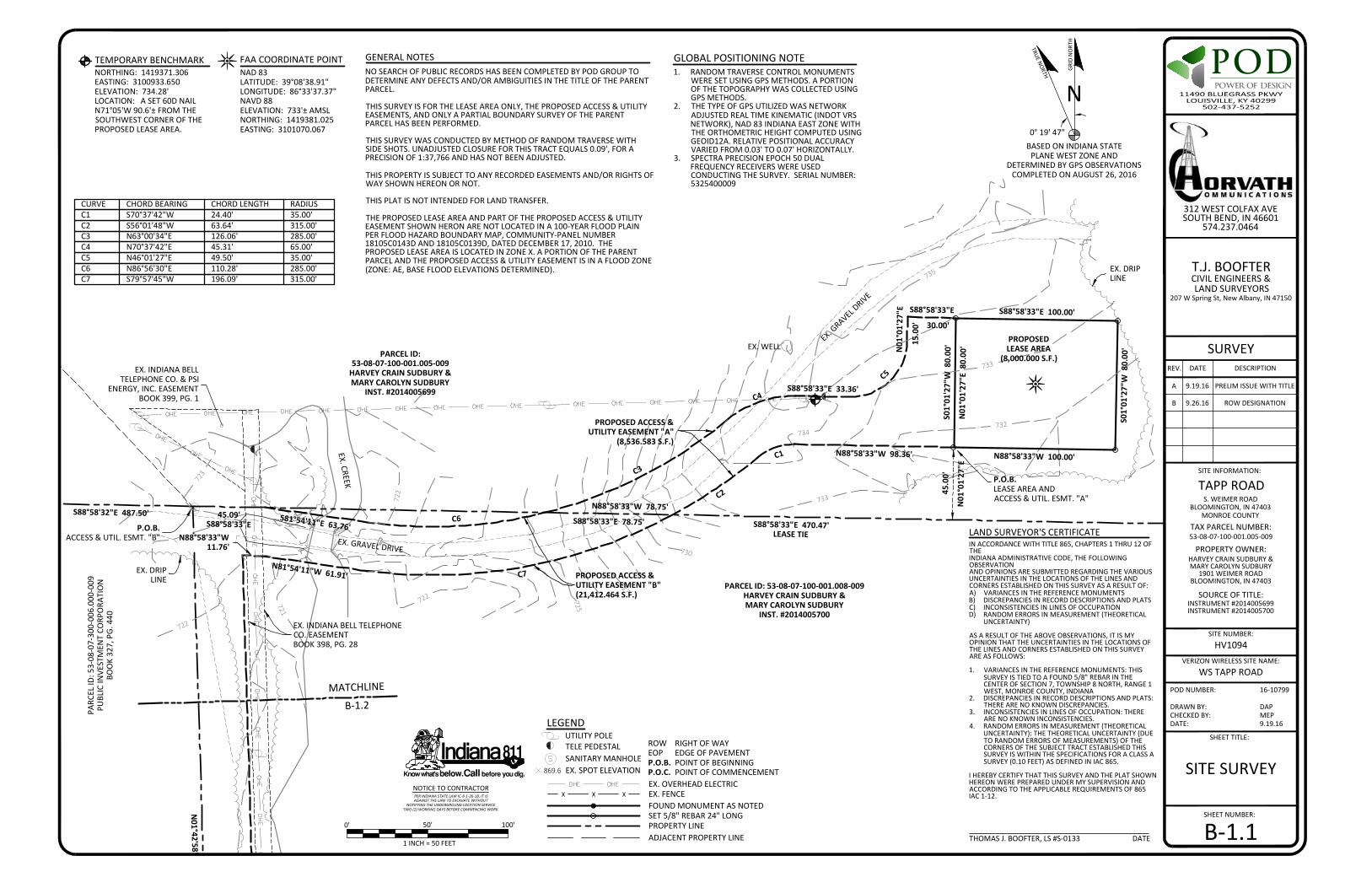
722
723
721
722
722
725
730
727
733
732
735
733
734
PARCEL ID:53-08-07-100-001.005-009
HARVEY CRAIN SUDBURY &MARY CAROLYN SUDBURY
INST. #2014005699
PROPOSEDLEASE AREA
(8,000.000 S.F.)
PROPOSED ACCESS &UTILITY EASEMENT "A"
(8,536.583 S.F.)
PROPOSED ACCESS &UTILITY EASEMENT "B"(21,412.464 S.F.)
PARC
EL ID
: 53-
08-0
7-30
0-00
6.00
0-00
9PU
BLIC
INVE
STM
ENT
CORP
ORA
TIO
NBO
OK
327,
PG.
440
EX. INDIANA BELLTELEPHONE CO. & PSI
ENERGY, INC. EASEMENTBOOK 399, PG. 1
S88°58'33"E 100.00'
S01°01'27"W 80.00'
N88°58'33"W 100.00'
N01°01'27"E 80.00'
S01°01'27"W 80.00'
S88°58'33"E 33.36'
S88°58'33"E
30.00'
N01°01'27"E
15.0
0'
45.0
0'
N01°01'27"E
S81°54'11"E 63.76'
N81°54'11"W 61.91'
N88°58'33"W 98.36'C1
C2
C3
C4
C5
C6
C7
S88°58'32"E 487.50'S88°58'33"E 470.47'
LEASE TIE
N88°58'33"W 78.75'S88°58'33"E 78.75'
N01°42'58"W
431.32'
45.09'S88°58'33"E
EX. INDIANA BELL TELEPHONECO. EASEMENTBOOK 398, PG. 28
PARCEL ID: 53-08-07-100-001.008-009HARVEY CRAIN SUDBURY &MARY CAROLYN SUDBURY
INST. #2014005700
EX. CREEK
EX. GRAVEL D
RIVE
EX. GRAVEL DRIVE
P.O.B.LEASE AREA ANDACCESS & UTIL. ESMT. "A"
P.O.B.ACCESS & UTIL. ESMT. "B"
EX. WELL
EX. DRIPLINE
EX. DRIPLINE
N88°58'33"W11.76'
DOP
DRAWN BY:CHECKED BY:DATE:
DAPMEP9.19.16
SHEET NUMBER:
SHEET TITLE:
POD NUMBER: 16-10799
SITE NUMBER:
SURVEYREV. DATE DESCRIPTION
A 9.19.16 PRELIM ISSUE WITH TITLE
TAPP ROADSITE INFORMATION:
S. WEIMER ROADBLOOMINGTON, IN 47403
MONROE COUNTY
SOURCE OF TITLE:
TAX PARCEL NUMBER:53-08-07-100-001.005-009
PROPERTY OWNER:HARVEY CRAIN SUDBURY &MARY CAROLYN SUDBURY
1901 WEIMER ROADBLOOMINGTON, IN 47403
INSTRUMENT #2014005699INSTRUMENT #2014005700
T.J. BOOFTERCIVIL ENGINEERS &LAND SURVEYORS
207 W Spring St, New Albany, IN 47150
HV1094
312 WEST COLFAX AVESOUTH BEND, IN 46601
574.237.0464
VERIZON WIRELESS SITE NAME:WS TAPP ROAD
B 9.26.16 ROW DESIGNATION
B-1.10'
1 INCH = 50 FEET
50' 100'
IN ACCORDANCE WITH TITLE 865, CHAPTERS 1 THRU 12 OFTHEINDIANA ADMINISTRATIVE CODE, THE FOLLOWINGOBSERVATIONAND OPINIONS ARE SUBMITTED REGARDING THE VARIOUSUNCERTAINTIES IN THE LOCATIONS OF THE LINES ANDCORNERS ESTABLISHED ON THIS SURVEY AS A RESULT OF:A) VARIANCES IN THE REFERENCE MONUMENTSB) DISCREPANCIES IN RECORD DESCRIPTIONS AND PLATSC) INCONSISTENCIES IN LINES OF OCCUPATIOND) RANDOM ERRORS IN MEASUREMENT (THEORETICAL
UNCERTAINTY)
AS A RESULT OF THE ABOVE OBSERVATIONS, IT IS MYOPINION THAT THE UNCERTAINTIES IN THE LOCATIONS OFTHE LINES AND CORNERS ESTABLISHED ON THIS SURVEYARE AS FOLLOWS:
1. VARIANCES IN THE REFERENCE MONUMENTS: THISSURVEY IS TIED TO A FOUND 5/8" REBAR IN THECENTER OF SECTION 7, TOWNSHIP 8 NORTH, RANGE 1WEST, MONROE COUNTY, INDIANA
2. DISCREPANCIES IN RECORD DESCRIPTIONS AND PLATS:THERE ARE NO KNOWN DISCREPANCIES.
3. INCONSISTENCIES IN LINES OF OCCUPATION: THEREARE NO KNOWN INCONSISTENCIES.
4. RANDOM ERRORS IN MEASUREMENT (THEORETICALUNCERTAINTY): THE THEORETICAL UNCERTAINTY (DUETO RANDOM ERRORS OF MEASUREMENTS) OF THECORNERS OF THE SUBJECT TRACT ESTABLISHED THISSURVEY IS WITHIN THE SPECIFICATIONS FOR A CLASS ASURVEY (0.10 FEET) AS DEFINED IN IAC 865.
I HEREBY CERTIFY THAT THIS SURVEY AND THE PLAT SHOWNHEREON WERE PREPARED UNDER MY SUPERVISION ANDACCORDING TO THE APPLICABLE REQUIREMENTS OF 865IAC 1-12.
LAND SURVEYOR'S CERTIFICATE
THOMAS J. BOOFTER, LS #S-0133 DATE
NOTICE TO CONTRACTORPER INDIANA STATE LAW IC-8-1-26-18, IT ISAGAINST THE LAW TO EXCAVATE WITHOUT
NOTIFYING THE UNDERGROUND LOCATION SERVICETWO (2) WORKING DAYS BEFORE COMMENCING WORK.
SITE SURVEY
FOUND MONUMENT AS NOTED
UTILITY POLE
SET 5/8" REBAR 24" LONG
EX. FENCE
P.O.B. POINT OF BEGINNING
TELE PEDESTALEOP EDGE OF PAVEMENTROW RIGHT OF WAY
P.O.C. POINT OF COMMENCEMENTEX. OVERHEAD ELECTRIC
PROPERTY LINEADJACENT PROPERTY LINE
SANITARY MANHOLE869.6 EX. SPOT ELEVATION
CURVE CHORD BEARING CHORD LENGTH RADIUSC1 S70°37'42"W 24.40' 35.00'C2 S56°01'48"W 63.64' 315.00'C3 N63°00'34"E 126.06' 285.00'C4 N70°37'42"E 45.31' 65.00'C5 N46°01'27"E 49.50' 35.00'C6 N86°56'30"E 110.28' 285.00'C7 S79°57'45"W 196.09' 315.00'
0° 19' 47"
GRID
NO
RTH
N
TRUE NORTH
BASED ON INDIANA STATEPLANE WEST ZONE AND
DETERMINED BY GPS OBSERVATIONSCOMPLETED ON AUGUST 26, 2016
GENERAL NOTESNO SEARCH OF PUBLIC RECORDS HAS BEEN COMPLETED BY POD GROUP TODETERMINE ANY DEFECTS AND/OR AMBIGUITIES IN THE TITLE OF THE PARENTPARCEL.
THIS SURVEY IS FOR THE LEASE AREA ONLY, THE PROPOSED ACCESS & UTILITYEASEMENTS, AND ONLY A PARTIAL BOUNDARY SURVEY OF THE PARENTPARCEL HAS BEEN PERFORMED.
THIS SURVEY WAS CONDUCTED BY METHOD OF RANDOM TRAVERSE WITHSIDE SHOTS. UNADJUSTED CLOSURE FOR THIS TRACT EQUALS 0.09', FOR APRECISION OF 1:37,766 AND HAS NOT BEEN ADJUSTED.
THIS PROPERTY IS SUBJECT TO ANY RECORDED EASEMENTS AND/OR RIGHTS OFWAY SHOWN HEREON OR NOT.
THIS PLAT IS NOT INTENDED FOR LAND TRANSFER.
THE PROPOSED LEASE AREA AND PART OF THE PROPOSED ACCESS & UTILITYEASEMENT SHOWN HERON ARE NOT LOCATED IN A 100-YEAR FLOOD PLAINPER FLOOD HAZARD BOUNDARY MAP, COMMUNITY-PANEL NUMBER18105C0143D AND 18105C0139D, DATED DECEMBER 17, 2010. THEPROPOSED LEASE AREA IS LOCATED IN ZONE X. A PORTION OF THE PARENTPARCEL AND THE PROPOSED ACCESS & UTILITY EASEMENT IS IN A FLOOD ZONE(ZONE: AE, BASE FLOOD ELEVATIONS DETERMINED).
1. RANDOM TRAVERSE CONTROL MONUMENTSWERE SET USING GPS METHODS. A PORTIONOF THE TOPOGRAPHY WAS COLLECTED USINGGPS METHODS.
2. THE TYPE OF GPS UTILIZED WAS NETWORKADJUSTED REAL TIME KINEMATIC (INDOT VRSNETWORK), NAD 83 INDIANA EAST ZONE WITHTHE ORTHOMETRIC HEIGHT COMPUTED USINGGEOID12A. RELATIVE POSITIONAL ACCURACYVARIED FROM 0.03' TO 0.07' HORIZONTALLY.
3. SPECTRA PRECISION EPOCH 50 DUALFREQUENCY RECEIVERS WERE USEDCONDUCTING THE SURVEY. SERIAL NUMBER:5325400009
GLOBAL POSITIONING NOTE FAA COORDINATE POINTNORTHING: 1419371.306EASTING: 3100933.650ELEVATION: 734.28'LOCATION: A SET 60D NAILN71°05'W 90.6'± FROM THESOUTHWEST CORNER OF THEPROPOSED LEASE AREA.
TEMPORARY BENCHMARKNAD 83LATITUDE: 39°08'38.91"LONGITUDE: 86°33'37.37"NAVD 88ELEVATION: 733'± AMSLNORTHING: 1419381.025EASTING: 3101070.067
MATCHLINE
B-1.2
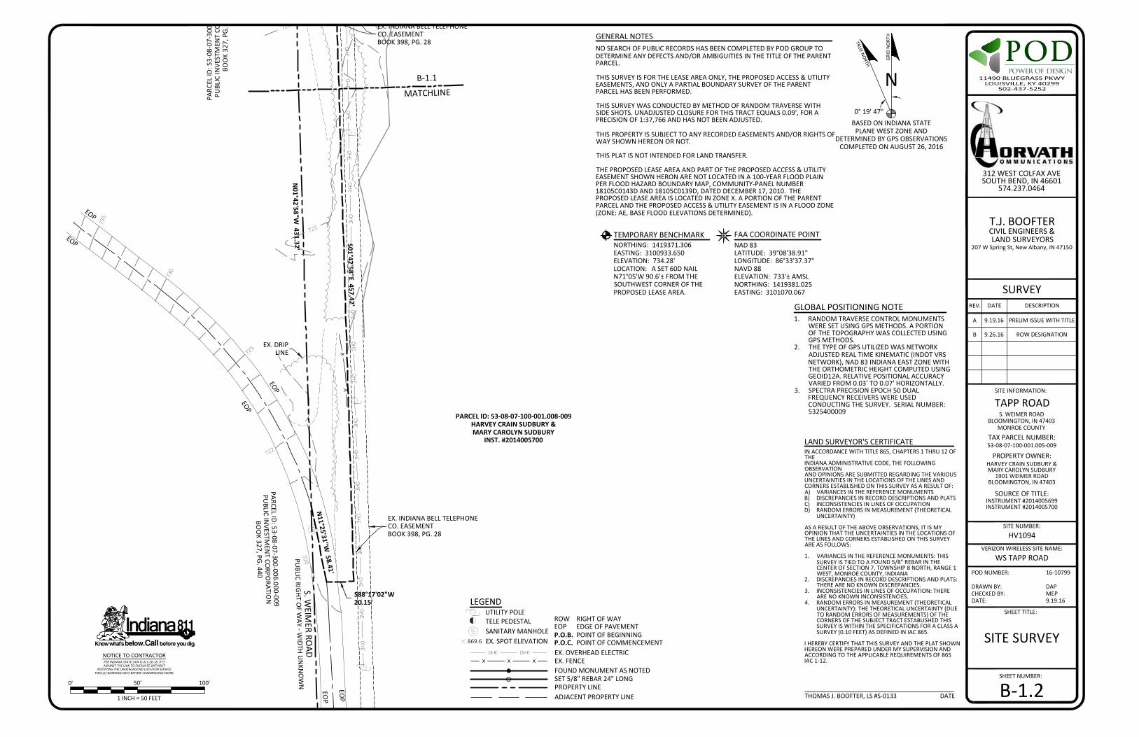
735
725
722
721
722
PARC
EL ID
: 53-
08-0
7-30
0-00
6.00
0-00
9PU
BLIC
INVE
STM
ENT
CORP
ORA
TIO
NBO
OK
327,
PG.
440
PARCEL ID: 53-08-07-100-001.008-009HARVEY CRAIN SUDBURY &MARY CAROLYN SUDBURY
INST. #2014005700
S. WEIM
ER ROAD
PUBLIC RIGHT O
F WAY - W
IDTH UN
KNO
WN
EX. INDIANA BELL TELEPHONECO. EASEMENTBOOK 398, PG. 28
S88°17'02"W20.15'
S01°42'58"E 457.42'
N01°42'58"W
431.32'
N11°25'31"W
58.41'
EX. INDIANA BELL TELEPHONECO. EASEMENTBOOK 398, PG. 28
PARCEL ID: 53-08-07-300-006.000-009PU
BLIC INVESTM
ENT CO
RPORATIO
NBO
OK 327, PG. 440
EOP
EOP
EOP
EOP
EOP
EOP
EX. DRIPLINE
DOP
DRAWN BY:CHECKED BY:DATE:
DAPMEP9.19.16
SHEET NUMBER:
SHEET TITLE:
POD NUMBER: 16-10799
SITE NUMBER:
SURVEYREV. DATE DESCRIPTION
A 9.19.16 PRELIM ISSUE WITH TITLE
TAPP ROADSITE INFORMATION:
S. WEIMER ROADBLOOMINGTON, IN 47403
MONROE COUNTY
SOURCE OF TITLE:
TAX PARCEL NUMBER:53-08-07-100-001.005-009
PROPERTY OWNER:HARVEY CRAIN SUDBURY &MARY CAROLYN SUDBURY
1901 WEIMER ROADBLOOMINGTON, IN 47403
INSTRUMENT #2014005699INSTRUMENT #2014005700
T.J. BOOFTERCIVIL ENGINEERS &LAND SURVEYORS
207 W Spring St, New Albany, IN 47150
HV1094
312 WEST COLFAX AVESOUTH BEND, IN 46601
574.237.0464
VERIZON WIRELESS SITE NAME:WS TAPP ROAD
B 9.26.16 ROW DESIGNATION
B-1.20'
1 INCH = 50 FEET
50' 100'
IN ACCORDANCE WITH TITLE 865, CHAPTERS 1 THRU 12 OFTHEINDIANA ADMINISTRATIVE CODE, THE FOLLOWINGOBSERVATIONAND OPINIONS ARE SUBMITTED REGARDING THE VARIOUSUNCERTAINTIES IN THE LOCATIONS OF THE LINES ANDCORNERS ESTABLISHED ON THIS SURVEY AS A RESULT OF:A) VARIANCES IN THE REFERENCE MONUMENTSB) DISCREPANCIES IN RECORD DESCRIPTIONS AND PLATSC) INCONSISTENCIES IN LINES OF OCCUPATIOND) RANDOM ERRORS IN MEASUREMENT (THEORETICAL
UNCERTAINTY)
AS A RESULT OF THE ABOVE OBSERVATIONS, IT IS MYOPINION THAT THE UNCERTAINTIES IN THE LOCATIONS OFTHE LINES AND CORNERS ESTABLISHED ON THIS SURVEYARE AS FOLLOWS:
1. VARIANCES IN THE REFERENCE MONUMENTS: THISSURVEY IS TIED TO A FOUND 5/8" REBAR IN THECENTER OF SECTION 7, TOWNSHIP 8 NORTH, RANGE 1WEST, MONROE COUNTY, INDIANA
2. DISCREPANCIES IN RECORD DESCRIPTIONS AND PLATS:THERE ARE NO KNOWN DISCREPANCIES.
3. INCONSISTENCIES IN LINES OF OCCUPATION: THEREARE NO KNOWN INCONSISTENCIES.
4. RANDOM ERRORS IN MEASUREMENT (THEORETICALUNCERTAINTY): THE THEORETICAL UNCERTAINTY (DUETO RANDOM ERRORS OF MEASUREMENTS) OF THECORNERS OF THE SUBJECT TRACT ESTABLISHED THISSURVEY IS WITHIN THE SPECIFICATIONS FOR A CLASS ASURVEY (0.10 FEET) AS DEFINED IN IAC 865.
I HEREBY CERTIFY THAT THIS SURVEY AND THE PLAT SHOWNHEREON WERE PREPARED UNDER MY SUPERVISION ANDACCORDING TO THE APPLICABLE REQUIREMENTS OF 865IAC 1-12.
LAND SURVEYOR'S CERTIFICATE
THOMAS J. BOOFTER, LS #S-0133 DATE
NOTICE TO CONTRACTORPER INDIANA STATE LAW IC-8-1-26-18, IT ISAGAINST THE LAW TO EXCAVATE WITHOUT
NOTIFYING THE UNDERGROUND LOCATION SERVICETWO (2) WORKING DAYS BEFORE COMMENCING WORK.
SITE SURVEY
FOUND MONUMENT AS NOTED
UTILITY POLE
SET 5/8" REBAR 24" LONG
EX. FENCE
P.O.B. POINT OF BEGINNING
TELE PEDESTALEOP EDGE OF PAVEMENTROW RIGHT OF WAY
P.O.C. POINT OF COMMENCEMENTEX. OVERHEAD ELECTRIC
PROPERTY LINEADJACENT PROPERTY LINE
SANITARY MANHOLE869.6 EX. SPOT ELEVATION
0° 19' 47"
GRID
NO
RTH
N
TRUE NORTH
BASED ON INDIANA STATEPLANE WEST ZONE AND
DETERMINED BY GPS OBSERVATIONSCOMPLETED ON AUGUST 26, 2016
GENERAL NOTESNO SEARCH OF PUBLIC RECORDS HAS BEEN COMPLETED BY POD GROUP TODETERMINE ANY DEFECTS AND/OR AMBIGUITIES IN THE TITLE OF THE PARENTPARCEL.
THIS SURVEY IS FOR THE LEASE AREA ONLY, THE PROPOSED ACCESS & UTILITYEASEMENTS, AND ONLY A PARTIAL BOUNDARY SURVEY OF THE PARENTPARCEL HAS BEEN PERFORMED.
THIS SURVEY WAS CONDUCTED BY METHOD OF RANDOM TRAVERSE WITHSIDE SHOTS. UNADJUSTED CLOSURE FOR THIS TRACT EQUALS 0.09', FOR APRECISION OF 1:37,766 AND HAS NOT BEEN ADJUSTED.
THIS PROPERTY IS SUBJECT TO ANY RECORDED EASEMENTS AND/OR RIGHTS OFWAY SHOWN HEREON OR NOT.
THIS PLAT IS NOT INTENDED FOR LAND TRANSFER.
THE PROPOSED LEASE AREA AND PART OF THE PROPOSED ACCESS & UTILITYEASEMENT SHOWN HERON ARE NOT LOCATED IN A 100-YEAR FLOOD PLAINPER FLOOD HAZARD BOUNDARY MAP, COMMUNITY-PANEL NUMBER18105C0143D AND 18105C0139D, DATED DECEMBER 17, 2010. THEPROPOSED LEASE AREA IS LOCATED IN ZONE X. A PORTION OF THE PARENTPARCEL AND THE PROPOSED ACCESS & UTILITY EASEMENT IS IN A FLOOD ZONE(ZONE: AE, BASE FLOOD ELEVATIONS DETERMINED).
1. RANDOM TRAVERSE CONTROL MONUMENTSWERE SET USING GPS METHODS. A PORTIONOF THE TOPOGRAPHY WAS COLLECTED USINGGPS METHODS.
2. THE TYPE OF GPS UTILIZED WAS NETWORKADJUSTED REAL TIME KINEMATIC (INDOT VRSNETWORK), NAD 83 INDIANA EAST ZONE WITHTHE ORTHOMETRIC HEIGHT COMPUTED USINGGEOID12A. RELATIVE POSITIONAL ACCURACYVARIED FROM 0.03' TO 0.07' HORIZONTALLY.
3. SPECTRA PRECISION EPOCH 50 DUALFREQUENCY RECEIVERS WERE USEDCONDUCTING THE SURVEY. SERIAL NUMBER:5325400009
GLOBAL POSITIONING NOTE
FAA COORDINATE POINTNORTHING: 1419371.306EASTING: 3100933.650ELEVATION: 734.28'LOCATION: A SET 60D NAILN71°05'W 90.6'± FROM THESOUTHWEST CORNER OF THEPROPOSED LEASE AREA.
TEMPORARY BENCHMARKNAD 83LATITUDE: 39°08'38.91"LONGITUDE: 86°33'37.37"NAVD 88ELEVATION: 733'± AMSLNORTHING: 1419381.025EASTING: 3101070.067
B-1.1
MATCHLINE

DOP
DRAWN BY:CHECKED BY:DATE:
DAPMEP9.19.16
SHEET NUMBER:
SHEET TITLE:
POD NUMBER: 16-10799
SITE NUMBER:
SURVEYREV. DATE DESCRIPTION
A 9.19.16 PRELIM ISSUE WITH TITLE
TAPP ROADSITE INFORMATION:
S. WEIMER ROADBLOOMINGTON, IN 47403
MONROE COUNTY
SOURCE OF TITLE:
TAX PARCEL NUMBER:53-08-07-100-001.005-009
PROPERTY OWNER:HARVEY CRAIN SUDBURY &MARY CAROLYN SUDBURY
1901 WEIMER ROADBLOOMINGTON, IN 47403
INSTRUMENT #2014005699INSTRUMENT #2014005700
T.J. BOOFTERCIVIL ENGINEERS &LAND SURVEYORS
207 W Spring St, New Albany, IN 47150
HV1094
312 WEST COLFAX AVESOUTH BEND, IN 46601
574.237.0464
VERIZON WIRELESS SITE NAME:WS TAPP ROAD
B 9.26.16 ROW DESIGNATION
SITE SURVEY
B-1.3
DENOTES FOUND MONUMENT AS NOTED ON B-1
SITE
STAT
E RO
UTE
37
SECTION 7, TOWNSHIP 8 NORTH, RANGE 1 WEST,MONROE COUNTY, INDIANA
S. W
EIM
ER R
OAD
IN ACCORDANCE WITH TITLE 865, CHAPTERS 1 THRU 12 OF THEINDIANA ADMINISTRATIVE CODE, THE FOLLOWING OBSERVATIONAND OPINIONS ARE SUBMITTED REGARDING THE VARIOUSUNCERTAINTIES IN THE LOCATIONS OF THE LINES AND CORNERSESTABLISHED ON THIS SURVEY AS A RESULT OF:A) VARIANCES IN THE REFERENCE MONUMENTSB) DISCREPANCIES IN RECORD DESCRIPTIONS AND PLATSC) INCONSISTENCIES IN LINES OF OCCUPATIOND) RANDOM ERRORS IN MEASUREMENT (THEORETICAL
UNCERTAINTY)
AS A RESULT OF THE ABOVE OBSERVATIONS, IT IS MY OPINIONTHAT THE UNCERTAINTIES IN THE LOCATIONS OF THE LINES ANDCORNERS ESTABLISHED ON THIS SURVEY ARE AS FOLLOWS:
1. VARIANCES IN THE REFERENCE MONUMENTS: THIS SURVEY ISTIED TO A FOUND 5/8" REBAR IN THE CENTER OF SECTION 7,TOWNSHIP 8 NORTH, RANGE 1 WEST, MONROE COUNTY,INDIANA
2. DISCREPANCIES IN RECORD DESCRIPTIONS AND PLATS: THEREARE NO KNOWN DISCREPANCIES.
3. INCONSISTENCIES IN LINES OF OCCUPATION: THERE ARE NOKNOWN INCONSISTENCIES.
4. RANDOM ERRORS IN MEASUREMENT (THEORETICALUNCERTAINTY): THE THEORETICAL UNCERTAINTY (DUE TORANDOM ERRORS OF MEASUREMENTS) OF THE CORNERS OFTHE SUBJECT TRACT ESTABLISHED THIS SURVEY IS WITHIN THESPECIFICATIONS FOR A CLASS A SURVEY (0.10 FEET) ASDEFINED IN IAC 865.
I HEREBY CERTIFY THAT THIS SURVEY AND THE PLAT SHOWNHEREON WERE PREPARED UNDER MY SUPERVISION ANDACCORDING TO THE APPLICABLE REQUIREMENTS OF 865 IAC 1-12.
LAND SURVEYOR'S CERTIFICATE
THOMAS J. BOOFTER, LS #S-0133 DATE
7
W. TAPP ROAD
PROPOSED LEASE AREA
PROPOSED 30' ACCESS AND UTILITY EASEMENT "A"
THE FOLLOWING IS A DESCRIPTION OF THE LEASE AREA TO BE LEASED FROM THE PROPERTY CONVEYED TO HARVEY CRAIN SUDBURY AND MARY CAROLYN SUDBURY ASRECORDED IN INSTRUMENT #2014005699, PARCEL ID: 53-08-07-100-001.005-009 WHICH IS MORE PARTICULARLY DESCRIBED AS FOLLOWS:
BEING PART OF THE NORTHEAST QUARTER OF SECTION 7, TOWNSHIP 8 NORTH, RANGE 1 WEST, MONROE COUNTY, INDIANA AND BEING MORE PARTICULARLY DESCRIBED ASFOLLOW:
BEARING DATUM USED HEREIN IS BASED UPON INDIANA STATE PLANE COORDINATE SYSTEM, WEST ZONE, NAD 83, FROM A REAL TIME KINEMATIC GLOBAL POSITIONINGSYSTEM OBSERVATION USING THE INDOT VRS REAL TIME GPS NETWORK (InCORS) COMPLETED ON AUGUST 26, 2016.
COMMENCING AT A FOUND AT A FOUND 5/8" REBAR IN THE CENTER TOWNSHIP OF SECTION 7, TOWNSHIP 8 NORTH, RANGE 1 WEST, MONROE COUNTY, INDIANA, SAIDCOMMENCEMENT BEING THE SOUTHWEST BOUNDARY CORNER OF THE PARCEL CONVEYED TO HARVEY CRAIN SUDBURY AND MARY CAROLYN SUDBURY AS RECORDED ININSTRUMENT #2014005699, FOR REFERENCE, SAID COMMENCEMENT POINT IS S01°37'59"E 610.00' FROM A FOUND 5/8" REBAR IN THE SIDE OF S. WEIMER ROAD AND BEINGTHE NORTHWEST MOST BOUNDARY CORNER OF THE PARCEL CONVEYED TO CORNER HARVEY CRAIN SUDBURY AND MARY CAROLYN SUDBURY AS RECORDED IN INSTRUMENT#2014005699; THENCE ALONG THE SOUTH LINE OF THE NORTHEAST QUARTER OF SECTION 7, S88°58'32"E 487.50' TO A POINT COMMON TO THE NORTHWEST BOUNDARYCORNER OF THE PARCEL CONVEYED TO HARVEY CRAIN SUDBURY AND MARY CAROLYN SUDBURY AS RECORDED IN INSTRUMENT #2014005700; THENCE CONTINUING ALONGTHE SOUTH LINE OF THE NORTHEAST QUARTER OF SECTION 7, S88°58'33"E 470.47'; THENCE LEAVING THE SOUTH LINE OF THE NORTHEAST QUARTER OF SECTION 7,TRAVERSING ACROSS THE LAND CONVEYED TO HARVEY CRAIN SUDBURY AND MARY CAROLYN SUDBURY AS RECORDED IN INSTRUMENT #2014005699, N01°01'27"E 45.00' TO ASET 5/8" REBAR IN THE SOUTHWEST CORNER OF THE PROPOSED LEASE AREA AND BEING THE TRUE POINT OF BEGINNING; THENCE N01°01'27"E 80.00' TO A SET 5/8" REBAR;THENCE S88°58'33"E 100.00' TO A SET 5/8" REBAR; THENCE S01°01'27"W 80.00' TO A SET 5/8" REBAR; THENCE N88°58'33"W 100.00' TO THE POINT OF BEGINNING CONTAINING8,000.00 SQUARE FEET AS PER SURVEY BY THOMAS J. BOOFTER, LS #S-0133 WITH T.J. BOOFTER, CIVIL ENGINEER AND LAND SURVEYOR, DATED AUGUST 26, 2016.
THE FOLLOWING IS A DESCRIPTION OF THE 30' ACCESS & UTILITY EASEMENT "A" TO BE GRANTED FROM THE PROPERTY CONVEYED TO HARVEY CRAIN SUDBURY AND MARYCAROLYN SUDBURY AS RECORDED IN INSTRUMENT #2014005699, PARCEL ID: 53-08-07-100-001.005-009 WHICH IS MORE PARTICULARLY DESCRIBED AS FOLLOWS:
BEING PART OF THE SOUTHEAST QUARTER AND THE SOUTHWEST QUARTER OF SECTION 10, TOWNSHIP 21 NORTH, RANGE 4 EAST, IN THE CIRERO TOWNSHIP, TIPTON COUNTY,INDIANA AND BEING MORE PARTICULARLY DESCRIBED AS FOLLOW:
BEARING DATUM USED HEREIN IS BASED UPON INDIANA STATE PLANE COORDINATE SYSTEM, EAST ZONE, NAD 83, FROM A REAL TIME KINEMATIC GLOBAL POSITIONINGSYSTEM OBSERVATION USING THE INDOT VRS REAL TIME GPS NETWORK (InCORS) COMPLETED ON AUGUST 20, 2016.
COMMENCING AT A FOUND AT A FOUND 5/8" REBAR IN THE CENTER TOWNSHIP OF SECTION 7, TOWNSHIP 8 NORTH, RANGE 1 WEST, MONROE COUNTY, INDIANA, SAIDCOMMENCEMENT BEING THE SOUTHWEST BOUNDARY CORNER OF THE PARCEL CONVEYED TO HARVEY CRAIN SUDBURY AND MARY CAROLYN SUDBURY AS RECORDED ININSTRUMENT #2014005699, FOR REFERENCE, SAID COMMENCEMENT POINT IS S01°37'59"E 610.00' FROM A FOUND 5/8" REBAR IN THE SIDE OF S. WEIMER ROAD AND BEINGTHE NORTHWEST MOST BOUNDARY CORNER OF THE PARCEL CONVEYED TO CORNER HARVEY CRAIN SUDBURY AND MARY CAROLYN SUDBURY AS RECORDED IN INSTRUMENT#2014005699; THENCE ALONG THE SOUTH LINE OF THE NORTHEAST QUARTER OF SECTION 7, S88°58'32"E 487.50' TO A POINT COMMON TO THE NORTHWEST BOUNDARYCORNER OF THE PARCEL CONVEYED TO HARVEY CRAIN SUDBURY AND MARY CAROLYN SUDBURY AS RECORDED IN INSTRUMENT #2014005700; THENCE CONTINUING ALONGTHE SOUTH LINE OF THE NORTHEAST QUARTER OF SECTION 7, S88°58'33"E 470.47'; THENCE LEAVING THE SOUTH LINE OF THE NORTHEAST QUARTER OF SECTION 7,TRAVERSING ACROSS THE LAND CONVEYED TO HARVEY CRAIN SUDBURY AND MARY CAROLYN SUDBURY AS RECORDED IN INSTRUMENT #2014005699, N01°01'27"E 45.00' TO ASET 5/8" REBAR IN THE SOUTHWEST CORNER OF THE PROPOSED LEASE AREA AND BEING THE TRUE POINT OF BEGINNING OF THE PROPOSED 30' ACCESS AND UTILITYEASEMENT "A"; THENCE N88°58'33"W 98.36'; THENCE WITH THE CHORD OF A CURVE TO THE LEFT HAVING A RADIUS OF 35.00', S70°37'42"W 24.40'; THENCE WITH THE CHORDOF A CURVE TO THE RIGHT HAVING A RADIUS OF 315.00', S56°01'48"W 126.06' TO A POINT IN THE SOUTH LINE OF THE NORTHEAST QUARTER OF SECTION 7 AND BEING THECOMMON BOUNDARY LINE OF THE AFOREMENTIONED SUDBURY PARCELS; THENCE ALONG THE SOUTH LINE OF THE NORTHEAST QUARTER OF SECTION 7, N88°58'33"W 78.75';THENCE LEAVING THE SOUTH LINE OF THE NORTHEAST QUARTER OF SECTION 7, TRAVERSING ACROSS THE LAND CONVEYED TO HARVEY CRAIN SUDBURY AND MARY CAROLYNSUDBURY AS RECORDED IN INSTRUMENT #2014005699, WITH THE CHORD OF A CURVE TO THE LEFT HAVING A RADIUS OF 285.00', N63°00'34"E 126.06'; THENCE WITH THECHORD OF A CURVE TO THE RIGHT HAVING A RADIUS OF 65.00', N70°37'42"E 45.31'; THENCE S88°58'33"E 33.36'; THENCE WITH THE CHORD OF A CURVE TO THE LEFT HAVING ARADIUS OF 35.00', N46°01'27"E 49.50'; THENCE N01°01'27"E 15.00'; THENCE S88°58'33"E 30.00' TO A SET 5/8" REBAR IN THE NORTHWEST CORNER OF THE PROPOSED LEASEAREA; THENCE ALONG THE WEST LINE OF THE PROPOSED LEASE AREA, S01°01'27"W 80.00' TO THE POINT OF BEGINNING CONTAINING 8,536.583 SQUARE FEET AS PER SURVEYBY THOMAS J. BOOFTER, LS #S-0133 WITH T.J. BOOFTER, CIVIL ENGINEER AND LAND SURVEYOR, DATED AUGUST 20, 2016.
PROPOSED 30' ACCESS AND UTILITY EASEMENT "B" THE FOLLOWING IS A DESCRIPTION OF THE 30' ACCESS & UTILITY EASEMENT "B" TO BE GRANTED FROM THE PROPERTY CONVEYED TO HARVEY CRAIN SUDBURY AND MARYCAROLYN SUDBURY AS RECORDED IN INSTRUMENT #2014005700, PARCEL ID: 53-08-07-100-001.008-009 WHICH IS MORE PARTICULARLY DESCRIBED AS FOLLOWS:
BEING PART OF THE SOUTHEAST QUARTER AND THE SOUTHWEST QUARTER OF SECTION 10, TOWNSHIP 21 NORTH, RANGE 4 EAST, IN THE CIRERO TOWNSHIP, TIPTON COUNTY,INDIANA AND BEING MORE PARTICULARLY DESCRIBED AS FOLLOW:
BEARING DATUM USED HEREIN IS BASED UPON INDIANA STATE PLANE COORDINATE SYSTEM, EAST ZONE, NAD 83, FROM A REAL TIME KINEMATIC GLOBAL POSITIONINGSYSTEM OBSERVATION USING THE INDOT VRS REAL TIME GPS NETWORK (InCORS) COMPLETED ON AUGUST 20, 2016.
COMMENCING AT A FOUND AT A FOUND 5/8" REBAR IN THE CENTER TOWNSHIP OF SECTION 7, TOWNSHIP 8 NORTH, RANGE 1 WEST, MONROE COUNTY, INDIANA, SAIDCOMMENCEMENT BEING THE SOUTHWEST BOUNDARY CORNER OF THE PARCEL CONVEYED TO HARVEY CRAIN SUDBURY AND MARY CAROLYN SUDBURY AS RECORDED ININSTRUMENT #2014005699, FOR REFERENCE, SAID COMMENCEMENT POINT IS S01°37'59"E 610.00' FROM A FOUND 5/8" REBAR IN THE SIDE OF S. WEIMER ROAD AND BEINGTHE NORTHWEST MOST BOUNDARY CORNER OF THE PARCEL CONVEYED TO CORNER HARVEY CRAIN SUDBURY AND MARY CAROLYN SUDBURY AS RECORDED IN INSTRUMENT#2014005699; THENCE ALONG THE SOUTH LINE OF THE NORTHEAST QUARTER OF SECTION 7, S88°58'32"E 487.50' TO A POINT COMMON TO THE NORTHWEST BOUNDARYCORNER OF THE PARCEL CONVEYED TO HARVEY CRAIN SUDBURY AND MARY CAROLYN SUDBURY AS RECORDED IN INSTRUMENT #2014005700 AND IN THE SOUTH BOUNDARYLINE OF THE PARCEL CONVEYED TO HARVEY CRAIN SUDBURY AND MARY CAROLYN SUDBURY AS RECORDED IN INSTRUMENT #2014005699 AND BEING THE TRUE POINT OFBEGINNING OF THE PROPOSED 30' ACCESS AND UTILITY EASEMENT "B"; THENCE CONTINUING ALONG THE SOUTH LINE OF THE NORTHEAST QUARTER OF SECTION 7,S88°58'33"E 45.09'; THENCE LEAVING THE SOUTH LINE OF THE NORTHEAST QUARTER OF SECTION 7, TRAVERSING ACROSS THE LAND CONVEYED TO HARVEY CRAIN SUDBURYAND MARY CAROLYN SUDBURY AS RECORDED IN INSTRUMENT #2014005700, WITH THE CHORD OF A CURVE TO THE LEFT HAVING A RADIUS OF 285.00', N86°56'30"E 110.28'TO A POINT IN THE SOUTH LINE OF THE NORTHEAST QUARTER OF SECTION 7 AND BEING THE COMMON BOUNDARY LINE OF THE AFOREMENTIONED SUDBURY PARCELS;THENCE ALONG THE SOUTH LINE OF THE NORTHEAST QUARTER OF SECTION 7, S88°58'33"E 78.75'; THENCE LEAVING THE SOUTH LINE OF THE NORTHEAST QUARTER OFSECTION 7, TRAVERSING ACROSS THE LAND CONVEYED TO HARVEY CRAIN SUDBURY AND MARY CAROLYN SUDBURY AS RECORDED IN INSTRUMENT #2014005700, WITH THECHORD OF A CURVE TO THE RIGHT HAVING A RADIUS OF 315.00', S79°57'45"W 196.09; THENCE N81°54'11"W 61.91'; THENCE N88°58'33"W 11.76'; THENCE S01°42'58"E457.42'; THENCE S88°17'02"W 20.15' TO THE CENTERLINE OF S. WEIMER ROAD; THENCE ALONG THE CENTERLINE OF S. WEIMER ROAD, N11°25'31"W 58.41' TO A POINT IN THEWEST BOUNDARY LINE OF THE PARCEL CONVEYED TO HARVEY CRAIN SUDBURY AND MARY CAROLYN SUDBURY AS RECORDED IN INSTRUMENT #2014005700; THENCE LEAVINGTHE CENTERLINE OF S. WEIMER ROAD, ALONG THE THE WEST BOUNDARY LINE OF SUDBURY, N01°42'58"W 431.32' TO THE POINT OF BEGINNING CONTAINING 21,412.464SQUARE FEET AS PER SURVEY BY THOMAS J. BOOFTER, LS #S-0133 WITH T.J. BOOFTER, CIVIL ENGINEER AND LAND SURVEYOR, DATED AUGUST 20, 2016.
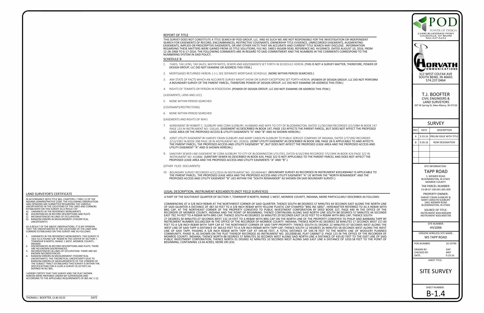
DOP
DRAWN BY:CHECKED BY:DATE:
DAPMEP9.19.16
SHEET NUMBER:
SHEET TITLE:
POD NUMBER: 16-10799
SITE NUMBER:
SURVEYREV. DATE DESCRIPTION
A 9.19.16 PRELIM ISSUE WITH TITLE
TAPP ROADSITE INFORMATION:
S. WEIMER ROADBLOOMINGTON, IN 47403
MONROE COUNTY
SOURCE OF TITLE:
TAX PARCEL NUMBER:53-08-07-100-001.005-009
PROPERTY OWNER:HARVEY CRAIN SUDBURY &MARY CAROLYN SUDBURY
1901 WEIMER ROADBLOOMINGTON, IN 47403
INSTRUMENT #2014005699INSTRUMENT #2014005700
T.J. BOOFTERCIVIL ENGINEERS &LAND SURVEYORS
207 W Spring St, New Albany, IN 47150
HV1094
312 WEST COLFAX AVESOUTH BEND, IN 46601
574.237.0464
VERIZON WIRELESS SITE NAME:
WS TAPP ROAD
B 9.26.16 ROW DESIGNATION
SITE SURVEY
B-1.4
IN ACCORDANCE WITH TITLE 865, CHAPTERS 1 THRU 12 OF THEINDIANA ADMINISTRATIVE CODE, THE FOLLOWING OBSERVATIONAND OPINIONS ARE SUBMITTED REGARDING THE VARIOUSUNCERTAINTIES IN THE LOCATIONS OF THE LINES AND CORNERSESTABLISHED ON THIS SURVEY AS A RESULT OF:A) VARIANCES IN THE REFERENCE MONUMENTSB) DISCREPANCIES IN RECORD DESCRIPTIONS AND PLATSC) INCONSISTENCIES IN LINES OF OCCUPATIOND) RANDOM ERRORS IN MEASUREMENT (THEORETICAL
UNCERTAINTY)
AS A RESULT OF THE ABOVE OBSERVATIONS, IT IS MY OPINIONTHAT THE UNCERTAINTIES IN THE LOCATIONS OF THE LINES ANDCORNERS ESTABLISHED ON THIS SURVEY ARE AS FOLLOWS:
1. VARIANCES IN THE REFERENCE MONUMENTS: THIS SURVEY ISTIED TO A FOUND 5/8" REBAR IN THE CENTER OF SECTION 7,TOWNSHIP 8 NORTH, RANGE 1 WEST, MONROE COUNTY,INDIANA
2. DISCREPANCIES IN RECORD DESCRIPTIONS AND PLATS: THEREARE NO KNOWN DISCREPANCIES.
3. INCONSISTENCIES IN LINES OF OCCUPATION: THERE ARE NOKNOWN INCONSISTENCIES.
4. RANDOM ERRORS IN MEASUREMENT (THEORETICALUNCERTAINTY): THE THEORETICAL UNCERTAINTY (DUE TORANDOM ERRORS OF MEASUREMENTS) OF THE CORNERS OFTHE SUBJECT TRACT ESTABLISHED THIS SURVEY IS WITHIN THESPECIFICATIONS FOR A CLASS A SURVEY (0.10 FEET) ASDEFINED IN IAC 865.
I HEREBY CERTIFY THAT THIS SURVEY AND THE PLAT SHOWNHEREON WERE PREPARED UNDER MY SUPERVISION ANDACCORDING TO THE APPLICABLE REQUIREMENTS OF 865 IAC 1-12.
LAND SURVEYOR'S CERTIFICATE
THOMAS J. BOOFTER, LS #S-0133 DATE
SCHEDULE B
REPORT OF TITLETHIS SURVEY DOES NOT CONSTITUTE A TITLE SEARCH BY POD GROUP, LLC. AND AS SUCH WE ARE NOT RESPONSIBLE FOR THE INVESTIGATION OR INDEPENDENTSEARCH FOR EASEMENTS OF RECORD, ENCUMBRANCES, RESTRICTIVE COVENANTS, OWNERSHIP TITLE EVIDENCE, UNRECORDED EASEMENTS, AUGMENTINGEASEMENTS, IMPLIED OR PRESCRIPTIVE EASEMENTS, OR ANY OTHER FACTS THAT AN ACCURATE AND CURRENT TITLE SEARCH MAY DISCLOSE. INFORMATIONREGARDING THESE MATTERS WERE GAINED FROM US TITLE SOLUTIONS, FILE NO. 54851-IN1608-5030, REFERENCE NO. HV1094CD, DATED AUGUST 10, 2016, FROM12-28-1968 TO 6-17-2016. THE FOLLOWING COMMENTS ARE IN REGARD TO SAID COMMITMENT AND THE NUMBERS IN THE COMMENTS CORRESPOND TO THENUMBERING SYSTEM IN SAID POLICY.
1. TAXES, TAX LIENS, TAX SALES, WATER RATES, SEWER AND ASSESSMENTS SET FORTH IN SCHEDULE HEREIN. (THIS IS NOT A SURVEY MATTER, THEREFORE, POWER OFDESIGN GROUP, LLC DID NOT EXAMINE OR ADDRESS THIS ITEM.)
2. MORTGAGES RETURNED HEREIN. (-1-). SEE SEPARATE MORTGAGE SCHEDULE. (NONE WITHIN PERIOD SEARCHED.)
3. ANY STATE OF FACTS WHICH AN ACCURATE SURVEY MIGHT SHOW OR SURVEY EXCEPTIONS SET FORTH HEREIN. (POWER OF DESIGN GROUP, LLC DID NOT PERFORMA BOUNDARY SURVEY OF THE PARENT PARCEL, THEREFORE POWER OF DESIGN GROUP, LLC DID NOT EXAMINE OR ADDRESS THIS ITEM.)
4. RIGHTS OF TENANTS OR PERSON IN POSSESSION. (POWER OF DESIGN GROUP, LLC DID NOT EXAMINE OR ADDRESS THIS ITEM.)
(JUDGMENTS, LIENS AND UCC)
5. NONE WITHIN PERIOD SEARCHED
(COVENANTS/RESTRICTIONS)
6. NONE WITHIN PERIOD SEARCHED
(EASEMENTS AND RIGHTS OF WAY)
7. AGREEMENT BY ROBERT C. SUDBURY AND CORA SUDBURY, HUSBAND AND WIFE TO CITY OF BLOOMINGTON, DATED 11/30/1964 RECORDED 3/2/1984 IN BOOK 147PAGE 133 IN INSTRUMENT NO :156145. (EASEMENT AS DESCRIBED IN BOOK 147, PAGE 133 AFFECTS THE PARENT PARCEL, BUT DOES NOT AFFECT THE PROPOSEDLEASE AREA OR THE PROPOSED ACCESS & UTILITY EASEMENTS "A" AND "B" AND AS SHOWN HEREON.)
8. JOINT UTILITY EASEMENT BY HARVEY CRAIN SUDBURY AND MARY CAROLYN SUDBURY TO PUBLIC SERVICE COMPANY OF INDIANA, DATED 2/7/1992 RECORDED3/13/1992 IN BOOK 398 PAGE 28 IN INSTRUMENT NO :203926. (JOINT UTILITY EASEMENT AS DESCRIBED IN BOOK 398, PAGE 28 IS APPLICABLE TO AND AFFECTSTHE PARENT PARCEL, THE PROPOSED ACCESS AND UTILITY EASEMENT "B", BUT DOES NOT AFFECT THE PROPOSED LEASE AREA AND THE PROPOSED ACCESS ANDUTILITY EASEMENT "A" AND IS SHOWN HEREON.)
9. SANITARY SEWER LINE EASEMENT BY CORA SUDBURY TO CITY OF BLOOMINGTON UTILITIES, DATED 6/16/1994 RECORDED 7/5/1994 IN BOOK 424 PAGE 322 ININSTRUMENT NO :410886. (SANITARY SEWER AS DESCRIBED IN BOOK 424, PAGE 322 IS NOT APPLICABLE TO THE PARENT PARCEL AND DOES NOT AFFECT THEPROPOSED LEASE AREA AND THE PROPOSED ACCESS AND UTILITY EASEMENTS "A" AND "B".)
(OTHER FILED DOCUMENTS)
10. BOUNDARY SURVEY RECORDED 4/21/2014 IN INSTRUMENT NO. 2014004467. (BOUNDARY SURVEY AS RECORDED IN INSTRUMENT #2014004467 IS APPLICABLE TOTHE PARENT PARCEL. THE PROPOSED LEASE AREA AND THE PROPOSED ACCESS AND UTILITY EASEMENT "A" LIE WITHIN THE "NORTH REMAINDER" AND THEPROPOSED ACCESS AND UTILITY EASEMENT "B" LIES WITHIN THE "SOUTH REMAINDER" AS SHOWN ON SAID BOUNDARY SURVEY.)
LEGAL DESCRIPTION, INSTRUMENT #201400570 (NOT FIELD SURVEYED)A PART OF THE SOUTHEAST QUARTER OF SECTION 7, TOWNSHIP 8 NORTH, RANGE 1 WEST, MONROE COUNTY, INDIANA, MORE PARTICULARLY DESCRIBED AS FOLLOWS:
COMMENCING AT A 5/8 INCH REBAR AT THE NORTHWEST CORNER OF SAID QUARTER; THENCE SOUTH 88 DEGREES 57 MINUTES 44 SECONDS EAST ALONG THE NORTH LINEOF SAID QUARTER A DISTANCE OF 487.50 FEET TO A 5/8 INCH REBAR WITH YELLOW PLASTIC CAP STAMPED "BRG INC 6892", HEREINAFTER REFERRED TO AS A REBAR WITHBRG CAP, AT THE NORTHEAST CORNER OF THE PROPERTY CONVEYED TO PUBLIC INVESTMENT CORPORATION BY DEED BOOK 327, PAGE 440 IN THE OFFICE OF THERECORDER OF MONROE COUNTY, INDIANA AND THE POINT OF BEGINNING; THENCE CONTINUING ALONG SAID NORTH LINE SOUTH 88 DEGREES 57 MINUTES 44 SECONDSEAST 792.74 FEET TO A REBAR WITH BRG CAP; THENCE SOUTH 40 DEGREES 16 MINUTES 29 SECONDS EAST 24.02 FEET TO A REBAR WITH BRG CAP; THENCE SOUTH27 DEGREES 30 MINUTES 07 SECONDS WEST 132.19 FEET TO A REBAR WITH BRG CAP ON THE NORTH LINE OF THE PROPERTY CONVEYED TO PHILIP AND BARBARA TAPP BYINSTRUMENT NUMBER 2011001304 IN THE OFFICE OF THE RECORDER OF MONROE COUNTY. INDIANA; THENCE NORTH 82 DEGREES 58 MINUTES 17 SECONDS WEST 157.60FEET TO A 5/8 INCH REBAR WITH TAPP CAP AT THE NORTHWEST CORNER OF SAID TAPP PROPERTY: THENCE SOUTH 01 DEGREE 22 MINUTES 07 SECONDS WEST ALONG THEWEST LINE OF SAID TAPP A DISTANCE OF 360.63 FEET TO A 5/8 INCH REBAR WITH TAPP CAP; THENCE SOUTH 12 DEGREES 26 MINUTES 58 SECONDS WEST ALONG THE WESTLINE OF SAID TAPP, PASSING A 5/8 INCH REBAR WITH TAPP CAP AT 549.46 FEET, A TOTAL DISTANCE OF 549.78 FEET TO THE NORTH LINE OF WOOLERY PLANNEDCOMMUNITY, PHASE IX, AS SHOWN ON THE PLAT THEREOF RECORDED AS INSTRUMENT NO. 2012008140, PLAT CABINET D. PAGE 115 IN THE OFFICE OF THE RECORDER OFMONROE COUNTY, INDIANA; THENCE NORTH 88 DEGREES 57 MINUTES 26 SECONDS WEST ALONG SAID NORTH LINE A DISTANCE OF 433.82 FEET TO THE EAST LINE OF SAIDPUBLIC INVESTMENT CORPORATION; THENCE NORTH 01 DEGREE 42 MINUTES 10 SECONDS WEST ALONG SAID EAST LINE A DISTANCE OF 1010.58 FEET TO THE POINT OFBEGINNING, CONTAINING 13.04 ACRES, MORE OR LESS.

DRAWN BY:CHECKED BY:DATE:
PODMEP9.22.16
SHEET NUMBER:
SHEET TITLE:
POD NUMBER: 16-10025
DOP
REV. DATE DESCRIPTION
PRELIMINARYNOT FOR
CONSTRUCTION
SITE INFORMATION:
HORVATH SITE NUMBER:
VERIZON WIRELESS SITE NAME:
TAPP ROADS. WEIMER ROAD
BLOOMINGTON, IN 47403MONROE COUNTY
HV1094
WS TAPP ROAD
ZONINGDRAWINGS
A 9.30.16 ISSUED FOR REVIEW
B 10.4.16 OLC COMMENTS
312 WEST COLFAX AVESOUTH BEND, IN 46601
REVISIONLOG
R-1
REVISION LOG
REV * MM/DD/YY SHEET NUMBER & NAME DESCRIPTION OF REVISION
A 9/30/2016 ALL SHEETS ISSUED FOR REVIEW
B 10/4/2016 C-1A REVISED DIMENSIONS PER OLC
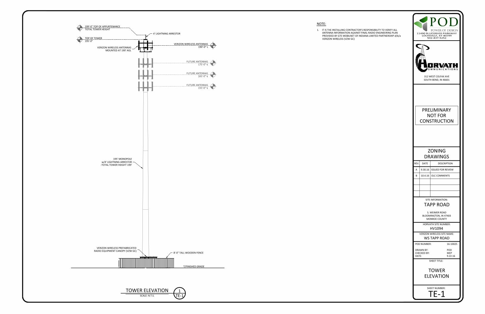
DRAWN BY:CHECKED BY:DATE:
PODMEP9.22.16
SHEET NUMBER:
SHEET TITLE:
POD NUMBER: 16-10025
DOP
REV. DATE DESCRIPTION
PRELIMINARYNOT FOR
CONSTRUCTION
SITE INFORMATION:
HORVATH SITE NUMBER:
VERIZON WIRELESS SITE NAME:
TAPP ROADS. WEIMER ROAD
BLOOMINGTON, IN 47403MONROE COUNTY
HV1094
WS TAPP ROAD
ZONINGDRAWINGS
A 9.30.16 ISSUED FOR REVIEW
B 10.4.16 OLC COMMENTS
312 WEST COLFAX AVESOUTH BEND, IN 46601
TOWERELEVATION
TE-1
NOTE:
1. IT IS THE INSTALLING CONTRACTOR'S RESPONSIBILITY TO VERIFY ALLANTENNA INFORMATION AGAINST FINAL RADIO ENGINEERING PLANPROVIDED BY GTE MOBILNET OF INDIANA LIMITED PARTNERSHIP d/b/aVERIZON WIRELESS (VZW GC)
TOWER ELEVATIONSCALE: N.T.S.
VERIZON WIRELESS ANTENNAS190'-0" ℄
T/FINISHED GRADE
TOP OF TOWER195'-0"
199'-0" TOP OF APPURTENANCETOTAL TOWER HEIGHT
FUTURE ANTENNAS175'-0" ℄
195' MONOPOLEw/4' LIGHTNING ARRESTOR
-TOTAL TOWER HEIGHT 199'
VERIZON WIRELESS PREFABRICATEDRADIO EQUIPMENT CANOPY (VZW GC)
8'-0" TALL WOODEN FENCE
4' LIGHTNING ARRESTOR
VERIZON WIRELESS ANTENNASMOUNTED AT 190' AGL
1TE-1
FUTURE ANTENNAS165'-0" ℄
FUTURE ANTENNAS155'-0" ℄

NEW 12'-0" GRAVEL ACCESS DRIVE- NEW DRIVE @ ±870 LF
195' MONOPOLE w/4'LIGHTNING ARRESTOR-TOTAL TOWER HEIGHT 199'
VERIZON WIRELESS 11'-6"x14'-9" RADIOEQUIPMENT CANOPY (VZW GC)
100'-0"x100'-0" HORVATHCOMUNICATIONS LEASE AREA- SEE SURVEY FOR DESCRIPTION
ACCESS/UTILITY EASEMENT- SEE SURVEY FOR LOCATION
DRAWN BY:CHECKED BY:DATE:
PODMEP9.22.16
SHEET NUMBER:
SHEET TITLE:
POD NUMBER: 16-10025
DOP
REV. DATE DESCRIPTION
PRELIMINARYNOT FOR
CONSTRUCTION
SITE INFORMATION:
HORVATH SITE NUMBER:
VERIZON WIRELESS SITE NAME:
TAPP ROADS. WEIMER ROAD
BLOOMINGTON, IN 47403MONROE COUNTY
HV1094
WS TAPP ROAD
ZONINGDRAWINGS
A 9.30.16 ISSUED FOR REVIEW
B 10.4.16 OLC COMMENTS
312 WEST COLFAX AVESOUTH BEND, IN 46601
OVERALL SITE PLANw/AERIAL OVERLAY
C-1SCALE: N.T.S.OVERALL SITE PLAN w/AERIAL OVERLAY NNOTICE TO CONTRACTOR
PER INDIANA STATE LAW IC-8-1-26-18, IT ISAGAINST THE LAW TO EXCAVATE WITHOUT
NOTIFYING THE UNDERGROUND LOCATION SERVICETWO (2) WORKING DAYS BEFORE COMMENCING WORK.
VERIZON WIRELESS 11'-6"x19'-6"CONCRETE RADIO EQUIPMENT PAD
S. WEIMER ROAD(PUBLIC RIGHT OF WAY - WIDTH UNKNOWN)
EX. CREEK
EX. BRIDGE(TO BE REPLACED)
EX. UTILITY EASEMENT- SEE SURVEY FOR LOCATION
EX. UTILITY EASEMENT- SEE SURVEY FOR LOCATION
PARCEL ID: 53-08-07-100-001.005-009HARVEY CRAIN SUDBURY &MARY CAROLYN SUDBURY
INST. #2014005699
PARC
EL ID
: 53-
08-0
7-30
0-00
6.00
0-00
9PU
BLIC
INVE
STM
ENT
CORP
ORA
TIO
NBO
OK
327,
PG
. 440 PARCEL ID: 53-08-07-100-001.008-009
HARVEY CRAIN SUDBURY &MARY CAROLYN SUDBURY
INST. #2014005700
PARCEL ID: 53-08-07-400-008.099-009JOE KEMP CONSTRUCTION, LLC
INST. #2016010797
EX. SANITARY SEWER EASEMENT- SEE SURVEY FOR LOCATION
EX. TREE MASS
EX. WELL

NEW 12'-0" GRAVEL ACCESS DRIVE- NEW DRIVE @ ±870 LF
195' MONOPOLE w/4'LIGHTNING ARRESTOR-TOTAL TOWER HEIGHT 199'
VERIZON WIRELESS 11'-6"x14'-9" RADIOEQUIPMENT CANOPY (VZW GC)
100'-0"x100'-0" HORVATHCOMUNICATIONS LEASE AREA- SEE SURVEY FOR DESCRIPTION
ACCESS/UTILITY EASEMENT- SEE SURVEY FOR LOCATION
DRAWN BY:CHECKED BY:DATE:
PODMEP9.22.16
SHEET NUMBER:
SHEET TITLE:
POD NUMBER: 16-10025
DOP
REV. DATE DESCRIPTION
PRELIMINARYNOT FOR
CONSTRUCTION
SITE INFORMATION:
HORVATH SITE NUMBER:
VERIZON WIRELESS SITE NAME:
TAPP ROADS. WEIMER ROAD
BLOOMINGTON, IN 47403MONROE COUNTY
HV1094
WS TAPP ROAD
ZONINGDRAWINGS
A 9.30.16 ISSUED FOR REVIEW
B 10.4.16 OLC COMMENTS
312 WEST COLFAX AVESOUTH BEND, IN 46601
OVERALL SITE PLANw/DISTANCE TOPROPERTY LINES
C-1ASCALE: 1" = 80'OVERALL SITE PLAN w/DISTANCE TO PROPERTY LINES NNOTICE TO CONTRACTOR
PER INDIANA STATE LAW IC-8-1-26-18, IT ISAGAINST THE LAW TO EXCAVATE WITHOUT
NOTIFYING THE UNDERGROUND LOCATION SERVICETWO (2) WORKING DAYS BEFORE COMMENCING WORK.
VERIZON WIRELESS 11'-6"x19'-6"CONCRETE RADIO EQUIPMENT PAD
LEGENDUTILITY POLE SANITARY MANHOLEGUY ANCHOR
PROPOSED LEASE LINEPROPOSED EASEMENTPROPOSED GRAVELPROPOSED FENCEEXISTING GRAVELEXISTING FENCEEXISTING LEASE AREAEXISTING EASEMENTEXISTING OVERHEAD ELECTRICEXISTING PAVEMENTPROPERTY LINE
0'
1"=
80'
80'
160'
S. WEIMER ROAD(PUBLIC RIGHT OF WAY - WIDTH UNKNOWN)
EX. CREEK
EX. BRIDGE(TO BE REPLACED)
EX. UTILITY EASEMENT- SEE SURVEY FOR LOCATION
EX. UTILITY EASEMENT- SEE SURVEY FOR LOCATION
PARCEL ID: 53-08-07-100-001.005-009HARVEY CRAIN SUDBURY &MARY CAROLYN SUDBURY
INST. #2014005699
PARC
EL ID
: 53-
08-0
7-30
0-00
6.00
0-00
9PU
BLIC
INVE
STM
ENT
CORP
ORA
TIO
NBO
OK
327,
PG
. 440 PARCEL ID: 53-08-07-100-001.008-009
HARVEY CRAIN SUDBURY &MARY CAROLYN SUDBURY
INST. #2014005700
PARCEL ID: 53-08-07-400-008.099-009JOE KEMP CONSTRUCTION, LLC
INST. #2016010797
EX. SANITARY SEWER EASEMENT- SEE SURVEY FOR LOCATION
EX. TREE MASS
EX. WELL
±215'
±251' TO ⅊ BEYOND
±694' TO
⅊ BE
YON
D
±1,008' TO ⅊ BEYOND

NEW 12'-0" GRAVEL ACCESS DRIVE- NEW DRIVE @ ±870 LF
195' MONOPOLE w/4'LIGHTNING ARRESTOR-TOTAL TOWER HEIGHT 199'
VERIZON WIRELESS 11'-6"x14'-9" RADIOEQUIPMENT CANOPY (VZW GC)
100'-0"x100'-0" HORVATHCOMUNICATIONS LEASE AREA- SEE SURVEY FOR DESCRIPTION
ACCESS/UTILITY EASEMENT- SEE SURVEY FOR LOCATION
DRAWN BY:CHECKED BY:DATE:
PODMEP9.22.16
SHEET NUMBER:
SHEET TITLE:
POD NUMBER: 16-10025
DOP
REV. DATE DESCRIPTION
PRELIMINARYNOT FOR
CONSTRUCTION
SITE INFORMATION:
HORVATH SITE NUMBER:
VERIZON WIRELESS SITE NAME:
TAPP ROADS. WEIMER ROAD
BLOOMINGTON, IN 47403MONROE COUNTY
HV1094
WS TAPP ROAD
ZONINGDRAWINGS
A 9.30.16 ISSUED FOR REVIEW
B 10.4.16 OLC COMMENTS
312 WEST COLFAX AVESOUTH BEND, IN 46601
DISTANCE TORESIDENTIALSTRUCTURES
C-1BSCALE: 1" = 80'
DISTANCE TO RESIDENTIAL STRUCTURES NNOTICE TO CONTRACTORPER INDIANA STATE LAW IC-8-1-26-18, IT ISAGAINST THE LAW TO EXCAVATE WITHOUT
NOTIFYING THE UNDERGROUND LOCATION SERVICETWO (2) WORKING DAYS BEFORE COMMENCING WORK.
VERIZON WIRELESS 11'-6"x19'-6"CONCRETE RADIO EQUIPMENT PAD
LEGENDUTILITY POLE SANITARY MANHOLEGUY ANCHOR
PROPOSED LEASE LINEPROPOSED EASEMENTPROPOSED GRAVELPROPOSED FENCEEXISTING GRAVELEXISTING FENCEEXISTING LEASE AREAEXISTING EASEMENTEXISTING OVERHEAD ELECTRICEXISTING PAVEMENTPROPERTY LINE
0'
1"=
80'
80'
160'
S. WEIMER ROAD(PUBLIC RIGHT OF WAY - WIDTH UNKNOWN)
EX. CREEK
EX. BRIDGE(TO BE REPLACED)
EX. UTILITY EASEMENT- SEE SURVEY FOR LOCATION
EX. UTILITY EASEMENT- SEE SURVEY FOR LOCATION
PARCEL ID: 53-08-07-100-001.005-009HARVEY CRAIN SUDBURY &MARY CAROLYN SUDBURY
INST. #2014005699
PARC
EL ID
: 53-
08-0
7-30
0-00
6.00
0-00
9PU
BLIC
INVE
STM
ENT
CORP
ORA
TIO
NBO
OK
327,
PG
. 440 PARCEL ID: 53-08-07-100-001.008-009
HARVEY CRAIN SUDBURY &MARY CAROLYN SUDBURY
INST. #2014005700
PARCEL ID: 53-08-07-400-008.099-009JOE KEMP CONSTRUCTION, LLC
INST. #2016010797
EX. SANITARY SEWER EASEMENT- SEE SURVEY FOR LOCATION
EX. TREE MASS
EX. WELL
±879' TOWER ℄ TO RESIDENTIAL HOME

SCALE: 1" = 10'-0"
DETAILED SITE PLAN*NOTE:GENERAL CONTRACTOR IS TO ENSURETHERE IS NO DISTURBANCE OF PROPERTY,SOIL, ETC. OUTSIDE OF THE STAKED LEASEAREA WITHOUT APPROVAL FROMVERIZON WIRELESS CONSTRUCTIONMANAGER
TE-11
DRAWN BY:CHECKED BY:DATE:
PODMEP9.22.16
SHEET NUMBER:
SHEET TITLE:
POD NUMBER: 16-10025
DOP
REV. DATE DESCRIPTION
PRELIMINARYNOT FOR
CONSTRUCTION
SITE INFORMATION:
HORVATH SITE NUMBER:
VERIZON WIRELESS SITE NAME:
TAPP ROADS. WEIMER ROAD
BLOOMINGTON, IN 47403MONROE COUNTY
HV1094
WS TAPP ROAD
ZONINGDRAWINGS
A 9.30.16 ISSUED FOR REVIEW
B 10.4.16 OLC COMMENTS
312 WEST COLFAX AVESOUTH BEND, IN 46601
DETAILEDSITE
PLAN
C-3
NEW 12'-0" GRAVEL ACCESS DRIVE- NEW DRIVE @ ±870 LF
GATE KEEPER(TYP OF 2)
14'-0" WIDEACCESS GATE
POWER & TELCO METERBOARD STRUCTURE- INSTALLED BY G.C.
VERIZON WIRELESS 11'-6"x14'-9"RADIO EQUIPMENT CANOPY
(CANOPY DWGS. SUPPLIEDBY MANUFACTURER) (VZW GC)
GRAVELCOMPOUND
ICE BRIDGE &FOUNDATIONS
8'-0" TALL WOODEN FENCE- @ 280 L.F.
FUTURE
FUTURE
FUTURE
NNOTICE TO CONTRACTORPER INDIANA STATE LAW IC-8-1-26-18, IT ISAGAINST THE LAW TO EXCAVATE WITHOUT
NOTIFYING THE UNDERGROUND LOCATION SERVICETWO (2) WORKING DAYS BEFORE COMMENCING WORK.
VERIZON WIRELESS STANDBY GENERATORON CONCRETE PAD (VZW GC)
195' MONOPOLE w/4'LIGHTNING ARRESTOR
-TOTAL TOWER HEIGHT 199'
LEGENDPROPOSED LEASE LINEPROPOSED EASEMENTPROPOSED GRAVELPROPOSED FENCE
0'
1"=
10'
10'
10'
VERIZON WIRELESS 11'-6"x19'-6"CONCRETE RADIO EQUIPMENT PAD
TE-11
EX. TREE MASS

SCALE: 1" = 10'-0"
DIMENSIONED SITE PLAN*NOTE:GENERAL CONTRACTOR IS TO ENSURETHERE IS NO DISTURBANCE OF PROPERTY,SOIL, ETC. OUTSIDE OF THE STAKED LEASEAREA WITHOUT APPROVAL FROMVERIZON WIRELESS CONSTRUCTIONMANAGER
DRAWN BY:CHECKED BY:DATE:
PODMEP9.22.16
SHEET NUMBER:
SHEET TITLE:
POD NUMBER: 16-10025
DOP
REV. DATE DESCRIPTION
PRELIMINARYNOT FOR
CONSTRUCTION
SITE INFORMATION:
HORVATH SITE NUMBER:
VERIZON WIRELESS SITE NAME:
TAPP ROADS. WEIMER ROAD
BLOOMINGTON, IN 47403MONROE COUNTY
HV1094
WS TAPP ROAD
ZONINGDRAWINGS
A 9.30.16 ISSUED FOR REVIEW
B 10.4.16 OLC COMMENTS
312 WEST COLFAX AVESOUTH BEND, IN 46601
DIMENSIONEDSITE PLAN
C-4
FUTURE
FUTURE
FUTURE
NNOTICE TO CONTRACTORPER INDIANA STATE LAW IC-8-1-26-18, IT ISAGAINST THE LAW TO EXCAVATE WITHOUT
NOTIFYING THE UNDERGROUND LOCATION SERVICETWO (2) WORKING DAYS BEFORE COMMENCING WORK.
LEGENDPROPOSED LEASE LINEPROPOSED EASEMENTPROPOSED GRAVELPROPOSED FENCE
0'
1"=
10'
10'
10'
100'-0" HORVATH COMMUNICATIONS LEASE AREA
70'-0" LIMITS OF FENCE15'-0"
15'-0"
80'-0
" HO
RVAT
H CO
MM
UN
ICAT
ION
S LE
ASE
AREA
70'-0
" LIM
ITS
OF
FEN
CE5'
-0"
5'-0
"
28'-0
"14
'-0"
28'-0
"
35'-0
" TO
WER
CEN
TER/
LEAS
E 35'-0" TOWER CENTER/LEASE
15'-6
"
5'-0
"
5'-0
"
25'-0"
19'-0"6'-0"
6'-0
"
25'-6"
25'-6"
19'-6" LIMITS OF CONCRETE PAD
11'-6
" LIM
ITS
OF
CON
CRET
E PA
D
20' RADIUS
20'-0" TURNAROUND 4'-0"

DRAWN BY:CHECKED BY:DATE:
PODMEP9.22.16
SHEET NUMBER:
SHEET TITLE:
POD NUMBER: 16-10025
DOP
REV. DATE DESCRIPTION
PRELIMINARYNOT FOR
CONSTRUCTION
SITE INFORMATION:
HORVATH SITE NUMBER:
VERIZON WIRELESS SITE NAME:
TAPP ROADS. WEIMER ROAD
BLOOMINGTON, IN 47403MONROE COUNTY
HV1094
WS TAPP ROAD
ZONINGDRAWINGS
A 9.30.16 ISSUED FOR REVIEW
B 10.4.16 OLC COMMENTS
312 WEST COLFAX AVESOUTH BEND, IN 46601
PLATFORMELEVATIONS
(REFERENCE ONLY)
D-3
REAR ELEVATIONSCALE: 1" = 5'-0"
END ELEVATIONSCALE: 1" = 5'-0"
0'
1"=
5'
5'
10'
COMPOUND GRADE
VZWFUTURE
GROWTHCABINET
VZWFUTURECABINET
VZW 20kW DIESELGENERATOR (VZW GC)
ROOF PANEL CLOSURE STRIP (VZW GC)-INSTALL BETWEEN ROOF PANELS ANDHORIZONTAL FRAMING MEMBERS (TYP.)
VZW AUTOMATIC TRANSFERSWITCH -BEYOND (VZW GC)CONCRETE
EQUIPMENT PAD
CANOPY ROOFSTRUCTURE
(VZW GC)
METAL ROOF(VZW GC)
VZW EQUIPMENTCABINET (VZW GC)
ICE BRIDGE &FOUNDATIONS
(TYP.) (VZW GC) ELECTRIC POWER CONDUITOVERHEAD (VZW GC)
METAL ROOF(VZW GC)
CANOPY ROOFSTRUCTURE(VZW GC)VZW
AUTOMATICTRANSFER
SWITCH-BEYOND(VZW GC)
VZW EQUIPMENTCABINET (VZW GC)
CONCRETEEQUIPMENT PAD
6"8'
-1"
CON
CRET
E TO
CAN
OPY
FRA
MIN
G
14'-9" LIMITS OF CANOPY
11'-6" LIMITS OF CANOPY
±9'-5" COMPOUND GRADE TO
HIGH
PO
INT
OF
CAN
OPY
6"8'
-1"
CON
CRET
E TO
CAN
OPY
FRA
MIN
G
±9'-2" COMPOUND GRADE TO
LOW
PO
INT
OF
CAN
OPY
NOTE:
CANOPY ROOF PANELS PROFILE R/PBR. PROVIDE 1.7lbDENSITY POLYETHYLENE FOAM PANEL CLOSURE STRIPS TOMATCH PROFILE. AS MANUFACTURED BY: SEALTITE BUILDINGFASTENERS "ST CLOSURE" STRIPS OR EQUAL (VERIFY PROFILEWITH ROOF PANELS SUPPLIED WITH CANOPY)
NOTE:ICE BRIDGE & FOUNDATIONS NOT
SHOWN FOR CLARITY
NOTE:GENERATOR NOT
SHOWN FOR CLARITY

DRAWN BY:CHECKED BY:DATE:
PODMEP9.22.16
SHEET NUMBER:
SHEET TITLE:
POD NUMBER: 16-10025
DOP
REV. DATE DESCRIPTION
PRELIMINARYNOT FOR
CONSTRUCTION
SITE INFORMATION:
HORVATH SITE NUMBER:
VERIZON WIRELESS SITE NAME:
TAPP ROADS. WEIMER ROAD
BLOOMINGTON, IN 47403MONROE COUNTY
HV1094
WS TAPP ROAD
ZONINGDRAWINGS
A 9.30.16 ISSUED FOR REVIEW
B 10.4.16 OLC COMMENTS
312 WEST COLFAX AVESOUTH BEND, IN 46601
PRELIMINARYBRIDGE DESIGN
D-5
PRELIMINARY BRIDGE DESIGNSCALE: 1" = 5'-0"
0'
1"=
5'
5'
10'

NT SUBMISSION PACKET -- FCC FORM 620 Approved by OMB
3060-1039 See instructions for
public burden estimates
Applicant’s Name: Horvath Towers, LLC Project Name: WS Tapp Road Project Number: HV1094
FCC Form 620
Attachment 5. Area of Potential Effects You are required to provide two attachments regarding the Determination of Effect: Areas of Potential Effect and Mitigation of Effect (if applicable). Areas of Potential Effect Guidelines: a. Describe the APE for direct effects and explain how this APE was determined.
The APE for direct effects is limited to the area of potential ground disturbance and any property, or any portion thereof, that will be physically altered or destroyed by the Undertaking. On November 24, 2008, the FCC further clarified that the APE-Direct Effects is limited to the proposed lease area including the access route and utility corridor. EBI Consulting completed a field survey on October 10, 2016 and determined that the APE for direct effects is limited to the 80-foot by 100-foot telecommunication tower lease area and access/utility easement.
b. Describe the APE for visual effects and explain how this APE was determined.
The APE for visual effects is the geographic area in which the Undertaking has the potential to introduce visual elements that diminish or alter the setting, including the landscape, where the setting is a character-defining feature of a historic property that makes it eligible for listing on the National Register. The presumed APE for visual effects for construction of new facilities is the area from which the tower will be visible: a. Within a half mile from the tower site if the proposed Tower is 200 feet or less in overall height; b. Within ¾ of a mile from the tower site if the proposed Tower is more than 200 but no more than 400 feet in overall height; or c. Within 1 ½ miles from the proposed tower site if the proposed Tower is more than 400 feet in overall height. Due to the height of the proposed tower, the presumed APE for visual effects for this project is a half-mile radius from the tower site.
Mitigation of Effect Guidelines: In the case where an Adverse Visual Effect or Adverse Direct Effect has been determined you must provide the following: a. Copies of any correspondence and summaries of any oral communications with the
SHPO/THPO and any consulting parties. As of the date of this report, there has been no correspondence with the SHPO/THPO. b. Describe any alternatives that have been considered that might avoid, minimize, or
mitigate any adverse effects. Explain the Applicant’s conclusion regarding the feasibility of each alternative.
No adverse effects are expected as a result of the proposed facility; therefore, alternatives that might avoid, minimize, or mitigate any adverse effects need not be considered.
For each property identified as a Historic Property in the online e-106 form: Indicate whether the Applicant believes the proposed undertaking would have a) no
effect; b) no adverse effect; or, c) an adverse effect. Explain how each such assessment was made. Provide supporting documentation where necessary.

NT SUBMISSION PACKET -- FCC FORM 620 Approved by OMB
3060-1039 See instructions for
public burden estimates
Applicant’s Name: Horvath Towers, LLC Project Name: WS Tapp Road Project Number: HV1094
FCC Form 620
Please see the table below for an evaluation of the proposed project’s effects on identified historic properties.
NRHP/ Inventory Number
Historic Property Name
Effect Determination Explanation of Effect Determination
EBI Photo No.
105-005-55001
Woolery Stone Company
No Adverse Effect
This resource is located within the APE-VE, approximately 1,200 feet south of the Project Site. The Project Site may be minimally visible from this resource; however, the view towards the tower is mitigated by distance and intervening vegetation. In addition, property has modern development to the east and south. Therefore the proposed project will not impact any of the characteristics that make this structure eligible for the National Register of Historic Places and will have No Adverse Effect.
14-16

NT SUBMISSION PACKET -- FCC FORM 620 Approved by OMB
3060-1039 See instructions for
public burden estimates
Applicant’s Name: Horvath Towers, LLC Project Name: WS Tapp Road Project Number: HV1094
FCC Form 620
Attachment 6. Tribal and NHO Involvement At an early stage in the planning process, the Nationwide Agreement requires the Applicant to gather information from appropriate Indian Tribes or Native Hawaiian Organizations (“NHOs”) to assist in the identification of Historic Properties of religious and cultural significance to them. Describe measures taken to identify Indian tribes and NHOs that may attach religious and cultural significance to Historic Properties that may be affected by the collocation within the Areas of Potential Effects (“APE”) for direct and visual effects. If such Indian tribes or NHOs were identified, list them and provide a summary of contacts by either the FCC, the Applicant, or the Applicant’s representative. Provide copies of relevant documents, including correspondence. If no such Indian tribes or NHOs were identified, please explain. EBI Consulting filed the proposed undertaking on the FCC’s Tower Construction Notification System (TCNS). The attached FCC Notification email lists the Tribes identified through the TCNS process. Follow up correspondence, when necessary, will be completed via the methods listed on the attached email considered acceptable to each Tribe.
1
Janet Roeser
From: [email protected]: Friday, September 30, 2016 12:02 AMTo: Janet RoeserCc: [email protected]; [email protected]: NOTICE OF ORGANIZATION(S) WHICH WERE SENT PROPOSED TOWER
CONSTRUCTION NOTIFICATION INFORMATION - Email ID #4730237
Dear Sir or Madam:
Thank you for using the Federal Communications Commission's (FCC) Tower Construction Notification System (TCNS).
The purpose of this electronic mail message is to inform you that the following authorized persons were sent the
information you provided through TCNS, which relates to your proposed antenna structure. The information was
forwarded by the FCC to authorized TCNS users by electronic mail and/or regular mail (letter).
Persons who have received the information that you provided include leaders or their designees of federally-recognized
American Indian Tribes, including Alaska Native Villages (collectively "Tribal Nations"), Native Hawaiian Organizations
(NHOs), and State Historic Preservation Officers (SHPOs). For your convenience in identifying the referenced Tribal
Nations and NHOs and in making further contacts, the City and State of the Seat of Government for each Tribal Nation
and NHO, as well as the designated contact person, is included in the listing below. We note that Tribal Nations may
have Section 106 cultural interests in ancestral homelands or other locations that are far removed from their current
Seat of Government. Pursuant to the Commission's rules as set forth in the Nationwide Programmatic Agreement for
Review of Effects on Historic Properties for Certain Undertakings Approved by the Federal Communications Commission
(NPA), all Tribal Nations and NHOs listed below must be afforded a reasonable opportunity to respond to this
notification, consistent with the procedures set forth below, unless the proposed construction falls within an exclusion
designated by the Tribal Nation or NHO. (NPA, Section IV.F.4).
The information you provided was forwarded to the following Tribal Nations and NHOs. If a Tribal Nation or NHO does
not respond within a reasonable time, you should make a reasonable effort at follow-up contact, unless the Tribal
Nation or NHO has agreed to different procedures (NPA, Section IV.F.5). In the event a Tribal Nation or NHO does not
respond to a follow-up inquiry, or if a substantive or procedural disagreement arises between you and a Tribal Nation or
NHO, you must seek guidance from the Commission (NPA, Section IV.G). These procedures are further set forth in the
FCC's Declaratory Ruling released on October 6, 2005 (FCC 05-176).
1. THPO Erich Longie Dr - Spirit Lake Nation - (PO Box: 198) Fort Totten, ND - [email protected];
[email protected] - 701-766-4032
Details: Spirit Lake Nation
Contact Us: Compliance Officer Susie Fox, 701-766-4031, email [email protected]
Submit Proposed Projects to: cms.spiritlakeconsulting.com
Summary of Information Required: We require the complete results of the file search ofthe area of potential effect.
Nearly every single Native cultural resource that is identified by archaeologists is recorded as unevaluated and needing
2
further evaluation. We require you to send ALL KNOWN sites identified in the complete file search - even the
unevaluated, undetermined, and recommended ineligible sites.
Complete Class I Cultural Inventory if fieldwork was not done. Complete Class III Cultural Resource Inventory Report if it
was done. This should include a list of all identified sites, their resource type, distance away from the project, National
Register eligibility determination if one has been made, SHPO file number, and site name. We require the same
information of all newly recorded cultural resources identified for the current undertaking as well.
We require the location of the proposed project, the area of direct effect and area of potential effect, topographical
maps, and photographs.
Current Fee Schedule: $400 per tower and PTC batches are $400 for the first tower and $250 per additional towers in
the batch
Checks: payable to the Spirit Lake THPO Office and mailed to PO Box 198, Fort Totten, North Dakota 58335
2. THPO & Tribal Anthropologist Dianne Desrosiers - Sisseton-Wahpeton Oyate of the Lake Traverse Reservation
- (PO Box: 907) Sisseton, SD - [email protected]; [email protected] - 605-698-3584
Details: The Sisseton-Wahpeton Oyate required method of consultation is digitally through our website.
http://sisseton.heritageconsultation.com
All projects must be processed through our website. We do not accept paper or emailed submissions.
Our tribe requires the Cultural Resource or Archaeological Survey Reports completed for the project, such as the Class III
Cultural Resource Inventory Report if done, or at least a Class I Cultural Inventory if fieldwork was not required. This
report should include ALL identified sites within the designated area of potential effect. This includes NOT ONLY the
listed and eligible sites; we want the unevaluated, undetermined, and recommended not eligible sites as well.
This report should include the previously located cultural resource designation, distance from the project, and National
Register eligibility determination, if a determination has been made. No determination is fine if the site has not been
evaluated, but we still want to see the information on these sites. Please include the resource type, such as historic
irrigation, homestead, lithic scatter, burial mound, etc.
The Tribe charges a review fee in the amount of $400 for processingeach request, including colocations, since we were
not at the table to begin with on these colocation projects, we want to make sure we have the opportunity to look at
these now and get that history known.
This paragraph only applies to Positive TrainControl Projects submitting multiple PTC towers using the FCC batching
method. The Tribe charges $400 for the first nonexcluded PTC tower in the batch, plus $250 for each additional
nonexcluded tower listed under one TCNS number.

3
Payments can be made by check or money order, made payable to the Sisseton Wahpeton OyateTHPO Office and mailed
to PO Box 907, Sisseton, South Dakota 57262. Please include the TCNS in the memo line of your check so that your
payment is applied to the correct project.
If you have any questions or need more information, our current compliance officer is Alicia Cloud. She can answer
project specific questions and track project payments.Her office phone number is 605 698 8306 and her email is
3. THPO-Director Garrie Kills a Hundred - Flandreau Santee Sioux Tribe - 603 W. Broad Avenue (PO Box: 283)
Flandreau, SD - [email protected]; [email protected] - 605-997-3891 (ext: 1240)
4. THPO Thomas Parker - Omaha Tribe of Nebraska - 100 Main Street (PO Box: 368) Macy, NE -
[email protected] - 402-837-5391
Details: If the Applicant receives no response from the Omaha Tribe of Nebraska within 30 days after notification
through TCNS, the Omaha Tribe of Nebraska has no objection to project, however, the Omaha Tribe will show no
interest in participating in pre-construction review for the site. The Applicant, however, must notify the Omaha Tribe of
Nebraska in the event archaeological properties or human remains are discovered during construction, consistent with
Section IX of the Nationwide Programmatic Agreement andapplicable law.
5. Tribal Historical Cultural Preservation Officer Thomas Wabnum - Prairie Band Potawatomi Nation -
Government Center 16281 Q Road Mayetta, KS - [email protected] - 785-966-4016
If the applicant/tower builder receives no response from the Prairie Band Potawatomi Nation within 30 days
after notification through TCNS, the Prairie Band Potawatomi Nation has no interest in participating in pre-construction
review for the proposed site. The Applicant/tower builder,
however, must immediately notify the Prairie Band Potawatomi Nation in the event archaeological properties
or human remains are discovered during construction, consistent with Section IX of the Nationwide Programmatic
Agreement and applicable law.
6. TCNS Administrator kenny wheeler - Kaw Nation - 3547 springwood Apartment 308 Ponca City, OK -
[email protected]; [email protected] - 405-443-7531
Details: The Kaw Nation wishes to continue exercising its sovereignty concerning identification and protection of Tribal
Cultural Sites, Sacred Sites, and Traditional Cultural Properties by fully participating in the FCC's Tower Control
Notification System and Section 106/pre-construction review for new and existing towers. The Kaw Nation requests that
consultants forward the complete FCC Form 620 along with a $500.00 fee made payable to the Kaw Nation for research

4
and review of each project identified through the Tower Control Notification System. After research and review, the Kaw
Nation will submit a letter of concurrence/non-concurrence and acknowledgment of receipt of fees. Point of contact for
all TCNS correspondence is Kenny Wheeler, TCNS Administrator, 3547 Springwood Suite 308, Ponca City, 74604.
Additionally Mr. Wheeler may be contacted at [email protected] (405) 443-7531.
7. Tribal Historic Preservation Officer Elsie Whitehorn - Otoe-Missouria Tribe of Indians - 8151 Highway 177 Red
Rock, OK - [email protected]; [email protected] - 580-723-4434 (ext: 202)
Details: The Otoe-Missouria Tribe of Indians requests that the complete FCC Form 620 including the cultural resources
survey be submitted along with the $500.00 research fee for every TCNS notification within the Otoe-Missouria areas of
interests and $650.00 research fee for PTC notices. The Otoe-Missouria Tribe will then conduct research and complete
the Section 106 Review process and submit a letter of concurrence or non-concurrence for each proposed TCNS action.
Mail or email requested information and fee toThe Otoe-Missouria Tribe THPO Elsie Whitehorn 8151 HWY 177 Red
Rock, OK 74651, Additionally, the THPO can be contacted at 580-723-4466 ext 202 [email protected].
We do prefer documents be sent electronically if at all possible. Thank you.
8. Chairman Earl Howe III - Ponca Tribe of Indians of Oklahoma - 20 White Eagle Drive Ponca City, OK -
[email protected] - 580-762-8104
Details: Mrs. Halona Clawson, THPO for Ponca Tribe of Oklahoma, is the point of contact for all TCNS notifications and
correspondence. The mailing address is 20 White Eagle Drive, Ponca City, OK 74601 and the email address is
[email protected]. The Ponca Tribe of Oklahoma will participate in pre-construction review and government
to government consultation regarding all proposed communication facilities that have a potential for affect on historical
properties (undertaking) as defined in Section 106 of the National Historic Preservation Act as amended. The Ponca
Tribe of Oklahoma requires that each applicant submit a copy of the FCC form 620 application preferably electronically
as a component of Tribal pre-construction review. After review, the PoncaTribe of Oklahoma will submit to the
applicant a letter of concurrence, non concurrence or request for additional information. The Ponca Tribe of Oklahoma
will charge a fee of $500.00 for completing this component of Section 106- Pre-Construction Reviewas described in the
FCC Best Practices Agreement and $650.00 review fee for PTC notices. The Ponca Tribe of Oklahoma will respond to all
proposed communications facilities applications in the manner stipulated by the Best Practices Agreement.
We do prefer documents be sent electronically if at all possible. Thank you.

5
9. THPO Specialist Ashley Brokeshoulder - Absentee-Shawnee Tribe of Indians of Oklahoma - 2025 S. Gordon
Cooper Drive Shawnee, OK - [email protected]; [email protected] - 405-275-4030
Details: Details - THIS IS YOUR OFFICIAL NOTICE THAT THE ABSENTEE SHAWNEE TRIBE of Indians of Oklahoma THPO IS
INTERESTED IN CONSULTING ON ALL PROJECTS IN OUR AREA OF GEOGRAPHIC INTEREST.
Information required in order to complete the Review Process are as follows:
Tower Site Information
SHPO Response Letter
Cultural Resource Report or Archaeological Survey Report
Site Aerial Photographs
Photographs in the Contour Directions
Topographic or Quadrangle Maps
Site Plans or Construction Drawings
The Complete FCC Form 620 or 621
NOTE: Our review period/time WILL NOT BEGIN until ALL information is received by the Absentee-Shawnee Tribe of
Indians of Oklahoma THPO office.
ATTENTION: As of October 1, 2013, the Absentee-Shawnee Tribe of Indians of Oklahoma THPO will charge a fee of $500
per tower project. Fees in the process cover the research, data processing, handling and other activities required to
provide you with a timely manner for projects.
Please submit your payment of $500 in the form of a check and on the memo line write all TCNS/PTC numbers. Send all
correspondence for the Absentee-Shawnee Tribe of Indians of Oklahoma to:
Absentee-Shawnee Tribe of Indians of Oklahoma
ATTN: Cultural Preservation Department
2025 S. Gordon Cooper Drive
Shawnee, OK 74801
10. THPO Gary Loonsfoot Jr - Keweenaw Bay Indian Community - 16429 Beartown Road . Baraga, MI -
[email protected] - 906-353-4278
Details: The KBIC THPO reviews all projects within historic homelands for the presence of cultural resources with
significance to the Anishinaabe. Your request will go through a preliminary review by our THPO/NAGPRA Technician, the
review consists of relevant studies submitted by the applicant regarding cultural resources documentation, in house
literature search, database search and GIS search for further information. If any cultural resources are identified during
this process, the file will be turned over to the Tribal Historic Preservation Officer in order to make a determination of
effects.
Information required in order to complete this process are as follows:
Project Name
Project Location

6
Physical Address
Latitude and Longitude
State, County,Township, Range, Section quarters
Brief Project Description
Existing studies for archaeological sites, and cultural resources.
As of June 11, 2014 the KBIC THPO will be charging a fee of $500.00 per review/collocation unless the review covers
more than one section of land in which case the fee is $500.00 per section. Fees in this process cover the research and
other activities required to provide you with a timely response so your project can stay on track. Please submit payment
of $500.00 for each project application submitted, checks should be made payable to KBIC THPO, 16429 Beartown Road,
Baraga, Michigan 49908. Any questions can be directed to: Gary Loonsfoot Jr via email [email protected], or by
phone: 906-353-6623 ext. 4108. (Please note thatMinogheezhig Sandman-Shelifoe is no longer a contact within the
KBIC-THPO office)
11. THPO Jason S Wesaw - Pokagon Band of Potawatomi Indians - 58620 Sink Road (PO Box: 180) Dowagiac, MI -
[email protected] - 269-462-4316
If the applicant/tower builder receives no response from the Pokagon Band of Potawatomi Indians within 30
days after notification through TCNS, the Pokagon Band of Potawatomi Indians has no interest in participating in pre-
construction review for the proposed site. The Applicant/tower builder,
however, must immediately notify the Pokagon Band of Potawatomi Indians in the event archaeological
properties or human remains are discovered during construction, consistent with Section IX of the Nationwide
Programmatic Agreement and applicable law.
12. Tribal Archaeologist/THPO Kade M Ferris MS - Red Lake Band of Chippewa Indians of Minnesota - (PO Box:
274) Red Lake, MN - [email protected] - 218-679-1691
Details: -Red Lake Requires TCNS number for all correspondence. As of 6/20/2014, all requests are subject to a cultural
resources review fee. The cost per review is $300 payable to the Red Lake Band of Chippewa Archaeology Department.
Please send a copy of all pertinent maps, archaeological reports, correspondence from SHPO, or other information that
will assist the Red Lake Band in completing your request in a timely manner. Email correspondence is preferred.
For more information, please contact Mr. Kade Ferris at (218) 679-1691, or by email at [email protected].
Mail can be sent to Kade Ferris, THPO/Tribal Archaeologist, PO Box 274, Red Lake, MN 56671
If the applicant/tower builder receives no response from the Red Lake Band of Chippewa Indians of Minnesota
within 30 days after notification through TCNS, the Red Lake Band of Chippewa Indians of Minnesota has no interest in
participating in pre-construction review for the proposed site. The Applicant/tower builder,
however, must immediately notify the Red Lake Band of Chippewa Indians of Minnesota in the event
archaeological properties or human remains are discovered during construction, consistent with Section IX of the
Nationwide Programmatic Agreement and applicable law.

7
13. THPO and NAGPRA Representative Giiwegiizhigookway Martin Ms - Lac Vieux Desert Band of Lake Superior
Chippewa Indians - E23857 Poplar Circle (PO Box: 249) Watersmeet, MI - [email protected] - 906-358-0137
Details: Effective January 2016
ELECTRONIC TRANSER OF MATERIALS - The Lac Vieux Desert Band of Lake Superior Chippewa (Getegitigaaning Ojibwe
Nation) will go paperless.
To enable us to participate fully, Lac Vieux Desert (Getegitigaaning Ojibwe Nation) fee for such services is $500. The fee
must be submitted so that the research can be done. This will be the only item received in our office via regular USPS
mail or other appropriate carriers.
At that time we will review and make our determinations with the appropriate information that we have on file with our
Tribe pertaining to this area and an email response will go to the designated person at that agency.
All Collocation Projects will be handled in the same manner as new projects UNLESS the Getegitigaaning Ojibwe Nation
commented on the original project.
The following information shall be emailed for each project to [email protected] . The information must contain
summary of the proposed ground disturbing activity, legal description of the Area of Potential Effects, (APE), Topo maps
identifying the proposed area, and copies of any studies that have already been conducted regarding cultural resources
and archaeology in their full format, including reports on archaeological andcultural sites identified to the email address
below. All responses and tower project closures will be emailed back to the appropriate contact person for your agency.
Should you have any questions, please feel free to contact me at 906-358-0137.
Miigwetch,
giiwegiizhigookway Martin,THPO
Fee can be sent along with the requested information to:
Make Check Payable to:
Getegitigaaning Ojibwe Nation THPO
P.O. 249
Watersmeet, Michigan 49969
Office: 906-358-0137
Fax: 906-358-4850Email: [email protected]
14. THPO Michael LaRonge - Forest County Potawatomi Community - 5320 Wensaut Ln. (PO Box: 340) Crandon,
WI - [email protected] - 715-478-7354
8
15. Tribal Historic Preservation Officer William Quackenbush - Ho-Chunk Nation - (PO Box: 667) Black River Falls,
WI - [email protected] - 715-284-7181 (ext: 1121)
Details: As of April 4, 2016, to enable us to participate fully in the TCNS program, the Ho-Chunk Nation does now require
a fee for service charge to conduct research and archeological records review for the amount of $500, payable by check,
made out to: HCN Cultural Resources Division
Mailing address of:
HCN Cultural Resources Division
P.O. Box 667
Black River Falls, WI 54615
The fee must be submitted to us via mail. Once we receive your correspondence and payment, we will begin our process
of conducting the research necessary for Section 106 compliance on our part.
All Co-location Projects will be handled in the same manner as individual new projects.
Please note, the following items need to be received by us, before our 30 day review process begins:
. Payment check - by Mail
. Archaeological Survey Report (via email)
. SHPO/THPO concurrence letter (via email)
. Map with description of location (via email)
Please send all email correspondences to both [email protected] and [email protected].
Should you have any questions, please feel free to contact me at 715-284-7181 or [email protected]
Thank you for your time and consideration with this matter.
16. THPO Larry Balber - Red Cliff Band of Lake Superior Chippewa Indians of Wisconsin - 88385 Pike Road, HWY
13 Bayfield, WI - [email protected] - 715-779-3700
Details: THPO & NAGPRA representative Larry Balber- Red Cliff Band of Lake Superior Chippewa Indians-Bayfield WI
Details: Effective August 16, 2015, the Red Cliff Band of Lake Superior Chippewa Indians has established a cultural
resource review fee of $400 per consultation.
Please provide the following information and reference the TCNS # in the subject line:
-Summary of the proposed undertaking;
-Legal description of the Area of Potential Effects;
-Topo Maps identifying the proposed area, and
-Copies of any studies that have already been conducted regarding cultural resources and archaeology in their full
format, including reports on archaeological and cultural sites identified.

9
Please submit Hard Copies of requested information, including feepayment to the following address-
Red Cliff THPO, 88385 Pike Road, Bayfield WI 54814
At that time we will review and make our determinations with the information we have on file with our Tribe pertaining
to this area.
17. THPO Sheila M Bird - Cherokee Nation - (PO Box: 948) Tahlequah, OK - [email protected];
[email protected] - 918-453-5389
Details: In an effort to expedite the TCNS process, on March 23, 2016, the Cherokee Nation has updated their FCC
Telecommunication Procedures.
If you have not received a copy of the updated TP's please contact the TCNS Coordinator at
Wado,
Sheila Bird, THPO
18. TCNS Coordinator Travis Patton - Eastern Shawnee Tribe of Oklahoma - 70500 East 128 Road Wyandotte, OK
- [email protected] - 918-666-2435 (ext: 1860)
Details: The Cultural Preservation Office of the Eastern Shawnee Tribe of Oklahoma requires the following information
and fees regarding all proposed FCC projects.
Please do not email documentation; it will be deleted without being opened. Mail one printed color copy of all
documentation to:
70500 E 128 Rd.
Wyandotte, OK 74370
Please submit by US postal mail or other parcel carrier all of the following information for all FCC projects:
1. A 1-page cover letter with the following information:
a) TCNS number
b) Company name
c) Project name, city, county, state
d) Project type
e) UTM coordinates using WGS84 (G1150)
f) Total area surveyed in acres
g) Contact information.
10
2. Professional cultural/archaeological resource survey report.
3. Aerial and color USGS topographic maps locating project area within the state, county, and local area.
4. Aerial, color USGS topographic, or planimetric maps locating tower site, APE, access road, utility easement,guy wire
locations surveyed, surveyed staging areas, and known archaeological/historic sites.
5. Project site plan map depicting labeled shovel test locations.
6. Shovel test log.
7. Site photographs.
8. A copy of the review letter or TCNS e-response from the State Historic Preservation
Office and all other state-mandated review offices for projects involving ground disturbance.
9. Please submit a fee of $550.00 per/TCNS project, for administration, data processing, handling, research and review.
Make the check payable to the Eastern Shawnee Tribe of Oklahoma. On the memo line write all TCNS numbers. This
includes new build towers, collocations, PTC poles, and projects in previously disturbed locations.
10.The Eastern Shawnee procedure document is available by email and is highly recommended for guidance. Send an
email to Travis Patton at: [email protected].
19. THPO Diane Hunter - Miami Tribe of Oklahoma - (PO Box: 1326) Miami, OK - [email protected];
[email protected] - 918-541-1390
Details: The Miami Tribe of Oklahoma has instituted new NHPA, Section 106, consultation procedures for cell towers
effective 9-15-2010. For an updated copy of these procedures (10-31-11), which you will need to follow to complete
Section 106 consultation with us, please contact the THPO Assistant at [email protected]. Thank you.
20. EPA Cheryl Stafford - Ottawa Tribe of Oklahoma - (PO Box: 110) Miami, OK - [email protected] -
918-541-1902
Details: NEW INFORMATION: ALL FINAL COMMENTS ON TCNS TOWER SITES WILL BE IN WRITTEN FORM AND SIGNED
INDIVIDUALLY BY Cheryl Stafford, WHICH WILL ALLOW FUTURE AUTHENTICATION BY COMPARING COPIES WITH THE
SIGNED, FILED ORIGINALS. THE OTTAWA TRIBE DOES NOT PROVIDE VERBALFINAL COMMENTS. The Ottawa Tribe of
Oklahoma has developed procedures for cell tower construction projects. Please contact Cheryl Stafford for a copy of
those procedures at 918-541-1902(phone) or 918-542-3214 (fax), or visit our web site ottawatribe.org. As you will see
when you obtain a copy of our procedures, we require photos and a topo map for EVERY proposed site. The Ottawa
Tribe of Oklahoma has listed its geographic areas of interest on this web site. We consider this listing to be official
notification to all those proposing to construct cell towers in those areas that you need to contact us. For those states
where we are interested in all counties, we have listed just the state. For those states where we are interested in only
11
certain counties, we have listed the counties. The Ottawa Tribe of Oklahoma, in concert with its historic preservation
consultant Algonquin Consultants, Inc., is pleased to assist you in complying with your Section 106 requirements. We
do not handle any consultation or inquiries by e-mail.
21. THPO Sherri Clemons - Wyandotte Nation - 64700 E, Hwy 60 Wyandotte, OK -
[email protected]; [email protected] - 918-678-6344
Details: Greetings from Wyandotte Nation.
PLEASE BE ADVISED THAT AS OF TCNS NO. 126800, ALL COLOCATIONS AND PREVIOUSLY DISTURBED TOWER LOCATIONS
WILL BE $200.
ALL RAW LAND NEW BUILD SITES REMAIN AT $600.
EACH PTC POLE IS STILL $100 (PER NON-EXEMPT POLE, NOT PER TCNS).
The following information is provided automatically via the TCNS web site. Additional information may be provided in a
second email that we send for each tower that is logged into TCNS. However, as we have been unable to use theTCNS
website reliably to send our second response email since early April 2014, this very likely will be the ONLY email that you
receive until the technical issue preventing us from using that feature has been addressed.
NEW INFORMATION- From this point forward, please send the required information for our review by email ONLY. Send
the fee and a cover letter by hard copy to the Tribe, but DO NOT send review information by hard copy. Doing so will
delay the review.
We are interested in consulting on this tower or broadband project, just as we are interested in being consulted
regarding all federal undertakings in our homelands. This consultation is one of the activities required by the National
Historic Preservation Act (NHPA) for such federal undertakings.
Please follow our archaeology procedures (9-9-13) and our general NHPA procedures for consultation (6-1-13), both
available by e-mailing the cell tower program archaeologist, Rebecca Hawkins, at [email protected]. These
procedures supersede all earlier versions of our procedures. All further correspondence regarding this tower should
also be directed to that email address. With questions, you may call Mr. Lamont Laird at 918-533-2212.
AS STATED IN OUR GUIDELINES, AN ARCHAEOLOGIST MUST PERFORM THE FIELD WORK AND RELATED ANALYSES. The
Wyandotte Nation will object to any tower where field work/analysis was performed after 9-9-13 and where a trained,
experienced archaeologist did NOT conduct the field work. The National Park Service defines Essential Competencies for
the field of archaeology at http://www.nps.gov/training/npsonly/RSC/archeolo.htm. Minimally, a "trained, experienced

12
archaeologist" has at least a BA in Anthropology with a focus in archaeology and two solid years of field experience in
the region where the field work is being performed.
The fee for all collocations and towers built in previously disturbed areas is $100. The fee for all other towers is $600.
Please make sure to provide your archaeologists witha copy of our procedures PRIOR TO the time that they do field
work. If archaeology reports do not provide the information requested on the last 2 pages of our archaeology
procedures, which you may use as a checklist, the report will be rejected. Pleasedo not send reports that you know are
deficient, as doing only delays the response process for your tower and those of other applicants as well.
Tizame (thank you),
Sherri Clemons, THPO
Wyandotte Nation
22. Special Projects Manager/NAGPRA Logan R Pappenfort - Peoria Tribe of Indians of Oklahoma - 118 S. Eight
Tribes Trail (PO Box: 1527) Miami, OK - [email protected] - 918-540-2535
Details: Peoria Tribe of Indians of Oklahoma Tower Consultation Procedures
Beginning April 21, 2015, the Tribe will require the following for tower consultation:
1. Materials are to be faxed, mailed or shipped to our tribal office. We will not handle tower consultation
electronically.
When you receive the FCC response that lists the Peoria Tribe of Indians of Oklahoma for your area, YOU HAVE BEEN
OFFICIALLY NOTIFIED OF OUR INTEREST.
To initiate consultation with the Peoria Tribe please submit a brief project summary via U.S. mail or other carrier with a
per-project research and filing fee as follows:
Project Type Filing Fee
New tower-any type, cell or PTC $200
Co-location $100
DAS Nodes in Right-of-Way $100
Checks should be made payable to Peoria Tribe of Indians of Oklahoma with the TCNS number in the memo line. Please
note, this fee is not for determining our initial interest, as we have already done so by defining our geographic areas of
interest through the TCNS, but for providing specialized information unique to the Peoria Tribe. Please use the TCNS
number in any type of communication with us.
2. With the consultation initiation letter, please include the following:

13
a. Contact information, including phone and fax numbers, physical address, and e-mail address for the person
to whom information from the Peoria Tribe should be sent.
b. A copy of the review letter from the State Historic Preservation Office for the state in which the tower is
located for both new towers and collocations.
c. These portions of the archaeological report: research methods and findings for both the historic archives
review and the field survey. Please do not send us the architectural survey information, unless it is embedded with the
archaeological information. We would appreciate 2 or 3 pictures of the project area.
d. A copy of the portion of the USGS quadrangle map, on which you have noted the project area.
e. Please fax or mail/ship materials regarding tower consultation. We will not handle tower consultation
electronically. Call 918-540-2535 with questions.
PLEASE DO NOT SEND THE ENTIRE FORM 620 or 621, OR PROJECT CONSTRUCTION PLANS. We request only the items
listed above.
3. Please use only the following address and contact information.
For U.S. Postal, Priority & Express Mail please address:
Peoria Tribe Historic Preservation Office
Attention: Logan Pappenfort
Peoria Tribe of Indians of Oklahoma
PO Box1527
Miami, OK 74355-1527
Or to physical address:
Peoria Tribe Historic Preservation Office
Attention: Logan Pappenfort
Peoria Tribe of Indians of Oklahoma
118 S. Eight Tribes Trail
Miami, OK 74354
23. THPO Kim Jumper - Shawnee Tribe - 29 South 69A Highway Miami, OK - [email protected] -
918-542-2441
Details: THIS IS YOUR OFFICIAL NOTICE THAT THE SHAWNEE TRIBE IS INTERESTED IN CONSULTING ON ALL PROJECTS
BUILT IN OUR AREAS OF GEOGRAPHIC INTEREST.
ATTENTION, NEW INFORMATION: Our procedures were updated on 14 January 2008. Please call Kim Jumper, THPO, at
918-542-2441, so that she can send you a copy.
If your tower is a co-location, please fax us this information to let us know. We cannot always tell from the TCNS web
site that a tower is a co-location. We require a written response from you to let us know that it is a co-location. If a co-
location project includes some new ground disturbance (such as from an expanded compound or access road, or
14
construction of an ancillary structure), the Shawnee Tribe treats such a project the same as any other non co-location
project.
Our correct mailing/physical address is: 29 South Highway 69A. Our correct phone number is (918-542-2441) and our
historic preservation fax line is (918-542-9915). THPO Kim Jumper manages all cell tower consultation.
As of 26 June2006, all of the faxed responses of our final comments on a tower site will contain an original Shawnee
Tribe signature. Each final comment fax is signed individually. Copies may be compared, for authentication, against the
original in our files.If afinal comment fax does not contain a signature, it is not valid. ALL FINAL COMMENTS FROM THE
SHAWNEE TRIBE ARE WRITTEN; FINAL COMMENTS ARE NEVER PROVIDED VERBALLY. IF THE SHAWNEE TRIBE IS
CREDITED WITH HAVING GIVEN A VERBAL RESPONSE, THAT RESPONSE IS NOT VALID.
If you receive notification through the TCNS listing the Shawnee Tribe, that is an indication that the Shawnee Tribe is
interested in consulting on the tower for which that notification was received. Please consider that our official
indication of interest to you. The Shawnee Tribe considers the Tower Construction Notification System's weekly e-mail
to be the first notification that we receive that a tower will be constructed in an area of our concern. We do not view
the TCNS notificationas completion of 106 consultation obligations.
The Shawnee Tribe has developed streamlined consultation procedures for cell tower developers and their
subcontractors. If you do not have a copy of the procedures - most recently updated on 14 January2008 - please contact
us, as you must follow these procedures to consult with us on cell tower projects. Call us at 918-542-2441 or fax us at
918-542-9915. It is the tower builder's responsibility to make sure that you have our most recent consultation
procedures.
PLEASE DO NOT SEND US INFORMATION, QUERIES, OR COMMENTS ELECTRONICALLY. SINCE 1 DECEMBER 2005, WE
HAVE NOT HANDLED ANY CELL TOWER CONSULTATION, INQUIRIES, OR CORRESPONDENCE VIA E-MAIL.
24. THPO Alvin Windy Boy Sr - Chippewa Cree Tribe of the Rocky Boy's Reservation - 9740 Upper Box Elder Road
(PO Box: 230) Box Elder, MT - [email protected] - 406-395-4700
Details: The Chippewa Cree Tribe has established a procedure for FCC TCNS review. Online submissions can be
completed at http://app.tribal106.com. Please include/upload the Archaeological Survey report, site plans, aerial
photos, topo map, and the correct coordinates for the proposed project.
According to our tribal elders, historians, and archaeological/anthropological evidence, the Chippewa & Cree Tribes have
a long and storied history throughout Pennsylvania, Ohio, Indiana, Illinois, Michigan, Wisconsin, Minnesota, North
Dakota, and Montana. That history includes major sacred events, encampments, medicinal plants and other significant
markers that indicate our footprint throughout this entire region.
Based on the location of the proposed project and the poles that you will be constructing as part of the Section 106
process in this particular geographic location, we are REQUESTING TO BE CONSULTED on this proposed project.
The Chippewa Cree Tribe, through the Cultural Resource Preservation Department,has established a fee schedule for
consultation services. We are only accepting checks at this time please make checks payable to i-Response.

15
Please utilize the consultation processing system on our website: http://app.tribal106.com
If you haveany questions, please feel free to contact Alvin Windy Boy Sr., THPO, at [email protected] or phone
(406)395-4700. THANK YOU!
25. THPO Melinda J Young - Lac du Flambeau Band of Lake Superior Chippewa Indians - Tribal Historic
Preservation Office (PO Box: 67) Lac du Flambeau, WI - [email protected] - 715-588-2139
The information you provided was also forwarded to the following SHPOs in the State in which you propose to construct
and neighboring States. The information was provided to these SHPOs as a courtesy for their information and planning.
You need make no effort at this time to follow up with any SHPO that does not respond to this notification. Prior to
construction, you must provide the SHPO of the State in which you propose to construct (or the Tribal Historic
Preservation Officer, if the project will be located on certain Tribal lands), with a Submission Packet pursuant to Section
VII.A of the NPA.
26. Chief of Staff, Deputy SHPO Theodore Hild - Illinois Historic Preservation Agency - 1 Old State Capitol Plaza
Springfield, IL - [email protected] - --
27. SHPO Robert E Carter Jr - Department of Natural Resources - 402 West Washington Street Indiana Govt.
Center South, Room W256 Indianapolis, IN - [email protected] - 317-232-1646
Details: If your APE (Area of Potential Effects) includes a portion of the state of Indiana, the Indiana SHPO will need to be
notified of the project.
28. Deputy SHPO Jon C Smith - Department of Natural Resources - 402 West Washington Street Indiana Govt.
Center South, Room W256 Indianapolis, IN - [email protected] - 317-232-1646
Details: If your APE (Area of Potential Effects) includes a portion of the State of Indiana, the Indiana SHPO will need to
notified of the project.
29. SHPO Brian D Conway - State Historic Preservation Office, Michigan Historical Center - (PO Box: 30740)
Lansing, MI - [email protected] - 517-373-1630
30. Amanda Terrell - Ohio History Connection - 800 E. 17th Avenue Columbus, OH - [email protected] -
614-298-2000

16
"Exclusions" above set forth language provided by the Tribal Nation or SHPO. These exclusions may indicate types of
PTC wayside pole notifications that the Tribal Nation or SHPO does not wish to review. TCNS automatically forwards all
notifications to all Tribal Nations and SHPOs that have an expressed interest in the geographic area of a proposal.
However, if a proposal falls within a designated exclusion, you need not expect any response and need not pursue any
additional process with that Tribal Nation or SHPO. Exclusions may also set forth policies or procedures of a particular
Tribal Nation or SHPO (for example, types of information that a Tribal Nation routinely requests, or a policy that no
response within 30 days indicates no interest in participating in pre-construction review).
Please be advised that the FCC cannot guarantee that the contact(s) listed above opened and reviewed an electronic or
regular mail notification. If you learn any of the above contact information is no longer valid, please contact the FCC. The
following information relating to the proposed tower was forwarded to the person(s) listed above:
Notification Received: 09/27/2016
Notification ID: 143449
Tower Owner Individual or Entity Name: Horvath Towers, LLC
Consultant Name: Janet Roeser
Street Address: 105 SW 131st Ave
City: Beaverton
State: OREGON
Zip Code: 97005
Phone: 503-726-9351
Email: [email protected]
Structure Type: MTOWER - Monopole
Latitude: 39 deg 8 min 38.9 sec N
Longitude: 86 deg 33 min 37.4 sec W
Location Description: S Weimer Rd.
City: Bloomington
State: INDIANA
County: MONROE
Detailed Description of Project: 6116004086; Proposed construction of a new telecommunications monopole and
compound resulting in ground disturbance. Please see Attachment 4 of this filing for project design details.
Ground Elevation: 223.4 meters
Support Structure: 59.4 meters above ground level
Overall Structure: 60.7 meters above ground level
Overall Height AMSL: 284.1 meters above mean sea level
If you have any questions or comments regarding this notice, please contact the FCC using the electronic mail form
located on the FCC's website at:
http://wireless.fcc.gov/outreach/notification/contact-fcc.html.
You may also call the FCC Support Center at (877) 480-3201 (TTY 717-338-2824). Hours are from 8 a.m. to 7:00 p.m.
Eastern Time, Monday through Friday (except Federal holidays). To provide quality service and ensure security, all
telephone calls are recorded.
Thank you,
Federal Communications Commission

17

NT SUBMISSION PACKET -- FCC FORM 620 Approved by OMB
3060-1039 See instructions for
public burden estimates
Applicant’s Name: Horvath Towers, LLC Project Name: WS Tapp Road Project Number: HV1094
FCC Form 620
Attachment 7. Historic Properties Direct Effects a. List all properties within the APE for direct effects.
On October 10, 2016, EBI completed a review of the available records as required per Section VI.D.2 of the Federal Communications Commission’s 2004 Nationwide Programmatic Agreement to identify historic properties in the APE for Direct Effects. Based on this review no Historic Properties were identified within the APE for direct effects.
b. Provide the name and address (including U.S. Postal Service ZIP Code) of each property
in the APE for direct effects, not listed in part “a.” (above), that the Applicant considers to be eligible for listing in the National Register as a result of the Applicant’s research. For each such property, describe how it satisfies the criteria of eligibility (36 C.F.R. Part 63). For each property that was specifically considered and determined not to be eligible, describe why it does not satisfy the criteria of eligibility.
The Subject Property is improved with a residence, shed, and three other structures. The area of the proposed facility currently consists of a landscaped grass field. There are no above-ground structures, objects or buildings present within the APE-DE as defined above.
c. Describe the techniques and the methodology, including any field survey, used to
identify Historic Properties within the APE for direct effects.1 If no archeological field survey was performed, provide a report substantiating that: i) the depth of previous disturbance exceeds the proposed construction depth (excluding footings and other anchoring mechanisms) by at least 2 feet; or, ii) geomorphological evidence indicates that cultural resource-bearing soils do not occur within the project area or may occur but at depths that exceed 2 feet below the proposed construction depth.2
Appalachian Archaeology, LLC completed an evaluation of the proposed Project Site for the likelihood of containing archeological Historic Properties. Please refer to the attached report documenting the findings of this project review by a qualified archaeologist including a description of the techniques and the methodology used to identify Historic Properties within the APE for direct effects. This report concludes that archeological resources are not expected to be impacted by the construction of the proposed tower and installation of associated support equipment at the Project Site.
1 Pursuant to Section VI.D.2.a. of the Nationwide Agreement, Applicants shall make a reasonable and good faith effort to identify above ground and archeological Historic Properties, including buildings, structures, and historic districts, that lie within the APE for direct effects. Such reasonable and good faith efforts may include a field survey where appropriate.
2 Under Section VI.D.2.d. of the Nationwide Agreement, an archeological field survey is required even if none of these conditions applies, if an Indian tribe or NHO provides evidence that supports a high probability of the presence of intact archeological Historic Properties within the APE for direct effects.
1
PHASE IA ARCHAEOLOGICAL SURVEY OF THE PROPOSED BLOOMINGTON TELECOMMUNICATIONS TOWER, MONROE
COUNTY, INDIANA
By: Kiristen D. Webb
Submitted by: Appalachian Archaeology, LLC
PO Box 984 Wooton, KY 41776
Prepared for: EBI Consulting
21 B Street Burlington, MA 01803
2
PHASE IA ARCHAEOLOGICAL SURVEY OF THE PROPOSED BLOOMINGTON TELECOMMUNICATIONS TOWER, MONROE COUNTY,
INDIANA
By: Kiristen D. Webb
EBI Consulting 21 B Street
Burlington, MA 01803 Contact Person: Aniela Travers
Phone: (707) 208-6410 Fax: (781) 425-3627
Prepared by: Appalachian Archaeology, LLC. PO Box 984
Wooton, KY 41776 Phone: (606) 279-4569
Email: [email protected]
______________________________
James C. Pritchard, RPA Principal Investigator
October 20, 2016
Lead Agency: Federal Communications Commission

i
ABSTRACT
At the request of EnviroBusiness, Inc. (dba EBI Consulting), Inc., Appalachian Archaeology, LLC, conducted a Phase Ia archaeological survey of a proposed 0.18 acre (0.07 hectare) Horvath Towers, LLC telecommunication tower lease area and access/utility easement. The proposed access/utility easement intersects the north side of South Weimer Road in Bloomington, Monroe County, Indiana, by Sudburg Lane, an existing gravel drive. The proposed utilities will fall within the proposed access easement route. The access/utility easement consists of an existing gravel road and a proposed new build segment totaling 0.69 acre (0.28 hectare). The project’s Area of Potential Effect encompasses 0.87 acre (0.35 hectare) and was surveyed in its entirety. The project area is located within the city limits of Bloomington, Indiana. The proposed tower lease area is located on terrace at an elevation of 733 feet above median sea level. The tower lease area measures approximately 30.48 meters (100 feet) by 24.38 meters (80 feet). The nearest bodies of water are an unnamed stream that intersects the gravel drive portion of the proposed access utility easement and Weimer Lake located southwest of the project area. The objective of the project was to identify and document archaeological sites in accordance with Section 106 of the National Historic Preservation Act and evaluate their eligibility for inclusion on the National Register of Historic Places and the Indiana Register of Historic Sites and Structures. In addition, the regulations and guidelines of the Indiana Department of Natural Resources - Division of Historic Preservation and Archaeology (IDNR-DHPA 1998) and Indiana Code (IAC 14-2-1) guided this investigation. There is one cemetery present in the landscape within 1.6 km (1 mile) of the Area of Potential Effect. However, this cemetery is not located within the immediate vicinity of the project area. The cemetery will not be disturbed by the proposed development activities. The entire Area of Potential Effect was visually inspected during the archaeological survey. Systematic shovel testing supplemented by pedestrian reconnaissance were employed at the telecommunication tower lease area and along the proposed access/utility easement. A portion of the Area of Potential Effect is situated within a designated flood zone. Deep testing was employed by utilizing a bucket auger in the bottom of every other shovel test in this portion of the project area. It is noted that a 25 foot (7.6 meters) buffer area around the perimeter of the proposed tower project area and a 10 foot (3.0 meters) buffer area along both sides of the proposed access/utility easement corridor were also visually inspected as part of this investigation. The proposed tower lease area and the new build portion of the access/utility easement has been mechanically stripped, most likely due to activities associated with an abandoned limestone quarry located north of the proposed tower lease area. No surface features were discovered by means of the visual inspection and the shovel tests were negative of cultural materials and subsurface features. No further archaeological work is recommended.
ii
TABLE OF CONTENTS
I. INTRODUCTION .......................................................................................................................... 1
II. ENVIRONMENTAL SETTING ................................................................................................................ 10
III. STATE SITE FILE SEARCH, PREVIOUS SURVEYS, AND BACKGROUND
RESEARCH ................................................................................................................................. 12
IV. CULTURAL CONTEXT .......................................................................................................... 15
V. FIELD METHODS AND ANALYTICAL TECHNIQUES .............................................. 22
VI. SUMMARY AND RECOMMENDATIONS ........................................................................ 39
VII. REFERENCES ......................................................................................................................... 40
APPENDIX A – CV FOR PERSONNEL ..................................................................................... 46
LIST OF FIGURES
Figure 1-1. Project Location within Monroe County .................................................................................... 4 Figure 1-2. USGS Topographical Map Showing Project Location ............................................... 5 Figure 1-3. Bloomington, Indiana 7.5’ USGS Quadrangle Showing APE .................................. 6 Figure 1-4. Aerial Map Showing APE ............................................................................................... 7 Figure 1-5. Survey Map of Proposed Tower Site and Access/Utility Easement ........................ 8 Figure 1-6. Survey Map of Proposed Tower Site ............................................................................. 9 Figure 3-1. Previous Archaeological Surveys within 2km of Project Area ................................ 15 Figure 3-2. Previous Archaeological Surveys that Cross the APE .............................................. 18 Figure 5-1. Survey Map of Proposed Tower Location Showing Shovel Test and
Pedestrian Transects ...................................................................................................... 24 Figure 5-2. Aerial Map of APE Showing Shovel and Auger Tests and Pedestrian
Transects .......................................................................................................................... 25 Figure 5-3. Graphic Demonstrating Shovel and Auger Tested Landform Areas
Designated as Zone AE and Zone X .......................................................................... 26 Figure 5-4. Shovel Test A-5 ............................................................................................................... 32 Figure 5-5. Shovel/Auger Test A-5 ................................................................................................. 32 Figure 5-6. Shovel Test A-2, Showing Disturbance and Metal Culvert Associated with
Road Construction ......................................................................................................... 33 Figure 5-7. Shovel Test C-1 ............................................................................................................... 33 Figure 5-8. Aerial Map Showing APE and Abandoned Limestone Quarry .............................. 34 Figure 5-9. Looking North Across Proposed Tower Location ................................................... 35

iii
Figure 5-10. Looking South Across Proposed Tower Location .................................................. 35 Figure 5-11. Looking East Across Proposed Tower Location .................................................... 36 Figure 5-12. Looking West Across Proposed Tower Location ................................................... 36 Figure 5-13. Proposed Access/Utility Easement, Showing Existing Road and Proposed
New Build Segments, Facing Southwest .................................................................... 37 Figure 5-14. Proposed Access/Utility Easement, Showing Existing Road, Bridge, and
Landforms Designated as Zone AE and Zone X, Facing East .............................. 37 Figure 5-15. Proposed Access/Utility Easement, Facing South ................................................. 38 Figure 5-16. From South Weimer Road, Showing Existing Road Segment of
Access/Utility Easement, Facing North ..................................................................... 38
LIST OF TABLES
Table 3-1. Previous Archaeological SurveyS within 1.6 km (1 mile) of Project Area ............... 13 Table 3-2. Archaeological Sites Within 1.6 km (1 mile) of Project Area .................................... 14 Table 5-1. Shovel and Auger Test Table ......................................................................................... 27
1
I. INTRODUCTION
This report describes the field methods utilized during a Phase Ia archaeological survey conducted on October 5, 2016, and the results of that survey. At the request of EnviroBusiness, Inc. (EBI Consulting), Appalachian Archaeology, LLC, conducted a Phase Ia archaeological survey of the proposed Bloomington 0.18 acre (0.07 hectare) Horvath Towers, LLC telecommunication tower lease area and access/utility easement. The proposed access/utility easement intersects the north side of South Weimer Road in Bloomington, Monroe County, Indiana (Figure 1-1), by Sudburg Lane, an existing gravel drive. The access/utility easement consists of an existing gravel road and a proposed new build segment totaling 0.69 acre (0.28 hectare). The project’s Area of Potential Effect (APE) encompasses 0.87 acre (0.35 hectare) (Figure 1-5 and Figure 1-6) and was surveyed in its entirety. The project area is located within the city limits of Bloomington.
Project Sponsors and Regulatory Authority This study was conducted to comply with Section 106 of the National Historic Preservation Act of 1966 (as amended), the Advisory Council on Historic Preservation’s implementing regulations (36 CFR Part 800), Secretary of the Interior’s Standards and Guidelines for Archaeology and Historic Preservation (1983), Indiana Department of Natural Resources - Division of Historic Preservation and Archaeology (IDNR-DHPA 1998) and Indiana Code (IAC 14-2-1) and Appendix B of the Nationwide Programmatic Agreement for Review of effects on Historical Properties for Certain Undertakings approved by the Federal Communications Commission (FCC 2004). The project was classified as a federal undertaking, as it required a Federal Communication Commission (FCC) license. All aspects of the investigation summarized in this report were conducted in accordance with guidelines of the Indiana Department of Natural Resources - Division of Historic Preservation and Archaeology (IDNR-DHPA 1998), and outlined in Consultation Procedures for Telecommunication Projects (Eastern Shawnee Tribe of Oklahoma Cultural Preservation Department 2014), Telecommunication Consultation Procedures (Osage Nation Historic Preservation Office 2014), and Archaeological Field Work and Reporting Requirements for Cell Towers and Other Section 106 NHPA Projects, Wyandotte Nation (Algonquin Consultants, Inc. 2013). Purpose and Scope of Work The objective of the project was to identify and document archaeological sites in accordance with Section 106 of the National Historic Preservation Act (NHPA) and evaluate their eligibility for inclusion on the National Register of Historic Places (NRHP) and the Indiana Register of Historic Sites and Structures (IRHSS). In addition, the regulations and guidelines of the Indiana Department of Natural Resources - Division of Historic Preservation and Archaeology (IDNR-DHPA 1998) and Indiana Code (IAC 14-2-1) guided this investigation, which was led by James C. Pritchard, an archaeologist registered with the Indiana Department of Natural Resources – Department of Historic Preservation and Archaeology (IN-DNR/DHPA) and Register of Professional Archaeologists (RPA).
2
The archaeological surveyors were prepared to shovel test areas of less than 15% slope that were not previously disturbed and to visually inspect the entire APE. Principal Investigator and Field Crew Kiristen Webb and Shawn Webb conducted the fieldwork over the course of twelve person hours. Mrs. Webb has an M.A. from the University of Florida (2010, Anthropology). She is an archaeologist registered with the Indiana Department of Natural Resources – Department of Historic Preservation and Archaeology (IN-DNR/DHPA) and Register of Professional Archaeologists (RPA). She has over 9 years of archaeological experience. Mr. Webb has a B.A. in Anthropology (2009) with a specialization in archaeology from the University of Kentucky. He has over 8 years of archaeological experience. James C. Pritchard, M.A. Sc., RPA, who served as principal investigator for this investigation, meets or exceeds the qualifications described in the Secretary of the Interior’s “Professional Qualifications Standards” (48 FR 44738-9). He has over 25 years of archaeological experience and is an archaeologist registered with the Indiana Department of Natural Resources – Department of Historic Preservation and Archaeology (IN-DNR/DHPA) and Register of Professional Archaeologists (RPA). Kiristen Webb served as field director and authored and prepared the final report. Shawn Webb prepared the maps and formatted the report. Description of Project Area The project location is in Monroe County, Indiana (Figure 1-1), part of the Mitchell Plateau physiographic unit of southern Indiana, and can be found on the Bloomington, Indiana, U.S.G.S 7.5’ quadrangle map (Figure 1-2 and Figure 1-3). The proposed tower lease area is located on terrace at an elevation of 733 feet above median sea level (AMSL). The tower lease area measures approximately 30.48 meters (100 feet) by 24.38 meters (80 feet) (Figure 1-5 and Figure 1-6). The nearest bodies of water are an unnamed stream that intersects the gravel drive portion of the proposed access utility easement and Weimer Lake located southwest of the project area. The site for the proposed telecommunications tower is located within the city limits of Bloomington, Indiana. Sudburg Lane, the gavel drive by which the tower will be accessed, intersects the north side of South Weimer Road, 0.6 km (0.4 mile) north of the intersection of West Tapp Road, that intersection being 0.9 km (0.6 mile) east from State Route 37. The access/utility easement consists of an existing gravel road and a proposed new build segment totaling 0.69 acre (0.28 hectare). Vegetation along the proposed access/utility easement consisted of grass and typical hardwood trees. Surface visibility was 10 percent at best due to vegetation and gravel. The tower lease area is located in a mown field and ground surface visibility was 0 percent due to grass cover.

3
Summary of Investigations A Phase Ia archaeological survey was conducted for the proposed Bloomington Telecommunication Tower Site in Monroe County, Indiana by archaeologists from Appalachian Archaeology LLC, at the request of EBI Consulting. There is one cemetery present in the landscape within 1.6 km (1 mile) of the APE (Figure 1-2, Figure 1-3). However, this cemetery is not located within the immediate vicinity of the APE. The cemetery will not be disturbed by the proposed development activities. Based on the results of this Phase Ia investigation, the proposed construction of the Bloomington telecommunications tower will have no effect on known archaeological and cultural resources. Records searches revealed no previously recorded archaeological sites within the project area, and no archaeological sites were identified as a result of this investigation. No further archaeological work is necessary within the APE.

4
Figure 1-1. Project Location within Monroe County

5
Figure 1-2. USGS Topographical Map Showing Project Location

6
Figure 1-3. Bloomington, Indiana 7.5’ USGS Quadrangle Showing APE

7
Figure 1-4. Aerial Map Showing APE

8
Figure 1-5. Survey Map of Proposed Tower Site and Access/Utility Easement
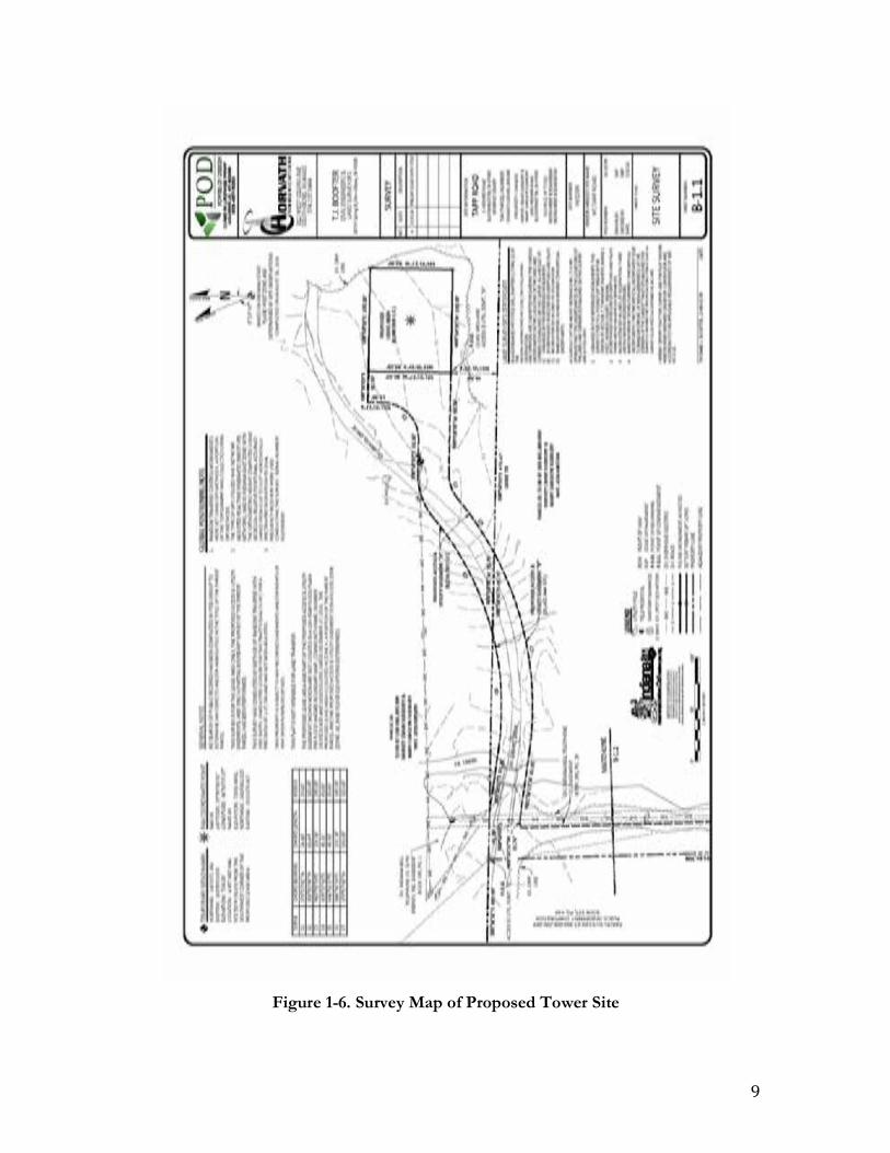
9
Figure 1-6. Survey Map of Proposed Tower Site
10
II. ENVIRONMENTAL SETTING
This section provides a summary of the environmental setting of the project area, including information on the physiography, geology, soils, climate, and vegetation. This information is provided, with a historical perspective, to illustrate how the environmental setting of the project area may have changed over the course of human habitation. The information is intended to provide a description of the modern and prehistoric landscape. Physiography Monroe County is located in the Southern Hills and Lowlands physiographic region, which is divided into 10 physiographic units. The current survey area is within the Mitchell Plateau physiographic unit. The Mitchell Plateau is south of the Martinsville Hills and bounded on the east by the Norman Upland and on the west by the Crawford Upland. The Mitchell Plateau is a limestone plateau characterized by major, deeply entrenched steam systems and a deep karst development. There are three physiographic aspects of the Mitchell Plateau. First, the section north of the East Fork of White River is deeply dissected by several large streams. There are steep slopes and limestone edges, and most of the upland is in the form of irregular branching ridges. Second, south of the East Fork of White River are areas of rolling hills underlain with thick red clay. Finally, in western portions of the plateau are large of karstic environments characterized by sinkholes and caves (Gray 2000:9). Geology Mississippian age deposits consisting of shale, sandstone, siltstone, limestone, and gypsum underlie Monroe County. The project area is underlain by limestone from the middle Mississippian Sanders and Blue River Groups (Camp and Richardson 1999). Soils Soils in the project area consist of Crider silt loam, 6 to 12 percent slopes (CrC) and Haymond silt loam, frequently flooded (Hd) (Thomas 1981). The Crider silt loam, 6 to 12 percent slopes soil is found on narrow and broad convex ridgetops of the uplands and is moderately sloping, deep, and well drained. The surface layer is typically about 7 inches thick and is dark brown silt loam. The subsoil is about 58 inches thick. The upper part of the subsoil is brown and strong brown silty clay loam. The middle part is yellowish red silty clay loam and the lower part is red, firm clay (Thomas 1981:20-21). The Haymond silt loam, frequently flooded soil is found on bottomland and is nearly level, deep, and well drained. The surface layer is typically about 10 inches thick and is dark brown and dark grayish brown silt loam. The subsoil extends to a depth of about 60 inches and consists of dark brown and yellowish brown silt loam. In places, the soil is more than 18 percent clay (Thomas 1981:34).

11
Climate Monroe County is included in the humid mesothermal climatic region, which defines the southeastern United States. The region’s climate has changed substantially since the arrival of humans. During this time, the region was much cooler. However, with the onset of the Hypsithermal period of the mid-Holocene (8,500 – 5,000 BP) the region experienced a warming trend followed by a cooling trend with increased precipitation (Delcourt and Delcourt, 1985). Currently, the climate of Monroe County is temperate and humid. Winters are cold with snow with averaging temperatures of about 32° F. Summers are hot and humid with an average temperature of 74° F, and precipitation annually averages 40 inches with over half of this falling from April to September (Thomas 1981).
Vegetation Monroe County is in the Western Mesophytic region. The dominant forest type is the Beech-Maple association. However, due to agriculture and development, forested areas are restricted to steep slopes and heavily dissected topography. Selective logging has changed the original forest composition (Petty and Jackson 1966). Currently, principle woodland crops include upland oak, tulip poplar, black walnut, and pin oak (Thomas 1981). Current land use The project area is situated on private property that has been well maintained. An abandoned limestone quarry is located approximately 50 meters (164 feet) north of the proposed tower lease area (Figures 1-2; Figure 1-3; Figure 5-8). The quarry is depicted on the 1956 Bloomington, Indiana, 7.5’ Series Topographic Quadrangle Map. However, it is not indicated on the 1910 Bloomington Topographic Quadrangle Map. Sudburg Lane, the gavel drive by which the tower will be accessed, intersects South Weimer Road and runs adjacent to the quarry. This road was likely associated with the quarry.

12
III. STATE SITE FILE SEARCH, PREVIOUS SURVEYS, AND BACKGROUND RESEARCH
Online and print resources such as historic plat maps, county histories, and the State Historic Architectural and Archaeological Research Database (SHAARD) at the Indiana Division of Historic Preservation and Archaeology were consulted prior to fieldwork for information regarding cultural resources located within and nearby the planned project area. Based on this research, 14 previously conducted surveys were carried out within a 1.6 kilometer (1.0 mile) buffer of the current survey area. Nine archaeological sites have been recorded within 1.6 kilometers (1.0 mile) of the current survey area. However, none of these sites are located within the immediate vicinity of the current survey area. Table 3-1 summarizes all of the previous investigations and the archaeological site information, based on the archaeological reports and site forms, is presented in Table 3-2. Historical Documentation A review of historic maps was conducted online. Available were the 1910 Bloomington Topographic Quadrangle Map and the 1956 Bloomington, Indiana, 7.5’ Series Topographic Quadrangle Map. Sanborn maps for the years 1883, 1887, 1892, 1898, 1907, and 1913 were also available. No historic structures were indicated within the APE on the topographic or Sanborn maps. However, there is a limestone quarry, located approximately 50 meters (164 feet) north of the proposed tower lease area (Figure 1-2; Figure 1-3; Figure5-8), indicated on the 1956 Bloomington, Indiana, 7.5’ Series Topographic Quadrangle Map. Cemeteries There is one cemetery present in the landscape within 1.6 km (1 mile) of the APE (Figure 1-2, Figure 1-3). However, this cemetery is not located within the immediate vicinity of the APE. The cemetery will not be disturbed by the proposed development activities.

13
Project Sites References
Research project - Unknown 12Mo0061
Site Form (date recorded: unknown) – Recorded by Glen
A. Black Lab, Indiana University, Archaeology Department – No
associated report Proposed State Road 37/45 and State
Road 37/48 intersection improvement areas
12Mo0665-0671 Pace 1979
Research project - Unknown 12Mo0924
1984 Site Form – Recorded by Glen A. Black Lab, Indiana
University, Archaeology Department – No associated
report Records check for: Proposed Phase I of a multi-phase development of the
Thomson Community Park in Bloomington
None Kearny 1991
Archaeological reconnaissance of the Phase I development of Thomson Community Park in Bloomington
12Mo0980-0983 Kearny and McCullough 1992
Proposed Bloomington Land Trust Subdivision Associated with the Thomson Community Park in
Bloomington
12Mo0988-1000 Kearny 1993
Proposed cellular phone tower in Bloomington None Stillwell 2005
Proposed Tapp Road and Rockport Road roundabout in Bloomington None Snell 2011
Phase Ia survey of I-69 Section 5 (from SR 37 to SR 39)
12Mo1387-1416, 12Mo1430, 12Mg437-446 Hinks and Lombardi 2012
Mill Creek development in Bloomington None Stillwell 2012
Second addendum to Phase Ia survey of I-69 Section 5 (from SR 37 to SR
39) 12Mo1468 Lombardi and Seymour 2013a
Third addendum to Phase Ia survey of I-69 Section 5 (from SR 37 to SR 39) 12Mo1474-1478 Lombardi and Seymour 2013b
Wapehani mountain bike park section 4, mitigation site for I-69 section 5 None Lombardi and Seymour 2013c
Fourth addendum to Phase Ia survey of I-69 Section 5 (from SR 37 to SR
39) 12Mo1479, 12Mg518-520 Baltz 2014
Fifth addendum to Phase Ia survey of I-69 Section 5 (from SR 37 to SR 39) 12Mo1497-1498 Baltz and McCord 2014
Addendum to Proposed Tapp Road and Rockport Road roundabout in
Bloomington None Giedd 2015
Table 3-1. Previous Archaeological SurveyS within 1.6 km (1 mile) of Project Area

14
Site No. Type Component Management Recommendations
NRHP Recommendations
12Mo0061 Workshop Prehistoric – indeterminate
Research/grant project, site was recorded as completely
eroded, no recommendations recorded,
no associated report
Not assessed
12Mo0665 Lithic scatter Prehistoric – indeterminate No further work Not assessed
12Mo0666 Lithic scatter Prehistoric – indeterminate No further work Not assessed
12Mo0667 Lithic scatter Prehistoric – indeterminate No further work Not assessed
12Mo0669 Lithic scatter Prehistoric – indeterminate No further work Not assessed
12Mo0791 Lithic scatter Prehistoric – indeterminate
Site was recorded as being disturbed, no
recommendations recorded, no associated report
Not assessed
12Mo0924 Lithic reduction, Lithic scatter
Prehistoric – Early Archaic
Site was recorded as being disturbed, no
recommendations recorded, no associated report
Not assessed
12Mo0981 Lithic scatter Prehistoric – indeterminate No further work Ineligible
12Mo0983 Camp Prehistoric – Early Archaic No further work Ineligible
Table 3-2. Archaeological Sites Within 1.6 km (1 mile) of Project Area

15
IV. CULTURAL CONTEXT
This section summarizes regional prehistory for Indiana and provides a historic cultural background of Monroe County within the general framework of Indiana settlement and history.
PREHISTORIC CONTEXT The prehistoric cultural chronology of the eastern United States is divided into a series of periods that broadly correspond to major shifts in subsistence and procurement strategies, social organization, and settlement patterns. These periods are linked to distinct material culture styles, especially in projectile point morphology and in later times, ceramic vessel form and decoration. The periods form a general framework for discussing the prehistoric chronology of the project area and eastern North America. Paleoindian Period The beginning of the Paleoindian period is uncertain. However coinciding with the end of the Pleistocene and the beginning of the Holocene, the period continues to circa 8,000 B.P. (Maggard and Stackelbeck 2008). The exact date of these earliest inhabitants’ arrival in Indiana is unclear. It is important to note that, to date, Indiana does not have any radiocarbon dates for Paleoindian sites, and chronological assessment is dependent on dating of similar material from surrounding regions (Hicks 1992). Current research suggests a process of colonizing migrations during the Early Paleoindian period (prior to 11,000 B.P.), initial regional adaptations and settling processes during the Middle Paleoindian period (ca. 11,000 to 10,500 B.P.), and subsequent regionalization and adaptations to the emerging Holocene environment during the Late Paleoindian period (ca 10,500 to 10,000 B.P.). This process resulted in an increased emphasis on local chert, plant, animal, and other resources through time, which helped diversify the tool kit and hunter/gatherer subsistence strategies. The emerging picture of Paleoindian lifeways suggests small, mobile hunter/gatherer bands exploiting locally available resources over relatively large territories (Anderson and Gillam 2000; Tankersley 1992; 1996). The Paleoindian hunter/gatherer toolkit consists primarily of projectile points, knives, and scrapers. In addition, this toolkit probably included a variety of, bone, ivory, antler, wood, and fiber plant tools. Likely as a result of changes in subsistence strategies, the diversity of the toolkit increased through time. Chipped stone knives and scrapers manufactured primarily from prismatic blades derived from prepared polyhedral cores are the most common tools associated with the Early Paleoindian period. The most diagnostic Early Paleoindian tool is the long, lanceolate-shaped, fluted Clovis or Clovis-like projectile point. During the Middle Paleoindian period, core and blade technology was replaced by bifacial lithic reduction, and spurred end scrapers became common. Diagnostic tools include small Clovis variants and Cumberland projectile points. Late Paleoindian projectile points are

16
stylistically diverse, consisting of Agate Basin, Dalton, Quad, Beaver Lake, and Hardaway Side Notched forms (Tankersley 1996: 77-81). Archaic Period The Archaic period includes the span of time between 10,000 and 3,000 B.P. Important cultural changes took place likely in response to environmental changes at the close of the Pleistocene and during the Hypsithermal climatic interval (Jefferies 1996). It is generally accepted that Archaic cultures evolved out of late Paleoindian traditions of the Southeast and Midwest (Funk 1978). Based on temporal, technological, social, subsistence, and settlement criteria, the Archaic period is divided into three sub-periods designated as Early, Middle, and Late Archaic (Jefferies 1996). The Early Archaic (10,000 to 8,000 B.P.) cultures in many ways resemble their Paleoindian ancestors except for the adoption of new projectile point styles. Otherwise their tool kits are nearly identical. However the types of animals they hunted and the plants they collected differed (Jefferies 1996; 2008). Due in part to a shift from boreal forest to an eastern deciduous forest, many of the modern species of fauna appeared in Indiana. Subsistence procurement activities shifted from hunting larger game to focus on deer and smaller mammals and the gathering of plant foods and nuts probably increased as well (Jefferies 1996; Stafford 1997). However hunting was likely still the major subsistence activity due to the scarcity of tools associated with the preparation of plant foods and fishing (Dragoo 1976:11; Jones and Johnson 2003). The general absence of substantial features, middens, and burials, as well as the few artifacts that compose most sites, suggest that most occupations were of short duration. The high percentage of projectile points made of non-nonlocal cherts suggests that groups were highly mobile. Social units were most likely small, highly mobile bands comprised of related individuals (Binford 1979; Jefferies 1996; 2008; Stafford 1994). The Middle Archaic (8,000 to 5,000 B.P.) occupation of Indiana lacks in site data. Most information from this period comes from other regions and from a sequence of comparable artifact forms (Kellar 1983). This period saw the development of regionally distinct cultures as indicated in artifact inventories and the addition of new artifact classes and projectile point styles (Jefferies 1996, 2008). At the onset of the Middle Archaic, forest environments had shifted to deciduous communities, similar to those today (Williams 1974). Near the onset of the Hypsithermal Interval (ca. 8,500 B.P.), plant communities began to further differentiate. Pollen records from the Midwest demonstrate an increase in grasses and herbs (King and Allen 1977). This period is marked by the introduction of groundstone artifacts, many of which are interpreted as tools for plant processing, indicating an increase in utilizing plant food resources. A wide range of plant food resources were exploited, including nuts, especially the hickory nut, starchy seeds, and fruits (Jefferies 2008). The presence of deep, rich midden deposits and burials, along with a high diversity of tool types implies that sites were intensively occupied on a long-term or year-round basis. An increase in group size and/or longer periods of occupation is also suggested by larger accumulations of materials than those of earlier periods (Conaty 1985; Jefferies 1983; 2008; Jefferies et al. 2005).

17
The Late Archaic (5,000 to 3,000 B.P.) witnessed the continuation of Middle Archaic trends and also included some important changes. There is a marked increase in the number and size of sites, suggesting population increase or aggregation and more permanent settlements (Jefferies 1990; 1996; Jones and Johnson 2003:6). Dragoo (1976:12-15) argues that this period was a time of growing complexity and continued cultural expansion. In contrast with the Middle Archaic, there are hundreds of Late Archaic sites in Indiana that vary by site type. Sites types identified by Jones and Johnson (2003:8) include “shell middens or mounds, fishing sites, semi-permanent villages, and cemeteries.” A more complex form of social organization is apparent during the Late Archaic. This is suggested by an inferred increase in mortuary ceremonialism and the presence of copper and marine shell artifacts acquired through long-distance trade networks (Dragoo 1976:17; Jefferies 1996; Kellar 1983:30; Winters 1968). Late Archaic subsistence, as during the Middle Archaic, focused on hunting and collecting native animals and plants. There was an increased dietary significance for certain starchy seeds, such as goosefoot and lambsquarters in Indiana (Jones and Johnson 2003:6). Although not a major contributor to the food supply, cultivated squash appeared in the archaeological record by 4,000 B.P. suggesting the beginning of horticulture (Kellar 1983). It remains unclear if it was an introduced tropical plant or a native cucurbit (Heiser 1989). Most researchers believe that, despite the presence of cultivated plants, Late Archaic subsistence was based primarily on wild resources Woodland Period The Woodland period includes the span of time between 3,000 and 1,000 B.P. with ceramic vessels marking the beginning of the period. The appearance of ceramic vessels may suggest changes in subsistence procurement strategies and settlement systems. However, in many ways, Archaic and Woodland cultural boundaries are indistinct. Societies became more politically complex while settlements became larger and more permanent. The same domesticated starchy-seeded plants utilized during the Late Archaic became more prominent. Long-distance trade networks intensified with regions of the Midwest for materials used specifically for burial offerings. The Woodland Period is divided into three sub-periods – Early (3,000 to 2,200 B.P.), Middle (2,200 to 1,500 B.P.), and Late (1,500 to 1,000 B.P.). Early Woodland pottery technology surfaced at different times. This may be a reflection of the variation of cultural adaptations. Baskets and squash/gourd containers may have been more practical in areas of rugged terrain as ceramic vessels would have made travel more difficult (Carstens 1996:10; Applegate 2008). Pottery types of the period include Marion Thick, Fayette Thick, and Early Crab Orchard (Bergman et al. 1998:27-28; Kellar 1983:36; Maxwell 1951). During this period, conoidal vessels with roughened exterior surfaces, as well as cord-marked or fabric-impressed interiors are found (Railey 1990:249). Groundstone tools such as nutting stones, hammerstones, pestles, and atlatl weights that were utilized during previous periods, were also utilized during the Early Woodland. However this period marks a shift from grooved axes to ungrooved celts, and a shift from chipped stone end scrapers to bone beamers (Applegate 2008). Early Woodland projectile points have a variety of large bladed forms: Adena, Cresap, Cypress, Dickson, Gary Contracting Stemmed, Kramer, Meadowood, Motley, and Robbins varieties (Jones and

18
Johnson 2003:9; Justice 1987). Tomak (1983:73) also lists Tureky Tail, Morgan, Black Creek, Lone Tree, and Crooked Tree projectile points. The Early Woodland displays an increase emphasis on mortuary facilities, such as ceremonial sites and burial mounds. These structures suggest territorial boundaries, increasing social stratification, and regional coherence of social and labor organization (Clay 1991). The Middle Woodland period witnessed an elaboration in mortuary ritual and long-distance exchange networks in many portions of the Midwest and Southeast (Railey 1996). Most of these developments occur within the Hopewell Interaction Sphere, a network of people that traded goods and ideas (Caldwell 1964). Hopewellian settlement patterns reveal that society developed into a complex network that included a variety of nondomestic sites, such as bluff-crest cemeteries, mortuary camps, as well as floodplain mound groups that variously served as local or regional transaction centers promoting the exchange of various goods. There were distinctions between various ceremonial centers and many occupation sites were positioned near a waterway that provided access to several resource zones (Struever 1968; Struever and Houart 1972). There are changes in ceramic technology, lithic technology, subsistence, and settlement practices. Ceramic technology displays a higher frequency of decorative styles including complicated stamping, rocker stamping, incising, and a distinctive pattern of zoning (Kellar 1983:42). Diagnostic ceramic types include Havana, Scioto, Late Crab Orchard, Mann, and Allison-Lamotte (Jones and Johnson 2003). Projectile points include Robbins, Snyder, Steuben Stemmed, Lowe Flared Base, Chesser Notched, and Bakers Creek types (Jones and Johnson 2003:11; Justice 1987). By the early Late Woodland (ca 1,500 to 1,200 B.P.), large earthworks are no longer constructed; burial mounds in some areas are not as elaborate and serve as general cemeteries; exotic raw materials from trade networks are nearly absent; and craft specialization diminishes (Kellar 1983:48). Ceramic vessels bore little or no decoration beyond simple surface roughening. These material changes may represent changes in household organization, community social organization, or patterns of interaction among households and communities (Braun 1991; Braun and Plog 1982). Most assemblages of artifacts lack the decorated ceramics and exotic items indicative of the Middle Woodland (Railey 1996). Despite this lack of characteristics, the Late Woodland has two new traits: the appearance of the bow and arrow (although the bow and arrow might appear earlier in the Late Archaic) and full-scale, intensive agriculture (Jones and Johnson 2003:14). Diagnostic projectile point types include Madison, Fort Ancient, Levanna, Hamilton, and side-or-corner notched forms such as Raccoon side-notched and Jack’s Reef corner-notched (Jones and Johnson 2003:14; Justice 1987). In addition, “commissary knives, large triagluar knives, and hoes (for agricultural purposes)” are part of the Late Woodland artifact assemblage (Jones and Johnson 2003:14). The terminal Late Woodland (ca 1,200 to 1,000 B.P.) exhibits much greater variety in terms of ceramic decoration and styles, subsistence strategies, and possible levels of social organization (Railey 1990:257). The introduction of the bow and arrow caused a change in

19
the technological organization of lithic reduction strategies and possibly in the economic organization of households and communities. Small triangular projectile points begin to occur during this time period (Railey 1990:257). Corn became an increasingly important crop during the terminal Late Woodland time period. Late Prehistoric Period The Late Prehistoric period dates from about 1,100 to 300 B.P. (Lewis 1990). This period is distinguished by two different cultural traditions — Mississippian and Fort Ancient, each characterized by distinct settlement patterns. Whereas Fort Ancient society is characterized by a non-hierarchical social organization, Mississippian society had a distinct hierarchical social organization. Mississippian peoples occupied southwestern Indiana, along the Ohio and Wabash Rivers, and are closer culturally to the Late Prehistoric inhabitants of the southeastern United States. The Fort Ancient culture is present in the southeastern corner of Indiana (Griffin 1978; Kellar 1983:60). Some Mississippian sites consisted of large ceremonial centers with some being built around platform mounds on which the house of a local chief was constructed. However, evident of a complex settlement hierarchy, some sites have mounds while others do not (Kellar 1983). Settlements were relatively permanent with evidence of town planning in their distribution of houses, preservation of open plazas, and arrangement of flat-top mounds. These mounds were used as elevated platforms for large community buildings. Some larger settlements are hundreds of acres in size and had populations of over a thousand people (Kellar 1983:51). Mississippian farmers cultivated maize, beans, and squash; hunted wild game; and gathered many wild plant resources to supplement the cultivated diet (Lewis 1990). Fort Ancient sites consist of large villages located along larger drainages in valley bottoms and smaller sites located throughout tributary drainages. The smaller sites are considered to be resource procurement activity sites and seasonal camps (Graybill 1981). Village sites often are comprised of a central area used for communal purposes as well as storage areas. That area is surrounded by dwelling areas, with a greater emphasis on smaller, family-sized features such as smaller storage pits as well as hearths. Mound burials are typically not occurring during that period in Indiana. Rather, burials were often placed in the dwelling area or at times in the central area; these burials rarely contain substantive grave goods. Many of the villages were surrounded by some form of stockade protection system. However, similar to their contemporary, Fort Ancient peoples relied heavily on the cultivation of maize, beans, and squash. Still, hunting was a very important means of subsistence as deer made up 80 percent of the game consumed. Ceramic styles are often elaborate, mostly tempered with mussel shell, with some tempered with limestone or grit (Griffin 1978).

20
HISTORIC CONTEXT
During the 1400s through the 1700s, there was a decline in Native American poplulations in North America, largely due to the combination of European diseases, famine, and warfare (Hicks1992:58). By 1700, Native American tribes, including the Potawatomi, Wea, Miami, Delaware, Wyandot, Shawnee, Chickasaw, Kickapoo, and Piankashaw, claimed most of Indiana (Hicks 1992:58). Most of these Native American populations had been displaced by Europeans or competing tribes from their original lands before settling in Indiana (Barnhart and Riker 1971). The first European to explore the present-day Indiana region was the Jesuit missionary Father Jacques Marquette in 1675, who reportedly traveled along the shores of Lake Michigan. In 1679, LaSalle portaged near South Bend and led an expedition through northwest Indiana (Lockridge 1980). The first European settlers in Indiana were French traders, missionaries, and trappers who established trading posts in the 1700s near the Indian villages of Kekionga (Fort Wayne), Ouiatenon (near Lafayette), and Chippecoke (Vincennes) (Parker 1997). By the 1740s and 1750s, the English interest in the fur trade fueled tensions leading to the French and Indian War. The Treaty of Paris in 1763 gave the British control of Indiana. In 1783, the British lost control of the region to the American Colonists (Parker 1997). After the Revolutionary War, Indiana was part of the larger Northwest Territory, which extended north of the Ohio River to the Great Lakes and west to the Allegheny Mountains to the Mississippi River. The Indiana Territory was separated from Ohio in 1880 in preparation for Ohio’s statehood in 1803. Vincennes was designated the territorial capital and William Henry Harrison was appointed the first Territorial Governor. Harrison passed several treaties between 1801 and 1809 that acquired the southern part of the state from Native Americans populations and opened the area for settlement (Parker 1997). Another 50 tracts were acquired over the next 31 years before the entire state was obtained. Indiana was granted statehood in 1816 and had a population of over 60,000 people (Barnhart and Riker 1971). The fist capital was Corydon, however was later moved to Indianapolis in 1824. The primary industry of Indiana during its early years as a territory and state was agriculture, producing surplus amounts of wheat, corn, cattle, swine, mules, and horses (Carmony 1966). Wheat was ground into flour for export, along with sugar and whiskey. Most of these products were shipped downriver by way of the Ohio, Wabash, White, and Mississippi Rivers to southern markets. Throughout the nineteenth century, agriculture remained the primary industry with over half of the population engaged in farming, with the number of farms increasing after the Civil War (Thornbrough 1995:439). Post Civil War farms produced oats, wheat, corn, rye, hay, tobacco, potatoes, apples and pecans (Baer et al. 2003:19-20). During the early twentieth century, the onset of the Great Depression caused many people in Indiana to lose their farms due to delinquent taxes or unpaid mortgages (Parker 1997). The federal and sate governments obtained many of these lands, converting them to National and State Forests. By World War II, Indiana transitioned into an industrialized economy with large farming operations.
21
Monroe County Monroe County was formed in 1818 from a portion of Orange County and was named in honor of James Monroe, the fifth president of the United States (Baker and Carmony 1975). The county seat is Bloomington. Hunters living in the area around 1810 were the earliest known Euro-American serrlers in Monroe County. These settlers included Samuel Dodds, Bazil Brown, John M. Saddler, Mr. Tarkinton, Solomon Green, William Lowe, James Slocum, and Henry Batterton (Baskin, Forster & Company 1876:273). More settlers arrived after Arthur Henrie and William Harris surveyed lands south of the Old Indian Boundary in 1812 (Goodspeed 1884:372). From 1814 to 1818, settlers built several commercial structures in Monroe County. Enos Blair built the first gristmill in 1816. Several more water and saw gristmills were built soon after by other settlers. Samuel Dodds opened the first Tannery in 1816 and William Hardin opened the first tavern in 1817. Joshua Howe opened the first store in 1818 (Baskin, Forster & Company 1876:273). The fist commissioners were Bartlett Woodward, Michael Buskirk, and James Parks. The fist sheriff was John W. Lee and the first county clerk/auditor was William Lowe (Goodspeed 1884:375). The fist county commissioners selected Bloomington as the county seat and they sectioned off lots for public auction. The fist townships in Monroe County were Bloomington, Clear Creek, Bean Blossom, and Indian Creek. The first Indiana limestone quarry opened in 1827 south of Stinesville in Monroe County (Hill 1998). The New Albany and Salem Railroad reached Monroe County in 1854 and provided a way to move the stone. The fist steam driven limestone sawing mill opened in 1855. After the Chicago and Boston fires in 1871 and 1872, limestone was in demand for building material. There were 15 limestone quarries in the state by 1870 and by 1900 Indiana produced one third of the nation’s commercial limestone (Hill 1998). In 1913, there were 50 quarries and mills in the Bloomington and Ellettsville areas. With the popularity of American Stone Architecture, the limestone industry reached its peak during the 1920s. Demand for limestone has fluctuated during the Great Depression and after World War II, and there has been a slow decline in the industry ever since (Taylor et al. 1989). One of these quarries is located just north of the current survey area and is indicated on the 1956 Bloomington, Indiana, 7.5’ Series Topographic Quadrangle Map. However, the quarry is not depicted on the 1910 Bloomington Topographic Quadrangle Map.

22
V. FIELD METHODS AND ANALYTICAL TECHNIQUES This section describes the field methods employed, reflecting conditions encountered, during the course of the Phase Ia survey. The Implemented field methods conform to the guidelines of the Indiana Department of Natural Resources - Division of Historic Preservation and Archaeology (IDNR-DHPA 1998), Eastern Shawnee Tribe of Oklahoma (Eastern Shawnee Tribe of Oklahoma Cultural Preservation Department 2014), Osage Nation (Osage Nation Historic Preservation Office 2014), and Wyandotte Nation guidelines (Algonquin Consultants, Inc. 2013). The APE consists of a proposed 0.18 acre (0.07 hectare), Bloomington telecommunication tower lease area. The access/utility easement consists of an existing gravel road and a proposed new build segment totaling 0.69 acre (0.28 hectare). The project area was located by the presence of surveyor stakes and flags. The proposed access/utility easement was located by the presence of surveyor flags. The fieldwork took approximately twelve person hours to complete. The elevation of the project area is 733 feet AMSL. The physical setting of the entire APE is shown in Figure 1-2 through Figure 1-5. The soil data for the APE consists of Crider silt loam, 6 to 12 percent slopes (CrC) and Haymond silt loam, frequently flooded (Hd) (Thomas 1981). There is one cemetery present in the landscape within 1.6 km (1 mile) of the APE (Figure 1-2, Figure 1-3). However, this cemetery is not located within the immediate vicinity of the APE. The cemetery will not be disturbed by the proposed development activities. Pedestrian Transects A pedestrian survey was conducted over the proposed location for the telecommunication tower utilizing transects spaced at five-meter intervals totaling seven transects (Figure 5-1and Figure 5-2). Ground surface visibility was 0 percent due to grass. It is noted that a 25 foot (7.6 meters) buffer area around the perimeter of the proposed tower project area and a 10 foot (3.0 meters) buffer area along both sides of the proposed access/utility easement corridor were also visually inspected as part of this investigation. A single pedestrian transect was placed along the proposed access/utility easement. Ground surface visibility was 10 percent at best due to vegetation and gravel. Systematic Shovel Testing Systematic shovel test probes (STPs) were excavated across the entire APE at 15-meter intervals, since the entire APE offers a less than 15 percent slope. Shovel test probes were a minimum of 45 centimeter x 45 centimeter, straight-sided, and were excavated to a depth of 1 meter below surface, to sterile subsoil, or to the water table. All excavated soils were screened by soil horizons through 0.25-inch mesh screens. The profile of each STP was recorded by measuring the stratigraphy and referencing a Munsell soil chart. Three representative shovel tests were photographed. T w o excavated shovel tests were positive for cultural materials, however consisted of modern trash (plastic and aluminum can

23
fragments) associated with the public right-of-way of South Weimer Road. Furthermore, these materials were recovered from disturbed context associated with road construction. A total of 25 shovel tests were excavated across the entire APE. Seven shovel tests were excavated within the proposed telecommunications tower lease area and 18 shovel tests were excavated along the proposed access/utility easement (Figure 5-1 and Figure 5-2). The majority of the shovel tests within the proposed tower lease area, as well as a portion of the proposed access/utility easement, showed signs of mechanical stripping. This is likely a result of activities associated with the limestone quarry located approximately 50 meters (164 feet) north of the proposed tower lease area (Figure 1-2; Figure 1-3; Figure 5-8) (discussed in Chapter III and Chapter IV of this report). Aside from the modern plastic and aluminum can fragments recovered from two STPs placed adjacent to South Weimer Road, all STPs proved to be negative of cultural materials or subsurface features. Sterile subsoil was recorded at between 2 and 40 centimeters below surface (cmbs). STP A-5, shown in a photograph in Figure 5-4 and Figure 5-5, serves as a representation of the natural soil stratigraphy encountered within the project area. STP A-2, shown in a photograph in Figure 5-6, serves as a representation of disturbance associated with road construction. STP C-1, shown in a photograph in Figure 5-7, serves as a representation of the soil stratigraphy encountered within the proposed tower lease area and a portion of the proposed access/utility easement and demonstrates mechanical stripping. A summary of the STPs is presented in Table 5-1. The soils encountered in the STPs matched the mapped soil data and consisted of Crider silt loam and Haymond silt loam. Deep Testing A portion of the proposed access/utility easement is located within an area that has been designated as a flood zone. This area is depicted as Zone AE on the project survey map (Figure 1-5). The Federal Emergency Management Agency (FEMA) defines Zone AE as a flood hazard area identified on the Flood Insurance Rate Map. Zone AE designates an area that “will be inundated by a flood event having a 1-percent chance of being equaled or exceeding in any given year. The 1-percent annual chance flood is also referred to as the base flood or 100-year flood” (FEMA 2016). The remaining portion of the APE consisting of the proposed tower lease area and a segment of the proposed access/utility easement is located in Zone X, which is outside of the flood zone. This area is located at higher elevations with the proposed tower lease area situated on a terrace. In order to assess the potential for a buried A horizon, or deeply buried cultural deposits, deep testing was employed by means of utilizing a four-inch diameter bucket auger in the bottom of every other shovel test (Figure 5-1 through Figure 5-3; Figure 5-5) in the portion of the APE designated to be within Zone AE. No auger testing was conducted in the portion of the APE that is within Zone X. Prior to auger testing, all shovel tests were excavated into sterile subsoil and to a minimum depth of 50 cmbs. All excavated soils were screened by soil horizons through 0.25-inch mesh screens. The profile of each auger test was recorded by measuring the stratigraphy and referencing a Munsell soil chart. All auger tests proved to be negative of a buried A horizon, cultural materials, or subsurface features. A summary of the auger tests is presented in Table 5-1.

24
Figure 5-1. Survey Map of Proposed Tower Location Showing Shovel Test and Pedestrian Transects
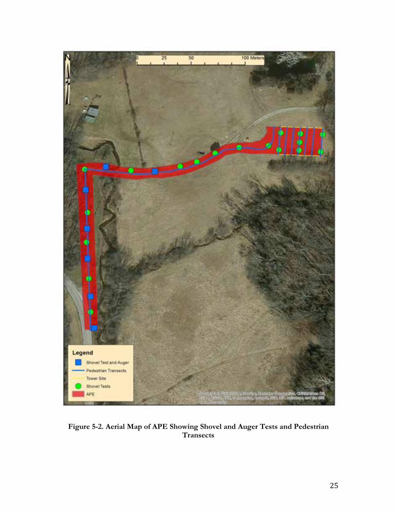
25
Figure 5-2. Aerial Map of APE Showing Shovel and Auger Tests and Pedestrian Transects
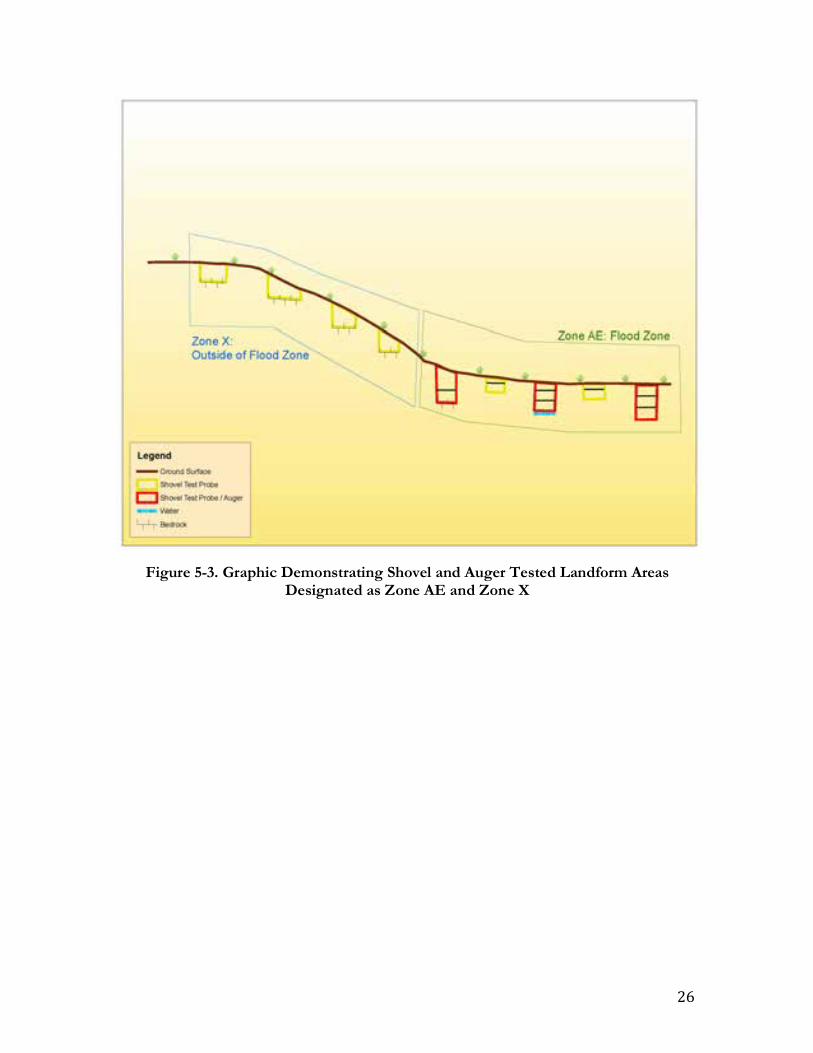
26
Figure 5-3. Graphic Demonstrating Shovel and Auger Tested Landform Areas Designated as Zone AE and Zone X
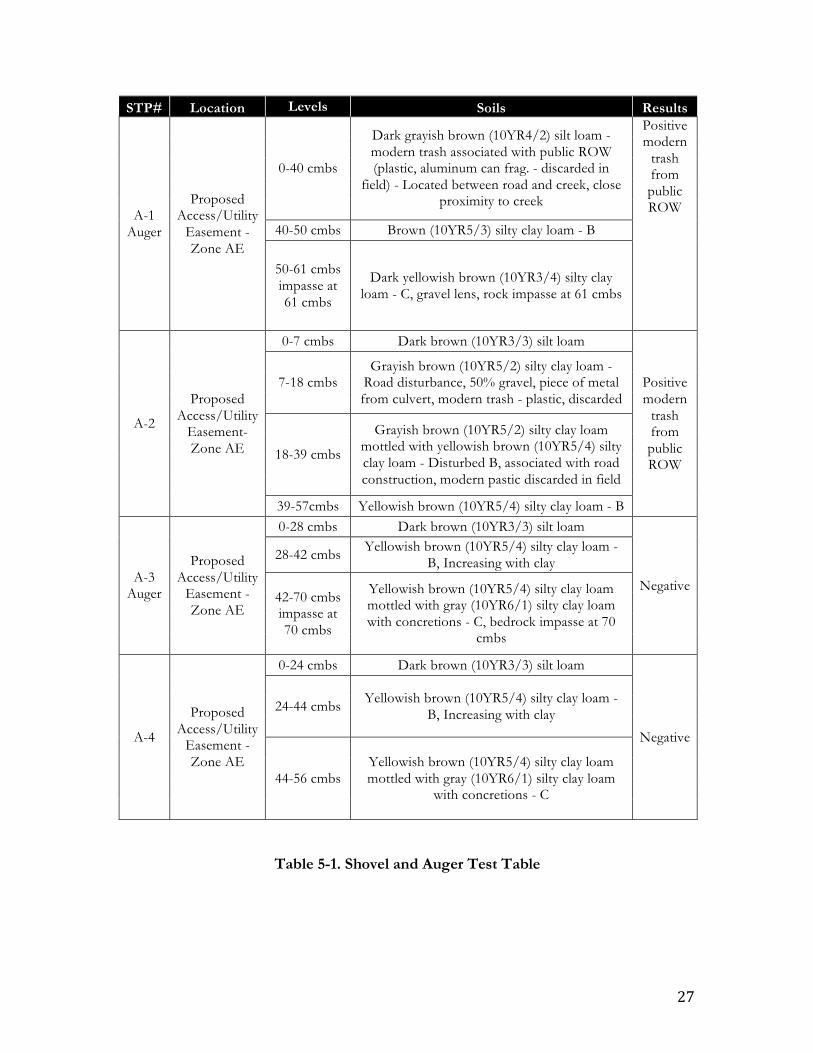
27
STP# Location Levels Soils Results
A-1 Auger
Proposed Access/Utility
Easement - Zone AE
0-40 cmbs
Dark grayish brown (10YR4/2) silt loam - modern trash associated with public ROW (plastic, aluminum can frag. - discarded in
field) - Located between road and creek, close proximity to creek
Positive modern
trash from public ROW
40-50 cmbs Brown (10YR5/3) silty clay loam - B
50-61 cmbs impasse at 61 cmbs
Dark yellowish brown (10YR3/4) silty clay loam - C, gravel lens, rock impasse at 61 cmbs
A-2
Proposed Access/Utility
Easement- Zone AE
0-7 cmbs Dark brown (10YR3/3) silt loam
Positive modern
trash from public ROW
7-18 cmbs Grayish brown (10YR5/2) silty clay loam -
Road disturbance, 50% gravel, piece of metal from culvert, modern trash - plastic, discarded
18-39 cmbs
Grayish brown (10YR5/2) silty clay loam mottled with yellowish brown (10YR5/4) silty clay loam - Disturbed B, associated with road construction, modern pastic discarded in field
39-57cmbs Yellowish brown (10YR5/4) silty clay loam - B
A-3 Auger
Proposed Access/Utility
Easement - Zone AE
0-28 cmbs Dark brown (10YR3/3) silt loam
Negative
28-42 cmbs Yellowish brown (10YR5/4) silty clay loam - B, Increasing with clay
42-70 cmbs impasse at 70 cmbs
Yellowish brown (10YR5/4) silty clay loam mottled with gray (10YR6/1) silty clay loam with concretions - C, bedrock impasse at 70
cmbs
A-4
Proposed Access/Utility
Easement - Zone AE
0-24 cmbs Dark brown (10YR3/3) silt loam
Negative
24-44 cmbs Yellowish brown (10YR5/4) silty clay loam - B, Increasing with clay
44-56 cmbs Yellowish brown (10YR5/4) silty clay loam mottled with gray (10YR6/1) silty clay loam
with concretions - C
Table 5-1. Shovel and Auger Test Table

28
STP# Location Levels Soils Results
A-5 Auger
Proposed Access/Utility
Easement - Zone AE
0-38 cmbs Dark brown (10YR3/3) silt loam
Negative 38-78 cmbs Yellowish brown (10YR5/4) silty clay loam -
B, Increasing with clay
78-85 cmbs impasse at 85 cmbs
Brown (10YR4/3) silty clay, gravel lens, fractured bedrock impasse at 85 cmbs
A-6
Proposed Access/Utility
Easement - Zone AE
0-14 cmbs Dark brown (10YR3/3) silt loam
Negative
14-46 cmbs Yellowish brown (10YR5/4) silty clay loam - B, Increasing with clay
46-55 cmbs Yellowish brown (10YR5/4) silty clay loam mottled with gray (10YR6/1) silty clay loam
with concretions - C
A-7 Auger
Proposed Access/Utility
Easement - Zone AE
0-24 cmbs Dark brown (10YR3/3) silt loam
Negative
24-42 cmbs Yellowish brown (10YR5/4) silty clay loam - B, Increasing with clay
42-60 cmbs Yellowish brown (10YR5/4) silty clay loam mottled with gray (10YR6/1) silty clay loam
with concretions - C
60-70 cmbs Grayish brown (10YR5/2) silty clay with concretions - C
70-82 cmbs impasse at 82 cmbs
Grayish brown (10YR5/2) silty clay with concretions - C, gravel lens, fractured bedrock
impasse at 82cmbs
A-8
Proposed Access/Utility
Easement - Zone AE
0-17 cmbs Dark brown (10YR3/3) silt loam
Negative 17-36 cmbs Yellowish brown (10YR5/4) silty clay loam -
B, Increasing with clay
36-50 cmbs Yellowish brown (10YR5/4) silty clay loam mottled with gray (10YR6/1) silty clay loam with concretions - C, high density of gravel

29
STP# Location Levels Soils Results
A-9 Auger
Proposed Access/Utility
Easement - Zone AE
0-27 cmbs Dark brown (10YR3/3) silt loam
Negative
27-51 cmbs Yellowish brown (10YR5/4) silty clay loam - B, Increasing with clay
51-62 cmbs Dark yellowish brown (10YR3/4) silty clay loam - C, gravel lens
62-73 cmbs impasse at 73 cmbs
Dark brown (10YR3/3) silty clay, gravel lens, impasse at 73 cmbs
A-10
Proposed Access/Utility
Easement - Zone AE
0-16 cmbs
Dark brown (10YR3/3) silt loam mottled with yellowish brown (10YR5/4) silty clay loam,
approximately 25% gravel - Road disturbance, next to gravel road
Negative 16-29 cmbs
Dark yellowish brown (10YR4/4) silty clay loam mottled with yellowish brown (10YR5/6)
silty clay loam - Disturbed
29-51 cmbs Yellowish brown (10YR5/4) silty clay loam mottled with gray (10YR6/1) silty clay loam
with concretions - C
A-11 Auger
Proposed Access/Utility
Easement - Zone AE
0-22 cmbs Dark brown (10YR3/3) silt loam
Negative 22-40 cmbs Dark brown (10YR3/3) silt loam mottled with
dark gray (10YR4/1) hydric silty clay loam
40-52 cmbs water table at 52 cmbs
Dark gray (10YR4/1) silty clay, high density of gravel, water table/innundated at 52 cmbs -
next to creek
A-12
Proposed Access/Utility
Easement - Zone AE
0-11 cmbs Dark brown (10YR3/3) silt loam
Negative
11-23 cmbs
Dark yellowish brown (10YR4/4) silty clay loam mottled with yellowish brown (10YR5/6) silty clay loam and gray (10YR5/1) silty clay -
Disturbed A/B, next to gravel road
23-36 cmbs Yellowish brown (10YR5/4) silty clay loam - B, Increasing with clay and concretions
36-51 cmbs Brown (10YR5/3) silty clay loam mottled with yellowish brown (10YR5/6) silty clay loam and gray (10YR5/1) silty clay with concretions - C
A-13 Auger
Proposed Access/Utility
Easement - Zone AE
0-19 cmbs Dark brown (10YR3/3) silt loam
Negative 19-25 cmbs impasse at 25 cmbs
Brown (10YR4/3) silty clay loam - B, bedrock impasse at 25 cmbs

30
STP# Location Levels Soils Results
A-14
Proposed Access/Utility
Easement - Zone AE
0-14 cmbs impasse at 14 cmbs
Dark brown (10YR3/3) silt loam, approximately 50% gravel, located next to gravel road - Bedrock impasse at 14 cmbs,
located on rise above floodplain
Negative
A-15
Proposed Access/Utility
Easement - Zone X
0-5 cmbs impasse at 5
cmbs
Dark brown (10YR3/3) silt loam, approximately 50% gravel, located next to gravel road - Bedrock impasse at 5 cmbs,
located on rise above floodplain
Negative
A-16
Proposed Access/Utility
Easement - Zone X
0-7 cmbs impasse at 7
cmbs
Dark brown (10YR3/3) silt loam - Bedrock impasse at 7 cmbs, located on rise above
floodplain Negative
A-17
Proposed Access/Utility
Easement - Zone X
0-12 cmbs impasse at 12 cmbs
Dark brown (10YR3/3) silt loam - Bedrock impasse at 12 cmbs, located on rise above
floodplain Negative
A-18
Proposed Access/Utility
Easement - Zone X
0-4 cmbs Dark brown (10YR3/3) silt loam
Negative 4-19 cmbs
Brown (10YR4/3) silty clay loam mottled with strong brown (7.5YR4/6) silty clay loam - B,
area has been mechanically stripped
B-1
Proposed Tower
Location - Zone X
0-3 cmbs Dark brown (10YR3/3) silt loam
Negative 3-18 cmbs
Brown (10YR4/3) silty clay loam mottled with strong brown (7.5YR4/6) silty clay loam - B,
area has been mechanically stripped
B-2
Proposed Tower
Location - Zone X
0-2 cmbs Dark brown (10YR3/3) silt loam
Negative 2-14 cmbs
Brown (10YR4/3) silty clay loam mottled with strong brown (7.5YR4/6) silty clay loam - B,
area has been mechanically stripped
B-3
Proposed Tower
Location - Zone X
0-3 cmbs Dark brown (10YR3/3) silt loam
Negative 3-13 cmbs
Brown (10YR4/3) silty clay loam mottled with strong brown (7.5YR4/6) silty clay loam - B,
area has been mechanically stripped
C-1
Proposed Tower
Location (center) - Zone X
0-12 cmbs Dark brown (7.5YR3/4) silty clay loam Negative
12-32 cmbs Strong brown (7.5YR4/6) silty clay loam - B

31
STP# Location Levels Soils Results
D-1
Proposed Tower
Location - Zone X
0-2 cmbs Dark brown (10YR3/3) silt loam
Negative 2-11 cmbs impasse at 11 cmbs
Brown (10YR4/3) silty clay loam mottled with strong brown (7.5YR4/6) silty clay loam - B, area has been mechanically stripped, bedrock
at 11 cmbs
D-2
Proposed Tower
Location - Zone X
0-2 cmbs Dark brown (10YR3/3) silt loam
Negative 2-13 cmbs
Brown (10YR4/3) silty clay loam mottled with strong brown (7.5YR4/6) silty clay loam - B,
area has been mechanically stripped
D-3
Proposed Tower
Location - Zone X
0-10 cmbs Dark brown (7.5YR3/4) silty clay loam Negative
10-28 cmbs Strong brown (7.5YR4/6) silty clay loam - B

32
Figure 5-4. Shovel Test A-5
Figure 5-5. Shovel/Auger Test A-5
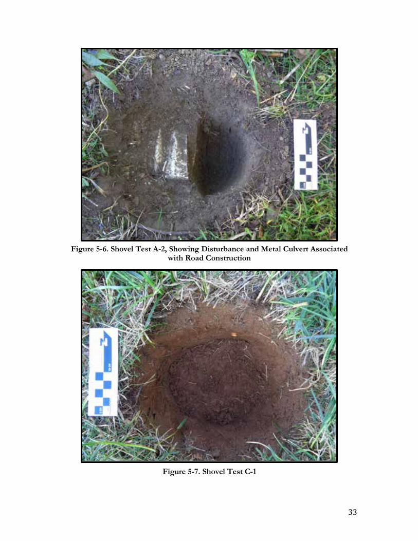
33
Figure 5-6. Shovel Test A-2, Showing Disturbance and Metal Culvert Associated with Road Construction
Figure 5-7. Shovel Test C-1

34
Figure 5-8. Aerial Map Showing APE and Abandoned Limestone Quarry

35
Figure 5-9. Looking North Across Proposed Tower Location
Figure 5-10. Looking South Across Proposed Tower Location

36
Figure 5-11. Looking East Across Proposed Tower Location
Figure 5-12. Looking West Across Proposed Tower Location

37
Figure 5-13. Proposed Access/Utility Easement, Showing Existing Road and Proposed New Build Segments, Facing Southwest
Figure 5-14. Proposed Access/Utility Easement, Showing Existing Road, Bridge, and Landforms Designated as Zone AE and Zone X, Facing East

38
Figure 5-15. Proposed Access/Utility Easement, Facing South
Figure 5-16. From South Weimer Road, Showing Existing Road Segment of Access/Utility Easement, Facing North
39
VI. SUMMARY AND RECOMMENDATIONS
Summary At the request of EBI Consulting, Appalachian Archaeology, LLC, conducted a Phase Ia archaeological survey of a proposed telecommunication tower location in Monroe County, Indiana. The site for the proposed telecommunications tower is located within the city limits of Bloomington, Indiana. The proposed access/utility easement intersects the north side of South Weimer Road by Sudburg Lane, an existing gravel drive, 0.6 km (0.4 mile) north of the intersection of West Tapp Road, that intersection being 0.9 km (0.6 mile) east from State Route 37. The proposed tower lease area is located on terrace at an elevation of 733 feet AMSL. The nearest bodies of water are an unnamed stream that intersects the gravel drive portion of the proposed access utility easement and Weimer Lake located southwest of the project area. The access/utility easement consists of an existing gravel road and a proposed new build segment. The entire APE was visually inspected during the archaeological survey. Systematic shovel testing was employed across the entire APE supplemented by pedestrian reconnaissance. A portion of the APE is situated within a designated flood zone. Deep testing was employed by utilizing a bucket auger in the bottom of every other shovel test in this portion of the APE. It is noted that a 25 foot (7.6 meters) buffer area around the perimeter of the proposed tower project area and a 10 foot (3.0 meters) buffer area along both sides of the proposed access/utility easement corridor were also visually inspected as part of this investigation. The proposed tower lease area and the new build portion of the access/utility easement has been mechanically stripped, most likely due to activities associated with an abandoned limestone quarry located north of the proposed tower lease area. The soils encountered during shovel and auger testing were consistent with the mapped soil data and consisted of Crider silt loam and Haymond silt loam. No surface features were discovered by means of the visual inspection and the shovel tests were negative of cultural materials and subsurface features. There is one cemetery present in the landscape within 1.6 km (1 mile) of the APE. However, this cemetery is not located within the immediate vicinity of the APE. The cemetery will not be disturbed by the proposed development activities. Recommendations Based on the results of this Phase Ia investigation, the proposed construction of the Bloomington telecommunication tower will have no effect on known archaeological and cultural resources. Records searches revealed no previously recorded archaeological sites within the project area, and no archaeological sites were identified as a result of this investigation. No sites listed in or eligible for the NRHP will be affected by the proposed construction. No further archaeological work is recommended.

40
VII. REFERENCES
Algonquin Consultants, Inc. 2013 Archaeological Field Work and Reporting Requirements for Cell Towers and Other Section 106,
NHPA Projects, Wyandotte Nation. Miami, Oklahoma. Anderson, David G., and J. Christopher Gillam 2000 Paleoindian Colonization of the Americas: Implications from an Examination of
Physiography, Demography, and Artifact Distribution. American Antiquity 65: 43-66. Applegate, Darlene 2008 Chapter Five: Woodland Period. In The Archaeology of Kentucky: an Update, Vol. 1,
edited by David Pollack, pp. 339-604. Kentucky Heritage Council, State Historic Preservation Comprehensive Plan Report No. 3, Frankfort.
Baker, Ronald L., and Marvin Carmony 1975 Indiana Place Names. Indiana University Press, Bloomington. Baltz, Christopher J. 2014a Fourth Addendum to Phase Ia Archaeological Investigations Section 5 (SR 37 to SR 39) Monroe
and Morgan Counties, Indiana. I-69 Corridor Tier 2 Studies. Project No. 13-43505. Gray & Pape, Indianapolis, Indiana.
Baltz, Christopher J., and Beth K. McCord 2014 Fourth Addendum to Phase Ia Archaeological Investigations Section 5 (SR 37 to SR 39) Monroe
and Morgan Counties, Indiana. I-69 Corridor Tier 2 Studies. Project No. 13-43505. Gray & Pape, Indianapolis, Indiana.
Baskin, Forster & Company 1876 Illustrated Historical Atlas of the State of Indiana. Baskin, Forster & Company, Chicago. Bergman, Christopher A., Donald A. Miller, John F. Doershuk, Ken Duerksen, and Teresa W. Tune 1998 Early Woodland Occupation of the Northern Bluegrass: The West Runway Site
(15Be391), Boone County, Kentucky. North American Archaeologist 19(1):13-33. Binford, Lewis R. 1979 Organization and Formation Processes: Looking at Curated Technologies. Journal of
Anthropological Research 35: 255-273. Braun, David P. 1991 Why Decorate a Pot? Midwestern Household Pottery, 200 B.C. – A.D. 600. Journal of
Anthropological Archaeology 10:360-397.
41
Braun, David P., and Stephen Plog 1982 Evolution of “Tribal” Social Networks: Theory and Prehistoric North American
Evidence. American Antiquity 47:504-525. Braun, Lucy E. 2001 Deciduous Forests of Eastern North America (Reprint). Hafner Press, New York.
Originally Published in 1950, Blackiston, Philadelphia. Caldwell, J. R. 1964 Interaction Spheres in Prehistory. In Hopewellian Studies, edited by J.R. Caldwell and
R. L. Hall, pp. 133-143. Vol. XII. Illinois State Museum Scientific Papers, Springfield.
Camp, Mark J., and Graham T. Richardson 1999 Roadside Geology in Indiana. Mountain Press Publishing Company, Missoula, Montana. 1991 Adena Ritual Development: An Organization Type in a Temporal Perspective. In
The Human Landscape in Kentucky: Past Site Structure and Settlement Patterns, edited by C.S. and C.K. Hensley, pp. 30-39. Kentucky Heritage Council, Frankfort.
1998 The Essential Features of Adena Ritual and their Implications. Southeastern
Archaeology. 17:1 pp. 1-21. Conaty, Gerald T. 1985 Middle and Late Archaic Mobility Strategies in Western Kentucky. Unpublished
Ph.D. Dissertation. Department of Archaeology, Simon Fraser University, Burnaby, British Columbia.
Delcourt, Paul A., and Hazel R. Delcourt 1985 Quaternary Palynology and Vegetational History of the Southeastern United States.
In Pollen Records of Late Quaternary North American Sediments, edited by V. Bryant and R. Holloway, pp. 1-28. American Association of Sedimentary Palynologists.
Dragoo, D.W. 1976 Some Aspects of Eastern North America Prehistory: A Review 1975. American
Antiquity 41(1): 3-27. Eastern Shawnee Tribe of Oklahoma Cultural Preservation Department 2014 Consultation Procedures for Telecommunication Projects. Wyandotte, OK. Funk, R.E. 1978 Post-Pleistocene Adaptations. In Handbook of North American Indians: Northeast (Vol.
15), edited by B.G. Trigger, pp. 16-27. Smithsonian Institution, Washington D.C. Giedd, Alycia 2015 Addendum to the Phase Ia Archaeological Records check and Reconnaissance Survey for the
Proposed Tapp Road and Rockport Road Roundabout in the City of Bloomington, Perry Township, Monroe County, Indiana . ASC Group, Inc., Indianapolis.

42
Federal Emergency Management Agency (FEMA) 2016 Floodzones. Webpage on the FEMA website. Electronic document,
https://www.fema.gov/flood-zones. Accessed on October 20, 2016 Goodspeed, Weston 1884 Counties of Morgan, Monroe, and Brown, Indiana, Historical and Biographical, edited by C.
Blanchard. F. A. Battey and Company, Chicago. Gray, Henry H. 2000 Physiographic Divisions of Indiana. Indiana Geological Survey Special Report 61. Indiana
University, Bloomington. Griffin, James B. 1978 Late Prehistory of the Ohio Valley. Handbook of North American Indians: Northeast (Vol.
15), edited by B.G. Trigger, pp. 547-559. Smithsonian Institution, Washington D.C. Heiser, Charles B. 1989 Domestication of Cucurbitacae: Cucurbita and Lagenaria. In Foraging and Farming: The
Evolution of Plant Exploitation, edited by D.R.H. and G.C. Hillan, pp. 471-480. One World Archaeology 13. Unwin Hyman, London.
Hicks, Ronald 1992 Native American Cultures in Indiana. Proceedings of the First Minnetrista Council for
Great Lakes Native American Studies. Minnetrista Cultural Center and Ball State University, Muncie, Indiana.
Hill, John R. 1998 Indiana Limestone. Webpage on the Indiana Geological Survey Website. Electronic
document, http://igs.indiana.edu/geology/minRes/indianaLimestone/index.cfm. Accessed October 19, 2016.
Hinks, Stephen J., and Kathryn M. Lombardi 2012 Phase Ia Archaeological Survey of the Indiana I-69 Evansville to Indianapolis Study, Section 5
(From SR 37 to SR 39), Monroe and Morgan Counties, Indiana. Michael Baker, Jr., Inc., Moon Township, Pennsylvania.
Jefferies, Richard W. 1983 Middle Archaic-Late Archaic Transition in Southern Illinois: An Example from the
Carrier Mills Archaeological District. American Archaeology 3: 199-206. 1996 Hunters and Gatherers After the Ice Age. In Kentucky Archaeology, edited by R.B.
Lewis, pp. 39-77. The University Press of Kentucky. Lexington, Kentucky. 2008 Chapter Four: Archaic Period. In The Archaeology of Kentucky: an Update, Vol. 1, edited
by David Pollack, pp. 193-338. Kentucky Heritage Council, State Historic Preservation Comprehensive Plan Report No. 3, Frankfort.

43
Jefferies, Richard W., Victor D. Thompson, and George R. Milner 2005 Archaic Hunter-Gatherer Landscape Use in West-Central Kentucky. Journal of Field
Archaeology 30: 3-23. Jones, James R. III, and Amy L. Johnson 2003 Early Peoples of Indiana. Indiana Division of Historic Preservation and Archaeology,
Indianapolis. Justice, Noel D. 1987 Stone Age Spear and Arrow Points of the Midcontinental and Eastern United States. Indiana
University Press, Bloomington and Indianapolis. Kearney, Janis K. 1991 Proposed Phase I of a Multi-phase Development of the Thomson Community Park to be located
1700 ft. East of the Intersection of South Rogers Street and Rockport Road, Southwest Side of Bloomington, Monroe County, Indiana. Glenn A. Black Laboratory of Archaeology. Indiana University, Bloomington.
1993 An Archaeological Reconnaissance of the Proposed Bloomington Land Trust Subdivision
Associated with the Thomson Community Park Located on the Southwest Side of Bloomington, Monroe County, Indiana. Reports of Investigations 93-9. Glenn A. Black Laboratory of Archaeology. Indiana University, Bloomington.
Kearney, Janis K., and Robert G. McCullough 1992 An Archaeological Reconnaissance of the Proposed Phase I Development of Thomson Community
Park Located on the Southwest Side of Bloomington, Monroe County, Indiana. Reports of Investigations 92-29. Glenn A. Black Laboratory of Archaeology. Indiana University, Bloomington.
Kellar, James H. 1983 An Introduction to the Prehistory of Indiana. Indiana Historical Society, Indianapolis. Lombardi, Kathryn M., and Brian R. Seymour 2013a Addendum II: Phase Ia Archaeological Survey of the Indiana I-69 Evansville to Indianapolis
Study, Section 5 (From SR 37 to SR 39), Monroe and Morgan Counties, Indiana. Michael Baker, Jr., Inc., Moon Township, Pennsylvania.
2013b Addendum III: Phase Ia Archaeological Survey of the Indiana I-69 Evansville to Indianapolis
Study, Section 5 (From SR 37 to SR 39), Monroe and Morgan Counties, Indiana. Michael Baker, Jr., Inc., Moon Township, Pennsylvania.
2013c Wapehani Mountain Bike Park Section 4(f), Mitigation Site for I-69 Section 5. Michael Baker,
Jr., Moon Township, Pennsylvania. Maggard, Greg J., and Kary L. Stackelbeck 2008 Chapter Three: Paleoindian Period. In The Archaeology of Kentucky: an Update, Vol. 1,
edited by David Pollack, pp. 73-192. Kentucky Heritage Council, State Historic Preservation Comprehensive Plan Report No. 3, Frankfort.

44
Maxwell, M.S. 1951 The Woodland Cultures of Southern Illinois: Archaeological Investigations in the Carbondale
Area. Publications in Anthropology, Bulletin No. 7. Logan Museum, Beloit College, Beloit, Wisconsin.
Osage Nation Historic Preservation Office 2014 Telecommunication Consultation Procedures. Pawhuska, OK. Pace, Richard B. 1979 An Archaeological Reconnaissance of the Proposed State Road 37/45 and State Road 37/48
Intersection Improvement Areas. SSI Earth Systems Division, Bloomington. Petty, R.O., and M.T. Jackson 1966 Plant Communities. In Natural Features of Indiana, edited by A. A. Lindsey, pp. 264-
296. Indiana Academy of Science, Indiana State Library, Indianapolis. Railey, Jimmy A. 1990 Woodland Period. In The Archaeology of Kentucky: Past Accomplishments and Future
Directions, Vol. 1. edited by D. Pollack, pp. 247-374. Kentucky Heritage Council State Historic Preservation Comprehensive Plan Report No. 1. Frankfort.
1996 Woodland Cultivators. In Kentucky Archaeology, edited by R. Barry Lewis, pp. 79-125.
University Press of Kentucky, Lexington, Kentucky. Snell, Samuel P. 2011 Phase Ia Archaeological Records check and Reconnaissance Survey for the Proposed Tapp Road
and Rockport Road Roundabout in the City of Bloomington, Perry Township, Monroe County, Indiana . ASC Group, Inc., Indianapolis.
Stafford, C. Russell 1994 Structural Changes in Archaic Landscape Use in the Dissected Uplands of
Southwestern Indiana. American Antiquity 59:219-237. 1997 Prehistoric Peoples of Indiana. In The Natural Heritage of Indiana, edited by M.T.
Jackson, pp. 360-367. Indiana University Press, Bloomington and Indianapolis. Stillwell, Larry N. 2005 An Archaeological Field Reconnaissance of a Proposed Cellular Phone Tower (Project # IN-
0622) in Bloomington, Monroe County, Indiana. Cultural Resource Management Report 05FR76. Archaeological Consultants of Ossian.
2012 An Archaeological Field Reconnaissance of the Proposed Mill Creek Development in Bloomington,
Monroe County, Indiana. Cultural Resource Management Report 12FR46. Archaeological Consultants of Ossian, Muncie.

45
Struever, Stuart 1968 Woodland Subsistence-Settlement Systems in the Lower Illinois Valley. In New
Perspectives in Archaeology, edited by Sally T. Binford and Lewis R. Binford, pp. 285-312. Aidine, Chicago.
Struever, Stuart, and G. L. Houart 1972 An Analysis of the Hopewell Interaction Sphere. In Social Exchange and Interaction,
edited by E. Wilmsen, pp. 47-80. Anthropological Papers 46. Museum of Anthropology, University of Michigan, Ann Arbor.
Tankersley, Kenneth B. 1992 The Archaeology of Early Paleoindians: A View from Indiana. In Native American
Cultures in Indiana, edited by R. Hicks, pp. 7-12. Minnetrista Cultural Center and Ball State University, Muncie, Indiana.
1996 Ice Age Hunters and Gatherers. In Kentucky Archaeology, edited by R.B. Lewis, pp. 21-
39. The University Press of Kentucky. Lexington, Kentucky. Taylor, R. M., E. W. Stevens, M. A. Ponder, and P. Brockman 1989 Indiana: A New Historical Guide. Indiana Historical Society, Indianapolis. Thomas, Jerry A. 1981 Soil Survey of Monroe County, Indiana. United States Department of Agriculture. Soil
Conservation Service, Washington, D.C. Tomak, Curtis H. 1983 A Proposed Prehistoric Cultural Sequence for a Section of the Valley of the West
Fork, of the White River in Southwestern Indiana. Tennessee Anthropologist 8(1):67-94. United States Geological Survey (USGS) 1910 Bloomington, Indiana, Topographic Quadrangle Map. 1956 Bloomington, Indiana, 7.5’ Series Topographic Quadrangle Map. 1992 Bloomington, Indiana, 7.5’ Series Topographic Quadrangle Map. Williams, Alice S. 1974 Late-Glacial-Postglacial Vegetational History of the Pretty Lake Region, Northeastern Indiana.
Geological Survey Professional Paper 686-B. United States Department of the Interior, Washington, D.C.
Winters, Howard D. 1968 Value Systems and Trade Cycles of the Late Archaic in the Midwest. In New
Perspectives in Archaeology, edited by Sally R. Binford and Lewis R. Binford, pp. 175-221. Aldine Publishers, Chicago.

46
JAMES C. PRITCHARD, RPA Sr. Archaeologist EDUCATION AND TRAINING 2001 Masters of Applied Science. University of Canberra, Australia, (Cultural Heritage Management/Archaeological Heritage Management). 1991 Bachelor of Arts. Millsaps College (Sociology) PROFESSIONAL MEMBERSHIPS Register of Professional Archaeologists Society for American Archaeology American Foreign Academic Research (Research Associate) American Institute of Archaeology (Education Committee) Tennessee Council of Professional Archaeologists (Awards Committee) Kentucky Organization of Professional Archaeologists (Board) Society of American Military Engineers SELECTED REPORTS 2015 Site Examinations Conducted for Four Sites at the Birch Hill Dam Reservoir Area in the Towns of Templeton and Winchendon, Worcester County, Massachusetts. Phase I Cultural Resources Survey of the Former Chrisman Lands (Tax Map 57, Parcels 28.0 and 28.07) along Rocky Fork Road in Nolensville, Williamson County, Tennessee. Phase I Cultural Resources Survey in Support of a Proposed Drees Premier Homes Development at Beckwith Road in Mt. Juliet, Wilson County, Tennessee. Phase I Cultural Resources Investigations in Support of the Tap Root Hill PUD Subdivision in Williamson County, Tennessee. Phase I Cultural Resources Investigation at King’s Chapel Communities, Williamson County, Tennessee.

47
Phase I Archaeological Investigation of 96 Acres at the Ovation Development Site, Williamson County, Tennessee. Phase I Archaeological Investigation of 109 Acres at the Mill Creek/York Road Site, Williamson County, Tennessee. 2014 Phase I Archaeological Site Detection Survey of 5 Acres for the Proposed UK Trunk A Sewer Project in Lexington, Fayette County, Kentucky. Phase I Archaeological Survey of the Proposed Swamp Road Mitigation Bank #2, Rutherford County, Tennessee. Phase I Archaeological Survey of a Proposed Expansion at the T.J. Patterson Industrial Park, Hardin County, Kentucky. Phase IA Archaeological Investigations of 561 Acres at Camp Atterbury Joint Maneuver Training Center, Union and Harrison Townships, Bartholomew County, Indiana. Phase IA Archaeological Investigation of 410 Acres at the Former Camp Atterbury Cantonment Area, Camp Atterbury Joint Maneuver Training Center, Nineveh and Blue River Townships, Johnson County, Indiana. 2013 Phase Ia Archaeological Reconnaissance of the Proposed Hughes Barge Fleeting Project in Charlestown, Clark County, Indiana. Phase I Archaeological Survey of the Proposed Robinson Developments Project, Wilson County, Tennessee. Phase I Archaeological Survey of Five Trailhead Parking Facilities in Support of the Dawkins Line Rails to Trails Project in Johnson and Magoffin Counties, Kentucky. Phase I Archaeological Survey in Support of Rehabilitation and Extension of Martin Luther King Avenue in Hattiesburg, Forrest County, Mississippi. Phase I Archaeological Survey of 2,467 Acres at Fort Campbell in Montgomery County, Tennessee and Trigg County, Kentucky. 2012 Phase I Archaeological Survey of the Proposed Tennessee Stampings Mitigation, Sumner County, Tennessee. Phase I Cultural Resources Survey of an Interchange on SR 2 (US 72/Corridor V) at Moore’s Mill Road, Madison County, Alabama.

48
Phase I Archaeological Survey of the Proposed Emergency Management Center in Winchester, Clark County, Kentucky. Archaeological Reconnaissance in Support of a Half-Mile Reconstruction of CR-1127 (Straight Fork Road) from KY 59, Lewis County, Kentucky. Phase I Archaeological Survey in Support of the Proposed Cumberland Townhomes at 291 Old Scottsville Road in Bowling Green, Warren County, Kentucky. An Archaeological Assessment of the Proposed Elizabethtown Nature Park, Hardin County, Kentucky. Phase II Archaeological Evaluation of Four Sites at the Sabre Heliport, Ft. Campbell, Montgomery County, Tennessee. Intensive Phase I Archaeological Survey of the Lincoln Heritage House Site (Site 15HD848) at Freeman Lake Park in Elizabethtown, Hardin County, Kentucky. Phase I Archaeological Survey of the Proposed Radcliff Bypass Corridor, Hardin County, Kentucky. Phase I Archaeological Survey in Support of Development and Revitalization of Infantry Facilities in Hunting Areas 16, 21, 29, 77, and 83 at Fort Knox, Hardin and Bullitt Counties, Kentucky. Phase II Testing of Two Sites and Phase I Intensive Investigations at Eight Sites at Fort Knox, Bullitt, Hardin, and Meade Counties, Kentucky. Archaeological Survey of 453 Acres in Support of Endangered Species Work in Hunting Areas 79 and 95 at Fort Knox. Phase I Archaeological Survey of 974 Acres and Phase I Intensive Archaeological Survey of Four Known Sites at Fort Knox, Bullitt, Hardin, and Meade Counties, Kentucky. Phase I Archaeological Survey of 99 Acres in Hunting Areas 14 and 74, Cantonment Area 11, and Phase I Intensive Evaluation of Sites 15HD158, 15HD160, 15HD163, 15HD164, 15HD165, 15HD166 and 15HD500 at Fort Knox, Hardin County, Kentucky. Phase I Archaeological Survey of 193 Acres in Support of the Battle Area (BAX) Project at Baum Range, Fort Knox, Hardin County, Kentucky. A Phase I Archaeological Survey of 146 Acres in Hunting Areas 80 and 81 at Fort Knox,
49
Hardin County, Kentucky. Phase I and Phase I Intensive Archaeological Investigations at the Proposed Live Fire Breach Facility in Hunting Areas 87 and 88 at Fort Knox, Hardin County, Kentucky. 2011 Archaeological Reconnaissance of the Walker Boat Yard Marine Railway in McCracken County, Kentucky. Archaeological Assessment of 1 Acre Adjacent to the Buchanan Cemetery, 2905 Elm Hill Pike in Nashville, Davidson County, Tennessee. Phase I Archaeological Survey of Approximately 11 Acres for a Proposed Multi-Family Residential Development on Tunnel Hill Road in Elizabethtown, Hardin County, Kentucky. Big Four Approach Ramp (INDOT Des. No. 0710993): Site 12CL937 Phase Ic (Deep Testing) in Jeffersonville, Clark County, Indiana. A Phase I Archaeological Survey for the Proposed Parks at Vine Residential Development in Radcliff, Hardin County, Kentucky. Phase I Archaeological Survey of 390 Acres for Endangered Species Habitat Management Actions (Year 3) at Fort Knox, Hardin and Meade Counties, Kentucky. Phase I Archaeological Survey of 1641 Acres in Support of BRAC 2005: Newport Chemical Depot. Vermillion County, Indiana. Section 110 Survey of 38 Acres at the West Tennessee Mitigation Area, Weakley County, Tennessee. Section 110 Survey of 662 Acres at the St. Francis Basin Mitigation Area, Dunklin County, Missouri. Section 110 Survey of 2,038 Acres at the Cache River and Wapanocca Bayou Mitigation Areas, Monroe and Crittendon Counties, Arkansas. Archaeological Inventory for Endangered Species Management Habitat Actions – Year 2 at Fort Knox, Hardin County, Kentucky. Phase I Intensive and Phase II Investigations along the Ohio River Floodplain Terraces in Hunting Areas 1 and 6 at Fort Knox, Meade County, Kentucky.

50
2010 Phase I Archaeological Survey of Four Acres for the Proposed McCracken Joint Entry at the Paducah Sports Plex in McCracken County, Kentucky. Phase I Archaeological Investigations for the Proposed Zion Wireless Communications Tower in Zion, Henderson County, Kentucky. Phase I Archaeological Survey for the Proposed Puncheoncamp Surface Mine in McDowell County, West Virginia. Phase I Archaeological Investigations for the Proposed Carrollton DT Wireless Communications Tower in Carrollton, Carroll County, Kentucky. Phase I Archaeological Investigations for the Proposed Broad Run Interceptor Sewer Line Project in Louisville, Jefferson County, Kentucky. Cultural Resource Investigations of the Proposed Dry Branch Surface Mine in McDowell County, West Virginia. Phase II Archaeological and Historical Evaluation of Three Sites Located within the Footprint of a Proposed Quarry near Grand Rivers, Livingston County, Kentucky. Phase I Archaeological Investigations for the Proposed Fort Boone Sewer Line and Pump Station Improvement Project in Frankfort, Franklin County, Kentucky. Phase I Archaeological Investigations for a Proposed Borrow Area Near the City of Cynthiana, Harrison County, Kentucky. An Archaeological Reconnaissance for the Proposed Rorer Property Site in Harrison County, Kentucky. Archaeological Testing of Site 15McN142 at the Proposed McCracken County Consolidated High School Site in McCracken County, Kentucky. Phase I Archaeological Investigations of 421 Acres in Hunting Areas 11, 72, 73, 77, 89, and 90; and a Proposed Paintball Facility in Hardin and Meade Counties, Kentucky. A Phase I Archaeological Survey of 490 Acres in Hunting Areas 95 and 96 at Fort Knox, Bullitt County, Kentucky. Phase I Archaeological Survey of a Proposed Coal Mine Operation for Southbound Coal, LLC. Near the Community of Burke in Elliott County, Kentucky. Phase I Archaeological Survey for a Proposed Expansion of State Route 52 in Overton

51
County, Tennessee. Phase I Archaeological Survey of 1.44 Acre in Support of the Liberty Crossing Bridges Project in the City of Liberty, Casey County, Kentucky. Phase I Archaeological Survey in Support of WMU Proposed Sanitary Upgrades in Clark County, Kentucky. A Phase I Archaeological Survey for the Proposed Winchester Municipal Utilities Sewage Trunkline Extension at Lower Howards Creek in Winchester, Clark County, Kentucky. Phase I Intensive Archaeological and Historic Evaluation of 55 Sites Located at Fort Knox, Hardin, Meade, and Bullitt Counties, Kentucky. Section 106 and 110 Survey Results: Archaeological Investigations for Proposed Improvements to the Godman Airfield and at Dietz and Van Voorhis Housing at Fort Knox, Hardin County, Kentucky. Phase I Survey of 504 Acres at Camp Carlson, HA71, TA10, Rodger’s Hollow and a Proposed Convention Center at Fort Knox, Hardin, Meade and Bullitt Counties, Kentucky. Phase II Test Excavations of Site 15BU563 and Site 15BU624 at Fort Knox, Bullitt County, Kentucky. 2009 Phase I Archaeological Investigations for the Proposed Chestnut Street Emergency Response Tower in Berea, Madison County, Kentucky. Sections 106 and 110 Survey Results: A Phase I Archaeological Survey of 200 Acres at the West Point Air Strip at Fort Knox, Hardin County, Kentucky. Phase I Archaeological Investigations for a Proposed Emergency Response Tower in Berea, Madison County, Kentucky. Phase I Archaeological Investigations for the Proposed NB Emergency Response Tower in Richmond, Madison County, Kentucky. Phase I Archaeological Investigations of the Proposed Central Hardin 138-69 kV Substation and Taps in Hardin County, Kentucky. Phase I Archaeological Investigations for a Proposed Power Transmission Line Between Goose Rock and Big Creek in Clay County, Kentucky.

52
Phase I Archaeological Survey of 1200 Acres in Support of BRAC 2005: Newport Chemical Depot. Vermillion County, Indiana. Phase I Archaeological Survey of the Proposed Replacement of the James D. Hoskins Bridge Over the French Broad River and The Proposed Rerouting of State Route 92 in Jefferson County, Tennessee. 2008 Phase I Archaeological Survey of a Proposed Coal Mine Operation Near the Community of Fannin in Elliott County, Kentucky. Phase I Archaeological Survey of a Proposed Coal Mine Operation Near the Community of Mazie in Lawrence County, Kentucky. Still-Williams-Jenkins Cemetery Documentation in Williamson County, Tennessee. Phase I Archaeological Investigations of 218 Acres in Hunting Areas 17, 21 and 29 at Fort Knox, Bullitt and Hardin Counties, Kentucky. Myakkahatchee Creek Grant Project: Cultural Resource Overview and Reconnaissance in the City of North Port, Sarasota County, Florida. Phase I Cultural Resources Survey of the 277-Acre Retreat Tract in Liberty County, Georgia. Phase I Cultural Resources Investigations of the Walnut Meadow Branch Stream Mitigation in the City of Berea, Madison County, Kentucky. Cultural Resources Assessment of the Blessing Addendum to the Victoria, Texas Transmission Line in Jackson and Matagorda Counties, Texas. Cultural Resources Assessment of the Victoria, Texas Transmission Line in Goliad, Jackson, and Victoria Counties, Texas. Phase I Archaeological Survey of 471 Acres in Hunting Areas 80 and 112 at Fort Knox in Hardin County, Kentucky. Phase I Archaeological Investigations of 48 Acres in Hunting Area 79 at Fort Knox, Hardin County, Kentucky. Phase II NRHP Evaluation of Site 15MA250 at the Blue Grass Army Depot in Madison County, Kentucky. Cultural Resources Survey of the Macedonia Primary Extension Tract in Baker County,

53
Florida. Integrated Cultural Resources Management Plan for Blue Grass Army Depot in Madison County, Kentucky. Phase I Survey of 622 Acres and Phase I Intensive Archaeological Investigations at 29 Sites for Improvement in Various Training Areas at Fort Knox, Hardin, Meade, and Bullitt Counties, Kentucky. Phase I Intensive Archaeological Investigations at 36 Sites for ITAM Land Rehabilitation at Fort Knox, Hardin and Meade Counties, Kentucky. Phase I Intensive and Phase II Test Excavations in Support of the Range and FOB Improvements at Fort Knox in Bullitt, Meade, and Hardin Counties, Kentucky. Phase I Archaeological Survey of the Green County Mitigation Bank in Green County, Georgia. Phase I Archaeological Survey of the Proposed 880-Acre Southern Company Power Plant in Wayne County, Georgia. Phase I Archaeological Survey of 399 Acres at the Blue Grass Army Depot in Madison County, Kentucky. Principal Investigator. Phase II NRHP Evaluation of Site 15MA264 at the Blue Grass Army Depot in Madison County, Kentucky. Phase I Archaeological Survey and Phase II NRHP Evaluation of the Armuchee Sewer Project in Rome, Floyd County, Georgia. Phase III Data Recovery of the Town Creek Site (9BL129) in Baldwin County, Georgia. Phase III Data Recovery at the Savannah Lots Site (9CH1094) in Chatham County, Georgia. 2007 Phase II Archaeological and Historical Evaluation of Four Sites and Phase I Intensive Investigations at Two Sites, U.S. Army Garrison Fort Knox, Bullitt and Hardin Counties, Kentucky. Final Report of Findings: Phase I Archaeological Investigations of the Proposed 360-Acre Forward Operating Base in Training Area 2, U.S. Army Garrison Fort Knox, Hardin County, Kentucky.

54
Phase I Intensive Archaeological Survey Addendum Report: Phase I Archaeological Investigations of the Proposed 360-Acre Forward Operating Base in Training Area 2, U.S. Army Garrison Fort Knox, Hardin County, Kentucky. Live-Fire Access Road and Firing Points/Observation Points Addendum Report: Phase I Archaeological Investigations of the Proposed 360-Acre Forward Operating Base in Training Area 2, U.S. Army Garrison Fort Knox, Hardin County, Kentucky. Final Report of Findings: Phase I Archaeological Investigations of a Proposed 86-Acre Land Transfer in Training Area 3, U.S. Army Garrison Fort Knox, Hardin County, Kentucky. Phase I Archaeological Investigations of 15 Acres in Training Areas 5 and 8, U.S. Army Garrison Fort Knox, Hardin County, Kentucky. 2006 Phase I Cultural Resources Survey of Approximately 85 Acres in Support of the Proposed Madison Lake and Park, Madison County, Mississippi. Intensive Archaeological Survey of the Proposed Creighton Road Tract Development, Cherokee County, Georgia. Phase I Cultural Resources Survey in Support of 2005 BRAC Activities at the Bluegrass Army Depot. Intensive Archaeological Survey of the Proposed Bannister Creek Mitigation Bank along Bannister and Brewton creeks, Forsyth County, Georgia. Intensive Archaeological Survey of the Proposed Bannister Creek Mitigation Bank along Bannister and Brewton Creeks, Forsyth County, Georgia. Phase I Cultural Resources Survey of an Interchange on SR 2 (US 72/Corridor V) at Moore’s Mill Road, Madison County, Alabama. Phase I Cultural Resources Survey In Support of a Proposed Stream Relocation Within the Clear Lake Meadows Development, Sumner County, Tennessee. Phase I Intensive Cultural Resources Investigations of Approximately 150 Acres near the City of Newnan, Coweta County, Georgia: Newnan Crossing. 2005 Phase I Archaeological Survey of a Proposed Electric Utility Easement within the U.S. Army Garrison Fort Knox, Hardin, Meade, and Bullitt Counties, Kentucky.

55
Final Report of Findings: Phase I Archaeological Survey of 670 Acres in Support of a Proposed Lands Exchange Between Bi-County Solid Waste Management Systems and the U.S. Army Garrison Fort Campbell, Trigg County, Kentucky, and Stewart County, Tennessee. Phase I Archaeological Survey In Support of a Proposed Stream Relocation within the Mt. Juliet Commons Development, Wilson County, Tennessee. Intensive Archaeological Survey in Support of Proposed Residential Communities Initiative Developments (Areas O thru S) at Fort Leavenworth, Leavenworth County, Kansas. Intensive Archaeological Survey of Proposed Improvements at the Porterdale Waste Water Treatment Facility, Newton County, Georgia. 2004 Phase I Cultural Resources Investigations for the Proposed Buckeye Gulf Coast Pipelines, L.P. Toledo, Ohio, Hydrogen and Product Lines Project, Oregon Township, Lucas County, Ohio. Phase I Cultural Resources Investigations in Support of But/War-75-3.76/1.90 (Pid No. 24664). Phase I Archaeological Survey at 15 Riverside Drive, St. Clair Township, Butler County, Ohio. Phase I Cultural Resources Reconnaissance Survey of a Proposed Waterfowl Marsh at Salamonie Lake in Huntington County, Indiana. Cultural Resources Literature Review and Preliminary Photodocumentation for the STA/MAH/COL-62F/14F-39.18/0.00/0.00 (PID 4089) Transportation Planning Study, Stark, Mahoning, and Columbiana Counties, Ohio. Phase II National Register Evaluation of Archaeological Site 15Sh66, for Shelbyville Bypass, Item 5.326.00, Shelby County, Kentucky. 2003 Phase I Archaeological Investigations of the Proposed Whole Neighborhood Renewal at the Anderson Golf Course, U.S. Army Armor Center and Fort Knox, Hardin County, Kentucky. Final Report, Phase I Investigations in Training Area 18 and the Wilcox Range at the US Army Armor Center and Fort Knox in Bullitt County, Kentucky. Final Report, Phase II Investigations of Four Sites (15Bu311, 15Bu544, 15Bu551 and

56
15Bu560) Within the U.S. Army Armor Center and Fort Knox, Bullitt County, Kentucky. Predictive Model, Phase I Archaeological Investigation of the Anderson Golf Course at the U.S. Army Armor Center and Fort Knox, Hardin County, Kentucky. Addendum Report, Cultural Resources Investigations for the ANR Pipeline Coffee Creek Line Change Project. Phase I Archaeological Survey for the Proposed Washington Boulevard Extension (Millikin Woods Section) in the City of Hamilton, Hanover Township, Butler County, Ohio. Final Letter Report, Cultural Resources Background Research and Literature Review and Walkover Survey, Cincinnati/Northern Kentucky Airport South Airfield, Boone County, Kentucky. Final Report, Phase I Cultural Resources Investigations for the ANR Pipeline Coffee Creek Line Change Project. Final Addendum Report No. 4, Phase I Cultural Resources Investigations for an Eight-Acre Wetland Mitigation for the Proposed Texas Eastern Hanging Rock Lateral Pipeline Project, Lawrence and Scioto Counties, Ohio. 2002 Final Report, Phase I Cultural Resources Investigations for the ANR NIPSCO-Chesterton Interconnect, Jackson Township, Porter County, Indiana. Literature Search of High Priority Areas for the MAH-76-0.00 (PID 23676) I-76/80 Corridor Improvements Project, Medina, Summit, Portage, Mahoning, Trumbull Counties, Ohio. Phase I Cultural Resources Survey of the Proposed Tuscarawas Bridge, City of Barberton, Norton and Coventry Townships, Summit County, Ohio. Cultural Resources Literature Review in Support of the Environmental Assessment for the Washington Boulevard Extension (Millikin Woods Section), City of Hamilton, Hanover Township, Butler County, Ohio. Phase I Cultural Resources Investigations For Columbia Gas Transmission Corporation's Proposed Line A-5 Natural Gas Pipeline Replacement, Town of Tuxedo, Orange County, New York Phase I And II Cultural Resources Investigations At A Proposed Commercial Development Near Columbus, Bartholomew County, Indiana.
57
Phase I Cultural Resources Investigations for the Proposed NYSEG Elmira Natural Gas Pipeline, Big Flats and Horseheads, Chemung County, New York. Historic American Engineering Record, Sault Ste. Marie International Railroad Bridge, Sault Ste. Marie, Chippewa County, Michigan. Final Supplemental Phase I Cultural Resources Investigations and Phase II Archaeological Testing at Sites 33SC92, 33SC417, 33SC431, 33SC432, 33SC434, and 33SC457 for the Proposed Texas Eastern Hanging Rock Lateral Pipeline Project, Lawrence and Scioto Counties, Ohio. Predictive Model and Ground-Truthing Survey of the NASA Plum Brook Station, Perkins, Huron, Milan, and Oxford Townships, Erie County, Ohio. Addendum Report No. 3 Phase I Archaeological Investigations of Tract 6 for the Proposed South Point Industrial Park, Lawrence County, Ohio. Phase I Archaeological Survey for the Proposed Owensboro South Site Wireless Communication Tower, Utica, Daviess County, Kentucky. Addendum Report No. 1: Supplemental Data for the Completion of the Phase I Cultural Resources Investigations Report for the Proposed Texas Eastern Hanging Rock Lateral Pipeline Project, Lawrence and Scioto Counties, Ohio. Cultural Resources Investigations along Selected Alignments (Alignments A-I, A-II, and B-Ib) of the Proposed Ohio River Greenway Corridor, Floyd and Clark Counties, Indiana. Phase I Archaeological Investigations of Proposed Road Upgrades to US Route 131, a 15-Acre Roadside Park and Additional Road Upgrades in Grand Traverse and Wexford Counties, Michigan. 2001 Phase IA Archaeological Investigation of the Proposed I-71 Corridor Light Rail Transit, Hamilton County, Ohio. Phase I Cultural Resources Investigations of the East Sandusky Bay Hydrology Restoration Project In Erie County, Ohio. Port Arthur Public Archaeology Program (Australia) Report 2001. Port Arthur Public Archaeology Program (Australia): Evaluation of Archaeology Tours Report 2001.
58
Conservation Report: Museum of the Riverina, Wagga Wagga, New South Wales, Australia. 2000 The Heritage of the Ainslie Church of Christ (Australia). 1997 Preliminary Report of 1997 Field Season: Excavations of Structure 8, a Post Classic Mayan single-phase construction. 1996 Phase I Cultural Resources Investigations of Columbia Gas Transmission Corporation Proposed Market Expansion Project: Line 10240 Eagle Suction Loop, East Hempfield, Penn, Warwick, Manheim, West Earl, Earl, East Earl Townships, Lancaster County, Pennsylvania. Phase I Cultural Resources Investigations of Columbia Gas Transmission Corporation Market Expansion Coco "C" Storage Facility Project, Kanawha County, West Virginia. PAPERS AND POSTERS 2012 Geoarchaeological and Palynological Evidence of Late Mississippian Landscape Alternation along the Wapanocca Bayou, Arkansas, USA. Poster presented at the 2012 SAA Conference, April 18-22, Memphis, TN. 2011 Fort Knox Cultural Resources Management: Supporting Endangered Species Management and Ensuring Mission Readiness. Poster presented at the Sustaining Military Readiness Conference, July 25-28, Nashville, TN. 2011 Prehistory and Geoarchaeological Investigations along the Central Mississippi Valley: Recent Advances. 2011 A Change of View? Archaeological Investigations at the Lincoln Heritage House. Paper presented at the 2011 SHA Conference, January 9-11, Austin, TX. 2004 Of Privies and Hog Pits: Archaeobotany of Site 15Sh66. Paper Presented at the joint SEAC/MAC meetings, October 21-24, St. Louis, Missouri. 2003 Balancing registers thematically and the resultant conflicts between levels of significance: Some insights derived from a gaps analysis of the heritage of the Tasman Peninsula, Tasmania. Paper presented at the Fifth World Archaeology Congress, June 21-26, 2003, Catholic University, Washington, DC. 2002 Public Archaeology at the Port Arthur Historic Site, Tasmania, Australia. Paper presented at the Society for Historical Archaeology 2002 Conference: Celebrating the 300th Anniversary of Mobile’s Colonial Origins, January 10, 2002

59
PROFESSIONAL EXPERIENCE June 2015-Present-Sr. Archaeologist, Environmental Research Group, Baltimore, Maryland. June 2007-Present-Research Associate, American Foreign Academic Research, Davidson, North Carolina. February 2007-June 2015-Vice President, Brockington and Associates, Inc., Elizabethtown, Kentucky. February 2005-February 2007-Senior Archaeologist/Principal Investigator, Brockington and Associates, Inc., Various Locations January 2002- February 2005- Principal Investigator, Gray & Pape, Inc., Cincinnati, Ohio May 1995-January 2002- Archaeologist/Field Director, Gray & Pape, Inc., Cincinnati, Ohio May 1993-May 1995-Archaeologist, Earth Search, Inc., New Orleans, Louisiana May 1992-May1993-Archaeologist, Archaeology Mississippi, Inc., Jackson, Mississippi SELECTED PROJECTS AND PROJECT INVOLVEMENT 2015 Principal Investigator. Site Examinations Conducted for Four Sites at the Birch Hill Dam Reservoir Area in the Towns of Templeton and Winchendon, Worcester County, Massachusetts. Research Associate/Instructor. Belize Valley Archaeological Reconnaissance Archaeological Field School at the Site of Cahal Pech, Cayo District, Belize. Principal Investigator. Phase I Cultural Resources Survey of the Former Chrisman Lands (Tax Map 57, Parcels 28.0 and 28.07) along Rocky Fork Road in Nolensville, Williamson County, Tennessee. Principal Investigator. Phase I Cultural Resources Survey in Support of a Proposed Drees Premier Homes Development at Beckwith Road in Mt. Juliet, Wilson County, Tennessee. Principal Investigator. Phase I Cultural Resources Investigations in Support of the Tap Root Hill PUD Subdivision in Williamson County, Tennessee. Principal Investigator. Phase I Cultural Resources Investigation at King’s Chapel Communities, Williamson County, Tennessee. Principal Investigator. Phase I Archaeological Investigation of 96 Acres at the Ovation Development Site, Williamson County, Tennessee.

60
Principal Investigator. Phase I Archaeological Investigation of 109 Acres at the Mill Creek/York Road Site, Williamson County, Tennessee. 2014 Research Associate/Instructor. Belize Valley Archaeological Reconnaissance Archaeological Field School at the Site of Cahal Pech, Cayo District, Belize. Principal Investigator. Phase I Archaeological Site Detection Survey of 5 Acres for the Proposed UK Trunk A Sewer Project in Lexington, Fayette County, Kentucky. Principal Investigator. Phase I Archaeological Survey of the Proposed Swamp Road Mitigation Bank #2, Rutherford County, Tennessee. Principal Investigator. Phase I Archaeological Survey of a Proposed Expansion at the T.J. Patterson Industrial Park, Hardin County, Kentucky. Principal Investigator. Phase IA Archaeological Investigations of 561 Acres at Camp Atterbury Joint Maneuver Training Center, Union and Harrison Townships, Bartholomew County, Indiana. Principal Investigator. Phase IA Archaeological Investigation of 410 Acres at the Former Camp Atterbury Cantonment Area, Camp Atterbury Joint Maneuver Training Center, Nineveh and Blue River Townships, Johnson County, Indiana. 2013 Research Associate/Instructor. Belize Valley Archaeological Reconnaissance Archaeological Field School at the Site of Cahal Pech, Cayo District, Belize. Principal Investigator. Phase Ia Archaeological Reconnaissance of the Proposed Hughes Barge Fleeting Project in Charlestown, Clark County, Indiana. Principal Investigator. Phase I Archaeological Survey of the Proposed Robinson Developments Project, Wilson County, Tennessee. Principal Investigator. Phase I Archaeological Survey of Five Trailhead Parking Facilities in Support of the Dawkins Line Rails to Trails Project in Johnson and Magoffin Counties, Kentucky. Principal Investigator. Phase I Archaeological Survey in Support of Rehabilitation and Extension of Martin Luther King Avenue in Hattiesburg, Forrest County, Mississippi. Principal Investigator. Phase I Archaeological Survey of 2,467 Acres at Fort Campbell in Montgomery County, Tennessee and Trigg County, Kentucky. 2012 Research Associate/Instructor. Belize Valley Archaeological Reconnaissance

61
Archaeological Field School at the Site of Cahal Pech, Cayo District, Belize. Principal Investigator. Phase I Archaeological Survey of the Proposed Tennessee Stampings Mitigation, Sumner County, Tennessee. Principal Investigator. Phase I Cultural Resources Survey of an Interchange on SR 2 (US 72/Corridor V) at Moore’s Mill Road, Madison County, Alabama. Principal Investigator. Phase I Archaeological Survey of the Proposed Emergency Management Center in Winchester, Clark County, Kentucky. Principal Investigator. Archaeological Reconnaissance in Support of a Half-Mile Reconstruction of CR-1127 (Straight Fork Road) from KY 59, Lewis County, Kentucky. Principal Investigator. Phase I Archaeological Survey in Support of the Proposed Cumberland Townhomes at 291 Old Scottsville Road in Bowling Green, Warren County, Kentucky. Principal Investigator. An Archaeological Assessment of the Proposed Elizabethtown Nature Park, Hardin County, Kentucky. Principal Investigator. Phase II Archaeological Evaluation of Four Sites at the Sabre Heliport, Ft. Campbell, Montgomery County, Tennessee. Principal Investigator. Intensive Phase I Archaeological Survey of the Lincoln Heritage House Site (Site 15HD848) at Freeman Lake Park in Elizabethtown, Hardin County, Kentucky. Principal Investigator. Phase I Archaeological Survey of the Proposed Radcliff Bypass Corridor, Hardin County, Kentucky. Principal Investigator. Phase I Archaeological Survey in Support of Development and Revitalization of Infantry Facilities in Hunting Areas 16, 21, 29, 77, and 83 at Fort Knox, Hardin and Bullitt Counties, Kentucky. Principal Investigator. Phase II Testing of Two Sites and Phase I Intensive Investigations at Eight Sites at Fort Knox, Bullitt, Hardin, and Meade Counties, Kentucky. Principal Investigator. Archaeological Survey of 453 Acres in Support of Endangered Species Work in Hunting Areas 79 and 95 at Fort Knox. Principal Investigator. Phase I Archaeological Survey of 974 Acres and Phase I Intensive Archaeological Survey of Four Known Sites at Fort Knox, Bullitt, Hardin, and Meade

62
Counties, Kentucky. Principal Investigator. Phase I Archaeological Survey of 99 Acres in Hunting Areas 14 and 74, Cantonment Area 11, and Phase I Intensive Evaluation of Sites 15HD158, 15HD160, 15HD163, 15HD164, 15HD165, 15HD166 and 15HD500 at Fort Knox, Hardin County, Kentucky. Principal Investigator. Phase I Archaeological Survey of 193 Acres in Support of the Battle Area (BAX) Project at Baum Range, Fort Knox, Hardin County, Kentucky. Principal Investigator. A Phase I Archaeological Survey of 146 Acres in Hunting Areas 80 and 81 at Fort Knox, Hardin County, Kentucky. Principal Investigator. Phase I and Phase I Intensive Archaeological Investigations at the Proposed Live Fire Breach Facility in Hunting Areas 87 and 88 at Fort Knox, Hardin County, Kentucky. 2011 Research Associate/Instructor. Belize Valley Archaeological Reconnaissance Archaeological Field School at the Site of Cahal Pech, Cayo District, Belize. Principal Investigator. Archaeological Reconnaissance of the Walker Boat Yard Marine Railway in McCracken County, Kentucky. Principal Investigator. Archaeological Assessment of 1 Acre Adjacent to the Buchanan Cemetery, 2905 Elm Hill Pike in Nashville, Davidson County, Tennessee. Principal Investigator. Phase I Archaeological Survey of Approximately 11 Acres for a Proposed Multi-Family Residential Development on Tunnel Hill Road in Elizabethtown, Hardin County, Kentucky. Principal Investigator. Big Four Approach Ramp (INDOT Des. No. 0710993): Site 12CL937 Phase Ic (Deep Testing) in Jeffersonville, Clark County, Indiana. Principal Investigator. A Phase I Archaeological Survey for the Proposed Parks at Vine Residential Development in Radcliff, Hardin County, Kentucky. Principal Investigator. Phase I Archaeological Survey of 390 Acres for Endangered Species Habitat Management Actions (Year 3) at Fort Knox, Hardin and Meade Counties, Kentucky. Principal Investigator. Phase I Archaeological Survey of 1641 Acres in Support of BRAC 2005: Newport Chemical Depot. Vermillion County, Indiana.

63
Project Manager. Section 110 Survey of 38 Acres at the West Tennessee Mitigation Area, Weakley County, Tennessee. Project Manager. Section 110 Survey of 662 Acres at the St. Francis Basin Mitigation Area, Dunklin County, Missouri. Project Manager. Section 110 Survey of 2,038 Acres at the Cache River and Wapanocca Bayou Mitigation Areas, Monroe and Crittendon Counties, Arkansas. Principal Investigator. Archaeological Inventory for Endangered Species Management Habitat Actions – Year 2 at Fort Knox, Hardin County, Kentucky. Principal Investigator. Phase I Intensive and Phase II Investigations along the Ohio River Floodplain Terraces in Hunting Areas 1 and 6 at Fort Knox, Meade County, Kentucky. 2010 Research Associate/Instructor. Belize Valley Archaeological Reconnaissance Archaeological Field School at the Site of Cahal Pech, Cayo District, Belize. Principal Investigator. Phase I Archaeological Survey of Four Acres for the Proposed McCracken Joint Entry at the Paducah Sports Plex in McCracken County, Kentucky. Principal Investigator. Phase I Archaeological Investigations for the Proposed Zion Wireless Communications Tower in Zion, Henderson County, Kentucky. Principal Investigator. Phase I Archaeological Survey for the Proposed Puncheoncamp Surface Mine in McDowell County, West Virginia. Principal Investigator. Phase I Archaeological Investigations for the Proposed Carrollton DT Wireless Communications Tower in Carrollton, Carroll County, Kentucky. Principal Investigator. Phase I Archaeological Investigations for the Proposed Broad Run Interceptor Sewer Line Project in Louisville, Jefferson County, Kentucky. Principal Investigator. Cultural Resource Investigations of the Proposed Dry Branch Surface Mine in McDowell County, West Virginia. Principal Investigator. Phase II Archaeological and Historical Evaluation of Three Sites Located within the Footprint of a Proposed Quarry near Grand Rivers, Livingston County, Kentucky. Principal Investigator. Phase I Archaeological Investigations for the Proposed Fort Boone Sewer Line and Pump Station Improvement Project in Frankfort, Franklin County, Kentucky.

64
Principal Investigator. Phase I Archaeological Investigations for a Proposed Borrow Area Near the City of Cynthiana, Harrison County, Kentucky. Principal Investigator. An Archaeological Reconnaissance for the Proposed Rorer Property Site in Harrison County, Kentucky. Principal Investigator. Archaeological Testing of Site 15McN142 at the Proposed McCracken County Consolidated High School Site in McCracken County, Kentucky. Principal Investigator. Phase I Archaeological Investigations of 421 Acres in Hunting Areas 11, 72, 73, 77, 89, and 90; and a Proposed Paintball Facility in Hardin and Meade Counties, Kentucky. Principal Investigator. A Phase I Archaeological Survey of 490 Acres in Hunting Areas 95 and 96 at Fort Knox, Bullitt County, Kentucky. Principal Investigator. Phase I Archaeological Survey of a Proposed Coal Mine Operation for Southbound Coal, LLC. Near the Community of Burke in Elliott County, Kentucky. Principal Investigator. Phase I Archaeological Survey for a Proposed Expansion of State Route 52 in Overton County, Tennessee. Principal Investigator. Phase I Archaeological Survey of 1.44 Acre in Support of the Liberty Crossing Bridges Project in the City of Liberty, Casey County, Kentucky. Principal Investigator. Phase I Archaeological Survey in Support of WMU Propsosed Sanitary Upgrades in Clark County, Kentucky. Principal Investigator. A Phase I Archaeological Survey for the Proposed Winchester Municipal Utilities Sewage Trunkline Extension at Lower Howards Creek in Winchester, Clark County, Kentucky. Principal Investigator. Phase I Intensive Archaeological and Historic Evaluation of 55 Sites Located at Fort Knox, Hardin, Meade, and Bullitt Counties, Kentucky. Principal Investigator. Section 106 and 110 Survey Results: Archaeological Investigations for Proposed Improvements to the Godman Airfield and at Dietz and Van Voorhis Housing at Fort Knox, Hardin County, Kentucky. Principal Investigator. Phase I Survey of 504 Acres at Camp Carlso, HA71, TA10, Rodger’s Hollow and a Proposed Convention Center at Fort Knox, Hardin, Meade and

65
Bullitt Counties, Kentucky. Principal Investigator. Phase II Test Excavations of Site 15BU563 and Site 15BU624 at Fort Knox, Bullitt County, Kentucky. 2009 Research Associate/Instructor. Belize Valley Archaeological Reconnaissance Archaeological Field School at the Site of Cahal Pech, Cayo District, Belize. Principal Investigator. Phase I Archaeological Investigations for the Proposed Chestnut Street Emergency Response Tower in Berea, Madison County, Kentucky. Principal Investigator. Sections 106 and 110 Survey Results: A Phase I Archaeological Survey of 200 Acres at the West Point Air Strip at Fort Knox, Hardin County, Kentucky. Principal Investigator. Phase I Archaeological Investigations for a Proposed Emergency Response Tower in Berea, Madison County, Kentucky. Principal Investigator. Phase I Archaeological Investigations for the Proposed NB Emergency Response Tower in Richmond, Madison County, Kentucky. Principal Investigator. Phase I Archaeological Investigations of the Proposed Central Hardin 138-69 kV Substation and Taps in Hardin County, Kentucky. Principal Investigator. Phase I Archaeological Investigations for a Proposed Power Transmission Line Between Goose Rock and Big Creek in Clay County, Kentucky. Principal Investigator. Phase I Archaeological Survey of 1200 Acres in Support of BRAC 2005: Newport Chemical Depot. Vermillion County, Indiana. Principal Investigator. Phase I Archaeological Survey of the Proposed Replacement of the James D. Hoskins Bridge Over the French Broad River and The Proposed Rerouting of State Route 92 in Jefferson County, Tennessee. 2008 Research Associate/Instructor. Belize Valley Archaeological Reconnaissance Archaeological Field School at the Site of Cahal Pech, Cayo District, Belize. Principal Investigator. Phase I Archaeological Survey of a Proposed Coal Mine Operation Near the Community of Fannin in Elliott County, Kentucky. Principal Investigator. Phase I Archaeological Survey of a Proposed Coal Mine Operation Near the Community of Mazie in Lawrence County, Kentucky. Principal Investigator. Still-Williams-Jenkins Cemetery Documentation in Williamson

66
County, Tennessee. Principal Investigator. Phase I Archaeological Investigations of 218 Acres in Hunting Areas 17, 21 and 29 at Fort Knox, Bullitt and Hardin Counties, Kentucky. Principal Investigator. Myakkahatchee Creek Grant Project: Cultural Resource Overview and Reconnaissance in the City of North Port, Sarasota County, Florida. Principal Investigator. Phase I Cultural Resources Survey of the 277-Acre Retreat Tract in Liberty County, Georgia. Principal Investigator. Phase I Cultural Resources Investigations of the Walnut Meadow Branch Stream Mitigation in the City of Berea, Madison County, Kentucky. Principal Investigator. Cultural Resources Assessment of the Blessing Addendum to the Victoria, Texas Transmission Line in Jackson and Matagorda Counties, Texas. Principal Investigator. Cultural Resources Assessment of the Victoria, Texas Transmission Line in Goliad, Jackson, and Victoria Counties, Texas. Principal Investigator. Phase I Archaeological Survey of 471 Acres in Hunting Areas 80 and 112 at Fort Knox in Hardin County, Kentucky. Principal Investigator. Phase I Archaeological Investigations of 48 Acres in Hunting Area 79 at Fort Knox, Hardin County, Kentucky. Principal Investigator. Phase II NRHP Evaluation of Site 15MA250 at the Blue Grass Army Depot in Madison County, Kentucky. Principal Investigator. Cultural Resources Survey of the Macedonia Primary Extension Tract in Baker County, Florida. Principal Investigator. Integrated Cultural Resources Management Plan for Blue Grass Army Depot in Madison County, Kentucky. Principal Investigator. Phase I Survey of 622 Acres and Phase I Intensive Archaeological Investigations at 29 Sites for Improvement in Various Training Areas at Fort Knox, Hardin, Meade, and Bullitt Counties, Kentucky. Principal Investigator. Phase I Intensive Archaeological Investigations at 36 Sites for ITAM Land Rehabilitation at Fort Knox, Hardin and Meade Counties, Kentucky. Principal Investigator. Phase I Intensive and Phase II Test Excavations in Support of the

67
Range and FOB Improvements at Fort Knox in Bullitt, Meade, and Hardin Counties, Kentucky. Principal Investigator. Phase I Archaeological Survey of the Green County Mitigation Bank in Green County, Georgia. Principal Investigator. Phase I Archaeological Survey of the Proposed 880-Acre Southern Company Power Plant in Wayne County, Georgia. Principal Investigator. Phase I Archaeological Survey of 399 Acres at the Blue Grass Army Depot in Madison County, Kentucky. Principal Investigator. Phase II NRHP Evaluation of Site 15MA264 at the Blue Grass Army Depot in Madison County, Kentucky. Principal Investigator. Phase I Archaeological Survey and Phase II NRHP Evaluation of the Armuchee Sewer Project in Rome, Floyd County, Georgia. Principal Investigator. Phase III Data Recovery of the Town Creek Site (9BL129) in Baldwin County, Georgia. Project Archaeologist. Phase III Data Recovery at the Savannah Lots Site (9CH1094) in Chatham County, Georgia. 2007 Research Associate/Instructor. Belize Valley Archaeological Reconnaissance Archaeological Field School at the Site of Cahal Pech, Cayo District, Belize. Principal Investigator. Phase I Archaeological Survey of 764 Acres in Hunting Areas 80 and 112 at the U.S. Army Garrison Fort Knox in Meade and Hardin Counties, Kentucky. Principal Investigator. Phase II Archaeological Evaluation of Site 15MA250 at the Blue Grass Army Depot, Madison County, Kentucky. Principal Investigator. Phase II Archaeological and Historical Evaluation of Six Sites and Phase I Intensive re-visit/site update at Three Sites Located at the U.S. Army Garrison Fort Knox, Bullitt, Hardin, and Meade Counties, Kentucky. Principal Investigator. ITAM: Phase I Intensive Archaeological Investigations of 36 sites located at the U.S. Army Garrison Fort Knox in Meade and Hardin Counties, Kentucky. Principal Investigator. Phase I Intensive Archaeological Investigations of 30 sites and Phase I Archaeological Survey of Approximately 1000 Acres located at the U.S. Army

68
Garrison Fort Knox in Meade and Hardin Counties, Kentucky. Principal Investigator. Phase II Archaeological Evaluation of Site 15MA264 at the Blue Grass Army Depot, Madison County, Kentucky. Contract No. W22G1F-06-V-0218. Principal Investigator. Phase I Archaeological Survey of 399 Acres at the Blue Grass Army Depot, Madison County, Kentucky. Contract No. W22G1F-06-V-0218. Principal Investigator. A Phase I Archaeological Resources Survey of 880 Acres for the Southern Company Wayne County Power Plant Tract, Wayne County, Georgia. Principal Investigator. Intensive Archaeological Survey of 75 Acres in Support of a Proposed Mitigation Bank along Town Creek in Greene County, Georgia. Surveyor. Belize Valley Archaeological Reconnaissance, Institute of Archaeology, Belize under the direction of Dr. Jaime Awe. GIS land survey and mapping of Maya components at Cahal Pech and Baking Pot Sites, Cayo District, Belize. July to August 2007. Principal Investigator. Intensive Archaeological Survey of 2.5 Acres in Support of a Proposed School Bus Maintenance Facility Construction at Fort Leavenworth, Leavenworth County, Kansas. June to September 2007. Principal Investigator. Phase II Archaeological and Historical Evaluation of Four Sites and Phase I Intensive Investigations at Two Sites, U.S. Army Garrison Fort Knox, Bullitt and Hardin Counties, Kentucky. December 2005 to June 2007. Principal Investigator. Phase I Archaeological Investigations of 15 Acres in Training Areas 5 and 8, U.S. Army Garrison Fort Knox, Hardin County, Kentucky. February to May 2007. 2006 Principal Investigator. Phase I Archaeological Investigations of the Proposed 360-Acre Forward Operating Base in Training Area 2, U.S. Army Garrison Fort Knox, Hardin County, Kentucky. October 2006 to June 2007. Principal Investigator. Phase I Intensive Archaeological Survey of Three Sites for the Proposed 360-Acre Forward Operating Base in Training Area 2, U.S. Army Garrison Fort Knox, Hardin County, Kentucky. October 2006 to June 2007. Principal Investigator. Live-Fire Access Road and Firing Points/Observation Points Survey for the Proposed 360-Acre Forward Operating Base in Training Area 2, U.S. Army Garrison Fort Knox, Hardin County, Kentucky. October 2006 to June 2007. Principal Investigator. Phase I Archaeological Investigations of a Proposed 86-Acre Land

69
Transfer in Training Area 3, U.S. Army Garrison Fort Knox, Hardin County, Kentucky. October 2006 to January 2007. Principal Investigator, Phase I Cultural Resources Survey of Approximately 85 Acres in Support of the Proposed Madison Lake and Park, Madison County, Mississippi. January 2006. 2005 Principal Investigator, Phase I Cultural Resources Survey in Support of 2005 BRAC Activities at the Bluegrass Army Depot. April 2006. Project included metal detection survey of portions of the delineated Battle of Richmond. Principal Investigator, Intensive Archaeological Survey of the Proposed Bannister Creek Mitigation Bank along Bannister and Brewton creeks, Forsyth County, Georgia. April 2006. Principal Investigator, Phase I Archaeological Survey of a Proposed Electric Utility Easement within the U.S. Army Garrison Fort Knox, Hardin, Meade, and Bullitt Counties, Kentucky. May through August 2005. Principal Investigator, Intensive Archaeological Survey in Support of Proposed Residential Communities Initiative Developments (Areas O thru S) at Fort Leavenworth, Leavenworth County, Kansas. April to August 2005. Principal Investigator, Phase I Archaeological Survey of Two Proposed Rail Lines, Gypsum Dewatering Facility, and Limestone Ball Mill at Georgia Power's Plant Bowen, Bartow County, Georgia. March and April 2005. Principal Investigator, Phase I Archaeological Survey of 8 Acres at the Harmony Club, Putnam County, Georgia. March 2005. Principal Investigator, New Hope Road/Mooneyham Cemetery Delineation, Gwinnet County, Georgia. February 2005. Archaeological Delineation of nineteenth century rural cemetery. 2004 Principal Investigator, Phase I Archaeological Survey in Support of the HAM-Reading Road Railroad Grade Separation (HAM-CR456-0.15, PID 23062), City of Sharonville, Hamilton County, Ohio. October and November 2004. Principal Investigator, Phase I Archaeological Survey of 38 Acres within Training Area 7 at U.S. Army Garrison Fort Knox, Hardin County, Kentucky. September to December 2004. Project included identification and recordation of numerous historic military sites. Principal Investigator, Phase I cultural resources investigations for the proposed Buckeye

70
Gulf Coast Pipelines, L.P. Toledo, Ohio, Hydrogen and Product Lines Project located in Oregon Township, Lucas County, Ohio. August to November, 2004. Crew Chief, Class III Archaeological Inventory in Support of the Entrega Pipeline Project, Sweetwater, Carbon, Laramie, and Albany Counties, Wyoming. May through September, 2004. Principal Investigator, Phase I Archaeological Survey of Training Areas 2-17, U.S. Army Armor Center and Fort Knox, Fort Knox, Hardin County, Kentucky. March through December, 2004. Principal Investigator, BUT-WAR/I-75/3.76-1.90 (PID No. 24664), Butler and Warren Counties, Ohio. March through May 2004. Principal Investigator, Phase I Cultural Resources Reconnaissance Survey of a Proposed Waterfowl Marsh at Salamonie Lake in Huntington County, Indiana. March and April 2004. Principal Investigator, Phase I Archaeological Investigations for the Proposed Improvements to Home Road (DEL-CR 124-4.38; PID 75917) in Liberty Township, Delaware County, Ohio. January through March 2004. Principal Investigator, Supplemental Phase I Cultural Resources Investigations, WAR-132 Bridge Replacement and Road Improvements, Warren County, Ohio. December 2003 and January 2004. 2003 Archaeologist, Gray & Pape, Inc., Plase II National Register Evaluation of Archaeological Site 15Sh666, for Shelbyville Bypass, Item 5.326.00, Shelby County, Kentucky. October 2003 through January 2004. Project included detailed assessment of a 1790s thru 1970s farm. Principal Investigator, Gray & Pape, Inc., Phase I Archaeological Investigations of the Proposed Whole Neighborhood Renewal at the Anderson Golf Course, U.S. Army Armor Center and Fort Knox, Hardin County, Kentucky. September and October 2003. Project included documentation of the archaeological remains of the historic communities of Bloomington and New Stithton, Kentucky. Principal Investigator, Gray & Pape, Inc., Archaeological Survey for the Woodsdale Regional Park, Madison Township, Butler County, Ohio. June through August 2003. Archaeologist, Gray & Pape, Inc. Phase I Cultural Resources Survey Within Training Area 18 and the Wilcox Range at Fort Knox, Bullitt County, Kentucky. April 2003.
71
Archaeologist, Gray & Pape, Inc. Phase I Cultural Resources Survey for Proposed Expansions A and B at the Godman Airfield, Fort Knox, Hardin County, Kentucky. March 2003. Principal Investigator, Gray & Pape, Inc. Phase I Cultural Resources Survey for A Proposed 1575-Foot Pipeline Replacement, 3.5-Acre Storage Yard, and 0.4-Acre Temporary Parking Area in Liberty Township, Porter County, Indiana. February 2003. Principal Investigator, Gray & Pape, Inc. Phase I Archaeological Survey for the Proposed Washington Boulevard Extension (Millikin Woods Section) in the City of Hamilton, Hanover Township, Butler County, Ohio. February 2003. Principal Investigator, Gray & Pape, Inc. Walkover Survey, Cincinnati/Northern Kentucky Airport South Airfield, Boone County, Kentucky. January 2003. Archaeologist, Gray & Pape, Inc. Phase I Cultural Resources Investigations of the ANR Pipeline Coffee Creek Line Change Project, Porter County, Indiana. January 2003. 2002 Archaeologist, Gray & Pape, Inc. Cultural Resources Investigations of Lake White Dam, Pike County, Ohio. December 2002. Archaeologist, Gray & Pape, Inc. Phase III Data Recovery of Site 33HA733, Hamilton County, Ohio. November 2002 through January 2003. Archaeologist, Gray & Pape, Inc. Phase I Cultural Resources Investigations for the ANR NIPSCO-Chesterton Interconnect, Jackson Township, Porter County, Indiana. October and November 2002. Archaeologist, Gray & Pape, Inc. Phase I Cultural Resources Investigations for an Eight-Acre Wetland Mitigation for the Proposed Texas Eastern Hanging Rock Lateral Pipeline Project, Lawrence and Scioto Counties, Ohio. October 2002. Archaeologist, Gray & Pape, Inc. Phase Ia investigations for the environmental assessment of the Washington Boulevard Extension (Millikin Woods Section), Butler County, Ohio. September 2002. Archaeologist, Gray & Pape, Inc. Phase II testing of Sites 15BU544, 15BU551 and 15BU560 at the Fort Knox Military Reservation, Bullitt County, Kentucky. August 2002. Project included documentation and excavation of two historic charcoal kilns in Bullitt County, Kentucky. Archaeologist, Gray & Pape, Inc. Phase I Archaeological Investigations of 582 Acres (Training Areas 5, 6, 7, 8 and 9) at the Fort Knox Military Reservation, Hardin and Meade
72
Counties, Kentucky. July 2002. Archaeologist, Gray & Pape, Inc. Phase I Archaeological Investigations of Tract 6 for the Proposed South Point Industrial Park, Lawrence County, Ohio. March 2002. Archaeologist, Gray & Pape, Inc. Additional Phase I Cultural Resources Investigations for the Proposed Texas Eastern Hanging Rock Lateral Pipeline Project, Lawrence and Scioto Counties, Ohio. February 2002. Archaeologist, Gray & Pape, Inc. Phase II testing of Site 12B1325, Bartholomew County, Indiana. February 2002. 2001 Archaeologist, Gray & Pape, Inc. Phase I Cultural Resources Investigations for the Proposed Texas Eastern Hanging Rock Lateral Pipeline Project, Lawrence and Scioto Counties, Ohio. October and November 2001. Archaeologist, Gray & Pape, Inc. Phase I Archaeological Investigations of Proposed Upgrades to US Route 131, a 15-Acre Roadside Park and Additional Road Upgrades in Grand Traverse and Wexford Counties, Michigan (MDOT Job# 52691). September and October 2001. Cultural Heritage Consultant, Port Arthur Historic Site Management Authority, Tasmania, Australia. Development of Initial Phase of a Public Archaeology Program for the Port Arthur Historic Site. January and February 2001. Project included excavation and interpretation of convict period (1830-1877) remains. Field Director, Tetra Tech, Inc. Phase II NRHP testing of Sites 18CH160 and 18CH161. Blossom Point Proving Grounds Research Facility, Charles County, Maryland. January 2001. 2000 Field Director, Hardlines Design Company. Data Recovery of Site 36AL480. Allegany County, Pennsylvania. November and December 2000. Project included excavation and recordation of the Harmony Brick Factory. Field Director, Tetra Tech, Inc. Phase II NRHP testing of Sites 18CH155 and 18CH156. Blossom Point Proving Grounds Research Facility, Charles County, Maryland. June 2000. Senior Field Technician, Gray & Pape, Inc. Data Recovery of Site 33FR1189. Franklin County, Ohio. January 2000. 1999 Senior Field Technician, Midwestern Environmental Consultants, Inc. Data Recovery of Sites 33WY674 and 33WY783. Wyandot County, Ohio. November and December 1999.
73
Senior Field Technician, Midwestern Environmental Consultants, Inc. Phase I Cultural Resources Survey of 16 acres at Ravenna Munitions Depot, Ohio. October 1999. Senior Field Technician, Midwestern Environmental Consultants, Inc. Phase I Cultural Resources Survey of proposed "Fort to Port" Highway 24 widening. Defiance County, Ohio. October 1999. Senior Field Technician, Gray & Pape, Inc. Phase II testing of Site 33OT263. Middle Bass Island, Ottawa County, Ohio. October 1999. Senior Field Technician, Pan American Consultants, Inc. Phase I Cultural Resources Survey of Proposed MDOT25. Marion County, Mississippi. September 1999. Senior Field Director, Gray & Pape, Inc. Phase II testing of Site BRO-117. Broome County, New York. July and August 1999. Recorder/Student, Arizona Archaeological Society. Rock Art Recording Field School. Coconino National Forest, Anderson Pass, Arizona. June 1999. Senior Field Director, Gray & Pape, Inc. Phase I and II testing. Millennium Pipeline Project. Broome, Delaware, Sullivan, Orange and Rockland Counties, New York. April through June 1999. Project included detailed assessment of rural historic farmsteads. Senior Field Technician, Tetra Tech, Inc. Phase II NRHP testing of Site 18CH227. Blossom Point Proving Grounds Research Facility, Charles County, Maryland. March and April 1999. Senior Field Technician, Pan American Consultants, Inc. Phase III data recovery of Site 1EE491, Elmore County, Alabama. Excavation of a multi-component prehistoric site. February and March 1999. 1998 Senior Field Director, Gray & Pape, Inc. Phase II NRHP testing of Sites 11WI1636, 12PR1943, and 12PR1948. Vector Pipeline project. Will County, Illinois, and Porter County, Indiana. October through December 1998. Senior Field Director, Gray & Pape, Inc. GIS access road survey and Penmapping of Historical Resources for Millennium Pipeline project. Erie, Chautauqua, Cattaraugus, Allegany, Chemung, Tioga, Broome, Steuben, Delaware, Sullivan, Rockland, and Westchester Counties, New York, August through October 1998. Senior Field Technician, Tetra Tech, Inc. Phase II Testing of 2 sites on Iowa Army Ammunitions Plant, Middletown, Iowa, July 1998.
74
Senior Field Technician, Gray & Pape, Inc. Phase I Mississinewa Lake archaeological survey. Wabash, Grant, and Miami Counties, Indiana, May to July 1998. Senior Field Director, Gray & Pape, Inc. Phase I Vector Pipeline survey, Lake County, Indiana, May 1998. 1997 Crew Chief, Commonwealth Cultural Resources Group. Phase I pipeline survey, Kalamazoo County, Michigan, November and December 1997. Senior Field Director, Gray & Pape, Inc. Phase I 408-mile pipeline survey. Erie, Chautauqua, Cattaraugus, Allegany, Chemung, Tioga, Broome, Steuben, Delaware, Sullivan, Rockland, and Westchester Counties, New York, July through November 1997. Excavation Supervisor, Mayflower Project, College of Lake County Archaeological Field School. Supervision of block excavation of Post-Classic Maya structure. Mayflower Camp, Stann Creek District, Belize, Central America, May to July 1997. Senior Field Technician, Gray & Pape, Inc. Green River Lake Shoreline Survey. Adair, Casey, and Taylor Counties, Kentucky. April 1997. Senior Crew Chief, Gray & Pape, Inc. Phase II investigations of Corn Wet Milling Plant, Davies County, Indiana, April 1997. Field Technician, Commonwealth Cultural Resources Group. Phase I Cultural Resources Survey. Washington, Indiana. March 1997. Senior Crew Chief, Gray & Pape, Inc. Corn Wet Milling Plant Phase Ib Survey, Davies County, Indiana, February 1997. 1996 Senior Field Technician, Earth Search, Inc. Phase III Data Recovery of Wilton Plantation (16SJ20). Donaldsonville, Louisiana, November 1996 through February 1997. Senior Field Technician, Earth Search, Inc. Phase III Data Recovery of Orange Grove Plantation. Waggaman, Louisiana, October 1996. Field Technician, Archaeological Services-Western Wyoming College and Brigham Young University Office of Public Archaeology. Mitigation of Site 48SW10888 ("Hearth in Road" site) in support of the Seedskadee Land Exchange project. Project was conducted for the Bureau of Reclamation. Sweetwater County, Wyoming, July to October 1996. Field Technician, GAI Consultants. Phase III Data Recovery of Site 46WA128. Washington County, West Virginia, July 1996.
75
Senior Field Director, Gray & Pape, Inc. Phase I Pipeline Replacement and Retirement Survey, Kanawha County, West Virginia, June 1996. Senior Field Director, Gray & Pape, Inc. Phase I Survey, Gilmer County, West Virginia, May 1996. Senior Field Technician, Gray & Pape, Inc. 46KA294 Data Recovery, Kanawha County, West Virginia, April to May 1996. Senior Field Director, Gray & Pape, Inc. Phase I Survey, Gettysburg and New Holland, Pennsylvania, February to April 1996. Senior Field Technician, Earth Search, Inc. Phase III Birds Creek Data Recovery, Harrisonburg, Catahoula Parish, Louisiana, January 1996. 1995 Senior Field Director, Gray & Pape, Inc. Phase I Twenty-mile Survey of Line 10240 Eagle Suction and Discharge, Lancaster, Pennsylvania, October to December 1995. Senior Crew Chief, Gray & Pape, Inc. Phase I Seven-mile Survey of Line 10240 Gettysburg Suction, Gettysburg, Pennsylvania, September to October 1995. Senior Field Director, Gray & Pape, Inc. Line A-5 Construction Monitoring, Orange County, New York, September 1995. Senior Field Technician, Gray & Pape, Inc. Phase II testing of two sites at Blue Sky Park Road Bridge, Clermont, Ohio, August 1995. Senior Field Technician, Gray & Pape, Inc. Phase III Stuart Station Data Recovery, Adams County, Ohio, August 1995. Field Technician, Cultural Resource Analysts, Inc. Phase II Higbie Tavern Project, Lexington, Kentucky, August 1995. Senior Field Technician, Gray & Pape, Inc. Phase I survey of Jefferson National Forest Access Roads, Allegheny and Rock Bridge Counties, Virginia, July 1995. Senior Field Technician, Gray & Pape, Inc. Phase II testing of Line A Replacement, Madison County, Ohio, July 1995. Senior Field Technician, Gray & Pape, Inc. Phase II testing of the North Fork of the Hughes River Dam, Cairo, West Virginia, June 1995.
76
Surveyor, NSF granted Ek Balam project under the direction of Dr. William Ringle and Dr. George Bey. GIS land survey and mapping of Spanish Colonial and Formative Maya components of Ek Balam site, Ek Balam, Yucatan, Mexico, March to May 1995. Field Technician, Archaeological Consultants, Inc. Phase I wetlands replacement survey, Plant City, Florida, February 1995. Senior Technician, Earth Search, Inc. Phase III Data Recovery of a Spanish Colonial Period (Isleño) House Site, Jefferson Parish, Louisiana, January 1995. 1994 Field Technician, Cultural Resource Analysts, Inc. Falls Harbor Phase II investigations, Louisville, Kentucky, October to December 1994. Field Technician, Archaeological Consultants, Inc. Phase I wetlands replacement survey, Tampa, Florida, September 1994. Field Technician, Earth Search, Inc. Phase III Data Recovery at 16JE218, Jefferson Parish, Louisiana, June to August 1994. Lab Technician, Earth Search, Inc. Washing and sorting of artifacts recovered from Phase II testing of Troyville, Frogmore, DePrato, and Turtle Lake mound complexes, May 1994. Field Technician, Earth Search, Inc. Phase I survey of 45 miles of Highway 84 widening. Phase II testing of Troyville, Frogmore, DePrato, and Turtle Lake mound complexes, Jonesville, Catahoula Parish, Louisiana, March to May 1994. Lab Technician, Earth Search, Inc. Artifact analysis, washing and sorting of Historic New Orleans Collection Project, February to March 1994. Crew Chief, Earth Search, Inc. Phase I survey of Highway 8 widening project, Harrisonburg, Catahoula Parish, Louisiana, January 1994. 1993 Lab Technician, Earth Search, Inc. Flat glass and metal analysis, SURFER, LOTUS, data entry, December 1993. Field Technician, Earth Search, Inc. Cultural Resources Survey of EAPL Off-Site Borrow Areas, Levee Items E-64, E-76, and E84a, Iberville, Iberia, and Assumption Parishes, Louisiana, October to November 1993. Field Technician, Earth Search, Inc. Phase III Data Recovery of Orange Grove Plantation, Waggaman, Louisiana, October 1993. 1992 Excavations Supervisor, Millsaps College Archaeological Field School, Flowood

77
Mounds, Mississippi, June to July 1992. Crew Chief, Archaeology Mississippi, Inc. Phase II testing, Hinds and Rankin Counties, Mississippi, April to July 1992. 1991 Field Technician, Ek Balam Project. Reconnaissance, mapping, and ceramic analysis, Ek Balam, Yucatan, Mexico, May to August 1991.

78
Kiristen Webb Appalachian Archaeology, LLC
PO Box 984 Wooton, KY 41776
(606) 275-‐1425 [email protected] Education University of Florida, Gainesville, Florida M.A., Anthropology with an emphasis in Archaeology Graduated May 8, 2010 Sambaqui: Changes in Monumental Architecture along the Brazilian Coast in Response to Disruptions in Climate Patterns University of Kentucky, Lexington, Kentucky B.A., Anthropology with an emphasis in Archaeology Graduated May 5, 2006 Field Experience Phase I Surveys • June 30 – July 11, 2003 - UK-PAR, KY 90 Road Widening, Pulaski and Wayne
Counties, Kentucky Field Technician • June 14 – June 18, 2004 - UK-PAR, I-69 Henderson County, Kentucky Field Technician • November 29 – December 3, 2010 - UK-PAR, Christian County, Kentucky (15CH670
and 15CH671) Field Technician • February 16 – February 18, 2011 - UK-PAR, KYTC Barren County, Kentucky Field Technician • July 26 , 2011 – KAS, Jim Scutter Nature Preserve
Field Technician • October 21, 2011 – UK-PAR, KYTC Lincoln County, Kentucky
Field Technician
• October 24-28, 2011 – UK-PAR, Whitley County, Kentucky Coal Survey Field Technician
• December 2011 – February 2012 – Gray and Pape, Fort Campbell Military base Field Technician
79
• April 10, 2013 – Appalachian Archaeology, LLC., Proposed Veterans Cemetery, Leslie Co., KY Field Director
• June 5, 2013 - Appalachian Archaeology, LLC., Proposed water plant facility, Lee Co.,
VA Field Director
• September 22, 2015 - Appalachian Archaeology, LLC., Proposed cell tower location in Harlan Co., KY Field Director
• October 6, 2015 – Appalachian Archaeology, LLC., Proposed cell tower location in Morgan Co., KY Field Director
• October 13, 2015 - Appalachian Archaeology, LLC., Proposed cell tower location in Morgan Co., KY Field Director
• November 2, 2015 - Appalachian Archaeology, LLC., Proposed cell tower location near Trace Fork in Magoffin Co., KY Field Director
• November 2, 2015 - Appalachian Archaeology, LLC., Proposed cell tower location near Authurmabel in Magoffin Co., KY Field Director
• November 9, 2015 – Appalachian Archaeology, LLC., Proposed cell tower location near Hendricks in Magoffin Co., KY Field Director
• November 10, 2015 – Appalachian Archaeology, LLC., Proposed cell tower location near Wolf Coal in Breathitt Co., KY Field Director
• November 10, 2015 – Appalachian Archaeology, LLC., Proposed cell tower location near Copland in Breathitt Co., KY Field Director
• November 13, 2015 – Appalachian Archaeology, LLC., Proposed cell tower location near
Haddix in Breathitt Co., KY Field Director
• November 23, 2015 - Appalachian Archaeology, LLC., Proposed cell tower location near Gunlock in Magoffin Co., KY Field Director

80
• December 7, 2015 - Appalachian Archaeology, LLC., proposed cell tower location near Smith Creek in Morgan Co., KY Field Director
• December 30, 2015 - Appalachian Archaeology, LLC, proposed cell tower location near Moon in Morgan Co., KY Field Director
• January 18, 2016 - Appalachian Archaeology, LLC, proposed cell tower location near Galdia in Magoffin Co., KY Field Director
• April 22, 2016 - Appalachian Archaeology, LLC, proposed cell tower location near Waddy in Shelby Co., KY Field Director
• April 23, 2016 - Appalachian Archaeology, LLC, proposed cell tower location near Clearfield in Rowan Co., KY Field Director
• May 18, 2016 - Appalachian Archaeology, LLC, proposed cell tower location near Barbourville in Knox Co., KY Field Director
• May 19, 2016 - Appalachian Archaeology, LLC, proposed cell tower location near Indian Creek in Jackson Co., KY Field Director
• July 6, 2016 - Appalachian Archaeology, LLC, proposed cell tower location near Burning Fork in Magoffin Co., KY Field Director
• July 6, 2016 - Appalachian Archaeology, LLC, proposed cell tower location near Ezel in Morgan Co., KY Field Director
• July 29, 2016 - Appalachian Archaeology, LLC, proposed cell tower location near Rogers in Wolfe Co., KY Field Director
• September 9, 2016 - Appalachian Archaeology, LLC, proposed cell tower location in Humboldt, Gibson Co., TN Field Director
• September 27, 2016 - Appalachian Archaeology, LLC, proposed cell tower location in Elizabethtown, Hardin Co., KY Field Director
• October 4, 2016 - Appalachian Archaeology, LLC, proposed cell tower location in Loogootee, Martin Co., IN Field Director

81
• October 5, 2016 - Appalachian Archaeology, LLC, proposed cell tower location in
Bloomington, Monroe Co., IN Field Director
• October 6, 2016 - Appalachian Archaeology, LLC, proposed cell tower location in Oldenburg, Franklin Co., IN Field Director
• October 11, 2016 - Appalachian Archaeology, LLC, proposed cell tower location in Beefhide, Letcher and Pike Co., KY Field Director
Phase II • July 7 – July 11, 2003 - UK-PAR, Mammoth Cave National Park, Lincoln, Kentucky Field Technician • June 2 – July 31, 2009 Santa Catarina, Brazil Master’s Field Research • July 14 – July 28, 2010 - McBride Preservation The Hall at Camp Nelson, Jessamine County, Kentucky (15JS256) Field Technician • January 31 – February 7, 2011 - UK-PAR The Battle of Richmond Site, Madison County, Kentucky (15MA306) Field Technician • March 5-6, 2011 – KAS, Hunt-Morgan House Fayette County, Kentucky • May 23- 27, 2011 – UK-PAR, McConnell House Greenup County, Kentucky Field Technician • June 6-10, 2011 – UK-PAR, Trigg County, Kentucky (15TR1)
Field Technician
• July 5-11, 2014 – Appalachian Archaeology, LLC, Data collection for multiple prehistoric sites in Sumner Co., SC
Phase III • June 1 – July 15, 2005 - UK-PAR, Clark County, Kentucky Field Technician

82
• July 18 – August 19, 2005 - CCRG, Inc., Boone County, Kentucky (15BE200) Field Technician • May 10 – July 13, 2010 - UK-PAR, Estill County, Kentucky (15ES111) Field Technician • February 21 – April 29, 2011 – KAS, Eastern State Hospital Cemetery, Lexington,
Kentucky Field Technician
Laboratory Experience • August 23, 2003 – December 19, 2005 - UK-PAR, KAS, OSA
Lab Technician • August 16 – September 30, 2010 - UK-PAR, Estill County, Kentucky (15ES111)
Macro-‐botanical Analyst • October 1 – November 26, 2010 - UK-PAR, Leslie County, Kentucky (15LS205)
Macro-‐botanical Analyst • December 6, 2010 – December 11, 2011 - UK-PAR, Estill County, Kentucky (15ES111)
Lithic Analyst • January 17 – February 8, 2011 - UK-PAR, Monroe County, Kentucky (15MR65)
Lithic Analyst Publications 2004 Andrew Madsen, with contributions by Ann Wilkinson, Kiristen Bright, Rebecca Madsen, Myrisa Byrd, and Allison Hadley. Phase 1 Archaeological Survey for the New
Connector for KY17 at Highland Park, Kenton County, Kentucky (Item No. 6-‐350.00) (UK PAR Project No. 04-‐07).
2010 Bright, Kiristen. Changes in Monumental Architecture along the Brazilian
Coast in Response to Disruptions in Climate Patterns. Gainesville, FL; University of Florida.
2011 Phase I Archaeological Survey of Spot Improvements Along US 31E in Larue
County, Kentucky (Item No. 4-‐8504) (UKPAR Project No. 11-‐06). Phase I Archaeological Survey of Selected Segments Along US 41A in Christian
County, Kentucky (Item No. 2-‐311.10) (UKPAR Project No. 11-‐1). 2013 Phase I Archaeological Survey of a Proposed Water Treatment Facility in Lee
County, Virginia. Appalachian Archaeology, LLC.

83
Phase I Archaeological Survey of the Proposed Veterans Cemetery in Leslie County, Kentucky. Appalachian Archaeology, LLC.
2016 Phase I Archaeological Survey of the Proposed Clearfield Telecommunications Tower, Rowan County, Kentucky. Appalachian Archaeology, LLC.
Phase I Archaeological Survey of the Proposed Humboldt Telecommunications Tower, Gibson County, Tennessee. Appalachian Archaeology, LLC.
Professional Affiliations Register of Professional Archaeologists Kentucky Organization of Professional Archaeologists
84
Shawn Webb APPALACHIAN ARCHAEOLOGY 3511 POLLS CREEK ROAD
SMILAX, KY 41764 (606) 279-‐4569 [email protected]
Education University of Kentucky, Lexington, Kentucky B.A., Anthropology with an emphasis in Archaeology Graduated May 5, 2009 Detailed Field Work Vitae: 119+ Weeks in Field (WIF) 2016 Field Tech on a Phase I survey for a proposed cell tower location near
Beefhide in Letcher and Pike Co., KY (October 11) 2016 Field Tech on a Phase I survey for a proposed cell tower location near
Oldenburg in Franklin Co., IN (October 6) 2016 Field Tech on a Phase I survey for a proposed cell tower location in
Bloomington, Monroe Co., IN (October 5) 2016 Field Tech on a Phase I survey for a proposed cell tower location near
Loogootee in Martin Co., IN (October 4) 2016 Field Tech on a Phase I survey for a proposed cell tower location in
Elizabethtown, Hardin Co., KY (September 27) 2016 Field Tech on a Phase I survey for a proposed cell tower location in
Humboldt, Gibson Co., TN (September 9) 2016 Field Tech on a Phase I survey for a proposed cell tower location near Rogers
in Wolfe Co., KY (July 29) 2016 Field Tech on a Phase I survey for a proposed cell tower location near Ezel in
Morgan Co., KY (July 6) 2016 Field Tech on a Phase I survey for a proposed cell tower location near
Burning Fork in Magoffin Co., KY (July 6) 2016 Field Tech on a Phase I survey for a proposed cell tower location near Indian
Creek in Jackson Co., KY (May 19) 2016 Field Tech on a Phase I survey for a proposed cell tower location near
Barbourville in Knox Co., KY (May 18) 2016 Field Tech on a Phase I survey for proposed housing development near
Summerville, SC (2 WIF) 2016 Field Tech on a Phase I survey for a proposed cell tower location near
Clearfield in Rowan Co., KY (April 23) 2016 Field Tech on a Phase I survey for a proposed cell tower location near Waddy
in Shelby Co., KY (April 22) 2016 Field Tech on a Phase I survey at Fort Campbell, KY/TN (18 WIF) 2016 Field Tech on a Phase I survey for a proposed cell tower location near Galdia
in Magoffin Co., KY (Jan. 18) 2015 Field Tech on a Phase I survey for a proposed cell tower location near Moon
in Morgan Co., KY (Dec. 30)
85
2015 Field Tech on a Phase I survey for a proposed cell tower location near Smith Creek in Morgan Co., KY (Dec. 7)
2015 Field Tech on a Phase I survey for a proposed cell tower location near Gunlock in Magoffin Co., KY (Nov. 23)
2015 Field Tech on a Phase II testing of a prehistoric site for the US Army at Fort Knox, KY (1 W.I.F.)
2015 Field Tech on a Phase I survey for a proposed cell tower location near Haddix in Breathitt Co., KY (Nov. 13)
2015 Field Tech on a Phase I survey for a proposed cell tower location near Copland in Breathitt Co., KY (Nov. 10)
2015 Field Tech on a Phase I survey for a proposed cell tower location near Wolf Coal in Breathitt Co., KY (Nov. 10)
2015 Field Tech on a Phase I survey for a proposed cell tower location near Hendricks in Magoffin Co., KY (Nov. 9)
2015 Field Tech on a Phase I survey for a proposed cell tower location near Arthurmabel in Magoffin Co., KY (Nov. 2)
2015 Field Tech on a Phase I survey for a proposed cell tower location near Trace Fork in Magoffin Co., KY (Nov. 2)
2015 Field Tech on a Phase I survey for a proposed cell tower location in Morgan Co., KY (Oct. 13)
2015 Field Tech on a Phase I survey for a proposed cell tower location in Morgan Co., KY (Oct. 6)
2015 Field Tech on a Phase I survey for a proposed cell tower location in Harlan Co., KY (Sept. 22)
2015 Field Tech on a Phase II testing of a prehistoric site on Three Mile Island nuclear power plant facility in Dauphin Co., PA (1 W.I.F)
2015 Field Tech on a Phase I survey for KYTC for proposed road construction (2 W.I.F.)
2015 Field Tech on a Phase II testing of multiple historic sites for the Army Corp of Engineers for a proposed reservoir in Worcester Co., Massachusetts (1.5 W.I.F)
2015 Field Tech/monitor for deep trenching for a proposed bridge in Pike Co., KY (Mar. 17-‐18)
2015 Field Tech on a Phase I survey for a proposed electrical power plant in Madison Co., KY (Mar. 16)
2015 Field Tech on a Phase I survey for a proposed cell tower site in Fayette Co., KY (Feb. 3)
2014 Field Tech on a Phase II testing of a prehistoric site for housing development in Sumner Co., TN (1.5 W.I.F)
2014 Field Tech on Phase II testing of a prehistoric site for the Department of Transportation in Trigg Co., KY (3 W.I.F)
2014 Field Tech on a Phase I survey in Oktibbeha Co., MS (1 W.I.F) 2014 Field Tech on a Phase II/Data recovery for proposed housing development in
Dorchester Co., SC (6 W.I.F) 2014 Field Tech on Phase II testing of a prehistoric/historic site for a proposed
location of an elementary school in Dorchester Co., SC (2 W.I.F)
86
2014 Field Tech on Phase II testing of a prehistoric/historic site for a proposed encatchment pond in Boyle Co., KY (1 W.I.F)
2014 Field Supervisor on a Phase I survey for the proposed placement of a cell phone tower in Lawrence Co., OH (May 22)
2014 Field Tech on a Phase I survey for the Department of Transportation in Trigg Co., KY (1 W.I.F)
2014 Field Tech on Phase II testing at the Hearndon House/Battle of Richmond site in Madison Co., KY (.5 W.I.F)
2013 Field Tech on a Phase I survey of multiple US Army facilities in Indiana (1 W.I.F)
2013 Field supervisor on a Phase I survey for a proposed highway interchange in Scott Co., KY (1 W.I.F)
2013 Field supervisor on a Phase I survey for an industrial park expansion in Hardin Co., KY (1 W.I.F)
2013 Field Tech on a Phase I survey at Camp Atterbury Military Base, IN (10 W.I.F) 2013 Field supervisor on a Phase I survey for a proposed water treatment plant in
Lee Co., VA (July 8) 2013 Field supervisor on a Phase I survey for the Army Corps of Engineers and
Veterans Affairs in Leslie Co., KY (1 W.I.F) 2011 – 2012 Field Tech on a Phase I survey at Fort Campbell Military Base, KY (6
W.I.F) 2011 Field Tech on a Phase I survey for the Department of Parks and Recreation in
Boone Co., KY (1 W.I.F) 2011 Field Tech on burial excavations at Eastern State Hospital Cemetery,
Lexington KY. (6 W.I.F) 2011 Field Tech on Phase II testing at the Battle of Richmond Site, Madison Co., KY
(15MA306) (2 W.I.F) 2011 Field Tech on Phase II testing at the McConnell House in Greenup Co., KY(1 W.I.F.) 2011 Field Tech on Phase II testing at an Early Archaic/Mississippian mound
complex in Trigg Co., KY (15TR1) (1 W.I.F.) 2011 Field Tech on a Phase III mitigation at the historic site of Champ’s Inn near
Carlisle, KY (2 W.I.F.) 2011 Field Tech on a Phase I road-‐widening survey in Barren Co., KY. (.5 W.I.F.) 2011 Field Tech on a Phase I survey at the Jim Scutter Nature Preserve (July 26) 2011 Field Tech on a Phase I survey at the White Hall Shrine State Park, KY. (2
W.I.F.) 2011 Field Tech on a Phase I coal survey near Coalstone Branch in Bell Co., KY (.5
W.I.F.) 2011 Field Tech on a Phase I road-‐widening survey in Lincoln Co., KY. (October 21) 2010 Geophysical Survey of a cemetery on an Army National Guard base in
Muhlenberg Co., KY. (.5 W.I.F.) 2010 Field Tech on a Phase I survey for a Kentucky Department of Fishing and
Wildlife proposal in Hickman Co., KY (.5 W.I.F.)

87
2010 Field Tech on a Phase I survey for a Kentucky Department of Fishing and Wildlife proposal in Livingston Co., KY (.5 W.I.F.)
2010 Field Tech on a Phase I survey for a proposed boat ramp at the Sledd Creek
embayment of Kentucky Lake in Marshall Co., KY (January 13) 2010 Field Tech on a Phase I survey for Kentucky State University Office of Capital
Planning and Construction, Frankfort, KY. (February 27) 2010 Field Tech on a Phase I survey at Pete’s Park in downtown Burlington, in
Boone Co., KY (March 22) 2010 Field Tech on Phase II testing at Camp Nelson, Jessamine Co., KY (15JS256) (2 W.I.F.) 2010 Crew Chief on a Phase I survey of the proposed new grounds for Clark County
High School. (1 W.I.F.) 2010 Field Tech on Phase II testing at a Middle to Late Archaic/Middle Woodland
site in Monroe Co., KY (15MR5) (3 W.I.F) 2010 Field Tech on a Phase III mitigation of a Fort Ancient Site In Irvine, KY
(15ES111). (8 W.I.F.) 2010 Field Tech on a Phase I Pipeline survey in Harrison Co., KY. (2 W.I.F.)
2010 Field Tech on a Phase I coal survey near Right Fork in Harlan Co., KY (.5 W.I.F.)
2010 Field Tech on a Phase I coal survey near Upper Path Fork in Bell and Harlan Counties, KY (.5 W.I.F.)
2010 Field Tech on a Phase I coal survey near Helton in Leslie Co., KY (.5 W.I.F.) 2010 Field Tech on a Phase I survey for the Cave Research Foundation at Crumps
Cave in Smith Grove, KY (1 W.I.F.) 2009 Field Tech on Phase II testing for KYTC at a Terminal Archaic-‐Middle
Woodland site in Cumberland Co., KY (15CU96) (1 W.I.F.) 2009 Field Tech on a Phase I survey of Harrison Fork Nature preserve in Harrison
Co., KY (2 W.I.F.) 2009 Field Tech on a Phase I survey at the Reb Stacey Woodland and Wildlife
Conservation Area in Grant Co., KY (2 W.I.F.) 2009 Remote Sensing project of Breeding Farm in Perryville, KY. (1 W.I.F.) 2009 Field Tech on a Phase I transect survey at Hisle Park in Fayette Co., KY. (2
W.I.F.) 2009 Field Tech on a Phase I coal survey near Upper path fork in Harlan Co., KY. (1 W.I.F.) 2009 Field Tech on a Phase I survey at Lake Cumberland State Park, Russell Co.,
KY. (December 9) 2009 Field Tech on a Phase I coal survey near Big Branch in Leslie Co., KY. (1 W.I.F)

88
2009 Field Tech on a Phase I coal survey near Cutshin Creek in Leslie Co., KY (1 W.I.F)
2009 Field Tech on a Phase I coal survey near Oat Field Branch in Bell and Know Counties, KY (.5 W.I.F)
2009 Field Tech on a Phase I coal survey near Owls Nest in Leslie Co., KY (.5 W.I.F.) 2009 Field Tech on a Phase I KYTC survey in Hardin Co., KY (September 10) 2009 Field Tech on a Phase I waterline survey in Bullitt Co., KY (.5 W.I.F.) 2009 Field Tech on a Phase I waterline survey in Marshall Co., KY (.5 W.I.F.) 2009 Field Tech for unit excavations for academic research at the Chiggerville Site
15OH1 (.5 W.I.F.) 2009 Field Tech for unit excavations for academic research at the Baker Site
15MU12 (1.5 W.I.F.) 2008 Geophysical survey of a cemetery site in Lexington, KY (.5 W.I.F.) 2008 Field school – Mississippian mound/village site in southwestern Virginia
(44LE10), Maureen Meyers, director. (4 W.I.F.) Lab Experience (70+ weeks) (April 2009 – December 2011) My lab experience reflects exposure to the many different aspects of cultural material found throughout the state, both prehistoric and historic. Much of the experience I have gained while working in the lab includes: conducting preliminary background, map, and deed research in preparation for field work, processing prehistoric and historic artifacts (wash and catalogue) in preparation of analysis; conducting artifact analysis on several large historic artifact assemblages including Hisle Park in Fayette County and a Phase III in historic downtown Danville. As an undergraduate, I completed an internship specific to lithic analysis. With this established background in lithic analysis, I have analyzed numerous lithic assemblages supplemented by technical report writing. Other lab experiences includes processing and sorting flotation samples and fine-screened bulk sediment samples, including Bio-Analysis sorting; processing of human remains for proper curation; organizing and preparing completed site surveys for curation according to state and federal guidelines.

NT SUBMISSION PACKET -- FCC FORM 620 Approved by OMB
3060-1039 See instructions for
public burden estimates
Applicant’s Name: Horvath Towers, LLC Project Name: WS Tapp Road Project Number: HV1094
FCC Form 620
Attachment 8. Historic Properties Visual Effects Historic Properties Identified for Visual Effects Guidelines a. Provide the name and address (including U.S. Postal Service ZIP Code) of each property
in the APE for visual effects that is listed in the National Register, has been formally determined eligible for listing by the Keeper of the National Register, or is identified as considered eligible for listing in the records of the SHPO/THPO, pursuant to Section VI.D.1.a. of the Nationwide Agreement.
On October 10, 2016, EBI completed a review of the available records as required per Section VI.D.1 of the Federal Communications Commission’s 2004 Nationwide Programmatic Agreement to identify historic properties in the APE for Visual Effects. Please refer to the above list in the FCC Form.
b. Provide the name and address (including U.S. Postal Service ZIP Code) of each Historic
Property in the APE for visual effects, not listed in part “a”, identified through the comments of Indian Tribes, NHOs, local governments, or members of the public. Identify each individual or group whose comments led to the inclusion of a Historic Property in this attachment. For each such property, describe how it satisfies the criteria of eligibility (36 C.F.R. Part 63). As of the date of this report, EBI has not received comments from Indian Tribes, NHOs, local governments, or members of the public that identify Historic Properties in the APE for visual effects that are not listed in the above list of Historic Properties.
c. For any properties listed in the above Historic Properties list, that the Applicant considers no longer eligible for inclusion in the National Register, explain the basis for this recommendation.
N/A
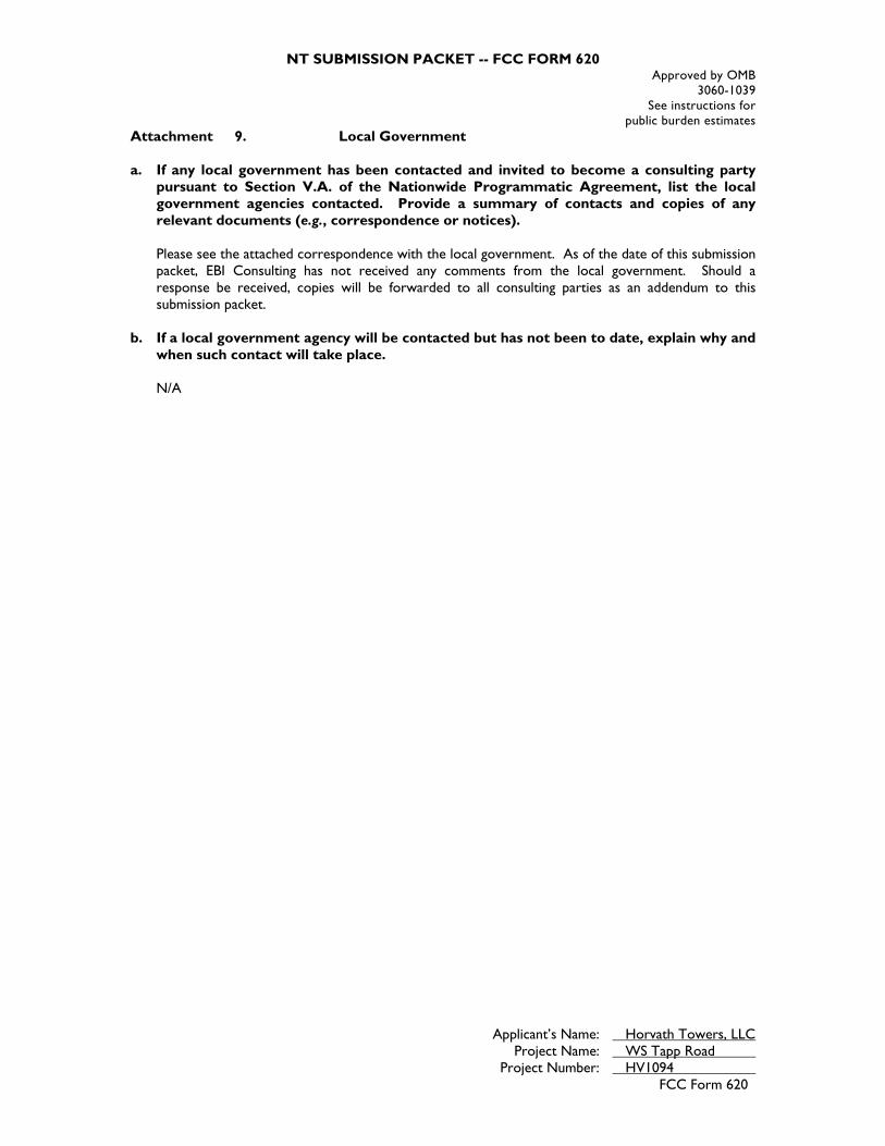
NT SUBMISSION PACKET -- FCC FORM 620 Approved by OMB
3060-1039 See instructions for
public burden estimates
Applicant’s Name: Horvath Towers, LLC Project Name: WS Tapp Road Project Number: HV1094
FCC Form 620
Attachment 9. Local Government a. If any local government has been contacted and invited to become a consulting party
pursuant to Section V.A. of the Nationwide Programmatic Agreement, list the local government agencies contacted. Provide a summary of contacts and copies of any relevant documents (e.g., correspondence or notices). Please see the attached correspondence with the local government. As of the date of this submission packet, EBI Consulting has not received any comments from the local government. Should a response be received, copies will be forwarded to all consulting parties as an addendum to this submission packet.
b. If a local government agency will be contacted but has not been to date, explain why and when such contact will take place.
N/A
ENVIROBUSINESS, INC. LOCATIONS | ATLANTA, GA | BALTIMORE, MD | BURLINGTON, MA | CHICAGO, IL | CRANSTON, RI | DALLAS, TX | DENVER, CO | EXETER, NH | HOUSTON, TX | LOS ANGELES, CA |
NEW YORK, NY | PHOENIX, AZ | PORTLAND, OR | SAN FRANCISCO, CA | SEATTLE, WA | YORK, PA
6876 Susquehanna Trail South York , PA 17403
Tel: (339) 234-2597 www.ebiconsulting.com
October 18, 2016 City of Bloomington Housing and Neighborhood Development c/o Ms. Nancy Hiestand, Program Manager Historic Preservation P.O. Box 100 Bloomington, IN 47402 Email: [email protected] Subject: Invitation to Comment
HV1094 / WS Tapp Road S. Weimer Rd., Bloomington, Monroe County, IN 47403 EBI Project #6116004086
Dear Ms. Hiestand: Pursuant to Section 106 of the National Historic Preservation Act, the regulations promulgated thereunder and interagency agreements developed thereto, EBI Consulting, Inc. on behalf of Horvath Towers, LLC provides this notice of a proposed telecommunications facility installation at the address listed above. EBI would like to inquire if you would be interested in commenting on this proposed project. Please refer to the attached project plans for complete details regarding this proposed project. Please note that we are requesting your review of the attached information as part of the Section 106 process only and not as part of the local zoning process. We are only seeking comments related to the proposed project’s potential effect to historic properties. Please submit your comments regarding the proposed project’s potential effect on historic properties to EBI Consulting, to my attention at 6876 Susquehanna Trail South, York, PA 17403, or contact me via telephone at the number listed below. Please reference the EBI project number. We would appreciate your comments as soon as possible within the next 30 days. Please do not hesitate to contact me if you have any questions or concerns about the proposed project.
Respectfully Submitted, Tara Cubie Senior Architectural Historian [email protected] (339) 234-2597 Attachments – Figures and Maps

1
Adam Crosbie
From: Microsoft OutlookTo: [email protected]: Wednesday, October 19, 2016 6:35 AMSubject: Relayed: Invitation to Comment (EBI# 6116004086)
Delivery to these recipients or groups is complete, but no delivery notification was sent by the destination server: [email protected] ([email protected]) Subject: Invitation to Comment (EBI# 6116004086)

NT SUBMISSION PACKET -- FCC FORM 620 Approved by OMB
3060-1039 See instructions for
public burden estimates
Applicant’s Name: Horvath Towers, LLC Project Name: WS Tapp Road Project Number: HV1094
FCC Form 620
Attachment 10. Other Consulting Parties and Public Notice List additional consulting parties that were invited to participate by the Applicant, or independently requested to participate. Provide any relevant correspondence or other documents. Please see the attached correspondence with interested parties. As of the date of this submission packet, EBI Consulting has not received any comments from any interested parties. Should a response be received, copies will be forwarded to all consulting parties as an addendum to this submission packet. You are required to provide a Public Notice Attachment. Attached, please find a copy of the legal notice regarding the proposed telecommunications installation that was posted in The Herald-Times on October 21, 2016. As of the date of this submission packet, no comments regarding this notice have been received by EBI. Should a response be received, copies will be forwarded to all consulting parties as an addendum to this submission packet.
6876 Susquehanna Trail South York , PA 17403
Tel: (602) 463-1698 Fax: (781) 425-3618
www.ebiconsulting.com
October 18, 2016 Herald Times 1900 South Walnut Street, PO Box 909 Bloomington, Indiana 47402 Tel: 812-331-4267 Email: [email protected] Subject: Request for Public Notice
EBI Project #6116004086 EBI Consulting (EBI), on behalf of Horvath Towers, LLC, would like to place the following ad in your paper for print on the next available publication date. Please send a tear sheet and a signed affidavit of the ad for confirmation to the address noted on the letterhead. The following is the text of the Public Notice:
Horvath Towers, LLC is proposing to construct a new telecommunications tower facility located at S. Weimer Road, approximately 500± feet of the intersection of Weimer Road and Sudburg Lane (39 08 38.9N/ 86 33 37.37 W), Bloomington, Monroe County, IN 47403. The new facility will consist of 199-foot (overall height) monopole tower in an 80-foot by 100-foot lease area. Any interested party wishing to submit comments regarding the potential effects the proposed facility may have on any historic property may do so by sending comments to: Project 6116004086-TC c/o EBI Consulting, 6876 Susquehanna Trail South, York, PA 17403, or via telephone at (339) 234-2597.
If possible, please send an invoice for the cost of the posting to the address noted on the letterhead. If not, every employee of EBI Consulting, Inc. has their own credit card so please call the number below to obtain credit card information for payment. Do not charge cards on file. Please reference EBI Project #6116004086 on any correspondence pertaining to this project, to ensure prompt processing. Please e-mail or call me with any questions or concerns concerning this publication. Thank you for your time. Sincerely, Ms. Melissa Bauer Senior Scientist [email protected] T (602) 463-1698 F (781) 425-3618

ENVIROBUSINESS, INC. LOCATIONS | ATLANTA, GA | BALTIMORE, MD | BURLINGTON, MA | CHICAGO, IL | CRANSTON, RI | DALLAS, TX | DENVER, CO | EXETER, NH | HOUSTON, TX | LOS ANGELES, CA |
NEW YORK, NY | PHOENIX, AZ | PORTLAND, OR | SAN FRANCISCO, CA | SEATTLE, WA | YORK, PA
6876 Susquehanna Trail South York , PA 17403
Tel: (339) 234-2597 www.ebiconsulting.com
October 18, 2016 Monroe County History Center 202 E. 6th St, Bloomington IN 47408 Subject: Invitation to Comment
HV1094 / WS Tapp Road S. Weimer Rd., Bloomington, Monroe County, IN 47403 EBI Project #6116004086
To Whom It May Concern: Pursuant to Section 106 of the National Historic Preservation Act, the regulations promulgated thereunder and interagency agreements developed thereto, EBI Consulting, Inc. on behalf of Horvath Towers, LLC provides this notice of a proposed telecommunications facility installation at the address listed above. EBI would like to inquire if you would be interested in commenting on this proposed project. Please refer to the attached project plans for complete details regarding this proposed project. Please note that we are requesting your review of the attached information as part of the Section 106 process only and not as part of the local zoning process. We are only seeking comments related to the proposed project’s potential effect to historic properties. Please submit your comments regarding the proposed project’s potential effect on historic properties to EBI Consulting, to my attention at 6876 Susquehanna Trail South, York, PA 17403, or contact me via telephone at the number listed below. Please reference the EBI project number. We would appreciate your comments as soon as possible within the next 30 days. Please do not hesitate to contact me if you have any questions or concerns about the proposed project.
Respectfully Submitted, Tara Cubie Senior Architectural Historian [email protected] (339) 234-2597 Attachments – Figures and Maps

NT SUBMISSION PACKET -- FCC FORM 620 Approved by OMB
3060-1039 See instructions for
public burden estimates
Applicant’s Name: Horvath Towers, LLC Project Name: WS Tapp Road Project Number: HV1094
FCC Form 620
Attachment 11. SHPO Specific Forms N/A

UPS CampusShip: View/Print Label
1. Ensure there are no other shipping or tracking labels attached to your package. Select the
Print button on the print dialog box that appears. Note: If your browser does not support this function
select Print from the File menu to print the label.
2. Fold the printed label at the solid line below. Place the label in a UPS Shipping Pouch. If you do
not have a pouch, affix the folded label using clear plastic shipping tape over the entire label.
3. GETTING YOUR SHIPMENT TO UPS
Customers with a Daily Pickup
Your driver will pickup your shipment(s) as usual.
Customers without a Daily Pickup
Take your package to any location of The UPS Store®, UPS Access Point(TM) location, UPS Drop
Box, UPS Customer Center, UPS Alliances (Office Depot® or Staples®) or Authorized Shipping Outlet
near you. Items sent via UPS Return Services(SM) (including via Ground) are also accepted at Drop
Boxes. To find the location nearest you, please visit the Resources area of CampusShip and select
UPS Locations.
Schedule a same day or future day Pickup to have a UPS driver pickup all your CampusShip
packages.
Hand the package to any UPS driver in your area.
UPS Access PointTM UPS Access PointTM UPS Access PointTM
THE UPS STORE THE UPS STORE THE UPS STORE
101 MIDDLESEX TPKE 101 GREAT RD 405 WALTHAM ST
BURLINGTON ,MA 01803 BEDFORD ,MA 01730 LEXINGTON ,MA 02421
FOLD HERE
Page 1 of 1UPS CampusShip: Shipment Label
11/3/2016https://www.campusship.ups.com/cship/create?ActionOriginPair=default___PrintWindowPage&key=labelWin...

APPENDIX ENATIVE AMERICAN CORRESPONDENCE
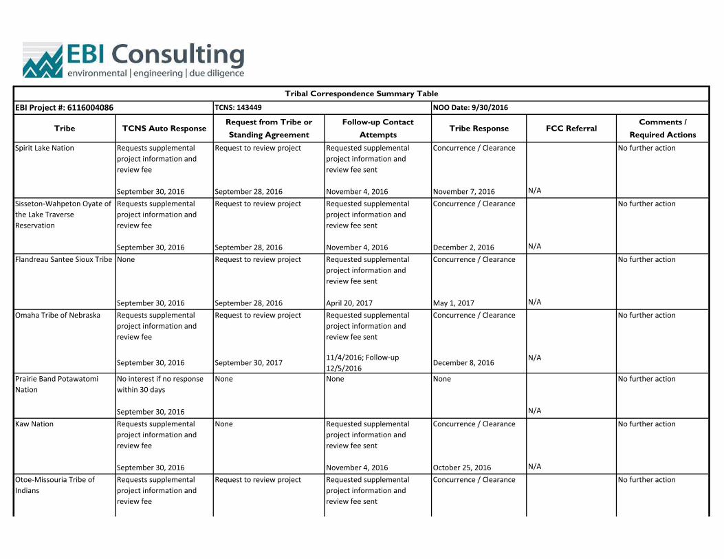
Tribe TCNS Auto ResponseRequest from Tribe or
Standing Agreement
Follow-up Contact
AttemptsTribe Response FCC Referral
Comments /
Required Actions
Requests supplemental project information and review fee
Request to review project Requested supplemental project information and review fee sent
Concurrence / Clearance
September 30, 2016 September 28, 2016 November 4, 2016 November 7, 2016 N/A
Requests supplemental project information and review fee
Request to review project Requested supplemental project information and review fee sent
Concurrence / Clearance
September 30, 2016 September 28, 2016 November 4, 2016 December 2, 2016 N/A
None Request to review project Requested supplemental project information and review fee sent
Concurrence / Clearance
September 30, 2016 September 28, 2016 April 20, 2017 May 1, 2017 N/A
Requests supplemental project information and review fee
Request to review project Requested supplemental project information and review fee sent
Concurrence / Clearance
September 30, 2016 September 30, 201711/4/2016; Follow‐up 12/5/2016
December 8, 2016N/A
No interest if no response within 30 days
None None None
September 30, 2016 N/A
Requests supplemental project information and review fee
None Requested supplemental project information and review fee sent
Concurrence / Clearance
September 30, 2016 November 4, 2016 October 25, 2016 N/A
Requests supplemental project information and review fee
Request to review project Requested supplemental project information and review fee sent
Concurrence / Clearance
Spirit Lake Nation No further action
Otoe‐Missouria Tribe of Indians
No further action
Omaha Tribe of Nebraska No further action
Flandreau Santee Sioux Tribe No further action
Sisseton‐Wahpeton Oyate of the Lake Traverse Reservation
No further action
Prairie Band Potawatomi Nation
No further action
Kaw Nation
Tribal Correspondence Summary Table
EBI Project #: 6116004086 NOO Date: 9/30/2016TCNS: 143449
No further action
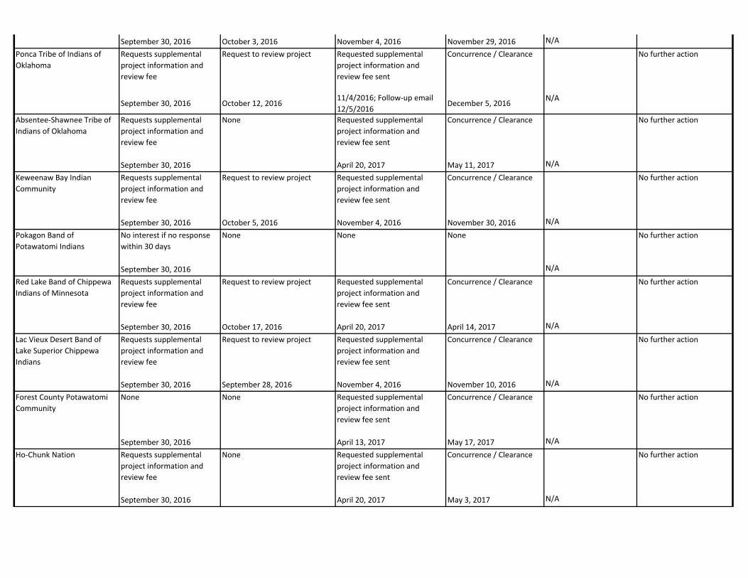
September 30, 2016 October 3, 2016 November 4, 2016 November 29, 2016 N/A
Requests supplemental project information and review fee
Request to review project Requested supplemental project information and review fee sent
Concurrence / Clearance
September 30, 2016 October 12, 201611/4/2016; Follow‐up email 12/5/2016
December 5, 2016N/A
Requests supplemental project information and review fee
None Requested supplemental project information and review fee sent
Concurrence / Clearance
September 30, 2016 April 20, 2017 May 11, 2017 N/A
Requests supplemental project information and review fee
Request to review project Requested supplemental project information and review fee sent
Concurrence / Clearance
September 30, 2016 October 5, 2016 November 4, 2016 November 30, 2016 N/A
No interest if no response within 30 days
None None None
September 30, 2016 N/A
Requests supplemental project information and review fee
Request to review project Requested supplemental project information and review fee sent
Concurrence / Clearance
September 30, 2016 October 17, 2016 April 20, 2017 April 14, 2017 N/A
Requests supplemental project information and review fee
Request to review project Requested supplemental project information and review fee sent
Concurrence / Clearance
September 30, 2016 September 28, 2016 November 4, 2016 November 10, 2016 N/A
None None Requested supplemental project information and review fee sent
Concurrence / Clearance
September 30, 2016 April 13, 2017 May 17, 2017 N/A
Requests supplemental project information and review fee
None Requested supplemental project information and review fee sent
Concurrence / Clearance
September 30, 2016 April 20, 2017 May 3, 2017 N/A
Ponca Tribe of Indians of Oklahoma
No further action
Keweenaw Bay Indian Community
No further action
Absentee‐Shawnee Tribe of Indians of Oklahoma
No further action
Pokagon Band of Potawatomi Indians
No further action
Red Lake Band of Chippewa Indians of Minnesota
No further action
Lac Vieux Desert Band of Lake Superior Chippewa Indians
No further action
Forest County Potawatomi Community
No further action
Ho‐Chunk Nation No further action

Requests supplemental project information and review fee
None Requested supplemental project information and review fee sent
Concurrence / Clearance
September 30, 2016 November 4, 2016 November 14, 2016 N/A
Requests supplemental project information and review fee
None Requested supplemental project information and review fee sent
Concurrence / Clearance
September 30, 2016 November 4, 2016 November 14, 2016 N/A
Requests supplemental project information and review fee
Request to review project Requested supplemental project information and review fee sent
Concurrence / Clearance
September 30, 2016 September 29, 2016 April 20, 2017 May 5, 2017 N/A
Requests supplemental project information and review fee
Request to review project Requested supplemental project information and review fee sent
Concurrence / Clearance
September 30, 2016 September 28, 2016 April 20, 2017 May 1, 2017 N/A
Requests supplemental project information and review fee
None Requested supplemental project information and review fee sent
Concurrence / Clearance
September 30, 2016 April 20, 2017 April 26, 2017 N/A
Requests supplemental project information and review fee
None Requested supplemental project information and review fee sent
None
May 25, 2017
September 30, 20164/20/2017; Follow‐up email 5/23/2017
Tribe referred to the FCC. No response within 20 days.
Requests supplemental project information and review fee
None Requested supplemental project information and review fee sent
None
May 25, 2017
September 30, 20164/20/2017; Follow‐up email 5/23/2017
Tribe referred to the FCC. No response within 20 days.
Requests supplemental project information and review fee
Request to review project Requested supplemental project information and review fee sent
Concurrence / Clearance
September 30, 2016 October 5, 2016 April 20, 2017 May 16, 2017 N/A
Cherokee Nation No further action
Eastern Shawnee Tribe of Oklahoma
No further action
Red Cliff Band of Lake Superior Chippewa Indians of Wisconsin
No further action
Miami Tribe of Oklahoma No further action
Ottawa Tribe of Oklahoma No further action
Wyandotte Nation No further action
Peoria Tribe of Indians of Oklahoma
No further action
Shawnee Tribe No further action

Requests supplemental project information and review fee
Request to review project Requested supplemental project information and review fee sent
Concurrence / Clearance
September 30, 2016 October 3, 2016 April 20, 2017 May 2, 2017 N/A
None Request to review project Requested supplemental project information and review fee sent
Concurrence / Clearance
September 30, 2016 October 3, 2016 November 4, 2016 November 18, 2016 N/A
Lac du Flambeau Band of Lake Superior Chippewa Indians
No further action
Chippewa Cree Tribe of the Rocky Boy's Reservation
No further action