Lake Britton 2016 Water Quality Monitoring
21
Lake Britton 2016 Water Quality Monitoring September 2016
Transcript of Lake Britton 2016 Water Quality Monitoring
Lake Britton 2016 Water Quality Monitoring
September 2016
2

3
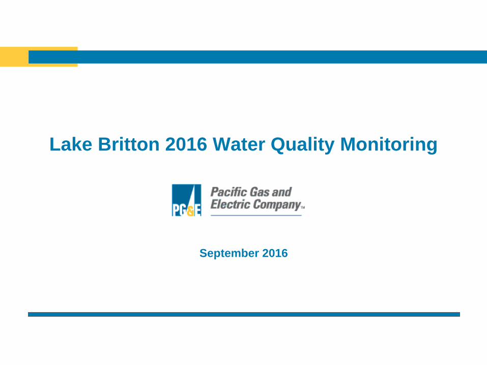
Monitoring Network
PH-27
PH-30 PR2
LB-P1
Pit 3 Intake
PH-37
PH-35

4
Lake Britton Monitoring Objectives
• Characterize the effects of the new license flow regime
on summer water quality (DO and water temperature)
in Lake Britton.
– Monthly synoptic water quality monitored in Lake Britton
(1 profile station near dam).
• June 15th, July 12th, August 9th, September 14th
– Install seasonal meteorology station at Pit 3 Intake.
• Perform visual assessment for the presence/absence
of algal blooms in Lake Britton.
– Conduct monthly visual assessments and photo
documentation.

5
Regional Hydrology
Watershed Runoff Precipitation4
DWR Runoff
Sac. River
Basin Flow Into Pit River
Hat
Creek Pit 5
Water Year Index1 WY Type1 Lake Britton2 WY Type3 PH No.1 PH
2016 7.0 Blw Norm 1,629 Blw Norm 14.7 p 62.6 p
2015 4.0 C Dry 1,102 C Dry 15.6 41.0
2014 4.0 C Dry 1,094 C Dry 17.3 75.6
2013 5.8 Dry 1,318 Dry 5.9 p 25.2
2012 6.9 Blw Norm 1,260 C Dry 19.9 86.9
2011 10.0 Wet 1,984 Wet 16.5 p 62.5
2010 6.9 Blw Norm 1,271 C Dry 18.9 99.2
2009 5.5 Dry 1,338 Dry 14.5 68.5
2008 5.4 C Dry 1,456 Blw Norm 13.6 57.2
2007 6.2 Dry 1,367 Dry 13.1 52.7
2006 13.0 Wet 2,646 Wet 14.2 93.7
2005 7.4 Blw Norm 1,686 Abv Norm 23.6 96.1
2004 7.7 Blw Norm 1,599 Blw Norm 18.4 72.0
2003 8.0 Abv Norm 1,656 Abv Norm 20.2 67.6
2002 6.5 Dry 1,524 Blw Norm 13.8 74.8
2001 5.9 Dry 1,482 Blw Norm 14.6 72.8
2000 9.2 Wet 1,911 Abv Norm 17.7 84.4
Average -- -- 1813 18.3 75.9
Maximum -- -- 2,914-1998 WY 34.2 138.8
Minimum -- -- 1,094-2014 WY 7.0 25.2
Data Years -- -- 41 70 64
6
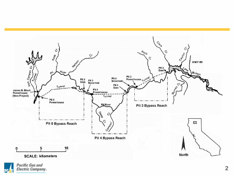
Project Area Meteorology
Mean Exceedance Mean Exceedance Mean Exceedance Mean Exceedance
Year (°C) (%) Class (°C) (%) Class (°C) (%) Class (°C) (%) Class
2015 20.4 1% Hot 20.7 51% Norm 20.1 39% Norm 16.8 43% Norm
2014 18.3 24% Abv Norm 23.2 2% Hot 20.3 30% Norm 17.0 34% Norm
2013 18.3 23% Abv Norm 21.8 26% Abv Norm 19.0 77% Blw Norm 15.4 75% Blw Norm
2012 16.2 80% Blw Norm 19.9 77% Blw Norm 21.1 15% Abv Norm 17.6 14% Abv Norm
2011 15.5 93% Cold 19.7 79% Blw Norm 19.6 52% Norm 18.7 4% Hot
2010 15.2 97% Cold 20.7 50% Norm 18.8 78% Blw Norm 15.4 77% Blw Norm
2009 16.7 63% Norm 20.6 55% Norm 19.0 73% Blw Norm 17.5 25% Abv Norm
2008 16.4 71% Blw Norm 20.8 48% Norm 20.6 26% Abv Norm 16.4 53% Norm
2007 17.6 43% Norm 19.4 87% Blw Norm 19.2 66% Norm 14.3 90% Cold
2006 18.8 16% Abv Norm 21.5 29% Abv Norm 18.4 88% Blw Norm 15.5 72% Blw Norm
2005 14.0 100% Cold 21.8 28% Abv Norm 19.8 46% Norm 13.2 100% Cold
2004 17.9 34% Norm 20.8 46% Norm 19.4 59% Norm 15.1 80% Blw Norm
2003 19.0 13% Abv Norm 21.9 19% Abv Norm 18.7 80% Blw Norm 17.3 28% Abv Norm
2002 17.8 38% Norm 21.8 26% Abv Norm 19.0 74% Blw Norm 16.3 57% Norm
2001 16.9 57% Norm 20.4 62% Norm 19.5 56% Norm 16.4 55% Norm
2000 18.5 21% Abv Norm 18.8 92% Cold 19.3 62% Norm 15.1 79% Blw Norm
Mean 17.3 20.7 19.7 16.3
Maximum 21.0 23.5 21.8 19.9
Minimum 14.0 17.6 16.5 13.2
Data Years 89 92 90 92
Mean Monthly Air Temperature - Hat 1 Powerhouse
June July August September

7
Lake Britton Water Temperature Profiles
2640
2660
2680
2700
2720
2740
2760
2780
10 12 14 16 18 20 22 24 26
Wa
ter
Su
rface
Ele
vati
on
(ft
PG
&E
datu
m)
Water Temperature (ºC)
June 15, 2016 July 12, 2016 August 9, 2016 September 14, 2016
Bladder Dam
Dam Spill Crest
Pit 3 Intake ℄
IFR Intake ℄
8
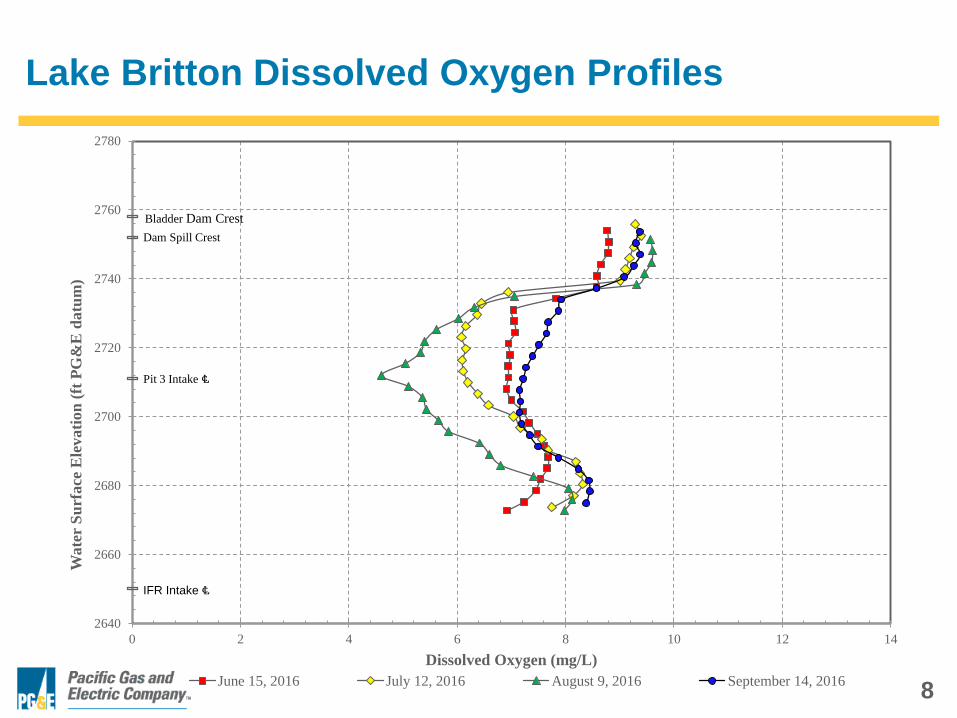
Lake Britton Dissolved Oxygen Profiles
2640
2660
2680
2700
2720
2740
2760
2780
0 2 4 6 8 10 12 14
Wate
r S
urf
ace
Ele
vati
on
(ft
PG
&E
datu
m)
Dissolved Oxygen (mg/L)
June 15, 2016 July 12, 2016 August 9, 2016 September 14, 2016
Bladder Dam Crest
Dam Spill Crest
Pit 3 Intake ℄
IFR Intake ℄
9
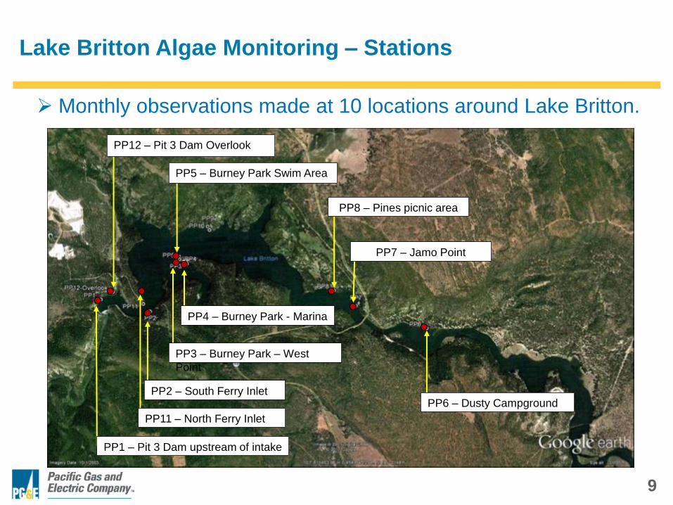
Monthly observations made at 10 locations around Lake Britton.
Lake Britton Algae Monitoring – Stations
PP8 – Pines picnic area
PP5 – Burney Park Swim Area
PP6 – Dusty Campground
PP4 – Burney Park - Marina
PP3 – Burney Park – West
Point
PP2 – South Ferry Inlet
PP11 – North Ferry Inlet
PP1 – Pit 3 Dam upstream of intake
PP12 – Pit 3 Dam Overlook
PP7 – Jamo Point

10
Lake Britton Algae Monitoring – Visual Assessment
• Moderate cyanobacteria concentration in July 2016.
o Some accumulation in quiet cover areas
(e.g., State Park Marina, Jamo Boat Ramp).
• Abundance low in August, no film/scum.
• Factors possibly influencing algae production:
o Water year with moderate inflow
(reduced residence time).
o Cooler meteorology.
o Moderate turbidity during spring run-off
(limited light penetration to sediments).
11
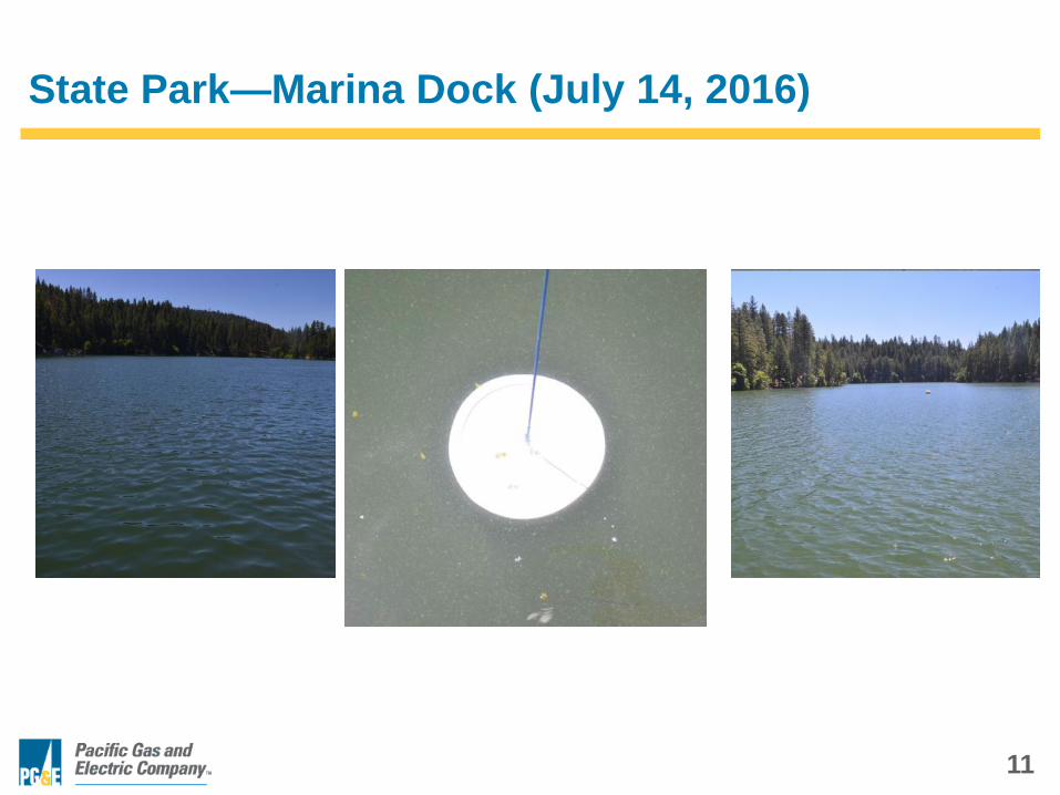
State Park—Marina Dock (July 14, 2016)
12
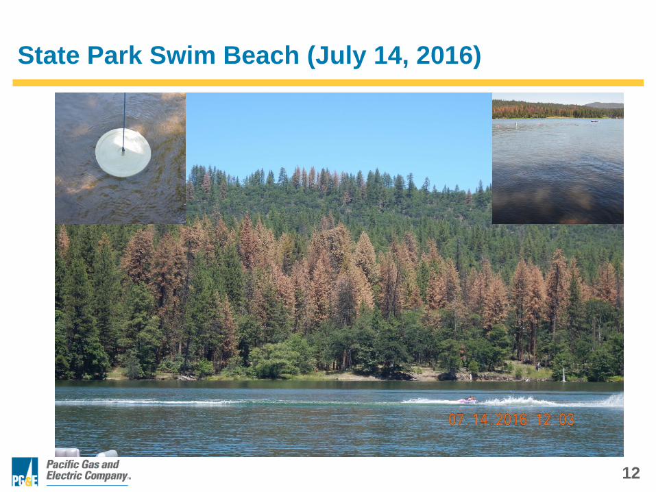
State Park Swim Beach (July 14, 2016)
13
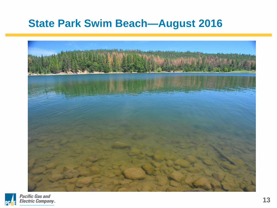
State Park Swim Beach—August 2016
14
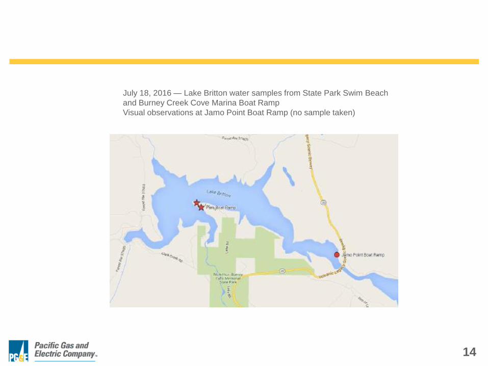
July 18, 2016 — Lake Britton water samples from State Park Swim Beach
and Burney Creek Cove Marina Boat Ramp
Visual observations at Jamo Point Boat Ramp (no sample taken)

15
Cyanotoxin Analysis Results:
Cyanobacteria genera ID'd Gloeotrichia, Aphanizomenon, and Anabaena
PG&E Anatoxin-a (ppb) (Test-strips)
Project Water Body Location GIS Coordinates 18-Jul-16 10-Aug-
16 15-Sep-16
Pit 1 Pit 1 Forebay Fall River Lake ADA Fishing Platform 41.008351, -121.448995 0.31 ND
Pit 345 Lake Britton State Park Burney Creek Cove Marina Boat Launch Ramp 41.028237, -121.657314 0.41 0.33 ND
Pit 345 Lake Britton State Park Swim Beach area 41.02902, -121.657663 0.52 0.23 ND
Pit 345 Lake Britton Jamo Boat Launch 41.019178, -121.623481 0.31 ND
Pit 345 Lake Britton Northshore Campground Swim Beach W 41.033608, -121.652881 <0.15 ND
Pit 345 Lake Britton
Pit 345 Pit River Pit5 Reach Big Bend bridge 41.020616, -121.910600 0.35 0.27 ND
Shasta Lake upper Pit River Arm A 40.83738, -122.02012 0.53
Shasta Lake upper Pit River Arm B 40.81686, -122.05859 0.53
Shasta Lake upper Pit River Arm C 40.76676, -122.12199 0.53
Microcystins, Cylindrospermopsin (ppb)
18-Jul-16 10-Aug-
16 15-Sep-16
Pit 1 Pit 1 Forebay Fall River Lake ADA Fishing Platform 41.008351, -121.448995 ND ND
Pit 345 Lake Britton State Park Burney Creek Cove Marina Boat Launch Ramp 41.028237, -121.657314 ND ND ND
Pit 345 Lake Britton State Park Swim Beach area 41.02902, -121.657663 ND ND ND
Pit 345 Lake Britton Jamo Boat Launch 41.019178, -121.623481 ND ND
Pit 345 Lake Britton Northshore Campground Swim Beach W 41.033608, -121.652881 ND ND
Pit 345 Lake Britton
Pit 345 Pit River Pit5 Reach Big Bend bridge 41.020616, -121.910600 ND ND
Shasta Lake upper Pit River Arm A 40.83738, -122.02012 ND
Shasta Lake upper Pit River Arm B 40.81686, -122.05859 ND
Shasta Lake upper Pit River Arm C 40.76676, -122.12199 ND
16
Satellite Multi-spectral Image Analysis
• Satelytics (Blue Water Satellite, Inc.), Toledo OH
• Proprietary algorithm for phycocyanin concentration
(primary cyanobacteria photosynthetic pigment).
• Monthly image analysis for June, July, August, and
September using Landsat 7 with a pixel size of 30
square meters. Selected image date as close to
physical sampling date as possible.
• Actual image used depended upon cloud cover and
capture resolution.
• Conducted annually since 2012 as a supplement to
ground level photo point assessment.

17
Lake Britton Algae Monitoring – 2016 Remote sensing
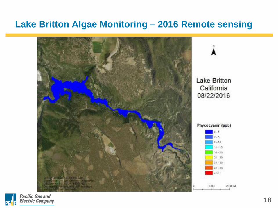
18
Lake Britton Algae Monitoring – 2016 Remote sensing

19
Lake Britton Algae Monitoring – 2015 Remote sensing

20
Lake Britton Algae Monitoring – 2015 Remote sensing

21
Cyanotoxin Monitoring Challenges
• Definition of Bloom Conditions
o Satellite Imagery provides big picture view
o Some “blooms” can be very localized
• Trigger values for anatoxin-a
o Maybe present with “background” levels of cyanobacteria
o Analytical sampling costs
• Public perception of environmental health risk
o Could be “acclimated” to postings if too conservative