2012 ISCCW AIS Lake Monitoring Program Summaryisccw.org/s/Lakes Surveyed in 2012.pdf2012 ISCCW AIS...
31
2012 ISCCW AIS Lake Monitoring Program Summary Date Lake Approximate Acres Monitored Invasive Species Observed 7.15.2012 Allen Lake 12.16 None 9.24.2012 Bass Lake 161 EWM 9.30.2012 Beatons Lake 36.48 None 6.22.2012, 6.23.2012 & 6.25.2012 Cisco Lake 156.13 CLP 9.27.2012 & 9.28.2012 Clearwater Lake 132 EWM 8.8.2012 County Line Lake 13.61 None 9.28.2012 Crooked Lake - 1st Bay 8.27 EWM 7.1.2012 Dinner Lake 19.46 None 7.10.2012 Duck Lake - Mid Season 65.66 EWM 5.31.2012 Duck Lake - Pretreatment 39.88 EWM 7.15.2012 Long Lake 24.32 None 6.4.12, 6.13.2012 & 6.16.2012 LVD - Early Season 73.44 EWM & CLP 8.28.2012 LVD - Mid Season 120.14 EWM 7.4.2012 Marion Lake 49.61 None 9.4.2012 & 9.15.2012 Misery Bay - LVD 54.96 None 7.2.2012 Moon Lake 15.08 None 9.28.2012 Palmer's Bay – Big Lake 9.73 EWM 6.26.2012 Record, Big and Little Africa 48.64 None 6.1.2012 & 6.4.2012 Thousand Island - Early Season 48.64 EWM 9.25.2012 & 9.27.2012 Thousand Island - Mid Season 113.82 EWM AIS = Aquatic Invasive Species EWM = Eurasian watermilfoil (Myrophyllum spicatum) CLP = Curly leaf pondweed (Potamogeton crispus)
Transcript of 2012 ISCCW AIS Lake Monitoring Program Summaryisccw.org/s/Lakes Surveyed in 2012.pdf2012 ISCCW AIS...

2012 ISCCW AIS Lake Monitoring Program Summary
Date Lake
Approximate Acres
Monitored Invasive Species
Observed 7.15.2012 Allen Lake 12.16 None
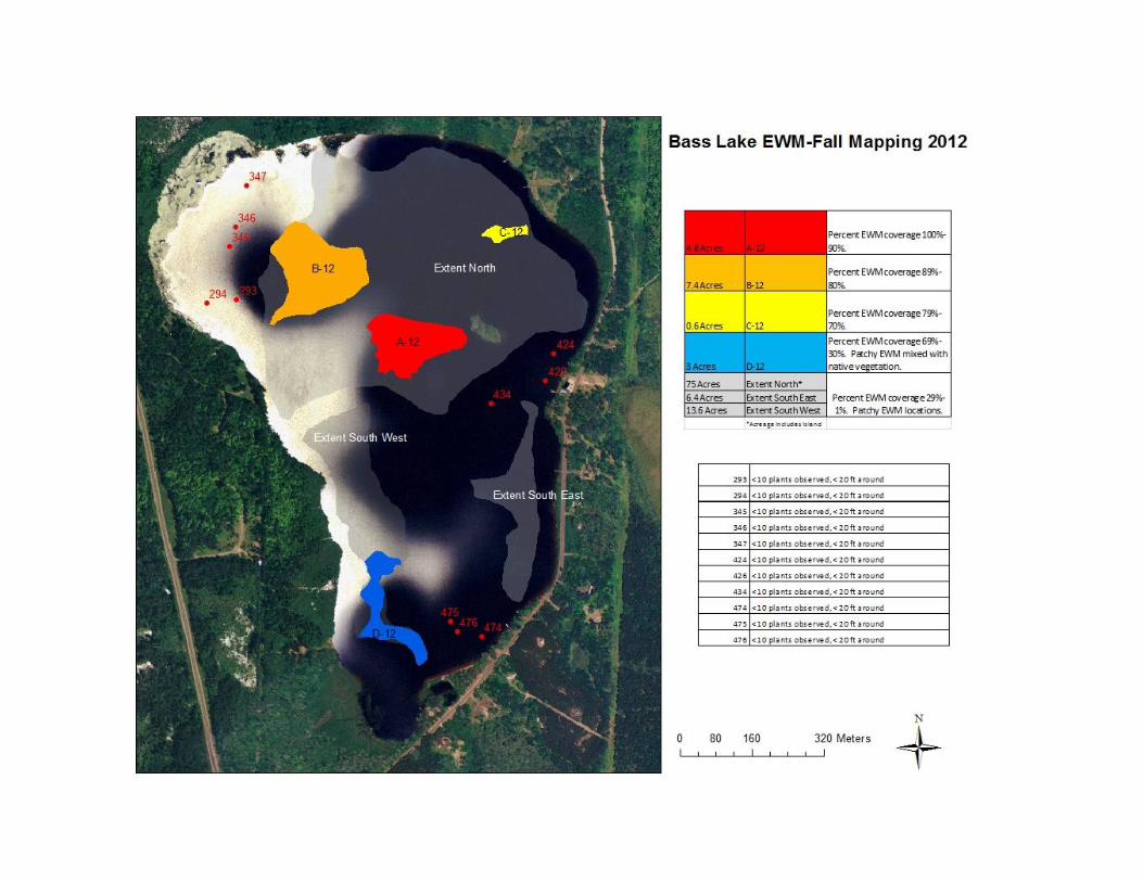
9.24.2012 Bass Lake 161 EWM
9.30.2012 Beatons Lake 36.48 None
6.22.2012, 6.23.2012 &
6.25.2012 Cisco Lake 156.13 CLP
9.27.2012 & 9.28.2012 Clearwater Lake 132 EWM
8.8.2012 County Line Lake 13.61 None
9.28.2012 Crooked Lake - 1st Bay 8.27 EWM
7.1.2012 Dinner Lake 19.46 None
7.10.2012 Duck Lake - Mid Season 65.66 EWM
5.31.2012 Duck Lake - Pretreatment 39.88 EWM
7.15.2012 Long Lake 24.32 None
6.4.12, 6.13.2012 & 6.16.2012 LVD - Early Season 73.44 EWM & CLP
8.28.2012 LVD - Mid Season 120.14 EWM
7.4.2012 Marion Lake 49.61 None
9.4.2012 & 9.15.2012 Misery Bay - LVD 54.96 None
7.2.2012 Moon Lake 15.08 None
9.28.2012 Palmer's Bay – Big Lake 9.73 EWM
6.26.2012
Record, Big and Little Africa 48.64 None
6.1.2012 & 6.4.2012 Thousand Island - Early
Season 48.64 EWM
9.25.2012 & 9.27.2012
Thousand Island - Mid Season 113.82 EWM
AIS = Aquatic Invasive Species
EWM = Eurasian watermilfoil (Myrophyllum spicatum)
CLP = Curly leaf pondweed (Potamogeton crispus)

2012 AIS Location Information by Lake
Cisco Lake-Cisco Chain of Lakes
Overview

North End
South End
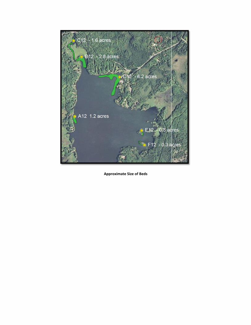
Approximate Size of Beds

Cisco Lake AIS (CLP) Location Information
GPS Information
Site ID Lat Long Notes
12CI01 46.23607 89.45158 3-6 CLP plants
12CI02 46.23714 89.45193 2 CLP plants adjacent to stump
12CI03 46.23717 89.45191 4 ft cluster of CLP sparse density
12CI04 46.23755 89.45233 Small cluster of sparse density CLP
12CI05 46.23821 89.45223 Small group of sparse density CLP about 4 ft
12CI06 46.23946 89.45242 6 CLP plants
12CI07 46.23968 89.45215 Several CLP plants by dock
12CI08 46.23968 89.45206 Clump of CLP in deeper water from 07, about 6-8 ft diameter, moderate density
12CI09 46.23983 89.45215 Small clump of CLP plants, moderate density, 4-6 ft diameter
12CI10 46.24020 89.45220 2 small clumps of CLP about 3 ft each
12CI11 46.24032 89.45224 several sparse density CLP plants
12CI12 46.24096 89.45209 Moderate to Density Bands of CLP that make up Polygon A12
12CI13 46.24111 89.45228 Moderate to Density Bands of CLP that make up Polygon A12
12CI14 46.24121 89.45229 Moderate to Density Bands of CLP that make up Polygon A12
12CI15 46.24135 89.45238 Moderate to Density Bands of CLP that make up Polygon A12
12CI16 46.24154 89.45252 Moderate to Density Bands of CLP that make up Polygon A12
12CI17 46.24172 89.45240 Moderate to Density Bands of CLP that make up Polygon A12
12CI18 46.24678 89.44379 Moderate to Density Bands of CLP that make up Polygon A12
12CI19 46.24685 89.44365 Moderate to Density Bands of CLP that make up Polygon A12
12CI20 46.24682 89.44347 Moderate to Density Bands of CLP that make up Polygon A12
12CI21 46.24226 89.45229 few scattered CLP plants mixed in with wood
12CI22 46.24374 89.45172 6 or less CLP plants sparse density north of boat lift
12CI23 46.24555 89.45188 small clump of CLP 3 ft diameter mixed in with lily pads and target weed
12CI24 46.24565 89.45194 another clump of CLP 2 ft in lily pads and target weed. Some outlying plants
12CI25 46.24820 89.45047 2 dense large colonies of CLP about 10 ft each
12CI26 46.24929 89.45126 large clumps of CLP, 15 ft diameter, dense, hidden in lily pads, another 10 ft clump into channel
12CI27 46.23764 89.44114 1 single CLP plant
12CI28 46.23758 89.44034 1 single CLP plant, 7 ft area of CLP under log just to the left of waypoint

GPS Information
Site ID Lat Long Notes
12CI29 46.23787 89.43864 Several small clumps of CLP, 5-12 plants each on pt. of Island
12CI30 46.23787 89.43947 2 CLP plants adjacent to stump
12CI31 46.23826 89.43931 very sparse CLP spread throughout 15 ft area of lily pads
12CI32 46.23823 89.43917 30 ft by 15 ft strip of CLP not very dense plant spacing <12 inches
12CI33 46.23830 89.43844 CLP in clusters from 6 ft to 10 ft surrounded by outlying plants
12CI34 46.23913 89.43891 15 ft strip of CLP in lily pads, spacing <6 inches
12CI35 46.23907 89.43903 Points used to form E12
12CI36 46.23983 89.43930 Points used to form E12
12CI37 46.23996 89.43926
Several clumps of CLP, dense, 6-10 ft with outlying plants cover 40 ft area, very hard to see by eye but aqua scope helps
12CI38 46.23910 89.43844 CLP, some clumps that are dense most about <6 inch spacing, 50 ft area
12CI39 46.23940 89.43809 20 ft area of Sparse density CLP
12CI40 46.24059 89.43723 3-6 CLP plants mixed in with stump
12CI41 46.24520 89.44451 4 ft cluster of CLP plant spacing varies from <6 to ~12 inches
12CI42 46.24505 89.44465 large 40 ft area of CLP, low density, ~6" spacing, growing right in dense bed of northern milfoil
12CI43 46.24466 89.44473 Largest cluster of CLP growing in Northern milfoil ranges from 15-35 ft wide
12CI44 46.24643 89.44375 sparse CLP, covers ~20 ft area
12CI45 46.24628 89.44389 Dense colony of CLP about 8 ft diameter and another just south of point, sparse density
12CI46 46.24587 89.44431 CLP at varying densities, ranges from 20-40 ft wide, extends to deep water
12CI47 46.24640 89.44410 2 colonies of CLP that are dense with outlying individual plants
12CI48 46.24702 89.44377 small clump of CLP around 2 ft in diameter, bed extends from boat launch to bay south of resort
12CI49 46.24723 89.44458 sparse density cluster of CLP about 4 ft diameter right off resort dock
12CI50 46.24721 89.44494 largest area of sparse to moderate density CLP around 30 ft diameter mixed in with native vegetation
12CI51 46.24730 89.44517 largest bed of CLP with outlying plants ~30 ft diameter, plant spacing <6"
12CI52 46.24712 89.44566 10-12 ft colony of CLP with outlying plants, CLP at varying densities all the way from 49
12CI54 46.24717 89.44617 large dense colony of CLP approx 20 ft wide by 60 ft long
12CI54 46.24680 89.44503 15 ft diameter area of dense CLP
12CI55 46.24705 89.44702
dense CLP in clumps then small gaps of no CLP then another clump, around 20 ft wide
GPS Information
Site ID Lat Long Notes
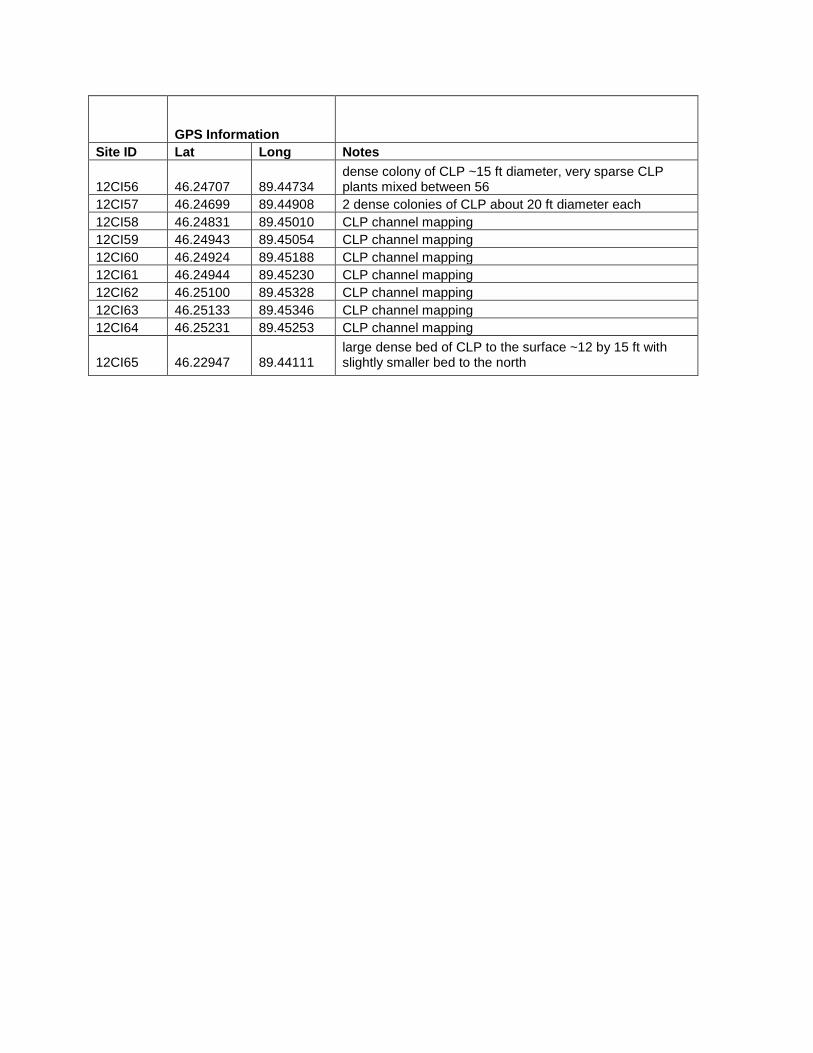
12CI56 46.24707 89.44734 dense colony of CLP ~15 ft diameter, very sparse CLP plants mixed between 56
12CI57 46.24699 89.44908 2 dense colonies of CLP about 20 ft diameter each
12CI58 46.24831 89.45010 CLP channel mapping
12CI59 46.24943 89.45054 CLP channel mapping
12CI60 46.24924 89.45188 CLP channel mapping
12CI61 46.24944 89.45230 CLP channel mapping
12CI62 46.25100 89.45328 CLP channel mapping
12CI63 46.25133 89.45346 CLP channel mapping
12CI64 46.25231 89.45253 CLP channel mapping
12CI65 46.22947 89.44111 large dense bed of CLP to the surface ~12 by 15 ft with slightly smaller bed to the north

Crooked Lake
Boat Launch Bay (1st
Bay)
Crooked Lake EWM Location Information
GPS Information
Site ID Lat Long Notes
CRL01 46.24855 89.28772 1 single EWM plant mixed with northern milfoil, still very vibrant green

Duck Lake
Overview South End

South End
West Shore (Blow Down)

Duck Lake EWM Location Information
GPS Information
Site ID Lat Long Notes
Pretreatment Survey 12DU01 46.18878 89.22430 Single EWM plant, 4-5 FOW
12DU02 46.18817 89.21757 Single robust EWM plant tucked under overhanging Maple limbs 3 FOW
12DU03 46.19630 89.22765 Single robust EWM plant, in treatment area by blow down 4 FOW
12DU04 46.19647 89.22753 3 EWM plants, lined up N to S buoy marks middle plant, In treatment area at least 4-6 more EWM plants within 20 yds of marker
Mid Season Survey DU22 46.19106 89.22491 2 EWM plants, both single sprig

Lac Vieux Desert
Early Season
Overview
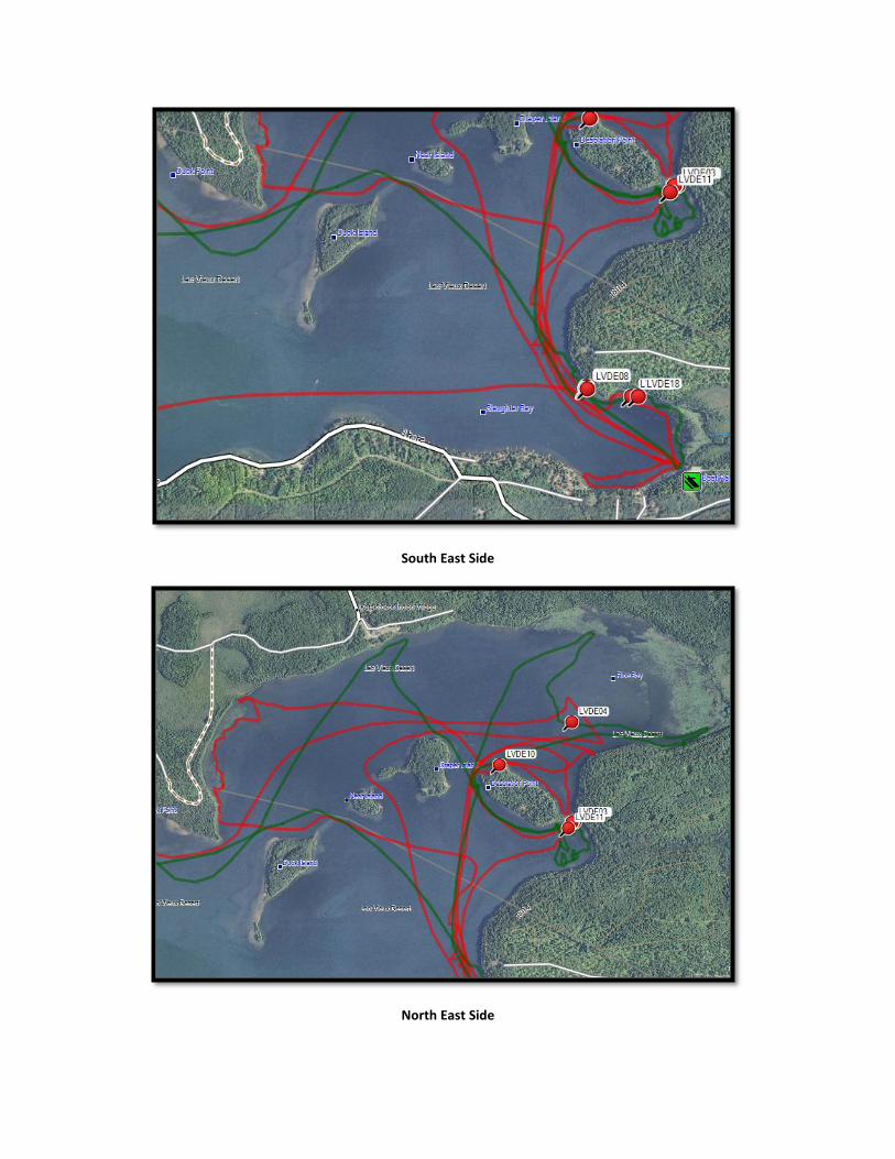
South East Side
North East Side

Outlet Bay
Outlet Bay
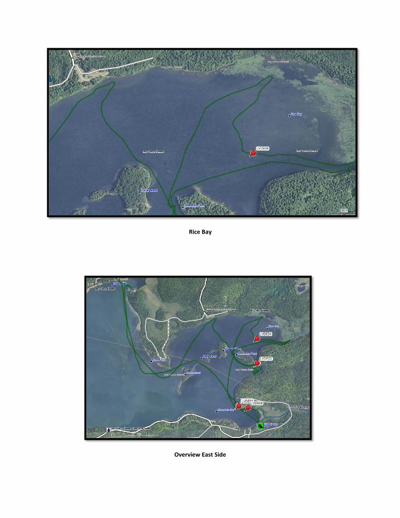
Rice Bay
Overview East Side

Simpson’s Point
Slaughter Bay

Lac Vieux Desert Early Season AIS Location Information
GPS Information
Site ID Lat Long Notes
LVDE01 46.13822 89.07422 Colony of CLP about 8 ft diameter in 3 FOW, sample collected
LVDE02 46.13821 89.07436 Small 2 ft clump of CLP to surface
LVDE03 46.13823 89.07443 8 ft diameter clump of CLP, plants are to surface with flowering parts
LVDE04 46.14442 89.07445 2 colonies of CLP, 15-30 plants total
LVDE05 46.12760 89.08024 1 EWM plant, sample collected
LVDE06 46.12753 89.08031 2 EWM plants, 1 very large and robust. Could be more just emerging
LVDE07 46.12751 89.08022 colony of EWM, mix of large robust plants and single sprig plants, covers 20 ft area
LVDE08 46.12747 89.08018 multiple EWM plants scattered throughout natural vegetation. Not as dense as LVDE07
LVDE09 46.12707 89.07726 Small colony of CLP covering 5 ft area, not very dense. 10-20 plants
LVDE10 46.14180 89.08003 1 single EWM plant, sample collected ~4 FOW
LVDE11 46.13786 89.07472 1 very large, multi branched EWM plant
LVDE12 46.12047 89.14716 10 ft diameter area of CLP, sparse Density
LVDE13 46.12062 89.14718 2 clumps of CLP about 2 ft diameter each, 15 ft apart
LVDE14 46.12049 89.14744 1 clump of very dense CLP about 2 ft diameter surrounding 6 ft sparse density of CLP
LVDE15 46.12012 89.14761 2 small clumps of CLP, about 2 ft diameter each
LVDE16 46.11963 89.14661 Sparse density CLP covering 20 ft
LVDE17 46.11941 89.14888 Small clump of CLP about 4 ft diameter
LVDE18 46.12709 89.07681 1 large, multi branched EWM plant

Mid-Season
East Half
Island View

Island View
Slaughter and Thunder Bay Views

Lac Vieux Desert Mid Season AIS Location Information
GPS Information
Site ID Lat Long Notes
LVDM01 46.12746 89.08015 South boundary of the EWM
LVDM02 46.12934 89.08248 Large cluster of EWM, very robust plants
LVDM03 46.12957 89.08257 Northern Edge of EWM bed
140 46.12926 89.08224 SE EWM boundary, area calculation of .4476 acres, track labeled Simpson 01
141 46.13211 89.08253 1 very large robust EWM plant, possible sister plants not visible
142 46.13229 89.08256 Clump of large robust EWM plants covering 15 ft area. .1544 acres of EWM, sparse density but large EWM plants between 141 & 142
143 46.13589 89.07780 1 very large robust EWM plant
144 46.13599 89.07790 1 EWM plant, not as large as 143
145 46.13599 89.07517 Cluster of EWM spread over 30 ft area, long and narrow parallel to shore, close to 2011 location
146 46.13704 89.07602 Cluster of EWM covering 20 ft area, some large robust plants and some single sprigs
147 46.13635 89.07405 Small cluster of EWM plants 3-6 plants in 2011 location
148 46.13630 89.07445 1 small EWM plant
149 46.13889 89.08127 Cluster of EWM covering 15 ft area, some large plants, some outlying single sprigs to the south
150 46.14214 89.08351 Small cluster of EWM covering 15 ft area, some plants large and robust
151 46.14200 89.08850 1 EWM plant, 2-3 ft deep, healthy multi branched
152 46.13960 89.08916 1 EWM plant mixed within Northern
153 46.14431 89.09768 2 large robust EWM plants
154 46.14445 89.09768 2 EWM plants, one very large and robust and 1 smaller and multi branched.

Palmer Bay-Big Lake, Cisco Chain of Lakes
Palmer Bay
Palmer Bay of Big Lake (Cisco Chain) EWM Location Information
GPS Information
Site ID Lat Long Notes
PB01 46.20712 89.45842 1 EWM plant south of blown down tree

Thousand Island-Cisco Chain of Lakes
Early Season
North Shore (Western View)
North Shore (Overview)

North Shore (Southern View – Between Islands)
North Shore (Northwest View)

North Shore
East of Boat Launch
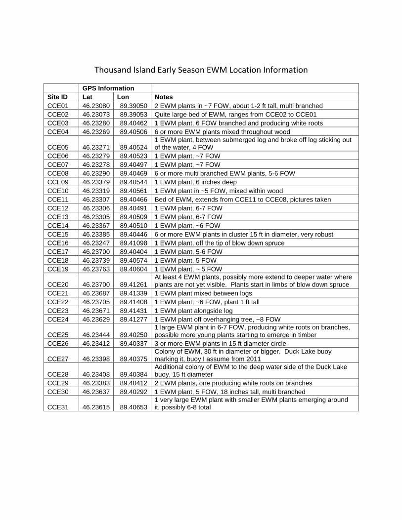
Thousand Island Early Season EWM Location Information
GPS Information
Site ID Lat Lon Notes
CCE01 46.23080 89.39050 2 EWM plants in ~7 FOW, about 1-2 ft tall, multi branched
CCE02 46.23073 89.39053 Quite large bed of EWM, ranges from CCE02 to CCE01
CCE03 46.23280 89.40462 1 EWM plant, 6 FOW branched and producing white roots
CCE04 46.23269 89.40506 6 or more EWM plants mixed throughout wood
CCE05 46.23271 89.40524 1 EWM plant, between submerged log and broke off log sticking out of the water, 4 FOW
CCE06 46.23279 89.40523 1 EWM plant, ~7 FOW
CCE07 46.23278 89.40497 1 EWM plant, ~7 FOW
CCE08 46.23290 89.40469 6 or more multi branched EWM plants, 5-6 FOW
CCE09 46.23379 89.40544 1 EWM plant, 6 inches deep
CCE10 46.23319 89.40561 1 EWM plant in ~5 FOW, mixed within wood
CCE11 46.23307 89.40466 Bed of EWM, extends from CCE11 to CCE08, pictures taken
CCE12 46.23306 89.40491 1 EWM plant, 6-7 FOW
CCE13 46.23305 89.40509 1 EWM plant, 6-7 FOW
CCE14 46.23367 89.40510 1 EWM plant, ~6 FOW
CCE15 46.23385 89.40446 6 or more EWM plants in cluster 15 ft in diameter, very robust
CCE16 46.23247 89.41098 1 EWM plant, off the tip of blow down spruce
CCE17 46.23700 89.40404 1 EWM plant, 5-6 FOW
CCE18 46.23739 89.40574 1 EWM plant, 5 FOW
CCE19 46.23763 89.40604 1 EWM plant, ~ 5 FOW
CCE20 46.23700 89.41261 At least 4 EWM plants, possibly more extend to deeper water where plants are not yet visible. Plants start in limbs of blow down spruce
CCE21 46.23687 89.41339 1 EWM plant mixed between logs
CCE22 46.23705 89.41408 1 EWM plant, ~6 FOW, plant 1 ft tall
CCE23 46.23671 89.41431 1 EWM plant alongside log
CCE24 46.23629 89.41277 1 EWM plant off overhanging tree, ~8 FOW
CCE25 46.23444 89.40250 1 large EWM plant in 6-7 FOW, producing white roots on branches, possible more young plants starting to emerge in timber
CCE26 46.23412 89.40337 3 or more EWM plants in 15 ft diameter circle
CCE27 46.23398 89.40375 Colony of EWM, 30 ft in diameter or bigger. Duck Lake buoy marking it, buoy I assume from 2011
CCE28 46.23408 89.40384 Additional colony of EWM to the deep water side of the Duck Lake buoy, 15 ft diameter
CCE29 46.23383 89.40412 2 EWM plants, one producing white roots on branches
CCE30 46.23637 89.40292 1 EWM plant, 5 FOW, 18 inches tall, multi branched
CCE31 46.23615 89.40653 1 very large EWM plant with smaller EWM plants emerging around it, possibly 6-8 total

Mid Season
Overview
North Shore
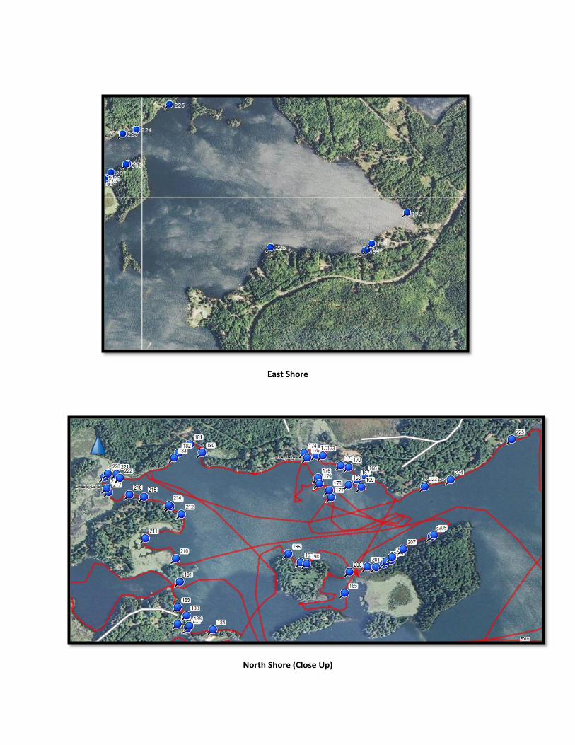
East Shore
North Shore (Close Up)

Thousand Island Mid Season EWM Location Information
GPS Information
Site ID Lat Long Notes
165 46.23318 89.40471 Healthy EWM plant about 15 ft from shore, Not showing any herbicide damage
166 46.23693 89.40392
20-25 ft diameter area of EWM, most are large robust plants covered in advantageous roots. Some areas are dense but not to the surface
167 46.23679 89.40421 Several large EWM plants mixed in with wood
168 46.23662 89.40456 several more large EWM plants
169 46.23656 89.40404 A few EWM plants mixed in with wood
170 46.23718 89.40456 Cluster of EWM plants >10 most large and robust
171 46.23724 89.40486 Small clump >6 EWM plants in with wood
172 46.23757 89.40585 EWM mixed throughout bed of northern mostly low density 30-40 ft area
173 46.23755 89.40558 Furthest south EWM plant of this bed, some areas of bed getting dense
174 46.23763 89.40633 SE corner of EWM bed mixed with northern
175 46.23749 89.40620 3-4 EWM plants out from dock
176 46.23684 89.40578 1 EWM plant
177 46.23623 89.40525 1 EWM plant
178 46.23645 89.40533 1 small EWM plant mixed in with wood
179 46.23667 89.40573 1 small EWM plant
180 46.23765 89.41038 1 EWM plant
181 46.23791 89.41086 >12 EWM plants mixed in and around dock pillars and end of boat lift
182 46.23764 89.41132 >6 EWM plants, some in wood
183 46.23748 89.41149 2 possibly more EWM plants
184 46.23202 89.40996 1 EWM plant mixed in with wood
185 46.23206 89.41097 small dense cluster of EWM, 4 ft diameter
186 46.23214 89.41089 small dense cluster of EWM 6 ft diameter
187 46.23220 89.41136 1 robust large EWM plant possibly more
188 46.23247 89.41100 small dense cluster of EWM to surface 4 ft diameter
189 46.23273 89.41136 1 large EWM plant
190 46.23335 89.41863 >6 small EWM plants in shallow water
191 46.23354 89.41127 1 EWM plant
192 46.23251 89.38042 1 large robust EWM plant
193 46.23092 89.38303 1 EWM plant, large and robust
194 46.23061 89.38336 EWM mixed into northern bed, sparse density but appears to be throughout bed
195 46.23053 89.38358 NW boundary of northern bed and EWM, some large EWM plants in bed
196 46.23443 89.40695 multiple EWM plants growing in the wood >10 plants, more EWM in front of shed where stumps stick out of water
197 46.23416 89.40646 Bed of EWM covering 30 ft area dense in some areas but not matted yet or quite to the surface
198 46.23412 89.40622 EWM mixed in with brush, couple plants
199 46.23424 89.40602 1 EWM plant along log
200 46.23385 89.40452 Large Dense EWM plants covering 10-15 ft area

GPS Information
Site ID Lat Long Notes
201 46.23403 89.40381 6 ft clump of dense EWM
203 46.23411 89.40315 1 EWM plant
204 46.23422 89.40287 1 very large EWM plant, 1 small EWM plant 15 ft east
205 46.23420 89.40305 1 large EWM plant
206 46.23432 89.40282 1 EWM plant
207 46.23458 89.40238 1 EWM plant underneath overhanging cedar
208 46.23499 89.40125 >6 EWM plants along tree
209 46.23504 89.40115 1 EWM plant in sunken limbs
210 46.23429 89.41143 multiple EWM plants mixed with wood
211 46.23492 89.41264 1 very large EWM plant with sister plants around it, 10 ft area
212 46.23570 89.41121 1 large EWM plant by old dock timber
213 46.23594 89.41165 1 large EWM plant under hemlock and adjacent to sunken tree top
214 46.23597 89.41170 multiple EWM plants mixed in with the lily pads
215 46.23624 89.41269 1 very large EWM plant
216 46.23631 89.41328 single EWM plant
217 46.23640 89.41409 1 EWM plant
218 46.23651 89.41418 small cluster of EWM plants medium density 6 ft diameter
219 46.23686 89.41427 single EWM plant
220 46.23698 89.41414 1 EWM plant, short but multi branched
221 46.23697 89.41380 multiple EWM plants but sparse density, 25 ft area
222 46.23684 89.41365 large 8 ft cluster of dense EWM with sister plants surrounding, multiple plants still left at CCE20
223 46.23656 89.40152 1 EWM plant >10 ft off dock
224 46.23679 89.40049 1 EWM plant under hemlock
225 46.23808 89.39806 1 large EWM plant mixed with wood
226 46.23073 89.39053 Existing EWM that is still present from 2011