La tecnica PSInSAR per la mappatura dei fenomeni …EC... · dei fenomeni franosi a scala...
28
La tecnica PSInSAR per la mappatura dei fenomeni franosi a scala regionale: casi di studio in regioni alpine ed appenniniche La tecnica PSInSAR per la mappatura dei fenomeni franosi a scala regionale: casi di studio in regioni alpine ed appenniniche alpine ed appenniniche alpine ed appenniniche Geology and Information Technology 3 – 5 giugno 2008 Offida (AP) M. Bianchi, G. Falorni & A. Tamburini (1) Tele-Rilevamento Europa - T.R.E. S.r.l., MILANO (Italy) Copyright - Tele-Rilevamento Europa - 2004 COPYRIGHT - Tele-Rilevamento Europa 2008 1
Transcript of La tecnica PSInSAR per la mappatura dei fenomeni …EC... · dei fenomeni franosi a scala...

La tecnica PSInSAR per la mappatura dei fenomeni franosi a scala
regionale: casi di studio in regioni alpine ed appenniniche
La tecnica PSInSAR per la mappatura dei fenomeni franosi a scala
regionale: casi di studio in regioni alpine ed appenninichealpine ed appenninichealpine ed appenniniche
Geology and Information Technology3 – 5 giugno 2008Offida (AP)
M. Bianchi, G. Falorni & A. Tamburini(1) Tele-Rilevamento Europa - T.R.E. S.r.l.,
MILANO (Italy)
Copyright - Tele-Rilevamento Europa - 2004
COPYRIGHT - Tele-Rilevamento Europa 2008 1
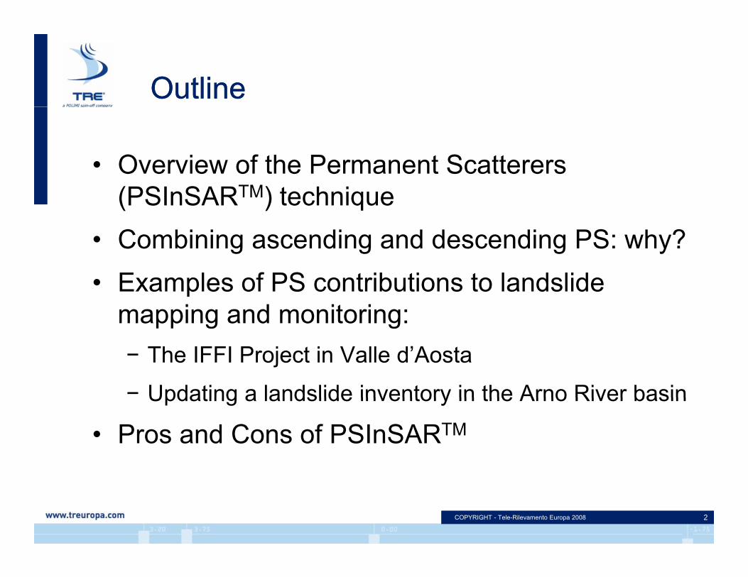
OutlineOutline
• Overview of the Permanent Scatterers (PSInSARTM) technique
• Combining ascending and descending PS: why?g g g y• Examples of PS contributions to landslide
mapping and monitoring:pp g g− The IFFI Project in Valle d’Aosta
− Updating a landslide inventory in the Arno River basinUpdating a landslide inventory in the Arno River basin
• Pros and Cons of PSInSARTM
COPYRIGHT - Tele-Rilevamento Europa 2008 2
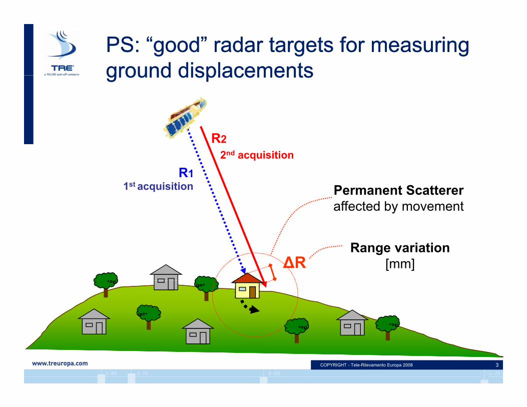
PS: “good” radar targets for measuringground displacementsPS: “good” radar targets for measuringground displacementsground displacementsground displacements
R1
R22nd acquisition
Permanent Scattereraffected by movement
1st acquisition
∆RRange variation
[mm]
COPYRIGHT - Tele-Rilevamento Europa 2008 3
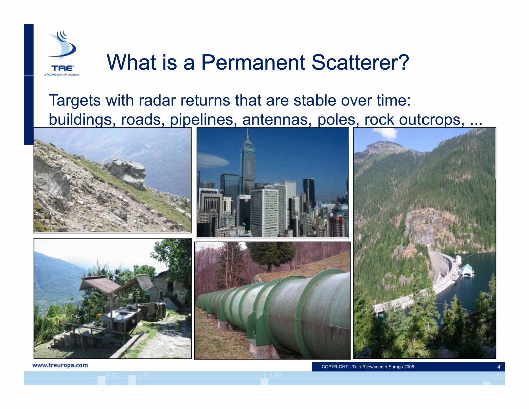
What is a Permanent Scatterer?What is a Permanent Scatterer?
Targets with radar returns that are stable over time:buildings, roads, pipelines, antennas, poles, rock outcrops, ...g p p p p
COPYRIGHT - Tele-Rilevamento Europa 2008 4

PSInSAR™: multi image approachPSInSAR™: multi image approach
R1
R2
Rn
∆R12
disp
lace
men
t∆R…n
PS
∆R12
∆R…n
COPYRIGHT - Tele-Rilevamento Europa 2008 5
St1 t2 tn…
time

Ascending and Descending PS exampleAscending and Descending PS example
Ascending DescendingVD>0
Vert
VD>0
East
COPYRIGHT - Tele-Rilevamento Europa 2008 6
LOS DesceLOS Asce
VA<0

Estimation of vertical and E-W horizontal displacements from Ascending and Descending dataEstimation of vertical and E-W horizontal displacements from Ascending and Descending data
Ascending geometry Descending geometry
d0 d0+d1 d0+dn
d0 d0+d1 d0+dn
H
V 0Est
Vr
Vd>0VrEPS
VrH r
Va<0
COPYRIGHT - Tele-Rilevamento Europa 2008 7
T0 T1 Tn
Case studiesCase studies
Valle d’AostaValle d’AostaValle d AostaValle d Aosta
COPYRIGHT - Tele-Rilevamento Europa 2008 8
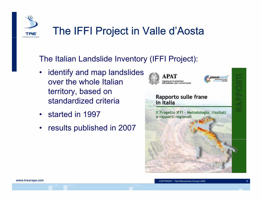
The IFFI Project in Valle d’AostaThe IFFI Project in Valle d’Aosta
The Italian Landslide Inventory (IFFI Project):y ( j )
• identify and map landslidesover the whole Italian
i b dterritory, based onstandardized criteria
• started in 1997• started in 1997
• results published in 2007
COPYRIGHT - Tele-Rilevamento Europa 2008 9
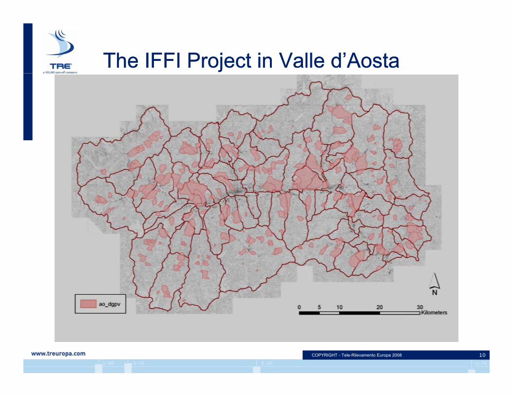
The IFFI Project in Valle d’AostaThe IFFI Project in Valle d’Aosta
COPYRIGHT - Tele-Rilevamento Europa 2008 10

PS processing Valle d’AostaPS processing Valle d’Aosta
• Satellite : ERS1 - ERS2
• AOI: 3.264 km2
• Regional PS Analysis (RPSA)Regional PS Analysis (RPSA)
• Acquisition geometry: ascending anddescending
• PS identified:138 095 Ascending234 913 D di234 913 Descending
COPYRIGHT - Tele-Rilevamento Europa 2008 11
From IFFI website:http://www.mais.sinanet.apat.it/

Processing ERS1-ERS2 Valle d’AostaProcessing ERS1-ERS2 Valle d’Aosta
Ascending data:Ascending data:Track 301: images 32 (1995-2000) Track 29: images 50 (1993-2000)Track 29: images 50 (1993 2000)
Descending data: Track 294: images 80 (1992-2000) Track 22: images 89 (1992-2001)
COPYRIGHT - Tele-Rilevamento Europa 2008 12
What can PS contribute in regionall l ?
What can PS contribute in regionall l ?scale analyses?scale analyses?
• Cross check of landslide areal extent
• Detect unmapped landslides
• Assess landslide activity• Assess landslide activity
COPYRIGHT - Tele-Rilevamento Europa 2008 13

What can PS contribute?What can PS contribute?
Landslide AActivity: confirmedB d difi d
A
Boundary: modifiedLandslide BActivity: modifiedBoundary: modified
BF
activeinactive
activeinactive DC
F
C’Landslide F
activeinactive
inactivedormant E
Landslide FActivity: modifiedBoundary: confirmed Landslide D
New detection!
L d lid C
COPYRIGHT - Tele-Rilevamento Europa 2008 14
dormant Landslide ENew detection!
Landslide CActivity: modifiedBoundary: modified

Apennines: the Arno River basinApennines: the Arno River basin
• 3 operationalpservices:– Landslide mapping– Landslide monitoring– Susceptibility assessment
• Test sitesTest sites– Arno catchment– Liri Garigliano Catchment– 3 Swiss cantons
COPYRIGHT - Tele-Rilevamento Europa 2008
European Space Agency
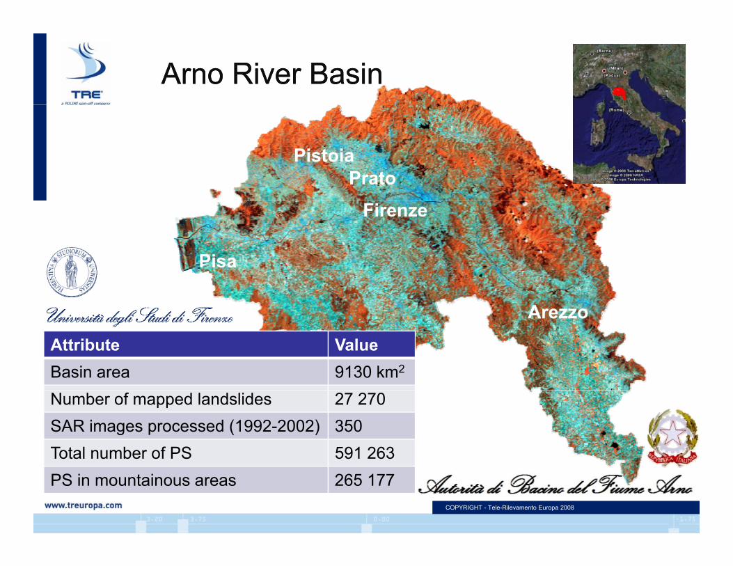
Arno River BasinArno River Basin
PratoPistoia
Firenze
Prato
Pisa
Arezzo
Attribute ValueBasin area 9130 km2
Number of mapped landslides 27 270SAR images processed (1992-2002) 350Total number of PS 591 263
COPYRIGHT - Tele-Rilevamento Europa 2008
PS in mountainous areas 265 177
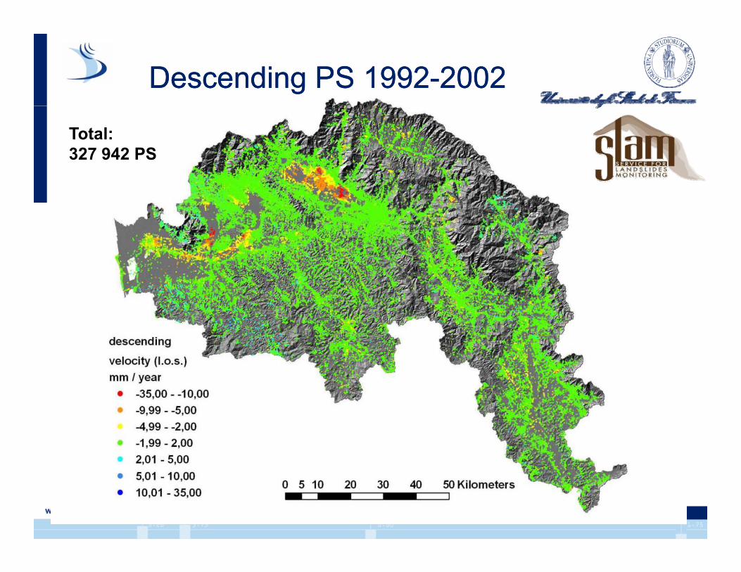
Descending PS 1992-2002Descending PS 1992-2002
Total:327 942 PS
COPYRIGHT - Tele-Rilevamento Europa 2008
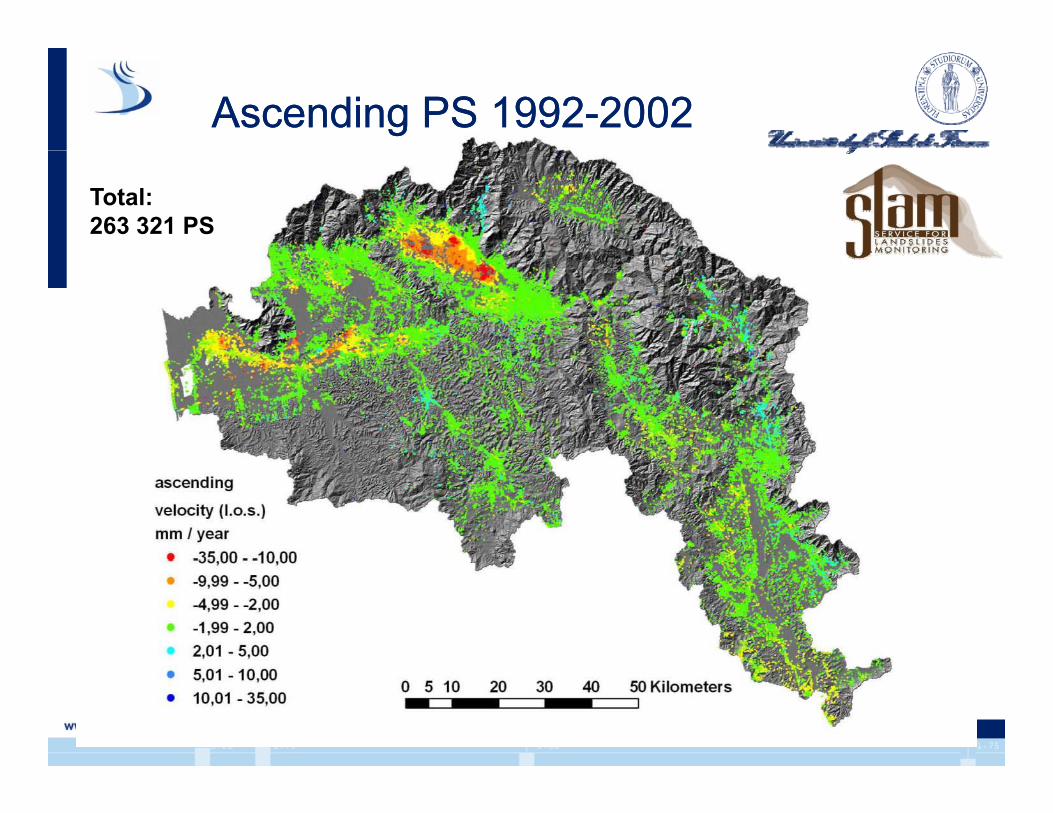
Ascending PS 1992-2002Ascending PS 1992-2002
Total:263 321 PS
COPYRIGHT - Tele-Rilevamento Europa 2008
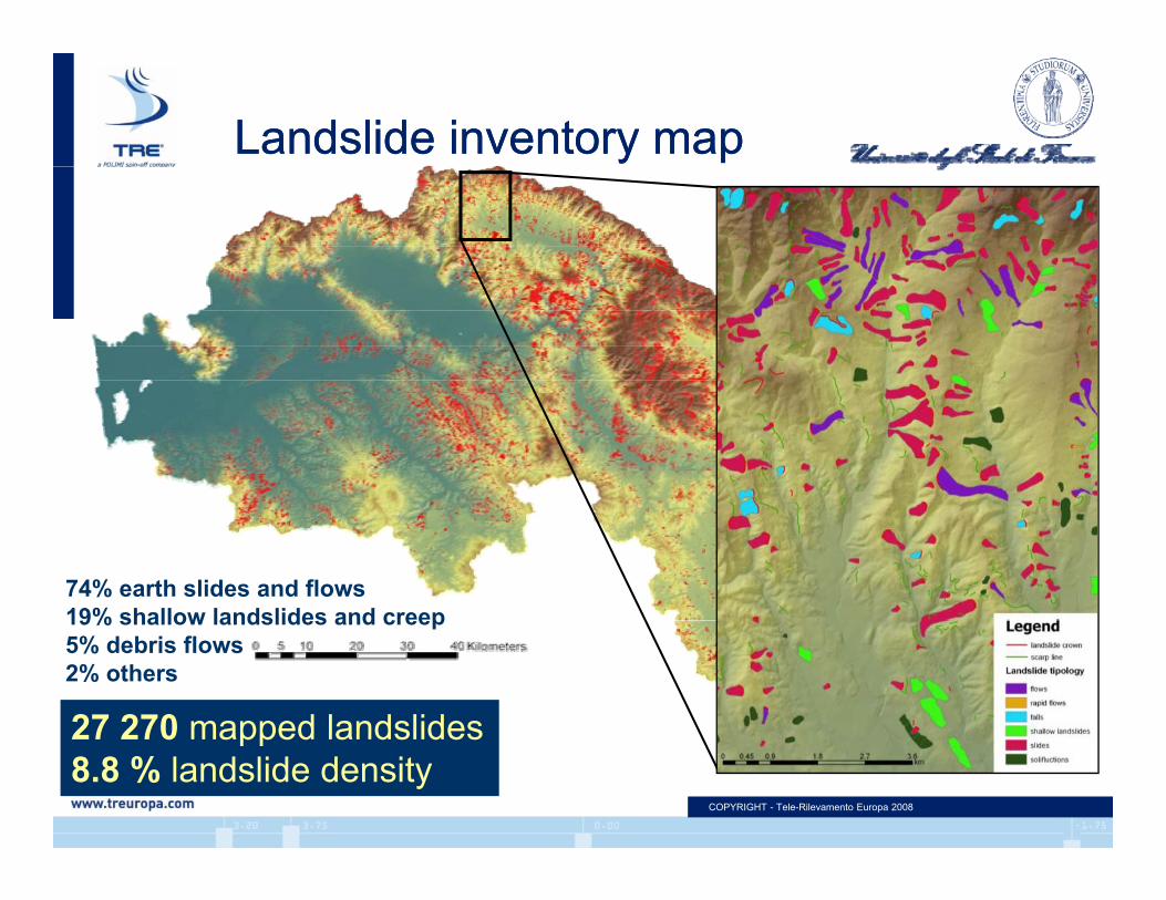
Landslide inventory mapLandslide inventory map
74% earth slides and flows19% shallow landslides and creep
27 270 mapped landslides
19% shallow landslides and creep5% debris flows2% others
COPYRIGHT - Tele-Rilevamento Europa 2008
27 270 mapped landslides8.8 % landslide density
COPYRIGHT - Tele-Rilevamento Europa 2008
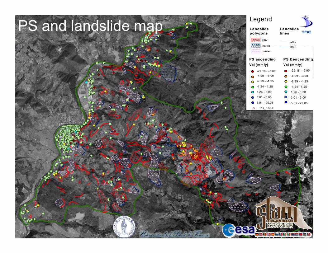
LegendLandslide polygons
attiv
instab
Landslidelines
attivinatt
PS and landslide mapinstab
quiescinatt
PS ascendingVel (mm /y)") -29.18 - -5.00") -4.99 - -3.00
PS DescendingVel (mm /y)$+ -29.18 - -5.00
$+ -4.99 - -3.00") -2.99 - -1.25
") -1.24 - 1.25
") 1.26 - 3.00
") 3.01 - 5.00
") 5.01 - 29.05
$+ -2.99 - -1.25
$+ -1.24 - 1.25
$+ 1.26 - 3.00
$+ 3.01 - 5.00
$+ 5.01 - 29.05
G PS_rufina
COPYRIGHT - Tele-Rilevamento Europa 2008
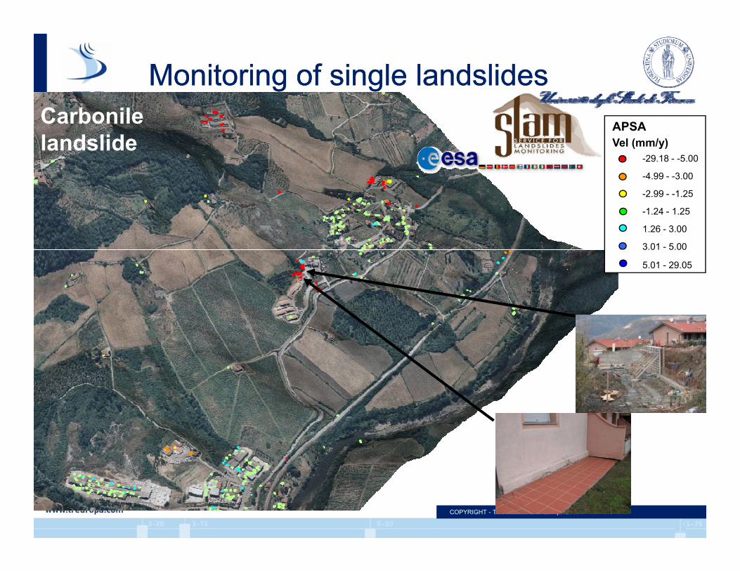
Monitoring of single landslidesMonitoring of single landslides
!( -4 99 - -3 00
!( -29.18 - -5.00Vel (mm/y)APSACarbonile
landslide
!( 3.01 - 5.00
!( 1.26 - 3.00
!( -1.24 - 1.25
!( -2.99 - -1.25
!( 4.99 3.00
!( 5.01 - 29.05
!( 3.01 5.00
COPYRIGHT - Tele-Rilevamento Europa 2008

Carbonile landslideCarbonile landslideStabilization works(drainage wells & subhorizontal drainages)
quiesc
instab
attiv
Landslide
Arno River ActiveInactiveDormant
Vel (mm/y)APSA
stabilizzataB
B
o a tStabilized
!( -1.24 - 1.25
!( -2.99 - -1.25
!( -4.99 - -3.00
!( -29.18 - -5.00
A A
5
!( 5.01 - 29.05
!( 3.01 - 5.00
!( 1.26 - 3.005
COPYRIGHT - Tele-Rilevamento Europa 2008
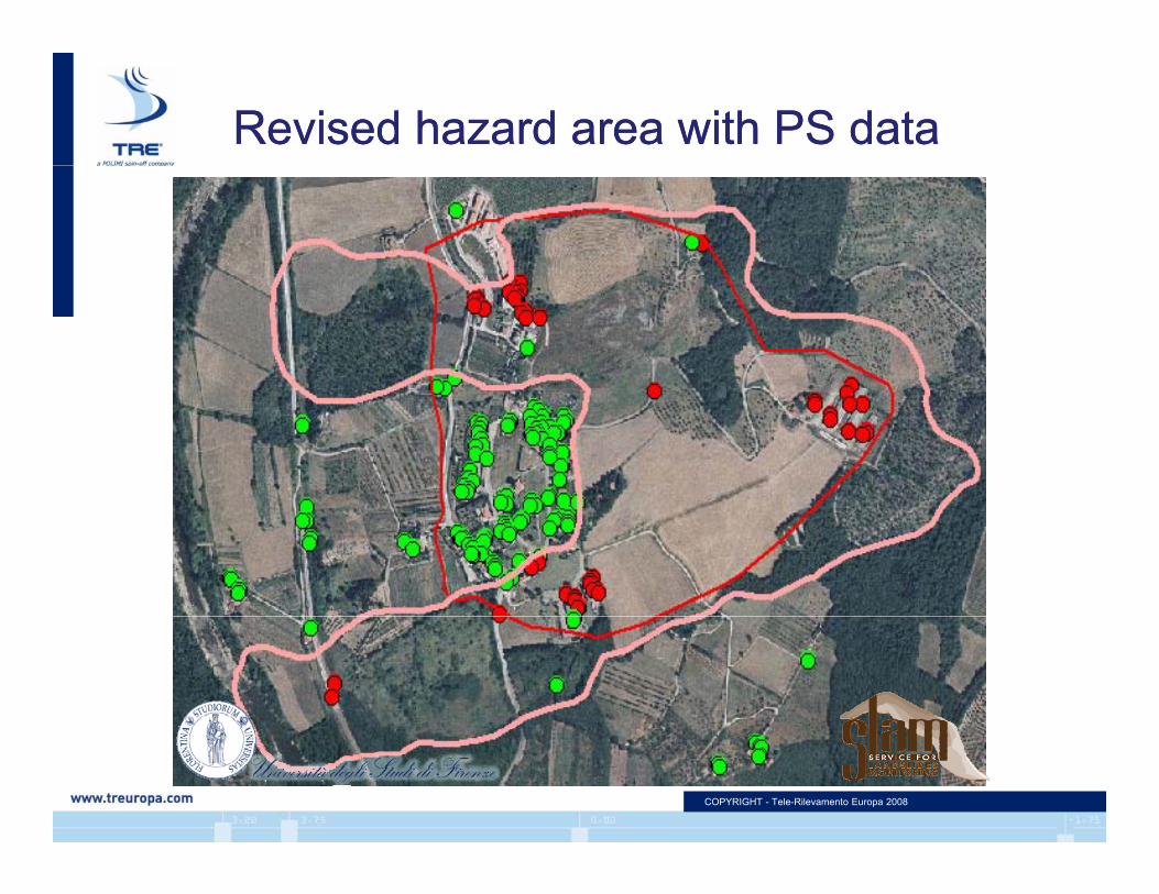
Revised hazard area with PS dataRevised hazard area with PS data
COPYRIGHT - Tele-Rilevamento Europa 2008
Pros of PSInSAR™Pros of PSInSAR™
Wide area investigations (e.g. catchments, DSGD)DSGD).
Vertical and E-W horizontal displacements can be retrieved in areas covered by both ascendingbe retrieved in areas covered by both ascending and descending data.
Historical database available from ERS-1 andHistorical database available from ERS 1 and ERS-2 (1992-2001) and RADARSAT-1 (2003-2008 for Italy) archives.
Useful for updating landslide inventories (landslide boundaries and activity; detection of unmapped landslides)
COPYRIGHT - Tele-Rilevamento Europa 2008 25
unmapped landslides)

Cons of PSInSAR™Cons of PSInSAR™
Areas without PS
The number and distribution of PS can’t be foreseen beforehand
Minimum 25 30 radar datasets are required forMinimum 25-30 radar datasets are required for processing
Revisiting time ~ 30 days (35 days for ERS 24Revisiting time 30 days (35 days for ERS , 24 days for Radarsat)
Can only measure slow movements (< 20 cm/yr)y ( y )
Can’t measure displacements in N-S direction
COPYRIGHT - Tele-Rilevamento Europa 2008 26
DevelopmentsDevelopments
• New missions will deploy constellations of satellites (e.g. CosmoSkyMed) which will have:• Lower revisting time (~ 14 days)Lower revisting time ( 14 days)• Specific configuration for SAR interferometry
• Ongoing development of processing algorithmsOngoing development of processing algorithms
• Opening of new branch of TRE in Canada
COPYRIGHT - Tele-Rilevamento Europa 2008 27
Grazie!Grazie!Grazie!Grazie!Marco BianchiMarco Bianchi [email protected]
Giacomo [email protected]
Andrea [email protected]
COPYRIGHT - Tele-Rilevamento Europa 2008 28