Kyle Warren Portfolio
24
KYLE PORTIE UNIVERSITY OF LOUISIANA AT LAFAYETTE SCHOOL OF ARCHITECTURE & DESIGN
-
Upload
kyle-portie-warren -
Category
Documents
-
view
220 -
download
0
description
Architecture portfolio of undergraduate studies.
Transcript of Kyle Warren Portfolio

KYLE PORTIEUNIVERSITY OF LOUISIANA AT LAFAYETTE
SCHOOL OF ARCHITECTURE & DESIGN

UNIVERSITY [expansion]HEBRARD BOULEVARDLAFAYETTE, LOUISIANA
FLOOD PLAIN [reclaim]LAFAYETTE, LOUISIANA
URBAN [mix use]BUCHANAN STREETLAFAYETTE, LOUISIANA

UNIVERSITY [expansion]HEBRARD BOULEVARDLAFAYETTE, LOUISIANA
FLOOD PLAIN [reclaim]LAFAYETTE, LOUISIANA
URBAN [mix use]BUCHANAN STREETLAFAYETTE, LOUISIANA

This project was a two week competition project following the completion of a 2029 master plan which was a group effort. The master plan for the University of Louisiana at Lafayette expansion includes a pedestrian bridge that allows safe travel over University Avenue - a heavy traffic location in Lafayette.
The driving design intent for the pedestrian bridge stems from the idea of campus pushing itself over University Avenue into thriving urban spaces created from the master plan. The initial sketches of the idea show the start of the bridge compact, but as the plazas begin to lift over the Live Oak tree line, it then begins to develop a canopy that expands to shade and shelter students.
retail shops
visitor centeruniversity avenue overpass
student plaza area
UNIVERSITY [expansion] - a design formed by developing urbanism from a sprawl city in Southern Louisiana
The objective of this proposal is to advocate the University of Louisiana at Lafayette to extend campus West (beyond University Avenue), to a more logical location than the current idea (to extend campus North beyond Johnston Street). The area beyond University Avenue is a neighborhood primarily consisting of students from the university. This 30 block neighborhood consist of many extraordinary live oak trees and green space, but also include damaged homes that would not last through the master plan timeline.
2029 master plan model
subsequent design charrette

secondary structureload bearing wall system
historic oak trees
tertiary structure
pedestrian plaza
primary structure
initial plan concept sketch
retail shops
waste chute
ADA elevator
The 2029 masterplan, as well as the top design charrette projects were presented to the University of Louisiana at Lafayette in hopes of influencing the current campus expansion proposal to a more appropiate location. The decision to include retail opportunities on the plazas of the bridge were an addition to persuade University President, Dr. Joseph Savoie, that the project has economic feasibility and opportunity for the university.
CAD shadow study
initial techtonic analysis
visitor center

retail shops
visitor center
university avenue overpass
student plaza area
initial section exploration
accent wall of visitor center
suspended shading for plaza
visitor center
plaza
lateral section study
Overall, the experience of this particular design charrette served as a way to quickly generate an idea and design solution while integrating the aptitudes and interests of a the group master plan and client needs and expectations from the university.
transverse section with Live Oak trees

FLOOD PLAIN [reclaim]
proposed buffer zone
121,000 people reside in 123.5 sq km
83% of Lafayette’s coulee system is concrete
146 cm rain fall annually
37% paved surfaces
-utilizing wetlands at the coulee boundary
This was a 7-week project designed around an urban boundary landscape architecture competition based out of Switzerland.
The objective of this proposal is to advocate Lafayette, Louisiana, in the United States, to return to a pre-engineered, inflexible infrastructural waterway condition- by reexamining the coulee system which in its current form disconnects residents from natural systems.
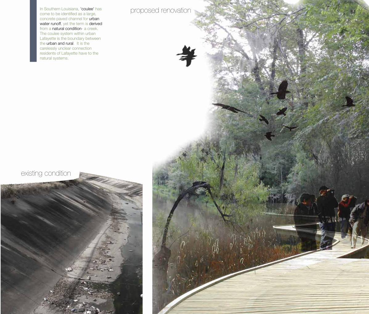
In Southern Louisiana, 'coulee' has come to be identified as a large, concrete paved channel for urban water runoff, yet the term is derived from a natural condition- a creek. The coulee system within urban Lafayette is the boundary between the urban and rural. It is the carelessly unclear connection residents of Lafayette have to the natural systems.
existing condition
proposed renovation

strong fiber plants to stop litter
pervious rock bed for filtration and reduced sediment load
petroleum oil and other pollution absorbing plants
deep rooted plants to prvent erosion and wash away
existing condition
brief oreintation
proposed renovationpetroleum oils, plastics, metals, and other waste drain from the urban Lafayette city limits, into an implemented buffer wetlands system that fitlers the waste, reduces sediment load, and creates healthier water flow into the Vermillion River
pulsing plant species
This proposal examines the conflicted relationships of the coulee boundary and seeks to vivify the dynamic processes and events of water management. Periodic and seasonal occasions, such as the flowering of Bulrushes and Pond Lilies, celebrate the wetland territory and create an opportunity for a personal connection with nature. By designating a particular time of blossom, between Late March until Early May, the wetland system can become an allure for residents and tourists, for both education and recreation.
petroleum oils, plastics, metals, and other waste drain from the urban Lafayette city limits, through a concrete coulee system and into the Vermillion River
Elocharis Ovata Juncus Effusus
& Sairpus Micro Carpus
IrisPseudacorus
TyphaBitifolica
Spargenium
Scirpus Acutus
Vermillion River
heavy flood
coulee system
flood zone
defining space within landscape
position and visibilityThe first flush from the streets at the beginning of the rainy season has the highest levels of volatile organic compounds and metals. Petroleum hyrocarbons are attracted to the stems and leaves of the wetlands plants, as well as dead vegetation and underlying soil. Essentially, the wetlands are a biological filter utilizing both biological and mechanical processes. Functions of the wetland system include, groundwater recharge and discharge, floodwater alteration, sediment stabilization and toxic retention, nutrient removal and transformation, and wildlife diversity and abundance. Values to the community include, recreation, unique-ness, heritage values, aesthetics, and visual beauty.
flow systems
Lafayette
St. Martin Parish
Broussard
drainage system
Vermillion River
flooding
vast green space
miniuscule green space
Evangleine Thwy
parish line
private ownership
public ownership
Vermillion River

secondary flows and periodic celebrationsconsist of coulees that carry the median load of water flow, second drain before the Vermillion River, heavy erosion, thick and pervious rock beds, deep root vegetation walls to decrease erosion.
tertiary flows and brief celebrationsconsist of coulees that carry the smallest load of water flow, third drain before the Vermillion River, heavy erosion, thick and pervious rock beds, deep root vegetation walls to decrease erosion.
primary flows and annual celebrationsconsist of coulees that carry the largest load of water flow, directly drains in the Vermillion River, heavy erosion, thick and pervious rock beds, deep root vegetation walls to decrease erosion.
zydeco music festival
bird watching
flowering plants
bird watching
picnics
flowering plants
flowering plantswetland education

The intervention dramatically suggest a transformation of the drainage system of Lafayette into culturally and ecologically appropriate wetland system. The proposal also included a techtonic study model of a boardwalk to ecologically, culturally, and architecturally connect Lafayette residents to natural wetlands systems.
Furthermore, in a more pragmatic way, the proposed buffer zone seeks to filter, clean and reduce sediment load and urban waste, such as petroleum oils, which presently flows unrestricted into the Vermillion River and sequentially into the Gulf of Mexico. The particular location of this proposal is distinctly the most beneficial because it is the last area before the water flow is almost ‘lost’ to filtration. The watershed will then enter into a fierce, ecological native habitat.
techtonic model

This was a 15 week project to quickly and efficiently understand comprehensive building in the world of architecture. The analysis of the project included urban categories of intense, transitional and marginal urban spaces within the Lafayette, Louisiana downtown area.
The analysis led to an understanding of dynamic relationships and play between the three categories as they intertwine with each other in the downtown area. This understanding then lead to the basic schematic design for the building, a play between materials, program, and space.
BUCHANAN [urban mix use]
siteparking garage
bank tower
commercial
parking garage
commercial
site
parking garage bank tower
city court house
commercial
commercial
parking garage
w. main street
w. main street
w. main street
- creating architecture beyond ‘building.’


urban space analysis
sitesitesite
densitypurposepedestrian space
dense, purposeful, heavy pedestrian space
transitional, fading, less pedestrian space
marginal, empty, no pedstrian space
model using a range of intense to marginal materials
retail shops exterior coffee shop space office reception area
To transition from schematic design into design development, modeling was used to inspire dynamic relationships between materials, program, and space. Specifically relevant model work include two model studies working through plan and section. These models were able to detach at three floor levels and two building sections, allowing further study and anaylsis in a three dimensional form while simultaneously developing the architectural design.

intense model exploration in horizontal planes
intense model exploration in vertical planes
techtonic studyThe high urban area includes : ‘downtown’, density with people and buildings, planned layouts between buildings, sidewalks, green space, parking, and road, close placement of spaces, trees seperating sidewalks and road, crosswalks and traffic signals, and encourages walking.
The transitional urban area includes : fading of restaurants, bars, and offices to government buildings, buildings have heavy setbacks from pedestrian spaces, less defined spaces, not as populated, more parking lots, and purposeless spaces.
The minimal urban area includes : empty spaces, few buildings and businesses, encourages driving vehicles and parking, less interactions with people, no relationships between buildings and other spaces, buildings spaced far apart, and no purposeful plan.

1.
4.
3.
6.
5.
5.
2.
5.
5.
7.
7.
8.
6.
5.
5.
6.
9.
10.
11.
ground level
second level
third level
1. cafe2. office entrance3. residential entrance4. cafe backroom5. private egress6. mechanical7. office space8. residential amenties9. ADA apartment 110. apartment 211. apartment 3
techtonic study
initial translation of site analysis into a section
rain collectionroof garden filtrationvisiual experience
of intense space
residential apartment
from a marginal space,open to intense area
intense collection space
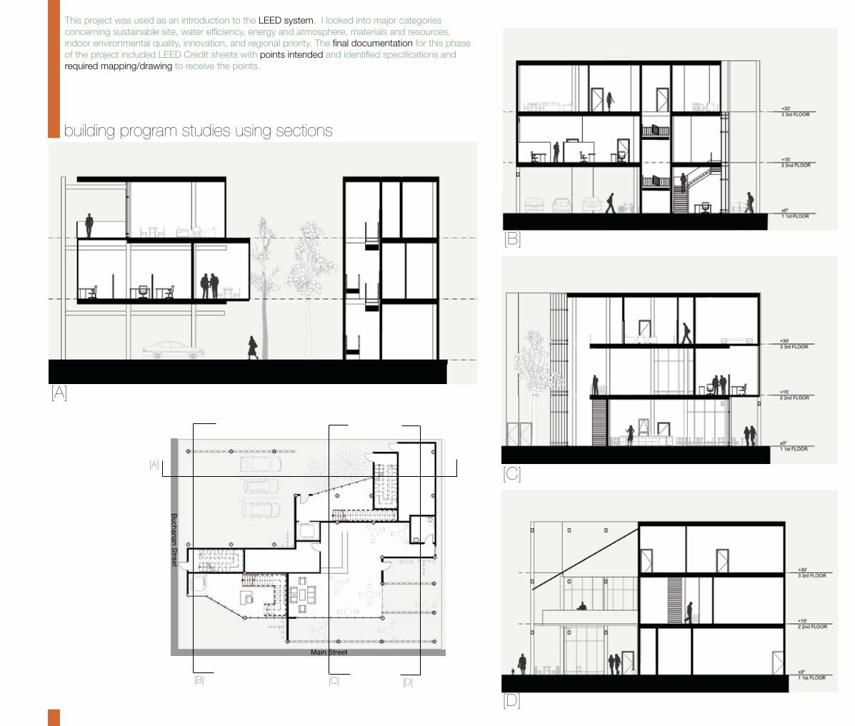
This project was used as an introduction to the LEED system. I looked into major categories concerning sustainable site, water efficiency, energy and atmosphere, materials and resources, indoor environmental quality, innovation, and regional priority. The final documentation for this phase of the project included LEED Credit sheets with points intended and identified specifications and required mapping/drawing to receive the points.
building program studies using sections
[A]
[B]
[C]
[D]
[A]
[B] [D]
[C]


Nearing the end of the 15-weeks, construction documentation for the project was started. Since built architecture revolves around the aspect of documentation and management, the experience gained from this phase of the project is extremely valuable. This project was used as an introduction to creating CDs, professional practice, and managerment in architecture. I worked with Carl B Trimble, RA (30+ years professional experience). The final documentation completed for the project included; site plan, two floor plans, two reflected ceiling plans, two exterior elevations, two building sections, two wall sections, stairs, details, specification outline, and cost estimate.
site plan included in construction documents

brief summary of construction documentation phase
first floor reflected ceiling plan
south elevation
longitudinal section
egress stair details
first floor plan third floor plan third floor reflected ceiling plan transverse section elevator plan
wall section details

337.349.4754 [email protected]
5400 Preston Oaks Rd Apt 3087Dallas, Texas 75254
337.349.4754 [email protected]
5400 Preston Oaks Rd Apt 3087Dallas, Texas 75254