!Kung Spaitial Organization - TSpace Repository: Home · !Kung Spaitial Organization: An Ecological...
23
!Kung Spaitial Organization: An Ecological and Historical Perspectivel Richard B. Lee2 Received March 15, 1972; revised May 31, 1972 The ecological and social bases of spatial organization among hunters and gatherers are examined. After criticizing the patrilocal band model of social organization, the author documents the flexible, nonterritorial groupings of the !Kung Bushmen of Botswana and relates them to rainzfall and surface water scarcity and variability. The paper goes onz to consider the effects of extra-Bushman contacts on the breakdown of sociospatial organization and finds that the observed flexibility occurred in both the pre- and the postcontact periods. The final section attempts to relate the analysis to general issues. Three areas that need further work if a more valid model of hunter spatial organization is to be developed are the problems of time perspective in research, adaptation to long-term climatic variability, and critical thresholds of population density. INTRODUCTION This is a contribution to the study of how hunters and gatherers organize themselves in space and how this organization adapts to variations in population and resources. Using fields data from the contemporary !Kung Bushman of Botswana, I examine the nature of the association between social groups and their space, and I search for the ecological and sociological determinants of this association. Since there has been extended controversy in anthropology on the question of sociospatial organization of hunter-gatherers, it is important at the outset to define the problem to be solved and to pinpoint possible sources of Supported by the National Institute of Mental Health (U.S.), the National Science Foundation (U.S.), and the Wenner-Gren Foundation for Anthropological Research. 1See the Appendix for a brief description of the pronunciation of the Bushman languages. 2University of Toronto, Toronto, Ontario, Canada. 125 ol1972 Plenum Publishing Corporation, 227 West 17th Street, New York, N.Y. 10011.
-
Upload
trinhkhanh -
Category
Documents
-
view
220 -
download
0
Transcript of !Kung Spaitial Organization - TSpace Repository: Home · !Kung Spaitial Organization: An Ecological...

!Kung Spaitial Organization:
An Ecological and Historical Perspectivel
Richard B. Lee2
Received March 15, 1972; revised May 31, 1972
The ecological and social bases of spatial organization among hunters and gatherers areexamined. After criticizing the patrilocal band model of social organization, the authordocuments the flexible, nonterritorial groupings of the !Kung Bushmen of Botswana andrelates them to rainzfall and surface water scarcity and variability. The paper goes onz toconsider the effects of extra-Bushman contacts on the breakdown of sociospatialorganization and finds that the observed flexibility occurred in both the pre- and thepostcontact periods. The final section attempts to relate the analysis to general issues. Threeareas that need further work if a more valid model of hunter spatial organization is to bedeveloped are the problems of time perspective in research, adaptation to long-term climaticvariability, and critical thresholds of population density.
INTRODUCTION
This is a contribution to the study of how hunters and gatherers organizethemselves in space and how this organization adapts to variations in populationand resources. Using fields data from the contemporary !Kung Bushman ofBotswana, I examine the nature of the association between social groups andtheir space, and I search for the ecological and sociological determinants of thisassociation.
Since there has been extended controversy in anthropology on thequestion of sociospatial organization of hunter-gatherers, it is important at theoutset to define the problem to be solved and to pinpoint possible sources of
Supported by the National Institute of Mental Health (U.S.), the National ScienceFoundation (U.S.), and the Wenner-Gren Foundation for Anthropological Research.
1See the Appendix for a brief description of the pronunciation of the Bushman languages.
2University of Toronto, Toronto, Ontario, Canada.
125ol1972 Plenum Publishing Corporation, 227 West 17th Street, New York, N.Y. 10011.

126 Lee
confusion. All hunting and gathering peoples live in organized groups that move
frequently through their ranges. Most modern hunter living groups are
small-under 200 people-and these groups are observed to move their campsites
from two to ten times per year. The existence of a group and a space necessarily
implies the existence of two kinds of boundaries: social and spatial. A social
boundary can be measured according to how open or closed the group is. At the
open extreme, individuals move at random within a space, encountering one
another for brief periods, then moving on. At the other extreme, there is a series
of tightly organized groups whose members stay together throughout the year
with minimal interchange with other groups. A spatial boundary can be
measured along the dimension of overlap/nonoverlap. Imagine a large space
containing five groups. At the "overlapping" extreme, all five groups have free
access to the entire space; at the nonoverlapping extreme, the five groups divide
the space into five exclusive sectors. In an intermediate condition, each of the
five groups has a core area which is theirs alone, while they share the rest of the
space with their neighbors. These two kinds of boundaries are illustrated in
Table I (c.f. Yellen and Harpending, 1972).
The distinction between social and spatial boundaries is a necessary one.
Open groups may have nonoverlapping territories but still accommodate
movement of personnel across the boundaries, and it is at least theoretically
possible for a closed group to share overlapping ranges with their neighbors.
Much confusion has arisen from the fact that group boundaries and land
boundaries have not been kept separate in analyses of hunter-gatherer
organization. As we shall see, both kinds of boundaries are fluid for
contemporary hunter-gatherers.
A second source of confusion has been the failure to distinguish between
the behavior of groups in their space and the conceptions or folk view of the
people about themselves and their land. The latter type of data, though
important, is at best an imperfect reflection of the actual arrangements of
persons on the ground. In this paper, my prime concern is with the behavior of
Table I. Dimensions Along Which Social and Spatial Boundaries May
Vary in Hunter-Gatherer Groups
open closed
(random movement) (no interchange)
Social boundary v i ,j
overlapping nonoverlapping
(shared) (exclusive)
Spatial boundary r, i

!Kung Spatial Organization: An Ecological and Historical Perspective 127
groups and not with their ideology, although later in the study some ideological
aspects are introduced (for example, p. 142).
Having defined the dimensions along which social and spatial organization
may vary, we must now consider what formations are actually observed in the
ethnographies of hunter-gatherer societies. Etimographically, there is no case
known of a society in which the members move randomly in a totally
overlapping space. Toward the opposite extreme, however, there is apparent
evidence in a number of societies for tightly organized groups maintaining
exclusive territories. Such groups have been reported from several parts of the
world and have been lumped under the general rubric of the "patrilocal band
model" of hunter-gatherer social organization.
In its essentials, the patrilocal band is based on three organizing principles:
(1) band exogamy (everyone must marry someone from outside the group),
(2) patrilocal post-marital residence (women move into other groups at marriage;
men remain together and bring their wives in), and (3) band territoriality (each
group controls a space, moves within it, and defends it against outsiders)
(Radcliffe-Brown, 1930; Steward, 1936, 1955; Service, 1962, 1966).
The operLation of these principles results in a situation not unlike the
"closed group/nonoverlapping space" extreme of our model. This is not to say
that no interchange occurs: women move between groups at marriage, and all of
these societies are acknowledged to have formalized visiting arrangements for the
purpose of carrying out rituals and trade. Nevertheless, the dominant impression
one gets from accounts of patrilocal bands is one of semi-isolated, male-centered
groups, encapsulated within territories.
This patrilocal territorial exogamous band or "horde," as Radcliffe-Brown
called it, has proven to be a remarkably persistent construct in the study of
hunting and gathering peoples. For Radcliffe-Brown in 1930 it was "the
important local group throughout Australia" (1930: 35); others have endorsed
this view quite recently and have presented some ethnographic data in support
of it (Stanner, 1965; Birdsell, 1970). Still others have sought to establish the
patrilocal form as the basic grouping not only for Australians but for all
hunter-gatherers present and past (Service, 1962, 1966; Williams, 1968).
Why do so many analysts continue to be attracted to the patrilocal band
model? At least part of its appeal is that it is an elegant and parsimonious
formulation. The society is seen as being structured by the interaction of a small
number of jural rules: territorial ownership by males, band exogamy, and
viripatrilocal postmarital residence. Similarly, the spatial arrangements are
extremely neat: a mosaic of territories arranged in a honeycomb pattern, each
containing its land-owning gr~oup. This apparent neatness and parsimony have
proved especially useful to model-builders seeking to characterize hunter-
gatherer group structure in an economic way for computer and mathematical
simulation.

128 Lee
However, the problem is that a society based on these rules would find
itself in severe adaptive difficulties. The patrilocal band makes scant provision
for a number of basic features of hunter-gatherer life, such as the necessity to
even out demographic variation in sex ratios and family size, the continuing
necessity to adjust group size to resources, and the desirability of resolving
conflict by fission.
In contrast to the recent advocates of the patrilocal model, I argue in the
present paper that this form of organization is empirically rare and that its rarity
can be made intelligible by a careful ecological analysis. The model of !Kung
Bushmen described in the paper appears to account well for the observed facts
and, moreover, can be applied to the analysis of other hunter-gatherer cases. A
similar critique of the patrilocal model based on !Kung Bushman materials is
presented by Yellen and Harpending (1972).
We are of course not the first to question the universality of the patrilocal
band among hunter-gatherers. This was done as early as 1936 by Steward (1936,
1938, 1955), and criticisms of the patrilocal model have become more frequent
in recent years (e.g., Helm, 1965; Hiatt, 1962, 1966, 1968; Leacock, 1969;
Meggitt, 1962: 70-71; Woodburn, 1968; and various authors in Damas, 1969,
and Lee and Devore, 1968). According to these criticisms, a relatively open,
social group with overlapping shared territories seems to be the prevailing form
among contemporary hunter-gatherers.
Yet the flexible group alternative to the patrilocal model is not without its
difficulties. Though different, it appears at first glance to be equally unattrac-
tive. The recent observations of hunter-gatherer group structure present an
apparently chaotic picture, in which a person may live wherever and with
whomever he or she pleases. The situation is further complicated by the fact that
all living hunter-gatherer groups have been strongly affected by contact with
outside peoples. Service (1962) goes so far as to argue that the flexibility of
modern hunter groupings is strictly an artifact of acculturation and breakdown.
In short, we are stuck with a complex set of messy facts collected in
ambiguous field situations, and the job of the analyst is to make sense of them.
Since so much of the recent controversy has focused on the Australian
Aboriginal material, it may be refreshing to take a different but equally
interesting case-that of the !Kung Bushman hunter-gatherers of southern Africa.
!KUNG LOCAL GROUPS AND THEIR SPACE
We will consider the Dobe Area !Kung of Botswana (including the /du/da
!Kung) and the closely related Nyae Nyae !Kung across the border in Namibia
(illegally occupied by South Africa). The latter people have been described in a
brilliant series of ethnographies by Lorna Marshall, in the films and writings of
John Marshall, and in the writings of Elizabeth Marshall Thomas. Aspects of the
Dobe Area !Kung have been investigated by a number of authors. The

!Kung Spatial Organization: An Ecological and Historical Perspective 129
description to follow is drawn from the Dobe material, although the main
features apply to the Nyae Nyae !Kung as well. Where specific points of
disagreement exist, they are explicitly stated.
What are the major features of !Kung local groupings, land ownership,
group affiliation, and boundary maintenance? The basic local grouping is a camp
(MarshalP's band), which is a noncorporate, bilaterally organized group of people
who live in a single settlement and who move together for at least part of the
year. At the core of each of these camps are two, three, or more siblings and/or
cousins, both male and female, who are generally acknowledged to be the
owners (K"ausi) of the waterhole. Around each waterhole is a bloc of land or
n!ore. This contains food resources and other water points and is the basic
subsistence area for the resident group. Lorna Marshall (1960: 344 ff) has argued
that the ownership of each waterhole resides in the person of a band headman
who is always male and who inherits his position patrilineally, but my own
research indicates that no headmen existed among either the Dobe or the Nyae
Nyae !Kung Bushmen. Instead the sibling-cousing group of K"ausi collectively
held the waterhole. (Documentation on the problem of the headman will be
presented elsewhere.
Specific groups have histories of association with their waterholes that
vary from a few years up to several decades in duration. Rarely does this
association go back as far as the grandparent generation of the oldest people
living. To put it another way, a first approximation of the "half-life" of a
group's tenure at a waterhole can be estimated at 30 to 50 years.
An individual may inherit his or her n!ore from his father's or mother's
family; or he or she may inherit it from both parents, or from neither. There is a
discernible patrilineal tendency, at least among males. A survey of 151 men over
the age of 15, representing 90% of the adult male residents of the Dobe area,
ga-ve the breakdown on inheritance of n!ore shown in Table II. We see that while
the majority take n!ores not in a strict patrilineal way, inheritance from father is
the most frequent single alternative. Unfortunately, comparable data were not
gathered for females.
Table II. Patrilineal vs. Matrilineal Inheritance of Locality
as Reported by 151 !Kung Men
Inherited n!ore from n %
Father 60 39.7
Mother 40 26.5
Both father and mother 16 10.6
Neither parent 21 13.9
[Doesn't know, or no n!ore] 14 9.3
Total 151 100.0

130 Lee
The composition of groups at any one time shows little or no patrilocal
emphasis. In fact, because of the frequency of bride service, there is even a slight
tendency toward matrilocality (cJ: Leacock, 1955). Of 114 currently married
couples, 22 were living with husband's parent(s); 24 were living with wife's
parent(s), while 12 were living with both husband's and wife's parents. A further
15 couples were living neolocally, while in the case of 41 couples, neither
husband's nor wife's parents were alive. Those couples in which both had living
parents were observed to pay frequent visits to both sides. This and other
processes of intergroup visiting created a fluid situation in which the
composition of groups changed from week to week with the comings and goings
of people (Lee, 1972a).
Within a local group's area, subsistence resources are not exclusively
reserved for the K"ausi and their families. By observing elementary good
manners, anyone who has a relative in a camp may enjoy the resources of the
area around the camp. Within the camp, food is shared in such a way that
everyone-residents and visitors alike-receives an equitable share (cf: L.
Marshall, 1960, 1961).
In moving through the annual round, the !Kung groupings satisfy their
subsistence requirements with surprisingly little friction with neighboring
groups. Subsistence: space is bounded, but these boundaries are vague and not
defended. In fact, a frequent pattern is for groups from two or more waterholes
to join forces for the joint exploitation of a major resource, such as tsin beans or
mongongo nuts. And during the winter dry season, it is common to find from
two to six different groups camping together at a permanent waterhole.
ENVIRONMENTAL CAUSES OF FLEXIBILITY
How do we account for this flexibility of group structure? Before we
conclude that it is due to the effects of recent contact and acculturation, we
should consider what effect pre-existing features of the environment would have
on group structure. Two permanent features of the Kalahari environment appear
to be salient: first, the high variability in rainfall and, second, the sparse
distribution of standing water in the northern Kalahari. Let us consider each of
these features in turn.
Rainfall Variability
Average annual rainfall has little meaning in an environment in which
rainfall may vary by as much as 300% from year to year. During the 1963 to
1964 rainy season, we recorded 239 mm (9.4 inches), while during 1967 to
1968, 597 mm (23.5 inches) was recorded. Given this variability, it would be
more useful to discuss rainfall in terms of extremes-for example, tabulating the
number of years out of every ten in which drought is experienced. Maun, 300

!Kung Spatial Organization: An Ecological and Historical Perspective 131
km by air southeast of Dobe, is the nearest weather station for which long-term
rainfall records are available. Figure 1 illustrates the fluctuations in rainfall that
Maun has experienced over the last half century. Table III summarizes these
data. In a run of 46 years, drought occurred in 17 years (37%), and, of these, 12
MEAN
woo- DROUGHT
SEVERE
soo DROUGHT
RAINFALL YEAR
Fig. 1. Variations in annual rainfall at Maun, Botswana, July 1922 to June 1968 (mean
462.3 mm based on 46 years of records).
Table III. Drought Frequencies and Intensities at Maun Botswana
over a 46-Year Period (Lat. S20000' Long. E23026')
n %
Years of normal rainfalla. 29 63
Year of droughtb 17 37
1st degree (mild) 5 11
2nd degree (severe) 11 24
3rd degree (very severe) 1 2
Total 46 100
aNormal rainfall is annual rainfall more than 85% of mean.
bDefinitions of drought severity adopted from Wellington (1964:
40-43): 1st degree, 70 to 84% of mean rainfall; 2nd degree, 55 to
69% of mean rainfall; 3rd degree, less than 55% of mean rainfall.
132 Lee
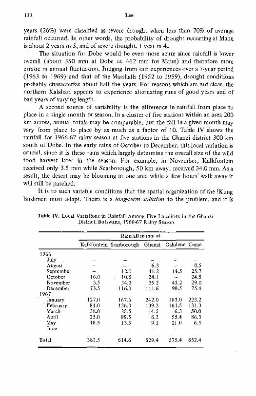
years (26%) were classified as severe drought when less than 70% of average
rainfall occurred. In other words, the probability of drought occurring at Maun
is about 2 years in 5, and of severe drought, 1 year in 4.
The situation for Dobe would be even more acute since rainfall is lower
overall (about 350 mm at Dobe vs. 462 mm for Maun) and therefore more
erratic in annual fluctuation. Judging from our experiences over a 7-year period
(1963 to 1969) and that of the Marshalls (1952 to 1959), drought conditions
probably characterize about half the years. For reasons which are not clear, the
northern Kalahari appears to experience alternating runs of good years and of
bad years of varying length.
A second source of variability is the difference in rainfall from place to
place in a single month or season. In a cluster of five stations within an area 200
km across, annual totals may be comparable, but the fall in a given month may
vary from place to place by as much as a factor of 10. Table IV shows the
rainfall for 1966-67 rainy season at five stations in the Ghanzi district 300 km
south of Dobe. In the early rains of October to December, this local variation is
crucial, since it is these rains which largely determine the overall size of the wild
food harvest later in the season. For example, in November, Kalkfontein
received only 3.5 mm while Scarborough, 50 km away, received 34.0 mm. As a
result, the desert may be blooming in one area while a few hours' walk away it
will still be parched.
It is to such variable conditions that the spatial organization of the !Kung
Bushmen must adapt. Theirs is a long-term solution to the problem, and it is
Table IV. Local Variations in Rainfall Among Five Localities in the Ghanzi
District, Botswana, 1966-67 Rainy Season
Rainfall in mm at
Kalkfontein Scarborough Ghanzi Oakdene Cume
1966
July
August - 6.3 0.5
September -12.0 41.2 14.5 25.7
October 16.0 10.5 24.1 24.5
November 3.5 34.0 35.2 43.2 29.0
December 73.5 116.0 111.6 90.5 75.4
1967
January 127.0 167.6 242.0 183.0 223.2
February 81.0 136.0 139.2 161.5 131.3
March 38.0 35.5 14.5 6.3 50.0
April 25.0 89.5 6.2 55.4 86.3
May 18.5 13.5 9.1 21.0 6.5
June
Total 382.5 614.6 629.4 575.4 652.4

!Kung Spatial Organization: An Ecological and Historical Perspective 133
unfortunate that an ethnographer will observe only a small segment of the
pattern in any given year of fieldwork.
Water Source Scarcity
The sparse distribution of water on the ground is the spatial correlate of
the temporal variability just discussed. Because of the porosity of the sandy
soils, the high rates of evaporation, and the infrequency of exposures of
water-bearing rock, standing water points are few and far between. Figure 2
shows an area south of the Aha Hills and north of the Eiseb Valley. This includes
the southern half of the Dobe area and parts of the Nyae Nyae and /du/da areas
on the west and south, respectively. The area straddles the international border
and measures about 80 by 80 km for a total area of 6400 km2 (2500 square
miles). This entire area contains only five permanent water points, that is,
waterholes that hold water throughout the year, and of these three have been
known to fail within living memory.
hxor n/woma2~
n /wmid /dwo Iob
to n//o!a and dumu
Fig.1 2.Dstiuto o atrurces n th fai/ai-/ga aea

134 Lee
In fact, the area contains a hierarchy of water sources arranged in order of
their duration and reliability: 1, two have never given out in living memory
(/ai/ai, /gam); II, three have not failed in the last five years (/wihaba, fo//gana,
/du/da); III, five (at least) are strong summer waters which may last through the
winter of good years (/dwia, nfwama, hxore, !widum, //gum//geni); IV, about
50 are seasonal water points holding water from a few days to several months; V,
about 100 are mongongo, baobab, and terminalia trees with small reservoirs in
their hollow boles; VI, about 150 are sites in which the water-bearing root !xwa
(Fockea monroi) is found.
In general, the farther down the hierarchy of water sources they go, the
harder it is for the !Kung to satisfy their moisture requirements. Tree water
(class V) is usually difficult of access and often must be soaked up in a makeshift
sponge or sucked out in a reed straw. (Sip-wells are known by the !Kung
Bushmen but rarely utilized.) Water root (class VI) is even more difficult to get
at, since the root itself must be dug out from depths of up to 40 cm (15 inches)
and contents of as many as 20 roots must be consumed per day to provide the
needs of one person (c~f Lee, 1965: ch. 8). On the other hand, root and tree
waters are widely distributed in close proximity to valuable food sources and
therefore are often utilized despite their difficulty of access.
The !Kung ability to operate successfully in this environment therefore
involves them in sorting out a complex set of variables about the current
locations of food and water, the ease or difficulty of getting it, and the
whereabouts and current activities of adjacent groups. And their subsistence
plans must be continually revised in light of the unfolding rainfall situation
through the growing season and beyond.
PATTERNS OF !KUNT~G SPATIAL ORGANIZATION
Given the ecological conditions, what land use pattern has emerged?
Today (1963 to 1969), international politics and pastoral occupation have
restructured the land use in non hunter-gatherer ways. The current situation and
how it evolved are interesting questions in their own right and will be discussed
below. In order to understand the hunting and gathering pattern, we have to do
a reconstruction to get a picture of the distribution of landholding groups as
they were during the 1920s, before the Bantu settlement.
In Fig. 3 are plotted the landholding groups of the /gam-f ai/ai areas of 40
years ago. The number is located on the map in the vicinity of the largest
waterhole each group's area contains. An examination of Fig. 3 makes it
apparent that there were many more groups holding land than there were
permanent waterholes to support them. Eleven groups regularly wintered in the
area, with occasional visits from at least four other groups; yet there were only
five permanent waterholes and of these only two were really reliable. Eleven is

!Kung Spatial Organization: An Ecological and Historical Perspective 135
/wimd umH /dwla /w haba;li 1~~
DUE
o!o it PeranntWatrhleSedmi-emnn
i- O P·Watrhoit .es hl.
ton/!u ond um/
Fig. 3 A recnstrution o the dstribtiormno lndhldn
ou o te re to th lrger "magnets" of the Gharbuinz o andGobabis ht frs
or to the Tswana and Herero cattle posts around Lake Ngami. Futher, this
presentation does not take into account groups that have moved into the study
area since 1930, such as the group from /gausa (355) who moved to /ai/ai in the
1940s, and groups from the Ghanzi farms who were moving into the /du/da area
in the late 1960s (625 and 729).
Such a large number of groups could be supported only if there were
widespread agreement to maintain regular and free access to permanent water.
The orderly, rather evenly spaced arrangement of groups in Fig. 3 is
characteristic only of the height of the rainy season when water and food are
available throughout the area. But as the summer waters evaporate with the

136 Lee
coming of the winter, the 11 groups would converge to the pattern plotted in
Fig. 4 and summarized in Table V, column 2.
Unless water was exceptionally strong, groups 2 and 4 would join group 3
at /wihaba, and later in the season most or all of the people would pay a visit to
group 1 at fai/ai. At the same time, groups 5, 6, and 7 would converge on
fo//gana, while groups 8, and 9, and 10 would converge on /gam. Group 11
stayed around /du/da, where it was joined by one or two groups from n//o!au
and dumn!a (see Table IV footnote). Later in the season, it was customary for
groups at /du/da and fo//gana to pay visits to relatives at /gam.
In good years, groups had the option of wintering in any one of several
places: in the home area, at a permanent waterhole, or visiting relatives at
waterholes outside the area. Also, the members of the $roups that were primarily
associated with one of the two very reliable waterholes-group 1 at fai/ai and
group 8 at /gam-could spend most of their year enjoying the seasonal food
n/umdi I~,,
/du/dor M /ajo S aso
/"II'scal o =okm~'oo
to E n//!o and dumn
dry seas*//on.~ and üm n indogt er,120t 90

!Kung Spatial Organization: An Ecological and Historical Perspective 137
Table V. Reconstructed Groups of the fai/ai and /gam Areas, Circa 1920 to 1930a
Location
Group Extreme dry Current
No. Informant Summer Winter recourse status
(1) (2) (3)
1 396 n!umdi /ai/ai /ai/ai !xumn!a's group
at /ai/ai
2 346 /wihaba /wihaba failai No longer function-
and failai ing; descendents
at /ai/ai
3 414 /dwia /wihaba /ailai /i! ay's group
and /ai/ai at fai/ai
4 429 !ai /wihaba failai No longer function-
and failai ing; descendents
at fai/ai
5 335 i-odanaha fo//gana /gam or Still utilize n!0re
failai part of the year;
winter at fai/ai
6 543 //gum//geni fo//gana /gam or A few families still
failai utilize n!ore; winter at
fai/ai or /du/da
7 363 n. of go//gana /gam or No longer function-
fo//gana fai/ai ing; descendents
at fai/ai
8 336 Around /gam /gam No longer function-
/gam ing; descendents
at /ai/ai
9 580 due or /gam /gam A functioning group
$·0n!a now based at /du/da
10 636? due /gam /gam Moved to South African
Government settle-
ment scheme at
Tsum!we
11 684 /du/da /du/da /gam A functioning group
based at /du/da
aln addition, there were several groups who moved into this area from the west and
south during the summer and may have opted to winter at /gam and/or /ai/ai during
extremely dry years such as Marshall's bands 1 and 2 from /gausa, band 15 from
dum!na, and band 17 from n//o!au (L. Marshall, 1960).
resources of their neighbors. Reciprocal access to resources at all times ensured
that key resources would be available at critical periods.
In moderate winter dry-season conditions, the 11 groups distributed
themselves at five water points. Under very severe conditions, the groups

138 Lee
underwent another phase of convergence (see Table V. column 3). Four groups
fell back on fai/ai, four others on /gam, and three others alternated between
/gam and /ai/ai. Thus in the most difficult drought years there might be as many
as seven groups at a single waterhole. Such a situation was observed by the
Marshalls when seven groups converged on /gam in the severe drought winter of
1952 (J. Marshall, 1957: 36).
Traditionally, waterholes such as fai/ai and /gam have played important
roles as entrepots in the economic and social lives of the !Kung. Even before the
Bantu built their cattle posts there, faifai was a trading center where people from
all points of the compass came to visit, dance, and do hxaro trading (and
sometimes fight).
/I!ay 414 described the traditional role of fai/ai as follows:
/ai/ai has always been a meeting place for people even before the blacks came.
People came from the north, from !angwa and !gose, and from the south from
/gam (and from the west from /gausa), stryed here, did hxaro, drank n!o (a
choice wild fruit), ate //"xa (mongongo nuts), and then went back.
They asked Kan!o [one of the owners] for permission. They also asked
-boma!gain [Father of 396).
/ai/ai was favored because the water was so big. Choma (men's initiation
ceremony] was danced here, but the main reason [to meet] was hxaro trade.
People came in all seasons of the year-summer, winter, an'd spring. But
they particularly came in spring [!gaa, September-October] when the trees
were in flower [before the onset of the rains]. When the summer pans dried
out, they ate !xwa [the water-bearing root]. When the !xwa got thin they
came into /ai/ai. This was because some of the n!ores did not have year round
water.
A closely comparable land use pattern has been observed in the Nyae Nyae
area as recently as 1952 to 1953 by the Marshall expedition. In a little-read but
extremely informative work ("Ecology of the !Kung Bushmen of the Kalahari,"
Harvard senior honors thesis, 1957), John Marshall discussed how the Nyae Nyae
groups would arrange themselves with reference to water first under "normal"
and then under drought conditions. Of the latter, he writes:
In very dry years, more of the bands would be concentrated around
/Gautscha, Deboragu, and perhaps Khumsa. I do not know for sure whether
Khumsa is a permanent waterhole. I am sure that there is a permanent
waterhole northeast of /Gautscha to which bands 8, 9, and 10 would shrink if
a winter of desiccation was complete. The distribution of the interior bands in
such a winter season that so utterly rejects all juicy things would probably be:
Bands 1, 2, 3, at /Gautscha is the highest yielding waterhole in the area,
therefore able to support the 85 people of these bands.
Bands 4 and 5 might hold out at Deboragu and would be joined by band 6.
Deboragu is a weak water. The 29 people of bands 4, 5, and 6 would probably
be able to survive, however. One man told us, speaking with affection for
Deboragu, that, though it may look dry, scratch and you will find water.
Band 11 might flee to S'amangaigai and so the people would endure. (J.
Marshall, 1957: 32-33)

!Kung Spatial Organization: An Ecological and Historical Perspective 139
HUNTER-GATHERER SPATIAL ORGANIZATION
The spatial organization of mnany hunting and gathering peoples was
similar to that of the two !Kung Bushmen cases cited. For example, a division of
the Eskimo year into a large-group phase and a small-group phase was first
formally described by Mauss in a classic paper (1906), and documented by maniy
observers (Boas 1888; Rasmussen, 1931; Spencer, 1959; Balikci, 1964; Dama,
1969; the last source is particularly useful). In the case of the central Eskimo,
the time of maximum concentration was also in the winter, but the environmental
determinant was the accessibility of good seal hunting rather than the
availability of water. For other Eskimo groups, the maximal aggregation was
associated with a variety of ecological strategies, as summarized by Damas
(1969: 135-138).
Among the Australian Aborigines, the flexible land use pattern was for a
long time obscured in anthropological studies by a confusion of the patrilineal
totemic group with the on-the-ground living group. The totemic group indeed
controlled real estate: exclusively but only for occasional ritual purposes, and not
for day-to-day living (Hiatt, 1962; Berndt, 1970). For the latter, the group that
hunted, gathered, and lived together was made up of members of a number of
patriclans and exhibited a genealogical composition and an annual pattern of
concentration-dispersion similar to that of the Bushmen. In arnhem Land and
Cape York, the significant ecological determinant appeared to be the annual
flooding of the plain which caused the people to congregate in larger groups on
the seacoast (Thomson, 1939: 209) or on higher interior ground (White and
Peterson, 1969; Schrire, in press; see also Hiatt, 1965: 24-29). In desert
Australia, the concentration-dispersion pattern has been known for many years.
Particular attention has been paid to the maximal grouping in the form of the
corroboree or ceremonial gathering (Spencer and Gillen, 1899: 271 ff). The
ecological significance of this gathering has been pointed out by Meggitt (1962:
54-55) and Strehlow (1947: 65). Here, as among the Bushman, the environmen-
tal determinant was seasonal differences in water availability.
Examples could be multiplied: concentration-dispersion and reciprocal
access to resources have been documented for subarctic Indians (Helm, 1965;
Leacock, 1955, 1969), Great Basin Indians (Steward, 1938, 1955), and Pygmies
(Turnbull, 1965, 1968); the case of the Northwest Coast is discussed below.
However, what is central to all of these cases is a pattern of concentration and
dispersion, usually seasonal, and a set of rules and practices for allowing
reciprocal access to or joint exploitation of key resources.
Thie worldwide occurrence of this pattern of spatial organization in vastly
different kinds of environments indicates the degree to which it was basic to thehunting and gathering adaptation. Several of the adaptive advantages can bespelled out. In the case of the !Kung Bushmen, we see, first, that reciprocal

140 Lee
access to resources allowed a much higher population density than could besupported if it were required that every n!ore contain a permanent water source(Fig. 4). Thus in the fai/ai-/gam areas, we find 11 groups in occupation insteadof two. Second, the pattern contained a mechanism for responding to localimbalance in food resources. It had the capacity to adjust to conditions ofscarcity and also to conditions of exceptional abundance. Third, the patternoffered many social advantages, not the least of which was the separating out ofindividuals and groups in conflict, thus keeping the threat of violence to aminimum. (Leacock, 1969:14 cites a very similar set of advantages for theflexibility ofMontagnais groupings.)
By contrast, the patrilocal pattern of spatial organization that encapsulatesa group of males with their spouses and offspring within a territory is far lessadaptive. Indeed, it would be difficult to visualize how a patrilocal territorial-organization could function in the Bushman case. I would predict that such asociety could survive only to the extent to which its members could slough offtheir patrilocality and territoriality and approximate the flexible model outlinedabove. (It is curious that Birdsell, one of the foremost exponents of theecological approach in anthropology, should have chosen to espouse a model ofhunter social organization that is as ecologically unviable as is the patrilinealband.)
In view of these adaptive advantages, it hardly seems likely-as Service hasargued-that this flexible land use pattern is strictly a product of acculturationbrought about by the breakdown of aboriginal bands. Flexibility appears to beadaptive in both the precontact and the postcontact situation. In fact, we arenow in a position to trace what actually has happened to change !Kung Bushmanland use patterns over the last 80 years.
CONTACT AND SPATIAL ORGANIZATION: 1890 TO 1969
Starting in the late 1880s and early 1890s, Tswana pastoralists begancoming out to the /ai/ai-/gam areas from their towns in the east for annualhunting and grazing expeditions. At the end of each rainy season, the varioushunting parties, along with several groups of Bushmen, would rendezvous forsome weeks of hunting, dancing, and trading. In the trade, the !Kung gave furs,hides, honey, and ostrich eggshell beadwork, while in return they receivedtobacco, clay pots, iron implements, and European goods. When the trading wasdone, the oxen were inspanned and the Tswana drove their wagons back to theeast for the winter. During this period of initial contact, an annual concentrationpoint occurred at this encampment known as koloi (ox-wagon, or ox-wagoncamp in Setswana).
During the 1920s, permanent Bantu-speaking settlers began to move intothe area, bringing herds of livestock and enlarging and deepening the waterholes

!Kung Spatial Organization: An Ecological and Historical Perspective 141
at /gam and /ai/ai. A nucleus of semisedentary !Kung began to develop at these
two points in a process that has been observed worldwide among hunter-
gatherers around what L. R. Hiatt has aptly called "the magnets" of
attractiveness. Mission and Government Stations constituted the magnets in
Australia, while, in the northern Kalahari, Bantu cattle posts were the magnets
(Lee, 1972b).
Prior to Bantu settlement, the !Kung had spent most of the year moving
around the n!ores and a few months camped at the permanent water. Since the
arrival of the Bantu, a reverse pattern has evolved. Today, many !Kung remain
most of the year camped at /ai/ai and spend only a few months of the year
moving around the n!ores. In fact, the point of major population concentration
in recent years has usually coincided with the Christmas feast offered the !Kung
by their Bantu neighbors (Lee, 1969).
The effects of contact on spatial organization are shown in Fig. 5 (and
Table V, last column). Acculturation has produced fragmentation and
onluo Permanent Waterholes
Id/d e Majo Seoon
Waehoe
ton//o n dm/
1963 to199
142 Lee
discontinuous utilization of n!ores. Four groups have ceased to function as
subsistence units, having become wholly attached to Bantu cattle posts (groups
2, 4, 7, and 8). One group, 10-along with many others from the Nyae Nyae,
outside our study area-has joined the South African government settlement
station in Tsum!we. Four other groups move in and out of fai/ai on hunting and
gathering trips of varying length (groups 1, 3, 5, and 6).
Even though these semisettled groups spend most of the year at fai/ai (or
Tsum!we), each tries to spend at least a month or two in the home n!ore. Unlike
the Australians, the !Kung Bushmen do not maintain totemic sites within their
home localities. Nevertheless, the ties to the n!ore are certainly based on
sentiment as well as economic expediency; this emotional content is expressed in
the following quotation from a young woman member of group 3 now living at
/ai/ai:
[You see us here today but] you know we are not /ai/ai people. Our true
n!ore is East at /dwia and every day at this time of year [November] we all
scan the eastern horizon for any sign of cloud or rain. We say, to each other,
"Has it hit the n!ore?" "Look, did that miss the n!ore?" And we think of the
rich fields of berries spreading as far as the eye can see and the mongongo nuts
densely littered on the grounid. We think of the meat that will soon be hanging
thick from every branch. No, we are not of /ailai; /dwia is our earth. We just
came here to drink the milk.
In only two cases (groups 9 and 11), are the groups using their n!ores in
anything like the traditional manner. And in the last 3 years, even these groups
have been affected. South African police patrols have ordered these groups to
confine their camps and activities to within a close radius of the border so that
they can be easily checked up on. This has produced two rather bizarre effects
on spatial and social organization: first, there is a highly unusual linear pattern
of land use as the groups move up the border road from camp to camp and then
down again, and, second, there are abnormally large groups of 90 to 120 people
camping together at times of the year when one would expect them to be
dispersed into much smaller groups. The !Kung say they are afraid to disperse
for fear that the police patrols will go out after them (c~f Fig. 5).
In short, contact has produced in !Kung land use a spectrum of effects
including fragmentation and sedentism in some groups and consolidation and
mobility in others. The actual changes in land use can be accounted for by a
combination of economic and political factors, although common to all
situations is the introduction of an economic "magnet" and along with it an
outside jural authority (Lee, 1972a, 1972b). The highly flexible spatial
arrangements of today appear to be a continuation of flexible spatial
arrangements of the precontact era. And these flexible arrangements in turn are
shown to be adaptations to the perennial problems of the arid environment:
recurrent drought and scarcity of surface water.

!Kung Spatial Organization: An Ecological and Historical Perspective 143
CONCLUSION
It remains now to deal briefly with several methodological issues. First, Iwant to specify the operations of the method used in this paper so that it can beapplied to other ethnographic cases. In the analysis of a given case, we consider,first, how the environment varies spatially in terms of the uneven distribution ofresources and, second, how the abundance and distributions of these resourcesvary through time. The resources that vary may be water supply, gamepopulations, salmon runs, vegetable foods, or other factors. Each case will haveits own constellation of factors. Then, invoking Elton's concept of Minimal orEconomic Density (Elton, 1927), we delineate the minimum area that a group ofpeople has to maintain access to in order to ensure its survival in the mediumand long run. For example, a hunter-gatherer group may be able to satisfysusistence requirements within 100 km2 for 4 years out of 5 but it will still goout of the business unless it has access to a much larger area duing the fifth year.And in order to ride out environmental fluctation over the course of 50, 100, or200 years, the area to which the group must maintain access must be even larger,probably on the order of 10 times the area it covers in a single good year.Maintaining access to such a large area is really a question of maintaining cordialworking relations with one's neighbors occupying the space. So the environmen-tal problem has a social solution.
However, little of this long-term perspective is visible to an observer. Whenan observer arrives on the scene and finds a hunting and gathering population ina state of constant motion, he may be initially puzzled by this mobility, sincethe people appear to be moving even more frequently than necessary to exploitwhat appear to be rather stable resources. Faced with such a set of facts, theobserver is liable to attribute this mobility-as Service does-to breakdown ofaboriginal bands through contact (Service, 1962: 108), or he may conclude withTurnbull that the mobility is socially determined and has nothing to do withenvironmental factors (Turnbull, 1965: 177-178).
Both these interpretations suffer from the short time perspective enforcedby the limitations of anthropological fieldwork. An ethnographer in his stint inthe field observes one or at best two repeats of the annual round, and on thisbasis tries to generalize about Pygmy life or Eskimo life. But we have seen thatthere is no such thing as a typical year for a hunter-gatherer population. Theiradaptation is a long-term one, and the observer can catch only a very shortsegment of the whole in a year.
When we see hunters moving widely about their range, in the apparentabsence of ecological necessity, we are watching intergroup, economic relationsthat take years and generations to unfold. Keeping up distant social ties against apossible future need and visiting neighbors who owe favors from previous yearsare only two of the factors that set hunter groups in motion. The ostensible

144 Lee
purposes are social, but the underlying rationale is adaptive. This may also help
to explain why hunter-gatherers trade beads in exchange for beads with their
neighbors. The trade item in the perspective is a facilitating device for
maintaining relations that may be ecologically crucial over the long run.
Similarly, when an investigator reports an environment which is without
significant regional or temporal variation (Turnbull, 1965, 1968), we may
suspect that he has not looked into the matter carefully enough or long enough.
Population density is also a key variable. An adequate analysis of
environmental variability must also plot the minimal subsistence areas for
varying levels of population density. A resource area that looks quite
undifferentiated for five persons per 100 km2 (13/100 square miles) may be
highly differentiated when the population grows to 25 persons per 100 km2
(65/100 square miles). For example, a population in the process of moving into
a new area and occupying it at low densities would be initially immune to
fluctuations in key resources, and its members thus might manage their affairs
without elaborate arrangements for reciprocal access. But their population
would grow after several generations to the level where environmental
fluctuation would threaten their survival. Long before this point is reached,
however, one would expect that the necessary mechanisms of reciprocal access
would have evolved. At this point, other forces tending to limit population
density become operative, and these serve to prevent the population from
threatening the overall level of resources (Lee, 1972b).
Finally, it might be argued that the method presented here is applicable
only in the most marginal environments with maximum unpredictability of
resources. Again I invoke population density. Since all environments vary, for all
environments there will be a certain threshold of population density at which
point the resource base will become unpredictable. It is extremely interesting
that concentration-dispersion land use and rules for reciprocal access to
resources are found even in the "richest" environments among the most affluent
of the world's recent hunter-gatherers. The Indians of the Northwest Coast
(Drucker, 1955) annually dispersed from their large winter villages into smaller
summer settlements located nearer to prime fishing sites. And it was on the
Northwest Coast that the pioneer research in the problem of environmental
variation in relation to spatial organization was carried out by Wayne Suttles.
Suttles (1960, 1962, 1968) has shown that even the rich environment of coastal
British Columbia was subject to severe local and annual variation in salmon runs.
Without the annual dispersion and the reciprocal access to resources offered by
intervillage feasts and potlatches, many villages of coastal Indians would have
gone out of business (see also Vayda, 1961; Piddocke, 1965).
If the method and the argument presented in this paper have merit, then it
may be appropriate for us to discard models of prehistoric populations that
encapsulate each group of males within a territory and to consider instead a

!Kung Spatial Organization: An Ecological and Historical Perspective 145
more dynamic model in which interlocking aggregations of persons undergo
continual reshuffling of groups in response to short- and long-term environmen-
tal fluctuations and to changes in population density.
APPENDIX
The Bushman languages are characterized by clicks, sounds produced with
an ingressive airstream when the tongue is drawn sharply away from various
points of articulation on the roof of the mouth. The four clicks, along with
examples and some English equivalents, follow:
/ Dental click as in /ai/ai, /du/da (in spoken English, this sound denotes a
mild reproach, written tsk, tsk)
f Alveolar click as fo//gana, fon!a.
! Alveopalatal click as in !Kung, /i!ay.
// Lateral click as in Zo//gana, //gum//geni (in spoken English, this sound is
used in some dialects to urge on a horse).
Bushman words may be pronounced by simply dropping the click in cases
where a consonant follows the click or by substituting t or k where the click is
followed by a vowel or w. For example, for /i!ay read tikay, for gam read gam.
ACKNOWLEDGMENTS
I would like to thank Sa//gai, /i!ay, foma !om !gowsi, /ase, //aihan!a, and
K"au!oma for their patience in describing past land use patterns in the
fai/ai-fgam areas, and for many fruitful suggestions. Mark Dornstreich, Pat
Draper, Michael Harner, Henry Harpending, June Helm, Nancy Howell, Patricia
Koten, Eleanor Leacock, and John Yellen have made helpful comments on
earlier versions of the paper. R. J. Andersson and the officers of the Botswana
Meteorological Office kindly provided the raw data on Maun and Ghanzi rainfall.
Lois Johnson drew the figures. The material for this paper was collected during
three years of field work with the !Kung Bushmen in 1963 to 1964 and 1967 to
1969.
REFERENCES
Balikci, A. (1964). Development of basic socio-economic units in two Eskimo communities.
Bulletin of the National Museum of Canada 202.
Berndt, R. M. (1970). Comment on Birdsell (1970). Current Anthropology 11: 132-133.
Birdsell, J. B. (1970). Local group composition among the Australian aborigines: A critique
of the evidence from fieldwork conducted since 1930. Current Anthropology 11(a):
115-142.
Boas, F. (1888). The Central Eskimo. Bureau of American Ethnology Annual Report 6:
399-699.
Damas, D. (1969). Characteristics of Central Eskimo band structure. In Damas, (ed.),

146 Lee
Contributions to anthropology: Band societies. National Museum of Canada Bulletin
228: 116-138.
Drucker, P. (1955). Indians of the Northeast Coast. Natural History Press, Garden City,
N. Y.
Elton, C. (1927). Anzimal Ecology. Sidgwick and Jackson, London.
Helm, J. (1965). Bilaterality in the socio-territorial organization of the Arctic drainage
Didé. Ethnology 4: 361-385.
Hiatt, L. R. (1962). Local organization among the Australian aborigines, Oceania 32:
276-286.
Hiatt, L. R. (1965). Kinship and Conflict: A Study of an Aboriginal Community in
Northern Arnhem Land. ANU Press, Canberra.
Hiatt, L. R. (1966). The lost horde. Oceania 37: 81-92.
Hiatt, L. R. (1968). Ownership and use of land among the Australian aborigines. In Lee, R.,
and DeVore, I. (eds.), Man the Hunter. Aldine, Chicago, pp. 99-102.
Leacock, E. (1955). Matrilocality in a simple hunting economy (Montagnais-Naskapi).
Southwestern Journal of Anthropology 11: 31-47.
Leacock, E. (1969). The Montagnais-Naskapi band. In Damas, D. (ed.), Contributions to
anthropology: Band societies. National Museum of Canada Bulletin 228: 1-17.
Lee, R. B. (1965). Subsistence ecology of !Kung Bushmen. Unpublished doctoral
dissertation in anthropology. University of California, Berkeley, 209 pp.
Lee, R. B. (1969). Eating Christmas in the Kalahari. Natural History (December), 14-22,
60-63.
Lee, R. B. (1972a). The !Kung Bushmen of Botswana. In Bicchieri, M. (ed.), Hunters and
Gatherers Today. Holt, Rinehart and Winston, New York.
Lee, R. B. (1972b). Work effort, group structure and land use in contemporary
hunter-gatherers. In Ucko, P. J., Tringham, R., and Dimbleby, G. W. (eds.), Man,
Settlement, and Urbanism. Duckworth, London, pp. 177-185.
Lee, R. B. (1972c). The intensification of social life among the !Kung Bushmen. In
Spooner, B. (ed.), Population Growth: Anthropological Implications. MIT Press,
Cambridge, Mass.
Lee, R. B., and Devore, I. (eds.) (1968). Man the Hunter. Aldine, Chicago.
Marshall, J. (1956). The Hunters (film). Center for Documentary Anthropology, Somerville,
Mass.
Marshall, J. (1957). Ecology of the !Kung Bushmen of the Kalahari. Senior honors thesis in
anthropology, Harvard University.
Marshall, J. (1958). Man as a hunter, parts I and II. Natural History (June-July), 291-309;
(August-September), 376-395.
Marshall, L. (1957). The kin terminology system of the !Kung Bushmen. Africa 27: 1-25.
Marshall, L. (1960). !Kung Bushman bands. Africa 30: 325-355.
Marshall, L. (1961). Sharing, talking and giving: Relief of social tensions among !Kung
Bushmen. Africa 31: 231-249.
Marshall, L. (1965). The !Kung Bushmen of the Kalahari Desert. In Gibbs, J. (ed.), Peoples
ofAfrica. Holt, Rinehart and Winston, New York.
Mauss, M. (1906). Essai sur les variations saisonieres des sociétés eskimos: Etude de
morphologie sociale. L 'Annee Sociologique 9: 39-132.
Meggitt, M. J. (1962). Desert People: A Study of the Walbiri Aborigines of Central
Australia. Angus and Robertson, Sydney.
Piddocke, S. (1965). The potlatch system of the southern Kwakiutl: A new perspective.
Southwestern Journal ofAnthropology 21: 244-264.
Radcliffe-Brown, A. R. (1930). The social organization of Australian tribes, part I. Oceania
1: 34-63.
Rasmussen, K. (1931). The Netsilik Eskimos. Report of the Fifth Thule Expedition,
1921-24, vol. 8. Copenhagen.
Schrire, C. (formerly C. White) (in press). The ethno-archaeology of subsistence behaviour in

!Kung Spatial Organization: An Ecological and Historical Perspective 147
Arnhem Land. In Clarke, D. L. (ed.), Models in Archeology. Methuen, London.
Service, E. R. (1962). Primitive Social Organization: An Evolutionary Perspective. Random
House, New York.
Service, E. R. (1966). The Hunters. Prentice-Hall, Englewood Cliffs, N.J.
Spencer, B., and Gillen, F. (1899). The Native Tribes of Central Australia. Macmillan,
London.
Spencer, R. (1959). The North Alaskan Eskimo: A study in ecology and society. Bureau of
American Ethnology Bulletin 171.
Stanner, W. E. H. (1965). Aboriginal territorial organization: Estate, range, domain, and
regime. Oceania 36: 1-26.
Steward, J. H. (1936). The economic and social basis of primitive bands. In Lowie, R. H.
(ed.), Essays in Anthropology Presented to A. L. Kroeber. University of California
Press, Berkeley, pp. 331-345.
Steward, J. H. (1938). Basin-plateau aboriginal socio-political groups. Bureau of American
Ethnology~ Butlletin 120.
Steward, J. H. (1955). Theory of Cult~ure Change. University of Illinois Press. Urbana.
Strehlow, T. G. H. (1947). Aranda Traditions. Melbourne University Press, Melbourne.
Suttles, W. (1960). Affinal ties, subsistence and prestige among the coast Salish. American
Anthropologist 62: 296-305.
Suttles, W. (1962). Variations in habitat and culture on the Northwest Coast. Proceedings of
the 34th International Congress of Americanists, Vienna 1960, 522-537.
Suttles, W. (1968). Coping with abundance: Subsistence on the Northwest Coast. In Lee, R.,
and DeVore, I. (eds.), Man the Hunter. Aldine, Chicago, pp. 56-68.
Thomas, E. M. (1959). The Harmless People. Knopf, New York.
Thomson, D. (1939). The seasonal factor in human culture. Proceedings of the Prehistorical
Society (n.s.) 5: 209-221.
Turnbull, C. (1965). Wayward Servants: The Two Worlds of the African Pygmies. Natural
History Press, Garden City, N.Y.
Turnbull, C. (1968). The importance of flux in two hunting societies. In Lee, R., and
DeVore, I. (eds.), Man the Hunter. Aldine, Chicago, pp. 132-137.
Vayda, A. P. (1961). A re-examination of Northwest Coast economic systems. Transactions
of the New York Academy of Sciences, ser. II, 23: 618-624.
Wellington, J. H. (1964). South West Africa and Its Human Issues. Oxford University Press,
London.
White, C. (see also Schrire), and Peterson, N. (1969). Ethnographic interpretations of the
prehistory of western Arnhem Land. Southwestern Journal of Anthropology 25:
45-67.
Williams, B. J. (1968). The Birhor of India and some comments on band organization. In
Lee, R., and DeVore, I. (eds.), Man the Hunter. Aldine, Chicago, pp. 126-131.
Woodburn, J. (1968). Stability and flexibility in Hadza residential groupings. In Lee, R., and
DeVore, I. (eds.), Man the Hunter. Aldine, Chicago, pp. 103-110.
Yellen, J., and Harpending, H. (1972). Hunter-gatherer populations and archeological
inference. World Archaeology.