Kotzebue Flight Log 2012 - shorezone.org
62
CORI Project: 12-15 October 2012 FLIGHT REPORT ShoreZone Aerial Video Imaging (AVI) Survey Northwest Alaska July 18-22, 2012 Team Kotzebue (KZ) prepared for: National Park Service - NPS COASTAL & OCEAN RESOURCES INC. 759-A Vanalman Avenue. Victoria, BC. V8Z 3B8. Canada ph: 250.658.4050, web: www.coastalandoceans.com, email: [email protected]
Transcript of Kotzebue Flight Log 2012 - shorezone.org
CORI Project: 12-15 October 2012
FLIGHT REPORT ShoreZone Aerial Video Imaging (AVI) Survey
Northwest Alaska July 18-22, 2012
Team Kotzebue (KZ)
prepared for:
National Park Service - NPS
COASTAL & OCEAN RESOURCES INC. 759-A Vanalman Avenue. Victoria, BC. V8Z 3B8. Canada
ph: 250.658.4050, web: www.coastalandoceans.com, email: [email protected]

October 2012 1 Team Kotzebue AVI Survey
SUMMARY
The purpose of this flight report is to summarize the field activities of the ShoreZone aerial video imaging (AVI) survey conducted out of Nome and Kotzebue in Northwest Alaska during July 18-22, 2012. The survey was conducted by Coastal & Ocean Resources Inc. (CORI) under contract with the National Park Service (NPS). A coastal ecologist from Archipelago Marine Research Ltd (AMRL) provided biological observations during the flights. Table1 provides a summary of crew affiliations and responsibilities. The tables and figures on the following pages summarize the extent and location of the 3,095 km (*based on the digital Alaska Coastline 1:63,360) of AVI data and imagery collected by the team. The teams utilized a Robinson R-44 helicopter charted from Bering Air in Nome, Alaska. Imagery was collected looking at the shoreline from the left side of the aircraft with the doors removed. A total of 27 HD mini DV master tapes were collected during the survey and recorded to DVDs. This report contains a summary table for each tape, illustrating its location, length, and key geographic points. Maps for each tape are annotated with representative geographic names, trackline times (hh:mm:ss UTC; UTC time is 8 hours ahead of Alaska Daylight Time), and photo numbers. The six-digit UTC time is also imprinted on the video imagery that is provided on DVDs with this report. All photos are supplied on hard drive, organized by tape number for each team, consistent with the ShoreZone image library. A total of 21,698 photos were collected by the team. The shapefiles and GIS data that accompany this report on DVD illustrate the flight trackline positions at 1-second intervals. Data and imagery are linked by a date time code (yyyymmddhhmmss). When processing is complete, all imagery will be posted online at the NOAA ShoreZone web site. http://www.fakr.noaa.gov/shorezone/default.htm

October 2012 2 Team Kotzebue AVI Survey
TABLE OF CONTENTS
SUMMARY ........................................................................................................ 1 TABLE OF CONTENTS ....................................................................................... 2 Team Kotzebue Survey Data Tapes: NW12_KZ_01 to NW12_KZ_27 .......................................... 3 References .................................................................................... 60 Acknowledgements ...................................................................... 60 Access and Use Constraints ....................................................... 60
LIST OF TABLES
Table Description Page 1 Flight Personnel and Responsibilities, Team Kotzebue ....... 3 2 Summary of Video Tapes, Team Kotzebue ......................... 3

October 2012 3 Team Kotzebue AVI Survey
Table 1. Flight Personnel and Responsibilities: Team Kotzebue (KZ)
Crew Member Individual/Affiliation Responsibilities
Geomorphologist Navigation
Kalen Morrow / John Harper CORI, Victoria, BC
videography, geomorphic commentary, in-flight navigation, survey coordination, post-flight data processing
Coastal Ecologist Mary Morris AMR, Victoria, BC
digital photography, biologic commentary
Pilot Cory Konik Bering Air, Nome, Alaska
Table 2. Survey Tapes: Team Kotzebue (KZ)
Tape Number Location
NW12_KZ_01 Shishmaref Inlet
NW12_KZ_02 Shishmaref, Cowpack Inlet
NW12_KZ_03 Cowpack Inlet, Shishmaref Inlet
NW12_KZ_04 Arctic Lagoon, Ikpek Lagoon
NW12_KZ_05 Ikpek Lagoon, Arctic Lagoon, Shishmaref
NW12_KZ_06 Goodhope Bay, Nugnugaluktuk River
NW12_KZ_07 Nugnugaluktuk River, Cape Espenberg
NW12_KZ_08 Cape Espenberg, Shishmaref
NW12_KZ_09 Shishmaref, Lopp Lagoon
NW12_KZ_10 Lopp Lagoon
NW12_KZ_11 Lopp Lagoon, Wales
NW12_KZ_12 Baldwin Peninsula, Kotzebue Sound
NW12_KZ_13 Eschscholtz Bay, Buckland River
NW12_KZ_14 Eschscholtz Bay, Kiwalik Lagoon
NW12_KZ_15 Willow Bay, Deering, Kotzebue Sound
NW12_KZ_16 Tigara Peninsula, Point Hope
NW12_KZ_17 Point Hope, Tigara Peninsula, Aiautak Lagoon
NW12_KZ_18 Cape Thompson, Cape Seppings
NW12_KZ_19 Kivalina Lagoon, Imikruk Lagoon, Ipiavik Lagoon
NW12_KZ_20 Kotlik Lagoon, Cape Krusenstern, Krusenstern Lagoon
NW12_KZ_21 Krusenstern Lagoon, Aukulak Lagoon, Sheshalik Spit
NW12_KZ_22 Sheshalik Spit, Noatak River Delta, Kotzebue
NW12_KZ_23 Hotham Inlet, Ekickuk Lake
NW12_KZ_24 Hotham Inlet, Kobuk River Delta, Selawik Lake
NW12_KZ_25 Selawik Lake
NW12_KZ_26 Baldwin Peninsula, Hotham Inlet
NW12_KZ_27 Baldwin Peninsula, Hotham Inlet
October 2012 4 Team Kotzebue AVI Survey
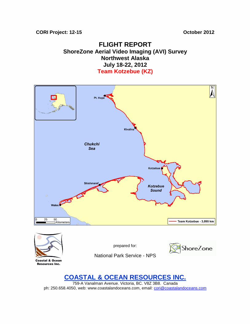
ShoreZone Aerial Video Imaging (AVI) Survey
Northwest Alaska July 18-22, 2012
Team Kotzebue (KZ)
Survey Maps and Tape Logs DVDs: NW12_KZ_01 to NW12_KZ_27
Flight trackline map showing the location and extent of videotapes (DVDs) for the July 18-22, 2012 Team Kotzebue survey in Northwest Alaska

October 2012 5 Team Kotzebue AVI Survey
October 2012 6 Team Kotzebue AVI Survey
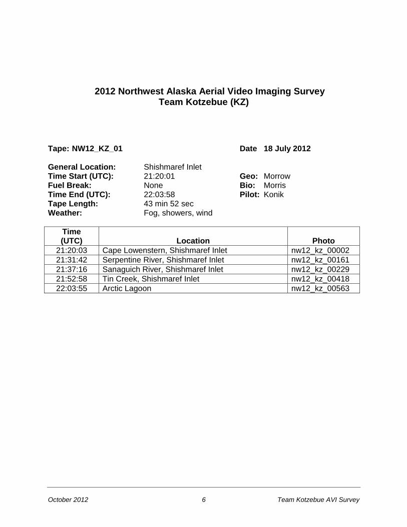
2012 Northwest Alaska Aerial Video Imaging Survey Team Kotzebue (KZ)
Tape: NW12_KZ_01 Date 18 July 2012 General Location: Shishmaref Inlet Time Start (UTC): 21:20:01 Geo: Morrow Fuel Break: None Bio: Morris Time End (UTC): 22:03:58 Pilot: Konik Tape Length: 43 min 52 sec Weather: Fog, showers, wind
Time (UTC)
Location
Photo
21:20:03 Cape Lowenstern, Shishmaref Inlet nw12_kz_00002
21:31:42 Serpentine River, Shishmaref Inlet nw12_kz_00161
21:37:16 Sanaguich River, Shishmaref Inlet nw12_kz_00229
21:52:58 Tin Creek, Shishmaref Inlet nw12_kz_00418
22:03:55 Arctic Lagoon nw12_kz_00563

October 2012 7 Team Kotzebue AVI Survey

October 2012 8 Team Kotzebue AVI Survey
2012 Northwest Alaska Aerial Video Imaging Survey Team Kotzebue (KZ)
Tape: NW12_KZ_02 Date 18 July 2012 General Location: Shishmaref, Cowpack Inlet Time Start (UTC): 22:56:45 Geo: Morrow Fuel Break: None Bio: Morris Time End (UTC): 23:54:26 Pilot: Konik Tape Length: 57 min 41 sec Weather: Fog, showers, wind
Time (UTC)
Location
Photo
22:56:49 Shishmaref nw12_kz_00581
23:07:31 East of Shishmaref, inside of barrier island nw12_kz_00756
23:24:32 West of Kividlo, inside of barrier island nw12_kz_01014
23:39:31 Kivildo nw12_kz_01222
23:54:24 Cowpack Inlet nw12_kz_01433

October 2012 9 Team Kotzebue AVI Survey
October 2012 10 Team Kotzebue AVI Survey
2012 Northwest Alaska Aerial Video Imaging Survey Team Kotzebue (KZ)
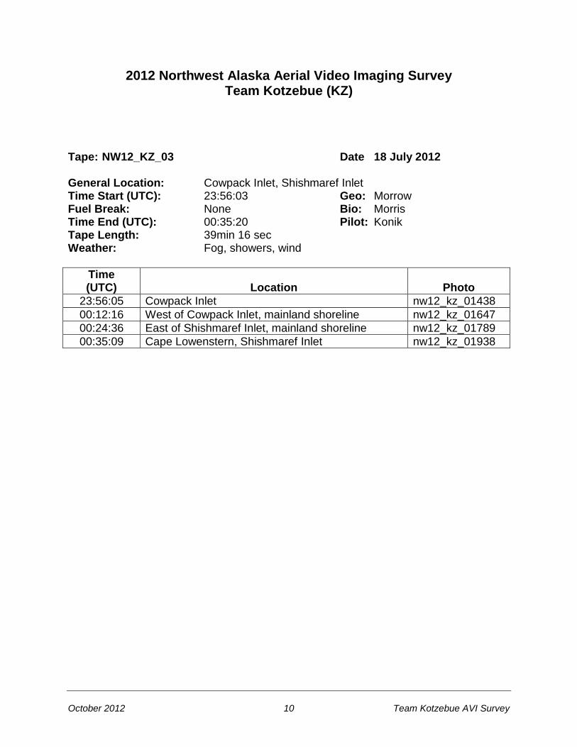
Tape: NW12_KZ_03 Date 18 July 2012 General Location: Cowpack Inlet, Shishmaref Inlet Time Start (UTC): 23:56:03 Geo: Morrow Fuel Break: None Bio: Morris Time End (UTC): 00:35:20 Pilot: Konik Tape Length: 39min 16 sec Weather: Fog, showers, wind
Time (UTC)
Location
Photo
23:56:05 Cowpack Inlet nw12_kz_01438
00:12:16 West of Cowpack Inlet, mainland shoreline nw12_kz_01647
00:24:36 East of Shishmaref Inlet, mainland shoreline nw12_kz_01789
00:35:09 Cape Lowenstern, Shishmaref Inlet nw12_kz_01938

October 2012 11 Team Kotzebue AVI Survey

October 2012 12 Team Kotzebue AVI Survey
2012 Northwest Alaska Aerial Video Imaging Survey Team Kotzebue (KZ)
Tape: NW12_KZ_04 Date 18 July 2012 General Location: Arctic Lagoon, Ikpek Lagoon Time Start (UTC): 01:28:37 Geo: Morrow Fuel Break: None Bio: Morris Time End (UTC): 02:23:24 Pilot: Konik Tape Length: 54 min 47 sec Weather: Fog, showers, wind
Time (UTC)
Location
Photo
01:28:44 Arctic Lagoon nw12_kz_01946
01:52:51 Kugrupaga Inlet nw12_kz_02253
02:06:18 Nuluk River, Ikpek Lagoon nw12_kz_02430
02:17:32 Pinguk River, Ikpek Lagoon nw12_kz_02554
02:23:20 Northwest corner of Ikpek Lagoon nw12_kz_02617
October 2012 13 Team Kotzebue AVI Survey

October 2012 14 Team Kotzebue AVI Survey
2012 Northwest Alaska Aerial Video Imaging Survey Team Kotzebue (KZ)
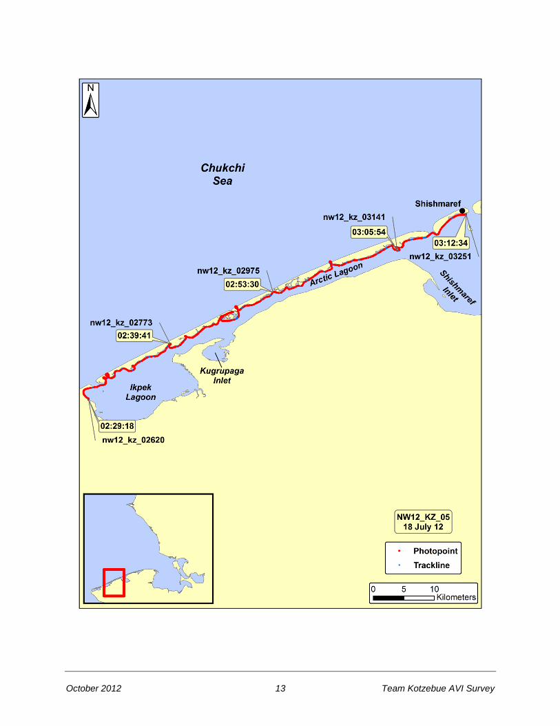
Tape: NW12_KZ_05 Date 18 July 2012 General Location: Ikpek Lagoon, Arctic Lagoon, Shishmaref Time Start (UTC): 02:29:16 Geo: Morrow Fuel Break: None Bio: Morris Time End (UTC): 03:12:36 Pilot: Konik Tape Length: 43 min 20 sec Weather: Fog, showers, wind
Time (UTC)
Location
Photo
02:29:18 Northwest corner of Ikpek Lagoon nw12_kz_02620
02:39:41 Ikpek Lagoon, inside of barrier island nw12_kz_02773
02:53:30 Sinrazat shelter cabin nw12_kz_02975
03:05:54 Arctic Lagoon, inside of barrier island nw12_kz_03141
03:12:34 Shishmaref nw12_kz_03251
October 2012 15 Team Kotzebue AVI Survey
October 2012 16 Team Kotzebue AVI Survey
2012 Northwest Alaska Aerial Video Imaging Survey Team Kotzebue (KZ)
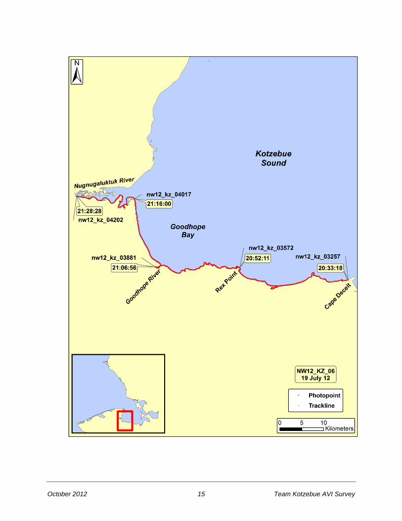
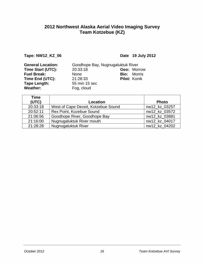
Tape: NW12_KZ_06 Date 19 July 2012 General Location: Goodhope Bay, Nugnugaluktuk River Time Start (UTC): 20:33:18 Geo: Morrow Fuel Break: None Bio: Morris Time End (UTC): 21:28:33 Pilot: Konik Tape Length: 55 min 15 sec Weather: Fog, cloud
Time (UTC)
Location
Photo
20:33:18 West of Cape Deceit, Kotzebue Sound nw12_kz_03257
20:52:11 Rex Point, Kozebue Sound nw12_kz_03572
21:06:56 Goodhope River, Goodhope Bay nw12_kz_03881
21:16:00 Nugnugaluktuk River mouth nw12_kz_04017
21:28:28 Nugnugaluktuk River nw12_kz_04202
October 2012 17 Team Kotzebue AVI Survey

October 2012 18 Team Kotzebue AVI Survey
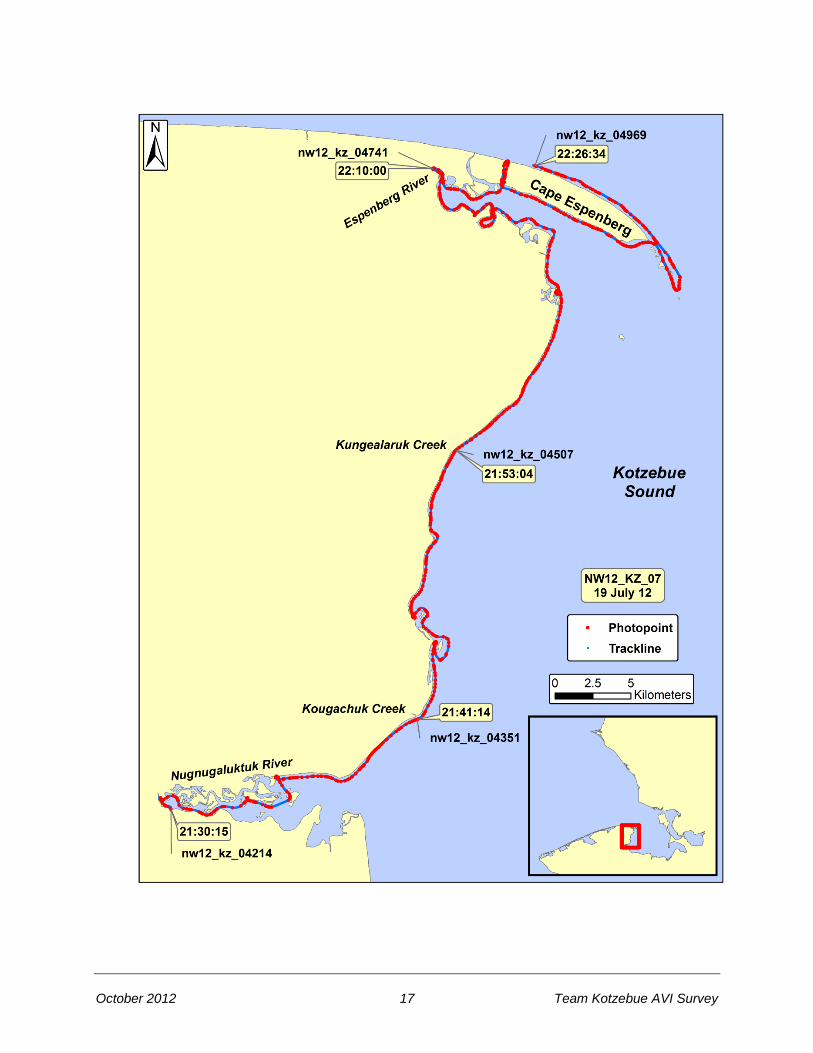
2012 Northwest Alaska Aerial Video Imaging Survey Team Kotzebue (KZ)
Tape: NW12_KZ_07 Date 19 July 2012 General Location: Nugnugaluktuk River, Cape Espenberg Time Start (UTC): 21:30:11 Geo: Morrow Fuel Break: None Bio: Morris Time End (UTC): 22:26:37 Pilot: Konik Tape Length: 56 min 26 sec Weather: Low overcast, scattered sunny periods
Time (UTC)
Location
Photo
21:30:15 Nugnugaluktuk River nw12_kz_04214
21:41:14 Kougachuk Creek, Kozebue Sound nw12_kz_04351
21:53:04 Kungealaruk Creek, Kotzebue Sound nw12_kz_04507
22:10:00 Espenberg River nw12_kz_04741
22:26:34 Cape Espenberg nw12_kz_04969

October 2012 19 Team Kotzebue AVI Survey
October 2012 20 Team Kotzebue AVI Survey
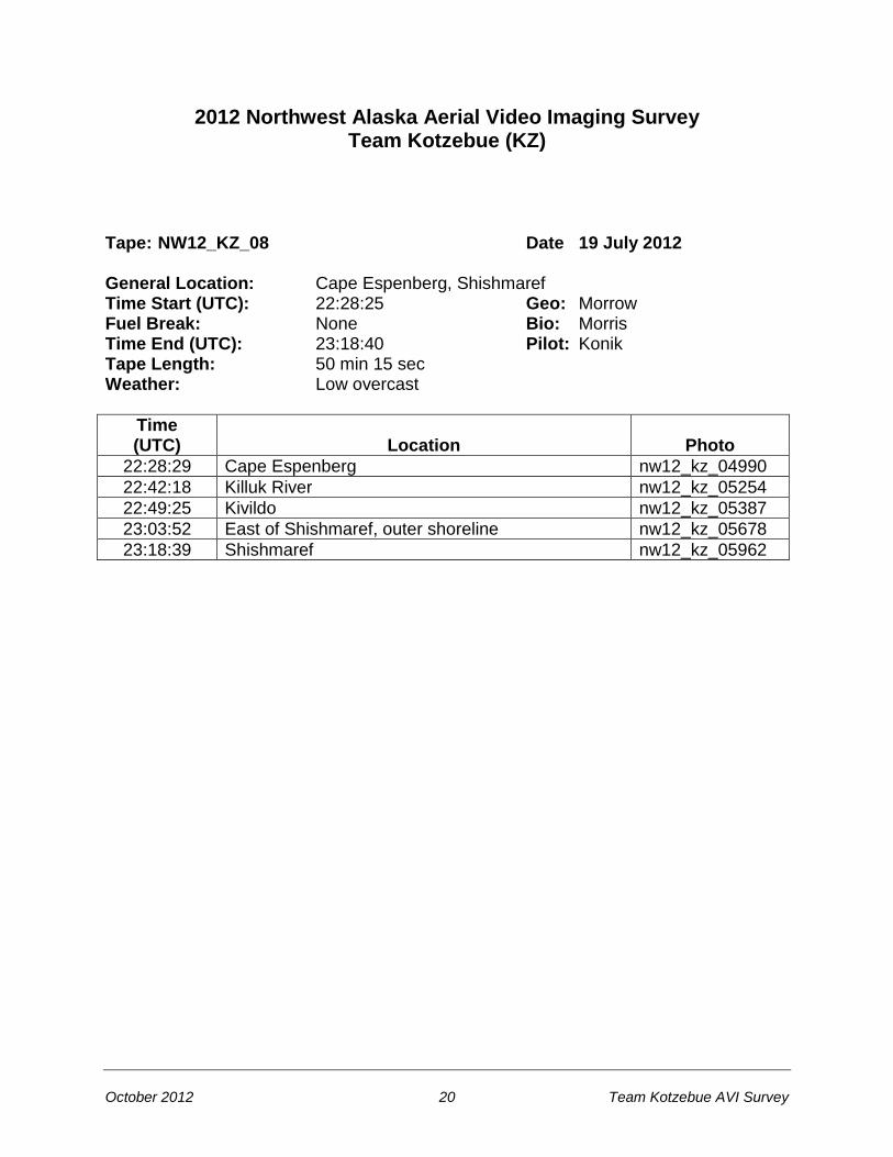
2012 Northwest Alaska Aerial Video Imaging Survey Team Kotzebue (KZ)
Tape: NW12_KZ_08 Date 19 July 2012 General Location: Cape Espenberg, Shishmaref Time Start (UTC): 22:28:25 Geo: Morrow Fuel Break: None Bio: Morris Time End (UTC): 23:18:40 Pilot: Konik Tape Length: 50 min 15 sec Weather: Low overcast
Time (UTC)
Location
Photo
22:28:29 Cape Espenberg nw12_kz_04990
22:42:18 Killuk River nw12_kz_05254
22:49:25 Kivildo nw12_kz_05387
23:03:52 East of Shishmaref, outer shoreline nw12_kz_05678
23:18:39 Shishmaref nw12_kz_05962

October 2012 21 Team Kotzebue AVI Survey

October 2012 22 Team Kotzebue AVI Survey
2012 Northwest Alaska Aerial Video Imaging Survey Team Kotzebue (KZ)
Tape: NW12_KZ_09 Date 19 July 2012 General Location: Shishmaref, Lopp Lagoon Time Start (UTC): 00:15:43 Geo: Morrow Fuel Break: None Bio: Morris Time End (UTC): 01:12:58 Pilot: Konik Tape Length: 57 min 15 sec Weather: Overcast turning to sun, wind
Time (UTC)
Location
Photo
00:15:44 Shishmaref, west end of town nw12_kz_05975
00:31:00 Sinrazat Shelter Cabin nw12_kz_06179
00:48:25 Entrance to Ikpek Lagoon nw12_kz_06429
00:57:51 East entrance to Lopp Lagoon nw12_kz_06550
01:12:58 Lopp Lagoon, near Mint River nw12_kz_06779

October 2012 23 Team Kotzebue AVI Survey

October 2012 24 Team Kotzebue AVI Survey
2012 Northwest Alaska Aerial Video Imaging Survey Team Kotzebue (KZ)
Tape: NW12_KZ_10 Date 19 July 2012 General Location: Lopp Lagoon Time Start (UTC): 01:14:07 Geo: Morrow Fuel Break: None Bio: Morris Time End (UTC): 02:11:08 Pilot: Konik Tape Length: 57 min 01 sec Weather: Sun, wind, scattered cloud
Time (UTC)
Location
Photo
01:14:26 Lopp Lagoon, near Mint River nw12_kz_06780
01:24:18 Potato Creek, Lopp Lagoon nw12_kz_06924
01:44:34 Granite Creek, Lopp Lagoon nw12_kz_07232
01:55:35 Mugisitokiwik, Lopp Lagoon nw12_kz_07420
02:11:08 Lopp Lagoon nw12_kz_07675

October 2012 25 Team Kotzebue AVI Survey

October 2012 26 Team Kotzebue AVI Survey
2012 Northwest Alaska Aerial Video Imaging Survey Team Kotzebue (KZ)
Tape: NW12_KZ_11 Date 19 July 2012 General Location: Lopp Lagoon, Wales Time Start (UTC): 02:13:15 Geo: Morrow Fuel Break: None Bio: Morris Time End (UTC): 02:42:52 Pilot: Konik Tape Length: 29 min 37 sec Weather: Sun, wind
Time (UTC)
Location
Photo
02:13:15 Lopp Lagoon nw12_kz_07678
02:22:01 Mitletukeruk, east entrance to Lopp Lagoon nw12_kz_07841
02:29:10 West entrance to Lopp Lagoon nw12_kz_07960
02:36:03 Bering Strait, north of Wales nw12_kz_08065
02:42:52 Wales nw12_kz_08204
October 2012 27 Team Kotzebue AVI Survey

October 2012 28 Team Kotzebue AVI Survey
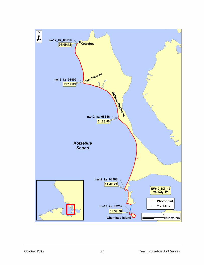
2012 Northwest Alaska Aerial Video Imaging Survey Team Kotzebue (KZ)
Tape: NW12_KZ_12 Date 20 July 2012 General Location: Baldwin Peninsula, Kotzebue Sound Time Start (UTC): 01:09:11 Geo: Morrow Fuel Break: None Bio: Morris Time End (UTC): 01:59:56 Pilot: Konik Tape Length: 50 min 45 sec Weather: Sun, high scattered cloud
Time (UTC)
Location
Photo
01:09:12 Kotzebue, south of airport nw12_kz_08210
01:17:09 Cape Blossom nw12_kz_08402
01:28:50 Baldwin Peninsula, Kotzebue Sound nw12_kz_08646
01:47:23 Choris Peninsula nw12_kz_08988
01:59:56 Chamisso Island nw12_kz_09252
October 2012 29 Team Kotzebue AVI Survey

October 2012 30 Team Kotzebue AVI Survey
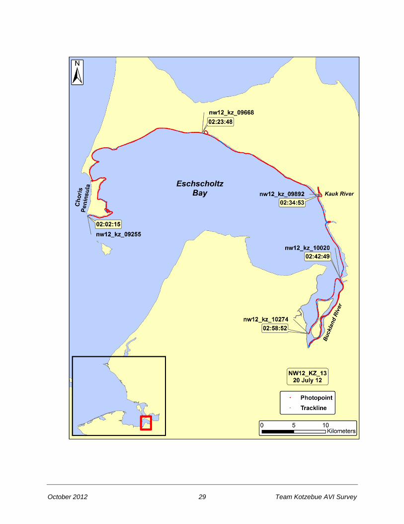
2012 Northwest Alaska Aerial Video Imaging Survey Team Kotzebue (KZ)
Tape: NW12_KZ_13 Date 20 July 2012 General Location: Eschscholtz Bay, Buckland River Time Start (UTC): 02:02:15 Geo: Morrow Fuel Break: None Bio: Morris Time End (UTC): 02:58:54 Pilot: Konik Tape Length: 56 min 39 sec Weather: Sun, high scattered cloud
Time (UTC)
Location
Photo
02:02:15 Pt. Garnet, Choris Peninsula nw12_kz_09255
02:23:48 Callahan Shelter Cabin, Eschscholtz Bay nw12_kz_09668
02:34:53 Kauk River, Eschscholtz Bay nw12_kz_09892
02:42:49 Mouth of Buckland River, Eschscholtz Bay nw12_kz_10020
02:58:52 Buckland River, Eschscholtz Bay nw12_kz_10274
October 2012 31 Team Kotzebue AVI Survey

October 2012 32 Team Kotzebue AVI Survey
2012 Northwest Alaska Aerial Video Imaging Survey Team Kotzebue (KZ)
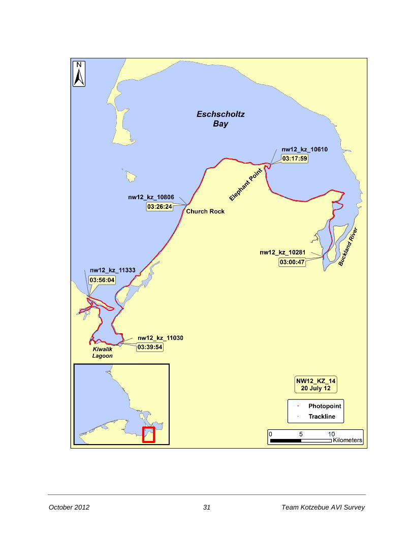
Tape: NW12_KZ_14 Date 20 July 2012 General Location: Eschscholtz Bay, Kiwalik Lagoon Time Start (UTC): 03:00:31 Geo: Morrow Fuel Break: None Bio: Morris Time End (UTC): 03:56:14 Pilot: Konik Tape Length: 55 min 43 sec Weather: Sun, high scattered cloud
Time (UTC)
Location
Photo
03:00:47 Buckland River nw12_kz_10281
03:17:59 Elephant Point, Eschscholtz Bay nw12_kz_10610
03:26:24 Church Rock, Eschscholtz Bay nw12_kz_10806
03:39:54 Kiwalik Lagoon nw12_kz_11030
03:56:04 West of Kiwalik Lagoon entrance nw12_kz_11333
October 2012 33 Team Kotzebue AVI Survey

October 2012 34 Team Kotzebue AVI Survey
2012 Northwest Alaska Aerial Video Imaging Survey Team Kotzebue (KZ)
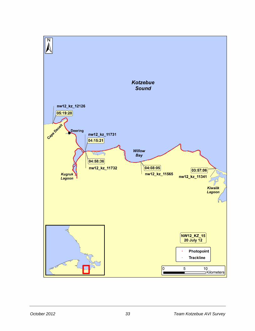
Tape: NW12_KZ_15 Date 20 July 2012 General Location: Willow Bay, Deering, Kotzebue Sound Time Start (UTC): 03:57:03 Geo: Morrow Fuel Break: 04:15:25 to 04:58:33 Bio: Morris Time End (UTC): 05:19:30 Pilot: Konik Tape Length: 39 min 19 sec Weather: Sun, high scattered cloud
Time (UTC)
Location
Photo
03:57:06 West of Kiwalik Lagoon nw12_kz_11341
04:08:05 Willow Bay, Kotzebue Sound nw12_kz_11565
04:15:21 Kugruk Lagoon entrance nw12_kz_11731
Fuel Break: 04:15:25 to 04:58:33
04:58:36 Kugruk Lagoon entrance nw12_kz_11732
05:19:28 West of Cape Deceit, Kotzebue Sound nw12_kz_12126

October 2012 35 Team Kotzebue AVI Survey
October 2012 36 Team Kotzebue AVI Survey
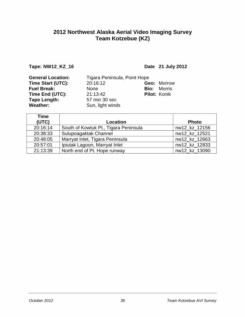
2012 Northwest Alaska Aerial Video Imaging Survey Team Kotzebue (KZ)
Tape: NW12_KZ_16 Date 21 July 2012 General Location: Tigara Peninsula, Point Hope Time Start (UTC): 20:16:12 Geo: Morrow Fuel Break: None Bio: Morris Time End (UTC): 21:13:42 Pilot: Konik Tape Length: 57 min 30 sec Weather: Sun, light winds
Time (UTC)
Location
Photo
20:16:14 South of Kowtuk Pt., Tigara Peninsula nw12_kz_12156
20:38:33 Sulupoagaktak Channel nw12_kz_12521
20:48:05 Marryat Inlet, Tigara Peninsula nw12_kz_12663
20:57:01 Ipiutak Lagoon, Marryat Inlet nw12_kz_12833
21:13:39 North end of Pt. Hope runway nw12_kz_13090
October 2012 37 Team Kotzebue AVI Survey

October 2012 38 Team Kotzebue AVI Survey
2012 Northwest Alaska Aerial Video Imaging Survey Team Kotzebue (KZ)
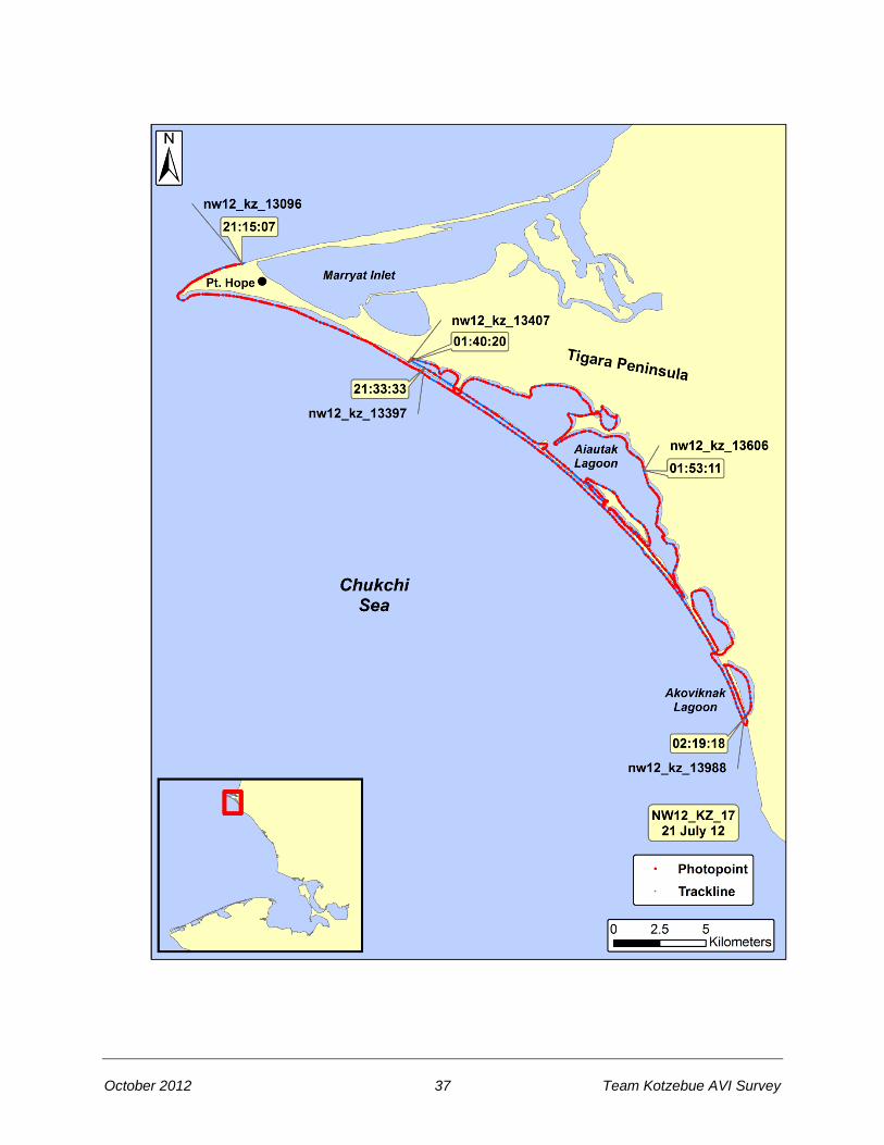
Tape: NW12_KZ_17 Date 21 July 2012 General Location: Point Hope, Tigara Peninsula, Aiautak Lagoon Time Start (UTC): 21:15:04 Geo: Morrow Fuel Break: 21:33:54 to 01:40:20 Bio: Morris Time End (UTC): 02:19:18 Pilot: Konik Tape Length: 57 min 48 sec Weather: Sun, light winds
Time (UTC)
Location
Photo
21:15:07 North end of Pt. Hope runway nw12_kz_13096
21:33:33 Near Jabbertown (ruins) nw12_kz_13397
Fuel Break: 21:33:54 to 01:40:20
01:40:20 Near Jabbertown (ruins) nw12_kz_13407
01:53:11 Aiautak Lagoon nw12_kz_13606
02:19:18 Akoviknak Lagoon nw12_kz_13988

October 2012 39 Team Kotzebue AVI Survey

October 2012 40 Team Kotzebue AVI Survey
2012 Northwest Alaska Aerial Video Imaging Survey Team Kotzebue (KZ)
Tape: NW12_KZ_18 Date 21 July 2012 General Location: Cape Thompson, Cape Seppings Time Start (UTC): 02:20:18 Geo: Morrow Fuel Break: None Bio: Morris Time End (UTC): 03:15:50 Pilot: Konik Tape Length: 55 min 32 sec Weather: Sun, light winds
Time (UTC)
Location
Photo
02:20:28 Akoviknak Lagoon, north of Cape Thompson nw12_kz_13993
02:27:47 Chariot nw12_kz_14151
02:44:32 Singoalik Lagoon nw12_kz_14428
02:58:04 Tasikpak Lagoon nw12_kz_14638
03:15:47 Outside of Kivalina Lagoon nw12_kz_14929

October 2012 41 Team Kotzebue AVI Survey
October 2012 42 Team Kotzebue AVI Survey
2012 Northwest Alaska Aerial Video Imaging Survey Team Kotzebue (KZ)
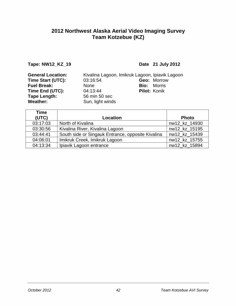
Tape: NW12_KZ_19 Date 21 July 2012 General Location: Kivalina Lagoon, Imikruk Lagoon, Ipiavik Lagoon Time Start (UTC): 03:16:54 Geo: Morrow Fuel Break: None Bio: Morris Time End (UTC): 04:13:44 Pilot: Konik Tape Length: 56 min 50 sec Weather: Sun, light winds
Time (UTC)
Location
Photo
03:17:03 North of Kivalina nw12_kz_14930
03:30:56 Kivalina River, Kivalina Lagoon nw12_kz_15195
03:44:41 South side or Singauk Entrance, opposite Kivalina nw12_kz_15439
04:06:01 Imikruk Creek, Imikruk Lagoon nw12_kz_15755
04:13:34 Ipiavik Lagoon entrance nw12_kz_15894

October 2012 43 Team Kotzebue AVI Survey
October 2012 44 Team Kotzebue AVI Survey
2012 Northwest Alaska Aerial Video Imaging Survey Team Kotzebue (KZ)
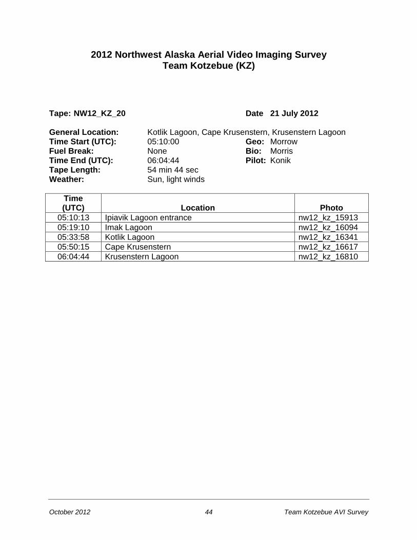
Tape: NW12_KZ_20 Date 21 July 2012 General Location: Kotlik Lagoon, Cape Krusenstern, Krusenstern Lagoon Time Start (UTC): 05:10:00 Geo: Morrow Fuel Break: None Bio: Morris Time End (UTC): 06:04:44 Pilot: Konik Tape Length: 54 min 44 sec Weather: Sun, light winds
Time (UTC)
Location
Photo
05:10:13 Ipiavik Lagoon entrance nw12_kz_15913
05:19:10 Imak Lagoon nw12_kz_16094
05:33:58 Kotlik Lagoon nw12_kz_16341
05:50:15 Cape Krusenstern nw12_kz_16617
06:04:44 Krusenstern Lagoon nw12_kz_16810
October 2012 45 Team Kotzebue AVI Survey

October 2012 46 Team Kotzebue AVI Survey
2012 Northwest Alaska Aerial Video Imaging Survey Team Kotzebue (KZ)
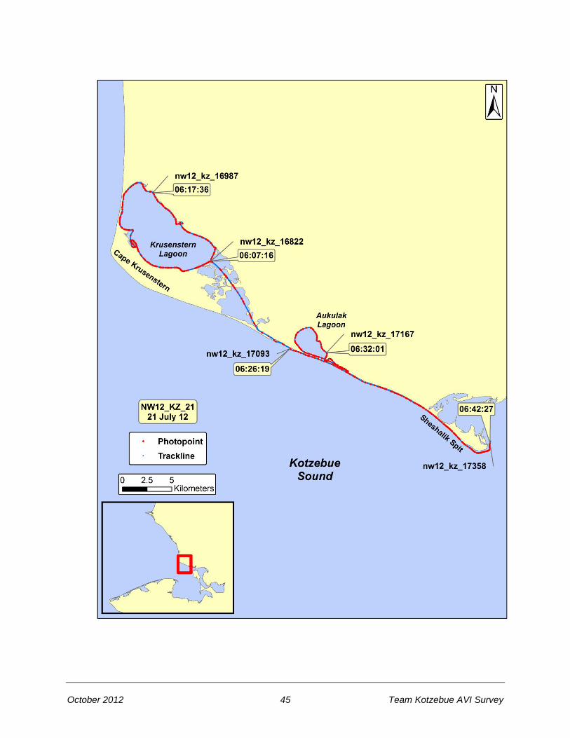
Tape: NW12_KZ_21 Date 21 July 2012 General Location: Krusenstern Lagoon, Aukulak Lagoon, Sheshalik Spit Time Start (UTC): 06:07:15 Geo: Morrow Fuel Break: None Bio: Morris Time End (UTC): 06:42:34 Pilot: Konik Tape Length: 35 min 19 sec Weather: Sun, light winds
Time (UTC)
Location
Photo
06:07:36 Krusenstern Lagoon nw12_kz_16987
06:17:36 Krusenstern Lagoon north end nw12_kz_16822
06:26:19 Krusenstern Lagoon entrance nw12_kz_17093
06:32:01 Aukulak Lagoon nw12_kz_17167
06:42:27 Sheshalik Spit nw12_kz_17358
October 2012 47 Team Kotzebue AVI Survey
October 2012 48 Team Kotzebue AVI Survey
2012 Northwest Alaska Aerial Video Imaging Survey Team Kotzebue (KZ)
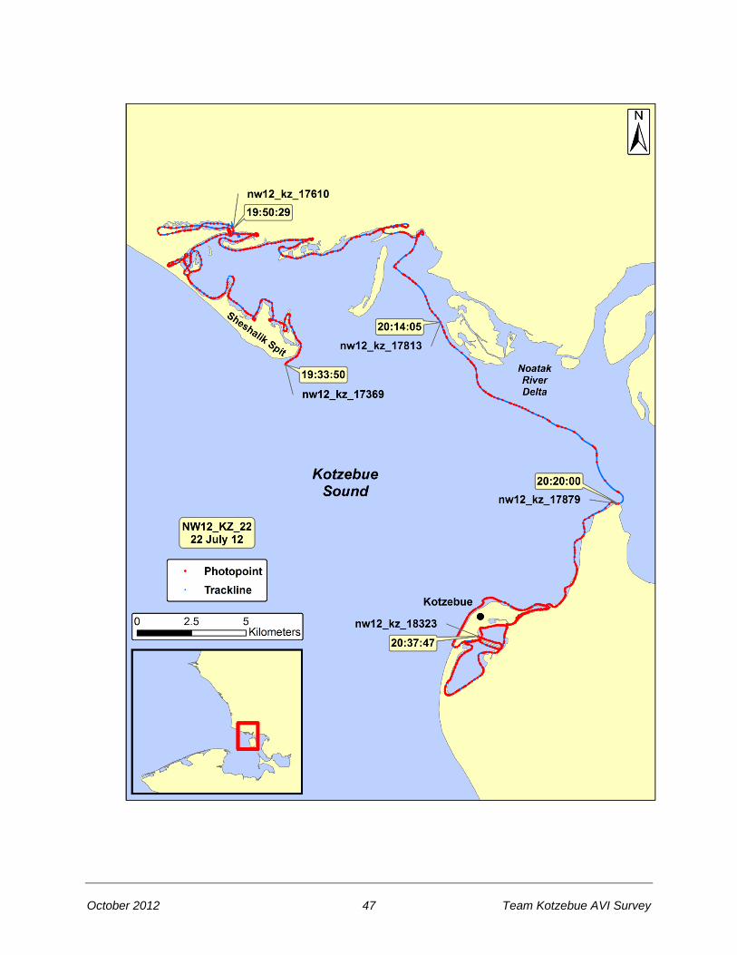
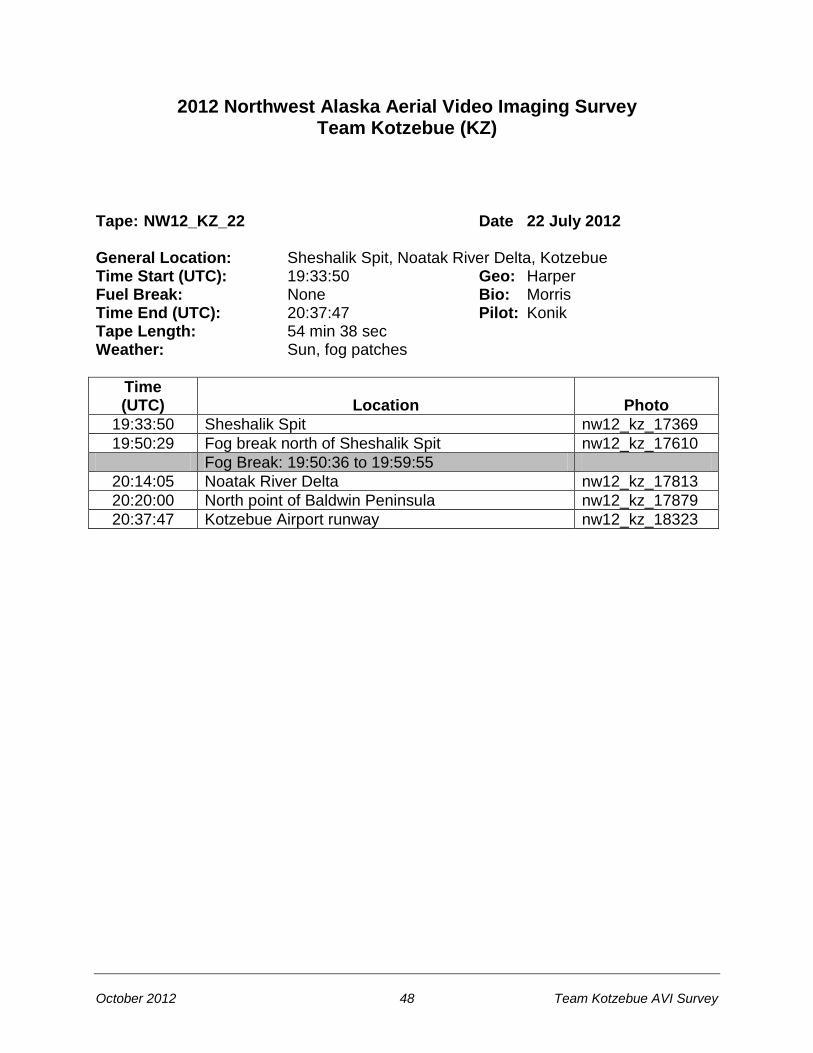
Tape: NW12_KZ_22 Date 22 July 2012 General Location: Sheshalik Spit, Noatak River Delta, Kotzebue Time Start (UTC): 19:33:50 Geo: Harper Fuel Break: None Bio: Morris Time End (UTC): 20:37:47 Pilot: Konik Tape Length: 54 min 38 sec Weather: Sun, fog patches
Time (UTC)
Location
Photo
19:33:50 Sheshalik Spit nw12_kz_17369
19:50:29 Fog break north of Sheshalik Spit nw12_kz_17610
Fog Break: 19:50:36 to 19:59:55
20:14:05 Noatak River Delta nw12_kz_17813
20:20:00 North point of Baldwin Peninsula nw12_kz_17879
20:37:47 Kotzebue Airport runway nw12_kz_18323

October 2012 49 Team Kotzebue AVI Survey

October 2012 50 Team Kotzebue AVI Survey
2012 Northwest Alaska Aerial Video Imaging Survey Team Kotzebue (KZ)
Tape: NW12_KZ_23 Date 22 July 2012 General Location: Hotham Inlet, Ekickuk Lake Time Start (UTC): 21:07:32 Geo: Harper Fuel Break: None Bio: Morris Time End (UTC): 22:02:09 Pilot: Konik Tape Length: 54 min 37 sec Weather: Sun
Time (UTC)
Location
Photo
21:07:37 Noatak River Delta nw12_kz_18334
21:22:24 North Hotham Inlet nw12_kz_18573
21:34:27 Ekickuk Lake nw12_kz_18792
21:48:07 Potoniek Lake nw12_kz_18999
22:02:08 Hotham Inlet, south of Ekickuk Lake nw12_kz_19229
October 2012 51 Team Kotzebue AVI Survey

October 2012 52 Team Kotzebue AVI Survey
2012 Northwest Alaska Aerial Video Imaging Survey Team Kotzebue (KZ)
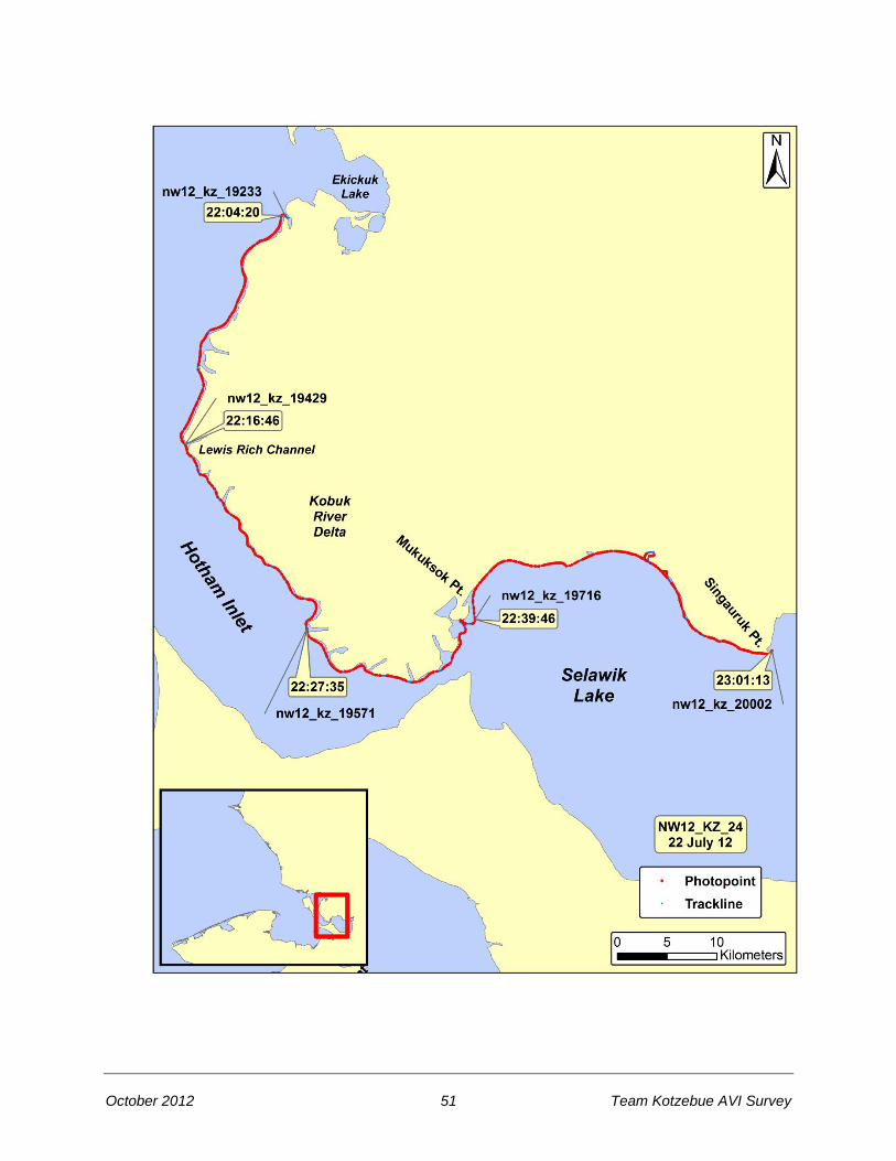
Tape: NW12_KZ_24 Date 22 July 2012 General Location: Hotham Inlet, Kobuk River Delta, Selawik Lake Time Start (UTC): 22:04:04 Geo: Harper Fuel Break: None Bio: Morris Time End (UTC): 23:01:14 Pilot: Konik Tape Length: 57 min 10 sec Weather: Sun
Time (UTC)
Location
Photo
22:04:20 Hotham Inlet, south of Ekickuk Lake nw12_kz_19233
22:16:46 Kobuk River Delta, Lewis Rich Channel nw12_kz_19429
22:27:35 Kobuk River Delta, Attiunik Channel nw12_kz_19571
22:39:46 Mukuksok Point, Selawik Lake nw12_kz_19716
23:01:13 Singauruk Point, Selawik Lake nw12_kz_20002

October 2012 53 Team Kotzebue AVI Survey
October 2012 54 Team Kotzebue AVI Survey
2012 Northwest Alaska Aerial Video Imaging Survey Team Kotzebue (KZ)
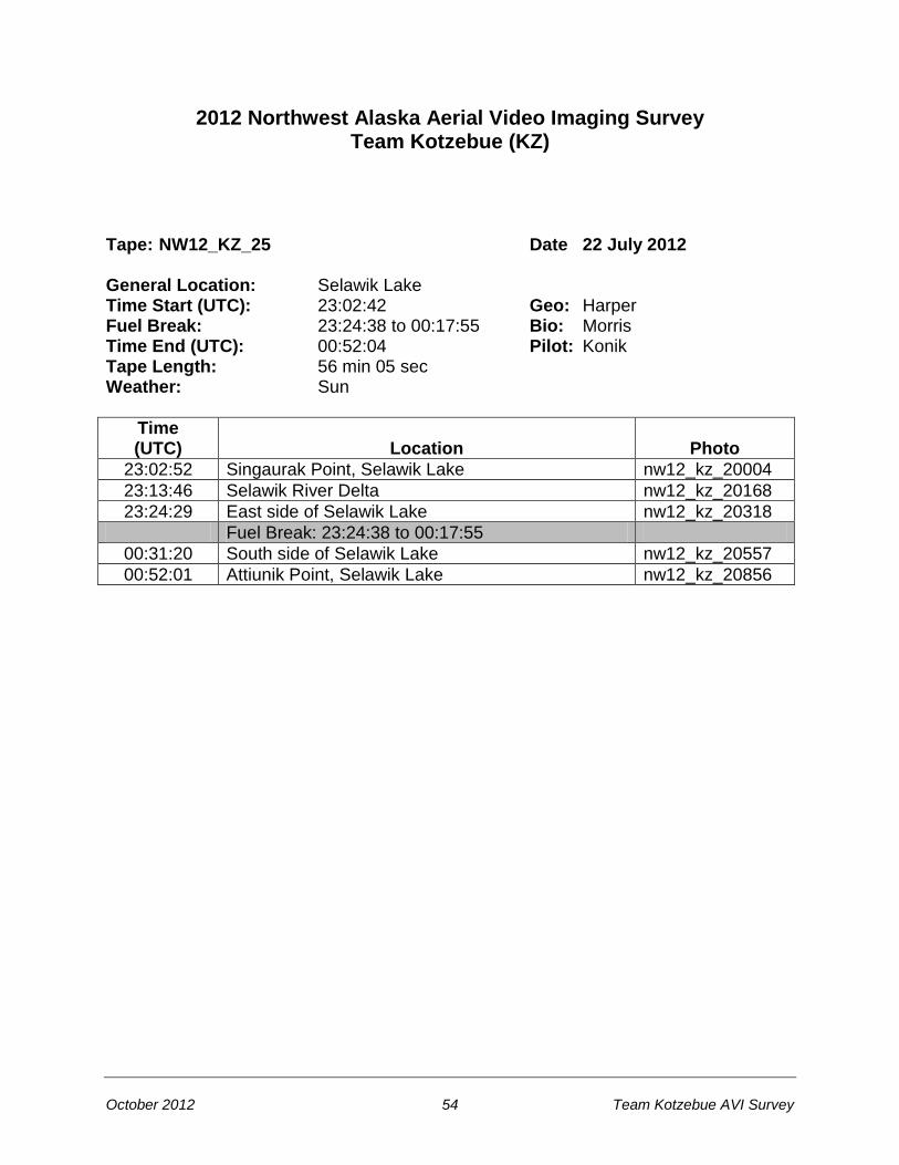
Tape: NW12_KZ_25 Date 22 July 2012 General Location: Selawik Lake Time Start (UTC): 23:02:42 Geo: Harper Fuel Break: 23:24:38 to 00:17:55 Bio: Morris Time End (UTC): 00:52:04 Pilot: Konik Tape Length: 56 min 05 sec Weather: Sun
Time (UTC)
Location
Photo
23:02:52 Singaurak Point, Selawik Lake nw12_kz_20004
23:13:46 Selawik River Delta nw12_kz_20168
23:24:29 East side of Selawik Lake nw12_kz_20318
Fuel Break: 23:24:38 to 00:17:55
00:31:20 South side of Selawik Lake nw12_kz_20557
00:52:01 Attiunik Point, Selawik Lake nw12_kz_20856
October 2012 55 Team Kotzebue AVI Survey

October 2012 56 Team Kotzebue AVI Survey
2012 Northwest Alaska Aerial Video Imaging Survey Team Kotzebue (KZ)
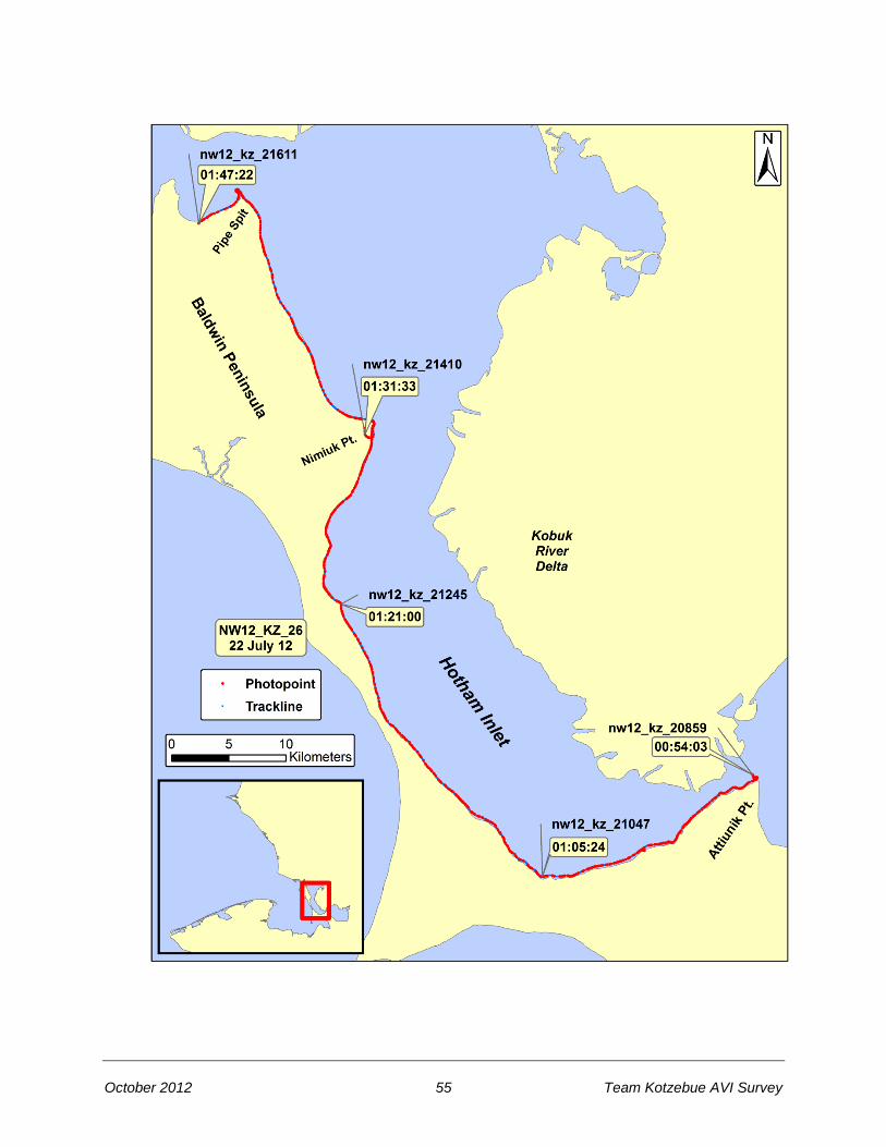
Tape: NW12_KZ_26 Date 22 July 2012 General Location: Baldwin Peninsula, Hotham Inlet Time Start (UTC): 00:53:58 Geo: Harper Fuel Break: None Bio: Morris Time End (UTC): 01:47:23 Pilot: Konik Tape Length: 53 min 25 sec Weather: Sun
Time (UTC)
Location
Photo
00:54:03 Attiunik Point, Selawik Lake nw12_kz_20859
01:05:24 Hotham Inlet, Baldwin Peninsula nw12_kz_21047
01:21:00 Hotham Inlet, Baldwin Peninsula nw12_kz_21245
01:31:33 Nimiuk Pt., Hotham Inlet nw12_kz_21410
01:47:22 West of Pipe Spit, Baldwin Peninsula nw12_kz_21611

October 2012 57 Team Kotzebue AVI Survey

October 2012 58 Team Kotzebue AVI Survey
2012 Northwest Alaska Aerial Video Imaging Survey Team Kotzebue (KZ)
Tape: NW12_KZ_27 Date 22 July 2012 General Location: Baldwin Peninsula, Hotham Inlet Time Start (UTC): 01:48:46 Geo: Harper Fuel Break: None Bio: Morris Time End (UTC): 01:53:50 Pilot: Konik Tape Length: 5 min 04 sec Weather: Sun
Time (UTC)
Location
Photo
01:48:46 West of Pipe Spit, Baldwin Peninsula nw12_kz_21615
01:51:47 North point of Baldwin Peninsula nw12_kz_21653
01:53:48 Baldwin Peninsula, north of Kotzebue nw12_kz_21684

October 2012 59 Team Kotzebue AVI Survey
This Page Left Blank to Facilitate Double-Sided Printing

October 2012 60 Team Kotzebue AVI Survey
References Harney, J.N., Morris, M., and Harper, J.R. 2008. ShoreZone Coastal Habitat Mapping Protocol for the
Gulf of Alaska. Report prepared for The Nature Conservancy, NOAA National Marine Fisheries Service, and the Alaska State Department of Natural Resources (Juneau, AK). 153 p.
http://www.fakr.noaa.gov/shorezone/goa_protocol.pdf Acknowledgments The ShoreZone program is a partnership of scientists, GIS specialists, web specialists, non-profit
organizations, and governmental agencies. We gratefully acknowledge the support of organizations working in partnership for the Alaska ShoreZone effort, including:
Alaska Department of Fish and Game Alaska Department of Natural Resources Archipelago Marine Research Ltd. Coastal and Ocean Resources Inc. Cook Inlet Regional Citizens’ Advisory Council Exxon Valdez Oil Spill Trustee Council National Park Service NOAA National Marine Fisheries Service Prince William Sound Regional Citizens’ Advisory Council The Nature Conservancy University of Alaska U.S. Forest Service U.S. Fish and Wildlife Service U.S. National Park Service
We also thank the staff of Coastal and Ocean Resources Inc. and Archipelago Marine Research Ltd.
for their efforts in the field and in the office. Access and Use Constraints Protocols for data access and distribution are established by the program partner agencies. Please
see www.shorezone.org for a list of partner agencies and related web sites. Video imagery can be viewed and digital stills downloaded online at: http://www.fakr.noaa.gov/shorezone/default.htm
Any hardcopies or published data sets utilizing ShoreZone products shall clearly indicate their source.
To ensure distribution of the most current public information or for correct interpretation, contact the ShoreZone project manager at Coastal and Ocean Resources, Inc. At the time of publication, that person is Dr. John Harper.
To effectively and appropriately use ShoreZone data, the user shall refer to the ShoreZone Coastal
Habitat Mapping Protocol (2008) available at: http://www.fakr.noaa.gov/shorezone/goa_protocol.pdf
Data provided are derived from large, regional databases that are continually being updated and modified. The accuracy of some information is subject to change. Any published data sets utilizing ShoreZone products (printed, digital, or online) shall clearly indicate their source. If the user has modified the data in any way, the user is obligated to describe the types of modifications performed. The user specifically agrees not to misrepresent these data, nor to imply that changes made were approved by the ShoreZone program or its partners.