Karuna Pujara, Maryland State Highway Administration and ... · 1 November 2014 | Issue 10 Letter...
16
1 November 2014 | Issue 10 Letter from the Technical Committee on Hydrology & Hydraulics Chair Karuna Pujara, Maryland State Highway Administration and TCHH Chair In This Issue Letter from the TCHH Chair ........ 1 TCHH Membership ......................... 2 2014 NHEC......................................... 2 Drainage Manual ............................. 3 Hydroplaning Tool ......................... 4 Regulatory Delegation .................. 5 2D Hydraulic Model ....................... 6 Pollutant Removal .......................... 7 FHWA News....................................... 9 TRB News ........................................ 12 New Members ............................... 13 AASHTO Updates.......................... 15 Calendar of Events....................... 16 It took seven years in making – a new Drainage Manual was published in 2014. This new manual was major overhaul from the 2007 manual with two separate parts – Policy and Procedure. This Drainage Manual is still meant to be a model manual for State DOTs to adopt however it is providing an authoritative policy section related to hydrology, hydraulics and drainage design that can be tailored to your state. As with anything that takes that long to prepare, some things are ready to be updated as soon as published. Members of the Technical Committee on Hydrology and Hydraulics (TCHH) have already embarked on that journey with an idea of publishing only the updates to specific chapters as needed, as opposed to the complete manual. If you have not already heard of the new Drainage Manual, please visit AASHTO Publications page at https://bookstore.transportation.org/ and searching for “drainage”. Also, be on the lookout for any updates. TCHH recently added three new members, David Hedstrom from Montana, Ann-Marie Kirsch from Wisconsin, and Brad McManus from Georgia. We are excited to welcome these new members and appreciate their willingness to serve on the committee. The TCHH organization is allowed to have maximum of 20 State DOT voting members plus the friends of the committee. If you are interested in joining TCHH please refer to the information provided in the TCHH Membership article on page 2. TCHH membership provides an opportunity to serve at a national level for the benefit of transportation engineers while utilizing your expertise and experience. As the name indicates, major work is related to hydrology, hydraulics, drainage design, scour, water quality, volume control, erosion and sediment control, and other emerging issues such as climate change, effluent limits, and stream stability. TCHH members also promote research in these areas and also serve on research panels. Other outreach activities include preparation of this publication and participating and planning of National Hydraulics Engineering Conference. I hope you find the information in this publication useful and enriching. If you are involved with a unique hydraulic effort, we like to hear from you. Please share your knowledge with the rest of the community. To that end, I look forward to a fruitful year of emerging approaches in the hydrology and hydraulics discipline. Cheers, Karuna Pujara, Chair - TCHH index
Transcript of Karuna Pujara, Maryland State Highway Administration and ... · 1 November 2014 | Issue 10 Letter...
1
November 2014 | Issue 10
Letter from the Technical Committee on Hydrology & Hydraulics Chair Karuna Pujara, Maryland State Highway Administration and TCHH Chair
In This Issue
Letter from the TCHH Chair ........ 1
TCHH Membership ......................... 2
2014 NHEC......................................... 2
Drainage Manual ............................. 3
Hydroplaning Tool ......................... 4
Regulatory Delegation .................. 5
2D Hydraulic Model ....................... 6
Pollutant Removal .......................... 7
FHWA News ....................................... 9
TRB News ........................................ 12
New Members ............................... 13
AASHTO Updates .......................... 15
Calendar of Events ....................... 16
It took seven years in making – a new Drainage Manual was published in 2014. This new manual was major overhaul from the 2007 manual with two separate parts – Policy and Procedure. This Drainage Manual is still meant to be a model manual for State DOTs to adopt however it is providing an authoritative policy section related to hydrology, hydraulics and drainage design that can be tailored to your state. As with anything that takes that long to prepare, some things are ready to be updated as soon as published. Members of the Technical Committee on Hydrology and Hydraulics (TCHH) have already embarked on that journey with an idea of publishing only the updates to specific chapters as needed, as opposed to the complete manual. If you have not already heard of the new Drainage Manual, please visit AASHTO Publications page at https://bookstore.transportation.org/ and searching for “drainage”. Also, be on the lookout for any updates.
TCHH recently added three new members, David Hedstrom from Montana, Ann-Marie Kirsch from Wisconsin, and Brad McManus from Georgia. We are excited to welcome these new members and appreciate their willingness to serve on the committee. The TCHH organization is allowed to have maximum of 20 State DOT voting members plus the friends of the committee. If you are interested in joining TCHH please refer to the information provided in the TCHH Membership article on page 2. TCHH membership provides an opportunity to serve at a national level for the benefit of transportation engineers while utilizing your expertise and experience. As the name indicates, major work is related to hydrology, hydraulics, drainage design, scour, water quality, volume control, erosion and sediment control, and other emerging issues such as climate change, effluent limits, and stream stability. TCHH members also promote research in these areas and also serve on research panels. Other outreach activities include preparation of this publication and participating and planning of National Hydraulics Engineering Conference. I hope you find the information in this publication useful and enriching. If you are involved with a unique hydraulic effort, we like to hear from you. Please share your knowledge with the rest of the community. To that end, I look forward to a fruitful year of emerging approaches in the hydrology and hydraulics discipline. Cheers, Karuna Pujara, Chair - TCHH
index
2
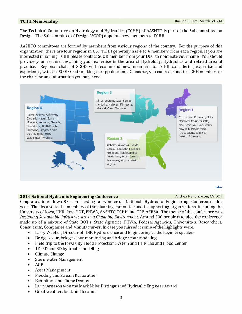
TCHH Membership Karuna Pujara, Maryland SHA
The Technical Committee on Hydrology and Hydraulics (TCHH) of AASHTO is part of the Subcommittee on Design. The Subcommittee of Design (SCOD) appoints new members to TCHH. AASHTO committees are formed by members from various regions of the country. For the purpose of this organization, there are four regions in US. TCHH generally has 4 to 6 members from each region. If you are interested in joining TCHH please contact SCOD member from your DOT to nominate your name. You should provide your resume describing your expertise in the area of Hydrology, Hydraulics and related area of practice. Regional chair of SCOD will recommend new members to TCHH considering expertise and experience, with the SCOD Chair making the appointment. Of course, you can reach out to TCHH members or the chair for any information you may need.
index
2014 National Hydraulic Engineering Conference Andrea Hendrickson, MnDOT
Congratulations IowaDOT on hosting a wonderful National Hydraulic Engineering Conference this year. Thanks also to the members of the planning committee and to supporting organizations, including the University of Iowa, IIHR, IowaDOT, FHWA, AASHTO TCHH and TRB AFB60. The theme of the conference was Designing Sustainable Infrastructure in a Changing Environment. Around 200 people attended the conference made up of a mixture of State DOT’s, State Agencies, FHWA, Federal Agencies, Universities, Researchers, Consultants, Companies and Manufacturers. In case you missed it some of the highlights were:
Larry Webber, Director of IIHR Hydroscience and Engineering as the keynote speaker Bridge scour, bridge scour monitoring and bridge scour modeling Field trip to the Iowa City Flood Protection System and IIHR Lab and Flood Center 1D, 2D and 3D hydraulic modeling Climate Change Stormwater Management AOP Asset Management Flooding and Stream Restoration Exhibitors and Flume Demos Larry Arneson won the Mark Miles Distinguished Hydraulic Engineer Award Great weather, food, and location
3
A link to the conference information is at http://www.uiowa.edu/~confinst/nhec2014/program.html Missed the conference? Don’t despair – the presentations can be viewed at online. To access the videos, go to: http://ir.uiowa.edu/nhec2014/ The next National Hydraulic Engineering Conference will be held in 2016, probably in August. So think about joining us then, perhaps even consider submitting an abstract. State DOT’s interested in hosting the 2016 conference should contact Cynthia Nurmi at [email protected] to get a host questionnaire.
index
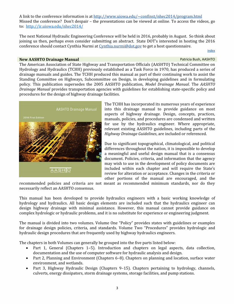
New AASHTO Drainage Manual Patricia Bush, AASHTO
The American Association of State Highway and Transportation Officials (AASHTO) Technical Committee on Hydrology and Hydraulics (TCHH) previously established as a Task Force in 1970, has produced a series of drainage manuals and guides. The TCHH produced this manual as part of their continuing work to assist the Standing Committee on Highways, Subcommittee on Design, in developing guidelines and in formulating policy. This publication supersedes the 2005 AASHTO publication, Model Drainage Manual. The AASHTO Drainage Manual provides transportation agencies with guidelines for establishing state-specific policy and procedures for the design of highway drainage facilities.
The TCHH has incorporated its numerous years of experience into this drainage manual to provide guidance on most aspects of highway drainage. Design, concepts, practices, manuals, policies, and procedures are condensed and written for use by the hydraulics engineer. Where appropriate, relevant existing AASHTO guidelines, including parts of the Highway Drainage Guidelines, are included or referenced. Due to significant topographical, climatological, and political differences throughout the nation, it is impossible to develop a meaningful and useful design manual that is a consensus document. Policies, criteria, and information that the agency may wish to use in the development of policy documents are included within each chapter and will require the State’s review for alteration or acceptance. Changes in the criteria or other portions of the manual are encouraged, and the
recommended policies and criteria are not meant as recommended minimum standards, nor do they necessarily reflect an AASHTO consensus. This manual has been developed to provide hydraulics engineers with a basic working knowledge of hydrology and hydraulics. All basic design elements are included such that the hydraulics engineer can design highway drainage with minimal assistance. However, this manual cannot provide guidance on complex hydrologic or hydraulic problems, and it is no substitute for experience or engineering judgment. The manual is divided into two volumes. Volume One “Policy” provides states with guidelines or examples for drainage design policies, criteria, and standards. Volume Two “Procedures” provides hydrologic and hydraulic design procedures that are frequently used by highway hydraulics engineers. The chapters in both Volumes can generally be grouped into the five parts listed below:
Part 1, General (Chapters 1–5). Introduction and chapters on legal aspects, data collection, documentation and the use of computer software for hydraulic analysis and design.
Part 2, Planning and Environment (Chapters 6–8). Chapters on planning and location, surface water environment, and wetlands.
Part 3, Highway Hydraulic Design (Chapters 9–15). Chapters pertaining to hydrology, channels, culverts, energy dissipators, storm drainage systems, storage facilities, and pump stations.
4
Part 4, Bridge Hydraulic Design and Floodplains (Chapters 16–19). Chapters on stream stability, bridges, channel and stream bank stabilization, and coastal zone.
Part 5, Construction and Maintenance (Chapters 20–22). Chapters about erosion and sediment control, construction, and maintenance.
Volume One chapters provide the following: guideline policy, criteria, and standard practices; reference to procedures in Volume Two; and overview of the subject.
Volume One “Policy” has been written to provide examples of policies, criteria, and practices for highway agency use in establishing agency-specific processes and procedures. Some policies may not apply to a specific geographic region (e.g., coastal zone and wetlands). Specific design values are provided for use on new construction or reconstruction projects. States are encouraged to supplement these guideline policies with agency-specific design policies, methods, and standards. Volume Two chapters provide the following:
Reference to policy, criteria, and standards in Volume One;
Design Procedures that the TCHH determined were frequently used have either:
o step-by-step procedures and design examples that can be worked by hand;
o step-by-step procedures and design examples that can be solved with the FHWA Hydraulic Toolbox, FHWA HY-8 and other public domain software; or
o reference to worked examples for procedures (e.g., storm drain design, bridge design, and coastal engineering) that are commonly solved with software that requires substantial expertise; and
References to recommended guidelines for less common procedures.
Volume Two “Procedures,” has been written to provide a set of core procedures for highway agency use in establishing agency-specific procedures. Some chapters of the manual may not apply to a specific geographic region (e.g., coastal zone and wetlands). States are encouraged to supplement these procedures with state-specific design policies, methods, standards, and other highway drainage-related topics. The AASHTO Drainage Manual, First Edition, may be purchased by visiting the AASHTO Bookstore at www.bookstore.aashto.org, and searching for “Drainage”.
index
I-4 Ultimate Project Designed with New Florida DOT Hydroplaning Prediction Tool
Catherine B. Earp and Vicki Morrison, FDOT
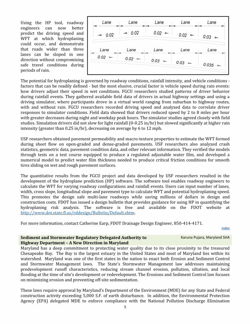
The reconstruction of Interstate 4 through Orlando--the biggest roadway project in FDOT history--applies a design technology developed through FDOT-funded research. In 2012, researchers at the University of South Florida (USF) developed a hydroplaning speed prediction (HP) software tool for evaluating the potential for hydroplaning. The tool, along with data developed in a companion research project conducted by Florida Gulf Coast University (FGCU) researchers that evaluated driver reaction to rainfall using a driving simulator, was developed into an FDOT design guidance procedure. The tool helps roadway engineers understand the risk of hydroplaning and reduce costs associated with road widening. In the past, FDOT has designed multi-lane roadways sloped in one direction for a maximum of three lanes. Limiting slope in one-direction to three lanes was intended to mitigate the potential for hydroplaning by limiting the water film thickness (WFT) formed from rain flowing across the road. FDOT’s Plans Preparation Manual (PPM) has specified that widening beyond three lanes would require the additional lane(s) to be sloped in the opposite downward angle, resulting in great cost in time and expense.
5
Using the HP tool, roadway engineers can now better predict the driving speed and WFT at which hydroplaning could occur, and demonstrate that roads wider than three lanes can be sloped in one direction without compromising safe travel conditions during periods of rain. The potential for hydroplaning is governed by roadway conditions, rainfall intensity, and vehicle conditions - factors that can be readily defined - but the most elusive, crucial factor is vehicle speed during rain events: how drivers adjust their speed in wet conditions. FGCU researchers studied patterns of driver behavior during rainfall events. They gathered available field data of drivers in actual highway settings and using a driving simulator, where participants drove in a virtual world ranging from suburban to highway routes, with and without rain. FGCU researchers recorded driving speed and analyzed data to correlate driver responses to simulator conditions. Field data showed that drivers reduced speed by 2 to 8 miles per hour with greater decreases during night and weekday peak hours. The simulator studies agreed closely with field studies. Simulation drivers did not slow for light rainfall (0-0.25 in/hr) but slowed significantly at higher rain intensity (greater than 0.25 in/hr), decreasing on average by 6 to 12 mph. USF researchers obtained pavement permeability and macro-texture properties to estimate the WFT formed during sheet flow on open-graded and dense-graded pavements. USF researchers also analyzed crash statistics, geometric data, pavement condition data, and other relevant information. They verified the models through tests on a test course equipped to produce a regulated adjustable water film, and developed a numerical model to predict water film thickness needed to produce critical friction conditions for smooth tires sliding on wet and rough pavement surfaces. The quantitative results from the FGCU project and data developed by USF researchers resulted in the development of the hydroplane prediction (HP) software. The software tool enables roadway engineers to calculate the WFT for varying roadway configurations and rainfall events. Users can input number of lanes, width, cross slope, longitudinal slope and pavement type to calculate WFT and potential hydroplaning speed. This promotes the design safe multi-lane roadways while saving millions of dollars in design and construction costs. FDOT has issued a design bulletin that provides guidance for using HP in quantifying the hydroplaning risk analysis. The software is free and available on the FDOT website at http://www.dot.state.fl.us/rddesign/Bulletin/Default.shtm. For more information, contact Catherine Earp, FDOT Drainage Design Engineer, 850-414-4171.
index
Sediment and Stormwater Regulatory Delegated Authority to Highway Department – A New Direction in Maryland
Karuna Pujara, Maryland SHA
Maryland has a deep commitment to protecting water quality due to its close proximity to the treasured Chesapeake Bay. The Bay is the largest estuary in the United States and most of Maryland lies within its watershed. Maryland was one of the first states in the nation to enact both Erosion and Sediment Control and Stormwater Management laws. The State’s Stormwater Management law addresses maintaining predevelopment runoff characteristics, reducing stream channel erosion, pollution, siltation, and local flooding at the time of site’s development or redevelopment. The Erosions and Sediment Control law focuses on minimizing erosion and preventing off-site sedimentation. These laws require approval by Maryland’s Department of the Environment (MDE) for any State and Federal construction activity exceeding 5,000 S.F. of earth disturbance. In addition, the Environmental Protection Agency (EPA) delegated MDE to enforce compliance with the National Pollution Discharge Elimination
6
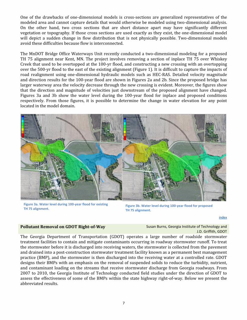
Figure 2a. Velocity through inplace bridge for the 100-year flood.
Figure 2b. Velocity through proposed bridge/alignment for the 100-year flood.
System (NPDES) established under Section 402 of the Clean Water Act. Therefore, Maryland State Highway Administration (SHA) projects and operations are regulated by MDE under two state laws as well as the NPDES regulations. In 2013, MDE proposed a legislative amendment allowing MDE to delegate regulatory authority for sediment and stormwater plan reviews and approvals. This amendment was signed into law, and in July of 2014, SHA and MDE signed an agreement making SHA the first state or federal agency in Maryland to be designated as an approval authority for MDE. As a result of this agreement, SHA established a separate and distinct Plan Review Division responsible for the review and approval of all SHA Erosion & Sediment Control and Stormwater Management plans. The Division is also responsible for reviewing major plan modifications that occur during the construction process. Integrating the plan review and approval process into the existing SHA project development process will improve SHA’s ability to effectively respond to changing priorities, meet deadlines for advertisement, and deliver better projects while meeting or exceeding our environmental goals.
index
Use of Two-Dimensional Hydraulic Model to Evaluate Impact of Road Realignment
Solomon Woldeamlak, MnDOT
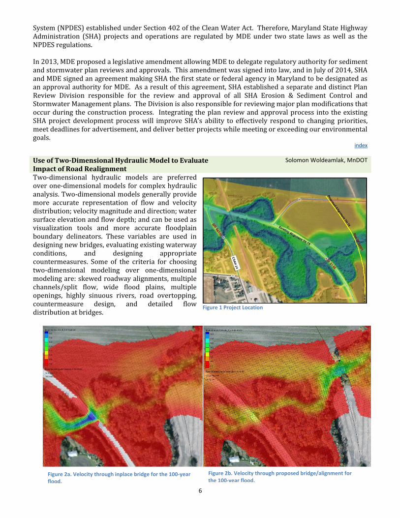
Two-dimensional hydraulic models are preferred over one-dimensional models for complex hydraulic analysis. Two-dimensional models generally provide more accurate representation of flow and velocity distribution; velocity magnitude and direction; water surface elevation and flow depth; and can be used as visualization tools and more accurate floodplain boundary delineators. These variables are used in designing new bridges, evaluating existing waterway conditions, and designing appropriate countermeasures. Some of the criteria for choosing two-dimensional modeling over one-dimensional modeling are: skewed roadway alignments, multiple channels/split flow, wide flood plains, multiple openings, highly sinuous rivers, road overtopping, countermeasure design, and detailed flow distribution at bridges.
Figure 1 Project Location
7
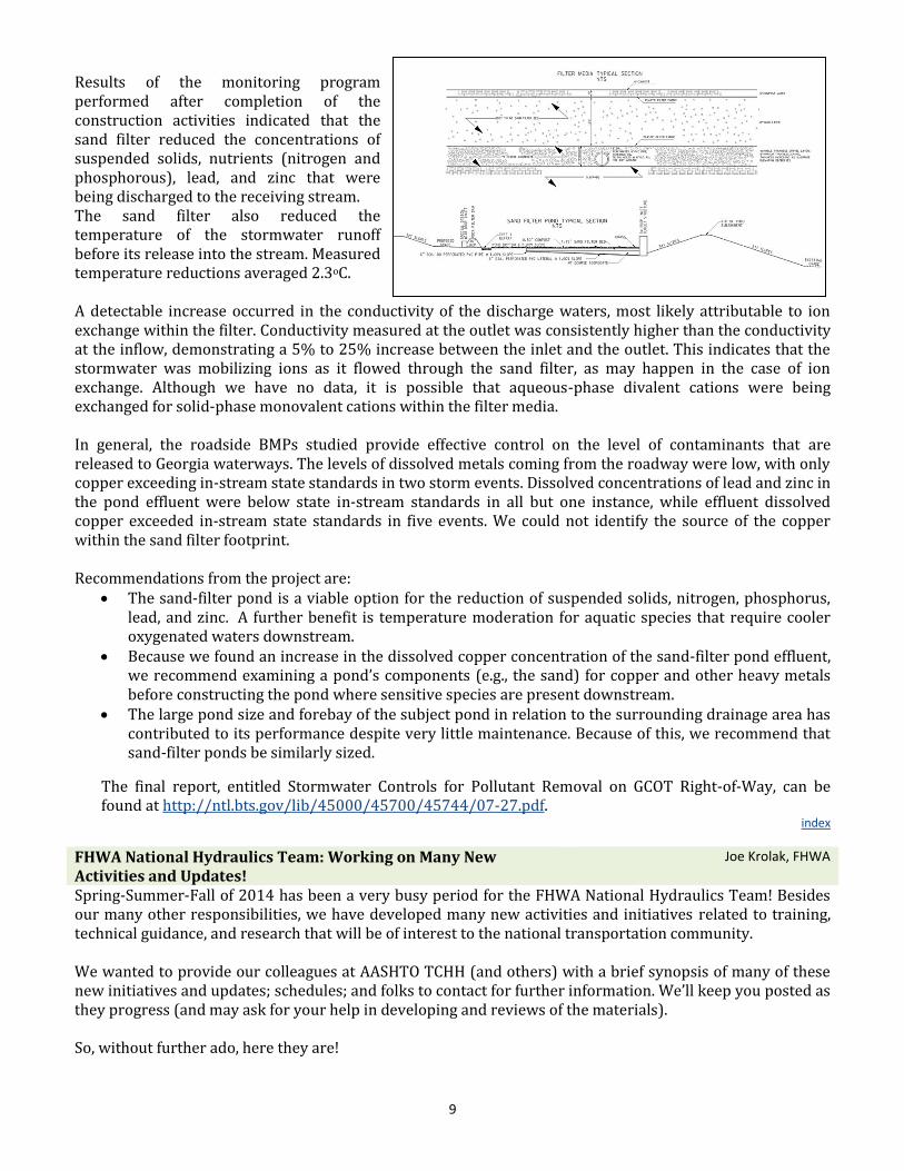
One of the drawbacks of one-dimensional models is cross-sections are generalized representatives of the modeled area and cannot capture details that would otherwise be modeled using two-dimensional analysis. On the other hand, two cross sections that are short distance apart may have significantly different vegetation or topography. If those cross sections are used exactly as they exist, the one-dimensional model will depict a sudden change in flow distribution that is not physically possible. Two-dimensional models avoid these difficulties because flow is interconnected. The MnDOT Bridge Office Waterways Unit recently conducted a two-dimensional modeling for a proposed TH 75 alignment near Kent, MN. The project involves removing a section of inplace TH 75 over Whiskey Creek that used to be overtopped at the 100-yr flood, and constructing a new crossing with an overtopping over the 500-yr flood to the east of the existing alignment (Figure 1). It is difficult to capture the impacts of road realignment using one-dimensional hydraulic models such as HEC-RAS. Detailed velocity magnitude and direction results for the 100-year flood are shown in Figures 2a and 2b. Since the proposed bridge has larger waterway area the velocity decrease through the new crossing is evident. Moreover, the figures show that the direction and magnitude of velocities just downstream of the proposed alignment have changed. Figures 3a and 3b show the water level during the 100-year flood for inplace and proposed conditions respectively. From those figures, it is possible to determine the change in water elevation for any point located in the model domain.
index
Pollutant Removal on GDOT Right-of-Way Susan Burns, Georgia Institute of Technology and J.D. Griffith, GDOT
The Georgia Department of Transportation (GDOT) operates a large number of roadside stormwater treatment facilities to contain and mitigate contaminants occurring in roadway stormwater runoff. To treat the stormwater before it is discharged into receiving waters, the stormwater is collected from the pavement and drained into a post-construction stormwater treatment facility known as a permanent best management practice (BMP), and the stormwater is then discharged into the receiving water at a controlled rate. GDOT designs their BMPs with an emphasis on the removal of suspended solids to reduce the turbidity, nutrient, and contaminant loading on the streams that receive stormwater discharge from Georgia roadways. From 2007 to 2010, the Georgia Institute of Technology conducted field studies under the direction of GDOT to assess the effectiveness of some of the BMPs within the state highway right-of-way. Below we present the abbreviated results.
Figure 3a. Water level during 100-year flood for existing TH 75 alignment.
Figure 3b. Water level during 100-year flood for proposed TH 75 alignment.

8
The goals of the project were to: (1) quantify the typical concentrations of suspended and dissolved solids, metals, and nutrients that leave the roadway and enter BMPs; (2) quantify the typical level of contamination treated within BMPs; and (3) quantify the typical change in contaminant concentrations that leave the roadway during a storm event and then discharge from BMPs into receiving streams. The most significant permanent BMP studied during the project is a 2.0-acre sand-filter pond that is located in the southwestern quadrant of the recently improved I-575 and SR-20 interchange. The pond has a 2-foot-thick silica sand filter and a network of 6-inch-diameter PVC collection pipes embedded in a 9-inch-thick bottom layer of #7 drainage aggregate. The outlet control structure is a GDOT D-4 drop inlet. The drainage area to the outlet, which includes the pond’s area, is approximately 22 acres. Although I-575 has a grassed median, we assumed the entire drainage basin to be impervious (NRCS CN = 98) to be conservative because the median may be converted into two additional travel lanes in the future. The pond was monitored during the construction activities for the interchange improvement, as well as during and after construction of an upstream 80-acre shopping complex. The motivation for the construction of the Canton sand filter was to detain and treat roadway runoff being discharged into the habitat of the federally threatened Cherokee darter fish. The detention pond and sand filter were constructed under an agreement between GDOT and the U.S. Fish and Wildlife Service, with the detention pond designed to remove large solid particles, like soils, by allowing the solids to settle out of suspension while the sand filter was designed to remove contaminants through adsorption to solid surfaces. The stormwater was sampled using automatic samplers that were equipped with four one-gallon polyethylene bottles each. Flow was measured with an area velocity sensor, and in-situ parameters of pH, temperature, and conductivity were measured with an integral pH/temperature/ORP meter. Rainfall levels were measured with a tipping bucket rain logger, and the in-situ parameters (temperature, conductivity, dissolved oxygen, pH, flow depth, and rainfall) were recorded at an interval of 5 minutes during the storm event, and the recorded data were transferred to a personal computer for subsequent analysis. Sample collection was performed for each sampler using three bottles to capture the first flush for the first 30-45 minutes of the storm. In the fourth bottle, 200 ml grab samples were collected at an interval of 15 minutes for the entire event. Sample collection was automated, and the automated samplers collected flow-weighted composite samples using the “Constant Time - Volume Proportional to Flow Volume Increment” method. Visual observation and turbidity measurements of the effluent indicated that the silica sand filter effectively controlled the solids loading and turbidity in Canton Creek during the construction phase. Suspended solids (75%-95% reduction) and turbidity (20%-95% reduction) were consistently reduced between the inlet and the outlet of the BMP. Also during the construction phase, the pouring of concrete for the culvert extension was detected through a transitory rise in the pH of the receiving stream.
9
Results of the monitoring program performed after completion of the construction activities indicated that the sand filter reduced the concentrations of suspended solids, nutrients (nitrogen and phosphorous), lead, and zinc that were being discharged to the receiving stream. The sand filter also reduced the temperature of the stormwater runoff before its release into the stream. Measured temperature reductions averaged 2.3oC. A detectable increase occurred in the conductivity of the discharge waters, most likely attributable to ion exchange within the filter. Conductivity measured at the outlet was consistently higher than the conductivity at the inflow, demonstrating a 5% to 25% increase between the inlet and the outlet. This indicates that the stormwater was mobilizing ions as it flowed through the sand filter, as may happen in the case of ion exchange. Although we have no data, it is possible that aqueous-phase divalent cations were being exchanged for solid-phase monovalent cations within the filter media. In general, the roadside BMPs studied provide effective control on the level of contaminants that are released to Georgia waterways. The levels of dissolved metals coming from the roadway were low, with only copper exceeding in-stream state standards in two storm events. Dissolved concentrations of lead and zinc in the pond effluent were below state in-stream standards in all but one instance, while effluent dissolved copper exceeded in-stream state standards in five events. We could not identify the source of the copper within the sand filter footprint. Recommendations from the project are:
The sand-filter pond is a viable option for the reduction of suspended solids, nitrogen, phosphorus, lead, and zinc. A further benefit is temperature moderation for aquatic species that require cooler oxygenated waters downstream.
Because we found an increase in the dissolved copper concentration of the sand-filter pond effluent, we recommend examining a pond’s components (e.g., the sand) for copper and other heavy metals before constructing the pond where sensitive species are present downstream.
The large pond size and forebay of the subject pond in relation to the surrounding drainage area has contributed to its performance despite very little maintenance. Because of this, we recommend that sand-filter ponds be similarly sized.
The final report, entitled Stormwater Controls for Pollutant Removal on GCOT Right-of-Way, can be found at http://ntl.bts.gov/lib/45000/45700/45744/07-27.pdf.
index
FHWA National Hydraulics Team: Working on Many New Activities and Updates!
Joe Krolak, FHWA
Spring-Summer-Fall of 2014 has been a very busy period for the FHWA National Hydraulics Team! Besides our many other responsibilities, we have developed many new activities and initiatives related to training, technical guidance, and research that will be of interest to the national transportation community. We wanted to provide our colleagues at AASHTO TCHH (and others) with a brief synopsis of many of these new initiatives and updates; schedules; and folks to contact for further information. We’ll keep you posted as they progress (and may ask for your help in developing and reviews of the materials). So, without further ado, here they are!
10
A. Development of Hydrology Web-Based Training
Synopsis: A new, one-hour Hydrology Web-Based Training (WBT) module will teach basic hydrologic concepts and methods of determination. The module will also teach concepts such as the hydrologic cycle, probability and frequency, precipitation, runoff, and flow. Methods of determining hydrology include the rational method, TR-55, and Regression Equations. The module may serve as a pre-requisite to other NHI courses but also as an introductory module for those who need a high-level knowledge of hydrology. The target audience focuses on federal, state, and local hydraulic engineers, highway designers, design consultants, and environmental specialists.
Schedule: The FHWA anticipates release of the Hydrology WBT in October 2015.
Contact: Cynthia Nurmi ([email protected])
B. Development of Web-Based Training for HY-8
Synopsis: A new, two-hour, Web-Based Training (WBT) module will demonstrate the basic functionality of the Culvert Hydraulic Analysis and Design Program (HY-8). The WBT module will provide information and instruction on HY-8, including all of its calculators and computational procedures, including analysis of various culvert material types and shapes, including tapered and broken-back culverts; assessing the hydraulic impacts of rehabilitative linings; interpreting culvert summary tables; application to aquatic organism passage (AOP) design; and use as an aid for energy dissipator design. The WBT course will serve as stand-alone training and as recommended follow-up training to National Highway Institute (NHI) instructor-led training (ILT) course 135056, Culvert Design. The target audience focuses on federal, state, and local hydraulic engineers, highway designers, design consultants, and environmental specialists.
Schedule: The FHWA anticipates release of the HY-8 WBT in October 2015.
Contact: Eric Brown ([email protected])
C. Development of Web-Based Training for Hydraulic Toolbox
Synopsis: A new, two-hour Web-Based Training (WBT) module will demonstrate the basic functionality of the “Hydraulic Toolbox” (Toolbox) software program. The Toolbox includes calculators for the Rational Method; Curb and Gutters; Drop inlets; Detention basin sizing; Weirs; Channels; Channel linings; Riprap design; Rock gradation; and Bridge Scour. The Toolbox WBT will from information and instruction on analysis and design capabilities; appropriate use and limitations of each calculator; and descriptions on how to create, format, and print a report. The WBT module will serve as stand-alone training and as recommended follow-up training to National Highway Institute (NHI) instructor-led training (ILT) Course 135065, Introduction to Highway Hydraulics. The target audience is comprised of federal, state, and local hydraulic engineers, highway designers, design consultants, and environmental specialists who have responsibility for the analysis, design, and permitting of roadway drainage features and stream crossings (both culverts and bridges). In order to derive the most benefit from these training courses, participants should have intermediate knowledge of the fundamentals of hydrology, open channel flow, culvert hydraulics, and bridge hydraulics.
Schedule: The FHWA anticipates release of the Toolbox WBT in October 2015.
Contact: Dan Ghere ([email protected])
D. Update of NHI Course 135028, Highway Stormwater Pump Station Design
Synopsis: The work proposed on this project is to provide a much needed technical update to the NHI instructor led pump station design course. The update will include a conversion from metric to English units, editing of graphics, insertion of additional slides to improve clarity on pump minimum cycle volumes and to provide an improved overview of pump
11
station hydraulic operation. The updated pump station course will also include the addition of case studies in appropriate lessons and will provide a summary list of items to check in the review of designs completed by others.
Schedule: The FHWA anticipates release of the updated course in September 2015.
FHWA Contact: Dan Ghere ([email protected])
E. Update of NHI Course 135041, HEC-RAS River Analysis System.
Synopsis: The current course was last updated in 2006; does not reflect current adult learning principles; and will soon become outdated with the anticipated release of HEC-RAS 5.0. The course materials will be updated to reflect changes and new features available in the new release of HEC-RAS. Although version 5.0 will include a new two-dimensional modeling component, this course will continue to focus solely on one-dimensional hydraulic modeling.
Schedule: The FHWA anticipates a completion date of December 2015.
FHWA Contacts: Scott Hogan ([email protected])
F. Update of Course 135071, 2-D Modeling of Rivers at Highway Encroachments
Synopsis: The FHWA is updating the current NHI course, 135071 “Surface Water Modeling System with Flo2DH and SMS.” The new course will maintain the same course number, with a new title, “Two-dimensional Hydraulic Modeling of Rivers at Highway Encroachments’.
Schedule: The FHWA anticipates a completion date of March 2015.
FHWA Contacts: Scott Hogan ([email protected])
G. Federal-Aid Essentials Video Series: Scour Program for Local Bridge Owners
Synopsis: The project will introduce local bridge owners to the risk based and data driven approach for managing scour critical bridges or bridges having unknown foundations. The 6 to 8 minute video establishes importance of attention to scour and expectation of safety for the traveling public. The presentation guides bridge owners in understanding risk or consequence of failure and how to establish realistic priorities that can be consistently applied across their entire program. The video provides an overview for selection of appropriate scour countermeasure based upon a risk based and data driven process. The video introduces the bridge owner to the fundamental concept of developing a scour plan of action for the scour critical bridge or the bridge having unknown foundation.
Schedule: The FHWA anticipates release of the video in March 2015.
FHWA Contacts: Dave Henderson ([email protected]), Eric Brown ([email protected])
H. Continuing 2-D Modeling Advancements
Synopsis: Since adopting the SRH-2D model and developing a custom user interface in SMS about a year ago, the FHWA and USBR have continued with further model development s and user interface improvements, as well as training for current and interested hydraulic modelers. Among the new features are culverts, weirs, gates, bridge pressure flow, and depth varied roughness values.
Schedule: The new features of SRH-2D are currently in beta testing and will be available with SMS 12.0 that is anticipated to be released in January 2015. The sediment transport features in SRH-2D are also being integrated into the SMS user interface and should be available in mid-2015.
FHWA Contact: Scott Hogan ([email protected])
12
I. Organizing a 2-D Hydraulic Modeling User’s Group
Synopsis: The FHWA is organizing a ‘Two-dimensional modeling user’s group’ that will meet via web conference roughly an hour monthly to discuss various 2D model topics, updates, and questions raised by the participants. Sample topics include 2D mesh development techniques, determining model limits, boundary condition options, modeling bridges and culverts, tools for evaluating results, modeling ‘tips and tricks’ and several more. FHWA RC staff will be the primary presenters, but others will be welcome to share their project experience and expertise. All are welcome to participate.
Schedule: Beginning in 2015
FHWA Contact: To sign up for the user’s group and receive meeting notifications, send an email with your contact information and stated interest to Scott Hogan ([email protected])
J. Development of HEC-17 (2nd edition), “Highways in the River Environment - Floodplains, Extreme Events, Risk, and Resilience”
Synopsis: This work will develop a reference manual that provides technical guidance and methodologies on how to consider floodplain management, risk, extreme events (including consideration of climate change and extreme weather), resilience, and adaptation when addressing highway planning and incorporating these considerations in the design of our highway infrastructure within the riverine environment. The reference manual will particularly focus on issues related to hydrology, statistics, risk assessments, and regulatory issues associated with precipitation and stream flow. The reference manual will provide both programmatic and technical guidance. The target audience for the reference manual includes hydraulic engineers, civil engineers, roadway designers, field inspectors, construction supervisors, planners, and other technical personnel involved with transportation systems. FHWA anticipates that, as is often the case with FHWA hydraulic engineering circulars (HECs), the reference manual may become a reference guidance document for not only FHWA, but also state Departments of Transportation (DOTs), the American Association of State Highway and Transportation Officials (AASHTO), consultants, and others.
Schedule: The FHWA anticipates release of the HEC-17 in February 2016.
FHWA Contact: Joe Krolak ([email protected])
K. Development of Coast Guard Bridge Permit tool
Synopsis: This project will collect and produce technical material that will assist bridge owners and other parties to ascertain bridges on navigable waters, and the likelihood that such a bridge may require a bridge permit. The target audience for this product includes bridge owners, planners, Coast Guard staff and personnel, hydraulic engineers, civil engineers, roadway designers, and other personnel involved with transportation systems.
Schedule: The FHWA anticipates release of the tool in April 2016.
FHWA Contact: Joe Krolak ([email protected])
L. Status of In-situ Scour Testing Device (ISTD)
FHWA has ordered the prototype drill rig from Acker Drill, Inc. and is currently under manufacture. Expect delivery by Dec 31, 2014. The custom bearing assembly and associated components have been received from Central Mining Equipment Company. The prototype-scale ISTD cutting head has been manufactured in-house and is being fitted with the sonar sensors required for maintaining the required ‘working gap’ at the soil-ISTD interface. The sonar sensors are currently being calibrated. The mobile platform that will contain the ISTD monitoring and control systems, as well as the necessary pumps, filters, and generator is currently under design and acquisition. The initial scour decay function has been identified and will be verified/calibrated in the TFHRC lab this winter using the prototype ISTD and drill rig. A 10-foot-deep test bed within the lab, needed to verify/calibrate the decay function, is in
13
the design/acquisition process. Meetings have been held with the USGS subsurface investigation group (Reston, VA) to scope field verification testing in a variety of subsurface soil conditions (8-10 sites) using the ISTD next summer.
Schedule: The FHWA anticipates ISTD deployment in Spring 2016.
FHWA Contact: Bart Bergendahl ([email protected])
index
TRB News Patricia Bush, AASHTO
The Transportation Research Board (TRB) 94th Annual Meeting will be held in Washington, DC, on January 11-15, 2015. There are two workshops sponsored by the Hydrology, Hydraulics, and Water Quality Committee (AFB60) that may of interest: 139: Climate Resilience: Results and Lessons Learned from the FHWA Climate Resilience Pilots – Sunday, January 11, 2015, 9:00 am - noon This session presents the results from FHWA-sponsored climate resilience pilot projects conducted by State DOTs. These pilots included the use of tools and the analysis of vulnerability assessment approaches and methods, approaches to understanding the impact of flooding and heavy precipitation, and options for improving climate resilience of specific facilities. 163: Environmental Sensing and Reliable Communication from Sensors to Decisions: A Bottom-Up and Top-to-Bottom Approach Filling the Gap for Transportation Climate Resiliency – Sunday, January 11, 2015, 1:30 pm – 4:30 pm Managing the challenges posed by the impacts of climate change in a multidisciplinary perspective depends on systems resilience, which relies on construction supported by technologies and frameworks. Information availability, time-scale, and capabilities for providing reliable communications from sensors to decision makers are critical for daily operations and future sustainable planning. Presentations address current technologies and frameworks. The National Cooperative Highway Research Program (NCHRP) announced the FY 2015 Research Projects in May. Included are several hydrology and hydraulics-related studies:
Project 15-54 – Design and Load Rating of Culverts
Project 20-101 – Framework for Analyzing the Costs and Benefits of Adaptation Measures in
Preparation for Extreme Weather Events and Climate Change
Project 25-51 – Limitations of the Infiltration Approach to Stormwater Management in the Highway
Environment
Additional information, including project statements, can be found at: http://onlinepubs.trb.org/onlinepubs/nchrp/NCHRP_Announcement2015.pdf. Recent NCHRP publications include:
Report 750 – Strategic Issues Facing Transportation, Volume 2: Climate Change, Extreme Weather
Events, and the Highway System: Practitioners Guide and Research Report
Report 761 – Reference Guide for Applying Risk and Reliability-Based Approaches for Bridge Scour
Prediction
Synthesis 449 – Reducing the Effects of Roadway Deicers on the Natural Environment
Report 792 – Long-Term Performance and Life-Cycle Costs of Stormwater Best Management Practices
Report 778 – Bridge Stormwater Runoff Analysis and Treatment Options
14
Synthesis 454 – Response to Extreme Weather Impacts on Transportation Systems
Report 767 – Measuring and Removing Dissolved Metals from Stormwater in Highly Urbanized Areas
Additional information on these and other NCHRP publications can be found at: http://www.trb.org/Publications/PubsNCHRPPublications.aspx. News and information on hydraulics and hydrology research at TRB can be found at: http://www.trb.org/HydraulicsHydrology/HydraulicsandHydrology1.aspx.
index
Welcome New Members! Andrea Hendrickson, MnDOT
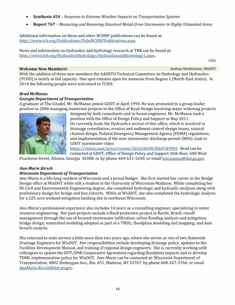
With the addition of three new members the AASHTO Technical Committee on Hydrology and Hydraulics (TCHH) is nearly at full capacity. One spot remains open for someone from Region 1 (North-East states). In 2014 the following people were welcomed to TCHH: Brad McManus Georgia Department of Transportation A graduate of The Citadel, Mr. McManus joined GDOT in April 1994. He was promoted to a group leader position in 2006 managing numerous projects in the Office of Road Design involving major widening projects
designed by both consultants and in-house engineers. Mr. McManus took a position with the Office of Design Policy and Support in May 2011. He currently leads the Hydraulics section of this office, which is involved in drainage consultation, erosion and sediment control design issues, natural channel design, Federal Emergency Management Agency (FEMA) regulations, and implementation of the new stormwater discharge permit (MS4). Link to GDOT stormwater video https://vimeo.com/ursci/review/101634690/fbb93499b9. Brad can be contacted at GDOT, Office of Design Policy and Support 26th floor, 600 West
Peachtree Street, Atlanta, Georgia 30308; or by phone 404-631-1630; or email [email protected]. Ann-Marie Kirsch Wisconsin Department of Transportation Ann-Marie is a life-long resident of Wisconsin and a proud Badger. She first started her career in the Bridge Design office at WisDOT while still a student at the University of Wisconsin-Madison. While completing her BS Civil and Environmental Engineering degree, she completed hydrologic and hydraulic analyses along with preliminary design for bridge and box culverts. While at WisDOT, she also completed the hydrologic analysis for a 225-acre wetland mitigation banking site in northeast Wisconsin. Ann-Marie’s professional experience also includes 14 years as a consulting engineer, specializing in water resource engineering. Her past projects include a flood protection project in Recife, Brazil; runoff management through the use of focused stormwater infiltration; urban flooding analysis and mitigation; bridge design; watershed modeling adopted as part of a TMDL; floodplain modeling and mapping; and dam breach analysis. She returned to state service a little more than two years ago, where she serves as one of two Statewide Drainage Engineers for WisDOT. Her responsibilities include developing drainage policy, updates to the Facilities Development Manual, and training of regional design engineers. She is currently working with colleagues to update the DOT/DNR Cooperative Agreement regarding floodplain impacts and to develop TDML implementation policy for WisDOT. Ann-Marie can be contacted at: Wisconsin Department of Transportation, 4802 Sheboygan Ave., Rm. 651, Madison, WI 53707; by phone 608-267-3766; or email [email protected].
15
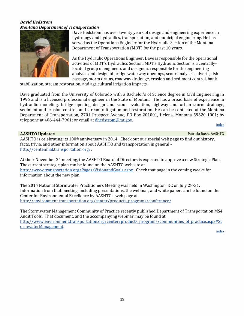
David Hedstrom Montana Department of Transportation
Dave Hedstrom has over twenty years of design and engineering experience in hydrology and hydraulics, transportation, and municipal engineering. He has served as the Operations Engineer for the Hydraulic Section of the Montana Department of Transportation (MDT) for the past 10 years. As the Hydraulic Operations Engineer, Dave is responsible for the operational activities of MDT’s Hydraulics Section. MDT’s Hydraulic Section is a centrally-located group of engineers and designers responsible for the engineering analysis and design of bridge waterway openings, scour analysis, culverts, fish passage, storm drains, roadway drainage, erosion and sediment control, bank
stabilization, stream restoration, and agricultural irrigation impacts. Dave graduated from the University of Colorado with a Bachelor’s of Science degree in Civil Engineering in 1996 and is a licensed professional engineer in the State of Montana. He has a broad base of experience in hydraulic modeling, bridge opening design and scour evaluation, highway and urban storm drainage, sediment and erosion control, and stream mitigation and restoration. He can be contacted at the Montana Department of Transportation, 2701 Prospect Avenue, PO Box 201001, Helena, Montana 59620-1001; by telephone at 406-444-7961; or email at [email protected].
index
AASHTO Updates Patricia Bush, AASHTO
AASHTO is celebrating its 100th anniversary in 2014. Check out our special web page to find out history, facts, trivia, and other information about AASHTO and transportation in general - http://centennial.transportation.org/. At their November 24 meeting, the AASHTO Board of Directors is expected to approve a new Strategic Plan. The current strategic plan can be found on the AASHTO web site at http://www.transportation.org/Pages/VisionandGoals.aspx. Check that page in the coming weeks for information about the new plan. The 2014 National Stormwater Practitioners Meeting was held in Washington, DC on July 28-31. Information from that meeting, including presentations, the webinar, and white paper, can be found on the Center for Environmental Excellence by AASHTO’s web page at http://environment.transportation.org/center/products_programs/conference/. The Stormwater Management Community of Practice recently published Department of Transportation MS4 Audit Tools. That document, and the accompanying webinar, may be found at http://www.environment.transportation.org/center/products_programs/communities_of_practice.aspx#StormwaterManagement.
index
16
Calendar of Events
Transportation Research Board (TRB) Washington, DC
January 11-15, 2014 Workshops and Presentation can be found on the TRB
Annual Meeting web site http://www.trb.org/AnnualMeeting2015/AnnualMee
ting2015.aspx
The 2015 TCHH Annual Meeting will be held in conjunction with the 2015 Subcommittee on Design
Annual Meeting in Seattle, Washington, in September 2015. Check the TCHH Meetings page for more
information in early 2015.
This newsletter is published biannually by the AASHTO Technical Committee on Hydrology and Hydraulics. Please send suggestions for articles and comments to: [email protected], or call 651-366-4466. To be added or removed from the mailing list, please email Patricia Bush at [email protected]. For more information on the Technical Committee on Hydrology and Hydraulics, see http://design.transportation.org/Pages/HydrologyandHydraulics.aspx.
index


![cOZ @S^]`b - Karuna](https://static.fdocuments.us/doc/165x107/61bebc364e1b821ab97c1fd8/coz-sb-karuna.jpg)