Karstic hydrostructures - idrogeologiaquantitativa.it · The Mount Amiata, Mount Vulsini, Mount...
9
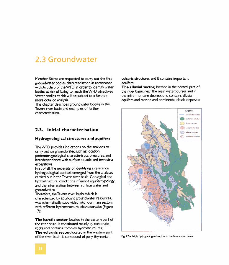
volcanic structures and it contains important aquifers; The alluvial secter, located in the centrai part of the river basin, near the main watercourses and in the intra-montane depressions, contains alluvial aquifers and marine and continental clastic deposits; Member Statesare requested to carry out the first groundwater bodies characterisationin accordance with Artide 5 of the WFD in arder to identify water bodies at risk of failingto reach the WFD objectives. Water bodies at risk will be subject to a further; more detailed analysis. This chapter describes groundwater bodies in the Tevere river basi n and examplesoffurther characterisation. 2.3. Initial characterisation Hydrogeological structures and aquifers The WFD provides indications on the analyses to carry out on groundwater; such as: location, perimeter; geological characteristics, pressures, and interdependence with surface aquatic and terrestrial ecosystems. First of all, the necessity of identifying a reference hydrogeological context emerged from the analyses carried out in the Tevere river basino Geological and hydrostructural conditions influence aquifertypology and the interrelation between surface water and groundwater: Therefore, theTevere river basin..which is characterized by abundant groundwater resources, was schematically subdivided into four main sectors with different hydrostructural characteristics (Figure 17): The karstic sector, located in the eastern part of the river basin, is constituted mainly by carbonate rocks andcontains complex hydrostructures; The volcanic sector, located in the western part of the river basin, is composed of pery-thyrrenian Fig. 17 - MQin hydroge%gica/ sectorsin the Tevere river basin
-
Upload
duongxuyen -
Category
Documents
-
view
219 -
download
0
Transcript of Karstic hydrostructures - idrogeologiaquantitativa.it · The Mount Amiata, Mount Vulsini, Mount...
volcanic structures and it contains importantaquifers;The alluvial secter, located in the centrai part ofthe river basin, near the main watercourses and inthe intra-montane depressions, contains alluvialaquifers and marine and continental clastic deposits;
Member States are requested to carry out the firstgroundwater bodies characterisation in accordancewith Artide 5 of the WFD in arder to identify waterbodies at risk of failing to reach the WFD objectives.Water bodies at risk will be subject to a further;more detailed analysis.This chapter describes groundwater bodies in theTevere river basi n and examples offurthercharacterisation.
2.3. Initial characterisation
Hydrogeological structures and aquifers
The WFD provides indications on the analyses tocarry out on groundwater; such as: location,perimeter; geological characteristics, pressures, andinterdependence with surface aquatic and terrestrial
ecosystems.First of all, the necessity of identifying a referencehydrogeological context emerged from the analysescarried out in the Tevere river basino Geological andhydrostructural conditions influence aquifertypologyand the interrelation between surface water and
groundwater:Therefore, theTevere river basin..which ischaracterized by abundant groundwater resources,was schematically subdivided into four main sectorswith different hydrostructural characteristics (Figure
17):
The karstic sector, located in the eastern part ofthe river basin, is constituted mainly by carbonaterocks and contains complex hydrostructures;The volcanic sector, located in the western partof the river basin, is composed of pery-thyrrenian Fig. 17 - MQin hydroge%gica/ sectors in the Tevere river basin
The flysch sector, located in the upper part ofthebasin, is characterized by turbidites sequencesconsisting of marls, shales, clays and sandstones withevaporites. Only in the more permeable arenaceoussediments, water circulation sustains an appreciableperennial base flow.During the initial characterisation, the aquiferscontained in the flysch sector were neglected,because they are of local interest.
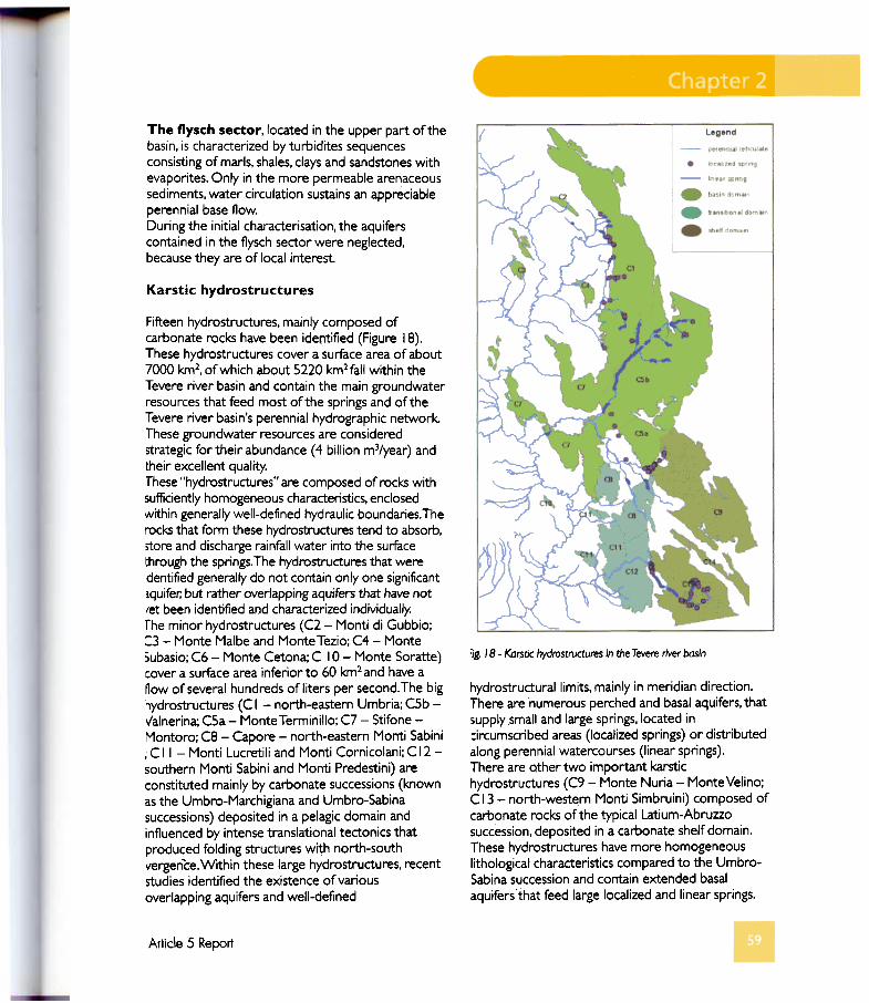
Karstic hydrostructures
:ig. /8 - Kaf$tic hydrostructures in the Tevere river bas;n
hydrostructurallimits. mainly in meridian direction.There are numerous perched and basai aquifers, that5upply small and large springs, located incircumscribed areas (Iocalized springs) or distributedalong perennial watercourses (Iinear springs).There are o.ther two important karstichydrostructures (C9 - Monte Nuria - Monte Velino;
C 13 - north-western Monti Simbruini) composed of
carbonate rocks of the typical Latium-Abruzzosuccession, deposited in a carbonate shelf domain.These hydrostructures have more homogeneouslithological characteristics compared to the Umbro-Sabina succession and contai n extended basaiaquifersthat feed large localized and linear springs.
Fifteen hydrostructures, main/y composed ofcarbonate rocks have been identified (Figure 18).These hydrostructures cover a surface area of about7000 km2, ofwhich about 5220 km2fall within theTevere river basi n and contai n the main groundwaterresources that feed most ofthe springs and oftheTevere river basin's perennial hydrographic network.These groundwater resources are consideredstrategic far their abundance (4 bi//ion m3/year) andtheir excellent quality.These "hydrostructures" are composed of rocks withsufficiently homogeneous characteristics, enclosedwithin generally well-defined hydrau/ic boundaries. Therocks that form these hydrostructures tend to absorb,stare and discharge rainfall water into the surfacethrough the springs. The hydrostructures that weredentified generally do not contai n only one significantiquifer; but rather overJapping aquifers that have notlet been identified and characterized individually:The minor hydrostructures (C2 - Monti di Gubbio;:3 - Monte Malbe and MonteTezio; C4 - Monte5ubasio; C6 - Monte Cetona; C 10- Monte Soratte)cover a surface area inferior to 60 km2 and have anow of several hundreds of liters per secondo The bighydrostructures (C I - north-eastern Umbria; C5b -I/alnerina; C5a - Monte Terminillo; C7 - Stifone -Montoro; C8 - Capore - north-eastern Monti Sabini, C Il - Monti Lucretili and Monti Cornicolani; C 12 -southern Monti Sabini and Monti Predestini) areconstituted mainly by carbonate successions (knownas the Umbro-Marchigiana and Umbro-Sabinasuccessions) deposited in a pelagic domain andinfluenced by intense translational tectonics thatproduced folding structures with north-southvergenèe. Within these large hydrostructures, recentstudies identified the existence of variousoverlapping aquifers and well-defined
Arlicle 5 Reporl
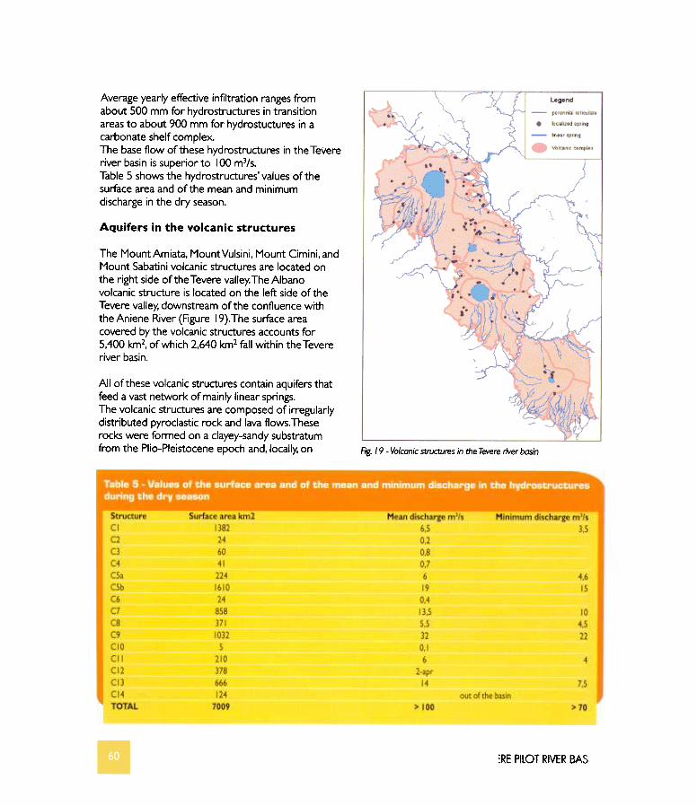
Average yearly effective infiltration ranges fromabout 500 mm far hydrostructures in transitionareas to about 900 mm far hydrostuctures in acarbonate shelf complex.The base flow of these hydrostructures in the Tevereriver basin is superior to 100 m3/s.Table 5 shows the hydrostructures' values of thesurface areaand of the mean and minimumdischarge in the dry season.
AQuifers in the volcanic structures
The Mount Amiata, Mount Vulsini, Mount Cimini, andMount Sabatini volcanic structures are located onthe right side ofthe Tevere valley.The Albanovolcanic structure is located on the left side of theTevere valley, downstream of the confluence withthe Aniene River (Figure 19). The surface areacovered by the volcanic structures accounts far5,400 km2, of which 2,640 km2 fall within the Tevereriver basino
Ali of these volcanic structures contain aquifers thatfeed a vast network of mainly linear springs.The volcanic structures are composed of irregularlydistributed pyroclastic rock and lava flows. Theserocks were formed on a clayey-sandy substratumfrom the Plio-Pleistocene epoch and, locally, on Fig. /9 - Va/canic structures in the Tevere rive, basin
:RE PllOT RIVER BASI
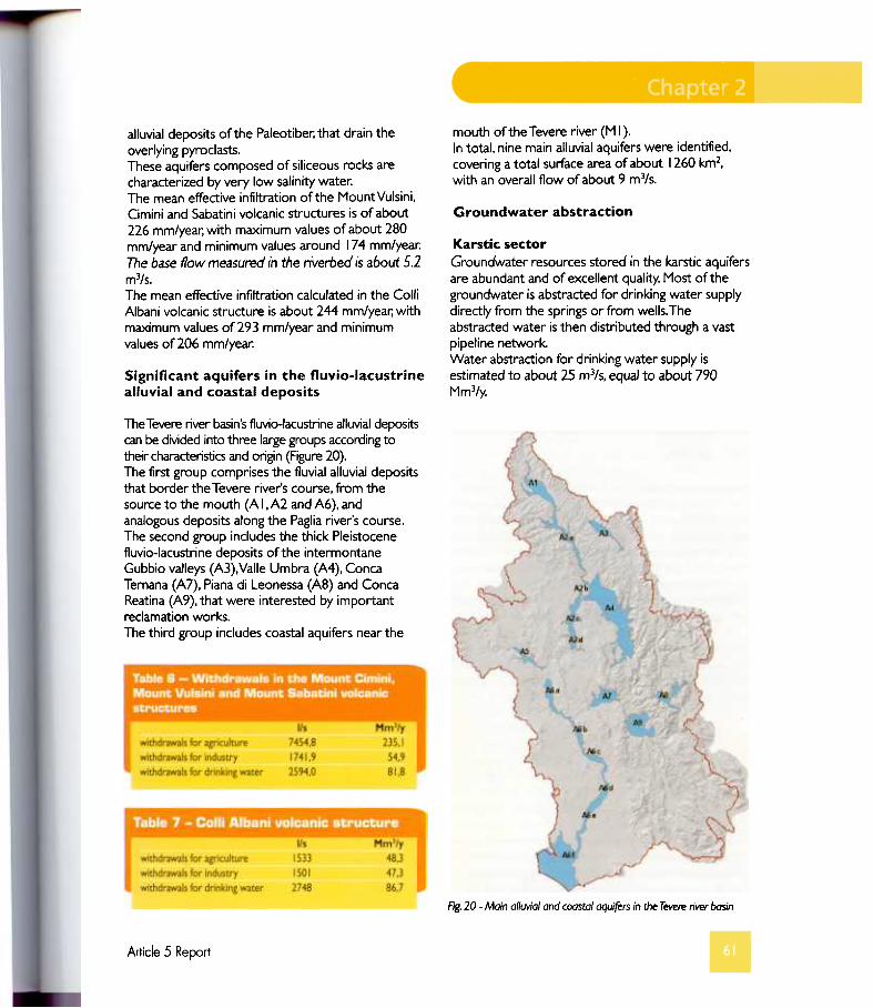
mouth of the Tevere river (M I).In total, nine main alluviaf aquifers were identified,covering a total surface area of about 1260 km2,with an overall flow of about 9 m3/s.
Groundwater abstraction
alluvial deposits of the Paleotiber; that drain theoverlying pyroclasts.These aquifers composed of siliceous rocks arecharacterized by very low salinity water:The mean effective infiltration ofthe MountVulsini,Cimini and Sabatini volcanic structures is of about226 mm/year; with maximum values of about 280mm/year and minimum values around 174 mm/year:The base flow measured in tl1e rl'veroed 15 a6out 5.2m3/s.The mean effective infiltration calculated in the ColliAlbani volcanic structure is about 244 mm/year; withmaximum values of 293 mm/year and minimumvalues of 206 mm/year:
Karstic sectorGroundwater resources stored in the karstic aquifersare abundant and of excellent quality. Most ofthegroundwater is abstracted far drinking water supplydirectly from the springs or from wells. Theabstracted water is then distributed through a vastpipeline network.Water abstraction far drinking water supply isestimated to about 25 m3/s, equal to about 790Mm3/y.
Significant aquifers in the fluvio-lacustrinealluvial and coastal deposits
The Tevere river basin's fluvio-lacustrine alluvial deposrtscan be divided into three large groups according totheir characteristics and origin (Figure 20).The first group comprises the fluvial alluvial depositsthat border the Tevere river's course, from thesource to the mouth (A I,A2 and A6), andanalogous deposits along the Paglia river's course.The second group includes the thick Pleistocenefluvio-lacustrine deposits of the intermontaneGubbio valleys (A3), Valle Umbra (A4), ConcaTemana (Al), Piana di Leonessa (A8) and ConcaReatina (A9), that were interested by importantreclamation works.The third group includes coastal aquifers near the
Fig. 20 - Main alluvial and coastal aquifers in the Tevere river basin
Article 5 Report
remi ValleyFig.
Volcanic sectorThe estimated total withdrawals in the whole area ofthe Vulsini, Cimini and Sabatini volcanic structures,comprising the areas within the Tevere river basinand the regional river basins, amounts to about 370Mm3/y.Total withdrawals in the Colli Albani volcanicstructure amounts to about 180 Mm3/y.The following T ables 6 and 7 show the distribution ofthe abstracted water far different uses.
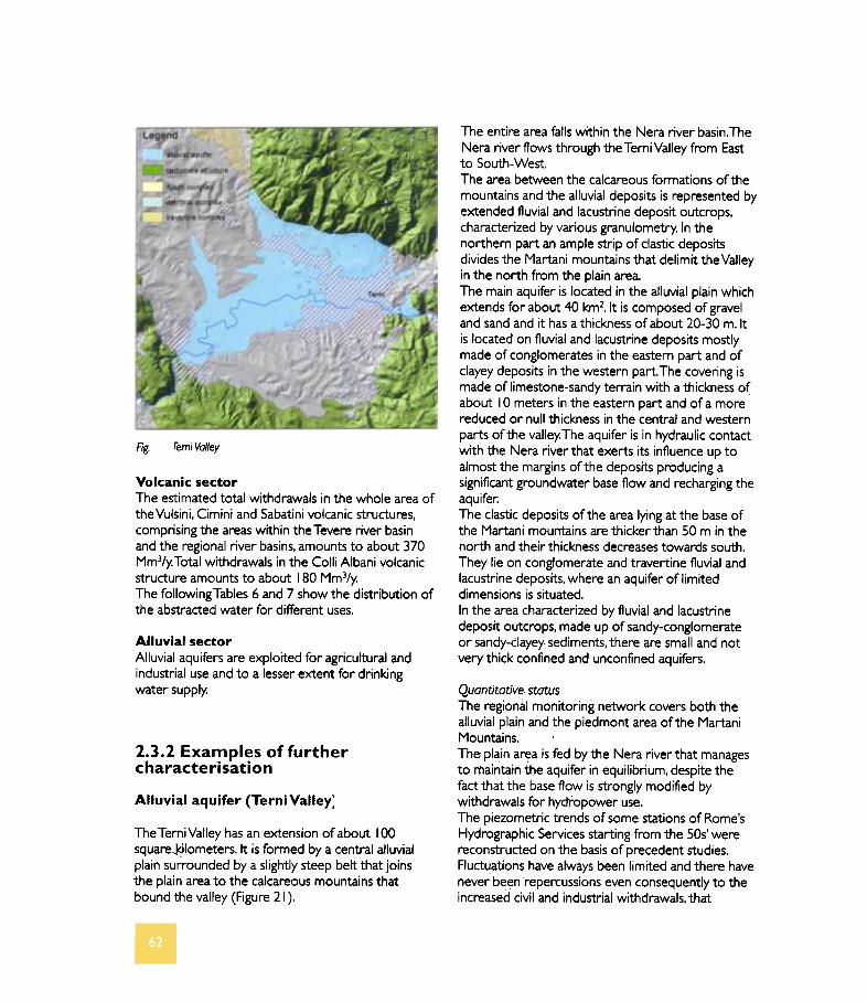
The entire area falls within the Nera river basino TheNera river flows through the Terni Valley from Eastto South-West.The area between the calcareous formations of themountains and the alluvial deposits is represented byextended fluvial and lacustrine deposit outcrops,characterized by various granulometry. In thenorthem part an ampie strip of clastic depositsdivides the Martani mountains that delimit the Valleyin the north from the plain area.The main aquifer is located in the alluvial plain whichextends far about 40 km2. It is composed of grave!and sand and it has a thickness of about 20-30 m.ltis located on fluvial and lacustrine deposits mostlymade of conglomerates in the eastern part and ofclayey deposits in the western parto The covering ismade of limestone-sandy terrain with a thickness ofabout IO meters in the eastern part and of a morereduced or null thickness in the centrai and westemparts of the valley. The aquifer is in hydraulic contactwith the Nera river that exerts its influence up toalmost the margins of the deposits producing asignificant groundwater base flow and recharging the
aquifer:The clastic deposits of the area Iying at the base ofthe Martani mountains are thicker than 50 m in thenorth and their thickness decreases towards south.They lie on conglomerate and travertine fluvial andlacustrine deposits, where an aquifer of limiteddimensions is situated.In the area characterized by fluvial and lacustrinedeposit outcrops, made up of sandy-conglomerateor sandy-clayey sediments, there are small and notvery thick confined and unconfined aquifers.
A/luvial sectorAlluvial aquifers are exploited far agricultural andindustriai use and to a lesser extent far drinkingwater supply.
2.3.2 Examples of furthercharacterisation
Alluvial aquifer (Terni Valley)
Quantitative statusThe regional monitoring network covers both thealluvial plain and the piedmont area of the MartaniMountains.The plain area is fed by the Nera river that managesto maintain the aquifer in equilibrium, despite thefact that the base flow is strongly modified bywithdrawals far hydropower use.The piezometric trends of some stations of Rome'sHydrographic Services starting from the 50s' werereconstructed on the basis of precedent studies.Fluctuations have always been limited and there havenever been repercussions even consequently to theincreased civil and industriai withdrawals, that
The TerniValley has an extension of about 100squareJ<)lometers. It is formed by a centrai alluvialplain surrounded by a slightly steep belt that joinsthe plain area to the calcareous mountains thatbound the valley (Figure 21).
amounted in certain periods to over 1800 l/s.Historical piezometric measurements andquantitative monitoring data carri ed out on aperiodical basis confirmed these indications.The sector ofthe aquifer located in the centrai partof the plain can be included in Class A (inaccordance with the Italian nationallegislation).Regarding the built-up area ofTerni, the quantitativeand chemical status cannot be defined at thepresent moment because monitoring stations arelacking and the hydrogeological situation iscomplex.The area at the feet ofthe Martani Mountains issubject to intense exploitation for drinking watersupply. Withdrawals for drinking water supplyaccount for more than 50% of mean annualrecharge. Monitoring dat~ from 1998 to 2002shows an elevated variability in the water levels inthis sector ofthe aquifer; which is classified in ClassC.
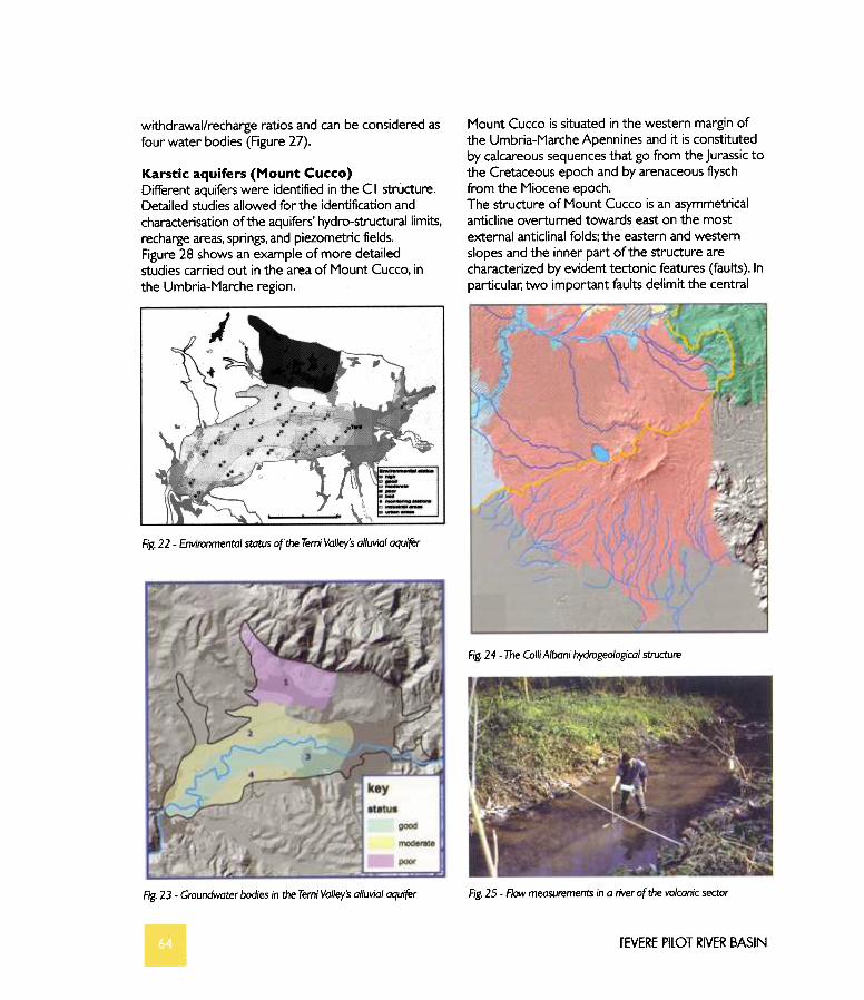
Environmental statu~Temi Valley's alluvial aquifer is characterized by asubstantial hydrogeological equilibrium and theanthropogenic impact on the water resource qualityis considerably mitigated by the Nera river'srecharge.The centrai part ofthe aquifer; in directhydraulic contact with the river; shows goodecological status. The more distant areas from theriver are characterized by sufficient environmentalstatus.The situation ofthe aquifer Iying at the base ofthe Martani mountains is different. Its chemical andquantitative status are compromised. therefore itsenvironmental status is poor (Figure 22).On the basis of environmental status fourgroundwater bodies have been identified (Figure 23).
Chemica/ statusTemiValley's alluvial aquifer beneflts from twohydrogeological conditions that allow the aquifer tomaintain the water's good qualitative condition:recharge from the Nera river and elevated
permeability.In the centrai area, at direct hydraulic contact withthe river; the water quality results good. Gettingfarther away from the river the aquifercharacteristics get worse due to an increase in thenitrates concentration, that however maintainsaverage values under the threshold of 50 mgil.Bad water quality characteristics are evident in thedetrital aquifer at the mar:gins of the Martanimountains. This aquifer is characterized by mediumto low permeability and it does not benefit from thekarstic aquifer's recharge. The consequence is anaccumulation of poi I utant input inthe aquifer:The main problems are linked to the presence ofpollutants from industriai activities. In particular;monitoring of organic volatile halogen compoundsevidenced diffuse pollution from tetrach/oroethy/ene.This compound was identified in almost ali themonitoring points of the network, although inconcentt:ations that were rarely superior to thelimits imposed by law.Among these compounds rarepositive cases of trich/oroethy/ene and trich/oroethanowere identified.
Volcanic aquifer (Colli Albani)The Colli Albani hydrogeological structure is locatedin the lower part of the Tevere river basin, near thecity of Rome (Figure 24).In the last 50 years this area has been subject to
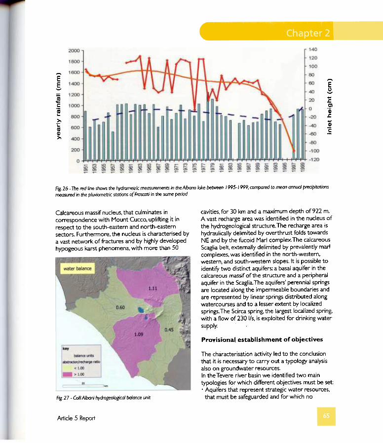
growing pressures due to the expansion of urbansettlements, industriai activity and agriculture (water-demanding crops).The waterdemand was mainlysatisfied by groundwater abstraction from wells.Consequently, in the last years, al so due to adecrease of rainfall, the base flow in surfacewatercourses dropped by 50% (Figure 25). Inparticular; the water level of Albano lake, which is indirect contact with the aquifer; dropped of about 2m (Figure 26).Considering that surface base flow is fundamental insustaining aquatic ecosystems and that the flow ofwater bodies receiving wastewater dischargedetermines the quality status of water bodies, it isvery important to maintain the base flow at acompatible level with the life of aquatic ecosystemsand theachievement of good quality status.Hydrogeological balance calculations were carri ed
out analyzing the spatial and temporal variabilityofprecipitations.and climatic conditions on a monthlybasis, analyzing the effects of morphological,lithological, pedological conditions, vegetation andland use on ruhoff and evapotranspiration withelevated spatial detail, estimating the withdrawals.This methodology allowed us to determine the ratiobetwe~n withdrawals and effective infiltration.On the basis ofthese calculations four balance unitshave been identified. The balance units have different
Article 5 Report
withdrawal/recharge ratios and can be considered asfour water bodies (Figure 27).
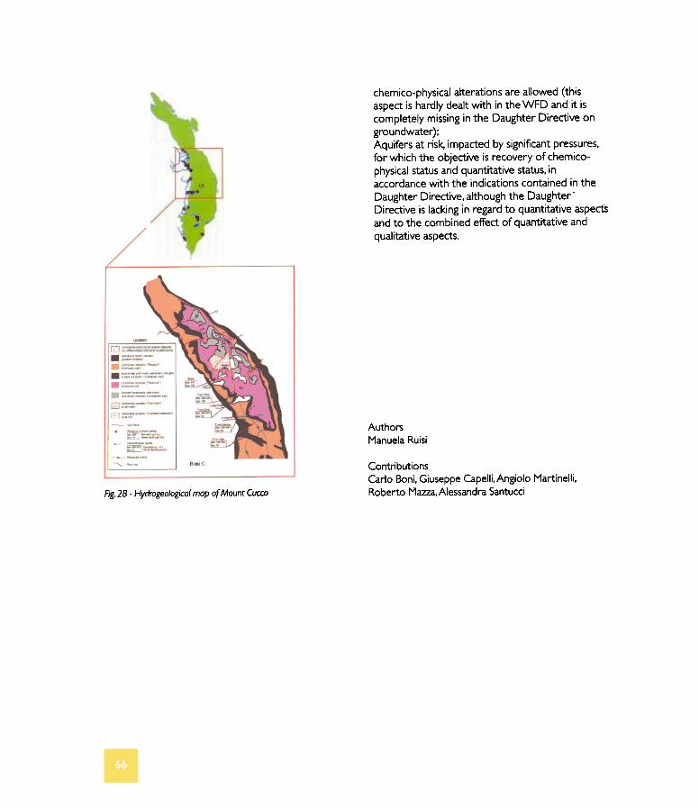
Karstic aquifers (Mount Cucco)Different aquifers were identified in the C I structure.Detailed studies allowed far the identification andcharacterisation ofthe aquifers' hydro-structurallimits,recharge areas, springs, and piezometric fields.Figure 28 shows an example of more detailedstudies carried out in the area of Mount Cucco, inthe Umbria-Marche region.
Mount Cucco is situated in the western margin ofthe Umbria-Marche Apennines and it is constitutedby calcareous sequences that go from the Jurassic tothe Cretaceous epoch and by arenaceous f1yschfrom the Miocene epoch.The structure of Mount Cucco is an asymmetricalanticline overtumed towards east on the mostexternal anticlinal folds; the eastern and westemslopes and the inner part of the structure arecharacterized by evident tectonic features (faults).lnparticular; two important faults delimit the centrai
~--
\:i
-1J 1==
~ ----
Fig. 22 - Environmental status ofthe Temi Valley's al/uvial aquifer
Fig. 24 - The Colli A/ban; hydrogeologica/ structure
Fig. 23 - Groundwater bodies in d1e Temi Va/ley's a/luvial aquifer Fig. 25 -Flow measurements in a river of the volcanic sector
rEVERE PllOT RIVER BASIN
EE---
!c'm...>."t:(Oal>.
"
E
~
ECI.~.c
'ai
f
Ag. 26 - The red line shows the hydrometric measurements in theAlbano lake between 1995-/999,compared to mean annual predpitotions
measured in the pluviometric stotions O( Froscati in the some period
cavities,for 30 km and a maximum depth of922 m.A vast recharge area was identified in the nucleus ofthe hydrogeological structure. The recharge area ishydraulically delimited by overthrust folds towardsNE and bythe fucoid Mari complex.The calcareousScaglia belt, externally delimited by prevalently maricomplexes, was identified in the north-westem,western, and south-western slopes. It is possible toidentify two distinct aquifers: a basai aquifer in thecalcareous massif ofthe structure and a peripheralaquifer in the Scaglia. The aquifers' perennial springsare located alongthe impermeable boundaries andare represented by linear springs distributed alongwatercourse~ and to a lesser extent by localizedsprings. The Scirca spring, the largest localized spring,with a tlow of 230 l/s, is exploited far drinking water
supply.
Calcareous massif nucleus, that culminates incorrespondence with Mount Cucco, uplifting it inrespect to the south-eastern and north-eastemsectors. Furthermore, the nucleus is characterised bya vast network of fractures and by highly developedhypogeous karst phenomena, with more than 50
Prov-isional, establishment of objectives
The characterisationactivity led to the conclusionthat it is necessary to carry out a typology analysisalso on gròundwater resources.In theTevere river basin we identified two maintypologiesfor which different objectives must be set:. Aquifers that represent strategic water resources,
that must be safeguarded and for which noFig. 27 - ColliA/bani hydrogeo/ogica/ balance unir
Article 5 Report
chemico-physical alterations are allowed (thisaspect is hardly dealt with in the WFD and it iscompletely missing in the Daughter Directive on
groundwater);Aquifers at risk. impacted by signiticant pressures,far which the objective is recovery of chemico-physical status and quantitative status, inaccordance with the indications contained in theDaughter Directive, although the Daughter-Directive is lacking in regard to quantitative aspectsand to the combined effect of quantitative and
qualitative aspects.
[;:J
. :.., ,Il. ==:""--'
.=.:..~~-
. =::--'
.:'-:"==--=:;;,-'-'~:.'" .,
. ~--~ =:-.::;'"~'S=..~~~,-"""- --
AuthorsManuela Ruisi
ContributionsCarlo Boni;Giuseppe Capelli.Angiolo Martinelli.Roberto Mazza. Alessandra SantucciFig. 28 - Hydrogeologica/ map or Mount Cucco