
Japan Aerospace Exploration Agency 1 Japan’s Contribution to GEO-Netcast and Sentinel-Asia GEO...
22
Japan Aerospace Exploration Agency 1 Japan’s Contribution to GEO-Netcast and Sentinel-Asia GEO Architecture and Data Committee 20-21 July 2006 Boing Kent Facility, Seattle, US Kazuo Umezawa Office of Space Application Japan Aerospace Exploration Agency (JAXA)
-
Upload
avice-glenn -
Category
Documents
-
view
223 -
download
0
Transcript of Japan Aerospace Exploration Agency 1 Japan’s Contribution to GEO-Netcast and Sentinel-Asia GEO...
Japan Aerospace Exploration Agency
1
Japan’s Contribution to GEO-Netcast
and Sentinel-Asia
GEO Architecture and Data Committee
20-21 July 2006Boing Kent Facility, Seattle, US
Kazuo UmezawaOffice of Space Application
Japan Aerospace Exploration Agency (JAXA)

Japan Aerospace Exploration Agency
2
How to Contribute to GEO-Netcast
MEXT/JAXA will:
• Provide Data of JAXA’s Satellite Sensors– Discussed in GEO-Netcast Participants Meeting
• Disseminate Data through Sentinel-Asia

Japan Aerospace Exploration Agency
3
Disseminate Data through Sentinel-Asia
• GEO-Netcast data are useful in Sentinel-Asia
• Sentinal-Asia can disseminate the data to Asia-Pacific region

Japan Aerospace Exploration Agency
4
• Best-efforts and Voluntary initiative by participating organizations in Asia
• An application of Digital Asia for disaster management objectives
• Digital Asia is a Web-based Geographic Information System (WebGIS) managed by Keio University
• JAXA’s WINDS (Wideband InterNetworking engineering test and Demonstration Satellite) is planned to be linked when it is launched in JFY2007
Overview of Sentinel-Asia

Japan Aerospace Exploration Agency
5
Sentinel-AsiaSentinel-Asia
APRSAF*
Space Community
Satellite Image
Content
Promotion of Utilization
Capacity Building
Web-GISData / Meta Data Management
Information Sharing Platform
Content
Digital Asia
Digital Earth / Web-GISCommunity
Digital MapSocial / Economic DataSatellite Image
Disaster Reduction Community
Disaster Information
Content
Utilization (User)
ADRC**Member Countries
Framework of Sentinel-Asia Project
UN / ESCAP UN / OOSAASEAN AIT
International Community
International Cooperation
** Asian Disaster Reduction Center
Joint Project Team (JPT)Join Project Team, consists of total 27 organizations including 23 agencies from 14 countries and 4 international organizations as of Feb. 2006.
Best-efforts, voluntary initiative by participating organizations
* Asian Disaster Reduction Center
* Asian-Pacific Regional Space Agency Forum

Japan Aerospace Exploration Agency
6
* Implement Various Projects in cooperation with UN/ISDR, UN/OCHA, UNESCO, UNU, WMO, UN/ESCAP, etc.
25 Member Countries, 5 Advisor Countries, 1 Observer
Pakistan
ADRC Member Countries
Japan Aerospace Exploration Agency
7
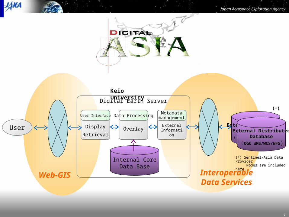
InteroperableData Services
Keio University
Digital Earth Server
Overlay
Data Processing
Display
RetrievalExternal
Information
MetadatamanagementUser Interface
Interoperability in Digital Asia
Web-GIS
User
Internal CoreData Base
External DistributedDatabase
( OGC WMS/WCS/WFS*)External Distributed
Database( OGC WMS/WCS/WFS)
(*)
(*) Sentinel-Asia Data Provider Nodes are included here.

Japan Aerospace Exploration Agency
8
Sentinel-Asia System (Disaster-related Part of Digital Asia)
ICIMOD
UNEP
Digital Earth Server
ADRC
JAXA
Keio Univ.
AIT
CRISP
GISTDA
MACRES
LAPAN
MARD
Tokyo Univ.
CSIRO/GA
InternetOverlay
Data Processing
VisualizationRetrieval
Sentinel Asia Information
about external Data Sources
MetaDataManagement
Internet
Sentinel-AsiaWeb Site
Internet
Public User
Disaster-relatedAgencies・
・・
・・・・・・by e-mail, Web site etc.
to JAXAReception
Disaster Information(Character information and digital camera image)
Sentinel AsiaData Provider Nodes(Reception, processing and providing satellite image)
Utilization
ALOS Observation Request
Keio Univ.
Data Sources
ADRC
User Interface
CSIRO/GA
Wildfire Data (Satellite Image etc.)
Observation RequestCheck
ADRC member countries /
organizations
Map DataInternally
Stored Data
Data Providing by FTP
Data providing by Minnesota MapServer
OverlaidImage
Not-overlaid Image
Automatic Data Acquisition / Registration
PDA withGPS (Field Research Data)
Data Providing by Portable Terminal with GPS
Data Registration
Tool
SentinelAsia
User Node
Wildfire Data (Satellite Image etc.)
Social / EconomicData
Satellite Image

Japan Aerospace Exploration Agency
9
Overlay
From Organization E
From Organization F
From Organization C
From Organization D
From Digital Earth Server in Keio
From Organization A (population)
GPS Equipped mobile device registeredData through Digital Earth Server
From Organization B (HotSpot FTP Server)Social / Economic DataGround Truth,
HotSpot etc.
Satellite Image
Map From Digital Earth Server in Keio
Retrieving by Space and Time
Overlay Processing of Digital Asia

Japan Aerospace Exploration Agency
10
• Emergency observation in case of major disasters by ALOS + ···
• ALOS accepts observation requests from ADRC member countries
• Wildfire monitoring (by MODIS)
• Flood monitoring
• Capacity building for utilization of satellite image for disaster management
Operations will start in October 2006
Main Activities

Japan Aerospace Exploration Agency
11
Digital Asia Node Network
1. GISTDA, Thailand2. LAPAN, Indonesia3. Survey Department, Sri Lanka4. Geography Department/VAST, Vietnam5. ICIMOD6. UNEP-AP7. Beijing Normal University8. NAMRIA, Philippine 9. National University Mongolia10.Fuzho University11.…..
Keio Univ.(MEXT) provide WebGIS-base Platform30 terminals in 5 years

Japan Aerospace Exploration Agency
12
• Disaster information in Asia-Pacific region from ADRC web site• Digital map data
– A millionth digital map stored in Digital Earth server in Keio Univ. provided by NGA (National Geospatial-Intelligence Agency), which covers the whole Asia area (as a default)
– Fine regional digital map
• Satellite image (processed image data without full resolution)– LANDSAT image before disaster archived in Digital Earth server in Keio
Univ. provided by Maryland Univ., which covers the whole Asia area– Satellite image of disaster area before and after disaster
• MODIS data for wildfire monitoring• On-the-spot digital camera image• Regional social / economic data
Contents (Shared Data)

Japan Aerospace Exploration Agency
13
Data ProvidersContent Data Provider from when Comments
Disaster InformationADRC Operational
Digital Map DataA millionth Map Keio Univ. Oct. 2006
•Cover the whole Asia area•Provided by NGA
...
Satellite ImageLANDSAT archived
ImageKeio Univ. Oct. 2006
•Cover the whole Asia area•Provided by Maryland Univ.
ALOS Image after major disasters
JAXA Oct. 2006
MODIS Image covering Australia
GA/CSIROOperational from
1.Jan, 2006For wildfire monitoring
...
On-the-spot Digital Camera Image
ADRC Oct. 2006
...Regional Social / Economic Data

Japan Aerospace Exploration Agency
14
2005 2006 2007 2008
Sentinel-Asia Project Milestone
Sentinel-Asia ProjectDisaster Management
Support System (STEP2)
APRSAF-13APRSAF-12 APRSAF-14
JPT#1 JPT#2 JPT#3 JPT#4
Digital Asia System
(by Keio Univ.)
update / maintenance
ALOS Rapid Response System
(by JAXA, Keio Univ., ADRC)
update / maintenance
ALOS Data
MODIS Data (for Wildfire Monitoring)
In Tokyo In Asia
APRSAF / JPT
Information
Sharing Platform
Operation
JAXA Project Office
Japan Aerospace Exploration Agency
15
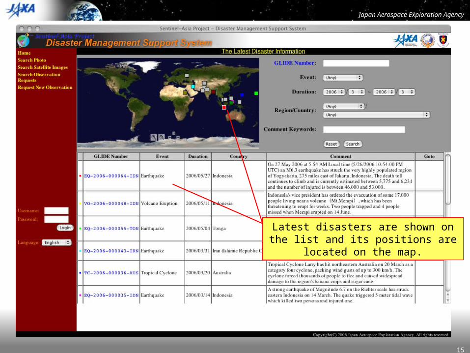
Where did the disaster occur?
Latest disasters are shown on the list and its positions are located on the map.

Japan Aerospace Exploration Agency
16
You can find the specific disaster which you want.
Watch the volcano disasters occurred in Indonesia.

Japan Aerospace Exploration Agency
17
The disaster full details of the volcano eruption in Indonesia.
The comments of this disaster.
Photographs of a digital camera and its shot locations.
Observed satellite images and its locations.
Requested observations of satellite images and its locations.

Japan Aerospace Exploration Agency
18
You can get location of the object on the map.
You can see the location of object (such as photograph, observed satellite image and requested observation position) on
the map which you want.
Japan Aerospace Exploration Agency
19
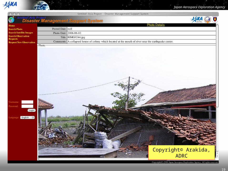
Photograph details
Copyright© Arakida, ADRC
Japan Aerospace Exploration Agency
20
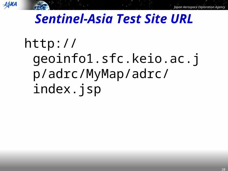
Sentinel-Asia Test Site URL
http://geoinfo1.sfc.keio.ac.jp/adrc/MyMap/adrc/index.jsp

Japan Aerospace Exploration Agency
21
Issues
• Who manage a Data Node (Digital Asia Server) for GEO-Netcast Data?– Contacting JMA– Can NOAA or EUMETSAT manage it ?
• How to disseminate the GEO-Netcast Data in the Sentinel-Asia?– File-based data distribution like FTP or Web-GIS i
ntegrated format?

Japan Aerospace Exploration Agency
Thank you for your attention
Thank you for your attention
Japan Aerospace Exploration Agency Office of Space Applications
Sentinel-Asia Project OfficeE-mail : [email protected]