INTRODUCTION - Alabama Department of Environmental … · 1 INTRODUCTION This book has been written...
40
INTRODUCTION This book has been written to help Alabama's citizens learn about one of our most important natural resources – ground water. Water beneath the earth’s surface, or ground water, quenches our thirst, supports our crops and livestock, waters our lawns, and supplies industry throughout Alabama. If used wisely, ground water resources will never run out. However, lack of planning and careless actions can cause shortages or contamination of ground water. The better we understand this valuable resource, the better we will be able to protect and manage it for our benefit and the benefit of future generations. Words printed in bold type in the text are defined in the glossary. Ground water facts, indicated by the water drop symbol, appear at various points in the text. Alabama has enough ground water to cover the entire state to a depth of about 50 feet.
Transcript of INTRODUCTION - Alabama Department of Environmental … · 1 INTRODUCTION This book has been written...

1
INTRODUCTIONThis book has been written to help
Alabama's citizens learn about oneof our most important naturalresources – ground water. Waterbeneath the earth’s surface, orground water, quenches our thirst,supports our crops and livestock,waters our lawns, and suppliesindustry throughout Alabama. If usedwisely, ground water resources willnever run out. However, lack ofplanning and careless actions cancause shortages or contamination of
ground water. The better weunderstand this valuable resource,the better we will be able to protectand manage it for our benefit and thebenefit of future generations.
Words printed in bold type in thetext are defined in the glossary.
Ground water facts, indicated bythe water drop symbol, appearat various points in the text.
Alabama has enough ground water to cover the entirestate to a depth of about 50 feet.
2
WHAT IS GROUND WATER?
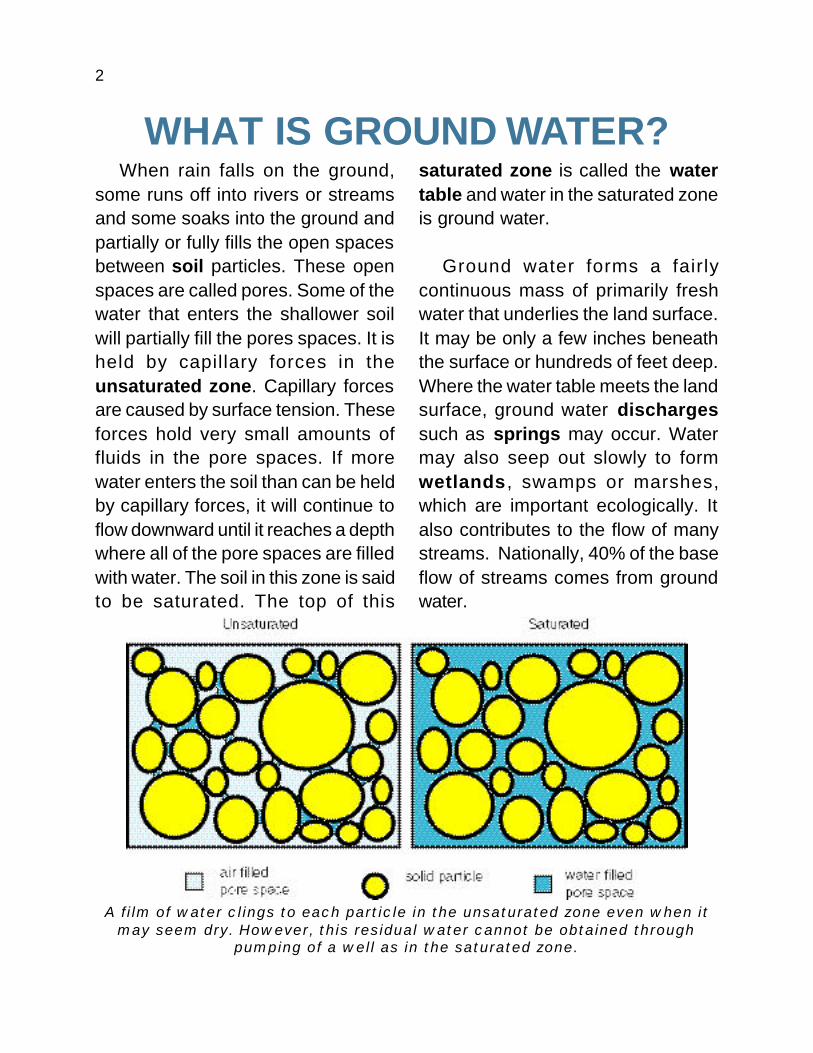
A film of water clings to each particle in the unsaturated zone even when itmay seem dry. However, this residual water cannot be obtained through
pumping of a well as in the saturated zone.
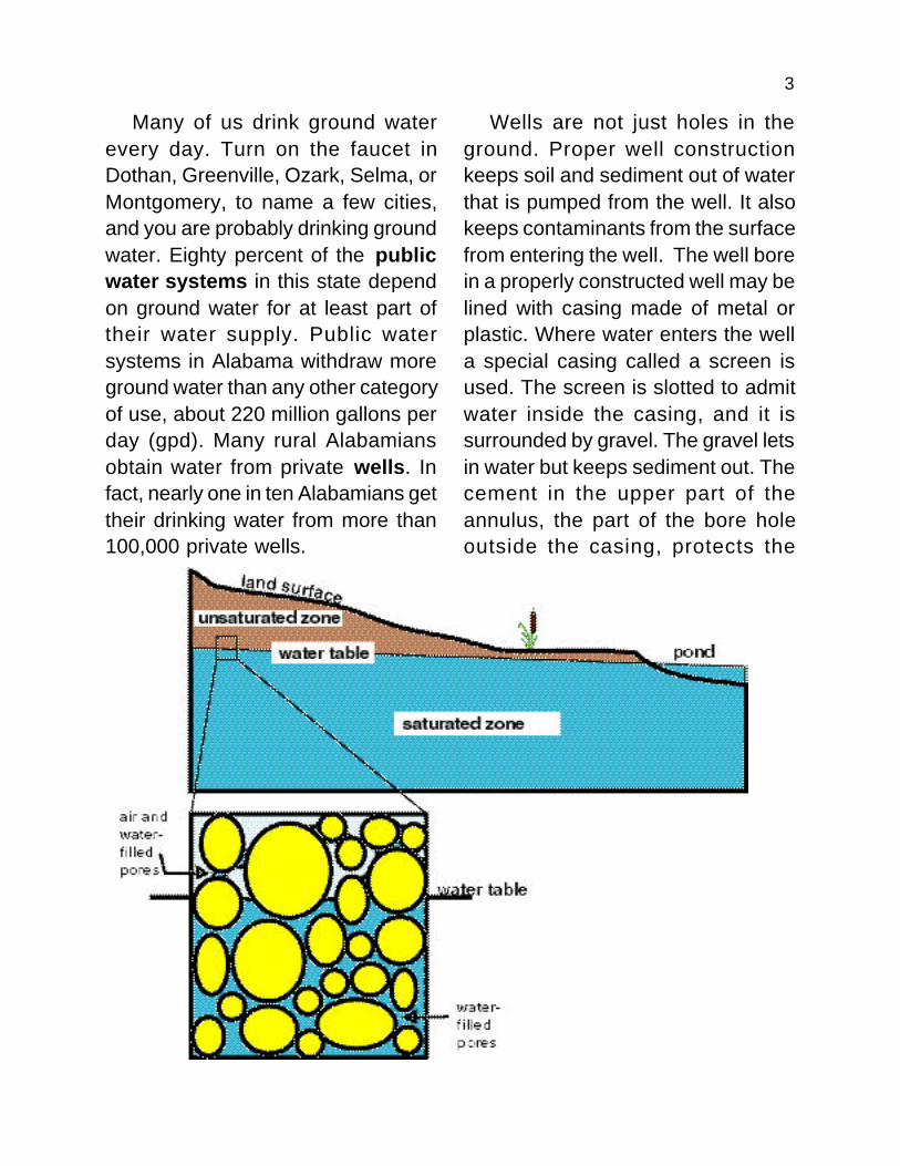
When rain falls on the ground,some runs off into rivers or streamsand some soaks into the ground andpartially or fully fills the open spacesbetween soil particles. These openspaces are called pores. Some of thewater that enters the shallower soilwill partially fill the pores spaces. It isheld by capillary forces in theunsaturated zone. Capillary forcesare caused by surface tension. Theseforces hold very small amounts offluids in the pore spaces. If morewater enters the soil than can be heldby capillary forces, it will continue toflow downward until it reaches a depthwhere all of the pore spaces are filledwith water. The soil in this zone is saidto be saturated. The top of this
saturated zone is called the watertable and water in the saturated zoneis ground water.
Ground water forms a fairlycontinuous mass of primarily freshwater that underlies the land surface.It may be only a few inches beneaththe surface or hundreds of feet deep.Where the water table meets the landsurface, ground water dischargessuch as springs may occur. Watermay also seep out slowly to formwetlands , swamps or marshes,which are important ecologically. Italso contributes to the flow of manystreams. Nationally, 40% of the baseflow of streams comes from groundwater.
3
Many of us drink ground waterevery day. Turn on the faucet inDothan, Greenville, Ozark, Selma, orMontgomery, to name a few cities,and you are probably drinking groundwater. Eighty percent of the publicwater systems in this state dependon ground water for at least part oftheir water supply. Public watersystems in Alabama withdraw moreground water than any other categoryof use, about 220 million gallons perday (gpd). Many rural Alabamiansobtain water from private wells. Infact, nearly one in ten Alabamians gettheir drinking water from more than100,000 private wells.
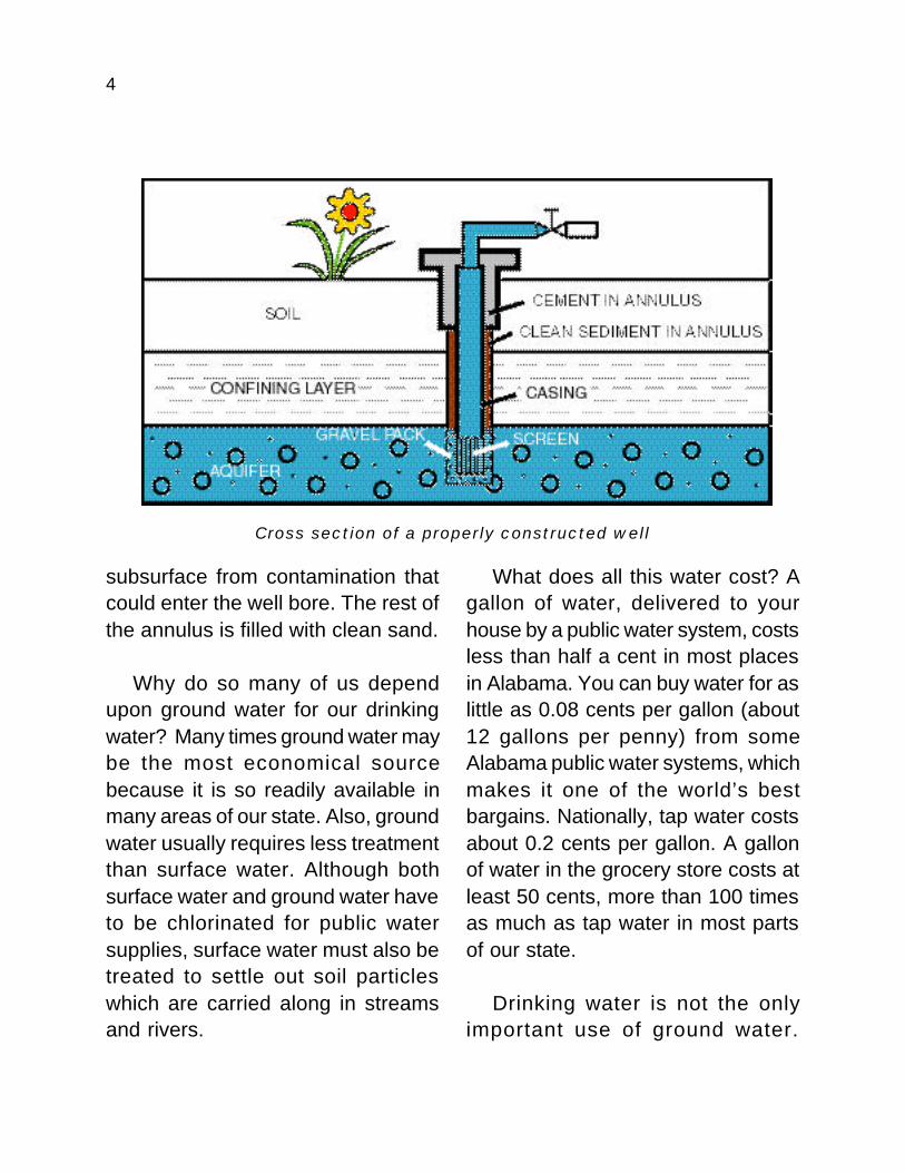
Wells are not just holes in theground. Proper well constructionkeeps soil and sediment out of waterthat is pumped from the well. It alsokeeps contaminants from the surfacefrom entering the well. The well borein a properly constructed well may belined with casing made of metal orplastic. Where water enters the wella special casing called a screen isused. The screen is slotted to admitwater inside the casing, and it issurrounded by gravel. The gravel letsin water but keeps sediment out. Thecement in the upper part of theannulus, the part of the bore holeoutside the casing, protects the
4
subsurface from contamination thatcould enter the well bore. The rest ofthe annulus is filled with clean sand.
Why do so many of us dependupon ground water for our drinkingwater? Many times ground water maybe the most economical sourcebecause it is so readily available inmany areas of our state. Also, groundwater usually requires less treatmentthan surface water. Although bothsurface water and ground water haveto be chlorinated for public watersupplies, surface water must also betreated to settle out soil particleswhich are carried along in streamsand rivers.
Cross section of a properly constructed well
What does all this water cost? Agallon of water, delivered to yourhouse by a public water system, costsless than half a cent in most placesin Alabama. You can buy water for aslittle as 0.08 cents per gallon (about12 gallons per penny) from someAlabama public water systems, whichmakes it one of the world’s bestbargains. Nationally, tap water costsabout 0.2 cents per gallon. A gallonof water in the grocery store costs atleast 50 cents, more than 100 timesas much as tap water in most partsof our state.
Drinking water is not the onlyimportant use of ground water.
5
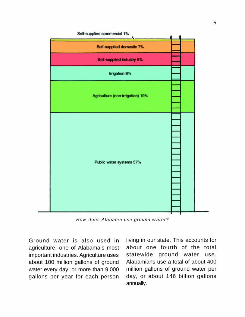
How does Alabama use ground water?
Ground water is also used inagriculture, one of Alabama’s mostimportant industries. Agriculture usesabout 100 million gallons of groundwater every day, or more than 9,000gallons per year for each person
living in our state. This accounts forabout one fourth of the totalstatewide ground water use.Alabamians use a total of about 400million gallons of ground water perday, or about 146 billion gallonsannually.
6
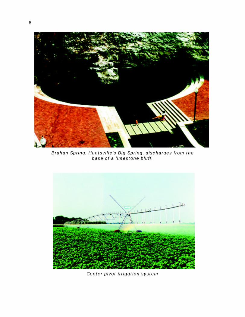
Brahan Spring, Huntsville's Big Spring, discharges from thebase of a limestone bluff.
Center pivot irrigation system

7
Alabama’s ground water reservesare estimated at about 533 trilliongallons, or enough to last 3,300 yearsat the present rate of consumption.Ground water is a renewableresource that is constantlyreplenished by rainfall. Alabama is arelatively wet states. More than 55inches of rain fall each year.Considering these facts, it seems thatconserving our ground water supplywould not be a concern, but thenumbers do not tell the whole story.
Ground water, while plentiful, is notevenly distributed throughout thestate. In some places the water isshallow and abundant; in other placesit is deeper and harder to find. Whenfound, ground water can be difficultto extract in the quantities needed andmay differ in quality from place toplace. So even though a statewideshortage is unlikely, local shortagesmay occur in some areas where thedemand is great, causing seriousproblems.
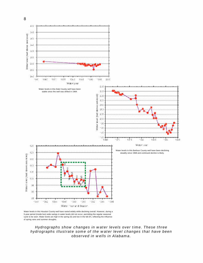
Hydrographs are graphs that showwater levels over time. Somehydrographs record water levels in
rivers or reservoirs, and otherhydrographs record water levels inwells. In a stable situation, that is, onewith no long term trends, water levelsdo not change. An example of a stablesituation is shown in the hydrographof the Dale County well shown on thenext page. If more water is pumpedthan can be naturally replenished,then water levels decline over time,as shown in the Barbour Countyhydrograph. The hydrograph from aHouston County well shows that waterlevels in wells may change with theseasons. All of these are realexamples. There are even somewells in which water levels are rising!
Ground water availability variesfrom region to region and is controlledprimarily by the kinds of rocks,sediments, and soils that contain thewater. To understand the differencesin water availability between differentareas, we must first understand howground water moves from one areato another, as well as the rock,sediment, and soil properties thatcontrol water movement, storage,and availability.
8
Hydrographs show changes in water levels over time. These threehydrographs illustrate some of the water level changes that have been
observed in wells in Alabama.
Water levels in this Barbour County well have been decliningsteadily since 1968 and continued decline is likely.
Water levels in this Dale County well have beenstable since the well was drilled in 1964.
Water levels in this Houston County well have varied widely while declining overall. However, during a5-year period (inside box) wide swings in water levels did not occur, permitting the regular seasonalcycle to be seen. Water levels are high in the spring (S) and low in the fall (F), reflecting the influenceof spring rains and summer droughts.
9
WHAT IS GROUND WATERMADE OF?
Water is composed of hydrogenand oxygen – two atoms of hydrogenfor every atom of oxygen. Butnaturally occurring water is neverpure H
2O. Water contains dissolved
or suspended materials, both naturaland anthropogenic (caused byhuman activity), that may be harmful,helpful, or not have any effect. Somenatural water constituents, likefluoride, are helpful in small amountsbut harmful where they are tooconcentrated. Iron causes noproblems at low concentrations butat high concentrations may result inan unpleasant taste and staining ofclothes and household fixtures.
Ground water commonly containsmore mineral matter than surfacewater. This is because ground watermoves slowly through the subsurfaceand has more time to react withminerals with which it comes incontact. The natural minerals in someground water taste good, which is one
reason bottled spring water is sopopular.
Ground water is also likely to varyless in quality over time than surfacewater. Ground water moves slowlyand it changes slowly. Natural factorsaffecting ground water quality includethe amount of time the water hasbeen underground, the compositionof the rocks through which the waterhas moved, and local conditionsunderground.
Few natural water qualityproblems affect ground water inAlabama. Problems of localsignificance in some areas includeexcessive hardness, highconcentrations of iron, chlorides anddissolved solids, and low pH (highacidity). All of these factors can makewater unsuitable for some uses. Asmentioned, too much iron in waterstains fabric and fixtures, whereashigh chloride concentrations and lowpH can corrode fixtures.
10
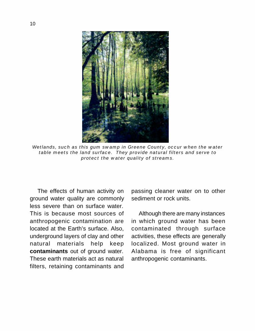
Wetlands, such as this gum swamp in Greene County, occur when the watertable meets the land surface. They provide natural filters and serve to
protect the water quality of streams.
The effects of human activity onground water quality are commonlyless severe than on surface water.This is because most sources ofanthropogenic contamination arelocated at the Earth’s surface. Also,underground layers of clay and othernatural materials help keepcontaminants out of ground water.These earth materials act as naturalfilters, retaining contaminants and
passing cleaner water on to othersediment or rock units.
Although there are many instancesin which ground water has beencontaminated through surfaceactivities, these effects are generallylocalized. Most ground water inAlabama is free of significantanthropogenic contaminants.

11
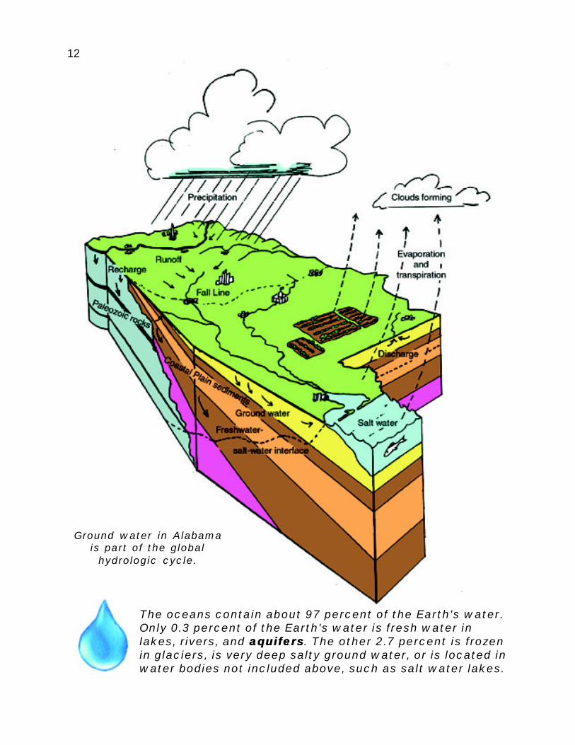
THE HYDROLOGIC CYCLEThe waters on the surface of the
earth and beneath the earth are notseparate. They are connected by soiland rock pore spaces and fractures.Water constantly moves from onezone to the other. This movement ispart of a global pathway called thehydrologic cycle, which can be
visualized as a series of banks thatstore and continuously transfer water.The oceans are the largest bank,containing about 97 percent of theEarth’s water. The other banks,though much smaller, are alsoimportant. These include theatmosphere, glaciers and ice sheets,rivers, lakes and streams, soilmoisture, and ground water.
Water evaporates from thesurfaces of the oceans and otherwater bodies and enters theatmosphere as water vapor,eventually falling back to Earth asprecipitation, usually in the form ofrain or snow. Some of the rainfall
drains directly into streams and lakesas runoff, and eventually flows backto the ocean. The rest enters the soil.If the sun is hot enough and the airdry enough, much of the moisture insoil evaporates and returns to theatmosphere. If plants are growing inthe soil, their roots will capture some
or most of thewater in thatzone. Ultimately,much of thiswater will bereturned to the
air by plants through transpiration,a process whereby moistureabsorbed by the plants evaporatesdirectly into the atmosphere fromplant surfaces. In Alabama, about 60percent of precipitation is returned tothe air by evaporation andtranspiration, orevapotranspiration . Part of thewater that enters the soil zone movesdownward to the water table. Groundwater may discharge as springs orseeps into streams, lakes, wetlands,or directly into the ocean, completingthe cycle. The hydrologic cycle goeson forever, and involves all water onand in the earth and in theatmosphere.
The hydrologic cycle goes on forever,and involves all water on and in theearth and in the atmosphere.
12
Ground water in Alabamais part of the global
hydrologic cycle.
The oceans contain about 97 percent of the Earth's water.Only 0.3 percent of the Earth's water is fresh water inlakes, rivers, and aquifersaquifers. The other 2.7 percent is frozenin glaciers, is very deep salty ground water, or is located inwater bodies not included above, such as salt water lakes.

13
Balancing Alabama's water budget
Water moves very slowly throughsome parts of the hydrologic cycle.Some water stays in the ground forthousands of years and maypenetrate miles below the surface.Precipitation that falls onto glaciersand ice sheets may also be trappedin ice for thousands of years.
Rates of ground water movementare variable and difficult to measure.
Depending upon local hydrologic andgeologic conditions, water can travelseveral miles underground in a fewdays, or it may take hundreds or eventhousands of years to cover thesame distance. The average rate ofground water movement in Alabamais about 1 inch per day. A drop ofwater moving at this rate would take174 years to travel 1 mile.
14
WHAT ARE AQUIFERS?Many people believe that ground
water occurs primarily inunderground lakes or rivers.Although underground lakes andrivers do exist, the vast majority ofground water is found in the tinyopenings called pores that occurbetween the grains in rocks, soil, andsediment. Many rock formations arefractured, and large amounts of watercan be contained in those fractures.Below the water table theseopenings are filled with water. Evenin areas where the ground is dry,water-saturated material existseverywhere at some depth, usuallyfrom a few inches to a few hundredfeet below the surface.
The upper part of the earth’s crustis composed of soil and manydifferent types of rocks.Some types of rocks are ableto store and transmit waterbetter than others. Rock,sediment, and soil units thatcontain significant amounts ofproducible ground water are calledaquifers (from the Latin aqua, water,and ferre, to bring). Aquifers have twovery important properties. The firstis porosity, which is the amount,
usually represented as percent, ofopen pore space in the aquifer. Thisrepresents the storage capacity of theaquifer. A good aquifer may contain10 to 30 percent open space andtherefore 90 to 70 percent rock, soits porosity is 10 to 30 percent. Anequally important aquifer property ispermeability.
Permeability is a measure of theinterconnectedness of a pore orfracture system, and determines theability of a rock unit to transmit fluids.Not all porous rocks are permeable.Impermeable rocks may containsignificant amounts of water, butmake poor aquifers because thewater cannot move from pore to poreand be pumped to the surface.Permeability can be illustrated by the
following example. An open pipe istotally permeable because itsvolume is all open space. If the pipeis filled with gravel, about 25 percentof the total volume of the pipeconsists of interconnected pore
Even where the ground is dry,water-saturated material exists
everywhere at some depth.
15
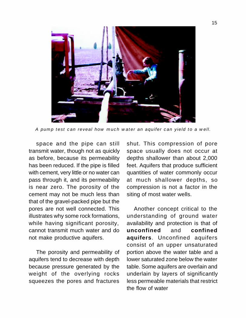
A pump test can reveal how much water an aquifer can yield to a well.
space and the pipe can stil ltransmit water, though not as quicklyas before, because its permeabilityhas been reduced. If the pipe is filledwith cement, very little or no water canpass through it, and its permeabilityis near zero. The porosity of thecement may not be much less thanthat of the gravel-packed pipe but thepores are not well connected. Thisillustrates why some rock formations,while having significant porosity,cannot transmit much water and donot make productive aquifers.
The porosity and permeability ofaquifers tend to decrease with depthbecause pressure generated by theweight of the overlying rockssqueezes the pores and fractures
shut. This compression of porespace usually does not occur atdepths shallower than about 2,000feet. Aquifers that produce sufficientquantities of water commonly occurat much shallower depths, socompression is not a factor in thesiting of most water wells.
Another concept critical to theunderstanding of ground wateravailability and protection is that ofunconfined and confinedaquifers. Unconfined aquifersconsist of an upper unsaturatedportion above the water table and alower saturated zone below the watertable. Some aquifers are overlain andunderlain by layers of significantlyless permeable materials that restrictthe flow of water
16
across the aquifer boundaries.These aquifers are called confinedaquifers. The less permeable layersthat impede water movement arecalled confining units. In Alabama,confining units are generallycomposed of clays, shales, andchalk. Confined aquifers arecompletely saturated with water.Because the space the wateroccupies in a confined aquifer isrestricted by the confining layer, the
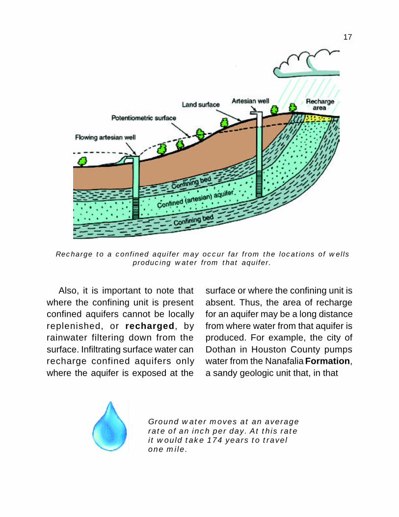
water can be under considerablepressure. When a well is drilled intoa confined aquifer the pressureforces the water in the well to riseabove the top of the aquifer itself. Ifthe pressure is great enough thewater will actually flow from the wellat the ground surface without havingto be pumped. Such flowing wells arecommon in and near the flood plainsof major streams in the southern halfof the state, and are sometimescalled artesian wells.
The time it takes ground water to travel from its point of recharge to pointof discharge can be measured in days to years for shallow ground water,
but may be centuries or millennia for deep ground water.
17
Ground water moves at an averagerate of an inch per day. At this rateit would take 174 years to travelone mile.
Recharge to a confined aquifer may occur far from the locations of wellsproducing water from that aquifer.
Also, it is important to note thatwhere the confining unit is presentconfined aquifers cannot be locallyreplenished, or recharged, byrainwater filtering down from thesurface. Infiltrating surface water canrecharge confined aquifers onlywhere the aquifer is exposed at the
surface or where the confining unit isabsent. Thus, the area of rechargefor an aquifer may be a long distancefrom where water from that aquifer isproduced. For example, the city ofDothan in Houston County pumpswater from the Nanafalia Formation,a sandy geologic unit that, in that
18
Flowing artesian well in Old Cahawba
that future generations will rely on inDothan can be affected by activitiesin the recharge area of the NanafaliaFormation, 30 miles away.
area, is a confined aquifer. Therecharge area for the Nanafaliaaquifer is where it crops out at thesurface, more than 30 miles north ofDothan. It is important to understandthis relationship because the water
19
KINDS OF AQUIFERS
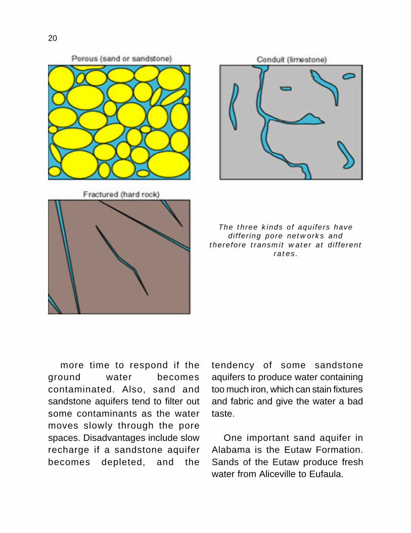
SAND OR SANDSTONEAquifers in Alabama can be
grouped according to the way waterflows through them. Aquifers transmitwater by porous flow, conduit flow,fracture flow, or by a combination ofthese. Porous flow is typical ofaquifers composed of sand orsandstone. These aquifers aremade up of sand-sized particles ofother rocks that were broken downby erosion, transported to theirpresent location by wind or water, anddeposited. Water is stored in andmoves through the open spaces, orpores, between the individual sandgrains. Sand bodies can range in sizefrom a few square feet to thousandsof square miles. Sand aquifers areoften found along rivers and streamswhere theyformed as thes t r e a mmeandered backand forth acrossthe floodplain.These aquifers,s o m e t i m e sc a l l e dw a t e r c o u r s eaquifers, cansupply significant
amounts of water but are restrictedto the floodplains of major rivers andthus are only of local importance. Thetowns of Saraland and Satsuma inMobile County use ground water fromsand aquifers deposited by theMobile River. Sandstone is simplysand that has been hardened intorock by the heat and pressurecaused by deep burial for extremelylong periods of geologic time. Manysand bodies and some sandstoneunits are highly permeable, withporosity values that may exceed 25percent. Typically, water movesslowly but steadily through sand andsandstone, making many sand andsandstone aquifers reliable sourcesof large amounts of ground water.
Sand ands a n d s t o n eaquifers are themost importantaquifers inmany parts ofAlabama andg e n e r a l l yproduce largeamounts ofwater. Becausewater moves
slowly through the aquifer, there is
Water moves slowlybut steadily throughsand and sandstone,making manysandstone aquifersreliable sources oflarge amounts ofground water.
20
more time to respond if theground water becomescontaminated. Also, sand andsandstone aquifers tend to filter outsome contaminants as the watermoves slowly through the porespaces. Disadvantages include slowrecharge if a sandstone aquiferbecomes depleted, and the
tendency of some sandstoneaquifers to produce water containingtoo much iron, which can stain fixturesand fabric and give the water a badtaste.
One important sand aquifer inAlabama is the Eutaw Formation.Sands of the Eutaw produce freshwater from Aliceville to Eufaula.
The three kinds of aquifers havediffering pore networks and
therefore transmit water at differentrates.
21
LIMESTONEA second way that water moves
through an aquifer is by conduit flow.In conduit flow, water actually flowsthrough underground channels, orconduits, in the rock. Conduit flow iscommonly associated with carbonaterocks, such as limestone anddolomite. Most conduits are formedover thousands of years bydissolution, a chemical reactionbetween limestone and fresh waterin which the limestone is dissolved.Sometimes, large volumes of rockcan be dissolved, forming cavitiesand caves. Although cave formationscan be fascinating and sometimes
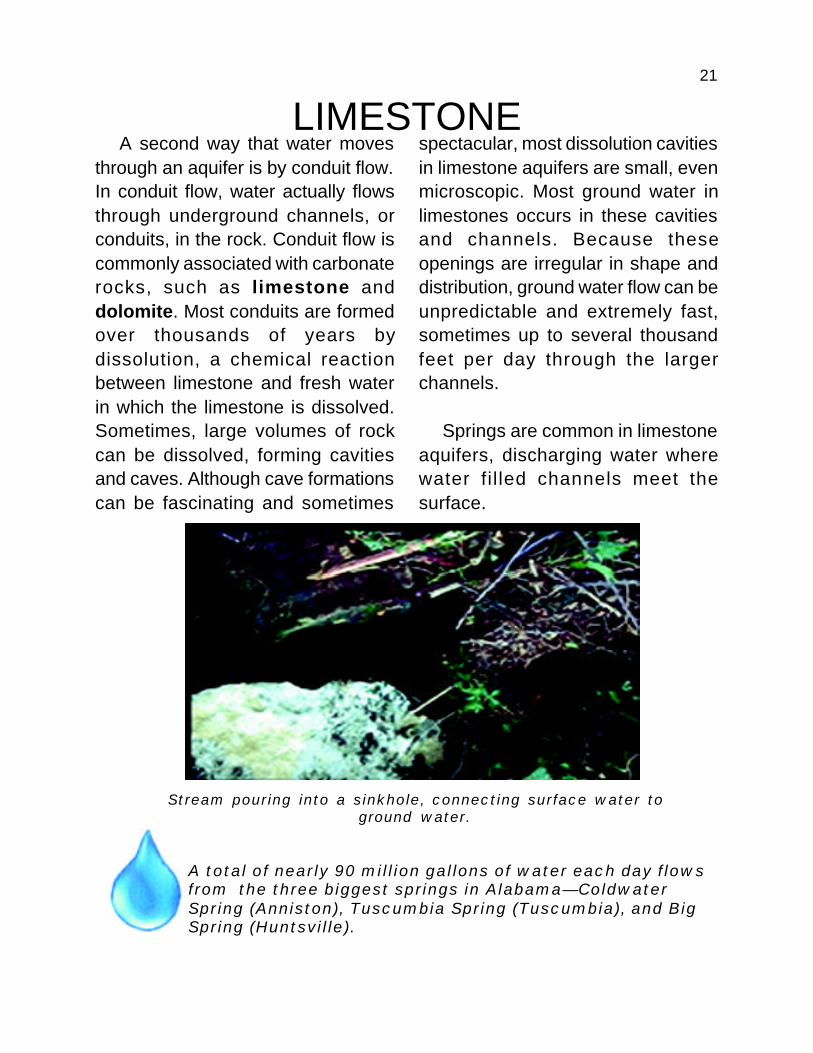
Stream pouring into a sinkhole, connecting surface water toground water.
spectacular, most dissolution cavitiesin limestone aquifers are small, evenmicroscopic. Most ground water inlimestones occurs in these cavitiesand channels. Because theseopenings are irregular in shape anddistribution, ground water flow can beunpredictable and extremely fast,sometimes up to several thousandfeet per day through the largerchannels.
Springs are common in limestoneaquifers, discharging water wherewater fil led channels meet thesurface.
A total of nearly 90 million gallons of water each day flowsfrom the three biggest springs in Alabama—ColdwaterSpring (Anniston), Tuscumbia Spring (Tuscumbia), and BigSpring (Huntsville).
22
Limestone aquifers have severalpotential disadvantages. Forexample, sinkholes tend to occur inareas underlain by limestone. Asinkhole forms when the groundsurface collapses into an underlyingdissolution cavity. Sinkholes are likehuge drains and water entering themis immediately introduced into theground water system. Ifcontaminated water enters a sinkholeconnected to a channel or cavitysystem capable of transporting largevolumes of water, ground water canbecome contaminated very quickly,leaving little time to take action toprotect it. Also, the water table inlimestone aquifers may fall rapidly inresponse to an increase in pumpingor a decrease in precipitation. As aresult, some wells in limestone
aquifers may stop producingaltogether during dry summermonths or periods of over-pumping.Fortunately, most of these wellsrecover quickly when the fall rainscome. Another potentialdisadvantage of many limestoneaquifers is the hardness of the water.This means it contains largequantities of dissolved carbonate,and does not readily produce a latherwith soap.
In spite of these disadvantages,limestone aquifers are importantsources of ground water in manyparts of Alabama. The Tuscumbia-Fort Payne aquifer in north Alabama,for example, serves more than100,000 public water supply systemcustomers, although it is prone to allthe problems which characterizelimestone aquifers.
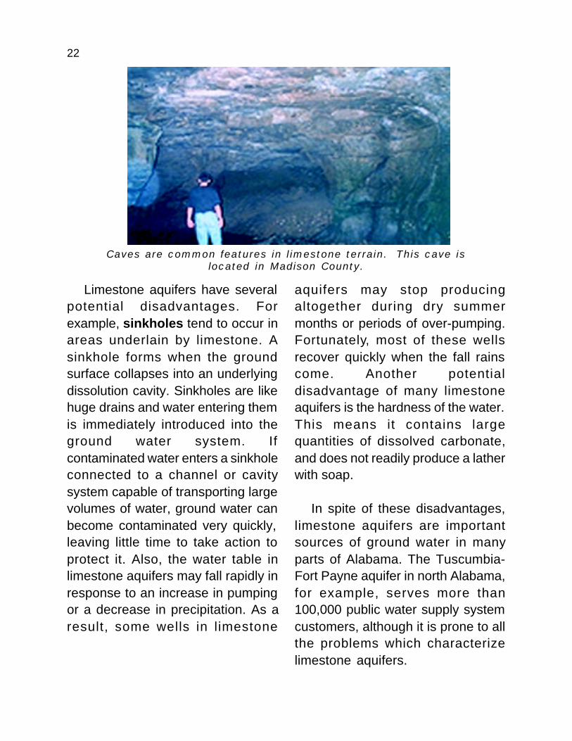
Caves are common features in limestone terrain. This cave islocated in Madison County.

23
FRACTURED ROCKThe third way aquifers transmit
water is through fractures. Aquiferscharacterized by porous flow orconduit flow canalso be fractured,which enhancesthe permeability ofthese aquifers. Innonporous andinsoluble rocks,fractures mayprovide the onlyway in which fluidscan be transmitted.Examples of suchrocks includesandstone in whichthe pores havebeen filled bysome secondarymaterial; shales;and most igneous and metamorphicrocks such as granite and gneiss(pronounced “nice”). These rocks arevery dense and contain few openspaces except for fractures.Typically, fractures are concentratednear the surface and are notdistributed evenly over a large area.
Fractures also may or may not bewell connected, and fracture-dependent aquifers rarely contain
enough water tomake them reliablesources of water.They are typicallyused only whenmore suitableaquifers are notpresent. Smallsprings are commonin fractured terrainwherever saturatedpermeable fracturesystems intersectthe land surface. InAlabama, fracturedaquifers are mostimportant in thePiedmont region
(see next section), where hardgranitic rocks, remnants of the coreof the Appalachian Mountains, yieldmodest amounts of water fromfracture systems. Fractured granitesand granitic rocks are major aquifersin large parts of Coosa, Tallapoosa,and Chambers Counties, and smallerparts of several neighboringcounties.
DeSoto Park is inan area of fractured rock

24
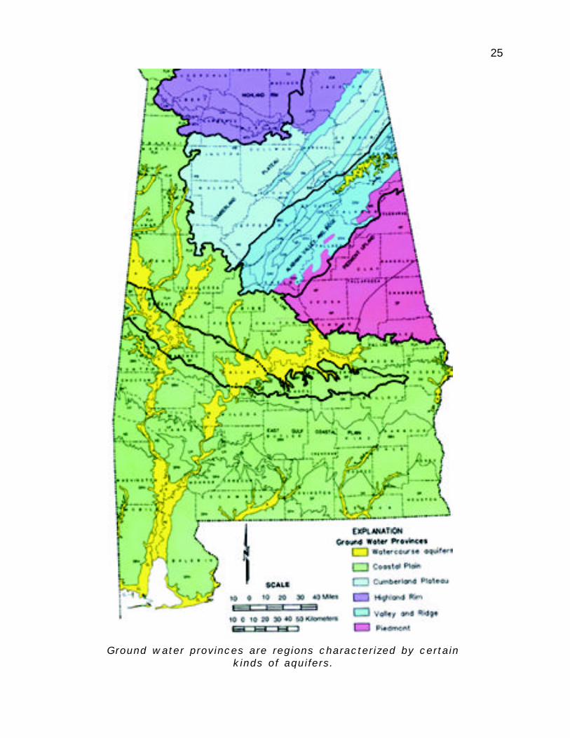
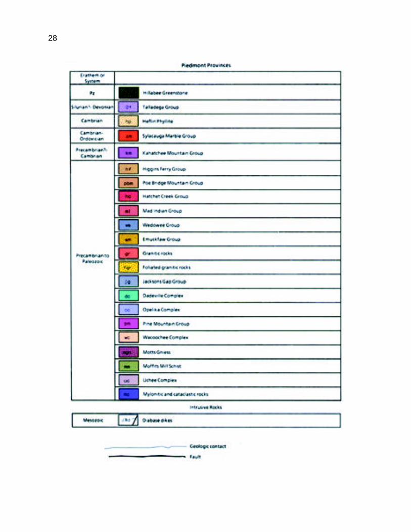
ALABAMA’S AQUIFERSAlabama is divided into five
hydrogeologic provinces: theCoastal Plain, Piedmont, Valley andRidge, Cumberland Plateau, andHighland Rim. These hydrogeologicprovinces are closely related to thephysiographic provinces. Thehydrogeologic provinces are definedon the basis of differences in waterbearing properties of rocks, rocktype, structural geology, andphysiography. Such characteristicsdetermine the types of aquifers inthese areas.
The Coastal Plain provinceincludes sediments such as sand,gravel, and clay, as well as chalk andsome limestone deposited by seasthat once covered the southern partof Alabama. Coastal plain sedimentsare relatively young compared withthe rocks that make up the otherprovinces and are mostlyunconsolidated, which means theyhave not been hardened into rocks.The other four provinces—thePiedmont, Valley and Ridge,Cumberland Plateau, and Highland
Rim—are composed of much oldersediments that have hardened intorocks. Also, the rocks in theseprovinces have all been structurallydeformed to varying degrees by theforces that formed the AppalachianMountains. The rocks of thePiedmont were strongly deformed tothe point of recrystallization by thedeformational pressures. Thismeans that original mineralogy andtexture of Piedmont rocks werefunda-mentally changed by mountainbuilding. The rocks of the Valley andRidge, protected to some extent bythe Piedmont, were highly folded andfaulted. The rocks of the CumberlandPlateau and the Highland Rim wereless affected. The intensity of thestructural deformation influences theoccurrence and quality of groundwater in each province. Theboundary between the soft rocks ofthe Coastal Plain province and thehard rocks of the other four provincesis called the fall line, because thechange in rock durability fosters theformation of waterfalls along this line.
25
Ground water provinces are regions characterized by certainkinds of aquifers.

26
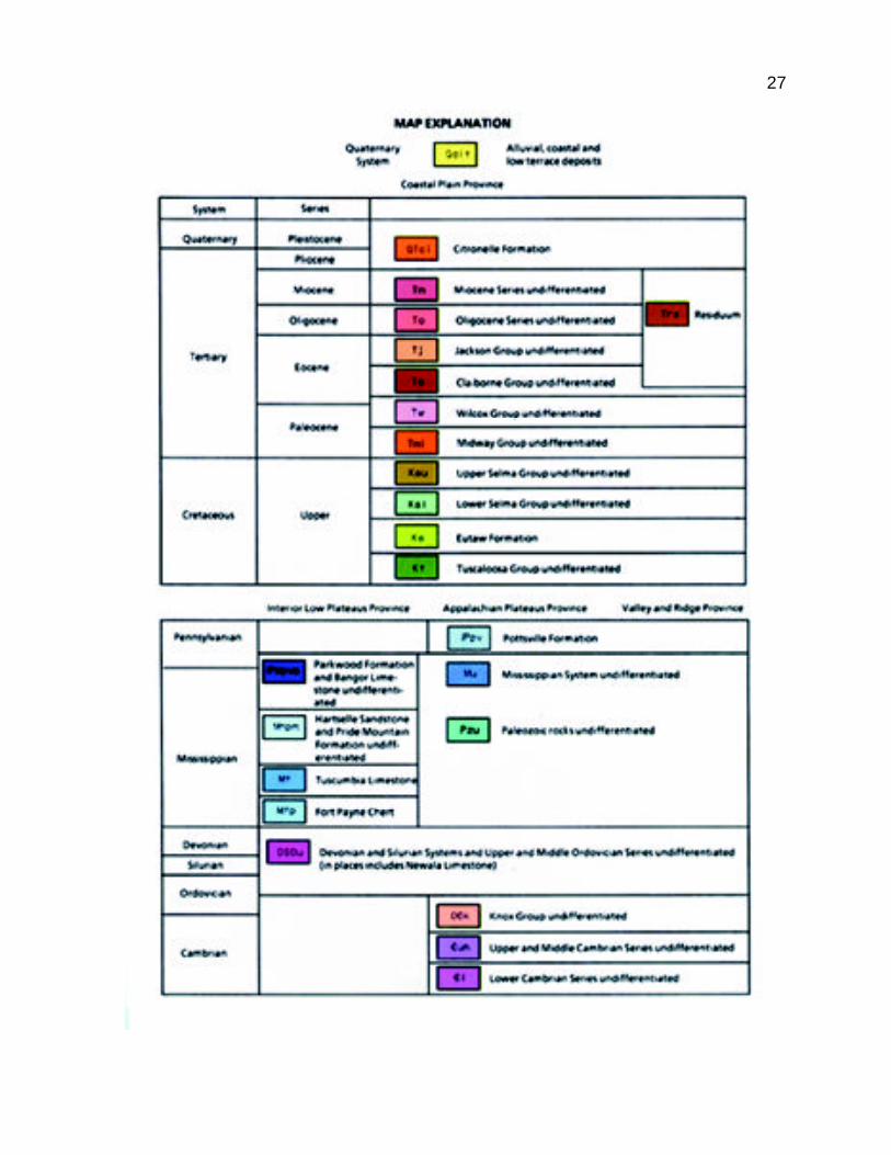
The geologic map shows that each part of the state is underlain bydifferent rocks, which control the nature and distribution of aquifers.
27
28
29
COASTAL PLAINThe Coastal Plain is by far the
largest and most populoushydrogeologic province in the state.The occurrence and availability ofground water in the Coastal Plain isquite high; some Coastal Plain wellscan yield up to several thousandgallons per minute (gpm). Averageproduction per well is higher than inany other province in Alabama. Inmost parts of the Coastal Plain, wellscan be expected to yield more than50 gpm. To put this in perspective, awell producing 7 to 10 gpm isadequate for most domesticpurposes.
Ground water resources in theCoastal Plain are estimated at about488 trillion gallons. Major groundwater users include the cities ofDothan, Enterprise, Jackson(supplied by a spring), Montgomery(which also uses surface water),Prattville, Selma, and Troy. Residentsof the Coastal Plain, while includingonly 44 percent of the state’spopulation, account forapproximately 63 percent of the totalground water use. The per capita useis high primarily because ofagricultural use. More than 70 percent
of Alabama’s total agricultural wateruse occurs in the Coastal Plain.
Although most areas in theCoastal Plain yield plenty of groundwater, some areas do not. Near thenorthern limit of the Coastal Plain,strata (rock layers) are too thin tostore large quantities of water, andmajor users have to augment theirground water supplies by developingother sources. The city ofTuscaloosa, for example, is locatedin the northern part of the CoastalPlain, and relies on Lake Tuscaloosafor its water because the groundwater supplies there are insufficientto support the city.
Farther south in the Coastal Plainis a part of Alabama which hascharacteristic black, dense soils thatare sticky when wet. This area isunderlain by chalk, a variety oflimestone, which is a poor aquifer.
Eighty percent ofpublic water supplysystems in Alabamahave at least oneground water source.

30
Flowing wells can waste millions of gallons of water. The rust coloredmaterial on the pipe is due to the iron content of the water.
Sinkhole in Shelby County, 1972. Sinkholes are common in parts of theAlabama Coastal Plain where limestone is near the surface.
31
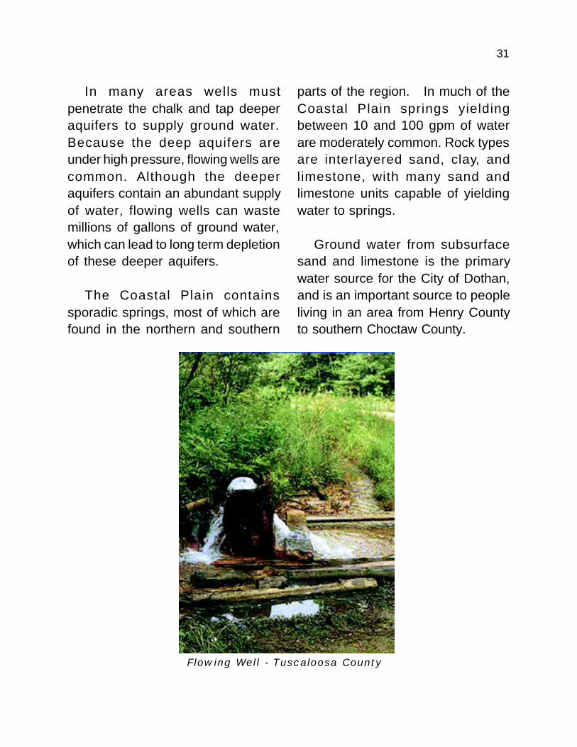
In many areas wells mustpenetrate the chalk and tap deeperaquifers to supply ground water.Because the deep aquifers areunder high pressure, flowing wells arecommon. Although the deeperaquifers contain an abundant supplyof water, flowing wells can wastemillions of gallons of ground water,which can lead to long term depletionof these deeper aquifers.
The Coastal Plain containssporadic springs, most of which arefound in the northern and southern
parts of the region. In much of theCoastal Plain springs yieldingbetween 10 and 100 gpm of waterare moderately common. Rock typesare interlayered sand, clay, andlimestone, with many sand andlimestone units capable of yieldingwater to springs.
Ground water from subsurfacesand and limestone is the primarywater source for the City of Dothan,and is an important source to peopleliving in an area from Henry Countyto southern Choctaw County.
Flowing Well - Tuscaloosa County
32
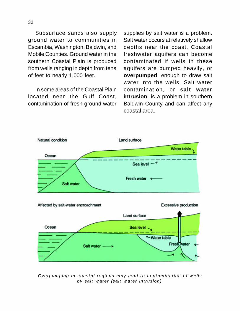
Subsurface sands also supplyground water to communities inEscambia, Washington, Baldwin, andMobile Counties. Ground water in thesouthern Coastal Plain is producedfrom wells ranging in depth from tensof feet to nearly 1,000 feet.
In some areas of the Coastal Plainlocated near the Gulf Coast,contamination of fresh ground water
supplies by salt water is a problem.Salt water occurs at relatively shallowdepths near the coast. Coastalfreshwater aquifers can becomecontaminated if wells in theseaquifers are pumped heavily, oroverpumped, enough to draw saltwater into the wells. Salt watercontamination, or salt waterintrusion, is a problem in southernBaldwin County and can affect anycoastal area.
Overpumping in coastal regions may lead to contamination of wellsby salt water (salt water intrusion).

33
PIEDMONTPiedmont is a French word
meaning foothills. The AlabamaPiedmont is the southernmostexposure of a vast physiographicprovince that forms the foothills ofthe Appalachian Mountains andstretches all the way to Pennsylvania.The ancient crystalline rocks of thePiedmont are igneous andmetamorphic rocks and are themost intensely deformed rocks in thestate. Rocks in the Piedmont do nothold much water compared to thesands and limestones of the CoastalPlain. Most of the porosity inPiedmont aquifers is fracture related,although soil andweathered rock nearthe surface may exhibitporous flow. Wateryields both fromfractures and from therelatively thin layer ofweathered materialnear the surface(known as saprolite)are typically low, highly variable, anddifficult to predict. Generally, wells inthe Piedmont yield enough water fordomestic use, or sometimes for
small communities, but not enoughfor a large town or for commercialuse.
Springs are more common in thePiedmont than in the Coastal Plain,but are not abundant. TypicalPiedmont springs yield 10 to 100gpm of water from fracturedmetamorphic and igneous rocks.
About 7 percent of Alabama’spopulation lives in the Piedmont,accounting for 5 percent (less than19 million gpd) of the state’s groundwater consumption. The hilly terrain
is unsuitable for largescale agriculture, andonly 3.5 percent ofAlabama’s agriculturalwater use takes placehere. There are nolarge cities in thePiedmont except forAnniston, which useswater from Coldwater
Spring, one of the largest springs inthe state. Even though Anniston is inthe Piedmont, Coldwater Spring islocated in the Valley and Ridgeprovince.
Water yields inthe Piedmont are
typically low,highly variable,and difficult to
predict.
34
VALLEY AND RIDGEThe Valley and Ridge province is
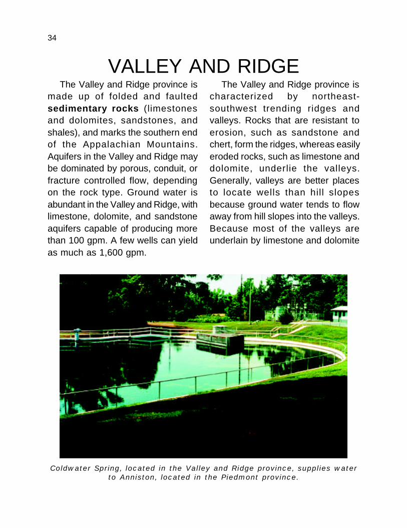
made up of folded and faultedsedimentary rocks (limestonesand dolomites, sandstones, andshales), and marks the southern endof the Appalachian Mountains.Aquifers in the Valley and Ridge maybe dominated by porous, conduit, orfracture controlled flow, dependingon the rock type. Ground water isabundant in the Valley and Ridge, withlimestone, dolomite, and sandstoneaquifers capable of producing morethan 100 gpm. A few wells can yieldas much as 1,600 gpm.
Coldwater Spring, located in the Valley and Ridge province, supplies waterto Anniston, located in the Piedmont province.
The Valley and Ridge province ischaracterized by northeast-southwest trending ridges andvalleys. Rocks that are resistant toerosion, such as sandstone andchert, form the ridges, whereas easilyeroded rocks, such as limestone anddolomite, underlie the valleys.Generally, valleys are better placesto locate wells than hill slopesbecause ground water tends to flowaway from hill slopes into the valleys.Because most of the valleys areunderlain by limestone and dolomite

35
and therefore are prone to conduitflow, aquifers located in these areasare relatively susceptible to groundwater contamination from thesurface.
The Valley and Ridge accounts for14 percent, or about 56 million gpdof the state’s total ground water use.Eighteen percent of Alabama’spopulation lives in the Valley andRidge and, although the water useper person approaches the stateaverage, agricultural water use is low(8 percent of the state total), becauseof the mountainous terrain.
The limestone aquifers in theValley and Ridge feed many springsincluding Coldwater Spring, whichhas an average discharge of 31.2million gpd. Few springs approachthe flow rate of Coldwater Spring, butsprings in the Valley and Ridgeprovince typically yield 100 gpm ormore of water from limestone,dolomite, and other rock types.Large springs are common in theValley and Ridge because of conduitflow in limestone and dolomiteaquifers.
Trussville, in Jefferson County, isthe largest single consumer ofground water in the Valley and Ridgeprovince. The cities of Attalla andLeeds also use ground water tosupply virtually all of their waterneeds.
Contaminated water may enter the subsurfacedirectly through sinkholes.
36
CUMBERLAND PLATEAUThe Cumberland Plateau in north
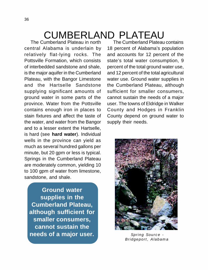
central Alabama is underlain byrelatively flat-lying rocks. ThePottsville Formation, which consistsof interbedded sandstone and shale,is the major aquifer in the CumberlandPlateau, with the Bangor Limestoneand the Hartselle Sandstonesupplying significant amounts ofground water in some parts of theprovince. Water from the Pottsvillecontains enough iron in places tostain fixtures and affect the taste ofthe water, and water from the Bangorand to a lesser extent the Hartselle,is hard (see hard water). Individualwells in the province can yield asmuch as several hundred gallons perminute, but 20 gpm or less is typical.Springs in the Cumberland Plateauare moderately common, yielding 10to 100 gpm of water from limestone,sandstone, and shale.
The Cumberland Plateau contains18 percent of Alabama’s populationand accounts for 12 percent of thestate’s total water consumption, 9percent of the total ground water use,and 12 percent of the total agriculturalwater use. Ground water supplies inthe Cumberland Plateau, althoughsufficient for smaller consumers,cannot sustain the needs of a majoruser. The towns of Eldridge in WalkerCounty and Hodges in FranklinCounty depend on ground water tosupply their needs.
Ground watersupplies in the
Cumberland Plateau,although sufficient for
smaller consumers,cannot sustain the
needs of a major user. Spring Source -Bridgeport, Alabama
37
HIGHLAND RIMAs is the case in many areas in
Alabama, ground water is unevenlydistributed in the Highland Rim. Highcapacity wells, producing from 100to more than 1,000 gpm, occur in thelimestones and dolomites of the FortPayne-Tuscumbia aquifer system inthe northern part of the Highland Rim,and in the Bangor Limestone in thesouthern part. The HartselleSandstone and several otheraquifers of local importance supplyminor amounts of ground water to thesouthern part of the province, mostlyfrom wells producing 10 gpm or less.
The major aquifers in the HighlandRim province contain significant
amounts of limestone. Caves andsinkholes are common, andcontamination of ground water is aserious concern. Much of the groundwater in the Highland Rim is hard andlocally contains objectionableamounts of iron, carbon dioxide, orhydrogen sulfide.
Thirteen percent of Alabama’spopulation lives in the Highland Rim,accounting for 12 percent ofAlabama’s total water use. Only 9percent of the state’s total groundwater consumption occurs in theHighland Rim. Part of the reason forthis is the Tennessee River system,which provides plentiful surface water
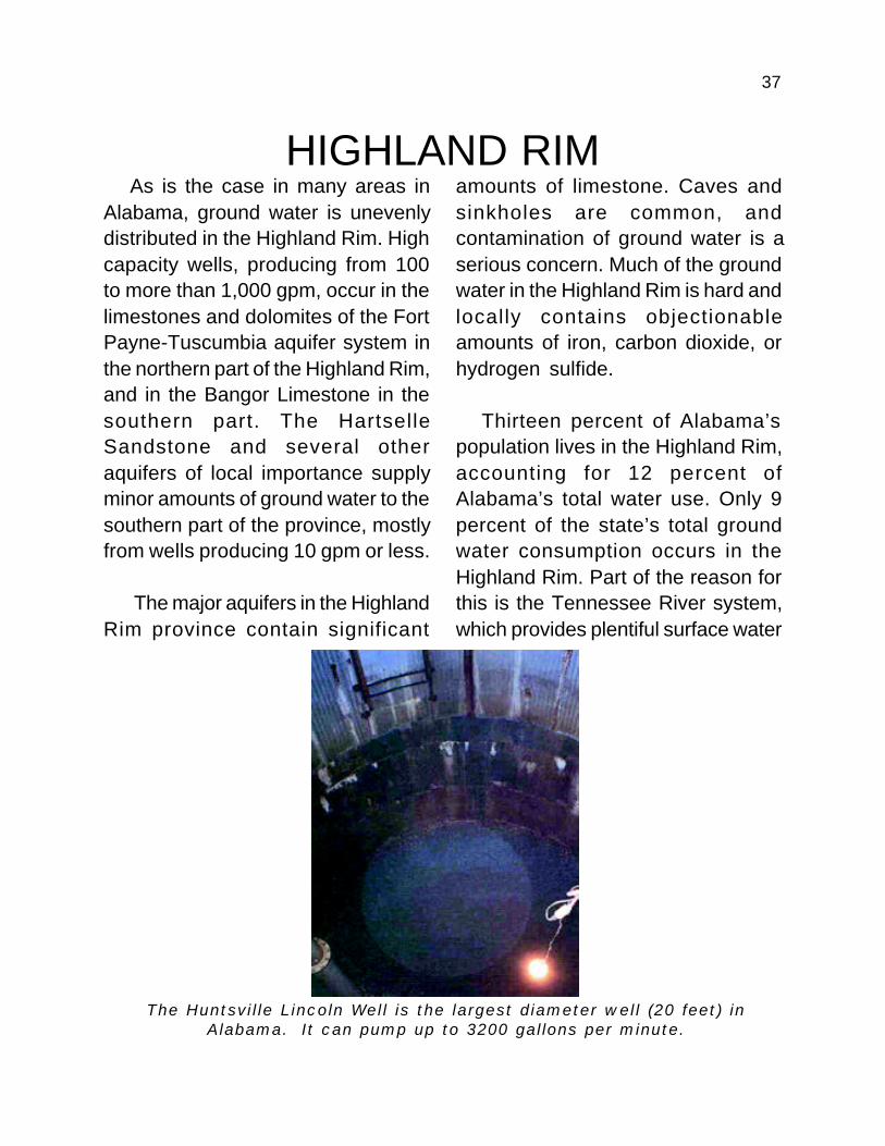
The Huntsville Lincoln Well is the largest diameter well (20 feet) inAlabama. It can pump up to 3200 gallons per minute.
38
to users throughout the province.Agricultural water use has increaseddramatically in the past few yearsbecause the practice of irrigation isbecoming more widespread in thearea.
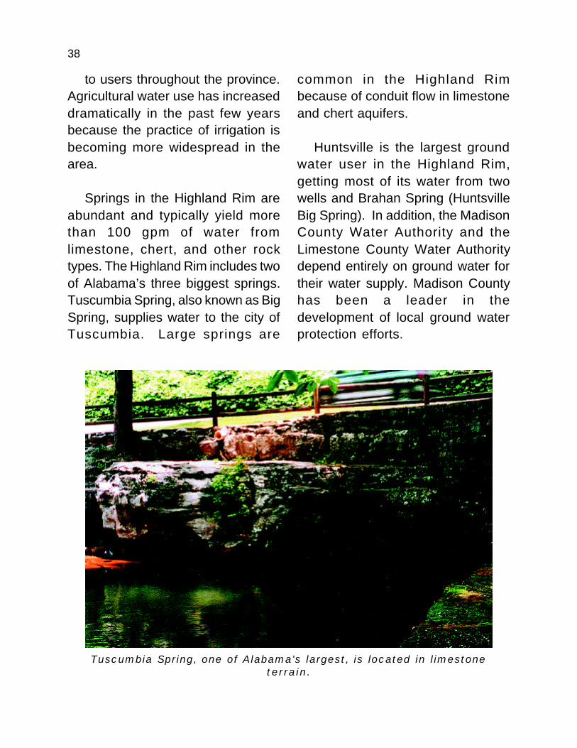
Springs in the Highland Rim areabundant and typically yield morethan 100 gpm of water fromlimestone, chert, and other rocktypes. The Highland Rim includes twoof Alabama’s three biggest springs.Tuscumbia Spring, also known as BigSpring, supplies water to the city ofTuscumbia. Large springs are
common in the Highland Rimbecause of conduit flow in limestoneand chert aquifers.
Huntsville is the largest groundwater user in the Highland Rim,getting most of its water from twowells and Brahan Spring (HuntsvilleBig Spring). In addition, the MadisonCounty Water Authority and theLimestone County Water Authoritydepend entirely on ground water fortheir water supply. Madison Countyhas been a leader in thedevelopment of local ground waterprotection efforts.
Tuscumbia Spring, one of Alabama's largest, is located in limestoneterrain.
39
GROUND WATER MYTHS
WATER WITCHINGWater witching (also called
divining or dowsing) is an ancientmethod of finding ground water. Theoldest detailed description ofdowsing was published in 1556, butcave paintings at least 6,000 yearsold appear to show a dowser at work.But does it work? Alas, there is nohard evidence that supports theclaims of any water dowser. In mostparts of Alabama it would be difficult
to drill a well and not find water.Dowsers in Alabama can easily buildup excellent “success” rates,because in most of our state groundwater is not that hard to find. In areaswhere water is more difficult to find,dowsers do no better than randomdrilling at locating usable quantitiesof water. The U.S. Geological Surveyhas two publications on dowsing.Both are listed in the referencesection.
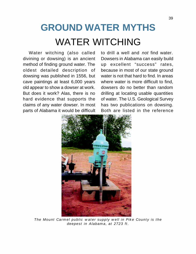
The Mount Carmel public water supply well in Pike County is thedeepest in Alabama, at 2723 ft.

40
UNDERGROUND STREAMS AND LAKESAs mentioned earlier,
underground lakes, rivers, and evenwaterfalls exist in Alabama. Thesefeatures are almost alwaysassociated with caves.
It is important to remember thateven in regions known for theircaves, such as northwest Alabamaor the southern Coastal Plain fromChoctaw to Geneva Counties, morethan 99 percent of the spaceunderground is solid rock, not cave,
and most ground water occurs insmall cavities and fractures in that“solid” rock.
At least five caves in Jackson andMadison Counties contain under-ground rivers more than a mile longthat are large enough for canoeing.No one knows exactly how long theserivers are, because they all com-pletely fill the cave passages at somepoint. Such places remain largelyunexplored because of the dangerposed even to experienced cavers.
The beautiful cave formations and mysterious underground rivers form aneerie part of Alabama's natural environment. However, most undergroundwater, even in cave country, is in holes too small to see. Bluff River Cave,
Jackson County, Alabama.