Intro Workbook Section 1 (Maps) - John Abbott Collegegeoscience/intro/IntroWorkbookSection1-F... ·...
36
Page 1-1 SECTION I Geography, Maps and Geographic Information Systems
Transcript of Intro Workbook Section 1 (Maps) - John Abbott Collegegeoscience/intro/IntroWorkbookSection1-F... ·...

Page 1-1
SECTION I
Geography, Maps and Geographic Information Systems

Page 1-2
Page 1-3
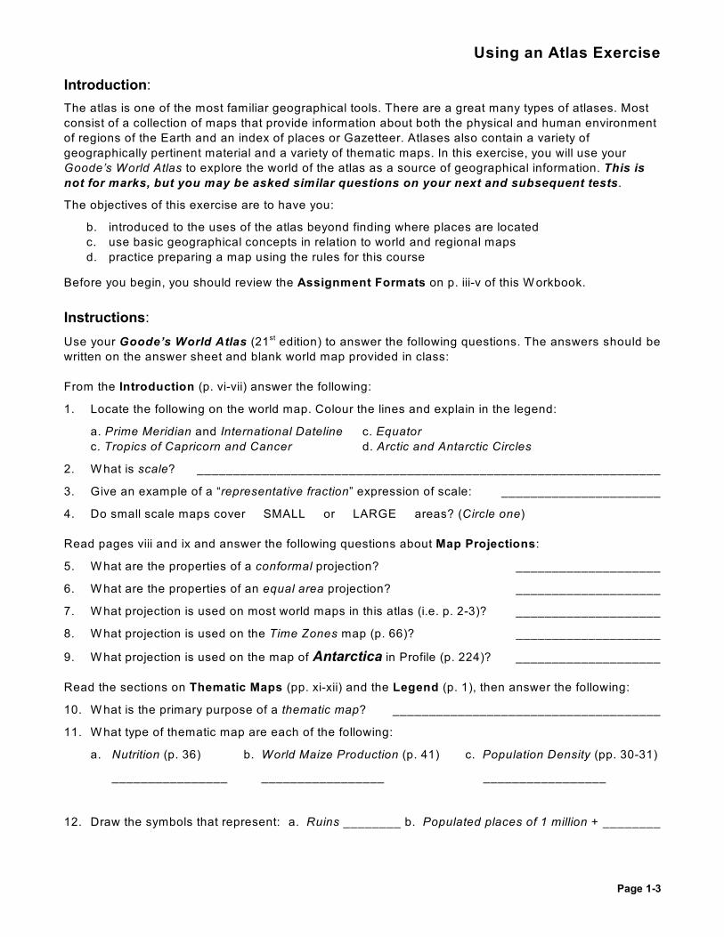
Using an Atlas Exercise
Introduction:
The atlas is one of the most familiar geographical tools. There are a great many types of atlases. Most
consist of a collection of maps that provide information about both the physical and human environment
of regions of the Earth and an index of places or Gazetteer. Atlases also contain a variety of
geographically pertinent material and a variety of thematic maps. In this exercise, you will use your
Goode’s World Atlas to explore the world of the atlas as a source of geographical information. This is
not for marks, but you may be asked similar questions on your next and subsequent tests.
The objectives of this exercise are to have you:
b. introduced to the uses of the atlas beyond finding where places are located
c. use basic geographical concepts in relation to world and regional maps
d. practice preparing a map using the rules for this course
Before you begin, you should review the Assignment Formats on p. iii-v of this W orkbook.
Instructions:
Use your Goode’s World Atlas (21 edition) to answer the following questions. The answers should best
written on the answer sheet and blank world map provided in class:
From the Introduction (p. vi-vii) answer the following:
1. Locate the following on the world map. Colour the lines and explain in the legend:
a. Prime Meridian and International Dateline c. Equator
c. Tropics of Capricorn and Cancer d. Arctic and Antarctic Circles
2. W hat is scale? ________________________________________________________________
3. Give an example of a “representative fraction” expression of scale: ______________________
4. Do small scale maps cover SMALL or LARGE areas? (Circle one)
Read pages viii and ix and answer the following questions about Map Projections:
5. W hat are the properties of a conformal projection? ____________________
6. W hat are the properties of an equal area projection? ____________________
7. W hat projection is used on most world maps in this atlas (i.e. p. 2-3)? ____________________
8. W hat projection is used on the Time Zones map (p. 66)? ____________________
9. W hat projection is used on the map of Antarctica in Profile (p. 224)? ____________________
Read the sections on Thematic Maps (pp. xi-xii) and the Legend (p. 1), then answer the following:
10. W hat is the primary purpose of a thematic map? _____________________________________
11. W hat type of thematic map are each of the following:
a. Nutrition (p. 36) b. World Maize Production (p. 41) c. Population Density (pp. 30-31)
________________ _________________ _________________
12. Draw the symbols that represent: a. Ruins ________ b. Populated places of 1 million + ________
Page 1-4
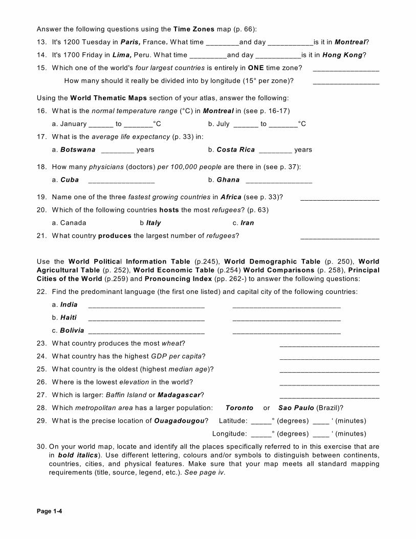
Answer the following questions using the Time Zones map (p. 66):
13. It's 1200 Tuesday in Paris, France. W hat time ________and day ___________is it in Montreal?
14. It's 1700 Friday in Lima, Peru. W hat time _________and day ___________is it in Hong Kong?
15. W hich one of the world's four largest countries is entirely in ONE time zone? ________________
How many should it really be divided into by longitude (15° per zone)? ________________
Using the World Thematic Maps section of your atlas, answer the following:
16. W hat is the normal temperature range (°C) in Montreal in (see p. 16-17)
a. January ______ to _______°C b. July ______ to _______°C
17. W hat is the average life expectancy (p. 33) in:
a. Botswana ________ years b. Costa Rica ________ years
18. How many physicians (doctors) per 100,000 people are there in (see p. 37):
a. Cuba ________________ b. Ghana ________________
19. Name one of the three fastest growing countries in Africa (see p. 33)? ___________________
20. W hich of the following countries hosts the most refugees? (p. 63)
a. Canada b Italy c. Iran
21. W hat country produces the largest number of refugees? ___________________
Use the World Political Information Table (p.245), World Demographic Table (p. 250), World
Agricultural Table (p. 252), World Economic Table (p.254) World Comparisons (p. 258), Principal
Cities of the World (p.259) and Pronouncing Index (pp. 262-) to answer the following questions:
22. Find the predominant language (the first one listed) and capital city of the following countries:
a. India ____________________________ __________________________
b. Haiti ____________________________ __________________________
c. Bolivia ____________________________ __________________________
23. W hat country produces the most wheat? ________________________
24. W hat country has the highest GDP per capita? ________________________
25. W hat country is the oldest (highest median age)? ________________________
26. W here is the lowest elevation in the world? ________________________
27. W hich is larger: Baffin Island or Madagascar? ________________________
28. W hich metropolitan area has a larger population: Toronto or Sao Paulo (Brazil)?
29. W hat is the precise location of Ouagadougou? Latitude: _____° (degrees) ____ ‘ (minutes)
Longitude: _____° (degrees) ____ ‘ (minutes)
30. On your world map, locate and identify all the places specifically referred to in this exercise that are
in bold italics). Use different lettering, colours and/or symbols to distinguish between continents,
countries, cities, and physical features. Make sure that your map meets all standard mapping
requirements (title, source, legend, etc.). See page iv.

Page 1-5

Page 1-6
Defining Intervals on a Choropleth Map
There are three ways to define intervals on a choropleth map: quantiles, equal-sized, or manual.Here’s an example using Female Literacy (%) in 2001 as the variable being mapped.
World Region % female lit. World Region % female lit. World Region % female lit.
N. Africa 40 C. America 82 E. Asia 76
W . Africa 45 Caribbean 81 N. Europe 99
E. Africa 46 S. America 87 W . Europe 99
M. Africa 48 W . Asia 64 E. Europe 99
S. Africa 78 SC Asia 38 S. Europe 96
N. America 99 SE Asia 88 Oceania 92
1. Quantiles (Equal Number of Observations per Interval)
There are 18 regions, so with 3 intervals there should be (18 ÷ 3) = 6 regions per interval.
Highest interval: N. America (99), N. Europe (99), W . Europe (99), E. Europe (99), S. Europe (96), Oceania (92)
Middle interval: SE Asia (88), S. America (87), C. America (82), Caribbean (81), S. Africa (78), E. Asia (76)
Lowest interval: W . Asia (64), M. Africa (48), E. Africa (46), W . Africa (45), N. Africa (40), SC Asia (38)
Note: If two regions havethe same value atthe break betweenintervals, do not separate the tworegions in differentintervals – put bothin the middleinterval.
The map should look like this:
What is the size of each interval? High _______ Medium _______ Low _______
What is the drawback with the intervals defined this way?
_____________________________________________________________________________
2. Equal-Sized Intervals: Divide total range into three equal-sized classes:
(Highest value (99) – Lowest value (38)) = 61 ÷ 3 intervals = 20.333 % per interval range
Highest interval: = 99 to (99 – 20.333) = 78.666 N. America (99), N. Europe (99), W . Europe (99), E. Europe (99),
S. Europe (96), Oceania (92), S.E. Asia (88), S. America (87), C. America (82), Caribbean (81)
Middle interval: = 78.666 to (78.666 – 20.333) = 58.333 S. Africa (78), E. Asia (76), W . Asia (64)
Lowest interval: = from 58.333 to (58.333 – 20.333) = 38 (this should equal your lowest value!)M. Africa (48), E. Africa (46), W . Africa (45), N. Africa (40), S.C. Asia (38)

Page 1-7
The map should look
like this:
How many regions are in each interval? High ________ Medium ________ Low _______
What is the drawback with the intervals defined this way?
__________________________________________________________________________
3. Manual Method
Cartographers candefine intervalsmanually or useones predefined bystages in a model(e.g. theurbanization curve).
A high level offemale literacy couldbe defined as over85%, a medium levelas 60-85%, and alow level as lessthan 60%.
Manually definedintervals musthowever be carefullythought out to bestshow the distributionof a variable.
What is the size (highest minus lowest value) of each interval? High ______ Medium ______ Low _____
How many regions are in each interval? High ______ Medium ______ Low _____

Page 1-8
ArcExplorer Exercise
Introduction:
In this exercise we will complete the following objectives:
• Introduce the use of GIS software – ArcExplorer – Java Edition for Education (AEJEE)available in the Penfield multipurpose computer labs (3 floor, P-306, 308 and 311)rd
• Introduce Choropleth mapping and the use of map projections
• Examine the relationship between socioeconomic indicators (such as Infant Mortality) andlevels of development
• Develop skills for using maps in presentations and papers
Instructions:
Open ArcExplorer (click on the desktop shortcut if available or use the Start menu underAEJEE). The program opens in the Map View window:
Menu bar
Toolbar
the Table of
Contents the View pane
(TOC) pane
Status bar
(x, y coordinates)
On the Toolbar, click on the Add Data button .
Go to the ‘Data’ folder, then to the ‘world ’ folder, click on the file ‘cntry07_demog.shp’ and click ‘OK ’
Page 1-9
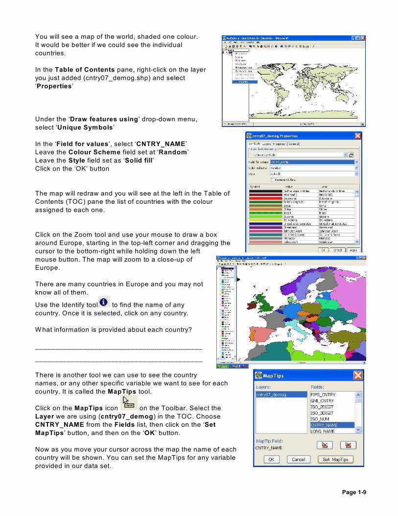
You will see a map of the world, shaded one colour.
It would be better if we could see the individual
countries.
In the Table of Contents pane, right-click on the layer
you just added (cntry07_demog.shp) and select
‘Properties’
Under the ‘Draw features using’ drop-down menu,
select ‘Unique Symbols’
In the ‘Field for values’, select ‘CNTRY_NAME’
Leave the Colour Scheme field set at ‘Random ’
Leave the Style field set as ‘Solid fill’
Click on the ‘OK’ button
The map will redraw and you will see at the left in the Table of
Contents (TOC) pane the list of countries with the colour
assigned to each one.
Click on the Zoom tool and use your mouse to draw a box
around Europe, starting in the top-left corner and dragging the
cursor to the bottom-right while holding down the left
mouse button. The map will zoom to a close-up of
Europe.
There are many countries in Europe and you may not
know all of them.
Use the Identify tool to find the name of any
country. Once it is selected, click on any country.
W hat information is provided about each country?
__________________________________________
__________________________________________
There is another tool we can use to see the country
names, or any other specific variable we want to see for each
country. It is called the MapTips tool.
Click on the MapTips icon on the Toolbar. Select the
Layer we are using (cntry07_demog) in the TOC. Choose
CNTRY_NAME from the Fields list, then click on the ‘Set
MapTips’ button, and then on the ‘OK ’ button.
Now as you move your cursor across the map the name of each
country will be shown. You can set the MapTips for any variable
provided in our data set.

Page 1-10
W e can also use the QueryBuilder tool to find countries which have similar attributes. W e will use it
to find those countries in Europe which are UN Member States.
On the Toolbar, select the QueryBuilder icon .
Select the STATUS field in the left menu to add the word
STATUS to the formula window.
Select ‘ = ’ on the middle menu to add it to our formula.
Select ‘UN Member State’ from the Values menu on the
right.
Now that our formula is complete, click on the Execute
button.
A message will appear telling you that there are more
than 100 records (it is using the data for the entire world,
not just Europe). Click ‘Yes’ to see all the records.
On your map, the countries which are UN members will
be highlighted.
Find the European “country” located between England
and Ireland that is not a member of the UN (or the United Kingdom either!). You may need to zoom in
further to find this small island state:
________________________________________
Close the QueryBuilder.and zoom back out to the map of Europe.
To clear the Query and return the map to its original colors, click the ‘Clear All Selection’ button .
You can add point data to your map as well – for example, the location of major cities.
Click on the Add Data button, select the ‘cities.shp’ file, and press on OK. Each city is added as a
circle on the map.
Skill-Testing Question:
W hat is the Infant Mortality Rate (IMR) for Germany for 2007 (field IMR2007)? _________(reset the MapTips field to CNTRY_NAME after you have finished).
Skill-Testing Question: (select IMR2007).
How many countries have an Infant Mortality Rate (IMR) that is $ 100? ____________
In what part of the world are most of these countries located? ________________________________
Page 1-11
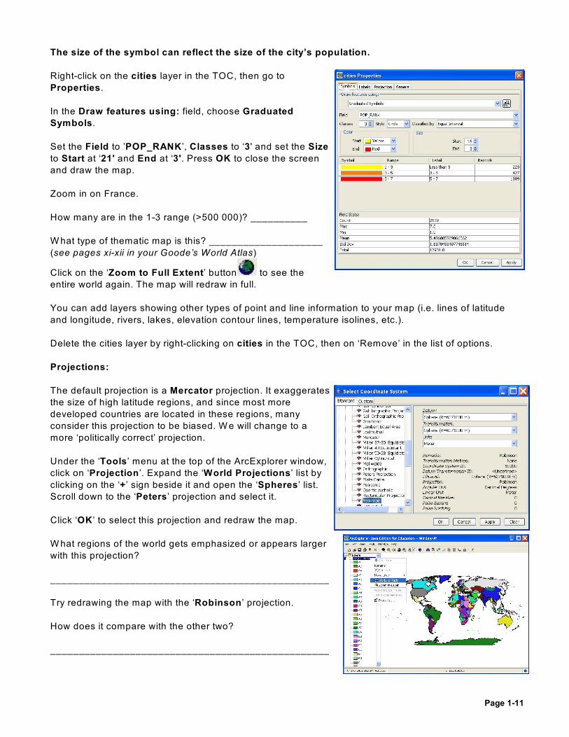
The size of the symbol can reflect the size of the city’s population.
Right-click on the cities layer in the TOC, then go to
Properties.
In the Draw features using: field, choose Graduated
Symbols.
Set the Field to ’POP_RANK ’, Classes to ‘3 ' and set the Size
to Start at ‘21' and End at ‘3'. Press OK to close the screen
and draw the map.
Zoom in on France.
How many are in the 1-3 range (>500 000)? __________
W hat type of thematic map is this? ____________________
(see pages xi-xii in your Goode’s World Atlas)
Click on the ‘Zoom to Full Extent’ button to see the
entire world again. The map will redraw in full.
You can add layers showing other types of point and line information to your map (i.e. lines of latitude
and longitude, rivers, lakes, elevation contour lines, temperature isolines, etc.).
Delete the cities layer by right-clicking on cities in the TOC, then on ‘Remove’ in the list of options.
Projections:
The default projection is a Mercator projection. It exaggerates
the size of high latitude regions, and since most more
developed countries are located in these regions, many
consider this projection to be biased. W e will change to a
more ‘politically correct’ projection.
Under the ‘Tools’ menu at the top of the ArcExplorer window,
click on ‘Projection’. Expand the ‘World Projections’ list by
clicking on the ‘+’ sign beside it and open the ‘Spheres’ list.
Scroll down to the ‘Peters’ projection and select it.
Click ‘OK ’ to select this projection and redraw the map.
W hat regions of the world gets emphasized or appears larger
with this projection?
_________________________________________________
Try redrawing the map with the ‘Robinson’ projection.
How does it compare with the other two?
_________________________________________________

Page 1-12
Choropleth Mapping
A choropleth map uses graduated colour shades to show the distribution of a variable by a region.
Let’s have a look at the data we have for each of our countries.
Right click on the ‘cntry07_demog’ layer in the TOC. Select the ‘Attribute’ table from the menu.
The Attribute table lists each country and, as you scroll
across the table, you will see the names of the different
attributes listed at the top of the table.
The attribute names may be hard to translate because they are
in a short form or code. You can get a list of attributes and their
translations from the ‘cntry_07_demog_metadata.doc’ file
which is found in the directory where we stored the GIS data.
Scroll over to the SQKM column. This lists the size of each
“country” in square kilometers.
Right-click on SQKM and choose Sort Descending.
W hich is the largest country in the world?
__________________________________
W hat is the 2 largest? (don’t count Antarctica)nd
__________________________________
Click on the largest country. Move the table out of the way and look at your map. W hat happened?
________________________________________________________________________________
Return to the table. W hile holding down the Shift key on your keyboard, select the top four countries.
Look at your map again. W hat happened?
________________________________________________________________________________
Now let’s create our Choropleth Map.
W e will use the attribute of Infant Mortality for 2007 as our variable for this map. This variable
measures the number of children who die before their first birthday for every 1000 live births. It is
often used as a surrogate measure of health within a population because healthy mothers give birth
to healthy children who have a better chance of surviving past 1yr of age. It also serves as good
indicator of development, the availability of health care, proper sanitation, healthy diets, etc.
Right click on the ‘cntry07_demog’ layer in the TOC.
Page 1-13
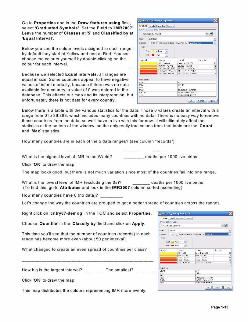
Go to Properties and in the Draw features using field,
select ‘Graduated Symbols’. Set the Field to ‘IMR2007’.
Leave the number of Classes at ‘5 ' and Classified by at
‘Equal Interval’.
Below you see the colour levels assigned to each range –
by default they start at Yellow and end at Red. You can
choose the colours yourself by double-clicking on the
colour for each interval.
Because we selected Equal intervals, all ranges are
equal in size. Some countries appear to have negative
values of infant mortality, because if there was no data
available for a country, a value of 0 was entered in the
database. This affects our map and its interpretation, but
unfortunately there is not data for every country.
Below there is a table with the various statistics for the data. Those 0 values create an interval with a
range from 0 to 36.888, which includes many countries with no data. There is no easy way to remove
these countries from the data, so we’ll have to live with this for now. It will ultimately affect the
statistics at the bottom of the window, so the only really true values from that table are the ‘Count’
and ‘Max’ statistics.
How many countries are in each of the 5 data ranges? (see column “records”)
______ ______ ______ ______ ______
W hat is the highest level of IMR in the W orld? ________ deaths per 1000 live births
Click ‘OK ’ to draw the map.
The map looks good, but there is not much variation since most of the countries fall into one range.
W hat is the lowest level of IMR (excluding the 0s)? _______ deaths per 1000 live births
(To find this, go to Attributes and look in the IMR2007 column sorted ascending)
How many countries have 0 (no data)? _________
Let’s change the way the countries are grouped to get a better spread of countries across the ranges.
Right click on ‘cntry07-demog’ in the TOC and select Properties.
Choose ‘Quantile’ in the ‘Classify by’ field and click on Apply.
This time you’ll see that the number of countries (records) in each
range has become more even (about 50 per interval).
W hat changed to create an even spread of countries per class?
_____________________________________________________
How big is the largest interval? ________ The smallest? ________
Click ‘OK ’ to draw the map.
This map distributes the colours representing IMR more evenly.

Page 1-14
The highest rates of IMR are generally found in (circle one): MDCs LDCs
This map gives a better spread of the countries across the ranges, but there is a potential problem...
W hat is the drawback to classifying by ‘Quantile” rather than the ‘Equal Intervals’ method?
(Hint: look at the difference between the highest and lowest values in the last interval).
________________________________________________________________________________
In order to try and lessen the extent to which the countries with missing data affect our map, we can
create an interval for these countries with no data. W e will still use the Quantile methodology, but we
will add one class to hold the countries with no data.
Go to Properties for this layer to change the no. of
classes to ‘6" and the Classify to field to ‘Manual’.
This screen allows you to set the breaks between
each interval. If you click on the downward arrow
under 'Select Break', you will see a list of numbers
starting with the minimum value and ending with the
maximum value. The second value in the list will be
highlighted – this is the break between the first and
second intervals. Press Enter to select it.
Replace this number in the Current field with ‘2.3 '
(the lowest real IMR). Go back and click on the
downward arrow under ‘Select Break’
This changes the first class to all countries with an
IMR less than 2.3, i.e., all with no data.
To make the five other data intervals represent the
same number of countries (44 or 45), we need to
adjust the other breaks as well. In the Select Break
click on the second break (8.14) and replace it in the Current field with 6.85. Replace the next three
breaks with 14.2, 26, and 59.5 (the last one is the maximum) and then click ‘OK ' to return to the
Properties screen. The number of records (countries) in each interval should be even, except for the
lowest (No data) interval.
Record the size of each interval (excluding no data):
______ ______ ______ ______ ______
W e want to make sure that the countries with no data are not
assigned a color to make the map more clear.
On the Properties screen there is a column labeled 'Symbol', and
the colors for each interval are shown there. Click once with the left
mouse button on the symbol (color) for the first interval range to
select the color selection palette. Choose the white color in the top
left corner for this interval with no data.

Page 1-15
A good choropleth map uses colours that visually show a progression from light (low levels) to dark
(high levels). Choose a clear colour sequence for the other five intervals (e.g. pale yellow, bright
yellow, orange, red and brown). Click ‘‘OK’’ to return to the Properties menu.
Change the Label for the first interval to make it clear it represents countries with no data. Double-
click in the field ‘Less than 2.3’ and replace the text with ‘No Data’, then click on the next interval
range (so this change will be saved) and click on the ‘Apply’ button.
W e also want to make the legend title to better describe the variable being shown. W e can change
the legend title while still in the Properties screen. Click on the ‘General’ tab at the top of the screen.
In the Layer Name field, replace the current title with ‘Infant Mortality Rate 2007 per 1000
population’. Click on Apply, then click on the OK button to return to the map.
It’s a good idea to save your map now to your USB key or to your dedicated space on the JAC server,
NOT IN THE ESRI DATA Directory!. Click on File, then Save As and choose where to save it. Give
it a filename that reflects its theme, scale and date (i.e. IMR2007WorldMap).
Click on each color in the map legend in turn. W hat happens when you click on each color?
________________________________________________________________________________
W ith one color selected, open the Attribute table (right click on the layer name) and sort the selected
data to the top by right clicking on the variables bar and selecting ‘Sort Selected Data to Top’. Now
you can see a list of the countries in each of the intervals.
You can also select the Identify tool to see this attribute of an individual country. Just left-click
on any highlighted country and the name and infant mortality rate will appear.
Click the ‘Clear All Selection’ icon to return the map to its original colours.
Warning: the Penfield computer labs only have black and white printers, so if you do not have access
to a colour printer elsewhere, assign grayscale colours from white (no data) to black (highest level).
Skill-Testing Question:
Make a choropleth map of IMR with six intervals (including one for countries with no data), where the
five real intervals are equal in size between the minimum value of 2.3 and the maximum of 184.44.
W here are the breaks?
0 2.3 _____ _____ _____ _____ 184.44
How many coutries are in each interval?
26 ______ ______ ______ ______ ______
(No data)

Page 1-16
Planning the final map document in the “Layout View”
Before you start, make sure that your map is as large as possible in the map window by clicking on
the Zoom to Full Extent button . It’s also a
good idea to save your map again before you start.
Click on the View menu and select the Layout
View . The icons on the toolbar will change.
Click on the map area while in Layout View . The
tools that let you add and manipulate information in
the map document will be activated in the Toolbar.
These tools allow you to add information to your
map that will facilitate the its interpretation.
There are the usual Zoom and Pan tools, but you
will also have the:
• Add Image tool
• Add text tool for adding text (titles, labels, credit, explanations or other text material)
• Add Overview Map tool that creates a reduced-size image of your map area and situates it
on a larger map
• Add North Arrow tool to show the cardinal directions on the map
• Add Map Scale Bar tool to show distances on your map
• Add Legend tool to show the meaning of numerous symbols from your TOC.
To enter text on your map, click on the Add Text icon on the Toolbar, then right-click the text box
and select Properties to enter text and format it. Create a different text box for each of the following
map components:
Title The title announces what it is that you are showing with the map. Make sure to
include all three components of a good title: W hat is the variable being shown? W hat
geographic area is being shown? W hat is the scale of the data shown (i.e. by
country)? W hat is the date of the data? The title should be at the top of the map.
W rite your text in the box and select an appropriate title format (bold, UPPER CASE,
at least a 14 point font size, centred and using up to two lines).
Data Source For the data source, you can write “Data Source: ESRI” (the company that makes
ArcExplorer) as we do not know where they found the IMR data. Put the source in
the bottom right-hand corner of the map.
Author Remember to include the name of the author of the map (you!) and the date. Put this
information in the lower left-hand corner of the map.
Map Scale Add a map scale in the units that are best understood by the reader. The map scale
will be Miles by default, so after you add the map scale, right-click on it and select
Properties. Set the Division Units to “kilometers” (it is in US spelling format).
In the When resizing… field, select “Adjust the number of divisions” and then set
the Division value to ‘2500' (meaning 2500 kilometres) since in this case we are
looking at a large area. Put the Kilometres label below the scale bar by setting
Label Position: to ‘Below bar’. Click on Apply to set the selected adjustments and
verify if you have the desired results. Drag it to the location you wish on your map.

Page 1-17
Legend Add legend to explain the colours used on our map. You can resize and move the
legend so that it does not obscure the map by clicking on it and dragging it around.
North Arrow As longitude and latitude are not shown on your map, you need to add a north arrow.
Click on the North Arrow tool and select a style that is appropriate for your map.
Generally the simpler the arrow, the easier it is to read. Resize and position the
arrow where you want it.
Please note that you cannot save this layout information with your map.
Print options and Page Setup
Before printing a map, some printers allow you to set its orientation. Go to the File menu, select Print
and click on the Page Setup tab (if it’s there)..
To print your map directly from the ArcExplorer program, go to the File menu, select Print and click
on the OK button. Remember that unless you have set up the map with gray-scale colours, it will not
print well in the Penfield computer lab...
Export Your Map
If you have access to a colour printer elsewhere, but the ArcExplorer program is not installed there,
you should export your map to a different graphic file format.
Page 1-18
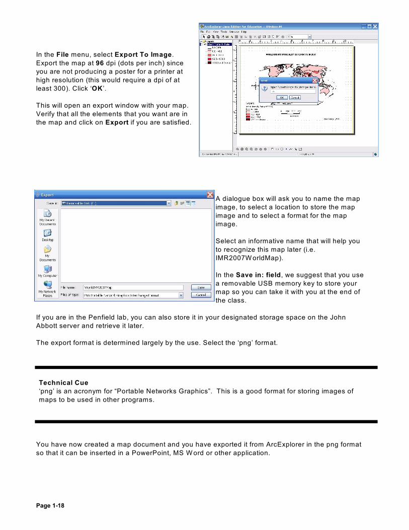
In the File menu, select Export To Image.
Export the map at 96 dpi (dots per inch) since
you are not producing a poster for a printer at
high resolution (this would require a dpi of at
least 300). Click ‘OK ’.
This will open an export window with your map.
Verify that all the elements that you want are in
the map and click on Export if you are satisfied.
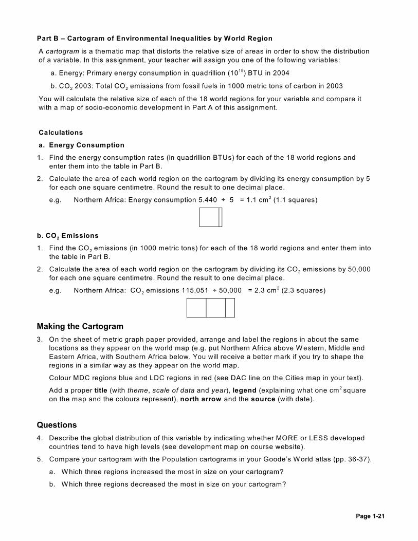
A dialogue box will ask you to name the map
image, to select a location to store the map
image and to select a format for the map
image.
Select an informative name that will help you
to recognize this map later (i.e.
IMR2007W orldMap).
In the Save in: field, we suggest that you use
a removable USB memory key to store your
map so you can take it with you at the end of
the class.
If you are in the Penfield lab, you can also store it in your designated storage space on the John
Abbott server and retrieve it later.
The export format is determined largely by the use. Select the ‘png’ format.
You have now created a map document and you have exported it from ArcExplorer in the png format
so that it can be inserted in a PowerPoint, MS W ord or other application.
Technical Cue
‘png’ is an acronym for “Portable Networks Graphics”. This is a good format for storing images of
maps to be used in other programs.

Page 1-19
Inserting Your Map Into a Microsoft Word Document
In order to hand in a map (i.e. if it is part of an assignment or paper), you will need to insert the
finished map into a Microsoft W ord document. Open a W ord document and from the Insert drop-
down menu, select Picture, then From File to insert your map. You will have to locate it (i.e. on your
removable memory key) and select the filename.
You should adjust the orientation of the page to landscape, as it will be better for this world map, and
you can adjust the size of the image to fit the page area by selecting a corner point with your mouse
cursor and dragging it up or down diagonally.
At a resolution of 96 dpi, the picture of the map in png format should fit perfectly. Your goal is
eventually to be able to share the information contained in your map, so many different media may be
used to disseminate the map image.
Save this W ord file and print a copy of your map at home or elsewhere where you have access to a
colour printer. It is not advised to print in the computer lab at school, as it only prints black and white.
Congratulations, you have just created your first GIS map!
The ArcExplorer Java edition for Education program is available free of charge from ESRI.
Instructions for downloading it and the data files needed for this course are available on theIntro to Geography website:
www2.johnabbott.qc.ca/~geoscience/intro/
Tip
W hen adjusting the size of the image, avoid pulling the image up or across. This will distort the
vertical or horizontal dimensions. To make an image larger or smaller, drag the corners diagonally so
that both the vertical and horizontal dimensions will change at the same rate.

Page 1-20
Thematic Maps Assignment
Introduction:
Thematic maps add physical or socio-economic information to a base map in order to provide the
observer with an instant picture of the spatial relationships in the data. They can be done at any scale
from locality to the world. The objectives of this assignment are to have you:
· demonstrate the ability to prepare and interpret choropleth maps and cartograms
· recognize the strengths and weakness of different interval selection methods
· describe global distributions of a variable in relation to level of development
Instructions:
Part A - Choropleth Map of Socio-Economic Development
1. Use ArcExplorer to produce two choropleth maps (evenly shaded multi-colour maps). Follow the
same procedures as in the ArcExplorer exercise.
Use the variable for Ecological Footprint (in number of hectares per person) or Life
Satisfaction as assigned by your teacher.
This data is available in the ‘cntry07_demog.shp’ file in the ArcExplorer data ‘world ’ subdirectory
(the same file that you used in the ArcExplorer exercise). Look under ‘Field’ for values.
You should produce two choropleth maps with five interval classes (the lowest one for ‘No Data’and four others).
a. Make quantile intervals by using the Manual method and setting the breaks at:
EF: 0.5 1.1 1.7 3.3 LS: 3.0 5.2 6.2 7.0
Record the interval size and how many countries are in each interval.
Save a copy of your map with a name that clearly identifies that it has quantile intervals.
b. Make equal-sized intervals by using the Manual method and setting the breaks at:
EF: 0.5 2.9 5.4 7.9 LS: 3.0 4.3 5.6 6.9
Record the interval size and how many countries are in each interval.
Save a copy of your map with a name that clearly identifies that it has equal-sized intervals.
c. In the Layout view, add to each map:
• a proper title (theme, scale of data, date)
• a legend with a well-thought out colour scheme
• a north arrow
• the data source
• the cartographer’s name (you!)
As you cannot save the Layout information, Export an image of the map when you are done.
2. Do the regions with the highest values for this variable tend to be MDCs or LDCs? (see thedevelopment map on course website or the DAC line on the Cities map in your textbook).
3. W hich is more equal: the size of the intervals (the difference between the highest and lowestvalue) or the number of countries within each interval? Explain why you chose your intervalmethod.
Page 1-21
Part B – Cartogram of Environmental Inequalities by World Region
A cartogram is a thematic map that distorts the relative size of areas in order to show the distribution
of a variable. In this assignment, your teacher will assign you one of the following variables:
a. Energy: Primary energy consumption in quadrillion (10 ) BTU in 200415
2 2b. CO 2003: Total CO emissions from fossil fuels in 1000 metric tons of carbon in 2003
You will calculate the relative size of each of the 18 world regions for your variable and compare it
with a map of socio-economic development in Part A of this assignment.
Calculations
a. Energy Consumption
1. Find the energy consumption rates (in quadrillion BTUs) for each of the 18 world regions and
enter them into the table in Part B.
2. Calculate the area of each world region on the cartogram by dividing its energy consumption by 5
for each one square centimetre. Round the result to one decimal place.
e.g. Northern Africa: Energy consumption 5.440 ÷ 5 = 1.1 cm (1.1 squares)2
2b. CO Emissions
21. Find the CO emissions (in 1000 metric tons) for each of the 18 world regions and enter them into
the table in Part B.
22. Calculate the area of each world region on the cartogram by dividing its CO emissions by 50,000
for each one square centimetre. Round the result to one decimal place.
2e.g. Northern Africa: CO emissions 115,051 ÷ 50,000 = 2.3 cm (2.3 squares)2
Making the Cartogram
3. On the sheet of metric graph paper provided, arrange and label the regions in about the same
locations as they appear on the world map (e.g. put Northern Africa above W estern, Middle and
Eastern Africa, with Southern Africa below. You will receive a better mark if you try to shape the
regions in a similar way as they appear on the world map.
Colour MDC regions blue and LDC regions in red (see DAC line on the Cities map in your text).
Add a proper title (with theme, scale of data and year), legend (explaining what one cm square2
on the map and the colours represent), north arrow and the source (with date).
Questions
4. Describe the global distribution of this variable by indicating whether MORE or LESS developed
countries tend to have high levels (see development map on course website).
5. Compare your cartogram with the Population cartograms in your Goode’s W orld atlas (pp. 36-37).
a. W hich three regions increased the most in size on your cartogram?
b. W hich three regions decreased the most in size on your cartogram?

Page 1-22

Page 1-23
Name: ______________________ Map Assignment
Teacher: ______________________ Intro to Geography
Part A – Choropleth Map of Socio-Economic Development
W hich variable were you assigned: ____________________________________________________
1. a. Quantile Intervals
Interval
(No Data) 2 (lowest) 3 4 5 (highest)nd rd th th
No. of Countries
Interval Size N/A
b. Equal Intervals
Interval
(No Data) 2 (lowest) 3 4 5 (highest)nd rd th th
No. of Countries
Interval Size N/A
c. Attach a copy of your TWO properly formatted ArcExplorer maps.
2. The regions with the highest values for this variable tend to be (circle one) MDCs LDCs
3. Intervals method chosen: Quantile _____ Equal Intervals _____
W hich is more equal: the size of the intervals (the difference between the highest and lowestvalue) or the number of countries within each interval? Explain why you chose your intervalmethod.
_____________________________________________________________________________
_____________________________________________________________________________
_____________________________________________________________________________
_____________________________________________________________________________
_____________________________________________________________________________
_____________________________________________________________________________
_____________________________________________________________________________

Page 1-24
Part B – Cartogram of Environmental Inequalities by World Region (see pages 1-11 to 1-12)
2W hich variable were you assigned: ___ a. Energy Consumption ___ b. CO 2003
1. and 2. Complete the following table using the data table in the back of your W orkbook:
World Region Var. cm World Region Var. cm World Region Var. cm2 2 2
N. Africa C. America E. Asia
W. Africa Caribbean N. Europe
E. Africa S. America W. Europe
M. Africa W. Asia E. Europe
S. Africa SC Asia S. Europe
N. America SE Asia Oceania
3. Attach your properly formatted and labelled cartogram (title, legend, source, north arrow)
4. The regions with the highest values for this variable are (circle one) MDCs LDCs
5. Compared with the Population cartograms in your Goode’s W orld atlas (pp. 36-37):
a. W hich three regions increased in size the most on your cartogram:
______________________ _____________________ ______________________
b. W hich three regions decreased in size the most on your cartogram:
______________________ _____________________ ______________________

Page 1-25

Page 1-26

Page 1-27
Topographic Maps Exercise
Introduction:
Topographic maps are among the most commonly used of thematic maps. Their main purpose is to
give information about the shape of the land, but they also include a great deal of other useful
information.
The objective of this exercise is to allow you to demonstrate on topographic maps the ability to:
· find precise locations
· interpret symbols
· interpret the scale and measure distances
· interpret elevation information to understand the shape of the land surface
· establish direction
Part A – Basic Information
1. Look around the margin of the map and find the answer to the following questions.
a) W hat is the name or title of the map? ___________________________
b) W hat is the scale of the map (as a representative fraction)? ___________________________
c) W hat is the edition number of this map? ___________________________
d) W hen was the information for this map obtained? ___________________________
e) W hen was the map published? ___________________________
f) Elevations on this map are shown in: _________ above mean sea level
g) W hat is the contour interval of the map? ___________________________
Part B – Symbols and Grid References
The main legend of a Canadian topographic map is printed on the back (no colour). W hen more than
one symbol is shown, read across from the left to find its meaning. Use the legend to do the following:
2. a) Draw the symbol for a Traffic circle:
b) Draw the symbol for a Coast Guard station:
c) Draw the symbol for a Drive-in theatre:
d) Draw the symbol for a Cave:
On the map there are blue lines running across and up and down. These are Grid lines which divide
the map into squares. Each line is numbered with a two digit number in the margin of the map.
3. Check any correct statement below:
a. Grid numbers increase from: Left to Right Right to Left Top to Bottom Bottom to Top
b. Vertical grid lines increase as you go: __________ to __________ (compass directions).
c. Horizontal grid lines increase as you go: __________ to __________ (compass directions).

Page 1-28
4.Look at your map to see how the grid lines converge to form squares similar to the diagram below.
Note the grid line 31 at the top (north) of the map, and the grid line 86 located at the side of the
map. The point where these grid lines cross is the bottom left hand corner of grid square 3186
(see below).
a) Name the famous battle site in grid square 2985 (on the map): ________________________
b) In the grid diagram below, shade in grid squares 4627 and 4528.
c) W hat university is located in grid square 2683 (on the map)? ________________________
d) In the diagram above are various circled numbers. Give the grid square for the circled
numbers:
#1 grid square _______________
#2 grid square _______________
#3 grid square _______________
e) On the Quebec topographic map:
W hat name or feature appears in the following grid squares?
i) 2204 ii) 2580
f) Use the legend to find any 3 human-made or natural features found in each of the following
grid squares:
i) 2894 ii) 4381

Page 1-29
So far so good.... But what if we find two similar signs or symbols in the same grid square? W e need
a more precise system than just the grid square to locate a specific feature. W e do this by dividing the
border of each grid square into 10 equal parts (tenths). These additional lines give us a 6 digit grid
reference.
The grid reference to a campground west of the city is 166883. W e get this by going to vertical grid
line 16 and estimating the number of tenths EAST of this line. In this case, the campground is 6
tenths east of line 16, so we get 16.6.
W ith grid references, we omit the decimal point and get 166. Similarly, estimate the number of tenths
NORTH of horizontal grid line 88 to get the second part of the location. It is 3 tenths above, so the full
number is 88.3 (written as 883).
The complete 6 digit grid reference for the location of the campground is therefore: 166883.
One way of increasing your accuracy is to make a scaled ruler. At the bottom of the map, you will find
a scale bar that is measured in metres. Take a sheet of paper and mark off in the top right corner the
tenths as shown below. Then do the same thing down the right side of the page:
5. Answer the following using the six digit grid reference numbers:
a. On the map, what is at grid reference 323068? _____________________________
b. W hat is at grid reference 304858? _____________________________
c. W hat is at grid reference 226963? _____________________________
d. W hat is at grid reference 326942? _____________________________
Remember – grid references are read first ACROSS and then UP.
Page 1-30
Part C – Distance
A map’s scale, you will remember, is the ratio of the distance on the map to the actual distance on the
ground.
6. The representative fraction statement of scale of this map is 1:50,000
a. This means:
1cm on the map is equal to ______________ cm in real life
or 1cm on the map is equal to ______________ m in real life
or 1cm on the map is equal to ______________ km in real life
b. W hat is the length or width of each grid square in metres? _______________________ m
To measure the straight line distance between two points, take a piece of paper and place the upper
edge on the map so that one corner is centred on one point and mark the centre of the other point on
the paper as in the illustration below.
After you have marked the paper, take it to the scale bars at the bottom of the map, and lay it along
the metric bar. You will get a more accurate reading if you place mark "B" at a major division and read
backwards, as in the example below.
As you can see, the line "A" extends into the minor divisions for more accurate reading.
The diagram illustrates a distance of 2.9 kilometres.
7. W hat is the straight line distance between the following:
a) From the campsite at 398878 to the navigation light at 386884 in:
_______________centimetres _______________ metres _____________kilometres
b) From the reservoir at 177915 to the cemetery at 217979 in:
_______________centimetres _______________ metres _____________kilometres

Page 1-31
Part D – Elevations
Maps are flat, of course, but the ground is not. Spot elevations are used to mark elevations on a
topographic map. They can be precise or approximate and are shown on the map as:
- Precise .582
- Approximate .582 ±
8. Identify the type of elevation symbol and record the information shown at each of the following
locations:
a. 212027 _________________ metres Type of symbol: Precise Approximate
b. 418921 _________________ metres Type of symbol: Precise Approximate
A second method of showing elevation that provides more detailed information about the shape of the
land (topography) is the use of contour lines. Contour lines are the brown lines on your map. They
connect points with the same elevation. In the example below, the same hill is represented in 3 ways:
The Hill Cross-section Top View (contours)
If you were to walk around the hill at the same level (going neither uphill nor downhill), you will be
following a contour for that level.
9. Check with a (Ö) mark the true statement(s) below:
a) Contours are lines on a map that keep the same elevation throughout their length _______
b) Contours are lines on a map that go uphill and downhill throughout their length _______
c) Both of the above statements are true _______
d) Neither of the above statements is true _______
The difference in elevation between one contour line and the next is called the contour interval.
This information can be found in two ways:
· Look at the information found on the bottom margin of the topographic map.
· Examine the contour lines visible on the map. Some have the elevation printed on the line. By
counting the number of lines between one numbered contour line and the next, the contour
interval can be calculated

Page 1-32
For example – if you find a numbered line with the elevation 100 on it, the next numbered line is
labelled 600, and it is the fifth line after the first, the contour interval is:
600 - 100 = 500 ÷ 5 = 100
10. W hat is the contour interval of:
a)
__________________ m
b) __________________ m
c) __________________ m
11. Confirm the contour interval of the Quebec map by finding the following contour lines: 200 metres
at 119879 and 100 metres at 145876. Count the number of contour lines that lie between these
two (in grid squares 1287 and 1387). Use the method above to calculate the map’s contour
interval. Show your work below.
W hat is the contour interval of the Quebec map? __________________ m
12. The thicker brown lines are called index contour lines. These are usually drawn every 4 to 5 lines
and are included to aid the map reader determine elevations, particularly in mountainous regions
where one could go bananas trying to count up the number of contour lines.
On the Quebec map, find the index contour line in the north-west corner of grid square 3098. Use
the contour interval and the 250 metre contour line in the same grid square to determine its
elevation.
__________________m
13. Place a check beside each of the following correct statement(s).
a) contour intervals can vary from map to map _________
b) all contour lines are numbered _________
c) all index contour lines are numbered _________
The distance between contour lines on a map tells you whether a slope is gentle or steep.
14. On the diagram below:
a) W hat is the contour interval? ________________
b) W hat is the elevation of the lowest index contour line? ______________

Page 1-33
15. If you walk from point A along the dotted line, which of the following statements would be TRUE?
a) W here contours are father apart (the left side of the map), the slope would be gentle _______
b) Contour lines closer together on the right side of the map means steep slopes _______
c) Both are correct _______
d) Neither are correct _______
16. On the topographic map of Quebec:
a) Locate Lac Bégon at 252978. If you travelled due north for 2 km, would you be walking
generally UP or DOW N hill? _____________________
b) Locate Mont Roland J. Auger at 115911. If you travelled due south-east for 4 km, would you
be walking generally UP or DOW N hill?_____________________
Part E – Direction
On topographic maps, rather than use the cardinal directions (north, south, east and west), direction
is usually given in degrees, with North at 0/, East at 90/, South at 180/, and W est at 270/.
Unfortunately, because flat maps distort the spherical earth even when small portions are shown, the
grid system used on topographic maps is almost always slightly off. In the bottom left margin of the
map there is a diagram which shows the difference between true north and grid north.
17. W hat is the difference between the two? (in degrees) ______________________________
Because compasses point to the north magnetic pole along lines which themselves are not perfectly
straight, another correction must be made if we are to use these instruments. Declination is the
difference between magnetic north and true north.
18. W hat was the declination on the Quebec map (in 1999)? ______________________________
In addition, the north magnetic pole is moving, so each year declination changes slightly. According
to your map
19. In this area, declination INCREASES/ DECREASES each year by ___________’ (minutes). By
the summer of 2006, the declination was ______ and _______’ (minutes).o

Page 1-34
Map Making
Answer the following questions as you watch the video:
1. In addition to “geography” what can maps tell us? ____________________________________
_____________________________________________________________________________
2. W hat is COMPSTAT? __________________________________________________________
a. W hat are the advantages of having these maps on the computer? ____________________
___________________________________________________________________________
b. W hat do the different icons represent? __________________________________________
c. W hat do the size of the icons represent? ________________________________________
d. W hat does the colour of the icons represent? _____________________________________
e. W hat other types of information are contained in other map layers? ___________________
___________________________________________________________________________
3. W hat do the oldest maps share with COMPSTAT? ___________________________________
4. How did the following indigenous peoples make maps before European contact?
a. Marshall Islanders _________________________________________________________
b. Pre-Columbian Mexicans ____________________________________________________
5. W ho made the first “world maps” ___________ On what medium? ________ W hen? ________
6. W hat type of maps did the Romans invent? _________________________________________
7. W ho made the first primitive maps of the moon? _____________________ W hen? _________
Using what technology? _______________________________________________________
8. How were modern maps of the moon made during the 1960s? __________________________
9. W ho was the first cartographer to apply science to map making? __________ W hen? _______
W hat scientific principles did he enunciate for maps?
___________________ ___________________ _ ______________or ________________
W hy were his works lost for centuries? ____________________________________________
10. Rather than geography, European maps represented _______________ made by _________
11. W hat is a T-O map? __________________________________________________________
a. W hat does the ‘T’ represent? _________________________________________________
b. W hat does the ‘O’ represent? _________________________________________________
c. W hat was the ‘umbilicus mundi’?_______________________________________________

Page 1-35
12. W hat new invention liberated map making in the 15 century? __________________________th
13. How was Ptolemy’s Geography saved and rediscovered? _____________________________
_____________________________________________________________________________
14. Ptolemy drastically underestimated ______________________________________________
and overestimated ____________________________________________________________
15. W hat “geographical lie” or compromise affects all maps? _____________________________
_____________________________________________________________________________
16. W hat is the “Greenland problem? ________________________________________________
17. Mercator’s 1569 projection allowed navigators to: ___________________________________
To allow this, it was necessary for Mercator to exaggerate what? _______________________
18. Cassini used a system based on ______________ to make ______________ measurements.
It took his family ____________ years to map France using this technique.
19. Rand McNally’s first maps showed _______________________________________________
a. In the 1890s they started producing maps for _____________________________________
b. To produce their “Blazed Trail” road maps they had to: _____________________________
20. W hen was aerial photography first used to produce maps? __________From what?_________
21. W hat British invention during W orld W ar II was used to map “the unseen”? _______________
22. W hat regions were mapped for the first time using this technique? ______________________
In 1990, the Magellan satellite used it to map ______________________________________
23. Maps, aerial photographs and satellite images are used in disasters to:
__________________________________________________________________________
24. G_____________________ P_____________________ S____________________ satellites
are used to locate and guide ____________, _________________ and __________________
The high-tech __________________ method these satellites use to define locations based on
______________________, ________________________ and _______________________
25. Today’s modern maps are the culmination of what?
___________________________________________________________________________
___________________________________________________________________________

Page 1-36