International Journal on Public Works, Ports & Waterways ......Lindsay Murray (CEFAS, UK), Antonio...
36
International Journal on Public Works, Ports & Waterways Developments Number 92 • September 2003 International Association of Dredging Companies
Transcript of International Journal on Public Works, Ports & Waterways ......Lindsay Murray (CEFAS, UK), Antonio...
International Journal on Public Works, Ports & Waterways Developments
Number 92 • September 2003
International Association
of Dredging Companies
Terra et Aqua – Number 92 – September 2003
Terra et Aqua is published quarterly by the IADC, The International Association of Dredging Companies.
The journal is available on request to individuals or organisations with a professional interest in the
development of ports and waterways, and in particular, the associated dredging work.
The name Terra et Aqua is a registered trademark.
Editor
Marsha R. Cohen
Editorial Advisory Committee
H.L.H. Smink H.W.J. Poiesz, Chairman A.G.M. Groothuizen
H.A.J. Fiers P.J.A. Hamburger P.G. Roland
H. de Vlieger R. Vidal Martin H. Cami
IADC Board of Directors
R. van Gelder, President O. Nakagome, Vice President C. van Meerbeeck, Treasurer
P.G. Roland M. Montevecchi G. Vandewalle
D. Eicke O.F. Verkerke
Please address inquiries to the editor.
Articles in Terra et Aqua do not necessarily reflect the opinion of the IADC Board or of individual members.
© 2003 IADC, The Netherlands
All rights reserved. Electronic storage, reprinting or abstracting of the contents is allowed for
non-commercial purposes with permission of the publisher.
ISSN 0376-6411
Typesetting and printing by Opmeer Drukkerij bv, The Hague, The Netherlands.
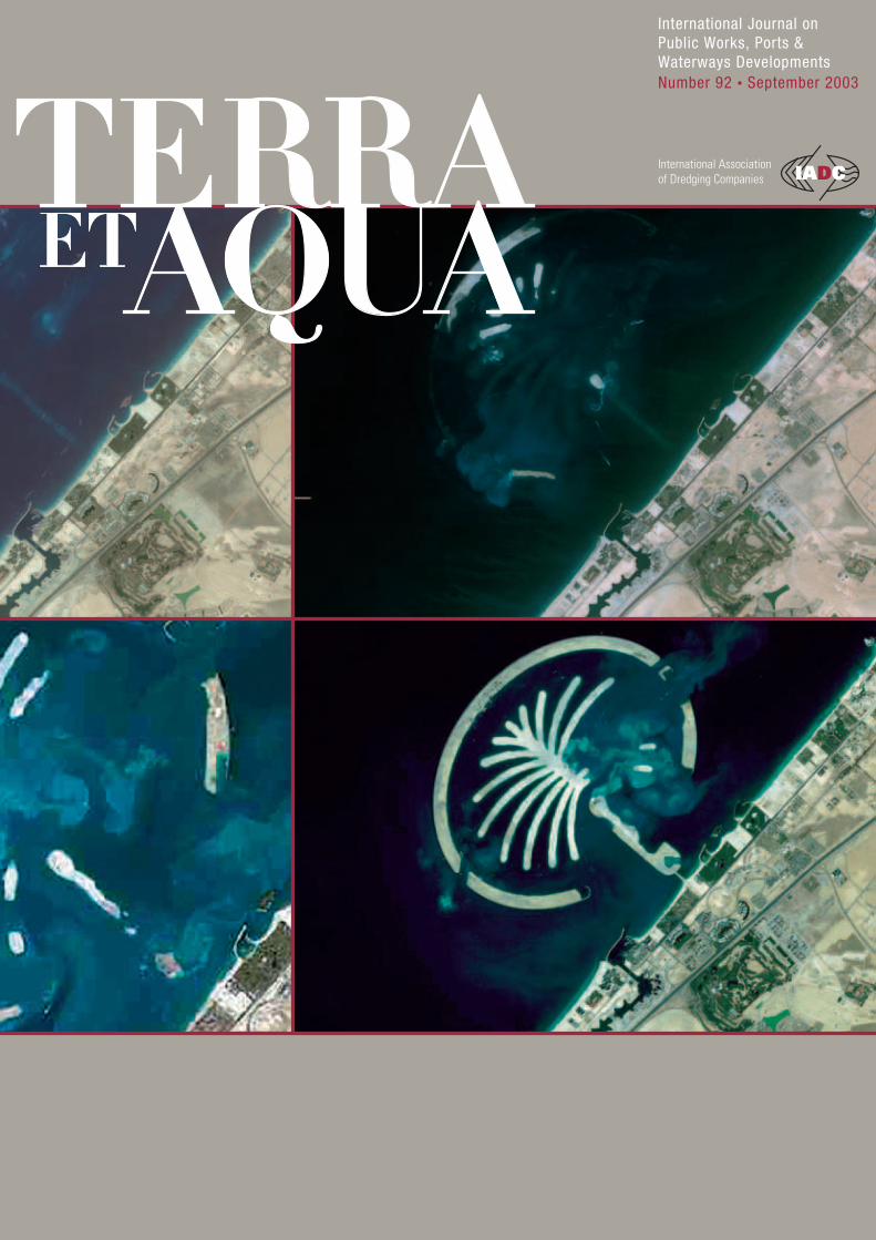
Cover:Satellite photos helped to monitor the progress of the construction of Palm Island
(pictures shown at three-month intervals, see page 14).
IADC
P.J.A. Hamburger, Secretary General
Duinweg 21
2585 JV The Hague, The Netherlands
Tel. +31 (70) 352 3334, Fax +31 (70) 351 2654
E-mail: [email protected]
http://www.iadc-dredging.comInternational Association of Dredging Companies
Terra et Aqua – Number 92 – September 2003
1
CO N T E N T S
2 Editorial
3 Beneficial Uses of Dredged Material: Yesterday, Today and Tomorrow
Eleni Paipai
Contrary to conventional wisdom, most dredged material should be regarded
as a resource, not a waste, and finding new uses for clean dredged material
should be a priority.
13 IADC Seminar on Dredging and Reclamation
IADC’s signature seminar, given in Delft at IHE, in Singapore, and Buenos Aires,
will be held this year in Dubai for the first time.
14 Execution Methodology for Reclamation Works Palm Island 1
Rob E. Jong, Mark H. Lindo, Saeed A. Saeed and Jan Vrijhof
Building an innovative artificial island shaped like a palm tree in unprotected seas
required optimal logistics to avoid risks and meet scheduling goals.
26 Books/Periodicals Reviewed
A book from the National Academy examines the issue of environmental windows
for dredging, and an important new educational website has been launched.
28 Seminars/Conferences/Events
A listing of upcoming events, including Europort, CEDA Dredging Days
and a Call for Papers for WODCON XVII.

Terra et Aqua – Number 92 – September 2003
2
EDITORIAL
The growth and expansion of dredging activities in the last decade, and the
concern for ecological issues, have been mirrored in the breadth of articles in
Terra et Aqua. In recent issues our pages have been filled with reports on
environmental concerns at the Port of Brisbane, the need for more public
awareness about dredging, the beneficial uses of dredged material, and new
projects such as the Hong Kong airport, Singapore land reclamation, the new land
IJburg in The Netherlands, and the Palm Island project in Dubai. These articles
reflect the wide realm of the International Association of Dredging Companies
(IADC). Whilst member companies are active from Asia to Australia to Europe
to the Americas and Africa, the role of their umbrella organisation has also
broadened.
As the voice of the private dredging industry, IADC has sought cooperation
with CEDA, WEDA, IAPH, PIANC and other maritime institutions. The IADC
seminar is in its eleventh year and will be given for the first time in the Middle
East, in Dubai. A new Environmental Seminar, under development with CEDA,
is ready to be launched by year’s end, and work with the London Convention
through CEDA continues, as does participation in several PIANC working
groups. In coordination with OPL, the initiative to publish Dredgers of the Worldwas undertaken and the fourth revised edition will appear in September.
The new edition of another publication, a joint venture with IAPH, Dredging forDevelopment should be ready by the end of the year.
At the forefront of these developments has been Peter J.A. Hamburger,
Secretary General of the International Association of Dredging Companies.
Having spent better than a decade at the helm of the IADC during this exciting
era, he is now ready to move on to new challenges elsewhere in the maritime
industry. As of 1st October 2003, he will be handing over the reins of IADC to
Constantijn Dolmans, who has been Deputy Secretary General for the last 5 years.
With recognition of their past contributions, we sincerely wish both men success
in their future endeavours.
Rob van Gelder
President, IADC Board of Directors
should be subject to a robust and rigorous study, but
equally the suitability of the dredged material for some
sort of beneficial use must be part of the same study.
Why? Because the vast majority of dredged material
around the world is not significantly different from the
sediment found naturally in rivers, estuaries and seas.
Natural processes bring soil down the river and into
the estuaries and seas, and natural processes bring
weathered rock material along the coast and up the
estuary. In other words, this material is basically a
natural resource and should not be regarded as a waste
material that has to be disposed of. Much of that
material therefore must be suitable for relocation
within the natural ecosystem and/or some other
form of beneficial use with or without treatment.
Abstract
Contrary to popular beliefs, the vast majority of dredged
material around the world is not significantly different
from the sediment found naturally in rivers, estuaries
and seas. Since the 1980s, a number of NGOs
including CEDA, PIANC and IAPH, as well as several
Contracting Parties to the London Convention, have
been arguing the case that dredged material generally
should be regarded as a resource and not a waste.
Therefore much of the dredged material is suitable for
relocation within the natural ecosystem and/or some
other form of beneficial use with or without treatment.
This paper attempts to re-define the word “beneficial”
and gives a survey of present beneficial use activities
and suggestions for future options.
The paper was prepared under the auspices of CEDA
by Eleni Paipai, presently of Halcrow Consulting
Engineers, UK, with invaluable assistance from Axel
Netzband (Germany), Polite Laboyrie (The Netherlands),
Lindsay Murray (CEFAS, UK), Antonio Navarres (Spain),
Caroline Fletcher (HR Wallingford, UK) and Neville Burt
(HR Wallingford, UK). It was presented on behalf of
WODA at the London Convention, Scientific Group
meeting, April 2003 in London, UK.
Introduction
The great majority of the world’s goods are transported
over water. Ports and inland waterways are therefore
major revenue earners and creators of employment.
Many waterways have recreational value and provide
amenity uses to the general public. Thus waterways
have considerable socio-economic value, which brings
prosperity to thousands of communities around the
world. In the majority of the world’s waterways
dredging is essential to provide safe navigation routes
to ports and harbours. Undoubtedly, the effects of
dredging and operations on environmental resources
Beneficial Uses of Dredged Material: Yesterday, Today and Tomorrow
Eleni Paipai
Beneficial Uses ofDredged Material:Yesterday, Today andTomorrow
3
Mrs Eleni Paipai holds a Masters in
Environmental Pollution Control and
has recently become a Principal
Environmental Scientist with the
environment team at Halcrow
Consulting Engineers, Peterborough
office. Previously she held a similar
position in the Estuaries and Dredging
Group in the Ports of HR Wallingford.
She works on waterside projects,
on the environmental aspects of port
development and operations and in
particular on aspects of dredging,
disposal and beneficial use of dredged
material. In 1994, she won the PIANC
Gustave Willems prize for her paper
“Environmental Enhancement using
Dredged Material”.
Eleni Paipai

The phrase “beneficial uses of dredged material” first
began to appear in dredging conference proceedings in
Europe in about mid 1980s although it had begun to be
used in the USA before that. To some extent it was a
response to the London Convention (LC). In those days
it was called the London Dumping Convention —
which implied that any dredged “spoil” was a waste.
A number of NGOs including CEDA, PIANC and IAPH,
as well as several Contracting Parties to LC, began to
argue the case that dredged material generally should
be regarded as a resource and not a waste.
The London Convention’s Dredged Material
Assessment Framework (DMAF) recognises that
dredged material is increasingly regarded as a resource
and it requires possible beneficial uses to be consid-
ered before a licence for sea disposal may be granted.
The principle of “dredged material is a resource not a
waste” was embodied in the first draft of the Dredged
Material Assessment Framework produced in the
Los Angeles inter-sessional working group in the early
1990s and has been generally adopted by Contracting
Parties. Sadly, because the procedure is called “specific
guidance for dredged material” under the “Waste
Assessment Framework” the word “waste” has
reappeared in its title. It is to be hoped that this does
not inhibit constructive thought about beneficial uses of
this plentiful resource.
TYPES OF BENEFICIAL USE OF DREDGED
MATERIAL
The disposal of dredged material, whether from capital
dredging or maintenance dredging, provides opportuni-
ties for a number of environmental, economic and
aesthetic uses, including a number of innovative
beneficial uses mainly with the fine grained dredged
material. The following is a list of beneficial uses of
dredged material:
– Sediment cell maintenance (more applicable to
maintenance dredging);
– Construction and other engineered uses (e.g. land
reclamation for port/airport development, residential
development, redevelopment of confined disposal
facilities);
– Construction material (e.g. dredged material mixed
with cement, manufacturing of bricks)
– Replacement fill;
– Shoreline stabilisation and erosion control
– beach nourishment
– coastal realignment
– muddy shore profile engineering
– offshore berms (eg. feeder berms, hard and soft
berms)
– Amenity
– beach nourishment
– derelict land restoration
– recreation (e.g. hills for walks and picnic areas)
– landscaping (parks and other commercial and
non-commercial landscaping applications)
– Capping (one of the early beneficial uses of clean
dredged material was to cap contaminated dredged
material in offshore disposal sites)
– Habitat restoration, enhancement and/or creation
(e.g. saltmarshes, mudflats, wetlands, bird islands,
gravel bars, oyster sandy/gravely beds) (Figure 1)
– Aquaculture
– Agriculture (e.g. cotton fields)
– Horticulture (e.g. orchards, ornamental plant nurseries)
– Forestry
– Strip mine reclamation and solid waste management
In the early days there was a widely held perception
that beneficial uses would only ever be applied to small
quantities in tailor-made situations. However, with
increasing pressures under the regulatory systems,
the use of some creative thinking, and the development
of new technologies there is now widespread use of
dredged material for beneficial purposes. It might also
be said that there has been some re-definition of the
word “beneficial”.
BENEFICIAL USE OPTIONS BY MATERIAL
TYPE
Rock is a valuable construction material and whether or
not it can be used economically depends on its quantity
and size.
Gravel and sand are generally considered the most
valuable material for reuse that a dredging project can
provide. They can find wider application as a resource
material to a number of engineered uses, and most
frequently without the need to sort (or pre-wash) the
material prior to being used. The engineered uses
mainly are land reclamation, construction material,
replacement fill, land improvement, capping, beach
nourishment, and offshore berms. “The range of
engineering applications for dredged material is diverse,
being limited only by the ingenuity of the designer”
(PIANC, 1992).
Clay and silt are the most common materials acquired
from maintenance dredging in rivers, canals and ports.
Consolidated clay can find more engineered uses than
soft clay, whereas silt in particular is more suitable for
agricultural/horticultural purposes and all forms of
habitat creation and/or enhancement. The economical
use of clays and silt differs from that of rock mainly in
terms of preparation work prior to their beneficial use;
silt and soft clay needs dewatering unless appropriate
dredging equipment removes them almost in-situ
density. Also, silt, being fine-grained sediment, can
contain contaminants in quantities, which necessitate
a certain degree of pre-treatment prior to a beneficial
use.
Terra et Aqua – Number 92 – September 2003
4

transport modelling studies and ecological models are
some of the tools, which nowadays can facilitate the
decision-making process for beneficial uses of dredged
material. Environmental legislation requires the use
of such tools for all dredging and disposal projects
particularly when they are located in or near sensitive
natural resources. It also emphasises the importance of
timing of such studies early on in the project in order to
prevent and/or reduce negative environmental impacts
and maximise the potential for mitigation measures.
Early consideration of beneficial use options in a dredging
project can have the dual benefit of a successful
beneficial use application and minimum environmental
impact.
Science alone, however convincing, cannot guarantee
the successful application of beneficial use options for
dredged material. The main reason for this is the large
number of interests of an equally large number of
stakeholders involved in a dredging project, who are
trying to reach a consensus particularly in terms of
timing and costs. Such difficulties can be overcome by
long-term planning. The key to success for the beneficial
use project planner is to identify how, when and where
dredged material from a navigation project can fulfil an
economic need, whilst paying due regard to environ-
mental considerations and limitations. Identification of
economic and/or social benefits may help overcome
some environmental opposition to the use of dredged
material. A multi-criteria analysis where ecology, geology,
hydrogeology, economy and society are considered is
the route to an effective screening down to an appro-
priate number of beneficial use options.
A large number of countries are already engaged in
such type of projects, however the beneficial use of
dredged material is not as widely applied as many in
the dredging industry would like. Why not? There are
Pre-treatment of dredged material to facilitate and
optimise their beneficial uses can, however, be costly
and co-ordination and cost sharing may be very difficult
to achieve. These difficulties, however, can be over-
come by discussion between the interested parties
and stakeholders from policy-makers to the dredging
industry who are left to do the work. Co-operation is
more likely where a defined regional policy exists
which positively encourages the beneficial use of
dredged material (PIANC, 1992).
DECISION-MAKING CONSIDERATIONS FOR
BENEFICIAL USES OF DREDGED MATERIAL
Defining “beneficial” is not easy. “The context in
which the phrase was coined has probably emphasised
beneficial to the environment rather than beneficial to
man in particular. It still poses the question of what will
benefit.” (CEDA/IADC, 1999).
Indeed, the construction of offshore berms for purposes
of improved coastal protection may be regarded by
many as a serious threat to shellfisheries resources.
A serious threat it may be, but a comprehensive
investigation of the physical, chemical and biological
characteristics of the dredged material, of the way it is
expected to behave after placement and of the hydro-
dynamic regime, which will determine its behaviour
can significantly contribute to a successful beneficial
use. Such information is essential for evaluating
the suitability of the dredged material for numerous
beneficial use applications, as well as for the identifica-
tion of preventative measures to ensure the minimum
environmental impact and maximum beneficial use
chance.
Environmental impact assessment studies, sediment
5
Figure 1. Wetlands restoration is a beneficial use option which encourages long-term habitat development.

a number of reasons including:
– Dredged material is legislated in a “peripheral” way;
disposing of dredged material on land is subject to
legislation on soil;
– First and foremost there is different legislation for
dredged sediment management between rivers and
coast;
– Unless a use is identified, dredged material in the
eyes of environmental law is a waste;
– Where dredging is most frequently required
(i.e. where low-energy hydrodynamic regimes
allow settling of suspended sediment) is where
contaminants entering watercourses upstream tend
to settle down along with the fine sediments.
BENEFICIAL USE OPTIONS FOR
CONTAMINATED DREDGED MATERIAL
Obviously, the degree of sediment contamination,
being a decisive factor in any management process for
dredged material, plays an even bigger part when
considering beneficial use. Without treatment, highly
contaminated sediments will normally not be suitable
for most proposed beneficial use applications, particu-
larly where wildlife habitat development projects are
proposed. The exception to this may be the processing
of highly contaminated sediment for the purpose of
creating a usable construction product (e.g. ceramic,
aggregate, and such) or the beneficial end-use of a
confined disposal facility (CDF) where contaminated
dredged material is disposed. However, moderate and
slightly contaminated sediments may be appropriate
for many beneficial uses, possibly after pre-treatment
and/or covering with clean material. What determines
whether or not contaminated dredged material can be
used beneficially is the compatibility between the
physical, chemical and biological properties of the
dredged material and those of the intended beneficial
use, as well as the potential for impacting on sensitive
natural resources.
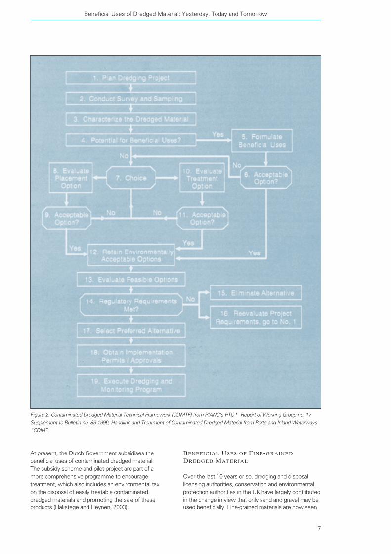
PIANC in its Working Group 17 report on “Handling and
Treatment of Contaminated Dredged Material from
Ports and Inland Waterways” has come up with the
Contaminated Dredged Material Technical Framework
(CDMTF) (Figure 2). This framework is an “international
road map” for nations to follow when developing and
evaluating the appropriate options for dredging and
management of contaminated dredged material,
including the options for a beneficial use. CDMTF
comprises a number of functional steps, aiming to
assist project developers and regulators to approach,
in a systematic and logical way, the development of
alternative uses of dredged material, that are both
environmentally and economically feasible.
“The assessment of the potential for a beneficial use
of dredged material that is contaminated is a functional
step early on in the CDMTF, demonstrating the
significance of regarding dredged material as a
resource rather than as a waste” (PIANC, 1996).
In both The Netherlands and Germany, dredged material,
which cannot be relocated in the water system or be
used directly as a soil substitute, is regarded as waste.
European legislation sets the priority on the beneficial
use option but pre-treatment (e.g. dewatering) is
almost certainly required. If the costs for pre-treatment
are prohibitive or it proves to be technically not feasible,
the only option left is disposal either offshore on in
confined disposal facilities. Management of such sites
nowadays includes the re-use of dredged material from
within the confined disposal facility, after some form of
treatment and/or the identification of an end use for the
site.
In The Netherlands in particular, dredged material has
always been regarded, and in many cases, used as a
resource. At present, relatively clean material is
returned to the North Sea where from they move north
and feed the Waddensea in areas where soft sediment
is needed for benthic productivity. Its usefulness was
first realised well over 30 years ago when farmers used
it as a growing medium, and polders were filled up with
it. Later on houses were built on land where dredged
material was used as engineering fill. Dried sediment
from rivers was used to make building blocks.
All that, however, was stopped when in the 1980s the
seriousness of the contamination levels in the sediments
was realised. In response to this significant problem
and in realisation of the potential of such a resource,
the Dutch Government decided to address the problem
at its root and targeted the industrial discharges into the
waterways, which were the major culprit for the
sediment contamination. In addition, confined disposal
facilities were built and research into treatment
technologies was becoming increasingly active.
The ultimate goal of this conscious activity was to
reduce contamination levels in dredged material as
much as it was necessary to enable their beneficial use.
In 1995, the Dutch Government set a target of 20% of
dredged material to be used beneficially. Dutch policy
now aims to increase the amount of contaminated
dredged material to be treated and reused as
construction materials in order to save on disposal
capacity in confined disposal facilities and to produce
new building materials. Although research and active
projects demonstrated that technically, chemically and
biologically treatment of contaminated sediment could
enable its beneficial use, the target percentage has not
yet been reached because the biggest problem was
public perception. In order to make the public aware of
what is possible with contaminated dredged material,
people had to learn about contamination and its
implications. The result was that people were still
suspicious of treated dredged material.
Terra et Aqua – Number 92 – September 2003
6
BENEFICIAL USES OF FINE-GRAINED
DREDGED MATERIAL
Over the last 10 years or so, dredging and disposal
licensing authorities, conservation and environmental
protection authorities in the UK have largely contributed
in the change in view that only sand and gravel may be
used beneficially. Fine-grained materials are now seen
At present, the Dutch Government subsidises the
beneficial uses of contaminated dredged material.
The subsidy scheme and pilot project are part of a
more comprehensive programme to encourage
treatment, which also includes an environmental tax
on the disposal of easily treatable contaminated
dredged materials and promoting the sale of these
products (Hakstege and Heynen, 2003).
Beneficial Uses of Dredged Material: Yesterday, Today and Tomorrow
7
Figure 2. Contaminated Dredged Material Technical Framework (CDMTF) from PIANC’s PTC I - Report of Working Group no. 17
Supplement to Bulletin no. 89 1996, Handling and Treatment of Contaminated Dredged Material from Ports and Inland Waterways
“CDM”.
as a valuable resource, and this was evident by the
number of opportunities to use capital and maintenance
dredged material. In 1992, 0.07% of fine-grained
dredged material was used beneficially in the UK,
whereas in 2000 0.47% was used beneficially. In 1998,
when Harwich Harbour Approach Channel in the east
coast of England was deepened, the amount of fine-
grained material used beneficially went up to 0.78%.
Fine-grained dredged material is mainly used for flood
and coastal defence, sediment cell maintenance and
habitat conservation or enhancement (Table I).
The soft coastlines of various parts of the UK, particu-
larly in the southeast of England are eroding, some of
them at an alarming rate. These soft coastlines
comprise saltmarshes and mudflats, which help protect
and stabilise sea walls by buffering wave action. The
Environment Agency, which is responsible for the flood
protection measures in the UK, see two alternative
solutions to the coastal erosion problem: either
maintain and build bigger sea walls, at huge costs,
or adopt a sustainable approach of working with coastal
processes such as using beneficially fine-grained
maintenance dredged material (DECODE, 2002).
Dredged material has been shown to successfully
combat erosion and even create new saltmarshes,
which eventually become capable of functioning like
natural systems. In a similar way, fine-grained
maintenance dredged material can be used to create
mudflats or, more usually, to enhance biologically poor
mudflats and in time turn them into much more
productive systems than before.
INNOVATIVE BENEFICIAL USES OF FINE-
GRAINED DREDGED MATERIAL
The recent success of beneficial use schemes has
significantly contributed to an increasing willingness to
identify novel methods of intertidal placement of fine
dredged material. One of the main drivers was the
assurance of the regulators and nature conservation
bodies that the retention of the material within an
estuarine system is one of the more appropriate
applications for beneficial use.
In many tidal estuaries there is a net balance between
the amount of material being deposited and eroded.
It is a dynamic and self-regulating process for excessive
erosion and accretion. The balance it achieves may be
disturbed as a result of dredging. Continuous removal
of fine material by dredging may eventually lead to the
permanent loss of intertidal banks and saltmarshes.
Fine-grained maintenance dredged material can be
(this is the current practice in the UK) returned to a tidal
estuary in order to minimise perturbations to an
estuary’s cell maintenance of soft sediment during
essential dredging works.
Between October 1998 and April 2000 the approach
channel to Harwich Haven Ports, in southeast England
was deepened. The Department of the Environment,
Transport and the Regions issued consents for the
works under the Coast Protection Act, 1949, part of
which was the “Mitigation and Monitoring Package”.
One of the detailed objectives for mitigation defined in
the “Mitigation and Monitoring Package” was to create
16.5 hectares of intertidal habitat in the Stour and Orwell
Estuaries Special Protection Area (SPA) (protected
under the European Directive for the Protection of
Birds) and to prevent the loss of up to 5 hectares per
annum of intertidal habitat owing to the increased rate
of erosion. This objective is to be achieved through the
implementation of a sediment recycling initiative asso-
ciated with maintenance dredging campaigns in the
Stour and Orwell Estuaries and is being implemented
by several means of returning fine-grained sediment in
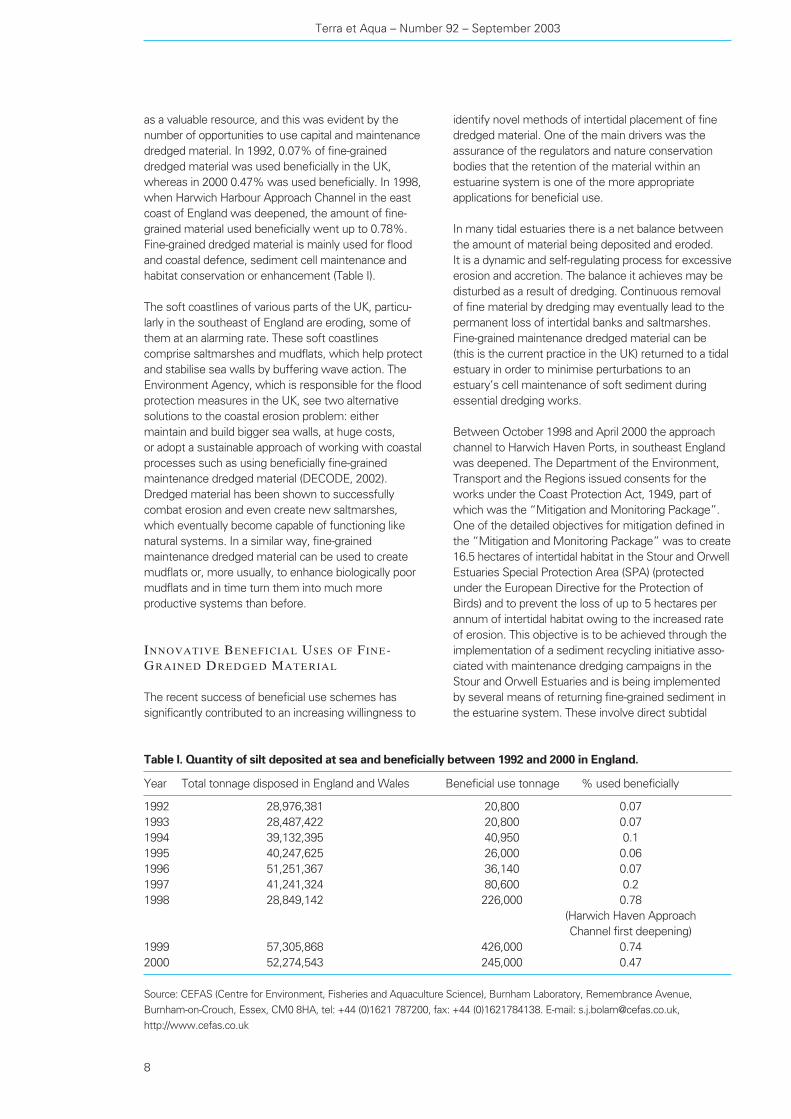
the estuarine system. These involve direct subtidal
Terra et Aqua – Number 92 – September 2003
8
Table I. Quantity of silt deposited at sea and beneficially between 1992 and 2000 in England.
Year Total tonnage disposed in England and Wales Beneficial use tonnage % used beneficially
1992 28,976,381 20,800 0.07
1993 28,487,422 20,800 0.07
1994 39,132,395 40,950 0.1
1995 40,247,625 26,000 0.06
1996 51,251,367 36,140 0.07
1997 41,241,324 80,600 0.2
1998 28,849,142 226,000 0.78
(Harwich Haven Approach
Channel first deepening)
1999 57,305,868 426,000 0.74
2000 52,274,543 245,000 0.47
Source: CEFAS (Centre for Environment, Fisheries and Aquaculture Science), Burnham Laboratory, Remembrance Avenue,
Burnham-on-Crouch, Essex, CM0 8HA, tel: +44 (0)1621 787200, fax: +44 (0)1621784138. E-mail: [email protected],
http://www.cefas.co.uk
the effects of sediment placement on bird and fish
populations. This is particularly important as the
majority of beneficial use schemes are in estuarine
intertidal habitats, areas important for sustaining such
populations (Bolam, 2000).
The impacts of sediment disposal on benthic communi-
ties vary depending on many factors including the
amount, frequency and nature of the disposed sediment,
water depth, hydrography, time of year, the types of
organisms inhabiting the disposal area and the similarity
of the dredged sediment to that of the disposal area
(Harvey et al., 1998). Where dredged material has been
placed, for instance for habitat enhancement, and
temporary upsetting or localised loss of benthos has
followed, the sequence of changes towards recovery
appeared to be dependent upon many factors, including:
– the availability of colonisers;
– the characteristics of the deposited sediment;
– the survival of the disposal site community and/or
exotics (species introduced with the disposed
material); and
– the timing of any later depositions.
The complex nature of the intertidal communities
makes prediction of their post-placement behaviour
inherently difficult. However, the observed succession
patterns have been shown to be similar following many
types of disturbances, even though the actual mecha-
nisms operating during the succession dynamics of
fine-grained sediments remain uncertain. In general,
following the local elimination of the macrofaunal
community, the re-colonisation process begins with the
placement, increased overflow during dredging opera-
tions and water column recharge (sprinkling). The latter
is the most novel of the recharge techniques being
applied in the Stour and Orwell estuarine system.
The process is subject to ongoing refinement as field
data is obtained and used to improve the knowledge of
sediment budgets within the system (Figure 3).
THE CHALLENGE TO WIDER APPLICATION
OF BENEFICIAL USES OF FINE-GRAINED
MATERIAL
Compared to capital dredged material, which typically
comprises relatively coarse material, the behaviour of
deposited fine-grained maintenance material tends to
be less predictable. It is possible to reduce this
unpredictability by engineering the placement site so
that it confines the deposited fine dredged material.
At present, the beneficial placement of maintenance
dredged material within the UK is limited to small-scale
trials. There are several reasons for this. Firstly, there
are concerns over subsequent movement and hence
the potential for interference with other uses/users of
the sea. These concerns arise from our current lack of
understanding of the biological processes following
deposition: phyto- and zoobenthic re-colonisation may
have profound effects on the stability of sediments,
and hence, the fate of deposited material in both the
short and long term. Secondly, our lack of knowledge
of the rates of invertebrate recovery, and how they are
affected by other factors, limits our ability to predict
9
Figure 3. Schematic presentation of subtidal placement and water column recharge of fine-grained dredged material

recruitment of opportunistic species, typically small,
tube-dwelling polychaetes and oligochaetes, which
may reach very high densities. Their near-surface
activities act beneficially as they gradually “condition”
the sediments allowing the successful colonisation of
less opportunistic species. Consequently, later succes-
sion species are able to survive and the community
functionally resembles the one prior to disturbance
(Figures 4, 5 and 6).
THE FUTURE
Understanding the factors influencing the colonisationof fine-grained sediment after intertidal disposalIn the UK, CEFAS, the Centre for Environment,
Fisheries and Aquaculture Science, is heavily engaged
in research work to better understand the factors
influencing the colonisation of fine-grained sediment
after intertidal disposal. There is a fundamental need to
develop a better predictive ability at the community
level in order to assess the ecological consequences of
disturbances, and design successful beneficial use
schemes (Bolam, S., 2000). In general, from the very
few studies in the intertidal zone, invertebrate commu-
nity responses to the deposition of maintenance
dredged material occur much more slowly than those
reported for subtidal (particularly estuarine) systems.
The fine sediments relocated during beneficial use
schemes tend to be very unconsolidated with very high
water contents and it is possible that this may inhibit
initial re-colonisation. Invertebrate community responses
are likely to depend on factors such as the frequency
and intensity of dredged sediment deposition, type of
material deposited and the nature of the recruiting
assemblage.
There are, however, still very important questions that
need to be addressed in order to improve our under-
standing of the biological processes following deposition,
our knowledge of the rates of invertebrate recovery,
and how they are affected by other factors. Answers to
the following questions should enable successful
applications of large-schemes of beneficial uses of
fine-grained dredged material (Waldock et al., 2002).
These questions include:
– How does the nature of dredged material (particle
size distribution, organic content) affect survival of
species at the deposition site and succession
dynamics following deposition?
– Does the degree of consolidation of relocated
sediments affect the initiation of re-colonisation?
– How does the rate of deposition of the dredged
material affect survival of species and succession
dynamics?
Wider application of beneficial uses of fine-grained(muddy) dredged materialThere is undoubtedly a fundamental need to improve
our understanding and predicting ability of how factors
influence the rate of colonisation of fine-grained
material after intertidal placement in order to increase
the degree of success of beneficial use schemes,
and particularly with fine-grained dredged material.
At present, the beneficial placement of fine-grained
dredged material within the UK is still limited to small-
scale trials because of the largely unknown factors that
10
Figure 4. In 1998 and 1999 fine-grained dredged material was placed at Titchmarsh Marina in the UK to create mudflats and
saltmarshes. Seen here, the placement stage.

Sediment managementThe primary limitation of more beneficial use application,
in the experience of Germany and The Netherlands,
is the contamination levels of dredged material.
Those responsible for dredging are not responsible for
the contaminants in the waterways, which is why
source control to reduce contamination input must
be seen as the only effective future solution to the
ongoing problem of dredged material disposal.
Germany believes that source control can solve the
problem of contaminated sediments. The International
contribute to the colonisation by plants and animals of
the disposal site after placement.
In the meantime, however, visible results mainly from
small-scale schemes in a relatively short time, increase
our confidence in beneficial use schemes using fine-
grained material in intertidal areas, and drive attempts
to identify new techniques in retaining such material
within sediment cells. Large-scale schemes of
beneficial use of fine-grained material, which provide
the opportunity to closely observe and understand
the factors influencing the re-colonisation process at
the disposal site, should also contribute to further
widening the spectrum of beneficial uses of dredged
material and give confidence to regulators that such
schemes are feasible.
Such a scheme has recently been commissioned by
DEFRA (the Department for Environment, Food and
Rural Affairs) in the southeast of England. The physical,
chemical and biological processes of this large-scale
scheme will be monitored by HR Wallingford and
CEFAS. In addition, the practicalities of large-scale
placement of fine-grained dredged material will be part
of the study as well as lessons learned from other
similar projects worldwide.
The water column recharge (sprinkling) in the Stour
Estuary in the UK is an innovative and promising
technique that uses fine-grained material. Ongoing
studies will show whether this is an effective method
of returning material to the intertidal areas despite its
negative, yet short-lived, aesthetic impact. Up until
now, observations indicate that it is likely to be the
most efficient way of returning fine sediment to the
intertidal areas.
Beneficial Uses of Dredged Material: Yesterday, Today and Tomorrow
11
Figure 5. Titchmarsh Marina: Growth starting to appear.
Figure 6. Titchmarsh Marina: Diverse saltmarsh vegetation
has colonised the recharged area successfully.

Commission for the Protection of the River Elbe
foresees that the sediments shall be clean by the
year 2010 in a way that they can be used beneficially,
for example, for agricultural purposes.
For a greater emphasis and more effective application
of beneficial uses of dredged material, handling of
sediments (including treatment and confined disposal)
has to be more effectively recognised and represented
in the legal framework (Dutch-German Exchange on
Management of Dredged Material, 2002). On the
European level this is not the case. For example,
the Landfill Directive does not take into account the
special properties of dredged material and the sub-
aquatic confined disposal is not accepted as an
effective way of storing and confining contaminants.
Contrary to conventional waste, fine-grained dredged
material, which has a very low permeability, when
stored in anoxic and sub-aqueous environment, provide
its own “sealing capacity” (both in terms of physical
and geo-chemical properties) and thus groundwater
protection. Yet the Landfill Directive requires that
confined disposal facilities for contaminated dredged
material should be lined with artificial liners. There is
however no known artificial liner with more than
25 years of lifetime; in other words effective ground
and groundwater protection is guaranteed up to a
maximum of 25 years. Thus wider recognition of the
properties of dredged material and its post-disposal
behaviour, as well as legislative harmonisation in terms
of how and where dredged material can or cannot be
disposed of on land, is required for a more successful
application of beneficial uses of dredged material and
particularly fine-grained dredged material.
Conclusions
The development of beneficial use options for dredged
materials contributes to a sound economy and ecology.
Yet these options remain acutely underdeveloped. In
general, relatively coarse, capital dredged material is
more easily utilised because it is more predictable.
For the intertidal placement of fine-grained maintenance
dredged material, however, a fundamental need
remains to identify innovative methods. This means
developing a better predictive ability to assess the
ecological consequences of disturbances caused by
fine-grained sediment. Recent small-scale schemes
in the UK and elsewhere give reason for optimism.
In addition, large-scale pilot studies are in the planning
or under way.
The primary limitation of more beneficial use applica-
tions is the contamination levels of dredged material.
Those responsible for dredging are not responsible for
the contaminants in the waterways, which is why
source control to reduce contamination input must
be seen as the most effective future solution to the
ongoing problem of dredged material disposal. In
addition, the handling of sediments, including treat-
ment and confined disposal, has to be more effectively
recognised and represented in the European and
international legal framework.
References
Bolam, S. (2000). Implications of the Nature and quality of dredged material for its
placement in the coastal environment. Framework for ecological
studies of “beneficial use” schemes, DECODE
(see below).
CEDA/IADC (1999).Reuse, Recycle, Relocate. Environmental Aspects of Dredging,
Volume 5.
CEFAS (2002). “Beneficial Use of Fine-Grained Maintenance Dredged
Material”. DECODE. http://intranet/cefaswww/decode/use.htm
DECODE (2002). http://intranet/cefaswww/decode/use.htm.
Hakstege, A.L. and Heynen, J. (2003). “Encouraging the treatment and reuse of contaminated
dredged material in The Netherlands”. Proceedings of the
WASCON 2003, San Sebastian, Spain, 4-6 June.
Harvey, M., Gauthier, D. and Munro, J. (1998). “Temporal changes in the composition and abundance of the
macro-benthic invertebrate communities at dredged material
disposal sites in the Anse a Beaufils, Baie des Chaleurs, Eastern
Canada”. Mar. Poll. Bull. 36: 41-55.
HR Wallingford (April 2001).“The beneficial use of muddy dredged material”. Report SR
579.
PIANC (International Navigation Association) (1992).Beneficial Uses of Dredged Material – A Practical Guide.
Report of Working Group 19.
PIANC (International Navigation Association) (1996). Handling and Treatment of Contaminated Dredged Material
from Ports and Inland Waterways “CDM”, Vol 1. Report of
Working Group 17.
Waldock, R., Paipai, E. and Bolam, S. (2002).“Beneficial Placement of Fine-grained Dredged Material
in England and Wales - A Success Story So Far”.
CEDA Dredging Days Conference, Casablanca, Morocco,
October 2002.
Terra et Aqua – Number 92 – September 2003
12
participants the opportunity to see dredging equipment
in action and to gain a firsthand view of the extent of
dredging activities.
As part of the course, participants receive a compre-
hensive manual which includes a reference list of
relevant literature in the field. At week’s end, attendees
are presented with a Certificate of Achievement from
the IADC in recognition of their completion of the
course.
Education about dredging, both within the profession
and for others who come in contact with dredging,
continues to be a necessity. Even today too often
misunderstandings arise between the public, dredging
companies and government agencies. Raising the level
of knowledge about the dredging industry is an
important responsibility of the industry itself. Ignorance
is not bliss, and only by providing accurate information
can we ensure that dredging, with the highest quality
and adherence to international guidelines, treaties and
safety standards, will continue.
The Seminar will next be given October 11-15 2003 in
Dubai. For further information about the venues for
courses in 2003 and 2004 please contact the IADC
Secretariat in The Hague by telephone (+31 70 352 3334)
or by email ([email protected]).
More than eleven years ago, the International
Association of Dredging Companies (IADC) and the
International Institute of Hydraulic and Environmental
Engineering (IHE) joined forces to develop the first
International Seminar on Dredging and Reclamation in
Delft, The Netherlands. The Seminar, presented by
professionals from IADC member companies, formed a
complete unit within a year-long graduate level study
programme at IHE.
Since then the Seminar has become one of the main
elements in the IADC’s efforts to reach young people
all over the world and help them understand the need
for dredging, the process by which the decision to
dredge is reached, and how a dredging project is
implemented. Building on the success at IHE Delft,
it has since been held in Singapore, Buenos Aires and
Egypt. Now, with the same enthusiasm, a request has
been made to present the Seminar at still another
location, and thus in October 2003 it will be given for
the first time in Dubai, UAE (see page 32).
Needless to say, as dredging is a growing, dynamic
industry, the Seminar programme has been updated
continuously and the manual has been revised to
include the newest equipment and state-of-the-art
techniques. The basic principle, however, remains
unchanged: A well-executed dredging project results in
positive developments for an area’s economy, for its
environment and for the quality of life of its residents.
Also unchanged is IADC’s commitment to education,
to encouraging young people to enter the field of
dredging, and to improving communications and
understanding about dredging throughout the world.
The Seminar in BriefTo optimise the chances of the successful completion
of a dredging project, it is important that from the start
contracting parties fully understand the requirements of
the project. The five-day course seeks to establish this
and is divided into two types of presentations:
– lectures by experts in the field, and
– workshops, partly conducted on-site in order to give
the “students” hands-on experience.
An important feature of the Seminar is a trip on a trailing
suction hopper or cutter to visit a nearby dredging
project in the local geographic area. This gives the
IADC International Seminar on Dredging and Reclamation
13
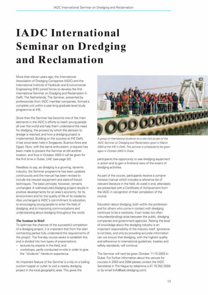
IADC International Seminar on Dredging and Reclamation
A group of international students on a site visit as part of the
IADC Seminar on Dredging and Reclamation given in March
2003 at the IHE in Delft. The seminar is scheduled to be given
again in October 2003 in Dubai.

Abstract
The construction of an artificial island in the shape of a
palm tree with a diameter of approximately 5 km in
front of the coast of Dubai is nearing completion.
To protect the island against wave attack, an offshore
crescent breakwater surrounding the island with a total
length of 11 km was constructed at the same time.
After completion, the island will be developed into
virtually self-contained communities including marinas,
shopping centre, theme parks, restaurants and so forth.
The Client is Dubai Palm Developers, a subsidiary
company of the Dubai Ports, Customs & Free Zone
Corporation. The main contractor for the reclamation
works, totalling some 70 million m3 of sand, is Van
Oord ACZ. The breakwater construction was carried
out under a separate contract awarded to Achirodon
Overseas. The contract was awarded to Van Oord ACZ
at the end of 2001 and works have to be completed
end 2003.
One of the main challenges was constructing the sand
fill for the island, which had to be carried out partly in
unprotected sea conditions, since the breakwater was
under construction simultaneously because of the tight
time schedule. Therefore an execution methodology
was developed aiming at an optimal schedule in terms
of speed of construction and minimal risks of damage
and sand losses.
First an inventory was made of the different sand
transport mechanisms i.e. long-shore, cross-shore and
wash-over transport and how this would effect the
work under construction taking into account a number
of possible execution strategies. From this study, the
optimal execution methodology was derived.
Also optimal logistics in terms of cycle times and
combination of placement/rainbowing has been
achieved, by implementing day-to-day survey results
into the DGPS tracking system. In this way underwater
filling is made possible, leaving open sufficient space to
manoeuvre the ships.
Terra et Aqua – Number 92 – September 2003
Rob E. de Jong, Mark H. Lindo, Saeed A Saeed and Jan Vrijhof
Execution Methodologyfor Reclamation WorksPalm Island 1
Figure 1. Artist impression of Palm Island 1.
Introduction
Jebel Ali Properties is developing a prestigious housing
and recreation project on new land to be reclaimed in
the Gulf between Dubai City and Mina Jebel Ali.
The project, aptly named Palm Island Project, comprises
an artificial palm-shaped island protected at the sea-
ward side by an armoured semi-closed oval crescent
(Figure 1). The area under consideration has water
depths ranging between 8-10 m below Jebel Ali CD
(tidal range is approximately CD+0.5 m to CD+1.5 m)
and an almost horizontal to very mild foreshore.
The island itself is built from locally dredged sand.
The dimensions of Palm Island are impressive: the
perimeter of the crescent is approximately 11 km long,
the surface to be reclaimed is about 650 ha and the net
sand volume is about 70 million m3. The total time
allowed to construct the island is two years.
The required sand is acquired by hopper and cutter
dredgers and is deposited in the lee of the oval
crescent surrounding it. The contractor Archirodon
Overseas is main contractor for the construction of the
rock armour protected crescent, where Van Oord ACZ
is the main contractor for the construction of the actual
island (Figure 2).
Since the crescent breakwater and sand-filled island
were built simultaneously due to time restrictions, the
island was partly unprotected during the first stages of
the construction. This means that during this construc-
tion period the integrity of the island was endangered
by the incoming waves, making the progress and
success of its construction strongly dependent upon
the progress of the crescent construction providing a
sheltered area.
Therefore an optimal execution schedule in terms of
maximum speed of construction and minimal risks
(of damage) was developed by cleverly scheduling the
works taking into account and combining the increasing
sheltering effect of the crescent under construction,
the relevant sediment transport processes and the
vessel characteristics and movements.
SHELTERING EFFECT OF THE CRESCENT
The wave climate can be characterised as generally
mild. The most frequent and most intense storms
come from a narrow range of directions in the W-NW
sector throughout the months November to April.
These are locally referred to as “Shamal” events.
Typically wave events with significant wave heights
(Hs) of 1-2 m occur rather frequently in this season.
Storms with return periods of 5-10 year will produce
waves in the order of 3.25 m whilst the 1:100 years
design conditions have been set at Hs=4 m. Storm
surges are limited to approximately 0.5 m above tidal
level (MHHW = CD+1.6 m).
Execution Methodology for Reclamation Works Palm Island 1
15
Rob de Jong obtained his Master
Degree in Civil Engineering from
the Technical University Delft in
The Netherlands (2001). Thereafter,
he joined the Van Oord ACZ
Engineering Department where
estimating sand loss during the
construction of Palm Island was his
first major project.
Rob E. de Jong
After graduating in Civil Engineering,
Mark Lindo joined FC de Weger
International Consultants, where he
was involved in the design and review
of several large-scale hydraulic and
civil engineering projects such as
storm-surge barriers and breakwater
rehabilitation projects. From 1986-1990
he was Head of the R&D Department
of ACZ Marine Contractors and also
part-time Scientific Officer at
Technical University Delft. Since 1990
he is Head of the Engineering
Department VOACZ.
Mark H. Lindo
Saeed A Saeed is Director of Projects
at Palm Island Developers, Dubai.
Jan Vrijhof is head of the Estimating &
Engineering Department at VOACZ
since 1999. After obtaining his degree
in Civil Engineering (Coastal
Construction) at the Technical
University Delft (1979), he joined the
dredging industry. Over the last 24
years he has worked in many positions
and locations. As project manager he
was responsible for a number of major
dredging projects including one of the
Airport Core Projects in Hong Kong,
the West Kowloon Reclamation
Project. In 2001/2002 he was appointed
interim Project Manager during the
start-up of the Palm Island Project.
Jan Vrijhof

To determine the sheltering effect of the crescent
under construction numerical wave computations have
been carried out with the 2-dimensional numerical
wave model SWAN. Since diffraction equations are not
yet modelled in SWAN, an increased directional wave
spreading has been applied in the SWAN wave
computations. The solution was tuned using the
diffraction examples provided in the Shore Protection
Manual [1] and gave satisfying results for this situation.
The wave computations were carried out for a
combination of 6 different wave directions, 6 different
wave heights and 18 different lengths of the crescent
under construction. Thus a total of 36 (6 x 6) wave
computations have been performed for 18 crescent
lengths, hence a total of 648 computations. The
completion dates for the various crescent chainages and
thus crescent lengths were derived from the planning
of the breakwater construction (Figure 3).
The ratio between the computed wave height and the
boundary wave height give so-called transformation
ratios. These transformation ratios were combined with
the nearshore monthly wave climates to determine the
monthly wave climates for the various stages of the
crescent construction. For each phase of the crescent
construction it was thus possible to estimate the
sheltering effect on the average wave conditions by
comparing the wave climate as computed with and
without the crescent (for each specific location,
relevant month and accompanying crescent length).
SEDIMENT TRANSPORT PROCESSES
When waves attack the partially completed sand island,
they will move sand out of the predefined boundaries
of the fronds and trunk (Figure 1). Especially the ends
of the fronds will experience losses, since they will lose
sand by a combination of littoral (long-shore) and
perpendicular (cross-shore) sand transport, whilst they
are the least protected by the crescent during the
construction phase and are more vulnerable to adverse
3-dimensional effects. Furthermore, there is no natural
sand supply. The removed sand is thus permanently
lost. This means that either the lost sand must be
brought back into the profile or more sand must be
borrowed. It is therefore very important to estimate
how much sand will be transported outside the final
profiles by these waves.
To be able to give a rough assessment of the anticipated
sand losses, the sand transport generated by waves
was quantified using simple but transparent morpho-
logical models. It is emphasised that these models
(cross-shore and long-shore) were made for uniform
straight beaches and sandbars are not valid for areas
such as the end-section of the fronds. These morpho-
logical models are discussed below making a distinc-
tion between two fundamentally different situations:
1. Crest level lower than the wave run-up level
(wash-over transport).
2. Crest level above the wave run-up level
(cross- and long-shore transport)
For the calculations use has been made of the
expertise and/or models of WL | Delft Hydraulics,
Alkyon, Professor Bijker and VOACZ’s in-house
expertise and models.
WASH-OVER TRANSPORT
When the crest level is lower than the wave run-up
level, waves will wash over the created berm, that can
than be seen as a sand bar. This sand bank will reshape
in time due to sand transport by waves and currents.
Three sub-mechanisms for this wash-over transport
can be distinguished. For each of those systems the
sand grains are mainly stirred up by the wave-induced
16
Figure 2. Trailing suction hopper dredger Volvox Atalanta “feeding” the Palm with the Burj-Arab Hotel in the background.

the partially constructed fronds. These increased flow
velocities, in combination with the expected local
wave climate were then used to estimate sediment
transport rates at various locations in the project area.
These sediment transport rates were determined using
formulations of Van Rijn [2], which have been
implemented in the profile model UNIBEST-TC by
WL | Delft Hydraulics.
The calculations showed that the sand losses during
the winter are dominated by the most severe storms.
Especially when breaking of the wave starts the trans-
port rates increase considerably. The actual duration
and severity of these storms may differ considerably
orbital flows. The origin of the current that is required to
transport the stirred-up sand grains, however differs.
These currents are:
1. Tidal current parallel to the shore
2. Down-slope directed density currents
3. (Breaking) wave-induced current
For the assessment of the wash-over transport the
local bathymetry and the complete submerged
Palm Island was taken into account. Two levels of
the submerged island were considered: CD–4 m and
CD–6 m. The breakwater under construction was not
taken into account. A 3D flow model was used to get
an indication of the increased tidal flow velocities over
Execution Methodology for Reclamation Works Palm Island 1
17
Figure 3. Typical results SWAN wave transmission calculations for 6 execution stages of the crescent (offshore significant wave
height 2.25 m, mean wave direction as indicated by the arrow).
FEB 2002 MAY 2002
AUG 2002 NOV 2002
FEB 2003 MAY 2003
= non-constructed part breakwater
= constructed part breakwater
Hs [m]
15

from one winter to the other. Changing the incoming
wave height +/–10% resulted in a +/–300% change in
the calculated transport rates. This means that the
associated sand loss may differ dramatically from one
winter to the next.
The berm level also influences the number of waves
that are forced to break. Accordingly, the calculated
transport rates for the berm level of CD–6 m were
considerably lower (order 10 times) than for the berm
level of CD–4 m.
The calculation also showed that the sand losses are
dominated by cross-shore transport. Not the tidal
current parallel to the shoreline, but the wave driven
currents (perpendicular to the coastline) over the
partially constructed fronds are dominant for the
expected sand losses. Unfortunately these transport
rates are very sensitive for the calculated near-bottom
flow velocities, which in their turn depend on the
modelled (sand) bed roughness. The bed roughness
was not exactly known. When the bed roughness was
varied between 1 cm and 10 cm, the calculated cross-
shore current velocity varied between 1 m/s-1.5 m/s.
For this range in current velocity the calculated
sediment transport rates differed a factor 10.
The magnitude of the sediment transport is however
principally not equal to the losses, since part of the
transported sediment will resettle in the eventually
required profile.
During the construction, the reshaping of the
submerged sand bars were monitored. The measure-
ments indicated that reshaping in case of a crest level
of about CD-4 m only occurs during extreme conditions
conform theory. The reshaping for this crest level is far
less than in case of a crest level above the water level.
The calculated transport rates are very dependent on
the wave height. The real wave climate outside the
breakwater during the first winter period (2001-2002)
was milder than average. This mild winter wave
climate would result in considerably lower calculated
sand transport since the losses are dominated by
the highest waves with only a small probability of
occurrence. These low transport rates were indeed
recorded.
LONG-SHORE TRANSPORT
For the berm with a crest level higher than the run-
up level of the waves, the waves are blocked.
Two transport directions are distinguished for this
situation: transport parallel to the berm (long-shore)
and transport perpendicular to the berm (cross-shore).
Three methods to calculate the long-shore transport
rates were compared.
CERCThe CERC formula is commonly used to estimate the
long-shore sediment transport. It is an empirical relation
between the waves and the long-shore transport for
relatively long and straight beaches, where the along-
shore differences in the breaking waves are small.
The CERC formula can be given as:
(1)
S long-shore sand transport [m3/s]
A dimensionless coefficient [-]
Hsig
significant wave height [m]
c wave celerity [m/s]
cg
wave group velocity [m/s]
n ratio cg
to c [-]
ϕ angle between the wave
crests with the shoreline [°]
Subscript “1” indicates that the dimensions at a water
depth of 10 m are used. Subscript “br” indicates that
the dimensions at the breaker line are used.
In the Shore Protection Manual, a value of A = 0.050 is
derived based on measurements on beaches which can
be characterised by a D50
of about 200 μm. At the Palm
Island project location sand of about 400 μm is present.
Larger grain result in lower transport rates, the value of
A was therefore adapted for the project location.
The effect of tidal current on the transport rates cannot
be incorporated in the CERC formula. The tidal current
velocities at the project location are however limited to
extremes of 0.25 m/s to 0.30 m/s, so the error of
neglecting them may be limited here.
The beach slope strongly effects the distribution of the
long-shore transport across the breaker zone. The effect
on the total long-shore transport is however limited,
since a steeper slope means a narrower breaker zone,
but on the other hand a more (energy dissipating)
intensive breaker zone. The net effect is a slight
increase in the long-shore transport in case of a steeper
slope (Bijker [3]). The effect of neglecting the slope at all
is therefore expected to be limited as well.
BIJKER (1971) AND VAN RIJN (1993) Alkyon calculated the long-shore transport for several
incident wave directions with respect to the normal on
the coastline using the transport model UNIBEST-LT.
The following input data was used:
– Slope of 1:4
– Constant tidal current of 0.1 m/s
– A constant water level of CD+1 m
– D50
= 400 μm
– Bed roughness = 0.05 m
For the computations the Bijker [3] and Van Rijn [2]
transport formula for sand were applied.
Terra et Aqua – Number 92 – September 2003
18
( ) ( )1112
1, sincos ϕϕ ⋅⋅⋅⋅⋅= brsig cnHAS

CROSS-SHORE TRANSPORT
In case the crest level is above wave run-up level not
only long-shore transport occurs, but also cross-shore
For several significant wave heights (Hs) with a wave
approach angle of 45° the long-shore sand transport
as calculated using the CERC, Bijker and Van Rijn
formulation are shown in Figure 4.
The long-shore transport rates calculated with CERC
and BIJKER are of the same order of magnitude
(within the morphological accuracy factor of 2 to 3).
The VAN RIJN transports are approximately 100 times
higher than the transports calculated with the other
two formulas. For more gentle slopes lower transport
rates are found with VAN RIJN, which is in contradic-
tion with the measurements by Bijker [3] that indicate
that the slope has very little impact on the total long-
shore transport.
As the long-shore sediment transport rates as calculated
with CERC and BIJKER are in good agreement and the
CERC formula is simpler and faster, the CERC formula
has been used for the determination of the resulting
monthly long-shore sediment transports.
Execution Methodology for Reclamation Works Palm Island 1
19
0
1
2
3
4
5
0 1 2 3 4 5
Hs [m]
Lo
ng-s
ho
res
an
d t
ran
spo
rt
[m3/s
]
CERC
BIJKER
VAN RIJN
Figure 4. Calculated long-shore transport rates for a 45° wave
approach angle.
SWL
Crest line
SWL
Transition zone Active zone Backshore
ho
hm
Figure 5A. Typical cross-profile before exposure to waves.
Figure 5B. Typical cross-profile after exposure to waves.
transport. In case of cross-shore transport (perpendicular
to the coastline) sand will be moved from the slope
downward (and to a lesser degree upward) and thus a
gentler slope will develop in time. The crest line will
shift in shoreward direction and sand will deposit
outside the required profile.
With several cross-shore transport models, the shape
of the foreshore (slope) for various wave conditions and
sand characteristics can be estimated. Also a prediction
of the time-dependent development of the profile can
be made. Eventually a more or less equilibrium profile
will develop.
In case of exposure to waves, the coastal zone can
be divided in 3 different zones as shown in Figure 5B.
The active zone is the zone that is directly influenced
by wave action. The transition and backshore zones are
not directly influenced by the waves.
The upper boundary for the active beach profile hm
theoretically equals the wave run-up level above still
water level. As a result of the (tidal) variation of the still
water level, the active zone varies in time.
In the breaker zone a lot of sand is in suspension and
considerable changes in the profile may take place
within hours or days. Seawards of the breaker zone
seasonal profiles can occur as a result of seasonal
changes in the wave climate. Therefore, the actual
lower boundary (hm
) for the active zone is dependent
on the time scale that is considered.
The cross-shore transport in the active zone is difficult to
quantify. Three models have been applied to estimate
this cross-shore transport:
SWART’S MODELIn the model of Swart it is assumed that for a certain
sand grading (characterised by its median grain diameter
D50
) and for certain wave conditions (characterised by
the wave height and wave period) an equilibrium profile
will develop (as shown in Figure 5B). It takes some
time to develop this equilibrium profile. The rate of
change of the profile is proportional to the difference in
shape of the existing and the equilibrium profile.
The larger this difference in shape, the faster initial
profile changes takes place.
Swart’s model (see [4], [5] and [6]) gives empirical
relations to determine the equilibrium beach profile
and cross-shore sand transport as a function of the
wave height, the wave period and the grain size.
These relations are mainly based on a large number of
small-scale (mainly regular wave) model test studies
but are validated with prototype measurements.
In [5] also an empirical relation for the speed at which
the equilibrium profile is reached, is given.
For the Palm Island project a translation was made from
the regular wave relations as presented by Swart to
irregular wave conditions. Moreover, the impacts of the
(tidal) still water variations were taken into account by
extending the range of the active zone (see Figure 5B).
This modified Swart’s model enabled the calculation of
the time-dependent beach profile development.
DUROSTAThe estimated erosion of the cross-shore profile was
also calculated by Alkyon using the DUROSTA model.
This model was developed for computing the offshore-
directed sediment transport of a (steep) dune profile
during storm conditions. The DUROSTA model is
therefore assumed suitable for computing the erosion
process along the steep initial slopes of the Palm Island.
UNIBEST-TCUnibest-TC is the cross-shore sediment transport
module of the Unibest Coastal Software Package, a
software program developed by WL | Delft Hydraulics.
It is designed to compute cross-shore sediment
transports and the resulting profile changes along any
coastal profile of arbitrary shape under the combined
action of waves, long-shore tidal currents and wind.
The model allows for constant, periodic and time series
of hydrodynamic boundary conditions to be prescribed.
Indicative calculations were made using the modified
SWART, DUROSTA and UNIBEST-TC model to
compare the results. In this indicative calculations the
following profile was modelled:
– Crest level CD+3 m
– Flat seabed level CD–9 m
– SWL at CD+1 m (no tidal variations were taken into
account)
– Initial profile was assumed to have a 1:4 slope
– D50
= 400 μm
In Figure 6 the calculated time-dependent regression of
the crest line (see Figure 5A) for all three models is
plotted.
From Figure 6A it can be seen that especially the
estimated regression speed during the first few days
differs considerably. The reason for this might be that
both the UNIBEST-TC and the SWART models are not
derived for the steep initial slopes as are present at the
Palm Island project. Swart [4] mentioned that the time
dependent calculation is inaccurate in the situation of
very steep slopes, but without quantifying when an
initial slope is too steep. In the situation of steep slopes
in combination with smaller waves, the horizontal
dimension of the breaker zone becomes small which
also results in instabilities in the UNIBEST-TC
calculations. DUROSTA was developed to model dune
regression in case of severe storms. During this
regression steep slopes are present. The initial slope
for the modelled conditions will however normally be
Terra et Aqua – Number 92 – September 2003
20

(a few hundred metres) fronds, which are affected by
head effects (see next section). This seems to be
confirmed by the fact that the sand that was washed
away from the higher parts of the slopes was not
deposited at the lower part of the slope, but was totally
removed from the profile. The MODIFIED SWART
model assumes a long strait frond with constant long-
shore transport. Therefore the sand balance is closed
for this model, resulting in more sand down slope.
SEDIMENT PROCESSES AROUND END
SECTIONS OF FRONDS
As mentioned before the sand transport models have
been applied for uniform, straight slopes; no boundary
effects have been incorporated. With some engineering
judgement the models can be applied for the gently
curved fronds, taking into account the changing incident
wave angle. However the erosion pattern for the
unprotected ends of the palm tree fronds is more
complicated.
far smoother (beach profile) than present here, so it
cannot be guaranteed that the model is suitable for this
situation.
From Figure 6B, it can be seen that the UNIBEST-TC
model results in a far smaller regression speed than the
DUROSTA and MODIFIED SWART model. During the
erosion, parts of the steep fronds will slide into sea due
to the (too) steep slopes and wave run-up. This process
is not modelled in UNIBEST. Therefore the erosion rate
for high waves (where this sliding occurs frequently) can
be expected to be underestimated by UNIBEST-TC.
The results for the DUROSTA and MODIFIED SWART
are within a margin of a factor 2-3 that is usually applied
for the accuracy for sediment transport calculations.
Both methods show considerable sand loss. For practi-
cal reasons the MODIFIED SWART model was used to
calculate the profile changes as a result of the local
wave climates as calculated using the SWAN wave
model. These calculations show that the smaller waves
are not of importance for the ultimate beach profile
which develops after a month. This profile is primarily
determined by the higher waves (Hs
> 0.5 m).
As soon as the first frond emerged and a storm took
place, the profile deformations were measured to verify
the models used and update the dump strategy if
required. The effects of the storm (about 6-8 Beaufort)
as occurred on April 4th 2002, with an estimated dura-
tion of 12 hours and with a significant wave height near
the central top branch of about 1.25 m, was used for
this. The disadvantage of this early measurement was
that the frond length above the water was limited to a
few hundred metres. This means that no long straight
uniform beach was present, resulting in head effects
(see next section). Moreover, the frond of investigation
was still under construction so that newly deposited
sand also influenced some of the cross-shore profiles.
Nevertheless, the real cross-shore sections before and
after the storm could be schematised as presented in
Figure 7. The profiles after the storm were also
calculated using the MODIFIED SWART model (with
tidal water level variation included) for the first two
situations with no overtopping this model can be used
for (Figure 7A and 7B).
The measured cross-sections after the storm show
that the amount of sand transported from the profile for
a crest level at the still water level (Figure 7C) is far
larger than when this crest level is brought up higher
before the storm occurs (Figure 7A and 7B). The
measurements show that considerable regressions of
the crest line can indeed be expected in relative short
time spans. The real deformations were in good
agreement with the predicted ones. The measured
regression exceeded the calculated regression a little.
This was probably caused by the fact that the
measured profiles were taken from relative short
Execution Methodology for Reclamation Works Palm Island 1
21
-50
-40
-30
-20
-10
0
0 500 1000 1500 2000
Duration of exposure to Hsig=1m waves [hours]
Cre
st l
ine r
egre
ssio
n [
m]
MODIFIED SWART
UNIBEST-TC
DUROSTA
Figure 6A. Calculated crest line regression for significant wave
height of 1 m.
Figure 6B. Calculated crest line regression for significant wave
height of 3 m.
-150
-125
-100
-75
-50
-25
0
0 20 40 60 80 100 120 140
Duration of exposure to Hsig=3m waves [hours]
Cre
st l
ine
re
gre
ssio
n [
m]
MODIFIED SWART
UNIBEST-TC
DUROSTA

Terra et Aqua – Number 92 – September 2003
22
Crest level at CD+2.5 m
-9
-7
-5
-3
-1
1
3
-40 -20 0 20 40 60 80 100
Pre-storm (April 3rd) Post-storm (April 5th) Post-strom calculated
Figure 7A. Typical measured and calculated profile deformations for crest level at CD+2.5 m.
Crest level at CD+2.0 m
-9
-7
-5
-3
-1
1
3
-40 -20 0 20 40 60 80 100
Pre-storm (April 3rd) Post-storm (April 5th) Post-strom calculated
Figure 7B. Typical measured and calculated profile deformations for crest level at CD+2.0 m.
Crest level at CD+1.0 m
-9
-7
-5
-3
-1
1
3
-160 -140 -120 -100 -80 -60 -40 -20 0 20 40 60 80 100
Pre-storm (April 3rd) Post-storm (April 5th)
Figure 7C. Typical measured and calculated profile deformations for crest level at CD+1.0 m.
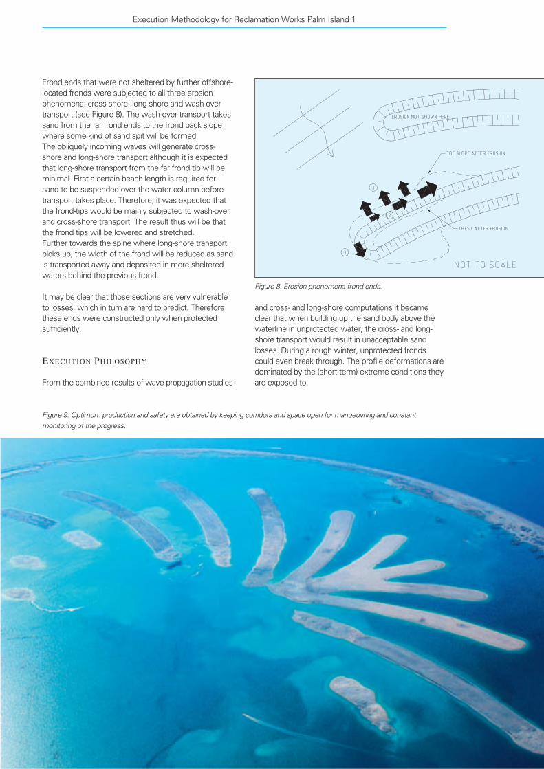
and cross- and long-shore computations it became
clear that when building up the sand body above the
waterline in unprotected water, the cross- and long-
shore transport would result in unacceptable sand
losses. During a rough winter, unprotected fronds
could even break through. The profile deformations are
dominated by the (short term) extreme conditions they
are exposed to.
Frond ends that were not sheltered by further offshore-
located fronds were subjected to all three erosion
phenomena: cross-shore, long-shore and wash-over
transport (see Figure 8). The wash-over transport takes
sand from the far frond ends to the frond back slope
where some kind of sand spit will be formed.
The obliquely incoming waves will generate cross-
shore and long-shore transport although it is expected
that long-shore transport from the far frond tip will be
minimal. First a certain beach length is required for
sand to be suspended over the water column before
transport takes place. Therefore, it was expected that
the frond-tips would be mainly subjected to wash-over
and cross-shore transport. The result thus will be that
the frond tips will be lowered and stretched.
Further towards the spine where long-shore transport
picks up, the width of the frond will be reduced as sand
is transported away and deposited in more sheltered
waters behind the previous frond.
It may be clear that those sections are very vulnerable
to losses, which in turn are hard to predict. Therefore
these ends were constructed only when protected
sufficiently.
EXECUTION PHILOSOPHY
From the combined results of wave propagation studies
Execution Methodology for Reclamation Works Palm Island 1
Figure 8. Erosion phenomena frond ends.
Figure 9. Optimum production and safety are obtained by keeping corridors and space open for manoeuvring and constant
monitoring of the progress.

When keeping the crest level sufficiently deep below
the water level, the deformations only occur during
extreme storm conditions. When staying sufficiently
deep, the overall profile deformations owing to wave
action will be far more limited than in case of a crest
above water.
Since repair of damaged sections would have been
disproportionately expensive, an execution methodology
was developed which was first of all based on
minimising the sand transport by waves and currents.
In addition to this also the following requirements were
taken into account:
– The inevitable sand transport should resettle within
the final profiles as much as possible.
– Optimal logistics should be achieved in terms of
cycle times and combination of dumping and
rainbowing taking into account ship restrictions
(draft, maximum rainbow distance).
– Production capacity and planning should meet the
time of delivery.
– Safety of the operations should be ensured.
EXECUTION METHODOLOGY
Based on the combined results of wave propagation
studies and cross- and long-shore computations,
the client could be convinced that the construction of
Palm Island itself should be closely related to the
progression of the breakwater, since the protection
provided by it, was essential. Therefore the following
execution methodology was developed based on the
requirements mentioned above, the computation
results and the progression schedule of the breakwater.
During first winter
– Especially at the beginning of the first winter,
starting at the end of 2001, the sheltering of the
partly constructed breakwater was very limited
(see Figure 10). The profiles therefore remained
below the CD–4 m during the first winter, since this
results in lower transport rates then when coming
above water.
– The width of the fronds at this stage was kept
slightly smaller than required to allow some
reshaping without material ending up outside the
eventual required profile.
– In between the sand bars, corridors and space for
manoeuvring is kept in order to allow the dredgers
to operate in a safe and efficient manner during the
construction of the fronds.
– The TSHD had such dimensions that this sand could
be dumped and did not have to be rainbowed.
After first winter
– Based on scheduled progress of the breakwater and
offshore wave climate, the wave and cross- and
long-shore sand transport model were used to
determine which fronds were sheltered enough at
what stage. This way the fronds were given free to
construct above water one by one, starting at the
most protected top end of the Palm.
– The sequence of the filling was anti-clockwise from
Terra et Aqua – Number 92 – September 2003
24
Figure 10. Satellite pictures of Palm Island showing the progress at approximately 3-month intervals.
8 DEC 2001 22 MAR 2002 26 jun 2002
22 SEP 2002 7 JAN 2003 25 MAR 2003
Van Oord ACZ determined the right strategy of staying
underwater the first winter and only raised those
fronds above water which had sufficient protection
from the crescent breakwater from then on.
References
[1] Coastal Engineering Research Center (1984).Shore Protection Manual. U.S Government Printing Office,
Washington, DC, USA.
[2] Rijn, L.C. van (1993).Principles of Sediment Transport in Rivers, Estuaries
and Coastal Seas. Aqua Publications, Amsterdam,
The Netherlands.
[3] Bijker, E.W., (1971).“Longshore transport computations”, Journal of
Waterways, Harbours and Coastal Engineering Division,
Vol. 97, No. WW4.
[4] Swart,J.H., (1974). “Offshore sediment transport and equilibrium beach pro-
files, report on model investigations”. Report number M918,
Part II.
[5] Swart, J.H., (1976). “Predictive equations regarding coastal transports”,
ASCE Proceedings 15th Conference on Coastal Engineering.
Hawaii. Vol. II. Chapter 66.
[6] Graaff, J. van de, (1978).“Transport of sand perpendicular to the coast”.
Course Coastal Dynamics and Coastal Protection CT.KK5,
Foundation of Postgraduate Education for Civil Engineering.
Delft, The Netherlands. (in Dutch).
West to East as to allow the TSHD to reach the
reclamation fronds via the anticipated corridor in the
Eastern part of the crescent breakwater with mini-
mum obstruction from already constructed sand fill
allowing maximum production of each dredger in a
safe manner.
– Optimal logistics in terms of cycle times and
combination of placement/rainbowing has also been
achieved, by implementing day-to-day survey results
into the DGPS tracking system. In this way safe
underwater filling was made possible, leaving open
sufficient space to manoeuvre the ships.
From the satellite pictures in Figure 10, which were
taken with a time interval of about three months, it can
be seen that the planned methodology has indeed
been applied. On the first two pictures even the under-
water berms can be seen from space. It is also clear
that the fronds are constructed one by one starting at
the top of the Palm. Only the top of the trunk was
raised above the water before schedule. This was done
at the request of the client.
Conclusions
A thorough study of the mechanisms responsible for
possible sand losses from the reclamation area prior to
execution of the works gave a good insight in the risks
and provides tools for defining the best strategy for the
execution of the works.
Cross-shore transport resulted in considerable slope
deformations, once the reclamation area is above
water even with limited wave action during a limited
time, which is in accordance with the calculations
carried out.
These deformations are even much more severe, if the
crest level is raised to just below the wave run up level.
Therefore, if going above water, the final crest level
should be reached as soon as possible.
The frond ends experienced similar but more severe
deformations (combination wash-over/long-shore/cross-
shore transport) as anticipated.
Reshaping owing to wash-over transport with a crest
level of about CD–4 m only occurred during extreme
conditions conform theory. The reshaping was
however far less than in case of a crest level above the
water level.
Especially at the beginning of the winter the sheltering
of the partly constructed breakwater was very limited
and the exposure of the fronds would have been large.
Since the real reshaping in case of a crest at least
CD–4 m was indeed considerably less than in case of a
crest above the water level, it can be concluded that
Execution Methodology for Reclamation Works Palm Island 1
25

A Process for Setting, Managing, and MonitoringEnvironmental Windows for Dredging Projects,Special Report 262. Committee for Environmental Windows for Dredging
Projects, Marine Board, Transportation Research
Board, Ocean Studies Board, National Academies.
Washington, D.C. 2001. Soft-cover, 6 x 9 inch, 83 pages,
with glossary. US$20.
National Academy Press
This small volume is the result of a workshop established
by the National Research Council to explore the decision-
making process used to establish environmental
windows for dredging projects, as well as consistency
in the windows-setting process.
Environmental windows are those periods of the year
when dredging and disposal activities may be carried
out because regulators have determined that the
adverse impacts associated with dredging and disposal
can be reduced below critical thresholds during these
periods. The first environmental windows in the
United States were established more than 30 years
ago. Today environmental windows are applied to over
80 percent of all federal dredging projects according to
the U. S. Army Corps of Engineers (USACE).
The cumulative impacts of the application of environ-
mental windows are significant and costly. For this
reason, the USACE requested that the National
Research Council’s Transportation Board-Marine Board
conduct a workshop to explore the decision-making
process used to establish environmental windows,
as well as the consistency of the windows-setting
process.
The report is organised into seven parts, beginning with
an Executive Summary and ending with appendices
and biographical information of the study committee.
Specifically, the report is divided as follows:
Executive Summary
1. Introduction
2. Workshop Preparations, Design, and Major Points of
Discussion
3. Process for Setting, Managing, and Monitoring
Environmental Windows
4. Key Findings and Recommendations
Appendices
Study Committee Biographical Information
The Executive Summary and the Key Findings and
Recommendations capture the essence and value of
the report. The report itself is fairly repetitive and those
two sections appeared to be of the most interest, both
to the casual reader as well as to those with a more
intimate involvement with environmental windows and
their effects.
Environmental windows restrict or prohibit dredging
and disposal activities during those periods when
perceived harm to aquatic resources is above a
determined critical threshold. They are an intuitively
simple means of reducing risks to biological resources
from stressors generated during dredging and disposal
activities. The use of windows has significant cost
implications for both the USACE and the local sponsors
of dredging projects and thus the taxpayers. They can
prolong completion of dredging projects, delay project
deadlines, and increase the risk to dredging personnel
by shifting dredging to periods of inclement weather
and sea states.
The report documents the windows-setting process
and sets a template by which the process can be
summarised. The workshop involved a broad spectrum
of stakeholders in the dredging of marine projects and
intended to synthesise these diverse perspectives into
a set of findings that serve as basis to place the issue
of environmental windows on a more objective and
consistent framework and practice.
The study resulted in eight recommendations,
summarised as follows:
Terra et Aqua – Number 92 – September 2003
Charles W. Hummer, Jr.
Books/PeriodicalsReviewed
26

http://education.usace.army.milU.S. Army Corps of Engineers Education Center. 2002.
The effort to encourage young people to enter the field
of dredging as well as attempts to educate the public
about the positive aspects of dredging have been of
major concern both in Europe and in the United States.
After many years of planning, the United States Army
Corp of Engineers (USACE) has recently launched a
new educational website. Though the site is obviously
US oriented, it provides an enormous amount of
information for any science teacher or pupil with
computer access, anywhere in the world.
USACE’s Education Center, as it is called, is aimed at
kindergarten through secondary school (K–12+)
students, teachers, librarians and other educators.
Its stated objectives are: to promote an understanding
of the USACE, create a Corps Classroom connection;
and spark interest in applied sciences. Subjects
covered in general are Engineering and Construction,
Navigation, Water Resources Management, Disaster
Response, Environmental Protection, R&D and
Recreation.
Its main components are:
– a Young Engineer’s Club, designed for elementary
age children;
– Classroom Resources, with a wide range of
resources, lesson plans, activities, and education
links;
– Corps Classroom Connection with stories about
engineering, environmental biology, chemistry,
physics, geography and other relevant science
subjects;
– Mission Lessons with classroom activities, interac-
tive quiz games, puzzles, glossaries and references;
– Fun science experiments (over 250), with 30 topic
categories utilising simple materials; and
– Navigation lessons, emphasising the importance
of ports and navigation channels, hydrographic
surveys, dredging and beneficial uses of dredged
material.
This website is a monumental work, and marks the
beginning of a much-needed ongoing effort to educate
the public from the ground up (that is, from youth
onward) to the important role that dredging plays in our
modern society. Anything that helps people understand
the positive aspects of dredging and does not encourage
knee-jerk negativity is worth taking a look at. The creators
of this website deserve a round of applause.
It is available at: http://education.usace.army.mil.
Like most of the Internet, it’s free of charge, just log on.
1. The decision-making process for managing dredging
and disposal operations to achieve sustainable
waterways and to protect natural resources, both
living and nonliving, should be broadly based.
2. All tools, including windows, should be considered in
designing a management plan for carrying out
dredging and disposal operations.
3. The proposed process for assessing the need for
windows and for managing and monitoring win-
dows when selected should be tested in a small
number of districts.
4. All existing scientific data and information should be
exploited in evaluating and setting windows as part
of an overall management strategy for dredging and
disposal activities.
5. Cross-training opportunities should be created for
resource manager and dredging operators.
6. A special effort should be made in identifying
existing tools for structured decision making in
complex socio-political situations and to evaluate
their applicability to the process of setting, managing
and monitoring environmental widows for dredging.
One or two of the most promising tools should
be selected for additional testing, research, and
refinement aimed at enhancing their acceptability
and use in the window-setting process.
7. Additional funding should be allocated to resource
agencies to ensure full, thorough, and active
participation in the window-setting process.
8. The windows-setting process should reflect the
principle of adaptive management. That is, as new
data and information are acquired and experience is
gained, they should be fed back into the process.
If these recommendations sound a bit vague and
ambiguous it is because, as is often the case when a
report is generated by a committee of stakeholders
with opposing disciplines and perspectives, they are.
Certainly, the report adds to the literature on environ-
mental windows, but some specific guidelines and a
framework by which to answer the basic questions and
issues stated in its purpose and objective would have
been welcome. In spite of this, it does give a valuable
insight into the issues and the process by which such
contentious matters are studied and how reports are
then written by such prestigious organisations as the
National Research Council.
The report is available from:
Transportation Research Board Business Office
National Research Council
2101 Constitution Avenue NW
Washington, DC 20418
or through the Internet at:
www.national-academies.org/trb
email: [email protected]
Books/Periodicals Reviewed
27

Coasts and Ports Australasian ConferenceThe Hyatt Hotel, Auckland, New Zealand
September 9-12 2003
This is the 16th Australasian Coastal & Ocean
Engineering Conference and 9th Australasian Port &
Harbour Conference. The theme of the conference is
“Coastal Development -- A Quest for Excellence” and
the issues it covers include: models for “good” coastal
development; change in port infrastructure and efficiency;
costs of regulation and compliance; managing conser-
vation and development; assessing impacts of coastal
structures on the natural system; and changes in
science and technology in modelling and monitoring
coastal change.
For further information contact:
The Conference Managers
The Conference Company
PO Box 90040
Auckland, New Zealand
tel. +64 9 360 1240, fax +64 9 360 1242
email: coasts and [email protected]
International Conference on Port and Maritime R&D and Technology
SingaporeSeptember 10-12 2003
The 2nd International Conference on Port and Maritime
R&D and Technology will be held in Singapore in
September. It is organised by a broad base of universi-
ties, technological institutes and maritime academies
from Singapore, as well as the Association of
Consulting Engineers Singapore, and supported by the
Maritime and Port Authority of Singapore as well as
many international organisations such as the IMO,
IAPH, PIANC, EADA, IHO and IALA.
The theme of the conference is “Challenges for the
Next Decade” and papers will be presented on:
Port development, management and operations;
coastal/hydraulics engineering; marine environment;
innovative ship designs and operations; and navigation
and maritime training.
In conjunction with the conference, an exhibition
featuring the latest R&D and technological products,
systems and services in the port and maritime
industries will take place.
For further information contact:
Conference Secretariat
Ace:Daytons Direct (International) Pte Ltd
2 Leng Kee Road #04-02, Thye Hong Centre
Singapore 159086
tel. +65 6379 5251/ 6475 9377
fax +65 6475 2077/ 6475 6436
email: [email protected]
www.mpa.gov.sg/homepage/conferences/RDT/main.html
COPEDEC VIColombo, Sri Lanka
September 15-19 2003
The theme of the sixth International Conference on
Coastal and Port Engineering in Developing Countries
(COPEDEC) will be “Engineering the Coastal
Environment”.
Subjects include: Port and harbour infrastructure
engineering in developing countries; port and
infrastructure planning and management in developing
countries; coastal sediments, hydrodynamics and
control; coastal zone management in developing
countries; and coastal and port environmental aspects.
For further information contact:
The Local Organising Secretariat
COPEDECVI-COLOMBO 2003
c/o Ace Travels & Conventions (Pvt) Ltd.
315, Vauxhall Street, Colombo 02 Sri Lanka
tel +94 1 300 589/300 590, fax +94 1 331 816
email: [email protected]
www.copedec.lk
Terra et Aqua – Number 92 – September 2003
Seminars/Conferences/Events
28

Marco Pellei, Batelle-Geneva Research Centre
fax +41 22 827 2094
email: [email protected]
or visit the website: www.battelle.org/sedimentscon.
Camels, Sand and Water, the Suez Canal in SliedrechtNational Dredging MuseumSliedrecht, The NetherlandsJuly 25 2003-January 2004
This unusually interesting exhibition is on display at the
dredging museum, which is opened Tuesday through
Saturday from 14:00 till 17:00 hours. Group visits are
possible outside official opening hours by appointment.
For further information contact:
National Dredging Museum, Molendijk 204,
Sliedrecht, The Netherlands
tel. +31 184 41 41 66 or +31 184 42 56 15.
www.baggermuseum.nl
Ports India 2003Mumbai, India
October 8-11 2003
The conference “Trade, Shipping and Port Strategy” will
focus on transport efficiency and infrastructure develop-
ment, which are the key to India’s trade sustainability.
The event will also include a one-day conference on
shipbuilding and finance, and a two-day conference on
dredging. The conference theme is “Dredging for
Development” and is being organised in conjunction
with the International Maritime Exhibition (INMEX) by
the Eastern Dredging Association (EADA)-India.
For further information contact:
Millennium Conferences International Ltd.
Chantry House, 156 Bath Road,
Maidenhead, Berkshire SL6 4LB, UK
tel. +44 1628 580 246, fax +44 1628 580 346
email: [email protected]
www. millenniumconferences.com
INMEXMumbai, India
October 8-11 2003
INMEX (Maritime Exhibition-India International
Maritime Expo) is India’s premier maritime exhibition
featuring state-of-the-art equipment available for
shipping, shipbuilding, port development, dredging and
offshore industries. It will showcase various material
components for effective maintenance of existing
fleets, both defensive and commercial.
During the exhibition a Dredging Symposium is being
organised EADA (see also above).
General Dredging Course 2003Training Institute for Dredging
Kinderdijk, The NetherlandsSeptember 29-October 10 2003
The Training Institute for Dredging (TID), founded in
1982, is dedicated to the education of dredging crews
and operational management in order to improve the
efficiency of dredging operations. The General Course
is aimed at managers and technical and operational
staff at dredging companies, port authorities and
consultants. The course is held at the training facilities
in Kinderdijk, The Netherlands. Subjects include: soil
characteristics and their effect on dredging; definition of
important dredging parameters; site investigation and
hydrographic surveying; trailing suction hopper
dredgers; plain suction dredgers, cutters and bucket
wheel dredgers; centrifugal pumps and slurry
transportation; instrumentation and automation;
practical and management aspects of dredging; costs;
maintenance aspects.
The fee for the course is Euro 3285. TID assist in
securing accommodations.
For further information contact:
Training Institute for Dredging
Att: Monique Rogaar
P.O. Box 8, 2960 AA Kinderdijk, The Netherlands
tel. +31 78 691 0500; fax +31 78 691 0331
email: [email protected]
www.mtiholland.com/tid
International Conference on Remediation of Contaminated Sediments
Palazzo del Cinema, Venice, ItalySeptember 30-October 3 2003
Contaminated freshwater and marine sediments are
a significant environmental problem worldwide.
Since disposal of contaminated dredged materials can
be a major financial issue, further research for better
technologies, and practicable and cost-effective
sediments-management practises must be designed.
To provide a forum for understanding the nature of
contaminated sediments and for finding potential
solutions, Battelle, with the support of 12 international
organisations active in management and remediation of
sediments, organised a conference in October of 2001.
Based on the positive response to that event, Battelle
is organising a second conference focussing on all
aspects of remediation and management of contami-
nated sediments.
For further information on the technical scope of the
programme or registration or other matters please
contact:
Seminars/Conferences/Events
29

Topics for discussion include: dredging of waterways
and ports, dredging for conservation of water
resources, and for mineral wealth, environmental
aspects of dredging, R&D efforts, pipeline sediment
transport, and the economics of dredging and training.
For further information contact:
Tebma Shipyards, Ltd.
III Floor, Khaleeli Centre, 149 Montieth Road,
Egmore, Chennai 600 008, India
For further information about INMEX contact:
Yogesh Srinivasan, PDA Trade Fairs
PDA House, no. 32/2, Spencer Road
Freazer Town, Bangalore – 560005, India
tel. +91 80 554 7434, fax +91 80 554 2258
email: [email protected]
www.pdatradefairs.com
Europort 2003RAI International Exhibition Centre
Amsterdam, The NetherlandsNovember 18-22 2003
The Europort Exhibition is one of the largest trade
shows for the international maritime industry and is
held every two years in Amsterdam. The trade exhibi-
tion covers all sectors of the maritime industry such as
seaborne shipping, inland shipping, offshore industry,
dredging and ports. Many countries have once again
made arrangements for national pavilions where their
companies can join forces and exhibit together.
Various maritime trade associations such as IRO (Dutch
Association of Suppliers to the Oil and Gas Industry),
KNVTS (Royal Dutch Association of Naval Architects),
KVNR (Royal Association of Netherlands Shipowners),
VNSI (Netherlands Shipbuilding Indsutry Association) and
VIV (Association of Importers of Combustion Engines)
are organising their (annual) meetings and seminars at
Europort. In this way Europort acts as a national and
international forum for the maritime industry.
As is customary, the CEDA Dredging Days will also
be held during Europort 2003 from November 20-21,
and the IADC Award for the best paper to a younger
author will be presented. The CEDA conference will
focus on the use of dredged sediments as primary and
secondary construction material.
For further information contact:
Farouk Nefzi, Europort 2003, RAI
P.O. Box 77777, 1070 MS Amsterdam,
The Netherlands
tel. +31 20 549 1212, fax +31 20 549 1889
email: [email protected]
www.europort2003.com
CEDA Dredging DaysRAI International Exhibition Centre
Amsterdam, The NetherlandsNovember 20-21 2003
“Specialist dredging techniques, inspiring dredging
solutions” is the theme of the next CEDA Dredging
Days to be held during the Europort Exhibition in
November 2003. Dredging activities cover a wide range
of applications, some of which are unfamiliar even to
the well-seasoned dredging professional. The variety
of dredging functions combined with the diversity of
the natural environments provides the profession with
new challenges and the need to develop specialised
techniques.
Topics of interest include, but are not limited to the use
of specialised solutions in: coastal and flood protection;
sea and river mining (sand and gravel, minerals,
precious metals); offshore oil and gas industry;
environmental improvement; land reclamation;
dredging in shellfish waters; waterway re-naturalisation;
cockle and scallop fishing; and salvage.
At this conference an IADC Young Authors Award will
be presented to the best paper by an author younger
than 35 years of age recommended by the Paper
Committee.
AnnouncementAll members of CEDA, EADA and WEDA are invited to
CEDA's 25th Anniversary Reunion Reception at
17:30 hrs on Thursday 20 November 2003 during
CEDA Dredging Days (20-21 November) and the
Europort Exhibition at the Europa Restaurant of the
Amsterdam RAI Congress Centre, Amsterdam, the
Netherlands.
The Anniversary Committee is preparing an exciting
program including CEDA's "Hall of Fame" in the form of
a "wall"' with printed photographs about dredging and
CEDA in the past 25 years and of a slide show running
on plasma screens.
A unique opportunity for dredging friends to meet.
Contact the CEDA Secretariat for your personal
invitation card.
For further information contact:
CEDA Secretariat, Anna Csiti
Radex Building,
Rotterdamseweg 183c
2629 HD Delft, The Netherlands
tel. +31 15 268 2575, fax +31 15 268 2576
email: [email protected]
www.dredging.org
Terra et Aqua – Number 92 – September 2003
30
Call for PapersWorld Dredging Congress XVII
CCH - Congress Centrum, Hamburg, Germany
September 27-October 1 2004
Every three years leading experts meet in a different
part of the world for the World Dredging Congress
(WODCON). The congress is held under the auspices
of the World Dredging Association which is comprised
of the WEDA, CEDA and EADA. In 2004 it will take
place in Hamburg, organised by CEDA on behalf of
WODA, and co-sponsored by the Ministry of Economic
Affairs, Free and Hanseatic City of Hamburg, and the
Department of Port and River Engineering and the
Shipbuilding, Machinery & Marine Technology
International Trade Fair (SMM 2004) which will run
simultaneously. The theme of the conference will be
“Dredging in a Sensitive Environment”.
Prospective authors are requested to submit titles and
abstracts (maximum 300 words) by October 1 2003.
If possible they should be sent by email in either RTF,
PDF or ASCII formats. If submitting hard copy five
copies are needed. Authors will be notified by the
Technical Paper Committee by December 1 2003 and
final papers are due by July 15 2004.
The programme will consist of Technical sessions
with high quality peer-reviewed papers and a special
Environment Day focussed on environmental
challenges and solutions. An Academic session,
with contributions by young scientists, continues
CEDA’s support of young professionals.
Technical visits in and around Hamburg including views
of the Port of Hamburg are planned.
GTZ, the German Technical Co-operation on behalf of
BMZ, the German Fedreal Ministry of Economic
Co-ooperation and Development sponsors participation
at WODCOON XVII for delegates from: China,
Indonesia, Bangladesh, Ghana, Cameroon, Namibia,
Romania, Uruguay, Chile, Argentina, Guatemala,
Honduras and Costa Rica. Application details and
conditions are available from the CEDA Secretariat
For further information contact:
Anna Csiti, CEDA Secretariat,
Radex Building, Rotterdamseweg 183c,
2629 HD Delft, The Netherlands
tel. +31 15 268 2575, fax +31 15 268 2576
email: [email protected]
www.dredging.org
Oceanology International 2004ExCel, London, UK
March 16-19 2004
This is one of the largest and busiest international
events in the global marine science and ocean
technology fields. It has hundreds of exhibitors and
attracts thousands of international visitors including
policy makers, industrialists, government
representatives, decision makers, researchers,
directors, managers and manufacturers involved in
every aspect of oceanography. They meet to address
the present and future trends of the industry and to
view the launch of new technologies, equipment and
services.
It is sponsored and supported by the Society for
Underwater Technology, European Oceanographic
Industry Association, World Meteorological
Organization, Intergovernmental Oceanographic
Commission, The Hydrographic Society and Hydro
International.
The following disciplines are representative of the
scope of OI:
Marine environmental science; ocean observing and
modeling; measurement and instrumentation; data
harvesting; marine survey and engineering; diving and
ROV; navigation and remote sensing; marine pollution
monitoring and control; hydrography; marine R&D;
maritime defence; dredging and coastal engineering;
renewable energy; resources from the sea; marine civil
engineering and more.
For further information contact:
Spearhead Exhibitions Ltd
Apex Tower, High St, New Malden,
Surrey, KT3 4DQ, UK
www.spearhead.co.uk
Lesley Ann Sandbach, Conference Director
email: [email protected]
tel. +44 208 949 9837
Craig Moyes, Project Director
email: [email protected]
tel. +44 208 949 9840
Seminars/Conferences/Events
31

Terra et Aqua – Number 92 – September 2003
32
Day 1: Why Dredging?The Need for Dredging/Project Phasing
Day 2: What is Dredging?Dredging Equipment/Survey Systems
(includes a Site Visit)
Day 3: Cost/Pricing and ContractsDay 4: Preparation of Dredging
ContractDay 5: How Dredging?
Dredging Projects
Representatives of port authorities, companies,
and individuals interested in attending are requested
to complete the preliminary registration form below
as soon as possible and prior to September 15, 2003,
and return to:
IADC Secretariat, Duinweg 21,
2585 JV The Hague, The Netherlands
tel. +31 70 352 3334, fax +31 70 351 2654
e-mail: [email protected]
Place: J.W. Marriot Hotel, Dubai City, UAE
Date: October 11 - 15, 2003
This year the IADC is please to announce that its
well-known seminar will be presented for the first time
In Dubai, UAE. The course has been held for several
years in Singapore, Delft and Buenos Aires with great
success. Recent enquiries from the area about dredging
have led the IADC to select Dubai as this year’s venue.
The intensive one-week seminar on dredging and
reclamation will be held from October 11-15 2003.
The costs are € 3895.00 and include accommodation
for six nights at the conference, hotel, breakfast and
lunch daily, one special participants dinner, and a general
insurance for the week.
The seminar includes workshops and a site visit to a
dredging project. Highlights of the programme are:
International Seminar onDredging and Reclamation
(please print)
Name ..........................................................................................................................................................................
Title ..........................................................................................................................................................................
Company ..........................................................................................................................................................................
Address ..........................................................................................................................................................................
..........................................................................................................................................................................
Tel. ................................................................................... Fax ...............................................................................
E-mail ..........................................................................................................................................................................
Please send this form and your deposit by cheque or credit card for € 500 in order to guarantee your place at the
seminar. Upon receipt of this form and your deposit your place in the seminar is confirmed. We will then send you
further detailed information, final registration forms, and an invoice for the correct amount.
Without your deposit we cannot guarantee your place and accommodations at the seminar.
�� A Cheque is enclosed.
�� Please charge my credit card:
�� American Express �� Eurocard/Master Card �� VISA �� Diners Club
Account no.:
Expiry date: Card validation code:
Signature .............................................................................................................. Date ................................................
Africa
Ballast Ham Dredging (Nigeria) Ltd., Ikeja-Lagos, NigeriaNigerian Westminster Dredging and Marine Ltd., Lagos,Nigeria
The Americas
ACZ Marine Contractors Ltd., Brampton, Ont., CanadaBallast Ham Sucursal Argentina, Capital Federal, ArgentinaBallast Ham Dredging do Brazil Ltda, Rio de Janeiro, BrazilDragamex SA de CV, Coatzacoalcos, Mexico
Asia
Ballast Ham Dredging India Private Ltd., Mumbai, IndiaBallast Ham Dredging bv Singapore Branch, SingaporeDredging International Asia Pacific (Pte) Ltd., SingaporeHyundai Engineering & Construction Co. Ltd., Seoul, KoreaJan De Nul Singapore Pte. Ltd., SingaporeTOA Corporation, Tokyo, JapanVan Oord ACZ B.V., Dhaka, BangladeshVan Oord ACZ B.V., Hong Kong, ChinaVan Oord ACZ B.V., SingaporeVan Oord ACZ Overseas B.V., Karachi, Pakistan
Middle East
Boskalis Westminster M.E. Ltd., Abu Dhabi, UAEGulf Cobla (Limited Liability Company), Dubai, UAEJan De Nul Dredging, Abu Dhabi, UAEVan Oord ACZ Marine Contractors Gulf FZE, Abu Dhabi, UAE
Australia
Ballast Ham Dredging Pty. Ltd., Brisbane, QLD, AustraliaDredeco Pty. Ltd., Brisbane, QLD., AustraliaVan Oord ACZ B.V., Victoria, NSW, Australia
Europe
ACZ Ingeniører & Entreprenører A/S, Copenhagen, DenmarkA/S Jebsens ACZ, Bergen, NorwayAtlantique Dragage S.A., Nanterre, FranceBaggermaatschappij Boskalis B.V., Papendrecht, NetherlandsBallast Ham Dredging bv, Rotterdam, NetherlandsBallast Ham Dredging Ltd., Camberley, United KingdomBallast Ham Nederland bv, Gorinchem, NetherlandsBoskalis B.V., Rotterdam, NetherlandsBoskalis International B.V., Papendrecht, NetherlandsBoskalis Westminster Aannemers N.V., Antwerp, BelgiumBoskalis Westminster Dredging B.V., Papendrecht, NetherlandsBoskalis Westminster Dredging & Contracting Ltd., CyprusB.V. Bedrijfsholding L. Paans en Zonen, Gorinchem,Netherlands
Draflumar SA., Neuville Les Dieppe, FranceDRACE (Grupo Dragados S.A.), Madrid, SpainDravo S.A., Madrid, SpainDredging International N.V., Zwijndrecht, BelgiumDredging International (UK), Ltd., Weybridge, United KingdomHeinrich Hirdes GmbH, Hamburg, GermanyJan De Nul N.V., Aalst, BelgiumJan De Nul Dredging N.V., Aalst, BelgiumJan De Nul (U.K.) Ltd., Ascot, United Kingdom
Mijnster Beheer B.V., Gorinchem, NetherlandsN.V. Baggerwerken Decloedt & Zoon, Oostende, BelgiumSociedad Española de Dragados S.A., Madrid, SpainSodranord S.A.R.L., Le Blanc-Mesril Cédex, FranceTerramare Oy, Helsinki, FinlandTideway B.V., Breda, NetherlandsTOA (LUX) S.A., Luxembourg
Van Oord ACZ B.V., Gorinchem, NetherlandsVan Oord ACZ Ltd., Newbury, United KingdomWasserbau ACZ GmbH, Bremen, GermanyWestminster Dredging Co. Ltd., Fareham, United Kingdom
Membership List IADC 2003
Through their regional branches or through representatives, members of IADC operate directly at all locations worldwide.

International Association
of Dredging Companies