Internasjonalt forskningssamarbeid om skred; SafeLand – et nytt stort integrert forskningsprosjekt...
29
Internasjonalt forskningssamarbeid om skred; SafeLand – et nytt stort integrert forskningsprosjekt i EUs 7. Rammeprogram Bjørn Kalsnes Nestleder International Centre for Geohazards Skred og vassdragsdagene, Tromsø, 9 juni 2009
-
Upload
madison-king -
Category
Documents
-
view
218 -
download
0
Transcript of Internasjonalt forskningssamarbeid om skred; SafeLand – et nytt stort integrert forskningsprosjekt...

Internasjonalt forskningssamarbeid om skred; SafeLand – et nytt stort integrert forskningsprosjekt i EUs 7. Rammeprogram
Bjørn KalsnesNestleder International Centre for Geohazards
Skred og vassdragsdagene, Tromsø, 9 juni 2009

INTERNATIONAL CENTRE for GEOHAZARDSINTERNATIONAL CENTRE for GEOHAZARDS
A Norwegian Centre of Excellence established in 2003 by the Reseach Council of Norway
10 years duration
Budget : ~ NOK 20 – 25 mill. / year (including in-kind contribution of partners,
Contribution from Research Council of Norway = NOK 12 mill. / year)

HOST ORGANISATION
Norwegian Geotechnical Institute (NGI)
PARTNERS
University of Oslo (UiO)
NTNU
Geological Survey of Norway (NGU)

ICG’s current research topicsProj. No. Title
2 Risk and vulnerability analysis for geohazards3 Earthquake hazard, risk and loss 4 Stability of rock slopes 5 Geomechanical modelling6 Offshore geohazards
7 Slope instability assessment and hazard zonation
10 Tsunami modelling
12 Remote sensing, monitoring and early warning systems
Theme 1 Geophysics for geohazards
Theme 4 Prevention and Mitigation
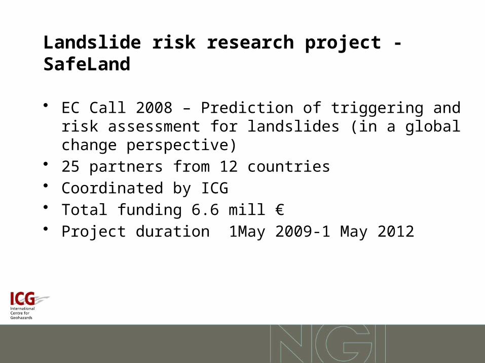
Landslide risk research project - SafeLand
• EC Call 2008 – Prediction of triggering and risk assessment for landslides (in a global change perspective)
• 25 partners from 12 countries• Coordinated by ICG• Total funding 6.6 mill €• Project duration 1May 2009-1 May 2012

Call• Title: Prediction of triggering and risk assessment for
landslides– Taking into account climate change and human activity– Forecast landslide hazards and detect risk zones– Quantify triggering mechanisms, conditions and thresholds– Develop generic QRA frame for a better risk management– Help to choose an appropriate set of mitigation and prevention
measure

Main aims of SafeLand
• Evaluate the changes in landslide risk pattern in Europe caused by climate change, changes in demography and human activity, and policy changes
• Provide policy-makers, public administrators, researchers, scientists, educators and other stakeholders with improved methods for the assessment and quantification of risk associated with landslides
• Provide guidelines for choosing the most approriate risk management strategies

Global change = Climate change + Changes in demography
I. Changes in demography
United Nations estimate:The World population willreach 9 billion by the year 2050.
In 2007 for the first time in history more than 50% of the World population wereliving in cities.

Population trends in Europe
1950 1960 1970 1980 1990 2000 2010 2020 2030 2040 2050Year
250000
300000
350000
400000
450000
500000
550000
600000
650000
700000
750000
Po
pu
lati
on
(th
ou
san
ds)
Urban population
Total population
United Nations' prognosis of Europe's population
1950 1960 1970 1980 1990 2000 2010 2020 2030 2040 2050
Year
20
30
40
50
60
70
80
90
Pe
rce
nta
ge
urb
an
po
pu
lati
on
(%
)
Switzerland
Rom ania
Italy
AustriaAll Europe
United Nation's prognosis of Europe's percentage of urban population
United Nations’ prognosis of the total population and urban Population in Europe until the Year 2050

II. Climate change:IPCC Fourth Assessment Report

• Significantly increased precipitation in eastern parts of North and South America, northern Europe and northern and central Asia.
• The frequency of heavy precipitation events has increased over most land areas - consistent with warming and increases of atmospheric water vapour
• Very likely that hot extremes, heat waves, and heavy precipitation events will continue to become more frequent
• Likely that future tropical cyclones will become more intense, with larger peak wind speeds and more heavy precipitation
IPCC Fourth Assessment Report

Other factors affecting landslide risk• Changing land-use (meadows, pastures, abandoned lands,
forests) which may influence the soil moisture availability. • Changes in vegetation species, vegetation cover and
vegetation root characteristics (human-induced or climate-induced); deforestation and timber harvesting.
• Expansion of new developments and facilities (roads, train lines, buildings) which may change slope geometry or hydrology.
• Advances in landslide science, in particular monitoring and remote sensing technologies, early warning systems, and basic understanding of landslide mechanisms.

SafeLand is organised in five Techincal Areas (+ 3 non-
technical ones), and 21 Work Packages
Area 1
Improving knowledge on landslide hazard (triggering
and run-out models)
Scale:
Detailed (slope)
Regional
Scale:
Detailed (slope)
Regional
Area 4Monitoring technology
development for predictionof behaviour of sample sites
Scale:
Detailed (slope)
Regional
Scale:
Detailed (slope)
Regional
Area 3Global change scenarios
and their impact on landslidehazard and risk patterns
Scale:
Regional / Local
European
Scale:
Regional / Local
European
Area 5Risk management
Scale:
Detailed (slope) / Regionalfor physical measures and
early warning
and
Societalfor other risk mitigation
measures
Area 2Quantitative
Risk Assessment(QRA)
Scale:
Detailed (slope)
Regional
European
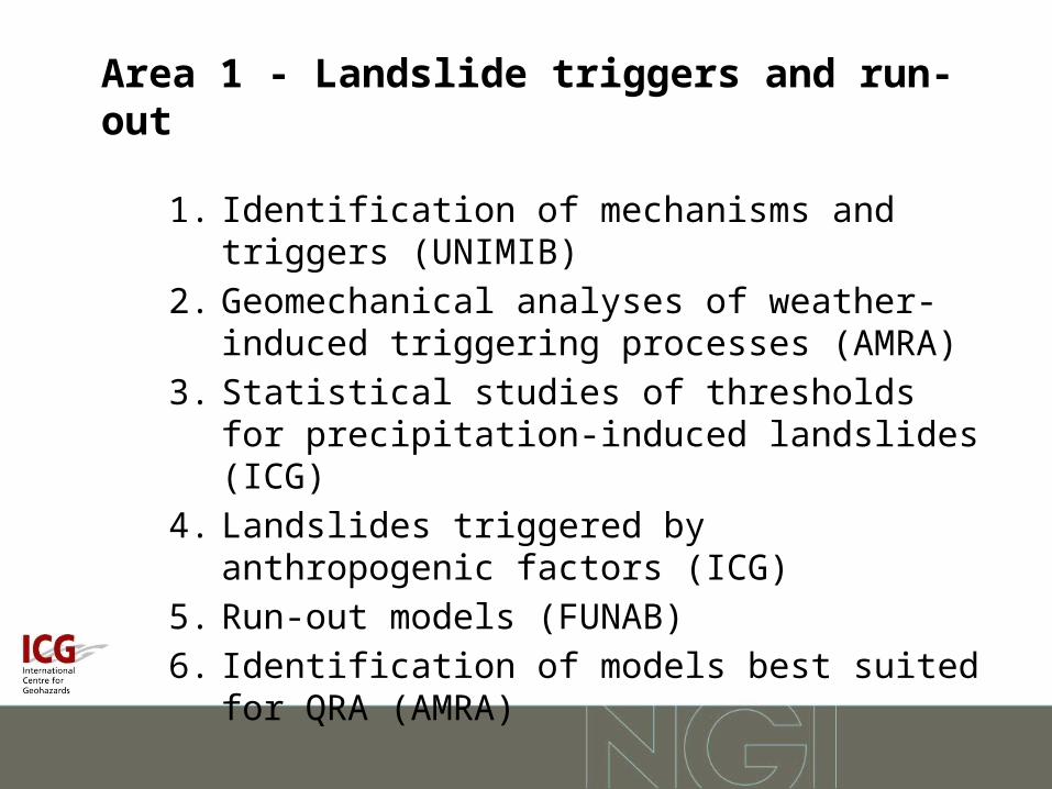
Area 1 - Landslide triggers and run-out
1. Identification of mechanisms and triggers (UNIMIB)
2. Geomechanical analyses of weather-induced triggering processes (AMRA)
3. Statistical studies of thresholds for precipitation-induced landslides (ICG)
4. Landslides triggered by anthropogenic factors (ICG)
5. Run-out models (FUNAB)
6. Identification of models best suited for QRA (AMRA)

Which climate indices are relevant for landslide triggering?
• Water is the main culprit. Intensity and duration of precipitation, air-temperature, air-humidity and wind speed (governing snow-melt) are some of the relevant factors associated with triggering of landslides.
• Precipitation-induced landslides are usually triggered during rare events at rainfall intensities with return period of 50 to 200 years.
• The duration of the rainfall influences the depth of the sliding surface, as the rainfalls with longer duration will infiltrate deeper into the soil and cause slides at greater depths.

Which climate indices are relevant for landslide triggering?
• The characterisation of extreme precipitation events is typically done on the basis of daily rainfall data using the following indices:• RX1day: annual maximum 1-day precipitation• RX5day: annual maximum consecutive 5-day precipitation• R10mm: annual count of days when precipitation > 10 mm• R20mm: annual count of days when precipitation > 20 mm• R95p: annual total precipitation when rainfall > 95th percentile• R99p: annual total precipitation when rainfall > 99th percentile
Are these the relevalant indices that should be focused on in SafeLand?

Area 2 - QRA
1. Harmonisation and development of procedures for quantifying landslide hazard (UPC)
2. Vulnerability to landslides (AUTh)
3. Development of procedures for QRA at regional and European scale (UPC)
4. Identification of landslide hazard and risk “hotspots” areas (ICG)

Quantitative Risk Assessment (QRA) of landslides or slope failures
• To evaluate the necessity of risk mitigation, one must first quantify the risk:
– (1) What can cause harm? → threat identification– (2) How often? → landslide occurrence frequency (hazard)– (3) What can go wrong? → consequence of landslide– (4) How bad? → severity of the consequence– (5) So what? → acceptability of landslide risk– (6) What should be done? → landslide risk management

Area 3 - Global change scenarios
1. Climate change scenarios for selected regions in Europe (MPG)
2. Human activity and demography scenarios (BRGM)
3. Landslide risk evolution in selected ”hotspot” areas (BRGM)

In case study areas in climate scenarios at 10km x 10km grid will be evaluated.
Possible hotspots Downscaling area for climate models
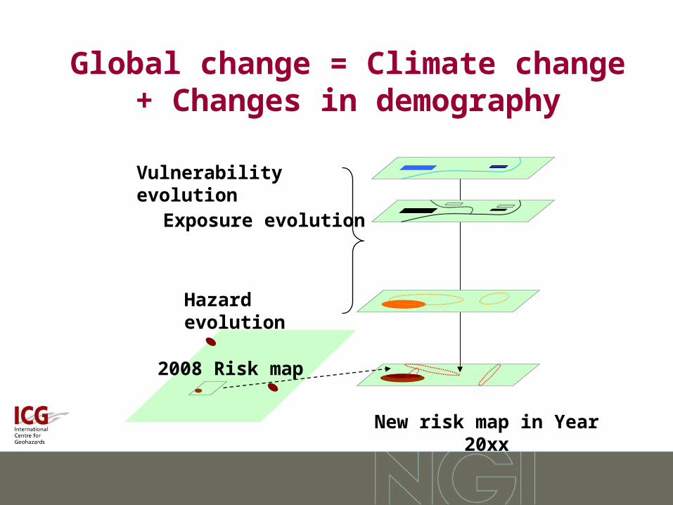
Global change = Climate change + Changes in demography
New risk map in Year 20xx
Hazard evolution
Exposure evolution
Vulnerability evolution
2008 Risk map

Area 4 – Monitoring technology
1. Short-term weather forecasting for shallow landslide protection (CMCC)
2. Remote sensing technologies for landslide detection (UNIFI)
3. Evaluation and development of reliable procedures and technologies for early warning (GSA)

Area 5 – Risk management
1. Toolbox for landslide hazard and risk mitigation and prevention measures (ICG)
2. Stakeholder process for choosing an appropriate set of mitigation and prevention measures (IIASA)

Definition of Risk
R = H . E . V
Risk = Hazard x Consequences
H = Hazard (temporal probability of a threat)E = Value of element(s)
at riskV = Vulnerability of
element(s) at risk

Landslide risk management framework(JTC1 experts)
LANDSLIDE (DANGER)CHARACTERISATIONMechanics, Location
Volume,Travel Distanceand Velocity
PoliticalAspirations
Otherconstraints
Budget
Socialdemands
Regulation
Risk acceptance
criteria
Elements at risk
Vulnerability
Temporal Spatial
probability
Frequencyanalysis
Consequences
ValuesJudgement
R I S K M A N A G E M E N T
R I S K A S S E S S M E N T
H A Z A R D A N A L Y S I S
Monitor and Review
Risk mitigationControl options & Control plan
R I S K A N A L Y S I S

Vulnerability
• Natural science perspective: Physical vulnerability of the elements at risk
• Social science approach: Attention is directed to the underlying structural factors that reduce the capacity of the human system to cope with a range of hazards

Risk Management
• Define acceptable risk criteria.
• If estimated risk is less than the acceptable risk, do nothing.
• If estimated risk is greater than the acceptable risk, then• Implement measures to reduce the risk (mitigation), or• Redefine the acceptable risk criteria.

Risk management objectives
• Propose mitigation and prevention measures, and produce harmonised toolbox of technically and economically appropriate (and innovative) prevention and mitigation measures based on experience and expert judgement
• Develop a risk-communication and stakeholder-led participatory process for choosing the prevention and mitigation measures that are most appropriate from the technical, economic, environmental and social perspectives

Takk for oppmerksomheten!