INTEGRATED RESERVE MANAGEMENT PLANresource.capetown.gov.za/documentcentre/Documents/City...
203
INTEGRATED RESERVE MANAGEMENT PLAN WITZANDS AQUIFER NATURE RESERVE City of Cape Town June 2011, updated September 2014
-
Upload
nguyenkhuong -
Category
Documents
-
view
222 -
download
1
Transcript of INTEGRATED RESERVE MANAGEMENT PLANresource.capetown.gov.za/documentcentre/Documents/City...

INTEGRATED RESERVE MANAGEMENT PLAN
WITZANDS AQUIFER NATURE
RESERVE
City of Cape Town
June 2011, updated September 2014

INTEGRATED RESERVE MANAGEMENT PLAN
Compiled by
Charline Mc Kie
Biodiversity Management Branch
Environmental Resource Management Department
City of Cape Town
Witzands Aquifer Nature Reserve
June 2011, updated September 2014
ISBN NUMBER

TABLE OF CONTENTS
PART NUMBER SECTIONS AND SUBSECTIONS PAGE NUMBERS
List of maps ii
List of figures ii
List of tables ii
List of appendices iii
List of abbreviations used iv
Part 1 Description
1. Introduction 1
1.1 Aim of the Integrated Reserve Management Plan 1
1.2 Location and extent 4
2. Description of landholdings and ownership 7
2.1 Property details and title deed information 7
2.2 Landscape perspective 9
2.3 Physical environment 12
2.4 Biological environment 16
2.5 Socio-political context 21
2.6 Protected-area expansion 23
3. Purpose, vision/mission, significance/value 23
3.1 Purpose of the protected area 23
3.2 Vision and mission 24
3.3 Significance of property (biodiversity, heritage and social)
26
Part 2 Management
policy framework
4. Administrative and legal framework for the management authority
27
4.1 Legal framework 27
4.2 Administrative framework 34
5. Protected-area policy framework & guiding management principles
36
5.1 Management objectives 36
5.2 SWOT analysis 43
5.3 Protected-area management policy framework and guiding principles
45
5.4 Sensitivity-value analysis of the Witzands Aquifer Nature
Reserve
52
5.5 Zoning plan of the Witzands Aquifer Nature Reserve
53
6. Development plan 57
7. Costing plan 57
Part 3 Monitoring &
auditing
8. Monitoring & auditing 58
8.1 Annual audit procedure 58
8.2 Management plan review 59
8.3 Biodiversity monitoring 60
Part 4 References
9. References 62
Part 5 Appendices
10. Appendices 65

Integrated Reserve Management Plan | ii
List of Maps Page Numbers
Map 1: Reserve location in Cape Town 5
Map 2: Reserve boundary 6
Map 3: Reserve erven 8
Map 4: Reserve location in terms of Cape West Coast Biosphere Reserve 11
Map 5: Catchments, including wetlands and rivers 15
Map 6: Nature reserve and biodiversity network 19
Map 7: The Witzands Aquifer Nature Reserve zoning summary 55
Map 8: The Witzands Aquifer Nature Reserve special management
overlays
56
List of Figures Page Numbers
Figure 1: The elements of the IRMP 2
Figure 2: Legal and planning framework for the IRMP 3
Figure 3: The greater Dassenberg Coastal Catchment Initiative 10
List of Tables Page Numbers
Table 1: Erf numbers of the Witzands Aquifer Nature Reserve 7
Table 2: Legal framework 27
Table 3: Current staffing complement for the reserve 35
Table 4: Biodiversity and heritage objectives for the reserve 36
Table 5: Socio-economic objectives for the reserve 40
Table 6: Broad costing management breakdown for the reserve 57
Table 7: Reserve’s monitoring requirements 60

Integrated Reserve Management Plan | iii
List of appendices
A. Charts and tables
Appendix 1: Northern region organogram
Appendix 2: Zoning and zone descriptions
B. Legal agreements
Appendix 3: Surveyor-General diagrams
C. Species check lists
Appendix 4: Plants
Appendix 5: Mammals
Appendix 6: Birds
Appendix 7: Reptiles
Appendix 8: Amphibians
D. Other documents, as required
Appendix 9: Sensitivity-value analysis and zoning
Appendix 10: Security audit executive summary
Integrated Reserve Management Plan | iv
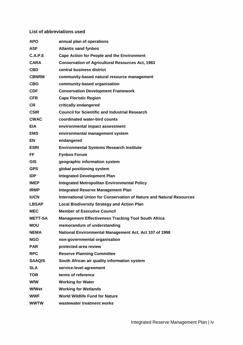
List of abbreviations used
APO annual plan of operations
ASF Atlantis sand fynbos
C.A.P.E Cape Action for People and the Environment
CARA Conservation of Agricultural Resources Act, 1983
CBD central business district
CBNRM community-based natural resource management
CBO community-based organisation
CDF Conservation Development Framework
CFR Cape Floristic Region
CR critically endangered
CSIR Council for Scientific and Industrial Research
CWAC coordinated water-bird counts
EIA environmental impact assessment
EMS environmental management system
EN endangered
ESRI Environmental Systems Research Institute
FF Fynbos Forum
GIS geographic information system
GPS global positioning system
IDP Integrated Development Plan
IMEP Integrated Metropolitan Environmental Policy
IRMP Integrated Reserve Management Plan
IUCN International Union for Conservation of Nature and Natural Resources
LBSAP Local Biodiversity Strategy and Action Plan
MEC Member of Executive Council
METT-SA Management Effectiveness Tracking Tool South Africa
MOU memorandum of understanding
NEMA National Environmental Management Act, Act 107 of 1998
NGO non-governmental organisation
PAR protected-area review
RPC Reserve Planning Committee
SAAQIS South African air quality information system
SLA service-level agreement
TOR terms of reference
WfW Working for Water
WfWet Working for Wetlands
WWF World Wildlife Fund for Nature
WWTW wastewater treatment works

Integrated Reserve Management Plan | 1
PART 1
DESCRIPTION
1. INTRODUCTION
The Witzands Aquifer Nature Reserve protects not only the Atlantis aquifer – the main water
supply for the towns of Atlantis, Mamre and Pella – but also the rich biodiversity of the area,
including an array of plant species, a number of mammals, an abundance of birdlife, and a
rich cultural heritage. The none-vegetated mobile dune fields are an outstanding feature of
the reserve, which appeals to visitors and locals alike because of its potential for hosting a
variety of recreational activities, which includes, but not limited to off road recreational
vehicles, sand boarding etc. The reserve’s natural beauty and unique features offer a range
of environmental education opportunities, making it an ideal venue for both learners and
educators for a unique ‘outdoor classroom’ experience.
The strategic management planning process, which results in the development of an
Integrated Reserve Management Plan (IRMP), for the Witzands Aquifer Nature Reserve
began with the definition of the vision followed by the purpose for the reserve. This purpose
is then supported by desired states for the reserve. The reserve objectives contribute to
realising the purpose and desired states. For each desired state, a number of management
objectives are identified. These management objectives are then implemented through the
identification of outputs. Objectives for each desired state are prioritised for the five-year
time horizon of the plan. Time frames, deliverables, performance indicators and targets are
then allocated to each objective, or a group of linked outputs contributing to the desired
state.
1.1 Aim of the Integrated Reserve Management Plan
The aim of the IRMP is to ensure that the Witzands Aquifer Nature Reserve has clearly
defined objectives and activities to direct the protection and sustainable use of its natural,
scenic and heritage resources over a five-year period. The IRMP thus provides the medium-
term operational framework for the prioritised allocation of resources and capacity in the
management, use and development of the reserve. The IRMP intends to add value and
continuity by clearly stating management objectives, scheduling action, and providing
management guidelines.
The planning process for the Witzands Aquifer Nature Reserve takes place against the
backdrop of (i) the City of Cape Town’s Integrated Development Plan (IDP) (Anon 2010); (ii)
the City of Cape Town’s Integrated Metropolitan Environmental Policy (IMEP) (Anon 20031),
(iii) biodiversity strategy (Anon 20032) and Local Biodiversity Strategy and Action Plan

Integrated Reserve Management Plan | 2
(LBSAP) (Anon 20091), as well as (iv) the bioregion (Cape Action for People and the
Environment, or C.A.P.E). The major elements of the IRMP are this document (overall
strategy, vision and context); the detailed subsidiary plans (as required), and an annual plan
of operations (APO). The IRMP for the Witzands Aquifer Nature Reserve is supported by a
State of Biodiversity report (City of Cape Town 2008), operational guidelines, and a
monitoring and evaluation framework to ensure on-going implementation and review of
protected-area management activities (figure 1).
Figure 1: Elements of the IRMP
The IRMP for the Witzands Aquifer Nature Reserve forms part of a tiered series of policies,
legislation and related planning documents at the sector, institutional, agency and local level
(figure 2).
Integrated Reserve Management Plan
Subsidiary
plans
Annual
plan of
operations
Strategic plan
for reserve:
vision,
background,
context State of
Biodiversity
report
LBSAP
Operational
guidelines
Monitoring
and
evaluation

Integrated Reserve Management Plan | 3
Figure 2: Legal and planning framework for the IRMP
Where possible, emphasis has been placed on the following:
Assigning responsibility for management interventions
Scheduling said management interventions
Quantifying management costs
This approach is specifically intended to create a mechanism whereby management
intervention can be monitored and audited on an annual basis.
In context, this IRMP is a dynamic document, and the detailed subsidiary plans should be
updated on an annual basis or as soon as new information comes to light that may better
inform decisions on responsible land management. The IRMP should be updated every five
years.
The drafting of this IRMP has been guided by a small interdisciplinary Reserve Planning
Committee (RPC) comprising the branch manager, the regional manager, the area manager,
various specialists, and other interested and affected persons. Repeated drafts of the IRMP
were presented to, and discussed by, the RPC before broader circulation for public
participation purposes.

Integrated Reserve Management Plan | 4
Pre-engagement workshops were held with community partners from March to May 2010.
This afforded key community partners an opportunity to give their input at an early stage.
Where practical, the ideas and outputs from these workshops have been incorporated into
the IRMP.
1.2 Location and extent
The Witzands Aquifer Nature Reserve is situated 45 km from Cape Town’s central business
district (CBD) in the Western Cape (map 1). The property is currently under the authority of
the City of Cape Town’s Bulk Water branch of the Water and Sanitation Department. The
reserve is 7 km west of the town of Atlantis along the R27 West Coast road, within the
northern region of the Cape metropolitan area, and covers an area of approximately 1705.55
ha with a global positioning system coordinate of 33˚35’41.92” S and 18˚26’18.81” E. This
GPS coordinate reading was recorded from the centre point of the Atlantis Dune field
(Google Earth 2005) (map 2).
The reserve does not have any formal conservation status, but is recognised as a major part
of the Atlantis water catchment area, supplying potable water to the towns of Atlantis, Mamre
and Pella. The area will be formally proclaimed under the name the Witzands Aquifer Nature
Reserve in order to protect the underground aquifer as a water resource, as well as
conserve the two vegetation types found here, namely Cape Flats Dune Strandveld and
Atlantis Sand Fynbos.

Integrated Reserve Management Plan | 5

Integrated Reserve Management Plan | 6
Integrated Reserve Management Plan | 7
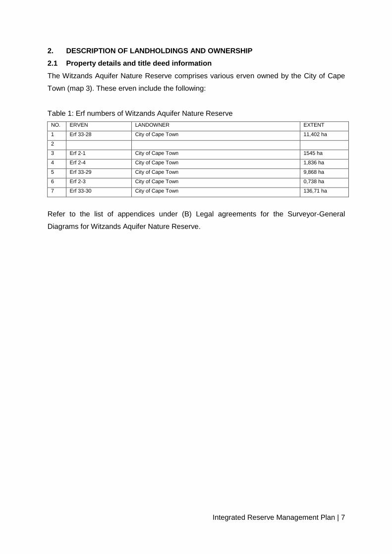
2. DESCRIPTION OF LANDHOLDINGS AND OWNERSHIP
2.1 Property details and title deed information
The Witzands Aquifer Nature Reserve comprises various erven owned by the City of Cape
Town (map 3). These erven include the following:
Table 1: Erf numbers of Witzands Aquifer Nature Reserve
NO. ERVEN LANDOWNER EXTENT
1 Erf 33-28 City of Cape Town 11,402 ha
2
3 Erf 2-1 City of Cape Town 1545 ha
4 Erf 2-4 City of Cape Town 1,836 ha
5 Erf 33-29 City of Cape Town 9,868 ha
6 Erf 2-3 City of Cape Town 0,738 ha
7 Erf 33-30 City of Cape Town 136,71 ha
Refer to the list of appendices under (B) Legal agreements for the Surveyor-General
Diagrams for Witzands Aquifer Nature Reserve.

Integrated Reserve Management Plan | 8

Integrated Reserve Management Plan | 9
2.2 Landscape perspective
The reserve falls within the Cape Floristic Region (CFR), the smallest yet richest of the
world’s six floral regions, and the only one to be found entirely within one country. However,
this rich biodiversity is under serious threat for a variety of reasons, including conversion of
natural habitat to permanent agricultural land, inappropriate fire management, rapid and
insensitive development, overexploitation of water resources, and infestation by invasive
species. The region has been identified as one of the worlds ‘hottest’ biodiversity hot spots
(Myers et al. 2000).
In response to this challenge, a process of extensive consultation involving various
interested parties, including local government and non-governmental organisations (NGOs),
resulted in the establishment of a strategic plan (C.A.P.E Project Team 2000) referred to as
Cape Action for People and the Environment, which identified the key threats and root
causes of biodiversity losses that need to be addressed in order to conserve the floral
region. This resulted in a spatial plan, identifying areas that need to be conserved and a
series of broad programme activities that need to take place over a 20-year period. Based
on the situation assessment and analysis of threats, three overarching, mutually
complementing and reinforcing themes were developed:
To establish an effective reserve network, enhance off-reserve conservation, and
support bioregional planning
To strengthen and enhance institutions, policies, laws, cooperative governance and
community participation
To develop methods to ensure sustainable yields, promote compliance with laws,
integrate biodiversity concerns with catchment management, and promote sustainable
eco-tourism
The C.A.P.E partnership was formed and works together to implement the C.A.P.E vision
and plan by strengthening institutions, supporting conservation efforts, enhancing education,
developing tourism benefits, and involving people in conservation. The City of Cape Town
was one of the 19 founding signatories of the C.A.P.E memorandum of understanding
(MOU).
The Witzands Aquifer Nature Reserve links up with Koeberg Private Nature Reserve, which
is managed by Eskom. The City of Cape Town also manages nearby the Blaauwberg Nature
Reserve and the Table Bay Nature Reserve, as well as provides assistance to the

Integrated Reserve Management Plan | 10
communally owned property of Mamre Nature Garden. The Mamre Nature Garden property,
although not owned by the City of Cape Town is an important site identified on the
biodiversity network in terms of its biodiversity found there. Witzands Aquifer Nature
Reserve, Blaauwberg Nature Reserve, Koeberg Nature Reserve and Mamre Nature Garden
all form part of the southern core of the greater Cape West Coast Biosphere Reserve (map
4).
The WANR is a key part of the Dassenberg Coastal Catchment Partnership (DCCP). The
DCCP is a landscape initiative formed between various conservation partners and the local
communities with the goal of linking CapeNature’s Riverlands Nature Reserve to the coast
(figure 3). The key objectives of the approximately 30000 ha initiatives are:
Protect critical ecological infrastructure
Deliver Socio Economic opportunities to the surrounding communities
Ensure the protection of the identified critical climate change adaptation and mitigation
corridor
Protect and promote the incredible natural and cultural heritage of the area
Figure 3: The greater Dassenberg Coastal Catchment Initiative

Integrated Reserve Management Plan | 11

Integrated Reserve Management Plan | 12
2.3 Physical environment
2.3.1 Climate
The area is associated with a Mediterranean climate, characterised by winter rainfall, hot,
dry summers and cold, wet winters. Rainfall is mainly produced by the passage of westerly-
wave frontal systems. Summers are relatively dry due to the effects of the South Atlantic
anticyclone system (Eskom 2006). Mean daily maximum and minimum temperatures range
between 26,7 °C and 7,5 °C, measured in February and July respectively. The occurrence of
mist is frequent in winter thus supplying additional precipitation. The winter rainfall regime
includes precipitation peaking from May to August. The mean annual rainfall is 290–660 mm
(mean: 424 mm), and the mean annual evaporation rate is 1 445 mm (Mabihi 2009).
This region’s entire coastal belt is characterised by strong winds. The dominant summer
winds are those from the south and south-east, and the dominant winter wind is from a
northerly direction (Mabihi 2009). All weather related data is received monthly from the
South African Weather Service’s automated weather station. The station is situated within
the Atlantis Industrial area, approximately 8 km from the WANR.
2.3.2 Geology, geomorphology, soils and land types
The reserve incorporates a number of environments, two vegetation types as well as an eco-
tonal zone between them. One wetland (infiltration pond) and an un-vegetated mobile dune
field occur at the Witzands Aquifer Nature Reserve. The dune area comprises a third to half
of the overall area. It is a dynamic system consisting of a number of active dune fields that
move through an area of naturally vegetated dunes; a small portion of the dune field lies
outside the boundaries of the reserve. The source of the sand is the sandy beach at
Melkbosstrand and Eskom to the south of the overall dune system (Knight Hall Hendry &
Associates 1996). The Centre for Scientific and Industrial Research (CSIR) (2002), report
further states that the granite outcrops of Dassenberg, Kanonkop and Mamre-Darling near
Mamre constitute the highest points in the area, at altitudes of 210–410 m above sea level.
The geology of the Witzands Aquifer Nature Reserve, as noted in the Eskom report (2006) of
the entire Atlantis coastal plain, comprises unconsolidated Cenozoic sediments associated
with the sandveld group. Soil types are mainly quartz sand, which was deposited on shale
bedrock of the Malmesbury group. The lower Varswater formation is of a shallow marine
origin, while the upper Bredasdorp formation is of an Aeolian origin. The shale bedrock
outcrops occur sporadically along the coastal parts and inland towards the south and north
of Atlantis. Granite intrusions of the Cape granite suite are not found in the reserve, but
occur in the Mamre area, 14 km to the north of the reserve.

Integrated Reserve Management Plan | 13
2.3.3 Hydrology and aquatic systems
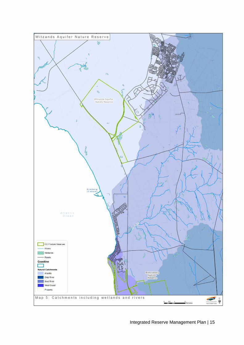
2.3.3.1 Catchments
The Witzands Aquifer Nature Reserve falls within the Atlantis water catchment hydro-
geological unit (Knight Hall Hendry & Associates 1996) (map 5). Within the inter-dune
hollows, natural seasonal wetlands are present, as described in the environmental
management system (EMS) (Knight Hall Hendry & Associates 1996), and are scattered
throughout the area. An open man-made pan, Pond 12, occurs in the area. The water is
collected from stormwater and treated effluent from the wastewater treatment works
(WWTW) in Atlantis. The open semi-natural Pond 7 (wetland) is also part of the water
abstraction process. However, half of the Pond 7 area falls outside the reserve, on property
owned by the National Department of Public Works. The City of Cape Town currently has a
servitude right to the Pond 7 area only. Some of the pans are seasonal, such as Pond 12,
while others are permanent, such as Pond 7. The pans are an important habitat for birds and
other aquatic species of plants and animals, including certain fish species (Knight Hall
Hendry & Associates 1996).
The aquifer covers an area of 130 km2, extending inland from the Atlantic Ocean to below
the town of Atlantis (CSIR 2002). The aquifer is defined by the unconsolidated sandy
sediments overlying the impervious clay layer, which forms the eroded upper portion of the
Malmesbury group shale bedrock. Due to the unconfined nature of the sandy aquifer, it is
highly susceptible to pollution, and requires rigorous protection. Clay and other salinity
sources in the sediments partially contribute to the wide variations in groundwater quality in
the Atlantis area. It squeezes out against the Malmesbury group shale and Cape granite
outcrops to the north and east. The thin aquifer slopes steeply in a south-westerly direction
from a maximum elevation of approximately 160 m in the north towards the sea. A small
portion of the aquifer extends below sea level in the Witzands and adjacent Silwerstroom
areas (CSIR 2002).
Groundwater is abstracted from the aquifer at two well fields, which form part of the Atlantis
water scheme. Some of the major components of the scheme are situated in the Witzands
Aquifer Nature Reserve, such as a portion of the well field; the water-softening plant; the
stormwater infiltration ponds, several well points and monitoring boreholes and the dune
field. The dune field is responsible for a major part, which is responsible for a major portion
of the infiltration.
The town of Atlantis requires a reliable supply of potable water in excess of 5,5 million m³
per annum, while the sustainable yield of the existing (1994) well fields was estimated at 6,1
million m³ per annum (Knight Hall Hendry & Associates 1996).

Integrated Reserve Management Plan | 14
The EMS (Knight Hall Hendry & Associates 1996) further explains the process by which the
water supply is provided, namely utilising the natural potential of the local coastal aquifer,
supplemented with recharged urban stormwater runoff and treated wastewater originating in
Atlantis. Groundwater is abstracted from the aquifer at two well fields, treated in an ion-
exchange water-softening plant, distributed, utilised, collected in two separate streams (from
the industrial and residential areas of Atlantis), and treated in two separate treatment works.
It is then artificially recharged together with urban stormwater runoff back into the aquifer.
This artificially recharged water augments the natural aquifer potential, which depends on
recharge by rainfall (Knight Hall Hendry & Associates 1996).
The monitoring network for the system includes a meteorological station, a flow-gauging
station, surface water-level recording stations, more than 100 groundwater-level measuring
points and stormwater monitoring sites. In addition, there are wastewater-effluent monitoring
sites and groundwater-quality monitoring sites. Sampling is done at regular intervals, and
involves both chemical and microbiological analysis. Flow-gauging and water-level
measurements are done on a continuous basis – hourly, weekly and monthly – and the data
are loaded onto a central database. According to the EMS (Knight Hall Hendry & Associates
1996), the Atlantis water supply system, as managed by the Atlantis water scheme (City of
Cape Town’s Bulk Water Branch), serves as a prototype for successful, sophisticated water
development in Southern Africa.
2.3.3.2 Rivers
The area lacks surface drainage features, except for the Buffels River at Silwerstroom to the
west of the reserve, and the Donkergat and Sout rivers in the south, which flow in winter
only. All rivers in the area and surrounds are non-perennial, drying up in summer (CSIR
2002). The un-vegetated dune system is an important component of the aquifer as a whole,
having a higher recharge potential (Knight Hall Hendry & Associates 1996).
Integrated Reserve Management Plan | 15

Integrated Reserve Management Plan | 16
2.4 Biological environment
Although the detailed species list for the reserve forms part of the appendices to this IRMP,
they can nevertheless still be accessed through the South African Biodiversity Database
(www.biodiversity.co.za 2010), which contains all listed species and statistics for all City of
Cape Town conservation areas as well as other areas that form part of the biodiversity
network (map 6).
2.4.1 Vegetation
The natural vegetation in the Witzands Aquifer Nature Reserve predominantly consists of
Cape Flats Dune Strandveld. A small area of Atlantis Sand Fynbos, of approximately 2,73
ha, also occurs within the reserve. It is restricted to the southernmost part of the reserve,
adjacent to the land owned by the National Department of Public Works (Brakkefontein). A
transitional zone consisting of both Cape Flats Dune Strandveld and Atlantis Sand Fynbos is
found where the two vegetation types meet (Dorse, 2010 pers. comm.).
Altogether 143 plant species have been recorded in the Witzands Aquifer Nature Reserve
(appendix 4). Two permanent vegetation monitoring plots have been established and
surveyed. Three more plots must still be established in the next five years. A field herbarium
has been established, and is still in its early stages of development. Fixed-point photography
will also be conducted for monitoring plots.
According to the latest national ecosystem conservation status, Cape Flats Dune Strandveld
is regarded to be Endangered (EN), while Atlantis Sand Fynbos is Critically Endangered
(CR). Within the City of Cape Town area, only 45% of Cape Flats Dune Strandveld remains.
Some 51% has been transformed, and only 13% is currently conserved against the national
conservation target of 24%. The national conservation target for Atlantis Sand Fynbos is
30%. However, only 6% is currently conserved, while 40% has been transformed. Of the
West Coast subtype of Cape Flats Dune Strandveld only 83% remains. The reserve is thus
an important sanctuary for this vegetation type (Dorse 2010).
The occurrence and distribution of the Witzands vegetation types, namely Cape Flats Dune
Strandveld and Atlantis Sand Fynbos, are influenced by the geology of the area. According
to Rebelo et al. (2006), Atlantis Sand Fynbos grows in deep sands of the coastal plain, with
a low pH and a poor nutrient availability, while Cape Flats Dune Strandveld is found on more
recent calcareous alkaline sands containing higher nutrients.

Integrated Reserve Management Plan | 17
2.4.1.1 Cape Flats Dune Strandveld
Cape Flats Dune Strandveld differs from both fynbos and renosterveld in that it does not
burn as frequently; the fire cycle is typically 20–100 years. It is therefore far more prone to
browsing, and many plant species have thorny defences. Cape Flats Dune Strandveld is
endemic to Cape Town, and occurs in two major segments: on the western shoreline from
Cape Town to Bokbaai (including the Atlantis dune fields), and on the False Bay shoreline
from Muizenberg to Gordon’s Bay. It is therefore confined mainly to the coastal margins, only
extending inland on dune fields as in the reserve. Historically, this was a series of dunes and
dune slack wetlands inhabited by hippopotami and rhinoceroses. For conservation purposes,
this vegetation type is considered as two separate units due to its local geographical extent
namely, the West Coast subtype and the False Bay subtype. The Witzands Aquifer Nature
Reserve consists of the West Coast sub-type of Cape Flats Dune Strandveld, which extends
north of the city bowl, at an altitude of 80 m. The dunes in the reserve tend to run southwest
to northeast, as does the West Coast Dune Strandveld subtype.
This vegetation type is described as a short to tall, evergreen, hard-leaved and succulent
shrubland, with abundant annual herbs and grasses in the gaps and understorey (Rebelo et
al. (2006). Post-fire, it may have a ‘fynbos’ phase dominated by fynbos elements, but most
thicket species regenerate from underground stems. The West Coast subtype tends to have
more succulent elements. Thirty one threatened Red List plant species are associated with
this veld type as a whole.
Cape Flats Dune Strandveld plant species found at the reserve include the pioneer species,
namely Metalasia muricata (Blombos) and Chrysanthemoides monilifera (Bitoubos), of which
the berries are eaten by both birds and mammals. The succulents include Euphorbia
mauritanica and Carpobrotus edulis (Sour Fig), of which the edible fruit and succulent leaves
can be used to treat burns and scalds. Bulbs found in the reserve include Lachenalia rubida
(Bergnaeltjie) and the commercially harvested Zantedeschia aethiopica (Arum Lily), of which
the leaves are used to treat burns and insect bites.
Other species occurring in the reserve are Salvia africana-lutea (Strand Salie/Sage), an
aromatic plant traditionally used as a tea to alleviate coughs and colds, and Nylandtia
spinosa (Skilpadbessie/Tortoise Berry), which grows abundantly throughout the area and is
a food source for tortoises and birds. Pelargonium capitatum (Rose-scented
Geranium/Kusmalva) and Leonotis leonurus (Wild Dagga) are also commonly found in the
reserve. The climbers include Kedostris nana (Ystervarkpatats), which produces a potato
like tuber, and Cissampelos capensis (Davidjies) that has medicinal value.

Integrated Reserve Management Plan | 18
The woody shrub species include Sercia glauca (Blue Kuni-bush/BouTaaibos), Sercia lucida
(Blinktaaibos), Euclea racemosa (Sea Guarri) and Olea exasperata (Coast Olive/Slanghout),
which all produce berries eaten by birds. Putterlickia pyracantha (False Spike-thorn), with its
prominent thorns, grows predominantly in the eastern sector of the reserve. This indigenous
plant can be seen as encroaching in the area. A study is proposed to determine methods to
limit this suspected encroachment.
2.4.1.2 Atlantis Sand Fynbos
The vegetation is typical asteraceous and proteoid fynbos, and does not differ structurally
from equivalent mountain fynbos types, although very few species are shared. Ericaceae
(heaths) are seldom dominant, but ericoid-leaved shrubs tend to dominate with the
Restionaceae (reeds) and Proteaceae (sugarbushes). Sand fynbos is characterised by the
presence of the Erica mammosa (Ninepin Heath), Phylica cephalantha (Starface), P.
stipularis (Baboon Face), and the restioids including Thamnochortus obtusus and T.
punctatus (Sandveld Thatching Reed). In the south of the reserve, the incidence of grass is
much higher than in the north, but most of these are invasive Mediterranean grasses

Integrated Reserve Management Plan | 19

Integrated Reserve Management Plan | 20
2.4.2 Mammals
Eighteen mammal species have been recorded through a series of baseline fauna surveys
that took place from 2008 to 2010 (appendix 5). These include Genetta genetta (Small
Spotted Genet), Hystrix africaeaustralis (Porcupine) and Galerella pulverulenta (Small Grey
Mongoose). Antelope species in the reserve include Raphicerus campestris (Steenbok),
Raphicerus melanotis (Cape Grysbok) and Sylvicaptra grimmia (Common Duiker). A Caracal
carcass was also found along the R307 Dassenberg Drive. This sighting could be a much
needed confirmation of the presence of this species in the reserve or surrounding areas.
Small mammal species found in the reserve include Rhabdomys pumilio (Striped Field
Mice), Tatera afra (Cape Gerbil) and Otomys irroratus (Vlei Rat). Sightings of Mellivorus
capensis (Honey Badger) in the Atlantis area indicate that these animals probably move
through the reserve from time to time.
The small-mammal fauna survey protocol for the Witzands Aquifer Nature Reserve is
available electronically. The reserve is largely dominated by smaller type mammals, many of
which are nocturnal and inconspicuous. Other indications of their presence are middens,
scat and spoor. A small antelope count has been conducted in the area south-west of the
dunes.
2.4.3 Birds
Altogether 149 bird species have been recorded since 2007 through ongoing coordinated
water-bird counts (CWACs), coordinated by the Animal Demography Unit at the University of
Cape Town, and ad hoc sightings recorded in the reserve sightings diary (appendix 6). Of
special interest is the confirmed presence of raptors, including the vulnerable Circus
ranivorus (African Marsh Harrier), the Near Threatened Circus maurus (Black Harrier) and a
resident breeding pair of Haliaeetus vocifer (African Fish Eagles). Other raptors recorded are
the Elanus caeruleus (Black Shouldered Kite) and Buteo rufofuscus (Jackal Buzzard). Water
birds sighted in the vicinity of Pond 7 (wetland) include the Near Threatened Pelecanus
onocrotalus (Great White Pelican), Phalacrocorax africanus (Reed Cormorant),
Phalacrocorax ludicus (White Breasted Cormorant), Platalea alba (African Spoonbill),
Plegadis falcinellus (Glossy Ibis), Threskiornis aethiopicus (African Sacred Ibis), Bostrychia
hagedash (Hadeda Ibis), Ardea cinerea (Grey Heron) and Alcedo cristata (Malachite
Kingfisher).
A special monitoring programme is in place for monitoring the breeding success of the black
harrier. Monitoring takes place annually during the breeding season, from July to December.
CWACs are done once per quarter.

Integrated Reserve Management Plan | 21
2.4.4 Reptiles
Twenty-eight reptile species are believed to occur in the Witzands Aquifer Nature Reserve
according to a desktop study conducted during the drafting of the EMS (Knight Hall Hendry
& Associates) in 1996 (appendix 7).
The reptile species that have been confirmed as present in the reserve are Naja nivea (Cape
Cobra), Dispholidus typus (Boomslang), Psammophylax rhombeatus (Rhombic
Skaapsteker), Pseudaspis cana (Mole Snake) and Chersina angulata (Angulate Tortoise).
2.4.5 Amphibians
Six amphibians, including Strongylopus grayii grayii (Clicking Stream Frog) and Xenopus
laevis (Common Platana), have been recorded in the reserve (appendix 8).
2.4.6 Fish
Three fish species have been recorded in Pond 7 (wetland) only, and these are all
freshwater fish, including invasive species such as the Oreochromis mossambicans
(Mozambique Tilapia), the indigenous Galaxius zabratus (Cape Galaxias) and the locally
invasive Clarias garipinus (Sharptooth Catfish).
2.4.7 Invertebrates
Currently, there is no baseline or desktop information on invertebrate fauna for the reserve.
The reserve management is required to conduct baseline studies in order to obtain these
data. However, Phymateus morbillosus (Common Milkweed Grasshopper) and
Opistophthalmus glabrifrons (Thin-tailed Scorpion) were recently recorded in the reserve.
2.5 Socio-political context
2.5.1 History
In 1819, the reserve was part of a large farm, the “Gouvernements Plaatsen”, along with
Melk Post and Hartebeeste Kraal, managed by CM Stoffberg. Jan Nagel, a charcoal burner,
was a resident on the farm. In the 18th and 19th centuries, a group of people referred to as
the “duinemense” of the Blaauwberg area eked out an existence on the farms, then known
as Brakkefontein, Laaste Stuiver, Hartebeeskraal, Wittesand (today the Witzands Aquifer
Nature Reserve), Melkpost, Blomboschfontein, Donkergat, Groot Springfontein and
Duinefontein (pers. comm. Sjanel Buchel 2010).
Integrated Reserve Management Plan | 22
Wittesand was later referred to as Witzand, and was then owned by the prominent Duckitts
family, and later bought by National Government (Department of Human
Settlements/National Housing Board).
In 1976, the land was managed by the City of Cape Town, and the Atlantis water scheme
was appointed as the authority to manage the area and its water extraction and supply
(Knight Hall Hendry & Associates 1996).
The area has been used as a venue for off road recreational driving since at least 1975 and
it forms part of a route along the west coast, from Melkbos to Yzerfontein (Jenkinson 2014).
Since the mid 1990’s, entry for recreational off-roaders into the dunes has been controlled
through a permit system, under the jurisdiction of the City of Cape Town. The venue is one
of the most popular off-roading destinations within the Western Cape, being visited by a
number of general off road vehicle users and formal off road clubs on a regular basis. The
venue has been used in the past for several organised off-road events (Toyota Guinness
World Record Attempt, annual 4x4 Family Fun Day, organised by the Four Wheel Drive Club
South Africa (4WDCSA)), with the most recent being the annual Mandela Day 4x4 Drive
Charity Event, organised by the City of Cape Town’s Environmental Resource Management
and Water and Sanitation Departments, in partnership with Atlantis Dunes Off-Road
Executive (ADORE).
Blaauwberg Municipality and the other municipalities in the Cape Town area were grouped
together to form the City of Cape Town in 2000. The reserve is now managed by the City of
Cape Town, and exists to provide the people of Cape Town with potable water, a safe
environment where biodiversity is maintained, as well as visitor facilities. The water
abstraction and supply management continue to be the responsibility of the City of Cape
Town’s Bulk Water Branch.
The reserve managers of the Witzands Aquifer Nature Reserve have been as follows:
2007–2009 Thumeka Mdlazi
2009–present Charline Mc Kie
2.5.2 Socio-economic context
Currently, the Atlantis water scheme has approximately 50 on-site staff members as well as
four Biodiversity Management Branch staff members. The majority of the staff members
employed are from the Atlantis community. The Atlantis, Mamre and Pella communities are
the residential communities closest to the site, with Atlantis being only 7 km from the

Integrated Reserve Management Plan | 23
Witzands Aquifer Nature Reserve. The reserve falls within Subcouncil 1’s jurisdiction, which
is administered from the suburb of Milnerton, covering six wards, of which ward 29 (Mamre,
Pella and Atlantis suburbs) and ward 32 (including Witsands informal settlement, Koeberg
and Atlantis Industrial) are relevant to the reserve. The subcouncil forms the link between
the City of Cape Town and its communities to promote transparency and accountability. It
strives to ensure public participation in City of Cape Town policies, and plans such as the
IDP.
The town of Atlantis was established during the apartheid era in the early 1970s, and it was
assumed that it would grow with the establishment of an industrial hub. However, with the
removal of financial support and the exodus of several of the biggest employer industries,
levels of unemployment in the area have soared.
According to the website Cape Gateway (2007), Atlantis has an estimated population of
261 537, with a gender composition of 50% males and 50% females. Some 14% of the
population has a Grade 12 certificate as their highest education level. These communities
are typically earning a low to medium income, with the low-income bracket being 30% and
the medium-income bracket 70%. The average unemployment rate in the Atlantis
community is 37%, with some 63% being employed. Atlantis offers 3 400 formal housing
units (property owners); houses leased total 1 414 units (leased from the City of Cape
Town), and informal living structures total 3 767. During 2011, an estimated 2 000 new
formal houses will be built in four phases in the area referred to as Kanonkop (i.e. the
Kanonkop housing project). Atlantis has four sectors of neighbourhood watch organisations
as well as one ratepayers’ association.
These communities are largely geographically isolated in relation to the Cape Town CBD,
and are surrounded largely by peripheral undeveloped land. A small component of small-
scale farmers is situated between the reserve and the Mamre community to the north.
The Witzands Aquifer Nature Reserve has undertaken to promote community involvement
and participation through various activities, including, but not limited to, environmental
education at the reserve as well as classroom education at schools. The reserve has
established partnerships for implementing projects and activities with two well-known
community-based organisations (CBOs) in Atlantis with a focus on the environment. The
reserve actively participates in integrated holiday programmes and festivals held in all three
towns of Atlantis, Mamre and Pella by means of exhibitions and stalls. Information regarding
harvesting of species, particularly in the Mamre Nature Garden, is collated in collaboration

Integrated Reserve Management Plan | 24
with members of the community. The reserve encourages and promotes community
empowerment with a focus on youth development.
According to Knight Hall Hendry and Associates (1996), the activity of recreational off-road
driving has been taking place within the Atlantis Dunes area since the 1970s. The area also
supports companies, which operate tours to the area as well as being a significant
contributor to off road driver training.
2.6 Protected-area expansion
Atlantis state land is located to the north and west of the reserve, approximately 10 000 ha in
extent. The Department of Public Works property, referred to as Brakkefontein, is located to
the east of the reserve. Parts of this land could be incorporated into the reserve through a
stewardship programme, as these properties are largely undeveloped tracts of land.
Negotiations have been initiated between the City of Cape Town and the Department of
Public Works to incorporate 850 ha of the Brakkefontein property into the reserve.
3. PURPOSE, VISION/MISSION, SIGNIFICANCE/VALUE
3.1 Purpose of the protected area
The Witzands Aquifer Nature Reserve is located in the Cape Floristic Region (CFR), an area
of global biodiversity significance. The reserve conserves a unique combination of habitats,
ecosystems and species, many of which are either rare or endemic to the area. The primary
purpose of the reserve is the conservation of this unique biodiversity and associated
ecosystem features and functions.
In conserving this unique biodiversity, secondary objectives will include the following:
The management of the reserve as a viable water resource by means of the Atlantis
water scheme through the aquifer
The conservation of the habitat for the Black Harriers, Marsh Harriers and breeding
pair of Fish Eagles
The protection of the mobile dunes surrounded by more stable, partially vegetated
dune ridges and dune slip faces, many of the latter giving rise to seepage areas at
their base
Developing high-quality visitor infrastructure, facilities and services to grow responsible
Sustainable tourism activities, including recreational off road driving
The conservation of Endangered Cape Flats Dune Strandveld and Critically
Endangered Atlantis Sand Fynbos

Integrated Reserve Management Plan | 25
Promoting sound environmental education principles
3.2 Vision and mission
3.2.1 Vision
Integrated Development Plan vision
The vision of the City of Cape Town remains as follows:
To be a prosperous city that creates an enabling environment for shared growth and
economic development
To achieve effective and equitable service delivery
To serve the citizens of Cape Town as a well-governed and effectively run
administration
To achieve this vision, the City recognises that it must:
actively contribute to the development of its environmental, human and social capital;
offer high-quality services to all who live in, do business in, or visit the city as tourists;
and
be known for its efficient, effective and caring government.
C.A.P.E vision
We, the people of South Africa, are proud to be the custodians of our unique Cape Floral
Region, and share its full ecological, social and economic benefits now and in the future.
Environmental Resource Management Department vision
To ensure that sustainable and equitable development is combined with sound
environmental practice for a healthy local environment, which sustains people and nature,
provides protection for our unique resources and results in an enhanced quality of life for all.
Biodiversity Management Branch vision
To be a City that leads by example in the protection and enhancement of biodiversity; a City
within which biodiversity plays an important role, where the right of present and future
generations to healthy, complete and vibrant biodiversity is entrenched; a City that actively
protects its biological wealth, and prioritises long-term responsibility over short-term gains.
The Witzands Aquifer Nature Reserve vision
To conserve and manage the two central features of the site, namely being a water
catchment resource and having unique surface biodiversity, ensuring a positive balance

Integrated Reserve Management Plan | 26
between utilisation and conservation, and providing long-term sustainable environmental
experiences to the surrounding communities.
3.2.2 Mission
Biodiversity Management Branch mission
To manage biodiversity proactively and effectively
To ensure an integrated approach to biodiversity between City of Cape Town line
functions and departments, actively pursuing external partnerships
To adopt a long-term approach to biodiversity
To ensure sustainability of our rich biodiversity
To adopt a holistic and multifaceted approach to biodiversity
To continue to measure and monitor the City of Cape Town’s performance in the
protection and enhancement of biodiversity
To continue to measure and monitor the state of biodiversity in Cape Town
The Witzands Aquifer Nature Reserve mission
To maintain and, where required, restore the natural environment and its associated
ecological processes and services through the implementation of the management
objectives of the Witzands Aquifer Nature Reserve, and to support the surrounding
communities in fulfilling their environmental and socio-economic responsibilities.
3.3 Significance of property (biodiversity, heritage and social)
The Witzands Aquifer Nature Reserve accommodates two national vegetation types, one of
which is critically endangered and the other vulnerable. The reserve forms an integral part of
the City of Cape Town’s biodiversity network within the area. It has a confirmed bird species
list of 149, a plant species list of 143, and a mammal list of 18 species, including threatened
and globally endangered species. The site is the closest City of Cape Town nature reserve
to the local communities of Atlantis, Mamre and Pella, and endeavours to involve the
surrounding communities actively in conservation, awareness and educational activities by
promoting youth development through volunteerism and various other means.
Summary of qualifying site assessment criteria
• The reserve hosts a mosaic of two different vegetation types, of which one vegetation
type is endemic to the West Coast, as well as approximately eight threatened plant
species.

Integrated Reserve Management Plan | 27
• The reserve houses the Atlantis water scheme, providing potable water to the three
surrounding towns.
• A large portion of the Atlantis hydro-geological (aquifer) system falls within the nature
reserve.
• The reserve provides a habitat to 149 bird species.
• Natural open spaces connect the reserve to extensive natural areas to the north, west
and east, while some of the high-quality state land in the vicinity could also be
incorporated into the reserve through stewardship or various other means. This will
further maximise conservation for the broader Cape metropolitan area, and promote
opportunities for integrating viable linkages (corridors) between the reserve and
neighbouring areas.
• A number of stewardship sites, including, but not limited to, Nirvana Private Fynbos
Conservation Area, is situated within the greater Atlantis area, and the reserve
management plays an important facilitation role with these private landowners.

Integrated Reserve Management Plan | 27
PART 2
MANAGEMENT POLICY FRAMEWORK
4. ADMINISTRATIVE AND LEGAL FRAMEWORK FOR THE MANAGEMENT AUTHORITY
4.1 Legal framework
Table 2: Legal framework
The following is a list of legislation applicable to the management of the City of Cape Town’s Biodiversity Management Branch, and specifically
to the Witzands Aquifer Nature Reserve. Repealed legislation has been included in greyed-out text for information purposes only.
Legislation:
Acts, ordinances, bylaws
Relevance:
Description
Amendment:
Latest amendment date
Comment:
Other notes
Constitution of the Republic of South Africa,
Act 108 of 1996 Lists South African citizens’ environmental rights N/A
Chapter 2: Bill of Rights assigns citizens
with particular rights
ENVIRONMENTAL LEGISLATION
National legislation
National Environmental Management Act
(NEMA), Act 107 of 1998
One of the most important environmental laws relating to most aspects
of the environment, including environmental impact assessments
(EIAs), environmental information and legal standing, etc.
Amendment Act 56 of 2002
Amended by GN 26018, Vol.
464 of 13 February 2004
Provides for cooperative environmental
governance
National Environmental Management:
Biodiversity Act, Act 10 of 2004
The objectives of the Act are to provide for:
the management and conservation of South Africa’s
biodiversity within the framework of the National
Environmental Management Act, 1998;
the protection of species and ecosystems that warrant
national protection;
the sustainable use of indigenous biological resources;
the fair and equitable sharing of benefits arising from bio-
prospecting involving indigenous biological resources; and
the establishment and functions of a South African National
Biodiversity Institute.
N/A
The development of the IRMP will assist in
ensuring that the objectives of this Act are
achieved in the reserve.

Integrated Reserve Management Plan | 28
In essence, the Act was put in place to safeguard the important
biodiversity attributes in the country, while allowing people to benefit
equally from the natural resources. In order to achieve these goals, the
Act made provision for the South African National Biodiversity Institute
(SANBI), which has been designated certain functions and afforded
powers and duties in respect of this Act.
National Environmental Management:
Protected Areas Act, Act 57 of 2003
To provide for:
the protection and conservation of ecologically viable areas
representative of South Africa’s biological diversity and natural
landscapes and seascapes;
the establishment of a national register of all national,
provincial and local protected areas;
the management of those areas in accordance with national
norms and standards;
intergovernmental cooperation and public consultation on
matters concerning protected areas; and
matters in connection therewith.
Amendment Act 62 of 2008
Amendment Act 15 of 2009
Regulations Notice 1029 of 2009 lists
specific regulations for reserves
proclaimed by the Member of the
Executive Council (MEC) (draft August
2009).
Conservation of Agricultural Resources Act
(CARA), Act 43 of 1983
The CARA regulations contain a list of alien invasive vegetation
categorised according to their legal status. The Act regulates the sale,
position and use of listed species.
Amended by GN R 2687 of 6
December 1985 and GN R 280
of 30 March 2001
Alien invasive plant legislation to be
included under the Biodiversity Act in
future
National Veld and Forest Fire Act, Act 101 of
1998
Relates to veld fire prevention, fire protection associations, fire danger
indexing, enforcement of fire legislation, and the fighting of fires N/A
A detailed fire management plan will be
developed.
Marine Living Resources Act, Act 18 of 1998 Regulates conservation of the marine ecosystem and the long term
sustainable utilisation of marine living resources
Environment Conservation Act, Act 73 of
1989
The Environment Conservation Act is the other law that relates
specifically to the environment. Although most of this Act has been
replaced by NEMA, some important sections still remain in operation.
These sections relate to:
protected natural environments;
littering;
special nature reserves;
waste management;
Environment Conservation
Amendment Act 98 of 1991
Environment Conservation
Amendment Act 79 of 1992
Environment Conservation
Second Amendment Act 115 of
1992
Environment Conservation

Integrated Reserve Management Plan | 29
limited-development areas;
regulations on noise, vibration and shock; and
EIAs.
Amendment Act 94 of 1993
Environment Conservation
Second Amendment Act 52 of
1994
Proclamation R27 of 1995
Proclamation R43 of 1996
National Environment
Management Act 107 of 1998
National Water Act, Act 36 of 1998 Relates to all use of water and the management of all water resources
in South Africa
National Environmental Management: Air
Quality Act, Act 39 of 2004
To provide for enhancing the quality of ambient air for the sake of
securing an environment that is not harmful to the health and well-
being of the people
Promulgated to give effect to section 24(b)
of the Constitution.
The South African Air Quality Information
System is a web-based system that
provides information on the quality of
ambient air across the country.
Animal Protection Act, Act 71 of 1962 To consolidate and amend the laws relating to the prevention of cruelty
to animals
Animal Matters Amendment Act,
Act 42 of 1993
Animal Diseases Act, Act 35 of 1985 Provides for control measures relating to animal diseases
Animal Health Act, Act 7 of 2002 Regulates animal health
Game Theft Act, Act 105 of 1991 Regulates the ownership and protection of game
Mountain Catchment Areas Act, Act 63 of
1970
Provides for catchment conservation
Administered under the Western Cape
Nature Conservation Board Act, Act 15 of
1998
National Heritage Resources Act 25 of 1999 Provides for the protection of heritage resources N/A
World Heritage Conservation Act 49 of 1999 Incorporates the World Heritage Convention into South African law N/A
Problem Animal Control Ordinance,
Ordinance 26 of 1957
Regulates problem animals
Administered under the Western Cape
Nature Conservation Board Act, Act 15 of
1998
Mineral and Petroleum Resources
Development Act, Act 28 of 2002
Provides for equitable access to, and sustainable development of,
mineral and petroleum resources
Atmospheric Pollution Prevention Act, Act 45 Entire Act repealed on 1 April

Integrated Reserve Management Plan | 30
of 1965 2010 in favour of the National
Environmental Management: Air
Quality Act, Act 39 of 2004
Provincial legislation
Land Use Planning Ordinance, Ordinance 15
of 1985
The purpose of the Ordinance is to regulate land use and to provide for
incidental matters related to land use.
Assented to on 22 November
1985
Western Cape Land Use
Planning Ordinance, 1985,
Amendment Act, 2004
Although it might not have a direct
application in the management of nature
reserves, it does affect the surrounding
properties, and could possibly be used to
control activities/developments around the
reserves to minimise negative effects, for
example in applying zoning restrictions.
Cape Nature and Environmental
Conservation Ordinance, Ordinance 19 of
1974
The purpose of this Ordinance is to regulate wild animals and plants,
and the establishment of nature reserves.
Publication date 1 September
1975
Administered under the Western Cape
Nature Conservation Board Act, Act 15 of
1998
Western Cape Nature Conservation Board
Act, Act 15 of 1998
The purpose of this Act is to promote and ensure nature conservation,
render services and provide facilities for research and training and to
generate income
Biodiversity agreements are signed under
this Act.
Municipal legislation
Integrated Metropolitan Environmental Policy
(IMEP), 2001
Envisages a set of Citywide aligned strategies dealing with all aspects
of the environment.
Influenced the Biodiversity Strategy, 2003
Biodiversity Strategy, 2003 To be a city that leads by example in the protection and enhancement
of biodiversity
Draft amendment for 2009–
2019
Influenced the development of the IRMP
City of Cape Town Bylaw relating to
Stormwater Management, LA 31420
To provide for the regulation of stormwater management in the area of
the City of Cape Town, and to regulate activities that may have a
detrimental effect on the development, operation or maintenance of the
stormwater system
Publication date 23 September
2005
Communication strategy and action plan
will take effect to address the issues with
the relevant departments
City of Cape Town Air Pollution Control
Bylaw, LA 12649
The purpose of this bylaw is to give effect to the right contained in
section 24 of the Constitution of the Republic of South Africa Act (Act
108 of 1996) by controlling air pollution within the area of the Council’s
Publication date 4 February
2003

Integrated Reserve Management Plan | 31
jurisdiction; to ensure that air pollution is avoided, or, where it cannot
be altogether avoided, is minimised and remedied.
Bylaw relating to Community Fire Safety,
Province of the Western Cape, LA 11257
The purpose and scope of the bylaw is to promote the achievement of
a fire-safe environment for the benefit of all persons within the
municipality’s area of jurisdiction, and to provide for procedures,
methods and practices to regulate fire safety within the municipal area.
Publication date 28 February
2002
A fire management plan to be designed
City of Cape Town Draft Animal Bylaw, 2009
The purpose of the Bylaw is to formulate a new single bylaw, including
ten different municipal dog bylaws and the Animal Protection Act of
1962.
The Bylaw includes chapters on dogs, cats, poultry and working
equines.
Draft, 2009
HUMAN RESOURCES/ADMINISTRATION LEGISLATION
National legislation
Occupational Health and Safety Act, 1993
To provide for the health and safety of persons at work, and for the
health and safety of persons in connection with the use of plant and
machinery; the protection of persons other than persons at work
against hazards to health and safety arising out of or in connection
with the activities of persons at work; to establish an advisory council
for occupational health and safety, and to provide for matters
connected therewith.
Occupational Health and Safety
Amendment Act, No 181 of 1993
Basic Conditions of Employment Act, Act 3
of 1997
Provides for control measures pertaining to employment Amendment Act 11 of 2002
Labour Relations Amendment Act, Act 66 of
1995
The Act aims to promote economic development, social justice, labour
peace and democracy in the workplace.
Labour Relations Amendment
Act, 42 of 1996
Afrikaans Labour Relations
Amendment Act, 1998
Labour Relations Amendment
Act, 127 of 1998
Labour Relations Amendment
Act, 2000
Integrated Reserve Management Plan | 32
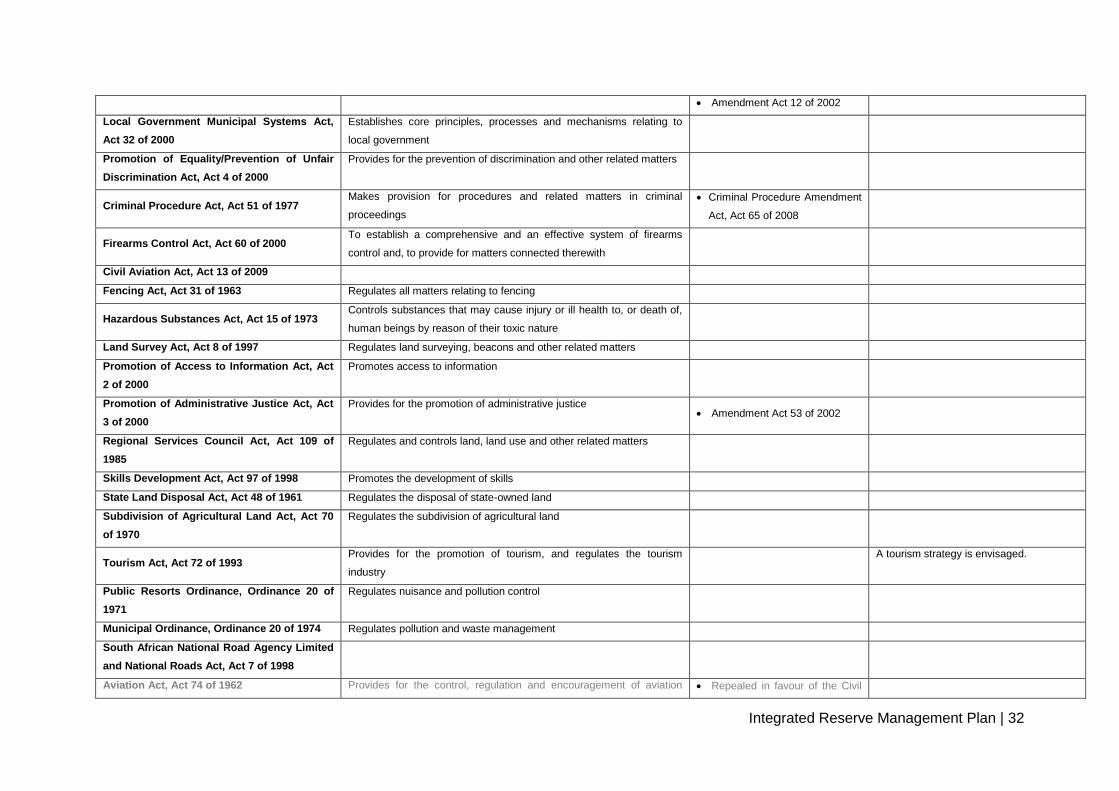
Amendment Act 12 of 2002
Local Government Municipal Systems Act,
Act 32 of 2000
Establishes core principles, processes and mechanisms relating to
local government
Promotion of Equality/Prevention of Unfair
Discrimination Act, Act 4 of 2000
Provides for the prevention of discrimination and other related matters
Criminal Procedure Act, Act 51 of 1977 Makes provision for procedures and related matters in criminal
proceedings
Criminal Procedure Amendment
Act, Act 65 of 2008
Firearms Control Act, Act 60 of 2000 To establish a comprehensive and an effective system of firearms
control and, to provide for matters connected therewith
Civil Aviation Act, Act 13 of 2009
Fencing Act, Act 31 of 1963 Regulates all matters relating to fencing
Hazardous Substances Act, Act 15 of 1973 Controls substances that may cause injury or ill health to, or death of,
human beings by reason of their toxic nature
Land Survey Act, Act 8 of 1997 Regulates land surveying, beacons and other related matters
Promotion of Access to Information Act, Act
2 of 2000
Promotes access to information
Promotion of Administrative Justice Act, Act
3 of 2000
Provides for the promotion of administrative justice Amendment Act 53 of 2002
Regional Services Council Act, Act 109 of
1985
Regulates and controls land, land use and other related matters
Skills Development Act, Act 97 of 1998 Promotes the development of skills
State Land Disposal Act, Act 48 of 1961 Regulates the disposal of state-owned land
Subdivision of Agricultural Land Act, Act 70
of 1970
Regulates the subdivision of agricultural land
Tourism Act, Act 72 of 1993 Provides for the promotion of tourism, and regulates the tourism
industry
A tourism strategy is envisaged.
Public Resorts Ordinance, Ordinance 20 of
1971
Regulates nuisance and pollution control
Municipal Ordinance, Ordinance 20 of 1974 Regulates pollution and waste management
South African National Road Agency Limited
and National Roads Act, Act 7 of 1998
Aviation Act, Act 74 of 1962 Provides for the control, regulation and encouragement of aviation Repealed in favour of the Civil
Integrated Reserve Management Plan | 33
activities in the Republic of South Africa Aviation Act, Act 13 of 2009
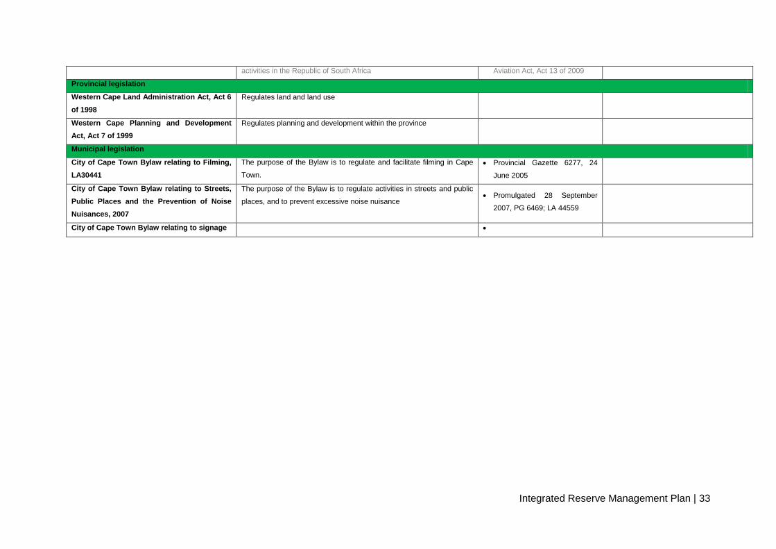
Provincial legislation
Western Cape Land Administration Act, Act 6
of 1998
Regulates land and land use
Western Cape Planning and Development
Act, Act 7 of 1999
Regulates planning and development within the province
Municipal legislation
City of Cape Town Bylaw relating to Filming,
LA30441
The purpose of the Bylaw is to regulate and facilitate filming in Cape
Town.
Provincial Gazette 6277, 24
June 2005
City of Cape Town Bylaw relating to Streets,
Public Places and the Prevention of Noise
Nuisances, 2007
The purpose of the Bylaw is to regulate activities in streets and public
places, and to prevent excessive noise nuisance Promulgated 28 September
2007, PG 6469; LA 44559
City of Cape Town Bylaw relating to signage

Integrated Reserve Management Plan | 34
4.2 Administrative framework
Nature conservation and biodiversity-related issues in the Witzands Aquifer Nature Reserve
will be managed under the direction of the City of Cape Town’s Biodiversity Management
Branch in the Environmental Resource Management Department of the Strategy and
Planning Directorate. The reserve is located in the northern region (District B, which is one of
the City of Cape Town’s eight districts) and falls under the oversight of the regional manager.
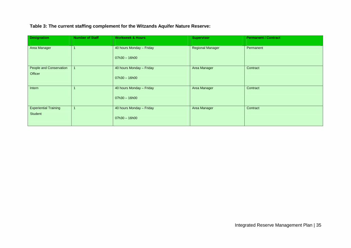
The reserve is the management responsibility of an area manager, assisted by three non-
permanent staff members (Table 3 and appendix 1). In the northern region, the area
manager’s jurisdiction covers the entire greater Atlantis area. The operational management
of the Witzands Aquifer Nature Reserve is supported by various other City of Cape Town
departments, including, but not limited to, Law Enforcement, Human Resources and
Finance. The Bulk Water Branch in the Water and Sanitation Department of the Utility
Services Directorate is based on-site, and is responsible for the management of water
supply to Atlantis, Pella and Mamre.
The regional manager and regionally based administrative officer operate from the
Biodiversity Management Branch’s head office in Maitland, 40 km south from the reserve.
Integrated Reserve Management Plan | 35
Table 3: The current staffing complement for the Witzands Aquifer Nature Reserve:
Designation Number of Staff Workweek & Hours Supervisor Permanent / Contract
Area Manager 1 40 hours Monday – Friday
07h30 – 16h00
Regional Manager Permanent
People and Conservation
Officer
1 40 hours Monday – Friday
07h30 – 16h00
Area Manager Contract
Intern 1 40 hours Monday – Friday
07h30 – 16h00
Area Manager Contract
Experiential Training
Student
1 40 hours Monday – Friday
07h30 – 16h00
Area Manager Contract

Integrated Reserve Management Plan | 36
5. PROTECTED AREA POLICY FRAMEWORK & GUIDING MANAGEMENT PRINCIPLES
5.1 Management objectives
5.1.1 Biodiversity and heritage objectives
Table 4: Biodiversity and heritage objectives for the reserve
High-level objective Objective Sub-objective Initiative Low-level plan
CONSERVATION OF
REPRESENTATIVE,
FUNCTIONAL
ECOSYSTEMS
To conserve a
representative sample of the
region’s ecosystems in a
linked landscape, and
maintain or restore
environmental processes to
enable natural spatial and
temporal variation in
structural, functional and
compositional components
of biodiversity
Representative
ecosystems
To incorporate a
spectrum of viable
aquatic and terrestrial
ecosystems
characteristic of
Witzands Aquifer
Nature Reserve, and
to re-introduce
missing elements,
where possible
Consolidation and expansion of
land areas
Consolidation of protected areas,
focusing on underrepresented
ecosystems, functional linkages and
processes
(1) Identify underrepresented
habitats/ecosystems
(2) Consolidate reserve boundaries
(3) Incorporate untransformed fynbos
(4) Establish corridors linking Witzands
Aquifer Nature Reserve with CapeNature
and state land through stewardship tool
Reserve expansion plan (to be developed
within five years)
Re-introduction of biota
Re-establishment, where possible, of
locally extinct or depleted biodiversity
components and populations in
accordance with International Union
for Conservation of Nature (IUCN)
principles and guidelines
(1) Re-establish indigenous herbivore
complement within constraints of reserve
size and urban setting
Faunal management plan (to be
developed within five years)
Fire management
Apply appropriate fire regime in
fynbos areas (frequency, season,
intensity, size)
(1) Implement an ecological fire
management plan in accordance with
objectives of conserving biodiversity and
threatened biota
(2) Monitor impact of fire management
regime
Fire management plan (being developed)
Threatened biota
Maintain viable populations of
threatened species in order to meet
obligations in terms of international
agreements and conventions
(1) Maintain viable populations of
rare/threatened plant and animal species
(identify, locate and monitor populations of
priority species)
Incorporated into a branch-wide monitoring
strategy
Monitoring plan
Implement and maintain an approved
monitoring plan for the reserve
(1) Implement and maintain a biological
monitoring programme for the reserve
Monitoring plan (monitoring protocols for
the reserve have been developed), to be
aligned with branch-wide plan

Integrated Reserve Management Plan | 37
Rehabilitation
Rehabilitate degraded areas,
including the re-
establishment of natural
biodiversity patterns, and the
restoration of key processes
that support the long-term
persistence of biodiversity
Vegetation
Re-establishment of physical,
chemical and biological processes in
degraded vegetation areas
(1) Rehabilitate all old, degraded sites Vegetation rehabilitation plan (in process
for ASF)
Alien plants and other alien biota
Control and, where possible,
eliminate alien biota to facilitate re-
establishment of natural biodiversity
pattern and process in invaded areas
(1) Establish the distribution and density of
invasive species
(2) Prioritise areas for alien removal,
focusing on biodiversity restoration
(3) Implement removal programmes for
priority species and areas
Invasive-plant management plan; invasive-
animal management plan (being
developed, branch-wide process)
MITIGATE INTERNAL and
EXTERNAL PRESSURES
To reduce threats and
pressures and limit
environmental impacts
resulting from non-
biodiversity management
aspects and operations on
surrounding land and
resource use
Reconciling biodiversity
with other reserve
objectives
To ensure that non-
biodiversity management
aspects of reserve operations
(revenue generation,
including visitors, resource
use, developments,
management activities, etc.)
are informed and constrained
by biodiversity conservation
objectives, and that the
impacts of these activities on
biodiversity are minimised
Internal developments
Minimise the impacts associated with
the development of visitor and
reserve management infrastructure,
and ensure that such developments
do not compromise biodiversity
objectives
(1) Reserve zoning
(2) Develop and implement Conservation
Development Framework (CDF)
(3) Develop in accordance with
environmental impact assessment (EIA)
process (NEMA) and corporate policies
(4) Establish visitor carrying capacities
(5) Implement green standards and
environmental best practice based on
corporate policy
CDF (to be developed within five years)
Internal activities
Minimise the impacts associated with
visitor and reserve management
activities, and ensure that such
activities do not comprise biodiversity
objectives
Extractive resource use
Minimise the impacts of extractive
resource use, and ensure that such
activities are aligned with corporate
guidelines, are within management
capacity constraints, and do not
compromise biodiversity objectives
(1) Quantify current extractive resource
activities
(2) Define opportunities and constraints in
line with corporate guidelines
(3) Regulate resource use according to
adaptive management process
Sustainable resource use management
plan (a feasibility study is required in the
next five years)

Integrated Reserve Management Plan | 38
Reconciling biodiversity
with external threats
To reduce external threats
and pressures, and limit
impacts of surrounding land
and resource use on
biodiversity conservation
within the reserve.
External developments
Minimise the impacts associated with
inappropriate developments outside
the reserve
(1) Engage regional land management
authorities, including IDPs and spatial
development frameworks at local and
regional level
(2) Align with bioregional planning,
including explicitly identified areas for the
maintenance of important biodiversity
patterns and processes with appropriate
land use guidelines
(3) Provide input into planning and
decision-making processes for external
development that may compromise reserve
and biodiversity network objectives
(4) Negotiate to ensure that external
developments are not visually obtrusive or
out of character with the park
(Cooperative governance and
communication plan) (to be developed,
branch-wide)
External activities
Negotiate to ensure that external
resource and land use do not
detrimentally affect ecological
processes within the reserve
(1) Negotiate to mitigate or improve the
management of external, potentially
detrimental impacts
(2) Encourage eco-friendly resource use
and land management practices on
adjacent properties
(3) Mitigate the impacts of oil and other
pollution events through appropriate
contingency planning
Oil spill contingency plan
(cooperative governance and
communication plan) (to be developed, the
responsibility of Bulk Water Branch, Caltex
pipeline and contamination of aquifer)
Hydrological and water chemistry
changes
Participate in activities for the
maintenance of aquifer flow regimes
and water chemistry within limits for
the maintenance of ecosystem
processes in aquatic ecosystems
within the reserve
(1) Lobby for appropriate catchment
categorisation (currently general
authorisation)
(2) Encourage enforcement of legislation
applicable to the management and
protection of aquatic resources
(3) Facilitate regular assessments of river
health.
(4) Address the issue of sewage and other
point-source pollution in aquatic systems
Cooperative governance and
communication plan (responsibility of Bulk
Water Branch)
Illegal harvesting of resources
Prevent the illegal collection, removal
and destruction of physical and
biological resources
(1) Public liaison
(2) Law enforcement
Reserve protection plan, safety and
security programme (a security audit and
report have been produced, however not
specifically for harvesting of resources;
feasibility study required within the next

Integrated Reserve Management Plan | 39
five years)
WILDNESS/ REMOTENESS
To maintain and restore
wildness/remoteness in
Witzands Aquifer Nature
Reserve so that the spiritual
and experiential qualities of
wildness are maintained,
enhanced or, where
necessary, restored
Range of experiences
Provide a range of visitor
experiences
(1) Reserve zoning
(2) Develop CDF and sensitivity-value
analysis (1) CDF (to be developed within the next
five years; sensitivity and zoning report
have been completed)
(2) Reserve expansion plan (to be
developed within the next five years)
(3) Invasive-alien plant management plan,
(in process, branch-wide)
Sense of place
Maintain or restore
appropriate sense of place
(1) Implement and update CDF
(2) Establish and apply appropriate visitor
carrying capacity
(3) Negotiate to ensure that external
developments are not visually obtrusive or
out of character with the reserve
CULTURAL HERITAGE
MANAGEMENT
To investigate and manage
all cultural assets
Conserve and manage
cultural heritage assets
(1) Develop a database of all tangible and
intangible cultural assets, including
inventory, maps and relevant
documentation
(2) Develop site management plans for
each cultural heritage site, with monitoring
systems in place for management priorities
and prescriptions
(3) Facilitate appropriate interpretation of
cultural heritage associated with the
reserve
Cultural heritage management plan (to be
developed within the next five years)
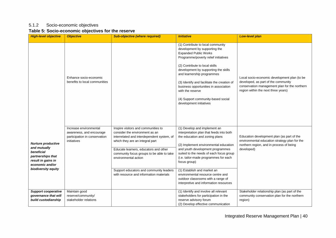
Integrated Reserve Management Plan | 40
5.1.2 Socio-economic objectives
Table 5: Socio-economic objectives for the reserve High-level objective Objective Sub-objective (where required) Initiative Low-level plan
Nurture productive
and mutually
beneficial
partnerships that
result in gains in
economic and/or
biodiversity equity
Enhance socio-economic
benefits to local communities
(1) Contribute to local community
development by supporting the
Expanded Public Works
Programme/poverty relief initiatives
(2) Contribute to local skills
development by supporting the skills
and learnership programmes
(3) Identify and facilitate the creation of
business opportunities in association
with the reserve
(4) Support community-based social
development initiatives
Local socio-economic development plan (to be
developed, as part of the community
conservation management plan for the northern
region within the next three years)
Increase environmental
awareness, and encourage
participation in conservation
initiatives
Inspire visitors and communities to
consider the environment as an
interrelated and interdependent system, of
which they are an integral part
(1) Develop and implement an
interpretation plan that feeds into both
the education and zoning plans
(2) Implement environmental education
and youth development programmes
suited to the needs of each focus group
(i.e. tailor-made programmes for each
focus group)
Education development plan (as part of the
environmental education strategy plan for the
northern region, and in process of being
developed) Educate learners, educators and other
community focus groups to be able to take
environmental action
Support educators and community leaders
with resource and information materials
(1) Establish and market an
environmental resource centre and
outdoor classrooms with a range of
interpretive and information resources
Support cooperative
governance that will
build custodianship
Maintain good
reserve/community/
stakeholder relations
(1) Identify and involve all relevant
stakeholders for participation in the
reserve advisory forum
(2) Develop effective communication
Stakeholder relationship plan (as part of the
community conservation plan for the northern
region)
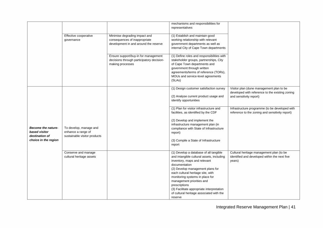
Integrated Reserve Management Plan | 41
mechanisms and responsibilities for
representatives
Effective cooperative
governance
Minimise degrading impact and
consequences of inappropriate
development in and around the reserve
(1) Establish and maintain good
working relationship with relevant
government departments as well as
internal City of Cape Town departments
Ensure support/buy-in for management
decisions through participatory decision-
making processes
(1) Define roles and responsibilities with
stakeholder groups, partnerships, City
of Cape Town departments and
government through written
agreements/terms of reference (TORs),
MOUs and service-level agreements
(SLAs)
Become the nature-
based visitor
destination of
choice in the region
To develop, manage and
enhance a range of
sustainable visitor products
(1) Design customer satisfaction survey
(2) Analyse current product usage and
identify opportunities
Visitor plan (dune management plan to be
developed with reference to the existing zoning
and sensitivity report)
(1) Plan for visitor infrastructure and
facilities, as identified by the CDF
(2) Develop and implement the
infrastructure management plan (in
compliance with State of Infrastructure
report)
(3) Compile a State of Infrastructure
report
Infrastructure programme (to be developed with
reference to the zoning and sensitivity report)
Conserve and manage
cultural heritage assets
(1) Develop a database of all tangible
and intangible cultural assets, including
inventory, maps and relevant
documentation
(2) Develop management plans for
each cultural heritage site, with
monitoring systems in place for
management priorities and
prescriptions
(3) Facilitate appropriate interpretation
of cultural heritage associated with the
reserve
Cultural heritage management plan (to be
identified and developed within the next five
years)

Integrated Reserve Management Plan | 42
Grow the domestic
visitor profile to be
representative of
South African
society
Grow the domestic visitor
profile of the reserve to be
representative of regional
demographics
(1) Promote and manage access to the
reserve
(2) Develop and support dedicated
access programmes, or incorporate a
‘dedicated access’ element into existing
programmes
(3) Actively market reserve resources
and services
Marketing plan (to be developed, branch-wide
process within the next five years)
Enhance the City of
Cape Town’s
reputation
Enhance the reserve’s
reputation
(1) Develop and implement a
communication plan to promote reserve
activities
Communication programme (to be developed
within the parameters of the City of Cape Town
policies for the Branch)
Advance strategic
human resource
management
Ensure good human resource
management
(1) Implement and support learnership
and volunteer programmes
(2) Ensure that all staff have access to
training initiatives as per the Workplace
Skills Plan
(3) Ensure adherence to all corporate
human resource policies
Staff capacity-building programme/institutional
development and staff capacity-building
programme (to be developed, City of Cape Town-
wide process)
Financial
management
Ensure sound financial
management practices are
applied to and underpin the
reserve
Manage cost spending appropriately To be developed; branch-wide process
Achieve good
corporate
governance
management
Effective management of risk
profile
N/A Conduct legal review Risk management programme (to be developed)
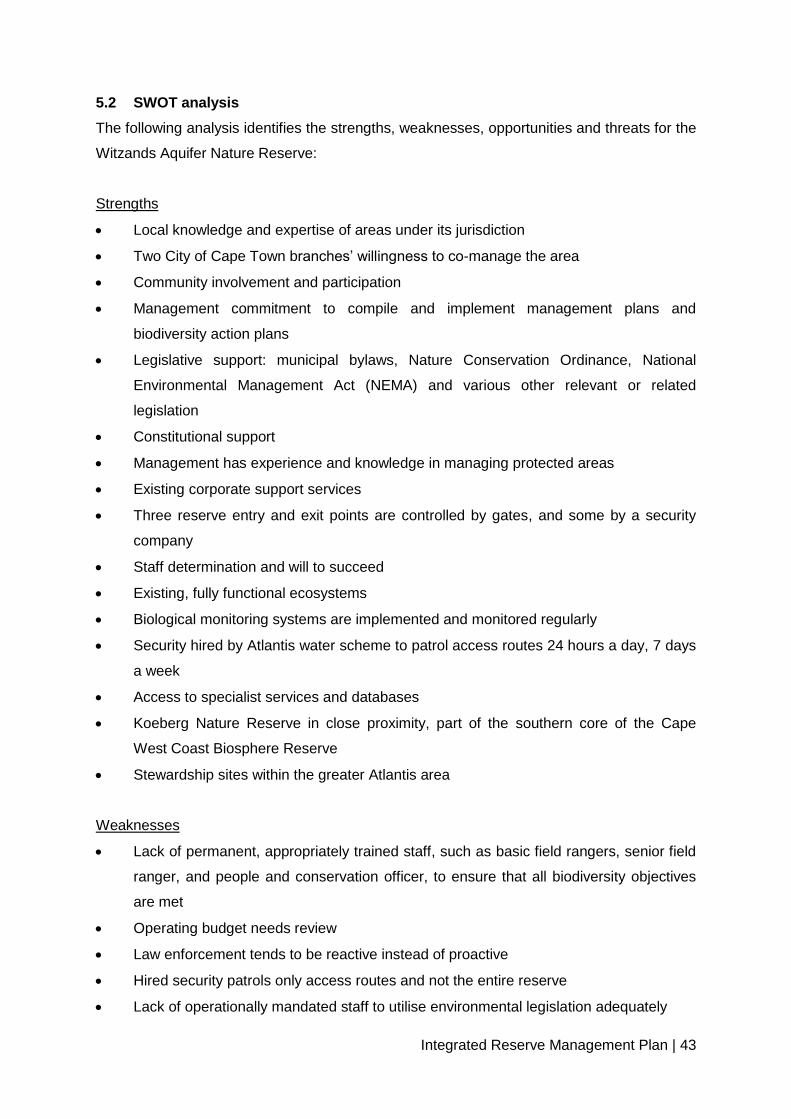
Integrated Reserve Management Plan | 43
5.2 SWOT analysis
The following analysis identifies the strengths, weaknesses, opportunities and threats for the
Witzands Aquifer Nature Reserve:
Strengths
Local knowledge and expertise of areas under its jurisdiction
Two City of Cape Town branches’ willingness to co-manage the area
Community involvement and participation
Management commitment to compile and implement management plans and
biodiversity action plans
Legislative support: municipal bylaws, Nature Conservation Ordinance, National
Environmental Management Act (NEMA) and various other relevant or related
legislation
Constitutional support
Management has experience and knowledge in managing protected areas
Existing corporate support services
Three reserve entry and exit points are controlled by gates, and some by a security
company
Staff determination and will to succeed
Existing, fully functional ecosystems
Biological monitoring systems are implemented and monitored regularly
Security hired by Atlantis water scheme to patrol access routes 24 hours a day, 7 days
a week
Access to specialist services and databases
Koeberg Nature Reserve in close proximity, part of the southern core of the Cape
West Coast Biosphere Reserve
Stewardship sites within the greater Atlantis area
Weaknesses
Lack of permanent, appropriately trained staff, such as basic field rangers, senior field
ranger, and people and conservation officer, to ensure that all biodiversity objectives
are met
Operating budget needs review
Law enforcement tends to be reactive instead of proactive
Hired security patrols only access routes and not the entire reserve
Lack of operationally mandated staff to utilise environmental legislation adequately

Integrated Reserve Management Plan | 44
Public’s ignorance of applicable environmental legislation
Lack of adequate operational and administrative office space and equipment
Geographically far from City of Cape Town administrative hubs
Roles and responsibilities of the two branches managing the area not yet clearly
defined
Haphazard network of paths and vehicles
Lack of coordination and cooperation between the reserve and national/provincial
government departments
Opportunities
Aesthetic beauty of the reserve attracts birdwatchers, environmental education groups
and recreational users
Creating buy-in among key stakeholders and role players, by having them represented
on the Protected Area Advisory Committee.
Community constituency building
Increased community ownership
Creation of job opportunities, and career succession and planning
Accessing funds for Expanded Public Works/Sustainable Livelihoods programmes to
assist in the creation of job opportunities and reserve infrastructure maintenance and
development
Proactively engaging communities closest to the reserve, and recognising their needs
Continuous liaison with CBOs and other NGOs
Linking up with surrounding landowners, sharing knowledge and resources in order to
manage the biodiversity network effectively
Promoting the reserve as a destination of choice for environmentally sound outdoor
activities
Building and establishing a viable volunteer group to actively participate in reserve
management activities
Involving the Atlantis water scheme staff in reserve management activities
Entrenching and maintaining strong political support from local ward councillors
Threats
Unemployment leads to rising crime levels
Threats and intimidation to conservation staff when enforcing legislation
Lack of commitment from stakeholders
Lack of appropriate training

Integrated Reserve Management Plan | 45
Personal safety of staff
Growing external communities, with increasing needs
Increased incidents of crime and other illegal activities in and around the reserve
Lack of sustained funding for students and interns
Lack of adequate funding to hire appropriate numbers of full-time staff
Lack of adequate operational funding
Loss of biodiversity due to inappropriate fire, invasive species, illegal activities and
inappropriate land use practices
Change in local government political structures
Illegal entry points not controlled, i.e. off-road vehicles and the network of footpaths
and tracks
Inappropriate development edge could reduce the viability of the reserve through
habitat fragmentation
Future expansion of Eskom facilities
Proposed aquaculture development at Silwerstroom
Informal settlement spreading from the urban edge of Atlantis
Contamination of the aquifer and surface biodiversity by the Caltex pipeline running
underground through a section of the reserve
Climate change
5.3 Protected-area management policy framework and guiding principles
5.3.1 Community participation
The Witzands Aquifer Nature Reserve will strive to nurture productive and mutually
beneficial partnerships that result in economic and/or biodiversity equity, such as alien-
clearing initiatives as per City of Cape Town procurement processes and the commercial
harvesting of invasive plant species by woodcutters. Participation in skills development and
learnership programmes in working partnerships with CBOs and NGOs can contribute to the
development of local skills. Through the support of community-based social development
initiatives, the reserve can also enhance socio-economic benefits to local communities.
Through the development of a regional education plan, the reserve will contribute to raising
environmental awareness and encouraging participation in conservation initiatives.
The main aims of the reserve education plan will be:

Integrated Reserve Management Plan | 46
to inspire visitors and communities to considering the environment as an interrelated
and interdependent system, of which they are an integral part;
to educate learners, educators and community focus groups to take environmental
action, assisted by resource and information materials;
to develop and implement environmental education programmes suited to the needs of
various focus groups; and
to develop and implement an interpretation plan that complements the education plan.
Through the development of a regional community conservation management plan, the
reserve will strive to:
identify, develop and maintain good nature reserve/community/stakeholder relations
involving all relevant stakeholders;
develop an effective communication system in order to address interested and affected
parties and the dissemination of information;
where necessary, establish task teams and working groups in order to assist the
reserve with key issues;
establish a steering committee in an advisory capacity, and to promote transparency;
and
develop sustainable volunteer programmes with the emphasis on capacity building and
development.
5.3.2 Safety and security
A safety and security audit aimed at completing a rapid and verifiable analysis of the current
security situation, security services, infrastructure, staffing and social context has been
carried out in the Witzands Aquifer Nature Reserve (see appendix 10 for the executive
summary of the audit report).
In summary, the results of this audit confirmed the threat level for the reserve as medium,
the main threats being illegal access and trespassing, which are primarily caused by a lack
of adequate fencing, in particular on the eastern boundary of the reserve. Woodcutter activity
in the reserve should also be closely monitored while these persons are in the area
harvesting, and after they leave the premises.
Furthermore, woodcutters should be restricted to a certain area and certain days in order to
manage the risk of setting snares or illegal flower harvesting. The number of woodcutters or

Integrated Reserve Management Plan | 47
groups should be limited, and operations can take place during working hours only, which
should be clearly specified on a permit. The validity and identity numbers should also be
displayed on the permit.
Illegal access must be addressed through specific actions, particularly on weekends and
public holidays. It is recommended that the reserve set up a multi-enforcement agency
stake-out to combat the illegal access challenge. Not mentioned in the security audit report
is the issue relating to the activities in, and access to, the dune area, including off-road
vehicles (quad bikes, motor cycles, etc.). Other activities in the dune area include sand
boarding and commercial filming. Currently, there are two legal-tariff access gates to the
dune area. However, due to a lack of fencing, there are several places where access can be
gained illegally. The fencing, access and management of the recreational activities in this
area must be adequately controlled in accordance with the zoning of the dunes system.
5.3.3 Culture-historical, archaeological and paleontological management
In 2009, bones were discovered in the dune fields of the reserve, and, according to Stynder
(2010), a lecturer at the University of Cape Town, they are from small game, including
Raphicerus melanotis (Cape grysbok) and tortoise species, as well as domestic farm
animals such as sheep. These bones have not been formally identified and published as yet.
They have also not been dated, but, from associated artefacts, it appears that they are from
the last 2 000 years. Stynder (2010) further states that the bones are definitely from the
colonial time period, since a clay pipe was also found with them. Dr Graham Avery Curator
at the Iziko Museum, Cape Town has stated that he has also found a single black rhino
tooth, when a learner discovered the remains of a skull in the dunes.
5.3.4 Tourism development and management
The reserve has tourism potential as part of the greater Atlantis/Mamre tourism route
concept. A marked, established hiking trail has been discussed as part of the above concept,
and there are already trained tour guides in Mamre. The tourism route project developers
have proposed that the reserve be part of the route. The area is a popular destination for off-
road tourism, with a number of local, national and
International visitors (ADORE, pers comm, 2014). There is great scope to further develop
this user group and to potentially unlock real benefits to the surrounding communities.
5.3.5 Infrastructure management
Minimum infrastructure exists within the Witzands Aquifer Nature Reserve. Existing
infrastructure, such as the office complex, is maintained by the Bulk Water Branch. However,

Integrated Reserve Management Plan | 48
in order for the reserve to reach its full operational potential, these facilities will have to be
extended to accommodate three administrative offices. The road network infrastructure also
needs to be prioritised in order to avoid vehicles driving across the reserve, causing
continuous damage to the already sensitive vegetation types. Fencing, where appropriate,
should also be prioritised in order to ease the management and control of illegal access to
the reserve. Future infrastructure should be included in a five-year maintenance plan.
Infrastructure with no use should be demolished and the sites rehabilitated.
5.3.6 Biodiversity conservation management
5.3.6.1 Community-based natural resource management (CBNRM)
Harvesting of certain natural resources within the Witzands Aquifer Nature Reserve is
currently permitted. Research on the amount of harvesting and the species harvested across
the city is currently under way. Some investigations as to the types and the extent of
harvesting in the reserve have been started, but, to date, there has been no detailed or
conclusive information to determine where current harvesting is sustainable and/or what
potential threats are foreseen should these activities persist. Where necessary, a species
harvesting plan should be developed in order to ensure the sustainability of such species
and the community’s livelihoods.
5.3.6.2 Fire management
Too frequent fires, or fires that burn out of phase with the natural burning regime, present a
threat to slower-growing species, which may be entirely eliminated. On the other hand, if fire
is excluded from the area, other indigenous species could encroach, resulting in a loss of
species diversity. Conversely, if vegetation is allowed to burn too frequently, the area could
become degraded, and alien species, especially grasses, could start to invade. Grasses
maintain a shorter fire cycle, and permanently change the vegetation structure and
biodiversity value of the area.
Cape Flats Dune Strandveld, the predominant vegetation type in the reserve, does not burn
as frequently, with a fire cycle of typically 20–100 years. It is far more prone to browsing, and
many plant species have thorny defences. Therefore, the fire management programme for
the Witzands Aquifer Nature Reserve involves the prevention and control of large wildfires,
as well as smaller fires, whether natural or unnatural. Historical records of fire events in the
reserve area as well as post-fire monitoring records assist in the documentation of veld
ages, which in turn influence fire management. Natural fires are limited in spread within the
constraints of ecological, project and public safety requirements. All possible actions are
taken to prevent the spread of fire onto the adjacent properties. All unnatural fires that

Integrated Reserve Management Plan | 49
threaten the reserve ecologically, or pose a threat to infrastructure and/or public safety, are
controlled.
Fire may be used to keep fuel loads low so as to reduce the risk of uncontrolled fires,
particularly on the urban edge and in areas that become a potential risk to infrastructure and
public safety. Firebreaks and other fire control measures required by law will be
implemented where necessary and feasible.
The nature of the area’s terrain, property boundaries and extensive areas of natural veld
increase the chances of fire spreading both into and out of the reserve. Reasonable pre-fire
protection measures are necessary, as well as a plan of action in the event of wildfire.
Interaction by various City of Cape Town departments and independent stakeholders as well
as continuous public and private landowner involvement are essential. The development of a
fire management plan (covering the issues of fire protection and response plans) is an
important component of the reserve’s fire management approach.
Fire management implementation in the Witzands Aquifer Nature Reserve involves the
following:
Application of guidelines on seasonal burning intervals and species requirements
acquired from relevant documentation and biophysical specialists
Accurate record keeping of all fires, including details and maps
Use of fire data and the geographic information system (GIS) for recording and
mapping
Application of post-fire monitoring programmes
Application of fire data to determine prescribed burning needs
Development and implementation of a fire protection and response plan, including
affected stakeholders such as additional City of Cape Town departments and private
landowners neighbouring the reserve
5.3.6.3 Catchment management
This is managed by the Atlantis water scheme (see Knight Hall Hendry 1996). Detailed
information on the management of the water extraction and supply is available from the
reserve and Atlantis water scheme management. Also see point 2.3.3 for further information
regarding catchment management.
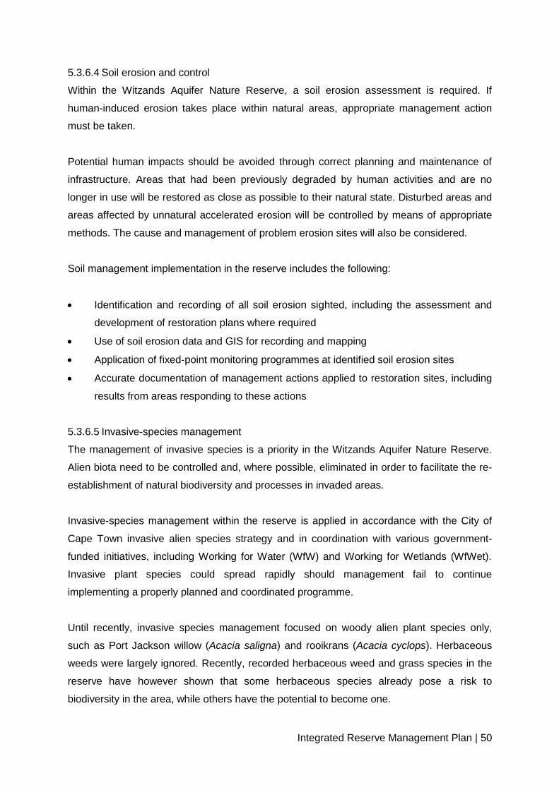
Integrated Reserve Management Plan | 50
5.3.6.4 Soil erosion and control
Within the Witzands Aquifer Nature Reserve, a soil erosion assessment is required. If
human-induced erosion takes place within natural areas, appropriate management action
must be taken.
Potential human impacts should be avoided through correct planning and maintenance of
infrastructure. Areas that had been previously degraded by human activities and are no
longer in use will be restored as close as possible to their natural state. Disturbed areas and
areas affected by unnatural accelerated erosion will be controlled by means of appropriate
methods. The cause and management of problem erosion sites will also be considered.
Soil management implementation in the reserve includes the following:
Identification and recording of all soil erosion sighted, including the assessment and
development of restoration plans where required
Use of soil erosion data and GIS for recording and mapping
Application of fixed-point monitoring programmes at identified soil erosion sites
Accurate documentation of management actions applied to restoration sites, including
results from areas responding to these actions
5.3.6.5 Invasive-species management
The management of invasive species is a priority in the Witzands Aquifer Nature Reserve.
Alien biota need to be controlled and, where possible, eliminated in order to facilitate the re-
establishment of natural biodiversity and processes in invaded areas.
Invasive-species management within the reserve is applied in accordance with the City of
Cape Town invasive alien species strategy and in coordination with various government-
funded initiatives, including Working for Water (WfW) and Working for Wetlands (WfWet).
Invasive plant species could spread rapidly should management fail to continue
implementing a properly planned and coordinated programme.
Until recently, invasive species management focused on woody alien plant species only,
such as Port Jackson willow (Acacia saligna) and rooikrans (Acacia cyclops). Herbaceous
weeds were largely ignored. Recently, recorded herbaceous weed and grass species in the
reserve have however shown that some herbaceous species already pose a risk to
biodiversity in the area, while others have the potential to become one.
Integrated Reserve Management Plan | 51
A number of alien herbaceous weed species have been identified in the reserve. The
occurrence of such species is generally as a result of planting and/or unintentional seed
dispersal from the surrounding areas when maintenance is undertaken. Horticultural strains
of indigenous species also present a risk to naturally occurring specimens. Some species
are known to hybridise with endemic species in the area, and pose a potential threat to the
genetic diversity of such populations.
In order to protect indigenous species from alien invasive species, the following is required:
Prioritisation of areas for alien removal, focusing on biodiversity restoration
The implementation of removal programmes for priority species and areas
The development and implementation of an invasive and alien-plant management plan
as well as a management plan for alien biota
The eradication of invasive alien faunal species is also carried out in the reserve. Formal
plans outlining the monitoring of the removal of identified species is however required.
5.3.6.6 Species introductions
There is potential to re-introduce species that were historically indigenous to the reserve,
and for which suitable habitat and eco-niches are available. Several fauna species that
previously occurred in the reserve are no longer present or down to small numbers.
Prior to the re-introduction of any species, a full proposal is required, which must be
submitted to the Fauna Management Committee for consideration and endorsement before
implementation. The committee will therefore ensure that investigations are conducted into
the availability of suitable habitat for the species with reference to public utilisation of areas,
as well as a full investigation into the historical occurrence and status of the species. The
effect of re-introducing species to the area must also be researched. Re-introduction of
potentially dangerous and problematic species may also require a public participation
process. Another requirement is an investigation into suitable sources.
All proposed re-introductions need to be recommended and approved by the Flora and
Fauna Management Committee as well as provincial authorities before implementation. The
implementation of any re-introduction programmes must be specified in a plan of action, and
documented accurately.

Integrated Reserve Management Plan | 52
5.3.6.7 Strategic research
The reserve needs to identify research subjects that are beneficial to its management. These
subjects can then be prioritised and further pursued.
Although research does currently take place in, and is supported by, the reserve, many of
the projects are conducted by outside student researchers and organisations, and are not
informed by the reserve’s needs. Only recently have a list of research topics been
formulated by the Biodiversity Management Branch in line with the Fynbos Forum (FF)
research priorities, and these will be used by both internal researchers and reputable
external institutions.
An effort needs to be made to obtain copies of data resulting from research projects
conducted within the reserve’s boundaries.
5.4 Sensitivity-value analysis of the Witzands Aquifer Nature Reserve
The reserve is a significant asset to the City of Cape Town, and significantly contributes to
the national vegetation targets of threatened vegetation types, as listed in the National
Spatial Biodiversity Assessment (Driver et al. 2005), as well as provides a service and
facilities to local residents and schools.
The development of the sensitivity and zoning plan is one of the steps required in compiling
a CDF for the reserve. A CDF is a tool to reconcile the various land use needs, and to
delineate visitor user zones and the positioning and nature of new infrastructure, access
points, roads and facilities (see appendix 9 for the sensitivity-value analysis and zoning
report).
The CDF process has grown in response to the requirements of the National Environmental
Management: Biodiversity Act, Act 10 of 2004, and seeks to comply with the spatial planning
requirements of the Act. The CDF will ensure that best practice and sustainable
development principles are integrated with spatial planning in protected areas.
The sensitivity-value analysis is the landscape analysis portion of the broader CDF. It is a
multi-criteria decision-support tool for spatial planning, designed to present the best available
information in a format that allows defensible and transparent decision making. The
sensitivity-value process is based on the principle that the acceptability of a development (or
placement of a structure) at a site is based on the site’s value (arising from that site’s

Integrated Reserve Management Plan | 53
biodiversity, heritage, aesthetic or other values) and its sensitivity or vulnerability to a variety
of disturbances (Holness 2005).
The sensitivity-value analysis, the CDF and the associated zoning plan should form part of
an adaptive management system. They will grow and change over time as the
understanding of the landscapes and ecosystems improves. These documents, however, do
not replace the need for detailed site and precinct planning and EIA compliance at site level.
The size of the reserve may require an extensive analysis, with the subsequent zoning
process being fairly straightforward. The methodology used for both the sensitivity-value
analysis and the zoning process was adapted from Holness and Skowno (2008) and SRK
Consulting (20081; 20082).
All geographic information work was carried out in Environmental Systems Research
Institute ESRI’s ArcMap Version 9.3.1 GIS, using the ArcInfo licence level, with Spatial
Analyst and 3D Analyst extensions. Map 7 depicts the balanced summary of the sensitivity
analysis for the Witzands Aquifer Nature Reserve.
5.5 Zoning plan of the Witzands Aquifer Nature Reserve
5.5.1 Zoning informants
This section briefly outlines the values underlying the identification of broad tourism use
zones. It is important to remember that the landscape/biodiversity analysis is just one of the
informants in the zoning process. Although the biodiversity analysis is intrinsically a relatively
objective scientific process, other informants to the zoning process are not.
Although every attempt is made to place high sensitivity-value sites into more protected
zones where possible, the zoning process is essentially a compromise between environment
and development. In particular, the identified high-value sites are often the key biodiversity
assets that need to be made available in an appropriate manner to the eco-tourism market.
Direct links between the biodiversity layers and the spatial management of the reserve are
made during the identification of special management areas (where applicable). Even within
broad high tourist-use zones, some areas will likely be subject to very tight conservation
controls (potentially including complete exclusion of human impacts from an area).

Integrated Reserve Management Plan | 54
Underlying decision-making rules used in the zoning process
The zoning process is aimed at striking a balance between environmental protection
and the development required to meet the broader economic and social objectives of
the reserve.
The zoning process takes into account existing development footprints and tourism
access routes.
This is based on the underlying principle that, all else being equal, an existing
transformed site is preferable to a greenfields site from a biodiversity perspective.
Infrastructure costs are dramatically increased when developments take place away
from existing infrastructure.
Existing tourism nodes and access routes are a reality of the economic landscape, and
it would not be possible to shut down existing tourism sites compromising the
development objectives of the reserve.
Where existing development nodes, tourist sites and access routes occur in areas with
high sensitivity-value, the broad use zoning aims to keep the development footprint as
small as is realistically possible, preferably within the existing transformed site.
Where possible, sites with high biodiversity sensitivity-value are put into stronger
protection zones.
Peripheral development is favoured and, where possible, should be located outside
the conservation area.
Two key points need to be emphasised:
o The designation of a broad use zone does not imply that all sites within that zone
would be suitable for all the development types anticipated. Detailed site-level
planning is still required, and many sites may prove to be unsuitable at a
site/precinct/EIA level.
o Special management areas/overlays need to be formalised and linked to the
management plans. (Holness 20081; 20082)
5.5.2 Zoning definitions and descriptions
The zoning definitions and descriptions were worked through with regional and area
managers in the form of a workshop. Four categories were decided on, namely primary
conservation zone, conservation zone, low-intensity leisure zone and high-intensity leisure
zone. Appendix 2 outlines the proposed zoning and zone descriptions. However, the process
is still linked to the zoning used for the CapeNature reserves (Holness 20081; 20082), as
there should be general alignment of the broader use zones to enable comparison and
integration if provincial documents so require.

Integrated Reserve Management Plan | 55
Map 7: Witzands Aquifer Nature Reserve zoning summary (Purves 2010)
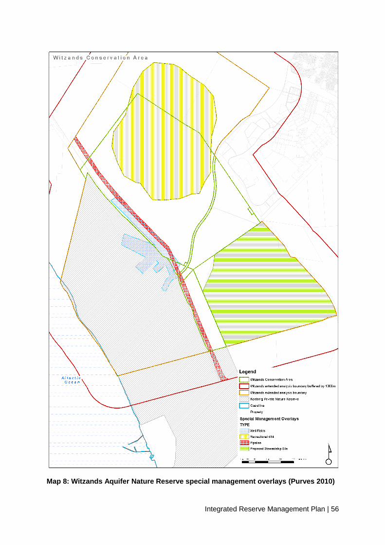
Integrated Reserve Management Plan | 56
Map 8: Witzands Aquifer Nature Reserve special management overlays (Purves 2010)

Integrated Reserve Management Plan | 57
6. DEVELOPMENT PLAN
The future expansion development plan will inform the following envisaged plans:
Office complex extension plan
Visitor facilities plan
Roads and access plan
Witzands aquifer and Brakkefontein expansion plan
A detailed development plan for the Witzands Aquifer Nature Reserve is required.
7. COSTING PLAN
Table 6: Broad costing management breakdown for the reserve:
Item Funding source 2011–2012 2012–2013 2013–2014 2014–2015 2015–2016
Invasive alien plants Grant R956 975,66 R1 014 394 R1 075 257 R1 139 773 R1 208 159
Fire management Operating R70 000 R77 000 R84 700 R93 170 R102 487
Road and trail maintenance Operating R1 700 000 R1 870 000 R2 057 000 R2 262 700 R2 488 970
Human resources Operating R1 100 000 R1 188 000 R1 283 040 R1 385 683 R1 496 537
Infrastructure development Capital expenditure/grant R1 200 000 R1 320 000 R2 772 000 R2 993 760 R3 293 136
Fencing
Operating/capital
expenditure R3 515 000 R3 866 500 R4 560 000 R5 016 000 R5 517 600
General expenses Operating R15 000 R15 750 R17 325 R18 191 R19 100
Special projects Grant/capital expenditure
Human resources are
escalated at 8%.
Operating expenditure is
escalated at 5%.
Invasive alien as per
management unit clearing
plan (6%)

Integrated Reserve Management Plan | 58
PART 3
MONITORING & AUDITING
8. MONITORING & AUDITING
8.1 Annual audit procedure
8.1.1 Management Effectiveness Tracking Tool South Africa (METT-SA)
The METT-SA is a rapid, site-level assessment tool adapted from the World Bank and Worldwide
Fund for Nature (WWF) system (second edition, 2007). The system is based on the idea that good
protected-area management follows a process comprising six distinct stages or elements:
It begins with understanding the context of existing values and threats (where are we now?), then
progress through planning (where do we want to be?), followed by allocation of resources
(inputs) (what do we need?). As a result of management actions (processes) (how do we go
about it?), it eventually produces products and services (outputs) (what were the results?), which
result in impacts or outcomes (what did we achieve?).
This version has been compiled so that it can be applied to the full range of protected areas
managed by all C.A.P.E partners. It also applies to protected areas in other regions, and, with
minor adaptations, could be applied outside of South Africa as well. It may also be used for marine
protected areas (MPAs) and islands, but, in the long run, it may become necessary to amend the
system to be more specific to these areas. In addition, a system for off-reserve conservation
areas, such as conservancies or stewardships, may need to be developed.
When applying METT-SA, it is important for the following to be kept in mind:
The METT-SA is intended to report on the reserve’s progress. Thus, the score is the
baseline against which future assessments are made to see if there has been an
improvement.
It is site-specific and must therefore not be used to compare scores between different
protected areas.
It is a useful tool to give indications of management trends. In this version, the six elements of
the management process, as defined in the original version, are scored as subsets of the
total. This gives an indication of where management should strive for improvement.
It is not intended to replace more detailed assessments as part of adaptive management
systems.
The METT-SA has limitations in the quantitative measurement of outcomes, and these should
be measured by more objective and quantitative systems.
This version adjusts the total score where questions are irrelevant.
Integrated Reserve Management Plan | 59
Often, low scores on some questions could be a reflection on the organisation as a whole, and
do not necessarily point to issues over which the protected-area manager has control. The
performance of managers should therefore under no circumstances be measured
against the METT-SA results.
Tracking the trends of management effectiveness is a long-term process, and instant
improvements are unlikely. Generally, the METT-SA is applied at three-year intervals, but an
annual application is acceptable if it is understood that changes may only be slight.
Most of the City of Cape Town’s reserves have undergone a METT-SA audit in 2007, and
the next one is planned for September 2011. However, the Witzands Aquifer Nature
Reserve, although identified on the biodiversity network, had no biodiversity staff assigned to
the area in 2007. This will therefore be the first METT-SA conducted for the reserve.
8.1.2 Protected-area review
The protected-area review (PAR) is an internal review conducted annually to assist
managers in reviewing their sites, and to allow for adaptive management actions to be taken
where required (and within managers’ control).
8.2 Management plan review
Every five years, this management plan should be reviewed, and adjusted where necessary.
To achieve this, the following questions (and others as needed) should be addressed:
Did this IRMP make a meaningful contribution to the management of the Witzands
Aquifer Nature Reserve?
Were individual management ‘prescriptions’ realistic and achievable? Were they
written unambiguously, or was there room for misunderstanding?
Were budgets for each management activity realistic? Were the allocated budgets too
much or too little?
Were sufficient staff members with the right qualifications allocated to each
management activity?
There will be some overlap between the review and the audit, and they should therefore be
done on the same day, by the same team.
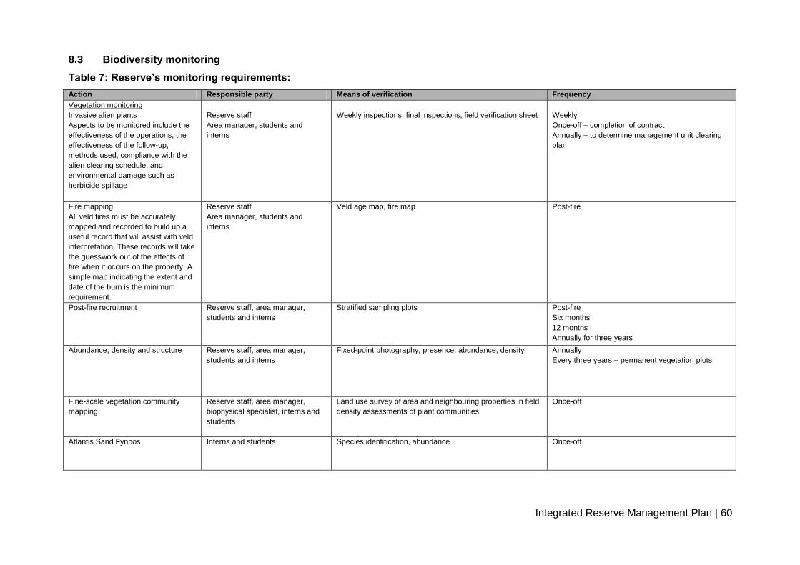
Integrated Reserve Management Plan | 60
8.3 Biodiversity monitoring
Table 7: Reserve’s monitoring requirements:
Action Responsible party Means of verification Frequency
Vegetation monitoring
Invasive alien plants
Aspects to be monitored include the
effectiveness of the operations, the
effectiveness of the follow-up,
methods used, compliance with the
alien clearing schedule, and
environmental damage such as
herbicide spillage
Reserve staff
Area manager, students and
interns
Weekly inspections, final inspections, field verification sheet
Weekly
Once-off – completion of contract
Annually – to determine management unit clearing
plan
Fire mapping
All veld fires must be accurately
mapped and recorded to build up a
useful record that will assist with veld
interpretation. These records will take
the guesswork out of the effects of
fire when it occurs on the property. A
simple map indicating the extent and
date of the burn is the minimum
requirement.
Reserve staff
Area manager, students and
interns
Veld age map, fire map
Post-fire
Post-fire recruitment
Reserve staff, area manager,
students and interns
Stratified sampling plots
Post-fire
Six months
12 months
Annually for three years
Abundance, density and structure
Reserve staff, area manager,
students and interns
Fixed-point photography, presence, abundance, density Annually
Every three years – permanent vegetation plots
Fine-scale vegetation community
mapping
Reserve staff, area manager,
biophysical specialist, interns and
students
Land use survey of area and neighbouring properties in field
density assessments of plant communities
Once-off
Atlantis Sand Fynbos Interns and students Species identification, abundance Once-off

Integrated Reserve Management Plan | 61
Aquatic weeds survey Interns and students Water bodies, species identification Once every three years
Faunal monitoring
Small-antelope sample survey
Reserve staff, area manager,
students and interns, people and
conservation officer
Game drive count
As required
Small mammal Students and interns Trap cages, Sherman traps 2009–2010
Black harrier Area manager, students, interns Visit to nesting/activity site Once per annum, September to November
Bird distribution
Reserve staff, area manager,
students, interns
Field observations
Monthly
Coordinated water-bird count Reserve staff, students, interns Bird count at water body (Pond 7) Quarterly
Reptile survey
Students, interns, reserve staff,
area manager
Traps used to capture, identify and release Once every five years
Amphibian survey Students, interns, reserve staff,
area manager
Audio and visual observation Once every five years
Geological features Mobile dune fields Vehicular and foot visual observations Before and after winter
Water monitoring
Water quality
Students, interns, reserve staff
Field collection equipment – samples
Bi-monthly
Integrated Reserve Management Plan | 62
PART 4
REFERENCES
9. REFERENCES
Anon 20031.The Integrated Metropolitan Environmental Policy. Unpublished report, City of
Cape Town.
Anon 20032. The Biodiversity Strategy. Unpublished report, City of Cape Town.
Anon 20091. Local Biodiversity Strategy and Action Plan 2009–2019. Unpublished report,
City of Cape Town.
Anon 20092. City of Cape Town Biodiversity Network – Analysis: 2009 Methods and Results.
Unpublished report, City of Cape Town.
Anon 2010. City of Cape Town, Five-year Plan for Cape Town, Integrated Development Plan
(IDP) 2007–2012, 2010–2011 Review. Unpublished report, City of Cape Town.
Buchel. S. 2010. Personal communication. CCT 190 Witzands.jpg. 29 November 2010.
C.A.P.E Project Team 2000. Cape Action Plan for the Environment: Strategy. Unpublished
report, City of Cape Town.
Cape Gateway, 2007. Statistics: Atlantis District Office [Online] Available at:
http://wwwcapegateway.gov.za/eng/pubs/reports_research/W/143867/9 [Accessed 5 August
2010].
City of Cape Town, 2008. City of Cape Town Biodiversity Report 2008. Cape Town: City of
Cape Town.
CSIR, 2002. Atlantis Aquifer: A status report on 20 years of groundwater management at
Atlantis. Stellenbosch: CSIR.
Dorse, C., 2010. Atlantis Sand Fynbos and Cape Flats Dune Strandveld [Conversation]
(Personal communication, 27 September 2010).

Integrated Reserve Management Plan | 63
Driver, A., Maze, K., Rouget, M., Lombard, A.T., Nel, J., Turpie, J. K., Cowling, R.M.,
Desmet, P., Goodman, P., Harris, J., Jonas, Z., Reyers, B., Sink, K. & Strauss, T. 2005.
National Spatial Biodiversity Assessment 2004: Priorities for biodiversity conservation in
South Africa. Strelitzia 17, SANBI, Pretoria.
ESKOM, 2006.General Description of the Study Area Environment. [Pdf] Atlantis, Western
Cape Province: ESKOM. Available at
www.eskom.co.za/content/Chap5DescStud081206.pdf [Accessed 21 April 2010].
Google Earth, 2005. Witzands Aquifer Conservation Area Global Positioning Co-ordinates
[Online] Available at: http://www.Google\Google Earth\client\googleearth.exe [Accessed 2
June 2010].
Holness, 2005. Sensitivity Value Analyses Manual. A decision support tool, operating on the
principles of systemic conservation planning, for integrating best available biodiversity
knowledge into spatial planning within national parks. SANParks Internal report.
Holness, S. & Skowno, A. 2008. Report on Sensitivity-Value Analyses and Zonation Process
for the Boland Mountain Complex. CapeNature conservation internal report.
Knight Hall Hendry & Associates, 1996. Environmental Management System 1996. Cape
Town: Knight Hall Hendry & Associates.
Mabihi, K. 2009. Student Experiential Training Report, Witzands Aquifer Conservation Area.
Myers, N., Mittermeyer, R.A.C.G., Fonseca, G.A. & Kent, J. 2000. Biodiversity hotspots for
conservation priorities. Nature 403:853–858.
Purves, A. 2010. Sensitivity-Value Analysis and Zonation Process: Witzands Conservation
Area 44 Wale Street, Cape Town: GIS Section, City of Cape Town.
Rebelo, AG, Boucher, C, Helme, N, Mucina, L & Rutherford, MC. 2006. Fynbos Biome, in: L
Mucina & MC Rutherford (eds). The Vegetation of South Africa, Lesotho and Swaziland.
Strelitzia 19:52–219.
Integrated Reserve Management Plan | 64
South African Biodiversity Database, 2010. Witzands Aquifer Nature Reserve Species
Statistics [Online]. Available at: http//www.biodiversity.co.za/speciesstats [Accessed 1
March 2011].
SRK Consulting. 20081. Final Conservation Development Framework for Settlers Park
Nature Reserve. Nelson Mandela Bay Municipality. Internal report.
SRK Consulting. 20082. Final Conservation Development Framework for Van Stadens
Wildflower Nature Reserve. Nelson Mandela Bay Municipality. Internal report.
Stynder, D. 2010. Personal communication. Bones discovered in the Atlantis dunes. 21
January 2011.

Integrated Reserve Management Plan | 65
PART 5
10. APPENDICES
Appendix : Zonation and Zone descriptions
City of Cape Town Nature Reserves and Conservation Areas: Visitor Use Zoning - Desired State* & Experiential Qualities
Experience Zone Desired State* Conservation
objectives Secondary objective Experiential Qualities Activities
Interaction
between users Frequency of use Group size
Sophistication and type
of facilities
Primary user
movement within the
zone
Roads & footpaths Equivalent Provincial zone
Close
ToNature
Activities
tend to be
at
landscape
level
Primary conservation
Natural or near-natural
areas (or areas that can be
rehabilitated to this state)
that are managed primarily
for biodiversity
conservation. The
experience is one of
relative solitude and
wildness. The nature of
the experience is
dependant on the quality
of the natural environment.
The main accent of
management is
biodiversity conservation
and "Pack it in Pack it out"
principles are applied to all
activities including
management. There may
be some signs of
infrastructure mainly of a
heritage nature. In the
longer term, unused utility
infrastructure (e.g.
reservoirs) should be
phased out and the site
rehabilitated.
Natural areas should be
kept intact in order to
protect habitat required
to meet biodiversity
targets for various
vegetation types and to
provide undisturbed
habitat for a range of
species. Where possible
degraded areas should
be rehabilitated.
Managed to provide
visitor experiences in a
way that does not impact
on the biodiversity
objective.
Where appropriate
heritage values are
managed as required
Relative sense of
isolation
Controlled access**
Research and
monitoring.
Accompanied small
groups.
The size and frequency
of groups to be
specified for each
reserve.
None or very low None -Very low Small
No new facilities.
Existing structures should
be phased out where
appropriate.
Heritage assets are
managed where
appropriate
Pedestrian access in
accompanied small
groups
Motorised for essential
management only.
Absolutely essential
management tracks
and footpaths in
accordance with the
foot path and road
management plan
Ongoing restoration of
old paths/roads to be
prioritized and
monitored.
Quiet
Conservation
Natural or near-natural
areas (or areas that can be
rehabilitated to this state)
that are managed for
biodiversity conservation.
This zone provides
experiences of a relative
sense of relaxation in an
environment that is openly
exposed to the sights and
sounds of the city.
Although it is a place of
quietness and naturalness,
there will be more
interaction between users
than in the Primary
Conservation Zone. The
quality of the experience is
less dependant on the
quality of the natural
Natural areas should be
kept intact in order to
protect habitat required
to meet biodiversity
targets for various
vegetation types and to
provide undisturbed
habitat for a range of
species. Where possible
degraded areas should
be rehabilitated.
Managed to provide
visitor experiences in a
way that does not impact
on the biodiversity
objective.
Relaxation Self guided hiking, non-
motorised access***,
bird watching, etc.
In reserves where
access to water bodies
is allowed, this area is
limited to non-
motorized vessels
onlyin accordance with
the Vlei By-Laws.
Moderate Moderate Small Low impact, eco-friendly
facilities that facilitate
ecologically sustainable
activities and visitor
experiences may be
permitted under certain
circumstances. These are
strictly for achieving the
social and development
objectives of the reserve
where appropriate and are
subject to a stringent
internal approval process
and must be inline with an
approved reserve
management plan.
Pedestrian
Non motorised
Motorised access for
management only.
Management
tracks/roads and
footpaths. Minimal
footpath construction
to prevent ecological
damage. Boardwalks
may be permitted
where appropriate to
protect sensitive areas.
The footpath system
should be designed so
as to control access
into the Primary
Conservation zone.
Off road wheelchair
access may be
provided where
appropriate.
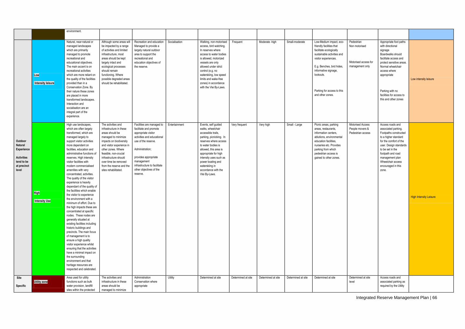
Integrated Reserve Management Plan | 66
environment.
Outdoor
Natural
Experience
Activities
tend to be
at precinct
level
Low
Intensity leisure
Natural, near-natural or
managed landscapes
which are primarily
managed to promote
recreational and
educational objectives.
The main accent is on
recreational activities
which are more reliant on
the quality of the facilities
provided than in a
Conservation Zone. By
their nature these zones
are placed in more
transformed landscapes.
Interaction and
socialisation are an
integral part of the
experience.
Although some areas will
be impacted by a range
of activities and limited
infrastructure, most
areas should be kept
largely intact and
ecological processes
should remain
functioning. Where
possible degraded areas
should be rehabilitated.
Recreation and education
Managed to provide a
largely natural outdoor
area to support the
recreational and
education objectives of
the reserve.
Socialisation Walking, non-motorised
access, bird watching.
In reserves where
access to water bodies
is allowed, motorized
vessels are only
allowed under strict
control (e.g. no
waterskiing, low speed
limits and wake-free
zones) in accordance
with the Vlei By-Laws.
Frequent Moderate -high Small-moderate Low-Medium impact, eco-
friendly facilities that
facilitate ecologically
sustainable activities and
visitor experiences.
E.g. Benches, bird hides,
informative signage,
lookouts.
Parking for access to this
and other zones.
Pedestrian
Non motorised
Motorised access for
management only
Appropriate foot paths
with directional
signage
Boardwalks should
facilitate access and
protect sensitive areas.
Normal wheelchair
access where
appropriate
Parking with no
facilities for access to
this and other zones
Low intensity leisure
High
Intensity Use
High use landscapes,
which are often largely
transformed, which are
managed largely to
support visitor activities
more dependent on
facilities, education and
administrative functions of
reserves. High intensity
visitor facilities with
modern commercialised
amenities with very
concentrated, activities.
The quality of the visitor
experience is heavily
dependant of the quality of
the facilities which enable
the visitor to experience
the environment with a
minimum of effort. Due to
the high impacts these are
concentrated at specific
nodes. These nodes are
generally situated at
existing facilities including
historic buildings and
precincts. The main focus
of management is to
ensure a high quality
visitor experience whilst
ensuring that the activities
have a minimal impact on
the surrounding
environment and that
heritage resources are
respected and celebrated.
The activities and
infrastructure in these
areas should be
managed to minimize
impacts on biodiversity
and visitor experience in
other zones. Where
feasible, non-crucial
infrastructure should
over time be removed
from the reserve and the
sites rehabilitated.
Facilities are managed to
facilitate and promote
appropriate visitor
activities and educational
use of the reserve.
Administration;
provides appropriate
management
infrastructure to facilitate
other objectives of the
reserve.
Entertainment Events, self guided
walks, wheelchair
accessible trails,
parking, picnicking. In
reserves where access
to water bodies is
allowed, this area is
appropriate for high
intensity uses such as
power boating and
waterskiing in
accordance with the
Vlei By-Laws.
Very frequent Very high Small - Large Picnic areas, parking
areas, restaurants,
information centers,
ablutions, environmental
education facilities,
nurseries etc. Provides
parking from which
pedestrian access is
gained to other zones.
Motorised Access
People movers &
Pedestrian access
Access roads and
associated parking.
Footpaths constructed
to a higher standard
for the comfort of the
user. Design standards
to be set in the
footpath and road
management plan
Wheelchair access
encouraged in this
zone.
High Intensity Leisure
Site
Specific
Utility zone
Area used for utility
functions such as bulk
water provision, landfill
sites within the protected
The activities and
infrastructure in these
areas should be
managed to minimize
Administration
Conservation where
appropriate
Utility Determined at site Determined at site Determined at site Determined at site Determined at site Determined at site
level
Access roads and
associated parking as
required by the Utility
Integrated Reserve Management Plan | 67
Level /conservation areas etc. impacts on biodiversity
and visitor experience in
other zones. Where
feasible, non-crucial
infrastructure should
over time be removed
from the reserve and the
sites rehabilitated.
Function
*Note. The "Desired State" is the long term objective of the zone and these desired conditions may not actually exist at the time of zoning. Achieving the" Desired State" will be informed by many factors and may only be reached after many years.
** Accompanied access refers to controlled access. The level and type of control is determined at reserve level.
*** Non-motorised access refers to mountain bikes, horses, paragliding etc. These activities are reserve specific and reference must be made to the reserve management plan for a list of acceptable activities per reserve.

Witzands IRMP June 2011v02 Final.doc
- 68 -
B. Legal Agreement
Appendix 2: Surveyor General (SG) diagrams
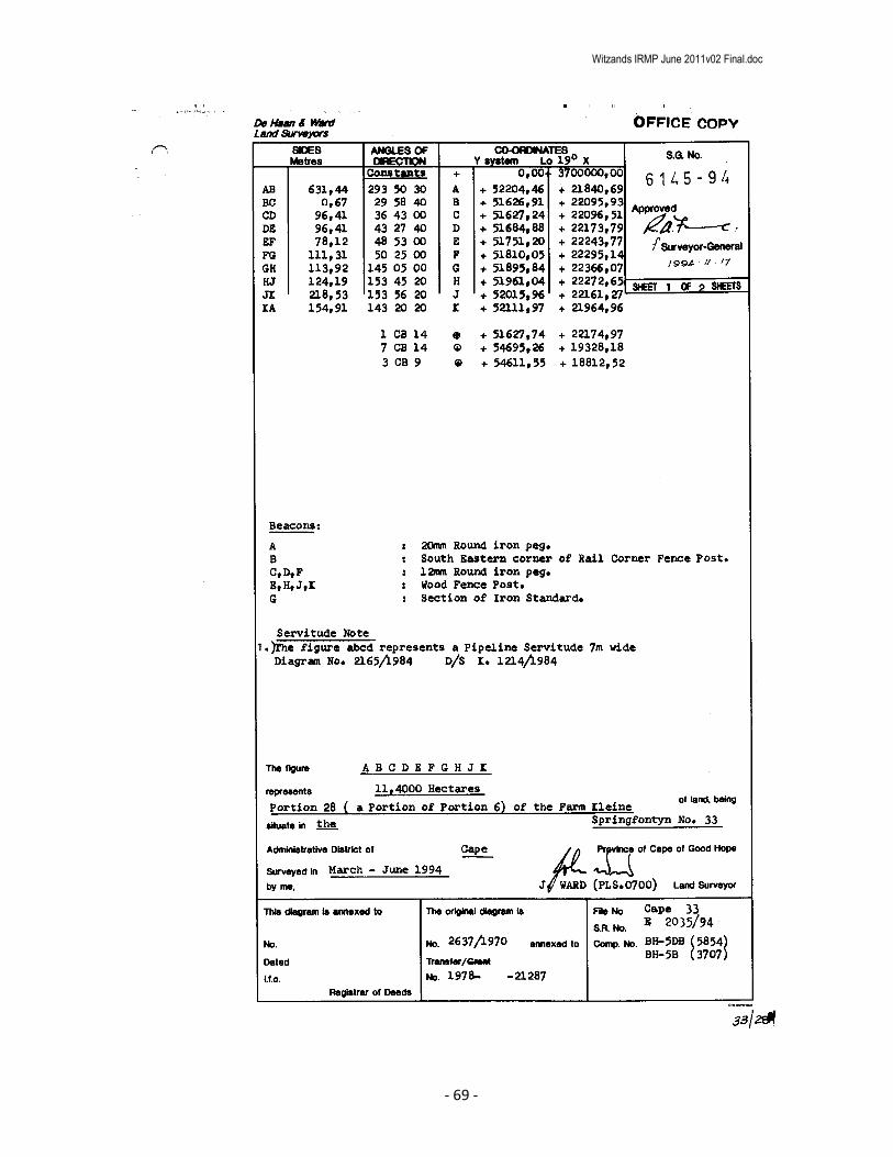
Witzands IRMP June 2011v02 Final.doc
- 69 -
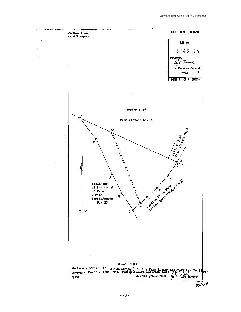
Witzands IRMP June 2011v02 Final.doc
- 70 -

Witzands IRMP June 2011v02 Final.doc
- 71 -
Witzands IRMP June 2011v02 Final.doc
- 72 -

Witzands IRMP June 2011v02 Final.doc
- 73 -

Witzands IRMP June 2011v02 Final.doc
- 74 -

Witzands IRMP June 2011v02 Final.doc
- 75 -

Witzands IRMP June 2011v02 Final.doc
- 76 -

Witzands IRMP June 2011v02 Final.doc
- 77 -

Witzands IRMP June 2011v02 Final.doc
- 78 -

Witzands IRMP June 2011v02 Final.doc
- 79 -
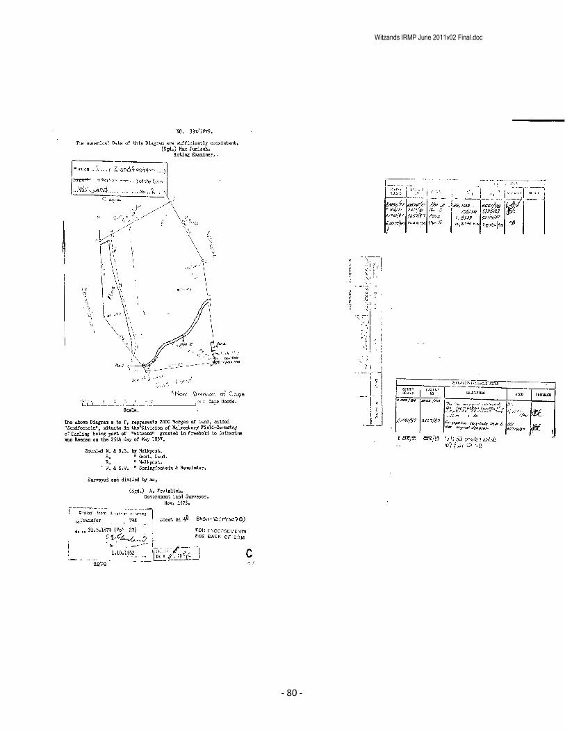
Witzands IRMP June 2011v02 Final.doc
- 80 -

Witzands IRMP June 2011v02 Final.doc
- 81 -

Witzands IRMP June 2011v02 Final.doc
- 82 -

Witzands IRMP June 2011v02 Final.doc
- 83 -

Witzands IRMP June 2011v02 Final.doc
- 84 -
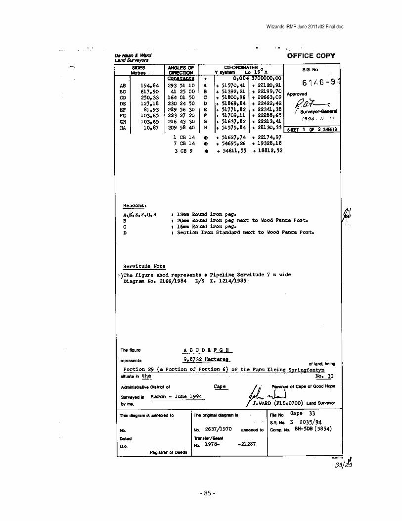
Witzands IRMP June 2011v02 Final.doc
- 85 -

Witzands IRMP June 2011v02 Final.doc
- 86 -
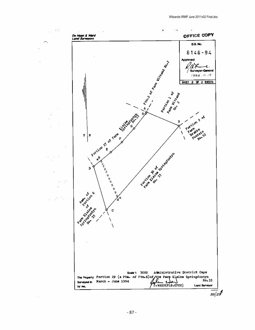
Witzands IRMP June 2011v02 Final.doc
- 87 -

Witzands IRMP June 2011v02 Final.doc
- 88 -
Witzands IRMP June 2011v02 Final.doc
- 89 -

Witzands IRMP June 2011v02 Final.doc
- 90 -
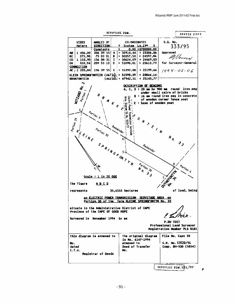
Witzands IRMP June 2011v02 Final.doc
- 91 -

Witzands IRMP June 2011v02 Final.doc
- 92 -

Witzands IRMP June 2011v02 Final.doc
- 93 -

Witzands IRMP June 2011v02 Final.doc
- 94 -

Witzands IRMP June 2011v02 Final.doc
- 95 -

Witzands IRMP June 2011v02 Final.doc
- 96 -

Witzands IRMP June 2011v02 Final.doc
- 97 -

Witzands IRMP June 2011v02 Final.doc
- 98 -
Witzands IRMP June 2011v02 Final.doc
- 99 -
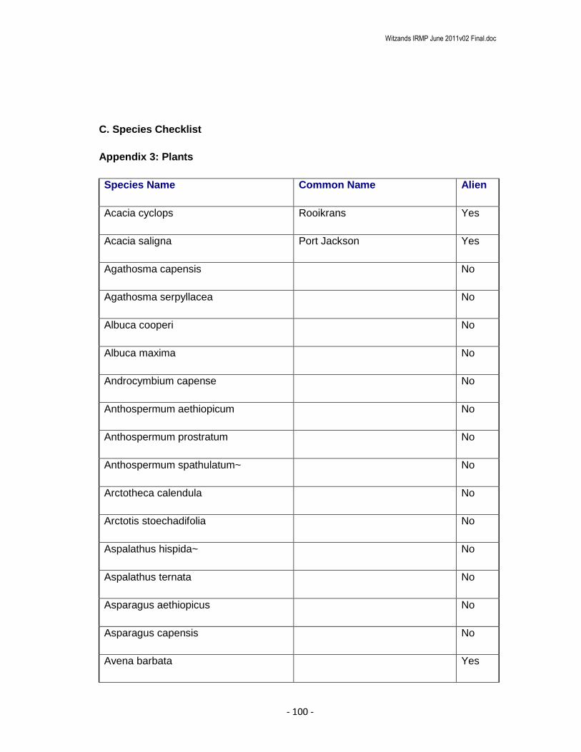
Witzands IRMP June 2011v02 Final.doc
- 100 -
C. Species Checklist
Appendix 3: Plants
Species Name Common Name Alien
Acacia cyclops Rooikrans Yes
Acacia saligna Port Jackson Yes
Agathosma capensis No
Agathosma serpyllacea No
Albuca cooperi No
Albuca maxima No
Androcymbium capense No
Anthospermum aethiopicum No
Anthospermum prostratum No
Anthospermum spathulatum~ No
Arctotheca calendula No
Arctotis stoechadifolia No
Aspalathus hispida~ No
Aspalathus ternata No
Asparagus aethiopicus No
Asparagus capensis No
Avena barbata Yes

Witzands IRMP June 2011v02 Final.doc
- 101 -
Babiana nana~ No
Babiana tubiflora No
Brunsvigia orientalis Candelabera Flower No
Carpobrotus acinaciformis No
Carpobrotus edulis No
Chironia baccifera No
Chrysanthemoides incana No
Chrysanthemoides monilifera Bitoubos No
Cineraria geifolia No
Cissampelos capensis No
Cliffortia strobilifera No
Clutia alaternoides~ No
Coleonema album No
Conicosia pugioniformis~ No
Conyza scabrida No
Corycium crispum No
Cotula turbinata No
Cotyledon orbiculata~ No
Crassula tetragona tetragona No
Crassula vaillantii No
Cullumia squarrosa No
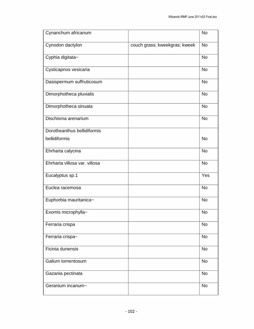
Witzands IRMP June 2011v02 Final.doc
- 102 -
Cynanchum africanum No
Cynodon dactylon couch grass; kweekgras; kweek No
Cyphia digitata~ No
Cysticapnos vesicaria No
Dasispermum suffruticosum No
Dimorphotheca pluvialis No
Dimorphotheca sinuata No
Dischisma arenarium No
Dorotheanthus bellidiformis
bellidiformis No
Ehrharta calycina No
Ehrharta villosa var. villosa No
Eucalyptus sp.1 Yes
Euclea racemosa No
Euphorbia mauritanica~ No
Exomis microphylla~ No
Ferraria crispa No
Ferraria crispa~ No
Ficinia dunensis No
Galium tomentosum No
Gazania pectinata No
Geranium incanum~ No

Witzands IRMP June 2011v02 Final.doc
- 103 -
Gethyllis ciliaris~ No
Gladiolus carinatus Blou Afrikaner No
Gladiolus sp.1 No
Gladiolus sp.2 No
Grielum grandiflorum No
Gymnodiscus capillaris No
Haemanthus coccineus No
Haemanthus pubescens~ No
Helichrysum cochleariforme No
Helichrysum revolutum No
Heliophila africana No
Heliophila sp.1 No
Hellmuthia membranacea No
Hemimeris sabulosa No
Hermannia pinnata No
Holothrix villosa~ No
Hyobanche sanguinea No
Indigofera psoraloides No
Ischyrolepis eleocharis No
Jordaaniella dubia No
Kedrostis nana~ No

Witzands IRMP June 2011v02 Final.doc
- 104 -
Lachenalia rubida No
Lampranthus explanatus No
Lapeirousia anceps No
Leonotis leonurus No
Lessertia argentea No
Leucospermum
hypophyllocarpodendron canaliculatum No
Leucospermum tomentosum No
Lycium afrum No
Malva parviflora~ No
Massonia sp.1 No
Melasphaerula ramosa No
Metalasia muricata No
Microloma sagittatum No
Monoculus monstrosus No
Moraea miniata No
Morella cordifolia No
Morella quercifolia No
Nemesia affinis No
Nylandtia spinosa
Skilpadbessie Bos, Tortoise
Berry Bush No
Olea exasperata No
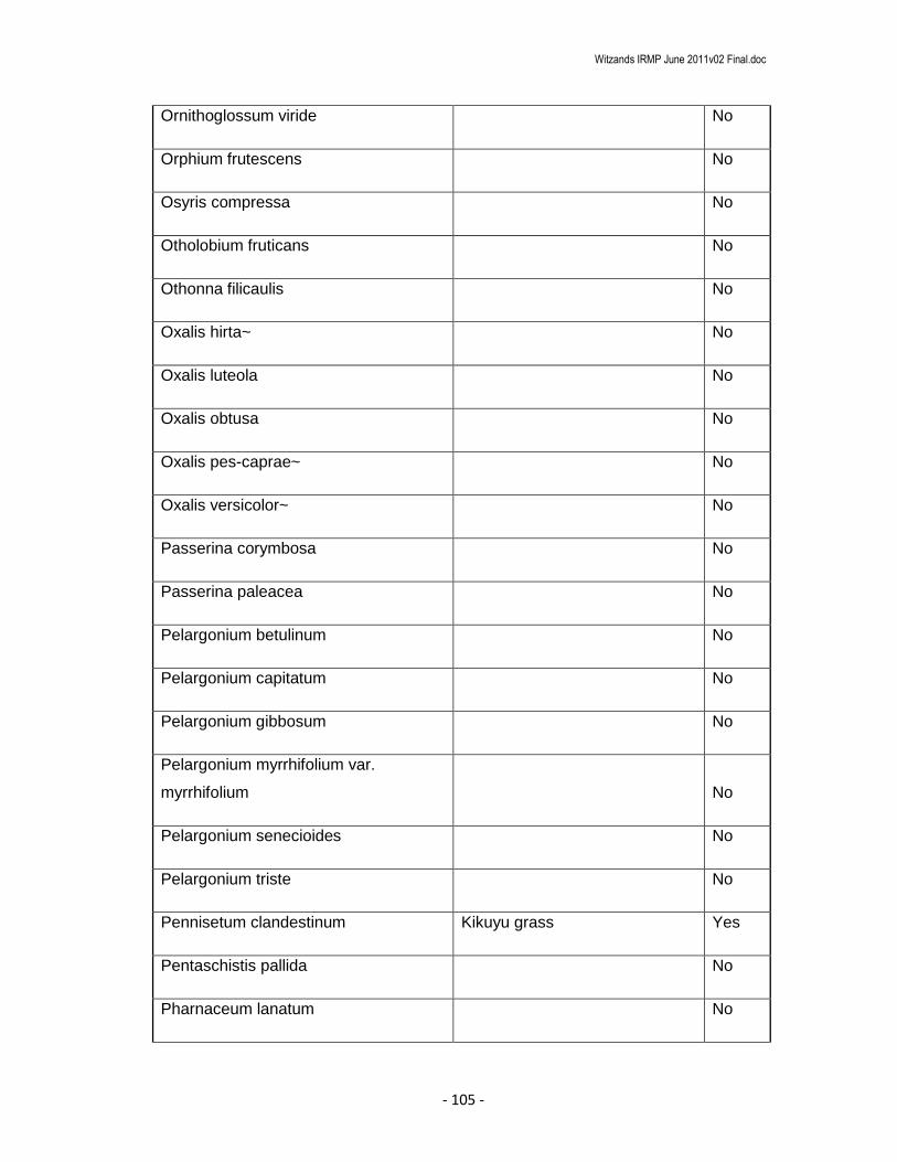
Witzands IRMP June 2011v02 Final.doc
- 105 -
Ornithoglossum viride No
Orphium frutescens No
Osyris compressa No
Otholobium fruticans No
Othonna filicaulis No
Oxalis hirta~ No
Oxalis luteola No
Oxalis obtusa No
Oxalis pes-caprae~ No
Oxalis versicolor~ No
Passerina corymbosa No
Passerina paleacea No
Pelargonium betulinum No
Pelargonium capitatum No
Pelargonium gibbosum No
Pelargonium myrrhifolium var.
myrrhifolium No
Pelargonium senecioides No
Pelargonium triste No
Pennisetum clandestinum Kikuyu grass Yes
Pentaschistis pallida No
Pharnaceum lanatum No

Witzands IRMP June 2011v02 Final.doc
- 106 -
Phylica cephalantha No
Phylica ericoides~ No
Putterlickia pyracantha No
Rhus glauca Blou Taaibos No
Rhus lucida~ No
Ruschia macowanii No
Salvia africana-lutea No
Thamnochortus erectus No
Thamnochortus punctatus No
Thamnochortus spicigerus No
Trachyandra ciliata No
Typha capensis Bulrush, Papkuil No
Viscum capense No
Zantedeschia aethiopica No
Appendix 4: Mammals
Species Name Common Name Red Book Status Alien
Bathyergus suillus Cape Dune Molerat Least Concern (LC) No
Felis caracal Caracal Least Concern (LC) No
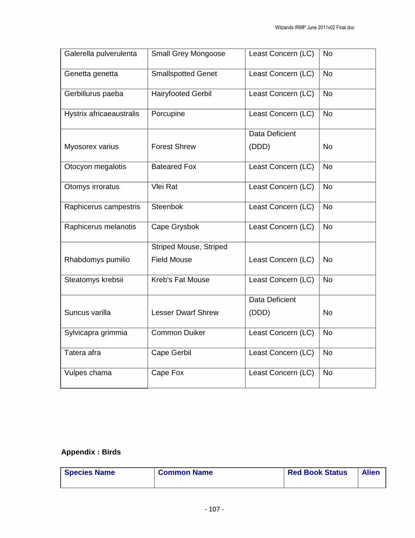
Witzands IRMP June 2011v02 Final.doc
- 107 -
Galerella pulverulenta Small Grey Mongoose Least Concern (LC) No
Genetta genetta Smallspotted Genet Least Concern (LC) No
Gerbillurus paeba Hairyfooted Gerbil Least Concern (LC) No
Hystrix africaeaustralis Porcupine Least Concern (LC) No
Myosorex varius Forest Shrew
Data Deficient
(DDD) No
Otocyon megalotis Bateared Fox Least Concern (LC) No
Otomys irroratus Vlei Rat Least Concern (LC) No
Raphicerus campestris Steenbok Least Concern (LC) No
Raphicerus melanotis Cape Grysbok Least Concern (LC) No
Rhabdomys pumilio
Striped Mouse, Striped
Field Mouse Least Concern (LC) No
Steatomys krebsii Kreb's Fat Mouse Least Concern (LC) No
Suncus varilla Lesser Dwarf Shrew
Data Deficient
(DDD) No
Sylvicapra grimmia Common Duiker Least Concern (LC) No
Tatera afra Cape Gerbil Least Concern (LC) No
Vulpes chama Cape Fox Least Concern (LC) No
Appendix : Birds
Species Name Common Name Red Book Status Alien

Witzands IRMP June 2011v02 Final.doc
- 108 -
Acrocephalus
gracilirostris Lesser Swamp-Warbler No
Alcedo cristata Malachite Kingfisher No
Alopochen aegyptiacus Egyptian Goose, Kolgans No
Anas capensis Cape Teal No
Anas erythrorhyncha Red-billed Teal No
Anas smithii Cape Shoveler No
Anas sparsa African Black Duck No
Anas undulata Yellow-billed Duck No
Anhinga rufa African Darter No
Anthoscopus minutus Cape Penduline-Tit No
Anthus cinnamomeus African Pipit No
Apalis thoracica Bar-throated Apalis No
Apus affinis Little Swift No
Apus apus Common Swift No
Apus barbatus African Black Swift No
Apus caffer White-rumped Swift No
Ardea cinerea Grey Heron No
Ardea melanocephala Black-headed Heron No
Ardea purpurea Purple Heron No
Batis capensis Cape Batis No
Bostrychia hagedash Hadeda Ibis No
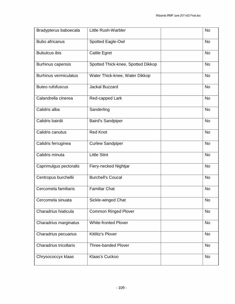
Witzands IRMP June 2011v02 Final.doc
- 109 -
Bradypterus baboecala Little Rush-Warbler No
Bubo africanus Spotted Eagle-Owl No
Bubulcus ibis Cattle Egret No
Burhinus capensis Spotted Thick-knee, Spotted Dikkop No
Burhinus vermiculatus Water Thick-knee, Water Dikkop No
Buteo rufofuscus Jackal Buzzard No
Calandrella cinerea Red-capped Lark No
Calidris alba Sanderling No
Calidris bairdii Baird's Sandpiper No
Calidris canutus Red Knot No
Calidris ferruginea Curlew Sandpiper No
Calidris minuta Little Stint No
Caprimulgus pectoralis Fiery-necked Nightjar No
Centropus burchellii Burchell's Coucal No
Cercomela familiaris Familiar Chat No
Cercomela sinuata Sickle-winged Chat No
Charadrius hiaticula Common Ringed Plover No
Charadrius marginatus White-fronted Plover No
Charadrius pecuarius Kittlitz's Plover No
Charadrius tricollaris Three-banded Plover No
Chrysococcyx klaas Klaas's Cuckoo No

Witzands IRMP June 2011v02 Final.doc
- 110 -
Circus maurus Black Harrier
Near Threatened
(NT) No
Circus ranivorus African Marsh-Harrier Vulnerable (VU) No
Cisticola tinniens Levaillant's Cisticola No
Colius colius White-backed Mousebird No
Colius striatus Speckled Mousebird No
Columba guinea Speckled Pigeon No
Corvus albus Pied Crow No
Corvus splendens Indian House Crow No
Cossypha caffra Cape Robin-Chat No
Creatophora cinerea Wattled Starling No
Dendropicos fuscescens Cardinal Woodpecker No
Egretta alba Great Egret No
Egretta garzetta Little Egret No
Egretta intermedia Yellow-billed Egret No
Elanus caeruleus Black-shouldered Kite No
Emberiza capensis Cape Bunting No
Emberiza impetuani Lark-like Bunting No
Eremopterix verticalis Grey-backed Sparrowlark No
Estrilda astrild Common Waxbill No
Euplectes capensis Yellow Bishop No
Euplectes orix Southern Red Bishop No
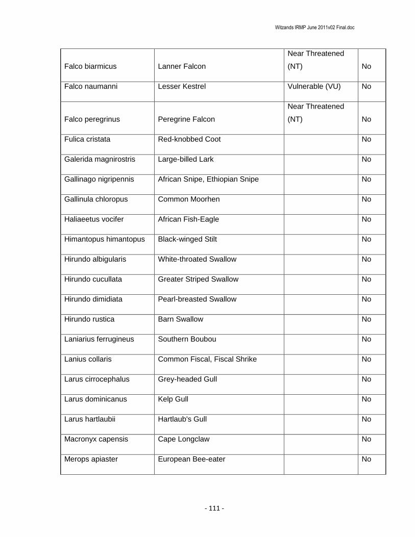
Witzands IRMP June 2011v02 Final.doc
- 111 -
Falco biarmicus Lanner Falcon
Near Threatened
(NT) No
Falco naumanni Lesser Kestrel Vulnerable (VU) No
Falco peregrinus Peregrine Falcon
Near Threatened
(NT) No
Fulica cristata Red-knobbed Coot No
Galerida magnirostris Large-billed Lark No
Gallinago nigripennis African Snipe, Ethiopian Snipe No
Gallinula chloropus Common Moorhen No
Haliaeetus vocifer African Fish-Eagle No
Himantopus himantopus Black-winged Stilt No
Hirundo albigularis White-throated Swallow No
Hirundo cucullata Greater Striped Swallow No
Hirundo dimidiata Pearl-breasted Swallow No
Hirundo rustica Barn Swallow No
Laniarius ferrugineus Southern Boubou No
Lanius collaris Common Fiscal, Fiscal Shrike No
Larus cirrocephalus Grey-headed Gull No
Larus dominicanus Kelp Gull No
Larus hartlaubii Hartlaub's Gull No
Macronyx capensis Cape Longclaw No
Merops apiaster European Bee-eater No

Witzands IRMP June 2011v02 Final.doc
- 112 -
Mirafra apiata Cape Clapper Lark No
Motacilla capensis Cape Wagtail No
Muscicapa adusta African Dusky Flycatcher No
Nectarinia famosa Malachite Sunbird No
Netta erythrophthalma Southern Pochard No
Numenius phaeopus Common Whimbrel No
Numida meleagris Helmeted Guineafowl Yes
Nycticorax nycticorax Black-crowned Night-Heron No
Oena capensis Namaqua Dove No
Oenanthe pileata Capped Wheatear No
Ortygospiza atricollis African Quailfinch No
Pandion haliaetus Osprey No
Parisoma subcaeruleum Chestnut-vented Tit-Babbler No
Parus afer Grey Tit No
Passer domesticus House Sparrow Yes
Passer melanurus Cape Sparrow No
Pelecanus onocrotalus Great White Pelican, Wit Pelikan
Near Threatened
(NT) No
Phalacrocorax africanus Reed Cormorant No
Phalacrocorax lucidus White-breasted Cormorant No
Philomachus pugnax Ruff No
Platalea alba African Spoonbill No

Witzands IRMP June 2011v02 Final.doc
- 113 -
Plectropterus gambensis Spur-winged Goose No
Plegadis falcinellus Glossy Ibis No
Ploceus capensis Cape Weaver No
Ploceus velatus Southern Masked-Weaver No
Pluvialis squatarola Grey Plover No
Podiceps cristatus Great Crested Grebe No
Prinia maculosa Karoo Prinia No
Promerops cafer Cape Sugarbird No
Pycnonotus capensis Cape Bulbul No
Riparia paludicola Brown-throated Martin No
Serinus canicollis Cape Canary No
Sigelus silens Fiscal Flycatcher No
Sphenoeacus afer Cape Grassbird No
Spreo bicolor Pied Starling No
Sterna bergii Swift Tern No
Sterna caspia Caspian Tern
Near Threatened
(NT) No
Sterna hirundo Common Tern No
Sterna paradisaea Arctic Tern No
Sterna sandvicensis Sandwich Tern No
Streptopelia capicola Cape Turtle-Dove No
Streptopelia semitorquata Red-eyed Dove No

Witzands IRMP June 2011v02 Final.doc
- 114 -
Streptopelia senegalensis Lag Duifie, Laughing Dove No
Sturnus vulgaris Common Starling, European Starling Yes
Sylvietta rufescens Long-billed Crombec No
Tachybaptus ruficollis Little Grebe No
Tachymarptis melba Alpine Swift No
Tadorna cana South African Shelduck No
Telophorus zeylonus Bokmakierie No
Thalassornis leuconotus White-backed Duck No
Threskiornis aethiopicus African Sacred Ibis No
Tricholaema leucomelas Acacia Pied Barbet No
Tringa nebularia Common Greenshank No
Turdus olivaceus Olive Thrush No
Tyto alba Barn Owl No
Upupa africana African Hoopoe No
Urocolius indicus Red-faced Mousebird No
Vanellus armatus
Blacksmith Lapwing, Blacksmith
Plover No
Vanellus coronatus Crowned Lapwing No
Vidua macroura Pin-tailed Whydah No
Zosterops pallidus Orange River White-eye No
Zosterops virens Cape White-eye No

Witzands IRMP June 2011v02 Final.doc
- 115 -
Appendix 6: Reptiles
Species Name Common Name Alien
Acontias meleagris Cape Legless Skink No
Afrogecko porphyreus Marbled Leaf-toed Gecko, Marbled Leaftoed Gecko No
Aspidelaps lubricus
lubricus Coral Snake No
Bradypodion pumilum Cape Dwarf Chameleon No
Chersina angulata Angulate Tortoise No
Crotaphopeltis
hotamboeia Herald Snake No
Dasypeltis scabra Common Eggeater No
Dispholidus typus Boomslang No
Duberria lutrix Common Slug Eater No
Goggia lineata
Striped Dwarf Leaf-toed Gecko, Striped Dwarf
Leaftoed Gecko No
Homoroselaps lacteus Spotted Harlequin Snake No
Lamprophis aurora Aurora House Snake No
Lamprophis capensis Brown House Snake No
Lamprophis inornatus Olive House Snake No
Leptotyphlops nigricans Black Thread Snake No
Meroles knoxii Knox's Desert Lizard No
Naja nivea Cape Cobra No
Pachydactylus austeni Austen's Thick-toed Gecko, Austen's Thicktoed Gecko No

Witzands IRMP June 2011v02 Final.doc
- 116 -
Pachydactylus geitje
Ocellated Thick-toed Gecko, Ocellated Thicktoed
Gecko No
Psammophis crucifer
Cross-marked Grass Snake, Crossmarked Grass
Snake No
Psammophis leightoni Cape Sand Snake No
Psammophis notostictus Karoo Sand Snake No
Psammophylax
rhombeatus Rhombic Skaapsteker No
Pseudaspis cana Mole Snake No
Scelotes bipes Silvery Dwarf Burrowing Skink No
Tetradactylus
tetradactylus Common Long-tailed Seps, Common Longtailed Seps No
Typhlosaurus caecus Cuvier's Blind Legless Skink No
Appendix 7: Amphibians
Species Name Common Name Alien
Breviceps namaquensis Namaqua Rain Frog No
Breviceps rosei Sand Rain Frog No
Cacosternum platys Caco sp., Flat Caco No
Strongylopus grayii grayii Clicking Stream Frog No
Tomopterna delalandii Cape Sand Frog No
Xenopus laevis Common Platanna No

Witzands IRMP June 2011v02 Final.doc
- 117 -
D.
Appendix 8: Sensitivity Analyses report
SENSITIVITY- VALUE ANALYSIS AND ZONATION
PROCESS:
Witzands Aquifer Nature Reserve
Prepared for the Biodiversity Branch and Environmental Management Systems Branch

Witzands IRMP June 2011v02 Final.doc
- 118 -
NOVEMBER 2010
Arne Purves
Natural Resource Specialist
Contents
1. Introduction 119
1.1 Scope of Report .....................................................................................................................................120
2. Background and Brief 121
3. Sensitivity-Value Analysis 121
3.1 Input Layers 123
3.1.1 Biodiversity..........................................................................................................................................123
3.1.1a Habitat Value ............................................................................................................................123
3.1.1b: Transformation # Degradation Map: ........................................................................................127
3.1.1c Special Habitat Value ...............................................................................................................137
3.1.2 Topographic Sensitivity 140
3.1.3 Hydrological Sensitivity 144
3.1.4 Visual Sensitivity 148
4. Sensitivity-Value Analysis process (including weightings) and summary layers 152
5. Zoning Process 158
5.1 Zoning Informants ..................................................................................................................................158
5.2 Zoning Definitions and Descriptions.......................................................................................................159
5.3 Draft Zoning Outputs ..............................................................................................................................160
5.4 Special Management Overlays ..............................................................................................................162
Witzands IRMP June 2011v02 Final.doc
- 119 -
5.4.1 Special Management Overlay for Restoration and Rehabilitation Sites ....... Error! Bookmark not
defined.
6. Conclusions and Recommendations 167
7. References 167
Appendices 169
Table 9: Base values: Ecosystem Status of National vegetation types occurring in the City ..............169
Table 10: National vegetation types for the City of Cape Town showing historic extent, remaining
extent, targets and targets achieved inside and outside Protected Areas ...........................................171
Table 11: City of Cape Town Nature Reserves and Conservation Areas: Visitor Use Zoning - Desired
State* & Experiential Qualities ............................................................................................................173
1 1. INTRODUCTION
The Witzands Aquifer Nature Reserve (WANR) is situated to the West of Atlantis, within the northern region
of the Cape Metropolitan Area. The reserve forms part of the City’s Biodiversity Network and is listed as a
protected area, although it is currently City owned land without any formal conservation status.
The predominant vegetation type is Cape Flats Dune Strandveld (Rebelo et al, 2006). This vegetation type
is listed as least threatened, but is poorly represented in formally protected areas. Only 28% of the
vegetation target of 24% (of the original extent) is formally conserved. The two other vegetation types that
occur in the study area are Atlantis Sand Fynbos (listed as vulnerable) and Swartland Shale Renosterveld
(listed as critically endangered). The ecotone that occurs between the Strandveld and Sand Fynbos
vegetation is also an important area.
The Atlantis dune field forms a large mobile sand dune system within the conservation area.
The Atlantis Aquifer

Witzands IRMP June 2011v02 Final.doc
- 120 -
The WCA overlies a large portion of the Atlantis aquifer, which is located in a narrow, low-lying coastal plain
to the west and south of Atlantis. It is an unconfined, sandy aquifer which results in the aquifer being highly
vulnerable to pollution. The groundwater from the Atlantis aquifer provides high quality water to the town of
Atlantis and surrounds, and is extracted from well fields in Witzand and Silwerstroom. Since 2000, the
groundwater supply has been augmented by surface water and has become known as the Atlantis Water
Scheme. Much research has been carried out by the CSIR on groundwater management etc in this area
(CSIR, 2002)
The reserve is a significant asset to the City and makes significant contributions to national vegetation
targets of threatened vegetation types as listed in the National Spatial Biodiversity Assessment (Driver et al,
2005), as well as providing a service and facilities to local residents and schools.
1.1 1.1 SCOPE OF REPORT
The development of the Sensitivity and Zonation plan is one of the steps required in compiling a
Conservation Development Framework (CDF) for the reserve. CDFs are tools to reconcile the various land-
use needs and to delineate visitor user zones and the positioning and nature of new infrastructure, access
points, roads and facilities.
The CDF process has grown in response to the requirements of the NEMBA (2004) and is a strategy to
comply with the spatial planning requirements of these acts. The CDFs will ensure that best practice and
sustainable development principles are integrated into spatial planning within protected areas.
The Sensitivity-Value analysis is the landscape analysis portion of the broader Conservation Development
Framework. It is a multi-criteria decision-support tool for spatial planning that is designed to integrate the
best available information into a format that allows for defensible and transparent decisions to be made. The
Sensitivity-Value process is based on the principle that the acceptability of a development (or placement of
a structure) at a site is based on the site’s value (either from biodiversity, heritage, aesthetic or a

Witzands IRMP June 2011v02 Final.doc
- 121 -
combination of values) and its sensitivity or vulnerability to a variety of types of disturbance (Holness et al,
2005).
The Sensitivity-Value analysis, the CDF and the associated zonation plan should form part of an
adaptive management system. They will grow and change over time as the understanding of the
landscapes and ecosystems improve; and
It does not replace the need for detailed site and precinct planning and EIA compliance at site
level.
2 2. BACKGROUND AND BRIEF
The Sensitivity-Value analysis was undertaken by the EMS Branch’s natural resource specialist. The small
size of the City’s nature reserve also did not require an extensive analysis, with the subsequent zonation
process being fairly straight forward. The methodology used for both the Sensitivity-Value analysis and the
zonation process was adapted from Holness (2008) and SRK Consulting (2008).
All geographical information work was carried out in ESRI’s ArcMap version 9.3.1 GIS (Geographical
Information System) using the ArcInfo license level with Spatial Analyst and 3D Analyst extensions.
The brief for the project was to compile a Sensitivity-Value analysis and zonation plan for the Witzands
Aquifer Nature Reserve.
3 3. SENSITIVITY-VALUE ANALYSIS
Sensitivity-Value Analysis and Zoning Process methodology
Stage 1: Data synthesis and compilation
Compilation of required data for the analysis

Witzands IRMP June 2011v02 Final.doc
- 122 -
Spatially define the planning domain or study area.
Evaluate available and required datasets for the Sensitivity-Value model.
Spatial data is collected or created for each element of the Sensitivity-Value model.
Stage 2: Layer interpretation
Layer interpretation is an important component of the Sensitivity-Value process that requires a combination
of spatial data interpretation and expert knowledge.
Using the assembled data, areas are assigned a score on a common scale for each element of the
model; and
The scores achieved for each element of the model are represented as separate input layers on a
GIS.
Stage 3: Sensitivity-Value Analysis
The Sensitivity-Value analysis stage involves an iterative exploration of the input layers.
The scores achieved for each element of the model are weighted and aggregated to obtain an
overall Sensitivity-Value ranking.
Different weightings and aggregation procedures and combinations of input layers can be explored;
and
The robustness of the Sensitivity-Value analysis is examined.
The resultant Sensitivity-Value output maps should provide an initial understanding of the spatial distribution
of the important and sensitive biodiversity, landscape and heritage features.
Stage 4: Development of a draft zonation plan
The outputs of the Sensitivity-Value process are used as the foundation for the development of a draft
zonation plan. The Sensitivity-Value outputs and draft zonation plan are workshopped with relevant
stakeholders.

Witzands IRMP June 2011v02 Final.doc
- 123 -
Stage 5: Refinement of the draft zonation and the identification of special management overlays
Special management areas/overlays are identified using the information derived from the Sensitivity-Value
analysis. Recommendations are made regarding the management of the land-use zones and special
management areas.
The draft is then presented for comment to the City and stakeholder groups to obtain broad public input into
the plan prior to finalisation,
Stage 6: Final Zonation and Conservation Development Framework.
The comments and input from the public participation process are integrated into the final zonation plan.
The plan is passed through Council for approval and adoption.
4 3.1 INPUT LAYERS
The study area for the CDF was defined as the current management boundary of the Witsands
Conservation Area, but also included additional portions of land that cover the shifting dune fields to the
North as well as portions of Eskom’s property to the west and the military shooting range to the south east.
This boundary was then buffered by 1000m and this was used as the outer analysis boundary (see Figure
1).
4.1 3.1.1 BIODIVERSITY
4.1.1 3.1.1a Habitat Value
The habitat unit as defined by a particular vegetation community is used as the broad proxy for biodiversity.
The vegetation communities are good surrogates for habitat value as it uses readily available information
that clearly delineates the distribution of distinct subsets of biodiversity across the landscape.
The South African National Vegetation Map (Rebelo et al, 2006) was used to broadly define the habitat
units. The NSBA (Driver et al, 2005) values were used to inform current ecosystem status and level of
protection of vegetation types within the study area.

Witzands IRMP June 2011v02 Final.doc
- 124 -
The following factors were also incorporated in the habitat value calculation
The value assigned to a habitat unit should reflect the contribution that vegetation type makes to
the local, provincial and national conservation estate.
This value should reflect the rarity of the habitat, the level of transformation that occurred within the
habitat type, species richness and diversity, habitat heterogeneity, and contribution to local
conservation targets as identified in the City’s Biodiversity Network (Benn, 2008).
The habitat value also takes into account a gap analysis (how much is in reserves), whereby
habitat types that exists largely outside of protected areas receive a higher value.
Broad habitat value is a poor indication of the value of a particular site if a reserve has a history of significant
transformation or degradation. Where a reserve includes transformed and/or degraded areas these need to
inform the adjustment of the broad habitat value to reflect:
The level and type of transformation that has occurred at a particular site.
The rehabilitation/restoration potential of a site. Areas that are likely to revert, with a minimum of
management intervention, to a natural or near natural state should be allocated a higher value than
areas where extensive management intervention is required.
Degraded or developed areas were considered to have lower habitat values. The habitat values
were adjusted downwards according to the level and type of degradation or habitat loss that has
occurred.
Data Inputs (GIS methods and sources)
Base habitat map:
The broader vegetation types as listed in the South African Vegetation Map (Rebelo et al, 2006) were used
as the smallest vegetation unit (see Figure 1) as there was little difference in the sensitivity values allocated
to vegetation communities within these broader units.

Witzands IRMP June 2011v02 Final.doc
- 125 -
The values used to adjust the base habitat scores are the listed in Table 2. This is necessary in order that
critically endangered ecosystems are accurately reflected in the scoring in terms of protection status and, %
transformation of the vegetation types.
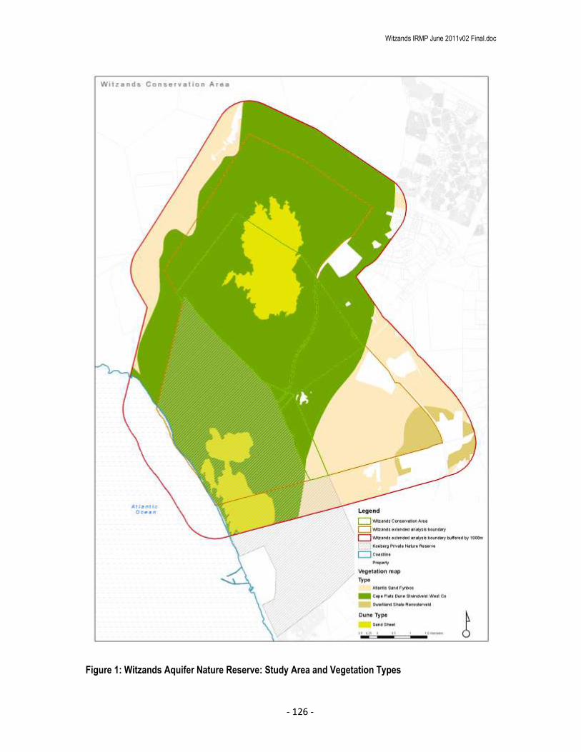
Witzands IRMP June 2011v02 Final.doc
- 126 -
Figure 1: Witzands Aquifer Nature Reserve: Study Area and Vegetation Types

Witzands IRMP June 2011v02 Final.doc
- 127 -
4.1.2 3.1.1b: Transformation # Degradation Map:
Habitat transformation and degradation was mapped from recent aerial photography (2005, 2007 and 2008).
Habitat modifiers are listed in Table 1 and Figure 2 shows their types and spatial extent.
Table 1: Habitat Modifiers
Type Category Description
Tra
nsf
orm
ed
Facilities Facilities for use by public within the reserve
(Ablutions, displays, benches etc.)
Housing and hard surfaces Formal and informal housing, incl. old sites that still
have hard surfaces etc.
Quarries Open excavation or burrow pits – can be current or
historic
Road & paths The road (management and access roads), trail and
boardwalk network
Dams Artificial water impoundments and Bulk water
infrastructure
Recreational Open Space Primarily areas where lawns are maintained for
public recreation. Often associated with non-
indigenous tree planting for shade etc.
Degra
ded
Heavy, m
odera
te o
r Low
Firebreaks/fencing Strips of cleared land maintained for fire
management. Including the boundary fencing which
usually incorporates a firebreak.
Invasive Alien vegetation These areas include sites that have an Invasive Alien
Plant infestation density of more than 75%. Sites
need to be assessed in terms of their restoration
potential. This would also include plantation
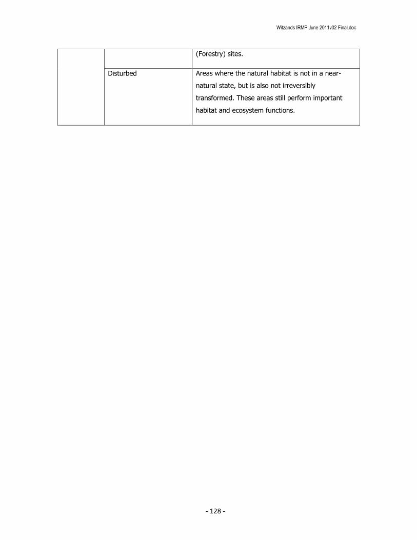
Witzands IRMP June 2011v02 Final.doc
- 128 -
(Forestry) sites.
Disturbed Areas where the natural habitat is not in a near-
natural state, but is also not irreversibly
transformed. These areas still perform important
habitat and ecosystem functions.

Witzands IRMP June 2011v02 Final.doc
- 129 -
Figure 2: Witzands Aquifer Nature Reserve : Habitat Modifiers

Witzands IRMP June 2011v02 Final.doc
- 130 -
Scoring, Logic and rationale
The scoring method derived was as follows:
1. Base values were assigned to the study area according to the ecosystem status of the vegetation
types (Table 2).
2. The Base values were adjusted on the basis of habitats that are likely to receive an adjusted
conservation status under the “Criterion D” listing of threatened ecosystems in terms of NEMBA
(2004). This reflects vegetation types with high numbers of rare and endangered plant species.
This value replaced the NSBA Conservation Status where higher and was not used in addition to
them (Table 2).
3. Base values were adjusted according to the protection status of the vegetation type (Gap Analysis)
as determined in the fine scale conservation plan for the City (see Appendices, Table 9).
4. Base values were adjusted according to the % Transformation that has occurred within each
vegetation type within the City. (See Appendices, Table 10).
5. The values of all degraded sites were reduced according to the type of habitat degradation (Table
3); and
6. The values of all transformed areas were reduced to zero
7. Once these values were determined, the values were converted to a 0-10 range using a linear
conversion method in ArcGIS.

Witzands IRMP June 2011v02 Final.doc
- 131 -
Table 2: Habitat Value summary for each vegetation type before local adjustment for
transformation/degradation
Vegetation Type NSBA
Conservation
Status
Score
Criterion
D
Score*
SANBI
Conservation
Status
% Transformed
Score
Unmodified
Score
Atlantis Sand Fynbos 6 10 5 3 18
Boland Granite Fynbos 8 6 3 3 14
Cape Estuarine Salt Marshes 4 0 -1 3 6
Cape Flats Dune Strandveld: False bay 8 8 3 10 21
Cape Flats Dune Strandveld: West Coast 4 8 3 2 13
Cape Flats Sand Fynbos 10 10 4 10 24
Cape Lowland Freshwater Wetlands 4 0 -1 2 5
Cape Winelands Shale Fynbos 8 0 3 3 14
Elgin Shale Fynbos 10 0 4 6 20
Hangklip Sand Fynbos 6 6 -1 4 9
Kogelberg Sandstone Fynbos 4 10 2 0 12
Lourensford Alluvium Fynbos 10 10 3 10 23
North Peninsula Granite Fynbos 4 0 -1 2 5
Peninsula Sandstone Fynbos 4 8 -1 0 7
Peninsula Shale Fynbos 6 0 -1 4 9
Peninsula Shale Renosterveld 10 0 3 10 23
South Peninsula Granite Fynbos 8 0 2 6 16
Southern Afrotemperate Forest 4 0 -1 0 3

Witzands IRMP June 2011v02 Final.doc
- 132 -
Swartland Alluvium Fynbos 10 0 5 10 25
Swartland Granite Renosterveld 10 10 4 10 24
Swartland Shale Renosterveld 10 10 4 10 24
Swartland Silcrete Renosterveld 10 0 -1 10 19
Western Shaleband Vegetation 4 0 3 0 7
*This value only replaces NSBA Conservation Status Value when it’s a higher value
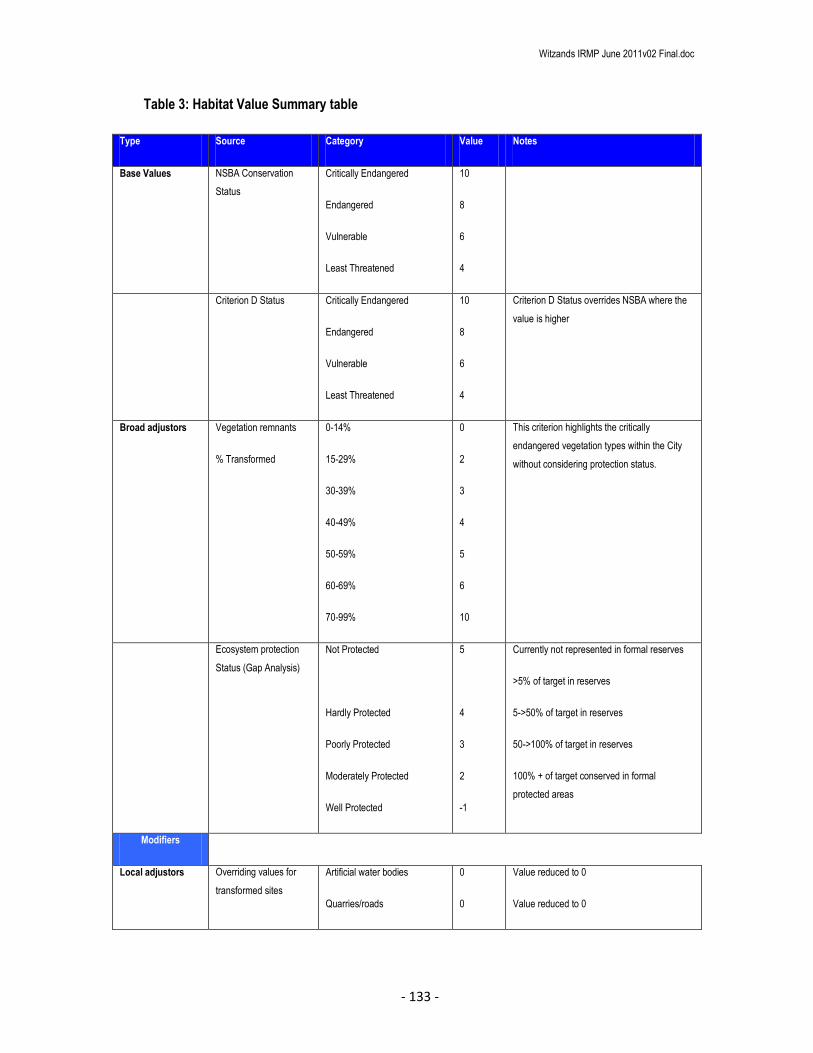
Witzands IRMP June 2011v02 Final.doc
- 133 -
Table 3: Habitat Value Summary table
Type Source Category Value Notes
Base Values NSBA Conservation
Status
Critically Endangered
Endangered
Vulnerable
Least Threatened
10
8
6
4
Criterion D Status Critically Endangered
Endangered
Vulnerable
Least Threatened
10
8
6
4
Criterion D Status overrides NSBA where the
value is higher
Broad adjustors Vegetation remnants
% Transformed
0-14%
15-29%
30-39%
40-49%
50-59%
60-69%
70-99%
0
2
3
4
5
6
10
This criterion highlights the critically
endangered vegetation types within the City
without considering protection status.
Ecosystem protection
Status (Gap Analysis)
Not Protected
Hardly Protected
Poorly Protected
Moderately Protected
Well Protected
5
4
3
2
-1
Currently not represented in formal reserves
>5% of target in reserves
5->50% of target in reserves
50->100% of target in reserves
100% + of target conserved in formal
protected areas
Modifiers
Local adjustors Overriding values for
transformed sites
Artificial water bodies
Quarries/roads
0
0
Value reduced to 0
Value reduced to 0

Witzands IRMP June 2011v02 Final.doc
- 134 -
Developed
Recreational Open Space
(ROS)
0
0
Value reduced to 0
Value reduced to 0
Adjusting values for
degraded sites
Heavily degraded -6 High density aliens – depleted seed bank with
low restoration potential
Previously ploughed old fields
Moderately degraded -2 High density aliens – intact seed bank with
high restoration potential
Forestry (Pine, Gum) plantations
Low degraded -1 High density non-locally indigenous species
Area is recovering from historic disturbance, to
a near natural state.
Cleared fire belt areas
Modified wetlands with NB habitat value
GIS Procedure:
Habitat Value Unmodified Score
1. Export vegetation data to separate shapefile
2. Delete all fields except the “SANBI_VEG” field
3. Dissolve on field “SANBI_VEG”
4. Add fields, NSBA Conservation Status Score (NSBA_SCR), Criterion D Score (Crit_D), SANBI
Conservation Status (SANBI_Cons), % Transformed (PERC_TRANS), Unmodified Score
(UNMod_SCR). Use Short Integer field type.
5. Populate the attribute table with the relevant scores
6. Calculate the Unmodified Habitat Value Score. Note: The Criterion D score will override the NSBA
score if the latter is a higher value.
Habitat Transformation

Witzands IRMP June 2011v02 Final.doc
- 135 -
1. All roads, trails and boardwalks are buffered by 1 meter.
2. All transformation types were digitised from aerial photography at a scale of 1:700. Artificial water
bodies were extracted from the wetlands layer.
3. All transformation layers were unioned.
4. Values were assigned as per the table. Type in field “TRANSCLASS” and the score in the field
“VALUE”
Habitat Value Modified Score
1. Union the above two layers
2. Clip the union layer to the study area
3. Delete all unnecessary fields.
4. Add field “MOD_SCR”
5. Calculate the value for “MOD_SCR”. Remember to reduce the over-riding transformation values to
0
6. Covert to a 1-10 range using equal intervals and label 1-10. Ensure sampling uses all records (set
to 25000).
7. Export to shapefile and label WITZ_Habitat_Value.shp
8. Create map for report and export
Outputs
See Figure 3
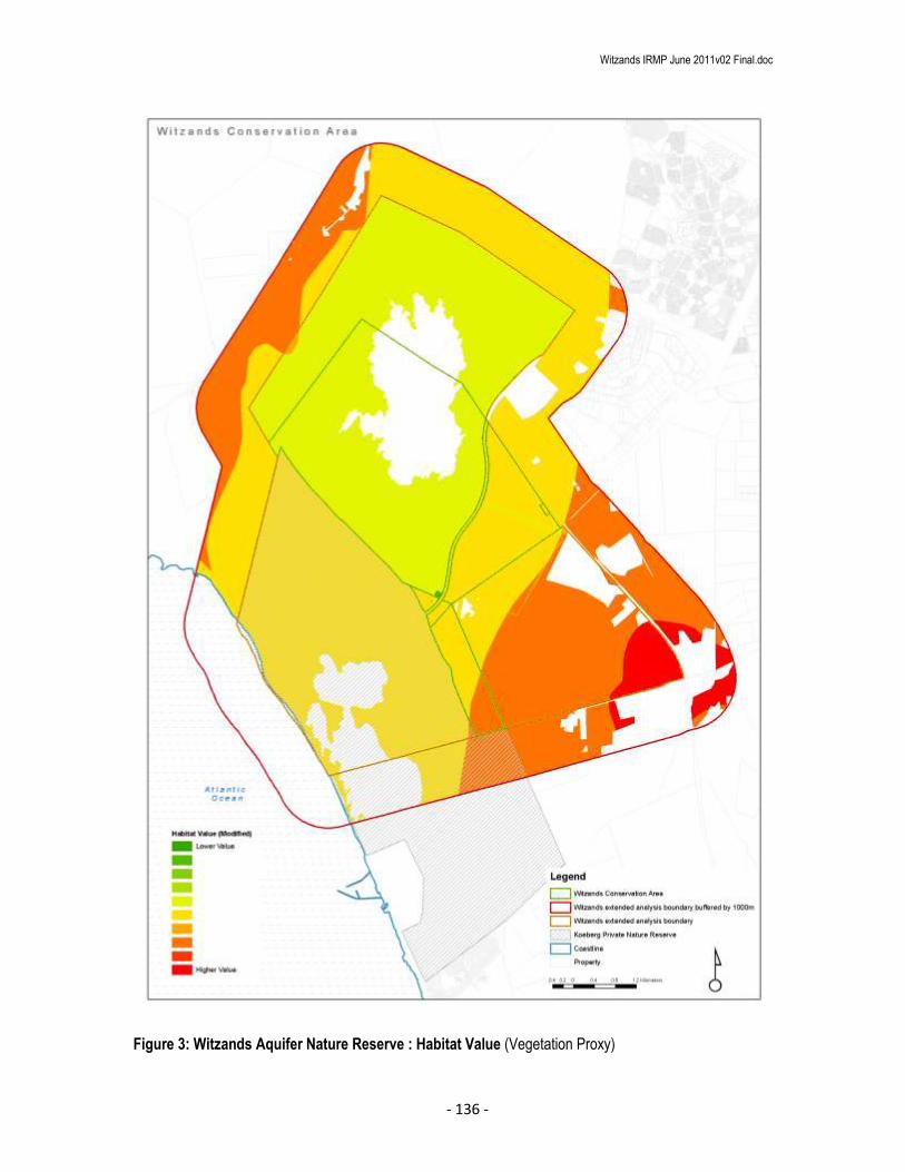
Witzands IRMP June 2011v02 Final.doc
- 136 -
Figure 3: Witzands Aquifer Nature Reserve : Habitat Value (Vegetation Proxy)
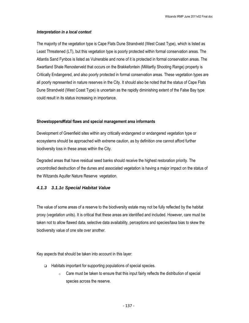
Witzands IRMP June 2011v02 Final.doc
- 137 -
Interpretation in a local context
The majority of the vegetation type is Cape Flats Dune Strandveld (West Coast Type), which is listed as
Least Threatened (LT), but this vegetation type is poorly protected within formal conservation areas. The
Atlantis Sand Fynbos is listed as Vulnerable and none of it is protected in formal conservation areas. The
Swartland Shale Renosterveld that occurs on the Brakkefontein (Militar6y Shooting Range) property is
Critically Endangered, and also poorly protected in formal conservation areas. These vegetation types are
all poorly represented in nature reserves in the City. It should also be noted that the status of Cape Flats
Dune Strandveld (West Coast Type) is uncertain as the rapidly diminishing extent of the False Bay type
could result in its status increasing in importance.
Showstoppers#fatal flaws and special management area informants
Development of Greenfield sites within any critically endangered or endangered vegetation type or
ecosystems should be approached with extreme caution, as by definition one cannot afford further
biodiversity loss in these areas within the City.
Degraded areas that have residual seed banks should receive the highest restoration priority. The
uncontrolled destruction of the dunes and associated vegetation is having a major impact on the status of
the Witzands Aquifer Nature Reserve vegetation.
4.1.3 3.1.1c Special Habitat Value
The value of some areas of a reserve to the biodiversity estate may not be fully reflected by the habitat
proxy (vegetation units). It is critical that these areas are identified and included. However, care must be
taken not to allow flawed data, selective data availability, perceptions and species/taxa bias to skew the
biodiversity value of one site over another.
Key aspects that should be taken into account in this layer:
Habitats important for supporting populations of special species.
o Care must be taken to ensure that this input fairly reflects the distribution of special
species across the reserve.

Witzands IRMP June 2011v02 Final.doc
- 138 -
o Where detailed and comprehensive data are available this can be based on actual
distributions, but in all likelihood this will be based on expert assessment of likely habitat
requirements for identified species.
Areas containing significant biodiversity assets such as Leopard, Black eagles, Leopard toads etc.
that are not specifically linked to entire habitats.
Other habitats that have significant biodiversity value that have been omitted from the broad
conservation value layer as a result of scale issues or type of habitat.
Dune Fields
The sand sheets (mobile sand dunes) were extracted from the sand dunes layer. These sand sheets do not
contribute to vegetation targets, but are an important biodiversity feature. Although the rest of the areas are
vegetated parabolic, embryo and transverse dunes the sand sheets are generally void of vegetation. The
sand sheets have been allocated a relative importance value, as the rest of the dunes are vegetated and
receive the value of their overlying vegetation type.
Data Inputs (GIS methods and sources)
1. Dunes layer was clipped to the study area.
2. Dissolved on Dune Type
3. Add Field “SPL_HAB_VAL
4. Populate field with value
5. Create map and export WITZ_SPL_HAB_VAL.shp

Witzands IRMP June 2011v02 Final.doc
- 139 -
Figure 4: Witzands Aquifer Nature Reserve : Special Habitat Value (Sand Dunes)

Witzands IRMP June 2011v02 Final.doc
- 140 -
Interpretation in a local context
Some of the largest parabolic dune fields on the West Coast are found at Yzerfontein and in
the Koeberg-Witzand area (Tinley, 1985; sensu Low & Pond, 2006). These dunes perform an important
ecosystem function and are a unique landscape feature.
Showstoppers#fatal flaws and special management area informants
Although, from a pure biodiversity perspective the sensitivity of the mobile sand sheets may be interpreted
as being fairly low, the fact that they overlay the Witzands aquifer and comprise course grained, highly
permeable sands makes the underlying aquifer zone extremely vulnerable and sensitive to above ground
impacts (pollution etc.). This value is captured in the hydrological sensitivity.
5 3.1.2 TOPOGRAPHIC SENSITIVITY
This layer is used to identify areas with steep slopes or with sensitive geological or geomorphologic
features. Significant impacts (such as accelerated soil erosion or landslides) may occur during construction
in, or with improper management.
Sensitivity to erosion was not considered in this report. The steepness and habitat values provide a good
enough proxy for sensitivity to erosion.
Data Inputs (GIS methods and sources)
This layer is derived from a triangular irregular network (TIN) created in ArcView 9.3.1 using the 3D Analyst
extension and ArcInfo licence level. The 2m Contour layer for the City was used to calculate the base
heights for the TIN. Slope angles were calculated using the 3D Analyst extension.
Scoring, logic and rationale

Witzands IRMP June 2011v02 Final.doc
- 141 -
Slope angles were split into categories that relate to potential impacts and the limits of construction without
significant cut and fill.
Procedure:
Buffer study area by 1000m
Clip the 2m contour layer with the buffered boundary layer
Calculate Slope angles
Reclassify according to Table 4 using 3D Analyst - reclassify
Convert raster layer to vector shapefile and clip to the reserve boundary
Create new field “VALUE”
Assign values according to attribute field “GRIDCODE” to shapefile field “VALUE”
Create and export map
Final Topographic Sensitivity layer: WITZ_topo_sensitivity.shp
Table 4: Topographic sensitivity
Source Category Value Note

Witzands IRMP June 2011v02 Final.doc
- 142 -
Slo
pe a
ngle
s ca
lcul
ated
from
2m
con
tour
laye
r
45 - <90
30 - <45
15 - <30
10 - <15
5° - <10
0° - <5°
10
9
8
6
2
0
Very high potential for erosion and slope instability
Strong potential for erosion and slope instability
High risk of erosion following disturbance
Moderate risk of erosion following disturbance
Low sensitivity
No special topographical sensitivity
Outputs
See Figure 4
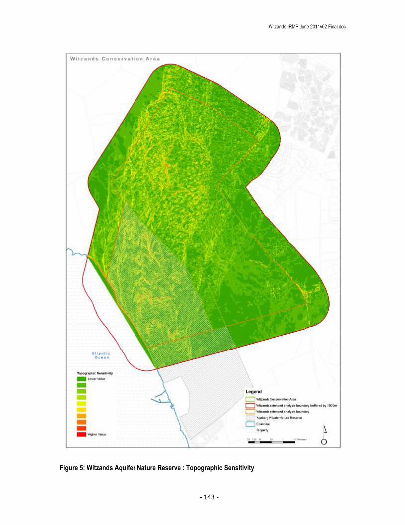
Witzands IRMP June 2011v02 Final.doc
- 143 -
Figure 5: Witzands Aquifer Nature Reserve : Topographic Sensitivity

Witzands IRMP June 2011v02 Final.doc
- 144 -
Showstoppers/fatal flaws and Special Management Area Informants
Structures or development on steeps slopes should be avoided. Generally flat, scenic landscapes should be
protected from unsightly developments that could impact on the scenic value of the site.
6 3.1.3 HYDROLOGICAL SENSITIVITY
The hydrological sensitivity layer has several purposes: to identify areas important for maintaining
hydrological processes and to identify areas where infrastructure could be damaged by flooding or high
water events.
Data inputs (GIS methods and sources)
The footprint within which the hydrological sensitivity is determined is defined by buffering the wetlands by
pre-determined distances.
Wetlands data was extracted from the City’s wetland layer.
Aquifer data was sourced from the Bulkwater Department.
Scoring, logic and rationale
There are semi-natural and natural wetlands occurring in the study area. The wetlands were buffered and
scored as detailed in Table 5.
Procedure (Wetlands)

Witzands IRMP June 2011v02 Final.doc
- 145 -
Clip the wetlands layer to the buffered boundary layer Create separate shapefiles for Natural/Semi-natural wetlands and Artificial/Modified wetlands Buffer natural and semi-natural wetlands by 50m (ensure use dissolve all) Buffer natural and semi-natural wetlands by 100m (ensure use dissolve all) Union the three wetlands shapefiles, create a new field “BUFFER”, populate with the buffer
distance value On the output shapefile create a field “WETNAT_VAL” and populate according to the value in
Table 4. Delete all unnecessary fields. Clip the shapefile to the reserve boundary
Procedure (Aquifer)
Clip the aquifer yield layer to the buffered boundary layer Add a field “AQUA_VAL” and populate according to the value in Table 5b. Delete all unnecessary fields.
Hydro sensitivity
Union the wetlands sensitivity layer and the aquifer yield layer. Add values and covert to 1-10 range using a linear conversion. Clip the shapefile to the reserve boundary Create and export map Final Hydrological sensitivity layer: WITZ_hydro_sensitivity.shp
Table 5a: Hydrological sensitivity (Wetlands)
Source Category Value Note
City
Wet
land
s la
yer
Natural wetlands, seeps and pans – actual area 10 Actual wetland area - potential for
direct disturbance.
Wetlands, seeps and pans 50m buffer 8 Close proximity to wetland.
Disturbance to faunal species.
Wetlands, seeps and pans - 100m buffer 7 High sensitivity to disruption of
hydrological and sediment transfer
processes
Table 5b: Hydrological sensitivity (Aquifer)
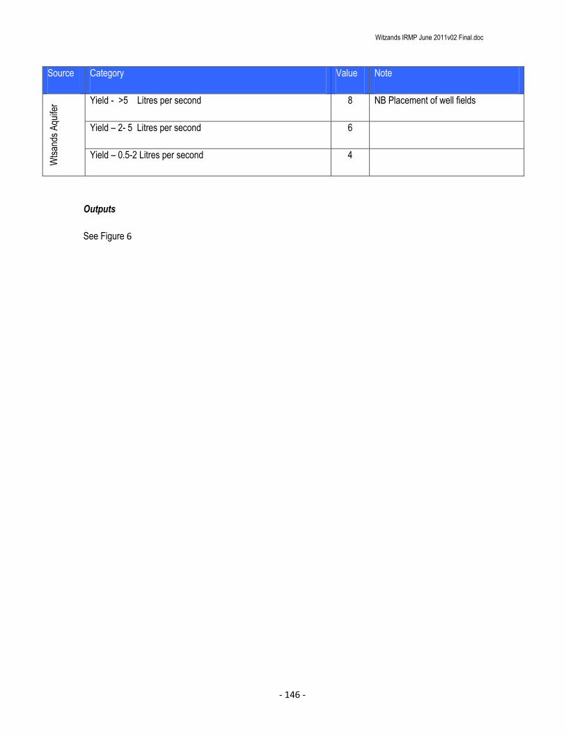
Witzands IRMP June 2011v02 Final.doc
- 146 -
Source Category Value Note
Wts
ands
Aqu
ifer Yield - >5 Litres per second 8 NB Placement of well fields
Yield – 2- 5 Litres per second 6
Yield – 0.5-2 Litres per second 4
Outputs
See Figure 6

Witzands IRMP June 2011v02 Final.doc
- 147 -
Figure 6a: Witzands Aquifer Nature Reserve : Hydrological Sensitivity (Wetlands)

Witzands IRMP June 2011v02 Final.doc
- 148 -
Interpretation in local context
The buffers applied in the analysis are generous and should be refined at a local, site level if required. The
inclusion of the aquifer yield value into the hydrological sensitivity implies that areas with a higher yield are
more sensitive to developments/disturbance than areas with a lower yield. The placement of well fields is
more likely to occur in these high yield areas.
7 3.1.4 VISUAL SENSITIVITY
This layer examines the value of the study area from a visually aesthetic perspective. Visually intrusive
development should not occur in areas with a high visual aesthetic value.
The visual sensitivity layer examines how visually intrusive a development will be in a landscape.
Data inputs (GIS methods and sources)
A viewshed analysis was run on the TIN created for the study area, using ArcMap 9.3.1 and the 3D Analyst
extension.
Scoring, logic and rationale
The visual analysis examined how visually intrusive a development or structure would be at a particular
point. Three separate variables were calculated (see Table 6).
Slope steepness was calculated based on the TIN for the study area. Slope angles were divided
into 10 equal width categories (the range was 0°-40°). These were scored in the range 1-10.
An analysis of the visibility of each site from every other site in the reserve was undertaken. A
200m grid of points within the reserve was used to define 714 viewpoints with a Z value of 1.5m
(the grid was created using the “Special Raster Tools” in Hawth’s Tools extension for ArcMap 9.3).

Witzands IRMP June 2011v02 Final.doc
- 149 -
The viewshed examines (on a proportional basis) which sites are most visible. Similar to slope
steepness, these values were divided into 10 equal width categories and scored on a 0-10 basis.
A viewshed analysis from all roads, paths and trails was undertaken. The analysis parameters
used were the same as above except for the viewpoints used.
These 3 values were added together and reclassified into the range 0-10 equal width categories to
ensure compatibility with other layers.
Table 6: Visual Sensitivity Procedure
Source Category Value Note
1. Slope Steepness
Slopes modeled in ArcGIS using Spatial Analyst
0-10 Slope angles calculated TIN created from 2m
Contours
Slopes reclassified 10 equal width
categories
Scored 1 to 10 Values converted into ten integer based
classes, with the maximum value equivalent to
slopes of over 45°
2. Grid visibility
200m grid of reserve area used as viewpoints 714 Viewpoints
0-10 Analysis based on the TIN
Reclassified 10 equal width
categories
Values converted into ten integer based
classes, with the maximum value equivalent to
visibility from 2.5% of park viewpoints.
3. Tourist viewpoint and public road visibility
All tourist roads, paths and trails used as viewpoints
0-10 Analysis based on the TIN
Reclassified 10 equal width
categories
Values converted into ten integer based
classes, with the maximum value equivalent to
visibility from 5% of park viewpoints.
Procedure:
Visual Sensitivity
Create a 100m point grid covering the buffered reserve boundary layer. Hawths tools have an easy tool for this.
Create a point shapefile using the roads and paths shapefile. Using the “feature vertices to points” tool.
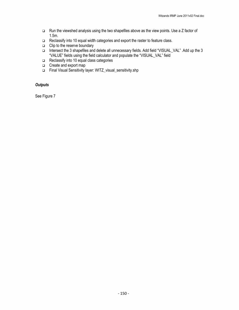
Witzands IRMP June 2011v02 Final.doc
- 150 -
Run the viewshed analysis using the two shapefiles above as the view points. Use a Z factor of 1.5m.
Reclassify into 10 equal width categories and export the raster to feature class. Clip to the reserve boundary Intersect the 3 shapefiles and delete all unnecessary fields. Add field “VISUAL_VAL” .Add up the 3
“VALUE” fields using the field calculator and populate the “VISUAL_VAL” field Reclassify into 10 equal class categories Create and export map Final Visual Sensitivity layer: WITZ_visual_sensitivity.shp
Outputs
See Figure 7

Witzands IRMP June 2011v02 Final.doc
- 151 -
Figure 7: Witzands Aquifer Nature Reserve : Visual Sensitivity

Witzands IRMP June 2011v02 Final.doc
- 152 -
Interpretation in local context
Visually intrusive structures or development should be avoided, especially where the Scenic value of an
area could be compromised.
Showstoppers/Fatal flaws and Special Management Area Informants
The viewshed analysis determines the visibility of areas from predefined observation points. However, the
visibility of a development is only one of the components that determine its visual impact. Other factors,
such as the development’s design, construction and layout also contribute to the overall impact on the
aesthetic character of its environment. Special consideration should be given to developments that are
proposed in highly visible areas.
8 4. SENSITIVITY-VALUE ANALYSIS PROCESS (INCLUDING WEIGHTINGS) AND SUMMARY LAYERS
The sensitivity-value analysis process has two key parts:
The preparation of the input layers in a consistent and easy to analyze format (as outlined in the
previous sections)
The preparation of a summary layer which allows all the input layers to be easily accessed,
interrogated, combined in a range of weightings (if necessary), and then used as a decision support tool
in a workshop situation.
Data inputs (GIS methods and sources)
The GIS process is geared to keeping the dataset flexible enough for use in a workshop situation. All input
and summary data need to be available within a single vector shapefile. The GIS method is as follows:
Clip all input summary datasets to the spatial footprint of the smallest layer. This should correspond
to the extent of the study area boundary. It is critical that all the clipped layers have the spatial
extent, even though not all the area within the layer may be included within a polygon. Areas
outside the polygons receive a 0 value in the union process so it is critical that these represent true
0 values and not gaps in the dataset.

Witzands IRMP June 2011v02 Final.doc
- 153 -
Union all datasets. This produces a composite vector shapefile containing all the data from the
underlying summary layers.
Delete all unnecessary attribute fields from the union shapefile.
Summary information is calculated for each of the fragmented polygons using simple field
calculations. A new attribute field is added for each summary weighting. Values are calculated
using the field calculator. Complex calculations can be saved as expressions.
Details of the summary calculations are given in Table 7.
Export final sensitivity layer as WITZ_sensitivity.shp
Table 7: Sensitivity-Value Weightings*
Name Field Name Composition Notes
Linear summary LINEAR Habitat Value + Special Habitat
Value + Topographic Sensitivity +
Hydrological Sensitivity + Visual
sensitivity + Heritage Value
Equal weighted summary of all
layers
Biodiversity Value BIODIV_VAL Habitat Value + Special Habitat
Value
Equal weighted summary of
biodiversity value layers
Biodiversity sensitivity
value
BIODIVSEN 2x(Habitat Value) + 2x(Special
Habitat Value) + Hydrological
Sensitivity + Visual sensitivity
Equal weighted summary of
biodiversity value and sensitivity
layers
Biodiversity Value driven
summary
BIOVALHEAV 4x(Habitat Value) + 4x(Special
Habitat Value) + Hydrological
Sensitivity + Visual sensitivity +
Heritage sensitivity
Layer which emphasizes the
biodiversity value of a site, and
hence is strongly influenced by the
distribution of rare and threatened
habitats and species, as well as by
patterns of transformation across
the landscape.
Balanced summary BALANCED 2x(Habitat Value) + 2x(Special
Habitat Value) + Topographic
Sensitivity + Hydrological
Sensitivity + Visual sensitivity +
Heritage Sensitivity
This is the favoured layer which
emphasizes biodiversity value and
aesthetic considerations, and de-
emphasizes biodiversity sensitivities

Witzands IRMP June 2011v02 Final.doc
- 154 -
*Not all layers may be required as in the table
Outputs
See Figure 8
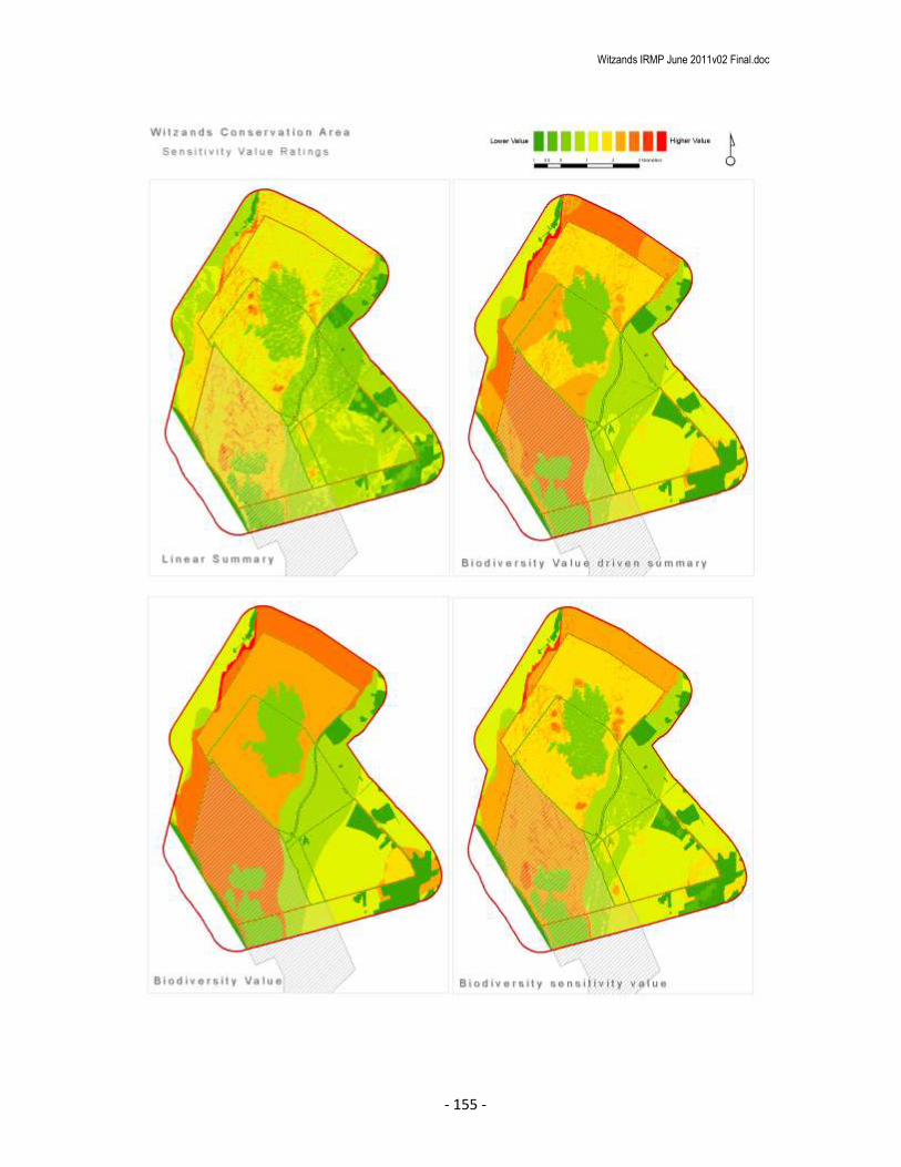
Witzands IRMP June 2011v02 Final.doc
- 155 -

Witzands IRMP June 2011v02 Final.doc
- 156 -
Figure 8: Examples from the outputs from the sensitivity–value analysis process using different weightings
(See Table 7)
Interpretation in local context
The combined range of weightings presented in Table 6 and Figure 7 indicate no significant difference in
outcome of the summary layers. This is a typical scenario of areas with high levels of biodiversity sensitivity
and relatively uniform topographic variability (Holness, 2008).
The inclusion of the aquifer yield value in the hydrological sensitivity value has attempted to account for the
underlying importance and critical link between, water resource protection, aquifer dependant ecosystem
protection and ecosystem functioning at a landscape level.
The Balanced Summary weighting (see Figure 8) was used as the sensitivity analysis input for the zonation
process.

Witzands IRMP June 2011v02 Final.doc
- 157 -
Figure 9: Sensitivity Analysis: Balanced Summary

Witzands IRMP June 2011v02 Final.doc
- 158 -
9 5. ZONING PROCESS
9.1 5.1 ZONING INFORMANTS
This section briefly outlines the values underlying the identification of broad tourism use zones. It is
important to remember that the landscape/biodiversity analysis is just one of the informants in the zonation
process. Although the biodiversity analysis is intrinsically a relatively objective scientific process, other
informants to the zoning process are not. Although every attempt is made to place high sensitivity-value
sites into more protected zones where possible, the zoning process is in its essence a compromise between
environment and development. In particular, often the identified high value sites are the key biodiversity
assets that need to be made available in an appropriate manner to the ecotourism market. Direct links
between the biodiversity layers and the spatial management of the reserve are made during the
identification of special management areas (Where applicable). Even within broad high tourist use zones,
there are likely to be areas subject to very tight conservation controls (potentially including complete
exclusion of human impacts from an area).
Underlying decision making rules used in the zonation process:
The zonation process is aimed a striking a balance between environmental protection and the
development required to meet the broader economic and social objectives of the reserve.
The zoning process takes into account existing development footprints and tourism access routes.
This is based on the underlying principle that all else being equal, an existing transformed
site is preferable to a greenfields site from a biodiversity perspective.
Infrastructure costs are dramatically increased when developments take place away from
existing infrastructure.
Existing tourism nodes and access routes are a reality of the economic landscape, and it
is would not be possible to shut down existing tourism sites compromising the
development objectives of the reserve.
Where existing development nodes, tourist sites and access routes occur in areas with high
sensitivity-value, then the broad use zoning aims to keep the development footprint as small as is
realistically possible, preferably within the existing transformed site.
Where possible, sites with high biodiversity sensitivity-value are put into stronger protection zones.

Witzands IRMP June 2011v02 Final.doc
- 159 -
Peripheral development is favoured and where possible should be located outside of the
conservation area.
Two key points need to be emphasized:
The designation of a broad use zone does not imply that all sites within that zone would be suitable
for all the development types anticipated within that use zone. Detailed site level planning is still
required, and many sites may prove to be unsuitable at a site/precinct/EIA level of planning.
Special Management Areas/Overlays need to be formalized and the links made to the
management plans.
(Adapted from Holness, 2008)
9.2 5.2 ZONING DEFINITIONS AND DESCRIPTIONS
The zonation definitions and descriptions were workshopped with reserve and area managers. Four
categories were decided on, namely; Primary Conservation zone, Conservation zone, Low Intensity leisure
zone and High Intensity leisure zone. Table 11 outlines the proposed zonation and zone descriptions. The
link is still made to the Zonation used for the CapeNature Reserves (Holness, 2008) as there should be
general alignment of the broader use zones for ease of comparison and integration if required in Provincial
documents.

Witzands IRMP June 2011v02 Final.doc
- 160 -
9.3 5.3 DRAFT ZONING OUTPUTS
A zonation workshop was held at the 38 Wale Street on the 20th November 2010. The zonation for the
Witzands Aquifer Nature Reserve was drawn up using the balanced summary weighting as an input in
applying the Zonation categories as defined in Table 11. Figure 10 shows the draft zonation for the
Witzands Aquifer Nature Reserve.
Table 8 shows the breakdown per zonation category and the % of the total per category.
Table 8: Breakdown (in HAs and % of Area) of the 5 Zonation Categories in the reserve
Zonation category Area Has % of Area
Conservation 1724.16 97
Utility 52.2 3
Total 1776.4

Witzands IRMP June 2011v02 Final.doc
- 161 -
Figure 10: Draft Zonation for the Witzands Aquifer Nature Reserve

Witzands IRMP June 2011v02 Final.doc
- 162 -
9.4 5.4 SPECIAL MANAGEMENT OVERLAYS
Overlay zones are applied to different areas of the reserve requiring special management intervention.
Overlay management zones are applied to areas of national, regional or reserve based importance for
example: RAMSAR SITE or IBA (important Bird Areas), NB cultural sites or Natural resource consumptive
use areas (Medicinal Plants) and specific recreational use areas that are located with conservation zones.
The potential special management overlays are:
1. Heritage
2. Special Conservation
a. This special management overlay defines areas around known locations of critically
endangered species or species requiring specific management interventions.
3. Rehabilitation
a. Areas identified for restoration and rehabilitation
4. Recreation Overlay
a. Recreational Activities on and surrounding the mobile dune sand sheets.
5. Well Field and pipeline Management
a. Areas requiring specific management around utility infrastructure.
5.4.1 Well Field and Pipeline Special Management Area
The Witzands well field is located within the Conservation Zone, however the management
requirements for each well site (Borehole) needs to be accommodated.
The area surrounding the well field is also extremely vulnerable to pollution from external
sources and for this reason this area should remain a restricted access area.
The associated water pipelines also require routine maintenance and management.
Activities include:
Maintaining the areas around the immediate vicinity of the well points free and clear
of vegetation and obstructions.
Maintaining of access routes to well sites.

Witzands IRMP June 2011v02 Final.doc
- 163 -
Maintenance of the actual boreholes (to prevent or rehabilitate if they have become
clogged.
The placement of new borehole sites may also occur within this zone (subject to all
necessary authorisations etc.)
5.4.2 Oil pipeline Special Management Area
The Caltex oil pipeline which runs down the R27 inside the conservation area must remain
a restricted area. Contingency and emergency response plans need to be put in place
with immediate effect.
5.4.3 Recreational Use Special Management Area
The use of the dune fields by recreational users is having an impact on the landscape. The
potential for groundwater contamination from pollutants is great, but needs to be investigated
and quantified. At present there are no facilities for recreational users, meaning ablutions etc
are happening all over. There is also a lack of control and illegal access onto the dunes and
surrounding areas. The destruction of sensitive Dune Strandveld vegetation is also a huge
concern.
This area has been zoned for conservation as it is an extremely important feature in the
landscape. However, it has been noted that the recreational value of this area for 4X4 users,
film/location shoots and other recreational uses should be accommodated, but in a manner
than has the smallest possible impact on the environment.
The unconfined nature of the Atlantis Aquifer and the shallow depth to the water table, make
the groundwater resource particularly vulnerable to pollution.
At present the impact of recreational use of the dune fields is unquantified, however there
exists serious potential of a disastrous pollution event from a vehicle burning out or releasing
contaminants (oil or fuel) into the aquifer.
Immediate measures need to be put in place to restrict the number of vehicles accessing the
dune field to a minimum, until such time as an operational plan is developed for this activity.

Witzands IRMP June 2011v02 Final.doc
- 164 -
January 2005

Witzands IRMP June 2011v02 Final.doc
- 165 -
March 2009
Figure 11: Uncontrolled destruction of sensitive dune vegetation by vehicles

Witzands IRMP June 2011v02 Final.doc
- 166 -
Figure 12: Witzands Aquifer Nature Reserve Special Management Overlay zones

Witzands IRMP June 2011v02 Final.doc
- 167 -
10 6. CONCLUSIONS AND RECOMMENDATIONS
The importance of the Witzands aquifer cannot be underestimated. It has an estimated replacement cost of
R257 466 667 for a pipeline from the Voelvlei dam or a staggering R675 300 000 for the installation of a
desalination plant.
The control of 4X4 vehicles requires urgent attention and action.
The expansion of the reserve to include the entire open dune sheet should be a priority conservation action.
The reserve also requires a perimeter fence and staff to control access.
11 7. REFERENCES
Benn, G. 2008. Terrestrial Systematic Conservation Plan re-Analysis: Methods and results. City of Cape
Town Internal report.
CSIR. 2002. Altlantis Aquifer. A Status Report on 20 years of groundwater management at Atlantis.
Driver, A., Maze, K., Rouget, M., Lombard, A. T., Nel, J., Turpie, J. K., Cowling, R.M., Desmet, P.,
Goodman, P., Harris, J., Jonas, Z., Reyers, B., Sink, K. & Strauss, T. 2005. National Spatial Biodiversity
Assesment 2004: Priorities for biodiversity conservation in South Africa. Strelitzia 17. SANBI, Pretoria.
Holness, 2005. Sensitivity Value Analysis Manual. A decision support tool, operating on the principles of
systematic conservation planning, for integrating best available biodiversity knowledge into spatial planning
within national parks. SANParks Internal Report.
Holness, S. Skowno, A. 2008. Report on Sensitivity-Value Analysis and Zonation Process for the Boland
Mountain Complex. CapeNature Conservation Internal report.

Witzands IRMP June 2011v02 Final.doc
- 168 -
CCT Internal Report. 1996. Atlantis Water Scheme. Environmental Management System. Compiled by
Knightly, Hall, Hendry and Associates.
Low, A B & Pond, U (2004). Mapping of coastal dunes within the City of Cape Town
metropolitan area. Coastec, Rondebosch
National Environmental Management: Biodiversity Act (NEMBA). 2004 (Act No. 10 of 2004). Draft National
List of Threatened Ecosystems.
Rebelo A. G., C. Boucher, N. Helme, L. Mucina, M.C. Rutherford et al. 2006. Fynbos Biome, in: L. Mucina &
M.C. Rutherford (eds). The Vegetation of South Africa, Lesotho and Swaziland. Strelitzia 19, pp 52-219.
SRK Consulting. 2008. Final Conservation Development Framework for Settlers Park Nature Reserve.
Nelson Mandela Bay Municipality. Internal report.
SRK Consulting. 2008. Final Conservation Development Framework for Van Stadens Wildflower Nature
Reserve. Nelson Mandela Bay Municipality. Internal report.
Snaddon, K. Day, L. Nel, J. Maherry, A. 2009. Prioritisation of City Wetlands. City of Cape Town Report.
Tinley, K L (1985). Coastal dunes of South Africa. South African National Scientific
Programmes Report no. 109. CSIR, Pretoria.

Witzands IRMP June 2011v02 Final.doc
- 169 -
12 APPENDICES
12.1.1 Table 9: Base values: Ecosystem Status of National vegetation types occurring in the City
Vegetation Type
NSBA
Conservation
Status
NSBA
Conservation
Status - Score
Criterion D
Status
Criterion
D score
SANBI Conservation
Status (% target
Conserved in City)
Conservation
Status Score
Atlantis Sand Fynbos Vulnerable 6
Critically
endangered 10 Not Protected 5
Boland Granite Fynbos Endangered 8 Vulnerable 6 Poorly Protected 3
Cape Estuarine Salt Marshes
Least
threatened 4 Well Protected -1
Cape Flats Dune Strandveld:
False bay Endangered 8 Endangered 8 Poorly Protected 3
Cape Flats Dune Strandveld:
West Coast
Least
threatened 4 Endangered 8 Poorly Protected 3
Cape Flats Sand Fynbos
Critically
endangered 10
Critically
endangered 10 Hardly Protected 4
Cape Lowland Freshwater
Wetlands
Least
threatened 4 Well Protected -1
Cape Winelands Shale Fynbos Endangered 8 Poorly Protected 3
Elgin Shale Fynbos
Critically
endangered 10 Hardly Protected 4
Hangklip Sand Fynbos Vulnerable 6 Vulnerable 6 Well Protected -1
Kogelberg Sandstone Fynbos
Least
threatened 4
Critically
endangered 10 Moderately Protected 2
Lourensford Alluvium Fynbos
Critically
endangered 10
Critically
endangered 10 Poorly Protected 3
North Peninsula Granite
Fynbos
Least
threatened 4 Well Protected -1
Peninsula Sandstone Fynbos
Least
threatened 4 Endangered 8 Well Protected -1
Peninsula Shale Fynbos Vulnerable 6 Well Protected -1
Peninsula Shale Renosterveld
Critically
endangered 10 Poorly Protected 3
South Peninsula Granite
Fynbos Endangered 8 Moderately Protected 2
Southern Afrotemperate
Forest
Least
threatened 4 Well Protected -1

Witzands IRMP June 2011v02 Final.doc
- 170 -
Swartland Alluvium Fynbos
Critically
endangered 10 Not Protected 5
Swartland Granite
Renosterveld
Critically
endangered 10
Critically
endangered 10 Hardly Protected 4
Swartland Shale Renosterveld
Critically
endangered 10
Critically
endangered 10 Hardly Protected 4
Swartland Silcrete
Renosterveld
Critically
endangered 10 Not Protected -1
Western Shaleband
Vegetation
Least
threatened 4 Poorly Protected 3

Witzands IRMP June 2011v02 Final.doc
- 171 -
12.1.2 Table 10: National vegetation types for the City of Cape Town showing historic extent, remaining extent, targets and targets achieved inside and outside Protected Areas
National Vegetation Type
Historic extent (ha)
Current extent (ha)
Selected in B
ionet
(ha)
Target %
Target (ha)
Extent in proclaim
ed
Protected A
reas
Target m
et in
selected Bionet
% T
arget conserved
% T
arget met in
proclaimed P
rotected
Areas
% S
elected in Bionet
from current extent
% R
emaining from
historic extent
15% of historic extent
% that is not selected
in Bionet
Conservation S
tatus
SA
NB
I Conservation
Status
Atlantis Sand Fynbos 25234.63 15711.95 12695.95 30 7570.39 0.00 Yes 168 0 81 62 3785.19 19 VU Not Protected
Boland Granite Fynbos 9575.31 6064.19 4807.17 30 2872.59 354.52 Yes 167 12 79 63 1436.30 21 EN Poorly Protected
Cape Estuarine Salt Marshes 39.86 25.79 25.64 24 9.57 25.64 Yes 268 268 99 65 5.98 1 LT Well Protected
Cape Flats Dune Strandveld: False
Bay 27260.11 8467.86 7272.84 24 6542.43 1855.58 Yes 111 28 86 31 4089.02 14 EN Poorly Protected
Cape Flats Dune Strandveld: West
Coast 12700.27 10603.88 6892.82 24 3048.07 964.79 Yes 226 32 65 83 1905.04 35 LT Poorly Protected
Cape Flats Sand Fynbos 54410.34 8466.70 8464.75 30 16323.10 464.07 No 52 3 100 16 8161.55 0 CE Hardly Protected
Cape Lowland Freshwater
Wetlands 1463.98 1095.47 1068.83 24 351.36 786.66 Yes 304 224 98 75 219.60 2 LT Well Protected
Cape Winelands Shale Fynbos 2666.97 1706.19 1388.97 30 800.09 217.89 Yes 174 27 81 64 400.05 19 EN Poorly Protected
Elgin Shale Fynbos 841.18 321.14 282.77 30 252.35 4.58 Yes 112 2 88 38 126.18 12 CE Hardly Protected
Hangklip Sand Fynbos 3301.60 1910.25 1489.88 30 990.48 1363.63 Yes 150 138 78 58 495.24 22 VU Well Protected
Kogelberg Sandstone Fynbos 9499.63 9260.73 8814.04 30 2849.89 1944.47 Yes 309 68 95 97 1424.94 VU LT Moderately Protected
Lourensford Alluvium Fynbos 4819.25 409.97 409.97 30 1445.77 190.30 No 28 13 100 9 722.89 0 CE Poorly Protected
North Peninsula Granite Fynbos 1997.35 1439.12 1343.54 30 599.21 986.44 Yes 224 165 93 72 299.60 7 LT Well Protected
Peninsula Sandstone Fynbos 21896.12 21348.95 20761.60 30 6568.83 17306.57 Yes 316 263 97 98 3284.42 3 LT Well Protected
Peninsula Shale Fynbos 1262.79 690.37 688.96 30 378.84 686.97 Yes 182 181 100 55 189.42 0 VU Well Protected

Witzands IRMP June 2011v02 Final.doc
- 172 -
Peninsula Shale Renosterveld 2374.81 316.89 316.89 26 617.45 261.67 No 51 42 100 13 356.22 0 CE Poorly Protected
South Peninsula Granite Fynbos 7148.66 2481.74 2290.70 30 2144.60 1770.19 Yes 107 83 92 35 1072.30 8 EN Moderately Protected
Southern Afrotemperate Forest 347.52 346.79 346.79 34 118.16 276.80 Yes 294 234 100 100 52.13 0 LT Well Protected
Swartland Alluvium Fynbos 1742.41 75.91 75.91 30 522.72 0.00 No 15 0 100 4 261.36 0 CE Not Protected
Swartland Granite Renosterveld 8059.16 1951.89 1951.89 26 2095.38 35.64 No 93 2 100 24 1208.87 0 CE Hardly Protected
Swartland Shale Renosterveld 46712.40 4019.33 4018.76 26 12145.22 408.13 No 33 3 100 9 7006.86 0 CE Hardly Protected
Swartland Silcrete Renosterveld 1066.65 188.43 188.43 26 277.33 0.00 No 68 0 100 18 160.00 0 CE Not Protected
Western Shaleband Vegetation 328.59 328.57 328.57 30 98.58 31.11 Yes 333 32 100 100 49.29 0 LT Poorly Protected
244749.59 97232.12 85925.67 68622.40 29935.65 36712.44

Witzands IRMP June 2011v02 Final.doc
- 173 -
12.1.3 Table 11: City of Cape Town Nature Reserves and Conservation Areas: Visitor Use Zoning - Desired State* & Experiential Qualities
Experience Zone Desired State* Conservation objectives Secondary objective Experiential
Qualities Activities
Interaction
between
users
Frequency of use Group size Sophistication and type of
facilities
Primary user
movement
within the zone
Roads & footpaths
Equivalent
Provincial
zone
Close To
Nature
Activities tend
to be at
landscape
level
Primary
conservation
Natural or near-natural areas (or areas that can
be rehabilitated to this state) that are managed
primarily for biodiversity conservation. The
experience is one of relative solitude and
wildness. The nature of the experience is
dependant on the quality of the natural
environment. The main accent of management
is biodiversity conservation and "Pack it in Pack
it out" principles are applied to all activities
including management. There may be some
signs of infrastructure mainly of a heritage
nature. In the longer term, unused utility
infrastructure (e.g. reservoirs) should be
phased out and the site rehabilitated.
Natural areas should be kept
intact in order to protect habitat
required to meet biodiversity
targets for various vegetation
types and to provide undisturbed
habitat for a range of species.
Where possible degraded areas
should be rehabilitated.
Managed to provide visitor
experiences in a way that
does not impact on the
biodiversity objective.
Where appropriate
heritage values are
managed as required
Relative sense
of isolation
Controlled access**
Research and monitoring.
Accompanied small groups.
The size and frequency of
groups to be specified for each
reserve.
None or
very low
None -Very low Small
No new facilities.
Existing structures should be
phased out where appropriate.
Heritage assets are managed where
appropriate
Pedestrian
access in
accompanied
small groups
Motorised for
essential
management
only.
Absolutely essential
management tracks and
footpaths in accordance with the
foot path and road management
plan
Ongoing restoration of old
paths/roads to be prioritized and
monitored.
Quiet
Conservation
Natural or near-natural areas (or areas that can
be rehabilitated to this state) that are managed
for biodiversity conservation. This zone
provides experiences of a relative sense of
relaxation in an environment that is openly
exposed to the sights and sounds of the city.
Although it is a place of quietness and
naturalness, there will be more interaction
between users than in the Primary
Conservation Zone. The quality of the
experience is less dependant on the quality of
the natural environment.
Natural areas should be kept
intact in order to protect habitat
required to meet biodiversity
targets for various vegetation
types and to provide undisturbed
habitat for a range of species.
Where possible degraded areas
should be rehabilitated.
Managed to provide visitor
experiences in a way that
does not impact on the
biodiversity objective.
Relaxation Self guided hiking, non-
motorised access ***, bird
watching, etc.
In reserves where access to
water bodies is allowed, this
area is limited to non-motorized
vessels only in accordance with
the Vlei By-Laws.
Moderate Moderate Small Low impact, eco-friendly facilities
that facilitate ecologically
sustainable activities and visitor
experiences may be permitted
under certain circumstances. These
are strictly for achieving the social
and development objectives of the
reserve where appropriate and are
subject to a stringent internal
approval process and must be inline
with an approved reserve
management plan.
Pedestrian
Non motorised
Motorised
access for
management
only.
Management tracks/roads and
footpaths. Minimal footpath
construction to prevent ecological
damage. Boardwalks may be
permitted where appropriate to
protect sensitive areas. The
footpath system should be
designed so as to control access
into the Primary Conservation
zone.
Off road wheelchair access may
be provided where appropriate.
Outdoor
Natural
Experience
Activities tend
to be at
precinct level
Low
Intensity
leisure
Natural, near-natural or managed landscapes
which are primarily managed to promote
recreational and educational objectives. The
main accent is on recreational activities which
are more reliant on the quality of the facilities
provided than in a Conservation Zone. By their
nature these zones are placed in more
transformed landscapes. Interaction and
socialisation are an integral part of the
experience.
Although some areas will be
impacted by a range of activities
and limited infrastructure, most
areas should be kept largely
intact and ecological processes
should remain functioning.
Where possible degraded areas
should be rehabilitated.
Recreation and education
Managed to provide a
largely natural outdoor
area to support the
recreational and education
objectives of the reserve.
Socialisation Walking, non-motorised access,
bird watching. In reserves
where access to water bodies is
allowed, motorized vessels are
only allowed under strict control
(e.g. no waterskiing, low speed
limits and wake-free zones) in
accordance with the Vlei By-
Laws.
Frequent Moderate -high Small-
moderate
Low-Medium impact, eco-friendly
facilities that facilitate ecologically
sustainable activities and visitor
experiences.
E.g. Benches, bird hides,
informative signage, lookouts.
Parking for access to this and other
zones.
Pedestrian
Non motorised
Motorised
access for
management
only
Appropriate foot paths with
directional signage
Boardwalks should facilitate
access and protect sensitive
areas.
Normal wheelchair access where
appropriate
Parking with no facilities for
access to this and other zones
Low
intensity
leisure
High
Intensity Use
High use landscapes, which are often largely
transformed, which are managed largely to
support visitor activities more dependent on
facilities, education and administrative functions
of reserves. High intensity visitor facilities with
modern commercialised amenities with very
concentrated, activities. The quality of the
visitor experience is heavily dependant of the
quality of the facilities which enable the visitor
to experience the environment with a minimum
of effort. Due to the high impacts these are
concentrated at specific nodes. These nodes
are generally situated at existing facilities
including historic buildings and precincts. The
main focus of management is to ensure a high
quality visitor experience whilst ensuring that
the activities have a minimal impact on the
surrounding environment and that heritage
The activities and infrastructure
in these areas should be
managed to minimize impacts on
biodiversity and visitor
experience in other zones.
Where feasible, non-crucial
infrastructure should over time
be removed from the reserve and
the sites rehabilitated.
Facilities are managed to
facilitate and promote
appropriate visitor activities
and educational use of the
reserve.
Administration;
provides appropriate
management infrastructure
to facilitate other objectives
of the reserve.
Entertainment Events, self guided walks,
wheelchair accessible trails,
parking, picnicking. In reserves
where access to water bodies is
allowed, this area is appropriate
for high intensity uses such as
power boating and waterskiing
in accordance with the Vlei By-
Laws.
Very
frequent
Very high Small -
Large
Picnic areas, parking areas,
restaurants, information centers,
ablutions, environmental education
facilities, nurseries etc. Provides
parking from which pedestrian
access is gained to other zones.
Motorised
Access
People movers
& Pedestrian
access
Access roads and associated
parking.
Footpaths constructed to a
higher standard for the comfort of
the user. Design standards to be
set in the footpath and road
management plan Wheelchair
access encouraged in this zone. High
Intensity
Leisure

Witzands IRMP June 2011v02 Final.doc
- 174 -
resources are respected and celebrated.
Site
Specific
Level
Utility zone
Area used for utility functions such as bulk
water provision, landfill sites within the
protected /conservation areas etc.
The activities and infrastructure
in these areas should be
managed to minimize impacts on
biodiversity and visitor
experience in other zones.
Where feasible, non-crucial
infrastructure should over time
be removed from the reserve and
the sites rehabilitated.
Administration
Conservation where
appropriate
Utility Determined at site Determined
at site
Determined at site Determined
at site
Determined at site Determined at
site level
Access roads and associated
parking as required by the Utility
Function
* Note. The "Desired State" is the long term objective of the zone and these desired conditions may not actually exist at the time of zoning. Achieving the" Desired State" will be informed by many factors and may only be reached after many years.
** Accompanied access refers to controlled access. The level and type of control is determined at reserve level.
*** Non-motorised access refers to mountain bikes, horses, paragliding etc. These activities are reserve specific and reference must be made to the reserve management plan for a list of acceptable activities per reserve.

Witzands IRMP June 2011v02 Final.doc
- 127 -
Appendix 9: Security Audit
CITY OF CAPE TOWN
BIODIVERSITY MANAGEMENT BRANCH
Executive Brief
Comprehensive Security Audit of the Biodiversity
Management Branch of the City of Cape Town
MARCH 2010
T H O R N - E X
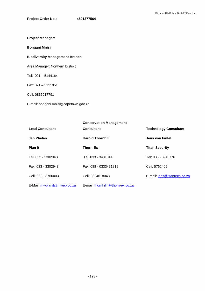
Witzands IRMP June 2011v02 Final.doc
- 128 -
Project Order No.: 4501377564
Project Manager:
Bongani Mnisi
Biodiversity Management Branch
Area Manager: Northern District
Tel: 021 – 5144164
Fax: 021 – 5111951
Cell: 0835917791
E-mail: [email protected]
Lead Consultant
Conservation Management
Consultant Technology Consultant
Jan Phelan
Plan-It
Tel: 033 - 3302948
Fax: 033 - 3302948
Cell: 082 - 8760003
E-Mail: [email protected]
Harold Thornhill
Thorn-Ex
Tel: 033 - 3431814
Fax: 088 - 0333431819
Cell: 0824618043
E-mail: [email protected]
Jens von Fintel
Titan Security
Tel: 033 - 3943776
Cell: 5762406
E-mail: [email protected]

Witzands IRMP June 2011v02 Final.doc
- 129 -
TABLE OF CONTENTS
1. Introduction ........................................................................................................................... 130
2. Approach .............................................................................................................................. 130
3. Executive Summary .............................................................................................................. 132
4. Conclusion and generic recomendations .............................................................................. 136
5. Summary of recommendations ............................................................................................. 133
6. Costing ................................................................................................................................. 139

Witzands IRMP June 2011v02 Final.doc
- 130 -
13 INTRODUCTION
The City of Cape Town’ Biodiversity Management Branch, in wishing to ensure the safety of visitors and
staff, requested assistance on conducting a security audit of all (25) its managed (and envisaged) Nature
Reserves.
The need was based on the following assumptions:
That the areas are poorly managed
Security Agencies are inefficient in their operations
The lack of tools to measure management effectiveness
Safety and security of visitors as well as that of personnel are threatened.
Plan-It, in collaboration with Thorn-Ex and Titan Security, agreed to undertake the project. Owing to the
budgetary constraints, it was agreed that the audit would encompass 12 priority Reserves, as selected by
the Biodiversity Management Branch.
The following outcomes were proposed and accepted:
A desktop exercise to evaluate existing information and identify gaps
A physical Audit of the listed facilities
Consultation with public user groups
Recommendations in respect of security technology and infrastructure
A comprehensive report on all findings
A basic entry level conservation security training session for staff
The project was to be completed by the end of April 2010.
14 APPROACH
The focus was to be on the safety and security of staff working in the different reserves, of visitors to theses
reserves and of the biodiversity within the reserves.
The audit was to involve the reserve managers, site managers and any other staff the Biodiversity
Management Branch deemed necessary to provide information for the audit.
The Project commenced with the Branch being approached to supply maps of each reserve with as much
information as possible on all types of infrastructure, bio-physiographic information etc e.g. boundaries of
reserves and kind of fence along these, access points, roads, tracks, paths, power lines, telephone lines,
buildings, cell phone towers, masts, aerials, bridges, streams, rivers, contours, vegetation, adjacent land
use, habitation or settlements in close proximity.

Witzands IRMP June 2011v02 Final.doc
- 131 -
Questionnaires were then drawn up and sent to all the Reserve Managers as well as separate
questionnaires which were sent to the various public interest groups, via the Reserve Managers.
Upon receipt of the above the project team drafted a preliminary working document to guide and focus the
audit.
The audit commenced on the 15th of February 2010 with a workshop with the various Managers and a
presentation of the findings from the questionnaires to the Biodiversity Branch.
The audits commenced on the 16th of February 2010 with a visit to each Reserve..
During each audit the manager and staff were interviewed and a physical inspection of infrastructure was
conducted. The audits focused on existing security systems, security infrastructure, activities, incidents, job
descriptions, training and manpower
In addition to the audits workshops were scheduled, via the Reserve Manager with relevant external safety
and security institutions and public interest groups. The workshops were then held with various District and
Reserve-specific public interest groups.
On conclusion of the audit phase, the security technology specialist visited the Reserves to inspect the
systems and infrastructure in place at each reserve. Based on and with reference to the initial draft Audit
Report, the specialist undertook an assessment of technology short-comings in order to arrive at feasible
recommendations for practicable improvements.
The completed report was then circulated to all the Reserve Managers as a Draft Report for comment, prior
to the Final Comprehensive Report incorporating such comment being presented to the Branch.
The Project was then concluded with a basic entry level security training session for nominated staff
covering aspects such as:
Information gathering and reporting
Patrol structuring, planning and safety
Preparedness and response
Handling of transgressors (armed or un-armed)
Incident handling
Charge office procedures
Evidence and Statements
Record keeping and dossier development

Witzands IRMP June 2011v02 Final.doc
- 132 -
15 EXECUTIVE SUMMARY
A safety and security audit was carried out on twelve Reserves under the jurisdiction of the Biodiversity
Branch of the Directorate Environmental Resource Management.
The Audit was aimed at doing a rapid and verifiable analysis of the current security situation, security
services, infrastructure, staffing, and social contexts. The information allowed for a “threat” level to be
determined for each reserve.
Information acquired through a questionnaire survey with the Reserve Mangers, and information provided
by the Branch was used as a baseline to guide and provide focus for the individual Reserve audits.
The Audits very quickly revealed that the location of the various reserves with their own unique social
contexts primarily dictated the level of threat of each Reserve.
Some Reserves perceived as being “dangerous” were found to be “safe” with very low key incidents
actually occurring. Although social ills do tend to spill over into Reserves the occurrence thereof is very
localised and relate to prostitution, substance abuse, theft and illegal plant harvesting for the muti trade.
General security observations revealed that any metal infrastructure or equipment and solar panels are at
greatest risk and are stolen on a regular basis. Trespassing, vagrants traversing the reserves and the
harvesting of plants for the commercial flower industry and commercially driven herbal medicine /”muthi”
industry are linked to an associated threat to staff and visitors. However incidents of visitors and staff being
accosted by vagrants are rare.
Security activities were generally viewed as an add-on function when incidents are reported, with some
Reserve Managers and Field staff trying to fit security patrols and activities into their management work
schedule. The Visitor Controller Officers, on the other hand are essentially Access Control Officers who
may be called on to perform some Law Enforcement function if their training enables them to do so.
However staff does carry out combined operations with Law Enforcement bodies like Marine and Coastal
Management, SAPS or City Law Enforcement when activities in the vicinity of the reserves warrant this in
the interests of conservation.
One of the most evident security shortcomings found was that Reserves were “abandoned”, for all practical
purposes, after hours, on weekends and on public holidays.
The investigation also found that very few Reserves actively patrol the Reserve and fences on a regular
basis.
The Findings of each audit, including the responses received form the public interest groups were used to
determine the threat level of each Reserve. The threat levels are based on a combination of factors which
may affect security to the reserve, its staff and visitors as well as these threats in relation to other reserves.

Witzands IRMP June 2011v02 Final.doc
- 133 -
The threat levels low, medium, and high reflects the safety threat to visitors, staff, and infrastructure.
Further to which the threat level provides an indication in respect of intervention priority (staffing,
infrastructure, equipment).
The results were as follow:
Understaffing and poor or non-existent boundaries were found to be the primary cause of compromised
Reserve security. The provision of “feet on the ground” or a management presence is therefore viewed as
the first step towards improving the current situation.
The Investigation did conclude that technology solution options entailed fairly low key equipment such as
Day-Night or Peak Inversion monitoring cameras, basic building alarm systems, external building detection
beams, lighting, etc.
Infrastructure requirements were predominantly in respect of fencing.
Fencing is not always the preferred solution for safeguarding and demarcating an urban Reserve. However,
it is suggested that failure to demarcate the boundaries of a Reserve compromises the authority’s ability to
manage a designated area and severely limits the authority’s ability to prosecute transgressors. Simple in-
expensive measures such as signage and markers will greatly aid in addressing these matters.
Reserve Threat Level Threat Primary Cause
Witzands ACA Medium Illegal Access / Trespassing Lack of fencing
Blaauwberg CA Medium Illegal Access / Trespassing Lack of coverage
Rietvlei WR Low Illegal Access / Trespassing Lack of coverage
Durbanville NR Low Theft Lack of presence
Bracken NR Low Trespassing Lack of coverage
Tygerberg NR High Trespassing / poaching Lack coverage
Zandvlei NR Low Illegal Access / Trespassing State of infrastructure
Falls Bay EP High Violent crime Lack of fencing
/coverage
Edith Stephens WP Low Theft Lack of fencing
Wolfgat & Macassar
NR Severe Violent crime Location & Social
Kogelberg NR Medium Illegal Access / Trespassing Extent / coverage
Helderberg NR Low Illegal Access / Trespassing Lack coverage

Witzands IRMP June 2011v02 Final.doc
- 134 -
The relative “newness” of the Branch was found create various generic management challenges which
negatively affect the efficiency and effective of Reserve management.
The aforesaid institutional matters included:
Lack in consistency of staff designations
Lack of consistency in functional content (job descriptions)
Lack of career pathing and skills development program
Lack of measurable performance standards
Lack of training and capacity building
Lack of uniform operational procedures and protocols
Un-clear performance objectives of Advisory Boards
Jurisdictional uncertainties in respect of cooperation with other environmental law enforcement
agencies
Lack of memorandums of Understanding with Utility Service Branches active in Reserves
The apparent absence of a clear and definitive Branch Policy on Reserve Safety and Security was viewed
as a contributing shortcoming. Further to which, no consistency was found in respect of operational
procedures or protocols. Some stations had a Management Plan whilst others were still going to develop
such plans. Some stations had developed their own safety procedures.
In respect of Procedures and Protocols it is suggested that the Biodiversity branch consider the developing
the following procedures and protocols;
Incident response (poaching, trespassing, theft, fire, attack, medical emergency, land invasion,
pollution, un-wanted pets)
Reserve patrols
Fence and gate security
Visitor control
It is suggested that the above procedures and protocols be developed in conjunction with an auditable
reserve management system which is linked to the personnel and finance performance requirements. It is
also recommended that the Branch conduct an Institutional “Governance Audit” to guide the above
protocols, relationships with other government institutions and law enforcement bodies as well as the
Branch’s legal obligations.
Consultation with public interest groups and reserve managers highlighted the benefits of “friend” groups.
Some stations financial ability and conservation maintenance activities were greatly enhanced by such
“friends” groups. Further to which, the social role that urban reserves play as “safe areas” for people to walk
their pets, have picnics or conduct social functions was highlighted at several public meetings. It was also
mentioned that in some areas where “gang turf” issues were dominant the reserves were viewed as
“neutral” territories.

Witzands IRMP June 2011v02 Final.doc
- 135 -
Advisory Boards are a requirement in terms of reserves proclaimed under the Protected Areas Act although
no clarity could be defined with respect to the extent, role and responsibilities of the various Reserves
Advisory Boards. Some Reserves indicated that they played an active role whilst others were not aware of
their existence. The development of clear responsibilities and objectives for each Board is viewed as
imperative to contributing to the achievement of the Reserve objectives whilst providing a formal link to
neighbouring communities and local government.
Most Reserves have other City Utility Departments executing functions within the Reserve, share
boundaries with them, or manage large tracts of land under their jurisdiction. None of the Reserves were
aware of any Memorandums of Understanding which clarify joint management matters. This was viewed as
institutional shortcoming requiring attention at higher level.
A variety of Security Service providers render various levels of security to Reserves. These services vary
from private security firms providing uniformed guards to provide a static or gate control service to services
where such guards are used as Bushrangers. It was the investigation’s conclusion that each District or
Reserve negotiates their own contract conditions with such service providers, a situation which does not
contribute to clear and measurable security service provisioning.
The City Law Enforcement Services and structures were generally viewed as not being able to respond to
conservation related incidents. Only a few Reserves reported adequate responses to call-outs or incidents
with most Reserves saying they rely on the local SAPS for assistance.
Reserves which have installed alarm systems linked to the City Law Enforcement Control Rooms, reported
that in the event of alarm activation the Reserve manager is phoned to investigate. No direct service
benefit could be found in respect City Law Enforcement.
What was most evident during the investigation was the risk posed by staff acting outside their areas of
jurisdiction. These transgressions are not through ill intent and staff is not necessarily aware that they are
exceeding their authority. Urgent attention should be paid to the authority necessary for the role staff plays
in enforcing provincial conservation laws, fisheries laws, and National laws. This should be done in
cognisance of the criminal Procedures Act. It is further suggested that cooperation agreements and
execution delegations be formalised with other environmental and conservation agencies.
Due to several reserves having a coastal boundary and the ever present activities of highly organised and
dangerous Abalone poaching gangs the involvement of staff in curbing these activities need to clearly
defined and coordinated. It is suggested that this should be the preserve of a highly trained and well
equipped District based Law Enforcement Component conducting their duties in collaboration with other
authorities and with the necessary jurisdiction.
It is the opinion of this investigation team that the establishment of a District based Law Enforcement
Component will greatly contribute in addressing some of the security shortcomings highlighted. In addition,
such a component will also alleviate some of the external enforcement requirements placed on Reserve
staff thus allowing them to focus on reserve management and security.

Witzands IRMP June 2011v02 Final.doc
- 136 -
16 CONCLUSION AND GENERIC RECOMENDATIONS
The audit results correlated closely with the location and management capacity of each Reserve. High
concentrations of un-employed people living in dense informal settlements adjacent to reserves do pose a
greater risk to the Reserves. Staff was found to be more exposed to violent crimes in such circumstances
than those located in rural or medium to high income areas.
Although social ills do tend to spill over into Reserves the occurrence thereof is very localised and relates to
prostitution, substance abuse, theft and illegal plant harvesting for the muti trade.
The Findings of each audit, including the responses received form the public interest groups were used to
determine the threat level of each Reserve.
The threat levels low, medium, and high reflects the safety threat to visitors, staff, and infrastructure.
Further to which the threat level provides an indication in respect intervention priority (staffing,
infrastructure, equipment).
The results were as follow:
Reserve Threat Level Threat Primary Cause
Witzands ACA Medium Illegal Access / Trespassing Lack of fencing
Blaauwberg CA Medium Illegal Access / Trespassing Lack of coverage
Rietvlei WR Low Illegal Access / Trespassing Lack of coverage
Durbanville NR Low Theft Lack of presence
Bracken NR Low Trespassing Lack of coverage
Tygerberg NR High Trespassing / poaching Lack coverage
Zandvlei NR Low Illegal Access / Trespassing State of infrastructure
Falls Bay EP High Violent crime Lack of fencing
/coverage
Edith Stephens WP Low Theft Lack of fencing
Wolfgat & Macassar
NR Severe Violent crime Location & Social
Kogelberg NR Medium Illegal Access / Trespassing Extent
Helderberg NR Low Illegal Access / Trespassing Lack coverage

Witzands IRMP June 2011v02 Final.doc
- 137 -
Understaffing and poor or non-existent boundaries were found to be the primary cause of compromised
Reserve security. The provision of “feet on the ground” or a management presence is therefore viewed as
the first step towards improving the current situation.
The Investigation did conclude that technology solutions entail fairly low key equipment such as Day-Night
or Peak Inversion monitoring cameras, basic building alarm systems, external building detection beams,
lighting, etc.
Infrastructure requirements were predominantly in respect of fencing.
Fencing is not always the preferred solution for safeguarding and demarcating an urban Reserve. However,
it is suggested that failure to demarcate the boundaries of a Reserve compromises the authority’s ability to
manage a designated area and severely limits the authority’s ability to prosecute transgressors. Simple in-
expensive measures such as signage and markers will greatly aid in addressing these matters.
In areas where fencing is vandalised on a regular basis the use of electric fencing (long distances, or
Diamond Razor Mesh (short distances) is recommended. However it is recommended that spring-steel barb
wire be used in all other instances.
The relative “newness” of the Branch was found to create various generic management challenges which
negatively affect the efficiency and effective of Reserve management.
The apparent absence of a clear and definitive Branch Policy on Reserve Safety and Security was viewed
as a contributing shortcoming.
A great inconsistency was found in staff designations, with some staff fulfilling similar conservation
functions being called Conservation Officers whilst other were called Site Managers or Assistant Managers.
The same problem was evident within the junior staff ranks. On some stations “labourers” conducted similar
duties to those of Bushrangers.
The appointment and use of Contract staff was found to be a management challenge to most Reserves.
Contract staff are generally employed by an external service provider whilst The Branch is responsible for
the day to day management of said staff including the provision of uniforms and training. The opinion is
held that the cost of these services could very well be such that the Branch could employ these contract
staff directly to a greater benefit.
Several instances were found of junior staff being employed for several years as “Small Plant operators” or
“Foreman” and having developed a keen interest and expertise in various conservation matters. The
provision of career pathing opportunities to staff will not only contribute to the goals of the Branch but also
provide an incentive to junior staff.
Witzands IRMP June 2011v02 Final.doc
- 138 -
No evidence was found of a clear skills development program for officers and the impression was created
that each officer arranges and sees to his or her own training. This was especially evident with some
officers having been trained as Peace officers and appointed whilst others had been trained but not
appointed and some still needed to be trained. Some Officers were also expressing the need to be
appointed as Fisheries Officers whilst other believed they should be trained and appointed as
Environmental Inspectors.
Most reserves had Conservation Students and Interns fulfilling a variety of roles and responsibilities, in
some instances un-paid. The rotation of Students and interns was thought to be a good means of exposing
them to various experiences and opportunities.
The investigation also found that most staff lacked basic equipment such as binoculars, handcuffs, batons
or mace thereby limiting their ability to execute their duties.
The apparent lack of a dress code was viewed as a factor which contributed to the public’s sense of
security or respect when coming into contact with officers. The wearing of T-shirts, overalls, or golf shirts
should not be promoted whilst on duty in the public eye.
No consistency was found in respect of operational procedures or protocols. Some stations had a
Management Plan whilst others were still going to develop such plans. Some stations had developed their
own safety procedures.
One of the most evident security shortcomings found was that Reserves were “abandoned”, for all practical
purposes, after hours, on weekends and on public holidays. It is understood that staff work standard
working hours. However, the provision of accommodation, which most Reserves have, to either Site
managers or Bushrangers are seen as a simple cost effective measure. Where there are operational staff
resident on the Reserves (mostly students) it acts as a definite deterrent to illegal activities. Staff stationed
on Reserves can then work on a “conservation standard” shift schedule of 20 days on 5 days off.
The investigation also found that very few Reserves actively patrol the Reserve and fences on a regular
basis. Although staff shortage is a contributing factor, careful planning and allocation of available resources
will ensure that Reserves are patrolled on a regular basis. It is further suggested that the sharing of
resources between Reserves will allow for more frequent patrols.
With regard to Procedures and Protocols it is suggested that the Biodiversity branch consider developing
the following;
Incident response ( poaching, trespassing, theft, fire, attack, medical emergency, land invasion,
pollution, un-wanted pets)
Reserve patrols
Fence and gate security
Visitor control
Witzands IRMP June 2011v02 Final.doc
- 139 -
It is suggested that the above procedures and protocols be developed in conjunction with an auditable
Reserve management system which includes a personnel and finance performance aspect.
Consultation with public interest groups and reserve managers highlighted the benefits of “friend” groups.
Some stations’ financial ability and conservation maintenance activities were greatly enhanced by such
“friends” groups. It is accepted that not all Reserves have the opportunity to have well capacitated “friends”.
However, the neighbouring community’s sense of ownership was found to be a primary contributor to a
Reserves state of security.
Further to which the social role that urban reserves play as “safe areas” for people to walk their pets, have
picnics or conduct social functions was highlighted at several public meetings. It was also mentioned that in
some areas where “gang turf” issues was dominant the reserves were viewed as “neutral” territories.
Advisory Boards are a requirement in terms of reserves proclaimed under the Protected Areas Act. The
aim of which is to allow participation by interested parties and to ensure their continual engagement. With
regard to reserves not yet proclaimed under the Protected Areas Act but which have Advisory Boards their
role is much the same with the possible addition of raising and allocation of funds. This investigation could
not clearly define the extent, role and responsibilities of the various Reserves Advisory Boards. Some
Reserves indicated that they played an active role whilst others were not aware of their existence. The
development of a clear responsibilities and objectives for each Board is viewed as imperative to contributing
to the achievement of the Reserve objectives whilst providing a formal link to neighbouring communities
and local government.
The removal of Spare tyres from Reserve vehicles by the Transport Sections should be halted as it poses a
significant risk to staff operating in remote areas or providing law enforcement services.
Most Reserves have other City Utility Departments executing functions within the Reserve, share
boundaries with them, or manage large tracts of land under their jurisdiction. None of the Reserves were
aware of any Memorandums of Understanding which clarify joint management matters. This was viewed as
institutional shortcoming requiring attention at higher level.
A variety of Security Service providers render various levels of security to Reserves. These services vary
from private security firms providing uniformed guards to providing a static or gate control service to
services where such guards are used as Bushrangers. It was the investigations conclusion that each
District or Reserve negotiates their own contract conditions with such service providers, a situation which
does not contribute to clear and measurable security service provisioning.
The City Law Enforcement Services and structures were generally viewed as not being able to respond to
conservation related incidents. Only a few Reserves reported adequate responses to call-outs or incidents
with moth Reserves saying they rely on the local SAPS for assistance.

Witzands IRMP June 2011v02 Final.doc
- 140 -
Reserves which have installed alarm systems linked to the City Law Enforcement Control Rooms, reported
that in the event of an alarm activation, the Reserve manager is phoned to investigate. No direct service
benefit could be found in respect of City Law Enforcement.
What was most evident during the investigation was the risk posed by staff acting outside their areas of
jurisdiction. These transgressions are not through ill intent and staff are not necessarily aware that they are
exceeding their authority. Urgent attention should be paid to necessary authority and the role staff play in
enforcing provincial conservation laws, fisheries laws, and National laws. This should be done in
cognisance of the criminal Procedures Act. It is further suggested that cooperation agreements and
execution delegations be formalised with other environmental and conservation agencies.
Due to several reserves having a coastal boundary and the ever present activities of highly organised and
dangerous Abalone poaching gangs, the involvement of staff in curbing these activities need to be clearly
defined and coordinated. It is the opinion of this team that this should be the preserve of a highly trained
and well equipped District based Law Enforcement Component conducting their duties in collaboration with
other authorities and with the necessary jurisdiction.
It is the opinion of this investigation team that the establishment of a District based Law Enforcement
Component will greatly contribute in addressing some of the security shortcomings highlighted. In addition,
such a component will also alleviate some of the external enforcement requirements placed on Reserve
staff thus allowing them to focus on reserve management and security. The current practice of Law
enforcement staff working a daily night shift is questioned as no evidence could be found on its
effectiveness. It is suggested that through information gathering, coordination with other authorities and
planning, such nightly activities could take place on a sporadic basis with much greater successes.
The investigation team was also of opinion that the management requirements of the various Reserves
need to be included in the Municipal Spatial Development Framework so as to ensure that the Reserve -
Neighbourhood interface receive adequate attention.

Witzands IRMP June 2011v02 Final.doc
- 133 -
17 SUMMARY OF RECOMMENDATIONS
INSTITUTIONAL
Aspect Issue Recommendation
Governance
1. Relationship with other National & Provincial
Conservation/Environmental institutions
2. Relationship with other City Institutions
3. Obligations in respect of By-laws, Municipal Systems Act
(2000) and the Municipal Finance Management Act (2003)
4. Working agreements with other Utility Services
1. Conduct Institutional Governance Audit
2. Draft MOU’s
Policy &
Procedures
1. Management Policies, Goals, Objectives
2. Operational Procedures &Protocols
1. Develop management Policies Goals & Objectives
2. Develop Procedures and Protocols
Management
1. Consistency in personnel designations
2. Consistency in personnel functional content
3. Career pathing
4. Skills development
5. Reserve Management Standards
1. Develop consistent Job Descriptions
2. Develop Skills Development and career pathing Protocol
3. Develop Auditable Reserve Management System linked to Personnel
& Financial Performance Management System

Witzands IRMP June 2011v02 Final.doc
- 134 -
Reserve Additional Staffing Security and Equipment Infrastructure
NORTH
Witzands
1. 3x Bushrangers
2. Small labor team
3. Staff must be trained
in 4 wheel driving
4. Officers appointed
as Peace Officers
1. Establish a MOU with
Bulk Water
2. Replace damaged fences
3. Monitor Wood cutter
activities
4. Permits must contain
more information
5. Reserve map required
6. Curb illegal access
7. Regular perimeter patrols.
1. 4x4 vehicle in good condition
2. Office Trellidor and burglar bars
3. Demarcation of boundaries
4. Erect signage
5. Electric fence along north and north-eastern boundary
6. Basic staff equipment
Blaauwberg
6. 6x Bushrangers ( 2
x3-member teams)
7. 2 x Permanent
Visitor Controller
Off’s
8. Officers appointed
as Peace Officers
9. Station District Law
Enforcement
Component
4. Staff be appointed as
Peace Officers
5. Law Enforcement
Component duties
expanded to cover “hot
spots” in district.
6. Daily night shifts limited to
conduct patrols across
district and do ad hoc
night time
1. Link present alarm system to security service provider.
2. Mount Day-Night camera to cover main resort area.
3. Active Monitor to monitor activities during peak periods.
4. Erect signage
5. Basic staff equipment
Rietvlei
1. 2 x Bushrangers
2. Officers appointed
as Peace Officers
1. Regular perimeter patrols
2. Co-ordinate with MCM
1. Fence along R27 road.
2. Alarm systems at new facilities
3. Peak Inversion camera with recording facility for main gate
4. Fence open residential property boundaries
5. Patrol boat
6. Basic staff equipment
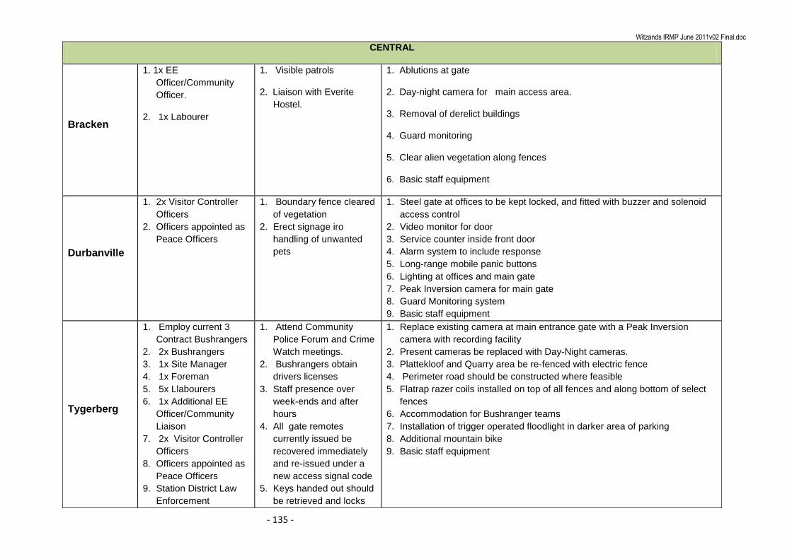
Witzands IRMP June 2011v02 Final.doc
- 135 -
CENTRAL
Bracken
1. 1x EE
Officer/Community
Officer.
2. 1x Labourer
1. Visible patrols
2. Liaison with Everite
Hostel.
1. Ablutions at gate
2. Day-night camera for main access area.
3. Removal of derelict buildings
4. Guard monitoring
5. Clear alien vegetation along fences
6. Basic staff equipment
Durbanville
1. 2x Visitor Controller
Officers
2. Officers appointed as
Peace Officers
1. Boundary fence cleared
of vegetation
2. Erect signage iro
handling of unwanted
pets
1. Steel gate at offices to be kept locked, and fitted with buzzer and solenoid
access control
2. Video monitor for door
3. Service counter inside front door
4. Alarm system to include response
5. Long-range mobile panic buttons
6. Lighting at offices and main gate
7. Peak Inversion camera for main gate
8. Guard Monitoring system
9. Basic staff equipment
Tygerberg
1. Employ current 3
Contract Bushrangers
2. 2x Bushrangers
3. 1x Site Manager
4. 1x Foreman
5. 5x Llabourers
6. 1x Additional EE
Officer/Community
Liaison
7. 2x Visitor Controller
Officers
8. Officers appointed as
Peace Officers
9. Station District Law
Enforcement
1. Attend Community
Police Forum and Crime
Watch meetings.
2. Bushrangers obtain
drivers licenses
3. Staff presence over
week-ends and after
hours
4. All gate remotes
currently issued be
recovered immediately
and re-issued under a
new access signal code
5. Keys handed out should
be retrieved and locks
1. Replace existing camera at main entrance gate with a Peak Inversion
camera with recording facility
2. Present cameras be replaced with Day-Night cameras.
3. Plattekloof and Quarry area be re-fenced with electric fence
4. Perimeter road should be constructed where feasible
5. Flatrap razer coils installed on top of all fences and along bottom of select
fences
6. Accommodation for Bushranger teams
7. Installation of trigger operated floodlight in darker area of parking
8. Additional mountain bike
9. Basic staff equipment
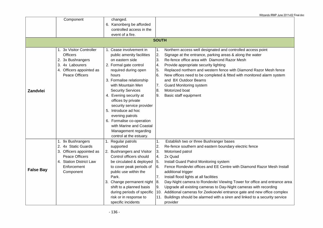
Witzands IRMP June 2011v02 Final.doc
- 136 -
Component changed.
6. Kanonberg be afforded
controlled access in the
event of a fire.
SOUTH
Zandvlei
1. 3x Visitor Controller
Officers
2. 3x Bushrangers
3. 4x Labourers
4. Officers appointed as
Peace Officers
1. Cease involvement in
public amenity facilities
on eastern side
2. Formal gate control
required during open
hours
3. Formalise relationship
with Mountain Men
Security Services
4. Evening security at
offices by private
security service provider
5. Introduce ad hoc
evening patrols
6. Formalise co-operation
with Marine and Coastal
Management regarding
control at the estuary.
1. Northern access well designated and controlled access point
2. Signage at the entrance, parking areas & along the water
3. Re-fence office area with Diamond Razor Mesh
4. Provide appropriate security lighting
5. Replaced northern and western fence with Diamond Razor Mesh fence
6. New offices need to be completed & fitted with monitored alarm system
and BX Outdoor Beams
7. Guard Monitoring system
8. Motorized boat
9. Basic staff equipment
False Bay
1. 9x Bushrangers
2. 4x Static Guards
3. Officers appointed as
Peace Officers
4. Station District Law
Enforcement
Component
1. Regular patrols
supported
2. Bushrangers and Visitor
Control officers should
be circulated & deployed
to cover peak periods of
public use within the
Park.
3. Change permanent night
shift to a planned basis
during periods of specific
risk or in response to
specific incidents
1. Establish two or three Bushranger bases
2. Re-fence southern and eastern boundary electric fence
3. Motorised patrol
4. 2x Quad
5. Install Guard Patrol Monitoring system
6. Fence Rondevlei offices and EE Centre with Diamond Razor Mesh Install
additional trigger
7. Install flood lights at all facilities
8. Day-Night camera to Rondevlei Viewing Tower for office and entrance area
9. Upgrade all existing cameras to Day-Night cameras with recording
10. Additional cameras for Zeekoevlei entrance gate and new office complex
11. Buildings should be alarmed with a siren and linked to a security service
provider
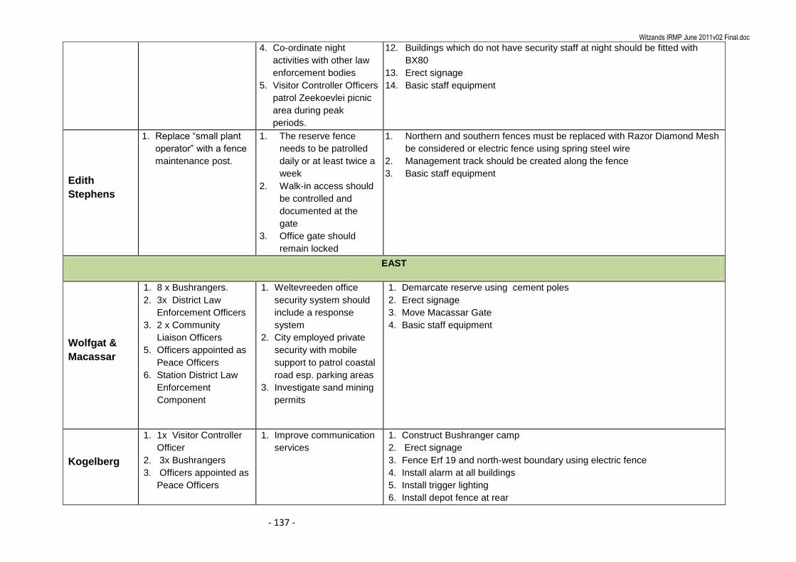
Witzands IRMP June 2011v02 Final.doc
- 137 -
4. Co-ordinate night
activities with other law
enforcement bodies
5. Visitor Controller Officers
patrol Zeekoevlei picnic
area during peak
periods.
12. Buildings which do not have security staff at night should be fitted with
BX80
13. Erect signage
14. Basic staff equipment
Edith
Stephens
1. Replace “small plant
operator” with a fence
maintenance post.
1. The reserve fence
needs to be patrolled
daily or at least twice a
week
2. Walk-in access should
be controlled and
documented at the
gate
3. Office gate should
remain locked
1. Northern and southern fences must be replaced with Razor Diamond Mesh
be considered or electric fence using spring steel wire
2. Management track should be created along the fence
3. Basic staff equipment
EAST
Wolfgat &
Macassar
1. 8 x Bushrangers.
2. 3x District Law
Enforcement Officers
3. 2 x Community
Liaison Officers
5. Officers appointed as
Peace Officers
6. Station District Law
Enforcement
Component
1. Weltevreeden office
security system should
include a response
system
2. City employed private
security with mobile
support to patrol coastal
road esp. parking areas
3. Investigate sand mining
permits
1. Demarcate reserve using cement poles
2. Erect signage
3. Move Macassar Gate
4. Basic staff equipment
Kogelberg
1. 1x Visitor Controller
Officer
2. 3x Bushrangers
3. Officers appointed as
Peace Officers
1. Improve communication
services
1. Construct Bushranger camp
2. Erect signage
3. Fence Erf 19 and north-west boundary using electric fence
4. Install alarm at all buildings
5. Install trigger lighting
6. Install depot fence at rear
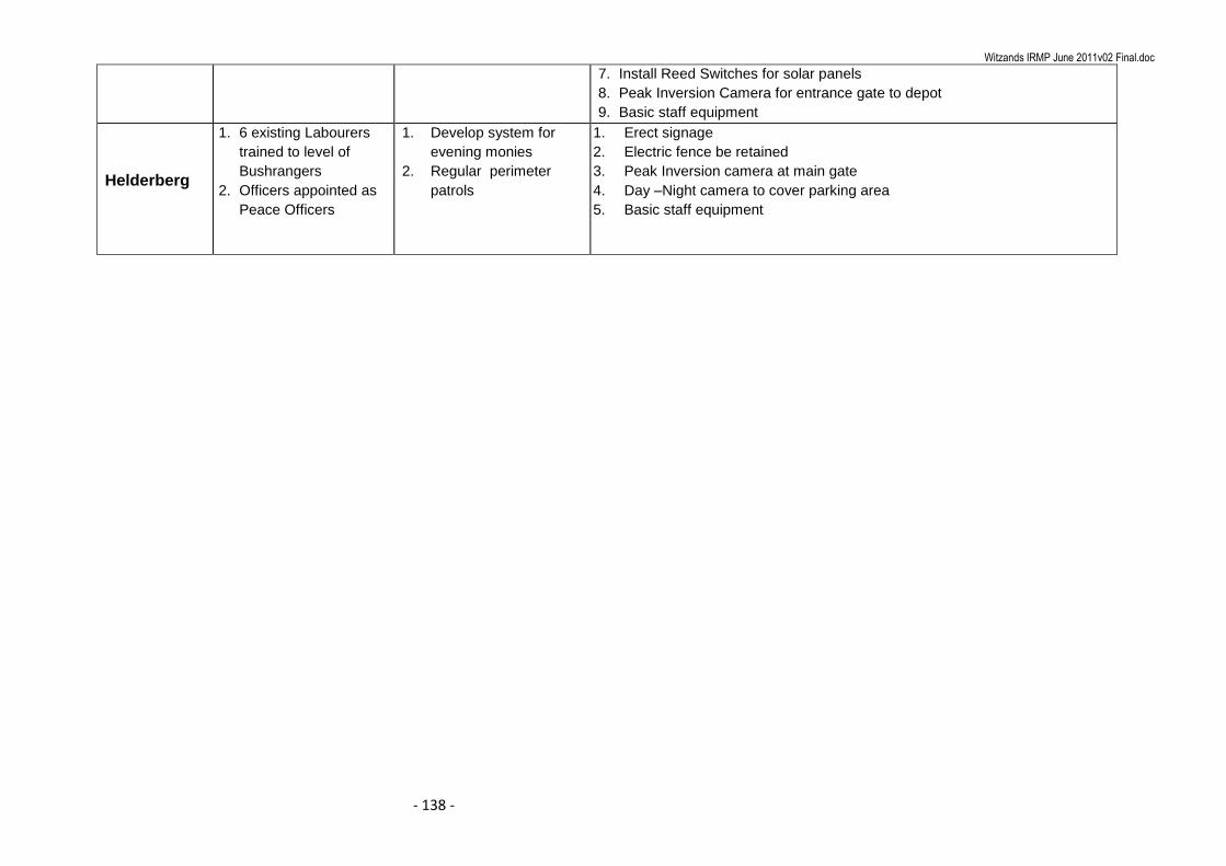
Witzands IRMP June 2011v02 Final.doc
- 138 -
7. Install Reed Switches for solar panels
8. Peak Inversion Camera for entrance gate to depot
9. Basic staff equipment
Helderberg
1. 6 existing Labourers
trained to level of
Bushrangers
2. Officers appointed as
Peace Officers
1. Develop system for
evening monies
2. Regular perimeter
patrols
1. Erect signage
2. Electric fence be retained
3. Peak Inversion camera at main gate
4. Day –Night camera to cover parking area
5. Basic staff equipment

Witzands IRMP June 2011v02 Final.doc
- 139 -
18 COSTING
The equipment costing listed below are based on actual quotes provided.
Fencing:
Diamond Razor mesh fencing installed per 100m R 440,00/meter
1,8m, 12 strand electric fencing installed at 100m (Au Alloy wire) R 55,00/meter
12 Joule Nemtek energizer with built in fence monitor R 3400,00 excl
Alarm Equipment:
To supply and install an 8-zone alarm Paradox alarm system complete with battery back-up, keypad, 15 watt siren, four internal infra red
passives, two fixed panic buttons and two reed switches. Alarm system can be zone doubled to a 16 zone system.
R 3600,00 excl.
To supply and install one outdoor BX80 beam R 1500,00 excl.
GSM 4 channel radio, programmed to four cellular phone numbers and linked to fence energizers, Alarm systems, Solar panels and standalone
panic systems R 1800,00 excl
Long Range remote panic – one long range remote R 250,00 excl.
Long Range receiver – installed R 1100,00 excl.

Witzands IRMP June 2011v02 Final.doc
- 140 -
Cameras:
To supply and install one gate camera – Peak inversion camera, auto-iris lens, 40m co-axial cable, power supply, 4-channel embedded digital
recorder (250 G) hard drive and one 17 inch monitor. Price includes camera housing and installation R 11 900,00 excl.
To supply and install one day/night camera – Day/Night camera, auto-iris lens, 40m co-axial cable, power supply, 4-channel embedded digital
recorder (250 G) hard drive and one 17 inch colour monitor. Price includes housing and installation R 12 900,00 excl.