Initial Proposal Report - london.ca · 2.0 PROVINCIAL POLICY STATEMENT (PPS) 2 3.0 OFFICIAL PLAN...
95
Final Proposal Report Part of Lot 16, R.C.P. 1028, City of London, County of Middlesex Sunningdale Golf & Country Club Ltd. – Owner Corlon Properties Inc. – Applicant March 7, 2018 Corlon Properties Inc. 379 Sunningdale Road West London, Ontario N6G 5B9 519∙660∙6200 David R. Schmidt, MCIP, RPP Development Manager
Transcript of Initial Proposal Report - london.ca · 2.0 PROVINCIAL POLICY STATEMENT (PPS) 2 3.0 OFFICIAL PLAN...
Final Proposal Report
Part of Lot 16, R.C.P. 1028, City of London, County of Middlesex Sunningdale Golf & Country Club Ltd. – Owner Corlon Properties Inc. – Applicant March 7, 2018
Corlon Properties Inc. 379 Sunningdale Road West London, Ontario N6G 5B9 519∙660∙6200
David R. Schmidt, MCIP, RPP Development Manager
Corlon Properties Inc. (Applicant)
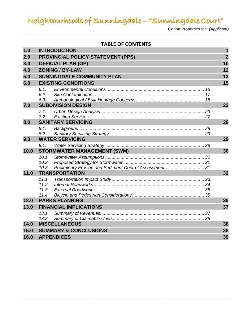
TABLE OF CONTENTS 1.0 INTRODUCTION 1
2.0 PROVINCIAL POLICY STATEMENT (PPS) 2
3.0 OFFICIAL PLAN (OP) 10
4.0 ZONING / BY-LAW 12
5.0 SUNNINGDALE COMMUNITY PLAN 13
6.0 EXISTING CONDITIONS 15
6.1. Environmental Conditions ............................................................................ 15 6.2. Site Contamination ....................................................................................... 17 6.3. Archaeological / Built Heritage Concerns ..................................................... 18
7.0 SUBDIVISION DESIGN 22
7.1. Urban Design Analysis ................................................................................. 23 7.2. Existing Services .......................................................................................... 27
8.0 SANITARY SERVICING 28
8.1. Background .................................................................................................. 28 8.2. Sanitary Servicing Strategy .......................................................................... 29
9.0 WATER SERVICING 29
9.1. Water Servicing Strategy ............................................................................. 29 10.0 STORMWATER MANAGEMENT (SWM) 30
10.1. Stormwater Assumptions ............................................................................. 30 10.2. Proposed Strategy for Stormwater ............................................................... 31 10.3. Preliminary Erosion and Sediment Control Assessment ............................... 31
11.0 TRANSPORTATION 32
11.1. Transportation Impact Study ........................................................................ 33 11.2. Internal Roadworks ...................................................................................... 34 11.3. External Roadworks ..................................................................................... 35 11.4. Bicycle and Pedestrian Considerations ........................................................ 35
12.0 PARKS PLANNING 36
13.0 FINANCIAL IMPLICATIONS 37
13.1. Summary of Revenues ................................................................................. 37 13.2. Summary of Claimable Costs ....................................................................... 38
14.0 MISCELLANEOUS 38
15.0 SUMMARY & CONCLUSIONS 38
16.0 APPENDICES 39
Corlon Properties Inc. (Applicant)
Page 2 of 95
Appendix A City of London (1989) Official Plan - Excerpt of Schedule ‘A’ (Land Use)
City of London – The London Plan – Excerpt of Map 1 (Place Types)
Appendix B City of London (1989) Official Plan - Excerpt of Schedule ‘B1’ (Natural Heritage Features) and Excerpt of Schedule ‘B2’ (Natural Resources and Hazards)
City of London – The London Plan – Excerpt of Map 5 (Natural Heritage) and Excerpt of Map 6 (Hazards and Natural Resources)
Appendix C City of London (1989) Official Plan - Excerpt of Schedule ‘C’ (Transportation Corridors)
City of London – The London Plan – Excerpt of Map 3 (Street Classification) and Excerpt of Map 4 (Active Mobility Network)
Appendix D “Sunningdale Court” – Post Development Drainage Areas, LDS Consultants Inc. April 24, 2017
Appendix E Initial Proposal Report (IPR) Cost Sharable & DC Revenue Estimate Worksheet, completed by Anthony Gubbels, of LDS Consultants Inc. June 30, 2017
Appendix F “Sunningdale Court” – MSTS Sanitary Drainage Areas, LDS Consulting Inc. July 12, 2017
“Sunningdale Court – Proposed Sanitary Catchments, LDS Consulting Inc. July 12, 2017
Appendix G Sunningdale Court - Parkland Dedication Requirements / Calculations Analysis
Appendix H Site Distance Analysis of Street ‘A’ and Sunningdale Road West, LDS Consultants Inc.
Appendix I Bibliography – complete list of sources that were used or referenced in the preparation of this report
Appendix J Opinion Letter for Class EA, LDS Consulting Inc, February 08, 2018 Appendix K Annotated “Proposal Review Meeting Summary & Record of Consultation”
November 2, 2017

Corlon Properties Inc. (Applicant)
1
1.0 Introduction
The applicant / developer of “Sunningdale Court” is Corlon Properties Inc. on behalf of its sister company and landowner, Sunningdale Golf & Country Club Ltd.
The development of “Sunningdale Court” is proposed to occupy a 20.695 hectare parcel of land located immediately south of Sunningdale Road West, between Richmond Street North and Wonderland Road North, within the Sunningdale Community Planning Area.
The lands are presently designated “Low Density Residential” and “Open Space” on Schedule ‘A’ (Land Use) of the City of London’s 1989 Official Plan and are designated as “Neighbourhoods” and “Green Space” Place Types of The London Plan (excerpts enclosed in Appendix A). The proposed development of “Sunningdale Court” will implement these existing land use designations / place types. The Medway Valley Heritage Forest is the predominant environmental feature of the immediate area and is located immediately to the east and south and the Wonderland Tributary to the west. All features of the City’s Natural Heritage System and various Natural Hazards which may influence the development of the subject lands are depicted on Schedule ‘B1’ (Natural Heritage Features) and ‘B2’ (Natural Resources and Hazards) of the City of London’s 1989 Official Plan as well as Map 5 (Natural Heritage) and Map 6 (Hazards and Natural Resources) of The London Plan (excerpt enclosed in Appendix B).

Corlon Properties Inc. (Applicant)
2
Sunningdale Road West is classified as an Arterial roadway on Schedule ‘C’ (Transportation Corridors) of the City of London’s 1989 Official Plan and as a Civic Boulevard on Map 3 (Street Classifications) of The London Plan (excerpt enclosed in Appendix C). Access to “Sunningdale Court” will be provided from Sunningdale Road West via a new intersection and roadway. The lands are highly characterized by their use as part of Sunningdale Golf & Country Club’s active golf facilities. A portion of the subject lands perimeter contain undevelopable vegetated slopes associated with the Medway Valley Heritage Forest (to the east and south) and Wonderland Tributary (to the west). These lands will be dedicated to the City of London. All stormwater flows will be directed to the southeast corner of the site where they will be treated by an oil and grit separator (OGS) device before being discharged to the Medway Creek. Larger storm events will be conveyed overland to the same location via the proposed local street network. Sanitary sewage flows from this development will be directed to the existing Medway Trunk Sanitary Sewer (750 mm) which is located immediately to the south of the subject lands, within the Medway Valley. Water supply mains will be looped from the existing 900 mm watermain located within the right-of-way of Sunningdale Road West.
2.0 Provincial Policy Statement (PPS)
Subsection 51(17) of the Planning Act, R.S.O. 1990, c. P.13, as amended, specifies the information and material (the “contents”) which an applicant shall provide to the approval authority for consideration and approval of a plan of subdivision. Specifically, this subsection sets out twelve (12) requirements (a to l) for prescribed information and material. As required, these requirements will be satisfied, as appropriate, on the face of the proposed draft plan of subdivision. In addition to the above, Ontario Regulation 544/06 specifies additional information and material to be provided by an applicant for approval of a plan of subdivision, for the purposes of subsection 51(17) of the Act. These requirements are set out in Schedule 1. O.Reg. 544/06, s. 2. For purposes of convenience, the following information is numbered in reference to the requirements set out in Schedule 1.
1. The name, address, telephone number and, if applicable, the e-mail address of the owner of the subject land, and of the agent if the applicant is the owner’s authorized agent.
Owner: Sunningdale Golf & Country Club Ltd. 379 Sunningdale Road West London, Ontario N6G 5B9 (519) 660-6200 ext. 2 Applicant: Corlon Properties Inc.
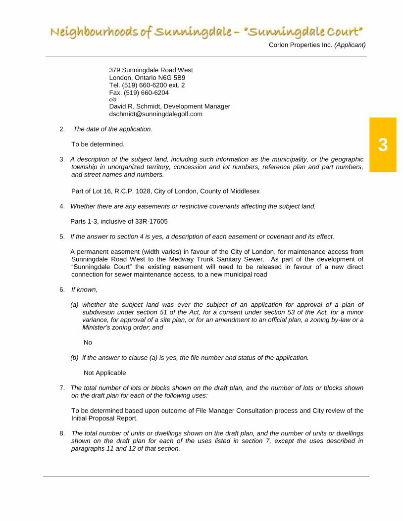
Corlon Properties Inc. (Applicant)
3
379 Sunningdale Road West London, Ontario N6G 5B9 Tel. (519) 660-6200 ext. 2 Fax. (519) 660-6204 c/o
David R. Schmidt, Development Manager [email protected]
2. The date of the application.
To be determined.
3. A description of the subject land, including such information as the municipality, or the geographic township in unorganized territory, concession and lot numbers, reference plan and part numbers, and street names and numbers.
Part of Lot 16, R.C.P. 1028, City of London, County of Middlesex 4. Whether there are any easements or restrictive covenants affecting the subject land.
Parts 1-3, inclusive of 33R-17605 5. If the answer to section 4 is yes, a description of each easement or covenant and its effect.
A permanent easement (width varies) in favour of the City of London, for maintenance access from Sunningdale Road West to the Medway Trunk Sanitary Sewer. As part of the development of “Sunningdale Court” the existing easement will need to be released in favour of a new direct connection for sewer maintenance access, to a new municipal road
6. If known,
(a) whether the subject land was ever the subject of an application for approval of a plan of subdivision under section 51 of the Act, for a consent under section 53 of the Act, for a minor variance, for approval of a site plan, or for an amendment to an official plan, a zoning by-law or a Minister’s zoning order; and
No
(b) if the answer to clause (a) is yes, the file number and status of the application.
Not Applicable
7. The total number of lots or blocks shown on the draft plan, and the number of lots or blocks shown on the draft plan for each of the following uses:
To be determined based upon outcome of File Manager Consultation process and City review of the Initial Proposal Report.
8. The total number of units or dwellings shown on the draft plan, and the number of units or dwellings shown on the draft plan for each of the uses listed in section 7, except the uses described in paragraphs 11 and 12 of that section.
Corlon Properties Inc. (Applicant)
4
To be determined based upon outcome of File Manager Consultation process and City review of the Initial Proposal Report.
9. In hectares, the total area of land shown on the draft plan, and the area of land shown on the draft plan for each of the uses listed in section 7.
To be determined based upon outcome of File Manager Consultation process and City review of the Initial Proposal Report.
10. The total number of units or dwellings shown on the draft plan per hectare, and the number of units or dwellings shown on the draft plan per hectare for each of the uses listed in section 7, except the uses described in paragraphs 11 and 12 of that section.
To be determined based upon outcome of File Manager Consultation process and City review of Initial Proposal Report.
11. The total number of parking spaces shown on the draft plan, and the number of parking spaces shown on the draft plan for each of the uses listed in section 7, except the uses described in paragraphs 1, 2, 11 and 12 of that section.
Not Applicable
12. If the application is for approval of a condominium description, the number of parking spaces shown on the draft plan for detached and semi-detached residential use.
Not Applicable
13. If one of the uses referred to under section 7, 8, 9, 10 or 11 is identified as “other residential”, “institutional” or “other”, a description of the use.
Not Applicable
14. The current designation of the subject land in the applicable official plan.
The lands are presently designated “Low Density Residential” and “Open Space” on Schedule ‘A’ (Land Use) of the City of London’s 1989 Official Plan and are designated as “Neighbourhoods” and “Green Space” Place Types on Map 1 of The London Plan Multi-Family, Medium Density (excerpts enclosed within Appendix A)
15. Whether access to the subject land will be,
(a) by a provincial highway, a municipal road that is maintained all year or seasonally, another public road or a right of way; or
Municipal road right-of-way, maintained all year
(b) by water.
Not applicable
16. If access to the subject land will be by water only, the parking and docking facilities to be used and the approximate distance of these facilities from the subject land and the nearest public road.
Corlon Properties Inc. (Applicant)
5
Not applicable
17. Whether water will be provided to the subject land by a publicly owned and operated piped water system, a privately owned and operated individual or communal well, a lake or other water body or other means.
Publicly owned and operated piped water system
18. If the plan would permit development of more than five lots or units on privately owned and operated individual or communal wells,
Not applicable
19. Whether sewage disposal will be provided to the subject land by a publicly owned and operated sanitary sewage system, a privately owned and operated individual or communal septic system or other means.
Publicly owned and operated sanitary sewage system
20. If the plan would permit development of five or more lots or units on privately owned and operated individual or communal septic systems,
Not applicable
21. If the plan would permit development of fewer than five lots or units on privately owned and operated individual or communal septic systems, and more than 4500 litres of effluent would be produced per day as a result of the development being completed,
Not applicable
22. If the plan would permit development of fewer than five lots or units on privately owned and operated individual or communal septic systems, and 4500 litres of effluent or less would be produced per day as a result of the development being completed, a hydrogeological report.
Not applicable
23. Whether the subject land contains any areas of archaeological potential.
A Stage 1 Archaeological Assessment has been completed for the subject lands (AECOM, June 8, 2017) and submitted to the Ministry of Tourism, Culture and Sport (MTCS). The Stage 1 Assessment recommends the completion of a Stage 2 Archaeological Assessment for all areas of undisturbed lands within the study area limits. A Stage 2 Assessment will be completed in the Fall of 2017. Subsequent archaeological assessments will be completed, as appropriate, to ensure that all archaeological concerns, under the Planning Act, have not yet been fully addressed to the satisfaction of the MTCS.
24. If the plan would permit development on land that contains known archaeological resources or areas of archaeological potential.
Please refer to No. 23 above.
25. Whether storm drainage will be provided by sewers, ditches, swales or other means.

Corlon Properties Inc. (Applicant)
6
Municipal Storm Sewer
26. If the application is for approval of a condominium description.
Not applicable
27. Whether the plan is consistent with policy statements issued under subsection 3 (1) of the Act.
The Provincial Policy Statement (PPS) provides policy direction on matters of provincial interest related to land use planning and development. As a key part of Ontario’s policy-led planning system, the PPS sets the policy foundation for regulating the development and use of land. It also supports the provincial goal to enhance the quality of life for the citizens of Ontario. The PPS provides for appropriate development while protecting resources of provincial interest, public health and safety, and the quality of the natural environment. The PPS supports improved land use planning and management, which contributes to a more effective and efficient land use planning system. The policies of the PPS are complemented by, among other things, municipal official plans. As a result, the PPS and the City of London Official Plan together provide a framework for comprehensive, integrated and long-tem planning that supports and integrates the principles of strong communities, a clean and healthy environment and economic growth, over the long term.
The PPS contains clear, overall policy directions on matters of provincial interest related to land use planning and development. The "shall be consistent with" rule means that the approval authority is obliged to consider the application of a specific policy statement when carrying out its planning responsibility. It is expected that the approval authority will implement the PPS in the context of other planning objectives and local circumstances.
The PPS promotes a policy-led system which recognizes that there are complex inter-relationships among environmental, economic and social factors in land use planning. It contains three major policy areas:
Managing change and promoting efficient, cost-effective development and land use patterns which stimulate economic growth and protect the environment and public health to promote communities which are economically and environmentally sound, meet the full range of needs of current and future residents, and avoid the need for costly remedial measures to correct problems;
Protecting resources for their economic use and / or environmental benefits; and
Deal with the wise use and protection of the province's resources - agricultural land, mineral
resources, natural heritage resources, ground and surface water and cultural heritage resources for their economic, environmental and social benefits in order to reduce the potential for public cost or risk to Ontario's residents by directing development away from areas where there is a risk to public health or safety, or of property damage.
Following the Provincial Governments enactment of Bill 51 (the London-Middlesex Act) in 1992, portions of several surrounding Townships were annexed to the City of London, effective January 1, 1993. This Act required the City to prepare and adopt an Official Plan for the annexed lands and as such this process, termed Vision ’96 and subsequently Vision London progressed. On July 2, 1996,

Corlon Properties Inc. (Applicant)
7
Municipal Council adopted Official Plan Amendment (OPA) No. 88 which identified urban growth areas in the City and designated land as either:
Urban Reserve-Community Growth, indicating the intent for primarily residential development; or,
Urban Reserve - Industrial Growth, indicating the intent for primarily industrial development.
OPA 88 divided the urban growth area into several Community Planning Areas to help conduct more detailed studies leading to the preparation of Area / Community Plans. An Area / Community Plan provided the basis for designating more specific land uses to replace the Urban Reserve designation while providing direction for zoning, subdivision planning, servicing and community facility planning. The Area / Community Plan provided a more detailed approach to land use planning, land use mix and compatibility, road alignment, municipal services, residential densities and affordability, road access points, location of community facilities, buffering concerns, location of pedestrian and bicycle routes, building conditions, the natural heritage system and the suitability of existing development requirements.
The Area / Community Plan served as the basis for an Official Plan amendment that:
identified environmental features and natural resources to be protected; applied specific land use designations; and, identified community collector (main) roads.
The subject lands which are proposed for development as part of this Initial Proposal Report are part of the City of London’s “Sunningdale Community Plan”, which were comprehensively planned as described above. The proposed development is within the Urban Growth Boundary and is identified by the City of London Official Plan as lands intended for residential uses.
The applications that will be necessary to eventually develop the subject lands have been considered for consistency with the entire 2014 Provincial Policy Statement. Through a review and consideration of the three main sections of the PPS (1.0 Building Strong Healthy Communities; 2.0 Wise Use and Management of Resources; 3.0 Protecting Public Health and Safety) the proposed development is deemed to conform with and support the PPS as follows:
Building Strong Healthy Communities
“Sunningdale Court” represents an efficient development and implements an approved land use pattern which, from an area plan perspective, accommodates an appropriate range and mix of residential, recreational and open space uses which assist in meeting the long-term needs of the immediate community as well as those of the City of London. The proposed plan ensures the long-term preservation of natural heritage features and will not cause any environmental, public health or safety concerns while facilitating the efficient expansion of the City’s settlement area as it represents the logical progression of development within the Sunningdale Area.
The proposed development, as part of the larger Sunningdale Community Planning Area, will assist in providing an appropriate range of housing types and densities to assist the regional market in meeting the projected needs / requirements of current and future residents.
Engaging and sustaining an active and healthy lifestyle has been one of the goals of the Sunningdale Community Plan. “Sunningdale Court” will continue to implement this objective through the provision of well planned public infrastructure that will provide for the needs of the cycling and
Corlon Properties Inc. (Applicant)
8
pedestrian public in a safe and accessible manner which promotes connectivity. The planned infrastructure will include a network of sidewalks and multi-use trail connections, which will facilitate non-motorized movements to and from the adjacent development to the west and the network of existing trails with the Medway Valley Heritage Forest Environmentally Significant Area, to the south. A full range of publicly accessible built and natural settings for recreation have been equitably distributed through the larger area / community master planning process.
Through the Sunningdale Community Plan process and the City’s own master plan servicing studies (Transportation, Sanitary, Storm, Water) and their new Growth Management Implementation Study, infrastructure and public service facilities are provided in a coordinated, efficient and cost-effective manner. The proposed plan implements this layered approach and will construct the necessary services to meet all regulatory requirements while protecting human health and the natural environment. The transportation infrastructure planned as part of the proposed development is predominantly “local” in nature. Meaning that it will provide for the safe and efficient movement of future residents, of the proposed development, to and from existing infrastructure while providing for missing segments / connections for non-motorized travelers. The proposed plan provides for the necessary land dedications to accommodate the future right-of-way needs (widening) of Sunningdale Road, including its southerly re-alignment, as per Policy 10.1.3 cxii of the City of London’s 1989 Official Plan and Policy 1752 of the London Plan
The proposed draft plan of subdivision is consistent with Policy 1.6.6.7 e) of the Provincial Policy Statement as it proposes a storm water management strategy that has been approved by municipalities, including the City of London and the Ministry of Environment and Climate Change (MOECC), in the past. The strategies outlined within the MOECC’s (April 2017) draft Low Impact Development (LID) Storm water Management Guidance Manual were contemplated through the design of the proposed draft plan of subdivision and proposed storm water management strategy. LID strategies help to mitigate the impacts of increased runoff and storm water pollution by managing runoff as close to its source as possible, by incorporating site features which enhance post-development infiltration, evapotranspiration, filtration and detention of storm water. These practices can help to reduce contaminants in runoff, and can reduce the volume and intensity of storm water flows. Through these efforts it is recognized that MOECC guidance documents state that infiltration measures are generally not suitable for soils with hydraulic conductivity values less than 15 mm/hour. This minimum infiltration rate is not satisfied by the predominant soils at the site, therefore mitigation measures that promote infiltration are generally not feasible for the Sunningdale Court site. As such, the consideration has been given to incorporating the following LID measures and best practices, on the subject lands, in consultation with the Hydrogeological/Geotechnical consultant for this project:
Roof downspouts should be directed to grass areas graded with swales to promote infiltration, thereby maximizing the recharge of precipitation from roof top areas;
Increased topsoil thickness in landscaped areas to increase the holding zone for evapotranspiration to occur;
Reduced lot grading in rear yards to slow run-off and increase storage capacity in permeable areas;
Promoting the use of rain-barrels to provide temporary storage of roof leader run-off for use within individual lots.
Wise Use and Management of Resources
The Medway Valley Heritage Forest Environmentally Significant Area is the predominant natural heritage feature within this area. An Environmental Impact Study and Geotechnical Slope Stability
Corlon Properties Inc. (Applicant)
9
Assessment have been completed to ensure that the development of “Sunningdale Court” will have no negative impacts on its natural features or ecological functions.
As previously mentioned, Archaeological Assessments will be completed for the subject lands and submitted to the Ministry of Culture for review and approval.
Protecting Public Health and Safety
The entire Medway Valley has been identified as a natural hazard due to its identification as flood plain and its steep erosion prone slopes. The health and social well being of future residents has been protected by ensuring that no development is permitted within the Medway Valley. Additionally, a Geotechnical Slope Stability Assessment has been completed to ensure that no development occurs within areas that are susceptible to unstable slopes. No human made hazards exist or will be created through the development of “Sunningdale Court”.
While the PPS is to be read in its entirety it is recognized that only relevant policies are to be applied to each situation and that land use planning is only one tool for implementing provincial interests. The above takes this into consideration when evaluating the proposed development in the context of the PPS. Accordingly, considering all of the above, it is the writer’s opinion that the proposed draft plan of subdivision is consistent with policy statements issued under subsection 3 (1) of the Planning Act.
28. Whether the subject land is within an area of land designated under any provincial plan or plans.
Not applicable
29. If the answer to section 28 is yes, whether the plan conforms to or does not conflict with the applicable provincial plan or plans.
Not applicable
30. If the applicant is not the owner of the subject land, the owner’s written authorization to the applicant to make the application.
Acknowledged, owner’s authorization will be provided as part of the City of London Subdivision Application Form.
31. An affidavit or sworn declaration by the applicant that the information required under this Schedule and provided by the applicant is accurate.
Acknowledged, owner’s authorization will be provided as part of the City of London Subdivision Application Form.
Additionally, Section 51(24) of the Planning act provides municipalities with criteria which must be considered prior to approval of a draft plan of subdivision. The Act notes that in addition to the health, safety, convenience, accessibility for persons with disabilities and welfare of the present and future inhabitants of the municipality, regard shall be had for: (a) the effect of development of the proposed subdivision on matters of provincial interest as
referred to in Section 2; (b) whether the proposed subdivision is premature or in the public interest;

Corlon Properties Inc. (Applicant)
10
(c) whether the plan conforms to the Official Plan and adjacent plans of subdivision, if any; (d) the suitability of the land for the purposes for which it is to be subdivided; (e) the number, width, location and proposed grades and elevations of highways, and the
adequacy of them, and the highways linking the highways in the proposed subdivision with the established highway system in the vicinity and the adequacy of them;
(f) the dimensions and shapes of the proposed lots; (g) the restrictions or proposed restrictions, if any, on the land proposed to be subdivided or the
buildings and structures proposed to be erected on it and the restrictions, if any, on adjoining land;
(h) conservation of natural resources and flood control; (i) the adequacy of utilities and municipal services; (j) the adequacy of school sites; (k) the area of land, if any, within the proposed subdivision that, exclusive of highways, is to be
conveyed or dedicated for public purposes; (l) the extent to which the plan’s design optimizes the available supply, means of supplying
efficient use and conservation of energy; and (m) the interrelationship between the design of the proposed plan of subdivision and site plan
control matters relating to any development on the lands, if the land is also located within a site plan control area.
As previously noted, it is the writer’s opinion that the proposed draft plan of subdivision is consistent with the Provincial Policy Statement. The proposed development is not premature given the infrastructure that exists or that is planned for the area. The proposed plan conforms to the Official Plan in terms of building form. The Sunningdale Community Plan, which was prepared for this area, identified this as a suitable area for residential development. The existing transportation infrastructure is designed to accommodate this development. Improvements to the surrounding arterial roads will be carried out as part this development, as appropriate, to ensure that it provides for convenient and safe access to this community. The proposed zoning will implement the existing “Low Density Residential” land use designation (1989 Official Plan) / “Neighbourhoods” place type (The London Plan). The zones requested will be consistent with the provisions of the City’s Z.-1 Zoning By-law. Any lands within the UTRCA regulated area will require the Owner to obtain necessary permits prior to any soil disturbance, as appropriate. Utilities and services will be constructed within this subdivision to allow for its development. Based upon the above analysis, the proposed draft plan is consistent with all of the relevant criteria within Section 51(24) of the Planning Act.
3.0 Official Plan (OP)
The subject lands are designated “Low Density Residential” on Schedule ‘A’ – Land Use, of the City’s Official Plan (1989) and has a “Neighbourhoods” place type within The London
Corlon Properties Inc. (Applicant)
11
Plan (excerpt enclosed within Appendix A). The following analysis will address the general land use policies associated with the existing land use designation / place type. Low Density Residential (1989 Official Plan): The Low Density Residential designation is applied to lands that are primarily developed or planned for low-rise, low density housing forms including single detached. Development within areas designated Low Density Residential shall have a low-rise, low coverage form that minimizes problems of shadowing, view obstruction and loss of privacy. The development of low density residential uses shall be subject to appropriate site area and frontage requirements in the Zoning By-law. These requirements may vary in areas of new development according to the characteristics of existing or proposed residential uses, and shall result in net densities that range to an approximate upper limit of 30 units per hectare (12 units per acre). Neighbourhoods (The London Plan): The Neighbourhoods Place Type is distributed throughout the city to support neighbourhoods that include a broad range of residential uses. The intensity of development and range of uses that may be permitted varies, depending upon the street classification that a property fronts onto, in addition to a number of other factors. As previously mentioned, full municipal services are already available to facilitate the development of the subject lands. These services can accommodate the proposed use. The existing and planned arterial road network, immediately adjacent to the subject lands should serve the proposed use well, with no impacts anticipated. Based upon an assessment of potential demand generated by the proposed and adjacent developments, the London Transit Commission has planned (“London Transit Commission, Transit Network, Rapid Transit Integration Framework, Final Report” Dillon Consulting Limits, August 2016) transit services (New – “Sunningdale Route) for the immediate area including specific route design, level of transit service and timing of service implementation for 2027. As there is presently no transit service north of Fanshawe Park Road, to the west of Richmond Street, this new route will service the immediate area and connect to the BRT Transit Village at Masonville Mall. In considering the proposed development, the proposed single family lots are surrounded by open space blocks of the Medway Valley Heritage Forest Environmentally Significant Area and the Wonderland Road Tributary. Single family homes exist beyond these open space blocks, to the east, south and west. Considering this, there are no concerns with compatibility between the proposed single-family lots and the existing surrounding developments.
Corlon Properties Inc. (Applicant)
12
4.0 Zoning / By-law
Most of the subject lands are presently zoned Urban Reserve 3 (UR3), while a strip of land in proximity to the adjacent natural heritage features are zoned with a holding provision (h-2) in combination with the Urban Reserve 3 (UR3) zone. In addition, a small portion of the subject lands, located in the southwest, are zoned Open Space 4 (OS4). Urban Reserve (UR3) Zone: The Urban Reserve (UR) Zone provides for and regulates existing uses on lands which are primarily undeveloped for urban uses. Generally, these uses have limited structures. The Urban Reserve Zone is intended to protect large tracts of land from premature subdivision and development to provide for future comprehensive development on those lands. Specifically, the UR3 Zone variation is applied to lands which have been reviewed through the Community Plan process and permits specific uses including “private outdoor recreation clubs”, which recognizes the existing use of the land by Sunningdale Golf & Country Club. Open Space 4 (OS4) Zone: The Open Space 4 (OS4) zone variation is one of the most restrictive open space zone variations and is applied to lands which have physical and/or environmental constraints to development. The zone is typically applied to hazard lands and development within the OS4 Zone is regulated pursuant to the Conservation Authorities Act. The Open Space 4 (OS4) Zone is generally applied to areas which are outside of the floodplain. This zone variation may be applied to public open space and other outdoor locations which may be appropriate for a range of recreational, open space, community and public facility uses and cemeteries. Permitted uses are limited to: conservation lands; conservation works; golf courses; private parks; public parks; recreational golf courses; and recreational uses and facilities associated with conservation lands and public parks. The historical ownership of these lands by Sunningdale Golf & Country Club Ltd., and its proximity to lands which are actively utilized as part of their golf course operations provides a clear indication of its zone origins. This zone provides for golf courses (without structures) as a permitted use which recognizes the existing use of the land by Sunningdale Golf & Country Club. Holding “h-2” Zone: The City of London’s Z.-1 Zoning By-law utilizes, in some instances “holding zones” and places the symbol "h" as a prefix to a single zone or a compound zone applying to certain lands. Notwithstanding the permitted use of the single zone or compound zone, until the By-law is amended to remove the relevant holding "h" zone symbol, those lands shall not be developed or used except in compliance with the provisions of the applicable zone for

Corlon Properties Inc. (Applicant)
13
existing uses, or for such other uses set out in the relevant Holding Zone Provisions. Specifically, the purpose of the Holding “h-2” Zone is to ensure that development and the extent to which it will be permitted will not have a negative impact on relevant components of the Natural Heritage System (identified on Schedule "B" of the Official Plan), an agreement shall be entered into specifying appropriate development conditions and boundaries, based on an Environmental Impact Study or Subject Lands Status Report that has been prepared in accordance with the provisions of the Official Plan and to the satisfaction of the City of London, prior to removal of the "h-2" symbol. Until the Holding “h-2” Zone is removed the only permitted uses are those which presently exist. Existing Zones which surround the subject property include: Open Space (OS5) to the east, south, and north; and Open Space (OS1) to the north (on the north side of Sunningdale Road West. To eventually proceed to develop the subject lands, a Zoning By-law Amendment, pursuant to the Planning Act will be required. This amendment will need to re-zone the existing Urban Reserve 3 (UR3) zone and perhaps some portion of the Open Space 4 (OS4) Zone (depending upon the findings of the EIS) to appropriate residential zones, in order to implement the existing (Low Density Residential) land use designation (1989 Official Plan) / Neighbourhoods Place Type (the London Plan). Additionally, the existing Holding (h-2) Zone will need to be lifted through approval of the Environmental Impact Study. A Zoning By-law Amendment to permit the proposed development will be prepared and will accompany the application for draft plan of subdivision.
5.0 Sunningdale Community Plan
The Sunningdale Community Plan was adopted by Municipal Council on June 22, 1998, pursuant to Section 19.2.1 of the Official Plan (1989). As a guideline document, the Community Plan provides direction and assistance in the review of planning and development applications, the planning of public facilities and services, and serves as the basis for amendments to the Official Plan and Zoning By-law and guide for subdivisions within the Sunningdale Community. Pursuant to the City’s Official Plan 1989), a Community Plan / Area Plan will provide the basis for an Official Plan Amendment that will: designate more specific land uses to replace the Urban Reserve designation; identify or refine environmental features, areas and natural resources in conformity with
the applicable Official Plan policies; and identify collector roads. A Community Plan / Area Plan will also provide for the co-ordination of development among multiple land owners and provide direction for:
Corlon Properties Inc. (Applicant)
14
the delineation, protection and management of natural heritage areas; the location and size of parks, schools and other community facilities; housing mix and densities; municipal services; the phasing of development; pedestrian and bicycle routes; transit routing and supportive facilities; site and subdivision design criteria; and local road access points to arterial and collector roads. Specifically, the objectives for the Sunningdale Community Plan were: promote the identity of the Sunningdale Community and the development potential of
the area; identify and protect significant features of the Medway Valley; develop a land use pattern that is efficient and environmentally responsible; ensure compatibility with existing and future surrounding land uses; promote an attractive community in which to live, work and play; involve all interested parties in the formation of the Community Plan; and develop a Plan that is acceptable to the Sunningdale landowners, their neighbours, the
public, the City of London, and the Province of Ontario. The Sunningdale Community Plan proposed “Low Density Residential” uses on most of the subject lands. The Medway Valley was proposed for “ESA / Open Space” uses. These proposed uses are all consistent with the eventual Official Plan Amendment (OPA) which provided for these specific land use designations on Schedule ‘A’ – Land Use, of the City’s Official Plan (excerpt enclosed within Appendix A). Considering that the relatively small size of the “Sunningdale Court” area and recognizing that it is surrounded on three (3) sides by Natural Heritage Features (the Medway Creek to the west and the Wonderland Road tributary to the west) no secondary collector roadways were identified as being necessary. As such, ingress and egress to the “Sunningdale Court” area would be accommodated with a direct connection of local street(s) to the adjacent arterial (Sunningdale Road West) roadway. The design of the proposed plan of subdivision for “Sunningdale Court” conforms to the land use designations and transportation requirements identified within the Community Plan and as included on Schedules ‘A’ and ‘C’ of the Official Plan (1989) / Map 1 (Place Types) and Map 3 (Street Classifications) of the London Plan. The Community Plan also provided direction for locations for school sites, storm water management facilities, and parkland. While no school sites or parkland were proposed for the subject lands, within the Community Plan, a storm water management facility was identified.
Corlon Properties Inc. (Applicant)
15
The community character for the entire Sunningdale area was envisioned within the Community Planning process. It recognized that with the presence of the Medway Valley ESA would provide a unique living environment for future residents of north London through the provision of natural and recreational amenities unlike any other community in the City. While the Medway Valley essentially bisects the community (approximately one third to the west of the valley and two thirds to the east), both portions could be connected through a system of walkways and trails. A community focus for the easterly portion of the Sunningdale Community is provided through the existing elementary school and neighbourhood park at the centre of the community. The proposed design for “Sunningdale Court” continues to implement this community character.
6.0 Existing Conditions
The subject lands have historically accommodated several golf holes, as part Sunningdale Golf & Country Club’s active play area, for golf course purposes. The defining feature of the immediate area is the vegetated ravine walls of the Medway Valley Heritage Forest Environmentally Significant Area, which border the subject lands on the east and south. Immediately to the west, the lands are bounded by a ravine which accommodates the Wonderland Road Tributary.
6.1. Environmental Conditions
The proximity of the subject lands to vegetative slopes of the Medway Valley will require the completion of various studies to determine the extent to which development will be permitted in adjacent areas. The Maximum Hazard Line, represents the general extent of combined natural hazards associated with the flood plain, areas of unstable or organic soils and steep slopes, including steep slopes outside of the Riverine Erosion Hazard Limit and is delineated on Schedule “B1” – Natural Heritage Features, of the City’s (1989) Official Plan (excerpt enclosed within Appendix B). Within the London Plan, the Maximum Hazard Line represents the outer limit of combined natural hazards including flood plains and areas of unstable or steep slopes. These lands are all regulated by the Upper Thames River Conservation Authority and as such are identified as “Conservation Authority Regulation Limit” on Map 6 (excerpt enclosed within Appendix B) The Riverine Erosion Hazard Limit identifies the erosion hazard associated with slopes along the City's river and stream corridors. These features are identified on Schedule “B2” – Natural Resources and Natural Hazards of the City’s (1989) Official Plan as well as Map 6 (Hazards and Natural Resources) of The London Plan (excerpt enclosed within Appendix B). Considering Sunningdale Court’s proximity to the adjacent Medway Valley Heritage Forest Environmentally Significant Area, a review of Schedules “B1” and “B2”’ of the City’s (1989)
Corlon Properties Inc. (Applicant)
16
Official Plan and Maps 5 and 6 of The London Plan, confirms the adjacent Max Hazard Line, Riverine Erosion Hazard, as well as the Environmentally Significant Area Limit and Conservation Authority Regulation Limit. As part of the Subwatershed Study and the Sunningdale Community Plan a large body of research has been assembled with respect to the stability of the slopes within the Medway Creek Valley system. Past assessments included information on the physical characteristics and stability of the slopes associated with the Medway Creek and its small tributaries. These reports provided a basis for determining limits of development and appropriate setbacks for structures to ensure that erosion and slope stability hazards could be safely addressed. Considering the above and consistent with policies contained within Chapter 15 (Environmental) of the City’s (1989) Official Plan and Part 6 (Environmental Policies) of The London Plan, a geotechnical assessment entitled “Slope Assessment – Sunningdale Court Subdivision, London Ontario” was completed by Trow Associates Inc. (project No. LON00011107-GE) on February 2011. Two (2) copies of this report were circulated to the Upper Thames River Conservation Authority (UTRCA) on February 8, 2011 (Attn: Mark Snowsell) for review, comment and approval. Following the receipt of review comments from the UTRCA on May 12, 2011, Exp Services Inc. (formerly Trow) provided a written response (dated May 24, 2011) which was subsequently forwarded to the UTRCA on May 26, 2011 (Attn: Christine Creighton). Subsequently, a meeting was held on June 28, 2011, between the UTRCA and Exp Services, to discuss remaining issues which were then addressed within a “Technical Follow-up” issued on July 4, 2011 by Exp. Further comments were received from the UTRCA on July 29, 2011 and addressed by Exp on August 3, 2011. On August 18, 2011, the UTRCA confirmed that they had completed their review of the latest response from Exp and “is satisfied with the information that has been provided”. Recognizing that some time has passed since the completion and review of the original slope stability assessment, Exp Services Inc. completed a review of their previous efforts and issued a report entitled “Slope Assessment, Sunningdale Court Subdivision” (project No. LON00011107-GE) in March 2015. Additionally, the subject lands are highly characterized by their proximity to the adjacent natural heritage feature and hazards within the Medway Valley Heritage Forest Environmentally Significant Area and the Wonderland Road Tributary. Section 15.5 of the City’s (1989) Official Plan and 1432 of The London Plan, establishes the purpose of an Environmental Impact Study (EIS), where an EIS will be required, and its contents. Considering the proximity of the Medway Valley it is understood that an EIS will be required to support the development of Sunninglea. In anticipation of the need to complete an EIS, an Issues Summary Report (ISR) Checklist was completed, by Stantec Consulting, and submitted to the City of London on September 6, 2011. The ISR was subsequently circulated for review, both internally and to the
Corlon Properties Inc. (Applicant)
17
UTRCA, and an approved ISR was received from the City on September 28, 2011. The City (Bonnie Bergsma) communicated these efforts to the City’s Environmental and Ecological Planning Advisory Committee (11th Report of EEPAC, meeting held on October 20, 2011), including a future anticipated site walk to stake the limits of the ESA. On November 4, 2011, a site visit was conducted with the City (Bonnie Bergsma) and the UTRCA (Christine Creighton) to walk the perimeter to review, discuss and confirm the limit of the ESA in the field, based upon existing ELC communities, field investigations, and City Official Plan policies and guidelines. Over the subsequent months’ various seasonal surveys were completed, as per the ISR. As the development of the subject lands is directly related to Sunningdale Golf & Country Club’s ability to relocate the existing golf holes south of Sunningdale Road, the advancement of the entire project, including the environmental work was placed on hold, pending the advancement of various approvals associated with the golf hole relocation effort. As such, the EIS was not completed. In May of 2015, a meeting was convened with the City (Bruce Page, James MacKay, Craig Smith) and UTRCA (Christine Creighton, Tara Tchir) to discuss the process to recommence the EIS. At this meeting, both the City and UTRCA confirmed that no additional field studies would be required to complete the EIS, considering the previous level of analysis completed to date. Notwithstanding this, a site walk to review the ESA boundary was desired and subsequently arranged in August 2015. Subsequently, Stantec has proceeded to finalize the EIS, based upon Sunningdale’s direction, as it related to progress of the approvals to relocate its existing golf holes.
6.2. Site Contamination
As previously mentioned, the subject lands have historically accommodated several golf holes, as part Sunningdale Golf & Country Club’s active play area, for golf course purposes. As such, there is no information or knowledge that would suggest that there is any history of spills on the subject lands, that the lands were ever used for landfill purposes or that the lands were ever the home of an industrial use or gas station. It is our understanding that a Record of Site Condition has never been completed for these lands and there is no reason to suspect and / or suggest that one would be necessary. To the best of our knowledge the lands are not contaminated and do not abut any other lands which are. As a condition of approval for subdividing land, the Planning Act provides that a planning approval authority may impose “such conditions to the approval…as in the opinion of the approval authority are reasonable”. In the case of a property that is contaminated or potentially contaminated, the planning approval authority may request that a property owner confirm the environmental condition of the property and whether it is suitable for the proposed use. An environmental site assessment may be carried out for this purpose to obtain approval from a municipality for a land use change. Under Part XV.1 of Ontario’s Environmental Protection Act (EPA), as an environmental assessment is required to file a
Corlon Properties Inc. (Applicant)
18
Record of Site Condition (RSC) in Ontario’s Site Registry. Section 168.3.1 of the EPA and Ontario regulation 153/04 require that an RSC must be filed before a change in use is allowed when there is a change from an” industrial”, “commercial” or “community property” use to “residential”, “institutional”, “parkland” or “agricultural”. Considering all the above, there is no documented history or use of the subject site or surrounding area that would suggest that the need for an environmental site assessment would be warranted or would be a reasonable condition of draft approval. Notwithstanding this, the changes in use associated with the proposed development would not require the filing of an RSC pursuant to the EPA, as the subject lands have never been used for “industrial”, “commercial” of “community property” type uses. Accordingly, there is no need to complete a Record of Site Condition in association with the proposed development of the subject property.
6.3. Archaeological / Built Heritage Concerns
As previously mentioned, a Stage 1 archaeological assessment has been completed for the subject lands (AECOM, June 8, 2017) and submitted to the Ministry of Tourism, Culture and Sport (MTCS). The objective of the Stage 1 archaeological assessment was to conduct a desktop study of the archaeological and land use history of the property to determine where archaeological potential may exist, and the objective of the Stage 2 archaeological assessment is to physically survey the subject land to identify any archaeological resources that may be present. The Stage 1 Assessment recommended the completion of a Stage 2 Archaeological Assessment for all areas of undisturbed lands within the study area limits. Consistent with the requirements set out in the Standards and Guidelines for Consultant Archaeologists (Ontario Government 2011), as the study area consists of areas of manicured lawn (existing golf holes) and woodlot that cannot be ploughed, the Stage 2 assessment will be completed using the standard test pit survey method. Test pit survey must be conducted at 5 m intervals in all areas of potentially undisturbed lands that will be impacted by the future development of the subject lands. The Stage 1 report requested that the Ontario MTCS accept the report into the Ontario Public Register of Archaeological Reports and issue a letter of concurrence with the recommendations presented therein. Considering that a Stage 2 assessment is recommended, archaeological concerns under the Planning Act have not yet been fully addressed. As the subject lands are largely characterized by the presence of active golf holes, the Stage 2 Assessment will be deferred until the Fall of 2017 and will occur immediately following the closure of these golf holes for the season, in conditions consistent with the Standards and Guidelines for Consultant Archaeologists. This timing has been deemed satisfactory to the City, through discussions with Allister Maclean and his internal discussions with Terry Grawey and Kyle Gonyou. A Stage 2 Archaeological Assessment was completed on the subject lands in the fall of 2017. This assessment was completed using the standard test pit survey, at 5 metre intervals. The findings / recommendations were outlined within “Stage 2 Archaeological
Corlon Properties Inc. (Applicant)
19
Assessment, Sunningdale Court…” (AECOM, January 17, 2018) and were submitted to the Ministry on January 24, 2018. While this Stage 2 Assessment cleared the vast majority of the subject lands of archaeological concern, there remains a need to complete a Stage 2 Assessment on the golf greens and tee decks, which could not be test pitted (at this time) as the golf course remains active. All archaeological concerns associated with these golf greens and tees will need to be fully assessed, in advance of any site alteration or development proceeding on the subject lands. In addition, the Stage 2 Assessment identified Location 2 (AgHh-259), which will require a Stage 3 Assessment. This Stage 3 Assessment will commence in the Spring of 2018.
6.4. Existing Background Studies The following table identifies the background studies that have either been prepared to date or are underway. Study / Report Title:
Prepared For:
Date:
Author:
Status:
Key Findings:
Sunningdale Community Plan
Sunningdale Landowners Group – Including but not limited to: Sunningdale Golf & Country Club Ltd. & Corlon Properties Inc. April 1998
C.E. Knutson & Associates Inc; ESG International; Stanley Consulting Group Ltd.
Complete
Established basis for existing land uses; Established municipal servicing schemes; Established Secondary Collector road locations and access point to
Sunningdale Road; Defined limits of ESA and establishes buffer requirements
Study / Report Title:
Prepared For:
Date:
Author:
Status:
Key Findings:
Sunningdale Court Environmental Impact Study
Sunningdale Golf & Country Club Ltd. (c/o Corlon Properties Inc.)
To be Determined October 12, 2017
Stantec Consulting Ltd.
Final Report write up underway
Sept. 28/11 “Issues Summary Report Checklist prepared and accepted by the City of London and UTRCA;
Established buffer setbacks from the existing vegetation of the Medway Heritage Forest ESA and the Wonderland Road Tributary and in consideration of the geotechnical development limit. Setbacks consistent with those depicted on proposed draft plan of subdivision (see enclosed map pocket in the back of this document).
Study / Report Title:
Prepared For:
Slope Stability Assessment Sunningdale Court Subdivision, London, Ontario
Corlon Properties Inc.

Corlon Properties Inc. (Applicant)
20
Date:
Author:
Status:
Key Findings:
February 2011
Trow Associates Inc.
Complete
Feb. 8/11 – 2 copies of report forwarded to UTRCA; May 12/11 - UTRCA review comments received; May 26/11 – written response to UTRCA from Exp Services Inc. (formerly
Trow); June 28/11 – meeting between Exp and UTRCA; July 4/11 – “Technical Follow-up prepared by Exp and forwarded to UTRCA; July 29/11 – further review comments received from UTRCA; Aug. 3/11 – response prepared by Exp and forwarded to UTRCA; Aug. 18/11 – UTRCA confirmation received that they have completed their
review and are satisfied with the information provided;
Study / Report Title:
Prepared For:
Date:
Author: Status:
Key Findings:
Slope Assessment, Sunningdale Court Subdivision (London, Ontario)
Corlon Properties Inc.
March 2015
exp Services Inc. Complete
Updated findings of the February 2011 report
Study / Report Title:
Prepared For:
Date:
Author:
Status:
Key Findings:
Sunningdale Area Storm Drainage and Stormwater Management Servicing for Undeveloped Lands (EA) City of London / Corlon Properties Inc.
April 2009
Earthtech / AECOM
Complete
Option 5 is selected as the preferred option associated with SWM No. 6A. Recommended a wet pond providing erosion and quality control for a 125 ha
catchment area, including lands located north of Sunningdale Road; Pond located on the south side of Sunningdale Road, west of Richmond Street
and bounded on the west by an easement for the future Medway Trunk Sanitary sewer;
Quantity control is not required as the facility discharges directly to the Medway Creek;
Since a portion of the facility is encroaching into the existing ESA, the intent is to modify the ESA boundary in accordance with the accepted EIS to incorporate the SWM facility.
Study / Report Title:
Prepared For:
Date:
Hydrogeological Study, Proposed Residential Subdivision, Sunningdale Court, London, Ontario Corlon Properties Inc.
February 8, 2018
Corlon Properties Inc. (Applicant)
21
Author:
Status:
Key Findings:
LDS Consultants Inc.
Complete
Roof downspouts being directed into grassed areas with swales; Installation of trench plugs and use of water-tight connections; Construction of grassed swales in rear yard areas at select locations; Grading to promote surface water drainage towards grassed swales; and Consideration be given to incorporating increased topsoil thicknesses in
landscaped areas to provide an increase to evapotranspiration which can also help to reduce run-off volumes.
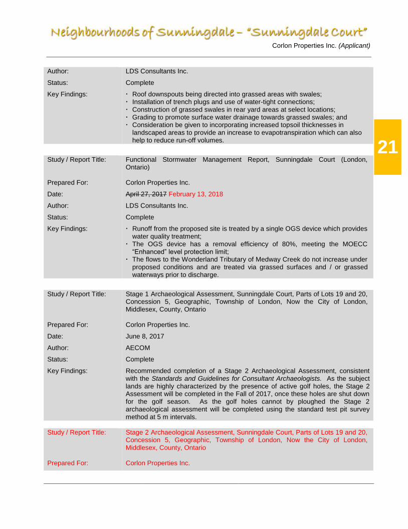
Study / Report Title:
Prepared For:
Date:
Author:
Status:
Key Findings:
Functional Stormwater Management Report, Sunningdale Court (London, Ontario) Corlon Properties Inc.
April 27, 2017 February 13, 2018
LDS Consultants Inc.
Complete
Runoff from the proposed site is treated by a single OGS device which provides water quality treatment;
The OGS device has a removal efficiency of 80%, meeting the MOECC “Enhanced” level protection limit;
The flows to the Wonderland Tributary of Medway Creek do not increase under proposed conditions and are treated via grassed surfaces and / or grassed waterways prior to discharge.
Study / Report Title: Prepared For:
Date:
Author:
Status:
Key Findings:
Stage 1 Archaeological Assessment, Sunningdale Court, Parts of Lots 19 and 20, Concession 5, Geographic, Township of London, Now the City of London, Middlesex, County, Ontario Corlon Properties Inc.
June 8, 2017
AECOM
Complete
Recommended completion of a Stage 2 Archaeological Assessment, consistent with the Standards and Guidelines for Consultant Archaeologists. As the subject lands are highly characterized by the presence of active golf holes, the Stage 2 Assessment will be completed in the Fall of 2017, once these holes are shut down for the golf season. As the golf holes cannot by ploughed the Stage 2 archaeological assessment will be completed using the standard test pit survey method at 5 m intervals.
Study / Report Title: Prepared For:
Stage 2 Archaeological Assessment, Sunningdale Court, Parts of Lots 19 and 20, Concession 5, Geographic, Township of London, Now the City of London, Middlesex, County, Ontario Corlon Properties Inc.

Corlon Properties Inc. (Applicant)
22
Date:
Author:
Status:
Key Findings:
January 17, 2018
AECOM
Complete, Submitted to the Ministry of Tourism, Culture and Sport on Jan. 24/18
Cleared the vast majority of subject lands of archaeological concern; A Stage 2 Archeological Assessment is required on all golf greens and tee
decks; A Stage 3 Archaeological Assessment is required for Location 2 (AgHh-259); The referenced Steg 2 and 3 Assessments must be completed and clear the
entire site of archaeological concern, to the satisfaction of the Ministry of Tourism, Culture and Sport, in advance of any site alternation or development proceeding
Study / Report Title:
Prepared For:
Date:
Author:
Status:
Key Findings:
Environmental Noise Assessment, “Sunningdale Court” – Corlon Properties Inc.
Corlon Properties Inc.
February 22, 2018
LDS Consultants Inc.
Complete
A 1.8 m high noise attenuation barrier is required along the south limit of Sunningdale Road, in association with the exterior side yards of Lot Nos. 1, 40, 53, 85, 86, and 102;
Noise warning clause A is required in association with Lot Nos. 1, 40, 41, 52, 53, 85, 86, 102, 103, and 114;
Noise warning clause C is required in associations with Lot Nos. 1, 40, 52, 53, 54, 84, 85, 86, 87, 101, 102, 103, and 114
7.0 Subdivision Design
The proposed plan of subdivision (see enclosed map pocket in the back of this document) consists of 114 single detached dwelling lots and four (4) Open Space Blocks. Block 115 is a 0.147 hectare Open Space Block, located in the southwest corner of the proposed development, and is provided to facilitate a neighbourhood connector (multi-use trail) to the existing neighbourhood (Sunningdale West, 33M-593) to the west. Block 116 (0.077 hectares) is an Open Space Block located in the southeast corner of the proposed plan and provides a direct connection to the multi-use trail, located within the adjacent Medway Valley Heritage Forest Environmentally Significant Area, which provides direct linkages to the existing neighbourhoods to the west and south and the larger community beyond. This block also serves as the location of the OGS devise device which handles storm water flows from the proposed development and provides direct maintenance access to this device as well as the Medway Trunk Sanitary Sewer immediately to the south. Block 117 is a 5.385 hectare Open Space Block which will be dedicated to the City of London. This block contains lands which provide the environmental and geotechnical buffer setbacks for the proposed development, as well as other lands which are part of the Medway Valley Heritage Forest Environmentally Significant Area and home to the Wonderland Road Tributary. At 1.198 hectares in size, Open Space Block 118 is part of the environmental and geotechnical buffer setbacks for the proposed development and contains lands within

Corlon Properties Inc. (Applicant)
23
the Medway Valley Heritage Forest Environmentally Significant Area. The dedication of this block will complete the transfer of one of the last portions of privately owned ESA lands (between Fanshawe Park Road and Sunningdale Road) to the City. The subdivision plan integrates in a cohesive manner with surrounding development on many levels, as follows: ▪ provides for a new intersection and access route, for the subject lands, to Sunningdale
Road West, consistent with the Sunningdale Community Plan and Schedule ‘C’ of the Official Plan; and
▪ provides for the completion of recreational pathways from the neighbourhood to the
west, through “Sunningdale Court” to the Medway Valley Heritage Forest ESA.
7.1. Urban Design Analysis
While the subject lands are bounded on three sides by natural heritage features and by Sunningdale Road on the north, land uses within the immediate vicinity are primarily residential and designated for predominantly “low density residential” / “neighbourhood” uses as per the Official Plan (1989) / London Plan. Lands to the west, south and east, across the Medway Valley and its associated tributaries (all designated as “Open Space”) are designated Low Density Residential. Lands to the north, across Sunningdale Road, are part of the active golf facilities associated with Sunningdale Golf & Country Club Ltd and as such are also designated as Open Space. A Community Commercial Node is located at the corner of Richmond Street and Sunningdale Road. Community facilities located in the vicinity include St. Catherine of Siena Catholic School, Jack Chambers Public School, Mother Teresa Catholic Secondary School and Medway High School as well as many neighbourhood parks. Trooper Mark Wilson Park is located in the neighbouhood to the west and will be accessible to the future residents of “Sunningdale Court” upon completion of the multi-use trails to this neighbourhood. The broader community context within the immediate vicinity of the subject site provides for what is primarily low density residential development with a mix of medium and high density uses. Further to the southeast of the subject site is the Masonville area, which is a highly utilized commercial and retail hub in the City of London. This area includes the Masonville Place Mall which is made up of a variety of retail and service shops, department stores and restaurants. The surrounding area includes a movie theatre, grocery store, retail, commercial, banks, service shops, restaurants and gas stations. This commercial and retail hub is approximately 3 kilometers from the subject lands which is approximately a 4 minute drive or 30 minute walk. Additional retail and commercial uses are planned for the intersection of Richmond and Sunningdale Road. Future residents of “Sunningdale Court” will also be able to access the shops and services located at “Sunningdale Village” (the northeast corner of Fanshawe and Wonderland) via the Medway Valley multi-use trail. While there is currently no transit service north of Fanshawe to the west of Richmond, the London Transit Service is planning a new “Sunningdale Route”. This route will travel east

Corlon Properties Inc. (Applicant)
24
along Sunningdale Road, from Fox Hollow, and connect to the Richmond rapid transit service, at Masonville Mall. Residential / Neighbourhood development is the intended land use for the subject site as per the Official Plan / London Plan. While protection of the Medway Valley lands and public safety are a priority, community amenity areas have been strategically located within the southeast and southwest corners of the proposed development. These Open Space Blocks will create a transition from the existing natural features adjacent to the site and the proposed built form of the residential neighbourhood, while providing residents a vantage point to enjoy the existing natural environment and access the existing multi-use trail network. Provincial Policy Statement: As previously mentioned in Section 2.0 of this report, engaging and sustaining an active healthy lifestyle has been one of the goals of the Sunningdale Community Plan. “Sunningdale Court” will continue to implement this objective through the provision of well planned public infrastructure that will facilitate pedestrian and non-motorized movements in a safe and accessible manner while promoting connectivity. A full range of publicly accessible built and natural settings for recreational uses have been equitably distributed through the larger master planning process, which is the Sunningdale Community Plan. “Sunningdale Court” now implements its portion of these facilities, open space areas and trails. With its direct access to the existing multi-use trail network, to the west and south, within the Medway Valley ESA, future residents of the proposed development will have access to the extensive range of recreational opportunities that exist within Plane Tree Park and Trooper Mark Wilson Park. Official Plan: The Urban Design Principles included within Chapter 11 of the Official Plan recognize that they will be utilized primarily for guideline purposes and their implementation will be cooperative in nature and less oriented to a regulatory approach. In also recognizes that the principles address matters that are largely subjective in nature related to the visual character and aesthetics of urban design. An analysis of the proposed development as it relates to the relevant urban design principles (11.1.1 of the Official Plan) promoted by Council, is as follows: i) The proposed plan of subdivision implements the findings of the Sunningdale
Community Plan as it relates to the natural features of the adjacent Medway Valley ESA. While the Sunningdale Community Plan (SCP) established the boundaries of the ESA, the subsequent Environmental Impact Study refined these while identifying site specific development criteria required to maintain the natural features and ecological functions of this ESA and to buffer it from the impact of the proposed development. The

Corlon Properties Inc. (Applicant)
25
Community Plan (Section 2.3.4) provided “Buffer and Management Guidelines” which would be refined through the completion of a subsequent site specific EIS. Figure 2.3.1 of the SCP established “ESA Buffer Segment” types for the entire portion of the ESA adjacent to the proposed development area. The east and south-east portions of the interface was characterized as “Buffer Type 3” which are areas that have lowest sensitivity and allow for the greatest flexibility with respect to the implementation of stormwater management infrastructure and trails. Most of the eastern interface is characterized by extreme slopes from the table lands of the proposed development down to the Medway Creek. As such, the proposed plan of subdivision has been designed with single family lots backing onto this portion of the interface, to restrict access to these steep slopes. Notwithstanding this, and considering the flexibility of the “Buffer Type 3” segment, a portion of the southeast interface has been utilized to provide the required connection to the existing trail network located within the Medway Valley ESA and provide maintenance access to the existing Medway Trunk Sanitary Sewer, while providing an outlet to the proposed SWM strategy for the subject lands. A large portion of the southern interface, between the proposed development and the Medway ESA, is characterized as “Buffer Type 2”. The edge treatment should address control of human access and where appropriate, enhancement of boundary conditions. As such, this area of the interface is largely coincident with proposed single-family lots backing onto the ESA. Consistent with City policy, the EIS requires these lots to be fenced without gates and the preparation of a buffer planting plan to enhance this boundary condition. Additionally, as discussed within Section 6.1 of this report, a geotechnical assessment was completed to determine the limits of development and appropriate setbacks for structures to ensure that erosion and slope stability hazards could be safely addressed. The slope around the site is about 9.7 to 14.0 m high, and is well vegetated with a mixture of shrubs and trees. The existing slope inclination ranges between about 2H:1V and 3.1H:1V, and extends down to the water’s edge of Medway Creek. Accordingly, the geotechnical assessment recommended appropriate setbacks in recognition of these hazards. Considering all the above, the form and design of the proposed development is consistent with the findings and recommendations of the SCP, the subsequent EIS and the geotechnical assessment, and compliments the adjacent significant natural feature that is the Medway Valley Heritage Forest ESA.
ii) A tree inventory and preservation plan will be prepared for the proposed development, as a condition of draft plan approval. In addition, as per i) above, a buffer planting plan will be prepared to enhance the remnant portions of the golf course located between the rear lot lines of Lot Nos. 1 to 40 and the existing vegetation within Block Nos. 117 and 118. A street tree planting plan will be developed, as per City of London requirements, for the proposed development.
Corlon Properties Inc. (Applicant)
26
iii) As discussed in i) above, portions of the ESA adjacent to the proposed development contain sensitive features and unstable slopes. Education, land ownership patterns, setbacks and fencing are all tools recommended within the SCP, the EIS and geotechnical assessment which are implemented within the design of the proposed development to ensure that the proposed development does not negatively impact the natural features and ecological functions of the ESA. In considering this urban design principle, the importance of “open views” is evaluated against the findings and recommendations of the previously mentioned studies / reports, as well as all other City policies and the PPS. Notwithstanding this and where appropriate the proposed development provides for “open views” through Block Nos. 115 and 116 to the Medway Valley. These Blocks have been located within the least sensitive location, considering the buffer segment type and the findings of the EIS, and serve to provide direct linkages to the existing trail network located within the subdivision to the west and the ESA to the south.
vii) Within the proposed development, consistent with all other phases of the
Neighbourhoods of Sunningdale, a coordinated approach to builder selection is employed to ensure a varied and high-quality streetscape. Lots are individually selected to ensure that the product line of no one custom builder dominates the streetscape of any street. This enables a streetscape, on an individual lot basis, that is unique and avoids the repetition that is seen in developments where one builder builds on every lot on a given street. Additionally, Corlon Properties Inc. maintains architectural control over every dwelling constructed within its developments. Individual custom homes are submitted, complete with exterior elevations and material and colour selections. This information is reviewed by Corlon in advance of building permit application to ensure that the architectural integrity of the development is maintained. This process ensures that no two homes with similar size, elevation, material and colour are constructed on the same street.
viii) Pedestrian traffic has been considered through the design of roads, sidewalk and
open space areas throughout the development. Sidewalks will be provided on the face of the proposed draft plan of subdivision. In addition, connection to the Medway Valley multi-use trail are provided through Block 116 and connection to Trooper Mark Wilson Park to the west, within “Sunningdale West” (33M-593), are provided through Block 115.
x) As in our previous developments within the Neighbourhoods of Sunningdale, the
proposed development will include numerous “enhanced landscaping features” which are beyond the present City standard. These enhancement areas will include the gateway / entrance feature at Street ‘A’ and Sunningdale Road, the landscape islands on Street ‘A’ from Sunningdale Road to Street ‘B’ / ‘C’, Open Space Blocks 115 and 115, and window street boulevard landscaping along Sunningdale Road. Additionally, consistent with our past practices, all required fencing (i.e. lot backing onto Open Space areas as well as those adjacent to Blocks 115 and 116) will be
Corlon Properties Inc. (Applicant)
27
upgraded beyond the present City standard to provide an elevated aesthetic and where necessary to minimize the loss of privacy for adjacent residential properties. Lastly, and consistent with past practices, upgraded street lights will be installed throughout the proposed development. While street lights are nut one small design element, when coupled with other elements they provide for a distinctive and attractive visual identity.
xiv) As indicated in x) above the fencing of Blocks 115 and 116 will be upgraded from the
City standard to provide an improved aesthetic while at the same time affording a level of privacy to the adjacent single-family homes not possible through the implementation of the City standard fencing requirement.
xviii) “Sunningdale Court” has been designed to provide for a window street (Street ‘B’ and
‘C’) adjacent to Sunningdale Road. This will enable the development of single family homes and eliminate the need for an extensive continuous sound barrier to attenuate noise. Notwithstanding the specific conditions of draft plan approval will be required on various lots (Nos. 1, 40, 41, 52, 53, 54, 84, 85, 86, 87, 100, 101, 102, 103 and 114,) to ensure that the recommendations of the noise study are implemented, as appropriate.
7.2. Existing Services
The ultimate municipal servicing strategies for the area have been included in several studies. Presently, existing services are as follows: Sanitary: The Medway Creek trunk sanitary sewer (MTSS) is located immediately south of the subject lands. This sewer has been designed to accommodate flows generated by the proposed development. Presently, sanitary flows from Sunningdale Golf & Country Club’s club house are pumped via a shallow pressure forcemain across Sunningdale Road to a temporary gravity sewer connected to the MTSS. Under proposed conditions, the forcemain will be intercepted within the first available manhole, south of Sunningdale Road, where sanitary flows from the clubhouse will then proceed by gravity though the sanitary sewer system installed within “Sunningdale Court” to the MTSS. The remnant forcemain south of Sunningdale Road will be abandoned and removed An overview of the existing sanitary network is included in Appendix F.
Storm: Stormwater Management in the traditional sense is not required for this site as stipulated by the Group 1 Subwatershed Study, prepared by Marshall Macklin and Monaghan (1995), which does not recommend water quantity control for the urbanized portion of the Medway Creek Subwatershed within City limits. For this reason, all flow is directed to Medway

Corlon Properties Inc. (Applicant)
28
Creek via the internal storm sewer system. Runoff from major events will be contained within local right-of-ways and flow overland to the southeastern corner of the site where flows will be directed through appropriately sized storm sewers which outlet to the Medway Creek. Flows generated from most runoff events will be treated by an oil and grit separator to ensure that water quality objectives are met. A functional stormwater management report detailing the proposed SWM strategy has been prepared by LDS Consultants Inc.
Water: Water supply for both domestic use and fire protection will be provided via a connection to the existing 900 mm PVC trunk watermain on Sunningdale Road. As the development contains more than 80 units the watermain will need to be looped with both connections coming off the watermain on Sunningdale Road. Roads: Sunningdale Road West, an arterial road, provides extensive frontage to the subject lands and will serve as the entrance point to the proposed development.
8.0 Sanitary Servicing
8.1. Background
The design of the Medway Sanitary Trunk Sewer (MSTS) provides capacity for lands situated to the north and west of the Sunningdale Road / Wonderland Road intersection as well as lands situated to the east of Wonderland Road, including lands forming part of the Sunningdale Golf and Country Club’s thirty-six hole golf course facility. This drainage area is represented by Drainage Area A2 on Figure 1 (included in Appendix F). By design, this area is contemplated to be serviced via an extension of the existing sanitary sewer within the Sunningdale Road right-of-way (western terminus is just west of the roundabout at Sunningdale Road / Wonderland Road, while the eastern terminus is as the intersection of Sunningdale Road / Wallingford Avenue). Additionally, Drainage Area A3, representing table lands situated to the east of Drainage Area A2, was originally contemplated to be serviced via an extension of a sub trunk sewer extending west from the terminus of the MSTS (just east of the Medway Creek) along Sunningdale Road. Sunningdale Court, represented by Drainage Area A4, is contemplated to be serviced directly to the MSTS along the south limit of the proposed development where it interfaces with the sewer easement containing the trunk sewer. In terms of storm servicing and storm water management, the Sunningdale Area Storm Drainage & Stormwater Management (SWM) Servicing Works for Undeveloped Lands Municipal Class Environmental Assessment “Schedule B” (2009) undertaking identifies a regional stormwater management facility immediately west of Wonderland (SWM 8/E2) in conjunction with a riparian corridor extending easterly linking SWM facility 8/E2 to the Wonderland Tributary immediately north of Sunningdale Road. A review of infrastructure

Corlon Properties Inc. (Applicant)
29
requirements associated with the conveyance of stormwater, whether it be by riparian corridor or by large diameter storm sewer, has identified a crossing conflict potentially compromising the future servicing of lands situated in the northern portion of Drainage Area A2 to the existing Sunningdale Road / Wonderland Road / Wallingford Avenue sanitary sewer system.
8.2. Sanitary Servicing Strategy
Due to potential constraints caused by the stormwater conveyance system an updated sanitary drainage area plan has been prepared. This updated sanitary drainage area plan is presented in Figure 2 (included in Appendix F). Drainage Area B1 and B6, which represent lands north of the riparian corridor, both east and west of Wonderland Road, will be directed easterly via a sub trunk sewer through the Sunningdale Golf and Country Club lands. This sewer will extend under Sunningdale Road to Drainage Area B7, which is the proposed Sunningdale Court subdivision where it will extend to the south limit of the plan and connect to the MSTS. Area B2 and B4 will continue to be serviced to the south to the Sunningdale Road / Wonderland Road / Wallingford Avenue sewer system. Under proposed conditions Drainage Areas B1 and B6 will enter the MSTS further upstream than contemplated in the original design of the MSTS. The diameter of the MSTS increases from a 750mm diameter pipe to an 825mm diameter sewer at S11, where the Subtrunk ‘B’ (which serves Sunningdale West, 33M-593) connects to the MSTS. As such, the capacity of the 750mm portion of the MSTS will have to be confirmed as being sufficient. Although not completed as part of this review, it is expected that the capacity will be sufficient as the per capita design standard for sewage flow has decreased considerably since the design of the MSTS. Under proposed conditions, the sub trunk sewer extending west from the terminus of the MSTS (just east of the Medway Creek) along Sunningdale Road would no longer be required.
9.0 Water Servicing
9.1. Water Servicing Strategy
New watermains will connect into the existing 900 mm trunk watermain located within the Sunningdale Road West right-of-way. Looping will be provided by an additional connection to this watermain.
A water supply system will be constructed within the proposed development and new water service connections will be provided to each new residential dwelling, all to City standards.
The design criteria for this site is summarized as follows:
▪ Average Domestic (Residential) Water Demand = 270 L/cap/day ▪ Development Density: Single Family Residential – 113 lots at 3 people / lot ▪ Maximum Hour Peaking Factor = 7.8 ▪ Maximum Day Peaking Factor = 3.5 ▪ Minimum Allowable Service Pressure = 275 kPa (40 psi) ▪ Minimum Allowable Pressure at any hydrant = 140 kPa (20 psi)
Corlon Properties Inc. (Applicant)
30
▪ Hazen-Williams “C” Factors for watermains: ▪ 100 to 150mm – 100 ▪ 200 to 250mm – 110 ▪ 300 to 600mm – 120 ▪ 600mm + - 130 ▪ Pipe Sizing: based upon Water Distribution Design Standard
Detailed hydraulic modeling has not been completed for the purposes of this report. This effort will be completed as part of development approvals process. The modeling will determine precise demands of the development and provide preliminary sizing of the watermains.
10.0 Stormwater Management (SWM)
10.1. Stormwater Assumptions
The site is in the Medway Creek subwatershed. No runoff from adjacent properties runs through the subject site. The stormwater drainage area comprises approximately 13 hectares of in-use golf course and outlets to Medway Creek, a tributary of the Thames River. There are no downstream capacity issues as the Medway Creek subwatershed is large and the subject site is near the bottom of the watershed, thus the recommendation from the Group 1 subwatershed study for no quantity control. Further the Group 1 subwatershed study does not stipulate erosion controls. A municipal class environmental assessment is not required for the development of this site. The Group 1 Subwatershed Study outlined the SWM criteria that should be followed for all new development within the Medway Creek subwatershed, of which the Sunningdale Court subdivision is a part. The criteria are summarized below. Water Quality Control - Ministry of Environment and Climate Change (MOECC) “Enhanced” Level Protection should be provided to remove 80% of the total suspended solids from the stormwater, prior to discharge to the receiving watercourse. Erosion Control - The Group 1 Subwatershed Study states that 60 m3/ha of erosion control storage should be provided for all lands that discharge to the Wonderland Tributary, however the majority of the land contributing flow to the Wonderland Tributary under post-development conditions will be intercepted. As a result, flows to the tributary will be limited to sheet flow from rear yard areas thereby mitigating erosion impacts on the tributary. Erosion control storage for discharges directly to Medway Creek is not required. Water Quantity Control - The Group 1 Subwatershed Study does not recommend quantity control within the Medway Creek Subwatershed.
Corlon Properties Inc. (Applicant)
31
Stormwater Management in the traditional sense is not required for this site as stipulated by the Group 1 Subwatershed Study, prepared by Marshall Macklin and Monaghan (1995), which does not recommend water quantity control for the urbanized portion of the Medway Creek Subwatershed within City limits.
10.2. Proposed Strategy for Stormwater
All runoff is directed to Medway Creek via the internal storm sewer system. Runoff from major events will be contained within local right-of-ways and flow overland to the southeastern corner of the site where flows will be directed through appropriately sized storm sewers which outlet to the Medway Creek. Flows generated from most runoff events will be treated by an oil and grit separator to ensure that water quality objectives are met. A functional stormwater management report detailing the proposed SWM strategy has been prepared by LDS Consultants Inc. (May 2017). Details of the stormwater catchments are presented in Appendix D. To convey the runoff from the development to Medway Creek, internal storm sewers have been designed using parameters from the City of London design standards. These parameters include a time of concentration of 19 minutes, the rainfall intensity duration frequency curve and the varied land use runoff coefficients. In addition to meet the water quality requirements an OGS device has been sized to remove 80% of the annual total suspended solids load. This OGS will protect Medway Creek from sediment deposition, and any hydrocarbons or pollutants that bind to sediment washed off the roadway during a rain event. As stated previously water quantity control is not recommended by the Group 1 subwatershed study so no traditional end of pipe quantity facility is being proposed. The site was evaluated using SWMHYMO 99 modelling software to model both existing and proposed conditions. This hydrologic modelling software generated peak flows and total runoff volumes from the site. These flows were then used to size the Oil Grit Separator. The flows generated by SWMHYMO were also used to ensure that overland flows could be conveyed within the public right of way.
10.3. Preliminary Erosion and Sediment Control Assessment
In 1987, the “Ontario Guidelines on Erosion Sediment Control (ESC) for Urban Construction Sites” were developed by the Ministries of Natural Resources, Environment, Municipal Affairs and Transportation & Communications, in cooperation with the Association of Conservation Authorities of Ontario, the Municipal Engineers Association and the Urban Development Institute of Ontario. These guidelines identify basic methods and practices that should be used to manage ESC for land development and construction sites in order to minimize the adverse effects of the storm discharge for these sites in order to provide some water quality protection of open watercourses in Ontario.

Corlon Properties Inc. (Applicant)
32
In the last ten years, the Federal and Provincial governments have introduced a number of legislative requirements regarding the protection of water quality within open watercourses, and specifically related to stormwater management (SWM) mitigation measures to address land use changes under new or updated Acts, Regulations and Guidelines. In order to comply with these requirements, the City of London’s Environmental and Engineering Services Department (EESD) has updated and developed standards and practices that endorse the required ESC measures. The City’s current subdivision / development agreement provisions, place the onus on the Owner’s Consulting Engineer to develop an ESC Plan to the satisfaction and specifications of the City Engineer. This ESC Plan is site specific and must be submitted as part of the detailed design of the proposed development. Construction cannot proceed without approval by the City of the ESC Plan. The erosion and sediment control methods include: ▪ Heavy duty silt fence at or above the regulatory flood line;
▪ Temporary sedimentation pond at the outlet end of the ravine;
▪ Temporary diversion swales are necessary to convey runoff away from stockpiles and towards the sedimentation pond;
▪ Straw bale and / or rock check dams in temporary diversion swales as indicated in the drawing set and as directed by the Contract Administrator;
▪ Stabilization of all disturbed areas where work will not take place for a period of 15 days or more in accordance with OPSS 572;
▪ Dewatering effluent discharge to be directed to sediment traps, filters, or sedimentation basins;
▪ Energy diffusers to be employed for dewatering effluent lines.
Specific details and locations of the proposed temporary and long-term erosion and sediment control measures for the proposed development will be outlined in detail within the proposed construction servicing drawings. Once complete and approved, these will form the ESC Plan for the proposed development.
11.0 Transportation
The subject site fronts onto Sunningdale Road West (Arterial / Civic Boulevard), with access provided from Sunningdale Road West via Street “A”. The London Transit Commission (LTC) currently does not service Sunningdale Road West. Notwithstanding this, LTC’s “Transit Network / Rapid Transit Integration Framework – Final Report” (Dillon Consulting Limited, August 2016) indicates that a new “Sunningdale Route” is to be established in 2027.

Corlon Properties Inc. (Applicant)
33
11.1. Transportation Impact Study
The main purpose of a Transportation Impact Study (TIS) is to demonstrate that the transportation impacts of a proposed development or redevelopment can be managed and that transportation aspects of the proposal are consistent with the objectives and policies of the City of London. The TIS provides the basis for the identification and evaluation of transportation related improvements or mitigation measures to be included as conditions of Draft Approval for development applications. Presently, a TIS associated with the development of the proposed subdivision has not been completed. Notwithstanding the above, the transportation demands and requirements for the entire Sunningdale Area, including the proposed development, were analyzed through the completion of the Sunningdale Community Plan, Sunningdale North Area Plan and other transportation / traffic studies completed for other communities, subdivisions and developments near the study area. The Sunningdale Community Plan “Engineering Components – Traffic and Transportation” was completed in April 1998. This study analyzed the existing arterial road network, estimated future traffic demands and proposed road improvements within the area bounded by Wonderland Road, Fanshawe Park Road, Richmond Street and the northerly municipal boundary. Specifically, the following road system design factors were included:
▪ Ultimate arterial road R.O.W. requirements and expected timing of upgrades; ▪ Number of through lanes and turning lanes on the surrounding arterial roads; ▪ Internal collector road intersection requirements with the arterial roads; ▪ Internal trip generation estimates and projected traffic distribution patterns; and ▪ Estimates of arterial / collector road intersection turning movements.
This study also established the internal collector road network within the Sunningdale Community Planning area. Considering that the “Sunningdale Court” area is an enclave surrounded on three sides by the natural heritage features of the Medway Heritage Forest ESA and an associated tributary of Medway Creek, no secondary collector connection was proposed through the subject lands. As such, potential transportation impacts are limited to the ingress / egress to the proposed development from Sunningdale Road West. While a TIS has not been completed for the proposed development, significant information can be gleaned from previous reports (Sunningdale Meadows – Traffic Impacts Study, Stantec Consulting Ltd. Dec. 2009) completed in the immediate area. The Sunningdale Meadows TIS undertook traffic forecasts and made specific recommendations based upon traffic generated from its draft plan that provided for 330 units. The recommendation for the intersection of Street ‘G’ (which is now Meadowlands Way) and Sunningdale Road was for a westbound left-turn lane with a minimum of fifteen (15) metres of storage. However, in recognition of the City of London’s design guidelines and an assumed design speed of 80 km/h (20 km/h over the posted speed limit) on Sunningdale Road West, a westbound left-

Corlon Properties Inc. (Applicant)
34
turn lane with 45 metres of storage with a 50 metre parallel lane length and a taper length of 80 metres was ultimately provided. Considering this, with 114 units, it is reasonable to assume that the peak hour trip generation for the a.m. and p.m. hours from “Sunningdale Court” will be much lower, resulting in a smaller westbound left-turn lane storage requirement on Sunningdale Road West at Street ‘A’. Notwithstanding this, the City of London’s Design Specifications & Requirements Manual (June 2014) specifies that the minimum storage on an arterial road intersection shall be 45 metres. As such, this minimum standard will be employed at the intersection of Sunningdale Road and Street ‘A’. In addition, considering the lower peak demand, this new arterial intersection will operate with a satisfactory level of service for all left turn movements with stop control. Traffic signals will likely be unnecessary during build-out and in advance of the City assuming the proposed development. As such, the City’s Transportation Division will likely monitor this intersection, and install traffic signals when specific warrants are met. Considering this analysis, it is the writer’s opinion that the completion of an additional TIS in support of the proposed development is unnecessary considering the enclave nature of “Sunningdale Court” and that the City’s minimum design storage requirements will satisfy the traffic generated needs of this development. Specifics necessary to properly plan for and design this intersection are already known. In addition, upon review of the proposed draft plan of subdivision (see enclosed map pocket in the back of this document) Block No. 119 provides for the ultimate road widening to accommodate the southerly shift of Sunningdale Road West, consistent with Official Plan (1989) policy 10.1.3 cxii, 1752 of the London Plan, as well as the approval and development of Sunningdale West (33M-593) to the west and Sunningdale Meadows (33M-647) to the east.
11.2. Internal Roadworks
A gateway treatment is proposed at the entrance to Sunningdale Court to facilitate traffic calming, making the area safer and more inviting for pedestrians and cyclists, without restricting local motorists’ access to the arterial road network. The proposed draft plan of subdivision has been designed to incorporate window streets (Street ‘B’ and Street ‘C”), to the east and west of its entrance (Street ‘A’) from Sunningdale Road West. These window streets are parallel to and are situated immediately adjacent to the south boulevard of the Sunningdale Road West road allowance. The objective of the two window streets is to provide an enhanced interface with Sunningdale Road West (eliminating the need for noise attenuation walls) as well as to provide vistas of the Sunningdale golf course to the north. In terms of road standards, all the proposed internal roads will be designed to “local” collector standards in accordance with City of London design guidelines. To develop Sunningdale Court, some disturbance to Sunningdale Road West will be necessary. These disruptions are a result of the need to connect to and install the necessary storm, sanitary and water connections, as appropriate. It is anticipated that a Traffic Management Plan will be necessary as part of Stage 4 (Servicing Drawings) of the

Corlon Properties Inc. (Applicant)
35
File Manager System for Subdivision Approvals, in recognition of the need to minimize impacts on existing residents of the area and the travelling public.
11.3. External Roadworks
The “Sunningdale Road Improvements Wonderland Road North to Adelaide Street North Environmental Study Report” (ESR) was completed in 2013 by AECOM. The purpose of this ESR was to identify a preferred design which provides an appropriate level of service to address safety, traffic congestion, comfort and convenience, speed and travel time, while ensuring a reliable transportation corridor with long term sustainability. The ESR concluded that improvements to Sunningdale Road, in the form of urbanization, traffic signalization and widening from two lanes to four lanes would be required to meet the projected transportation requirements in the northwest quadrant of the City of London. The ESR also recommended a preferred horizontal alignment and vertical profile for Sunningdale Road. The existing and proposed ultimate profiles were analyzed within the context of the proposed draft plan of subdivision and the location of the entrance to “Sunningdale Court”, via a new intersection (Street ‘A’) with Sunningdale Road West. As shown in Appendix H, based on the Geomatics Design Guide for Canadian Roads the location of Street ‘A’ adequately provides the required minimum decision site distance and turning sight distance to safely provide access to Sunningdale Road West, with the implementation of an interim profile.
11.4. Bicycle and Pedestrian Considerations
The “Sunningdale Court” lands are one of the last areas of the Sunningdale Community Plan to develop. A multi-use recreational path network, within the Medway Valley, was originally envisioned in the late 1990’s as part of the Sunningdale Community Plan. To date, most of the path network has been completed, south of Sunningdale Road, east of Wonderland Road, north of Fanshawe Park Road, and west of Richmond Street. The existing path (3.0 metre, asphalt) extends along the alignment of the Medway Trunk Sanitary Sewer (MTSS), within the Medway Valley Heritage Forest Environmentally Significant Area, situated to the immediate south of the subject lands. This pathway also serves to provide maintenance access to the sanitary sewer. At the time that the MTSS was constructed, a sewer stub was provided to the subject lands to serve as an outlet for Sunningdale Golf Clubs clubhouse facility. In addition, a maintenance access was provided from Sunningdale Road West to the MTSS, by way of an easement in favour of the City of London. Considering all for the above, direct access from “Sunningdale Court” to the existing path network in the Medway Valley, is required for both sewer maintenance and recreational purposes. While the future residents of “Sunningdale Court” will benefit from this direct connection to the existing path network, the development of the subject lands will also provide a connection to this network for the residents of “Sunningdale West” (33M-593). At the time that “Sunningdale West” was developed (to the west of the subject lands), no direct access to the Medway Valley was provided in consideration of the existing

Corlon Properties Inc. (Applicant)
36
topography and the sensitivity of the surrounding flora and fauna. As such, access was planned and pathways were constructed through Trooper Mark Wilson Park and along the south side of the adjacent stormwater management facility. These pathways would serve to connect “Sunningdale West” to the Medway Valley through the development of “Sunningdale Court” once the existing golf holes were relocated. Accordingly, an opportunity now exists to connect the existing paths in “Sunningdale West’ through Blocks 115 and 116 of the proposed draft plan of subdivision for “Sunningdale Court” to connect both neighborhoods to the Medway Valley path network. These connections will also provide access to Trooper Mark Wilson Park within “Sunningdale West” as well as provide access to Wonderland Road for the residents of “Sunningdale Court”. Additionally, as per Council Policy, Streets “A”, “B”, and “C”, within the proposed draft plan of subdivision, will include sidewalks which provide direct linkages to Sunningdale Road West. The proposed window street design offers a variety of direct connections between Sunningdale Road West and the Medway Valley path network and the neighbourhoods of Sunningdale. Once complete, the pathway system, sidewalks, walkways, and bicycle lanes (on adjacent arterial roadways) will provide one of the City’s most comprehensive pedestrian network systems. This network will provide multiple options for the residents of the immediate area as well as users of the City’s more extensive bicycle and pedestrian network systems.
12.0 Parks Planning
Pursuant to the Sunningdale Community Plan, no active parkland was identified on the subject lands. Notwithstanding this, the Planning Act requirement for parkland dedication will still need to be satisfied. The proposed draft plan of Subdivision provides for the following (Open Space) Blocks:
Block No. 115 (0.147 ha) Block No. 116 (0.077 ha) Block No. 117 (5.385 ha) Block No. 118 (1.198 ha)
The intention is that these Blocks would be transferred to the City of London at the time that “Sunningdale Court” is developed, as partial satisfaction of the required parkland dedication requirements. Block Nos. 115 and 116 are lands that are otherwise developable, pursuant to the recommendations of the Environmental Impact Study and Slope Stability Analysis. Notwithstanding this, these blocks have been located within the southwest and southeast corners of the proposed draft plan of subdivision to provide view corridors into the adjacent natural heritage features and to provide active mobility connections between the proposed development and the neighbourhood to the west
Corlon Properties Inc. (Applicant)
37
(“Sunningdale West – 33M-593) and to the multi-use paths and hiking trails located within the adjacent Medway Heritage Forest ESA. Block Nos. 117 and 118 are lands that either constrained due to naturally occurring processes or contain significant natural heritage features or ecological functions and have been identified for protection. As previously mentioned, these lands will also be dedicated to the City of London consistent with the dedication ratios provided in previous developments. Through the completion of the “Sunningdale Court - Parkland Dedication Requirements / Calculations Analysis” (Appendix “G”) it has been determined that the parkland dedication requirements for “Sunningdale Court” have been fulfilled through the dedication of Block Nos. 115 to 118, inclusive. These dedications coupled with an outstanding parkland dedication credit associated with the development of “Sunningdale Meadows” (39T-10502), provide for an over dedication (1.066 ha) of parkland through the development of the subject lands. As such, consistent with past approvals, the draft plan approval of “Sunningdale Court” will acknowledge that this parkland dedication credit exists and will be applied towards the required parkland dedication requirements of future subdivision lands, to the north, owned by the applicant.
13.0 Financial Implications (Prepared by Anthony Gubbels, P.Eng. of LDS Consultants Inc.)
The proposed “Sunningdale Court” subdivision provides for 114 single family residential lots. The financial implications for this development application, with anticipated total revenues of $3,469,590.00 to the CSRF and the UWRF (based on 2018 rates) will result in a net revenue benefit of $3,343,515.00 compared to estimated claimable works of $126,075.00 to the CSRF.
A summary of anticipated cost sharable works and Development Charge revenue estimates, along with corresponding rates, notes and assumptions are presented on the “Initial Proposal Report (IPR) Cost Sharable Works & DC Revenue Estimates Worksheet” (enclosed in Appendix E).
Please note that Sunningdale SWMF 6A is presently scheduled within the 2017 GMIS for 2018 at an estimated cost of $1,800,000. Through the stormwater servicing strategy proposed herein and as contemplated within the “Functional Stormwater Management Report, Sunningdale Court (London, Ontario)” (LDS Consultants Inc. May 1, 2017 February 13, 2018) this pond can be eliminated in favour of an OGS devise. This would reduce the cost to provide stormwater servicing to the subject lands from $1,800,000 to approximately $95,000.
13.1. Summary of Revenues
Based upon the present Development Charge rates and assuming density (uph) as per the proposed draft plan of subdivision, the proposed development will generate the following revenues:
Corlon Properties Inc. (Applicant)
38
Land Use Estimated UWRF
Revenue Estimated CSRF
Revenue
Low Density Residential $286,026 $3,183,564
Total $286,026 $3,183,564
Note: See “Initial Proposal Report (IPR) Cost Shareable Works & DC Revenue Estimate Worksheet” in Appendix E for additional details.
13.2. Summary of Claimable Costs
A summary of major claimable works associated with the proposed development are as follows:
Description Estimated UWRF
Claims Estimated CSRF Claims
Sanitary Sewers - $31,075
SWM Facility - $95,000.00
Total - $126,075
Note: See “Initial Proposal Report (IPR) Cost Shareable Works & DC Revenue Estimate Worksheet” in Appendix E for additional details.
14.0 Miscellaneous
A Zoning By-law Amendment will be brought forward together with the application for draft plan approval. At this point, it is assumed that an Official Plan Amendment is unnecessary.
15.0 Summary & Conclusions
Corlon Properties Inc. in association with LDS Consultants Inc. has prepared this Final Proposal Report for “Sunningdale Court”. Consistent with the Sunningdale Community Plan, which provided the overall vision and framework for development of the area, the intent of the “Sunningdale Court” development is to identify and protect the features of the Medway Valley and develop a land use pattern that is efficient and environmentally responsible. Preservation of natural features is a core principle of the proposed development while promoting an attractive community in which to live, work and play. All technical reports in support of the applications have been completed and submitted to provide the necessary support for the proposed development.

Corlon Properties Inc. (Applicant)
39
In summary, the proposed applications for an Official Plan Amendment, Zoning By-law Amendment and Draft Plan of Subdivision, as per the Planning Act, in support of the development of “Sunningdale Court” represent good planning and are in the interest for the City of London and the public, as they:
▪ Are consistent with the relevant policies of the Provincial Policy Statement; ▪ Conform to the relevant policies of the City of London Official Plan (1989); ▪ Have regard for the policies of The London Plan; ▪ Apply to lands which are designated for growth, with the City’s Urban Growth
Boundary and represent the logical progression of development while maximizes existing infrastructure and services;
▪ Provide for an attractive, pedestrian orientated development while balancing the need to protect the exiting / surrounding natural heritage features;
▪ Preserve significant natural heritage features and protect the functions of the various natural hazard features; and
▪ Contributes to a form of housing which contributes to an appropriate range, type and density to meet the projected requirements of current and future residents of the regional market area on an aggregate basis.
Report Prepared By:
David R. Schmidt, MCIP, RPP
Development Manager Corlon Properties Inc.
16.0 Appendices
Appendix A
City of London (1989) Official Plan - Excerpt of Schedule ‘A’ (Land Use) (Prepared by LDS Consultants Inc.)
City of London – The London Plan – Excerpt of Map 1 (Place Types)
(Prepared by LDS Consultants Inc.)

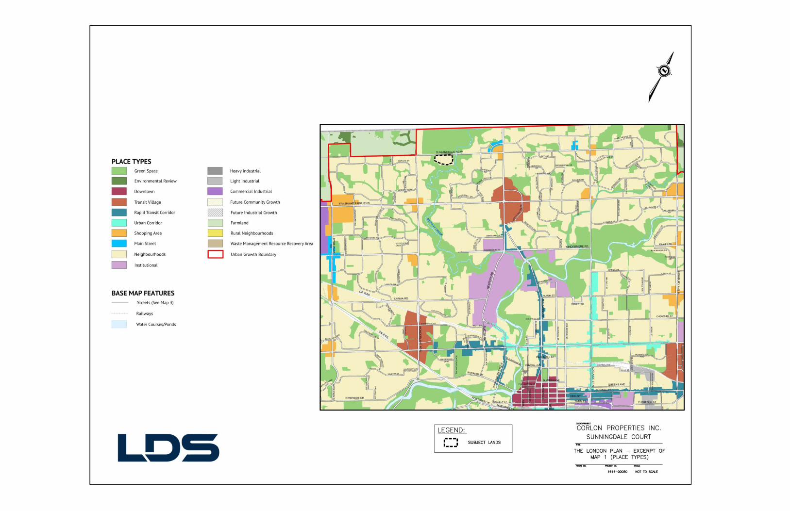
Appendix B
City of London Official Plan - Excerpt of Schedule ‘B1’ (Natural Heritage Features) and Excerpt of Schedule ‘B2’ (Natural Resources and Hazards)
(Prepared by LDS Consultants Inc.)
City of London – The London Plan – Excerpt of Map 5 (Natural Heritage) and Excerpt of Map 6 (Hazards and Natural Resources)
(Prepared by LDS Consultants Inc.)


Appendix C
City of London (1989) Official Plan - Excerpt of Schedule ‘C’ (Transportation Corridors) (Prepared by LDS Consultants Inc.)
City of London – The London Plan – Excerpt of Map 3 (Street Classification) and
Excerpt of Map 4 (Active Mobility Network) (Prepared by LDS Consultants Inc.)
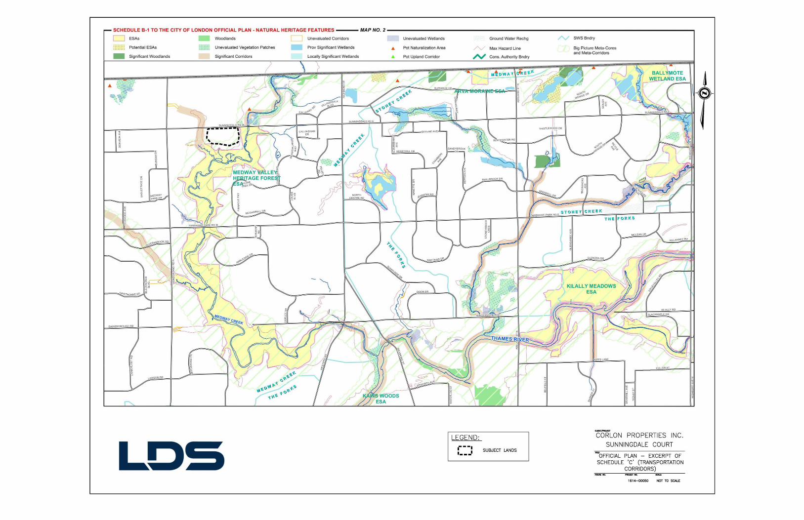
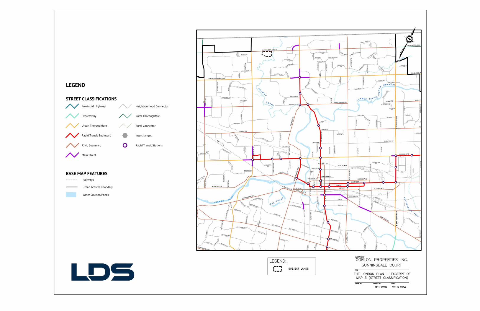


Appendix D
“Sunningdale Court” – Post Development Drainage Areas, LDS Consultants Inc.
April 24, 2017


Appendix E
Initial Proposal Report (IPR) Cost Sharable & DC Revenue Estimate Worksheet, completed by
Anthony Gubbels. LDS Consulting Inc. June 30, 2017 February 8, 2018


Appendix F
“Sunningdale Court” – MSTS Sanitary Drainage Areas LDS Consulting Inc. July 12, 2017
“Sunningdale Court – Proposed Sanitary Catchments LDS Consulting Inc. July 12, 2017

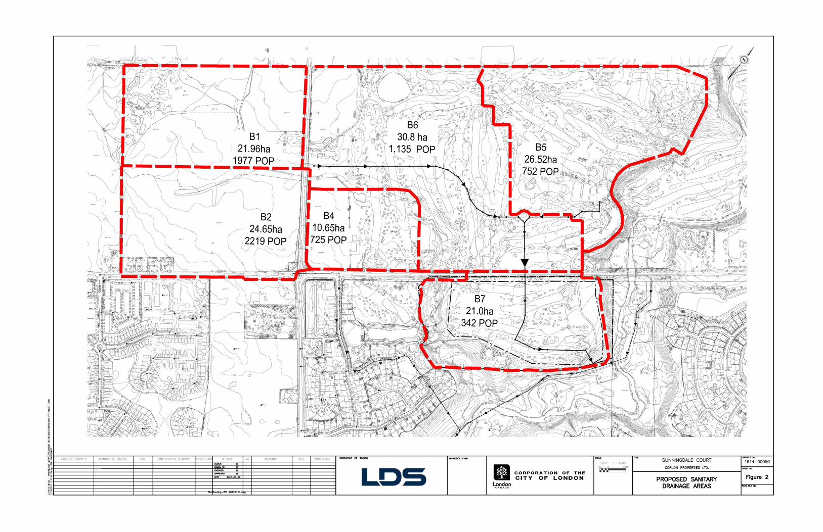
Appendix G
Sunningdale Court - Parkland Dedication Requirements / Calculations Analysis
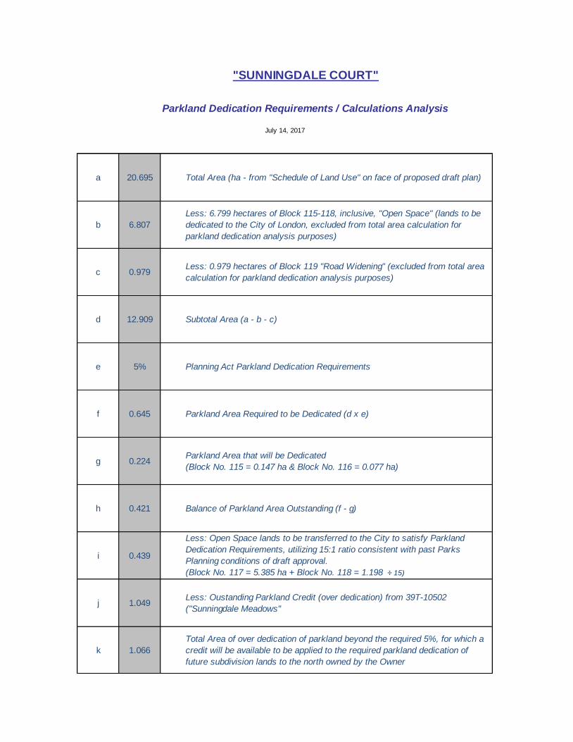
a 20.695
b 6.807
c 0.979
d 12.909
e 5%
f 0.645
g 0.224
h 0.421
i 0.439
j 1.049
k 1.066
Subtotal Area (a - b - c)
Planning Act Parkland Dedication Requirements
Parkland Area Required to be Dedicated (d x e)
Parkland Area that will be Dedicated
(Block No. 115 = 0.147 ha & Block No. 116 = 0.077 ha)
Balance of Parkland Area Outstanding (f - g)
Total Area of over dedication of parkland beyond the required 5%, for which a
credit will be available to be applied to the required parkland dedication of
future subdivision lands to the north owned by the Owner
Less: Open Space lands to be transferred to the City to satisfy Parkland
Dedication Requirements, utilizing 15:1 ratio consistent with past Parks
Planning conditions of draft approval.
(Block No. 117 = 5.385 ha + Block No. 118 = 1.198 ÷ 15)
Less: Oustanding Parkland Credit (over dedication) from 39T-10502
("Sunningdale Meadows"
"SUNNINGDALE COURT"
Parkland Dedication Requirements / Calculations Analysis
July 14, 2017
Total Area (ha - from "Schedule of Land Use" on face of proposed draft plan)
Less: 0.979 hectares of Block 119 "Road Widening" (excluded from total area
calculation for parkland dedication analysis purposes)
Less: 6.799 hectares of Block 115-118, inclusive, "Open Space" (lands to be
dedicated to the City of London, excluded from total area calculation for
parkland dedication analysis purposes)

Appendix H
Site Distance Analysis of Street ‘A’ and Sunningdale Road West LDS Consulting Inc.

Appendix I
Bibliography – complete list of sources that were used or referenced in the preparation of this report

AECOM, 2030 Transportation Master Plan: SmartMoves, May 2013.
AECOM, Sunningdale Road Improvements Wonderland Road North to Adelaide Street North Environmental Study Report, May 2013.
AECOM, Stage 1 Archaeological Assessment, Sunningdale Court, June 8, 2017. AECOM, Stage 2 Archaeological Assessment, Sunningdale Court, January 17, 2018. C.E. Knutson & Associates Inc, ESG International, and Stanley Consulting Group Ltd.
Sunningdale Community Plan, June 22, 1998.
Corporation of the City of London, Bicycle Master Plan, October 2, 2005.
Corporation of the City of London, Official Plan, June 19, 1989, as amended.
Corporation of the City of London, Zoning By-law No. Z.-1, July 1, 1993, as amended.
Corporation of the City of London, The London Plan, December 26, 2016
Corporation of the City of London, Design Specifications & Requirements Manual, June 2014
Dillon Consulting Limited, London Transit Commission, Transit Network, Rapid Transit Integration Framework, Final Report, August 2016.
Earthtech / AECOM, Sunningdale Area Storm Drainage and Stormwater Management Servicing for Undeveloped Lands (EA), April 2009.
exp Services Inc. Slope Assessment, Sunningdale Court Subdivision (London, Ontario), March 2015.
Government of Ontario, Planning Act, R.S.O. 1990, Chapter P.13, as amended. Government of Ontario, Provincial Policy Statement, March 1, 2005. LDS Consultants Inc., Hydrogeological Study, Proposed Residential Subdivision, Sunningdale
Court, London, Ontario, June 13, 2017. LDS Consultants Inc., Hydrogeological Study, Proposed Residential Subdivision, Sunningdale
Court, London, Ontario, February 8, 2018. LDS Consultants Inc., Functional Stormwater Management Report, Sunningdale Court
(London, Ontario), February 13, 2018. LDS Consultants Inc., Functional Stormwater Management Report, Sunningdale Court
(London, Ontario), May 1, 2017.

LDS Consultants Inc. Environmental Noise Study Assessment “Sunningdale Court” – Corlon Properties Inc, February 22, 2018
Stantec Consulting Ltd., Sunningdale Court Environmental Impact Study. October 12, 2018 Stantec Consulting Ltd., Sunningdale Meadows Subdivision, Stormwater Management
Facility 4, Conceptual Stormwater Management Report, May 2009.
Stantec Consulting Ltd. Sunningdale Meadows – Traffic Impacts Study, Dec. 2009.
Trow Associates Inc., Slope Stability Assessment Sunningdale Court Subdivision, London, Ontario, February 2011.
Appendix J
Opinion Letter for Class EA, LDS Consulting Inc
(February 8, 2018)


Appendix K
Annotated “Proposal Review Meeting Summary & record of Consultation”
(November 2, 2017)

Note: Original executed copy received from the City of London (via email from Rob Carnegie) on November 6, 2017. Digital copy subsequently annotated in “red” herein by David R. Schmidt, Development Manager of Corlon Properties Inc. and / or Anthony Gubbels, Principal, Urban Land Engineering of LDS Consultants Inc. / Rebecca A. Walker, Principal, Geotechnical Services of LDS Consultants Inc.
PROPOSAL REVIEW MEETING SUMMARY & RECORD OF CONSULTATION
Date: November 2, 2017 Subject: Proposal Review Meeting 379 Sunningdale Road West – Sunningdale Court Meeting Date: September 13, 2017 Meeting Participants: P. Yeoman Development Services – Planning A. Riley Development Services – Planning L. Pompilii Development Services – Planning I. Absushehada Development Services – Engineering M. Harrison Development Services – Engineering M. Aitken Development Services – Engineering C. Liu Development Services – Engineering M. Salama Development Services – Engineering M. Feldberg Development Finance W. Rotteau Development Finance R. Carnegie Development Finance K. Edwards Development Finance A. Giesen E.E.S. – Transportation M. Schaum E.E.S. – Wastewater & Drainage Engineering K. Fairhurst E.E.S. – Waterworks Engineering P. Titus E.E.S. – Stormwater Management B. Page Planning – Parks Planning & Design H. McNeely Planning – Urban Design C. Creighton Upper Thames River Conservation Authority M. Snowsell Upper Thames River Conservation Authority David Schmidt – Corlon Properties Inc. Anthony Gubbels – LDS Consultants Inc.
Owner: Sunningdale Golf and Country Club Applicant: Corlon Properties Inc. Authorized Agent: David Schmidt, Development Manager, Corlon Properties Inc Type of Application: Proposed Draft Plan of Subdivision, File #TS2017-006 Location: 379 Sunningdale Road West File Manager: Lou Pompilii Planner: Alanna Riley David Schmidt provided a brief overview of the proposal along with history and context of the subject lands.

Note: Original executed copy received from the City of London (via email from Rob Carnegie) on November 6, 2017. Digital copy subsequently annotated in “red” herein by David R. Schmidt, Development Manager of Corlon Properties Inc. and / or Anthony Gubbels, Principal, Urban Land Engineering of LDS Consultants Inc. / Rebecca A. Walker, Principal, Geotechnical Services of LDS Consultants Inc.
DEPARTMENT & AGENCY COMMENTS The following is a summary of the comments as reported by the respective service areas/agencies in response to the proposal. It is noted that these comments do not necessarily reflect the final planning recommendation on the proposal. DEVELOPMENT PLANNING: Lou Pompilii Manager, Development Services Planning Alanna Riley Senior Planner
- Planning justification report – add more analysis in Placemaking housing types - Acknowledged
- Noise study – Requirement Acknowledged, report submitted as part of the complete application package
- Archaeological – Acknowledged, Stage 2 Archaeological Assessment complete, report submitted as part of the complete application package
URBAN DESIGN/PLANNING POLICY: Britt O'Hagan Urban Designer – Note: Not in attendance at Proposal Review Meeting
Planning Services has reviewed the Initial Proposal Review noted address and provide the following comments:
Items to be included in the Planning and Design Report:
Natural Heritage, Parks and Open Space 1. The subject lands are adjacent to an ESA and a significant ravine corridor – Acknowledged 2. Appropriate SAR screening should be undertaken. – Acknowledged, SAR screening was
undertaken as part of EIS submitted as part of the complete application package
3. Staff are seeking confirmation the identified geotechnical limit identified on the plan includes the required 6 meter access allowance. – Acknowledged, the geotechnical / development limit
includes the require six (6) metre access allowance, as per the Slope Assessment submitted as part of the complete application package
4. Consistent with the Bicycle Master Plan, a multi-use pathway is to be located at the south
portion of the property. - The Bicycle Master Plan depicted the conceptual alignment of a “Proposed Secondary Recreational Route” through the southern portion of the subject lands to provide neighbourhood connections to the Primary Recreation Network. It is further acknowledged that the preference is for an off-street path. In analyzing options for these neighbourhood connections, it became clear that alignments needed to avoid sensitive portions of the ESA, to the south of the proposed subdivision. Accordingly, the proposed draft plan of subdivision provides for Open Space Blocks which serve as neighbourhood connectors from Sunningdale West (33M-593) through the subject lands and onto the Primary Recreation Network, which is the multi-use pathway located within the Medway Valley. This is consistent with the “first principles” of the Bicycle Master Plan which seeks a network that takes “…advantage of attractive and scenic areas, views and vistas while having consideration for environmentally significant ant features and functions.” This is also consistent with
Note: Original executed copy received from the City of London (via email from Rob Carnegie) on November 6, 2017. Digital copy subsequently annotated in “red” herein by David R. Schmidt, Development Manager of Corlon Properties Inc. and / or Anthony Gubbels, Principal, Urban Land Engineering of LDS Consultants Inc. / Rebecca A. Walker, Principal, Geotechnical Services of LDS Consultants Inc.
how all other neighbourhood connectors have been planned and development within the entire Sunningdale area.
5. The Draft Medway Conservation Master Plan identifies the possible need of an accessible parking lot. This site has been identified as a potential candidate for the parking area. Further discussions are required. - Dave Schmidt participated as an active member within every step of the Trail Master Planning Study, associated with the Medway Valley Heritage Forest Environmentally Significant Area – North. Unfortunately, this “future parking lot and ESA Access point” was added to the plans at the eleventh hour, prior to seeking Council approval, without any consultation. Sunningdale’s concerns on this matter were outlined within an email to Andrew MacPherson on April 8, 2013. Through recent conversations (after this Initial Proposal Meeting) with Parks Planning, it is our understanding that the City intends to pursue other options for parking. At the offline meeting on January 30th (more on this below), it was confirmed that the City has other options for potential parking areas.
6. Parkland dedication will be required for this application; natural areas provided to the City will
not be included within the overall parkland calculation. – Consistent with past practice and recent
experiences associated with the draft approval of “Sunninglea” (39T-16504), we would expect to have parkland dedication ratios applied to the non-developable Open Space Blocks which are intended to be dedicated to the City of London, as part of the proposed draft plan of Sunningdale for “Sunningdale Court”. Additionally, Sunningdale’s / Corlon’s outstanding parkland dedication credits, due to the over dedication of parklands in association with other draft plans in the Sunningdale area, will be applied to the required parkland dedication calculations associated with the subject lands.
7. Lot lines should be regularized along open space areas. – Acknowledged. However, experience
suggests that the normalization of the rear lot lines, adjacent to open space areas should be completed through the review / approval process, as a redline amendment to the final plan for draft approval. This eliminates any potential confusion associated with the recommendations of the EIS for appropriate buffer widths.
8. Staff would like to have an offline meeting with the applicant to discuss the above – An offline discussion was held with Bruce Page on Oct. 4th to discuss all Parks matters. A second offline meeting occurred on January 30th, with Alanna Riley, Bruce Page, Lu Pompilii, Matt Feldberg and Dave Schmidt in attendance, to discuss item Nos. 1-8 above.
Policy, Planning and Design
9. Demonstrate how the proposed development is planned to accommodate a mix of housing types and intensity that will contribute to an efficient utilization of land and services. – The entire area of the subject lands was designated as “Low Density Residential” through the Sunningdale Community Plan and are designated as such in the City’s Official Plan (1989). The Sunningdale Community Plan analyzed housing mix and density for the entire Community Planning area and was determined to be consistent with City and Provincial policies on this matter.
10. Demonstrate how the proposed development is in keeping with Provincial Policy Statement
and City of London Official Plan for the provision of opportunities for affordable housing. In residential development throughout all areas of the City, a target of 25% of housing is to be affordable to Low- and Moderate-income households as defined in the Official Plan and the Provincial Policy Statement. - The proposed draft plan of subdivision is consistent with the approved Sunningdale Community Plan. This Plan was found to be consistent with all City and Provincial Policies. The Provincial Policy Statement (PPS - 1.4.3) requires that Planning authorities provide for an appropriate range and mix of housing types and densities to meet the projected requirements of current and future residents of the regional market area by providing housing which is

Note: Original executed copy received from the City of London (via email from Rob Carnegie) on November 6, 2017. Digital copy subsequently annotated in “red” herein by David R. Schmidt, Development Manager of Corlon Properties Inc. and / or Anthony Gubbels, Principal, Urban Land Engineering of LDS Consultants Inc. / Rebecca A. Walker, Principal, Geotechnical Services of LDS Consultants Inc.
affordable to low and moderate income households. In addition, the London Plan Policy (517), which is not yet in force and affect, indicates that a “target of 25% of new housing, in aggregate, is to be affordable…as defined by the PPS.” Accordingly, both City policy and the PPS recognize that housing affordable is to be looked at on a large regional / city-wide basis and not on a subdivision by subdivision basis. The proposed draft plan of subdivision provides for 114 single family lots and is one of the only subdivisions within the entire City of London which caters to this particular market segment, consistent with past developments within the Sunningdale Community Plan area. Notwithstanding this, significant amendments have been approved, over the years, to the Sunningdale Community Plan. These amendments have introduced new high-density housing units in the form of apartments, that were not originally contemplated within the (originally) approved Sunningdale Community Plan area. These existing and planned apartment units along with other housing forms in Sunningdale, neighbouring Community Planning areas and other parts of the City, ensure that affordable housing options exist consistent with City and Provincial policy. The City of London is often recognized as one of Ontario’s most affordable mid-sized cities (London Plan).
Lastly, on January 22, 2018, the City of London Planning Department brought forward a report entitled “Information Report – Proposed Regulations Promoting Affordable Housing Act, 2016 (Inclusionary Zoning) to the Planning & Environment Committee. This report acknowledges that the proposed Provincial regulations to implement inclusionary zoning is permissive in nature “…that municipalities that are not prescribed (required) to provide for inclusionary zoning may adopt Official Plan policies that authorize inclusionary zoning by requiring the inclusion of affordable housing in buildings or projects that include residential units…”. We are not aware of any proposed Official Plan policies within the existing Official Plan (1989) or the London Plan that authorize inclusionary zoning. In addition, the referenced staff report outlines significant municipal concerns with the Provinces proposed regulations.
11. The London Plan speaks to providing public streets along 50% of open spaces – to provide
views and physical connection to the existing open space corridor and pathway network.
Demonstrate how the community layout is achieving this objective. Consider incorporating a
portion of window street along the open space. - The only policy of the London Plan (which is not
in force and affect as of yet) which speaks to this matter, is Policy 247 which states, “public spaces
should be located and designed within neighbourhoods to ensure that a minimum of 50% of their
perimeter will be bounded by a public street.” This is clearly referring to public (open) spaces such as
parks / plazas which can be located as a designed element within a draft plan of subdivision /
neighbourhood as opposed to an existing natural heritage / hazard feature (which cannot be located or
designed) that will be designated as Open Space. Notwithstanding this, Open Space Blocks 115 and
116 of the proposed draft plan of subdivision, have been strategically located to provide access to and
from adjacent neighbourhoods and to the larger recreational amenities beyond the limits of the
proposed development. In addition, these Open Space Blocks serve to provide “windows” into these
adjacent natural heritage / hazard areas (the Medway Valley Heritage Forest ESA) while limiting direct
access to the most sensitive areas of the ESA and ensuring an efficient layout of municipal services.
12. Where they are provided, pathway blocks should be aligned with the ends of public streets to
create attractive view corridors and maintain visual connection for safety. Consider designing
the neighbourhood to create a focal point at Block 16, as people enter the neighbourhood. –
We acknowledge the opinion that pathway blocks should align with the ends of public streets, to create
attractive view corridors. Notwithstanding this, there are countless examples of pathway blocks within
the Sunningdale area as well as other in the City, designed by the City, that provide attractive view
corridors and safe access that do not align with the end of public streets. In addition, through the early
iterations associated with the design of the proposed draft plan of subdivision, an Open Space Block
was contemplated at the end of Street ‘A’ where Lot 16 is presently proposed. The thinking was that

Note: Original executed copy received from the City of London (via email from Rob Carnegie) on November 6, 2017. Digital copy subsequently annotated in “red” herein by David R. Schmidt, Development Manager of Corlon Properties Inc. and / or Anthony Gubbels, Principal, Urban Land Engineering of LDS Consultants Inc. / Rebecca A. Walker, Principal, Geotechnical Services of LDS Consultants Inc.
this Block would provide for the connections to the Sunningdale West (refer to No. 4 above) in lieu of
Open Space Blocks 115 and 116. Unfortunately, the EIS confirmed that this was not a particularly
good location to provide access to the ESA, due to sensitive features south of the proposed
development. As such, this Open Space access block was abandoned in favour of Open Space
Blocks 115 and 116, as this design balances the needs to provide neighbourhood connections to the
Medway Valley trail system, while protecting the most sensitive features and functions of the ESA.
In addition, Blocks 115 and 116 have been designed to meet CPTED’s (Crime Prevention Through
Environment Design) core principles of natural surveillance, natural access control and territorial
reinforcement. Both blocks provide clear unobstructed sightlines from the municipal right-of-way
associated with Street “B” / “C” for pedestrians, utilizing the municipal sidewalk system on Street “B” /
“C” and for those using vehicular forms of transportation on Street “B” / “C”. These unobstructed
sightlines maintain visual connection for the safety and natural surveillance of these Block by the
residents of the neighbourhood. The lots adjacent to Blocks 115 and 116 will be fenced, pursuant to
City policy. Corlon Properties, will construct a board-on-board fence along these property lines (to the
satisfaction of Parks Planning) consistent with its past developments within the Sunningdale Area.
This board-on-board fence will serve to provide privacy to the adjacent lot owners and will also serve
to provide a clear border of controlled space (public vs. private) for natural access control. In addition,
the implementation of a board-on-board fence prevents the unsightly growth of landscape material
from adjacent lots through the adjacent fence, which creates safety / security concerns that are all to
common on City walkways which employ chain-link style fencing.
13. The community layout should enhance Sunningdale Rd West as a gateway into the city. Lots along Sunningdale Road W should be oriented to the arterial road to minimize the need for noise attenuation fencing; shield rear yards with building mass; increase the amount of active building facades, and decrease the presence of garages. Lot depths may need to be increase in order to facilitate this. Incorporation of more intense building forms (i.e. townhouses) along Sunningdale Rd West should also be considered. - Sunningdale Road is recognized as a gateway into the City. As such, consistent with other Official Plan policies, Street ‘B’ and ‘C’ of the proposed draft plan of subdivision, were designed as window streets, to minimize the need for noise attenuation fencing. While this design avoids the need for long continuous sections of noise attenuation fencing, it does not eliminate the need for noise attenuation measures entirely. Lots 1, 40, 53, 85, 86, and 102 are all immediately adjacent to Sunningale Road. This is unavoidable, considering the extensive frontage of the subject lands with the adjacent arterial road. The Noise Study, completed and submitted as part of the complete application package, confirms the need for specific noise attenuation measures in association with these lots; including the need for specific noise attenuation fencing to protect the outdoor amenity areas of specific lots. Consistent with all Corlon’s developments in the Sunningdale area, this noise attenuation fencing will be designed and constructed in a consistent and high-quality manner. In addition, Lots 41, 52, 103 and 114, all require specific noise attenuation measures. Again, specific measures will be employed in a high quality consistent manner. In addition, through the early iterations associated with the design of the proposed draft plan of subdivision, the proposed lots in the vicinity of 41, 52, 103, and 104 were designed to front onto the window street portion of Street ‘B’ and ‘C’. This design was ultimately abandoned in favour of the proposed layout due to the fact that it represented an inefficient servicing design (sanitary sewers would need to be extended around the window street portions of these streets, to provide PDC’s these lots), an inefficient utilization of land (exterior side yards would be required as a rear lot adjacent to a side lot line would be created) and that the future residents of these lots / dwellings would in some ways, be isolated from the balance of the neighbours on the street whose front doors all face onto Street ‘B” and ‘C’ in a consistent manner. The proposed layout of Lots 41, 52, 103 and 114 flanking Street’s “B” and “C”, respectively, (not fronting to the window street portion of these streets) is consistent with the City’s approval of Tribalwood Street (Lot 156 and 178) within 33M-671. Lastly,

Note: Original executed copy received from the City of London (via email from Rob Carnegie) on November 6, 2017. Digital copy subsequently annotated in “red” herein by David R. Schmidt, Development Manager of Corlon Properties Inc. and / or Anthony Gubbels, Principal, Urban Land Engineering of LDS Consultants Inc. / Rebecca A. Walker, Principal, Geotechnical Services of LDS Consultants Inc.
enhanced landscaping will be provided within the right-of-way associated with these window streets, adjacent to Sunningdale Road and adjacent to the exterior side yards of Lots 41, 52, 103, and 104.
Submission Requirements
1. An EIS will be required establishing an appropriate buffer and mitigation recommendation to ensure there is no impact on the natural heritage feature. Staff are satisfied with the previous data collection for this site and no new data will be required. – Acknowledged, as EIS has been completed and has been submitted as part of the complete application package
2. EIS will address any proposed outlet to the Medway Creek – further scoping may be required
for this portion of the EIS – The EIS includes a discussion about the proposed outlet to the Medway Creek. The outlet is proposed to be located within an area that was significantly impacted when the Medway Trunk Sanitary Sewer was constructed through the ESA.
3. The applicant has already undertaken a scoping meeting with the City, UTRCA and EPPAC –
Acknowledged.
4. A tree preservation report in accordance with City standards will be required (not as a complete application) – Acknowledge that a requirement to complete a tree preservation report will be included as a condition of draft plan approval and must be completed in advance of any site alteration and / or development.
5. a noise study, prepared by a certified acoustical/noise consultant, that provides
recommendations to address noise levels generated from the ultimate road width of Sunningdale Road W, and protection measures of the outdoor amenity areas for Lots 1, 40, 41, 52, 53, 85, 86, 102, 103, and 114 inclusive. – Requirement acknowledged, Noise Study submitted as part of the complete application package
6. Urban Design Brief:
• Spatial Analysis showing the existing context, as well as physical constraints and opportunities, trail and street networks, transit, land uses, etc. – Corlon Properties Inc. / Sunningdale Golf & Country Club Ltd. Is extremely familiar with the opportunities and constraints associated with the subject lands. This property has been owned by Sunningdale for over fifty years and Corlon has been the predominant developer of the Sunningdale Community Planning area for over fifteen years. The proposed draft plan of subdivision is consistent with the Sunningdale Community Plan and implements the existing approved land use designation. The proposed plan provides for all necessary trail connections by providing direct access to the Medway Valley multi-use trail. Also, the planned neighbourhood trail connections enabling access to and from “Sunningdale West” (33M-593), providing access to Trooper Mark Wilson Park for the future residents of “Sunningdale Court” while enabling resident of “Sunningdale West” to connect to the Medway Valley multi-use trail. Considering that “Sunningdale Court” is surrounded on three sides by natural heritage features, there are no opportunities to connect to existing adjacent street networks, save and accept for access from Sunningdale Road West, consistent with the Sunningdale Community Plan. Presently, there is no transit services north of Fanshawe Park Road to the west of Richmond Street. The London Transit Commission’s (LTC) “Transit Network, Rapid Transit Integration Framework” (Dillon Consulting, August 2016) plans for new “Sunningdale Route” in 2027 along Sunningdale Road, to connect the Fox Hollow and Sunningdale areas to the BRT village planned at Masonville Mall. Consistent with LTC’s advise, as part of our detailed design efforts for Sunningdale West Phase 2, there will be a future

Note: Original executed copy received from the City of London (via email from Rob Carnegie) on November 6, 2017. Digital copy subsequently annotated in “red” herein by David R. Schmidt, Development Manager of Corlon Properties Inc. and / or Anthony Gubbels, Principal, Urban Land Engineering of LDS Consultants Inc. / Rebecca A. Walker, Principal, Geotechnical Services of LDS Consultants Inc.
opportunity for the City / LTC to locate a bus stop on Sunningdale Road, to provide transit services to the residents of “Sunningdale Court” once the “Sunningdale Route is operational.
• A Community Vision, Goals and Design Principles. – Consistent with the approved
Sunningdale Community Plan and Corlon’s past developments of the Neighbourhoods of
Sunningdale.
• Orientation Plan showing orientation of buildings/lots towards streets and public open spaces. – Previously discussed above. An orientation plan is unnecessary as the street and lot fabric proposed within the draft plan of subdivision provide a clear indication of desired building / lot orientation. Orientation is based upon principles associated with the efficient provision of municipal services, the efficient utilization of land, and marketability / desirability of lots for the future homeowner.
• Circulation Plans demonstrating the provision of safe and effective pedestrian linkages on sidewalks, walkways and the trail system. – Previously discussed herein. All pedestrian linkages (sidewalks, walkways, trails) are provided for on the face of the proposed draft plan of subdivision. There are no outstanding matters associated with safe and effective pedestrian linkages.
PARKS PLANNING:
Bruce Page Planning - Environmental and Parks Planning The Parks Planning & Design Section has reviewed the Initial Proposal application for 379 Sunningdale Road West and offers the following comments:
Natural Heritage
• The subject lands are adjacent to an ESA and a significant ravine corridor – Acknowledged.
• An EIS will be required establishing an appropriate buffer and mitigation recommendation to ensure there is no impact on the natural heritage feature. Staff are satisfied with the previous data collection for this site and no new data will be required. – Acknowledged, as EIS has been completed and has been submitted as part of the complete application package.
• EIS will address any proposed outlet to the Medway Creek – further scoping may be required for this portion of the EIS – The EIS includes a discussion about the proposed outlet to the Medway Creek. The outlet is proposed to be located within an area that was significantly impacted when the Medway Trunk Sanitary Sewer was constructed through the ESA.
• The applicant has already undertaken a scoping meeting with the City, UTRCA and EPPAC – Acknowledged.
• Appropriate SAR screening should be undertaken. – Acknowledged, SAR screening was undertaken as part of EIS submitted as part of the complete application package.
• Staff are seeking confirmation the identified geotechnical limit identified on the plan includes the required 6 meter access allowance. – Acknowledged, the geotechnical / development limit
includes the require six (6) metre access allowance, as per the Slope Assessment submitted as part of the complete application package.
Note: Original executed copy received from the City of London (via email from Rob Carnegie) on November 6, 2017. Digital copy subsequently annotated in “red” herein by David R. Schmidt, Development Manager of Corlon Properties Inc. and / or Anthony Gubbels, Principal, Urban Land Engineering of LDS Consultants Inc. / Rebecca A. Walker, Principal, Geotechnical Services of LDS Consultants Inc.
• A tree preservation report in accordance with City standards will be required (not as a complete application) – Acknowledge that a requirement to complete a tree preservation report will be included as a condition of draft plan approval and must be completed in advance of any site alteration and / or development.
Parks Planning and Open Space
• The applicant has proposed two walkway blocks at the southeast and southwest corners of the site to access the existing pathway. – Acknowledged.
• E&PP staff are suggesting these blocks could be increased in size and a third block added at
the terminus of Street A. Consistent with the Bicycle Master Plan, the multi-use pathway is to be located at the rear of the lots 8 to 28. – There is no rational planning argument to justify an increase to the size of Blocks 115 and 116 as they are already larger then they need to be to service their planned function as Open Space Block to provide neighbourhood pathway connections. As mentioned in No. 12 above, through the early iterations associated with the design of the proposed draft plan of subdivision, an Open Space Block was contemplated at the end of Street ‘A’ where Lot 16 is presently proposed. The thinking was that this Block would provide for the connections to the Sunningdale West (refer to No. 4 above) in lieu of Open Space Blocks 115 and 116, as proposed. Unfortunately, the EIS confirmed that this was not a good location to provide access to the ESA, due to sensitive features south of the proposed development. As such, this Open Space access block was abandoned in favour of Open Space Blocks 115 and 116, as this design balances the needs to provide neighbourhood connections to the Medway Valley trail system, while protecting the most sensitive features and functions of the ESA. As mentioned in No. 4 above, the Bicycle Master Plan depicted the conceptual alignment of a “Proposed Secondary Recreational Route” through the southern portion of the subject lands to provide neighbourhood connections to the Primary Recreation Network. It is further acknowledged that the preference is for an off-street path. In analyzing options for these neighbourhood connections, it became clear that alignments needed to avoid sensitive portions of the ESA, to the south of the proposed subdivision. Accordingly, the proposed draft plan of subdivision provides for Open Space Blocks which serve as neighbourhood connectors from Sunningdale West (33M-593) through the subject lands and onto the Primary Recreation Network, which is the multi-use pathway located within the Medway Valley. This is consistent with the “first principles” of the Bicycle Master Plan which seeks a network that takes “…advantage of attractive and scenic areas, views and vistas while having consideration for environmentally significant features and functions.” This is also consistent with how all other neighbourhood connectors have been planned and development within the entire Sunningdale area.
• The Draft Medway Conservation Master Plan identifies the possible need of an accessible parking lot. This site has been identified as a potential candidate for the parking area. Further discussions are required. - Dave Schmidt participated as an active member within every step of the Trail Master Planning Study, associated with the Medway Valley Heritage Forest Environmentally Significant Area – North. Unfortunately, this “future parking lot and ESA Access point” was added to the plans at the eleventh hour, prior to seeking Council approval, without any consultation. Sunningdale’s concerns on this matter were outlined within an email to Andrew MacPherson on April 8, 2013. Through recent conversations (after this Initial Proposal Meeting) with Parks Planning, it is our understanding that the City intends to pursue other options for parking.
• Parkland dedication will be required for this application; natural areas provided to the City will
not be included within the overall parkland calculation – Consistent with past practice and recent experiences associated with the draft approval of “Sunninglea” (39T-16504), we would expect to have parkland dedication ratios applied to the non-developable Open Space Blocks which are intended to be dedicated to the City of London. Additionally, Sunningdale’s / Corlon’s outstanding parkland dedication

Note: Original executed copy received from the City of London (via email from Rob Carnegie) on November 6, 2017. Digital copy subsequently annotated in “red” herein by David R. Schmidt, Development Manager of Corlon Properties Inc. and / or Anthony Gubbels, Principal, Urban Land Engineering of LDS Consultants Inc. / Rebecca A. Walker, Principal, Geotechnical Services of LDS Consultants Inc.
credits, due to the over dedication of parklands in association with other draft plans in the Sunningdale area, will be applied to the required parkland dedication calculations associated with the subject lands.
• The rear lot line of the proposed lots should be regularized – Acknowledged. However, experience suggests that the normalization of the rear lot lines, adjacent to open space areas should be completed through the review / approval process, as a redline amendment to the final plan for draft approval. This eliminates any potential confusion associated with the recommendations of the EIS for appropriate buffer widths.
• Staff would like to have an offline meeting with the applicant to discuss the above – An offline discussion was held with Bruce Page on Oct. 4th to discuss all Parks matters. A second offline meeting occurred on January 30th, with Alanna Riley, Bruce Page, Lu Pompilii, Matt Feldberg and Dave Schmidt in attendance, to discuss item Nos. 1-8 above.
HERITAGE PLANNING: Kyle Gonyou Heritage Planner Archaeology Please be advised that this property is identified as having archaeological potential. The IPR indicates that a Stage 1 archaeological assessment has been completed; the Stage 2 archaeological assessment will be a requirement as part of the complete application. Further archaeological work may be required, which will be identified in the recommendations of the Stage 2 report and must be completed before development or site alteration can be permitted. Please have all archaeological assessments and compliance letters from the Ministry of Tourism, Culture and Sport send to me as well. - As per the IPR, a Stage 1 Archaeological Assessment as completed for the subject lands (AECOM, June 8, 2017). A subsequent letter from the Ministry of Tourism, Culture and Sport, dated July 31/17, confirms that the report was entered into the Ontario Public Register of Archaeological Reports without technical review. A copy of the Stage 1 Assessment and the Ministry’s subsequent letter was forwarded to Kyle Gonyou, via email on Nov. 15/17. As outlined in the IPR, the Stage 2 Archaeological Assessment was deferred until the Fall of 2017 and occurred immediately following the closure of the golf holes for the season. The Stage 2 Assessment is now complete (AECOM January 17, 2018) and has been submitted to the Ministry on January 24, 2018 (PIF number P131-0063-2017). A digital copy of this Stage 2 was provided to the City of London, on the CD which was submitted as part of the complete application package associated with “Sunningdale Court”. We will undertake to provided Kyle Gonyou with a copy of the Ministry’s review letter, associated with the Stage 2 Assessment, once received. As per AECOM’s (Adria Grant) discussions with Kyle Gonyou, in mid-November of 2017 and as outlined within the Stage 2 Report, the Stage 2 Assessment was completed using the standard test pit survey method. However, the existing golf greens and tee decks were not subject to this survey. As such, the Stage 2 Assessment recommends that an additional Stage 2 Assessment must be completed, using the standard test pit survey method (at 5 m intervals), to assess these areas for archaeological significance (to the satisfaction of the Ministry) in advance of any site alteration activities or development proceeding on the subject lands. In addition, the completed Stage 2 Assessment has identified the need to complete a Stage 3 assessmentat a specific location (AgHh-259). It is acknowledged that the archaeological significance of this location will also need to be fully assessed, to the satisfaction of the Ministry. This Stage 3 will proceed in the spring of 2018. Considering all the above and as per AECOM’s discussions with Kyle Gonyou, we acknowledge that a draft plan condition requiring the clearance of all archaeological matters will be required to be cleared in advance of any site alteration or development form proceeding on the subject lands.
WASTEWATER & DRAINAGE ENGINEERING: Taylor Douglas Technologist II

Note: Original executed copy received from the City of London (via email from Rob Carnegie) on November 6, 2017. Digital copy subsequently annotated in “red” herein by David R. Schmidt, Development Manager of Corlon Properties Inc. and / or Anthony Gubbels, Principal, Urban Land Engineering of LDS Consultants Inc. / Rebecca A. Walker, Principal, Geotechnical Services of LDS Consultants Inc.
The following Wastewater and Drainage Engineering (WADE) comments are to be included in the meeting minutes for the Proposal Review Meeting held September 13, 2017 with respect to the Initial Proposal Report prepared by Corlon Properties Inc. for the proposed Draft Plan of Subdivision by Sunningdale Golf & Country Club Ltd. in regards to the subject lands located on the south side of Sunningdale Road, east of Wallingford Ave (Subdivision Plan 33M-593). – Acknowledged.
Initial Proposal Review Comments:
• The sanitary sewer outlet for this site is to be the existing 200mm sanitary sewer stub which extends north out of the existing Medway Sanitary Trunk Sewer (MSTS), located in the southeast corner of the subject land. – Acknowledged.
• It is WADE’s preference to maintain the existing sanitary sewer servicing strategy for the subject
lands as shown on Stantec’s design of the Medway Trunk (Medway Trunk Sanitary Sewer Phase 2, 2011) and Dillion’s design of the Sunningdale/Wonderland Intersection (Sunningdale Road Intersection Improvements, 2016). - Acknowledged. While it remains Corlon’s preference to similarly maintain the existing sanitary sewer servicing strategy as noted above, LDS has identified a potential future servicing conflict via the extension of sewerage works to service the Sunningdale North area – a review which likely wasn’t even remotely considered at the time the MTSS and Sunningdale Road / Wonderland Road intersection projects were designed. While the outcome of this potential conflict will be resolved in the fullness of time, possibly in conjunction with a scoped Secondary Plan for the Sunningdale North area, it may be prudent to provide a contingency plan at a nominal cost in the event the conflict is realized. If a conflict is realized at a later date and no contingency plan put in place, a pumping station would otherwise be required at a substantially greater cost.
o If the sanitary servicing strategy for lands external to this subdivision are to be revised, the
applicant must demonstrate the need for the revision (i.e. identify the conflict with enough information to satisfy the city that the revision is required). – Acknowledged.
o An analysis of the capacity of the MSTS must be completed in order to change to servicing
strategy as outlined in the report to verify the section of 725mm pipe will be sufficient to convey the additional flows which will be introduced from drainage areas B5 and B6 (Appendix F, Figure 2). – Acknowledged.
o The existing outlet for this site is an existing 200mm sanitary stub as stated above and may be
located within an environmentally sensitive area. Any changes to the proposed size may require special consideration to facilitate the construction, which will need to be determined as part of any future submissions. Acknowledged.
• Further to the point above, it was noted during the meeting that the Applicant’s Engineer has already been in discussion with Jennie Ramsay (former manager of Development Services) regarding the change in sanitary area plan. Please include any applicable correspondence/information as part of the Final Proposal Report. It is also recommended that this information be provided with the Draft Plan of Subdivision application, to allow for more simplified draft plan conditions relating to the sanitary servicing strategy. – The sanitary servicing strategy for the subject lands and / or lands external to the subject lands is an engineering matter and not a planning matter. Regardless of whether the sanitary servicing strategy for lands external to this subdivision is revised or not, this should not affect the review / approval of the proposed draft plan of subdivision, as nothing on the face of the proposed draft plan of subdivision will change. Notwithstanding this, it is certainly our hope that
Note: Original executed copy received from the City of London (via email from Rob Carnegie) on November 6, 2017. Digital copy subsequently annotated in “red” herein by David R. Schmidt, Development Manager of Corlon Properties Inc. and / or Anthony Gubbels, Principal, Urban Land Engineering of LDS Consultants Inc. / Rebecca A. Walker, Principal, Geotechnical Services of LDS Consultants Inc.
we can address the servicing of external lands as quickly and efficiently as possible. In the event that we do not have confirmation from Wastewater and Drainage Engineering that a change to external sanitary drainage areas is warranted, in advance of the draft approval of “Sunningdale Court”, the City of London can simply include a draft plan condition that requires the owner / applicant to design a sanitary sewerage system to the satisfaction of the City of London. This condition will cover off any future solution, with respect to the external lands, and not delay draft plan approval for the subject lands.
These notes highlight WADE comments at the Proposal Review Meeting based on the circulated plan accompanying the Initial Proposal Report, and are to be used to aid in preparing the minutes. The comments themselves are preliminary in nature and do not preclude the possibility that further issues may be identified as the review proceeds. WADE formal comments on the draft plan of subdivision application will be provided when the application is circulated for review under the standard File Manager review process. – Acknowledged.
WATER ENGINEERING:
(No comments Rec’d) – Acknowledged.
STORMWATER MANAGEMENT: Paul Titus Senior Engineering Technologist General Comments – Stormwater Management (SWM) 1. The Sunningdale Area Storm Drainage & Stormwater Management (SWM) Servicing Works for
Undeveloped Lands Municipal Class EA –Schedule ‘B’ identified Option 5 as the preferred option for the location and sizing of proposed SWM Facility 6A to service these lands. Your proposal to use OGS controls for the quality requirement and since there is no requirement for quantity control the City is generally in agreement with your SWM strategy subject to the detailed design review. There is one aspect of the report that states that there is no requirement for erosion control measures but the EA states for this facility that there is 874 cubic metres of extended detention and erosion control storage required. Please provide confirmation/rational that this requirement does not need to be addressed in your SWM design. Alternatively, please provide a statement in the report of how this requirement will be addressed in the overall SWM strategy. – Since the proposal review meeting, there have been numerous discussions between LDS Consultants Inc. and the City’s SWM Unit via Adrienne Sones. These discussions resulted in the submission of a series of iterative analysis in relation to the requirement to provide erosion control storage. On November 9th, 2017, the SWM Unit confirmed that erosion control storage is not required for the Sunningdale Court development.
2. Further to item #1- With regards to the use of OGS controls for quality control, it has been a concern of the MOECC with recent ECA approvals with OGS controls that the size of the catchment area draining to an individual OGS is usually limited to 5 Ha and below. Recently, the MOECC has approved up to 9.0 Ha to an individual OGS. Please be aware that the SWM quality strategy may require a treatment train approach (multiple OGSs) to satisfy the quality controls and MOECC requirements. Please provide confirmation of this in your FPR and for the submitted application. – It is acknowledged that the MOECC’s guideline document, which dates back to 2003, permits the treatment of runoff from small catchment areas by water quality type devices. That being said, over the course of the intervening 15 year period, there has been significant advancements in treatment technologies that enable treatment of runoff from substantially larger catchment areas. For purposes of the

Note: Original executed copy received from the City of London (via email from Rob Carnegie) on November 6, 2017. Digital copy subsequently annotated in “red” herein by David R. Schmidt, Development Manager of Corlon Properties Inc. and / or Anthony Gubbels, Principal, Urban Land Engineering of LDS Consultants Inc. / Rebecca A. Walker, Principal, Geotechnical Services of LDS Consultants Inc.
Sunningdale Court application, LDS’s analysis verifies that the selected water quality device exceeds the level of treatment required by the MOECC.
3. Please provide a statement addressing the 250 year major overland flow conveyance to the Medway Creek. - The 250-year flow will be conveyed to Medway Creek via a rip rap lined overland flow route situated in the south-east corner of the development. The overland flow route will be designed at the
detailed design stage.
4. LIDs are expected to be required under the new MOECC requirements to be released in late 2017. Please include a statement that addresses the implementation of LIDs for this plan and the requirement for an overall water balance analysis. – The stormwater design strategy has considered and incorporated the use of LID measures which are appropriate to the soil conditions documented at the site. The SWM Report refers to the Low Impact Development (LID) Stormwater Management Guidance Manual prepared by MOECC (April 2017 draft), and the applicable LID principles which have been carried over into the SWM strategy. A feature-based water balance analyses is provided in the SWM report, with analyses focusing around stormwater run-off which will be directed towards Medway Creek and the Wonderland Tributary, including an assessment between existing predevelopment conditions, and anticipated post-development conditions. The Hydrogeological Report expands on the water balance analyses, and provides additional discussion on how the use of LID measures can help decrease post-development run-off volumes.
5. Any new storm outlet structures/conveyance to the Medway Creek or any tributary of the Medway creek will require an EIS. - Acknowledged, as EIS has been completed and has been submitted as part of the complete application package. The EIS includes a discussion about the proposed outlet to the Medway Creek. The outlet is proposed to be located within the former working easement associated with the construction of Medway Trunk Sanitary Sewer (2007). This are was significantly impacted when the sewer was constructed.
6. As part of the complete submission package please include the following:
a. Hydrogeological Report (including water balance); - Acknowledged, a Hydrogeological Study has been completed and has been submitted as part of the complete application package.
b. Geotechnical report; and – Acknowledged, a Slope Stability Assessment has been completed and
has been submitted as part of the complete application package.
c. Environmental Impact Study for all new storm outlets as per Item #5 above. - Acknowledged,
as EIS has been completed and has been submitted as part of the complete application package.
TRANSPORTATION PLANNING & DESIGN:
Andrew Giesen Senior Transportation Technologist The Transportation Planning & Design Division has reviewed the proposal summary and has the following comments.
• As part of a complete application an updated plan showing all bends, tapers, & centre line radii complying with City Standards including 6.0m straight tangents – Acknowledged, the face of the proposed draft plan of subdivision has been updated to show bends, tapers, centre line radii, and 6.0 metre straight tangents in compliance with City Standards.
• As part of a complete application a revised sight line analysis will be required, the sight line analysis is to be in keeping with the Sunningdale Road EA recommendation regarding ultimate centre line. – The sight line analysis utilizes the ultimate centreline profile of Sunningdale Road, as per
the EA. Given the current profile of Sunningdale Road, temporary measures may be warranted to satisfy sight line requirements. The warrant for these improvements will be based on the timing of this
Note: Original executed copy received from the City of London (via email from Rob Carnegie) on November 6, 2017. Digital copy subsequently annotated in “red” herein by David R. Schmidt, Development Manager of Corlon Properties Inc. and / or Anthony Gubbels, Principal, Urban Land Engineering of LDS Consultants Inc. / Rebecca A. Walker, Principal, Geotechnical Services of LDS Consultants Inc.
project relative to the City’s schedule for planned improvements to the Sunningdale Road corridor from Wonderland Road to Richmond Street.
• As part of a complete application a traffic calming plan will be required - The relative length of the internal local collector road system would seemingly suggest that a traffic calming plan would not be warranted for the proposed plan of subdivision. Notwithstanding, please provide the appropriate justification and specific City of London policy that requires a traffic calming plan for a proposed draft plan of subdivision having 114 single family lots, one connection to an arterial roadway and no external roads that connect to other adjacent developments.
- A second public access is required as the development will exceed 80 units, the second public access will be restricted to right in/right out and should be located towards the westerly limit of the proposed subdivision, a raised median will need to be constructed in accordance with the City’s Access Managed Guidelines - While it is acknowledged that it is the City’s practice to limit the
number of units permitted from a single point of access to 80 units, it should also be recognized that the 80 unit limit is not based on technical merits. Accordingly, alternative solutions should be considered / employed consistent with how this matter has been addressed in other subdivisions and City projects, which provide emergency access while avoiding additional access points.
• Right and left turn lanes will be required on Sunningdale Road at Street “A” – Acknowledged.
• Road widening dedication required along Sunningdale Road as identified in the Sunningdale Road EA – Acknowledged. The proposed draft plan of subdivision provides for the required road
widening (Block 119) on the face of the plan.
• Grading of the site is to be completed in accordance with the Sunningdale Road EA – Acknowledged.
• 0.3m (1ft) reserve’s required along Sunningdale Road frontage – Acknowledged. The proposed draft plan of subdivision provides for the required 0.3m reserves (Block Nos 120 & 121) on the face of the plan.
• 6.0m x 6.0m daylight triangles will be required on Street “A” at Sunningdale Road -Acknowledged. The proposed draft plan of subdivision provides for the required 6m x 6m day light triangles as part of the road widening Block (No. 119).
• Gateway feature required on Street “A” at Sunningdale Road - Acknowledged. The proposed draft plan of subdivision provides for the required gateway feature on Street “A” at Sunningdale Road
• Temporary Street lights will be required on Sunningdale Road at Street “A” – Acknowledged. We anticipate an appropriate draft plan condition will be included to address this matter.
• Sunningdale Road has been identified in the DC for a road widening from 2-4 lanes in 2020 and the City is just starting detailed design, construction of external works and construction access should be coordinated depending on construction timing of the proposed subdivision –
Acknowledged. On 072717 we met with Josh Ashworth, Ted Koza, and Doug MacCrae to discuss timing and coordination issues / opportunities
DEVELOPMENT FINANCE Matt Feldberg Manager, Development Finance General No general comments. – Acknowledged. Sanitary The applicant has proposed an alternate sanitary servicing option in the proposal. The ultimate size of sanitary sewers for this development will be confirmed through detailed design. All local sewers will be installed at the owner’s cost. – Acknowledged.

Note: Original executed copy received from the City of London (via email from Rob Carnegie) on November 6, 2017. Digital copy subsequently annotated in “red” herein by David R. Schmidt, Development Manager of Corlon Properties Inc. and / or Anthony Gubbels, Principal, Urban Land Engineering of LDS Consultants Inc. / Rebecca A. Walker, Principal, Geotechnical Services of LDS Consultants Inc.
Storm There are no anticipated claims from the CSRF for subsidy on internal oversized storm sewers (sewers exceeding 1050mm). All local and temporary sewers will be installed at the owner’s cost. – Acknowledged.
SWM Sunningdale SWMF 6A has been identified for construction in 2018, however the applicant is proposing to provide stormwater management through the use of two OGS devices. EES has also identified the need for erosion control storage which will need to be addressed by the applicant prior to determining the final SWM work solution and the associated DC eligibility for this site. – since the
proposal review meeting, there have been numerous discussions with Paul Titus and Adrienne Sones of the City’s SWM unit. These discussions have led to various analysis and submissions by LDS Consultants Inc. in relation to this erosion control storage matter. On Nov. 9, 2017, we received correspondence (email) from Adrienne Sones, confirming that the SWM Unit is in agreement with the analysis provided and that erosion control is not required for the Sunningdale Court development.
If the site progresses as a vacant land condo then private permanent systems are required which may change the approach to assigning DC eligibility. – Site will not progress as a vacant land condo.
Roads A City-led arterial road upgrade project is identified for construction in 2020 along Sunningdale Rd including the frontage of this development. Connections to the arterial road may be required by Transportation, but any minor external roadworks (channelization, street lights, sidewalks, etc.) required by this development will be considered temporary and a direct developer cost. –
Acknowledged. All internal streets up to and including secondary collectors are to be built and funded by the Owner. If required, road class oversizing may be eligible for recovery from DC’s. – Acknowledged.
Water There are no anticipated claims from the CSRF for subsidy on internal oversized watermains (watermains 250mm). All local watermains will be installed at the owner’s cost. – Acknowledged. Parks There are no anticipated claims for parks related infrastructure. – Should Parks Planning continue to
pursue a multi-use pathway, located through the ESA, as a separate standalone piece of recreational infrastructure, then the applicant would desire confirmation of funding source for this pathway. DEVELOPMENT ENGINEERING: Ismail Abushehada Manager, Development Engineering Michael Harrison Senior Engineering Technologist Moe Salama Technologist II STANDARD COMMENTS: - All the usual standard conditions of draft plan will be imposed; - Acknowledged. However, let’s be clear on what is and is not a condition of draft plan approval.
Note: Original executed copy received from the City of London (via email from Rob Carnegie) on November 6, 2017. Digital copy subsequently annotated in “red” herein by David R. Schmidt, Development Manager of Corlon Properties Inc. and / or Anthony Gubbels, Principal, Urban Land Engineering of LDS Consultants Inc. / Rebecca A. Walker, Principal, Geotechnical Services of LDS Consultants Inc.
- External land needs are to be addressed as necessary (e.g. utility corridors, drainage corridors, public roads, construction roads, emergency access, servicing, etc.). – Acknowledged.
- Drawings are to be completed to scale and an accurate scale is to be included on each drawing. – Acknowledged.
INITIAL PROPOSAL REPORT COMMENTS: The following are comments on the Initial Proposal Report:
- The report must be signed; - Acknowledged. Please refer to Section 15.0 of the FPR. - Subject lands are within UTRCA regulated areas, therefore approvals will be required. –
Acknowledged. - Final EIS Report should be finalized prior to the draft plan approval. – Acknowledged, the EIS is
complete and has been submitted as part of the complete application package
6.0 Existing Conditions:
1. The final Draft Plan of subdivision is to take into consideration the findings of the EIS with respect to any setbacks and/or other recommendations. - Acknowledged. The proposed draft plan
of subdivision is consistent with the findings and recommendations of the EIS. 2. Detail slope stability report will be required on a site to accurately delineate the Riverine
Erosion Hazard limit. – Acknowledged, a Slope Assessment has been completed and was submitted as part of the complete application package
6.3 Archaeological Considerations/Built Heritage Concerns - Should the required Stage 2 archaeological investigation be completed prior to the Final
Proposal Report, please discuss the results of the investigation in the report. – Acknowledged.
The Stage 2 Archaeological Assessment has been completed and as such, additional language has been added to Section 6.3 of the FPR.
8.2 Sanitary Servicing:
- Is there sufficient capacity in Medway Trunk Sewer to accommodate the flow directed from the
purposed updated sanitary drainage area? - An assessment of the MTSS’s capacity has not been completed at this time. Notwithstanding this, updated design standards (i.e. lower per capita design flows) coupled with downzoning in the upper reaches of the sewershed would suggest that there is ample capacity within the trunk sewer at the proposed outlet location. It is however acknowledged that this will need to be verified.
- Confirm the purposed drainage areas to be match previous accepted planes. - Drainage area limits for the subject development are in conformity with the drainage area illustrated on the MTSS sanitary drainage area plan. Notwithstanding, consideration should be given to lowering and oversizing the internal sewer to accommodate an expanded area encompassing lands north of Sunningdale Road to address potential subsurface conflicts with the future extension of services to the Sunningdale North Secondary Planning Area. Please refer to the comments provided previously herein in response to matters raised by Wastewater & Drainage Engineering (Taylor Douglas). If a conflict is realized at a later date and no contingency plan put in place, a pumping station would otherwise be required at a substantially greater cost.
11.0 Transportation Requirements: - The number of entrance access would be determined by the number of lots into the subdivision
therefore, the subdivision consist of (143 lots) and should have more than one entrance access. - Correction – there are 114 lots as opposed to 143 lots. While it is acknowledged that it is the
Note: Original executed copy received from the City of London (via email from Rob Carnegie) on November 6, 2017. Digital copy subsequently annotated in “red” herein by David R. Schmidt, Development Manager of Corlon Properties Inc. and / or Anthony Gubbels, Principal, Urban Land Engineering of LDS Consultants Inc. / Rebecca A. Walker, Principal, Geotechnical Services of LDS Consultants Inc.
City’s practice to limit the number of units permitted from a single point of access to 80 units, it should also be recognized that the 80 unit limit is not technically based. Accordingly, alternative solutions should be considered / employed consistent with how this matter has been addressed in other subdivisions and City projects, which provide emergency access while avoiding additional access points.
- The collector road into subdivision from arterial roads should follow the Design Specification & Requirements Manual (Fig2.16 and 2.16B). – Acknowledged. Street “A” has been designed as per Fig. 2.16B of the City’s Design Specification & Requirements Manual.
- Once the London plan is approved, side walk will be required on both sides of all streets. – Acknowledged.
- A Traffic Impact Study may be required to determine the impact of the traffic flow as a result of this development. - As per earlier comments from Transportation Planning & Design, it is
acknowledged that Sunningdale Road has been identified in the DC for a road widening from 2-4 lanes in 2020. In addition, it has also been acknowledged that right and left turn lanes will be required on Sunningdale Road at Street “A”. Section 11.0 of both the IPR and the FPR acknowledged that the minimum storage on an arterial road intersection shall be 45 metres, complete with a 50 metre parallel lane length and a taper length of 80 metres, as per the City’s Design Specifications & Requirements Manual. Previous Transportation Impact Studies have confirmed that this minimum storage requirement is more than adequate to service the proposed development of 114 single family units. Accordingly, it continues to be the writer’s opinion that the impacts of the proposed development on the traffic flow of the immediate area is well understood and the specifics necessary to properly plan for and design the arterial intersection are already known. As such, respectfully, a Traffic Impact Study is unnecessary as it will not provide any answers to any outstanding questions.
- Based on the Growth management implementation strategies (GMIS), the widening of the Sunningdale determined is schedule for 2020. – Acknowledged.
DRAFT PLAN OF SUBDIVISION DRAWING COMMENTS: The draft plan of subdivision drawing is to comply with all City standards with regard to the above comments and the following:
• Draft plan of subdivision is to include various existing features; – Acknowledged, all provided for on the face of the proposed draft plan of subdivision. o Topographical information (e.g. contours, elevations, vegetation areas, water courses, wells,
utility corridors, and flood plain limits) o Legal info of this plan and adjoined lands (e.g. easements, lot and plan numbers, addresses,
and adjacent streets) o Dimension road curvature and radii to comply with City standards
o Tapers / transitions
o Road widening’s
o Dimension all right of way’s including window streets o Daylighting triangles where applicable
o 0.3m reserves and road dedications as necessary
o Lot Frontages
o Block Areas
o Drawing to scale o North arrow, etc.
REQUIREMENTS FOR A COMPLETE DRAFT PLAN OF SUBDIVISION SUBMISSION:

Note: Original executed copy received from the City of London (via email from Rob Carnegie) on November 6, 2017. Digital copy subsequently annotated in “red” herein by David R. Schmidt, Development Manager of Corlon Properties Inc. and / or Anthony Gubbels, Principal, Urban Land Engineering of LDS Consultants Inc. / Rebecca A. Walker, Principal, Geotechnical Services of LDS Consultants Inc.
For a complete Draft Plan of Subdivision Application, the Owner is to provide the following:
• The Final Proposal Report addressing all Development Services comments with respect to the IPR. – One (1) digital copy and ten (10) hard copies of the FPR are enclosed as part of the complete
application package. In addition, this annotated “Proposal Review Meeting Summary & record of Consultation” has been included within Appendix “J” of the FPR.
• Revised proposed Draft Plan of Subdivision drawing as per Development Services comments. The final proposed Draft Plan of Subdivision, revised as appropriate, has been submitted as part of the complete application package.
• The servicing outlets for the proposed plan of subdivision and lands to be developed. –
Acknowledged, as per the appropriate Sections of the FPR.
• Provide a Geotechnical/Hydrogeological report. - Acknowledged, report submitted as part of the complete application package.
• Detail slope stability report will be required. - Acknowledged, report submitted as part of the complete application package.
• Opinion letter for Class EA - Acknowledged, letter included within Appendix “K” of the IPR. • Update Site Line Analysis profile based on City Comments. The sight line analysis utilizes the ultimate
centreline profile of Sunningdale Road, as per the EA.
• Noise study report - Acknowledged, report submitted as part of the complete application package.
CONSENT COMMENTS: These notes highlight the Development Services (Engineering) comments for the Proposal Review Meeting based on the circulated plan accompanying the Initial Proposal Report. The comments themselves are preliminary in nature and do not preclude the possibility that further issues may be identified as the review proceeds. Development Services formal comments on the draft plan of subdivision application will be provided when the application is circulated for review under the standard File Manager review process. – Acknowledged.
EXTERNAL COMMENTING AGENCIES Ministry of Natural Resources and Forestry (MNRF)
Karina Černiavskaja District Planner – Aylmer District
The Initial Proposal Report states that Stantec finalized an Environmental Impact Study for this development in 2015, but the report does not provide information on the natural heritage (NH) fieldwork, NH features considered and any proposed mitigation measures. MNRF would like to provide the following information on species at risk (SAR) in order for SAR and habitat protected under the Endangered Species Act, 2007 to be considered in the EIS. – Acknowledged, SAR screening was
undertaken as part of EIS submitted as part of the complete application package
There are no known occurrences for species at risk (SAR) on the subject property, but there are known occurrences for the following SAR in the general area, with the potential to occur:
- Butternut (endangered) – receives species and general habitat protection. - Barn Swallow (threatened) – receives species and general habitat protection. - Bobolink (threatened) – receives species and general habitat protection. - Chimney Swift (threatened) – receives species and general habitat protection.

Note: Original executed copy received from the City of London (via email from Rob Carnegie) on November 6, 2017. Digital copy subsequently annotated in “red” herein by David R. Schmidt, Development Manager of Corlon Properties Inc. and / or Anthony Gubbels, Principal, Urban Land Engineering of LDS Consultants Inc. / Rebecca A. Walker, Principal, Geotechnical Services of LDS Consultants Inc.
- Eastern False Rue-anemone (threatened) – receives species and general habitat protection. - Eastern Hog-nosed Snake (threatened) – receives species and general habitat protection. - Eastern Meadowlark (threatened) – receives species and general habitat protection. - Green Dragon (special concern) - Snapping Turtle (special concern) - Aquatic species at risk, including Kidneyshell and Silver Shiner (threatened) are known to
occur in Medway Creek and its tributaries. These species and their habitat receive protection under the provincial Endangered Species Act, 2007 and the federal Species at Risk Act.
UNION GAS LTD. Justin Cook Senior Pipeline Engineer (No comments Rec’d) LONDON TRANSIT COMMISSION (L.T.C.) Daniel Hall Transportation Planning Technician
(No comments Rec’d) THAMES VALLEY DISTRICT SCHOOL BOARD Danielle Kettle Capital Data Analyst
(No comments Rec’d) LONDON DISTRICT CATHOLIC SCHOOL BOARD Rebecca McLean Planning Specialist
(No comments Rec’d) LONDON-MIDDLESEX HEALTH UNIT Bernadette McCall Public Health Nurse
(No comments Rec’d)
UPPER THAMES RIVER CONSERVATION AUTHORITY (U.T.R.C.A.) Christine Creighton Land Use Planner
(Comments & Regulatory Mapping rec’d via email & attached)
The Upper Thames River Conservation Authority (UTRCA) has reviewed this proposal with regard for the policies in the Environmental Planning Policy Manual for the Upper Thames River Conservation Authority (June 2006). These policies include regulations made pursuant to Section 28 of the

Note: Original executed copy received from the City of London (via email from Rob Carnegie) on November 6, 2017. Digital copy subsequently annotated in “red” herein by David R. Schmidt, Development Manager of Corlon Properties Inc. and / or Anthony Gubbels, Principal, Urban Land Engineering of LDS Consultants Inc. / Rebecca A. Walker, Principal, Geotechnical Services of LDS Consultants Inc.
Conservation Authorities Act, and are consistent with the natural hazard and natural heritage policies contained in the Provincial Policy Statement (2014). The Upper Thames River Source Protection Area Assessment Report has also been reviewed in order to confirm whether the subject lands are located in a vulnerable area. The Drinking Water Source Protection information is being disclosed to the Municipality to assist them in fulfilling their decision making responsibilities under the Planning Act. – Acknowledged.
CONSERVATION AUTHORITIES ACT As shown on the enclosed mapping, the subject lands are regulated by the UTRCA in accordance with Ontario Regulation 157/06, made pursuant to Section 28 of the Conservation Authorities Act. The regulation limit is comprised of riverine flooding and erosion hazards. The UTRCA has jurisdiction over lands within the regulated area and requires that landowners obtain written approval from the Authority prior to undertaking any site alteration or development within this area including filling, grading, construction, alteration to a watercourse and/or interference with a wetland. – Acknowledged.
UTRCA ENVIRONMENTAL PLANNING POLICY MANUAL The UTRCA’s Environmental Planning Policy Manual is available online at:
http://thamesriver.on.ca/planning-permits-maps/utrca-environmental-policy-manual/ - Acknowledged.
The policies which are applicable to the subject lands include: - Acknowledged.
3.2.2 General Natural Hazard Policies These policies direct new development and site alteration away from hazard lands. No new hazards are to be created and existing hazards should not be aggravated. The Authority also does not support the fragmentation of hazard lands through lot creation which is consistent with the Provincial Policy (PPS). 3.2.3 Riverine Flooding Hazard Policies These policies address matters such as the provision of detailed flood plain mapping, floodplain planning approach, and uses that may be allowed in the flood plain subject to satisfying UTRCA permit requirements. 3.2.4 Riverine Erosion Hazard Policies The Authority generally does not permit development and site alteration in the meander belt or on the face of steep slopes, ravines and distinct valley walls. The establishment of the hazard limit must be based upon the natural state of the slope, and not through re-grading or the use of structures or devices to stabilize the slope. DRINKING WATER SOURCE PROTECTION Clean Water Act The Clean Water Act (CWA), 2006 is intended to protect existing and future sources of drinking water. The Act is part of the Ontario government's commitment to implement the recommendations of the Walkerton Inquiry as well as protecting and enhancing human health and the environment. The CWA sets out a framework for source protection planning on a watershed basis with Source Protection Areas established based on the watershed boundaries of Ontario’s 36 Conservation Authorities. The

Note: Original executed copy received from the City of London (via email from Rob Carnegie) on November 6, 2017. Digital copy subsequently annotated in “red” herein by David R. Schmidt, Development Manager of Corlon Properties Inc. and / or Anthony Gubbels, Principal, Urban Land Engineering of LDS Consultants Inc. / Rebecca A. Walker, Principal, Geotechnical Services of LDS Consultants Inc.
Upper Thames River, Lower Thames Valley and St. Clair Region Conservation Authorities have entered into a partnership for The Thames-Sydenham Source Protection Region. The Assessment Report for the Upper Thames watershed delineates three types of vulnerable areas: Wellhead Protection Areas, Highly Vulnerable Aquifers and Significant Groundwater Recharge Areas. Mapping which identifies these areas is available at: http://maps.thamesriver.on.ca/GVH_252/?viewer=tsrassessmentreport Upon review of the current assessment report mapping, we wish to advise that there are no vulnerable areas identified for this area. – Acknowledged.
UTRCA COMMENTS ON THE IPR ▪ P.7 – PPS - Building Strong Healthy Communities – please include a discussion as to how the
proposed plan is consistent with Policy 1.6.6.7 e) Planning for stormwater management –promote stormwater management best practices including Stormwater attenuation and re-use and low impact development. – Additional language has been added to Section 2.0 of the FPR to address this matter.
▪ P.8 – PPS - It is indicated that an Environmental Impact Study and Geotechnical Slope Stability
Assessment have been completed for the proposed development. An EIS should also be prepared for the proposed outlet. The UTRCA requests a hard copy and an electronic version of the reports. – Acknowledged. The completed EIS included discussion on the proposed SWM outlet. Digital and Hard copies of the EIS have been submitted as part of the complete application package.
▪ P.15-16 – Environmental Conditions - Makes reference to the previous geotechnical submissions
that were prepared for the subject lands. As indicated the UTRCA provided a sign off on the report on August 18, 2011 however we had also noted for future submissions that:
1. The required cross-sections undertaken for the analyses of the erosion hazard limit match up
with contours of the site shown on the plan. The contours represent the site while the surveyed cross-sections represent the slope. The two should be merged to represent the actual conditions of the slope on the site. Furthermore, the cross-sections should be submitted with the written horizontal and vertical scale rather than “as shown”.
2. Submitted plans should include an engineering scale and not a bar scale. The UTRCA requests that the updated slope stability assessment (March 2015) be provided for our review and comment. – Acknowledged. The updated slope stability assessment has been submitted as part of the complete application package.
▪ P.20 – Existing Background Studies - a Hydrogeological Study has been prepared. This report was
not scoped with the UTRCA. Ideally the EIS and Hydrogeological Assessment (including water balance analysis) should be scoped and prepared in tandem. It is the ecologist’s role to identify the features which need to be evaluated and protected. This information is then used by the hydrogeologist to help determine where the monitoring wells need to be installed to evaluate the amount and timing of groundwater input to the features. The water resources engineer’s role is to identify/delineate the area contributing surface runoff to the feature for the water balance. This sets

Note: Original executed copy received from the City of London (via email from Rob Carnegie) on November 6, 2017. Digital copy subsequently annotated in “red” herein by David R. Schmidt, Development Manager of Corlon Properties Inc. and / or Anthony Gubbels, Principal, Urban Land Engineering of LDS Consultants Inc. / Rebecca A. Walker, Principal, Geotechnical Services of LDS Consultants Inc.
up the analysis for the hydrogeological assessment and water balance which shall be prepared consistent with the Hydrogeological Assessment Submissions, Conservation Authority Guidelines to Support Development Applications (June, 2013) by a qualified professional.
The hydrogeological assessment and water balance should be completed on a catchment area basis. For the hydrogeological assessment, a minimum of three monitoring wells (piezometers), not placed in a straight line, in each hydrostratigraphic unit to be investigated, at locations and in a manner appropriate to interpret horizontal flow directions are required. Fluctuations of ground water flow direction need to be considered so that water level measurements from these wells are representative of ground water flows from the aquifer to the nearest water body. Screened intervals of monitoring wells shall be positioned within the geologic horizon (aquifer) which may be in communication with the natural heritage feature (can also be a natural hazard feature e.g. wetland, watercourse). A minimum of one year of monitoring is required.
Once the hydrogeological assessment and water balance analysis have been accepted, the information is then handed off to the ecologist to incorporate into the EIS analysis. The water resources engineer interprets the amount of pre and post development flow coming from the surface water using a water balance analysis, the hydrogeologist determines the volume and timing of groundwater contributing to the feature, while the ecologist uses the information from the water resources engineer and hydrogeologist to determine whether changes in the amount and timing of surface and groundwater from pre to post will impact the natural heritage and natural hazard features that need protecting. We note that some consultants do not understand the difference between a water budget analysis and a water balance analysis and that is why it is important that a water resources engineer complete the water balance analysis in conjunction with the hydrogeologist. We remind the proponent that the UTRCA’s peer review fee for technical reports is $1000.00 which includes one comprehensive review and one revised report review. Furthermore, in accordance with our Environmental Policy Manual, the Authority reserves the right to charge additional report review fees. If the submitted Hydrogeological Report (including Water Balance Analysis) does not meet our submission requirements, the UTRCA will return the report to the applicant as incomplete and the incomplete submission will be deemed to be the first review. - We concur that the scoping process noted above is appropriate for new applications. With regard to this specific application, a Desktop Hydrogeological Study has been prepared in support of the proposed development. The EIS work at the site has been ongoing since 2008, and as such, much of the work associated with the Scoped EIS Report pre-dates the preparation of the Hydrogeological Report. However, the consulting team has coordinated their efforts to incorporate information related to their studies, as appropriate. LDS has prepared the Desktop Hydrogeological Study in conjunction with the preparation of the Stormwater Management Plan for the site. Available soil and groundwater information within the proposed limits of development are consistent with natural heritage features receiving surface water run-off contributions, rather than groundwater contributions from the proposed development limits. Indiscriminate drilling and installation of monitoring wells to search out the limits of intermittent and discontinuous water-bearing strata has not been undertaken at the site. The Desktop Hydrogeological Report has been prepared on this basis. A water budget analyses is presented in the Stormwater Management Plan in support of the stormwater management strategy. A feature-based water balance calculation is also presented in the Stormwater Management Report, as it relates to the catchments determined through the water budget analyses. The Hydrogeological Report expands on the water balance discussion in the Stormwater Management Plan, with
Note: Original executed copy received from the City of London (via email from Rob Carnegie) on November 6, 2017. Digital copy subsequently annotated in “red” herein by David R. Schmidt, Development Manager of Corlon Properties Inc. and / or Anthony Gubbels, Principal, Urban Land Engineering of LDS Consultants Inc. / Rebecca A. Walker, Principal, Geotechnical Services of LDS Consultants Inc.
regards to the specific impacts to the natural heritage features (Medway Creek and Wonderland Tributary) which will be receiving stormwater flows.
▪ P.20 – Existing Background Studies - a Functional Stormwater Management report has been
prepared. The UTRCA requests a hard copy and electronic version of the SWM Report. – Acknowledged. The Functional Stormwater Management Report has been submitted as part of the complete application package.
▪ P.21 – typo – “devise” – device. – Acknowledged. Corrected in FPR.
▪ P.21 – Subdivision Design (and P.33 Bicycle & Pedestrian Connections) – makes reference to
recreational pathways through Sunningdale Court. Please identify the pathway location on the draft plan. Based on the discussion at the Proposal Review Meeting, it is our understanding that the City would prefer to have the proposed pathway located behind lots 8-18. Please ensure that the pathway is located outside of the natural hazard lands which includes the 6 metre erosion access allowance. We recommend that the pathway location be ghosted on the draft plan. – While the applicant acknowledges that it is the City’s preference to have a pathway located behind lots 8-18, this has not been provided for as it contradicts the findings of the EIS. The location of the proposed pathways depicted on the face of the proposed draft plan of subdivision. The sidewalk along Street “B” provides these connections through to Block 115 and 116.
Draft Plan Please clearly identify/label the recreational pathway location on the draft plan. The location of the
proposed multi-use trail connections, through Block 115, to connect to the west to “Sunningdale West” and through Block 116, in the southeast, to connect to the Medway Trail system are all clearly demarked on the face of the proposed draft plan of subdivision.
UTRCA REQUIREMENTS FOR A COMPLETE APPLICATION An electronic and hard copy of all submission is required as follows: - Acknowledged. Copies of the requested reports have all been submitted to the City of London as part of the complete application package.
1. Environmental Impact Study 2. Functional SWM Report 3. Hydrogeological & Water Balance Assessment prepared in accordance with the Conservation
Ontario Hydrogeological Assessment Guidelines (2013) by a qualified professional 4. Updated Geotechnical Report
Lastly, a Section 28 permit will be required for the proposed development as well as the outlet. – Acknowledged.
REQUIREMENTS TO PROCEED WITH CURRENT APPLICATION The following documentation is required for a complete application submission:
• Draft Plan of Subdivision Application: - Acknowledged. All submitted - 1 copy of the City of London Subdivision Application Form. - 24 rolled copies of the Draft Plan, completed as required under Section 51(17) of the
Planning Act (the Draft Plan must include the Approval Authority signature block)
Note: Original executed copy received from the City of London (via email from Rob Carnegie) on November 6, 2017. Digital copy subsequently annotated in “red” herein by David R. Schmidt, Development Manager of Corlon Properties Inc. and / or Anthony Gubbels, Principal, Urban Land Engineering of LDS Consultants Inc. / Rebecca A. Walker, Principal, Geotechnical Services of LDS Consultants Inc.
- A digital file of the Draft Plan tied to the City’s geographic horizontal control network (NAD 1983 UTM Zone 17N) must be submitted as well (refer to the City’s Plans Submission Standards available on-line).
- 1 legal sized copy of the Draft Plan. - Associated application fees
• Zoning By-law Amendment Application: - Acknowledged. All submitted
- 1 copy of completed City of London Zoning By-law Amendment application form and supporting documentation
- Hard copy and digital file of proposed zoning map - Associated application fees
• Final Proposal Report (FPR) & Reports/Studies Required: - Acknowledged. All submitted - Update the Initial Proposal Report to reflect the comments that have been identified in this
Record of Consultation, in accordance with the requirements prescribed in the File Manager Reference Manual.
- FPR is to include updated water, sanitary, stormwater, transportation and development finance components, addressing comments identified in the Record of Consultation (Note: applicant/consultant should undertake off-line discussions with contacts prior to completing the FPR, to ensure all servicing requirements are suitably addressed)
- Environmental Impact Study - Functional SWM Report - Hydrogeological & Water Balance Assessment prepared in accordance with the
Conservation Ontario Hydrogeological Assessment Guidelines (2013) by a qualified professional
- Updated Geotechnical Report - Urban Design Brief - Noise Study - Stage 2 Archaeological Assessment - Hydrogeological Report (including water balance) - Geotechnical Report
- Road layout and concept plan showing all bends, tapers, & centre line radii complying with City Standards including 6.0m straight tangents
- Revised Sight Line Analysis
- Traffic Calming Plan
- The servicing outlets for the proposed plan of subdivision and lands to be developed.
- Detail slope stability report will be required.
- Opinion letter for Class EA

Note: Original executed copy received from the City of London (via email from Rob Carnegie) on November 6, 2017. Digital copy subsequently annotated in “red” herein by David R. Schmidt, Development Manager of Corlon Properties Inc. and / or Anthony Gubbels, Principal, Urban Land Engineering of LDS Consultants Inc. / Rebecca A. Walker, Principal, Geotechnical Services of LDS Consultants Inc.
__________________________ Prepared By: Rob Carnegie Proposal Review Meeting Coordinator, Development Planning (519) 661-CITY (2489) ext. 2787 [email protected] ___________________________ Recommended By: Alanna Riley Senior Planner, Development Planning (519) 661- CITY (2489) ext. 4866 [email protected] ____________________________ Approved By: Lou Pompilii Manager, Development Planning (519) 661- CITY (2489) ext. 5488 [email protected]