International Banking Trade Blocs Session 4 --Hilla Shahpur Maneckji.

Initial Environmental Examination August 2014
IND: Madhya Pradesh District Connectivity Sector Project
Hardua to Chakghat Road Prepared by Madhya Pradesh Road Development Corporation for the Asian Development Bank.

CURRENCY EQUIVALENTS (as of 24th August 2014)
Currency unit = Indian rupee (INR) INR1.00 = $ 0.0164
$1.00 = INR 60.86
ABBREVIATIONS
AAQ – ambient air quality AAQM – ambient air quality monitoring ADB – Asian Development Bank APHA – American Public Health Association BGL – below ground level BOD – biological oxygen demand BOQ – bill of quantity CO – carbon monoxide COD – chemical oxygen demand CPCB – Central Pollution Control Board CSC – construction supervision consultant MPRDC – Madhya Pradesh Road Development Corporation DG – diesel generating set DO – dissolved oxygen DPR – detailed project report E&S – environment and social EA – executing agency EAC – Expert Appraisal Committee EIA – environmental impact assessment EMP – environmental management plan EMOP – environmental monitoring plan GHG – greenhouse gas GIS – geographical information system GOM – Government of Madhya Pradesh GRC – grievance redress committee GRM – grievance redress mechanism HFL – highest flood level IEE – initial environmental examination IMD – Indian Meteorological Department IRC – Indian Road Congress LHS – left hand side LPG – liquefied petroleum gas Max – Maximum Min – Minimum MJB – major bridge MNB – minor bridge MORT&H – Ministry of Road Transport and Highways MOEF – Ministry of Environment and Forests MPRSD – Master Plan Road Sector Development
N, S, E, W, – Wind Directions ( North, South, East, West or combination of two directions like South West,
NE, SW, NW North West) HC Road – Hardua – Chakghat Road

NGO – nongovernmental organization NH – National Highway NIC – National Information Centre NOC – No Objection Certificate NOx – oxides of nitrogen OBC – other backward classes PCC – Portland Cement Concrete PCU – Passenger Car Units PD – Project Director PFR – project feasibility report PIU – project implementation unit PPE – personal protective equipment PPT – parts per trillion PWD – Public Works Department RCC – reinforced cement concrete REA – rapid environmental assessment RHS – right hand side ROW – right of way RSPM – respiratory suspended particulate matter SH – state highway SOI – Survey of India
SO2 – Sulphur Dioxide SPCB – State Pollution Control Board SPL – sound pressure level SPM – suspended particulate matter SPS – ADB Safeguard Policy Statement, 2009 TA – technical assistance UT – Union Territories WHC – Water holding capacity
WEIGHTS AND MEASURES
dB (A) – A-weighted decibel ha – Hectare km – Kilometre
km2 – square kilometre KWA – kilowatt ampere Leq – equivalent continuous noise level µg – Microgram m – Meter MW (megawatt) – Megawatt PM 2.5 or 10 – Particulate Matter of 2.5 micron or 10 micron Size

NOTE
In this report, "$" refers to US dollars.
This initial environmental examination is a document of the borrower. The views expressed herein do not necessarily represent those of ADB's Board of Directors, Management, or staff, and may be preliminary in nature. Your attention is directed to the “terms of use” section of this website In preparing any country program or strategy, financing any project, or by making any designation of or reference to a particular territory or geographic area in this document, the Asian Development Bank does not intend to make any judgments as to the legal or other status of any territory or area..

CONTENTS EXECUTIVE SUMMARY ............................................................................................................. i I. INTRODUCTION ................................................................................................................ 1
A. Project Background .................................................................................................. 1 B. Nature, Size and Location of the Project ................................................................... 2 C. Purpose and Scope of the Study .............................................................................. 2 D. Methodology ............................................................................................................. 3 E. Organizational Setting of Implementing Agency ........................................................ 5
II. POLICY AND LEGAL FRAMEWORK ................................................................................. 7 A. Country’s Legal Framework and Regulatory Requirements for the Project ............... 7 B. International Agreements .......................................................................................... 9 C. Asian Development Bank Safeguard Policies ..........................................................10 D. Category of the Project as per SPS .........................................................................10
III. PROJECT DESCRIPTION .................................................................................................11 A. Rational and Project Settings ...................................................................................11 B. Project Road Condition: ...........................................................................................12 C. Proposed Improvement ...........................................................................................14
IV. DESCRIPTION OF THE ENVIRONMENT .........................................................................20 A. Introduction ..............................................................................................................20 B. Physical Environment ..............................................................................................20 C. Madhya Pradesh Economy ......................................................................................50
V. ANTICIPATED ENVIRONMENTAL IMPACTS AND MITIGATION MEASURES ................57 A. Impact on Physical Environment Design Stage ........................................................57 B. Construction Stage ..................................................................................................58 C. Socio-Economic Impact ...........................................................................................65
VI. PUBLIC CONSULTATION AND INFORMATION DISCLOSURE .......................................74 A. Methodology for Consultations ................................................................................74 B. Project Stakeholders ................................................................................................74 C. Results of Consultation with Local People ...............................................................77 D. Conclusion and Recommendation ...........................................................................77
VII. ENVIRONMENTAL MANAGEMENT PLAN AND GRIEVANCE REDRESS MECHANISM .79 A. Environmental Management Plan ............................................................................79 B. EMP Implementation Schedule ................................................................................79 C. Emergency Response Plan .....................................................................................79 D. Environmental Monitoring Plan (EMoP) ...................................................................79 E. Institutional Setting and Proposed Implementation Arrangement .............................81 F. Institutional Capacity Building ..................................................................................82 G. Grievance Redress Mechanism ...............................................................................82 H. Cost for Environmental Management Plan, Training and Environmental Monitoring 84
VIII. CONCLUSIONS AND RECOMMENDATIONS ..................................................................86 A. Environmental Gains Due to Proposed Work Justifying Implementation ..................86 B. Potential Impacts and Mitigation ..............................................................................86 C. Irreplaceable Resources ..........................................................................................86 D. Post IEE Surveillance and Monitoring ......................................................................87 E. Public Consultations ................................................................................................87 F. Recommendations ...................................................................................................87

APPENDIXES
APPENDIX-1: RAPID ENVIRONMENTAL ASSESSMENT CHECKLIST ...................................88 APPENDIX-2: GUIDELINES FOR BORROW AREAS MANAGEMENT ....................................93 APPENDIX -3: ENVIRONMENTAL MANAGEMENT PLAN .......................................................96 APPENDIX 4: ENVIRONMENTAL MONITORING PROGRAMME .......................................... 126 APPENDIX-5: NATIONAL AMBIENT AIR QUALITY STANDARDS ......................................... 128 APPENDIX 6: INDIAN STANDARD DRINKING WATER SPECIFICATION-IS 10500:1991 .... 129 APPENDIX 7: AMBIENT AIR QUALITY STANDARDS IN RESPECT OF NOISE ................... 130 APPENDIX 8: MINUTES OF MEETING OF PUBLIC CONSULTATION AT HARDUA ........... 131 APPENDIX 9: GRM IN HINDI ................................................................................................. 151

i
EXECUTIVE SUMMARY
A. Introduction
1. The Madhya Pradesh District Connectivity Sector Project will improve transport connectivity in the state by rehabilitating and upgrading Major District Roads (MDRs). The Project constitutes: (i) rehabilitating and upgrading about 1,600 km of MDRs, (ii) improving road maintenance and asset management, and (iii) developing an efficient accident response system. MPRDC specifically targets MDRs to form key linkage between rural, semi urban and urban areas and complete the state roads connectivity. 2. Madhya Pradesh Road Development Corporation Ltd (MPRDC), the Government of Madhya Pradesh, has started the improvements of State highway and Major District Roads network for meeting the supply-demand gap of the traffic in near future. As a part of this strategy MPRDC has taken up the up-gradation of Hardua to Chakghat Road. The main objectives are to improve the regional as well as inter- and intra-state transport flows to improve access to services and making the State attractive to developers and investors. To fulfill the above objectives and due considerations to environmental feasibility of above road section, this initial environmental examination (IEE) was carried out for this section.
3. Since the project is following the sector loan modality four subprojects were selected as which is one of the sample roads. This subproject is categorized as Category “B‟ and hence, an initial environmental examination (IEE) has been undertaken. The IEE is carried out in accordance applicable laws and regulations of the Government of India and in ADB’s Safeguard Policy Statement (SPS), 2009. The report is also consistent with the requirements of the Environment Assessment and Review Framework (EARF) which was prepared for the sector loan. Since the project road will be upgraded within existing available RoW, no Environmental Clearance is required for the proposed road widening project as per EIA Notification 2006. B. Description of Project
4. The Project road starts from T- Junction at Hardua town on Rewa – via – Semariya road (3.6 km from end point of Rewa – Bankuiya – Semariya section and existing Km 37+201), Passing through Hataha, Majhiyaar, Rangoli, Jadua, Devkhar, Atraila, Chaukhandi, Rambagh,Gadwa, Java, Chilla, Chandpur, Chakghat and merges NH-27 (Rewa- Allahabad), then passes in built up areas i.e. Koni, Raipur, Sonauri, Bhagatpurwa & Choura, after that it crosses hilly area known as Chouraghat between Choura and Ganigawan, then passes through Gauri, Hardiha, Shahpur, Charaiya and merges to NH-7 (Rewa-Mirzapur) at Hanumana. The Section describing in this report is from Hardua to Chakghat (From Km 0 to Km 92.256, Design) for a length of 92.256 kms only. 5. The alignment is single lane having width of 3-3.75 m only with poor road conditions. The Project road is falling in Rewa District & forms a major link in between Rewa ,Satna and Allahabad and other connecting roads in Madhya Pradesh. 6. The project involves widening & Strengthening of existing roads within available ROW to in, 2-lane carriageway (7.0 m wide with 3.5 m width of each lane and 2.5m paved shoulder either side

ii
C. Description of Environment
7. Rewa lies between 24'18 and 25'12 north latitudes and 81'2 and 82'18 east longitudes in the north-east of the division of the same name . The district is bounded on the north and east by the state of Uttar Pradesh, in the south Sidhi district and in the west with Amarpatan and Raghurajnagar tahsils of Satna district. In shape the district can be compared to an isosceles triangle, with its base along the Satna border and the two longer arms converging towards Mauganj in east. 8. The region has a tropical climate characterized by hot summer season, except during the southwest monsoon season. It has four seasons: cold from December to February, hot from March to mid-June, southwest monsoon from mid-June to September, and post monsoon from October and November. The maximum temperature during summers ranges from 33ºC to 44ºC while minimum temperature from 30ºC to 19ºC. During winter season, temperature ranges between of 27ºC to 10ºC. The monsoon season spreads from June to September with average rainfall of 1,000 mm in the west to 2,000 mm in the east parts of the state. The mean annual rainfall in the state is 1200 mm. 9. Baseline data on ambient air quality including noise levels meet the national air quality standards. Water quality from hand pumps along the project road complies with the drinking water standards. 10. A section of the road passes through forest area but the available RoW is adequate and will not require forest land conversion. Hardua-Chakghat Road does not pass through any wildlife sanctuary, national park, or bio-reserve and its buffer zones. Approximately 664 (Right side 261 and Left side 403) trees will be cleared within the right-of-way to accommodate needed road upgrading. No rare or endangered species were found along the subproject road’s impact area. There is no archaeological and historical monument along or near the road. No community religious properties will be affected by during road widening.
D. Anticipated Environmental Impacts and Mitigation Measures
1. Design and Construction Phase
a. Impact on Physiography and Topography
11. Since proposed project is only widening of existing road within available ROW without any land acquisition, impact on the physiography of the area is not significant. The design will consider the improvement of roadside drainage conditions through the improvement of cross drainage structures. Design of the cross drainage structures will follow IRC Guidelines (IRC,1995).
b. Potential Environmental Impacts on Soil
12. Loss of Productive Soil. All activities will occur within the available RoW, no adverse environmental impact is anticipated on the productive soil. Lands taken on lease for access road and for construction camp will be restored its original land use. 13. Soil Erosion. Land clearing and grubbing will remove vegetation and soil cover which may cause some soil erosion during monsoon. Excavations in borrow pits may lead to loss of top soil and soil erosion. The risks of stream and river bank erosion near bridges and cross

iii
drainage works are significant. To avoid or minimize erosion, land clearing and grubbing will be conducted during dry season, productive top soils from borrow pits will be stored and reused in road embankment slope protection. Erosion control measures like silt screens will be installed along rivers and nallahs. 14. Contamination of Soil. There is the risk of contamination of soil from construction material and oil spills. Contractors are required to ensure proper handling materials and able to implement spills containment. Oil contaminated waste will be properly collected, stored disposed through 3rd party service providers. All fuel and lubricant storage and handling area will be located at least 500 meters from the nearest water body and provided with perimeter interceptor drains. All constructuction debris will disposed by the Contractor on pre-designated area as identified by the CSC-Environmental Specialist.
c. Impact on Water Resources and Drainage
15. Deterioration of water quality may occur near the construction camp and active construction camps. This will be minimized by timing land clearing and earthmoving during the dry season; proper handling of materials including oil, and lubricants; prohibiting the disposal of untreated sewage; and proper erosion control near rivers and nallahs.
d. Impact on Ambient Air Quality
16. Significant amount of dust will be generated during project construction. The following mitigation measures will also be undertaken:
i. Asphalt and hot-mix plants will be located at least 1 km away from any inhabited
urban and rural stretches along the road with the clearance from MP Pollution Control Board.
ii. Sprinkling of water on the active construction fronts and construction yard. iii. Regular maintenance of machinery and equipment.
17. Substantial noise will be generated from the use of heavy equipment and processing of rocks and asphalt. Adequate distance separating the rock crusher and hotmix plants will be required and the sourcing of “ready made” gravel and asphalt will be promoted to avoid the establishment of these plants. Along the road particularly near sensitive sites like schools and hospitals, the use of less noisy equipment, scheduling of noisy activities, and provision of noise barriers will be implemented by the contractor to minimize disturbance.
e. Impact on Flora, Fauna and Ecosystem
18. Clearing and grubbing activities will result to the removal of shrubs, grasses, and an estimated 664 trees, majority of trees which are Tactona Grandis ,Neem,Acasia Species Babul or Acacia nilotica species. All cut trees will be compensated at the rate of 1:10 with preference to fast growing local species that are more efficient in absorbing carbon emissions.
f. Construction Workers’ Camp
19. As the Contrator are required to source labor from the local communities along the subproject road, the size of the construction camps will be relatively small. It is the contractual responsibility of the Contractors to maintain a hygienic camp with adequate water and electric supply; toilet facilities located away from the water bodies and wells; proper disposal of

iv
domestic refuse; temporary medical facilities; pest control; clean and adequate food; and security.
g. Impacts on Social Environment
20. Construction and operation phases of project road will have some beneficial impact on social environment. Some increase in income of local people is expected as local unskilled, semiskilled and skilled persons may gain direct or indirect employment during construction phase. Since the immigration of work force during construction phase is likely to be very small, the social impacts on literacy, health care, transport facilities and cultural aspects are expected to be insignificant.
2. Operation Phase
21. Increase in vehicular emissions, noise level, road crashes due to higher speed vehicular speed, and oil contaminated road surface runoff will occur during project operation phase. The impact on air quality is not expected to be significant given the low projected traffic. 22. Community safety is enhanced through the crash barriers, speed brakes, traffic signs, and pavement markers. Oil contamination will occur but expected to be in trace amounts based on the low level vehicular traffic. To control the anticipated increase in noise level the following measures will be implemented; good road surface will reduce the road-tire noise, prohibition of horns along sensitive areas, road widening will increase capacity and decrease congestion of vehicles, and compensatory tree plantation will be located near sensitive areas.
E. Public Consultation and Information Disclosures 23. Public consultations have been carried out in the project area during the feasibility as well as detailed design stage. Key issues raised during the consultations were:
i. Provision of suitable drainage in the settlements areas. ii. Provisions of safety measures in school and settlement areas. iii. Suitable mitigation measures to address air and noise pollution. iv. Provision of safety signage near school. v. Avoid sourcing water for construction from public water sources. vi. Minimize the cutting of trees. vii. Construction labour camps should not be located near settlements area. viii. Avoid borrow of earth near settlement and schools. ix. Start tree plantation during construction phase.
F. Environmental Management Plan and Grievance Redress Mechanism
1. Environmental Management Plan
24. The Hardua - Chakghat Road specific Environment Management Plan has been formulated which consists mitigation and monitoring measures, and clear definition of roles and responsibilities. The project will have one grievance redress mechanism for social and environment issues comprising a village level and district level committee. The nodal officer under the PIU will be the key person to coordinate the receiving of complaints and addressing them.

v
2. Environmental Monitoring Program (EMoP)
25. A comprehensive monitoring plan has been prepared for all stages of the project. This includes parameters to be measured, methods to be used, sampling locations, frequency of measurements, detection limits, cost and responsibility for implementation and supervision. Construction Stage Monitoring to be carried out by contractor under supervision of construction supervision consultant (CSC). Monitoring will focus on air, water, noise, soil erosion, drainage congestion and compensatory tree plantation. For tree plantation, the 75% survival rate of re-plantation shall be monitored for three years of the operation phase.
3. Institutional Arrangement and Capacity Building
26. The implementation arrangements basically follow the ongoing MPSRSP-II with the following improvements: i) expansion of the Environmental and Social cell (ESC) staff from 1 to 4 with the recruitment of two social safeguard and one environmental safeguard officers; ii) MPRDC ten division offices acting as Project Implementation Units (PIUs) will appoint a social and environment safeguards focal person; and iii) Construction Supervision Consultant’s environmental specialist from the CSC will provide technical support to MPRDC and the PIU for implementation of environment safeguards. 27. To enable MPRDC officials to implement for environmental safeguard requirements 28. Effectively, a training programme will be conducted for the EA and IA of the sector loan to improve environmental awareness, construction practices, legislative compliance requirements, EMP and EMoP implementation requirements, and roles and responsibilities.
G. Conclusions and Recommendations
29. The findings of the IEE show that overall the project has limited and short term environmental impacts. Effective EMP implementation will ensure elimination and minimization of identified adverse impacts. MPRDC shall ensure that EMP and EMoP is included in Bill of Quantity (BOQ) and forms part of bid document and civil works contract. If there is any change in the project design the EMP and EMOP will accordingly. MPRDC needs capacity building and practical exposure. Adequate training shall be imparted as proposed under environmental management plan to enhance the capability of concerned EA and IA officials.

1
I. INTRODUCTION
A. Project Background
1. The Madhya Pradesh District Connectivity Sector Project (MPDCSP) will improve transport connectivity in the state by rehabilitating and upgrading Major District Roads (MDRs). The Project constitutes (i) rehabilitating and upgrading about 1600 km of MDRs (ii) improving road maintenance and asset management and (iii) developing an efficient accident response system. MPRDC specifically targets MDRs to form key linkage between rural, semi urban and urban areas and complete the state roads connectivity. A consulting service will be provided to supervise the implementation of civil works and a piggy-backed technical assistance (TA) will support the development of an accident response system and a computerized road asset management system (RAMS). A sector lending modality is preferred considering the large number of distributed MDRs and MPRDC has the requisite institutional capacity to prepare and implement a sector development plan and prepare the individual road packages. 2. Government of Madhya Pradesh (GoMP) has been using a combination of budgetary, PPP, and ADB financing, to improve state highways. Rural roads are specifically addressed through MPRRDA and funds are made available from the Pradhan Mantri Gram Sadak Yojana (PMGSY) which is the national rural roads plan. ADB’s funds are made available to the rural roads in the state through past loans to the central line ministry. However, the intermediate tier – the major district roads or MDRs – have not been specifically targeted for improvement. MDRs form the key linkage between rural, semi urban and urban areas and needs to be developed to complete state road connectivity. The GoMP is now proposing to improve the MDRs through the plan indicated in Table 1.
Table 1: Proposed Improvement Plan for MDRs
Total MDRs in Madhya Pradesh - (Km) 19,574
Under construction by MPPWD (Under Central Road Fund Scheme)
- 5,398
(Under Major District Roads Scheme) - 1,134
Under Construction by MPRDC (Under build operate transfer (BOT) Toll + Annuity & Annuity Scheme)
- 1,992
Total Under Construction - 8,524
Balance to be constructed - 11,050
Proposed under the Project a - 1600 aThe actual estimates will depend on the assessment from the DPRs. Source: MPRDC
3. The actual estimates will depend on the assessment from the DPRs.
4. Since the project will follow a sector loan modality, the present MDR was selected to screen significance of potential impacts and determine the environmental assessment required to address the safeguard issues, and needed disclosure and consultation requirements.

2
Figure 1 : Location map of Hardua – Chakghat Road
5. An environmental assessment and review framework (EARF) has been prepared separately for the entire project to guide the subprojects, preparation of IEE or EIA reports and implementation of all environment safeguards requirements in accordance with relevant policies and regulations of the Government of India, SGoMP, and the ADB Safeguard Policy Statement 2009 (SPS). The IEE report and the EARF are disclosed in the MPRDC and ADB websites. 6. This report focuses on the Hardua-Chakghat (HC) road. B. Nature, Size and Location of the Project 7. The Project road starts from T- Junction at Hardua town on Rewa – via – Semariya road (3.6 km from end point of Rewa – Bankuiya – Semariya section and existing Km 37+201), Passing through Hataha, Majhiyaar, Rangoli, Jadua, Devkhar, Atraila, Chaukhandi, Rambagh,Gadwa, Java, Chilla, Chandpur, Chakghat and merges NH-27 (Rewa- Allahabad), then passes in built up areas i.e. Koni, Raipur, Sonauri, Bhagatpurwa & Choura, after that it crosses hilly area known as Chouraghat between Choura and Ganigawan, then passes through Gauri, Hardiha, Shahpur, Charaiya and merges to NH-7 (Rewa-Mirzapur) at Hanumana. The Section describing in this report is from Hardua to Chakghat (From Km 0 to Km 92.256, Design) for a length of 92.256 kms only. C. Purpose and Scope of the Study 8. This IEE report documents the environmental assessment of the HC Road subproject and identifies the environmental issues to be considered in the project planning and design

3
stages. In this report, the different activities that are likely to take place to achieve the project objectives have been analyzed and the potential impacts that may accompany them have been identified, assessed for significance, and concomitant avoidance, mitigation, and compensation measures were prepared in consultation with stakeholders to be incorporated on the engineering design and project implementation. The IEE addresses the environmental management requirements of the Government of India (GOI) and Asian Development Bank. Specifically, this report:
i. Provides information about the baseline environmental setting of the subproject; ii. Provides information on potential environmental impacts of the proposed
subproject activities with its magnitude, distribution and duration. iii. Provides information on required mitigation measures with cost to minimize the
impacts. iv. Analyses the alternatives options considering alternative locations, designs,
management approaches for selection of most feasible and environmental acceptable options.
v. Provides details of stakeholder’s consultations. vi. Designs an environmental management and monitoring plan with institutional
measures for effective implementation of mitigates measures proposed and addressing grievances.
9. The IEE was based on proposed road alignment and key construction activities such as site clearing, removal of trees, excavation, filling, grading and embankment formation, excavation for utility trenches, sub grade preparation, base course and asphalt overlay, shoulder, and construction of permanent structures like retaining walls, culverts and drains. The IEE also covered ancillary activities like camp site establishment and maintenance, sourcing of materials, and operation of equipment like rock crusher and hot mix plant. The corridor of impact is taken as 10 meters either side of the alignment. However, the study area impact zone is considered up to 5 km on both sides of road alignment to allow for coverage of indirect and induced impacts and a larger analysis of land use and other environmental features. Assessment is carried out on the following environment components: terrestrial and aquatic ecology, soil, water, air, noise, and socio economic aspects. 10. This IEE report is presented in eight chapters as follow:
Chapter 1 - Introduction Chapter 2 - Policy, Legal and Administrative Framework Chapter 3 - Description of Project Chapter 4 - Description of Environment Chapter 5 - Anticipated Impacts and Mitigation Measures Chapter 6 - Information Disclosure, Consultation, and Participation Chapter 7 - Environment Management Plan and Grievance Redress Mechanism Chapter 8 - Conclusion and Recommendation
D. Methodology 11. The methodology for IEE adopted complies with the ADB Safeguard Policy Statement (SPS) 2009 and environmental guidelines. The study was carried out using reconnaissance survey, field visits, consultation with stakeholders, review of existing data, identification of adverse impacts and preparation of environmental management and monitoring plans. The stepwise activities carried out include:

4
I. Review of legal requirements II. Review of feasibility study
III. Reconnaissance survey for identification of key issues data requirement and preliminary consultation
IV. Primary and secondary data collection V. Consultation with stakeholders VI. Identification of impacts and mitigation measures
1. Data Collection
12. Primary and secondary data on the Physical, Ecological, and Socio-economic resources were collected to provide baseline conditions to be used in impact assessment and monitoring plan design. 13. The type and source of information compiled in this IEE are below:
Table 2: Primary and Secondary Information Sources
Information Sources
Technical information on existing road features and proposed
MPRDC Design Consultant
Ground physical surveys and graphics consultants
Rehabilitation work. Inventorisation of road features; viz. water bodies community structures, environmental sensitive location areas, congested locations, etc.
Indian Meteorological Department, ENVIS Website, NIC, primary data collection
Climatic Condition Geological survey of India, SOI
Geology, Seismicity, Soil and Topography Toposheets, Primary data collection
Land Use/ Land Cover Survey of India (SoI) Toposheet, Observation during survey.
Drainage Pattern Survey of India Toposheet and field observation
Status of forest areas. Compensatory afforestation norms etc
Divisional Forest Office, Rewa District
Status of Fishing Activity District Fisheries Offices at Rewa District
Air quality Noise, Soil and Water Onsite monitoring and Analysis of Field samples
Borrow Areas, Quarries and other construction material source
Design consultant and public consultation during field visit
River geo-morphology, hydrology, drainage, flood patterns.
Feasibility report, field observations
Socioeconomic Environment Primary Census Abstract of Rewa District 2001. Official websites maintained by state Govt., and Public Consultation during the Field survey
2. Public Consultation
14. Extensive consultations were held during different stages (reconnaissance, detailed design and design review) with key stakeholders that includes local and beneficiary population,

5
government departments/agencies, road users, and project-affected persons. These consultations allowed the interaction between the stakeholders and road designers to identify road features and construction methods that will enhance road upgrading and minimize potential impacts. Information gathered were integrated in the project design and formulating mitigation measures and environmental management plan. Detailed description of public consultation is presented in Chapter 6. E. Organizational Setting of Implementing Agency 15. The Madhya Pradesh Road Development Corporation (MPRDC) is mandated for construction and maintenance of roads in behalf of the Government of Madhya Pradesh. MPRDC is the executing agency (EA) for this project and a PIU is created within MPRDC at headquarter which is responsible for the proper implementation of all ADB funded road projects. The EA capability for effective implementation of Environmental Management Plan (EMP) has been assessed and presented in Chapter 7.

6
Figure 2: Location Map

7
II. POLICY AND LEGAL FRAMEWORK
16. India has well defined institutional and legislative framework. The legislation covers all components of environment viz air, water, soil, terrestrial and aquatic flora and fauna, natural resources, and sensitive habitats. The environmental legislations in India are framed to protect the valued environmental components and comply with its commitment to international community under various conventions and protocols as well. Asian Development Bank has also developed interventions to guide social and environment safeguards, in their Safeguard Policy Statement, 2009. This assessment is about the applicability of above laws and regulations, and safeguards. This chapter summarizes the following:
a. Applicability of ADB safeguards policies and categorization of the project. b. Applicability of various National and local laws and regulations at different stages
of project implementations
A. Country’s Legal Framework and Regulatory Requirements for the Project
17. The legal framework of the country consists of several acts, notifications, rules, and regulations to protect environment and wildlife. Key policies, acts and regulations relevant for the project are provided in table 3 below.
Table 3: Summary of Relevant Environmental Legislation
Act Objective Responsible Institution
Environment (Protection) Act (1986) and Rules (1986)
To protect and improve the overall environment
MoEF
Environmental Impact Assessment (EIA) Notification under Environmental Protection Rules (2006, 2009, 2011) and relevant Office Memorandums (OM)
To provide guidance on environmental clearance requirements and clarification on related specific technical issues
MoEF
Wildlife Protection Act (1972 and amended in 1993)
To protect wild animals and birds through the creation of National Parks and Sanctuaries
MoEF
The Water (Prevention and Control of Pollution) Act 1972 (Amended 1988) and Rules 1974
To provide for the prevention and control of water pollution and the maintaining or restoring of wholesomeness of water.
CPCB
The Air (Prevention and Control of Pollution) Act, 1981(Amended 1987) and Rules 1982
To provide for the prevention, control and abatement of air pollution, and for the establishment of Boards to carry out these purposes.
CPCB and Road Authorities
Hazardous Waste (Management, Handling and Trans-boundary Movement) Rules 2008 (Amended 2009),
To protection the general public against improper handling, storage and disposal of hazardous wastes
State Pollution Control Board
The Forest (Conservation) Act 1980 (Amended 1988) and Rules 1981 (Amended 2003)
To protect and manage forests MoEF
Central Motor Vehicle Act (1988) and Rules (1988)
To control vehicular air and noise pollution. To regulate development of the transport sector, check and control vehicular air and noise pollution.
State Transport Department

8
Act Objective Responsible Institution
Ancient Monuments and Archaeological Sites and Remains
Conservation of Cultural and historical remains found in India.
Archaeological Dept. GOI
Act (1958)
Building and Other construction workers (Regulation and the Employment and conditions of service) Act, 1996
To regulate the employment and conditions of service of building and other construction workers and to provide for their safety, health and welfare measures
Ministry of Labour and Employment
Child labour (Prohibition and Regulation) Act, 1986
To regulate the employment of children including age limits, type of employment, timing of work, information disclosure and health and safety.
Ministry of Labour and Employment
18. As per provisions of Environmental Impact Assessment Notification 2006 amended 2009), and its amendments, vide notification S.O.3067(E), dated the 1st December 2009 all State Highway expansion projects, except those in hilly terrain (above 1000 m AMSL) and ecologically sensitive areas, have been exempted from Environmental Clearances. 19. Since, the project road is a major district road and not a state, the above EIA Notification, 2006 (amended till date) promulgated under Environment (Protection) Act 1986 is not applicable for the project road and hence no Environmental Clearance is required for the proposed road widening project.
2. Forests Clearance 20. As per Indian Forests Conservation Act (1980), any project requiring diversion of frosts land for non-forestry purposes require forest clearance from MoEF for the same. The forestry clearance is granted through two stages process. 21. Since no diversion of forestland is involved in Hardua to Chakghat Road, no forest clearance is required for this road Only NOC will require from forest deptt for working in forest area and permission for tree cutting will be required from Revenue deptt.
3. Permission to Withdraw Ground Water 22. As per the power Granted under Environmental Protection Act, 1986, Permission from Central Ground Water Authority is required for extracting ground water for construction purposes, from areas declared as critical or semi critical from ground water potential prospective.
4. Required Clearances/Permissions 23. For up-gradation of the project road, required clearances/ permissions related to environment has been summarized in Table 4.

9
Table 4: Permissions/Clearances Required for the Subproject
Sl.No. Permissions/ Clearances
Acts/ Rules/ Notifications/Guidelines
Concerned Agency
Responsibility
A. Pre-construction Stage 1 Permission for cutting of
trees Forest Conservation Act (1980)
District Forest Office/State Forest Department for
MPRDC
Sl.No. Permissions/ Clearances Acts/ Rules/ Notifications/Guidelines
Concerned Agency Responsibility
Procedural Guidelines developed by the Department of Environment, Government of M. P. under the orders of the Honorable High Court Tree removal will be guided as per state government rules.
trees felling in forest areas and District Authorities in non-forests Areas (Compensatory tree plantation to be made 1:10 as per the permission granted)
B. Implementation Stage
2 Consent to operate hot mix plant, Crushers, Batching plant
Air (Prevention and Control Pollution) Act of 1981
M.P. State Pollution Control Board (To be obtained before installation)
Contractor
3 Authorization for Disposal of hazardous waste
Hazardous Waste (Management and Handling) Rules 1989
M.P. State Pollution Control Board (To be obtained before generation)
Contractor
4 Consent for Disposal of sewage from labor camps
Water (Prevention and Control of Pollution) Act 1974
M.P. State Pollution Control Board (Before setting up the camp)
Contractor
5 Pollution Under Control Certificate
Central Motor and Vehicle Act 1988
Department of Transport, Government of M. P. authorized testing centers
Contractor
6 Employing Labour/Workers
The Building and Other Construction Workers (Regulation and Employment Conditions of Service) Act, 1996
District Labour Commissioner
Contractor
B. International Agreements
24. India has been playing an active role in environmental conservation since the first United Nations (UN) conference on Human Environment in Stockholm in 1972 and recognizes that protection of environment is closely linked to combating poverty. Key international agreements that India is signatory to and relevant for the project are provided below:
a. Convention Relative to the conservation of Flora and Fauna in their Natural State

10
(1933) b. International Plan Protection Convention (1951) c. Convention on Wetlands of International Importance, Especially as Waterfowl
Habitat (Ramsar,1971) d. Convention concerning the Protection of the World Cultural and Natural Heritage
(Paris, 1972) e. Convention in International Trade in Endangered Species of Wild Fauna and
Flora (Washington, 1973) f. Convention on Migratory Species of Wild Animals (Bonn, 1979) g. Convention on the Prior Informed Procedure for Certain Hazardous Chemicals
and Pesticides in International Trade (PIC or Rotterdam, 1990) h. United Nations Framework Convention on Climate Change (Rio De Janeiro,
1992) i. Convention on Biological Diversity (Rio De Janeiro, 1992) j. Protocol to the United Nations Convention on Climate Change (Kyoto,1997)
25. The above list of international conventions served as requirements for the project to comply. However, due to the limited scale of the road upgrading and the predicted traffic increase during operation, the expected environmental issues that are governed by these international conventions would be insignificant.
C. Asian Development Bank Safeguard Policies
26. The Asian Development Bank has defined its safeguard requirements in the Safeguard Policy Statement 2009 (SPS). The prime objectives of these safeguard policies are to: (i) avoid adverse impacts of projects on the environment and affected people, where possible; and (ii) minimize, mitigate, and/or compensate for adverse project impacts on the environment and affected people when avoidance is not possible.
D. Category of the Project as per SPS
27. Using the prescribed ADB Rapid Environmental Assessment Checklist (see Appendix 1), UM road was classified as environmental category “B.” This categorization was primarily based on the following considerations:
i. Subproject road does not pass through or located within 10 km from any wildlife sanctuary, national park, or any other environmentally sensitive or protected
areas. ii. Anticipated impacts from road upgrading on relatively flat terrain along
agricultural land are mostly site specific and easily mitigated through proper design and good construction practices.
iii. Majority of the activities have short-term duration co-terminus with the construction phase.
iv. Subproject road does not pass through or located within 10 km from any wildlife sanctuary, national park, or any other environmentally sensitive or protected areas.

11
III. PROJECT DESCRIPTION
A. Rational and Project Settings
28. The Project road starts from T- Junction at Hardua town on Rewa – via – Semariya road (3.6 km from end point of Rewa – Bankuiya – Semariya section and existing Km 37+201), Passing through Hataha, Majhiyaar, Rangoli, Jadua, Devkhar, Atraila, Chaukhandi, Rambagh,Gadwa, Java, Chilla, Chandpur, Chakghat and merges NH-27 (Rewa- Allahabad), then passes in built up areas i.e. Koni, Raipur, Sonauri, Bhagatpurwa & Choura, after that it crosses hilly area known as Chouraghat between Choura and Ganigawan, then passes through Gauri, Hardiha, Shahpur, Charaiya and merges to NH-7 (Rewa-Mirzapur) at Hanumana. The Section describing in this report is from Hardua to Chakghat (From Km 0 to Km 92.256, Design) for a length of 92.256 kms only. 29. Present Road Location: The Project Road starts from 3 arm junction at Hardua town on Rewa-Veeda-Semariya road (3.6 km from end point of Rewa-Bankuiya-Semariya section and existing Km 37+201), Passing through Hataha, Majhiyaar, Rangoli, Jadua, Devkhar, Atraila, Chaukhandi, Rambagh, Gadwa, Jawa, Chilla, Chandpur, Chakghat and ends at NH-27 (Rewa-Allahabad). , then passes in built up areas i.e. Koni, Raipur, Sonauri, Bhagatpurwa & Choura, after that it crosses hilly area known as Chouraghat between Choura and Ganigawan, then passes through Gauri, Hardiha, Shahpur, Chairaiya and merges to NH-7 (Rewa-Mirzapur) at Hanumana. The Section describing in this report is from Hardua to Chakghat (From km 0 to km 92.256, Design) for a length of 92.256 kms only. The Total length of road is 92.256kms (Existing) and 151.646 Kms (Design). The alignment is single lane having width of 3.0 – 3.5m only with poor stretches in most of the lengths.
30. The salient Features of the Hardua –Chakghat Road is given at Table 5.
Table 5: Summary Road Components and Design Standard
Road Length 92.256Km length
Alignment Follow the exits road alignment. Except some of the locations where geometric improvements is required.
Flyovers/overpasses/ ROB There is no flyovers/overpasses/ ROB in the alignment.
Bridges Eight nos. Bridges
Other Structures Total 219 nos of culverts (117 Reconstruction and 102 New Construction) one
Embankment Design Embankment height established for 1m free board on 20 years frequency HFL Embankment height up to 3.0 m with 2H: 1V for embankment height from 3.0 m to 6.0 m with 15H: 1V. Construction of embankment of height more than 3.0 m, using borrow soil is recommended. However high embankment have been restricted within Row providing returning walls
Design Standard As per IRC Codes and MORSTH Guidelines. Vertical Clearance 0.60 m above HFL for bridges upto 30 m length 0.90m above HFL for bridges above 30 m length The discharges for which the bridge has been designed are maximum flood discharge on record for a period of 100 years for major bridges and 50 years for minor bridges.
Speed Design : 100 Km/h

12
Permissible : 80 km/h
Horizontal Controls As per IRC: 73 -1980
Maximum value of 7% for super elevation and 15% for side friction factor, the minimum radius for for horizontal curves is 230m for design speed 80Km/hr
Vertical Controls Grade break of 0.5%, vertical curves will be provided . Length of vertical curve will be restricted to minimum 50m
Carriageway Carriageway : 7m Cross fall will be 2.5% for pavement and 3% for earthen shoulder.
Table 6: Existing Land Use Pattern of Hardua - Chakghat Section
S. no.
Existing Chainage
Length (m)
Side Village/ town
From To LHS RHS Both
1 0+800 1+500 700 AG Hadaha
2 7+000 7+300 300 PBU AG Rangoli
3 27+360 29+500 2440 AG+BU Devkhar
4 39+200 39+960 760 BU+PBU Ramgadwa
5 57+500 58+300 800 BU Jawa
6 62+500 64+500 2000 BU+PBU+AG Akori
7 64+500 65+250 750 AG+BU Chandi
8 73+000 74+500 1500 AG+BU Chilla
9 81+600 85+750 4150 AG+BU Pansi
10 91+400 92+918 1518 BU Chak Khotar
31. The pavement type is flexible throughout the length of project road. The condition of the pavement is generally fair to poor. The condition of shoulders is also poor and now covered with vegetation. There is no formal drainage system along the Hardua to Chakghat road and the existing shoulders slope does not facilitate proper drainage. On an average the project road traverses through 0.50m to 2.0m embankment. Suitable measures will be carried out by site specific drainage deigns. Stretches of telephone and electric utilities need to be shifted to allow planned upgrading.
Table 7: Stretches for Improvements
S.no Extending Change
Length Carriageway width(m)
Formation with (m)
Type of Road
Condition
From to
1 0+800 92+918 92+118 7 10 BT POOR
B. Project Road Condition:
32. The existing road condition is poor , during the survey it is found that- (1) construction of CC road at Jawahas been completed by Nagar Nigam the length of this road is around 1 km and width of this road is 3.75 mtr one side.(2) construction of CC and BT road at Chalkghat has been completed by Nagar Nigam the length of this road is around 1 km and width of this road is 7.5 mtr.(3) construction of CC and BT road at Chilla is completed by Nagar Nigam the length of this road is around 800 mtr and width of this road is 7.5 mtr. (4) Construction of BT road Hardua to Rangolihas been complited by PWD the length of this road is around 13 km and width of this

13
road is 5.5mtr. It need overlay at Jawa ,Chalkghat , Chilla and Hardua to Rangoli.The condition of existing road including pavement, shoulder, embankment and drainage is not at satisfaction level. In pavement condition data regarding pavement distress like cracking, raveling, and potholes are recorded in terms of pavement affected. The edge break is measured in length and rutting is measured in mm depth. Shoulder Condition is assessed as earthen shoulder, corrugation or ruts development in mm and shoulder edge drop in mm. Distresses like raveling, Patching and Cracks are found during the investigation at many locations along the project road hence, entire project road goes under reconstruction right from Granular Sub-base layer.
33. The local people are reliable on public transport and travel with available transport. The travel cost is also affordable as well. The condition is worst in rainy season, maintenance work of road is totally stopped, difficult to identify potholes due to full of water. During rainy season, in most parts, especially built up area water logging and water overflow due to poor drainage system is one of the key issues. In some sections the road is blocked by huge quantity of rain water at the slope provided in the roads. Poor maintenance of existing drainage, especially in built up area is also one of the problems of blocking road by rain water. Mobility during rainy season is also limited due to agricultural activities. During rainy season the built up area become muddy and slippery due to water logging.
34. Traffic: A number of traffic surveys have been carried out on the project corridor in order to identify present and likely future problems and to device suitable remedial measures and to evolve appropriate design method. 35. Classified traffic volume obtained during the traffic surveys were analyzed both in terms of number of vehicles and Passenger Car Units (PCU’s). PCU factors were adopted as per recommendations of Indian Road Congress (IRC: 64) and based on factors used in other similar studies. Average Daily Traffic (ADT) at each count stations were derived as a simple average of seven day volumes and Annual Average Daily Traffic (AADT) has been worked out by applying the seasonal correction factor to the Average Daily Traffic are shown in following table 8.
Table 8: Summary of average Daly Traffic
SN Location CVPD ADT PCU Remarks
1 At Km 41+000, Tedani Village
24 569 364 At Atraila, traffic diverts mostly to Rambagh, Satna, Rewa
2 At Km 65+000, Chandi Village
24 588 374 At Chakghat, traffic diverts mostly to Allahabad, Sidhi, Rewa & Hanumana
IRC: SP 19-2001, IRC: 108-1996, IRC SP: 41-1994, IRC: 102-1998, IRC 103-1988 Pedestrian Facilities and IRC: 09-1972
Table 9: Summary of Projected Total Traffic Volume
Section Year
2013 2020 2025 2027 2030 2035
At Km 41+000, Tedani Village
363 584 752 836 978 1281
At Km 65+000, Chandi Village
374 602 774 861 1008 1321

14
C. Proposed Improvement
36. Hardua to Chakghat Road will received the following upgrades under the project:
a. Curvature improvement and realignment b. Widening c. Flexible pavement d. Rearrangement of junctions e. Road side drains f. Bridge and cross drainage structures g. User facilities h. Traffic control and safety measures
1. Realignment and Curvature Improvement
37. Based on approved geometric standards the alignment plan of the existing road requires correction of sub-standard geometry at various locations. In plain or rolling terrain, a minimum curve radius of 230 m has been attempted to achieve design speed, however an absolute minimum radius of 155m is used at location with space constraints like urban areas, structure approach, and forest area.
a. Carriageway Width
38. The carriageway configuration of two lane with hard shoulder is proposed for the project road having a 7.0m carriageway width.
b. Hard Shoulder
39. Hard shoulders are proposed to be 2.5m wide both sides of the proposed main carriageway for rural plain and rolling terrains.
c. Footpath 40. The minimum width of footpath in urban stretches is proposed to be 1.50m. The side drain in such stretches may be accommodated under the footpath.
d. Utility Corridor 41. Minimum width of utility corridor for rural sections will be 2.0m and for urban/ built-up sections will be 1.00m.
e. Embankment Slopes 42. Side slopes shall not be steeper than 2H: 1V unless soil is retained by suitable soil retaining structures

15
Typical Cross-section of Geometric Realignment
f. Pavement Composition
43. The existing crust of project alignment is WBM and BT layer (Approx 50 mm thick), the crust has been dismantled in most of the stretches. As per traffic plying on Project road, the capacity of project road in terms of PCU is coming very less due to some breakage / road blockage at several places on project road, so the traffic for long distances does not ply on project road. The sections of project road due to breakage are Semariya – Gudguda (Km 22.0), breakage due to dismantled of Bridge, Gudguda (Km 22.0) to Chakghat. 44. So all t he freight/commercial vehicles and long distance running vehicles are not using the project road presently and using the adjacent roads, which is also only 3 m wide in fair / poor conditions. After development of the project road, the traffic plying on adjacent roads will divert to project road and the intensity of traffic will increase. As per traffic plying on Project

16
road, the capacity of project road is achieving less than 1 CMSA on both locations considering design period of 8 years, according to crust design of adjacent project roads, it is recommended to design crust for strengthening for the both homogenous section i.e on basis of 5% CBR and 6msa.
a. BC 30 mm b. DBM 50 mm c. WMM 250 mm d. GSB 300 mm
g. Proposed Bypasses/Realignment
45. No any bypass proposed for this section but the project road is realigned for a length of 6030 m due to geometric improvement. The details of realignment Sections are as under –
S. no Existing Chanage Length (m)
From To
1 0+400 0+520 120
2 1+440 1+560 110
3 1+660 1+960 310
4 4+000 4+120 100
5 9+400 9+500 100
6 10+320 10+440 110
7 14+340 14+440 100
8 16+850 16+980 120
9 21+680 22+080 340
10 22+560 23+780 1040
11 23+920 24+000 80
12 24+200 24+320 120
13 25+100 25+200 100
14 25+500 25+760 400
15 26 +480 26+580 130
16 27+120 27+220 100
17 28+000 28+100 90
18 28+300 28+480 180
19 29+040 29+200 160
20 29+580 29+680 80
21 30+120 30+480 330
22 32+640 32+740 100
23 35+160 35+500 340
24 36+040 36+160 120
26 42+020 42+300 250
27 45+420 42+980 100
28 46+140 45+680 240
29 86+540 86+940 260
Total 6030

17
h. Intersection Turning Movement Survey
46. The Project road crosses 85 major & minor roads having traffic of less than 500 PCU, so it is proposed to develop these junctions as at grade. The Flow chart of vehicles at major intersection is –
i. Design of Roadside Drains 47. The following drainage improvement are have been incorporated in the design:
a. Road-side earthen drains of trapezoidal sections (please refer Typical Drawings) on both sides along the entire length,
b. Open chute drain in RCC on slopes of high embankment and as rapids on high cut sections. Further dissipation basins are provided at the toe of high embankments to reduce the velocity of water flow, especially where pitching is
c. Road-side RCC covered drains for urban areas. d. Open lined drain in RCC on hillside mountainous terrain.
Table 10: Cement Concrete Lined Drain
S. no. Existing Chainage Length (m) Village/ town
From To
1 0+800 1+500 Hadaha 700
2 7+000 7+300 Rangoli 300
3 27+360 29+500 Devkhar 2440
4 39+200 39+960 Ramgadwa 760
5 57+500 58+300 Jawa 800
6 62+500 64+500 Akori 2000
7 64+500 65+250 Chandi 750
8 73+000 74+500 Chilla 1500
9 81+600 85+750 Pansi 4150
10 91+400 92+918 Chak Khotar 1518
j. Pavement Design
48. The project road envisages two lane carriageway with hard shoulders and upgrading of the existing pavement to carry the anticipated traffic over the design period. This would involve the construction of new pavement on the widened side and strengthening and rehabilitation of the existing pavements. Flexible asphalt pavement is proposed for the entire length of project road. The applicable IRC Guidelines would be used for this purpose, but using other internationally accepted design method(s) to ensure that the recommended design is the most appropriate one would further check the design.
k. Traffic Control and Safety Measures 49. In addition to adequate provisions for roadway width, geometric elements and junction improvement, the following provisions will enhance the safety of road users. Due consideration has been made for the provisions contained in IRC: SP 44-1994, “Highway Safety Code”. Also, various measures have been proposed to increase traffic control for the High-speed highway.

18
50. Road Signs. Adequate road signs are proposed for the project road in order to provide advance information to regulate/control traffic flow and ensure safety of operations. All road signs are provided in accordance with IRC. 51. Appropriate road markings are provided with stop signs, give-way signs, traffic merging and diverging signs, lane closure signs, compulsory keep left/right signs or any other signs as per IRC-67. Advance cautionary signs will be installed on sharp curves along with chevron signs at the outer edge of the curves. In hilly areas, curve-ahead signs are accompanied with appropriate delineators.
52. The signs will be of retro reflective sheeting of high intensity grade with encapsulated lens and fixing details as per clause 801 of MoRT&H Specifications for Road and Bridge Works, 2001 (4th Revision, latest reprint). 53. Pavement Markings. In project road, pavement will comply with the IRC: 35-1997, “Code of Practice for Road Marking” with centre-line, edge line, continuity line, stop line, give way lines,diagonal / chevron markings and zebra crossings. The pavement marking shall be of hot applied thermoplastic paint with glass beads as per the MORT&H specification for Road and Bridge Works, 2001(4th Revision, latest reprint).
2. Material Investigation
a. Type of Materials
54. The objective of material investigations is to identify the source of natural materials like soil, sand, stone, etc. near and along the alignment of the projectroad as required for the construction of the embankment and subgrade under the pavement and as also the source of aggregates/stones and sand for the construction of road pavement, embankment, bridges, culverts and other structures.
b. Source of Materials
55. Soil Borrow Sources. Suitable soil conforming to MORT&H specifications will be required to construct embankment, sub-grade and earthen shoulder. An investigation to identify potential soil borrow sources have confirmed the availability of suitable soil at number of locations along the project road corridor. The soil can be imported from the land near to the project road which is suitable with nature of the type of the soil. The identification of borrow areas were done mainly through local inquiries and contacting the Villagers and Local (Panchayat) bodies. A total of fifteen soils borrow sources which define the type and nature of soil in that area. The results are presented in Volume III – Material Report.
56. Fly Ash/ Pond Ash. No any NTPC found in 50 Km periphery (as per ToR Clause 4.12.5 point 1) of Project Road thus no Fly ash /Pond ash is proposed for embankment filling.
57. Stone Quarry. Good quality aggregate of various sizes is available at the quarries at Bankuiya (From Km 10 to Km 12). This quarry is approved by the PWD, Govt. of Madhyan Pradesh and the material available there confirms acceptable specifications. 58. Cement. Cement to be used in the construction work shall be any of the following types with the prior approval of the Engineer:

19
a. Ordinary Portland cement, 33 Grade, conforming to IS: 269 b. Rapid Hardening Portland Cement, conforming to IS: 8041 c. Ordinary Portland cement, 43 Grade, conforming to IS: 8112 d. Ordinary Portland cement, 53 Grade, conforming to IS: 12269 e. Sulphate Resistance Cement, Conforming to IS: 12330
59. The chloride content in cement shall in no case exceed 0.05 percent by mass of cement. Also, total sulphur content calculated as sulphuric anhydride (SO3) shall in no case exceed 2.5 percent and 3.0 percent when tri-calcium aluminates percent by mass is upto 5 or greater than 5 respectively. Good quality Cement is locally available. 60. Steel. For plain and reinforced concrete (PCC and RCC) or pre-stressed concrete (PSC) works, the reinforcement/un-tensioned steel as the case may be shall consists of the following grades of reinforcing bars as shown in following table-
Strength of Steel
Grade Designation
Bar Type conforming to governing IS Specification
Characteristic Strength fy (MPa)
Elastic Modulus GPa
S 240 IS:432 Part I, Mild Steel Bar 240 200
S 415 IS:1786 High Yield Strength Deformed Bars (HYSD)
415 200
61. Bitumen. Bitumen can be used from Mathura refinery approximate 570 km from Chakghat and the tentative locations for HMP camps are –
S.No. Locations (Design Ch.) Side Distance from Mathura Refinary
1 Km 45+000 LHS 620 Kms
2 Km 144+000 LHS 620 Kms
62. Sand. A good source of sand is available at bank of Gopadriver from 150 km away from Project road.

20
IV. DESCRIPTION OF THE ENVIRONMENT
A. Introduction
63. The collection of baseline information on biophysical, social and economic aspects of the project area is the most important reference for conducting Initial Environmental Examination (IEE) study. The description of environmental settings includes the characteristic of area in which the activity of the project road would occur and cover area affected by all impacts. The existing baseline line conditions has been analysed based on primary data collection with regard to air quality, water quality, noise, soil, biodiversity and socio- economic aspects and secondary data collection from published source and various government agencies.. Efforts have been made to collect the latest information both at regional as well as local level especially along the project roads alignment. The primary survey for water, air, noise and soil was carried out during July,2014. The sampling has been done along the project alignment. The existing baseline data and analysis around Hardua to Chakgnat Road is presented in the following sections.
B. Physical Environment
1. Topography, Geology & Soil
64. Madhya Pradesh nicknamed the "heart of India" due to its geographical location in India is bordered by Uttar Pradesh to the northeast, Chhattisgarh to the southeast, Maharashtra to the south, Gujarat to the west, and Rajasthan to the northwest. Madhya Pradesh the second largest state of the country has a geographic area of 30.82 million hectare, which constitutes 9.37% of the land area of the country. Geologically the State is divided in two zones; Central Plateau and Hill Region, and the Western Plateau and Hill Region. The Central Plateau and Hill Region is further divided into 7 sub-regions, namely: Bundelkhand, Madhya Pradesh Hills, Keymore Plateau and Satpura Hills, Vindhya Plateau, Satpura Plateau, Central Narmada Valley, and Gird. The Western Plateau and Hill Region hasn 2 sub-regions: Jhabua Hills, and Malwa and Nimar Plateau.
Table 11: Geological features of the State
Zone Sub-group District covered Rain Climate Type of Soil
(Region) fall (mm) Central Plateau
Bundelkhand Chatterpur, Datia, Tikamgarh
700 Dry sub humid
Mixed red & Black
and Hill Region
Madhya Pradesh Hills
Mandla, Dindori 1570 Moist sub humid
Red & Yellow
Keymore Plateau & Satpura Hills
Jabalpur, Panna, Satna, Rewa, Sidhi, Seoni, Katni, Balaghat, Shahdol, Anooppur, Umariya Bhopal, Damoh,
1100 Dry sub humid
Medium Black
Vindhya Plateau
Raisen, Sagar, Sehore, Vidisha 1130 Dry subhumid
Shallow to Medium Black
Satpura Plateau
Betul, Chhindwara Narsinghpur, 1220 Dry subhumid
Shallow to Medium Black
Central Narmada Valley
Hosangabad, Harda 1300 Dry subhumid
Deep Black

21
Zone Sub-group District covered Rain Climate Type of Soil
(Region) fall (mm)
Gird Morena, Bhind, Gwalior, Guna, Shivpuri, Ashoknagar, Sheopur
670 Semi-arid Medium Black alluvial
Western Plateau
Jhabua Hills Jhabua 988 Semi-arid Medium to deep black
and Hill Region
Malwa & Nimar Plateau
Indore, Dhar, Ujjain, Ratlam, Dewas, Mandsaur, Rajgarh, Shajapur, Khandwa, Khargone, Neemuch, Badwani, Burhanpur
874 Semi-arid Medium to deep black
Figure 6: The geological Map of MP
65. The proposed Hardua to Chakghat project road between is situated on the North East and Hill Region agro climate zone and forms Gird sub-group. The soil type in the area is Medium Black. Collected soil samples along the project corridor were analyzed and results are presented in Table 12. The results show that pH of the soil is alkaline, and available nutrients indicated medium nitrogen, low phosphorus, and high potassium contents.

22
Table 12: Soil Characteristics of Study Area Sr. No.
Parameters Test method
Unit Hardua Village
(KM 0+150)
Vijay Rambag (KM
48+400)
Kayat Village
(KM 59+700)
Murlidhar Hospital
Makshi (KM 96+000)
1. pH(1:5 suspension)
IS:2720 (Part-26)
7.72 7.18 7.37 7.45
2. Electrical Conductivity at 25OC (1:5 suspension.)
IS:2720 (Part-21)
µmhos/cm 203 208 207 207
3 Water Holding Capacity
STP/SOIL % 33 32 36 33
4 Nitrogen STP/SOIL Kg/Ha 50.18 48.92 48.92 48.92
5 Potassium (as K) STP/SOIL Kg/Ha 26.99 27.10 28.22 28.0
6 Phosphorus STP/SOIL Kg/Ha 46.82 47.25 43.90 45.25
Figure 7: Soil Map of MP
2. Seismicity
66. The entire Madhya Pradesh falls under zone least active to moderate zone as per seismic map of India. In the moderate damage risk zone structures are at risk of a Medvedev–

23
Sponheuer–Karnik (MSK) scale VII with very strong earthquake where most people are frightened and try to run outdoors causing serious damage to older buildings, masonry chimneys collapse and small landslides. In the least active zone an MSK VI or less and is classified as the Low Damage Risk Zone where earthquake can frighten most people dishes and glassware may break and visible damage to masonry structures, cracks in plaster may occur. Figure 8 shows seismic Zone map of India.
Source:IS1893(Part1)2002
Figure 8: Seismic Zone Map of India
3. Climate
67. The region experiences typical tropical climate. It is characterized by hot summer season and general dryness except in the southwest monsoon season. The year may be divided into four seasons; cold season from December to February is followed by the hot season from March to about the middle of June. The periods from mid-June to September is the southwest monsoon season, and from October to November constitute the post monsoon or retreating monsoon season. The maximum temperature during summers ranges from 30ºC to 44ºC while minimum temperature from 30ºC to 19ºC. The temperature during the winter season ranges between of 27ºC to 10ºC. The monsoon season spreads from the month of June to September with average rainfall of 1000 mm in the west to 1500 mm in the eastern part of state. The mean annual rainfall in the state is 1200 mm. Table: 20 shows the climate condition of Rewa district.

24
4. Surface Water Hydrology
68. There are ten major rivers that originate from the State. As Madhya Pradesh is located in the center of India, most of the rivers are interstate rivers. The rivers namely Chambal, Sindh, Betwa, Ken flow northward and meet with Yamuna whereas the river Sone falls directly into Ganga. Narmada, Tapti and Mahi rivers flow westward and meet Arabian Sea whereas Wainganga and Pench rivers meet Godavari in the south. Rivers in Madhya Pradesh are mostly seasonal and rainfed, receiving maximum water flow during the monsoon season. The non -monsoon flow in some perennial rivers is mainly due to flow from groundwater.
5. Ground Water Hydrology
69. Ground water is the major water source in the area for drinking purpose. The source of recharging of ground water is mostly from rainfall and canals. Hand pumps are commonly used to draw the water from ground in the villages. Static water levels vary along the stretch of the sample roads. First or upper ground water aquifer lies in the range of 12 to 18 m below ground level (bgl). The ground water levels in the area show a decline of 0.8 m to 1.2 m from post monsoon to pre monsoon period. The details of water boides along the project road are given in Table 13. 70. No of hand pump falling within RoW /near the carriageway and need to be shifted.
Table 13: Water Bodies (Hardua To Chakghat)
Sl. No.
Chainage Distance
(m) L/R or
Crossing
Type - Pond, River, Well, HP,
Tubwell etc Remarks
1 0.05 10.5 LHS HP Harduwa Chauraha
2 0.15 8 LHS HP Harduwa Village
3 0.50 10 LHS HP Harduwa Village
4 0.70 - Crossing River Tedha Rever, all time water, vill- Harduwa
5 1.00 13 RHS Well Harduwa Village
6 1.10 4.5 LHS HP Harduwa Village
7 1.30 6 LHS Well Harduwa Village
8 1.50 4, / 6 RHS ;well /HP Harduwa Village
9 3.00 10 LHS HP Majhiyar
10 3.40 15 RHS Well Majhiyar
11 3.40 8 LHS HP Majhiyar
12 4.50 - Crossing Canal Majhiyar
13 5.50 - Crossing Nala all time water, Vill- Majhiyar
14 5.70 - Crossing Nala Kushol Nala, all time water, vill- Kushol
15 5.90 4.5 LHS HP Kushol
16 7.20 - Crossing Nala Seasonal nala, Khaphtiha
17 7.40 10 RHS HP Khaphtiha
18 7.50 13 LHS HP Khaphtiha
19 9.10 - Crossing Nala Seasonal nala, Khaphtiha
20 9.30 14 LHS HP Gundwa
21 10.40 7 LHS HP Rangoli

25
Sl. No.
Chainage Distance
(m) L/R or
Crossing
Type - Pond, River, Well, HP,
Tubwell etc Remarks
22 12.80 - Crossing Nala Seasonal Nala, Bamni Ajmer
23 13.30 9 RHS HP Bamni Ajmer
24 13.90 7 RHS HP Bamni Ajmer
25 14.00 11 RHS HP Bamni Ajmer
26 15.80 - Crossing Nala Seasonal,Bamni Ajmer
27 24.30 6.5 RHS Bauli Kurali
28 24.30 - crossing Nala Kurali
29 24.70 - Crossing River Kurali Pahari River, Seasonal, Kurali
30 27.10 - Crossing Nala Seasonal Nala
31 27.50 15 LHS HP Kurali
32 27.80 - Crossing River All time water, Kurali Pahadi
33 28.00 8 LHS HP Dewkhar
34 28.90 7 LHS HP Dewkhar
35 29.20 2 RHS Well Dewkhar
36 30.70 3 RHS HP Marwa
37 30.80 10 LHS HP Marwa
38 39.10 4 RHS HP Atrala
39 39.80 4 RHS HP Atrala
40 40.30 3.5 LHS HP Atrala
41 40.40 4 RHS HP Atrala
42 40.40 5 RHS HP Atrala
43 40.50 3 LHS HP Atrala
44 41.20 10 RHS HP Atrala
45 41.20 11 RHS Ponds Atrala
46 41.50 13 RHS HP Atrala
47 41.60 3.5 LHS HP Atrala
48 41.80 3 RHS HP Atrala
49 42.10 6 LHS HP Atrala
50 42.30 7 LHS HP Atrala
51 42.30 8 LHS Ponds Atrala
52 42.50 5 RHS Well Atrala
53 42.55 4.5 LHS HP Atrala
54 42.60 5 RHS HP Atrala
55 43.00 4.5 RHS HP Atrala
56 43.10 7 LHS Well Atrala
57 43.40 5 RHS Well Atrala
58 43.80 8 RHS Well Tenduni
59 43.90 10 LHS HP Tenduni
60 44.00 9 LHS Well Tenduni
61 44.10 7 LHS HP Chaukhandi
62 44.20 6 RHS HP Chaukhandi
63 44.30 4 RHS HP Chaukhandi
64 44.35 5.5 RHS Well Chaukhandi

26
Sl. No.
Chainage Distance
(m) L/R or
Crossing
Type - Pond, River, Well, HP,
Tubwell etc Remarks
65 44.60 9 LHS HP Chaukhandi
66 44.70 - Crossing Nala Seasonal nala, Vill- Chaukhandi
67 45.10 6 LHS HP Chaukhandi
68 45.30 2.5 RHS HP Chaukhandi
69 44.30 3 RHS HP Chaukhandi
70 45.40 3 RHS Well Chaukhandi
71 45.50 3 RHS HP Chaukhandi
72 45.70 2.5 LHS HP Chaukhandi
73 45.70 3 LHS Well Chaukhandi
74 45.80 2.5 RHS HP Chaukhandi
75 46.00 2.5 LHS HP Chaukhandi
76 46.00 3 RHS Well Chaukhandi
77 46.10 2.5, / 3 RHS 2 no HP Chaukhandi
78 46.10 4 RHS HP Chaukhandi
79 46.20 3.5 RHS HP Chaukhandi
80 46.40 4 RHS HP Chaukhandi
81 46.40 3.5 LHS HP Chaukhandi
82 46.70 5 RHS Well Chaukhandi
83 47.10 6 RHS HP Chaukhandi
84 47.20 4 RHS Well Chaukhandi
85 47.40 6 RHS HP Chaukhandi
86 47.70 8 LHS HP Chaukhandi
87 48.10 9 LHS HP Rambagh
88 48.20 3 LHS Ponds Rambagh
89 48.20 4 LHS HP Rambagh
90 48.20 3.5 RHS HP Rambagh
91 48.60 4 RHS HP Rambagh
92 48.80 - Crossing Nala Seasonal nala, vill- Rambagh
93 48.90 - Crossing Nala Seasonal nala, vill- Rambagh
94 49.10 4 LHS HP Rambagh
95 49.20 4 LHS HP Rambagh
96 49.40 3 LHS HP Rambagh
97 49.50 4 RHS HP Rambagh
98 49.60 5 LHS HP Rambagh
99 50.10 7 RHS HP Khamaria
100 50.70 5 RHS HP Khamaria
101 51.40 5 LHS HP Khamaria
102 51.90 5 LHS HP Khamaria
103 52.10 6 LHS HP Khamaria
104 52.10 6 LHS HP Khamaria

27
Sl. No.
Chainage Distance
(m) L/R or
Crossing
Type - Pond, River, Well, HP,
Tubwell etc Remarks
105 52.90 5 LHS HP Khamaria
106 53.00 5 LHS HP Khamaria
107 53.00 6 LHS HP Khamaria
108 53.40 7 RHS HP Hardawa
109 54.20 - Crossing Nala Hardawa Nala, Seasonal
110 54.70 7 LHS HP Kirhaimid
111 55.50 5.5 LHS HP Bamandhar
112 56.00 7 RHS HP Garhwa
113 56.00 7 LHS HP Garhwa
114 56.20 6 RHS HP Garhwa
115 56.20 6 RHS HP Garhwa
116 56.30 8 RHS HP Garhwa
117 56.50 8 LHS HP Garhwa
118 56.60 6 RHS HP Garhwa
119 56.70 6 RHS HP Garhwa
120 56.70 7 RHS HP Garhwa
121 56.80 8 RHS HP Sitlaha
122 57.00 6.5 LHS HP Sitlaha
123 57.10 5 RHS HP Sitlaha
124 57.20 5 RHS HP Sitlaha
125 57.20 6 RHS HP Sitlaha
126 57.80 5 RHS HP Sitlaha
127 58.60 6 RHS HP Taktaiya
128 58.80 8 LHS HP Jawa
129 59.60 8 RHS HP Jawa
130 59.70 6 RHS HP Jawa
131 59.80 7 RHS HP Jawa
132 59.90 8 RHS HP Jawa
133 60.00 10 LHS HP Jawa
134 60.10 6 RHS HP Jawa
135 60.20 5 RHS HP Jawa
136 60.40 5 RHS HP Jawa
137 60.70 5 LHS HP Jawa
138 60.80 5 LHS HP Jawa
139 61.00 5 LHS HP Jawa
140 61.10 5 LHS HP Jawa
141 61.10 - Crossing Nala Seasonal Nala, Jawa
142 61.10 5 RHS HP Jawa
143 61.20 6 RHS HP Jawa

28
Sl. No.
Chainage Distance
(m) L/R or
Crossing
Type - Pond, River, Well, HP,
Tubwell etc Remarks
144 61.30 7 RHS HP Jawa
145 61.40 8 LHS HP Jawa
146 61.40 8 LHS HP Jawa
147 61.70 6 LHS HP Jawa
148 61.80 8 LHS HP Jawa
149 62.00 7 LHS HP Jawa
150 62.10 6 LHS HP Jawa
151 62.20 8 RHS HP Jawa
152 62.30 8 LHS HP Jawa
153 62.30 8 LHS HP Jawa
154 62.40 7 LHS HP Jawa
155 62.50 7 LHS HP Jawa
156 62.60 9 RHS HP Jawa
157 62.70 8 LHS HP Jawa
158 62.70 8 RHS HP Jawa
159 62.80 8 RHS HP Jawa
160 62.90 6 LHS HP Jawa
161 63.10 9 RHS HP Itaw
162 63.20 6 RHS Ponds Itaw
163 63.30 6 LHS HP Itaw
164 63.40 9 RHS HP Itaw
165 43.70 6 LHS HP Itaw
166 63.80 5 LHS HP Itaw
167 64.10 5 LHS HP Itaw
168 64.20 6 RHS HP Itaw
169 64.20 10 RHS Well Itaw
170 64.50 10 RHS HP Chandi
171 64.90 3 LHS Ponds Chandi
172 65.00 5 LHS HP Chandi
173 65.10 5 RHS HP Chandi
174 65.20 6 LHS HP Chandi
175 65.30 6 RHS HP Chandi
176 65.30 7 LHS HP Chandi
177 65.60 6 LHS HP Chandi
178 66.30 8 RHS HP Chandi
179 66.30 7 LHS HP Chandi
180 66.40 7 LHS HP Chandi
181 66.70 8 LHS HP Chandi
182 66.90 8 LHS HP Chandi
183 67.60 5 LHS HP Chandi
184 67.70 9 RHS HP Chandi
185 67.80 9 RHS HP Chandi
186 68.20 12 RHS HP Chandi
187 68.70 7 RHS HP Kush Mada
188 68.80 9 LHS HP Kush Mada
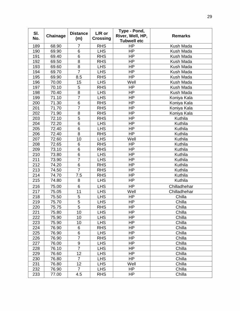
29
Sl. No.
Chainage Distance
(m) L/R or
Crossing
Type - Pond, River, Well, HP,
Tubwell etc Remarks
189 68.90 7 RHS HP Kush Mada
190 69.90 6 LHS HP Kush Mada
191 69.40 6 RHS HP Kush Mada
192 69.50 8 RHS HP Kush Mada
193 69.60 8 LHS HP Kush Mada
194 69.70 7 LHS HP Kush Mada
195 69.90 8.5 RHS HP Kush Mada
196 70.00 15 LHS Well Kush Mada
197 70.10 5 RHS HP Kush Mada
198 70.40 8 LHS HP Kush Mada
199 71.10 7 LHS HP Koniya Kala
200 71.30 6 RHS HP Koniya Kala
201 71.70 7 RHS HP Koniya Kala
202 71.90 8 RHS HP Koniya Kala
203 72.10 5 RHS HP Kuthila
204 72.20 6 LHS HP Kuthila
205 72.40 6 LHS HP Kuthila
206 72.40 8 RHS HP Kuthila
207 72.60 10 LHS Well Kuthila
208 72.65 6 RHS HP Kuthila
209 73.10 6 RHS HP Kuthila
210 73.80 6 LHS HP Kuthila
211 73.90 7 LHS HP Kuthila
212 74.20 6 RHS HP Kuthila
213 74.50 7 RHS HP Kuthila
214 74.70 7.5 RHS HP Kuthila
215 74.80 8 LHS HP Kuthila
216 75.00 6 LHS HP Chilladhehar
217 75.05 11 LHS Well Chilladhehar
218 75.50 5 LHS HP Chilla
219 75.70 5 LHS HP Chilla
220 75.75 5 RHS HP Chilla
221 75.80 10 LHS HP Chilla
222 75.90 10 LHS HP Chilla
223 75.90 10 LHS HP Chilla
224 76.90 6 RHS HP Chilla
225 76.90 6 LHS HP Chilla
226 76.90 7 RHS HP Chilla
227 76.00 9 LHS HP Chilla
228 76.10 7 LHS HP Chilla
229 76.60 12 LHS HP Chilla
230 76.80 7 LHS HP Chilla
231 76.80 12 LHS Well Chilla
232 76.90 7 LHS HP Chilla
233 77.00 4.5 RHS HP Chilla

30
Sl. No.
Chainage Distance
(m) L/R or
Crossing
Type - Pond, River, Well, HP,
Tubwell etc Remarks
234 77.00 15 RHS Well Chilla
235 77.20 6 RHS HP Chilla
236 77.30 4.5 LHS HP Chilla
237 77.35 8 LHS HP Chilla
238 77.50 5 LHS HP Chilla
239 77.60 10 LHS HP Chilla
240 77.90 6 LHS HP Kotra
241 78.10 6.5 LHS HP Kotra
242 78.20 5 RHS HP Kotra
243 78.40 6 RHS HP Kotra
244 78.50 8 LHS HP Kotra
245 78.60 9 RHS HP Kotra
246 79.20 10 LHS HP Purwa
247 79.40 11 RHS HP Purwa
248 79.50 7 LHS HP Purwa
249 79.80 6 RHS HP Purwa
250 79.90 5 RHS HP Purwa
251 80.30 6.5 RHS HP Purwa
252 80.40 7.5 LHS HP Purwa
253 81.10 5 RHS HP Purwa
254 82.20 - Crossing Nala Seasonal nala, Vill - Chandela
255 82.50 8 RHS HP Chandela
256 82.80 12 LHS HP Chandela
257 83.10 - Crossing Nala Sukhad nala, all time water, Vill - Chandela
258 83.50 9 LHS HP Chandpur
259 83.60 6 LHS HP Chandpur
260 83.80 9.5 RHS HP Chandpur
261 83.90 6 LHS HP Chandpur
262 84.50 7 RHS HP Chandpur
263 84.70 5 RHS HP Chandpur
264 84.90 5 RHS HP Chandpur
265 85.20 8.5 LHS HP Panasi
266 85.40 5.5 RHS HP Panasi
267 85.50 4.5 RHS HP Panasi
268 85.90 5 LHS HP Panasi
269 86.00 15 RHS HP Panasi
270 86.10 6 RHS HP Jhagaduwa
271 86.40 5.5 RHS HP Jhagaduwa
272 86.80 5.5 RHS Tube Well Panasi
273 86.90 8 LHS HP Panasi
274 87.30 12 LHS HP Panasi
275 87.50 8 LHS HP Panasi
276 87.80 10 RHS HP Papaura
277 89.10 4 LHS HP Papaura

31
Sl. No.
Chainage Distance
(m) L/R or
Crossing
Type - Pond, River, Well, HP,
Tubwell etc Remarks
278 89.50 7 LHS HP Loniyapar
279 89.70 5 LHS HP Loniyapar
280 89.80 5 RHS HP Loniyapar
281 90.30 10 RHS HP Loniyapar
282 90.50 - Crossing Nala Seasonal nala, Vill - Loniyapar
283 91.90 5 RHS HP Deura
284 92.90 4 RHS HP Deura
285 93.00 5 LHS HP Deura
286 93.40 5 LHS HP Deura
287 94.00 4 LHS HP Deura
288 94.90 12 RHS HP Deura
289 95.00 5 LHS HP Patiwar
290 95.60 4 RHS HP Chakghat
291 95.70 6 LHS HP Chakghat
292 95.90 5 RHS HP Chakghat
293 96.10 6 LHS HP Chakghat
294 96.20 7 LHS HP Chakghat
295 96.60 5 LHS HP Chakghat
296 96.80 2.5 RHS HP Chakghat
6. Water Quality
71. Water quality along the sample roads were sampled and analysed for a physicochemical characteristics based on procedures specified in published by NABL and Certified by ISO 9001 : 2008. Results were compared to the standards for drinking water as per IS: 10500 and were all found suitable for drinking water and all parameters are within desirable. The results are enclosed as Appendix10
7. Ambient Air Quality
72. The baseline status of the ambient air quality has been established through ambient air quality monitoring at selected points along the project roads. The ambient air quality has been monitored at 4 along the project road for particulate matter (PM2.5 and PM10), sulphur dioxide (SO2), oxides of nitrogen (NOX); and carbon monoxides (CO) using standard analysis technique (Table 14).
Table 14: Techniques Used for Ambient Air Quality Monitoring
Sl. Parameter Technique Minimum Detectable
No. Limit (ug/m3) 1. Particulate Matter (PM2.5) Gravimetric Method 1.0
2. Particulate Matter (PM10) Gravimetric Method 1.0 3. Sulphur dioxide Modified West and Gaeke 5.0 4. Nitrogen Oxide Modified Jacob & Hochheiser 5.0 5. Carbon Monoxide Non Dispersive Infrared 1
Spectroscopy (NDIR)

32
73. Ambient air quality monitoring results for PM2.5, PM10, SO2, NOx and CO concentrations are given in Table 25 and summarized below. The monitored values are compared with National Ambient Air Quality Standards prescribed by Central Pollution Control Board (CPCB) for residential, rural and other areas. The Ambient air quality levels meet the National air quality standards for rural, residential and industrial area all along the project road.
PM10: The mean PM2.5 concentration at ambient air quality monitoring locations varies from 76.5 to 81.7 /m
3.
PM2.5: The mean PM10concentration at ambient air quality monitoring
locations varies from 34.2 to 41.07 /m3. The values are within the
permissible limit at all the stations.
SO2: The mean concentrations of SO2at all ambient air quality monitoring locations are <4. The values are within the permissible limit at all the stations.
NOx: The mean concentrations of NOx at all AAQM locations are <5. The values are within the permissible limit at all the stations.
CO: The mean concentrations of CO at all AAQM locations are <1. The values are within the permissible limit at all the stations.
Table 15: Ambient Air Quality along the Project Road
Sr No.. Parameter
Test Method Units
Limits as per Environment
(Protection) Act.
Hardua Rambag Jawa Chalghat
1. Particulate Matter(PM10
IS:5182 Part XXIII -
µg/m3 100.0 80.25 76.5 78.5 81.7
2. Particulate Matter (PM2.5)
CPCB Volume– 1
/ Grav
µg/m3 60.0 38.9 34.2 37.5 41.07
3. Sulphur Dioxide
IS:5182 Part-II µg/m3 80.0 <4 <4 <4 <4
4. Nitrogen Dioxide
IS:5182 Part-VI
µg/m3 80 <5 <5 <5 <5
5. Carbon Monoxide
IS:5182 Part-X
mg/m3 4.0 <1 <1 <1 <1
8. Noise Measurements
74. Preliminary reconnaissance survey was undertaken to identify the major noise generating sources in the area. The noise at different noise generating sources has been identified based on the industrial, commercial and residential activities, traffic and noise at sensitive areas. Sound Pressure Level (SPL) measurements were undertaken at all locations, with an interval of about 5 seconds over a period of 10 minutes per hour for 24 hr. The day noise level has been monitored during 6 AM to 10 PM and night levels during 10 P.M. to 6 AM at all locations. Day and night-time Leq have been calculated from hourly Leq values and compared with the stipulated standards. Table 16 gives the day and night-time Leq noise levels. Measured Leq noise levels exceed prescribed standards during the day time due to various commercial activities and the location of monitoring points close to the road.

33
Table 16: Day and Night Time Leq in the Area Locations Day Time dB(A) Night Time dB(A) Prescribed Standards dB(A)
Day Time Night Time Rewa 66.9 44.2 55 45 Bakia 64.5 37.9 55 45 Bankunia 61.8 36.8 55 45 Simaria 64.9 42.2 55 45
Source: Field monitoring, July 2014
9. Abutting Land Use Pattern
75. The existing alignment is a link for Semariya–Atraila-Rambagh & Chakghat. The pattern on both side of road is agricultural and built-up. The details of land use pattern along the project road are:
Agricultural land – 67.26%, Built-up Land – 26.74%, Barren Land – 3.53% & Hill / Valley – 2.48%
76. The alignment passes through one ghat section i.e. Bhulia Ghat
C. Ecological Resources
1. Forests
77. The forest cover has been classified as dense forest and open forest. The latest estimates of Forest Survey of India (FSI), published in the State of Forest Report (SFR) 2003, suggest that the total forest cover of M.P. is 76,429 sq. km., constituting 24.79% of the State’s total land area. Of the total forest cover, dense forest accounts for 13.57% and open forest about 11.22%. Central, eastern, and southern parts of the state are rich in forest cover. Figure 9 show the forest map of the state.
Figure 9: Forest Cover in the District of Madhya Pradesh

34
2. Wild Life and Protected Areas
78. The project road does not pass through any protected area such as Wildlife Sanctuary, National park or bio –reserve. There is no wildlife sanctuary Wildlife Sanctuary, National park or bio –reserve within 10 km from the project road.At some section ,the road passing through only protected forest area.
3. Trees
79. Moderate tree density is observed all along the Hardua to Chakghat road. The main tree species observed are, Neem, Babool, Plash, Eucplitus, Mango. An estimated 668 trees will be cleared to accommodate the require road upgrading .Most dominating of which is Neem (Azadirachta Indica) tree.
Table 17: List of Trees
S. No.
Chainage
Distance from centre of existing
road*
Girth (0-30cm , 30-60cm , 60-
90,90-120, >120cm
Approx Ht.(M)
Left *
Right *
Local Name BotanicaI
Name Remarks
*Laft and Right are based on assending chainage *With in ROW i.e. 6 mtr from the centre of road
1 0.200 5.5 90-120 12 R Eucklipuls Eucalyptus cinerea
2 0.210 4.5 30-60 8 L Shubabul Eucalyptus cinerea
3 0.220 4.75 30-60 7 L Shubabul Eucalyptus cinerea
4 0.230 4.75 30-60 6 L Shubabul Eucalyptus cinerea
5 0.240 5 60-90 7 L Shubabul Eucalyptus cinerea
6 0.250 5 30-60 7 L Eucklipuls Eucalyptus Radiata
7 0.260 5 0-30 6 L Eucklipuls Eucalyptus Radiata
8 0.270 4.5 0-30 6 L Eucklipuls Eucalyptus Radiata
9 0.300 5.5 0-30 5 L Neem Azadirachta Indica
10 0.500 4.5 30-60 7 L Mango Mangifera Indica
11 0.510 4 0-30 6 L Mango Mangifera Indica
12 0.515 4.5 0-30 5 L Jamun Syzygium cumini
13 0.520 5.5 30-60 7 L Sagoun Tectona grandis
14 0.521 5.5 30-60 7 L Sagoun Tectona grandis
15 0.522 5.5 30-60 6 L Neem Azadirachta Indica
16 0.523 5 0-30 6 L Shubabul Leucaena leucocephala
17 0.524 5 0-30 6 L Shubabul Leucaena leucocephala
18 0.525 5.5 0-30 7 L Shubabul Leucaena leucocephala
19 0.526 5 30-60 7 L Shubabul Leucaena leucocephala
20 0.527 5 30-60 7 L Shubabul Leucaena leucocephala
21 0.528 5 30-60 7 L Shubabul Leucaena leucocephala
22 0.529 5 30-60 7 L Shubabul Leucaena leucocephala
23 0.530 5 0-30 7 L Shubabul Leucaena leucocephala
24 0.800 5 30-60 8 R Shubabul Leucaena leucocephala
25 1.100 5.5 30-60 8 L sheesham Dalbergia sissoo
26 1.400 5 60-90 7 R Shubabul Leucaena leucocephala
27 1.420 4.5 30-60 6 R sheesham Dalbergia sissoo
28 1.500 4.5 30-60 6 L sheesham Dalbergia sissoo
29 1.510 6 90-120 6 L Shubabul Leucaena leucocephala
30 1.515 6 30-60 5 L Neem Azadirachta indica

35
S. No.
Chainage
Distance from centre of existing
road*
Girth (0-30cm , 30-60cm , 60-
90,90-120, >120cm
Approx Ht.(M)
Left *
Right *
Local Name BotanicaI
Name Remarks
31 1.530 5.5 30-60 4 L Shubabul Leucaena leucocephala
32 1.540 5.5 30-60 5 L Eucklipuls Eucalyptus Radiata
33 3.200 5.5 30-60 5 L Berry Zizyphus mauritiana
34 3.300 5 0-30 2 R kadam Neolamarckia
cadamba
35 3.320 5 0-30 4 R kadam Neolamarckia
cadamba
36 3.500 5.5 0-30 4 R Mahua Madhuca longifolia
37 3.510 5.5 30-60 7 R Eucklipuls Eucalyptus Radiata
38 3.520 5 0-30 6 R Shubabul Leucaena leucocephala
39 5.900 5.5 0-30 6 L Shubabul Leucaena leucocephala
40 5.910 5.5 0-30 5 L Shubabul Leucaena leucocephala
41 5.915 5.5 0-30 5 L Shubabul Leucaena leucocephala
42 5.920 5.5 0-30 5 L Shubabul Leucaena leucocephala
43 5.925 5 0-30 6 L Eucklipuls Eucalyptus Radiata
44 5.930 5.5 0-30 6 L Eucklipuls Eucalyptus Radiata
45 7.300 5 0-30 5 L Palash Butea monosperma
46 7.310 5 0-30 4 L Palash Butea monosperma
47 7.315 4.5 30-60 4.5 L Palash Butea monosperma
48 7.320 5 30-60 5 L Palash Butea monosperma
49 7.325 5.5 30-60 6 L Palash Butea monosperma
50 7.330 5 0-30 5 L Palash Butea monosperma
51 7.315 5 0-30 5 L Palash Butea monosperma
52 7.500 4.5 30-60 4 R Bargad Ficus bengalensis
53 8.500 4.5 0-30 4 R Neem Azadirachta Indica
54 8.510 5 0-30 5 R Mango Mangifera Indica
55 8.900 5.75 0-30 6 R Eucklipuls Eucalyptus Radiata
56 8.910 5.5 60-90 7 R Eucklipuls Eucalyptus Radiata
57 8.920 5 >120 8 R Palash Butea monosperma
58 10.400 5 >121 9 R Peepal Phycus Relogiasa
59 12.600 5.5 >122 9 L Peepal Phycus Relogiasa
60 12.620 5 30-60 10 L Bargad Ficus benghalensis
61 13.200 5 30-60 6 R Eucklipuls Eucalyptus Radiata
62 13.210 4.75 30-60 5 R sheesham Dalbergia sissoo
63 13.220 5 30-60 4 R Eucklipuls Eucalyptus Radiata
64 13.225 4.75 30-60 5 R Eucklipuls Eucalyptus Radiata
65 13.230 5.5 0-30 6 R Eucklipuls Eucalyptus Radiata
66 13.235 5.5 0-30 5 R Shubabul Leucaena leucocephala
67 13.240 5.5 0-30 4 R Shubabul Leucaena leucocephala
68 13.245 5.5 0-30 6 R Shubabul Leucaena leucocephala
69 13.250 5 0-30 5 R Shubabul Leucaena leucocephala
70 13.255 5 60-90 5 R Neem Azadirachta Indica
71 15.000 5.5 30-60 6 L Palash Butea monosperma
72 15.010 5.5 30-60 5 L Palash Butea monosperma
73 15.020 5.5 30-60 6 L Palash Butea monosperma
74 15.030 5 60-90 6 L Palash Butea monosperma
75 15.040 5 60-90 7 L Bargad Ficus bengalensis
76 15.300 5 30-60 2 R Palash Butea monosperma
77 15.320 5.5 0-30 1.5 L Palash Butea monosperma

36
S. No.
Chainage
Distance from centre of existing
road*
Girth (0-30cm , 30-60cm , 60-
90,90-120, >120cm
Approx Ht.(M)
Left *
Right *
Local Name BotanicaI
Name Remarks
78 15.600 5 >120 6 L Mahua Madhuca longifolia
79 15.700 5.5 60-90 5 L Bargad Ficus benghalensis
80 15.750 5.5 60-90 5 R Bargad Ficus benghalensis
81 15.800 5 30-60 5 R Palash Butea monosperma
82 15.820 5 30-60 5.5 R Palash Butea monosperma
83 15.830 5.5 30-60 5 L Palash Butea monosperma
84 15.850 5.5 30-60 5 R Palash Butea monosperma
85 16.600 5.5 0-30 5 L Palash Butea monosperma
86 16.610 5 0-30 6 L Palash Butea monosperma
87 16.620 5.5 30-60 5 R Palash Butea monosperma
88 16.630 5.5 30-60 5 R Palash Butea monosperma
89 16.640 5 0-30 5 L Palash Butea monosperma
90 16.650 5 0-30 5 L Palash Butea monosperma
91 16.700 5 30-60 3 L Tendu Diospyros melanoxylon
92 16.900 5 30-60 4 R sedhu Terminalia Tomentosa
93 16.930 5 30-60 3 R sedhu Terminalia Tomentosa
94 16.950 5 30-60 6 R sedhu Terminalia Tomentosa
95 16.970 5 30-60 5 R sedhu Terminalia Tomentosa
96 16.980 5 30-60 4 L Tendu Diospyros melanoxylon
97 17.200 5.5 30-60 4 R Tendu Diospyros melanoxylon
98 17.210 5.5 30-60 5 R Palash Butea monosperma
99 17.400 5 30-60 5 L Palash Butea monosperma
100 17.700 5 60-90 4 L Tendu Terminalia Tomentosa
101 17.750 5 60-90 5 L Tendu Diospyros melanoxylon
102 17.800 5 60-90 6 L Tendu Diospyros melanoxylon
103 17.810 5.5 60-90 5 R sedha Terminalia Tomentosa
104 17.820 5.5 30-60 6 R sedha Terminalia Tomentosa
105 17.840 5.5 30-60 4 R sedha Terminalia Tomentosa
106 17.900 5.5 90-120 5 L Tendu Diospyros melanoxylon
107 17.920 5 30-60 3 L sedha Terminalia Tomentosa
108 17.930 5.5 30-60 3 L sedha Terminalia Tomentosa
109 17.940 5 60-90 4 L Palash Butea monosperma
110 18.100 4.5 >120 6 R Palash Butea monosperma
111 18.110 4 30-60 5 L sedha Terminalia Tomentosa
112 18.120 4.5 30-60 5 L Palash Butea monosperma
113 18.150 5 30-60 4 R sedha Terminalia Tomentosa
114 18.170 5 30-60 5 R sedha Terminalia Tomentosa
115 18.200 5 60-90 6 L Palash Butea monosperma
116 18.300 5 60-90 5 R semra Bombax ciba
117 18.310 5 60-90 5 L semra Bombax ciba

37
S. No.
Chainage
Distance from centre of existing
road*
Girth (0-30cm , 30-60cm , 60-
90,90-120, >120cm
Approx Ht.(M)
Left *
Right *
Local Name BotanicaI
Name Remarks
118 18.400 4.5 60-90 5 L Palash Butea monosperma
119 18.410 4.5 30-60 5 L semra Bombax ciba
120 18.430 4.5 30-60 5 R semra Bombax ciba
121 18.500 4.5 0-30 4 R Palash Butea monosperma
122 18.510 5 0-30 2 R Tendu Diospyros melanoxylon
123 18.600 4.5 0-30 2 R Tendu Diospyros melanoxylon
124 18.650 5 >120 6 L Imali Tamarindus indica
125 18.700 5 >121 7 R sedhu Terminalia Tomentosa
126 18.720 5.5 0-30 4 R sedhu Terminalia Tomentosa
127 18.800 5 30-60 6 L Tendu Diospyros melanoxylon
128 18.820 6 >121 7 R Arjun Terminalia arjuna
129 18.840 5.5 30-60 6 L Tendu Diospyros melanoxylon
130 19.000 4.5 90-120 7 L semra Bombix ciba
131 19.010 5.5 30-60 5 R Tendu Diospyros melanoxylon
132 19.100 5 >121 6 L sedhu Terminalia Tomentosa
133 19.110 5.5 0-30 4 R Tendu Diospyros melanoxylon
134 19.200 5.5 90-120 6 R semra Bombix ciba
135 19.300 5 90-120 7 L Arjun Terminalia arjuna
136 19.320 5.5 >120 6 L Tendu Diospyros melanoxylon
137 19.330 5 0-30 4 R Tendu Diospyros melanoxylon
138 19.400 5 30-60 3.5 R Tendu Diospyros melanoxylon
139 19.500 5.5 60-90 4 L Tendu Diospyros melanoxylon
140 19.550 5.5 30-60 3.5 L Tendu Diospyros melanoxylon
141 19.600 5.5 >120 7 L semra Bombix ciba
142 19.700 5 0-30 5 R sedha Terminalia Tomentosa
143 19.720 5.5 0-30 5 R sedha Terminalia Tomentosa
144 19.950 5 >120 8 R Imali Tamarindus indica
145 20.300 5 30-60 5 L Tendu Diospyros melanoxylon
146 20.320 5 0-30 4 L Tendu Diospyros melanoxylon
147 20.350 4.5 30-60 5 L dudhiya Wrightia tinctoria
148 20.400 4 0-30 4 L amaltas Cassia fistula
149 20.420 4.5 30-60 5 R amaltas Cassia fistula
150 20.530 4 60-90 6 R Mahua Madhuca longifolia
151 20.450 4 0-30 5 R Tendu Diospyros melanoxylon
152 20.500 4 0-30 4 R Tendu Diospyros melanoxylon
153 20.510 4 0-30 5 R Tendu Diospyros melanoxylon
154 20.520 4.5 30-60 4.5 R Tendu Diospyros melanoxylon
155 20.530 5 0-30 4 R Tendu Diospyros melanoxylon
156 20.550 4 >120 4.5 L amaltas Cassia fistula
157 20.600 4.5 >120 7 L amaltas Cassia fistula
158 20.620 4.5 30-60 6 R Tendu Diospyros melanoxylon
159 20.640 5 30-60 5 L Tendu Diospyros melanoxylon
160 20.700 5.5 30-60 5 L Tendu Diospyros melanoxylon
161 21.000 5 30-60 5 R Khar Acacia catechu
162 21.100 4.5 0-30 4 R Palash Butea monosperma
163 21.110 5 30-60 6 R hardi T. Chubala
164 21.600 6 60-90 7 L semra Bombax malabaricum
165 21.620 5.5 30-60 6 L abhijeet Nyctanthes arbor-tristis
166 22.100 5.5 90-120 7 L Arjun Terminalia arjuna

38
S. No.
Chainage
Distance from centre of existing
road*
Girth (0-30cm , 30-60cm , 60-
90,90-120, >120cm
Approx Ht.(M)
Left *
Right *
Local Name BotanicaI
Name Remarks
167 22.150 5 60-90 6 L hardi T. Chubala
168 22.200 5 30-60 6 L dudhiya Wrightia tinctoria
169 22.210 5 30-60 5 R Palash Butea monosperma
170 22.500 5.5 60-90 5 L Arjun Terminalia arjuna
171 22.700 5.5 30-60 4 L Palash Butea monosperma
172 22.800 4.5 0-30 4 R Palash Butea monosperma
173 23.100 4 30-60 5 R Khar Acacia catechu
174 23.300 4.5 90-120 6 R Khar Acacia catechu
175 23.320 5 60-90 5 L Arjun Terminalia arjuna
176 23.400 4 60-90 7 R Arjun Terminalia arjuna
177 23.500 4.5 30-60 6 R Arjun Terminalia arjuna
178 23.800 5 30-60 5 L Palash Butea monosperma
179 23.810 5 30-60 5 L Palash Butea monosperma
180 23.820 4.5 30-60 6 L Palash Butea monosperma
181 23.840 5 30-60 5 L Palash Butea monosperma
182 23.900 5 30-60 7 L Palash Butea monosperma
183 24.000 3 >120 8 R Bell Aegle marmelos
184 24.300 4.5 >120 3 R Bell Aegle marmelos
185 24.600 4.5 30-60 6 L Palash Butea monosperma
186 26.670 4.5 60-90 5 L Palash Butea monosperma
187 24.900 5 60-90 2 R Palash Butea monosperma
188 25.100 5.5 0-30 2 L Palash Butea monosperma
189 25.200 5.5 0-30 6 L Palash Butea monosperma
190 26.000 2.5 >120 5 L Palash Butea monosperma
191 26.010 5 >120 9 L Palash Butea monosperma
192 26.020 4.5 30-60 8 L Palash Butea monosperma
193 26.050 4 90-60 7 L Palash Butea monosperma
194 26.500 5.5 >120 7 L Mahua Madhuca longifolia
195 26.600 5 90-120 6 R Peepal Butea monosperma
196 28.300 4.5 60-90 8 R Neem Azadirachta Indica
197 28.330 5 60-90 4 R Eucklipuls Eucalyptus Radiata
198 28.500 5.5 30-60 5 L Berry Zizyphus zigapa
199 28.510 5.5 30-60 5 R Mahua Madhuca longifolia
200 28.700 5.5 60-90 4 L sheesham Sesamun indicum
201 28.720 5.5 0-30 6 L awala Emblica officinalis
202 28.900 4 >120 7 R Neem Azadirachta Indica
203 28.920 4 >120 8 R Neem Azadirachta Indica
204 28.940 4.5 30-60 9 R Berry Zizyphus mauritiana
205 28.960 4.5 >120 7 L kaitha Feronia limonida
206 29.400 4.5 >120 8 L Mango Magnifera indica

39
S. No.
Chainage
Distance from centre of existing
road*
Girth (0-30cm , 30-60cm , 60-
90,90-120, >120cm
Approx Ht.(M)
Left *
Right *
Local Name BotanicaI
Name Remarks
207 30.400 4.5 >120 R Peepal Butea monosperma
208 30.500 4 0-30 L Shubabul Leucaena leucocephala
209 30.510 4.5 0-30 L Neem Azadirachta Indica
210 30.520 4 0-30 L Neem Azadirachta Indica
211 30.050 5.5 >120 8 R Peepal Butea monosperma
212 31.900 5 30-60 3 R Neem Azadirachta Indica
213 31.920 5 60-90 4 R Neem Azadirachta Indica
214 31.940 4.5 30-60 5 L Sagoun Tectona grandis
215 31.960 5 30-60 5 L Sagoun Tectona grandis
216 31.980 5.5 30-60 5 L Sagoun Tectona grandis
217 32.000 4 30-60 5 L Sagoun Tectona grandis
218 32.020 4.5 30-60 5 L Sagoun Tectona grandis
219 32.400 4.5 90-120 6 R Neem Azadirachta Indica
220 32.410 5 60-90 6 R Neem Azadirachta Indica
221 32.430 4.5 60-90 5 L Mango Mangifera Indica
222 32.440 5 60-90 4 L Mango Mangifera Indica
223 33.900 5 30-60 4 L Tendu Diospyros melanoxylon
224 33.910 5 30-60 4 L Tendu Diospyros melanoxylon
225 33.920 4.5 30-60 4 L Tendu Diospyros melanoxylon
226 33.950 5.5 30-60 4 L Tendu Diospyros melanoxylon
227 33.940 5 30-60 4 L Tendu Diospyros melanoxylon
228 33.950 5.5 30-60 5 L Tendu Diospyros melanoxylon
229 33.960 4.75 30-60 5 L Tendu Diospyros melanoxylon
230 33.975 4.75 30-60 4 L Tendu Diospyros melanoxylon
231 33.980 4 30-60 5 L Tendu Diospyros melanoxylon
232 33.990 5 30-60 4 L Tendu Diospyros melanoxylon
233 34.100 5 0-30 4 R Tendu Diospyros melanoxylon
234 34.110 5 0-30 4 R Tendu Diospyros melanoxylon
235 34.120 5.25 30-60 4 R Tendu Diospyros melanoxylon
236 34.130 5 30-60 5 R Tendu Diospyros melanoxylon
237 34.600 5 60-90 5 L Tendu Diospyros melanoxylon
238 34.700 5.5 0-30 4 L Neem Azadirachta Indica
239 35.400 6 60-90 6 L Neem Azadirachta Indica
240 35.500 5.5 0-30 4 L Neem Azadirachta Indica
241 35.520 5.5 60-90 5 L Neem Azadirachta Indica
242 35.600 5.5 30-60 6 L Neem Azadirachta Indica
243 35.620 5.5 60-90 6 L Neem Azadirachta Indica
244 36.100 5 30-60 4 L Tendu Diospyros melanoxylon
245 36.110 5 30-60 4 L Tendu Diospyros melanoxylon
246 36.120 5.5 0-30 4 L Tendu Diospyros melanoxylon

40
S. No.
Chainage
Distance from centre of existing
road*
Girth (0-30cm , 30-60cm , 60-
90,90-120, >120cm
Approx Ht.(M)
Left *
Right *
Local Name BotanicaI
Name Remarks
247 36.130 5 0-30 5 L Tendu Diospyros melanoxylon
248 36.140 5.5 30-60 3 L Tendu Diospyros melanoxylon
249 36.150 5 30-60 4 L Tendu Diospyros melanoxylon
250 36.160 5 30-60 5 L Tendu Diospyros melanoxylon
251 36.170 5.5 30-60 4 R Tendu Diospyros melanoxylon
252 36.300 4.5 0-30 4 L Tendu Diospyros melanoxylon
253 36.310 5.5 30-60 3 L Tendu Diospyros melanoxylon
254 36.320 5 30-60 4 L Tendu Diospyros melanoxylon
255 36.330 5 30-60 3 L Tendu Diospyros melanoxylon
256 36.340 5 0-30 5 L Tendu Diospyros melanoxylon
257 36.350 5 0-30 4 L Tendu Diospyros melanoxylon
258 36.360 5 30-60 3 L Tendu Diospyros melanoxylon
259 36.400 5.5 0-30 4 R Tendu Diospyros melanoxylon
260 36.420 5 0-30 4.5 R Tendu Diospyros melanoxylon
261 36.440 5.5 0-30 5 R Tendu Diospyros melanoxylon
262 36.900 4.5 30-60 4 L amaltas Cassia fistula
263 37.600 5.5 30-60 5 L Palash Butea monosperma
264 37.620 5 30-60 5 L Palash Butea monosperma
265 37.640 5 0-30 5 L Neem Azadirachta Indica
266 37.900 5.5 90-120 7 L Palash Butea monosperma
267 37.930 5 30-60 6 L Palash Butea monosperma
268 38.300 4.5 30-60 6 R Palash Butea monosperma
269 38.600 5.5 0-30 4 L Neem Azadirachta Indica
270 38.700 5.5 0-30 5 L Neem Azadirachta Indica
271 39.500 5 30-60 5 R Neem Azadirachta Indica
272 39.510 5 30-60 5 R Neem Azadirachta Indica
273 39.530 5.5 60-90 6 R Neem Azadirachta Indica
274 39.550 5.5 >120 6 R Neem Azadirachta Indica
275 40.000 5 90-120 7 L Neem Azadirachta Indica
276 4.010 5.5 90-120 6 R Neem Azadirachta Indica
277 40.020 5.5 90-120 7 R Neem Azadirachta Indica
278 40.030 5.5 60-90 6 R Neem Azadirachta Indica
279 40.100 5.5 90-120 7 R Neem Azadirachta Indica
280 40.150 5.5 >120 7 R Peepal Butea monosperma
281 40.200 5 60-90 6 R Neem Azadirachta Indica
282 40.500 5 30-60 7 R Shubabul Leucaena leucocephala
283 40.510 5.5 60-90 6 L Shubabul Leucaena leucocephala
284 40.520 5.5 0-30 5 R Ashok Saraca indica
285 40.530 5.25 0-30 5 R Ashok Saraca indica
286 40.540 5 0-30 5 R Ashok Saraca indica

41
S. No.
Chainage
Distance from centre of existing
road*
Girth (0-30cm , 30-60cm , 60-
90,90-120, >120cm
Approx Ht.(M)
Left *
Right *
Local Name BotanicaI
Name Remarks
287 40.550 5.25 60-90 6 R Neem Azadirachta Indica
288 40.560 5.5 30-60 4 R awala Emblica officinalis
289 40.600 4.5 60-90 7 R Neem Azadirachta Indica
290 40.700 5.5 60-90 6 L Neem Azadirachta Indica
291 40.720 5.5 60-90 8 L Eucklipuls Eucalyptus Radiata
292 40.730 5 60-90 7 L Neem Azadirachta Indica
293 40.800 5.5 60-90 7 L Neem Azadirachta Indica
294 40.810 5.5 30-60 6 L Neem Azadirachta Indica
295 40.820 5.5 60-90 7 L Neem Azadirachta Indica
296 40.840 5.5 30-60 6 L Neem Azadirachta Indica
297 40.850 6 60-90 4 L awala Emblica officinalis
298 40.860 5.75 30-60 5 L awala Emblica officinalis
299 40.870 6 30-60 6 L Neem Azadirachta Indica
300 40.900 5.75 30-60 6 L Neem Azadirachta Indica
301 41.000 5.5 >120 8 R Mahua Madhuca longifolia
302 41.010 5 30-60 6 L Berry Zizyphus mauritiana
303 41.020 4.5 60-90 5 R Berry Zizyphus mauritiana
304 41.030 4.5 30-60 6 R Berry Zizyphus mauritiana
305 41.040 4.5 30-60 6 R Berry Zizyphus mauritiana
306 41.050 4.5 >120 7 L Mango Mangifera Indica
307 41.100 5 >121 8 R Mango Mangifera Indica
308 41.120 5.25 >122 6 R Mango Mangifera Indica
309 41.130 5 60-90 6 L Berry Zizyphus mauritiana
310 42.200 5 60-90 5.5 L Neem Azadirachta Indica
311 42.220 5.5 60-90 5 L Neem Azadirachta Indica
312 41.600 5 0-30 6 L Shubabul Leucaena leucocephala
313 41.620 5.5 0-30 7 L Shubabul Leucaena leucocephala
314 41.630 4.75 30-60 6 L Shubabul Leucaena leucocephala
315 41.640 5 30-60 7 L Shubabul Leucaena leucocephala
316 41.800 5.5 60-90 7 L Neem Azadirachta Indica
317 41.820 5.5 0-30 6 L Neem Azadirachta Indica
318 41.840 5.5 60-90 7 L Neem Azadirachta Indica
319 41.900 5.5 30-60 8 L Neem Azadirachta Indica
320 41.910 5.5 30-60 7 L Shubabul Leucaena leucocephala
321 41.920 5.5 0-30 7 L Shubabul Leucaena leucocephala
322 41.930 5.5 0-30 6 L Shubabul Leucaena leucocephala
323 41.940 5.5 30-60 6 R Neem Azadirachta Indica
324 41.950 5.75 90-120 5 R Eucklipuls Eucalyptus Radiata
325 41.960 5.75 >120 6 R Neem Azadirachta Indica
326 42.000 5.75 90-120 7 R Neem Azadirachta Indica

42
S. No.
Chainage
Distance from centre of existing
road*
Girth (0-30cm , 30-60cm , 60-
90,90-120, >120cm
Approx Ht.(M)
Left *
Right *
Local Name BotanicaI
Name Remarks
327 42.300 5 >120 10 L Bargad Phycus bagalancis
328 42.400 5.5 30-60 5 R Belll Eagal marmilos
329 42.500 5 30-60 5 R Neem Azadirachta Indica
330 42.520 5.75 60-90 8 L Shubabul Leucaena leucocephala
331 42.540 5.5 90-120 7 L Shubabul Leucaena leucocephala
332 42.600 5 >120 8 L Eucklipuls Eucalyptus Radiata
333 42.610 5 >120 9 L Eucklipuls Eucalyptus Radiata
334 42.620 5.5 >120 10 L Peepal Phycus relogiasa
335 42.700 5 0-30 7 L Berry Zizyphus mauritiana
336 42.720 5.5 60-90 6 L Berry Zizyphus mauritiana
337 42.740 5 60-90 8 L Neem Azadirachta Indica
338 42.800 4.5 60-90 7 R Berry Zizyphus mauritiana
339 42.900 6 >120 9 R Mahua Mangifera Indica
340 43.100 5 >120 8 R Neem Azadirachta Indica
341 43.300 5.5 30-60 7 L Neem Azadirachta Indica
342 43.320 5.75 0-30 6 L Neem Azadirachta Indica
343 43.330 5.5 60-90 8 L Neem Azadirachta Indica
344 43.350 5.5 >120 9 L Peepal Butea monosperma
345 43.500 5 >120 7 L Mango Mangifera Indica
346 43.510 5 >120 6 L Mango Mangifera Indica
347 43.520 6 >120 7 R Mango Mangifera Indica
348 43.530 6 >121 7 R Mango Mangifera Indica
349 43.540 6 >122 7 R Mango Mangifera Indica
350 43.600 5 >123 10 L Khirni Manilkara hexandra
351 43.610 5.5 >124 8 L Khirni Manilkara hexandra
352 43.620 5.5 90-120 7 L Mango Mangifera Indica
353 43.630 6 90-120 6 R Mango Mangifera Indica
354 43.640 6 90-121 6 L Mango Mangifera Indica
355 43.700 5.5 >120 8 L Peepal Phycus relogiasa
356 43.900 6 >121 10 L Eucklipuls Eucalyptus Radiata
357 43.910 6 >122 9* L Eucklipuls Eucalyptus Radiata
358 43.920 6 >123 9 L Eucklipuls Eucalyptus Radiata
359 43.930 6 >124 11 L Eucklipuls Eucalyptus Radiata
360 43.940 6 >125 10 L Eucklipuls Eucalyptus Radiata
361 43.950 6 >126 9 L Eucklipuls Eucalyptus Radiata
362 43.960 6 >127 8 L Eucklipuls Eucalyptus Radiata
363 44.400 5.75 60-90 7 L Neem Azadirachta Indica
364 44.430 5.75 60-90 8 L Neem Azadirachta Indica
365 44.600 5.5 30-60 7 R Shubabul Leucaena leucocephala
366 44.610 5.5 0-30 6 R Shubabul Leucaena leucocephala

43
S. No.
Chainage
Distance from centre of existing
road*
Girth (0-30cm , 30-60cm , 60-
90,90-120, >120cm
Approx Ht.(M)
Left *
Right *
Local Name BotanicaI
Name Remarks
367 44.630 5.5 30-60 7 R Shubabul Leucaena leucocephala
368 44.700 5 60-90 6 R Neem Azadirachta Indica
369 44.720 5.5 0-30 5 R Neem Azadirachta Indica
370 45.200 5.5 30-60 6 R Neem Azadirachta Indica
371 45.300 5.5 60-90 6 L Neem Azadirachta Indica
372 45.320 5.5 0-30 5 L Neem Azadirachta Indica
373 45.340 5 0-30 7 L Neem Azadirachta Indica
374 45.350 5 60-90 7 R Shubabul Leucaena leucocephala
375 45.600 5.75 30-60 6 L Neem Azadirachta Indica
376 45.700 5 60-90 5 L Neem Azadirachta Indica
377 45.710 5.75 60-90 6 L Neem Azadirachta Indica
378 45.720 5 60-90 7 L kaitha Feronia limonida
379 45.730 5 30-60 4 L Berry Zizyphus mauritiana
380 45.740 5.5 0-30 5 L Berry Zizyphus mauritiana
381 45.750 5 0-30 6 L Berry Zizyphus mauritiana
382 46.300 5.5 60-90 7 R Neem Azadirachta Indica
383 46.600 5.5 60-90 8 R Neem Azadirachta Indica
384 47.100 4.5 60-90 6 R Neem Azadirachta Indica
385 47.120 4.5 >120 12 R Neem Azadirachta Indica
386 47.140 5 60-90 6 R Mango Mangifera Indica
387 47.150 5.5 0-30 6 R Bell Eagal marmilos
388 47.300 5 >120 4 R Imali Tremendus indica
389 47.400 5 30-90 5 R Neem Azadirachta Indica
390 47.500 5 60-90 4 L Neem Azadirachta Indica
391 48.000 5.5 30-60 5 R Neem Azadirachta Indica
392 48.010 5 >120 6 L Neem Azadirachta Indica
393 48.020 5.5 >120 7 L Shubabul Leucaena leucocephala
394 48.400 5.5 30-60 4 L Jamun Syzygium cumini
395 48.600 5 60-90 9 R Mango Mangifera Indica
396 48.640 6 >120 7 L Neem Azadirachta Indica
397 49.200 6 >120 10 R Neem Azadirachta Indica
398 49.500 5.5 90-120 10 L Neem Azadirachta Indica
399 49.550 5.5 >120 9 L Neem Azadirachta Indica
400 49.700 5.5 60-90 8 L Neem Azadirachta Indica
401 50.200 5 30-60 9 L Shubabul Leucaena leucocephala
402 50.210 5 30-60 7 L Shubabul Leucaena leucocephala
403 50.220 5 30-60 7 L Shubabul Leucaena leucocephala
404 50.230 5 >120 6 L Shubabul Leucaena leucocephala
405 50.300 5.5 90-120 10 R kinni Manilkara hexandra
406 50.500 5 30-60 7 L Peepal Butea monosperma
407 51.800 4.5 30-60 6 L Neem Azadirachta Indica
408 51.520 5.5 30-60 5 L Berry Zizyphus mauritiana

44
S. No.
Chainage
Distance from centre of existing
road*
Girth (0-30cm , 30-60cm , 60-
90,90-120, >120cm
Approx Ht.(M)
Left *
Right *
Local Name BotanicaI
Name Remarks
409 51.830 5 >120 6 L Neem Azadirachta Indica
410 51.900 5.5 >120 9 R Mahua Madhuca longifolia
411 51.920 6 30-60 10 L Mahua Madhuca longifolia
412 53.300 5.5 60-90 6 L Neem Azadirachta Indica
413 53.400 5.5 30-60 6 L Ashok Sarica indica
414 53.520 5.75 30-60 5 L Neem Azadirachta Indica
415 53.600 5.5 30-60 6 R Neem Azadirachta Indica
416 54.000 5.75 >120 10 R Peepal Butea monosperma
417 54.200 5.75 >120 9 R Peepal Butea monosperma
418 54.220 5.5 >121 7 L Neem Azadirachta Indica
419 54.600 5 >122 10 L Peepal Butea monosperma
420 54.800 5 >123 9 Peepal Butea monosperma
421 54.850 5.5 90-120 7 Neem Azadirachta Indica
422 54.900 5 >120 10 Peepal Butea monosperma
423 55.300 5.5 >121 8 R Peepal Butea monosperma
424 55.320 5 >122 7 L Neem Azadirachta Indica
425 55.350 5.5 30-60 8 L Neem Azadirachta Indica
426 55.900 5.75 60-90 8 L Mango Mangifera Indica
427 56.300 5 >120 10 R Peepal Butea monosperma
428 56.500 5.5 >121 10 R Mango Mangifera Indica
429 56.510 4.5 >122 10 L Peepal Butea monosperma
430 56.520 5 >123 9 L Mango Mangifera Indica
431 56.530 5 >124 8 L Peepal Butea monosperma
432 56.540 5 90-120 7 L Neem Azadirachta Indica
433 57.200 5 >120 7 L Bargad Ficus bengalensis
434 57.900 5 >121 8 R Mango Mangifera Indica
435 57.920 5 60-90 6 R kathal Limonia acidissima
436 58.500 5.5 30-60 5 L kathal Limonia acidissima
437 59.200 5.5 >120 11 R Peepal Butea monosperma
438 59.300 5 60-90 7 R Peepal Butea monosperma
439 59.500 5.75 >120 10 R Peepal Butea monosperma
440 59.550 5.5 >120 7 R Peepal Butea monosperma
441 59.600 5.5 90-120 8 R Bargad Ficus bengalensis
442 59.700 5.5 >120 7 R Jamun Syzygium cumini
443 60.100 6 >120 8 R Neem Azadirachta Indica
444 60.110 5.5 60-90 8 R Peepal Butea monosperma
445 60.200 5.5 60-90 6 R Neem Azadirachta Indica
446 60.210 5.5 30-60 6 L Peepal Butea monosperma
447 60.800 5.5 30-60 7 R Neem Azadirachta Indica
448 61.100 5.5 60-90 6 R Neem Azadirachta Indica
449 61.300 5.5 >120 6 R Neem Azadirachta Indica

45
S. No.
Chainage
Distance from centre of existing
road*
Girth (0-30cm , 30-60cm , 60-
90,90-120, >120cm
Approx Ht.(M)
Left *
Right *
Local Name BotanicaI
Name Remarks
450 61.400 4.5 >120 8 R Neem Azadirachta Indica
451 61.500 5.5 >120 9 R kadam Neolamarckia
cadamba
452 61.510 5.5 >120 8 R umar Phycus glumerat
453 41.600 6 >120 9 R Neem Azadirachta Indica
454 61.650 5.5 90-120 8 R Neem Azadirachta Indica
455 61.800 55.5 >120 10 L Peepal Butea monosperma
456 62.000 5.5 >120 8 L Neem Azadirachta Indica
457 62.010 5 60-90 7 L Neem Azadirachta Indica
458 62.020 5 30-60 6 R Neem Azadirachta Indica
459 62.100 5 90-120 7 L umar Phycus glumerat
460 62.120 5.5 90-120 8 L Shubabul Leucaena leucocephala
461 62.300 5.5 60-90 6 R Neem Azadirachta Indica
462 63.330 5.5 >120 10 L Mahua Madhuca longifolia
463 63.200 5.5 >120 9 L Mango Mangifera Indica
464 63.210 6 >120 7 L Mango Mangifera Indica
465 63.220 5 >120 9 L Peepal Butea monosperma
466 63.500 5.5 60-90 8 R awala Emblica officinalis
467 63.510 6 60-90 7 L umar Phycus glumerat
468 63.540 5 0-30 6 L Neem Azadirachta Indica
469 63.600 5.5 >120 8 L Mahua Madhuca longifolia
470 63.800 5 60-90 6 L Berry Zizyphus mauritiana
471 63.810 5.5 60-90 7 L Neem Azadirachta Indica
472 64.000 5.75 >120 6 R Jamun Syzygium cumini
473 64.010 5.75 >120 6 L Neem Azadirachta Indica
474 64.040 5 90-120 9 R Palash Butea monosperma
475 64.050 5 60-90 6 L Mango Mangifera Indica
476 64.100 5 >120 8 L Mango Mangifera Indica
477 64.500 5.5 >120 10 R Peepal Phycus relogiasa
478 64.700 5 >120 8 R Bargad Ficus bengalensis
479 64.710 5.5 60-90 8 L Berry Zizyphus mauritiana
480 64.720 5 90-120 9 L semra Bombix ciba
481 64.730 5.5 >120 8 L Palash Butea monosperma
482 64.740 4.5 90-120 9 L semra Bombix ciba
483 64.750 5.5 90-120 7 L Palash Butea monosperma
484 64.760 5 >120 7 L semra Bombix ciba
485 64.770 4.5 90-120 10 L semra Bombix ciba
486 64.780 4.5 90-120 11 L semra Bombix ciba
487 64.790 5 60-90 8 R Mango Mangifera Indica
488 64.795 5.5 >120 6 R Mango Mangifera Indica
489 64.800 5.5 90-120 9 R Mango Mangifera Indica

46
S. No.
Chainage
Distance from centre of existing
road*
Girth (0-30cm , 30-60cm , 60-
90,90-120, >120cm
Approx Ht.(M)
Left *
Right *
Local Name BotanicaI
Name Remarks
490 64.810 5 60-90 7 R Mango Mangifera Indica
491 64.820 5.5 60-90 7 R Mango Mangifera Indica
492 64.830 5.5 90-120 8 R Jamun Syzygium cumini
493 64.900 5 >120 9 R Peepal Butea monosperma
494 65.000 5.5 >120 10 L Peepal Butea monosperma
495 65.200 5 90-120 10 L Neem Azadirachta Indica
496 65.210 5.5 >120 9 L Bargad Phycus bagalancis
497 65.300 5.5 90-120 8 L Neem Azadirachta Indica
498 65.500 5.5 >120 9 R Neem Azadirachta Indica
499 65.530 5 >120 8 R Peepal Butea monosperma
500 65.700 6 >120 8 L Peepal Butea monosperma
501 65.800 6 >120 9 L Peepal Butea monosperma
502 66.000 5.5 >120 6 L Bargad Ficus bengalensis
503 66.010 5.5 30-60 5 L Neem Azadirachta Indica
504 66.300 5.5 60-90 6 L Neem Azadirachta Indica
505 66.310 5 60-90 7 L Neem Azadirachta Indica
506 66.320 5.5 60-90 8 L Neem Azadirachta Indica
507 66.400 6 >120 7 R Peepal Butea monosperma
508 66.450 5.5 >121 10 L Mahua Madhuca longifolia
509 66.700 5.5 >122 9 L Peepal Butea monosperma
510 66.800 5.5 >123 9 R Mango Mangifera Indica
511 67.300 5.5 90-120 7 L Neem Azadirachta Indica
512 67.400 5.5 60-90 7 L Palash Butea monosperma
513 67.600 5 60-90 6 R Neem Azadirachta Indica
514 67.700 5 90-120 7 L semra Bombix ciba
515 67.720 5.5 90-120 6 R semra Bombix ciba
516 67.740 5 >120 7 L Mango Mangifera Indica
517 67.760 5.5 90-120 8 R Mango Mangifera Indica
518 68.100 5 >120 9 R Neem Azadirachta Indica
519 68.120 5 >120 10 R Neem Azadirachta Indica
520 68.400 5 90-120 8 L Neem Azadirachta Indica
521 68.410 5.5 60-90 2 L Neem Azadirachta Indica
522 68.420 5 90-120 8 L Neem Azadirachta Indica
523 68.430 5.5 90-120 7 L Neem Azadirachta Indica
524 68.440 5 60-90 7 L Neem Azadirachta Indica
525 68.450 5 60-90 8 L Neem Azadirachta Indica
526 68.460 5.5 90-120 7 L Neem Azadirachta Indica
527 68.530 5.5 >120 10 L Mahua Madhuca longifolia
528 68.800 5 >120 9 R kadam Neolamarckia cadamba
529 68.840 5.5 >120 10 L Peepal Butea monosperma

47
S. No.
Chainage
Distance from centre of existing
road*
Girth (0-30cm , 30-60cm , 60-
90,90-120, >120cm
Approx Ht.(M)
Left *
Right *
Local Name BotanicaI
Name Remarks
530 68.900 5 90-120 8 L Palash Butea monosperma
531 68.910 5.5 >120 9 L Peepal Phycus relogiasa
532 68.920 5 >120 8 R Bargad Ficus bengalensis
533 69.200 5.5 60-90 8 R semra Bombix ciba
534 69.210 5 30-60 6 R Mango Mangifera Indica
535 69.220 5 60-90 5 R Berry Zizyphus mauritiana
536 69.230 5.5 60-90 6 R Berry Zizyphus mauritiana
537 69.240 5 90-120 7 R Mango Mangifera Indica
538 69.300 5 30-60 6 R Mango Mangifera Indica
539 69.310 5.5 0-30 5 R Mango Mangifera Indica
540 69.800 5.5 30-60 6 L Berry Zizyphus mauritiana
541 70.000 5 60-90 7 L Neem Azadirachta Indica
542 70.010 5.5 60-90 8 L Eucklipuls E.officilanice
543 70.020 5 60-90 6 L Mango M.indica
544 70.030 5 60-90 7 L Jamun Syzygium cumini
545 70.400 5.5 90-120 8 L Neem Azadirachta Indica
546 70.500 5.5 90-120 8 R Neem Azadirachta Indica
547 70.510 5.5 90-120 7 R Neem Azadirachta Indica
548 70.600 5.5 >120 9 L Berry Zizyphus mauritiana
549 70.610 5.5 >121 8 L Berry Zizyphus mauritiana
550 70.700 5 >122 8 L Neem Azadirachta Indica
551 70.720 5.5 >123 7 R Neem Azadirachta Indica
552 70.730 5 >120 9 R Neem Azadirachta Indica
553 70.900 5.5 90-120 9 L Neem Azadirachta Indica
554 70.980 5.5 60-90 7 R Neem Azadirachta Indica
555 71.300 5.5 >120 10 L Bargad Ficus bengalensis
556 71.330 5.5 >120 10 L Neem Azadirachta Indica
557 71.500 4 >120 9 R Neem Azadirachta Indica
558 71.600 5.5 60-90 8 R Neem Azadirachta Indica
559 71.900 5 >120 7 L Peepal Butea monosperma
560 71.990 5 90-120 10 L Jamun Syzygium cumini
561 72.000 5.5 60-90 5 L semra Bombix ciba
562 72.010 5 60-90 6 L Neem Azadirachta Indica
563 72.020 5 30-60 6 L Neem Azadirachta Indica
564 72.030 5 60-90 7 R Mango Mangifera Indica
565 72.040 5.5 90-120 7 R Mango Mangifera Indica
566 72.050 5 30-60 8 R Mango Mangifera Indica
567 73.700 5.5 60-90 6 L Mango Mangifera Indica
568 74.200 5.5 30-60 5 L Jamun Syzygium cumini
569 74.400 5.5 30-60 5 R Neem Azadirachta Indica

48
S. No.
Chainage
Distance from centre of existing
road*
Girth (0-30cm , 30-60cm , 60-
90,90-120, >120cm
Approx Ht.(M)
Left *
Right *
Local Name BotanicaI
Name Remarks
570 74.420 5 60-90 6 R Neem Azadirachta Indica
571 74.430 5.5 60-90 7 R Neem Azadirachta Indica
572 74.500 5 30-60 6 L Neem Azadirachta Indica
573 74.800 5 60-90 7 R Bargad Ficus bengalensis
574 75.000 5 60-90 7 R Palash Butea monosperma
575 75.010 5.5 30-60 7 R Ashok Sarica indica
576 75.400 5 >120 6 R Neem Azadirachta Indica
577 75.600 5 30-60 7 R Ashok sarica indica
578 75.620 5 30-60 7 R Ashok sarica indica
579 75.700 5 >120 10 L Peepal Phycus relogiasa
580 75.720 5 >120 4 L Peepal Phycus relogiasa
581 75.800 5 >120 9 R Neem Azadirachta Indica
582 76.500 5 >120 8 L Neem Azadirachta Indica
583 76.510 5 90-120 7 L Neem Azadirachta Indica
584 76.520 4.5 >120 8 L Bargad Ficus bengalensis
585 76.600 5 >120 12 R Imali Tamarindus indica
586 76.700 5 90-120 8 L Neem Azadirachta Indica
587 76.710 5.5 90-120 9 L Neem Azadirachta Indica
588 76.720 5.5 30-60 7 L Berry Zizyphus mauritiana
589 76.800 5.75 60-90 7 R Neem Azadirachta Indica
590 77.000 5.5 60-90 8 L Neem Azadirachta Indica
591 77.010 5 30-60 6 R Berry Zizyphus mauritiana
592 77.000 5.5 30-602 5 R awala E.officilanice
593 77.110 5 30-60 5 R awala e.officilanice
594 77.200 5 30-60 7 R Neem Azadirachta Indica
595 77.230 5.75 60-90 6 L Mango Mangifera Indica
596 77.240 5.5 60-90 7 R Neem Azadirachta Indica
597 77.250 5 60-90 8 R Neem Azadirachta Indica
598 77.400 5.5 >120 10 L semra Bombix ciba
599 77.500 5.5 >120 9 L kadam Neolamarckia cadamba
600 77.700 5.5 90-120 7 L Neem Azadirachta Indica
601 77.720 5 60-90 7 L Mango Mangifera Indica
602 77.740 5.5 >120 8 R Neem Azadirachta Indica
603 77.900 5.5 90-120 7 L Neem Azadirachta Indica
604 77.910 5 90-120 8 L Neem Azadirachta Indica
605 77.920 5 >120 7 L Neem Azadirachta Indica
606 77.930 5.5 90-120 8 L Neem Azadirachta Indica
607 77.940 5 >120 7 L sheesham Sesamun indicum
608 78.100 5.5 90-120 4 L Neem Azadirachta Indica
609 78.400 5.5 60-90 10 L Bell Eagal marmilos
610 78.420 5.5 >120 8 L Peepal Butea monosperma
611 78.700 5 90-120 6 L Palash Butea monosperma
612 78.710 5 30-60 7 L Palash Butea monosperma

49
S. No.
Chainage
Distance from centre of existing
road*
Girth (0-30cm , 30-60cm , 60-
90,90-120, >120cm
Approx Ht.(M)
Left *
Right *
Local Name BotanicaI
Name Remarks
613 78.720 5 30-60 8 L Palash Butea monosperma
614 78.730 5.5 60-90 10 L Palash Butea monosperma
615 78.780 5.5 >120 7 L Neem Azadirachta Indica
616 78.800 5 90-120 8 L Neem Azadirachta Indica
617 78.810 5.75 60-90 6 L Palash Butea monosperma
618 78.820 5 30-60 7 L Berry Zizyphus mauritiana
619 78.830 5.75 60-90 7 L Berry Zizyphus mauritiana
620 78.840 5 60-90 6 L Neem Azadirachta Indica
621 78.850 5 30-60 6 L Neem Azadirachta Indica
622 78.860 5.5 30-60 7 L Mango Mangifera Indica
623 78.870 5.5 >120 7 R Palash Butea monosperma
624 78.900 5 >120 10 L Neem Azadirachta Indica
625 79.000 5 30-60 L Peepal Phycus relogiasa
626 79.010 5.5 30-60 L Neem Azadirachta Indica
627 79.200 5.5 >120 10 L Peepal Butea monosperma
628 79.300 5 >120 8 R Peepal Butea monosperma
629 79.900 5.5 90-120 8 L Neem Azadirachta Indica
630 79.900 5 >120 9 L Neem Azadirachta Indica
631 82.300 5.5 90-120 7 R Neem Azadirachta Indica
632 82.320 5 90-120 8 R Neem Azadirachta Indica
633 82.400 5 >120 7 L Peepal Butea monosperma
634 82.500 4 90-120 8 R Neem Azadirachta Indica
635 82.900 5.5 90-120 7 L Neem Azadirachta Indica
636 82.920 5 60-90 5 L Neem Azadirachta Indica
637 83.200 5.5 >120 7 R Peepal Butea monosperma
638 83.210 5 90-120 6 L Neem Azadirachta Indica
639 83.250 5 60-90 7 L Neem Azadirachta Indica
640 83.900 5.5 >120 8 L Peepal Butea monosperma
641 83.920 5.75 90-120 7 L Neem Azadirachta Indica
642 86.200 5.5 >120 11 L kadam Neolamarckia cadamba
643 87.100 5.5 90-120 7 L Neem Azadirachta Indica
644 87.290 5.5 >120 8 L Peepal Butea monosperma
645 87.500 5.5 >120 9 L Peepal Butea monosperma
646 90.600 5.5 >120 10 L Neem Azadirachta Indica
647 90.800 6 >120 10 R Neem Azadirachta Indica
648 91.300 4.5 >120 7 L Peepal Phycus relogiasa
649 91.310 5.75 60-90 6 R Peepal Phycus relogiasa
650 93.300 5.75 60-90 7 L sheesham Sesamun indicum
651 93.320 5.75 60-90 7 R sheesham Sesamun indicum
652 93.350 5 90-120 6 R Peepal Butea monosperma
653 93.370 5.5 0-30 7 R Neem Azadirachta Indica
654 93.600 5.5 >120 6 R Neem Azadirachta Indica
655 93.800 5.5 90-120 8 L Neem Azadirachta Indica
656 93.900 5 30-60 8 L Eucklipuls Eucalyptus Radiata
657 94.700 5 >120 10 L Neem Azadirachta Indica
658 94.900 5.75 90-120 9 L Jamun Syzygium cumini
659 95.100 5.5 60-90 7 L Neem Azadirachta Indica
660 95.150 5.75 >120 8 L Neem Azadirachta Indica
661 95.200 5 60-90 6 L kadam Neolamarckia cadamba

50
S. No.
Chainage
Distance from centre of existing
road*
Girth (0-30cm , 30-60cm , 60-
90,90-120, >120cm
Approx Ht.(M)
Left *
Right *
Local Name BotanicaI
Name Remarks
662 95.3 5.5 90-120 7 L Neem Azadirachta Indica
663 95.6 5.75 >120 10 R Neem Azadirachta Indica
664 95.95 5.5 >121 10 R Neem Azadirachta Indica
665 95.9 5.5 >122 11 R Neem Azadirachta Indica
666 96 5.75 >123 10 R Peepal Butea monosperma
667 96.9 5.5 90-120 8 L Shubabul Leucaena leucocephala
668 96.93 5.5 90-120 9 L Shubabul Leucaena leucocephala
4. Rare or Endangered Species
80. No rare or endangered species found in corridor of impact along the project road.
5. Wild life
81. The project road traverses mainly through agricultural fields and during field survey no wild animals were spotted. However in discussion with the Forestry Department and during the public consultations, it was found that common fauna in the study area are Neelgai /Nilgai (Boselaphus tragocamelus); chital or Indian Spotted Deer (Axis axis); monkey (Rhesus macaque), and hare (Lepus nigricolis) are listed as least concern by the IUCN based on the wide range of occurrence. Also documented to occur in the project area are threthened species of Jackal (Canis aureus indicus); jungle cat (Felix chaus), fox (Vulpes bengalensis),and king cobra (Binocellate cobra).
C. Madhya Pradesh Economy1
82. The state economy’s GDP has registered a growth rate of 9.07 percent CAGR between 2006 and 2012(Advance Estimates), while the national GDP grew at 7.8 percent during the same period. This indicates a gradual shift in the economy from primary to secondary and tertiary sectors. In 2011-12, the primary sector contributed to one-fifth of the total GSDP, while contribution from the secondary sector had remained almost constant at a little less than one third of the total economy between 2009-10 and 2011-12. Tertiary sector has shown the maximum growth amongst the segments with a contribution of 46.96 percent in 2011-12. 83. While the state per capita income (Estimated at constant prices 2004-05 base) has increased from INR 17,013 to INR 24,132 between 2006-07 and 2011-12, it is still lower than the national level average of INR 38,005 during 2011-12. Per capita income at current prices has grown at the rate of 7.29% and 12.04 % per annum for Madhya Pradesh and All India level respectively during 1999-2000 to 2009-10. In terms of contribution of individual districts to the overall state economy, urban districts of Indore, Bhopal, and Jabalpur predominantly dominated by services sector account for a major share. Fifteen key districts in Madhya Pradesh contribute to about 55% of the total state economy. 84. Agriculture: Madhya Pradesh is predominantly an agrarian economy with agriculture, animal husbandry and fisheries being the nucleus of the primary sector in the state. The state has greater dependence on agriculture, both from an economic as well as employment perspective. Between 2006-07 and 2010-11, the sector’s contribution to GSDP at current prices
1District wise skill gap study for the state of MP, 2013 by National Skill Development Corporation.

51
grew at 13.5%. While the absolute growth of the sector at current prices shows an increasing trend, the rate of growth across different years has been highly fluctuating. Further, between 2006-07 and 2010-11, secondary and tertiary sectors grew at a higher pace than agriculture - consequently, the relative contribution of agriculture sector to the state economy, reduced from 23.85% to 20.93%.
Figure 10: Agriculture Map of Madhya Pradesh
85. Secondary Sector: Madhya Pradesh is endowed with rich mineral deposits and other natural resources, providing tremendous potential for industrial growth. Secondary sector in the state grew at a compounded growth rate of 17.0930 percent between 2006-07 and 2011-12, though its contribution to state GDP continued to remain almost constant at around 29 percent during the same period. 86. Minerals Mining and Processing: Madhya Pradesh is one of the key mineral production states India. The state has rich deposits of coal, limestone and manganese, also the only source of diamond mining in India. Bauxite, Copper, Dolomite, Fire Clay and Granite/Marble stones are the other mineral resources available in the state. Balaghat, Singrauli, Panna, Katni, Satna and Sagar are among the mineral rich districts of Madhya Pradesh. Presence of rich mineral base has resulted in the growth of mineral based industries like cement, power, steel and stone processing in the mineral clusters. 87. Tertiary Sector: Tertiary sector is the largest contributor to the state economy, contributing 46.94% to GSDP in 2011-12, with a 5 year CAGR of 17.36%. Key components of tertiary sector include hospitality sector, ownership of dwelling, business services, banking and insurance and public administration.
1. Labour Force Distribution in the State

52
88. As per NSSO (National Sample Survey Organization) 66th Round Employment Survey, Worker Participation Ratio (WPR) per 1000 persons in the 15-59 age group based on current daily status is 551 in comparison to the national average of 509. The Labour Force Participation Rate (LFPR) per 1000 persons in the 15-59 age group based on current daily status for rural Madhya Pradesh is 628 as compared to 471 in urban regions. This significant difference arises from better participation of rural people in agriculture. Though the participation rate in rural regions is high, seasonal nature of agricultural work would mean underemployment for a significant section of agricultural labour force in the state. Subsequently, Madhya Pradesh has a low unemployment rate of 38 per 1000 persons in the 15-59 age group based on current daily status of 38 in comparison to the country’s average of 67. 89. Madhya Pradesh has 68.8 percent of its worker population involved in agriculture and allied activities as of 2004 indicating the agrarian nature of the state workforce. Around 16 percent of the worker population is involved in secondary and tertiary activities each, which are low in comparison to the country’s average of around 21 percent for both. The distribution of workers in the secondary and tertiary sectors for both the country and the state is dominated by the manufacturing, construction and trade segments. 90. Madhya Pradesh Labour force and Workforce for 2012, 2017 and 2022, are estimated considering the LFPR, WPR from NSSO 66th Round Employment Survey and applying it over the estimated population in the 15-59 age group for these periods. Overall labour force and workforce would change because of the change in working age group population (15-59 age groups). Projected labour force and workforce for the overall state are presented in the table.
2. Demographical profile of Rewa District
91. Rewa district is divided into 9 administrative blocks with Rewa town as the administrative headquarters. As of 2011, Rewa has a population of 23.63 Lakhs, with significant high proportion of the population living in rural area (83.3%), Rewa is a density population district with a population density of 372 people per square Km, in comparison to state average of 236.Gender ratio of the district standing at 929 females per 1,000 male populations is similar to the state average of 930 females per 1000 males. However gender ratio 0 to 6 year population standing 883 girls per 1000 boys is significantly lower than the state of 912 girls per 1,000 boys.The district has a comparable proportion of backward caste population to that of the state with Scheduled Castes & scheduled Tribes accounting for 15.75% and 12.87% of the total population respectively. 92. Population Growth Rate: There was change of 19.86 % in the population compared to population as per 2001. In the previous census of India 2001, Rewa District recorded increase of 26.90% to its population compared to 1991. 93. Density 2011: The initial provisional data released by census India 2011, shows that density of Rewa district for 2011 is 375 people per sq. km. In 2001, Rewa district density was at 313 people per sq. km. Rewa district administers 6,314 square kilometers of areas.
94. Literacy Rate, 2011: As, per the census of 2011, Rewa has a literacy rate (69.2%) Comparable to the state average (70.06%). Gender disparity in the literacy rate is significant, with male literacy rate 80.9% and the female literacy rate at 56.7%.The district has a total of 3,643 primary schools, 895 middle schools 115 high schools and 95 higher secondary schools.

53
The number of enrollments in Class VII when compare to class I is significantly low in Rewa. Government schools play a major role in Rewa as the percentage of students enrolled in government school are 62.375%. This shows that there is a slightly skewed share of students studying in government schools via-a-vis private schools in Rewa. The transition rate from primary to upper primary (81.56%), is significantly higher than the transition rate from upper primary to secondary (61.40%). Further, Current enrollments in higher secondary education is only 10,408 (Class XI) in comparison to secondary enrollment of 34,372 (Class IX), indicating the need to enhance secondary and higher secondary capacities to cope with increasing demand.
95. Sex Ratio, 2011: With regards to Sex Ratio in Rewa, it stood at 931 per 1000 male compared to 2001 census figure of 941. The average national sex ratio in India is 940 as per latest reports of Census 2011 Directorate. In 2011 census, child sex ratio is 885 girls per 1000 boys compared to figure of 926 girls per 1000 boys of 2001 census data.
96. Child Population, 2011: In census enumeration, data regarding child under 0-6 age were also collected for all districts including Rewa. There were total 351,983 children under age of 0-6 against 374,637 of 2001 census. Of total 351,983 male and female were 186,697 and 165,286 respectively. Child Sex Ratio as per census 2011 was 885 compared to 926 of census 2001. In 2011, Children under 0-6 formed 14.88 percent of Rewa District compared to 18.99 percent of 2001. There was net change of -4.11 percent in this compared to previous census of India.
3. Rewa District Economy
97. The Economy of Rewa has been growing at a CAGR of 12.58% during the period 2003 to 2009. The growth rate of the secondary sector has been the maximum, at 19.72% in the period from 2003 to 2009. Following it, has been the tertiary sector, with a growth rate of 12.98%. The agriculture sector has been the slowest growing sector, with a growth rate of 6.33%. The per capita income of Rewa is Rs. 16,132, with is below the state average of Rs. 25,175. The per capita income has been growing at a CAGR of 9.86% during the period 2003 to 2009. The district of Rewa is rich in natural resources, especially marble mines, bauxite and Coal. The Gross district Domestic product shows the maximum contribution by the tertiary sector, over the last decade. 98. Agriculture and Allied Sector: The total contribution of the primary sector to the GDDP has been 899 crores in 2008-09. It grew at 6.33% CAGR in the period 2003 to 2009. The main crops of the Rewa district are paddy, wheat and maize. The major soil type is mixed-red and black soil. Ground water has an important role in irrigation in the district. During the period of June 2011to September 2011, the rainfall received in Rewa district was 1035mm, which was 10% more than the average expected rainfall of 944mm. The percentage irrigated area of the land under cultivation is 26.1%, and increased by 2.03% during the period 2005-09. The percentage area under cultivation is 56.19% and has seen a decrease of 2.31% during the period 2005-09. There has been almost no change in percentage of double-cropped land, and it has remained at 35.92% during the period 2008-2009. The GDDP of Agriculture sector in 2008-09 was INR 73,121 lakhs and that of forestry and logging was INR 7,915 lakhs. The contribution of fishing to GDDP was INR 1860 lakhs. College of Agriculture in Rewa is a key educational institute which offers various courses in the field of agriculture. In the Horticulture sector, Rewa districts soil and rainfall are suitable for cultivation of fruit crops like Mango, Guava, Jack-Fruit,

54
Custard apple, Jamun and Chironji and also cultivation of vegetables like sweet potato and Green peas, spices like Chilli and Coriander. 99. Industry: The industrial sector of Rewa is a growing sector with a GDDP contribution of 93,984 lakhs in 2008-09, the secondary sector in Rewa district grew at a CAGR of 19.72% during the period 2009 to 2009. The contribution of manufacturing sector has been INR 17,791 lakhs and that of mining and quarrying has been INR 22,871 lakhs. The share of construction sector has been INR 36,699 lakhs. The Non-Metallic Minerals & Chemical & Chemical products constitute a major chunk of investments made in Rewa district. This is due to the presence of flourishing Cement Industry in the district. The “ JapeeRewa Plant” is one of the largest cement and power producers of the district. The group has invested over Rs. 1,800 Crores and employed over 2000 workers. “Vindhya Tele Links Ltd” has invested Rs 121 Crores employing 500 workers. Also, “Birla Ericsson Optical Ltd.”Has invested Rs. 960 Crores in Rewa while employing 300 Workers. The small-scale industries of the Rewa district have shown an uneven trend of investment and employment in recent years. The small scale industries are constituted mainly with Brick Kilns and food processing units. Also stone crushers, Beedi manufactures, handicrafts, bamboo furniture works etc. contribute towards the small scale industry sector of the district. Mineral based industries - At present three major cement plants are working in Rewa district, two at Naubasta and another at Bela and approx. 35 stone crusher industries are also working in the area near Rewa town. 100. Mineral based industries of RewaDistt. are summarized below :
Table 18: Mineral-based Industries
No. Name of industries Mineral used Remark
1. JaypeeRewa Cement Ltd., Unit-I, Naubasta District Rewa Limestone Working
2. JaypeeRewa Cement Ltd., Unit-II, Naubasta District Rewa Limestone Working
3. JaypeeRewa Cement Ltd., Bela District Satna Limestone Working
4. Stone crushers (35 No’s) Village Bankuiya District Rewa Stone Working
101. Service Sector: Services sector has been the driver of the district economy with contribution of about 50% to GDDP. The sector grew at 12.98% between 2003-09, driven by hospitality, public administration and other services. Trade Hotels and Restaurants, which are mostly unorganized, account for 28.83% of the GDDP. In the financial services space, between 2006-07 to 2010-11 bank branches in the district have increased from 103 to 140, also recording a 27.73% compounded growth in deposits, to Rs. 4100 Crores. High growth rate in bank deposits is expected to further the growth of NBFCs in the district. The district has 28 primary Health Centers (availability per lakh population is 1.18), and 268 Secondary Health centers (availability per lakh people is 12.34). The availability is comparatively lower than the surrounding districts. Also, the district is well connected by a busy railway line connectingShahdol, Katni, Damog, Sagar& Bhopal with Rewa district. Rewa is also connected by the roads such as the NH 7 Highway; this highway connects several important India cities such as Varanasi, Rewa, Jabalpur, Nagpur, Hyderabad, Bangalor, Salem, Virudhunagar, Tirunelveli, Dindigul, and Madurai. Also National Highway 27 and 75 pass through Rewa. The nearest bit towns to Rewa are Allahabad in UP (130Km) and Jabalpur (204Km). 102. Workforce Distribution in the District. Current Employment Scenario in Rewa: The Worker’s participation rate stands at 43.7% and is relatively higher than the state average of 42.7%, and that of agricultural laborers is 30.5%. 5.2% of the workers are employed by
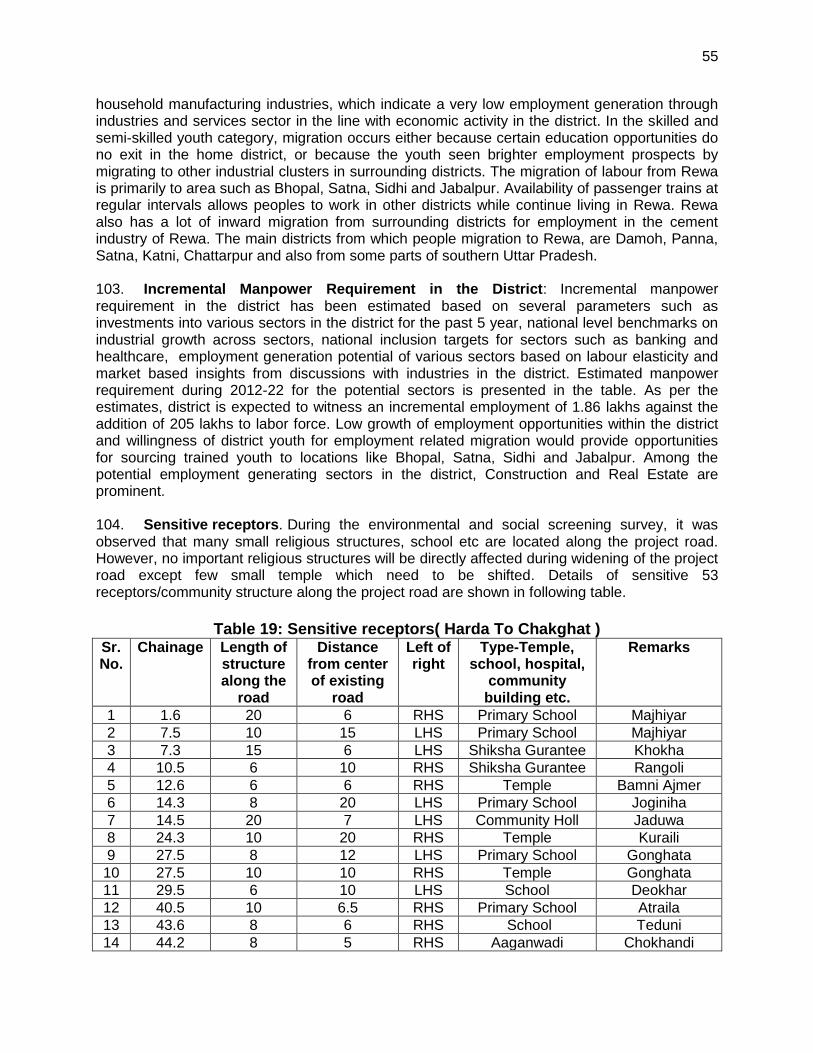
55
household manufacturing industries, which indicate a very low employment generation through industries and services sector in the line with economic activity in the district. In the skilled and semi-skilled youth category, migration occurs either because certain education opportunities do no exit in the home district, or because the youth seen brighter employment prospects by migrating to other industrial clusters in surrounding districts. The migration of labour from Rewa is primarily to area such as Bhopal, Satna, Sidhi and Jabalpur. Availability of passenger trains at regular intervals allows peoples to work in other districts while continue living in Rewa. Rewa also has a lot of inward migration from surrounding districts for employment in the cement industry of Rewa. The main districts from which people migration to Rewa, are Damoh, Panna, Satna, Katni, Chattarpur and also from some parts of southern Uttar Pradesh. 103. Incremental Manpower Requirement in the District: Incremental manpower requirement in the district has been estimated based on several parameters such as investments into various sectors in the district for the past 5 year, national level benchmarks on industrial growth across sectors, national inclusion targets for sectors such as banking and healthcare, employment generation potential of various sectors based on labour elasticity and market based insights from discussions with industries in the district. Estimated manpower requirement during 2012-22 for the potential sectors is presented in the table. As per the estimates, district is expected to witness an incremental employment of 1.86 lakhs against the addition of 205 lakhs to labor force. Low growth of employment opportunities within the district and willingness of district youth for employment related migration would provide opportunities for sourcing trained youth to locations like Bhopal, Satna, Sidhi and Jabalpur. Among the potential employment generating sectors in the district, Construction and Real Estate are prominent. 104. Sensitive receptors. During the environmental and social screening survey, it was observed that many small religious structures, school etc are located along the project road. However, no important religious structures will be directly affected during widening of the project road except few small temple which need to be shifted. Details of sensitive 53 receptors/community structure along the project road are shown in following table.
Table 19: Sensitive receptors( Harda To Chakghat ) Sr. No.
Chainage Length of structure along the
road
Distance from center of existing
road
Left of right
Type-Temple, school, hospital,
community building etc.
Remarks
1 1.6 20 6 RHS Primary School Majhiyar
2 7.5 10 15 LHS Primary School Majhiyar
3 7.3 15 6 LHS Shiksha Gurantee Khokha
4 10.5 6 10 RHS Shiksha Gurantee Rangoli
5 12.6 6 6 RHS Temple Bamni Ajmer
6 14.3 8 20 LHS Primary School Joginiha
7 14.5 20 7 LHS Community Holl Jaduwa
8 24.3 10 20 RHS Temple Kuraili
9 27.5 8 12 LHS Primary School Gonghata
10 27.5 10 10 RHS Temple Gonghata
11 29.5 6 10 LHS School Deokhar
12 40.5 10 6.5 RHS Primary School Atraila
13 43.6 8 6 RHS School Teduni
14 44.2 8 5 RHS Aaganwadi Chokhandi

56
Sr. No.
Chainage Length of structure along the
road
Distance from center of existing
road
Left of right
Type-Temple, school, hospital,
community building etc.
Remarks
15 45.5 4 4 RHS Temple Chokhandi
16 46.1 20 6 RHS School Chokhandi
17 46.2 3 3 RHS Temple Chokhandi
18 48.4 40 6 LHS School Rambagh
19 48.4 3 4 LHS Temple Rambagh
20 52.1 4 4 LHS Temple Khamhriya
21 55.1 2 8 LHS Temple Kirhaimod
22 56.8 6 7 RHS School Sitlaha
23 59.7 2 5 RHS Temple Jawa
24 59.8 2 6 RHS Temple Jawa
25 59.9 2 10 RHS Temple Near Police Station Jawa
26 60.1 2 10 RHS Temple Jawa
27 60.2 2 10 RHS Temple Jawa
28 64.2 20 20 RHS Temple/ School Jawa
29 64.5 20 10 RHS Coperativ socity Chandi
30 65 3 15 RHS Temple Chandi
31 65.3 15 10 RHS Primary School Chandi
32 65.8 8 8 LHS Temple Chandi
33 67.7 3 6 LHS Temple Chandi
34 68.2 3 8 LHS Temple Chandi
35 68.4 10 15 LHS Aaganwadi Chandi
36 70 11 15 LHS Temple Kusmaidha
37 70.8 17 10 LHS Middle School Koniya Kala
38 73.10 3 13 RHS Temple Kuthila
39 75.50 2 8 LHS Temple Chilla
40 75.60 2 8 RHS Temple Chilla
41 76.80 3 5 LHS Temple Chilla
42 76.90 4 10 LHS Temple Chilla
43 78.30 6 8 RHS Temple Kotra
44 82.30 12 10 RHS School Chandela
45 82.80 6 10 LHS School Chandela
46 83.50 4 8 LHS Temple Chandpur
47 86.80 3 6 LHS Temple Panasi
48 88.10 3 7 RHS Temple Papouara
49 89.30 40 7 LHS School Lunipar (U.P)
50 91.50 40 8 RHS School Deora (U.P)
51 95.50 4 8 RHS Temple Chakghat
52 96.00 2 3.5 RHS Temple Chakghat
53 96.00 17 15 RHS Temple Chakghat

57
V. ANTICIPATED ENVIRONMENTAL IMPACTS AND MITIGATION MEASURES 105. Impact identification, screening for significance, and recommended mitigation measures for HC Road was guided by the use of ADB Rapid Environmental Assessment (REA) Checklist for Roads and Highways as provided in Appendix 1. The environmental screening of HC Road revealed the following the entire alignment is located inside or near a cultural heritage site, protected area, wetland, mangrove, estuarine, buffer zone of protected area or special area for protecting biodiversity. 106. The potential impacts of the proposed upgrading includes: removal of avenue trees, increase in ambient dust concentration, increase in noise, generation of construction debris and camp wastes, and loss of community structures
A. Impact on Physical Environment Design Stage
1. Natural Hazard
107. The entire Madhya Pradesh falls under zone least active to moderate zone as per seismic map of India and therefore the risk of damage to the project road due to earthquake is minimal. Nonetheless, relevant IS codes were adopted in the design the civil structures
a. Road Widening, Utilities shifting and Safety Planning
108. The entire road section has enough available ROW to accommodate the proposed road improvement works and will be undertaken along the existing alignment. Road widening will result to shifting of utilities and encroaching structures. Poor coordination with local authorities and communities will increase the risk of accidental damage to drainage canals and temporary disruption of water and electric supplies along active construction fronts. The further contraction of the useable carriageway during construction will exacerbate traffic and will hinder direct access across the road by residents along the road. Temporary detention of sewage on depressed areas during the reconstruction of drainage canals may occur. 109. Road formation widening will be made on the basis of minimizing tree cutting, utility shifting, and damage to community properties. Road design has incorporates the drainage system to avoid accumulation of sewage and surface run-off. Temporary pits will constructed side-and cross drains to collect sewage from demolished or damage drainage canals which will either be hauled for off-site treatment through septic tanks prior to disposal or land application. 110. Adequate safety provisions like crash barriers on accident prone areas, rumble strips in community areas to regulate speed, retro-reflective warning sign boards near school, hospital, and religious places are incorporated in the design. All utilities requiring shifting shall be largely made before start of construction. Prior to shifting, the Contractor will coordinate with the concerned agencies regarding the time and extent of shifting and community affected will be informed of potential service disruption at least 1 week in advance.
2. Terrestrial Ecology
111. There is no national park, wildlife sanctuaries or any other similar eco-sensitive areas within 10 km distance of the project area. However, six trees are likely to be affected. The impact and mitigation due to tree cutting has been discussed in following paragraphs. The road

58
has direct bearing on tree resources. Road widening option is made to minimize the cutting of tree. However efforts have been made in designing to reduce the tree cutting to only six. Compensatory plantation of 1:10 has been planned under the project to address this impact. 112. The road has direct bearing on tree resources. Road widening option is made to minimize the cutting of tree. However efforts have been made in designing to reduce the tree cutting to only six. Compensatory plantation of 1:10 has been planned under the project to address this impact.
B. Construction Stage
1. Air Quality
113. The potential sources of air emission during the construction phase of the project are:
(i) dust re-suspension from earthworks including materials loading and unloading; (ii) quarrying and rock crushing; (iii) operation of construction equipment and machines; (iv) fugitive emissions from unpaved road travel; and (v) combustion of fuels from equipment, machineries, and vehicles.
114. Particulate matter, comprising the majority from road construction, Particle size distribution from road construction is dominantly large, with 85.5% > 10um and 55% > 20 um2 which can settle within close proximity of the source. Hot mix plant will generate carbon monoxide (CO), un-burnt hydrocarbon, sulphur dioxide, particulate matters, and nitrogen oxides (NOx) emissions. This may affect the air quality of nearby areas especially due to emission discharge from low height stack. The deterioration of the air quality within the immediate vicinity of the road construction activities will be significant but temporary. 115. Mitigation Measures. Following measures are proposed to minimize the dust and emission generation:
i. Vehicles delivering loose and fine materials like sand and aggregates shall be covered.
ii. Loading and unloading of construction materials in project area or provisions of
water fogging around these locations.
iii. Storage areas should be located downwind of the habitation area.
iv. Water shall be sprayed on earthworks and unpaved haulage roads regularly.
v. Regular maintenance of machinery and equipment. Vehicular pollution check
shall be made mandatory.
vi. Explore the potential for using ready made asphalt and crushed rocks to avoid or
minimize the use of hot mix and rock crushing plants
vii. Mixing plants and asphalt (hot mix) plants shall be located at least 1 km
downwind of the human settlements. The asphalt plants, crushers and the
batching plants shall be sited at least 500m in the downwind direction from the
nearest settlement and after securing a No-Objection Certificate (NOC) from the
SPCB. Hot mix plant shall be fitted with stack of adequate height as may be
prescribed by SPCB to ensure enough dispersion of exit gases.
2 (undated) W.R. Reed and J.A. Organiscak. Evaluation of dust exposure to truck drivers following the
lead haul truck. http://www.cdc.gov/niosh/mining/userfiles/works/pdfs/eodet.pdf

59
viii. Only crushers licensed by PCB shall be used.
ix. LPG should be used as fuel source in construction camps instead of wood. Tree
cutting shall be restricted.
x. Mask and other PPE shall be provided to the construction workers.
xi. Diesel Generating (DG) sets shall be fitted with adequate height as per
regulations (Height of stack = height of the building + 0.2 KVA.
xii. Low sulphur diesel shall be used in DG sets as well as machineries.
xiii. Air quality monitoring should be carried out during construction phase. If
monitored parameters are above the prescribed limit, suitable control measures
must be taken
2. Noise
116. The scale of the construction necessary to upgrade the road and the corresponding slight increase in traffic are not expected to generate adverse impacts. Ambient noise level may increase temporarily in the close vicinity of various construction activities, maintenance workshops and vehicles and earthmoving equipment. These construction activities are expected to generate noise levels in the range of 80 – 95 dB(A) at a distance of about 5 m from the source. 117. Although this level of noise is higher than the permissible limit for ambient noise level for residential/commercial levels but will occur only intermittently and temporary. This noise level will attenuate with increase in distance from noise source, decreasing by 10dB at a distance of about 55m and 20 dB at 180 meters. Impact due to noise during construction activities will be minimal to communities as construction camps are located at least 50 meters from community areas. 118. Along the project road, a number of noise sensitive places are located which includes schools and temples. Noise impacts during project construction will be significant and temporary. 119. Mitigation Measures. Since the baseline noise levels already exceed prescribed standards the target for the operational stage monitoring will be to ensure that the noise levels do not exceed baseline levels. 120. All equipment shall be fitted with silencers and will be properly maintained to minimize its operational noise. Noise level will be one of the considerations in equipment selection, which will favor lower sound power levels. Stationary noise making equipment shall be placed along uninhabited stretches. 121. In addition to preferring less noise generating equipment, the timing of operation can be scheduled to avoid disruption of activities like school and prayer times. Finally, provision of temporary noise barriers will be made near identified sensitive locations or near the noise source during construction. 122. To protect workers operating in noisy environment, ear plugs or ear muffs will be provided by the Contractor to the workers and occupational exposure limits will be strictly implemented

60
3. Impact on Land and Soil
123. Borrow areas may lose its productivity if top soil is not preserved. Similarly, land area used for locating construction camp may lose its productivity, if it is not restored to its original stage after disbanding the construction camp. 124. Mitigation Measures. The top soil from the productive land shall be preserved and reused for plantation purposes. It shall also be used as top cover of embankment slope for growing vegetation to protect soil erosion. It shall be ensured that the land taken on lease for access road and construction camp is restored back to its original land use before handing it over back
a. Soil Erosion
125. Soil erosion may take place at locations of sharp bend near bridge construction locations, along steep and uncompact embankment slope, and wherever vegetation is cleared. Soil erosion may have cumulative effect viz. siltation, embankment damage, and drainage problem. Loss of soil due to run off from earth stock-piles may also lead to siltation of nearby water bodies. The intensity of soil erosion at different locations will be influenced by the lithology, topography, soil type and climatic condition (mainly rainfall) and drainage pattern.
126. Mitigation measures. Following mitigation measures are proposed for prevention of soil erosion:
i. Bank protection measures shall be taken at erosion prone areas. The protection measures may include use of geo-textiles matting, bio (vegetative) – turfing
ii. Provision of side drain to guide the water to natural outfalls.
iii. Stone pitching wherever necessary.
iv. When soil is spread on slopes for permanent disposal, it shall be buttressed at
the toe by retaining walls.
v. Side slopes of the embankment shall not be steeper than 2H:1V. Turfing of
embankment slopes shall be done along the stretch.
vi. Shrubs shall be planted in loose soil area.
vii. In rural stretches, longitudinal side drains shall be intercepted by drains serving
as outlet channels to reduce the erosion
viii. IRC: 56 -1974 recommended practice for treatment of embankment slopes for
erosion control shall be taken into consideration. ix. Soil erosion shall be visually checked on slopes and high embankment areas. In
case soil erosion is found, suitable measures shall be taken to control the soil erosion further including bio-turfing.
x. While planning or executing excavations, the Contractor will take all adequate
precautions against soil erosion as per MoRTH 306. xi. The earth stockpiles to be located downwind and provided with gentle slopes to
prevent oil erosion
b. Borrow Areas and Quarries
127. The project area is flat terrain. Farmers are willing to provide earth from their field up to certain depth on adequate compensation, it is recommended that borrowing from agricultural land shall be minimized to the extent possible.
61
128. Borrow areas if left un-rehabilitated may pose risk to people, particularly children and animals of accidentally falling into it as well as become potential breeding ground for mosquitoes and vector born disease 129. Illegal quarrying may lead to unstable soil condition; destroy the landscape of the terrain, air and noise pollution. Opening of new quarries is not envisaged due to the proposed project. Quarry material will be sourced from existing nearby quarries. 130. Mitigation measures. Borrow pits shall be selected from barren land/wasteland to the extent possible. Borrow areas should not be located on cultivable lands except in the situations where land owners desires to level the land. The top soil shall be preserved and depth shall be restricted to the desired level. 131. Borrow areas should be excavated as per the intended end use by the owner. The Indian Road Congress (IRC):10-1961 guideline should be used for selection of borrow pits and amount that can be borrowed. 132. The depths in borrow pits to be regulated so that the sides shall not be steeper than 25%. To the extent possible, borrow areas shall be sited away from inhabited areas. Borrow areas shall be leveled with salvaged material or other filling materials which do not pose contamination of soil. In addition, it shall be converted into fishpond in consultation with fishery department and if desired by land owner/community. The borrow shall be 133. Rehabilitated following the broad guidelines given at Appendix 2. 134. Aggregates will be sourced from existing licensed quarries. Copies of consent/ approval / rehabilitation plan for a new quarry or use of existing source will be submitted to EO, PIU. The contractor will develop a Quarry Redevelopment plan, as per the Mining Rules of the state and submit a copy of the approval to EA if new quarries are opened.
c. Compaction and Contamination of Soil 135. Soil in the adjoining productive lands beyond the ROW, haulage roads, and construction camp area may be compacted due to movement of construction vehicles, machineries and equipment, and due to sitting of construction camps and workshops. Approach road either paved or unpaved is available for most the bridge approaches. However, for some bridges approach road has to be constructed. 136. Soil may be contaminated due to inappropriate disposal of liquid waste, (lubricating oil and fuel spills, waste oil and lubricant and vehicle/equipment washing effluent) and solid waste (fuel filters, oily rags) likely to be generated from repair and maintenance of transport vehicles, construction equipment and machinery. Soil may be contaminated due to inappropriate disposal of domestic solid waste and sewage from construction camps. 137. Mitigation Measures. Fuel and lubricants shall be stored at the predefined storage location and away from drainage channels. The storage area shall be paved with gentle slope to a corner and connected with a chamber to collect any spills of the oils. Construction vehicles and equipment will be maintained and refueled in such a fashion that oil/diesel spillage does not contaminate the soil.
62
138. All efforts shall be made to minimize the waste generation. Unavoidable waste shall be stored at the designated place prior to disposal. To avoid soil contamination at the wash-down and re-fuelling areas, oil interceptors shall be provided. Oil and grease spill and oil soaked materials are to be collected and stored in labeled containers (Labeled: WASTE OIL; and hazardous sign be displayed) and sold off to SPCB/ MoEF authorized Waste Oil Recycler. 139. To prevent soil compaction in the adjoining productive lands beyond the ROW, the movement of construction vehicles, machinery and equipment shall be restricted to the designated haulage route.
i. Approach roads shall be designed along the barren and hard soil area to reduce
the compaction induced impact on soil. ii. The productive land shall be reclaimed after construction activity.
iii. Septic tank or mobile toilets fitted with anaerobic treatment facility shall be provided at construction camp.
iv. Domestic solid waste at construction camp shall be segregated into biodegradable and non-biodegradable waste. The non-biodegradable and recyclable waste shall be sold off.
v. Efforts shall be made that biodegradable waste shall be composted in the mechanized and movable composter by the contractor. Non bio-degradable and non-saleable waste shall be disposed off to authorized land fill site. Non-bituminous wastes to be dumped in borrow pits with the concurrence of landowner and covered with a layer of topsoil conserved from opening the pit.
vi. Bituminous wastes will be disposed off in an identified dumping site approved by the State Pollution Control Board
a. Construction waste constitutes debris, which are generated due to dismantling of pavement (though involved only for few kilometer in DBH Road), quarry dust and unused iron bars or damaged support structures. Uncontrolled disposal of these wastes may affect soil and even receiving water bodies may cause contamination of soil, and landscape of the area.
d. Groundwater
140. Contamination of groundwater is not envisaged since construction camps will have septic tanks or mobile toilets depending on the number of workers in each camp. 141. Mitigation Measures. Requisite permission as applicable shall be obtained for abstraction of groundwater. The contractor shall make arrangements for water required for construction in such a way that the water availability and supply to nearby communities remain unaffected. Water intensive activities shall not be undertaken during summer season.
e. Surface Water Bodies 142. Temporary pollution of water bodies may occur due to spillage of chemicals and oil at construction sites and disposal of waste from construction camps. Installation of a haul road or temporary access across the river/nala maybe required while construction work is ongoing in the existing minor bridges and culverts. This may cause sedimentation and other disturbances to the water body.

63
143. Mitigation Measures. To prevent siltation of road side ponds, provision of retaining wall is made along the road for the ponds located next to the road. As enhancement measures, efforts shall be made to increase the water holding capacity of the ponds (other than those affected) in the region by using the bed material as borrow earth. Following measures shall be followed additionally:
i. Bridge construction activity including piling is recommended during non-monsoon
(October to End of May) period. ii. Check dams must be created during construction to catch the silt or debris
generated from construction activities across the water channels iii. All chemicals and oil shall be stored away from water and concreted platform
with catchment pit for spills collection. iv. All equipment operators, drivers, and warehouse personnel will be trained in
immediate response for spill containment and eventual clean-up. v. Readily available, simple to understand and preferably written in the local
language emergency response procedure, including reporting, will be provided by the contractors.
vi. Silt fencing and/or brush barrier shall be installed along drainage path, erosion prone areas for collecting sediments before letting them into the water body. Silt/sediment should be collected and stockpiled for possible reuse as surfacing of slopes where they have to be re-vegetated.
vii. All wastes arising from the construction should be disposed in an environmentally accepted manner so as not to block the flow of water in the channels. The wastes should be collected, stored and transported to the approved disposal sites.
viii. No vehicles or equipment should be parked or refueled near water bodies, so as to avoid contamination from fuel and lubricants
ix. Substructure construction should be limited to the dry season. x. Construction camps shall be located away from habitation (at least 1 Km Away)
and water bodies. Sewage from labour camps will be treated through septic tanks. No untreated/treated sanitary wastewater shall be discharged into surface
water bodies as these are used for bathing and washing purpose. xi. The borrow areas may also be converted into ponds with the concurrence of the
land owners. Fisheries activity can be encouraged in such ponds through institutional support from concerned department
f. Hydrology and Drainage
144. Construction material and waste may contaminate or clog the small drains if stored or disposed close to water body. 145. Mitigation Measures. Adequate cross drainage structures shall be provided. Additional balancing culverts shall be provided in flood prone areas. The embankment height shall be designed consistent with the existing topography of the region and shall be higher than the HFL. Elaborate drainage system shall be provided to drain the storm water from the roadway and embankment and to ensure minimum disturbance to natural drainage of surface and subsurface water of the area. 146. The design of drainage system such as surface and sub-surface drainage shall be carried out as per IRC: SP: 42 and IRC: SP: 50. Surface runoff from the main highway,

64
embankment slopes and the service roads shall be discharged through longitudinal drains, designed for adequate cross section, bed slopes, invert levels and the outfalls. If necessary, the walls of the drains shall be designed to retain the adjoining earth. 147. IRC: 34-1970: Recommendations for road construction in waterlogged area and IRC: 75 and MORT&H guidelines for Design of High Embankments shall be referred. 148. No construction material will be stored or disposed near any water body except for reusing it for enhancement measures such as embankment raising.
4. Impact on Biological Environment
a. Terrestrial Ecology 149. There is no national park, wildlife sanctuaries or any other similar eco-sensitive areas within 10 km distance of the project area. However, some trees are likely to be affected. The impact and mitigation due to tree cutting has been discussed in following paragraphs. 150. One month before the construction starts, clearing and grubbing will be performed by the contractor. All trees within the ROW with 300 mm diameter at 1m above the ground will be cut, including the removal of stumps. A total of 664 trees are likely to be affected due to the proposed project. The cutting of trees will have minor to negligible impact on local environment.
151. Mitigation Measures. Requisite permission from Forest Department shall be obtained for cutting of roadside trees located in forest land otherwise; permission will be taken from district commissioner. 152. One month before the construction starts, clearing and grubbing will be performed by the contractor. All trees within the ROW with 300 mm diameter at 1m above the ground will be cut, including the removal of stumps. A total of 586 trees are likely to be affected due to the proposed project. The cutting of trees will have minor to negligible impact on local environment. 153. Mitigation Measures. Requisite permission from Forest Department shall be obtained for cutting of roadside trees located in forest land otherwise; permission will be taken from district commissioner. 154. The project envisages plantation of approximately 6640 trees along both sides of road as per IRC SP: 21 specifications. This will include the compensatory plantation as per prevailing guidelines of States forest department on 1:10 basis replacement rate or as per permission granted by district authorities for cutting of tree located on non-forest land, which vary from 1:3 to 1;10. Besides, additional plantation shall be done on banks of water bodies near bridge sites to enhance the aesthetics and check soil erosion. All tree plantations will be carried out through forest department, local community or the civil works contractor. Tree species selected for plantation must be suitable for local climatic conditions and be equal to or better in sequestering carbon than the the trees removed/be good for sequestering carbon (only for roads where there is no tree cutting). Necessary advise maybe sought from the local Forestry office in the selection of tree species. 155. A range of 10-15 m Centre-to-Centre is recommended for spacing of trees (parallel to the road). Setback distance of trees in different situations shall be based on IRC: SP: 21 and IRC: 66. The distance between the kerb, if any, and the nearest edge of tree trunk shall be at

65
least 2 m. The plantation in median shall comprise shrubs whose height would normally not exceed 1 -1.5 m and shall be as per IRC SP: 21. 156. For safe traffic operation, vertical clearance between the crown of the carriageway and lowest part of overhang of the tree available across the roadway shall conform to the standards laid down in IRC: SP: 21. The pit size, fencing, watering, and manuring requirements shall also conform to the above standard. The use of pesticides shall be avoided or minimized to the extent possible. Planting shall be such that it does not obstruct the visibility of traffic from any side and shall be pleasing in appearance.
b. Aquatic Ecology
157. Temporary sedimentation and water quality deterioration is expected from the project during the construction stage. Accidental spill of materials, chemicals, and fuels may also deteriorate receiving water quality and hence the aquatic ecology. 158. Mitigation measures. It is proposed to undertake construction activities near water bodies during summer season when most of water bodies are practically dry. Best construction practices shall be adopted to prevent increase in siltation level of the water. All precautionary efforts shall be taken as given under surface water section to prevent accidental damage of water quality.
C. Socio-Economic Impact
159. Hardua to Chakghat Road project will have both positive and negative impact on socioeconomic aspects as narrated below.
1. Positive Impacts 160. Economic activities supporting transport like fuel stations, automotive repair shops, lodging, and restaurants are expected to increase with increase of traffic and induced development of the area. The improved road will provide better connectivity which will result in (i) Reduction in travel time (ii) better mode and frequency of transport (iii) access to quality health care facilities, educational and other infrastructural facilities (iv) enhanced tourism activities in the area and state which in many terms will boost the local economy (v) better investment climate for industries creating more employment opportunities to local people.
2. Anticipated Negative Impacts 161. The other impacts are expected due to sitting and operation of construction camp during construction. 162. Construction workers expected to be about 150 per day per package are likely to be employed during construction. Most of the workers will be employed locally. However, some may be from nearby areas. This will cause additional burden on local resources. However, this impact will be temporary and will not have the potential for changes in the demographic scenarios of the area. The outside workers will be housed at the construction camp, which is expected to one per package. Poor sitting and improper management of construction camp may lead to several adverse impacts on environment viz. (i) loss of vegetation due to use of wood as fuel source for cooking (ii) deterioration in nearby surface water bodies‟ quality (iii) compaction and contamination of soil due to uncontrolled disposal of solid waste (iv) Poor sanitation may

66
result to transmission of communicable diseases among the workers and the host communities. This includes the possible spread of sexually transmitted disease, diseases from improper handling and supply of foodstuffs, poor water supply, and insect-borne diseases. 163. Mitigation Measures. Construction camp shall be sited at such locations so as to utilize the existing infrastructure. No productive land should be utilized for construction camp. All sites must be graded, ditched and rendered free from depressions to avoid water stagnation. Accommodation and ancillary facilities including recreational facility for workers shall be erected and maintained to standards and scales approved by the resident engineer. All camps should maintain minimum distance of 1000 m from habitation and water bodies. 164. All construction camps shall be provided sanitary latrines and urinals with provision of septic tanks attached with soak pits or mobile toilets fitted with anaerobic digestion system. Storm water drains shall be provided for the flow of used water outside the camp. Drains and ditches shall be treated with bleaching powder on a regular basis. Garbage bins must be provided in the camp and regularly emptied and disposed of in a hygienic manner. LPG cylinders shall be provided as fuel source for cooking to avoid any tree cutting.
165. The Contractor will ensure the following:
i. The good health and hygiene of all workers to prevent sickness and epidemics.
These include the HIV/AIDS prevention program to reduce the risk and transfer of HIV virus between and among the workers and community, promote early diagnosis and assist affected individuals. Activities under the program include monthly information, education, and consultation communication campaigns to workers, drivers, delivery crew, and communities on the risk, dangers, and impacts of STD and HIV/AIDS. Contractor will also provide first aid facilities at the camp and organize regular health check-up camps as well.
ii. Availability of safe drinking water and sufficient supply of suitable and hygienically prepared food at reasonable price is available to the workers.
iii. Adoption of all precautions to protect the workers from insect and pest to reduce the risk to health. This includes the use of insecticides, which should comply with local regulations.
iv. Prohibition on supply or availability of alcoholic liquor or prohibited drugs at the camp.
v. Regular health check-up and immunization camps shall also be organized for the workers and nearby population.
3. Safety
166. The road construction activities may create various unsafe situations. This will require attention to the following safety aspects viz. (i) safety of construction workers, (ii) safety of road users including pedestrians and cyclists (iii) safety to cattle; (iv) safety of local community (iv) unsafe/ hazardous traffic conditions due to construction vehicle movement need to be considered during design and construction stage and (v) conduct of safety audit. 167. Mitigation measures. During the construction phase, contractors shall be required to adopt and maintain safe working practices. Internationally accepted and widely used safety procedures should be followed during (i) road works (ii) handling of large construction equipment and machineries, (iii) handling of chemicals and hazardous materials and

67
inflammable substances (iii) welding and (iv) electrical works. Contractor shall also arrange required PPEs for workers, first aid and firefighting equipment at construction sites. Contractor will also prepare an emergency preparedness plan, which shall be duly approved by EA to respond to any emergency and unsafe conditions. To avoid disruption of the existing traffic due to construction activities, comprehensive traffic management plan shall be drawn up by the contractor. Retro
168. Reflectorized traffic caution signs shall be used during construction. Regular safety audit or periodic review shall be made to assess the effectiveness of safety measures adopted during construction.
169. Adequate caution signage near school, sensitive locations, speed control, caution notes shall be fixed at appropriate locations. These shall be preferably of PCC with Retroreflective paints. Steel base signage shall be avoided to prevent theft of the same. Crash barrier shall also be installed at appropriate locations particularly near school to provide safety to school children. Provision of sped breakers shall be made near schools and religious places.
4. Impacts during operation stage
170. The subproject road is located in vast open agricultural land, which will provide adequate dispersion of gaseous emission from vehicle. Further, proposed plantation will ameliorate/enhance the micro climate. No adverse climatic changes/impacts are anticipated during operation stage other than GHG (CO2) emission due to increased traffic, which would be largely offset with better fuel efficiency and reduced vehicle idling due to improved road conditions.
a. Air Quality 171. Vehicular emissions will be the principle source of pollution during operation stage. The subproject road is mostly located in vast open agricultural land, which will provide adequate dispersion dynamics of gaseous pollutants. Moreover, majority of the traffic on the subproject will be diverted traffic from the existing highways. 172. Mitigation Measures. Plantation is one of the preferred solutions to check air pollution. Plants serve as a sink for pollutants, reduce the spread of dust. Tree plantation along roadsides and other places shall include pollution absorbent species. Awareness signboards shall be installed at prominent location to educate drivers for good driving and vehicle maintenance practices.
b. Noise 173. During the operational Stage, movement of traffic will be the prime source of noise. Traffic congestion and pedestrian interferences increase the use of horns. This may result in increased noise levels at nearby schools and religious places. 174. Mitigation Measures. Effective traffic management and good riding conditions shall be maintained to reduce the noise level throughout the stretch. Speed limitation and honking restrictions may be enforced near sensitive locations. Increased plantation along the road and boundary wall will also work as noise barrier. Since most of the schools buildings are away from the road, therefore impact of noise is expected to be insignificant. Since improved road

68
conditions and multi-layered plantation will be helpful in attenuation of noise levels, the effectiveness of these measures shall be monitored. If noise levels are still found higher than the prescribed ambient noise standards at these sensitive receptors, adequate noise barrier shall be fixed.
c. Land and Soil 175. The better access can lead to conversion of agriculture land for residential and commercial purposes close to roads and especially in rural and urban area. 176. Mitigation Measures. The EA may explore the feasibility of restricting about 30 m area either side of the road as no development zone on the line restriction are imposed for National Highways authority of India.
d. Soil Erosion
177. No impact on soil is anticipated during operation phase of the project except bridge approaches where unexpected rainfall may erode the embankment formation and deterioration of borrow areas if not rehabilitated properly. 178. Mitigation measures. Embankment stabilization shall be check periodically during operation stage and suitable stabilization measures shall be taken wherever any erosion is identified. Borrow areas will also be rehabilitated following the guidelines given at Appendix 2.
e. Groundwater
179. No impact is anticipated on groundwater due to the project during operation phase of the project hence, no specific mitigation measure is proposed.
f. Surface Water Bodies 180. No major or long-term impact is anticipated during the operation phase on the surface water bodies due to the project implementation activities. Oil contaminated runoff from the road during monsoon will have minimal impacts considering their low concentration.
g. Hydrology and Drainage 181. Regular removal/cleaning of deposited silt shall be done from drainage channels and outlet points before the monsoon season. Rejuvenation of the drainage system by removing encroachments/ congestions will be regularly conducted.
5. Impact on Biological Environment
a. Terrestrial ecology 182. Positive impacts on terrestrial ecology are expected during the project operation stage due to the increase in vegetation and landscaping along the road. The project will coordinate with the local communities to maintain and enhance the trees planted along the state road. ”No adverse impact is anticipated during operation stage except accidental damages or absence of proper tree management.

69
183. Mitigation Measures. Arrangement shall be made to ensure survivability of the tree plantation. The tree survivability audit shall also be conducted at least once in a year to assess the effectiveness of the programme.
b. Aquatic Ecology
184. No impact is envisaged during operation phase of the project and hence no mitigation proposed. However, periodic surveillance shall be conducted to check erosion and siltation in major water bodies.
c. Community Health and Safety 185. During operation phase, the projected increase in the number of motorized road users traveling at higher speeds also increases the chances of injuries and fatalities from road crashes. 186. Mitigation Measures. Adequate caution signage near school, sensitive locations, speed control, caution notes shall be fixed at appropriate locations. These shall be preferably of PCC with Retro-reflective paints. Steel base signage shall be avoided to prevent theft of the same. Crash barrier shall also be installed at appropriate locations particularly near school to provide safety to school children. Provision of speed breakers shall be made near schools and religious places. D. Climate Change Impacts and Risks
1. Climate Change Mitigation 187. The Transport Emissions Evaluation Model for Projects (TEEMP)3 developed by Clean Air Asia4 was utilized to assess the CO2 gross emissions with and without the project improvements. The main improvement from the project that was considered for the model is better surface roughness which was translated into impacts on traffic speed and hence fuel consumption. The model also allows for the inclusion of impacts related to traffic congestion with and without project through provisions for inserting data on the traffic numbers, lane width, number of lanes and volume/capacity saturation limit. 188. Information that was fed into the model for projecting the CO2 emissions were:
(i) The road will rehabilitate 92.25 km of major district roads; (ii) The existing road having 2 lane with a 3.5 m carriageway width will be improved
intained to the same number of lanes and carriageway width with asphalt concrete surface;
(iii) Road roughness will decrease from the general condition of 16 m/km to 2.5 m/km;
(iv) Construction will take place over a period of 12 months in 2015 and road operations will begin in 2016.
(v) The design life of the road is 20 years. Hence the midpoint of the design life is after 10 years or 2025.
(vi) Other improvements include the repair or reconstruction of damaged culverts, introduction of lined longitudinal and cross drains for the road and removal of irregularities on the existing vertical profile and road safety appurtenances.

70
189. The traffic forecast data was taken from the traffic studies and economic analysis for the road disaggregated into vehicle types and annual average daily traffic. Key vehicle categories considered for the road and the annual average daily traffic in 2014 (baseline scenario) without project and in 2025 with the project is given in the table below. Table 20: Annual Average Daily Traffic for different vehicle categories
Vehicle category 2016 (without the project) with project) 2-wheeler 222 458
3-wheeler/autorickshaw 30 58
Car/jeep/taxi/van 166 343 Light Commercial Vehicle 41 86
Minibus and standard bus 7 15 Heavy commercial vehicle 6 12
TOTAL 472 972
190. The volume/capacity saturation limit was taken at 2.0 or twice the designed road capacity and beyond which traffic congestion will result to less than optimum travel speed and increase in fuel consumption. Emission factors were taken from the CBCP/MOEF (2008) Draft Report on Emission Factor Development for Indian Vehicles, the Automotive Research Association of India, and C. Reynolds et.al (2011) Climate and Health Relevant Emissions from in-Use Indian for three-wheelers rickshaw as follows:
CO2 Emission Factors
191. 192. Emissions from road construction were also calculated using estimates of the total quantity of materials that will be used to rehabilitate the road which is 961 tons of steel, 8088 tons of cement and 9858 tons of bitumen. 193. Estimated carbon emissions. The proposed road upgrading resulting to surface roughness and road capacity improvements have implications in CO2 emissions. Improved roughness results to higher speed and lesser emissions while increase road users increases emissions. These factors are further affected by traffic congestion once the volume/capacity saturation limit. 194. CO2 emissions will also result from the processing and manufacturing of raw materials needed to upgrade the road and in the case of Ujjain-Maksi, a total of 8088 tons of cement, 961 tons of steel, and 9858 tons of bitumen will be needed. These construction materials will produce an estimated 10700 tons of CO2.
Vehicle Type Gas/Petrol Diesel
2-Wheel 2.28 kg/l
3-Wheel 2.63 kg/l
Cars/bus/bus 2.59 kg/l 2.68 kg/l
LCV 3.21 kg/l
Bus 3.61
HCV 3.50

71
195. The Figure below presents the impacts on emissions due to road improvements. Total CO2 emission at business-as-usual scenario was estimated at 4188 tons for the entire project life and without-and with-induced traffic are 42153 and 42451 tons respectively. These values are below the 100,000 tons per year threshold set in the ADB SPS 2009. Therefore it is not necessary to implement options to reduce or offset CO2 emissions under the project. .
Figure 11: Plot of CO2 Emissions Considering Improvement in Surface Roughness and Road Capacity
196. The design life of the roads is 20 years. The project’s CO2 emission intensity indicators are provided in the succeeding Table 21
197. Table 21: Project CO2 Emissions Intensity Indicators
Details Business-As-Usual Project (without Induced Traffic)
Project (with Induced Traffic)
tons/km 45.40 456.91 460.14
tons/year 97.98 986.16 993.14
tons/km/year 3.78 38.08 38.35
g/pkm 107.16 1,078.52 1,011.62
g/tkm 108.75 1,094.565 1,026.26
198.
2. Climate Risks and Adaptation needs
199. Climate risks were identified following both top down and bottom up approaches. Under the top down approach changes of key climate parameters, mainly temperature and precipitation were projected for 2050 using an ensemble of Global Climate Models (GCMs). Given the projected variations of temperature and precipitation the project roads were screened for 9 types of climate risks:
• Landslide triggered by increased precipitation • Fire

72
• Flood • Drought • Tsunami • Cyclone wind • Cyclone surge • Sea level rise • Coastal erosion
200. Climate risk maps based on information from the GCMs were created for the project area using Geographic Information System (GIS) maps. After overlaying the road locations on the climate risk maps low to medium risks identified for the project roads were flooding, landslides triggered by precipitation, coastal erosion and tsunami. 201. The overall climate change risk level identified from the above exercise is low. The key risk identified is flooding (increased storminess). Bridges and road embankments are the main project components that will be prone to flooding. Increase in temperature may also affect road safety. 202. Under the bottom up approach the flood prone areas in the project road were identified based on field surveys for the engineering design. 203. Key engineering measures taken to address the risk of flooding in the design are: increase in road embankment height in flood prone areas/sections, improvement and provision of lined longitudinal and cross drains and new culverts, improvement and new construction of minor and major bridges. Bridge heights have been designed to have a height of 0.6m above HFL for minor bridges and 0.9m above HFL for major bridges. Flood return period of 50 years for minor bridges and 100 years for major bridges have been considered.

73
E. Cumulative and Induced Impacts
204. According to the ADB Environment Safeguards Sourcebook 3 cumulative impact is described as: “The combination of multiple impacts from existing projects, the proposed project, and anticipated future projects that may result in significant adverse and/or beneficial impacts that cannot be expected in the case of a stand-alone project.” The sourcebook also describes induced impacts as: “Adverse and/or beneficial impacts on areas and communities from unintended but predictable developments caused by a project, which may occur at later or at a different location. 205. Economic activities supporting transport like fuel stations, automotive repair shops, lodging, and restaurants are expected to increase with increase of traffic and induce development in the project area. The improved road will provide better connectivity and result in (i) Reduction in travel time (ii) better mode and frequency of transport (iii) access to quality health care facilities, educational and other infrastructural facilities (iv) enhanced tourism activities in the area and state which in many terms will boost the local economy (v) better investment climate for industries creating more employment opportunities to local people. 206. In terms of environment safeguard issues the improved road surface is expected to result in less dust and noise due to traffic plying on the damaged roads. However, the increased traffic due to the improved road will generate more air pollution due to vehicle exhaust and noise. The smoother road conditions will also result in increase of traffic speeds, hence creating more risks for accidents amongst traffic users as well as the local communities in the project area.
207. For addressing the impacts of air pollution and noise, regular maintenance of the road surface, maintenance and monitoring of newly planted trees and installation of noise barriers where necessary have been included in the EMP for implementation during operation stage. For addressing safety related impacts, regular maintenance of the road furniture include safety related furniture, enforcing rules against encroachment of structures and sensitive structures (schools, temples etc.) inside the ROW and implementation of the emergency response system has been included in the EMP for implementation during operation stage, 208. Information on future development projects along the project road was not available. Hence, it is difficult to assess cumulative impacts from other projects which may get implemented in the project area.
3 Environment Safeguards, A Good Practice Sourcebook, Draft Working Document, December 2012
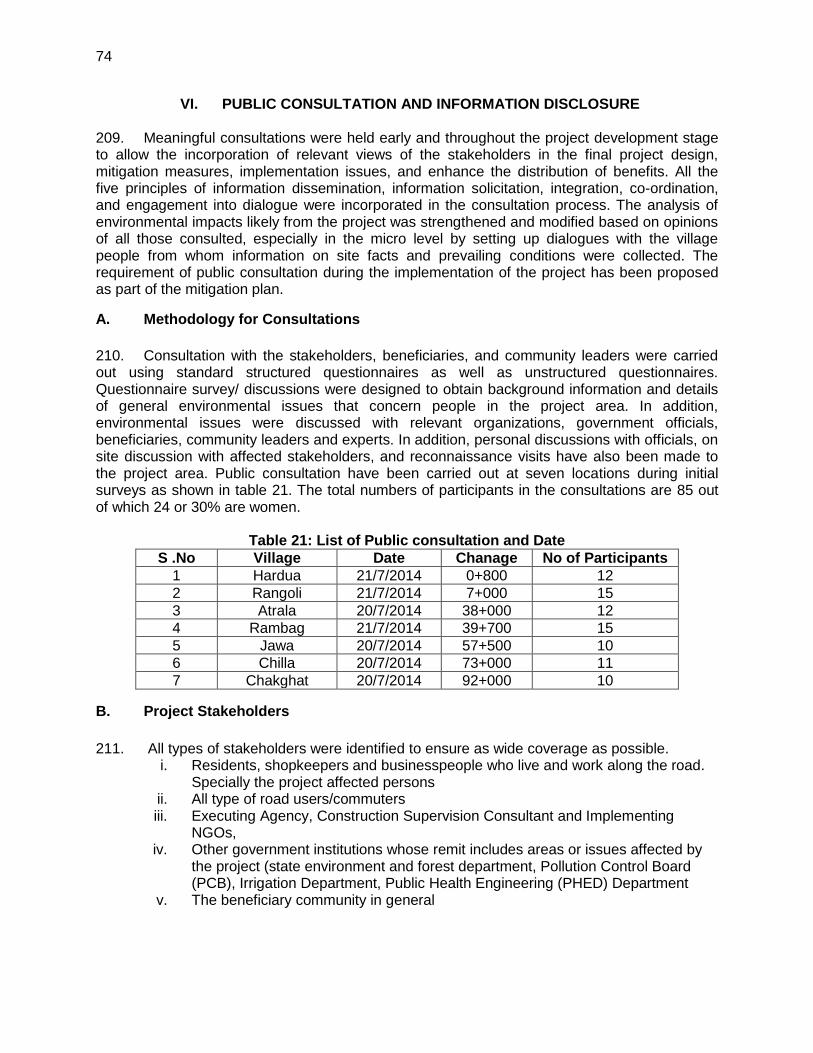
74
VI. PUBLIC CONSULTATION AND INFORMATION DISCLOSURE
209. Meaningful consultations were held early and throughout the project development stage to allow the incorporation of relevant views of the stakeholders in the final project design, mitigation measures, implementation issues, and enhance the distribution of benefits. All the five principles of information dissemination, information solicitation, integration, co-ordination, and engagement into dialogue were incorporated in the consultation process. The analysis of environmental impacts likely from the project was strengthened and modified based on opinions of all those consulted, especially in the micro level by setting up dialogues with the village people from whom information on site facts and prevailing conditions were collected. The requirement of public consultation during the implementation of the project has been proposed as part of the mitigation plan.
A. Methodology for Consultations
210. Consultation with the stakeholders, beneficiaries, and community leaders were carried out using standard structured questionnaires as well as unstructured questionnaires. Questionnaire survey/ discussions were designed to obtain background information and details of general environmental issues that concern people in the project area. In addition, environmental issues were discussed with relevant organizations, government officials, beneficiaries, community leaders and experts. In addition, personal discussions with officials, on site discussion with affected stakeholders, and reconnaissance visits have also been made to the project area. Public consultation have been carried out at seven locations during initial surveys as shown in table 21. The total numbers of participants in the consultations are 85 out of which 24 or 30% are women.
Table 21: List of Public consultation and Date
S .No Village Date Chanage No of Participants
1 Hardua 21/7/2014 0+800 12
2 Rangoli 21/7/2014 7+000 15
3 Atrala 20/7/2014 38+000 12
4 Rambag 21/7/2014 39+700 15
5 Jawa 20/7/2014 57+500 10
6 Chilla 20/7/2014 73+000 11
7 Chakghat 20/7/2014 92+000 10
B. Project Stakeholders
211. All types of stakeholders were identified to ensure as wide coverage as possible.
i. Residents, shopkeepers and businesspeople who live and work along the road. Specially the project affected persons
ii. All type of road users/commuters iii. Executing Agency, Construction Supervision Consultant and Implementing
NGOs, iv. Other government institutions whose remit includes areas or issues affected by
the project (state environment and forest department, Pollution Control Board (PCB), Irrigation Department, Public Health Engineering (PHED) Department
v. The beneficiary community in general

75
a. Consultation with Government Departments 212. Various officials consulted during IEE preparation included PWD Officials, DFO & Ranger Forest Deptt State pollution control board for Air, Noise and Water quality information, IMD for the climatic data, statistical officer for Population and demographic profile, Panchyat department for village level information, Survey of India for the toposheet requirement, Revenue department for the land record information, PHQ officers for hand pump relocation and quality assessment, MPSEB offices for electric pole shifting etc. 213. These departments helped to provide various project related data and information which helped preparation of reports and data analysis.
b. Consultation with Local People and Beneficiaries
214. The informal consultation generally started with explaining the project, followed by an explanation to potential impacts. Participant’s views were gathered with regard to all aspects of the environment which may have direct or indirect impact on local people. Key Issues discussed are:
i. Awareness and extent of the project and development components; ii. Benefits of the project for the economic and social upliftment of community; iii. Labour availability in the project area or requirement of outside labour
involvement; iv. Local disturbances due to project construction work; v. Necessity of tree felling etc. at project sites; vi. Impact on water bodies, water logging and drainage problem if any; vii. Environment and health viii. Flora and fauna of the project area ix. Socio-economic standing of the local people and
215. The project has immense acceptability among the local people. They perceive that in addition to providing all weather connectivity, the subproject road will bring positive socioeconomic changes in the area. Local people mainly discussed on the issues related to flooding, rehabilitation, resettlement, and road safety issues. The list of participants views, and outcome of the consultations have been summarised in Table 36. The Details of Participants and Public Consultation photographs are attached in Appendix 8. In addition information on the GRM procedures and formats in local language in.Hindi was shared with the local people as provided in Appendix-9. 216. The project has immense acceptability among the local people. They perceive that in addition to providing all weather connectivity, the subproject road will bring positive socioeconomic changes in the area. Local people mainly discussed on the issues related to flooding, rehabilitation, resettlement, and road safety issues. The list of participants views, and outcome of the consultations have been summarised in Table 22. 217. The Details of Participants and Public Consultation photographs are attached in Appendix 8. In addition information on the GRM procedures and formats in local language i.e. Hindi was shared with the local people as provided in Appendix-9.

76
Table 22: Outcome of the Consultations
Sr.
No.
Date and
Location
Issues Discussed Measures Taken Participants
1 Date:
21/07/14
Village:
Hardua
Dust control measures like water sprinkling shouldbe done during construction phase.
Speed breakers should be provided near Settlements to control the speed of vehicles.
Tree shall be planted along the road.
Road .
Safety measures should be taken for Pedestrian.
Drain andculverts
Should be provided to avoid accumulationof rain water on the road.
The road should be wide as compare to existing road.
All the resident and official will help during the construction phase. Width of the road should not be less than 8 m even in market area
The villagers were very happy to listen that the MPRDC is going to construct a road in the village.
Proposed widening and strengthening of the road will provide better level of services in terms of improved riding quality and smooth traffic flow.
There will be considerable reduction in the number of accident and level of pollution.
Accessibility to social health and educational infrastructure will increase through all-weather road.
Generation of employment during construction phase of the road.
The discussion generate considerable awareness of the project
As the proposed road shall be an widened one, it shall provide an efficient public transportation system besides ensuring reduction in congestion level
The non -title holders shall also be compensated as per ADB guidelines.
Drainage system is mention in built-up area and drainage for rural area.
Road safety features like traffic signs, Overhead Sign Boards, Road Illumination, Delineators, pavement marking, pedestrian path and rumble strips has been included in the design .
Proper Rehabilitation measures will be taken and compensation will be as per market rate.
Total
Participants-
12
2 Date:
21/7/14
Village:
Rangoli
Total
Participants-
15
3 Date:
20/07/14
Village:
Atrala
Total
Participants-
12
4
,5
6
7.
Date
21/7/14
,village
Rambag
Jawa
20/7/14
Chilla20/7/
14
Chakghat
20/7/14
Total
participant -15
Total
Participant
10 Total
Participant
11 Total
Participant
10

77
218. Most of the people interviewed were well aware of the environmental conditions in and around their villages. A major percentage was ignorant about any deterioration in the air and noise quality due to expansion of existing highway. However, their major concern was related to the loss of fertile agricultural land. The villagers are quite enthusiastic about the proposed project as it will give fillip to rural economy and present them many employment opportunities during construction of project road. Overall positive approach towards the project is observed.
C. Results of Consultation with Local People
219. Most of the people interviewed strongly support the project. The people living in the entire project area expect the different project elements to facilitate transport, employment, tourism, boost economic development and thereby provide direct, or indirect, benefits to them. In order to access the existing environment and likely impacts on surrounding population, an interview survey was carried out. A sample of the population was interviewed through a designed questionnaire. Precaution has been exercised during the survey to ensure that the sample interviewed is truly representative of the affected groups and the questions are worded so as not to generate a bias response. 220. It is observed from the interview survey that there is increased environmental awareness among the people. It can also be seen from Table 38 that about most of the persons are in the opinion that an environmental condition of the area is not good due to bad conditions of road specifically for air & noise.. Poor road condition and vehicular emissions are the major sources they feel responsible for this. People are not fully aware about presence of archaeological, historical and cultural sites. There is no major history of natural disasters in the region and local people have mixed response about natural disasters. Overall, the general environmental awareness in the region is good and people have increased environmental awareness. Table 23 shows the result of public opinion survey carried out in the region.
Table 23 : Peoples’ Perception about Environmental Scenario
Note: Positive response shows that the people have awareness regarding environmental scenario.
D. Conclusion and Recommendation
221. Overall, most of the people interviewed strongly support the project. The people living in the entire project area expect the different project elements to facilitate transport, employment, tourism, boost economic development and thereby provide direct, or indirect, benefits to them.
Sr. No.
Question asked about No. of people
interviewed
Positive response
(%)
Negative response
(%)
No response
(%)
1 Water quality of rivers, ponds, wells, and canals
85 85 10 5
2 Noise quality of the area 85 60 30 10
3 Air quality of the area 85 55 40 5
4 Archaeological sites 85 5 85 5
5 Natural disaster 85 10 70 20
6 Rare species of animals and birds found
85 10 75 15
7 Cultural sites i.e. market, melas
85 80 10 10

78
Construction camps may, however, put stress on local resources and the infrastructure in nearby communities. In addition, local people raised construction-process related grievances with the workers. This sometimes leads to aggression between residents and migrant workers. To prevent such problems, the contractor should provide the construction camps with facilities such as proper housing, health care clinics, proper drinking water and timely payment. The use of local laborers during the construction will, of course, increase benefits to local peoples and minimise these problems. Wherever possible, such people should be employed. 222. The following are the Consultants’ initial findings in regard to likely positive and negative impacts.
1. Positive Impacts:
The improved road: will reduce travel times, fuel consumption and emissions
from base traffic volumes
Drainage conditions will be considerably improved: this because of the provision
of improved side drains, culverts and causeways;
Economic development and access will be stimulated
Health, Agricultural and Education facility will improve.
2. Negative Impacts
Few tree loss which reduce the green cover but simultaneously plantation will
take place to improve the green cover.
Minor deteriorations in the present minimum levels of air, water and noise quality
may be expected during construction- but this should be short-term and localised
– in order to minimise the impacts, the mitigation measures recommended
During construction the traffic will slow and messy.
On the basis of available information, field visits over the entire length of the
project road, discussions with the project authorities; other discussions amongst
the project team, NGOs, local people and various governmental officials, it has
been concluded that overall:
All elements of the projects will be beneficial;
All negative impacts, during and post construction, including those deemed
“significant” can be properly mitigated; and
No comprehensive, broad, diverse or irreversible adverse impacts have been
identified.

79
VII. ENVIRONMENTAL MANAGEMENT PLAN AND GRIEVANCE REDRESS MECHANISM
223. The environmental impacts associated with any development project are eliminated or minimized to an acceptable level through development of appropriate mitigation measures based on most suitable techno-economic options. The Environmental Management Plan (EMP) is a well-established tool to ensure effective implementation of the recommended mitigations measures throughout the subsequent project development stages. The EMP also ensures that the positive impacts are conserved and enhanced. An EMP provides location and time specific actions to be taken with defined responsibility. It also provides measures for institutional strengthening and effectiveness assessment through defined monitoring plan, reporting and corrective & preventive action planning.
A. Environmental Management Plan
224. The H-C Road specific Environment Management Plan has been formulated which consists of a set of mitigation; monitoring and institutional measures applicable to design, construction and operation stages of the project (Appendix 3). The components of this EMP includes (i) mitigation of potentially adverse impacts (ii) monitoring of impacts and mitigation measures during project implementation and operation (iii) institutional capacity building and training (iii) compliance to statutory requirements (iv) integration of EMP with project planning, design, construction and operation.
B. EMP Implementation Schedule
225. The EMP provided in Appendix 3 provides measures. However, specific mention is made for location specific measures. The package specific EMP costs are separately assessed. These EMP will form part of bidding document as well. The construction period for MC Road is considered as 24 months from the date of start of construction.
C. Emergency Response Plan
226. Assessment of nature, type and extent of project activities establishes that this project may have only one environmental emergency i.e. accidents on paved roads and consequent spillage due to damage of oil tank of the vehicle. It is suggested to develop a communication and response system to minimize the response time. The project authorities shall be prepared to counteract against such emergency either by developing in-house capabilities or by associating with any competent agency.
D. Environmental Monitoring Plan (EMoP)
227. The purpose of the environmental monitoring program is to ensure that the envisaged objectives of the project are achieved and result in desired benefits. To ensure the effective implementation of the mitigation measures and Environmental Management Plan (EMP), it is essential that an effective monitoring program be designed and carried out. The board objectives of environmental monitoring plan are:
i. To evaluate the performance of mitigation measure proposed in the EMP,
ii. To evaluate the adequacy of Environmental Assessment
iii. To suggest improvements in management plan, if required,

80
iv. To assess change in environmental quality,
228. A comprehensive monitoring plan has been prepared for all stages of the project and provided as Appendix 4. This includes parameters to be measured, methods to be used, sampling locations, frequency of measurements, detection limits, cost and responsibility for implementation and supervision. The monitoring programme is designed for monitoring during construction and operation stages with details on budget and responsible agencies:
Construction Stage: (three years of construction period)
Monitoring to be carried out by construction supervision consultant (CSC). The costs to form part of CSC budget.
Six Monthly monitoring by external agency to be arranged by PIU ADB from Project cost budget. This report will be directly submitted by agency to MPRDC.
229. Monitoring Programme and schedule for Key Performance Indicators (Physical, biological and environmental management components identified as of particular significance) are given in the following section:
1. Ambient Air Quality (AAQ) Monitoring
230. Ambient air quality parameters recommended for road transportation developments are Fine Particular Matter (PM2.5), Respirable Particular Matter (PM10), Carbon Monoxide (CO), Oxide of Nitrogen (NOx) and Sulphur Dioxide (SO2). These are to be monitored at designated locations starting from the commencement of construction activities. Data should be generated twice in a week at all identified locations in accordance to the National Ambient Air Quantity Standards (Appendix 5). The locations and environmental parameters to be monitored are detailed out in the Environmental Monitoring Plan (Appendix 4).
2. Water Quality Monitoring
231. The physical and chemical parameters recommended for analysis of water quality relevant to road development project are pH, total solids, total dissolved solids, total suspended solids, and oil & grease. The monitoring of the water quality is to be carried out at all identified locations in accordance to the Indian Standard Drinking Water Specification – IS 10500 (Appendix 6). The locations, duration and the pollution parameters to be monitored are detailed in the Environmental Monitoring Plan (Appendix 4).
3. Noise Levels Monitoring
232. The measurements for monitoring noise levels would be carried out at designated locations in accordance to the ambient Noise Standards formulated by Ministry of Environment and Forests (MoEF) as given (Appendix 7). Noise level would be monitored on a twenty-four hours basis. Noise should be recorded at “A” weighted frequency using a slow time response mode of the measuring instrument. The measurement location, duration and the noise pollution parameters to be monitored and the responsible institutional arrangements are detailed in the Environmental Monitoring Plan (Appendix 4).
4. Tree Plantation

81
233. The 75% survival rate of re-plantation shall be monitored on the first year of the operation phase. If the survival rate is found below 75%, additional compensatory plantation shall be carried out by agency responsible for plantation and maintenance. The survival rate monitoring shall be again taken up after 1 year again. This cycle should continue until the 75% survival rate is achieved. Since tree plantation would be made through forest department, monitoring would be carried out through MPRDC.
5. Soil Erosion and Drainage Congestion
234. No significant soil erosion problem is anticipated due to the project either in the construction phase or in the operation phase. However, in the construction phase, some localized soil erosion may be noticed owing to construction activities. However, if soil erosion is noticed during construction and operation phase, the corrective action shall be initiated and frequency of check be increased to assess the tendency of occurrence.
E. Institutional Setting and Proposed Implementation Arrangement
235. The Executing Agency for the project will be GoMP through MPRDC. MPRDC is wholly owned by GoMP and has been equipped with adequate capacity to implement the project. The implementation arrangements basically follow the ongoing MPSRSP-II. A General Manager (GM) at MPRDC headquarter has been designated as person in charge for project implementation. The Environmental and Social cell (ESC) at MPRDC headquarters, reporting to the General Manager, will be responsible for ensuring compliance with environmental and social safeguards of project roads. This cell currently has only one officer to cover both social and environment safeguards. To support this officer, two more social safeguard officers and one environmental safeguard officer will be appointed or recruited. This will allow the ESC to have a total of four officers, 2 for social safeguards and 2 for environment safeguards. 236. MPRDC has ten division offices (Bhopal, Jabalpur, Sagar, Gwalior, Ujjain I, Ujjain II, Indore I, Indore II, Rewa I, and Rewa II) acting as Project Implementation Units (PIUs). Each PIU headed by a Divisional Manager (Tech.) will be responsible for project road implementation in the field. Each PIU will be responsible for one to two contracts depending on the location of the sub projects, and one project manager will be assigned for each contract package. The project manager will be delegated adequate technical and administrative authority for expeditious project implementation. In each PIU one of the Assistant Engineers or Managers under the Divisional Manager will be appointed as the social and environment safeguards focal person. MPRDC will engage Construction Supervision Consultants to act as the engineer for the construction contracts.. An environmental specialist from the CSC will provide technical support to MPRDC and the PIU for implementation of environment safeguards under the project. Environmental awareness and EMP implementation training will be held for MPRDC staff, contractors and CSC. 237. Six monthly monitoring reports will be prepared by the CSC environmental specialist to report on compliance with construction contracts, effectiveness of mitigation measures, and complaints (also known as project performance monitoring), and the state and health of nearby environmental resources (also known as ambient environmental monitoring). 238. Monitoring during operation shall be conducted for five years (once a year basis) as part of CSC contract and budget as this project will have a five year performance based

82
maintenance works to be implemented by the contractor. Thereafter it will be done on an as-needed basis depending on the design or change in project activity.
F. Institutional Capacity Building
239. .To ensure that all parties clearly understand their role and responsibilities for implementing environment safeguards under the project, the following training and awareness programme is proposed:
Awareness programme on environmental issues associated with construction and
improvement of road projects and legislative compliance requirements.
Target audience: designated engineers from field units, contractor’s
Faculty: Environmental Expert and Environment Expert of CSC.
No of Programmes: Minimum one per contract package
EMP and EMoP implementation requirements, its benefits and roles of different
level and functions.
Target audience: designated engineers from field units, contractor’s officials, and key workers, other officials of MPRDC associated for the project. Faculty: EE and Environment Expert of CSC. No of Programmes : Minimum one per contract package
G. Grievance Redress Mechanism
240. Grievances related to the implementation of the project, particularly regarding the environmental management plan will be acknowledged, evaluated, and responded to the complainant with corrective action proposed. The outcome shall also form part of six monthly compliances report to ADB. Grievance Redress Committee (GRCs) should be established at the MPRDC state level and PIU level to assure accessibility for APs .The GRCs are expected to resolve the grievances of the eligible persons within a stipulated time. The decision of the GRCs is binding, unless vacated by the court of law. The GRC will be constituted at MPRDC level and at the PIU level
241. The State level GRC will comprise of the :- i. General Manager, MPRDC, Bhopal
ii. Superintended Engineer, PWD, Bhopal
iii. DGM, MPRDC, Bhopal
iv. Manager (Environment & Social) , MPRDC, Bhopal
242. The PIU level GRC will comprise of the:- i. Divisional Manager ii. A representative from local NGOs or a local person of repute and standing in the
society, elected representative from ZilaParisad /District Council.
iii. Two representatives of affected persons including vulnerable groups and women
in the committee.

83
243. The GRC will continue to function, for the benefit of the APs, during the entire life of the project including the five year maintenance period. The following flow chart defines the process of GRM.The details of GRM, procedures and formats in local language i.e. Hindi are provided in Appendix-9.
Complaints by individuals, Groups, or institutions
Complaints by People’s representatives: political,
religious, community
Step 1 GRC Secretary at divisional Level (Complaints to GRC in written form
Step 1 GRC meeting
Step 2 GRC meeting at State l Level
Decision of Step 2 GRC – Convey the decision to Public / Chairman and other members of Step 1GRC
Decision to be taken within 3
week of receipt of complaint
Decision to be taken within 3
week of receipt of complaint
GRC process ends
Simple issues
Complex issues
6 Weeks

84
H. Cost for Environmental Management Plan, Training and Environmental Monitoring
244. The cost of environment management, monitoring & Training programme is given in Table 24.
Table: 24: Environment Management, Monitoring and Training Cost
Parameters / Components
Parameter to be monitored
Guidelines Unit Cost
(Rs) Total Cost
(Rs)
1 Ambient Air Monitoring: 3 times in a year for 3 years or construction period at 4 sites & Five years during operation/ defect liability period ,once in a year at 4 sites
PM10, PM2.5, SO2, NOx& CO
High Volume samplers to be used and located 50 m from the construction site
9000
504000
2 Water Monitoring: 3 times in a year for 3 years or construction period at 4 locations
pH, BOD, COD, TDS, TSS, DO, Total coliform, Conductivity, Oil & Grease
Analyse as per the standard methods for examination of water and waste water
5000 180000
3 Noise Monitoring: 3 times in a year for 3 years or construction period , 4 locations&Five years during operation/ defect liability period ,once in a year at 4 sites
Noise levels on dB (A) scale
Using an integrated noise level meter kept at a distance of 15 m from the construction site
3000 168000
Total Monitoring Cost 852000
4.
Opening, running and restoration of stone quarry/sand extraction pits along the entire project length
IRC Code of Practice and MoSRT&H manual
LS Engineering cost
5.
Gabion walls (above height 4 m) along elevated embankment
IRC Code of Practice and MoSRT&H manual
LS Engineering cost
6.
Dust Suppression along the entire project length Four tankers in a days for 240 Days
IRC Code of Practice and MoSRT&H manual
Rs2000/- per day per tanker
1920000/--
7.
Solid Waste management during entire project period
As per MoEF guidelines
3000/ month
108000/-

85
Parameters / Components
Parameter to be monitored
Guidelines Unit Cost
(Rs) Total Cost
(Rs)
8.
Erosion Control Measures (Turfing / Pitching / Seeding & Mulching) Provision of Cross drainage & side drainage structures General Borrow area management and maintenance of haul roads related to borrow areas Air/noise pollution control measures in construction equipment Management and disposal of scarified waste bituminous material Provision of Informatory Signs Bus shelters Construction of Speed Humps Management of quarries Redevelopment of Borrow Areas Construction Camp Management Costs Safety measures for workers
As per IRC Guidelines
Shall be included in contractor’s quoted rates
Engineering cost
Total Mitigation Cost (B) 2028000/-
8.
Training. Three training sessions during construction period.
As per modules developed by MPRDC
50000 per session
150000
Total Training Cost (C) 150000/-
Total Environmental Cost (A+B+C) 3030000/-

86
VIII. CONCLUSIONS AND RECOMMENDATIONS 245. The assessment of environment impacts for the sub-project shows that there are no significant, long term impacts. Most impacts are short term and limited to the construction stage. Key conclusions on the environmental implications of the project are given in the paras below.
A. Environmental Gains Due to Proposed Work Justifying Implementation
246. The project entails various impacts on the project setting. There are many impacts bearing benefits to the area against the limited number and magnitude of negative impacts. These include the following: (i) the project will substantially improve the transport efficiency on the roads. (iii) the project once implemented will improve the overall environmental conditions with better roads, fuel efficiency and environmental protection measures (iv) will reduce traffic congestion particularly at junctions hence, air pollution due to idling of the vehicles.
B. Potential Impacts and Mitigation
247. The finding of IEE indicates that project is unlikely to cause any significant adverse environmental impacts. While some of the impacts are negative, there are many bearing benefits to the area. Most of the impacts are likely to occur during construction stage and are temporary in nature. Anticipated minor impacts will be mitigated through the implementation of mitigation measures summarized in the Environmental Management Plan. 248. Factors contributing to minimal impacts include, widening of the project road confined within the available RoW, presence of no sensitive environmental issue like wildlife sanctuary, national park, bio reserve, with 10 km from the project road and most of water body crossed by the road are non-perennial in nature except one which is already bridged. However, some of the impacts are unavoidable. These impacts with mitigation measures are indicated below:
About 6 trees will need be cut with prior permission of district or forest authorities. Compensatory Tree plantation on the basis of 1:10 will be made to compensate this loss. Preventive measures shall be taken into consideration during construction phase especially in rainy months, to prevent soil erosion because of tree cutting and alteration of ground flora.
Air Pollution due to construction activities and operation of hot mix plant will be controlled through adoption of dust suppression measures and provision of high stack for good dispersion of gaseous emission from hot mix plant.
Noise levels may increase during the construction phase due to operation of construction machineries. All the construction equipment and DG set will be well maintained and fitted with silencers.
Waste materials generated during construction phase may contaminate soil, surface and ground water resources. Waste shall be segregated and reused or disposed off in environmentally acceptable manner.
Along the project stretch, few religious structures are located. Appropriate design options are exercised to minimize the loss of such structures.
The social issues are addressed through Social Safeguards, Due Diligence reports prepared as per SPS of ADB.
C. Irreplaceable Resources 249. The project does not pass through any protected areas, or eco sensitive areas. The construction material will also be sourced from identified and approved sources. As such, there

87
are no environmental sensitive resources found in the project area, which is likely to be affected due to the project.
D. Post IEE Surveillance and Monitoring
250. While an IEE is meant to provide a comprehensive understanding of the environment status of the area under the study, post IEE surveillance is the means to ensure that the significant impacts identified are adequately mitigated as per the proposed mitigation plan. A detailed monitoring plan has been provided as part of the Environmental Management Plan. Air, water quality, noise, soil erosion, and tree survival rate monitoring and reporting along with the follow up actions in case of deviation from the norms have been detailed out. The frequency has been set in consideration of the likely impacts.
E. Public Consultations 251. The project received support and consent from most of local people. The local people did not perceive any adverse impact due to the proposed project. Environmental awareness and likewise concern were found generally moderate. People, however expressed the desire of minimising the tree cutting.
F. Recommendations
252. Effective EMP implementation is essential for elimination or minimization of the identified impacts. The MPRDC shall ensure that EMP and EMoP is included in Bill of Quantity (BOQ) and forms part of bid document and civil works contract. The same shall be revised if necessary during project implementation or if there is any change in the project design. 253. MPRDC needs capacity building and practical exposure. Adequate training shall be imparted as proposed under environmental management plan to enhance the capability of concerned EA officials.

88 Appendix 1
APPENDIX-1: RAPID ENVIRONMENTAL ASSESSMENT CHECKLIST
ROADS AND HIGHWAYS
Instructions
(i) The project team completes this checklist to support the environmental classification of a project. It is to be attached to the environmental categorization form and submitted to the Environment and Safeguards Division (RSES), for endorsement by Director, RSES and for approval by the Chief Compliance Officer.
(ii) This checklist focuses on environmental issues and concerns. To ensure that social dimensions are adequately considered, refer also to ADB's (a) checklists on involuntary resettlement and Indigenous Peoples; (b) poverty reduction handbook; (c) staff guide to consultation and participation; and (d) gender checklists.
(iii) Answer the questions assuming the “without mitigation” case. The purpose is to identify potential
impacts. Use the “remarks” section to discuss any anticipated mitigation measures.
Country / Project Title: India: Madhya Pradesh District Connectivity Sector Project: Subproject : Hardua-Chakghat Road Sector Division: Transport Sector
Screening questions Yes No Remarks
A. Project Siting
Is the project area adjacent to or within any of the following
environmentally sensitive areas?
Cultural heritage site No archaeologically protected monument or cultural heritage site in located within the road,
Protected Area X Forest area is located close to the roads, Total 4.0 km road passing through the forest area. widening will be done within ROW
Wetland X No protected or classified wet land is located close to the
Mangrove X
Project road is not located in Coastal areas.
Estuarine X No Estuarine is located in the Project area. Buffer zone of protected area X No such area is located in the Project vicinity. Special area for protecting biodiversity
X No such area is located in the project vicinity.
B. Potential Environmental Impacts
Screening questions Yes No Remarks Encroachment on historical/cultural areas; disfiguration of landscape by road embankments cuts, fills, and quarries?
X The topography of project road is mainly plain & rolling. There is no encroachment of historical places. However, some small temples exist along the project road which are not get impacted.

Appendix 1 89
Screening questions Yes No Remarks
Since road widening will be confined to
available ROW, no change in landscape is expected.
Opening of new Quarries is not envisaged. Only operational and licensed quarry will be used for road construction.
Earth material will be sourced from pre identified areas (located within 5 to 10 Km from the road) and with the consent of landowner. All borrow areas will be suitably rehabilitated.
Encroachment on precious X There is no National Parks, Wild ecology (e.g. Sensitive or Life Sanctuaries or any other similar protected areas)? eco-sensitive areas in and around the project area. Only six tree need to be cut. Alteration of surface water hydrology of waterways crossed by roads, resulting in increased sediment in streams affected by increased soil erosion at construction site.
X The proposed alignment is crossing only small natural drains. All drainage courses will be maintained to avoid alteration in surface water hydrology so that watercourses are not affected. The temporary soil stockpiles will be designed so that runoff will not induce sedimentation of waterways. Silt fencing during construction will be provided.
Deterioration of surface water quality due to silt runoff and sanitary wastes from worker-based camps and chemicals used in construction?
Adequate sanitary facilities including soak pits treatment facilities will be provided at construction camps which will be set-up away from habitat and water bodies. No harmful ingredients are likely to be used in the construction activities. Surface water quality is not impacted due to construction.
Measures like embankment slop stabilisation, RCC retaining walls are proposed to prevent siltation of ponds located next to the road due to surface runoff.
Increased local air pollution due to rock crushing, cutting and filling works and chemicals from asphalt processing?
X Localised air pollution level is likely to increase for shortduration during construction period due to construction vehicle movement and asphalt processing. The asphalt mixing plant (hot mix plant) will be located away from habitat areas with adequately high stack for effective dispersion of likely emissions.

90 Appendix 1
Screening questions Yes No Remarks
Dust separation measures like spraying water on unpaved vehicle movement areas are proposed to minimise the dust generation.
Risks and vulnerabilities to occupational health and safety due to physical, chemical, biological and radiological hazards during project construction and operation?
Workers may get exposed to the dust and noise during construction activities. However exposure levels are likely to be short and insignificant. Workers will be provided requisite PPEs to minimise such exposure and associated harmful occupational health effects. Traffic on the road is expected to be low and as such, no occupational health hazard is anticipated during operation phase.
Noise and vibration due to blasting and other civil works?
X No blasting is involved. No significant noise generation is expected during construction activities except normal construction equipment operational noise. These noise levels will be impulsive in nature and its impact will be confined within few meters of either side of the road.
All stationary noise making sources equipment like DG set, compressors will be installed with acoustic enclosures.
There are few noise sensitive locations especially schools close to the alignment where noise level may increase due to increased traffic during operation Stage. Provision of no horn zone will be made wherever noise level is likely to increase beyond the prescribed ambient noise levels.
Dislocation or involuntary resettlement of people
The project road will be widened within existing RoW. The project affected persons are also expected to be very less. This aspect will be addressed as per Govt. rules and ADB‟s Social Safeguard Policies SPS2009) separately in a Resettlement Plan
Dislocation and compulsory No displacement of people is involved.

Appendix 1 91
Screening questions Yes No Remarks
resettlement of people living in right-of-way? Disproportionate impacts on the por, women and children, Indigenous peoples ot other vulnerable groups?
X No such impact is anticipated.
Other social concerns relating to inconveniences in living conditions in the project areas that may trigger cases of upper respiratory problems and stress?
X No such social concern is Expected Concern may arise during construction stage due to increase in ambient air pollution level, which is expected to belocalised and temporary in nature. This aspect will be effectively controlled with the proposed dust suppression and other mitigation measures. As such people at large are supportive of project and areleast bothered about air pollution concerns as well.
Hazardous driving conditions where construction interferes with existing roads?
X Hazardous driving condition may arise around bridge construction areas and at locations of road interface with non-project roads. To minimized the impact suitable traffic management plan will be designed and implement by the contractor to prevent any hazardous driving condition in above situations.
Poor sanitation and solid waste disposal in construction camps and work sites and possible transmission of communicable diseases from workers to local populations?
X Proper provisions for sanitation (sewage treatment), health care, (drinking water supply and periodic health check ups and composting) facilities will be made at each construction camp. Awareness will be created amongst the worksers about hygiene and health protection.
Creation of temporary breeding habitats for mosquito vectors of disease?
X No such condition is anticipated. Each borrow area will be rehabilitated as per pre agreed used and rehabilitation plan.
Accident risks associated with increased vehicular traffic, leading to accidental spills of toxic materials and loss of life ?
Adequate safety measures will be to avoid accidents during construction and during construction operation stages. Measures likesignage, speed control, crash barriers will be taken close to sensitive locations such as schools, temple or hospitals.
Increased noise and air pollution resulting from traffic volume?
X Increase in noise and air pollution is expected during construction phase but is likely to be confined within few meters of either side of the road. Adequate mitigation measures will be adopted to minimise the same.

92 Appendix 1
During operation phase, vehicular traffic will be the main source of air and noise pollution. Improved road conditions, extensive plantation including multi-layered plantation along the road will reduce the noise and air pollution impact. Moreover, most of the road stretch passed through open agricultural land which will provide adequate dispersion to vehicular emissions.
Increased risk of water pollution X This possibility is minimal but cannot from oil, grease and fuel spills, be ruled out. Controlled construction and other materials from vehicles activities and proper drainage system using the road? will reduce this possibility.
Provision is made for adequate signage and crash barriers near water bodies
which will minimise the possibilities of accidental water pollution.
Social conflicts if workers from X Most of the workers will be hired locally. other regions or countries are
hired?
Large population influx during project construction and operation that causes increased burden on social infrastructure and services(such as water supply and Sanitation systems)?
X Most of the worksers will behired locally. One construction camp is proposed per package with expected workers population of only 60-70. This is unlikely tp cause any significant burden on social infrastructure and services.
Risks to community health and safety due to the transport storage, and use and/or disposal
X The construction material (aggregate from approved quarries, borrow earth, bitumen) will be sourced from nearby and
of materials such as explosives, approved sources. No explosive fuel and other chemicals during construction and operation?
or chemicals are likely to be used. Bitumen waste if any generated during construction will either recycled or disposed off in controlled manner.
Community safety risks due to both accidental and natural causes especially where the structural elements or components of the project are accessible to members of the affected community or where their failure could result in injury to the community throughout project construction, operation nad decommissioning.
X No such impacts are anticipated. Adequate awareness will be created amongst peopoe and workers through information disclosure, safety signage anf public consultation about safety aspects.
Based on above assessment and the project is categorized as ‘B’

Appendix 2 93
APPENDIX-2: GUIDELINES FOR BORROW AREAS MANAGEMENT
A. Selection of Borrow Areas
1. Location of borrow areas shall be finalized as per IRC: 10-1961 guidelines. The finalization of locations in case of borrows areas identified in private land shall depend upon the formal agreement between landowners and contractor. If, agreement is not reached between the contractor and landowners for the identified borrow areas sites, arrangement for locating the source of supply of material for embankment and sub-grade as well as compliance to environment requirements in respect of excavation and borrow areas as stipulated from time to time by the Ministry of Environment and Forests, Government of India, and local bodies, as applicable shall be the sole responsibility of the contractor. The contractor in addition to the established practices, rules and regulation will also consider following criteria before finalizing the locations.
The borrow area should not be located in agriculture field unless
unavoidable i.e. barren land is not available. The borrow pits preferably should not be located along the roads. The loss of productive and agriculture soil should be minimum. The loss of vegetation is almost nil or minimum. The Contractor will ensure that suitable earth is available.
B. Contractor’s Responsibility
2. The Contractor shall obtain representative samples from each of the identified borrow areas and have these tested at the site laboratory following a testing programme approved by the Engineer. It shall be ensured that the sub-grade material when compacted to the density requirements shall yield the design CBR value of the sub-grade. Contractor shall begin operations keeping in mind following;
(1) Haulage of material to embankments or other areas of fill shall proceed only when sufficient spreading and compaction plants is operating at the place of deposition.
(2) No excavated acceptable material other than surplus to requirements of the Contract shall be removed from the site. Contractor should be permitted to remove acceptable material from the site to suit his operational procedure, then shall make consequent deficit of material arising there from.
(3) Where the excavation reveals a combination of acceptable and unacceptable materials, the Contractor shall, unless otherwise agreed by the Engineer, carry out the excavation in such a manner that the acceptable materials are excavated separately for use in the permanent works without contamination by the un-acceptable materials. The acceptable material shall be stockpiled separately.
(4) The Contractor shall ensure that he does not adversely affect the stability of excavation or fills by the methods of stockpiling materials, use of plants are siting of temporary buildings or structures.
C. Borrowing From Different Land-Forms
1. Borrow Areas located in Agricultural Lands

94 Appendix 2
(i) The preservation of topsoil will be carried out in stockpile. (ii) A 15 cm topsoil will be stripped off from the borrow pit and this will be
stored in stockpiles in a designated area for height not exceeding 2m and side slopes not steeper than 1:2 (Vertical: Horizontal).
(iii) Borrowing of earth will be carried out up to a depth of 1.5m from the existing ground level.
(iv) Borrowing of earth will not be done continuously throughout the stretch.
(v) Ridges of not less than 8m widths will be left at intervals not exceeding 300m.
(vi) Small drains will be cut through the ridges, if necessary, to facilitate drainage.
(vii) The slope of the edges will be maintained not steeper than 1:4 (vertical: Horizontal).
(viii) The depth of borrow pits will not be more than 30 cm after stripping the 15 cm topsoil aside.
2. Borrow Areas located in Elevated Lands
(i) The preservation of topsoil will be carried out in stockpile. (ii) A 15 cm topsoil will be stripped off from the borrow pit and this will be
stored in stockpiles in a designated area for height not exceeding 2m and side slopes not steeper than 1:2 (Vertical: Horizontal).
(iii) At location where private owners desire their fields to be levelled, the borrowing shall be done to a depth of not more than 1.5m or up to the level of surrounding fields
3. Borrow Areas near River Side
(i) The preservation of topsoil will be carried out in stockpile. (ii) A 15 cm topsoil will be stripped off from the borrow pit and this will be
stored in stockpiles in a designated area for height not exceeding 2m and side slopes not steeper than 1:2 (Vertical: Horizontal).
(iii) Borrow area near to any surface water body will be at least at a distance of 15m from the toe of the bank or high flood level, whichever is maximum.
4. Borrow Areas near Settlements
(i) The preservation of topsoil will be carried out in stockpile. (ii) A 15 cm topsoil will be stripped off from the borrow pit and this will be
stored in stockpiles in a designated area for height not exceeding 2m and side slopes not steeper than 1:2 (Vertical: Horizontal).
(iii) Borrow pit location will be located at least 0.75 km from villages and settlements. If un-avoidable, the pit will not be dug for more than 30 cm and drains will be cut to facilitate drainage.
(iv) Borrow pits located in such location will be re-developed immediately after borrowing is completed. If spoils are dumped, that will be covered with a layers of stockpiled topsoil in accordance with compliance requirements with respect MOEF/SPCB guidelines.

Appendix 2 95
5. Borrow Pits along the Road
3. Borrow pits along the road shall be discouraged and if deemed necessary and permitted by the Engineer; following precautions are recommended
(i) The preservation of topsoil will be carried out in stockpile. (ii) A 15 cm topsoil will be stripped off from the borrow pit and this will be stored in
stockpiles in a designated area for height not exceeding 2m and side slopes not steeper than 1:2 (Vertical: Horizontal).
(iii) Ridges of not less than 8m widths should be left at intervals not exceeding 300m. (iv) Small drains shall be cut through the ridges of facilitate drainage. (v) The depth of the pits shall be so regulated that there bottom does not cut an
imaginary line having a slope of 1 vertical to 4 horizontal projected from the edge of the final section of bank, the maximum depth of any case being limited to 1.5m.
(vi) Also, no pit shall be dug within the offset width from the toe of the embankment required as per the consideration of stability with a minimum width of 10m.
6. Rehabilitation of Borrow Areas
4. The objective of the rehabilitation programme is to return the borrow pit sites to a safe and secure area, which the general public should be able to safely enter and enjoy. Securing borrow pits in a stable condition is fundamental requirement of the rehabilitation process. This could be achieved by filling the borrow pit floor to approximately the access road level.
5. Re-development plan shall be prepared by the Contractor before the start of work in line with the owners will require and to the satisfaction of owner. The Borrow Areas shall be rehabilitated as per following;
6. Borrow pits shall be backfilled with rejected construction wastes and will be given a vegetative cover. If this is not possible, then excavation sloped will be smoothed and depression will be filled in such a way that it looks more or less like the original round surface.
7. Borrow areas might be used for aquaculture in case landowner wants such development. In that case, such borrow area will be photographed after their post use restoration and Environment Expert of Supervision Consultant will certify the post use redevelopment.
8. The Contractor will keep record of photographs of various stages i.e., before using materials from the location (pre-project), for the period borrowing activities (construction Phase) and after rehabilitation (post development), to ascertain the pre and post borrowing status of the area.

96 Appendix 3
APPENDIX -3: ENVIRONMENTAL MANAGEMENT PLAN
Environmental Issue/
Component
Remedial Measure
Reference to laws
/guidelines
Location Monitoring indicators
Monitoring Methods
Time Frame
Mitigation Cost
Institutional Responsibility
Implementation Supervision
A. Design and Preconstruction Stage
1. Alignment
Pavement damage and inadequate drainage provisions in habitat areas
Selection of suitable pavement design in habitat reas considering alignment level and drainage
Raise road level above the nearby areas with provision of adequate side drains to evacuate the rain water and domestic discharges (drained by habitats occasionally) to prevent damage to road and rain water entry to habitats’ houses.
Provision of adequate no of cross drainage structures based on drainage pattern around the alignment
Design requirement
All habitat areas throughout the alignment
Design of both cross & side drains ,no. of slab/box culverts ,no & size of Hume pipes
Review of detail design documents & drawings
During the design stage
Included in construction cost
Design Consultant
SQC/MPRDC

Appendix 3 97
Environmental Issue/
Component
Remedial Measure
Reference to laws
/guidelines
Location Monitoring indicators
Monitoring Methods
Time Frame
Mitigation Cost
Institutional Responsibility
Implementation Supervision
Safety along the proposed alignment
Make provisions of crash barriers at accident prone areas
Provision of rumble strips in habitat areas to regulate speed.
Provision of retro-reflective warning signboards nears school, hospital, religious places and forests areas
Provision of walk area along the road near habitat areas, school, hospital, religious places and forests
Compliance with norms specified in IRC codes for state highway for curvature and grading
Provision of safety kerb at all bridges
The design should attempt to equalize cut and fill.
Minimize the cutting in hill areas. Incorporate slope stabilization measures to prevent any land slide situation.
Design requirement
places where height of embankment is more than 3.0 m.
No. of accident & Vehicle collision
Field observation ,interview of locals
During the design stage
Included in construction cost
Design Consultant
SQC/MPRDC
2. Natural Hazards

98 Appendix 3
Environmental Issue/
Component
Remedial Measure
Reference to laws
/guidelines
Location Monitoring indicators
Monitoring Methods
Time Frame
Mitigation Cost
Institutional Responsibility
Implementation Supervision
Protection from damage from Earthquake
Design considering the earthquake potential though the area falls under low earthquake intensity of 2/3
IRC:34 Recommendations for road construction in water logged area and IRC: 75 and MORT&H guidelines for Design of High Embankments
Throughout the stretch
Provision of emergency response plan
Accomplishment report
Design Stage
Project preparation Cost
Design Consultant
SQC/MPRDC
Protection of road embankment in Flood prone Areas
Raise embankment height above the HFL levels in the flood prone areas.
Provision of adequate balancing culverts.
Improvement in existing culverts/ Bridges to increase their carrying capacity.
All the
existing
culverts/bri
dges.
Design of both cross & side drains ,no. of slab/box culverts ,no & size of Hume pipes
Review of detail design documents & drawings
Design and
Construction
Stage
Include
d in construction cost
Design
Consulta
nt
SQC/MPRDC
3. Weather Conditions

Appendix 3 99
Environmental Issue/
Component
Remedial Measure
Reference to laws
/guidelines
Location Monitoring indicators
Monitoring Methods
Time Frame
Mitigation Cost
Institutional Responsibility
Implementation Supervision
Local Weather conditions
Geometric adjustment to reduce tree cutting.
Compensatory tree Plantation (1:10)
Additional Plantation on river banks, borrow areas and sensitive locations to increase the green cover and improve the aesthetics
Kyoto Protocol, Environmental Protection Act, 1986; The Air (Prevention and Control of Pollution) Act, 1981 + IRC and
Throughout No of tree cutting project corridor, mainly at level crossings, haulage roads, earthwork, construction sites, loading areas, storage areas, transport route
Data of planation & documentation
Design and Construction stage
Plantations cost is separate.
Design Consultant and Contractor
SQC /MPRDC
B. Construction Stage
1. Air Quality
Dust Generation due to construction activities and transport, storage and handling of construction materials
Transport, loading and unloading of loose and fine materials through covered vehicles.
Paved approach roads.
Storage areas to be located downwind of the habitation area.
Water spraying on earthworks, unpaved haulage roads and other dust prone areas.
Provision of PPEs to workers.
Included in project cost
Design Consultant and Contractor
SQC/MPRDC
SQC/MPRDC

100 Appendix 3
Environmental Issue/
Component
Remedial Measure
Reference to laws
/guidelines
Location Monitoring indicators
Monitoring Methods
Time Frame
Mitigation Cost
Institutional Responsibility
Implementation Supervision
Emission of air pollutants (HC, SO2, NOX, CO etc) from vehicles due to traffic congestion and use of equipment and machinery
Regular maintenance of machinery and equipment.
Batching, asphalt mixing plants and crushers at downwind (1km) direction from the nearest settlement.
Only crushers licensed by the PCB shall be used
DG sets with stacks of adequate height and use of low sulphur diesel as fuel.
Ambient air quality monitoring
Follow traffic management plan as given in Section 8.
Asphalt mixing plants, crushers, DG sets locations
Monitoring of ambient air quality & checking PUC certificates
Standards CPCB methods
During the Construction stage
Included in project cost
Contractor
SQC/MPRDC
2. Noise
Noise from construction vehicle, equipment and machinery.
All equipment to be timely serviced properly maintained.
Bottlenecks to be removed.
Construction equipment and machinery to be fitted with silencers and maintained properly.
Only IS approved equipments shall be used for construction activities.
Legal requirement Noise Pollution (Regulation and Control) Rules, 2000 and amendments thereof Clause No 501.8.6. MORT&H Specifications for
Throughout project section especially at construction sites, residential and identified sensitive locations. Noise levels Measurements
As per Noise rule ,2000
During the Construction stage
Included in Project Cost
Contractor
SQC/MPRDC

Appendix 3 101
Environmental Issue/
Component
Remedial Measure
Reference to laws
/guidelines
Location Monitoring indicators
Monitoring Methods
Time Frame
Mitigation Cost
Institutional Responsibility
Implementation
Supervision
Timing of noisy construction activities shall be done during night time and weekends near sensitive receptors suchas schools and temples, concurrent noisy operations may be separated to reduce the total noise generated, and if possible re-route traffic during construction to avoid the accumulation of noise beyond standards. Else provision of temporary noise barrier at sensitive locations or near sources.
Time regulation near residential and forest areas construction shall be restricted to daylight hours.
Initiation of multi layered plantation, to serve as mitigation option for operation phase
Honking restrictions near sensitive areas
PPEs to workers
Noise monitoring as per EMoP.
Road and Bridge works
Plantation cost is separate
Contractor SQC
3. Land and Soil

102 Appendix 3
Environmental Issue/
Component
Remedial Measure
Reference to laws
/guidelines
Location Monitoring indicators
Monitoring Methods
Time Frame
Mitigation Cost
Institutional Responsibility
Implementation
Supervision
Land use Change and Loss of productive/ top soil
For construction non-agricultural areas to be used as borrow areas.
If using agricultural land, top soil to be preserved and laid over either on the embankment slope for growing vegetation to protect soil erosion.
Project requirement
Throughout the project section and borrow areas
Quarry and borrow pit locations
Design documents & site observations
During design and construction Stage
Included in construction cost
Contractor
SQC/MPRDC
Slope protection and Soil erosion due to
Bio-turfing of embankments to protect slopes.
Slope protection by providing
IRC: 56 -1974 recommended practice for
Throughout the stretch especially along hilly areas
Bioengineering techniques & selection of species
Design documents & site observations
Design and construction stage
Included in Construction cost
Design consultant and Contractor,
SQC/MPRDC
Construction activities, earthwork, and cut and fill etc.
frames, dry stonepitching, masonry retaining walls, planting of grass and trees.
The side slopes of all cut and fill areas will be graded and covered with stone pitching, grass and shrub as per design specifications. Care should be taken that the slope gradient shall not be greater than 2:1.
treatment of embankment slopes for erosion control Clause No. 306 and 305.2.2 MORT&H Specifications for Road and Bridge works Guidelines IX for Soil erosion
Soil erosion at earth stockpiles
The earth stockpiles to be provided with gentle slopes to prevent soil erosion.
At earth stockpiles
Bioengineering techniques & selection of species
Design documents & site observations
Design and construction stage
Included in Construction cost
Contractor
SQC/MPRDC

Appendix 3 103
Environmental Issue/
Component
Remedial Measure
Reference to laws
/guidelines
Location Monitoring indicators
Monitoring Methods
Time Frame
Mitigation Cost
Institutional Responsibility
Implementation
Supervision
_ Borrow areas
Non-productive, barren lands, upland shall be used for borrowing earth with the necessary permissions/consents.
Depths of borrow pits to be regulated and sides not steeper than 25%.
Topsoil to be stockpiled and protected for use at the rehabilitation stage.
Transportation of earth materials through covered vehicles.
IRC recommended practice for borrow pits (IRC 10: 1961).
Borrow areas not to be dug continuously.
To the extent borrow areas shall be sited away from habitated areas. Borrow areas shall be leveled with salvaged material or other filling materials which do not pose contamination of soil. Else, it shall be converted into fishpond in consultation with fishery department and land owner/community.
IRC Guidelines on borrow areas and for quarries (Environmental Protection Act and Rules, 1986; Water Act, Air Act) Clause No. 305.2.2 MORT&H Specifications for Road and Bridge works Guidelines V for Borrow Areas Management
Borrow sites location.
Borrow area locations
Design documents & site observations
During Design and construction Stage
Included in Construction cost
Contractor
SQC/MPRDC
Rehabilitation of the borrow areas as per Guidelines for redevelopment of Borrow Areas.
Quarry area locations
Design documents & site observations

104 Appendix 3
Environmental Issue/
Component
Remedial Measure
Reference to laws
/guidelines
Location Monitoring indicators
Monitoring Methods
Time Frame
Mitigation Cost
Institutional Responsibility
Implementation
Supervision
Quarry Operations
Aggregates will be sourced from existing licensed quarries.
Copies of consent/ approval / rehabilitation plan for a new quarry or use of existing source will be submitted to EO, MPRDC.
The contractor will develop a Quarry Redevelopment plan, as per the Mining Rules of the state and submit a copy of the approval to EA.
Clause No. 111.3 MORT&H Specifications for Road and Bridge works Guidelines VI for Quarry Areas Management
Compaction of soil and impact on quarry haul roads due to movement of vehicles and equipment
Construction vehicles, machinery, and equipment to be stationed in the designated ROW to avoid compaction.
Approach roads/haulage roads shall be designed along the barren and hard soil area to reduce the compaction.
Transportation of quarry material to the dumping site through heavy vehicles shall be done through existing major roads to the extent possible to restrict wear and tear to the village/minor roads.
Land taken for construction camp and other temporary facility shall be restored to its original conditions.
Design requirement
Parking areas, Haulage roads and construction yards.
Monitoring of ambient air quality & checking PUC certificates
Standards CPCB methods
Just before commencement of construction
Included in construction cost
Contractor
SQC/MPRDC

Appendix 3 105
Environmental Issue/
Component
Remedial Measure
Reference to laws
/guidelines
Location Monitoring indicators
Monitoring Methods
Time Frame
Mitigation Cost
Institutional Responsibility
Implementation
Supervision
Contamination of soil due to leakage/spillage of oil, bituminous and non
Construction vehicles and equipment will be maintained and refueled in such a fashion that oil/diesel spillage does not contaminate the soil.
Design requirement
Fuelling station, construction sites, and construction camps and disposal location.
Soil quality monitoring near storage area
Standards methods
During construction stage.
Included in construction cost.
Contractor
SQC/MPRDC
bituminous debris generated from demolition and road construction
Fuel storage and refueling sites to be kept away from drainage channels.
Unusable debris shall be dumped in ditches and low lying areas.
To avoid soil contamination, Oil-Interceptors shall be provided at wash down and refueling areas.
Waste oil and oil soaked cotton/ cloth shall be stored in containers labeled ‘Waste Oil’ and ‘Hazardous’ sold off to MoEF/SPCB authorized vendors
Non-bituminous wastes to be dumped in borrow pits with the concurrence of landowner and covered with a layer of topsoil conserved from opening the pit.

106 Appendix 3
Environmental Issue/
Component
Remedial Measure
Reference to laws
/guidelines
Location Monitoring indicators
Monitoring Methods
Time Frame
Mitigation Cost
Institutional Responsibility
Implementation
Supervision
Bituminous wastes will be disposed off in an identified dumping site approved by the State Pollution Control Board
Soil quality monitoring
4. Water Resources
Sourcing of water during Construction
Requisite permission shall be obtained for abstraction of groundwater fromCentral Groundwater Authority
Arrangements shall be made by contractor that the water availability and supply to nearby communities remain unaffected.
-
Throughout the Project section
Approval from competent authority
Documentation check
During Construction stage
Included in construction cost
Contractor
SQC/MPRDC
Disposal of water during Construction
Provisions shall be made to connect road side drains with exiting nearby ponds otherwise make provision of water harvesting pits intermittently.
Clause No. 1010 EP Act 1986 MORT&H Specifications for Road and Bridge works
Throughout the Project section
Design of road side drains
Standards methods &,documentation
During Construction stage
Included in construction cost
Contractor
SQC/MPRDC
Alteration in surface water hydrology due to embankment
Existing drainage system to be maintained and further enhanced.
Provision shall be made for adequate size and number of cross drainage structures esp. in the areas where land is sloping towards road alignment.
Road level shall be raised above HFL level wherever road level is lesser than HFL.
Design requirement, Clause No 501.8.6. MORT&H Specifications for Road and Bridge
Near all drainage channels, river crossings etc.
During Construction stage
Included in construction cost
Contractor
SQC

Appendix 3 107
Environmental Issue/
Component
Remedial Measure
Reference to laws
/guidelines
Location Monitoring indicators
Monitoring Methods
Time Frame
Mitigation Cost
Institutional Responsibility
Implementation
Supervision
Siltation in water bodies due to construction activities/ earthwork
Embankment slopes to be modified suitably to restrict the soil debris entering water bodies.
Provision of Silt fencing shall be made at water bodies.
Silt/sediment should be collected and stockpiled for possible reuse as surfacing of slopes where they have to be re-vegetated.
Earthworks and stone works to be prevented from impeding natural flow of rivers, streams and water canals or existing drainage system.
Design requirement , Clause No 501.8.6. MORT&H Specifications for Road and Bridge works (CP and CP) and worldwide best practices
Near all river water bodies, river embankment slopes.
Design & planning for waste disposal ,
Water quality monitoring ,field observation
During Construction stage
Included in construction cost
Contractor
SQC
Deterioration in Surface water quality due to leakage from vehicles and equipments and waste from construction camps.
No vehicles or equipment should be parked or refuelled near water-bodies, so as to avoid contamination from fuel and lubricants.
Oil and grease traps and fuelling platforms to be provided at re-fuelling locations.
All chemicals and oil shall be stored away from water and concreted platform with catchment pit for spills collection.
All equipment operators, drivers,
The Water (Prevention and Control of Pollution) Act, 1974 and amendments thereof.
Water bodies,
refuelling stations, construction camps.
Design & planning for waste disposal ,Vehicle maintenance records , design of oil and grease traps
Water quality monitoring ,field observation
During Construction Stage
Included in construction cost
Contractor
SQC

108 Appendix 3
Environmental Issue/
Component
Remedial Measure
Reference to laws
/guidelines
Location Monitoring indicators
Monitoring Methods
Time Frame
Mitigation Cost
Institutional Responsibility
Implementation
Supervision
and warehouse personnel will be trained in immediate response for spill containment and eventual clean-up. Readily available, simple to understand and preferably written in the local language emergency response procedure, including reporting, will be provided by the contractors
Construction camp to be sited away from water bodies.
Wastes must be collected, stored and taken to approve disposal site only.
Water quality shall be monitored periodically.
5. Flora and Fauna

Appendix 3 109
Environmental Issue/
Component
Remedial Measure
Reference to laws
/guidelines
Location Monitoring indicators
Monitoring Methods
Time Frame
Mitigation Cost
Institutional Responsibility
Implementation
Supervision
Vegetation loss due to site preparation and construction activities and Plantation Strategy
Minimize tree cutting to the extent possible.
Roadside trees to be removed with prior approval of competent authority.
Compensatory plantation at 1:10 basis and additional plantation as per the IRC guidelines in consultation with Forest Department.
Regular maintenance of all trees planted.
Provision of LPG in construction camp as fuel source to avoid tree cutting, wherever possible.
Plantation of trees on both sides of the road. Integrate vegetation management (IVM) with the carriage way completely clear of vegetation. From the edge of the road to the boundary of ROW, vegetation structured with smaller plants near the line and larger trees further away to avoid costly and provide habitats for a wide variety of plants and animals. Additional plantation near river banks to check erosion as part of compensatory plantation.
Forest Conservation Act 1980 + IRC SP: 21 and IRC SP:66
Throughout project corridor
ROW width , no of tree felling ,compensatory plantation
Review of documents and records and observations
During the design and Construction stage
Road side plantation cost is separate.
MPRDC through competent authority
SQC

110 Appendix 3
Environmental Issue/
Component
Remedial Measure
Reference to laws
/guidelines
Location Monitoring indicators
Monitoring Methods
Time Frame
Mitigation Cost
Institutional Responsibility
Implementation
Supervision
In the event of design changes during the construction stages additional assessments including the possibility to save trees shall be made by the EA.
Road side Plantation Strategy as per IRC specifications including manuring.
Control use of pesticides/ fertilizers
6. Construction Camps
Impact associated with location
All camps should maintain minimum distance from following:
# 500 m from habitation
# 1000 m from forest areas where possible
# 500 m from water bodies where possible
# 500 m from through traffic route where possible
The average distance between two camps should be 50 km
Design Requirement
All construction camps
Status of camp sites , interaction with workers ,check basic water & sanitation facilities
On site observation ,interaction with workers and local community
During Construction stage
Included in construction cost
Contractor and EO
SQC

Appendix 3 111
Environmental Issue/
Component
Remedial Measure
Reference to laws
/guidelines
Location Monitoring indicators
Monitoring Methods
Time Frame
Mitigation Cost
Institutional Responsibility
Implementation
Supervision
worker’s Health in construction camp
The location, layout and basic facility provision of each labor camp will be submitted to SQC prior to their construction. The construction shall commence only after approval of SQC.
The contractor will maintain necessary living accommodation and ancillary facilities in functional and hygienic manner as approved by the EA.
Adequate water and sanitary latrines with septic tanks attached to soak pits shall be provided.
Preventive medical care to be provided to workers including a First-Aid kit that must be available
Waste disposal facilities such as dust bins must be provided in the camps and regular disposal of waste must be carried out . in the camp.
The Contractor will take all precautions to protect the workers from insect and pest to reduce the risk to health. This includes the use of insecticides which should comply with local regulations.
The Building and Other Construction workers (Regulation of Employment and Conditions of Service) Act 1996 and The Water (Prevention and Control of Pollution) Act, 1974 and amendments thereof
All construction camps
Dr availability at camp ,health records
Records & site check
During construction stage
Part of the Contract
Contractor
SQC

112 Appendix 3
Environmental Issue/
Component
Remedial Measure
Reference to laws
/guidelines
Location Monitoring indicators
Monitoring Methods
Time Frame
Mitigation Cost
Institutional Responsibility
Implementation
Supervision
No alcoholic liquor or prohibited drugs will be imported to, sell, give, barter to the workers of host community.
Awareness raising to immigrant workers/local community on communicable and sexually transmitted diseases.
7. Management of Construction Waste/Dismantled Debris
Selection of Dumping Sites
Unproductive/wastelands shall be selected for dumping sites.
Away from residential areas and water bodies Dumping sites have adequate capacity equal to the amount of debris generated.
Public perception and consent from the village Panchayats has to be obtained before finalizing the location.
Design Requirement and MORT&H guidelines
At all Dumping Sites
Disposal on approved sites away from water bodies
Field survey and local people interaction
During Construction Stage
Included in construction cost.
Contractor.
SQC

Appendix 3 113
Environmental Issue/
Component
Remedial Measure
Reference to laws
/guidelines
Location Monitoring indicators
Monitoring Methods
Time Frame
Mitigation Cost
Institutional Responsibility
Implementation
Supervision
_ Reuse and disposal of construction and dismantled waste
The existing bitumen surface shall be utilized for paving of cross roads, access roads, and paving works in construction sites and camps, temporary traffic diversions, and haulage routes.
All excavated materials from roadway, shoulders, verges, drains, cross drainage will be used for backfilling embankments, filling pits, and landscaping.
Unusable debris material should be suitably disposed off at pre-designated disposal locations, with approval of the concerned authority. The bituminous wastes shall be disposed in secure landfill sites only in environmentally accepted manner. For removal of debris, wastes and its disposal MOSRTH guidelines should be followed.
Unusable and surplus materials, as determined by the Project Engineer, will be removed and disposed off-site.
MORT&H guidelines
Throughout the project corridor
Selection of reuse sites
Field survey and local people interaction
During Construction Stage
Included in construction cost.
Contractor.
SQC
8. Accessibility, Traffic Management, Accident and Safety Risks

114 Appendix 3
Environmental Issue/
Component
Remedial Measure
Reference to laws
/guidelines
Location Monitoring indicators
Monitoring Methods
Time Frame
Mitigation Cost
Institutional Responsibility
Implementation
Supervision
Design requirement and Traffic Planning During Construction Stage
Temporary traffic diversion shall be planned by the contractor and approved by the ‘Engineer’.
The traffic control plans shall contain details of diversions; traffic safety arrangements during construction; safety measures for nighttime traffic and precautions for transportation of hazardous materials. Traffic control plans shall be prepared in line with requirements of IRC’s SP 55 document’.
The Contractor will ensure that the diversion/detour is always maintained in running condition, particularly during the monsoon to avoid disruption to traffic flow.
On stretches where it is not possible to pass the traffic on the part width of existing carriageway, temporary paved diversions will be constructed.
Restriction of construction activity to only one side of the existing road.
The contractor shall inform local community of changes to traffic routes, and pedestrian access arrangements with assistance from “Engineer”.
signages to ensure traffic management and safety. Conduct of regular safety audit on safety measures.
Design requirement and IRC SP:55
Throughout the project corridor especially at intersections.
Traffic management plan ,signage
Check availability of plan and on site checking of documents & site safety arrangements
During construction stage
Project preparation and construction cost
Contractor
SQC

Appendix 3 115
Environmental Issue/
Component
Remedial Measure
Reference to laws
/guidelines
Location Monitoring indicators
Monitoring Methods
Time Frame
Mitigation Cost
Institutional Responsibility
Implementation
Supervision
Pedestrians, animal and Vehicular movement,
All measures for the safety of traffic during construction viz. signs, markings, flags, lights and flagmen as proposed in the Traffic Control Plan/Drawings shall be taken.
Temporary access and diversion, with proper drainage facilities.
Access to the schools, temples and other public places must be maintained when construction takes place near them.
Fencing wherever cattle movement is expected. To avoid the need for cattle underpasses, some of the proposed culverts `near habitations may be widened to facilitate cattle movement.
Design requirement and IRC: SP: 27 1984 Report Containing Recommendation s of IRC Regional Workshops on Highway Safety IRC:SP: 32 -1988 Road Safety for Children (5-12 Years Old) IRC:SP: 44 -1994 Highway Safety Code IRC: SP: 55 -2001 Guidelines for Safety in Construction Zones The Building and other Construction workers Act 1996 and Cess Act of 1996 actories Act 1948
Near habitation on both sides of schools,temples, hospitals, graveyards construction sites, haulage roads, diversion sites.
Road signage & drainage as per IRC guideline
On site checking ,public and road users interaction
During Construction stage
Included in construction cost.
Contractor in consultation with Forest department
and MPRDC
SQC

116 Appendix 3
Environmental Issue/
Component
Remedial Measure
Reference to laws
/guidelines
Location Monitoring indicators
Monitoring Methods
Time Frame
Mitigation Cost
Institutional Responsibility
Implementation
Supervision
Safety of Workers and accident risk from construction activities
Contractors to adopt and maintain safe working practices.
Usage of fluorescent and retroflectory signage, in local language at the construction sites
Training to workers on safety procedures and precautions.
Mandatory appointment of safety officer.
All regulations regarding safe scaffolding, ladders, working platforms, gangway, stairwells, excavations, trenches and safe means of entry and egress shall be complied with.
Provision of PPEs to workers.
Provision of a readily available first aid unit including an adequate supply of dressing materials.
The contractor will not employ any person below the age of 14 years for any work
Use of hazardous material should be minimized and/or restricted.
Emergency plan (to be approved by engineer) shall be prepared to respond to any accidents or emergencies.
Construction sites
Availability of Safety gears to workers ,signage ,training records
On site checks and safety gear availability at site ,records
Construction period
Included in construction cost
Obligation of Contractor
SQC

Appendix 3 117
Environmental Issue/
Component
Remedial Measure
Reference to laws
/guidelines
Location Monitoring indicators
Monitoring Methods
Time Frame
Mitigation Cost
Institutional Responsibility
Implementation
Supervision
Accident Prevention Officer must be appointed by the contractor.
_ Accident risk to local community
Restrict access to construction sites to authorized personnel.
Physical separation must be provided for movement of vehicular and human traffic.
Adequate signage must be provided for safe traffic movement
Construction sites
Records ,signage
On site checking ,consultation with local people
Construction period
Included in construction cost
Contractor SQC
9. Common Property Resources and other Utilities
Utilities
All telephone and electrical poles/wires and underground cables should be shifted before start of construction
Project requirement
Throughout the corridor
Utility shifting plan
Interaction with concerned authority ,public consultation
Before Construction
Included in construction.
Contractor/SQ C
SQC
10. Enhancement Measures
Environmental enhancement along the corridor
Maintenance of tree plantations.
Enhancement/rehabilitationof borrow areas and camp sites etc.
Environmental Enhancement as part of project requirement
Throughout the corridor
As per EMP
On site observation ,interaction with locals
Design and Construction Stage
Included in maintenance cost.
Contractor
SQC
11. Contractor Demobilization

118 Appendix 3
Environmental Issue/
Component
Remedial Measure
Reference to laws
/guidelines
Location Monitoring indicators
Monitoring Methods
Time Frame
Mitigation Cost
Institutional Responsibility
Implementation
Supervision
Clean-up Operations, Restoration and Rehabilitation
Contractor will prepare site restoration plans, which will be approved by the ‘Engineer’. The clean-up and restoration operations are to be implemented by the contractor prior to demobilization.
All construction zones including river-beds, culverts, road-side areas, camps, hot mix plant sites, crushers, batching plant sites and any other area used/affected by the project will be left clean and tidy, at the contractor's expense, to the satisfaction of the Environmental officer. All the opened borrow areas will be rehabilitated .and ‘Engineer’ will certify in this regard.
Project requirement
Throughout the Corridor and borrow areas
As per EMP
On site observation ,interaction with locals and final checking and issue completion certificate after closing the site as per EMP
Immediately after construction
Included in construction cost.
Contractor
SQC
C. Operation Stage
1. Climate and Air quality
Air pollution due to due to vehicular movement
Roadside tree plantations shall be maintained.
Regular maintenance of the road will be done to ensure good surface condition
Vehicular air pollution will be managed and monitored.
Ambient air quality monitoring. If monitored parameters are above the prescribed limit, suitable control measures must be taken.
Environmental Protection Act, 1986; The Air
(Prevention and Control of
Pollution) Act, 1981
Throughout the Corridor
Monitoring of ambient air quality and tree planation details
As per CPCB standards and local consultation
Throughout operation period
Road side plantation cost is separate.
SQC/contractor

Appendix 3 119
Environmental Issue/
Component
Remedial Measure
Reference to laws
/guidelines
Location Monitoring indicators
Monitoring Methods
Time Frame
Mitigation Cost
Institutional Responsibility
Implementation
Supervision
Technological and behavioural changes
Road signs shall be provided reminding motorist to properly maintain their vehicles to economize on fuel consumption and protect the environment.
2. Noise Environment
_ Noise due to movement of traffic
Effective traffic management and good riding conditions shall be maintained to reduce the noise level throughout the stretch and speed limitation and honking restrictions may be enforced near sensitive locations.
The effectiveness of the multilayered plantation should be monitored and if need be, solid noise barrier shall be placed.
Create awareness amongst the residents about likely noise levels from road operation at different distances, the safe ambient noise limits and easy to implement noise reduction measures while constructing a building close to the road.
Noise Pollution (Regulation and Control) Rules, 2000 and amendments thereof
Noise sensitive locations.
Noise monitoring as per noise rules ,2000
CPCB methods, on site check. tree counting
Throughout operation period
Plantation cost is separate.
SQC
3. Land and Soil

120 Appendix 3
Environmental Issue/
Component
Remedial Measure
Reference to laws
/guidelines
Location Monitoring indicators
Monitoring Methods
Time Frame
Mitigation Cost
Institutional Responsibility
Implementation
Supervision
_ Soil erosion at embankment during heavy rain fall.
Periodic checking to be carried to assess the effectiveness of the stabilization measures viz. turfing, stone pitching, river training structures etc.
Necessary measures to be followed wherever there are failures
Project requirement
At bridge locations and embankment slopes and other probable soil erosion areas.
Check stabilization measures and their effectiveness
On site observation and local consultation
Throughout operation period
Included in Operation/ Maintenance cost
SQC
4. Water Resources
Contamination of surface water quality due to leakage of oil
Monitoring of surface water bodies
Near surface Water bodies.
Water quality monitoring
Standards methods of CPCB and local consolation ,site visits
During construction and maintenance period.
Included in construction and maintenance cost.
Siltation
Regular visual checks shall be made to observe any incidence of blockage of drains/culverts. Regular checks shall be made for soil erosion and turfing conditions of river training structures for its effective maintenance. _ Water
logging due to blockage of streams
Regular checks shall be done along the alignment to ensure that flow of water is maintained through cross drains and other channels/streams.
Monitoring of water borne diseases due to stagnant water bodies
Throughout the corridor
Heath records , cross drainage structure
Documentation ,field observations

Appendix 3 121
Environmental Issue/
Component
Remedial Measure
Reference to laws
/guidelines
Location Monitoring indicators
Monitoring Methods
Time Frame
Mitigation Cost
Institutional Responsibility
Implementation
Supervision
Protection of Embankment in Flood prone Areas
Immediate removal of deposited silt from drainage channels and out-let points. Rejuvenation of the drainage system by removing encroachments/ congestions. This shall be done in close coordination with concerned department.
Long term strategy to be worked out with water resources, agriculture, soil and other department.
Project requirement
Identified Flood prone areas
Site conditions, training
Data and records ,on site observations
During whole operation stage
Operation and Maintenance Cost
SQC
5. Flora and Fauna
Vegetation
Planted trees, shrubs, and grasses to be properly maintained.
The tree survivalist audit to be conducted at least once in a year to assess the effectiveness
Maintenance of box culverts, wherever provided.
Forest Conservation Act 1980
Throughout project section
Tree survival audit
Records and fields observations
During whole operation period
Operation and Maintenance Cost
SQC
6. Flooding/ inundation
Road inundation due to choking of drainage channels
MPRDC will ensure that all drains (side drains and all cross drainages) are periodically cleared especially before monsoon season to facilitate the quick passage of rainwater and avoid flooding.
Project operation requirement
Throughout the stretch particularly in rolling topography section
Site conditions ,design details of structure
Records and field observation ,local consultation
During whole operation period
Overall Operation cost
SQC
7. Right-of-Way Maintenance

122 Appendix 3
Environmental Issue/
Component
Remedial Measure
Reference to laws
/guidelines
Location Monitoring indicators
Monitoring Methods
Time Frame
Mitigation Cost
Institutional Responsibility
Implementation
Supervision
Accident Risk due to uncontrolled growth of vegetation
Efforts shall be made to make shoulder completely clear of vegetation.
Regular maintenance of plantation along the roadside
Invasive plant not to be planted near the road.
Project requirement
Throughout the Project route
Accident data , plan for Row maintains
Records and public consultations
During whole operation period.
Included in operation/ Maintenance cost
SQC
8. Accidents and Safety
Accident risks associated with traffic movement.
raffic control measures, including speed limits, will be enforced strictly.
Further encroachment and squatting within the ROW will be prevented.
No school or hospital will be allowed to be established within 100 m of the highway without permission from the planning authorities.
Monitor/ensure that all safety provisions included in design and construction phase are properly maintained
Highway patrol unit(s) for round the clock patrolling. Phone booths for accidental reporting and ambulance services with minimum response time for rescue of any accident victims, if possible.
Tow-away facility for the break down vehicles if possible.
IRC:SP:55
Throughout the Project route
Police records on accident, Safety arrangements
Records and on site observations ,local interaction
During whole operation period.
Included in operation/ Maintenance cost
SQC

Appendix 3 123
Environmental Issue/
Component
Remedial Measure
Reference to laws
/guidelines
Location Monitoring indicators
Monitoring Methods
Time Frame
Mitigation Cost
Institutional Responsibility
Implementation
Supervision
Coordination with operating agency of intersecting National Highways to have common facilities and share the costs as appropriate if possible.
_ Transport of Dangerous Goods
and control and emergency preparedness and responsive plans based on an analysis of hazards, implementation of presentation and control measures.
carrying hazardous material
Throughout the project stretch
Road signage ,availability of on site emergency plan
Records and local consultation
Included in operation/ Maintenance cost.
SQC
9. Monitoring Operation Performance
_ Monitoring Operation Performance
ll monitor the operational performance of the various mitigation/ enhancement measures carried out as a part of the project .
indicators selected for monitoring include the survival rate of trees; utility of enhancement provision, status of rehabilitation of borrow areas, Air quality, water quality, noise levels, soil quality, drainage pattern, etc.
Throughout the corridor
-------
SQC
EA: Executing Agency, MPRDC: Madhya Pradesh Road Development Corporation, SQC: Supervision Quality Controller, EO: Environmental Officer, IRC: Indian Road Congress

124 Appendix 3
Budget for Environmental Monitoring & Management Plan Parameters / Components Parameter to be monitored Guidelines Unit Cost (Rs) Total Cost (Rs)
1 Ambient Air Monitoring: 3 times in a year for 3 years or construction period at 4 sites & Five years during operation/ defect liability period ,once in a year at 4 sites
PM10, PM2.5, SO2, NOx & CO High Volume samplers to be used and located 50 m from the construction site
9000 504000
2 Water Monitoring: 3 times in a year for 3 years or construction period At 4 locations
pH, BOD, COD, TDS, TSS, DO, Total coliform, Conductivity, Oil & Grease
Analyse as per the standard methods for examination of water and waste water
5000
180000
3 Noise Monitoring: 3 times in a year for 3 years or construction period ,4 locations & Five years during operation/ defect liability period ,once in a year at 4 sites
Noise levels on dB (A) scale Using an integrated noise level meter kept at a distance of 15 m from the construction site
3000 168000
Total Monitoring Cost 852000
4.
Opening, running and restoration of stone quarry/sand extraction pits along the entire project length
IRC Code of Practice and MoSRT&H manual
LS Engineering cost
5.
Gabion walls (above height 4 m) along elevated embankment IRC Code of Practice and MoSRT&H manual
LS Engineering cost
6.
Dust Suppression along the entire project length four tankers in a days for 240 Days
IRC Code of Practice and MoSRT&H manual
Rs2000/- per day per tanker
1920000/--
7 Solid Waste management during entire project period As per MoEF guidelines 3000/ month 108000/-
8.
Erosion Control Measures (Turfing / Pitching / Seeding & Mulching) Provision of Cross drainage & side drainage structures General Borrow area management and maintenance of haul roads related to borrow areas Air/noise pollution control measures in construction equipment Management and disposal of scarified waste bituminous material Provision of Informatory Signs Bus shelters Construction of Speed Humps Management of quarries Redevelopment of Borrow Areas Construction Camp Management Costs Safety measures for workers
As per IRC Guidelines Shall be included in contractor’s quoted rates
Engineering cost
Total Mitigation Cost (B) 2028000/-

Appendix 3 125
Parameters / Components Parameter to be monitored Guidelines Unit Cost (Rs) Total Cost (Rs)
8 Training ,Three training sessions during construction period.
As per modules developed by MPRDC 50000 per session
150000
Total Training Cost (C) 150000/-
Total Environmental Cost (A+B+C) 3030000/-

126 Appendix 4
APPENDIX 4: ENVIRONMENTAL MONITORING PROGRAMME
Environmental Components
Monitoring Location Frequency
Institutional Responsibility
Parameters Special Guidance Standards Implementation Supervision
Air PM2.5, PM10, SO2, NOX, CO
As per CPCB guidelines
The Air (Prevention and
Control of Pollution) Rules,
CPCB, 1982
At sites where hot mix plant / batching plant
is located
3 times in a year for 3 years or construction period at 3 sites & once in year for five years at 3 sites during operation/defect liability period
Contractor through approved
monitoring agency
PIU, MPRDC, SC
Water pH, BOD, COD, TDS, TSS, DO,
Total coliform, Conductivity, Oil & Grease
Grab sample collected from
source and analyze as per standard
methods for examination of
water and wastewater
Water quality standards by
CPCB
river tributaries and ground
water at construction camp sites
3 times in a year for 3 years or construction period
At 3 locations
Contractor through approved
monitoring agency
PIU, MPRDC, SC
Noise Levels Noise level on dB(A) scale
In free field at 1m distance from the equipment to be
monitored
Noise standard by CPCB
At equipment yards, camp and villages
along the alignment.
3 times in a year for 3 years or construction period ,
3 locations & once in a year for 5 years at 3
sites during operation/defect liability period.
Contractor through approved
monitoring agency
PIU, MPRDC, SC
Soil quality Monitoring of NPK &heavy metals and
grease
As per IRC code of practice
Ad hock if accident / spill
locations involving bulk transport of
- PIU through an approved agency
PIU, MPRDC

Appendix 4 127
Environmental Components
Monitoring Location Frequency
Institutional Responsibility
Parameters Special Guidance Standards Implementation Supervision
carrying hazardous materials
Road side plantation
Monitoring of felling of trees
It should be ensured that the marked
trees are felled only
As given in the IEE report
All along the corridor
During the felling of trees
Forest department PIU, MPRDC
Survival rate of trees,
success of re-vegetation
The number of trees surviving during
each visit should be compared with the number of saplings
planted
The survival rate should be at-
least 70% below which re-plantation
should be done
At locations of compensatory afforestation
Every year for 3 years
PIU PIU, MPRDC

128 Appendix 4
APPENDIX-5: NATIONAL AMBIENT AIR QUALITY STANDARDS
Sl. Pollutant Time Weighted Concentration in Ambient Air No. Average Industrial
Residential, Rural & Other
Areas
Ecologically Sensitive Area
(Notified by Central
Government )
1. Sulphur dioxide Annual Average* 50 20
(SO2)(g/m3) 24 Hours** 80 80
2. Oxides of Nitrogen Annual Average* 40 30
(NOx) (g/m3) 24 Hours** 80 80
3. Particulate Matter (Size Annual Average* 60 60
Less Then 10 m) or 24 Hours** 100 100
PM10 (g/m3)
4. Particulate Matter (Size Annual Average* 40 40
Less Then 2.5 m) or 24 Hours** 60 60
PM2.5 (g/m3)
5. Ozone O3 (g/m3) 8 Hours* 100 100 1 Hours** 180 180
6. Lead (Pb) (g/m3) Annual Average* 0.5 0.5 24 Hours** 1.0 1.0
7. Carbon Monoxide (CO) 8 Hours* 2 2
(mg/m3) 1 Hours** 4 4
8. Ammonia (NH3) (g/m3) Annual Average* 100 100 24 Hours** 400 400
9. Benzene (C6H6) (g/m3) Annual* 5 5
10. Benzo (a) Pyrane (BaP) Annual* 1 1 particulate phase only
(g/m3)
11. Arsenic (As) (g/m3) Annual* 6 6
12. Nickel (Ni) (g/m3) Annual* 20 20
Note: * Annual arithmetic mean of minimum 104 measurements in a year taken twice a week
24 hourly at uniform interval. ** 24 hourly or 8 hourly or 1 hourly monitored values, as applicable shall complied 98%
of the time in a year. However 2% of the time, it may exceed but not on two consecutive days.

Appendix 5 129
APPENDIX 6: INDIAN STANDARD DRINKING WATER SPECIFICATION-IS 10500:1991
S.no Parameters Essential Standards Relaxed Standards
1.0 Physical Standards
1.1 Colour (Hazen units) 10 50
1.2 Taste Agreeable Agreeable
1.3 Odour Unobjectionable Unobjectionable
1.4 PH 6.5-8.5 6.5-8.5
1.5 Turbidity (NTU) 10 25
1.6 TDS (mg/l) 500(without treatment) 1500(with treatment)
1.7 Total Hardness (mg/l) 300 600
2.0 Inorganic Parameters
2.1 Ca (mg/l) 75 200
2.2 Mg (mg/l) 30 100
2.3 Fe (mg/l) 0.3 1
2.4 Mn (mg/l) 0.1 0.5
2.5 Cl (mg/l) 250 1000
2.6 SO4 (mg/l) 150 400 if Mg<30mg/l
2.7 NO3 (mg/l) 45 45
2.8 F (mg/l) 0.6-1.2 1.5
2.9 Free Cl (mg/l) 0.2 0.5
3.0 Heavy Metals
3.1 Hg (mg/l) 0.001 0.001
3.2 Cd (mg/l) 0.01 0.01
3.3 Se (mg/l) 0.01 0.01
3.4 As (mg/l) 0.05 0.05
3.5 Pb (mg/l) 0.1 0.1
3.6 Zn (mg/l) 5 10
3.7 Cr+6 (mg/l) 0.05 0.05
3.8 Cu (mg/l) 0.05 1.5
4.0 Other Parameters
4.1 Phenolic Compounds 0.001 0.002 (mg/l) (as C6H5HO)
4.2 CN (mg/l) 0.05 0.05
4.3 Anionic Detergents 0.2 1.0 (mg/l) (as MBAS)
4.4 Mineral Oil (mg/l) 0.01 0.03
4.5 Pesticides Absent Absent
5.0 Microbiological Parameters
5.1 Mean Probable Number 50 without treatment Of Total Coliforms 500 outdoor bathing (Number/100 ml) 5000 with treatment
6.0 Radiological Parameters
6.1 10-6
6.2 10-7

130 Appendix 6
APPENDIX 7: AMBIENT AIR QUALITY STANDARDS IN RESPECT OF NOISE
Area Category of Area Leq. Limits in dB(A) Code Day Time Night Time
A Industrial Area 75 70
B Commercial Area 65 55
C Residential Area 55 45
D Silence Zone 50 40
Note: : 1. Day time shall mean from 6.00 a.m. to 10.00 p.m. Night time shall mean from 10.00 p.m. to 6.00 a.m. Silence zone is defined as an area comprising not less than 100 meters around hospitals, educational institutions and courts. The silence zones are zones, which are declared as such by the competent authority. Mixed categories of areas may be declared as one of the four above-mentioned categories by the competent authority.

Appendix 8 131
APPENDIX 8: MINUTES OF MEETING OF PUBLIC CONSULTATION AT HARDUA

132 Appendix 8

Appendix 8 133
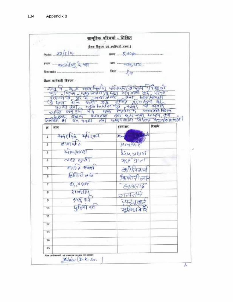
134 Appendix 8

Appendix 8 135

136 Appendix 8

Appendix 8 137
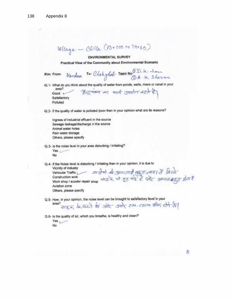
138 Appendix 8

Appendix 8 139

140 Appendix 8

Appendix 8 141

142 Appendix 8

Appendix 8 143

144 Appendix 8

Appendix 8 145

146 Appendix 8

Appendix 8 147

148 Appendix 8

Appendix 8 149

150 Appendix 8

Appendix 9 151
APPENDIX 9: GRM IN HINDI

152 Appendix 9

Appendix 9 153

154 Appendix 9

Appendix 9 155

156 Appendix 9

Appendix 9 157