
Initial Environmental Examination - Asian … Environmental Examination Document Stage: Final IEE...
72
Initial Environmental Examination Document Stage: Final IEE Project Number: 40031 ADB Loan No.: 2725 August 2012 India: Rajasthan Urban Sector Development Investment Program—Rajsamand Roads Improvement Subproject (Tr-03) Prepared by Local Self Government Department for the Asian Development Bank.
-
Upload
truongdiep -
Category
Documents
-
view
216 -
download
1
Transcript of Initial Environmental Examination - Asian … Environmental Examination Document Stage: Final IEE...

Initial Environmental Examination Document Stage: Final IEE Project Number: 40031 ADB Loan No.: 2725 August 2012
India: Rajasthan Urban Sector Development Investment Program—Rajsamand Roads Improvement Subproject (Tr-03) Prepared by Local Self Government Department for the Asian Development Bank.

CURRENCY EQUIVALENTS (as of 15 August 2012)
Currency Unit = Indian rupee/s (Re/Rs) Re1.00 = $0.0181
$1.00 = Rs55.175
ABBREVIATIONS
ADB — Asian Development Bank BOQ — Bill Of Quantity CBO — Community-Based Organization CFE — Consent for Establishment CFO — Consent for Operation CGWB — Central Ground Water Board CLC — City Level Committees CLIP — City Level Investment Plan CWR — Clear Water Reservoirs DSC — Design and Supervision Consultants EAC — Expert Appraisal Committee EARF — Environmental Assessment Resettlement Framework EIA — Environmental Impact Assessment EMP — Environmental Management Plan EMS — Environmental Monitoring Specialist EPA — Environmental Protection Agency GLR — Ground Level Reservoir GRC — Grievance Redress Committee H&S — Health And Safety IEE — Initial Environmental Examination IPIU — Investment Program Implementation Unit IPMC — Investment Program Management Consultants IPMU — Investment Program Project Management Unit ITI — Industrial Training Institutes JNNURM — Jawaharlal Nehru National Urban Renewal Mission LSGD — Local Self Government Department MFF — Multitranche Financing Facility MLD — Million Litres Per Day MOEF — National Ministry of Environment and Forests NAAQS — National Ambient Air Quality Standards NGO — Nongovernmental Organization NRRP — National Resettlement and Rehabilitation Policy NRW — Non-Revenue Water O&M — Operation And Maintenance OHSA — Occupational Health and Safety Administration OHSR — Overhead Storage Reservoirs OMC — Operations and Maintenance Contractors PHED — Public Health Engineering Department PIU — Project Implementation Unit PMU — Project Management Unit ROW — Right Of Way RPCB — Rajasthan State Pollution Control Board RUIDP — Rajasthan Urban Infrastructure Development Project
RUSDIP — Rajasthan Urban Sector Development Investment Programme
SEIAA — State Environment Impact Assessment Authority SPS — Safeguard Policy Statement STP — Sewage Treatment Plant TDS — Total Dissolved Solids
TOR — terms of reference UIDSSMT — Urban Infrastructure Development Scheme for Small and
Medium Towns ULB — Urban Local Body USEPA — United States Environmental Protection Agency WTP — Water Treatment Plant
WEIGHTS AND MEASURES
lakh – 100 thousand = 100,000 crore – 100 lakhs = 10,000,000 µg/m3 – micrograms per cubic meter km – kilometer lpd – liters per day m – meter mg/l – milligrams per liter mm – millimeter ppm – parts per million
NOTES
(i) The fiscal year (FY) of the Government of India and its agencies begins on 1 April and ends on 31 March. ―FY‖ before a calendar year denotes the year in which the fiscal year ends, e.g., FY2011 begins on 1 April 2011 and ends on 31 March 2012.
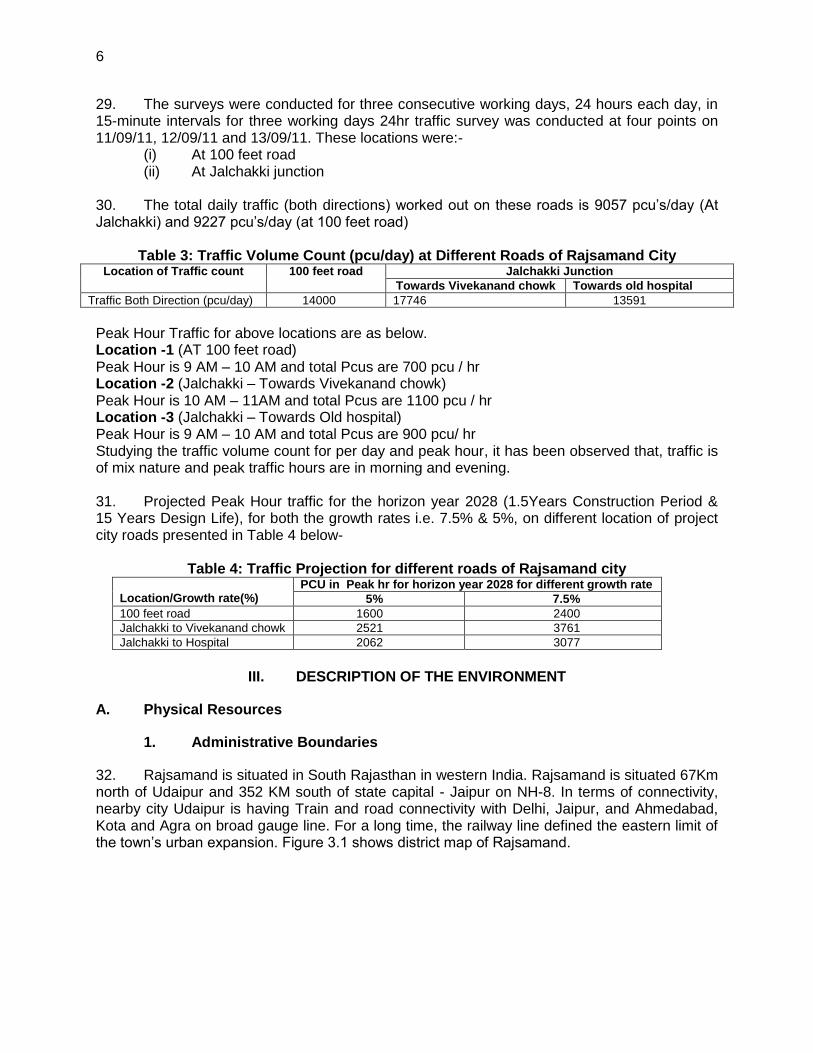
(ii) In this report, "$" refers to US dollars. This initial environmental examination is a document of the borrower. The views expressed herein do not necessarily represent those of ADB's Board of Directors, Management, or staff, and may be preliminary in nature. Your attention is directed to the ―terms of use‖ section of this website. In preparing any country program or strategy, financing any project, or by making any designation of or reference to a particular territory or geographic area in this document, the Asian Development Bank does not intend to make any judgments as to the legal or other status of any territory or area.

TABLE OF CONTENTS Page
EXECUTIVE SUMMARY
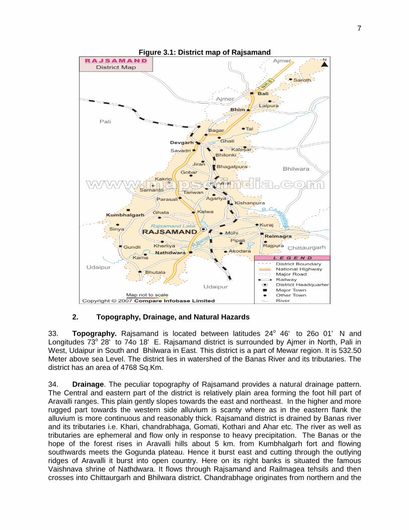
I. INTRODUCTION 1
A. Purpose of the Report 1 B. Extent of the Initial Environmental Examination 1
II. DESCRIPTION OF THE PROJECT 3
A. Type, Category and Need 3 B. Location and Implementation Schedule 3 C. Description of the Subproject 4
III. DESCRIPTION OF THE ENVIRONMENT 6
A. Physical Resources 6 B. Ecological Resources 9 C. Economic Development 10 D. Social and Cultural Resources 12
IV. ANTICIPATED ENVIRONMENTAL IMPACTS AND MITIGATION 12
A. Pre-construction – Location and Design 13 B. Construction 14 C. Operation and Maintenance 20
V. PUBLIC CONSULTATION AND INFORMATION DISCLOSURE 22
A. Project stakeholders 22 B. Consultations and Disclosures to date 22 C. Future Consultation and Disclosure 23
VI. GRIEVANCE REDRESS MECHANISM 24
VII. ENVIRONMENTAL MANAGEMENT PLAN 25
A. Institutional Arrangements 25 B. Environmental Mitigation Plan 27 C. Environmental Monitoring Program 34 D. Environmental Management Plan Costs 39
VIII. FINDINGS AND RECOMMENDATIONS 40
IX. CONCLUSIONS 41
List of Appendices 1. Rapid Environmental Assessment (REA) Checklist 42 2. Public Consultations and photographs 48 3. Recommended Contract Clauses 60 4. Photos of Project Roads 64

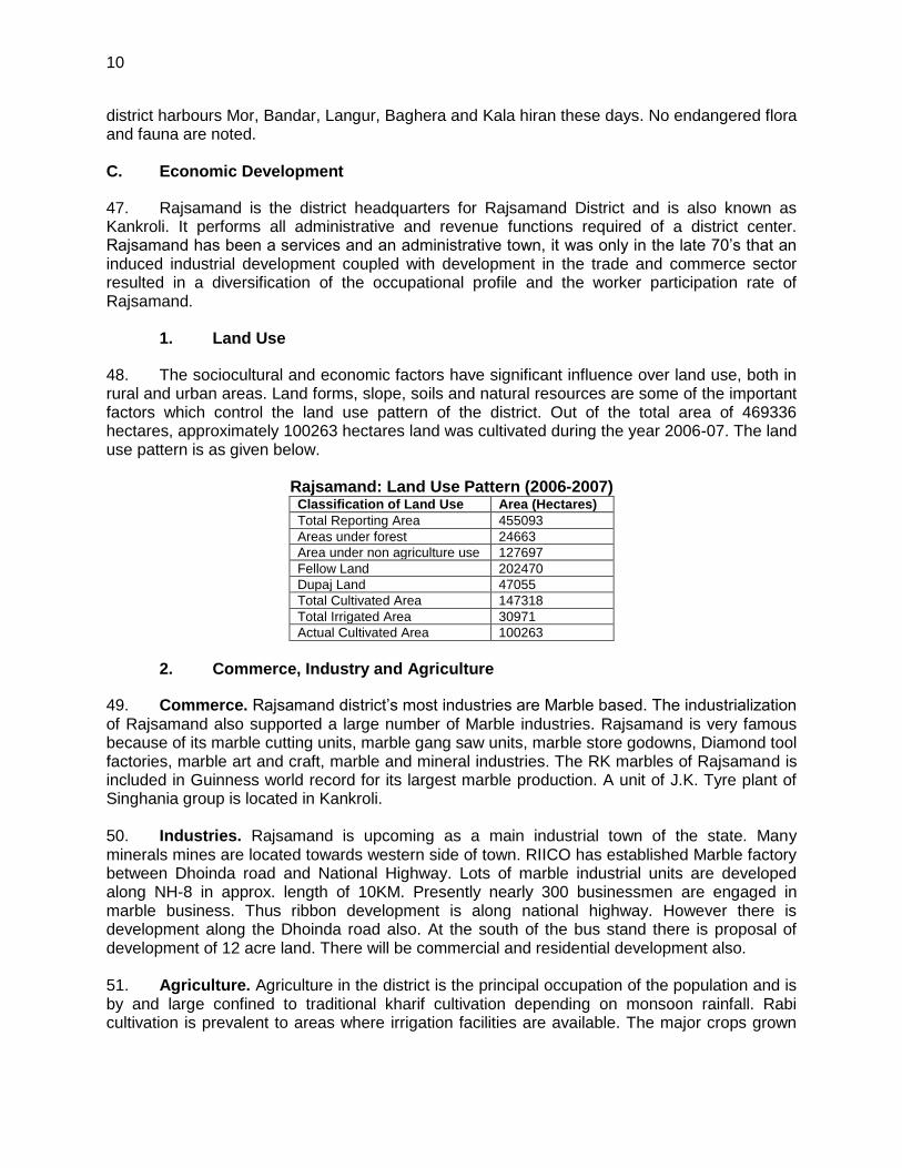
EXECUTIVE SUMMARY 1. Rajasthan Urban Sector Development Investment Program (RUSDIP) is intended to optimize social and economic development in 15 selected towns in the State, particularly district headquarters and towns with significant tourism potential. RUSDIP Phase II is being implemented over a seven year period beginning in 2008, and being funded by a Multitranche Financing Facility (MFF) loan from the Asian Development Bank (ADB). The Executing Agency is the Local Self-Government Department (LSGD) of the Government of Rajasthan; and the Implementing Agency is the Project Management Unit (PMU) of the Rajasthan Urban Infrastructure Development Project (RUIDP). ADB requires the consideration of environmental issues in all aspects of the Bank’s operations, and the requirements for Environmental Assessment are described in ADB’s SPS. This states that ADB requires environmental assessment of all project loans, program loans, sector loans, sector development program loans, loans involving financial intermediaries, and private sector loans. 2. This Initial Environmental Examination (IEE) has been prepared for the Rajsamand Roads improvement Subproject as part of RUIDP Phase II – Tranche 3. The subproject site is located in Rajsamand town (Kankroli), the administrative headquarter of Rajsamand District. The subproject covers widening and strengthening of 3 existing city roads in Rajsamand town. 3. The subproject is needed to improve the roads network system particularly widening and strengthening of 3 roads of Rajsamand Town. 4. Detailed design began in the year 2011 and completed in Nov 2011. Construction of all elements will begin in the year 2012, and work will be completed in 2013. 5. The subproject sites are existing 3 city roads within the Rajsamand town. It is not prone to salinasation, and flash flood. There are also no protected areas, wetlands, mangroves, or estuaries within or near the sub project sites. Trees, vegetation and animals in the subproject site are those commonly found in built-up areas. 6. Potential negative impacts were identified in relation to construction and operation of the improved infrastructure. No impacts were identified as being due to the subproject design or location. An Environmental Management Plan (EMP) is proposed as part of this IEE which includes (i) mitigation measures for significant environmental impacts during implementation, (ii) environmental monitoring program, and the responsible entities for mitigation, monitoring, and reporting; (iii) public consultation and information disclosure; and grievance redress mechanism. Mitigation measures have been developed to reduce all negative impacts to acceptable levels. A number of impacts and their significance have already been reduced by amending the designs. 7. During the construction phase, impacts mainly arise from the need to disturb large areas due to excavation, transportation, vehicle and equipment operation and other construction activities which can result to increase in dust and noise levels, disturbance to residents and businesses along the delivery routes, and traffic. These are common impacts of construction in built-up areas, and there are well developed methods for their mitigation. 8. One field in which impacts are low of interest in the subproject is archaeology because, a series of specific measures have been developed to avoid damaging important remains during construction.

ii
9. Apart from providing good road and resulting decrease in air and noise pollution, there were limited opportunities to provide environmental enhancements, but certain measures were included. For example the sub project will employ in the workforce people who live in the vicinity of construction sites to provide them with a short-term economic gain; and ensure that people employed in the longer term to maintain and operate the new facilities are residents of nearby communities. 10. Once the system is operating the environmental condition of the town will be improved due to improved road surface and width resulting lesser pollution from the vehicles. 11. Also, the work will be conducted in areas that have already been exploited for existing roads within Right of Way (ROW), so there will be not much need to protect archaeological materials. 12. Mitigation will be assured by a program of environmental monitoring to be conducted during construction and operation stages. The environmental monitoring program will ensure that all measures are implemented, and will determine whether the environment is protected as intended. It will include observations on- and off-site, document checks, and interviews with workers and beneficiaries. Any requirements for remedial action will be reported to the IPMU. 13. The main impacts of the operating the improved road network and other subproject components will be beneficial to the citizens of Rajsamand town because they will be provided with safe and comfortable city roads. 14. The stakeholders were involved in developing the IEE through face-to-face discussions on site and a City Level Committee meeting held in the town, after which views expressed were incorporated into the IEE and the planning and development of the project. The IEE will be made available at public locations in the town and will be disclosed to a wider audience via the ADB and RUIDP website. The consultation process will be continued and expanded during project implementation, when a nationally-recognised NGO will be appointed to handle this key element to ensure that stakeholders are fully engaged in the project and have the opportunity to participate in its development and implementation. 15. The subproject is unlikely to cause significant adverse impacts. The potential adverse impacts that are associated with design, construction, and operation can be mitigated to standard levels without difficulty through proper engineering design and the incorporation or application of recommended mitigation measures and procedures. Based on the findings of the IEE, the classification of the Project as Category ―B‖ is confirmed, and no further special study or detailed EIA needs to be undertaken to comply with ADB SPS (2009) or GoI EIA Notification (2006).

I. INTRODUCTION
A. Purpose of the Report
1. The Rajasthan Urban Sector Development Investment Program (RUSDIP) is intended to optimize social and economic development in 15 selected towns in the State, particularly district headquarters and towns with significant tourism potential. This will be achieved through investments in urban infrastructure (water supply; sewerage and sanitation; Roads improvement; urban drainage; urban transport and roads), urban community upgrading (community infrastructure; livelihood promotion), and civic infrastructure (art, culture, heritage and tourism; medical services and health; fire services; and other services). RUSDIP will also provide policy reforms to strengthen urban governance, management, and support for urban infrastructure and services. The assistance will be based on the state-level framework for urban reforms, and institutional and governance reforms recommended by the Government of India (the Government) through the Jawaharlal Nehru National Urban Renewal Mission (JNNURM) and Urban Infrastructure Development Scheme for Small and Medium Towns (UIDSSMT). 2. RUIDP Phase II is implemented over a seven year period beginning in 2008, and funded by a loan via a Multitranche Financing Facility (MFF) of the Asian Development Bank (ADB). The Executing Agency is the Local Self-Government Department (LSGD) of the Government of Rajasthan; and the Implementing Agency is the Project Management Unit (PMU) of the Rajasthan Urban Infrastructure Development Project (RUIDP). 3. This Initial Environmental Examination (IEE) has been prepared for the Rajsamand Roads improvement subproject as part of RUIDP Phase II. The subproject covers widening and strengthening of 3 existing roads of Rajsamand town. 4. This IEE covers the general environmental profile of Rajsamand and includes an overview of the potential environmental impacts and their magnitude on physical, ecological, economic, and social and cultural resources within the subproject’s influence area during design, construction, and operation stages. An Environmental Management Plan (EMP) is also proposed as part of this IEE which includes mitigation measures for significant environmental impacts during implementation of the Project, environmental monitoring program, and the responsible entities for mitigation and monitoring. B. Extent of the Initial Environmental Examination
5. This IEE was prepared on the basis of detailed screening and analysis of all environmental parameters, field investigations and stakeholder consultations to meet the requirements for environmental assessment process and documentation as per ADB’s Safeguard Policy Statement (2009, SPS) and Government of India (the Government) Environmental Impact Assessment (EIA) Notification of 2006.
1. ADB Policy
6. ADB requires the consideration of environmental issues in all aspects of the Bank’s operations, and the requirements for Environmental Assessment are described in ADB’s SPS. This states that ADB requires environmental assessment of all project loans, program loans, sector loans, sector development program loans, loans involving financial intermediaries, and private sector loans.

2
7. Screening and Categorization. The nature of the environmental assessment required for a project depends on the significance of its environmental impacts, which are related to the type and location of the project, the sensitivity, scale, nature and magnitude of its potential impacts, and the availability of cost-effective mitigation measures. Projects are screened for their expected environmental impacts and are assigned to one of the following four categories:
(i) Category A: Projects could have significant adverse environmental impacts. An EIA is required to address significant impacts.
(ii) Category B: Projects could have some adverse environmental impacts, but of lesser degree or significance than those in category A. An IEE is required to determine whether significant environmental impacts warranting an EIA are likely. If an EIA is not needed, the IEE is regarded as the final environmental assessment report.
(iii) Category C: Projects are unlikely to have adverse environmental impacts. No EIA or IEE is required, although environmental implications are reviewed.
(iv) Category FI: Projects involve a credit line through a financial intermediary or an equity investment in a financial intermediary. The financial intermediary must apply an environmental management system, unless all Projects will result in insignificant impacts.
8. Environmental Management Plan An EMP which addresses the potential impacts and risks identified by the environmental assessment shall be prepared. The level of detail and complexity of the EMP and the priority of the identified measures and actions will be commensurate with the Project’s impact and risks. 9. Public Disclosure ADB will post the following safeguard documents on its website so affected people, other stakeholders, and the general public can provide meaningful inputs into the project design and implementation:
(i) For environmental category A projects, draft EIA report at least 120 days before Board consideration;
(ii) Final or updated EIA and/or IEE upon receipt; and (iii) Environmental Monitoring Reports submitted by the Investment Program
Implementation Unit (IPIU) during project implementation upon receipt.
2. National Law
10. The Government’s EIA Notification of 2006 (replacing the EIA Notification of 1994), sets out the requirement for environmental assessment in India. This states that Environmental Clearance is required for specified activities/projects, and this must be obtained before any construction work or land preparation (except land acquisition) may commence. Projects are categorized as A or B depending on the scale of the project and the nature of its impacts. 11. Categories A projects require EC from the National Ministry of Environment and Forests (MOEF). The proponent is required to provide preliminary details of the project in the form of a Notification, after which an Expert Appraisal Committee (EAC) of the MOEF prepares comprehensive Terms of Reference (TOR) for the EIA study, which are finalized within 60 days. On completion of the study and review of the report by the EAC, MOEF considers the recommendation of the EAC and provides the environmental clearance if appropriate. 12. Category B projects require environmental clearance from the State Environment Impact Assessment Authority (SEIAA). The State level EAC categorizes the project as either B1 (requiring EIA study) or B2 (no EIA study), and prepares TOR for B1 projects within 60 days. On

3
completion of the study and review of the report by the EAC, the SEIAA issues the EC based on the EAC recommendation. The Notification also provides that any project or activity classified as category B will be treated as category A if it is located in whole or in part within 10 km from the boundary of protected areas, notified areas or inter-state or international boundaries. 13. The only type of infrastructure provided by the RUSDIP that is specified in the EIA Notification is Solid Waste Management Project, where an EC is required. This road improvement project does not require EC from Pollution Control Board.
II. DESCRIPTION OF THE PROJECT
A. Type, Category and Need
14. Type. This is a Roads improvement subproject intended to improve the current situation in Rajsamand in terms of providing a safe and comfortable city road network. 15. Category. Environmental examination indicates the proposed subproject falls within ADB’s environmental Category B1 projects. The Project components will only have small-scale, localized impacts on the environment, and can be mitigated. Under ADB procedures such projects require an IEE to identify and mitigate the impacts, and to determine whether further study or a more detailed EIA may be required. 16. Need. The subproject is needed because the present city road network of Rajsamand town is insufficient to cope with the growing needs of safe and pollution free road network with the ease of growing population and increasing number of vehicles. Present roads are having insufficient width and are in damaged and poor conditions at some places. As per requirement widening and strengthening of this 7.3 km length of the city road is, therefore, absolutely necessary to ease traffic situation within the city, to provide relief and time savings to through traffic, and to reduce accidents, congestion and operating expenses of the vehicles. This will also improve the environment of Rajsamand city. B. Location and Implementation Schedule
17. Location. The subproject sites are existing 3 different roads located in Rajsamand town, the headquarters of Rajsamand district. Total length of all the roads is around 7.3 km. The details of roads are as below-
(i) 100 Feet Road- Total length 2.6 Kms (ii) Vivekanand Chowk to Rajnagar Bus Stand- total length 4 Kms (iii) Jalchakki to TVS Circle- Total length 0.67 Kms
18. Implementation Schedule. Detailed design began in the year 2011 and completed in end of 2011. Construction of all elements will begin in the year 2012, and work will be completed in 2013. Design period for this sub project is 15 years and ultimate year for optimum utility of the project is 2041.
1
This category includes projects judged likely to have some adverse environmental impacts, but of less significance than Category A projects. Accordingly, there is a need for an ADB IEE during project preparation to determine whether any impacts are likely to be sufficiently significant to warrant further studies or an ADB EIA.
4
C. Description of the Subproject
1. Existing Roads condition
19. The section of road of Rajsamand city passes from various busy commercial/populated area of city. 100 feet road is passing through civil line area of Rajsamand, hence it is important from diplomatic point of views. The other road from Bus stand to Jalchakki and further extending to Mukherjee chowk and Vivekanand chowk is heart of Rajsamand city. All the important markets, Banks, hotels and related commercial activities are located on this road. Nagarpalika office, Police station and old hospital is also on this road. All these daily needs make this road life line of Rajasamand city. ROW of this road varies. Starting from Bus stand and till Old hospital ROW is 7 to 9 meter, which make this stretch highly congestable. Further from hospital to Mata mandir till Jalchakki and Mukherjee chowk ROW is 16, 20, 24 and also 28 m. From Old hospital to Aavara mata mandir building to building available distance varies from 17 to 28 m. In this section existing BT road width is 5.5 m each side, with median of 1.0 m width. Available building to building distance narrows near Mata Mandir and Nagar Palika office. Further moving from Aavara Mata mandir to Jalchakki building to building available distance was found varying from 12 to 16 and to 18 m. It is narrow near jalchakki. Existing road is 7.0 m wide bituminous road. The condition of the road is fair. 20. Jalchakki junction divides the road in two direction, one moves to vivekanand chowk and other one towards TVS chouraha. The section of project corridor from Jalchakki to Mukherjee chouraha is heavily congested due to less ROW and construction of big nala on one side of road, which make moving space very small. The available building to building space is average 15 m which has reduced to 10 to 12 m because of nala. The existing path is bituminous with hard shoulders. The final section of this stretch from Mukherjee chowk to Vivekannad chouraha has around 20 m ROW. This has also ribbon development on both side of road. Existing 7.0 m BT road is fair to good condition. Drain is absent. 21. The other road from Jalcahkki to TVS chouraha is congested area with Building to Building gap is only 12 m. Existing BT road is only 6.3 m. Local drains are present. Buildings are constructed abruptly according to encroachment. 22. Photos of existing conditions of project roads are attached as Annexure 4 with this report.
2. Subproject Components
23. Proposed geometrical improvement: Descriptions of proposed works, in existing 3 roads taken in the subproject are described in following table-
Table 1: Proposed Geometric Cross-section for Rajsamand City Roads Sr.No Road Chainage Pavement Carriageway Median (m) Interlocking
1 Jalchakki to Rajsamand Bus stand
1(a) Jalchakki to Mata mandir
0- 585 BT 10.5 2 x 1.5
1(b) Mata mandir to Hospital
585 – 1220 BT 2 x 7.0 1.0 Existing 2 x 3.0
1 (c) Hospital to Hussaini Masjid
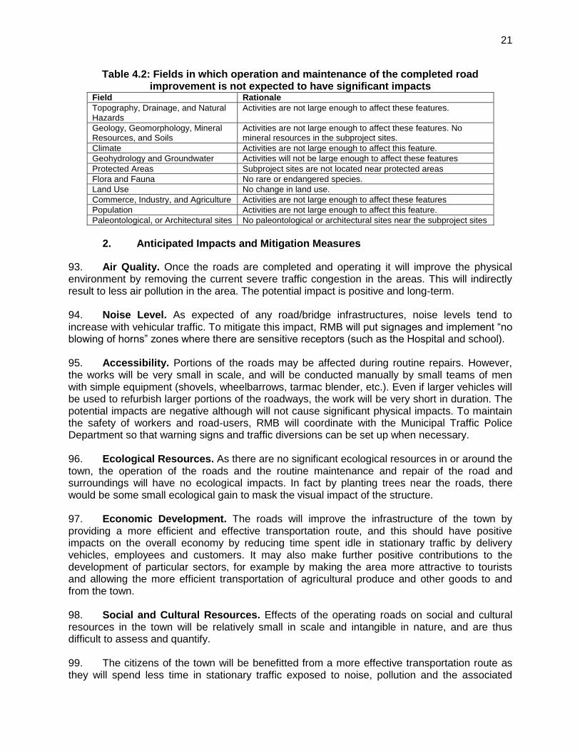
1220-1650 CC 5.5
1(d) Hussaini Masjid to 1650- 2560 BT Existing

5
Rajnagar Bus stand
2 Jalchakki to Vivekanand Chowk
2(a) Jalchakki to Mukherji chowk
0-1070 BT Existing
2(b) Mukherji chowk to Vivekanand chowk
1070 - 1430 BT 2 x 7.0 1.2 2 x 1.5
3. Jalchakki to TVS chouraha
0 - 670 BT 7.0 2 x 1.5
4. 100 feet road 0-2600 BT 2 x 7.0 2.5 2.0 x 2
24. Cross-Section Elements: Flexible pavement is proposed for the entire roads except a section of 500 m on Jalchakkki Rajnagar Bus stand road from hospital to Hussaini Masjid is designed for cement concrete pavement. The details of proposed pavement cross-section for different roads are given in table no 2.
Table 2- Details of Pavement cross-section for different roads of Rajsamand
Road No BC/SDBC DBM/BM WMM GSB
Road No1 Jalchakki to Aavara Mata
30 mm 60 mm 250 mm 250 mm
Aavara Mata to Hospital 30 mm 60 mm 250 mm 250 mm
Rajnagar Bus stand to Hussaini Masjid
30 mm 60 mm
Road No-1 (Jalchakki to Mukherjee Chowk
40 mm 50 mm
Road No-1 (Mukherjee Chowk to Vivekanand chowk)
40 mm 60 mm 250 mm 300 mm
Road No-2 Jalchakki to TVS Chowk
40 mm 30 mm 250 mm 200 mm
Road No-3 (100 feet road) 40 mm 60 mm 250 mm 300 mm
25. Cement Concrete Pavement: Cross-section for Hospital to Hussaini Masjid section would be:-
PCC M-10 - 100 mm PCC M-30 - 250 mm
26. Road Lighting, Traffic Lights and Relocation of HT/LT and Telephone Lines: Central median lighting have been proposed in this package for 100 feet road and for section of Rajnagar to Vivekanand chouraha road. Exiting HT/ LT lines have been proposed to be relocated to suit the requirements of the proposed future widening. 27. Estimated Cost: Based on the RUIDP, SOR, the estimated cost of this package work comes out about Rs 11.38 Crore.
3. Traffic Survey and Traffic Projections
28. Growth of Traffic for a city is altogether different from growth for a highway. For a city it depends on population of the town and density in particular area. Other factors which affect the traffic intensity of the road is its location on map of that city. Speed of city extension also effect traffic growth. Therefore, keeping in view the future extension of city, and in accordance with IRC: 37 - 2001, a growth factor of 7.5% per annum has been used to predict the future traffic.
6
29. The surveys were conducted for three consecutive working days, 24 hours each day, in 15-minute intervals for three working days 24hr traffic survey was conducted at four points on 11/09/11, 12/09/11 and 13/09/11. These locations were:-
(i) At 100 feet road (ii) At Jalchakki junction
30. The total daily traffic (both directions) worked out on these roads is 9057 pcu’s/day (At Jalchakki) and 9227 pcu’s/day (at 100 feet road)
Table 3: Traffic Volume Count (pcu/day) at Different Roads of Rajsamand City Location of Traffic count 100 feet road Jalchakki Junction
Towards Vivekanand chowk Towards old hospital
Traffic Both Direction (pcu/day) 14000 17746 13591
Peak Hour Traffic for above locations are as below. Location -1 (AT 100 feet road) Peak Hour is 9 AM – 10 AM and total Pcus are 700 pcu / hr Location -2 (Jalchakki – Towards Vivekanand chowk) Peak Hour is 10 AM – 11AM and total Pcus are 1100 pcu / hr Location -3 (Jalchakki – Towards Old hospital) Peak Hour is 9 AM – 10 AM and total Pcus are 900 pcu/ hr Studying the traffic volume count for per day and peak hour, it has been observed that, traffic is of mix nature and peak traffic hours are in morning and evening. 31. Projected Peak Hour traffic for the horizon year 2028 (1.5Years Construction Period & 15 Years Design Life), for both the growth rates i.e. 7.5% & 5%, on different location of project city roads presented in Table 4 below-
Table 4: Traffic Projection for different roads of Rajsamand city Location/Growth rate(%)
PCU in Peak hr for horizon year 2028 for different growth rate
5% 7.5%
100 feet road 1600 2400
Jalchakki to Vivekanand chowk 2521 3761
Jalchakki to Hospital 2062 3077
III. DESCRIPTION OF THE ENVIRONMENT
A. Physical Resources
1. Administrative Boundaries
32. Rajsamand is situated in South Rajasthan in western India. Rajsamand is situated 67Km north of Udaipur and 352 KM south of state capital - Jaipur on NH-8. In terms of connectivity, nearby city Udaipur is having Train and road connectivity with Delhi, Jaipur, and Ahmedabad, Kota and Agra on broad gauge line. For a long time, the railway line defined the eastern limit of the town’s urban expansion. Figure 3.1 shows district map of Rajsamand.
7
Figure 3.1: District map of Rajsamand
2. Topography, Drainage, and Natural Hazards
33. Topography. Rajsamand is located between latitudes 24o 46' to 26o 01' N and Longitudes 73o 28' to 74o 18' E. Rajsamand district is surrounded by Ajmer in North, Pali in West, Udaipur in South and Bhilwara in East. This district is a part of Mewar region. It is 532.50 Meter above sea Level. The district lies in watershed of the Banas River and its tributaries. The district has an area of 4768 Sq.Km. 34. Drainage. The peculiar topography of Rajsamand provides a natural drainage pattern. The Central and eastern part of the district is relatively plain area forming the foot hill part of Aravalli ranges. This plain gently slopes towards the east and northeast. In the higher and more rugged part towards the western side alluvium is scanty where as in the eastern flank the alluvium is more continuous and reasonably thick. Rajsamand district is drained by Banas river and its tributaries i.e. Khari, chandrabhaga, Gomati, Kothari and Ahar etc. The river as well as tributaries are ephemeral and flow only in response to heavy precipitation. The Banas or the hope of the forest rises in Aravalli hills about 5 km. from Kumbhalgarh fort and flowing southwards meets the Gogunda plateau. Hence it burst east and cutting through the outlying ridges of Aravalli it burst into open country. Here on its right banks is situated the famous Vaishnava shrine of Nathdwara. It flows through Rajsamand and Railmagea tehsils and then crosses into Chittaurgarh and Bhilwara district. Chandrabhage originates from northern and the

8
Gomti from the north-west part of the areas. The Chandra Bhaga and Gomti river trend NNWSSE to NW-SE. The predominant drainage pattern in the western hill ranges is rectangular to sub-rectangular and it is dendritic to sub-dendritic in rest of the area. Drainage pattern in the western hill region is controlled by fractures & joints and in rest of the area by subsurface liniments. Overflows of the existing stormwater drains in the town area goes into famous Rajsamand Lake. 35. Natural Hazards. Rajsamand town lies in low damage risk zone II in terms of earthquake. The area is less prone to earthquakes as it is located on comparatively stable geological plains based on evaluation of the available earthquake zone information.
3. Geology, Geomorphology, and Soils
36. Geology. The various rocks type exposed in the area belong to Bhilwara and Decan Traps Supergroups. A major part of the district is occupied by limestone, the most important mineral of the district, glass sand occurrences, and small occurrences of copper, marble, and iron. 37. Geomorphology. The district is classified into structural plain, pediment, alluvial plain, and badland (ravines). The ground water potential range from 5 to 10 liters per second (lps). Rajsamand district consists of monotonously rolling topography interacted by shallow valleys. Towards the western part of the district, Aravalli hills, a series of ridges run diagonally in the direction of NE and SW. The highest portion of Aravallis occurs south of Kailwara near Kumbhalgarh fort (25°08’:73°35’) with an altitude of 1293 m above msl. A typical gneissic plain bearing irregularly carved of gneisses and granites without any alluvium cover is observed to the highest altitude of above 600 m amsl. Mineral Resources. Sizeable reserves of good quality clay, marble, limestone, zinc, lead, copper, iron, rock phosphates, and building stones are found in the district. The subproject sites do not have mineral resources. 38. Soils. Soil of the region falls within low rainfall zone of 500- 900 mm. The soils are lithosolsat in foot hills and alluvials in plains. The soils of the district vary from sandy loam in Bhim, Deogarh & Amet blocks to clay loam in Rajsamand, Reilmagra & Khamner to heavy clay in Kumbhalgerh block. Nutrient level in the Rajsamand soil includes area coverage of saline and sodic soil. The nutrient status of the Rajsamand soil is graded as medium to high level.
4. Rainfall and Climate
39. The district has moderate climate from arid to semi-arid climate, without significant seasonal variations. The mean temperature is 22 degrees celsius. Average rainfall at the district head quarter (Rajsamand town) is 49.5 cms. The rainfall over Rajsamand is scanty and is concentrated over four month i.e. from June to September. The rains are erratic and so is the distribution of the rainfall. Mean annual rainfall (1971-2005) of the district is 55.32 cms whereas normal rainfall (1901-1970) is lower than average rainfall and placed at 5.51 cm. Almost 93% of the total annual rainfall is received during the southwest monsoon which enters the district in the third or fourth week of June and withdraws in the mid of September. However agriculture and the animal wealth are dependent on rains to large extent.
5. Air and Noise Quality
40. Air Quality monitoring of Rajsamand was taken in varous RUIDP project in November month of 2011 at Sadhana Sikhar (about 1 kms from project roads), Village Bhawa (about 5

9
Kms from project roads) and Village Sanwad (about 5 Kms from project roads). The results of air and noise monitoring at these locations are shown is table 5 below-
Table 5: Air and Noise Quality S.No. Location Air monitoring results Noise monitoring results
1. Sadhana Sikhar PM10= 74.68 mg/m3 PM 2.5 = 50.08 mg/m3 Sulphur Dioxide as SO2= 9.36 mg/m3 Oxides of Nitrogen as NO2= 13.70 mg/m3 Carbon Monoxide as CO=166 mg/m3
Lday time=50.74 dB(A) Lnight time= 36.76 dB(A)
2. Village Bhawa PM10= 79.28 mg/m3 PM 2.5 = 49.84mg/m3 Sulphur Dioxide as SO2= 9.37 mg/m3 Oxides of Nitrogen as NO2= 14.6 mg/m3 Carbon Monoxide as CO=181 mg/m3
Lday time=37.32 dB(A) Lnight time= 32.48 dB(A)
3. Village Sanwad PM10= 88.09 mg/m3 PM 2.5 = 39.21mg/m3 Sulphur Dioxide as SO2= 8.36 mg/m3 Oxides of Nitrogen as NO2= 14.5 mg/m3 Carbon Monoxide as CO=149 mg/m3
Lday time=42.52 dB(A) Lnight time= 31.64 dB(A)
41. Traffic is the significant pollutant in Rajsamand in the city area, so levels of oxides of sulphur and nitrogen are well within the National Ambient Air Quality Standards (NAAQS), whereas mining and agricultural activities are major sources of air pollution in the outskirt rural areas. Base line monitoring shall be done prior to start of the project at the project sites.
6. Surface Water
42. Famous and historical Rajsamand Lake is situated in Rajsamand town, which is also major source of drinking water supply and agricultural practices. The other famous lakes like Picchhola lake, Nakki lake, Fateh Sagar lake are located at Udaipur 68 km Rajsamand. Rajsamand district is drained by Banas river and its tributaries i.e. Khari, chandrabhaga, Gomati, Kothari and Ahar, etc.
7. Groundwater
43. The Central Ground Water Board monitors several national hydrographic monitoring stations in and around Rajsamand. Records of monitoring conducted from May 2005 to January 2006 shows ground water table ranged between 5 to 60 meters below ground level. Depth of water table in the year 2006 in pre monsoon was 3.16 – 20.99 mtrs and in post monsoon was 1.08-13.31 mtrs according to Central Ground Water Board reports. B. Ecological Resources
44. Rajsamand town has been converted for agricultural use and there are no remaining natural habitats in the area. There are no protected areas nearby the subproject site. 45. Flora. The Rajasmand district supports mahua, baheda, saded, aam and jhinjha. The endemic taxa or species found in the district are represented by papal, bad or banyan tree bael, dhak, kaith, datura, indrokdhav. 46. Fauna. Rajsmand falls in Paleotropical – Oriental Region .It is needless to mention that India as a whole also falls in Oriental Region. Of the typical fauna of the Oriental region, the
10
district harbours Mor, Bandar, Langur, Baghera and Kala hiran these days. No endangered flora and fauna are noted. C. Economic Development
47. Rajsamand is the district headquarters for Rajsamand District and is also known as Kankroli. It performs all administrative and revenue functions required of a district center. Rajsamand has been a services and an administrative town, it was only in the late 70’s that an induced industrial development coupled with development in the trade and commerce sector resulted in a diversification of the occupational profile and the worker participation rate of Rajsamand.
1. Land Use
48. The sociocultural and economic factors have significant influence over land use, both in rural and urban areas. Land forms, slope, soils and natural resources are some of the important factors which control the land use pattern of the district. Out of the total area of 469336 hectares, approximately 100263 hectares land was cultivated during the year 2006-07. The land use pattern is as given below.
Rajsamand: Land Use Pattern (2006-2007) Classification of Land Use Area (Hectares)
Total Reporting Area 455093
Areas under forest 24663
Area under non agriculture use 127697
Fellow Land 202470
Dupaj Land 47055
Total Cultivated Area 147318
Total Irrigated Area 30971
Actual Cultivated Area 100263
2. Commerce, Industry and Agriculture
49. Commerce. Rajsamand district’s most industries are Marble based. The industrialization of Rajsamand also supported a large number of Marble industries. Rajsamand is very famous because of its marble cutting units, marble gang saw units, marble store godowns, Diamond tool factories, marble art and craft, marble and mineral industries. The RK marbles of Rajsamand is included in Guinness world record for its largest marble production. A unit of J.K. Tyre plant of Singhania group is located in Kankroli. 50. Industries. Rajsamand is upcoming as a main industrial town of the state. Many minerals mines are located towards western side of town. RIICO has established Marble factory between Dhoinda road and National Highway. Lots of marble industrial units are developed along NH-8 in approx. length of 10KM. Presently nearly 300 businessmen are engaged in marble business. Thus ribbon development is along national highway. However there is development along the Dhoinda road also. At the south of the bus stand there is proposal of development of 12 acre land. There will be commercial and residential development also. 51. Agriculture. Agriculture in the district is the principal occupation of the population and is by and large confined to traditional kharif cultivation depending on monsoon rainfall. Rabi cultivation is prevalent to areas where irrigation facilities are available. The major crops grown

11
are: Maize, Wheat and Jowar, among others are- Pulses: Kharif Pulses and Gram, Oils: Groundnut, Til and Mustard, Others: Sugarcane and Chilly.
3. Infrastructure
52. Water Supply. Rajsamand dam on Lake is a source of water supply to Rajsamand town. There are two headwords on the bank of this lake/ dam. The raw water from these head works is pumped to treatment plants. The source of Rajsamand dam is adequate and sufficient if the annual rainfall is received satisfactorily. However during the year 1987, 1998, 1999, 2000, 2002, 2003, 2004, the Rajsamand dam has not received sufficient water and therefore, water was required to be taken through pipelines laid from Nandsamand and Chikalwas dam. During dry season sometimes tube wells (5 nos.) and open wells (3 nos.) are taken in the bed of dry portion of the Rajsamand bed of the dam to get water to meet the requirement. The old treatment plant is consisting of pressure filters but it is not in operation. There is another waterworks of 3.67 mld capacity, at that location and is the only one in operation. This plant has all the treatment units such as flash mixer, clarifloculator, rapid sand gravity filters and chlorination unit and clear water reservoir 1.20 ML capacity. The water is then transported to pipeline by gravity to 3 GLSR and 5 OHSR in the town and finally distributed through distribution pipeline network. The present supply of the city is reported as 43 lpcd, which is much lower than the standard indicated in the CPHEEO manual i.e. 135 lpcd. 53. Sewerage and Sanitation. Sewerage and drainage system in Rajsamand is not available and causing discharge untreated sewage into open drains or nallahs. There is no underground sewerage system as of now. The municipal drains are mostly open and overflowing causing problem in raining reason. The water flow in drain is also dirty as it receives flow from toilets and sludge causing unsanitary condition. Only 70 % of the households reportedly has septic tanks and soaks well as the system of sewerage disposal. The remaining accounted for cases of open defecation which is an unacceptable and unhygienic practice. The raw settled sewage from septic tank is periodically flushed out by sanitary workers of the Municipal Board and discharge to open spaces, agricultural lands in an indiscriminate manner. Slum areas were also not equipped with requisite sanitation (LCS etc.) resulting in open defecation 54. Irrigation. The principal means of irrigation in the district are wells though the small area is irrigated by tank also. Ground water plays an important role for irrigation and is utilized through dug wells, dug cum bored wells and tube wells. 55. Industrial Effluents. Industries exists, which is outside the city area and effluent disposed scattered in local nallahs. As reported by the local MC, the responsibility of effluent disposal is under Industry’s own and could not be connected to the proposed sewer network. The individual industry should treat their effluent to bring it to the required standard before final disposal. 56. Transportation. Rajsamand comprises a road network of 28 km, consisting of 2 km concrete roads, 15 km bituminous roads, and 6 km of water bound macadam roads and 5.0 Km earthen road. Physical growth of the city has resulted in a corresponding increase in vehicular traffic greater than that of the city’s population growth due to improving economic status of the city. Due to water blockage in drains, the road drainage system has failed in low-lying areas of the city and resulted in deteriorating road surface condition.
12
D. Social and Cultural Resources
57. Demography. According to Census 2001, the population of Rajsamand Urban Agglomeration is 55687. Male constitute 52% and female 48%. Rajsamand population is 1.82% of state population. The UA witnessed a very high growth between 1951 and 1961 &1971 to 1981. The population for the purpose of identifying and planning the infrastructure requirements for the urban settlement, the total population of the UA may be considered. With the rapid development of Rajsamand, the densification pattern across the city varies immensely. The city along with the contiguous residential settlements has a population density 118 persons per acre as per census of year 2001 and is categorized as high density areas. 58. Health and Educational Facilities. There are good educational facilities in Rajsamand district, which serve both townspeople and inhabitants of surrounding villages and towns in the hinterland. There are 1254 primary schools, 153 secondary and higher secondary schools, plus 6 general degree colleges, 4 technical college including industrial training institutes (ITI). There is 1 district hospital and 1 town hospital and 7 community centers in urban area of Rajsamand. There are also 35 primary public health centers and 215 sub–centers in Rajsamand district. 59. History, Culture and Tourism. Carved out from erstwhile Udaipur district, Rajsamand district was constituted on 10th April, 1991, and named after the famous lake "Rajsamand" built by Maharana Raj Singh. Rajsamand has moderate tourist inflows with main attractions being Lake and Fort. Rajsamand is much rich district regarding history, religion, culture and mining industries. Among famous places of tourist interest Chetak Tomb, Kumbhalgarh - the birth place of Maharana Pratap, Haldighati the famous battle field, Shrinathji the chief deity of Vaishnav religion, Dwarikadheesh, Charbhuja and many Shiv temples are noted. Rajsamand is very well known for its marble production as the largest producing district as well as the largest single unit in the whole country. Rajsamand also saw the vicissitudes of the freedom struggle between Tantya Tope and the British troops at 'Rakamgarh ka chhapar' in 1857. The subproject site is not located in or near any historically-, culturally-, archaeologically- or architecturally-significant or tourist area except the historical Rajsamand Lake and Nouchowki, located about 1 Kms from project sites.
IV. ANTICIPATED ENVIRONMENTAL IMPACTS AND MITIGATION
60. This section of the IEE reviews possible subproject-related impacts, in order to identify issues requiring further attention and screen out issues of no relevance. ADB SPS (2009) require that impacts and risks will be analyzed during pre-construction, construction, and operational stages in the context of the subproject’s area of influence. As defined previously, the primary impact areas are (i) the sites for construction of roads (ii) main routes/intersections which will be traversed by construction vehicles; and (ii) quarries and borrow pits as sources of construction materials. The secondary impact areas are: (i) entire Rajsamand area outside of the delineated primary impact area; and (ii) entire Rajsamand district in terms of over-all environmental improvement. 61. The ADB Rapid Environmental Assessment Checklist for Roads and Highways in http://www.adb.org/documents/guidelines/environmental_assessment/eaguidelines002.asp was used to screen the subproject for environmental impacts and to determine the scope of the IEE investigation. The completed Checklist is found in Appendix 1. All the proposed subproject components will interact physically with the environment.
13
62. In the case of this subproject (i) most of the individual elements are relatively small and involve straightforward construction and operation, so impacts will be mainly localized and not greatly significant; (ii) most of the predicted impacts are associated with the construction process, and are produced because that process is invasive, involving excavation and earth movements; and (iii) being located in the built-up area of Rajsamand, will not cause direct impact on biodiversity values. The subproject will be in properties held by the local self government and access to the subproject area is thru public rights-of-way and existing roads hence, land acquisition and encroachment on private property will not occur. A. Pre-construction – Location and Design
63. Environmentally-sensitive areas. Location impacts are not significant as there are no environmentally sensitive areas within the subproject area. A few trees may be affected or to be cut in this road subproject. Prior to construction, the Design and Supervision Consultants (DSC) in close coordination with the Rajsamand Investment Project Implementation Unit (IPIU) will (i) make inventory of the trees to be cut; (ii) obtain tree-cutting permit from Rajsamand Municipal Council and/or District Collector; and (iii) include in the bid documents provisions on re plantation of 3 trees for every one tree cut during construction. 64. Utilities. Telephone lines, electric poles and wires, water and sewer lines within the existing right-of-way (ROW) may be affected and/or damaged. To mitigate the adverse impacts due to relocation of the utilities, DSC will (i) identify and include locations and operators of these utilities in the detailed design documents to prevent unnecessary disruption of services during construction phase; and (ii) require construction contractors to prepare a contingency plan to include actions to be done in case of unintentional interruption of services. 65. Existing Roads. Area of land required for widening is included in the plan drawings. Affected communities will be consulted prior to finalizing any subproject lay-out and design and they will be informed well in advance before the start of the work about nature of disturbance and duration of impact. 66. Social and Cultural Resources. Rajsamand is an area of rich and varied cultural heritage which includes lake and palaces from the Rajput and Mughal periods, and large numbers of temples and other religious sites, so there is a risk that any work involving ground disturbance can uncover and damage archaeological and historical remains. For this subproject, excavation will occur in and around existing road ROWs, so it could be that there is a low risk of such impacts. Nevertheless, IPIU/DSC will:
(i) Consult ASI to obtain an expert assessment of the archaeological potential of the site;
(ii) Consider alternatives if the site is found to be of medium or high risk; (iii) Include state and local archaeological, cultural and historical authorities, and
interest groups in consultation forums as project stakeholders so that their expertise can be made available; and
(iv) Develop a protocol for use by the construction contractors in conducting any excavation work, to ensure that any chance finds are recognised and measures are taken to ensure they are protected and conserved.
67. Site selection of construction work camps, hot mix plant, stockpile areas, storage areas, and disposal areas. Priority is to locate these near the project area. However, if it is deemed necessary to locate elsewhere, sites to be considered will not promote instability and result in destruction of property, vegetation, irrigation, and drinking water supply systems.

14
Residential areas will not be considered to protect the human environment (i.e., to curb accident risks, health risks due to air and water pollution and dust, and noise, and to prevent social conflicts, shortages of amenities, and crime). Extreme care will be taken to avoid disposals near the sensitive areas or in areas which will inconvenience the community. All locations would be included in the design specifications and on plan drawings. 68. Site selection of sources of materials. Extraction of materials can disrupt natural land contours and vegetation resulting in accelerated erosion, disturbance in natural drainage patterns, ponding and water logging, and water pollution. To mitigate the potential environmental impacts, locations of quarry site/s and borrow pit/s (for loose material other than stones) would be included in the design specifications and on plan drawings. Priority would be sites already permitted by Mining Department. If other sites are necessary, these would to be located away from population centres, drinking water intakes and streams, cultivable lands, and natural drainage systems; and in structurally stable areas even if some distance from construction activities. It will be the construction contractor’s responsibility to verify the suitability of all material sources and to obtain the approval of Urban Local Body. If additional quarries will be required after construction is started, then the construction contractor shall use the mentioned criteria to select new quarry sites, with written approval of RMB. B. Construction
1. Screening out areas of No Significant Impacts
69. From the descriptions given in Section II. C, it is clear that implementation of the subproject should not have major negative impacts because it will affect only one site, at which all construction will be conducted within a relatively small area. 70. Because of this there are several aspects of the environment that are not expected to be affected by the construction process and these can be screened out of the assessment at this stage as required by ADB procedure. These are shown in Table 4.1, with an explanation of the reasoning in each case
Table 4.1: Fields in which construction is not expected to have significant impacts Field Rationale
Topography, Drainage, and Natural Hazards
Activities are only in the existing roads and not large enough to affect these features.
Geology, Geomorphology, Mineral Resources, and Soils
Activities are not large enough to affect these features. No mineral resources in the subproject sites.
Climate Activities are not large enough to affect this feature.
Protected Areas No any protected areas near the sub project site
Flora and Fauna No rare or endangered species found near the sub project site.
Economic Development Activities are not large enough to permanently affect this feature.
Land Use No change in land use.
Commerce, Industry, and Agriculture
Activities are not large enough to affect these features, only some short term effect on trade and commerce, which is analysed in SRP
Population Activities are not large enough to affect this feature.
Health and education facilities
No health and education facilities lies near the sub project site
Historical, Archaeological, Paleontological, or Architectural sites
No scheduled or unscheduled historical, archaeological, paleontological, or architectural sites within the subproject site, except some temples and chhatris, which fall near project road no. 1.
15
71. These environmental factors have thus been screened out presently but will be assessed again before implementation and during construction and be revised if found necessary.
2. Construction method
72. As explained above, this subproject will involve widening and strengthening of 3 different existing roads of Rajsamand city. 73. Road construction is generally started with Clearing and Grubbing of the area of construction. Thereafter Survey work will be carried out including fixing of TBM. After survey earthwork will be done including items like excavation, cutting, loosening & re-compacting, filling vide embankment /sub grade. Then Sub base will be prepared i.e. Granular sub base / Drainage layer. Thereafter Base course will be prepared i.e. Wet Mix Macadam /Water Bound Macadam. Dense Bituminous Macadam and finally wearing course will be laid. Then finally road marking, road signage, road furniture will be fixed. The salient details of works to be undertaken in the subproject are given in section II B&C. 74. The operation will be conducted by a team of around 30 men, roughly 50% unskilled labour and 50% with various skills including truck drivers, vehicle and machine operatives, surveyors, foremen and supervisors, etc. The operation should be completed in around 18 months.
3. Anticipated Environmental Impacts and Mitigation Measures
75. Although all work will be conducted at a single, relatively small site, construction will involve a great deal of excavation and earth moving over a period of approximately 15-30 days for each road. However these physical environmental impacts are generic construction-related impacts associated with (i) road construction and (ii) removal and relocation of utility lines. These impacts are not expected to be significant and permanent, and can be managed through adoption of good engineering practices and undertaking specific mitigation measures. 76. Sources of Materials. Significant amount of gravel, sand, and cement will be required for this subproject. The construction contractor will be required to:
(i) Use quarry sites and sources permitted by government; (ii) Verify suitability of all material sources and obtain approval of Investment
Program Implementation Unit (IPIU); (iii) If additional quarries will be required after construction has started, obtain written
approval from PMU; and (iv) Submit to DSC on a monthly basis documentation of sources of materials
77. Air Quality. Emissions from construction vehicles, equipment, and machinery used for excavation and road construction will induce impacts on the air quality in the construction sites as well on the road users (pedestrians and vehicles). Anticipated impacts include dusts and increase in concentration of vehicle-related pollutants such as carbon monoxide, sulphur oxides, particulate matter, nitrous oxides, and hydrocarbons) but temporary and during construction activities only. To mitigate the impacts, construction contractors will be required to:
(i) Consult with IPIU/DSC on the designated areas for stockpiling of clay, soils, gravel, and other construction materials;
(ii) Excavate the required ground at the same time as the other roads are built so that dug material is used immediately, avoiding the need to stockpile on site;

16
(iii) Damp down exposed soil and any stockpiled on site by spraying with water when necessary during dry weather;
(iv) Use tarpaulins to cover sand and other loose material when transported by trucks; and
(v) Fit all heavy equipment and machinery with air pollution control devices which are operating correctly and ensure that only those vehicles having PUC should be permitted to work on site.
78. Surface Water Quality. Construction activities may result mobilization of settled silt materials, run-off from stockpiled materials, and chemical contamination from fuels and lubricants during construction works, which may contaminate downstream surface water quality of nearby drains, nallahs, ponds and lakes of the town. These potential impacts are temporary and short-term duration only and to ensure these are mitigated, construction contractor will be required to:
(i) Avoid stockpiling of earth fill especially during the monsoon season unless covered by tarpaulins or plastic sheets;
(ii) Prioritize re-use of excess soils and materials in the construction works. If soils will be disposed, consult with IPIU/DSC on designated disposal areas;
(iii) Install temporary silt traps or sedimentation basins along the drainage leading to the water bodies;
(iv) Place storage areas for fuels and lubricants away from any drainage leading to water bodies;
(v) Dispose any wastes generated by construction activities in designated sites; and (vi) Conduct surface quality inspection according to the Environmental Management
Plan (EMP). 79. Noise Levels. There are no paleontological, or architectural sites near the construction sites. The sensitive receptors are the adjacent settlements, health facilities, road users and general public and visitors of Rajsamand heritage sites. Increase in noise level may be caused by earth-moving and excavation equipment, and the transportation of equipment, materials, and people. Impact is negative, short-term, and reversible by mitigation measures. The construction contractor will be required to:
(i) Plan activities in consultation with IPIU/DSC so that activities with the greatest potential to generate noise are conducted during periods of the day which will result in least disturbance;
(ii) Require horns not be used unless it is necessary to warn other road users or animals of the vehicle’s approach;
(iii) Minimize noise from construction equipment by using vehicle silencers, fitting jackhammers with noise-reducing mufflers, and portable street barriers the sound impact to surrounding sensitive receptor; and
(iv) Maintain maximum sound levels not exceeding 80 decibels (dbA) when measured at a distance of 10 m or more from the vehicle/s.
80. Existing Infrastructure and Facilities. Telephone lines, electric poles and wires, water and sewer lines within the existing road ROW will be removed/shifted thus there is anticipated disruption of service during construction. Excavation could however damage existing infrastructure located alongside roads, in particular water supply pipes and sewer lines. It will be particularly important to avoid damaging existing water pipes as these are mainly manufactured from Asbestos Cement (AC), which can be carcinogenic if inhaled, so there are serious health risks for both workers and the public. It is therefore important that construction contractors will be required to:

17
(i) Obtain from IPIU and/or DSC the list of affected utilities and operators; (ii) Prepare a contingency plan to include actions to be done in case of unintentional
interruption of services. and (iii) Develop and implement an Asbestos Cement Pipes Management Plan
81. Flora and Fauna. There are no protected areas in or within the subproject sites. Few trees and shrubs are the vegetation noted in the area, which may be affected due to construction activities. Land-clearing activities and presence of workers in the sites can damage or cause loss of existing flora. Potential impacts are negative but reversible by mitigation measures. The construction contractors will be required to:
(i) Minimize removal of vegetation and disallow cutting of trees if not required for the construction activities;
(ii) If tree removal will be required, obtain tree-cutting permit from the Municipal Board or District Collector;
(iii) Earth-ball trees and transplant to IPIU-approved areas; (iv) Require to plant three native trees for every one that is removed; and (v) Prohibit employees from cutting of trees for firewood.
82. Landscape and Aesthetics. The construction activities will produce solid wastes as well as excess construction materials. Such waste could include removed concrete, wood, trees and plants, packaging material, empty containers, spoiled soil, sludge, oils, lubricants, paints, chemicals, worn-out spares, remnants of construction materials, and other similar items. These impacts are negative but short-term and reversible by mitigation measures. The construction contractor will be required to:
(i) Prepare and implement Waste Management Plan; (ii) Recover used oil and lubricants and reuse or remove from the sites; (iii) Manage solid waste according to the following preference hierarchy: reuse,
recycling and disposal to designated areas; (iv) Remove all wreckage, rubbish, or temporary structures (such as buildings,
shelters, and latrines) which are no longer required; and (v) Request IPIU/DSC to report in writing that the necessary environmental
restoration work has been adequately performed before acceptance of work. 83. Transportation–Accessibility. Hauling of construction materials and operation of equipment on-site can cause traffic problems and conflicts in ROW. Potential impact is negative but short term and reversible by mitigation measures. The construction contractor will be required to:
(i) Plan transportation routes so that heavy vehicles do not use narrow local roads, except in the immediate vicinity of delivery sites;
(ii) Schedule transport and hauling activities during non-peak hours; (iii) Locate entry and exit points in areas where there is low potential for traffic
congestion; (iv) Keep the site free from all unnecessary obstructions; (v) Drive vehicles in a considerate manner; (vi) Coordinate with Rajsamand Municipal Traffic Office for temporary road
diversions and for provision of traffic aids if transportation activities cannot be avoided during peak hours; and
(vii) Notify affected sensitive receptors by providing sign boards informing nature and duration of construction works and contact numbers for concerns/complaints.
18
(viii) Provide wooden bridges for pedestrians and metal sheets for vehicles to allow access across open trenches where required (including access to houses and shops);
(ix) Increase workforce in these areas to ensure that work is completed quickly; and (x) Restore trenches immediately after completion of works.
84. Socio-Economic. Manpower will be required during the whole period of construction stage. This can result to generation of contractual employment and increase in local revenue. Thus potential impact is positive and long-term. The construction contractor will be required to:
(i) Employ at least 50% of the labour force, or to the maximum extent, local persons within the 2-km immediate area if manpower is available; and
(ii) Procure construction materials from local market. 85. Occupational Health and Safety. Workers need to be mindful of the occupational hazards which can arise from working in infrastructures like roads and roads. Potential impacts are negative and long-term but reversible by mitigation measures. The construction contractor will be required to:
(i) Develop and implement site-specific Health and Safety (H&S) Plan which will include measures such as: (a) excluding public from the site; (b) ensuring all workers are provided with and use Personal Protective Equipment; (c) H&S Training2 for all site personnel; (d) documented procedures to be followed for all site activities; and (e) documentation of work-related accidents;
(ii) Ensure that qualified first-aid can be provided at all times. Equipped first-aid stations shall be easily accessible throughout the site;
(iii) Provide medical insurance coverage for workers; (iv) Secure all installations from unauthorized intrusion and accident risks; (v) Provide supplies of potable drinking water; (vi) Provide clean eating areas where workers are not exposed to hazardous or
noxious substances; (vii) Provide H&S orientation training to all new workers to ensure that they are
apprised of the basic site rules of work at the site, personal protective protection, and preventing injuring to fellow workers;
(viii) Provide visitor orientation if visitors to the site can gain access to areas where hazardous conditions or substances may be present. Ensure also that visitor/s do not enter hazard areas unescorted;
(ix) Ensure the visibility of workers through their use of high visibility vests when working in night or walking through heavy equipment operating areas;
(x) Ensure moving equipment is outfitted with audible back-up alarms; (xi) Mark and provide sign boards for hazardous areas such as energized electrical
devices and lines, service rooms housing high voltage equipment, and areas for storage and disposal. Signage shall be in accordance with international
2 Some of the key areas that may be covered during training as they relate to the primary causes of accidents
include (i) slips, trips and falls; (ii) personal protective equipment; (iii) ergonomics, repetitive motion, and manual handling; (iv) workplace transport; and (v) legislation and responsibilities. Training can provide the foundations of competence but it does not necessarily result in a competent worker. Therefore, it is essential to assess staff competence to ensure that the training provided is relevant and effective. Supervision and monitoring arrangements shall be in place to ensure that training has been effective and the worker is competent at their job. The level of supervision and monitoring required is a management decision that shall be based on the risks associated with the job, the level of competence required, the experience of the individual and whether the worker works as part of a team or is a lone worker.

19
standards and be well known to, and easily understood by workers, visitors, and the general public as appropriate; and
(xii) Disallow worker exposure to noise level greater than 85 dBA for a duration of more than 8 hours per day without hearing protection. The use of hearing protection shall be enforced actively.
86. Community Health and Safety. Hazards posed to the public; specifically in high-pedestrian areas (such as the busy road) may include traffic accidents and vehicle collision with pedestrians. Potential impact is negative but short-term and reversible by mitigation measures. The construction contractor will be required to:
(i) Plan routes to avoid times of peak-pedestrian activities. (ii) Liaise with IPIU/DSC in identifying high-risk areas on route cards/maps. (iii) Maintain regularly the vehicles and use of manufacturer-approved parts to
minimize potentially serious accidents caused by equipment malfunction or premature failure.
(iv) Provide road signs and flag persons to warn of dangerous conditions. 87. Work Camps. Operation of work camps can cause temporary air and noise pollution from machine operation, water pollution from storage and use of fuels, oils, solvents, and lubricants. Potential impacts are negative but short-term and reversible by mitigation measures. The construction contractor will be required to:
(i) Consult with IPIU/DSC before locating project offices, sheds, and construction plants;
(ii) Minimize removal of vegetation and disallow cutting of trees; (iii) Provide water and sanitation facilities for employees; (iv) Train employees in the storage and handling of materials which can potentially
cause soil contamination; (v) Recover used oil and lubricants and reuse or remove from the site; (vi) Manage solid waste according to the following preference hierarchy: reuse,
recycling and disposal to designated areas; (vii) Remove all wreckage, rubbish, or temporary structures (such as buildings,
shelters, and latrines) which are no longer required; and (viii) Request IPIU/DSC to report in writing that the camp has been vacated and
restored to pre-project conditions before acceptance of work. 88. Social and Cultural Resources. For this subproject, excavation will occur in and around existing road ROWs, so it could be that there is a low risk of such impacts. Nevertheless, the construction contractor will be required to:
(i) Strictly follow the protocol for chance finds in any excavation work; (ii) Request IPIU/DSC or any authorized person with archaeological field training to
observe excavation; (iii) Stop work immediately to allow further investigation if any finds are suspected;
and (iv) Inform IPIU/DSC if a find is suspected, and take any action they require ensuring
its removal or protection in site. 89. Two of the subproject roads are having inhabitations, markets, religious places and public utilities, so action should be taken to minimise disturbance as far as possible. The contractor will require:

20
(i) Consultation with the local community to inform them of the nature, duration and likely effects of the construction work, and to identify any local concerns so that these can be addressed;
(ii) Involving the community in planning the work programme so that any particularly noisy or otherwise invasive activities can be scheduled to avoid sensitive times;
(iii) Avoiding conducting noise-generating activities at night; (iv) Implementing the measures described in EMP to reduce dust; (v) Utilising modern vehicles and machinery with the requisite adaptations to limit
noise and exhaust emissions, and ensuring that these are maintained to manufacturers’ specifications at all times.
The subproject will not entail any permanent land acquisition and resettlement. The construction of the road improvements will be carried out within the existing right-of-way (ROW). However, during widening of road, few roadside mobile venders mobile/ambulatory hawkers and vendors will be affected temporarily by the road construction works, and will need to be relocated/shifted near to present location so they can continue their business activities. The impacts are categorized as temporary due to the loss of temporary income during the construction period. All the displaced persons will be shifted to a nearby location if required. During the shifting, they will be provided shifting allowance and livelihood assistance for the period of disruption, which is covered in separate resettlement plan. 90. There is invariably a safety risk in any construction conducted in an urban area, and precautions will thus be needed to ensure the safety of both workers and citizens. The Contractor will be required to produce and implement a site Health and Safety Plan, and this should include such measures as:
(i) Excluding the public from the site; (ii) Ensuring that all workers are provided with and use appropriate Personal
Protective Equipment; (iii) Health and Safety Training for all site personnel; (iv) Documented procedures to be followed for all site activities; (v) Accident reports and records, etc.
C. Operation and Maintenance
91. O&M of the roads will be the responsibility of the Municipal Department (RMB). The roads have a design life of 15 years, during which it shall require periodical repairs or refurbishments. The stability and integrity of the roads will be monitored periodically to detect any problems and allow remedial action if required. Routine maintenance will include:
(i) Small scale ad hoc repairs of surface damage caused by traffic use or accidents; (ii) Repairs and replacement of damaged safety barriers and signs; and (iii) Regular unblocking of drains to prevent damage from flooding in the monsoon.
1. Screening out areas of no significant impact
92. Because roads generally operate with the need for regular repair and maintenance (see below), there are several environmental factors that should be unaffected once the constructed roads begin to function. These are identified in Table 4.2 below, with an explanation of the reasoning in each case. These factors are thus screened out of the impact assessment and will not be mentioned further.
21
Table 4.2: Fields in which operation and maintenance of the completed road improvement is not expected to have significant impacts
Field Rationale
Topography, Drainage, and Natural Hazards
Activities are not large enough to affect these features.
Geology, Geomorphology, Mineral Resources, and Soils
Activities are not large enough to affect these features. No mineral resources in the subproject sites.
Climate Activities are not large enough to affect this feature.
Geohydrology and Groundwater Activities will not be large enough to affect these features
Protected Areas Subproject sites are not located near protected areas
Flora and Fauna No rare or endangered species.
Land Use No change in land use.
Commerce, Industry, and Agriculture Activities are not large enough to affect these features
Population Activities are not large enough to affect this feature.
Paleontological, or Architectural sites No paleontological or architectural sites near the subproject sites
2. Anticipated Impacts and Mitigation Measures
93. Air Quality. Once the roads are completed and operating it will improve the physical environment by removing the current severe traffic congestion in the areas. This will indirectly result to less air pollution in the area. The potential impact is positive and long-term. 94. Noise Level. As expected of any road/bridge infrastructures, noise levels tend to increase with vehicular traffic. To mitigate this impact, RMB will put signages and implement ―no blowing of horns‖ zones where there are sensitive receptors (such as the Hospital and school). 95. Accessibility. Portions of the roads may be affected during routine repairs. However, the works will be very small in scale, and will be conducted manually by small teams of men with simple equipment (shovels, wheelbarrows, tarmac blender, etc.). Even if larger vehicles will be used to refurbish larger portions of the roadways, the work will be very short in duration. The potential impacts are negative although will not cause significant physical impacts. To maintain the safety of workers and road-users, RMB will coordinate with the Municipal Traffic Police Department so that warning signs and traffic diversions can be set up when necessary. 96. Ecological Resources. As there are no significant ecological resources in or around the town, the operation of the roads and the routine maintenance and repair of the road and surroundings will have no ecological impacts. In fact by planting trees near the roads, there would be some small ecological gain to mask the visual impact of the structure. 97. Economic Development. The roads will improve the infrastructure of the town by providing a more efficient and effective transportation route, and this should have positive impacts on the overall economy by reducing time spent idle in stationary traffic by delivery vehicles, employees and customers. It may also make further positive contributions to the development of particular sectors, for example by making the area more attractive to tourists and allowing the more efficient transportation of agricultural produce and other goods to and from the town. 98. Social and Cultural Resources. Effects of the operating roads on social and cultural resources in the town will be relatively small in scale and intangible in nature, and are thus difficult to assess and quantify. 99. The citizens of the town will be benefitted from a more effective transportation route as they will spend less time in stationary traffic exposed to noise, pollution and the associated

22
physical and psychological stresses. Since people commuting on these roads will save time, they will socially much better off than before. People may also benefit from an improvement in the economy of the town, although it would require much larger improvements in transportation and other infrastructure for this to be recordable. 100. Repairs to the road will not be physically invasive so there will be no risk to historical remains, and as there are no areas or resources of social or cultural importance in the vicinity there will be no any risk to such features.
V. PUBLIC CONSULTATION AND INFORMATION DISCLOSURE
A. Project stakeholders
101. The primary stakeholders are: (i) Residents, shopkeepers and businesspeople who live and work alongside the
roads in which improvements will be provided and near sites where facilities will be built;
(ii) Custodians and users of socially and culturally important buildings in affected areas;
(iii) State and local authorities responsible for the protection and conservation of archaeological relics, historical sites and artefacts; and
(iv) State and local tourism authorities. 102. The Secondary stakeholders are:
(i) LSGD as the Executing Agency; (ii) Other government institutions whose remit includes areas or issues affected by
the subproject (state and local planning authorities such as Public Health Engineering Department, Local Government Department, Ministry of Environment and Forests, Roads and Highways Division);
(iii) Non-government organizations (NGOs) and community-based organizations (CBOs) working in the affected communities;
(iv) Other community representatives (prominent citizens, religious leaders, elders, women’s groups);
(v) The beneficiary community in general; and (vi) ADB, GoI, and Ministry of Finance.
B. Consultations and Disclosures to date
103. Some informal discussion was held with the local people during site visit. Issues discussed are:
(i) Awareness and extent of the project and development components; (ii) Benefits of Project for the economic and social upliftment of community; (iii) Labour availability in the Project area or requirement of outside labour
involvement; (iv) Local disturbances due to Project Construction Work; (v) Necessity of tree felling etc. at project sites; (vi) Water logging and drainage proadslem if any; (vii) Drinking water proadslem; (viii) Forest and sensitive area nearby the project site; and (ix) Movement of wild animals nearby the project site.

23
104. The public Consultation and group discussion meeting was conduct by RUIDP in City Level Committee (CLC) meeting headed by District Collector on Date 12 February 2011 after advertising in Local News papers. The objective of the meeting was to appraise the stakeholders about the environmental and social impacts of the proposed program and the safeguards provided in the program to mitigate the same. In the specific context of Rajsamand, the environmental and social impacts of the proposed subprojects under Tranche 2 and 3 in Rajsamand were discussed. 105. Public consultation was also carried out at proposed subproject roads during design phase. Records of public consultations are attached as Appendix 2. The major issues raised are related to traffic interferences and possible dust and noise problems during construction phase. Other comments include construction vehicles creating some disturbances to the local people daily activities, necessity of proper safety arrangements, preservation of public convenience, providing road lights and signages and widening of roads prior to construction activities. The issues and comments have been considered and incorporated in the design of the subproject and mitigation measures for the potential environmental impacts raised during the public consultations. 106. Informal discussions were held with the local people during site visits for the preparation of this IEE. Issues discussed were:
(i) Proposed Roads improvement project should ensure to improve the traffic condition of town;
(ii) Executive agency should give preference to engage reputed contractors as people do not faith about the local contractors in respect of quality of works as well as timely completion of work;
(iii) Efforts should be made by government to maintain the road in good conditions all the time
(iv) Livelihood affected households should be given assistance in the mode of cash compensation;
(v) Local people should be employed by the contractor during construction work; (vi) Adequate safety measures should be taken during construction work; (vii) Mobile kiosks/vendors/hawkers have shown willingness to shift in nearby places
during construction periods without taking any compensation and assistance from the Executing Agency; and
(viii) Local people have appreciated the road improvement proposal of the government and they have ensured that they will cooperate with the Executing Agency during project implementation.
107. Hindi versions of the Environmental Framework were provided during workshops to ensure stakeholders understood the objectives, policy, principles, and procedures. Likewise, English and Hindi versions of the Environmental Framework have been placed in Urban Local Body (ULB) offices, Investment Program Project Management Unit (IPMU) and IPIU offices, and the town library. C. Future Consultation and Disclosure
108. LSGD extended and expanded the consultation and disclosure process significantly during implementation of RUSDIP. They have appointed an experienced NGO to handle this key aspect of the programme. The NGO (Community Awareness and Participation Program, CAPP) continuously (i) conducts a wide range of activities in relation to all subprojects in each

24
town; and (ii) ensures the needs and concerns of stakeholders are registered and are addressed in subproject design. 109. For this subproject, the CAPP consultant will develop, in close coordination with IPIU and DSC, a public consultation and disclosure program which is likely to include the following:
(i) Consultation during detailed design: (a) Focus-group discussions with affected persons and other stakeholders (including women’s groups, NGOs and CBOs) to hear their views and concerns, so that these can be addressed in subproject design where necessary; and (b) Structure consultation meetings with the institutional stakeholders (government bodies and NGOs) to discuss and approve key aspects of the project.
(ii) Consultation during construction: (a) Public meetings with affected communities to discuss and plan work programmes and allow issues to be raised and addressed once construction has started; and (b) Smaller-scale meetings to discuss and plan construction work with individual communities to reduce disturbance and other impacts, and provide a mechanism through which stakeholders can participate in subproject monitoring and evaluation.
(iii) Project disclosure: (a) Public information campaigns (via newspaper, TV and radio) to explain the project to the wider town population and prepare them for disruption they may experience once the construction programme is underway; (b) Public disclosure meetings at key project stages to inform the public of progress and future plans, and to provide copies of summary documents in Hindi; and (c) Formal disclosure of completed project reports by making copies available at convenient locations in the study towns, informing the public of their availability, and providing a mechanism through which comments can be made.
110. Based on ADB requirements, the following will be posted on ADB website: (i) this IEE, upon receipt; (ii) a new or updated IEE, if prepared, reflecting significant changes in the Project during design or implementation; (iii) corrective action plan prepared during Project implementation to address unanticipated environmental impacts and to rectify non-compliance to EMP provisions; and (iv) environmental monitoring reports, upon receipt.
VI. GRIEVANCE REDRESS MECHANISM
111. Grievances of affected persons will first be brought to the attention of the implementing NGO or IPIU engineer. Grievances not redressed by the NGO or IPIU will be brought to the City Level Committees (CLC) set up to monitor project implementation in each town. The CLC, acting as a grievance redress committee (GRC) is chaired by the District Collector with representatives from the ULB, state government agencies, IPIU, community-based organizations (CBOs) and non-government organizations (NGOs). As GRC, the CLC will meet every month. The GRC will determine the merit of each grievance, and resolve grievances within a month of receiving the complaint, failing which the grievance will be addressed by the inter-ministerial Empowered Committee. The Committee will be chaired by the Minister of Urban Development and LSGD, and members will include Ministers, Directors and/or representatives of other relevant Government Ministries and Departments. Grievance not redressed by the GRC will be referred to the IPMU for action; failure at this level will be referred to the appropriate courts of law. The IPIU will keep records of all grievances received including: contact details of complainant, date that the complaint was received, nature of grievance, agreed corrective actions and the date these were effected, and final outcome. The grievance redress process is shown in Figure 2.

25
112. All costs involved in resolving the complaints will be borne by the IPMU. The GRCs will continue to function throughout the project duration.
Figure 2: Grievance Redress Mechanism – RUSDIP
VII. ENVIRONMENTAL MANAGEMENT PLAN
A. Institutional Arrangements
113. The main agencies involved in managing and implementing the subproject are: (i) LSGD is responsible for management, coordination, and execution of all activities
funded under the loan; (ii) IPMU is responsible for coordinating construction of subprojects across all towns,
and for ensuring consistency of approach and performance; (iii) IPMC assists IPMU in managing the program and assures technical quality of
design and construction; (iv) DSCs design the infrastructure, manage tendering of Contractors and supervise
the construction process; (v) IPIUs appoint and manage Construction Contractors to build elements of the
infrastructure in a particular town. (vi) An inter-ministerial Empowered Committee3 (EC) assists LSGD in providing
policy guidance and coordination across all towns and subprojects.; and
3 The EC is chaired by the Minister of Urban Development and LSG, and members include Ministers, Directors and/or
representatives of other relevant Government Ministries and Departments.
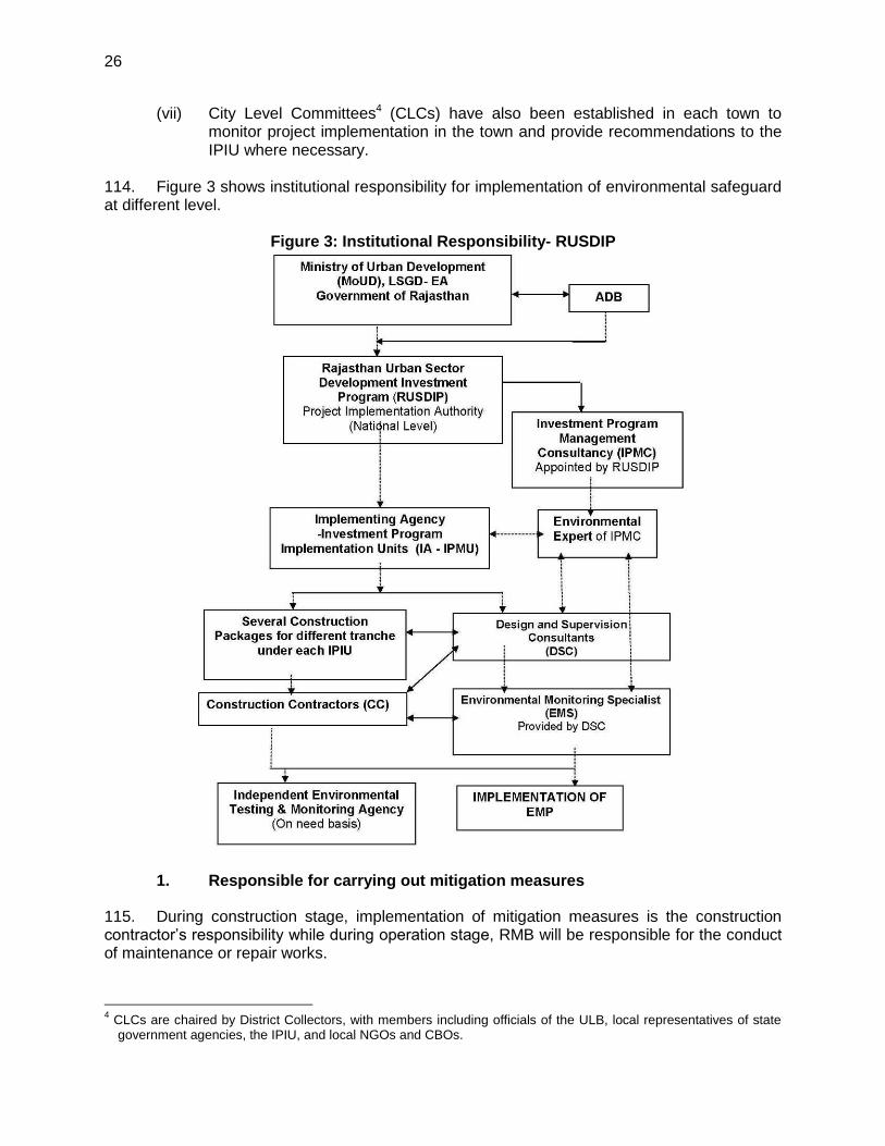
26
(vii) City Level Committees4 (CLCs) have also been established in each town to monitor project implementation in the town and provide recommendations to the IPIU where necessary.
114. Figure 3 shows institutional responsibility for implementation of environmental safeguard at different level.
Figure 3: Institutional Responsibility- RUSDIP
1. Responsible for carrying out mitigation measures
115. During construction stage, implementation of mitigation measures is the construction contractor’s responsibility while during operation stage, RMB will be responsible for the conduct of maintenance or repair works.
4 CLCs are chaired by District Collectors, with members including officials of the ULB, local representatives of state
government agencies, the IPIU, and local NGOs and CBOs.
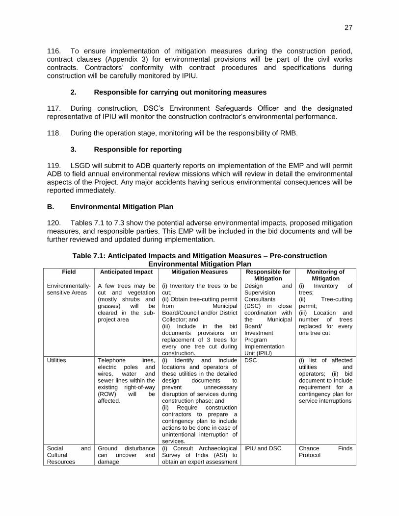
27
116. To ensure implementation of mitigation measures during the construction period, contract clauses (Appendix 3) for environmental provisions will be part of the civil works contracts. Contractors’ conformity with contract procedures and specifications during construction will be carefully monitored by IPIU.
2. Responsible for carrying out monitoring measures
117. During construction, DSC’s Environment Safeguards Officer and the designated representative of IPIU will monitor the construction contractor’s environmental performance. 118. During the operation stage, monitoring will be the responsibility of RMB.
3. Responsible for reporting
119. LSGD will submit to ADB quarterly reports on implementation of the EMP and will permit ADB to field annual environmental review missions which will review in detail the environmental aspects of the Project. Any major accidents having serious environmental consequences will be reported immediately. B. Environmental Mitigation Plan
120. Tables 7.1 to 7.3 show the potential adverse environmental impacts, proposed mitigation measures, and responsible parties. This EMP will be included in the bid documents and will be further reviewed and updated during implementation.
Table 7.1: Anticipated Impacts and Mitigation Measures – Pre-construction Environmental Mitigation Plan
Field Anticipated Impact Mitigation Measures Responsible for Mitigation
Monitoring of Mitigation
Environmentally-sensitive Areas
A few trees may be cut and vegetation (mostly shrubs and grasses) will be cleared in the sub-project area
(i) Inventory the trees to be cut; (ii) Obtain tree-cutting permit from Municipal Board/Council and/or District Collector; and (iii) Include in the bid documents provisions on replacement of 3 trees for every one tree cut during construction.
Design and Supervision Consultants (DSC) in close coordination with the Municipal Board/ Investment Program Implementation Unit (IPIU)
(i) Inventory of trees; (ii) Tree-cutting permit; (iii) Location and number of trees replaced for every one tree cut
Utilities Telephone lines, electric poles and wires, water and sewer lines within the existing right-of-way (ROW) will be affected.
(i) Identify and include locations and operators of these utilities in the detailed design documents to prevent unnecessary disruption of services during construction phase; and (ii) Require construction contractors to prepare a contingency plan to include actions to be done in case of unintentional interruption of services.
DSC (i) list of affected utilities and operators; (ii) bid document to include requirement for a contingency plan for service interruptions
Social and Cultural Resources
Ground disturbance can uncover and damage
(i) Consult Archaeological Survey of India (ASI) to obtain an expert assessment
IPIU and DSC Chance Finds Protocol
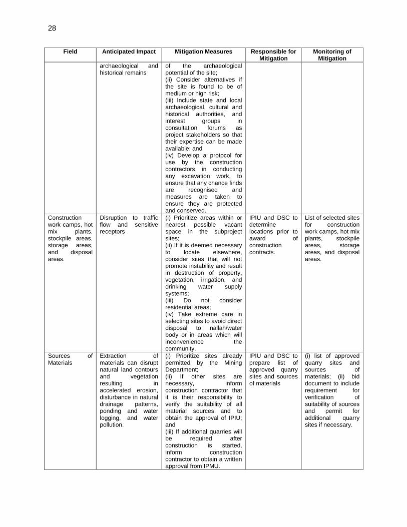
28
Field Anticipated Impact Mitigation Measures Responsible for Mitigation
Monitoring of Mitigation
archaeological and historical remains
of the archaeological potential of the site; (ii) Consider alternatives if the site is found to be of medium or high risk; (iii) Include state and local archaeological, cultural and historical authorities, and interest groups in consultation forums as project stakeholders so that their expertise can be made available; and (iv) Develop a protocol for use by the construction contractors in conducting any excavation work, to ensure that any chance finds are recognised and measures are taken to ensure they are protected and conserved.
Construction work camps, hot mix plants, stockpile areas, storage areas, and disposal areas.
Disruption to traffic flow and sensitive receptors
(i) Prioritize areas within or nearest possible vacant space in the subproject sites; (ii) If it is deemed necessary to locate elsewhere, consider sites that will not promote instability and result in destruction of property, vegetation, irrigation, and drinking water supply systems; (iii) Do not consider residential areas; (iv) Take extreme care in selecting sites to avoid direct disposal to nallah/water body or in areas which will inconvenience the community.
IPIU and DSC to determine locations prior to award of construction contracts.
List of selected sites for construction work camps, hot mix plants, stockpile areas, storage areas, and disposal areas.
Sources of Materials
Extraction of materials can disrupt natural land contours and vegetation resulting in accelerated erosion, disturbance in natural drainage patterns, ponding and water logging, and water pollution.
(i) Prioritize sites already permitted by the Mining Department; (ii) If other sites are necessary, inform construction contractor that it is their responsibility to verify the suitability of all material sources and to obtain the approval of IPIU; and (iii) If additional quarries will be required after construction is started, inform construction contractor to obtain a written approval from IPMU.
IPIU and DSC to prepare list of approved quarry sites and sources of materials
(i) list of approved quarry sites and sources of materials; (ii) bid document to include requirement for verification of suitability of sources and permit for additional quarry sites if necessary.
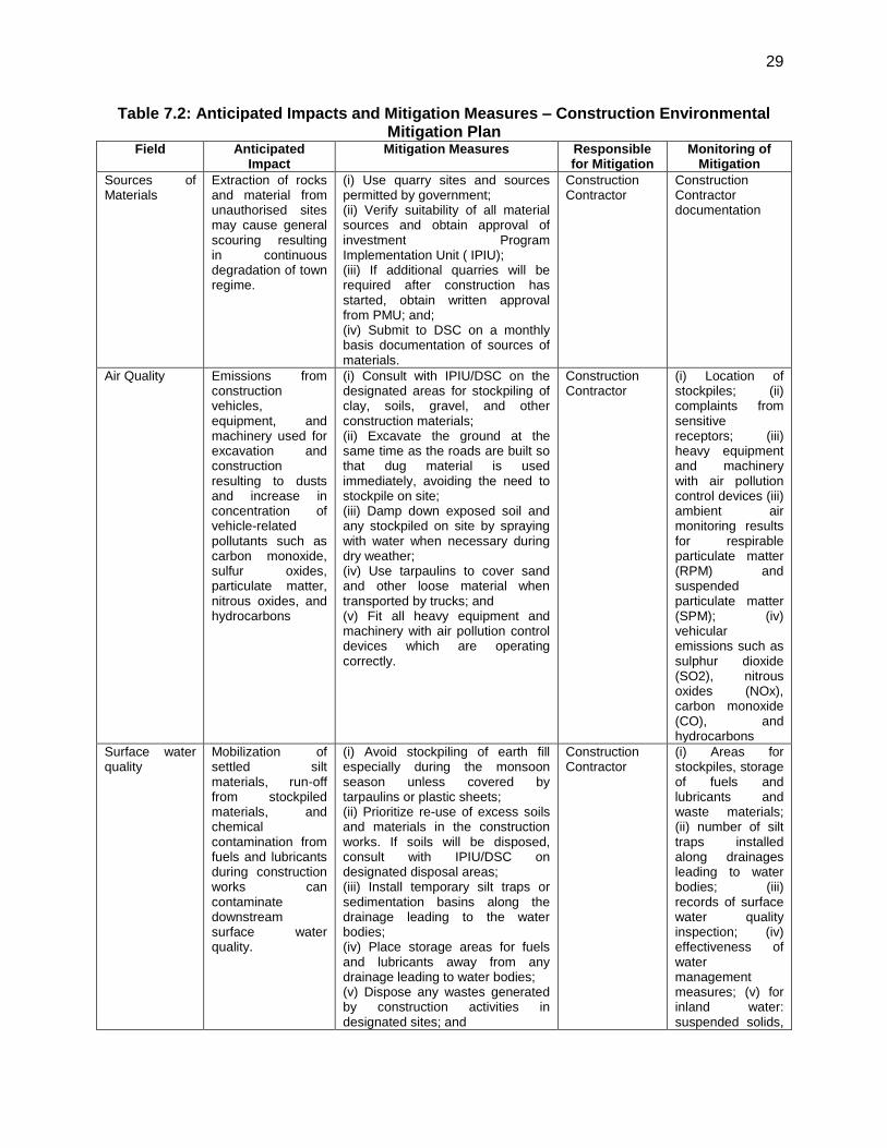
29
Table 7.2: Anticipated Impacts and Mitigation Measures – Construction Environmental Mitigation Plan
Field Anticipated Impact
Mitigation Measures Responsible for Mitigation
Monitoring of Mitigation
Sources of Materials
Extraction of rocks and material from unauthorised sites may cause general scouring resulting in continuous degradation of town regime.
(i) Use quarry sites and sources permitted by government; (ii) Verify suitability of all material sources and obtain approval of investment Program Implementation Unit ( IPIU); (iii) If additional quarries will be required after construction has started, obtain written approval from PMU; and; (iv) Submit to DSC on a monthly basis documentation of sources of materials.
Construction Contractor
Construction Contractor documentation
Air Quality Emissions from construction vehicles, equipment, and machinery used for excavation and construction resulting to dusts and increase in concentration of vehicle-related pollutants such as carbon monoxide, sulfur oxides, particulate matter, nitrous oxides, and hydrocarbons
(i) Consult with IPIU/DSC on the designated areas for stockpiling of clay, soils, gravel, and other construction materials; (ii) Excavate the ground at the same time as the roads are built so that dug material is used immediately, avoiding the need to stockpile on site; (iii) Damp down exposed soil and any stockpiled on site by spraying with water when necessary during dry weather; (iv) Use tarpaulins to cover sand and other loose material when transported by trucks; and (v) Fit all heavy equipment and machinery with air pollution control devices which are operating correctly.
Construction Contractor
(i) Location of stockpiles; (ii) complaints from sensitive receptors; (iii) heavy equipment and machinery with air pollution control devices (iii) ambient air monitoring results for respirable particulate matter (RPM) and suspended particulate matter (SPM); (iv) vehicular emissions such as sulphur dioxide (SO2), nitrous oxides (NOx), carbon monoxide (CO), and hydrocarbons
Surface water quality
Mobilization of settled silt materials, run-off from stockpiled materials, and chemical contamination from fuels and lubricants during construction works can contaminate downstream surface water quality.
(i) Avoid stockpiling of earth fill especially during the monsoon season unless covered by tarpaulins or plastic sheets; (ii) Prioritize re-use of excess soils and materials in the construction works. If soils will be disposed, consult with IPIU/DSC on designated disposal areas; (iii) Install temporary silt traps or sedimentation basins along the drainage leading to the water bodies; (iv) Place storage areas for fuels and lubricants away from any drainage leading to water bodies; (v) Dispose any wastes generated by construction activities in designated sites; and
Construction Contractor
(i) Areas for stockpiles, storage of fuels and lubricants and waste materials; (ii) number of silt traps installed along drainages leading to water bodies; (iii) records of surface water quality inspection; (iv) effectiveness of water management measures; (v) for inland water: suspended solids,
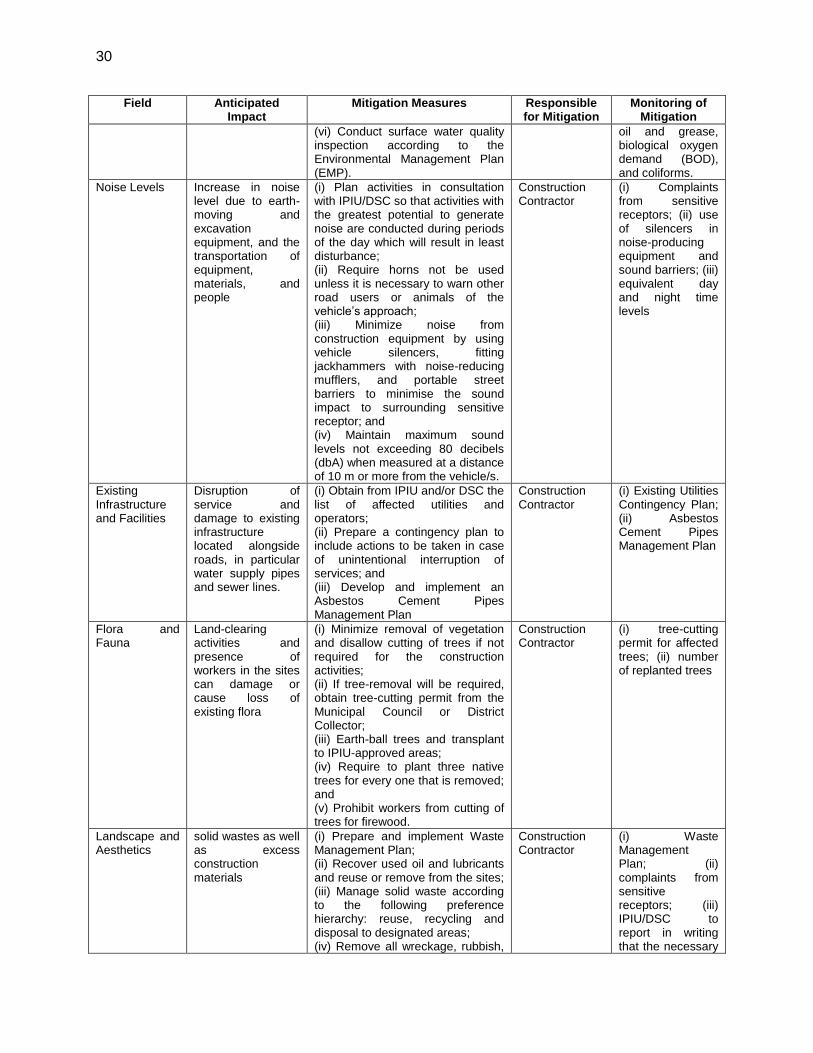
30
Field Anticipated Impact
Mitigation Measures Responsible for Mitigation
Monitoring of Mitigation
(vi) Conduct surface water quality inspection according to the Environmental Management Plan (EMP).
oil and grease, biological oxygen demand (BOD), and coliforms.
Noise Levels Increase in noise level due to earth-moving and excavation equipment, and the transportation of equipment, materials, and people
(i) Plan activities in consultation with IPIU/DSC so that activities with the greatest potential to generate noise are conducted during periods of the day which will result in least disturbance; (ii) Require horns not be used unless it is necessary to warn other road users or animals of the vehicle’s approach; (iii) Minimize noise from construction equipment by using vehicle silencers, fitting jackhammers with noise-reducing mufflers, and portable street barriers to minimise the sound impact to surrounding sensitive receptor; and (iv) Maintain maximum sound levels not exceeding 80 decibels (dbA) when measured at a distance of 10 m or more from the vehicle/s.
Construction Contractor
(i) Complaints from sensitive receptors; (ii) use of silencers in noise-producing equipment and sound barriers; (iii) equivalent day and night time levels
Existing Infrastructure and Facilities
Disruption of service and damage to existing infrastructure located alongside roads, in particular water supply pipes and sewer lines.
(i) Obtain from IPIU and/or DSC the list of affected utilities and operators; (ii) Prepare a contingency plan to include actions to be taken in case of unintentional interruption of services; and (iii) Develop and implement an Asbestos Cement Pipes Management Plan
Construction Contractor
(i) Existing Utilities Contingency Plan; (ii) Asbestos Cement Pipes Management Plan
Flora and Fauna
Land-clearing activities and presence of workers in the sites can damage or cause loss of existing flora
(i) Minimize removal of vegetation and disallow cutting of trees if not required for the construction activities; (ii) If tree-removal will be required, obtain tree-cutting permit from the Municipal Council or District Collector; (iii) Earth-ball trees and transplant to IPIU-approved areas; (iv) Require to plant three native trees for every one that is removed; and (v) Prohibit workers from cutting of trees for firewood.
Construction Contractor
(i) tree-cutting permit for affected trees; (ii) number of replanted trees
Landscape and Aesthetics
solid wastes as well as excess construction materials
(i) Prepare and implement Waste Management Plan; (ii) Recover used oil and lubricants and reuse or remove from the sites; (iii) Manage solid waste according to the following preference hierarchy: reuse, recycling and disposal to designated areas; (iv) Remove all wreckage, rubbish,
Construction Contractor
(i) Waste Management Plan; (ii) complaints from sensitive receptors; (iii) IPIU/DSC to report in writing that the necessary

31
Field Anticipated Impact
Mitigation Measures Responsible for Mitigation
Monitoring of Mitigation
or temporary structures (such as buildings, shelters, and latrines) which are no longer required; and (v) Request IPIU/DSC to report in writing that the necessary environmental restoration work has been adequately performed before acceptance of work.
environmental restoration work has been adequately performed before acceptance of work.
Transportation – Accessibility
traffic problems and conflicts in right-of-way (ROW)
(i) Plan transportation routes so that heavy vehicles do not use narrow local roads, except in the immediate vicinity of delivery sites; (ii) Schedule transport and hauling activities during non-peak hours; (iii) Locate entry and exit points in areas where there is low potential for traffic congestion; (iv) Keep the site free from all unnecessary obstructions; (v) Drive vehicles in a considerate manner and speed limit; (vi) Coordinate with Municipal Traffic Office for temporary road diversions and with provision of traffic aids if transportation activities cannot be avoided during peak hours; and (vii) Notify affected sensitive receptors by providing sign boards informing nature and duration of construction works and contact numbers of concerns/ complaints. Provide wooden bridges for pedestrians and metal sheets for vehicles to allow access across open trenches where required (ix) provide footbridges on open trenches for access to houses and shops (x) complete the work quickly and restore open trenches immediately after completion of work in such areas
Construction Contractor
(i) Traffic Management Plan; (ii) complaints from sensitive receptors; (iii) number of signages placed at subproject sites.
Socio-Economic
generation of contractual employment and increase in local revenue
(i) Employ at least 50% of the labour force, or to the maximum extent, local persons within the 2-km immediate area if manpower is available; and (ii) Procure construction materials from local market.
Construction Contractor
(i) employment records; (ii) records of sources of materials
Occupational Health and Safety
occupational hazards which can arise from working in infrastructures like roads and bridges
(i) Develop and implement site-specific Health and Safety (H&S) Plan which will include measures such as: (a) excluding public from the site; (b) ensuring all workers are provided with and use Personal Protective Equipment; (c) H&S Training for all site personnel; (d) documented procedures to be followed for all site activities; and (e) documentation of work-related
Construction Contractor
(i) site-specific Health and Safety (H & S) Plan; (ii) Equipped first-aid stations; (iii) Medical insurance coverage for workers; (iv) Number of accidents;
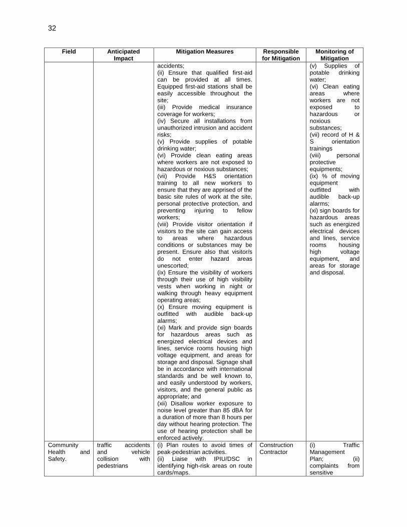
32
Field Anticipated Impact
Mitigation Measures Responsible for Mitigation
Monitoring of Mitigation
accidents; (ii) Ensure that qualified first-aid can be provided at all times. Equipped first-aid stations shall be easily accessible throughout the site; (iii) Provide medical insurance coverage for workers; (iv) Secure all installations from unauthorized intrusion and accident risks; (v) Provide supplies of potable drinking water; (vi) Provide clean eating areas where workers are not exposed to hazardous or noxious substances; (vii) Provide H&S orientation training to all new workers to ensure that they are apprised of the basic site rules of work at the site, personal protective protection, and preventing injuring to fellow workers; (viii) Provide visitor orientation if visitors to the site can gain access to areas where hazardous conditions or substances may be present. Ensure also that visitor/s do not enter hazard areas unescorted; (ix) Ensure the visibility of workers through their use of high visibility vests when working in night or walking through heavy equipment operating areas; (x) Ensure moving equipment is outfitted with audible back-up alarms; (xi) Mark and provide sign boards for hazardous areas such as energized electrical devices and lines, service rooms housing high voltage equipment, and areas for storage and disposal. Signage shall be in accordance with international standards and be well known to, and easily understood by workers, visitors, and the general public as appropriate; and (xii) Disallow worker exposure to noise level greater than 85 dBA for a duration of more than 8 hours per day without hearing protection. The use of hearing protection shall be enforced actively.
(v) Supplies of potable drinking water; (vi) Clean eating areas where workers are not exposed to hazardous or noxious substances; (vii) record of H & S orientation trainings (viii) personal protective equipments; (ix) % of moving equipment outfitted with audible back-up alarms; (xi) sign boards for hazardous areas such as energized electrical devices and lines, service rooms housing high voltage equipment, and areas for storage and disposal.
Community Health and Safety.
traffic accidents and vehicle collision with pedestrians
(i) Plan routes to avoid times of peak-pedestrian activities. (ii) Liaise with IPIU/DSC in identifying high-risk areas on route cards/maps.
Construction Contractor
(i) Traffic Management Plan; (ii) complaints from sensitive
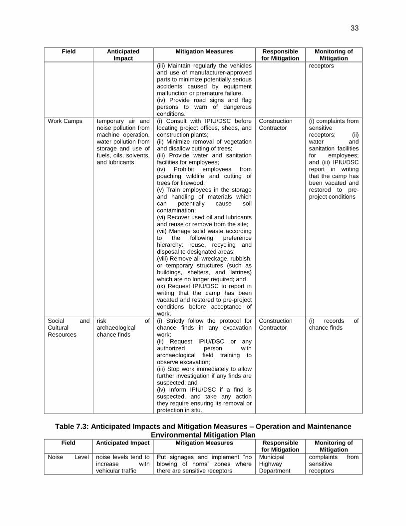
33
Field Anticipated Impact
Mitigation Measures Responsible for Mitigation
Monitoring of Mitigation
(iii) Maintain regularly the vehicles and use of manufacturer-approved parts to minimize potentially serious accidents caused by equipment malfunction or premature failure. (iv) Provide road signs and flag persons to warn of dangerous conditions.
receptors
Work Camps temporary air and noise pollution from machine operation, water pollution from storage and use of fuels, oils, solvents, and lubricants
(i) Consult with IPIU/DSC before locating project offices, sheds, and construction plants; (ii) Minimize removal of vegetation and disallow cutting of trees; (iii) Provide water and sanitation facilities for employees; (iv) Prohibit employees from poaching wildlife and cutting of trees for firewood; (v) Train employees in the storage and handling of materials which can potentially cause soil contamination; (vi) Recover used oil and lubricants and reuse or remove from the site; (vii) Manage solid waste according to the following preference hierarchy: reuse, recycling and disposal to designated areas; (viii) Remove all wreckage, rubbish, or temporary structures (such as buildings, shelters, and latrines) which are no longer required; and (ix) Request IPIU/DSC to report in writing that the camp has been vacated and restored to pre-project conditions before acceptance of work.
Construction Contractor
(i) complaints from sensitive receptors; (ii) water and sanitation facilities for employees; and (iii) IPIU/DSC report in writing that the camp has been vacated and restored to pre-project conditions
Social and Cultural Resources
risk of archaeological chance finds
(i) Strictly follow the protocol for chance finds in any excavation work; (ii) Request IPIU/DSC or any authorized person with archaeological field training to observe excavation; (iii) Stop work immediately to allow further investigation if any finds are suspected; and (iv) Inform IPIU/DSC if a find is suspected, and take any action they require ensuring its removal or protection in situ.
Construction Contractor
(i) records of chance finds
Table 7.3: Anticipated Impacts and Mitigation Measures – Operation and Maintenance
Environmental Mitigation Plan Field Anticipated Impact Mitigation Measures Responsible
for Mitigation Monitoring of
Mitigation
Noise Level
noise levels tend to increase with vehicular traffic
Put signages and implement ―no blowing of horns‖ zones where there are sensitive receptors
Municipal Highway Department
complaints from sensitive receptors
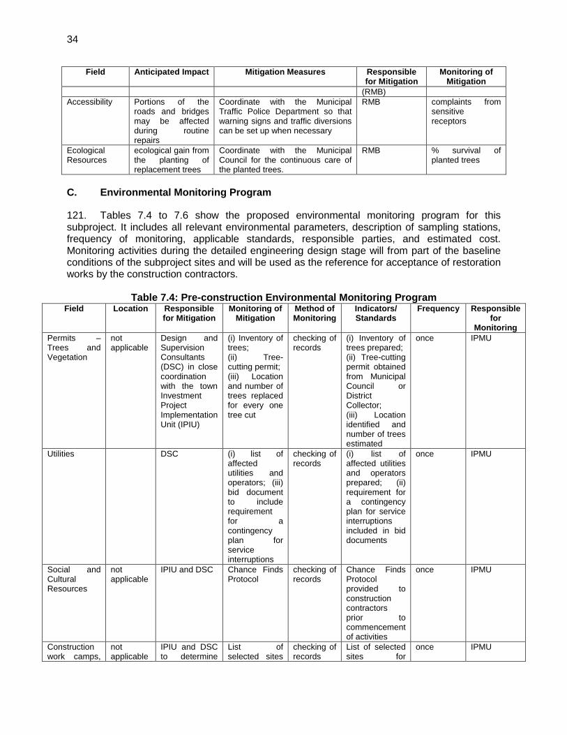
34
Field Anticipated Impact Mitigation Measures Responsible for Mitigation
Monitoring of Mitigation
(RMB)
Accessibility Portions of the roads and bridges may be affected during routine repairs
Coordinate with the Municipal Traffic Police Department so that warning signs and traffic diversions can be set up when necessary
RMB complaints from sensitive receptors
Ecological Resources
ecological gain from the planting of replacement trees
Coordinate with the Municipal Council for the continuous care of the planted trees.
RMB % survival of planted trees
C. Environmental Monitoring Program
121. Tables 7.4 to 7.6 show the proposed environmental monitoring program for this subproject. It includes all relevant environmental parameters, description of sampling stations, frequency of monitoring, applicable standards, responsible parties, and estimated cost. Monitoring activities during the detailed engineering design stage will from part of the baseline conditions of the subproject sites and will be used as the reference for acceptance of restoration works by the construction contractors.
Table 7.4: Pre-construction Environmental Monitoring Program Field Location Responsible
for Mitigation Monitoring of
Mitigation Method of Monitoring
Indicators/ Standards
Frequency Responsible for
Monitoring
Permits – Trees and Vegetation
not applicable
Design and Supervision Consultants (DSC) in close coordination with the town Investment Project Implementation Unit (IPIU)
(i) Inventory of trees; (ii) Tree-cutting permit; (iii) Location and number of trees replaced for every one tree cut
checking of records
(i) Inventory of trees prepared; (ii) Tree-cutting permit obtained from Municipal Council or District Collector; (iii) Location identified and number of trees estimated
once IPMU
Utilities DSC (i) list of affected utilities and operators; (iii) bid document to include requirement for a contingency plan for service interruptions
checking of records
(i) list of affected utilities and operators prepared; (ii) requirement for a contingency plan for service interruptions included in bid documents
once IPMU
Social and Cultural Resources
not applicable
IPIU and DSC Chance Finds Protocol
checking of records
Chance Finds Protocol provided to construction contractors prior to commencement of activities
once IPMU
Construction work camps,
not applicable
IPIU and DSC to determine
List of selected sites
checking of records
List of selected sites for
once IPMU

35
Field Location Responsible for Mitigation
Monitoring of Mitigation
Method of Monitoring
Indicators/ Standards
Frequency Responsible for
Monitoring
hot mix plants, stockpile areas, storage areas, and disposal areas.
locations prior to award of construction contracts.
for construction work camps, hot mix plants, stockpile areas, storage areas, and disposal areas.
construction work camps, hot mix plants, stockpile areas, storage areas, and disposal areas provided to construction contractors prior to commencement of works.
Sources of Materials
not applicable
IPIU and DSC to prepare list of approved quarry sites and sources of materials
(i) list of approved quarry sites and sources of materials; (ii) bid document to include requirement for verification of suitability of sources and permit for additional quarry sites if necessary.
checking of records
(i) list of approved quarry sites and sources of materials provided to construction contractors (ii) bid document included requirement for verification of suitability of sources and permit for additional quarry sites if necessary.
once IPMU
Baseline Environmental Condition – Ambient Air Quality
Subproject sites
DSC Establish baseline values of (i) respirable particulate matter (RPM) and (ii) suspended particulate matter (SPM)
Air sample collection and analyses by in-house laboratory or accredited 3rd party laboratory
GOI Ambient Air Quality Standards
Once prior to start of construction
IPMU
Table 7.5: Construction Environmental Monitoring Program
Mitigation Measures
Location Responsible for
Mitigation
Monitoring of Mitigation
Method of Monitoring
Indicators/ Standards
Frequency Responsibility
Sources of Materials
quarries and sources of materials
Construction Contractor
Construction Contractor documentation
(i) checking of records; (ii) visual inspection of sites
(i) sites are permitted; (ii) report submitted by construction contractor monthly (until such time there is excavation work)
Monthly submission for construction contractor as needed for DSC
DSC
Air Quality construction Construction (i) Location of (i) checking (i) stockpiles monthly for DSC

36
Mitigation Measures
Location Responsible for
Mitigation
Monitoring of Mitigation
Method of Monitoring
Indicators/ Standards
Frequency Responsibility
sites and areas designated for stockpiling of materials
Contractor stockpiles; (ii) complaints from sensitive receptors; (iii) heavy equipment and machinery with air pollution control devices (iii) ambient air for respirable particulate matter (RPM) and suspended particulate matter (SPM); (iv) vehicular emissions such as sulphur dioxide (SO2), nitrous oxides (NOx), carbon monoxide (CO), and hydrocarbons (HC)
of records; (ii) visual inspection of sites
on designated areas only; (ii) complaints from sensitive receptors satisfactorily addressed; (iii) air pollution control devices working properly; (iv) GOI Ambient Quality Standards for ambient air quality; (iv) GOI Vehicular Emission Standards for SO2, NOx, CO and HC.
checking records
Noise Levels (i) construction sites; (ii) areas for stockpiles, storage of fuels and lubricants and waste materials; (iii) work camps
Construction Contractor
(i) Complaints from sensitive receptors; (ii) use of silencers in noise-producing equipment and sound barriers; (iii) equivalent day and night time levels
(i) checking of records; (ii) visual inspection
(i) complaints from sensitive receptors satisfactorily addressed; and (ii) silencers in noise-producing equipment and (iii) sound barriers installed where necessary
Monthly DSC
Existing Infrastructure and Facilities
(i) construction sites; (ii) alignment of affected utilities
Construction Contractor
(i) Existing Utilities Contingency Plan; (ii) Asbestos Cement Pipes Management Plan
(i) checking of records; (ii) visual inspection
implementation according to Utilities Contingency Plan and Asbestos Cement Plan
as needed DSC
Flora and Fauna
(i) construction sites; (ii) location where replacement trees will be
Construction Contractor
(i) tree-cutting permit for affected trees; (ii) number of replanted trees
(i) checking of records; (ii) visual inspection
number of trees cut, replanted and location according to the tree-cutting permit
as needed DSC
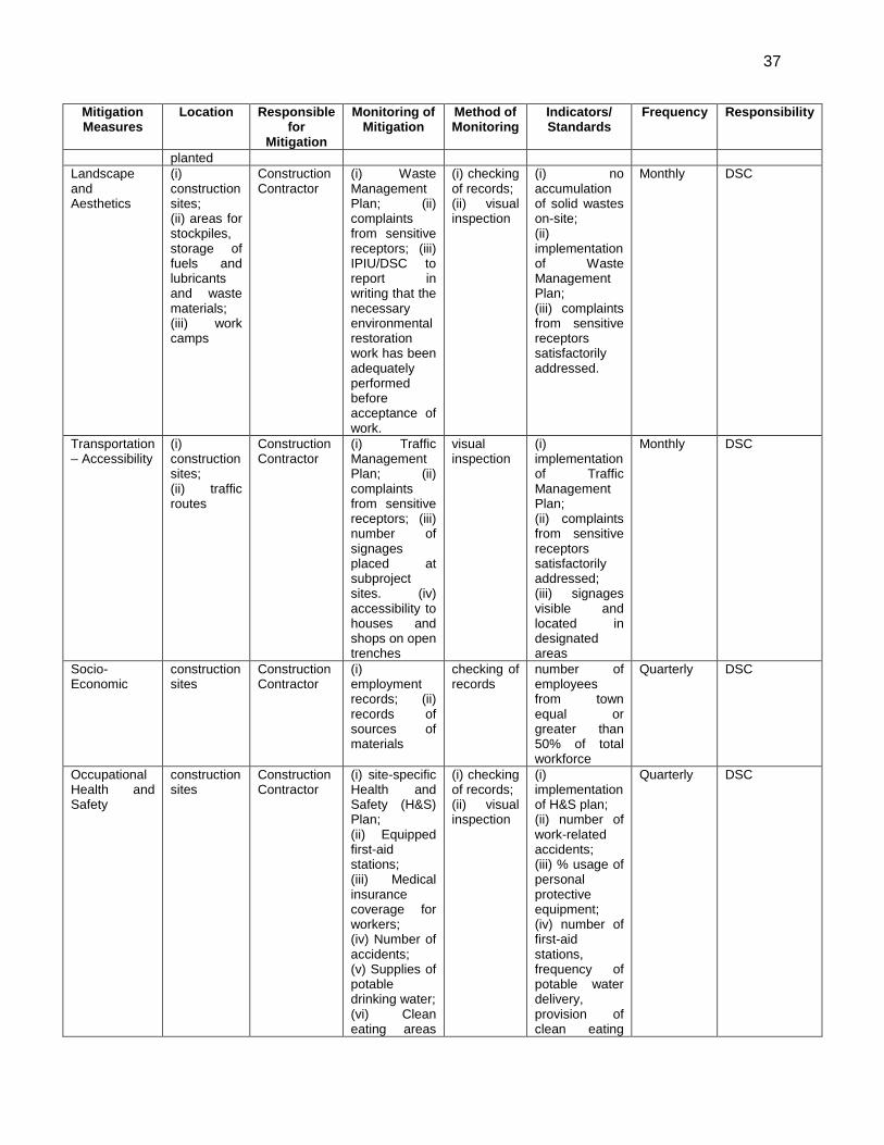
37
Mitigation Measures
Location Responsible for
Mitigation
Monitoring of Mitigation
Method of Monitoring
Indicators/ Standards
Frequency Responsibility
planted
Landscape and Aesthetics
(i) construction sites; (ii) areas for stockpiles, storage of fuels and lubricants and waste materials; (iii) work camps
Construction Contractor
(i) Waste Management Plan; (ii) complaints from sensitive receptors; (iii) IPIU/DSC to report in writing that the necessary environmental restoration work has been adequately performed before acceptance of work.
(i) checking of records; (ii) visual inspection
(i) no accumulation of solid wastes on-site; (ii) implementation of Waste Management Plan; (iii) complaints from sensitive receptors satisfactorily addressed.
Monthly DSC
Transportation – Accessibility
(i) construction sites; (ii) traffic routes
Construction Contractor
(i) Traffic Management Plan; (ii) complaints from sensitive receptors; (iii) number of signages placed at subproject sites. (iv) accessibility to houses and shops on open trenches
visual inspection
(i) implementation of Traffic Management Plan; (ii) complaints from sensitive receptors satisfactorily addressed; (iii) signages visible and located in designated areas
Monthly DSC
Socio-Economic
construction sites
Construction Contractor
(i) employment records; (ii) records of sources of materials
checking of records
number of employees from town equal or greater than 50% of total workforce
Quarterly DSC
Occupational Health and Safety
construction sites
Construction Contractor
(i) site-specific Health and Safety (H&S) Plan; (ii) Equipped first-aid stations; (iii) Medical insurance coverage for workers; (iv) Number of accidents; (v) Supplies of potable drinking water; (vi) Clean eating areas
(i) checking of records; (ii) visual inspection
(i) implementation of H&S plan; (ii) number of work-related accidents; (iii) % usage of personal protective equipment; (iv) number of first-aid stations, frequency of potable water delivery, provision of clean eating
Quarterly DSC
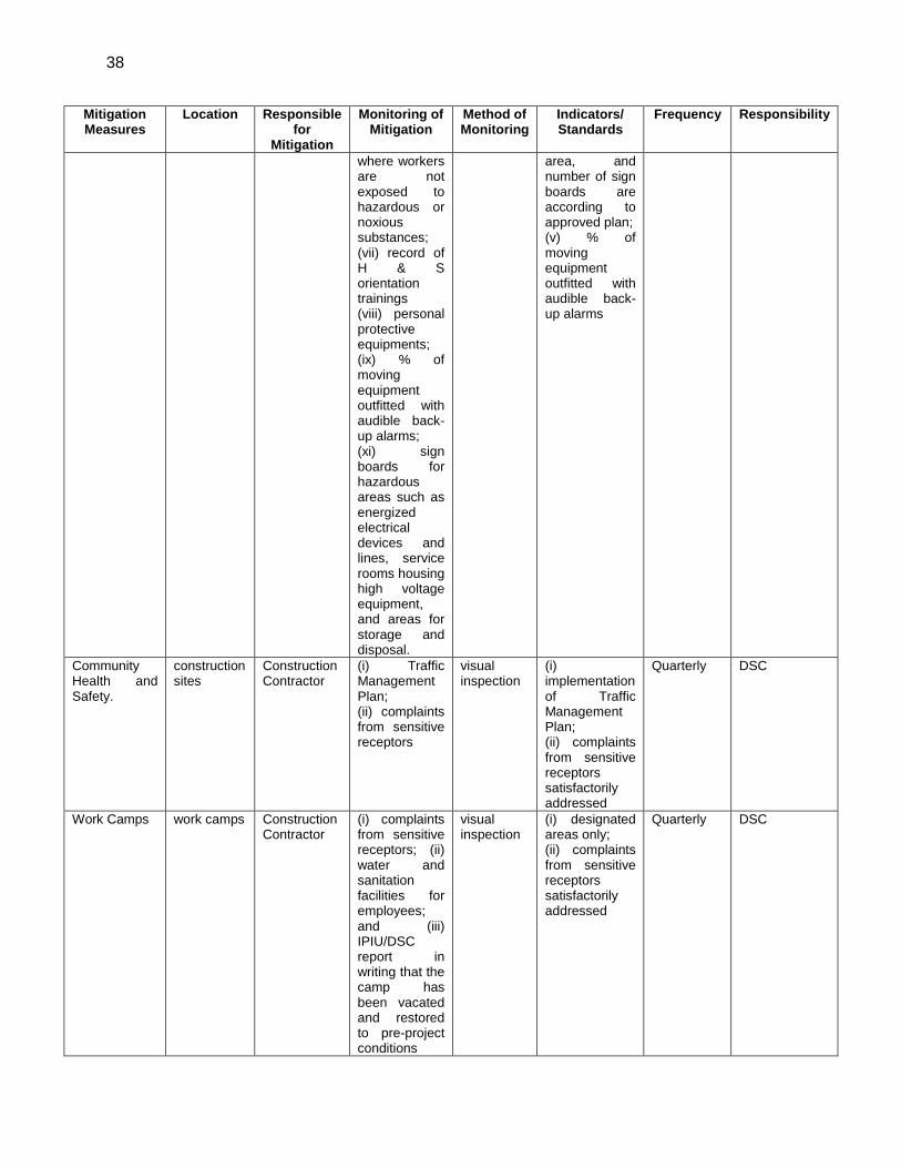
38
Mitigation Measures
Location Responsible for
Mitigation
Monitoring of Mitigation
Method of Monitoring
Indicators/ Standards
Frequency Responsibility
where workers are not exposed to hazardous or noxious substances; (vii) record of H & S orientation trainings (viii) personal protective equipments; (ix) % of moving equipment outfitted with audible back-up alarms; (xi) sign boards for hazardous areas such as energized electrical devices and lines, service rooms housing high voltage equipment, and areas for storage and disposal.
area, and number of sign boards are according to approved plan; (v) % of moving equipment outfitted with audible back-up alarms
Community Health and Safety.
construction sites
Construction Contractor
(i) Traffic Management Plan; (ii) complaints from sensitive receptors
visual inspection
(i) implementation of Traffic Management Plan; (ii) complaints from sensitive receptors satisfactorily addressed
Quarterly DSC
Work Camps work camps Construction Contractor
(i) complaints from sensitive receptors; (ii) water and sanitation facilities for employees; and (iii) IPIU/DSC report in writing that the camp has been vacated and restored to pre-project conditions
visual inspection
(i) designated areas only; (ii) complaints from sensitive receptors satisfactorily addressed
Quarterly DSC
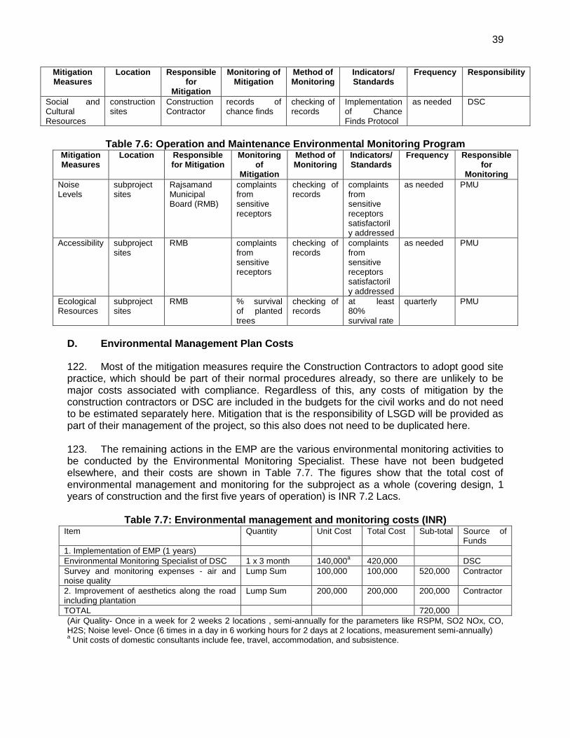
39
Mitigation Measures
Location Responsible for
Mitigation
Monitoring of Mitigation
Method of Monitoring
Indicators/ Standards
Frequency Responsibility
Social and Cultural Resources
construction sites
Construction Contractor
records of chance finds
checking of records
Implementation of Chance Finds Protocol
as needed DSC
Table 7.6: Operation and Maintenance Environmental Monitoring Program
Mitigation Measures
Location Responsible for Mitigation
Monitoring of
Mitigation
Method of Monitoring
Indicators/ Standards
Frequency Responsible for
Monitoring
Noise Levels
subproject sites
Rajsamand Municipal Board (RMB)
complaints from sensitive receptors
checking of records
complaints from sensitive receptors satisfactorily addressed
as needed PMU
Accessibility subproject sites
RMB complaints from sensitive receptors
checking of records
complaints from sensitive receptors satisfactorily addressed
as needed PMU
Ecological Resources
subproject sites
RMB % survival of planted trees
checking of records
at least 80% survival rate
quarterly PMU
D. Environmental Management Plan Costs
122. Most of the mitigation measures require the Construction Contractors to adopt good site practice, which should be part of their normal procedures already, so there are unlikely to be major costs associated with compliance. Regardless of this, any costs of mitigation by the construction contractors or DSC are included in the budgets for the civil works and do not need to be estimated separately here. Mitigation that is the responsibility of LSGD will be provided as part of their management of the project, so this also does not need to be duplicated here. 123. The remaining actions in the EMP are the various environmental monitoring activities to be conducted by the Environmental Monitoring Specialist. These have not been budgeted elsewhere, and their costs are shown in Table 7.7. The figures show that the total cost of environmental management and monitoring for the subproject as a whole (covering design, 1 years of construction and the first five years of operation) is INR 7.2 Lacs.
Table 7.7: Environmental management and monitoring costs (INR) Item Quantity Unit Cost Total Cost Sub-total Source of
Funds
1. Implementation of EMP (1 years)
Environmental Monitoring Specialist of DSC 1 x 3 month 140,000a 420,000 DSC
Survey and monitoring expenses - air and noise quality
Lump Sum 100,000 100,000 520,000 Contractor
2. Improvement of aesthetics along the road including plantation
Lump Sum 200,000 200,000 200,000 Contractor
TOTAL 720,000
(Air Quality- Once in a week for 2 weeks 2 locations , semi-annually for the parameters like RSPM, SO2 NOx, CO, H2S; Noise level- Once (6 times in a day in 6 working hours for 2 days at 2 locations, measurement semi-annually) a Unit costs of domestic consultants include fee, travel, accommodation, and subsistence.

40
VIII. FINDINGS AND RECOMMENDATIONS
124. The process described in this document has assessed the environmental impacts of all elements of the infrastructure proposed under the Rajsamand Roads improvement Subproject. Potential negative impacts were identified in relation to construction and operation of the improved infrastructure, but no impacts were identified as being due to either the subproject design or location. Mitigation measures have been developed to reduce all negative impacts to acceptable levels. These were discussed with specialists responsible for the engineering aspects, and as a result some measures have already been included in the outline designs for the infrastructure. This means that the number of impacts and their significance has already been reduced by amending the design. 125. Regardless of these and various other actions taken during the IEE process and in developing the project, there will still be impacts on the environment when the infrastructure is built and when it is operating. This is mainly because of the invasive nature of excavation work; some parts of which are within densely populated area of the town; and because Rajsamand is an area with a rich history, in which there is a high risk that ground disturbance may uncover important remains. Because of these factors the most significant impacts are on the physical environment, the human environment, and the cultural heritage. 126. During the construction phase, impacts mainly arise from the need to dispose of large quantities of waste and soil produced by excavation and demolition at the road site. These are common impacts of construction in and around urban areas, and there are well developed methods for their mitigation. 127. One field in which impacts are much less routine is archaeology, and here a series of specific measures have been developed to avoid damaging important remains. \ 128. Special measures were also developed to protect workers and the public from exposure to carcinogenic asbestos fibres in the event that Asbestos Cement pipes used in the existing water supply system are encountered accidentally during excavation work. 129. There were limited opportunities to provide environmental enhancements, but certain measures were included. For example it is proposed that the project will employ in the workforce people who live in the vicinity of construction sites to provide them with a short-term economic gain; and plant trees around completed parts of the roads once it is operating, to improve the appearance and provide a small ecological gain. 130. Once the system is operating, it will be important that Rajsamand Municipal Board maintains the subproject roads as a whole in proper operating order, because the town environment will deteriorate rapidly due to damaged roads if the system begins to fail. The project will provide capacity building, public education and financial support to ensure continuation of the operating system. 131. The main impacts of the operating waste management system will be beneficial as the general environment of the town will improve considerably as there will be less traffic congestion due to wider and smoother roads. Some people will also gain socio-economically from being employed in companies engaged to operate the system, or in the expanded Municipality manpower.

41
132. Mitigation will be assured by a program of environmental monitoring conducted during construction and operation to ensure that all measures are implemented, and to determine whether the environment is protected as intended. This will include observations on- and off-site, document checks, and interviews with workers and beneficiaries, and any requirements for remedial action will be reported to the IPMU. There will also be a longer-term survey to monitor the expected improvements in the town environment from the Roads improvement. 133. Finally, stakeholders were involved in developing the IEE through face-to-face discussions on site and a large public meeting held in the town, after which views expressed were incorporated into the IEE and the planning and development of the project. The IEE will be made available at public locations in the town and will be disclosed to a wider audience via the ADB website. The consultation process will be continued and expanded during project implementation, when a nationally-recognised NGO will be appointed to handle this key element to ensure that stakeholders are fully engaged in the project and have the opportunity to participate in its development and implementation.
IX. CONCLUSIONS
134. The environmental impacts of the proposed improvements in Roads infrastructure in Rajsamand Town have been assessed by the Initial Environmental Examination reported in this document, conducted according to ADB guidelines. The overall conclusion is that providing the mitigation, compensation and enhancement measures are implemented in full, there should be no significant negative environmental impacts as a result of location, design, construction or operation of the subproject. There should in fact be some small benefits from recommended mitigation and enhancement measures, and major improvements in the town environment once the scheme is in operation. 135. During designing stage, as location of subproject sites are existing 3 city roads in the town and at government land only, no requirement of private land acquisition. Therefore no additional impact is expected. 136. There are no uncertainties in the analysis, and no additional work is required to comply with ADB procedure.
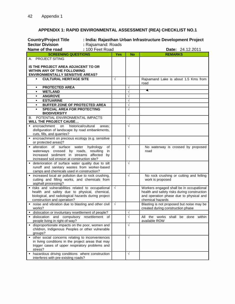
42 Appendix 1
APPENDIX 1: RAPID ENVIRONMENTAL ASSESSMENT (REA) CHECKLIST NO.1 Country/Project Title : India: Rajasthan Urban Infrastructure Development Project Sector Division : Rajsamand: Roads Name of the road : 100 Feet Road Date: 24.12.2011
SCREENING QUESTIONS Yes No REMARKS
A. PROJECT SITING IS THE PROJECT AREA ADJACENT TO OR WITHIN ANY OF THE FOLLOWING ENVIRONMENTALLY SENSITIVE AREAS?
CULTURAL HERITAGE SITE
√ Rajsamand Lake is about 1.5 Kms from road
PROTECTED AREA √
WETLAND √
ANGROVE √
ESTUARINE √
BUFFER ZONE OF PROTECTED AREA √
SPECIAL AREA FOR PROTECTING BIODIVERSITY
√
B. POTENTIAL ENVIRONMENTAL IMPACTS WILL THE PROJECT CAUSE…
encroachment on historical/cultural areas; disfiguration of landscape by road embankments, cuts, fills, and quarries?
√
encroachment on precious ecology (e.g. sensitive or protected areas)?
√
alteration of surface water hydrology of waterways crossed by roads, resulting in increased sediment in streams affected by increased soil erosion at construction site?
√
No waterway is crossed by proposed road
deterioration of surface water quality due to silt runoff and sanitary wastes from worker-based camps and chemicals used in construction?
√
increased local air pollution due to rock crushing, cutting and filling works, and chemicals from asphalt processing?
√
No rock crushing or cutting and felling work is proposed
risks and vulnerabilities related to occupational health and safety due to physical, chemical, biological, and radiological hazards during project construction and operation?
√
Workers engaged shall be in occupational health and safety risks during construction and operation phase due to physical and chemical hazards
noise and vibration due to blasting and other civil works?
√ Blasting is not proposed but noise may be created during construction phase
dislocation or involuntary resettlement of people? √
dislocation and compulsory resettlement of people living in right-of-way?
√ All the works shall be done within available ROW
disproportionate impacts on the poor, women and children, Indigenous Peoples or other vulnerable groups?
√
other social concerns relating to inconveniences in living conditions in the project areas that may trigger cases of upper respiratory problems and stress?
√
hazardous driving conditions where construction interferes with pre-existing roads?
√

Appendix 1 43
SCREENING QUESTIONS Yes No REMARKS
poor sanitation and solid waste disposal in construction camps and work sites, and possible transmission of communicable diseases (such as STI's and HIV/AIDS) from workers to local populations?
√
Poor sanitation and solid waste disposal in construction camps and work sites may create health hazards to workers and local communities, transmission of communicable diseases is also possible due to outside workers will be engaged
creation of temporary breeding habitats for diseases such as those transmitted by mosquitoes and rodents?
√
accident risks associated with increased vehicular traffic, leading to accidental spills of toxic materials?
√
No toxic materials are proposed to be used in road project
increased noise and air pollution resulting from traffic volume?
√
Operation of transportation vehicles and construction equipments may increase noise and air pollution in the locality
increased risk of water pollution from oil, grease and fuel spills, and other materials from vehicles using the road?
√
Accidental leakage of oil and grease from construction vehicles and equipments or leakage due to poor maintenance may cause risk of water pollution
social conflicts if workers from other regions or countries are hired?
√
Most of the workers shall be hired locally as per guidelines
large population influx during project construction and operation that causes increased burden on social infrastructure and services (such as water supply and sanitation systems)?
√
Improvement in the existing road will not result in large population influx
risks to community health and safety due to the transport, storage, and use and/or disposal of materials such as explosives, fuel and other chemicals during construction and operation?
√
There are no major use, transportation or disposal of materials such as explosives, fuel and other chemicals during construction and operation
community safety risks due to both accidental and natural causes, especially where the structural elements or components of the project are accessible to members of the affected community or where their failure could result in injury to the community throughout project construction, operation and decommissioning.
√
No community safety risks due to accidental and natural causes during project execution are expected.

44 Appendix 1
RAPID ENVIRONMENTAL ASSESSMENT (REA) CHECKLIST NO. 2 Country/Project Title : India: Rajasthan Urban Infrastructure Development Project Sector Division : Rajsamand: Roads Name of the road : Vivekanand Choraha to Raj Nagar Bus Stand (via Jal Chakki) Road Date : 24.12.2011
SCREENING QUESTIONS Yes No REMARKS
A. PROJECT SITING IS THE PROJECT AREA ADJACENT TO OR WITHIN ANY OF THE FOLLOWING ENVIRONMENTALLY SENSITIVE AREAS?
CULTURAL HERITAGE SITE
√ Rajsamand Lake is about 1.5 Kms from road, one Jain Temple is also situated about 300 mtrs from this road
PROTECTED AREA √
WETLAND √
MANGROVE √
ESTUARINE √
BUFFER ZONE OF PROTECTED AREA √
SPECIAL AREA FOR PROTECTING BIODIVERSITY
√
C. POTENTIAL ENVIRONMENTAL IMPACTS WILL THE PROJECT CAUSE…
encroachment on historical/cultural areas; disfiguration of landscape by road embankments, cuts, fills, and quarries?
√
Some cultural areas (temples) and old monuments (like Chattris) exists on the sides of this road
encroachment on precious ecology (e.g. sensitive or protected areas)?
√
alteration of surface water hydrology of waterways crossed by roads, resulting in increased sediment in streams affected by increased soil erosion at construction site?
√
No waterway is crossed by proposed road
deterioration of surface water quality due to silt runoff and sanitary wastes from worker-based camps and chemicals used in construction?
√
increased local air pollution due to rock crushing, cutting and filling works, and chemicals from asphalt processing?
√
No rock crushing or cutting and felling work is proposed
risks and vulnerabilities related to occupational health and safety due to physical, chemical, biological, and radiological hazards during project construction and operation?
√
Workers engaged shall be in occupational health and safety risks during construction and operation phase due to physical and chemical hazards
noise and vibration due to blasting and other civil works?
√ Blasting is not proposed but noise may be created during construction phase
dislocation or involuntary resettlement of people?
√ The construction of the road improvements will be carried out within the existing ROW. However, during widening of road, roadside mobile hawkers and vendors will only be affected temporarily and will need to be shifted near to present location so they can continue their business activities. They will be provided shifting allowance and livelihood assistance for the period of disruption

Appendix 1 45
SCREENING QUESTIONS Yes No REMARKS
dislocation and compulsory resettlement of people living in right-of-way?
√ All the works shall be done within available ROW, but some road side vendors may be affected
Disproportionate impacts on the poor, women and children, Indigenous Peoples or other vulnerable groups?
√
Some road side vendors, movable shopkeeper and service providers like cobblers etc and some women shopkeepers may be affected during widening and strengthening of road. They will be provided shifting allowance and livelihood assistance for the period of disruption
other social concerns relating to inconveniences in living conditions in the project areas that may trigger cases of upper respiratory problems and stress?
√
hazardous driving conditions where construction interferes with pre-existing roads?
√
At some places, road is very narrow, which will create congestion during construction which may lead to risks of accidents
poor sanitation and solid waste disposal in construction camps and work sites, and possible transmission of communicable diseases (such as STI's and HIV/AIDS) from workers to local populations?
√
Poor sanitation and solid waste disposal in construction camps and work sites may create health hazards to workers and local communities, transmission of communicable diseases is also possible due to outside workers will be engaged
creation of temporary breeding habitats for diseases such as those transmitted by mosquitoes and rodents?
√
accident risks associated with increased vehicular traffic, leading to accidental spills of toxic materials?
√
No toxic materials are proposed to be used in road project
increased noise and air pollution resulting from traffic volume?
√
Operation of transportation vehicles and construction equipments may increase noise and air pollution in the locality
increased risk of water pollution from oil, grease and fuel spills, and other materials from vehicles using the road?
√
Accidental leakage of oil and grease from construction vehicles and equipments or leakage due to poor maintenance may cause risk of water pollution
social conflicts if workers from other regions or countries are hired?
√
Most of the unskilled workers shall be hired locally as per guidelines
large population influx during project construction and operation that causes increased burden on social infrastructure and services (such as water supply and sanitation systems)?
√
Improvement in the existing road will not result in large population influx
risks to community health and safety due to the transport, storage, and use and/or disposal of materials such as explosives, fuel and other chemicals during construction and operation?
√
There are no major use, transportation or disposal of materials such as explosives, fuel and other chemicals during construction and operation
community safety risks due to both accidental and natural causes, especially where the structural elements or components of the project are accessible to members of the affected community or where their failure could result in injury to the community throughout project construction, operation and decommissioning.
√
No community safety risks due to accidental and natural causes during project execution are expected.
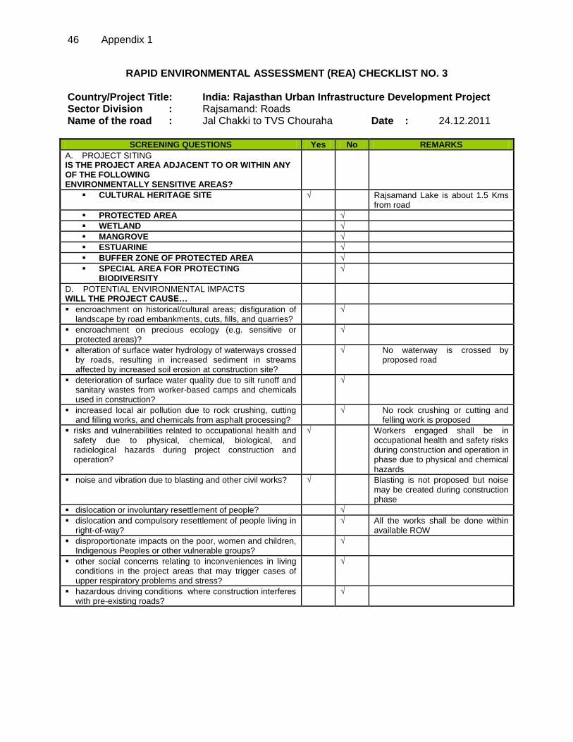
46 Appendix 1
RAPID ENVIRONMENTAL ASSESSMENT (REA) CHECKLIST NO. 3 Country/Project Title: India: Rajasthan Urban Infrastructure Development Project Sector Division : Rajsamand: Roads Name of the road : Jal Chakki to TVS Chouraha Date : 24.12.2011
SCREENING QUESTIONS Yes No REMARKS
A. PROJECT SITING IS THE PROJECT AREA ADJACENT TO OR WITHIN ANY OF THE FOLLOWING ENVIRONMENTALLY SENSITIVE AREAS?
CULTURAL HERITAGE SITE
√ Rajsamand Lake is about 1.5 Kms from road
PROTECTED AREA √
WETLAND √
MANGROVE √
ESTUARINE √
BUFFER ZONE OF PROTECTED AREA √
SPECIAL AREA FOR PROTECTING BIODIVERSITY
√
D. POTENTIAL ENVIRONMENTAL IMPACTS WILL THE PROJECT CAUSE…
encroachment on historical/cultural areas; disfiguration of landscape by road embankments, cuts, fills, and quarries?
√
encroachment on precious ecology (e.g. sensitive or protected areas)?
√
alteration of surface water hydrology of waterways crossed by roads, resulting in increased sediment in streams affected by increased soil erosion at construction site?
√
No waterway is crossed by proposed road
deterioration of surface water quality due to silt runoff and sanitary wastes from worker-based camps and chemicals used in construction?
√
increased local air pollution due to rock crushing, cutting and filling works, and chemicals from asphalt processing?
√
No rock crushing or cutting and felling work is proposed
risks and vulnerabilities related to occupational health and safety due to physical, chemical, biological, and radiological hazards during project construction and operation?
√
Workers engaged shall be in occupational health and safety risks during construction and operation in phase due to physical and chemical hazards
noise and vibration due to blasting and other civil works?
√ Blasting is not proposed but noise may be created during construction phase
dislocation or involuntary resettlement of people? √
dislocation and compulsory resettlement of people living in right-of-way?
√ All the works shall be done within available ROW
disproportionate impacts on the poor, women and children, Indigenous Peoples or other vulnerable groups?
√
other social concerns relating to inconveniences in living conditions in the project areas that may trigger cases of upper respiratory problems and stress?
√
hazardous driving conditions where construction interferes with pre-existing roads?
√
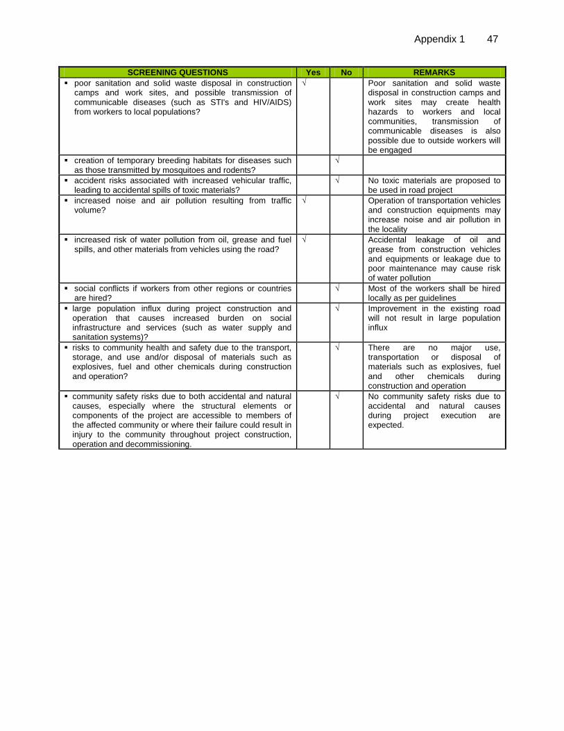
Appendix 1 47
SCREENING QUESTIONS Yes No REMARKS
poor sanitation and solid waste disposal in construction camps and work sites, and possible transmission of communicable diseases (such as STI's and HIV/AIDS) from workers to local populations?
√
Poor sanitation and solid waste disposal in construction camps and work sites may create health hazards to workers and local communities, transmission of communicable diseases is also possible due to outside workers will be engaged
creation of temporary breeding habitats for diseases such as those transmitted by mosquitoes and rodents?
√
accident risks associated with increased vehicular traffic, leading to accidental spills of toxic materials?
√
No toxic materials are proposed to be used in road project
increased noise and air pollution resulting from traffic volume?
√
Operation of transportation vehicles and construction equipments may increase noise and air pollution in the locality
increased risk of water pollution from oil, grease and fuel spills, and other materials from vehicles using the road?
√
Accidental leakage of oil and grease from construction vehicles and equipments or leakage due to poor maintenance may cause risk of water pollution
social conflicts if workers from other regions or countries are hired?
√
Most of the workers shall be hired locally as per guidelines
large population influx during project construction and operation that causes increased burden on social infrastructure and services (such as water supply and sanitation systems)?
√
Improvement in the existing road will not result in large population influx
risks to community health and safety due to the transport, storage, and use and/or disposal of materials such as explosives, fuel and other chemicals during construction and operation?
√
There are no major use, transportation or disposal of materials such as explosives, fuel and other chemicals during construction and operation
community safety risks due to both accidental and natural causes, especially where the structural elements or components of the project are accessible to members of the affected community or where their failure could result in injury to the community throughout project construction, operation and decommissioning.
√
No community safety risks due to accidental and natural causes during project execution are expected.
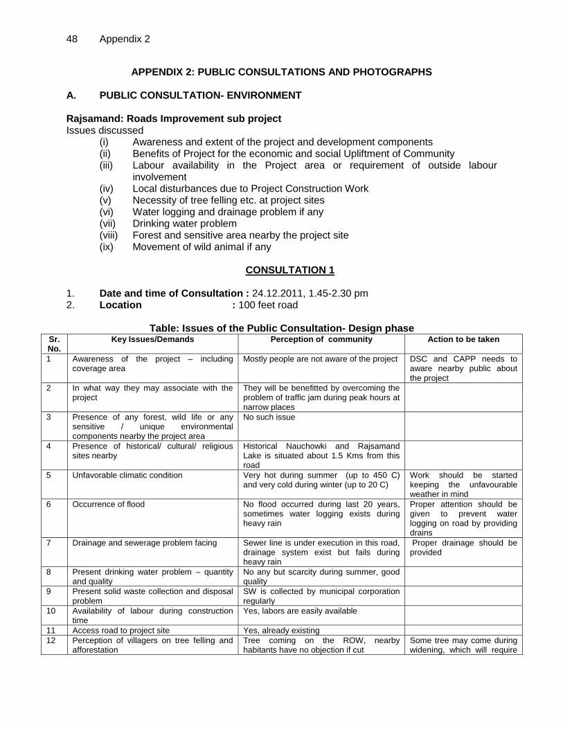
48 Appendix 2
APPENDIX 2: PUBLIC CONSULTATIONS AND PHOTOGRAPHS
A. PUBLIC CONSULTATION- ENVIRONMENT
Rajsamand: Roads Improvement sub project Issues discussed
(i) Awareness and extent of the project and development components (ii) Benefits of Project for the economic and social Upliftment of Community (iii) Labour availability in the Project area or requirement of outside labour
involvement (iv) Local disturbances due to Project Construction Work (v) Necessity of tree felling etc. at project sites (vi) Water logging and drainage problem if any (vii) Drinking water problem (viii) Forest and sensitive area nearby the project site (ix) Movement of wild animal if any
CONSULTATION 1
1. Date and time of Consultation : 24.12.2011, 1.45-2.30 pm 2. Location : 100 feet road
Table: Issues of the Public Consultation- Design phase
Sr. No.
Key Issues/Demands Perception of community Action to be taken
1 Awareness of the project – including coverage area
Mostly people are not aware of the project DSC and CAPP needs to aware nearby public about the project
2 In what way they may associate with the project
They will be benefitted by overcoming the problem of traffic jam during peak hours at narrow places
3 Presence of any forest, wild life or any sensitive / unique environmental components nearby the project area
No such issue
4 Presence of historical/ cultural/ religious sites nearby
Historical Nauchowki and Rajsamand Lake is situated about 1.5 Kms from this road
5 Unfavorable climatic condition
Very hot during summer (up to 450 C) and very cold during winter (up to 20 C)
Work should be started keeping the unfavourable weather in mind
6 Occurrence of flood
No flood occurred during last 20 years, sometimes water logging exists during heavy rain
Proper attention should be given to prevent water logging on road by providing drains
7 Drainage and sewerage problem facing
Sewer line is under execution in this road, drainage system exist but fails during heavy rain
Proper drainage should be provided
8 Present drinking water problem – quantity and quality
No any but scarcity during summer, good quality
9 Present solid waste collection and disposal problem
SW is collected by municipal corporation regularly
10 Availability of labour during construction time
Yes, labors are easily available
11 Access road to project site Yes, already existing
12 Perception of villagers on tree felling and afforestation
Tree coming on the ROW, nearby habitants have no objection if cut
Some tree may come during widening, which will require
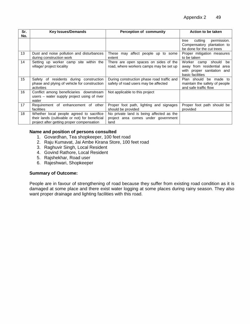
Appendix 2 49
Sr. No.
Key Issues/Demands Perception of community Action to be taken
tree cutting permission. Compensatory plantation to be done for the cut trees
13 Dust and noise pollution and disturbances during construction work
These may affect people up to some extent
Proper mitigation measures to be taken
14 Setting up worker camp site within the village/ project locality
There are open spaces on sides of the road, where workers camps may be set up
Worker camp should be away from residential area with proper sanitation and basic facilities
15 Safety of residents during construction phase and plying of vehicle for construction activities
During construction phase road traffic and safety of road users may be affected
Plan should be made to maintain the safety of people and safe traffic flow
16 Conflict among beneficiaries downstream users – water supply project using of river water
Not applicable to this project
17 Requirement of enhancement of other facilities
Proper foot path, lighting and signages should be provided
Proper foot path should be provided
18 Whether local people agreed to sacrifice their lands (cultivable or not) for beneficial project after getting proper compensation
No private land is being affected as the project area comes under government land
Name and position of persons consulted 1. Govardhan, Tea shopkeeper, 100 feet road 2. Raju Kumavat, Jai Ambe Kirana Store, 100 feet road 3. Raghuvir Singh, Local Resident 4. Govind Rathore, Local Resident 5. Rajshekhar, Road user 6. Rajeshwari, Shopkeeper
Summary of Outcome: People are in favour of strengthening of road because they suffer from existing road condition as it is damaged at some place and there exist water logging at some places during rainy season. They also want proper drainage and lighting facilities with this road.

50 Appendix 2
CONSULTATION 2 Date and time of Consultation : 24.12.2011 Location : Different locations (Vivekananad Chouraha to Mukherji Chouraha)
Table: Issues of the Public Consultation- Design phase Sr. No.
Key Issues/Demands Perception of community Action to be taken
1 Awareness of the project – including coverage area
Mostly people are not aware of the project
IPIU, DSC and CAPP needs to aware people of the project area by consultation, about the work
2 In what way they may associate with the project
People are ready to cooperate in all way, temporary shopkeepers are ready to move their shops for the project period to another place
Prior information to the local people and businessmen to be given about the construction period
3 Presence of any forest, wild life or any sensitive / unique environmental components nearby the project area
No such issue
4 Presence of historical/ cultural/ religious sites nearby
Some Hindu and Jain temples are situated near this road, Rajsamand Lake is situated about 1 Kms
Proper care should be taken to preserve the temples and old monuments
5 Unfavorable climatic condition
Very hot during summer (up to 450 C) and very cold during winter (up to 20 C)
Work should be started keeping the unfavourable weather in mind
6 Occurrence of flood
No flood occurred during last 20 years, sometimes water logging exists during heavy rain
Proper attention should be given to prevent water logging
7 Drainage and sewerage problem facing
Satisfactory drainage system exist during dry season but water logging exists at some places during rainy season, new sewer line is being lad in RUIDP project
Proper drainage should be provided
8 Present drinking water problem – quantity and quality
No any but scarcity during summer, water supplied by PHED is of good quality
9 Present solid waste collection and disposal problem
SW is collected by municipal corporation regularly
10 Availability of labour during construction time
Yes, labors are easily available
11 Access road to project site Yes, this is existing road
12 Perception of villagers on tree felling and afforestation
No tree is planned to cut in this project
Compensatory plantation to be done for the cut trees (if any)
13 Dust and noise pollution and disturbances during construction work
These may affect people up to some extent during construction phase
Proper mitigation measures to be taken
14 Setting up worker camp site within the village/ project locality
Project road goes from market place and residential area so worker camp should be set up away from this area
Worker camp should be away from residential area
15 Safety of residents during construction phase and plying of vehicle for construction activities
Yes during construction phase road traffic and safety of road users may be affected due to construction work and plying of construction vehicles
Plan should be made to maintain the safety of people and safe traffic flow
16 Conflict among beneficiaries Not applicable to this project

Appendix 2 51
Sr. No.
Key Issues/Demands Perception of community Action to be taken
downstream users – water supply project using of river water
17 Requirement of enhancement of other facilities
Proper foot path and drainage on both side should be provided
Proper foot path and drainage should be provided
18 Whether local people agreed to sacrifice their lands (cultivable or not) for beneficial project after getting proper compensation
No private land is being affected as the project area comes under government land, some shops, temporary structures may be affected
Resettlement plan should be prepared and followed
NAME AND POSITION OF PERSONS CONSULTED 1. Om Prakash Regar, Pan Shop, Vivekanand Chouraha 2. Udai Ram, Tea shop on movable trolly 3. Mahendra Kumar Chipa, Tan and Pan-Bidi Shop, near H.P.O. 4. Prem Mali, Vegetable shop, Near Mukharjee Chouraha 5. Dinesh Kumawat, Bherunath Tea Shop Near Mukharjee Chouraha
Summary of Outcome: People are in favour of widening and strengthening of road because they suffer from existing road as it is narrow at some place and water logging exists in rainy season. People want to take in to consideration of religious and historical places.
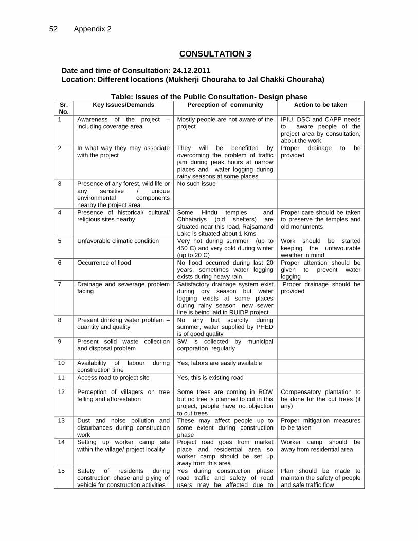
52 Appendix 2
CONSULTATION 3
Date and time of Consultation: 24.12.2011 Location: Different locations (Mukherji Chouraha to Jal Chakki Chouraha)
Table: Issues of the Public Consultation- Design phase
Sr. No.
Key Issues/Demands Perception of community Action to be taken
1 Awareness of the project – including coverage area
Mostly people are not aware of the project
IPIU, DSC and CAPP needs to aware people of the project area by consultation, about the work
2 In what way they may associate with the project
They will be benefitted by overcoming the problem of traffic jam during peak hours at narrow places and water logging during rainy seasons at some places
Proper drainage to be provided
3 Presence of any forest, wild life or any sensitive / unique environmental components nearby the project area
No such issue
4 Presence of historical/ cultural/ religious sites nearby
Some Hindu temples and Chhatariys (old shelters) are situated near this road, Rajsamand Lake is situated about 1 Kms
Proper care should be taken to preserve the temples and old monuments
5 Unfavorable climatic condition
Very hot during summer (up to 450 C) and very cold during winter (up to 20 C)
Work should be started keeping the unfavourable weather in mind
6 Occurrence of flood
No flood occurred during last 20 years, sometimes water logging exists during heavy rain
Proper attention should be given to prevent water logging
7 Drainage and sewerage problem facing
Satisfactory drainage system exist during dry season but water logging exists at some places during rainy season, new sewer line is being laid in RUIDP project
Proper drainage should be provided
8 Present drinking water problem – quantity and quality
No any but scarcity during summer, water supplied by PHED is of good quality
9 Present solid waste collection and disposal problem
SW is collected by municipal corporation regularly
10 Availability of labour during construction time
Yes, labors are easily available
11 Access road to project site
Yes, this is existing road
12 Perception of villagers on tree felling and afforestation
Some trees are coming in ROW but no tree is planned to cut in this project, people have no objection to cut trees
Compensatory plantation to be done for the cut trees (if any)
13 Dust and noise pollution and disturbances during construction work
These may affect people up to some extent during construction phase
Proper mitigation measures to be taken
14 Setting up worker camp site within the village/ project locality
Project road goes from market place and residential area so worker camp should be set up away from this area
Worker camp should be away from residential area
15 Safety of residents during construction phase and plying of vehicle for construction activities
Yes during construction phase road traffic and safety of road users may be affected due to
Plan should be made to maintain the safety of people and safe traffic flow
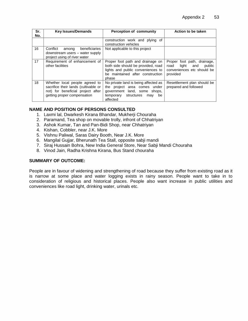
Appendix 2 53
Sr. No.
Key Issues/Demands Perception of community Action to be taken
construction work and plying of construction vehicles
16 Conflict among beneficiaries downstream users – water supply project using of river water
Not applicable to this project
17 Requirement of enhancement of other facilities
Proper foot path and drainage on both side should be provided, road lights and public conveniences to be maintained after construction phase
Proper foot path, drainage, road light and public conveniences etc should be provided
18 Whether local people agreed to sacrifice their lands (cultivable or not) for beneficial project after getting proper compensation
No private land is being affected as the project area comes under government land, some shops, temporary structures may be affected
Resettlement plan should be prepared and followed
NAME AND POSITION OF PERSONS CONSULTED
1. Laxmi lal, Dwarkesh Kirana Bhandar, Mukherji Chouraha 2. Paramand, Tea shop on movable trolly, infront of Chhatriyan 3. Ashok Kumar, Tan and Pan-Bidi Shop, near Chhatriyan 4. Kishan, Cobbler, near J.K. More 5. Vishnu Paliwal, Saras Dairy Booth, Near J.K. More 6. Mangilal Gujjar, Bherunath Tea Stall, opposite sabji mandi 7. Siraj Hussain Bohra, New India General Store, Near Sabji Mandi Chouraha 8. Vinod Jain, Radha Krishna Kirana, Bus Stand chouraha
SUMMARY OF OUTCOME: People are in favour of widening and strengthening of road because they suffer from existing road as it is narrow at some place and water logging exists in rainy season. People want to take in to consideration of religious and historical places. People also want increase in public utilities and conveniences like road light, drinking water, urinals etc.
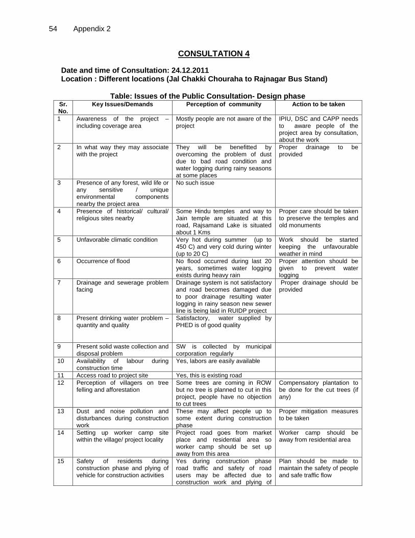
54 Appendix 2
CONSULTATION 4
Date and time of Consultation: 24.12.2011 Location : Different locations (Jal Chakki Chouraha to Rajnagar Bus Stand)
Table: Issues of the Public Consultation- Design phase
Sr. No.
Key Issues/Demands Perception of community Action to be taken
1 Awareness of the project – including coverage area
Mostly people are not aware of the project
IPIU, DSC and CAPP needs to aware people of the project area by consultation, about the work
2 In what way they may associate with the project
They will be benefitted by overcoming the problem of dust due to bad road condition and water logging during rainy seasons at some places
Proper drainage to be provided
3 Presence of any forest, wild life or any sensitive / unique environmental components nearby the project area
No such issue
4 Presence of historical/ cultural/ religious sites nearby
Some Hindu temples and way to Jain temple are situated at this road, Rajsamand Lake is situated about 1 Kms
Proper care should be taken to preserve the temples and old monuments
5 Unfavorable climatic condition
Very hot during summer (up to 450 C) and very cold during winter (up to 20 C)
Work should be started keeping the unfavourable weather in mind
6 Occurrence of flood
No flood occurred during last 20 years, sometimes water logging exists during heavy rain
Proper attention should be given to prevent water logging
7 Drainage and sewerage problem facing
Drainage system is not satisfactory and road becomes damaged due to poor drainage resulting water logging in rainy season new sewer line is being laid in RUIDP project
Proper drainage should be provided
8 Present drinking water problem – quantity and quality
Satisfactory, water supplied by PHED is of good quality
9 Present solid waste collection and disposal problem
SW is collected by municipal corporation regularly
10 Availability of labour during construction time
Yes, labors are easily available
11 Access road to project site Yes, this is existing road
12 Perception of villagers on tree felling and afforestation
Some trees are coming in ROW but no tree is planned to cut in this project, people have no objection to cut trees
Compensatory plantation to be done for the cut trees (if any)
13 Dust and noise pollution and disturbances during construction work
These may affect people up to some extent during construction phase
Proper mitigation measures to be taken
14 Setting up worker camp site within the village/ project locality
Project road goes from market place and residential area so worker camp should be set up away from this area
Worker camp should be away from residential area
15 Safety of residents during construction phase and plying of vehicle for construction activities
Yes during construction phase road traffic and safety of road users may be affected due to construction work and plying of
Plan should be made to maintain the safety of people and safe traffic flow

Appendix 2 55
Sr. No.
Key Issues/Demands Perception of community Action to be taken
construction vehicles, people want mostly night works to least disturb their movement and business during construction phase
16 Conflict among beneficiaries downstream users – water supply project using of river water
Not applicable to this project
17 Requirement of enhancement of other facilities
Proper foot path and drainage on both side should be provided, road lights and public conveniences to be maintained after construction phase
Proper foot path, drainage, road light and public conveniences etc should be provided
18 Whether local people agreed to sacrifice their lands (cultivable or not) for beneficial project after getting proper compensation
No private land is being affected as the project area comes under government land, some shops, temporary structures may be affected
Resettlement plan should be prepared and followed
NAME AND POSITION OF PERSONS CONSULTED
1. Om Prakash Soni, Sri Nath Medical Store, Kishor Nagar, Near Govt. Hospital 2. Sunder Lal, Kumawat Dairy, Silawant Wari 3. Ram Lal Mochi, Cobbler near Raj Nagar Bus Stand 4. Santosh, miscellaneous cosmetic shop, Near Raj Nagar Bus Stand 5. Savitri Devi, petty shop, near Raj Nagar Bus Stand 6. Radheshyam Gujjar, Tea Shop, near Raj Nagar Bus Stand
SUMMARY OF OUTCOME: People are in favour of widening and strengthening of road because they suffer from existing road as it is narrow at some place (between Kabutarkhana to Bus Stand Rajnagar) and water logging exists in rainy season. People want to take in to consideration of religious and historical places. People also want increase in public utilities and conveniences like road light, drinking water, urinals etc.
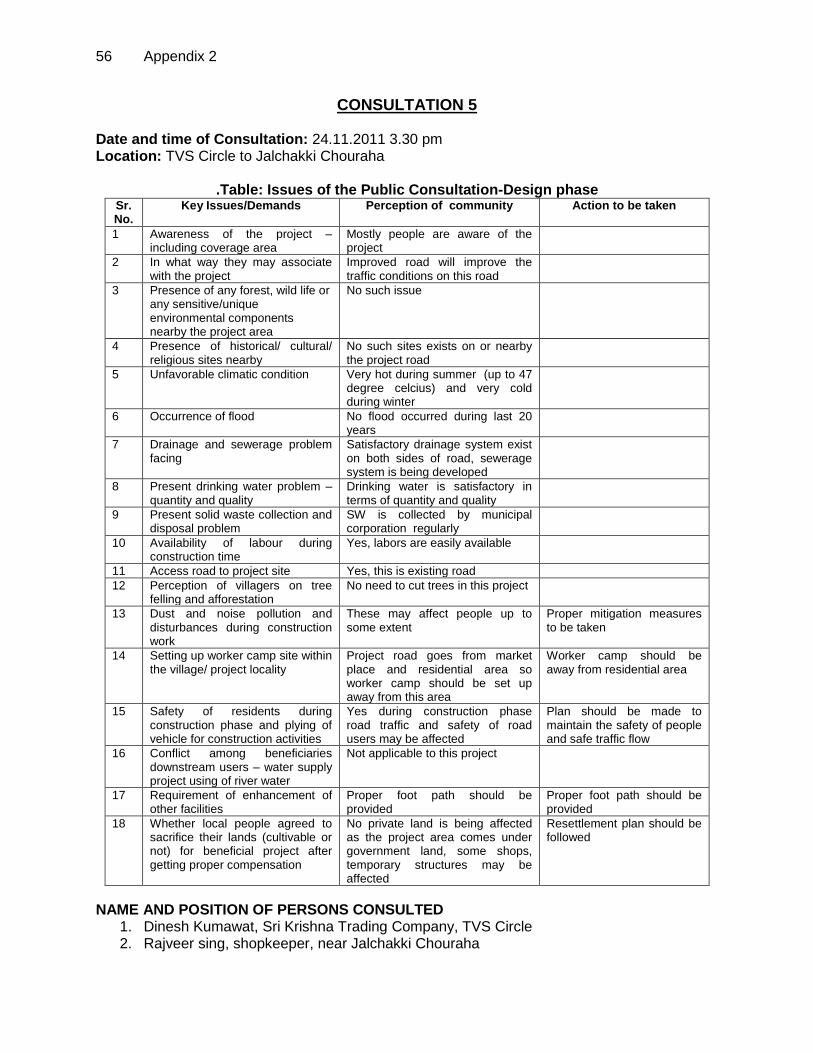
56 Appendix 2
CONSULTATION 5 Date and time of Consultation: 24.11.2011 3.30 pm Location: TVS Circle to Jalchakki Chouraha
.Table: Issues of the Public Consultation-Design phase Sr. No.
Key Issues/Demands Perception of community Action to be taken
1 Awareness of the project – including coverage area
Mostly people are aware of the project
2 In what way they may associate with the project
Improved road will improve the traffic conditions on this road
3 Presence of any forest, wild life or any sensitive/unique environmental components nearby the project area
No such issue
4 Presence of historical/ cultural/ religious sites nearby
No such sites exists on or nearby the project road
5 Unfavorable climatic condition
Very hot during summer (up to 47 degree celcius) and very cold during winter
6 Occurrence of flood No flood occurred during last 20 years
7 Drainage and sewerage problem facing
Satisfactory drainage system exist on both sides of road, sewerage system is being developed
8 Present drinking water problem – quantity and quality
Drinking water is satisfactory in terms of quantity and quality
9 Present solid waste collection and disposal problem
SW is collected by municipal corporation regularly
10 Availability of labour during construction time
Yes, labors are easily available
11 Access road to project site Yes, this is existing road
12 Perception of villagers on tree felling and afforestation
No need to cut trees in this project
13 Dust and noise pollution and disturbances during construction work
These may affect people up to some extent
Proper mitigation measures to be taken
14 Setting up worker camp site within the village/ project locality
Project road goes from market place and residential area so worker camp should be set up away from this area
Worker camp should be away from residential area
15 Safety of residents during construction phase and plying of vehicle for construction activities
Yes during construction phase road traffic and safety of road users may be affected
Plan should be made to maintain the safety of people and safe traffic flow
16 Conflict among beneficiaries downstream users – water supply project using of river water
Not applicable to this project
17 Requirement of enhancement of other facilities
Proper foot path should be provided
Proper foot path should be provided
18 Whether local people agreed to sacrifice their lands (cultivable or not) for beneficial project after getting proper compensation
No private land is being affected as the project area comes under government land, some shops, temporary structures may be affected
Resettlement plan should be followed
NAME AND POSITION OF PERSONS CONSULTED 1. Dinesh Kumawat, Sri Krishna Trading Company, TVS Circle 2. Rajveer sing, shopkeeper, near Jalchakki Chouraha
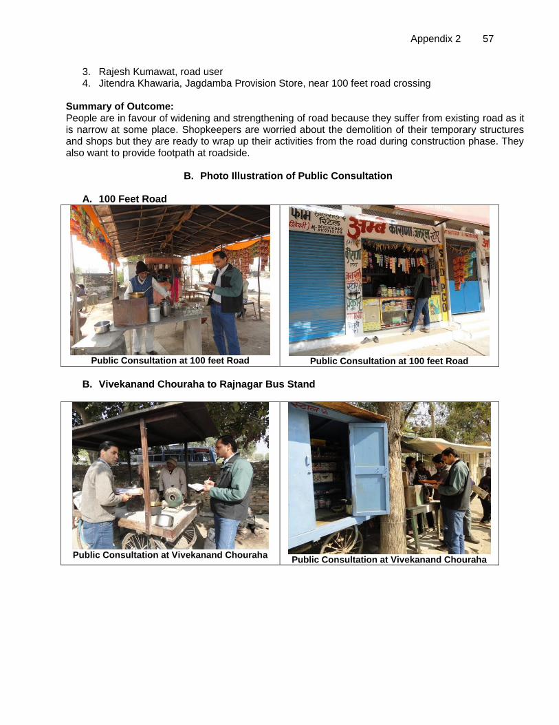
Appendix 2 57
3. Rajesh Kumawat, road user 4. Jitendra Khawaria, Jagdamba Provision Store, near 100 feet road crossing
Summary of Outcome: People are in favour of widening and strengthening of road because they suffer from existing road as it is narrow at some place. Shopkeepers are worried about the demolition of their temporary structures and shops but they are ready to wrap up their activities from the road during construction phase. They also want to provide footpath at roadside.
B. Photo Illustration of Public Consultation
A. 100 Feet Road
Public Consultation at 100 feet Road
Public Consultation at 100 feet Road
B. Vivekanand Chouraha to Rajnagar Bus Stand
Public Consultation at Vivekanand Chouraha
Public Consultation at Vivekanand Chouraha
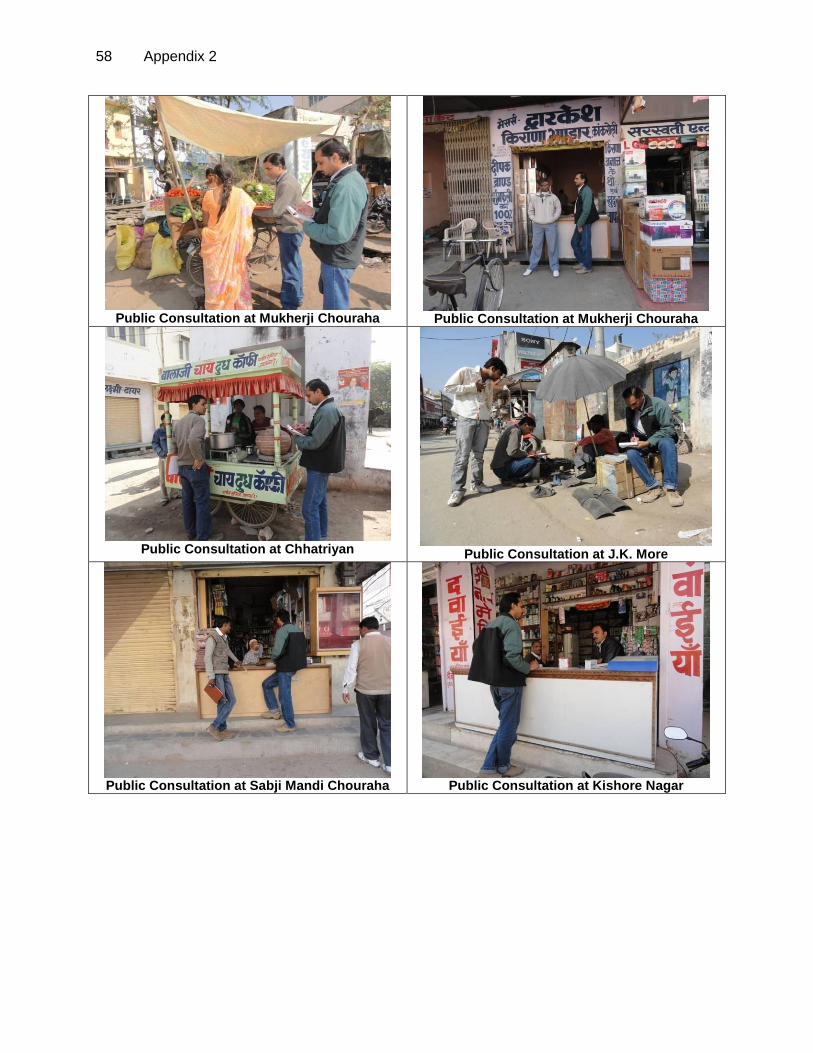
58 Appendix 2
Public Consultation at Mukherji Chouraha
Public Consultation at Mukherji Chouraha
Public Consultation at Chhatriyan
Public Consultation at J.K. More
Public Consultation at Sabji Mandi Chouraha
Public Consultation at Kishore Nagar
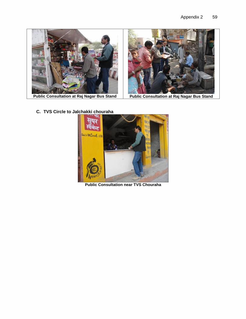
Appendix 2 59
Public Consultation at Raj Nagar Bus Stand
Public Consultation at Raj Nagar Bus Stand
C. TVS Circle to Jalchakki chouraha
Public Consultation near TVS Chouraha

60 Appendix 3
APPENDIX 3: RECOMMENDED CONTRACT CLAUSES
A. Sources of Materials (i) Use quarry sites and sources permitted by government; (ii) Verify suitability of all material sources and obtain approval of Investment
Program Implementation Unit (IPIU); (iii) If additional quarries will be required after construction has started, obtain written
approval from PMU; and; (iv) Submit to DSC on a monthly basis documentation of sources of materials.
B. Air Quality
(i) Consult with IPIU/DSC on the designated areas for stockpiling of clay, soils, gravel, and other construction materials;
(ii) Damp down exposed soil and any stockpiled on site by spraying with water when necessary during dry weather;
(iii) Use tarpaulins to cover sand and other loose material when transported by trucks; and
(iv) Fit all heavy equipment and machinery with air pollution control devices which are operating correctly.
C. Surface Water Quality
(i) Avoid stockpiling of earth fill especially during the monsoon season unless covered by tarpaulins or plastic sheets;
(ii) Prioritize re-use of excess spoils and materials in the construction works. If spoils will be disposed, consult with IPIU/DSC on designated disposal areas;
(iii) Install temporary silt traps or sedimentation basins along the drainage leading to the water bodies;
(iv) Place storage areas for fuels and lubricants away from any drainage leading to water bodies;
(v) Dispose any wastes generated by construction activities in designated sites; and (vi) Conduct surface water quality inspection according to the Environmental
Management Plan (EMP). D. Noise Levels
(i) Plan activities in consultation with IPIU/DSC so that activities with the greatest potential to generate noise are conducted during periods of the day which will result in least disturbance;
(ii) Require horns not be used unless it is necessary to warn other road users or animals of the vehicle’s approach;
(iii) Minimize noise from construction equipment by using vehicle silencers, fitting jackhammers with noise-reducing mufflers, and portable street barriers the sound impact to surrounding sensitive receptor; and
(iv) Maintain maximum sound levels not exceeding 80 decibels (dbA) when measured at a distance of 10 m or more from the vehicle/s.
E. Existing Infrastructure and Facilities
(i) Obtain from IPIU and/or DSC the list of affected utilities and operators; (ii) Prepare a contingency plan to include actions to be done in case of unintentional
interruption of services; and (iii) Develop and implement an Asbestos Cement Pipes Management Plan
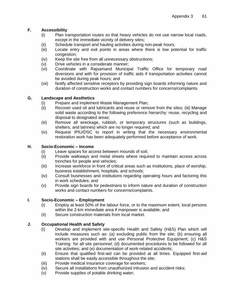
Appendix 3 61
F. Accessibility (i) Plan transportation routes so that heavy vehicles do not use narrow local roads,
except in the immediate vicinity of delivery sites; (ii) Schedule transport and hauling activities during non-peak hours; (iii) Locate entry and exit points in areas where there is low potential for traffic
congestion; (iv) Keep the site free from all unnecessary obstructions; (v) Drive vehicles in a considerate manner; (vi) Coordinate with Rajsamand Municipal Traffic Office for temporary road
diversions and with for provision of traffic aids if transportation activities cannot be avoided during peak hours; and
(vii) Notify affected sensitive receptors by providing sign boards informing nature and duration of construction works and contact numbers for concerns/complaints.
G. Landscape and Aesthetics
(i) Prepare and implement Waste Management Plan; (ii) Recover used oil and lubricants and reuse or remove from the sites; (iii) Manage
solid waste according to the following preference hierarchy: reuse, recycling and disposal to designated areas;
(iii) Remove all wreckage, rubbish, or temporary structures (such as buildings, shelters, and latrines) which are no longer required; and
(iv) Request IPIU/DSC to report in writing that the necessary environmental restoration work has been adequately performed before acceptance of work.
H. Socio-Economic – Income
(i) Leave spaces for access between mounds of soil; (ii) Provide walkways and metal sheets where required to maintain access across
trenches for people and vehicles; (iii) Increase workforce in front of critical areas such as institutions, place of worship,
business establishment, hospitals, and schools; (iv) Consult businesses and institutions regarding operating hours and factoring this
in work schedules; and (v) Provide sign boards for pedestrians to inform nature and duration of construction
works and contact numbers for concerns/complaints. I. Socio-Economic – Employment
(i) Employ at least 50% of the labour force, or to the maximum extent, local persons within the 2-km immediate area if manpower is available; and
(ii) Secure construction materials from local market. J. Occupational Health and Safety
(i) Develop and implement site-specific Health and Safety (H&S) Plan which will include measures such as: (a) excluding public from the site; (b) ensuring all workers are provided with and use Personal Protective Equipment; (c) H&S Training for all site personnel; (d) documented procedures to be followed for all site activities; and (e) documentation of work-related accidents;
(ii) Ensure that qualified first-aid can be provided at all times. Equipped first-aid stations shall be easily accessible throughout the site;
(iii) Provide medical insurance coverage for workers; (iv) Secure all installations from unauthorized intrusion and accident risks; (v) Provide supplies of potable drinking water;

62 Appendix 3
(vi) Provide clean eating areas where workers are not exposed to hazardous or noxious substances;
(vii) Provide H&S orientation training to all new workers to ensure that they are apprised of the basic site rules of work at the site, personal protective protection, and preventing injuring to fellow workers;
(viii) Provide visitor orientation if visitors to the site can gain access to areas where hazardous conditions or substances may be present. Ensure also that visitor/s do not enter hazard areas unescorted;
(ix) Ensure the visibility of workers through their use of high visibility vests when working in or walking through heavy equipment operating areas;
(x) Ensure moving equipment is outfitted with audible back-up alarms; (xi) Mark and provide sign boards for hazardous areas such as energized electrical
devices and lines, service rooms housing high voltage equipment, and areas for storage and disposal. Signage shall be in accordance with international standards and be well known to, and easily understood by workers, visitors, and the general public as appropriate; and
(xii) Disallow worker exposure to noise level greater than 85 dBA for a duration of more than 8 hours per day without hearing protection. The use of hearing protection shall be enforced actively.
K. Asbestos Cement Pipes
(i) Train all personnel (including manual labourers) to enable them to understand the dangers of AC pipes and to be able to recognise them in situ;
(ii) Report to management immediately if AC pipes are encountered; (iii) Develop and apply AC Management Plan.
L. Community Health and Safety. (i) Plan routes to avoid times of peak-pedestrian activities. (ii) Liaise with IPIU/DSC in identifying high-risk areas on route cards/maps. (iii) Maintain regularly the vehicles and use of manufacturer-approved parts to minimize potentially serious accidents caused by equipment malfunction or premature failure. (iv) Provide road signs and flag persons to warn of dangerous conditions. M. Work Camps
(i) Consult with IPIU/DSC before locating project offices, sheds, and construction plants;
(ii) Minimize removal of vegetation and disallow cutting of trees; (iii) Provide water and sanitation facilities for employees; (iv) Prohibit employees from poaching wildlife and cutting of trees for firewood; (v) Train employees in the storage and handling of materials which can potentially
cause soil contamination; (vi) Recover used oil and lubricants and reuse or remove from the site; (vii) Manage solid waste according to the following preference hierarchy: reuse,
recycling and disposal to designated areas; (viii) Remove all wreckage, rubbish, or temporary structures (such as buildings,
shelters, and latrines) which are no longer required; and (ix) Request IPIU/DSC to report in writing that the camp has been vacated and
restored to pre-project conditions before acceptance of work.

Appendix 3 63
N. Social and Cultural Resources (i) Strictly follow the protocol for chance finds in any excavation work; (ii) Request IPIU/DSC or any authorized person with archaeological field training to
observe excavation; (iii) Stop work immediately to allow further investigation if any finds are suspected;
and (iv) Inform IPIU/DSC if a find is suspected, and take any action they require ensuring
its removal or protection in site.
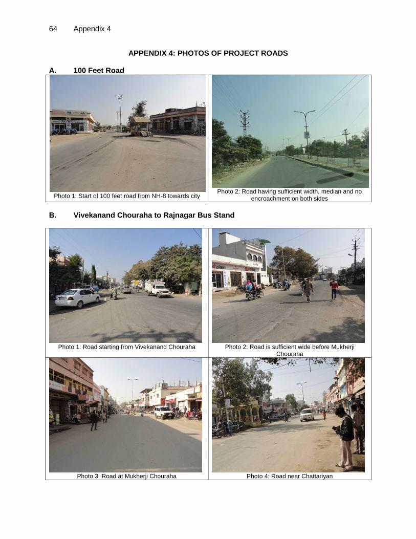
64 Appendix 4
APPENDIX 4: PHOTOS OF PROJECT ROADS A. 100 Feet Road
Photo 1: Start of 100 feet road from NH-8 towards city
Photo 2: Road having sufficient width, median and no
encroachment on both sides
B. Vivekanand Chouraha to Rajnagar Bus Stand
Photo 1: Road starting from Vivekanand Chouraha
Photo 2: Road is sufficient wide before Mukherji
Chouraha
Photo 3: Road at Mukherji Chouraha
Photo 4: Road near Chattariyan
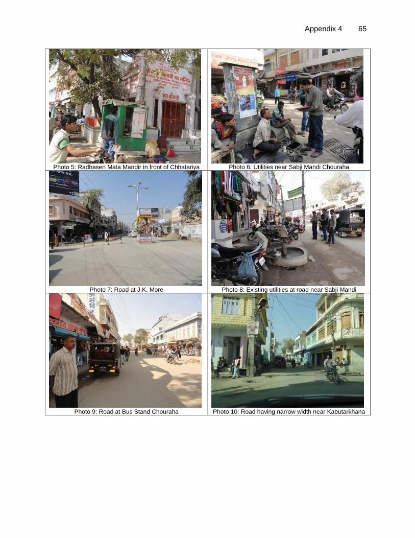
Appendix 4 65
Photo 5: Radhasen Mata Mandir in front of Chhatariya
Photo 6: Utilities near Sabji Mandi Chouraha
Photo 7: Road at J.K. More
Photo 8: Existing utilities at road near Sabji Mandi
Photo 9: Road at Bus Stand Chouraha
Photo 10: Road having narrow width near Kabutarkhana
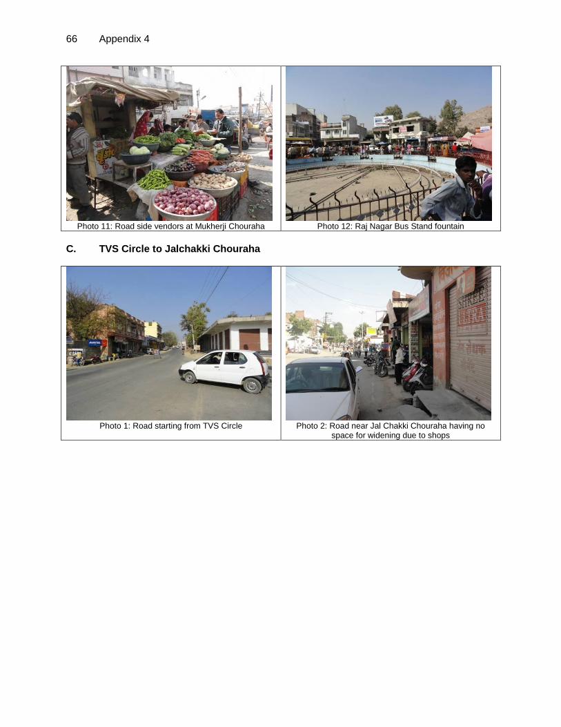
66 Appendix 4
Photo 11: Road side vendors at Mukherji Chouraha
Photo 12: Raj Nagar Bus Stand fountain
C. TVS Circle to Jalchakki Chouraha
Photo 1: Road starting from TVS Circle
Photo 2: Road near Jal Chakki Chouraha having no
space for widening due to shops