
Initial Environment Examination-Shangede Dam (IEE) Environment Examination-Shangede Dam (IEE) ......
67
1 Initial Environment Examination-Shangede Dam (IEE) ____________________________________________ August 2014 PAK: Federally Administered Tribal Areas Water Resources Development Project (FWRDP) Prepared by Federally Administered Tribal Areas, Secretariat, for the Asian Development Bank.
Transcript of Initial Environment Examination-Shangede Dam (IEE) Environment Examination-Shangede Dam (IEE) ......

1
Initial Environment Examination-Shangede Dam
(IEE)
____________________________________________
August 2014
PAK: Federally Administered Tribal Areas Water
Resources Development Project (FWRDP)
Prepared by Federally Administered Tribal Areas, Secretariat, for the Asian Development Bank.

2
Abbreviation
ADB Asian Development Bank
APA Assistant Political Agent
BMP Better Management Practices
CO Community Organization
CE Construction Engineer
CCA Culturable Command Area
DEM Digital Elevation Model
DG Director General
EIA Environmental Impact Assessment
EMU Environmental Management Unit
EMP Environment Management Plan
EPA Environment Protection Agency
ECR Environmental Complaints Register
FRDP FATA Rural Development Project
FWRDP FATA Water Resources Development Project
FATA Federally Administered Tribal Areas
FGD Focus Group Discussions
GIS Geographic Information System
GoP Government of Pakistan
GRC Grievance Redress Committee
GFP Grievance Focal Point
GRM Grievance Redress Mechanism
HSE Health, Safety and Environment
IEE Initial Environmental Examination
GF Inspector General Forests
KII Key Informant Interviews
KPK Khyber Pakhtunkhwa
MMT Main Mantle Thrust
NGO Non Governmental Organization
NOC No Objection Certificate
PA Political Agent

3
PEPA Pakistan Environmental Protection Act
PPTA Project Preparatory Technical Assistance
ToP Terms of Partnership
SDIP Shangade Dam Irrigation Project
ToR Terms Of Reference
WWF World Wide Fund for Nature
This Initial Environmental Examination Report is a document of the borrower. The views
expressed herein do not necessarily represent those of ADB's Board of Directors, Management,
or staff, and may be preliminary in nature. Your attention is directed to the “terms of use” section
of this website.
In preparing any country program or strategy, financing any project, or by making any
designation of or reference to a particular territory or geographic area in this document, the
Asian Development Bank does not intend to make any judgments as to the legal or other status
of any territory or area.

4
Contents Executive Summary ………………………………………………………………………………………….…….7
A. Introduction .......................................................................................................................................... 10
B. Assessment of Legal and Policy Frameworks..................................................................................... 10
C. Description of the Project ..................................................................................................................... 11
1. Location ........................................................................................................................................... 11
2. Project Objectives ............................................................................................................................ 12
3. Construction Plan ............................................................................................................................ 13
D. Baseline Environment ......................................................................................................................... 15
1. Studied Area .................................................................................................................................... 15
a. Topography of the Area ............................................................................................................... 16
2. Physical Resources ......................................................................................................................... 16
a. Atmosphere .................................................................................................................................. 16
b. Geology ........................................................................................................................................ 17
c. Soils .............................................................................................................................................. 19
d. Seismicity/ Earth Quake Hazard .................................................................................................. 19
e. Surface Water .............................................................................................................................. 19
f. Ground Water ............................................................................................................................... 22
g. Water Quality ............................................................................................................................... 22
h. Ecological Resources .................................................................................................................. 22
i. Protected Area .............................................................................................................................. 24
3. Social, Economic, and Cultural Resources ..................................................................................... 25
a. Demography ................................................................................................................................. 25
b. Family Size .................................................................................................................................. 26
c. Housing Characteristics ............................................................................................................... 26
d. Social Organization ...................................................................................................................... 26
e. The Family system ....................................................................................................................... 26
f. Conflicts Resolution Mechanism................................................................................................... 27
g. Religious Beliefs ........................................................................................................................... 27
h. Infrastructure ................................................................................................................................ 27
i. Cropping Pattern ........................................................................................................................... 27
j. Economic Features ....................................................................................................................... 28
k. Livestock ...................................................................................................................................... 28
l. Culturally and Socially Significant Sites ........................................................................................ 28
E. Anticipated Environmental Impacts and Mitigation Measures ............................................................. 29

5
1. Explanation of the Impact Assessment ........................................................................................... 31
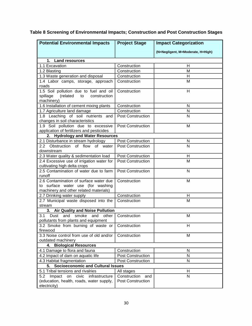
a. Construction Phase ...................................................................................................................... 31
F. Information Disclosure, Consultation and Participation ....................................................................... 37
1. Summary of Consultations ............................................................................................................... 38
a. Federal level stakeholders ........................................................................................................... 38
b. Line Departments (FATA and KP Government) .......................................................................... 38
c. Civil Society .................................................................................................................................. 38
d. Communities ................................................................................................................................ 39
e. Future Consultations .................................................................................................................... 39
G. Grievance Redress Mechanism .......................................................................................................... 39
H. Environmental Management Plan ....................................................................................................... 41
1. Objectives of Environment Management Plan ................................................................................ 42
2. Institutional & Management Structures ............................................................................................ 42
a. Environment Management Unit ................................................................................................... 42
b. Environment Management Plan (Construction and Operational Stage) ..................................... 44
c. Environment Monitoring Plan ....................................................................................................... 50
d. Trainings and capacity enhancement .......................................................................................... 51
I. Conclusion and Recommendation ........................................................................................................ 52
J. Annexures ............................................................................................................................................. 54
Annexure 1 Governor KPK Notification 1 ................................................................................................ 56
Annexure 2 Governor KPK Notification 2 ................................................................................................ 58
K. Figures ................................................................................................................................................. 60
Figure 1 Dam Location vis-à-vis River System of Khyber Agency ......................................................... 61
Figure 2 Location, Catchment & Command Area of Shangade Dam ..................................................... 62
Figure 3 Land Cover of Khyber Agency .................................................................................................. 63
Figure 4 Dam Location vis-à-vis Tectonic Map of Pakistan .................................................................... 64
Figure 5 Dam Location vis-à-vis Seismic Zones of Pakistan .................................................................. 65
Figure 6 Land Cover of Shangade .......................................................................................................... 66
Figure 8 Cropping Calendar for Khyber Agency ..................................................................................... 67

6
EXECUTIVE SUMMARY
THE PROJECT
1. The proposed Shangade Dam Irrigation Project (SDIP) is located in Khyber Agency, a
Federally Administered Tribal Area (FATA) in northwest Pakistan. The dam will be
constructed on Lashora Khwar, a semi-perennial tertiary stream, which after draining into
secondary and primary streams, eventually falls into Kabul River. The site is located 12 km
North West of Jamrud Town (agency head quarter of Khyber Agency) near the village of
Wula Mela. The coordinates of the proposed dam axis are 34° 4'36.68"N and 71°19'5.91"E.
2. Catchment area of the SDIP is 11.48 km2, and the length of the main stream is about 6.20
km. The vegetative cover of the catchment is poor, while the stream/khwar bed is covered
with overburden comprising of boulders, shingle, gravel and coarse sand. The settlements
in the catchment area are scattered in small pockets.
PROJECT OBJECTIVES
3. The main objective of the SDIP is to develop flood runoff storage for assured irrigation
supplies to Culturable Command Area (CCA) of approximately 171 ha downstream of the
dam. It is estimated that a reasonable quantity of water from the dam will meet the irrigation
demand of lands proposed in the command area, and will also contribute to recharging the
groundwater table.
4. The main component of the sub-project consists of a plumb concrete gravity dam to store
floodwater. The project also includes a component of watershed management to ensure
continuous water quality and quantity, and to decrease the sedimentation load. The
catchment area consists of 2 ha riverbed, 639 ha of shrubs and 490 ha rangeland/forest
land. Forests and rangeland management activities, along with soil conservation works will
be carried out upstream of the SDIP. Community Organizations (Cos) will be formed, and
will become a part of the larger Watershed Management Committee, that will comprise of
relevant stakeholders from FATA Secretariat, Forest Dept., and Political Administration.
Watershed Development Plans will be developed by these Committees, and endorsed by
the COs. These Plans will earmark the responsibility of each stakeholder.
CONSTRUCTION PLAN
5. The main components of Shangade dam project include geotechnical investigation,
foundation preparation, and construction of the main dam embankment, ogee shaped
spillway with stilling basin at the downstream, intake and outlet structures and irrigation
system.

7
6. These components are proposed to be constructed in various stages. The geotechnical
investigation will be carried out first, while construction of civil works will be carried out after
design review. Further, Stage I will comprise of the preparation of foundation for the main
dam, and construction of the grouting curtain and left section of the main dam. Stage II will
include the construction of the main dam body, the spillway and stilling basin and the
irrigation system. The Dam and its associated structures will be commissioned on
completion of Stage-II.
ASSESSMENT OF LEGAL AND POLICY FRAMEWORKS
Asian Development Bank (ADB)
7. SDIP has been classified ADB environmental category B. Category B projects require initial
environmental examination (IEE), which determines whether or not there are potential
significant environmental impacts warranting an EIA. If there are none, the IEE becomes the
final environmental assessment report.
Pakistan Environmental Protection Act (PEPA), 1997, Government of Pakistan (GoP)
8. The Pakistan Environmental Protection Act (PEPA) 1997 covers the entire country including
all its territories. Schedules I & II of the Act describe the criteria for determining the
environmental assessment requirements (IEE or EIA) for various types of projects. The
criteria qualify JKDIP as requiring an IEE. This IEE is to be submitted to the Pakistan
Environment Protection Agency (Pak EPA) for vetting and a no objection letter to initiate civil
works and construction phase.
DESCRIPTION OF THE ENVIRONMENT
9. The studied area for this IEE was broadly the Khyber Agency, and more specifically sub-
project location including Shangade settlement and the catchment of Lashora Khwar,
stream on which SDIP is proposed to be constructed.
10. Total population of the Agency in 1998 was about 546,000 persons, out of which 52% was
males and 48% female. The population has been estimated to have increased to about 1.0
million by 2013, with a growth rate of 3.92%. The population density is about 391 persons
per km2 while the male-female ratio is 1:1.091.
11. The project site is situated in the northwest of Jamrud tehsil having a population of
approximately 3558 persons, and 391 households. Afridis are the main tribe and are further
sub divided into Zakha Khel sub tribe.
1 FWRDP Inception Report, Important Agnecy/FR wise Socioeconomic Indicators of FATA 2012

8
12. FATA has a unique governance status in Pakistan, with limited presence of state
functionaries at the local level, especially line departments for environmental management.
Apart from PEPA and Pakistan Trade Control of Fauna and Flora Act, 2012, none of the
other laws pertaining to environmental management govern FATA. Hence, there is
extremely limited information on species distribution and abundance in the region. FATA
Secretariat has a Forestry Unit, which is only involved in afforestation activities, and
maintains basic data of forest area in the region. However management of the available
forests and rangelands is under tribal control, as there are no state designated reserves or
protected areas. The only data available on water, soil, agriculture, climate and watersheds
is from the Water Assessment Study and Management Plan2.
13. For the purpose of this IEE, detailed deliberations were held with relevant stakeholders from
the state, civil society and academia. A focused primary survey was also conducted to
ascertain species distribution and abundance along with a very basic hazard mapping
exercise.
14. As a result, an effort was made to establish a baseline or state of environment for the three
selected agencies, with a focus on sub-project site locations. Having stated the above, there
are still limitations to the accuracy and authenticity, since in numerous cases, sources for
data are singular and cannot be cross verified due to paucity of reliable sources.
ENVIRONMENTAL IMPACTS AND MITIGATION
15. Most of the environmental impacts of SDIP will be associated with the construction phase,
which would be dealt with mitigation measures proposed in the environmental management
plan (EMP). Excavation with a limited amount of blasting will be carried out but since the
project is not located in any protected area or near an archeological site, the adverse
impacts can be reversed and mitigated.
16. The air quality of the area is found to be clean, and no obvious source of pollution was found
near the site. Management of vehicular and machine related emissions as well as dust
suppression will be made the responsibility of the contractor with relevant clauses
embedded into all legal contracts.
17. The site is not home to any critically endangered species, nor is a part of larger habitat. The
nearest settlements are at a safe distance, and the site is not used as a regular commuting
route or meeting place. The contractor will be required to take necessary precautions during
the construction phase as advised by the EMP.
18. Sanitation and waste management issues related to labor camps would be dealt with by
constructing dedicated facilities in the camp as well as at the construction site. Waste bins,
2 Water Assessment Study & Management Plan, Bajaur, Khyber and Mohmand, published by ADB and FATA
Secretariat, produced under the ADB FATA Rural Development Project (FRDP)

9
latrines and pits will be dug for different purposes of solid and liquid waste management.
Drinking water facility will also be provided, and will be made the contractors’ responsibility.
19. Although the site is located in a volatile, tribal region, no social conflicts exist at the moment.
Regular interaction with the political setup and tribal elders will be ensured by the project
team so as to deal with any conflict in an amicable manner.
20. Information disclosure will be ensured throughout the design, construction and completion
phases, with a culturally suitable and effective grievance redress mechanism in place.
21. The proposed project will bring about a net positive benefit in terms of improved water
resource management and agricultural productivity in the area. Continuous environmental
monitoring will be carried out for the entire construction phase, to ensure due diligence of
environmental performance. The EMP will also ensure reporting of all non-conformances
and their rectification within a specified period of time along with safety, health and
environment audits carried out by the project team in the leadership of a dedicated
Environment Specialist.
CONCLUSION
22. Environmental impacts of SDIP will not be significant enough to cause any irreversible
damages to the ecology of the area. There are potential impacts that have the risk to alter
the conditions in the medium to longer term, but this IEE attempts to suggest mitigation
measures that would help minimize such impacts.
23. In order to ensure that the impacts remain minimal, EMP compliance monitoring will be
critical; dedicated staff must be engaged as soon as the mobilization for project
implementation initiates. EMU must be set up immediately with project mobilization, so that
the specialists can start liaison with the Federal EPA as well as initiate vetting the
contractual bids. Also, the trainings need to be imparted within the second month as soon as
the project staff is hired, especially the technical staff who will supervise the construction
phase, as well as the contractors. The second round of consultations with the relevant
stakeholders including communities is to be taken up immediately after the establishment of
the EMU.
24. During the construction phase, review meetings with contractor staff, project team and EMU
need to be a permanent feature, happening at least on a monthly basis. These meetings
should ideally be facilitated by the Environment Specialist, and all responsible staff should
be present and provide feedback on the progress achieved as per EMP.
25. In conclusion, with the EMP being implemented in its letter and spirit, potential
harmful impacts of the project will be minimized.
10
Environmental Assessment Report
FATA Water Resources Development Project
Shangade Irrigation Dam Project
A. Introduction
26. Federally Administered Tribal Areas (FATA) Water Resources Development Project
(FWRDP) will be operational in the federal territories at the western borders of Pakistan with
Afghanistan. It focuses on increasing irrigation supplies in three agencies, namely
Mohmand, Khyber and Bajaur, to increase crop production and harvest water sustainably.
The project is being proposed as a result of the Water Assessment Study executed under
the completed ADB supported FATA Rural Development Project of FATA Secretariat. The
study identified 44 watersheds where the groundwater aquifers are depleting at a high rate,
even under average weather conditions due to unplanned water extraction for irrigation and
other associated purposes. It recommends shifting from groundwater to surface water,
which remains totally unutilized, and identified potential sites for small reservoirs and
diversion weirs in the 44 watersheds of Mohmand, Khyber and Bajaur Agencies of FATA.
27. The cost of FWRDP was tentatively estimated at $40 million (as per ADB Concept Note for
the S-PPTA) with ADB financing of $30 million under a sector loan. The project will (i)
construct small reservoirs, diversion weirs and conveyance channels (ii) develop command
area, and (iii) improve watershed management.
28. Since the project is categorized as a category B project as per ADB’s Safeguards Policy
Statement 2009, an Initial Environmental Examination (IEE) exercise is required for each
sub-project. The purpose of this report is to present the findings of the IEE of the Shangade
Dam Irrigation Project (SDIP), a sub project proposed for Khyber Agency. SDIP is one of the
three sub-projects currently being proposed for inclusion in FWRDP.
B. Assessment of Legal and Policy Frameworks
1. Asian Development Bank (ADB)
29. SDIP has been classified ADB environmental category B. Category B projects require initial
environmental examination (IEE), which determines whether or not there are potential

11
significant environmental impacts warranting an EIA. If there are none, the IEE becomes the
final environmental assessment report.
2. Pakistan Environmental Protection Act (PEPA), 1997, Government of
Pakistan (GoP)
30. GOP enacted PEPA in 1997, and it covers entire Pakistan, including its territories.
Schedules I & II of the Act describe the criteria for various types of projects so as to qualify
them for an IEE or an Environmental Impact Assessment (EIA). Table 1 describes the
criteria, reproduced from the Act, and qualifies SDIP as requiring an IEE. This IEE is to be
submitted to the Pakistan Environment Protection Agency (Pak EPA) for vetting and a no-
objection letter to initiate civil works and construction phase.
Table 1 Environmental Classification of SDIP in accordance to PEPA 1997
Criteria for conducting an IEE by PEPA 1997, Schedule I Shangade Irrigation Dam Project
Dams and reservoirs with storage volume less than 50 million cubic meters or surface area less than 8 square kilometers
Yes
Irrigation and drainage projects serving less than 15,000 hectares Yes
C. Description of the Project
1. Location
31. The proposed SDIP is located on Lashora Khwar, a semi-perennial tertiary stream, which
after draining into secondary and primary streams, eventually falls into Kabul River. Figure 1
explains the drainage of the stream. The site is located12 km North West of Jamrud Town
(agency head quarter of Khyber Agency) near the village of Wula Mela. The coordinates of
proposed dam axis are 34° 4'36.68"N and 71°19'5.91"E, as shown in Figure 2.
32. Catchment area of the SDIP is 11.48 km2 (4.432 sq miles).The length of main stream is
about 6.20 km (3.85 miles) with a bed slope of 109.18 m per km (2.83 %). There is no
perennial flow upstream of dam site, whereas perennial flow in the downstream of dam site
has been monitored for 3 months, and average flow of 4.7 cusec is taken as per observation
and locals interviews. The inflow into the reservoir is based on runoff generated due to
rainfall. The catchment area has moderate to steep gradient with highest levels of 1354.53
m (4444 ft) AMSL, extracted from digital elevation model, while elevation at proposed dam
site is 663.8 m (2177.8 ft). The vegetative cover of the catchment is poor, while the
stream/khwar bed is covered with overburden comprising of boulders, shingle, gravel and
coarse sand. The settlements in the catchment area are scattered in small pockets.

12
2. Project Objectives
33. The main objective of the SDIP is to develop flood runoff storage for assured irrigation
supplies to Culturable Command Area (CCA) of approximately 171 ha, downstream of the
dam. It is estimated that a reasonable quantity of water from the dam will meet the irrigation
demand of lands proposed in the command area, and will also contribute in recharging the
groundwater table.
34. The main component of the sub-project will consist of a plumb concrete gravity dam to
store the flood water. An Overflow Ogee spillway within the dam body has been
suggested, due to simplicity in design and construction, and its flood-friendliness. The
spillway capacity and width were optimized by flood routing exercise. In addition to the
above, a component of watershed management will also be executed, in order to stabilize
the slopes and control the sedimentation load. The Catchment area of Shangade Dam has
been classified as semi-arid sub-tropical on the basis of the finding of ground and surface
water studies under FRDP Water Assessment Study. The catchment area consists of 2 ha
riverbed, 639 ha of shrubs and 490 ha rangeland/forest land. Forests and rangeland
management activities, along with soil conservation works will be carried out upstream the
SDIP. Community Organizations will be formed, and will become a part of the larger
Watershed Management Committee, that will comprise of relevant stakeholders from
FATA Secretariat, Forest Dept., and Political Administration. Watershed Development
Plans will be developed by these Committees, and endorsed by the COs. These Plans will
earmark the responsibility of each stakeholder.

13
Diagram 1: Layout Plan of Shangade Dam
3. Construction Plan
35. The main components of Shangade dam project include the:
i. Geotechnical Investigation
ii. Foundation preparation
iii. Main Dam Embankment.
iv. Ogee Shaped Spillway with Stilling Basin at the downstream.
v. Intake and Outlet structure and
vi. Irrigation system.
36. These components are proposed to be constructed in two stages. The Geotechnical
investigation will be carried out first, while construction of civil works will be carried out after
design review. The stage wise break-up of components for construction purposes is briefly
described below:
a. Stage-I
i. Preparation of Foundation for Main Dam

14
37. The foundation preparation will involve excavation in stream/khwar bed and abutments,
which mostly constitute of shingle gravel and weathered rock formation. Most of the
excavation will be done without blasting, whereas in some places controlled blasting will be
employed, avoiding shattering of rock formation.
ii. Grouting Curtain 38. On the basis of Geotechnical investigations double grout curtain will be suggested/revised.
Surface treatment of rock and completion of grout curtain at the Shangade dam site will be
done during this stage preferably during dry season. Perennial flows of stream/khwar will be
diverted through proper arrangement.
iii. Main Dam - Left Section 39. Construction of main dam embankment is proposed to commence from left abutment
towards the middle and to pipe conduit / Intake level. The RCC Pipe Conduit will be laid
through dam body and irrigation channel is to be temporarily re-aligned to RCC pipe conduit
for maintaining irrigation flows. Construction of intake and outlet structure will be taken up at
later stage.
b. Stage- II
i. Main Dam Body 40. Construction of main dam embankment is proposed to commence from right abutment
towards the left abutment in layers and intake pipe would be placed near right abutment.
The RCC Pipe Conduit 0.61 m diameter will be laid through dam body and will end in the
gate valve structure, from where irrigation channel will lead towards command area.
Construction of Irrigation channel and outlet structure will be taken up as parallel activities of
this stage.
ii. Spillway and Stilling Basin 41. Construction of spillway and stilling basin near left abutment will be started after construction
of outlet structures (d/s of pipe conduit) on the left side of stream/khwar. The crest elevation
of spillway has been kept at El.677.617 m with chute channel having (1.73:1,H:V) slope and
ending with a USBR type-III stilling basin.
iii. Irrigation System 42. Commencement of activities for the construction of irrigation system will also take place after
construction of intake and gate valve structure. This activity will run parallel to other activities
onwards till final completion of main dam and other appurtenant structures. Once the main

15
Irrigation channel has been completed, the beneficiaries will be provided with design and
layout of field channels falling within the proposed Chack-Bandi of Shangade dam. The
activity would be mostly carried out by the beneficiaries as part of their Labour and Land
contribution
c. Commissioning of Dam 43. The dam and its associated structures will be commissioned on completion of Stage-II works
and by starting the filling up of the storage reservoir.
D. Baseline Environment
1. Studied Area
44. The studied area for this IEE was broadly the Khyber Agency, and more specifically sub-
project location including Shangade settlement and the catchment of the Lashora Khwar,
stream on which SDIP is proposed to be constructed.
45. Information sources for this IEE include:
i. Water Assessment Study & Management Plan, Bajaur, Khyber and Mohmand,
published by ADB and FATA Secretariat, produced under the ADB FATA Rural
Development Project (FRDP)
ii. Forest Atlas of Pakistan
iii. Species Distribution Maps prepared by WWF Pakistan
iv. GIS Database developed by the PPTA GIS Specialist
v. Primary Surveys conducted under PPTA by Environment Specialist
vi. Hydraulic Design Feasibilities conducted under PPTA by Hydraulic Design Specialist
vii. Agriculture and Geological Studies conducted under PPTA by Agricultural Specialist
and Geologist
viii. Social Assessment Studies conducted under PPTA by the Social Safeguards
Specialist
ix. Meetings with FATA Chief Economist, Forestry Unit, Fisheries Department,
Monitoring & Evaluation Department, KPK Wildlife Department, Inspector General of
Forests, Pakistan, and Director General Pak EPA
46. FATA has a unique governance status in Pakistan, with limited presence of state
functionaries at the local level, especially line departments for environmental management.
Apart from PEPA and Pakistan Trade Control of Fauna and Flora Act, 2012, none of the
other laws pertaining to environmental management govern these territories. Hence, there is
extremely limited information on species distribution and abundance in the region. There are

16
no baselines for wild flora and fauna species, and secondary information is scanty and
dispersed. FATA Secretariat has a Forestry Unit, which is only involved in afforestation
activities, and maintains basic data of forest area in the region. However management of the
available forests and rangelands is under tribal control, as there are no state designated
reserves or protected areas. The only data available on water, soil, agriculture, climate and
watersheds is from the Water Assessment Study and Management Plan3.
47. For the purpose of this IEE, detailed deliberations were held with relevant stakeholders from
the state, civil society and academia. A focused primary survey was also conducted to
ascertain species distribution and abundance along with a very basichazard mapping
exercise.
48. As a result, an effort was made to establish a baseline or state of environment for the three
selected agencies, with a focus on sub-project site locations. Having stated the above, there
are still limitations to the accuracy and authenticity, since in numerous cases, sources for
data are singular and cannot be cross verified due to paucity of reliable sources.
a. Topography of the Area
49. Khyber Agency covers an area of 2,556 km2 and is located between latitude 34o 45’ and
34o-20’North and longitude 70o 26’ and 71o 32’E. The area drains into Kabul River in the
north and Bara River towards south. The area is mountainous, with a series of Hindukush
off-shoots, such as Lacha Ghar, Karagah Ghar, Surghar and Torgah. Tirah and Loe Shilman
are the prominent valleys of the Agency. Most of these ranges are barren, with elevation
ranging between 461 to 1100 m.
2. Physical Resources
a. Atmosphere
i. Climate 50. Khyber Agency has severe weather i.e. very cold in winters and very hot in summers.
December and January are the coldest months of the year. The summer temperatures
range from 23oC to 45oC and average annual rainfall is about 519 mm.
51. The climate of the project area varies from semi-arid to sub-humid sub-tropical temperate.
Physiographic features, especially altitudes have major impact on local climatic conditions.
This is well depicted by the soils and vegetation of the area.
52. The rainfall occurs mainly due to western winds and monsoon. The average rainfall ranges
from 300 mm to 1,000 mm, with the usual average annual rainfall being 422 mm. Based on
3 Water Assessment Study & Management Plan, Bajaur, Khyber and Mohmand, published by ADB and FATA
Secretariat, produced under the ADB FATA Rural Development Project (FRDP)

17
the available climatic data and altitudinal considerations, the project area is classified as
semi-arid sub-tropical zone. 11 watersheds of Khyber Agency fall into this climatic zone,
including Kuki Khel, which is the watershed of the SDIP. Average annual rainfall in Kuki Khel
is recorded as 381 mm. Winter rains are more frequent with lesser intensity and longer
duration. Mean annual temperature ranges between 180Cand 230C, mean winter
temperature ranges between 80C and 120C and mean summer temperature ranges between
29oC and 32oC. June and July are the hottest months with mean maximum temperature
ranging between 35oC and 40oC. December and January are the coldest months with mean
minimum temperatures from 5oC to 1.5oC.
ii. Recent Droughts 53. Primary survey, conducted as a part of this IEE, revealed that droughts are common in the
area. The last significant drought was of three years duration, from 2009 to 2011. Agriculture
and livestock suffered major losses in these years. Many heads of cattle died as well as
food security was threatened due to inability of the rain-fed agriculture to provide harvests
even for subsistence purposes.
iii. Air Quality and Noise
54. Sources of air and noise pollution around the sub-project area are minimal. The area is
predominantly rural, with no major industrial setups, apart from small scale marble cutting
and polishing units. The NEQS for noise in residential areas is 55 dB(A) in the day time and
45 dB(A) at night. Traffic is low, with heavy traffic being minimal. Particulate matter
emissions from the small scale marble setups are estimated to be below the maximum
allowable level of 500 mg/Nm3 in the National Environmental Quality Standards (NEQS) for
Industrial Gaseous Emissions. Levels of smoke, metallic substances and oxides of carbon,
nitrogen and sulphur in the sub-project area are also estimated to be below the maximum
allowable levels in the NEQS4.
b. Geology
i. Regional Geology 55. Figure 4 shows the tectonic map of the area. The Geological formation in the region related
to the project area is composed of sedimentary and metamorphic rocks of Silurian-Devonian
Age. Khyber Agency consists largely of Paleozoic Rock which consists of the following rock
formations:
(i) Jafar Kandao formation: Argillite, limestone, argillaceous and calcareous quartzite.
4 There is no Environmental Protection Agency (EPA) in FATA, and neither did the IEE Team have the opportunity to
measure the ambient air and noise levels due to security concerns. The statements in the section are based on estimates derived from minimum standards provided in NEQS.

18
(ii) Lowara Mena formation: Phyllite and phyllitic slate with beds of fossiliferous
limestone, carbonaceous shale and dolorite dykes.
(iii) Warsak Metamorphic complex: Quartz mica schist, garnet mica schist, amphibolites
schist with hydrothermal quartz veins.
(iv) Nowshera formation: Pinkish gray tin to medium bedded limestone, dolomite and
carbonate cemented sandstone and quartzite.
(v) Ghnadai Sar formation: Marble, dolomite, quartzite, phyllite, slate and fossiliferous
limestone.
(vi) Panjpair formation: Dark gray argillite and phyllite with lenses and inter-beds of
crinoidal limestone and quartzite.
(vii) Misri Banda Quartzite: Pinkish gray feldspathic quartzite with subordinate argillite.
(viii) Ambar formation: Gray, cherty dolomite, inter-bedded limestone. Overlain by
maroon colored thinly laminated argillite.
(ix) Inzari Limestone: Light yellowish gray limestone traversed by stylolitic filling in the
upper part.
(x) Hisartang formation: White to light gray quartzite in lower and upper parts, argillite in
the middle part.
(xi) Darawaza formation: Dark gray argillite, quartzose sandstone with subordinate
limestone.
ii. Dam Site Geology 56. Main rocks of the project area are metamorphic rocks such as mica schist and some meta-
sedimentary rocks, such as metamorphosed limestone, extending from north towards south.
Both formations are inter-bedded. The geological map of the dam site was proposed with
the help of quadrangle geological map of Geological Survey of Pakistan and resistivity
survey conducted at site. On the basis of these investigations the geological condition of
dam is inferred.
iii. Reservoir 57. The reservoir areas is located just upstream of the proposed dam axis, between the dam
axis and the confluence of the main stream of the area. The stream is open to make a
sufficient space for the storage of water. The rocks exposed at both the banks of the stream
are medium hard, and impermeable. Sufficient water could be stored even at low height of
the dam.
58. Mica schist is mainly exposed on both abutments of dam site. The rock is gray to dark gray,
medium grains, schistose character, very closely jointed and low, medium to high in

19
strength. On weathered surface it is brownish gray, while on fresh surface it is gray. Two
meters over burden is present at both abutments. Small scale folds and faults are present. A
large number of quartz veins are present along the weaker plains. Quartz veins are from few
mm to many cm.
59. Same type of rock body (mica schist) is exposed on stream bed. It has same petro physical
properties. According to the electrical resistivity survey conducted, the subsurface lithology
of the project site is mostly composed of sandy clay, sand and gravel, boulders overlying on
bed rock.
c. Soils
60. The Project area consists of a blend of sedimentary, igneous and metamorphic rocks. The
most common sedimentary formations consist of sandstone, limestone, shale and
conglomerates. These formations can be a source of sedimentation load as well as soil
erosion. Metamorphic rocks in the area include schist, slate and marble, and thick patches
of pure clay are also significant. The soils are derived mainly from the local weathering of
bedrock deposited by streams and rivers, though windblown soil also exists to some extent.
Landform in the area is varied, and includes piedmont, plains, valleys, gravel fans, rough
broken land and gullied land. Level areas are loamy, while lowlands are calcareous in
nature. The organic matter and phosphorus content are very low.
61. The soil of the dam site and command area in Shangade is piedmont plain, coarse to
medium in texture, and light dark in color. The profile depth is shallow and mostly immature
soil development, gently to moderate sloping and well drained. The limitations of the area
are irregular topography, rocky land, rapid permeability, erosion hazards and topographic
conditions.
d. Seismicity/ Earth Quake Hazard
62. Figure 6 shows the seismicity of the area. As can be observed, the Agency lies in the Minor
to Moderate Damage areas, with earthquake magnitude of 6 to 7.5. Respondents of the
primary survey, residents of Shangade, also confirmed occurrence of minor earthquakes.
e. Surface Water
63. The Water Assessment Study & Management Plan, published by FATA Secretariat and
ADB in 2010 is the most detailed and reliable study conducted for water resources
development and management for the three agencies of FATA. According to the Study,
there are a number of rivers and their tributaries in the project area of Khyber Agency (as
shown in Figure 1) that have perennial flow from snow melt.

20
64. The following major rivers flow through the project area of Khyber agency:
Kabul River (at the boundary of Khyber and Mohmand agencies)
65. Kabul River originates from Chitral, and enters Afghanistan at Arandu, making a semi-circle
around Kabul City reaches in the vicinity of Jalalabad where it is called Kunar River. Of late,
Government of Afghanistan has planned a multipurpose dam at Kama village near
Jalalabad. The proposed Kama dam is expected to irrigate about 40,486 ha in Kunar
province. The proposed Kama dam will reduce the flows in Kabul River by 15%5. The
construction of proposed Munda dam on Swat River which is a tributary of Kabul River will
mitigate the effects of 15% reduction of flows in Kabul River due to Kama dam in
Afghanistan.
66. Kabul River re-enters Pakistan in Mohmand Agency and after traversing a few kilometers it
turns into a boundary river between Mohmand and Khyber agencies. There are 7 canals off-
taking from Kabul River as described below.
Table 2 Irrigation Canals on Kabul River
S.No Description Discharge
(cusecs)
Length (m) CCA (ha)
1. Warsak Gravity Canal 350 93908 55473
2. Warsak Left Bank
Canal
45 28041 11604
3. Warsak Lift Canal 198 662635 40337
4. Kabul River Canal 450 115610 4440
5. Joe Sheikh Canal 350 54223 56596
6. Banda Mohib Canal 46 15285 3124
7. Zakha Lift Scheme 7 2133 562
Bara River (Khyber Agency)
67. Bara River originates in the southeast of Khyber Agency from Rajgah and Malik Din Khel
watersheds. It drains into the Kabul River near Nissata, after passing through the settled
5NESPAK paper on Western Tributaries of Indus-2007

21
areas. There are three canals off-taking from the river, within and outside Khyber Agency.
The details are given as under:
Table 3 Irrigation Canals on Bara River
S.N
o
Description Discharge
(cusecs)
Length (m) CCA (ha)
1. Sangu Branch in KPK 10 1225 548
2. Shekhan Branch in KPK 16 1541 1218
3. Bara River Canal in
Khyber Agency
279 2680 18219
68. There are 14 watersheds in Khyber Agency, 11 of which fall into the semi-arid sub-tropical
climatic zone, while 3 fall into the sub-humid sub-tropical zone. Total surface water available
in the Agency for a given average year is approximately 802.5 MCM, where 385.3 MCM is
already being utilized for irrigation purposes while approximately 417 MCM flows out of the
Agency unutilized. This water is mostly runoff generated from rainfall. The distribution of
watersheds and their salient features are given below.
Table 4 Watershed Details
S. No
Watershed Confining Coordinates Area of
Watershed (km2)
Longitude(E) Degree
Latitude(N) Degree
1. Spinpokh-Shamsai 71.12-71.30 34.08-34.14 96.80
2. Jamrud 71.20-71.44 34.02-34.10 166.42
3. Bazar Valley (ZakhaKhel)
70.90-71.25 34.04-34.17 301.13
4. Bara 71.20-71.54 34.04-34.12 478.05
5. Mulagori 71.23-71.41 33.90-34.07 75.20
6. Shilman 71.12-71.31 33.84-33.99 204.28
7. Shpora 71.17-71.29 33.84-33.96 62.31
8. Landi Kotal 71.07-71.22 33.76-33.84 108.02
9. Zakha Khel 70.77-71.22 33.74-33.99 348.10
10. Malik Din Khel 70.44-70.95 34.11-34.29 384.44
11. Rajgah 70.51-70.82 34.09-34.18 270.72
12. Murda Dand 71.31-71.38 33.75-33.96 30.34
13. Kuki Khel 71.27-71.39 33.93-34.05 56.38
14. Miri Khel 70.84-70.99 33.76-33.84 66.58
22
69. Khyber Agency is drained mostly by the Bara River, which originates from Tirah Valley and
culminates into Kabul River south of Peshawar city. The high flow months are of April and
May while January records minimum flows. Chora and Khyber streams drain Zakha Khel
area and Khyber Pass. Lashora drains Kuki Khel watershed and has perennial flows ranging
from 0.25 cusecs to 1.0 cusecs. The major streams draining the Khyber Agency are Nakai,
Bazar, Aladand, Khangai, KamShilmen, Lashira, Malal, Ghalanai, Chora, Khyber and Bara
and Kabul rivers.
70. Lashora Khwar/stream, where SDIP will be constructed, falls within the Kuki Khel
watershed.
f. Ground Water
71. Unregulated abstraction of groundwater through unplanned construction of tube-wells and
dug-wells has considerably lowered the water table and groundwater aquifers are under
extreme stress in most of the watersheds in the project area. Khyber has a carboniferous
formation, slate phyllites and schist with minor limestone and quartzite beds. The Agency is
mountainous with no well-developed alluvial plains.
72. Groundwater is usually found at a depth of 55 - 70 meters, where annual recharge is 85.41
MCM for an average year, 46.18 for a dry year and 146.06 MCM for a wet year.
g. Water Quality
73. Water tests of the stream show high electrical conductivity, meaning salinity levels were high
in the water sample.
h. Ecological Resources
i. Land Use and Land Cover
74. Landuse and landcover of the Agency are depicted in Figure 3. Recent satellite imagery
was used to calculate and estimate the landcover of the area, using Digital Elevation Model
(DEM) and Spot Imageries. Moreover, data was also obtained from Forest Dept. Land cover
and land use of the sub-project site can be seen in Figures 7. It can be observed that there
is no forest cover in the area, rather there are rangelands.
ii. Biodiversity
75. No authentic information or studies are available on biodiversity of FATA. Historical records
and primary survey (consisting of Focus Group Discussions (FGD) and Key Informant
Interviews (KII)) provide some insight to the biodiversity of the area.

23
Flora
Table 5: Forests Type and Coverage
(ha & %)
Dry Temperate
Sub Tropical Broad Leaves
Tropical Thorn
Plantations Total (Ha)
46379 (91.5)
1243 (2.4)
1408 (2.8)
1660 (3.3)
50690 (100)
76. Vegetation in the Agency reflects its climatic classification that is semi-arid, sub humid
subtropical temperate. Maximum tree types are sub-tropical broad leaves, and shrubs and
bushes. Major species of trees are Phulai, Sanatha, Keekar and Gurgura.
Fauna
77. As stated earlier, no baselines on wild mammals, birds and fish species are available for
FATA. No comprehensive survey has ever been conducted in the territories by any line
department or NGO. For the purpose of this IEE, a primary survey was conducted to
ascertain the distribution of species, and to collect evidence of any sightings. The exercise
was based on a questionnaire developed for Key Informants as well as for Focus Group
Discussions. List of interviewers and the questionnaires are attached as Annex 2. Charts
and posters, developed by KPK Wildlife Department of mammal and birds found commonly
in KPK were used as survey tools, whereby respondents were asked to respond to
questions with the help of these pictorial tools.
78. According to the results of the primary survey, under the mammals’ category, Common
Leopard, Pallas cat, Mongoose, Leopard cat, Hyena, Grey Goral, Hare, Chinkara, Jackal,
Wild boar and Porcupine have been sighted in the Agency. The hotspots for several of these
mammals are in the hills of Loi Shalman, Mulagori, Jamrud and Tirah. Common leopard and
Black Bear were also said to be present in the Agency but no one has sighted any recently.
Common leopard, Black Bear, Chinkara and Hare are becoming increasingly rare to sight.
The birds found in the Agency, as reported by the survey respondents, include Long Legged
Buzzard, Hobby, Saker Falcon, Peregrine Falcon, Rose Finch, Indian Blue Robin, Grey Tree
Pie, Red Headed Bunting, Crested Bunting, Green Tit, Red Crowned Eurasian Jay, Blue
Throated Fly Catcher, White Throated Dipper, Green Warbler, Himalayan Tree Creeper,
White Throated Laughing Thrush , River Chat , Magpie Robin, Rosy Pastor, Blue Whistling
Thrush, Common Bubbler, Owlet, Western Swallow, Parakeet, Hoopoe, Paradise Fly

24
Catcher, Red Vented Bulbul, White Cheeked Bulbul, Chukar, Grey Partridge, See-See
Partridge and Quail. Water fowls include Spoonbill and Little Ringed Plover.
79. The hotspots for these birds and waterfowls are irrigation dams, khwars and river beds and
banks, especially around the Ali Masjid area.
Fisheries
80. Data on fisheries reported here in Table 6, is based on secondary sources since there were
no pictorial tools available such as charts and posters to be used for the primary research
exercise. Moreover, most of the fish available in the Agency have been introduced by the
Fisheries Dept, in order to improve the livelihoods of the locals. Hence, making a distinction
between culturable and wild fish extremely difficult in the area.
Table 6 List of Wild Fish found in Khyber Agency (FATA)
S.No. Local Name Common Name Scientific Name
1 Pattay Mahay Chalwa Barilius Pakistanicus
2 Katch Paptale Rosybarb Puntious Conconchonicus
3 Kattay Daoly Machlee Channa Gachua
4 Kategy Dady Machlee Channa Punctatus
5 Spena Deqa Dogra Crossochelius Diplocheilus
6 Paplate Gold Fish Carssius Aurantus
7 Marmahee Bam Machlee Mestasembalus Armatus
8 Gulabay/ Sulemanay Punjabi Pahari Glypotothorax Punjabensis
9 Hindu Mahay Sundali Schistura Alepidota
10 Shermahi Shermahi Clupisoma Naziri
11 Gulfam China Cyprinus Carpio
12 Mahaseer Mahaser Tor Putitora
13 Torkai Torki Cirrihinus Mrigala
14 Soul Katasare Channa Punctatus
15 Swati Khauki Schizothorax Plajiostomus
16 Chadu Chadu Barilious Wagra
i. Protected Area
81. As stated earlier, there are no wildlife or forest laws enacted for FATA. However, more
recently, Governor KPK has issued a notification, declaring all wetlands in FATA as
Community Game Reserves. Hunting shall only be allowed with joint agreement of local
communities and political authorities. Following map shows the protected wetlands along
with proximity to SDIP, as per Governor’s notification. Moreover, a separate notification has
also been issued declaring trade in body parts (pelt, skin, stuffed bodies, trophies, etc.) of all

25
wild fauna including migratory birds as illegal. Both of these are attached as Annexures 1
and 2.
3. Social, Economic, and Cultural Resources6
a. Demography
82. Total population of the Agency in 1998 was about 546,000persons, out of which 52% are
males and 48% are female population. Furthermore, it has been estimated to have
increased to about 1.0 million by 2013, with growth rate of 3.92%. The population density is
about 391 persons per km2 while the male-female ratio is 1:1.097.
83. The project site is situated in northwest of Jamrud tehsil having a population of
approximately 3558 persons, and 391 households. Afridis are the main tribe and are further
sub divided into Zakha Khel sub tribe.
6 The section benefits mainly from the Social Assessments carried out under the PPTA, unless mentioned
otherwise 7 FWRDP Inception Report, Important Agency/FR wise Socioeconomic Indicators of FATA 2012

26
Table 7 Settlement Details of Khyber Agency8
S.No Tehsil Villages Houses Average H.H
Size
Population
No
1. Bara 218 29,504 9.7 286,184
2. Jamrud 31 9,524 10.1 96,188
3. Landi Kotal 60 14,188 10.2 144,714
4. Mulagori 16 1,964 10.0 19,644
Total 325 55,225 9.9 546,730
Source: Water Assessment Study and Management Plan, 2010
b. Family Size
84. Average family size in the Project area is calculated as 10 members per household. This
clearly reveals the existence of extended family system which is still dominating the rural set
up in the Project Area. Field investigation shows that the number of adult male outnumbers
the female.
c. Housing Characteristics
85. Majority of the houses (90%) of the study area have ordinary construction (Katcha structure)
with timber roof and mud mortar, whereas dry stone masonry (semi-pacca structure) are
10%.
d. Social Organization
86. Society is structured on kinship basis in the Project area. Most of the decisions are made at
the household level. The rich and influential people are accepted as community leaders,
especially in collective welfare and development of the area. Also, the traditional leader in
the village is the “Malik”, the elder who commands respect in the community.
e. The Family System
87. The area has a predominant tradition of joint families with male siblings residing in one
household even after marriage. New life style has motivated people towards a nuclear family
system, but economic compromises and cultural values restrain them from adopting this
8 Water Assessment Study and Management Plan, 2010

27
type of family system. The family ties are still good and relatively less materialistic. As a
social institution, the family is still very strong.
f. Conflicts Resolution Mechanism
88. The edifice of the tribal society rests on certain institutions that have evolved through
centuries. These institutions not only hold the Pukhtun tribal society together but also act as
instruments of conflict resolution. The Jirga system plays a vital role for conflict resolution in
the area. It broadly regulates everyday life of the tribes. All issues are discussed i.e.
settlement of land conflicts, social issues, the site of a new mosque and how to interact with
other tribes etc. A Jirga in its simplest form is merely an assembly. Practically all community
business, both public and private, is subject to its jurisdiction. It acts as a channel for a
dialogue or as an intermediary between the government and the people and all matters
which need to be discussed and thrashed out with authorities are within the domain of the
Jirga.
g. Religious Beliefs
89. A primary survey was conducted as part of the Social Feasibility Study carried out under the
PPTA. All the respondents of the Social Assessment Primary Survey, reported to be Muslim.
People generally have conservative outlook on life and are particular in observance of
religious ceremonies. Majority of the respondents normally offers prayers and keep fasts
during the month of Ramzan. Religious extremism was in full swing for last few years, but
the situation is relatively better now. Majority of the population belong to Sunni sect of Islam.
They believe in Hanfi interpretation of Shariah. Majority has a religious disposition and
practice Islam according to its fundamental principles. Inheritance is divided according to the
Islamic principles and daughters are given their property right accordingly.
h. Infrastructure
90. Khyber Agency is predominantly rural, with limited public infrastructure. Although larger in
area, number of black topped roads is relatively better as compared to the rest of FATA.
With Jamrud and Landi Kotal being active Pak Afghan Trade routes, communications, in
terms of telephones and post offices is relatively sufficient.
i. Cropping Pattern
91. Crops are categorized under two types, Rabi and Kharif, according to their cultivation
seasons. Rabi crops are sown in winter and harvested in late winter or during early summer.
Kharif crops are sown in summer and harvested in late summer or early winter. The Rabi
crops include wheat (major), fodder and few vegetables. Kharif crops include maize (major),
fodder and few vegetables. A cropping calendar for FATA is attached as Figure 8.

28
j. Economic Features
92. For Shangade area, out of the total sample size of the Primary Social Survey, 25 percent
households were found to be involved in farming activities, 35 percent as daily wage laborers,
while 20 percent reported to be in government services. About 8% of the population reported to
be small traders or vendors engaged in small scale business (shops, stores, auto workshops,
hotel etc.), while 4 percent were associate with self-owned services (Drivers for trucks, trailers)
and in 8% of cases, earnings were coming from abroad. The average annual household income
was reported to be PKR312,000, which comes from all sources of income of a given household,
such as livestock, remittances etc. from inland and outside the country. For cooking fuel, 80% of
the population is using both wood and dung while 20% also use kerosene oil.
k. Livestock
93. Livestock rearing is considered to be an important source of income as well. Like other
areas of Pakistan, people practice rearing livestock as an income source. Nearly 59%
population reported to have livestock in which sheep and goats surfaced as maximum in
number. In addition, cows, buffalos and horses are also reared to some extent.
l. Culturally and Socially Significant Sites
94. No sites have been reported around the SDIP site of any cultural and social significance.

29
E. Anticipated Environmental Impacts and Mitigation
Measures
95. This section presents likely environmental impacts of the proposed subproject, keeping
abreast the various stages of the project lifecycle, and suggests mitigation measures.
96. Above image demonstrates the location of the dam, of the proposed labor camp at a
distance of 2 km, and the command area (yellow polygons) that will be developed by using
the irrigation water. The area as can be observed has no or denuded vegetation, with the
dam site being located in an isolated area.
97. Table 8 considers the potential impacts at various stages of the project, and assesses the
category of the impact, classifying them as negligent, moderate or high. Each category is
defined as under:
Negligent: No adverse impact
Moderate: Potential impact but can be mitigated
High: Definite impact but can be mitigated
98. The section further goes on to explain the table, by describing those impacts that have
moderate to high impact, but can be mitigated.
30
Table 8 Screening of Environmental Impacts; Construction and Post Construction Stages
Potential Environmental Impacts Project Stage Impact Categorization
(N=Negligent, M=Moderate, H=High)
1. Land resources
1.1 Excavation Construction H
1.2 Blasting Construction M
1.3 Waste generation and disposal Construction H
1.4 Labor camps, storage, approach roads
Construction M
1.5 Soil pollution due to fuel and oil spillage (related to construction machinery)
Construction H
1.6 Installation of cement mixing plants Construction N
1.7 Agriculture land damage Construction N
1.8 Leaching of soil nutrients and changes in soil characteristics
Post Construction N
1.9 Soil pollution due to excessive application of fertilizers and pesticides
Post Construction M
2. Hydrology and Water Resources
2.1 Disturbance in stream hydrology Post Construction N
2.2 Obstruction of flow of water downstream
Post Construction N
2.3 Water quality & sedimentation load Post Construction H
2.4 Excessive use of irrigation water for cultivating high delta crops
Post Construction M
2.5 Contamination of water due to farm runoff
Post Construction N
2.6 Contamination of surface water due to surface water use (for washing machinery and other related materials)
Construction M
2.7 Drinking water supply Construction H
2.7 Municipal waste disposed into the stream
Construction M
3. Air Quality and Noise Pollution
3.1 Dust and smoke and other pollutants from plants and equipment
Construction M
3.2 Smoke from burning of waste or firewood
Construction H
3.3 Noise control from use of old and/or outdated machinery
Construction M
4. Biological Resources
4.1 Damage to flora and fauna Construction N
4.2 Impact of dam on aquatic life Post Construction N
4.3 Habitat fragmentation Post Construction N
5. Socioeconomic and Cultural Issues
5.1 Tribal tensions and rivalries All stages H
5.2 Impact on civic infrastructure (education, health, roads, water supply, electricity)
Construction and Post Construction
N

31
Potential Environmental Impacts Project Stage Impact Categorization
(N=Negligent, M=Moderate, H=High)
5.3 Land ownership and tenure Post Construction N
5.4Community safety risks due to both accidental and natural hazards
Construction and Post Construction
M
5.5 Health and safety of labor and employees at construction site
Construction H
5.6 Aesthetic/scenic value Post Construction N
5.7 Employment of alien labor Construction N
Negligent: No adverse impact, Moderate: Potential impact but can be mitigated, High: Definite impact but can be
mitigated
1. Explanation of the Impact Assessment
99. The above table provides a schematic presentation of the degree and significance of various
environmental and social factors at construction and post construction phases. This section
provides brief explanation of those impacts categorized as having moderate to high impact,
also suggesting mitigation measures for the adverse impacts.
a. Construction Phase
i. Land Resources
A. Excavation and blasting
100. Being located in a hilly terrain, the dam will require excavation and blasting for alignment
of abutments and land leveling. Such physical work has the propensity to alter the
landscape, due to cutting of trees and/or leveling mounds and hills, and also create dust
pollution. Moreover use of dynamite also poses risks to the safety of the workers as well as
general public as a whole. In case of SDIP, the site does not have extensive vegetation in
terms of trees, but the area is uneven.
Mitigation
101. To be made contractor’s responsibility through contract document to minimize cutting of
trees, use blasting where it is absolutely necessary, use safety measures in handling
explosives, prepare blasting schedules along with warning sirens, and ensure minimum
damage to the landscape.
B. Waste generation and disposal
102. Two types of waste will be generated during the construction phase, waste related to
construction, and municipal waste as a result of human activity in terms of labor camps and
otherwise. Construction waste will involve debris due to cutting of stones and blasting,

32
residual RCC material and other associated waste. Municipal waste will include both solid
and liquid, and would require a management system.
Mitigation
103. The contractor will, in consultation with Construction Engineer (CE) and Environment
Specialist, find a suitable landfill site alongside the stream for burying both types of solid
waste (construction and municipal). None of the solid waste will be disposed-off into the
stream. For municipal liquid waste, septic tanks will have to be constructed within the vicinity
of labor camps.
C. Labor camps, storage and approach roads
104. Labor camps are planned to be located at a distance of 2 km from the site, keeping in
mind availability of flat surface as well as security. Since the area is barren, no clearing of
land will be required for the purpose. Stores for various equipment and related materials will
also be located next to the labor camp, with proper fencing and demarcation. Dam site is
easily accessible from Jamrud via Gudar, Walo Mela road. It has a distance of about 12 km
from main Jamrud road of which approximately 6 km road is shingle gravel. Since carriage
of construction material can easily be transported to the dam site, approach roads will not be
constructed. Primary issue will be the security of labor, safe and secure storage of materials
like fuel, dynamite and steel.
Mitigation
105. In consultation with the CE and concerned Assistant Political Agent (APA), the
contractor will locate the labor camps and stores, keeping in mind the safety of labor and of
material. Also, a sanitation system along with solid and liquid waste management system
will be put in place with the advice of the Environment Specialist. Latrines with septic tanks
and land fill site for solid waste will be identified and constructed.
D. Soil Pollution due to fuel and oil spillage
106. There is a high risk of diesel and oil spillage while construction machinery is being used,
especially when fuel pumping stations are also located at site. Strict rules will have to be
followed in order to ensure that such spills do not happen, and if they do, they are dealt with
immediately and adequately.
Mitigation
107. The contractor will be required to follow strict rules for minimizing such spilling. Labor
associated with fuel filling and storage will have to be trained in optimum filling techniques,
as well as penalties will be set for spilling diesel or motor oil. In case of a spill, contractor will

33
follow mitigation measures as per Guidelines for Oil Spill Waste Minimization and
Management issued by International Petroleum Industry Environmental Conservation
Associate.
ii. Hydrology and Water Resources
A. Water quality and sedimentation load
108. The soil texture at the SDIP site is light textured with low organic load. Due to the sand
formation upstream, there is a likelihood of sedimentation load filling up the dam.
Mitigation
109. Monthly water sampling and testing will be conducted in order to ascertain water quality
during different seasons. A sample each at two locations, one upstream and another
downstream of the dam, will be drawn for testing.
B. Use of additional irrigation water for cultivating high delta crops
110. With additional guaranteed supply of irrigation water, there is strong likelihood that the
farmers will cultivate high delta crops in this semi-arid, drought prone area. Such practices
will not be sustainable in longer term, since the water inflow into the reservoir is dependent
on rain run-off, where a dry year can limit the irrigation capacity of the dam. In such a
situation, high water demand crops will consume maximum share of irrigation water supply,
and leave the farmers unattended for future cropping seasons. Water balance models for
the area will need to take heed of this factor, and cropping pattern will have to be developed
per se.
Mitigation
111. Cultivation of high delta crops will be strictly discouraged, keeping in mind the semi-arid
climate of the area, and the water balance model9.Cropping pattern in accordance with the
water balance model will be suggested and promoted with the help of the FATA Agriculture
Department.
C. Contamination of surface water due to washing
112. There is a tendency to wash construction machinery and equipment using the stream
water, eventually draining the same into the stream. Contaminants like motor oil, diesel and
other such materials pollute the water body in the short run, causing harm to aquatic life,
and affecting the overall water quality. Also, municipal waste, liquid and solid, if thrown into
the stream has similar impacts.
9 Water balance models were prepared as part of the Water Assessment Study and Management Plan, 2010

34
Mitigation
113. Contractor will demarcate a washing area for all sorts of washing activities, with running
water facility connected to a dedicated drain flowing into the septic tanks.
D. Drinking water
114. Since the site and adjacent area is away from settlements, there is no connection
available to a water supply scheme. There are springs in the catchment of the dam, but they
can be far off. Stream water will need to be tested and used for drinking purposes.
Mitigation
115. Contractor, under the guidance of Environment Specialist, will get stream water tested
for chemical and biological contaminants, and assist in providing filtration to make water
drinkable. There are numerous cost effective water treatment models available in order to
mitigate chemical and/or biological contamination. Sand filtration, UV treatment and
oxidation are a few such methods.
E. Municipal solid and liquid waste
116. Municipal waste generated due to human activity is a concern if it is disposed and
drained into the stream.
Mitigation
117. Solid waste bins will be placed at labor eating and resting areas. This waste will
periodically be collected and disposed into the land fill site dedicated for waste disposal.
Latrines and washing areas with septic tanks will be erected by the contractor at the
construction site.
iii. Air Quality and Noise Pollution
A. Dust from construction and smoke from plants and machinery
118. Due to nature of the construction, involving excavation, land leveling and clearing, a lot
of dust will be produced. Heavy machinery will be used to carry out these activities which will
result in vehicular emissions as well as other exhaust fumes. Although the site is located
close to village Wula Mela, dust and emissions will be irritants for the villagers, as well as
the labor itself.
Mitigation
119. Contractor will be required to sprinkle at least three times a day at all earthen areas,
especially where the excavation and land leveling is taking place. The contractor shall also
make the best of his efforts to provide machinery in a workable condition that has been well

35
maintained and emits least possible emissions. The machinery, including vehicles will be
maintained regularly during the construction, and checked for emissions.
B. Smoke from burning of waste and firewood
120. Labor will burn waste material and wood for various purposes, including cooking and
heating, which will cause smoke, and in some weather conditions smog in the area.
Mitigation
121. Contractor shall strictly ban burning of waste or of wood, especially extracted from
nearby shrubs and bushes. He must provide clean fuel to the labor to use for their daily
purposes.
C. Noise from use of old/outdated machinery
122. Heavy machinery, which is either old or outdated, or has not been maintained properly,
creates lots of noise, in addition to smoke.
Mitigation
123. The contractor will ensure use of newer, well maintained machinery that creates
minimum noise and emissions as per National Environmental Quality Standards (NEQS
2000). Environment Specialist will ensure that this clause is added into the bids and
contracts. Night time construction activities will be strictly discouraged, and only be carried
out in exceptional cases, with prior permission of Construction Engineer. Noise monitoring
will be carried out near sensitive receptors on a monthly basis. The NEQS for noise
residential areas is 55 dB(A) in the day time and 45 dB(A) at night. It is recommended that
noise levels close to sensitive receptors do not exceed 55 dB(A) during the day time as
required by the NEQS.
iv. Biological Resources 124. Overall impact on flora and fauna, aquatic life and on habitat is perceived as minimal by
the project. The primary survey carried out under this IEE reported minimal siting of wildlife
species in this area, but a detailed survey might be required to confirm the same. During the
construction phase, a check will be maintained on possible use or disturbance to the
resources around.
Mitigation
125. Environment Specialist together with FATA line departments will ascertain the status of
the site area in terms of occurrence of wildlife species, especially flora. And in accordance,
recommend a watch and ward system that will be based on partnership between
communities, wildlife department and political administration. Each partner’s roles will be

36
specified at the onset, and responsibilities assigned. Till the completion of the survey,
contractor will ensure no extraction takes place from the surrounding vegetation for
fuelwood or hunting of any birds by the labor employed. If such a case is witnessed, it will be
brought to the notice of the project management as well as the concerned APA.
v. Socioeconomic and cultural issues
A. Tribal tensions and rivalries
126. Since the project will benefit a certain number of beneficiaries and their agricultural land,
a tendency of rivalry exists which can cause tensions amongst neighboring tribal
households. Although terms of partnership have been signed with the intended
beneficiaries, the risk will still remain.
Mitigation
127. Project Team along with the Social Development Specialist will ensure continuous
liaison with the communities throughout the construction phase of the project, so as to
identify any such incident in time. Relevant political authorities will be kept abreast of the
progress, as well as any such issue if in making.
B. Community safety risks due to accidental or natural hazards
128. Although there are no settlements nearby the construction site, but risk remains of
communities being harmed due to any project activity accidently. Also, since the area is
prone to natural hazards including floods, earthquakes and drought, the construction team
will pay heed to this risk as well.
Mitigation
129. The contractor will ensure proper signage and fencing in order to limit public access to
the construction site. Especially during activities such as blasting and excavation, access
will be strictly restricted. Construction site will have a first aid facility with certain staff trained
to handle emergencies. The design of the dam has been tested for a 1000 years flood
figures, but at the same time, an emergency response plan will be prepared by project in
order to respond to any hazard caused naturally or otherwise.
C. Health and safety of labor at construction site
130. Since the project is being constructed at a remote site in the tribal areas, safety of labor
will be of prime concern. In addition, adequate measures related to Health, Safety and
Environment (HSE) will have to be provided for the labor employed.
Mitigation

37
131. The contractor will ensure that proper HSE protocols are in place, including protective
gear, drinking water, sanitation, energy supply and overall safety for the labor. Evacuation
plans in case of fire or any other accidents will also be prepared, and drills carried out to
ensure the labor is aware of responding to such a situation.
F. Information Disclosure, Consultation and Participation
132. As suggested earlier, FATA has a unique governance status, whereby all land is owned
by tribes inhabiting the areas since generations. Any physical activity hence carried out
needs the agreement of the locals, as well as land donation by them. Since it is an
egalitarian society, chances of elite capture are minimal and major decisions are taken by
Jirga, the tribal administrative and management body.
133. For SDIP, consultations have taken place between the PPTA Team, FATA Secretariat
and local tribes, facilitated by the Political Administration of the Agency. Detailed Terms of
Partnership (ToP) have been developed, signifying the roles and responsibilities of all
stakeholders and have been signed by the communities.
134. For the purposes of this IEE, meetings were held with various stakeholders, including
community representatives. Table 9 provides the list of people met:
Table 9: Consultation Details; List of people met
Name Designation/Department Contact Date 1. Mr. AsifShuja Khan Director General (DG), Federal
Environment Protection Agency (Fed EPA), Islamabad
28/01/14
2. Mr. Syed Mehmood Nasir Inspector General Forests (IGF), Government of Pakistan, Islamabad
27/01/14
3. Mr. Junaid Khan Chief Economist, FATA Secretariat, Peshawar
15/01/14
4. Mr. Mian Zakiullah Director, Monitoring and Evaluation, FATA Secretariat, Peshawar
19/12/13
5. Mr. Ali Gohar Conservator, Forests, FATA Secretariat, Peshawar
19/12/13
6. Dr. Muhammad Tanveer Assistant Director, Fisheries, FATA Secretariat, Peshawar
19/12/13
7. Mr. Syed Sadar Shah Conservator, Wildlife, Government of Khyber Pakhtunkhwa (KP), Peshawar
22/01/14
8. Mr. Ibrahim Khan Head, KP Program, WWF Pakistan, Peshawar
20/12/13
9. Dr. Ghulam Akbar Senior Director, WWF Pakistan, Islamabad
21/01/14
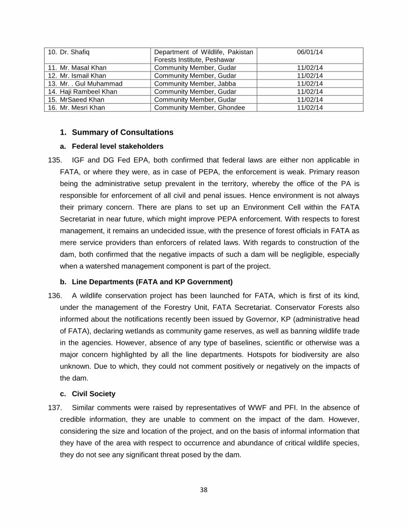
38
10. Dr. Shafiq Department of Wildlife, Pakistan Forests Institute, Peshawar
06/01/14
11. Mr. Masal Khan Community Member, Gudar 11/02/14
12. Mr. Ismail Khan Community Member, Gudar 11/02/14
13. Mr. . Gul Muhammad Community Member, Jabba 11/02/14
14. Haji Rambeel Khan Community Member, Gudar 11/02/14
15. MrSaeed Khan Community Member, Gudar 11/02/14
16. Mr. Mesri Khan Community Member, Ghondee 11/02/14
1. Summary of Consultations
a. Federal level stakeholders
135. IGF and DG Fed EPA, both confirmed that federal laws are either non applicable in
FATA, or where they were, as in case of PEPA, the enforcement is weak. Primary reason
being the administrative setup prevalent in the territory, whereby the office of the PA is
responsible for enforcement of all civil and penal issues. Hence environment is not always
their primary concern. There are plans to set up an Environment Cell within the FATA
Secretariat in near future, which might improve PEPA enforcement. With respects to forest
management, it remains an undecided issue, with the presence of forest officials in FATA as
mere service providers than enforcers of related laws. With regards to construction of the
dam, both confirmed that the negative impacts of such a dam will be negligible, especially
when a watershed management component is part of the project.
b. Line Departments (FATA and KP Government)
136. A wildlife conservation project has been launched for FATA, which is first of its kind,
under the management of the Forestry Unit, FATA Secretariat. Conservator Forests also
informed about the notifications recently been issued by Governor, KP (administrative head
of FATA), declaring wetlands as community game reserves, as well as banning wildlife trade
in the agencies. However, absence of any type of baselines, scientific or otherwise was a
major concern highlighted by all the line departments. Hotspots for biodiversity are also
unknown. Due to which, they could not comment positively or negatively on the impacts of
the dam.
c. Civil Society
137. Similar comments were raised by representatives of WWF and PFI. In the absence of
credible information, they are unable to comment on the impact of the dam. However,
considering the size and location of the project, and on the basis of informal information that
they have of the area with respect to occurrence and abundance of critical wildlife species,
they do not see any significant threat posed by the dam.
39
d. Communities
138. Community representatives unanimously approved the project, confirming the site is not
located within any critical habitat, nor have they sighted any species of special concern, in
the recent past. They identified the biodiversity hotspots which are located at considerable
distance to the dam site. They informed that the project was being undertaken with their
support, and that prior consultations have already taken place.
e. Future Consultations
139. Design stage consultations have already taken place, while another round will happen
prior to the initiation of construction, with the following objectives:
- To inform the communities of the scope of work, construction schedule, and likely
effects the construction activity will have on their routines
- Dissemination of EMP, and anticipated environmental impacts of the project, with the
suggested mitigation measures
- Information about Grievance Redress Mechanism, and access of communities to it
overall benefits of the project
G. Grievance Redress Mechanism
140. Keeping in mind the unique status of FATA, as well as the low literacy and technological
development in the area, a simple but effective Grievance Redress Mechanism (GRM) will
have to be designed by the Project Team. It must consist of multiple layers of contact points,
from Sub Agency to FATA Secretariat level, with telephone (both stationary and mobile)
being the main source of communications, followed by mail. The Political Administration will
have to designate a focal point for GRM, so as to facilitate the tribal communities in
contacting the Secretariat in Peshawar.
141. A typical Grievance Redress Mechanism, to be established by the project, is described
below:
142. FATA Secretariat/Project Director will facilitate the establishment of a Grievance Redress
Committee (GRC) and Grievance Focal Point (GFP) at the project location prior to the
Contractor’s mobilization to site. The functions of the GRC and GFPs are to address
concerns and grievances of the local communities and affected parties as necessary.
143. The GRC will comprise representatives from local political authorities (designate focal
point by PA), affected parties and other well-reputed persons from related sectors, as
mutually agreed with the Political Agent and affected persons. It will also comprise of

40
Contractor’s Environmental Specialist, FWRDP’s Environment Specialist and Social
Development/Safeguards Specialist. The role of the GRC is to address the Project related
grievances of the affected parties that are unable to be resolved satisfactorily through the
initial stages of the Grievance Redress Mechanism (GRM). The project will also assist
affected communities/villages identify local representatives to act as Grievance Focal Points
(GFP) for each community/village.
144. GFPs will ideally be designated personnel from within the community who will be
responsible for i) acting as community representatives in formal meetings between the
project team (including the contractors) and the local community he/she represents, and ii)
communicating community members’ grievances and concerns to the contractor during
project implementation. The number of GFPs to be identified for the project will depend on
the number and distribution of affected communities.
145. A pre-mobilization public consultation meeting will be convened by the FATA Secretariat
for SDIP, and will be attended by GFPs, contractor, Political Agents’ representative and
other interested parties (eg. Irrigation Dept, NGOs etc). Following the pre-mobilization public
consultation meeting, environmental complaints associated with the construction activity will
be routinely handled through the GRM as explained below:
(i) Individuals will lodge their environmental complaint/grievance with their respective
community’s nominated GFP.
(ii) The GFP will bring the individual’s complaint to the attention of the Contractor.
(iii) The Contractor will record the complaint in the onsite Environmental Complaints
Register (ECR) in the presence of the GFP.
(iv) The GFP will discuss the complaint with the Contractor and have it resolved;
(v) If the Contractor does not resolve the complaint within one week, then the GFP will
bring the complaint to the attention of the FWRDP’s Environmental Specialist. The
Environment Specialist will then be responsible for coordinating with the Contractor in
solving the issue.
(vi) If the Complaint is not resolved within 2 weeks the GFP will present the complaint to
the Grievance Redress Committee (GRC).
(vii) The GRC will have to resolve the complaint within a period of 2 weeks and the
resolved complaint will have to be communicated back to the community. The Contractor
will then record the complaint as resolved and closed in the Environmental Complaints
Register.
41
(viii) In parallel to the ECR placed with the Contractor, each GFP will maintain a record of
the complaints received and will follow up on their rapid resolution.
(ix) If the grievance is not resolved through this process, the issue will be taken to the local
legal structures (Jirga, PA Office)
Proposed Grievance Redress Mechanism
H. Environmental Management Plan
146. This section describes the potential environmental impacts, with a set of mitigation
measures and the institutional arrangements required to monitor, minimize and alleviate
those. An Environment Management Plan (EMP) is a comprehensive plan which describes
the mitigation measures to alleviate negative impacts, and enhance positive impacts
associated with a given project. Additionally, it suggests frequency, roles and responsibilities
for effective compliance and adherence to the Plan.
Gri
evan
ce
Red
ress
ed
C
om
mit
tee
Affected Person through GFP
Contractor
Not Redressed
Resolve through Local
Legal Process
Redressed
Resolve with Env Specialist FWRDP Redressed
Not Redressed
Appeal to Grievance Redress Committee Redressed
Not Redressed

42
1. Objectives of Environment Management Plan
147. An EMP serves as the guiding document for the project management to minimize and
manage any negative environmental or social impact, and enhance the positive impacts. Its
objectives usually are as follows:
- Inform the project team as well as the contractors of the potential impacts, the
mitigation measures and the costs involved in implementing the Plan
- Provide guidance on institutional and management structures required to implement
the Plan
- Provide compliance requirements, monitoring parameters and frequency of
monitoring
- Propose a capacity enhancement plan on areas related to environment and social
management
- Enable the Environment and Social Management Team of the project, to ensure and
oversee compliance
2. Institutional & Management Structures
a. Environment Management Unit
148. For an effective compliance of an EMP, roles and responsibilities need to be defined at
the onset, with relevant professionals hired as project team members at the executing or
implementing agency (E/IA) levels. Moreover, these professionals are to be placed in the
project hierarchy in such a way whereby they cannot be influenced by the operational teams
(engineers, procurement, contractors, etc.) in order to lessen their compliance monitoring
responsibilities.
149. For SDIP, an EMU is proposed to be set up within the Project Director’s (PD) Office at the
E/IA level, with direct reporting line to the PD. Ideally, an Environment Specialist and a
Social Development Specialist will need to be a part of the EMU so as to ensure compliance
to both parts of the EMP.
150. The responsibilities of EMU will be the following, but not limited to:
- Ensure effective compliance of EMP as per ADB Safeguards Policy requirements
- Provide technical assistance to the Project Team, in matters related to EMP in
particular, and to environmental and social safeguards as a whole
- Put in place reporting mechanism and monitoring regimes for project staff as well as
contractors

43
- Ensure that EMP related clauses specifically, and environment related clauses in
general, are part of all the tender/bid/RFP documents.
- Provide technical input to the various training programs proposed as a part of the
EMP
- Ensuring that all regulatory clearances (for example, Pak EPA) have been obtained
before starting civil works for the subproject.
- Conduct on site spot checks to check the compliance level, as well as for any
outstanding issue not being covered by the EMP
- Regularly report to PD as well as ADB on progress related to EMP Compliance

44
b. Environment Management Plan (Construction and Operational Stage)
Environmental Concerns
Mitigation Measures Implementation Supervision Cost
IEE Approval - Submit IEE to Fed EPA for approval and NOC for initiating construction
- Environment Specialist Project Director Suggested in Table 12
Land Resources
Excavation and blasting
- Contractor to be responsible as per contract document to minimize cutting of trees, use safety measures in handling explosives, prepare blasting schedules along with warning sirens, and ensure minimum damage to the landscape.
- Contractor - Constructor Engineer Included in the project costs
Construction waste - The contractor will find a suitable landfill site alongside the stream for burying construction waste. No solid waste will be disposed into the stream.
- Contractor - Construction Engineer - Environment Specialist
Included in the project costs
Labor camps and material storage
Contractor will
- Locate the labor camps and stores, at 2 km from the site at a secure location.
- Sanitation system along with solid and liquid waste management system will be put in place Latrines with septic tanks and land fill site for solid waste will be identified and constructed.
- Contractor - Construction Engineer
- Environment Specialist
Included in the project costs

45
Environmental Concerns
Mitigation Measures Implementation Supervision Cost
Soil Pollution due to fuel and oil spillage
- Contractor will follow strict rules for minimizing such spilling.
- Labor associated with fuel filling and storage will be trained in optimum filling techniques, as well as penalties will be set for spilling diesel or motor oil.
- In case of a spill, contractor will follow mitigation measures as per Guidelines for Oil Spill Waste Minimization and Management issued by International Petroleum Industry Environmental Conservation Associate.
- Contractor - Construction Engineer
- Environment Specialist
Included in the project costs except training costs which are included in Table 11
Soil pollution due to excessive application of fertilizers and pesticides
- Agriculture extension programs targeting use of IPM, green manure, and limiting use of pesticides to required levels only will target farmer communities to inform and train them
- FATA Agriculture Directorate
- Project Director Suggested in Table 12
Hydrology and Water Resources
Water quality and sedimentation load
- Monthly water sampling and testing will be conducted to ascertain water quality during different seasons. Samples at locations upstream and downstream of the dam will be drawn for testing
- Environment Specialist - Project Director Suggested in Table 12

46
Environmental Concerns
Mitigation Measures Implementation Supervision Cost
Use of irrigation water for cultivating high delta crops
- Cultivation of high delta crops will be strictly discouraged. Cropping pattern in accordance with the water balance model will be suggested and promoted.
- FATA Agriculture Department
- Project Director Suggested in Table 12
Surface water contamination due to washing etc.
- Contractor will demarcate a washing area for all sorts of washing activities, with running water facility connected to a dedicated drain flowing into the septic tanks
- Contractor - Construction Engineer Included in project costs
Drinking water - Contractor will get stream water tested for chemical and biological contaminants, and assist in providing filtration to make water drinkable.
- Contractor - Environment Specialist Suggested in Table 12
Municipal liquid and solid waste
- Contractor will ensure solid waste bins are placed at labor eating and resting areas. Latrines and washing areas with septic tanks will be erected by the contractor at the construction site.
- Contractor - Construction Engineer Included in project costs
Air Quality and Noise Pollution

47
Environmental Concerns
Mitigation Measures Implementation Supervision Cost
Noise Pollution due to use of old machinery
- The contractor will ensure use of newer, well maintained machinery creates minimum noise and emissions, as per NEQS, 2000)
- Vehicles used will be regularly checked for engine and exhaust noise.
- Night time construction activities will be discouraged strictly, especially no blasting will take place after sunset.
- Noise monitoring will be carried out near sensitive receptors on a monthly basis. The NEQS for noise residential areas is 55 dB(A) in the day time and 45 dB(A) at night. It is recommended that noise levels close to sensitive receptors do not exceed 55 dB(A) during the day time as required by the NEQS.
- Contractor - Construction Engineer Suggested in Table 12
Dust from construction and smoke from plants and machinery
- Contractor will use water sprinkling to minimize dust.
- The contractor will make best efforts to provide well maintained machinery in a workable condition and emits least possible emissions
- Vehicles will be regularly tuned, and checked for vehicular emissions to reduce air pollution
- Contractor Construction Engineer No additional costs

48
Environmental Concerns
Mitigation Measures Implementation Supervision Cost
Smoke from burning of waste or firewood
- Contractor shall strictly ban burning of waste or of wood, especially extracted from nearby shrubs and bushes. He must provide clean fuel to the labor to use for their daily purposes
- Contractor Construction Engineer No additional costs
Biological Resources
Damage to flora, fauna and habitat
- Contractor will ban extraction from the surrounding vegetation for fuelwood (or any other purpose), hunting of any birds/mammals/fish by the labor employed.
- If such a case is witnessed, it will be brought to the notice of the project management as well as the concerned APA
- Contractor - Environment Specialist - APA
Project Director
Socioeconomic and Cultural Issues
Tribal tensions and rivalries
- Ensure continuous liaison with the communities throughout the construction of the project, so as to identify any such incident in time.
- Relevant political authorities will be kept abreast of the progress, as well as any such issue if in making.
Social Development Specialist
Project Director No additional costs
49
Environmental Concerns
Mitigation Measures Implementation Supervision Cost
Community safety risks due to both accidental and natural hazards
- Dam site will be located away from any settlement, or any public place where communities visit (graveyards, shrines, schools, etc.)
- Public access to the site will be strictly prohibited, and a periphery fence will be erected.
- Construction Camp Site will have first aid facility, with certain staff trained to handle emergencies.
- Emergency Response Plan prepared and in place
- Contractor - Social Development Specialist
- Project Director
No additional costs
HSE protocols for labor
- Labour will be provided with protective gear including safety equipment, such as helmets, jackets, boots, torches, etc
- Fire safety plans will also be prepared and drills carried out
- Contractor
- Construction Engineer Suggested in Table 12

50
c. Environment Monitoring Plan
151. The overall responsibility for the environmental monitoring of the project lies with the EA.
Environmental performance of the project will be monitored by the EMU, assisted by the
Construction Supervision Engineer. The results will be communicated to ADB throughbi-annual
environmental monitoring reports prepared on ADB prescribed template. Indicators for the internal
monitoring will be those related to process and immediate outputs and results. This information will
be collected directly in the field by EMU, and reported monthly to the Project Director to assess the
environmental compliance.
152. Specific monitoring benchmarks will be:
(i) Contractor(s) compliance with EMP;
(ii) Complaints received and addressed by the Grievance Committee;
(iii) Environmental impacts other than perceived.
153. Monitoring activities during implementation will focus on recording implementation of mitigation
measures (as per EMP), recording environmental parameters, reviewing contractor environmental
performance and proposing remedial actions to address unexpected impacts during construction.
154. During the design phase, the monitoring activities will focus on
(i) checking the contractor’s bidding documents, particularly to ensure that all necessary
environmental requirements have been included;
(ii) checking that the contract documents’ references to environmental mitigation measures
requirements have been incorporated as part of contractor’s assignment.
155. During the construction period, the monitoring activities will focus on ensuring that environmental
mitigation measures are implemented, recording the project’s environmental achievements and to
guide any remedial action to address unexpected impacts.
Table 10 Environmental Monitoring Plan for SDIP
Monitoring Task Responsibility Timeline
1. Design phase 1.1 IEE submitted to Federal EPA and
NOC obtained Environment Specialist Prior to initiation of
construction and issuance of bidding documents
1.2 Review bidding documents to ensure EMP is included
Environment Specialist Prior to issuance of bidding documents
1.3 Training on EMP imparted to project staff
Environment Specialist and EMU
Prior to initiation of construction
2. Construction Phase
51
2.1 Monthly monitoring and bi-annual reporting of contractor’s compliance with environment mitigation measures
Environment Specialist Throughout construction
2.2 Monthly monitoring and bi-annual reporting of contractual obligations with regards to EMP
Environment Specialist Throughout construction
2.3 Monthly monitoring and bi-annual reporting of all grievances related to environment issues
Environment Specialist Throughout construction
2.4 Monthly monitoring and bi-annual reporting of all tasks assigned as per EMP
Environment Specialist Throughout construction
2.5 Quarterly review of EMP to make any adjustments
Environment Specialist Throughout construction
1. Operations and Maintenance 3.1 Observations during routine
maintenance inspections of facilities. Inspections will include monitoring implementation of operational mitigation measures as specified in EMP for operational impacts
Environment Specialist As per inspection workplan
d. Trainings and capacity enhancement
156. Various types of trainings have been suggested in the EMP for construction phase as well as post
construction. The target audience for these trainings also varies from the project staff, contractor’s
staff and communities at large. Table 10 describes the details:
Table 11 Capacity Enhancement Program
Training Session Learning Objectives Target Groups
1. Fuel and Oil Spillage To learn about optimum methods of fuel filling and storage
Contractor(s)
2. Health, Safety and Environment
Understanding HSE requirements and protocols,
Contractor(s), related project staff
3. Better Management Practices (BMP) in Agriculture
Improved methods of fertilizer and pesticide use, including on farm water management
Farmer communities
4. EMP implementation Understanding of implementation requirements and roles and responsibilities
Project Staff, contractors
Table 12 Estimated Costs associated with ESMP Implementation
Item Sub Item Costs in PKR (million)
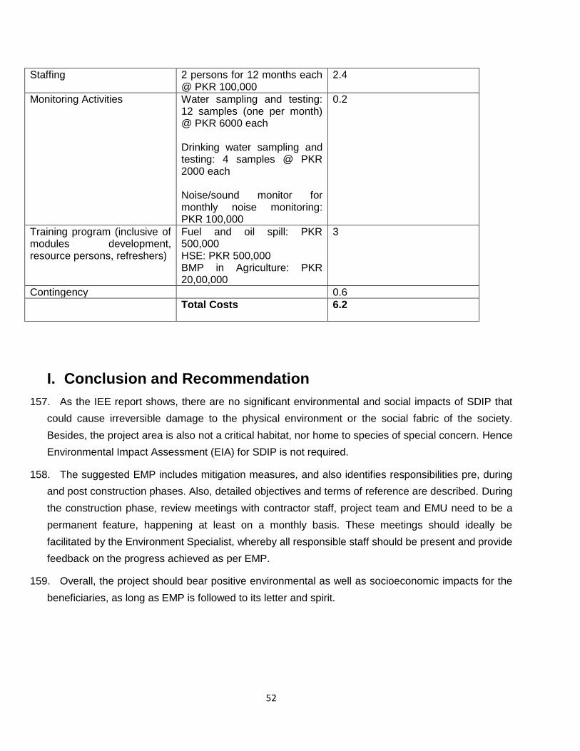
52
Staffing 2 persons for 12 months each @ PKR 100,000
2.4
Monitoring Activities Water sampling and testing: 12 samples (one per month) @ PKR 6000 each Drinking water sampling and testing: 4 samples @ PKR 2000 each Noise/sound monitor for monthly noise monitoring: PKR 100,000
0.2
Training program (inclusive of modules development, resource persons, refreshers)
Fuel and oil spill: PKR 500,000 HSE: PKR 500,000 BMP in Agriculture: PKR 20,00,000
3
Contingency 0.6
Total Costs 6.2
I. Conclusion and Recommendation
157. As the IEE report shows, there are no significant environmental and social impacts of SDIP that
could cause irreversible damage to the physical environment or the social fabric of the society.
Besides, the project area is also not a critical habitat, nor home to species of special concern. Hence
Environmental Impact Assessment (EIA) for SDIP is not required.
158. The suggested EMP includes mitigation measures, and also identifies responsibilities pre, during
and post construction phases. Also, detailed objectives and terms of reference are described. During
the construction phase, review meetings with contractor staff, project team and EMU need to be a
permanent feature, happening at least on a monthly basis. These meetings should ideally be
facilitated by the Environment Specialist, whereby all responsible staff should be present and provide
feedback on the progress achieved as per EMP.
159. Overall, the project should bear positive environmental as well as socioeconomic impacts for the
beneficiaries, as long as EMP is followed to its letter and spirit.

53

54
J. Annexures

55

56
Annexure 1 - Governor KPK Notification 1

57

58
Annexure 2 - Governor KPK Notification 2
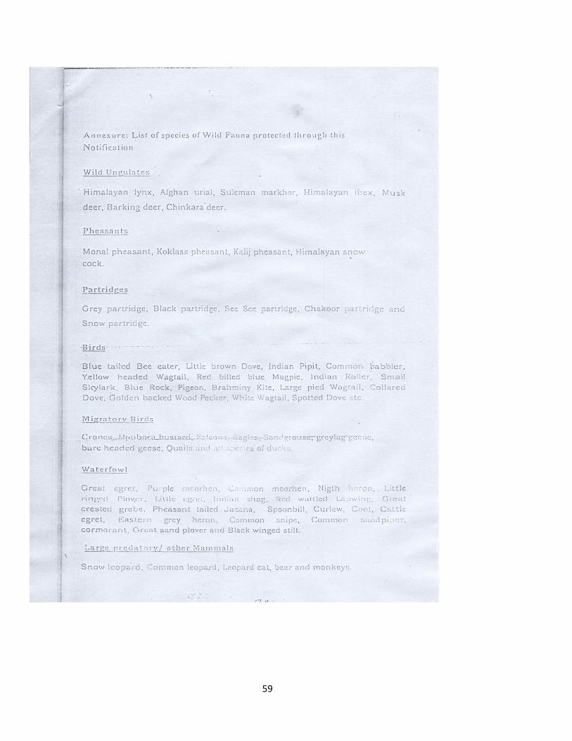
59

60
K. Figures
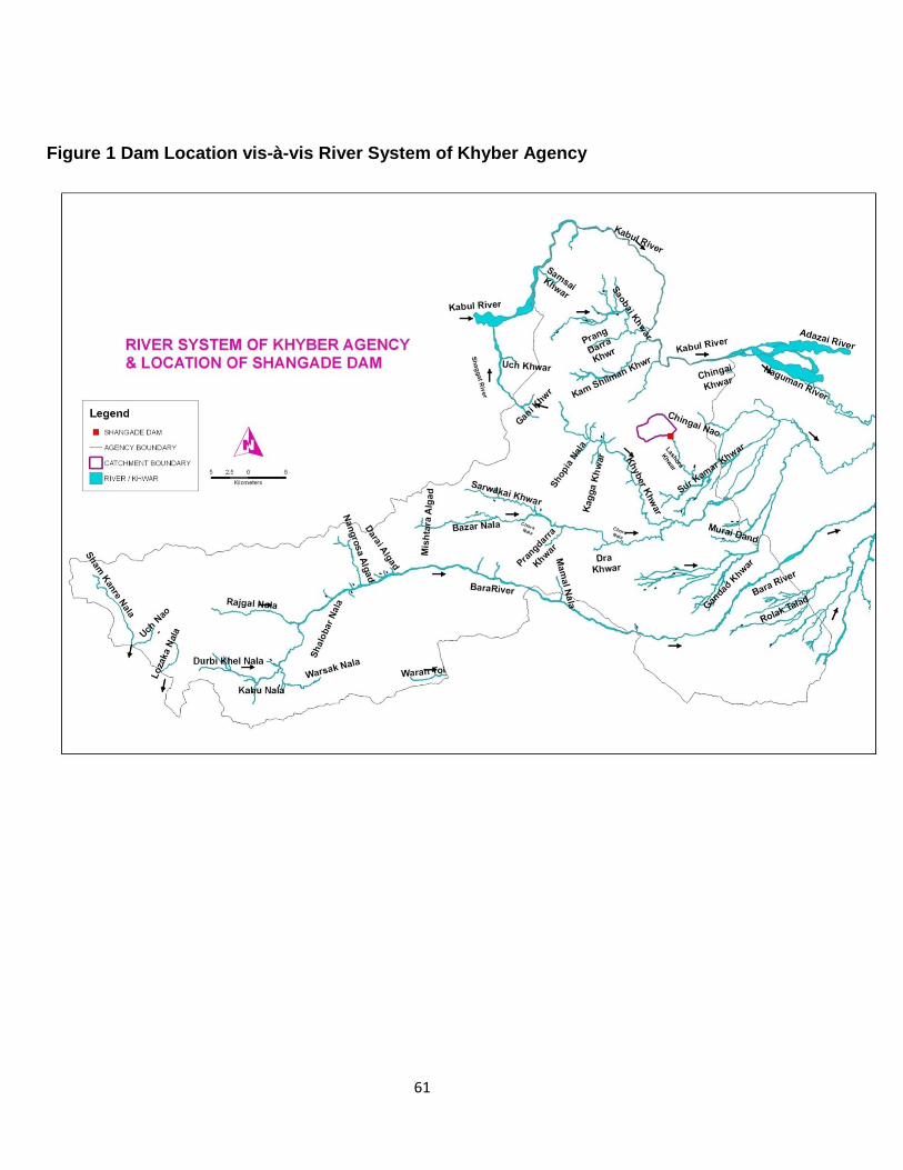
61
Figure 1 Dam Location vis-à-vis River System of Khyber Agency

62
Figure 2 Location, Catchment & Command Area of Shangade Dam
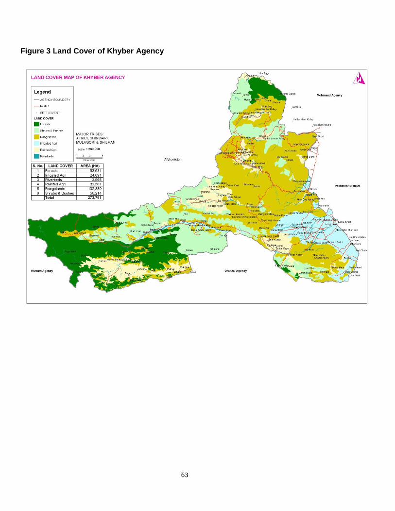
63
Figure 3 Land Cover of Khyber Agency

64
Figure 4 Dam Location vis-à-vis Tectonic Map of Pakistan

65
Figure 5 Dam Location vis-à-vis Seismic Zones of Pakistan

66
Figure 6 Land Cover of Shangade

67
Figure 8 Cropping Calendar for Khyber Agency
Cropping Calendar in the Project Area
Khyber Agency
Crops Jan Feb Mar Apr May Jun Jul Aug Sep Oct Nov Dec
Wheat
Fertigation-
irrigation early harvesting -Harvesting Prep.land sowing sowing L sowing
Carrot Prep.land sowing Management practices
Peas early harvesting -Harvesting Prep.land sowing irrigation MP
Turnip early harvesting -Harvesting Prep.land sowing MP MP
Raddish early harvesting -Harvesting Prep. land sowing MP MP
Tomato early harvesting -Harvesting Prep. land sowing MP MP MP
Onion Prep. land sowing MP MP MP
Potato1
Prep.
land sowing
MP MP
Potato 2
MP MP Harvesting
Prep.
land sowing
Maize
Prep.
land sowing MP early harvesting -Harvesting