INFLUENCE OF GROUNDWATER ON THE BEACH PROFILE … · Thanks for your pray, attention, and spiritual...
21
INFLUENCE OF GROUNDWATER ON THE BEACH PROFILE CHANGE NOR SUHAILA BINTI RAHIM A project report submitted in partial fulfilment of the requirements for the award of the degree of Master of Engineering (Civil – Hydraulics & Hydrology) Faculty of Civil Engineering Universiti Teknologi Malaysia JANUARY 2014
Transcript of INFLUENCE OF GROUNDWATER ON THE BEACH PROFILE … · Thanks for your pray, attention, and spiritual...
INFLUENCE OF GROUNDWATER ON THE BEACH PROFILE CHANGE
NOR SUHAILA BINTI RAHIM
A project report submitted in partial fulfilment of the
requirements for the award of the degree of
Master of Engineering (Civil – Hydraulics & Hydrology)
Faculty of Civil Engineering
Universiti Teknologi Malaysia
JANUARY 2014

iii
Specially dedicated to my beloved father and mother,
Rahim Bin Isa & Noraini Binti Salleh
And my siblings members
Thanks for your pray, attention, and spiritual support..........

iv
ACKNOWLEDGEMENTS
Assalamualaikum w.b.t.
It is a great pleasure to address those people who helped me throughout this
project to enhance my knowledge and practical skills especially in research area. My
deepest and most heartfelt gratitude goes to my supervisor, Dr Mohamad Hidayat for
his guidance and help. Thanks for all the kindness and shared experiences to help me
preparing this thesis. My deepest appreciation also goes to Mr Norasman for his
guidance and sharing experiences towards my master project. Further thanks go to all
staffs in NHC especially Lt Kdr Musa, RMN, DID, KEJORA, and METMalaysia for
assistance and cooperation towards this study. To all staffs in COEI, Department of
Hydraulics & Hydrology especially Mr Md Ridzuan, and my fellow friends; Izyan,
Mariahti, Mardhiah, Hana, Nabila, Thanwa, and Farahiyah; thanks a lot for your
criticisms and kindness.
Last but not least, thanks to my beloved family, who never give up in giving
me encouragement and enthusiasm to finish my master project. May Allah swt
rewards all of them for their kindness and sincerity.
Finally, I would also like to thank everyone who has contributed whether
directly or indirectly to this project. This project would have been impossible without
your guidance, advice and support. I hope this project will be useful for future use.
Thank you.

v
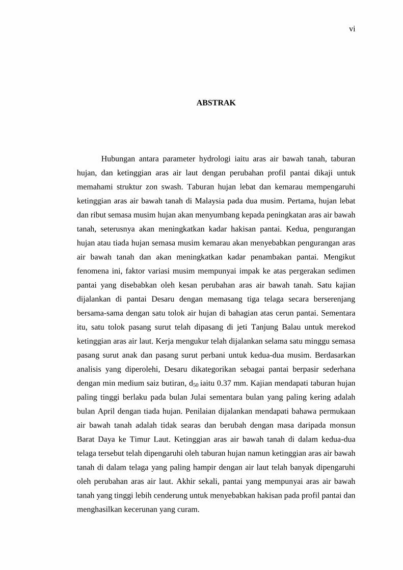
ABSTRACT
Relationships of hydrological parameters which are groundwater level,
rainfall, and tides to the beach profile change of a beach are examined in order to
advance understanding on swash zone morphology. Heavy rainfall and drought affect
the groundwater level in Malaysia during two seasons. First, heavy rainfall and
storms contribute to higher groundwater level during the wet season; thereby
enhance the erosion rate. Second, lesser rainfall or no rain during the dry season will
drop the groundwater level and enhances the accretion rate. According to this
phenomenon, seasonal variation factor has significant impact to the sediment
transport due to the groundwater level effects. A field investigation is conducted at
Desaru beach with three monitoring wells are installed cross shore to the beach along
with a rain gauge at the upslope. A tide gauge is installed at jetty Tanjung Balau in
order to record the water level. Two field works are done for one week during spring
and neap tides for both seasons. From the analysis obtained, Desaru is categorised as
medium-sandy beach with the mean of medium grain size, d50 = 0.37 mm. It is found
that the highest rainfall occurred on July while the driest month occurred on April
with no rainfall at all. Observations from both monitoring wells show that the
groundwater surface is generally not flat but fluctuated with time from the Southwest
to the Northeast monsoon. The beach groundwater levels in the two monitoring wells
were affected by rainfall however groundwater level in the well that located near to
the shore is highly affected by tidal fluctuation. Finally, it is found that beach with
high groundwater level tends to erode and producing flatter gradient.
vi
ABSTRAK
Hubungan antara parameter hydrologi iaitu aras air bawah tanah, taburan
hujan, dan ketinggian aras air laut dengan perubahan profil pantai dikaji untuk
memahami struktur zon swash. Taburan hujan lebat dan kemarau mempengaruhi
ketinggian aras air bawah tanah di Malaysia pada dua musim. Pertama, hujan lebat
dan ribut semasa musim hujan akan menyumbang kepada peningkatan aras air bawah
tanah, seterusnya akan meningkatkan kadar hakisan pantai. Kedua, pengurangan
hujan atau tiada hujan semasa musim kemarau akan menyebabkan pengurangan aras
air bawah tanah dan akan meningkatkan kadar penambakan pantai. Mengikut
fenomena ini, faktor variasi musim mempunyai impak ke atas pergerakan sedimen
pantai yang disebabkan oleh kesan perubahan aras air bawah tanah. Satu kajian
dijalankan di pantai Desaru dengan memasang tiga telaga secara berserenjang
bersama-sama dengan satu tolok air hujan di bahagian atas cerun pantai. Sementara
itu, satu tolok pasang surut telah dipasang di jeti Tanjung Balau untuk merekod
ketinggian aras air laut. Kerja mengukur telah dijalankan selama satu minggu semasa
pasang surut anak dan pasang surut perbani untuk kedua-dua musim. Berdasarkan
analisis yang diperolehi, Desaru dikategorikan sebagai pantai berpasir sederhana
dengan min medium saiz butiran, d50 iaitu 0.37 mm. Kajian mendapati taburan hujan
paling tinggi berlaku pada bulan Julai sementara bulan yang paling kering adalah
bulan April dengan tiada hujan. Penilaian dijalankan mendapati bahawa permukaan
air bawah tanah adalah tidak searas dan berubah dengan masa daripada monsun
Barat Daya ke Timur Laut. Ketinggian aras air bawah tanah di dalam kedua-dua
telaga tersebut telah dipengaruhi oleh taburan hujan namun ketinggian aras air bawah
tanah di dalam telaga yang paling hampir dengan air laut telah banyak dipengaruhi
oleh perubahan aras air laut. Akhir sekali, pantai yang mempunyai aras air bawah
tanah yang tinggi lebih cenderung untuk menyebabkan hakisan pada profil pantai dan
menghasilkan kecerunan yang curam.

vii
TABLE OF CONTENTS
CHAPTER CONTENT PAGE
TITLE i
DECLARATION ii
DEDICATIONS iii
ACKNOWLEDGMENTS iv
ABSTRACT v
ABSTRAK vi
TABLE OF CONTENTS vii
LIST OF TABLES x
LIST OF FIGURES xi
LIST OF ABREVATIONS xiii
LIST OF SYMBOLS xiv
LIST OF APPENDICES xv
1 INTRODUCTION 1
1.1 General 1
1.2 Problem Statement 2
1.3 Objectives of Study 4
1.4 Scope of Study 4
1.5 Importance of Study 4
2 LITERATURE REVIEW 5
2.1 Coastal Zone 5
2.1.1 Swash Zone 6
2.1.2 Surf Zone 8
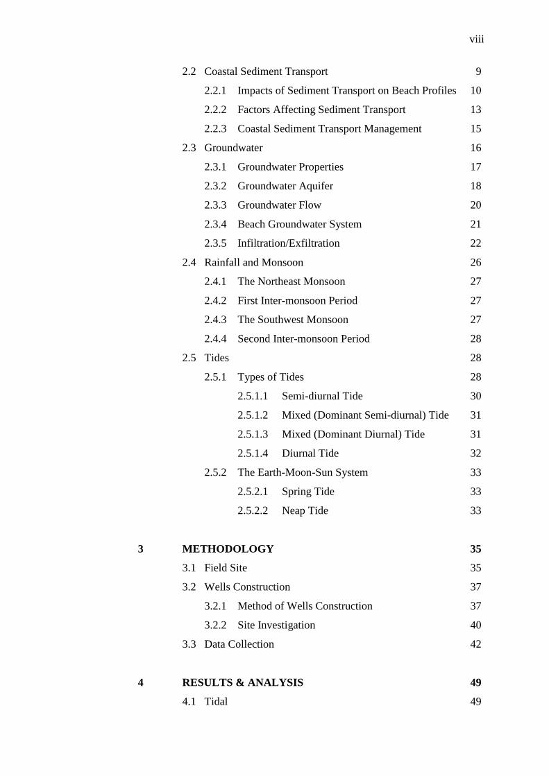
viii
2.2 Coastal Sediment Transport 9
2.2.1 Impacts of Sediment Transport on Beach Profiles 10
2.2.2 Factors Affecting Sediment Transport 13
2.2.3 Coastal Sediment Transport Management 15
2.3 Groundwater 16
2.3.1 Groundwater Properties 17
2.3.2 Groundwater Aquifer 18
2.3.3 Groundwater Flow 20
2.3.4 Beach Groundwater System 21
2.3.5 Infiltration/Exfiltration 22
2.4 Rainfall and Monsoon 26
2.4.1 The Northeast Monsoon 27
2.4.2 First Inter-monsoon Period 27
2.4.3 The Southwest Monsoon 27
2.4.4 Second Inter-monsoon Period 28
2.5 Tides 28
2.5.1 Types of Tides 28
2.5.1.1 Semi-diurnal Tide 30
2.5.1.2 Mixed (Dominant Semi-diurnal) Tide 31
2.5.1.3 Mixed (Dominant Diurnal) Tide 31
2.5.1.4 Diurnal Tide 32
2.5.2 The Earth-Moon-Sun System 33
2.5.2.1 Spring Tide 33
2.5.2.2 Neap Tide 33
3 METHODOLOGY 35
3.1 Field Site 35
3.2 Wells Construction 37
3.2.1 Method of Wells Construction 37
3.2.2 Site Investigation 40
3.3 Data Collection 42
4 RESULTS & ANALYSIS 49
4.1 Tidal 49

ix
4.2 Particle Size Distribution 51
4.3 Rainfall 53
4.3.1 Monthly Rainfall 53
4.3.2 Number of Rainy Days 54
4.4 Beach Groundwater 55
4.5 Groundwater Levels and Rainfall 57
4.6 Groundwater Level and Tides 59
4.7 Beach Profiles 60
4.7.1 Beach Profiles (28 June & 24 Aug 2013) 60
4.7.2 Beach Profiles (24 Aug & 28 Oct 2013) 61
4.7.3 Beach Profiles (28 Oct & 16 Nov 2013) 63
5 CONCLUSIONS AND RECOMMENDATIONS 66
5.1 Conclusions 66
5.2 Recommendations 68
REFERENCES 70
Appendices 74
Appendix A 75
Appendix B 81
Appendix C 83
x
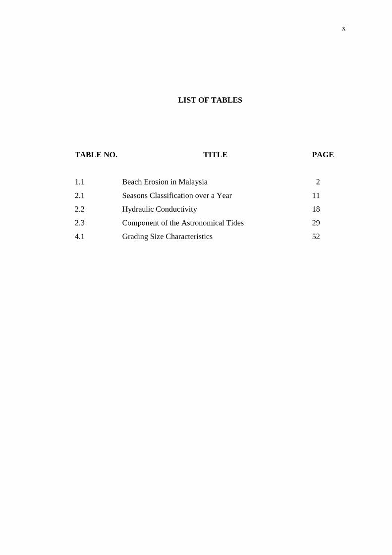
LIST OF TABLES
TABLE NO. TITLE PAGE
1.1 Beach Erosion in Malaysia 2
2.1 Seasons Classification over a Year 11
2.2 Hydraulic Conductivity 18
2.3 Component of the Astronomical Tides 29
4.1 Grading Size Characteristics 52
xi
LIST OF FIGURES
FIGURE NO. TITLE PAGE
1.1 Beach Erosion in Peninsular Malaysia 3
2.1 Coastal Zone 6
2.2 Definition of Swash Zone 7
2.3 Beach Profiles on Seasonal Change 12
2.4 Seasonal Change in Cross-sectional Area 13
2.5 Schematic Cross-section of Aquifer 19
2.6 Hydrologic Cycle 20
2.7 Beach Groundwater System 22
2.8 (a) Schematic Representation of Infiltration on the Uprush:
(1) Sediment Destabilisation and (2) Boundary Layer
Thickening 24
2.8 (b) Schematic Representation of Exfiltration on the Backwash:
(1) Sediment Stabilisation and (2) Boundary Layer
Thinning 24
2.9 (a) Discharge for Static Sea Level 25
2.9 (b) Discharge and Infiltration for Dynamic Tidal Cycle
during (1) high tide, (2) ebb tide, (3) low tide, and
(4) flood tide 25
2.10 Current Directions in South China Sea 26
2.11 Typical Ratio (F) Values in Malaysia 30
2.12 Semi-diurnal Tide 30
2.13 Mixed Semi-diurnal Tide 31
2.14 Mixed Diurnal Tide 32
2.15 Diurnal Tide 32

xii
2.16 Spring Tide 33
2.17 Neap Tide 34
3.1 Location of Desaru in Peninsular Malaysia 36
3.2 (a) Boring and Drilling Pump at BH1 38
3.2 (b) Boring and Drilling Pump at BH2 38
3.2 (c) Boring and Drilling Pump at BH3 39
3.3 Typical Monitoring Well Construction 40
3.4 Soil Profile 41
3.5 Rain Gauge Station at Field Site 42
3.6 Acoustic Doppler Velocimeter 43
3.7 Pressure Transducer 44
3.8 Optical Backscatter Sensor 45
3.9 Tide Gauge at Tanjung Balau Jetty 46
3.10 Surveying Field Works from BH2 47
3.11 Schematic Diagram of Field Work at Desaru 48
3.12 Arrangement at the Field Site in Desaru 48
4.1 Tidal in Desaru 50
4.2 Particle Size Distribution during Neap and Spring Tide 51
4.3 Monthly Rainfall 54
4.4 Number of Rainy Days 55
4.5 (a) Groundwater Levels (28 June to 24 August 2013) 56
4.5 (b) Groundwater Levels (28 October to 16 November 2013) 56
4.6 Groundwater Levels and Rainfall 58
4.7 Groundwater Level and Tides 59
4.8 Beach Profiles (28 June & 24 Aug 2013) 61
4.9 Beach Profiles (24 Aug & 28 Oct 2013) 62
4.10 Wave Rose for October 63
4.11 Beach Profiles (28 Oct & 16 Nov 2013) 64
4.12 Wave Rose for November 65

xiii
LIST OF ABREVATIONS
ACD Admiralty Chart Datum
ADV Acoustic Doppler Velocimeter
BH Borehole
COEI Coastal and Offshore Engineering Institute
DID Department of Irrigation and Drainage
DOE Department of Environment
EIA Environmental Impact Assessment
ICSZ Integrated Coastal Zone Management
ISMP Integrated Shoreline Management Plan for Malaysia
KEJORA South Johor Development Authority
LS Lower Swash
LSD Land Survey Datum
METMalaysia Malaysia Meteorology Department
MHHW Mean Higher High Water
MHLW Mean Higher Low Water
MLHW Mean Lower High Water
MLLW Mean Lower Low Water
MS Middle Swash
MSL Mean Sea Level
N Neap
NHC National Hydrographic Centre
PT Pressure Transducer
RMN Royal Malaysian Navy
S Spring
US Upper Swash

xiv
LIST OF SYMBOLS
β Beach Profile Gradient
°C Degree Celsius
Cc Coefficient of Gradation
Cu Uniformity Coefficient
d50 Medium Grain Size
d10 Effective Size
g Gram
hr Hour
km Kilometre
m Meter
min Minute
mm Millimetre
% Percent

xv
LIST OF APPENDICES
APPENDIX TITLE PAGE
A Sieve Analysis 75
B Astronomical Tides in Tanjung Balau 81
C Groundwater, Rainfall, & Tides 83
CHAPTER 1
INTRODUCTION
1.1 General
To advance understanding on swash zone morphology with a complex
interaction between beach profiles at different groundwater level; relationships of
hydrological parameters which are rainfall, groundwater level, and tides to the
morphological changes of a beach were examined. Cross-shore beach profile change
is commonly used by many researchers as it is one of the main features in natural sea
coasts that can be directly used to estimate the accretion or erosion process within the
swash zone.
Malaysia is known as one of Asian country which located near the equator
that experience hot and humid climates throughout the year. Malaysia is mostly
affected by the climate change that increased seawater levels, rainfall, flooding risks,
and leading to extreme droughts. There are two dominant monsoons wind season in
Malaysia which are the Northeast Monsoon and Southwest Monsoon. The Northeast
Monsoon is generally carried in more rainfall compared to the Southwest Monsoon.
Thus, the Northeast Monsoon is normally addressed as wet season which starts from
November to March while the Southwest Monsoon is addressed as dry season which
starts from June to September.

2
1.2 Problem Statement
Heavy rainfall and drought affect the groundwater level in the swash zone
mostly during the two seasons as mentioned earlier. Firstly, heavy rainfall and storms
contribute to higher groundwater level during the wet season; thereby enhance the
erosion rate in the swash zone. Secondly, lesser rainfall or no rain during the dry
season will drop the groundwater level. During this season, more or less, the drop in
the groundwater level will enhance the accretion rate in the swash zone. This
situation can be concluded that beaches in Malaysia are likely to erode during the
wet season and accrete during the dry season. According to this phenomenon,
seasonal variation factor has significant impact to sediment transport due to the
groundwater level effect primarily in the swash zone.
Table 1.1: Beach Erosion in Malaysia (Source: DID, 2012)
States Length of Beach
(km)
Number of Beach
Erosion
Percentage of
Erosion (%)
Perlis 20 8 72.50
Kedah 148 20 29.40
Pulau Pinang 152 15 41.60
Perak 230 10 61.00
Selangor 213 20 71.30
N. Sembilan 58 7 42.20
Melaka 73 9 50.30
Johor 492 29 47.70
Pahang 271 22 46.30
Terengganu 244 22 62.50
Kelantan 71 11 73.40
W.P. Labuan 59 6 51.90
Sarawak 1035 25 4.80
Sabah 1743 19 17.00
Total 4,809 223

3
Table 1.1 shows the percentage, number, and length of eroded beaches
experienced in Malaysia. Malaysia has 4,809 km long with 223 numbers of disturbed
or undisturbed eroded beaches. According to DID (2012), Johor experience the
highest amount of eroded beaches in Peninsular Malaysia which is 29 beaches with
234.8 km beach length. Figure 1.1 shows the beach erosion at different states in
Peninsular Malaysia. It is shown that the beaches in the Northeast of Johor
experienced greatest erosion rate. Hence, Desaru beach which located at the
Northeast of Johor is chosen as the study site in order to estimate the beach
morphological change within the swash zone.
Figure 1.1: Beach Erosion in Peninsular Malaysia (Source: DID, 2012)

REFERENCES
Aagaard, T. and Hughes, M.G. (2006). Sediment Suspension and Turbulence in the
Swash Zone of Dissipative Beaches. Marine Geology 228, 117-135
Alley, W.M., Reilly, T.E., and Franke, O.L. (1999). Sustainability of Ground-Water
Resources. U.S. Department of the Interior, U.S. Geological Survey Circular
1186, 1-79
Ataie-Ashtiani, B., Volker, R.E., and Lockington, D.A. (2001). Tidal Effects on
Groundwater Dynamics in Unconfined Aquifers. Hydrological Processes 15,
655-669
Austin, M.J. and Masselink, G. (2006). Swash-groundwater Interaction on a Steep
Gravel Beach. Continental Shelf Research 26, 2503-2519
Bakhtyar, R., Barry, D.A., Li, L., Jeng, D.S., and Bakhtiary, A.Y. (2009). Modeling
Sediment Transport in the Swash Zone : A Review. Journal of Ocean
Engineering 36, 767-783
Butt, T., Russell, P., and Turner, I. (2001). The Influence of Swash Infiltration -
Exfiltration on Shoreline Sediment Transport: Onshore or Offshore? Coastal
Engineering 42, 35-52
Cartwright, N. (2004). Groundwater Dynamics and the Salinity Structure in Sandy
Beaches. Journal of Coastal Engineering, University of Queensland, 1841-1850
Davidson-Arnott, R. (2010). Introduction to Coastal Processes and Geomorphology.
Cambridge: Cambridge University Press
Davidson-Arnott, R. and Greenwood, B. (2011). Waves and Sediment Transport in
the Nearshore Zone. Encyclopedia of Life Support System (EOLSS), 1-4
DID (2012), Coastal Management –Activities. Department of Irrigation and
Drainage, retrieved: 10 Dec 2013, from: http://www.water.gov.my/our-services-
mainmenu-252/coastal-management-mainmenu-279/activities-mainmenu-184
71
Doodson, A.T. (1921). The Harmonic Development of the Tide-generating Potential.
Proc. Roy. Soc. London, A, 100
Elfrink, B. and Baldock, T. (2002). Hydrodynamics and Sediment Transport in the
Swash Zone: A Review and Perspectives. Journal of Coastal Engineering, 149-
167
Hashim, N.B., Shamsudin, S., Camerlengo, A.L., and Malek, A.R.A. (2008).
Evaluation of the Behaviour of the Sea Level of the Malaysian Waters during El
Nino and La Nina Events. Research Management Centre, Universiti Teknologi
Malaysia, 70
Hayashi, K., Mori, N., Mase, H., Kuriyama, Y., and Kobayashi, N. (2012).
Influences of Climate Change on Beach Profile. Coastal Engineering
Proceedings 1(33), Sediment 17
Hoe, T.S. (2010). The Malaysian Sea Level Monitoring Network. Third Issue of
GLOSS Bulletin, Afro-America GLOSS News
Horn, D.P. (2002). Beach Groundwater Dynamics. Geomorphology 48, 121-146
Horn, D.P. (2006). Measurements and Modeling of Beach Groundwater Flow in the
Swash Zone : A Review. Continental Shelf Research 26, 622-652
Horn, D.P., Baldock, T.E., and Li, L. (2007). The Influence of Groundwater on
Profile Changes of Fine and Coarse Sand Beaches. Coastal Sediments 07, ASCE,
506-519
Huey, T.T. and Ibrahim, A.L. (2012). Statistical Analysis of Annual Rainfall Patterns
in Peninsular Malaysia Using TRMM Algorithm. In Proc. The 33rd
Asian
Conference on Remote Sensing (ACRS), Pattaya, Thailand
Iverson, R.M. and Major, J.J. (1987). Rainfall, Ground-water Flow, and Seasonal
Movement at Minor Creek Landslide, Northwestern California: Physical
Interpretation of Empirical Relations. Geological Society of America Bulletin
v.99, 579-594
Jensen, S.G., Aagaard, T., and Baldock, T.E. (2010). Swash Zone Bed Level
Changes and Sediment Entrainment at the Surf-Swash Boundary. Coastal
Engineering Proceedings, No. 32: Proceedings of 32nd
Conference on Coastal
Engineering, Shanghai, China, 2010
Julien, P.Y. (2010). Erosion and Sedimentation. British Library (2nd
Edition),
University Press, Cambridge, United Kingdom

72
Kobayashi, N. (1999). Numerical Modeling of Wave Run-up on Coastal Structures
and Beaches. Journal of Marine Technology Society, 33-37
Lee, K.H., Mizutani, N., Hur, D.S., and Kamiya, A. (2007). The Effect of
Groundwater on Topographic Changes in a Gravel Beach. Ocean Engineering
34, 605-615
Lin, Y.F., Wang, J., and Valocchi, A.J. (2008). Making Groundwater Recharge and
Discharge Estimate Maps in One Day: An ArcGIS 9.2 Application for Water
Resources Research. ArcUser 11, No. 1, 32-35
Lu, Y. (2012). Weather Sensitivity of Maritime Activities on Chinese Shelf. Journal
of Science and Technology, University of Stavanger, 104
Marsily, G.D. (1986). Quantitative Hydrogeology: Groundwater for Engineers.
Academic Press, Inc (1st Edition), 440
Masselink, G. and Hughes, M.G. (1998). Field Investigation of Sediment Transport
in the Swash Zone. Continental Shelf Research 18, 1179-1199
Masselink, G. and Hughes, M.G. (2003). An Introduction to Coastal Processes and
Geomorphology. Edward Arnold Publishers, 354
Mohamad, N.A (2010). River Mouth Stability of Sungai Papar, Sabah. Journal of
Civil-Hydraulics and Hydrology, 17-87
Nielsen, P. (1988). Wave Setup: A Field Study. Journal of Geophysical Research 93
(C12), 15643-15662
Pierce, R. (2012). The Seasons. Math Is Fun. Retrieved: 26 Dec 2013, from:
http://www.mathsisfun.com/measure/seasons.html
Rivera, A., Allen, D.M., and Maathuis, H. (2004). Climate Variability and Change –
Groundwater Resources. Chapter 10 of Threats to Water Availability in Canada,
NWRI Scientific Assessment Report Series No. 3 and ACSD Science Assessment
Series No. 1, 128
Scherer, W., Stoney, W.M., Mero, T.N., O’Hargan, M., Gibson, W.M., Hubbard,
J.R., Weiss, M.I., Varmer, O., Via, B., Frilot, D.M., and Tronvig, K.A. (2001).
Tidal Datums and Their Applications. NOAA Special Publication NOS CO-OPS
1, Centre for Operational Oceanographic Products and Services
Seidel, G.S. (1991). An Experimental Investigation of the Effects of Tides on
Subsurface Drains Used for Beach Stabilization. Journal of the Institute of Civil
Engineers, Theses and Dissertations, Paper 17, 27-54

73
Smith, J.M. (2003). Surf Zone Hydrodynamics. Coastal Engineering Manual, Part
II, Engineering Manual, EM 1110-2-1100, U.S. Army Corps of Engineers,
Washington, D.C.
Sorensen, R.M. (2006). Basic Coastal Engineering. Springer US (3rd
Edition),
Springer Science+Business Media, Inc., 247-286
Topper, R., Spray, K.L., Bellis, W.H., Hamilton, J.L., and Barkmann, P.E. (2003).
Groundwater Atlas of Colorado. Chapter 2 of Special Publication 53, Colorado
Geological Survey
Urish, D.W. and McKenna, T.E. (2004). Tidal Effects on Groundwater Discharge
Through a Sandy Marine Beach. National Groundwater Association Volume 42,
No.7, 971-982
U.S. Army Corps of Engineers (1984). Shore Protection Manual. Coastal
Engineering Research Center, Volume I (4th
Edition), U.S. Government Printing
Office Washington, D.C.
Wackerman, C.C., Clemente-Colón, P. (2004). Wave Refraction, Breaking and Other
Near-Shore Processes. In: Jackson C, Apel J (ed) Synthetic Aperture Radar
Marine User’s Manual, U.S. Department of Commerce and NOAA, Washington
DC, 171-187
Wu, L. (2009). Experimental Research on Effect of Tide for Alongshore
Groundwater level. Journal in Water Resources and Hydraulics Engineering,
785-788