In Partial Fulfillment of the Requirement for the Degree ...
47
0 RETHINKING TRANSPORTATION AND THE BUILT ENVIORNMENT DEVELOPMENT; Examining The Impacts of Path Dependence On Car Infrastructure in Bahrain A Thesis Presented to the faculty of the graduate school of Architecture and Planning Columbia University In Partial Fulfillment of the Requirement for the Degree Master of Science in Urban Planning By Mohammed AlKhalifa May 2, 2018 Advisor: Dr. Hiba Bou Akar Reader: Andrea Marpillero-Colomina
Transcript of In Partial Fulfillment of the Requirement for the Degree ...

0
RETHINKING TRANSPORTATION AND THE BUILT ENVIORNMENT DEVELOPMENT;
Examining The Impacts of Path Dependence On Car Infrastructure in Bahrain
A Thesis Presented to the faculty of the graduate school of Architecture and Planning
Columbia University
In Partial Fulfillment of the Requirement for the Degree
Master of Science in Urban Planning
By
Mohammed AlKhalifa
May 2, 2018
Advisor: Dr. Hiba Bou Akar
Reader: Andrea Marpillero-Colomina

1
Table of contents
Abstract……………………………………………………………………………….2
Introduction……………………………………………………………………………4
Background……………………………………….……………………………………5
Methodology ……………………………………..……………………………………7
The Built Environment…………………………………………………………………8
The Economy………………………...…………………………………………………13
Health………………………………….……………..…………………………………21
Interview Findings………………………………………………………………………24
Interventions………………………………………….…………………………………30
Conclusion………………………………………………………………………………38
Citations……………………………….………………………………..………………41
Appendix……………………………….………………………….……………………45

2
Abstract:
A well-built and sturdy transportation
infrastructure can be extremely beneficial to
a metropolis, as mobility is key to
supporting sustainability. Cities and
metropolises grow and expand as population
increases within an urban space, and the
city’s authorities are mainly responsible for
maintaining and upholding efficient modes
of mobility. A community that lacks
infrastructure for mobility is thus not
sustainable because there won’t be a steady
inflow of people and goods needed for a
city’s survival.
A path-dependent system is one in which the
initial conditions play a key role in
determining future structure (Smith 2011,
p32). In the case of Bahrain, path
dependence refers to the country’s heavy
dependence on the automobile as a primary
mode of transport.
The built environment of a city plays a key
role in determining whether or not that city
and its inhabitants are flourishing.
According to the United Nations, 70% of the
world’s population will live in cities in the
year 2050. This means that tens of thousands
of people will be moving into dense urban
spaces, and everyone is going to need a
place to live, a chance to make a living, and
the ability to move around their city.
This paper will evaluate the impacts of car
dependence on Bahrain’s economy, its built
environment, and the health of its citizens.
Additionally, the research will explore
alternative and more sustainable methods for
development by diverting away from auto
dependence and improving access to
mobility within the country.

3
Departments of government that oversee
transportation:
The Ministry of Transportation oversees the
public bus network, international airport,
national airline, and ports.
The Ministry of Works and Urban Planning
oversees the planning and construction of
new roads, highways, and bridges.
The Traffic Police are a special division of
the police that specifically deal with law
enforcement, traffic control and monitoring,
and collect traffic violation fees.

4
Introduction:
In Bahrain, with many
neighborhoods having little to no sidewalks,
public parks, and alternative modes of
transportation, a car-centric infrastructure is
the only option people have of getting
around. With an area of just 765 km2—
slightly smaller than the state of Rhode
Island—and ranked the seventh-densest
country in the world, Bahrain needs to
develop its infrastructure to cope with its
growing population. The more people
exclusively use cars as their mode of
mobility, the less physically active they are,
which does not benefit the health of the
Bahrainis.
The issue of car culture and path
dependence is not exclusive to Bahrain, as
many cities and countries around the world
face similar problems such as traffic
congestion, pollution, and scarce space. This
is exactly why more research must be
conducted and tough regulations must be
passed by city planners —to study the
region’s mobility infrastructure with the
purpose of working towards efficient and
sustainable cities. The significance of this
information will hopefully drive officials to
invest in upgrading urban infrastructure to
eradicate inefficient path dependencies by
encouraging movement and activity.
The argument I am making is that
path dependency on prioritizing car
infrastructure and the lack of regulation
around car parking in Bahrain dramatically
hinders long term sustainable development,
because path dependency prevents the
diversification of mobility of people, creates
congestion, and causes the government to
lose a lot of money in potential tax revenue.
The purpose of my research is to
analyze the impacts of car dependence on
Bahrain’s built environment, economy, and
health of citizens. The aim is to show the
effects of past planning methods, and the
results of path dependency.
The car has become a major symbol
of status and wealth, which tends to leave a
large portion of the population unpersuaded
to leave their individual cars for public
transportation. This is exactly why the
intended audience of my research is the
people of Bahrain, as it is crucial for the
citizens to be aware of how things such as
unorganized car parking and weak
transportation planning, and how these
uncertainties create a negative multiplier
effect that hinders development.
For young Bahrainis, one of the
greatest points of excitement and freedom is
turning 18, because that is when they can
legally obtain their driver’s license.
However, that excitement is only temporary,
as the freedom of moving around is hindered
by the amount of time wasted in traffic and
looking for parking.
Infrastructure such as rail and bus
rapid transit (BRT) has never been built in
Bahrain, and highway construction and
expansion has been the norm since cars were
first introduced in the 1940s.

5
Background
The Bahrain Islands occupy a strategic
position in the Arabian Gulf that has been a
locus for maritime trade for well over 4,000
years (Potts 3, 1983).
In his book, Dilmun: New Studies In The
Archaeology and Early History of Bahrain
(1983), Daniel T. Potts mentions that one of
the things that attracted initial settlers to
Bahrain was the availability of artesian
water and vegetation sufficient for a small
population. With the availability of the most
essential human life source, water, Bahrain
was ripe for civilization to flourish.
Image 1: Map of ancient trade routes that
included Bahrain as a trade point.
The map displayed above, published by the
School of Oriental and African Studies,
shows ancient trade routes that include
Bahrain as one of the trading destinations
between Mesopotamia and the Indus Valley.
In pre-Islamic and early Islamic times,
Bahrain depended on its harbour for its
prosperity (Brice 135, 1983).
Whether pearling, fishing, or spices, trade
was the center of Bahrain’s economy, and
advancement in ship-building techniques
allowed goods and people to flow in and out
of the island.
Image 2: The Bahraini town of Muharraq in
the 1950s.
The image shown above shows the Bahraini
city of Muharraq in the 1950s. The image
displays the typical structures of towns in
Bahrain in the first half of the 20th century,
with no roads and highways, and buildings
built close to each other. Although the
structure lacked any zoning codes, the city
was an efficient place to live because people
lived within walking distance of schools,
markets, and workplaces. Furthermore, with
development focused close to sea and
having cooling methods such as palm tree
leaves to cover alleyways, Bahrainis used
innovative methods for cooling. Without
being aware of it, Bahrain in the past was
more urban and more innovative when it
came to development in a warm desert
environment.

6
Bahrain was the first country in the region to
strike oil in the Arabian Peninsula in 1932,
making it extremely desirable to the British
Empire, which declared the island nation a
protectorate. Under British rule, Bahrain’s
first roads and automobiles were introduced
in the first half of the 20th century, and were
used by wealthy citizens who could afford
cars, and for transporting oil meant for
exportation.
Image 3: Bahrain street in the 1970s.
Following the Second World War, Bahrain’s
economy experienced a boom of wealth
because of oil revenue and increased
government spending on education and
infrastructure, primarily roads. Soon after,
the idea of the “American Dream” reached
Bahrain, and the car became the ultimate
status symbol. Endless miles of roads and
highways were built, and eventually, the car
became the only way to freely get around
the country.
The use of the American growth model for
Bahraini infrastructure - developing
Bahraini towns and neighborhoods around
cars - was the beginning of path dependency
in Bahrain.
Image 4: Middle class housing in Bahrain.
Image 5: Blue print of a neighborhood
development in the 1960s with roads as the
only mode of transit.

7
Thesis Question:
What are the impacts of path dependence on car infrastructure in Bahrain? Can reformed policies
achieve more transit-oriented development?
Methodology
I relied on government sources, such as
interviews with government officials,
reports, and statistics—in addition to
theoretical research and historical
information produced by urban planning
scholars who also advocate for sustainability
and transit-oriented development—to obtain
most of my findings and data.
Interviews and field observations were
conducted during a visit to Bahrain in
December 2017 and January 2018.
Government officials who were interviewed
include officials at the Ministry of
Transportation, Ministry of Works, Traffic
Directorate, and the Road and Transit
Authority (RTA) of the Emirate of Dubai.
Field observations played a vital part of my
research, as they allowed me to capture and
map most of the unregulated spaces in the
capital that drivers use to park their cars for
free.
The sites that I observed were spaces in the
capital city, Manama, where pockets of
empty desert space exist and are filled with
many cars, and drivers pay no form of
parking tax or fee.
The research is divided into two parts:
The first analyzes the influence of cars on
development in Bahrain and how this has
dictated the current problematic urban form.
The second focuses on examining
alternative development methods and
proposing urban planning interventions.

8
The Built Environment
Cars
The legal driving age in Bahrain is
18 years old. However, acquiring this may
not always be an easy process for citizens
who cannot afford a car, or families with
members who have strict cultural traditions
that ban women from driving. Street life in
Bahrain is nonexistent, largely due to
traditional and cultural norms that limit
unplanned socializing. Also, the fact that
Bahrain is a desert island means that
temperatures sometimes soar beyond 45
degrees Celsius, making it physically
harmful for a human body left standing
outside in the heat during the warmer
months of the year. For these reasons, not
only is driving one’s first taste of
independence and freedom, it also serves
practical purposes.
According to the directorate of
traffic police, there are over 500,000
registered cars in Bahrain. During an
interview with the country’s main English
newspaper, the Gulf Daily News, Bahrain’s
Minister of Works and Housing mentioned
that there is an annual growth rate of 10
percent in the amount of cars on the roads in
Bahrain. This means that the average growth
rate of cars is about 50,000 a year.
(Data provided by Bahrain Traffic Police)
In another interview conducted by
local business news publication Trade
Arabia in 2011 with Abdul Nabi Al-
Sabah—who is the roads and traffic advisor
at the Ministry of Labour—Al-Sabah
predicted a five-fold increase in the number
of vehicle on the roads in Bahrain over the
next two decades. According to the official
government advisor, “In the next 20 years,
we expect there will be as many people as
there are vehicles.” He continued, “At the
present growth rate, it is estimated Bahrain's
population will be around 2.5 million in
2030 and one can imagine what the vehicle
population would do on the roads if there
was no development of public transport.”
In 1960, during the time of the oil
and car-industry boom, the population of
Bahrain was 0.2 million (according to the
World Bank), and it wasn’t a problem at the
time to handle the auto demand and traffic.
Today, with the population being 1.4 million
people, and many of those people needing
cars, Bahrain’s path dependence has created
an infrastructural chokehold that delays
movement across the country.

9
Images 6-7-8: Heavy road congestion and ubiquitous
drive throughs are pure results of path dependence on car
infrastrucrutre in Bahrain.

10
Parking
In an interview conducted by Fredrik
Gertten with Raquel Rolnik—author and
professor at the School of Architecture and
Urbanism at the University of Sao Paulo—
for his documentary titled Bikes vs Cars
(2015), professor Rolnik mentions that one
of the biggest wastes of urban space is space
that is allocated to car parking, as it gives
nothing back to the urban environment and
takes away space that could have been
allocated to local businesses or public
services.
(Photo A: taken in an open, unregulated
parking lot in Manama)
Photo A Analysis
The image in this photo was taken
when I observed an unregulated empty
parking lot in the capital city, one that is
mainly used by employees of one of the
major telecommunications companies in the
country, as well as shoppers looking for an
open parking space close to the adjacent
mall.
Land without titles, empty lots, and
open desert space in Bahrain are considered
land that is owned by the government.
Furthermore, those empty lots and
unclaimed lands are unregulated and are
often used and free parking spaces by
random drivers.
As indicated by field observations
and analysis of satellite images from Google
Maps, the area is approximately 2,000
square feet with an average of between 200
to 300 cars parked at this specific location
during peak hours. Had this space at least
been converted into a regulated parking lot
where people pay a fee to use the space, the
empty lots in government owned land could
be earning as much as $9,600 a day for a set
price of $2 an hour per paying customer,
rather than having the space remain
unregulated and benefit a very small amount
of people.
In his book Finding Lost Space:
Theories of Urban Design, Roger Trancik
defines such places as “the undesirable
urban areas that are in need of a redesign—
antispaces, making no positive contribution
to the surroundings or users. The ill-defined,
without measurable boundaries, and fail to
connect elements in a coherent way.” (Ben-
Joseph, 4). On the other hand, Trancik
asserts “they offer tremendous opportunities
to the designer for urban redevelopment and
creative infill and for rediscovering the
many hidden resources in our cities” (Ben-
Joseph, 39).
Trancik mentions open-surface
parking in urban areas is indeed lost space;
however, it may hold opportunities if the lot
space is given a chance to expand beyond
just parking cars—for example, with an
open market or community sporting events.

11
(Photo B: taken in a popular district
showing no parking meters)
Photo B Analysis
This photo was taken during my
observation of the popular Adliya district in
Manama, which is known for its restaurants
and bars, making it a hot spot for both
tourists and locals. While driving around the
area, I started taking note of all the cars
parked along the curb, as well as those
parked on the sidewalk. Of note was the fact
there were no parking meters anywhere,
charging drivers for parking, and there
seems to be an accepted attitude for drivers
to take up sidewalk space if there are no
other options or available locations for
parking their cars.
Parking meters
As it stands, Adliya and most other
towns in Bahrain have no parking meters
and no source of generating city revenue,
and instead is left with constant traffic
congestion and unregulated parking lots
with cars scattered all over. The long-term
effect of little to no parking regulation and
no alternative modes of transportation will
be the complete gridlock of roadways. The
lack of adequate transit infrastructure will
occlude the district and will severely impede
the local economy, which relies on the
patronization of local businesses.
Introducing parking meters in
Bahrain would formalize parking, and they
have proven to be a successful revenue
generator and could be very useful in the
future. Traffic planners in Bahrain should
consider them as a serious source for
generating city revenue and be less reliable
on oil revenues.
Public Transportation
Bahrain currently has two modes of
public transportation: a bus network and
private taxi services. The bus system in
Bahrain has recently been overhauled, which
has slightly improved the system’s image.
Image 9: New public bus fleet in a bus
station that lacks proper air conditioning.
The updated bus network began
operations on August 1, 2015, when the
Ministry of Transportation in Bahrain, in a
joint venture with the British transit
operating company National Express,
introduced a new and improved system with
new buses and modified route maps.
According to the Ministry of Transportation,
daily bus ridership since the new system was
introduced has reached 23,000 people a day.

12
However, some local Bahrainis
would argue that the majority of bus riders
consist of migrant workers with extremely
low income.
Although making the system a
preferred mode of transit might take time, it
was a step in the right direction for the
government to partner with a private
company specialized in this field. They
improved the system by adding features
such as air-conditioning in every bus, free
WiFi access, and an easy card payment
method to pay for rides.
The new system still lacks essential
components such as air-conditioned bus
stops for the warmer months and bus stops
with updated schedules, and it still shares
the heavily congested Bahraini roads with
other cars.
The World Bank report titled “Are
They Being Served: Effective Infrastructure
Access in 15 Kenyan Cities” (2017) by
Sumila Gulyani, Andrea Rizvi, and
Debabrata Talukdar discusses the idea of
measuring the success of infrastructure by
evaluating both nominal data and effective
outcomes. According to the authors,
nominal data looks into the physical
presence and proximity of infrastructure to
people, while effective information focuses
on functionality. In the case of Bahrain and
public transportation, nominal data might
indicate that buses in Bahrain have
significant daily ridership, but there has yet
to be data published on effective information
and whether the majority of commuters in
Bahrain rely on public transportation. For
this to be resolved, the Ministry of
Transportation – the department that
oversees bus operations – should consider
surveying bus riders to get a better
understanding of what people think of the
transit system.
Although the buses have improved,
the preponderance of bus stops in Bahrain
are mostly not air-conditioned and are in
locations that may be hard to access.
Bottom images were taken during a visit to
Bahrain in January 2018—they show
examples of common bus stops in Bahrain.
Images 10-11: Bus stops in Bahrain that are
located far away from residential
neighborhoods.

13
The Economy
The built environment not only
shapes the physical appearance of a city, it
also determines the success or failure of a
city’s economy.
In second half of the 20th century,
after the discovery of oil, Bahrain went from
being a tiny pearling and textile-trading
nation to having a spot on the global map in
terms of economic trade and being one of
the most developed countries in the region.
Most of this success came from oil sale
revenues, which have gone through good
and bad times economically and politically
over the years.
Bahrain gained its independence
from Britain in 1971, and since then, fossil
fuel revenue makes up for the vast majority
of the country’s economy. Another method
frequently used by the government to
generate revenue is leasing land to private
developers to build hotels and malls.
The property along Bahrain’s coast
is private residents’ or government-owned
area, with very limited access to the public
and only a small number of public beaches.
Most manicured beaches with soft sand and
no sharp rocks belong to hotels, which build
physical barriers that prevent anyone who is
not a hotel guest from using the beach.
Image 12-13: Hotels in Bahrain with their
private beaches.
The images above are just two
examples of hotels in Bahrain that have
adopted the U-shape design that allows each
hotel a small private beach, which is
exclusive to hotel guests or fee-paying
customers.
Image 14: Public beach in Bahrain.
The image above is an example of one of the
few public beaches in Bahrain; they offer
very minimal access, so people have to drive

14
their cars on the sand to get to the beach,
only to find the beach is littered with sharp
rocks and located far from any hospitals and
major towns.
The Fluid City Paradigm:
Waterfront Regeneration as an Urban
Renewal Strategy (2016), edited by
Maurizio Carta and Daniele Ronsivalle, is a
collection of essays that discuss the
importance of waterfronts in cities, and
mention various cases of waterfront
regeneration projects. Real estate, tourism,
businesses, and the environment all have
something to gain from having a waterfront
that is designed to be sustainable and
equitable.
The book mentions that the
waterfront cities along the Mediterranean
Sea are the receive the most international
visitors. In 2011, the Mediterranean coast
attracted over 255 million visitors (UNWTO
2012), and despite competition from other
tourism regions, it continues to lead the
tourism scene (Theuma 2016, p 11). This is
important for countries such as Bahrain,
which is an island with very minimum
waterfront access and an economy which is
in need of diversification.
This graph by Bloomberg Intelligence
records the healthy and steady increase of
the price of oil over the last couple of
decades, before plummeting to prices as low
as $40 in March, 2016, which caused a crisis
for many economies around the world,
especially economies that are heavily reliant
on the oil industry.
One of the places that took a big hit
from low oil prices was Bahrain, which
reacted to the change in oil prices by
adopting austerity measures recommended
to them by the IMF to curtail government
spending. The austerity measures included
removing government subsidies on meat,
electricity, and gas.
On January 11, 2016, the
government gave only 24-hour notice before
it dropped gas subsidies, which caused a
60% increase in the cost of petroleum. The
public reacted in shock, mostly due to the
short notice of the price hike. This left a lot
of people worried and queuing up in gas
stations to fill up cars before the price hike.
Following the drop of gas subsidies,
members of parliament also reacted in anger
by saying that the Department of Energy
should have given people notice a fair
amount of time before the new prices came
into effect. For example, if people were
given earlier notice of gas price hikes,
people could have made financial
adjustments – such as selling their cars and
car-pool instead - that needed to be made for
those who might have found the higher
prices harder to pay.
The recent oil crisis should have
been the needle the pops the bubble of a
region whose authorities have been used to
relying heavily and solely on oil revenues.

15
This resource has proven a problem at many
points during history, causing many
economic and political problems whenever
oil was involved. Politics and economics
aside, other facets of oil, including the
process of drilling, refining, and later
combustion, have a severe negative impact
on the environment and cause tons of carbon
dioxide to be released into the air.
For a region that is already deprived
of greenery and sufficient water resources, it
is crucial that the government take into
serious consideration the environmental
impacts of path dependence to any
infrastructural projects to be constructed.
Theories on Urban Economies
In Rethinking Urban Policy, Royce
Hanson mentions that urban areas create
demands for technology and are in turn
shaped by it. This is mostly because cities
shifted from being the center of
manufacturing to service economies where
information and technology are essential.
In the case of Bahrain, the
technology needed to further boost the
economy and decrease oil revenue
dependence is a sturdy infrastructure system
to ensure an efficient flow of people and
goods around the country.
According to the Index of Economic
Freedom published by the Heritage
Foundation and the Wall Street Journal,
Bahrain remains the Middle East and North
Africa (MENA) region’s most economically
free country. In theory, Bahrain has the
economic foundations to support a thriving
metropolis, however, the lack of adequate
infrastructure has made neighboring cities
such as Dubai, Abu Dhabi, and Doha—
which all have major central business
districts and public transportation
networks—more attractive alternatives to
international investors and corporations.
Housing
Public housing in Bahrain is
distributed for free to extremely low-income
citizens, with the condition that those
receiving aid must have a job and a family.
Public housing cannot be owned or resold
by its residents. Those seeking government
housing must register and then be placed on
waiting lists that could take months and
sometimes years before housing is approved
and granted.
Bahrain lacks any zoning laws, and
most land is owned by the government. The
capital city, Manama, is very similar to New
York City’s financial district in that it is
where all the major banks and corporations
are located, but the capital turns into a ghost
town at night when most people leave to go
to their homes in the suburbs.
Private developers are welcome to
build grand residential projects in many
parts of Bahrain. Furthermore, developers
can build with little to no regulation from
the government causing most development
projects to not have any transit requirements
such improving sidewalks or have the
requirements to have development be
located close to public transit.

16
An example of an island city-state
that manages to handle complex urban
development projects and support a stable
economy in such limited space is Hong
Kong.
Bahrain and Hong Kong are island
states that are almost similar in size. Both
have similar historical background and
capitalistic economic foundations, yet both
locations developed in very different ways,
especially with regard to housing and
infrastructure. The most similar
characteristic between the two locations is
that both Hong Kong and Bahrain are in the
process of dealing with growing
populations.
2017 marks 20 years since Hong
Kong was returned back to China, and since
then, Hong Kong has led the way in sectors
such as manufacturing, cargo, IT, and
banking, becoming a global economic hub.
According to the IMF, Hong Kong’s GDP
per capita is $58,322 (2016), and unlike
Bahrain, Hong Kong’s wealth has
accumulated despite an absence any oil
reserves to profit from.
Similar to Hong Kong, Bahrain’s
culture of embracing trade and private
enterprise allowed it to easily adopt western
capitalistic norms in its economy. However,
rapid suburban sprawl and path dependence
on car infrastructure prevent Bahrain from
being as successful as Hong Kong. This is
because people continue to live farther apart
from each other, causing an increase in car
use, congestion, and pollution, as well as
decay in the overall urban landscape.
With 7.3 million residents in such a
small and tight area of land, development in
Hong Kong has no other direction to go
other than upward. Tall buildings with many
floors are the only way Hong Kong can fit
its people into the city.
Image 15: Public housing in Hong Kong.
Zoning is another land-use method
Hong Kong authorities use to organize such
a tight space with such a large population.
Zoning laws are constantly changing to
encourage new development, which would
increase economic opportunities and
accommodate more people.
(Image 14)
The combination of vertical
development with progressive zoning laws
allows the city to better prepare for future
development. Furthermore, it allows for
multiple uses for space—commercial,
residential, and recreational (i.e. parks and
access to the waterfront)—within a city.
Another way the city profits from land is by
taxing, leasing, and selling it to wealthy
private buyers.
If millions of people are packed in a
densely populated area, those people will
need the ability to freely and efficiently
move around their city. For this reason,
Hong Kong’s metro network is the backbone
of the city. According to Railway
Technology, in 2014, the Hong Kong MTR
transported an estimated 4.4 million
passengers a day and generated $5 billion in

17
annual revenue. Hong Kong MTR is one of
the most, if not the most, profitable rail
networks in the world.
“Rail plus property” is a term coined
by Hong Kong and it is a TOD tool that
denotes the granting of rights by the
government to the MTR corporation to land
above and around rail stations (Suzuki 2015,
109).
In their book Financing Transit-Oriented
Development with Land Value (2015) by
Hiroaki Suzuki, Jin Murakami, Yu-Hung
Hong, and Beth Tamayose describe the
phenomenon known as transit-oriented
development (TOD), in which the
development of a part of a city would be
determined by its proximity to main lines of
public transit. According to the authors,
almost all development projects are required
by policies to within close proximity to the
Hong Kong’s multiple transit options
including rail and sidewalks. Additionally,
Hong Kong residents also pay a tax for
transportation amenities as taxes are
essential for the state or operator in order to
maintain and expand public transportation.
Hong Kong is a prime example of a
city that successfully achieved sustainable
and efficient urban development by aligning
housing and transit policies. In contrast, real
estate and urban renewal projects continue
to be centered around roads and highways
with no policies to prioritize proximity
access and distance public transportation.
Land Reclamation
Image 16: Land reclemation in Manama
1960-2009.
The map above shows the landform
change of Bahrain’s capital city, Manama,
as a result of land reclamation over time. As
Bahrain reclaims more land and builds
outward into the sea, unnecessary sprawl
occurs, which makes things such homes,
workplaces, and infrastructure such as
hospitals and schools more spread out and
farther apart.
When urban renewal projects lack
policies and regulations that require
development to have a transit component,
then developers might opt in spending extra
to improve public transit.
As people in Bahrain spend more
money on gas and as the government spends
more money investing exclusively in road
infrastructure, this weakens spending power
and the ability for government and private
individuals to save money for other
necessities.

18
Image 17-18: Land reclamation projects.
The above images are examples of
the artificial-island development method that
the government employs with the help of
private developers. These land reclamation
projects come at extremely high costs, and
most of the development is geared towards
ultra-luxury real estate properties that most
people in Bahrain cannot afford.
The Durrat Al-Bahrain project (top
image) came at a cost of $1.3 billion for
construction alone, and only 30% of the
development has been fully completed and
occupied. An explanation as to why the
development has such low occupancy rates
can be found when comparing the price of
housing here to the median income of the
country. According to current sale prices, a
house in the artificial island development of
Durrat Al-Bahrain can go for $1 to $1.3
million dollars. According to Salary
Explorer, the median annual salary in
Bahrain is $31,000, which makes owning a
luxury home at one of these artificial island
developments out of reach for most
households.
According to Green Prophet, a
Dubai-based paper that focuses on
sustainability, the delicate ecosystem of
coral reefs, mangrove coastal areas and
seagrass habitats has been depleted by more
than 35%. The Gulf’s seawater’s salinity has
also increased, affecting sea life.
Theories of the built environment
Auto manufacturers and marketers
work strenuously to perfect the image of the
car into being something that every person
needs to have, while working their best to
conceal the negative externalities and
burdens that come with owning a car. This is
why it is vital to reference literature in my
research that discusses a history of this
phenomenon from when it started, and how
it was able to spread to Bahrain.
Key to car culture is the eponymous
vehicle itself, which quickly gained
popularity and started becoming more
accessible to non-elites in the United States
after the car-industry boom in the 1950s and
1960s. The earliest example of sprawl
appeared in the United States following the
Second World War as a result of post-
depression economic recovery and the
notion of “the American Dream.” In a
chapter titled “Drive-in Culture,” Kenneth
T. Jackson (City Reader, 1996) mentions
that one of the greatest catalysts for sprawl
was the automobile, which created a
network linking the homes of the suburbs to
the workplaces of the metropolis. Sprawl is
an anti-urban characteristic because it does
not focus on maximizing space utility and

19
individualizes space. The importance this
piece of literature has in relation with
Bahrain is that, just like in the US, the auto
industry markets the car as a lifestyle object,
as more than just a vehicle, which will be
discussed in further detail in the data
section.
The most notorious figure in the
urban planning of New York City is Robert
Moses, who envisioned this idea of having
the car at the center of all planning schemes
and prioritizing the car as the most ideal
form of transport. Moses’ controversial
plans were eventually met by strong
opposition by community members and
renowned planning theorist Jane Jacobs. In a
biographical analysis of Moses’ aggressive
planning methods, Pierre Christian and
Olivier Balez (2014) discuss the outcome of
car dependence in New York City in the
1960s and 1970s as one of the main factors
responsible for causing the city to
experience one of the worst economic times
at any point in history. This source is
significant to my research as it draws into
my argument that the lack of car regulation
and policies that does not prioritize public
transportation negatively impacts the long
term development of a city.
Evidence to prove that Moses’
methods is currently in use in Bahrain can
be found in an article published by the local
news source Trade Arabia (2014), which
mentions the $50 million government
budget that was granted in 2015 to improve
and expand the current road network. This
move by the Bahraini government is similar
to the way Moses planned to solve the issue
of traffic and congestion by simply building
more roads and more bridges.
The fundamental law of road
congestion is: New roads will create new
drivers, resulting in the intensity of traffic
staying the same (Max Brantley, 2015). This
means that path dependency on one single
mode of transit is a failed method for city
planning, as it hinders long term sustainable
development.
An important source that I consider
to be one of the pieces of work that founded
modern urban planning is Jane Jacobs’
Death and Life of Great American Cities.
Jacobs’ literature is one of the first of its
kind to actually discuss livability in cities
from the point of view of an urban dweller.
After experienced almost having her
neighborhood of Greenwich Village and
Washington Square Park get demolished in
favor of building a highway through it by
Robert Moses and his car-centric plans,
Jacobs’ work showed how people—not
cars—are singlehandedly responsible for a
city’s success.
As Bahrain continually invests in
road infrastructure, opportunities for
freedom of movement become further
limited as more and more urban space is
allocated to the car. Jacobs’ work is vital to
consider because she doesn’t only talk about
dignity for infrastructure, but dignity for the
city as a whole. According to Jacobs, the
greatest resource for any city—and why
people move to cities in the first place—is
human resources and connectivity, along
with the ability for a person to be
surrounded by an abundance of diversity and
the opportunity for all kinds of exchange to
occur. Jacobs argues that people shape the
cities we inhibit, a perspective officials in
Bahrain seem to lack. The main point of this

20
literature was used to help show how there
needs to be a change in mentality on how
people view cities to revolve around people
instead of cars, and to make the city a space
where efficient movement and opportunities
can occur.
What Greenwich Village meant to
Jane Jacobs is how a lot of people in
Bahrain are starting to feel about the lack of
access to public beaches, even though the
country is a small island. According to an
article published by Dubai-based publication
The National (2009), there are a growing
number of citizens and members of
parliament who are concerned about private
seafront developments and planned seafront
highways, as they’ll further shrink space that
is available to the public. No neighborhood
or district, no matter how well-established,
prestigious, or well-heeled, and no matter
how intensely populated for one purpose,
can flout the necessity of spreading people
through time of day without frustrating its
potential for generating diversity (Jacobs,
1961). If city planners continually carve
away public spaces by privatizing them and
making them exclusive to their owners, this
will only generate more problems and create
failed cities as a result of a lack of sufficient
infrastructure that shape cities and attract
more people instead of attracting more cars.
The feeling of superiority that
drivers have wouldn’t exist without car
culture. This makes the existence of
alternative modes of public transportation
one of the major pillars of sustainable city
planning, which Carey Curtis and Nicholas
Low discuss in their book, Institutional
Barriers to Sustainable Transport. Citing
both social and environmental impacts, the
authors argue that the more diverse and
integrated urban infrastructure is, the more
the system tends to accommodate larger
numbers of people and allow for greater
economic and social activity. With public
transportation either nonexistent or not
respected in Bahrain, this book was essential
during the section of my research that
focuses on recommendations and methods
for Bahrain to start introducing alternative
modes of transportation to curtail path
dependence.
Donald Shoup’s book The High Cost of
Free Parking (2005) thoroughly articulates
important economic and political
methodologies to help eradicate the negative
impact of car parking.
In a chapter titled “Optimum Size for
a Parking Benefit District” (Shoup, 447),
Shoup discusses a method to make
neighborhood curb parking more successful
by actually involving the neighborhood with
setting parking prices. According to Shoup,
getting a neighborhood’s community to
participate in deciding parking prices fosters
self-governance and democracy. The
information in this literature is particularly
vital in Bahrain’s case because a federalized
political system, as suggested by Donald
Shoup, does not exist, as municipal leaders
are appointed rather than elected.
Bahrain’s parking system completely
lacks the democratic methods used to
determine parking prices and justly
allocating revenues. Since the Traffic
Ministry is a centralized entity and the
country has no parking meters, there is no
possibility of collecting revenue, and if there
was, there is no platform that would allow
for transparency of where those fees are

21
reinvested by the authorities.
In the chapter titled “Parking Meters
and Revenue,” Shoup mentions a case study
that was conducted in the city of Pasadena,
California. He brings up in exact detail the
economic success of the city as a result of
parking-fee revenues. According to Shoup’s
data, in the year 2001, the city of Pasadena’s
parking revenue totaled $1.4 million ($2,096
per parking meter), of which the city used
97% (a total of over $1.1 million) to reinvest
in the city’s infrastructure such as street
lighting and maintenance. (Shoup, 405)
In the beginning of 2016, as a result
of falling oil pricing and the need for the
government to decrease spending, the IMF
gave Bahrain recommendations to apply
austerity measures such as subsidy cuts.
Subsidy cuts were made on goods such as
gasoline, meat, and electricity, which were
all generally cheap, leaving many who were
used to the low cost of those goods
extremely unhappy. Historically,
governments that play around with food
prices face negative backlashes from the
general public. Because the car is a necessity
for getting around the country, and because
it is the main cause for congestion and
pollution, rather than introducing taxes on
essential life goods such as food and
electricity (these taxes have never been
enforced in the country in the past), taxes
should instead be placed on car ownership
and road tolls, as these are still inelastic
goods and will definitely generate tax
revenue given the high rate of car ownership
and road usage.
In the introduction section of his
book titled “Rethinking a lot: the design and
culture of parking”, Eran Ben-Joseph (2012)
asks the question, “Can’t parking lots be
aesthetically pleasing, environmentally and
architecturally responsible? Used for
something other than car storage?” The main
message the author is trying to send across
hinges around aesthetics for the purpose of
sustainability and dignity. This literature is
important because Ben-Joseph mentions
many cases where cities didn’t have to
completely reinvent the wheel to achieve
development, and simply redeveloped
parking lots into useful, people-friendly
spaces. What drew me most to this source
are the practical ideas the author proposes to
work with existing conditions to simply
replace cars with people. This book applies
perfectly to the case of Bahrain, as the
country is littered with open and unregulated
patches of space used for car parking, some
of which are documented and mapped in my
research and can be found in the Solutions
section.
Health
For those unfamiliar with the world
of planning and the many branches and
responsibilities that come along with being a
planner, one might think that planning and
health are two entirely separate fields, but
they go more hand in hand than most people
might think. Typically, at the government
level, issues of urban planning and
development go before planning authorities
and departments, while health has its own
department; however, it is planners who are
responsible for planning and making
healthcare resources accessible to
communities and cities.

22
In Bahrain, path dependency on car
infrastructure means that people are
physically inactive most of the day and rely
on cars to get around.
Image 19: WHO data on obesity in Bahrain
According to data from World
Health Organization (WHO 2016), over
30% of the population of Bahrain in 2015
was obese. The cause can ostensibly be
drawn back to infrastructure, as Bahrain
lacks adequate infrastructure to encourage
physical activity.
In a research article titled “Built
Environment and Obesity in Disadvantaged
Populations” by Gina S. Lovasi, Malo A.
Hutson, Monica Guerra, and Kathryn M.
Neckerman (2009), the authors conducted a
systematic review of published scientific
literature, screening for studies with
relevance to disadvantaged individuals or
areas, identified by low socioeconomic
status, black race, or Hispanic ethnicity. The
authors looked into the availability of
affordable healthy food options and their
proximity to where people lived.
The authors concluded that flawed
zoning that purposes large areas to be
exclusively designated for low income-
housing, along with a lack of opportunity for
mixed-use and commercial space, is a failed
model that negatively impacts health in a
neighborhood. This is exactly why it is
crucial for Bahrain’s urban planning
authorities seriously consider health impacts
whenever new urban development projects
are proposed.
According to a report by WHO titled
“Urban Transport and Health” (2011),
transportation has a major impact on health,
and a transport system development may
either enhance health or, conversely,
increase health risks. The report mentions
that health risks of transit include exposure
to air pollutants, noise emissions from
motorized vehicles, and risks of road traffic
injury.
The WHO report also mentions that
the transport sector globally is responsible
for a large and growing proportion of urban
air pollutants that impact health. The sector
also is responsible for a significant
proportion of global emissions of CO2 and
other global warming pollutants that
contribute to climate change and its long-
term health impacts.
Fuel combustion produces a number
of air pollutants that have been linked to ill
health and premature mortality (WHO
2011).
242628303234
2010 2015
Percentage of obese population in Bahrain

23
Image 20: Air quality in GCC countries.
According to the list above, which
was created by Dubai-based media company
Gulf Business, Bahrain is least polluting
nation in the Arab Gulf region. However, it
is also an important fact that Bahrain is the
smallest country in the GCC region, so any
polluting factories and refineries will have a
greater impact on surrounding
neighborhoods who are within close
proximity to fumes.
Copenhagen, Denmark, is constantly
ranked high on the United Nations
Happiness Index and the WHO’s Healthy
Cities initiative. Life in Copenhagen,
Denmark is healthy due to the abundance of
public space for walking and bike lanes, as
well as high-quality education and health
facilities.
Learning from Singapore: Eminent
Domain & Land-Use Policy Reform
Currently, Bahrain’s development
pattern has been similar to cities in the
United States where almost all development
revolves around cars and highways.
To ensure that public transit
infrastructure is a top development priority,
policies must be set in place to ensure all
new development—regardless of sector,
public or private sector—offers wide
sidewalks along buildings and is within
close proximity to public transit and public
parking facilities.
A success story of a city-state that
completely transformed itself to becoming a
global economic hub is Singapore.
Singapore has a smaller land size
than Bahrain; however, Singapore has
almost five times the population of Bahrain
and a higher GDP per capita. Furthermore,
Singapore’s economy does not include an oil
sector, and owes its success to having an
infrastructure foundation that upholds a
sustainable city that attracts many
international investors and businesses.
In his book titled “Lee Kuan Yew
and the physical transformation of
Singapore” by Peter Ho (2016), the author
discusses urban development in Singapore

24
during the administration of the first Prime
Minister from 1959 to 1990.
According to Ho, Lee Kuan Yew
believed that good governance and long-
term planning that upholds sustainability
were the reasons behind Singapore’s
success. The author discusses that limited
land left the government no option but to
often use imminent domain to obtain
privately owned land. Repurposing land
allowed it to have mixed use opportunities,
and helped the government fit as many
people into the country’s public housing
system as possible. As a result, Singapore
went from being a poor third world country,
into a global economic hub.
Imminent domain is not only a tool
for government to obtain privately owned
land, but it is also a tool to manage density.
(C. Abrams, S. Kobe and 0. Koenigsberger
1990)
In his book titled “Transforming
Cities with Transit” (Suzuki 2013) author
Hiroaki Suzuki discusses the benefits of
density with regards to transportation.
According to Suzuki, when people are more
densely packed, then this will decrease with
travel time required for people to move from
one place to the other.
Vehicle kilometers traveled (VKT)
per capita is widely viewed as the best
aggregate metric for gauging sustainability
in the urban transport sector. (Suzuki 2013,
p 71). As VKT per capita increases, so does
fossil fuel consumption; tailpipe emissions,
and land consumption from roadway
expansion. (Suzuki 2013, p 71)
According to the website Trading
Economics (2016), 2016 density estimates -
people per square km - in Bahrain were at
1,848 sq km. Yet, instead of making the
most out of density by constructing public
transportation to connect people and
discouraging car use, planning authorities in
Bahrain still prefer suburban sprawl and
spreading people farther away from each
other.
For this reason, it is crucial that
planning authorities in Bahrain use methods
such as eminent domain to condemn land
and property that hinders sustainability.
Eminent domain is necessary to condemn
and take private property (mostly private
real estate projects that are too sparsely
spread out) to provide more land that then
needs to have reformed zoning and land use
plans before it can be redeveloped.
Improved land use plans will result in more
sustainable and equitable urban renewal and
organizes density and land use rather than
continue suburban sprawl.
Interview Findings
Between December 20, 2017 and
January 10, 2018, I was able to visit Bahrain
and conduct interviews with officials at two
major ministries that deal with transit: the
Ministry of Transportation and the Traffic
Police. In addition, an official at the Roads
and Transit Authority (RTA) in Dubai, UAE
provided valuable input regarding how a
different city government in the same region
manages transportation.
Interviews were conducted in person
with officials at their respective ministries in
Bahrain, and over the phone with the official
from the government of Dubai. Interviews
were in an unstructured format, and the
interview subjects (government officials)
requested their names not be listed.

25
Ministry of Transportation
The main question I wanted an
answer to from of the official at the Ministry
of Transportation was: “What are some of
the latest projects and initiatives that the
government is undergoing in order to tackle
transit issues in both the short run and long
run?”
According to the official, in the long
run, the Ministry of Transportation is
currently in the early planning phase of a
light rail network project that will run along
stops in the capital city, Manama. In the
short run, the official mentioned that the
Ministry is considering proposing a car
usage fee on highways for non-Bahraini
drivers.
A light rail project in the capital city
could reduce car traffic, and give people a
reliable mode of alternative transit.
However, in the case of the car-
usage fee for foreign residents, I believe
such a fee should be imposed on both
foreign and local residents. According to the
2010 Bahrain Census, the population of
Bahraini nationals was 568,399, and the
population of foreign residents was 666,399.
The majority of foreign residents are Asian
migrant workers who work in construction
and the hotel industry, and as domestic
house workers, which means the majority of
foreign residents in Bahrain are either poor,
unable to drive, or both.
For this reason, a usage fee for non-
Bahraini drivers will most likely not reduce
traffic significantly, nor will it make car
ownership more of a burden. Alternatively,
the government can set a usage fee on all
drivers so wealthier car owners must also
pay a fee—as well as to change everyone’s
lifestyle of “needing” a car and making it so
that cars are one of many transit options.
Traffic Police
The traffic police usually bear the
brunt of issues that come with path
dependency on car infrastructure. This is
because traffic police are only in charge of
law enforcement and take no part in the
planning or managing of roads.
The daily responsibilities of the
traffic police include traffic monitoring and
collecting traffic violations. In 2014, the
traffic police significantly increased the
price of traffic violation fines with the aim
that this action would decrease accidents and
fatalities. According to a local article
published on the Daily Tribune News in
2017, the traffic police was making around
$700,000 a day from collecting traffic fines.
According to the official with the
traffic police whom I interviewed, car
accident fatalities and traffic congestion are
only increasing because there is no mode of
transit more reliable than private cars. This
means that there is an urgency to divert
away from path dependence on car
infrastructure to make Bahrain more safe
and sustainable.
Ministry of Works and Urban Planning
One shortcoming of my research was
not being able to interview an official at the
Ministry of Works and Urban Planning, as
this is the department of the government that
facilitates path dependency on auto-
infrastructure in Bahrain. The main role of
the Ministry of Work and Urban Planning is
to support projects proposed to them by the
Ministry of Housing. Since the Ministry of
Housing has adopted more of an American
suburban sprawl style of development, the
Ministry of Works and Urban Planning is
the department of government that maintains
the pattern of path dependency in Bahrain.

26
RTA, Dubai
Following my interviews with
different transit authorities in Bahrain, I
wanted to analyze a city in the same region
with a different approach to public transit
management.
Located just a short distance away
from Bahrain is the small emirate city of
Dubai, which is a prime example of a city
that developed into a global economic
powerhouse due to massive infrastructural
investments. In 2005, some of the key
transport challenges that Dubai faced were
traffic congestion, increasing car ownership,
a high road accident fatality rate, low public
transport ridership, and transportation-
related pollution. In order to maintain the
city’s economic prosperity and make Dubai
a role model for public transport in the
region, the visionary ruler of the Emirate,
Sheikh Mohamed Bin Rashid Al Maktoum,
has made improving the transportation
infrastructure of the city a priority. The
Roads and Transport Authority of Dubai
took a proactive and systematic approach to
facing the growing challenges and
improving the quality of life in the Emirate.
A comprehensive, integrated, strategic
transportation plan was developed to assess
the challenges of improving the transit
system and to prepare an action plan to
address them. An important element of
Dubai’s Strategic Transport Plan was
implementing transportation policies and
legislation to optimize public transport and
the existing road network.
Dubai, in the United Arab Emirates,
enjoys a sturdier infrastructure only because
of the immense wealth from oil revenues
and resources with size and capabilities that
dwarf Bahrain’s. However, in 2010,
authorities in Bahrain did indeed conduct a
thorough plan with a vision for the future,
which is a sign that there is some awareness
of the growing mobility crisis. So far, the
“Vision 2030” plan hasn’t gained much
support from members of government, or
even citizens, because they aren’t persuaded
enough by the campaign. The lack of
copious oil resources, however, does not
mean that Bahrain doesn’t have the potential
to be far more prosperous if the country
undergoes a complete mobility and public
transportation upgrade.
During my interview with an official at the
RTA Dubai, the main question I wanted an
answer to was: “How does the RTA deal
with congestion?”
According to the RTA official, the
government of Dubai has allocated billions
of dollars ($7.8 for the Dubai metro alone)
to be invested in public transit, provide
alternative modes of transit, and impose
taxes on car sales and car-usage fees on
congested highways.
Dubai’s transit system now consists
of a metro line, public buses, ferries, taxi
services and tolls on major highways.
According to the official I interviewed,
many people were skeptical at first of the
success of public transit in Dubai and many
predicted failure, but a combination of
policies discouraging car use and the
availability of high-quality alternative
modes of transit allowed the RTA Dubai to
become very successful and reliable.
To further prove the success and
positive influence of the RTA in Dubai,
during the interview, the RTA official
discussed how the busiest and biggest event
of the year in Dubai is the New Year’s Eve
celebration that takes place surrounding the
tallest building in the world, the Burj
Khalifa. During the New Year’s Eve
celebration, major highways are closed and
people are forced to use alternatives modes
of transit. According to the government
official, during the 2018 New Year’s Eve
celebration, a total of 1.8 million people
used public transportation instead of cars.

27
In addition to government officials,
two local Bahraini professionals were
contacted and contributed valuable input to
the urban environment in Bahrain.
Interviewees were contacted via email and
consented to being a part of this research.
Hamed AlKhalifa, is the former
Director General of the Ministry of Urban
Planning in Bahrain until 2017.
Reem AlMealla, PhD, is a Bahraini
marine biologist and environmentalist who
has also worked in environmental consulting
and assisted many real estate projects with
environmental assessment.
Question: What is the state of the urban
environment in Bahrain?
AlKhalifa: The urban environment in
Bahrain is developing rapidly, and we still
haven't transitioned our zoning policies to
sustainable medium densities that will allow
us to transform to a society where people
walk, and use public transportation more
extensively. In many ways we have a long
way to go in my opinion. I believe the
reason we rank so high in our rate of
diabetes is our lack of walking and sidewalk
designs within our road reserve
planning. Our entire city system is car
based and we keep building more highways
and large junctions on this small island. We
even tend to run highways within our capital
city of Manama!
Question: What are the impacts of land
reclamation, and is it sustainable?
AlKhalifa: The impacts of land reclamation
depends entirely on the location of the land
being reclaimed. Through our National
Plan study we identified areas to be
protected and defined very clearly the lands
that could be reclaimed. Furthermore, the
method of reclamation has been improved
tremendously. The problem is that we still
have some projects that are reclaimed with
a lack of proper oversight, and some
unauthorized reclamation that goes
unnoticed. The lack of an integrated
process to monitor all reclamation and the
lack of proper enforcement is the main
problem. In terms of sustainability we
continue to build social housing with density
that is too low, and continue to subsidize
infrastructure, and services in ways that do
not incentivize anyone to think about the
long term effects of our decision making that
is focused primarily on solving current
problems.
Question: What do you say to the
argument that Bahrain cannot have more
sustainable transportation because it’s
too hot?
AlKhalifa: It's incorrect; we just need a
system that works for our heat. We needed
shaded walkways that can enable people to
walk for longer distances to stations, and air
conditioned stations. We also need to stop
the subsidy of fuel completely, and properly
enforce parking regulations. Furthermore,
we have not developed proper car pooling
solutions, and continue driving expenditure
toward improvements that only yield
moderate results in the short term and very

28
limited results in the long term. Bahrain is
one of the most dense countries in the world,
but we continue to waste our very scarce
land resources on building a car based
society.
We need a strategic plan to move towards
transit oriented development. We should
start by limiting the amount of cars by
making it more expensive to own and
operate a car, meanwhile we should invest
all that money towards creating a better
public transportation system. It is also
worthy to note that we continue to welcome
thousands of cars every day from Saudi
Arabia without providing the tourists with
means to park and ride. Our current plans
involve building a light rail system, and
improving our current bus system. However
our ridership remains very low, because of
the ease of car ownership, and lack of
enforcement of parking regulations. The
only way to devise a complete plan is to
have the zoning and city planning work
together with the public transportation
authority in designing and redesigning the
city. We tend to work in silos, and our plans
and projects are executed independently of
each other. We also need to develop a
better to system to gather and build data so
that decision makers can understand what is
really happening on the ground in terms of
traffic, number of cars, and where the
current system is actually leading us.
Question: What are the impacts of land
reclamation, and is it sustainable?
Almealla: The impacts of land reclamation
are numerous, coastal areas that are
reclaimed undergo biological, chemical and
physical changes. Looking at something as
simple as water clarity, reclamation impacts
turbidity which means that the waters are
more sediment, which in turn smothers
anything living. This activity also
contributes towards the destruction of costal
ecosystems such as mudflats which serve as
feeding habitats for sea birds and small fish,
in addition to other ecosystems such
as seagrass beds that serve as nursery
grounds of many marine species, when
ecosystems are destroyed, biodiversity loss
is witnessed. Other impacts include the
change in the movement of tides and
currents. In Bahrain, the freshwater in the
water table / groundwater, has been
contaminated by saltwater also due to land
reclamation and dredging activities, which
is one of the reasons we witness palm trees
dying on the coasts which is a result of
increased salinity in the natural water
table.
Land reclamation is unsustainable
especially if we look at climate change
impacts and sea level rise over 50 years
from now. I think in Bahrain planning seems
to be for the short term rather than the
actual long term. In addition, land
reclamation requires constant coastal
protection to ensure that the sand does not
just erode due to tidal action... this is
expensive and is honestly in my personal
opinion sustainable.
Question: What do you say to the
argument that Bahrain cannot have more
sustainable transportation because it’s
too hot?
AlMealla: I have never heard the argument
that it’s too hot and that people won't use
public transportation. If anything, I see
many people trying to walk/run on the
highway side track which is highly
dangerous due to the lack of sidewalks.
Public parks are usually fully utilized more
than 70% of the year (from October - April)

29
so it’s just 4 months of the year that people
might be hesitant to use the sidewalks, the
weather is actually workable). Public parks
like Water Garden, Prince Khalifa Park or
others, have a full parking lot in those
months. It is filled with people, so whomever
gives you that argument is obviously from a
class/world that is not part of the average
Bahraini citizen class. If anything, people
are desperate for more sustainable transport
in order to elevate the current congestion on
the streets caused by high traffic.
I personally would prefer if there was a tram
that I could use which has a park and ride
car park so I could leave my car if the tram
system does not extend to where my house
is, it would be more realistic then building
an underground which Bahrain has been
talking about since before the year 2000. I
have tried and know a few Bahrainis who
have attempted to use the public buses, but
one can never get to his/her destination on
time as there is no actual bus lane for these
buses which means they are also stuck in
traffic.
Analysis
The two interviewees represent important
voices in Bahrain; one coming from a
former government director, and the other a
private citizen who is also a professional in
the field of environmental planning.
Both interviewees view land reclamation as
unsustainable in the long run, and that there
is an urgent need to reform urban
development methods.
Most importantly, both interviewees agree
that the main problem that feeds into path
dependency on car infrastructure is the lack
of alternative modes of transit. This shows
that there is little to no political will in
making Bahrain a more sustainable and
livable place in the long run.
The more transportation infrastructure is
neglected, the more the problems associated
with path dependence – including
congestion, pollution, and declining citizen
health – continues to get worse.
The government of Bahrain in the past made
promises to improve public transit when it
published the “Bahrain 2030” masterplan.
(Bahrain 2030, 2008) The “Bahrain 2030”
masterplan included proposed transit
improvements (including rail and BRT) but
have yet to accomplish any of the transit
projects that were proposed.
The next sections of the research are
dedicated to proposals and interventions that
the government should consider in order to
prioritize sustainability, and possibly bring
to life some of the proposals by the year
2030.

30
Interventions
RTA Bahrain
After concluding interviews and field
work in Bahrain while researching theories
and cases made by urban planning
academics, it is clear to say that the Bahraini
government must work as swiftly as possible
to reduce the negative impacts of path
dependence and improve freedom of
movement.
The heart of all the infrastructural
issues that Bahrain is dealing with is simply
due to the lack of policies and political will
to uphold sustainability. Cars are the source
of congestion, CO2 emissions harming the
air, and the isolation of people into little
bubbles preventing them from physical
movement and social interaction.
For this reason, I am proposing an
idea for the government to reorganize transit
management in Bahrain, and have a single
government department that manages and
regulate all things related to transit in
Bahrain.
The Bahrain Transit Authority
(BTA) will be similar to the RTA Dubai and
thus manage and regulate all things transit in
the country, including all forms of public
transit, sidewalks, traffic monitoring and
collecting toll fees, regulate Uber and other
taxi services, and parking.
Funding Mechanisms
Since automobiles have a
monopolistic grip on mobility in Bahrain,
the government must consider imposing
more policies and taxes on the auto sector,
including the introduction of parking bans in
deserted areas of the capital city to eradicate
any notion or belief that open space is free
and unregulated.
Furthermore, better funding
mechanisms, such parking meters and multi-
story parking structures, must be constructed
to organize parking spaces and properly
charge people for the occupied space during
the time it needs to be utilized.
After a stable long-term funding
mechanism is set in place, the BTA could
then focus on planning and implementing
transportation projects.
Only after people have better
infrastructure, become less car-dependent,
and have an organized tax system for the
government to increase revenue will
sustainable development occur as revenue is
generated, collected, and later reinvested to
fund more mass public transportation
projects.

31
When planning policies are reformed, and after a funding mechanism is established so that the
government could receive a steady flow of revenue, only then can investments in transportation
infrastructure that are essential to providing people with multiple transit options to abate path
dependency can be made.
The following chart was created to show transit project recommendations that could possibly be
accomplished by 2030, as well as their potential for short term and long term improvements:
Transit Solution Implementation
(Short/Medium/Long)
Reasoning
- User fees during rush
hour/tolls
- Parking Tax
- Car import tax
- Imminent domain
Short Term
Laws could get passed quickly as
the government in Bahrain does
not have a complex bureaucratic
system and simply requires
parliament to approve a plan.
These policies will provide
government with quick tax
revenue that will be intended to
be reinvested in infrastructure.
- Bus/BRT
- Light rail/street car
Medium
Buses and light rail are
considered medium term because
these modes will require more
time to construct as eminent
domain will be required to take
away road space to give to buses.
- Rail/metro
- Walkability
Long Term
Rail is considered long term
because it is an infrastructure
that requires a lot of time and
money to complete. In addition,
ensuring walkability throughout
the entire country would require
massive reconstruction of most
roads to include sidewalks.

32
Walkability
The first step I believe the new
Bahrain Transit Authority must work on is
building infrastructure for the most natural
form of movement around a city: walking.
With improved walkability within a city,
people will not only have a more up close
and personal experience with their city, but
they’ll experience the health benefits of
being more physically active.
Image 21: Adliya district with streets that
are more car friendly than people friendly.
The image above shows the area of
Adliya in the capital city Manama, where
the district is comprised of restaurants and
cafes, and is a tourism and nightlife hotspot.
However, the area is highly
congested with cars and does not have
adequate parking space. An intervention I
am recommending is to make the whole area
of Adliya car-free and suitable for
pedestrians, with sufficient parking close to
the district.
Image 22: Shaded street in Nicosia, Cyprus.
The image above shows a shaded
pedestrian district in Nicosia City Center,
Cyprus. The street consists of small
boutiques with sheets of fabric hung from
above by wires attached to buildings to
block sunlight.
In a study titled “Effects of Tree
Shading on Building’s Energy
Consumption” (Abdul-Aziz, Al-Kurdi, Al
Shboul, 2015), the authors conduct study
analysis of different public spaces in
Amman, Jordan. According to the authors,
streets that have shading on the side of
buildings or streets with numerous trees can
reduce the surface temperatures of streets by
1-5 degrees Celsius. (Abdul-Aziz, Al-
Kurdi, Al Shboul, 2015)
Providing shaded sidewalks and
pedestrian districts would be a way to
encourage people to walk instead of use cars
as cooling techniques makes walking in
warm weather more tolerable. In addition,
improving walking conditions will keep
people more physically active and improve
social interactions. However, with most
roads in Bahrain designed to exclusively
handle cars, making sure most streets in
Bahrain are walkable is ambitious and could
take a significant amount time to
accomplish.

33
Car Tolls
Image 23: Car toll station in Florida, USA
Highway tolls are an easy tool to
make a return on investing in highway
construction. Currently, there are no tolls or
any form of car-usage fee on major
highways in Bahrain.
One of the busiest highways in Bahrain is
the Shaikh Khalifa Highway, which acts as a
major transit artery between the capital city,
Manama, and suburban towns such as Saar,
Riffa, Hamad Town, and Isa Town.
According to data obtained by the
traffic police, some of the most highly used
segments of Shaikh Khalifa Highway can
have an estimated 160,000 cars using the
road daily. If the same numberof cars were
charged a toll fee of 1 Bahraini Dinar
($2.65) during rush hours, the government
would generate upwards of $424,000 of car
toll revenue per day thus giving the
government more funding to then be
reinvest in future infrastructure expansion
projects.
Parking
Map 1
The map displayed above shows the area
where the research fieldwork took place, in
an unregulated parking lot adjacent to a
building belonging to one of the country’s
top telecommunications companies, as well
as next to the most popular shopping mall in
Bahrain, called City Center.
Map 2
The image in Map 1 shows the area
as it is—unregulated, with cars scattered all
over the space, the drivers of which pay
absolutely nothing to occupy the space.
Map 2 displays an area in black that
represents a proposed multi-story parking
facility capable of handling 3,500 parking
spaces in a space that is currently
underutilized.
The proposed Bahrain Transit
Authority (BTA) must work to shift people’s
mindset away from thinking that it is

34
acceptable to park a car in any open space,
and it must begin regulating and taxing more
parking spaces.
Image 24: 111 Lincoln Road in Miami,
Florida
An example of a more opulent
parking complex is 111 Lincoln Road in
Miami, Florida. This six-story parking
structure was designed by Herzog & de
Meuron architects, and has a maximum
capacity of 300 cars and an area of 1,700
square feet. The structure costs $65 million.
In the case of the Herzog de Meuron
case, the construction cost was extremely
high mostly due to the over-the-top design
and fee for design by celebrity architects.
However, building a regular multistory 300-
car parking structure should cost a fraction
of the Miami example, and if the charge of
parking a car was $2 at a 24-hour operating
system, the revenue from such a project
being constructed in Bahrain could see
earnings of about $14,400 a day if capacity
is approached or reached. If the same price
is set for a parking facility in Bahrain that
has a capacity to handle 3,500 cars, then
earnings could go up to a possible $168,000
a day.
As it currently stands, free and
unregulated parking in Bahrain generates $0
in revenue for the government, and wastes
valuable city space that feeds into the
problem of path dependence on car
infrastructure. Free riders who utilize free
space are under the illusion that they are
benefitting from not paying for parking;
however, the benefits are extremely short-
term as drivers have to remember that these
parking spaces are usually unpaved, have no
shade, and may not be a close walking
distance to their final destination. Collecting
parking fees and creating an organized
system with adequate infrastructure can go a
long way in city planning by creating a
system where benefits are equally felt for
both drivers and the city itself.

35
BRT
(photos taken above during a trip to Bogota)
Bus Rapid Transit (BRT) is an
efficient mode of transportation that
functions using advanced buses running on
special segregated sections of the road. BRT
functions similarly to a metro; however, it
does not require special tracks and does not
need to be built underground, making it far
less of a financial burden. Bogota,
Colombia, now has one of the world’s
biggest BRT systems, called Transmilenio,
which – according to the operator - caters to
an estimated 1.7 million passengers a day on
87 kilometers of dedicated routes.
Bogota is a case of a city that
completely, successfully transformed
socioeconomically after the implementation
of new transportation policies.
Enrique Peñalosa was the mayor of
Bogota from 1998 to 2001, and reelected
once again in 2015. Peñalosa described
Bogota prior to his tenure as lacking
sufficient infrastructure to cater to growth
and development; this was because the city
had been plagued by crime and had poor
access to mobility, causing severe
disinvestment and further economic
consequences. (Penalosa 2011)
This was because Bogota (a city with
a population of 7.5 million according to the
UN) was facing urban planning problems
that made moving within the city extremely
difficult. According to a World Bank report
titled “Transmilenio Busway-Based Mass

36
Transit” (2003) there were 21,000 to 22,000
buses in Bogota prior to the implementation
of TransMilenio, with no dedicated bus
lanes, which caused buses to operate in one
of the world’s worst traffic condition.
(World Bank 2003)
As part of a travel grant provided to
me by the Urban Planning program at
Columbia GSAPP, I was able to visit
Bogota, Columbia in November, 2017, and
try Transmilenio for myself.
After being a passenger on board
Transmilenio and speaking to other
commuters in Bogota about the network, I
came to find out that Transmilenio is
probably the fastest way to get around the
city, yet the system faces many problems.
Transit in Bogota—as with many cities and
countries—is a highly politicized topic.
Because of this, not many politicians have
made BRT and transit a priority, especially
politicians from the opposing party of
Enrique Peñalosa. As a result of this, not
much investment and expansion has gone
into Transmileino since operations began in
2000, causing the system to face issues such
as overcrowding, fair jumping, and increases
in petty burglary crimes.
Fortunately for Transmilenio,
Enrique Penalosa came to power once again
as mayor of Bogota in 2016. Soon after, in
September 2017, Bogota’s city council
approved a proposal agreement to fund the
Colombian capital’s first metro line. For a
system that suffers extreme overcrowding,
the news of a metro line is extremely
beneficial to supplement and support the
BRT system by relieving passenger volume.
Upgrading the current bus network
in Bahrain even further to having major
routes run as BRT lines—and learning from
the successes and failures of other BRT
networks around the world—would be
taking a leap forward in progressing and
diversifying transit development in Bahrain.
Bahrain is a dynamic country where
residents are constantly moving and
occupying new neighborhoods, which
causes the population and physical size of
certain cities to constantly shift. Building a
transportation mode such as a subway
network would require spending billions of
dollars in digging and tunneling under areas
where the population might have moved,
which causes the project to be useless if
demand from people to live the specific area
changes and the area becomes uninhabited.
Furthermore, elevated railways can
have severe negative impacts on an already
fragile society. Research analysis done by
Roderick B. Diaz, the Director of Planning
and Development at Los Angeles-based
planning firm Metrolink, shows how real
estate properties surrounding rail tracks are
devalued significantly, creating social
barriers that threaten the sustainability of an
urban environment.
A BRT in Bahrain would mirror that
of Bogota with regard to functionality and
financial cost, in hopes of also becoming
just as successful. Funding for such a project
will not be a very hard task for the
government of Bahrain, as it is wealthy from
oil revenues, as well as from being tightly
aligned with giant, oil-rich neighboring
GCC states—Saudi Arabia, Qatar, United
Arab Emirates, Oman, and Kuwait—who
are known for their various financial support
to the Kingdom of Bahrain. An investment
in a BRT project will be a clear indication
that Bahrain is ready and willing to develop
its economy by providing greater access to
right of movement and that the government
work for what is best for its citizens in the
long run.

37
Rail
The many transit options mentioned
previously are great examples of alternative
modes of transit and tools that abate car use.
However, many transit scholars and transit
enthusiasts will argue that rail infrastructure
is the most reliable and beneficial in the long
term.
In her book Rail and the City, MIT
professor Roxanne Warren asserts while
cost is always a concern, a cost-benefit
evaluation of transit must consider the
quality of time spent on a transit vehicle.
According to Warren, time spent on rail is
more usable than the time spent on buses
because one can more comfortably read,
write, and process work with electronic
devices when riding a train.
In cities such as New York, London,
and Hong Kong, metro systems act as the
cities’ backbones, connecting millions of
commuters on a daily basis. If Bahrain
intends on diversifying its economy away
from oil to be more service-oriented, while
catering to a growing population at the same
time, rail would be the ultimate investment
in long-term transit improvements in
Bahrain.
(Map created by Alya Al Saleh)
The map above shows the New York
City subways system layered above Bahrain
to scale. According to the MTA (2017) the
New York City subways system handles
more than 5 million passengers - almost 5
times the population of Bahrain – every day.
This is significant because the full length of
1,112km (850 miles) of New York City
subway tracks could comfortably fit within
the boundaries of Bahrain. Having a sturdy
rail infrastructure could be Bahrain’s best
cure in reducing path dependence on car
infrastructure.
With innovations such as the
Hyperloop in testing phase, and major rail
projects in the neighboring GCC countries
currently underway, rail will continue to be
the dominant mode of land transportation in
most developed countries. This is why it is
important for Bahrain to follow suit by
investing in rail, which will allow Bahrain to
be more people-centric and less car-centric.

38
Conclusion
In the United States, the auto
industry is a multibillion dollar industry that
has a long history and pride attached to it,
making it hard for other modes of
transportation to break this infrastructural
hierarchy. This US is currently the second-
highest producer of cars after China, with an
average production rate of 8 to 10 million
cars annually, according to the Organization
of Motor Vehicle Manufacturers.
The auto industry in the US is
massive, and the industry is a huge source of
corporate tax revenue for the government. It
has extremely wealthy and powerful auto
lobbying and interest groups, so it makes
sense that the car has become the dominant
mode of transport.
Bahrain, on the other hand, does not
have a single car-manufacturing company,
nor does it have the same bureaucratic
barriers as the US auto lobby, which makes
it extremely unintelligent to continue to
invest solely in car infrastructure, especially
because Bahrain is a wealthy country that
simply needs to make smarter investments in
transit infrastructure.
Authorities in Bahrain must now
focus on reforming and implementing new
and improved transportation policies that
would allow for greater mobility and
connectivity. Given the unpredictability of
the oil market and the skyrocketing
population rate, there is more pressure on
Bahrain now to develop at a faster rate. The
government must act swiftly to come up
with solutions.
Future Research
The research found that path
dependency creates more negative impacts
than it does benefits for the people of
Bahrain. To increase transit-oriented
development, authorities in Bahrain must
reform development methods by introducing
policies – such as car sales taxes, parking
tax, and zoning laws that requires real estate
development to be closer to transit and other
important infrastructure – to uphold and
encourage sustainability.
Once the car becomes more of a
burden to own, and the government collects
enough taxes to then be invest in
transportation infrastructure, Bahrain will be
on the path to sustainability. Most
importantly, better infrastructure will allow
Bahrain to compete with other island
metropolises such as Singapore, Hong
Kong, and Manhattan and become a leading
economic and tourism hub.
This research was conducted in a
timeframe of two semesters (8 months), and
was not without its shortcomings.
As mentioned during the interview
analysis section, one of the main influencers
of planning in Bahrain is the Department of
Works and Urban Planning who were unable
to conduct an interview for this research. It
would have been extremely beneficial to
know what the Ministry has planned for the
long-term development of Bahrain,
especially when the Ministry of Planning
and the Ministry of Housing are? the main
departments in government that influence
housing and town development in Bahrain.
Due to distance and time constraints,
there was no survey component to the
research. If a survey were to be conducted, it
would be focused on Bahraini residents (all
ages, gender, income levels included) and
their travel behaviors.

39
Possible examples of survey
questions include, “How long do you spend
driving a day?”, “How many cars do you
own?”, “Would you use alternatives modes
of transit such as metro or buses if they were
easier to access?”.
The purpose of the survey would be
to figure out whether there was a demand for
more public transit in Bahrain, or if people
do not mind congestion and would not
choose to travel by any other modes other
than private cars.
If a survey determined that there is a
demand for more public transit in Bahrain,
this result guarantees that there will be
significant ridership if a reliable alternative
mode of transit is provided. If a survey
determined that people don’t mind
congestion and would rather they remain
using private cars, then this result would
mean that transit authorities in Bahrain need
to also consider campaigns to educate
people on why sustainability is important
and that if path dependence on car
infrastructure continues, then issues such as
traffic delays and health issues will not be
resolved.
Lastly, important mapping data on
Bahrain required for GIS is not widely
available to the public and made creating
maps of Bahrain hard. If more time was
given for this research, more GIS maps
would be included because of the timely
process it takes to make new data.
Acknowledgements:
To my Mother and Father, thank you for
your unconditional love and support.
To my advisor, Dr. Hiba Bou Akar, thank
you for believing in my ideas and always
pushing me to do my best.
To Andrea Marpillero-Colomina, thank you
for inspiring me and opening my eyes to the
world of urban planning.
To all the classmates at the Urban Planning
program at GSAPP, you are the hardest
working and most inspiring group of people
I ever got to know.

40
Works Cited
Print/Journal:
Ben Joseph, E. (2012). ReThinking a lot: The design and culture of parking. Cambridge, MA:
MIT Press.
Curtis, C., & Low, N. (2012). Institutional barriers to sustainable transport. Farnham, Surrey,
England: Ashgate.
Dora, Carlos, et al. “Urban Transport and Health.” World Health Organization, 2011,
www.who.int/hia/green_economy/giz_transport.pdf.
LeGates, R. (1996). Drive-In Culture. In The city reader. London: Routledge.
Lovasi, G. S., et al. “Built Environments and Obesity in Disadvantaged Populations.”
Epidemiologic Reviews, vol. 31, no. 1, 2009, pp. 7–20., doi:10.1093/epirev/mxp005.
Penalosa, Enrique. “A City Talks: Learning from Bogota's Revitalization.” Architectural Design,
vol. 81, no. 3, 2011, pp. 90–95., doi:10.1002/ad.1245.
Potts, Daniel T. Dilmun: New Studies in the Archaeology and Early History of Bahrain. D.
Reimer, 1983.
Rice, Michael, and Abdulla AlKhalifa. Bahrain through the Ages. the History. KPI, 1986.
Rizvi, Andrea, et al. “Are They Being Served?Effective Infrastructure Access and Quality in 15
Kenyan Cities.” The World Bank, June 2017
Shoup, D. (2005). The high cost of free parking. Chicago: Planners Press, American Planning
Association.
Suzuki, Hiroaki. Financing Transit-Oriented Development with Land Values: Adapting Land
Value Capture in Developing Countries. World Bank Group, 2015.
Sweet, M (2011) Journal of Planning Literature, November 2011 vol .26: 391-404.
Jacobs, Jane. (1961). The Death and Life of Great American Cities. NY: Vintage Books.
Warren, Roxanne. Rail and the City: Shrinking Our Carbon Footprint and Reimagining Urban
Space. The MIT Press, 2014.

41
Websites
Kermeliotis, Teo. "Is Bahrain the most modern of the Gulf states?" CNN. 08 Mar. 2010. Cable
News Network. 18 March 2018
<http://www.cnn.com/2010/WORLD/meast/02/25/bahrain.country.profile/>.
"Manama: Getting around by Taxi." TripAdvisor. 18 March 2018
<http://www.tripadvisor.com/Travel-g293997-
c51277/Manama%3ABahrain%3AGetting.Around.By.Taxi.html>.
“2.5m Vehicles on Bahrain Roads by 2030.” Trade Arabia, 19 Jan. 2011,
www.tradearabia.com/news/MTR_192025.html.
“$49.9m Road Projects Planned in Bahrain.” Trade Arabia, 2014,
www.tradearabia.com/news/CONS_271962.html.
Mansour, Muhannad. “BD300,000 Collected Daily as Traffic Fine.” News Of Bahrain, 29 Mar.
2017,
<www.newsofbahrain.com/viewNews.php?ppId=31749&TYPE=Posts&pid=21&MNU=2&SUB
=.>
"Economic Vision 2030." Bahrain Economic Development Board. 18 March 2018
<http%3A%2F%2Fwww.bahrainedb.com%2Fen%2Fabout%2FPages%2Feconomic%2520visio
n%25202030.aspx%23.U3DSrOD-slI>.
"Bogoto Transmilenio." Bus Rapid Transit Policy Center. 18 March 2018
<http://www.gobrt.org/Transmilenio.html>.
Sarah Algethami "UAE to Spend More than $300 Billion on Infrastructure Development by
2030." GulfNews. 03 Apr. 2014. Web. 18 March 2018.
<http://gulfnews.com/business/sectors/tourism/uae-to-spend-more-than-300-billion-on-
infrastructure-development-by-2030-1.1314180>.
Price, Andrew. "The Negative Consequences of Car Dependency." Strong Towns. Strong Towns
Organization, 21 Jan. 2015. Web. 18 March 2018.
<http://www.strongtowns.org/journal/2015/1/20/the-negative-consequences-of-car-dependency>.

42
Appendix i
Size comparison: Bahrain & Singapore
Bahrain: 295.5mi ² (765.5km ²)
Singapore: 278mi ² (719.9km ²)
Source: Administrative GIS Data - http://gadm.org/country
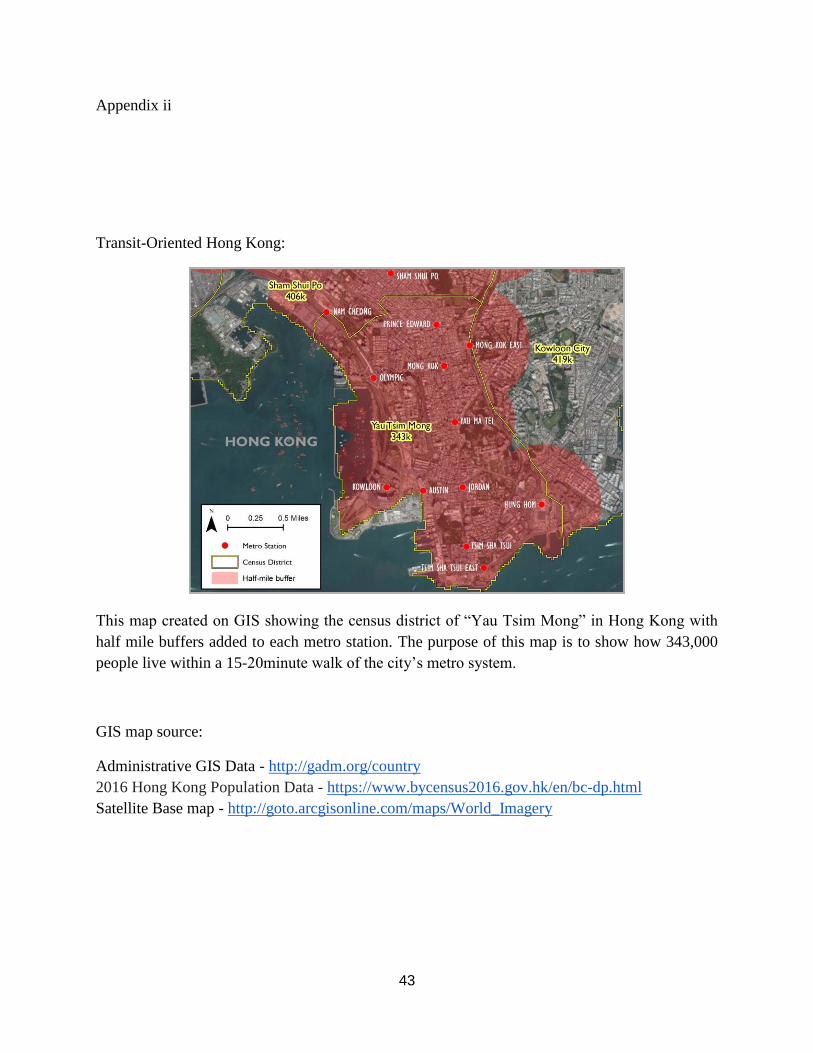
43
Appendix ii
Transit-Oriented Hong Kong:
This map created on GIS showing the census district of “Yau Tsim Mong” in Hong Kong with
half mile buffers added to each metro station. The purpose of this map is to show how 343,000
people live within a 15-20minute walk of the city’s metro system.
GIS map source:
Administrative GIS Data - http://gadm.org/country
2016 Hong Kong Population Data - https://www.bycensus2016.gov.hk/en/bc-dp.html
Satellite Base map - http://goto.arcgisonline.com/maps/World_Imagery

44
Appendex iii
Redesign of Bahraini streets to be more equitable
Before:
After:
(Rendering created by Ebrahim N. AlKhalifa 2018)
Improved rendering shows a more equitable street “Complete Street” scheme that allows for
multi-modal transit options including private cars, dedicated bus lane, bike lane, and pedestrian
path.

45
Image Citations:
Image 1: https://www.pinterest.com/pin/466544842623970342/
Image 2: https://www.curbed.com/2016/6/14/11867016/urban-market-bahrain-holtrop
Image 3: http://intlhistory.blogspot.com/2013/01/bahrain-old-photographs.html
Image 4: http://www.mumsinbahrain.net/where-stay-bahrain
Image 5: https://hiveminer.com/Tags/awali%2Cmap
Image 6: Taken during research trip in Bahrain 2017.
Image7:http://www.alamy.com/stock-photo-hsbc-drive-through-atm-services-facility-for-
motorists-approx-midpoint-23476333.html
Image 8: http://www.alamy.com/stock-photo/drive-thru-atm.html
Image 9: https://www.khaleejtimes.com/region/bus-shelters-to-be-renovated-in-bahrain
Image 10: Taken during research trip in Bahrain 2017.
Image 11: Taken during research trip in Bahrain 2017.
Image 12: Taken during research trip in Bahrain 2017.
Image13:https://en.wikipedia.org/wiki/Public_housing_in_Hong_Kong#/media/File:Kin_Ming_
Estate.jpg
Image 14: http://hongkongimpression.weebly.com/land-use-and-traffic.html
Image 15: http://www.durratbahrain.com/
Image16:https://www.weetas.com/gccnews/10-year-work-in-bahrain-bay-starts-to-come-to-light/
Image17:https://editorialrestauro.com.mx/residential-high-rise-clusters-as-a-contemporary-
planning-challenge-in-manama/
Image 18: http://www.maplandia.com/bahrain/az-zallaq/hotels/sofitel-bahrain-zallaq-thalassa-
sea-spa/
Image 19: https://www.southtravels.com/middleeast/bahrain/novotelaldanaresort/index.html
Image 20: https://www.strol.com/localities/details/257?page=8
Image 21: http://forgotten-ny.com/2001/06/millers-crossing-the-west-side-elevated-highway/

46
Image22:https://shopgotham.com/shop-new-york/2017/08/14/biking-new-york-city-may-we-
suggest-a-great-few-hours-our-itinerary-suggestions/
Image23:https://blog.euromonitor.com/2017/01/rising-obesity-rates-gulf-states-create-
opportunity-health-positioned-beverages.html
Image24:http://gulfbusiness.com/top-five-countries-with-the-highest-air-pollution-in-the-middle-
east/
Image25: http://ifonlysingaporeans.blogspot.com/2013/02/land-use-plan.html
Image26: Taken during research trip in Bahrain 2017.
Image27: http://www.alamy.com/stock-photo/ledras-street.html
Image28: https://en.wikipedia.org/wiki/Toll_road
Image29: https://www.dezeen.com/2012/11/27/movie-1111-lincoln-road-by-herzog-de-meuron/