Implementing a Geographic Information Science Research Agenda to Address Challenging Issues Michael...
35
Implementing a Geographic Implementing a Geographic Information Science Information Science Research Agenda to Address Research Agenda to Address Challenging Issues Challenging Issues Michael P. Finn and E. Lynn Usery http://cegis.usgs.gov . S. Department of Interior U. S. Geological Survey
-
Upload
thomas-davis -
Category
Documents
-
view
217 -
download
0
Transcript of Implementing a Geographic Information Science Research Agenda to Address Challenging Issues Michael...

Implementing a Geographic Implementing a Geographic Information Science Research Information Science Research
Agenda to Address Challenging Agenda to Address Challenging IssuesIssues
Michael P. Finn and E. Lynn Usery
http://cegis.usgs.gov U. S. Department of Interior
U. S. Geological Survey


3
OutlineOutline
GIScience Research in the USGSGIScience Research in the USGS Center of Excellence for Geospatial Center of Excellence for Geospatial
Information Science (CEGIS)Information Science (CEGIS) Implementing the NRC ReportImplementing the NRC Report The CEGIS 2007 ProspectusThe CEGIS 2007 Prospectus

4
Geography Science Plan’s Nine science goals:
Goals 8 and 9 and parts of Goal 5 are GIScience
http://geography.usgs.gov/gcw/
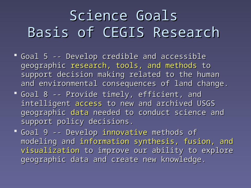
Science GoalsScience GoalsBasis of CEGIS ResearchBasis of CEGIS Research
Goal 5 -- Develop credible and accessible geographic Goal 5 -- Develop credible and accessible geographic research, tools, and methodsresearch, tools, and methods to support decision making to support decision making related to the human and environmental consequences related to the human and environmental consequences of land change.of land change.
Goal 8 -- Provide timely, efficient, and intelligent Goal 8 -- Provide timely, efficient, and intelligent accessaccess to new and archived USGS geographic to new and archived USGS geographic datadata needed to needed to conduct science and support policy decisions.conduct science and support policy decisions.
Goal 9 -- Develop Goal 9 -- Develop innovativeinnovative methods of modeling and methods of modeling and information synthesis, fusion, and visualizationinformation synthesis, fusion, and visualization to to improve our ability to explore geographic data and create improve our ability to explore geographic data and create new knowledge. new knowledge.
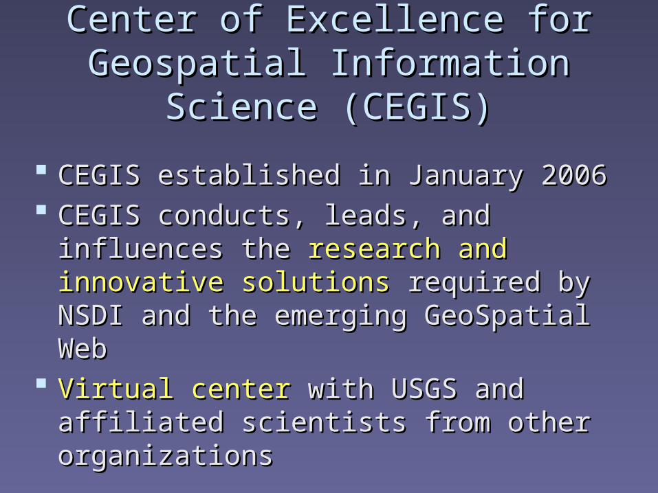
Center of Excellence for Geospatial Center of Excellence for Geospatial Information Science (CEGIS)Information Science (CEGIS)
CEGIS established in January 2006CEGIS established in January 2006 CEGIS conducts, leads, and influences the CEGIS conducts, leads, and influences the
research and innovative solutionsresearch and innovative solutions required required by NSDI and the emerging GeoSpatial Web by NSDI and the emerging GeoSpatial Web
Virtual centerVirtual center with USGS and affiliated with USGS and affiliated scientists from other organizationsscientists from other organizations
7
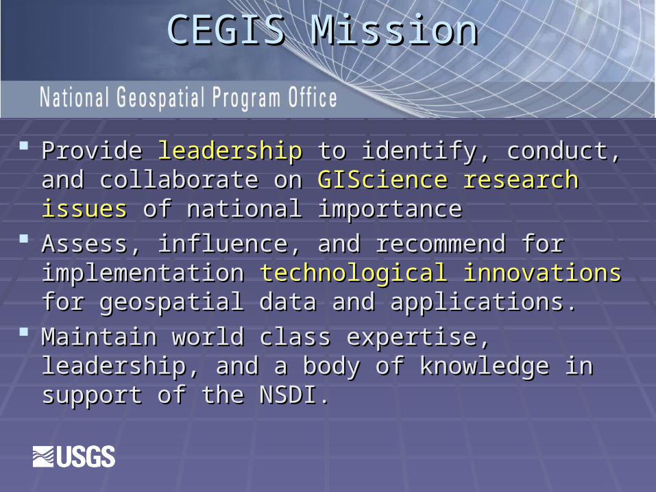
CEGIS MissionCEGIS Mission
ProvideProvide leadership leadership to identify, conduct, and to identify, conduct, and collaborate on collaborate on GIScience research issuesGIScience research issues of national of national importanceimportance
Assess, influence, and recommend for Assess, influence, and recommend for implementation implementation technological innovationstechnological innovations for for geospatial data and applications.geospatial data and applications.
Maintain world class expertise, leadership, and a Maintain world class expertise, leadership, and a body of knowledge in support of the NSDI.body of knowledge in support of the NSDI.
8
The NRC ReportThe NRC Report
GIO contracted the National Research GIO contracted the National Research Council to prepare a Council to prepare a research agendaresearch agenda for for GIScience in the USGS, i.e., an agenda GIScience in the USGS, i.e., an agenda for CEGISfor CEGIS
The report includes The report includes 12 recommendations12 recommendations including both short-term and long-term including both short-term and long-term researchresearch
10
Report available at:
http://books.nap.edu/catalog.php?record_id=12004

11
The NRC Study OverviewThe NRC Study Overview
Short-term high priority projectsShort-term high priority projects Already begunAlready begun 2 to 4 year timeframe for research2 to 4 year timeframe for research Basis of The National Map 3.0Basis of The National Map 3.0
Long-term projects Long-term projects Begin on completion of short-term or after 2 Begin on completion of short-term or after 2
yearsyears Build the NRC vision for CEGIS and TNMBuild the NRC vision for CEGIS and TNM

Ontology
Electronic Topographic Mapping
User-Centered Design
DataIntegration
GeneralizationOntology-DrivenGazetteers
Multi-Resolution Raster Data
CEGIS Current Research

1) Geographic Feature Ontology1) Geographic Feature Ontology
Objective: Research and design of a complete description of all semantic characteristics and relations among geographic features that are part of The National Map
Approach:
Feature Lists, Attributes, Relationships – Develop complete list of features for all data layers. The list includes attributes with possible values and relationships within a data layer and across data layers.
DB Implementation – Implementation of the features in a database environment. This will use the Best Practices Data model and interface to the Arc Geodatabase environment.

Ontology Examples/ ProblemsOntology Examples/ Problems StreamStream
MouthMouth SourceSource BankBank ShoreShore DirectionDirection
Terrain FeaturesTerrain Features CanyonCanyon
WallsWalls RidgeRidge
How to define from a DEM?How to define from a DEM?
Ontology Project StatusOntology Project Status
Comparison of feature, attribute, relationship Comparison of feature, attribute, relationship lists donelists done DLG-E/DLG-FDLG-E/DLG-F SDTSSDTS FGDC FrameworkFGDC Framework
Beginning software testingBeginning software testing OWLOWL ProtégéProtégé
Review of Best Practices ModelReview of Best Practices Model Geodatabase training for project personnelGeodatabase training for project personnel

2) User-Centered Design for Web 2) User-Centered Design for Web ServicesServices
Objective: Research and design of a human intuitive Objective: Research and design of a human intuitive interface for interface for The National MapThe National Map viewers and access to all viewers and access to all USGS dataUSGS data
ApproachApproach User Survey – Complete interviews with users to User Survey – Complete interviews with users to
determine needs and design of the Web interface and determine needs and design of the Web interface and services. Coordination with Larry Sugarbaker’s user services. Coordination with Larry Sugarbaker’s user study.study.
Viewer Interface – Development of a viewer for Viewer Interface – Development of a viewer for The National Map The National Map based on the results of the user survey based on the results of the user survey and the design.and the design.

3) Electronic Topographic Map 3) Electronic Topographic Map Design Design
Objective: Research and design of symbology, type, layer Objective: Research and design of symbology, type, layer structure, color hierarchy, and map layout for electronic structure, color hierarchy, and map layout for electronic topographic mapstopographic maps
Approach:Approach:
Design Review – Comprehensive evaluation of design Design Review – Comprehensive evaluation of design requirements for Web-based topographic maps. This includes requirements for Web-based topographic maps. This includes design of geopdf for control of layer presentation and design design of geopdf for control of layer presentation and design for both electronic and print versions of topographic maps.for both electronic and print versions of topographic maps.
Color Hierarchy – Development of rules for the hierarchy of Color Hierarchy – Development of rules for the hierarchy of colors to be presented for electronic topographic maps.colors to be presented for electronic topographic maps.

18
Current WorkCurrent Work
Building 6 datasets complete with all TNM Building 6 datasets complete with all TNM layers.layers.
Becomes basis for the designBecomes basis for the design Also used for generalizationAlso used for generalization

19
4) Data Integration -- Objective4) Data Integration -- Objective
Determine if different data layers can be Determine if different data layers can be integrated based on resolution, accuracy, integrated based on resolution, accuracy, and other metadata and explore automated and other metadata and explore automated methods to achieve horizontal and vertical methods to achieve horizontal and vertical integration of the 8 data layers of integration of the 8 data layers of The The National MapNational Map

Data Integration -- Current Data Integration -- Current ResultsResults
Approximately 6 m RMSE appears integrated at Approximately 6 m RMSE appears integrated at 1:24,000 scale.1:24,000 scale.
Can we use this as a specification to automatically Can we use this as a specification to automatically decide if two layers can be integrated?decide if two layers can be integrated?
Generalization is the problem with smaller scalesGeneralization is the problem with smaller scales We can automate transportation with images in We can automate transportation with images in
urban areas (Contract to Knoblock, Geosemble?)urban areas (Contract to Knoblock, Geosemble?)

Data Integration -- ApproachData Integration -- Approach
Current Results to TNM – Implementation of the Current Results to TNM – Implementation of the rulesrules for for integration integration developed thus fardeveloped thus far by CEGIS research to by CEGIS research to provide for broader testing with many different datasets. provide for broader testing with many different datasets. Implementation of test cases for automated integration of Implementation of test cases for automated integration of transportation and orthographic images based on the transportation and orthographic images based on the results of the USC research.results of the USC research.
Other Layers – Extend methods for both determining Other Layers – Extend methods for both determining possibilities of integration and automation techniques to possibilities of integration and automation techniques to layers other than transportation and orthographic layers other than transportation and orthographic images. Particular attention to hydrography and images. Particular attention to hydrography and elevation.elevation.
5) Generalization5) Generalization
Objective: Research and design Objective: Research and design algorithms and proceduresalgorithms and procedures to to change resolution/ scale from high levels of detail to lower, e.g., change resolution/ scale from high levels of detail to lower, e.g., from 1:24,000 to 1:100,000 scalefrom 1:24,000 to 1:100,000 scale
Approach: Approach:
Initial work with Initial work with NHDNHD to prune stream network and to prune stream network and maintain characteristics to support current applicationsmaintain characteristics to support current applications
NHD to TNM – Complete preprocessing requirements for NHD to TNM – Complete preprocessing requirements for the entire country for the NHD procedures. Develop any the entire country for the NHD procedures. Develop any required new procedures for NHD.required new procedures for NHD.
Other Layers – Extend methods of generalization to other Other Layers – Extend methods of generalization to other layers, particularly transportation.layers, particularly transportation.

23
Current StatusCurrent Status
Preprocessing in process for NHDPreprocessing in process for NHD Six test areas Six test areas
Building all 8 layers for these areasBuilding all 8 layers for these areas Support generalization and electronic Support generalization and electronic
topographic map designtopographic map design

6) Multi-Resolution Raster Data6) Multi-Resolution Raster Data
Objective: Research and design rapid, web-based Objective: Research and design rapid, web-based projectionprojection of of multi-Gb datasets throughmulti-Gb datasets through The National Map The National Map
ApproachApproach mapIMGmapIMG refinement – Development mapIMG to work refinement – Development mapIMG to work
with local and regional data as well as global. Refine with local and regional data as well as global. Refine mapIMGmapIMG to work with to work with The National MapThe National Map data. data.
Parallel/grid version.—develop a version of mapIMGParallel/grid version.—develop a version of mapIMG to to work in parallel computing environment. Extend to Grid work in parallel computing environment. Extend to Grid computing version.computing version.
Web-based – Develop a Web-based version of mapIMG Web-based – Develop a Web-based version of mapIMG that ties to the UCD viewer interface and uses the parallel/ grid that ties to the UCD viewer interface and uses the parallel/ grid version.version.

Data Model Research
Spatio-Temporal
Quality Aware
Transaction Processing
Ontology
CEGIS Long-Term Research

26
7) Ontology-Driven Data Models 7) Ontology-Driven Data Models
8) Quality-Aware Data Models8) Quality-Aware Data Models
9) Spatio-Temporal Data Models 9) Spatio-Temporal Data Models
10) Transaction Processing10) Transaction Processing
CEGIS Long-Term Research

Milestone DescriptionsMilestone Descriptions
DM Design – Design of the appropriate data DM Design – Design of the appropriate data model.model.
DB Implementation – Implementation of the DB Implementation – Implementation of the data model in a stand-alone environment.data model in a stand-alone environment.
DM in TNM – Implementation of the data DM in TNM – Implementation of the data model with model with The National MapThe National Map..
TNM DM Operations – Establish operational TNM DM Operations – Establish operational capability of the data model with capability of the data model with The National The National Map.Map.


Nationwide Coverage 8 Data Layers
Seamless Elevation, Images, Land Cover

Nationwide Coverage 8 Data Layers
Seamless Elevation, Images, Land Cover

Generalization
Trusted Data Source
Integrated Data
MultiscaleNationwide Coverage 8 Data Layers
Seamless Elevation, Images, Land Cover

Generalization
Trusted Data Source
Integrated Data
MultiscaleNationwide Coverage 8 Data Layers
Seamless Elevation, Images, Land Cover

User-Centered Design
E-Topo Maps
Feature-Based
Intelligent Knowledge Base
Ontology Driven
Spatio-Temporal
Quality Aware
Nationwide Coverage 8 Data Layers
Seamless Elevation, Images, Land Cover
Generalization
Trusted Data Source
Integrated Data
Multiscale

34
CEGIS Prospectus 2007CEGIS Prospectus 2007
Call for proposals Call for proposals Bureau-wideBureau-wide for GIScience for GIScience research projectsresearch projects
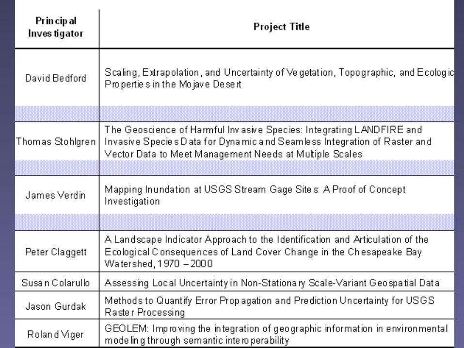
7171 proposals received proposals received NSF-like review processNSF-like review process Funded Funded sevenseven proposals totaling near $1 million proposals totaling near $1 million Results will be presented in Reston in Summer Results will be presented in Reston in Summer
20082008

Implementing a Geographic Implementing a Geographic Information Science Research Information Science Research
Agenda to Address Challenging Agenda to Address Challenging IssuesIssues
Michael P. Finn and E. Lynn Usery
http://cegis.usgs.gov U. S. Department of Interior
U. S. Geological Survey