I-580/Castro Valley Interchange Project - Caltrans · I-580/Castro Valley Interchange Project...
187
I-580/Castro Valley Interchange Project ALAMEDA COUNTY, CALIFORNIA DISTRICT 4 – ALA – KP R44.7/R47.7 (PM 27.8/29.6) Initial Study / Environmental Assessment June, 2006 U.S. Department of Transportation Federal Highway Administration and State of California Department of Transportation May 2003
Transcript of I-580/Castro Valley Interchange Project - Caltrans · I-580/Castro Valley Interchange Project...

I-580/Castro Valley Interchange Project
ALAMEDA COUNTY, CALIFORNIA DISTRICT 4 – ALA – KP R44.7/R47.7 (PM 27.8/29.6)
Initial Study / Environmental Assessment
June, 2006
U.S. Department of Transportation Federal Highway Administration
and State of California Department of Transportation
May 2003

GENERAL INFORMATION ABOUT THIS DOCUMENT What’s in this document? This Initial Study/Environmental Assessment (IS/EA), which examines the potential environmental impacts of the alternatives being considered for the proposed project, has been prepared for the California Department of Transportation (the Department) and the Federal Highway Administration (FHWA). The document explains why the project is being proposed, alternatives for the project, the existing environment in the project area, the potential impacts that would result from the alternative, and the proposed avoidance, minimization and/or mitigation measures. Upon completion, fifteen copies of the IS/EA and a Notice of Completion form are required to be filed at the State Clearinghouse, Governor’s Office of Planning and Research for distribution. In addition, copies were distributed to the agencies and organizations listed in Chapter 5 “Distribution List” of the IS/EA. All copies will be available for review commencing on June 19, 2006. What you should do: � Please review this Initial Study/Environmental Assessment. Additional copies of this
document as well as the technical studies that are available for review starting on June 19, 2006 at the Department’s District 4 Office, 111 Grand Avenue, Oakland, CA 94610, and the Castro Valley Library, 20055 Redwood Rd, Castro Valley, CA 94546.
� We welcome your comments. If you have any comments regarding the proposed
project or the analysis contained in this document, please attend the public open house that will be held at the Castro Valley High School Cafeteria located at 19400 Santa Maria Avenue Castro Valley, CA 94546 from 6:00-8:00 PM on the 11th of July, 2006, and/or send your written comments to the Department by the deadline July 18, 2006.
� Submit comments via postal mail to:
Ed Pang, Senior Environmental Planner or Eric Cordoba, ACTIA Project Manager Caltrans Office of Environmental Analysis Wakefield Building P.O. Box 23660 426 17th Street, Suite 100 Oakland, CA 94623-0660 Oakland, CA 94612 � Submit comments by the deadline: July 18, 2006. What happens next: After comments are received from the public and reviewing agencies, the Department and the Federal Highway Administration may: (1) give environmental approval to the proposed project, (2) undertake additional environmental studies, or (3) abandon the project. If the project is given environmental approval and funding is appropriated, the Department could design and construct all or part of the project. For individuals with sensory disabilities, this document can be made available in Braille, large print, on audiocassette, or on computer disk. To obtain a copy in one of these alternate formats, please call or write Attn: Eric Cordoba, ACTIA, 426 17th St., Ste 100 Oakland, CA 94612 (510) 893-3347. TDD users may contact the California Relay Service Line at 711.


Proposed Mitigated Negative Declaration Pursuant to: Division 13, Public Resources Code
Project Description The I-580/Castro Valley Interchange Improvement Project proposes to improve mobility within Castro Valley, as well as to improve access between I-580, the Castro Valley Business District, and the Castro Valley Bay Area Rapid Transit (BART) Station. The project includes construction of a new westbound off-ramp to Redwood Road, a new eastbound on-ramp from Redwood Road, and a new eastbound off-ramp to Grove Way. Also included are removal of the existing eastbound off-ramp to Center Street, removal of the existing westbound on-ramp from Castro Valley Blvd. just west of Center Street; and construction of a new auxiliary lane between the new Redwood Road on-ramp and the Grove Way off-ramp. Determination This Mitigated Negative Declaration (MND) is included to give notice to interested agencies and the public that it is the Department’s intent to adopt a MND for this project. This does not mean that the Department’s decision regarding the project is final. This MND is subject to modification based on comments received by interested agencies and the public. The Initial Study/Environmental Assessment has been prepared, and it has been determined from this study that the proposed project would not have an adverse effect on the environment for the following reasons:
• The project will not have an adverse effect on topography or erosion, or increase the potential for geologic or seismic hazards.
• There will be no adverse impacts on air, water quality, or hazardous waste, nor would the project adversely change the rate of use of any natural resource.
• The project will not adversely affect floodplains, wetlands, or riparian vegetation, compensatory mitigation is included for wetland impacts.
• There will be no adverse impact on fish and wildlife, endangered species, and habitat.
• There will be no effect on agricultural resources. • There will be no adverse impact on public facilities, neighborhoods, housing,
business, economy, or employment of the area. • The project will not have an adverse effect on land use and growth. • Overall, there will be no adverse effects on traffic. • There will be no adverse effect on cultural resources, recreation, parkland, or
open space. • The project will not have an adverse effect on visual/aesthetic quality or noise.
The mitigation measures incorporated into the project to reduce potential effects to insignificance are identified in the Executive Summary and throughout Chapter 2 of this document. With regard to potential noise effects, abatement measures are discussed in Section 2.11 (Noise) of this document.
_________ __________________ _____________ Deputy District Director Date Division of Environmental Planning and Engineering
���������� ������������������ �� ����� ��� ������������������������ ������� ������ � !����"��#�
Table of Contents Executive Summary .................................................................................. ES-1 Chapter 1: Proposed Project........................................................................ 1-1 Chapter 2: Affected Environment, Environmental Consequences, and
Avoidance, Minimization, and/or Mitigation Measures ........... 2.1-1 Chapter 2.1: Utilities/Emergency and Other Services ............................... 2.1-1 Chapter 2.2: Traffic & Transportation/Pedestrian & Bicycle Facilities ....... 2.2-1 Chapter 2.3: Visual/Aesthetics.................................................................. 2.3-1 Chapter 2.4: Cultural Resources............................................................... 2.4-1 Chapter 2.5: Paleontology ........................................................................ 2.5-1 Chapter 2.6: Hydrology & Floodplain ........................................................ 2.6-1 Chapter 2.7: Water Quality & Storm Water Runoff.................................... 2.7-1 Chapter 2.8: Geology/Soils/Seismic/Topography...................................... 2.8-1 Chapter 2.9: Air Quality............................................................................. 2.9-1 Chapter 2.10: Biological Environment..................................................... 2.10-1 Chapter 2.11: Noise ................................................................................ 2.11-1 Chapter 2.12: Land Use & Community Impacts...................................... 2.12-1 Chapter 2.13: Hazardous Waste/Materials ............................................. 2.13-1 Chapter 2.14: Cumulative Impacts.......................................................... 2.14-1 Chapter 3: Comments & Coordination ......................................................... 3-1 Chapter 4: List of Preparers......................................................................... 4-1 Chapter 5: Distribution List........................................................................... 5-1 List of Tables Table ES-1 – Summary of Build Alternative Impacts and
Proposed Mitigation..............................................................ES-3 Table 1-1 – Comparison of Alternatives Based on Evaluation Criteria......... 1-5 Table 1-2 – Permits and Approvals.............................................................. 1-8 Table 2.2-1 – Freeway Mainline Level of Service Criteria ........................ 2.2-2 Table 2.2-2 – Intersection Level of Service Criteria .................................. 2.2-3 Table 2.2-3 – Comparison of AM Peak Hour I-580 Mainline LOS
for No Build vs. Project (2030)............................................ 2.2-7 Table 2.2-4 – Comparison of PM Peak Hour I-580 Mainline LOS
for No Build vs. Project (2030)............................................ 2.2-9 Table 2.2-5 – Comparison of I-580 Mainline Effectiveness (2030) ......... 2.2-11 Table 2.8-1 – Active Faults within 50 Kilometers and
Potential MCM Ratings of Project Site................................ 2.8-2 Table 2.9-1 – Federal and State Ambient Air Standards Attainment Status................................................................ 2.9-2 Table 2.9-2 – Comparison of Project to I-680 at Jackson Street............... 2.9-4 Table 2.9-3 – Future Carbon Monoxide Concentrations at Study
Intersections (in parts per million) ...................................... 2.9-5 Table 2.10-1 – Permanent Fill in Waters of the US................................. 2.10-3 Table 2.10-2 – Special Status Plant Species .......................................... 2.10-5

���������� ������������������ �� ����� ��� ������������������������ ������� ������ � !����"��#�
Table 2.10-3 – Animal Species in Project Area....................................... 2.10-6 Table 2.11-1 – Noise Abatement Criteria................................................ 2.11-1 Table 2.11-2 – Existing Noise Levels...................................................... 2.11-4 Table 2.11-3 – Noise Modeling Results with Insertion Loss at
Representative Receivers............................................. 2.11-10 Table 2.11-4 – Summary of Feasible Sound Walls Evaluated for
Reasonableness ........................................................... 2.11-13 Table 2.11-5 – Construction Equipment Noise ..................................... 2.11-14 Table 2.12-1 – Cost of Housing Increases in Castro Valley.................... 2.12-4 Table 2.12-2 – Cost of Rental Housing Increases in Castro Valley ........ 2.12-4 Table 2.12-3 – Population by Race and Ethnicity in 2000....................... 2.12-4 Table 2.12-4 – Housing Characteristics in 2003 ..................................... 2.12-5 Table 2.12-5 – Major Employers in Castro Valley................................... 2.12-6 Table 2.12-6 – Income and Poverty in 2000 ........................................... 2.12-6 Table 2.13-1 – Listed Sites of Potential Concern within the Study Area . 2.13-3 Table 2.13-2 – Listed Sites of Potential Concern Located Near the Study
Area ................................................................................ 2.13-5 List of Figures Figure 1-1 – Project Vicinity Figure 1-2 – Project Study Area Map Figure 1-3 – Alternative 3 – Full Diamond Interchange at Redwood Road Figure 1-4 – Alternative 2 – ACTIA Expenditure Plan Alternative Figure 2.3-1 – Viewpoints 1-4 Figure 2.3-2 – Existing and Simulated view with project from Viewpoint 1 Figure 2.3-3 – Existing and Simulated view with project from Viewpoint 2 Figure 2.3-4 – Existing and Simulated view with project from Viewpoint 3 Figure 2.3-5 – Existing View from viewpoint 4 Figure 2.6-1 – 100-Year Floodplain in Project Vicinity Figure 2.7-1 – Main Surface Water Bodies in Project Area Figure 2.7-2 – Alameda County Flood Control Lines Figure 2.10-1 – Impacted Waters of the U.S. Figure 2.11-1 – Noise Measurement Locations Figure 2.13-1 – Sites on Regulatory Agency Lists within One-Half Mile of
the Study Area List of Appendices Appendix A: CEQA Checklist Appendix B: Title VI Policy Statement Appendix C: Caltrans Relocation Assistance Appendix D: Parcel Address List Appendix E: List of Acronyms Appendix F: List of Sources

���������� ������ ���������� �������� ������� ������ ����������������� ����� ���� ��� !��"
EXECUTIVE SUMMARY A. Introduction The following is an executive summary of the Initial Study/Environmental Assessment (IS/EA) that has been prepared in accordance with the California Environmental Quality Act (CEQA) (Cal. Pub. Res. Code sec 21000 et seq.), the State CEQA Guidelines (14 Cal. Code of Regs. Sec. 15000 et seq.), the National Environmental Policy Act of 1969, as amended (NEPA) (42 U.S.C. 4321 et seq.), and the Council of Environmental Quality NEPA regulations (40 CFR Part 1500 et seq.). Review under NEPA is required because the proposed project includes improvements to an interstate freeway. A federal lead agency must ensure that its regulations, policies, and programs (including funding) are carried out in accordance with NEPA. This IS/EA is intended to inform the public and project decision makers of the environmental effects of the I-580/Castro Valley Interchange Project. B. Description of the Project The I-580/Castro Valley Interchange Improvement Project (hereby referred to as the Project) seeks to improve mobility within Castro Valley, as well as to improve access between I-580, the Castro Valley Business District, and the Castro Valley Bay Area Rapid Transit (BART) Station. The Project would include the following components:
• Construction of a new westbound off-ramp from I-580 to Redwood Road; • Construction of a new eastbound on-ramp from Redwood Road to I-580; • Construction of a new eastbound off-ramp from I-580 to Grove Way; • Removal of the existing eastbound off-ramp to Center Street; • Removal of the existing westbound on-ramp from Castro Valley Blvd just west of
Center Street;
• Construction of a new auxiliary lane between the new Redwood Road on-ramp and the new Grove Way off-ramp;
• Construction of an HOV bypass lane, a CHP enforcement area, and a
Maintenance Vehicle Pullout on the eastbound Redwood Road on-ramp; and
• Installation of ramp meters on the eastbound Redwood Road on-ramp and the existing westbound Redwood Road on-ramp. (Note: activation of the ramp meters will not occur with this project.)

���������� ������ ���������� �������� ������� ������ ����������������� ����� ���! ��� !��"
C. Purpose of and Need for the Project Project Purpose The purpose of the project is to improve access between I-580 and central Castro Valley and the BART station by constructing a new eastbound on-ramp at Redwood Road; simplifying traffic movement between I-580 and central Castro Valley to improve traffic mobility and operations through the introduction of a full interchange at Redwood Road; and reducing circuitous traffic movement and cut-through traffic patterns in local neighborhoods as a result of the distance between isolated ramps and common destination points (i.e. BART parking). Project Need The existing poor level of access between central Castro Valley and I-580 results in inefficient traffic patterns and circuitous routes through residential neighborhoods. Specific access issues include the following:
• There is no direct access from westbound I-580 to Redwood Road, which provides a primary connection to the Castro Valley Business District and BART station. Currently westbound traffic on I-580 with destinations in this area use the Castro Valley Boulevard off-ramp east of Crow Canyon Road and travel westerly approximately one mile on Castro Valley Boulevard.
• Currently traffic from the Castro Valley Business District and the Castro Valley
BART Station desiring to travel east on I-580 must use one of three circuitous routes to access I-580. The first route involves traveling south on Redwood Road to Grove Way then traveling east on Grove Way through a residential neighborhood to the existing eastbound on-ramp on Grove Way. The second route consists of traveling east on Castro Valley Boulevard to Center Street, south on Center Street to Grove Way, then east on Grove Way to the existing eastbound on ramp at Crow Canyon Road. The third route consists of traveling east on Castro Valley Boulevard to Crow Canyon Road then traveling south on Crow Canyon Road to the existing eastbound loop on ramp.
• Access to eastbound I-580 from central Castro Valley is difficult and indirect
because the closest eastbound on-ramp to the project area is located approximately one mile to the east.
• Access between Castro Valley and I-580 is currently provided by a number of
physically isolated on- and off-ramps along I-580. Motorists traveling eastbound on I-580 can exit on Redwood Road; however, there is no eastbound on-ramp at the interchange. Similarly, while there is no westbound off-ramp from I-580 to Redwood Road, there is an on-ramp. The spatial separation of on-and off-ramps complicates traffic movement between I-580 and Castro Valley, which adversely affects mobility and operations (i.e. intersection LOS).
���������� ������ ���������� �������� ������� ������ ����������������� ����� ���# ��� !��"
• Limited access between central Castro Valley and I-580 increases circuitous or cut-through traffic movement on surface streets, which increases noise and congestion in residential areas and decreases safety for pedestrians and bicyclists in those areas.
D. Public Review The IS/EA will be circulated for public review and comment from June 19, 2006 to July 18, 2006. In addition, a public hearing/informational meeting will be held on July 11, 2006 with prior notification through mailings and local newspapers. The California Department of Transportation (Caltrans) and the Federal Highway Administration (FHWA) will accept comments on this document until July 18, 2006. Comments should be addressed to: Ed Pang, Senior Environmental Planner or Eric Cordoba, ACTIA Project Manager Caltrans Office of Environmental Analysis Wakefield Building P.O. Box 23660 426 17th Street, Suite 100 Oakland, CA 94623-0660 Oakland, CA 94612 E. Environmental Effects and Mitigation Measures Table ES-1 below summarizes the environmental effects that would result from the proposed project. Also provided in this table are the mitigation measures that have been proposed to avoid, minimize, rectify, reduce and/or compensate for the environmental effects of the project. NOTE: This table is intended only as a brief summary of the environmental effects and mitigation measures associated with the proposed project. It has not been provided to fulfill, in and of itself, the requirements of either NEPA or CEQA. Complete discussions of the proposed project, its environmental effects, and any mitigation measures that have been identified are included in the sections of the IS/EA that follow this executive summary. Table ES-1: Summary of Build Alternative Impacts and Proposed Mitigation Measures Impact Category
Build Alternative Effects
Proposed Avoidance, Compensation, Minimization, and Mitigation Measures
Permanent Impacts Human Environment
Emergency Services
The project would not disrupt emergency services or increase response times.
None required.
Traffic/Safety Short spacing along Redwood Road to the south of I-580 between the freeway on and off-
The intersection of Redwood Road and Vegas Avenue shall be converted to a right-in/right-out intersection, which would reduce potential impacts to a less than significant

���������� ������ ���������� �������� ������� ������ ����������������� ����� ���$ ��� !��"
Impact Category
Build Alternative Effects
Proposed Avoidance, Compensation, Minimization, and Mitigation Measures
ramps and side streets could contribute to severe traffic degradation and LOS F conditions.
level.
Transit AC Transit bus lines 91, 84, 80, and 87 along Redwood Road that provide connections to the Castro Valley BART station could be affected.
Curbside transit stops (including bus shelters) in the project area shall be maintained in place to the maximum extent feasible.
Parking Parking spaces behind a mortuary on Redwood Road would be lost due to the construction of the new westbound off ramp to Redwood Road.
The lead agency shall coordinate with the Mortuary property owner prior to construction to identify adequate replacement parking.
Aesthetics The project would introduce new sources of permanent lighting and could increase the potential for glare.
During the operation phase of the project, any new overhead street lighting shall be installed with angled hood shields and directed onto roadways or the mainline of I-580 so as to minimize the amount of extraneous light that could affect adjacent homes or motorists on adjacent roadways.
Archaeological Resources
There are no known archaeological resources in the archaeological Area of Potential Effect (APE).
None required.
Historical Architectural Resources
No structures eligible for the National Register of Historical Places (NRHP) were identified within the Architectural APE.
None required.
Paleontological Resources
There are no known paleontological resources or unique geologic features within the project area.
None required.
Physical Environment Hydrology/ Drainage
A portion of project will occur in the 100-year floodplain but would not
None required.

���������� ������ ���������� �������� ������� ������ ����������������� ����� ���� ��� !��"
Impact Category
Build Alternative Effects
Proposed Avoidance, Compensation, Minimization, and Mitigation Measures
result in potentially significant flooding impacts.
Geology/Soils Portions of the off-ramp to Grove Way will be in close proximity to the steep banks of Crow Creek. Given the potential for landslides following heavy rain on unstable slopes, a landslide in this area could significantly impact the structural integrity of the new off ramp.
In major earthquake, damage could result from strong ground shaking or liquefaction.
During the design phase, further soil data collection together with site specific borings and penetrometer data shall be conducted to determine foundation requirements. Soil laboratory test data and analysis shall be conducted to determine site specific geotechnical design parameters.
The project shall be designed and constructed in accordance with the most current seismic building codes to minimize risks related to a seismic event, such as groundshaking, liquefaction, and structural failure.
Air Quality The project will not cause a violation of the Institute of Transportation Studies (ITS) CO protocol standards, have an adverse impact on PM10 concentrations in the project area, or result in a violation of state ambient air quality standards.
None required.
Noise The addition of the on- and off-ramps to I-580 at Redwood Road along with the removal of sound wall sections to accommodate these ramps would not result in a substantial noise impact. However, many Category B uses within the study area would experience future noise levels that would
• The project includes constructing a sound wall along the eastbound side of the new Redwood Road on-ramp to eastbound I-580, connecting to the remaining portion of the existing sound wall along eastbound I-580 (i.e., reduce noise levels by 5 dBA and block line of sight to heavy-duty truck stacks in the near travel lane).
• The project includes constructing a sound wall along the westbound side of the new I-580 to Redwood Road off-ramp, connecting to the remaining

���������� ������ ���������� �������� ������� ������ ����������������� ����� ���" ��� !��"
Impact Category
Build Alternative Effects
Proposed Avoidance, Compensation, Minimization, and Mitigation Measures
approach or exceed the NAC.
portion of the existing sound wall along westbound I-580 (i.e., reduce noise levels by 5 dBA and block line of sight to heavy-duty truck stacks in the near travel lane).
Vegetation and Wildlife Communities
The project will not result in habitat fragmentation or potential impacts to wildlife corridors or fish passage.
None required.
Threatened and Endangered Species
The project would not result in adverse effects to any special status species (i.e. Threatened or Endangered).
None required.
Wetlands and Other Waters of U.S.
The project will result in an approximate 0.003-hectare (0.007-acre) impact to Waters of the US in Castro Valley Creek.
A Section 404 permit and a Section 401 Clean Water Certification will be required by the Corps and RWQCB shall be included as part of the project.
Invasive Species Weeds may be inadvertently introduced into the corridor during construction.
None of the species on the California list of noxious weeds shall be used for erosion control purposes during construction or subsequent landscaping. In compliance with the Executive Order on Invasive Species, E.O. 13112, and subsequent guidance from the FHWA, erosion control included in the project shall not include the use of species listed as noxious weeds. In areas of particular sensitivity (such as areas near Crow Creek and San Lorenzo Creek), extra precautions shall be taken if invasive species are found in or adjacent to the construction areas, such as cleaning of construction equipment, vehicles, and tools to remove all soils, seeds, and plant material. Should an invasion of nonnative species occur, measures shall be implemented to eradicate the species.

���������� ������ ���������� �������� ������� ������ ����������������� ����� ���% ��� !��"
Impact Category
Build Alternative Effects
Proposed Avoidance, Compensation, Minimization, and Mitigation Measures
Community Impacts
The project will displace seven residences and one commercial property.
The special needs and circumstances of each displaced household and property and business owners are not known at this time but shall be determined prior to negotiations for acquisition. Additional housing and commercial property availability studies shall be conducted when relocation properties are being considered. Mitigation would ensure that relocation activities are conducted in such a way that potential impacts to property owners will be to a less than significant level. Displacements shall be in accordance with the Uniform Relocation Assistance and Real Property Acquisition Policy Act of 1970, as amended in 1987, collectively known as the Uniform Relocation Act, as amended, which provides for uniform and equitable treatment of persons displaced from their homes, businesses, non-profit associations, or farms by Federal and federally-assisted programs, and establishes uniform and equitable land acquisition policies. In accordance with this Act, Caltrans shall provide relocation advisory assistance to any person, business, farm, or nonprofit organization displaced as a result of the acquisition of real property for public use.
Hazardous Waste/Materials
Listed Sites of Potential Concern within and near the Project area are not a potential concern for project development.
None required.
Vegetation and Wildlife Communities
The project will result in the removal of trees that provide suitable nesting habitat for migratory birds.
Pre-construction surveys shall be conducted if tree removal activity is planned to occur during the nesting season, which runs from February 1 to August 1. If active nests are identified, the tree shall not be removed until a qualified biologist has determined that the young have fledged and that the nest is no longer active. Construction activities proposed in the vicinity of the active nest shall be evaluated
���������� ������ ���������� �������� ������� ������ ����������������� ����� ���� ��� !��"
Impact Category
Build Alternative Effects
Proposed Avoidance, Compensation, Minimization, and Mitigation Measures to determine potential for nest abandonment. Once determined that the nest is no longer active, construction activities may proceed as planned.
Tree Preservation
Removal of certain trees within the County right-of-way may conflict with the County’s Tree Preservation Ordinance.
Prior to land clearing activities, coordination with the Arborist within the County Public Works Department shall determine whether trees to be removed from the County ROW are protected under the County ordinance and if so, determine an appropriate replacement ratio (i.e. 1:1).
Construction Phase Impacts Utility Relocations
The project could temporarily affect water lines in the area.
Any proposed construction activity in the EBMUD right-of-way shall be subject to the terms and conditions determined by EBMUD including relocation of the water mains and/or right-of-ways. A final field verification of utilities shall be conducted as one of the first steps in the PS&E phase.
Aesthetics The project would introduce new sources of temporary lighting and could increase the potential for glare.
Contractors shall be required to follow the provisions of a construction lighting plan, which would specify that all nighttime construction lighting be directed onto the project area to the maximum extent feasible.
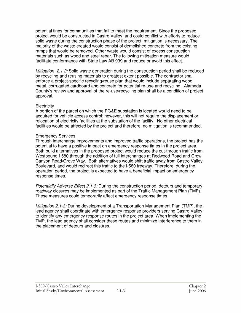
Solid Waste Recycling/Reuse
During the construction phase, the Project could conflict with local efforts to reduce solid waste.
Solid waste generation during construction shall be reduced by recycling and reusing materials to greatest extent possible. The contractor shall enforce a project-specific recycling/reuse plan that includes separating wood, metal, corrugated cardboard and concrete for potential re-use and recycling. Alameda County’s review and approval of the re-use/recycling plan shall be a condition of project approval.
Emergency Services
Road closures or detours during construction could affect emergency service.
Development of a Transportation Management Plan (TMP) and coordination with emergency response providers to identify emergency response routes in the project area to minimize effects of detours and closures.
Traffic/Safety Construction could result in temporary impacts on local traffic circulation.
A Transportation Management Plan (TMP) prepared prior to construction to address potential traffic impacts would identify traffic handling strategies and the optimum location for detours. In the event that lane

���������� ������ ���������� �������� ������� ������ ����������������� ����� ���& ��� !��"
Impact Category
Build Alternative Effects
Proposed Avoidance, Compensation, Minimization, and Mitigation Measures or street closures are required during construction, the TMP shall include details of a public notification program and a Construction or Maintenance Zone Enhanced Enforcement Program (COZEEP).
Transit AC Transit bus lines 91, 84, 80, and 87 along Redwood Road that provide connections to the Castro Valley BART station could be affected.
A TMP shall identify measures to minimize interruption of transit service during project construction. At a minimum, the TMP shall include measures to ensure AC transit lines not be interrupted.
Pedestrian and Bicycle
Construction will potentially impact a Class I bike path on Grove Way and temporarily remove sidewalk access on Redwood Road between Vegas Avenue and Pine Street during the widening of Redwood Road.
In the event that project construction would affect bicycle facilities, alternate access shall be identified for the construction period and full access shall be restored following construction, or, if full access cannot be restored, alternate access shall be provided. During the design phase, a plan for temporary sidewalk access shall be provided by Alameda County would be a condition of approval.
Archaeological Resources
Unknown resources may be discovered and potentially affected during construction activities.
In accordance with CEQA Guidelines Subsection 15064.5(f), should any previously unknown historic or prehistoric resources, including but not limited to charcoal, obsidian or chert flakes, grinding bowls, shell fragments, bone, pockets of dark, friable soils, glass, metal, ceramics, wood or similar debris, be discovered during construction, earthwork within 100 feet of these materials shall be stopped until a professional archaeologist certified by the Registry of Professional Archaeologists has had an opportunity to evaluate the significance of the find and suggest appropriate mitigation(s).
Paleontological Resources
Unknown resources may be discovered and potentially affected during construction activities.
In the event that paleontological resources are encountered during excavation activities, these resources would be treated as archaeological resources. If necessary, the lead agency shall prepare or have prepared a report documenting any

���������� ������ ���������� �������� ������� ������ ����������������� ����� ����� ��� !��"
Impact Category
Build Alternative Effects
Proposed Avoidance, Compensation, Minimization, and Mitigation Measures findings, which shall include recommendations for treatment. Project personnel shall not collect or move any cultural material.
Water Quality Erosion of exposed surfaces could lead to increased sedimentation in water bodies. Accidental spills of contaminants could potentially impact water quality and fisheries in surface water bodies.
A SWPPP shall be prepared during the Plan, Specifications, and Estimate (PS&E) phase of the project and provided to Caltrans for review and approval prior to any demolition or construction. The SWPPP shall identify a series of “Best Management Practices” (BMPs) that, when implemented, would help improve the quality and reduce the amount of stormwater runoff from project site and shall also incorporate BMPs that minimize the amount of erosion during and after construction. Caltrans’ approval of the SWPPP shall be required. A Spill Prevention Plan (SPP) to prevent spills of oil or other petroleum products (gasoline, diesel fuel, solvents), during construction of the interchange improvements shall also be developed.
Air Quality A localized reduction in air quality may occur due to the pollutants generated from construction equipment and the elevation of dust levels from grading, excavation, hauling, and various other construction activities.
The following standard mitigation measures recommended by the Bay Area Air Quality Management District (BAAQMD) to ensure that construction-period air quality impacts are less-than-significant shall be implemented: • Water all active construction areas at
least twice daily; • Water or cover stockpiles of debris, soil,
sand, or other materials that can be blown by the wind, as required;
• Cover all trucks hauling soil, sand, and other loose materials, or require all trucks to maintain at least two feet of freeboard, as required;
• Sweep daily (preferably with water sweepers) all paved access roads, parking areas, and staging areas at
���������� ������ ���������� �������� ������� ������ ����������������� ����� ����� ��� !��"
Impact Category
Build Alternative Effects
Proposed Avoidance, Compensation, Minimization, and Mitigation Measures
construction sites; and • Sweep streets daily (preferably with
water sweepers) if visible soil material is carried onto adjacent public streets.
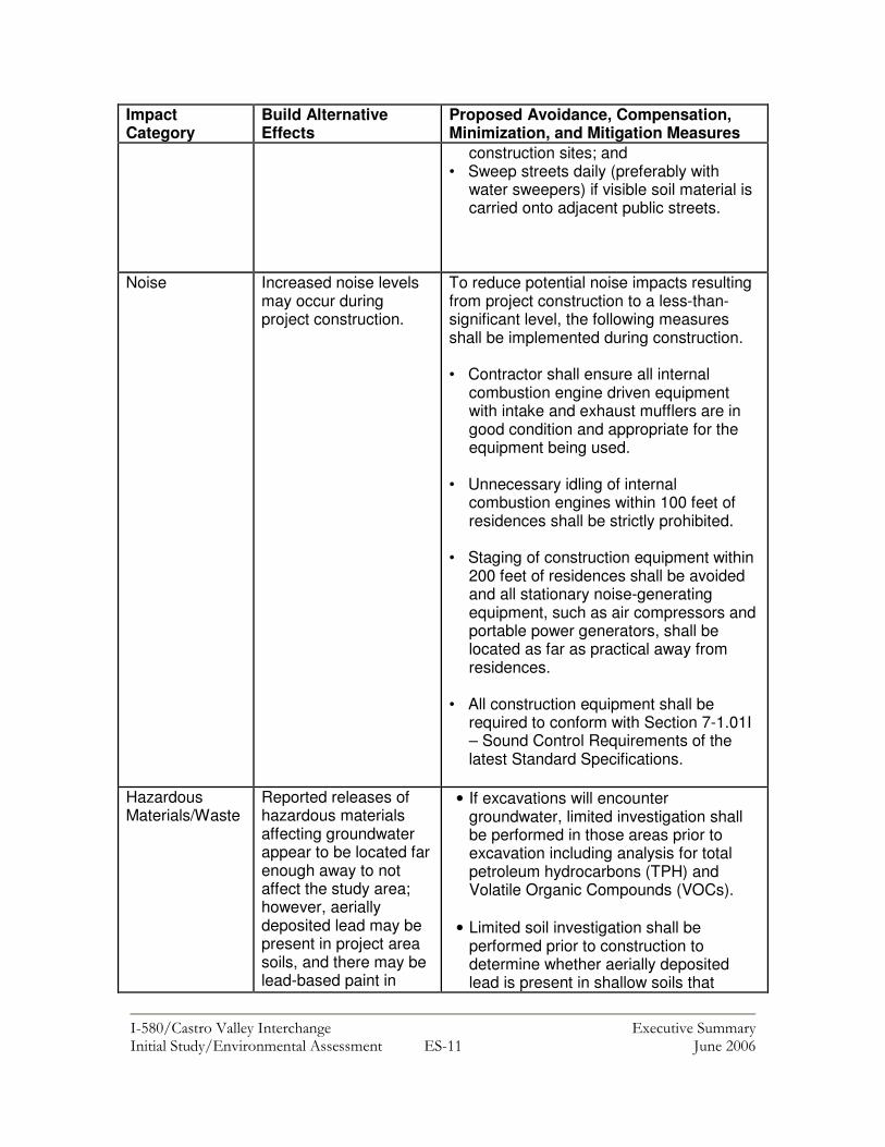
Noise Increased noise levels may occur during project construction.
To reduce potential noise impacts resulting from project construction to a less-than-significant level, the following measures shall be implemented during construction. • Contractor shall ensure all internal
combustion engine driven equipment with intake and exhaust mufflers are in good condition and appropriate for the equipment being used.
• Unnecessary idling of internal
combustion engines within 100 feet of residences shall be strictly prohibited.
• Staging of construction equipment within
200 feet of residences shall be avoided and all stationary noise-generating equipment, such as air compressors and portable power generators, shall be located as far as practical away from residences.
• All construction equipment shall be
required to conform with Section 7-1.01I – Sound Control Requirements of the latest Standard Specifications.
Hazardous Materials/Waste
Reported releases of hazardous materials affecting groundwater appear to be located far enough away to not affect the study area; however, aerially deposited lead may be present in project area soils, and there may be lead-based paint in
• If excavations will encounter groundwater, limited investigation shall be performed in those areas prior to excavation including analysis for total petroleum hydrocarbons (TPH) and Volatile Organic Compounds (VOCs).
• Limited soil investigation shall be
performed prior to construction to determine whether aerially deposited lead is present in shallow soils that

���������� ������ ���������� �������� ������� ������ ����������������� ����� ����! ��� !��"
Impact Category
Build Alternative Effects
Proposed Avoidance, Compensation, Minimization, and Mitigation Measures
buildings proposed to be demolished.
would be disturbed by construction activities.
• A survey shall be performed prior to
demolition to confirm the presence of lead-based paint and/or asbestos so that appropriate health and safety procedures can be developed prior to the beginning of construction.

���������� ������ ���������� ������ � ������ ����� ������������ ����� ��� ��� !��"
CHAPTER 1
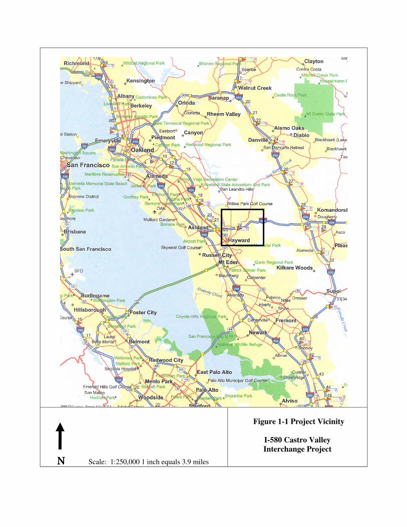
PROPOSED PROJECT Introduction The I-580 Castro Valley Interchange Improvement Project (hereby referred to as the project) is located in the Interstate-580 (I-580) corridor in Castro Valley in Alameda County, CA (see Figure 1-1: Note that all figures are included in the Chapter 1 Exhibits section immediately following this chapter). The study area and vicinity were defined by agricultural uses until the mid-1940s. Beginning about 1946, residential subdivisions began to be constructed in the area. By 1958, land use was primarily residential with some commercial uses. I-580 was constructed through the area during the 1950s. Prior to 1994, I-580 was expanded into a divided freeway and the current system of roadways, overpasses, on-ramps, and off-ramps were constructed. I-580 provides both regional and inter-regional access and extends from Interstate 5 (I-5) in Tracy, CA to Interstate 80 (I-80) in Emeryville, CA. The project area is shown on Figure 1-2. The project limits are the eastbound off-ramp at Redwood Road on the west and the proposed eastbound off-ramp at Grove Way on the east, which is just west of where Crow Creek crosses under Grove Way. The extent of the project area to the north and south of I-580 is also shown on Figure 1-2. I-580 includes four through lanes in both east and west directions. These lanes do not include High Occupancy Vehicle (HOV) lanes or auxiliary lanes.1 The Department of Transportation (Caltrans) and the Federal Highway Administration propose to improve the traffic operations on I-580 and at existing interchanges in the project area. In November 2000, 81.5 percent of Alameda County voters approved Measure B, which provided the continuation of a half cent sales tax to fund select transportation projects in Alameda County. Alameda County Transportation Improvement Authority (ACTIA) is responsible for administering Measure B funds. The proposed project meets the objective of improving mobility within Castro Valley, a rapidly growing community, and improving access to/from the Castro Valley Bay Area Rapid Transit Station. This project is also included in Alameda County’s 20-Year Transportation Expenditure Plan (July 2000) and the Metropolitan Transportation Commission’s (MTC) financially constrained 2002-2003 Regional Transportation Improvement Program (RTIP) (page 188). MTC 2002-2003 Transportation Improvement Program was found to conform by the Federal Highway Administration (FHWA) and Federal Transit Administration (FTA) on February 3, 2003. The design concept and scope of the I-580/Castro Valley Boulevard Interchange Project is consistent with the project description in the 2001 Regional Transportation Plan (RTP) and 2002-2003 RTIP.
1 Lanes which connect the entrance ramp from one interchange to the exit ramp or deceleration lane of the next off-ramp

���������� ������ ���������� ������ � ������ ����� ������������ ����� ��! ��� !��"
Project Need The existing poor level of access between central Castro Valley and I-580 results in inefficient traffic patterns and circuitous routes through residential neighborhoods. 1) There is no direct access from westbound I-580 to Redwood Road, which provides a
primary connection to the Castro Valley Business District and BART station. Currently, westbound traffic on I-580 with destinations in this area use the Castro Valley Boulevard off-ramp east of Crow Canyon Road and travel westerly approximately one mile on Castro Valley Boulevard.
Currently traffic from the Castro Valley Business District and the Castro Valley BART Station desiring to travel east on I-580 must use one of three circuitous routes to access I-580. The first route involves traveling south on Redwood Road to Grove Way then traveling east on Grove Way through a residential neighborhood to the existing eastbound on ramp on Grove Way. The second route consists of traveling east on Castro Valley Boulevard to Center Street, south on Center Street to Grove Way, then east on Grove Way to the existing eastbound on ramp at Crow Canyon Road. The third route consists of traveling east on Castro Valley Boulevard to Crow Canyon Road then traveling south on Crow Canyon Road to the existing eastbound loop on ramp.
2) Access to eastbound I-580 from central Castro Valley is difficult and indirect because
the closest eastbound on-ramp to the project area is located approximately one mile to the east.
3) Access between Castro Valley and I-580 is currently provided by a number of
physically isolated on- and off-ramps along I-580. Motorists traveling eastbound on I-580 can exit on Redwood Road; however, there is no eastbound on-ramp at the interchange. Similarly, while there is no westbound off-ramp from I-580 to Redwood Road, there is an on-ramp. The spatial separation of on-and off-ramps complicates traffic movement between I-580 and Castro Valley, which adversely affects mobility and operations (i.e. intersection LOS).
4) Limited access between central Castro Valley and I-580 increases circuitous or cut-
through traffic movement on surface streets, which increases noise and congestion in residential areas and decreases safety for pedestrians and bicyclists in those areas.
Project Purpose The purpose of the project is to improve access between I-580 and central Castro Valley and the BART station by constructing a new eastbound on-ramp at Redwood Road; simplifying traffic movement between I-580 and central Castro Valley to improve traffic mobility and operations through the introduction of a full interchange at Redwood Road; and reducing circuitous traffic movement and cut-through traffic patterns in local neighborhoods as a result of the distance between isolated ramps and common destination points (i.e. BART parking).

���������� ������ ���������� ������ � ������ ����� ������������ ����� ��# ��� !��"
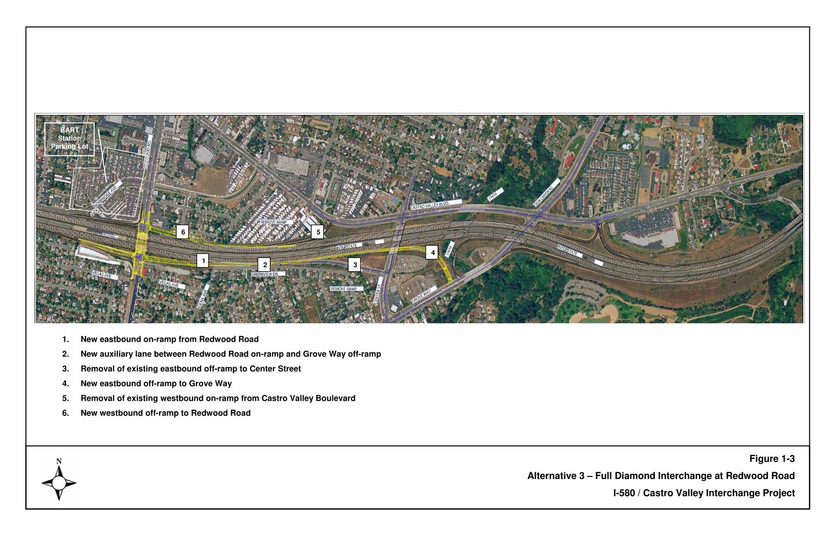
Project Description The proposed project (Full Diamond Interchange at Redwood Road) includes the following components as shown in Figure 1-3.
� Construction of a new westbound off-ramp from I-580 to Redwood Road; � Construction of a new eastbound on-ramp from Redwood Road to I-580;
� Construction of a new eastbound off-ramp from I-580 to Grove Way;
� Removal of the existing eastbound off-ramp to Center Street;
� Removal of the existing westbound on-ramp from Castro Valley Blvd just west of
Center Street; and � Construction of a new auxiliary lane between the new Redwood Road on-ramp
and the new Grove Way off-ramp.
� Construction of an HOV bypass lane, a CHP enforcement area, and a Maintenance Vehicle Pullout on the eastbound Redwood Road on-ramp; and
� Installation of ramp meters on the eastbound Redwood Road on-ramp and the
existing westbound Redwood Road on-ramp. (Note: activation of the ramp meters will not occur with this project.)
Alternatives Considered ACTIA, Caltrans and FHWA, partnered to develop a Project Study Report (PSR) to identify alternatives that best addressed existing transportation problems at the I-580 and Castro Valley interchanges. A total of three potential build alternatives were identified during development of the PSR that would meet the project purpose and need. The alternatives included the ACTIA Expenditure Plan Project, a Full Interchange Alternative, and a Single Point Urban Interchange Alternative. After initial analysis of the geometric concepts for each of the alternatives, the Single Point Urban Interchange Alternative was dropped from further consideration by the Project Development Team (PDT), due to the significant right of way impacts associated with that concept. Several variations of the ACTIA Expenditure Plan Project and the Full Interchange Alternative were then developed and analyzed to determine the optimum layout configuration for each of the alternatives. As a result, three alternatives were carried forward for analysis in the PSR including the No Build- Alternative, the Full Interchange Alternative, and the ACTIA Expenditure Plan Alternative. Descriptions of the three alternatives include the following:
���������� ������ ���������� ������ � ������ ����� ������������ ����� ��$ ��� !��"
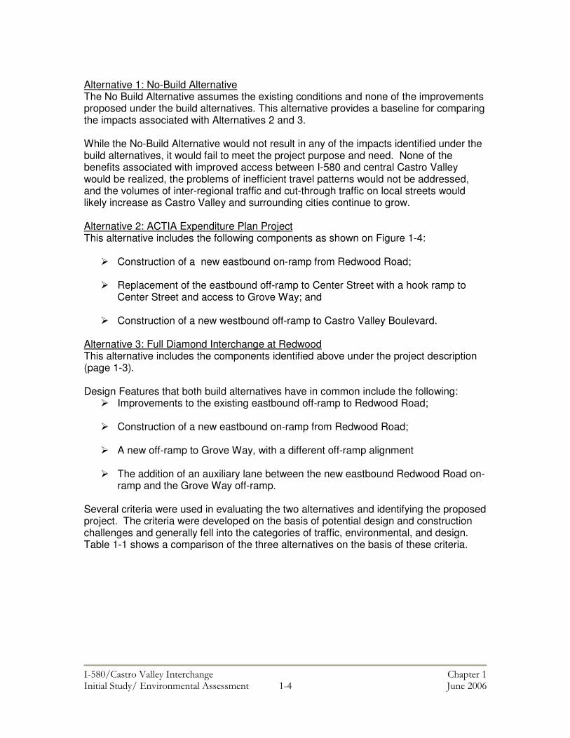
Alternative 1: No-Build Alternative The No Build Alternative assumes the existing conditions and none of the improvements proposed under the build alternatives. This alternative provides a baseline for comparing the impacts associated with Alternatives 2 and 3. While the No-Build Alternative would not result in any of the impacts identified under the build alternatives, it would fail to meet the project purpose and need. None of the benefits associated with improved access between I-580 and central Castro Valley would be realized, the problems of inefficient travel patterns would not be addressed, and the volumes of inter-regional traffic and cut-through traffic on local streets would likely increase as Castro Valley and surrounding cities continue to grow. Alternative 2: ACTIA Expenditure Plan Project This alternative includes the following components as shown on Figure 1-4:
� Construction of a new eastbound on-ramp from Redwood Road; � Replacement of the eastbound off-ramp to Center Street with a hook ramp to
Center Street and access to Grove Way; and � Construction of a new westbound off-ramp to Castro Valley Boulevard.
Alternative 3: Full Diamond Interchange at Redwood This alternative includes the components identified above under the project description (page 1-3). Design Features that both build alternatives have in common include the following:
� Improvements to the existing eastbound off-ramp to Redwood Road; � Construction of a new eastbound on-ramp from Redwood Road; � A new off-ramp to Grove Way, with a different off-ramp alignment � The addition of an auxiliary lane between the new eastbound Redwood Road on-
ramp and the Grove Way off-ramp. Several criteria were used in evaluating the two alternatives and identifying the proposed project. The criteria were developed on the basis of potential design and construction challenges and generally fell into the categories of traffic, environmental, and design. Table 1-1 shows a comparison of the three alternatives on the basis of these criteria.

���������� ������ ���������� ������ � ������ ����������������� ����� ��� ��� !��"
Table 1-1: Comparison of Alternatives Based on Evaluation Criteria Criteria Alternative 1- No Build-
Alternative Alternative 2-ACTIA
Expenditure Plan Project Alternative 3-Full Diamond Interchange at Redwood
Rd. Effect on traffic operations at interchanges of I-580 and local arterial roads, I-580 mainline, and traffic flow and congestion on local arterial roads.
Please refer to Chapter 2.2 (Traffic and Transportation/Pedestrian and Bicycle Facilities).
Please refer to Chapter 2.2 (Traffic and Transportation/Pedestrian and Bicycle Facilities).
Please refer to Chapter 2.2 (Traffic and Transportation/Pedestrian and Bicycle Facilities).
Potential for impacts on Crow Creek.
Neither construction nor operation of this alternative would result in impacts to Crow Creek.
Due to construction of an auxiliary lane on the portion of I-580 over Crow Creek, the project would result in environmental impacts to Crow Creek.
Neither construction nor operation of this alternative would result in impacts to Crow Creek.
Potential need for right-of-way (ROW) acquisition.
This alternative would not require any additional ROW.
The project would require minimal ROW outside the existing State ROW, however the existing park and ride lot across from the existing Center Street off-ramp would need to be relocated.
The project would result in the displacement of seven homes on Juniper Road and one commercial (office) building on Redwood Road. Minor ROW would also need to be acquired from two other commercial properties on Redwood Road for roadway widening.
Ability to meet Federal and State design standards.
This alternative would meet Federal and State design features.
This alternative includes significant non-standard Federal and State design features.
This alternative would meet Federal and State design features.
���������� ������ ���������� ������ � ������ ����������������� ����� ��" ��� !��"
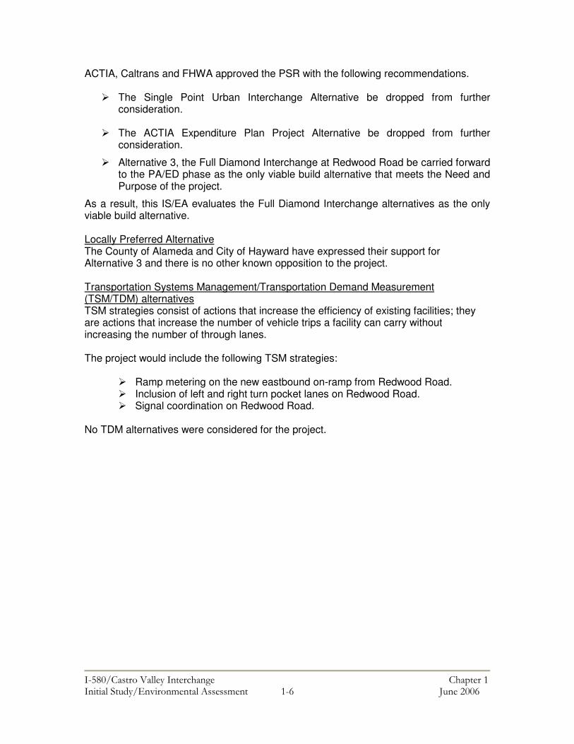
ACTIA, Caltrans and FHWA approved the PSR with the following recommendations.
� The Single Point Urban Interchange Alternative be dropped from further consideration.
� The ACTIA Expenditure Plan Project Alternative be dropped from further
consideration.
� Alternative 3, the Full Diamond Interchange at Redwood Road be carried forward to the PA/ED phase as the only viable build alternative that meets the Need and Purpose of the project.
As a result, this IS/EA evaluates the Full Diamond Interchange alternatives as the only viable build alternative. Locally Preferred Alternative The County of Alameda and City of Hayward have expressed their support for Alternative 3 and there is no other known opposition to the project. Transportation Systems Management/Transportation Demand Measurement (TSM/TDM) alternatives TSM strategies consist of actions that increase the efficiency of existing facilities; they are actions that increase the number of vehicle trips a facility can carry without increasing the number of through lanes. The project would include the following TSM strategies:
� Ramp metering on the new eastbound on-ramp from Redwood Road. � Inclusion of left and right turn pocket lanes on Redwood Road. � Signal coordination on Redwood Road.
No TDM alternatives were considered for the project.

���������� ������ ���������� ������ � ������ ����������������� ����� ��% ��� !��"
Public Outreach ACTIA hosted an informational open house on November 18, 2003 at Castro Valley High School between 6:00 – 8:00 PM. to present the results of the work conducted to date and the two alternatives being recommended for further study at that time. Local residents, property owners, business people, elected officials, and representatives from agencies, media and special interest organizations were invited to attend (see Section 6.1.1.5 of the Appendix for full mailing list of invitees). The meeting provided an opportunity for participants to comment on the presented alternatives and identify issues that should be considered in the project’s next phase. The public was notified of the meeting through a meeting announcement mailed on November 5, 2003, two weeks prior to the open house. The announcement included a description of the project, a description of the alternatives being studied, a project schedule, a project area map and contact information. The announcement was mailed to approximately 860 addresses which included residents, property owners and businesses within 500 feet of I-580 within the project limits. In addition, an invitation letter announcing the open house was mailed to local, State and Federal elected officials, the Castro Valley Municipal Advisory Committee, and the ACTIA Governing Board. A display ad announcing the open house was printed in the Daily Review on Sunday, November 9, 2003 and in the Castro Valley Forum on Wednesday, November 12, 2003. Additional meeting announcements were distributed to the Castro Valley Public Library, the Castro Valley High School, the Castro Valley Chamber of Commerce, and shopping centers in the area on November 14, 2003, four days prior to the open house. Approximately 65 people attended the open house, including local elected officials, residents and businesses, media representatives and other interested parties. Information was organized at six stations covering different topics. Agency staff was available at each station to answer questions and discuss issues with attendees. Comment sheets were made available for attendees to submit written comments. The comment sheets could either be submitted at the open house or mailed to ACTIA offices. Additional public meetings are scheduled for summer 2006 to update community members, agency representatives, and other stakeholders on the status of the project and to respond to any questions or concerns. Project Decision-Making Process Following the public review period, all comments will be considered by ACTIA and Caltrans/FHWA in making the final determination of the project’s effect on the environment. In accordance with California Environmental Quality Act (CEQA), if no unmitigable significant adverse impacts are identified, Caltrans will prepare a Negative Declaration (ND) or Mitigated ND. Similarly, if FHWA determines the action does not significantly impact the environment, FHWA will issue a Finding of No Significant impact (FONSI) in accordance with the National Environmental Policy Act of 1969, as amended (NEPA).
���������� ������ ���������� ������ � ������ ����������������� ����� ��� ��� !��"
Permits and Approvals Needed The following permits, reviews, concurrence or approvals may be required for project construction: Table 1-2: Permits and Approvals Agency Permit/Approval Status United States Army Corps of Engineers
Section 404 Permit for impacts to waters of the United States.
Not yet in process. Application for Section 404 permit anticipated after final distribution of IS/EA.
California Department of Fish and Game
1602 Agreement for Streambed Alteration Section 2080.1 Agreement for Threatened and Endangered Species
Not yet in process.
State Water Resources Control Board
Section 401 Certification Application to be completed concurrently with the Section 404 permit application.
Regional Water Quality Control Board
National Pollution Discharge Elimination System (NPDES) permit
Not yet in process.
Alameda County Flood Control and Water Conservation District
Right-of-Way Encroachment Permit
Not yet in process.

�
�
�
�
�
�
�
�
�
�
�
� � �
�
�
�
�
�������������� ����
�
�
�
ΝΝΝΝ Scale: 1:250,000 1 inch equals 3.9 miles
Figure 1-1 Project Vicinity
I-580 Castro Valley Interchange Project

Figure 1-2
Project Study Area Map
I-580 / Castro Valley Interchange Project
Project Study Area Limits
1 2 3
4
56
1. New eastbound on-ramp from Redwood Road
2. New auxiliary lane between Redwood Road on-ramp and Grove Way off-ramp
3. Removal of existing eastbound off-ramp to Center Street
4. New eastbound off-ramp to Grove Way
5. Removal of existing westbound on-ramp from Castro Valley Boulevard
6. New westbound off-ramp to Redwood Road
Figure 1-3
Alternative 3 – Full Diamond Interchange at Redwood Road
I-580 / Castro Valley Interchange Project
BART Station
Parking Lot

Figure 1-4
Alternative 2 – ACTIA Expenditure Plan Alternative
I-580 / Castro Valley Interchange Project
12 3
7
45
6
1. Minor modifications to the eastbound off-ramp to Redwood Road
2. New eastbound on-ramp from Redwood Road
3. New auxiliary lane between Redwood Road on-ramp and new Center Street off-ramp
4. Removal of existing eastbound off-ramp to Center Street
5. New eastbound off-ramp at Center Street with connection to Grove Way
6. New auxiliary lane between existing westbound on-ramp and new off-ramp to Castro Valley Boulevard
7. New westbound off-ramp to Castro Valley Boulevard
BART Station
Parking Lot

���������� ������������������ �� ��������������������������� �������������� � !�!�� "�������#�
CHAPTER 2 AFFECTED ENVIRONMENT, ENVIRONMENTAL CONSEQUENCES, AND AVOIDANCE, MINIMIZATION, AND/OR MITIGATION MEASURES As part of the scoping and environmental analysis conducted for the project, the environmental issues discussed in Chapter 2 were considered but no adverse impacts were identified. Consequently, there is no further discussion regarding these issues in this document. 2.1 UTILITIES / EMERGENCY and OTHER SERVICES Information used to complete this section was obtained through coordination with the project engineer, Mark Thomas and Company, and additional research. Preliminary investigations have been conducted by the project engineer to confirm the locations of utilities within the project area. Regulatory Setting In the project area, utilities, emergency response and solid waste services are provided by a number of different agencies and specific districts as described below. Utilities-Affected Environment Water Water service in Castro Valley is provided by the East Bay Municipal Utility District (EBMUD). Sanitary and Sewer Sewer service in Castro Valley is provided by the Castro Valley Sanitary District (CVSD), which operates six pump stations and 125 miles of sewer pipes. The Livermore-Amador Valley Water Management Agency transports treated wastewater through a pipeline that runs through the project area along Castro Valley Boulevard, a small portion of Grove Way, Greenview Avenue and Vegas Avenue. Solid Waste The Castro Valley Sanitary District provides garbage and recycling collection services through agreements with the Oakland Scavenger Company. Solid waste is transported to the Davis Street Transfer Station in Oakland, CA. and then hauled to the Altamont landfill east of Livermore, CA. These services are funded though user fees. Electricity Electricity in the project area is provided by Pacific Gas and Electric (PG&E). There is a PG & E substation in the project area that is located immediately to the west of where the new Grove Street off-ramp will be constructed.

���������� ������������������ �� ��������������������������� �������������� � !���� "�������#�
Emergency Response Services-Affected Environment Law Enforcement Law enforcement on the mainline and ramps of I-580 in the project area is provided by the California Highway Patrol Hayward/Castro Valley Office. Law enforcement in the remainder of the project area is provided by the Alameda County Sheriff’s Department. The Sheriff’s Department serves as both a countywide law enforcement agency and a community police department. Police services in Castro Valley are dispatched from the Eden Township Substation, which services unincorporated areas of Alameda County and is located in San Leandro. Fire Protection The Alameda County Fire Department maintains four stations in the Castro Valley area. There is also a station located on 164th Street in San Leandro, which responds to incidents on sections of I-580. Impacts and Mitigation Water The project does not include uses that would significantly increase either the short or long-term demand on water supplies in the area, and therefore would not impact EBMUD’s ability to serve residential and commerical uses in the project area. During construction, watering of graded areas would take place to limit the generation of fugitive dust. Water for this purpose would be transported to the site by water trucks. As a result, no mitigation is recommended. Potentially Adverse Effect 2.1-1: The project may require the temporary or permanent relocation of water lines in the project area. Mitigation 2.1-1: Any proposed construction activity within EBMUD easements or right-of-way owned by EBMUD shall be subject to the terms and conditions determined by EBMUD including relocation of the water mains and/or right-of-ways, at the lead agency’s expense. A final field verification of utilities shall be conducted as one of first steps in the PS&E phase. Sanitary and Sewer Project construction activities would not affect any of the CVSD pump stations; however, one sewer line would need to be relocated to accommodate the new off-ramp to Grove Way. The sewer line would be relocated so that it would parallel the new off-ramp but would remain within Caltrans right of way. Solid Waste The project contractors would be responsible for transporting solid waste generated during project construction (e.g. construction debris such as building materials, concrete, etc.) to an appropriate landfill facility. As a result, generation of additional waste through construction and demolition activities would not affect the sanitary district’s ability to service the project area. Potentially Adverse Effect 2.1-2: California State Law AB 939 requires that each City reduce its solid waste output to 50 percent of 1989 levels by the year 2000, with
���������� ������������������ �� ��������������������������� �������������� � !�$�� "�������#�
potential fines for communities that fail to meet the requirement. Since the proposed project would be constructed in Castro Valley, and could conflict with efforts to reduce solid waste during the construction phase of the project, mitigation is necessary. The majority of the waste created would consist of demolished concrete from the existing ramps that would be removed. Other waste would consist of excess construction materials such as wood and steel rebar. The following mitigation measure would facilitate conformance with State Law AB 939 and reduce or avoid this effect. Mitigation 2.1-2: Solid waste generation during the construction period shall be reduced by recycling and reusing materials to greatest extent possible. The contractor shall enforce a project-specific recycling/reuse plan that would include separating wood, metal, corrugated cardboard and concrete for potential re-use and recycling. Alameda County’s review and approval of the re-use/recycling plan shall be a condition of project approval. Electricity A portion of the parcel on which the PG&E substation is located would need to be acquired for vehicle access control; however, this will not require the displacement or relocation of electricity facilities at the substation of the facility. No other electrical facilities would be affected by the project and therefore, no mitigation is recommended. Emergency Services Through interchange improvements and improved traffic operations, the project has the potential to have a positive impact on emergency response times in the project area. Both build alternatives in the proposed project would reduce the cut-through traffic from Westbound I-580 through the addition of full interchanges at Redwood Road and Crow Canyon Road/Grove Way. Both alternatives would shift traffic away from Castro Valley Boulevard, and would redirect this traffic to the I-580 freeway. Therefore, during the operation period, the project is expected to have a beneficial impact on emergency response times. Potentially Adverse Effect 2.1-3: During the construction period, detours and temporary roadway closures may be implemented as part of the Traffic Management Plan (TMP). These measures could temporarily affect emergency response times. Mitigation 2.1-3: During development of a Transportation Management Plan (TMP), the lead agency shall coordinate with emergency response providers serving Castro Valley to identify any emergency response routes in the project area. When implementing the TMP, the lead agency shall consider these routes and minimize interference to them in the placement of detours and closures.

���������� ������������������ �� ��������������������������� �������������� � !�%�� "�������#�
Page Left Intentionally Blank
���������� ������������������ �� ��������������������������� �������������� � ��!�� "�������#�
2.2 TRAFFIC & TRANSPORTATION/PEDESTRIAN & BICYCLE FACILITIES This section is based on a Traffic Projections Report for Route 580/Castro Valley Interchange Study and a Traffic Operations Analysis Report for Interstate 580/Castro Valley Boulevard Interchange, which were completed by CCS in August 2005. REGULATORY SETTING The Federal Highway Administration directs that full consideration should be given to the safe accommodation of pedestrians and bicyclists during the development of federal-aid highway projects. It further directs that the special needs of the elderly and the disabled must be considered in all federal-aid projects that include pedestrian facilities. When current or anticipated pedestrian and/or bicycle traffic presents a potential conflict with motor vehicle traffic, every effort must be made to minimize the detrimental effects on all highway users who share the facility. The Department and FHWA are committed to carrying out the 1990 Americans with Disabilities Act (ADA) by building transportation facilities that provide equal access for all persons. The same degree of convenience, accessibility, and safety available to the general public will be provided to persons with disabilities. AFFECTED ENVIRONMENT I-580 in the project area includes four through lanes in both east and west directions. These lanes do not include High Occupancy Vehicle lanes or auxiliary lanes.1 Access to and from the freeway in the project area is currently provided by two on-ramps and two-off ramps, which connect to surface streets. The existing traffic operations of an area are typically evaluated through Level of Service (LOS). Accordingly, LOS on the mainline of I-580 and at key adjacent intersections is relevant to defining the existing traffic operations in the project area and determining what effect the project would have on those operations. The LOS methodology used for all facilities discussed in this chapter is based on the procedures and methodologies as described in the 2000 Highway Capacity Manual (HCM). This chapter identifies existing traffic conditions through current LOS measurements along this portion of I-580 in the project area and at key intersections, and compares these measurements to LOS projections for three alternatives (No-Build, Alternative 2, and Alternative 3) under 2030 traffic conditions.
1 Auxiliary lanes connect the entrance ramp from one interchange to the exit ramp or deceleration lane of the next off-ramp.
���������� ������������������ �� ��������������������������� �������������� � ����� "�������#�
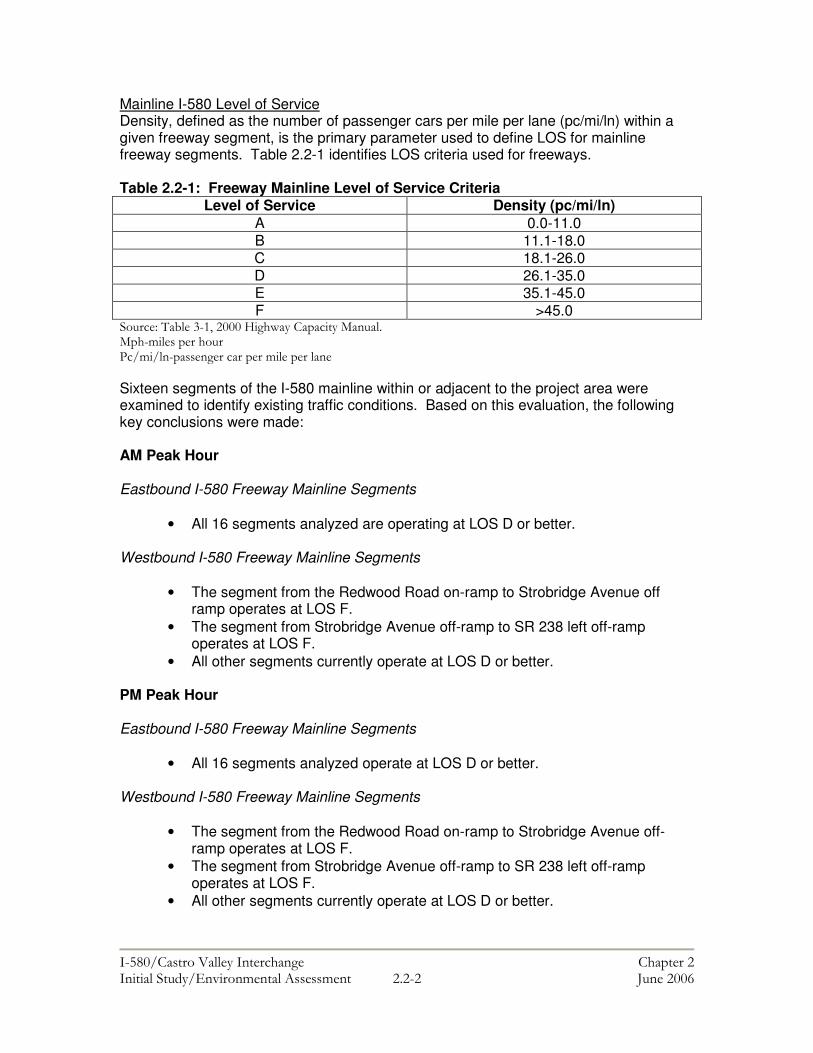
Mainline I-580 Level of Service Density, defined as the number of passenger cars per mile per lane (pc/mi/ln) within a given freeway segment, is the primary parameter used to define LOS for mainline freeway segments. Table 2.2-1 identifies LOS criteria used for freeways. Table 2.2-1: Freeway Mainline Level of Service Criteria
Level of Service Density (pc/mi/ln) A 0.0-11.0 B 11.1-18.0 C 18.1-26.0 D 26.1-35.0 E 35.1-45.0 F >45.0
� ����$�%&���'�!(������)���*���������+��� ��+������������� ���,���������������������������������� Sixteen segments of the I-580 mainline within or adjacent to the project area were examined to identify existing traffic conditions. Based on this evaluation, the following key conclusions were made: AM Peak Hour Eastbound I-580 Freeway Mainline Segments
• All 16 segments analyzed are operating at LOS D or better. Westbound I-580 Freeway Mainline Segments
• The segment from the Redwood Road on-ramp to Strobridge Avenue off ramp operates at LOS F.
• The segment from Strobridge Avenue off-ramp to SR 238 left off-ramp operates at LOS F.
• All other segments currently operate at LOS D or better. PM Peak Hour Eastbound I-580 Freeway Mainline Segments
• All 16 segments analyzed operate at LOS D or better. Westbound I-580 Freeway Mainline Segments
• The segment from the Redwood Road on-ramp to Strobridge Avenue off- ramp operates at LOS F.
• The segment from Strobridge Avenue off-ramp to SR 238 left off-ramp operates at LOS F.
• All other segments currently operate at LOS D or better.

���������� ������������������ �� ��������������������������� �������������� � ��'�� "�������#�
In conclusion, existing traffic operations on the portion of mainline I-580 in the project area are worse in the westbound direction than in the eastbound in both the AM and PM peak hours. Intersection Level of Service LOS at signalized intersections is defined in terms of average vehicle control delay, which is a measure of driver discomfort, frustration, fuel consumption, and lost travel time. The LOS thresholds for signalized intersections are presented in Table 2.2-2. Table 2.2-2: Intersection Level of Service Criteria
Level of Service Density (pc/mi/ln) A <10 B >10 and < 20 C >20 and < 35 D >35 and < 55 E >55 and < 80 F >80
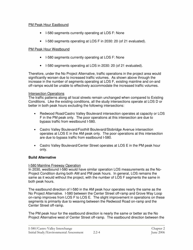
21 intersections were evaluated during the AM and PM peak as part of the 2005 Traffic Operations Report. All the intersections are operating at LOS E or better in both the AM and PM peak hours excluding the Redwood Road/Castro Valley Boulevard intersection, which operates at LOS F in the PM peak only. IMPACTS OF ALTERNATIVES No Project Alternative I-580 Mainline Traffic Operation Based on existing LOS data and 2030 traffic volume forecasts found in the Traffic Forecast Report for Route 580/Castro Valley Interchange Study, I-580 would become a highly congested mainline freeway with numerous locations operating at LOS F if no modifications are made to the existing facilities. Specifically, the following four changes in traffic operations in the project corridor are likely to occur in 2030 under the No Project alternative: AM Peak Hour Eastbound
• I-580 segments currently operating at LOS F: None
• I-580 segments operating at LOS F in 2030: 20 (of 21 evaluated). AM Peak Hour Westbound
• I-580 segments currently operating at LOS F: Five • I-580 segments operating at LOS F in 2030: 20 (of 21 evaluated).
���������� ������������������ �� ��������������������������� �������������� � ��-�� "�������#�
PM Peak Hour Eastbound
• I-580 segments currently operating at LOS F: None • I-580 segments operating at LOS F in 2030: 20 (of 21 evaluated).
PM Peak Hour Westbound
• I-580 segments currently operating at LOS F: None
• I-580 segments operating at LOS in 2030: 20 (of 21 evaluated). Therefore, under the No Project Alternative, traffic operations in the project area would significantly worsen due to increased traffic volumes. As shown above through the increase in the number of segments operating at LOS F, existing mainline and on-and off-ramps would be unable to effectively accommodate the increased traffic volumes. Intersection Operations The traffic patterns along all local streets remain unchanged when compared to Existing Conditions. Like the existing conditions, all the study intersections operate at LOS D or better in both peak hours excluding the following intersections:
• Redwood Road/Castro Valley Boulevard intersection operates at capacity or LOS F in the PM peak only. The poor operations at this intersection are due to bypass traffic from westbound I-580.
• Castro Valley Boulevard/Foothill Boulevard/Stobridge Avenue intersection
operates at LOS E in the AM peak only. The poor operations at this intersection are due to bypass traffic from eastbound I-580.
• Castro Valley Boulevard/Center Street operates at LOS E in the PM peak hour
only.
Build Alternative I-580 Mainline Freeway Operation In 2030, westbound I-580 would have similar operation LOS measurements as the No-Project Condition during both AM and PM peak hours. In general, LOS remains the same as it would without the project, with the number of LOS F segments the same in both peak hours. The eastbound direction of I-580 in the AM peak hour operates nearly the same as the No Project Alternative. I-580 between the Center Street off-ramp and Grove Way Loop on-ramp improves from LOS F to LOS E. The slight improvement in operations on these segments is primarily due to weaving between the Redwood Road on-ramp and the Center Street off-ramp. The PM peak hour for the eastbound direction is nearly the same or better as the No Project Alternative west of Center Street off-ramp. The eastbound direction between the
���������� ������������������ �� ��������������������������� �������������� � ����� "�������#�
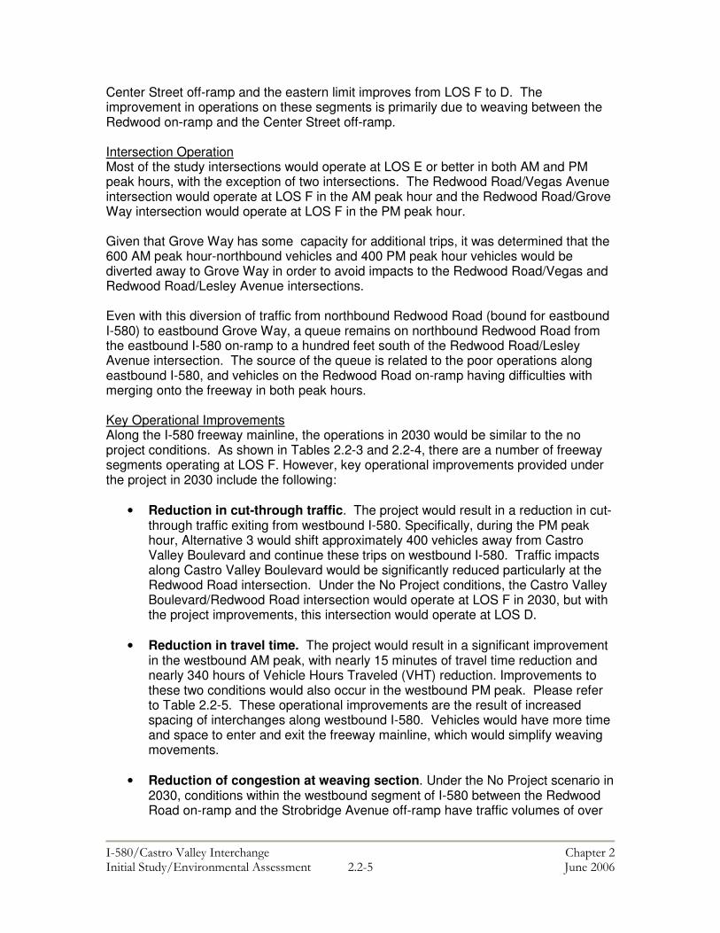
Center Street off-ramp and the eastern limit improves from LOS F to D. The improvement in operations on these segments is primarily due to weaving between the Redwood on-ramp and the Center Street off-ramp. Intersection Operation Most of the study intersections would operate at LOS E or better in both AM and PM peak hours, with the exception of two intersections. The Redwood Road/Vegas Avenue intersection would operate at LOS F in the AM peak hour and the Redwood Road/Grove Way intersection would operate at LOS F in the PM peak hour. Given that Grove Way has some capacity for additional trips, it was determined that the 600 AM peak hour-northbound vehicles and 400 PM peak hour vehicles would be diverted away to Grove Way in order to avoid impacts to the Redwood Road/Vegas and Redwood Road/Lesley Avenue intersections. Even with this diversion of traffic from northbound Redwood Road (bound for eastbound I-580) to eastbound Grove Way, a queue remains on northbound Redwood Road from the eastbound I-580 on-ramp to a hundred feet south of the Redwood Road/Lesley Avenue intersection. The source of the queue is related to the poor operations along eastbound I-580, and vehicles on the Redwood Road on-ramp having difficulties with merging onto the freeway in both peak hours. Key Operational Improvements Along the I-580 freeway mainline, the operations in 2030 would be similar to the no project conditions. As shown in Tables 2.2-3 and 2.2-4, there are a number of freeway segments operating at LOS F. However, key operational improvements provided under the project in 2030 include the following:
• Reduction in cut-through traffic. The project would result in a reduction in cut-through traffic exiting from westbound I-580. Specifically, during the PM peak hour, Alternative 3 would shift approximately 400 vehicles away from Castro Valley Boulevard and continue these trips on westbound I-580. Traffic impacts along Castro Valley Boulevard would be significantly reduced particularly at the Redwood Road intersection. Under the No Project conditions, the Castro Valley Boulevard/Redwood Road intersection would operate at LOS F in 2030, but with the project improvements, this intersection would operate at LOS D.
• Reduction in travel time. The project would result in a significant improvement
in the westbound AM peak, with nearly 15 minutes of travel time reduction and nearly 340 hours of Vehicle Hours Traveled (VHT) reduction. Improvements to these two conditions would also occur in the westbound PM peak. Please refer to Table 2.2-5. These operational improvements are the result of increased spacing of interchanges along westbound I-580. Vehicles would have more time and space to enter and exit the freeway mainline, which would simplify weaving movements.
• Reduction of congestion at weaving section. Under the No Project scenario in
2030, conditions within the westbound segment of I-580 between the Redwood Road on-ramp and the Strobridge Avenue off-ramp have traffic volumes of over

���������� ������������������ �� ��������������������������� �������������� � ��#�� "�������#�
6,200 vehicles in both peak hours. This segment also operates with a high volume of nearly 1,000 vehicles attempting to enter or exit the freeway. This results in a highly congested weave section, which is compounded by the queued back up from the State Route 238 split downstream of this location. The project would shift nearly 1,000 vehicles away from this segment of westbound I-580 to the stretch of I-580 east of the Redwood Road Interchange. This new access point is the primary source of improvement in travel time and VHT in the westbound direction for Alternative 3.
���������� ������������������ �� ��������������������������� �������������� � ��.�� "�������#�
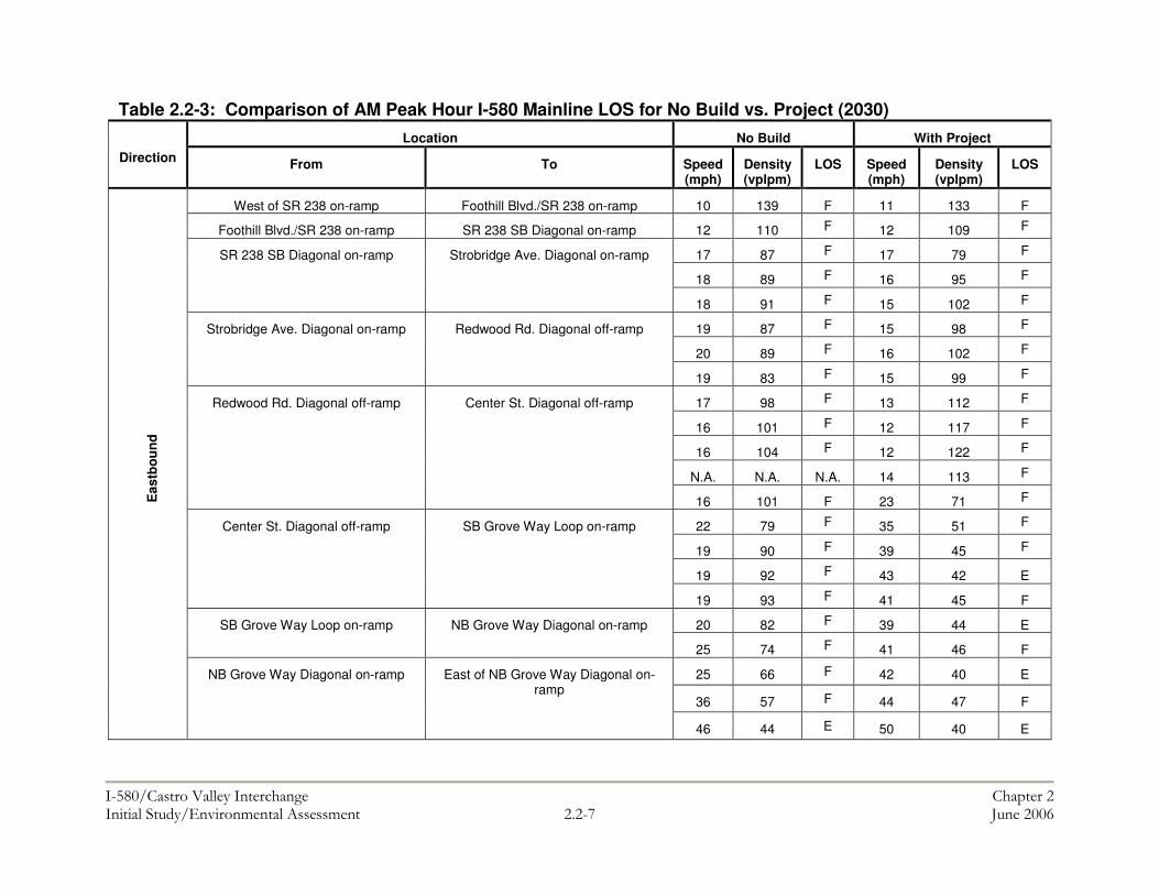
Table 2.2-3: Comparison of AM Peak Hour I-580 Mainline LOS for No Build vs. Project (2030)
Location No Build With Project Direction From To Speed
(mph) Density (vplpm)
LOS Speed (mph)
Density (vplpm)
LOS
West of SR 238 on-ramp Foothill Blvd./SR 238 on-ramp 10 139 F 11 133 F
Foothill Blvd./SR 238 on-ramp SR 238 SB Diagonal on-ramp 12 110 F 12 109 F
17 87 F 17 79 F
18 89 F 16 95 F SR 238 SB Diagonal on-ramp Strobridge Ave. Diagonal on-ramp
18 91 F 15 102 F
19 87 F 15 98 F
20 89 F 16 102 F Strobridge Ave. Diagonal on-ramp Redwood Rd. Diagonal off-ramp
19 83 F 15 99 F
17 98 F 13 112 F
16 101 F 12 117 F
16 104 F 12 122 F
N.A. N.A. N.A. 14 113 F
Redwood Rd. Diagonal off-ramp Center St. Diagonal off-ramp
16 101 F 23 71 F
22 79 F 35 51 F
19 90 F 39 45 F
19 92 F 43 42 E
Center St. Diagonal off-ramp SB Grove Way Loop on-ramp
19 93 F 41 45 F
20 82 F 39 44 E SB Grove Way Loop on-ramp NB Grove Way Diagonal on-ramp
25 74 F 41 46 F
25 66 F 42 40 E
36 57 F 44 47 F
Eas
tbou
nd
NB Grove Way Diagonal on-ramp
East of NB Grove Way Diagonal on-ramp
46 44 E 50 40 E
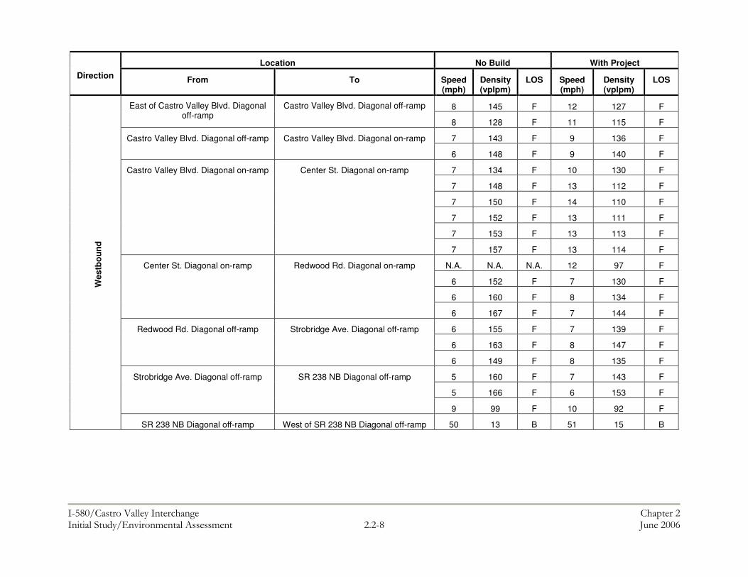
���������� ������������������ �� ��������������������������� �������������� � ����� "�������#�
Location No Build With Project Direction From To Speed
(mph) Density (vplpm)
LOS Speed (mph)
Density (vplpm)
LOS
8 145 F 12 127 F East of Castro Valley Blvd. Diagonal off-ramp
Castro Valley Blvd. Diagonal off-ramp
8 128 F 11 115 F
7 143 F 9 136 F Castro Valley Blvd. Diagonal off-ramp Castro Valley Blvd. Diagonal on-ramp
6 148 F 9 140 F
7 134 F 10 130 F
7 148 F 13 112 F
7 150 F 14 110 F
7 152 F 13 111 F
7 153 F 13 113 F
Castro Valley Blvd. Diagonal on-ramp Center St. Diagonal on-ramp
7 157 F 13 114 F
N.A. N.A. N.A. 12 97 F
6 152 F 7 130 F
6 160 F 8 134 F
Center St. Diagonal on-ramp Redwood Rd. Diagonal on-ramp
6 167 F 7 144 F
6 155 F 7 139 F
6 163 F 8 147 F
Redwood Rd. Diagonal off-ramp Strobridge Ave. Diagonal off-ramp
6 149 F 8 135 F
5 160 F 7 143 F
5 166 F 6 153 F
Strobridge Ave. Diagonal off-ramp SR 238 NB Diagonal off-ramp
9 99 F 10 92 F
Wes
tbou
nd
SR 238 NB Diagonal off-ramp West of SR 238 NB Diagonal off-ramp 50 13 B 51 15 B

���������� ������������������ �� ��������������������������� �������������� � ��/�� "�������#�
Table 2.2-4: Comparison of PM Peak Hour I-580 Mainline LOS for No Build vs. Project (2030) Location No Build With Project
Direction From To Speed (mph)
Density (vplpm)
LOS Speed (mph)
Density (vplpm)
LOS
West of SR 238 on-ramp Foothill Blvd./SR 238 on-ramp 15 110 F 14 115 F
Foothill Blvd./SR 238 on-ramp SR 238 SB Diagonal on-ramp 17 86 F 15 88 F
21 68 F 19 72 F
28 61 F 17 92 F
SR 238 SB Diagonal on-ramp Strobridge Ave. Diagonal on-ramp
27 62 F 15 101 F
27 62 F 15 98 F
28 66 F 15 103 F
Strobridge Ave. Diagonal on-ramp Redwood Rd. Diagonal off-ramp
27 62 F 15 97 F
24 72 F 12 118 F
23 74 F 11 123 F
21 82 F 11 129 F
N.A. N.A. N.A. 13 120 F
Redwood Rd. Diagonal off-ramp Center St. Diagonal off-ramp
21 80 F 24 66 F
21 82 F 41 37 E
19 90 F 46 33 D
18 91 F 53 29 D
Center St. Diagonal off-ramp SB Grove Way Loop on-ramp
18 94 F 56 27 D
18 86 F 56 25 C SB Grove Way Loop on-ramp NB Grove Way Diagonal on-ramp
20 86 F 57 28 D
20 79 F 56 26 D
37 53 F 56 32 D
Eas
tbou
nd
NB Grove Way Diagonal on-ramp East of NB Grove Way Diagonal on-ramp
49 41 E 58 31 D

���������� ������������������ �� ��������������������������� �������������� � ��!��� "�������#�
Location No Build With Project Direction From To Speed
(mph) Density (vplpm)
LOS Speed (mph)
Density (vplpm)
LOS
20 91 F 23 84 F East of Castro Valley Blvd. Diagonal off-ramp
Castro Valley Blvd. Diagonal off-ramp
19 82 F 23 75 F
14 100 F 21 80 F Castro Valley Blvd. Diagonal off-ramp Castro Valley Blvd. Diagonal on-ramp
13 106 F 19 86 F
13 92 F 19 81 F
13 109 F 21 85 F
13 111 F 21 84 F
13 113 F 21 85 F
13 111 F 20 88 F
Castro Valley Blvd. Diagonal on-ramp Center St. Diagonal on-ramp
13 112 F 20 88 F
11 116 F 18 78 F
N.A. N.A. N.A. 11 109 F
10 126 F 12 100 F
Center St. Diagonal on-ramp Redwood Rd. Diagonal on-ramp
9 133 F 10 114 F
9 125 F 10 112 F
10 137 F 11 117 F
Redwood Rd. Diagonal off-ramp Strobridge Ave. Diagonal off-ramp
9 130 F 11 112 F
8 146 F 10 110 F
8 149 F 9 119 F
Strobridge Ave. Diagonal off-ramp SR 238 NB Diagonal off-ramp
13 85 F 12 86 F
Wes
tbou
nd
SR 238 NB Diagonal off-ramp West of SR 238 NB Diagonal off-ramp 52 19 C 48 21 C
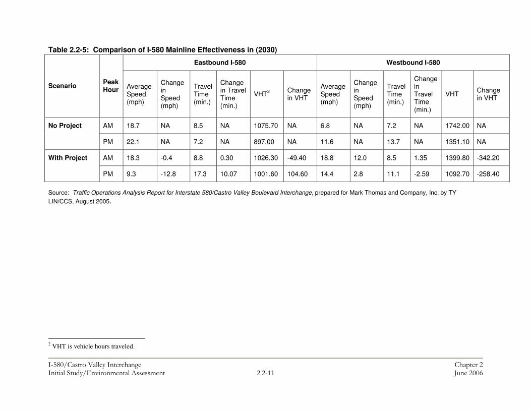
���������� ������������������ �� ��������������������������� �������������� � ��!!�� "�������#�
Table 2.2-5: Comparison of I-580 Mainline Effectiveness in (2030)
Source: Traffic Operations Analysis Report for Interstate 580/Castro Valley Boulevard Interchange, prepared for Mark Thomas and Company, Inc. by TY LIN/CCS, August 2005.
2 VHT is vehicle hours traveled.
Eastbound I-580 Westbound I-580
Scenario Peak Hour Average
Speed (mph)
Change in Speed (mph)
Travel Time (min.)
Change in Travel Time (min.)
VHT2 Change in VHT
Average Speed (mph)
Change in Speed (mph)
Travel Time (min.)
Change in Travel Time (min.)
VHT Change in VHT
AM 18.7 NA 8.5 NA 1075.70 NA 6.8 NA 7.2 NA 1742.00 NA No Project
PM 22.1 NA 7.2 NA 897.00 NA 11.6 NA 13.7 NA 1351.10 NA
AM 18.3 -0.4 8.8 0.30 1026.30 -49.40 18.8 12.0 8.5 1.35 1399.80 -342.20 With Project
PM 9.3 -12.8 17.3 10.07 1001.60 104.60 14.4 2.8 11.1 -2.59 1092.70 -258.40

���������� ������������������ �� ��������������������������� �������������� � ��!��� "�������#�
Impacts and Mitigation Potentially Adverse Effect 2.2-1: Construction could result in temporary adverse effects on local traffic circulation. Although construction will be phased to minimize impacts, existing delays on the freeway, ramps, and affected intersections could increase during construction.
Mitigation 2.2.1: A Transportation Management Plan (TMP) shall be prepared prior to construction to address potential traffic impacts during the construction period. The TMP would identify traffic handling strategies and the optimum location for detours based on existing traffic patterns and volumes. In the event that lane or street closures would be required during construction, the TMP shall include details of a public notification program and a Construction or Maintenance Zone Enhanced Enforcement Program (COZEEP) during construction. The public notification program shall include press releases and other documents necessary to adequately inform the public of traffic delays associated with the project. Advance notification of construction activity shall be provided to local newspaper, television and radio stations, and emergency response providers. Weekly informational updates should also be submitted to the Caltrans District 4 Public Information Office for use in Caltrans Weekly Traffic Updates. The TMP shall identify steps for coordinating with emergency response agencies to identify emergency response routes in the project area and strategies for minimizing impacts to emergency response times.
Potentially Adverse Effect 2.2-2: The short intersection spacing along Redwood Road to the south of I-580 between the freeway on- and off-ramps and side streets could contribute to traffic degradation and LOS F conditions. For example, vehicles may not be able to clear the intersection of Redwood Road and Vegas Avenue in a given cycle, which might result in backups of through-traffic along Vegas Road crossing Redwood Road. Mitigation 2.2-2: The intersection of Redwood Road and Vegas Avenue shall be converted to a right-in/right-out intersection, which would reduce or avoid this potential effect.
Potentially Adverse Effect 2.2-3: There is a Class I bike path on Grove Way.2 Construction of the new eastbound off-ramp to Grove Way would potentially affect this facility during construction.
Mitigation 2.2-3: Caltrans shall ensure that ramp construction, intersection modifications, and lane widenings do not permanently remove existing bicycle facilities. In the event that project construction would affect bicycle facilities, Caltrans shall identify alternate access for the construction period and restore full access following construction. If full access cannot be restored, Caltrans shall coordinate
2 Alameda Countywide Bicycle Plan, July 2001, Website: http://www.accma.ca.gov/pages/taskforce_map3.shtml�

���������� ������������������ �� ��������������������������� �������������� � ��!'�� "�������#�
with Alameda County Congestion Management Agency (ACCMA) to identify appropriate alternate access. Potentially Adverse Effect 2.2-4: The construction of the project would temporarily remove sidewalk access on Redwood Road between Vegas Avenue and Pine Street during the widening of Redwood Road. Mitigation 2.2-4: During the project design phase, Caltrans shall develop a plan for temporary sidewalk access during the construction period. Sidewalks shall have ADA compliant curb ramps to accommodate wheelchair access. The review and approval of the plan by Alameda County would be a condition of approval.
Potentially Adverse Effect 2.2-5: Parking spaces behind a mortuary on Redwood Road would be lost due to the construction of the new westbound off ramp to Redwood Road. Mitigation 2.2-5: The lead agency shall coordinate with the mortuary property owner prior to construction to identify adequate replacement parking. Potentially Adverse Effect 2.2-6: Alameda County Transit (AC Transit) provides several bus lines (Lines 91, 84, 80, and 87) that service points along Redwood Road and provide connections to the Castro Valley BART station. Transit service could experience delays during construction due to construction activities and detours. Mitigation 2.2-6: The TMP shall identify measures, as needed, to minimize interruption of transit service in the project area during project construction. At a minimum, the TMP shall include measures to ensure that AC Transit lines serving the area have continued access during construction and that during operation, curbside transit stops (including bus shelters) are maintained in place to the maximum extent feasible.

���������� ������������������ �� ��������������������������� �������������� � ��!-�� "�������#�
Page Left Intentionally Blank

���������� ������ ���������� ������ � ������ ����������������� ����� � !�" #��� ���$
2.3 VISUAL/AESTHETICS The following chapter is based on a Visual Impact Assessment (VIA) report, dated July 15, 2005, which was prepared by Pattillo & Garrett Associates. The methods used to assess the visual impacts of the project are consistent with Federal Highway Administration guidelines outlined in the March 1981 publication Visual Impact Assessment for Highway Projects. Approach and Methodology This section assesses the effects that the proposed project would have on views of the site from publicly accessible locations. The analysis considers the visual quality of the site and its vicinity, public views of the project site and relevant policies from the Alameda County General Plan. The visual analysis is supported with photographs of the project area paired with visual simulations depicting the same views, but with the completed project. Visual simulations are computer-generated photographic quality images used to reflect how a proposed project would appear after it is completed and what visual effects the proposed project would have on an area.
Visual impacts of the project are assessed according to the anticipated change in landscape character and visual quality caused by the project, and the public’s likely response to such change. Changes to visual resources are characterized by attributes such as line, form, color, texture, dominance, scale, diversity and continuity. Changes to visual quality are measured in terms of vividness, intactness and unity. Regulatory Setting The National Environmental Policy Act of 1969 as amended (NEPA) establishes that the federal government use all practicable means to ensure all Americans safe, healthful, productive, and aesthetically (emphasis added) and culturally pleasing surroundings [42 U.S.C. 4331(b)(2)]. To further emphasize this point, the Federal Highway Administration in its implementation of NEPA [23 U.S.C. 109(h)] directs that final decisions regarding projects are to be made in the best overall public interest taking into account adverse environmental impacts, including among others, the destruction or disruption of aesthetic values. Likewise, the California Environmental Quality Act establishes that it is the policy of the state to take all action necessary to provide the people of the state “with…enjoyment of aesthetic, natural, scenic and historic environmental qualities [CA Public Resources Code Section 21001(b)].
Scenic vistas are identified in the Scenic Element of the Alameda County General Plan. It was determined in the VIA that the project would not affect any of the scenic vistas identified in the County General Plan.

���������� ������ ���������� ������ � ������ ����������������� ����� � !�� #��� ���$
Affected Environment The existing visual setting for the west end of the project area is urbanized, including a mixture of commercial and suburban residential development, gradually progressing to a more suburban-rural character on the east end of the project area. Residential properties in the project area primarily consist of one story, single-family houses and mobile homes. Viewing distances from the homes closest to I-580 on the north side vary from 10.5 to 12 meters (35 to 40 feet), while homes adjacent to the south side of I-580 on Greenview Drive have viewing distances of approximately 5 meters (16 feet). Views from homes adjacent to the freeway are typically blocked by earth-filled embankments, sound walls and mature plantings associated with the existing freeway. Views from the freeway to the adjacent neighborhoods are blocked in some areas by existing sound walls and mature vegetation. Landscape Units The project area was divided into landscape units1, each having certain visual attributes with regard to landform, vegetation, and the built environment. The relationship of these elements to each other differs for each landscape unit and is what gives the unit its visual character. Based on the relationships observed with the project unit, four landscape units were identified:
• The Mortuary on Redwood Road Landscape Unit (From Front) • The Mortuary on Redwood Road Landscape Unit (From Rear) • Juniper and Elm Streets Landscape Unit • Greenview Drive Landscape Unit
The visual characteristics of the landscape units are described below, including each unit’s landscape components, image types, and edge conditions (key conditions occurring along the right-of-way, and their influences.) A description of the landscape unit as viewed from the road, including important vistas and visual landmark, is provided. A description of views toward Redwood Road, I-580, and Greenview Drive, from sensitive viewpoints within the landscape unit is also provided. Pre-project visual quality of the unit is described using the following criteria: vividness, intactness, and unity. According to FHWA guidelines, vividness is defined as the presence of memorable landscape components combined with striking and distinctive visual patterns. Intactness is the visual integrity of the natural and human built landscape and its freedom from encroaching elements. Unity is the visual coherence and compositional harmony of the landscape considered as a whole. Viewer Groups In general, four viewer groups are identified within the entire project area:
• local residents • persons engaged in recreation, including persons traveling for pleasure • motorists/highway travelers
1 The FHWA (1981) defines landscape units as distinct components of a regional landscape that are enclosed by clear landform or landcover boundaries. These units provide a framework for comparing the visual impacts of highway project alternatives.

���������� ������ ���������� ������ � ������ ����������������� ����� � !�! #��� ���$
• persons engaged in business or commerce Viewer groups vary in terms of exposure and sensitivity to their surroundings. For example, residents would be expected to have greater sensitivity to the visual environment from their homes than would a motorist traveling quickly through the same area. Each viewer group is described within each landscape unit. Effects of the project on visual resources also are discussed within each landscape unit.
Four viewpoints (1-4 listed below) were also evaluated. In general, the viewpoints were selected on the basis of where, in the project area, the proposed improvements would likely have the greatest effect on existing visual resources and visual quality. The locations of viewpoints 1-4 are shown below in Figure 2.3-1 and focus primarily on the visual impacts of the proposed full diamond interchange at Redwood Road because this is where the greatest degree of visual change would occur.
For viewpoints 1-3, an illustration of existing conditions is followed by a simulation of the view with the project constructed. These illustrations are shown in Figures 2.3-2 – 2.3-4.
BART Station
Parking Lot
LINE J
LINE I
Figure 2.3-1 Viewpoints 1-4

���������� ������ ���������� ������ � ������ ����������������� ����� � !�% #��� ���$
The Mortuary on Redwood Road Landscape Unit (From Front) Visual characteristics: This landscape unit consists of the mortuary and its parking area. Edge conditions include southern views constrained by an existing sound wall, riprap on earth-filled embankments, and an 80-meter row of mature eucalyptus trees, adjacent commercial and residential properties and a vacant lot. The roadway, elevated interchange structures, sound walls, and mature plantings dominate the views from the freeway. Overall, the level of visual quality is moderate. Vividness was rated as moderate due to the proximity of the sound walls and mature plantings to the viewer. Intactness was rated as low/moderate since the natural landscape pattern was altered by the placement of the freeway, sound walls, and commercial/residential areas. Unity was rated as moderate because the mature plantings and sound walls form a consistent visual pattern through the length of this unit. Viewers: Most motorists on local streets have below-grade, filtered views of the freeway because existing highway plantings and sound walls help screen the freeway from view. Motorists on local streets traveling through this landscape unit have their attention focused mainly along their line of travel and immediate surroundings. Due to relativity short duration of exposure, this viewer group has a lower sensitivity than residents and their overall response to visual change may be low. Business owners, workers, and patrons in this landscape unit have close- and mid-range, below grade filtered views of the freeway. Viewer exposure time varies but is generally shorter than residents; thus, their response to visual change may be low to moderate. Effects of the project on visual resources: As illustrated by a comparison of the existing view and the view with project (see Figure 2.3-2, Viewpoint 1), the proposed project would create a new westbound off-ramp at Redwood Road. The new ramp would cut into the existing parking lot of the mortuary and would displace an 80-meter row of mature eucalyptus trees on the southern edge of the mortuary property, which currently provides screening for both motorists on I-580 and from the mortuary building from the freeway. The project would result in a moderately high visual change from this view. The existing level of visual quality at the interchange is moderate; however, with the proposed project, the visual quality would be low/moderate with removal of the mature trees. The removal of the mature trees would also result in a change to vividness and unity from a moderate to low/moderate rating because the off-ramp and existing freeway structures would increase in visual dominance. Intactness, however, would remain low/moderate due to the alteration of the natural landscape pattern by the placement of the freeway, sound walls and adjacent commercial/residential uses. Mitigation 2.3-1: To mitigate for the removal of mature row trees, the sound wall shall be aesthetically treated with colors and textures, and planted with new vines and/or shrubs to reduce glare, screen and soften wall views and deter graffiti.
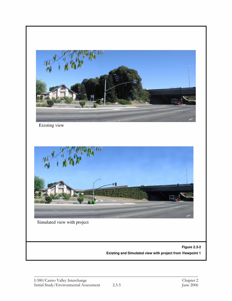
���������� ������ ���������� ������ � ������ ����������������� ����� � !�� #��� ���$
Figure 2.3-2
Existing and Simulated view with project from Viewpoint 1
Existing view
Simulated view with project

���������� ������ ���������� ������ � ������ ����������������� ����� � !�$ #��� ���$
The Mortuary on Redwood Road Landscape Unit (From Rear) Visual characteristics: This landscape unit consists of the mortuary and its parking area. Edge conditions include southern views constrained by an existing sound wall and an 80-meter row of mature eucalyptus trees, adjacent commercial and residential properties and a vacant lot. Elevated freeway structures, sound walls, and mature plantings dominate the views from the freeway. Overall, the level of visual quality is moderate. Vividness was rated as moderate due to the proximity of the sound walls and mature plantings to the viewer. Intactness was rated as low/moderate since the natural landscape pattern was altered by the placement of the freeway, sound walls, and commercial/residential areas. Unity was rated as moderate because the mature plantings and sound walls form a consistent visual pattern through the length of this unit. Viewers: Most motorists on local streets have below-grade, filtered views of the freeway because existing highway plantings and sound walls help screen the freeway from view. Motorists on local streets traveling through this landscape unit have their attention focused mainly along their line of travel and immediate surroundings. Due to relativity short duration of exposure, this viewer group has a lower sensitivity than residents and their overall response to visual change may be low. Business owners, workers, and patrons in this landscape unit have close- and mid-range, below grade filtered views of the freeway. Viewer exposure time varies but is generally shorter than residents; thus, their response to visual change may be low to moderate. Effects of the project on visual resources: As illustrated by a comparison of the existing view and the view with project (see Figure 2.3-3, Viewpoint 2), the proposed project would create a new westbound off-ramp at Redwood Road. The new ramp would displace a portion of the mortuary parking lot and an 80-meter row of mature eucalyptus trees on the southern edge of the mortuary property. A new sound wall would partially block the view of the freeway, while a chain link fence would control access to the off-ramp. The project would result in a moderately high visual change from this view. The currently moderate level of visual quality would be adversely affected by the removal of the mature trees. The unity and vividness of the view would change from a moderate to low/moderate rating because of the higher visual dominance of the off-ramp and existing freeway structures; however, the intactness of the view would be aided by the addition of a new sound wall, which would partially screen views of the freeway from the mortuary parking lot. Mitigation 2.3-2: To mitigate for the removal of mature row trees, the sound wall shall be aesthetically treated with colors and textures. The area bordering the sound wall shall be paved for parking to compensate for the displacement of the existing parking area behind the mortuary. A chain link fence shall be constructed on top of a concrete barrier to control access to the off-ramp.

���������� ������ ���������� ������ � ������ ����������������� ����� � !�& #��� ���$
Existing view
Simulated view with project
Figure 2.3-3
Existing and Simulated view with project from Viewpoint 2

���������� ������ ���������� ������ � ������ ����������������� ����� � !�� #��� ���$
Juniper and Elm Streets Landscape Unit Visual characteristics: This landscape unit consists of a mixture of single-family houses and mobile homes. Edge conditions include views constrained by an existing sound wall, riprap on earth-filled embankments, an 80-meter row of mature eucalyptus trees, commercial properties and several residential streets (Juniper, Elm, and Pine). The roadway, elevated freeway structures, sound walls and mature plantings dominate the views from the freeway. The level of visual quality is moderate. Vividness was rated as moderate due to the proximity of the sound walls and mature plantings to the viewer. Intactness was rated as low/moderate since the natural landscape pattern was altered by the placement of the freeway, sound walls and commercial/residential areas. Unity was rated as moderate because the mature plantings and sound walls form a consistent visual pattern through the length of this unit. Viewers: Approximately 19 single-family homes are located between 10 to 60 meters (33 to 197 feet) from I-580 along Elm and Juniper Streets. These residents have close-range, full and filtered views of the freeway and sound walls, and their exposure time is unlimited. Residents have a heightened, detailed awareness of visual resources such as the mature eucalyptus trees, and their sensitivity to the visual environment is considered high. Their response to visual change may be moderate to high. Motorists on local streets traveling through this landscape unit have their attention focused mainly along their line of travel and immediate surroundings. Existing highway plantings and sound walls help screen the freeway from view. Most motorists on local streets have below-grade, filtered views of the freeway. Viewer sensitivity of this group is lower than the residents’ due to relativity short duration of exposure. Their response to visual change may be low. Effects of the project on visual resources: As illustrated by a comparison of the existing view and the view with project (see Figure 2.3-4, Viewpoint 3), the proposed project would create a new westbound off-ramp at Redwood Road, flanked by a retaining and sound wall that would be 123 meters (404 feet) long and 360 meters (1,181 feet) long, respectively. Construction of these features would result in the displacement of six existing houses and an existing 80-meter row of mature eucalyptus trees. It would alter the existing residential views for the residents living north of the proposed Redwood Road off-ramp. For residents immediately adjacent to the freeway, the proposed retaining and sound walls would become more prominent features than the existing sound and retaining walls because they would be closer to private residences, they would be a different color than the existing walls, and they may become a temporary source of glare until new landscaping matures. The project would result in a moderately high visual change from this view. The existing level of visual quality from this viewpoint is moderate; however, with the proposed project, the visual quality would be low/moderate, since the removal of the mature trees and houses would eliminate the visual screening separating residents from the new off-ramp. The displacement of the mature plantings and the six existing houses would adversely affect the vividness of the view and its overall unity with the surrounding landscape, resulting in a change from a moderate to a low/moderate rating. Intactness, however, would remain low/moderate due to the previous alteration of the natural
���������� ������ ���������� ������ � ������ ����������������� ����� � !�' #��� ���$
landscape pattern by the placement of the freeway, sound walls and adjacent residential uses. Mitigation 2.3-3: A 3.6-meter (8.2 feet)-high sound wall shall be built along the side of the ramp in the residential area. The proposed design shall include space for a terraced planting strip between the sound wall and the top of the retaining wall. Walls shall be aesthetically treated with colors and textures, and planted with new vines and/or shrubs to reduce glare, screen and soften wall views and deter graffiti.
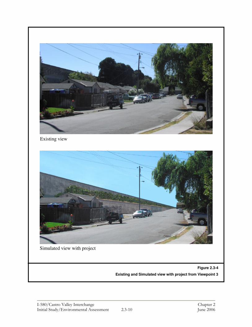
���������� ������ ���������� ������ � ������ ����������������� ����� � !�"� #��� ���$
Figure 2.3-4
Existing and Simulated view with project from Viewpoint 3
Existing view
Simulated view with project
���������� ������ ���������� ������ � ������ ����������������� ����� � !�"" #��� ���$
Viewpoint 4: Greenview Drive Landscape Unit Visual characteristics: This landscape unit consists of single-family houses. Edge conditions include northern views constrained by the existing sound wall, an eastbound off-ramp, riprap on earth-filled embankments and 65 meters (213 feet) of existing plantings, and several residential streets (Idena Avenue and Belten Way). The roadway, elevated freeway structures, sound walls and existing plantings dominate the views from the freeway. The level of visual quality is moderate. Vividness was rated as moderate due to the proximity of the sound walls and mature plantings to the viewer. Intactness was rated as low/moderate since the natural landscape pattern was altered by the placement of the freeway, sound walls, and commercial/residential areas. Unity was rated as moderate because the mature plantings and sound walls form a consistent visual pattern through the length of this unit. Viewers: As many as 16 single-family houses are located approximately 9-11 meters (29 to 36 feet) from I-580 on Greenview Drive, between Idena Avenue and Belten Way. These residents have close-range, full and filtered views of the freeway and the sound wall, and their exposure time is unlimited (see Figure 2.3-5, Viewpoint 4). Residents have a heightened, detailed awareness of visual resources such as the mature plantings, and their sensitivity to the visual environment is considered high. Their reponse to visual change may be moderate to high. Motorists on local streets traveling through this landscape unit have their attention focused mainly along their line of travel and immediate surroundings. Existing highway plantings and sound walls help screen the freeway from view. Most motorists on local streets have below-grade, filtered views of the freeway. Viewer sensitivity of this group is lower than residents due to relativity short duration of exposure. Their response to visual change may be low. Effects of the project on visual resources: The proposed relocation of the existing sound wall on the north side of Greenview Drive would remove existing trees and groundcover for approximately 260 meters (853 feet) and would bring the 3.6-meter (8.2-foot)-high sound wall up to four meters (13 feet) closer to residents on the south side of Greenview Drive, between Idena Avenue and Belten Way (see Figure 2.3-5). Although the street would be narrowed slightly and the wall would be moved closer to the residences along this section of Greenview Drive, the new location of the sound wall would not result in a significant visual impact to adjacent residents. The height and massing of the wall would generally remain the same, and new plantings would be included to replace the existing plantings and screen and soften views of the wall, where feasible. In some areas, there would be no space for replacement plantings, and views of the wall would go unmitigated and could cause increased glare, but overall, the impacts of the proposed project would be negligible for residents living adjacent to the freeway. Mitigation: No mitigation is needed.

���������� ������ ���������� ������ � ������ ����������������� ����� � !�"� #��� ���$
All Landscape Units – Light and Glare The project would introduce new sources of temporary and permanent lighting and could increase the potential for glare. For any construction occurring after dark, mis-directed lighting could impact adjacent residences, businesses or motorists. Following construction, new overhead streetlights, and the replacement of mature vegetation with sound walls in two locations has the potential to increase glare. A substantial increase in the level of light or glare, beyond that currently experienced in the project area would result in a significant visual impact. The following mitigation measure is included to ensure that potentially adverse impacts related to light and glare are reduced to a less than significant level. Mitigation 2.3-4 Contractors shall be required to follow the provisions of a construction lighting plan, which would specify that all nighttime construction lighting is to be directed onto the project area to the maximum extent feasible. During the operation phase of the project, any new overhead street lighting shall be installed with angled hood shields and directed onto roadways or the mainline of I-580 so as to minimize the amount of extraneous light that could affect adjacent homes or motorists on adjacent roadways.
Figure 2.3-10
Existing view of eastbound I-580 from Greenview Drive
LINE J
LINE I
Figure 2.3-5
Existing view from Viewpoint 4

���������� ������ ���������� ������ � ������ ����������������� ����� � !�" #��� ���$
2.4 CULTURAL RESOURCES This chapter is based on cultural resource studies completed by William Self Associates, Inc. in April 2005. These studies include a Historic Property Survey Report (HPSR), an Archaeological Survey Report (ASR), and a Historic Resource Evaluation Report (HRER). Regulatory Setting “Cultural resources” as used in this document refers to historic and archaeological resources. The primary federal laws dealing with historic and archaeological resources include: The National Historic Preservation Act, as amended, (NHPA) sets forth national policy and procedures regarding "historic properties" -- that is, districts, sites, buildings, structures and objects included in or eligible for the National Register of Historic Places. Section 106 of NHPA requires federal agencies to consider the effects of their undertakings on such properties, following regulations issued by the Advisory Council on Historic Preservation (36 CFR 800). The Native American Graves Protection and Repatriation Act (NAGPRA) addresses the rights of lineal descendants, Indian tribes, and Native Hawaiian organizations to Native American human remains and certain cultural items with which they are affiliated, and directs federal agencies and federally assisted museums to identify and repatriate the cultural affiliation of Native American human remains and related cultural items in holdings or collections under their possession or control. The Archaeological Resources Protection Act (ARPA) protects archaeological resources on land owned by the United States or Indian tribes. ARPA requires that a permit be obtained before excavation of an archaeological resource on such land can take place. Cultural resources may also be protected by Section 4(f) of the U.S. Department of Transportation Act. Under California law, cultural resources are protected by the California Environmental Quality Act, as well as Public Resources Code Section 5024.1, which established the California Register of Historic Places. Section 5024.5 requires state agencies to provide notice to, and to confer with the State Historic Preservation Officer (SHPO) before altering, transferring, relocating, or demolishing state-owned historic resources. Coordination and Consultation Completion of the HPSR, the ASR, and the HRER involved extensive coordination and consultation with agencies, literature searches, and field surveys. The following is a brief overview of the research that was completed to identify the potential for historically significant resources of historical significance in the project area.

���������� ������ ���������� ������ � ������ ����������������� ����� � !�� #��� ���$
Literature Review The California Historic Resource Information System (CHRIS) Northwest Information Center (NWIC) conducted a record search and literature review of the project area on November 19, 2002 (File No. 02-328). CHRIS staff searched their files for information on previously recorded archaeological sites within and adjacent to the project area to identify and evaluate the potential for the presence of cultural resources. The search included an examination of archaeological, ethnographic, historical, and environmental literature, manuscripts, site records, and maps on file at the NWIC. The informational sources reviewed by CHRIS staff included the National Register of Historic Places Index (NRHP), California Register of Historical Resources (CRHR), the California Inventory of Historic Resources (1976), the California Historical Landmarks (CHL), the California Points of Historical Interest listing (CPHI) (May 1992 and updates), the Historic Property Directory Office of Historic Preservation current computer list, the Survey of Surveys (1989), and GLO Plats. In conducting the cultural resources assessment the following resources were also consulted: The Alameda County Historical Society, Hayward Area Historical Society and the Museum of Local History (located in Fremont), the Alameda County Public Works Department, Quarterly meeting minutes (1980-present) of the State Historic Resources Commission, Caltrans Historic Bridge Inventory (2003), and the 1951 Hayward City Directory. Native American Consultation Native American consultation was conducted to help determine the presence of Native American cultural resources in the project area. In the fall of 2002, the Native American Heritage Commission (NAHC) was consulted and a search of the sacred lands file at the NAHC office in Sacramento was conducted. The search failed to indicate the presence of Native American cultural resources in the immediate project area. In October 2002, a letter was sent to the Native American Heritage Commission in Sacramento requesting a list of Native American contacts in Alameda County who may have had knowledge of cultural resources in the project area. Based on the list received from NAHC, letters were mailed to the identified contacts in September 2004 requesting any information regarding cultural resources or sacred sites within the project area. No responses were received. Follow up letters were mailed to the same contacts in April 2005, but again no responses were received. Field Surveys In March 2005, a certified architectural historian conducted three site visits to survey the architectural properties within the project area and a qualified archaeologist conducted a pedestrian field survey to determine whether any previously undiscovered historic properties exist within the area, and to examine any known properties identified during the 2002 record search.

���������� ������ ���������� ������ � ������ ����������������� ����� � !�% #��� ���$
Affected Environment One of the key first steps in determining whether an undertaking would adversely impact historically significant resources is the delineation of an Area of Potential Effect (APE). As defined in 36 CFR 800.16(d), an APE is “the geographic area or areas within which an undertaking may directly or indirectly cause alterations in the character or use of historic properties, if any such properties exist. The area of potential effects is influenced by the scale and nature of an undertaking and may be different for different kinds of effect caused by the undertaking.” Effects include physical damage or destruction of all or part of a property; physical alterations; moving or realigning a historic property; isolating a property from its setting; visual, audible, or atmospheric intrusions; shadow effects; vibrations; and change in access or use. The Architectural History APE for buildings, structures, objects and cultural landscapes was set with consideration given to the undertaking’s potential effects on a historic property as a whole. The Architectural History APE is to encompass a property in whole or part to include any features such as buildings, structures, objects, trees, and cultural landscapes. The Archaeological APE was set at the outer limits of all construction disturbances. It includes all construction easements (slope and drainage), storm water detention basins, mandatory borrow pits and disposal sites, utility relocations, access roads, equipment storage and laydown ancillary construction areas. The Architectural History and Archaeological APE were developed in consultation with Professionally Qualified Staff (PQS) in the Caltrans Office of Cultural Resource Studies, and the Caltrans Project Manager for this project. The map was reviewed and approved by Caltrans PQS, the Caltrans Project Manager, and the Project Manager from Alameda County Transportation Improvement Authority (ACTIA). Architectural and Archaeological resources within the APE were evaluated for historical significance and are discussed below. Architectural Resources Nineteen properties (lots) containing buildings, groups of buildings, or structures can be found within the Architectural APE. Ten of the properties evaluated were built between the late 1940s and 1960 and were evaluated in the HRER on State of California Department of Parks and Recreation (DPR) 523 forms. Based on the age of these buildings, they have been evaluated according to the criteria of the National Register of Historic Places, and to section 15064.5(a) (2)-(3) of the CEQA Guidelines, using the criteria outlined in Section 5024.1 of the California Public Resources Code. The remaining nine properties fall under one of the six property types exempt from evaluation, as outlined in Attachment 4 of the Caltrans/FHWA Section 106 Programmatic Agreement (PA). They also do not appear to be historic resources for the purposes of CEQA. In conclusion, of the 10 properties evaluated, none appear to be eligible for listing on the NRHP, nor do they appear to be historical resources for the purposes of CEQA. Nine

���������� ������ ���������� ������ � ������ ����������������� ����� � !�! #��� ���$
other properties identified in the architectural APE, including state-owned resources, are exempt from further evaluation under the Caltrans/FHWA Section 106 PA. Archaeological Resources The record search and literature review completed by CHRIS staff in November 2002 indicated that three prehistoric and 10 historic sites exist within a one mile radius of the APE and that 17 previous cultural resource investigations were conducted that included portions of the APE. However, based on the research completed, no previously recorded historic cultural resources are known to be within the archaeological APE. One prehistoric archaeological site (CA-ALA-60) is located adjacent to, but outside the APE. This site has been previously evaluated for the National Register of Historic Places (NRHP) and was found to be eligible for listing. During field surveys conducted by a qualified archaeologist in March 2005, no prehistoric or historic cultural resources were observed and no evidence of CA-ALA-60 was noted within the APE. In September 2004, local historical societies were consulted and asked to search their files for any additional cultural resource concerns that should be addressed. No comments were received and follow-up phone calls did not produce any additional information, with the exception of the Hayward Historical Society. Ms Lucille Lorge from the Society relayed information that was included in the American Period history section of the ASR. Based on the field review and research, no archaeological resources appear to be present within the APE. While site CA-ALA-60 is adjacent to the project area, the project would not directly affect this site and project construction activities nearest CA-ALA-60 would occur in areas previously disturbed by construction activity. Section 4(f) Resources Department of Transportation Act “Section 4(f)” [49 USC 303] and the Federal-Aid Highway Act [23 USC 138] require that all undertakings by the US Department of Transportation (USDOT) and the Federal Highway Administration, respectively, preserve and protect certain types of resources when approving transportation projects. These resources include the following:
• A public park; • Recreational areas of national, state or local significance; • Wildlife or waterfowl refuges; or • Any land from an historic site of national, state or local significance.
Such resources may be used for Federal Aid highway projects only if there is no feasible and prudent alternative and all possible planning has been taken to avoid the use of a 4(f) property or to minimize harm to any 4(f) property affected by the project. Each project proposal must include a 4(f) avoidance alternative. The project area for this project does not contain any 4(f) resources. As a result, the project would not involve the use of any 4(f) resources. Avoidance, Minimization and/or Mitigation Measures Potentially Adverse Effect 2.4-1: Although no known cultural resources would be impacted as a result of this project, it is possible that unknown resources would be
���������� ������ ���������� ������ � ������ ����������������� ����� � !�� #��� ���$
discovered and potentially affected during construction activities (i.e., excavation and grading). Mitigation 2.4-1: Should unknown cultural resources be uncovered during construction, work in the immediate vicinity shall cease until an archaeologist is informed and an assessment of the historic or prehistoric resources can be conducted. In the event that Native American human remains or funerary objects are discovered, the provisions of Section 7050.5(b) of the California Health and Safety Code shall be followed. Section 7050.5(b) states: In the event of discovery or recognition of any human remains in any
location other than a dedicated cemetery, there shall be no further excavation or disturbance of the site or any nearby area reasonably suspected to overlie adjacent remains until the coroner of the county in which the human remains are discovered has determined, in accordance with Chapter 10 (commencing with Section 27460) of Part 3 of Division 2 of Title 3 of the Government Code, that the remains are not subject to the provisions of Section 27492 of the Government Code or any other related provisions of law concerning investigation of the circumstances, manner and cause of death, and the recommendations concerning treatment and disposition of the human remains have been made to the person responsible for the excavation, or to his or her authorized representative, in the manner provided in Section 5097.98 of the Public Resources Code.
Prior to construction, the lead agency shall develop a program that combines preconstruction worker training and intermittent construction monitoring by a qualified archaeologist. The purpose of the program would be to ensure compliance with the regulations pertaining to the protection of human remains. Worker training typically instructs workers on the potential for discovery of cultural or human remains, the need for proper and timely reporting of such remains, and the consequences of failure thereof. Mitigation 2.4-2: In accordance with CEQA Guidelines Subsection 15064.5(f), should any previously unknown historic or prehistoric resources, including but not limited to charcoal, obsidian or chert flakes, grinding bowls, shell fragments, bone, pockets of dark, friable soils, glass, metal, ceramics, wood or similar debris, be discovered during construction, earthwork within 100 feet of these materials shall be stopped until a professional archaeologist certified by the Registry of Professional Archaeologists has had an opportunity to evaluate the significance of the find and suggest appropriate mitigation(s). SHPO Consultation Caltrans has reviewed the HPSR, ASR, and HRER, and has stated its preliminary concurrence with the determinations made therein that there are no known resources within the Area of Potential Affect that are eligible for the National Register of Historic Properties. Caltrans transmitted these documents to the State Historic Preservation Officer for review on June 14, 2005. Consultation with SHPO is undertaken in accordance with the January 1, 2004 Programmatic Agreement among the Federal Highway Administration, the Advisory Council on Historic Preservation, the California State Historic Preservation Officer, and the California Department of Transportation.

���������� ������ ���������� ������ � ������ ����������������� ����� � !�$ #��� ���$
The Programmatic Agreement requires that Caltrans seek SHPO concurrence with its determination of eligibility of potential historic properties. SHPO issued a letter of concurrence that no historic properties exist in the project’s Area of Potential Effect on July 5, 2005. Please refer to Chapter 3 for a copy of the letter.

���������� ������������������ �� ��������������������������� �������������� � ��!�� "�������#
2.5 PALEONTOLOGY Regulatory Setting Paleontology is the study of life in past geologic time based on fossil plants and animals. Although there is no federal law that specifically protects natural or paleontological resources, there are a number of laws that have been interpreted to do so—the primary law being the Antiquities Act of 1906, which protects historic or prehistoric ruins or monuments and objects of antiquity. This Act has been amended to specifically allow funding for paleontological mitigation. Under California law, paleontological resources are protected by the California Environmental Quality Act, the California Administrative Code, Title 14, Section 4306 et seq., and Public Resources Code Section 5097.5. Affected Environment Based on an a database search of records maintained by University of California at Berkeley Museum of Paleontology, no known paleonotological resources or unique geologic features exist within the project area.1 Avoidance, Minimization and/or Mitigation Measures Potentially Adverse Effect 2.5-1: According to current records (University of California at Berkeley Museum of Paleontology), no known paleonotological resources would be impacted as a result of this project. However, it is possible that unknown resources would be discovered and potentially affected during construction activities (i.e., excavation and grading). Mitigation 2.5-1: A qualified paleontologist shall monitor ground disturbing activities. In the event that paleontological resources are encountered during excavation activities, these resources would be treated as sensitive resources. Project personnel shall not collect or move any paleontological material. Fill soils that may be used for construction purposes should not contain paleontological materials. If necessary, the lead agency shall prepare a report documenting any findings, which shall include recommendations for treatment.
1 Berkeley Mapper Locality Search through UC Berkeley Museum of Paleontology, website http://elib.cs.berkeley.edu/ucmp/loc.shtml, accessed May 2005.

���������� ������������������ �� ��������������������������� �������������� � ����� "�������#
Page Left Intentionally Blank

���������� ������������������ �� ��������������������������� �������������� � !�"�� #�������!
2.6 HYDROLOGY AND FLOODPLAIN The following chapter is based on a Draft Flood Analysis Report completed by Mark Thomas and Company in August 2005. Regulatory Setting Executive Order 11988 (Floodplain Management) directs all federal agencies to refrain from conducting, supporting, or allowing actions in floodplains unless it is the only practicable alternative. The Federal Highway Administration requirements for compliance with the Executive Order are outlined in 23 CFR 650 Subpart A. In order to comply, the following must be analyzed:
• The practicability of alternatives to any longitudinal encroachments of the floodplain;
• Risks of the action; • Impacts on natural and beneficial floodplain values; • Support of incompatible floodplain development; and • Measures to minimize floodplain impacts and to preserve/restore any beneficial
floodplain values impacted by the project. The 100-year floodplain is defined as “the area subject to flooding by the flood or tide having a one percent chance of being exceeded in any given year.” An encroachment is defined as “an action within the limits of the 100-year floodplain.” Affected Environment Based on the Flood Insurance Rate Map (FIRM) for the project area, which was updated on February 2000, a narrow portion of the proposed project is within the limits of the 100-year floodplain (see Figure 2.6-1). Groundwater Groundwater levels were measured in borings drilled in the late 1970’s and 1980’s. Levels were found to be approximately 145 feet to 165 feet in the western portion of the project area and near Crow Creek, and at 176 to 208 feet in the eastern and upland portions. It is not known whether these represent current or stabilized levels given that groundwater levels can fluctuate seasonally. Surface Water The two receiving bodies in the project area are the San Lorenzo Creek and the Crow Creek. The majority of the surface runoff from I-580 and surrounding surface streets flows into existing drainage inlets and eventually outfalls into these creeks. Both of the creeks are heavily vegetated riparian corridors. There are two sub-watersheds located north of the project, which range in elevation from 48.7 meters (160.0-feet) to 243.8 meters (800.0-feet). Drainage from these watersheds
���������� ������������������ �� ��������������������������� �������������� � !���� #�������!
generally flows in a north/south direction and is controlled with two primary open concrete channel flood control facilities within the Alameda County ROW. These facilities are identified as Alameda Flood Control lines “I” and “J”. The confluence point of the two lines is immediately South of Juniper Street, after which point flow is metered through a dual reinforced concrete pipe system that passes under I-580 into San Lorenzo Creek at a point south of the project area. Avoidance, Minimization and/or Mitigation Measures Groundwater The project would not substantially deplete any sources of groundwater or interfere with its recharge. Water for the project would be supplied by the East Bay Municipal Utility District (EBMUD) and would not affect local groundwater supplies. Water required for the project would be provided through existing pipelines and water transport trucks. Surface Water The project would not alter the existing drainage pattern of the site or local area and would not affect the course of either the San Lorenzo Creek or the Crow Creek. Runoff from the project area would continue to be directed to the existing storm sewer network. Floodplain Encroachment The Hydrologic Engineering Centers River Analysis System (HEC-RAS) was used to determine the potential for flooding in the project area during a 100-year storm event. The water surface elevation during the 100-year storm at points immediately north of I-580 and south of Juniper Street was found to be 50.42 meters (162.66 feet) and 50.48 meters (162.86-feet), respectively. The freeway elevation at the measurement point is approximately 57.2 meters (184.9-feet) and the Juniper Street elevation is approximately 49.92 meters (161.0-feet). Therefore, Juniper Street would be flooded during the 100-year storm in that water levels could exceed the street elevation by 0.56 meters (1.84 feet). However I-580 would have a freeboard of approximately 7 meters (22.9 feet). The widening of I-580 required for the new westbound off-ramp to Redwood Road would require the extension of an existing dual 2.4-meter (8-feet) diameter reinforced concrete culvert within Castro Valley Creek, approximately 4 meters (13-feet) northward. The purpose of the Flood Analysis Report completed in February 2005 was to evaluate the 100-year storm event in relation to the extension of these culverts. The water surface elevation was calculated for the northern point to which the culvert would be extended and was found to be 50.50 meters (162.93 feet). The surface elevation upstream of the extension terminus and directly south of Juniper Street was found to be 50.47 meters (162.83-feet). Therefore, Juniper Street would be flooded during the 100-year storm in that water levels could exceed the street elevation by 0.55 meters (1.80 feet). The 100-year storm water surface will not flood the freeway. Therefore, although a portion of the project would take place in the 100-year floodplain, the project would not result in an adverse affect in terms of flooding. In addition, based on the analysis performed for the 100-year flood plain, and by comparing the HEC-RAS print out results for the existing conditions against the proposed conditions, the culvert extension will not affect the existing floodplain and will not alter the existing drainage pattern.

���������� ������������������ �� ��������������������������� �������������� � !�$�� #�������!
In conclusion, the project would not result in a significant encroachment of the floodplain as defined at 23 CFR 650.105. Significant encroachment would occur if the project would result in any of the following:
• A significant potential for interruption or termination of a transportation facility that is needed for emergency vehicles or provides a community's only evacuation route;
• A significant risk (to life or property); or
• A significant adverse impact on natural and beneficial floodplain values.

���������� ������������������ �� ��������������������������� �������������� � !�%�� #�������!
Page Left Intentionally Blank
���������� ������������������ �� ��������������������������� �������������� � !�"�� #�������$
2.7 WATER QUALITY & STORM WATER RUNOFF This chapter is based on a Stormwater Data Report completed by Mark Thomas and Company in June 2005 and submitted to Caltrans for review and comment. A separate Storm Water Quality Assessment Report will be prepared if Caltrans determines, in coordination with the Project Engineer that a more detailed technical study of stormwater is necessary. Regulatory Setting
The primary federal law regulating Water Quality is the Clean Water Act. Section 401 of the Act requires a water quality certification from the State Board or Regional Board when a project: 1) requires a federal license or permit (a Section 404 permit is the most common federal permit for Department projects), and 2) will result in a discharge to waters of the United States.
Section 402 of the Act establishes the National Pollutant Discharge Elimination System (NPDES) permit system for the discharge of any pollutant (except dredge or fill material) into waters of the United States. To ensure compliance with Section 402 of the Clean Water Act, the State Water Resources Control Board (SWRCB) has issued a NPDES Statewide Storm Water Permit to regulate storm water discharges from Department facilities. The permit regulates storm water discharges from the Department right-of-way both during and after construction, as well as from existing facilities and operations.
In addition, the San Francisco Regional Water Quality Control Board (RWQCB) has issued a general permit requirement for most construction activities covering greater than 1 acre (0.40 hectare), that are part of a Common Plan of Development exceeding 5 acres (2.02 hectare) or that have the potential to significantly impair water quality. Some construction activities may require an individual construction permit. All Department projects are subject to the construction general permit that requires a Storm Water Pollution Prevention Plan (SWPPP), while all other projects require a Water Pollution Control Program (WPCP). Subject to the Department’s review and approval, the contractor prepares both the SWPPP and the WPCP. The SWPPP and the WPCP identify construction activities that result in the discharge of pollutants to storm water and measures to control these pollutants. Since neither the WPCP nor the SWPPP are prepared at this time, the following discussion focuses on anticipated pollution controls.
In some areas, Regional Water Quality Control Boards have issued permits that supersede parts of the general permit. Also, some RWQCBs have issued Water Discharge Requirements in addition to the general permit. An example is the requirement in some areas to notify the RWQCB that soils containing aerially deposited lead will be reused.
Additional laws regulating water quality include the Porter-Cologne Water Quality Act , Safe Drinking Water Act and Pollution Prevention Act. State water quality laws are codified in the California Water Code.

���������� ������������������ �� ��������������������������� �������������� � !���� #�������$
Affected Environment The three main surface water bodies in the project area are the San Lorenzo Creek, the Crow Creek, and the Castro Valley Creek (see Figure 2.7-1). The majority of surface runoff from I-580 flows to existing surface drainage inlets and eventually outfalls into these creeks. The portions of San Lorenzo and Crow Creeks in the project area are bordered by developed riparian corridors and the Castro Valley Creek is channelized for flood control purposes. The San Lorenzo Creek is listed in Clean Water Act Section 303(d) with Diazinon (insecticide) as a pollutant of concern. This pollutant generally comes from urban runoff and storm sewers. There are two sub-watersheds located north of the proposed improvements, which range in elevation from 48.7 meters (160.0-feet) to 243.8 meters (800.0-feet) and generally flow in a north/south direction. Drainage from these watersheds is controlled with two primary open concrete channel flood control facilities within the Alameda County right-of-way. These facilities are identified as Alameda Flood Control lines “I” and “J” (see Figure 2.7-2). The confluence point of the two lines is immediately South of Juniper Street, after which point flow is metered through a dual reinforced concrete pipe system that passes under I-580. The pipe system eventually ties in with San Lorenzo Creek south of the project area. Caltrans has performed many studies to monitor and characterize highway storm water runoff throughout the state. Pollutants of Concern in Caltrans runoff found from the “Final Report of the Caltrans BMP Retrofit Pilot Program” were phosphorus, nitrogen, copper (total or dissolved), lead (total or dissolved), zinc (total or dissolved), sediments, general metals (unspecified metals), and litter. Some sources of pollutants are natural erosion, phosphorus from tree leaves, combustion products from fossil fuels, trash and falling debris from motorists, and the wearing of brake pads. Pollution sources within the right-of-way are as follows:
1) Oil, grease, petroleum products, battery acid, metals, and other toxic materials and coolants from vehicles.
2) Bacteria from animal waste. 3) Litter and general debris from the traveling public and adjacent properties. 4) Sediment from soil erosion.
There are no known locations where spills from Caltrans-owned rights-of-way, activities, or facilities can discharge directly to municipal or domestic water supply reservoirs or groundwater percolation facilities.
Impacts and Mitigation
Potentially Adverse Effect 2.7-1: The project would involve excavation and grading in several areas to construct the project. The total area of disturbance would be 6.9 acres. These construction activities would temporarily increase the amount of exposed (unvegetated) surfaces. Erosion of these surfaces could lead to increased sedimentation in receiving water bodies (e.g. San Lorenzo Creek and Crow Creek).

���������� ������������������ �� ��������������������������� �������������� � !�%�� #�������$
Mitigation 2.7-1: Unless RWQCB determines that it is not necessary, a SWPPP shall be prepared by the Project Engineer during the final Plan, Specifications, and Estimate (PS&E) phase of the project and provided to Caltrans for review and approval prior to any demolition or construction. The SWPPP shall identify a series of “Best Management Practices” (BMPs) that, when implemented, would help improve the quality and reduce the amount of stormwater runoff from project site. The SWPPP shall also incorporate BMPs that would minimize the amount of erosion occurring both during and after construction. Caltrans’ approval of the SWPPP shall be a condition of project approval. BMPs are broken down into four categories (Pollution Prevention, Treatment, Construction and Maintenance). Several BMP options would be evaluated during the final PS&E phase of the project. Based on this evaluation, a final set of BMPs would be identified for implementation. The final set of BMPs would be selected based on their ability to collectively improve the quality and reduce the amount of stormwater leaving the site both during and after construction. Based on the Stormwater Data Report, the following BMPs are being considered for the project. There are no acquisitions or easements intended for design, construction, and maintenance of these BMPs. Pollution Prevention BMPs Downstream Effects Related to Potentially Increased Flow Due to an increase in overall impervious surface area, the project would increase the velocity and volume of storm water runoff within the project area. However, the downstream effects of these changes would be negligible. Conveyance systems shall be studied in the necessary locations to keep water velocity at or below 0.8 m/s. Storm water runoff from the new on- and off- ramps shall be collected by a dike and catch basin system and then eventually released to the San Lorenzo Creek and Crow Creek. Drainage capacity shall be maintained by adding more inlets, modifying existing inlets, and increasing the capacity of existing pipes.
Surface erosion and associated sediment loading into surface water bodies shall be minimized by flattening cut and fill slopes and constructing retaining walls to shorten the length and reduce the surface area of cut and fill slopes.
Slope Surface Protection Systems Disturbed slopes shall be revegetated per the project erosion control plan, subject to review and approval by the district landscape architect. Re-vegetation will utilize seed mixtures, mulch, and fertilizer as recommended by the district landscape architect. Hard (impermeable) surfaces shall be minimized on slopes where revegetation is occurring. Concentrated Flow Conveyance Systems The flow conveyance systems shall utilize flared end sections. The final design of these systems and where they will be located within the project shall be specified in the PS&E phase. Preservation of Existing Vegetation The new eastbound off ramp to Grove Way shall be aligned to preserve critical areas such as the riparian areas along San Lorenzo Creek and Crow Creek that are adjacent to the proposed improvements.
���������� ������������������ �� ��������������������������� �������������� � !�&�� #�������$
The Redwood Road on and off ramps shall be aligned to minimize the amount of cut and fill that is required. Preservation areas (e.g. banks of the Crow Creek) shall be identified in the PS&E phase, shown on all construction plans, and fenced during construction. Treatment BMPs During the PS&E phase of the project, the project engineer, in coordination with Caltrans, shall review the need for biofiltration swales/strips and dention basins within the project area. Infiltration basin tributary areas and locations, gross solid removal devices, and traction sand will not be implemented in this project.
Potentially Adverse Effect 2.7-2: Accidental spills of contaminants commonly used for roadway improvement projects (e.g. diesel fuels for equipment) have the potential to adversely affect water quality and fisheries in surface water bodies. Mitigation 2.7-2 (Spill Prevention Plan): The lead agency shall develop, in cooperation with state, and local agencies, a Spill Prevention Plan (SPP) to prevent spills of oil or other petroleum products (gasoline, diesel fuel, solvents), during construction of the interchange improvements. The plan shall include conditions that would be imposed on contractors involved in construction of the project. The following items shall be included in the plan:
(1) Procedures for reporting a spill. (2) Definition of what constitutes a spill. (3) Methods of containing, recovering, and cleaning up a spill. (4) A list of equipment needed to remediate a spill and its location. (5) A list of all governmental agencies and management personnel to be contacted
in the event of a spill.
���������� ������������������ �� ��������������������������� �������������� � ��!�� "�������#
2.8 GEOLOGY/SOILS/SEISMIC/TOPOGRAPHY
This chapter is based on a geotechnical information report that was prepared for the project by Geo/Resource Consultants, Inc. in January 2003 and information presented in the project Preliminary Environmental Assessment Report (August 2003). Regulatory Setting The federal law governing the protection of unique geologic and topographic features is the Historic Sites Act of 1935. Unique topographic and geologic features are also protected under the California Environmental Quality Act.
This section discusses geology, soils, and seismic concerns as they relate to project design and public safety. The potential for earthquakes are prime consideration in the design and retrofit of structures in the Bay Area due to the seismically active nature of the region. The Department’s Office of Earthquake Engineering is responsible for assessing the level of seismic risk associated with Department projects. The current policy is to use the anticipated Maximum Credible Magnitude (MCM) from faults in and near California. The MCM is defined as the largest earthquake that can be expected to occur on a fault over a particular period of time. The Seismic Safety and Safety Elements of the Alameda County General Plan is also relevant to the discussion of geology, soils and seismicity. These elements of the Alameda County General Plan list objectives, principles and implementation recommendations intended to minimize seismic risks for projects within Alameda County. The relevant planning principle and implementation strategies include the following:
Principle 2.2: All new development should be designed and constructed to minimize risk due to geologic and seismic hazards.
Implementation 2.2.1: Require geologic and/or soils and engineering investigations for development proposed in geologic hazards areas. Condition projects to follow report recommendations (City and County Planning, Public Works Department).
Implementation 2.2.2: Require structures and facilities to be designed and constructed to meet seismic safety and related design requirements of the most recent Uniform Building Code, or more stringent requirements applicable to critical, essential or high occupancy facilities; or as indicated by site investigations.
Affected Environment Geology The project area is located within the California Coast Range. The Coast Range has been formed by deformation of tectonic plates that has been occurring since the Cretaceous period (144-65 million years ago) and is a northwest trending series of

���������� ������������������ �� ��������������������������� �������������� � ����� "�������#
ranges and valleys with moderately rugged ridges and relatively narrow valleys. Basement rocks, which are older rocks that are generally covered by sedimentary rocks, in the Coast Range are composed of rocks from the late Jurassic (206-144 million years ago) and Cretaceous age. Tertiary (26-66 million years ago) age rocks overlie the basement rocks throughout much of the area. The western two-thirds of the project area is located on a dissected alluvial valley, and terrace gravels and sedimentary bedrock underlie the eastern third. The bedrock is composed of clay, silt, sand and gravel, and reaches depths of greater than 50 feet deep. The bedrock is mostly sandstone and shale. Soils Previous soil investigations have been conducted by Caltrans along I-580 within the project area prior to construction of the current I-580 freeway. Data from these investigations reveal that the native soils are comprised of alluvial soil deposits consisting of clays, silts, sands, and gravels. The clays and silts are the predominant soil type, and they are generally stiff to very stiff, and may be expansive in nature. The sands and gravels are generally dense. Gravels and gravelly lenses (discontinuous zones of gravel) are more abundant in the eastern portion of the project area, particularly near stream channels. In the eastern portion of the project area, sandstone and siltstone with minor shale were encountered. All of these soils are likely to provide adequate support for the proposed project. The bedrock formations along the site should also generally provide good support, although some heavy ripping (bulldozer method to break up soil) may be necessary. Seismicity The Castro Valley area is located within a seismically active region of the Bay Area and has experienced several strong earthquakes during the 200-year period for which historical records exist. Active faults in close proximity to the project area that may cause severe ground shaking include the Hayward, San Andreas, San Gregorio, and Calaveras faults. These faults are considered active, however none of them crosses the project area according to the current Alquist-Priolo Earthquake Fault Map. The project area is closest to the Hayward fault, which is 2.1 miles from the eastern edge of the project area and 0.9 miles from the western edge. See Table 2.8-1 for a summary of the distances of the project area from local faults. Table 2.8-1-Active Faults within 50 Kilometers and Potential MCM Ratings of the Project Site Fault Maximum Credible
Magnitude (on the Richter Scale)1
Distance from Site West End/East End (miles)
Hayward 7.1 0.9/2.1 Calaveras 6.8 7.3/6.2 Concord-Green Valley 6.9 14.7/14 Greenville 6.9 17.8/16.7 San Andreas (1906) 7.9 19/20 Monte Vista-Shannon 6.8 20/21 San Gregorio 7.3 26/27 1 California Division of Mines and Geology, 1998.
���������� ������������������ �� ��������������������������� �������������� � ��$�� "�������#
Impacts and Mitigation Geotechnical Potentially Adverse Effect 2.8-1: Portions of the off-ramp to Grove Way will be in close proximity to the steep banks of Crow Creek. Given the potential for landslides following heavy rain on unstable slopes, a landslide in this area could adversely affect the structural integrity of the new off ramp. Mitigation 2.8-1: During the design phase, further soil data collection together with site specific borings and penetrometer data shall be conducted to determine foundation requirements. Soil laboratory test data and analysis shall be conducted to determine site specific geotechnical design parameters. Seismicity Potentially Adverse Effect 2.8-2: In a major earthquake, the proposed project would likely be exposed to strong ground shaking and could be subject to damage as a result of liquefaction. This would represent a potentially adverse effect. Mitigation 2.8-2: The project shall be designed and constructed in accordance with the most current seismic building codes to minimize risks related to a seismic event, such as groundshaking, liquefaction, and structural failure.

���������� ������������������ �� ��������������������������� �������������� � ��%�� "�������#
Page Left Intentionally Blank

���������� ������������������ �� ��������������������������� �������������� � !�"�� #�������$
2.9 AIR QUALITY This chapter is based on an Air Quality Impact Evaluation that was completed by Mr. Donald Ballanti for the project in February 2005. Regulatory Setting The Clean Air Act as amended in 1990 is the federal law that governs air quality in the U.S. Its counterpart in California is the California Clean Air Act of 1988. These laws set standards for the quantity of pollutants that can be present in the air. At the federal level, these standards are referred to as National Ambient Air Quality Standards (NAAQS). Standards have been established for carbon monoxide (CO), nitrogen dioxide (NO2), ozone (O3) and particulate matter that is 10 microns in diameter or smaller (PM10).
Under the 1990 Clean Air Act Amendments, the U.S. Department of Transportation cannot fund, authorize, or approve Federal actions to support programs or projects that are not in conformance with Clean Air Act requirements. As a result, the proposed project must conform with the Clean Air Act at the regional level as well as at the project level.
Regional level conformity relates to how well the region is meeting the standards set for the pollutants listed above. At the regional level, Regional Transportation Plans (RTP) are developed that include all transportation projects planned for a region over a period of years (usually 20 years). Based on the projects included in the RTP, an air quality model is run to determine whether or not the implementation of those projects would result in a violation of the Clean Air Act. If no violations would occur, then the regional planning organization, such as the Metropolitan Transportation Commission and the appropriate federal agencies, such as the Federal Highway Administration, make the determination that the RTP is in conformity with the State and Federal Clean Air Act, respectively. Otherwise, the projects in the RTP must be modified until conformity is achieved. If the design and scope of the proposed transportation project are the same as described in the RTP, then the proposed project is deemed to be in conformity at the regional level.
Conformity at the project-level is also required. Again the pollutants of concern are: CO, NO2, O3 and PM10. If a region is meeting the standard for a given pollutant, then the region is said to be in “attainment” for that pollutant. If the region is not meeting the standard, then it is designated a “non-attainment” area for that pollutant. Areas that were previously designated as non-attainment areas but have recently met the standard are called “maintenance” areas. If a project is located in a non-attainment or maintenance area for a given pollutant, then additional air quality analysis and reduction measures are required to reduce generation of that pollutant. This is most frequently done for CO and PM10.
Table 2.9-1 below shows current federal and state ambient air quality standards and federal and state attainment status within the San Francisco Bay Air Basin.

���������� ������������������ �� ��������������������������� �������������� � !���� #�������$
Table 2.9-1: Federal and State Ambient Air Standards Attainment Status Criteria Pollutant
Federal Standard (NAAQ)
Federal Attainment Status
State Standard
State Attainment Status
Carbon Monoxide (CO)
35 ppm (1 hour avg.)
9 ppm (8 hour avg.)
Maintenance 20 ppm (1 hour avg.)
9 ppm (8 hour avg.)
Maintenance
Nitrogen Dioxide (NO2)
.053 ppm
(1 hour annual avg.)
Attainment 0.25 ppm (1 hour annual avg.)
Attainment
Sulfur
Dioxide (SO2)
0.14 ppm
(24 hour avg.)
Attainment 0.04 ppm (24 hour avg.)
0.25 ppm (1 hour avg.)
Attainment
Ozone (O3) 0.12 ppm (1 hour avg.)
Non-Attainment 0.09 ppm (1 hour avg.)
Non-Attainment
Particulate Matter (PM10)
150 µg/m3
(annual arithmetic mean)
Attainment 50 µg/m3
(annual arithmetic mean)
Non-Attainment
Particulate Matter (PM2.5)
15 µg/m3
(annual arithmetic mean)
Attainment/
Unclassifiable
12 µg/m3
(annual arithmetic mean)
Non-Attainment
Transportation Project-Level Carbon Monoxide Protocol identifies three types of criteria for determination of the acceptability of impacts:
• Under CEQA, a transportation project would be deemed to have a significant effect if
the project violates any California ambient air quality standard, contributes substantially to an existing or projected air quality violation, or exposes sensitive receptors to substantial pollutant concentrations.
• All projects involving federal funding and/or approval are subject to NEPA.
According to NEPA, the project must not violate any national ambient air quality standard or the project must incorporate all practicable means to avoid or minimize expected exceedances of the national ambient air quality standards.
• All projects involving federal funding and/or approval, and not otherwise exempt,
require a federal conformity determination. Within federal nonattainment and maintenance areas, a project must not cause or contribute to any new localized CO violations or increase the frequency or severity of any existing CO violations.

���������� ������������������ �� ��������������������������� �������������� � !�%�� #�������$
Affected Environment Castro Valley is located in Alameda County, one of the nine counties included in the San Francisco Bay Area Air Basin (other counties include Sonoma, Marin, San Francisco, San Mateo, Santa Clara, Contra Costa, Solano, and Napa).1 Although part of the San Francisco Bay Area Air Basin, Castro Valley is indirectly affected by marine air flow. Air flow from the Pacific Ocean passes through the Golden Gate, across the San Francisco Bay, and is blocked by the East Bay hills. This air flow is then forced to diverge in northerly and southerly directions; the southerly flow passes along the East Bay hills and eventually passes over Castro Valley. This marine air flow is strongest in the afternoon. During the summer and fall months, when high pressure systems dominate the weather patterns, there is a high potential for decreased air quality in Castro Valley. The concurrence of low mixing depths2 and bay ocean wind patterns concentrate, carrying pollutants to Castro Valley from other cities, further degrading the existing air quality. During winter and spring months, the potential for air pollution in Castro Valley is moderate. Impacts and Mitigation Regional Air Quality Conformity The 2001 Regional Transportation Plan includes the proposed project and was found to conform by the Metropolitan Transportation Commission in December 2001, and on March 8, 2002 the Federal Highway Administration (FHWA) and Federal Transit Administration determined that the 2001 Regional Transportation Plan conforms to the purposes of the State Implementation Plan (SIP). The project is also included in the Metropolitan Transportation Commission’s financially constrained 2002-2003 Transportation Improvement Program (RTIP). The MTC 2002-2003 Transportation Improvement Program was found to conform by the Federal Highway Administration (FHWA) and Federal Transit Administration on February 3, 2003. The design concept and scope of the project is consistent with the project description in the 2001 RTP and 2002-2003 RTIP, and the assumptions in the MTC regional emissions analysis. The project is also included in the 2005 Transportation Improvements Program adopted by the Metropolitan Transportation Commission on July 28, 2004. Carbon Monoxide Analysis The project level air quality analysis utilizes the Transportation Project-Level Carbon Monoxide Protocol, dated December 1997, prepared by the Institute of Transportation Studies, University of California at Davis. This protocol was approved by MTC in Resolution No. 3075 on June 24, 1998 and by the EPA on September 1, 1998. Use of this protocol was recommended by the Bay Area Interagency Conformity Task Force, which is the interagency consultation group established pursuant to EPA’s conformity regulation and the Bay Area’s conformity SIP.
1State if California Air Resources Board website, http://www.arb.ca.gov/aqdas/bsn2sfb.htm, accessed November 4, 2004. 2 Mixing depth refers to a vertical distance between the ground and the altitude (i.e. 100 feet) in which pollutants are mixed by turbulence caused by convective currents or vertical shear in the horizontal wind (http://www.geog.ubc.ca/courses/geog102/Resources/G102Glossary.html). Pollutants may dilute in the air up to the mixing depth layer, but generally, above this height, pollutants will remain dense and not mix with atmosphere (Don Ballanti, personal communication, November 4, 2004).
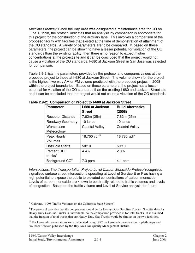
���������� ������������������ �� ��������������������������� �������������� � !�&�� #�������$
Mainline Freeway: Since the Bay Area was designated a maintenance area for CO on June 1, 1998, the protocol indicates that an analysis by comparison is appropriate for this project for the construction of the auxiliary lane. This involves a comparison of the proposed facility with facilities that existed at the time of demonstration of attainment of the CO standards. A variety of parameters are to be compared. If, based on these parameters, the project can be shown to have a lesser potential for violation of the CO standards than the existing facility, then there is no reason to expect higher concentrations at the project site and it can be concluded that the project would not cause a violation of the CO standards. I-680 at Jackson Street in San Jose was selected for comparison. Table 2.9-2 lists the parameters provided by the protocol and compares values at the proposed project to those at I-680 at Jackson Street. The volume shown for the project is the highest two-way AM or PM volume predicted with the proposed project in 2008 within the project boundaries. Based on these parameters, the project has a lesser potential for violation of the CO standards than the existing I-680 and Jackson Street site and it can be concluded that the project would not cause a violation of the CO standards. Table 2.9-2: Comparison of Project to I-680 at Jackson Street
Parameter I-680 at Jackson Street
Build Alternative (2008)
Receptor Distance 7.62m (25=)
7.62m (25=)
Roadway Geometry 10 lanes
10 lanes
Worse case Meteorology
Coastal Valley
Coastal Valley
Peak Hourly Volumes
18,700 vph3
16,785 vph4
Hot/Cold Starts
50/10
50/10
Percent HDG trucks4
4.4%
2.0%
Background CO5
7.3 ppm
4.1 ppm
Intersections: The Transportation Project-Level Carbon Monoxide Protocol recognizes signalized surface street intersections operating at Level of Service E or F as having a high potential to expose the public to elevated concentrations of carbon monoxide. Levels of carbon monoxide are known to be directly related to traffic volumes and levels of congestion. Based on the traffic volume and Level of Service analysis for future
3 Caltrans, “1998 Traffic Volumes on the California State System”. 4 The protocol provides that the comparison should be for Heavy-Duty Gasoline Trucks. Specific data for Heavy Duty Gasoline Trucks is unavailable, so the comparison provided is for total trucks. It is assumed that the fraction of total trucks that are Heavy-Duty Gas Trucks would be similar on the two facilities.
5 Background concentrations were calculated using 1992 background concentration isopleth maps and "rollback" factors published by the Bay Area Air Quality Management District.

���������� ������������������ �� ��������������������������� �������������� � !���� #�������$
operation6 of signalized intersections within the project area, four intersections were selected for analysis as worst-case intersections:
• Redwood Road at Castro Valley Boulevard; • Castro Valley Boulevard at I-580 Westbound on-ramp; • Center Street at Grove Way; and • Castro Valley Road at Foothill Boulevard / Strobridge Avenue.
Table 2.9-3 summarizes the worst-case carbon monoxide concentrations that would occur under future traffic conditions with the project at the selected intersections. Table 2.9-3: Future Carbon Monoxide Concentrations at Study Intersections (in parts per million)
Intersection No Build Build Alternative 1-Hour 8-Hour 1-Hour 8-Hour Redwood Road/ Castro Valley
5.9 4.1 5.9 4.1
Castro Valley/I-580 WB on ramp
6.3 4.4 N. A N.A.
CenterStreet/ Grove Way
7.7 5.4 6.6 4.6
Castro Valley/ Foothill/Strobridge
6.7 4.7 6.6 4.6
Most Stringent Standard
20.0 9.0 20.0 9.0
Particulate Matter (PM10) Analysis Because the project area is located in a federal attainment area for PM10, no further PM10 study would need to be conducted in advance of this project to satisfy NEPA. Based on the air quality analysis and data gathered for this report, the project would not have an adverse impact on PM10 concentrations in the project area, and would not result in a violation of state ambient air quality standards. Construction period emissions Potentially Adverse Effect 2.9-1: A localized reduction in air quality may occur during the construction period due to the pollutants generated from construction equipment and the elevation of dust levels from grading, excavation, hauling, and various other construction activities. The affect on local air quality would vary from day to day throughout the
6 As a worst-case assumption year 2025 traffic volumes were used for the project build year. Subsequent to completion of the project air quality analysis, the traffic operations report was revised, which included projected traffic volumes from horizon year 2025. The analyst (Don Ballanti) who completed the air quality study reviewed the 2030 traffic volume projections in relation to 2025 projections. Mr. Ballanti determined that the projected 2030 volumes would not change the conclusion of the analysis or the final air quality report.

���������� ������������������ �� ��������������������������� �������������� � !�$�� #�������$
construction period due to the changes in daily activities on the site and changing weather patterns. Mitigation 2.9-1: The lead agency shall implement the following standard measures recommended by the Bay Area Air Quality Management District (BAAQMD) to reduce or avoid construction-period air quality effects:
• Water all active construction areas at least twice daily; • Water or cover stockpiles of debris, soil, sand, or other materials that can
be blown by the wind, as required; • Cover all trucks hauling soil, sand, and other loose materials, or require
all trucks to maintain at least two feet of freeboard, as required; • Sweep daily (preferably with water sweepers) all paved access roads,
parking areas, and staging areas at construction sites; and • Sweep streets daily (preferably with water sweepers) if visible soil
material is carried onto adjacent public streets.
���������� ������������������ �� ���������������������������� �������������� � !��!�� "�������#
2.10 BIOLOGICAL ENVIRONMENT This chapter is based on a Natural Environment Study (NES) completed by RCL Ecology in November 2004. This NES outlines the potential environmental impacts associated with the project on special status plant and animal species, wetlands, and natural communities. This section focuses on the results of the NES, and where applicable, identifies proposed mitigation measures to lessen environmental impacts to biological resources in the project area. NATURAL COMMUNITIES Regulatory Setting The regulations pertaining to natural communities of concern, including critical habitat under the Federal Endangered Species Act (FESA) and wetlands and other waters of the US, are discussed later in this section. Affected Environment Wildlife movement corridors are portions of connected habitat that provide linkage between animal populations. The riparian corridor habitats of Crow Creek and San Lorenzo Creek provide this linkage in an otherwise urbanized environment. These habitats provide important breeding and rearing habitats for a number of common resident species, as well as a potential habitat for the Central California coast steelhead, which is discussed later in this section. Environmental Consequences, and Avoidance, Minimization and/or Mitigation Measures Since there will be no construction or physical alterations to the riparian corridors of San Lorenzo Creek or Crow Creek, no habitat fragmentation or potential affects to wildlife or fish passage would occur. WETLANDS AND OTHER WATERS Regulatory Setting Wetlands and other waters of the United States are protected under a number of laws and regulations. At the federal level, the Clean Water Act (33 U.S.C. 1344) is the primary law, which regulates the discharge of dredged or fill material into other waters, including wetlands. Waters of the United States include navigable waters, interstate waters, territorial seas and other waters that may be used in interstate or foreign commerce. Wetlands are defined through three criteria including the presence of hydrophytic (water-based) vegetation, wetland hydrology, and hydric soils (soils subject to saturation/inundation). All three criteria must be met for an area to be designated as a wetland under the Clean Water Act.
���������� ������������������ �� ���������������������������� �������������� � !����� "�������#
Section 404 of the Clean Water Act mandates that no discharge of dredged or fill material can be permitted into wetlands or other waters if a practicable alternative exists that is less damaging to the aquatic environment or if the nation’s waters would be significantly degraded. The Section 404 permit program is administered by the U.S. Army Corps of Engineers (ACOE) with oversight by the Environmental Protection Agency (EPA). The Executive Order for the Protection of Wetlands (E.O. 11990) also regulates the activities of federal agencies with regard to wetlands. Essentially, this executive order states that a federal agency, such as the Federal Highway Administration, cannot undertake or provide assistance for new construction that would significantly affect wetlands unless the head of the agency finds: 1) that there is no practicable alternative to the construction and 2) the proposed project includes all practicable measures to minimize harm. At the State level, impacts to wetlands and other waters are also of interest to the Department of Fish and Game (CDFG) and the Regional Water Quality Control Boards. In certain circumstances, the Coastal Commission (or Bay Conservation and Development Commission) may also have jurisdiction. Sections 1600-1607 of the Fish and Game Code require any agency that proposes a project that will substantially divert or obstruct the natural flow of or substantially change the bed or bank of a river, stream, or lake to notify CDFG. If CDFG determines that the project may substantially adversely affect fish or wildlife resources, a Lake or Streambed Alteration Agreement will be required. CDFG jurisdictional limits are usually defined by the tops of the stream or lake banks, or the outer edge of riparian vegetation, whichever is wider.
The Regional Water Quality Control Boards were established under the Porter-Cologne Water Quality Control Act to oversee water quality. The RWQCB issues water quality certifications in compliance with Section 401 of the Clean Water Act. Please see Chapter 2.6-Water Quality, for additional details. Affected Environment Within the project area there are portions of Crow Creek, San Lorenzo Creek, and a channelized section of Castro Valley Creek that fall under the jurisdiction of the ACOE. Castro Valley Creek Castro Valley Creek comprises a sub-watershed of the regional San Lorenzo Creek Watershed. Alameda County operates the San Lorenzo Creek Watershed Project, which aims to develop and apply pertinent management strategies to restore, protect, and improve water quality and biodiversity throughout the watershed.1 The area surrounding the portion of Castro Valley Creek that would be affected by the project is comprised of residential streets and lots with lawns and ornamental landscaping. The creek itself is completely channelized in this area, and there is no vegetation (with the exception of algae) on the base or on the banks of the cement channel. Castro Valley Creek flows south to its confluence with San Lorenzo Creek, and eventually into the San Francisco Bay. As a completely cement-lined creek, the primary 1Alameda County Resource Conservation District website, http://www.carcd.org/wisp/alameda/, accessed October 25, 2004.

���������� ������������������ �� ���������������������������� �������������� � !��$�� "�������#
function of the creek is to convey stormwater through the Castro Valley Area.2 The Creek flows under I-580 through a dual culvert system. The wetland delineation was conducted in accordance with ACOE guidelines and specifications.3 Observations were made in both April and October 2004, and the delineation was conducted on October 8, 2004. Crow Creek and San Lorenzo Creek Riparian Systems and Watershed Both of these systems are deeply incised creeks with well-developed riparian areas that encompass a wide range of vegetation types. The creek system also serves as the primary migration route through the area for both aquatic and terrestrial species. The San Lorenzo Creek Watershed encompasses 50 square miles. Eight major creek sub-watersheds drain into San Lorenzo Creek including Cull, Crow, Eden Canyon, Hollis Canyon, Norris, Palomares, Castro Valley, and Chabot Creeks. Ninety five percent of the watershed area is located in unincorporated areas of Alameda County. San Lorenzo Creek flows through Castro Valley, Hayward and San Lorenzo. Environmental Consequences, and Avoidance, Minimization and/or Mitigation Measures The construction of a new westbound off-ramp to Redwood Road would require extending the existing dual culvert system under I-580 to the new off-ramp, and would result in an approximate 0.003-hectare (0.007-acre) permanent impact to Waters of the US in Castro Valley Creek. Therefore, a preliminary Wetland Delineation was prepared for this area. Potentially Adverse Effect 2.10-1: As shown in Table 2.10-1, the proposed project would permanently fill approximately 0.003 acres (0.007-acres) of Waters of the U.S. No additional temporary affects would occur. Table 2.10-1: Permanent Fill in Waters of the US (Castro Valley Creek)
Total Waters in Impact Area Linear Type* Hectacres Acres Meters Feet
Channel 0.003 0.007 6.15 20 *All Corps jurisdictional Waters. Mitigation 2.10-1: The lead agency shall obtain a Section 404 permit and a Section 401 Clean Water Certification. Mitigation required by the Corps and RWQCB through these permits shall be made conditions of the project. All practicable measures to minimize harm to wetlands and Waters of the U.S. have been included in the proposed project. Consideration of environmental impacts has been a part of the alternatives analysis process. More specifically, as alternatives were developed and evaluated by ACTIA, Caltrans/FHWA, careful consideration has been given to potential affects and the ability to avoid wetlands and waters of the U.S. As
2 Preliminary Wetland Delineation for the I-580 Castro Valley Interchange Project, prepared by RCL Ecology for Public Affairs Management, October 2004. 3 US Army Corps of Engineers Wetland Delineation Manual, Technical Report No. 87-1, Environmental Laboratory, Department of the Army, 1987.

���������� ������������������ �� ���������������������������� �������������� � !��%�� "�������#
shown in Table 1-1, part of the reason that Alternative 2 (ACTIA Expenditure Plan Alternative) was withdrawn from consideration was because construction of an auxiliary lane on I-580 would affect wetlands and Waters of the U.S. associated with Crow Creek. The proposed project would avoid this affect and the No-Build Alternative would avoid all affects to wetlands and waters of the U.S. However, the No-Build alternative does not meet the project purpose and need. The analysis conducted by ACTIA, Caltrans/FHWA concluded that no alternative exists that would completely avoid affects to wetlands or other waters and meet the project purpose and need. PLANT SPECIES Regulatory Setting The U.S. Fish and Wildlife Service (USFWS) and California Department of Fish and Game share regulatory responsibility for the protection of special-status plant species. “Special-status” species are selected for protection because they are rare and/or subject to population and habitat declines. Special status is a general term for species that are afforded varying levels of regulatory protection. The highest level of protection is given to threatened and endangered species; these are species that are formally listed or proposed for listing as endangered or threatened under the Federal Endangered Species Act and/or the California Endangered Species Act (CESA). The regulatory requirements for FESA are found at United States Code 16 (USC), Section 1531, et. seq. See also 50 CFR Part 402. The regulatory requirements for CESA are found at California Fish and Game Code, Section 2050, et. seq. Department of Transportation projects are also subject to the Native Plant Protection Act, found at Fish and Game Code, Section 1900-1913, and the California Environmental Quality Act, Public Resources Code, Sections 2100-21177. Please see the Threatened and Endangered Species Section in this document for detailed information regarding these species.
This section also discusses special-status plant species that have been afforded other levels of protection. These species include CDFG fully protected species and species of special concern, USFWS candidate species, and non-listed California Native Plant Society (CNPS) rare and endangered plants. Affected Environment A reconnaissance survey was conducted in 2002 and revealed the potential for certain special-status plant and animal species to occur within the project area. Additional focused studies were conducted in 2003 to determine the occurrence of specific species.4 The project area includes both landscaped and natural riparian habitats along Crow Creek and San Lorenzo Creek. A few native plant species exist in the landscaped portions of the project area, however the vegetative community is dominated by a variety of ornamental trees and shrubs. Tree types include cedar, pine, juniper, and eucalyptus.
4 Natural Environment Study, I-580 Castro Valley Interchange, prepared by RCL Ecology for Public Affairs Management, October 2004.
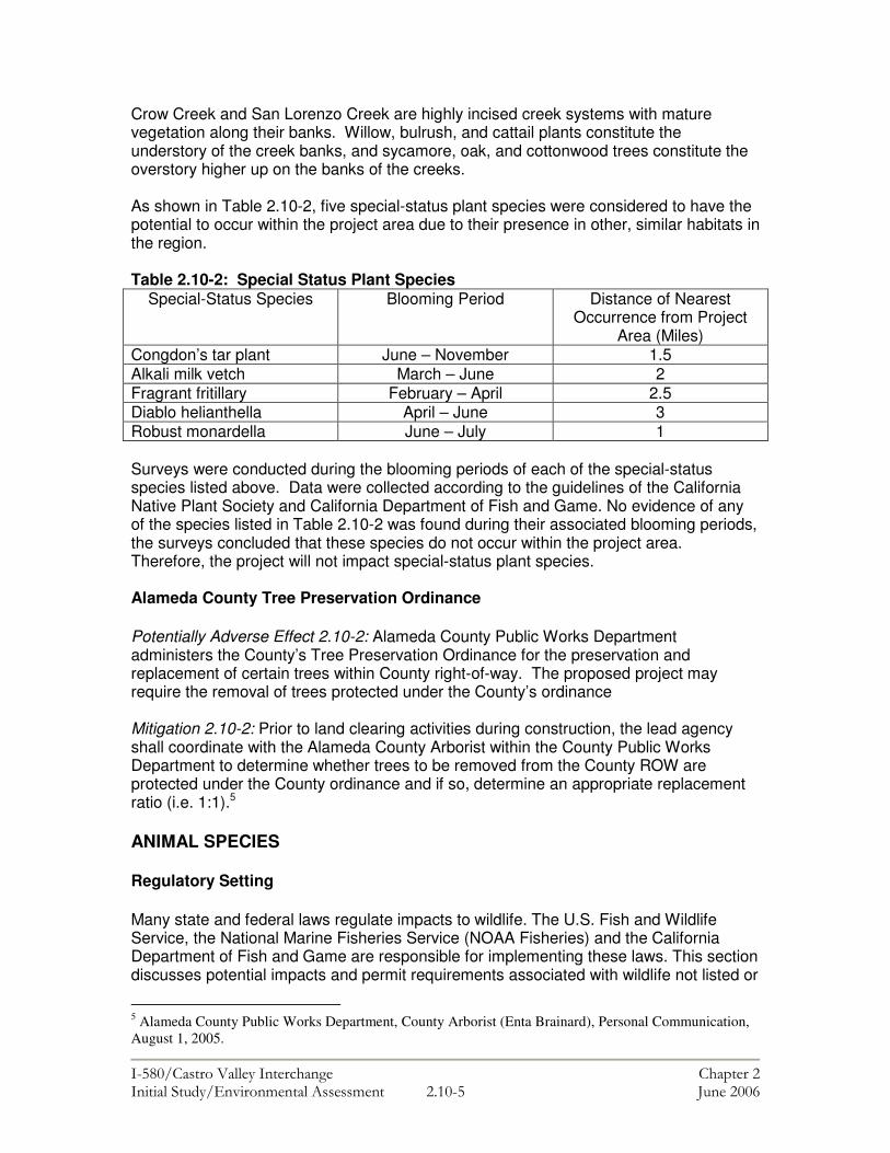
���������� ������������������ �� ���������������������������� �������������� � !����� "�������#
Crow Creek and San Lorenzo Creek are highly incised creek systems with mature vegetation along their banks. Willow, bulrush, and cattail plants constitute the understory of the creek banks, and sycamore, oak, and cottonwood trees constitute the overstory higher up on the banks of the creeks. As shown in Table 2.10-2, five special-status plant species were considered to have the potential to occur within the project area due to their presence in other, similar habitats in the region. Table 2.10-2: Special Status Plant Species
Special-Status Species Blooming Period Distance of Nearest Occurrence from Project
Area (Miles) Congdon’s tar plant June – November 1.5 Alkali milk vetch March – June 2 Fragrant fritillary February – April 2.5 Diablo helianthella April – June 3 Robust monardella June – July 1 Surveys were conducted during the blooming periods of each of the special-status species listed above. Data were collected according to the guidelines of the California Native Plant Society and California Department of Fish and Game. No evidence of any of the species listed in Table 2.10-2 was found during their associated blooming periods, the surveys concluded that these species do not occur within the project area. Therefore, the project will not impact special-status plant species. Alameda County Tree Preservation Ordinance Potentially Adverse Effect 2.10-2: Alameda County Public Works Department administers the County’s Tree Preservation Ordinance for the preservation and replacement of certain trees within County right-of-way. The proposed project may require the removal of trees protected under the County’s ordinance Mitigation 2.10-2: Prior to land clearing activities during construction, the lead agency shall coordinate with the Alameda County Arborist within the County Public Works Department to determine whether trees to be removed from the County ROW are protected under the County ordinance and if so, determine an appropriate replacement ratio (i.e. 1:1).5 ANIMAL SPECIES Regulatory Setting Many state and federal laws regulate impacts to wildlife. The U.S. Fish and Wildlife Service, the National Marine Fisheries Service (NOAA Fisheries) and the California Department of Fish and Game are responsible for implementing these laws. This section discusses potential impacts and permit requirements associated with wildlife not listed or
5 Alameda County Public Works Department, County Arborist (Enta Brainard), Personal Communication, August 1, 2005.

���������� ������������������ �� ���������������������������� �������������� � !��#�� "�������#
proposed for listing under the state or federal Endangered Species Act. All other special-status animal species are also discussed here, including CDFG fully protected species and species of special concern, and USFWS or NOAA Fisheries candidate species.
Federal laws and regulations pertaining to wildlife include the following:
• National Environmental Policy Act • Migratory Bird Treaty Act • Fish and Wildlife Coordination Act
State laws and regulations pertaining to wildlife include the following:
• California Environmental Quality Act • Sections 1601 – 1603 of the Fish and Game Code • Section 4150 and 4152 of the Fish and Game Code
Affected Environment The area is located within an urban setting which consists of I-580 and its associated right-of-way, city streets, and residential and commercial properties adjacent to the I-580 freeway. The study area also includes a portion of well-developed riparian systems associated with the Crow and San Lorenzo Creeks. Animal Species The initial survey of the site conducted in 2002 indicated the occurrence of several sensitive resources, including special-status wildlife habitat and wildlife movement corridors. Table 2.10-3 identifies the animal species found in the project area. Table 2.10-3: Animal Species in Project Area
Common Name Mourning dove American crow American kestrel White-crowned sparrow Barn swallow Botta’s pocket gopher California ground squirrel Black-tailed jackrabbit Raccoon Striped skunk Western fence lizard
Source: NES, RCL Ecology, October 2004 Wildlife Movement Corridors Wildlife movement corridors are portions of connected habitat that provide linkage between animal populations. The riparian habitats of Crow Creek and San Lorenzo Creek are examples of two such corridors in the project area. These corridors provide vital breeding and rearing habitat for a variety of common resident species as identified in the table above, as well as potential habitat for the Central California coast steelhead.
���������� ������������������ �� ���������������������������� �������������� � !��&�� "�������#
Raptors All migratory birds, including raptors (birds of prey) and their nests are protected by the Federal Migratory Bird Treaty Act and the California Department of Fish and Wildlife. While no raptors were observed in the project area during the site survey, trees that provide suitable nesting habitat are located adjacent to the area in which construction activities will occur. Environmental Consequences, and Avoidance, Minimization and/or Mitigation Measures Potentially Adverse Effect 2.10-3: Trees providing suitable nesting habitat for migratory birds would be removed during construction of the project. This includes a row of mature eucalyptus trees that would be removed to construct the new westbound off-ramp from I-580 to Redwood Road. Mitigation 2.10-3: Pre-construction surveys shall be conducted if tree removal activity is planned during the nesting season, which runs from February 1 to August 1. If active nests are identified, the tree in which the nest is located shall not be removed until a qualified biologist has determined that the young have fledged and that the nest is no longer active. Construction activities that are proposed within the vicinity of the active nest shall also be evaluated to determine if there is a potential to cause nest abandonment. Once it is determined that the nest is no longer active, construction activities may proceed as planned. THREATENED AND ENDANGERED SPECIES
Regulatory Setting The primary federal law protecting threatened and endangered species is the Federal Endangered Species Act: United States Code (USC), Section 1531, et seq. This Act and subsequent amendments provide for the protection of endangered and threatened species and the ecosystems upon which they depend. Under Section 7 of FESA, federal agencies, such as the Federal Highway Administration, are required to consult with the U.S. Fish and Wildlife Service and the National Marine Fisheries Service to ensure that they are not undertaking, funding, permitting or authorizing actions likely to jeopardize the continued existence of listed species or destroy or adversely modify designated critical habitat. Critical habitat is defined as geographic locations critical to the existence of a threatened or endangered species. The outcome of consultation under Section 7 is a Biological Opinion or the issuance of an incidental take permit. Section 3 of FESA defines a take in regards to threatened or endangered species as any activity that would “harass, harm, pursue, hunt, shoot, wound, kill, trap, capture or collect or any attempt at such conduct.”
California has enacted a similar law at the state level, the California Endangered Species Act, California Fish and Game Code; Section 2050, et seq. The California Department of Fish and Game is the agency responsible for implementing CESA. CESA emphasizes early consultation between all responsible parties to avoid potential impacts to rare, endangered, and threatened species and to offset project caused losses of listed species populations and their essential habitats. Section 2081 of the Fish and Game Code prohibits "take" of any species determined to be an endangered species or a threatened species. Take is defined in Section 86 of the Fish and Game Code as any
���������� ������������������ �� ���������������������������� �������������� � !����� "�������#
activity that would "hunt, pursue, catch, capture, or kill, or attempt to hunt, pursue, catch, capture, or kill" endangered or threatened species. CESA allows for take incidental to otherwise lawful development projects; for these actions an incidental take permit is issued by CDFG. For projects requiring a Biological Opinion under Section 7 of the FESA, CDFG may also authorize impacts to CESA species by issuing a Consistency Determination under Section 2080.1 of the Fish and Game Code.
Affected Environment “Special-status” wildlife refers to those species that:
• have been designated by the California Department of Fish and Game and/or the U.S. Fish and Wildlife Service as either threatened or endangered; and are legally protected under the California or Federal endangered species acts;
• are proposed and/or candidate species being considered for listing under either federal or California endangered species legislation; or
• are of expressly stated interest to resource/regulatory agencies and/or local jurisdictions.
There are two federally listed threatened species that are considered to have the potential to occur in the project area due to the presence of habitat on-site and known occurrence of the species in the vicinity. These species are the California red-legged frog (Rana aurora draytonii) and the Central California coast steelhead (Oncorhynchus mykiss). The Alameda County Flood Control and Water Conservation District (ACFC&WCD) and Hagar Environmental Science completed a comprehensive fish habitat and population assessment for the entire San Lorenzo Creek watershed in 2002. This report was used to determine the potential effect of the project on the local fish populations. Environmental Consequences, and Avoidance, Minimization and/or Mitigation Measures California red-legged frog The federally listed threatened California red-legged frog (CRF) has been recorded in the upstream reaches of Crow Creek approximately five miles from the project site, and therefore has the potential to occur within the project area. Additionally, federally designated Critical Habitat for the species occurs within two miles of the project area. In accordance with USFWS protocols, a habitat site assessment of the project area is required when CRF are known to exist within five miles of the site. The purpose of the habitat site assessment is to determine if suitable habitat occurs within the project area and within one-mile of the project site. If the results of the site assessment show that suitable habitat is present, the USFWS requires that a focused survey be performed to determine if CRF are actually occupying the habitats. A site assessment was conducted in accordance with USFWS protocols, and concluded that the CRF was absent from the study area and therefore would not be affected by project activity. The USFWS reviewed the project and concluded that it would not involve the “take” of any California red-legged frogs. (Letter dated March 7, 2003).

���������� ������������������ �� ���������������������������� �������������� � !��'�� "�������#
Central California coast steelhead The assessment conducted by the ACFC&WCD found that there are Central California coast steelhead present in Crow Creek, which is in the project area. The portion of Crow Creek located in the project area extends from its confluence with San Lorenzo Creek, known as “China Hole”, to the upstream side of the Castro Valley Boulevard Bridge. The fisheries study found suitable steelhead habitat in this portion of the creek. The habitat identified provides moderate pool/riffle ratios, as well as adequate water temperature, spawning gravels and rearing shelter. Riffles are shallow areas in the creek where the coast steelhead are known to feed. The study also found that the project area and two upstream reaches provide the highest accessible portion of the watershed for migratory steelhead. Although the review found that there are Central California coast steelhead present in the area, the project would not involve work within the bed or bank of Crow Creek or alteration of the associated riparian corridor. As a result, the project would have no effect on the Central California coast steelhead. INVASIVE SPECIES Regulatory Setting On February 3, 1999, President Clinton signed Executive Order 13112 requiring federal agencies to combat the introduction or spread of invasive species in the United States. The order defines invasive species as “any species, including its seeds, eggs, spores, or other biological material capable of propagating that species, that is not native to that ecosystem whose introduction does or is likely to cause economic or environmental harm or harm to human health." FHWA guidance issued August 10, 1999 directs the use of the state’s noxious weed list to define the invasive plants that must be considered as part of the NEPA analysis for a proposed project. Affected Environment While a few native species persist in the project area, the majority of species present are non-native. Environmental Consequences, and Avoidance, Minimization and/or Mitigation Measures Potentially Adverse Effect 2.10-1: While the potential is low, the project could result in the spread of noxious weeds through the movement of earth during the construction phase. Mitigation 2.9-1: None of the species on the California list of noxious weeds shall be used for erosion control purposes during construction or subsequent landscaping. In compliance with the Executive Order on Invasive Species, E.O. 13112, and subsequent guidance from the FHWA, erosion control included in the project shall not include the use of species listed as noxious weeds. In areas of particular sensitivity (such as areas near Crow Creek and San Lorenzo Creek), extra precautions shall be taken if invasive species are found in or adjacent to the construction areas, such as the cleaning of construction equipment, vehicles, and tools to remove soil, seeds, and plant material.

���������� ������������������ �� ���������������������������� �������������� � !��!��� "�������#
Should an invasion of nonnative species occur, measures shall be implemented to eradicate the species.

���������� ������ ���������� ������ � ������ ����������������� ����� � !!�! "��� ���#
2.11 NOISE The following chapter is based on a noise impact study, dated January 20, 2005, which was prepared for the project by Illingworth & Rodkin, Inc. The study complies with Title 23, Part 772 of the Code of Federal Regulations, “Procedures for Abatement of Highway Traffic Noise”, and Caltrans noise analysis policy described in Construction Noise and Traffic Noise Analysis Protocol for New Highway Construction and Reconstruction Projects (Caltrans 1998a). Regulatory Setting The National Environmental Policy Act of 1969 and the California Environmental Quality Act provide the broad basis for analyzing and abating highway traffic noise effects on the human environment.
For highway transportation projects with FHWA involvement, the federal-Aid Highway Act of 1970 and the associated implementing regulations (23 CFR 772) govern the analysis and abatement of traffic noise impacts. The regulations require that potential noise impacts in areas of frequent human use be identified during the planning and design of a highway project. The regulations contain noise abatement criteria (NAC) that are used to determine when a noise impact would occur. The NAC differ depending on the type of land use under analysis. For example, the NAC for residences (67 dBA) is lower than the NAC for commercial areas (72 dBA). Table 2.11-1 lists the noise abatement criteria. Table 2.11-1: Noise Abatement Criteria Activity Category
NAC, Hourly A- Weighted Noise Level, dBA Leq(h)
Description of Activities
A 57 Exterior
Lands on which serenity and quiet are of extraordinary significance and serve an important public need and where the preservation of those qualities is essential if the area is to continue to serve its intended purpose
B 67 Exterior
Picnic areas, recreation areas, playgrounds, active sport areas, parks, residences, motels, hotels, schools, churches, libraries, and hospitals.
C 72 Exterior Developed lands, properties, or activities not included in Categories A or B above
D -- Undeveloped lands.
E 52 Interior Residence, motels, hotels, public meeting rooms, schools, churches, libraries, hospitals, and auditoriums
���������� ������ ���������� ������ � ������ ����������������� ����� � !!�� "��� ���#
In accordance with the Department’s Traffic Noise Analysis Protocol for New Highway Construction and Reconstruction Projects, October 1998, a noise impact occurs when the future noise level with the project results in a substantial increase in noise level (defined as a 12 dBA or more increase) or when the future noise level with the project approaches or exceeds the NAC (Category A – E). Approaching the NAC is defined as coming within 1 dBA of the NAC. If it is determined that the project will have noise impacts, then potential abatement measures must be considered. Noise abatement measures that are determined to be reasonable and feasible at the time of final design are incorporated into the project plans and specifications. This chapter identifies noise abatement measures that would likely be incorporated in the project. The Department’s Traffic Noise Analysis Protocol sets forth the criteria for determining when an abatement measure is reasonable and feasible. Feasibility of noise abatement is basically an engineering concern. A minimum 5 dBA reduction in the future noise level must be achieved for an abatement measure to be considered feasible. Other considerations include topography, access requirements, other noise sources and safety considerations. Factors used in determining whether a proposed noise abatement measure is reasonable include: residents’ acceptance, the absolute noise level, build versus existing noise levels, environmental impacts of abatement, public and local agencies’ input, newly constructed development versus development pre-dating 1978 and the cost per benefited residence. Alameda County also monitors noise levels related to transportation and development projects. According to Alameda County’s noise ordinance, noise impacts for residential receivers would occur if the project would result in an increase in 5 dBA or more. 1 Affected Environment Sound walls are located north and south of I-580 and the associated ramps in the project area. The roadway is at an elevation above receivers west of the Castro Valley on-ramp to westbound I-580. East of this ramp, I-580 transitions to below the elevations of adjacent receivers. Sound wall and terrain features provide substantial reduction of traffic noise generated by I-580. Noise measurements were conducted to quantify existing noise levels in the project area. These measurements were supplemented with traffic noise modeling. A combination of four long-term (24-hour) and 19 short-term (10-minute) noise measurements were conducted at residential land uses representative of Category B receiver locations (Figure 2.11-1). The land uses, where noise measurements were conducted, included: • Single-family residences along Vegas Avenue and Greenview Drive, south of the
project and adjacent to the proposed on-ramp to eastbound I-580 from Redwood Road and eastbound I-580 auxiliary lane;
1 Alameda County Planning Department, Bret Lucas, Planner III, Personal Communication, August 2, 2005.
���������� ������ ���������� ������ � ������ ����������������� ����� � !!�$ "��� ���#
• Single-family residences along Pine Street, Elm Street, and Juniper Street north of the project where a westbound I-580 to Redwood Road off-ramp is proposed;
• Mobile home parks located north of the project between the proposed westbound I-
580 to Redwood Road off-ramp and the existing Castro Valley Boulevard to westbound I-580 on-ramp.
Long-term noise measurements were conducted to show the daily trend in noise levels throughout a 24–hour period. Long-term noise measurement locations were selected to generally represent “worst-case” human activity areas. These were located at Category B activity areas or in areas considered acoustically equivalent to Category B activity areas. Bay Area Rapid Transit trains travel along the median of I-580. Although these BART train passbys are audible at times, they were not observed to affect the measured 10-minute Leq noise levels. Short-term noise measurements were conducted in simultaneous intervals with traffic volume and speed observations. Traffic conditions were monitored by video taping traffic and sampling vehicle speeds using a hand-held traffic radar gun. Traffic monitoring was conducted from the Center Street overcrossing. A summary of measured noise levels and corresponding noisiest hour noise levels is shown in Table 2.11-2. The estimated worst-hour noise levels were based on daytime measurement data, peak-hour traffic data, and trends in hourly noise levels measured at representative 24-hour measurement locations. Eastbound I-580 -Vegas Avenue Category B receivers are located along both sides of Vegas Avenue and are exposed to I-580 traffic noise. These receivers are shielded from the freeway by terrain and a 3.7-m high sound wall relative to the elevation of I-580. I-580 is elevated on fill through this section. Three short-term and one long-term measurement were made in this neighborhood (Receivers ST-1, ST-2, ST-3 and LT-1). Worst-hour noise levels ranged from about 59 to 62 dBA Leq[hr]. Levels were slightly higher at the first tier receivers than at the second tier.2 Eastbound I-580 - Greenview Drive Category B receivers, including multi-family and single-family residences are located along Greenview Drive, between Idena Avenue and Greenview Road. These receivers are shielded by a continuous sound wall that runs along eastbound I-580 and transitions to the right-of-way along Greenview near Betham Way. The profile of I-580 transitions from above the receivers near Idena Avenue to below Greenview Drive near Betlen Way.
2 Tier refers to row of receivers (e.g. homes) in relation to the project. The row of homes closest to I-580 where project work will occur is the first tier. Second tier refers to the second row of homes.

���������� ������ ���������� ������ � ������ ����������������� ����� � !!�% "��� ����
Table 2.11-2: Existing Noise Levels
Receiver I.D. No.* Location or Address Type of
Development Number of Units
Represented
Noise Abatement Category and
Criterion (dBA)
Existing Worst Hour Noise Level,
Leq(hr) (dBA)
Noise Level Measured** or Modeled
LT-1 Rear Yard of 2636 Vegas Drive Residential *** B (67) 58 Measured LT-2 21892 Greenview Drive Residential 10 B (67) 65 Measured LT-3 Front of 3628 Juniper Street Residential 15 B (67) 66 Measured LT-4 3945 Castro Valley Road #17 Residential 22 B (67) 74 Measured ST-1 2639 Vegas Avenue Residential 15 B (67) 59 Measured
ST-2 Rear property line of residence along Vegas Avenue, near LT-1 Residential 5 B (67) 62 Measured
ST-3 Rear property line of residence along Vegas Avenue, near Idena Avenue Residential 12 B (67) 62 Measured
ST-4 Southeast corner of Idena Ave. & Greenview Dr. Residential ** B (67) 64 Measured ST-5 Intersection of Greenview Drive and Betlen Way Residential 5 B (67) 69 Measured ST-6 21898 Betlen Way Residential 16 B (67) 62 Measured ST-7 Intersection of Greenview Dr. and Vernetti Way Residential 9 B (67) 65 Measured ST-8 Vernetti Way Residential 7 B (67) 59 Measured ST-9 Side yard of 3079 Greenview Drive Residential 8 B (67) 63 Measured ST-10 Front yard of 22297 Ralston Court Residential 25 B (67) 56 Measured
ST-11 End of Cynthia Court Residential Out of Project
Area B (67) 69 Measured
ST-12 Rear yard of 3447 Pine Street Residential 7 B (67) 63 Measured ST-13 Northeast corner of Juniper St. and Elm St. Residential ** B (67) 65 Measured ST-14 Front of 3612 Juniper Street Residential ** B (67) 65 Measured ST-15 Backyard near flood channel, north of Juniper St. Residential 12 B (67) 61 Measured ST-16 Side yard of 3663 Juniper Street Residential ** B (67) 66 Measured ST-17 #22 Wagon Wheel Mobile Home Park Residential 12 B (67) 67 Measured ST-18 #18 Wagon Wheel Mobile Home Park Residential 9 B (67) 64 Measured ST-19 #54 Chetwood Crest Mobile Home Park Residential 12 B (67) 66 Measured
* See Figure 2.11-1 for locations. ** All measurements shown reflect worst-hour noise levels, i.e. they were either measured during the noisiest hour or were adjusted to worst hour traffic characteristics. *** In areas where several noise measurements were found to be representative of a particular noise environment, Category B Receivers were represented by one worst-case receiver location.

���������� ������ ���������� ������ � ������ ����������������� ����� � !!�� "��� ���#
Six short-term noise measurements and one long-term noise measurement were made along this portion of the project (Receivers ST-4, ST-5, ST-6, ST-7, ST-8, ST-9 and LT-2). Worst-hour noise levels at first-tier residences were about 64 to 65 dBA Leq[hr] near Idena Avenue, 69 dBA Leq[hr] near Betlen Way, and about 63 to 65 dBA Leq[hr] at the eastern portion of Greenview Drive. Noise levels were lower at the second-tier homes, about 59 to 62 dBA Leq[hr]. Although a sound wall shields the area from I-580 traffic noise, existing traffic noise levels approach or exceed the NAC at first row residences near Betlen Way. Westbound I-580 – Pine Street, Elm Street and Juniper Street The Category B receivers identified along this portion of the project are single-family residences. These residences are currently shielded from I-580 traffic noise by a 3.7-meter high sound wall that runs along the shoulder of I-580. The freeway and sound wall are located about 6 to 8 meters above the neighborhood. Six short-term measurements and one long-term noise measurement were conducted at locations along this portion of the project (Receivers ST-12, ST-13, ST-14, ST-15, ST-16, ST-17 and L-3). Worst-hour noise levels were about 65 to 66 dBA Leq[hr] at the second tier residences along Juniper Street. Backyards of residences along the south side of Pine Street had worst-hour noise levels of 61 to 63 dBA Leq[hr]. Two receivers along Juniper had existing noise levels that are considered to approach the NAC. Westbound I-580 – Mobile Home Parks along Castro Valley Boulevard Category B receivers identified in this portion of the project area are mobile homes in three different mobile home parks located between Castro Valley Boulevard and the existing westbound on-ramp to I-580. I-580 is slightly above grade (and the receivers) through this area. A 2.7-meter high sound wall is located along the westbound on-ramp to I-580. This sound wall transitions upwards to 3.7 meter high as the ramp connects to I-580. Receivers or mobile homes adjacent to I-580 and the on-ramp are about 1 to 4 meters below the freeway elevation. The receivers located further away from the freeway are at or slightly above the freeway elevation. Four sites were selected to document existing noise levels (three short-term measurements and one long-term noise measurement) along this portion of the project (Receivers ST-17, ST-18, ST-19 and LT-4). Worst-hour noise levels were 64 to 67 dBA Leq[hr]
at the two western mobile home parks and 74 dBA Leq[hr]
at the eastern mobile
home park. Some of the receivers located in these mobile home parks have noise levels that approach or exceed the NAC. Environmental Consequences, and Avoidance, Minimization and/or Mitigation Measures Receiver locations are described by different NAC activity category (see Table 2.11-1). Noise receiver locations exposed to potential traffic noise impacts were identified within the project area. Category B land uses, in the form of single-family and multi-family residential land uses border most of the project area. No Activity Category A, C, and D areas, which experience frequent human use and could benefit from a lower noise level, were identified within the study area. Modeling of future year (2025) traffic conditions without the project indicates that noise levels will remain basically unchanged from existing levels (i.e., a 0 to 1 dBA Leq[hr]

���������� ������ ���������� ������ � ������ ����������������� ����� � !!�# "��� ���#
increase).3 The project would increase noise levels by 1 to 8 dBA near the Redwood Road interchange as a result of the removal of existing sound wall segments to accommodate the new freeway on- and off-ramps and eastbound I-580 auxiliary lane. Perceivable increases to noise levels would occur at those residences near the Redwood Road interchange and near portions of I-580 where the sound wall would be removed. These residences would be considered impacted with the project since worst-hour noise levels would approach or exceed the NAC. Changes to noise levels at other portions of the project would not be perceivable; however, noise impacts would occur since worst-hour noise levels would approach or exceed the NAC. The project would not result in a substantial noise increase (12 dBA Leq[hr] or more) at identified Category B uses in the study area. Eastbound I-580 - Vegas Avenue Category B receivers along Vegas Avenue are located down a slope at an elevation below the roadway and shielded by the existing portion of the sound wall to remain along the main line and by the existing terrain. The noise environment would primarily be defined by traffic along the I-580 mainline, but would be punctuated by autos, trucks, or motorcycles accelerating up the on-ramp. First-tier Category B receivers would have future noise levels ranging from 61 to 66 dBA Leq[h] with the project (assuming the removal of portions of the existing sound wall). Future project noise levels are calculated to be about 63 dBA Leq[hr] at second-tier receivers and below 63 dBA Leq[hr] at third-tier receivers. Only first-tier receivers would be considered noise impacted as future noise levels would approach or exceed the NAC. Eastbound I-580 - Greenview Drive First-tier Category B receivers located along the western portion of Greenview Drive (in areas exposed to the removal of the sound wall) would have future noise levels ranging from 71 to 74 dBA Leq[hr] with the project (assuming the removal of portions of the existing sound walls along the main line to accommodate the project). Future project noise levels are calculated to be about 64 dBA Leq[hr] at second-tier receivers and below 64 dBA Leq[hr] at third-tier receivers. Only first-tier receivers would be considered noise impacted as future noise levels would approach or exceed the NAC. First-tier receivers located along eastern portions of Greenview Drive (shielded by the existing sound wall along the Center Street Off-Ramp that is to remain intact) would have future noise levels ranging from 63 to 66 dBA Leq[hr] with the project. Future project noise levels are calculated to be about 60 dBA Leq[hr] at second-tier receivers. Only first-tier receivers would be considered noise impacted along eastern portions of Greenview Drive as future noise levels would approach or exceed the NAC. Westbound I-580 – Pine Street, Elm Street and Juniper Street
3 The project noise consultant (Illingworth and Rodkin, Inc.) compared 2025 versus 2030 mainline traffic volumes for the segments of I-580 (mainline) that were evaluated in the original noise study (January, 2005). Based on the comparison, Illingworth and Rodkin found that there would be a less than 0.3 dBA increase in noise levels. Based on this finding, Illingworth and Rodkin did not recommend that the traffic noise study be revised.

���������� ������ ���������� ������ � ������ ����������������� ����� � !!�& "��� ���#
Category B receivers in the vicinity of Pine Street, Elm Street and Juniper Street are located down a slope at an elevation below the roadway and shielded by the existing portion of the sound wall to remain along the main line and by the existing terrain. Ramp traffic is not calculated to contribute substantially to the overall Leq[hr] noise levels, however, individual traffic events along the ramps would be audible. Noise levels are predicted to be 71 to 72 dBA Leq[hr] with the project at first-tier receivers along Juniper Street, 62 to 66 dBA Leq[hr] at second-tier receivers along Pine Street, and below 65 dBA Leq[hr] at third row receivers. First and second-tier receivers would be considered noise impacted along Pine Street, Elm Street and Juniper Street as future noise levels would approach or exceed the NAC. Westbound I-580 – Mobile Home Parks along Castro Valley Boulevard Category B receivers located in the mobile home parks along Castro Valley Boulevard would have future noise levels with the project ranging from 71 to 75 dBA Leq[h]
(assuming the removal of portions of the existing sound walls along the main line to accommodate the project). Future project noise levels are calculated to be about 70 dBA Leq[hr]
at second and third-tier receivers, about 66 to 67 dBA
Leq[h]
at forth and fifth-tier
receivers and below 65 dBA Leq[h] at sixth-tier receivers. First- through fifth-tier receivers
would be considered noise impacted as future noise levels would approach or exceed the NAC. Some receivers (e.g., LT-4), where noise levels would be 75 dBA Leq[h] would be considered to have a “severe” impact. Noise Abatement Analysis The primary noise impacts associated with the project would result from the addition of the on- and off-ramps to I-580 at Redwood Road along with the removal of sound wall sections to accommodate these ramps. Substantial noise impacts would not occur at Category B uses along the corridor, but many receivers along the project would experience future noise levels that would approach or exceed the NAC. As a result, noise abatement must be evaluated for these receivers. According to Caltrans and FHWA policies, feasible noise barriers must provide a minimum 5 dBA reduction in traffic noise. Furthermore, under Caltrans policies, noise barriers should interrupt the line of sight between a truck stack (of average height) and a receiver. Where I-580 is elevated above receivers, the most acoustically effective location for a barrier is near the edge of shoulder or top of slope. Noise barriers were evaluated at the most acoustically effective location. The feasibility of noise barriers was studied where receivers would be noise impacted. Table 2.11-3 identifies the noise level reduction that sound walls could achieve. Note that noise level reductions are rounded. A preliminary noise abatement analysis was conducted that identified the feasibility of constructing or replacing sound walls to reduce traffic noise levels. Feasible sound walls are identified below. The final decision to include sound walls in the proposed project design must consider reasonableness factors, such as cost effectiveness, as well as other pertinent information developed during the design and public review process.
���������� ������ ���������� ������ � ������ ����������������� ����� � !!�� "��� ���#
SW 1A – EB I-580 from Station 32+20 to Station 37+12.310 A sound wall located along the eastbound side of the Redwood Road on-ramp to eastbound I-580, connecting to the remaining portion of the existing sound wall along eastbound I-580 could be feasible (i.e., reduce noise levels by 5 dBA and block line of sight to heavy-duty truck stacks in the near travel lane). With this sound wall option, the existing sound wall located along the existing Center Street ramp would remain, as would a portion of the wall from the Redwood Road over-crossing towards the new on-ramp access. Table 2.11-3 identifies the noise level reduction that a sound wall could achieve. This sound wall would benefit approximately 10 to 42 receivers along Vegas Avenue and Greenview Drive (including residences of the apartment building located along Idena Avenue), depending upon the selected barrier height. Since the elevation of the on-ramp transitions from below I-580 to that of I-580, which is above the receivers, the sound wall would need to be located at the edge of shoulder and overlap the remaining portion of the sound wall west of the on-ramp access, beginning at Station 32+20 and connecting to the existing portion of the sound wall at Station 37+12.310. The length of this noise barrier would be about 490 m. A 3.0 m. barrier would reduce noise levels by 7 dBA at about 10 receivers, and block line-of-sight to truck exhaust stacks. This would be the minimum height of a feasible sound wall. A 3.7 m. noise barrier would benefit approximately 22 receivers, providing 5 to 8 dBA of noise reduction. A 4.2 m. noise barrier would benefit approximately 42 receivers, reducing noise levels by 5 to 9 dBA. The locations and heights of barriers should be verified based on the final design and consideration of other design criteria. For visual or other considerations, the barrier could extend further west down the ramp towards Redwood Road. Increasing the height of the existing noise barrier along the existing Center Street Off-Ramp (east of Station 37+12) up to 4.9 m would not feasibly benefit noise levels for impacted Category B receivers adjacent to the Center Street Off-Ramp (noise levels would be reduced by 1 to 4 dBA). SW2 – WB I-580 from Station 32+50 to Station 35+50 A sound wall located along the westbound side of the Redwood Road off-ramp, connecting to the remaining portion of the sound wall along westbound I-580 would benefit about 15 Category B receivers in the vicinity of Pine Street, Elm Street and Juniper Street. SW2 could be a feasible barrier (i.e., reduce noise levels by 5 dBA and block line of sight to heavy-duty truck stacks in the near travel lane). This analysis assumes the existing sound wall located along the Castro Valley Boulevard on-ramp would remain and a portion of the sound wall from the Redwood Road over-crossing towards the new off-ramp access would remain. The sound wall would need to be located at the edge of shoulder beginning at the new on-ramp at about Station 32+50 and extend eastward to about Station 35+50 where it would either connect or overlap with the remaining sound wall section along the eastern portion of I-580 and the Castro Valley Boulevard on-ramp. The approximate length of this barrier would be 290 m. A 3.0 m. barrier would reduce noise levels by 5 dBA and block line-of-sight to truck exhaust stacks. This would be the minimum height of a feasible sound wall. A 3.7 m. noise barrier provides approximately 6 dBA of noise reduction and a 4.2 m. noise barrier would reduce noise levels by 6 dBA. The locations and heights of barriers should be
���������� ������ ���������� ������ � ������ ����������������� ����� � !!�' "��� ���#
verified based on the final design. Extending the barrier westward along the on-ramp should be considered for visual or other design criteria. Replacement SW along Castro Valley Blvd. On-Ramp to WB I-580 from Station 35+40 to Station 38+50 A 2.4 m to 3.7 m sound wall would remain along the abandoned on-ramp to westbound I-580 from existing Castro Valley Boulevard with the project. The existing barrier is beneficial to Category B receivers in the mobile home parks in the northwestern portion of the project area. Residences in the vicinity of LT-4 are located at approximately the same elevation as I-580. However, the on-ramp (and associated barrier) begins at an elevation approximately 6 m above I-580 and slopes down to be at grade with the freeway. The barrier remains the same height throughout this portion of the roadway (2.4 m) until it meets the main line barrier (3.7 m). At upper portions of the roadway (elevations above 59 m), the 2.4 m barrier is sufficient to block line of sight to heavy-duty truck stacks in the near I-580 travel lane. However, as the barrier reaches the I-580 grade, truck stacks become visible at these receivers. Replacing this barrier with a 4.9 m high barrier could reduce noise levels by 2 to 5 dBA at receivers located along the existing on-ramp. Increasing the height of the wall along the freeway portion to 4.9 m high would benefit some Category B Receivers and block line of sight to truck stacks.

���������� ������ ���������� ������ � ������ ����������������� ����� � !!�!� "��� ���#
Table 2.11-3: Noise Modeling Results With Insertion Loss At Representative Recievers Wall H=3.0 m* Wall H=3.7 m Wall H=4.3 m Wall H=4.9 m
Location Units Represented
Noise Level w/o
Wall Leq(h) I.L.** Leq(h) I.L. Leq(h) I.L. Leq(h) I.L.
SW1: Barrier along proposed Redwood Road On-Ramp to Eastbound I-580 to Existing Center Street Off-Ramp
First row receiver along Vegas Ave west (ST-2) 5 65.5 61.5 4 61.1 4 60.8 5 *** ***
First row receiver along Vegas Ave near Idena Ave (ST-3) 12 66.1 61.9 4 61.4 5 61.0 5 *** ***
Second row receiver along Vegas Ave (ST-1) 15 62.5 59.3 3 58.6 4 57.9 5 *** ***
First row receiver along Greenview Dr west (LT-2) 10 73.9 67.3 7 66.0 8 64.7 9 *** ***
First row receiver along Greenview Dr near Betlen Way (ST-5) 5 71.3 70.2 1 70.0 1 68.7 3 67.7 4
Second row receiver along Greenview Dr (ST-6) 16 63.5 62.9 1 62.9 1 62.4 1 61.9 2
First row receiver along Center St On-Ramp (ST-7) 9 65.6 65.5 0 65.5 0 64.5 1 63.6 2
Distant Southern receiver (ST-10) 25 56.9 56.9 0 56.9 0 56.9 0 56.8 0 SW2: Barrier along existing Castro Valley Blvd. On-Ramp to Westbound I-580 to proposed Redwood Road Off-Ramp
First row receiver along Juniper Street (LT-3) 15 72.3 67.6 5 66.7 6 66.0 6 *** ***
Second row receiver along Pine St west (ST-12) 7 66.2 65.7 1 64.7 2 64.1 2 *** ***
Second row receiver along Pine St east (ST-15) 12 62.4 62.0 0 61.5 1 60.9 2 *** ***
First-Third row receiver in Mobile Home Park (ST-17) 12 70.0 68.6 1 67.9 2 67.2 3 66.7 3
Forth-Sixth row receiver in Mobile Home Park (ST-18) 9 66.8 65.6 1 64.8 2 64.1 3 63.6 3
First-Third row receiver along Castro Valley Blvd On-Ramp (LT-4) 22 74.8 73.4 1 72.2 3 71.1 4 70.1 5 Fourth-Sixth row receiver along Castro Valley Blvd On-Ramp (ST-19) 12 66.9 66.1 1 65.2 1 64.5 2 63.8 3
* Portions of the 3.7 m existing barrier to remain were not modeled at heights less than their existing height. Height represents eastbound and westbound sound wall heights. ** Insertion Loss (IL) – The actual noise level reduction at a receiver as the result of the construction of the noise barrier. *** The proposed noise barrier is located within 4.5 m of the traveled way at these receiver locations, and therefore, should be limited to a maximum height of 4.2 m.

���������� ������ ���������� ������ � ������ ����������������� ����� � !!�!! "��� ���#
Noise Abatement Feasibility and Reasonable Cost Allowances The reasonableness allowance considers the absolute future noise level, the noise level increase caused by the project, the achievable reduction provided by the sound wall, and the age of the dwelling unit (built before or after 1978). A base reasonable cost allowance of $26,000 per benefited residence (or residential equivalent) was applied. Caltrans policies include a modification of the reasonable allowance to account for the total project costs. Because the total reasonable costs listed in Table 2.11-4 are less than 50% of the estimated project construction cost, no modification of the allowance is necessary. SW1 and SW2 have been included as part of the project. Replacement of the sound wall along Castro Valley on-ramp to I-580 is estimated to cost $1.2 million dollars which exceeds the reasonable allowance for this wall (see Table 2.11-4). As a result, replacement of this barrier is not included as part of this project. Although there have been issues raised as to noise levels increasing due to the construction of sound walls, the conclusion reached in all studies (Illingworth & Rodkin, 2004) is that noise barriers would not affect noise levels at distant receivers. Construction Noise Construction activities associated with the I-580 Castro Valley Interchange Project would include the removal of existing sound wall sections and two existing ramps, the construction of new on- and off-ramps at Redwood Road, the construction of a new eastbound freeway off-ramp to Grove Way, the construction of a new auxiliary lane along the eastbound side of I-580, and the possible construction of new sound wall sections. Table 2.11-5 summarizes typical noise levels generated by construction equipment at a distance of 15 meters or 50 feet. Noise generated by construction equipment would drop off at a reduction rate of 6 dB per doubling of distance. Detailed construction techniques are not yet available. Some construction activities, such as pile driving, have the potential to generate very high noise levels. Pile driving is not likely to be used as a construction method for this project, but the construction of the retaining walls may include drilling. Potentially Adverse impact 2.11-1: Activity from construction would temporarily increase noise levels at locations immediately adjacent to the project where major construction occurs. The majority of construction would occur near the Redwood Road interchange. There are several residences and commercial receivers in the vicinity of the interchange that could be affected by construction noise. The major construction noise impact is expected to be the removal of the existing sound wall sections, which would result in a large increase in the I-580 traffic noise levels that are experienced at the nearby receivers. Removal of sound wall sections to accommodate the new freeway ramps could result in noise level increases of up to 10 dBA at the nearby land uses. This increase in noise levels would remain until wall sections are replaced. It is expected that Caltrans will perform much of the construction at night to avoid traffic congestion. The ramps could likely be constructed during daytime hours. Much of the construction noise would not be audible above traffic noise levels.
���������� ������ ���������� ������ � ������ ����������������� ����� � !!�!� "��� ���#
Mitigation 2.11-1: To reduce potential noise impacts resulting from project construction to a less-than-significant level, the following measures shall be implemented during construction.
• Contractor shall ensure all internal combustion engine driven equipment with intake and exhaust mufflers are in good condition and appropriate for the equipment being used.
• Unnecessary idling of internal combustion engines within 100 feet of residences shall be strictly prohibited.
• Staging of construction equipment within 200 feet of residences shall be avoided
and all stationary noise-generating construction equipment, such as air compressors and portable power generators, shall be located as far practical from noise sensitive residences.
• All construction equipment shall be required to conform with Section 7-1.01I –
Sound Control Requirements of the latest Standard Specifications. With the implementation of Caltrans’ standard construction practices, no adverse impacts from construction noise are anticipated.

���������� ������ ���������� ������ � ������ ����������������� ����� � !!�!$ "��� ���#
Table 2.11-4: Summary Of Feasible Sound Walls Evaluated For Reasonableness
Sound Wall Height Description Approximate Length of Barrier
Predicted Noise
Reduction
Number of Benefited
Receivers or Residences
Reasonable Allowance Per
Residence
Total Reasonable Allowance*
3.0 m 7 dBA 10 $ 46,000 $ 460,000
3.7 m 5-8 dBA 22 $ 40,000 to $ 46,000
$ 940,000 SW1
4.3 m
EB I-580 from Station 32+20 to Station 37+12 ~490 m.
5-9 dBA 42 $ 40,000 to $ 48,000
$ 1,760,000
3.0 m 5 dBA 15 $ 42,000 $ 630,000
3.7 m 6 dBA 15 $ 44,000 $ 660,000 SW2 4.3 m
WB I-580 from Station 32+50 to Station 35+40 ~290 m
6 dBA 15 $ 44,000 $ 660,000
3.0 m 1 dBA -- -- -- 3.7 m 3 dBA -- -- -- 4.3 m 4 dBA -- -- --
Replace SW along Castro Valley On-
Ramp to WB I-580 4.3 m
WB I-580 from Station 35+40 to Station 38+50 ~310 m
5 dBA 22 $ 42,000 $ 924,000 * The total reasonable allowance is weighted by representative receiver allowance
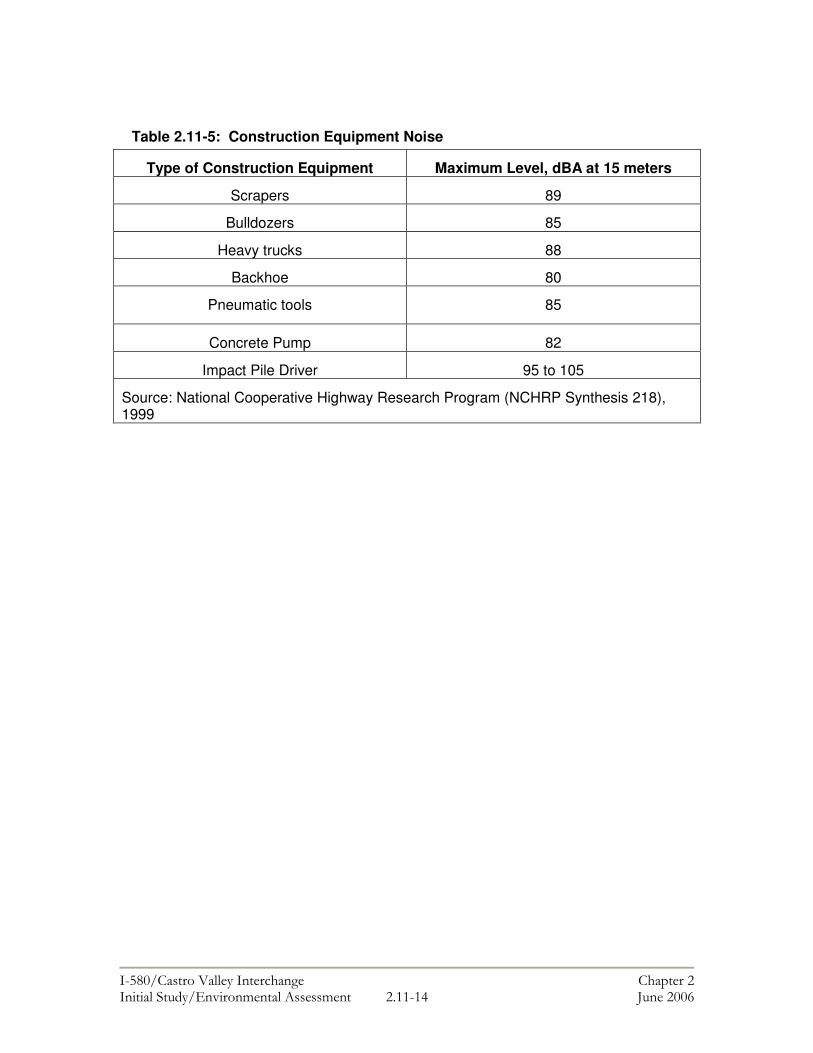
���������� ������ ���������� ������ � ������ ����������������� ����� � !!�!% "��� ���#
Table 2.11-5: Construction Equipment Noise
Type of Construction Equipment Maximum Level, dBA at 15 meters
Scrapers 89
Bulldozers 85
Heavy trucks 88
Backhoe 80
Pneumatic tools 85
Concrete Pump 82
Impact Pile Driver 95 to 105
Source: National Cooperative Highway Research Program (NCHRP Synthesis 218), 1999
���������� ������������������ �� ��������������������������� �������������� � !��!�� "�������#
2.12 LAND USE & COMMUNITY IMPACTS This chapter is based on a Community Impact Assessment that was completed in November 2004 in accordance with Caltrans guidelines. The purpose of this chapter is to define the community where the project is occurring and analyze potential impacts that the project may have in terms of property relocations, growth inducement, environmental justice, and community cohesion. The key regulations governing these topics are identified below. Regulatory Setting Community Character and Cohesion The National Environmental Policy Act of 1969 as amended, established that the federal government use all practicable means to ensure for all Americans safe, healthful, productive, and aesthetically and culturally pleasing surroundings [42 U.S.C. 4331(b)(2)]. The Federal Highway Administration in its implementation of NEPA [23 U.S.C. 109(h)] directs that final decisions regarding projects are to be made in the best overall public interest. This requires taking into account adverse environmental impacts, such as, destruction or disruption of human-made resources, community cohesion and the availability of public facilities and services.
Under the California Environmental Quality Act, an economic or social change by itself is not to be considered a significant effect on the environment. However, if a social or economic change is related to a physical change, then social or economic change may be considered in determining whether the physical change is significant. Since this project would result in physical change to the environment, it is appropriate to consider changes to community character and cohesion in assessing the significance of the project’s effects.
Growth Inducement The Council on Environmental Quality (CEQ) regulations, which implement the National Environmental Policy Act of 1969, requires evaluation of the potential environmental consequences of all proposed federal activities and programs. This provision includes a requirement to examine indirect consequences, which may occur in areas beyond the immediate influence of a proposed action and at some time in the future. The CEQ regulations, 40 CFR 1508.8, refer to these consequences as secondary impacts. Secondary impacts may include changes in land use, economic vitality, and population density, which are all elements of growth.
The California Environmental Quality Act also requires the analysis of a project’s potential to induce growth. CEQA guidelines, Section 15126.2(d), require that environmental documents “…discuss the ways in which the proposed project could foster economic or population growth, or the construction of additional housing, either directly or indirectly, in the surrounding environment.
���������� ������������������ �� ��������������������������� �������������� � !����� "�������#
Property Relocation The Department’s Relocation Assistance Program (RAP) is based on the Federal Uniform Relocation Assistance and Real Property Acquisition Policies Act of 1970 (as amended) and Title 49 Code of Federal Regulations (CFR) Part 24. The purpose of RAP is to ensure that persons displaced as a result of a transportation project are treated fairly, consistently, and equitably so that such persons will not suffer disproportionate injuries as a result of projects designed for the benefit of the public as a whole.
All relocation services and benefits are administered without regard to race, color, national origin, or sex in compliance with Title VI of the Civil Rights Act (42 U.S.C. 2000d, et seq.). Environmental Justice All projects involving a federal action (funding, permit, or land) must comply with Executive Order (EO) 12898, Federal Actions to Address Environmental Justice in Minority Populations and Low-Income Populations, signed by President Clinton on February 11, 1994. This Executive Order directs federal agencies to take the appropriate and necessary steps to identify and address disproportionately high and adverse effects of federal projects on the health or environment of minority and low-income populations to the greatest extent practicable and permitted by law. Low income is defined based on the Department of Health and Human Services poverty guidelines. For 2005, this was $19,350 for a family of four.1
All considerations under Title VI of the Civil Rights Act of 1964 and related statutes have also been included in this project. The Department’s commitment to upholding the mandates of Title VI is evidenced by its Title VI Policy Statement, signed by the Director, which can be found in Appendix C of this document. Affected Environment Castro Valley is an unincorporated area of Alameda County, California which is in the San Francisco Bay Area region. Castro Valley is generally located north of the City of Hayward and east of the City of San Leandro. Situated in a valley surrounded by rolling hills, Castro Valley possesses a suburban atmosphere. The community includes a range of residential, commercial and recreational uses. Land Use Features that add to the quality of life in Castro Valley include an extensively developed and coordinated park system, a county operated swimming lagoon, a 3.15 acre lake, an 18-hole golf course, a community center, a senior center, an art gallery, ballparks and tennis courts. The project area is located in the Castro Valley Urban Area within the County of Alameda. Based on the Castro Valley General Plan, all development in Castro Valley must occur within this area, which currently contains a mix of suburban and low density residential, medium and high density residential, convenience commercial, office and
1 Federal Register, Vol. 70, No. 33, February 18, 2005, pp. 8373-8375, from U.S. Department of Health and Human Services Website: http://aspe.hhs.gov/poverty/05poverty.shtml

���������� ������������������ �� ��������������������������� �������������� � !��$�� "�������#
medical office, commercial, and automotive-oriented commercial uses. The area surrounding the project is predominantly suburban and low density residential uses with some medium and high density residential, convenience commercial, office and medical office commercial, automotive-oriented commercial, and intensive commercial uses. Also included in the project area is a BART station located at 3301 Norbridge Dr. The Don Castro Regional Recreation Area is located in the eastern end of the project, south of I-580. The project area is also within the Castro Valley Sub-Area, which is administered by the Alameda County Redevelopment Agency. The area is bounded approximately by Castro Valley Boulevard to the north, Grove Way to the south, Center Street to the east, and the Castro Valley Boulevard/I-580 interchange to the west. The primary objective for this redevelopment area will be the revitalization of the commercial core along Castro Valley Boulevard. Although a strategic economic development plan has not yet been developed, eventual programs from this plan will focus on the improvement of commercial and retail opportunities in the area. A portion of the project area also overlaps the Castro Valley Central Business District and Don Castro Regional Park is located near the southeast portion of the project area. There is no farmland or land under Williamson Act contracts within the project area. Land Use Development Trends The Alameda County Redevelopment Agency is in the process of preparing the Castro Valley Redevelopment Strategic Plan. The goals of the Redevelopment Strategic Plan are to create a development strategy that will guide future growth and investment in the Central Business District of Castro Valley and to help prioritize the expenditure of redevelopment funds. The objectives of the Strategic Plan are to create:
• a downtown where people want to go and spend time; • an environment that will support economic vitality; • a pedestrian friendly main street atmosphere.
The County of Alameda does not maintain a current listing of planned or proposed development projects in the County. No County of Alameda projects with current environmental documentation are located within or near the project area.
Employment / Housing Based on ABAG 2003 projections, employment in Castro Valley is expected to grow 14.0 percent and population is expected to grow 8.0 percent from 2000 to 2012. However, unemployment is expected to grow 5.2 percent. As shown in Tables 2.12-1 and 2.12-2, housing prices in Castro Valley are increasing. The purchase price of homes and condominiums increased 43.4 from 1999 to 2001 and 48.9 percent from 2000 to 2001. Rental cost increases ranged from 34.5 percent to 43.7 percent from 1999 to 2002, depending on the number of rooms in the unit.
���������� ������������������ �� ��������������������������� �������������� � !��%�� "�������#
Table 2.12-1: Cost of Housing Increases in Castro Valley Housing Type January 1999 January
2001 Percent Increase
Purchase Price Single Family Median Home Prices $279,000 $400,000 43.4% Condominium Median Prices $225,000 $335,000 48.9%
Table 2.12-2: Cost of Rental Housing Increases in Castro Valley
Monthly Fee for Rental Housing December 1997
September 2002
Percent Increase
Studio $664 $954 43.7% 1 BR/1Bath $828 $1,117 34.9% 2 BR/1Bath $923 $1,248 35.2% 2 BR/2Bath $1,118 $1,504 34.5% 3BR/2Bath $1,235 $1,736 40.6%
Source: Alameda County Housing Element, October 2003. Population and Housing Between the 1950s and the end of the 1970s, the population of Castro Valley increased from approximately 18,000 to 45,749. The population decreased in the 1980s; however, it increased again between 1990 and 2000, growing to 58,200. The population increased by 11.1 percent from 1980 to 1990 and by approximately 32 percent between 1980 and 2000. In 1980, the median age of Castro Valley residents was 35.5 years. Currently (April 2005), the median resident age is 39.4 years. The small difference in age over such a long period of time is an indication that new residents continue to move into the community. Table 2.12-3 identifies some of the distinctive demographic characteristics of Castro Valley and Alameda County and also the characteristics of the six census tract blocks (CT) that cover the project area. The study area includes Census Tracts 4310, 4311, 4312, 4309, 4301, 4352. As shown in the table, the overall racial composition of the project area is primarily White, with lower percentages of Black, Asian, Native American, and Native Hawaiian/Pacific Islander. Table 2.12-3: Population by Race and Ethnicity in 2000
CT 4310
CT 4311
CT 4312
CT 4309
CT 4301
CT 4352
Castro Valley
Alameda County
Population 2,585 3,137 5,988 4,667 8,338 4,198 58,200 1,443,741 % White alone 70.4 71.2 69.1 70.7 56.1 43.0 70.85 48.8 % Black or African American alone
4.6 7.7 8.5 4.8 2.9 30.6 5.1 14.9

���������� ������������������ �� ��������������������������� �������������� � !����� "�������#
Table 2.12-3: (continued) CT
4310 CT 4311
CT 4312
CT 4309
CT 4301
CT 4352
Castro Valley
Alameda County
% American Indian and Alaska Native alone
<1 <1 <1 <1 <1 <1 <1 <1
% Asian alone 10.1 8.0 9.9 10.1 33.5 11.5 13.5 20.4 % Native Hawaiian and Other Pacific Islander alone
<1 <1 <1 <1 <1 1.3 <1 <1
% Some other race alone
6.5 5.5 5.7 6.0 2.2 6.3 4.1 8.9
% Two or more races
6.7 6.1 6.0 6.3 4.7 7.1 5.3 5.6
Ethnicity % Non-Hispanic/ Latino1
82.1 80.9 85.6 81.5 93.2 85.2 15.3 40.9
% Hispanic/ Latino
22.0 19.1 14.4 18.5 6.8 14.8 12.2 19.0
1. The Census Bureau considers Hispanic or Latino to be an ethnicity and not a race. Note: Data in bold meet the criteria for an Environmental Justice community. Source: US Census Bureau 2000 Census. Table 2.12-4 identifies the number of housing units in each census tract and certain characteristics of these dwelling units. The average household size is comparable to the averages for Castro Valley and Alameda County. Vacancy rates are comparable to the rate for Castro Valley, which is lower than the rate for Alameda County. Table 2.12-4: Housing Characteristics in 2003 CT
4310 CT 4311
CT 4312
CT 4309
CT 4301
CT 4352
Castro Valley
Alameda County
Number of units
1,220
1,345
2,694
1,946
2,954
1,386
22,003 551, 137
% owner Occupied
35.2% 36.3% 58.5% 20.0% 93.9% 79.4% 69.7% 54.7%
Average Household Size
2.19 2.35 2.15 2.29 2.87 2.99 2.58 2.75
Vacancy Rate
3.1% 2.1% 2.0% 2.0% 1.8% 2.0% 1.8% 3.03%
Source: California Department of Finance, Demographic Research Unit. Employment and Income Table 2.12-5 shows major employers within Castro Valley. The Castro Valley Unified School District (CVUSD), which employs 953 persons, employs the most people in Castro Valley including administrators, faculty and staff.

���������� ������������������ �� ��������������������������� �������������� � !��#�� "�������#
Table 2.12-5: Major Employers in Castro Valley Employers Employees Product Castro Valley Unified School District 953 Educational Services Eden Hospital Medical Center 777 Health Services Seaworthy Ocean Specialists, Inc. 208 Local Trucking Safeway Stores, Inc. 143 Food Stores Eden Hospital Health Services Corp. 134 Health Services Apple One Services Ltd. 113 Health Services Lucky Stores, Inc. 110 Food Stores Kreske Enterprises, Inc. 72 Business Services PW Super Market, Inc. 71 Grocery Store Pay Less Drug Stores 69 Drug Store Shugart Matson Marketing 68 Advertising Source: Castro Valley Chamber of Commerce, Community Profile, 2001. Aside from the businesses identified in Table 2.12-5 above, the study area includes smaller businesses that generally serve the local community such as eateries, tax and insurance services, medical offices, auto repair shops, a self storage facility, a high pressure wash service, and a mortuary. The main commercial corridor in Castro Valley is Castro Valley Boulevard in the Central Business District, less than1/2 mile from the project area. The main office area within Castro Valley is along Redwood Road near the I-580 interchange.2 As shown in Table 2.12-6, the per capita income for Castro Valley is higher than the overall per capita income of Alameda County. The average incomes of residents in the study area census tracts range from $22,985 to $38,860. The percentage of people in poverty in Castro Valley and in each census tract is lower than the total percentage of Alameda County. Table 2.12-6: Income and Poverty in 2000 CT
4310 CT 4311
CT 4312
CT 4309
CT 4301
CT 4352
Castro Valley
Alameda County
Per Capita Income (in dollars)
23,645 27,739 29,246 22,985 38,860 25,391 30,454 26,680
Total Population
2,585 3,137 5,988 4,667 8,338 4,198 58,200 1,443,741
People in Poverty
278 169 343 410 232 387 2,519 156,804
% in Poverty
10.8 5.4 6.0 9.0 2.7 9.5 4.5 11
Source: U.S. Census Bureau 2000. 2 Telephone conversations with Mike Tanzillo of MTC Real Estate, and Max Morris of Adams & Morris Real Estate, 10/13/04.
���������� ������������������ �� ��������������������������� �������������� � !��&�� "�������#
Education The following schools are located within approximately one mile of the project area.
• Castro Valley Elementary • Independent Elementary • Marshall Elementary • Creekside Middle • Castro Valley High School
The Castro Valley Library is also located within one mile of the project area, on Redwood Road. Environmental Consequences, and Avoidance, Minimization and/or Mitigation Measures Land Use Implementation of the project would not physically divide communities as the freeway system is already in place. However, the project would result in the displacement of six residences and one commercial building (see Appendix D). The residences that would be displaced are located along Elm and Juniper Streets and would be displaced to accommodate the new off-ramp from westbound I-580 to Redwood Road. All of the displaced residences are one story and built in the late 1940s. Of these, five are two bedroom units, one is a three bedroom unit and one is a four bedroom unit. A portion of the property located at 21634 Redwood Road would be acquired to accommodate construction of the new on-ramp from Redwood Road to eastbound I-580. Construction on this on-ramp would affect access to the existing Redwood Road Professional Building located on this property. Replacement access cannot be provided without demolishing the existing commercial building located on this property. As a result the Redwood Road Professional Building would be demolished and the existing businesses in the building would be displaced. The building contains seven office units and based on a field visit conducted in October 2004, four businesses currently lease space in the building. The businesses include a tree management company, a roofing company, a delivery company, and a retail store. The nature of the commercial properties that would be displaced is such that they do not rely on foot traffic or drive-by patronage to be successful. Therefore, it is not anticipated that a new location slightly further from I-580 would affect the revenues of the displaced businesses. Construction of the westbound off-ramp from I-580 to Redwood Road would require a partial take of a commercial parking lot, and an excess street right of way from Alameda County. The construction of the eastbound Redwood Road on ramp will require additional right of way along the Greenview Drive frontage road which is currently excess street right of way owned by Alameda County. Improvements along Redwood Road will require four partial takes from commercial properties. Construction of the new off-ramp to Grove Way will require access control rights and closing one driveway at a commercial property (3151 Grove Way), but would not require displacement of this business (see Appendix D).

���������� ������������������ �� ��������������������������� �������������� � !����� "�������#
The project would not impact any Section 4(f) resources (e.g. parks, wildlife refuges, or historic sites). Temporary impacts to bicycle and pedestrian facilities are discussed in Chapter 2.2. No other recreational facilities would be affected by the project. The schools within a one-mile radius of the project area would not be physically affected by construction of the project as none of these schools are located within the project limits. Further, the project would not increase the number of housing units. Therefore, it is not anticipated that enrollment would be affected by the project and the existing library would continue to serve nearby populations. Mitigation Based on the project Draft Relocation Impact Statement, there appears to be adequate resources currently available to enable displaced residents and businesses to relocate within or near the project area. Relocating displaced properties in close proximity to their original locations would minimize potential impacts such as loss of employees and local customers and decreased community cohesion. The mitigation identified below would ensure that relocation activities are conducted in such a way that impacts to the community, residents, and business owners are minimized. Mitigation 2.12-1: The special needs and circumstances of each displaced household and property and business owners are not known at this time but shall be determined prior to negotiations for acquisition. Additional housing and commercial property availability studies shall be conducted when relocation properties are being considered. Mitigation would ensure that relocation activities are conducted in such a way that potential impacts to property owners will be to a less than significant level. Mitigation 2.12-2: Displacements shall be in accordance with the Uniform Relocation Assistance and Real Property Acquisition Policy Act of 1970, as amended in 1987, collectively known as the Uniform Relocation Act, as amended, which provides for uniform and equitable treatment of persons displaced from their homes, businesses, non-profit associations, or farms by Federal and federally-assisted programs, and establishes uniform and equitable land acquisition policies. In accordance with this Act, Caltrans shall provide relocation advisory assistance to any person, business, farm, or nonprofit organization displaced as a result of the acquisition of real property for public use. Consistency with Local Plans The project is consistent with applicable policies outlined in the current Castro Valley General Plan. Specifically, the project would develop and improve the community roadways system (Principal D.2.B.2.9) by providing more direct routes to and from the I-580 freeway. The project would also help meet normal travel needs of all residents and workers (Objective 2) by removing some of the existing cut-through traffic that uses side streets to access I-580. Additionally, the project would modify roadway systems consistent with transit needs by providing more direct access to and from the Castro Valley BART station (Principle D.2.B.2.4). The project would also help achieve the applicable goals and policies of the Castro Valley Central Business District Specific Plan. The project would help to make the District more of a community focal point (Goal A) by simplifying access from I-580. The more direct access would also help to revitalize the Business District. The project would
���������� ������������������ �� ��������������������������� �������������� � !��'�� "�������#
also help to strengthen the relationship between available transportation modes (Goal K) by making the Castro Valley BART station more easily accessible from the freeway. The project is also consistent with the objectives of the current Castro Valley Redevelopment Strategic Plan process. Directly connecting the downtown area to I-580 by constructing a full Redwood Road interchange would support economic vitality and growth of the downtown area. Environmental Justice This project has been developed in accordance with the Civil Rights Act of 1964, as amended, and Executive Order 12898, “Federal Actions to Address Environmental Justice in Minority Populations and Low-Income Populations.” The Executive Order requires each Federal agency (or its designee) to take the appropriate and necessary steps to identify and address ‘disproportionately high and adverse’ effects of federal projects on minority and low-income populations. As shown in Table 2.12-6, the percentage of people in poverty in the study area is less than Alameda County as a whole and as shown in Table 2.12-3 the percentage of minorities in the study area is less than Alameda County as a whole. Therefore, minority and low-income populations would not be disproportionately affected by the project. Community Cohesion According to Caltran’s community impact assessment guidelines (California Department of Transportation 1997), community cohesion is the degree to which residents have a sense of belonging to their neighborhood; a level of commitment of the residents of the community; or a strong attachment to neighbors, groups, or institutions, usually because of continued association over time. Communities are often delineated by physical barriers, such as major roadways or large open space areas. Cohesive communities are indicated by specific social characteristics, such as long average lengths of residency, home ownership, frequent personal contact, ethnic homogeneity, high levels of community activity, and shared goals. Transportation projects may divide cohesive neighborhoods when such projects act as physical barriers or are perceived as psychological barriers by residents. A transportation project perceived as a physical or psychological barrier may isolate one portion of a homogeneous neighborhood (California Department of Transportation 1997). Reconstruction of I-580, from Castro Valley to Livermore, which was completed in 1985, originally divided Castro Valley. Since that time, the community has adapted and developed around the freeway, creating “freeway friendly” uses such as the Castro Valley BART station. The project would not create a new division in the community although seven residential and two commercial property displacements would occur. The project could have a beneficial effect on community cohesion because it would create more direct and less confusing access to main locations in Castro Valley. The local residential neighborhoods surrounding the interchange would generally benefit from the project due to the reduction of cut-through traffic on local streets. Currently, because there is no direct access from westbound I-580 to Redwood Road, which provides a primary connection to the Castro Valley Central Business District and the BART station, cars are forced to use side streets which also provide access to and from neighborhoods. Implementation of the project would provide more direct access to and from I-580. The anticipated reduction in cut-through traffic would foster neighborhood cohesion.

���������� ������������������ �� ��������������������������� �������������� � !��!��� "�������#
Growth Inducement The project, which primarily involves freeway interchange and ramp improvements, is intended to improve access between I-580 and Central Castro Valley. All improvements are proposed within an area that has long been defined by I-580. The project does not include a provision of new access to undeveloped or newly developed areas. Therefore, while the project would improve access for existing residents and businesses in Castro Valley, it is not expected that the project itself would lead to new growth. However, the project could foster economic growth in the area by providing direct access to the Castro Valley Central Business District. Simplifying access to and from Castro Valley Boulevard, the main commercial corridor in Castro Valley, would help the Central Business District become more of a focal point in the community, which is one of the goals of the Central Business District Specific Plan. As an identified goal of the Specific Plan, increased activity in the Central Business District is anticipated and supported by Alameda County. Growth associated with this area of Castro Valley would not constitute an adverse impact. The project would not result in new residential development. As a result, population growth is not expected and secondary impacts associated with population growth, such as inadequate school capacities and overuse of public facilities and utilities, are not anticipated. The project would improve existing roadways. These improvements would not change land use patterns, increase population, or cause unanticipated growth in the area. Therefore, the project would not result in secondary community impacts.

���������� ������������������ ���������������������������� ������������������������������� !"�!��� #�������$
2.13 HAZARDOUS WASTE/MATERIALS This chapter is based on a Hazardous Materials Technical Report and Phase 1/Initial Site Assessment (Phase 1/ISA) completed for the project by Baseline Environmental Consulting in February 2003. Regulatory Setting Hazardous materials and hazardous wastes are regulated by many state and federal laws.
The primary federal laws regulating hazardous wastes/materials are the Resource Conservation and Recovery Act of 1976 (RCRA) and the Comprehensive Environmental Response, Compensation and Liability Act of 1980 (CERCLA). The purpose of CERCLA, often referred to as Superfund, is to clean up contaminated sites so that public health and welfare are not compromised. RCRA provides for “cradle to grave” regulation of hazardous wastes. Other federal laws include:
• Community Environmental Response Facilitation Act (CERFA) of 1992 • Clean Water Act • Clean Air Act • Safe Drinking Water Act • Occupational Safety & Health Act (OSHA) • Atomic Energy Act • Toxic Substances Control Act (TSCA) • Federal Insecticide, Fungicide, and Rodenticide Act (FIFRA)
In addition to the laws listed above, Executive Order 12088, Federal Compliance with Pollution Control, mandates that necessary actions be taken to prevent and control environmental pollution when federal activities or federal facilities are involved.
Hazardous waste in California is regulated primarily under the authority of RCRA, and the California Health and Safety Code. Other California laws that affect hazardous waste are specific to handling, storage, transportation, disposal, treatment, reduction, cleanup and emergency planning. A Phase 1 (ISA) was completed in accordance with Caltrans’ Initial Site Assessment Checklist. The scope of work included a review of historical land use information, interviews, a visual site reconnaissance, a review of regulatory lists and databases, and the development of recommendations for further actions to determine whether current or historical releases of hazardous materials may have the potential to affect the project. Federal, State, and local regulatory agency databases were searched in 2002 by Environmental Data Resources (EDR), Inc. to identify any hazardous material use or releases on properties within a one-mile radius of the project site. However, because the project would not involve
���������� ������������������ ���������������������������� ������������������������������� !"����� #�������$
extensive demolition or excavation, only those sites within one-half mile of the study area or within the study area are considered potentially relevant. Affected Environment Listed Sites of Potential Concern within the Study Area Seven sites of potential concern are located within the study area (Sites 26, 27, 30, 44, 50, 55, and 57). These sites are discussed in Table 2.13-1 and shown in Figure 2.13-1. Sites 26 and 27 are no longer a source of potential concern because the businesses at these locations have been removed and replaced by a public storage facility (Rent-A-Space). Sites 30 and 57 represent a minor commercial spill that was cleaned up within 24 hours. No detailed information is available regarding Site 44, but it is assumed to be a roadway spill that has been cleaned up. Site 50, the PG&E electrical substation, contains transformers that may have at one time contained polychlorinated biphenyls (PCBs). The available database information indicates there has not been a release at this site and a file check in November 2002 with the Alameda County Environmental Health Department (ACEHD) found no record of a release. Because the project does not involve construction, demolition, or excavation activity on the PG&E property and, since there is no evidence of off-site migration of hazardous materials, this site is unlikely to affect the proposed project. Site 55 is an operational Unocal service station containing active Underground Storage Tanks (USTs). This business generates waste oil and other liquid wastes, which are recycled. Records indicate that a release of gasoline was detected in 1992, but it was determined that only soil was impacted and this case was closed by the lead agency the Alameda County Environmental Health Department in 1995. A visual inspection during the site reconnaissance did not reveal the presence of groundwater monitoring wells at the site. The ACEHD confirmed that the file for this site is closed. None of the alternative alignments proposed for the I-580 project involves construction, demolition, or excavation activity on the Unocal property so it is unlikely this site would affect project development.

���������� ������������������ ���������������������������� ������������������������������� !"�"��� #�������$
Table 2.13-1: Listed Sites of Potential Concern within the Study Area ID
Site Name & Address
Database
Listing
Site Description
26
Diablo Builders 3937 Castro Valley Blvd Castro Valley, CA 94546
HAZNET
Business generated 23.6 tons of asbestos-containing waste. The waste was disposed of at a landfill. Business is no longer located at this location.
27
Fotomat Corp 3949 Castro Valley Blvd Castro Valley, CA 94546
RCRIS-SQG, FINDS
Business is listed as a small quantity generator. No violations have been reported. Business is no longer at this location.
30
(Owner/operator not identified) 4105 Castro Valley Blvd. Castro Valley, CA 94546
CHMIRS
A spill involving 0.25 gallon of hydrochloric acid occurred on 11/23/91. The spill was cleaned up by 11/24/91.
44
Center & East Castro Valley Blvd Castro Valley, CA
ERNS
Only the site address was listed in the ERNS database. No additional information was provided.
50
PG&E-Castro Substation 3160 Grove Way Castro Valley, CA 94546
HAZNET
Business generated 42 tons of waste oil and mixed oil. Waste was disposed of by recycling.
55
Unocal Service Station #3770 3020 Grove Way Castro Valley, CA 94546
HIST UST, LUST, CA FID UST, Cortese, HAZNET
The business has generated 3 tons of waste oil and liquid organic wastes. These waste streams were disposed of at a recycler. Approximately 2.5 tons of an unspecified organic liquid were disposed of by treatment. Business is an active UST site and contains three 12,000-gal USTs for storing product. Gasoline leak from UST detected in 1992. Only soil was impacted. Case was closed by ACDEH in 1995.
57
(Owner/Operator not identified) 21666 Redwood Road Castro Valley, CA 94546
CHMIRS
A hypochlorite solution of unknown volume was spilled on 4/15/91. The spill was cleaned up by 4/15/91.
Notes: ACEHD = Alameda County Environmental Health Department. CA FID UST = California EPA facility inventory database of historically active and inactive USTs. CHMIRS = California Hazardous Material Incident Reporting System database of hazardous material spills. Cortese = State list of contaminated sites. HAZNET = California EPA list of hazardous waste generators based on manifest data. HIST UST = Water Resource Control Board list of historical underground storage tank sites. LUST = leaking underground petroleum storage tank sites. UST = State Water Resource Control Board list of registered and active underground storage tanks.
Listed Sites of Potential Concern Located near the Study Area Four other sites of potential concern within one-half mile of the study area were identified from the regulatory database based on their listing in the Leaking Underground Storage Tank (LUST) database, and their status of involving a release of gasoline that has impacted groundwater

���������� ������������������ ���������������������������� ������������������������������� !"�%��� #�������$
(Sites 22, 23, 31, and 52). These sites are discussed in Table 2.13-2 and shown in Figure 2.13-1. A file review was conducted at ACEHD on November 8, 2002 to review the current status of site investigation and/or remediation at each of these four sites, and to assess their potential impact on the study area. The findings are summarized below. Site 22 is a service station site located at the southwest corner of Castro Valley Boulevard and Redwood Road. A release from a UST was reported in 1992 and elevated levels of gasoline have been detected in the groundwater. Depth to groundwater was about ten feet below ground surface (bgs) and groundwater flowed to the south-southeast (toward the study area) (ACEHD, 2002). The site is being monitored quarterly but an off-site investigation has not been conducted. This site is about one-quarter mile from I-580, which suggests it is unlikely to impact the study area. Since the extent of the off-site plume is unknown, excavation to groundwater in the vicinity of Redwood Road would have potentially encountered contamination. However, the extent of excavation in this area will be limited to trenching for storm drain improvements. This trenching would not require excavation to groundwater. Site 23 is a service station site located at the southwest corner of Castro Valley Boulevard and Redwood Road. A release from a UST was reported in 1990 and elevated levels of diesel and gasoline were detected in the groundwater. The depth to groundwater was about eight feet bgs and groundwater flowed to the south-southeast (toward the study area). The site has been monitored quarterly since 1992 (ACEHD, 2002). An initial off-site investigation was conducted to collect groundwater samples. This investigation detected a contaminant plume extending approximately 500 to 600 feet south of the site (ACEHD, 2002). Although the off-site plume does not appear to extend to the study area, groundwater monitoring wells were not installed and the plume extent cannot therefore be confirmed. As a result, if construction activities were to require excavation to groundwater in the vicinity of Redwood Road, there is a potential that contamination could be encountered. Site 31 is a service station site located near the study area where it extends onto Castro Valley Boulevard. A UST removal in 1993 identified a leak and elevated levels of gasoline were subsequently detected in the groundwater. Depth to groundwater was about 12 feet bgs and groundwater flowed to the west-northwest (away from the study area). The site is being monitored annually or semi-annually. An off-site investigation has been conducted and determined that a groundwater contaminant plume extends off-site approximately 250 feet. Contaminant concentrations suggest the plume has degraded over time (ACEHD, 2002). Since the groundwater contaminant plume is migrating away from the study area, this site does not appear to be a potential concern for project development. Site 52 is a service station site located near the study area where it extends to Grove Way. A release from an underground storage tank was reported in 1990 and minor concentrations of gasoline have been detected in the groundwater. Depth to groundwater was typically 45 to 50 feet bgs and groundwater flowed to the southwest (away from the study area). Following remediation, this case was closed in 1996. Since any residual groundwater contaminant plume would migrate away from the study area, this site does not appear to be a potential concern for project development.

���������� ������������������ ����������������������������������� �������������� �� !"���� #�������$
Table 2.13-2: Listed Sites of Potential Concern Located Near the Study Area ID
Site Name & Address
Database Listing
Site Description
Current Site Status
22
Mobil Oil/BP/Chevron 3519 Castro Valley Blvd Castro Valley, CA 91505
CA FID UST, UST, HAZNET, LUST, HIST UST
Businesses have generated 1.5 tons of an unspecified solvent waste stream which was recycled. Site contains four active USTs. One 10,000 gal, one 8,000 gal, & one 6,000 gal. UST used to store product. Fourth UST used to store waste oil. Gasoline leak from UST detected in 1993. Groundwater was impacted. No action has been taken. A preliminary site assessment is underway.
Review of ACEHD file indicates depth to water is about 10 ft. bgs and flows toward the southeast (toward the study area). Contaminant plume includes elevated levels of TPH and MTBE. Offsite investigation has not occurred and plume has not been delineated. Distance to site suggests it is unlikely to have a adverse impact on the study area but the actual extent of the contaminant plume is not known.
23
Xtra Oil Co dba Shell Oil 3495 Castro Valley Blvd Castro Valley, CA 94546
CA FID UST, LUST, Cortese
Gasoline leak from UST detected in 1989. Groundwater was impacted. USTs are listed as inactive in 1993. A preliminary site assessment was completed in 2000. Proposed abatement method is to excavate and dispose of soil.
Review of ACEHD file indicates depth to water is about 8 ft bgs and flows toward the south and southeast (toward the study area). Floating product detected onsite. Initial offsite investigation detected hydrocarbon plume extending to within 1/8th mile of I-580 and about 600 feet from the Redwood Road at Norbridge Ave. Distance to site suggests it is unlikely to have a adverse impact on the study area but the confirmed extent of the contaminant plume is not known.
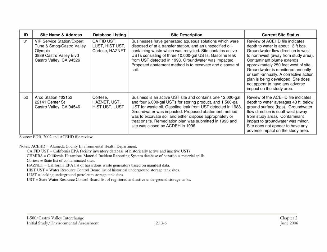
���������� ������������������ ����������������������������������� �������������� �� !"�$�� #�������$
ID
Site Name & Address
Database Listing
Site Description
Current Site Status
31 VIP Service Station/Expert Tune & Smog/Castro Valley Olympic 3889 Castro Valley Blvd Castro Valley, CA 94526
CA FID UST, LUST, HIST UST, Cortese, HAZNET
Businesses have generated aqueous solutions which were disposed of at a transfer station, and an unspecified oil-containing waste which was recycled. Site contains active USTs consisting of three 10,000-gal USTs. Gasoline leak from UST detected in 1993. Groundwater was impacted. Proposed abatement method is to excavate and dispose of soil.
Review of ACEHD file indicates depth to water is about 13 ft bgs. Groundwater flow direction is west to northwest (away from study area). Contaminant plume extends approximately 250 feet west of site. Groundwater is monitored annually or semi-annually. A corrective action plan is being developed. Site does not appear to have any adverse impact on the study area.
52
Arco Station #02152 22141 Center St Castro Valley, CA 94546
Cortese, HAZNET, UST, HIST UST, LUST
Business is an active UST site and contains one 12,000-gal and four 6,000-gal USTs for storing product, and 1 500-gal UST for waste oil. Gasoline leak from UST detected in 1988. Groundwater was impacted. Proposed abatement method was to excavate soil and either dispose appropriately or treat onsite. Remediation plan was submitted in 1993 and site was closed by ACDEH in 1996.
Review of the ACEHD file indicates depth to water averages 48 ft. below ground surface (bgs). Groundwater flow direction is southwest (away from study area). Contaminant impact to groundwater was minor. Site does not appear to have any adverse impact on the study area.
Source: EDR, 2002 and ACEHD file review. Notes: ACEHD = Alameda County Environmental Health Department.
CA FID UST = California EPA facility inventory database of historically active and inactive USTs. CHMIRS = California Hazardous Material Incident Reporting System database of hazardous material spills. Cortese = State list of contaminated sites. HAZNET = California EPA list of hazardous waste generators based on manifest data. HIST UST = Water Resource Control Board list of historical underground storage tank sites. LUST = leaking underground petroleum storage tank sites. UST = State Water Resource Control Board list of registered and active underground storage tanks.

���������� ��������������������������������������������������������������������������������������������������������������������������������������� �������������� �� !"�&� #�������$
Aerially-Deposited Lead
Studies have identified total lead in shallow soils near roadways attributed to the use of lead in gasoline, which was phased out beginning in the mid-1970s (Teichman, et al., 1993). No sampling information regarding shallow soils in the project vicinity were available for this report, but there may be a potential for soils near roadways in the study area to have elevated concentrations of total and/or soluble lead. Soils exceeding hazardous waste thresholds would be classified as a hazardous waste, once excavated, and could require special handling and disposal procedures.1 Soils with elevated lead concentrations could also be a health hazard to construction workers, who may have direct contact with the soils during project construction activities. Different hazardous waste thresholds apply for total lead and for soluble lead, the concentration of lead that dissolves into leachate when extracted with a weak acid. Title 22 of the California Code of Regulations (Section 66261) establishes the Total Threshold Limit Concentration (TTLC) for total lead at 1,000 mg/kg, and a Soluble Threshold Limit Concentration (STLC) for soluble lead at 5.0 mg/L, using the WET. As the WET procedure for soluble lead includes a 10:1 dilution, wastes containing greater than 50 mg/kg of total lead may exceed the STLC, depending on the percentage of the total lead that is soluble in the leachate. Wastes that exceed the TTLC or STLC are considered a California hazardous waste and must be disposed of at a Class I hazardous waste disposal facility in California. Under the federal Resource Conservation and Recovery Act (RCRA), a waste containing greater than 5.0 mg/L of soluble lead by the TCLP method may also be classified as a hazardous waste. As the TCLP method uses a 20:1 dilution and a less acidic leachate, the California soluble lead hazardous waste threshold is more conservative. State Health and Safety Code Section 25157.8, which became part of State Law on 1 January 1999, contains a stricter total lead threshold, and effectively requires that wastes containing greater than 350 mg/kg total lead be disposed of in a Class I hazardous waste disposal facility; this section of the Health and Safety Code expires on 1 July 2006. Lead-Based Paint and Asbestos-Containing Materials
The project would require the demolition of structures built prior to the first half of the 1980s. These structures have the potential to contain lead-based paint or asbestos. Demolition of such structures could require special abatement and health and safety procedures under applicable state laws and regulations. 1 There are three applicable hazardous waste thresholds for lead, two California, and one federal. The State has a threshold for total lead (Total Threshold Limit Concentration) of 1,000 mg/kg (ppm). The State has a soluble lead waste threshold (Soluble Threshold Limit Concentration) of 5 mg/L (ppm). The State test for soluble lead is the Waste Extraction Test (WET), which involves a 10:1 dilution with a weak acid. The federal standard (established under the Resource Conservation and Recovery Act) is for soluble lead only, and is also 5 mg/l, but is measured using the Toxicity Characteristic Leaching Procedure, which involves a 20:1 dilution with a weaker acid than the WET procedure.

���������� ��������������������������������������������������������������������������������������������������������������������������������������� �������������� �� !"��� #�������$
Environmental Consequences, and Avoidance, Minimization and/or Mitigation Measures Potentially Adverse Effect 2.13-1: Four sites in proximity to the study area (within a half-mile) have reported releases of hazardous materials affecting groundwater. A file review indicates two of these sites are located approximately one-quarter mile from I-580, a distance that should be far enough away to not affect groundwater in the study area; however, the extent of the groundwater contaminant plumes are either unknown or cannot be confirmed. Mitigation 2.13-1: It is not expected that the project would require excavation to groundwater, but if that is the case, a limited investigation shall be performed in those areas prior to excavation to collect and analyze groundwater samples. Groundwater samples shall be analyzed prior to construction for total petroleum hydrocarbons (TPH) as gasoline, diesel, and motor oil using EPA Method 8015M with silica gel cleanup for diesel and motor oil; and for Volatile Organic Compounds (VOCs) using EPA Method 8260B. Depending on the results of the investigation, special management and disposal procedures for dewatering effluent and/or construction worker health and safety measures may be required during construction in those areas where exposure to groundwater is proposed. Potentially Adverse Effect 2.13-2: Aerially-deposited lead may be present in shallow soils near study area roadways at concentrations that could present a health risk to construction workers. Mitigation 2.13-2: During the PS&E phase or just prior to construction, a limited soil investigation shall be performed by a qualified professional prior to construction to determine whether aerially deposited lead is present in shallow soils that would be disturbed by construction activities. Sampling locations should be chosen within non-paved areas that will be disturbed by construction. All samples should be analyzed for total lead using EPA Method 6010. Additional soluble lead analyses may also be required to determine waste classification. Depending on the results of the investigation, special soil management, soil disposal, and/or construction worker health and safety measures may be required during project construction. Potentially Adverse Effect 2.13-3: Lead-based paint and asbestos may be present in structures built prior to the mid 1980s that will be demolished under this project at concentrations that could present a health risk to construction workers. Mitigation 2.13-3: A survey shall be performed prior to demolition to confirm the presence of lead-based paint and/or asbestos so that appropriate health and safety procedures can be developed prior to the beginning of construction.

���������� ������������������ ������������������������������� �������������������������� !"�!���� ����#�������$
2.14 CUMULATIVE EFFECTS Regulatory Setting NEPA defines cumulative effect as “the impact which results from the incremental impact of the action when added to other past, present, and reasonably foreseeable future actions regardless of what agency (federal or non-federal) or person undertakes such other actions.” CEQA defines cumulative effects as "two or more individual effects which, when considered together are considerable," and suggests that cumulative effects can result from individually minor but collectively significant projects taking place over a period of time" (State CEQA Guidelines Section 15355). CEQA documents are required to include a discussion of cumulative effects when those effects are significant, and the State CEQA Guidelines suggest two possible methods for assessing potential cumulative effects as identified in CEQA Guidelines Section 15130. The first method is a list based approach, which considers a list of past, present, and reasonably foreseeable future projects producing related or cumulative impacts. The second method is projections based, and uses a summary of projections contained in an adopted general plan or related planning document that is designed to evaluate regional or areawide conditions. While the use of regional projections is one possible method of analyzing cumulative effects under CEQA, it is the required method under NEPA. Because this is a combined CEQA/NEPA document and only the projections-based approach is permissible under both, this cumulative analysis uses the projections-based methodology.
Accordingly this cumulative analysis is based on regional projections contained in the following three documents:
• Castro Valley General Plan (1985),1 which provides a vision for how Castro Valley was/is likely to grow between 1985 and 2005.
• The Association of Bay Area Governments’ (ABAG) Projections 2005, which projects how Castro Valley is likely to grow between 2005 and 2030.
• Metropolitan Transportation Commission’s 2003 Regional Transportation Plan, which identifies transportation improvements planned for Castro Valley between 2001 and 2030.
Affected Environment The Council on Environmental Quality’s (CEQ’s) recommended cumulative effects analysis methodology begins with defining spatial and temporal boundaries—a scope—for the study. Within this scope, and for each resource of concern, an agency determines whether a resource may be affected by the proposed action in combination
1 The 1985 Castro Valley General Plan is currently being updated but a new version has not yet been adopted.

���������� ������������������ ������������������������������� �������������������������� !"������ ����#�������$
with future reasonably foreseeable actions planned by public or private entities.2 Spatial and temporal boundaries are the geographic area and time frame within which the cumulative effects acting upon each resource of concern are studied. CEQ recommends that, instead of doing superficial analyses of a list of barely relevant issues, an agency “count what counts,”3 considering the distance an effect can travel and the length of time it can endure before it becomes insignificant.4 For this reason, the temporal and spatial parameters used in this analysis vary according to the resource studied. These parameters are defined for each resource discussed in the next sub-section of this chapter (Impacts, Mitigation, and Avoidance). For most resources, the spatial parameters for the cumulative analysis are roughly the same area for which this project would have potentially significant direct and indirect impacts. For example, the resource area to consider for noise impacts could logically be confined to projects that would occur adjacent to or within a limited distance of the project area. If the project would only affect sensitive receptors within one-quarter mile of the highway, other projects within one quarter would be a logical resource area to consider for the cumulative impact analysis. Therefore, in this analysis, with the exception of potential air and water impacts, the area over which cumulative impacts could be significant is congruent with the areas of direct and indirect impacts from construction and operation of the proposed action. The area for which an effect upon water and air quality remains potentially significant is greatest of the resources considered in the IS/EA. This is due to the potential for air and water impacts to traverse great distances, unconstrained by topography and possibly facilitated by surface water, groundwater movement, or prevailing winds. Additionally, effects resulting from these cumulative impacts may not be experienced or noticed immediately. Therefore, in accordance with CEQ’s guidelines, the spatial parameters for the cumulative analysis of potentially significant air and water impacts have been broadened in comparison to the analysis for other resources. Although CEQ’s advice on defining a temporal boundary for a cumulative effects analysis is less concrete than for spatial boundaries, it suggests that the same time frame used for the project-specific analysis of direct and indirect impacts is generally appropriate.5 Therefore, the temporal boundary for this project includes a 10-year time frame (until 2015), which includes the construction period and a portion of the operation phase thereafter.
Projections Considered in Cumulative Effects Evaluation
The projections evaluated in this report provide quantitative information (estimates) on how Castro Valley is likely to grow in terms of total population, households, and number of jobs. These estimates provide a sense of how Castro Valley is likely to grow in the next 25 years and at what pace such development might occur. Comparing impacts that are specific to this project to impacts that could occur under future growth projections
2 Council on Environmental Quality, Executive Office of the President, “Considering Cumulative Effects Under the National Environmental Policy Act,” January 1997, p. 11. 3 Ibid, page 12 4 Ibid, page 16 5 Ibid, page 16

���������� ������������������ ������������������������������� �������������������������� !"�%���� ����#�������$
provides the basis for determining whether cumulative effects are likely to occur as a result of this project.
In accordance with Section 15130(b)(1)(B) of the CEQA guidelines, this analysis includes an evaluation of projections set forth in the most recently adopted Castro Valley General Plan (1985). While the General Plan is currently being updated, a newer version has not yet been adopted and could therefore not be evaluated as part of this analysis.
The following key projections were set forth in the 1985 Castro Valley General Plan Based on ABAG’s Projections 1983.
• The population of Castro Valley is expected to increase from 44,202 in 1980 to 50,000 in 1990 (13.9 percent increase), and to 57,000 in year 2000 (13.5 percent increase).
• The number of households in Castro Valley will increase from 17,299 in 1980 to 19,565 in 1990 and again to 24,280 in year 2000.
The next main set of projections evaluated were ABAG Projections 2005. The forecasts provided in this report are based on a set of assumptions about the Bay Area and national economies, demographic changes, labor force composition, and other factors. The regional growth projections are allocated to the counties using a model that considers historical growth trends and information about relationships between employment sectors. ABAG then allocates the county totals to jurisdictions and unincorporated sub-areas (i.e. Castro Valley) based on projections that incorporate “Smart Growth” principles. These principles are based on the Smart Growth Vision developed in 2001 through a series of regional workshops and adopted by the ABAG Executive Board. Implementation of the Vision would require changes in regional development patterns that shift development toward transportation corridors and urbanized areas. Based on ABAG Projections 2005, the following key projections were provided specifically for Castro Valley:
• The population of Castro Valley is expected to increase from 59,800 in 2005 to 62,600 in 2015 (4.4 percent increase from 2005), and to 65,700 in year 2030 (8.9 percent increase from 2005).
• The number of households in Castro Valley is expected to increase from 22,
210 in 2005 to 23,270 in 2015 (4.5 percent increase from 2005), and to 24,480 in year 2030 (9.3 percent increase from 2005).
• The number of jobs in Castro Valley is expected to increase from 12,380 in
2005 to 13,750 in 2015 (9.9 percent increase from 2005), and to 14,770 in year 2030 (16 percent increase from 2005).
This analysis also includes an evaluation of MTC’s 2001 Regional Transportation Plan (RTP). This plan identifies projects that will, in part, help accommodate regional growth or in the case of this project, growth in Castro Valley. The only highway project(s) in
���������� ������������������ ������������������������������� �������������������������� !"�"���� ����#�������$
Castro Valley for which funding has been committed in the RTP are I-580 interchange improvements at Redwood Road, Castro Valley Boulevard, and Center Street, all of which are addressed under this project. Environmental Consequences, and Avoidance, Minimization and/or Mitigation Measures Only those resources that have the potential to be adversely affected by this project, and thus can contribute to a cumulative impact, are discussed here. Special Status Species The project would not affect any special status (Threatened or Endangered) species. As a result, the project would not result in any cumulative effects to such resources. Wetlands and Waters of the U.S. The project would result in a small amount of fill in Castro Valley Creek. The spatial parameters for potential cumulative effects to wetlands and waters of the U.S. therefore include the extent of Castro Valley Creek within Castro Valley. Due to the growth projected for Castro Valley in the next 10 years and the gradual urbanization that is likely to accompany such growth, it is foreseeable that other transportation or development projects could result in additional filling of Castro Valley Creek. This could be considered a cumulative affect to Waters of the U.S. However, the Section 404 and Section 401 permitting processes that are required under this project and other projects impacting Waters of the U.S. would reduce or avoid this effect. Traffic and Transportation The spatial parameters in relation to potential cumulative effects on transportation are Alameda County, which is the applicable planning area in MTC’s 2001Regional Transportation Plan and the Alameda County’s Congestion Management Agency’s (ACCMA’s) Countywide Transportation Plan 2004. This project is identified for implementation in both plans. The operational cumulative affect of this project, in combination with other transportation projects that may take place in Castro Valley under these two plans, would be to create a more efficient transportation system. This would result in a long-term beneficial effect. Moreover, the project would help accommodate the projected growth of Castro Valley over the next ten years, including growth in the Central Business District where growth is planned and supported by Castro Valley and the County of Alameda. During the construction period, detours and delays would be managed through a Traffic Management Plan (TMP), which would minimize disruption to traffic and emergency services in Castro Valley. Land Use The spatial parameters of the cumulative land use analysis are the project area. Land use within the project area is predominantly defined by transportation infrastructure, which would continue to be the case during and after project implementation. However, this project would require the conversion of residential and
���������� ������������������ ������������������������������� �������������������������� !"������ ����#�������$
commercial uses to transportation uses. Similar changes in land could occur under other projects that may be implemented in the project area over the next 10 years. However, this is not likely to have a adverse affect on the overall land use patterns in the project area. Due to the critical nature of such facilities, it is anticipated that I-580 and associated interchanges will remain as the predominant land uses in the immediate project area over the next ten years. Moreover, due to the small number of conversions required under this project, it is not expected that this project would make a cumulatively considerable contribution to land use changes. Therefore the project is not expected to have a cumulatively adverse effect on land uses in the project area. Noise The spatial parameters for potential cumulative noise effects would be the project area and the areas adjacent to the highway that are potentially affected by noise from I-580. In accordance with the Department’s Traffic Noise Analysis Protocol for New Highway Construction and Reconstruction Projects, October 1998, an adverse noise affect occurs when the future noise level with the project results in a substantial increase in noise level (defined as a 12 dBA or more increase). In addition, noise abatement must be considered when the future noise level with the project approaches or exceeds the Noise Abatement Criteria (67 dBA). Approaching the NAC is defined as coming within 1 dBA of the NAC. According to Alameda County’s noise ordinance, an adverse noise affect for residential receivers would occur if the project would result in an increase in 5 dBA or more over existing noise levels. Many receivers along the project corridor would experience future noise levels that would approach or exceed the NAC. As a result, noise abatement was evaluated for these receivers. Sound walls are proposed in sensitive land use areas where adverse noise levels would occur and is deemed reasonable and feasible. The final decision to include sound walls in the proposed project design must consider reasonableness factors, such as cost effectiveness, as well as other pertinent information developed during the design and public review process. The noise modeling conducted for this project showed that noise levels approaching or exceeding NAC under project conditions could be returned to levels below NAC through the inclusion of new soundwalls or the extension of existing soundwalls. In addition, the project would not cause a substantial noise increase (12 dBA or more) or result in an increase of 5 dBA or more over existing noise levels, per County standards. As a result, no cumulative noise effect would occur under this project. Construction-period noise would be subject to standard noise reduction measures and would not result in a short-term cumulative effect. Community Impacts The spatial parameters for cumulative community effects are the larger area of Castro Valley.
���������� ������������������ ������������������������������� �������������������������� !"�$���� ����#�������$
The project would require the displacement and relocation of seven residences and one commercial property. Similar displacements could occur as a result of projects occurring under projected growth in Castro Valley over the next ten years. When combined, these displacements have the potential to result in an adverse affect on the community by physically dividing portions of the community and displacing a substantial number of local residents and businesses. However, this project, and others that would result in the displacement of existing properties, would provide relocation assistance in accordance with the Uniform Relocation Assistance and Real Property Acquisition Policies Act. Geology and Soils The spatial parameters for cumulative soils and geology effects are the project area and the areas immediately bordering the project area. This project, and other projects developed to accommodate projected growth of Castro Valley in the next ten years, have the potential to expose an increased number of people to risk associated with regional seismic events. The portions of I-580 that would be improved under this project would be subject to partial or complete failure during a seismic event. However, adherence to the Uniform Building Code (UBC), as required under this project, would maintain safety during a seismic event to the maximum extent feasible. Application of the UBC to other future buildings and roadway projects would further reduce the exposure of people to risks associated regional seismic events. Aesthetics The spatial parameters for cumulative aesthetic effects are the project area and immediately adjacent area that have views of project changes. The project would introduce new roadway infrastructure into the visual environment such as modified interchange facilities and noise barriers. The project also would remove some existing mature vegetation that screens residential and commercial areas from the highway. All of these elements would represent visual changes, but these changes are generally consistent with the existing visual character of the I-580 corridor. In addition, the project would mitigate any adverse visual effects through measures such as surface treatments on retaining and sound walls (i.e. texturing and coloring), and including replacement plantings immediately adjacent to retaining walls and sound walls where feasible. During construction, there would be temporary disruptions from demolitions, earthwork, staging of construction materials, removal of construction debris, and other construction activities. These would be limited in duration and area, with different locations being under construction at different times, and would be consistent with other types of construction projects that are a regular feature of the urban landscape. Air Quality The design concept and scope of the project is consistent with the project description in the 2001 RTP and 2002-2003 RTIP, and the assumptions in the MTC regional emissions analysis. This project will meet microscale air quality requirements and will therefore have no adverse effect on air quality or cause exceedances of state or federal CO standards. As
���������� ������������������ ������������������������������� �������������������������� !"�&���� ����#�������$
a result, the project is considered to have no long-term cumulative effects on air quality. The proposed project would have the effect of improving air quality within the project area by reducing traffic congestion when compared to the No Project Alternative. During construction, a localized reduction in air quality may occur due to the pollutants generated from construction equipment and the elevation of dust levels from grading, excavation, hauling, and various other construction activities. Implementation of standard mitigation measures recommended by the Bay Area Air Quality Management District (BAAQMD) would reduce or avoid construction-period air quality effects. Other projects in the area could contribute to cumulative dust, however implementation of similar BAAQMD-recommended measures on these projects would also reduce or avoid construction-period dust emissions. Hazardous Materials The potential cumulative effects related to hazardous materials are generally localized. Therefore, the spatial parameters in relation to hazardous materials are the project area. During construction, a limited amount of fueling and maintenance of equipment may occur within the project area. Transport, storage, handling and use of fuels, lubricants, and other chemicals at the site could create the potential for accidental release of hazardous materials. This potential effect would be minimized through implementation of a spill and pollution prevention plan and standard safety training for construction workers who may be exposed to hazardous materials during excavation activities. Preliminary soil sampling will be conducted to evaluate the potential for aerially deposited lead within the project area and any soil generated during construction would be subject to the soil reuse variance issued by Cal/EPA, Department of Toxic Substances Control (DTSC). With the implementation of these measures, any accidental release hazardous materials would be localized and quickly remediated Water Quality The spatial parameters for potential cumulative effects related to hydrology and water quality is the watershed for Castro Valley Creek, which is the waterbody that would be affected by construction of the project. Implementation of this project, in combination with other projects likely to occur under projected growth in the next 10 years would increase the amount of impervious surface area in the Castro Valley Creek watershed. This is a potentially cumulative effect due to the possible increase in the volumes and levels of contamination in storm water runoff that may enter the creek. However, compliance with the National Pollutant Discharge Elimination System (NPDES) and other RWQCB regulations (401 Water Quality Certification), as required under this project, would reduce and/or avoid this potential cumulative effect. Other projects would also be required to adhere to NPDES and RWQCB Clean Water Act requirements. During construction activities, water quality could be affected by contaminated storm water runoff, and spills of hazardous materials. To avoid and minimize this potential effect, Best Management Practices (BMPs) are required to address sediment control during construction. Compliance with the California NPDES permit would reduce or avoid this potential construction related effect. Pollution Prevention and Treatment BMPs, if feasible, would be incorporated into the project to improve water quality or

���������� ������������������ ������������������������������� �������������������������� !"������ ����#�������$
reduce the discharge of pollutants. All other projects possibly contributing to a cumulative water quality effect would also include Construction and Design Pollution and Prevention BMPs, thereby minimizing the potential for a cumulative water quality effect. Utilities and Infrastructure The spatial parameters for potential cumulative effects to utilities and infrastructure include the project area. Project effects on utilities and infrastructure for this project are limited to the construction period, during which utility relocations may be required. Mitigation for this project requires coordination with utility providers to confirm the location of utilities and to minimize the potential for damage to utilities and infrastructure, which could lead to service interruptions. Based on the implementation of this mitigation, no significant cumulative effects are expected in regards to utilities and infrastructure. Cultural Resources The spatial parameters for potential cumulative effects to cultural resources include the project area and areas immediately adjacent to the project area. There are no known cultural resources in the project area, however there are provisional mitigation measures in place to ensure the protection and treatment of such resources if they are discovered during the construction period. Based on the lack of known resources and the inclusion of mitigation to minimize potential impacts to unknown resources, the project would not result in a significant cumulative effect on cultural resources. Paleontological Resources The spatial parameters for potential cumulative impacts to paleontolgocial resources include the project area. There are no known paleontological resources in the project area, however there are provisional mitigation measures in place to ensure the protection and treatment of such resources if they are to be discovered during the construction period. Based on the lack of known resources and the inclusion of mitigation to minimize potential impacts to unknown resources, the project would not result in a significant cumulative effect on paleontological resources.

�
�
�
�
�
�
�
�
�
�
�
� � �
�
�
�
�
�������������� ����
�
�
�
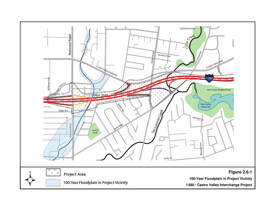
BART Station
Parking Lot
Figure 2.6-1100-Year Floodplain in Project Vicinity
I-580 / Castro Valley Interchange Project
LINE J
LINE I
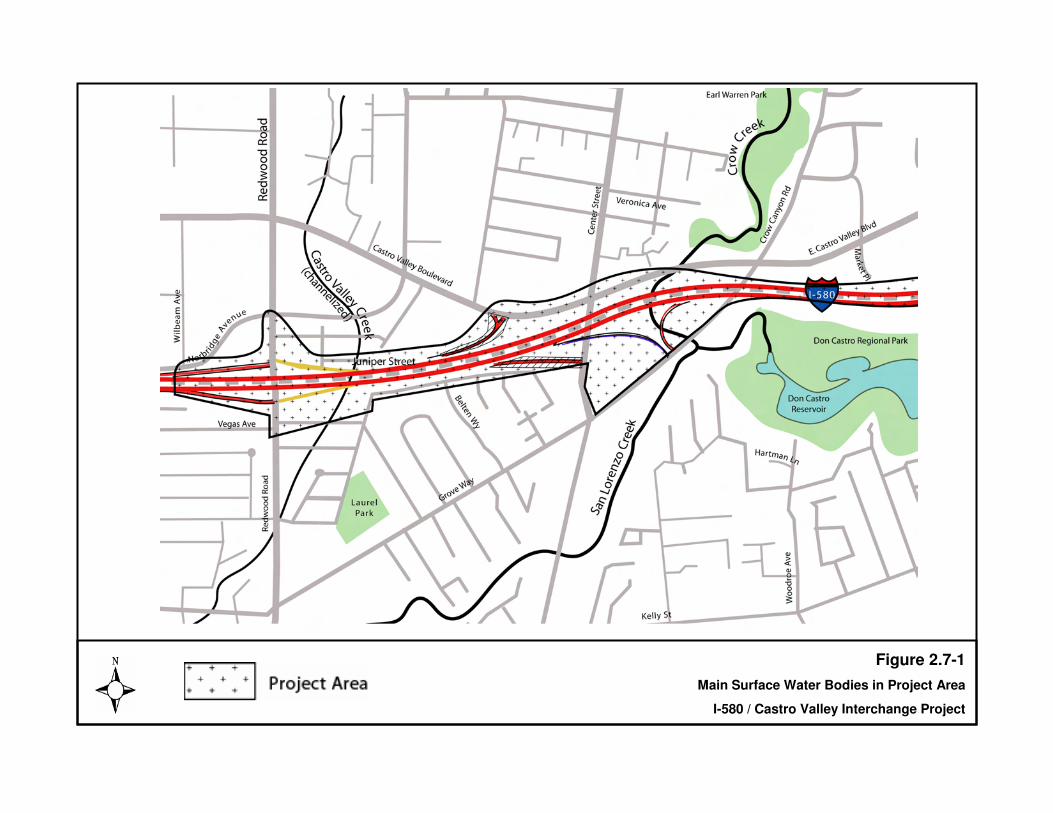
BART Station
Parking Lot
Figure 2.7-1Main Surface Water Bodies in Project Area
I-580 / Castro Valley Interchange Project
LINE J
LINE I
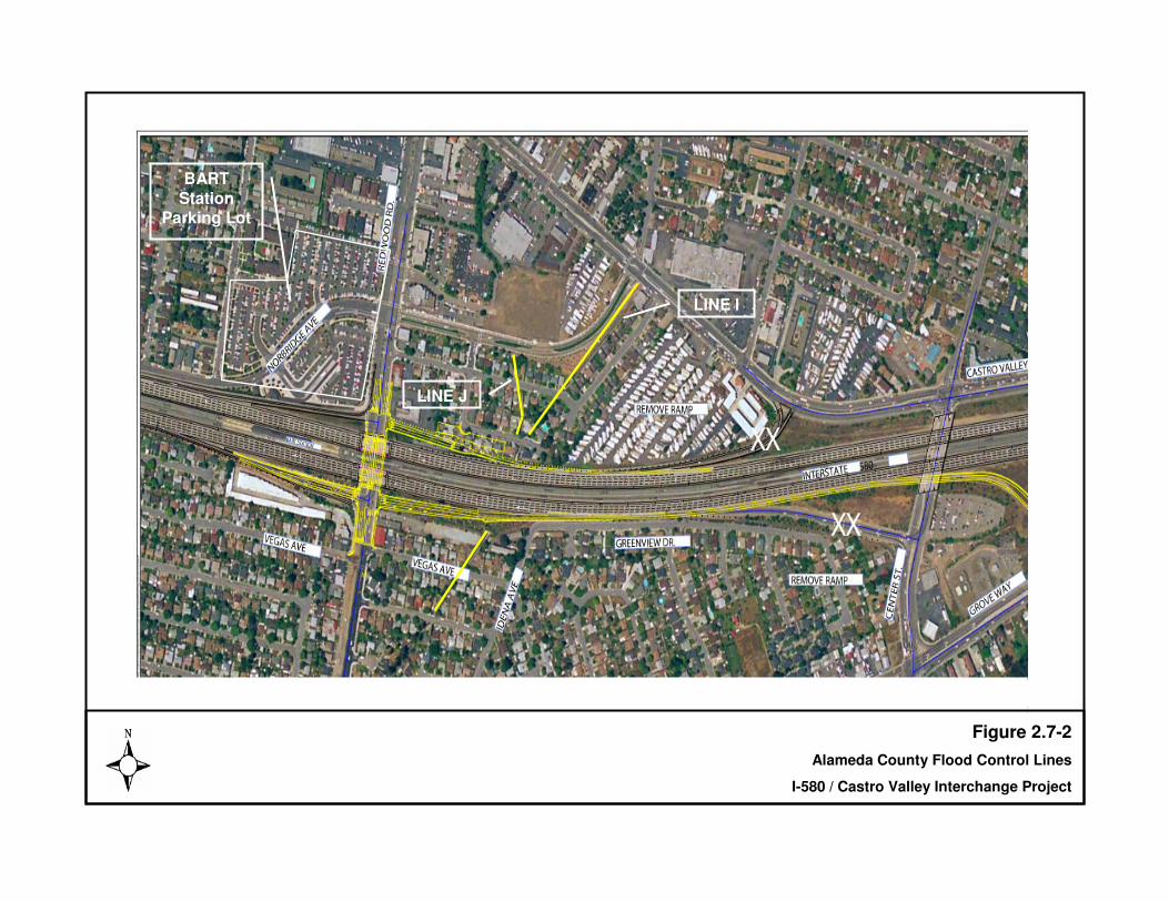
BART Station
Parking Lot
Figure 2.7-2Alameda County Flood Control Lines
I-580 / Castro Valley Interchange Project
LINE J
LINE I
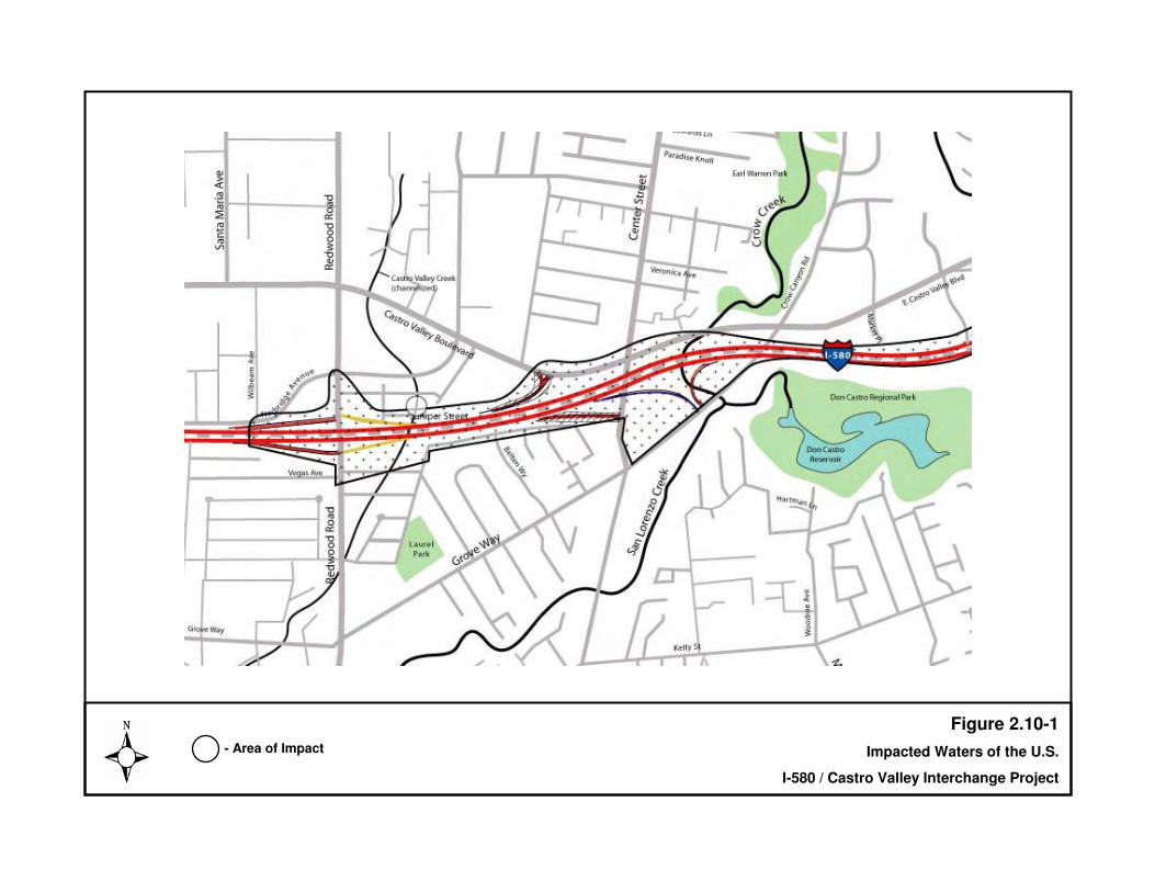
BART Station
Parking Lot
Figure 2.10-1Impacted Waters of the U.S.
I-580 / Castro Valley Interchange Project
LINE J
LINE I
- Area of Impact

BART Station
Parking Lot
Figure 2.11-1
Noise Measurement Locations
I-580 / Castro Valley Interchange Project
LINE J
LINE I
- Measurement Location

BART Statio
n Parki
ng Lot
Figure 2.13-1
Sites on Regulatory Agency Lists Within One-Half Mile of the Study Area
I-580 / Castro Valley Interchange Project
LINE J
LINE I
Note: Numbers inside circles denote sites of potential concern listed in Table 2.10-1. Not to scale.
���������� ������������������ �� ��������������������������� �������������� �� �� !����"��#
CHAPTER 3 COMMENTS & COORDINATION
Coordination with the public and appropriate public agencies is an essential part of the environmental process. This coordination helps the project team in determining the scope of environmental documentation, the level of analysis, potential impacts and mitigation measures and related environmental requirements. Agency consultation and public participation for this project have been accomplished through a variety of formal and informal methods, including: project development team meetings, interagency coordination meetings, and an informational open house. This chapter summarizes the results of the ACTIA’s efforts to fully identify, address and resolve project-related issues through early and continuing coordination. Public involvement activities have been structured to meet CEQA, Alameda County, and Caltrans requirements for public notification and participation. Public Involvement ACTIA hosted an informational open house on November 18, 2003 at Castro Valley High School between 6:00 – 8:00 PM. to present the results of the work conducted to date and the two alternatives being recommended for further study at that time. Local residents, property owners, business people, elected officials, and representatives from agencies, media and special interest organizations were invited to attend (see Section 6.1.1.5 of the Appendix for full mailing list of invitees). The meeting provided an opportunity for participants to comment on the presented alternatives and identify issues that should be considered in the project’s next phase. The public was notified of the meeting through a meeting announcement mailed on November 5, 2003, two weeks prior to the open house. The announcement included a description of the project, a description of the alternatives being studied, a project schedule, a project area map and contact information. The announcement was mailed to approximately 860 addresses which included residents, property owners and businesses within 500 feet of the I-580 within the project limits. In addition, an invitation letter announcing the open house was mailed to local, State and Federal elected officials, the Castro Valley Municipal Advisory Committee, and the ACTIA Governing Board. A display ad announcing the open house was printed in the Daily Review on Sunday, November 9, 2003 and in the Castro Valley Forum on Wednesday, November 12, 2003. Additional meeting announcements were distributed to the Castro Valley Public Library, the Castro Valley High School, the Castro Valley Chamber of Commerce, and shopping centers in the area on November 14, 2003, four days prior to the open house. Approximately 65 people attended the open house, including local elected officials, residents and businesses, media representatives and other interested parties. Information was organized at six stations covering different topics. Agency staff was available at each station to answer questions and discuss issues with attendees.

���������� ������������������ �� ��������������������������� �������������� ��"�� !����"��#
Comment sheets were made available for attendees to submit written comments. The comment sheets could either be submitted at the open house or mailed to ACTIA offices. A public information meeting is scheduled for winter/spring 2006. Agency Coordination Army Corps of Engineers Wetland Delineation A 404 nationwide permit will be required from the ACOE for the minor impact (fill) of a portion of Castro Valley Creek that will be required to accommodate construction of the westbound off-ramp to Redwood Road. In addition, a 401 water quality certification will also be required from the San Francisco Bay Regional Water Quality Control Board (RWQCB), as well as an encroachment permit from the ACFC&WCD for work within this flood control channel. Coordination for the preliminary delineation of approximately 0.003 hectare (0.007 acre) and 6.15 meters (20 linear feet) of Castro Valley Creek was conducted with the ACOE who will verify the delineation during the permitting process. Proposed mitigation is to plant riparian trees within a denuded section of the Crow Creek riparian area at a 2:1 ratio to off-set the linear encroachment into the creek. See the Preliminary Wetland Delineation in Appendix D, and planned mitigation area in Appendix E. US Fish and Wildlife Service Consultation for Endangered Species Act Informal technical assistance was obtained from the Service pursuant to the California red-legged frog site assessment. The Service issued a letter of concurrence with the assessment findings (see letter attached). California Department of Fish and Game As no State-listed species were present, no formal consultation was required. Alameda County Department of Public Works A tree permit will be required from the Alameda County Department of Public Works for the trees to be removed and compensated. State Historic Preservation Officer
• Request for Concurrence of Historic Property Survey Report and Historic Resources Evaluation Report, and Archaeological Survey Report was submitted on June 14, 2005.
• Concurrence of Findings from SHPO, July 5, 2005 (see letter attached).

���������� ������������������ �� ��������������������������� �������������� �� �� !����"��#
CHAPTER 4 LIST OF PREPARERS This Initial Study/Environmental Assessment was prepared by CirclePoint, Inc. in consultation with Caltrans District 4, the Alameda County Transportation Improvement Authority (ACTIA) and Mark Thomas & Company, Inc. Caltrans Oversight Staff John Chang, Project Manager Ed Pang, Office of Environmental Analysis Jennifer Darcangelo, Office of Cultural Resource Studies Lissa McKee, Office of Cultural Resource Studies Elizabeth Krase, Office of Cultural Resource Studies ACTIA Oversight Staff Art Dao, Deputy Director Eric Cordoba, ACTIA Consultant Mark Thomas and Company Richard K. Tanaka, Principal-In-Charge, Transportation Division, M.S. Public Works Administration and B.S. Civil Engineering (CA PE 23233); 33 years experience Brian Krcelic, Division Manager. B.A. Civil Engineering (CA PE 33203); 27 years experience CirclePoint Scott Steinwert, Principal. B.A. Biology; over 16 years experience in environmental analysis and planning. Ted Heyd, Project Manager. B.A. History; MA Urban and Regional Planning; 5 years experience in environmental analysis and planning. Cara Naiditch, Assistant Planner, B.A. Environmental Studies and Economics; 2 years experience in assisting on the development of environmental planning documents. Andrew Martin, Assistant Planner, B.A. Biology; MS Environmental Studies; 1 year experience in assisting on the development of environmental planning documents.

���������� ������������������ �� ��������������������������� �������������� ��"�� !����"��#
Page Left Intentionally Blank

���������� ������������������ �� ��������������������������� �������������� ����� ����!��"
CHAPTER 5 DISTRIBUTION LIST Copies of this Draft Initial Study/Environmental Assessment were distributed to the following parties: Federal Agencies US Army Corps of Engineers 333 Market Street San Francisco, CA 94105-2197 State Agencies California Department of Fish and Game Attn: Habitat Conservation P.O. Box 47 Yountville, CA 94599 Governor’s Office of Planning and Research 1400 Tenth Street Sacramento, CA 95814 Regional and Local Agencies Alameda County Planning Department Public Works Agency 399 Elmhurst Street Hayward, CA 94544-1395 Alameda County Transportation Improvement Authority (ACTIA) 426 17th Street, Suite 100 Oakland, CA 94612 San Francisco Regional Water Quality Control Board 1515 Clay St. Suite 1400 Oakland, CA 94612 Alameda County Clerk-Recorder's Office 1106 Madison Street Oakland, CA 94607 Organizations, Businesses, and Individuals Castro Valley Chamber of Commerce 3467 Castro Valley Blvd. Castro Valley, CA. 94546

���������� ������������������ �� ��������������������������� �������������� ��!�� ����!��"
Page Left Intentionally Blank

�
�
�
�
�
�
�
�
�
�
�
� � �
�
�
�
�
�����������
����� �������

�
���������� ������ ���������� ������ �������� ������ ���� �� !"�� #��$�
������
���������� ������ ���������� ������ �
���� ������������ �������
������ ����!���"
�� ������ #���" ������� ������������ ��������������� �� ��������� ��
�� $��% ������ &��� ��% �%%��"��� ������� � � � �!������"���#�$%��&���'�(���#��$�)!*���
�
+� ����� ����� ��% ����� &'�(��"��,-.�/
!� ������ $������" -��������� ��������%��������� ����0� ����� ��� � ������������������ #������1�����2 �&���������-��������� ������� 3 ������4� 1����5�#1��#�5��#� �� ���1�� ���#�
����������#���� 4�&�#��00���3��� �"��%��6��� �� ������ ��1� ��� ���&� �1�� ��0� ����� � �
1�������1����(���������&�#���"��%��1�����-����7 �� ��0� ��������� ������ �� ������ ��
��#���& ���0�������4� 1���� ������ ������#�1�� ���������� ������4�&�#�� ��� �����1�����
2 �&���������
�
�� ������ )!����* &��� ��% �%%��" $� ������$��3�#���&� ��-������� � ����3���%�3�� �$& ��� ���$-�$�����& ��� ��� �����������*8�*��!�
*� General Plan Designation: Land use designations from the Alameda County General Plan for the project area are commercial and residential.
8� +�����" -���������%�� �&��9�� ���#�� ��� ���� �� ��������� ��������-����� #�� 0 �#� �� ����� ���
�������"������������ ���&#�� ���0����1 ��:�
• ���� ����.&� ������ � � � ���;&4$����)�
• ���� ����.&� ������ � � � ���;&4$�������
• ���� ����.&� ������ � � � ���;&4$��������6�� �
• ���� ����.&� ������ � � � ���;&4$��������<�� �
• �'�$#3 � � �� %��'00 ���
• ����������#���%����3�� �
• 5����;=��5���; �����2�3 ���5�� #�� ���
• 5�;��������;&4&�4���5�� #�� ��� �� ����!��� �, ������"���3���%�3�� �� �� ���������� ������������ ��������� ���##������������
#�0 � ��� ���4� 1������ ��� � ����������������#��� ������������-��������� � ���&#��� ���0����1 ���
��3����� �:
�
���������� ������ ���������� ������ �������� ������ ���� �� !"�� #��$�
������
• ��� �&� ����0�����1�1�� 4�&�#��00���3��0��3������� ��5�#1��#�5��#>��
• ��� �&� ����0�����1���� 4�&�#������3��0��3�5�#1��#�5��#� �������>�
• ��� �&� ����0�����1���� 4�&�#��00���3��0��3������� ��"��%��6��>�
• 5�3�%����0� ����7 � ������ 4�&�#��00���3��� ��� ���; ��� >�
• 5�3�%����0� ����7 � ���1�� 4�&�#������3��0��3��� ����������.�%#��&� �1�� ��0�
�� ���; ��� >���#��
• ��� �&� ����0�����1��&7 � ���������4� 1���� �����1�5�#1��#�5��#������3����#�
��1�"��%��6����00���3���
�
-��������� �1 �������� ���&#�� ������� �&� ����0���&�#1�������#� ������� ��3�� ���#�
������ �&� ����0��7 � �����&�#1�����1 � �� ��������� �������<7 � ��� �������#����#���� ���
��3�%�#� ������ �&� � ��������� �1�&�#�4���������#�1�����0��� 4���1 � �� ��������� ��������
�
)� )'���'�%��� $��% -� ��% )����" -����������#������� �� �� ������ �#�1 � ���� ���������� ��$��3�#���&� ����?�� ��0� ��������� �1�&�#�4������ �&� �#�1 � ���7 � ����� ������ �� ��0�1���
�5'6��0�����������@��#�&�����#����� � �� ���� ��1���1 � �� ��������� �� &#���������� ������&� �
�& � #�� ��������� �������� 3�� ������� � ��0���33��� �����#���� #�� ���&����
��� .��� !'(��� ������� /��� �!!����� � ��0'���% 1�2�2 !����3 ,�������� �!!�����3 �� !�����!���� ��������4" ���3 �����% �1�������&���������#������%����3���4����A& ��#�0���
������ ����� �&� ���0��3�=� �#�; � ���2 �����#�6 �#� 0��;��% ����=� �#�; � ���$�3��������0�
<�� ��������� 0��� ������� 3�� ��0�2 �����#�"�3�����#� ���5�� �����6� ���B&�� ���� ����
.���#���
�
������������ 5���� ��������� �,,���%"
-��� ��% ���3�� ��� 0�� ���� ����(�#� 4���1� 1�&�#� 4�� �� �� ����� �00�� �#� 4�� � �� ������ ��
�%��% ��� � � ���� � ���� 3��� � �� � �� �� C�� �� ����� ; �� 0 ��� � �3��� D� ��� �# �� �#� 4�� ���
����(� � ���� ���0����1 �����������
�
�����$�� �� ���������!� ��E��? ������5���&��������������
�������$�� �&� &����5���&������������� ��E���F� ������������
�������$ ��B&�� ��������*� ���E�������&�� ���G�H�&� ����������*�
������. ���� ����5���&�����������8� ���E������&4� ��;��% �����������8�
�����&� &����5���&������������� ��E����5����� ������������
������"�������G�;� ���������)� ��E���-������� � ���G� ��&�� ����������)�
������H�9��#�&��?� �� �������������� ��E����= � ���G�;��% ���;�� �3�����������
��������H�#�������G�6� ���B&�� ����������� � E����� ?��#� ���� 2 �# ���� �0� ; �� 0 �������
��������
���E��@��#�=���G������ ����������!� �
�
���������� ������ ���������� ������ �������� ������ ���� �� !"�� #��$�
��+���
�
�
�
�
����������
'�� ���4�� ���0� � �� � ����%��&� ��:�
��0 �#� �� � ����������#������� �'=@��F'-���%����� �� 0 ��� ��00�� ���� �����% ���3�� ��
��#���F<"$-��<��<@$5$-�'F�1 ���4���������#��
�
��0 �#� �� ��� ��&��� ����������#������� ���&�#���%����� �� 0 ��� ��00�� ���� �����% ���3�� �
�����1 ����� �4����� �� 0 ��� ��00�� � �� � �������4���&��� ���3 �� ���3���&����#���� 4�#� ��
���� ����#����� ���%��4�����##�#� �� ��������� ��$�F<"$-��<��<@$5$-�'F�1 ���4��
�������#��
�
��0 �#� �� � ����������#������� �?$I���%����� �� 0 ��� ��00�� ���� �����% ���3�� ����#����
<F��5'F?<F-$@��?�$-�5<�'5-� ����A& ��#���
�
��0 �#� �� � ����������#������� �?$I���%����� �� 0 ��� ��00�� ������� �����% ���3�� ��4& �� �
���� ������00�� �����4�����#�A&� ���������9�#� ��������� ���#��&3�� ��&��&�� � ������ ��4���
������� ��#��#�����#��������4�����##�����#�4��3 �� ���3���&����4���#���� ������� ���
������ �����#���� 4�#����� ����#����� ��� 0� ����00�� � ����C�� �� ������ �� 0 ��� � 3��� D����
C�� �� ������ �� 0 ��� �&������3 �� �#�D�$��<F��5'F?<F-$@��?�$-�5<�'5-� ��
��A& ��#��4& � �3&� ������9������� ����00�� �� �� ���3� �� ��4���##�����#���
�
��0 �#� �� ��� ��&��� ����������#������� ���&�#���%����� �� 0 ��� ��00�� ���� �����% ���3�� ��
�����6�@@�F'-�4����� �� 0 ��� ��00�� � �� � �������4���&��������� �� ������ �� 0 ��� ��00�� ��
������%��4���������9�#��#�A&� ���� ��������� ���<�5��&��&�� � ������ ��4���� ��#��#����#��4��
��%��4�����%� #�#����3 �� ����&��&�� � �� �� ����� ���<�5�� ���&# �����% � �������3 �� ���
3���&���� �� ����� 3����#�&���� ����������#������� ���
�
�
;&���� ���#��&3�� � ����0�����<B$�����(� � �#� ��3 �� ���� �����% #�#� ����� ������0�
� ���� ���; &#�<�% ���3�� ���$�����3�� ���� ��&�� ����0����� 3��� ����%� #������
3 � 3 9� ������#���3 �� ���3���&���� ��&�#��� ���������� � �� �� �����# ���� ����� ������
�
�
�
�
�
�
�
�
�
�

�
���������� ������ ���������� ������ �������� ������ ���� �� !"�� #��$�
��!���
�
�&��6.&7�&#�$ �7���# �8��9$�)#
�2 ������
�
���������
)����,����
��!��
���������
)����,����
-���
7�������
�����!����%
$� #���
)����,����
��!��
&�
��!��
6�&�#� ��������� :�
���H�%�����&4� �� ����#%������00�� �
��������� ��% � �J�
4��;&4� �� �����#�3�������� ��
����&������ ���&# ���4& ��� �� 3 �#�
�:� ���������(��& ����� �������#�
� � �� ��4& �# ����1 � ����� � ��
���� ��� ��1��J�
���;&4� �� �����#����#�� ����7 � ���
% �&��������� ������A&�� ���0� ���� ��
��#� ���&���&�# ���J�
#����� ������1���&�����0��&4� �� ���
� �� ����������1� ���1�&�#��#%�������
�00�� �#������� �� 3��% �1�� �� ���
����J��
�
�
�
�
���������� ������ ���������� ������ �������� ������ ���� �� !"�� #��$�
������
��2������'�'��� 6��'����
�
���������
)����,����
��!��
���������
)����,����
-���
7�������
�����!����%
$� #���
)����,����
��!��
&�
��!��
6�&�#� ��������� :�
�����%�� ��� 3��2��3���#��=� A&��
2��3���#�����2��3���#��0�; � �1 #��
�3��� ������2��3���#�� ������
��� �&� &����&��J�
4����0� � �1 ���7 � ���9�� ���0���
��� �&� &����&�������1 ����
6 �� �3����$� ���� ��� J�
�����%��%��� ������������ �� ���
�7 � �����% ���3�� �1� ���#&�� ��
�� ������ �������� &������&�#�
�# % #&���������&3&�� %�������&� � ��
������0�2��3���#� ��������� �&� &����
&��J��
�

�
���������� ������ ���������� ������ �������� ������ ���� �� !"�� #��$�
��*���
���2 ��� �'����
�
���������
)����,����
��!��
���������
)����,����
-���
7�������
�����!����%
$� #���
)����,����
��!��
&�
��!��
6�&�#� ��������� :�
�����0� � �1 ������4� �&� �
3���3�� � ����0� ������� ��4���$ ��
B&�� ��$ � �3�� ���������
����� ���?�����3�� �����J��
4��� ��� ������� ��A&�� ��� ��#��#����
��� � 4& ���&4� �� ����� �����
�7 � ������������ �#�� ��A&�� ��
% ��� ��J�
���5��&� � �����&3&�� %����
���� #���4����� � ���������0�����
�� �� ������& �� �0���1� ��� ���
������ ���� ��� ������� � �3�� �
&�#���0�#��������� � ���34 �� �� ��
A&�� ��� ��#��#�� ���&# ��������� ���
�3 �� ����1� ����7���#�A&�� � %��
�������#��0����9��������&������J��
#��<7��������� %������� ���� ��
�&4� �� �������& �� ������� �� ���J�
������ ���4��� ���4����#����
�00�� ������&4� �� ����&34����0�
������J�
�
�
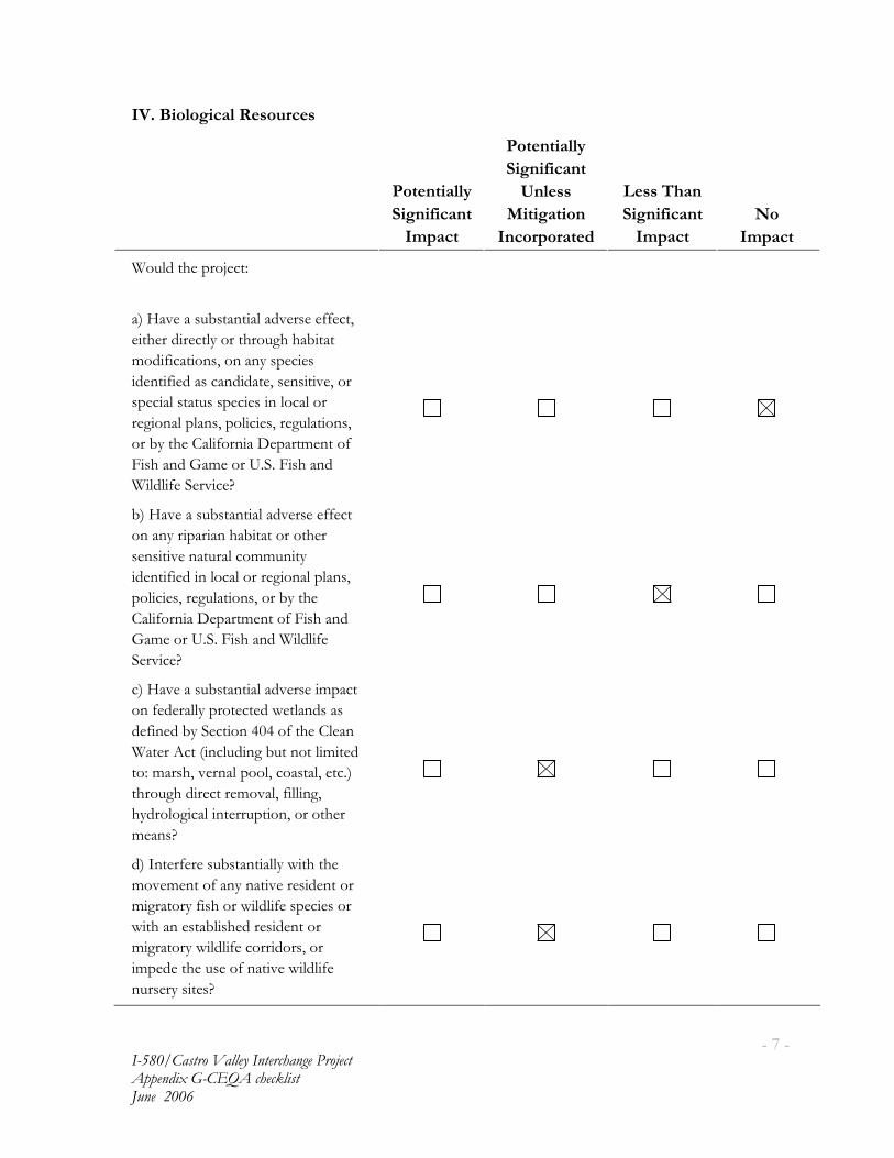
�
���������� ������ ���������� ������ �������� ������ ���� �� !"�� #��$�
��8���
��2 :��������� 6��'���
�
���������
)����,����
��!��
���������
)����,����
-���
7�������
�����!����%
$� #���
)����,����
��!��
&�
��!��
6�&�#� ��������� :�
���H�%�����&4� �� ����#%������00�� ��
� ����# ��� ������ ���&�����4 � �
3�# 0 �� ���������������� ���
#�� 0 �#�������# #� ������� %������
���� ���� � &������ ��� �����������
��� ��������������� � �������&�� �����
���4�� ����� 0��� ������� 3�� ��0�
2 �����#�"�3�����=�;��2 �����#�
6 �#� 0��;��% ��J��
4��H�%�����&4� �� ����#%������00�� �
�������� ��� �����4 � ����� ����
���� %���� &������33&� ��
#�� 0 �#� �������������� ������������
��� � �������&�� ��������4�� ���
�� 0��� ������� 3�� ��0�2 �����#�
"�3�����=�;��2 �����#�6 �#� 0��
;��% ��J�
���H�%�����&4� �� ����#%����� 3��� �
���0�#���������� �� �#�1� ���#�����
#�0 ��#�4��;�� ���!�!��0� ��������
6� ���$� �� ���&# ���4& ��� �� 3 �#�
�:�3������%���������������� ����� ����
���&���# ��� ���3�%����0 �� ����
��#����� ���� � ���&� �������� ����
3����J���
#���� ��0�����&4� �� �����1 �� ���
3�%�3�� ��0������� %����� #�� ����
3 ��� ����0 ������1 �#� 0������ ������
1 ������� �4� ���#���� #�� ����
3 ��� ����1 �#� 0������ #��������
3��#�� ���&����0��� %��1 �#� 0��
�&������� ��J��

�
���������� ������ ���������� ������ �������� ������ ���� �� !"�� #��$�
������
�
���������
)����,����
��!��
���������
)����,����
-���
7�������
�����!����%
$� #���
)����,����
��!��
&�
��!��
�����0� � �1 ��������������� � ������
��# ���������� �� ���4 ���� ����
����&�������&�������� ����������%� ���
��� ��������# �����J��
0����0� � �1 �� ������% � �����0����
�#�� �#�H�4 � ������%� ���������
F� &���������%� ����33&� ��
���������� ���������%�#��������
5�� ���������� � ����4 � �
�����%� �������J�
�
�2 �'�'��� 6��'���
�
���������
)����,����
��!��
���������
)����,����
-���
7�������
�����!����%
$� #���
)����,����
��!��
&�
��!��
6�&�#� ��������� :�
����&������&4� �� ����#%�������
������� �� ���� �� 0 �������0���
� � �� ��������&�������#�0 ��#� ��
;�� ������*!��J�
4���&������&4� �� ����#%�����
������� �� ���� �� 0 �������0����
��������� ��������&������&��&�� � ��
;�� ������*!��J�
���� ��� ������ �# ��� ���#�� ������
&� A&�������� ���� ��������&������ ���
���&� A&�������� ��0�� &���J�
#��� � &�4������&3�����3� ����
���&# ��� ����� � ����#��& � #���0�
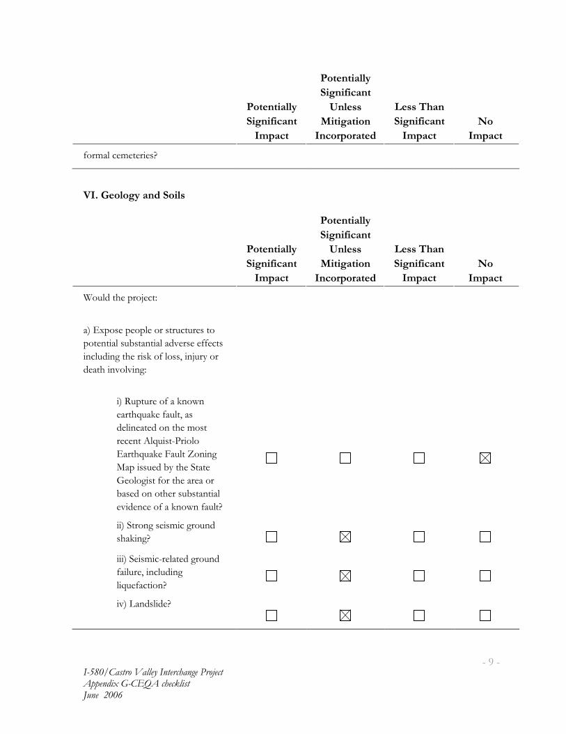
�
���������� ������ ���������� ������ �������� ������ ���� �� !"�� #��$�
��)���
�
���������
)����,����
��!��
���������
)����,����
-���
7�������
�����!����%
$� #���
)����,����
��!��
&�
��!��
0��3�����3� �� ��J�
��2 ;������ ��% )���
�
���������
)����,����
��!��
���������
)����,����
-���
7�������
�����!����%
$� #���
)����,����
��!��
&�
��!��
6�&�#� ��������� :�
���<7���������������� �&� &���� ��
�� �� ����&4� �� ����#%������00�� ��
���&# ��� ���� �(��0������� ��&������
#�� �� �%��% ��:�
�
��5&� &����0���(��1��
��� �A&�(��0�&� �����
#�� ��� �#���� ���3�� �
����� �$�A& � ��� ����
<�� �A&�(��2�&� �K�� ���
?��� ��&�#�4�� ���; � ��
"����� � �0��� �����������
4���#����� �����&4� �� ���
�% #������0���(��1��0�&� J�
��; ������� �3 �����&�#�
���( ��J�
��;� �3 ������ �#����&�#�
0� �&���� ���&# ���
� A&�0�� ��J�
%��@��#�� #�J�

�
���������� ������ ���������� ������ �������� ������ ���� �� !"�� #��$�
�������
�
���������
)����,����
��!��
���������
)����,����
-���
7�������
�����!����%
$� #���
)����,����
��!��
&�
��!��
4��6�&�#� ��������� ����&� � ���� ��������
�&4� �� ����� ������ ������ ���������0�
���� �J��
���.������ �#������������ ��&� ����
�� �� �� � ��&�� �4������� �� �1�&�#��
4���3��&�� �4�����������&� ��0� ���
������ ����#��� �� ��������&� � �����
����00�� �����#�� #����� �����
�����# �����&4� #������� A&�0�� ���
�����������J�
#��.������ �#�����7���� %���� �������������������������������������
#�0 ��#� �� �4�������4��0� ����
=� 0��3�.& �# ����#����))!���
���� ����&4� �� ���� �(�� ��� 0�����
������ �J�
���H�%���� ��� �����4����0��#�A&� ����
�&���� ��� ���&����0���� �� ��(�����
�� ���� %��1�� ��1� ���# �������
��� �3��1�������1���������� �
�%� ��4���0��� ���# ��������0�1�� ��
1� ��J�
�
���2 8�<��% ��% 8�<��%�' 7������
�
���������
)����,����
��!��
���������
)����,����
-���
7�������
�����!����%
$� #���
)����,����
��!��
&�
��!��
6�&�#� ��������� :�
������ ����� �� 0 ��� ���9��#� �����������
����&4� ����� �����% ���3�� �
���&��� �����& ��� ������� ��&����

�
���������� ������ ���������� ������ �������� ������ ���� �� !"�� #��$�
�������
�
���������
)����,����
��!��
���������
)����,����
-���
7�������
�����!����%
$� #���
)����,����
��!��
&�
��!��
���# ��������0���9��#�&��3� �� ���J�
4����� ����� �� 0 ��� ���9��#� �� ���
�&4� ����� �����% ���3�� � ���&���
�������4���0�������4���&��� ���#�
��� #�� ����# ���� �%��% ��� ���
���������0���9��#�&��3� �� ���� � ��
�����% ���3�� J�
���<3 ���9��#�&���3 �� �������
���#�����9��#�&�������& ����
��9��#�&��3� �� ������&4� ����������
1�� ��1 � ������A&�� ���3 ����0����
�7 � �������������#�������J�
#��.������ �#������� ��1� ��� ��
���&#�#������� � ��0���9��#�&��
3� �� ����� �����3�� �#��&��&�� � ���
"�%���3�� ��#��;�� ���*�)*����
��#���������&� ��1�&�#� ����� ����
� �� 0 ��� ���9��#� �� ����&4� �����
�����% ���3�� J�
���2����������� ����� �#�1 � ������������
� ���� ����#�&������������1������&���
������������� �4�����#�� �#��1 � ��
1��3 �����0����&4� ��� ���� ����
�&4� ��&���� ���� ��1�&�#� ��������� �
���&� � ������0� ����9��#�0����������
��� # ������1��( ��� �� ��������� �
����J�
0��2����������� �1 � �� ���% � � �������
�0����� %� ��� �� � ���1�&�#� ���
������ ����&� � ������0� ����9��#�0���
���������� # ������1��( ��� �� ���
������ �����J��
����3�� �� 3���3�� � ����0����
���� ������ � ��0����1 ������#�� �#�
�3�������������������������

�
���������� ������ ���������� ������ �������� ������ ���� �� !"�� #��$�
�������
�
���������
)����,����
��!��
���������
)����,����
-���
7�������
�����!����%
$� #���
)����,����
��!��
&�
��!��
�3���������%��&� �������J��
���<7���������������� �&� &���� ��
���� �(��0������� ��&������#�� ��
�%��% ���1 �#���#�0 ����� ���&# ���
1�����1 �#���#�������#����� � ��
&�4�� 9�#����������1�������� #������
���� � ��3 7�#�1 ��1 �#���#�J��
�
�
����2 8�%������ ��% =��� �'����
�
���������
)����,����
��!��
���������
)����,����
-���
7�������
�����!����%
$� #���
)����,����
��!��
&�
��!��
6�&�#� ��������� :�
���� ��� ������1� ���A&�� ��
� ��#��#�����1�� ��# ��������
��A& ��3�� �J� ����
4��;&4� �� �����#���� �����&�#1� ���
�&��� ������ � ��0�����&4� �� �����
1 �����&�#1� �������������&��� �� �
�����1�&�#�4������ �#�0 � � ��
�A& 0���%��&3���������1�� ����0� ���
���������&�#1� ��� �4�����%���������
������#&� ����� ���0������7 � ���
����4��1�����1�&�#�#���� ������%���
1� ���1�&�#��� ��&���� ��7 � ���
���#�&�������������#�&����0���1� ���
���3 ����%��4�������� �#J�
���;&4� �� ������� ��� ����7 � ��������
#�� ������� ������0� ���� ����������
���&# ��� ���&��� ����� ��� ����0�

�
���������� ������ ���������� ������ �������� ������ ���� �� !"�� #��$�
���+���
�
���������
)����,����
��!��
���������
)����,����
-���
7�������
�����!����%
$� #���
)����,����
��!��
&�
��!��
�����&�����0���� ���3����� %���� ����
3������1� ���1�&�#����&� � ��
�&4� �� ������� ������� � � ���������
�00�� �J�
#��;&4� �� ������� ��� ����7 � ������
#�� ������� �����0� ���� �����������
���&# ��� ���&��� ����� ��� ����0�
�����&�����0���� ���3����� %�������
�&4� �� ����� �������� ����� �����
�3�&� ��0��&�0�����&��00� ����
3������1� ���1�&�#����&� � ��
0���# ����������00�� �J�
������ �������� � 4& ���&��00�1� ���
1� ���1�&�#��7���#� �������� ���0�
�7 � ������������#�� ��31� ���
#�� �������� �3��������% #��
�&4� �� ����## �������&������0�
����& �#��&���00J�
0��' ���1 ����&4� �� �����#����#������
1� ���A&�� �J�
�����������&� ���1 � ������������������
0���#���9��#���������3����#�������
2�#�����2���#�H�9��#�.�&�#�������
2���#����&������5� ��?������� ����
0���#���9��#�#�� ��� ���3��J��
���������1 � �������������0���#�������
��9��#������� �&� &����1� ���1�&�#�
3��#�������# ��� �0���#�0��1�J�
��<7���������������� �&� &���� ����
� �� 0 ��� �� �(��0������� ��&������
#�� �� �%��% ���0���# ���� ���&# ���
0���# �����������&� ��0� ���0� �&����0���
��%������#�3J��

�
���������� ������ ���������� ������ �������� ������ ���� �� !"�� #��$�
���!���
�
���������
)����,����
��!��
���������
)����,����
-���
7�������
�����!����%
$� #���
)����,����
��!��
&�
��!��
�����&�#� ���4���� ����� �&��3 �����
3���1J�
�
�
�>2 $��% -� ��% ��������
�
���������
)����,����
��!��
���������
)����,����
-���
7�������
�����!����%
$� #���
)����,����
��!��
&�
��!��
6�&�#� ��������� :�
������� ������# % #������� �4� ���#�
��33&� �J�
4����0� � �1 ���������� ��4��� ��������
���#�&������������ ����������&�� ���
�0�����������1 ���&� �# � ����%���
��������� �� ���&# ����4& ��� �
� 3 �#� �� ��������������������� 0 ��
���������������� ���������3�����
9�� �����# ��������#�� �#�0��� ���
�&�������0��%� # ������3 �� ������
��% ���3�� ����00�� J�
�������0� � �1 ���������� ��4���
��4 � �������%� ������������� &����
��33&� ��������%� �������J�

�
���������� ������ ���������� ������ �������� ������ ���� �� !"�� #��$�
�������
>2 7������ 6��'���
�
���������
)����,����
��!��
���������
)����,����
-���
7�������
�����!����%
$� #���
)����,����
��!��
&�
��!��
6�&�#� ��������� :�
���5��&� � �� ���������0��%� ��4 � ���0�
�� (��1�� 3 ������ ����&���� �� �
1�&�#�4���0�%��&�� �� ������ �����#�
������ #�� ���0� ���� � �J�
4��5��&� � �� ���������0��%� ��4 � ���0�
���������� 3��� �� �3 ����������&����
����%����� ��#�� ��� �#������������
������������������ 0 ����������� ����
���#�&�������J��
>�2 &���
�
���������
)����,����
��!��
���������
)����,����
-���
7�������
�����!����%
$� #���
)����,����
��!��
&�
��!��
6�&�#� ��������� :�
���<7���&����0��������� �������� ��������
������ ����0��� �����%���� ���7�����
�0�� ��#��#���� �4� ���#� �� ���������
������������������ �����# ����������
���� ��4���� ��#��#���0� ���� ����
����� ��J��
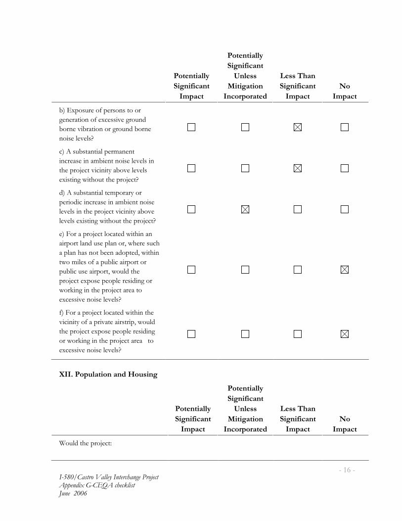
�
���������� ������ ���������� ������ �������� ������ ���� �� !"�� #��$�
���*���
�
���������
)����,����
��!��
���������
)����,����
-���
7�������
�����!����%
$� #���
)����,����
��!��
&�
��!��
4��<7���&����0��������� �����
������ ����0��7���� %�����&�#�
4�����% 4�� ���������&�#�4�����
�� �����%���J�
���$��&4� �� ������3���� ��� ���
�������� ���34 �� ��� �����%���� ��
��������� �% � � ���4�%����%����
�7 � ���1 ��& � ��������� J�
#��$��&4� �� ��� �3������������ �������
��� �# �� �������� ���34 �� ��� ���
��%���� �� ��������� �% � � ���4�%��
��%�����7 � ���1 ��& � ��������� J�
���2����������� ����� �#�1 � �������������
� ���� ����#�&������������1������&���
������������� �4�����#�� �#��1 � ��
1��3 �����0����&4� ��� ���� ����
�&4� ��&���� ���� ��1�&�#� ���
������ ��7��������������� # ������
1��( ��� �� ��������� ������ ��
�7���� %���� �����%���J�
0��2����������� ����� �#�1 � �� ���������
% � � ���0����� %� ��� �� � ���1�&�#�
��������� ��7��������������� # ���
���1��( ��� �� ��������� �������� ��
�7���� %���� �����%���J��
�
>��2 ��!'����� ��% 8�'���
�
���������
)����,����
��!��
���������
)����,����
-���
7�������
�����!����%
$� #���
)����,����
��!��
&�
��!��
6�&�#� ��������� :�
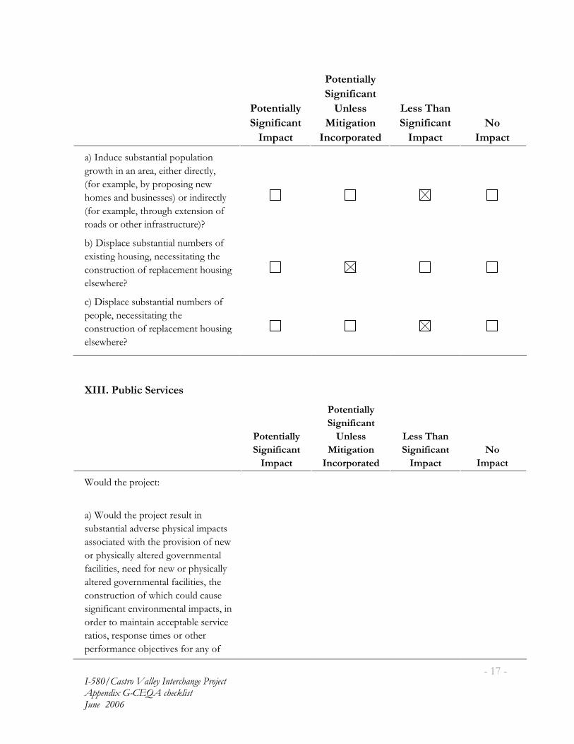
�
���������� ������ ���������� ������ �������� ������ ���� �� !"�� #��$�
���8���
�
���������
)����,����
��!��
���������
)����,����
-���
7�������
�����!����%
$� #���
)����,����
��!��
&�
��!��
�����#&����&4� �� ������&�� ���
���1 �� ������������ ����# ��� ����
�0����7�3�����4�������� �����1�
��3�����#�4&� ����������� �# ��� ���
�0����7�3����� ���&����7 ��� ����0�
���#������ ���� �0��� �&� &���J�
4��� ��������&4� �� ����&34�����0�������
�7 � �����&� ���������� � ��� ���
���� �&� ����0��������3�� ���&� ���
����1����J�
���� ��������&4� �� ����&34�����0������
�������������� � ��� ���
���� �&� ����0��������3�� ���&� ���
����1����J���
�
�
>���2 �'(��� )������
�
���������
)����,����
��!��
���������
)����,����
-���
7�������
�����!����%
$� #���
)����,����
��!��
&�
��!��
6�&�#� ��������� :�
���6�&�#� ��������� ����&� � ��
�&4� �� ����#%��������� ���� 3��� ��
����� � �#�1 �� ������% � ����0���1�
������� �������� ���#���%���3�� ���
0�� � �������#�0�����1�������� ������
�� ���#���%���3�� ���0�� � ���� ���
���� �&� ����0�1� �����&�#���&���
� �� 0 ��� ���% ���3�� ��� 3��� ��� ��
��#��� ��3� � � ������� �4������% ���
�� ������������� 3������� ����
���0��3������4��� %���0��������0�

�
���������� ������ ���������� ������ �������� ������ ���� �� !"�� #��$�
�������
�
���������
)����,����
��!��
���������
)����,����
-���
7�������
�����!����%
$� #���
)����,����
��!��
&�
��!��
����&4� �����% ���:�
��2 ������ �� ��J�
����� ������ �� ��J�
��;������J�
%�����(�J�
%��' �����&4� ��0�� � ��J�
�
>��2 6��������
�
���������
)����,����
��!��
���������
)����,����
-���
7�������
�����!����%
$� #���
)����,����
��!��
&�
��!��
6�&�#� ��������� :�
������������ ���&����0��7 � ���
�� ��4�����#���#���� ��������(�����
� ���������� �����0�� � ����&��� �� �
�&4� �� ������� ����#� �� ��� ����0�
���0�� � ��1�&�#����&�����4��
�������� �#J�
4������&#�������� �����0�� � �����������
��A& ��� ������� �&� ������
�7���� ����0������� �����0�� � ���
1� ���3 �� ���%������#%�����
���� �����00�� ���� �����% ���3�� J�

�
���������� ������ ���������� ������ �������� ������ ���� �� !"�� #��$�
���)���
>�2 #���!������ ��% #��,,��
�
���������
)����,����
��!��
���������
)����,����
-���
7�������
�����!����%
$� #���
)����,����
��!��
&�
��!��
6�&�#� ��������� :�
����&������ �������� �� ��00 ��1� ���
���&4� �� ��� ������ ��� �� ���
�7 � ��� ��00 �����#���#������ ���0�
���� ��� ���� �3�� ��������&� � ����
�&4� �� ��� �������� ��� ���� ���
�&34����0�%�� ���� � ���� ���%��&3��
������� ���� ��������#������
������ ���� � � ����� ����J�
4��<7���#��� ���� �# % #&��������
�&3&�� %���������%����0����% ���
� ��#��#��� �4� ���#�4�� �����&� ��
������ ���3�����3�� ��������0���
#�� ��� �#����#������ ��1���J�
���5��&� � ����������� ��� �� ��00 ���������
�� ������ ���&# ���� ������� ��������
�� ��00 ����%���������������� ��
���� ��� �� ����&� � ���&4� �� ���
��0� ��� �(�J����
#��;&4� �� ����� ����������9��#�� ����
#�� ���0�� &�����������������&�%��������
#������&�� � ����� ��������
���3�� 4���&�����������0��3�
�A& �3�� �J��
���5��&� � �� ��#�A&� ���������� ����������������������������
�3��������������J�
0��5��&� � �� ��#�A&� �����( ���
����� �J��
�����0� � �1 ���#�� �#���� � ���������
���������������3���&���� ���
�� ���� %�� ������� � ����������4&��
&���& ���4 ���������(��J�

�
���������� ������ ���������� ������ �������� ������ ���� �� !"�� #��$�
�������
>��2 -����� ��% )������ )���
�
���������
)����,����
��!��
���������
)����,����
-���
7�������
�����!����%
$� #���
)����,����
��!��
&�
��!��
6�&�#� ��������� :�
���<7���#�1�� �1� ��� ��� 3�� ����������
��A& ��3�� ���0� ������� ��4���
5�� �����6� ���B&�� ���� ����
.���#J�
4��5�A& ���������&� � �� ���
���� �&� ����0���1�1� ������
1�� �1� ��� ��� 3�� �0�� � ������
�7���� ����0��7 � ���0�� � ���� ���
���� �&� ����0�1� �����&�#���&���
� �� 0 ��� ���% ���3�� ����00�� �J�
���5�A& ���������&� � �� ���������������������������
���� �&� ����0���1�� ��3�1� ���
#�� �����0�� � �������7���� ����0�
�7 � ���0�� � ���� ������� �&� ����0�
1� �����&�#���&���� �� 0 ��� �
��% ���3�� ����00�� �J����
#��H�%���&00 � �� �1� ����&��� ���
�%� ��4��� �����%�� ��������� �0��3���
�7 � ����� ��3�� ����#�����&������
���������1�����7���#�#��� ��3�� ��
���#�#J�
���5��&� � ����#� ��3 �� ���4������������
���1�� �1� ��� ��� 3�� ����% #���
1� ������%������3������%�� ���
������ � �� � ������#�A&� ������� ��
�����%�� ��������� L�������� �#�
#�3��#� ���## ��� �� ������% #��L��
�7 � �����33 3�� �J�
0��.�����%�#�4�������#0 ���1 ��
�&00 � �� ����3 �#������ �� ��
����33�#� �� ��������� L����� #�
1�� ��# ����������#�J�

�
���������� ������ ���������� ������ �������� ������ ���� �� !"�� #��$�
�������
�
���������
)����,����
��!��
���������
)����,����
-���
7�������
�����!����%
$� #���
)����,����
��!��
&�
��!��
����3����1 ��0�#������� � �����#�
������� � & �����#����&�� �������� �#�
����� #�1�� �J�
�
>���2 7��%���� 5��%��� �, )����,������
�
���������
)����,����
��!��
���������
)����,����
-���
7�������
�����!����%
$� #���
)����,����
��!��
&�
��!��
6�&�#� ��������� :�
���H�%�� ����� �� ��� ��#����#��
A&�� ���0� �����% ���3�� ��
�&4� �� �������#&��� �����4 � ��0���
0 ������1 �#� 0������ ������&�����0 ���
���1 �#� 0�����&�� ��� ��#����4���1�
���0��&� � � �����%����� ���� ��� ��
�� 3 �� �������� ������ 3���
��33&� �����#&��� ����&34������
��� � � � ����������0�����������
��#������#����� ������ 3������
�� 3 �� �� 3��� �� ��7�3������0� ���
3�������� �#���0��� 0��� ��� � ����
������� � ���J��

�
���������� ������ ���������� ������ �������� ������ ���� �� !"�� #��$�
�������
�
���������
)����,����
��!��
���������
)����,����
-���
7�������
�����!����%
$� #���
)����,����
��!��
&�
��!��
4��H�%�� 3��� �� �� ����� �# % #&�����
� 3 �#��4& ��&3&�� %����
���� #���4��J��C&3&�� %����
���� #���4��D�3����� �� � ���
����3�� ����00�� ���0��������� �����
���� #���4���1����% �1�#� ��
������ ���1 �� ����00�� ���0���� �
������ ��� ����00�� ���0�� �����&���� �
������ �����#� ����00�� ���0����4�4���
0& &��������� ��J����
���H�%����% ���3�� ����00�� ��� ��������
1� ���1 �����&����&4� �� ����#%�����
�00�� ������&3���4� ������ ����
# ��� ������ �# ��� ��J�
�
�
�
�
�
�
�
�
�
�
�
�
�
�
�
�
�
� � �
�
�
�
�
����������
����� �������������������
�
�
�

�
�
�
�
�
�
�
�
�
�
�
� � �
�
�
�
�
����������
�� �����������������������
�
�
�
California Dept. of Transportation Relocation Assistance Program RELOCATION ASSISTANCE ADVISORY SERVICES The California Department of Transportation (the Department) will provide relocation advisory assistance to any person, business, farm or non-profit organization displaced as a result of the Department’s acquisition of real property for public use. The Department will assist residential displacees in obtaining comparable decent, safe and sanitary replacement housing by providing current and continuing information on sales price and rental rates of available housing. Non-residential displacees will receive information on comparable properties for lease or purchase.
Residential replacement dwellings will be in equal or better neighborhoods, at prices within the financial means of the individuals and families displaced, and reasonably accessible to their places of employment. Before any displacement occurs, displaces will be offered comparable replacement dwellings that are open to all persons regardless of race, color, religion, sex or national origin, and are consistent with the requirements of Title VIII of the Civil Rights Act of 1968. This assistance will also include supplying information concerning federal and state assisted housing programs, and any other known services being offered by public and private agencies in the area. RESIDENTIAL RELOCATION PAYMENTS PROGRAM The Relocation Payment program will assist eligible residential occupants by paying certain costs and expenses. These costs are limited to those necessary for, or incidental to, purchasing or renting a replacement dwelling, and actual reasonable expenses incurred in moving to a new location within 80 kilometers (50 miles) of displacee’s property. Any actual moving costs in excess of 80 kilometers (50 miles) are the responsibility of the displacee. The Residential Relocation Program can be summarized as follows:
Moving Costs Any displaced person who was "lawfully" in occupancy of the acquired property regardless of the length of occupancy in the property acquired will be eligible for reimbursement of moving costs. Displacees will receive either the actual reasonable costs involved in moving themselves and personal property up to a maximum of 80 kilometers (50 miles), a moving service authorization, or a fixed payment based on a fixed moving cost schedule which is determined by the number of furnished or unfurnished rooms of the displacement dwelling. Purchase Supplement In addition to moving and related expenses payments, fully eligible homeowners may be entitled to payments for increased costs of purchasing replacement housing. Homeowners who have owned and occupied their property for 180 days prior to the date of the first written offer to purchase the property, may qualify to receive a price differential payment equal to the difference between the Department’s offer to purchase their property and the price of a comparable replacement dwelling, and may qualify to receive reimbursement for certain nonrecurring costs incidental to the purchase of the replacement property. An interest differential payment is also available if the interest rate for the loan on the replacement dwelling is higher than the loan rate on the displacement dwelling, subject to certain limitations on
reimbursement based upon the replacement property interest rate. Also the interest differential must be based upon the "lesser of" either the loan on the displacement property or the loan on the replacement property. The maximum combination of these three supplemental payments that the owner-occupants can receive is $22,500. If the calculated total entitlement (without the moving payments) is in excess of $22,500, the displacee may qualify for the Last Resort Housing described below. Rental Supplement Tenants who have occupied the property to be acquired by the Department for 90 days or more and owner-occupants who have occupied the property 90 to 180 days prior to the date of the first written offer to purchase may qualify to receive a rental differential payment. This payment is made when the Department determines that the cost to rent a comparable and "decent, safe and sanitary" replacement dwelling will be more than the present rent of the displacement dwelling. As an alternative, the eligible occupant may qualify for a down payment benefit designed to assist in the purchase of a replacement property and the payment of certain costs incidental to the purchase, subject to certain limitation noted below under the "Down Payment" section (see below). The maximum amount of payment to any tenant of 90 days or more and any owner-occupant of 90 to 179 days, in addition to moving expenses, will be $5,250. If the calculated total entitlement for rental supplement exceeds $5,250, the displacee may qualify for the Last Resort Housing Program described below.
The rental supplement of $7,500 or less will be paid in a lump sum, unless the displacee requests that it be paid in installments. The displaced person must rent and occupy a "decent, safe and sanitary" replacement dwelling within one year from the date the Department takes legal possession of the property, or from the date the displacee vacates the Department-acquired property, whichever is later. Down Payment Displacees eligible to receive a rental differential payment may elect to apply it to a down payment for the purchase of a comparable replacement dwelling. The down payment and incidental expenses cannot exceed the maximum payment of $5,250, unless the Last Resort Housing Program is indicated. The one-year eligibility period in which to purchase and occupy a "decent, safe and sanitary" replacement dwelling will apply. Last Resort Housing Federal regulations (49 CFR 24.404) contain the policy and procedure for implementing the Last Resort Housing Program on federal aid projects. In order to maintain uniformity in the program, the Department has also adopted these federal guidelines on non-federal-aid projects. Except for the amounts of payments and the methods in making them, last resort housing benefits are the same as those benefits for standard relocation as explained above. Last resort housing has been designed primarily to cover situations where available comparable replacement housing, or when their anticipated replacement housing payments, exceed the $2,520 and $22,500 limits of the standard relocation procedures. In certain exceptional situations, last resort housing may also be used for tenants of less than 90 days.
After the first written offer to acquire the property has been made, the Department will, within a reasonable length of time, personally contact the displacees to gather important information relating to:
• Preferences in area of relocation. • Number of people to be displaced and the distribution of adults and children according to age and sex. • Location of school and employment. • Special arrangements to accommodate any handicapped member of the family. • Financial ability to relocate into comparable replacement dwelling, which will house all members of the family decently.
The above explanation is general in nature and is not intended to be a complete explanation of relocation regulations. Any questions concerning relocation should be addressed to the Department. Any persons to be displaced will be assigned a relocation advisor who will work closely with each displacee in order to see that all payments and benefits are fully utilized, and that all regulations are observed, thereby avoiding the possibility of displacees jeopardizing or forfeiting any of their benefits or payments.
THE BUSINESS AND FARM RELOCATION ASSISTANCE PROGRAM The Business and Farm Relocation Assistance Program provides aid in locating suitable replacement property for the displacee’s farm or business, including, when requested, a current list of properties offered for sale or rent. In addition, certain types of payments are available to businesses, farms, and non-profit organizations. These payments may be summarized as follows:
• Reimbursement for the actual direct loss of tangible personal property incurred as a result of moving or discontinuing the business in an amount not greater than the reasonable cost of relocating the property.
• Reimbursement up to $1,000 of actual reasonable expenses in searching for a new business site.
• Reimbursement up to $10,000 of actual reasonable expenses related to the reestablishment of the business at the new location
• Reimbursement of the actual reasonable cost of moving inventory, machinery, office equipment and similar business-related personal property, including dismantling, disconnecting, crating, packing, loading, insuring, transporting, unloading, unpacking, and reconnecting personal property.
Payment "in lieu" of moving expense is available to businesses which are expected to suffer a substantial loss of existing patronage as a result of the displacement, or if certain other requirements such as inability to find a suitable relocation site are met. This payment is an amount equal to the average annual net earnings for the last two taxable years prior to relocation. Such payment may not be less than $1,000 and not more than $20,000. ADDITIONAL INFORMATION No relocation payment received will be considered as income for the purpose of the Internal Revenue Code of 1954 or for the purposes of determining eligibility or the extent of eligibility of any person for assistance under the Social Security Act or any other federal law (except for any federal law providing low-income housing assistance).

Persons who are eligible for relocation payments and who are legally occupying the property required for the project will not be asked to move without being given at least 90 days advance notice, in writing. Occupants of any type of dwelling eligible for relocation payments will not be required to move unless at least one comparable "decent, safe and sanitary" replacement residence, open to all persons regardless of race, color, religion, sex or national origin, is available or has been made available to them by the state. Any person, business, farm or non-profit organization, which has been refused a relocation payment by the Department, or believes that the payments are inadequate, may appeal for a hearing before a hearing officer or the Department’s Relocation Assistance Appeals Board. No legal assistance is required; however, the displacee may choose to obtain legal council at his/her expense. Information about the appeal procedure is available from the Department’s Relocation Advisors. The information above is not intended to be a complete statement of all of the Department's laws and regulations. At the time of the first written offer to purchase, owner-occupants are given a more detailed explanation of the state's relocation services. Tenant occupants of properties to be acquired are contacted immediately after the first written offer to purchase, and also given a more detailed explanation of the Department’s relocation programs. IMPORTANT NOTICE To avoid loss of possible benefits, no individual, family, business, farm or non-profit organization should commit to purchase or rent a replacement property without first contacting a Department of Transportation relocation advisor at:
State of California Department of Transportation, District # 4 111 Grand Avenue Oakland, CA 94623-0660

�
�
�
�
�
�
�
�
�
�
�
� � �
�
�
�
�
����������
�� ����������������
�
�
�

I-580 Castro Valley Interchange Improvement Project
Parcel Address List
Redwood Road Off-Ramp - Right of Way
Parcel No APN No. Type Total Area of ParcelArea Required for
ImprovementRemainder Area Owner Owner Address Acquisition Cost
1 084C-0605-007-08 Mortuary 5039 m2 (54,239 SF) 740 m2 (7,960 SF) 3,964 m2 (42,668 SF) 21228 Redwood Road Castro Valley 94546 Spencer, Jess C Mortuary Inc. SAME Partial $318,200
2 084C-0605-006 Residential 442 m2 (4,758 SF) 442 m2 (4,758 SF) NONE 21195 Elm Street Castro Valley 94546 Arellano, Benito & Diane SAME Full $732,000
3 Public Street Public Street Public Street 189 m2 (2,035 SF) N/A Elm Street Alameda County N/A Partial $0
4 084C-0607-008 Residential 529 m2 (5,694 SF) 529 m2 (5,694 SF) NONE 21194 Elm Street Castro Valley 94546 Mycung, Phat & Du, Cung SAME Full $732,000
5 084C-0607-007-02 Residential 485 m2 (5,221 SF) 485 m2 (5,221 SF) NONE 3589 Juniper Street Castro Valley 94546 Fulkerson, David SAME Full $732,000
6 084C-0607-006-02 Residential 465 m2 (5,005 SF) 465 m2 (5,005 SF) NONE 3597 Juniper Street Castro Valley 94546 Mendes, Jeanne 3589 Juniper Street, Castro Valley CA 94546-5905 Full $732,000
7 084C-0607-005-02 Residential 434 m2 (4,672 SF) 434 m2 (4,672 SF) NONE 3609 Juniper Street Castro Valley 94546 Bernardo, Michael & Marie SAME Full $732,000
8 084C-0607-004-03 Residential 404 m2 (4,348 SF) 404 m2 (4,348 SF) NONE 3615 Juniper Street Castro Valley 94546 Canestro, John C & Patricia D 4747 Mira Vista Drive, Castro Valley CA 94546-1033 Full $732,000
Redwood Road Widening
Parcel No APN No. Type Total Area of ParcelArea Required for
ImprovementRemainder Area Owner Owner Address Acquisition Cost
9 415-0080-055-04 Commercial 4804 m2 (51,710SF) 11 m2 (118 SF) 4793 m2 (51,592SF) 21662 Redwood Road Castro Valley 94545 IDS & Shurgard Income Growth Partners LP III
1154 Valley Street, Seattle WA 98109-4426 Partial $4,730
10 415-0080-012 Commercial 593 m2 (6,383 SF) 22 m2 (237 SF) 571 m2 (6,146 SF) 21663 Redwood Road Castro Valley 94546 IDS & Shurgard Income Growth Partners LP III
1155 Valley Street, Seattle WA 98109-4426 Partial $9,460
Redwood Road On-Ramp - Access Control
Parcel No APN No. Type Total Area of ParcelArea Required for
ImprovementRemainder Area Owner Owner Address Acquisition Cost
11 416-0010-017 Office Building 4081m2 (43,928 SF) 0 4081m2 (43,928 SF) 21634 Redwood Road Castro Valley 94546 Alameda County 1221 Oak Street, Suite 536, Oakland CA 94612-4224 Access Control $1,612,300
*This acqusition includes the moving of a driveway, building demolition and business relocations.
Redwood Road On-Ramp - Right of Way
Parcel No APN No. Type Total Area of ParcelArea Required for
ImprovementRemainder Area Owner Owner Address Acquisition Cost
12 Public Street Public Street Public Street 1126 m2 (12,120 SF) N/A Greenview Drive Alameda County 1222 Oak Street, Suite 536, Oakland CA 94612-4224 Partial $0
Grove Way Off-Ramp - Access Control
Parcel No APN No. Type Total Area of ParcelArea Required for
ImprovementRemainder Area Owner Owner Address Acquisition Cost
13 417-0010-013-02 Commercial 709 m2 (7,632 SF) 0 709 m2 (7,632 SF) 3151 Grove Way Castro Valley 94546 Coffey, John T. & Cheryl S. 5357 El Caminito Court, Castro Valley CA 94546-1529 Access Control $200,000
Address
Address
Address
Address
Address
Mark Thomas & Co., Inc.
(925)417-8000
Pleasanton, CA 94588
Suite 315
5000 Hopyard Road
E:\Projects\Consulting Services\1582.1 - Castro Valley Interchange Phase 2\IS-EA\JUNE 2006 REVISED IS EA\Appendix D.xls 1 of 1 6/6/2006 12:00 PM
�
�
�
�
�
�
�
�
�
�
�
� � �
�
�
�
�
����������
���� ����� �����
�
�
�

ACCMA Alameda County Congestion Management Agency ACEHD Alameda County Environmental Health Department ACFC&WCD Alameda County Flood Control and Water Conservation District AC Transit Alameda County Transit ACTIA Alameda County Transportation Improvement Authority ADA Americans with Disabilities Act) ARPA Archaeological Resources Protection Act ASR Archaeological Survey Report APE Area of Potential Effect ACOE Army Corps of Engineers BART Bay Area Rapid Transit BMPs Best Management Practices CDFG California Department of Fish and Game DPR California Department of Parks and Recreation CESA California Endangered Species Act CEQA California Environmental Quality Act CHRIS California Historic Resource Information System CHL California Historical Landmarks CPHI California Points of Historical Interest listing CRF California red-legged frog CRHR California Register of Historical Resources CO Carbon Monoxide CVSD Castro Valley Sanitary District CVUSD Castro Valley Unified School District CT Census Tract CFR Code of Federal Regulations CERFA Community Environmental Response Facilitation Act CERCLA Comprehensive Environmental Response, Compensation and Liability
Act COZEEP Construction or Maintenance Zone Enhanced Enforcement Program CEQ Council on Environmental Quality EBMUD East Bay Municipal Utility District EPA Environmental Protection Agency EO Executive Order FESA Federal Endangered Species Act FHWA Federal Highway Administration FIFRA Federal Insecticide, Fungicide, and Rodenticide Act FONSI Finding of No Significant Impact FIRM Flood Insurance Rate Map HOV High Occupancy Vehicle HCM Highway Capacity Manual HPSR Historic Property Survey Report HRER Historic Resource Evaluation Report HEC-RAS Hydrologic Engineering Centers River Analysis System ISA Initial Site Assessment IS/EA Initial Study/Environmental Assessment LUST Leaking Underground Storage Tanks LOS Level of Service MCM Maximum Credible Magnitude MTC Metropolitan Transportation Commission NAAQS National Ambient Air Quality Standards

NEPA National Environmental Policy Act NHPA National Historic Preservation Act NOAA Fisheries National Marine Fisheries Service NPDES National Pollutant Discharge Elimination System NRHP National Register of Historic Places Index NAGPRA Native American Graves Protection and Repatriation Act NAHC Native American Heritage Commission CNPS Native Plant Society NES Natural Environment Study ND Negative Declaration NO2 Nitrogen Dioxide NAC Noise Abatement Criteria NWIC Northwest Information Center OSHA Occupational Safety & Health Act O3 Ozone PG&E Pacific Gas and Electric PM10 Particulate matter that is 10 microns in diameter or smaller PS&E Plan, Specifications, and Estimate PCBs Polychlorinated Biphenyls PQS Professionally Qualified Staff PA Programmatic Agreement PDT Project Development Team PSR Project Study Report RTIP Regional Transportation Improvement Program RTP Regional Transportation Plan RWQCB Regional Water Quality Control Board RAP Relocation Assistance Program RCRA Resource Conservation and Recovery ACT ROW Right-of-way SHPO State Historic Preservation Officer SIP State Implementation Plan SWRCB State Water Resources Control Board SWPPP Storm Water Pollution Prevention Plan TSCA Toxic Substances Control Act TMP Transportation Management Plan TSM/TDM Transportation Systems Management/Transportation Demand
Management USFWS U.S. Fish and Wildlife Service UST Underground Storage Tank USC United States Code USDOT US Department of Transportation VIA Visual Impact Assessment VOCs Volatile Organic Compounds WPCP Water Pollution Control Program

�
�
�
�
�
�
�
�
�
�
�
� � �
�
�
�
�
����������
���� ��� ������
�
�
�
Ballanti, Donald. Air Quality Impact Evaluation, Interstate 580/Castro Valley Boulevard Interchange in Castro Valley, February 2005.
Baseline Environmental Consulting. Hazardous Materials Technical Report and Initial
Site Assessment, Interstate 580 Interchange Project, February 2003. CCS. Traffic Projections Report for Route 580/Castro Valley Interchange Study, August
2005. CCS. Traffic Operations Analysis Report for Interstate 580/Castro Valley Boulevard
Interchange, August 2005. Geo/Resource Consultants, Inc. Geotechnical Report, I-580/Castro Valley Interchange
Project, January 2003. Geo/Resource Consultants, Inc. Preliminary Environmental Assessment Report, I-
580/Castro Valley Interchange Project, August 2003. Illingworth & Rodkin, Inc. Noise Study Report, I-580/Castro Valley Interchange, January
20, 2005. Pattillo & Garrett Associates. Visual Impact Assessment, Interstate 580 (I-580) Castro
Valley Interchange Project, July 15, 2005. RCL Ecology. Natural Environment Study (NES), I-580 Castro Valley Interchange,
November 2004. William Self Associates, Inc. Historic Property Survey Report (HPSR), I-580/Castro
Valley Interchange Project, April 2005. William Self Associates, Inc. Archaeological Survey Report (ASR), I-580/Castro Valley
Interchange Project, April 2005. William Self Associates, Inc. Historic Resource Evaluation Report (HRER), I-580/Castro
Valley Interchange Project, April 2005. Mark Thomas and Company, Inc. Draft Flood Analysis Report, I-580/Castro Valley
Interchange Project, August 2005. Mark Thomas and Company, Inc. Stormwater Data Report, I-580/Castro Valley
Interchange Project, June 2005. Mark Thomas and Company, Inc. Interstate 580/Castro Valley Boulevard Interchange
Project, Community Impact Assessment, November 2004.