Hydrogeological and Numerical Groundwater Flow Model in ... · Hydrogeological and Numerical...
6
Dr. rer. nat. Thomas T. Putranto, S.T., M.Eng. ([email protected]‐aachen.de) Institute of Hydrogeology RWTH Aachen University Hydrogeological and Numerical Groundwater Flow Model in Semarang/Indonesia Dissertation summary Introduction Declining groundwater levels, land subsidence, and flooding are the most common problems related to groundwater usage in Indonesia’s urban areas. In Semarang, which is located on the northern coastal Java (Central Java Province), the number of registered deep wells increased tremendously in the 1980s. It went up to 1,127 wells with a total groundwater abstraction of around 35 MCM/yr in 2010. Therefore, there is an urgent need to give a quantitative assessment to the actual situation. This study focused on major improvements to the existing hydrogeological model using integrated geological, hydrogeological, and hydrological data. The hydrogeological model was then implemented as a numerical model to simulate groundwater flow under steady state and transient conditions. The calibrated transient model was applied for several prognoses in order to predict groundwater levels and storages based on the future city development and climate change. Study area Geographically, the study area is located on 419500 to 480250 m in East Longitude and 9212850 to 9258190 m in South Latitude using the Universal Transverse Mercator (UTM) zone 49 south. It covers around 1,070 km 2 and comprises urban (Semarang city) and suburban areas (Demak, Grobogan, and Semarang Regencies) with a population of about 3 million inhabitants. Topographically, Semarang consists of two major morphologies: lowland and coastal areas in the north with a maximum elevation of 10 m above sea level (masl) and the foothill of Mount Ungaran in the south rising up to 210 masl at the border of the study area. The study area is located dominantly in the alluvial plains of the northern part of Java. According to the regional stratigraphy, these belong to the Alluvium and Damar formations. Groundwater in plain and coastal areas flows primarily in an intergranular system, whereas a fissures and interstices system occurs in the south of Semarang. A multiple layer aquifer system is found in the study area consisting of an unconfined aquifer at the top and a confined aquifer below which is sub‐classified into different units. Generally, groundwater flows from the mountainous area in the south towards the coast in the north. Methodology The research was divided into three main sections: understanding the natural system, developing the hydrogeological model (conceptual model), and finally applying the numerical groundwater flow model. In order to develop the hydrogeological model, the following steps were done: constructing hydrogeological cross sections and deriving hydrostratigraphical units (HSU), defining the water type using hydrogeochemistry analysis, calculating groundwater recharge, defining boundary conditions and initial parameters. The development of the numerical model was focused on groundwater flow under steady state and transient conditions. The finite element method was chosen as the numerical solution, using DHI‐Wasy FEFLOW 5.2. A steady state model was set up using data for the year 2010 due to a relatively good data base, and complementary measurements of piezometric head from twelve monitoring wells in the model domain. Boundary conditions are constant head along the coastline of Java Sea for the first aquifer and a zero‐flux for the second aquifer in the north, a flux boundary in the south, water leakage from or into rivers in the east and inside the model domain, and a zero‐flux boundary in the west. Based on the experience and results of the steady state model, a transient model was created for the period 1998 to 2010. Groundwater abstraction and recharge were implemented as time series with an annual resolution. As model application, several prognoses were developed related to the city development plan and future climate change. Prognoses were run until 2031 with respect to the spatial planning for Semarang city.
Transcript of Hydrogeological and Numerical Groundwater Flow Model in ... · Hydrogeological and Numerical...
Dr. rer. nat. Thomas T. Putranto, S.T., M.Eng. ([email protected]‐aachen.de) Institute of Hydrogeology RWTH Aachen University
Hydrogeological and Numerical Groundwater Flow Model in Semarang/Indonesia
Dissertation summary
Introduction Declining groundwater levels, land subsidence, and flooding are the most common problems related to groundwater usage in Indonesia’s urban areas. In Semarang, which is located on the northern coastal Java (Central Java Province), the number of registered deep wells increased tremendously in the 1980s. It went up to 1,127 wells with a total groundwater abstraction of around 35 MCM/yr in 2010. Therefore, there is an urgent need to give a quantitative assessment to the actual situation. This study focused on major improvements to the existing hydrogeological model using integrated geological, hydrogeological, and hydrological data. The hydrogeological model was then implemented as a numerical model to simulate groundwater flow under steady state and transient conditions. The calibrated transient model was applied for several prognoses in order to predict groundwater levels and storages based on the future city development and climate change.
Study area Geographically, the study area is located on 419500 to 480250 m in East Longitude and 9212850 to 9258190 m in South Latitude using the Universal Transverse Mercator (UTM) zone 49 south. It covers around 1,070 km2 and comprises urban (Semarang city) and suburban areas (Demak, Grobogan, and Semarang Regencies) with a population of about 3 million inhabitants. Topographically, Semarang consists of two major morphologies: lowland and coastal areas in the north with a maximum elevation of 10 m above sea level (masl) and the foothill of Mount Ungaran in the south rising up to 210 masl at the border of the study area.
The study area is located dominantly in the alluvial plains of the northern part of Java. According to the regional stratigraphy, these belong to the Alluvium and Damar formations. Groundwater in plain and coastal areas flows primarily in an intergranular system, whereas a fissures and interstices system occurs in the south of Semarang. A multiple layer aquifer system is found in the study area consisting of an unconfined aquifer at the top and a confined aquifer below which is sub‐classified into different units. Generally, groundwater flows from the mountainous area in the south towards the coast in the north.
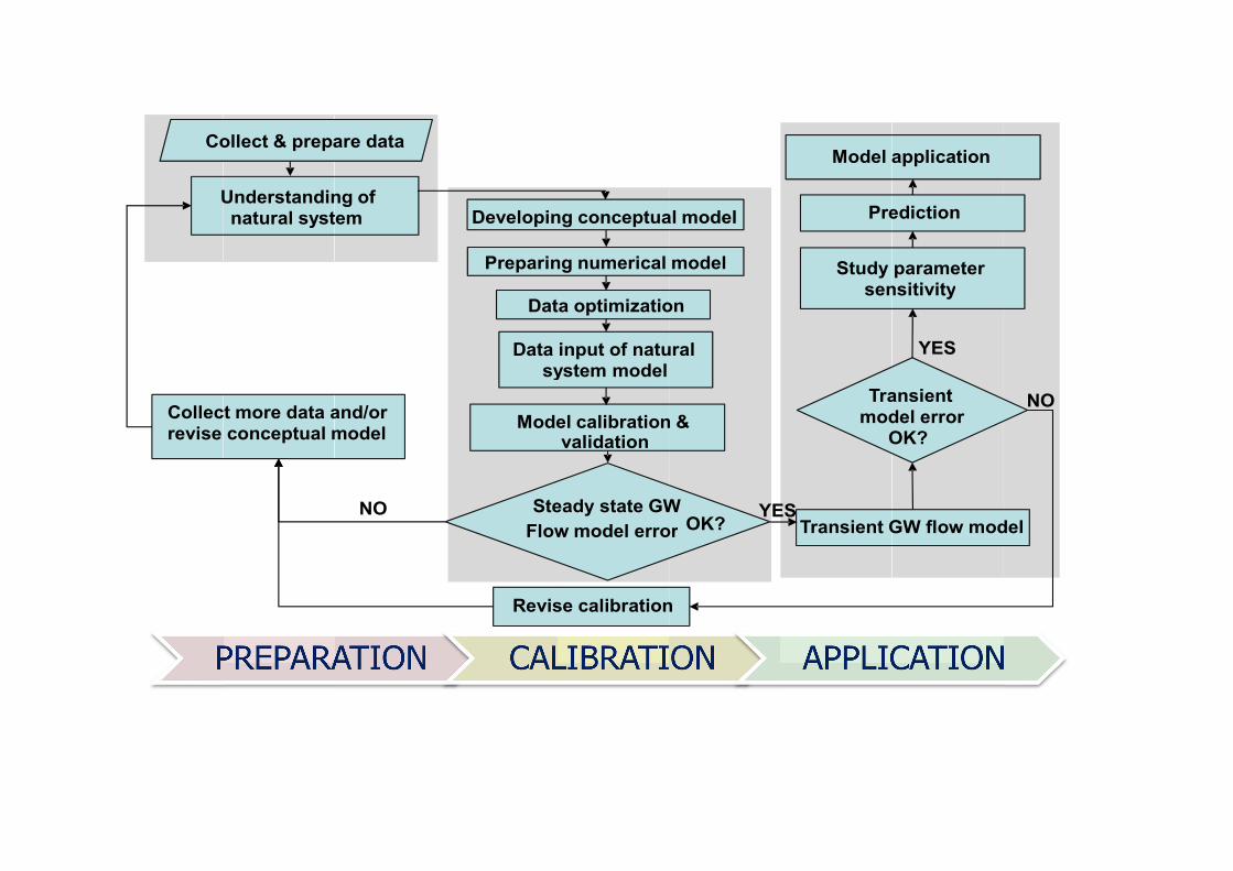
Methodology The research was divided into three main sections: understanding the natural system, developing the hydrogeological model (conceptual model), and finally applying the numerical groundwater flow model. In order to develop the hydrogeological model, the following steps were done: constructing hydrogeological cross sections and deriving hydrostratigraphical units (HSU), defining the water type using hydrogeochemistry analysis, calculating groundwater recharge, defining boundary conditions and initial parameters.
The development of the numerical model was focused on groundwater flow under steady state and transient conditions. The finite element method was chosen as the numerical solution, using DHI‐Wasy FEFLOW 5.2. A steady state model was set up using data for the year 2010 due to a relatively good data base, and complementary measurements of piezometric head from twelve monitoring wells in the model domain. Boundary conditions are constant head along the coastline of Java Sea for the first aquifer and a zero‐flux for the second aquifer in the north, a flux boundary in the south, water leakage from or into rivers in the east and inside the model domain, and a zero‐flux boundary in the west. Based on the experience and results of the steady state model, a transient model was created for the period 1998 to 2010. Groundwater abstraction and recharge were implemented as time series with an annual resolution. As model application, several prognoses were developed related to the city development plan and future climate change. Prognoses were run until 2031 with respect to the spatial planning for Semarang city.
Dr. rer. nat. Thomas T. Putranto, S.T., M.Eng. ([email protected]‐aachen.de) Institute of Hydrogeology RWTH Aachen University
Results of the hydrogeological model Two aquifers (Aquifer 1 and Aquifer 2), three aquitards (Aquitards 1, 2, and 3) and one aquiclude are distinguished as HSU in the study area. Aquifer 1 represents an unconfined aquifer whereas aquifer 2 is a confined one. Aquifer 2 is subdivided into 3 groups. Aquifer 2a represents the Garang aquifer (Gr) as the main aquifer in the study area showing a predominantly (hydrogen‐)carbonate alkaline water. It extends from the centre of Semarang to the north east. Aquifer 2b consists of Quaternary marine sediments (Qm) and has a predominantly chloride alkaline water, locally alkaline earth water type. It is dominant in plain and coastal areas. The Damar formation (Dm) is classified as Aquifer 2c. It contains fresh water in volcanic rocks of predominantly hydrogencarbonate alkaline earth water type. A higher higher alkaline content is common. The Dm aquifer spreads out from lower to intermediate slopes.
Recharge to the aquifer system is derived from precipitation, urban recharge, inflow from adjacent aquifers, and bank filtration. Negative balance terms of the water balance in the study area are surface runoff, evapotranspiration, outflow to other basins, baseflow, and abstraction from deep wells. The potential groundwater recharge in the study area ranges from 70 to 410 mm/yr.
Results of the numerical model The discretization of the model domain is using a 6‐noded triangular prisms into 294,020 nodes and 524,979 elements as a three dimensional representation.
A steady state model was set up to simulate hydraulic heads in 2010. Calibration resulted in a high absolute error calculated as root mean square (RMS) of around 2.9 m, but normalized RMS indicates an acceptable value (6.2%). The normalized RMS value is a more representative measure of the fit than the RMS itself, as it accounts for the scale of the potential range of data values (observed heads have a range from ‐39 to 8 masl). The calibrated steady state model gives a reasonable value of abstraction around 60 MCM/yr with a real groundwater recharge of about 43% of the potential groundwater recharge (30‐176 mm/yr). This is around 1‐8% of the average precipitation in the model domain. The value coming from modelling is much higher than the officially documented groundwater extractions.
The transient model simulates groundwater flow from 1998 until 2010. The quantitative result of calibration shows that around 40% of the residual heads lie outside of the 95% confidence interval. RMS shows a high value of around 7.55 m, but normalized RMS indicates an acceptable value (around 12%). This is due to the high range of observed heads between ‐47.5 and 13.6 masl. The model results show a decrease of piezometric heads in the north of Semarang year by year due to an intensive abstraction. Hydraulic conductivity, groundwater abstraction, groundwater recharge, and flux boundary are parameters to be evaluated in the sensitivity analysis. Hydraulic conductivity and groundwater abstraction are the most sensitive parameters. A variation of these parameters leads to significant changes in both conclusion and residual statistics.
Finally, prognoses show a lowering of piezometric heads in Semarang and the cone of depression becomes wider to the south. An increase in groundwater abstraction and the impact of future climate change will cause groundwater storage to decrease. Prognoses using the transient model indicate that a reduction of the annual abstraction by 20 MCM/yr until 2031 is necessary to restore groundwater resources in Semarang urban area and to prevent a further drawdown of groundwater levels.


Table Typical model data requirements, formats and sources.
Data type Data format Data source
Topographic map Raster DEM 90mx90m derived from SRTM (Jarvis et
al. 2008)
Wells (location, bore log, total depth,
screen position, pumping rate,
piezometric heads)
Reports The Directorate of Environmental Geology
(DGTL) and P.T. Gea Sakti
Hydrogeochemical data Reports DGTL and P.T. Gea Sakti
Regional geological map of Semarang,
Salatiga and Kudus; scale 1:100.000
Maps
(analog)
The Geological Research and Development
Centre (P3G)
Regional hydrogeological maps of
Semarang; scale 1:250.000
Map (analog) DGTL
Climatology (1998–2007) Reports Meteorology, Climatology and Geophysics
Agency (BMKG), and Water Resources
Development Bureau in Central Java (PSDA
Prov. Jateng)
Population (2005–2010) Report Statistics Centre Bureau in Central Java
Province (BPS Prov. Jateng)
River packages (1999) Report Snow Mountain Engineering Cooperation
(SMEC)
Regional climate change projection for
Indonesia
Report The Centre for Australian Weather and
Climate Research (CAWCR)
Spatial planning of Semarang city in
2011–2031
Report The government of Semarang municipality
Aquifer properties (K, So, Sy) Reports DGTL, P.T. Gea Sakti, Books and Journals
Land use Shapefiles National coordination of mapping and survey
agency (Bakosurtanal)
Co
U
Collecrevise
ollect & prepa
Understandinnatural syst
ct more data aconceptual m
are data
ng of tem
and/or model
NO
Developin
Preparin
Dat
Data sy
Mode
SteFlow
Revis
ng conceptua
ng numerical
ta optimizatio
input of natuystem model
el calibrationvalidation
eady state GWw model erro
se calibration
al model
model
on
ural
n &
W or
n
YEOK?
Model a
Tramod
O
Study sen
Pre
Transient GES
application
ansient del error OK?
parameter nsitivity
ediction
GW flow mod
YES
del
NO