Human and Economy : India - WordPress.com
20
Human and Economy : India Population 1. First census in 1872 but first complete census in 1881 2. UP > Maharashtra > Bihar > West Bangal > Madhya Pradesh (Lakshdweep last) 3. Literacy [Kerala > Lakshdweep > Mizoram > Goa > Tripura] India's literacy rate is at 74.04%. Kerala is the most literate state in India, with 93.91% literacy. Bihar is the least literate state in India, with a literacy of 63.82%. 4. Population Growth Phase 1 : 1901-1921 Stagnant growth Phase 2 : 1921-1951 Steady population growth Phase 3 : 1951-1981 High growth rate Phase 4 : 1981-2019 Remained high but slowed down (Due to decrease in crude birth rate) 5. Density of population increased from 117 persons/ sq km in 1951 to 382 persons/sq km in 2011 6. Mumbai is most populated [Mumbai > Delhi > Kolkata] 7. Density of Population [Delhi > Chandigarh > Pondi > D&D > Bihar > West Bengal > Kerala > UP] 11,297 persons in the National Capital Territory of Delhi Arunachal Pradesh has least density Eastern Region- 625(Highest) Highest in Kerala in peninsular India (Bihar in north after NCT) Physiological density = total population / net cultivated area Agricultural density = total agricultural population / net cultivable area 8. Population growth [Annual growth rate of India 1.64] Natural : Crude birth and death rate The growth rate of females was 18.3 per cent which is higher than males — 17.1 per Induced : Inward and Outward approach Kerala lowest growth rate and Meghalaya highest (Confusing dont focus much) 9. Population Composition Rural – Urban Composition The proportion of urban population 31.16 per cent Highest proportion of urban population is in NCT Delhi (97.5 per cent). Top five states in share of urban population are Goa (62.2 per cent), Mizoram (52.1 per cent), Tamil Nadu (48.4 per cent), Kerala (47.7 per cent) and Maharashtra (45.2 per cent). Rural Population - UP > Bihar > West Bengal Urban population - Maharashtra > UP > Tamilnadu Linguistic Composition (Hindi > Bengali > Marathi > Telagu )
Transcript of Human and Economy : India - WordPress.com

Human and Economy : India
Population
1. First census in 1872 but first complete census in 18812. UP > Maharashtra > Bihar > West Bangal > Madhya Pradesh (Lakshdweep last) 3. Literacy [Kerala > Lakshdweep > Mizoram > Goa > Tripura]
India's literacy rate is at 74.04%. Kerala is the most literate state in India, with 93.91% literacy. Bihar is the least literate state in India, with a literacy of 63.82%.
4. Population Growth
Phase 1 : 1901-1921 Stagnant growth
Phase 2 : 1921-1951 Steady population growth
Phase 3 : 1951-1981 High growth rate
Phase 4 : 1981-2019 Remained high but slowed down (Due to decrease in crude birth rate)
5. Density of population increased from 117 persons/ sq km in 1951 to 382 persons/sq km in 2011 6. Mumbai is most populated [Mumbai > Delhi > Kolkata] 7. Density of Population [Delhi > Chandigarh > Pondi > D&D > Bihar > West Bengal > Kerala > UP]
11,297 persons in the National Capital Territory of Delhi Arunachal Pradesh has least density Eastern Region- 625(Highest)
Highest in Kerala in peninsular India (Bihar in north after NCT)
Physiological density = total population / net cultivated area
Agricultural density = total agricultural population / net cultivable area
8. Population growth [Annual growth rate of India 1.64]
Natural : Crude birth and death rate The growth rate of females was 18.3 per cent which is higher than males — 17.1 per
Induced : Inward and Outward approach
Kerala lowest growth rate and Meghalaya highest (Confusing dont focus much)
9. Population Composition
Rural – Urban Composition
The proportion of urban population 31.16 per cent Highest proportion of urban population is in NCT Delhi (97.5 per cent). Top five states in share of urban population are Goa (62.2 per cent), Mizoram (52.1 per cent), Tamil Nadu(48.4 per cent), Kerala (47.7 per cent) and Maharashtra (45.2 per cent). Rural Population - UP > Bihar > West Bengal Urban population - Maharashtra > UP > Tamilnadu
Linguistic Composition (Hindi > Bengali > Marathi > Telagu )

Hindi highest Sanskrit, bodo, manipuri lowest
Religious Composition
Hindu 79.8 %
Muslim 14.2%
Christ 2.7 %
Sikh 1.7 %
Composition of Working Population
main workers + marginal workers (39.8 %)
non-workers - Dependent population India GDP contribution [Worker] - Service (58) [33]; Manufacturing (24) [24]; Agriculture (18) [43]
10. Sex ratio
943 female against 1000 males Highest sex ratio Kerala (Pondi in UT) Lowest Sex ratio in Harayana (Lowest in Diu Daman which is also lowest overall)
11. Child Sex ratio (914) Highest Arunachal Pradesh then Meghalaya Lowest Harayana
12. Main Worker is a person who works for atleast 183 days ( or six months) in a year.13. According to Census 2011, out of total female main workers, 55% were agricultural laborers and 24% were
cultivators 14. According to the Food and Agriculture Organization (FAO), women's contribution to Indian agriculture is about 32% 15. Marginal Worker is a person who works for less than 183 days ( or six months) in a year. 16. The percentage of persons below the poverty line in 2011-12 has been estimated as 25.7% in rural areas, 13.7% in
urban areas and 21.9% for the country as a whole. 17. Overall literacy in India is approximately 74.04 per cent (2011). while female literacy is 65.46 per cent 18. State Human development index - Kerala, Delhi, Himachal Pradesh, Goa and Punjab.
Migration
1. Migration recorded from first census 1881, 1981 reason recorded 2. Intra state in all type UU, UR, RU, RR females dominated 3. In inter state RR, UU, UR female dominated while in RU male dominated4. International migration Bangladesh (3.0 million) followed by Pakistan (0.9 million) and Nepal (0.5 million).
[96% neighboring countries]5. Maharashtra highest immigration then Delhi, Gujarat and Haryana [UP, Bihar highest out migration]6. 65 per cent of females move out from their parental houses [except Meghalaya]
Settlements
Rural
Compact - Rajasthan, Bundelkhand, Nagaland (Security and proper use of resources)

Semi-Clustered Settlements - Fragmentation, stratification
Hamleted Settlements - Fragmented, Ethnic factor [Locally called panna, para, palli, nagla, dhani]
Dispersed Settlements - Hilly area
Gaddi tribe transhumance HP
Greater Mumbai has more population than Delhi
Land Resources and Agriculture
1. Classified as forest - identified and demarcated for forest growth [Area (Notified) vs Cover]2. Barren and Wastelands - cannot be brought under cultivation with the available technology 3. Land put to Non-agricultural Uses - Land under settlements (rural and urban), infrastructure (roads,
canals, etc.), industries, shops, etc. 4. Area under Miscellaneous Tree Crops and Groves (Not included in Net sown Area) - land under
orchards and fruit trees 5. Culturable Wasteland - Left fallow (uncultivated) for more than five years. It can be brought under
cultivation after improving it through reclamation practices. 6. Current Fallow - Left without cultivation for one or less than one agricultural year. The land recoups the
lost fertility through natural processes. 7. Net Area Sown - The physical extent of land on which crops are sown and harvested is known as net sown
area
8. Share of area under forest, area under non-agricultural uses, current fallow lands and net area sown have
shown an increase. 9. common property resources - public spaces where a group larger than a household or family unit
exercises rights of use and carries responsibility of management 10. Cropping Intensity in percentage = GCA/NSA 11. Cropping Seasons in India

12. Types of Farming
Irrigated - Protected and productive
Rainfed area
Dryland Farming
ragi, bajra, moong, gram and guar (fodder crops)
Wetland Farming (In rainy season rainfall is in excess of soil moisture requirement)
water intensive crops such as rice, jute and sugarcane and practice aquaculture in the fresh water bodies.
13. Foodgrains
Cereals
Occupies 54% of total crops
Third in production after China and USA
Fine grains (rice, wheat) and coarse grains (jowar, bajra, maize, ragi)
(i) Rice
crop of tropical humid areas
Grown in tropical area and Punjab, Haryana, western U.P. and northern Rajasthan.
In West Bengal farmers grow three crops of rice called ‘aus’, ‘aman’ and ‘boro’.
In Himalaya and North western part Kharip crop
Second rank after China
25% area under rice cultivation
West Bengal, Uttar Pradesh, and Punjab were the leading rice producing states
Yield level of rice is high in Punjab, Tamil Nadu, Haryana, Andhra Pradesh, Telangana, West Bengaland Kerala

In Punjab, Hariyana lower levels of susceptibility of the crop to pests due to dry climate (hence highproductivity)
(ii) Wheat
Crop of temperate zone (hence in winter)
It is mostly grown under irrigated conditions.
It is a rainfed crop in Himalayan highlands and parts of Malwa plateau in Madhya Pradesh. (Wheatmore water than Kapas)
(iii) Jowar
Main food crop in semi-arid areas of central and southern India Maharashtra alone produces more than half of the total jowar production of the country.
Both kharip and rabi in south India but kharip in north (fodder), South of Vindyanchal rainfed
(iv) Bajra
Sown in hot and dry climatic conditions (Hence Kharip)
Hardy crop which resists frequent dry spells and drought
Leading producers : Maharashtra, Gujarat, Uttar Pradesh, Rajasthan and Haryana
(v) Maize
Semi-arid climatic conditions and over inferior soils
Sown all over India except Punjab and eastern and north-eastern regions
Yield higher than other coarse cereal (Decrease from south to north)
Pulses
legume crops, India leading producer
concentrated in the drylands of Deccan and central plateaus and northwestern parts of the country
Being the rainfed crops of drylands, the yields of pulses are low and fluctuate from year to year
(i) Gram
Rainfed crop, Rabi, low and fluctuating yield
Just one or two light showers or irrigation are required
Madhya Pradesh, Uttar Pradesh, Maharashtra, Andhra Pradesh, Telangana and Rajasthan
(ii) Tur (Arhar/Red gram/pigeon pea)
Cultivated over marginal lands and under rainfed conditions in the dry areas of central and southernstates of the country (Very low yeild)

Maharashtra 1/3 rd production
Oil Seed
Region : Drylands of Malwa plateau, Marathwada
Gujarat, Rajasthan, Tamil Nadu, Telangana, Andhra Pradesh, Karnataka and Maharashtra are theleading producers.
(i) Groundnut
Largely a rainfed kharif crop of drylands (In south India Rabi)
Yield high in Tamilnadu (partly irrigated)
(ii) Rapeseed and Mustard
Subtropical crops cultivated during Rabi season
Frost sensitive crops (Hence yield fluctuate)
Rajasthan 1/3 production
Yields are comparatively high in Haryana and Rajasthan.
(iii) Soyabean - is mostly grown in Madhya Pradesh and Maharashtra
(iv) Sunflower - Karnataka, Andhra Pradesh, Telangana and adjoining areas of Maharashtra (Minorcrop in north)
Fibre Crops
(i) Cotton
Tropical crop grown in kharif season in semi-arid areas
Grows both short staple (Indian) cotton as well as long staple (American) cotton [narma]
Requires clear sky during flowering season
Gujarat, Maharashtra and Telangana (Yield low in Mahrashtra as grown in rainfed season)
India after China
(ii) Jute
3/5 th production in world
Bihar, Asam, W Bangal
Kharip crop
Other Crops
(i) Sugarcane

Crop of tropical areas
Second largest producer after Brazil
UP largest producer of sugarcane but Maharashtra is highest producer of Sugar
High yield in Maharashtra, Karnataka, Tamil Nadu, and Andhra Pradesh (Low yield in North)
(ii) Tea
Black fermented, green tea unfermented
Indigenous crop of hills in northern China
Drown over undulating topography of hilly areas and well drained soils in humid and sub-humid tropicsand sub-tropics
1840 Assam
India is leading producer and second tea exporter
(iii) Coffee
Tropical plantation crop
Arabica (Superior India produces this), robusta and liberica varieties of coffee
6 th producer
14. Land-human ratio in the country is only 0.31 ha which is almost half of that of the world as a whole (0.59 ha) 15. More than 60 per cent of the ownership holdings have a size smaller than one (ha). Furthermore, about 40
per cent of the farmers have operational holding size smaller than 0.5 hectare (ha). 16. Small and marginal farmers with less than two hectares of land account for 86.2% of all farmers in India,
but own just 47.3% of the crop area 17. India ranked first in the production of pulses and jute in 2011. It is the second largest producer of rice,
wheat, groundnut, sugarcane and vegetables. 18. Irrigation covers only about 33 per cent of the cultivated area in India 19. Rice needs high temperature, high humidity and rainfall. 20. Wheat requires moderate temperature and rainfall during growing season and bright sunshine at the time of
harvest. 21. Millets are hardy crop that needs low rainfall and high to moderate temperature22. Maize requires moderate temperature, rainfall and lots of sunshine. It needs well-drained fertile soils.23. Cotton requires high temperature, light rainfall, two hundred and ten frost-free days and bright sunshine for
its growth.24. Jute was also known as the ‘Golden Fibre’. It grows well on alluvial soil and requires high temperature,
heavy rainfall and humid climate.25. Coffee requires warm and wet climate and well drained loamy soil.26. Tea requires cool climate and well distributed high rainfall throughout the year for the growth of its tender
leaves. It needs well-drained loamy soils and gentle slopes.
Water Resources
1. Water Resources in India
4% of world water resources for 16% population

Surface Water Resources
Rivers - 1,869 cubic km but only 32% usable
Replenishable groundwater - 432 cubic km
Lagoons and Backwaters - used for fishing and irrigating certain varieties of paddy crops, coconut, etc.
Agriculture 89% surface water & 92% ground water
2. High yielding varieties of crops need regular moisture supply 3. Over withdrawals in some states, like Rajasthan and Maharashtra, has increased fluoride concentration in
groundwater, and this practice has led to increase in concentration of arsenic in parts of West Bengal andBihar
4. Watershed management basically refers to efficient management and conservation of surface andgroundwater resources.
5. Haryali is a watershed development project sponsored by the Central Government which aims at enablingthe rural population to conserve water for drinking, irrigation, fisheries and afforestation. The Project isbeing executed by Gram Panchayats with people’s participation.
6. Neeru-Meeru (Water and You) programme (in Andhra Pradesh) and Arvary Pani Sansad (in Alwar,Rajasthan) have taken up constructions of various water -harvesting structures
7. India’s National Water Policy, 2002
Irrigation and multi-purpose projects should invariably include drinking water component, whereverthere is no alternative source of drinking water.
Providing drinking water to all human beings and animals should be the first priority.Measures should be taken to limit and regulate the exploitation of groundwater.Both surface and groundwater should be regularly monitored for quality. A phased programme
should be undertaken for improving water quality.The efficiency of utilisation in all the diverse uses of water should be improved.Awareness of water as a scarce resource should be fostered. Conservation consciousness should
be promoted through education, regulation, incentives and disincentives.
8. Jal Kranti Abhiyan (GOI) 2015-16 is designed to provide livelihood and food security through water security.
Mineral Resources
1. Bulk of the valuable minerals are products of pre-palaezoic age 2. Distribution of minerals in India
Most metallic minerals in peninsular plateau region in old crystalline rock
Over 97 per cent of coal reserves occur in the valleys of Damodar, Son, Mahanadi and Godavari
Petroleum reserves - sedimentary basins of Assam, Gujarat and Mumbai High (New region in Krishna-Godavari and Kaveri basins)
Most of the major mineral resources occur to the east of a line linking Mangaluru and Kanpur.
The North-Eastern Plateau Region
Chhotanagpur (Jharkhand), Odisha Plateau, West Bengal and parts of Chhattisgarh
The South-Western Plateau Region

Karnataka, Goa and contiguous Tamil Nadu uplands and Kerala. (Rich in ferrous and bauxite, Highgrade iron, manganese and limestone,This belt packs in coal deposits except Neyveli lignite)
The North-Western Region
Minerals are associated with Dharwar system of rocks
Aravali in Rajasthan and part of Gujarat (Copper, zinc, sandstone, granite, marble. Gypsum and Fuller’searth deposits)
Himalayan belt is another mineral belt where copper, lead, zinc, cobalt and tungsten are known to occur
3. Ferrous Mineral

(i) Iron Ore
Largest reserve of iron ore in Asia
Haematite and magnetite found in India(Superior quality)
Iron ore founds in close proximity with coal mines
In Odisha, iron ore occurs in a series of hill ranges in Sundergarh, Mayurbhanj and Jhar.
Iron ore is located in the States of Odisha, Jharkhand, Chhattisgarh, Karnataka, Goa, Telangana,Andhra Pradesh and Tamil Nadu.
Domestic consumption is 110 MT. Karnataka (25%) > Odisha (22%) > Chattisgarh (20%) > Goa (18%) >Jharkhand (14%).
1. Hematite: 60-70% Fe. Its reddish in color. Jharkhand, Odisha, Chattisgarh, MP, AP, Goa,Maharastra, Karnataka.2. Magnetite: 60-65% Fe and black in color, igneous or metamorphic. Karnataka (Dharwar,Shimoga), AP (Bellary), TN (Salem, Tiruchillapalli).3. Limonite: 35-50% Fe, yellow in color and is hydrated. W Bengal (Raniganj), UP (Mirzapur),Uttarakhand (Garhwal), HP (Kangra).4. Siderite: 10-30% Fe, carbonate of Fe.
(ii) Manganese
Important raw material for smelting of iron ore and also used for manufacturing ferro alloys.
Leading producer Odisha then Maharashtra
Second largest reserve after Zimbambwe (but fifth producer)
Manganese deposits are found in almost all geological formations (but mainly associated with Dharwarsystem)

Disadvantage to these mines is that they are located far from steel plants
4. Non Ferrous Mineral (India poorly endowed except Bauxite)
Bauxite
Ore used in manufacturing of aluminium
Bauxite is found mainly in tertiary deposits and is associated with laterite rocks occurring extensivelyeither on the plateau or hill ranges of peninsular India and also in the coastal tracts of the country
Chhattisgarh has bauxite deposits in Amarkantak plateau (Not Fe)
Odisha (largest), Jharkhand, Gujarat, Chhattisgarh, Madhya Pradesh and Maharashtra
Copper
In terms of reserves, Rajasthan > MP > Jharkhand. In terms of production, MP > Rajasthan >Jharkhand
India is importer of copper
Chromite - 99% in Odisha (Important for steel industry)
Lead - Rajsthan (India is importer)

Zinc - Rajasthan produces 99% (India is importer)
Gold - Karnataka (Kolar and Hutti) > AP (Ramgiri).
5. Non-metallic Minerals
Mica
Jharkhand (High quality in lower Hazaribagh plateau), Andhra Pradesh (Nellore district High quality),Telanganga and Rajasthan followed by Tamil Nadu, West Bengal and Madhya Pradesh.
India is largest producer and exporter in the world. Japan, USA, UK are the main clients.
Gypsum - Rajasthan is the leading producer (99%)
Dolomite - Contains ≥ 10% Mg and used in iron and steel industry. Odisha is leading producer (30%) ofdolomite followed by Chattisgarh (27%). [But highest reserve in Rajasthan]
Diamond - Panna mine (MP)

6. Energy Resources
Coal [Jharkhand (29%) > Odisha (25%) > Chattisgarh (16%) > W Bengal (11%) ]
About 80 per cent of the coal deposits in India is of bituminous type and is of non-coking grade Gondwana coal fields : Damodar Valley
Jharia is the largest coal field followed by Raniganj
Miners depends upon birds to detect Carbon Monoxide
Tertiary coals : Assam, Arunachal Pradesh, Meghalaya and Nagaland, J&K Kalakot
brown coal or lignite occur in the coastal areas of Tamil Nadu, Puducherry, Gujarat and Jammu andKashmir
Petroleum
Crude petroleum occurs in sedimentary rocks of the tertiary period.


Non-Conventional Energy Sources
Nuclear Energy Resources
Uranium deposits occur in the Dharwar rocks.
Rajasthan, Durg district of Chhattisgarh, Bhandara district of Maharashtra and Kullu district of HimachalPradesh
Thorium is mainly obtained from monazite and ilmenite in the beach sands along the coast of Keralaand Tamil Nadu. (Worlds richest monazite deposit in Pallakad Kerala)
Geo thermal at Manikaran in Himachal Pradesh.
[Note In world production China leads every where except Bauxite (Australia), Copper (Chile), Silver (Peru),Mica and Domite (India), Asbestos (Russia) and Uranium, Petroleum and Thorium]
Manufacturing Industries
1. Foot loose industries - can be placed anywhere 2. Iron ore and coal both are weight-losing raw materials hence iron industry in iron and coal area3. The Iron and Steel Industry
Essential for iron and steel industry : Iron ore, coking coal (Low supher), limestone, dolomite,manganese and fire clay (All are weight losing)
Indian coal has high ash content and low calorific value. It has low sulphur and low phosphorouscontent but high ash fusion temperature.
Crescent shaped region comprised of Chhattisgarh, Northern Odisha, Jharkhand and western WestBengal VISL plant baba budan hill - hydroelectricity from the Jog Falls hydel power project & Bhadravati riverwater [Earlier used coal from forest wood now electric furnace]
Vizag Steel Plant - In Vishakhapatnam, Andhra Pradesh is the first port-based plant

Subarnarekha, Kharkai & Damodar, Koel and Sankh, river important for steel industry
4. The Cotton Textile Industry
India was famous for muslin, calicos, chintz (Fine variety of cotton cloth)
Cotton is the most comfortable fabric for a hot and humid climate (Cotton does not loose weight)
Tamil Nadu has the largest number of mills and most of them produce yarn rather than cloth.
5. Sugar Industry
Weight loosing crop
Maharashtra leading sugar producer (Sugarcane UP)
6. Petrochemical Industries
(i) polymers, (ii) synthetic fibres, (iii) elastomers, and (iv) surfactant intermediate
Polymers are made from ethylene and propylene
polyethylene is a widely used thermoplastic
7. Major industrial regions
1. Mumabi-Pune Region

2. Hugli Region
3. Bengaluru-Tamil Nadu Region
4. Gujarat Region
5. Chotanagpur Region
6. Vishakhapatnam-Guntur Region
7. Gurugram-Delhi-Meerut Region
8. Kollam-Thiruvananthapuram Region.
Sustainable Development
1. ‘Our Common Future’ in 1987. The report defines sustainable development as a “development that meetsthe needs of the present without compromising the ability of future generations to meet their own needs.”
2. Indira Gandhi Canal
All the lift canals of Indira Gandhi Canal system originate at the left bank of main canal while all the canalson the right bank of main canal are flow channels (70%).

3. warabandi system - equal distribution of canal water in the command area of outlet
Transport
1. Road Transport
second largest road networks in the world
National Highways : 2% length and 40% traffic
2. Focus on map work 3. Sher Shah Suri built the Shahi (Royal) road to strengthen and consolidate his empire from the Indus Valley
to the Sonar Valley in Bengal. This road was renamed the Grand Trunk (GT) road during the British period,connecting Calcutta and Peshawar.
4. Radio broadcasting started in India in 1923 by the Radio Club of Bombay. 5. Indian Broadcasting System (1930) changed to All India Radio in 1936 and to Akashwani in 1957 6. 1911 – Air transport in India was launched between Allahabad and Naini. 7. 1953 - Air transport was nationalised and two Corporations, Air India International and Indian Airlines were
formed.
8. Asia’s first cross country pipeline covering a distance of 1,157 km was constructed by OIL from Naharkatiyaoilfield in Assam to Barauni refinery in Bihar
9. Pawan Hans is the helicopter service operating in hilly areas and is widely used by tourists in north-easternsector.
10. The INSAT, which was established in 1983,is a multipurpose satellite system for telecommunication,meteorological observation and for various other data and programmes.
11. west coast has more ports than its east coast [But TN has highest number of ports]
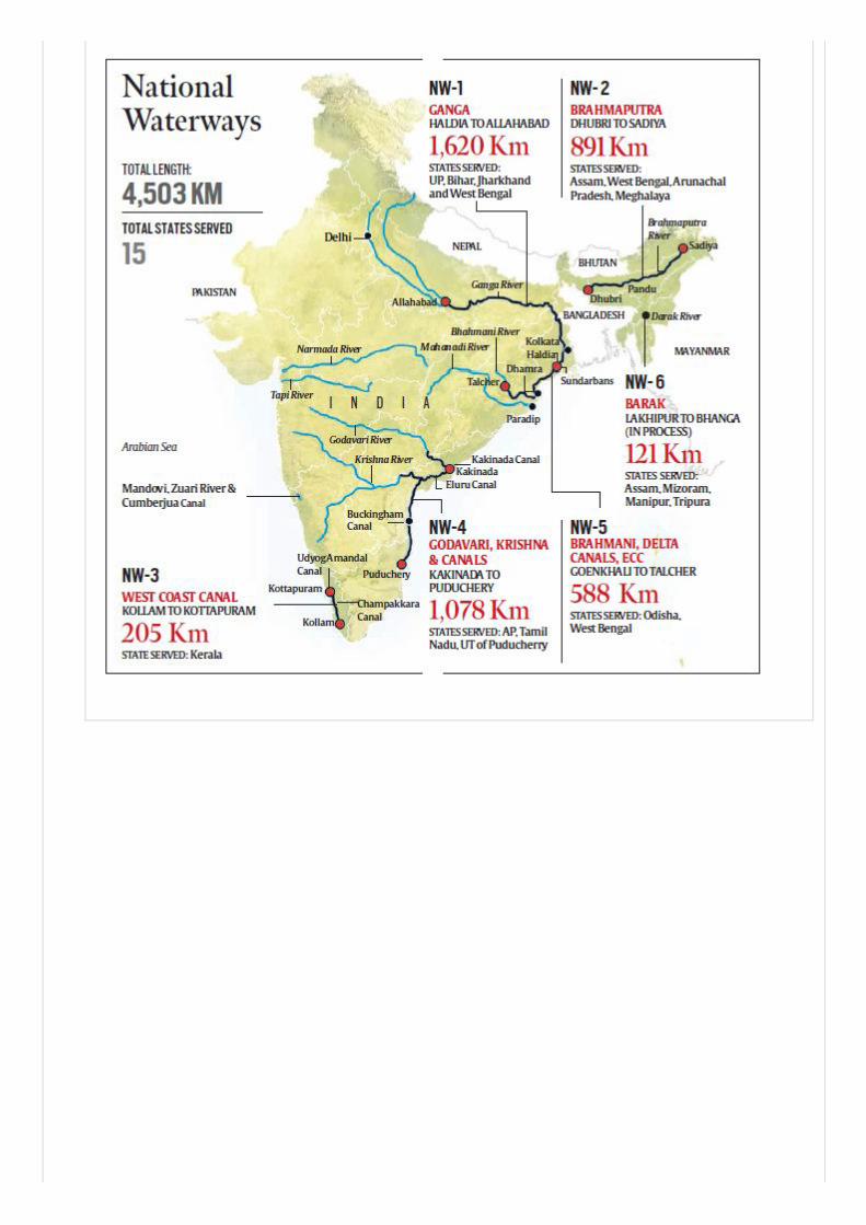
12. Inland water Ways


![Economy of India[1]](https://static.fdocuments.us/doc/165x107/5571f80e49795991698c8a26/economy-of-india1.jpg)