1.1 Oceanographic and meteorological conditions for the design

National Oceanic and Atmospheric Administration (NOAA) Climate Database Modernization Program (CDMP) 2010
Historical Meteorological and Oceanographic Data for the Maritime and Coastal Areas of Chile and the Southern Pacific
Clive Wilkinson NOAA Climate Database Modernization Program
Climatic Research Unit University of East Anglia
Norwich NR4 7TJ United Kingdom
email cwwilkinsonueaacuk
Jorge Guzman Scott Polar Research Institute Cambridge
email jgg29camacuk
1
Contents
Acknowledgments 2
A Repositories of Archived Meteorological and Oceanographic Data
1 National Archives of Chile 5
2 Naval and Maritime Museum Valparaiso 6
3 Hydrographic and Oceanographic Service of the Chilean Navy 12
4 Meteorological Office of Chile 12
5 British Archives 19
6 Other Archives 23
B The Documents
1 Lighthouse Records 25
2 Logbooks
Spanish Logbooks 27
Chilean Logbooks 30
British Logbooks 41
C Summary Recommendations and Appendix 47
Appendix A - Chilean Meteorological Publications held by the NOAA Central Library
Appendix B ndash Royal Navy Vessels in the south-east Pacific 1914-1946
2
Acknowledgments
Valuable research assistance was given by Catherine Ward CORRAL Project University of Sunderland and Sally Wilkinson University of East Anglia
The authors gratefully acknowledge the financial and logistical support provided by the British Embassy Santiago (2009) and in 2010 the U S Global Climate Observing System (GCOS) Program and its support contractor Riverside Technology Inc (RTi) and NOAA Climate Database Modernization Program (CDMP) Particular thanks is given to Howard Diamond US GCOS Program Manager at NOAAs National Climatic Data Center Dr Jorge Carrasco Director Direccioacuten Meteoroloacutegica de Chile Santiago Admiral Perez Director Museo Naval y Maritimo Valparaiso Cecelia Guzman Archivist of the Museum Lieutenant Commander Miguel Vasquez SHOA Jorge Cepeda Gonzaacutelez SHOA and Carlos Tromben Centro de Estudios Estrateacutegicos
NOTE
Please note that logbook images and meteorological documents in this report are reproduced with the permission of the Armada de Chile and Direccioacuten Meteoroloacutegica de Chile
The logbook of HMS Ajax is reproduced with the permission of the UK National Archives
3
INTRODUCTION
The terrestrial and maritime areas of Chile and the south-east Pacific are one of the least represented areas for historical climate data such as barometric pressure air temperature and sea temperature The maps below give an indication of the global coverage of historical sea-level pressure observations The colours show the total number of observations in a 2deg box per decade using the ldquoenhancedrdquo monthly summaries (including ships buoys and other platform types) from the latest version of International Comprehensive Ocean-Atmosphere Data Set (ICOADS) release 25
Global Sea-Level Pressure (SLP) Data Coverage ndash ICOADS Release 25
In various archives there are undigitized pressure and temperature data available for about 170 years (back to c1840) for Chilean maritime areas with sea temperatures back to 1870 and sporadically available before that time This data can be found in the archives of Chile and of Great Britain and probably also in other European archives and in the United States
The purpose of this report is to provide a regional overview of the historical meteorological and oceanographic data to be found in Chile and in Britain covering the south-east Pacific and the west coast of South America in particular the maritime areas and coastal regions of Chile The focus is on data that predates the modern ocean observing system The report is intended to assist in the documentation and efficient planning of the imaging digitization and processing of the scientific data
4
Chilean Maritime Areas
Combining the data from both Chile and Great Britian ensures a longer temporal coverage and a spatially extensive dataset that incorporates much of the southern and south-eastern Pacific This report also examines the historic documents containing the data providing a translation of the chief meteorological and other related elements from Spanish to English as well as assessing their potential for climate studies Combining material from different national archives also provides opportunities for the cross-checking of data and data homogenization This process will also assist in the study of data biases and other related issues where meteorological data from for example Royal Navy logbooks is studied in a different geographical context
5
A Repositories of Archived Meteorological and Oceanographic Data
1 Archivo Nacional de Chile (National Archive of Chile) Santiago
httpwwwarchivonacionalcl
The National Archive of Chile in Santiago is housed in two buildings holding records from
separate periods The National Historical Archive is located centrally in Santiago at 50 Calle
Miraflores The site can be reached easily by Metro the closest station being lsquoUniversidad
de Chilersquo This archive holds records of the colonial period from the earliest times to the
founding of the Republic The second archive the National Archive of the Central State
Administration is located at Matucana 51 Santiago and can also be reached by Metro
either lsquoQuinta Normalrsquo or lsquoUnion Latinamericanarsquo This archive holds the records of the
Chilean Republic
National Historical Archive
The National Historical Archive holds the hydrographic file of Vidal Gormaz 1557-1914
(predominantly 1740-1895) Francisco Vida Gormaz was the first director of the Chilean
Hydrographic Office The file is yet to be examined for useful meteorological and
oceanographic data for the early non-instrumental period However as the file spans both
the colonial and republican periods the entire collection is found in this the earlier section
of the National Archive A booklet Indice del Archivo Hidrografico lsquoVidal Gormazrsquo is available
in the reading room outlining that part of the lsquoVidal Gormaz Collectionrsquo that is of
hydrographic interest A copy has been obtained There is also catalogue Historia del mar
de Chile Ministerio de Marine From this catalogue 27 logbooks (diario de navegacioacuten) have
been identified Of those logbooks almost all are from Spanish vessels and only one is
Chilean
2009 - Several manuscript logbooks were examined the Spanish warships Resolucion (1864-
5) Helice (1862-3) near the Galapagos Islands and Triunfo (1862) All contained
meteorological data mostly pressure and air temperature Helice had observations of sea
temperature These were not regular deck logbooks but appeared to be fair copies of some
other document Navigational and meteorological data in these documents is presented in
an irregular fashion often as an extract The documents were all in good condition and clear
and easy to read Note 2010 - The logbooks of the Resolucion Triunfo and other Spanish
warships are held in the Naval and Maritime Museum in Valparaiso
National Archive of the Central State Administration
From the National Archive of the Administration the material of interest for marine
meteorology is most likely to be found in two sections These are the Ministerio de Marina
1817-1900 and the Subsecretaria de Marina 1901-2001 The former contains material for
the 19th century including logbooks navigational data lighthouse and bathymetric and
other scientific data for the coast of Chile The Subsecretaria de Marina 1901-2001 has
6
material on lighthouses and hydrographic exploration This material is yet to be examined
for meteorological and oceanographic data
2 Museo Naval y Maritimo (Naval and Maritime Museum) Valparaiso httpwwwmuseonavalcl
The Naval and Maritime Museum is located on the Paseo 21 de Mayo Cerro Artilleria
Valparaiso It is a part of the establishment of the Chilean Navy (Armada de Chile) and is
open to the public The most convenient access to the Museum is via funicular from
Aduana in the port area This is within walking distance from lsquoPuertorsquo the terminal station
of the Valparaiso Metro Visitors to the archive and library should carry suitable
identification such as a passport as the Museum is part of a defence establishment There
is a small reading room Resources consist of a library and manuscripts stored in a climate
controlled repository with a further storage area largely filled with logbooks of the Chilean
Navy The logbooks commence from the 1860s to very recent times and retrieval and
viewing of logbooks is restricted to those before 1960
Armada de Chile
Main Operations Building
19th Century logbooks in temperature
controlled storage area
7
19th Century Logbooks
The Museum holds 121 logbooks for the period 1861-1901 housed in a temperature
controlled room These are in various formats and sizes (see illustration above) Of these
12 are engineering logs and 109 are navigational logs (bitaacutecora) and port logs (bitaacutecora de
puerto) Eight of the navigational logbooks are Spanish diario de navegacioacuten These are
exceptionally fine documents with clear neat entries Table one summarizes the scope and
content of the eight Spanish logbooks and a page from one of these is illustrated below
Ship No of
Logs
Date range Type of data Frequency
of Obs
LocationMovements
Blanca 1 1862-1863 pressure amp air
temperature
dailynoon West Indies
Princesa
Asturias
2 1861-1862 pressure amp air
temperature
2-hourly West Indies
Resolucion 1 1862-1863 Pressure air
temperature amp SST
2-hourly South Atlantic Straits of
Magellan amp SE Pacific
Triunfo 1 1863-1865 Pressure air
temperature amp SST
2-hourly South Atlantic Straits of
Magellan amp SE Pacific
Villa de
Madrid
1 1864-1865 Pressure air
temperature amp SST
dailynoon Coast of Chile and Peru
Virgen de
Covadonga
1 1863-1864 pressure amp air
temperature
4-hourly West Indies
Unknown 1 1862-1863 pressure amp air
temperature
2-hourly Cadiz amp West Indies
Table 1 ndash Spanish Logbooks
Bulk of logbooks kept in general
storage area
8
Spanish navigation Journal 1862 - Museo Naval y Maritimo Valparaiso
The remaining 109 Chilean naval logbooks from the 19th century range from 1876 to 1901
It is clear that not every logbook for every ship has been preserved Why only certain
logbooks have been preserved is not known and the fate of the others has not been
determined Many of the logbooks are from the period of the Pacific War against Peru
(1879-1882) Most record barometric pressure and air temperature usually at 4-hourly
intervals A significant number also record sea temperatures both at sea and while in port
The locations and movements of all but four of these vessels are exclusively along the coasts
of Chile and Peru The coastal waters off Peru are particularly well represented by vessels
blockading Peruvian ports during the early 1880s during the War of the Pacific Most of
these vessels recorded SST at 4-hourly intervals Positional data such as latitude and
longitude is seldom recorded although it is clear that the vessels are situated off shore of a
named port The four vessels in locations other than the northern and central coasts of
Chile and the coast of Peru are those visiting the far south towards Punta Arenas These
are the Esmeralda 1876-1879 and Magallanes 1879 The logbook of the Almirante Cochrane
1890 covers the South Atlantic Magellan Straits and the south-east Pacific The Baquedano
in 1901 visited Easter Island (Pascua) Juan Fernandez and the Patagonian fiords
Some of the logbooks record meta data providing the builder of the vessel the date of
completion and other particulars including dimensions tonnage armament engines etc
9
There are also very basic instructions on completing the logbook including weather
observations There is no meta data concerning the type and location of meteorological
instruments in the logbooks The Chilean Navy dates from 1818 and at present (2010)
information concerning logs and journals for the period 1818 to 1876 has not been found
20th Century Logbooks
For the period after 1900 there are an estimated 6000 logbooks The Museum holds a
typed list of all logbooks held in the main logbook store (see illustration of the store above)
This list is organized according to the name of the vessel Under each individual ship name
the logbooks are listed with the reference number and the month and year of the
commencement and the end date of each logbook For the period 1899 to 1960 there are
3094 logbooks for surface vessels and submarines Logbooks after 1960 are on restricted
access The format and content logbooks is discussed in more detail in section 7 below
The wide movements and activities of the Chilean Navy are evident from an examination of
the logbooks Those studied in detail were the training ship (buque escuela) Baquedano
1899-1935 a frigate of the same name (1946-1959) the battleship (acorazado) Latorre
(1923-1951) and the hydrographic vessel (buque hidrographo) Vidal Gomaz (1943) The
logs of the training ship Baquedano include numerous trans-Pacific voyages visiting Easter
Island Hawaii Yokohama and Sydney Baquedano performed a circumnavigation in the
years 1903-1904 with visits to European waters and the Mediterranean in 1905 and 1906
and again in 1928 and 1929 The frigate Baquedano and the battleship Latorre confined
their movements at least from those logbooks examined to Chilean territorial waters The
Vidal Gormaz operated in the vicinity of Punta Arenas
Historiales
In addition to the logbooks there are related documents called historiales These are
journals or histories of the vessels usually written by the commanding officer These
historiales are narrative describing the movements and activities of the vessel often with a
tabulated reacutesumeacute of the shiprsquos movements The historiales also describe extreme weather
events and include either synoptic charts and barographs or more often a diagram of a low
pressure area with the ship track through it From those volumes examined there was no
tabulated meteorological data This data is to be found in the logbook itself The Museum
holds 79 volumes of historiales covering a wide range of dates and types of vessels These
were originally the private property of the journal writer and were donated to the Museum
Therefore it is likely that many other volumes are privately held
10
Barograph 14-15 October 1903 ndash Baquedano Historiales vol 15
Synoptic Chart ndash Baquedano Historiales vol 19
11
Track of Depression and Ship Positionsndash Baquedano Historiales vol 20
Printed Sources
Several useful printed sources are held by the Museum containing information on the history and movement of vessels with some hydrographic and meteorological data Among these are annual publications such as the Memoria de Marina 1836-1941 Manual del Marino 1817-1912 and the Anuario Hidrografico de la Armada which was first issued in 1874 This latter publication is also held by SHOA (section 3 below)
The Memoria de Marina contain tables of meteorological data scattered throughout the volumes For example the 1867 edition has daily meteorological observations (pressure temperature winds) for the station at Melinka Islas Guaitecas (4348S 7350W) for the years 1865-1867 The pressure observations were made using a cistern barometer and are recorded in English inches The Manual del Marino has not yet been examined The Anuario Hidrografico is especially rich in material There are tables of barometric and other meteorological observations from various hydrographic voyages and surveys Like the Memoria de Marina there are also tables of observations from (near-marine) terrestrial locations Volumes also contain resumes of voyages making it possible to trace the movements of vessels The collection of Anuario Hidrografico held in the archive of SHOA (see section 3 below) is being scanned for production in an electronic format
12
3 Sevicio Hidrografico y Oceanografico de la Armada de Chile (SHOA)
(Hydrographic and Oceanographic Service of the Navy of Chile) Valparaiso
httpwwwshoamicl
The Hydrographic Office was founded in 1874 and was re-named the Hydrographic and
Oceanographic Service of the Chilean Navy (SHOA) in 1990 It is situated at Erraacutezuriz 254
Playa Ancha Valparaiso SHOA has a technical library and archive specializing in
hydrography oceanography cartography and meteorology It contains over 12000 books
including SHOA publications dating back to 1874 The library is available to naval staff
researchers and students The archive contains all documentation used to produce nautical
charts and other Chilean naval publications The archive contains material dating back to
1834 at the time of the first hydrographic survey carried out by the Navy Documents of
historical significance are usually transferred to the Naval Museum SHOA holds no
logbooks
SHOA has not archived the Chilean equivalent of the manuscript remark books and survey
data books held by the UK and US hydrographic services The information that British
remark books commonly contain is to be found in print in the Anuario Hidrografico de la
Armada which was first issued in 1874 These are being scanned (2010) into an electronic
format (see lsquoPrinted Sourcesrsquo above) More general enquires are being made to locate and
document any other meteorological and oceanographic data either in manuscript or printed
form To date these enquires have revealed the existence of engineering logbooks held by a
separate department of the Navy These documents dating from about the 1940s contain
records of SST observations from engine room intake (ERI) sensors Further enquires are
being made to determine how many if any of these logs have been archived
4 Direccioacuten Meteoroloacutegica de Chile MeteoChile Santiago (wwwmeteochilecl)
The Chilean Meteorological Office is situated at Av Portales 3450 Central Station Santiago
within walking distance of the Santiago Metro The nearest metro stations are lsquoQuinta
Normalrsquo or lsquoEstacion Centralrsquo (see map below)
13
Direccioacuten Meteoroloacutegica de Chile
Present day records archived at Direccioacuten Meteoroloacutegica de Chile
The Office has an extensive library and archive with material from the second half of the
19th century to the modern day The Office holds a collection of lighthouse (faro) records
These lighthouses are situated along the entire length of the extensive Chilean coastline
from Peru to Tierra del Fuego and include the Pacific islands of Pascua (Easter Island) Isla
San Felix and Juan Fernandez (Robinson Crusoe Island) The Office holds 71 bound volumes
14
The only 19th century volume is for Playa Anchar Valparaiso 1877-1881 illustrated below
The remainder of the lighthouse records commence in 1914 and an inventory of these
records has been made More detail on the Lighthouse meteorological records is in section
6 below
Sub-Daily meteorological data Playa Ancha Lighthouse Valparaiso 1877 To enlarge image increase document magnification
The office also holds copies of the Anurio de la Oficina Central Meteoroloacutejia These
commence in 1869 and continue through to 2008 Observations were made at 230am 9am
and 9pm The position of the various stations is given (latitude and hours and minutes west
of Greenwich) as well as the elevation of the station (see images below) The observations
consist of barometric pressure (reduced) temperature maximum and minimum relative
humidity winds and clouds Note that the NOAA Central Library holds the volumes for
1871-75 and 1886 in electronic form (httpdocslibnoaagovrescuedata_rescue_chilehtml)
Also see appendix below
15
Meteorological Annual 1869 and locations of observations
Sub-daily pressure and temperature (230am 9am amp 9pm) November-December 1868
Other sets of records are held both in printed and manuscript form from 1914 The example
below from the Santiago station 1914 includes sub-daily pressure and temperature
humidity wind direction and strength cloud cover and rainfall
16
Sub-daily meteorological data Santiago 1914
There are also 81 sets of historic daily records of rainfall from numerous locations in Chile
including Easter Island Some of these reports are printed some are handwritten on pre-
printed forms while others are entirely handwritten These are illustrated below The
records run from 1912 to 1960 with a volume for 1969 At various times up to 340 separate
stations recorded observations of rainfall It is assumed that more modern records post-
1960 are archived in a different section of the Office and these were not examined A
comprehensive inventory of all precipitation records would be useful and an inventory of
the 81 sets described above has been made
17
Register of Precipitation ndash January 1939
Register of Precipitation October 1948
18
Daily Rainfall Records - 1912
Other sets of meteorological records extend to the present day representing various met
stations lighthouses and airfields Detailed archive documentation is required to determine
the range and extent of these records some of which are archived on microfilm Of
particular interest are upper air radiosonde observations from a number of locations
including Easter Island Some of the data from Easter Island may already be held by NOAArsquos
National Climatic Data Center (NCDC) as several documents contain printed references to
NOAA Some care should be taken that data is not duplicated in any subsequent digitization
exercise
Radiosonde Observations Easter Island 1977
19
Radiosonde Data Puerto Montt 1977
Additional material archived at MeteoChile includes synoptic charts barographs and every
type and format of meteorological record usually associated with such an institution
5 Data for the Southern Pacific and Chilean Marine Areas in British Archives
Chile is a maritime nation and up to 80 of its modern trade is by sea Due to the nature of
the geography of Chile trade has historically been carried on through ports such as
Valparaiso Many European maritime nations Great Britain in particular have strong
historic maritime trade links with Chile British archives therefore contain many thousands
of documents connected with trade and trade protection in the eastern and south-eastern
Pacific including naval logbooks remark books from hydrographic surveys and merchant
shipping meteorological logbooks These are archived in the National Archives Kew
London the Hydrographic Office Taunton and the National Meteorological Archive in
Exeter All of these documents contain weather observations and after c 18301840 sub-
daily instrumental observations of pressure and air temperature Sub-daily sea temperature
observations can be consistently found from about 18601870 These records complement
those found in the archives of Chile making it possible to fill gaps in the temporal and
geographic record The data in these British records also provide an opportunity for
comparison and homogenization with the corresponding Chilean marine and lighthouse
observations
20
5a UK National Archives - Royal Navy Logbooks
19th Century Royal Navy Logbooks
The Recovery of Logbooks and International Marine Data (RECLAIM) Project
httpicoadsnoaagovreclaim has produced an inventory of British Royal Navy vessels in the
eastern Pacific for the period 1790 to 1913 This inventory includes all Royal Navy vessels
stationed or passing through the eastern Pacific Ocean during that period It includes
vessels from the China station that returned to England by the eastern route either stopping
at Valparaiso or sailing directly to the Drake Passage In the early part of the 19th century
the inventory includes vessels from the South American station that passed around Cape
Horn and into the Pacific The complete commission is included with the voyage out to the
Pacific and the return Detailed movements are provided where known The purpose of
this inventory is to assist with the selection imaging and digitization of the meteorological
and oceanographic observations in the logbooks for scientific study
There are 918 logbooks in this inventory and these are held at the National Archives in
London Most are ships logs (ADM 53) but there are also captains logs (ADM 51) and
masters logs (navigating officer - ADM 52) and logs from ships of exploration (ADM 55)
Detailed information on these collections can be found in the report British Logbooks in UK
Archives 17th ndash19th Centuries at httpicoadsnoaagovreclaim
The number of days covered by these logbooks is calculated at nearly 363K The estimated
number of days of sea observations is calculated to be nearly 272K days a figure that
assumes that frac14 of the days in the logbook will be spent in port The minimum number of
days of recorded sub-daily air pressure and SST are calculated to be 186K and 101K
respectively These estimates are based on logbook formats known to record this type of
data (1845-50 and later for pressure and 1870 and later for SST) The figures do not include
pressure and SST from logs before 1845 Earlier instrumental observations can be found in
many of the pre-1845 logbooks but are not included in this calculation as there is less
consistency in the presence of data and it should not be assumed that all the logbooks of
the earlier period will have instrumental observations Pressure and SST totals are
therefore conservative and actual totals are likely to exceed the estimates stated All
logbooks record sub-daily wind direction wind force precipitation and general weather
usually descriptive rather than instrumental
The total number of images required to process all 918 logbooks is estimated to be 308K
This is an approximation taking account of changing logbook formats in the early 19th
century It should be noted that several of the logbooks (ADM 55 series and a few ADM 53
series at the UK National Archives) have already been imaged under the CORRAL Project
(UK Colonial registers and Royal Navy Logbooks httpwwwcorralorguk ) All of these
records await digitization (2010)
21
20th Century Royal Navy Logbooks
The Royal Navy did not have a permanent presence in the eastern Pacific in the 20th century
and the gradual withdrawal of that presence began as early as the mid 1880s However
there are logbooks for vessels that passed through Chilean maritime areas and many of
these have been imaged and some of them also digitized under various projects supported
by the UK Met Office Hadley Centre and the Atmospheric Circulation Reconstructions over
the Earth (ACRE) Project httpwwwmet-acreorg These projects covered an extended
World War II period 1938-1947 and an extended World War I period 1914-1923 The latter
period is presently (2010) being digitized under a UK based citizen science project A sub-
inventory of those vessels in the south-east Pacific and Chilean maritime areas 1914-1946
an extension of the 1790-1913 inventory discussed above will be available in 2011 This
new sub-inventory will list vessels movements and the status of the digitization process A
provisional list of the 20th century Royal Navy vessels is included in Appendix B to this
document
5b UK Hydrographic Office - Royal Navy Remark Books
Remark books were kept on board many Royal Navy vessels but particularly those on
voyages of exploration or hydrographic survey Remark books reproduce much of the
information in the shiprsquos logbook but often with greater detail and frequency
Typically from 1816 the most common observations to be found in the remark books are
barometric pressure air temperature and sea surface temperature wind direction and
force and weather although not every remark book contains instrumental data before
about 1845 By 1845 there is always at least one daily observation taken at noon but sub-
daily observations can frequently be found and after 1860 are always present usually
three four six or more observations per day at set times or intervals Less frequently
recorded were wet and dry bulb temperature observations hygrometer (humidity)
readings specific gravity (density) of seawater and sub-surface sea temperatures
Information on the type and positioning of the various instruments became common in the
remark books during the 1880s mirroring similar information provided in shiprsquos logbooks
and journals The graph below indicates the spatial and temporal distribution of remark
books The south-east Pacific is well represented in the period 1825-1840 and after 1875
No remark books have yet been imaged or digitized (2010)
22
Range of Remarks Books (Philip Brohan UK Met Office Hadley Centre)
5c UK National Meteorological Archive - Merchant Shipping Meteorological Logbooks
The UK National Meteorological Library holds a large collection of marine meteorological
logbooks registers and weather books mostly kept on board merchant vessels There are
about 10000 items for the period 1854 to 1904 See section B-24 below for a description
of the format and content of these logs
An inventory of these logbooks is being compiled (2010-2011) and the total number of
documents covering the south-east Pacific and Chilean marine areas will not be determined
until this work is completed However a sub-inventory for vessels traversing the eastern
Pacific during the 1880s has been compiled It is made up of vessels visiting the west coasts
of North and South America and includes all circumnavigations For the 1880s there are 474
logbooks yielding nearly 50K days of observations This total includes the other ocean
basins traversed by these vessels and the actual amount of data for the Pacific is likely to be
about 18K days The utility of the data from these logbooks lies in the typical trajectory of
these vessels From the 474 logbooks for the 1880-1889 period see the track chart below
taken from just five vessels in the period 1886-87
23
Tracks of Five British Merchants ships 1886-87
These are typical tracks of vessels sailing from Australia and New Zealand towards the Drake
Passage or ports on the coast of Chile and Peru These vessels sail through sea areas where
meteorological and oceanographic observations are presently sparse or absent in
databases These sea areas are also scientifically significant for studies of El Nintildeo and the
Southern Annular Mode None of this data has been digitized (2010)
6 Other Archives and Sources
Climatological Database of the Worldrsquos Oceans 1750-1850 ndash CLIWOC Project
There are other sources and archives that will yield good quality meteorological and
oceanographic data as well as related sources of climatological interest The CLIWOC
Project database httpwwwucmesinfocliwoc contains data for English and Spanish
vessels rounding Cape Horn either as part of a circumnavigation (for instance Cookrsquos
voyages) or sailing to destinations such as Valparaiso or Callao Access is free and much of
the data has already been incorporated into the International Comprehensive Ocean-
Atmosphere Data Set (ICOADS) httpicoadsnoaagov
24
Salesian Museum Punta Arenas
The Salesian Museum in Punta Arenas holds meteorological records from 1896 to 1954
These were digitized in 2006 by the International Environmental Data Rescue Organization
(IEDRO) httpiedroorgchile-newhtml The pressure observations have been added to the
International Surface Pressure Databank (ISPD) 1768-2008 httpdssucaredudatasetsds1320
The Museum also holds over I000 photographic plates of glaciers from about 1870 to 1925
Chilean Shipping Companies
Chilean shipping companies will have archived the logbooks from their ships For example
Austral Broom SA have an archive of logbooks in Punta Arenas and their vessels traverse
sea areas that include Cape Horn the Fuegian fjords Strait of Magellan and connections
with Puerto Montt The Austral Broom archive and other shipping archives require further
investigation and documentation In the context of shipping companies it is worth noting
that todayrsquos meteorological observations are tomorrowrsquos historic weather data
Other Records
Chilean Lighthouse records before 1914 have not yet been located except for the few
examples at Meteo Chile and the National Archive Further searches are required Likewise
the earliest examples of Chilean logbooks before the 1870s have not been located
Logbooks from the time of the war of Independence and later may be held privately or in
foreign archives It is also known that the National Archive in Santiago holds records of
insurance claims from the 18th and 19th centuries made by vessels damaged in the passage
around Cape Horn and arriving at ports such as Valparaiso Relevant extracts of winds and
weather from the logbooks of these vessels were frequently transcribed as supporting
evidence in an insurance claim These records are of particular importance as the original
logbooks from which the transcriptions were made have almost certainly not survived
The logbooks of naval and merchant ships visiting the ports of Chile will include nationalities
such as PrussiaGermany the Netherlands Spain and France Any vessel making a
circumnavigation via Cape Horn would have visited a Chilean port or passed directly through
Chilean waters The documentation of these passages will discover more vessels and
indicate the direction of further archival research
25
B The Documents
1 Lighthouse Records
11 Extent and Range
Lighthouses extend along the coast of Chile from Arica at 18deg north to Diego Ramirez Island
at 56deg south and along the Strait of Magellan The most easterly lighthouse is Punta
Dungeness (5223S 6825W) at the eastern entrance of the Strait of Magellan Meteo-Chile
hold 71 bound volumes one from the 19th century the other volumes dating from 1914
The Navy Meteo Service holds a further 35 sets of records from 1988 to 2008 The National
Archive of the Administration holds three volumes of records for the lighthousemet station
at Caldera from 1868-1881 but there are likely to be many more at this Archive
The transmission of information (in recent times) is for the meteorological observations
recorded on paper to be sent periodically to a central location locally For instance the
lighthouses in the eastern Straits of Magellan will transmit their records to Punta Arenas
These records are then sent to the Naval Meteorological Service in Valparaiso thence to
SHOA and then Meteo-Chile in Santiago and ultimately to the National Archives of the
Administration On this basis the National Archives of the Administration is a logical place
to search for the lighthouse records prior to 1914 and the records between 1960 and 1988
This is an investigation (at 2010) that should be undertaken
12 Lighthouse Records Format and Content
Only one example of 19th century lighthouse meteorological records has been seen and it is
therefore not possible to say if this is typical of the format and content The records from
1914 have a consistent format except for the time of the observations From 1914 to the
mid 1920s three daily sets of observations were made at 7am 2pm and 9pm After the mid
1920s and certainly by 1928 observations were made at 0700 1300 and 2100 hours By
1983 there were four daily observations at 0600 1200 1800 and 0000 hours It has not yet
been determined when the change of timings took place from three to four sets of daily
observations There are three slightly different formats corresponding to three distinct
organizations performing meteorological services as outlined below
Organization Years Times of observations
Instituto Central Meteoroloacutegico y Geofisico de
Chile
1914-1922 7am 2pm 9pm
Servico de Meteorologia Agricola 1927-1928 7am 2pm 9pm
Oficina Meteoroloacutegica de Chile 1928-1940s+ 0700 1300 2100
Oficina Meteoroloacutegica de Chile 1980s 0600 1200 1800 0000
26
Meteorological Observations Punta Lavapieacute ndash January 1922
Meteorological Observations Punta Galera January 1941
27
Apart from the observations being recorded at slightly different times there are several
other differences between the two formats illustrated above The later format (1928
onwards ndash 1941 illustrated) has columns for both the barometer and the attached
thermometer These are the observations lsquoas readrsquo (leido) There are also additional
columns for corrections for temperature and latitude The earlier format only records
pressure observations with no indication if these are lsquoas readrsquo or corrected The context
therefore suggests that these earlier readings are uncorrected The earlier format also
records absolute and relative humidity while the latter records wet and dry bulb
observations There are no differences in recording wind direction and force or clouds The
earlier format records daily rainfall while the latter records sub-daily rainfall at the same
times as the other observations with a total for the day
2 The Logbooks - Format and Content
Marine journals and logbooks document the day-to-day events in the passage of a ship and
are the ultimate primary record of a nationrsquos maritime past Deck logs and the navigational
logbook in particular document the daily positions and movements of the vessel the
weather conditions the proximity of land the expenditure or loss of material the activities
of the crew and any events worthy of remark This detailed recording was necessary as
officers were held accountable for the management and safe navigation of the vessels in
their charge Loss or damage to a vessel could be the subject of an official enquiry a court
martial or an insurance claim Logbooks can therefore be considered legal documents and
carry the corresponding weight and authority of all such documents held in state archives
They can be considered a true and faithful account
Hundreds of millions of individual pieces of meteorological and oceanographic data have
been recorded in the logbooks and journals of maritime nations from the earliest times to
the present day and as such they constitute an unsurpassed history of environmental
conditions over the oceans for the past 300 years and more All logbooks record wind
direction and wind strength usually descriptive but later measured From the late 18th
century onwards logbooks frequently record air pressure and temperature and by the
1860s sea surface temperature (SST) Logbooks also have observations of the strength and
direction of currents sea swell incidents of rain squalls storms and hurricanes or typhoons
Reports of icebergs usually termed ice islands and pack ice are common in higher latitudes
As such these records are of immeasurable value to climate scientists and for decades have
been the basis of studies of the marine climate in the past
21 Spanish Logbooks in Chilean Archives
The logbooks found in the National Historical Archive in Santiago are as noted above in
section 1 almost exclusively Spanish and of a format not usually associated with regular
deck logs Similar examples were also found at the Naval and Maritime Museum in
Valparaiso These consist of pre-printed pages and the content suggests that they were
28
produced in this format as a response to the Brussels Conference of 1853 One particularly
fine example from the Museum dated 1862 is described on the cover as lsquoEstracto del Diario
de Navegacioacutenrsquo or abstract navigation Journal (see section 2 above) The data to be found
in this type of journal is shown in the examples below All three images are a detail of part
of the page shown in section 2 above
Detail of left side of page - Spanish abstract navigation Journal 1862- Museo Naval y Maritimo Valparaiso
The section above shows the day hour latitude and longitude (observed and estimated -
NB the prime meridian is the Naval Observatory Cadiz not Greenwich) current direction
and force magnetic variation wind direction and force barometric pressure and attached
thermometer air temperature and humidity
29
Detail of centre section of page - Spanish abstract navigation Journal 1862
Museo Naval y Maritimo Valparaiso
The section above shows wind direction and force barometric pressure and attached
thermometer air temperature and humidity type of cloud and direction (bearing from
ship) amount of cloud cover precipitation at a particular hour (niebla-fog Iluvia-light rain
nieve-snow granizo-hail) sea state sea surface temperature specific gravity (temperatura
al fondo) sub-surface temperature and (estado de las aguas) state of the waters (colour)
The sub-surface sea temperatures column states a depth and temperature but the scale
used for depth has not yet been determined It is likely to be fathoms or the Spanish
equivalent of the fathom State of the water may indicate colour The term lsquoclarorsquo or clear
written in the lower part of the full logbook page suggests that this is the case
30
Detail of right side of page - Spanish abstract navigation Journal 1862
Museo Naval y Maritimo Valparaiso
The right-hand side of the page (above) shows the section for general observations or
remarks These remarks are not necessarily of a meteorological or oceanographic nature
22 Chilean Logbooks
The Chilean naval logbooks are of mostly printed formats that vary slightly in layout over
time but contain essentially the same information Logbooks in both the National Archive
and the Naval Museum are described using the terms outlined in the following table
Chilean Document English Estracto del Diario de Navegacioacuten Abstract Navigation Journal
Diario de Navegacioacuten Navigation Journal
Diario del Mar Sea Journal
Diario de Bitaacutecora del Buque Logbook
Bitaacutecora Logbook
Bitaacutecora del Puerto Port Logbook
Bitaacutecora del Mar Sea Logbook
Table 2
Timekeeping
All logbooks until about the late 1920s were kept according to the nautical day not the civil
day This means that the day and the logbook page commenced at 1pm and terminated at
noon of the following day The last entry in the logbook is therefore the noon observation
31
The lsquoremarks sectionrsquo or lsquoAcaecimientosrsquo (occurrences) is double dated meaning that
although the shiprsquos day runs from noon to noon the dates according to the civil day are
acknowledged This double dating is a clear indication of a nautical day format The civil
day format of later logbooks from c 1930 is similar to the format of British Royal Navy
logbooks Below are examples of the civil day format from the Chilean naval transport
Micalvi and from the British cruiser HMS Ajax
MICALVI - Transport 1935
Armada de Chile
HMS AJAX ndash Cruiser 1939
Royal Navy
32
Navigation
It should be noted that the examples of Spanish journals held in both archives use the Naval
Observatory at Cadiz as a zero meridian All Chilean logbooks examined use the Greenwich
meridian The use of the Greenwich meridian was probably universal in Chile The
publication Faros de Chile (Lighthouses of Chile) No 1 issued by the Ministerio de Marina
Santiago in October 1857 gives the longitude of lighthouses according to the Greenwich
meridian (UK National Archives ADM 1722)
The following images are from the logbook of the corvette (corbeta) General Baquedano
used by the Chilean Navy as a training ship (buque escuela) the first page contains the
lsquoacaecimientosrsquo or occurrences the second page presents the tabulated navigational and
meteorological data Note that in most logbooks the order of lsquoacaecimientosrsquo and tabulated
data is reversed with the latter on the left-hand page
Left-hand facing page of Logbook ndash General Baquedao 1918
33
Right-hand facing page of Logbook General Baquedano 1918
The tables below represent sections of the page above being a typical logbook page
containing tabulated data Each box shows a section of the logbook page concerned with
navigation and meteorology The Spanish terms are translated into English Where there is
doubt lsquorsquo indicates that an explanation is to be sought The pages of earlier logbooks do not
greatly differ and many of the same headings can be found
Millas por Corredera Rumbo Navegado
Per
Horas Orda Meca
E B
Miles for Log Course
Hour Ordinary Log Patent Log
E B Table 3A
A) Top-left corner of the page This section lists the courses and distance made in each
hour from 1pm The final entry is for noon The patent log is a mechanical log
recording speed as opposed to the ordinary hand-held log and line lsquoErsquo is miles in
34
that hour and lsquoBrsquo a running total Note that in the example page the ordinary log is
cast and recorded as well as the running total from the patent log In most cases the
two are roughly the same
Rumbos Corregidos
Distancias por Corredra
Ordina Mec N S E O
Course Corrected
Distance for Log
Ordinary Log Patent Log N S E W Table 3B
B) Top-right corner of the page (This section is for the calculation of the shiprsquos position
by dead reckoning The list of courses (corrected for magnetic variation) with the
number of miles each hour provide the number of miles of northing southing
easting or westing achieved during the preceding 24 hour period The figures are
then used to resolve a series of right triangles Connecting the start and end points
provides an estimate of the course and distance made good in the past 24 hours
This can then be transferred to a chart and the estimated latitude and longitude
determined
C)
Term English Lat Sal Departure Latitude (previous day)
Difnaval Difference in latitude
Lat lleg est Estimated latitude
Lat Obs Al mer Observed latitude
Dif Al Difference of estimated and observed
Lonj Sal Departure Longitude (previous day)
Dif Naval Difference in longitude
Lonjlleg est Estimated longitude
Lonj Obs Observed longitude
Dif Al Difference of estimated and observed
Rumbo y Dist Nav Course made good
Corriente y velocidad Direction and speed of current
Dist y rumbo a Distance and bearing to hellip
Variacion mag Magnetic Variation
Table 3C
D) Right-centre of page This section provides the noon positions derived from B above
1 The entries for lsquoLat salrsquo and lsquoLonj salrsquo or the previous noon position are always the
observed latitude and longitude of the previous day where entered
2 The lsquoDif nav alrsquo is always the estimated difference in latitude or longitude over the
previous dayrsquos observed position to produce a new estimate
35
3 lsquoDif alrsquo is the difference between the new estimated and new observed positions
4 lsquo Lat Obs Al mer and Lonj Obsrsquo are observed latitude and longitude All positions are
expressed in degrees and minutes and tenths of a minute for example 29deg 472N
5 lsquoRumbo y Dist Navrsquo or course and distance made good (over the preceding dayrsquos position)
is noted as degrees of a circle but expressed as a quadrant So N25W 163 would be 25
degrees west of north (or a course of 335deg) and 163 nautical miles This would be a true
bearing as it is the course as applied to a chart This type of course notation is the same as is
commonly found in British logbooks up until the early 20th century
6 lsquoCorriente y velocidadrsquo or direction and speed of current uses the same notation as the
course with a variety of methods of recording speed but usually clearly expressed as miles
in 24 hours It is assumed that the direction is magnetic
7 lsquoDist y rumbo arsquo or distance and bearing to Example Pascua S83W Easter Island 263deg
8 lsquoVariacion magrsquo or magnetic variation can be expressed in the same notation as other
bearings such as N15E but more commonly just as 15E or 15 degrees of easterly variation
36
Table 3D - The Observations
Viento Abo Asp Estado del Mar
Aparejo en Viento
Escando Baromet Termo
Direccioacuten Fza Presion Ter At Ag
Wind Leeway Aspect Sea State Sails set Barometer Thermometer
Direction Force Pressure Therm Air Sea
E) This section covers most of the page with the potential for hourly observations starting at 1pm and with the last entry at noon
1 The wind directions are given as standard compass points The winds are uncorrected for magnetic variation Note that by the
1930s and probably by the mid 1920s as with British Royal Navy logbooks wind directions are then recorded as true The example
of the Micalvi logbook page illustrated above with HMS Ajax shows wind directions as true (direccioacuten verdadera)
2 Wind forces are according to the standard Beaufort Scale The scale was in common use in the 1870s and probably earlier
Sistema Beaufort 1870-1920
Sistema Beaufort 1921-
Metros por Segundo (1921)
0 Indica calma Calma 103
1 Ventolina para gobernar Ventolina 360
2 Viento mui flojo Flojo 566
3 Viento flojo Bonancible 823
4 Viento bonancible Galeno 1029
5 Viento fresquito Fresquito 1286
6 Viento fresco Fresco 1492
7 Viento frescachon Frescachon 1800
8 Viento duro Duro 2161
9 Viento mui duro Muy Duro 2521
10 Temporal Temporal 2932
11 Borrasca Temporal 3395
12 Huracan Huracan 4064
Table 3D1
37
3 Column ABo represents the word abatimiento lateral deviation or leeway
4 Column Asp Represents the word aspecto The full word rather than the
abbreviation is used in some earlier logs for example the Baquedano 1901 The
term aspecto del cielo is used in the logbook for the Baquedano 1908 meaning
aspect or state of the sky The column is usually filled with letters denoting a
coding such as D N Dp Np and N2 In later logbooks D is defined as despejado
or clear and N as nublado or cloudy
5 Estado del Mar is sea state Sea state descriptors were in general use from the
1870s and probably before this The terms used from this time and at least until
the late 1940s are outlined below with an English translation according to the
description given in the instructions for completing the log There was
apparently no equivalent of the Douglas Scale used by the Chilean Navy up until
c 1950
6
Sea State Descriptors
Llana Flat
Cabrilleo Ripples small waves
Rizada Small wind formed waves choppy
Marullo Larger waves
Boba Heavy confused sea
Arbolada Large waves with wind-blown crests
Gruesa Violent sea
7 Aparejo en Viento This column indicates which sails were set In the case of the
Baquedano log of 1918 it is frequently filled with the term lsquovaporrsquo or steam
meaning the vessel was under steam propulsion Baquedano used a
combination of sail and steam
8 Escando This is likely to be an abbreviation of escandallo a sounding instrument
meaning that the column is used to record soundings or the depth of water
below the ship Logbooks of most other nations record this information under
lsquoremarksrsquo and the column only appears in Chilean logs in the first decades of the
20th century
9 The remaining 4 columns record barometric pressure attached thermometer air
temperature and sea temperature At present the types of buckets used to draw
water from the sea have not been determined A variety of units for pressure
and temperature were used over the period 1860s-1940s and these are outlined
in table 4 using specific vessels as examples The type and frequency of
observation is also noted
Table 3D2
38
Table 4 - LOGBOOK DATA CHARACTERISITICS
YEAR SHIP Nat BP AT SST Sub-Daily
Daily Frequency Pressure Units
Temp Units
Movements Notes
1861 Princessa de Asturias
Spain 1 1 0 0 Daily at noon Inches Far Spain to SE Pacific Nautical day
1862 Blanca Spain 1 1 0 0 Daily at noon Inches Far Spain to SE Pacific Nautical day
1867 Covadonga Chile 1 1 0 1 4 x Centimtrs Far Valparaiso Nautical day
1874 Chacabuco Chile 1 1 0 1 6 x Inches Cent Punta Arenas Nautical day
1876 Esmeralda Chile 1 1 1 1 6 x Inches - Valparaiso Lota Punta Arenas Straits of Magellan Punta Arenas
Nautical day
1879 Magallenes Chile 1 1 1 1 6 x Inches Far Valparaiso and North Nautical day
1883 Amazonas Chile 1 1 0 1 6 x Inches Far Chimbote Callao Nautical day Aneroid barometer
1883 Huascar Chile 1 1 0 1 6 x Centimtrs Cent Anchored in Callao Peru Nautical day
1901 General Baquedano
Chile 1 1 1 1 6 x Millimtrs Cent Valparaiso Nautical day
1908 Baquedano Chile 1 1 1 1 6x Millimtrs Cent Valparaiso Tahiti Yokohama Nagasaki Shang-hai
Nautical day
1916 Blanco Encalada
Chile 1 1 1 1 6 x Millimtrs Cent Valparaiso and Punta Arenas Nautical day
1918 Baquedano Chile 1 1 1 1 24 x Millimtrs Cent Valparaiso Talcahuano San Felix Isla de Pascua (Easter Island) Honolulu Yokohama Kobe
Nautical day
1921 Chacabuco Chile 1 1 0 1 12 x Millimtrs Cent At anchor in Valparaiso Nautical day
1935 Micalvi Chile 1 1 0 1 6 x Millimtrs Cent Not determined Civil day
1948 Sibbald Chile 1 1 0 1 24 x millibars Cent Not determined Civil day
39
Port Logbooks
Many of the logbooks are clearly marked on the cover Bitaacutecora del Mar or Bitaacutecora del
Puerto It is relatively easy therefore to distinguish the sea and port logs Some logbooks
are a combination of port and sea and this is also marked on the cover The port logbooks
examined contained pressure and air temperature data with a few recording SST Port
logbooks will provide an opportunity to compare the observations of different vessels with
each other and from the fixed terrestrial data from the port or a more particularly the
lighthouse data once this is located
Port Logbook of General Baquedano anchored at Nagasaki 2 July 1908
Data elements at four-hourly intervals consist of wind direction and force state of the sky
barometric pressure attached thermometer air temperature sea temperature and sea
state
40
Port Logbook of the Cruiser
Chacabuco
September-December 1921
Valparaiso
Two-hourly data elements
Wind direction and force
State of the sky
Barometric pressure
Attached thermometer
Psycrometer (temperature)
Humidity
State of the sea
41
Meta Data ndash Chilean Logbooks
The logbooks contain a page describing the vessel in some detail This includes the name of
the commanding officer date and place of the vesselrsquos construction dimensions and
tonnage armament engines boilers fuel capacity (coal) and often information on the
compass and corrections for compass deviation There are frequently instructions on
completing the log with general notes on making meteorological observations These are
presently awaiting translation There was no record found in the examples viewed of any
instrument meta data whether instrument type location or height above sea level
Enquiries with MeteoChile and the Armada de Chile are on-going to determine if records
exist for the issuing and positioning of instruments for navy vessels
23 British Royal Navy Logbooks Eastern Pacific 1790-1913 ndash Format and Content
Details about the format and content of British logbooks can be found in two reports British
Logbooks in UK Archives 17th ndash19th Centuries and British Logbooks in UK Archives 20th Century Both
reports are available at httpicoadsnoaagovreclaim
Before about 1845-1850 there is no certainly that a typical British Royal Navy logbook will
contain pressure or air and sea temperature observations However may of those vessels
that sailed to the Pacific did record these instrumental observations due to the nature of
their voyage which frequently involved exploration and hydrographic survey During the
1820s and 1830s the number of vessels visiting the eastern Pacific grew steadily and by
January 1846 with the establishment of HMS Nerus as a base ship at Valparaiso the Royal
Navy had a continuous presence in the eastern Pacific for the remainder of the century It
should be noted however that the number of vessels station in the eastern Pacific declined
from the early to mid 1880s to just a handful of vessels by the turn of the 20th century
Below is a summary of the type of meteorological and oceanographic data recorded in the
19th century logbooks
Air temperature and pressure data will be found in all logbooks after 1850 and in the Pacific in most logbooks after 1820
Sea surface temperature was recorded by 1870 and possibly earlier in the mid 1860s
Wind force was recorded according to the Beaufort Scale
Weather was recorded according to a lettered scheme from c 1850s
Wind directions were magnetic until c 1920
By the 1870s observations were made at 4 8 and 12 am and pm by regulation and more frequently in stormy weather
Type maker and position of instruments was cited in logbooks from the 1890s
Sea state was consistently recorded from 1890s
It should be noted that there are also remark books and some meteorological registers for
Royals Navy ships in the eastern Pacific in the 19th century
42
24 19th century British Meteorological Logs and Weather Books for the Southern Pacific
Format and Content
Meteorological log of the Barque Cape Clear May 12-15 1888 (left-hand page)
43
The meteorological register (as illustrated above) sometimes referred to as a weather book
contains detailed tabular data recorded on pre-printed pages at two-hourly intervals under the
following headings
Date and Hour Attached thermometer
Latitude by observation and dead reckoning Dry and wet bulb temperature
Longitude by observation and dead reckoning Clouds upper and lower
Course and distance Proportion of the sky clouded
Total compass error Direction of swell
Direction of shiprsquos head Sea disturbance (scale 0-9)
Wind direction and force Sea temperature
Barometric pressure (uncorrected and with
height of cistern)
Remarks
The registers contain copious metadata concerning the instruments usually type and number
position height above sea level etc The necessary correction to be applied to the observations was
frequently recorded Additionally many of the registers include a lsquoForm for Testing Logsrsquo a
quality control document produced in the 19th Century for each log by the Meteorological
Office The form for the RMS steamer Kaikoura in 1887 is reproduced below The criteria
used to evaluate the registers could be applied with advantage to the assessment of other
logbooks for quality of observation
44
Form for Testing Logs ndash Kaikoura Royal Mail Steamer 1887
C Summary Observations and Recommendations (provisional)
Chilean Logbooks
Logbooks of Chilean vessels at sea are marked on the cover as such There are many very
fine examples but there are also a significant number of vessels making coasting journeys
45
without recording position or giving a bearing and distance to a landmark These vessels did
record regular meteorological observations although the lack of positional data is of some
concern This can be overcome by a program that would take the start and end point of the
voyage with input of course and speed thereby estimating the shiprsquos position at any hour of
the day This additional task would have to weigh the value of the meteorological data
against the additional work involved in the input of sub-daily course and speed
Other logbooks (19thC) not recording positional data were clearly stationed off ports such
as Calloa and Mollendo during the period of the Pacific War and the lack of geo-co-
ordinates should not present a difficulty These logbooks are of particular value as they
were recording sub-daily SST off the coast of Peru
In view of these facts some examination and pre-selection of logbooks for imaging would
be desirable but the cost of this additional task should be weighed against the time and
cost of imaging all logs whether they contain useful and useable data or not A further
consideration is whether the Naval Museum would want all of the logbooks imaged Basing
the number of images in the collection on the assumption that there are approximately 32k
logbooks for the period of 1860-1959 and assuming 190 images per log based on the
Baquedano 1918 logbook the total number of images is likely to be 608k Presently there
are no estimates of the cost per image
It is clear from table 4 that all of the logs of the Chilean navy contained sub-daily tabulated
meteorological data This varied from hourly to 6 x daily observations Observations were a
combination of pressure attached thermometer air and sea temperature sea state sea
current course and velocity Cloud cover descriptions were also evident in some logbooks
The pages of the logbook facing the tabular data (Acaecimientos) have not yet been
examined as these pages require English translation If however these conform to the
content of logbooks of other nations they are likely to contain descriptions of precipitation
and other meteorological and oceanographic observations For instance sea ice and
icebergs were not noted in any of the logbooks examined but must exist in the logbooks of
some vessels as such sightings are commonly remarked upon in the logbooks of other
nations
The operations of the Chilean Navy also cover an area of the Pacific that is data sparse The
data from the Baquedano logbooks and historiales demonstrate that the Chilean Navy did
not confine itself to local waters The Baquedano a training ship sailed several times from
Valparaiso towards Easter Island then to Honolulu and Yokohama and then Sydney and
Auckland At least one circumnavigation was noted and there were several voyages to
European waters The noon observations of pressure temperature and SST have been
processed from the 1918 logbook (Valparaiso to Yokohama) but this represents only a
fraction of the hourly observations recorded in that particular logbook Comparisons of this
data with existing marine data in the ICOADS 25 database has established that the 1918
Baquedano data is entirely new and that existing ICOADS observations along the west coast
46
of South America are for vessels moving towards the Panama Canal and therefore unlikely
to be Chilean naval vessels The Chilean naval archive and the corresponding near marine
(lighthouse data) for the Chilean coast and Easter Island therefore represents a hitherto
untapped repository of high quality high resolution marine data
British Logbooks
The amount of data from British logbooks in British archives for the southern Pacific and
Chilean maritime areas is extensive There are over 900 Royal Navy logbooks for the 19th
century and an estimated 1800 merchant shipping meteorological logbooks for the second
half of the 19th century Meteorological logbooks for the 20th century have (2010) not been
documented but will provide even further data The 19th century Royal Navy Logbooks
have been completely documented in preparation for an imaging and digitization project
The corresponding merchant shipping meteorological logbooks can be prepared in early
2011
Recommendations and Additional Investigations
Efforts should be made to fund the imaging and digitization of material from both
Chilean and British archives
Digitization of the data should be undertaken by a lsquocitizen sciencersquo project with the
data made freely available to the world-wide scientific community
Graduate students from interested universities should be recruited to undertake
dissertations based on further investigations of the archives for additional data
sources searches for meta data including instruments and observing practices and
any other issues relevant to the history and development of meteorological and
oceanographic sciences in Chile and the Chilean maritime areas It is important to
establish as broad an historical context as possible for the study of the scientific data
Additional study by students should also focus on early accounts of survey and
exploration 16-19c not just for meteorological data (mostly pre-instrumental) but
for early accounts and descriptions of glaciers and other relevant geo-scientific data
Further work is needed to document the archive of Meteo-Chile
Further work is required to document the hydrographic meteorological and geo-
scientific content of the National Archive of Chile
Relevant metadata must be found for instruments and observing practices for
Chilean ships and lighthouses and for the corresponding British vessels
Chilean shipping company archives require investigation and documentation
47
To make contemporary surface marine meteorological observations more widely
available internationally the possibility of recruitment of Chilean merchant ships
into the World Meteorological Organizationrsquos (WMO) Voluntary Observing Ship
(VOS) Scheme should be investigated
Meteorological and other relevant data should captured from printed publications
where this process has not already been undertaken specifically the Anuario de la
Oficina Central Meteoroloacutejica de Santiago de Chile Anuario del Servicio
Meteoroloacutejico de la Direccioacuten del Territorio Mariacutetimo Anuario Meteoroloacutegico de
Chile (See appendix A below) Memoria de Marina 1836-1941 Manual del Marino
1817-1912 and the Anuario Hidrografico de la Armada from 1874 onwards
APPENDIX A
Chilean Meteorological Publications held by the NOAA Central Library
Electronic Format (pdf) httpdocslibnoaagovrescuedata_rescue_chilehtml
Anuario de la Oficina Central Meteoroloacutejica de Santiago de Chile
1871-1875 1886
Anuario del Servicio Meteoroloacutejico de la Direccioacuten del Territorio Mariacutetimo
1899-1910
Anuario Meteoroloacutegico de Chile
1912-1929 1931-1946 1949-1970
48
Appendix B
Royal Navy Vessels in the south-east Pacific 1914-1946
Ship Ship Type Period in south
east Pacific
Years Imaged Years Digitized
or to be digitized
Avoca Armed Merchant
Cruiser
Jun 1916-Sep 1918 1916-1918
Berwick Armoured Cruiser Jan-Apr 1919 1919
Celtic Armed Merchant
Cruiser
1915 1915
Dartmouth Cruiser Oct 1919-Jan 1920 1919-1920
Glasgow Light Cruiser Oct-Nov 1914
Jan-Feb 1915
Good Hope Armoured Cruiser Oct-Nov 1914
Kent Armoured Cruiser Sep 1915-Mar 1916 1915-1916
Lancaster Armoured Cruiser Apr-Nov 1916
Feb 1917-Jun 1918
Mar-May 1919
1916-1919
New Zealand Battlecruiser Sep 1913
Newcastle Light Cruiser Dec 1914-May 1916 1914-1916
Ophir Armed Merchant
Cruiser
Sep-Nov 1918 1918
Orbiter Armed Merchant
Cruiser
Mar 1916-Jul 1918 1916-1918
Orama Armed Merchant
Cruiser
Dec 1914-Dec 1915 1914-1915
Otranto Armed Merchant
Cruiser
1914
Jun 1915-Aug 1916
Mar 1917-Apr 1918
1914-1918
Southampton Light Cruiser Nov 1919-Feb 1920
Nov 1920-Jan 1921
1919 1920-
1921
Weymouth Light Cruiser Jul-Dec 1920 1920
49
Ship Ship Type Period in south
east Pacific
Years Imaged Years Digitized
Yarmouth Light Cruiser Jan-Sep 1920 1920
Amazon Destroyer 1928
Ambuscade Destroyer 1928
Achilles Cruiser Dec 1939
Ajax Cruiser 1936 1938
Jan-Feb 1939
1938-1939 1938-1939
Colombo Light Cruiser Sep-Oct 1926
Dauntless Light Cruiser Nov 1931-Mar 1932
Dispatch Cruiser Nov 1939-Jan 1940
1941
1939-1941 1939-1941
Diomede Cruiser Mar-May 1940
Jan-Feb 1941
1941 1941
Exeter Cruiser 1934
Aug-Nov 1937
Dec 1938-Feb 1939
1938-1939 1938-1939
Orion Cruiser Aug-Sep 1941 1941 1941
Rajputana Armed Merchant
Cruiser
Jan-Apr 1940
Uganda Cruiser Feb-Mar 1946
Warspite Battleship Jan-Feb 1942 1942 1942
William
Scoresby
Survey Ship 1925

6
material on lighthouses and hydrographic exploration This material is yet to be examined
for meteorological and oceanographic data
2 Museo Naval y Maritimo (Naval and Maritime Museum) Valparaiso httpwwwmuseonavalcl
The Naval and Maritime Museum is located on the Paseo 21 de Mayo Cerro Artilleria
Valparaiso It is a part of the establishment of the Chilean Navy (Armada de Chile) and is
open to the public The most convenient access to the Museum is via funicular from
Aduana in the port area This is within walking distance from lsquoPuertorsquo the terminal station
of the Valparaiso Metro Visitors to the archive and library should carry suitable
identification such as a passport as the Museum is part of a defence establishment There
is a small reading room Resources consist of a library and manuscripts stored in a climate
controlled repository with a further storage area largely filled with logbooks of the Chilean
Navy The logbooks commence from the 1860s to very recent times and retrieval and
viewing of logbooks is restricted to those before 1960
Armada de Chile
Main Operations Building
19th Century logbooks in temperature
controlled storage area
7
19th Century Logbooks
The Museum holds 121 logbooks for the period 1861-1901 housed in a temperature
controlled room These are in various formats and sizes (see illustration above) Of these
12 are engineering logs and 109 are navigational logs (bitaacutecora) and port logs (bitaacutecora de
puerto) Eight of the navigational logbooks are Spanish diario de navegacioacuten These are
exceptionally fine documents with clear neat entries Table one summarizes the scope and
content of the eight Spanish logbooks and a page from one of these is illustrated below
Ship No of
Logs
Date range Type of data Frequency
of Obs
LocationMovements
Blanca 1 1862-1863 pressure amp air
temperature
dailynoon West Indies
Princesa
Asturias
2 1861-1862 pressure amp air
temperature
2-hourly West Indies
Resolucion 1 1862-1863 Pressure air
temperature amp SST
2-hourly South Atlantic Straits of
Magellan amp SE Pacific
Triunfo 1 1863-1865 Pressure air
temperature amp SST
2-hourly South Atlantic Straits of
Magellan amp SE Pacific
Villa de
Madrid
1 1864-1865 Pressure air
temperature amp SST
dailynoon Coast of Chile and Peru
Virgen de
Covadonga
1 1863-1864 pressure amp air
temperature
4-hourly West Indies
Unknown 1 1862-1863 pressure amp air
temperature
2-hourly Cadiz amp West Indies
Table 1 ndash Spanish Logbooks
Bulk of logbooks kept in general
storage area
8
Spanish navigation Journal 1862 - Museo Naval y Maritimo Valparaiso
The remaining 109 Chilean naval logbooks from the 19th century range from 1876 to 1901
It is clear that not every logbook for every ship has been preserved Why only certain
logbooks have been preserved is not known and the fate of the others has not been
determined Many of the logbooks are from the period of the Pacific War against Peru
(1879-1882) Most record barometric pressure and air temperature usually at 4-hourly
intervals A significant number also record sea temperatures both at sea and while in port
The locations and movements of all but four of these vessels are exclusively along the coasts
of Chile and Peru The coastal waters off Peru are particularly well represented by vessels
blockading Peruvian ports during the early 1880s during the War of the Pacific Most of
these vessels recorded SST at 4-hourly intervals Positional data such as latitude and
longitude is seldom recorded although it is clear that the vessels are situated off shore of a
named port The four vessels in locations other than the northern and central coasts of
Chile and the coast of Peru are those visiting the far south towards Punta Arenas These
are the Esmeralda 1876-1879 and Magallanes 1879 The logbook of the Almirante Cochrane
1890 covers the South Atlantic Magellan Straits and the south-east Pacific The Baquedano
in 1901 visited Easter Island (Pascua) Juan Fernandez and the Patagonian fiords
Some of the logbooks record meta data providing the builder of the vessel the date of
completion and other particulars including dimensions tonnage armament engines etc
9
There are also very basic instructions on completing the logbook including weather
observations There is no meta data concerning the type and location of meteorological
instruments in the logbooks The Chilean Navy dates from 1818 and at present (2010)
information concerning logs and journals for the period 1818 to 1876 has not been found
20th Century Logbooks
For the period after 1900 there are an estimated 6000 logbooks The Museum holds a
typed list of all logbooks held in the main logbook store (see illustration of the store above)
This list is organized according to the name of the vessel Under each individual ship name
the logbooks are listed with the reference number and the month and year of the
commencement and the end date of each logbook For the period 1899 to 1960 there are
3094 logbooks for surface vessels and submarines Logbooks after 1960 are on restricted
access The format and content logbooks is discussed in more detail in section 7 below
The wide movements and activities of the Chilean Navy are evident from an examination of
the logbooks Those studied in detail were the training ship (buque escuela) Baquedano
1899-1935 a frigate of the same name (1946-1959) the battleship (acorazado) Latorre
(1923-1951) and the hydrographic vessel (buque hidrographo) Vidal Gomaz (1943) The
logs of the training ship Baquedano include numerous trans-Pacific voyages visiting Easter
Island Hawaii Yokohama and Sydney Baquedano performed a circumnavigation in the
years 1903-1904 with visits to European waters and the Mediterranean in 1905 and 1906
and again in 1928 and 1929 The frigate Baquedano and the battleship Latorre confined
their movements at least from those logbooks examined to Chilean territorial waters The
Vidal Gormaz operated in the vicinity of Punta Arenas
Historiales
In addition to the logbooks there are related documents called historiales These are
journals or histories of the vessels usually written by the commanding officer These
historiales are narrative describing the movements and activities of the vessel often with a
tabulated reacutesumeacute of the shiprsquos movements The historiales also describe extreme weather
events and include either synoptic charts and barographs or more often a diagram of a low
pressure area with the ship track through it From those volumes examined there was no
tabulated meteorological data This data is to be found in the logbook itself The Museum
holds 79 volumes of historiales covering a wide range of dates and types of vessels These
were originally the private property of the journal writer and were donated to the Museum
Therefore it is likely that many other volumes are privately held
10
Barograph 14-15 October 1903 ndash Baquedano Historiales vol 15
Synoptic Chart ndash Baquedano Historiales vol 19
11
Track of Depression and Ship Positionsndash Baquedano Historiales vol 20
Printed Sources
Several useful printed sources are held by the Museum containing information on the history and movement of vessels with some hydrographic and meteorological data Among these are annual publications such as the Memoria de Marina 1836-1941 Manual del Marino 1817-1912 and the Anuario Hidrografico de la Armada which was first issued in 1874 This latter publication is also held by SHOA (section 3 below)
The Memoria de Marina contain tables of meteorological data scattered throughout the volumes For example the 1867 edition has daily meteorological observations (pressure temperature winds) for the station at Melinka Islas Guaitecas (4348S 7350W) for the years 1865-1867 The pressure observations were made using a cistern barometer and are recorded in English inches The Manual del Marino has not yet been examined The Anuario Hidrografico is especially rich in material There are tables of barometric and other meteorological observations from various hydrographic voyages and surveys Like the Memoria de Marina there are also tables of observations from (near-marine) terrestrial locations Volumes also contain resumes of voyages making it possible to trace the movements of vessels The collection of Anuario Hidrografico held in the archive of SHOA (see section 3 below) is being scanned for production in an electronic format
12
3 Sevicio Hidrografico y Oceanografico de la Armada de Chile (SHOA)
(Hydrographic and Oceanographic Service of the Navy of Chile) Valparaiso
httpwwwshoamicl
The Hydrographic Office was founded in 1874 and was re-named the Hydrographic and
Oceanographic Service of the Chilean Navy (SHOA) in 1990 It is situated at Erraacutezuriz 254
Playa Ancha Valparaiso SHOA has a technical library and archive specializing in
hydrography oceanography cartography and meteorology It contains over 12000 books
including SHOA publications dating back to 1874 The library is available to naval staff
researchers and students The archive contains all documentation used to produce nautical
charts and other Chilean naval publications The archive contains material dating back to
1834 at the time of the first hydrographic survey carried out by the Navy Documents of
historical significance are usually transferred to the Naval Museum SHOA holds no
logbooks
SHOA has not archived the Chilean equivalent of the manuscript remark books and survey
data books held by the UK and US hydrographic services The information that British
remark books commonly contain is to be found in print in the Anuario Hidrografico de la
Armada which was first issued in 1874 These are being scanned (2010) into an electronic
format (see lsquoPrinted Sourcesrsquo above) More general enquires are being made to locate and
document any other meteorological and oceanographic data either in manuscript or printed
form To date these enquires have revealed the existence of engineering logbooks held by a
separate department of the Navy These documents dating from about the 1940s contain
records of SST observations from engine room intake (ERI) sensors Further enquires are
being made to determine how many if any of these logs have been archived
4 Direccioacuten Meteoroloacutegica de Chile MeteoChile Santiago (wwwmeteochilecl)
The Chilean Meteorological Office is situated at Av Portales 3450 Central Station Santiago
within walking distance of the Santiago Metro The nearest metro stations are lsquoQuinta
Normalrsquo or lsquoEstacion Centralrsquo (see map below)
13
Direccioacuten Meteoroloacutegica de Chile
Present day records archived at Direccioacuten Meteoroloacutegica de Chile
The Office has an extensive library and archive with material from the second half of the
19th century to the modern day The Office holds a collection of lighthouse (faro) records
These lighthouses are situated along the entire length of the extensive Chilean coastline
from Peru to Tierra del Fuego and include the Pacific islands of Pascua (Easter Island) Isla
San Felix and Juan Fernandez (Robinson Crusoe Island) The Office holds 71 bound volumes
14
The only 19th century volume is for Playa Anchar Valparaiso 1877-1881 illustrated below
The remainder of the lighthouse records commence in 1914 and an inventory of these
records has been made More detail on the Lighthouse meteorological records is in section
6 below
Sub-Daily meteorological data Playa Ancha Lighthouse Valparaiso 1877 To enlarge image increase document magnification
The office also holds copies of the Anurio de la Oficina Central Meteoroloacutejia These
commence in 1869 and continue through to 2008 Observations were made at 230am 9am
and 9pm The position of the various stations is given (latitude and hours and minutes west
of Greenwich) as well as the elevation of the station (see images below) The observations
consist of barometric pressure (reduced) temperature maximum and minimum relative
humidity winds and clouds Note that the NOAA Central Library holds the volumes for
1871-75 and 1886 in electronic form (httpdocslibnoaagovrescuedata_rescue_chilehtml)
Also see appendix below
15
Meteorological Annual 1869 and locations of observations
Sub-daily pressure and temperature (230am 9am amp 9pm) November-December 1868
Other sets of records are held both in printed and manuscript form from 1914 The example
below from the Santiago station 1914 includes sub-daily pressure and temperature
humidity wind direction and strength cloud cover and rainfall
16
Sub-daily meteorological data Santiago 1914
There are also 81 sets of historic daily records of rainfall from numerous locations in Chile
including Easter Island Some of these reports are printed some are handwritten on pre-
printed forms while others are entirely handwritten These are illustrated below The
records run from 1912 to 1960 with a volume for 1969 At various times up to 340 separate
stations recorded observations of rainfall It is assumed that more modern records post-
1960 are archived in a different section of the Office and these were not examined A
comprehensive inventory of all precipitation records would be useful and an inventory of
the 81 sets described above has been made
17
Register of Precipitation ndash January 1939
Register of Precipitation October 1948
18
Daily Rainfall Records - 1912
Other sets of meteorological records extend to the present day representing various met
stations lighthouses and airfields Detailed archive documentation is required to determine
the range and extent of these records some of which are archived on microfilm Of
particular interest are upper air radiosonde observations from a number of locations
including Easter Island Some of the data from Easter Island may already be held by NOAArsquos
National Climatic Data Center (NCDC) as several documents contain printed references to
NOAA Some care should be taken that data is not duplicated in any subsequent digitization
exercise
Radiosonde Observations Easter Island 1977
19
Radiosonde Data Puerto Montt 1977
Additional material archived at MeteoChile includes synoptic charts barographs and every
type and format of meteorological record usually associated with such an institution
5 Data for the Southern Pacific and Chilean Marine Areas in British Archives
Chile is a maritime nation and up to 80 of its modern trade is by sea Due to the nature of
the geography of Chile trade has historically been carried on through ports such as
Valparaiso Many European maritime nations Great Britain in particular have strong
historic maritime trade links with Chile British archives therefore contain many thousands
of documents connected with trade and trade protection in the eastern and south-eastern
Pacific including naval logbooks remark books from hydrographic surveys and merchant
shipping meteorological logbooks These are archived in the National Archives Kew
London the Hydrographic Office Taunton and the National Meteorological Archive in
Exeter All of these documents contain weather observations and after c 18301840 sub-
daily instrumental observations of pressure and air temperature Sub-daily sea temperature
observations can be consistently found from about 18601870 These records complement
those found in the archives of Chile making it possible to fill gaps in the temporal and
geographic record The data in these British records also provide an opportunity for
comparison and homogenization with the corresponding Chilean marine and lighthouse
observations
20
5a UK National Archives - Royal Navy Logbooks
19th Century Royal Navy Logbooks
The Recovery of Logbooks and International Marine Data (RECLAIM) Project
httpicoadsnoaagovreclaim has produced an inventory of British Royal Navy vessels in the
eastern Pacific for the period 1790 to 1913 This inventory includes all Royal Navy vessels
stationed or passing through the eastern Pacific Ocean during that period It includes
vessels from the China station that returned to England by the eastern route either stopping
at Valparaiso or sailing directly to the Drake Passage In the early part of the 19th century
the inventory includes vessels from the South American station that passed around Cape
Horn and into the Pacific The complete commission is included with the voyage out to the
Pacific and the return Detailed movements are provided where known The purpose of
this inventory is to assist with the selection imaging and digitization of the meteorological
and oceanographic observations in the logbooks for scientific study
There are 918 logbooks in this inventory and these are held at the National Archives in
London Most are ships logs (ADM 53) but there are also captains logs (ADM 51) and
masters logs (navigating officer - ADM 52) and logs from ships of exploration (ADM 55)
Detailed information on these collections can be found in the report British Logbooks in UK
Archives 17th ndash19th Centuries at httpicoadsnoaagovreclaim
The number of days covered by these logbooks is calculated at nearly 363K The estimated
number of days of sea observations is calculated to be nearly 272K days a figure that
assumes that frac14 of the days in the logbook will be spent in port The minimum number of
days of recorded sub-daily air pressure and SST are calculated to be 186K and 101K
respectively These estimates are based on logbook formats known to record this type of
data (1845-50 and later for pressure and 1870 and later for SST) The figures do not include
pressure and SST from logs before 1845 Earlier instrumental observations can be found in
many of the pre-1845 logbooks but are not included in this calculation as there is less
consistency in the presence of data and it should not be assumed that all the logbooks of
the earlier period will have instrumental observations Pressure and SST totals are
therefore conservative and actual totals are likely to exceed the estimates stated All
logbooks record sub-daily wind direction wind force precipitation and general weather
usually descriptive rather than instrumental
The total number of images required to process all 918 logbooks is estimated to be 308K
This is an approximation taking account of changing logbook formats in the early 19th
century It should be noted that several of the logbooks (ADM 55 series and a few ADM 53
series at the UK National Archives) have already been imaged under the CORRAL Project
(UK Colonial registers and Royal Navy Logbooks httpwwwcorralorguk ) All of these
records await digitization (2010)
21
20th Century Royal Navy Logbooks
The Royal Navy did not have a permanent presence in the eastern Pacific in the 20th century
and the gradual withdrawal of that presence began as early as the mid 1880s However
there are logbooks for vessels that passed through Chilean maritime areas and many of
these have been imaged and some of them also digitized under various projects supported
by the UK Met Office Hadley Centre and the Atmospheric Circulation Reconstructions over
the Earth (ACRE) Project httpwwwmet-acreorg These projects covered an extended
World War II period 1938-1947 and an extended World War I period 1914-1923 The latter
period is presently (2010) being digitized under a UK based citizen science project A sub-
inventory of those vessels in the south-east Pacific and Chilean maritime areas 1914-1946
an extension of the 1790-1913 inventory discussed above will be available in 2011 This
new sub-inventory will list vessels movements and the status of the digitization process A
provisional list of the 20th century Royal Navy vessels is included in Appendix B to this
document
5b UK Hydrographic Office - Royal Navy Remark Books
Remark books were kept on board many Royal Navy vessels but particularly those on
voyages of exploration or hydrographic survey Remark books reproduce much of the
information in the shiprsquos logbook but often with greater detail and frequency
Typically from 1816 the most common observations to be found in the remark books are
barometric pressure air temperature and sea surface temperature wind direction and
force and weather although not every remark book contains instrumental data before
about 1845 By 1845 there is always at least one daily observation taken at noon but sub-
daily observations can frequently be found and after 1860 are always present usually
three four six or more observations per day at set times or intervals Less frequently
recorded were wet and dry bulb temperature observations hygrometer (humidity)
readings specific gravity (density) of seawater and sub-surface sea temperatures
Information on the type and positioning of the various instruments became common in the
remark books during the 1880s mirroring similar information provided in shiprsquos logbooks
and journals The graph below indicates the spatial and temporal distribution of remark
books The south-east Pacific is well represented in the period 1825-1840 and after 1875
No remark books have yet been imaged or digitized (2010)
22
Range of Remarks Books (Philip Brohan UK Met Office Hadley Centre)
5c UK National Meteorological Archive - Merchant Shipping Meteorological Logbooks
The UK National Meteorological Library holds a large collection of marine meteorological
logbooks registers and weather books mostly kept on board merchant vessels There are
about 10000 items for the period 1854 to 1904 See section B-24 below for a description
of the format and content of these logs
An inventory of these logbooks is being compiled (2010-2011) and the total number of
documents covering the south-east Pacific and Chilean marine areas will not be determined
until this work is completed However a sub-inventory for vessels traversing the eastern
Pacific during the 1880s has been compiled It is made up of vessels visiting the west coasts
of North and South America and includes all circumnavigations For the 1880s there are 474
logbooks yielding nearly 50K days of observations This total includes the other ocean
basins traversed by these vessels and the actual amount of data for the Pacific is likely to be
about 18K days The utility of the data from these logbooks lies in the typical trajectory of
these vessels From the 474 logbooks for the 1880-1889 period see the track chart below
taken from just five vessels in the period 1886-87
23
Tracks of Five British Merchants ships 1886-87
These are typical tracks of vessels sailing from Australia and New Zealand towards the Drake
Passage or ports on the coast of Chile and Peru These vessels sail through sea areas where
meteorological and oceanographic observations are presently sparse or absent in
databases These sea areas are also scientifically significant for studies of El Nintildeo and the
Southern Annular Mode None of this data has been digitized (2010)
6 Other Archives and Sources
Climatological Database of the Worldrsquos Oceans 1750-1850 ndash CLIWOC Project
There are other sources and archives that will yield good quality meteorological and
oceanographic data as well as related sources of climatological interest The CLIWOC
Project database httpwwwucmesinfocliwoc contains data for English and Spanish
vessels rounding Cape Horn either as part of a circumnavigation (for instance Cookrsquos
voyages) or sailing to destinations such as Valparaiso or Callao Access is free and much of
the data has already been incorporated into the International Comprehensive Ocean-
Atmosphere Data Set (ICOADS) httpicoadsnoaagov
24
Salesian Museum Punta Arenas
The Salesian Museum in Punta Arenas holds meteorological records from 1896 to 1954
These were digitized in 2006 by the International Environmental Data Rescue Organization
(IEDRO) httpiedroorgchile-newhtml The pressure observations have been added to the
International Surface Pressure Databank (ISPD) 1768-2008 httpdssucaredudatasetsds1320
The Museum also holds over I000 photographic plates of glaciers from about 1870 to 1925
Chilean Shipping Companies
Chilean shipping companies will have archived the logbooks from their ships For example
Austral Broom SA have an archive of logbooks in Punta Arenas and their vessels traverse
sea areas that include Cape Horn the Fuegian fjords Strait of Magellan and connections
with Puerto Montt The Austral Broom archive and other shipping archives require further
investigation and documentation In the context of shipping companies it is worth noting
that todayrsquos meteorological observations are tomorrowrsquos historic weather data
Other Records
Chilean Lighthouse records before 1914 have not yet been located except for the few
examples at Meteo Chile and the National Archive Further searches are required Likewise
the earliest examples of Chilean logbooks before the 1870s have not been located
Logbooks from the time of the war of Independence and later may be held privately or in
foreign archives It is also known that the National Archive in Santiago holds records of
insurance claims from the 18th and 19th centuries made by vessels damaged in the passage
around Cape Horn and arriving at ports such as Valparaiso Relevant extracts of winds and
weather from the logbooks of these vessels were frequently transcribed as supporting
evidence in an insurance claim These records are of particular importance as the original
logbooks from which the transcriptions were made have almost certainly not survived
The logbooks of naval and merchant ships visiting the ports of Chile will include nationalities
such as PrussiaGermany the Netherlands Spain and France Any vessel making a
circumnavigation via Cape Horn would have visited a Chilean port or passed directly through
Chilean waters The documentation of these passages will discover more vessels and
indicate the direction of further archival research
25
B The Documents
1 Lighthouse Records
11 Extent and Range
Lighthouses extend along the coast of Chile from Arica at 18deg north to Diego Ramirez Island
at 56deg south and along the Strait of Magellan The most easterly lighthouse is Punta
Dungeness (5223S 6825W) at the eastern entrance of the Strait of Magellan Meteo-Chile
hold 71 bound volumes one from the 19th century the other volumes dating from 1914
The Navy Meteo Service holds a further 35 sets of records from 1988 to 2008 The National
Archive of the Administration holds three volumes of records for the lighthousemet station
at Caldera from 1868-1881 but there are likely to be many more at this Archive
The transmission of information (in recent times) is for the meteorological observations
recorded on paper to be sent periodically to a central location locally For instance the
lighthouses in the eastern Straits of Magellan will transmit their records to Punta Arenas
These records are then sent to the Naval Meteorological Service in Valparaiso thence to
SHOA and then Meteo-Chile in Santiago and ultimately to the National Archives of the
Administration On this basis the National Archives of the Administration is a logical place
to search for the lighthouse records prior to 1914 and the records between 1960 and 1988
This is an investigation (at 2010) that should be undertaken
12 Lighthouse Records Format and Content
Only one example of 19th century lighthouse meteorological records has been seen and it is
therefore not possible to say if this is typical of the format and content The records from
1914 have a consistent format except for the time of the observations From 1914 to the
mid 1920s three daily sets of observations were made at 7am 2pm and 9pm After the mid
1920s and certainly by 1928 observations were made at 0700 1300 and 2100 hours By
1983 there were four daily observations at 0600 1200 1800 and 0000 hours It has not yet
been determined when the change of timings took place from three to four sets of daily
observations There are three slightly different formats corresponding to three distinct
organizations performing meteorological services as outlined below
Organization Years Times of observations
Instituto Central Meteoroloacutegico y Geofisico de
Chile
1914-1922 7am 2pm 9pm
Servico de Meteorologia Agricola 1927-1928 7am 2pm 9pm
Oficina Meteoroloacutegica de Chile 1928-1940s+ 0700 1300 2100
Oficina Meteoroloacutegica de Chile 1980s 0600 1200 1800 0000
26
Meteorological Observations Punta Lavapieacute ndash January 1922
Meteorological Observations Punta Galera January 1941
27
Apart from the observations being recorded at slightly different times there are several
other differences between the two formats illustrated above The later format (1928
onwards ndash 1941 illustrated) has columns for both the barometer and the attached
thermometer These are the observations lsquoas readrsquo (leido) There are also additional
columns for corrections for temperature and latitude The earlier format only records
pressure observations with no indication if these are lsquoas readrsquo or corrected The context
therefore suggests that these earlier readings are uncorrected The earlier format also
records absolute and relative humidity while the latter records wet and dry bulb
observations There are no differences in recording wind direction and force or clouds The
earlier format records daily rainfall while the latter records sub-daily rainfall at the same
times as the other observations with a total for the day
2 The Logbooks - Format and Content
Marine journals and logbooks document the day-to-day events in the passage of a ship and
are the ultimate primary record of a nationrsquos maritime past Deck logs and the navigational
logbook in particular document the daily positions and movements of the vessel the
weather conditions the proximity of land the expenditure or loss of material the activities
of the crew and any events worthy of remark This detailed recording was necessary as
officers were held accountable for the management and safe navigation of the vessels in
their charge Loss or damage to a vessel could be the subject of an official enquiry a court
martial or an insurance claim Logbooks can therefore be considered legal documents and
carry the corresponding weight and authority of all such documents held in state archives
They can be considered a true and faithful account
Hundreds of millions of individual pieces of meteorological and oceanographic data have
been recorded in the logbooks and journals of maritime nations from the earliest times to
the present day and as such they constitute an unsurpassed history of environmental
conditions over the oceans for the past 300 years and more All logbooks record wind
direction and wind strength usually descriptive but later measured From the late 18th
century onwards logbooks frequently record air pressure and temperature and by the
1860s sea surface temperature (SST) Logbooks also have observations of the strength and
direction of currents sea swell incidents of rain squalls storms and hurricanes or typhoons
Reports of icebergs usually termed ice islands and pack ice are common in higher latitudes
As such these records are of immeasurable value to climate scientists and for decades have
been the basis of studies of the marine climate in the past
21 Spanish Logbooks in Chilean Archives
The logbooks found in the National Historical Archive in Santiago are as noted above in
section 1 almost exclusively Spanish and of a format not usually associated with regular
deck logs Similar examples were also found at the Naval and Maritime Museum in
Valparaiso These consist of pre-printed pages and the content suggests that they were
28
produced in this format as a response to the Brussels Conference of 1853 One particularly
fine example from the Museum dated 1862 is described on the cover as lsquoEstracto del Diario
de Navegacioacutenrsquo or abstract navigation Journal (see section 2 above) The data to be found
in this type of journal is shown in the examples below All three images are a detail of part
of the page shown in section 2 above
Detail of left side of page - Spanish abstract navigation Journal 1862- Museo Naval y Maritimo Valparaiso
The section above shows the day hour latitude and longitude (observed and estimated -
NB the prime meridian is the Naval Observatory Cadiz not Greenwich) current direction
and force magnetic variation wind direction and force barometric pressure and attached
thermometer air temperature and humidity
29
Detail of centre section of page - Spanish abstract navigation Journal 1862
Museo Naval y Maritimo Valparaiso
The section above shows wind direction and force barometric pressure and attached
thermometer air temperature and humidity type of cloud and direction (bearing from
ship) amount of cloud cover precipitation at a particular hour (niebla-fog Iluvia-light rain
nieve-snow granizo-hail) sea state sea surface temperature specific gravity (temperatura
al fondo) sub-surface temperature and (estado de las aguas) state of the waters (colour)
The sub-surface sea temperatures column states a depth and temperature but the scale
used for depth has not yet been determined It is likely to be fathoms or the Spanish
equivalent of the fathom State of the water may indicate colour The term lsquoclarorsquo or clear
written in the lower part of the full logbook page suggests that this is the case
30
Detail of right side of page - Spanish abstract navigation Journal 1862
Museo Naval y Maritimo Valparaiso
The right-hand side of the page (above) shows the section for general observations or
remarks These remarks are not necessarily of a meteorological or oceanographic nature
22 Chilean Logbooks
The Chilean naval logbooks are of mostly printed formats that vary slightly in layout over
time but contain essentially the same information Logbooks in both the National Archive
and the Naval Museum are described using the terms outlined in the following table
Chilean Document English Estracto del Diario de Navegacioacuten Abstract Navigation Journal
Diario de Navegacioacuten Navigation Journal
Diario del Mar Sea Journal
Diario de Bitaacutecora del Buque Logbook
Bitaacutecora Logbook
Bitaacutecora del Puerto Port Logbook
Bitaacutecora del Mar Sea Logbook
Table 2
Timekeeping
All logbooks until about the late 1920s were kept according to the nautical day not the civil
day This means that the day and the logbook page commenced at 1pm and terminated at
noon of the following day The last entry in the logbook is therefore the noon observation
31
The lsquoremarks sectionrsquo or lsquoAcaecimientosrsquo (occurrences) is double dated meaning that
although the shiprsquos day runs from noon to noon the dates according to the civil day are
acknowledged This double dating is a clear indication of a nautical day format The civil
day format of later logbooks from c 1930 is similar to the format of British Royal Navy
logbooks Below are examples of the civil day format from the Chilean naval transport
Micalvi and from the British cruiser HMS Ajax
MICALVI - Transport 1935
Armada de Chile
HMS AJAX ndash Cruiser 1939
Royal Navy
32
Navigation
It should be noted that the examples of Spanish journals held in both archives use the Naval
Observatory at Cadiz as a zero meridian All Chilean logbooks examined use the Greenwich
meridian The use of the Greenwich meridian was probably universal in Chile The
publication Faros de Chile (Lighthouses of Chile) No 1 issued by the Ministerio de Marina
Santiago in October 1857 gives the longitude of lighthouses according to the Greenwich
meridian (UK National Archives ADM 1722)
The following images are from the logbook of the corvette (corbeta) General Baquedano
used by the Chilean Navy as a training ship (buque escuela) the first page contains the
lsquoacaecimientosrsquo or occurrences the second page presents the tabulated navigational and
meteorological data Note that in most logbooks the order of lsquoacaecimientosrsquo and tabulated
data is reversed with the latter on the left-hand page
Left-hand facing page of Logbook ndash General Baquedao 1918
33
Right-hand facing page of Logbook General Baquedano 1918
The tables below represent sections of the page above being a typical logbook page
containing tabulated data Each box shows a section of the logbook page concerned with
navigation and meteorology The Spanish terms are translated into English Where there is
doubt lsquorsquo indicates that an explanation is to be sought The pages of earlier logbooks do not
greatly differ and many of the same headings can be found
Millas por Corredera Rumbo Navegado
Per
Horas Orda Meca
E B
Miles for Log Course
Hour Ordinary Log Patent Log
E B Table 3A
A) Top-left corner of the page This section lists the courses and distance made in each
hour from 1pm The final entry is for noon The patent log is a mechanical log
recording speed as opposed to the ordinary hand-held log and line lsquoErsquo is miles in
34
that hour and lsquoBrsquo a running total Note that in the example page the ordinary log is
cast and recorded as well as the running total from the patent log In most cases the
two are roughly the same
Rumbos Corregidos
Distancias por Corredra
Ordina Mec N S E O
Course Corrected
Distance for Log
Ordinary Log Patent Log N S E W Table 3B
B) Top-right corner of the page (This section is for the calculation of the shiprsquos position
by dead reckoning The list of courses (corrected for magnetic variation) with the
number of miles each hour provide the number of miles of northing southing
easting or westing achieved during the preceding 24 hour period The figures are
then used to resolve a series of right triangles Connecting the start and end points
provides an estimate of the course and distance made good in the past 24 hours
This can then be transferred to a chart and the estimated latitude and longitude
determined
C)
Term English Lat Sal Departure Latitude (previous day)
Difnaval Difference in latitude
Lat lleg est Estimated latitude
Lat Obs Al mer Observed latitude
Dif Al Difference of estimated and observed
Lonj Sal Departure Longitude (previous day)
Dif Naval Difference in longitude
Lonjlleg est Estimated longitude
Lonj Obs Observed longitude
Dif Al Difference of estimated and observed
Rumbo y Dist Nav Course made good
Corriente y velocidad Direction and speed of current
Dist y rumbo a Distance and bearing to hellip
Variacion mag Magnetic Variation
Table 3C
D) Right-centre of page This section provides the noon positions derived from B above
1 The entries for lsquoLat salrsquo and lsquoLonj salrsquo or the previous noon position are always the
observed latitude and longitude of the previous day where entered
2 The lsquoDif nav alrsquo is always the estimated difference in latitude or longitude over the
previous dayrsquos observed position to produce a new estimate
35
3 lsquoDif alrsquo is the difference between the new estimated and new observed positions
4 lsquo Lat Obs Al mer and Lonj Obsrsquo are observed latitude and longitude All positions are
expressed in degrees and minutes and tenths of a minute for example 29deg 472N
5 lsquoRumbo y Dist Navrsquo or course and distance made good (over the preceding dayrsquos position)
is noted as degrees of a circle but expressed as a quadrant So N25W 163 would be 25
degrees west of north (or a course of 335deg) and 163 nautical miles This would be a true
bearing as it is the course as applied to a chart This type of course notation is the same as is
commonly found in British logbooks up until the early 20th century
6 lsquoCorriente y velocidadrsquo or direction and speed of current uses the same notation as the
course with a variety of methods of recording speed but usually clearly expressed as miles
in 24 hours It is assumed that the direction is magnetic
7 lsquoDist y rumbo arsquo or distance and bearing to Example Pascua S83W Easter Island 263deg
8 lsquoVariacion magrsquo or magnetic variation can be expressed in the same notation as other
bearings such as N15E but more commonly just as 15E or 15 degrees of easterly variation
36
Table 3D - The Observations
Viento Abo Asp Estado del Mar
Aparejo en Viento
Escando Baromet Termo
Direccioacuten Fza Presion Ter At Ag
Wind Leeway Aspect Sea State Sails set Barometer Thermometer
Direction Force Pressure Therm Air Sea
E) This section covers most of the page with the potential for hourly observations starting at 1pm and with the last entry at noon
1 The wind directions are given as standard compass points The winds are uncorrected for magnetic variation Note that by the
1930s and probably by the mid 1920s as with British Royal Navy logbooks wind directions are then recorded as true The example
of the Micalvi logbook page illustrated above with HMS Ajax shows wind directions as true (direccioacuten verdadera)
2 Wind forces are according to the standard Beaufort Scale The scale was in common use in the 1870s and probably earlier
Sistema Beaufort 1870-1920
Sistema Beaufort 1921-
Metros por Segundo (1921)
0 Indica calma Calma 103
1 Ventolina para gobernar Ventolina 360
2 Viento mui flojo Flojo 566
3 Viento flojo Bonancible 823
4 Viento bonancible Galeno 1029
5 Viento fresquito Fresquito 1286
6 Viento fresco Fresco 1492
7 Viento frescachon Frescachon 1800
8 Viento duro Duro 2161
9 Viento mui duro Muy Duro 2521
10 Temporal Temporal 2932
11 Borrasca Temporal 3395
12 Huracan Huracan 4064
Table 3D1
37
3 Column ABo represents the word abatimiento lateral deviation or leeway
4 Column Asp Represents the word aspecto The full word rather than the
abbreviation is used in some earlier logs for example the Baquedano 1901 The
term aspecto del cielo is used in the logbook for the Baquedano 1908 meaning
aspect or state of the sky The column is usually filled with letters denoting a
coding such as D N Dp Np and N2 In later logbooks D is defined as despejado
or clear and N as nublado or cloudy
5 Estado del Mar is sea state Sea state descriptors were in general use from the
1870s and probably before this The terms used from this time and at least until
the late 1940s are outlined below with an English translation according to the
description given in the instructions for completing the log There was
apparently no equivalent of the Douglas Scale used by the Chilean Navy up until
c 1950
6
Sea State Descriptors
Llana Flat
Cabrilleo Ripples small waves
Rizada Small wind formed waves choppy
Marullo Larger waves
Boba Heavy confused sea
Arbolada Large waves with wind-blown crests
Gruesa Violent sea
7 Aparejo en Viento This column indicates which sails were set In the case of the
Baquedano log of 1918 it is frequently filled with the term lsquovaporrsquo or steam
meaning the vessel was under steam propulsion Baquedano used a
combination of sail and steam
8 Escando This is likely to be an abbreviation of escandallo a sounding instrument
meaning that the column is used to record soundings or the depth of water
below the ship Logbooks of most other nations record this information under
lsquoremarksrsquo and the column only appears in Chilean logs in the first decades of the
20th century
9 The remaining 4 columns record barometric pressure attached thermometer air
temperature and sea temperature At present the types of buckets used to draw
water from the sea have not been determined A variety of units for pressure
and temperature were used over the period 1860s-1940s and these are outlined
in table 4 using specific vessels as examples The type and frequency of
observation is also noted
Table 3D2
38
Table 4 - LOGBOOK DATA CHARACTERISITICS
YEAR SHIP Nat BP AT SST Sub-Daily
Daily Frequency Pressure Units
Temp Units
Movements Notes
1861 Princessa de Asturias
Spain 1 1 0 0 Daily at noon Inches Far Spain to SE Pacific Nautical day
1862 Blanca Spain 1 1 0 0 Daily at noon Inches Far Spain to SE Pacific Nautical day
1867 Covadonga Chile 1 1 0 1 4 x Centimtrs Far Valparaiso Nautical day
1874 Chacabuco Chile 1 1 0 1 6 x Inches Cent Punta Arenas Nautical day
1876 Esmeralda Chile 1 1 1 1 6 x Inches - Valparaiso Lota Punta Arenas Straits of Magellan Punta Arenas
Nautical day
1879 Magallenes Chile 1 1 1 1 6 x Inches Far Valparaiso and North Nautical day
1883 Amazonas Chile 1 1 0 1 6 x Inches Far Chimbote Callao Nautical day Aneroid barometer
1883 Huascar Chile 1 1 0 1 6 x Centimtrs Cent Anchored in Callao Peru Nautical day
1901 General Baquedano
Chile 1 1 1 1 6 x Millimtrs Cent Valparaiso Nautical day
1908 Baquedano Chile 1 1 1 1 6x Millimtrs Cent Valparaiso Tahiti Yokohama Nagasaki Shang-hai
Nautical day
1916 Blanco Encalada
Chile 1 1 1 1 6 x Millimtrs Cent Valparaiso and Punta Arenas Nautical day
1918 Baquedano Chile 1 1 1 1 24 x Millimtrs Cent Valparaiso Talcahuano San Felix Isla de Pascua (Easter Island) Honolulu Yokohama Kobe
Nautical day
1921 Chacabuco Chile 1 1 0 1 12 x Millimtrs Cent At anchor in Valparaiso Nautical day
1935 Micalvi Chile 1 1 0 1 6 x Millimtrs Cent Not determined Civil day
1948 Sibbald Chile 1 1 0 1 24 x millibars Cent Not determined Civil day
39
Port Logbooks
Many of the logbooks are clearly marked on the cover Bitaacutecora del Mar or Bitaacutecora del
Puerto It is relatively easy therefore to distinguish the sea and port logs Some logbooks
are a combination of port and sea and this is also marked on the cover The port logbooks
examined contained pressure and air temperature data with a few recording SST Port
logbooks will provide an opportunity to compare the observations of different vessels with
each other and from the fixed terrestrial data from the port or a more particularly the
lighthouse data once this is located
Port Logbook of General Baquedano anchored at Nagasaki 2 July 1908
Data elements at four-hourly intervals consist of wind direction and force state of the sky
barometric pressure attached thermometer air temperature sea temperature and sea
state
40
Port Logbook of the Cruiser
Chacabuco
September-December 1921
Valparaiso
Two-hourly data elements
Wind direction and force
State of the sky
Barometric pressure
Attached thermometer
Psycrometer (temperature)
Humidity
State of the sea
41
Meta Data ndash Chilean Logbooks
The logbooks contain a page describing the vessel in some detail This includes the name of
the commanding officer date and place of the vesselrsquos construction dimensions and
tonnage armament engines boilers fuel capacity (coal) and often information on the
compass and corrections for compass deviation There are frequently instructions on
completing the log with general notes on making meteorological observations These are
presently awaiting translation There was no record found in the examples viewed of any
instrument meta data whether instrument type location or height above sea level
Enquiries with MeteoChile and the Armada de Chile are on-going to determine if records
exist for the issuing and positioning of instruments for navy vessels
23 British Royal Navy Logbooks Eastern Pacific 1790-1913 ndash Format and Content
Details about the format and content of British logbooks can be found in two reports British
Logbooks in UK Archives 17th ndash19th Centuries and British Logbooks in UK Archives 20th Century Both
reports are available at httpicoadsnoaagovreclaim
Before about 1845-1850 there is no certainly that a typical British Royal Navy logbook will
contain pressure or air and sea temperature observations However may of those vessels
that sailed to the Pacific did record these instrumental observations due to the nature of
their voyage which frequently involved exploration and hydrographic survey During the
1820s and 1830s the number of vessels visiting the eastern Pacific grew steadily and by
January 1846 with the establishment of HMS Nerus as a base ship at Valparaiso the Royal
Navy had a continuous presence in the eastern Pacific for the remainder of the century It
should be noted however that the number of vessels station in the eastern Pacific declined
from the early to mid 1880s to just a handful of vessels by the turn of the 20th century
Below is a summary of the type of meteorological and oceanographic data recorded in the
19th century logbooks
Air temperature and pressure data will be found in all logbooks after 1850 and in the Pacific in most logbooks after 1820
Sea surface temperature was recorded by 1870 and possibly earlier in the mid 1860s
Wind force was recorded according to the Beaufort Scale
Weather was recorded according to a lettered scheme from c 1850s
Wind directions were magnetic until c 1920
By the 1870s observations were made at 4 8 and 12 am and pm by regulation and more frequently in stormy weather
Type maker and position of instruments was cited in logbooks from the 1890s
Sea state was consistently recorded from 1890s
It should be noted that there are also remark books and some meteorological registers for
Royals Navy ships in the eastern Pacific in the 19th century
42
24 19th century British Meteorological Logs and Weather Books for the Southern Pacific
Format and Content
Meteorological log of the Barque Cape Clear May 12-15 1888 (left-hand page)
43
The meteorological register (as illustrated above) sometimes referred to as a weather book
contains detailed tabular data recorded on pre-printed pages at two-hourly intervals under the
following headings
Date and Hour Attached thermometer
Latitude by observation and dead reckoning Dry and wet bulb temperature
Longitude by observation and dead reckoning Clouds upper and lower
Course and distance Proportion of the sky clouded
Total compass error Direction of swell
Direction of shiprsquos head Sea disturbance (scale 0-9)
Wind direction and force Sea temperature
Barometric pressure (uncorrected and with
height of cistern)
Remarks
The registers contain copious metadata concerning the instruments usually type and number
position height above sea level etc The necessary correction to be applied to the observations was
frequently recorded Additionally many of the registers include a lsquoForm for Testing Logsrsquo a
quality control document produced in the 19th Century for each log by the Meteorological
Office The form for the RMS steamer Kaikoura in 1887 is reproduced below The criteria
used to evaluate the registers could be applied with advantage to the assessment of other
logbooks for quality of observation
44
Form for Testing Logs ndash Kaikoura Royal Mail Steamer 1887
C Summary Observations and Recommendations (provisional)
Chilean Logbooks
Logbooks of Chilean vessels at sea are marked on the cover as such There are many very
fine examples but there are also a significant number of vessels making coasting journeys
45
without recording position or giving a bearing and distance to a landmark These vessels did
record regular meteorological observations although the lack of positional data is of some
concern This can be overcome by a program that would take the start and end point of the
voyage with input of course and speed thereby estimating the shiprsquos position at any hour of
the day This additional task would have to weigh the value of the meteorological data
against the additional work involved in the input of sub-daily course and speed
Other logbooks (19thC) not recording positional data were clearly stationed off ports such
as Calloa and Mollendo during the period of the Pacific War and the lack of geo-co-
ordinates should not present a difficulty These logbooks are of particular value as they
were recording sub-daily SST off the coast of Peru
In view of these facts some examination and pre-selection of logbooks for imaging would
be desirable but the cost of this additional task should be weighed against the time and
cost of imaging all logs whether they contain useful and useable data or not A further
consideration is whether the Naval Museum would want all of the logbooks imaged Basing
the number of images in the collection on the assumption that there are approximately 32k
logbooks for the period of 1860-1959 and assuming 190 images per log based on the
Baquedano 1918 logbook the total number of images is likely to be 608k Presently there
are no estimates of the cost per image
It is clear from table 4 that all of the logs of the Chilean navy contained sub-daily tabulated
meteorological data This varied from hourly to 6 x daily observations Observations were a
combination of pressure attached thermometer air and sea temperature sea state sea
current course and velocity Cloud cover descriptions were also evident in some logbooks
The pages of the logbook facing the tabular data (Acaecimientos) have not yet been
examined as these pages require English translation If however these conform to the
content of logbooks of other nations they are likely to contain descriptions of precipitation
and other meteorological and oceanographic observations For instance sea ice and
icebergs were not noted in any of the logbooks examined but must exist in the logbooks of
some vessels as such sightings are commonly remarked upon in the logbooks of other
nations
The operations of the Chilean Navy also cover an area of the Pacific that is data sparse The
data from the Baquedano logbooks and historiales demonstrate that the Chilean Navy did
not confine itself to local waters The Baquedano a training ship sailed several times from
Valparaiso towards Easter Island then to Honolulu and Yokohama and then Sydney and
Auckland At least one circumnavigation was noted and there were several voyages to
European waters The noon observations of pressure temperature and SST have been
processed from the 1918 logbook (Valparaiso to Yokohama) but this represents only a
fraction of the hourly observations recorded in that particular logbook Comparisons of this
data with existing marine data in the ICOADS 25 database has established that the 1918
Baquedano data is entirely new and that existing ICOADS observations along the west coast
46
of South America are for vessels moving towards the Panama Canal and therefore unlikely
to be Chilean naval vessels The Chilean naval archive and the corresponding near marine
(lighthouse data) for the Chilean coast and Easter Island therefore represents a hitherto
untapped repository of high quality high resolution marine data
British Logbooks
The amount of data from British logbooks in British archives for the southern Pacific and
Chilean maritime areas is extensive There are over 900 Royal Navy logbooks for the 19th
century and an estimated 1800 merchant shipping meteorological logbooks for the second
half of the 19th century Meteorological logbooks for the 20th century have (2010) not been
documented but will provide even further data The 19th century Royal Navy Logbooks
have been completely documented in preparation for an imaging and digitization project
The corresponding merchant shipping meteorological logbooks can be prepared in early
2011
Recommendations and Additional Investigations
Efforts should be made to fund the imaging and digitization of material from both
Chilean and British archives
Digitization of the data should be undertaken by a lsquocitizen sciencersquo project with the
data made freely available to the world-wide scientific community
Graduate students from interested universities should be recruited to undertake
dissertations based on further investigations of the archives for additional data
sources searches for meta data including instruments and observing practices and
any other issues relevant to the history and development of meteorological and
oceanographic sciences in Chile and the Chilean maritime areas It is important to
establish as broad an historical context as possible for the study of the scientific data
Additional study by students should also focus on early accounts of survey and
exploration 16-19c not just for meteorological data (mostly pre-instrumental) but
for early accounts and descriptions of glaciers and other relevant geo-scientific data
Further work is needed to document the archive of Meteo-Chile
Further work is required to document the hydrographic meteorological and geo-
scientific content of the National Archive of Chile
Relevant metadata must be found for instruments and observing practices for
Chilean ships and lighthouses and for the corresponding British vessels
Chilean shipping company archives require investigation and documentation
47
To make contemporary surface marine meteorological observations more widely
available internationally the possibility of recruitment of Chilean merchant ships
into the World Meteorological Organizationrsquos (WMO) Voluntary Observing Ship
(VOS) Scheme should be investigated
Meteorological and other relevant data should captured from printed publications
where this process has not already been undertaken specifically the Anuario de la
Oficina Central Meteoroloacutejica de Santiago de Chile Anuario del Servicio
Meteoroloacutejico de la Direccioacuten del Territorio Mariacutetimo Anuario Meteoroloacutegico de
Chile (See appendix A below) Memoria de Marina 1836-1941 Manual del Marino
1817-1912 and the Anuario Hidrografico de la Armada from 1874 onwards
APPENDIX A
Chilean Meteorological Publications held by the NOAA Central Library
Electronic Format (pdf) httpdocslibnoaagovrescuedata_rescue_chilehtml
Anuario de la Oficina Central Meteoroloacutejica de Santiago de Chile
1871-1875 1886
Anuario del Servicio Meteoroloacutejico de la Direccioacuten del Territorio Mariacutetimo
1899-1910
Anuario Meteoroloacutegico de Chile
1912-1929 1931-1946 1949-1970
48
Appendix B
Royal Navy Vessels in the south-east Pacific 1914-1946
Ship Ship Type Period in south
east Pacific
Years Imaged Years Digitized
or to be digitized
Avoca Armed Merchant
Cruiser
Jun 1916-Sep 1918 1916-1918
Berwick Armoured Cruiser Jan-Apr 1919 1919
Celtic Armed Merchant
Cruiser
1915 1915
Dartmouth Cruiser Oct 1919-Jan 1920 1919-1920
Glasgow Light Cruiser Oct-Nov 1914
Jan-Feb 1915
Good Hope Armoured Cruiser Oct-Nov 1914
Kent Armoured Cruiser Sep 1915-Mar 1916 1915-1916
Lancaster Armoured Cruiser Apr-Nov 1916
Feb 1917-Jun 1918
Mar-May 1919
1916-1919
New Zealand Battlecruiser Sep 1913
Newcastle Light Cruiser Dec 1914-May 1916 1914-1916
Ophir Armed Merchant
Cruiser
Sep-Nov 1918 1918
Orbiter Armed Merchant
Cruiser
Mar 1916-Jul 1918 1916-1918
Orama Armed Merchant
Cruiser
Dec 1914-Dec 1915 1914-1915
Otranto Armed Merchant
Cruiser
1914
Jun 1915-Aug 1916
Mar 1917-Apr 1918
1914-1918
Southampton Light Cruiser Nov 1919-Feb 1920
Nov 1920-Jan 1921
1919 1920-
1921
Weymouth Light Cruiser Jul-Dec 1920 1920
49
Ship Ship Type Period in south
east Pacific
Years Imaged Years Digitized
Yarmouth Light Cruiser Jan-Sep 1920 1920
Amazon Destroyer 1928
Ambuscade Destroyer 1928
Achilles Cruiser Dec 1939
Ajax Cruiser 1936 1938
Jan-Feb 1939
1938-1939 1938-1939
Colombo Light Cruiser Sep-Oct 1926
Dauntless Light Cruiser Nov 1931-Mar 1932
Dispatch Cruiser Nov 1939-Jan 1940
1941
1939-1941 1939-1941
Diomede Cruiser Mar-May 1940
Jan-Feb 1941
1941 1941
Exeter Cruiser 1934
Aug-Nov 1937
Dec 1938-Feb 1939
1938-1939 1938-1939
Orion Cruiser Aug-Sep 1941 1941 1941
Rajputana Armed Merchant
Cruiser
Jan-Apr 1940
Uganda Cruiser Feb-Mar 1946
Warspite Battleship Jan-Feb 1942 1942 1942
William
Scoresby
Survey Ship 1925
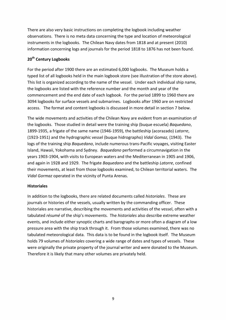
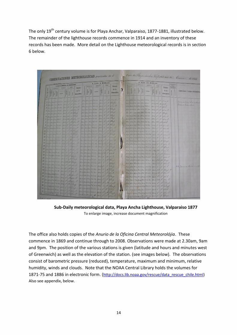
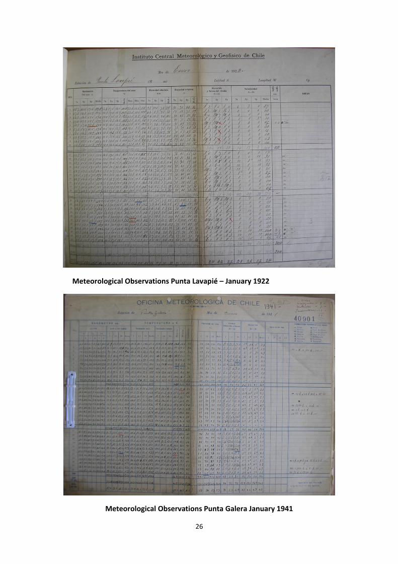
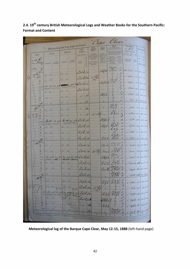
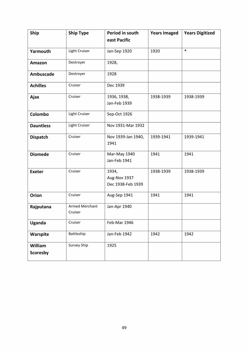