
Historic Urban Landscape approach and spatial planning · Ana Manuela Tarrafa Pereira da Silva ......
92
Historic Urban Landscape approach and spatial planning Exploring the integration of heritage issues in local planning in Portugal Ana Manuela Tarrafa Pereira da Silva Thesis to obtain the Master of Science Degree in Urbanism and Spatial Planning Supervisor(s): Prof. Ana Isabel Loupa Ramos (IST-UL) Prof. Ana Rita Gomes Mendes Martins Pereira Roders (TU/e) Examination Committee Chairperson: Jorge Manuel Gonçalves Supervisor: Ana Isabel Loupa Ramos Members of the Committee: José Maria da Cunha Rego Lobo de Carvalho October, 2017
Transcript of Historic Urban Landscape approach and spatial planning · Ana Manuela Tarrafa Pereira da Silva ......

Historic Urban Landscape approach and spatial planning
Exploring the integration of heritage issues in local planning in Portugal
Ana Manuela Tarrafa Pereira da Silva
Thesis to obtain the Master of Science Degree in
Urbanism and Spatial Planning
Supervisor(s): Prof. Ana Isabel Loupa Ramos (IST-UL)
Prof. Ana Rita Gomes Mendes Martins Pereira Roders (TU/e)
Examination Committee
Chairperson: Jorge Manuel Gonçalves
Supervisor: Ana Isabel Loupa Ramos
Members of the Committee: José Maria da Cunha Rego Lobo de Carvalho
October, 2017
Ao Pinhal Real de Leiria,
tempo da minha infância e imaginário, cuja destruição pelos recentes incêndios que
assolaram Portugal fortalece a minha consciência sobre a importância de conhecer e planear para
um mundo melhor.

Agradecimentos (Acknowledgements)
A elaboração de uma dissertação leva-nos a contactar uma imensidão de pessoas. Um grupo
que vai crescendo à medida que o tempo que despendemos se vai estendendo. E eu tenho a sorte de
serem muitos.
Começava por agradecer à CCDR-Norte, e em particular ao José Nogueira por toda a
disponibilidade demonstrada seja qual fosse o documento pedido. A todos os técnicos das câmaras
municipais guardiães dos PDM (amostra) que foram objeto de análise, que de uma forma ou de outra
foram disponibilizando os documentos pedidos.
Começando então nas particularidades, às minhas orientadoras Prof. Isabel Loupa Ramos e
Prof. Ana Pereira Roders pela total disponibilidade e motivação que sempre me ofertaram. Com elas
aprendi muito, mas acima de tudo sempre percebi que era com elas que poderia crescer. Ao Prof.
Jorge Gonçalves também por toda a motivação e entusiasmo que sempre incutiu nos seus alunos e
nos quais deixa indubitavelmente uma marca.
À Teresa Valente, por todos os almoços e os que ainda temos de marcar.
Aos colegas desta aventura, que apesar da distância, geográfica e temporal, foram muitas
vezes o pilar onde me sustentava. Em particular à Catarina, à Diana, ao Ruben e à Rita, que sempre
lá estiveram. E ao Rogério, pela amizade mesmo nos momentos mais difíceis.
Às almas que mais de perto me amparam nesta longa caminha final. À Gi, à Rita, à Vera e à
Renata por todas as gargalhadas, pelo apoio e pela força. À Carina por todas as caminhadas, físicas
e mentais. À Janet Heron pela sua preciosa ajuda.
À Laura, a mais antiga e melhor amiga.
Aos meus Pais, que nunca questionaram e que sempre, sob todas as circunstâncias confiaram
em mim.
Ao Filipe, meu companheiro e minha metade, que tudo sempre compreendeu.
A todos os que de uma forma ou de outra me animaram, empurraram e não desistiram de mim.

i
Abstract
The perspective over heritage is expanding towards more all-inclusive approaches, founding
its main expression in UNESCO’s Historic Urban Landscape Recommendation. Due to its
comprehensive nature, local planning tools are been indicated as privileged tools to support this new
paradigm. But, are they prepared to it? By crossing both policies – heritage management and spatial
planning, this research aims to explore the relations of a more comprehensive concept of heritage
(cultural/natural, tangible/intangible) into local spatial policies.
Focused in Portuguese context, this research presents an overview on the way the heritage
concept is evolving in heritage management and spatial planning policies. This study narrows the
analysis to the PDM published after the ratification of 2001 Cultural Heritage Law until the end of 2014,
when the spatial planning legal framework changes. A sampling was retrieved from this universe, for
further analysis. Firstly the PDM elements with heritage evidence were identified, followed by a content
analysis applied to PDM ordinance document where attribute categories were coded, being finally
crossed with the PDM sections.
Results indicate a higher degree of comprehensiveness of heritage concept by heritage
legislation than reported in literature and even lower in spatial planning policies. In the PDM analysed,
references to tangible categories were in all zoning plans as expected. Nevertheless some explicitly
evidence to multiple dimensions of heritage intangible categories were identified, mostly related with
the visual relations of the city. This urges to be further explored in order be extensively integrated in
heritage management policies and notably in planning practices.
Keywords: local planning, Historic Urban Landscape, heritage attributes, PDM
ii
Resumo analítico
A noção de património vai evoluindo para abordagens mais inclusivas, tendo a sua maior
expressão na Recomendação das Paisagens Históricas Urbanas da UNESCO. Devido à sua natureza
abrangente, os instrumentos de gestão territorial têm sido apontados como os mecanismos mais
eficazes neste novo paradigma. Mas estarão preparados? Cruzando as políticas da gestão patrimonial
e do ordenamento do território, procura-se explorar as relações de um conceito patrimonial mais
inclusivo (cultural/natural, tangível/intangível) nas políticas de planeamento locais.
Integrado no contexto português, este estudo apresenta uma visão geral sobre o modo como
o conceito de património evoluiu nas políticas de gestão do património e ordenamento do território.
Definindo como universo os PDM publicados entre a publicação da Lei do Património Cultural (2001)
e o final de 2014, quando o quadro jurídico do ordenamento do território se altera, foi retirada uma
amostragem de 18 PDM, posteriormente sujeitos a uma análise de conteúdo em várias escalas, sendo
identificadas e codificadas as referências a questões patrimoniais.
Os resultados revelam que o conceito de património é mais abrangente na legislação do que
na literatura ou nas políticas de ordenamento do território. Nos PDM analisados, como o esperado,
foram identificadas referências a categorias tangíveis em todos os planos. No entanto, o estudo
identificou também referências explícitas às múltiplas dimensões assumidas pela categoria patrimonial
de atributos intangíveis, principalmente relacionados com as relações visuais da cidade. É necessário
que esta abordagem seja explorada de forma mais abrangente, sendo amplamente integrada nas
políticas de gestão patrimonial e particularmente no planeamento.
Palavras-chave: planeamento local, Paisagens Históricas Urbanas, atributos patrimoniais,
PDM

iii
CONTENT
1 Introduction ...................................................................................................................................... 1
1.1 Aims and Objectives ........................................................................................................... 4 1.2 Thesis alignment................................................................................................................. 4
2 Literature review .............................................................................................................................. 6
2.1 A new paradigm in urban resources management ............................................................. 6
2.1.1 From monuments to landscape ............................................................................... 6 2.1.2 From heritage protection to the management of thoughtful change ....................... 8
2.2 Heritage management process in Portugal ...................................................................... 12
2.2.1 Heritage attribute categories ................................................................................. 13 2.2.2 Heritage management tools .................................................................................. 14
3 Comparative evolution: attributes and spatial planning............................................................ 20
3.1 Urban Planning (1755-1974) ............................................................................................ 20 3.2 Municipal Planning (1974-1998) ....................................................................................... 22 3.3 Territorial planning (1998 - present) ................................................................................. 23
4 Legal Framework............................................................................................................................ 25
4.1 Cultural Heritage Legal framework ................................................................................... 25
4.1.1 Heritage management ........................................................................................... 26 4.1.2 Amendments to LBPC2001 ................................................................................... 28 4.1.3 Portuguese heritage legislation and HUL Recommendation ................................ 29
4.2 Heritage in Portuguese Spatial Planning System ............................................................. 29
5 Methodology ................................................................................................................................... 34
5.1 Data collection .................................................................................................................. 35 5.2 Processing data ................................................................................................................ 35
5.2.1 Inventory ................................................................................................................ 36 5.2.2 Comparative analysis ............................................................................................ 39
6 Case-study: Portugal and PDM .................................................................................................... 40
6.1 Crossing the bridge .......................................................................................................... 40 6.2 PDM - A tool from and for the community ........................................................................ 41 6.3 Applying proposed methodology ...................................................................................... 42
6.3.1 Data collection ....................................................................................................... 43 6.3.2 Processing data ..................................................................................................... 44
7 Heritage issues in PDM ................................................................................................................. 47
7.1 Inventory ........................................................................................................................... 47
7.1.1 WHERE – PDM components ................................................................................ 47 7.1.2 WHAT – PDM statutory ordinance document ....................................................... 51 7.1.3 WHERE + WHAT – Section analysis .................................................................... 54
7.2 Comparative analysis and results discussion ................................................................... 58
8 Conclusions .................................................................................................................................... 63 Bibliography ........................................................................................................................................ 66 A Appendices ..................................................................................................................................... 72
A.1 PDM elements flowchart ................................................................................................... 72 A.2 PDM published between 2002-2014 ................................................................................ 73 A.3 Primary sources analysis of the content analysis ............................................................. 75 A.4 Extended attributes typology by Veldpaus with content analysis and subsequent coding of attributes ............................................................................................................................... 76 A.5 Consulted documents ....................................................................................................... 77

iv
List of tables
Table 1 – Comparison between attributes references in Portuguese heritage framework and the ones identified in HUL Recommendation by Veldpaus (2015). .....................................................................29
Table 2 - Heritage-related keywords (HRK) used for preliminary systematic review in statutory text. .36
Table 3 – Three levels of WHAT (Gutscoven, 2016) ............................................................................37
Table 4 - Attribute typology of Veldpaus (see Veldpaus & Pereira Roders, 2013; Veldpaus, 2015) ....38
Table 5 – PDM sections used in WHAT+WHERE analysis ..................................................................46
Table 6 – Content analysis of the ordinance statutory document (regulamento) of each PDM. ...........75
List of figures
Fig. 1 - Action plan and recommended steps to implement HUL approach (UNESCO, 2011a; Veldpaus, 2015; WHITRAP, 2016) .......................................................................................................... 9
Fig. 2 – Toolkit proposed by HUL Recommendation (UNESCO, 2011, p.14) ......................................10
Fig. 3 – Heritage-related references on first generation PDM elements (Raposo, 2003) .....................18
Fig. 4 - Different protection levels in LBPC2001 ...................................................................................27
Fig. 5 - Portuguese Spatial Planning System as defined by 1999 RJIGT (adapted from Cabrita, 2008) ...............................................................................................................................................................31
Fig. 6 - Policy analysis process (Thyer, 2011) ......................................................................................34
Fig. 7 – Analysis methodology flowchart ...............................................................................................35
Fig. 8 – Three stages of PDM content analysis.....................................................................................36
Fig. 9 – Contextualization timeframe of both PDM surveys. .................................................................42
Fig. 10 – Location of both universe of 81 PDM and sample of 18 PDM. ..............................................44
Fig. 11 - Percentage of PDM with references to heritage on “PDM content” section. ..........................48
Fig. 12 - “PDM content” article ..............................................................................................................48
Fig. 13 – HRE on Fundamental Elements by PDM ...............................................................................49
Fig. 14 – HRE on fundamental cartography. .........................................................................................50
Fig. 15 - HRE on PDM Supporting documents by PDM ........................................................................50
Fig. 16 – Level 0: Ratio of PDM where HRE are attributes, categories of attributes or both. ...............51
Fig. 17 - Level 1: Tangible VS Intangible ..............................................................................................52
Fig. 18 - Level 2: six attribute categories ...............................................................................................52
Fig. 19 - Level 3: eighteen categories of attributes types ......................................................................54
Fig. 20 - Amount of PDM in which were identified heritage-related evidences by PDM section. .........54
Fig. 22 – Discrimination inside “restrictions” PDM section, between SARUP and protection system. .55
Fig. 21 - Amount of PDM with single articles addressed to heritage issues (heritage exclusive). ........55
Fig. 23 - Level 1: Tangible VS Intangible by PDM sections. .................................................................56
Fig. 24 - Level 2: six attributes sub categories by PDM sections ..........................................................56
Fig. 25 - Level 3: eighteen categories of attributes types by PDM sections .........................................57
Fig. 26 - Identification of heritage issues on PDM composed parts: comparison between both surveys (2003 and 2017). ...................................................................................................................................58

v
List of Acronyms
ACCRU Critical Area of Urban Reconversion and Renovation (Área Critica de Recuperação e Reconversão Urbanística)
CoE Council of Europe
DGEMN General Direction of National Buildings and Monuments (Direcção Geral dos Edificios e Monumentos Nacionais)
DGOTDU General Direction for Spatial Urban Planning (Direção-Geral do Ordenamento do Território e do Urbanismo)
DGT General Direction of Territory (Direção-Geral do Território)
ELC European Landscape Convention
EU European Union
GIS Geographic Information Systems
HIA Heritage Impact Assessment
HUL Historic Urban Landscape
ICOMOS International Council on Monuments and Sites
IGT Spatial Planning Tools (Instrumentos de Gestão Territorial)
INE Statistics National Institute (Instituto Nacional de Estatística)
IPPAR Portuguese Institute of Architectonic Heritage (Instituto Português do Património Arquitetónico)
LBCP2001 National Cultural Heritage Law (Lei de Bases do Património Cultural: Law no. 107/2001 of 8 September)
LBPOTU Framework Law for the Policy on Territorial Management and Urbanism (Lei de Bases das Políticas do Solo, do Ordenamento do Território e Urbanismo: Law no. 48/98, of 11 August)
LBPPSOTU Framework Law for the Public Policy on Land, Territorial Management and Urbanism; (Lei de Bases Gerais da Política Pública de Solos, de Ordenamento do Território e de Urbanismo: Law no. 34/2014, of 30 May)
MAOTE Ministry of Environment, Spatial Planning and Energy (Ministério do Ambiente, do Ordenamento do Território e da Energia)
PDM Municipal Master Plan (Plano Diretor Municipal)
PEOT Special Spatial Plans (Planos Especiais de Ordenamento do Território)
PMOT Municipal Spatial Plans (Planos Municipais de Ordenamento do Território)
PNPOT National Program of Spatial Planning Policy (Programa Nacional da Política de Ordenamento do Território)
PP Detailed Development Plans (Plano de Pormenor)
PPS Safeguarding Detailed Plan (Plano de Pormenor de Salvaguarda)
PROT Regional Spatial Plans (Planos Regionais de Ordenamento do Território)
PRU Urban Rehabilitation Plan (Plano de Reabilitação Urbana)
PU Urban Development Plans (Plano de Urbanização)
REOT Spatial Planning Periodic Report (Relatório do Estado do Ordenamento do Território)
RJIGT Law Framework for Spatial Planning Tools (Regime Jurídico dos Instrumentos de Gestão Territorial: Decree-law no. 380/99 of 22 September, reviewed by the Decree-Law n.º 80/2015, of 14 May)
SARUP Administrative Easements of Restrictions Land Public Use (Servidões Administrativas e Restrições de Utilidade Pública)
SNIT National System of Spatial Planning Tools
UNESCO United Nations Educational, Scientific and Cultural Organization
UOPG Operational Units of Planning and Management (Unidades Operativas de Programação e Gestão)
WHITRAP World Heritage Institute of Training and Research for Asia and the Pacific

vi

1
1 INTRODUCTION
The world is witnessing quick changes either on demography and climate, deriving in pressing
costs to available resources, and increasing threats over irreplaceable ones, like heritage or biodiversity
(UNESCO, 2015). As living and dynamic organisms, cities are unceasingly under pressure to change
and adapt to dwellers aspirations and needs. The management of this change, fostering the balance
between conservation and development forces, is one of the century challenges to contemporary urban
planners.
While a great part of the urban world is facing the consequences of intensive and uncontrolled
urban growth (UN, 2014), some European cities are struggling with the costs of decades of urban
expansion policies, and their tremendous impacts in city centres and historical districts, resulting in
phenomena like gentrification, tertiarisation1, marginalization, physical degradation and abandonment
(Barreira, Panagopoulos, & Guimarães, 2015). To revert this situation, some regions are, by one hand,
adopting urban cohesion policies and the return to urban centres (Gonçalves, 2011), which, on the other
hand, would increase pressures over existing urban resources, namely over the ones with
acknowledged cultural significance (Pereira Roders, 2013).
Recently, heritage has been recognized, by supranational organizations as a key urban
resource to achieve sustainable development, complementing the improvement of urban areas
liveability with economic development and social cohesion in a changing global context (UNESCO,
2011; UN-HABITAT, 2016). Moreover, heritage conservation has been accepted as “the management
of thoughtful change” (Getty, 2010, p. 13), an idea strictly associated with the growing complexity of the
heritage concept on its different dimensions (cultural/natural, tangible/intangible, urban/rural), and
consequently, with a greater understanding over what (attributes) should be conserved and why
(values).
Hence, traditional object-based approaches, focused on the physical conservation of protected
heritage assets, are being replaced for more all-inclusive, such as the landscape-based approaches,
which have been recommended by supra-national reference documents since the European Landscape
Convention2 (CoE, 2000), culminating in the recently adopted Recommendation on the Historic Urban
Landscapes3 (UNESCO, 2011). This UNESCO document is announced as simultaneously being a
definition of urban context and an approach to sustainable urban development (WHITRAP, 2016),
aiming to end the long conflict between conservation and development, promoting not the process to
avoid change but the means to manage it. Besides providing the framework on how landscape-based
approaches can be performed, these policy documents recognize change as an intrinsic quality of
significant resources, its management being a critical step towards sustainable development. They
1Definition by the European Foundation for the Improvement of Living and Working Conditions (July 20, 2014), meaning the replacement of housing function by services sector. 2 Hereafter “ELC”. 3 Hereafter “HUL Recommendation”.

2
recommend the implementation of heritage assessment methods, supported by public consultation, in
order to better evaluate the impacts of new developments, and thus manage transformation, instead of
avoiding it. Furthermore, the integration of these outcomes, in urban planning tools is either indicated,
as a fundamental step to provide a better quality of life to their citizens.
The combination of heritage concerns on planning policies has been strongly recommended
and present in several UE policy documents since the 1990’s4 (Brito Henriques, 2006; O'Donnell, 2014),
although the way they are developed vary from country to country, as varies the adopted planning policy
framework (Nadin & Stead, 2008). Moreover, planning policies are commonly recognized as
fundamental regulatory tools that control and shape urban areas, having direct or indirect influence over
resources as heritage (O'Donnell, 2014). Again, the impact over heritage resources varies and makes
it either an obstacle or a mechanism to protect, conserve or enhance heritage issues, by depending, on
the level of knowledge of those resources that will influence the level of tolerance to change that they
might integrate.
In Portugal, heritage management and spatial planning practices evolved side by side (Cidre,
2015). Their management is a recognized state duty to provide a better quality of life for all. Regarding
heritage management, Portugal has been following international recommendations, such as, the
elaboration of heritage lists at national and local level, as well as, its legal protection trough listing
processes. According to literature, this protective perspective was traditionally adopted by spatial
planning tools managing heritage issues, (a) by being focused on tangible attributes and limiting the
management to legally protected cultural properties (listed and submitted to be listed) through their
established protection zones, (b) by restricting their management actions to the identification and listing
(Raposo, 2003), and (c) by defining general orientations opened to a wide range of interventions and
interpretations, often ignoring the existent values and intangible relations.
Among the Portuguese spatial planning system (Sistema de Gestão Territorial 5 ) are the
municipal spatial planning tools (Planos Municipais de Ordenamento do Território – PMOT). These are
the most important and practical instruments to manage heritage. Firstly due to its proximity to territory
(ground) and its communities, and also due to its regulatory nature setting rules both to public and
private actors. Hierarchically organized by scale, traditionally more detailed plans, either Urban
Development Plans (Plano de Urbanização - PU) or Detailed Plans (Plano de Pormenor - PP)) have
been the most preferred to manage historic areas. Nevertheless the role of municipal master plans
(Planos Diretores Municipais – PDM) in heritage management have been undervalued by literature.
Despite the fact that it is standing at the top of PMOT hierarchy, being the one that is mandatory, and in
which are defined the greater strategic options of development at local level for a long period of time6,
managing both urban and rural areas, and human, natural and cultural resources. It is the spatial
planning tool that includes the objectives of cross-sectorial policies that should be further developed on
4 Guiding Principles for Sustainable Spatial Development of the European Continent (CoE, 2000); Liubliana Declaration (CoE, 2003); European Spatial Development Perspective (CoE, 1999). 5 Decree-Law no. 380/99, of 22 September. 6 Idem; Decree-Law no. 80/2015, of 14 May.

3
hierarchically lower plans (PU, PP), and therefore the most privileged tool to integrate the holistic
perspective claimed by recent heritage landscape-based approaches.
Within this new paradigm for heritage management, current research aims to cross both policies
– heritage management and spatial planning – proposing an analysis of how local planning policies have
been integrating heritage issues.
In fact, this question derived from a first proposal of this dissertation, which aimed not only the
exploration of this relation at national level, but also the development of a methodology, constructed by
mixing ELC and HUL recommendation proposed approaches, to be applied a case study city (Faro).
Crossing the definition of the character of the city (attributes and values) with the identification of the
factors affecting it, the research aimed to define Landscape Quality Objectives (LQO) for the Historic
Landscape Units (HLU), further validated in a meeting involving all the interested actors. Retrieved LQO
would then propose to be integrated into the PDM, under revision process. But, the proposal has proved
unviable when the exploration of the content of PDM started to reveal more and complex information
regarding heritage issues, requiring a different approach.
Therefore, the research that is now presented corresponds to the first research question of this
previous proposal - “How urban heritage is being addressed in local spatial planning tools?” - had been
refined for a more comprehensive concept of heritage and focused on one single spatial planning tool -
Portuguese municipal masterplans (PDM), and in particular, those published after the ratification of 2001
Cultural Heritage Law (Lei de Bases do Património Cultural – Law no.107/2001 of 8 September –
LBPC2001) till the end of 2014, corresponding to the last stable legal period for spatial planning policies7.
After an incursion throughout the evolution and the legislative framework of both policies, a sample of
18 PDM, forming the universe of 81 PDM, was analysed in order to identify how this tool has been
integrating heritage policies. The research explores an attribute typology (Veldpaus, 2015) that was
tested on World Heritage Cities and related nomination documents, demanded for more comprehensive
experiences, namely at the level of local planning (Gutscoven, 2016). Therefore, firstly is identified the
presence of heritage evidence on the entire structure of PDM, followed by a content analysis applied to
one single PDM element looking for categories of attributes, and finally the identification of the sections
in which they were identified.
Despite the fact that we recognize that it is necessary to establish a relation between HUL and
ELC proposed approaches in order to progress, the present research focuses solely on the production
of a more systematic understanding of heritage related evidence in PDM and its limitations
The recognition of the active role of heritage resources on contemporary development is the
utmost step to unblock the old conflict between conservation and development. The extension of the
7 Precedes the changes introduced first by the new Framework Law for the Public Policy on Land, Territorial Management and Urbanism (Lei de Bases Gerais da Política Pública de Solos, de Ordenamento do Território e de Urbanismo – LBPPSOTU; Law no. 34/2014, of 30 May), that replaces the Framework Law for the Policy on Territorial Management and Urbanism (Lei de Bases das Políticas do Solo, Ordenamento do Território e Urbanismo – LBPOTU: Law no. 48/98, of 11 August), developed by the Law Framework for Spatial Planning Tools (Regime Jurídico dos Instrumentos de Gestão Territorial - RJIGT: Decree-law no. 380/99 of 22 September) also replaced by the Decree-Law n.º 80/2015, of 14 May.

4
heritage notion, enabled the introduction of new and more conscious attitudes, towards landscape-
based approaches. Meaning that, not only the physical condition and traditional cultural values are
managed but, need extending to the relations with the broader context, the multiple connections
stablished with several actors and areas, in a way to understand this resource as part of contemporary
life and not a sacred or museum area, preserved to be remembered.
1.1 AIMS AND OBJECTIVES
Located in the policy analysis field, this research proposes to explore the interactions between
spatial planning and heritage management policies, and in particular, how local regulatory tools, shaping
urban form and consequently their resources, are addressing irreplaceable capital such as heritage.
Along with the purpose to reinforce the potentials of heritage resources into sustainable
development models, this research aims to contribute for a wider implementation of HUL
Recommendation, applying it to new contexts assessing its impact and possible improvements.
Focused on local planning, this research aims give information about the relation between heritage
identification and management, as well as, the impact of local regulations on enhance the knowledge
over the nature of heritage issues.
This research establishes as specific objectives (SO):
I. To demonstrate the place and role of heritage management process in local land use planning;
II. To unveil the level of comprehensiveness of land use planning tools regarding heritage concept;
III. To set recommendations for further research in order to explored the HUL recommendation
approach.
Methodologically, the goal is to find answers to the following research questions:
1. Are municipal spatial planning tools an integrative tool for heritage issues?
a) What is the level of heritage representativeness in PDM (SO1)?
b) Which heritage attribute categories are been addressed in PDM ordinance (SO1)?
c) Is there a relation between categories of attributes and PDM ordinance sections (SO2)?
d) How close are Portuguese PDM to HUL definition (SO3)?
1.2 THESIS ALIGNMENT
The first chapter, introduces the thematic and problem field, explaining aims and research
questions. The theoretical background of raised questions is described in second chapter, both to
international to national context. Chapter 3 presents a comparative evolution of spatial planning tools
and heritage attributes in Portuguese legislation, followed by the analysis of current national legal
framework (chapter 4). Chapter 5 describes and discusses the applied methodology, the methods,
sources and the process, followed by chapter 6 with the description of the case study used to answer
to proposed research questions. Further the results of the content analysis applied to a PDM sample

5
retrieved from a defined universe are presented and discussed, first a transversal analysis to every PDM
element, and then an in-depth analysis using the attributes typology to a specific PDM element
(ordinance statutory document - Regulamento). This document ends with the presentation of the
conclusions and recommendations (Chapter 8), where gathered results are discussed with literature
and settle recommendations for future policy and planning practice as well as for future research.

6
2 LITERATURE REVIEW
2.1 A NEW PARADIGM IN URBAN RESOURCES MANAGEMENT
2.1.1 From monuments to landscape
The history of heritage is strictly related to the expansion of attribute categories that had been
added to this notion. This evolution has been explored by several authors (Veldpaus, 2015; Araoz, 2011;
Vecco, 2010; Labadi, 2013; Landorf, 2009; Sullivan, 2004; Stovel, 2007, Jokilehto, 2006; Plevoets &
Van Cleempoel, 2011), and moulded by supranational documents released by international
organizations such as UNESCO, ICOMOS and Council of Europe, which despite not being binding
documents, are frequently interpreted by national and local governments as guidelines to construct their
own heritage management policies (Veldpaus, 2015).
First significant change in heritage concept, occurs by the end of 19th century, among industrial
revolution and the modernist incursions ribboning the old urban areas, when the theorists John Ruskin
and Camillo Sitte8 expanded the Renaissance perspective over heritage focused on monuments as
masterpieces, to minor and domestic architecture. Later, the studies of Gustavo Giovannoni, will break
the boundaries of single and isolated buildings to spread their significance to the urban fabric with varied
ensembles, in which all buildings should be preserved. Heritage starts to be perceived at urban scale,
contrasting with previous centuries, which “mostly referring to a building as an individual organism”
(Pereira Roders, 2007, p. 81). First reference to urban heritage concept, in international charters
appears at Athens Conference (1932), defending the integration of built heritage into urban planning,
the conservation of historic fabric functions and the respect for the monuments ensemble, mainly with
the planning of new developments (Bandarin & Van Oers, 2012). Rather than being the sum of cultural
significant buildings, urban heritage was understood as the city and its complex relations moulding it. It
achieves its “conceptual identity” from the contradictions between heritage conservation and modern
urbanism arguments, for which old cities were a barrier to the progress proclaimed by modern movement
(Choay, 2001). The advent of World War II brought a new perspective, reinforcing the urgency to protect
heritage, as well as the awareness to expand the heritage concept itself. Monuments, groups of
buildings and sites (UNESCO, 1972) become the main heritage typologies that urged to be preserved,
materializing the broad notion of heritage initiated by early century theorists. Further documents will
strengthen this position, introducing notions such as urban heritage, historic centres and urban
ensembles, driving the discussion towards issues beyond the object testimony of the past.
In this new millennium, heritage concept experienced a new growth in complexity, keep adding
notions, such as “the intangible, setting and context, and urban and sustainable development,
accompanied by a greater consideration of the social and economic function of cities” (Veldpaus, 2015,
8Sitte was the first of a generation of urban morphologists, focused on city and its essential elements, and the creator of the notion of historic city.

7
p. 37) that claim for more all-inclusive approaches. Heritage concept evolved either on scale, nature
and significance.
The recently adopted Recommendation on the Historic Urban Landscapes (UNESCO, 2011) is
the key document representative of this new paradigm and the outcome of a long path constructed by
previous documents, such as European Landscape Convention (CoE, 2000), Convention for the
Safeguarding of Intangible Cultural Heritage (UNESCO, 2003), Faro Convention (CoE, 2005), Xi’an
Declaration (ICOMOS, 2005) and Valletta Principles (ICOMOS, 2011). It defines urban area, “as the
result of a historic layering of cultural and natural values and attributes, extending beyond the notion of
“historic centre” or “ensemble” to include the broader urban context and its geographical setting. This
wider context includes notably the site’s topography, geomorphology, hydrology and natural features,
its built environment, both historic and contemporary, its infrastructures above and below ground, its
open spaces and gardens, its land use patterns and spatial organization, perceptions and visual
relationships, as well as all other elements of the urban structure. It also includes social and cultural
practices and values, economic processes and the intangible dimensions of heritage as related to
diversity and identity” (UNESCO, 2011, p. 3). The concept of heritage is extended in several senses:
from cultural or natural to landscape, from object to landscape, from tangible to intangible (Labadi &
Logan, 2016). Not proposed to be a new heritage category (Jokilehto, 2010), it constitutes a new
paradigm for heritage management that encompasses all the revealed categories and attributes, known
or to explore, evolving with the heritage concept, and a new model for a sustainable urban development.
The focus was into expanding heritage perspective to the natural and human features
influencing it, and understand “heritage” as the testimonies (attributes), to which each society ascribes
significance (values) according to prevalent beliefs (Pereira Roders, 2007). Authors are unanimous
stating that research about values is more consistent than about attributes (Pereira Roders, 2013;
Veldpaus, 2015; Sanjbod, Hermans, Reijnders, & Veldpaus, 2016). As argued by Gutscoven (2016),
while value typologies are being discussed and improved since 1903’ Riegl studies (English Heritage,
1997; Mason, 2002; Pereira Roders, 2007; Vecco, 2010;) achieving a greater relevance with the Burra
Charter (ICOMOS, 1999), the discussion over attribute typologies is still green, although had been
identified by this author in some documents (Preservation Charter for the United States of America
(1992), the Nara document on authenticity (1994) and the Burra charter (1999) in Gutscoven, 2016).
Moreover, while the notion of “attributes”, entangled with the inner notion of “heritage” can be easily
identified, the use of the term “attributes” is very recent, had been identified by the 2010 ICOMOS expert
recommendation, that defined it “as the elements that contain or yield the outstanding universal value
(OUV) of a property” (Gutscoven, 2016, p. 12) had been adopted by HUL recommendation document
(UNESCO, 2011a). Some research was also find using the term “attributes”, however lacking on
definitions and mostly focused on the property authenticity and integrity conditions (Gutscoven, 2016).
Therefore, a property (attribute) might be intangible or tangible, but to be considered as heritage it has
always to have cultural significance (value) ascribed to it. It means that intangible attributes, such as the
Portuguese World Heritage listed national songs of “Fado” and “Cante Alentejano”, are simultaneously
understand as the value of something (e.g. the restaurants and bars (“tabernas”) where they take place)

8
and their own cultural values (Veldpaus, 2015). Meaning that, the management of intangible heritage is
closely related with the tangible attributes, which the disappearance will jeopardize the value of the
property. Therefore, intangible attributes should also be considered in heritage planning policies.
2.1.2 From heritage protection to the management of thoughtful change
Understanding heritage conservation as the “broad discipline that addresses all aspects of
retaining and enhancing historic places”, Kalman (2014, p. 14) defines heritage management process
or heritage planning as a discipline under both heritage conservation and urban planning, which aims
to manage change and not avoid it, as argued by Burra Charter (ICOMOS, 1999).
The growing complexity of the heritage concept, demands for more interdisciplinary and wider
approaches, where change is understood as inevitable and thus necessarily to be managed. Therefore,
heritage management evolved from the traditionally object-based approach, focused on the physical
preservation of heritage resources and traditional values, towards landscape-based approaches, more
holistic and comprehensive, integrating a growing set of fields from economic, social and environmental
sciences (Veldpaus, 2015). Recognized in literature since 1960s, this all-inclusive (landscape) approach
understands urban areas as a mix of constant mutable layers, where conservation is part of their
development and not an obstacle. It reintroduces heritage resources into their natural evolutionary
process (Martini, 2013), recognizing change as part of this process, and thus, conservation as the
“management of thoughtful change” (Getty, 2010, p. 12), driving integrated heritage management into
the larger planning and development frameworks (e.g. Belvedere program in Netherlands (1999)).
Actually, change was always an option and part of the heritage management process, together with the
understanding of context and the development of a strategy (Pereira Roders, 2007; Veldpaus, 2015).
The tipping point lies, however, on the level of the tolerance to change accepted (Pereira Roders &
Veldpaus, 2013; Oers & Bandarin, 2012), i.e., the expected balance between the conservation of
heritage values and attributes, and the persecution of contemporary needs.
The development of approaches to heritage conservation had been explored by several authors
(Kalman, 2014; Veldpaus, 2015; Bandarin & Van Oers, 2012), conflicting broader with focused
perspectives on specific attribute categories. Nonetheless, on the whole, they agree that this path is
evolving into a more holistic and complex heritage management, integrating growing heritage attribute
categories and consequently requiring more complex and broader approaches. The integration of
change management approaches or “transition management” (Veldpaus, 2015, p. 51) are at stake, as
heritage is no longer understood as a static element that should be protected and preserved against
any threat of alteration, but as an active resource to achieve sustainable urban development (UN, 2015;
UN-HABITAT, 2016; UNESCO, 2016; UNESCO, 2015).
As aforementioned, the HUL Recommendation combines the functions of a definition and an
approach. As an approach the HUL recommendation proposes a new perspective over urban planning
and management, fostering the control over the continuity and change of every area (protected/non-
protected; urban/rural or natural surroundings), respecting place significance and people’s identity
(Martini, 2013), and move the process driven by stakeholders and experts to community engagement
9
(Labadi & Logan, 2015). The roadmap proposed by HUL recommendation is no longer unilaterally
focused on heritage issues, but an interdisciplinary approach “to integrate policies and practices of
conservation of the built environment into the wider international goals of urban development, whilst
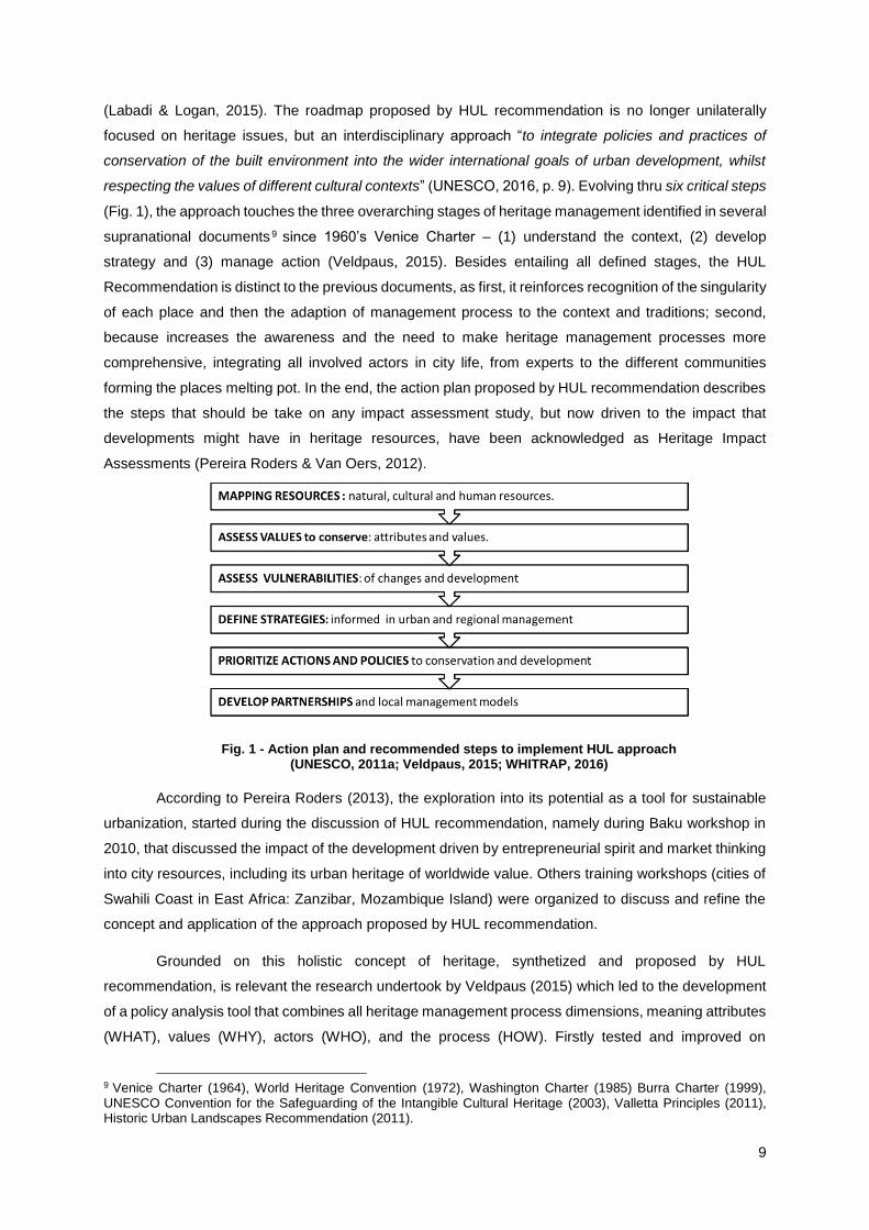
respecting the values of different cultural contexts” (UNESCO, 2016, p. 9). Evolving thru six critical steps
(Fig. 1), the approach touches the three overarching stages of heritage management identified in several
supranational documents 9 since 1960’s Venice Charter – (1) understand the context, (2) develop
strategy and (3) manage action (Veldpaus, 2015). Besides entailing all defined stages, the HUL
Recommendation is distinct to the previous documents, as first, it reinforces recognition of the singularity
of each place and then the adaption of management process to the context and traditions; second,
because increases the awareness and the need to make heritage management processes more
comprehensive, integrating all involved actors in city life, from experts to the different communities
forming the places melting pot. In the end, the action plan proposed by HUL recommendation describes
the steps that should be take on any impact assessment study, but now driven to the impact that
developments might have in heritage resources, have been acknowledged as Heritage Impact
Assessments (Pereira Roders & Van Oers, 2012).
According to Pereira Roders (2013), the exploration into its potential as a tool for sustainable
urbanization, started during the discussion of HUL recommendation, namely during Baku workshop in
2010, that discussed the impact of the development driven by entrepreneurial spirit and market thinking
into city resources, including its urban heritage of worldwide value. Others training workshops (cities of
Swahili Coast in East Africa: Zanzibar, Mozambique Island) were organized to discuss and refine the
concept and application of the approach proposed by HUL recommendation.
Grounded on this holistic concept of heritage, synthetized and proposed by HUL
recommendation, is relevant the research undertook by Veldpaus (2015) which led to the development
of a policy analysis tool that combines all heritage management process dimensions, meaning attributes
(WHAT), values (WHY), actors (WHO), and the process (HOW). Firstly tested and improved on
9 Venice Charter (1964), World Heritage Convention (1972), Washington Charter (1985) Burra Charter (1999), UNESCO Convention for the Safeguarding of the Intangible Cultural Heritage (2003), Valletta Principles (2011), Historic Urban Landscapes Recommendation (2011).
Fig. 1 - Action plan and recommended steps to implement HUL approach (UNESCO, 2011a; Veldpaus, 2015; WHITRAP, 2016)
10
workshops with Amsterdam stakeholders, this tool was already the basis of other studies to World
Heritage cities (Gutscoven, 2016), confirming it as a feasible tool to be applied to other contexts (even
other places besides World Heritage), in particular at the level of local planning. This tool proposes the
most complete and comprehensiveness list of attribute categories, so far developed, in which tangible
(including natural elements) and intangible attributes are breakdown in several types (which can and
should be extended), contributing on this way for more objective assessments.
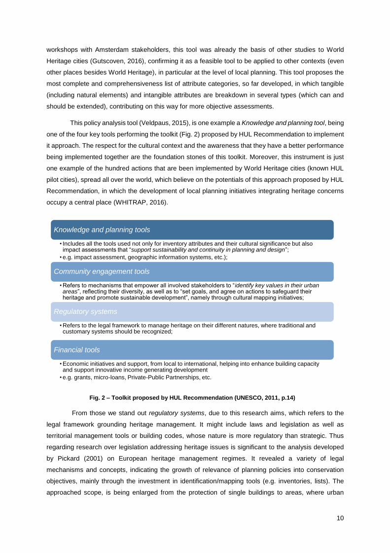
This policy analysis tool (Veldpaus, 2015), is one example a Knowledge and planning tool, being
one of the four key tools performing the toolkit (Fig. 2) proposed by HUL Recommendation to implement
it approach. The respect for the cultural context and the awareness that they have a better performance
being implemented together are the foundation stones of this toolkit. Moreover, this instrument is just
one example of the hundred actions that are been implemented by World Heritage cities (known HUL
pilot cities), spread all over the world, which believe on the potentials of this approach proposed by HUL
Recommendation, in which the development of local planning initiatives integrating heritage concerns
occupy a central place (WHITRAP, 2016).
From those we stand out regulatory systems, due to this research aims, which refers to the
legal framework grounding heritage management. It might include laws and legislation as well as
territorial management tools or building codes, whose nature is more regulatory than strategic. Thus
regarding research over legislation addressing heritage issues is significant to the analysis developed
by Pickard (2001) on European heritage management regimes. It revealed a variety of legal
mechanisms and concepts, indicating the growth of relevance of planning policies into conservation
objectives, mainly through the investment in identification/mapping tools (e.g. inventories, lists). The
approached scope, is being enlarged from the protection of single buildings to areas, where urban
Knowledge and planning tools
• Includes all the tools used not only for inventory attributes and their cultural significance but also impact assessments that “support sustainability and continuity in planning and design”;
• e.g. impact assessment, geographic information systems, etc.);
Community engagement tools
• Refers to mechanisms that empower all involved stakeholders to “identify key values in their urban areas”, reflecting their diversity, as well as to “set goals, and agree on actions to safeguard their heritage and promote sustainable development”, namely through cultural mapping initiatives;
Regulatory systems
• Refers to the legal framework to manage heritage on their different natures, where traditional and customary systems should be recognized;
Financial tools
• Economic initiatives and support, from local to international, helping into enhance building capacity and support innovative income generating development
• e.g. grants, micro-loans, Private-Public Partnerships, etc.
Fig. 2 – Toolkit proposed by HUL Recommendation (UNESCO, 2011, p.14)

11
rehabilitation and other re-use philosophies are gaining ground against former dominant restoration
policies. An interesting fact revealed is the identification of a relation between listing categories to
economics issues. On the other side of the spectrum, is the comparative study undertook over building
codes across Italy, Portugal and Spain legislation, which reveals divergences regarding the function
attributed to listing categories and their influence in management process (Ornelas, Guedes, & Breda-
Vázquez, 2016).
Therefore, spatial planning tools, embodying the wide realm of built territories (meaning human,
natural and cultural resources), should integrate all the instruments proposed in HUL toolkit.
Traditionally, spatial planning tools have been associated to zoning figures (land use planning), which
in heritage management field has been understood as the application of a larger scale of protective
measures, where the object of protection is unclear. Meaning the specific relations and dynamics do not
have to be described or illustrated, nor do the attributes or values have to be located within that protected
area, which could easily led to complications in management, such as binary evaluations “in which either
all or nothing is protected (…) or [to] different treatments within the same zone” (Veldpaus, 2015, p. 71).
Although the integration of heritage concerns in spatial planning policies have been widespread
implemented (O'Donnell, 2014), the way they are implemented can vary country to country, as does the
adopted spatial planning policies framework (Nadin & Stead, 2008). This integration has been strongly
recommended in several Council of Europe documents, such as the Guiding Principles for Sustainable
Spatial Development of the European Continent (CoE, 2000), the Liubliana Declaration (CoE, 2003) and
the European Spatial Development Perspective (CoE, 1999) (Brito Henriques, 2006). Spatial planning
policies are commonly recognized as fundamental regulatory tools that control and shape urban form,
having influence directly or indirectly over resources such as heritage (O'Donnell, 2014). The impact
over heritage resources vary and makes it either an obstacle or a mean to protect, conserve or enhance
heritage properties, by depending, on the level of tolerance to change, that they integrate.
The World Heritage Committee invites state-parties “to adopt a general policy which aims to
give the cultural and natural heritage a function in the life of the community and to integrate the protection
of that heritage into comprehensive planning programmes” (UNESCO, 1972, p. 3). Regardless of listing
level, but in particular at a higher level (World Heritage), this recognition is not a one stand direct tool to
spatial control, but signalled the relevance of the place as a material factor that should be attended to
local stakeholders (Evens, 1994 in Cidre, 2015) 10 . Remaining at the core of the most recent
recommendations and approaches, literature indicates that the practical integration of heritage policies
into socioeconomic development is far from established (Veldpaus, 2015). Traditionally, the
identification of heritage assets results from experts’ evaluations, which state what should be conserved
or not. This new paradigm calls for more comprehensive processes, integrating other interested voices,
from different fields and with various aspirations, and thus expanding and strengthen the awareness
10 e.g. in Portugal, since 1991, listed buildings are free from municipal taxes (Decree-law no. 380/99 of 22 September)

12
over the issue identified to be protected, improving thus the discussion and application of territorial
planning strategies (Swensen & Jerpåsen, 2008).
Moreover, these holistic and long-term approaches are being recognized in literature as a
crucial step towards sustainable development (Veldpaus, 2015) and which the results were already
explored in several case studies (Anheier and Isar, 2012; Dupagne and EC, 2004; Nijkamp and Riganti,
2008; Scholz et al., 2012; URBACT, 2014). Also, intergovernmental and non-governmental
organizations, such as UNESCO and ICOMOS have been elaborating strategies to integrate these
approaches (e.g. CoE, 2000, 2005; ICOMOS, 2005b, 2011; UNESCO, 2005, 2009, 2011a).
The intersections between the evolution of urban planning and heritage conservation theories
has been explored and demonstrated by several authors (Jokilehto, 2010; Sonkoly, 2011; Veldpaus et
al., 2013a; Martini, 2013), being spatial planning tools considered as the most important and practical
instruments to manage heritage (O'Donnell, 2014). As stated by Stead and Nadin (2008), spatial
planning regimes vary from country to country, and from region to region, which hamper an international
comparative analysis. Although some literature was found regarding local planning and heritage.
Swensen & Jerpåsen (2008), for instance, explored the impacts of Norwegian local planning in cultural
heritage assets, verifying the prevalence of a perspective over heritage issues driven to the object and
ignoring created and surrounding relations. Heritage is seen as a by-product from others, concluding
that a proper planning process is not guarantee for heritage conservation if not integrated in the debate
as an equal part with all other interests. More recently Jackson (2016) explored the potentials of local
planning as a mechanism to locally protect cultural heritage, focused on public participation, whether on
the identification of the heritage to protect or on the sustainable and economic development perspective.
2.2 HERITAGE MANAGEMENT PROCESS IN PORTUGAL
Heritage management in Portugal dates from the 18th century, when the first concerns to
distinguish properties with specific value came into force11. The developments and returns of a century
of heritage management was object of a singular exhibition in 2010, from which resulted an anthology
integrating several contributions of heritage experts from different fields (Custódio, Soromenho &
Cortesão, 2010). Also, the work of Lopes (2012) is relevant to understand this evolution, more related
with the development of national legal framework and the influence operated by international doctrinal
documents. Moreover, there are other studies regarding specific time periods remarkable to heritage
management as was the dictatorship period (1926-74) and the role of General Direction of National
Buildings and Monuments (Direcção Geral dos Edificios e Monumentos Nacionais - DGEMN) (Neto,
2001) as well as the work of Tomé (2001) which stretches to 1996.
Besides the innovations and enhancements introduced in theory, heritage was frequently
considered in a protective manner, limiting the management to legally protected cultural properties
(listed and submitted to be listed) by the establishment of standard protection zones (many established
automatically (50 meters) after the opening of listing process), limiting their management to mapping
11 Charter of 20th August 1721, proclaimed by King D. João V

13
actions (Raposo, 2003; Gonçalves, 2013). If on the one hand rehabilitation strategies introduced the
management of change in conservation practices (Aguiar, 2010), on the other hand the functionalist and
technocratic urban planning drove city management towards a fragmentary perspective, by establishing
protection areas, old urban districts and historic centres (Gonçalves, 2007). The place of heritage in law
policies is explored by Nabais (2004), as well their relations with other sectorial policies, namely planning
and environment, being also explored in international and communitarian law.
2.2.1 Heritage attribute categories
As was described for international context, also the concept of heritage has expanded in
national context (Pereira, 2010; Folgado, 2010; Lopes, 2012). This is relevant to the development of
legal framework related with heritage, which despite being limited to cultural issues, had evolved from
the national monuments listing (1901), towards the inventory and listing of immaterial and material
heritage, including natural elements as part of the context that should be approached under landscape-
based perspective (Nabais, 2004).
Focused on the evolution of heritage concept in Portuguese legal framework, and then listed
immovable (cultural) heritage, the narrative constructed by Lopes (2012) over one century of Portuguese
heritage management, indicates that heritage concept evolved from object to context, to ensemble and
finally to urban area. First were the monuments (objects), then the protection zones (context) that
overruled the debate during Estado Novo, only constituting an attribute with LBPC2001, then the groups
of buildings, urban ensemble acknowledged as “historic-centres” and more recently with the introduction
of “integrative conservation” notions the expansion to urban areas, influenced by rehabilitation practices.
Nonetheless the perspective remains on city fragments, whether be planning units (UOPG), protection
zones or rehabilitation areas (Àreas de Reabilitação Urbana - ARU), being the landscape, meaning the
relations between different attributes and values ignored.
The description done by Torres da Silva (2012) is also relevant, over the evolution of immovable
heritage concept, revealing that listing has often been used as a value per se, emptied of identified
associated cultural values that international practices recommend to be considered in management
actions. An argument reinforced by Ornelas (2016) systematic analysis, which concludes that Portugal,
contrary to other southern European countries, do not ascribed to listing categories any management
criteria, but only restrictions and the tutelage, reinforcing the argument of the restrictive protective nature
of Portuguese heritage management.
Literature is still focused on heritage typologies than in attribute categories. Heritage typologies
are related to former and potential uses (Bernardes, Oliveira, & Moreira, 2014) or in what Pereira (2010)
defines as “estimated categories”, meaning listing degrees established by decree. Similar to what was
performed by Veldpaus (2015), Folgado (2010), undertook a comparative survey over general heritage
attributes in international and national context. Through the analysis of international doctrinal
documents, concluded that this expansion was not as useful in Portugal as it abroad. Folgado (2010)
argues about an “inclusive heritage”, indicating UNESCO World Heritage Convention (UNESCO, 1972)
the key document that introduces natural into heritage discussion.

14
2.2.2 Heritage management tools
Listing procedures under the form of inventories were the first tools to heritage management
(Jokilehto, 2005), remaining today the main protection instrument (Pereira, 2010; MAOTE, 2014).
Nevertheless, with the development of legal mechanisms (LBPC2001), valorisation tools are acquired
more relevance, mainly with the introduction of spatial planning concerns and financial and technical
support programs.
Not being a tool per se, the process of listing acquires this nature as it not only imposes specific
rules for assets in this process, but also for its surroundings, throughout the definition of a protection
zone surrounding the object, which might be listed (special protection zones) or submitted to be listed
(general protection zones). Protection zones become then conservation areas (Kalman, 2014), with
specific management planning programs dictated either by building codes or spatial planning tools. It is
in fact, also a signal of attribute categories expansion, from object to area, had being used in some
cases as “opportunist listing”, in which an asset is listed for the purpose to conserve surrounding areas
(Calado, Pereira, & Leite, 2001, p. 105). Authors such as Marado (2007; 2009) and Lopes (2013)
explored the evolutionary path of protections zones role, since its legal definition on 1930’s closely
related with the concept of buffer zones and understood under an object-based and restrictive approach,
till recent legal developments that define it as “autonomous planning units”, for which the definition of
specific spatial planning tools is mandatory (Decree-law no. 309/2009 of 23 October). Marado (2009)
points out this change of paradigm as the first step into harmonize both policies of heritage and spatial
planning, constituting also the bridge needed between protection to valorisation tools.
Defined by current national heritage law (LBPC2001), valorisation is assumed as the potential
use that might be ascribed to heritage, either from knowledge and education aims to conservation and
management initiatives, indicating as tools the inventories, spatial planning tools, archaeological parks,
museology initiatives and supporting programs (e.g. the preservation of original function, visits,
educational and training, touristic use and acquisition initiatives). In particular the relation between
spatial planning tools with heritage management has been explored by an ample literature, assuming
diverse natures: from formal to informal planning (e.g. strategic plans, etc.), addressing an area or a
landscape, involving communities, experts and politicians, conservation concerns have always been
considered in planning practice, despite the legislation lag (Cidre, 2015; Pinho, 2009; Gonçalves, 2013;
Tomé, 2002). This is clearly assumed by Cidre (2015), which concludes that Portuguese history of
(urban) heritage management was followed by the own development of urban spatial planning practices.
The same author also argues that conservation plans, meaning formal or informal plans specifically
focused on historic areas, are generally considered as the most suitable planning tools to manage
heritage, which even though not being mandatory, they remained the most flexible instruments in the
context, being when informal, a potential source of conflicts between stakeholders.
Particular to local spatial plans, those are distinguished from “conservation plans” due their
institutional and formal nature. These plans, known as PMOT, and constituted by PDM, PU and PP, as
above mentioned must be approved by local authorities from municipal administration to municipal
15
assembly, including mandatory public discussion, being the outcome of a large and long negotiation
process amongst all parts of society.
Among PMOT, and following what had been proposed since first heritage legislation (Law no.
13/1985 of 6 July), most of the literature indicates more detailed plans, PP or PU (the latter when urban
area suits with the historic centre, e.g. Évora PU), as the privileged tools to manage urban heritage
areas (Flores, 2003). A preference that ascribes more responsibility to local governments, fulfilling the
incapacity shown by the state authority in charge (Cidre, 2015), which had been, till recently12, the
authority legally in charge to elaborate Safeguarding Detailed Plans (Plano de Pormenor de
Salvaguarda - PPS) after listing approval.
Also, although being mentioned since 1985 and reinforced by 2001 heritage law, detailed plans
(PP) ascribed to conservation areas (PPS), are only defined as a specific modality of PP from 200713,
had been legally developed in 200914. Meanwhile, municipalities grounded on the knowledge derived
from international experiences (Flores, 2003), and essentially due to the support and action provided by
the technicians from Local Technical Offices (GTL) created during 1990’s (Pinho, 2009), PPS thrived
around all territory, being recognized for its crucial role into conserve today historic urban areas, mainly
historic-centres, regardless of the options and the development model proposed. With time, those
conservation plans acquired diverse nominations15 (Flores, 2003). On the other hand, this multiplication
of detailed plans have been indicated as one of the causes of the urban fragmentation and “agony” of
historic areas (Portas, 1985). The solution, it has been claimed by several authors (Gonçalves, 2013;
Brito Henriques, 2006), lies not on zoning or on the establishment of protection zones, but by integrating
urban heritage management on the wider urban developed objectives, meaning, the adoption of
landscape-based approaches to the detriment for the traditional object-based perspective.
Therefore, it is understandable why rehabilitation and regeneration strategies have become
since 1990’s the most used solution to intervene in urban settlements. Despite not being directly focused
on heritage, their intervention areas (consolidated and degraded zones) often covered heritage assets
as they are frequently degraded areas. In fact, the financial funding for heritage and urban conservation
dynamics have always been attached to urban renewal and requalification programs, and more recently
to urban regeneration ones (Cidre, 2015). They expanded the conservation focus to more
comprehensive areas, meaning conservation areas (historic districts), following the preventive and
programmed conservation logic, by using spatial planning tools (e.g. PPS, PRU16), and developing aside
programs for tourism development and use functions. This focus change, resulted not only from the
interpretation of integrative conservation derived from international guidelines, but mainly from the
12 Decree-law no. 309/2009 of 23 October; Decree-Law no. 140/2009 of 15 June. 13 Art. 91ºA, Decree-law no. 316/2007, of 19 September. 14 Decree-law no. 140/2009 of 15 June. 15 “Safeguarding Plan” (Plano de Salvaguarda), “Safeguarding and Valorisation Plan” (Plano de Valorização e Salvaguarda), “Building Conservation, Recovery and Renovation Plan” (Plano de Conservação, Recuperação e Renovação de Imóveis), later named “Conservation, Reconstruction and Urban Rehabilitation Plan” (Plano de Conservação, Reconstrução e Reabilitação Urbana - Decree-law no. 310/2003 of 10 December), and applied to historic areas and Critical Area for Urban Recuperation and Conversion (Área Critica de Recuperação e Reconversão Urbanística). 16 Urban Rehabilitation Plans (Planos de Reabilitação Urbana – PRU)
16
acceptance of change in conservation areas intervention, which traditionally were managed targeting
its physical preservation (Aguiar, 2010).
Moreover, in literature the research crossing rehabilitation programs and heritage is ample, from
policies analysis to practical cases (Pinho, 2009; Gonçalves, 2013). Literature indicates however that,
on the whole, first rehabilitation programs failed in their objectives, essentially due to the lack of clear
objectives and theoretical reflection, the absence of coherent and too restrictive spatial planning tools,
change-averse, and by postponing its integrated planning (Gonçalves, 2013; 2012).
Therefore, authors affirm that the reintegration of historic districts into local and regional
development dynamics, is dependent on the reassembly of the combination between PMOT and their
revision, to ensure that PP or the recently created Urban Rehabilitation Operations (Operações de
Reabilitação Urbana – ORU: Decree-law no. 307/2009, of 23 October) answer to the established
strategies by upper plans (Gonçalves, 2012). Also for further developments and matching with the
international debate, it is claimed the creation and exploration either of economic, social and cultural
impact assessment of projects and methodologies to support sharing processes, as well as the research
over the potentials and weaknesses of strategic planning model associated to urban and architectonic
heritage, on its authenticity and integrity (Pinho, 2009).
2.2.2.1 PDM and heritage issues
Few studies were found analysing previous PDM generations (case revisions) in order to point
out orientations for further revisions (Gonçalves, 2012b; Drago, 2014). Authors are unanimous into
agree that PDM have been seen as “mere tools for the management of expansion of urban settlements”,
often omitting the explanation of planning objectives and the spatial strategy (Cabrita, 2008; MEPAT,
1999).
The dominance of PP and PU in heritage management is visible when comparing the amount
of literature crossing PDM and heritage. Moreover, most of the identified literature remains on simply
reflections or recommendations over the relevance to improve the role of PDM into define strategies for
heritage issues (Brito Henriques, 2006; Nabais, 2004), or in which approaches to heritage should be
adopted into PDM (Babo, 1992)17. Having completed the first PDM cycle by the first years of new
millennium, authors warning about the restrictive approach that have been adopted, which bounded
heritage management to inventory tools (listing and cartography), known by their static and controlled
nature (Raposo, 2003; Afonso, 2012).
Regarding this PDM first cycle is relevant to the survey undertaken by Almada Archaeological
Centre lead by Jorge Raposo (2003). Its significance lies on the selected timeframe entailing the
eminence of a new PDM revisions cycle, framed by the ratification of the LBPOTU (Law no. 48/98, of
11 August) and RJIGT 18 (Costa, Ramalhete, & Serra, 2003), the growing responsibilities of local
17 First reference (Babo, 1992) regards to a communication on a GTL meeting, where author explores which approaches to heritage issues (without discriminating attributes category) were been applied on PDM (…). Indicating the topicality of the idea, those conclusions were recently integrated on CCDR technical documents to support local authorities to integrate heritage on this municipal tool (Valente & Carvalho, 2006). 18 Decree-law no. 380/99 of 22 September.

17
authorities regarding heritage management 19 , and reinforced by recent cultural heritage law
(LBPC2001). It takes the time period between the publication of first PDM in 1985 (Évora) and the last
one (of these first publications) in 2003 (Góis), covering every Portuguese mainland municipalities20.
The study started with a descriptive analysis of those PDM first publications, analysing more
generalist topics, namely publication year (and its relation with the conditions to access to EU funds),
the time taken by publication processes and the number of further amendments as their factors. It
confirmed the relation between the increase of PDM publications and the access to EU funding21, the
slowness of the entire process, and the higher number of amendments (some PDM reached seven
amendments) being the adaptation to urban growth pressures the main factor. Nonetheless, there were
also identified factors related to heritage in few examples, e.g. the replacement of the historic character
predicted to a public facility, and the extension of historic centre limits due to PPS publication.
More focused on heritage issues, the second aim was developed through inductive reasoning,
by using a random sample of 33 PDM (sampling rate of 12%), stratified by districts (NUTII), which
enabled making general conclusions about PDM “first generation”. The direct consultation of those PDM
processes enabled deepening the analysis to new indicators such as the time taken between the
opening process till PDM registration and teams characterization. Again, data reinforce the procedure
slowness (majority not less than 2 years, and some reaching 14 years), as well as the predominance of
external technical teams, which in the few cases where its composition was described (39%), only 9%
of PDM teams integrated experts from human and social sciences field (sociology).
To understand how heritage issues were represented and managed, PDM were divided in three
parts: ordinance (regulamento), cartographic elements (cartografia) and “other documentation” (Fig. 3).
By different manners and levels, all PDM included references to heritage issues, although without
describing it nature/categories. As represented by the figure, 76% of analysed PDM accumulated
heritage-related evidence in all PDM parts, 15% in ordinance and “other attached documentation”, 3%
in ordinance and cartography and two PDM indicated it in a single part. Therefore, in more than 90% of
PDM, ordinance22 and/or “other attached documentation” indicated heritage-related evidence, being
less mentioned in cartographic elements (79%).
19 Law no. 159/99, of 14 September. 20 Some municipalities only had their PDM first published after 2003: Trofa, Vizela and Odivelas had their first publication in 2013 and 2015, as they were classified as administrative councils in a later stage (1998), and Lagos, due to some proceedings delays in 2015. 21 70% published between 1994-95; 22 Arouca PDM is the one-off without references to heritage on ordinance.

18
Despite not being clearly defined, the “regulamento” (ordinance statutory document) is
interpreted by us for further comparison, as the PDM statutory document without annexes, cartography
as the maps legally mandatory (masterplan and restrictions), and “other documentation” as the
ordinance annexes (heritage inventories), specific cartography (heritage charters) and the mentioned
“technical studies” (“estudos técnicos”, pp.90). The latter, defined as the basis in which the political
options are taken, includes PDM report, baseline studies, inventories (lists or forms), heritage maps
(with regulations), preliminary studies, and other undefined complementary studies. Despite, some
proposed sound methodological proposals and practice examples for baseline characterizations (e.g.
Built Heritage inventories, specific maps attached to restrictions maps, intervention guidelines), others
just mentioned it, or rooted their guidelines on “questionable” studies. Others identified lack of
knowledge which should be solved by complementary studies to draft on an undefined future. This lack
regards with the fact that heritage was often considered as part of “strategic aims”, and a resource to
municipal economic development, mainly to the touristic field. The consultation of public discussion
processes was hard due to the nonexistence of these documents in most of 33 PDM. From those,
despite the reasons related to heritage being residual, it the oppose perspectives shared by privates
and the state institutions was relevant, when the firsts acted to block protection measures and the
second to warn to the incipient protection.
Legally protected23 properties are predominant, and in some cases the only things referenced,
being represented through basic inventory lists and cartography. Cartographic elements were described
as of “hard interpretation and in unsuitable scales (1:250 000)”, being recommended a charter specific
for this thematic (Raposo, 2003, p. 92). Regarding management, the applied restrictions follow the ones
stated by legislation mostly related to architectonic and archaeological heritage (more developed), being
interventions conditioned by the tutelage organisms technical opinion. The concern over non listed
elements was rare, but if existing, were indicated under “ambiguous expressions”24 (Raposo, 2003, p.
23 Listed and submitted to be listed. 24 e.g. " historic, architectonic, urban and environmental value", "notable building and archaeological sites", "relevant significance", "heritage value", "cultural spaces".
Fig. 3 – Heritage-related references on first generation PDM elements (Raposo, 2003)

19
92), and in few cases identified to be proposed for listing25. As elements without legal protection, the
municipalities proposed their protection by establishing protection areas (based on legal tools) and
safeguarding measures, as well as by indicating them to inventory (heritage or archaeological charters)
and to be considered in other spatial planning tools, in some cases addressed at the same level of
legally protected ones. Gathered outcomes confirmed the superficial way in which heritage issues were
been addressed in “first generation” PDM, which Raposo (2003) associated with the insufficiencies
identified in elaboration process, even though it had been identified “interesting” methodologies and
sound practices in a few municipalities. On the other hand, the awareness over archaeological heritage
seems to be more developed, as several PDM indicate the intention to draft Archaeological Municipal
Charters. Despite the relevance of this study, as being the only one known covering the specific thematic
of PDM and heritage, some lack might be identified. The parts that compose the PDM are unclear:
“ordinance”, it is the statutory body or annexes, or both?; “cartography” it all maps or only the
fundamental ones?; “other attached documentation”, includes ordinance annexes, supporting
documents (technical studies), other maps?. Also only tangible heritage is considered (archaeological
and architectural) as well as cultural.
The answer indicated by several authors (Raposo, 2003; Afonso, 2012; Leite, 2012; Carvalho,
2012), lies on the development of Municipal Heritage Charters (Carta Municipal de Património - MHC),
a “document-process” that contribute for PDM more strategic, dynamic and flexible, which the outcomes
were not yet analysed, and thus the efficiency and relevance have not been proved. Afonso (2012)
defined it as “a document-process with strategic objectives for heritage safeguarding and valorisation
and cultural and identity value, social and economic resource, within the cultural territory”. It is the “most
consistent and innovative methodological base targeting heritage integration and valorisation”, where
monuments, groups of buildings and sites as well as museums, interpretation centre, signalized
itineraries are included. It is a framework capable to undertake a networked management, based on a
sectorial and additional document, that expands the heritage concept to landscape scale, transcending
the classic targets of inventory (due to its continuous updating and georeferenced), focused on creating
strategies to make heritage a resource for integrated development. The “Vulnerability Heritage Charters”
focus on the definition of risk condition, causes, prevention and action policies, means and solutions,
should be defined in coordination with the MHC (Carvalho, 2012). This tool is claimed by Afonso (2012)
to be an answer to the way heritage issues were addressed by previous PDM generation, that he
classifies as “static and conditioned (…) limited to a inventory list and cartography related”, contributing
to the perspective that PDM should be no longer a “final tool” but a “strategic, dynamic, flexible tool,
based on the coordination and integration of different categories of MHC”. In the archaeology field the
“Archaeological Heritage Charters” are yet legally recognized26, being however absent for other heritage
typologies.
25 Before to be submitted to be listed. 26 Art. 79º, Law no. 107/2001, of 8 September (LBPC2001).

20
3 COMPARATIVE EVOLUTION: ATTRIBUTES AND SPATIAL
PLANNING
For a wider understanding of the role that has been ascribed to heritage in spatial planning, this
chapter presents a brief incursion on the evolution of spatial planning in Portugal, focusing on municipal
planning and on the way heritage issues had been addressed by it. Data was organized on a chronologic
description divided in three distinct phases, regarding spatial planning evolution in Portugal: Urban
Planning (1755-1974); Municipal Planning (1974-1998) and Spatial Planning (1998-present). The
nomenclature given to each phase corresponds to the dominant territorial scale in each period.
3.1 URBAN PLANNING (1755-1974)
Among the three defined periods this is the longest, covering three centuries, which goes from
the Enlightenment, passing through the First Republic to end with the collapse of Estado Novo. Being
indicated by the title given to each period, this in particularly, is characterized by a spatial planning
focused on urban scale and on urbanistic details.
The reference to Enlightenment is justified by the Reconstruction Plan for Downtown Lisbon,
drafted to guide the reconstruction of this area after the 1755 earthquake. According to Alves Correia
(1989) it launched the practice of plan as an urban development tool. In 1865 was published the first
diploma that systematizes and regulated urban planning in Portugal27, and in spite of its “regulatory pre-
urbanism” character (Lôbo, 1995, p. 16), was pioneer into predicted the “Plano Geral de Melhoramentos”
(Improvements General Plan). Although, only mandatory to Lisbon and Porto (Correia, 1989), this plan
obliged the enlargement of planning scale to a more comprehensive perspective over urban area, which
so far had focused on city areas (Lôbo, 1995). Regarding heritage, despite being recognized as a
cultural element since the beginnings of 18th century28, the historians attributed to Enlightenment and
Liberal Revolution the first legal framework, structured and standardized, oriented to heritage recovery
(Nabais, 2004), finalizing the 19th century with the first official inventory of “monuments considered
worthy of preservation”. The proclamation of first Portuguese Republic in 1910, brought the first ratified
list of National Monuments.
Few years after the military takeover of 1926 that installed dictatorship, the General Direction of
National Buildings and Monuments (Direção Geral dos Edifícios e Monumentos Nacionais - DGEMN)
was created. This State institution was at the head of the works regarding cultural heritage, grounding
its intervention on a strong ideological conservation philosophy. In 1934, due to Duarte Pacheco
intervention, spatial planning became mandatory and is extended to capital-municipalities, obliging local
authorities to undertake topographic studies and “Planos Gerais de Urbanização” (Urban Development
27 Decree of 31 December 1864, From the rebuildings and buildings plano of Lisboa, general measures to proceed with police requirements (Título III, Secção I: Do plano de edificações e reedificações em Lisboa, medidas gerais para se levar a efeito e prescrições da polícia.). 28 Charter of 20th August 1721, proclaimed by King D. João V.

21
General Plans). Despite little understanding, covering only the municipal urban area and limited to
aesthetic and hygienic issues, Fernandes (2002) considers those plans were fundamental to prepare
local authorities for further decades, characterized by an urban development and growth without
precedent. Further, other spatial planning tools were implemented, namely the “Planos de Expansão”
(Expansion Plans), the “Planos Parciais de Urbanização” (Urban Development Partial Plans) (1944)29
and the “Ante-Planos de Urbanização” (Urban Development Pre-Plan), which according Fernando
Gonçalves (1986) were a short-term response by a group of urbanists and central services poorly
prepared, but ended being permanent, dominating spatial planning field till changed in 1971 to “Planos
Gerais ou Parciais de Urbanização” (Urban Development Partial and General Plans). Still, some
significant evolution was registered during the first half of the 1970’s, namely the territorial scope
enlargement of “Planos para Áreas Territoriais” (Plans for Spatial Areas) from urban areas to rural
context, the regulation of “Planos Gerais de Urbanização” and the first “Planos de Pormenor” (PP),
which the content started to include zoning and ordinance.
Within this context, references or concerns regarding heritage issues were residual, excepting
for the appearance of the first protection zones30, ratified in 1932. Although focused on the building,
often working as a frame to the object (monument), protection zones arose as a first approach of heritage
to territory, when cultural enhancement, though limited, surpasses the architectonic asset limits and
enlarges the relation with its context. This tool, despite being acknowledged on literary field, only
appeared in legal documents during the first quarter of 20th century31, through an “object-perspective”,
where the asset is imposed to the context (Marado & Correia, 2009). It is, nonetheless, a first attempt
of the protection zones of “public buildings of worthy value”, recognized as so in 1936 32 and
disseminated in 1970 and 1980, being a concept frequently associated to restoring works or intervention
(aesthetic cleanness) within monument context (Cláudio Guiomar de Oliveira in Pereira, 2010, p.200).
Despite the weight of restoring ideology, the guidelines spread by Venice Charter (1960), ended
by having a strong impact in Portuguese heritage management. According to Aguiar (2010), while the
international debate was moving to the issues arising from the new territorial dimension of conservation
problematic, Portugal was promoting international meetings about urban planning and several
internships abroad for technical officials from the General Direction of Urban Development Service
(Direção-Geral dos Serviços de Urbanização), which founded in 1968 a department focused in the
mapping, planning and management of urban and rural landscape (Serviços de Defesa e Recuperação
da Paisagem Urbana e de Ordenamento da Paisagem Rural). Among this context appears the “Estudo
de Prospeção e Defesa da Paisagem Urbana do Algarve”, headed by Architect Cabeça Padrão, in an
outstanding survey due to the “integrated vision of the role of urban and architectonic heritage within the
29 Decree-law no. 33/921, of 5 September 1944. 30 Heritage zones for “the public buildings of recognized architectonic value” (Cláudio Guiomar de Oliveira in Pereira, 2010, p.200) 31 The Law no.1/700 of 18 December 1924, establishes as mandatory the rulling from the “Conselho Superior de Belas Artes” to every works near to listed properties. In 1926 with the Decree no.11.445, of 13 February, the protection zones are defined, with the imposition to have at least 50 meters. 32 Decree no.21.885, of 18 November 1936.
22
general territory planning”, where listing and the integration of future urban plans were indicated as the
main mechanisms to protect the historic urban landscapes (Aguiar, 2010, p. 225).
3.2 MUNICIPAL PLANNING (1974-1998)
With the democratic revolution in April 25th, 1974, and the strengthening of local governments,
the municipal planning gained a new impulse. Although PDM figure had legally appeared in the 1980’s,
the experiences of 1960’ and 1970’ soon revealed, as argued by Simões (2007) “the idea of draft plans
at the municipal scale”, dating from 1977 the first legal document addressing a municipal entity
(Municipal Assembly) the responsibility to “decide over the PDM” and if needed “order its elaboration”33.
Till 1990’s, Portuguese territory planning was characterized by a “centralist bureaucratic culture”
(Campos, 2015), where practice, although oriented to urban space and urban operations, resulted from
central state orientations, with little influence of local governments.
The PDM was “born”, legally speaking, in 198234, where it achieved the status of strategic
programming and participatory tool (Correia, 1989), surpassing for the first time urban space limits and
covering the entire municipal territory. For the first time a territorial management tool includes in its
concerns heritage issues, framing the ideas proclaimed by the new democratic Constitution:
“O Estado tem a obrigação de preservar, defender e valorizar o
património cultural do povo português.”35
Constituição da República Portuguesa, 1976, art.78º
Nonetheless, the state is the supra responsible for promoting the safeguarding and protection
of cultural heritage, in articulation with others cultural agents36, being the Assembly of Republic in charge
of regulate the cultural heritage protection system37. During the 1980’s Portugal had its first World
Heritage nominations recognized, introducing a new impulse and responsibility on heritage
management. However, under this legal context, due to technical and financial constrains (Terêncio
cited by Gonçalves, 2010; Simões, 2007), few were the municipalities which at the end of the 1980’s
had PDM. The ratification in 199038 of the legal document regulating the PMOT, aimed to simplify and
ease the process, strengthening municipalities’ capabilities and responsibilities. Even with state
penalties and incentives during further years39, the paradigm would only change after 1993, and mainly
in 1995, when more than a hundred of PDM were published (Santos, 2014). Authors are not unanimous,
while some address to the “diplomatic role” of Permanent Commission of PDM Evaluation40, which
eased the process among the diverse players (Santos, 2014), others (Raposo, 2003) address to the
33 Law no.79/77 of 25 October. (Atribuições das autarquias e competências dos respectivos órgãos. Diário da
República n.º 247/1977, Série I de 1977-10-25). 34 Decree-law no. 208/82, of 26 May. 35 The State has the obligation to protect, defend and valorise the cultural heritage of Portuguese people. 36 (al. e), art. 9.º, Law no. 1/82, of 30 September) 37 Al. g) p.1, art. 165º, Law no. 1/2005, of 10 January. 38 Decree-law no. 69/90, of 2 March. Law Framework of Municipal Spatial Plans. 39.According to Decree-law no. 25/92, of 25 February, without PDM, the municipalities are dependent from the rulings report of the Technical Commission to interpose expropriations or to have access to financial support programs. 40 Decree-law no. 281/93, of 17 December.

23
criteria used to access the European financial funds, blocked by the absence of PDM. In fact by the end
of 1990’s, about 87% of mainland Portuguese municipalities had their PDM published, moving close for
a new PDM cycle (Santos, 2014).
In Portugal the integration of cultural heritage protection in planning territory policies, appears
only in the 1990’s, strictly oriented for the historic centres and the intervention guided by the “Local
Technical Offices” (hereafter GTL), through the PMOT. Regarding the content, heritage-related
references are present since the first law framing the PDM (1982) but only represented in cartographic
elements: first in the “Carta de Zonamento do Território Municipal” integrating a new space typology
named “protection zones for historic, cultural and artistic heritage values”, and more recently, through
the RJIGT in Restriction Maps as “protection areas for listed properties” (Simões, 2007). It should be
noted that the 1982 law does not make any distinction regarding listed degrees, although those existed
since the end of 19th century. These first regulating tools were strongly limited to architectonic and
aesthetic issues, being criticised for been too specific (PP) or, in the case of PDM, to work exclusively
as zoning plans (Cidre, 2015).
The interventions over urban heritage in Portugal, had been closely influenced by public
initiatives, from which the DGEMN had the longest inherence (Marado, 2009). The practice developed
for more than eighty years (Custódio et al, 2010) of this public office dictated the protective perspective
over heritage elements, excelling for maintenance interventions, meaning conservation and/or
preservation of listed buildings and sites, which characterizes heritage management in Portugal. As well
as of it, other experiences were performed that came to influence other scales of intervention, mostly
resulted in rehabilitation practices, that determined the intervention over consolidated Portuguese urban
tissues, after the decade of 1960. The studies developed by architect Cabeça Padrão and Fernando
Távora, had revealed pioneering on the way they think of urban heritage. Their approach was
considered detached from the official ones, moving from object-approach to landscape-approaches.
The creation in 1976 of CRUARB41 in Porto, and the consequent creation of local technical offices
(GTL)42 all over the country, under several public programs (PRID, PRAUD, PRU), performed one the
of the best periods for urban heritage management in Portugal, combining the urgent need to improve
life conditions in degraded areas, with the exploration of heritage management practices, as not few
times those areas corresponded to historic districts.
3.3 TERRITORIAL PLANNING (1998 - PRESENT)
The end of the 1990’ decade is marked by a fundamental shift in spatial planning legislation.
For the first time a legal corpus integrating soil and urban law is ratified - Basic Law for Spatial Planning
and Urbanism Policy43 - and the organization of structuring the territorial planning system at several
41 Comissariado para a Renovação Urbana da Área de Ribeira/Barredo (Committee for the Urban Renovation of Ribeira/Barredo Area) - CRUARB 42 Gabinetes Técnicos Locais - GTL 43 Law n. º 48/98, of August 11st.

24
levels and coverages - Law Framework for Spatial Planning Tools (RJIGT)44, which will be analysed
next chapter, as they frame the legal scenario of case-study.
Meanwhile, in 1999 municipalities gain more responsibilities in particular the management of
public investments related to municipal heritage (natural or urban). Since the 1996’ remodelling and the
2001’ report, the Portuguese Institute of Architectonic Heritage (Instituto Português do Património
Arquitectónico – IPPAR)45 had assumed the preparation studies to define the specific contents for
safeguarding plan management, and to envisage a heritage-socio-economic approach with local and
private agents. The strategic plan 2000-2006 envisage an expansion of heritage concept to landscape
and urban contexts, the promotion of management projects for areas (and not objects), urban projects
in protected areas and strengthening relations between heritage conservation and urban planning,
environment, tourism, education, social exclusion and leisure. But these intentions were not more than
mirrors of international documents, lacking in practice in action plans (Cidre, 2015).
The recent approved Portuguese legal framework for public policies on soils, land use and
urbanism (Law no. 31/2014, of 30th May), regulated by the revision of RJIGT46 in 2015, indicates a
change of paradigm, moving from urban expansion to the promotion of spatial cohesion. A trend that
seems to follow the path delineated with PNPOT (2007), which identified fragmentation and decay of
urban centres as one of the main disparities in Portuguese spatial planning.
44 Decree-Law no. 380/99, of 22 September. 45 Created by the Decree-law no. 106-F/92 of 1 June. 46 Decree-law no. 80/2015, of 14 May.

25
4 LEGAL FRAMEWORK
Far from aiming at being comprehensive on the legislation and the spatial planning system,
further sections aim to analyse the scenario framing case-study universe: PDM published between 2002
and 2014, focusing in the issues related to heritage.
The duty to protect, preserve and valorise heritage is constitutionally expressed since the first
version of the democratic Portuguese Constitution47. Although ascribing to state the responsibility to
promote cultural heritage safeguarding and valorisation, it claims also a growing collaboration with other
agents, governmental or not, appealing for more cross-sectorial policies, mainly the ones related with
natural resources 48 . Besides, assuming the guarantee of proper spatial planning along with the
protection of cultural and natural heritage resources49, last constitutional revision (2005), reinforces the
responsibility of National Assembly to legislate over a legal protection system for cultural and natural
heritage50, which came to be concretized first in 1985 and more recently in 2001.
As described in latter chapter, the integration of heritage conservation objectives in Portuguese
spatial planning policies, comes from the 1940’s, firstly centred on state governance evolving towards a
sharing and growing decentralization with the empowerment of local governments.
4.1 CULTURAL HERITAGE LEGAL FRAMEWORK
First legal mechanisms applied to cultural heritage safeguarding in Portugal date from the very
beginning of 20th century, when it was decreed that the listing of national monuments must be ratified
and published in Diário da República51 (Pinho, 2011). Since then, the definition of statutory measures
for heritage, although constant, were dispersed, mostly oriented to building or art codes, as well as to
the attribution of categories of listing and subsequent protection zones definition.
In the same year in which the Granada Convention (CoE, 1985) was published, stating the
definition of legal mechanisms as a key step to heritage conservation, was ratified the first Portuguese
Cultural Heritage Law (Lei do Património Cultural - LPC1985)52. In addition to defining the concept of
cultural heritage, already including notions such as material and intangible heritage, compulsory
integration of conservation objectives at any level were made compulsory, indicating the elaboration of
special plans - Safeguarding Plans - as privileged mechanisms to protect conservation areas 53 .
Nonetheless, despite its intentions and innovation on proposed heritage concept and protection
47 Law no. 1/76, of 2 April. 48 art. 9.º, Law n.º 1/82, of 30 September. 49 art.º9, Law no 1/2005, of 12 August. 50 “Bases do sistema de protecção da natureza, do equilíbrio ecológico e do património cultural“ Al. g) p.1, art. 165º, Law no. 1/2005, of 12 August. 51 Platform (now digital) where all law acts approved by National Assembly are published, updated in a daily basis (https://dre.pt/ ). 52 Law no 13/1985,of 6 July. 53 Listed monument, group of building or site and related protection zones.

26
measures, it remained restricted to a set of declarations and intentions without regulation or further
implementation (Cidre, 2015; Nabais, 2004).
Despite the ineffective character of LPC1985, cultural heritage had to wait fifteen years more to
see again some attention into its legal framework. Protection and valorisation policy was finally defined
by the new Law Framework for Cultural Heritage (Lei de Bases do Património Cultural – Law
no.107/2001 of 8 September – LBPC2001), which expanded heritage management policy, from the
protection perspective towards valorisation tools, and detailed cultural heritage concept derived from
former law. Therefore, according to current law, “cultural heritage” entails “every property witness of
civilization or culture value (…) which should be object of special protection and enhancement”, whether
they are tangible or intangible assets54, as long as holding “relevant cultural interest”55 (value), as the
“related settings, which due their testimony value, hold with those, an interpretative and informative
relation”, meaning the intangible attribute of to be related with other objects. Tangible heritage is further
distinguished into immovable and movable, and organized under distinct categories: immovable
(monuments, groups of buildings and sites) and movable (archaeological, archivist, photographic, etc.).
Not ascribing categories to it, intangible heritage, is defined by this law, as ethnographic or anthropologic
manifestations with memory and identity value, which may have (or not) a material support, that should
be manage as the tangible heritage.
In 2009, intangible heritage was object of a specific legal mechanism56, defined as “the cultural
manifestations expressed on practices, representations, knowledge and skills, of traditional character,
regardless of their popular or erudite origin, which communities, groups and individuals recognize it as
part of their cultural heritage, and being passed from generation to generation, are constantly recreated
by their communities and groups according to its context, interaction with nature and its history, giving
to them a collective identity sense.” (art.1º). Material properties are interpreted as the context/setting
that should be preserved and protected. These manifestations should be considered in the elaboration
of sectorial programs of territorial planning, being that the recognition of this materialization may lead to
the inventory and/or listing of material, movable or immovable, heritage assets.
4.1.1 Heritage management
The introduction and development of valorisation tools and components, adding the utility value
to heritage assets, has been pointed out as one of the main improvements of LBPC2001 (Nabais, 2004).
Spatial planning tools are finally recognized (along with technical and financial supporting programs) as
valorisation mechanisms. Regarding protection tools, besides listing is added inventory (being
simultaneously a valorisation tool), extending the legal protection from listed properties or submitted to
be listed to all the assets included in national inventory57. Also, listing principles and inventory criteria
were defined, as well as, the expected coordination that should exist between planning, efficiency,
prevention, information, equity, responsibility and cooperation between action and strategy plans. The
54 “…forming core parts of portuguese colective identity and memory” (p.4. art.2º) 55 “…historic, palaeontological, archaeological, architectural, linguistic, documental, artistic, ethnographic, scientific, social, industrial or technical…” 56 Decree-law no. 139/2009, of 15 June, altered by the Decree-law no. 149/2015 of 4 August. 57 Art.º16, Law n. º 107/2001, of September 8th.

27
local responsibility to manage heritage increased, introducing the duty to define a Safeguarding Detailed
Plans or, when a planning tool is in force, an integrated plan derived from listing procedure58; adding to
latter responsibilities of survey, research, protection, valorisation and divulgation, the ability to classify
properties at municipal level. Nonetheless the duty of research, enhancement and divulgation of cultural
heritage keeps shared between the State, autonomous regions and local authorities (art.79º), being
defined according to listing level (National Monument (Monumento Nacional - MN), Property of Public
Interest (Imóvel de Interesse Público - IIP) or Property of Municipal Interest (Imóvel de Interesse
Municipal - IIM)). Each listing level, besides constituting a degree in terms of protection and safeguarding
actions, ascribes the authority in charge of it, meaning municipalities are responsible for properties of
Municipal Interest, being the others levels from State and Culture Regional Departments responsibility.
Besides the ones described in the figure (Fig. 4), there is a fourth degree, being buildings covered by
protection zones, whether listed properties or submitted to be listed, sharing restrictions with those.
As is illustrated by the figure (Fig. 4), the inventory works as the first step to protect cultural
heritage (art.61º), being defined as “the systematic, updated and gradually exhaustive survey of the
cultural properties identified at national level, in order for their identification". It should include every
property with value ascribed from listed to not protected ones, and should be defined from national to
local level.
The next degree of protection is the properties under listing process, hereafter, “properties
submitted to be listed” (em vias de classificação - EVC). A property is considered “submitted to be listed”,
after publication of the opening procedure (art.25º), and listed when the property is administratively
recognized as a “property holding a priceless cultural value” (art.18º), meaning when the procedure is
concluded and the property registered with a protection category. Despite belonging to different
theoretical (and administrative) categories, and even assuming that EVC elements respond to a special
regime (art.25º), in practice these two status – “submitted to be listed” and “listed”, obey almost the
same management guidelines proposed by this law. Hence, an object for which a listing process is
opened, becomes a property submitted to be listed, and acquires the same status as a listed one.
Differences lie, in the attribution of protection categories, the compulsory requirement of preliminary
58 Moreover the listing makes mandatory the municipal elaboration of PPS or integrated plans to ensure any planning tool in force, and until their ratification the property is of State responsibility.
Inventory
Submittion to be listed
Listing
Fig. 4 - Different protection levels in LBPC2001

28
permits to inside and outside interventions as the change of function for listed assets. All the other
obligations are common to both and in some cases they are extended to other cultural heritage
properties included in inventory, as well as to buildings inside of protection zones.
Also this law obliges to both protection levels, the definition of Protection Zones (Zonas de
Proteção) to protect what it considers as the “related settings, which due their testimony value, hold with
those, an interpretative and informative relation”. Those can be of two types: General Protection Zone59,
a buffer zone of 50 meters, automatically established after the opening of listing process; or a Special
Protection Zone60 which the definition, despite being recommended is not mandatory. The definition of
these “buffer zones”, ending to be what literature considers as “conservation areas” (Kalman, 2014) as
the rules stated to the protected asset are extended (on different levels) to surrounding area. Moreover,
these areas gain the attribute of Administrative Easements of Restrictions Land Public Use61, becoming
mandatory it identification in PMOT, harmonizing, on this way, both policies of heritage and spatial
planning, constituting also the bridge needed between protection to valorisation tools (Marado & Correia,
2009).
4.1.2 Amendments to LBPC2001
Recently LBPC2001 had two important amendments: Decree-Law no. 309/2009 of 23 October
and Decree-Law no. 140/2009 of 15 June. The first one aims to improve the relations and articulation
between cultural heritage protection, spatial planning policies and practice with the sustainable
development of communities, fostering a better integration with urbanization, building and urban
rehabilitation legal framework. Moreover, at attributes level, this amendment details the concept of
immovable heritage to rural and urban plots/buildings, permanent buildings, gardens, squares and
paths. The regime for protection zones, being defined now tending-towards autonomous planning units,
enabling the anticipation of the PPS character, making municipalities responsible for its draft and action,
foreseeing the creation of a temporary protection zone (till ZEP approval), which aims to protect property
architectonic, urbanistic and landscaped context 62 . The suspension of urban proceedings, at the
opening of listing procedure is extended to protection zones. This amendment increases the
responsibility of local authorities, strengthening the coordination between those and national
administration, on the common task to protect listed properties, regardless its listing level, ruling the
cases in which the intervention of central administration is revealed unnecessary, either in urban
operation or in properties and protection zones. Also it is finally stated the possibility of municipalities
apply the general regime of protection to properties of municipal interest (IIM). Finally the Safeguarding
and the Rehabilitation Detailed Plan is legally developed, and the participation of heritage protection
associations, is promoted in collaboration with the cultural heritage administration.
Focused on actions over listed assets, the Decree-Law no. 140/2009 of 15 June, added a
substantial contribution to heritage management introducing cultural values and protection status as
59 Zona geral de proteção (ZGP) 60 Zona especial de proteção (ZEP) 61 Servidões Administrativas e Restrições de Utilidade Pública (SARUP) 62 Replaces the general protection zones - ZGP – of 50 meters, which raised issues regarding the management of context historical characteristics

29
conditions to intervention degree. Nonetheless, there is no references to landscape, context or
environment, being, again, strictly oriented to the immovable heritage listed properties, being the level
of tolerable change remaining restrict to the strictly necessary (art.19º).
4.1.3 Portuguese heritage legislation and HUL Recommendation
National heritage legal framework recognizes inventory as the first step to heritage
management, matching also with the first step proposed by HUL Recommendation for sustainable
heritage management approaches (Fig. 1). In recent amendments the second stage of HUL approach
(assess values and attributes to conserve) is also considered, detailing the concept of immovable
heritage, and introducing cultural values and protection status as conditions to define the intervention
degree. The definition of strategies (4) and the ranking of actions and policies (5) are also recommended
as valorisation tools, as well as, is visible the attempt to expand the spectrum of involved actors, by
promoting the participation of heritage protection associations (step 6 – develop partnerships). Only the
assessment of vulnerabilities (3) is ignored, which the absence is commonly argued as one of the
causes of the conflict between conservation and development.
Regarding heritage concept and in particular to attribute categories, the comparison of both
national heritage legal documents and the attribute categories identified by Veldpaus (2015) reveals a
substantial evolution from 1980’s legislation to current one. Despite both consider tangible and intangible
attributes, in fact, the content analysis revealed intangible attribute categories just in LBPC2001, being
all represented excepted intangible category related with the process. On the side of tangible categories,
the focus expanded from object and area attribute categories towards landscape.
Table 1 – Comparison between attributes references in Portuguese heritage framework and the ones identified in HUL Recommendation by Veldpaus (2015).
HUL (2011) LPC (1985) LBPC (2001)
WHAT – main
Historic urban landscape; cultural heritage; cultural properties;
cultural heritage;
Tangible attributes;
Tangible attributes (cultural properties): immovable and movable; monuments, groups of buildings and sites;
Tangible attributes (cultural properties): immovable and movable; monuments, groups of buildings and sites;
Intangible attributes Intangible attributes Intangible attributes
WHAT – specific
(T) object (T) object (T) object
(T) area (T) area (T) area
(T) landscape - (T) landscape
(I) relation - (I) relation
(I) societal - (I) societal
(I) process - -
4.2 HERITAGE IN PORTUGUESE SPATIAL PLANNING SYSTEM
At the end of the 1990’s, the publication of the first Portuguese Framework Law for the Policy
on Territorial Management and Urbanism (Lei de Bases das Políticas do Solo, Ordenamento do

30
Território e Urbanismo - LBPOTU: Law no. 48/98, of 11 August) developed by the Law Framework for
Spatial Planning Tools (Regime Jurídico dos Instrumentos de Gestão Territorial – RJIGT: Decree-law
no. 380/99, of 22 September), inaugurated a new phase in planning practice in Portugal. This piece of
legislation was altered in 2014. Since the period under study ends here, the following sections only
scrutinize the legislation place from 1998 to 2014.
The 1998 legislation define for the first time a consistent Territorial Planning System (Fig. 5),
either on national, regional and municipal level, where plans started to be defined according to their
typology and nature, being prioritized according to the relations among them.
Ratified in 1998, the LBPOTU, establishes the core objectives for territorial planning and the
Spatial Territorial System, further developed by the RJIGT. Relating heritage, it’s safeguarding and
valorisation was assumed as one of the objectives of territorial planning, a condition to achieve better
quality of life, as a resource that should be thoughtfully managed. Heritage attribute categories, only
material and immovable heritage were mentioned in general, and specifically for historic-centres and
listed assets, for which were recommended rehabilitation and revitalization actions.
Replacing former legislation covering only municipal plans63, the RJIGT enhanced its scope to
the whole territorial system, defining and regulating the coordination scheme of its national, regional and
municipal level, the general scheme of land use and the process of drafting, approval, execution and
assessment of territorial planning tools (art.1º). Again, this legal document only mentions material and
immovable heritage, individualizing it to “architectural and archaeological”, but recognizing it as a
territorial resource that should be identified by territorial planning tools (art.4º). National, regional,
intermunicipal and sectorial plans should establish the “essential measures of protection and
valorisation, safeguarding the use of surrounding areas”64, that may further inform municipal plans
(PMOT), which would define the applied urban parameters and protection zones. In particular is required
to PDM the definition of what is called as “protection systems” of cultural values and resources.
63 Decree-Law n. º 69/90 of March 2sd. Law Regime of Municipal Plans of Territorial Planning. Série I. Ministry of Planning and Territory Administration. Diário da República. 64 Decree-law no. 46/2009, of 20 February.

31
Since its first version65, even before the LBPC2001, the RJIGT enshrines a single article to
cultural heritage (“Architectonic and Archaeologic Heritage”) stating that all “elements or groups of
buildings representing the history of land use and occupation, with significant value for community
memory and identity are identified in territorial planning tools”. This legal document also considers
cultural and natural heritage as territorial resources, and thus, eligible to be managed by territorial
planning tools.
It was in this legal context that the National Program of Territorial Planning Policy (Programa
Nacional da Política de Ordenamento do Território – PNPOT: Law no. 58/2007 of 4 September), as well
as, the various Regional Spatial Plans (Planos Regionais de Ordenamento do Território - PROT) was
designed. Being the instruments that with the Intermunicipal Masterplans (Planos Diretores
Intermunicipais – PIOT) form the spatial development planning tools, with a strategic nature, within the
Portuguese Spatial Planning System (Fig. 5). The PNPOT establishes the protection of cultural heritage,
along with natural heritage and the prosecution of a high quality of territorial planning, as targets of
territorial planning. Establishing the territorial objectives for each NUT II, PROTs were ratified between
2007-2010, being a partnership between the regional coordination institutions (Comissões de
Coordenação e Desenvolvimento Regional – CCDR) and local governments which should establish the
65 Decree-law no. 380/99, of 22 September.
Fig. 5 - Portuguese Spatial Planning System as defined by 1999 RJIGT (adapted from Cabrita, 2008)

32
regional strategy for different scopes. Among those, heritage occurs as a supplement for tourism targets,
and, again only material heritage is considered and treated aside with natural heritage.
Located at the municipal level, are the plans in which is located the plans object of this analysis:
Municipal Spatial Plans (Planos Municipais de Ordenamento do Território – PMOT) or Spatial Planning
tools (Instrumentos de Gestão Territorial – IGT). Formed by the Municipal Master Plans (Planos
Diretores Municipais – PDM), the Urban Development Plans (Plano de Urbanização - PU) and Detailed
Plans (Plano de Pormenor - PP), they are the only Portuguese planning tools that are regulatory and
compelling both public and private interests. The relations between these plans, and in particular PDM,
will be further explored.
Sectorial plans (Planos Sectoriais) are programming and action tools used to implement the
strategies for the various sectors of State administration with territorial expression, ranging from so
different themes as communications to culture. Thus, regarding heritage we should highlight the National
Strategy of Sustainable Development (ENDS15), in which heritage is mentioned as an endogenous
resource profitable for a more sustainable economic growth, clearly given relevance to the tourism
sector, claiming, however, for the inherent risks to natural and cultural heritage. More recently, was
created the national commission to implement the so-called National Policy of Architecture and
Landscape (2014-25) (MAOTE, 2014). Characterized as a cross-disciplinary policy targeting the
integration in the scope of public policies, it recognizes listing as the most used and relevant protection
tool in Portuguese heritage management. This plan calls for more interdisciplinary and participate
processes, being recommendations derived from the spirit of European Landscape Convention (CoE,
2000).
4.2.1 Technical guidelines issued by regional coordination institutions
During research a couple of references were found for technical documents drafted by, CCDR-
Norte and CCDR-Centro66, aiming to help technicians on the ongoing process of PDM draft. The first,
dating from 2006 exclusively developed to help to integrate heritage issues in PDM (Valente & Carvalho,
2006), despite not being assumed, was based on a communication given at the 5th National Meeting of
Local Technical Offices (GTL), entitled as “The approach to heritage in PDM” (Babo, 1992). Assuming
the two main approaches that at the time were in discussion – conservation and rehabilitation – authors
advocate an holistic approach to heritage resources which should be presented at all PDM draft stages,
from diagnosis and preparatory studies, proposal and to final published ordinance. In the end the
approach to heritage resources should follows the line of rehabilitation.
Regarding the more recent guideline from CCDR-Centro (Grego & Gabriel, 2016) being more
generalist, heritage is mentioned in the two main moments of PDM revision process –
66 In the absence of administrative regions, Portuguese State structure entails nominee regional committees – Committees of Regional Coordination and Development (CCDR), distributed by the five Portuguese NUTII for mainland. They are Central Administration decentralized services, endowed with administrative and financial autonomy entrusted to accomplished in their designated geographic areas, the national policies for environment, spatial planning, biodiversity and nature conservation, the sustainable use of natural resources, urban requalification, regional strategic development and support local governments and its associations, fostering the integrated regional development (Decree-Law no. 140/2003 of 23 May).

33
characterization/diagnosis and proposal, as well as, in the proposed PDM ordinance model. The first -
characterization/diagnosis - being a basilar moment when the territorial development model is defined,
is where territorial resources should be identified and characterized, namely the “architectonic,
archaeological and landscape heritage”67, defined as the archaeological remains, build ensembles and
elements which represent the testimony of territory occupation and use history, embodying a relevant
significance to community memory and identity. In the proposal, the guideline refers that it should identify
the means and proposed actions for heritage resources protection. The proposed PDM ordinance
model, apart from the transcriptions from RJIGT and LBPC2001, obliging the identification of legally
protected assets and related protection zones, either in statutory document as well as in restrictions
map, it mentions a “heritage framework” (protection system). Without detailing what this should covered
is just indicated that should be integrated among the others “structural frameworks” forming the urban
system, and thus should be defined in PDM Report (Relatório do Plano) and shaped in ordinance as a
land use class per se. Despite the ambiguity, the document makes a reference to built heritage, stating
that its conservation is dependent from the level of comprehensiveness of planning policies into integrate
factors such as the cultural features of built landscape, the humanized natural landscape and the
integration of the urban expansion areas into historic-centres.
67 This technical document was drafted under the orientations of the new RJIGT (Decree-law no. 80/2015, of 14 May).

34
5 METHODOLOGY
This research best defined as a policy analysis, used a mix approach integrating qualitative and
quantitative methods, supported by techniques of content analysis, such as coding, thematic and
qualitative-interpretative analysis. The main aim was to perform an assessment on how heritage is
being referenced in local land use planning policies. Defined as a decision-making methodology for
applied social sciences, policy analysis methods analyze “a law, a rule, a statute, an edict, a regulation
or an order” (Fischer, Miller, & Sidney, 2007) generating “scholarly, high-quality findings that help
decision makers determine what to do next”, aiming to be persuasive (Thyer, 2011, p. 528). Usually,
the process scheme follows the definition of the problem and evaluation criteria, the alternatives
identification and evaluation and the recommendation of policy accordingly. It is, although, an iterative
process (Fig. 6), moving from one step to another and back, in random order until each step if sufficiently
satisfied (Thyer, 2011).
The major methods used are the analysis of (existing) policies (its development and
performance, being more descriptive and analytical) and the analysis for (new) policies, with a more
prospective nature (Bührs & Bartlett, 1993). Current research combines both approaches, starting with
the analysis and description of current policies on local spatial planning, and how they address heritage
management.
This chapter describes the methodology adopted to answer to proposed research questions,
organized thru five main steps: (1) the comparative description and analysis of spatial planning and
heritage policies evolution; (2) the analysis of national legal context covered by it, which more or less
complements the description made in previous chapter; (3) with the research universe defined, the PDM
are subject to a preliminary systematic review, being then reduced to a sample comparable with
previous research; (4) Sample PDM are subject to a content analysis, divided on three stages: a)
heritage issues on PDM components (WHERE-PDM components); b) by using the Veldpaus (2015)
policy analysis tool to code heritage categories of attributes (WHAT), c) being those results analysed
according to the document section found (WHAT+WHERE). The last stage (5) corresponds to the
results discussion.
Problem and evaluation
criteria definition
Identify and evaluate
alternatives
Recommend the policy
accordingly
Fig. 6 - Policy analysis process (Thyer, 2011)

35
5.1 DATA COLLECTION
Making documents of spatial territorial character accessible to all is one of the main targets to
get more participatory processes. As so, today in most of EU state members, it is already possible to
access full spatial planning tools contents, either through local or national authorities’ websites.
Nonetheless, direct contact with authorities is always recommended (personal or email) in order to get
grounded and extra data.
Spatial planning tools, independent of the scale, are constituted by several elements, being:
ordinance statutory document (regulamento), where rules and strategy are settled, and respective
cartography shaping those guidelines and then, a variety of annexes and supporting documents.
Ordinance and related maps (fundamental elements) are easily available, while additional ones
(supporting elements) might require a direct contact with respective authorities. The analysis to every
plan component become relevant, as they complement each other’s information. Nonetheless, due to
the limits inherent to a research like this, we opted to deep content analysis limited to ordinance
documents, and remain at a superficial level in remaining elements.
5.2 PROCESSING DATA
Due to the nature of regulatory tools, they were separated by their different elements and
organized in a raw table, being data categorized according to given general parameters (pre-coding):
PDM Cod, NUTII and Dynamic. The analysis of gathered data involved two stages: inventory and
comparative analysis (Fig. 7). Inventory entails the identification of heritage-related evidence (HRE),
had been divided in two scales (all document elements; one element), two themes (WHAT, WHERE)
and three levels (Table 3). Then a comparative analysis was undertaken between the results from
former assessments (Raposo, 2003), international literature cases (Veldpaus, 2015; Gutscoven, 2016),
and between the results from WHAT and WHERE inventories.
Fig. 7 – Analysis methodology flowchart

36
5.2.1 Inventory
According to Bowen (2009, p. 30) “documents provide a means of tracking change and
development”. Their analysis “involves skimming (superficial examination), reading (thorough
examination), and interpretation. This iterative process combines elements of content analysis and
thematic analysis.” Data (excerpts, quotations, or entire passages) are collected through techniques of
systematic document review, being further organised into major themes, categories, and case
examples specifically through content analysis. Despite being usually applied in combination with other
methods, as the triangulation of odd techniques breeds credibility, document analysis can be also used
stand-alone, exploring hermeneutic techniques (the art of interpret laws) and phenomenological
interpretation (understand the individual perspective and experience).
The inventory was undertaken on three stages (Fig. 8) starting with the identification of
references to heritage issues in all spatial planning available documents, from fundamental to
supporting elements (WHERE - stage 1). The second stage was focused in the ordinance statutory
document, being identified and classified heritage related evidences, through attribute taxonomy
developed by Veldpaus (2015) based on HUL Recommendation (WHAT). And finally those attribute
category evidences where crossed with the ordinance PDM sections, defined by this research.
5.2.1.1 Stage 1 - WHERE – PDM elements
Therefore, a first preliminary content analysis was undertaken at every element (scale 1), being
skimmed using a set of heritage-related keywords (HRK), which resulted from a preliminary analysis of
three randomly selected documents, validated with references in national heritage law (Table 2)68. In
fact, in cartography, annexes and supporting documents, only titles were skimmed, while ordinance
statutory documents were fully analysed (scale 2). Main cartography, since their titles were usually
general, were skimmed the respective map keys.
Table 2 - Heritage-related keywords (HRK) used for preliminary systematic review in statutory text.
68 These HRK were used to validate the research universe (PDM published between 2002-2014) further described.
HRK Terms to search LBPC2001
“classifi” (Imóveis, bens, conjuntos, áreas), (não) classificados ou (em vias de) classificação; a classificar;
“Bens culturais classificados” (art.31º)
“invent” Inventário; inventariado; inventariar; “Bens culturais inventariados” (art.61º)
“patrim” Património; (sistema), (valor), (interesse) patrimonial; “Património cultural” (art.2º)
“hist” História; (centro), (valor), (interesse) histórico; (interesse cultural relevante) “histórico” (art.2º)
“cultura” Cultura; (espaço), (património), (interesse), (valor) cultural;
“Património cultural”, “interesse cultural relevante” (art.2º), “bens culturais” (art.14º)
“antig” (centro), (espaço) antigo; (zona), (área) antiga; “Valores de memória (…) antiguidade” (art.2º)
WHERE -components (stage 1)WHAT - (cat.) attributes (stage 2)
WHAT+WHERE (stage 3)
Fig. 8 – Three stages of PDM content analysis.

37
5.2.1.2 Stage 2 - WHAT – PDM ordinance
Working now in stage 2 (one selected element – scale 1), this preliminary content analysis,
enabled the isolation of statutory articles including HRE from others articles. With the evidence
expressing attributes69 and/or categories of attributes identified, those were further coded using a
coding-protocol adapted from Veldpaus (2015) taxonomy of attribute categories, based on HUL
Recommendation. According to it, attributes might be categorized into tangible and intangible types,
had been broken down into a second level (ranging from assets, areas or landscape for tangible to
object-related, societal and process-related for intangible types) and a third level of parameters
(Veldpaus, 2015). Therefore the analysis was developed in several levels, similar to what was
previously tested by Gutscoven (2016):
Table 3 – Three levels of WHAT (Gutscoven, 2016)
Level 1: two attribute categories
UN T I
Undefined Tangible Intangible
Level 2: six attribute categories
Tas Tar Tal Ir Is Ip
Asset Area All Relation Societal Process
Level 3: eighteen attributes sub-categories
T0 Tas1 Tas2 Tas3 Tas4 Tar1 Tar2 Tar3 Tal1 Tal2 Ir1 Ir2 Ir3 Is1 Is2 Is3 Is4 Ip1 Ip2
Und
efine
d
Bu
ilt e
lem
en
ts
Bu
ildin
g
Urb
an
ele
me
nto
Natu
ral e
lem
ento
En
sem
ble
Con
text/
Se
ttin
g
Are
a
La
ndscap
e
La
ye
rin
g
Cha
racte
r
Rela
tio
n
Con
ce
pt
Use
Kn
ow
ledg
e
Associa
tio
n
Com
mun
ity
Pla
nn
ed
Not
pla
nn
ed
During coding process, some attributes or attribute categories, despite being identified as
related with heritage, revealed some ambiguity disabling its ascription to any defined attribute type,
leading to the introduction of a “category” of “undefined”. When the level tangible/intangible (level 1)
was unclear (e.g. “heritage”, “cultural heritage”, “cultural values”, “cultural and landscape values”
“historic, natural and landscape heritage”, “cultural, natural and landscape heritage”), those were
ascribed to “undefined” level 1; when level 1 is identified as tangible, they were ascribed to “undefined”
level 2 (e.g. “immovable heritage”; “built heritage”, “natural and built heritage”).
69 Attributes refers to a specific property (e.g. S. Pedro de Alcântara Terrace, Monastery of Jerónimos, etc.), while category of attributes refers to a group representing a type of attributes (e.g. historic center, gardens, terraces, etc.)
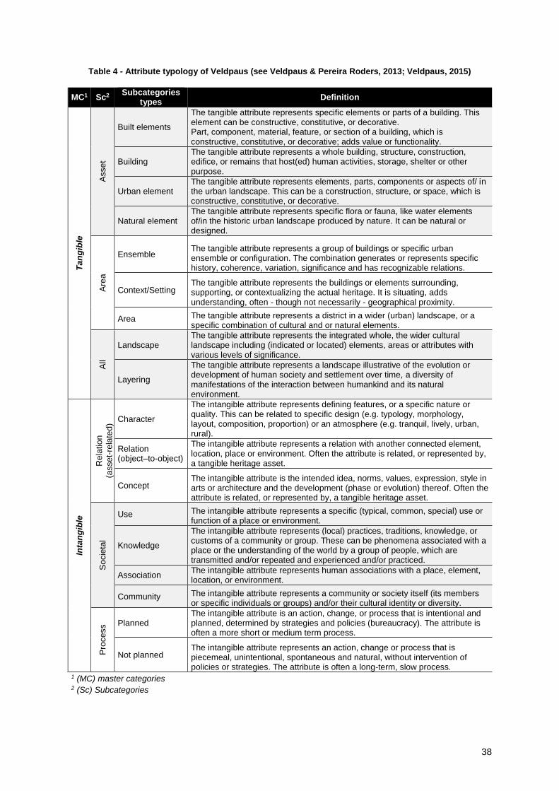
38
Table 4 - Attribute typology of Veldpaus (see Veldpaus & Pereira Roders, 2013; Veldpaus, 2015)
MC1 Sc2 Subcategories
types Definition
Ta
ng
ible
Asse
t
Built elements
The tangible attribute represents specific elements or parts of a building. This element can be constructive, constitutive, or decorative. Part, component, material, feature, or section of a building, which is constructive, constitutive, or decorative; adds value or functionality.
Building The tangible attribute represents a whole building, structure, construction, edifice, or remains that host(ed) human activities, storage, shelter or other purpose.
Urban element The tangible attribute represents elements, parts, components or aspects of/ in the urban landscape. This can be a construction, structure, or space, which is constructive, constitutive, or decorative.
Natural element The tangible attribute represents specific flora or fauna, like water elements of/in the historic urban landscape produced by nature. It can be natural or designed.
Are
a
Ensemble The tangible attribute represents a group of buildings or specific urban ensemble or configuration. The combination generates or represents specific history, coherence, variation, significance and has recognizable relations.
Context/Setting The tangible attribute represents the buildings or elements surrounding, supporting, or contextualizing the actual heritage. It is situating, adds understanding, often - though not necessarily - geographical proximity.
Area The tangible attribute represents a district in a wider (urban) landscape, or a specific combination of cultural and or natural elements.
All
Landscape The tangible attribute represents the integrated whole, the wider cultural landscape including (indicated or located) elements, areas or attributes with various levels of significance.
Layering
The tangible attribute represents a landscape illustrative of the evolution or development of human society and settlement over time, a diversity of manifestations of the interaction between humankind and its natural environment.
Inta
ng
ible
Rela
tio
n
(asse
t-re
late
d)
Character
The intangible attribute represents defining features, or a specific nature or quality. This can be related to specific design (e.g. typology, morphology, layout, composition, proportion) or an atmosphere (e.g. tranquil, lively, urban, rural).
Relation (object–to-object)
The intangible attribute represents a relation with another connected element, location, place or environment. Often the attribute is related, or represented by, a tangible heritage asset.
Concept The intangible attribute is the intended idea, norms, values, expression, style in arts or architecture and the development (phase or evolution) thereof. Often the attribute is related, or represented by, a tangible heritage asset.
So
cie
tal
Use The intangible attribute represents a specific (typical, common, special) use or function of a place or environment.
Knowledge
The intangible attribute represents (local) practices, traditions, knowledge, or customs of a community or group. These can be phenomena associated with a place or the understanding of the world by a group of people, which are transmitted and/or repeated and experienced and/or practiced.
Association The intangible attribute represents human associations with a place, element, location, or environment.
Community The intangible attribute represents a community or society itself (its members or specific individuals or groups) and/or their cultural identity or diversity.
Pro
cess Planned
The intangible attribute is an action, change, or process that is intentional and planned, determined by strategies and policies (bureaucracy). The attribute is often a more short or medium term process.
Not planned The intangible attribute represents an action, change or process that is piecemeal, unintentional, spontaneous and natural, without intervention of policies or strategies. The attribute is often a long-term, slow process.
1 (MC) master categories 2 (Sc) Subcategories

39
5.2.1.3 Stage 3 – WHAT+WHERE
To proceed with this last stage of inventory, the spatial planning tool was divided on their
different sections, which may vary according each tool, being further described for this specific case-
study (PDM).
5.2.2 Comparative analysis
Gathered analysis outcomes were compared with the results of previous research, enabling to
establish a parallel and construct a development path from previous versions, and how they addressed
heritage assets. In addition, a comparison between the results obtained from different analysed spatial
planning tools documents and stages of inventory analysis (WHAT & WHERE) was undertaken, as well
as the comparison with the outcomes of other international research.

40
6 CASE-STUDY: PORTUGAL AND PDM
6.1 CROSSING THE BRIDGE
The management of urban resources in Portugal has evolved, from a model shaped by urban
expansion policies, leading to the abandonment of consolidated areas with deep economic, social,
cultural and ecological impacts; towards a less consumer and responsible policy, focused on existing
resources, understood as actives for sustainable urban development, as has been promoted by
rehabilitation and regeneration policies70. On the other hand, threats over heritage are arising and
becoming more complex, with pressures derived from growing tourism, unsustainable globalization
externalities, or from this new attention over consolidated urban areas and its resources, traditionally
more wealthy, whether economic, social or culturally.
Meanwhile, the spectrum of conservation areas is expanding71, if we considered the rational
assumed by 2001 Heritage Law (LBPC2001) and further amendments72 , where protection zones,
considered as conservation areas, should be defined as “autonomous planning units”73 managed by
detailed spatial plans (PP), particularly safeguarding and rehabilitation plans. Recent changes in
rehabilitation legal framework74 smoothed the process, enabling the definition of Urban Rehabilitation
Areas or Operations (ARU/ORU) independently of a spatial plan.
Following the European trend that is evolving from a bureaucratic “land use planning” approach
towards “spatial planning”, more related with governance concept, as strategic, collaborative, integrative
and participatory (Ferrão, 2014.), Portugal is starting a new era in its spatial planning culture. Recent
changes in legal framework, both in the new Public Policy for Territorial Planning (Law no. 31/2014, of
30 May) and the revised RJIGT (Law no. 80/2015, of 14 May), are guiding this road to a less regulator
and more strategic one, which should have deep implications at municipal territorial plans level.
70Law Framework of Urban Rehabilitation (Lei de Bases da Reabilitação Urbana: Law n. º 32/2012, of August 14th). 71 Portugal has today more than 4000 protection zones, among 871 National Monuments (in which 15 are UNESCO WH), more than 2000 of public value, 549 of municipal value and 500 submitted to be listed (which also receive a protection zone). 72 Decree-law n. º 309/2009, of October 23rd. Establishes the listing procedures of immovable properties of cultural interest, and the legal framework for protection zones and for safeguarding detail plan. 73 Ibidem, art.41º. 74 Decree-Law n. º 53/2014, of April 8th. Exceptional and temporary framework for rehabilitation on properties (with
housing function) under 30 years or covered by urban rehabilitation areas.

41
6.2 PDM - A TOOL FROM AND FOR THE COMMUNITY
As mentioned in previous sections, PDM was selected to be the spatial planning tool to be
analysed for several reasons. First because it is the only mandatory tool binding public and private
sector, resulting from collective negotiation 75 . It is also the most comprehensive municipal plan,
embodying urban and rural areas, natural and cultural resources, making it a privileged tool to integrate
objectives for cross-sectorial policies, which should be further developed in hierarchically lower plans
(PU, PP). It is the only document within the Portuguese spatial planning system where the elaboration
and revision are mandatory (art. º98, RJIGT), being both of municipal responsibility. PDM’s main
function is the definition of the territorial model based on land classification and qualification76, as well
as, the principles, rules and criteria for uses, activities and services location, as well as to establish the
criteria for land use and public spaces use and benefit, defining also the directives that ensure
environmental quality and cultural heritage protection. Being a territorial management tool, PDM should
follow the evolution path of their local but also national context. Revisions, were, according former
RJIGT, recommended to be undertaken every decade, or when the overall conditions changed. More
than a regulatory, statutory and planning tool, PDM is now evolving to be more strategic, which besides
defining the broad development strategic options at local level for a long period, it should include
orientations and outcomes derived from “informal plans”, seen as efforts made by municipalities to close
the gaps from classic planning (Gonçalves, 2008). Moreover, new legal framework came to reinforce
this strategic function, eliminating the mandatory revision deadline, replacing it by an evaluation based
on indicators related with the level of strategic objectives accomplished (Monteiro, Valle, & Miranda,
2015).
Relative heritage resources, RJIGT indicates that PDM should define the “protection
frameworks of natural values and resources, architectural and archaeological heritage”. This
responsibility increased when the national government decided to delegate to municipalities the
management of “municipal cultural, landscape and urban heritage” becoming in charge of the
organization and management of an updated inventory (Law no. 159/99 of 14 September), and more
recently by the whole listing process of the Properties of Municipal Interest (Decree-Law no. 140/2009
of 15 June). Within the HUL toolkit, PDM shares two of the proposed four tool clusters: “knowledge and
planning tools” and “regulatory systems”. The first as it establishes “protection zones”, be performed as
zoning instruments defining land use rules and restrictions, according to their heritage attribute
categories. And also because it is a regulatory planning tool with regulatory and binding nature,
managing territorial resources and shaping both rural and urban areas.
75 Public consultation is a mandatory step on PDM design process, as established by former RJIGT (Decree-law no. 380/99, of 22 September). These sessions are opened to all community and interested actors, which any contributions must have a response by authorities in charge (municipality). 76 Introduced by the Statutory Decree n.º11/2009, land qualification, is related with the basic option of spatial planning that defines land destination (n.º2, art.º15, LBPOTU), which might be rural or urban, and within those might have other classes. Land classes should be categorized (qualified), meaning, establishes land use and use regulation (occupation, use and intervention rules). Categories might be functional or operational, having sub-categories.

42
Moreover the PDM revision process is on a growing path, had already been published between
2002 and July 19th of 2016 (DGT, 2016) 154 PDM by 153 municipalities77, representing more than a
half of the 278 composing mainland Portugal78. In remaining councils, 118 were indicated as having
PDM revision in progress, being that 6 still do not started the process (DGT, 2016). Reported data
indicate that we are at the middle of PDM revision moment, as during last three years (2013-2016),
more that 50% of the municipalities revised their PDM, and in particularly the year of 2016 where the
number of PDM revised have quadruplicated. If adding the PDM in elaboration process, we might
predict that till the end of this decade, the majority of municipalities remaining will revised their PDM,
introducing a new generation of PDM. Thus, we are in an outstanding period to assess what has been
done so far, and it is where this research is placed, which will be focused in a second cycle of PDM,
published between 2002 and 2014, constituting the studied universe and will be further detailed
scrutinized.
6.3 APPLYING PROPOSED METHODOLOGY
Although already described in the previous chapter, there is need to introduce more information
related to the followed methodology now adapted to presented case-study, namely the used sources,
which might vary from country to country.
First PDM were published between 1980’s and the beginning of the new millennium (Raposo,
2003), being in revision process till now (Fig. 9). To build the universe of this research, were identified
the PDM revised after the publication of current National Heritage Law (LBPC2001): the first general
77 Murtosa PDM has it first publication in 2002 and the revision in 2015, being both versions covered by the research period. 78 “Number of municipalities and parishes of mainland and Autonomous Regions at December 31st.” INE. Retrieved
from smi.ine.pt, accessed in September 20th of 2016.
Fig. 9 – Contextualization timeframe of both PDM surveys.

43
law combining all the regulations for cultural heritage of different typologies, predicting special measures
to protect monuments, landscapes and contexts79, and defining for the first time spatial planning tools
as heritage valorisation mechanisms, along with protection tools (listing and inventory). The end of 2014
year was selected as the closing date, as it completes the period in which analysed legal frameworks
(LBPUOT and RJIGT) were in force, had been replaced in 2014 and 2015.
6.3.1 Data collection
The National System of Spatial Planning Tools (SNIT) was the main data source used. It is an
online database, managed by the spatial planning state department (DGT), entailing all spatial planning
tools published in mainland Portugal80. Documents became available after becoming law, meaning
approved by National Assembly and published in Diário da República81, thus being a continuous
updated data-base. Therefore the first survey was over PDM, in all regions82, from which it was possible
to identify municipalities whose PDM were published between 2002 and 2014, forming the universe of
this study. It also gave access to main documents composing PDM, as well as, related amendments83.
According to RJIGT, PDM is composed by Ordinance (Regulamento), Master Plan Map (Planta
de Ordenamento) and Restrictions Map (Planta de Condicionantes), forming the category of
Fundamental Elements (Elementos Fundamentais). Ordinance is the core part of PDM, been composed
by the “statutory document” (texto do regulamento), where the rules for municipal land are described,
and often by other supporting documents in annex (hereafter Ordinance Annexes – Anexos do
Regulamento), which in the case of heritage take the form of inventories (lists) and/or cartographic
documents. While Master Plan Map, illustrates the spatial planning model for municipal territory
grounded on defined structural systems, land classification and qualification, and Planning Units
(Unidades Operativas de Planeamento e Gestão – UOPG), Restrictions Map identifies Administrative
Easements of Restrictions Land Public Use (Servidões Administrativas e Restrições de Utilização
Pública - SARUP) (which integrate legally protected heritage) and any other restrictions to land use.
Both might be unfolded in other maps according to a specific sector (e.g. National Ecological and
Agricultural Networks84, Municipal Heritage Charter, etc.). During drafting process, heritage as a spatial
resource recognized by RJIGT, is usually part of the preliminary stages of analysis and diagnosis, being
integrated in the PDM proposal report (Relatório do PDM) one of the elements compounding the
Supporting Elements (Elementos de Acompanhamento) drafted during PDM drafting or revision
process. Others supporting elements are defined by RJIGT (art. º86), as the Diagnostic Studies
79 Draft Legislation 39/VIII (2000), for LBPC2001. 80 From national, regional and local scope, including also special plans (PNPOT, POAT, POAAP, POOC, PROT, PDM, PU, PP, PIOT, Rede Natura, Rede Nacional da Água, PNRH, PGRH, PROF, PRN). 81 Platform (now digital) where all law acts approved by National Assembly are published, updated in a daily basis (https://dre.pt/ ). 82 This tool only covers Portugal mainland. Autonomous regions are responsible for their own spatial planning at regional and municipal level. 83 After a quick assessment to the amendments of sampled PDM, their integration on this study proved to be unduly as they do not add substantial changes to original published PDM (first publication or revision), having a residual impact on heritage issues, and due to the relevance of time fluctuations represented by original PDM. Therefore only original published versions were analysed. Despite of it, a briefly reference to this analysis will be part of the comparative analysis with the results obtained on 2003 survey (Raposo, 2003). 84 Rede Ecológica Nacional (REN); Rede Agrícola Nacional (RAN).

44
(Estudos de Caracterização), PDM Report (Relatório) and Operation Program (Programa de Execução)
and to which in 2005 were added the Regional Framework Map (Planta de Enquadramento Regional),
the Current Condition Map (Planta da Situação Actual), the Report and Map for Urbanistic Actions
(Plantas e Relatório dos Compromissos Urbanísticos), Noise Map (Planta de Ruído) and the
Participations and Weighting Report of Public Discussion (Relatório de Ponderação da Discussão
Pública)85 and in 2007 the Environmental Report (Relatório Ambiental)86 (see Appendix A.1). Besides,
as each municipality is free to add other type of data, supporting document typologies varies.
6.3.2 Processing data
PDM related data were categorized by municipality, location (NUTIII), publication year, and
dynamic (First Publication, Revision, and 2nd Revision). From those, were selected the ones published
till 2014, being attributed an identification code (ID code)87 forming the universe of 81 PDM of this
research (see Appendix A.2).
6.3.2.1 From universe to sampling case-studies
According to SNIT data, since the publication of current heritage national law (LBPC2001) and
the year before the latter changes in spatial planning framework (2002-2014), were published 81 PDM,
representing 29% of the 278 PDM of mainland Portugal, and constituting the universe of this research
(Fig. 10).
In order to deepen the analysis a sampling from the 81 PDM universe was taken, using two
criteria: district capitals (11) and the municipalities which were object of analysis by 2003 research
85 Portaria n.º 138/2005 de 2 de Fevereiro 86 DL n.º 316/2007, de 19/09 87 To each PDM was attributed a code, composed by last two digits of publication/revision year and municipality name abbreviation, e.g. Porto (06PRT).
Fig. 10 – Location of both universe of 81 PDM and sample of 18 PDM.

45
(Raposo, 2003) to PDM of first generation88 (8 from 33). It resulted into a sample of 18 PDM case-
studies (see Appendix A.2), representing 22% of the defined universe, being represented every
mainland Portugal regions (NUT II), excepting to Algarve region (as occurred for PDM selected
universe)89.
Moreover, three important realities are represented in the sampling. First because it includes
two municipalities where he PDM manages uniquely urban land, as the municipal territory matches with
the totality of urban perimeter (Porto and Lisboa). Further issues are more related with heritage issues,
being that three of the eighteen identified councils are World Heritage cities (Coimbra, Porto and Évora)
and another one that despite not fitting in this international category embodies heritage with the same
listing level (Lisboa). At the extreme point of view, this sampling also integrates a municipality without
listed heritage (Vagos), having been analysed in the 2003 survey, but which this characteristic was not
revealed. Therefore, this sampling may be representative, if considering these terms: includes PDM
covering uniquely urban land, PDM of cities with the higher international heritage listing level and, in
contrast, PDM without listed heritage.
6.3.2.2 Inventory
6.3.2.2.1 WHAT+WHERE
As mentioned before, Veldpaus policy analysis tool (2015) was the attribute typology applied
by this approach. However, some changes had to be introduced in order to adapt it to case-study, either
to the characteristics of case-study document (PDM) and its comprehensiveness, covering all built and
natural resources located in municipal territory, and to the different interpretations and concepts to
heritage, derived from LBPC2001. The adaptation resulted not only into adding “new categories”90 but
also on the enrichment of existing ones (e.g. when properties are discriminated by use (religious, civil,
etc.), following for what was defined by Bernardes (2014) those were integrated in Veldpaus attribute
category of “intangible-social-use/function”. Therefore, attribute categories such as “natural element”
had to be adapted, being only considered when associated to heritage issues/references (e.g. “cultural
and natural heritage values”). In addition, protection zones, predicted by LBPC2001 for legally protected
properties (listed or submitted to be listed) were considered as Veldpaus (2015) subcategory “Context”
(Tangible>Area>Context), as the management is extended to the area and not restricted to the asset.
The introduction of new categories, besides the “undefined” described before, were related with the
ambiguous terms used by LBPC2001 influenced by international doctrinal documents, and replicated
in PDM (e.g. monuments, building assembles and sites; immovable and movable heritage;
archaeological, architectural heritage, etc.).
Lastly, regarding PDM sections (WHERE), those are established according to PDM chapters
or article titles, which more or less are common to every PDM. According to it, this research defined
seven distinct PDM sections (Table 5), which go from strategic chapters (“obj&strat”), to restrictions
88 Portalegre fullfils both criteria. 89 Only one council (Lagos) ratified a PDM recently (September, 2015), being although, a First Publication. 90 Refers to “undefined” category, which is not an actual category by the reference of it ambiguity.

46
(including the legally imposed restrictions known as SARUP, derived from listed properties and
respective protection zones: and the “protection systems”, a unformal framework were heritage
properties categories are described according legal protection, scale or nature criteria).
Table 5 – PDM sections used in WHAT+WHERE analysis
PDM section Description
Plan content Lists the PDM elements, distinguished between fundamental and supporting elements;
Obj&strat. Lists the strategic aims of PDM to the territory;
PMOT Lists the IGT in force and that should be considered;
Glossary Lists definitions relevant to the plan;
Land use Definition of classes and categories of land use and related rules;
Restrictions Legal restrictions (SARUP) and the ones imposed by the plan (protection system);
Exe&prog. PDM chapter where is described the execution strategy of the plan.
6.3.2.3 Comparative analysis
Along with the comparison between PDM results and international literature, findings were also
compared with the results obtained by Almada Archaeology Centre in 2003 (Raposo, 2003), about
heritage and first generation PDM. Despite using different criteria and terminology, often ambiguous
(e.g. “other documentation” is unclear regarding which document it entails - annexes and/or supporting
elements), results are generally comparable by the presence of heritage evidence in different PDM
components.

47
7 HERITAGE ISSUES IN PDM
The preliminary content analysis (Table 2) applied to the 81 PDM published between 2002 and
2014, revealed that all analysed PDM contain references to heritage issues. As described before, this
universe was further resumed to a sample of 18 PDM, in order to narrow the analysis to PDM elements
and heritage attribute categories.
The results are presented in three parts: WHERE – PDM components; WHAT - Attribute
categories; WHERE – PDM section. The first part was further subdivided between the outcomes derived
from the analysis of the ordinance statutory article “PDM content” (PDM content – a theoretical preview)
and the analysis of actual available PDM elements (see Appendix A.1), divided between the
fundamental and supporting elements. The elements identified with references to heritage (HRE) were
recognized by using the 7 keywords content analysis (Table 2). This point ends with a brief analysis
over the amendments that have been made to PDM, which were also object of analysis in 2003 survey.
Besides an overview of this generation, this general analysis enabled further comparison with the
outcomes retrieved in 2003 from PDM first generation (Raposo, 2003), being further discussed.
For a more in-depth analysis, results from the identification of attribute categories (WHAT –
Attribute categories) are only present in ordinance documents. Once again, results are present from
general to specific, meaning that first results are discussed on a perspective to understand which
attribute categories are represented. Further is presented the relation between the identified categories
and the section PDM where they were found (WHERE – PDM section).
7.1 INVENTORY
7.1.1 WHERE – PDM components
7.1.1.1 PDM content – a theoretical preview
Every PDM ordinance statutory document includes an introduction article listing all the elements
composing it – “PDM content”. It gives a “theoretical” overview about the presence of heritage issues
in PDM components, either in fundamental (FE) or supporting ones (SE). As the analysis to this PDM
section only considered the titles and not the content of mentioned documents, this only refers to PDM
elements specific to heritage, excluding general documents, which an analysis of its contents may
reveal the inverse. This is the case, of fundamental elements, in which were only identified heritage
references in ordinance annexes and unfolded maps (maps defined for a specific thematic), as well as
to the supporting elements.
This explains the low percentage of PDM where heritage issues were identified in fundamental
documents (22%), contrasting with the 44% in supporting documents (Fig. 11), which increases if we
consider the three PDM mentioning heritage in both. Lastly, three PDM do not indicate any reference
to heritage issues in this PDM article.

48
References to heritage in the titles of fundamental elements (FE) were identified in two PDM
referring ordinance annexes. Regarding fundamental unfolded cartography, from the twelve PDM with
unfolded masterplan maps, three are related to heritage, and for the twelve PDM with unfolded
restrictions maps, two redirect to heritage (Fig. 12). Due to the specific nature of supporting elements
(SE), the identification of heritage references at the title is facilitated. Being described in every PDM,
supporting elements mentioning heritage issues where identified in eleven PDM. Those, seven refer
supporting cartography focused on heritage, and three in heritage lists (two PDM have both). Regarding
PDM Diagnosis Report, when the volumes are described, four present heritage references
(accumulating with lists or cartography). Lastly, in this sample three PDM indicate Heritage Municipal
Charters, which might include previous elements, but only an analysis of it content will confirm. Overall
(Fig. 12), results indicate heritage references in fundamental elements in four PDM, eight for supporting
elements, three for both, and also three with any references to heritage in this article.
7.1.1.2 PDM content - available documents
As explained in methodology, the data to proceed with this analysis were collected either in
municipalities’ website or by direct contact with the regard departments. Documents were analysed by
using the 7 keywords content analysis (Table 2), aiming only to identify the PDM elements with
references to heritage, being the nature of these references ignored. Only the documents, not displaying
any reference to heritage in the title were analysed on its content (e.g. key maps of general cartography,
PDM reports, etc.). Moreover, though presenting the results by PDM, this analysis do not attempt to
evaluate or rank PDM or councils, but illustrate the various combinations that PDM might adopt to
represent heritage issues.
0 1 2 3 4 5 6 7 8
(FE) Ordinance annexes
(FE) UMM
(FE) URM
(SE) Lists
(SE) Cartography
(SE) Municipal Heirtage Charter
(SE) Diagnostic Report
PDM (no.)
Fig. 12 - “PDM content” article
22% 44% 17% 17%
Fundamental Elem. Supporting Elem. FE+SE No references
Fig. 11 - Percentage of PDM with references to heritage on “PDM content” section.
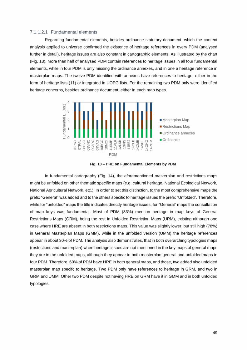
49
7.1.1.2.1 Fundamental elements
Regarding fundamental elements, besides ordinance statutory document, which the content
analysis applied to universe confirmed the existence of heritage references in every PDM (analysed
further in detail), heritage issues are also constant in cartographic elements. As illustrated by the chart
(Fig. 13), more than half of analysed PDM contain references to heritage issues in all four fundamental
elements, while in four PDM is only missing the ordinance annexes, and in one a heritage reference in
masterplan maps. The twelve PDM identified with annexes have references to heritage, either in the
form of heritage lists (11) or integrated in UOPG lists. For the remaining two PDM only were identified
heritage concerns, besides ordinance document, either in each map types.
In fundamental cartography (Fig. 14), the aforementioned masterplan and restrictions maps
might be unfolded on other thematic specific maps (e.g. cultural heritage, National Ecological Network,
National Agricultural Network, etc.). In order to set this distinction, to the most comprehensive maps the
prefix “General” was added and to the others specific to heritage issues the prefix “Unfolded”. Therefore,
while for “unfolded” maps the title indicates directly heritage issues, for “General” maps the consultation
of map keys was fundamental. Most of PDM (83%) mention heritage in map keys of General
Restrictions Maps (GRM), being the rest in Unfolded Restriction Maps (URM), existing although one
case where HRE are absent in both restrictions maps. This value was slightly lower, but still high (78%)
in General Masterplan Maps (GMM), while in the unfolded version (UMM) the heritage references
appear in about 30% of PDM. The analysis also demonstrates, that in both overarching typologies maps
(restrictions and masterplan) when heritage issues are not mentioned in the key maps of general maps
they are in the unfolded maps, although they appear in both masterplan general and unfolded maps in
four PDM. Therefore, 60% of PDM have HRE in both general maps, and those, two added also unfolded
masterplan map specifc to heritage. Two PDM only have references to heritage in GRM, and two in
GRM and UMM. Other two PDM despite not having HRE on GRM have it in GMM and in both unfolded
typologies.
0
1
2
3
4
06P
RT
07P
AL
08E
VO
08V
NC
09A
RC
09V
AG
10B
GC
10M
OI
11S
MP
11V
LR
12LS
B
13V
IS
14B
EJ
14C
LB
14C
MB
14N
EL
14O
HO
14P
OM
Fu
nd
am
en
tal E
. (n
o.)
PDM
Masterplan Map
Restrictions Map
Ordinance annexes
Ordinance
Fig. 13 – HRE on Fundamental Elements by PDM

50
7.1.1.2.2 Supporting elements
To analyse supporting elements, it is important to be aware that despite (some) being described
in PDM content article, not all of them were available. In fact, the main source resource of this research
(SNIT) only contains fundamental elements, being the supporting documents available either in
municipalities’ website or by requiring it directly to municipal departments (some of them nor were
described in PDM content article, had been found in mentioned sources). Therefore, only 80% of
sampling municipalities facilitate these elements (10% partially). Again, some of the supporting
elements indicate in the title their thematic, enabling it identification as heritage related (e.g.
cartography, lists, Municipal Heritage Charters). Others, more general, such as PDM report, diagnosis
studies, public discussion reports, spatial planning periodic reports (REOT) 91 or strategic reports,
obliged a skimmed review of its content. Crossing both approaches, the results indicate that every PDM
sample has references to heritage issues in their supporting documents (Fig. 15), although some of
those, despite mentioned in PDM content article, were not provided.
None of the PDM have heritage references in every identified supporting elements types.
Nonetheless, one PDM stands out with five different documents and three PDM with four documents,
sharing the fact to have references in PDM report and in the report resulted from public discussion.
91 Relatório do Estado do Ordenamento do Território (REOT)
0
1
2
3
06P
RT
07P
AL
08E
VO
08V
NC
09A
RC
09V
AG
10B
GC
10M
OI
11S
MP
11V
LR
12L
SB
13V
IS
14B
EJ
14C
LB
14C
MB
14N
EL
14O
HO
14P
OMC
art
og
rap
hy e
lem
en
ts
(no
.)PDM
GRM URM GMM UMM
Fig. 14 – HRE on fundamental cartography.
0
2
4
6
8
10
06P
RT
07P
AL
08E
VO
08V
NC
09A
RC
09V
AG
10B
GC
10M
OI
11S
MP
11V
LR
12L
SB
13V
IS
14B
EJ
14C
LB
14C
MB
14N
EL
14O
HO
14P
OM
Su
pp
ort
ing
ele
me
nts
(n
o.)
PDM
Specific Heritage Cartography
Heritage list
Diagnosis studies
Municipal Heritage Charter
Cartography report
REOT
Public discussion report
SARUP list
PDM Report
Strategic report
Fig. 15 - HRE on PDM Supporting documents by PDM

51
Further, five PDM share references to heritage in three documents, three PDM in two documents and
the remaining six PDM in just one document. Cartography specific to heritage is the most common
supporting document being present in half of PDM, followed by PDM report with HRE in eight PDM and
by Diagnostic studies and the public discussion report (7 PDM) and in six PDM the heritage lists. On
the other side, identified in two PDM are the Municipal Heritage Charters and REOT with heritage
references. Cartography report, SARUP list and the strategic report containing heritage evidence were
identified one single time, but always cumulatively with other supporting documents. In fact, PDM report
(2), cartography (3) and REOT (1) are the only documents appearing solely in six PDM.
The purpose of this analysis was to give an overview of the presence of heritage issues in the
full structure of PDM. Being assumed its superficiality, the results indicate the potential of a deeper
survey of this territorial tool, similar to what is further proposed to ordinance statutory document.
Not being static tools with an average length more than a decade, PDM are usually subjected
to successive amendments. Those might have various natures (Gusmão, Oliveira, & Catita, 2011),
taking the form of simple material corrections, rectifications, context change or in order to adapt to new
upper or lower territorial plans influencing PDM (e.g. PROT, PP, PU). In this sampling, the amendments
published until end-2014 appeared in eight PDM, from those five introduced amendments related with
heritage issues. Those amendments can be resumed to the identification and/or introduction of new
elements with heritage value, the attachment of new rules regarding a specific intervention type in areas
with heritage value (e.g. new construction), the definition of execution mechanisms for UOPG with
heritage value, material simplifications and corrections, as well as, the change of land use category.
7.1.2 WHAT – PDM statutory ordinance document
Further the analysis will be focused in one single document – ordinance statutory document –
which previous analysis confirmed as the only PDM element in which HRE were identified in every
PDM. Being articles with HRE isolated (preliminary analysis using heritage-related keywords – Table
2), named “qualifying articles”, their content was further analysed using the attribute category typology
described in literature review and methodology chapters (Table 3).
The nature of PDM ordinance statutory document obliged
to the addition of a pre-level (level 0) of analysis entailing as
variables the “attributes” (A) and “categories of attributes” (AC). As
the ordinance document is intended to develop to be more
strategic and thus more comprehensive, categories of attributes
are expected to be more frequent than references to attributes. In
fact, results (Fig. 16) came to confirm this prediction, indicating that
attributes appear only cumulatively with attribute categories (14),
and those are singly referenced in three PDM. Nonetheless, when
the account is done by HRE identified to each PDM (see Appendix
A.3), the results indicate the dominance of attribute categories in
22%
78%
A
AC
A+AC
Fig. 16 – Level 0: Ratio of PDM where HRE are attributes,
categories of attributes or both.

52
every PDM (ranging from 68% to 100%), being attributes in 14 PDM, ranging from 31% to 4%. HRE
combining both overcaching categories appear residually in two PDM.
7.1.2.1 Level 1: two master categories of attributes
Being the application of attribute typology complete, results
at the first level reveal a majority of PDM (78%) conveying HRE with
both tangible and intangible categories (T+I). Singly, were only
identified tangible categories, meaning also that there is no
references to intangible heritage issues in three PDM. Not being a
category, but the absence of it, was added a third “hypothesis” for
HRE which the nature is ambiguous (undefined), such as “heritage”,
“cultural heritage”, “cultural values”, “cultural and landscape values”
“historic, natural and landscape heritage”, “cultural, natural and
landscape heritage”, "heritage value" or "heritage system". Those
were identified in every PDM (Fig. 17).
7.1.2.2 Level 2: six attributes sub categories
In the second level, both master categories were divided: three sub categories to tangible
category and three to intangible (Table 3). Again a fourth “hypothesis” was added this time to tangible
attribute subcategories, to code expressions which although indicating a material category the detailed
nature is unclear, e.g. immovable, built, architectonic, archaeological, built elements/heritage/values92,
etc. Those ambiguous expressions were identified in every PDM (Fig. 18).
Tangible subcategories prevail as the most referenced, for which contributed subcategories of
asset and area, universal to the entire sample. The same cannot be said for tangible subcategory of
landscape (“all”) identified in five PDM, while intangible subcategories of asset-related (“relation”) and
92 The expression “values” acquires different meanings on PDM. If sometimes it corresponds to the cultural value inherent to any heritage attribute, it is also used to refer the set of properties (attributes) with cultural value covered by municipal territory, and then considered as a tangible attribute category.
02468
1012141618
UN T I T+I
PD
M (
no
.)
Macro attribute categories
Fig. 17 - Level 1: Tangible VS Intangible
0 2 4 6 8 10 12 14 16 18
(T) Undefined
(T) Asset
(T) Area
(T) All
(I) Relation
(I) Societal
(I) Process
PDM (no.)
Attribute
s
subcate
gories
Fig. 18 - Level 2: six attribute categories

53
“societal” were identified in 15 and 8 PDM, respectively. Lastly, process intangible sub category were
the least referenced category type, had been identified in one PDM.
7.1.2.3 Level 3: eighteen categories of attributes types
The last level of analysis broke previous six sub categories of attributes into eighteen sub
categories types (Table 3): on the side of tangible, four types to asset, three to area, two to landscape
(all); and to intangible, three types to asset-related, four to societal and two to process (Fig. 19).
Unlike level 2, none of these level 3 sub categories types are universal to all analysed PDM.
However, the three sub-categories related with tangible-area (“ensemble”, “context”, “area”) were
identified in 94% of analysed PDM. “Ensemble” is related with the historic-centres or built ensembles,
being categories deeply disseminated by international doctrine and transposed to national legislation.
Also “context”, as here interpreting legally protection zones as conservation areas, derived from the
listing process and a restriction imposed to be translated and managed by PDM. “Areas”, being defined
as homogenous spaces where natural and cultural elements converge, and then frequently coding
evidence related with gardens, farms, etc.
The second most referenced category type is intangible and refers to the “character” of the
place, meaning the image or atmosphere perceived from a certain tangible attribute (e.g. “city image”,
“morphology”, “historic centre silhouette”, “visual access and reading of properties”, etc.). This
intangible category type stands out among their likes, had been identified in more than 80% of analysed
PDM.
Yet, inside of tangible categories, “buildings” (e.g. buildings, houses, etc.) appears as the third
most referenced category type with 72%, followed by “natural elements” (natural elements identified
along with cultural heritage e.g. “trees of public interest”, “geological monuments”, etc.) represented
also in more than a half of analysed PDM (67%).
Then, evidence such as façades, masonry, tiles and the chromaticism constituting “built
elements” type were found in 44% of PDM, followed by “urban elements” (e.g. “isolated elements”,
walls, aqueducts, wells, railway platforms, squares, chimneys, ponds, noria, traditional ovens, etc.)
mentioned in 33% of analysed PDM.
Yet, the sub categories types of “landscape”, associated with a holistic perspective of a certain
area, result from the interaction of human and natural factors (e.g. “design of spontaneous character
adapted to land features and topography”, “global image of the City and Historic Centre”), and “layering”,
related with attributes indicating a certain evolution (e.g. “spatiality resulted from historic moments”,
“urban areas built in different periods, since 18th century up to now”), are the least referenced tangible
sub categories, appearing in 17% of PDM.
As stated before, excepting for “character” mentioned in more than 80% of PDM, intangible sub
category types are clearly underrepresented, when not absent (community-societal). None of them was
identified in more than three PDM, being the lowest ratio identified for tangible categories. Represented
in three PDM (17%), are three sub categories types, divided between “relation” (“concept”) and

54
“societal” (“use”; “knowledge”) level 2 sub categories. Further, presented in two PDM are “association”
(“societal”) and “planned” (“process”), followed with the least identified types: “relation” and “unplanned”.
7.1.3 WHERE + WHAT – Section analysis
Further, the results are presenting comparing WHAT and WHERE analysis results, by using
the same three analysis levels from WHAT approach. Defined sections (Table 5) are slightly universal
to all PDM, although, the location of heritage evidence is not universal. In fact, the presence of HRE is
almost universal to all PDM in “restrictions” section93, followed by “Plan Content” and “land use” present
in more than 80% of PDM, and “Exe&Prog” and strategic chapters in 72%. Remaining sections, “PMOT”
and “Glossary”, HRE are represented in less than the half of PDM (Fig. 20).
93 Missing Vagos PDM as it has not legally protected properties.
0
2
4
6
8
10
12
14
16
18
Bu
ilt e
lem
en
ts
Bu
ildin
g
Urb
an e
lem
en
t
Na
tura
l ele
me
nt
En
se
mb
le
Co
nte
xt/S
ett
ing
Are
a
Lan
dsca
pe
Laye
rin
g
Ch
ara
cte
r
Re
lation
Co
nce
pt
Use
Kn
ow
led
ge
Asso
cia
tio
n
Co
mm
unity
Pla
nn
ed
No
t pla
nn
ed
(T) Asset (T) Area (T) All (I) Relation (I) Societal (I) Process
PD
M (
no
.)
Attributes subcategories types
Fig. 19 - Level 3: eighteen categories of attributes types
13
16
15
13
17
5
3
Obj&Strat
Plan content
Land use
Exe&Prog
Restrictions
Glossary
PMOT
PDM (no.)
PD
M s
ectio
ns
Fig. 20 - Amount of PDM in which were identified heritage-related evidences by PDM section.

55
Being PDM a multidisciplinary tool, defined sections are broad covering other scopes than
heritage. As illustrated by figure (Fig. 21), while this generalist nature is universal to all defined PDM
sections, two sections – “land use” and “restrictions” – include chapters uniquely focused in heritage
issues.
Also, restrictions section had revealed
another issue related with the protection
system mentioned by CCDR-Centro document
(Grego & Gabriel, 2016). In fact, as restrictions
(Fig. 22), heritage issues may occur as an
administrative condition (SARUP) derived from
listing processes (1) or as a protection system
(3) or as both (13). This protection system
works as a kind of municipal heritage
framework, in which heritage issues are
structured according to different criteria from
legal protections (e.g. listed properties, identified and proposed to be listed), nature (e.g. architectonic,
archaeologic, natural) or scale (e.g. great ensembles, ensembles, single structures).
7.1.3.1 Level 1: two master categories of attributes
The chart (Fig. 23) is clear demonstrating the prevalence of tangible categories, being not only
the unique master heritage attribute category referenced in every PDM section, but also standing alone
in “Plan content”, “Glossary” and “PMOT” sections. Although represented always less than material
attribute categories, intangible categories were identified in four of the seven defined PDM sections:
one (“obj&strat”) uniquely along with tangible categories, and on the remaining sections together and
solely. As one-off references, intangible categories appear in “land use” section in five PDM,
13
0
16
0
15
8
13
0
15 15
5
0
3
0
genera
l
Herita
ge e
xclu
siv
e
genera
l
Herita
ge e
xclu
siv
e
genera
l
Herita
ge e
xclu
siv
e
genera
l
Herita
ge e
xclu
siv
e
genera
l
Herita
ge e
xclu
siv
e
genera
l
Herita
ge e
xclu
siv
e
genera
l
Herita
ge e
xclu
siv
e
Obj&Strat Plan content Land use Exe&Prog Restrictions Glossary PMOT
PD
M (
no
.)
PDM sections
Fig. 21 - Amount of PDM with single articles addressed to heritage issues (heritage exclusive).
SARUP6%
Protection system
18%
Both76%
Fig. 22 – Discrimination inside “restrictions” PDM section, between SARUP and protection system.

56
“restrictions” in three PDM, and “Exe&Prog” in one PDM. Undefined, not being a category but
representing the absence of it, was identified as the second most referenced “category” in most of PDM
sections, being absent in “Glossary” and “PMOT” sections.
7.1.3.2 Level 2: six attributes sub categories
As illustrated by further chart (Fig. 24), “land use” and “restrictions” are the PDM sections where
all heritage sub categories are represented and with similar values. “Exe&prog” is the third section in
which only “process” sub category is absent, followed by strategic section representing both tangible
subcategories “asset” and “area”, as well as the intangible “relation” in one PDM. Further are “plan
content” and “glossary” sections, with two sub categories (asset and area), and finally “PMOT”
representing solely “area” attribute sub category. HRE representing tangible values, but for which were
impossible to ascribe any Veldpaus (2015) attribute sub categories (undefined), were identified in
almost every section in a high number of PDM, being absent in the PDM section (“PMOT”) that refers
the management of this attribute category to other detailed spatial planning tools (PP/PU).
Again, HRE coded as “area” is clearly the most referenced in the majority of PDM sections,
excepting strategy chapters and “glossary”, in which “asset” sub category matches with “area” as well
0
2
4
6
8
10
12
14
16
18
Obj&Strat Plan content Land use Exe&Prog Restrictions Glossary PMOT
PD
M (
no
.)
PDM sections
(T) Undefined (T) Asset (T) Area (T) All (I) Relation (I) Societal (I) Process
Fig. 24 - Level 2: six attributes sub categories by PDM sections
0
2
4
6
8
10
12
14
16
18
Obj&Strat Plan content Land use Exe&Prog Restrictions Glossary PMOT
PD
M (
no
.)
PDM sections
UN T I T+I
Fig. 23 - Level 1: Tangible VS Intangible by PDM sections.

57
as takes the lead, being the second most referenced sub category. Along with “asset”, appears the
intangible sub category of “relation”, being the third most referenced in all sections with intangible
categories identified (“land use”, “restrictions”, “exe&prog”, “obj&strat”). “Land use”, “exe&prog” and
“restrictions” are also the only sections in which remaining tangible and intangible sub categories were
identified, missing uniquely subcategory “process” in “exe&prog” section.
7.1.3.3 Level 3: eighteen categories of attributes types
As was verified by previous WHAT analysis results, “community” sub category type is absent
in every analysed PDM (Fig. 25), being “land use”, “restrictions” (15) as well as “exe&prog” (9) as the
sections with more identified heritage attribute typologies. Again “area” related types prevail over others,
being referenced, through ensemble type in every PDM section.
Indeed, “ensemble” is the most referenced attribute type in almost every PDM section,
excepting for “restrictions” in which is exceeded by attribute typologies related with the context, by “area”
in “land use section and by “natural elements” in strategic chapters. The dominance of “natural element”
type, mainly in strategic chapters and “plan content” section, is explained by the presence of ambiguous
expressions such as “cultural and natural heritage” (património cultural e natural), mixing both undefined
cultural (level 1) evidence and natural elements, coded as such. The presence of “character” type
confirms the weight verified before for “relation” subcategory, being the most referenced intangible
category type and even more than remain material types, such as building type. “Built elements” and
“building” typologies, only appear in definitions, “land use”, restrictions and action (“exe&prog”)
0
2
4
6
8
10
12
14
16
Obj&Strat Plan content Land use Exe&Prog Restrictions Glossary PMOT
PD
M (
no
.)
PDM sections
(T) Asset Built elements (T) Asset Building (T) Asset Urban element
(T) Asset Natural element (T) Area Ensemble (T) Area Context/Setting
(T) Area Area (T) All Landscape (T) All Layering
(I) Relation Character (I) Relation Relation (I) Relation Concept
(I) Societal Use (I) Societal Knowledge (I) Societal Association
(I) Societal Community (I) Process Planned (I) Process Not planned
Fig. 25 - Level 3: eighteen categories of attributes types by PDM sections

58
chapters, while “urban elements” is referenced all those except in action sections. Landscape holistic
types (“landscape”, “layering”) occur in “land use”, action (not “lyering”) and restrictions articles.
On the side of intangible category types, “land use” and “restrictions” are again the PDM
sections where more category types were identified and for many the only reference. Nevertheless,
execution sections also include intangible types indicating a period of time or an artistic trend
(“concept”), appearing also on restrictions articles, and traditional built practices (“knowledge”), which
also are mentioned as a land class (“land use”). Remain intangible category types referring cultural
events (“association”) or related with management processes appear all in “land use” and “planned”
type in restrictions section.
7.2 COMPARATIVE ANALYSIS AND RESULTS DISCUSSION
The content analysis to the PDM published after LBPC2001 till 2014 indicates heritage issues,
as a common represented issue. This is the first signal of a change from the first PDM generation (1985-
2003), which identified few PDM without heritage references (e.g. Arouca). The analysis by PDM
elements (Fig. 26), also confirms this growing integration of heritage issues, reaching the 100% in
cartographic and ordinance documents, as well as in “other documentation” (assumed as every PDM
documents besides the aforementioned). Despite, this positive evolution is probably more related with
the full application of RJIGT orientations, meanwhile ratified (1999), than a growing of awareness of
decision-makers.
As recommended by 2003 survey, this new cycle introduced specific cartography for heritage
issues, had been registered in fourteen PDM, from unfolded fundamental to supporting cartography.
Meanwhile, regarding amendments, present research stands out two types of amendment indicating a
progressive improvement of heritage list and then identification, and the introduction of heritage issues
in operational stage of PDM. These results contrast with 2003 findings which the identified amendments
related with heritage issues, respected to the replacement of the historic character predicted to a public
facility and the extension of historic centre limits due to PPS publication.
Fig. 26 - Identification of heritage issues on PDM composed parts: comparison between both surveys (2003 and 2017).

59
The comparison between the “theoretical content” (Fig. 12) and the documents actually
available (Fig. 13), demonstrates that if some of them were unavailable, meaning those mentioned in
“PDM content” article but not provided, others showed the inverse. This is clearer in supporting
elements rather than in fundamental elements, in which are indicated the same documents for the same
PDM in both contents (theoretical and practical). Exception for the two ordinance annexes, which
despite being indicated in “PDM content” article as fundamental elements, they were considered by this
research as supporting elements, as they do not meet the definition of ordinance annexes assumed by
this research94. Still regarding supporting elements, the analysis to actual documents revealed not only
HRE in general documents (6) which were ignored in “PDM content” article analysis, as well as more
PDM with HRE on the four documents typologies aforementioned on theoretical content. This might be
related with subsequent amendments to PDM after revision, when those elements were added.
Regarding the results gathered from actual documents (Fig. 13;Fig. 15), the analysis revealed
ordinance statutory document as the one-off PDM component in which heritage issues are always
mentioned, validating it as the selected PDM document to be the object for a more in-depth analysis.
Once one of the studied municipalities is known for the absence of legally protected heritage (Vagos),
being the only PDM without HRE in restrictions maps, it can be stated that this PDM cycle is more
comprehensiveness regarding heritage, including not only legally protected heritage properties (listed)
but also other inventoried (identified). More than half of PDM mention heritage in the all four documents
categories of fundamental elements, and the other half have references to heritage at least in ordinance
and cartographic documents. Regarding ordinance annexes, not being a mandatory document, the
sample shows that every time it is presented, heritage issues are referenced (heritage lists), and when
not identified in fundamental elements, they are often assumed as a supporting document.
In fact, every PDM has references to heritage in supporting documents, which besides to
confirm the compliance with the legal recommendations, stating that PMOT should identify heritage
properties, corresponds to what the HUL approach defines as the first step to heritage management
(Fig. 1) – “mapping resources”, meaning specific heritage maps, heritage lists, SARUP lists, i.e., identify
and locate heritage. The HRE in other documents such as the Diagnosis Studies, REOT, PDM report
and strategic report, indicates the potential of this spatial planning tool to allocate other approach steps
proposed by HUL Recommendation (e.g. (3) assess vulnerabilities, (4) define strategies).
The content analysis applied to PDM statutory ordinance document (regulamento) confirmed
the prevalence of categories of attributes over attributes, which only appear cumulatively with
categories. Thus, the ordinance document, as stated by RJIGT means to establish the general land use
rules, being the resources mapped (identified and located) in supporting elements, as confirmed by
previous analysis.
94 This research assumes as ordinance annexes the documents associated and delivery with ordinance statutory document, and thus available on SNIT. Therefore, the annex documents referenced on PDM content article for Lisboa and Moita, being individual documents and not available on SNIT, were considered as supporting documents.

60
Similar results were found in the second stage analysis (WHAT), where tangible categories are
common to all PDM, while intangible only appear cumulatively with those, being absent in three PDM.
This confirms the tangible-driven orientation disseminated by spatial planning policies and legislation,
where the reference to intangible heritage is not developed. However, the identification of categories
related with intangible attributes, besides not universal, have still an outstanding weight (14 PDM),
demonstrating that local planning, meaning PDM, is considering intangible relations derived from their
material resources (e.g. morphology; city image; hill silhouette, etc.), besides of what is predicted by
RJIGT, and following the overarching understanding over heritage attributes disseminated by
LBPC2001 (Table 1).
While in Gutscoven comparative analysis “asset” subcategory was the most represented (due
to “building” type), in this study all the three subcategories types forming “area” subcategory are the
most represented being present in 17 PDM. This shapes the zoning nature of PDM, i.e., the resources
and territory is managed as a sum of fragments. In particular, heritage is translated in these plans by
the identification of protection zones (described along with other restrictions areas – SARUP), the
location of historic areas (historic centres), or natural environments surrounding heritage assets. But,
the “asset” subcategory is the next most represented subcategory, being along with “area” represented
in every analysed PDM. Besides the expected “building” type, it is relevant the score gathered by
“natural elements”, meaning a close interconnection between cultural and natural heritage, and by the
type “built elements”, which indicates that PDM are increasing the scale to elements such as façades,
or painting which was expected just in detailed plans (PPS), where urban parameters and ratios should
be defined.
On the other hand, results indicate that the landscape perspective over the territory is in terms
of categories very far way. Heritage areas are still see as fragments of the territory, that should be
managed independently, and not as something that is part of it and evolve with it. It is a consequence
of long used zoning practices, criticized by Portas (1985) and indicated as one of the causes of the
conflicts between conservation and development. On the other hand, the high score gathered for
“character” intangible attribute (higher than “asset” types) indicates that local stakeholders are aware
of the relevance of the preservation of the intangible attributes such as the “image of the city”, meaning
the relations between tangible attributes placed at the same area (“character”). Although less scored,
the identification of evidence of relations with other assets placed in a different space (“relation object-
to-object”) or other mind set (“concept”), are also relevant, meaning that there is a recognition and
valorisation of the subjective perspective of urban landscape.
Though represented in less than half of analysed PDM, were also identified the categories
types related with societal attributes, being what is internationally known as “intangible heritage”
(UNESCO, 2003), as the “shops with historic and artistic character” that retain the use from another
age, or the traditional building practices (“knowledge”), as well as the preservation of a place because
it is related with a festive event (“association”). While Gutscoven (2016) was enabled to identify the
subcategories types “association” and “relation object-to-object” in its comparative analysis to World

61
Heritage Cities, this research only missed the attribute type related with the identification of a particular
community (“community”).
The categories related with the management of the city (“process”) meaning the valorisation of
planning processes, planned or not, are also residual, but again their identification constitutes already
a step and a warning over the existence of these attributes, that should be considered in management
processes.
The presence of a high ratio of “undefined” expressions, clearly derived from legislation (also
ambiguous) which may lead to “ambiguous” interventions. The unknown is the first door to free
interventions. The ambiguity of terms used to mention heritage was already identified by 2003 survey,
namely referring to non-listed elements, e.g. "historic, architectonic, urban and environmental value",
"notable building and archaeological sites", "relevant significance", "heritage value", "cultural spaces".
Regarding section analysis, stands out section “restrictions” where almost every PDM (94%)
have references to heritage issues, closely followed by “plan content” and “land use” sections in more
than 80% of sampling case-studies. “Land use” and “restrictions” are also the only sections in which
heritage issues are addressed in specific articles. Restriction sections, as aforementioned, entails the
identification of legally protected heritage issues (listed, submitted to be listed and regarding protection
zones) legally constituting administrative restrictions (SARUP) and thus mandatory to be identified in
spatial planning tools; and a protection system for heritage issues, which likely to “Municipal Ecological
Framework”, works as a restriction introduced by the plan. This, in fact, might be the “protection system”
mentioned by RJIGT or the “heritage framework” recommended by the CCDR-Centro technical report
(Grego & Gabriel, 2016).
The results gathered from the combination of PDM sections (WHERE) and the attribute
categories analysis (WHAT), reveals that not only tangible categories are the common feature to every
section, as the intangible categories are considered either in “land use”, in the description of plan
restrictions, in strategic articles and in the chapters where plan’ execution and programming are settled.
This means, first that restrictions go beyond from what is stated by legislation, addressing also
intangible categories besides material attributes, and that intangible categories are been taken in
account when defined the programed actions, had been also considered in the strategy chapters,
although here together with tangible ones. It is relevant to observe, that “plan content”, “glossary” and
“PMOT” are limited to what has been considered as traditional attribute categories, mentioning solely
“asset” and “area” related categories; and ignoring not only intangible categories but also innovative
tangible ones, which introduces a holistic, broaden and landscape-based perspective over heritage
(“all”).
Breaking down the overarching categories, is clear the level of comprehensiveness of “land
use”, “restrictions” and execution sections, despite missing “process” subcategories. Indeed, while the
first two present similar results (“societal” subcategories are less represented in restrictions), execution
sections present more PDM with references to holistic categories (“all”) than to societal intangible ones.
Which might be related with the zoning nature of the instruments proposed to manage identified

62
attributes. But overall, results obtained in all sections reflect the ones gathered in previous WHAT
analysis.
The dominance of “ensemble” category type in the chapters establishing the execution options
of the plan (“exe&prog”), as in “PMOT” (meaning when the plan indicates the existence of more detailed
plans (PP or PU) related with heritage issues) and “plan content”, derives from the fact that those
chapters when referring heritage issues, they are actually mentioning execution tools, such as UOPG
or other IGT (PP, PU) to manage historic centres or other built ensembles. Therefore, the dominance
of “area context” type in restriction sections is related with the heritage protection zones as legally
imposed as SARUP. Meanwhile, the same typology is one of the least referenced in land use sections.
It is also relevant the relation that can be drawn between strategic and execution chapters.
While it is clear the confluence of “area” and intangible categories, references to “natural elements” type
disappear in “exe&progr”. This means that despite assumed together in strategy they are managed
separately. Moreover, the high score gathered by “natural elements” should be analysed with the score
obtained for “undefined” categories. Most of PDM refers to heritage in these chapters by expressions
such as “cultural and natural heritage” (património cultural e natural), which the content analysis
considered “natural heritage“as “natural elements” type and “cultural heritage” as an ambiguous
expression.
63
8 CONCLUSIONS
The main target of urban planners is to prospect the best territory management in order to
provide the best quality of life for citizens. Heritage has been recognized as one of the most important
drivers of this development, contributing not only for a sense of place belonging but also as a crucial
resource for sustainable development. To achieve this it is crucial to understand the concept of heritage,
and go beyond the 19th century notion of monuments and single objects, but as a complex organism,
formed by tangible and intangible attributes and their values, both cultural and natural. The adoption of
HUL Recommendation, both a definition and an approach, is becoming a fundamental mechanism to
achieve it. In the proposed landscape-based approach, all community, stakeholders and citizens, have
a role to achieve a sustainable urban development. For a comprehensive approach to heritage
resources in PDM it is fundamental to foster a holistic perspective implemented by a multidisciplinary
team in order to analyse the various typologies and heritage relations.
In this context it is relevant to understand the intersections between heritage management
policies and spatial planning policies. Looking into the main research question of this study – “Are
municipal spatial planning tools an integrative tool for heritage issues?” results show a high level of
heritage representativeness in PDM, being present in all of their elements, from fundamental to
supporting documents. Heritage lists and specific cartography representing those elements are
universal to all PDM, indicating not only an evolution from previous PDM generation (Raposo, 2003),
but mainly the 1999 RJIGT guidelines accomplishment (mapping heritage resources – archaeological
and architectonic). Supporting documents, integrate it not only through heritage lists and cartography,
but also in strategic documents (e.g. strategic report; REOT). The identification of heritage evidence in
every ordinance statutory document (regulamento), being the one-off PDM element truly operational,
also indicates that heritage is being considered beyond the resources mapping stage. Regarding
heritage attribute categories, those were almost all found (missing community type). Tangible
categories were more represented than intangible. However, contrary to what has been reported in
spatial planning legislation and literature, but according to LBPC2001 (Table 6), intangible categories
were identified, mainly the ones related with the visual relations of the place (relation>character) and
with the specific significant use (societal>use). Relations were found between “ensemble” category type
and operational sections (exe&prog; PMOT) and between those with strategic chapters.
Therefore, results indicate that scrutinized PDM are more closed to the HUL definition than
what was expected. They evolved beyond the traditional notions of “historic centre” or “ensemble”, to
understand the territory as a historic layering conveying multiples attributes and relations, from tangible
to intangible attributes, natural and cultural. Though demanding for a deep exploration, this research
also revealed that PDM might constitute a privileged land use tool to develop the action plan proposed
by HUL approach (Fig. 1). First it fully confirmed that PDM is able to map natural, cultural and human
resources (1), resulting from a negotiation process (public discussion) where attributes and values might
be confirmed (2). The integration of vulnerability assessment studies for heritage issues (3) might be
also a reality, being already reported by literature (Carvalho, 2012). The fourth step is also confirmed,

64
as PDM is establishing a strategy since the moment it defines planning units (UOPG) and the execution
tool to manage those areas, establishing a set of objectives and parameters. In my opinion, the
remaining two steps (5 – prioritize actions and policies; 6 – develop partnerships) might be better
developed on more detailed plans (PU and PP).
Despite of the optimistic results presented in this study, the comparison between PDM has
been revealed misleading due to the limited scope of the study. Discrepancies comparing findings of
each PDM might result (or not) from the number and quality of heritage present in each territory.
Nonetheless, all the references found in the documents might show by the analysed municipalities an
awareness of the value of heritage in its broad notion within planning process. Indeed, it is fundamental
to understand that this research was limited to ordinance statutory document, in which heritage-related
evidence occur under attribute categories format. This means that they sometimes gives an idea of a
type of heritage attribute (e.g. “vernacular architecture”), and not the evidence of a specific attribute
(e.g. “Bairro da Malagueira”).
In order to get more insight, these data collection could be further explored namely:
To apply the attribute typology tool to other PDM elements to get comparable
results, enable to compare and reach conclusions regarding priorities settled to
heritage;
To extend the methodology to the defined universe, enabling to get conclusions
over the full period preceding the legal changes in spatial planning legal
framework;
To include the analysis by frequency, i.e., to explore the relation between the
frequency in which each attribute or category of attribute is identified, and the
priorities of each PDM/municipality;
To undertake a comparative study to Portuguese World Heritage Cities, exploring
the relations between nomination and monitoring documents and local policies.
Concluding, this research explored how heritage issues is been represented in PDM ordinance,
but the approach that needs to be undertaken is much wider. This research is just the first step into a
future broader approach where the limits of acceptable change (LAC) derived from the assessment of
heritage attributes and values, crossed with the factors (positive/negative) affecting it, might be
integrated in planning decision processes. To accomplish it is fundamental to assess how local
technicians and community understand these relations between attributes/values and impact factors,
appealing to surveys, focus groups, scenarios sessions or cultural mapping initiatives. Through the
integration of these LAC into the definition of Landscape Units (LU), heritage is assumed not as simple
polygons or points, but on their multiple dimensions and relations (e.g. viewpoints maps). On the current
context, in which LU maps are being explored as planning units (UOPG), the territorialisation of this
holistic perspective of heritage, emerges as a crucial tool to enhance the rationality of these areas.

65
Meaning, as well as informing the definition process to technicians, it also make these areas more
perceptible to people, and consequently more acceptable. The discussion of all process, from the
definition of LAC to LU ending with the integration of Landscape Qualifying Objectives, should be as
wider as possible. Therefore, in the context of planning practice there is opportunity and the future
revised plans might benefit from it.
In a world where pressures over irreplaceable resources are unceasingly growing, holistic
approaches like this are crucial. The prospective nature of plans and in particular PDM make it the key
tools to manage our resources in order to ensure that future generations will benefit it. To achieve it is
fundamental to invest on more all-inclusive approaches, where the entire community is not only involved
but enrolled, from mapping to the strategy design process. It is time to change and enlarge the ancient
perspective over heritage concept, towards a more landscape mindset, in which heritage is understand
as a “live” and complex organism, meant to evolve and not to be frozen on a certain period of time.

66
BIBLIOGRAPHY
Afonso, J. C. (2012). “Carta Municipal do Património e os Planos Diretores Municipais de 2ª Geração”. Seminário promovido pelo IPPAR e pela Ordem dos Arquitetos/Delegação do Distrito de Castelo Branco. Maio de 2005. In P. Carvalho, Ordenamento e desenvolvimento territorial. Coimbra.
Aguiar, J. (2010). Após Veneza: do restauro estilístico para o restauro crítico. In Custódio, J, Soromenho, M. & Cortesão, M. (Edits.), 100 anos de Património: Memória e identidade. Portugal 1910-2010 (pp. 219-236). Lisboa: Instituto de Gestão do Património Arquitectónico e Arqueológico, I.P.
Anheier, H.K .and Isar, Y.R. (2012). Cultures and Globalization: Cities, Cultural Policy and Governance. SAGE.
Araoz, F.G. (2011). Preserving heritage places under a new paradigm. Journal of Cultural Heritage Management and Sustainable Development, 1(1), 55-60.
Avrami, E., Mason, R., & Torre, M. d. (2000). Values and heritage conservation: research report. Getty Conservation Institute.
Babo, E. (1992). A abordagem ao património nos PDM's. A Reabilitação Urbana. Comunicações e Conclusões do 5º Encontro Nacional de GTL's. Junho. Chaves (pp. 74-89). Porto: Comissão de Coordenação da Região Norte: Direção Regional do Ordenamento do Território: Divisão de Reabilitação e Áreas Críticas.
Bandarin, F., & Van Oers, R. (2012). The Historic Urban Landscape: Managing Heritage in a Urban Century. Chichester: Wiley Blackwell.
Barreira, A., Panagopoulos, T., & Guimarães, M. H. (2015). Politicas para cidades que perdem população. Faro: Universidade do Algarve.
Bernardes, J. P., Oliveira, L. F., & Moreira, R. (2014). Património e Território - Relatório Final. Faro: Gabinete de Estratégia, Planeamento e Avaliação Culturais: Secretaria de Estado da Cultura.
Bowen, G. A. (2009). Document Analysis as a Qualitative Research Method. Qualitative Research Journal, 9(2), 27-40. doi:10.3316/QRJ0902027
Brito Henriques, E. (2006). O património nas políticas territoriais. Actas do VI Congresso da Geografia Portuguesa ‘Portugal: Territórios e Protagonistas. (p. 11). Guimarães: Associação Portuguesa de Geógrafos e Universidade do Minho.
Bührs, T., & Bartlett, R. V. (1993). Environmental Policy in New Zealand. The Politics of Clean and Green. Oxford University Press.
Cabrita, E. (2008). Intervenção do Secretário de Estado Adjunto e da Administração Local. In Ad Urbem, Os Dez Anos da Lei de Bases da Politica de Ordenamento do Território e de Urbanismo. Génese e Evolução do sistema de Gestão Territorial 1998-2008 (pp. 11-12). Lisboa: Ad Urbem.
Calado, L. F., Pereira, P., & Leite, J. P. (2001). Falando com franqueza… . In IPPA, Revista Estudos de Património (Vol. 1, pp. 103-107). Lisboa: IPPA.
Choay, F. (2001). A Alegoria do Património. Edições 70.
Cidre, E. M. (2015). A discursive narrative on planning for urban heritage conservation in contemporary World Heritage Cities in Portugal. European Spatial Research and Policy, 22(2), 37-56.
CoE. (1999). European Spatial Development Perspective . Potsdam: Council of Europe.
CoE. (2000). European Landscape Convention. Council of Europe Treaty Series.

67
CoE. (2000). Guiding Principles for Sustainable Spatial Development of the European Continent. Hanover: Council of Europe.
CoE. (2003). Liubliana Declaration. Liubliana: Council of Europe.
CoE. (2005). Convention on the Value of Cultural Heritage for Society (Faro Convention). Faro: Council of Europe.
Correia, F. A. (1989). O Plano Urbanístico e o Princípio da Igualdade. Lisboa: Almedina.
Costa, J. P. (2008). A revisão dos PDM de primeira geração. Os Dez Anos da Lei de Bases da Politica de Ordenamento do Território e de Urbanismo. Génese e Evolução do sistema de Gestão Territorial 1998-2008 (pp. 323-329). Lisboa: Ad Urbem.
Costa, P., Ramalhete, F., & Serra, G. V. (2003). Regime Jurídico dos Planos Directores Municipais do anterior ao actual regime. In Raposo, J. (2003). “Planos Directores Municipais e Património: Inquérito aos PDM’s de «1ª geração»”. Al-madan. IIª Série. N.º 12, (pp. 83, 85).
Custódio, J, Soromenho, M. & Cortesão, M. (2010), 100 anos de Património: Memória e identidade. Portugal 1910-2010 (pp. 323-335). Lisboa: Instituto de Gestão do Património Arquitetónico e Arqueológico, I.P.
DGOTDU. (2011). Dinâmica dos perímetros urbanos nos PDM revistos após a publicação do PNPOT. Lisboa: Direção-Geral do Ordenamento do Terriório e Desenvolvimento Urbano.
DGT.( 2016). Sistema Nacional de Informação Territorial (SNIT). Retrieved from Direcção-Geral do Território: http://www.dgterritorio.pt/sistemas_de_informacao/snit/igt_em_vigor__snit_/acesso_simples/ (Accessed in 19th July 2016).
Drago, B. L. (2014). A 2ª geração de planos diretores municipais: continuidade ou mudança de paradigma de ordenamento do território? Vila Real de Santo António como caso de estudo. Dissertação para obtenção do grau de mestrado. Lisboa: Faculdade de Ciências Sociais e Humanas: Universidade de Lisboa.
Dupagne, A. and E.C. (2004). SUIT, sustainable development of urban historical areas through an active integration within towns: guidance for the environmental assessment of the impacts of certain plans, programmes or projects upon the heritage value of historical areas, in order to contribute to their long-term sustainability. Luxembourg, EC Directorate General for Research: Office for Official Publications of the European Communities.
English Heritage (1997). Sustaining the Historic Environment. London: English Heritage.
Fischer, F., Miller, G. J., & Sidney, M. S. (2007). Handbock of Public Policy Analysis: Theory, Politics and Methods. CRC Press. Taylor & Francis Group.
Flores, J. (2003). Planos de Salvaguarda e Reabilitação de «Centros Históricos» em Portugal. VIII Encontro Nacional dos Municípios com Centro Histórico: Centros Históricos e Planos Municipais de Ordenamento do Território. Porto: Associação dos Municipios com Centro Histórico.
Folgado, D. (2010). Património inclusivo. Das expectativas aos desafios. In Custódio, J, Soromenho, M. & Cortesão, M. (Edits.), 100 anos de Património: Memória e identidade. Portugal 1910-2010 (pp. 323-335). Lisboa: Instituto de Gestão do Património Arquitectónico e Arqueológico, I.P.
Getty, C. I. (2010). Historic Urban Environment Conservation Challenges and Priorities for Action Experts Meeting. March 12–14, 2009. Historic. Getty Conservation Institute. Retrieved 05 25, 2016, from http://www.getty.edu/conservation/our_projects/field_projects/
Gonçalves, A. (2007). Which urban plan for an urban heritage? An overview of recent portuguese practice on integrated conservation. City & Time, 3(2). Retrieved from http://www.ct.ceci-br.org
Gonçalves, A. (2011). Património urban(istico) e Planeamento da Salvaguarda. Coimbra: Universidade de Coimbra.

68
Gonçalves, A. (2012). O Planeamento (no Âmbito) da Reabilitação Urbana. In Oliveira, F. P, (Ed.), O Direito do Urbanismo e do Ordenamento do Território - Estudos (pp. 269-277). Coimbra: Almedina.
Gonçalves, A. (2013). A dimensão urban(ístic)a do património. Encontro Internacional Arquimemória 4: sobre preservação do património edificado. Salvador.
Gonçalves, J. (2008). Do planeamento territorial ao planeamento do desenvolvimento. In Ad Urbem, Os Dez Anos da Lei de Bases da Politica de Ordenamento do Território e de Urbanismo. Génese e Evolução do sistema de Gestão Territorial 1998-2008 (pp. 83-92). Lisboa: Ad Urbem.
Gonçalves, J. (2011a). PDM no século XXI. Cadernos do Curso de Doutoramento em Geografia FLUP | 2011, 10-30.
Gonçalves, J. T. M. (2012a). Revisão dos PDM: Processo de Planeamento ou Imperativo Legal. Avaliação das políticas de ordenamento do território e de urbanismo no espaço europeu e nos âmbitos nacional, regional e municipal (pp. 169-182). Lisboa: Ad Urbem.
Grego, M. A., & Gabriel, M. G. (2016). Guia Orientador: Revisão do PDM. Coimbra: Comissão de Coordenação e Desenvolvimento Regional do Centro.
Gusmão, C., Oliveira, A. G., & Catita, A. (2011). Relatório Final da Avaliação das Alterações ao RJIGT (Introduzidas pelo DL n.º 316/2007). Lisboa: Direcção-Geral de Ordenamento do Território e Desenvolvimento Urbano: Direcção Geral do Ordenamento do Território e Desenvolvimento Urbano.
Gutscoven, E. (2016). Attributes of World Heritage cities, sustainability by management - A comparative study between the World Heritage cities of Amsterdam, Edinburgh and Querétaro. Thesis to obtain the degree of Master of Science in Conservation of Monuments and Sites. Leuven: Belgium: KU Leuven.
ICOMOS. (1999). The Australia ICOMOS Charter for Places of Cultural Significance (The Burra Charter). Burra: International Council on Monuments and Sites.
ICOMOS. (2005). Xi'an Declaration on the Conservation of the setting of heirtage structures, sites and areas. Xi'an: International Council on Monuments and Sites.
ICOMOS. (2011). The Valletta Principles for the Safeguarding and Management of Historic Cities, Towns and Urban Areas . Valletta: International Council on Monuments and Sites.
Jackson, S. A. (2016). Neighbourhood governance and heritage protection in the Big Society. Heritage 2016: International Conference on Heritage an Sustainable Development (pp. 85-94). Lisbon: Green Lines Institute.
Gonçalves, J. T. M. (2012). Revisão dos PDM: Processo de Planeamento ou Imperativo Legal. Avaliação das políticas de ordenamento do território e de urbanismo no espaço europeu e nos âmbitos nacional, regional e municipal (pp. 169-182). Lisboa: Ad Urbem.
Jokilehto, J. (2005). A History of Architectural Conservation (PhD dissertation). The University of York England, Institute of Advanced Architectural Studies.
Jokilehto, J. (2006). Considerations on authenticity and integrity in world heritage context. City & Time 2, 1(1), 1-16.
Jokilehto, J. (2010). Notes on the Definition and Safeguarding of HUL. City & Time, 3(4). Retrieved from http://www.ct.cecibr
Kalman, H. (2014). Heritage Planning: Principles and process. Glasgow: Routledge.
Labadi, S. (2013). Theoretical Perspectives on Outstanding Universal Value. In Labadi, S. (Ed.). UNESCO, cultural heritage, and outstanding universal value (pp. 11-25). Plymouth, United Kingdom: AltaMira Press.
Labadi, S., & Logan, W. (2016). Approaches to urban heritage, development and sustainability. In Labadi, S., Urban Heritage, Development and Sustainability: International Frameworks, National and Local Governance (p. 314). Routledge.

69
Landorf, C. (2009). Managing for sustainable tourism: a review of six cultural World Heritage Sites. Journal of Sustainable Tourism, 17 (1), 53-70.
Lôbo, M. S. (1995). Planos de urbanização: a época de Duarte Pacheco. Porto: Faculdade de Arquitectura da Universidade do Porto.
Lopes, F. (2012). Património Arquitetónico e Arqueológico. Noção e normas de proteção. Lisboa: Caleidoscópio.
Lopes, F. (2013). Zonas de Proteção ao Património Arquitetónico. Para que servem? Lisboa: Caleidoscópio.
MAOTE. (2014). Plano Nacional de Arquitetura e Paisagem. Lisboa: Ministry of Environment, Spatial Planning and Energy. Portugal Government.
Marado, C. A. (2007). Patrimonio conventual y periferia. La salvaguardia de los antiguos conventurales del Algarve. Sevilha: Universidade de Sevilla.
Marado, C. A., & Correia, L. M. (2009). O Contexto do Património Arquitectónico: Um Projecto de Investigação. Discussion Papers Nº2: Spatial and Organizational Dynamics (pp. 84-92).
Martini, V. (2013). The conservation of Historic Urban Landscapes: an approach. Venice: University of Nova Gorica. Graduate School.
Mason, R. (2002). Assessing Values in Conservation Planning: Methodological Issues and Choices. In: De la Torre, M. (Ed.). Assessing the Values of Cultural Heritage (pp. 5-30). Los Angeles: Getty Conservation Institute.
MEPAT. (1999). Estudos Analiticos dos PDM. Lisboa: Ministério do Equipamento, do Planeamento e da Administração do Território.
Monteiro, C., Valle, J., & Miranda, J. (2015). O novo Regime Jurídico dos Instrumentos de Gestão Territorial. Coimbra: Almedina.
Nabais, J. C. (2004). Introdução ao Direito do Património Cultural. Coimbra: Almedina.
Nadin, V., & Stead, D. (2008). European spatial planning systems, social models and learning. disP - The Planning Review , 44(172), (pp. 35-47).
Nijkamp, P. and Riganti, P. (2008). Assessing cultural heritage benefits for urban sustainable development. International Journal of Services Technology and Management, 10(1), (pp.29–38).
O’Donnell P (2014) The Role of Regulatory Systems. In: Bandarin F and Van Oers R (eds), Reconnecting the City: The Historic Urban Landscape Approach and the Future of Urban Heritage, John Wiley & Sons, Ltd. (pp. 269–281).
Oers, R. v., & Bandarin, F. (2012). The Historic Urban Landscape: Managing Heritage in an Urban Century. Wiley-Blackwell.
Ornelas, C., Guedes, J. M., & Breda-Vázquez, I. (2016). Cultural built heritage and intervention criteria: A systematic analysis of building codes and legislation of Southern European countries. (20), (pp.725–732).
Pereira Roders, A. (2007). Re-Architecture: Lifespan rehabilitation of built heritage. Eindhoven: Eindhoven University of Technology.
Pereira Roders, A. & Van Oers, R. (2012). Guidance on heritage impact assessments: Learning from its application on World Heritage site management. Journal of Cultural Heritage Management and Sustainable Development, 2(2), (pp.104-114).
Pereira Roders, A. (2013). How can urbanization be sustainable? A reflection on the role of city resources in global sustainable development. BDC - Bollettino del Centro Calza Bini, 13(1), (pp. 79-90).

70
Pereira, P. (2010). Sob o signo de Sísifo. Políticas do património edificado em Portugal, 1980-2010. In Custódio, J, Soromenho, M. & Cortesão, M. (Edits.), 100 anos de Património: Memória e identidade. Portugal 1910-2010 (pp. 261-280). Lisboa: Instituto de Gestão do Património Arquitectónico e Arqueológico, I.P.
Pickard, R. (2001). Policy and Law in Heritage conservation. Council of Europe.
Pinho, A. (2009). Conceitos e políticas europeias de reabilitação urbana. Análise da experiência portuguesa dos Gabinetes Técnicos Locais. Lisboa: Universidade de Lisboa.
Pinho, E. G. (2011). Património Cultural da Nação: Bens culturais móveis classificados, inventariados ou arrolados. Retrieved from http://www.patrimoniocultural.gov.pt/pt/patrimonio/patrimonio-movel/classificacao-do-patrimonio-movel/.
Plevoets, B., Van Cleempoel, K. (2011). Assessing authenticity of nineteenth-century shopping passages. Journal of Cultural Heritage Management and Sustainable Development, 1 (2), (pp.135-156).
Raposo, J. (2003). Planos Directores Municipais e Património: Inquérito aos PDM’s de «1ª geração. Al-madan. IIª Série. N.º 12, (pp. 82-94).
Sanjbod, H. S., Hermans, L., Reijnders, D., & Veldpaus, L. (2016). Captain, where can we find the attributes? The Historic Environment: Policy and Practice.
Santos, R. A. (2014). Um novo ciclo de Planos Diretores Municipais: O caso de Vila Nova de Gaia. Dissertação do 2º Ciclo de Estudos em Riscos, Cidades e Ordenamento do Território. Faculdade de Letras da Universidade do Porto.
Scholz, M., Hedmark, Å. and Hartley, W. (2012). Recent advances in sustainable multifunctional land and urban management in Europe: a review. Journal of Environmental Planning and Management , 55(7), (pp. 833–854).
Simões, J. M. (2007). Ordenamento municipal e desenvolvimento local: uma reflexão. Inforgeo, (pp. 39-48).
Stovel, H. (2007). Effective use of authenticity and integrity as world heritage qualifying conditions. City & Time 2, 3(3), (pp. 21-36).
Sullivan, S. (2004). Local Involvement and Traditional Practices in the World Heritage System. In: World Heritage Papers 13 – Linking Universal and Local Values: Managing a Sustainable Future for World Heritage (pp. 49-57). Paris: World Heritage Centre.
Swensen, G., & Jerpåsen, G. B. (2008). Cultural heritage in suburban landscape planning: A case study in Southern Norway. Landscape and Urban Planning, 87(4), (pp. 289–300). https://doi.org/10.1016/j.landurbplan.2008.07.001
Thyer, B. (2011). The Handbook of Social Work Research Methods. Sage.
Tomé, M. (2002). Património e restauro em Portugal (1920-1995). FAUP - Faculdade de Arquitectura da Universidade Porto.
Torres da Silva, M. J. (2012). O Estado e o (seu) património: Práticas administrativas de aquisição e afectação do património edificado (Dissertação de Mestrado). Lisboa: Universidade Técnica de Lisboa.
UN. (2014). World Urbanization Prospects. The 2014 Revision. United Nations.
UN. (2015). Habitat III - Issue papers 4, Urban Heritage and Culture. United Nations.
UNESCO. (1972). World Heritage Convention. Paris: United Nations Educational, Scientific and Cultural Organization: World Heritage Committee.
UNESCO. (2003). Convention for the Safeguarding of Intangible Cultural Heritage. Paris : United Nations Educational, Scientific and Cultural Organization.
UNESCO (2005) Vienna Memorandum on ‘World Heritage and Contemporary Architecture – Managing the Historic Urban Landscape’. Vienna: United Nations Educational, Scientific and Cultural

71
Organization. Available from: http://whc.unesco.org/document/6814 (accessed 18 January 2015).
UNESCO. (2011). Recommendation on Historic Urban Landscapes. Paris: United Nations Educational, Scientific and Cultural Organization.
UNESCO. (2015). World Heritage and Sustainable Development. Bonn: United Nations Educational, Scientific and Cultural Organization: World Heritage Committee.
UNESCO. (2016). Culture Urban Future: Global Report on Culture for sustainable urban development. Paris: United Nations Educational, Scientific and Cultural Organization.
UN-HABITAT. (2016). New Urban Agenda: Quito Declaration on Sustainable Cities and Human Settlements for All. Quito: United Nations Conference on Housing and Sustainable Urban Development (Habitat III).
URBACT (2014). URBACT II – Brochure Project Results 2011. Available from: http://urbact.eu/sites/default/files/import/general_library/Rapport_Urbact_II.pdf (accessed 26 April 2015).
Valente, R., & Carvalho, M. (2006). O património edificado nos planos diretores municipais. In Valente, R., & Carvalho, M. (coord.), Cadernos de Apoio, , n.º3 de acompanhamento da 2ª geração de Planos Diretores Municipais. Porto: Comissão de Coordenação e Desenvolvimento Regional do Norte.
Vecco, M. (2010). A definition of cultural heritage: From the tangible to the intangible. Journal of Cultural Heritage, 11, (pp. 321-324).
Veldpaus, L. (2015). Historic urban landscapes : framing the integration of urban and heritage planning in. Eindhoven: TU/e.
WHITRAP. (2016). The HUL guidebook. Shanghai: World Heritage Institute of Training and Research for the Asia and the Pacific Region.

72
A APPENDICES
A.1 PDM ELEMENTS FLOWCHART
PDM
Fundamental Elements
Ordinance
Statutory document
Ordinance Annexes
Cartography
General Masterplan Map
Unfolded Masterplan Map
General Restrictions Map
Unfolded Restrictions Map
Supporting Elements
Characterization Studies
PDM Report
Operational Program
Regional Framework Map
Current Condition Map
Report and Map for Urbanistic
Actions
Noise Map
Public Discussion
Environmental Report
...

73
A.2 PDM PUBLISHED BETWEEN 2002-2014
(Selected PDM sample are presented in grey with the related criterion)
COD NUTS II Municipality Dynamic Year Critera
02CAL Centro Caldas da Rainha 1st Publication 2002
02MUR Centro Murtosa 1st Publication 2002
02OUR Centro Ourém 1st Publication 2002
02SCD Centro Santa Comba Dão Revision 2002
03ARR Alentejo Arraiolos Revision 2003
03GOI Centro Góis 1st Publication 2003
04SOR Alentejo Ponte de Sôr Revision 2004
05PLM Norte Ponte de Lima Revision 2005
06PRT Norte Porto Revision 2006 District capital
07AVZ Norte Arcos de Valdevez Revision 2007
07PFR Norte Paços de Ferreira Revision 2007
07PEN Norte Penafiel Revision 2007
07PAL Alentejo Portalegre Revision 2007 District capital / Raposo, 2003
07TRV Centro Torres Vedras Revision 2007
08BRB Alentejo Borba Revision 2008
08BOT Norte Boticas Revision 2008
08CBB Norte Cabeceiras de Basto Revision 2008
08EVO Alentejo Évora Revision 2008 District capital
08MOR Alentejo Mora Revision 2008
08VLC Norte Vale de Cambra Revision 2008
08VAL Norte Valpaços Revision 2008
08VNC Norte Viana do Castelo Revision 2008 District capital
08VIV Alentejo Vila Viçosa Revision 2008
09ARC Norte Arouca Revision 2009 Raposo, 2003
09MAI Norte Maia Revision 2009
09MON Norte Monção Revision 2009
09PMS Centro Pampilhosa da Serra Revision 2009
09PRG Norte Peso da Régua Revision 2009
09RSD Norte Resende Revision 2009
09RBP Norte Ribeira de Pena Revision 2009
09VAG Centro Vagos Revision 2009 Raposo, 2003
09VFX AML Vila Franca de Xira Revision 2009
09VNG Norte Vila Nova de Gaia Revision 2009
10BGC Norte Bragança Revision 2010 District capital
10ELV Alentejo Elvas Revision 2010
10MSF Norte Mesão Frio Revision 2010
10MOI AML Moita Revision 2010 Raposo, 2003
10VAL Norte Valença Revision 2010
11PND Norte Penedono Revision 2011
11SMP Norte Santa Marta de Penaguião Revision 2011 Raposo, 2003
11STR Norte Santo Tirso Revision 2011
11TND Centro Tondela Revision 2011
11VLR Norte Vila Real Revision 2011 District capital
12AGD Centro Águeda Revision 2012
12AMR Norte Amares Revision 2012
12LSB AML Lisboa Revision 2012 District capital
12LSD Norte Lousada Revision 2012
12SJM Norte São João da Madeira Revision 2012
12TMC Norte Torre de Moncorvo Revision 2012
12VNC Norte Vila Nova de Cerveira Revision 2012

74
COD NUTS II Municipality Dynamic Year Critera
12VPA Norte Vila Pouca de Aguiar Revision 2012
12VOU Centro Vouzela Revision 2012
13AGB Centro Aguiar da Beira Revision 2013
13LOS Centro Lousã Revision 2013
13MNG Centro Mangualde Revision 2013
13MEL Norte Melgaço Revision 2013
13MTL Norte Montalegre Revision 2013
13OAZ Norte Oliveira de Azeméis Revision 2013
13PEN Centro Penela Revision 2013
13PNB Norte Ponte da Barca Revision 2013
13SAT Centro Sátão Revision 2013
13TAB Norte Tabuaço Revision 2013
13TRF Norte Trofa 1st Publication 2013
13VIS Centro Viseu Revision 2013 District capital
13VIZ Norte Vizela 1st Publication 2013
14ALI Norte Alijó Revision 2014
14ACH Alentejo Alter do Chão Revision 2014
14BEJ Alentejo Beja 2nd Revision 2014 District capital
14CLB Norte Celorico de Basto Revision 2014 Raposo, 2003
14CMB Centro Coimbra Revision 2014 District capital
14ETJ Centro Estarreja Revision 2014
14ILH Centro Ilhavo Revision 2014
14MRC Centro Miranda do Corvo Revision 2014
14NEL Centro Nelas Revision 2014 Raposo, 2003
14OHO Centro Oliveira do Hospital Revision 2014 Raposo, 2003
14PRD Norte Paredes Revision 2014
14POM Centro Pombal Revision 2014 Raposo, 2003
14SER Alentejo Serpa Revision 2014
14VNP Centro Vila Nova de Poiares Revision 2014
14VVD Norte Vila Verde Revision 2014
14VIN Norte Vinhais Revision 2014

75
A.3 PRIMARY SOURCES ANALYSIS OF THE CONTENT ANALYSIS
PDM SUM
articles (1)
1# qualifying articles(2)
2# qualifying articles (3)
Heritage-related evidence(4)
no. (%) no. (%) no. A
(%) AC (%)
A+AT (%)
06PRT 93 30 32% 23 25% 47 15% 85% 0%
07PAL 72 21 29% 11 15% 19 11% 89% 0%
08EVO 173 59 34% 41 24% 95 31% 68% 1%
08VNC 174 23 13% 12 7% 18 11% 89% 0%
09ARC 58 15 26% 8 14% 14 7% 93% 0%
09VAG 68 13 19% 4 6% 10 10% 90% 0%
10BGC 84 33 39% 17 20% 48 4% 96% 0%
10MOI 70 11 16% 5 7% 14 0% 100% 0%
11SMP 70 27 39% 13 19% 30 0% 100% 0%
11VLR 88 35 40% 18 20% 33 21% 79% 0%
12LSB 93 45 48% 26 28% 64 0% 95% 5%
13VIS 92 33 36% 11 12% 17 12% 88% 0%
14BEJ 105 35 33% 17 16% 24 13% 88% 0%
14CLB 113 25 22% 12 11% 17 6% 94% 0%
14CMB 151 37 25% 16 11% 25 8% 92% 0%
14NEL 102 32 31% 15 15% 30 10% 80% 0%
14OHO 114 38 33% 31 27% 52 4% 96% 0%
14POM 153 31 20% 22 14% 29 0% 100% 0%
543 302 586
(1) Total amount of article of each PDM; (2) Articles isolated trough preliminary content analysis using the six heritage-related
keywords, and percentage of qualifying articles regarding the total amount of articles (SUM article) of each PDM; (3) Resulted
article from content analysis, and percentage of qualifying articles regarding the total amount of articles (SUM article) of each
PDM; (4) HRE gathered from 2# qualifying articles, and the percentage of attributes (A) and/or attribute categories (AC) identified
on that.
Table 6 – Content analysis of the ordinance statutory document (regulamento) of each PDM.
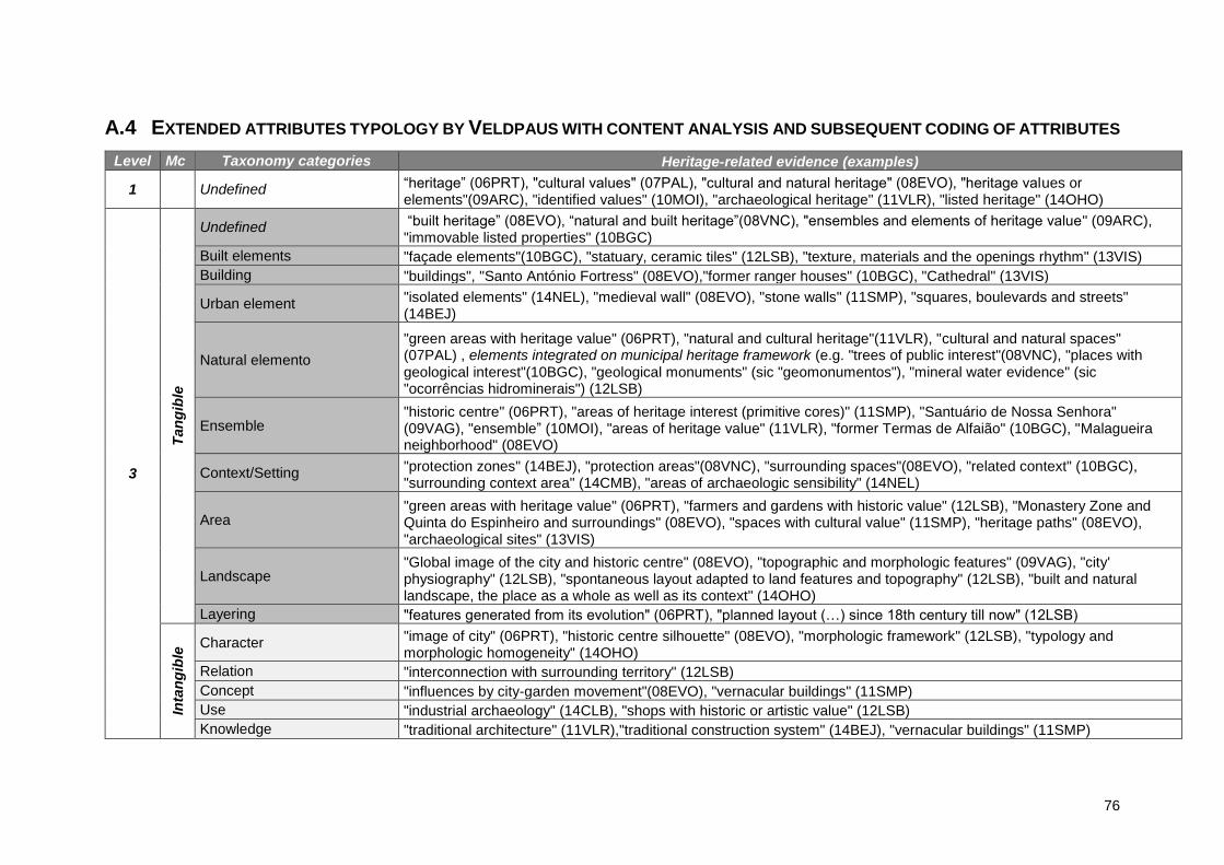
76
A.4 EXTENDED ATTRIBUTES TYPOLOGY BY VELDPAUS WITH CONTENT ANALYSIS AND SUBSEQUENT CODING OF ATTRIBUTES
Level Mc Taxonomy categories Heritage-related evidence (examples)
1 Undefined “heritage” (06PRT), "cultural values" (07PAL), "cultural and natural heritage" (08EVO), "heritage values or elements"(09ARC), "identified values" (10MOI), "archaeological heritage" (11VLR), "listed heritage" (14OHO)
3
Tan
gib
le
Undefined “built heritage” (08EVO), “natural and built heritage”(08VNC), "ensembles and elements of heritage value" (09ARC), "immovable listed properties" (10BGC)
Built elements "façade elements"(10BGC), "statuary, ceramic tiles" (12LSB), "texture, materials and the openings rhythm" (13VIS)
Building "buildings", "Santo António Fortress" (08EVO),"former ranger houses" (10BGC), "Cathedral" (13VIS)
Urban element "isolated elements" (14NEL), "medieval wall" (08EVO), "stone walls" (11SMP), "squares, boulevards and streets" (14BEJ)
Natural elemento
"green areas with heritage value" (06PRT), "natural and cultural heritage"(11VLR), "cultural and natural spaces" (07PAL) , elements integrated on municipal heritage framework (e.g. "trees of public interest"(08VNC), "places with geological interest"(10BGC), "geological monuments" (sic "geomonumentos"), "mineral water evidence" (sic "ocorrências hidrominerais") (12LSB)
Ensemble "historic centre" (06PRT), "areas of heritage interest (primitive cores)" (11SMP), "Santuário de Nossa Senhora" (09VAG), "ensemble” (10MOI), "areas of heritage value" (11VLR), "former Termas de Alfaião" (10BGC), "Malagueira neighborhood" (08EVO)
Context/Setting "protection zones" (14BEJ), "protection areas"(08VNC), "surrounding spaces"(08EVO), "related context" (10BGC), "surrounding context area" (14CMB), "areas of archaeologic sensibility" (14NEL)
Area "green areas with heritage value" (06PRT), "farmers and gardens with historic value" (12LSB), "Monastery Zone and Quinta do Espinheiro and surroundings" (08EVO), "spaces with cultural value" (11SMP), "heritage paths" (08EVO), "archaeological sites" (13VIS)
Landscape "Global image of the city and historic centre" (08EVO), "topographic and morphologic features" (09VAG), "city' physiography" (12LSB), "spontaneous layout adapted to land features and topography" (12LSB), "built and natural landscape, the place as a whole as well as its context" (14OHO)
Layering "features generated from its evolution" (06PRT), "planned layout (…) since 18th century till now" (12LSB)
Inta
ng
ible
Character "image of city" (06PRT), "historic centre silhouette" (08EVO), "morphologic framework" (12LSB), "typology and morphologic homogeneity" (14OHO)
Relation "interconnection with surrounding territory" (12LSB)
Concept "influences by city-garden movement"(08EVO), "vernacular buildings" (11SMP)
Use "industrial archaeology" (14CLB), "shops with historic or artistic value" (12LSB)
Knowledge "traditional architecture" (11VLR),"traditional construction system" (14BEJ), "vernacular buildings" (11SMP)

77
Level Mc Taxonomy categories Heritage-related evidence (examples)
Association "spaces with recognized natural, cultural (…) designed for cultural manifestations" (14OHO), "spaces where historically were implemented urban agricultural forms" (12LSB)
Community
Planned "Zona de Urbanização n.º 1 — Núcleo Inicial) urban ensemble designed by Etienne de Gröer", "Bairro da Malagueira - unique ensemble with a typology inspired on Alentejo’s vernacular architecture" (08EVO), "regular layout", "planned and organized layout" (12LSB)
Not planned “spontaneous layout adapted to land features and topography” (12LSB)
A.5 CONSULTED DOCUMENTS
PDM Designação Ano Nível Tipologia Fonte
06PRT Regulamento 2006 E. Fundamental Regulamento SNIT
06PRT Planta de Ordenamento 2014 E. Fundamental Cartografia SNIT
06PRT Planta de Condicionantes 2012 E. Fundamental Cartografia SNIT
06PRT Planta de Ordenamento - Património 2012 E. Fundamental Cartografia SNIT
06PRT REOT 2015 Outros Relatório CM website
07PAL Regulamento (Declaração n.º 324-A/2007) 2007 E. Fundamental Regulamento SNIT
07PAL Planta de Ordenamento 2009 E. Fundamental Cartografia SNIT
07PAL Planta de Ordenamento - por aglomerado urbano (Portalegre) 2007 E. Fundamental Cartografia SNIT
07PAL Planta de Condicionantes 2008 E. Fundamental Cartografia SNIT
07PAL Relatório do PDM 2006 E. Acompanhamento Relatório CM website
08EVO Regulamento (Regulamento n.º 47/2008) 2008 E. Fundamental Regulamento SNIT
08EVO Planta Geral de Ordenamento 2013 E. Fundamental Cartografia SNIT
08EVO Planta de Ordenamento - 2-B - Condicionamentos do Plano 2013 E. Fundamental Cartografia SNIT
08EVO Planta de Ordenamento - 2-C - Património Arquitetónico e Arqueológico 2013 E. Fundamental Cartografia SNIT
08EVO Planta de Condicionantes 2012 E. Fundamental Cartografia SNIT
08EVO Estudos de caracterização: Anexo IV – Inventário e Plantas do Património Arquitetónico e Arqueológico Concelhio
2007 E. Acompanhamento Cartografia/Inventário
CM website
08EVO Servidões Administrativas de Restrições de Utilidade Pública 2012 E. Acompanhamento Relatório CM website

78
PDM Designação Ano Nível Tipologia Fonte
08VNC Regulamento (Aviso n.º 10601/2008) 2008 E. Fundamental Regulamento SNIT
08VNC Planta de Ordenamento 2008 E. Fundamental Cartografia SNIT
08VNC Planta de Condicionantes 2008 E. Fundamental Cartografia SNIT
08VNC Planta do Património Cultural Construído e Arqueológico 2008 E. Acompanhamento Cartografia CM website
09ARC Regulamento (Aviso n.º 21653/2009) 2009 E. Fundamental Regulamento SNIT
09ARC Planta de Ordenamento 2009 E. Fundamental Cartografia SNIT
09ARC Planta de Condicionantes 2012 E. Fundamental Cartografia SNIT
09ARC Relatório do PDM 2009 E. Acompanhamento Relatório CM website
09VAG Regulamento (Aviso n.º 8076/2009) 2009 E. Fundamental Regulamento SNIT
09VAG Planta de Ordenamento 2010 E. Fundamental Cartografia SNIT
09VAG Planta de Condicionantes - Outras condicionantes 2010 E. Fundamental Cartografia SNIT
09VAG Relatório e Diagnóstico 1998 E. Acompanhamento Relatório CM website
09VAG Relatório do PDM (Vols.3) s/d E. Acompanhamento Relatório CM website
10BGC Regulamento (Aviso n.º 12248-A/2010) 2010 E. Fundamental Regulamento SNIT
10BGC Planta de Ordenamento 2011 E. Fundamental Cartografia SNIT
10BGC Planta de Condicionantes - Outras condicionantes 2011 E. Fundamental Cartografia SNIT
10MOI Regulamento (Aviso n.º 10488/2010) 2010 E. Fundamental Regulamento SNIT
10MOI Planta de Ordenamento - Geral 2014 E. Fundamental Cartografia SNIT
10MOI Planta de Condicionantes - Outras condicionantes 2010 E. Fundamental Cartografia SNIT
10MOI Carta e Fichas do Património Edificado 2007 E. Acompanhamento Cartografia SNIT
10MOI Relatório do PDM 2007 E. Acompanhamento Relatório CM website
11SMP Regulamento (Aviso n.º 779/2011) 2011 E. Fundamental Regulamento SNIT
11SMP Planta de Ordenamento 2010 E. Fundamental Cartografia SNIT
11SMP Planta de Condicionantes 2010 E. Fundamental Cartografia SNIT
11VLR Regulamento (Aviso n.º 7317/2011) 2011 E. Fundamental Regulamento SNIT
11VLR Planta de Ordenamento 2014 E. Fundamental Cartografia SNIT
11VLR Planta de Ordenamento - Qualificação do Solo - Centro Histórico da Cidade 2014 E. Fundamental Cartografia SNIT
11VLR Planta de Condicionantes 2011 E. Fundamental Cartografia SNIT
79
PDM Designação Ano Nível Tipologia Fonte
11VLR Relatório de discussão pública 2010 E. Acompanhamento Relatório CM website
12LSB Regulamento (Aviso n.º 11622/2012) 2012 E. Fundamental Regulamento SNIT
12LSB Planta de Ordenamento 2014 E. Fundamental Cartografia SNIT
12LSB Planta de Condicionantes - 9 - Servidões Administrativas e Restrições de Utilidade Pública II 2012 E. Fundamental Cartografia SNIT
12LSB Planta do Anexo I do Regulamento - Planos eficazes 2012 E. Fundamental Cartografia SNIT
12LSB Relatório do PDM 2012 E. Acompanhamento Relatório CM website
12LSB REOT 2009 Outros Relatório CM website
12LSB Relatório de discussão pública 2012 E. Acompanhamento Relatório CM website
12LSB Estudos de Caracterização 2012 E. Acompanhamento Relatório CM website
13VIS Regulamento (Aviso n.º 12115/2013) 2013 E. Fundamental Regulamento SNIT
13VIS Planta de Ordenamento 2013 E. Fundamental Cartografia SNIT
13VIS Planta de ordenamento — Carta do Património Arqueológico e Arquitetónico 2013 E. Fundamental Cartografia SNIT
13VIS Planta de Condicionantes - Vários 2013 E. Fundamental Cartografia SNIT
13VIS Relatório de discussão pública 2013 E. Acompanhamento Relatório CM website
13VIS Património arquitetónico s/d E. Acompanhamento Inventário CM
13VIS Planta do Património Cultural 2013 E. Acompanhamento Cartografia CM
14BEJ Regulamento (Aviso (extrato) n.º 4296/2014) 2014 E. Fundamental Regulamento SNIT
14BEJ Planta de Ordenamento do Concelho 2014 E. Fundamental Cartografia SNIT
14BEJ Planta de Ordenamento da Área Urbana de Beja 2014 E. Fundamental Cartografia SNIT
14BEJ Planta de Condicionantes e Restrições de Utilidade Pública 2014 E. Fundamental Cartografia SNIT
14BEJ Carta do Patrimonio Arquitetonico do Concelho de Beja (Inventário) 2013 E. Fundamental Inventário CM website
14BEJ Carta do Patrimonio Arquitetonico do Concelho de Beja (Relatório) 2013 E. Fundamental Relatório CM website
14BEJ Relatórios da Cartas do Património Arquitetónico e Arqueológico 2013 E. Acompanhamento Relatório CM website
14BEJ Estudos de caracterização e diagnóstico 2013 E. Acompanhamento Relatório CM website
14BEJ Relatório da estratégia de desenvolvimento e de ordenamento e quadro de intervenção estratégica — programas de intervenção e conjunto de medidas, ações e projetos
2013 E. Acompanhamento Relatório CM website
14CLB Regulamento (Aviso n.º 8539/2014) 2014 E. Fundamental Regulamento SNIT
14CLB Planta de Ordenamento - Qualificação Funcional do Solo 2014 E. Fundamental Cartografia SNIT
14CLB Planta de Ordenamento - Salvaguardas e Execução do Plano 2014 E. Fundamental Cartografia SNIT

80
PDM Designação Ano Nível Tipologia Fonte
14CLB Planta de Condicionantes Geral 2014 E. Fundamental Cartografia SNIT
14CLB Carta do Património arquitetónico (CPAA) 2008 E. Acompanhamento Cartografia CM website
14CLB Estudos de caracterização 2011 E. Acompanhamento Relatório CM website
14CLB Relatório de discussão pública 2014 E. Acompanhamento Relatório CM website
14CLB Relatório do PDM 2014 E. Acompanhamento Relatório CM website
14CLB Ficha de dados estatísticos 2014 E. Acompanhamento Relatório CM website
14CMB Regulamento (Aviso n.º 7635/2014) 2014 E. Fundamental Regulamento SNIT
14CMB Planta de Ordenamento - Classificação e Qualificação do Solo 2014 E. Fundamental Cartografia SNIT
14CMB Planta de ordenamento - Sítios com potencial arqueológico e outros bens imóveis de interesse patrimonial
2014 E. Fundamental Cartografia SNIT
14CMB Planta de condicionantes - Património 2014 E. Fundamental Cartografia SNIT
14CMB Estudos de Caracterização 2013 E. Acompanhamento Relatório CM website
14CMB Ficha de dados estatísticos 2013 E. Acompanhamento Relatório CM website
14CMB Relatório do PDM 2014 E. Acompanhamento Relatório CM website
14NEL Regulamento (Aviso n.º 33/2014) 2014 E. Fundamental Regulamento SNIT
14NEL Planta de Ordenamento 2014 E. Fundamental Cartografia SNIT
14NEL Planta de Condicionantes - Outras condicionantes 2014 E. Fundamental Cartografia SNIT
14NEL Estudos do Património Arquitetónico, Arqueológico e dos Valores Naturais 2013 E. Acompanhamento Inventário CM website
14NEL Relatório do PDM 2013 E. Acompanhamento Relatório CM website
14NEL Fundamentos da proposta de ordenamento 2013 E. Acompanhamento Relatório CM website
14NEL Relatório de discussão pública 2013 E. Acompanhamento Relatório CM website
14OHO Regulamento (Aviso n.º 10986/2014) 2014 E. Fundamental Regulamento SNIT
14OHO Planta de Ordenamento - Classificação e Qualificação do Solo 2014 E. Fundamental Cartografia SNIT
14OHO Planta de ordenamento — Património Cultural e Natural 2014 E. Fundamental Cartografia SNIT
14OHO Planta de condicionantes — Património Edificado, Infraestruturas e Atividades Perigosas. 2014 E. Fundamental Cartografia SNIT
14OHO Estudos de Caracterização do Património Natural e Cultural (Relatorio e lista anexa) 2003 E. Acompanhamento Inventário/Relatório
CM website
14OHO Relatório do PDM 2013 E. Acompanhamento Relatório CM website
14OHO Relatório de discussão pública 2013 E. Acompanhamento Relatório CM website
14OHO Ficha de dados estatísticos 2013 E. Acompanhamento Relatório CM website

81
PDM Designação Ano Nível Tipologia Fonte
14POM Regulamento (Aviso n.º 4945/2014) 2014 E. Fundamental Regulamento SNIT
14POM Planta de Ordenamento - Classificação e Qualificação do Solo 2014 E. Fundamental Cartografia SNIT
14POM Planta de Ordenamento - Sistema Patrimonial 2014 E. Fundamental Cartografia SNIT
14POM Planta de Condicionantes Gerais 2014 E. Fundamental Cartografia SNIT
14POM Estudos de Caraterização: Vol.IV — Património 2013 E. Acompanhamento Inventário/Relatório
CM website
14POM Estudos de Caracterização: Vol.IV - Planta do Patrimonio Arqueológico, Arquitetónico, Paleontológico e Natural
2013 E. Acompanhamento Cartografia CM website
14POM Diagnóstico 2013 E. Acompanhamento Relatório CM website
14POM Relatório do PDM 2014 E. Acompanhamento Relatório CM website
14POM Relatório explicativo 2014 E. Acompanhamento Relatório CM website
14POM Relatório de discussão pública 2014 E. Acompanhamento Relatório CM website
14POM Ficha de dados estatísticos 2014 E. Acompanhamento Relatório CM website

82


