HIGHWAY NETWORK ANALYSISHIGHWAY … for the efficient and successful conduct of our mission One of...
30
H R M HAMPTON ROADS MILITARY TRANSPORTATION NEEDS STUDY HIGHWAY NETWORK ANALYSIS TRANSPORTATION NEEDS STUDY HIGHWAY NETWORK ANALYSIS P RESENTED BY : S AM B ELFIELD , S ENIOR T RANSPORTATION E NGINEER F REIGHT T RANSPORTATION A DVISORY C OMMITTEE M EETING N OVEMBER 16, 2011
-
Upload
nguyenthuy -
Category
Documents
-
view
215 -
download
2
Transcript of HIGHWAY NETWORK ANALYSISHIGHWAY … for the efficient and successful conduct of our mission One of...
H R MHAMPTON ROADS MILITARYTRANSPORTATION NEEDS STUDY
H I G H W A Y N E T W O R K A N A L Y S I S
TRANSPORTATION NEEDS STUDY
H I G H W A Y N E T W O R K A N A L Y S I S
P R E S E N T E D B Y :S A M B E L F I E L D , S E N I O R T R A N S P O R TAT I O N E N G I N E E R
F R E I G H T T R A N S P O R TAT I O N A D V I S O R Y C O M M I T T E E M E E T I N G
N O V E M B E R 1 6 , 2 0 1 1
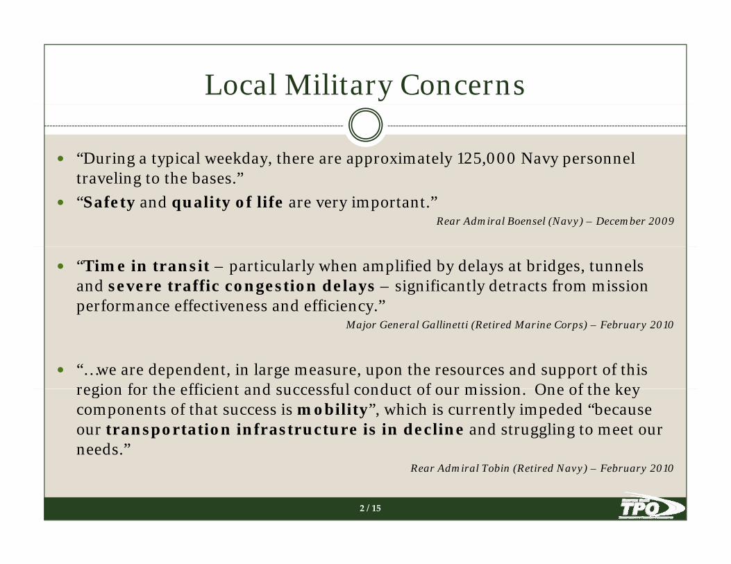
Local Military Concerns
“During a typical weekday, there are approximately 125,000 Navy personnel tra eling to the bases ”traveling to the bases.”“Safety and quality of life are very important.”
Rear Admiral Boensel (Navy) – December 2009
“Time in transit – particularly when amplified by delays at bridges, tunnels and severe traffic congestion delays – significantly detracts from mission performance effectiveness and efficiency.”
Major General Gallinetti (Retired Marine Corps) – February 2010
“…we are dependent, in large measure, upon the resources and support of this region for the efficient and successful conduct of our mission One of the keyregion for the efficient and successful conduct of our mission. One of the key components of that success is mobility”, which is currently impeded “because our transportation infrastructure is in decline and struggling to meet our needs.”
2 / 15
Rear Admiral Tobin (Retired Navy) – February 2010
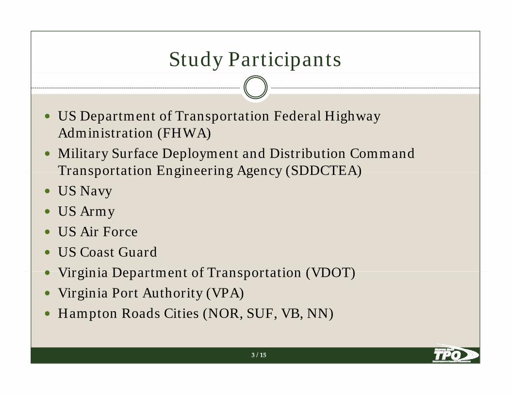
Study Participants
US Department of Transportation Federal Highway p p g yAdministration (FHWA)Military Surface Deployment and Distribution Command Transportation Engineering Agency (SDDCTEA)Transportation Engineering Agency (SDDCTEA)US NavyUS ArmyUS Air ForceUS Coast GuardVirginia Department of Transportation (VDOT)Virginia Department of Transportation (VDOT)Virginia Port Authority (VPA)Hampton Roads Cities (NOR, SUF, VB, NN)
3 / 15

Study Objectives
Engage local stakeholdersg g
Examine adequacy of current STRAHNET designations
Identify Non-STRAHNET military-related sitesy y
Develop “Roadways Serving the Military”(STRAHNET and non-STRAHNET)
Determine deficiencies on “Roadways Serving the Military”
Identify transportation projects that benefit the military
Update Project Prioritization Tool
4 / 15

Strategic Highway Network (STRAHNET)
H t R dHampton Roads
DefinitionTotal minimum defense highwayTotal minimum defense highwaynetwork to support defenseemergency and are used for dailymilitary cargo movement.
LEGENDLEGEND
STRAHNET Interstate Highway
STRAHNET Site
Non-Interstate STRAHNET Route
STRAHNET Connector
Strategic Rail Corridor Network (STRACNET) Railroad
Non-STRACNET Railroad
5 / 16
Prepared by: HRTPO Staff, February 2011
Data Source: SDDCTEA and FHWA

Military and Supporting SitesOther Military Site Jurisdiction
1 Camp Peary York County2 Camp Pendleton - Military Reservation Virginia Beach3 Craney Island Fuel Terminal Portsmouth
STRAHNET Site Jurisdiction1 Fort Eustis Newport News2 Joint Expeditionary Base Little Creek - Fort Story (East) Virginia Beach3 Joint Expeditionary Base Little Creek - Fort Story (West) Norfolk/
4 Lafayette River Annex - Naval Support Activity Norfolk Norfolk5 NASA Langley Research Center Hampton6 NAS Oceana Dam Neck Annex Virginia Beach7 Naval Auxiliary Landing Field Fentress Chesapeake8 Naval Medical Center Portsmouth Portsmouth9 Naval Support Activity Northwest Annex Chesapeake
Virginia Beach4 Langley Air Force Base Hampton5 Naval Air Station Oceana Virginia Beach6 Naval Supply Center Cheatham Annex York County7 Naval Weapons Station Yorktown York County/
Newport News 9 Naval Support Activity Northwest Annex Chesapeake10 Newport News Shipbuilding - Huntington Ingalls Industries Newport News11 Saint Helena Annex - Norfolk Naval Shipyard Norfolk12 St. Julien's Creek Annex - Norfolk Naval Shipyard Chesapeake13 US Army Corps of Engineers - Norfolk District Norfolk14 US Coast Guard - Atlantic Area and Fifth District Portsmouth
p8 Naval Station Norfolk (NSN) Norfolk9 Naval Support Activity Norfolk (NSA) Norfolk
10 Norfolk Naval Shipyard Portsmouth11 Port of Virginia - Norfolk International Terminals Norfolk12 Port of Virginia - Newport News Marine Terminal Newport News13 Port of Virginia Portsmouth Marine Terminal Portsmouth (Portsmouth Federal Building)
15 US Coast Guard - Base Portsmouth Portsmouth16 US Coast Guard Training Center Yorktown York County17 US Joint Forces Command - Suffolk Campus (USJFCOM) Suffolk18 US Marine Corps Reserve Center Newport News19 Yorktown Fuel Depot - Naval Weapons Station Yorktown York County
13 Port of Virginia - Portsmouth Marine Terminal Portsmouth14 Lambert's Point Docks Norfolk
Other Intermodal Facility Jurisdiction1 Amtrak - Newport News Newport News2 Chesapeake Intermodal - Norfolk Southern Chesapeake3 Newport News/Williamsburg International Airport Newport News
19 Yorktown Fuel Depot Naval Weapons Station Yorktown York County
6 / 16
4 Norfolk International Airport Norfolk5 Williamsburg Transportation Center Williamsburg

Roadways Serving the Military
LEGENDLEGEND
STRAHNET Roadway
Non-STRAHNET RoadwayServing Military Site or Intermodal Facility
Other Intermodal Facility
Other Military Site
Strategic Highway Network (STRAHNET) Site
7 / 16
Prepared by: HRTPO Staff, April 2011
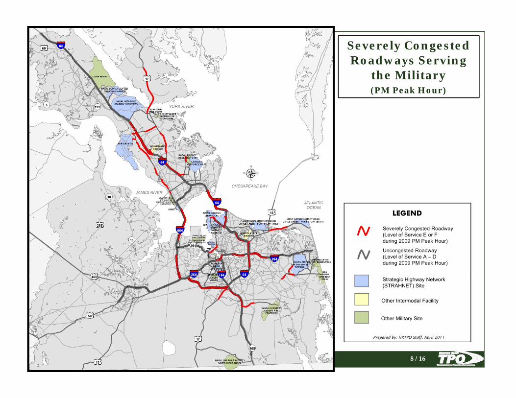
Severely Congested Roadways Serving
the Militarythe Military(PM Peak Hour)
LEGENDLEGENDLEGEND
Severely Congested Roadway (Level of Service E or Fduring 2009 PM Peak Hour)
Severely Congested Roadway (Level of Service E or Fduring 2009 PM Peak Hour)
Uncongested Roadway(Level of Service A – Dduring 2009 PM Peak Hour)
Uncongested Roadway(Level of Service A – Dduring 2009 PM Peak Hour)
Severely Congested Roadway (Level of Service E or Fduring 2009 PM Peak Hour)
Uncongested Roadway(Level of Service A – Dduring 2009 PM Peak Hour)
Other Intermodal FacilityOther Intermodal Facility
Other Military SiteOther Military Site
Strategic Highway Network (STRAHNET) SiteStrategic Highway Network (STRAHNET) Site
Other Intermodal Facility
Other Military Site
Strategic Highway Network (STRAHNET) Site
8 / 16
Prepared by: HRTPO Staff, April 2011Prepared by: HRTPO Staff, April 2011Prepared by: HRTPO Staff, April 2011

Deficient Bridges onRoadways Serving
th Militthe Military
Number PercentTotal Bridges (on Roadways Serving the Military)
582Serving the Military)
Structurally Deficient Bridges 15 2.6%
Functionally Obsolete Bridges 133 22.9%
Deficient Bridges 148 25.4%
LEGEND
Structurally Deficient BridgeStructurally Deficient Bridge
Functionally Obsolete Bridge
Bridge
Other Intermodal Facility
Other Military Site
Strategic Highway Network (STRAHNET) Site
9 / 16
Data sources: VDOT & FHWA (Data as of February 2011)
Prepared by: HRTPO Staff, April 2011

Bridges & Tunnels with Vertical
Clearances belowClearances below Preferred Height on Roadways Serving
the Militaryt e ta y
Military-Preferred Min. Vertical ClearanceInterstate Bridges is 16 feetOther STRAHNET is 14 feetLEGEND
Vertical Clearance < 14 Feet
Vertical Clearance between14 Feet and 16 Feet
#0
#0
Other Intermodal Facility
Other Military Site
Strategic Highway Network (STRAHNET) Site
10 / 16
Data sources: VDOT & FHWA (Data as of February 2011)
Prepared by: HRTPO Staff, April 2011
Roadways Serving the Military
with Lane Widthswith Lane Widths below 12 Feet
LEGEND
STRAHNET Roadway withSTRAHNET Roadway with Average Lane Width < 12 Feet
Non-STRAHNET Roadway with Average Lane Width < 12 Feet
Other Intermodal Facility
Other Military Site
Strategic Highway Network (STRAHNET) Site
11 / 16
Data sources: VDOT & Google Maps
Prepared by: HRTPO Staff, April 2011

Identification of Transportation Projectsthat Benefit the Militaryy
Project Description of Work Locality System
Cost Estimate
(Millions)Prioritization
ScoreHighway ProjectsSoutheastern Parkway and Greenbelt (I-264 to Chesapeake Expy)
Build new 4-lane limited access highway, providing east-west access to tourism destinations, and emergency evacuation as an alternative to congested I-264. Multi Primary $2,500.0 180
I-64 Peninsula Widening between Route 199 (Exit 242) to Jefferson Ave (Exit 255)
Add capacity by widening from 2 lanes in each direction to 3 general purpose lanes and 1 HOV lane in each direction. Multi Interstate $779.4 178
Mt. Pleasant Road, Phase 1 (Chesapeake Expy to Etheridge Rd)
Relieve congestion w/ 2 additional travel lanes & improve pedestrian accommodations Chesapeake Urban $26.4 134
I-64 North Peninsula Widening between Route Add capacity by widening from 2 lanes in each direction to 3
Table 1 – Unfunded 2034 LRTP Candidate Projects that Benefit the Military*
UPC ProjectDescription
Locality System Scope Cost Estimate
99037 Hampton Roads Bridge-Tunnel Corridor Study Environmental Impact Statement for I-64 from I-664 in
Hampton to I-564 in Norfolk
Hampton
Roads
Interstate Studies Only $5,000,000
98814 Hampton Roads Bridge-Tunnel PPTA PPTA project development and management Hampton
Roads
Interstate Studies Only$10,000
175 I 264 Downtown Tunnel PPTAPPTA project development and management
Hampton
Roads
Interstate R/W or Eng $25,400,000
l C sh Total Team Station Hampton
Roads
Interstate Safety/Traffic
Opers/TSM
$30,000
Studies Only $500,000
Project
Description of Work
Locality System Cost Estimate Prioritizati
I-64 between Jefferson Ave (exit 255) and Ft Eustis Blvd (exit 250) Add capacity by widening from 2 lto 3
HRTPO Staff reviewed:199 (Exit 242) and New Kent County Line general purpose lanes and 1 HOV lane in each direction. Multi Interstate $1,098.0 119J. Clyde Morris Blvd (Route 17) (I-64 to York CL) Provides interstate access on Route 17 from York County Newport
News Urban $80.0 114Route 17 (G.W. Memorial Highway) (Denbigh Blvd to Fort Eustis Blvd)
Congestion ReliefYork County Primary $17.2 109
Route 17 (G.W. Memorial Highway) (Newport News CL to Victory Blvd)
Congestion ReliefYork County Primary $15.3 109
Route 17 (G.W. Memorial Highway) (Victory Blvd to Hampton Hwy)
Congestion ReliefYork County Primary $12.4 108
Route 17 (G.W. Memorial Highway) (Fort Eustis Blvd to Coleman Bridge)
Congestion ReliefYork County Primary $78.0 106
Mt. Pleasant Road, Phase 2 (Etheridge Rd to Centerville Tnpk)
Relieve congestion w/ 2 additional travel lanes & improve pedestrian accommodations Chesapeake Urban $20.0 103
Route 17 (G.W. Memorial Highway) (1 mi North of Coleman Bridge to Main St)
Congestion Relief Gloucester County Primary $89.2 102
Brambleton Ave (Midtown Tunnel to I-264) Corridor improvements to improve travel flow, pedestrian safety and comfort and landscaping Norfolk Urban $76.0 100
Hampton Blvd (21st St to 38th St) Corridor improvements to improve travel flow, pedestrian safety and comfort and landscaping Norfolk Urban $27.0 98
Little Creek Road (Tidewater Dr to Shore Dr) Corridor improvements to improve travel flow, pedestrian safety and comfort and landscaping Norfolk Urban $113.0 97
Dam Neck Road (Princess Anne Rd to Holland Rd) Relieve congestion on parallel facilty Virginia Beach Urban $60.0 90
Shore Drive (Norfolk CL to Diamond Springs Rd) Relieve congestion on parallel facilty Virginia Beach Urban $12.0 88
Route 17 (G.W. Memorial Highway) (Main St to Ark Congestion Relief Gloucester
97175 I-264 Downt
97724 I-64 Safety ImprovementsPurchase of Fatal Crash Total Team S Roads
99587 Patriots Crossing Corridor StudyStudy of the Patriots Crossing portion of the Third Crossing
from I-664 at the MMMBT to I-564
Hampton
Roads
Interstate Studies Only
93077 I-64 Bridge Replacement - Denbigh Boulevard Replacement of Denbigh Blvd bridge over I-64 and CSX
railroad
Newport
News
Interstate Bridge Replacement
$30,333,981
57313 I-64 WideningWiden I-64 from 4 to 8 lanes from the east Route 143
interchange (Exit #255) to the west Route 143 interchange
)
Newport
News
Interstate Major Widening $419,665,387
18968 I-564 Construction - Intermodal Connector Construct Intermodal Connector from I-564 to the Norfolk
Naval Base/Norfolk International Terminal
Norfolk Interstate New Construction $170,335,747
17824 I-64 Interchange Improvements - Norview
Avenue
Improve Norview Ave interchange from 0.3 mi west of
Norview Ave to 0.2 mi east of Norview Ave
Norfolk Interstate Minor Widening $7,902,687
17630 I-264 Interchange Improvements - I-64 &
Witchduck Road
Improve I-64 and Witchduck Rd interchanges from 0.4 mi east
of westbound I-64 to 0.5 mi east of Witchduck Rd
Virginia
Beach
Interstate Major Widening $172,548,500
95554 I-264/London Bridge Road Interchange
Improvements
Interchange improvements and new ramps to London Bridge
Rd from 0.3 mi east of Lynnhaven Pkwy to 0.2 mi south of I-
d Bridge Rd
Virginia
Beach
Interstate New Construction $12,815,287
19005 I-264/Lynnhaven Parkway Interchange
Improvements - Phase II
Surface treatment of Lynnhaven Pkwy interchange Virginia
Beach
Interstate Resurfacing $119,175,685
97537 I-64 MaintenanceResurfacing of westbound I-64 in York County
York County Interstate Resurfacing $1,620,000
92212 I-64 Corridor Study - Environmental I-64 Corridor Environmental Study from Richmond to
Hampton Roads
Statewide Miscellaneous Studies Only $3,000,000
89231 I-64 Corridor Study - RevenuesI-64 Revenue Study
Statewide Miscellaneous Studies Only $4,683,634
98806 Route 17 Signal System Improvements Signal coordination along Route 17 from the Coleman Bridge
to the Gloucester Court House area
Gloucester
County
Primary Safety/Traffic
Opers/TSM
$2,200,000
13497/ 92992
Fort Eustis Boulevard WideningConstruct parallel lanes westbound from 0.4 mi east of Route
143 to Route 17
Hampton
Roads
Primary Major Widening $22,881,518
l System Improvements Primary districtwide signals Hampton
Roads
Primary Safety/Traffic
Opers/TSM
$588,272
li etc Hampton Primary Environmentally
Related
$5,035,000
$227 993 965
ate (Millions)
Prioritization Score
ening from 2 lanes in each direction to 3 general purpose lanes and 1 HOV lane in each direction. Newport
NewsInterstate
$260.0 178
Multimodal High-Speed and Intercity Passenger Rail Station DevelopmentClosure of existing Amtrak station and construction of new Amtrak stations at Bland Boulevard and 3000s block of Warwick Boulevard (Downtown Newport News).
Newport News
Passenger Rail $20.0 N/A
Harbor Park Multimodal High-Speed and Intercity Passenger Rail Station DevelopmentConstruction of new Amtrak station as part of Norfolk Harbor Park multimodal transportation hub.
Norfolk Passenger Rail $6.0 N/A
Route 17 (George Washington Hwy) (Dare Rd to Denbigh Blvd) Widen from 4-lane divided arterial to a 6-lane divided arterial.
York County Primary$8.1 146
Route 17 (George Washington Hwy) (Hampton Hwy to Dare Rd) Widen from 4-lane divided arterial to a 6-lane divided arterial.
York County Primary$56.7 202
Midtown Tunnel/MLK Extension/Downtown Tunnel Build new 2-lane tunnel, upgrade existing 2-lane tunnel, extend MLK Expressway from existing termini to I-264, and safety improvements at the Downtown Tunnel.
Norfolk/ Portsmouth
Primary (Bridges and Tunnels)
$1,300.0 242
WATA Administrative Operations Center Construction of a Transit Administrative Operations Center to replace leased facilities WATA currently using.
James City County
Public Transportation
$9.0 N/A
Craney Island ConnectorConstruction of two lane undivided arterial from VA-164 (Western Freeway) to Craney Island Marine Terminal (Future). Construction of an interchange at VA-164 for the new arterial.
Portsmouth Urban$460.0 189
Route 58 (Suffolk Bypass to 0.7 miles West of Manning Bridge Rd) Widen from 4-lane divided arterial to a 6-lane divided arterial.
Suffolk Urban$75.0 180
Birdneck Rd (I-264 to Virginia Beach Blvd) Widen from 4-lane divided arterial to a 6-lane divided arterial.
Virginia Urb
Dam Neck Rd (Holland Rd to Drakesmile Rd) Widen from 4 l
FY 12-15 TIP Projects2034 LRTP Projects and Studies2034 Candidate Projects not included in 2034
Rd) County Primary $34.6 75General Booth Blvd (Birdneck Rd to Oceana Blvd) Relieve congestion on parallel facilty Virginia
Beach Urban $71.0 67Highway Interchange ProjectsI-264/Witchduck Interchange Interchange improvement Virginia
Beach Interstate $172.5 192I-264 EB Ramp from I-64 WB (Curlew Dr to Witchduck Rd)
Modify InterchangeMulti Interstate $97.3 179
I-264/Independence Blvd Interchange Interchange improvement Virginia Beach Interstate $250.0 168
I-64/464 Interchange (I-64 EB / Battlefield Blvd to I-464 NB)
Address Geometric Deficiencies with interchange. Add 1 mile lane extension from I-464 to Battlefield Blvd on I-64 EB.
Chesapeake Interstate $19.0 154Air Terminal Interchange Construction of new interchange on I-564 to provide
alternate access to Norfolk Naval Air Station. Norfolk Interstate $60.0 150I-64 @ Ft. Eustis Blvd Address Geometric Deficiencies with interchange Newport
News Interstate $134.0 149I-264/Lynnhaven Interchange Phase II Interchange improvement Virginia
Beach Interstate $140.2 145I-64 Interchange @ Bland Blvd/Denbigh Blvd Construct new interchange either at Bland Blvd or at
Denbigh Blvd.Newport News Interstate $128.9 141
I-64/City Line Interchange and Arterial (I-64 to Centerville Tnpk)
New Interchange and two lane access roadMulti Interstate $104.9 114
Chesapeake Expressway Interchange @ Mt. Pleasant Road
Add clover-leaf ramps for northbound 168 Bypass and eastbound and westbound clover-leaf ramps on Mt. Pleasant Road. Chesapeake Primary $26.0 102
9299270621 Hampton Roads Signal System Improve
50651 HOV Marketing & AnalysisTDM Marketing, Expressbus Service, Carpooling, etc.
RoadsRelate
76642 Midtown TunnelPPTA project development and management
Hampton
Roads
Primary R/W or Eng $227,993,965
95149 Midtown Tunnel - PPTAPPTA for the Midtown Tunnel, MLK Extension, and Downtown
Tunnel
Hampton
Roads
Primary New Construction $451,550,000
95050 US 58 Lane Reversal Plan
Hampton
Roads
Primary Safety/Traffic
Opers/TSM
$600,000
56638 Route 460 Corridor StudyLocation and environmental study for Route 460 from the
Suffolk Bypass to I-295
Statewide Primary Studies Only $7,094,390
84272 Route 460 PPTAPPTA project development and management from Route 58
to I-295
Statewide Primary New Construction $1,735,012,000
97737 Shore Drive Bridge Replacement - Lesner Bridge Replacement of the Lesner Bridge Virginia
Beach
Primary Bridge Replacement
$96,622,926
60843 Route 17 WideningWiden Route 17 from 4 to 6 lanes from 1.3 mi south to 1.5 mi
north of Lakeside Dr (Route 620)
York County Primary Major Widening $56,348,970
HRT0073 Conventional Passenger Rail Service (Richmond
to Norfolk)
Daily roundtrip rail service along existing Norfolk Southern
and CSX tracks.
DRPT Public Transportation
Transit$100,200,000
T1824 Facility Upgrades - Southside Bus Facility Replacement of the Hampton Roads Transit Southside Bus
Facility
HRT - DRPT Public Transportation
Transit$1,800,000
T9092 HRT Facility Upgrades
HRT - DRPT Public Transportation
Transit$3,500,000
T4184 Miscellaneous Transit - Feeder Buses Norfolk Light Rail Transit - Operating Assistance HRT - DRPT Public Transportation
Transit$10,500,000
T9091 Signing and Pavement Marking Improvements Systemwide bus stop sign program HRT - DRPT Public
TransportationTransit
$1,900,000
T9090 Transit ImprovementsFerry fare collection equipment
HRT - DRPT Public Transportation
Transit$1,500,000
I stallation of Hampton Roads Transit bus shelters HRT - DRPT Public Transportation
Transit$150,000
RPT Public Transit$5,000,000
ginia Beach
Urban$21.1 59
) Widen from 4-lane divided arterial to a 6-lane divided arterial.
Virginia Beach
Urban$34.8 114
Dam Neck Rd (London Bridge Rd to Drakesmile Rd) Widen from 4-lane divided arterial to a 6-lane divided arterial.
Virginia Beach
Urban$48.9 109
General Booth Blvd (Oceana Blvd to Dam Neck Rd) Widen from 6-lane divided arterial to a 8-lane divided arterial.
Virginia Beach
Urban$37.4 86
Lesner BridgeBridge Replacement of four-lane bridge, with incorporated future six-lane capacity. Virginia
BeachUrban
$84.9 173
London Bridge Rd (Dam Neck Rd to Shipps Corner Rd) Widen from 2-lane undivided arterial to a 4-lane divided arterial.
Virginia Beach
Urban$40.8 66
Shore Drive (Great Neck Rd to Page Ave) Widen 4-lane divided roadway to 6-lane divided roadway.
Virginia Beach
Urban$12.9 N/A
Shore Drive (Marlin Bay Dr to East Stratford Rd) Widen 4-lane divided roadway to 6-lane divided roadway.
Virginia Beach
Urban$14.8 N/A
Shore Drive (Pleasure House Rd to Treasure Island Dr) Widen 4-lane divided roadway to 6-lane divided roadway.
Virginia Beach
Urban$18.4 N/A
Route 460 (Suffolk Bypass to Zuni) Build new 4-lane limited access tollway parallel to existing undivided arterial. VDOT is currently reviewing three PPTA proposals, with construction costs ranging from $1.5 Billion to $2.7 Billion.
Suffolk/Isle of Wight $1,500 - 2,700 187
LRTP List of Funded Projects
Selection CriteriaAny project (i e road widening interchange improvement or bridge
Northampton Blvd/Shore Dr Interchange Improve Interchange Virginia Beach Urban $33.0 99
I-64 @ Military Hwy (Military Hwy NB to I-64 EB) New ramp from NB Military Hwy to EB I-64 Norfolk Interstate $29.0 80I-664/Terminal Avenue Interchange (I-664 at Terminal Interchange to Jefferson Ave via 12th St)
Upgrade Terminal Avenue/I-664 interchange to provide direct access to 12th Street and Jefferson Avenue.
Newport News Interstate $18.0 65
Source: Hampton Roads Regional Prioritization Tool – List of 2034 LRTP Candidate Projects.
*These projects are either on “Roadways Serving the Military” or they are non-highway transportation projects (i.e. ITS and operational upgrades, public transit, and travel management) that may yield benefits to military travel.
T9
T9110 Chesapeake Transit Improvements Installation of H p
T9093 Light Rail Transit StudyStudy of extending light rail to Norfolk Naval Station and
Virginia Beach Oceanfront
HRT - DRPT Public Transportation
Any project (i.e. road widening, interchange improvement, or bridge replacement) located on “Roadways Serving the Military”Other non-highway transportation projects (i.e. ITS/Operational upgrades, public transit, and TDM Programs)
12 / 15
p g
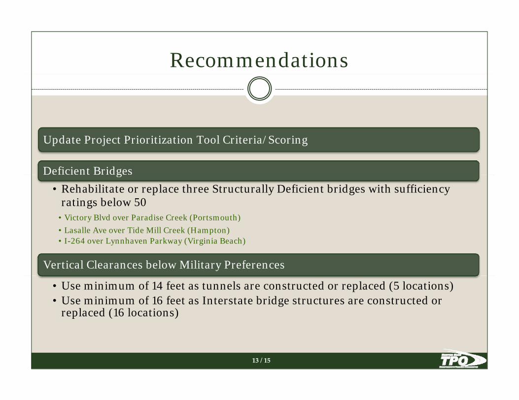
Recommendations
Update Project Prioritization Tool Criteria/Scoring
Deficient Bridgesg• Rehabilitate or replace three Structurally Deficient bridges with sufficiency
ratings below 50• Victory Blvd over Paradise Creek (Portsmouth)• Lasalle Ave over Tide Mill Creek (Hampton)• I-264 over Lynnhaven Parkway (Virginia Beach)
Vertical Clearances below Military Preferences
• Use minimum of 14 feet as tunnels are constructed or replaced (5 locations)• Use minimum of 16 feet as Interstate bridge structures are constructed or
replaced (16 locations)
13 / 15

Recommendations
Transportation ProjectsTransportation Projects
I-64 Peninsula Widening between Rte 199 and Fort Eustis Blvd*
I-64 Southside Widening (including High-Rise Bridge) between I-64/I-464 to I-664*
I-64/I-264 Ramp*
I-264 at Witchduck Rd Interchange*
I-64 at Fort Eustis Blvd Interchange*I 64 at Fort Eustis Blvd Interchange
Improved ability to cross Hampton Roads harbor (HRBT expansion, Patriots Crossing or Third Crossing)
Air Terminal InterchangeAir Terminal Interchange
Light Rail Transit Extension to Virginia Beach Oceanfront
Light Rail Transit Extension to Naval Station Norfolk
Hi h S d d I t it P R il S i (H t R d Ri h d)
14 / 15
High-Speed and Intercity Passenger Rail Service (Hampton Roads – Richmond)*2034 LRTP: “Unfunded Projects Recommended for Future Consideration” (Approved by HRTPO on 3/17/11)

Next Steps
Military Commuter Survey (FY 2012)Military Commuter Survey (FY 2012)To determine transportation challenges facing local military personnel during their daily commutes in Hampton Roads.Web-based survey located on HRTPO website (www.hrtpo.org)Web based survey located on HRTPO website (www.hrtpo.org) Planned distribution methods include:
HRTPO website and HR Crossings blogMilitary websitesyMilitary and study stakeholdersTTAC membersJurisdiction websitesMilitary email chainsMilitary email chainsLocal news and print mediaNewslettersSocial Media (i.e. Facebook)
S ll ti i d (N b 8 2011 F b 20 2012)
15 / 15
Survey collection period (November 8, 2011 – February 20, 2012)

PresentedPresented by:by:Presented Presented by:by:Camelia Ravanbakht, PhDCamelia Ravanbakht, PhDDeputy Deputy Executive DirectorExecutive Director
November 16, 2011November 16, 2011
DDOCUMENTATIONOCUMENTATION
Overview
Shapes and Patterns
Framing the LRTP
Transportation ChallengesTransportation Challenges
Transportation Strategies
The Plan
Looking Ahead
2

OOVERVIEWVERVIEW
IntroductionIntroductionRegional OverviewWhat is an LRTP?What is an LRTP?Approach/Framework
State of the RegionState of the RegionTransportation Network CharacteristicsTransportation Network Usagea spo a o Ne wo Usage
3

SSHAPESHAPES ANDAND PPATTERNSATTERNS
Regional DemographicsRegional DemographicsCurrent/Anticipated PopulationCurrent/Anticipated EmploymentCurrent/Anticipated Employment
Environmental JusticeMinoritiesMinoritiesElderlyMedical/Functional NeedsMed ca / u c o a NeedsLinguistically-isolated HouseholdsZero-Vehicle Households
4

FFRAMINGRAMING THETHE LRTPLRTP
Public InvolvementPublic InvolvementCitizen Input OpportunitiesOutreach EffortsOutreach Efforts
Vision and GoalsRegional PrioritiesRegional PrioritiesPlanning FactorsGoal AttainmentGoa a e
5

TTRANSPORTATIONRANSPORTATION CCHALLENGESHALLENGES
Mobility and AccessibilityEnvironmental Justice GroupsFreight/MilitaryModal Choices
ReliabilityTransportation Infrastructure Condition
EnvironmentalEnvironmentalClimate ChangeTransportation & Land Use
FinancialFederal/State funding deficitsConstruction Cost Increases
6

TTRANSPORTATIONRANSPORTATION SSTRATEGIESTRATEGIES
Mobility and AccessibilityFreight/Military Transportation NeedsCongestion Management ProcessModal Planning Efforts
ReliabilitySystem PreservationSystem Management
EnvironmentalMitigating/Adaption to Climate ChangeEnvironmental Consultation
FinancialGovernor’s Omnibus Transportation Funding Bill
Project Prioritization Tool
7
j

TTHEHE PPLANLAN Hampton Roads Transportation Project Priorities
The Financial PlanJ a m e s C i t y C o u n t yJ a m e s C i t y C o u n t y
To Richmond/I-295FundedOngoing Studies
"/ Interchange Studies
Multimodal Studies
Highway Studies
FundedP j t f C t ti
G l o u c e s t e r C o u n t yG l o u c e s t e r C o u n t y
Economic ForecastLRTP Plan Revenues
Selecting Projects "/
p¤
p£
§̈¦64
tu60
OP199
Y o r k C o u n t yY o r k C o u n t y
P
W i l l i a m s b u r gW i l l i a m s b u r g
Projects for Constructionp£ Planned Transit O&M Center
p¤ Planned HSIPR Stations
!. Planned Intersection Projects
!. Committed Intersection Projects
"/ Committed Interchange Projects
Committed Roadway Projects
Planned Roadway Projects
Candidate/Committed ProjectsComponents of 2034 LRTP Projects
The 2034 LRTP Projects"/
p¤
tu
H a m p t o nH a m p t o n
N e w p o r t N e w sN e w p o r t N e w sP o q u o s o nP o q u o s o n Planned Roadway Projects
Unfunded Projects forFuture Consideration"/ Interchanges for Consideration
Projects for Consideration
Project ListingFiscal Constraint Demonstration
Plan Performance
"/
!.
!.
"/
"/!.
!.
!.
!.
"/p¤
"/§̈¦564
§̈¦264
§̈¦464
§̈¦64
§̈¦264
§̈¦664
tu460
tu58tu460
tu13
V i r g i n i a B e a c hV i r g i n i a B e a c h
I s l e O f W i g h t C o u n t yI s l e O f W i g h t C o u n t y N o r f o l kN o r f o l k
P o r t s m o u t hP o r t s m o u t hTo Petersburg/I-295
Volumes and CongestionAir Quality ConformityEnvironmental Justice Analysis
§̈¦64
tu17
tu58
tu460
OP168
S u f f o l kS u f f o l kC h e s a p e a k eC h e s a p e a k e
V i r g i n i a B e a c hV i r g i n i a B e a c h
Prepared by HRTPO Staff0 3 61.5
Miles
8

LLOOKINGOOKING AAHEADHEAD
Implementation and MonitoringImplementation and MonitoringTransportation Improvement ProgramRelated Planning EffortsRelated Planning Efforts
Beyond the Horizon2034 Vision Plan2034 Vision PlanFuture LRTP Priorities
9
NNEXTEXT SSTEPSTEPS10
Public Review of 2034 LRTP Document
Comment Period ends December 8, 2011
Provide comments to LRTP Staff ([email protected]) by December 8, 2011,
Receive Joint FHWA/FTA Conformity Finding in November/December 2011November/December 2011
Document approval by HRTPO Board in January 2012
www.hrtpo.orgwww.KeepHamptonRoadsMoving.com
Navigating the FutureThe 2034 LRTP for Hampton Roads
DRAFT
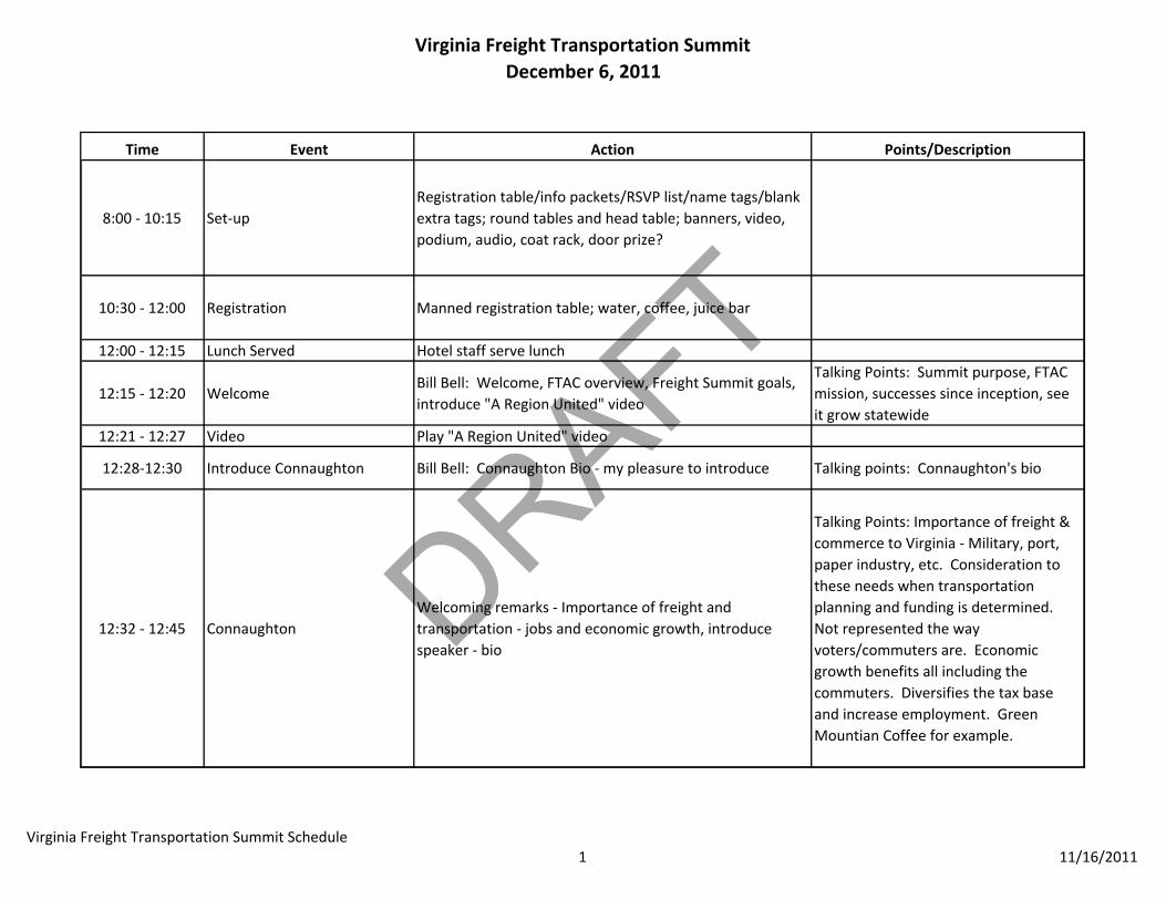
Virginia Freight Transportation SummitDecember 6, 2011
Time Event Action Points/Description
8:00 ‐ 10:15 Set‐upRegistration table/info packets/RSVP list/name tags/blank extra tags; round tables and head table; banners, video, podium, audio, coat rack, door prize?
10:30 ‐ 12:00 Registration Manned registration table; water, coffee, juice bar
12:00 ‐ 12:15 Lunch Served Hotel staff serve lunch
12:15 ‐ 12:20 WelcomeBill Bell: Welcome, FTAC overview, Freight Summit goals, introduce "A Region United" video
Talking Points: Summit purpose, FTAC mission, successes since inception, see it grow statewide
12:21 ‐ 12:27 Video Play "A Region United" video
12:28‐12:30 Introduce Connaughton Bill Bell: Connaughton Bio ‐ my pleasure to introduce Talking points: Connaughton's bio
12:32 ‐ 12:45 ConnaughtonWelcoming remarks ‐ Importance of freight and transportation ‐ jobs and economic growth, introduce speaker ‐ bio
Talking Points: Importance of freight & commerce to Virginia ‐ Military, port, paper industry, etc. Consideration to these needs when transportation planning and funding is determined. Not represented the way voters/commuters are. Economic growth benefits all including the commuters. Diversifies the tax base and increase employment. Green Mountian Coffee for example.
Virginia Freight Transportation Summit Schedule1 11/16/2011
DRAFT
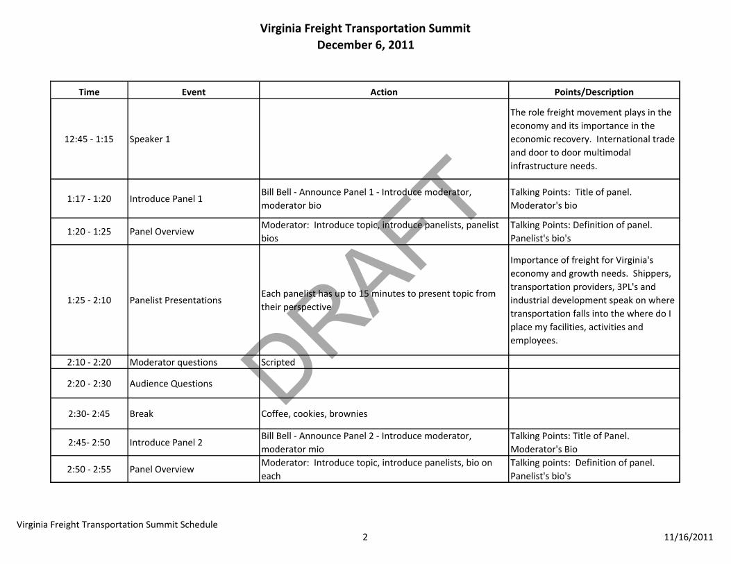
Virginia Freight Transportation SummitDecember 6, 2011
Time Event Action Points/Description
12:45 ‐ 1:15 Speaker 1
The role freight movement plays in the economy and its importance in the economic recovery. International trade and door to door multimodal infrastructure needs.
1:17 ‐ 1:20 Introduce Panel 1Bill Bell ‐ Announce Panel 1 ‐ Introduce moderator, moderator bio
Talking Points: Title of panel. Moderator's bio
1:20 ‐ 1:25 Panel OverviewModerator: Introduce topic, introduce panelists, panelist bios
Talking Points: Definition of panel. Panelist's bio's
1:25 ‐ 2:10 Panelist PresentationsEach panelist has up to 15 minutes to present topic from their perspective
Importance of freight for Virginia's economy and growth needs. Shippers, transportation providers, 3PL's and industrial development speak on where transportation falls into the where do I place my facilities, activities and employees.
2:10 ‐ 2:20 Moderator questions Scripted
2:20 ‐ 2:30 Audience Questions
2:30‐ 2:45 Break Coffee, cookies, brownies
2:45‐ 2:50 Introduce Panel 2Bill Bell ‐ Announce Panel 2 ‐ Introduce moderator, moderator mio
Talking Points: Title of Panel. Moderator's Bio
2:50 ‐ 2:55 Panel OverviewModerator: Introduce topic, introduce panelists, bio on each
Talking points: Definition of panel. Panelist's bio's
Virginia Freight Transportation Summit Schedule2 11/16/2011

DRAFT
Virginia Freight Transportation SummitDecember 6, 2011
Time Event Action Points/Description
2:55 ‐ 3:40 Panelist PresentationsEach panelist has up to 15 minutes to present topic from their perspective
Planning and funding multimodal infrastructure. PPTA's, tolling, innovative revenues. Prioritizing projects utilizing economic vitality as one of the criteria.
3:40 ‐ 3:50 Moderator questions Scripted
3:50 ‐ Until We Stop after 4:00
Audience Questions
4:00 +/‐ Closing RemarksBill Bell (Unless Connaughton wants to speak first.) Thanks, hope summit were of value. Reminder for Half Moone at 5:00
Talking points: Thanks for attending. Hope of some value. Half Moone Cruice & Celebration Center right down the street at 5:00
End Part ‐ 1 Play Freight Video AgainDismiss audience ‐ Wait 30 seconds & play video again as audience is leaving.
5:00 ‐ 6:00 Cocktail HourOpen Bar ‐ Orchestra ‐ video screens playing Warner, LaHood, video and other images from conference
6:00 ‐ 6:20Seating for Dinner and Serving Dinner
Bill Bell: Recap of day, enjoy your dinner
7:00 ‐ 7:30 Speaker Intro Bill Bell: speaker introduction and bio
Virginia Freight Transportation Summit Schedule3 11/16/2011
DRAFT
Virginia Freight Transportation SummitDecember 6, 2011
Time Event Action Points/Description
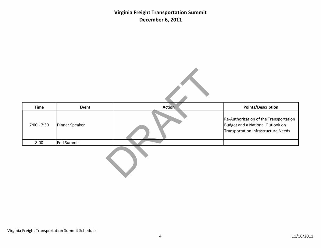
7:00 ‐ 7:30 Dinner SpeakerRe‐Authorization of the Transportation Budget and a National Outlook on Transportation Infrastructure Needs
8:00 End Summit
Virginia Freight Transportation Summit Schedule4 11/16/2011