
High Level Site Assessment Proforma - Home | Hart … · 2017-07-21 · Hart District Council Local...
7
Hart District Council Local Plan Site Assessment: Stage 2 – High Level Site Assessment – SHL290 – Land at Rosemary Cottage, Rotherwick Confidential Draft - 1.1 – April 2015 Adams Hendry Consulting Ltd 1 High Level Site Assessment Proforma Site Reference SHL290 Site Name Land at Rosemary Cottage Parish Rotherwick Site Address Land at Rosemary Cottage, Wedmanʼs Lane, Rotherwick, RG27 9BH Capacity Assessment and Categorisation Site Size (ha) 0.3ha Estimated Capacity 8 Comments on capacity The capacity was calculated using a dph figure of 30. This allows for a gross-to-net ratio of 100% from the baseline density of 30 dph and also allows for the potential loss of 1 existing dwelling. Housing Strategy Category(s) Strategy 2 - Dispersal Land Supply Category Category B – Small sites adjoining urban areas Key to Site Assessments: Site Assessment Assessment Criteria Assessment comments Coloured assessment Accessibility to Employment and services o Bus Stop: (London Road, service numbers; 1, 2, 65X, 83, and 421) 2.9 km o Railway Station: (Hook) 3.6 km o Employment Centre: (Hook Business Park) 3.7 km o Public Open Space: (Hartletts Park, Hook) 3.3 km o Health Facility: (Hook Surgery) 3.2 km o Primary School: (Whitewater C of E school) 1.1 km. o Secondary school: (Robert Mayʼs school) 7.4 km. o Supermarket: (Tesco, Hook) 3.7 km. Note that Lampardʼs Close and other roads in this area have no pavements and would not be suitable for pedestrian access, for children in particular. Infrastructure provision Schools: There is a projected (2018) surplus of 16% for the Infant/Junior schools in the Hook/Odiham/Hartley Wintney area, including the planned expansion of Hook Infants by 1FE and Hook Junior School by 0.5FE. However, this surplus will not be sufficient to provide school places for any significant development at Hook, and the HDC Infrastructure Delivery Plan (IDP) indicates that additional provision within Hook is required. For secondary schools the projected (2018) surplus capacity across Hart district is 9%, although the HDC IDP indicates No overriding constraint to development of the site Constraint requiring further detailed assessment Major constraint undermining suitability of site
Transcript of High Level Site Assessment Proforma - Home | Hart … · 2017-07-21 · Hart District Council Local...

Hart District Council Local Plan Site Assessment: Stage 2 – High Level Site Assessment – SHL290 – Land at Rosemary Cottage, Rotherwick Confidential Draft - 1.1 – April 2015
Adams Hendry Consulting Ltd 1
High Level Site Assessment Proforma Site Reference SHL290 Site Name Land at Rosemary Cottage Parish Rotherwick Site Address Land at Rosemary Cottage, Wedmanʼs Lane, Rotherwick,
RG27 9BH Capacity Assessment and Categorisation Site Size (ha) 0.3ha Estimated Capacity 8 Comments on capacity The capacity was calculated using a dph figure of 30. This allows for a gross-to-net ratio of 100% from the baseline density
of 30 dph and also allows for the potential loss of 1 existing dwelling.
Housing Strategy Category(s) Strategy 2 - Dispersal Land Supply Category Category B – Small sites adjoining urban areas Key to Site Assessments: Site Assessment Assessment Criteria Assessment comments Coloured
assessment Accessibility to Employment and services
o Bus Stop: (London Road, service numbers; 1, 2, 65X, 83, and 421) 2.9 km o Railway Station: (Hook) 3.6 km o Employment Centre: (Hook Business Park) 3.7 km o Public Open Space: (Hartletts Park, Hook) 3.3 km o Health Facility: (Hook Surgery) 3.2 km o Primary School: (Whitewater C of E school) 1.1 km. o Secondary school: (Robert Mayʼs school) 7.4 km. o Supermarket: (Tesco, Hook) 3.7 km.
Note that Lampardʼs Close and other roads in this area have no pavements and would not be suitable for pedestrian access, for children in particular.
Infrastructure provision
Schools: There is a projected (2018) surplus of 16% for the Infant/Junior schools in the Hook/Odiham/Hartley Wintney area, including the planned expansion of Hook Infants by 1FE and Hook Junior School by 0.5FE. However, this surplus will not be sufficient to provide school places for any significant development at Hook, and the HDC Infrastructure Delivery Plan (IDP) indicates that additional provision within Hook is required. For secondary schools the projected (2018) surplus capacity across Hart district is 9%, although the HDC IDP indicates
No overriding constraint to development of the site Constraint requiring further detailed assessment Major constraint undermining suitability of site

Hart District Council Local Plan Site Assessment: Stage 2 – High Level Site Assessment – SHL290 – Land at Rosemary Cottage, Rotherwick Confidential Draft - 1.1 – April 2015
Adams Hendry Consulting Ltd 2
that capacity expansions for Robert Mayʼs School will be needed. However, access to Robert Mayʼs School from Hook is poor due to the need to cross both the motorway and railway line which prevents cycling being a reasonable alternative. Retail: The most recent evidence found that there is no pressing need to increase convenience and comparison floorspace. However, some of Hartʼs supermarkets are overtrading (inc. Tesco in Hook) and there is a modest deficit in convenience floorspace. Therefore, additional housing, not already planned for will increase the need to expand retail floorspace (convenience and comparison) either in Fleet or potentially in Hook Village Centre. Health: There are no planned expansions of health facilities in the Hook area, but it is likely that any significant level of development in the centre of the district will require additional provision. Transport (road): From the available evidence, the key proposed road improvement affecting Hook is the capacity improvements planned for junction 5 of the M3 motorway. Transport (other): The main bus services on the north side of Hook are the ½ (to Hartley Wintney, Yateley, and Camberley), the 83 (To Hartley Wintney, Eversley and Yateley) and 421 (to Odiham, Fleet, and Farnborough). However, each of these services offers only one or two buses a day, and are mainly tailored towards school and college transport. The HCC Transport Statement notes a number of pedestrian and cycling improvements in the area, the most significant of which is the scheme to provide a new route running parallel to the A30 linking Hook, Hartley Wintney, and Winchfield. There is a further proposal to create a new cycle route along the B3349 between Hook and Heckfield. Green Infrastructure: The Hart Infrastructure Delivery Schedule highlights the replacement Hart Leisure Centre at Hitches lane as a strategic project, for which development could help to address the deficit. In addition the HDC IDP identifies a need for open space, SANGs and allotments provisions in Hook.
Current Use and Relevant Planning History
The current use appears to be as a dwelling with garden and horse paddock. No planning history was found.
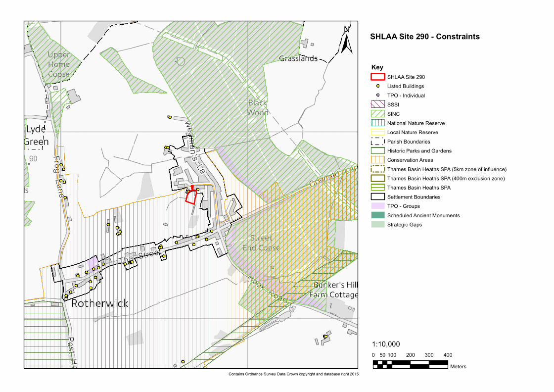
Nature Conservation Site is within the 5km Thames Basin Heaths SPA Zone of Influence. It is possible that a site of this scale could be within the capacity of the Hitches Lane SANG to mitigate its potential impact on the TBH SPA. If this proves not to be the case, any development at the site would require contributions for the provision of appropriate SANGs. There are no nature conservation designations on or in close proximity to the site.

Hart District Council Local Plan Site Assessment: Stage 2 – High Level Site Assessment – SHL290 – Land at Rosemary Cottage, Rotherwick Confidential Draft - 1.1 – April 2015
Adams Hendry Consulting Ltd 3
Minerals Resources The Hampshire Minerals and Waste Plan Policies Map indicates that there are no areas within the site that are subject to minerals safeguarding.
Landscape HCC Integrated LCA (2012) Landscape type: Lowland Mosaic small scale Landscape character: Loddon Valley and Forest of Eversley West Hart District LCA 1997: Landscape type: mixed farmland and scattered blocks of woodland Landscape Character Area: Tylney Main features of the Tylney LCA: A strong landscape structure of mixed farmland and numerous areas of woodland, now remnants of a once extensively wooded landscape. Enclosure of the landscape is also aided by the gently undulating landforms, which contain views. The LCA has a dispersed pattern of small settlements, north of Hook, which are linked by a sparse network of rural lanes, giving the LCA a remote and rural feel. Summary Assessment: This is a small site partially within the built-up area boundary of Rotherwick. The site boundaries have some screening, particularly to the west and visual intrusion into the countryside is not considered likely. Development is more likely to cause visual intrusion to the existing residential properties on Wedmanʼs Lane to the east and on the Street to the south, although this may be possible to overcome with appropriate mitigation.
Agricultural Land This site is situated on Grade 3 agricultural land, which may include ʻbest and most versatileʼ farmland. This would need to be determined if the site were to be taken forward.
Heritage Assets The entire site is within the Rotherwick Conservation Area and any development on the site would need to take this constraint fully into account. The neighbouring properties include two Grade II Listed Buildings; Tudor Cottage to the west, and Timbers Cottage to the east, both of which are in very close proximity. The northern part of the site, including the access road, is also indicated to be a site of Significant Archaeological Features.
Water resources and quality
There are no groundwater source protection zones or licensed water abstraction points in close proximity to the site.
Air Quality There are not believed to be any Air Quality Management Areas in close proximity to this site. On the basis of evidence seen, none of the surrounding land uses would be likely to cause any air quality issues for the site.
Flood risk The site is within Flood Zone 1 and the Draft SFRA maps indicate that the site is not subject to flood risk from any potential of the sources.

Hart District Council Local Plan Site Assessment: Stage 2 – High Level Site Assessment – SHL290 – Land at Rosemary Cottage, Rotherwick Confidential Draft - 1.1 – April 2015
Adams Hendry Consulting Ltd 4
Location and scale of development
The site appears to be predominately greenfield although it also includes an existing dwelling. It is not located within any strategic or local gap. The site is adjacent to the rear of several dwellings on Wedmanʼs Lane, The Street and Lampardʼs Close. The general character of the village is low-density development; therefore high-density development is likely to be incongruous in this location. This local character presence of the Conservation Area and the may serve to reduce site capacity.
Un-neighbourly Uses
There are no un-neighbourly uses on or in close proximity to this site.
Availability Assessment
The site is believed to be available, although this would need to be confirmed by the landowner / site promoter.
Site Access
The only access to this site is a private driveway on land between Rosemary Cottage and The Timbers and this appears to be shared by users of both properties and may require third-party consent to be used for the development site. If the site were to be developed, this access route would require upgrading and this might harm the Conservation Area. Careful consideration would also be required of the impact additional vehicular traffic would have on Lampardʼs Close, which is a narrow cul-de-sac with no pavements.
Summary of Constraints
• The site has no clear dedicated access to the public highway and the feasibility of providing safe vehicular and pedestrian access to the site needs to be considered in the context of the nearby heritage assets.
• Accessibility to services and facilities is very poor, which is likely to encourage car dependency. • Infrastructure deficiencies have been identified which would need to be addressed. • Development may cause visual intrusion into the surrounding residential areas. • Development may harm the Rotherwick Conservation Area or the setting of two nearby Listed Buildings.
Summary of Opportunities
This is a small site, but has the potential to provide a limited level of residential development, assuming the various constraints can be overcome.
Focus of further assessment, should the site be shortlisted by the Council
• Consideration should be given to how safe vehicular and pedestrian access to the site could be achieved. • The potential impact of development on relevant heritage assets needs to be considered and how possible impacts could be
avoided or mitigated. • An assessment is needed of the potential for development to cause visual intrusion and whether this could be avoided through
mitigation. • Site availability needs to be confirmed. • The presence of ʻbest and most versatileʼ agricultural land needs to be ascertained.

Hart District Council Local Plan Site Assessment: Stage 2 – High Level Site Assessment – SHL290 – Land at Rosemary Cottage, Rotherwick Confidential Draft - 1.1 – April 2015
Adams Hendry Consulting Ltd 5
Site Assessment Completed by
Name: PH Date: 14/04/2015
HDC Conclusion and recommendation
Shortlist the site:
Do not shortlist the site:
HDC Comments:
0 100 200 300 40050Meters
1:10,000
±Key
SHLAA Site 290Listed Buildings
! TPO - IndividualSSSISINCNational Nature ReserveLocal Nature ReserveParish BoundariesHistoric Parks and GardensConservation AreasThames Basin Heaths SPA (5km zone of influence)Thames Basin Heaths SPA (400m exclusion zone)Thames Basin Heaths SPASettlement BoundariesTPO - GroupsScheduled Ancient MonumentsStrategic Gaps
Contains Ordnance Survey Data Crown copyright and database right 2015
SHLAA Site 290 - Constraints

0 100 200 300 40050Meters
1:10,000
±Key
SHLAA Site 290Flood Zone 3Flood Zone 2Reservoir Flood OutlinesSurface Water Flooding (1 in 30 year AEP)Surface Water Flooding (1 in 100 year AEP)Groundwater Flooding (Limited)Groundwater Flooding (Potential flooding to basements)Groundwater Flooding (Potential flooding at surface)
Contains Ordnance Survey Data Crown copyright and database right 2015
SHLAA Site 290 - Flood Risk


