HEN AND CHICKENS GROUP vegetation has been divided into sixcom-munities: I.The coastal community, a...
9
RITCHIE AND RITCHIE: ECOLOGICAL SURVEV OF WHATUPUKE ISLAND AN ECOLOGICAL SURVEY OF WHATUPUKE ISLAND, HEN AND CHICKENS GROUP 57 M. A. RITCHIE and L M. RITCHIE Farest and Range Experiment Station. Rangiora SUMMARY: The vegctatie.n of Whatupuke island (240 acres, Jat. 35° 54' S., long. 174045' E.) is discussed under six headings: (1) Coastal herbs, grasses and shrubs; (2) Cordyline forest; (3)-(5) three phases in the succession after burning, with kanuka (Leptospermum ericoide.~) as a major species; and (6) puriri (Vitex Lucens) - pohutukawa (Melrosideros excelsa) forest. Stands of the latter are probably the most mature to be found on the Chicken Islands. The soils have been classified as related to the northern brown granular loarns and clays c.n the eastern portion (overlying rocks of the Coppcrmine plutonic series) and as northern yellow-brown earths on the western end (overlying metamorphosed sedimentary rocks). 170 species of vascular plants were found on the island. Of ,these, 18 were not found on adjacent Coppetmine Island, 40 species are added to the list for Coppermine Island, and 22 previous records are not confirmed. Petrel burrows were found on all soil types provided there \vas sufficient depth, relatively open vegetative cover and at least a gradual slope. INTRODUCTION During the period 24-31 October 1968, a joint Wildlife Service - Ecology Division expedition visited Coppermine and Whatupuke Islands to record the status of as many aspecls of the eco- systems of these islands as feasible, prior to pos- sible prospecting for copper. Our project was to map the vegetation and soils of Whatupuke Island and to collect specimens of all its plants. As no voucher specimens were collected for the list published by Atkinson (1968) for Copper mine Island, an attempt was made to collect specimens of all plants growing on that island also. Two full days were spent on Coppermine Island and nearly four days on Whatupuke. COPPERMINE ISLAND Since Atkinson had recently published his fairly comprehensive account of the vegetation types on Coppermine Island, work on this island was re- stricted to the collection of plant specimens. A list of those collected, and those recorded by Atkinson, is given in the appendix. Of the 152 species recorded by him, 22 were not found by our party. However, 40 species were recorded for the Iirst time, giving a total for the present visit of 170. Parris (1969) added the common plum (Prunus dome>1ica) to the list, but this has not been recorded by other parties. One kauri tree (Agathis australis) found above Coppermine Bay was 76 em. in circumference at breast height and was bearing cones. WHATUPUKE ISLAND Whatupuke Island, with an area of 240 acres, is the second largest of the Chicken Islands (Fig. I ). With the other Chicken Islands it was declared a scenic reserve in 1920 and landing without writ- ten authority was prohibited in 1956. The coastal sJopes are generally very steep and, on the northern face of the main block, extend as a cliff to the summit, 775 ft. high. Away from the coast, slopes are less steep and gentler grades are found in a large basin behind the bay on the south coast. The island has a long history of Maori occupa- tion, and Mr. K. Peters, Anthropology Depart- ment, University of Auckland, suggests (pers. comm.) that the occupation on Whatupuke was more permanent and extensive than On Copper- mine Island. The attempts to mine copper in the group last century were apparently conlined to
Transcript of HEN AND CHICKENS GROUP vegetation has been divided into sixcom-munities: I.The coastal community, a...

RITCHIE AND RITCHIE: ECOLOGICAL SURVEV OF WHATUPUKE ISLAND
AN ECOLOGICAL SURVEY OF WHATUPUKE ISLAND,
HEN AND CHICKENS GROUP
57
M. A. RITCHIE
and
L M. RITCHIE
Farest and Range Experiment Station. Rangiora
SUMMARY: The vegctatie.n of Whatupuke island (240 acres, Jat. 35° 54' S., long. 174045' E.)is discussed under six headings: (1) Coastal herbs, grasses and shrubs; (2) Cordyline forest;(3)-(5) three phases in the succession after burning, with kanuka (Leptospermum ericoide.~)as a major species; and (6) puriri (Vitex Lucens) - pohutukawa (Melrosideros excelsa) forest.Stands of the latter are probably the most mature to be found on the Chicken Islands.The soils have been classified as related to the northern brown granular loarns and clays c.n
the eastern portion (overlying rocks of the Coppcrmine plutonic series) and as northernyellow-brown earths on the western end (overlying metamorphosed sedimentary rocks).170 species of vascular plants were found on the island. Of ,these, 18 were not found on
adjacent Coppetmine Island, 40 species are added to the list for Coppermine Island, and 22previous records are not confirmed.Petrel burrows were found on all soil types provided there \vas sufficient depth, relatively
open vegetative cover and at least a gradual slope.
INTRODUCTION
During the period 24-31 October 1968, a jointWildlife Service - Ecology Division expeditionvisited Coppermine and Whatupuke Islands torecord the status of as many aspecls of the eco-systems of these islands as feasible, prior to pos-sible prospecting for copper. Our project was tomap the vegetation and soils of Whatupuke Islandand to collect specimens of all its plants. As novoucher specimens were collected for the listpublished by Atkinson (1968) for Copper mineIsland, an attempt was made to collect specimensof all plants growing on that island also. Twofull days were spent on Coppermine Island andnearly four days on Whatupuke.
COPPERMINE ISLAND
Since Atkinson had recently published his fairlycomprehensive account of the vegetation types onCoppermine Island, work on this island was re-stricted to the collection of plant specimens. Alist of those collected, and those recorded byAtkinson, is given in the appendix. Of the 152species recorded by him, 22 were not found byour party. However, 40 species were recorded forthe Iirst time, giving a total for the present visit
of 170. Parris (1969) added the common plum(Prunus dome>1ica) to the list, but this has notbeen recorded by other parties. One kauri tree(Agathis australis) found above Coppermine Baywas 76 em. in circumference at breast height andwas bearing cones.
WHATUPUKE ISLAND
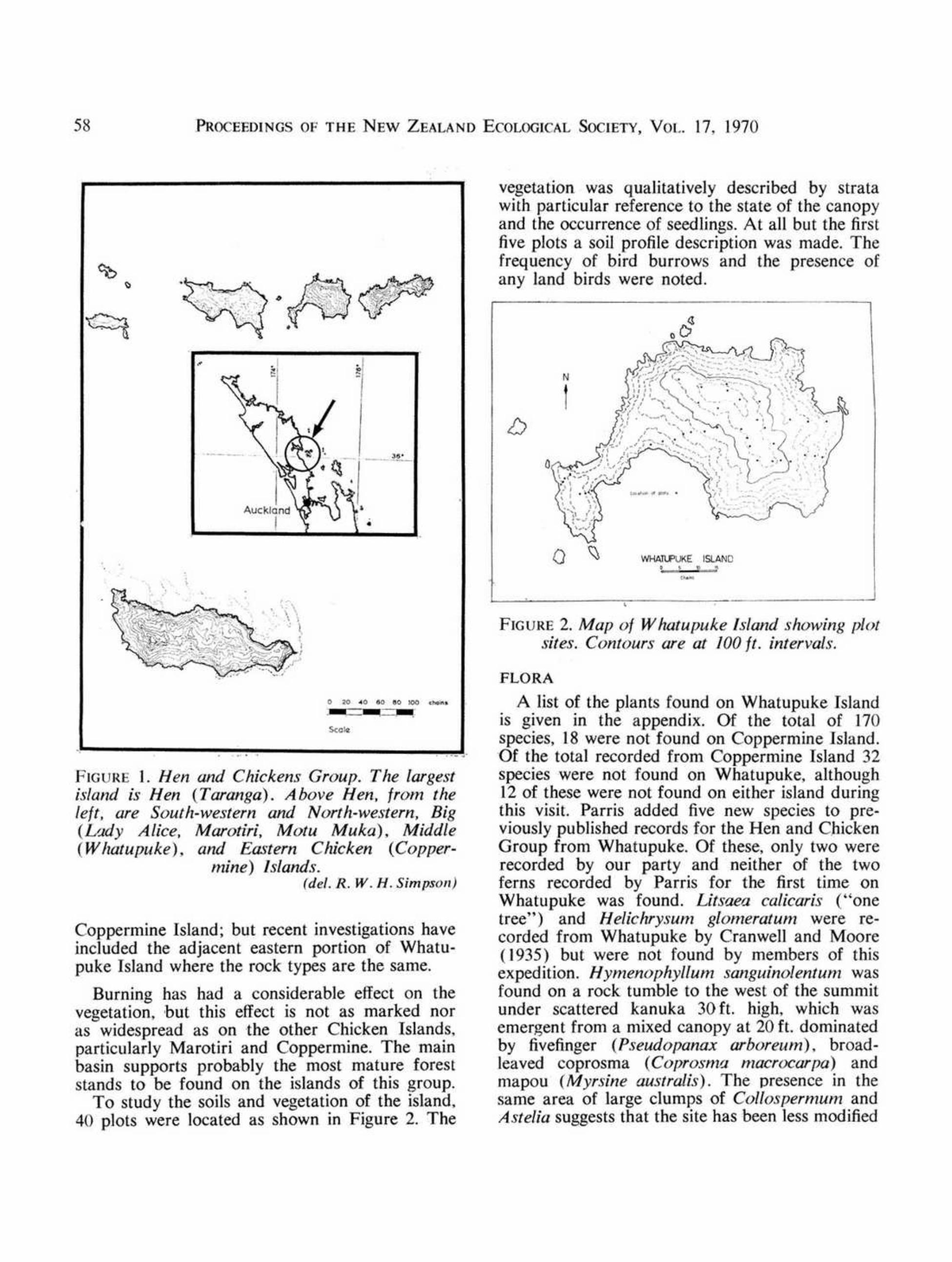
Whatupuke Island, with an area of 240 acres,is the second largest of the Chicken Islands (Fig.I ). With the other Chicken Islands it was declareda scenic reserve in 1920 and landing without writ-ten authority was prohibited in 1956.The coastal sJopes are generally very steep and,
on the northern face of the main block, extend asa cliff to the summit, 775 ft. high. Away from thecoast, slopes are less steep and gentler grades arefound in a large basin behind the bay on the southcoast.
The island has a long history of Maori occupa-tion, and Mr. K. Peters, Anthropology Depart-ment, University of Auckland, suggests (pers.comm.) that the occupation on Whatupuke wasmore permanent and extensive than On Copper-mine Island. The attempts to mine copper in thegroup last century were apparently conlined to
PROCEEDINGS OF THE NEW ZEALAND ECOLOGICAL SOCIETY, VOL 17, 1970
FIGURE I. Hen and Chickens Group. The largestis/and is Hen (Taranga). Above Hen, from theleft. are South-western and North-western, Big(Ludy Alice, Marotiri, Motu Muka), Middle(Whatupuke), and Ea.Ytern Chicken (Copper-
mine) Islands.(del. R. W. H. Simpson)
Coppermine Island; but recent investigations haveincluded the adjacent eastern portion of Whatu-puke Island where the rock types are the same.
Burning has had a considerable effect on thevegetation, but this effect is not as marked noras widespread as on the other Chicken Islands.particularly Marotiri and Coppermine. The mainbasin supports probably the most mature foreststands to be found on the islands of this group.To study the soils and vegetation of the island,
40 plots were located as shown in Figure 2. The
vegetation was qualitatively described by stratawith particular reference to the state of the canopyand the occurrence of seedlings. At all but the firstfive plots a soil profile description was made. Thefrequency of bird burrows and the presence ofany land birds were noted.
FIGURE2. Map of W hatupuke Is/and showing plotsites. Contours are at 100 ft. intervals.
FLORA
A list of the plants found on Whatupuke Islandis given in the appendix. Of the total of 170species, 18 were not found on Coppermine Island.Of the total recorded from Coppermine Island 32species were not found on Whatupuke, although12 of these were not found on either island duringthis visit. Parris added five new species to pre-
viously published records for the Hen and ChickenGroup from Whatupuke. Of these, only two wererecorded by our party and neither of the twoferns recorded by Parris for the first time onWhatupuke was found. Litsaea ca/icari,\' ("onetree") and Helichrysum glomeratum were re~corded from Whatupuke by Cranwell and Moore(1935) but were not found by members of thisexpedition. Hymenophyllum sanguinolentum wasfound on a rock tumble to the west of the summitunder scattered kanuka 30 ft. high, which wasemergent from a mixed canopy at 20 ft. dominatedby fivefinger (Pseudopanax arboreum), broad-leaved coprosma (Coprosma macrocarpa) andmapou (Myrsine australis). The presence in thesame area of large clumps of Collospermum andAstelia suggests that the site has been less modified
58
RITCHIE AND RITCHIE: ECOLOGICAL SURVEY OF WHATUPUKE ISLAND
by fire than its surroundings and that the filmyfern colony is a remnant rather than a recent intro-duction.
Percy (1956) suggested that the limited runningwater and the absence of filmy ferns on MarotiriIsland (Big Chicken) is indicative of a poroussubsoil. On Whatupuke. running water is equallyscarce and the subsoils are almost invariablyimpermeable. However, the nature of the limitedoccurrence of H. sanguinolentum on Whatupukesuggests that its present distribution in the groupis a consequence of the widespread burning whichhas taken place. Under undisturbed conditions,features of the microclimate such as relativehumidity probably determine the distribution offilmy ferns.
Jane and Beever (1965) attributed the lownumbers of pteridophytes and monocotyledonousplants on Big Chicken to the general lack ofground cover. The higher proportion of bothgroups of plants on Whatupuke appeared to beassociated with the wide range of micro-environ-ment rather than with ground cover.
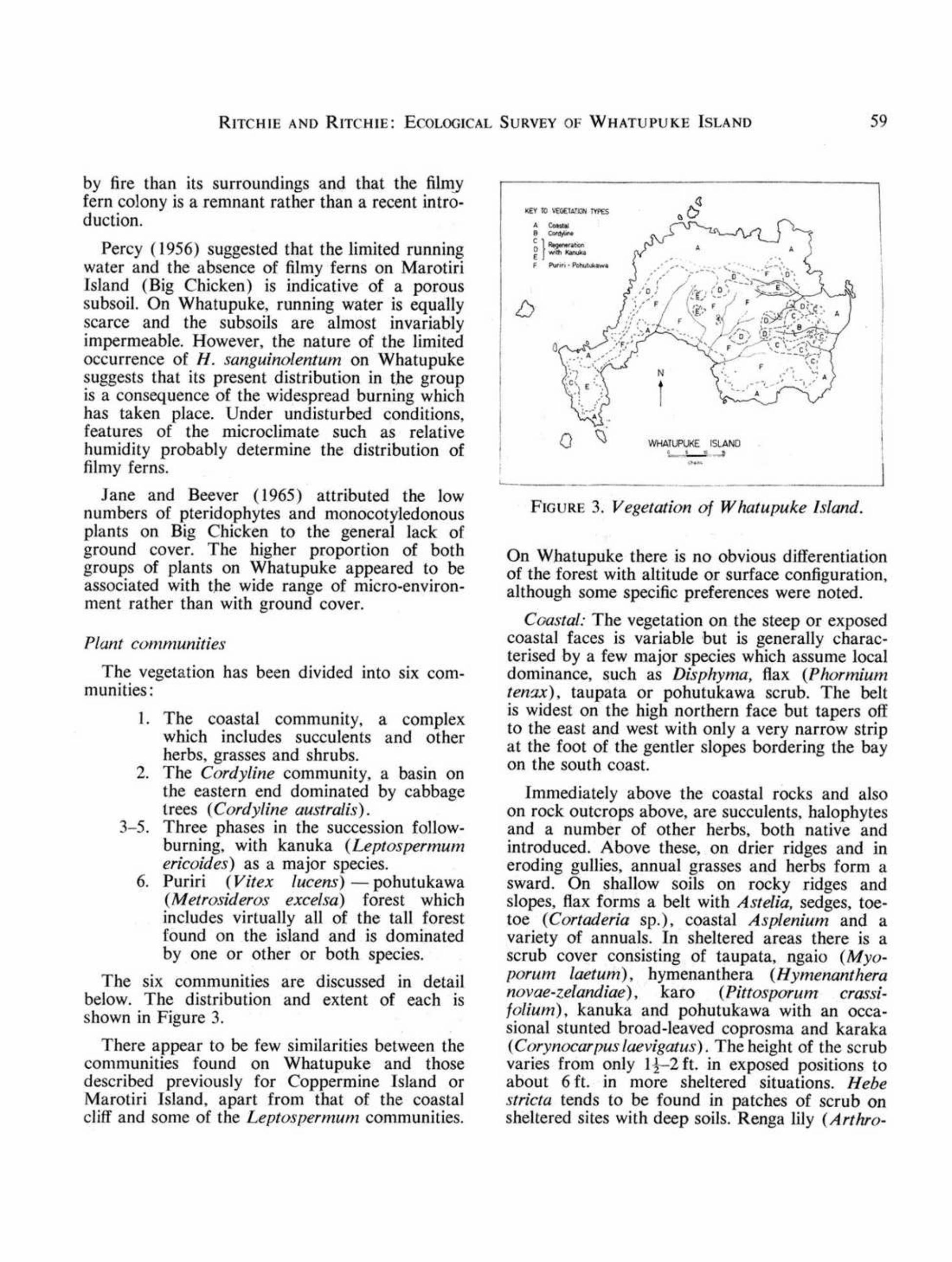
Plant communities
The vegetation has been divided into six com-munities:
I. The coastal community, a complexwhich includes succulents and otherherbs, grasses and shrubs.
2. The Cordyline community, a basin onthe eastern end dominated by cabbagetrees (Cordyline australis).
3-5. Three phases in the succession follow-burning, with kanuka (LeptospermUlnericoides) as a major species.
6. Puriri (Vitex lucens) - pohutukawa(Metrosideros excelsa) forest whichincludes virtually all of the tall forestfound on the island and is dominatedby one or other or both species.
The six communities are discussed in detailbelow. The distribution and extent of each isshown in Figure 3.
There appear to be few similarities between thecommunities found on Whatupuke and thosedescrihed previously for Coppermine Island orMarotiri Island, apart from that of the coastalcliff and some of the Leptospermum communities.
FIGURE 3. Vegetation of W hatupuke Island.
On Whatupuke there is no obvious differentiationof the forest with altitude or surface configuration,although some specific preferences were noted.
Coastal: The vegetation on the steep or exposedcoastal faces is variable but is generally charac-terised by a few major species which assume localdominance, such as Disphyma, flax (PhormiumtenTe) , taupata or pohutukawa scrub. The beltis widest on the high northern face but tapers offto the east and west with only a very narrow stripat the foot of the gentler slopes bordering the bayon the south coast.
Immediately above the coastal rocks and alsoon rock outcrops above, are succulents, halophytesand a number of other herbs, both native andintroduced. Above these, on drier ridges and ineroding gulJies, annual grasses and herbs form asward. On shallow soils on rocky ridges andslopes, flax forms a belt with Astelia, sedges, toe-toe (Cortaderia sp.), coastal Asplenium and avariety of annuals. In sheltered areas there is ascrub cover consisting of taupata, ngaio (Myo-porum laetum), hymenanthera (Hymenantheranovae-zelandiae), karo (Pittosporum crassi-folium), kanuka and pohutukawa with an occa-sional stunted broad-leaved coprosma and karaka(Corynocarpusluevigatus). The height of the scrubvaries from only I!-2 ft. in exposed positions toabout 6 ft. in more sheltered situations. Hebestricta tends to be found in patches of scrub onsheltered sites with deep soils. Renga lily (Arthro-
59

60 PROCEEDINGS OF THE NEW ZEALAND ECOLOGICAL SOCIETY, VOL ]7. ]970
podium cirrhalum) is generally found on rockyseepages. The different zones are often inter-mingled and vary in extent depending upon thedegree of exposure.
Cordyline: This community is located in a mid-slope basin on the eastern end of the island. Treesare about 30 ft. in height and up to 2-3 ft. indiameter at breast height (d.b.h.), Cabbage treesare co-dominant with puriri and pohutukawa atthe head of the basin and with kohekohe (Dysoxy-lum _'pectahile) and karaka nearer the coastalslopes. In the gullies and on the gentler slopes nearthe lower edge of the basin, stands are virtuallypure Cordyline. Elsewhere there is a range ofbroad-leaved species below slightly emergentcabbage trees.
Regeneration with kanuka dominant: On theeastern end of the island are several stands witha complete or near-complete canopy of kanukabetween] 5-20 ft. high, Where the kanuka givescomplete cover, few other species are present.There is a deep coarse litter on the ground withscattered plants of Doodia and Pterostylis banksiionly. Where the canopy is open, an often densegrowth of broad-leaved species forms an under-storey. The more common species are mapou.mahoe (Melicytus ramifiorus), pigwood (Genio-stoma ligustrifolium), fivefinger and broad-leavedcoprosma. In older stands, clumps of Gahnia andflax, Pterastylis trul/ifolia and Acianthus are pre-sent on the floor with the lianes Parsonsia andpohuehue (Mueh!enheckia complexa) above.
ReReneration with kal1uka emergent from umixed canopy: In patches on the main spurs atthe eastern end of the island and in a. belt alongthe ridge above the northern slopes kanuka, witha height of about 30 ft. and approaching] 2 in.d.b.h.. is emergent above a mixed canopy at about20 ft. The major species in the canopy are mapou.mahoe, hohere (Hoheria pOI>ulnea),broad-leavedcoprosma, fivefinger and pigwood. In the olderstands fivefinger and hohere are emergent withkanuka. Kohekohe was also seen in the lowercanopy in this community. Usually there is alsoa shrub layer consisting mainly of Coprosmarhamnoides.
Regeneration with kanuka a scattered co-dom-inant: This community is on the western penin-su]a and in patches in the main basin. The canopyis generally open at about 30-35 ft. The major
canopy species are: kanuka, puriri or pohutukawa(or both), fivefinger, and kohekohe. Mapou,mahoe, pigwood and broad-leaved coprosma forman understorey at about 15 ft. The _ground-storeyincludes: Doodia, Asplenium lucidum, Astelia,Carex, Uncinia, Acianthus and Pterastylis trul/i-folia. On the upper, south-west facing slopes ofthe main basin, rewarewas (Knightia excelsa)locally take the place of puriri, their conicalcrowns piercing the canopy.
All the last three stages in the succession are- usually present and the boundaries that have beendrawn between them are arbitrary. In someinstances the different stages merge or intermingle.The area of the last stage on the western penin-sula may be stable in its present form becauseof its proximity to coastal influences. However.most of the other areas appear capable of develop-ing to puriri-pohutukawa forest.
Puriri-po/zutukawa forest: This community isfound over most of the main basin, on the south-east facing slopes of the neck and on the south-east corner of the island. On the broader slopesthere is generally a mixture of puriri and pohu-tukawa but there is a tendency for puriri to bedominant in the deeper gullies and pohutukawato be dominant on the ridges.
The depth of the transition zone from thecoastal community to the forest varies with thedegree of exposure and depth of soiL This zoneis usually marked by the presence of kawakawa(Macrapiper excelsum) and mahoe. This giveswav on the slopes and ridges to Dohutukawa (ca.]8 in, d.b.h.) which forms a fairly complete can-opy at 30-40 ft., with karo as a partial suh-canopyjust below and an understorey at 15-20 ft. con-sistinq mainly of karaka but including kawakawa.hroad,leaved coprosma. kohekohe and pukanui(Mervta sinclai,;;). Pukanui is common in thecoastal gullies. This tvpe merges rapidly intostands of mixed Duriri and pohutukawa about:10ft. high with a broken sub-canopy of karaka.kohekohe, mahoe and mapou and an understoreyof tawapou (Planc/1onella novo-zefandica).karaka. kawakawa, broad-leaved coprosma andpigwood.
Nikau (Rhopalostylis sapida) seedlings andtree ferns are common locally on the higher slopeswith the tree ferns particularly common in thegullies. Wbere the canopy is open, a dense suh.

RITCHIE AND RnCHW: ECOLOGICAL SURVEY OF WHATUPUKE ISLAND
canopy of mapou. kohekohe. karaka. taraire(Beilschmiedia taraire). fivefinger and pigeon-wood (Hedycarya arhorea) is usually present.
The most mature stands were seen on somegentle mid-basin slopes. They consist of a com-plete canopy of puriri (ca. 18-20 in. d.b.h.) andpohutukawa (ca. 24-30 in. d.b.h.) in about equalproportions and about 35-40 ft. high. and at adensity of about 30 trees! acre. An occasional kohe-kohe. tawapou. karaka and broad-leaved maire(Nestegis apetala) form a scattered sub-canopy.A few saplings of para para (Heimerliodendronhrunonianum), karaka, kawakawa and pukanuiwere present. There was a deep (5 em.) litter onthe floor with scattered seedlings of pigeonwood.karaka and pukanui and the ferns Aspleniumluddum, A. hulbiferum, Doodia and Pteri.\'comans. In a broad gully towards the back ofthe basin. puriri (ca. 36 in. d.b.h.) forms a densecanopy at 40 ft.. with some pohutukawa (ca. 24 in.d.b.h.). Parapara. broad-leaved maire. hohere.karaka and wharangi (Melicope ternata) form ascattered subcanopy. The understorey consists ofseveral broad.leaved species. and supplejack(Rhipo!lonum scandens) is present.
~OILS
A preliminary soil survey was attempted usinga l{ in. diameter auger. The following propertieswere described: depth of topsoil and subsoil.colour, texture and, where possible, structure. Theconclusions and correlations based on the dataobtained must be regarded as tentative.
The geology of part of the eastern end ofWhatupuke Island is discussed briefly by Thomp-son et al. (1967); but a more complete descriptionis given by Small (1969). Most of the easternhalf of the island is composed of rocks of theCoppermine plutonic series. mainly medium-grained quartz diorite but with some fine-grainedtonalite near the north-eastern corner. The re-mainder of the island is composed of metamor-phosed sedimentary rocks of the Waipapa group;hornblende hornfels occurs near the contact withthe plutonics and jlrades to albite-epidote hornfelsaway from it. Small's boundary between thehornfelses and the plutonicsis shown in Figure4. Andesitic dykes occur at intervals around thecoastline.
The better.developed soils on the roBing andhilly land overlying the plutonic rocks usually
61
consist of about 6 in. of dark greyish.brown siltyclay loam of fine granular to nutty structure, over-lying about 6 in. of brown to pale brown compactclay loam with reddish mottles; and this lies aboveyellowish-brown compact clay loam. The better-developed soils on the rolling and hilly land over-
lying the metamorphosed sedimentary rocks haveabout 4-6 in. of dark greyish-brown silt loam ofless weB developed structure. over about 6-8 in.of dark yeBowish-brown compact silty clay loamabove yellowish-brown compact silty clay loam.Soils of the first kind are found on slopes of upto 25' while those of the second kind are foundon slopes of up to 300.
Soils on the steep-lands are only about 9-18 in.thick. with up to 6 in. of grey-brown sandy siltto silt loam of weakly to moderately developedstructure above paler friable sandy silt to silt loam.These are found on the coastal slopes and thereis a range of profile development dependine. uponthe degree of stability.
In many of the gullies. topsoils have been erodedand burrowing by petrels has assisted in mixingthe remaining soil with rock fragments. Stonysoils were found at various locations over theisland.
Soil Bureau staff (NZ. Soil Bureau. 1954), onthe basis of a reconnaissance survey, classified thesoils of both Coppermine and Whatupuke Islandsas skeletal soils. Those on Coppermine belong tothe Te Kie set and those on Whatupuke to theTe Ranga set. On the basis of the genetic classifi-cation system (NZ. Soil Bureau. 1968) the soilson Coppermine Island. mainly on plutonic rocksand hypabyssal intrusives. would be classed assteep-land soils related to the northern browngranular loams and clays. and those on Whatu-puke Island. mainly on sedimentaries. as steep-land soils related to the northern yellow-brownearths.
Results of the present survey suggest that, inaddition to the steepland soils. the soils on rollingand hilly lands may be classified as follows: Theheavy, generally finer-structured soils on the east-ern end of the island are allied to the northernbrown granular loams of the Awapuku set; where-as the not so heavy generally coarser-structuredsoils farther west rail into the Marua set of thenorthern yellow-brown earths. The shallowerstony or light-textured soils of the coastal faces

PROCEEDINGS OF THE NEW ZEALAND ECOLOGICAL SOCIETY, VOL. 17. 1970
FIGURE 4. Soils of WhaJupuke Island.Northern yellow-brown earths: A: on rolling andhilly lands, Marua set (brown silt loam and siltyclay lo:;m); B: on steep-lands, Te Ranga set (stonysilt loams) * C: Northern brown granular loamsand clays: on rolling and hilly lands, Awapukuset (silty clay loam); D: on steep-lands, Te Kieset (stony silt loam and silty clay loam)*.
* includes bare rock faces and shingle slides.~ - - ~ Soil boundaries.
_ _ _ - Boundary between diorite and hornsfelscd grey-wacke (after Small. 1969) and approximate bc.andarybetween northern brown granular loarns and clays andnorthern yellow-brown earths.
are classed as Te Kie clay loam and stony loamand Te Ranga clay loam and stony loam respect-ively. The distribution of the different soils isgiven in Figure 4. For mapping purposes, thesteep-land soils include small areas of true skeletalsoils and rock outcrops.
The steep-land soils support species of thecoastal plant community, with succulents andannuals on the less-developed and scrub on themore mature. On the sheltered sites these soilsmay also support some forest species. The deeperheavier soils of the rolling and hilly land supportthe more extensive kanuka and forest communi-ties. The cabbage tree community appears to beassociated with an area of bouldery soils. Whatappeared to be small charcoal fragments werefound at seven sites, in all but one, under kanukaat a depth of about 18 in.
IJIROS
North Island saddlebacks (Philesturnus carun-culatus' rutosater) were liberated on WhatupukeIsland in January-February 1964. Sixteen monthslater adults and juveniles were found to be fairlyevenly distributed over the whole island (Merton1965). By October 1968 the distribution patternhad reverted to that found on Hen Island byAtkinson and Campbell (1966) - most birdswere Seen and heard about the coastal scrub andforest margin and in the younger mixed kanukastands, with an occasional pair in the tall forest.Most of the other land birds listed by Merton andAtkinson (1968) for Whatupuke Island werefound to. have a distribution pattern similar tothat of the saddlebacks.
Notes were also taken on the distribution ofbird burrows over the island. However. data areinsufficient to provide a map of the densities.Merton and Atkinson found that areas denselyburrowed by lIesh-footed shearlVaters (Pufjinuscamelpes hullianus) on Coppormine Island hanvery friable sandy soils. Atkinson suggested thatlow numbers of petrel burrows under kanuka onCoppermine Island are probably due to compactsoils.
On Whatupuke Island, petrel burrows wererecorded aI 29 of the 40 plot sites. At 13 of theseburrows are prolific. As previously mentioned, nofriable sandy soils were recorded on the island.Dense burrowing was recorded on all types ofsoil at all altitudes. Data for plots where few orno burrows were recorded were examined forpossible factors affecting the distribution. Limit-ing factors appear to be insufficient depth of soilarising from soil loss by erosion. the presenceof rocks or both~ dense regeneration giving animpenetrable canopy and ground cover; or insuffi-cient slope - burrows were not found on slopesof less than about 5". Burrows of different speciesand mixed populations were noted in certain areasbut very little is known of the distribution of thevarious species on the island. More detailed workis needed before specific preferences for soil typesor other factors may be ascertained.
ACKNOWLEDGMENTS
Wc arc indebted to Mr D. V. Merton. Wildlife Service.Department of Internal Affairs, fo:- the opportunity to,\ccompany the party, to the Department of Lands andSurvey for a grant covering travelling expenses and "<0the Navy who assisted with transport in H.M.N.Z.$.
62

COPPER- WHATU-TREES AND SHRUBS MINE PUKE
Agathis australis RBeilschmiedia tarairi + RB. tawa + RBrachyglottis repanda + RCarmichaelia cunningham;; + XCoprosma areolata R RC. australis + RC. macrocar pa + RC. repens + R
COPPER~ WHATU-TREES AND SHRUBS MINE PUKE
C. rhamnoides + RC. robusta + RC. spathulata PCordyline australis + RCoriaria arborea + RCorynocarpus laevigatus + RCyathodes frase,; + RDysoxylum spectabile + RElaeocarpus dentatus REnte/ea arborescens + RGeniostoma ligustrifolium + RHebe parviflora + RHebe stricta t AH. stricta var. strictat R RHedycarya arborea + RHeimerliodendron brllllOllial1um + RHoherfa po pu/nea + RHymenanthera novae~zelandiae + RKnightia excelsa A RLeptospermum ericoides + RL. scoparium +Litsaea calicaris CMacropiper excelsum + RMelicope ternata + RMelicytus ramiflorus + XMeryta sinc/arii + RMetrosideros excelsa + RM. robusta RMyoporum laetum + RMyrsine australis + RM. sa/icina RNestegis apetala + RN. lanceolata AOlearia fllrfuracea A XParatrophis banks;; A RPime/ea prostrata + RPittosporum crassifolium + RP. umhellatum APlanchonella novo-zelandica + RPomaderris phylicifolia t AP. phylicifolia var. ericifoliat RPrunus domestica PPseudopanax arboreum + RP. lessonii + RP. arboreumXlessonii? RRhahdothamnus solandri + RRhopa/ostylis sapida + R'Schefflera digitata + RSolanum aviculare A RSophora microphylla + RVitex llicens + R
LlANES
Calystegia turguriorum + RClematis panicldata + RMetrosideros perforata +Muehlenheckia complexa + RParsollsia heterophylla + RRhipogollum scandells + RSicyos angulata + R
FERNS
Adhmtum aethiopicum RPA. cunninghamii + R
.>--." RITCHIE AND RITCHIE: ECOLOGICAL SURVEY OF WHATUPUKE ISLAND 63
Maroro under the command of Lieutenant F. Wilson,R.N.Z.N. The assistance of Drs D. G. Drury, E. Edgar,L B. Moore, Messrs G. Brownlie, A. J. Healy, B. E. V.Parham, and V. D. Zotov with the checking and identifi-cation of plant specimens is much appreciated. Topogra-phical information was supplied by the Department ofLands and Survey. We are grateful to the other membersof the party for assistance in the field. We wish to thankDr L B. Moore, Mr D. A. Franklin, Mr J. E. Cox andMr E. J. B. Cutler for their cons.tructive criticism of themanuscript.
REFERENCES
ATKINSON, 1. A. E. 1968. An ecological reconnaissanceof Coppennine Island. Hen and Chickens. Group.N.2. J. Bot. 6: 285-294.
ATKINSON, I. A. E., and CAMPBELL,D. J. 1966. Habitatfactors affecting saddlcbacks on Hen Island. Proc.N.Z. Ecol. Soc. 13: 35-40.
CRANWELL,L M., and MOORE, L. B. 1935. Botanicalnotes on the Hen and Chicken Islands. Rec. Auck.Inst. and Mus. 1: 301-308.
JANE, G., and BEEVER,R. E. 1965. A list of the vascularplants on Motu Muka (Hen and Chickens Group).Tane 11: 87-91.
MERTON,D. V. 1965. Transfer of saddlebacks from HenIsland to Middle Chicken Island, January, 1964.Notornis 12: 213-222.
MERTON,D. V., and ATICINSON,1. A. E. 1968. Notes onthe birds of Coppermine Island, Hen and ChickenGroup. Notornis 15: 100-108.
N.Z. SOIL BUREAU1954. General survey of the soils ofNorth Island, New Zealand. N.z. Soil Bur. Bull. 5.
N .Z. SoiL BUREAU 1%8. Soils of New Zealand. Part 1.N.z. Soil Bur. Bull. 26.
PARRIS, B. S. 1969. Additions to previously publishedspecies lists for the Hen and Chicken Islands. Tone15: 93-95.
PERCY,C. A. 1956. A primary survey of the vegetation ofMarotiri Island. Tane 7: 3-6.
SMALL, A. K. 1969. Geology of the Chicken Islands,Northland. M.Sc. thesis, Univ. Auckland.
THOMPSON, B. N.; WOOZICKI,A., and WEISSBERG,B. G.1967. Geolc'JY and mineralisation of CoppermineIsland with appendix on soil geochemistry. N.Z.Geol. Survey Rept. 25.
ApPENDIX
Plant /ist for Coppermine and Whatupuke Island"(Hen and Chickens Group)

COPPER- WHATU- COPPER- WHATU-
MINE PUKE MINE PUKE
A. hispidulum + R Microlaena polynoda? RAllarthropteris lanceolala R N a/odanthania unarede A RArthropteris tenella + R Notodanthonia sp. RAsplenium bulbiterum + R Opfismenus undulatifoliust AA. buliferumX(laccidum? R O. imbecilis t R RA. falcatum + l' Parapholis illcurva RA. flaccidum + R Phalaris minor R RA.lamprophyllum P Poa anceps t AA./ucidum + X P. anceps "fine head"t RA. oblllsatum var. obliquum R P. anceps var. densum R RBJechnum aggregalllm A Sporobolus capens1st AB. capense R R S. africalis t RB. filiforme A R Stenotaphrum secondatum RPB. membranaceum R R Trisetum sp. +Cheilanthes distal1s R R Vulpia bromoides R RC. ,~ieberi R
OTHER HERBACEOUS PLANTSCyathea dealbata + RC. medullari.~ + R Acianthus fornicatus var.J)oodia media + R sinclarii R RHymenophyllum sanglfil10lenwm R Anagallis arvensis A RLastreopsis velutina R R Angelica rosaefolia + RPaesia scaberula R A plum australe + RPellaea rotundifolia A R Arthropodium cirrhatum + RPhymatodes diversifolium + R Astelia banksii + RPolystichum richardii-r A A. solandri? RP. vestitum t R Astersp. RP. vestitumXrichardii? R Bidens pilosa R RPteridium esculentum + R Brassica campestris + RPteris comans + R Calystegia soldanella RP. tremula + R Calystegia sp. (pubescent) RPyrrosia serpens + R Carduus tenuiflorus R RThelypteris pennigera A R Centaurium erythraea + RTrichomanes endlicherianllm P Cerastium sp. t A
SEDGESC. glomeratumt R RCirsium vulgare + R
Carex breviculmis + R Co/lospermum hastatum + RC. dissita A Conyza canadensis AC. lllcida R R Cotula australis RC. vacillans + R Crepis capil/aris R? RGahnia lacera + R Dauchus glochidiatu,~ RLepidosperma australe + R /Jianella intermedia + RMariscus IlsWlatus + R Dichondra repens
,RT
Scirpus cerl1lws + R Disphyma australe + RS. nodosus + R /Jrosera auricu/ata +Uncinia uncinata + R Euphorbia glauca R
GRASSESGeranium pi/osum + RGnaphalium collinum +
Aira caryophyllea + R G. japonicum R RAnthoxanthum odoratum A G.luteo-a/bum + RAvenasp. R G. purpureum t ABriza minor A G. purpureum (a)t R RBromus arenariliS R R (b) RB. diandrus + R Ha/oragis erect a + RB.mollis + R H. procumbens RCortaderia toetoet A Helichrysum g/omeratllm CCortaderia sp. t R R Hydrocotyle elongata +Dactylis glomerata + Hypochaeris glabra RDeyeuxia billardieri A H. radicata + RDiche/achne crinita + R Ipomoea palmata PEchinopogon ovatllS R R Lepidium sp. (Introd.)t AHolcu,~ lanatllS + L. ruderale t R RLachnagrostis filiformis var. Linum monogynum + R
littoralis R R Lobelia anceps + RLagllrlls ovatus P Lotus hispidus A
64 PROCEEDINGS OF THE NEW ZEALAND ECOLOGICAL SocIETY, VOL. 17, 1970

COPPER- WHATU~ MINE PUKE
MINE PUKE COPPER- WHATU-
S. hispidulus var. scaberu/us RL. pedunculatus R? R S. lautus A XLycopodium volubile R S. minimus R RMicrotis unifolia + R S. quadridentatus R ROrobanche minor + R Solanum nigrum? ROxalis corniculata + R S. nodiflorum +O. comicu/ata var. microphylla R Sonchus o/eraceus + RParietaria debitis A X Stellaria parvifiora + RPe!argollium inodorum + R Stellaria media R RPeperomia urvilleana + R T araxicum otJicinale , APhormium lenox + R Tillaea sieberiana
,R R
Phytolacca octandra + R Tetragonia trlgyna + RPlantago lanceo/ata + Thelymitra longifolia + RP. major R Typha muelleri RPolycarpon tetraphyllum + R Wahlenbergia gracilis + RPterostylis banksii + R W. co/ensoi RP. trullifalia R RP. rrulli/olia var. a/obufa R + = Recorded by Atkinson aDd by Ritchie & Ritchie.Ranuncu/us hirtus
,A=Recorded by Atkinson.'r
Rhagodia triandra + R R=Recorded by Ritchie & Ritchie; voucher specimensSagina procumbens R deposited in the herbarium, Botany Divisic.n.Sa/icomia australis + X O.S.LR. (CHR).Samolus repens + R X=Recorded by Ritchie & Ritchie but no specimensSarcochi/us adversus R taken.Senecio bipinnatisectus R R p= Recorded by Parris.S. g/omeratus + C= Recorded by Cranwell and Moore.S. hispidulus t A t=Signifies that probably only the one speCIes ISS. hispidll/us var. hispidu/ust R R involved.
RITCHIE AND RITCHIE: ECOLOGICAL SURVEY OF WHATUPUKE ISLAND 65