Handbook on Integrating Land Use Considerations into...
52
Handbook on Integrating Land Use Considerations into Transportation Projects to Address Induced Growth Requested by: American Association of State Highway and Transportation Officials (AASHTO) Standing Committee on the Environment Prepared by: ICF Consulting Fairfax, Virginia March, 2005 The information contained in this report was prepared as part of NCHRP Project 25-25, Task 3: Analysis of Assessment and Mitigation Strategies for Land Development Impacts of Transportation Improvements, National Cooperative Highway Research Program, Transportation Research Board.
Transcript of Handbook on Integrating Land Use Considerations into...

Handbook on Integrating Land Use
Considerations into Transportation Projects to Address Induced Growth
Requested by:
American Association of State Highway and Transportation Officials (AASHTO)
Standing Committee on the Environment
Prepared by:
ICF Consulting Fairfax, Virginia
March, 2005
The information contained in this report was prepared as part of NCHRP Project 25-25, Task 3: Analysis of Assessment and Mitigation Strategies for Land Development Impacts of
Transportation Improvements, National Cooperative Highway Research Program, Transportation Research Board.
Acknowledgements This study was requested by the American Association of State Highway and Transportation Officials (AASHTO), and conducted as part of the National Cooperative Highway Research Program (NCHRP) Project 25-25. The NCHRP is supported by annual voluntary contributions from the state Departments of Transportation. Project 25-25 is intended to fund quick response studies on behalf of the AASHTO Standing Committee on the Environment. The report was prepared by ICF Consulting. The work was guided by a task group chaired by Mary Kay Bailey which included Lamar Smith, Susan Fox, David Scott, and Gail Grimes. The project was managed by Christopher Hedges, NCHRP Senior Program Officer. The opinions and conclusions expressed or implied are those of the research agency that performed the research and are not necessarily those of the Transportation Research Board or its sponsoring agencies. This report has not been reviewed or accepted by the Transportation Research Board Executive Committee or the Governing Board of the National Research Council.

i
Table of Contents 1 Introduction................................................................................................................. 1
1.1 About This Handbook............................................................................................. 1
1.2 Land Use and Transportation Interactions.............................................................. 2
1.3 Brief Overview of Transportation and Land Use Planning .................................... 3
1.4 The Challenge of Integrated Consideration During Project Implementation ......... 4
1.5 A Response in Three Parts: Integrating Transport and Land Use Considerations . 7
2 Engaging With Land Use Planning Processes ............................................................ 9
2.1 Why Should Transportation Agencies Engage With Land Use Planning Processes? ............................................................................................................... 9
2.2 How Can Transportation Agencies Engage With Land Use Planning Processes?10
2.2.1 Through Statewide Growth Efforts............................................................... 11 2.2.2 Through Local and Regional Growth Planning Efforts................................ 13 2.2.3 Local Land Use Goals in Transportation Project Selection.......................... 19
3 Methods for Analyzing Land Use Changes .............................................................. 21
3.1 General Approach ................................................................................................. 21
3.2 Qualitative Methods.............................................................................................. 23
3.3 Quantitative Methods............................................................................................ 25
3.3.1 Economic and Land Allocation Models ....................................................... 25 3.3.2 Integrated Land Use and Transportation Models.......................................... 27 3.3.3 Sketch Planning Tools .................................................................................. 29
3.4 Resources for Analyzing Land Use Impacts......................................................... 29
4 Strategies to Avoid Undesirable Land Use Impacts of Transportation Projects ...... 31
4.1 Strategies Outside Transportation Agency Control .............................................. 31
4.2 Strategies within Transportation Agency Control ................................................ 32
4.2.1 Access Management ..................................................................................... 33 4.2.2 Purchase of Access Rights ............................................................................ 37 4.2.3 Context Sensitive Design.............................................................................. 39 4.2.4 Land Acquisition and Conservation Easements ........................................... 42 4.2.5 Incentives for infill development .................................................................. 46

1
1 Introduction Transportation improvements make land more accessible and so increase the likelihood that it will be developed or redeveloped. In response, transportation providers are increasingly being asked to assess the likely development impacts, and to mitigate negative impacts. To provide departments of transportation with assistance in responding to these requests, the National Cooperative Highway Research Project commissioned Project 25-25 (3) “Assessment and Mitigation Strategies for Land Development: Impacts of Transportation Improvements.” The product of Project 25-25 (3) is this Handbook, whose goal is to provide assistance in assessing whether a project is likely to produce new development (including dispersed development), and, if the use or its impacts are deemed inconsistent with goals1, how to mitigate them.
The material and examples in this Handbook are drawn from interviews with a wide variety of state Departments of Transportation, state land use and other resource agencies, and metropolitan planning organizations, as well as review of planning and project documents, including numerous Environmental Impact Statements. The lessons and useful practices from those interviews and documents are the basis for this Guidebook.
1.1 About This Handbook
This Handbook describes concepts and provides resources on the methods and approaches that state and local transportation agencies can use to understand the link between transportation investment and land development, and respond appropriately to the forces at work in that link, particularly by planning for and then mitigating negative impacts. More and more, transportation agencies are recognizing induced land development as an impact of transportation capacity projects. These impacts are being recognized both during analysis done under the National Environmental Policy Act (NEPA) and in system or other planning activities.
Development, especially that which is dispersed, can contribute to serious environmental problems. Dispersed development, characterized by lower densities, few transportation options, and rigid separation of residences, jobs, and shops, can exacerbate air and water pollution, habitat loss, and a decline in ecosystem functions. It can also increase the demands on the transportation system and reduce the efficiency of the system, as the same number of people and same level of economic activity generates more and longer trips.2 Managing these challenges is particularly demanding when transportation and land use are planned separately, as they are in most localities.
1 This handbook does not tackle the determination of what uses or impacts are ‘desirable’ or ‘undesirable’. Rather, this document presents ways to analyze impacts of investment to support determination of desirability in a given context. A desire for mitigation may arise because project impacts would otherwise be inconsistent with federal, state, or local laws and regulations, or with stakeholder goals for an area. 2 Environmental Protection Agency. Our Built and Natural Environment: A Technical Review of the Interactions Between Land Use, Transportation, and Air Quality (Washington, D.C.: January 2001).

2
The research that supported development of this Handbook, including interviews with state DOTs and other state agencies, found that assessment and mitigation of land use impacts works best when transportation planning and delivery is integrated with land use planning and community goal-setting. As a result, this Handbook presents ways to better analyze and then avoid or mitigate impacts within a framework of integrated transportation and land use planning.
Potential land use impacts of transportation investments must be assessed as part of NEPA review. However, both interviews with agency staff and review of NEPA documents produced for transportation projects suggest that the NEPA process, as generally executed, is not an ideal place to integrate land use and transportation considerations. Among other reasons, land use and transportation planning should be integrated at a broader scale than is usually used for NEPA analysis, and begun earlier than is generally done for NEPA project-level analysis. As a result, this Handbook discusses not only project analysis within NEPA, but also discusses integration efforts that can be undertaken without direct ties to NEPA project analysis.
Discussion on important aspects of integrated consideration of transportation and land use is organized under three key topics:
1. integrated transportation and land use planning;
2. analysis methods for land use; and
3. mitigation strategies.
Once engaged with land use planning processes, transportation agencies are able to employ methods to better understand interactions between transportation and land use, and use mitigation strategies to ensure that land use policies and transportation projects work together to meet economic, environmental, and social goals.
1.2 Land Use and Transportation Interactions
Land use and transportation are inextricably linked. Agencies often struggle to understand and respond to this linkage in a way that fulfills natural resource and quality-of-life objectives while fulfilling community economic objectives. New transportation infrastructure can help shape land uses by increasing the accessibility of sites and the mobility of site users.3 For example, on a highway corridor through undeveloped land, a new interchange increases the accessibility of sites in the vicinity, enabling their development. In addition, the new interchange offers some existing users of the highway network time savings over their current routes and destinations, thereby increasing demand for new development on these sites. These pressures can result in land development, often at quite a distance from the interchange. While the new interchange may represent a transportation agency’s good-faith effort to fulfill its charge of improving 3 US Environmental Protection Agency, Our Built and Natural Environment: A Technical Review of the Interactions Between Land Use, Transportation, and Air Quality (Washington, D.C.: January 2001), p. 9.

3
mobility, it also produces powerful effects on land use. Other transportation investments produce “induced growth” in similar ways.4 That growth can then contribute to undesired environmental outcomes. If not managed properly, habitat loss from new greenfield development can interfere with ecosystem functions, including support of fish and wildlife populations. Impervious surface can quickly grow to the point of degrading surface and ground water quality. Losses in open space, increases in the heat-island effect, and greater air pollution from higher amounts of vehicle travel can all degrade human and environmental health and community quality.5 Of course transportation investment cannot produce growth absent demand. That demand, and the land use policies that affect it, drive land use and resulting impacts. Local policies may produce new development, creating new travel demand and taxing the existing transportation network. As a result, the transportation agency may be unable to maintain its level of service standards, leading users and the locality to call for expanded capacity. Thus begins again the cycle of new transportation projects that encounter environmental issues. Thus the importance of coordination between transportation and land use agencies, as decisions by each can affect the other’s ability to carry out its responsibilities. To understand how to achieve real coordination, it is useful to first revisit briefly the institutional contexts in which land use and transportation planning take place. The traditional context in which transportation projects are selected and developed, and the separate context in which land use concerns are addressed, pose challenges for integrated evaluation. Attempts at better coordination, then, need to respond to these challenges.
1.3 Brief Overview of Transportation and Land Use Planning
The institutional contexts and planning processes in which transportation projects are conceived and carried out present particular challenges to addressing land use impacts. Transportation agencies are generally charged with improving safety, and providing or enabling mobility, but their success requires coordination between those doing system planning and those implementing projects. With a few exceptions, transportation project implementation remains a function of state Departments of Transportation (DOTs), while responsibility for advance transportation systems planning has been de-centralized to local Metropolitan Planning Organizations (MPOs).
MPOs, whose membership derives from local decision-makers such as city councils, are charged with building regional consensus on investment priorities for the regional transportation system, including where to place new capacity.
State DOTs are then called upon to implement projects from those plans. In close coordination with USDOT, state DOTs perform the work necessary to take projects from
4 A recent comprehensive examination is Robert Cervero, “Road Expansion, Urban Growth, and Induced Travel: A Path Analysis,” Journal of the American Planning Association, Vol. 69, No. 2, Spring 2003. 5 EPA, pp. 12-13, 25-33.

4
plans to construction, including engineering design, NEPA environmental analysis, fulfillment of federal funding requirements, and federal natural resource agency consultation and permitting requirements. This division of responsibility between state DOTs and MPOs places state DOTs a step removed from the local system planning function, and the local context in which projects have been developed. The timing of, and responsibility for, environmental evaluation in transportation decision-making can pose additional challenges for addressing land use impacts. Transportation projects generally proceed to the development stage before federal resource agency expertise and environmental analysis are applied. By then, the range of transportation options has been narrowed, and significant amounts of technical work invested. Moreover, at this point, the MPO has passed project responsibility to the state DOT, which may not have played a role in the system planning.
Just as planning for transportation has been distributed among different agencies, planning for land use has also been divided among agencies. Jurisdiction for regulating land use originally lay with the states, but most states have empowered local city and county governments to regulate land use, creating numerous decision-making bodies in a region that functions as a single unit from a variety of social, transportation, and environmental perspectives. Effective responses to land use and transportation interactions must address the challenges raised by these contexts and conditions under which transportation planning and project implementation occur. A wide variety of efforts at the regional, local, and federal level are underway to address these challenges, and the case studies below include examples of regions that have successfully overcome them. The conclusion should not be that transportation agencies face insurmountable challenges in productively and proactively addressing development and land use impacts. They do not, as the cases illustrate. Rather, transportation agencies and their partners in project planning, analysis, and delivery, should be aware of these challenges and draw on the examples in the Handbook to help overcome them.
1.4 The Challenge of Integrated Consideration During Project Implementation
NEPA requires that transportation agencies analyze environmental impacts, including land use impacts, in advance of building transportation infrastructure projects. The land use analysis generally takes the form of comparing future land use with and without the transportation project in question; NCHRP guidance is available for conducting this analysis.6
If NEPA analysis is the first or only venue in which these issues are confronted, effective outcomes may be difficult to produce. It is by now a commonplace that different views of how transportation and land use interact can cause conflicts that slow the transportation
6 Transportation Research Board. NCHRP Report 466: Desk Reference for Estimating the Indirect Effects of Proposed Transportation Projects (Washington, D.C.: 2001).

5
planning and delivery process. The average length of time for a project to move through the NEPA environmental analysis process has trended up, from 2.2 years in the 1970s to 5.0 years in the 1990s7. Although this increase is not due only to conflicts over whether NEPA documents appropriately reflect proposed investments’ likely impacts on land use, those conflicts certainly contribute. If the NEPA environmental review process serves as the forum where concerns are voiced regarding the effects of transportation projects, then it will be in the NEPA process that contentious debates over the effects of the project on land uses and the environment occur, delaying projects, increasing public costs, and creating acrimonious situations.
In part as a result, transportation agencies are devoting increasing attention to the land use effects of transportation projects. This consideration occurs both before projects are proposed, and during individual project implementation. Doing so helps agencies develop projects with smaller and fewer clashes with community visions. These agencies are better able to build community support for broad-based responses to avoid undesirable impacts from a particular project, and to implement more general growth management objectives. After all, the goal of NEPA is that decisions be based on thoughtful analysis, whether or not that analysis occurs within the actual process. In fact, analysis before the NEPA stage is preferable. There are least three general difficulties in doing integrated planning in the context of the NEPA process. NEPA analysis comes late in the transportation decision process. By the time NEPA analysis begins, significant investment in project planning has already been made, and project revisions or re-designs can be costly, providing a significant disincentive for transportation agencies to conduct rigorous analysis at this point. In addition, outside political momentum may have built up, putting pressure on transportation agencies to deliver a particular project, with no meaningful changes, in a specific timeframe. Dialogue about land impacts at this point may be seen by officials and the public as delay, rather than productive discussion. These conditions can create a hostile environment in which good-faith dialogue about growth-related problems and solutions becomes difficult. NEPA narrowly focuses the dialogue. NEPA analysis focuses attention on the effects of a particular project. This focus can limit the dialogue to whether or not to build the project, rather than the broad range of strategies that can be employed to respond to and manage growth and transportation needs effectively. Many effective solutions are broad-based, requiring cooperation among agencies, and between different levels of government. Effective growth solutions for communities and regions employ a range of actions, including, but not limited to, transportation capacity improvements. Transportation agencies can take some of these actions on their own. Often agencies can take action to address a project’s unintended effects by themselves, such as land purchase, or access management techniques. These actions can be highly effective, and may be all that a particular project needs. But comprehensively addressing broader regional needs requires broader and more holistic 7 Federal Highway Administration, Evaluating the Performance of Environmental Streamlining: Development of a NEPA Baseline for Measuring Continuous Performance (Washington, D.C.: Jan. 2001).
6
packages, and these cannot be developed or implemented by transportation agencies alone. The complexity and landscape scale of these solutions mean that it is difficult at best to develop them in the context of a particular transportation project’s environmental analysis. They need input from other agencies, and from affected levels of government that are likely to be both more and less local than the transportation agency.
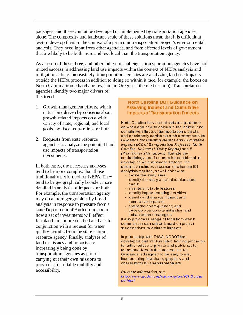
As a result of these three, and other, inherent challenges, transportation agencies have had mixed success in addressing land use impacts within the context of NEPA analysis and mitigations alone. Increasingly, transportation agencies are analyzing land use impacts outside the NEPA process in addition to doing so within it (see, for example, the boxes on North Carolina immediately below, and on Oregon in the next section). Transportation agencies identify two major drivers of this trend.
1. Growth-management efforts, which in turn are driven by concerns about growth-related impacts on a wide variety of state, regional, and local goals, by fiscal constraints, or both.
2. Requests from state resource agencies to analyze the potential land use impacts of transportation investments.
In both cases, the necessary analyses tend to be more complex than those traditionally performed for NEPA. They tend to be geographically broader, more detailed in analysis of impacts, or both. For example, the transportation agency may do a more geographically broad analysis in response to pressure from a state Department of Agriculture about how a set of investments will affect farmland, or a more detailed analysis in conjunction with a request for water quality permits from the state natural resource agency. Finally, analyses of land use issues and impacts are increasingly being done by transportation agencies as part of carrying out their own missions to provide safe, reliable mobility and accessibility.
North Carolina DOT Guidance on Assessing Indirect and Cumulative Impacts of Transportation Projects
North Carolina has crafted detailed guidance on when and how to calculate the indirect and cumulative effects of transportation projects, and consistently carries out such assessments. Its Guidance for Assessing Indirect and Cumulative Impacts (ICI) of Transportation Projects in North Carolina, Volumes I (Policy Report) and II (Practitioner’s Handbook), illustrate the methodology and factors to be considered in developing an assessment strategy. The guidance includes discussion of when an ICI analysis is required, as well as how to:
- define the study area; - identify the study area’s directions and
goals; - inventory notable features; - identify impact-causing activities; - identify and analyze indirect and
cumulative impacts; - assess the consequences; and - develop appropriate mitigation and
enhancement strategies. It also provides a range of tools from which communities can select, based on project specifications, to estimate impacts. In partnership with FHWA, NCDOT has developed and implemented training programs to further educate private and public sector representatives on the process. The ICI Guidance is designed to be easy to use, incorporating flowcharts, graphics, and checklists for ICI analysis preparers. For more information, see: http://www.ncdot.org/planning/pe/ICI_Guidance.html

7
A two-pronged approach is needed, one that includes attention to the environmental and community impacts of growth before transportation projects are readied for implementation, as well as attention to the impacts of particular projects as they are implemented. By devoting attention to analysis of growth impacts before specific projects are selected, undertaking capacity solutions as well as non-capacity solutions, and following through with actions to minimize undesirable land use impacts of projects, transportation agencies can become active partners in efforts to manage growth in ways that address multiple community objectives. They also position them-selves to more quickly perform NEPA-mandated analyses, and are likely to encounter fewer challenges (and certainly fewer unexpected challenges) if those analyses are extensions of analyses done as part of larger planning and growth management efforts.
1.5 A Response in Three Parts: Integrating Transport and Land Use Considerations
Although transportation and land use are planned in separate contexts, transportation agencies can support easier and faster implementation of transportation projects and avoid the problems the separation inevitably creates by considering the land use impacts of projects earlier and producing initiatives that truly address those impacts. Doing so does not require transportation agencies to abandon the goals of improving mobility and accessibility, but rather to employ new means to achieve those goals. Three kinds of responses can help strengthen linkages between transportation and land use: Engagement in Local Land Planning. Transportation agencies can develop mechanisms to engage with local land planning processes as a way to bridge the divides created by divisions of responsibility for transportation and land use. Through this engagement with land planning, more holistic solutions can realistically be considered and implemented. In fact, mitigation strategies often depend on advance planning work in order to be implemented. This engagement can also provide a political environment that is more conducive to good-faith dialogue about how transportation agencies, land use agencies, and the community at-large can work together to address growth issues. Analysis Methods. As previously discussed, transportation and land use interactions are complex. Many current analysis methods have proved insufficient for capturing these interactions. Agencies can work to improve the methods used to predict the land use effects of transportation projects, and the methods to help convey these effects to broad audiences, especially visually. Mitigation Strategies. Ultimately, strategies are necessary for implementing land use growth and development management visions and goals. Agencies can employ such strategies in connection with transportation projects, or as general initiatives unconnected with particular projects. Some of these strategies involve land use regulations, underscoring the importance of close coordination and partnerships with land use jurisdictions. Others transportation agencies themselves can undertake.

8
By engaging with and supporting land use planning, transportation agencies can build partnerships and help form a regional consensus on managing growth and its effects. In many areas, new analysis methods are needed to improve the understanding of land use and transportation interactions. And finally, mitigation strategies are needed to help implement these regional strategies to manage growth. The nature of these responses highlights the need for successful coordination with land use at all stages of decision-making, from system planning to project implementation. Success lies in determining the most effective kinds of analysis and actions to be undertaken at each stage. The remainder of this Handbook is structured to provide more detail on these three types of responses.

9
2 Engaging With Land Use Planning Processes The compartmentalization of land use and transportation planning in many institutional contexts can act as a barrier to integrated consideration. In most cases, institutional structures are not expected to change dramatically from their current forms. Local jurisdictions are likely to continue to control land use, although an increasing number of regions have varying degrees of regional land use or related authority.8 Recognizing this, to be truly effective transportation agencies need to get involved with land use during both system planning and project implementation.
The most common current approach to coordinating with land use is to use planned or projected future land uses to project transportation demand, and plan investments in response—a “predict and provide” model. This approach does not go far enough to address the land use impacts of transportation system improvements. And while NEPA requires that agencies address impacts, including land use, in project implementation, a broader view is necessary to address problems, as discussed in Section 1.3 above.
2.1 Why Should Transportation Agencies Engage With Land Use Planning Processes?
Induced growth can reduce the effectiveness of transportation investment, may conflict with local growth desires, and trigger adverse environmental impacts. An integrated effort can benefit transportation agencies and the community at large in three ways:
First, projects emerging from planning processes that consider transportation and land use together can respond better to community needs. Transportation agencies can support community goals that extend beyond mobility and economic vitality, enabling them to select projects that combine mobility and economic objectives with quality-of-life and environmental ones.
Just as important is the ability of projects from more coordinated planning processes to garner greater public support. Engaging with land planning processes allows transportation projects to be conceived within a community vision for land use and transportation. The support built around this vision can in turn help facilitate transportation project implementation.
Finally, coordinated land use and transportation planning processes can develop more community- and environmentally sensitive land use plans and policies. Transportation projects can be catalysts to initiate local and regional dialogues about how to manage future growth, illuminating the impacts of land use choices. The ties that transportation agencies have to state and federal resource agencies can bring natural resource concerns into local planning, allowing land use plans and policies to better address those concerns.
8 For example, the Atlanta region’s Georgia Regional Transportation Authority, which has substantial authority in both regional transportation and land use planning and permitting.

10
In sum, genuine engagement with land use planning enables transportation agencies and land use jurisdictions together to develop and implement the planning and mitigation strategies necessary to avoid or reduce negative land use impacts of transportation projects. Transportation agencies stand to gain from involvement in land planning processes not only through better projects, but also from a better environment in which to implement projects.
2.2 How Can Transportation Agencies Engage With Land Use Planning Processes?
The goal of engaging in land planning is to create a vision for land use in which transportation plays an integral role, ensuring that transportation projects have the effects that local communities desire and so are supported by the communities they serve. Recognizing that the institutional contexts in which transportation and land use are planned will generally remain fixed, the way for transportation agencies to become involved in land use is to partner with other stakeholders. These stakeholders could include metropolitan planning organizations, state DOTs, local land use jurisdictions, transit agencies, regional agencies, and resource agencies, as well as the greater community and its constituent interest groups.
Transportation agencies have access to and control over substantial funding resources, as well as a wealth of technical expertise. They can become engaged in land use planning by bringing to the table the funding and expertise needed to support efforts to address growth impacts. Transportation agencies can make these linkages with:
statewide growth efforts;
local or regional growth planning efforts; and
local land use goals in transportation project selection.

11
2.2.1 Through Statewide Growth Efforts
Background
From a statewide perspective, interactions between land use and transportation become strikingly clear. State agencies are called upon to provide infrastructure expansions as new land development brings demand for new investment, which in turn spurs new growth over time, creating further demand for infrastructure. In many places, this cycle of demand is outstripping the financial capacity of the state. And because this progression often occurs across local jurisdictional lines, the ability of one jurisdiction to address this issue is limited. State agencies, with their statewide perspective, are positioned well to formulate an effective response on a more regional scale. States have taken several approaches, including:
State legislation compelling local authorities to conduct planning in specific ways that support containment of growth in urban areas. States have employed requirements such as urban growth boundaries and designation of areas of environmental sensitivity that are left to local authorities to conduct the actual work.
Designating areas where future growth is desired and where it is not desired. Several states have undertaken efforts to designate future growth areas. By itself, this does not produce tangible outcomes on the ground. But it can play a crucial role by setting the framework for creating policies and programs that provide incentives for managing
Oregon Transportation Growth Management
Perhaps the most comprehensive approach to integrating land use and transportation on a statewide basis is in Oregon. Oregon has merged the two issues in both policy and program respects to an exceptional degree. Its Transportation Growth Management (TGM) program—a joint effort between ODOT and the state Department of Land Conservation and Development (DLCD)—best embodies this marriage as the entity responsible for allocating transportation funds for land use planning. Today, the TGM program uses transportation funds to offer direct technical assistance and grants statewide to communities engaged in transportation and land use planning. Other state policies reinforce this connection. For example, ODOT’s Policy 1B on Land Use and Transportation states It is the policy of the State of Oregon to coordinate land use and transportation decisions to efficiently use public infrastructure investments to:
- Maintain the mobility and safety of the highway system;
- Foster compact development patterns in communities [….]
Oregon’s Highway Plan explicitly discusses the transportation benefits of compact development, and commits the Highway Plan to supporting “the state goal of compact, highly livable urban areas.” Similar connections are made in project implementation provisions. The Oregon Transportation Planning Rule, for example, states that large highways should not be constructed outside urban areas that would generate development pressure. And recently, interchange management plans have been utilized to establish agreement between ODOT and the applicable land use agency that the land around new or proposed interchanges will not be rezoned to commercial. For more information, see: http://www.odot.state.or.us/tdb/planning/highway/documents/Amended_Policy_1B.htm

12
growth. Some states are using such designations as ways to build consensus among local communities for policies that support growth management.
Directing state-financed infrastructure to designated growth areas and away from designated rural areas. States can couple the previous approach with policies to direct state funds to designated growth areas. Since state-financed infrastructure can often constitute a significant percentage of public facilities, these policies can have powerful effects on which areas are able to grow.
Incentives to conduct planning efforts that aim to contain growth, in the form of financial and technical assistance. Some states provide assistance to local jurisdictions interested in implementing growth management techniques but that do not have the resources to conduct such planning and policymaking activities on their own.
Linkage Opportunities
The nature of existing statewide growth efforts dictate the kinds of linkages that transportation agencies can make on their own. In states that direct funding to support growth only in designated growth areas, state transportation agencies can do their part by directing funds under their control to support growth in particular areas. Some state and federal funding sources are distributed by formula, which state agencies cannot re-direct. But significant transportation funding is discretionary, and can be directed by state transportation agencies. In this way, agencies can both more actively manage state infrastructure costs as well as meet goals for open space and environmental conservation. Some states provide technical planning assistance to local agencies doing growth planning. State transportation agencies can play their part by providing in-kind planning expertise and funding for planning expertise. This topic is covered in more depth in the following section.
New Jersey DOT: Using Land Use Strategies to Decrease
Infrastructure Costs The State of New Jersey has a long history of involvement in land use planning. The State has been developing a statewide land use Development and Redevelopment Plan (State Plan) since 1988, which aims to focus growth and development in designated areas. Because New Jersey municipalities operate under home rule, the State has approached implementation through consensus building among, and incentives for, local jurisdictions. Meanwhile, NJDOT has come to recognize that the cost of providing the capacity increases necessary to maintain current levels of mobility for future growth exceeds the funding resources it reasonably expects to become available. In response, NJDOT and other state agencies have aligned their interests and influence toward guiding local planning efforts to more rigorously reflect the goals of the State Plan, and to ultimately reduce the need for infrastructure investment. Municipalities are still free to plan as they prefer, but State agencies are leveraging State technical assistance, permitting, and infrastructure financing to favor planning efforts that closely adhere to the State Plan over those which do not. NJDOT has also agreed to give priority for available transportation infrastructure funding to localities that are undertaking efforts consistent with the State’s Growth Plan above those municipalities that are not actively targeting State Plan goals. For more information: http://www.nj.gov/dca/osg/team/news.shtml

13
Finally, keep in mind that because land use is generally interpreted as an issue for local control, transportation agency participation in statewide efforts to manage growth will not be successful unless those efforts are seen to respect home rule. Statewide efforts that are framed as ways for state agencies to facilitate and encourage local planning efforts are more likely to gain acceptance than ones that are seen to impose a state mandate on local communities.
2.2.2 Through Local and Regional Growth Planning Efforts
Given that land use decisions are, by and large, made at the local level, any integrated consideration of transportation and land use must necessarily include local decision-makers. However, especially in small communities on the outskirts of burgeoning metropolitan areas, transportation-related growth pressures can reveal themselves before communities have had a chance to develop a community vision for growth. Transportation agencies are asked to provide infrastructure solutions that address these growth pressures. Often other issues are at hand than whether or not to build transportation improvements; sometimes, communities are also grappling with how much growth is desired. Transportation agencies can get caught in the middle of these issues. Transportation agencies can help by engaging early with local planning efforts. By doing so, transportation agencies can bring land use decision makers into a local or regional dialogue about growth, and ensuring that the dialogue includes strategies that employ land use as well as transportation actions.
Background
The goal of a local planning process for land use and transportation is to build consensus around a community vision for future land use supported by transportation improvements, based on analysis that captures the interactions between land use and transportation. It can then serve as a point of departure for efforts to revise local comprehensive plans and regional transportation plans.
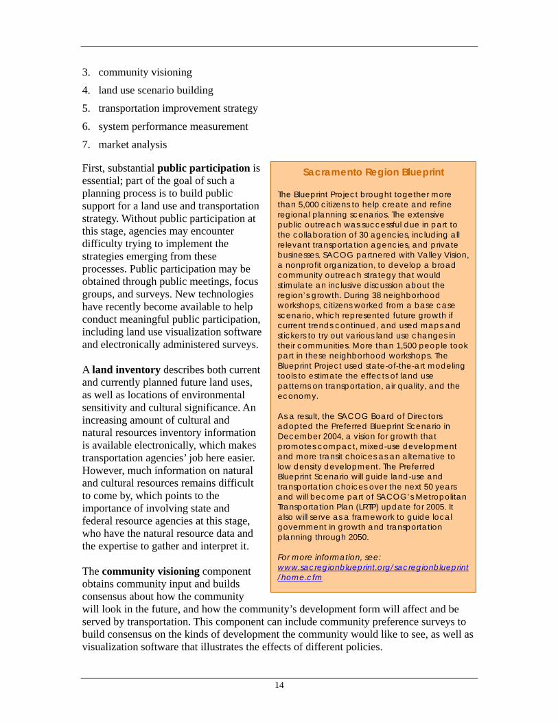
A local planning process can consist of the following components: 1. public participation
2. land inventory
Utah Quality Growth Commission A statewide commission in Utah has created a program that provides priority access to state funds for communities certified as “Quality Growth Communities” and for special districts, transit districts, and other service providers certified as “Quality Growth Service Providers.” To become certified, an agency or jurisdiction must be engaged in an enhanced community planning process, including close coordination with neighboring communities. Priority access to state funds includes Utah DOT funds: “Local "corridor preservation" and "safe sidewalk" funding programs will be directed towards Quality Growth Communities and Service Providers.” For more information, see: http://governor.utah.gov/Quality/
14
3. community visioning
4. land use scenario building
5. transportation improvement strategy
6. system performance measurement
7. market analysis
First, substantial public participation is essential; part of the goal of such a planning process is to build public support for a land use and transportation strategy. Without public participation at this stage, agencies may encounter difficulty trying to implement the strategies emerging from these processes. Public participation may be obtained through public meetings, focus groups, and surveys. New technologies have recently become available to help conduct meaningful public participation, including land use visualization software and electronically administered surveys. A land inventory describes both current and currently planned future land uses, as well as locations of environmental sensitivity and cultural significance. An increasing amount of cultural and natural resources inventory information is available electronically, which makes transportation agencies’ job here easier. However, much information on natural and cultural resources remains difficult to come by, which points to the importance of involving state and federal resource agencies at this stage, who have the natural resource data and the expertise to gather and interpret it. The community visioning component obtains community input and builds consensus about how the community will look in the future, and how the community’s development form will affect and be served by transportation. This component can include community preference surveys to build consensus on the kinds of development the community would like to see, as well as visualization software that illustrates the effects of different policies.
Sacramento Region Blueprint The Blueprint Project brought together more than 5,000 citizens to help create and refine regional planning scenarios. The extensive public outreach was successful due in part to the collaboration of 30 agencies, including all relevant transportation agencies, and private businesses. SACOG partnered with Valley Vision, a nonprofit organization, to develop a broad community outreach strategy that would stimulate an inclusive discussion about the region’s growth. During 38 neighborhood workshops, citizens worked from a base case scenario, which represented future growth if current trends continued, and used maps and stickers to try out various land use changes in their communities. More than 1,500 people took part in these neighborhood workshops. The Blueprint Project used state-of-the-art modeling tools to estimate the effects of land use patterns on transportation, air quality, and the economy. As a result, the SACOG Board of Directors adopted the Preferred Blueprint Scenario in December 2004, a vision for growth that promotes compact, mixed-use development and more transit choices as an alternative to low density development. The Preferred Blueprint Scenario will guide land-use and transportation choices over the next 50 years and will become part of SACOG’s Metropolitan Transportation Plan (LRTP) update for 2005. It also will serve as a framework to guide local government in growth and transportation planning through 2050. For more information, see: www.sacregionblueprint.org/sacregionblueprint/home.cfm

15
Community input and the land inventory can be used to build alternative potential future land use scenarios. Scenarios can be shaped as ‘low-growth’ and ‘high-growth’ scenarios, or (more usefully in most cases) as absorbing the same amount of growth in various ways, such as ‘trend,’ ‘low-density’, and ‘cluster’ growth scenarios. The point of these scenarios is not necessarily to predict with certainty the kinds of land uses that will occur in the future, but rather inform policymaking by constructing scenarios that capture and illustrate discernible differences in system performance that can be expected from various land policies.
Transportation improvement strategies can then be developed for one or several preferred land use scenarios. This step can eventually be used to create regional transportation plans (RTPs).
Performance measures for land use, transportation, and other measures of concern to the community should be developed and analyzed for current conditions and each of the land use and transportation scenarios. In quantifying likely future performance, this component allows communities to differentiate among and understand the implications of different scenarios for growth and infrastructure improvements. Equally important, such quantitative measures help focus discussion on what the community wants, and what approaches help deliver those qualities. Put another way, focusing a process on quantitative measures can help move community discussions away from high-level debates that are essentially unproductive (“Are density/growth/new roads ‘good’ or ‘bad’?”) and toward concrete questions that can be productively answered: “Which scenario performs better across this set of goals? What trade-offs do these results suggest?”
Scenarios can be evaluated on a wide range of indicators and measures, from traditional transportation measures such as Level of Service, vehicle hours of travel, vehicle miles of travel, and ridership, to physical measures such as land required, open space preserved, regional impervious surface and runoff, water consumption, and emissions, to measures of community quality of life and economic health such as jobs accessibility, and
Maryland DOT: Initiating Local Planning Efforts
On the Perryman Peninsula in Hartford County, Maryland, the State Department of Transportation (MDOT) has led a land use visioning effort as a way to clarify the community’s transportation expectations. The area had been slated for substantial economic development, especially warehousing, but suffered from lack of supporting transportation infrastructure; a previous study had identified $300 million worth of necessary road improvements. Recognizing that the State did not have such funds, MDOT and Hartford County embarked on a visioning project to re-visit land use plans for the area to better match them to the available transportation resources. The project, which MDOT managed, utilized an extensive public process to inform the community about the issues, as well as to collect community input on the local vision for growth, which was then refined by a land use consultant. The outcomes of the project included a new vision for land use in the Perryman area and a new set of transportation projects tailored to the land use vision. Hartford County agreed to revise its comprehensive plan to reflect the new vision, and as an added bonus, arrangements are being made to enable costs to be shared with the private sector as well. For more information: http://www.balto-region-partners.org/perryman_letter.htm or contact Don Halligan, Maryland DOT

16
proximity to parks, shopping, and schools. An example of a broad set of performance measures is given in the Sketch Planning section, below. Agencies also sometimes employ a market analysis to better understand market forces and to determine the feasibility of implementing any of the land use strategies developed in the process. All seven components are important to helping decision-makers and the public to understand the different impacts of different transportation and land use scenarios, and to make policy choices with a full understanding of likely outcomes. Finally, follow-through is required to make these community visions for land use and transportation become reality. The next steps after the completion of local planning processes are for local jurisdictions to revise their comprehensive plans to reflect these community visions, and for transportation agencies to include projects in their long-range transportation plans.
Because growth is a regional phenomenon, these kinds of growth visioning and planning efforts are generally conducted on a regional scale, across multiple land use jurisdictions. Political, fiscal, and economic concerns can render these situations tremendously more challenging than local planning, and oftentimes, there is a real need for regional leadership that is able to transcend parochial interests to build a regional approach to growth-related land use and transportation issues.
Linkage Opportunities
Growth planning requires investments in expertise, data, tools, and time for the requisite supporting activities, such as modeling analysis and public participation. Local land use jurisdictions, especially smaller municipalities, are often short on the resources they need for these kinds of activities. One way for transportation agencies to help localities is to provide the necessary resources for a local planning process. Agencies can provide these resources either in the form of in-kind technical assistance, or of funding for planning expertise and activities.
Building Regional Consensus: Lansing Tri-County Regional Planning
Commission In the 78-jurisdiction Lansing, Michigan, metropolitan area, rapid growth prompted the Tri-County Regional Planning Commission (the MPO), to undertake a regional growth process and build consensus on a growth management approach. Project elements included a GIS-based land inventory of existing and currently planned future uses, scenario-building and predictive modeling to describe possible future land uses, analysis to compare the impacts of various policies, and an extensive public process that included visual preference surveys to build consensus on a preferred regional land use vision. The outcomes of the project included an adopted set of land use goals, and a land use policy map. TCRPC’s Board of Directors will use the goals and map to establish priorities for federal aid transportation projects. In this way, the regional land use outcomes serve as foundation for the regional transportation plan. For more information: http://www.mitcrpc.org/publications.html, or contact Paul Hamilton, Tri-County Regional Planning Commission

17
In many cases, transportation agencies already have the technical expertise with which to analyze the travel demand impacts of land use. MPOs and state DOTs can take advantage of the tools they already use to fulfill their regular responsibilities for developing transportation improvement strategies. Transportation agencies could lend this expertise to local growth planning processes, providing critical inputs to create performance measures that can help communities understand the impacts of land use policy options. Transportation agencies can also support these efforts by providing the funding required for growth planning. Planning expenditures are generally small when compared with capital infrastructure expenditures, and can help reduce capital needs by developing solutions that require less transportation investment. Transportation agencies can set up grant programs for which funds can be used for planning activities such as public workshops, mapping of land uses and natural resources, and performance measurement. Grant programs could be structured to direct funds by a competitive application process, which could employ as evaluation criteria state priority corridors or areas, interest in growth planning to support more compact development, and matching contributions by local jurisdictions.
If no growth planning processes currently exist, transportation agencies themselves can initiate these discussions, taking lead roles in local planning. By bringing together within such processes the necessary transportation expertise, environmental information and input from state and federal resource agencies, local land decision makers, and the greater community, transportation agencies can convene a comprehensive dialogue about growth and its impacts, informed by analyses that broaden communities’ understanding of transportation and land use options.
New Hampshire DOT: Funding Local Planning Efforts
New Hampshire DOT (NHDOT) developed a $3.5 million I-93 Technical Assistance Program (TAP) as a “project enhancement” for an 18-mile stretch of the congested I-93 corridor. The program aims to support five “primary” communities impacted by the project, and a number of “secondary” communities over five years. Approximately 80 percent of the $3.5 million budget comes from federal transportation dollars; the remaining 20 percent from state transportation funds. Examples of activities expected to be covered by the TAP include direct technical assistance to the communities to support more integrated planning, to develop build-out analyses for future growth alternatives, and to develop specific tools and materials to support local planning and conservation efforts. Three committees are expected to guide the TAP: one representing the member communities, another representing regional planning commissions and state and federal agencies, and a third representing a variety of statewide interests such as real estate developers and environmentalists. It is hoped that the committees will function beyond the initial five-year project timeframe. For more information on the I-93 project, see: http://webster.state.nh.us/dot/10418c/default.htm, or contact Ansel Sanborn, NH DOT.

18
Transportation agencies can provide strong leadership in regional growth planning efforts. They are especially well positioned to help build consensus around a regional strategy for growth and transportation, given a need to address transportation problems through regional solutions. Transportation agencies can help bring other agencies to the table, and lead once there, because of the clear connection between regional growth challenges and transportation, because transportation agencies already have a regional perspective on planning and analysis, and because they have a project funding process in place to help implement at least the transportation portion of the plans that result.
Lessons from the Field
Discussions and development of regional strategies are sensitive, potentially controversial processes. It is beyond the scope of this Handbook to give a recipe for success in such endeavors, not least because each one must necessarily take into account local context and concerns. However, experience around the country suggests at least two lessons.
1. Make transportation proactive, not reactive
In growing areas, transportation agencies often face two types of pressures, which, while not quite in opposition, illustrate the directions in which agencies are pulled. On the one hand, agencies are often called upon to support local economic goals with transportation infrastructure investments. On the other, agencies are often seen as either bringing or at least facilitating unplanned and undesired growth. The solution typically lies in positioning transportation as an integral and necessary component of a regional approach to accommodating/driving growth in a manner that strengthens the community. Such positioning is difficult to do on a project-by-project basis, and requires a regional approach to growth, one that is sensitive to environmental and financial constraints.
2. Plan to save money Agencies around the country are seeing ever-widening gaps between needs/demands and available funding. Research typically finds that growth management reduces infrastructure needs for everyone. A local study of the issue can help address conflicts over limited infrastructure funding.
Illinois DOT: Planning Support for Transportation
Corridors Illinois DOT (IDOT) engages communities directly affected by proposed transportation investments to assist in local planning. For the past decade, corridor-planning councils have been used on every major transportation project. These councils, funded by IDOT and composed of local officials from jurisdictions affected by the proposed projects, are tasked with coordinating land use planning and with helping localities manage the land use impacts likely to come from the project. Depending on the context, these councils review everything from lighting and drainage to interchange locations and compatible zoning. Many communities have since revisited their comprehensive plans to incorporate the results of the council process. IDOT views these councils as its contribution to improving the local planning process and believes that the community as well as IDOT will benefit. For more information, http://www.dot.state.il.us/corridorplanning/corridor.html, or contact Randy Blankenhorn, IDOT.

19
Planning to save money can also garner side benefits, such as securing private-sector financial support. Planning efforts often reveal that the increases in travel demand caused by new development will overtax the existing transportation system. This is not a surprising finding, but when made clear, it can help to build support for local policies that require new development to help pay for the infrastructure improvements needed to accommodate resulting travel demand increases.
2.2.3 Local Land Use Goals in Transportation Project Selection
Background
With, or even without, local or regional growth planning efforts, transportation agencies can use local input to choose projects and new initiatives that support local desires. Clearly, a growth planning process that integrates transportation concerns into land use decision-making and that conceives of transportation projects as components of a larger growth strategy make it easier for transportation agencies to choose projects that support local goals. But even in the absence of such a process, transportation agencies can still link with land use by recognizing local land use plans and goals in the selection of transportation projects. Many of the projects and initiatives highlighted in the text boxes above support making that linkage. This section discusses the linkage in more detail.
Linkage Opportunities
Long-range regional and state transportation plans are the most important opportunities for linkages with local land use goals. These linkages can take the form of evaluation criteria for analyzing potential transportation investments. Transportation agencies can 1) include land use goals as criteria for overall transportation projects, and 2) create specific funding programs that support community- and land-use- oriented transportation projects, such as pedestrian, streetscape, and transit improvement projects.
As observed in Section 2.2.2. immediately above, transportation agencies are generally already familiar with their role in facilitating development by improving access. The recent challenge for many agencies has been not to select projects that support local land use goals, but to select projects that support a new kind of land use goal, such as mixed-use infill, or transit-oriented development.
Aligning Transportation with Land Use: Atlanta Regional Commission
In Georgia, the Atlanta Regional Commission has taken several steps to better align its long-range transportation decision-making processes with local land use goals.
For the 2025 Regional Transportation Plan, ARC’s scoring criteria for federal STP and CMAQ funds included support of local land use, which can provide a maximum of 15 points out of 135 total.
ARC has also created a $350 million fund to help local agencies implement bicycle and pedestrian projects, streetscape projects, transit access improvements, and parking coordination efforts.
To help local jurisdictions develop projects for this fund program, ARC has also provided funding for planning under a separate grant program called the Livable Centers Initiative.
For more information: http://www.atlreg.com/transportationair/transportationair.html

20
Often, communities desire transportation projects that will support a particular kind of land use, say, infill, but because of inexperience with this kind of development, are not able to conduct the necessary planning work to propose specific projects for inclusion in long-range transportation plans. Transportation agencies can help by supporting this planning work.
The opposite condition can also be common: a transportation agency wants to support specific kinds of land uses, but supporting specific kinds of land uses with specific kinds of transportation infrastructure may be a new approach to local communities. A transportation agency program that offers such dedicated investment may, then, not receive substantial interest or qualifying applications without significant amount of support from the transportation agency.
Both types of challenges can be addressed by creating twin programs: a planning support program to build project request lists, conduct initial studies, and create conceptual designs; and a capital grant program to move forward into infrastructure construction. In either case, transportation agencies can become a catalyst for change by making transportation funds available for building community-oriented transportation infrastructure, thereby supporting private investment.
Because transit-oriented development is a popular approach to absorbing growth in many urban areas, discussions of how to support this new direction in land use planning sometimes focus on the transit element to the exclusion of other kinds of transportation that TOD and related kinds of development need. Even with a strong transit orientation, compact and mixed land uses will still require highway investments to provide vehicle access to the area. How those highway investments are designed and delivered will be crucial to the success of these areas.
Supporting Sustainable Land Uses with Transportation:
North Central Texas COG NCTCOG’s Mobility 2025 Update establishes sustainable development as the region’s strategic approach to transportation planning, programming, and construction. Sustainable development leverages the land use/transportation relationship to improve mobility, enhance air quality, support economic growth, and ensure the financial stability of the transportation system. NCTCOG is implementing this strategic approach in part through its Land Use/Transportation Joint Venture Program. This program supports private sector investment in mixed/integrated land use, infill development, transit, and pedestrian-oriented development by providing dedicated planning assistance and designating transportation project investments to support those projects. NCTCOG works through local governments to identify potential Development Excellence partners, to support their participation in the process, and ultimately to select projects that will receive dedicated transportation support. The “Joint Venture” refers to the contributions from multiple stakeholders: in addition to the developer’s investment and the transportation investments, selected projects receive local tax, zoning, and other regulatory support.
For more information: http://www.nctcog.org/trans/landuse/

21
3 Methods for Analyzing Land Use Changes This section describes how to analyze indirect land use changes from transportation investments and summarizes methods for doing so. It also discusses some of the major tools used for predicting such changes. Some of these methods are straightforward and can be achieved through common survey techniques, comparisons, or basic quantitative analysis. Other methods are complex and require specialized software and training.
The goal of this section is to provide a general sense of approaches and tools that are available. The examples below are loosely grouped into qualitative and quantitative tools. In reality, most components of land use impact analysis combine both quantitative and qualitative techniques. Several more detailed resources are listed at the end of this chapter to provide more in depth discussion of these analysis tools.
3.1 General Approach9
Land use impact analysis uses a wide range of analysis tools and strategies. Different tools and strategies are suitable for different stages in the analysis process. Selecting the most appropriate tools and strategies depends on specifics such as the quality and availability of data. This section briefly describes general steps in the assessment process. Assessments of land use changes are necessary in three different areas:
1) Baseline land use forecasts, i.e., what future land use would be expected in the absence of any investments or policy changes.
2) Impact assessment, i.e., land use changes attributable to specific infrastructure construction or expansion.
3) Policy assessments, i.e., land use impacts attributable to changes in transportation policy changes (e.g., pricing or parking policies) or technology (e.g., intelligent transportation systems efficiencies).
In each of these three categories of land use analysis, several steps are required to determine the degree and character of likely land use change. While the sequence of analysis steps depends on each circumstance, the following steps generally describe the analysis process. A) Understand existing conditions and trends. This principally involves assembling data
that will be necessary to conduct the analysis. Existing databases, surveys, statistical trend analysis, remote sensing technology, and GIS are likely to be required for this stage of analysis.
9 A more detailed discussion of the approach outlined in this section can be found in Land Use Impacts of Transportation: A Guidebook, NCHRP Project 8-32(3), prepared by Parsons Brinckerhoff Quade & Douglas, Inc. October 1998. See also the Federal Highway Administration’s on-line “Toolbox for Regional Policy Analysis”, at http://www.fhwa.dot.gov/planning/toolbox/index.htm.

22
Targeting Land Use Assessment Methods in New Hampshire
The best technique to measure land use impacts differs from one project to the next. For example, NHDOT employed two different assessment methods in two separate highway projects. For its widening of I-93, the Delphi expert panel method was employed to analyze impacts, while on the new Spaulding Turnpike improvement project, the REMI (Regional Economic Models, Inc.) economic model was used. NHDOT staff members indicated that the methods were chosen in large part based on the type of project. The I-93 project was large and not well defined in terms of impact area, making the qualitative, consensus-based Delphi approach more appropriate. Conversely, the small and well-defined nature of the Turnpike project was better suited to the data-intensive, quantitative REMI method. Still, NHDOT said that the use and type of methodologies in the future is likely to vary on a case-by-case basis, and will depend on magnitude of a project and its likely regional impact.
For more information, see: http://www.state.nh.us/dot/10418c/default.htm, or contact Bill Cass, New Hampshire DOT.
B) Establish policy assumptions. This step involves determining currently anticipated changes in regulatory or economic policies. When comparing future scenarios, this may also require defining different policy assumptions for various scenarios. Examples of areas where policy assumptions must be clearly defined include zoning, environmental regulations, and impact fees. This step generally requires discussions with regulatory practitioners and policy makers.
C) Estimate regional population and employment growth resulting from change in
accessibility. This step uses local population and employment trends; broader state and national economic industry trends; and economic forecasting models in order to establish future population and employment trends for various scenarios. Regional economic and demographic models are the key tools.
D) Inventory land with development potential. This step identifies undeveloped and
underdeveloped land and, in combination with environmental restrictions and zoning regulations, quantifies land available to absorb growth. This typically involves surveys and interviews as well as GIS analysis. The environmental restrictions can be either statutory (a required stream setback) or based in the goals of the planning process (avoid highly erodible lands).
E) Assign population and employment to specific locations. This step uses land
availability, the cost of development, and the attractiveness of various areas to estimate the amount and type of growth that will occur in each zone. This stage can use expert interviews and panels (including Delphi panels), statistical trend analysis, and/or integrated transportation and land use models.
Ideally, there is a feedback process from step E to step B until equilibrium is achieved.

23
3.2 Qualitative Methods
The approaches listed below are qualitative in that they do not aim to produce specific numbers about what impact is expected. They generally seek to use a combination of professional expertise, informed foresight, and comparable cases to provide a solid sense of likely impacts. This will undoubtedly involve some quantitative analysis. For example, some analysis tools may be necessary to isolate population or economic growth rates, or to adjust them so they can be compared to other cases. These examples are described as qualitative simply because there are obvious stages where professional judgment is a primary tool. This contrasts with more complex mathematical models (described later) where professional judgment is often not so visible amidst mathematical representations.
Comparative Case Analysis
This technique compares the case under examination to comparable cases in other locations. Cases are never perfectly comparable, so professional judgment and additional analysis tools will be necessary to account for differences. Typically, case study research may involve interviews, site visits, and data compilation. Researchers look for patterns among comparable cases and for reasons why some cases deviate from these patterns. This approach is relatively subjective, and thus will have little value unless the research team is perceived as a trusted and objective party. While comparisons are always imperfect, having a real example of a comparable situation can lend credibility and tangibility to an assessment of land use impacts. For a comparison to be valid, comparison cases should be similar in size, project type, location, demographic statistics, as well as population and economic growth rates.
As a hypothetical example of this approach, an analyst concerned with land use impacts from a new interchange could study a range of similar interchange developments around the country. It is likely that cases could be found that are similarly situated relative to urban and rural lands, with similar traffic volumes and demographics, and with similar land use controls already in place. The impact in these comparable cases would not necessarily be the same in the case being analyzed, but these actual comparisons would certainly provide concrete examples of the sorts of concerns that are common and the types of controls actions that could steer them in a desirable direction.
Scenario Writing
Instead of predicting how land use will change as a result of a proposed project, scenario writing establishes a logical sequence of events to show how land development might evolve under reasonable future conditions. The result is a narrative that describes the sequence of events that could occur after a project is built. They can be useful in setting upper and lower boundaries for anticipated results (i.e., best and worst case scenarios). This approach includes obvious uncertainties ranging from future actions of decision makers (such as changes to land use regulations or additional transportation investments) to major economic shifts (such as major growth in the region’s primary industry).

24
The Delphi Process in Wisconsin To assess potential land use impacts from State Trunk Highway 26, WisDOT convened a panel of experts. The panel included county and municipal planners and engineers, University of Wisconsin staff, local economic development professionals, and representatives of the farming, real estate, and environmental communities. Panel members ranked alternatives for segments of the project on the basis of consistency with land use plans, site-specific institutional impacts, and community access. While the panel did not agree on many issues, some key consensus issues emerged, such as:
• Interchanges and signalized intersections outside the urban service areas tend to be inconsistent with local land use plans; and
• Alternatives that do not sever 40-acre farm lots reduce impact on agricultural resources.
Panel consensus on these land use impacts carried significant weight in the evaluation of project alternatives.
For more information: Wisconsin Department of Transportation, “Land Use in Environmental Documents: Indirect and Cumulative Effects Analysis for Project-Induced Land Development,” Technical Reference Document, 1993.
Expert Panels and the Delphi Process
Expert panels attempt to use the aggregate experience of diverse local professionals to illuminate the most likely range of outcomes from particular transportation policies or investments. Panels typically include planners, developers, local government officials, business leaders, and others with informed perspectives on likely development trends and influences.
The Delphi process is one form of expert panel analysis. Delphi seeks to arrive at an informed assessment via a structured exploration of diverse and often conflicting opinions. The Delphi process is iterative with several rounds of input and feedback. Experts generally suggest broad trends and possible events that are related to the impacts being assessed. Based on analysis and discourse, these issues are narrowed to those that are most likely to be pertinent for impacts being assessed. Through further discussion and stakeholder feedback, the panel gains agreement on the most likely impacts in light of the consensus set of events and trends. This process requires expert facilitation and firm commitment by panel members to participate in the full process. A Delphi expert panel for land use impacts might include experts such as local developers and real estate leaders, planners, local government officials, and business leaders.

25
Remote Sensing for Washington State’s I-405
Washington State’s I-405 corridor is in the midst of programmatic environmental analysis for a range of transportation improvements through the Puget Sound Metropolitan Area. Remote sensing is being used in an effort to streamline the NEPA process. Land use and land cover information is being compiled by remote sensing techniques to determine urban growth, growth in impervious surfaces, and habitat fragmentation. This data is being automatically integrated into the area’s GIS for comparative analysis in the alternatives phase. Ultimately, this project will compare costs with those associated with typical data gathering techniques.
For more information, see http://www.ncgia.ucsb.edu/ncrst/synthesis/SynthRep2002/, or contact Elizabeth Lanzar, WA State DOT.
3.3 Quantitative Methods
Remote Sensing
Although remote sensing is not a predictive tool, it can improve the efficiency and accuracy of data on existing land use conditions, and increasingly, of data on trends. Understanding baseline land use conditions and trends in land use change is fundamental to accurately predicting future land use transportation impacts. Recent advances in remote sensing and other spatial information technologies10 have enabled more efficient and accurate capture of such data. These new approaches can be very useful when there is inadequate information on land use conditions or when transportation investment decisions hinge on a better understanding of current trends.
3.3.1 Economic and Land Allocation Models
Economic modeling can be very useful in estimating the indirect land use impacts from transportation investments. Regional economic models simulate an area’s economy. They estimate the impact of major economic changes including changes in transportation costs (and travel time) on various sectors of the economy. The models forecast changes to employment and industrial output, and population at the county, regional, or state scale. These models are also used in combination with land use allocation models to estimate land use changes in policy and project scenarios. While direct land use impacts relate to the specific design and location of transportation facilities, some indirect land use impacts can be attributed to changes in a region’s land economics. A number of approaches can be used to estimate this effect.
10 A range of new and developing remote sensing technologies can be found in the following report: Achievements of the DOT-NASA Joint Program on Remote Sensing and Spatial Information Technologies http://www.ncgia.ucsb.edu/ncrst/synthesis/SynthRep2002/

26
REMI Analysis for I-69 through Indiana and Kentucky
In evaluating alternatives for the new I-69 freeway, Indiana DOT, Kentucky Transportation Cabinet and Evansville Urban Transportation Study sponsored an EIS that focused heavily on economic development impacts. The EIS considered whether various I-69 alternatives would attract industry to the project study area, and how industry shifts would affect the study area's share of some national industries. The EIS used a three-part strategy: (1) site visits and interviews concerning economic development, land use, real estate and transportation conditions, (2) economic base analysis to rate the region's economic performance, along with economic competitiveness analysis to identify business growth and attraction opportunities, and (3) application of the REMI economic model to forecast relationships between business cost, job creation and population growth impacts. The analysis found that one alternative was less costly; more effectively targeted population and growth increases in desired locations; and offered significant overall economic development opportunities compared to other options. For more information, see the project Draft EIS: http://deis.i69indyevn.org/DEIS/Summary/summary.html
REMI, one example of a regional economic impact model, produces socio-economic forecasts based on an historical analysis of the regional economy. For example, it can forecast natural population changes based on fertility and mortality combined with the results of employment forecasts that assess whether more people are needed to fill new jobs in the region. Economic migration predictions are based on the region’s attractiveness relative to the country as a whole based on the availability of jobs and on wage rates.
The population forecasts are then used to estimate consumer demand, which in turn changes the economic forecast. Revised employment and wage estimates are then applied to the demographic estimates to adjust for further changes in economic migration. This cycle continues until equilibrium is achieved. DRAM/EMPAL is a pair of spatial interaction models based on the Lowry gravity model of land use. Both models predict household and employment data by zone at a point in time. These predictions are based on spatial data and anticipated growth trends. DRAM (Disaggregated Residential Allocation Model) estimates the future number of households in each zone by income groups. Travel between zones is based on transportation impedance (time or cost) and a measure of attractiveness for each zone based on the availability of land, the percentage of households by income quartiles, and the location of employment. EMPAL (Employment Allocation Model) estimates the location of jobs based on assumptions such as current travel times, spatial arrangements, as well as housing and job growth trends.
A key advantage of DRAM/EMPAL is that it integrates effectively with a number of commonly used travel demand models. A disadvantage is that this approach is not well suited to individual project analysis. The analysis is often insufficiently sensitive to supply the geographic detail and responsiveness to interpret the potential land use impact of a single project. It is best suited to assessment of regional build versus no-build planning scenarios.

27
Sacramento’s MEPLAN Assessment of Projects and Policies
Sacramento evaluated the land use impacts of a range of policies such as HOV and HOT lanes, various transit investments, transit-oriented development, and roadway pricing. The model projected the spatial distribution of population and employment for the 2005 and 2015. When planners used these new population and employment distributions as an input to the region’s travel demand model, the resulting forecasts indicated that these transportation investments had a significant effect on projected vehicle trips, VMT, congestion, and emissions. The analysis also indicated important interactions between various transportation policies. For example, transit and pricing policies had little impact individually but a significant impact in combination. While parking pricing had the effect of reducing trip lengths and VMT, it provided some disincentive to transit station area development. For more information: http://www.fhwa.dot.gov/planning/toolbox/sacramento_overview.htm
3.3.2 Integrated Land Use and Transportation Models
Integrated land use and transportation models are different from typical travel demand models used to predict traffic patterns in that they do not use fixed land use inputs. Rather, they allow land uses to shift based on the differences in transportation policies, investments, and behavior. This is achieved by linking land use allocation processes (e.g., DRAM/EMPAL) with travel demand models. Such models are typically developed for an entire metropolitan region. Through an iterative process these integrated models predict an equilibrium land use and traffic pattern for some future year. Based on regionwide forecasts of population and employment, they allocate housing and business development to small zones based on transportation accessibility, land prices, land availability. The models are calibrated to represent the decision-making characteristics of a given metropolitan area by using historical data on transportation accessibility, and observed changes in land development and prices. Following are several commonly applied integrated land use and transportation models:
ITLUP is among the most widely applied integrated models in the U.S. The model consists of two major components: DRAM/EMPAL estimates geographic household and employment growth as described above. Another component calculates actual land consumption based on these estimates. The model then takes inputs for zone-to-zone travel times from any number of major travel demand models (e.g., TRANPLAN, EMME/2, and MINUTP). The model can then be run iteratively to compare a range of combined transportation and land use consequences from various transportation policy and investment scenarios.
UrbanSim is an integrated transportation-land use model that has been applied in a number of regions to test alternative land development scenarios and transportation policies. The model represents urban development, urban markets for land, housing, non-residential space and transportation. By treating urban development as the interaction between market behavior and governmental actions, UrbanSim can assess impacts of alternative governmental plans and policies related to land use and transportation. The model requires population and employment estimates, regional economic forecasts, transportation system plans, land use plans, and land development policies such as density constraints, environmental constraints, and development impact fees. UrbanSim

28
Chittenden County, VT Decision Support System
Chittenden County (which includes Burlington), Vermont, seeks to accommodate substantial growth with transportation investments, while protecting its character—in part by seeking to limit the dispersed development impacts of those investments. As part of this effort, a partnership of the Chittenden County MPO, the Chittenden County Regional Planning Commission, and the Vermont Agency of Transportation (VTrans) has developed and is now testing an integrated transportation land use modeling suite and Decision Support System (DSS). The DSS has two modules: The Snapshot Module of the DSS is a support tool to help stakeholders and decision-makers:
• Create plans through issue identification, alternatives analysis, and goal setting. • Implement plans by evaluating development consistency with goals. • Achieve plans by measuring cumulative progress toward goals.
At the heart of snapshots is a set of indicators that are used to benchmark existing conditions, evaluate alternative courses of action, and monitor change over time. Indicators are measurements of key community characteristics that provide insights into overall conditions. The premise of the DSS is that plan formulation and implementation can be valuably informed by a standardized set of indicator measurements that are used regularly to gauge actions. The Forecast Module predicts the location of future housing and employment based on transportation accessibility and local land use policies. Testing of this module is currently underway on historic development patterns in Chittenden County and a number of hypothetical projects. The forecast module will be a valuable tool for informing regional discussions of transportation and land use into the future. The forecast module also has a standardized set of indicator measurements that are used to gauge actions and compare results across alternative land use and transportation scenarios. Adapted from (and for more information see): http://www.ccmpo.org/activities/Modeling/dss.html.
simulates urban development as a dynamic process over time. This is different from most other models that examine static moments in time or that assume some equilibrium state.
MEPLAN and TRANUS are both used to test regional transportation and land use scenarios. In these models, employment markets are modeled using input/output models. Jobs and housing are allocated to zones based on land price, labor, and travel time. These models are based on fundamental theories of macroeconomic behavior, and include markets for land, floor space, and labor.
Many of the integrated models are highly data- and labor-intensive, and as such are usually regarded as appropriately used only by large regions. However, smaller regions can enjoy the same analytic insight (for example, see the accompanying box on the Chittenden County DSS).

29
Compare Transportation & Redevelopment Scenarios using INDEX Redeveloping brownfields and other idle urban land is often proposed as a way to absorb growth while reducing pressure for dispersed development. Redevelopment choices can make a substantial difference in whether that promise can be fulfilled, especially with regard to how redevelopment relates to transportation improvements. The Wilmington Delaware MPO (WILMAPCO) used the Smart Growth INDEX model to analyze three different scenarios for redeveloping an abandoned mall in Wilmington’s Fox Point Community. The scenarios included: 1) commercial redevelopment of the mall
with sidewalk improvements, 2) mixed use redevelopment with no
transportation changes, and 3) mixed use redevelopment, pedestrian
improvements, and new train station. The analysis found that all scenarios improved jobs/housing balance. In addition, the scenario that included a new train station showed a 20 percent decrease in the number of vehicle trips, an 18.5 percent decrease in the vehicle miles traveled, and reduced air pollution. These benefits would increase were the analysis extended to a regional scale. These results will inform investment decisions about transportation and land use investments most suitable for this abandoned mall. For more information on this and other INDEX applications: http://www.crit.com/index/documents.html
3.3.3 Sketch Planning Tools
Sketch planning tools are not as detailed as some integrated transportation land use models discussed above, but have the capacity to quickly capture how various investment and policy scenarios perform relative to various community goals. Such tools sacrifice the specificity and detail of choice behavior in order to produce rapid results with less data input. Sketch planning tools are designed to inform community decisionmaking where resources are not available to run more advanced models, to narrow the range of alternatives to be considered in more detail, and/or to support real-time analysis of alternatives in a community setting. The INDEX11 suite of GIS-based planning tools is an example of sketch planning tools designed to support the entire process of community planning and development. INDEX is used to design and visualize alternative planning scenarios, including specific transportation investments, and compare their performance relative community land use and environmental goals. Maps that are produced through the INDEX analysis are particularly accessible to decisionmakers and the public, facilitating broader participation in the planning process.
3.4 Resources for Analyzing Land Use Impacts
Desk Reference for Estimating the Indirect Effects of Proposed Transportation Projects, NCHRP Report 466, Transportation Research Board, 2002. Prepared by Louis Berger Group. http://gulliver.trb.org/publications/nchrp/nchrp_rpt_466.pdf.
11 INDEX estimates travel demand responses to planning and design changes, but can also be used in conjunction with more advanced travel demand models such as MINUTP and TRANSCAD.

30
Guidance for Assessing Indirect and Cumulative Impacts of Transportation Projects in North Carolina Volume II: Practitioner’s Handbook, North Carolina DOT and Department of Natural Resources, November 2001. Prepared by Louis Berger Group. http://www.ncdot.org/planning/pe/naturalunit/ICI_Guidance_Volume2.pdf
Toolbox for Regional Policy Analysis Website, Developed for the Federal Highway Administration, and Federal Transit Administration by Cambridge Systematics, Inc. http://www.fhwa.dot.gov/planning/toolbox/index.htm
Land Use Impacts of Transportation: A Guidebook, NCHRP Project 8-32(3), October 1998. Prepared by Parsons Brinckerhoff Quade & Douglas, Inc.

31
4 Strategies to Avoid Undesirable Land Use Impacts of Transportation Projects
Ultimately, strategies are necessary to ensure that transportation projects do not affect land use in undesirable ways. The planning activities discussed in Chapter 2 can only be effective if policies and actions are used to carry out the visions developed within those planning processes. Furthermore, transportation projects may carry the potential to create undesirable land use effects even if they arise from integrated planning processes. This Chapter presents and discusses strategies available to land use and transportation agencies for addressing such effects. Such strategies are strongest when shaped and informed by community planning processes, and can be applied to address impacts relating to a particular transportation project, or can be applied as part of a broader strategy to ensure that land use and transportation interactions occur in a way that supports economic, social, and environmental community goals. Many strategies are solely within the control of transportation agencies, but that some are outside their immediate control underscores the importance of coordinating planning efforts and building strong partnerships with land use agencies.
4.1 Strategies Outside Transportation Agency Control
Land use policies can effectively reduce or avoid negative induced land use impacts of transportation projects, but are generally not under the control of transportation agencies. The importance of such policies in addressing land use impacts again points to the importance of close coordination and partnerships with land use jurisdictions. Moreover, these policies are most effective when they are utilized as part of a broader plan for land use and transportation and combined with transportation strategies to form an integrated response to growth pressures that allows land use policies and transportation infrastructure to support community livability and mobility goals. Because transportation agencies generally do not make land use policy directly, this Handbook discusses these strategies as concepts only. The discussion here is intended to help transportation agencies understand the policy options available to local jurisdictions for preventing or reducing negative induced land use effects as well as for supporting transportation strategies. While transportation agencies cannot themselves set land use policy, an understanding of how policies can be used in coordination with transportation strategies can illuminate the kind of outcomes that inter-agency partnerships can obtain. Land use policy options include the following. Zoning regulations are the principal and most powerful way that land use jurisdictions can control land use. By regulating the density, type, and design of development, agencies can shape the land uses within their boundaries. A well-coordinated effort to plan land uses, to adopt zoning to implement that those plans, and to create incentives for desired types of development can focus growth to the places that have access to, or are planned to have access to, robust transportation infrastructure, including support for multiple travel modes, enabling choice, while preventing development where it is not desired.

32
Among the many challenges in effective use of zoning is the regional nature of growth, which limits the ability of one jurisdiction to effectively control growth without coordination with or participation by neighboring jurisdictions. This again raises the importance of a coordinated, regional approach to land use and transportation. Numerous growth management regulations are available, including urban growth boundaries, adequate public facilities ordinances, and development moratoria. These regulations are generally aimed at creating orderly growth, and can be used to prevent or discourage new development from occurring outside urban areas until adequate public infrastructure is in place and available land within urban areas is used. Transfer of development rights supports growth management by allowing landowners in areas where less growth is planned to transfer development rights to landowners in areas where more growth is planned. In this way, landowners can be compensated for preserving their land. This system requires continual oversight and management by the local jurisdiction. Development fees and exactions can offer a dual benefit: first, enable localities to share the burden of providing new infrastructure with the new development which produces the additional infrastructure needs, and second, encourage development in developed areas over greenfields. The potential effects of such policies necessitate a careful determination of how to structure fees and exactions. Since these policies are outside the control of transportation agencies, they have relatively less influence on whether or not such policies are enacted. But transportation agencies can promote these policies by funding policy studies and community processes that help local agencies determine which policies are desirable for local conditions.
Resources on Land Use Policy
International City/County Management Association, Getting to Smart Growth: 100 Policies for Implementation (Washington, D.C.: 2001). http://www.smartgrowth.org/pdf/gettosg.pdf. International City/County Management Association, Getting to Smart Growth II: 100 More Policies for Implementation (Washington, D.C.: 2003). http://www.smartgrowth.org/pdf/gettosg2.pdf.
Transportation Research Board, NCHRP Report 466: Desk Reference for Estimating the Indirect Effects of Proposed Transportation Projects (Washington, D.C.: 2002). http://gulliver.trb.org/publications/nchrp/nchrp_rpt_466.pdf.
4.2 Strategies within Transportation Agency Control
Transportation agencies already use a wide variety of tools useful for minimizing undesirable land use impacts of transportation investments. Many may require using familiar strategies in new ways. For example, an agency that is already using access

33
management to achieve safety and traffic management objectives might expand access management objectives to include land use protection. In other cases, minimizing land use impacts requires strategies that are less common among transportation agencies. For example, under some conditions, transportation-related or agency-provided incentives for infill development may be an efficient means of controlling undesirable land use impacts.
Beginning with options that are most familiar to transportation agencies, the following section discusses strategies in five categories:
1. Access Management 2. Context Sensitive Design 3. Purchase of Access Rights 4. Land Acquisition and Conservation Easements 5. Incentives for infill development.
In examining these strategies, it is important to consider the different scales at which they operate. Some strategies are most appropriate for mitigating specific impacts at a specific location. Others are very broad and function by promoting more sustainable development patterns with the hopes of reducing pressure on more valuable land use resources.
4.2.1 Access Management
A seminal resource on access management produced by NCHRP12 gives extensive detail on issues related to its application. ISTEA established strong national policy support for access management and improved coordination of land use and transportation, which has continued through TEA-21. Growing interest in growth management has also given rise to the use of access management to achieve some of its objectives: more efficient use of existing transportation resources, use of more compact urban development patterns, better protection of cultural and natural resources, and improved consistency in planning and regulation. This section discusses these issues in further detail.
What is Access Management?
Access management applies strategic criteria to determine whether and how a roadway may be accessed by adjacent land. Access management strategies are commonly directed toward improving safety and traffic flow by reducing the likelihood of hazardous vehicle movements and reducing disruptions to traffic flow. More recently, however, access management has emerged as a way to minimize undesirable land use impacts. Since increased accessibility is the means by which transportation influences land use change, it follows that restricting access can reduce land use change.
Access management strategies range from simple rules to comprehensive strategies. Employing a basic form of access management, many states apply guidelines in order to define where driveways may be placed along major roadways. Such guidelines may include criteria such as proximity of the proposed driveway to other access points, sight 12 Transportation Research Board, Land Development Regulations that Promote Access Management, Synthesis of Highway Practice 233, 1996.

34
Access Management in Wisconsin Wisconsin’s Access Management System Plan delineates of 5,320 miles of highways subject to access management. The Wisconsin DOT (WisDOT) also identified highways in areas where the present rate of traffic growth is likely to necessitate access management in the near future. The state manages access to designated highways by the following methods:
• Designate “controlled access highways” that cannot have access without specific WisDOT approval.
• Work with local governments to review development plans and subdivision plans for lands that are adjacent to or affect the traffic flow to a state highway.
• Insert covenants into deeds to limit accesses to a property along a state highway.
• Purchase access rights at the same time that right-of-way is purchased (discussed in section 4.2.2 below).
For more information: http://www.dot.wisconsin.gov/business/rules/property-permits.htm#driveway
distances, and the overall frequency of access points along a stretch of roadway. A more advanced access management approach involves a comprehensive access management program that defines a range of criteria establishing access rights based on corridor and community characteristics. Such comprehensive policies may encourage inclusion of access management criteria within jurisdictional comprehensive plans and within local government land use management functions, such as permitting. State programs may, for example, designate highways subject to access management controls and emphasize state collaboration on local efforts to incorporate access management guidelines.
What are the Potential Land Use Affects of Access Management?
Some areas use access management to manage growth. Access management can help control development and minimize pressure that state highways exert on surrounding land. First, by preventing access to the highway along a stretch of land a transportation agency can ensure that access to adjacent land remains unchanged or even declines. Second, access management can limit roadway access in a way that focuses development toward desired areas. Comprehensive access management strategies can also affect land use by increasing coordination between local governments, transportation agencies, and resource agencies. While State DOTs often play a leadership role in access management planning, MPOs and local governments must also play a strong role in facilitating coordination on specific access management objectives. When these partner agencies adopt a state policy on access management, this establishes a consistent framework by which transportation and land use agencies can coordinate to meet conservation, development, and mobility objectives. While the use of access management for coordinating land use impacts is not common, its potential in this area is being realized in a number of states.
What are the Drawbacks?
Controlling land use through access management may face strong political pressures in the long-term. Such strategies can lead to a situation where there is intense pressure for land development, yet the development is prevented only by a low-cost roadway access point. In other cases, access management strategies may be implemented as planned but may not deter development to the degree expected. This leads to a situation where land is

35
Access Management along Florida’s US-19
To improve access management decision-making on the Florida’s Interstate system, Florida DOT is reaching out to local governments to explain the benefits of access management and to coordinate land development and roadway decisionmaking processes. This effort has focused on a ten-mile corridor of US-19 in rural Levy County, an important north-south component of the Florida Interstate network. The effort has prompted drafting of interagency agreements, development of an ongoing multi-jurisdictional coordinating committee, and development of a public education/outreach program. For More Information: “Accomplishing Access Management on the Florida Interstate Highway System: The US 19 Highway Corridor Experience,” TRB, 2001.
developed yet denied convenient access to major roadways. Understandably, this can create a dynamic where access management controls are politically difficult to maintain. Access management can also raise equity concerns. Under some circumstances, access management strategies can enhance access for development at the urban fringe at the expense of access for land closer to the urban core. For example, policies may limit highway access points along a particular segment of highway, thereby decreasing accessibility for the surrounding neighborhood. This action may be justified because it maintains more efficient traffic flow along this segment, but this justification is weakened if there are not regulations in place to control development on the region’s fringe. Development on the fringe may itself lead to congestion due to increased traffic. Finally, access management can be unpopular at the local level because of concerns that that these strategies will impede economic development.
How Can Transportation Agencies Implement Access Control to Minimize Undesirable Land Use Impacts?
Government authority to engage in regulation is traditionally derived from the power to protect the public good.13 Both state statutes and state constitutions provide procedural planning authority. Several well-established techniques are available to states and localities to implement access management programs. These include zoning and subdivision standards that establish minimum lot size, and traffic controls that address issues such as driveway design and reverse frontage requirements. Some jurisdictions use access classification systems to integrate access management into local land use codes. Such systems can guide a range of access issues including driveway location, design, and spacing; corner clearance; private road construction; and access requirements for multiple modes (transit, bicycle, pedestrian). Other effective approaches—such as overlay zones, cluster zoning, or planned unit development ordinances—may require specific enabling legislation. Such legislation would typically permit use of these techniques by localities in targeted areas to regulate development and land use to achieve access management goals.
13 See the section on Statutory Authority/ Legal Considerations, in NCHRP Synthesis 233, Chapter 5.

36
Corridor Capacity Program at Delaware DOT
Through the Corridor Capacity Program, DelDOT strives to preserve capacity and minimize land use impacts from roadway enhancements. The State has designated areas by their development potential. DelDOT determines the most appropriate approaches to preserving the corridor, based on the State’s designation. Approaches range from allowing new infrastructure, limiting road access, or purchase of access or development rights. The program involves DelDOT in the review of local development proposals, giving the agency an opportunity to comment on local plans. Through this process the agency addresses both how the plans affect roadway infrastructure and how roadway investments are likely to affect the plans. For more information: www.deldot.net/static/pubs_forms/manuals/corr_cap/toc.html
Develop an Access Management Program Local land development activities can also be affected by access management procedures of the state DOTs. Proposed changes in land use, which affect the amount, type or intensity of traffic activity to a site, may require alterations in order to meet access requirements. These requirements can be imposed either by the state or local authority. However, in some states local agencies are prohibited from implementing access regulations more stringent than those issued by the state DOT. In some states, South Carolina and Oregon for example, approval must be obtained from both the local jurisdiction and the state. Develop Interchange Management Plans Interchange area management plans describe the roadway network, right-of-way, access control, and land parcels in the analysis area of an existing or planned interchange. In some states, an interchange area management plan is required for any new interchange or significant modifications to an existing interchange. Both the State DOT and local governmental agencies may be encouraged to develop interchange area management plans with the goal to protect the function of interchanges by maximizing the capacity of the interchanges for safe movement from the mainline facility, to provide safe and efficient operations between connecting roadways, and to minimize the need for major improvements of existing interchanges.

37
Resources on Access Management and Land Use
• The Transportation Research Board Access Management Committee’s webpage: http://www.accessmanagement.gov/resources.html
• Land Development Regulations that Promote Access Management, Synthesis of Highway Practice 233, 1996. http://trb.org/news/blurb_detail.asp?id=3324
• Impacts of Access Management Techniques, NCHRP Report 420, 1999. http://www.cutr.usf.edu/research/access_m/ada70/420NCHRP.pdf
• Land Development and Access Management Strategies For Florida Interchange Areas, Florida DOT, March 2000. http://www.cutr.usf.edu/research/access_m/ada70/Land_Development.pdf
4.2.2 Purchase of Access Rights
What is meant by Purchase of Access Rights?
Purchase of access rights is a form of access management, but merits separate discussion because of benefits and drawbacks that are particular to this approach. Purchase of access
Funding Contingent upon Interchange Management Plan in Oregon The Oregon Transportation Commission (OTC), which controls Oregon Transportation Investment Act funds, required ODOT to prepare an Interchange Access Management Plan (IAMP) and have it approved by the OTC before it would release funds for a recent interchange project – the Jackson School Road project. This project replaces an at-grade intersection with a diamond interchange where a two-lane local road (Jackson School Road) meets a four-lane divided highway (U.S. 26). The interchange is surrounded by agricultural lands designated for exclusive farm use by Washington County, which has land use jurisdiction in the area. This zoning designation restricts subdivision by maintaining a minimum parcel size of 80 acres. There is some development pressure in the area from the nearby towns of North Plains and Hillsboro, both of which are planning to expand their urban growth boundaries in the direction of the interchange.
The primary strategy of the initial proposal was to use existing zoning to protect nearby lands, and to coordinate with local governments on plan amendments that could affect the interchange. However, the Commission heard testimony from local farmers who were concerned about the impacts the interchange would have on their practices and access, and 1000 Friends of Oregon, who expressed concern about the process used to develop the plan as well as its efficacy in achieving the OTC’s desired protections. Through the IAMP development process, OTC asked its staff to improve protections for the interchange and surrounding lands.
Along Jackson School Road, the access management strategy calls for ODOT to control access for 1,320 feet on either side of the new interchange. Three existing access points already within this distance will be allowed to continue, but Washington County is required to issue permits for them, and those permits will automatically expire if the parcels change to a non-farm use. In addition, Washington County amended its comprehensive plan to incorporate the IAMP. The IAMP also requires the County to notify ODOT if it plans any functional upgrades or capacity increases to Jackson School Road.
For more information: http://www.odot.state.or.us/region1/f_jackson_school/
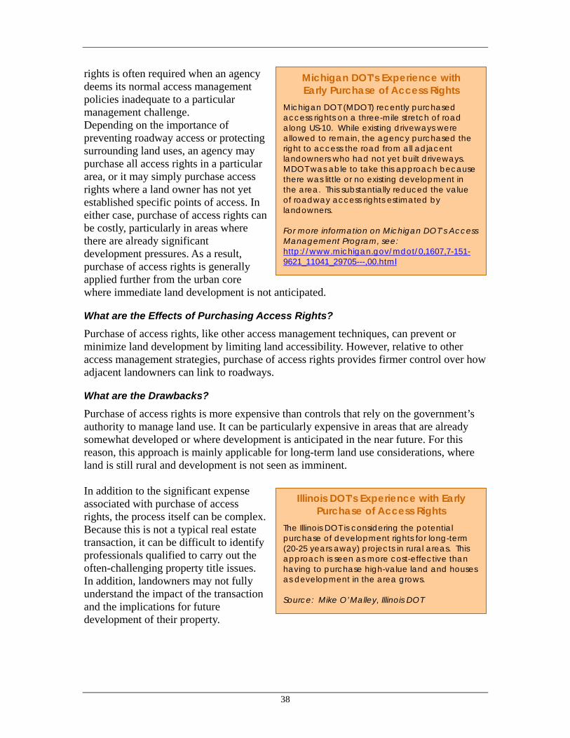
38
Michigan DOT’s Experience with Early Purchase of Access Rights
Michigan DOT (MDOT) recently purchased access rights on a three-mile stretch of road along US-10. While existing driveways were allowed to remain, the agency purchased the right to access the road from all adjacent landowners who had not yet built driveways. MDOT was able to take this approach because there was little or no existing development in the area. This substantially reduced the value of roadway access rights estimated by landowners. For more information on Michigan DOT’s Access Management Program, see: http://www.michigan.gov/mdot/0,1607,7-151-9621_11041_29705---,00.html
Illinois DOT’s Experience with Early Purchase of Access Rights
The Illinois DOT is considering the potential purchase of development rights for long-term (20-25 years away) projects in rural areas. This approach is seen as more cost-effective than having to purchase high-value land and houses as development in the area grows. Source: Mike O’Malley, Illinois DOT
rights is often required when an agency deems its normal access management policies inadequate to a particular management challenge. Depending on the importance of preventing roadway access or protecting surrounding land uses, an agency may purchase all access rights in a particular area, or it may simply purchase access rights where a land owner has not yet established specific points of access. In either case, purchase of access rights can be costly, particularly in areas where there are already significant development pressures. As a result, purchase of access rights is generally applied further from the urban core where immediate land development is not anticipated.
What are the Effects of Purchasing Access Rights?
Purchase of access rights, like other access management techniques, can prevent or minimize land development by limiting land accessibility. However, relative to other access management strategies, purchase of access rights provides firmer control over how adjacent landowners can link to roadways.
What are the Drawbacks?
Purchase of access rights is more expensive than controls that rely on the government’s authority to manage land use. It can be particularly expensive in areas that are already somewhat developed or where development is anticipated in the near future. For this reason, this approach is mainly applicable for long-term land use considerations, where land is still rural and development is not seen as imminent. In addition to the significant expense associated with purchase of access rights, the process itself can be complex. Because this is not a typical real estate transaction, it can be difficult to identify professionals qualified to carry out the often-challenging property title issues. In addition, landowners may not fully understand the impact of the transaction and the implications for future development of their property.

39
Delaware DOT Purchase of Access Rights
Under the Delaware DOT (DELDOT) Corridor Capacity Preservation Program, the State can purchase a property’s access to a corridor and redirect the access to a side road. One benefit of this approach is that the property remains on the state tax rolls and the property owner retains ownership. This minimizes revenue impacts and government management responsibilities.
The current program relies on property owners making the request to the State to initiate negotiations. The county governments monitor the parcels and record the deed, which states that DELDOT owns the development rights to the property. Delaware is looking into obtaining credit from resource agencies for acquiring development rights.
For more information: http://www.deldot.net
How Can Transportation Agencies Purchase Access Rights to Prevent Undesirable Land Use Impacts?
Transportation agencies generally take two approaches to purchase of access rights: passive acquisition through corridor plans and more aggressive acquisition for targeted protections.
Passive Acquisition Through a comprehensive corridor management program, agencies may identify segments of priority corridors where they have an ongoing interest in limiting access. In these cases, the transportation agencies may encourage property owners to contact the agencies to initiate the negotiations for access rights sales agreements. This tends to be uncontroversial because the agency’s role is passive. It also limits administrative effort on the agency’s part. At the same time, the collection of access rights purchases may not achieve the desired land or capacity protections since there is no particular tracking goal. This approach tends to be suitable where the concern is the aggregate number of access points on the corridor, rather than more specific special concerns. Targeted Purchase Where the goals of purchasing access rights have been defined more specifically, an agency may proactively identify areas where particular lands must be protected through purchase of access rights. In this case, the agency would approach all landowners adjacent to a corridor segment and attempt to persuade these owners to sell their access rights. This can be a more time consuming and more costly process (per access right purchased). However, the process can also achieve more targeted and coordinated land use protections.
Resources on Purchase of Access Rights
Purchase of access rights is discussed as a specific access management tool in the resources listed in the access management subsection (section 4.2.1 above).
4.2.3 Context Sensitive Design
What is Context Sensitive Design?
Context sensitive design is an inclusive approach to transportation design and implementation that integrates and balances community, aesthetic, and environmental

40
Westminster Maryland, Main Street Improvements for Pedestrian
Environment East Main Street through Westminster, Maryland required significant reconstruction. After numerous public meetings, an initial plan for wide lanes and reduced sidewalk trees was scrapped, The final plan included reducing the roadway width, protecting mature street trees, creating space for many new trees, widening sidewalks, and implementing other pedestrian improvements. Westminster's heritage was also promoted by constructing sidewalks and crosswalks with concrete made to look like the bricks used in nearby historical buildings.
For more information: FHWA’s Public Roads magazine http://www.tfhrc.gov/pubrds/marapr99/flexdsgn.htm
values with traditional transportation safety and performance goals.14 It emphasizes greater flexibility in transportation project design in order to reflect community values, provide safety, and respect the natural and man-made environment. Context sensitive design requires early and continued input from both multidisciplinary professional teams and stakeholders.
How Can Context Sensitive Design Help Minimize Undesirable Land Use Effects?
Context Sensitive Design strategies rarely influence land use directly. These strategies are most useful for their capacity to develop roadway infrastructure that reinforces local community land use strategies. A number of design considerations play a critical role in the way a given project affects surrounding land use. In business districts for example, design factors influence traffic speed and pedestrian accessibility, both of which influence surrounding land use decisions over time. Wide streets with no on-street parking and few access points can lead to faster speeds. Design features such as street trees and appropriate signal timing can encourage pedestrian activity. While many factors are involved, a slower street with more pedestrian activity is more likely to have smaller, street-oriented businesses. In contrast, a faster street with few pedestrian amenities is more likely to evolve big box retail with large surface parking lots at the street edge. Context sensitive design can also influence land use by engaging a broader spectrum of professionals in the roadway design process. Involvement from community planners, landscape architects, urban designers, and environmental resource specialists increases expertise available to address potential land use impacts. Where diverse involvement occurs early in project discussions, there is more opportunity to understand and minimize potential undesirable land use impacts.
What are the Drawbacks?
Context sensitive design is a relatively indirect way to influence land use impacts. This strategy does not imply any increased control over land that may be influenced by transportation investments, nor does it limit access to adjacent lands. As a result, context sensitive design depends on coordination with local governments and implementation of designs that complement desired land uses. In the absence of coordinated land use controls from local governments, transportation agencies would need to combine context 14 Based on Minnesota DOT working definition on FHWA’s Context Sensitive Design/Thinking Beyond the Pavement website: http://www.fhwa.dot.gov/csd/

41
Minnesota DOT – Making Context Sensitive Design a Part of the Institution
Minnesota DOT (Mn/DOT) has implemented a variety of staff training efforts in order to integrate context sensitive design into all aspect of transportation project development--planning, design, construction, and operations. Mn/DOT has coordinated with the University of Minnesota, Center for Transportation Studies in the joint development of a staff training program. These agencies are working to establish a common understanding of context sensitive design philosophies and approaches among all Mn/DOT staff, local units of government, and consultants. Ongoing training encourages open dialogue and exchange and promotes critical evaluation and exploration of design alternatives and standards that will best meet and balance the State's transportation needs with community, aesthetic, and environmental concerns and conditions. Policy and design issues identified through dialogue during training and during the project development process will be discussed and researched when necessary so that best practices can be established to support CSD. For more information: Context Sensitive Design Website, http://www.fhwa.dot.gov/csd/
sensitive design strategies with other land use control strategies in order to prevent undesirable land use impacts.
How Can Transportation Agencies Implement Context Sensitive Design?
Transportation agencies can adopt policy language and training programs that support context sensitive design principles. In order to support land use coordination, these guidelines and trainings must push context sensitive design principles beyond aesthetic considerations that can sometimes become the focus of project designs. These principles must address how facility design can influence surrounding land use and promote design solutions that help support the desired land use effects. This can be accomplished through institutional policies, development of multidisciplinary teams, and staff trainings. Develop Multidisciplinary Planning Teams In some agencies, planning and design of transportation facilities occurs in sequence, with each step involving a particular area of expertise. Transportation modelers forecast travel demand and facility needs; traffic engineers establish options for facilities, hydrology and resource specialists indicate design restrictions, and community liaisons then gather feedback from the public. Increasingly, transportation agencies are finding that projects are more effective, and can be delivered more quickly when experts are brought together in multidisciplinary project teams. Some agencies have advanced context sensitive design by establishing project planning procedures, organizational structure, and staffing to encourage and institutionalize such multidisciplinary teams. This can be particularly beneficial with regard to consideration of land use impacts. For example, urban designers, and landscape architects, and natural resource specialists can often contribute land use insights that are best considered during the early design phase of a particular piece of transportation infrastructure. Context Sensitive Design Training DOTs can offer educational programs for staff and consultants that develop the necessary skills and attitudes to carry out context sensitive design, including highway design, communication skills, and process improvements.
Flexibility in design is particularly important at the arterial level, where guidance about form and function is often inadequate. Arterials often carry multiple modes, serve local and regional travelers, and traverse different types of

42
North Carolina Land Acquisition Funding
North Carolina recently established the Ecosystem Enhancement Program (EEP), a public-private partnership to promote land conservation across the state. The partnership directs State DOT funds for wetland and stream mitigations and for the acquisition and permanent protection of lands with high conservation values. The partnership includes local land trusts that identify and screen potential sites for the EEP. On approval by the EEP, the land trust works with landowners to determine conservation options and to implement real estate agreements or transactions. The local land trust also monitors sites into the future. The EEP awarded a three-year contract to the non-profit Conservation Trust for North Carolina to coordinate the program and compensate land trusts for their costs. The program not only protects important land resources, but also builds an ongoing relationship between the DOT and the states land conservation organizations. For more information: http://www.fhwa.dot.gov/environment/ecosystems/nc.htm
urbanized environments. As a result, the design process for arterials can be complex. The relationship between transportation and land use is highly complex along arterials, particularly because these streets are corridors of commerce, as well as of movement.
Resources on Context Sensitive Design
• Building Projects that Build Better Communities - Recommended Best Practices, Washington State Department of Transportation, 2003. http://www.wsdot.wa.gov/biz/csd/BPBC_Final/
• Context Sensitive Design, The Road Best Traveled, Center for Transportation Studies, University of Minnesota. http://environment.transportation.org/environmental_issues/context_sensitive_solutions/documents_reports.htm
• Flexibility in Highway Design, FHWA Pub. No. FHWA-PD-97-062. http://www.fhwa.dot.gov/environment/flex/index.htm
• FHWA’s Context Sensitive Design/Thinking Beyond the Pavement website: http://www.fhwa.dot.gov/csd/
4.2.4 Land Acquisition and Conservation Easements
What are Land Acquisition and Conservation Easements?
Easements are voluntary, legally binding agreements that are initiated by either the property owner or an agency or organization. Land acquisition is the outright purchase of land. In the case of acquisition, the government (or an independent land trust) is responsible for managing the land. Conservation and scenic easements involve the purchase of development rights. These are legal agreements between landowners and a government agency (or land trust) that permanently limit uses of the land in order to protect its conservation or scenic values. In the case of easements, the land may continue to be managed by the owners, within the constraints of the easement requirements.

43
Indiana DOT HCP for Bat Habitat The FHWA, three state agencies and a county partnered with the Indiana DOT to develop a habitat conservation program (HCP) for the endangered Indiana Bat in conjunction with the design of a new interchange to the Indianapolis International Airport. According to FHWA, “approximately 3,600 areas will be protected, including 373 acres of existing bat habitat. In addition, approximately 346 acres of hardwood seedlings will be planted for new habitat, and an outreach program and 15-year monitoring program will be developed.” The plan was adopted in April 2002. For more information: http://environment.fhwa.dot.gov/strmlng/newsletters/sep03nl.htm
How can land acquisition and conservation easements help to minimize undesirable land use effects?
These strategies take direct control of land or development rights prevent undesirable land use impacts. This is the most secure and direct means of controlling land use impacts. Thus, these strategies are most useful and justified when a guarantee of land use protection is needed. For example, if endangered species habitat could be destroyed if lands are not properly managed, the government may place a priority on ensuring adequate protection through land acquisition or easements.
What are the Drawbacks of these Strategies?
The strong protection against undesirable land uses afforded by land acquisition and conservation easements can come at a significant cost. Land acquisition in particular can be expensive. Even easements, where donations sometimes play a significant role, can entail both administrative and conservation management costs. Land acquisition and conservation easements require agreements on purchase prices, and landowners can view land and development values to be higher than the market suggests. For this and other reasons, these arrangements can face legal and bureaucratic complexities.
How Can Transportation Agencies Implement Land Acquisition and Conservation Easements?
Land Acquisition Land ownership is the surest way to control development and protect resources. Land acquisition is also more expensive than other land use controls. Even when land is donated, there will be costs associated with long-term management and maintenance. Because of these costs, land acquisition is most appropriate when absolute control of land is necessary to achieve land use protection goals. Recognizing that land acquisition is appropriate in such cases, additional funds may be available to help transportation agencies make such purchases. For example, if the protection of particular land is deemed necessary to preserve critical habitat, TEA-21 includes funding for land acquisition. Conservation Easements A conservation easement (or conservation restriction) is a legal agreement between a landowner and a government agency (or land trust). The agreement permanently limits uses of the land that would negatively affect its value for habitat or resources.

44
Colorado DOT land banking to protect short grass prairie
In April 2001, the Colorado DOT signed a memorandum of agreement (MOA) with FHWA, the U.S. Fish and Wildlife Service, the Colorado Department of Natural Resources, and The Nature Conservancy (a private environmental organization) to preserve and manage up to 50,000 acres of short grass prairie. Through this agreement, specific parcels of land are being identified through individual landowners, who may either sell their land or an easement to the Colorado DOT. Colorado DOT is budgeting $5 million for the effort.
According to FHWA, “the MOA will lower costs, avoid project delays, and streamline the Endangered Species Act (ESA) Section 7 consultation process. Covering nearly 90,000 acres of CDOT right-of-way, the MOA outlines programmatic clearance processes for activities on the existing road network for the next 20 years. ”
For more information: http://environment.fhwa.dot.gov/strmlng/newsletters/dec01nl.htm.
Wisconsin DOT, Highway 12 Conservation Easements
With the planned addition of two lanes to U.S. Highway 12 through the Dane and Sauk Counties, Wisconsin, many of the area’s rural residents expressed concerns over the potential loss of farmland due to induced development. The Wisconsin DOT worked with conservation organizations including the American Farmland Trust, to protect the farmland at risk of development along the highway corridor. Dane and Sauk counties each received $5 million as part of a mitigation agreement with the state DOT. This funding is helping Dane County purchase conservation easements from willing farmers who are affected by the Highway 12 expansion project. The American Farmland Trust is working with government agencies to develop criteria for identifying the most at-risk farmland and helping to create an application system for farmers who want to sell conservation easements. For more information: http://www.farmland.org/; http://www.uwsp.edu/cnr/landcenter/forestplanning/pdfandpowerpoint%20files/CaseStudyPDRSaukCounty.pdf
The activities allowed by a conservation easement are negotiated by the landowner and the entity acquiring the easement, and respond to both the goal of the acquirer and the characteristics of the property. In some instances, no further development is allowed on the land. In other circumstances some additional development is allowed, but the amount and type of development is less than would otherwise be allowed. Conservation easements may be designed to cover all or only a portion of a property. Easements are tailored to suit a particular landowner’s goals as well a transportation agencies needs. Conservation easements can be efficient land use protection mechanisms for owners because they can qualify as a charitable deduction for federal and state income taxes and can lower federal inheritance taxes. Land Banking Land banking purchases land in advance of anticipated need for mitigation purposes. With this strategy, a transportation agency may budget for the purchase and protection of important habitat in an area that is not yet experiencing development pressures and where there are no current plans for transportation investments.
This practice can provide two principal advantages over standard land acquisition techniques. First, by purchasing sensitive lands before they face immediate development pressures, transportation agencies generally pay less for the land, allowing for greater habitat protection for the same investment. Second, land banking can increase environmental benefits by preserving entire habitat areas instead of fragmented parcels on a project-by-

45
California DOT Land Acquisition for a Habitat Conservation Plan
The California DOT (Caltrans) has developed a draft cooperative agreement with state and federal wildlife agencies to create a land bank of up to 2,000 acres of desert in the Coachella Valley. The agreement covers five new interchanges on Interstate 10. The agreement is expected to be rolled into a larger habitat conservation plan, the Coachella Valley Multiple Species Habitat Conservation Plan that will cover several dozen species and approximately 1.2 million acres. The land bank will be administered by the Coachella Valley Association of Government (CVAG). CVAG is the region’s MPO and also led the development of the habitat conservation plan.
For more information: Coachella Valley Association of Governments, www.cvmshcp.org
California DOT’s Big Sur Scenic Easement
The Big Sur Trust issued easements in order to protect Highway 1 and preserve the scenic beauty of a dramatic segment of California’s Pacific Coast Highway.
For more information: www.bigsurlandtrust.org/
project basis. Protecting individual land parcels may provide less habitat protection than the same area of land protected in a continuous swath, even though some smaller pieces of habitat may be lost as a result. All else being equal, protecting a substantial parcel of habitat at some other location is likely to provide greater ecological value. Scenic Easements For scenic easements, an agency pays the landowner for the right to control the scenic characteristics of property. A scenic easement may be issued to protect a natural resource, a scenic view, historic preservation, or other preservation purposes. Scenic easements seek to retain the environment in its natural state or retain the unique character of a neighborhood, when a transportation investment is viewed as potentially threatening. Scenic easements are often used when local agencies designate a road or highway as a scenic byway. A state DOT then works with the local agencies to determine which sections of the roadway have scenic resources that merit protection. Habitat Conservation Plans Habitat conservation plans often protect the habitat for particular species that are endangered, threatened, or otherwise vulnerable. Such plans may include strategies for minimizing land impacts, restoring degraded land to functional habitat, and permanently protecting land from development.
The U.S. Fish and Wildlife Service requires a habitat conservation plan before it can issue an incidental take permit, a permit that allows a development that might otherwise threaten an endangered or threatened species.
Resources on Land Acquisition/Conservation Easements
• The Challenges of Purchasing Development Rights in Transportation Corridors: Lessons from Vermont and Beyond, Michael Crane, Dennis Bidwell, and Daniel Senecal, April 2003 (Draft). http://www.richmondvt.com/documents.php
• A Highway Runs Through It: Conserving Scenic Corridors in Florida, Daniel N. Sagastizabal, University of Florida Levin College of Law, December 1999.

46
Caltrans Transit-Oriented Development Programs
Since 2000, the California Department of Transportation (Caltrans) has implemented several programs several programs to support and encourage transit-oriented development. This DOT-funded effort has included a number of related efforts including:
• A statewide study identifying factors for success for TOD in California,
• A statewide TOD website, providing searchable information on built projects (http://transitorienteddevelopment.dot.ca.gov
• A grants program to support community-based planning for TOD, and
• Funds to support parking structures that can make land available around transit centers.
In using transportation funds to support development around transit stations, Caltrans recognizes that such infill projects relieve some pressure for development at the urban fringe and support more efficient operation of urban transportation systems. For more Information: http://transitorienteddevelopment.dot.ca.gov
4.2.5 Incentives for infill development
What is meant by Incentives for Infill?
Incentives for infill are policies that make it easier to develop housing, jobs, and services in urban areas, and/or encourage development of vacant or under-used lands. These strategies can relieve growth pressures to expand at the urban fringe while improving existing neighborhoods. Such strategies generally have one or more of three goals: 1) Change regulations to reduce barriers and provide incentives for infill and
redevelopment
A variety of regulatory barriers discourage infill and redevelopment, the most clear and also common example being zoning regulations that do not allow the kinds of mixed-use, compact development that make for successful infill but rather require single-use developments separated by parking. Although transportation agencies do not play a direct role in developing or revising most zoning, agencies can examine whether their policies and regulations either contribute barriers, or can be revised to offset other barriers. Transportation agency input into parking policies, both on- and off-street, are excellent places to start.
Transportation agencies can also develop policies that help implement regional transportation and land use goals, and encourage zoning changes if necessary. For example, an agency could make certain kinds of transportation investments contingent on land use regulations that could be reasonably expected to promote infill development. Investments in transit to serve potential infill sites might be contingent upon zoning that encourages development and accommodates certain minimum densities and design features.
2) Reduce costs to developers
Studies consistently find that homes in compact developments (designed to standards commonly known as Smart Growth, New Urbanist, or Traditional Neighborhood Development) than enjoy sales premiums over comparable homes elsewhere. Nonetheless, developers face a variety of risks in infill markets that they do not face when providing a more standardized product on a greenfield.

47
Metropolitan Transportation Commission’s Housing Incentive
Program The San Francisco-region MTC launched its Housing Incentive Program (HIP) in 1998. The housing program is designed to maximize public investments in transit infrastructure and encourage transit use while also addressing the region's housing shortage. The incentives, in this case, are grants to help communities and developers implement infill projects that meet program goals. MTC devotes $9million annually to HIP Grants.
To qualify for a HIP grant, the proposed housing project must be in the initial planning stages; be within a one-third mile walk from a bus route, rail station or ferry dock that offers service at 15-minute frequencies or better; and provide a minimum of 25 units per acre. The award amounts range from $1,000 per bedroom at the 25-unit-per-acre level, to $2,000 per bedroom for a 60-unit-per-acre project. A $500 bonus per bedroom is awarded for all affordable units, and mixed-use development is encouraged but not required.
The program was designed, in part, to address the fact that infill development, though advantageous for regional transportation efficiency, is expensive, risky, and difficult to implement relative to other types of housing development.
For more information: http://www.mtc.ca.gov/publications/transactions/ta11-1200/hip.htm
The cost of developing infill may be higher due to fragmented property ownership, slower permitting as a result of increased scrutiny, and the challenge of working with existing property and buildings. Efforts to reduce the cost of infill development seek to offset these higher costs.
3) Support infill development through infrastructure provision, and reduce infrastructure support for development outside preferred areas
This approach is exemplified at the state level by policies that focus infrastructure investment, especially capacity enhancement, in identified growth areas, and restrict it in areas identified as rural/agricultural reserves and other areas not designated as existing urban or designated growth areas.
What are the potential effects of such incentives?
The effects of infill and redevelopment depend on the strategies selected, the rate of growth in the relevant region or state, and site characteristics. With coordination, policies can direct varying portions of new development to the existing urban area.
What are the Drawbacks?
Infill development is challenging even when driven by the private sector. Incentives for infill development can be politically challenging. Typically, some stakeholders in areas that are already developed wish to prevent more development. Infill produces fewer automobile trips per person, but in most cases more trips per unit of area. Thus infill may increase local traffic in some areas. Whether or not congestion increases as a result depends on the baseline traffic levels, amount of remaining capacity, and whether infill will be accompanied by transportation investments (road, transit, and/or non-motorized). Absent good analysis of likely local transportation impacts, and planning for them, promoting infill as transportation improvement strategy may be counterintuitive for some stakeholders.

48
New Jersey DOT Corridor Plans Include Infill Incentives
In Camden, New Jersey, the State DOT (NJDOT) and other State agencies are working closely with a private developer to facilitate residential redevelopment of a large infill site that includes multiple types of land use. Smart growth objectives called for fine-grained mixing of different types of housing along with office and commercial uses. This made plans more complex and increased project costs. To achieve these goals and still make the project worthwhile for the developer, NJDOT and the other State and local agencies have agreed to work cooperatively to prioritize public investments and approvals in exchange for plan modifications. The redevelopment plan called for a new interchange a new river crossing to improve site access. NJDOT agreed to place these new projects in the capital program. For more information on NJDOT smart growth efforts see, http://www.nj.gov/dca/osg/team/news.shtml or Gary Toth, NJ DOT.
How Can Transportation Agencies Implement Infill Incentives?
Transportation agencies can play a significant role in promoting infill. Although they lack the land use authority to provide incentives such as density bonuses and parking requirement waivers, they play a vital role when transportation investments are the central need for successful infill projects. Following are some examples of how transportation agencies can provide support. Use Transportation Funds to Directly to Support Transit Oriented Development Recognizing that infill development can reduce the need for major roadway investments, transportation agencies can legitimately use transportation funds to provide grants to such projects. Transportation agencies would typically be most interested in supporting transit-oriented development in a location where new development would enhance efficiency of the transportation network. This may mean supporting office, housing, or commercial development along an existing transit route that is not overcapacity. It can also mean supporting such development in conjunction with new transit investments that will ensure efficient use of new transit that is also viable for existing travel patterns. In a strong real estate market, infill and redevelopment may occur in areas without supporting public policies. More often, coordination of public policies and private investment is required to encourage development in specific areas. Areas may be targeted because adequate public facilities are available and underutilized. There may also be active neighborhood support. The area may be important for economic, social, or cultural reasons. Or, they may be well situated for access to jobs and services. Providing Support to Developers Public investment in infrastructure is the most common form of public “assistance”. Other types of assistance may include direct subsidies to developers, or guaranteed or low- interest loans, or assistance with acquisition of enough parcels to make an efficient large-scale development viable. Transportation agencies are clearly in the best position to support developers with strategic transportation investments. In cases where transportation infrastructure is the key limiting factor to a viable infill development, transportation agencies can play a vital role in supporting efficient land use development.

49
Limiting Fringe Development Incentives Reducing the supply of developable land in fringe areas is an important complimentary strategy for infill incentive programs. A strong market for infill will not exist if there is ample, cheap, serviced land elsewhere. Urban growth boundaries, greenbelts, development fees, and other policies can limit the amount of land available for development and prompt developers to reconsider sites closer to the urban core that have been passed over. Transportation agencies can cooperate with local and regional planning agencies to limit development pressures on such fringe areas through all of the strategies discussed above.
Resources on Infill Incentives
• Dena Belzer and Gerald Autler, “Transit Oriented Development: Moving From Rhetoric To Reality”, The Brookings Institution Center on Urban and Metropolitan Policy And The Great American Station Foundation, June 2002. http://www.brookings.edu/dybdocroot/es/urban/publications/belzertod.pdf.
• Infill and Redevelopment Code Handbook, Otak Inc., Transportation and Growth Management Program, Oregon DOT and Dept. of Environmental Quality http://www.lcd.state.or.us/tgm/publications.htm
• See also Getting to Smart Growth (I and II): 100 Policies for Implementation, Smart Growth Network, January 2002, referenced above.