
Great Aten Temple Spring 2012 Season
32
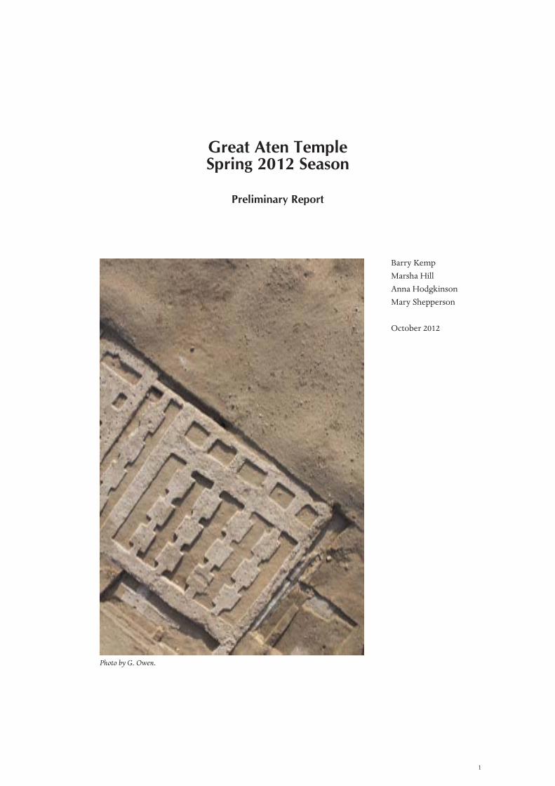
1 Great Aten Temple Spring 2012 Season Preliminary Report Barry Kemp Marsha Hill Anna Hodgkinson Mary Shepperson October 2012 Photo by G. Owen.
Transcript of Great Aten Temple Spring 2012 Season
1
Great Aten TempleSpring 2012 Season
Preliminary Report
Barry KempMarsha HillAnna HodgkinsonMary Shepperson
October 2012
Photo by G. Owen.

2
Introduction
The 2012 season at the Great Aten Temple ran from 31 March to 10 June. The Ministry of Antiquities was represented by Mohammed Wahaballah Abdelaziz and Shimaa Sobhy Omar. The archaeological team comprised Mary Shepperson and Marsha Hill at the stela site, and Miriam Bertram, Delphine Driaux and Anna Hodgkinson at the temple entrance. Two pairs of SCA inspectors joined the field team each for one month of training.
According to contemporary texts and depictions, the most important building at Amarna was the ‘House of the Aten’, the centre of the cult of the Aten. Previous fieldwork, especially the excavations carried out by the Egypt Exploration Society in 1926, 1932 and 1933 (the last two seasons under the direction of John Pendlebury), established that it is identical to the part of Amarna known as the Great Aten Temple (Pendlebury 1951: 5–20).
pylon areastela
slaughter court
offering-tables
Great Aten Temple Sanctuary
modern cemetery
0 100 200metres
modern fields
Long Temple (perhaps Gem-pa-Aten)
bakery
Panehsy’s house
North Entrance Pavilion
Roy
al R
oad
North Harem
Bridge
large well
stables
barracks?RecordsOffice
Houseof Life
King’s House
Small Aten Temple
clerks’ houses
House of theKing’s Statue
Smenkhkara Hall
O42.1
Great Palace
Figure 1. Plan of the Central City of Amarna. The two areas outlined in red are the locations of the recent fieldwork. The green line marks the edge of the modern cemetery as surveyed by Helen Fenwick in April 2009. Map based on Kemp and Garfi 1993, sheets 4 and 5.
3
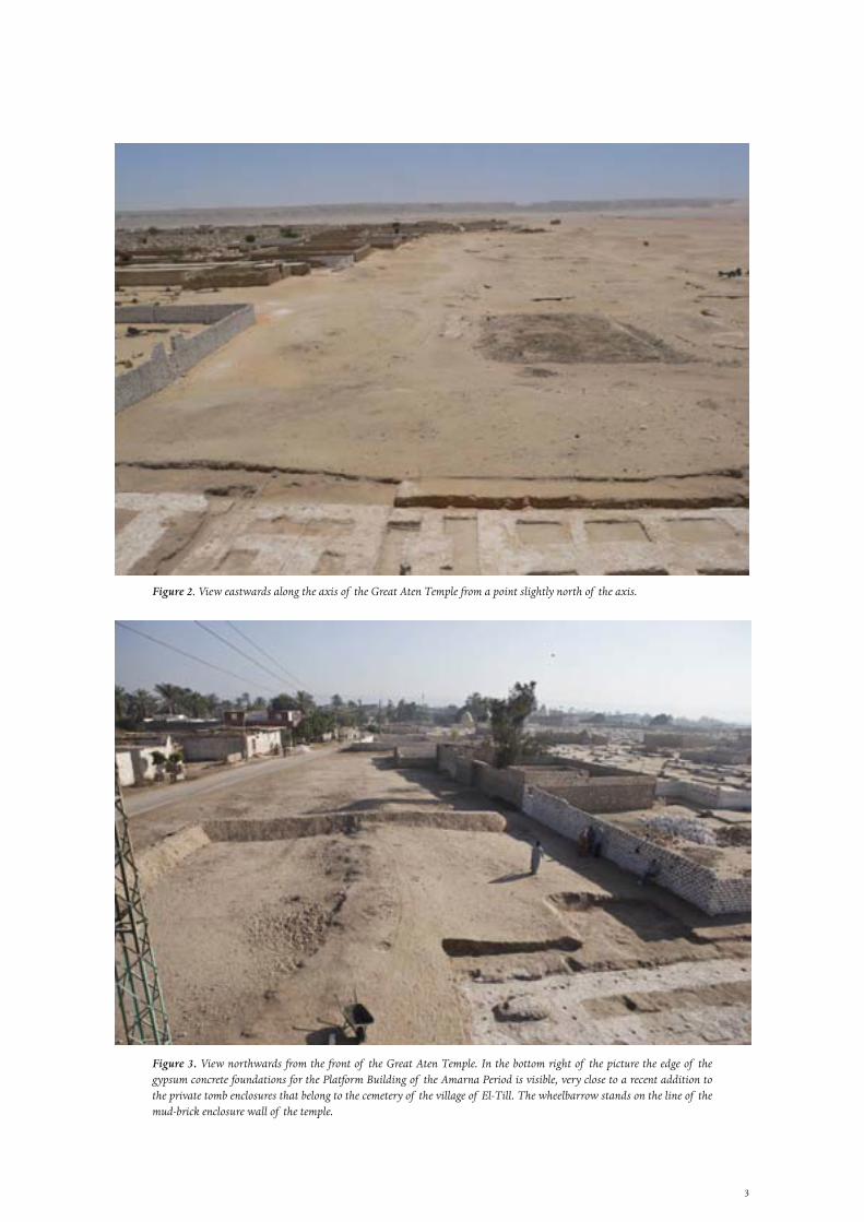
Figure 2. View eastwards along the axis of the Great Aten Temple from a point slightly north of the axis.
Figure 3. View northwards from the front of the Great Aten Temple. In the bottom right of the picture the edge of the gypsum concrete foundations for the Platform Building of the Amarna Period is visible, very close to a recent addition to the private tomb enclosures that belong to the cemetery of the village of El-Till. The wheelbarrow stands on the line of the mud-brick enclosure wall of the temple.
4
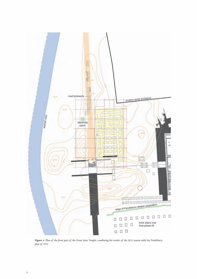
Figure 4. Plan of the front part of the Great Aten Temple, combining the results of the 2012 season with the Pendlebury plan of 1932.

5
It is not a single building but a collection of structures spread across a huge area of flat open desert, measuring 800 x 300 m, and surrounded by a mud-brick enclosure wall (Figure 1). The largest single building was situated towards the front, along the central axis of the temple enclosure. It might have had a separate ancient name, Gempa-aten (‘The finding of the Aten’), but here it is referred to as the Long Temple (Pendlebury 1951: 191–7 is Fairman’s summary of the evidence for the ancient names of parts of the temple). Much further back but on the same axis stood the Sanctuary. Both had been constructed very largely from stone blocks but these had been methodically removed after the Amarna Period ended and transported to other sites, many to Hermopolis/El-Ashmunein across the river. In front of the Sanctuary and to one side (the north) came a group of lesser structures that included what was probably the pedestal for a large stela.
The removal of the stonework had left behind large areas of a foundation layer made from gypsum mixed with fragments of limestone and sandstone. This had retained many traces of the blocks that had once formed the lowest course of walls and other architectural elements, particularly columns and offering-tables. The architect responsible for planning the Pendlebury excavations, Ralph Lavers, had included these traces on his plans and, from them, had made reconstruction drawings of how the Long Temple and the Sanctuary might have looked (Pendlebury 1951: Pls. III, IV, VI–IX). The reports of this older work are, nevertheless, brief and do not entirely correspond with what is still visible. This alone justifies taking a fresh look at the site, but there is a second reason that lends it urgency.
Even in Pendlebury’s time, a large part of the original temple enclosure had been occupied by the cemetery of the modern village of El-Till. In recent years, the density of its graves has reached its likely maximum and it has begun to expand (Figures 2, 3). Pendlebury had left the excavated areas open but surrounded by spoil heaps. In the intervening years the deposition of sand and erosion of the dumps have, between them, blurred the outlines of what is ancient, almost inviting the expansion of the cemetery and creating an appearance of neglect that has been intensified by the dumping of village rubbish over the front part.
Re-opening work at the site thus creates the opportunity to make the outlines of the buildings more visible and thereby to dispel the air of neglect and to demarcate the limits of the ancient buildings more effectively. Two areas were chosen for simultaneous examination in 2012, the front of the building, where the main entrance in the brick enclosure wall had been through a pair of pylons, and the area further back where the stela was probably located.
The first week was spent in cleaning accumulations of modern rubbish from the front area, and then in making a contour plan of the same area at the scale of 1:100. On 7 April the work force was enlarged and divided between the two separate sites. The cleaning and re-excavation stage ended on 17 May. Nothing more was done at the stela site (which was backfilled), but at the front entrance the remaining time until 10 June was spent on repairing the ancient foundations to a stone building that stood in front of the Long Temple, and marking the outlines of its original walls with fresh limestone blocks.
The temple front entrance
The Long Temple lay 36 m behind the line of the mud-brick enclosure wall which, on the temple axis, was cut by a wide doorway flanked by pylons. Just inside the entrance, on the north side, the Pendlebury expedition had discovered the foundations for a stone building that they termed the ‘Altar’ and that had lain close beside the north pylon tower (Figure 4; Pendlebury 1933: 114, Pls. XIII, XIV.4, where it is called a ‘pavilion’; 1951: 11, Pl. III). Here the term Platform Building is used in preference to Pendlebury’s ‘Altar’.
A block of five-metre squares, based on the initial 1:100 survey, was laid out over this area. The pylon itself was covered with a large spoil heap from the previous excavations whereas the stone building and the site of the
6
entrance itself had been left open and had gradually been buried in compacted dust. The foundations of the stone building and half of the entrance area were steadily excavated so that, by the end, the original ancient surfaces had been reached. The Pendlebury spoil heap, by contrast, was removed in layers but comprised such a volume of material that, by the end, approximately half of it remained for a future season. All earth that was removed was passed through sieves, producing a significant quantity of material, some of it recent but much of it ancient architectural fragments and pieces of stone and faience inlay and some pieces of statuary. The sieved debris was then piled into a linear embankment as a way of delimiting the site and separating it from the adjacent asphalt road, whilst leaving a gap to allow village access to the cemetery (Figure 3).
The only parts of the pylon fully exposed were the inner, eastern face, for its complete length of 16 m, and the northern half of the gateway that had lain between the pylons and which had been floored with a mud-brick threshold, 4.25 m across (the width of the pylon). It stood above sloping walls to east and west that had supported the sides of ramps, the ascending and descending of which had provided access to the temple at one stage of its use. The pylon itself had been robbed of much of its brickwork a long time in the past, so that little remains above the ancient ground level. This made it convenient to use as the site for a spoil heap in 1932. One useful piece of information to emerge from working here is that the pylon had originally been plastered with mud and then coated with white. Patches of this survived on the east side where they had been subsequently buried by the ancient raising of the ground level.
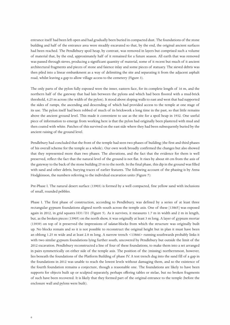
Pendlebury had concluded that the front of the temple had seen two phases of building (the first and third phases of his overall scheme for the temple as a whole). Our own work broadly confirmed the changes but also showed that they represented more than two phases. The alterations, and the fact that the evidence for them is well preserved, reflect the fact that the natural level of the ground is not flat. It rises by about 60 cm from the axis of the gateway to the back of the stone building 25 m to the north. In the final phase, this dip in the ground was filled with sand and other debris, burying traces of earlier features. The following account of the phasing is by Anna Hodgkinson, the numbers referring to the individual excavation units (Figure 7):
Pre-Phase I. The natural desert surface (13903) is formed by a well compacted, fine yellow sand with inclusions of small, rounded pebbles.
Phase I. The first phase of construction, according to Pendlebury, was defined by a series of at least three rectangular gypsum foundations aligned north–south across the temple axis. One of these [13865] was exposed again in 2012, in grid squares H31/I31 (Figure 5). As it survives, it measures 1.7 m in width and 2 m in length, but, as the broken pieces (13905) on the north show, it was originally at least 3 m long. A layer of gypsum mortar (13939) on top of it preserved the impressions of talatat-blocks from which the structure was originally built up. No blocks remain and so it is not possible to reconstruct the original height but in plan it must have been an oblong 1.25 m wide and at least 2.8 m long. A narrow trench <13866> running southwards probably links it with two similar gypsum foundations lying further south, uncovered by Pendlebury but outside the limit of the 2012 excavation. Pendlebury reconstructed a line of four of these foundations, to make them into a set arranged in pairs symmetrically on either side of the temple axis. The position of the (missing) northernmost, however, lies beneath the foundations of the Platform Building of phase IV. A test trench dug into the sand fill of a gap in the foundations in 2012 was unable to reach the lowest levels without damaging them, and so the existence of the fourth foundation remains a conjecture, though a reasonable one. The foundations are likely to have been supports for objects built up or sculpted separately, perhaps offering tables or stelae, but no broken fragments of such have been recovered. It is likely that they formed part of the original entrance to the temple (before the enclosure wall and pylons were built).

7
Phase II. This began with the removal of the stonework on the gypsum foundations [13865] and the partial breaking up of the foundations themselves, following which at least three alternating layers of mud-floor and gypsum whitewash were spread across the area (the top one 13849) visible in Figure 5. They were uncovered over parts of grid squares G31, H31 and I31. In G31 this necessitated digging a c. 1m wide, east–west oriented trench against the later ramp wall and threshold to verify the existence and continuation of the floors westwards from H31. In the south-east corner of I31 the floors gave way to the natural desert surface (13903).
The good state of preservation of the mud floors is, in part, because they were buried beneath the sand fill (13793) of the ramp in phase III and then by the filling debris that built up the general ground level in phase IV. A particularly well-preserved area of the uppermost layer of gypsum whitewash (13850) was found to cover the
Figure 5. View westwards across the area of the entrance ramp. On the right is the southern edge of the gypsum concrete foundations for the Platform Building (with limestone blocks [13901] still in place), and in the foreground the square extension attached to its south-east corner [13920]. Beyond this is the rectangular gypsum foundation belonging to Phase I [13865], and beyond that the end of the mud-brick wall that marked the northern edge of the ramp of Phase III [13791].

8
south-western part of H31 (visible in the background to Figure 5 and in Figure 6). Its roughly square outline suggests that something had lain over and protected it. The first and second layers of mud-floors and gypsum whitewash covering can be observed across the excavation area in those places where the layers above have been damaged.
Phase III. The temple began to take on its final appearance when the mud-brick pylons and associated enclosure wall were erected. The 2012 excavations covered only the northern pylon tower [13780], as it lay within grid squares F31–F34 (and the edge of G32–G34). It was fully exposed only in the southernmost, F31; for the remainder, by the end of the season, most of the brickwork still lay buried beneath the partially removed Pendlebury spoil heap, that was also excavated over F30–F34.
The width of the pylon was 4.15 m. Its length, measured from the inner face of the inner ramp wall on the east to the place where the eastern face of the pylon turned inwards, close to the northern limit of square G34, was 15.95 m. For comparison, the north front pylon at the Small Aten Temple measures 8.5 x 22.25 m. One question that is not settled is whether, as at the Small Aten Temple, tall wooden masts or flagpoles stood in deep niches against the outer face of the pylon. It is likely that the brickwork is not preserved to sufficient height to provide a definite answer. That the pylon is only half the width of the Small Aten Temple pylon perhaps lessens the likelihood that it had sufficient mass to support such a set of heavy wooden masts.
The brickwork core of the pylon was badly robbed out, something that must have taken place before Pendlebury’s excavations, since photographs taken at the time show it standing to roughly the same height, with the dump already over it. The eastern face of the pylon retained patches of gypsum whitewash (13868) that had been protected by the subsequent building of the Platform Building very close to it. The brickwork of the pylon
Figure 6. Northwards view of the excavations, with the brick pylon at the left and, occupying the centre ground, the gypsum-concrete foundations for a stone building constructed during Phase IV. In the foreground the brick ramp of Phase III, east of the pylon threshold, is beginning to appear.
9
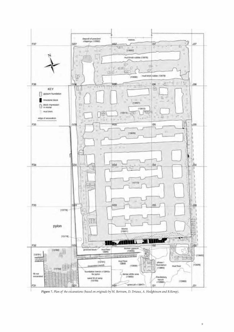
Figure 7. Plan of the excavations (based on originals by M. Bertram, D. Driaux, A. Hodgkinson and B.Kemp).
10
continued unbrokenly southwards to become the threshold [13792] between the two pylon towers. Only the northern part was exposed by excavation, within grid squares F31 and G31. It was built from at least eight courses of mud bricks, all of which were oriented east–west. At the Small Aten Temple, the thresholds of the pylon entrances had been floored with limestone blocks laid over a thick layer of gypsum concrete. Here, at the Great Aten Temple, neither the brick threshold nor the brickwork of the pylon tower beside it showed any trace of gypsum and thus of evidence that a stone floor had been laid.
An exploratory trench was dug down to the top layer of the mud floors, with the aim of exposing the full depth of the eastern face of the threshold. This revealed that the threshold had been built, to a depth of at least two courses, in a foundation trench <13943> that had been cut into the mud floors of the earlier phase. The trench was wider than the brickwork on this side by 18 cm. It contained a primary fill of fallen and hardened mud mortar (13983) with a sandy fill (13944) on top. The level of the top layer of mud-floor was 65 cm below the surface of the threshold [13792], which has a vertical eastern face.
To maintain accessibility across the brick threshold, a ramp on both the outer and inner sides was created, the side walls of which had been exposed by Pendlebury. In the case of the western, outer ramp, this year’s excavations uncovered only a short length (1.5 m) of the top of the northern ramp wall [13791] (west part), showing it to have been built with a width of one header and one stretcher course of bricks (c. 50.5–51.5 cm). The northern, inner ramp wall was, however, fully exposed [13791] (east part). It had the same width and ran for a length of c. 8.5 m (its further end eroded). It reached to the same height as that of the threshold, but this is probably not its original height. The eastern end slopes down gently to the same level as the top layer of mud-floors in square H31 13849. At this point, a piece of this floor lapped against the northern face of the ramp wall, representing the continuing use of the mud floor outside the limits of the ramp itself.
To begin with, the builders constructed the ramp wall to be only a single header-brick in thickness. They must have worked only slightly ahead of the dumping of the sand (13793) that made up the ramp. Eventually, however, they increased the thickness of the wall by adding a stretcher course on the inside, but extending it down into the sand by only two courses (the sand underneath was numbered separately as (13876)). They finished by plastering the outer face with mud and coating it with white (13867).
The entire area between the north and south sets of ramp walls was filled with yellow, sterile sand (13793), which was relatively fine and loosely compacted. It served as the basis for the ramp which is likely to have had a firmer final surface, presumably of mud. The eastern end of the sand ramp had been removed by Pendlebury’s excavation, more or less on a line coinciding with the division between our grid squares G31 and H31. The making of the sand ramp buried the underlying mud floors (and consequently part or all of the rectangular gypsum foundation belonging to Phase I).
Phase IV. It is to this phase that the main stone constructions of the temple belong, principally the set of courts filled with offering tables, and the massive foundations for a set of colossal columns that stood in front, to which the names Gempa-aten and Per Hai, respectively, were assigned in the reports of the Pendlebury excavations. Their floor level was the same as that of the brick threshold of the front pylon entrance. The same floor level also applied to a fairly modest stone building that stood at right angles to the temple axis, parallel to and only a metre away from the northern brick pylon, and which must have been built at this time, too. In the preliminary report of 1933 it is referred to as the ‘pavilion’ (Pendlebury 1933: 114), but is labelled the ‘Altar’ on the final published plan (Pendlebury 1951: Pl. III), although there is little to recommend this label. Here we have called it the Platform Building.
In order to create a firm but level foundation for it, that corresponded to the intended raised level of the ground in Phase IV, a platform was built using a combination of limestone blocks and flat-topped ridges of gypsum
11
concrete that corresponded to the locations of walls and columns. As the ground rose to the north, the foundation platform decreased in height until it became a series of surfaces sunk into the ground.
The foundations cover a rectangular area, of c. 25 x 14.25 m, to which an almost square extension [13920], of 3.0 x 2.3 m, was added to the south-east corner (Figure 7). It should be noted that Pendlebury did not expose the foundations entirely, stopping 5 m short of the northern edge (the part that lies in squares G36–I36). From its general appearance, it has three parts (not counting the small extension in the south-east corner). The southern part, roughly square, was largely made from a series of long, narrow, flat-topped ridges of gypsum concrete that had been built up from the natural ground to the intended new ground level [13772]. For the middle section [13907], that runs across grid squares G35–I35, the final level dropped by 20 cm, or a little more, and the gypsum was spread as a single layer that had a depth of around 10 cm.
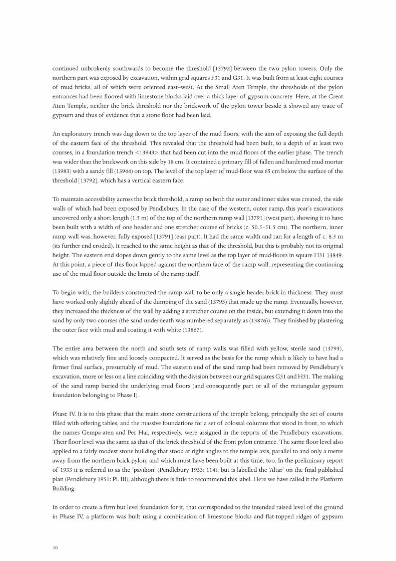
For the northern part [13682], the builders left in place a layer of mud-brick debris (13678), perhaps rubble from a demolished building (Figure 8). Aiming for a surface that was close to that of the southern section, they dug trenches into it, to a depth of about 20 cm, and filled them with gypsum concrete. In this way, the middle section was lower than the sections on either side, but this is unlikely to represent a final floor level that was lower.
Despite their differences, the southern and middle sections were built at the same time. The first step had been to spread, on the gently sloping desert surface, a bed of gypsum concrete that created a foundation for a perimeter wall of stone blocks and, simultaneously, the full foundation spread for the middle part. No sooner was this done than a wall was built from limestone blocks on the south, east and west sides, reaching three courses in height on the south ([13901] is the lowest course). On the south and east sides, the heaping up of the ridges of gypsum concrete foundations was done against this wall. Along the southern edge, weathering has exposed how the upper portion of the gypsum, at least, was spread in several layers. On the west side, by contrast, the perimeter wall was left to stand free, just over a metre from the westernmost foundation ridge.
Figure 8. Northern end of the gypsum-concrete platform, sections [13907] and [13682]. The stone tomb enclosure that stands adjacent to it was built in January 2012. The holes in the gypsum were made to help lever up the limestone blocks during their removal after the end of the Amarna Period.
12
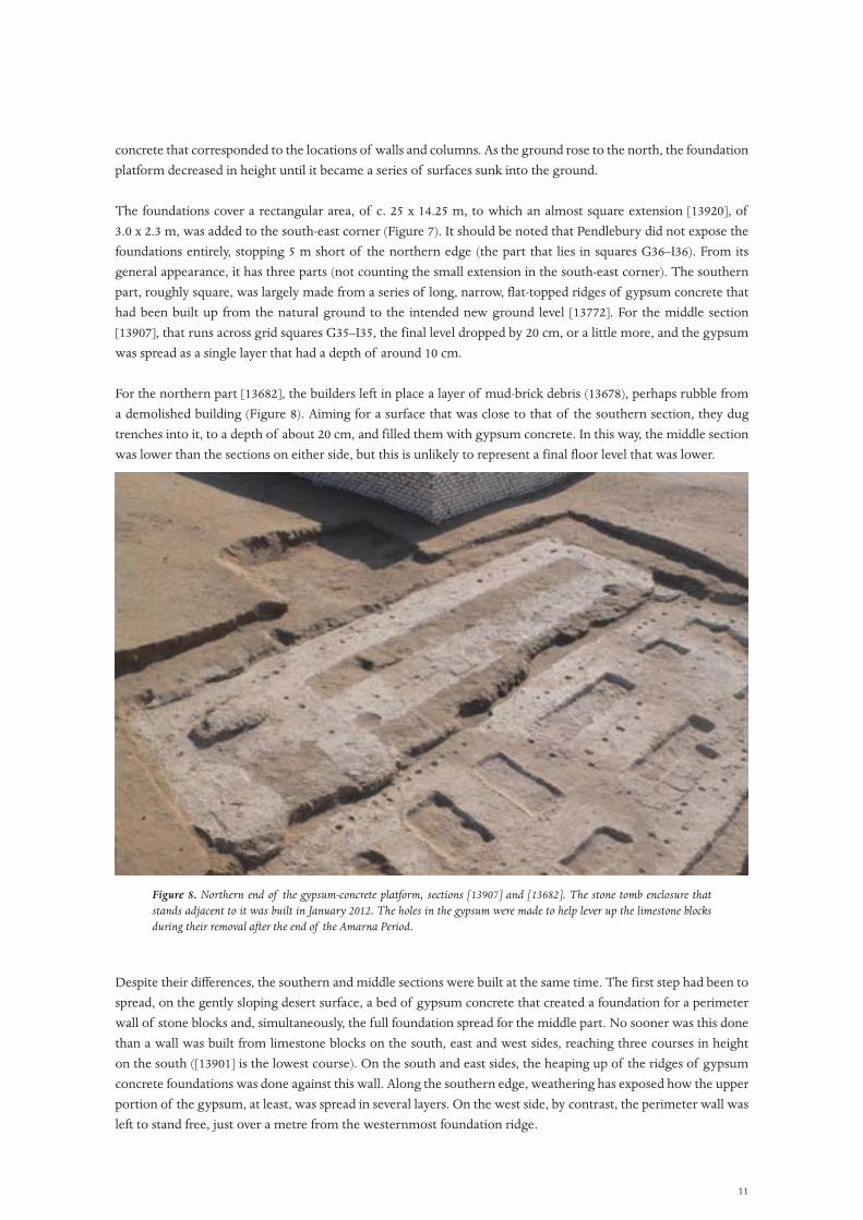
Figure 9. Part of the plan made by Ralph Lavers of the Pendlebury excavations at the front of the Great Aten Temple. The shaded additions are a reconstruction of where Pendlebury’s trenches ran.
13
Against the south-east corner of the Platform Building an almost square extension [13920] was added (3 m x 2.3 m), leaving its own set of gypsum concrete foundations and impressions of limestone blocks in a layer of gypsum mortar (13929). At least at foundation level, the stones had not been keyed into the main foundation wall. Instead, they were laid leaving a gap of 20 cm, that was presumably filled with gypsum mortar.
Once the foundations were in place, the surrounding area was leveled up to the new general ground level of the temple using sand and other debris. In the course of this, the eastern entrance ramp was entirely buried, the sand used for this also filling the space between the ramp retaining wall and the gypsum concrete foundations of the Platform Building.
In his reports, Pendlebury does not specify how much of this fill he removed, but it is possible to reconstruct his excavation plan by reference to photographs made at the time and to the present appearance of the site (Figure 9). This suggests that an important element in his strategy was the excavation of an irregular trench along the line of the temple axis, leaving large areas of the Phase IV fill in place on either side. The photographs taken at the time show that the fill had been capped by a thick mud floor, traces of which are still visible in the eroded sides of the trench (it is marked by lighter shading in Figure 9). Presumably this floor originally extended as far as the temple entrance, covering the ramp and also reaching the sides of the Platform Building.
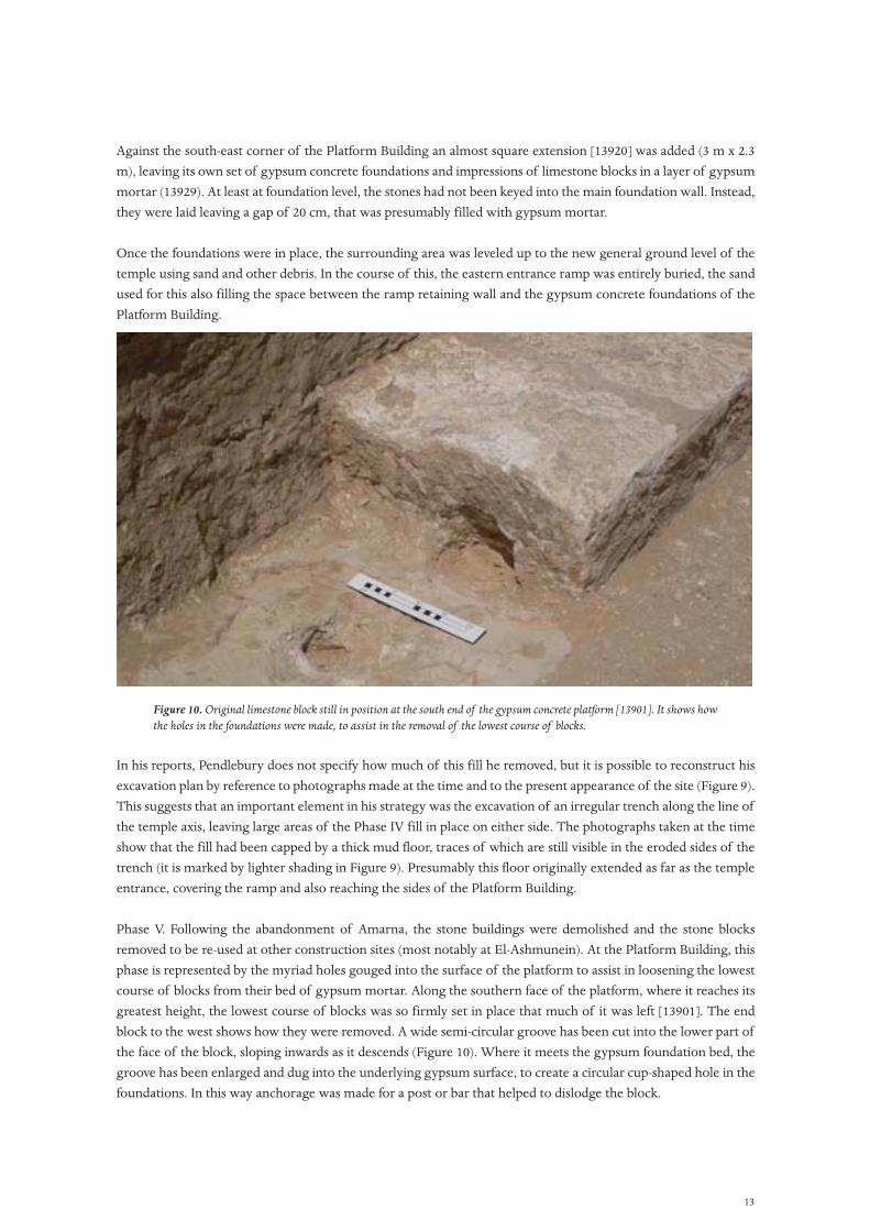
Phase V. Following the abandonment of Amarna, the stone buildings were demolished and the stone blocks removed to be re-used at other construction sites (most notably at El-Ashmunein). At the Platform Building, this phase is represented by the myriad holes gouged into the surface of the platform to assist in loosening the lowest course of blocks from their bed of gypsum mortar. Along the southern face of the platform, where it reaches its greatest height, the lowest course of blocks was so firmly set in place that much of it was left [13901]. The end block to the west shows how they were removed. A wide semi-circular groove has been cut into the lower part of the face of the block, sloping inwards as it descends (Figure 10). Where it meets the gypsum foundation bed, the groove has been enlarged and dug into the underlying gypsum surface, to create a circular cup-shaped hole in the foundations. In this way anchorage was made for a post or bar that helped to dislodge the block.
Figure 10. Original limestone block still in position at the south end of the gypsum concrete platform [13901]. It shows how the holes in the foundations were made, to assist in the removal of the lowest course of blocks.
14
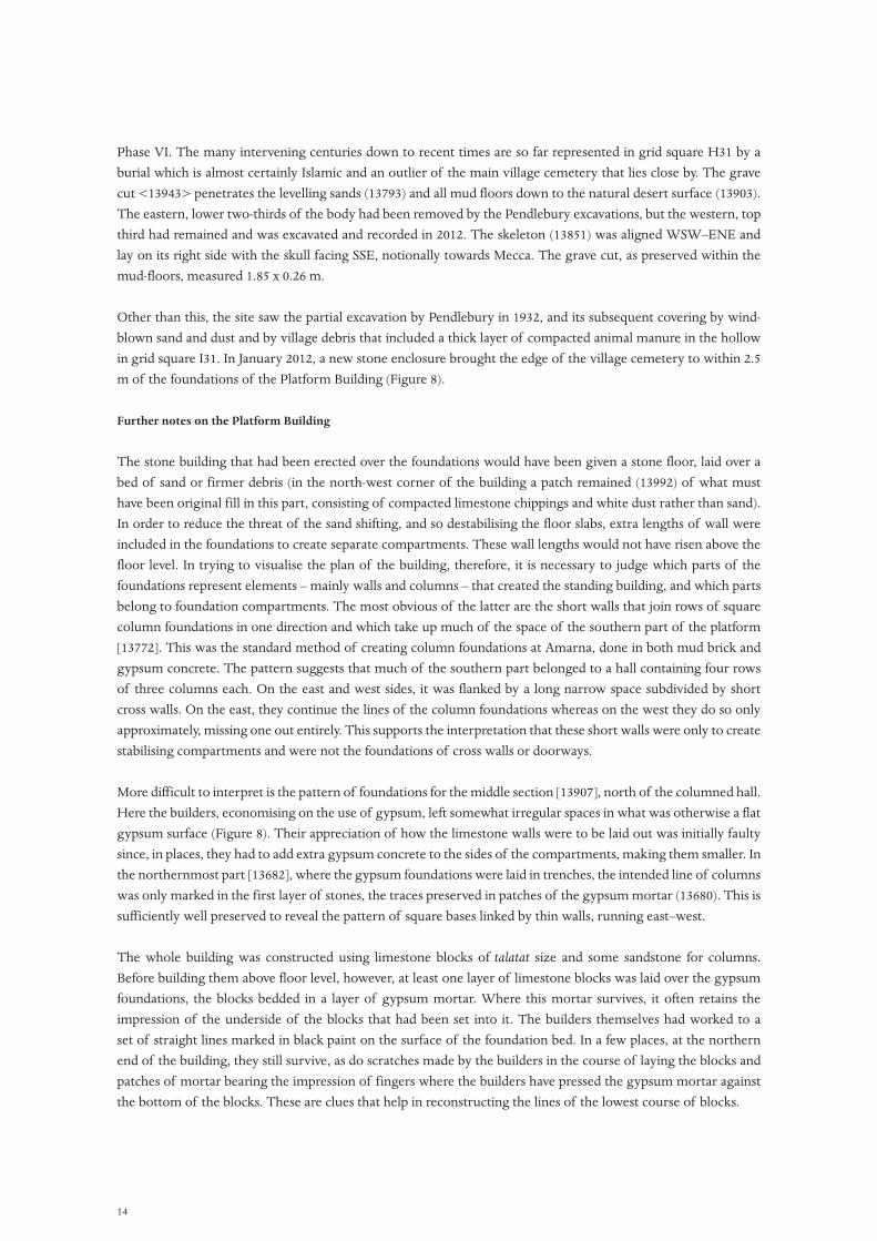
Phase VI. The many intervening centuries down to recent times are so far represented in grid square H31 by a burial which is almost certainly Islamic and an outlier of the main village cemetery that lies close by. The grave cut <13943> penetrates the levelling sands (13793) and all mud floors down to the natural desert surface (13903). The eastern, lower two-thirds of the body had been removed by the Pendlebury excavations, but the western, top third had remained and was excavated and recorded in 2012. The skeleton (13851) was aligned WSW–ENE and lay on its right side with the skull facing SSE, notionally towards Mecca. The grave cut, as preserved within the mud-floors, measured 1.85 x 0.26 m.
Other than this, the site saw the partial excavation by Pendlebury in 1932, and its subsequent covering by wind-blown sand and dust and by village debris that included a thick layer of compacted animal manure in the hollow in grid square I31. In January 2012, a new stone enclosure brought the edge of the village cemetery to within 2.5 m of the foundations of the Platform Building (Figure 8).
Further notes on the Platform Building
The stone building that had been erected over the foundations would have been given a stone floor, laid over a bed of sand or firmer debris (in the north-west corner of the building a patch remained (13992) of what must have been original fill in this part, consisting of compacted limestone chippings and white dust rather than sand). In order to reduce the threat of the sand shifting, and so destabilising the floor slabs, extra lengths of wall were included in the foundations to create separate compartments. These wall lengths would not have risen above the floor level. In trying to visualise the plan of the building, therefore, it is necessary to judge which parts of the foundations represent elements – mainly walls and columns – that created the standing building, and which parts belong to foundation compartments. The most obvious of the latter are the short walls that join rows of square column foundations in one direction and which take up much of the space of the southern part of the platform [13772]. This was the standard method of creating column foundations at Amarna, done in both mud brick and gypsum concrete. The pattern suggests that much of the southern part belonged to a hall containing four rows of three columns each. On the east and west sides, it was flanked by a long narrow space subdivided by short cross walls. On the east, they continue the lines of the column foundations whereas on the west they do so only approximately, missing one out entirely. This supports the interpretation that these short walls were only to create stabilising compartments and were not the foundations of cross walls or doorways.
More difficult to interpret is the pattern of foundations for the middle section [13907], north of the columned hall. Here the builders, economising on the use of gypsum, left somewhat irregular spaces in what was otherwise a flat gypsum surface (Figure 8). Their appreciation of how the limestone walls were to be laid out was initially faulty since, in places, they had to add extra gypsum concrete to the sides of the compartments, making them smaller. In the northernmost part [13682], where the gypsum foundations were laid in trenches, the intended line of columns was only marked in the first layer of stones, the traces preserved in patches of the gypsum mortar (13680). This is sufficiently well preserved to reveal the pattern of square bases linked by thin walls, running east–west.
The whole building was constructed using limestone blocks of talatat size and some sandstone for columns. Before building them above floor level, however, at least one layer of limestone blocks was laid over the gypsum foundations, the blocks bedded in a layer of gypsum mortar. Where this mortar survives, it often retains the impression of the underside of the blocks that had been set into it. The builders themselves had worked to a set of straight lines marked in black paint on the surface of the foundation bed. In a few places, at the northern end of the building, they still survive, as do scratches made by the builders in the course of laying the blocks and patches of mortar bearing the impression of fingers where the builders have pressed the gypsum mortar against the bottom of the blocks. These are clues that help in reconstructing the lines of the lowest course of blocks.
15
The gypsum concrete foundations are also covered with roughly circular holes that have been cut into the surface. They are fewest over the main, southern part, probably because this has the most eroded surface. Holes of this kind are a feature of most gypsum concrete foundations at Amarna, sometimes corresponding to the join between blocks in places where the layer of gypsum mortar remained behind after the blocks had been removed, preserving a clear impression of the underside of the blocks. How they had been made is illustrated by the line of limestone blocks [13901] left in place against the southern face of the platform. They had stuck firmly not only to the gypsum surface underneath but also to the tall side of the platform. Those who removed the stones after the end of the Amarna Period attempted to remove these but, in the end, abandoned the task and left a row of around 25 blocks in the middle. The long face of the westernmost block is well preserved (Figure 10). In the lower part of the block, roughly in the middle, a semicircular hole has been chiselled down at an angle. Where it meets the gypsum foundation, the hole has been continued into the gypsum and made circular. This offered space for a bar of metal or wood to be used to help lever the block up from its bed of mortar. The holes, in pointing to where two blocks lay adjacent to one another, provide a further set of clues as to the layout of the lowest course of blocks.
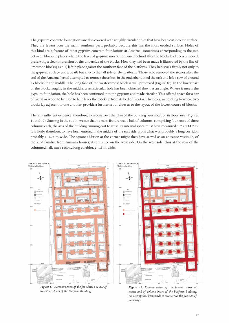
There is sufficient evidence, therefore, to reconstruct the plan of the building over most of its floor area (Figures 11 and 12). Starting in the south, we see that its main feature was a hall of columns, comprising four rows of three columns each, the axis of the building running east to west. Its internal space must have measured c. 7.7 x 14.7 m. It is likely, therefore, to have been entered in the middle of the east side, from what was probably a long corridor, probably c. 1.75 m wide. The square addition at the corner might then have served as an entrance vestibule, of the kind familiar from Amarna houses, its entrance on the west side. On the west side, thus at the rear of the columned hall, ran a second long corridor, c. 1.5 m wide.
H32G32 I32F32
F31 G31 H31 I31 J31
F33 G33
F34 G34
F35 G35 H35
F36 J36
F37 G37 H37 J37
reconstructed foundations
N
pylon
sand fill of ramp
excavation trench
foundation trench
grave
Pendleburytrench
phase 1foundation
GREAT ATEN TEMPLEPlatform BuildingJune 2012
original fill
gypsum foundation
limestone block
block impressionin mortar
mud brick
edge of excavation
KEY
metres
0 5
H32G32 I32F32
F31 G31 H31 I31 J31
F33 G33
F34 G34
F35 G35 H35 J35
F36 I36 J36
F37 G37 H37 I37 J37I37I37
I36I36I36I36
reconstructed foundations
reconstructed walls
N
pylon
sand fill of ramp
excavation trench
foundation trench
grave
Pendleburytrench
phase 1foundation
GREAT ATEN TEMPLEPlatform BuildingJune 2012
original fill
gypsum foundation
limestone block
block impressionin mortar
mud brick
edge of excavation
KEY
metres
0 5
Figure 11. Reconstruction of the foundation course of limestone blocks of the Platform Building.
Figure 12. Reconstruction of the lowest course of stones and of column bases of the Platform Building. No attempt has been made to reconstruct the position of doorways.

16
The northern half of the building subdivides into three parts that together create an approximately symmetrical layout. In the centre comes the lower-lying gypsum foundations [13907] with their irregular subdivisons. The asymmetries and the smallness of many of the spaces are likely to be signs that this was a single open court (c. 12.7 x 3.6 m), and that the walls merely created stabilising compartments for the sand beds on which the stone floor was to be laid. On the south, and separating it from the main columned hall, was an east–west hall (c. 10.7 x 3.0 m) down the centre of which ran a single line of four columns (represented by foundations [13839]). This was repeated on the north, the hall of four columns measuring c. 10 x 3.8 m and represented by the mortar layers (13680). In this case, the columns stopped well short of the west wall of the building, probably leaving space for a separate chamber. The same might have been true for the corresponding southern narrow hall.
An important element that is not normally marked on the foundations is the position of doorways. The first layer of limestone blocks acted both as a foundation course for walls and as thresholds for doors. The one exception to this is along the southern wall of the space that we have identified as a possible courtyard. Extra blocks laid on either side of the main axis of its southern wall (mortar layers (13914), (13915)) could be foundations for the jambs of a stone doorway that projected into the courtyard (if that is what it was).
The removal of the loose covering material and of part of the Pendlebury dump over the north pylon produced a collection of stone and faience fragments that are likely to derive from the Platform Building and to which can be added the list of finds from the Pendlebury excavations themselves (Pendlebury 1951: 17–20, presumably those found inside and outside the ‘West Entrance to the Temenos’, though some, particularly the fragment of sphinx, 32/20, will more likely have belonged to Phase I, before the Platform Building was constructed). The new fragments include two from columns decorated with the carved pendant ducks that were a common motif on columns at Amarna (Figure 13) and pieces of limestone frieze decorated with cobras (Figure 14). What particularly stands out is the variety of inlays that must have been used to decorate the stone surfaces. Some were in hard stones, including black granite, quartzite (Figure 15) and a fine-grained green stone that might be the same as the ‘metamorphosed green limestone’ of pieces from Amarna in the Petrie Museum (e.g. UC 46426, see <http://www.accessingvirtualegypt.ucl.ac.uk/COVES/index.php>). Others were in faience. Several pieces of faience tile were also found, depicting marsh and pond scenes. Were they set into a floor in the columned hall? Fragments were also found from relatively small statues in limestone and quartzite, two of them decorated with tiny carved Aten cartouches (Figure 16).
Figure 13. Fragment of limestone column, from G36 (13857), that has been carved with pendant ducks, all surfaces then covered with a lightly incised plant decoration.
Figure 14 (right). Fragment of a limestone frieze carved with cobras, from E31 (13782).
17
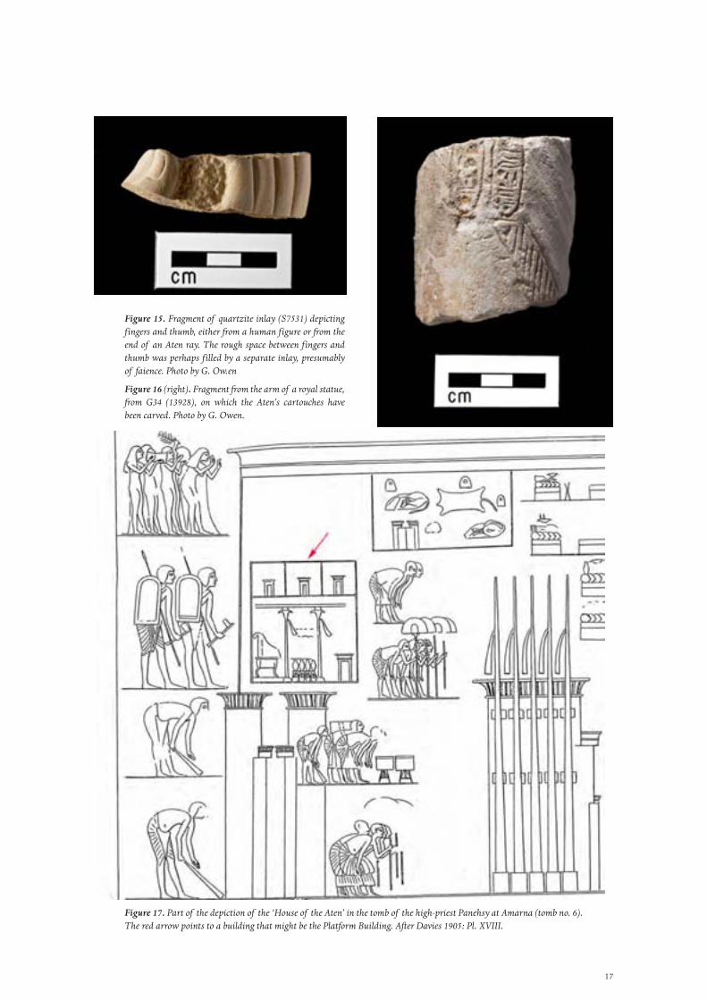
Figure 15. Fragment of quartzite inlay (S7531) depicting fingers and thumb, either from a human figure or from the end of an Aten ray. The rough space between fingers and thumb was perhaps filled by a separate inlay, presumably of faience. Photo by G. Ow.en
Figure 16 (right). Fragment from the arm of a royal statue, from G34 (13928), on which the Aten’s cartouches have been carved. Photo by G. Owen.
Figure 17. Part of the depiction of the ‘House of the Aten’ in the tomb of the high-priest Panehsy at Amarna (tomb no. 6). The red arrow points to a building that might be the Platform Building. After Davies 1905: Pl. XVIII.
18
As to the purpose of the building, in three of the pictures of the House of the Aten in tombs at Amarna (two in the tomb of Meryra, one in the tomb of Panehsy, Figure 17), seemingly just inside the outer entrance to the temple stands a separate building (shown duplicated in the case of one of the Meryra scenes). The details differ in each case. The Panehsy version gives prominence to a throne, whilst one of the Meryra versions includes a Window of Appearance. The building could therefore be classed as a small palace. It was also one of the few buildings in the temple enclosure that was roofed and offered safe storage for valuable objects.
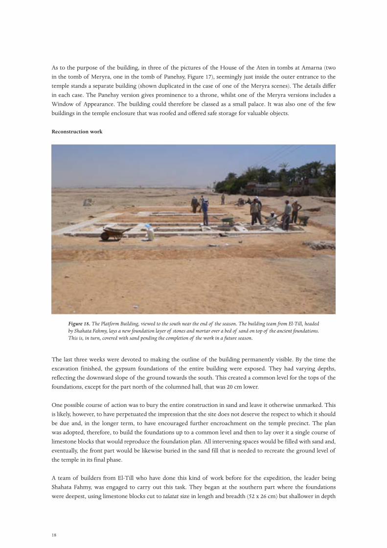
Reconstruction work
The last three weeks were devoted to making the outline of the building permanently visible. By the time the excavation finished, the gypsum foundations of the entire building were exposed. They had varying depths, reflecting the downward slope of the ground towards the south. This created a common level for the tops of the foundations, except for the part north of the columned hall, that was 20 cm lower.
One possible course of action was to bury the entire construction in sand and leave it otherwise unmarked. This is likely, however, to have perpetuated the impression that the site does not deserve the respect to which it should be due and, in the longer term, to have encouraged further encroachment on the temple precinct. The plan was adopted, therefore, to build the foundations up to a common level and then to lay over it a single course of limestone blocks that would reproduce the foundation plan. All intervening spaces would be filled with sand and, eventually, the front part would be likewise buried in the sand fill that is needed to recreate the ground level of the temple in its final phase.
A team of builders from El-Till who have done this kind of work before for the expedition, the leader being Shahata Fahmy, was engaged to carry out this task. They began at the southern part where the foundations were deepest, using limestone blocks cut to talatat size in length and breadth (52 x 26 cm) but shallower in depth
Figure 18. The Platform Building, viewed to the south near the end of the season. The building team from El-Till, headed by Shahata Fahmy, lays a new foundation layer of stones and mortar over a bed of sand on top of the ancient foundations. This is, in turn, covered with sand pending the completion of the work in a future season.
19
(18 cm or less), a limitation imposed by the equipment used in the quarry that supplied them. The blocks were laid over a bed of sand that separated the old from the new. The mortar was a mixture of alabaster powder and white cement. At the south end they had to lay three courses of blocks, but as they moved northwards along the sides, the foundation level stepped up, requiring only a single course until the back part was reached, where the foundations correspond to the ground level. Because the blocks we use are shallower than the original talatat size, the top surface of the new blocks is lower than the top of the original concrete areas. To compensate for this, a continuous layer of white concrete, up to 8 cm deep, was laid over the blocks so that, at the end, both the ancient concrete foundations and the modern limestone foundations have a common level.
By this time it was necessary to stop the work (Figure 18). All exposed ancient surfaces were protected with sand. The final step (planned for 2013) will be to lay a single course of new stones over all wall lines, and to recreate the column foundation pattern. All intervening spaces will then be filled with sand, leaving a low platform, one block in height, over which the plan of the building will be unobtrusively visible.
The stela emplacement
by Mary Shepperson
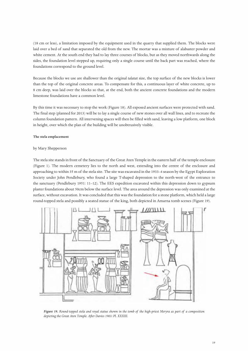
The stela site stands in front of the Sanctuary of the Great Aten Temple in the eastern half of the temple enclosure (Figure 1). The modern cemetery lies to the north and west, extending into the centre of the enclosure and approaching to within 35 m of the stela site. The site was excavated in the 1933–4 season by the Egypt Exploration Society under John Pendlebury, who found a large T-shaped depression to the north-west of the entrance to the sanctuary (Pendlebury 1951: 11–12). The EES expedition excavated within this depression down to gypsum plaster foundations about 50cm below the surface level. The area around the depression was only examined at the surface, without excavation. It was concluded that this was the foundation for a stone platform, which held a large round-topped stela and possibly a seated statue of the king, both depicted in Amarna tomb scenes (Figure 19).
Figure 19. Round-topped stela and royal statue shown in the tomb of the high-priest Meryra as part of a composition depicting the Great Aten Temple. After Davies 1903: Pl. XXXIII.
20
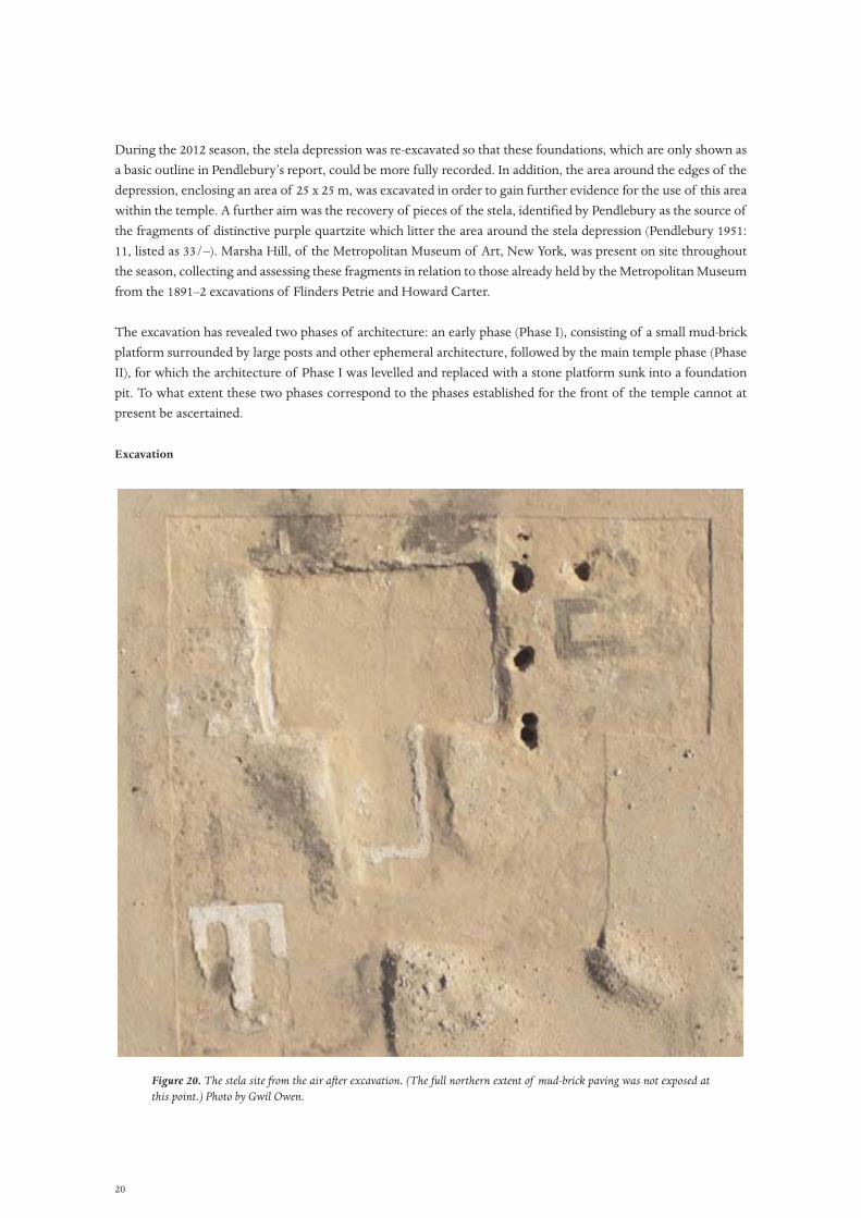
During the 2012 season, the stela depression was re-excavated so that these foundations, which are only shown as a basic outline in Pendlebury’s report, could be more fully recorded. In addition, the area around the edges of the depression, enclosing an area of 25 x 25 m, was excavated in order to gain further evidence for the use of this area within the temple. A further aim was the recovery of pieces of the stela, identified by Pendlebury as the source of the fragments of distinctive purple quartzite which litter the area around the stela depression (Pendlebury 1951: 11, listed as 33/–). Marsha Hill, of the Metropolitan Museum of Art, New York, was present on site throughout the season, collecting and assessing these fragments in relation to those already held by the Metropolitan Museum from the 1891–2 excavations of Flinders Petrie and Howard Carter.
The excavation has revealed two phases of architecture: an early phase (Phase I), consisting of a small mud-brick platform surrounded by large posts and other ephemeral architecture, followed by the main temple phase (Phase II), for which the architecture of Phase I was levelled and replaced with a stone platform sunk into a foundation pit. To what extent these two phases correspond to the phases established for the front of the temple cannot at present be ascertained.
Excavation
Figure 20. The stela site from the air after excavation. (The full northern extent of mud-brick paving was not exposed at this point.) Photo by Gwil Owen.
21
The feature excavated by Pendlebury in 1933 remained as a shallow T-shaped depression in the flat area in front of the Sanctuary, measuring around 11 m wide and 15 m long. The edge of the ‘slaughter court’, probably the area in which animals were slaughtered and prepared for offerings, was visible to the west as a low ridge defining a right-angled corner. The western half of the slaughter court now lies under the modern cemetery. The depression was filled with loose sand and fine limestone gravel, probably deposited by wind action; it is unclear whether there was deliberate backfilling after its previous excavation. The area surrounding the depression was mostly flat and covered with a thin layer of sand and fine gravel to a depth of 5–10 cm. It contained occasional small fragments of purple quartzite and a few pieces of black diorite. Several small-to-medium spoil heaps from the EES excavations surrounded the site, the closest lying around 6 m from the northern edge of the depression and part of which was cleared during the course of the season. It was in these dumps that the majority of stela and statue fragments were found.
To the south-west of the T-shaped depression, traces of gypsum plaster could be seen protruding through the surface deposit in three parallel ridges. These had been noted by Pendlebury (1951: 11) and by Kemp and Garfi’s survey (1993: 52) but never investigated.
Excavation proceeded in 5 x 5 m squares, initially along the northern edge of the depression, then continuing south down both sides until a 5 m strip had been cleared on all sides. The surface deposit was removed down to the archaeological deposits and then each area was carefully cleaned. As part of this process, the slopes of the depression were also cleared back to the archaeological deposits. The centre of the depression was then excavated down to the gypsum foundations and the area of excavation was extended northward and eastward to follow the archaeological features initially exposed. The features exposed by surface cleaning were excavated as they were found, although time constraints left a few hollow features unexcavated at the end of the season (Figure 20).
The excavation revealed two phases of architecture, which are described separately below.
Phase I (Figure 21)
A rectangular mud-brick foundation (6.30 x 4.50 m) lay on the eastern side of the stela depression, preserved at its western end as a single course of bricks [13695] and at the east end as just a foundation cut (Figure 22). This mud-brick structure had been noted, although not fully excavated, by Pendlebury, who interpreted it as the base for a ramp leading up to the stela platform from the east (1951: 11). This is clearly not the case, as the structure does not reach the edge of the stela foundation but stops more than 2 m short. Instead, this appears to be the foundation of a free-standing mud-brick platform. The remains of a pair of mud-brick bases [13697], [13813] mid-way along the long north side might belong to the ends of a ramp or steps approaching the platform from this side, with a hard-packed floor surface 13816 preserved at the foot of this.
These platform steps were flanked by a pair of roughly circular pits <13807>, <13882>, around 0.5 m in diameter and 1 m deep. These pits were two of a series of six deep, narrow pits which formed three sides of a rectangle around the mud-brick platform (Figure 43), with at least one further pit <13694> left unexcavated. The dimensions of these pits were unusual, being only 50–70 cm wide but up to 1.9 m deep, with smooth vertical sides. They were all cut through clean sand and contained a distinctive fill consisting of sand and fine gravel mixed throughout with mud plaster fragments, grass, feathers, charcoal and date stones. All pits also contained incense, mostly in a processed form of small red glassy rods or filaments (Figure 24), but the two pits flanking the platform steps also contained a substantial amount of raw incense in lumps.
The dimensions and distribution of these pits suggest that they must have held posts of some considerable size, possibly of the magnitude of the flagstaffs found on temple pylons. The later removal of such posts would explain

22
Figure 21. Plan of the Phase I features at the stela site, by Mary Shepperson.
Figure 22. The Phase I mud-brick platform, viewed to the west.

23
Figure 23. One of the Phase I pits, this one showing two attempts to cut it into the desert. The scale is 1 m long.
Figure 24. Fragments of incense recovered from one of the deep pits at the site of the stela in the rear part of the Great Aten Temple. The filament shapes probably resulted from pouring viscous incense through a strainer (an explanation provided by Margaret Serpico). Photo by Teresa Wilson.

24
Figure 25. Phase I ditch before excavation, looking south.

25
the damage to the upper parts of the pit cuts while the lower parts were undisturbed. The erection of tall posts or flags around the temporary structure may have been a fast and easy way of lending an idea of scale and monumentality to the site while this was yet lacking in the nascent temple. This arrangement of a platform surrounded by free-standing posts or flags is hard to parallel in Egyptian temple architecture of historic times.
On the west side of the stela depression, a compacted surface was uncovered into which numerous circular depressions and a long shallow ditch <13741> had been cut (Figure 25). This surface and its features certainly predated the main stone stela platform as it was overlaid by limestone debris from the platform’s construction. Efforts then seem to have been made to level these features — some had been packed with lumps of mud brick — before the Phase II mud plaster and gypsum floor was laid above. The north–south running ditch was cut at its southern end by the foundation cut for the Phase II rectangular gypsum base, suggesting it was out of use by the time this base was built. The ditch at least can be tentatively linked to the deep pits described above, as the ditch fill was more or less identical to that of the pits.
Some features appear to be postholes for both round- and square-sectioned posts, while there were also many clusters of shallow circular depressions which are most likely to have been emplacements for round-bottomed bowls or jars. One clear example was a perfectly circular pit <13747> at the northern end of the ditch, which contained the greater part of the blue-painted jar which it almost certainly held. Some of the postholes formed lines suggestive of a fence or screen, such as the holes along the western side of the ditch or those running parallel to the ditch’s eastern side, but it is difficult to interpret the function of many of these features. In general, they seem to represent an activity area associated with the use of the Phase I mud-brick platform, possibly for the dedication or preparation of offerings.
The mud-brick platform and associated features described above appear to be part of Pendlebury’s ‘First Period’; preliminary mud-brick structures which allowed the performance of cult practices at the temple before the monumental buildings were completed (Pendlebury 1951: 5). The mud-brick platform seems to have been completely levelled and the deep pits filled in before the construction of the main stela platform; no limestone or purple quartzite debris was found in the pit fills, and construction debris overlies the top of at least one of the filled pits. Along with the ditch, postholes and pot emplacements, the whole area appears to have been levelled in preparation for the construction of the stela platform.
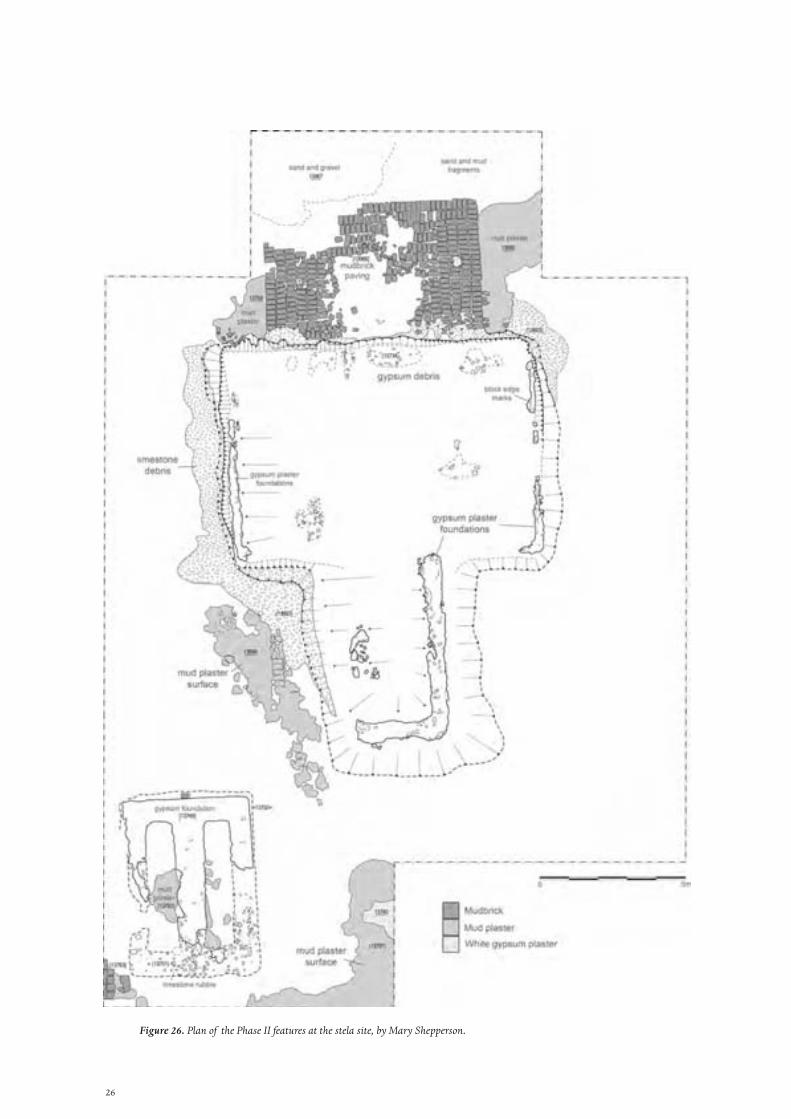
Phase II (Figure 26)
The stela depression remained much as it was described by Pendlebury (1951: 11). The sides were somewhat irregular and seem to have suffered considerable erosion since they were exposed in the 1930s (Figure 20). The heavily fragmented gypsum plaster (or concrete) foundations remained at the bottom of the cut in thin strips along the east and west sides of the main rectangular section. In the southern extension — the upright of the T shape — the foundation was better preserved, possibly because it was originally thicker than the main section or perhaps because the gypsum plaster here seems to have been mixed with more limestone fragments. In any case, the foundation material in the southern extension appears to be slightly different from that of the main section, suggesting the two parts may not have been built quite at the same time.
As was normal for other areas of the temple, the foundations seem to have been made by digging out a trench, spreading a layer of plaster mixed with stone fragments onto the sand at the bottom, and then laying the stone blocks onto a layer of wet gypsum mortar. The impressions of block edges could be clearly seen in the mortar layer along the eastern side of the depression (Figure 27). Over the rest of the foundation cut, only a few patches of gypsum plaster debris could be found. The centre of the depression was deeper than the plaster foundations and completely bare, suggesting that, at some time in the past, digging has removed most of the foundation debris
26
Figure 26. Plan of the Phase II features at the stela site, by Mary Shepperson.

27
no longer in situ and excavated below the original level of the foundation cut. This could have been done by the Petrie-Carter excavation, which produced many fragments of the stela, or even before that.
Pendlebury’s interpretation of the T-shaped structure was that it represented two adjoining stone platforms, the larger holding the round-topped stela and the smaller bearing the statue of the king depicted in the tomb scenes (1951: 11). Kemp and Garfi (1993: 52) and Spence (2009: 502) considered it more likely that the main body of the foundation was for a single stone platform, with the southern extension representing a ramp or staircase by which it was approached. This seems by far the more convincing interpretation, as this configuration is very common, not only at Amarna but in New Kingdom temple architecture in general (Arnold 2003: 8).
To the north, careful cleaning exposed a rectangular expanse of mud-brick paving [13966] abutting the edge of the stela depression, retaining a few traces of a white gypsum plaster coating. Mud-brick paving is an unusual feature at the Great Aten Temple and suggests that this area on the north side of the stela platform saw an unusually large amount of traffic to require such reinforcement. It is possible that a statue or feature of some kind stood against the stela platform here where the paving is broken. A round socket was preserved in a mud brick at the centre of the paved area.
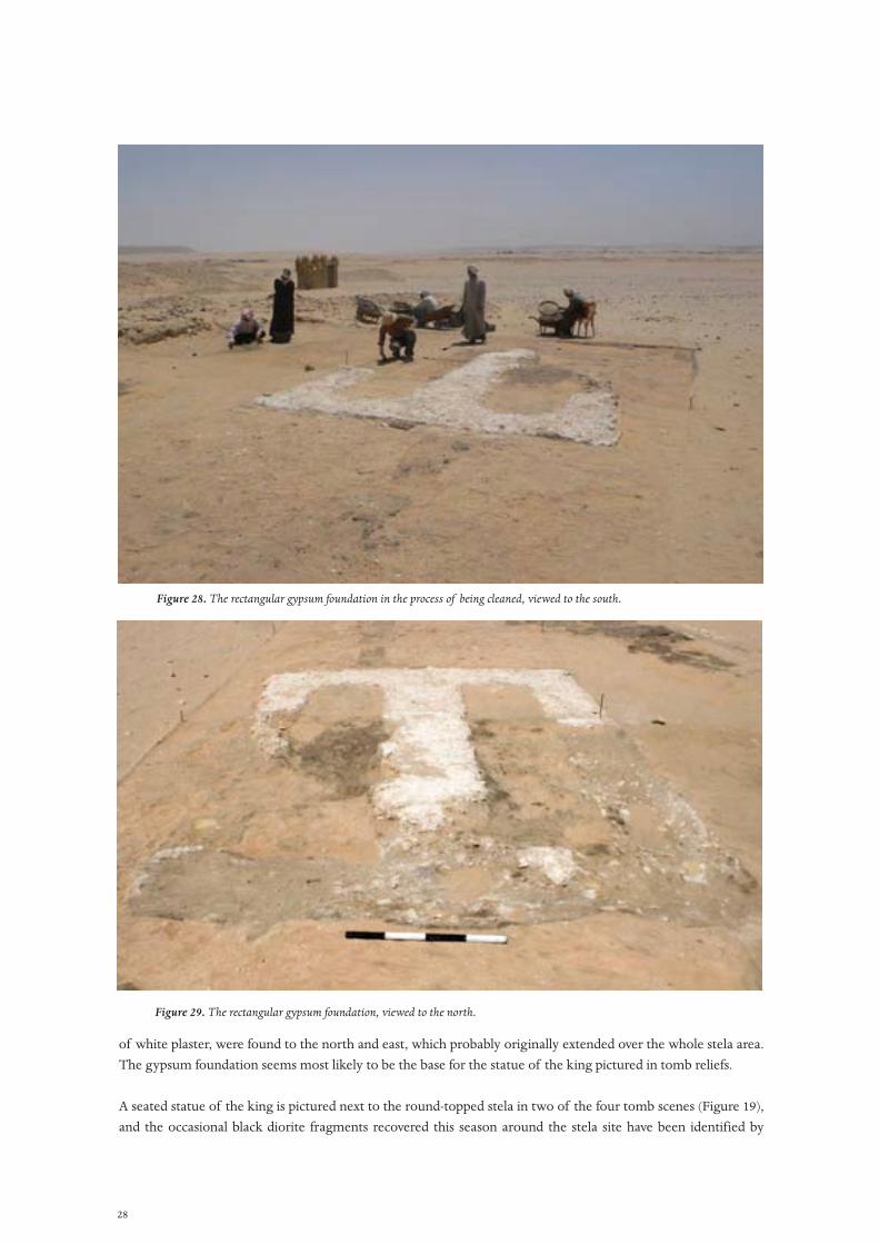
On investigation, the traces of gypsum plaster to the south-west of the stela platform noted by Pendlebury resolved themselves into the foundation of a rectangular structure [13749], measuring 6.10 x 4.30 m (Figures 28, 29). The northern end was composed of gypsum plaster mixed with limestone fragments and resembled the gypsum foundations of the temple’s major buildings. The southern end was only preserved as a foundation cut lined with limestone chippings (13751). The rectangular perimeter of gypsum was reinforced with a central strip of foundation and the voids between were levelled with mud plaster (13762), suggesting that a stone surface was laid directly above to make a low platform. The remains of a mud plaster floor 13696, 13761 , coated with traces
Figure 27. The Phase II stela site: the impression of part of a limestone block is preserved in the layer of mortar laid over the bed of gypsum concrete. On the far side of the ridge that marks the edge of the block is the surplus mortar that has been worked with fingers.
28
of white plaster, were found to the north and east, which probably originally extended over the whole stela area. The gypsum foundation seems most likely to be the base for the statue of the king pictured in tomb reliefs.
A seated statue of the king is pictured next to the round-topped stela in two of the four tomb scenes (Figure 19), and the occasional black diorite fragments recovered this season around the stela site have been identified by
Figure 28. The rectangular gypsum foundation in the process of being cleaned, viewed to the south.
Figure 29. The rectangular gypsum foundation, viewed to the north.

29
Marsha Hill as probably originating from a male royal statue. The association of such a statue with the stela site seems fairly certain. Pendlebury suggested that the southern extension of the stela footprint was a base for this statue (1951: 11) but, as discussed above, this structure is almost certainly a ramp providing access to the stela platform. Spence suggests that, as the stela platform is very large, it could easily have held both the stela and the statue (2009: 502), but the tomb depictions go some way to refute this as both show the king’s statue at ground level and not on the platform with the stela. In presenting a foundation for a low base beside the stela platform, the rectangular gypsum foundation excavated this season would seem to fit very well in form and position for the statue pictured in the tombs and would be of about the right size to hold the slightly larger than life-sized statue indicated by the diorite fragments.
It is interesting to note that two small fragments of purple quartzite were found embedded in the limestone chippings lining the foundation cut for the statue base. This suggests that construction debris from the erection of the stela was present at the time of the base’s construction, and that it therefore probably post-dates the stela platform. If the statue was a later addition, this could explain why two tomb scenes show the statue by the stela and two just show the stela.
Finds
One of the aims of this season was the collection of fragments of the stela which sat on top of the Phase II stone platform. All fragments of purple quartzite within the excavation area were examined and those with worked faces were retained for future study. Many small inscribed fragments were recovered; generally these had small hieroglyphs in registers, as seen on the larger fragments held by the Metropolitan Museum, but some figurative elements were also found, including a very small fragment with a carved eye, possibly of a royal princess (Figure 32). Some indications, from the quality of stone and style of carving, suggest that more than one stela may in fact be represented. Small fragments of the diorite royal statue discussed above were also found.
Two clay jar stoppers were recovered. The larger was stamped with a label identifying the jar contents as wine, and was found just below the surface above a deep Phase I pit (Figure 30). The smaller stopper, which retained some of its fabric covering, was jammed into a Phase I pot emplacement as part of the levelling material laid down before the construction of Phase II.
Figure 30. Mud jar stopper, as found at the stela site.
30
Incense was a common find on site, and fragments were found in almost all the ditches, pits and postholes of Phase I. Some was in a raw form as lumps, but it was more commonly found in a processed form as tiny curving rods or filaments resembling red glass (Figure 24). To produce this shape, the incense had probably been passed through a strainer (an idea suggested by Margaret Serpico). In general, very few finds of any kind were recovered from the excavated material, indicating that the stela area of the temple was largely kept clear of rubbish and debris. The fact that the stela area had already been excavated by the EES and probably earlier by Carter probably also reduced the number of finds remaining on the site.
Marsha Hill supplies the following additional comments:
Finds of relief and sculpture fragments derive almost entirely from the dumps that resulted from Pendlebury’s clearance of the platform area. The floor levels of the areas belonging to earlier constructions were devoid of these destruction traces.
The finds await further study as the work proceeds, but already provide important information for understanding earlier work in the area of the platform. The lists of finds published in City of Akhenaten III record the discovery of ‘many fragments’ of red quartzite and of ‘black granite’, which Pendlebury attributed to the stela and the statue of the king, respectively. His remarks in the 1933/4 season report provide supplementary information: ‘Fragments of purple sandstone from the stela itself were found scattered all round, for this spot had been partly excavated. Unfortunately, the only pieces large enough to make sense seem merely to consist of a list of offerings’ (Pendlebury 1934: 132).
A single photograph in the EES archive (Figure 31) depicts five fragments of this offering list (current whereabouts unknown), but their distinctive character is enough to associate them with fragments of the same type in the Metropolitan Museum of Art (Figure 32) that derive from the 1891–2 work that the teenage Howard Carter undertook (as Petrie’s assistant and Lord Amherst’s representative) in the areas of the Sanctuary of the Great Aten Temple and the dump just south of it (outside the temenos). Pendlebury’s remark about prior excavation suggests that he actually saw traces of Carter’s work and thus that the New York fragments were actually retrieved in the platform area.
So far, none of the fragments preserves any lines of inscription that can be understood as discussing the disposition of the items listed. But the fragments themselves, and their location in a distinct installation within the Great Aten Temple, place them in a wider context that includes offering lists and imposition lists from Karnak that testify to Akhenaten’s marked concern with providing sufficient support for the cult of the Aten (Traunecker 2005: esp. 175–6).
Other fragments recovered derive from a diorite royal male statue and include elements of a royal kilt, blue crown and knee area. These relate closely in size and by other indications to fragments from the Amherst collection in New York that may well be from this area, and indications from both sources suit remarkably well the statue depicted in the tombs of Meryra and Panehsy, although the size is slightly over-life size rather than colossal, as the tomb depictions could imply. Further finds will be illuminating and may warrant the use of casts from New York to investigate similarities or joins.
At the same time, this year’s results reveal features — something also documented in the New York fragments –—that contrast with the tomb depictions. The offering-stela fragments show variations in the red quartzite and in the quality of the inscription that, at the least, indicate more than one person or period of inscription and, at most, could point to more than one stela. In addition, there are fragments of typical Amarna balustrades and parapets,

31
Figure 31. Fragments of stela from the Great Aten Temple discovered in 1933/4. EES archive photograph 1933/4, no. O 74.
Figure 32. Lower left: two fragments of quartzite stela in the Metropolitan Museum of Art, Harrris Brisbane Dick Fund. Photographs by William Barrette. Right: three small fragments from the 2012 excavations. Photographs by Marsha Hill. Top: fragment (S7569), from the 2012 season, that seems to be part of a face, perhaps of a princess. On the left it has been placed within the outline of one of the princesses depicted on Boundary Stela S.
32
and relief and statuary elements that point to a considerably more crowded and varied area than the simple, if impressive, installation suggested by the tomb depictions. Some part of this sculpture collection could well be a manifestation of donations made by those who saw the area — that included the rectangular podium as well as the platform — as a focus for donations on the king’s behalf.
References
Arnold, D., 2003. The Encyclopedia of Ancient Egyptian Architecture. London, Tauris and Princeton, Princeton University Press.
Davies, N. de G. 1903. The Rock Tombs of El Amarna I. London, Egypt Exploration Fund.
Davies, N. de G. 1905. The Rock Tombs of El Amarna II. London, Egypt Exploration Fund.
Kemp, B.J. and S. Garfi, 1993. A Survey of the Ancient City of El-‘Amarna. London, Egypt Exploration Society.
Pendlebury, J.D.S. 1951. The City of Akhenaten III. London, Egypt Exploration Society.
Pendlebury, J.D.S. 1933. ‘Preliminary report of the excavations at Tell el-‘Amarnah, 1932–1933.’ Journal of Egyptian Archaeology 19, 113–8.
Pendlebury, J.D.S. 1934. ‘Excavations at Tell el Amarna: Preliminary Report for the Season 1933–4.’ Journal of Egyptian Archaeology 20, 129–36.
Spence, K. 2009. ‘The “Hall of Foreign Tribute” (S39.2) at El-Amarna.’ In S. Ikram and A. Dodson, eds., Beyond the Horizon: Studies in Egyptian Art, Archaeology and History in Honour of Barry J. Kemp. Cairo, Supreme Council of Antiquities, 498–505.
Traunecker, C. 2005. ‘Amenhotep IV, Percepteur royal du Disque.’ In Akhénaton et l’époque amarnienne. Paris, Editions Khéops, 145–82.