Goodsprings Trails Study - Clark County · Boulder, Colorado 80302 Environmental Consulting: BEC...
37
CLARK COUNTY NEVADA Goodsprings Trails Study Findings Report #2 | June 19, 2009
Transcript of Goodsprings Trails Study - Clark County · Boulder, Colorado 80302 Environmental Consulting: BEC...

C L A R K C O U N T Y N E VA D A
Goodsprings Trails Study
F i n d i n g s R e p o r t # 2 | J u n e 1 9 , 2 0 0 9

Planning Team:
Leed Consultant/ Planning and Landscape Architecture:
Shapins Belt Collins 1818 Sixteenth Street
Boulder, Colorado 80302
Environmental Consulting:
BEC Environmental, Inc. 9061 W. Sahara Ave., Suite 103
Las Vegas, Nevada 89117
Civil EngineeringConsulting:
Nevada By Design 3515 East Harmon Avenue Las Vegas, Nevada 89121
Public Process / Trails Consultant:
Outside Las Vegas Foundation 6755 W. Charleston Boulevard Ste. D
Las Vegas, Nevada 89146

Goodsprings Trail Study Findings Report #2 Shapins Belt Collins
Page1
Introduction
The Goodsprings Trail Study began with field work, research and analysis, and a public meeting in the early winter of 2008. The culmination of these efforts was a set of analysis maps and a preliminary set of draft alternative trail alignments – Draft I Alignment Alternatives. In February 2009, these preliminary alternatives were distributed to a number of different stakeholders for review and comment. During this period, the planning team also contacted several other organizations and entities about specific issues which had been identified during the research and analysis phase of the trail study. Following the synthesis of all stakeholder comments and the results of the interim site visit (February 2009) and subsequent research, the planning team refined the preliminary alternatives and produced a second set of alternative alignments – Draft II Alignment Alternatives. The issues that the Draft II Alignment Alternatives responded to and outstanding issues that may impact the feasibility of the trail development in the Goodsprings area are outlined in Findings Report #1 (March 2009). This report (which includes Analysis Maps and the Draft I & II Alignment Alternatives) was made available to the public on the project website at www.shapins.com/goodsprings.
View overlooking the Town of Goodsprings from the Bird Spring Mountains.

Goodsprings Trail Study Findings Report #2 Shapins Belt Collins
Page2
The Draft II Alignment Alternatives were presented to the public in May 2009. Also presented at this time were several other illustrative displays including details of possible trailhead layouts, signage and surfacing options, and several perspectives (Appendix 1). At this time the planning team asked for input from the public and other stakeholder groups on the details of the preferred trail alignment such as trail location, usage, and ammenities. The Draft Preferred Trail Alignment (Appendix 2) reflects the input received.
Part I of this findings report will summarize the input gathered through the public process and explain how it has guided the development of the Draft Preferred Trail Alignment . The second part of this report contains the Draft Environmental Issues and Constraints Summary completed by BEC Environmental.
Part I: Public Process As described earlier, two public meetings have been organized to educate the public about the trail study and to seek input on the preferred trail alignment. Both meetings followed an open house format and included brief presentations by the Planning Team followed by a question and answer session. The second public meeting was timed to coincide with two of Goodspring’s most popular annual events, the Old Timers Reunion and the Pioneer Saloon’s Chili Cook‐off. In addition to the public meeting, the Planning Team operated information booths at these events. In addition, materials have been made available on the project website which includes an electronic form that allows people to submit comments online to the Planning Team.
The first open house was very well attended and introduced the public to the trail study.

Goodsprings Trail Study Findings Report #2 Shapins Belt Collins
Page3
The second open house introduced the public to the three alignment alternatives and asked for their input on the preferred trail alignment.
A member of the Planning Team talks to an interested citizen at the trail study booth at the Pioneer Saloon’s Chili Cook‐off.

Goodsprings Trail Study Findings Report #2 Shapins Belt Collins
Page4
The following comments were identified by the Planning Team during the public process. These comments represent issues, concerns, or suggestions that were made in reaction to the Trail Study and the Three Alternative Alignment Maps. Most of these comments were voiced by more than one individual and overall this list reflects the comments which were the most commonly received by (or voiced to) the planning team by members of the general public. They are listed here in no particular order of importance.
Public Comment #1: Safety and Access for Road Cyclists An issue that was brought to the attention of the Planning Team during the first public meeting was the need to improve safety for road cyclists on SR 161. Currently this user group utilizes the shoulder of SR 161 from Jean to Goodsprings. The planning team was told that a typical road cyclist’s circuit might begin in Jean and head northwest on SR 161 to Goodsprings. From there, cyclists typically continue through town on Spring Street to Reimann Road which takes cyclist to an intersection with Sandy Valley Road. From there, the circuit heads back to SR 161 and to Jean for a total of approximately 16 ½ miles. A representative from Green Valley Cyclist Club explained that this road is unsafe due to the lack of an adequate shoulder, frequent truck traffic (especially trucks hauling gravel), spilled gravel in the roadway, and an unsafe intersection at Reimann Road and Sandy Valley Road.
SR 161 at Jean heading northwest to Goodsprings. The paved shoulder is wide enough to safely accommodate cyclists.

Goodsprings Trail Study Findings Report #2 Shapins Belt Collins
Page5
SR 161 heading southeast to Jean from Goodsprings. The shoulder is no longer paved and cyclists must utilize the road.
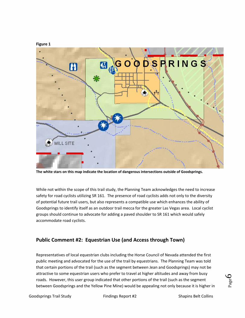
Trail Corridor Implications (Draft Preferred Trail Alignment): While the majority of the trails shown on the Draft Preferred Trail Alignment are natural surface and geared towards mountain bikers and hikers the plan does identify a paved portion of the trail between the Vista Point Trailhead and Goodsprings. This 6.7 mile stretch of paved surface will serve as an alternative to road bikers who wish to avoid SR 161 for a portion of their existing Jean to Goodsprings circuit. The Planning Team also recommends increasing safety on SR 161 by adding signs which alert drivers to the possible presence of cyclists. Adding signs to the intersection of Reimann Road and Sandy Valley Road is especially important. This dangerous intersection is identified on the Study Area Analysis Map, see Figure 1 below.
Goodsprings Trail Study Findings Report #2 Shapins Belt Collins
Page6
Figure 1
The white stars on this map indicate the location of dangerous intersections outside of Goodsprings.
While not within the scope of this trail study, the Planning Team acknowledges the need to increase safety for road cyclists utilizing SR 161. The presence of road cyclists adds not only to the diversity of potential future trail users, but also represents a compatible use which enhances the ability of Goodsprings to identify itself as an outdoor trail mecca for the greater Las Vegas area. Local cyclist groups should continue to advocate for adding a paved shoulder to SR 161 which would safely accommodate road cyclists.
Public Comment #2: Equestrian Use (and Access through Town) Representatives of local equestrian clubs including the Horse Council of Nevada attended the first public meeting and advocated for the use of the trail by equestrians. The Planning Team was told that certain portions of the trail (such as the segment between Jean and Goodsprings) may not be attractive to some equestrian users who prefer to travel at higher altitudes and away from busy roads. However, this user group indicated that other portions of the trail (such as the segment between Goodsprings and the Yellow Pine Mine) would be appealing not only because it is higher in

Goodsprings Trail Study Findings Report #2 Shapins Belt Collins
Page7
altitude and away from SR 161, but because of the historical focus of this segment. They indicated that lack of water was not a limitation since most equestrians travel with plenty of water for both horse and owner. We also heard from Goodsprings residents who were worried about horses coming through town. Their concern was that equestrians might cause conflicts between cars and motorcyclists. As requested by Goodsprings residents, no formal trail goes through town. Instead, the trail follows the Goodsprings Historical Walking Tour and will utilize existing town streets and right‐of‐ways. The Planning Team was asked to provide an alternate route around town for equestrians who choose to ride the Jean to Goodsprings segment.
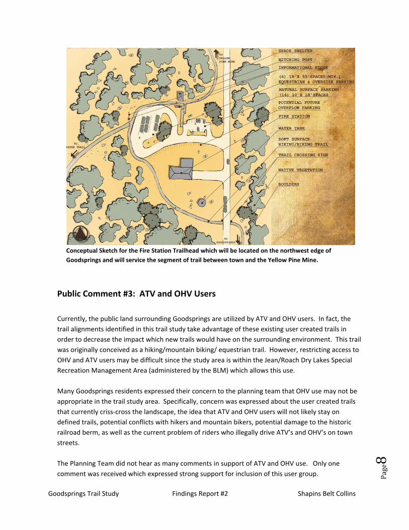
Trail Corridor Implications (Draft Preferred Trail Alignment): The Draft Preferred Trail Alignment provides an equestrian bypass which utilizes the existing gravel haul road where it intersects with the proposed trail alignment. From there, the equestrian bypass would skirt the north end of town and tie into the proposed trailhead at the Goodspring’s Fire Station. In addition, trailheads will include parking spaces for horse trailers and will also have hitching posts to accommodate equestrian users. The plan illustration below represents a possible layout for the Fire Station Trailhead. This trailhead design could also be applied to the Vista Point and Jean Trailheads as well.
Goodsprings Trail Study Findings Report #2 Shapins Belt Collins
Page8
Conceptual Sketch for the Fire Station Trailhead which will be located on the northwest edge of Goodsprings and will service the segment of trail between town and the Yellow Pine Mine.
Public Comment #3: ATV and OHV Users Currently, the public land surrounding Goodsprings are utilized by ATV and OHV users. In fact, the trail alignments identified in this trail study take advantage of these existing user created trails in order to decrease the impact which new trails would have on the surrounding environment. This trail was originally conceived as a hiking/mountain biking/ equestrian trail. However, restricting access to OHV and ATV users may be difficult since the study area is within the Jean/Roach Dry Lakes Special Recreation Management Area (administered by the BLM) which allows this use. Many Goodsprings residents expressed their concern to the planning team that OHV use may not be appropriate in the trail study area. Specifically, concern was expressed about the user created trails that currently criss‐cross the landscape, the idea that ATV and OHV users will not likely stay on defined trails, potential conflicts with hikers and mountain bikers, potential damage to the historic railroad berm, as well as the current problem of riders who illegally drive ATV’s and OHV’s on town streets. The Planning Team did not hear as many comments in support of ATV and OHV use. Only one comment was received which expressed strong support for inclusion of this user group.

Goodsprings Trail Study Findings Report #2 Shapins Belt Collins
Page9
Trail Corridor Implications (Draft Preferred Trail Alignment): As previously mentioned, a portion of the study area is located within the Jean/Roach Dry Lakes Special Recreation Management Area (SRMA). While OHV and ATV use are allowed within this SRMA, BLM has acknowledge that it may be possible to amend the designation and the permitted uses within the study area. The planning team is currently investigating this option and will include an analysis of this possibility in the final trail study. If this possibility is confimed and recommended in the final report, it is important to note that OHV and ATV use will continue to be allowed within the broader SRMA. Designated areas will continue to be accessible to these users on nearby land outside the study area.
Public Comment #4: Possible Conflicts with Hunters, Trappers, & Shooters The Planning Team received one comment regarding hunters who currently utilize the area around Goodsprings including portions of the proposed trail corridor. The Planning Team also documented several areas that are currently being utilized as “party” or target shooting areas. The creation of a formal trail system in this area may make the area less attractive to hunters, trappers and shooters. However, it is important to note that, as with OHV and ATV use, the Jean‐Roach SMRA allows for hunting, trapping, and shooting of firearms. Trail Corridor Implications (Draft Preferred Trail Alignment): The Planning Team recognizes that potential conflicts between these users and trail users may exist. As with OHV and ATV use, this user group has a number of alternative locations outside the study area to pursue these activities. If the possibility of amending the SRMA is confirmed, the BLM may want to consider closing the study area to this use as well in order to promote safety and discourage conflict between user groups. Several restoration and re‐vegetation areas have been identified on the Draft Preferred Trail Alignment. Two of these are located at areas which are currently being utilized by target shooters. The debris associated with these areas is dangerous to visitors and harmful to the environment. The Planning Team will recommend in the final report that these two areas be cleaned up and effort made to restore native vegetation to the areas be made.

Goodsprings Trail Study Findings Report #2 Shapins Belt Collins
Page10
Located adjacent to the Yellow Pine Mine Trail, this old squatter’s camp has become a target for
shooters.
This “party site” is located adjacent to the Vista Point Trailhead.
Goodsprings Trail Study Findings Report #2 Shapins Belt Collins
Page11
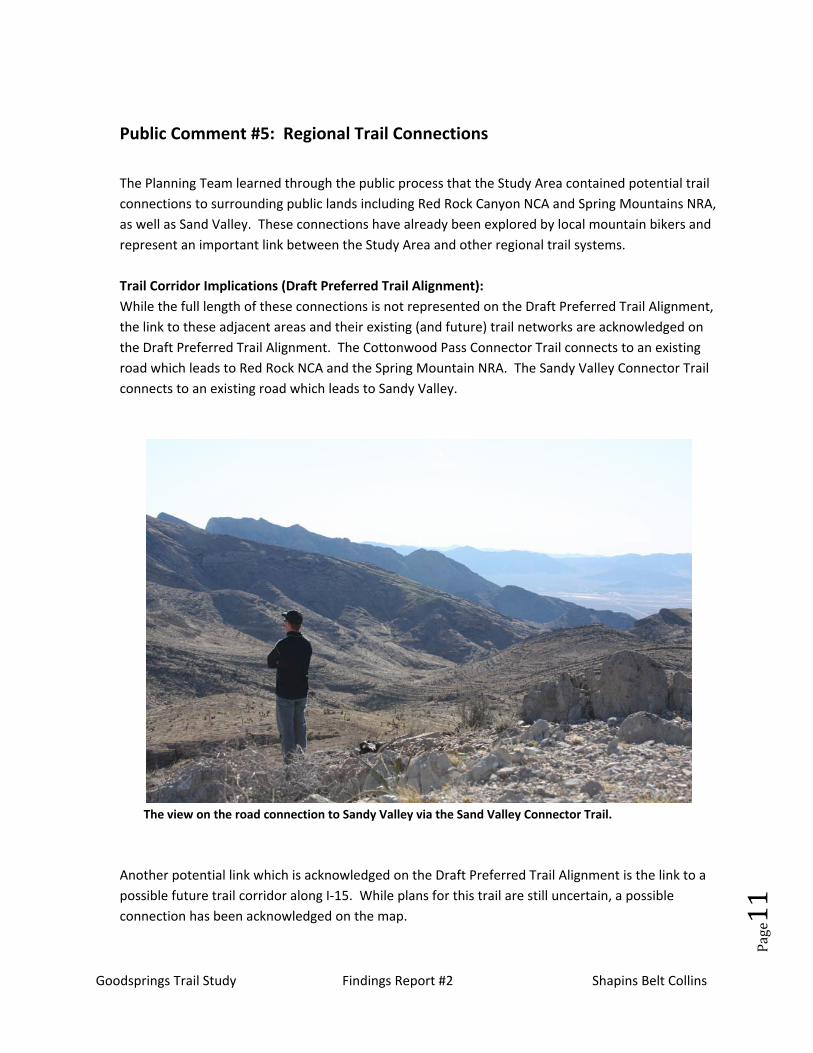
Public Comment #5: Regional Trail Connections The Planning Team learned through the public process that the Study Area contained potential trail connections to surrounding public lands including Red Rock Canyon NCA and Spring Mountains NRA, as well as Sand Valley. These connections have already been explored by local mountain bikers and represent an important link between the Study Area and other regional trail systems. Trail Corridor Implications (Draft Preferred Trail Alignment): While the full length of these connections is not represented on the Draft Preferred Trail Alignment, the link to these adjacent areas and their existing (and future) trail networks are acknowledged on the Draft Preferred Trail Alignment. The Cottonwood Pass Connector Trail connects to an existing road which leads to Red Rock NCA and the Spring Mountain NRA. The Sandy Valley Connector Trail connects to an existing road which leads to Sandy Valley.
The view on the road connection to Sandy Valley via the Sand Valley Connector Trail.
Another potential link which is acknowledged on the Draft Preferred Trail Alignment is the link to a possible future trail corridor along I‐15. While plans for this trail are still uncertain, a possible connection has been acknowledged on the map.

Goodsprings Trail Study Findings Report #2 Shapins Belt Collins
Page12
Public Comment #6: Safety and Abandoned Mines This issue was expressed as a concern by the Bureau of Land Management (BLM) during the initial research and analysis phase of the project as well as several members of the general public during Public Meetings 1 & 2. See Findings Report #1 for an analysis of how this issue was addressed in past draft trail alignments. After Findings Report #1 was issued, the Planning Team helped the County to develop a letter to all mine owners within the project area. This letter was also reviewed by Bill Durbin at the Nevada Division of Minerals and included information on how to contact him for more information on how to safely close mines. This letter elicited one response from a mine owner who was concerned about the trail alignment and its proximity to his mine.
Trail Corridor Implications (Draft Preferred Trail Alignment): Due to the dangers which abandoned mines represent, the Planning Team has worked closely with the Nevada Division of Minerals (NVDM) to ensure that the trail does not unduly put people at risk. The draft alignments have been reviewed by this agency and the Planning Team will invite NVDM to review the final alignment prior to completion. Due to the concerns expressed by the public and BLM, the trail alignment does not take visitors into the mining area nor does it cross into any of the private property surrounding these mines. The trail terminates at a safe distance away from the mining area at a terminus point overlooking the Yellow Pine Mine. A kiosk will be provided at this location to explain the dangers associated with abandoned mines and the risks of approaching them. It is important to note that recreational use is already occurring in this area without the benefit of signs identifying the dangers of abandoned mines or private property boundaries. The information kiosks associated with the trail will help the Nevada Division of Minerals in their mission to educate people on this issue while introducing people to the historic mining traditions of the area. In addition, the Planning Team will recommend in the final report that private property boundaries be more clearly defined in an effort to prevent curious people from venturing towards abandoned mines.

Goodsprings Trail Study Findings Report #2 Shapins Belt Collins
Page13
Conceptual perspective of what the trail terminus overlooking the mining area might look like.
Public Comment #7: Restroom Facilities at Trailheads The planning team received comments regarding the desire to provide restroom facilities at trailheads. Such a facility would need to be low maintenance and require no plumbing or water. The final report will include an investigation into restroom facilities as well as other comfort features such as picnic tables, trash cans, and shade.
Public Comment #8: Campground at Fire Department Trailhead The desire to provide a campground at this location was expressed to the Planning Team on multiple occasions. Due to the cost associated with maintaining and operating this facility, Clark County does not wish to explore this possibility as part of this Trail Study effort.

Goodsprings Trail Study Findings Report #2 Shapins Belt Collins
Page14
Public Comment #9: Visitor Safety and Law Enforcement The Planning Team received many questions regarding the trail and whether visitors would obey posted rules and regulations such as no littering, no vandalism, and trail use designations (such as hiking only designated trails vs. multi‐use trails). While the question of enforcement is a good one, it is unlikely that increased law enforcement personnel will be employed to enforce rules and regulations associated with the trail corridor. Rules will be posted at trailhead kiosks and, as with other trails located in remote areas, trail visitors may or may not abide by them. An important consideration for this trail will be the creation of a trail group that will help to maintain the trail and its associated facilities, educate visitors, and provide a presence which encourages trail stewardship. The Goodsprings Historical Society and Trail Committee are well poised to transition into this role if the trail is built. Other organized user groups, such as the Horse Council of Nevada and local bicyclist clubs might also be called upon to help support a safe and respectful trail environment.
Public Comment #10: Possible Negative Impact of an Increase in Visitors to Goodsprings The Planning Team also heard from a number of residents who were concerned about a possible increase in outside visitors to the Goodsprings. The concern is based primarily in the fear that more visitors will change the town and cause unwanted problems. While the trail, if built, will likely increase the number of people who visit the Goodsprings area, it is difficult to speculate on how this increase in visitation will impact the town. Visitors may have a positive impact on the Town by encouraging economic development. For example, many residents expressed their hope that the trail would indeed bring more visitors to Goodsprings and provide an economic base to support new small businesses such as a coffee shop, antiques shop, and even the possibility of a bed and breakfast was mentioned.
Trail Corridor Implications (Draft Preferred Trail Alignment): All three trailheads are located outside of town. The portion of the trail alignment which does pass through town will follow the historic walking tour. This walking tour already exists and takes people by a number of the historic structures in the town. The trail for the walking tour will be described in a brochure that will be made available at an information kiosk as one enters town and will also be available on‐line via the Goodsprings Historical Society website. Stops along this trail will continue to be highlighted by sandstone markers (as they are now) and the trail itself will be defined subtlety by a stencil that will help to visually lead people from stop to stop, as well as to the Fire Department Trailhead at the other end of town.

Goodsprings Trail Study Findings Report #2 Shapins Belt Collins
Page15
This photo illustrates a possible stencil that could be applied to the asphalt pavement which would help visitors navigate through town via the walking tour. The sandstone sign in front of this historic structure identifies it to visitors.

Goodsprings Trail Study Findings Report #2 Shapins Belt Collins
Page16
Part II: Draft Environmental Issues and Constraints Summary The following report was completed by BEC Environmental in April 2009. This report was followed up by a field visit in May of 2009. The results of this analysis will be available in the next Findings Report.
Introduction BEC Environmental, Inc. (BEC) is pleased to report their findings in this Draft Environmental Issues and Constraints Summary for the Goodsprings Trail Study Project. A review of the environmental and cultural resources encompassed in this Project and an overview of potential challenges to developing the Project is detailed below. However, this report does not serve as a substitute for a comprehensive Environmental Assessment or National Environmental Policy Act (NEPA) evaluation. A NEPA review for this area will be required after submitting a right of way application to the U.S. Bureau of Land Management (BLM) since the Project is located outside the established Las Vegas Valley land disposal boundary (BLM, 2004).
The area being considered for the proposed Goodsprings Trail is located in southern Clark County and is comprised of the 21 sections listed in Table 1. This area consists of 13,440 acres (approximately 5439 hectares) and includes the Town of Goodsprings and areas adjacent to Goodsprings. Land located on both sides of the existing State Route 161 connecting the towns of Goodsprings and Jean is also included. Collectively, this area is hereinafter referred to as the Study Area.
Table 1. Study Area Boundaries
Township Range Sections
24 South 58 East 14-17, 20-23, 25-27, 34-36
24 South 59 East 31-32
25 South 59 East 3-5, 10-11

Goodsprings Trail Study Findings Report #2 Shapins Belt Collins
Page17
Land Management The Study Area consists predominantly of BLM managed lands. Several areas of patented mining claims are contained within the Study Area, mainly northwest of Goodsprings. These claims, placed before 1955, are treated as private property, with the mine owner having the deed to the land. These now
inactive mines produced copper, zinc ore, lead, gold and uranium.
Land Use The existing Kern River natural gas pipeline runs north‐south through the Study Area, east of Goodsprings.
Between Jean and Goodsprings, there are two designated future multiple use corridors located in portions of the Study Area. North of State Route 161 is the West‐wide Energy Corridor Final Programmatic EIS Utility Corridor. This corridor has been surveyed for oil, gas and hydrogen pipelines and electricity transmission and distribution facilities. South of State Route 161 is the BLM Resource Management Plan (RMP) Designated Utility Corridor which follows an existing power line. The two corridors cross northwest of Goodsprings, paralleling one another until reaching Pahrump, Nevada.
Jean is part of the Jean/Roach Dry Lakes Special Recreation Management Area, designated and managed by the BLM, which allows for multiple recreational uses including off‐highway vehicle activity on existing roads, trails, and dry washes and lake beds.
Biological Resources The Nevada Natural Heritage Program and the BLM have compiled a detailed list of the biological resources, flora and fauna, that exist in the Study Area.
A records request for all special status species1 within the boundary of the Study Area defined in Table 1 was requested from the Nevada Natural Heritage Program (NNHP). The NNHP is coordinated by the Nevada Department of Conservation and Natural Resources. Copies of the data request form and the response from the NNHP dated January 12, 2009, have been provided in the Supporting Documents Section. Permission to publish this data publically has also been provided by NNHP.
1 Special‐status species are animals that are listed or proposed for listing under federal and/or state Endangered Species Acts as endangered or threatened; federal or state candidates for possible listing as endangered, threatened, or species of concern; and/or listed by the BLM as a sensitive species.

Goodsprings Trail Study Findings Report #2 Shapins Belt Collins
Page18
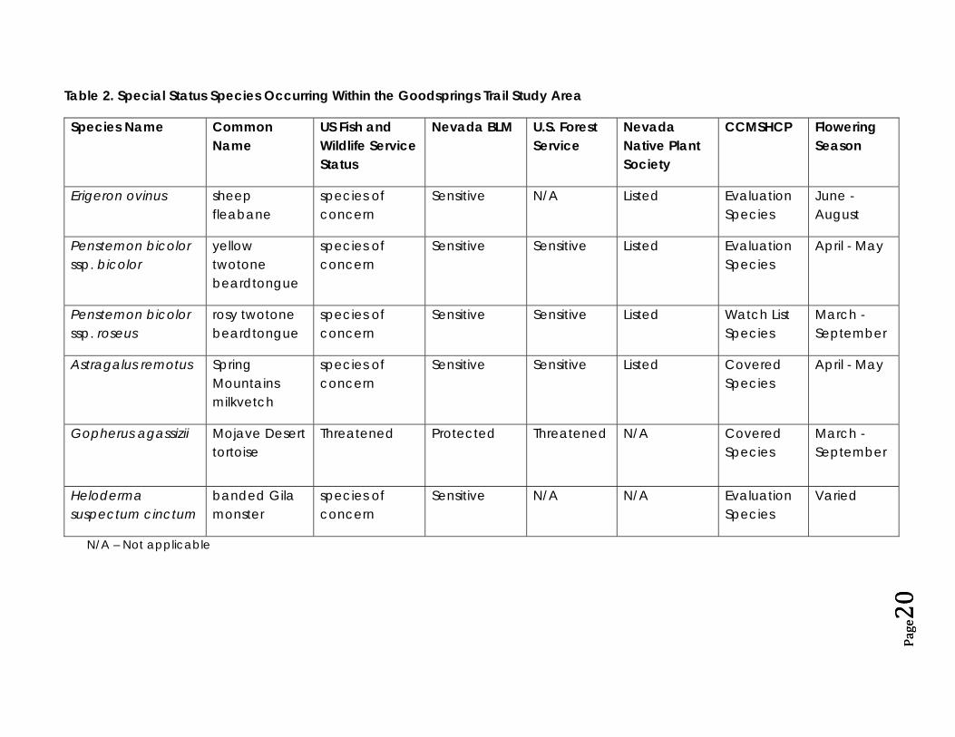
Table 2 details the sensitive species that were identified by the NNHP as occurring within the Study Area. In addition, Table 2 includes occurrences of the yellow twotone beardtongue (Penstemon bicolor
ssp. bicolor), rosy twotone beardtongue (Penstemon bicolor ssp. roseus) and Spring Mountains milkvetch (Astragalus remotus) that have been observed within one kilometer of the Study Area boundary. This information, provided by NNHP, is significant because Penstemon and Astragalus are transient species, meaning that the plants may be observed in an area one year and due to transport by wind or water, may establish in adjacent areas the following year.
According to the BLM RMP, the habitat type for the Study Area is characterized as Mojave Desert shrub with limited sections designated as a southern desert shrub zone (BLM RMP defined criteria). These zones receive two to eight inches of rain a year, typically during summer thunderstorms. Zone vegetation is a mixture of shrubs characteristically having Creosote (Larrea tridentata) as the dominant shrub with a Joshua tree (Yucca brevifolia) over‐story. Other shrubs common to the area are the spiny menodora (Menodora spinescens) and burrobrush (Hymenoclea salsola), with white bursage (Ambrosia dumosa), Nevada ephedra (Ephedra nevadensis), and blackbrush (Coleogyne ramosissima) primary in some areas. Various cacti and other yucca species are also found throughout the area. Yucca and cacti are protected species in the State of Nevada under Nevada Revised Statutes.
“It is unlawful . . . to cut, destroy, mutilate, remove or possess any Christmas tree, cactus, yucca or branches thereof, . . . from any of the lands owned by or under the jurisdiction of the State of Nevada or its counties, or on any reserved or unreserved lands owned by the United States, or from any privately owned lands, without written permission from the legal owner, or his duly authorized agent, specifying locality by legal land description and number of plants to be removed or possessed.” (NRS 527.101).
Wildlife typical to the Mojave Desert shrub and southern desert shrub habitat types include various small mammal and reptilian desert species such as the black‐tailed jackrabbit (Lepus californicus), side‐blotched lizard (Uta stansburiana), and collared lizard (Crotaphytus sp.). Also known to occur within the Study Area boundary are the Mojave Desert tortoise (Gopherus agassizii) and banded Gila monster (Heloderma suspectum cinctum). These special status species require a Nevada Division of Wildlife certified biologist to conduct surveys and act as an observer during most disturbance activities.
The Study Area may also fall within the Pacific flyway for migratory birds. Migratory birds are protected under the Migratory Bird Treaty Act of 1918 (16 USC 703‐712), as amended. The Clark County Multiple Species Habitat Conservation Plan (CCMSHCP) identified the birds listed in Table 3 as possibly inhabiting or utilizing portions of the Study Area. Mitigation measures and additional permits may be required as part of the CCMSHCP if construction activities are conducted during nesting season, February through August. The species of particular concern is the western burrowing owl (Athene cunicularia hypugea) known to nest in abandoned mines and listed as sensitive by the BLM.

Goodsprings Trail Study Findings Report #2 Shapins Belt Collins
Page19
The Study Area is not located within a BLM designated Area of Critical Environmental Concern (ACEC) or a Wilderness Study Area; however, it is adjacent to (within 3 to 5 miles or 5 to 8 kilometers of) the Red Rocks Wild Horse and Burro Management Area (managed by Red Rocks Canyon National Conservation Area (NCA), which in turn is managed by the BLM under the National Landscape Conservation System) and the Bird Springs ACEC. Bird Springs has been designated for annexation into the Red Rocks Canyon NCA.
The southeast portion of the Study Area boundary includes a portion of the Desert Tortoise Translocation Area which is managed by the BLM, U.S. Fish and Wildlife Service (USFWS), and the Clark County Desert Conservation Program. Considerations will need to be made regarding tortoise/trail user interactions including the introduction of domestic dogs. A secondary consequence of increased human activity in this area is the attraction of tortoise predators such as the coyote and raven. Studies at the Ft. Irwin, California, military translocation site have shown that the occurrence of these two predators and associated predation on the tortoises increases with an increase in human activity (Esque et al. 2009). Close consultation with the BLM, USFWS, and the Clark County Desert Conservation Program is recommended for locating the proposed trail through this area.
Page20
Page20
Table 2. Special Status Species Occurring Within the Goodsprings Trail Study Area
Species Name Common Name
US Fish and Wildlife Service Status
Nevada BLM U.S. Forest Service
Nevada Native Plant Society
CCMSHCP Flowering Season
Erigeron ovinus sheep fleabane
species of concern
Sensitive N/A Listed Evaluation Species
June - August
Penstemon bicolor ssp. bicolor
yellow twotone beardtongue
species of concern
Sensitive Sensitive Listed Evaluation Species
April - May
Penstemon bicolor ssp. roseus
rosy twotone beardtongue
species of concern
Sensitive Sensitive Listed Watch List Species
March - September
Astragalus remotus Spring Mountains milkvetch
species of concern
Sensitive Sensitive Listed Covered Species
April - May
Gopherus agassizii Mojave Desert tortoise
Threatened
Protected Threatened N/A Covered Species
March - September
Heloderma suspectum cinctum
banded Gila monster
species of concern
Sensitive N/A N/A Evaluation Species
Varied
N/A – Not applicable

Goodsprings Trail Study Findings Report #2 Shapins Belt Collins
Table 3. CCMSHCP Possible Migratory Bird Encounters within the Goodsprings Trail Study Area
Species Name Common Name IUCN Red List*
USFWS CCMSHCP Nesting Period
Falco peregrinus anatum
American peregrine falcon
least concern delisted 12/03
covered March to June
Toxostoma bendirei
Bendire’s thrasher vulnerable N/A evaluation February to August
Vireo vicinior gray vireo least concern N/A evaluation April to June
Toxostoma lecontei
Le Conte’s thrasher least concern N/A evaluation February to June
Lanius ludovicianus
loggerhead shrike least concern N/A evaluation March to June
Phainopepla nitens
Phainopepla least concern N/A covered February to July
Sialia Mexicana
western bluebird least concern N/A evaluation April to May
Athene cunicularia hypugea
western burrowing owl least concern (BLM designated sensitive)
evaluation March to July
* International Union for the Conservation of Nature and Natural Resources: The Red List is a comprehensive inventory of the global conservation status of plant and animal species.

Goodsprings Trail Study Findings Report #2 Shapins Belt Collins
Page22
Cultural Resources The Study Area is within the historic Yellow Pine Mining District established in 1882 and active until the 1960’s. The Yellow Pine Mine rail line was taken up in 1934. A historical trading route, the Old Spanish Trail, was also established through this area in the 1930’s.
Since detailed cultural inventories are completed on a project by project basis, a complete inventory of the Study Area has not yet been performed. The BLM Las Vegas Office and the Nevada State Historic Preservation Office (SHPO) will need to work closely with Clark County during subsequent design and planning stages in order to preserve existing cultural resources in the area. A detailed cultural field survey will be necessary during the NEPA evaluation.
Environmental Resources Environmental resources identified within the Study Area are summarized in the subsequent sections. However, this summary does not evaluate the presence or absence of hazardous substances that may be located within the Study Area.
Geology and Soils
A majority of the Study Area is comprised of soils derived from river or other running water deposits known as alluvium (see Supporting Documents Map). Alluvium is typically made up of a variety of materials including fine particles of silt and clay and larger particles of sand and gravel. The Yellow Pine Mine area in the northwest portion of the Study Area is predominantly limestone with intrusions of dolomite and shale. The northern, western and southern portions of Goodsprings sit on shale and limestone. A more detailed analysis of the Jean/Goodsprings area geology will be included in the final Environmental Constraints summary to be submitted on June 12, 2009.
Topography
The Study Area experiences a gradual rise in elevation from Jean, located at 2820 feet (860 meters) above mean sea level, to the Yellow Pine Mine area, averaging 4400 feet (1340 meters). Goodsprings has an elevation of 3700 feet (1128 meters). The Bird Spring Range east of Goodsprings rises to over 5000 feet (1525 meters); however, within the Study Area boundary the maximum elevation is around 4050 feet (1235 meters).
Visual Resources
Goodsprings Trail Study Findings Report #2 Shapins Belt Collins
Page24
Surface Water Resources
Perennial surface water resources do not exist within the Study Area. However, there are natural ephemeral drainage ways starting to the northwest of Goodsprings that convey runoff generated during rain events to the southeast towards Jean. Goodsprings is located within a Federal Emergency Management Agency (FEMA) Special Flood Hazard Area (SFHA) Zone X, which is defined as outside the 100‐year flood zone. A FEMA SFHA Zone A, which is defined as a 100‐year flood zone, does exist to the east of Goodsprings and traverses State Route 161 just southeast of the town before it bends to parallel the roadway alignment. The SFHA Zone A terminates at a dry lake bed located northwest of the interchange between Interstate 15 and State Route 161. The lake bed becomes saturated during seasonally heavy rain events. Copies of the FEMA Flood Insurance Rate Maps showing this flood zone have been provided in the Supporting Documents.
Flood control improvements proposed as part of the Study Area would need to be submitted to Clark County Regional Flood Control District for approval. Improvements proposed within the FEMA SFHA Zone A would also need to be submitted to FEMA for approval. Because surface waters within the Study Area are not considered Waters of the U.S., the Study Area would not be required to obtain a 404 permit from the U.S. Army Corps of Engineers.
Ground Water Resources
To review potential ground water resources in the Study Area, a search of the Nevada Division of Water Resources’ (DWR) online database for underground active water rights was conducted on March 14, 2009. The results have been included in the Supporting Documents.
The Site is located within Hydrographic Basin 164A which has a perennial yield of 700 acre‐feet annually (AFA). Of these, 687.03 AFA have been certificated by putting the water to beneficial use. A review of water rights holders in the basin was also completed. Clark County holds 2.18 AFA of certificated water rights that have been developed for stock watering purposes and 15.99 AFA permitted water rights that are designated for quasi‐municipal uses. Considering the limited quantity of ground water resources available, landscaping that exerts minimal water requirements is recommended.
Site Visit Observations BEC team members participated in the site orientation visit with other members of the design team and the Goodsprings Trail Committee on January 27, 2009. During this orientation, BEC personnel, including a team biologist, conducted a windshield survey while driving Route 161 from Interstate 15 to the Town of Goodsprings and noted that the area adjacent to the roadway did not contain habitat that was likely to be suitable for threatened, endangered, and sensitive species due to frequent regrading and shoulder maintenance conducted by Nevada Department of Transportation (NDOT). The presence of Penstemon

Goodsprings Trail Study Findings Report #2 Shapins Belt Collins
Page25
species was noted in some of the yards of private residences in town; however, since the plants were not in bloom, it could not be determined if the plants were a sensitive species.
The sensitive plant species that have been noted in the area by the NNHP can only be identified when they are in bloom. Blooming times range from March to September, with a majority of the plants blooming in the late May to late June timeframe. Therefore, BEC is planning to conduct a preliminary biological site survey of trailhead locations and general directions of proposed trail alignments in late May. Results from this site visit will be included in the revised/final version of this summary.
Conclusions The Goodsprings Trail Study Area encompasses land of biological, cultural and environmental significance. The rich mining history of the area combined with the biodiversity and aesthetics of the desert makes the Study Area an ideal destination for outdoor enthusiasts and naturalists. A summary of the constraints to developing the Goodsprings Trail and associated mitigation measures are presented in Table 4. Additional information regarding potential impacts to the area surrounding the final trail alignment will be delineated during the NEPA process.

Goodsprings Trail Study Findings Report #2 Shapins Belt Collins
Page26
Table 4. Environmental Constraints and Mitigation Measures for the Goodsprings Trail Study Area
Resource Constraint Mitigation
Biological Presence of sensitive species, seasonal or permanent
Coordinate alignment of proposed trail with various land and wildlife management authorities
Discourage construction activities during migratory bird nesting season
State certified biologist on site during disturbance activities
Cultural Presence of culturally significant areas
Survey prior to construction activities to identify and avoid culturally sensitive areas
Promote public awareness and education of cultural significance and need for preservation
Air Quality Fugitive dust
particulates generated during construction activities
Obtain CCDAQEM Dust Control Permit prior to construction
Implement Best Management Practices during construction activities
Use of aggregate or native soil for trail surface
Water
Existing ephemeral drainage ways, FEMA designated Special Flood Hazard Areas
Available quantity limited (none) for trail maintenance
Obtain CCRFCD and/or FEMA approval for construction of flood control improvements
Incorporate landscaping that minimizes or eliminates water use requirements after construction is completed
Geology Potential for
abandoned mine openings near proposed trail route
Coordinate with the US Army Corps of Engineers, BLM and the Bureau of Reclamation to identify and close potentially dangerous mine entrances
Biological and cultural issues need to be taken into consideration in the development of a trail system in this area of Clark County. However, the limited footprint of the project and adaptive design of the trail should mitigate possible issues that may develop during the comprehensive archeological and biological surveys that will be conducted as part of the NEPA process once the Project is allowed to proceed. The main concern at this point is the alignment of the trail through the sensitive Desert Tortoise Translocation Area near I‐15. Careful review of alternative alignments and active collaboration with area stake holders, including the multiple land owners, will bring about an acceptable resolution to most issues.

Goodsprings Trail Study Findings Report #2 Shapins Belt Collins
Page27
Supporting Documents:
FEMA Flood Zone Maps
Goodsprings Trail Study soils type map
Nevada Natural Heritage Program Data Request, January 12, 2009
Nevada Division of Water Resources Hydrographic Abstract, Basin 164a, March 14, 2009.
References Used:
Clark County Department of Air Quality and Environmental Management, Clark County, Nevada Development Standards for Off‐Street Trails, October 18, 2005.
Draft Revised Recovery Plan for the Mojave Population of the Desert Tortoise (Gopherus agassizii), Region 8, California and Nevada, U.S. Fish and Wildlife Service, Sacramento, California, August 2008.
Esque, Todd C., K.E. Nussear, W.I. Boarman, A.D. Walde, A.P. Woodman, K.H. Berry, R.C. Averill‐Murray, C.R. Darst, K.K. Drake, J. Mack, P.A. Medica, and J.S. Heaton. 2009. “Predation and Translocated Desert Tortoises at Ft. Irwin National Training Center: Separating Fact from Fiction”, paper presented at the Desert Tortoise Council 34th Annual Symposium, February 20‐22, 2009, Mesquite, Nevada.
IUCN 2008. 2008 International Union for the Conservation of Nature and Natural Resources Red List of Threatened Species. <www.iucnredlist.org>. Downloaded on 26 March 2009.
Las Vegas Resource Management Plan and Final Environmental Impact Statement, U.S. Department of the Interior, Bureau of Land Management, May 1998.
Las Vegas Valley Disposal Boundary Final Environmental Impact Statement, U.S. Department of the Interior, Bureau of Land Management, December 2004.

APPENDIX 1 DISPLAY MATERIALS: PUBLIC MEETING #2

EXISTING TRAIL CONDITIONS
7. Berm facing northwest toward Yellow Pine Mine.
9. Goodsprings multi-use ridgetrail.
11. Existing Goodsprings multi- use wash trail.
MAY 2009
6. Can dump along Yellow Pine Mine Corridor.
5. View entering Goodsprings along Highway 161.
12. Trail Terminus at Yellow Pine Overlook with fire damage in the foreground.
13. Trail overlook located north of Yellow Pine Mine.
1. Berm looking southeast from Goodsprings toward Jean.
2. Bird Spring Mountain trail.
3. Looking north toward Bird Spring Mountain.
4. On Bird Spring Mtn. looking south east toward Jean. Note the numerous powerlines in the distance.
10. View from ridgetrail looking south toward Goodsprings
8. Experience along Cottonwood Pass Connector trail.

ILLUSTRATIVE DETAILS MAY 2009
WAYSIDE PARKING-HIKER/BIKER PARKING
EXISTING CONDITION EXISTING CONDITION
TRAILHEAD-HIKER/BIKER/EQUESTRIAN PARKING1 2
15’
TOGOODSPRINGS
STATE HIGHWAY 161
SOFT SURFACE- HIKING/BIKING TRAIL
INFORMATIONAL KIOSK
SOFT SURFACE HIKING/BIKING TRAIL
SHADE SHELTER
HITCHING POST
BOULDERS(4) 18’X 55’SPACES(MIN.)EQUESTRIAN & OVERSIZE PARKING
BOULDERS
NATIVE VEGETATION
NATURAL SURFACE-3 SPACE PARKING
POTENTIAL FUTURE OVERFLOW PARKING
NATURAL SURFACE PARKING(14) 10’X 18’SPACES
FIRE STATION
WATER TANK
NATIVE VEGETATION
NOTE:A TRAIL EASEMENT WOULD BE REQUIRED FOR THE PORTION OF THE TRAIL THAT LEAVES THE RIGHT-OF-WAY.
TRAIL EXTENDS TOWARD R.O.W TO ACCOMMODATE FOR PARKING
KIOSK
TRAIL CROSSING SIGN
50’50’100’ R.O.W.
TGT
( )
*SEE DOWNTOWN TRAIL ALIGNMENT MAP FOR LOCATION OF PROPOSED TRAILHEAD.
TOYELLOWPINE MINE
TYTTTT
TOGOODSPRINGS
TORIDGE TRAIL
EAD*SEE DOWNTOWN TRAIL ALIGNMENT MAP FOR LOCATION OF PROPOSED WAYSIDE.

ILLUSTRATIVE DETAILS MAY 2009
JEAN TRAIL
EXISTING CONDITION EXISTING CONDITION
AFTER AFTER
LOWER BIRD SPRING MOUNTAIN TRAIL3 4
VIEW FROM JEAN TRAILHEAD • LOOKING NORTHWEST TOWARD GOODSPRINGS
8’ MULTI-USE SOFT SURFACE • TRAIL (DECOMPOSED GRANITE)
30’ BETWEEN PROPOSED TRAIL • AND UTILITY POLES
VIEW LOOKING NORTH TOWARD • BIRD SPRING MOUNTAIN
3’ MULTI-USE SOFT SURFACE • TRAIL (DECOMPOSED GRANITE)
8’ PAVED MULTI-USE TRAIL•

ILLUSTRATIVE DETAILS MAY 2009
YELLOW PINE MINE BERM TRAIL YELLOW PINE MINE TERMINUS
EXISTING CONDITION
PROPOSED YELLOW PINE MINE TERMINUS
EXISTING CONDITION
AFTER AFTER
5 6
VIEW ALONG YELLOW PINE MINE • BERM LOOKING NORTH TOWARD YELLOW PINE MINE
4-5’ NATURAL SURFACE • HIKING/BIKING TRAIL
VIEW AT YELLOW PINE MINE TERMINUS•
TYPICAL KIOSK SHOWN•
POTENTIAL EDUCATION OPPORTUNITIES • RELATED TO MINING

WAYFINDING SYSTEMS May 2009
SURFACE WAYFINDING

TRAIL SURFACE OPTIONS MAY 2009
Existing Goodsprings berm trail - hiking and biking
Asphalt paving - biking/hiking
Existing Goodsprings multi-use trail
Concrete trail - hiking and biking
Multi-use natural trail Multi-use decomposed granite paving trail
Existing Goodsprings multi-use trail (Upper Wash Trail)
Equestrian and auto parking
Potential auto parking/staging area
NATURAL SURFACE ASPHALT SURFACE CONCRETE SURFACE
SOFT SURFACE PARKING
Equestrian and auto parking
SOFT SURFACE (DECOMPOSED GRANITE)

APPENDIX 2 DRAFT PREFERRED TRAIL ALIGNMENT

GFGF GFGFGFGFGFGFGF
GFGF GF
GFGFGF
GF
GFGF
GFGFGF
GFGF
GF
GO
OD
SP
RI
NG
S
VA
LL
EYYELLOW
PINE MINE
COLUMBIA PASS
#RATTLER HILL
#LOOKOUT PEAK
JEAN
CRYSTAL PASS
TA
BL
E
MO
UN
TA
IN
G O O D S P R I N G S
MILL SITE
TORTOISE TRANSLOCATION SITE
#
ú
TO L
AS
VE
GA
S
§̈¦15
ú
#
#
REVEGETATE HILLSIDE
USER TRAILS
UPPER WASH TRAIL
ÆÆTO SANDY VALLEY
ÆTO SAN
DY
VALLEY
RAILWAY TIE
SEEP
MINING ACCESS RD
CASINO
i
k
!5
k
SANDY VALLEY CONNECTOR
COTTONWOOD PASS CONNECTOR
YELLOW PINE MINE TRAIL
BIRD SPRING MOUNTAIN LOOP TRAIL
LOWER BIRD SPRING MTN. TRAIL
RIDGE TRAIL
!B
Æ
LINK TO FUTURE
I -15 TRAIL
Æ
TO
RE
D R
OC
K
!5!B
!F
I-
I-
!F!H
GF
GF
#
GFGF
I-
k
GF
!5!C
Ñ©
NOTES:
GOODSPRINGS OVERLOOK TRAIL
- ALL TRAILS ARE DESIGNATED MULTI-USE UNLESS SIGNIFIED WITH AN ICON.- ALL TRAILHEADS INCLUDE A PARKING AREA.- ALL PROPOSED FACILITIES WILL BE LOCATED WITHIN COUNTY OR STATE R.O.W. AND/OR ON BLM LAND.
POTENTIAL SOFT SURFACE........................................11.5 MILES
EXISTING ROAD/TRAIL...................................................8.0 MILES
POTENTIAL PAVED.........................................................6.7 MILES
DESIGNATED TRAIL/CITY STREET................................1.3 MILES
TRAIL TYPE: LENGTH:
- PROVIDE ACCESS TO SURROUNDING REGIONAL TRAILS.- PROPOSE A SOIL CEMENT MULTI-USE TRAIL BETWEEN GOODSPRINGS & JEAN LOCATED NORTH OF HWY 161 TO BIRDSPRING MOUNTAIN (BSM) TRAILHEAD. - TWO TRAIL OPTIONS EXIST FROM THE BSM TRAILHEAD TO GOODSPRINGS: (1) A PAVED MULTI-USE TRAIL AND A SOIL CEMENT TRAIL ALONG THE LOWER BSM TRAIL (2) A MULTI-USE SOIL CEMENT TRAIL ALONG BSM TRAIL LOOP. - RESTORE DISTURBED SITES: ABANDONDED CAMPSITE/ OHV USE/USER CREATED TRAILS.- YELLOW PINE MINE TRAIL TERMINUS IS SETBACK FROM YPM TO REDUCE DISTURBANCE AND DISCOURAGE ENCROACHMENT TO MINES. TRAIL TERMINUS WILL BE LOCATED OUTSIDE OF PRIVATE LANDS. - PROPOSE A MULTI-USE BYPASS TO THE EAST OF GOODSPRINGS FOR NON-WALKING TOUR USERS.
PREFERRED TRAIL ALIGNMENT DETAILS: