Goals, Policy Objectives, Key Plan Concepts, and ... · PDF fileRegional Transportation Plan...
32
Regional Transportation Plan 2030 November 2006 Goals, Policy Objectives, Key Plan Concepts, and Recommendations/Implementation Strategies
-
Upload
duongduong -
Category
Documents
-
view
219 -
download
3
Transcript of Goals, Policy Objectives, Key Plan Concepts, and ... · PDF fileRegional Transportation Plan...

Regional Transportation Plan 2030 November 2006���
Goals, Policy Objectives, Key Plan Concepts, and Recommendations/Implementation Strategies

Regional Transportation Plan 2030 November 2006���

Regional Transportation Plan 2030 November 2006��7
The plan goals and policy objectives outlined below guided the design and preparation of the plan, and will continue to provide a policy framework for decision-making for the overall transportation system following plan adoption.
The goals and policy objectives are organized into three sections. The first section covers the overall transportation system. It includes the plan’s overall goal of an integrated and balanced land use and transportation system (see Goal #� below) and a second goal describing the desired characteristics of the transportation system. The second section addresses land use and transportation coordination. The third section includes the different elements of the transportation system. Policy objectives describing strategies for achieving the goals follow in each section. Key plan concepts are also dis-cussed.
Recommendations/implementation actions follow the goals and policy objectives for land use and transportation coordina-tion and each element of the transportation system. They include facility recommendations and planning and program ac-tions for carrying out the goals and policy objectives. The primary implementing agencies and/or organizations are noted for each recommendation.
Overall Transportation System Goals#1 Integrated Transportation and Land Use SystemDevelop an integrated and balanced land use and transportation system which provides for the efficient, effective and safe movement of people and goods, promotes the regional economy, supports transportation-efficient development patterns and the regional land use plan, and provides mode choice wherever possible while enhancing and, where relevant, pre-serving the character and livability of the neighborhoods where transportation facilities are located.
#2 Transportation System CharacteristicsAchieve a transportation system that is:Balanced – provides a range of transportation options and takes advantage of the inherent efficiencies of each mode.Accessible – serves all areas of the region and all residents and visitors.Efficient – maximizes mobility provided by existing and new facilities through systems and demand management strate-gies.Safe – designed, built, and operated to minimize risk of harm to persons and property, and allows persons to feel confident and secure in and around all modes of travel.Reliable – minimizes and alerts persons to unexpected travel delays.Equitable – provides an equitable level of service and benefits among demographic and user groups, including low-in-come, minority, the elderly, and persons with disabilities. Interconnected – provides for ease of transfer between the different modes of travel.Environmentally responsible – minimizes negative environmental impacts and energy consumption to the extent feasible.Supportive of compact and efficient patterns of development – integrates transportation and land use planning in support of transportation efficient development (e.g., walkable neighborhoods, transit-oriented activity centers) that maximizes travel, housing, and employment choices.Supportive of the social and economic activity of the region – provides convenient travel for all persons and efficient movement of goods.Responsive to community needs and neighborhood impacts – is flexible and adaptable and addresses negative impacts, particularly in residential areas.Economically viable and financially stable – is cost efficient and financially feasible with sufficient ongoing financial sup-port for operations and maintenance.
Goals and Policy Objectives, Key Plan Concepts, andRecommendations/Implementation Strategies

Regional Transportation Plan 2030 November 2006128
Policy Objectives#1 Public InvolvementAttain an area-wide transportation planning process responsive to the needs and interests of area-wide residents, groups, units of government and affected agencies, with sufficient opportunity for all to participate in policy and implementation decisions.
#2 System PreservationMaintain the region’s transportation infrastructure and preserve transportation corridors, particularly rail corridors, for possible future travel uses by other modes.
#3 Accessibility and MobilityImprove regional mobility and accessibility for all persons while maintaining a balance between the two sometimes com-peting concerns.
#4 SafetyImprove transportation safety through design, operations and maintenance, system improvements, support facilities, pub-lic information, and law enforcement efforts.
#5 Balanced SystemAchieve a balanced transportation system through investment in improvements across all modes of travel.
#6 Management/OperationsApply Intelligent Transportation Systems (ITS) technologies and utilize Travel Demand Management and Transportation Systems Management (TSM) strategies to respond to traffic congestion, make efficient use of existing roadway capacity, and make the transportation system more reliable, convenient, and safe.
#7 Land Use/Transportation ConnectionUse public decisions on the provision of publicly financed transportation facilities and services as a tool for creating com-pact, well-designed and balanced communities.
#8 Timing of ImprovementsStage the extension and expansion of urban transportation services within urban service areas, to encourage compact ur-ban growth in accord with regional and local development plans and policies.
#9 Congestion ManagementConsider all mobility options and operational strategies (ITS, TDM, TSM) in congested corridors before adding capacity for general purpose travel lanes or building new facilities.
#10 Interconnected SystemEncourage and facilitate connections between various modes of travel, including connections with inter-city bus and rail.
#11 DesignEncourage attention to aesthetics in the design of transportation improvements to fully integrate improvements into the environment, including consideration of scenic views and vistas, landscaping (with use of native species where possible) along roadsides and boulevards, and the location of signing.
#12 Intergovernmental CoordinationContinue to enhance intergovernmental coordination in land use and transportation planning, project development, and operations and maintenance to ensure protection of transportation investments and make efficient use of limited resources.
#13 Basic ServicesSupport and maintain basic transportation services such as maintenance, snow removal, traffic control, street sweeping, and other services.

Regional Transportation Plan 2030 November 2006��9
#14 FreightEnhance mobility and safety for goods movement to support the local economy while maintaining community livability.
#15 Financial FeasibilityEnsure that existing and future financial resources are realistic, reliable, and equitable.
Land Use and Transportation System CoordinationThere is a close inter-relationship between land use development and the transportation system. The location, type, and intensity of development determine the need for transportation facilities and services. The region’s land use development pattern plays an important role in determining the viability of mode choice options and the safety and efficiency of the transportation system. At the same time, transportation strategies can support the regional land use plan, the preservation of neighborhoods, and minimize undesirable impacts from the transportation system on the environment. The following goal, policy objectives, and recommendations/implementation strategies address this land use – transportation connection.
Goal: Coordinate land use and transportation planning and decision-making in a manner that fosters compact urban devel-opment patterns that support and are supported by a balanced, safe, and efficient transportation system.
Policy Objectives#1 Promote the development of balanced communities with sufficient commercial, industrial, residential, and open space land to meet the needs of existing and future residents.
#2 Support and maintain downtown Madison as the region’s major activity center and seek greater diversity and vitality in that area.
#3 Encourage the concentration of higher density, mixed-use, pedestrian-friendly employment/activity centers at nodes and along transit corridors to maximize the efficiency of the existing and future transportation system.
#4 Encourage the redevelopment of established employment/activity centers, transit corridors, and other areas, where appropriate, in order to make efficient use of existing transportation infrastructure, expand job-housing choices, improve pedestrian and bicyclist safety and accessibility, and support transit service.
#5 Encourage mixed-use neighborhoods with pedestrian-friendly centers or focal points (e.g., shopping district, commu-nity center, park, etc.) and higher density residential uses closest to these centers and transit routes, thus facilitating shorter trips that make walking, bicycling, and public transit to be more convenient and effective transportation alternatives.
#6 Encourage land use development patterns and site designs that maximize the safety and efficiency of the transportation system.
#7 Provide non-interchange crossings of limited access roadways to improve mobility and access for motorists, transit us-ers, bicyclists, and pedestrians in coordination with local land use development planning.
#8 Encourage intergovernmental cooperation concerning land use and transportation issues.
Recommendations/Implementation Strategies#1 Continue undertaking a reform or modernizing of land use development ordinances and engineering standards (e.g., street design) to remove regulatory barriers that prevent the design of compact, mixed-use, pedestrian-friendly develop-ment. [Local governments]
The City of Madison is planning to undertake a comprehensive revision of its existing zoning ordinance. Special empha-sis will be placed on creating new mixed-use zoning districts, a traditional neighborhood development (TND) district, and zoning standards for transit-oriented development (TOD). Many other area communities have begun the process of reforming their land use ordinances to remove barriers to mixed use, pedestrian-friendly development.

Regional Transportation Plan 2030 November 2006130
#2 Consider requiring or using incentives for providing transit, bicycle, and pedestrian improvements in new commercial, public, mixed-use, and multi-family residential developments. [Local governments]
#3 Work with Metro Transit staff to ensure that new developments are planned and designed to be transit-supportive and include transit support facilities, wherever appropriate and feasible. [Local governments, Metro Transit]
#4 Adopt transit-oriented development (TOD) zoning, where appropriate, such as in areas identified as likely rail transit station sites in the Transport 2020 and Streetcar studies and other key transit corridors. [City of Madison and other local governments]
Key Plan ConceptsThe following are key plan concepts designed to achieve the overall transportation system and land use – transportation system coordination goals and policy objectives. The concepts address the transportation system in a multi-modal manner and inform the mode-specific goals, policy objectives, and recommendations/implementation strategies that follow.
Growth Area and Activity Center LinkageThe plan seeks to maintain mobility and accessibility options throughout the region. Figure 40, on the next page, illus-trates how the major employment/activity centers and cities/villages in the Madison Area are interconnected by the present system of arterial and collector roadways, and how these centers and communities can be served with a potential rail and express bus system with park-and-ride lots. As the outlying communities continue to grow, rail service could be extended in the future.
Balanced TransportationThe plan strives to increase use of travel alternatives to driving alone and to minimize demand on the transportation system during peak travel periods. This is especially the case for work trips to central Madison and for school trips. This makes more efficient use of roadway capacity and provides mobility choices for those who wish to use other modes rather than an automobile or who do not have access to an automobile. This plan also recognizes that the majority of trips within the region will still be made by automobile for shopping and business, and that modifications to the roadway system will be needed.
Traffic AccommodationThe plan continues to accept somewhat higher traffic congestion levels (Level of Service D), particularly during peak hours. This is intended as a means of encouraging travel during off-peak periods, greater use of transit and carpooling, and lessening the need for expanding streets and roadways. Travel on circumferential routes (such as the South Beltline) is ac-commodated as a means to draw travel to these corridors wherever possible. Techniques of traffic engineering and safety improvements are made to make existing streets and roadways more efficient in moving traffic. Higher mobility levels are also maintained on the Interstate System and other key circumferential routes to ensure efficient movement of people and goods throughout the region.
Traffic DirectionThe plan seeks to draw local auto through-traffic to local arterial major travel corridors as a way to reduce the amount of through-traffic penetrating central Madison neighborhoods and other neighborhoods in the region. Maintaining mobility on key regional routes like the Interstate System and the Beltline is also important in order to direct inter-regional through-traffic to these corridors to reduce the potential of inter-regional travel on the local arterial system. Traffic calming and other transportation system management (TSM) techniques are encouraged to reduce and/or redirect traffic from local neighborhood streets and other sensitive areas. Bypasses around outlying cities and villages are also considered, while at the same time making sure that such facilities do not have negative land use impacts.
Other Plan ConceptsThe plan seeks to broaden the understanding of the other modes of transportation and to recognize and encourage: pedes-trian and bicycle travel; specialized travel needs of the elderly and persons with disabilities; taxi and paratransit services; and integration of travel into multi-modal corridors. In addition, the plan seeks to highlight the importance of preserving corridor lands, particularly rail corridors, for possible future travel uses.

Regional Transportation Plan 2030 November 2006���
Transportation System ElementsThe following goals, policy objectives, and recommendations/implementation strategies address the different modes of transportation, travel demand management (TDM), inter-regional travel, freight, parking, and corridor preservation.
Streets/RoadwaysThe street and roadway system improvements needed to serve forecast growth over the next �� years is dependent on the number of person trips generated by future land use development, the distribution of those trips, and the number of those trips that can be accommodated by alternatives to single-occupant vehicle driving or shifted to off-peak time periods.
Currently, around 80% of person trips by City of Madison residents and 90% of trips by other county residents are taken by automobile. The average vehicle occupancy for person trips by all county residents ranges from �.�� for work trips to �.�� for social/recreational trips with an overall average of �.9�. The majority of the remaining trips are made by walking, accounting for 14% of trips by Madison residents and 7% of trips by other county residents. Public transit and bicycling together account for 6% of trips by Madison residents and 3% of trips by other county residents. Travel characteristics and trends presented in Part � of this plan such as average trip lengths, the increasingly dispersed travel pattern, and increased solo occupant vehicle commuting, demonstrate the challenge of increasing the percentage share of trips made by alterna-tive transportation modes.
Waunakee
Middleton
Verona
Oregon
Fitchburg
Stoughton
McFarland
CottageGrove
SunPrairie
DeForest
0 2 4
Miles
Prepared by staff to the:
PRINTED: 8/7/2006NAME: pldms FILE: H:\ArcMapPrj\Rail\RTP\ExprressRailHybridActivityCenters.mxd
Commuter Rail (Hybrid*)Transit Alternative
*Technology allows running on street as well as rail line.
Madison
Commuter Rail & Station
Transfer Station
Park and Ride Lot
Employment / Activity Center
Express Bus Routes
FIGURE 40

Regional Transportation Plan 2030 November 2006���
The process for developing the growth forecasts and land use assumptions and forecasting future travel using the regional travel simulation model was described in the previous section of the plan starting on page ��7. The forecast countywide increases in population (153,500 or 36%), households (71,500 or 41%), and employment (97,600 or 34%), coupled with the assumptions concerning the distribution and density of this growth, are expected to result in a 43% increase in trip-making by the Year 2030.
Roadway capacity expansion projects were only considered after modeling the impacts of implementation of an aggres-sive expansion and improvement of the transit system, including a hybrid rail system (see discussion of transit improve-ments in the Transit section on page ���). The modeling also accounts for non-motorized trips (walking and bicycling) and assumes that the current levels of bicycling and walking would continue to expand proportionately with future growth. The regional travel model is unable to account for the impacts of travel demand management (TDM) and trans-portation system management (TSM) measures, but the potential impacts of these strategies were also considered.
To address the remaining roadway congestion after implementation of transit system improvements, a series of roadway improvements were tested starting with construction of new two-lane collector street connections and extensions to com-plete the “grid” street network and progressing to major arterial capacity expansion projects. More information on these scenarios is provided on pages ���-���.
Based upon this modeling, a financial capacity analysis, and consultation with WisDOT and local officials, roadways were identified for potential capacity expansion by 2030. These recommended capacity expansion projects are listed in Table �� on page ��� and illustrated in Figure �� on page ���. In almost all cases, these roadways are forecasted to become con-gested or very congested by the Year 2030. There are some roadway segments (e.g., CTH AB from Cottage Grove Road to USH 12/18) that are included for connectivity purposes. There are also some roadways identified for official mapping rather than a capacity change on Figure �� that are nonetheless included in the table (e.g., Pioneer Road) as potential proj-ects in the last time period of the plan. These are projects that might be needed should development occur in those areas faster than anticipated at this time. Projects already programmed are listed in Section � of Table �� and the additional potential projects are listed in Section �, on page ���.
Section � of Table �� also includes a list of studies on state roadways. State roadway studies listed include the two USH 51 corridor studies and the USH 18/151/West Beltline Study, which are looking at potential capacity expansion projects (addition of general purpose travel lanes and/or new or reconfigured interchanges) as well as shorter term TSM/safety improvements. Because the specific type of capacity expansion project, if any, is unknown at this time for these state road-ways, they are not included in the list of potential capacity improvement projects in Table ��. Once those studies are com-pleted, specific capacity improvement project(s) are identified, regional agreement is reached on the projects, and funding is identified, the plan will be amended to add the project(s). Another study listed is the environmental study of the western end of the proposed North Mendota Parkway, which would run in a new corridor from CTH M to USH ��. Because of the uncertainty over the routing and the fact that funding has not been identified for this project, it is not included in the “financially constrained” plan, except for the segment from Willow Road west to CTH K.
Section 5 of Table 24 also (page 138) includes a short list of “illustrative” capacity expansion projects needed based upon the traffic forecasting, but without identified funding. These projects are therefore not part of the “financially constrained” plan. The North Mendota Parkway is included in this list. A plan amendment would be required in the future for these projects to proceed if federal funding is involved. They could still proceed with local funding.
Implementation of the recommended capacity expansion projects will result in a significant reduction in the system-wide levels of current and projected future congestion. However, even with these local arterial projects and any potential state roadway projects that come out of the current corridor studies, traffic congestion will still remain on numerous roadways. This includes in particular the arterials leading into the Isthmus area. Figure ��, on page ���, shows these remaining areas of congestion. Congestion on these and other roadways will need to be addressed with congestion management strategies (TDM, TSM, transit service and bicycle facility improvements) as part of the Congestion Management System (CMS) process. See page �9 of the plan for a description of the CMS process and strategies.

Regional Transportation Plan 2030 November 2006���
In addition to capacity expansion projects, Table �� also lists roadways recommended for “system preservation” (recon-struction or resurfacing without a capacity expansion). Those already programmed are included in Section � (page ��7) and the additional projects are included in Section 4 (page 138). The system preservation project list is not a complete one and doesn’t include any projects in the last time period (2021-2030) due to insufficient data. The MPO plans to work with FHWA, WisDOT, and local units of government to attempt to develop the data for a more comprehensive, longer term list of system preservation needs as part of the next plan update.
The streets/roadways goal, policy objectives, and recommendations/implementation strategies follow below. The recom-mendations are grouped by the following general categories: capacity expansion projects/studies; system preservation; TSM; and safety.
Goal: Develop and maintain a safe, effective, and efficient street and roadway system that meets the combined needs of all users for travel within and through the region, and enhances community and economic vitality.
Policy Objectives#1 Maintain and reconstruct existing roadways and bridges in a manner that promotes safety, increases efficiency, and minimizes lifetime costs.
#2 Apply Intelligent Transportation Systems (ITS) technologies and utilize Transportation Systems Management (TSM) strategies to increase the efficiency, reliability, and safety of the roadway network, where appropriate.
#3 Address the mobility and safety needs of all users (motorists, transit users, bicyclists, pedestrians, emergency vehicles) and consider the community context when planning, designing, and constructing roadway system improvements.
#4 Provide for a continuous, interconnected roadway system (avoiding use of cul-de-sacs whenever possible) with proper spacing of arterial and collector roadways that efficiently collects and distributes traffic within and through the region, minimizing travel delays and preserving mobility of regional facilities, while also minimizing negative impacts on adja-cent land uses and neighborhoods.
#5 Alleviate traffic congestion through increased roadway capacity, but only when TSM and TDM strategies have been exhausted, consistent with the goals of compact urban development and modal choice.
#6 Draw motor vehicle traffic away from local neighborhood streets and environmentally sensitive areas (traffic redirec-tion), where possible.
#7 Manage access to the regional roadway system to preserve safety and operational efficiency.
#8 Reduce traffic crashes through a comprehensive “3-E” approach that includes education, enforcement, and imple-mentation of cost-effective engineering counter-measures (i.e., roadway reconfiguration, new or modified traffic control devices, etc.).
#9 Provide bicycle and pedestrian accommodations along and across all streets in conjunction with street construction and reconstruction where feasible and appropriate in accordance with the U.S. Department of Transportation Policy on Inte-grating Bicycling and Walking into Transportation Infrastructure.
Recommendations/Implementation StrategiesCapacity Expansion Projects and Studies#1 Continue or initiate detailed planning and construction of the arterial roadway capacity expansion, bridge, and potential future interchange projects shown in Figure ��, Major Transportation Improvements and Studies, on the next page, and listed in Table 24, Potential Arterial and Collector Street and Roadway Improvements, 2007-2030, on page 135, with con-sideration given to staging construction of improvements where appropriate. Table �� shows the current projected general timing of the projects (2007-2010, 2011-2020, and 2020-2030). The timing of the projects may change due to the timing

Regional Transportation Plan 2030 November 2006���
1. P
oten
tial C
apac
ity Im
prov
emen
ts &
Stu
dies
Alre
ady
Prog
ram
med
ESTI
MA
TED
TIM
ETA
BLE
(2)
AN
D P
REL
IMIN
AR
Y C
OST
S (0
00s)
FAC
ILIT
Y SE
GM
ENT
ASS
UM
ED P
OTE
NTI
AL
IMPR
OVE
MEN
T (1
) ES
T.M
ILES
2007
TO
20
1020
11 T
O
2020
2021
TO
20
30C
OM
MEN
TS
Roa
dway
Seg
men
ts
(3)
Fem
rite
Dr
Mar
sh R
d. -
I39/
90
4-la
ne fa
cilit
y &
bik
e la
nes
0.6
1,96
0Lo
cal F
unds
Fi
sh H
atch
ery
Rd
Byr
nela
nd S
t. - L
acy
Rd.
4-
lane
div
ided
faci
lity
& b
ike
lane
s 0.
62,
600
Loca
l Fun
ds
Hoe
pker
Rd
Rat
tman
Rd.
- P
rovi
denc
e P
lat
4-la
ne d
ivid
ed fa
cilit
y &
bik
ela
nes
0.5
1,58
0Lo
calF
unds
Hig
h P
oint
Rd
Mid
-Tow
n R
d to
Tw
inflo
wer
Dr.
4-la
ne fa
cilit
y &
bik
e la
nes
0.28
920
Loca
l Fun
ds
Wel
ton
Dr.
- Sta
rr G
rass
Dr.
4-la
ne fa
cilit
y &
bik
e la
nes
0.4
560
Loca
l Fun
ds
I94
I39/
90 -
CTH
N
6-la
ne d
ivid
ed fr
eew
ay
4.4
25,0
00IM
Fun
ds
Lien
Rd
N. T
hom
pson
Dr.
- City
Vie
w D
r. 4-
lane
div
ided
faci
lity
& b
ike
lane
s 0.
752,
510
Loca
l Fun
ds
City
Vie
w D
r. - F
ella
nd R
d.
4-la
ne d
ivid
ed fa
cilit
y &
bik
e la
nes
0.48
1,52
0Lo
cal F
unds
Fe
lland
Rd.
- R
eine
r Rd.
4-
lane
div
ided
faci
lity
& b
ike
lane
s 0.
491,
560
Loca
l Fun
ds
W M
ain
St
CTH
C to
Pla
t lin
e 4-
lane
div
ided
faci
lity
& b
ike
lane
s 0.
491,
225
Loca
l Fun
ds
Old
Sau
k R
d P
rairi
e S
mok
e R
d. to
Cric
ket L
ane
4-la
ne fa
cilit
y &
bik
e la
nes
0.7
1,63
0Lo
cal F
unds
P
leas
ant V
iew
Rd
Ext
M
iner
al P
t. R
d. -
Val
ley
Vie
w R
d.
4-la
ne d
ivid
ed fa
cilit
y &
bik
e la
nes
0.8
6,44
0Lo
calF
unds
Sig
gelk
ow R
d M
arsh
Rd
– C
atal
ina
Pkw
y 4-
lane
faci
lity
& b
ike
lane
s 0.
902,
480
Loca
l Fun
ds
Spr
eche
r Rd
I94
- Buc
keye
Rd.
4-
lane
div
ided
faci
lity
& b
ike
lane
s 2.
45,
240
Loca
l Fun
ds
Val
ley
Vie
w R
d / C
TH
MIn
ters
ectio
n4-
lane
expa
nsio
n 1,
680
STP
Urb
an fu
nds
Subt
otal
Roa
dway
Seg
men
ts
13.7
956
,905
00
Brid
ges
Hig
h P
oint
Rd.
Brid
ge
Hig
h P
oint
Rd.
& W
. Bel
tline
4-
lane
brid
ge &
bik
e la
nes
795
NH
S/B
ridge
Fun
ds
I39/
90/9
4 B
ridge
P
orta
ge R
d 4-
lane
brid
ge &
bik
e la
nes
2,87
5IM
Fun
ds
I39/
90/9
4 B
ridge
Li
en R
d. U
nder
pass
& I9
0/94
Brid
ge
Brid
ge E
xpan
sion
for u
nder
pass
1,
395
IM F
unds
Su
btot
al B
ridge
s 5,
065
00
Stud
ies
STH
19
C. o
f Sun
Pra
irie
- V. o
f Wau
nake
e S
afet
y &
TS
M C
orrid
or S
tudy
14
0S
tate
Fle
x Fu
nds
US
H 1
2 P
arm
ente
r St –
STH
19
Free
way
Con
vers
ion
Stu
dy
100
Sta
te F
lex
Fund
s U
SH
12/
18/1
4 C
TH N
- U
SH
14
(Mid
dlet
on)
Saf
ety
& T
SM
Cor
ridor
Stu
dy
2,50
0S
tate
Fle
x Fu
nds
US
H 5
1 U
SH
12/
18 to
I90/
94
Cor
ridor
Stu
dy (E
IS)
1,20
0S
tate
Fle
x Fu
nds
US
H 5
1 V
. of M
cFar
land
- C
. of S
toug
hton
C
orrid
or S
tudy
(EIS
) 1,
000
Sta
te F
lex
Fund
s U
SH
18/
151/
W.B
eltli
ne
Ver
ona
Rd.
- W
. Bel
tline
- M
in. P
t. R
d.C
orrid
or S
tudy
(EIS
) 2,
400
Sta
te F
lex
Fund
s U
SH
14
C. o
f Mid
dlet
on -
V. o
f Maz
oman
ie
Saf
ety
& T
SM
Cor
ridor
Stu
dy
600
Sta
te F
lex
Fund
s N
orth
Men
dota
Pky
C
TH K
/CTH
M -
US
H 1
2 E
nviro
nmen
tal S
tudy
10
0Lo
cal F
unds
I3
9/90
US
H 1
2/18
- W
I/IL
Bor
der
Cor
ridor
Stu
dy (E
IS)
2,30
0S
tate
Fle
x Fu
nds
Subt
otal
Stu
dies
10
,340
00
Tota
l13
.79
72,3
100
0(1
) For
cos
t est
imat
ing
purp
oses
onl
y. D
esig
n an
d m
agni
tude
of i
mpr
ovem
ent i
s su
bjec
t to
mor
e de
taile
d le
vels
of p
lann
ing
and
appr
oval
by
unit
of g
over
nmen
t with
juris
dict
ion.
(2
) Con
side
ring
the
fisca
l con
stra
ints
on
the
plan
, som
e pr
ojec
ts m
ay n
ot b
e fu
nded
, and
all
road
way
pro
ject
s m
ay h
ave
thei
r prio
ritie
s an
d sc
hedu
ling
mod
ified
. (3
) Pro
ject
s ou
tsid
e of
the
MP
O P
lann
ing
Are
a, n
ot in
clud
ed in
the
finan
cial
con
stra
int r
equi
rem
ent a
re a
s fo
llow
s:
(a
) US
H 1
4, C
TH M
M to
STH
138
, as
a 4-
lane
div
ided
free
way
faci
lity,
1.6
mile
s, $
4,00
0, S
tate
Fle
x Fu
nds
(200
6 to
201
0 tim
e pe
riod)
(b) R
iver
Rd,
CTH
V to
Inno
vatio
n D
rive,
4-la
ne fa
cilit
y &
bik
e la
nes,
2.1
mile
s, $
2,38
0, L
ocal
fund
s (2
007
to 2
010
time
perio
d)
TAB
LE 2
4PO
TEN
TIA
L A
RTE
RIA
L A
ND
CO
LLEC
TOR
STR
EET
AN
D R
OA
DW
AY IM
PRO
VEM
ENTS
200
7-20
30

Regional Transportation Plan 2030 November 2006���
2. P
oten
tial C
apac
ity Im
prov
emen
ts
ESTI
MA
TED
TIM
ETA
BLE
(2)
AN
D P
REL
IMIN
AR
Y C
OST
S (0
00s)
FAC
ILIT
Y SE
GM
ENT
ASS
UM
ED P
OTE
NTI
AL
IMPR
OVE
MEN
T (1
) ES
T.M
ILES
2007
TO
20
1020
11 T
O
2020
2021
TO
20
30C
OM
MEN
TS
Roa
dway
Seg
men
ts (3
) C
otta
ge G
rove
Rd.
S
. Tho
mps
on -
Spr
eche
r Rd.
4-
lane
div
ided
faci
lity
& b
ike
lane
s 1.
202,
860
Loca
l Fun
ds
CTH
N
CTH
TT
– G
asto
n R
d 4-
lane
faci
lity
& b
ike
lane
s 0.
382,
052
Loca
l Fun
ds
CTH
PD
(McK
ee R
d.)
CTH
M -
Sou
th H
igh
Pt.
Rd.
4-
lane
div
ided
faci
lity
& b
ike
lane
s 0.
571,
800
Loca
l or S
TP U
Fun
ds
Sou
th H
igh
Pt.
Rd.
- M
aple
Gro
ve R
d.4-
lane
div
ided
faci
lity
& b
ike
lane
s 1.
14,
390
Loca
l or S
TP U
Fun
ds
CTH
M
Cro
ss C
ount
ry R
d. -
CTH
PD
4-
lane
div
ided
faci
lity
& b
ike
lane
s 1.
003,
168
Loca
l or S
TP U
Fun
ds
CTH
PD
- V
alle
y V
iew
Rd.
4-
lane
div
ided
faci
lity
& b
ike
lane
s 2.
026,
420
Loca
l or S
TP U
Fun
ds
Val
ley
Vie
w R
d. -
Wat
ts R
d.
4-la
ne d
ivid
ed fa
cilit
y &
bik
e la
nes
0.75
2,40
0Lo
cal o
r STP
U F
unds
W
atts
Rd.
- M
iner
al P
t. R
d.
6-la
ne d
ivid
ed fa
cilit
y &
bik
e la
nes
0.34
1,26
0Lo
cal o
r STP
U F
unds
C
TH M
C
TH K
- W
illow
Rd
4-la
ne d
ivid
ed fa
cilit
y &
bik
e la
nes
1.07
3,39
0Lo
cal o
r STP
U F
unds
H
oepk
er R
d.
US
H 5
1 - C
TH C
4-
lane
div
ided
faci
lity
& b
ike
lane
s 2.
949,
300
Loca
l or S
TP U
Fun
ds
Mid
tow
n R
d.
CTH
M -
Mea
dow
s R
d.
4-la
ne fa
cilit
y &
bik
e la
nes
1.7
4,50
0Lo
cal o
r STP
U F
unds
C
TH M
- M
uir F
ield
Rd.
4-
lane
div
ided
faci
lity
& b
ike
lane
s 1.
334,
200
Loca
l or S
TP U
Fun
ds
Min
eral
Pt.
Rd.
(CTH
S)
Bel
tline
Hw
y - J
unct
ion
Rd
8-la
ne d
ivid
ed fa
cilit
y &
bik
e la
nes
0.25
2,60
0Lo
cal o
r STP
U F
unds
Ju
nctio
n R
d. -
Ple
asan
t Vie
w R
d.
6-la
ne d
ivid
ed fa
cilit
y &
bik
e la
nes
0.51
2,70
0Lo
cal o
r STP
U F
unds
P
leas
ant V
iew
Rd.
- P
ione
er R
d.
4-la
ne d
ivid
ed fa
cilit
y &
bik
e la
nes
1.7
5,40
0Lo
cal o
r STP
U F
unds
N
elso
n R
d Fe
lland
Rd.
- R
eine
r Rd.
4-
lane
div
ided
faci
lity
& b
ike
lane
s 0.
491,
560
Loca
l or S
TP U
Fun
ds
Old
Sau
k R
d.
Pio
neer
Rd.
- B
ear C
law
Way
4-
lane
faci
lity
& b
ike
lane
s 1.
132,
400
Loca
l or S
TP U
Fun
ds
Pio
neer
Rd.
M
idto
wn
Rd.
- O
ld S
auk
Rd.
4-
lane
faci
lity
& b
ike
lane
s 3.
038,
000
Loca
l or S
TP U
Fun
ds
Ple
asan
t Vie
w R
d.
Min
eral
Poi
nt R
d. -
US
H 1
44-
lane
div
ided
faci
lity
& b
ike
lane
s 2.
146,
780
Loca
l or S
TP U
Fun
ds
Rei
ner/S
prec
her R
d.
US
H 1
51 -
CTH
T
4-la
ne d
ivid
ed fa
cilit
y &
bik
e la
nes
3.78
12,0
00Lo
cal o
r STP
U F
unds
B
ucke
ye R
oad
to U
SH
12/
18
4-la
ne d
ivid
ed fa
cilit
y &
bik
e la
nes
2.70
8,55
3Lo
cal o
r STP
U F
unds
V
alle
y V
iew
Rd.
C
TH M
- P
ione
er R
d.
4-la
ne fa
cilit
y &
bik
e la
nes
2.01
5,50
0Lo
cal o
r STP
U F
unds
Su
btot
al R
oadw
ay S
egm
ents
32
.14
0
58,7
8042
,453
Inte
rcha
nges
M
iner
al P
t. R
d. (C
TH S
) Ju
nctio
n R
d/C
TH M
inte
rsec
tion
Urb
an in
terc
hang
e &
bik
e la
nes
16,2
10S
TP U
rban
& L
ocal
Fun
ds
US
H 1
4 R
eloc
ated
Lac
y R
d.
New
Inte
rcha
nge
6,00
0Lo
cal f
unds
; nee
ds a
cces
s pe
rmit
US
H 1
2/18
C
TH A
B
New
Inte
rcha
nge
6,00
0Fu
ndin
g un
dete
rmin
ed
Ver
ona
Rd
CTH
PD
N
ew In
terc
hang
e 6,
000
Loca
l Fun
ds
I39/
90/9
4H
oepk
er R
d In
terc
hang
e S
tudy
Fu
ndin
g un
dete
rmin
ed
Subt
otal
Inte
rcha
nges
6,
000
16,2
1012
,000
Tota
l32
.14
6,0
00
74,9
9054
,453
(1) F
or c
ost e
stim
atin
g pu
rpos
es o
nly.
Des
ign
and
mag
nitu
de o
f im
prov
emen
t is
subj
ect t
o m
ore
deta
iled
leve
ls o
f pla
nnin
g an
d ap
prov
al b
y un
it of
gov
ernm
ent w
ith ju
risdi
ctio
n.
(2) C
onsi
derin
g th
e fis
cal c
onst
rain
ts o
n th
e pl
an, s
ome
proj
ects
may
not
be
fund
ed, a
nd a
ll ro
adw
ay p
roje
cts
may
hav
e th
eir p
riorit
ies
and
sche
dulin
g m
odifi
ed.
(3) P
roje
cts
outs
ide
of th
e M
PO
Pla
nnin
g A
rea,
not
incl
uded
in th
e fin
anci
al c
onst
rain
t req
uire
men
t are
as
follo
ws:
(a)
US
H 5
1, S
TH 1
9 to
CTH
V, 4
-lane
exp
ress
way
, 4.3
mile
s, $
13,0
00, S
tate
Fle
x Fu
nds
(201
1 to
202
0 tim
e pe
riod)
(b)
I39/
90, U
SH
12/
18 to
Cou
nty
Line
, 6-la
ne fr
eew
ay, 2
0.1
mile
s, IM
fund
s (2
021
to 2
030
time
perio
d); p
art o
f lar
ger p
roje
ct to
WI/I
L bo
unda
ry.
TAB
LE 2
4PO
TEN
TIA
L A
RTE
RIA
L A
ND
CO
LLEC
TOR
STR
EET
AN
D R
OA
DW
AY IM
PRO
VEM
ENTS
200
7-20
30 (C
ON
TIN
UED
)

Regional Transportation Plan 2030 November 2006��7
3. P
oten
tial A
rter
ial S
yste
m P
rese
rvat
ion
Impr
ovem
ents
Alre
ady
Prog
ram
med
(Pro
ject
s >$
1.0
mil.
)
ESTI
MA
TED
TIM
ETA
BLE
(2)
AN
D P
REL
IMIN
AR
Y C
OST
S (0
00s)
FAC
ILIT
Y SE
GM
ENT
ASS
UM
ED P
OTE
NTI
AL
IMPR
OVE
MEN
T (1
) ES
T.M
ILES
2007
TO
20
1020
11 T
O
2020
2021
TO
20
30C
OM
MEN
TS
Roa
dway
Seg
men
ts (3
) C
ampu
s D
rive
Uni
v. B
ay D
r. - 4
,600
feet
eas
t R
esur
face
0.87
1,66
0Lo
cal f
unds
C
TH C
V
Tenn
yson
Ln
– U
SH
51
Rec
onst
ruct
ion
3.30
1,55
0S
TP U
rban
& R
ural
C
TH M
W
est P
oint
Rd
- Sig
natu
re D
rive
Reh
ab &
bik
e la
nes
0.74
1,00
0S
TP U
rban
G
amm
on R
d.
Bel
tline
- Tr
ee L
n.
Res
urfa
ce0.
901,
000
Loca
l fun
ds
W. M
ain
St.
N. B
ird S
t. - C
lam
ar D
r.R
econ
stru
ctio
n0.
812,
405
Loca
lfun
dsM
iner
al P
oint
Rd.
B
eltli
ne -
Gra
nd C
anyo
n R
esur
face
1.00
1,00
0Lo
cal f
unds
M
onon
a D
rive
Bro
adw
ay -
Pfla
um R
d.
Rec
onst
ruct
ion
& b
ike
lane
s 1.
006,
285
STP
Urb
an fu
nds
Win
nequ
ah D
r. - C
otta
ge G
rove
Rd.
R
econ
stru
ctio
n&
bik
e la
nes
0.57
2,58
6S
TP U
rban
fund
s S
TH 1
9 I3
9/90
- U
SH
51
Rep
air/r
epla
ce p
avem
ent
1.00
3,16
3S
tate
Fle
x fu
nds
Sta
te S
t. 50
0 &
600
Blo
cks
Rec
onst
ruct
ion
0.21
5,50
0E
arm
arks
Uni
vers
ity A
ve.
Cam
pus
Dr.
- Sho
rew
ood
Blv
d.R
esur
face
0.50
1,01
0Lo
calf
unds
W. J
ohns
on S
t. - N
. Bro
om S
t. R
epai
r/rep
lace
pave
men
t1.
001,
400
Loca
lfun
dsA
llen
Blv
d. -
Seg
oe
Rec
onst
ruct
ion
& b
ike
lane
s 1.
584,
920
STP
Urb
an
US
H 1
4 M
adis
on -
Ore
gon
Res
urfa
ce7.
305,
300
Sta
te F
lex
fund
s E
. Was
hing
ton
Ave
. Th
ird S
t. - M
arqu
ette
St.
Rec
onst
ruct
ion
& b
ike
lane
s 1.
0410
,112
STP
-U, S
tate
, Loc
al fu
nds
Mar
quet
te S
t. - M
elvi
n C
t. &
Inte
rch.
R
econ
stru
ctio
n&
bik
e la
nes
0.47
16,4
60S
TP-U
, Sta
te, L
ocal
fund
s Su
btot
al R
oadw
ay S
egm
ents
22
.29
65,3
510
0
Brid
ges
Buc
keye
Rd.
In
ters
tate
39/
90 &
Buc
keye
Rd.
B
ridge
repl
acem
ent &
bik
e ln
. 2,
530
IM fu
nds
Milw
auke
e S
t. In
ters
tate
39/
90 &
Milw
auke
e S
t. B
ridge
repl
acem
ent &
bik
e ln
. 1,
680
IM fu
nds
E. W
ashi
ngto
n A
ve.
Third
St.
- Mar
quet
te S
t. B
ike
over
pass
/stre
etsc
ape
3,86
4E
arm
arks
, Enh
ance
men
t fun
ds
Subt
otal
Brid
ges
08,
074
00
Tota
l22
.29
73,4
250
0(1
) For
cos
t est
imat
ing
purp
oses
onl
y. D
esig
n an
d m
agni
tude
of i
mpr
ovem
ent i
s su
bjec
t to
mor
e de
taile
d le
vels
of p
lann
ing
and
appr
oval
by
unit
of g
over
nmen
t with
juris
dict
ion.
(2
) Con
side
ring
the
fisca
l con
stra
ints
on
the
plan
, som
e pr
ojec
ts m
ay n
ot b
e fu
nded
, and
all
road
way
pro
ject
s m
ay h
ave
thei
r prio
ritie
s an
d sc
hedu
ling
mod
ified
. (3
) Pro
ject
s ou
tsid
e of
the
MP
O P
lann
ing
Are
a, n
ot in
clud
ed in
the
finan
cial
con
stra
int r
equi
rem
ent a
re a
s fo
llow
s:
(
a) I3
9/90
, US
H 5
1/S
TH 7
3 to
US
H 1
2/18
, Asp
halt
over
lay,
17.
97 m
iles,
$8,
022,
IM fu
nds,
(200
7 to
201
0 tim
e pe
riod)
(
b) I9
4, C
TH N
to S
TH 7
3, J
oint
repa
ir/pa
tch
and
over
lay,
7.4
7 m
iles,
$15
,345
, IM
fund
s (2
007
to 2
010
time
perio
d)
(
c) U
SH
14,
Cro
ss P
lain
s to
W. C
ount
y lin
e, M
ill &
ove
rlay,
10.
3 m
iles,
$4,
028,
NH
S/S
AF
fund
s (2
007
to 2
010
time
perio
d)
(
d) U
SH
18/
151,
STH
78
to W
. Cou
nty
line,
Pat
ch &
ove
rlay,
4.1
2 m
iles,
$64
19, N
HS
fund
s (2
007
to 2
010
time
perio
d)
(
e) S
TH 1
9, S
TH 7
8 to
US
H 1
2, R
econ
ditio
n, 9
.6 m
iles,
$3,
107,
Sta
te F
lex
fund
s, (2
011-
2020
tim
e pe
riod)
(f)
STH
78,
CTH
H to
S. C
ount
y Li
ne, R
econ
stru
ctio
n, 0
.90
mile
s, $
4,15
9, S
tate
Fle
x fu
nds
(200
7 to
201
0 tim
e pe
riod)
(g)
STH
92,
Par
k S
t. to
Hill
Rd.
, Rec
onst
ruct
& s
truct
ures
, 1.1
mile
s, $
5,56
6, S
tate
Fle
x fu
nds
(201
1 to
202
0 tim
e pe
riod)
(
h) C
TH ID
, STH
78
to W
. Cou
nty
line,
Res
urfa
ce, 4
.21
mile
s, $
1,10
0, R
u &
loca
l fun
ds (2
007
to 2
010
time
perio
d)
(
I) C
TH S
, CTH
P to
Pin
e B
luff,
Res
urfa
ce, 2
.1 m
iles,
$15
00, R
U &
loca
l fun
ds (2
007
to 2
010
time
perio
d)
(
j) V
inbu
rn R
d., C
TH C
V to
US
H 5
1, R
econ
stru
ct, $
1,65
0, L
ocal
fund
s (2
007
to 2
010
time
perio
d)
TAB
LE 2
4PO
TEN
TIA
L A
RTE
RIA
L A
ND
CO
LLEC
TOR
STR
EET
AN
D R
OA
DW
AY IM
PRO
VEM
ENTS
200
7-20
30 (C
ON
TIN
UED
)

Regional Transportation Plan 2030 November 2006138
4. P
oten
tial A
rter
ial S
yste
m P
rese
rvat
ion
Impr
ovem
ents
(Pro
ject
s >$
1.0
mil.
)
ESTI
MA
TED
TIM
ETA
BLE
(2)
AN
D P
REL
IMIN
AR
Y C
OST
S (0
00s)
FAC
ILIT
Y SE
GM
ENT
ASS
UM
ED P
OTE
NTI
AL
IMPR
OVE
MEN
T (1
) ES
T.M
ILES
2007
TO
20
1020
11 T
O
2020
2021
TO
20
30C
OM
MEN
TS
Roa
dway
Seg
men
ts
E. J
ohns
on S
t. B
utle
r St.
- Bal
dwin
St.
Rec
onst
ruct
ion
1.04
5,85
0Lo
cal o
r STP
U fu
nds
Mon
ona
Dr
Pfla
um -
Win
nequ
ah
Rec
onst
ruct
ion
0.94
1,80
0Lo
cal o
r STP
U fu
nds
Old
Mid
dlet
on R
d.
Cap
ital A
ve. -
Cou
ntry
side
Ln.
Rec
onst
ruct
ion
0.70
1,61
0Lo
cal f
unds
S
TH 1
9 K
lein
Dr.
– D
ivis
ion
St.
Rec
onst
ruct
ion
0.75
2,01
4S
tate
Fle
x fu
nds
STH
113
E
. Joh
nson
- D
ebs
Rd.
R
esur
face
/Rep
air
4.50
10,0
00S
tate
& L
ocal
fund
s N
. Tho
mps
on D
r. Li
en R
d/Ze
ier R
d. In
ters
ectio
nR
econ
stru
ctio
n1,
530
Loca
lfun
dsE
. Was
hing
ton
Ave
. Th
iere
r Rd.
– E
ast S
prin
gs D
r. R
econ
stru
ctio
n &
bik
e la
nes
0.80
9,94
0Lo
calf
unds
Tota
l8.
730
32,7
440
(1) F
or c
ost e
stim
atin
g pu
rpos
es o
nly.
Des
ign
and
mag
nitu
de o
f im
prov
emen
t is
subj
ect t
o m
ore
deta
iled
leve
ls o
f pla
nnin
g an
d ap
prov
al b
y un
it of
gov
ernm
ent w
ith ju
risdi
ctio
n.
(2) C
onsi
derin
g th
e fis
cal c
onst
rain
ts o
n th
e pl
an, s
ome
proj
ects
may
not
be
fund
ed, a
nd a
ll ro
adw
ay p
roje
cts
may
hav
e th
eir p
riorit
ies
and
sche
dulin
g m
odifi
ed.
TAB
LE 2
4PO
TEN
TIA
L A
RTE
RIA
L A
ND
CO
LLEC
TOR
STR
EET
AN
D R
OA
DW
AY IM
PRO
VEM
ENTS
200
7-20
30 (C
ON
TIN
UED
)
5. Il
lust
rativ
e C
apac
ity Im
prov
emen
t Pro
ject
s (N
o id
entif
ied
fund
ing)
ESTI
MA
TED
TIM
ETA
BLE
(2)
AN
D P
REL
IMIN
AR
Y C
OST
S (0
00s)
FAC
ILIT
Y SE
GM
ENT
ASS
UM
ED P
OTE
NTI
AL
IMPR
OVE
MEN
T (1
) ES
T.M
ILES
2007
TO
20
1020
11 T
O
2020
2021
TO
20
30C
OM
MEN
TS
Roa
dway
Seg
men
ts
And
erso
n S
t In
tern
atio
nal L
n to
Wrig
ht S
t 4-
lane
faci
lity
& b
ike
lane
s 1.
143,
000
CTH
CV
Te
nnys
on L
n –
US
H 5
1 4-
lane
faci
lity
& b
ike
lane
s 3.
308,
712
CTH
N
Gas
ton
Rd
– C
otta
ge G
rove
Rd
4-la
ne fa
cilit
y &
bik
e la
nes
1.24
3,27
3C
TH Q
C
entu
ry A
ve –
Bal
zar R
d 4-
lane
faci
lity
& b
ike
lane
s 1.
504,
600
Bal
zar R
d –
Vill
age
of W
auna
kee
4-la
ne d
ivid
ed fa
cilit
y &
bik
e la
nes
3.18
10,0
74N
orth
Men
dota
Pkw
y C
TH K
/ C
TH M
/ S
TH 1
13 /
STH
19
4-la
ne d
ivid
ed e
xpre
ssw
ay
12.0
328
,000
Offi
cial
map
cor
ridor
; can
dida
te
(45-
55m
ph s
peed
faci
lity)
E
IS s
tudy
in la
ter t
ime
perio
ds
Tota
l22
.39
00
57,6
59(1
) For
cos
t est
imat
ing
purp
oses
onl
y. D
esig
n an
d m
agni
tude
of i
mpr
ovem
ent i
s su
bjec
t to
mor
e de
taile
d le
vels
of p
lann
ing
and
appr
oval
by
unit
of g
over
nmen
t with
juris
dict
ion.
(2
) Con
side
ring
the
fisca
l con
stra
ints
on
the
plan
, som
e pr
ojec
ts m
ay n
ot b
e fu
nded
, and
all
road
way
pro
ject
s m
ay h
ave
thei
r prio
ritie
s an
d sc
hedu
ling
mod
ified
.

Regional Transportation Plan 2030 November 2006��9
and location of future land use development, the impacts of congestion management system (CMS) strategies (which are implemented prior to addition of general purpose travel lanes), safety analyses, future pavement conditions, available funding, and other factors. [WisDOT, Dane County, local governments]
#2 Consider potential Beltline (USH 12/14/18/151) and Interstate interchange design changes to improve capacity and/or safety as part of ongoing and planned studies, including the Beltline interchanges at Mineral Point Road, Verona Road, Fish Hatchery Road, Park Street/USH 14, and Stoughton Road (USH 51) and the Interstate 39/90 interchanges at STH 19 and USH 12/18. [WisDOT]
#3 Complete the Alternatives Analysis Studies and Environmental Impact Statements (EISs) for the central and southern segments of USH �� (Interstate to Terminal Drive south of the Beltline and McFarland to Stoughton) that are looking at long-term solutions to the congestion, safety, and multi-modal access issues in the corridor. Upon completion of ac-cepted Final EISs, begin planning to advance recommended improvements with the timing dependent upon ongoing needs assessment and available funding. Also, continue to implement short-term TSM, safety, and pedestrian/bicycle improve-ments in the corridor. [WisDOT, City of Madison]
Currently planned short-term TSM and safety improvements in the central segment of the USH �� corridor include: l Improvements to the signal timing along the roadway; l Extension of Bartillon Drive connecting Portage Road to USH 51 via Kinsman Boulevard; l Addition of a southbound transition lane between Buckeye Road and Cottage Grove Road; l Improvements to address safety concerns at the Hoepker Road intersection; and l Increasing the capacity of the ramps and approaches at the USH �� and Beltline interchange.
#4 Complete the Final EIS for the Verona Road/West Beltline Study looking at long-term solutions to the congestion, safe-ty, and multi-modal access issues in the corridor. Upon completion of an accepted Final EIS, begin planning to advance recommended improvements with the timing dependent upon ongoing needs assessment and available funding. Continue to pursue and implement interim or short-term TSM, safety, and pedestrian/bicycle improvements in the corridor. Also continue to pursue extending Raymond Road access to the Allied Drive neighborhood and adding additional grade-sepa-rated crossings of the Beltline to relieve congestion from the interchanges. [WisDOT, City of Madison]
#5 Complete the recently initiated Safety/TSM Study in the STH �9/STH ��� corridor between Sun Prairie and Wauna-kee. Advance short-term improvement recommendations that come out of the study, while taking into consideration and continuing to plan for potential future capacity expansion of the roadway. [WisDOT, local governments in corridor]
#6 Conduct a Freeway Conversion Study for USH �� from Parmenter Street in the City of Middleton north to STH �9. Upon completion, begin planning to advance interchanges and other recommendations generated from the study. [WisDOT]
#7 Conduct a Safety/TSM Study in the USH 14 corridor between the City of Middleton and the Village of Cross Plains. Advance short-term TSM and safety improvement recommendations that come out of the study. [WisDOT, local govern-ments in corridor]
#8 Conduct a needs assessment of a potential new interchange on USH 12/18 at CTH AB. [WisDOT]
#9 Conduct a needs assessment of a potential new interchange on Interstate 39/90 at Hoepker Road. [City of Madison]
#10 Continue to plan for and utilize official mapping, right-of-way dedications, and other programs to preserve existing and planned future arterial and collector roadway corridors for potential improvements such as Pioneer/Meadow Road (USH 14 to Mid-Town), Mid-Town Road (CTH M to Meadow), Old Sauk Road (west to Pioneer Rd.), Valley View Road (CTH M to Pioneer), Hoepker Road (CTH C to CTH CV), and Siggelkow Road (USH 51 to CTH AB). See Figure 41, Major Transportation Improvements and Studies on page ���. Also, see Figure ��, Future Planned Roadway Functional Classification System, on the next page, which includes planned new collector roadways. [Dane County, local govern-ments]

Regional Transportation Plan 2030 November 2006���
#11 Continue or initiate detailed planning and construction of collector street connections and extensions that help com-plete the “grid” street network, thereby efficiently distributing traffic on the regional system. [Local governments, Wis-DOT]Examples of currently planned or proposed such connections include the following: l New crossing of Interstate 9� between Sprecher Road and Gaston Road; l Milwaukee Street extension to Gaston Road; l Extension of Eastpark Blvd. in the American Center to Portage Road; l Extension of Thompson Road across USH 151 to O’Keefe Avenue in Sun Prairie; l Extension of West Main Street in Sun Prairie from CTH C to Rattman Road; l Extension of Watts Road across the Beltline to Odana Road at Research Park Blvd.; l New street across Beltline west of Gammon Road interchange connecting West Towne Mall and Watts Rd.; l Extension of S. High Point Road from Mid-Town Rd. to Raymond Rd., connecting to the southern segment of street; l Extension of Fitchrona Road from Nesbitt to McKee Road (CTH PD); l Extension of Post Road from Fish Hatchery Road to existing Post Road; l Mid-Town Road realignment to connect directly to Raymond Road; and l Extension of Elderberry Road from existing terminus to Pleasant View Road.
#12 Work with the City of Verona to identify the potential for future official mapping of a north-south roadway west of the City from USH 18/151 north to CTH PD and possibly to Mid-Town Road as part of the future arterial/collector roadway system on the West side of the metro area. [City of Verona, Madison Area MPO]
#13 Work with the City of Sun Prairie to conduct a study of the Egre Road corridor as a potential long-term future arterial roadway. [City of Sun Prairie, Madison Area MPO]
System Preservation#14 Continue to implement pavement management programs to assist in making cost-effective decisions concerning the maintenance and rehabilitation of roadways in a systematic way. It is also recommended that Dane County and local governments prepare annual street condition reports similar to the report prepared by the City of Madison that provide information on the pavement condition of roadways and maintenance and reconstruction work. [WisDOT, Dane County, local governments]
#15 Continue enforcement of truck weight regulations to reduce premature deterioration of roadways and bridges. [Wis-DOT]
Enforcement activities are conducted at State Patrol safety and weight inspection facilities as well as through mobile enforcement using portable scales.
Transportation System Management (TSM)#16 Continue to implement access management standards and plans for existing and future arterial roadways as develop-ment and street reconstruction (curb replacement) occur. [Local governments]
Access management plans include consideration of: (a) combining driveways, moving them away from intersections, or aligning them with other driveways or streets; (b) addition of a median or other median treatments such as pedestrian refugee areas at intersections; and (c) providing for protected left-turn movements. Access management plans for existing roadways would in many cases need to be implemented incrementally over time as (re)development occurs.
#17 Continue to monitor congestion and crash data for arterial and collector roadway intersections, and implement inter-section improvements (e.g., adding turn lanes, signalization, etc.) to address major problem areas, where feasible. [Local governments]
#18 Consider restricting curb-lane parking during peak traffic periods on arterial roadways, where appropriate, as a means to improve traffic flow and local bus service without expanding roadway capacity. [Local governments]

Regional Transportation Plan 2030 November 2006���
#19 Continue to expand and improve current traffic signal coordination efforts. Implement a coordinated system for those arterials that currently don’t have coordinated signals. [City of Madison Traffic Engineering and other local public works departments, WisDOT]
#20 Continue to monitor improvements in technology (e.g., video cameras for traffic detection, traffic responsive signal systems) and implement where cost effective. [City of Madison Traffic Engineering, other local public works departments, WisDOT]
#21 Expand use of ramp meters (with HOV bypass) to other locations on the Beltline and other locations where appropri-ate and cost effective. [WisDOT]
#22 Expand the current incident management program to include additional roadways (e.g., USH 12, Verona Road/USH 18/151), additional coverage of service patrols to peak non-work related travel periods, and additional strategies (e.g., motorist information systems). [WisDOT]
#23 Establish an inter-agency Intelligent Transportation Systems (ITS) staff work group/committee with the following purposes and responsibilities: l Provide a forum for continued dialogue and coordination on all ITS related issues; l Monitor and provide input to the ITS project conformity process; l Coordinate the development of procedures or agreements in support of ITS activities; l Oversee the maintenance and updating of the regional ITS architecture plan and priority list of projects; l Monitor ITS standards development and identify approaches to regional application of standards; l Coordinate specific regional ITS projects and the interface between local projects and regional ITS systems; l Monitor and evaluate evolving technologies for potential implementation; l Coordinate the collection, sharing, and use of ITS-generated data (e.g., from traffic sensors); and l Facilitate liason with ITS activities in other areas (e.g., Southeast Wisconsin). [Madison Area MPO, WisDOT]
#24 More fully incorporate ITS applications into future roadway corridor studies, where appropriate. [WisDOT]
#25 Encourage integration of ITS infrastructure into preliminary engineering and design of major reconstruction projects on arterial roadways. [WisDOT, Dane County, local governments]
#26 Continue to improve the area-wide communication network for sharing information among state, county, and local agencies and making such information available to the general public on planned and unplanned road/lane closures, detour and alternative route information, construction zones, major traffic crashes and other incidents, special events, etc. [Wis-DOT, Dane County, local governments]
#27 Explore the implementation of a ��� telephone system to report non-emergency incidents such as vehicle break-downs, debris in the roadway, and traffic signal problems, as well as other non-transportation related issues. [WisDOT, Dane County, local governments]
Besides the 9�� emergency number, America’s telephone companies and the Federal Communication Commission (FCC) have adopted other three-digit number, including ���. The ��� number was approved for nationwide use by the FCC in �997. While implementation has been relatively slow, there are now numerous cities around the country that have imple-mented the system. Calls to ��� can either be routed to a separate center staffed by non-public safety personnel or to the same center where 9�� and other public safety calls are handled. In either case, the information is entered into a computer and routed to the proper city/county agency for handling.
#28 Update Isthmus Traffic Redirection Study. [Madison Traffic Engineering, Madison Area MPO]
#29 Continue to improve the area wide traffic count program (e.g., adding turning movement counts at high volume intersections/interchanges) to assist with the regional congestion management system process. [WisDOT, City of Madison Traffic Engineering, Madison Area MPO]

Regional Transportation Plan 2030 November 2006���
Safety#30 Continue to improve on state and local efforts to identify high crash locations, conduct more detailed study of these areas, and implement remedial design improvements as part of the ongoing transportation planning and programming process. [WisDOT, Dane County, local governments, Madison Area MPO]
There is a need for improved quantitative analysis for prioritizing safety needs and determining the benefits of safety im-provements. There is a new focus on looking at crashes for different types of facilities versus use of crash rates. Improving the design and operation of intersections is one of the high priority issue areas of WisDOT’s 2006-2008 Wisconsin Strate-gic Highway Safety Plan (see recommendation #30).
#31 Improve the statewide Safety Information Management System, particularly in regards to developing better location-specific crash data and improving access to and dissemination of this data. [WisDOT]
This is also one of the highest priority issue areas of 2006-2008 Wisconsin Strategic Highway Safety Plan (see recommen-dation #30).
#32 Continue to implement cost-effective changes to traffic signals and signs that are found to reduce crashes (e.g., use of brighter, light emitting diode (LED) lighting, de-activation of unwarranted existing signals, overhead lighted street signs on arterials, etc.). [Local public works/traffic engineering agencies]
#33 Support efforts of the Wisconsin Department of Transportation (WisDOT) to implement the 2006-2008 Wisconsin Strategic Highway Safety Plan and future updates to the plan. [WisDOT, Dane County, local governments, state agencies, law enforcement agencies, private organizations, others]
The 2006-2008 Wisconsin Strategic Highway Safety Plan was prepared by WisDOT’s Traffic Safety Council, a multi-dis-ciplinary team that works with a wide range of safety professionals and advocates. Such plans are required by SAFETEA-LU. The 2006 plan is the second strategic highway plan prepared. One of the primary functions of the plan is to coordinate statewide goals and safety programs, helping WisDOT’s safety partners (federal, state and local planners/engineers, law enforcement agencies, MPOs, health care organizations, non-profit organizations, UW-Madison, media) better leverage limited resources and work together. The plan prioritizes 26 identified issue areas based upon the issue’s importance rela-tive to the number of traffic crashes, injuries, and deaths and the ability of WisDOT and its safety partners to influence the issue. The top ten issue areas identified are: l Increase safety belt use/air bag effectiveness. l Improve the design/operation of intersections. l Improve the safety data/decision support system. l Reduce speed-related crashes. l Reduce impaired driving. l Minimize the consequences of leaving the roadway. l Design safer work zones. l Reduce head-on and cross-median crashes. l Keep vehicles on the roadway. l Increase driver safety awareness.Other issue areas include: sustaining proficiency in older drivers; curbing aggressive driving, improving traffic incident management, making truck travel safer, making walking and bicycling safer, and reducing deer crashes.
#34 Expand membership and activities of the Dane County Traffic Safety Commission. [Dane County Highway & Trans-portation Dept.]
#35 Study and implement cost-effective measures to reduce motor vehicle/deer crashes in the county (e.g., deer fences). [WisDOT, Dane County, local governments]
A state study on this issue is in progress. Dane County has had the most such crashes statewide (1,007 in 2004).

Regional Transportation Plan 2030 November 2006���
#36 Continue to expand safety education efforts, including neighborhood-based initiatives. [WisDOT, local governments, non-profit organizations]
#37 Continue to support and expand traffic enforcement activities, including using local traffic teams such as the City of Madison’s TEST unit and Dane County Sheriff’s Office Traffic Team and undertaking special enforcement initiatives such as the one targeting aggressive driving on the Beltline using helicopters by the Beltline Task Force. [Dane County and local law enforcement agencies]
Other#38 Work with WisDOT, Dane County, and local governments to review potential jurisdictional transfers of roadways, where appropriate.
Public TransitMetro Transit provides a much higher level of service and has much higher ridership than similarly sized urban areas around the country. Metro provides �.� times more hours of service and has four times as many riders per capita than other areas with a similar population. Weekday peak-period service frequencies are generally less than five minutes to 10 minutes in the greater Isthmus area where routes converge in the arterial corridors leading to the downtown/UW campus area. Beyond this core area, peak service frequencies are 15-30 minutes. Off-peak frequencies are generally 10-15 min-utes (5-7 minutes between the UW campus and downtown) in the core area and 30-60 minutes elsewhwere. The weekday span of service for most areas with all-day service is excellent with routes running �7-�9 hours a day.
A major weakness of the system is the lack of express service. Travel times from suburban communities and peripheral Madison neighborhoods to the downtown/UW campus area are long relative to driving. Other needs include: (a) im-proved service to some peripheral employment centers; (b) downtown/UW campus commuter service from suburban communities such as Sun Prairie, Oregon, and Stoughton; and (c) new or improved off-peak and weekend service to some areas (e.g., south side) and communities (e.g., Middleton, Monona). Express service and other improvements to the system are unlikely to be implemented without a new dedicated funding source for transit and a new governance struc-ture that regionalizes the system.
This plan continues a Madison Metropolitan Area transit expansion emphasis, and carries forward the recommendation from the previous plan to establish high capacity, fixed-guideway transit service in the identified East-West Transit Cor-ridor. The details of such a system, including the technology to be used and the routing of an initial start-up system, are being addressed in the currently ongoing Transport 2020 Study. This study, which is in the final preliminary engineering/EIS phase, will also be making recommendations for a new finance/governance structure for the transit system.
As part of development of the plan, the ridership and traffic impacts of implementation of an aggressive expansion and improvement of the transit system were analyzed using the MPO’s travel simulation model. The transit improvements modeled included a “hybrid” rail system (which allows running on-street as well as in the rail corridor) with two seg-ments on each end connecting Greenway Center and the new UW Research Park on the west side with the airport and Sun Prairie on the east side. They also included new express bus service from outlying communities running through the bus transfer points as well as local bus service extensions and improvements. Figure 40 on page 131 shows the hybrid rail and express bus system that was modeled. The modeling showed that transit ridership could be expected to increase 30-40% by 2030 with these improvements. Additional refinements to the transit model are being made as part of the Transport 2020 Study. In addition, changes to the existing bus system are being planned to better integrate it with the fixed guideway system—something that wasn’t done as part of this planning process. Thus, the potential increase in tran-sit ridership could perhaps be even higher.
The public transit goal, policy objectives, and recommendations/implementation strategies to achieve these objectives follow below.
Goal: Develop and maintain a safe, effective, and efficient transit system that provides a viable transportation alternative to the auto for trips within and between urban areas.

Regional Transportation Plan 2030 November 2006���
Policy Objectives#1 Maintain and operate transit facilities and service as safely and efficiently as possible.
#2 Improve transit service and facilities to increase the system’s accessibility, attractiveness, and competitiveness with the auto in a manner to achieve an increasing proportion of total transit trips, particularly in congested or constrained corri-dors serving the central Madison area and other major employment/activity centers.
#3 Increase accessibility to employment opportunities and medical and other services for persons having less or no access to automobiles and those with disabilities.
#4 Focus transit service improvements and extensions in existing, redeveloping, and developing urban areas with support-ive land use patterns and population and employment characteristics.
#5 Develop commuter transit and/or expand vanpool services to the central Madison area and to other major employment/activity centers from outlying cities and villages.
#6 Expand the Park-and-Ride system within the Madison area and outlying cities and villages.
Recommendations/Implementation Strategies#1 Work to reach regional agreement on and implement the service improvement and finance/governance recommenda-tions from the current final phase (PE/EIS) of the Transport 2020 (East-West Transit Corridor) Study. [Transport 2020 Implementation Task Force, City of Madison and other local governments, Dane County, WisDOT, Madison Area MPO]
The Transport 2020 Study is looking at the establishment of high capacity, fixed-guideway transit service with comple-mentary express bus and connecting local service in a general East-West Transit Corridor extending from the greater East Towne area and the airport on the East and North sides to the greater West Towne area and the City of Middleton’s Green-way Center on the West side. Express bus service from outlying communities and peripheral Madison neighborhoods and connecting local service is envisioned to complement the fixed guideway system, which might be extended in the future (e.g., to Sun Prairie). Federal funding, which is necessary for the project to proceed, will be sought through the Federal Transit Administration’s (FTA) New Starts process.
The Transport 2020 Study will also be making recommendations regarding a finance and governance structure for the en-hanced regional transit system. Among the alternatives being studied by the study’s Finance/Governance Sub-Committee is the creation of a countywide Regional Transit Authority (RTA) funded through a sales tax. There are still many issues that need to be worked out, however. Most people would agree that creation of some form of an RTA will be necessary at some point in order to develop a regional transit system. The current structure of a city-owned transit system that contracts with other jurisdictions for service makes service planning difficult and leads to route inefficiencies.
Figure 40, on page 131, shows one of the fixed-guideway transit alternatives being considered as part of the Transport 2020 Study—a hybrid rail technology that allows running on-street as well as in the rail line. The rail system would be complemented by express bus service from outlying communities and peripheral Madison area neighborhoods. The system shown in Figure 40 is a long-term vision, and shows how the system connects the urban areas and employment/ac-tivity centers. The Transport 2020 Study is looking at a starter system that would include only part of the fixed-guideway transit system and some of the express bus routes shown.
#2 Complete the current Streetcar Study, and advance to the next phase of planning if found to be feasible. Consider mov-ing forward with short-term improvements in downtown/UW campus circulator service for residents, students, employ-ees, and visitors using some type of bus (e.g., smaller 30-foot, hybrid-electric, trolley bus). Also explore the potential for circulator service (possibly using a trolley bus) between downtown Middleton and Greenway Center.
#3 Continue efforts to improve and expand local bus service through service extensions, increased frequency of service, improved bus phasing, reduced travel time, enhanced transfer opportunities, route schedule changes/simplification, and improved on-time performance. [Metro Transit]

Regional Transportation Plan 2030 November 2006���
#4 Add “express” or “limited stop” bus services to the extent feasible from peripheral neighborhoods and outlying com-munities. [Metro Transit]
Metro Transit staff have had service planning discussions with a number of communities that have shown interest in implementing commuter-oriented service, including the Cities of Sun Prairie and Stoughton and the Villages of Oregon and Cross Plains. Surveys conducted show significant ridership potential.
#5 Continue efforts to implement traffic management strategies and other actions (exclusive bus lanes, transit signal prior-ity, bus queue jumpers), where appropriate and practical, that give priority to transit. [Local governments, Metro Transit]
Metro Transit and City of Madison Traffic Engineering staff have begun to explore potential applications of traffic signal prioritization. Opportunities to expand the existing network of bus lanes should be considered and planned where feasible and practicable. Examples of arterial streets where bus lanes should be considered in the future include: Johnson Street (Randall St. to Bassett St.); Campus Drive; Whitney Way (University Ave. to Mineral Point Rd.); and Cottage Grove Road (if the transit system is restructured to a more east-west orientation in the future). Extensions of the Fish Hatchery Road and Mineral Point Road bus lanes should also be planned.
#6 Continue efforts to improve the amenities at bus stops (pads, benches, shelters, shelter heating at transfer points and other major stops, schedule information, etc.), utilizing boarding/alighting, land use, demographic, and other data to pri-oritize bus stop improvements. [Metro Transit]
Metro continues to work with the City of Madison and other communities on expanding the number of bus stops with boarding pads, benches, and shelters through the sidewalk replacement program, incorporating requirements in develop-ment plans, and working with land owners. Metro is pursuing a bus shelter advertising program to provide new, attractive back-lit shelters. Metro is also considering a pilot program to test the addition of heating elements in shelters at some transfer points.
#7 Continue efforts to improve pedestrian and bicyclist access to the transit system, including putting bicycle racks on all buses.
#8 Continue efforts to improve safety and security of bus riders and drivers on buses and at the transfer points and other major bus boarding locations. [Metro Transit]
Metro recently developed a new safety/security plan and has placed surveillance cameras on some buses and at the South and West Transfer Points. Additional training is being provided to bus supervisors and operators in maintaining a safe environment and dealing with altercations.
#9 Continue efforts to improve the effectiveness of the ITS system and to implement additional ITS applications, includ-ing making real-time traveler information available via the Internet and telephone and adding displays at major stops. [Metro Transit]
It is anticipated that real-time schedule information will be available on Metro’s Web site starting in late fall of 2006 or early 2007.
#10 Continue to explore additional short-term funding options (e.g., advertising at bus stops, application of Medicaid funding for fixed route service trips by eligible persons), support increased state funding, and pursue a longer term dedi-cated funding source to support regional transit system improvements. [Metro Transit, Transport 2020 Implementation Task Force]
Continued efforts of Metro to explore all possible funding options as well as the continued commitment of the State to be a strong partner in the funding of public transit are essential to making further improvements in and expanding the Metro transit system. The percent of Metro operating expenses covered by the State has dropped from 45% in 1996 to 37% in

Regional Transportation Plan 2030 November 2006��7
2005. The 2003-2005 State budget provided no funding increase for public transit statewide and the 2005-2007 budget only provides a 2% annual increase. Higher percentage increases will be needed in the future.
Implementation of major transit service improvements, such as the rail and express commuter bus service proposals be-ing evaluated as part of the Transport 2020 Study, are dependent upon attaining a dedicated source of local funding for public transit. Around 25% of Metro’s 2005 budget came from local funding largely provided by property taxes. Metro must compete annually for limited property tax dollars with mandated services and projects. Metro has barely been able to secure enough funding to offset shortages in State and Federal funding, let alone fund any service improvements or expan-sion. Service improvements over the last six years have come through reallocation of service hours versus an increase in service levels. Most public transit systems nationwide have dedicated local funding, typically a sales tax. A sales tax provides funding that increases with inflation and area growth, providing a stable funding source.
#11 Continue to update the map of potential future bus routings and promote transit-supportive land use and site designs in these corridors. [Metro Transit, City of Madison and other local governments]
Paratransit/Specialized TransportationParatransit refers to demand responsive transit service provided on an advance reservation basis for persons unable to use the regular fixed-route service. The Americans with Disabilities Act (ADA) requires such service to be provided within three-quarters of a mile of all regular bus routes and sets out other requirements for the service. Metro Transit meets and in some cases exceeds these ADA requirements. Specialized transportation refers to other group ride and demand-responsive services provided for the elderly and persons with disabilities. These services supplement Metro service, generally trans-porting persons to support and medical services, jobs, and training.
Goal: Provide high-quality ADA paratransit service for persons unable to utilize accessible fixed-route bus service and supplementary specialized transportation services (particularly outside the Metro service area) that provide basic mobility and allow persons to access essential services.
Policy Objectives#1 Improve the efficiency and coordination of paratransit and specialized transportation services for the elderly and per-sons with disabilities and expand the services available to these groups.
#2 Coordinate specialized transportation services with shared-ride taxi service and other private transportation services.
Recommendations/Implementation Strategies#1 Continue efforts to improve the efficiency and on-time performance of Metro paratransit service through use of Metro’s new automatic vehicle locator (AVL) system, information provided by contractors, use of incentives, and other means. Continue to provide paratransit service that meets and preferably exceeds ADA requirements to the extent feasible. [Metro Transit]
Metro’s strategic plan for improving the efficiency of paratransit includes: (a) reducing overall service costs by attracting more providers to the provision of service, thereby increasing competitive pricing; (b) expanding the number of templates for paratransit subscription services to increase efficiency and consistency in service; and (c) improving the monitoring of on-time compliance. Metro has implemented a pilot program called Long-Term Assignment, which allows Metro to assign individual clients with recurring or standing trip requests to a contractor that is directly responsible for receiving, coordi-nating, scheduling, performing, and reporting their trip requests. The program provides both the incentive and opportunity to increase efficiency in scheduling trips by “templating” a substantial number of clients and allowing negotiation of pick up times. Another Metro initiative is to contract for in-person functional assessment to be done for paratransit service ap-plicants.
#2 Continue efforts to increase funding and improve county specialized transportation services (particularly outside the Metro transit service area), and to coordinate such services and Metro paratransit service. [Dane County Human Services]

Regional Transportation Plan 2030 November 2006148
#3 Work to expand the RSVP program through recruiting of additional volunteers, increasing reimbursement rates, and better publicizing the program. [Dane County Human Services, private organizations/aging network, MPOs]
#4 Explore possible creation of a “mobility management center” for the coordination of transportation for persons with transit needs (taxis, vans, etc.), particularly those that have non-traditional hours and locations, such as rural areas. [Madi-son Area MPO, Metro Transit, Dane County Human Services, private taxi companies, non-profit organizations]
#5 Explore creation of a countywide specialized transportation coordinating council to assist in the planning and coordina-tion of publicly and privately provided specialized transportation services. [Dane County Human Services, Madison Area MPO]
#6 Continue efforts to reduce duplication of paratransit and specialized transportations services provided by Metro, Dane County, and private agencies. [Dane County Human Services, Metro Transit, Madison Area MPO, private organizations]
#7 Continue efforts to increase the accessibility of private taxicab service for persons with a disability. [Madison Traffic Engineering, Madison Area MPO, others]
#8 Develop a process for regional licensing of private taxi cab operators. [Dane County, RTA (if created), others]
TDM/RidesharingTravel demand management (TDM) refers to strategies that seek to shift travel to higher occupancy (transit, car/vanpool) or non-motorized (bicycle, walking) transportation modes, shift travel to less congested times of the day, and/or reduce or eliminate the need to travel (e.g., through telecommuting). Current TDM programs and activities were described in Part � of the plan (see page 99). This plan recommends expansion of the current activities and programs, including the Madi-son Area MPO’s employer-based program. Employer based programs are generally the most effective in reducing work trips, and work trips are the easiest to shift to alternative transportation modes. TDM strategies can be chosen to meet the specific needs of the employees based upon the worksite characteristics and the employees’ demographic and travel characteristics. In addition, a corporate “culture” can be created that reinforces the TDM message. TDM goals and specific recommendations/implementation strategies are described below.
Goals: #1 Make the most efficient use of the existing transportation system through TDM strategies.
#2 Encourage ridesharing, particularly for trips to work and school, and for trips not conveniently served by the public transit system.
Recommendations/Implementation Strategies#1 Continue to expand the countywide park-and-ride (PnR) system to encourage carpooling and transit use. See Figure ��, on the next page, which shows the existing, planned, and other potential future park-and-ride lots supporting the transit system and ridesharing programs. [WisDOT, Metro Transit, Dane County, local governments]
PnR lots provide convenient locations for car- and vanpoolers to meet. They also can provide access to the transit system for persons who cannot conveniently access the bus system on foot. Common reasons for using PnR lots are that there is no bus service or convenient service near a person’s home or a car is needed before or after the bus trip (e.g., to drop a child off at daycare). Most PnR lot users are commuters who work or go to school in the downtown/UW campus area where parking is expensive and/or in short supply. Increased use of the PnR system will help reduce traffic congestion and parking demand in the downtown area and other intensely developed areas.
#2 Continue to expand the scope of the Madison Area MPO’s Rideshare Etc. program (e.g., provide assistance to more employers or groups of employers on TDM plans, work with local communities on TDM ordinances, hold promotional and PR events, possibly add a School Pool Program). [Madison Area MPO, local governments]

Regional Transportation Plan 2030 November 2006150
#3 Increase funding for TDM incentives (funding match for free or discounted bus passes, vanpool subsidies, free bicycle tune-ups, etc.), support services (e.g., guaranteed ride home program, bicycle commuting classes) and marketing (materi-als, advertising). [WisDOT, Dane County, local governments]
#4 Continue to encourage telecommuting/e-Work and alternative work schedules. [Madison Area MPO, state and local governments]
#5 Continue to encourage employer participation in alternative transportation incentive programs such as Commute Choice, unlimited bus passes, and “parking cash out.” [Madison Area MPO, Metro Transit, state and local governments]
#6 Support selective application of mandatory TDM strategies (e.g., designation of employee transportation coordinator, Commute Choice program, etc.) for large developments and areas with significant existing or projected congestion prob-lems. [Madison Area MPO]
#7 Support establishment of Transportation Management Associations (TMAs) in the larger employment centers and other areas with the highest traffic congestion. [Madison Area MPO, local governments]
#8 Continue and seek to expand the Smart Commute program, a loan program that gives homebuyers the opportunity to qualify for a larger mortgage if they purchase a home along a Metro route. [Metro Transit, local governments, private sector]
#9 Explore potential public-private partnerships for door-to-door or stop-to-stop demand responsive transit services to reduce single-occupant vehicle trips. [Dane County, Madison Area MPO, and others]
Bicycle TransportationBicycling is an important mode of transportation and a healthful recreational activity. It is a particularly efficient and convenient form of transportation in urban areas where destinations are closer together. Like the automobile, the bicycle provides a high degree of independence, flexibility, and freedom of choice relative to schedule and destination. The City of Madison is recognized as one of the most “bicycle-friendly” communities in the U.S. due to the extensive network of bicycle facilities, relatively high levels of bicycling, and strong institutional and public support for bicycling.
The Madison Area MPO prepared a comprehensive regional bicycle plan in 2000. The Bicycle Transportation Plan for the Madison Urban Area and Dane County covers the “four Es” of engineering (facility improvements), education, encourage-ment, and enforcement. It includes a vision statement, three broad goals, and a detailed set of objectives and recommenda-tions within the following categories: (�) facilities planning and development; (�) facilities maintenance; (�) parking and other support facilities and transit connections; (�) education and encouragement; and (�) enforcement.
The 2000 bicycle transportation plan identified and prioritized both on-street bicycle facility needs and proposed off-street paths. On-street facility improvement needs were based on an analysis of the compatibility for bicycling of the arterial and collector roadways in the Madison area and rural Dane County. Recommended bicycle routes were also identified.
As part of this overall regional transportation plan update, an updated countywide bikeway system plan was prepared to incorporate new information and detailed neighborhood and local bicycle facility plans that have been prepared since 2000 for communities within the now expanded MPO planning area. A regional bikeway system was identified that pro-vides important connections through the Madison urban area and between communities, thereby providing access to major destinations such as employment centers, shopping areas, schools, and parks. Figure �� on page ��� shows the planned bikeway system. The regional system is shown in red (off-street facility) and maroon (on-street facility). This regional bikeway system serves as a core system that local communities preparing neighborhood plans and developers planning projects can tie into with connecting local bikeway facilities. Figure �� shows additional planned local bikeways in green (off-street) and gray (on-street). The planned regional system highlights high priority projects for potential federal fund-ing. Table ��, on page ���, lists these high priority regional projects.

Regional Transportation Plan 2030 November 2006���
The bicycle transportation goal, policy objectives, and recommendations/implementation strategies are listed below. The recommendations are grouped by the following categories: system preservation; facility planning and development; and education and enforcement.
Goal: Provide for the safe, convenient and enjoyable travel by bicyclists throughout the region.
Policy Objectives#1 Maintain and reconstruct existing bicycle facilities in a manner that promotes safety, increases convenience, and mini-mizes lifetime costs.
#2 Develop a continuous, interconnected system of bikeways providing reasonably direct, enjoyable, and safe routes within and between neighborhoods and communities throughout the region.
#3 Provide on-street bicycle facilities on arterial and collector roadways where feasible and appropriate given available right of way, traffic volumes and speeds, and other factors.
#4 Eliminate bicycling hazards and barriers.
#5 Provide necessary bicycle system support facilities and improve accessibility to transit and other transportation modes.
#6 Encourage bicycle travel for transportation as well as recreational purposes.
#7 Reduce bicycle crashes through a comprehensive “�-E” approach that includes education, training, enforcement, and implementation of cost-effective engineering counter-measures (i.e., bike lanes, intersection reconfiguration, new or modi-fied traffic control devices, etc.).
Recommendations/Implementation StrategiesSystem Preservation#1 Budget for and provide regular maintenance (sweeping, snow plowing, repair of surface defects) of on- and off-street bicycle facilities. [Dane County, local governments]
#2 Monitor the surface condition of existing multi-use paths and trails, and provide routine maintenance (e.g., crack fill-ing) to preserve the facilities and minimize lifetime costs. [Dane County, local governments]
Facility Planning and Development#3 Develop the recommended regional bikeway system. See Figure ��, Regional Bicycle Way System Plan, on the next page. Prioritize for Federal Enhancement and state funding high priority projects on this system listed in the Table ��, on page ���, as well as those that provide important connections to the system. [Dane County, local governments]
The high priority bicycle projects listed in Table 25 are significant components of the regional bikeway system because they fill in gaps or missing links in the existing system, provide regional connectivity and access to neighborhoods or activity centers, improve overall system safety, and/or overcome significant barriers such as major highways.
#4 Continue to implement the recommendations in the Bicycle Transportation Plan for the Madison Urban Area and Dane County (2000). Update the plan within the next few years, expanding the coverage to include the new larger urban area. [Dane County, local governments, Madison Area MPO]
#5 Continue to develop and implement local bicycle plans, using the regional bicycle plan and regional bikeway system plan map as a resource and framework. [Local governments]
#6 Improve and expand upon the current signed Madison area bicycle route system, coordinating the routes with those of neighboring jurisdictions and Dane County. [Dane County, local governments]

Regional Transportation Plan 2030 November 2006���
Path
/Cor
ridor
Loc
atio
n Se
gmen
t Im
plem
ente
r(s)
C
omm
ents
Pr
ogra
mm
ed P
roje
cts
with
App
rove
d or
Com
mitt
ed F
undi
ng
Bad
ger S
tate
Tra
il S
un V
alle
y P
kwy.
to B
elle
ville
/Cou
nty
Line
W
isD
NR
Sou
ther
n, u
npav
ed p
ortio
n of
trai
l C
ampu
s D
rive/
Rai
l Cor
ridor
Pat
h U
nive
rsity
Bay
Dr.
to L
inde
n @
Vet
Med
Bld
g.
UW
-Mad
ison
Rem
oves
bar
rier i
n hi
gh d
eman
d U
nive
rsity
Ave
. cor
ridor
C
apita
l City
Tra
il (E
-Way
Seg
men
t) B
ike/
Ped
Ove
rpas
s of
Fis
h H
atch
ery
Rd.
/CTH
D
C. F
itchb
urg
Impr
oves
saf
ety,
pat
h co
ntin
uity
C
apita
l City
Tra
il (E
ast S
egm
ent)
Cot
tage
Gro
ve R
d. to
Buc
keye
Rd.
C
. Mad
ison
Im
prov
es U
SH
51
corr
idor
mob
ility
. C
TH M
Cor
ridor
(Nor
th) P
ath
CTH
M B
ike/
Ped
Und
erpa
ss S
outh
of O
ncke
n R
d.
Dan
e C
ount
y C
onne
ctio
n to
Gov
. Nel
son
Par
k S
tark
wea
ther
Cre
ek (W
Bra
nch)
Pat
h E
xist
ing
path
N o
f Abe
rg A
ve. t
o M
ilwau
kee
St.
C. M
adis
on
Eve
ntua
l con
nect
ion
to E
ast I
sthm
us R
ail P
ath
Abe
rg, E
. Was
hing
ton
Ave
. Bik
e/P
ed O
verp
asse
s
C. M
adis
on, W
isD
OT
Rem
oves
maj
or b
arrie
rs, p
rovi
des
path
con
tinui
ty
US
H 1
51 C
orrid
or P
ath
Cap
itol A
ve. t
o N
elso
n R
d.
Wis
DO
TIn
clud
es b
ike/
ped
unde
rpas
s ne
ar C
apito
l Ave
./Ter
ra C
t. Ya
hara
Riv
er P
arkw
ay P
ath
E. W
ashi
ngto
n A
ve. B
ike/
Ped
Und
erpa
ss
Wis
DO
TB
eing
con
stru
cted
as
part
of E
. Was
hing
ton
reco
nstru
ctio
nE
. Joh
nson
to W
illia
mso
n S
t. C
. Mad
ison
Impr
oves
cro
ss-is
thm
us m
obili
ty
Prop
osed
Pro
ject
sB
adge
r Sta
te T
rail
Cap
ital C
ity T
rail
to S
un V
alle
y P
kwy.
W
isD
NR
, C. F
itchb
urg
Nor
ther
n se
ctio
n of
trai
l to
be p
aved
B
loom
ing
Gro
ve D
rum
lin P
ath
Gas
ton
Rd.
to C
TH A
B
C. M
adis
on, D
ane
Cty
. C
onne
cts
Spr
eche
r Nei
gh. t
o C
apita
l City
Tra
il ex
t. C
anno
nbal
l Tra
il Fi
sh H
atch
ery
Rd.
to M
ilita
ry R
idge
Tra
il (in
rail
C. F
itchb
urg,
Mad
ison
,A
lt. b
ike-
frien
dly
rout
e in
Fis
h H
atch
ery
Rd.
cor
ridor
; alt.
mor
e co
rrid
or),
incl
udin
g gr
ade-
sepa
rate
d B
eltli
ne c
ross
ing
Wis
DN
Rle
vel r
oute
to C
CT
thro
ugh
Fitc
hbur
g C
apita
l City
Tra
il (C
CT)
(Eas
tern
Seg
men
t) B
ucke
ye R
d. (C
. Mad
ison
) to
V C
otta
ge G
rove
C
. Mad
ison
, Wis
DN
R
Con
nect
ion
to th
e G
laci
al D
rum
lin T
rail
Cap
ital S
prin
gs C
onne
ctor
Pat
h C
CT
@ L
ake
Farm
Rd.
to V
McF
arla
nd in
Rai
l C
orrid
or
Dan
e C
ty.,
V M
cFar
land
C
onne
ctio
n to
CC
T, C
apita
l Spr
ings
Sta
te P
ark
CTH
M (N
orth
) Cor
ridor
Pat
h S
TH 1
13 to
Woo
dlan
d D
r. T.
Wes
tpor
t, D
ane
Cty
. C
onne
ctio
n be
t. W
auna
kee/
Wes
tpor
t and
Nor
th M
adis
on
(Nor
th M
endo
ta T
rail)
W
oodl
and
Dr.
to G
ov. N
elso
n P
ark
Dan
e C
ount
yP
rovi
des
suita
ble,
dire
ct b
ike
rout
e to
Gov
. Nel
son
Par
k G
ov. N
elso
n P
ark
to P
heas
ant B
ranc
h Tr
ail S
yste
m
Dan
e C
ount
y C
onne
ctio
n be
t. M
iddl
eton
and
Gov
. Nel
son
Par
k C
TH M
(Wes
t) C
orrid
or P
ath
W. B
eltli
ne C
orrid
or P
ath
to Ic
e A
ge J
unct
ion
Pat
h,
C. M
adis
on, D
ane
Cty
. C
onne
cts
to Ic
e A
ge J
unct
ion
Pat
h; A
lt. E
-W rt
e. to
Wat
ts R
d.
incl
. pot
entia
l gra
de-s
epar
ated
cro
ssin
gs o
f CTH
M
Ice
Age
Jun
ctio
n P
ath
Elv
er P
ark
Pat
h to
Mili
tary
Rid
ge S
tate
Tra
il,
C. M
adis
on, D
ane
Cty
. Li
nks
Elv
er, B
adge
r Pra
irie
Par
ks a
nd M
ilita
ry R
idge
Tra
il in
cl. V
eron
a R
d. (C
TH M
V) B
ike/
Ped
Und
erpa
ss
Maj
or N
-S ro
ute
on W
est s
ide
Junc
tion
Rid
ge P
ath/
Ove
rpas
s W
. Bel
tline
Ove
rpas
s so
uth
of O
ld S
auk
Roa
d C
. Mad
ison
A
lt. to
Old
Sau
k R
d. in
terc
hang
e ar
ea fo
r maj
or E
-W ro
ute
Low
er Y
ahar
a R
iver
Tra
il V
. McF
arla
nd to
C. S
toug
hton
D
ane
Cty
., V
. McF
arla
nd
Con
nect
s co
mm
uniti
es to
Lak
e K
egon
sa S
tate
Par
k al
ong
river
C
. Sto
ught
on
and
rail
corr
idor
s N
E G
reen
spac
e/W
est S
un P
rairi
e P
ath
US
H 1
51 to
STH
19
C. S
un P
rairi
eC
onne
ctio
n to
Tok
en C
reek
Par
k; N
-S c
orrid
or e
ast o
f I-9
4 P
heas
ant B
ranc
h C
reek
Tra
il E
nhan
cem
ents
U
SH
12
to C
entu
ry A
ve.
C. M
iddl
eton
B
ridge
s, p
avin
g, e
tc. o
f tra
il to
impr
ove
acce
ssib
ility
She
rman
Fly
er P
ath
Yaha
ra R
iver
Par
kway
Pat
h to
She
ridan
Dr.
C. M
adis
on
Pro
vide
s bi
ke-fr
iend
ly ro
ute
in S
herm
an A
ve. c
orrid
or
S. B
eltli
ne B
ike/
Ped
Ove
rpas
s A
t Per
ry S
treet
W
isD
OT,
C. M
adis
on
Con
nect
s re
sid.
, em
ploy
men
t are
as; r
emov
es b
arrie
r to
N-S
rte.
Sou
thw
est P
ath
(UW
Cam
pus)
Ext
ensi
on
Uni
vers
ity A
ve. t
o ex
istin
g S
W P
ath
("M
issi
ng L
ink"
)U
W-M
adis
onC
onne
cts
Cam
pus
Driv
e pa
th to
SW
pat
h an
d Jo
hn N
olen
pat
h S
tark
wea
ther
Cre
ek (W
Bra
nch)
Pat
h M
ilwau
kee
St.
to C
apita
l City
Tra
il (Is
thm
us s
egm
ent)
C. M
adis
onV
ia D
evon
Gre
enw
ay a
nd W
orth
Par
k S
tark
wea
ther
Crk
. (E
. Bra
nch)
Pat
h S
tark
wea
ther
Crk
. Pat
h to
Mar
sh V
iew
Pat
h C
. Mad
ison
P
oten
tial p
ath
link
once
qua
rry
clos
ed, s
ite re
deve
lope
d M
arsh
Vie
w P
ath
to C
ity V
iew
Dr.
C. M
adis
onM
ight
loca
te in
RR
cor
ridor
; im
porta
nt N
E li
nk
Wis
cons
in &
Sou
ther
n R
ail C
orrid
or P
ath
City
Vie
w D
rive
to S
. Bird
Stre
et in
Sun
Pra
irie
C M
adis
on, C
Sun
Pra
irie
Dire
ct c
onne
ctio
n be
t. do
wnt
own
Sun
Pra
irie
and
Mad
ison
U
W R
esea
rch
Par
k C
onne
ctor
Pat
h E
nter
pris
e Ln
. to
Res
earc
h P
ark/
Toka
y B
lvd.
C
. Mad
ison
P
rovi
des
alt.
thro
ugh
rout
e in
Min
eral
Pt./
Oda
na R
d. c
orrid
or
W. B
eltli
ne C
orrid
or P
ath
Com
mer
ce D
r. to
Bel
tline
Und
erpa
ss a
t Stru
ck S
treet
W
isD
OT,
C. M
adis
on
Pro
vide
s E
-W ro
ute
in B
eltli
ne/M
iner
al P
oint
Rd.
cor
ridor
W
isco
nsin
Riv
er R
ail C
orrid
or P
ath
Sho
rew
ood
Blv
d. to
Uni
vers
ity B
ay D
r. V
. Sho
rew
ood
Rem
oves
bik
e m
obili
ty b
arrie
r in
Uni
vers
ity A
ve. c
orrid
or
Lind
en a
t Med
Vet
Bld
g. to
Bab
cock
Dr.
UW
-Mad
ison
Rem
oves
bik
e m
obili
ty b
arrie
r in
Uni
vers
ity A
ve. c
orrid
or
Old
Mid
dlet
on R
d @
Eau
Cla
ire to
Bla
ck E
arth
Crk
P
ath
C. M
adis
on, M
iddl
eton
S
erve
s sa
me
corr
idor
as
Old
Mid
dlet
on R
d/E
lmw
ood
St.
TAB
LE 2
5H
IGH
PR
IOR
ITY
OFF
-STR
EET
BIC
YCLE
FA
CIL
ITY
PRO
JEC
TS O
N T
HE
IDEN
TIFI
ED R
EGIO
NA
L B
IKEW
AY S
YSTE
M

Regional Transportation Plan 2030 November 2006���
#7 Adopt land use development ordinances and street design standards to ensure that neighborhoods are designed to pro-vide for direct, safe bicycle and pedestrian connections within the neighborhood and to nearby activity centers and major destinations. [Local governments]
#8 Provide bicycle accommodations and safety devices (bicycle-proof drain grates, rubberized pads at rail crossings, etc.) in conjunction with (re)construction of the street system, where feasible and appropriate. [WisDOT, Dane County, local governments]
All streets in the metropolitan area and Dane County should be designed to safely accommodate bicyclists and pedestrians if at all possible. This includes provision of bike lanes or paved shoulders where traffic volumes warrant such facilities, sidewalks, and accommodations for safely crossing streets. Despite the existing and planned network of multi-use paths, the street system will always make up the bulk of the bicycle facility network. As part of development of the 2000 Bicycle Transportation Plan for the Madison Urban Area and Dane County, Madison Area MPO staff conducted an assessment of the need for bicycle accommodations on the regional arterial and collector roadway system. It is proposed that MPO staff update this roadway suitability analysis as part of the planned future bicycle plan update.
#9 Provide grade-seperated crossings of limited access or other major roadways in conjunction with roadway construction and reconstruction work, where feasible and appropriate. [WisDOT, Dane County, local governments]
#10 Proactively acquire land or secure dedications of land or access easements for bikeways or bikeway segments or con-nections in connection with utility rights-of-way, drainage ways, rivers, rail lines, and other corridors. This should be done in accordance with approved plans or as part of plat/development approval. [Local units of government]
#11 Improve the safety and convenience of major street crossings for bicyclists. [WisDOT, Dane County, local govern-ments]
#12 Ensure that traffic signals work for bicyclists as well as motorists (e.g., detector loops are tuned to detect bicyclists). [Local governments]
Education and Enforcement#13 Continue to update and distribute the Madison area and Dane County bicycle maps and other informational materials.
#14 Continue to support and expand upon bicycle safety education and training programs and activities for the public and professional staff.
#15 Continue to support and expand upon enforcement efforts by properly trained personnel, focusing on those violations most likely to lead to bicyclist-motorist crashes. [Local police departments and others]
Pedestrian TransportationAs with bicycling, walking forms an important part of the transportation picture and is also a healthful recreational activ-ity, providing social and economic benefits to the region. Walking is the most feasible and economical form of transporta-tion for many people, including those with special needs. It is the second most common mode of transportation, account-ing for 14% of trips by City of Madison residents and 7% of trips by other county residents. Walking is an essential part of all trips, whether they are made by car, bus, or bicycle (e.g., walking from the parking lot to the store or from home to the bus stop).
State law defines a “pedestrian” as any person walking, standing, or in a wheelchair. Pedestrian facilities include side-walks or other walkways, facilities in holding or queuing areas at street intersections or mid block (e.g., curb ramps, bus boarding pads, signals), and facilities for crossing streets (e.g., crosswalks, refuge islands). These facilities are necessary for safe and convenient pedestrian travel (particularly those with a mobility limitation) and should be included as part of “complete” streets. Walking for transportation as opposed to purely recreational/fitness purposes is most convenient and practical in compact urban areas with mixed land uses that put destinations closer to where people live.

Regional Transportation Plan 2030 November 2006���
The pedestrian transportation goal, policy objectives, and recommendations/implementation strategies are outlined below. The recommendations are grouped by the following categories: system preservation; facility planning and development; and education and enforcement.
Goal: Provide for safe, convenient and enjoyable pedestrian travel throughout the region.
Policy Objectives#1 Maintain and reconstruct existing pedestrian facilities in a manner that promotes safety, increases convenience, and minimizes lifetime costs.
#2 Improve the accessibility of pedestrian facilities for persons with disabilities or special needs.
#3 Develop a continuous, interconnected pedestrian facility network providing reasonably direct and safe routes within and between neighborhoods to destination points in all directions.
#4 Promote mixed-use development, where appropriate, to provide as many destinations as possible within walking distance.
#5 Provide connections within and between developments to buildings, bus stops, and other destinations with off-street pedestrian facilities.
#6 Provide safe, convenient street crossings through intersection/crosswalk design, traffic control devices, and use of ac-cessible facilities.
#7 Accommodate pedestrians and seek to minimize conflicts between pedestrians and other modes of travel as improve-ments are made to the transportation system.
#8 Encourage walking for transportation as well as recreational purposes.
#9 Reduce crashes involving pedestrians through a comprehensive “�-E” approach that includes education, enforcement, and implementation of cost-effective engineering counter-measures (i.e., intersection design, traffic calming techniques, new or modified traffic control devices, etc.).
Recommendations/Implementation StrategiesSystem Preservation#1 Budget for and provide regular maintenance (repair of surface defects, snow plowing) of sidewalks and other facilities (lighting, plantings, etc.) adjacent to pedestrian areas. [Dane County, local governments]
Facility Planning and Development#2 Develop and implement local pedestrian policy and facility plans. [Local governments]
#3 Continue to review and improve street design/sidewalk standards to ensure that streets are not over-engineered and are designed to meet the needs of pedestrians as well as motorists. [Local governments]
#4 Provide pedestrian accommodations in conjunction with all new street construction and reconstruction projects where feasible and appropriate in accordance with the U.S. Department of Transportation Policy on Integrating Bicycling and Walking into Transportation Infrastructure. [WisDOT, Dane County, local governments]
#5 Continue to review and improve land use development ordinances to remove any barriers to developing pedestrian areas, and ensure that new developments include pedestrian circulation plans and are well integrated with adjacent land uses, providing reasonably direct routes between destination points. [Local governments]

Regional Transportation Plan 2030 November 2006���
Zoning ordinances tend to focus on ensuring that a site has adequate parking and provides for safe vehicular circulation. However, pedestrian circulation is often overlooked. In addition, because zoning focuses on sites, connections between sites are also often overlooked. Many ordinances also require buffers, separations between uses, and perimeter fencing that become barriers to pedestrian activity. These barriers should be identified and rectified. Direct routes between des-tination points are extremely important because out-of-direction travel discourages walking. Pedestrian overlay districts should be considered for downtown and other pedestrian destination areas.
#6 Ensure that all new or reconstructed sidewalks and other pedestrian facilities comply with the provisions of the Ameri-can with Disabilities Act (ADA). [Local governments, Dane County, WisDOT]
#7 Improve the safety and convenience of major street crossings for pedestrians. [WisDOT, Dane County, local govern-ments]
Examples of things that can be done include: adding pedestrian refuges and/or curb extensions; use of smaller curb radii; adjusting traffic signal timing; improved signage and crosswalk markings; and installation of count-down pedestrian signals. WisDOT is in the process of developing detailed planning, design, and program information for pedestrian safety and mobility that will be included in Best Practices Guide, similar to the Bicycle Facility Design Handbook published in January 2004.
#8 Continue to develop and improve neighborhood traffic management programs to address problems with speeding and cut-through traffic on local streets, and incorporate the same principles and techniques into new developments. [Local governments]
#9 Develop safe routes to school programs and consider pedestrian/bicyclist access in identifying school sites. [Local governments, school districts, WisDOT]
A new Federal funding program—Safe Routes to Schools–was established in SAFETEA-LU. WisDOT has hired a pro-gram coordinator and is in the process of implementing the new program in Wisconsin. Grants will be awarded through a statewide competitive process. A minimum of 70% of available Federal funding must be used for infrastructure projects. Grant applications are anticipated to be available by early 2007. Examples of eligible projects include: sidewalk improve-ments; traffic calming projects and other speed reduction initiatives; pedestrian/bicycle crossing improvements; and secure bike parking.
The following planning steps are recommended for local communities developing a safe routes to school program: l Involve the entire community. Meet with teachers, parents, planners/engineers, law enforcement officers, local health officials, politicians, and others. Start a committee that includes as many of these groups as possible. l Collect data through surveys. Survey the number of children walking and bicycling to school now, which will help identify problems and evaluate the program in the future. l Map current school routes. Create maps of routes currently used for walking and bicycling to school, indicating un- safe areas and potential solutions and/or alternative routes. l Analyze problems. Based on the survey data and school route maps, identify problems and discuss them with the community. l Identify needed projects. Identify high priority infrastructure improvement projects as well as educational and law enforcement activities to address problems.
#10 Prepare and implement ADA compliance plans to retrofit existing non-conforming facilities, prioritizing those in areas with higher levels of pedestrian activity and areas with concentrations of elderly and persons with disabilities. [Local governments]
#11 Implement programs to install accessible (e.g., audio/tactile) pedestrian signal systems and other ADA accessibility treatments where a need is demonstrated. Create policy and procedure (e.g., request form) for installing accessible pedes-trian traffic signals where a need is demonstrated. [Dane County, local governments]

Regional Transportation Plan 2030 November 2006��7
The City of Madison is in the process of adopting a policy, creating a procedure (request form), and posting the informa-tion on its Web site.
Education and Enforcement#12 Continue to support and expand upon pedestrian safety education and training programs and activities for the public and professional staff.
#13 Continue to support and expand upon enforcement efforts, focusing on the crosswalk law, speeding, red light running, and other violations most likely to lead to pedestrian-motorist crashes. [Local police departments and others]
The following sections include the goals, policy objectives, and recommendations/implementation strategies for inter-regional, freight, rail transportation, air transportation, parking, and corridor preservation.
Inter-regional TravelGoal: Provide a variety of quality, safe inter-regional transportation options for the region’s residents and visitors, maxi-mizing connections to the regional transportation system.
Policy Objectives#1 Maintain existing facilities and services and develop new and expanded ones to increase inter-regional travel options (e.g., intercity bus service, high speed passenger rail service, Interstate system and other key routes).
#2 Insure that regional attractions are easy to find using inter-regional travel facilities.
Recommendations/Implementation Strategies#1 Support private sector efforts to improve inter-city bus service and facilities, and improve local bus service connections to the inter-city bus terminal and other existing or potential stops to the extent possible. [WisDOT, local governments]
#2 Support provision of rail-related infrastructure improvements and other activities of the Midwest High Speed Rail Ini-tiative to promote and implement inter-city passenger rail service to Madison. [WisDOT, local governments]
#3 Continue exploring the potential for a downtown Madison high-speed rail station site in addition to the airport station. [City of Madison]
#4 As planning for both inter-city and local rail service continues, explore opportunities in the future for developing a downtown Madison intermodal transportation center for bus, rail, taxi, and other modes.
FreightGoal: Provide for safe, efficient, and reliable movement of goods within and through the region in order to support the region’s economy and residents’ quality of life.
Policy Objectives#1 Maintain and reconstruct existing roadways, bridges, and railways in a manner that promotes safety, increases efficien-cy, and minimizes lifetime costs.
#2 Address significant transportation issues that may negatively impact industrial parks/sites, shipping/trucking opera-tions, and agricultural establishments.
#3 Develop and expand transportation facilities to accommodate freight movement and meet the changing needs of the regional economy.

Regional Transportation Plan 2030 November 2006158
#4 Enhance intermodal freight transportation opportunities for movement of goods into and out of the region.
#5 Reduce crashes involving heavy trucks.
#6 Minimize and/or mitigate the negative impacts of trucking on adjacent residential areas
Recommendations/Implementation Strategies#1 Continue to incorporate freight considerations into future corridor and other planning studies and the PE/design phases of major reconstruction projects on existing or potential future truck routes. [WisDOT, local governments]
A freight committee/group was created for the USH �� Corridor study because of the corridor’s importance for freight.
#2 Continue to identify and correct existing safety deficiencies on the freight network related to roadway geometry and traffic controls; at-grade railroad crossings; traffic congestion at intersections/interchanges; truck traffic in neighborhoods; and other factors. [WisDOT, Dane County, local governments]
#3 Identify priority freight projects and others that improve the safety and efficiency of goods movement. Coordinate the scheduling of such projects with any related private projects. [WisDOT, local governments]
#4 Determine if there is interest by the freight industry in establishing a state and/or regional multi-county freight planning committee. [WisDOT, Madison Area MPO]
#5 Conduct survey and/or focus group of freight industry (rail and trucking) representatives regarding important transpor-tation system issues and needs. [Madison Area MPO]
#6 Promote (re)development of existing and planned industrial areas along rail lines with rail freight-oriented businesses as a mechanism to enhance the region’s economic development base.
Rail TransportationGoal: Preserve rail corridors and provide safe and convenient rail facilities and service to meet rail passenger and freight transportation needs for the region.
Policy Objectives#1 Preserve rail corridor lands throughout the county for current and future transportation and other public uses.
#2 Maintain and improve freight rail access to the region and continue rail freight service to all users where justified and needed.
#3 Work with rail companies to consolidate rail tracks, and seek to use excess rail lands for alternative transportation or scenic/recreational uses.
#4 Work with rail companies to address potential conflicts between new passenger rail service and freight rail service.
#5 Ensure safe street/railway crossings.
Recommendations/Implementation Strategies#1 Promote (re)development of existing and planned industrial areas along rail lines with rail freight-oriented businesses as a mechanism to enhance the region’s economic development base.
#2 Continue to obtain any abandoned rail right-of-way for use as multi-use paths or other future transportation purposes, while maintaining the potential for rail transportation in the future.
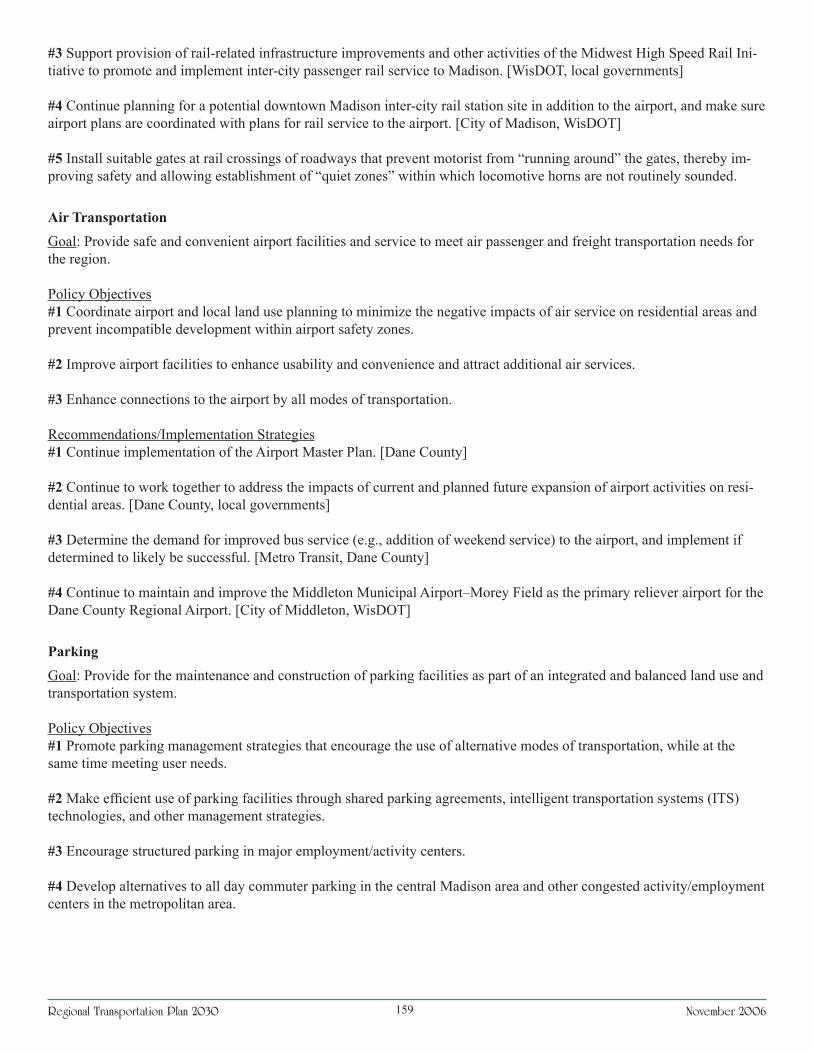
Regional Transportation Plan 2030 November 2006��9
#3 Support provision of rail-related infrastructure improvements and other activities of the Midwest High Speed Rail Ini-tiative to promote and implement inter-city passenger rail service to Madison. [WisDOT, local governments]
#4 Continue planning for a potential downtown Madison inter-city rail station site in addition to the airport, and make sure airport plans are coordinated with plans for rail service to the airport. [City of Madison, WisDOT]
#5 Install suitable gates at rail crossings of roadways that prevent motorist from “running around” the gates, thereby im-proving safety and allowing establishment of “quiet zones” within which locomotive horns are not routinely sounded.
Air TransportationGoal: Provide safe and convenient airport facilities and service to meet air passenger and freight transportation needs for the region.
Policy Objectives#1 Coordinate airport and local land use planning to minimize the negative impacts of air service on residential areas and prevent incompatible development within airport safety zones.
#2 Improve airport facilities to enhance usability and convenience and attract additional air services.
#3 Enhance connections to the airport by all modes of transportation.
Recommendations/Implementation Strategies#1 Continue implementation of the Airport Master Plan. [Dane County]
#2 Continue to work together to address the impacts of current and planned future expansion of airport activities on resi-dential areas. [Dane County, local governments]
#3 Determine the demand for improved bus service (e.g., addition of weekend service) to the airport, and implement if determined to likely be successful. [Metro Transit, Dane County]
#4 Continue to maintain and improve the Middleton Municipal Airport–Morey Field as the primary reliever airport for the Dane County Regional Airport. [City of Middleton, WisDOT]
ParkingGoal: Provide for the maintenance and construction of parking facilities as part of an integrated and balanced land use and transportation system.
Policy Objectives#1 Promote parking management strategies that encourage the use of alternative modes of transportation, while at the same time meeting user needs.
#2 Make efficient use of parking facilities through shared parking agreements, intelligent transportation systems (ITS) technologies, and other management strategies.
#3 Encourage structured parking in major employment/activity centers.
#4 Develop alternatives to all day commuter parking in the central Madison area and other congested activity/employment centers in the metropolitan area.

Regional Transportation Plan 2030 November 2006160
Recommendations/Implementation Strategies#1 Continue efforts to increase use of parking management strategies (e.g., incentives for structured parking, shared park-ing arrangements, preferential parking for carpoolers, etc.) in downtown areas and other major activity centers. [Local governments]
#2 Develop and implement a downtown Madison parking management plan that includes: l An inventory and usage survey of all parking facilities, both public and private, in the downtown area. l An assessment of the cost of providing parking and revenues generated in order to make a policy decision on the share of costs to assess public parking users. l An evaluation of strategies for minimizing long-term parking demand and effectively allocating the most convenient parking to customers. l An assessment of the viability for creating additional short-term parking on some downtown streets. [City of Madison Traffic Engineering Division]
#3 Review local minimum parking requirements to determine if they might be lowered for some uses or areas, provide exemptions or variances from these requirements, where appropriate, and consider establishing maximum parking require-ments for some areas. [Local governments]
#4 Continue efforts to use new technology, where affordable and cost effective, to increase parking convenience and ef-ficiency, improve downtown area traffic conditions (e.g., providing real-time information on parking availability), encour-age adherence to parking time limits, and increase parking revenue (e.g., using electronic meters that summon parking officers when meters expire and reset to zero when cars pull away from space). [City of Madison and other local govern-ments]
Corridor PreservationGoal: Preserve lands that may be needed for possible future transportation uses. Recommendations/Implementation Strategies #1 Continue to undertake official mapping of new and/or expanded future anticipated roadway and bikeway corridors, particularly for developing areas, as soon as sufficient information is available to determine recommended right-of-way width and corridor alignment. [Local governments]
#2 Continue to preserve rail corridors as special transportation corridors for future yet-to-be-determined uses, and discour-age conversion of such corridors for non-transportation related uses. [Local governments, WisDOT]