GIS Newsletter March 2015 - picgisrs.org
10
Litia Biukoto Kevin Rotsaert Wolf Forstreuter Litia Gaunavou Dominic Afuyave Robert Matau Emily Artack Teja Kattenborn Digital Globe provides First Look images of Vanuatu ............... 2 Revolutionizing Aerial Imagery with UAV’s in the South Pacific ............... 3 Pacific Island Countries Move to Collect Earth Tools to Prepare Data for Biannual Reporting to UNFCCC ............... 4 Separating Breadfruit from other Vegetation with WorldView-2 Image Data ..... 5 Assets Information and Management System AIMS) using GIS/RS for PNG Power Ltd ................ 6 Pacific Islands work on updating their Sea Charts............................... 7 Negotiations for Pacific Island countries maritime borders ............... 8 Unmounted Lidar - a Solution for the Pacific? ............... 9 Announcements ............... 10 The Pacific Islands GIS&RS User Conference was held from 25 to 27 November under the theme “Empowering Pacific Communities through Improved Geospatial Data” in the facilities of the Japan Pacific ICT Centre at USP. The GIS conference 2014 received a goodresponse from GIS&RS software vendors, users from agencies, organisations and government ministries within Fiji, the pacific region and the international arena. A total of 57 organisations, 11 vendors and 22 countries were represented at the three-day conference. More than 300 people participated and, in average, there were 115 people in every of the 16 sessions, partly held in parallel. On 24 and 28 November 2-14, the Geospatial Specialists and Surveyors from the Pacific Island countries met and formed – so far, interim – the Pacific Geospatial and Surveying Council. This group had an impact to the conference, especially during the discussion session, talking about Pacific projections. It is planned to have this back-to-back conference again in 2015. On 24 November 2014, the ESRI user conference was also held as a back- to-back function. The presentations covered a wide range of GIS, GPS & RS topics. This included GIS software, new sensors like WV-3 and ALOS 2&3, GPS applications, GIS Web platforms, field surveys, utilities, new land cover and forestry mapping approaches, 3D mapping, surfacemodels, disaster applications, UAV applications. A total of 74 presentations, four presentations identified commercial GIS software like ESRI, Hexagon, Trimble etc. and its mapping applications. Three presentations covered the latest GPS models, new features and it’s accuracy level. Eight presentations concentrated on new sensors, image data availability and new methods, for example crowd sourcing. Five presentations focused on UAV/UAS technology, high resolution beach terrain mapping and UAV assistance to disaster assessment response. Two presentations touched on Pacific frames or projections. Three presentations centred on Utilities. Four presentations focused on land cover mapping, eight presentations focused on Open Source GIS, highlighting Geo- node solutions, Web portals, open access and projects that are positively using Open Source GIS. Seven presentations elaborated on remote sensing topics, covering forest stratification, using VHR images, assessment of forest carbon stock and change detection. March 2015 The Pacific Islands GIS&RS User Conference 2014, Greater than ever GIS&RS NEWSLETTER T H E N E W S L E T T E R O F GIS&RS U S E R S I N T H E P A C I F I C INSIDE Copter type and Fixed Wing UAVs deployed in Vanuatu Post Pam damage assessment Cover photo: For the Vanuatu post damage assessment, SPC-GSD sent their fixed wing Trimble UX5 UAV and GIZ funded Teja Kattenborn’s Chopter type UAV from Germany. Both UAVs were used interchangeably and compliment each other on the joint mission. [see footnote]
Transcript of GIS Newsletter March 2015 - picgisrs.org

Litia Biukoto
Kevin Rotsaert
Wolf Forstreuter
Litia Gaunavou
Dominic Afuyave
Robert Matau
Emily Artack
Teja Kattenborn
Digital Globe provides First Look images of
Vanuatu ............... 2
Revolutionizing Aerial Imagery with UAV’s
in the South Paci! c ............... 3
Paci! c Island Countries Move to Collect
Earth Tools to Prepare Data for Biannual
Reporting to UNFCCC ............... 4
Separating Breadfruit from other Vegetation
with WorldView-2 Image Data ..... 5
Assets Information and Management
System AIMS) using GIS/RS for PNG Power
Ltd ................ 6
Paci! c Islands work on updating their Sea
Charts............................... 7
Negotiations for Paci! c Island countries
maritime borders ............... 8
Unmounted Lidar - a Solution for the
Paci! c? ............... 9
Announcements ............... 10
The Paci! c Islands GIS&RS User Conference was held from 25 to 27 November under the theme “Empowering Paci! c Communities through Improved Geospatial Data” in the facilities of the Japan Paci! c ICT Centre at USP. The GIS conference 2014 received a goodresponse from GIS&RS software vendors, users from agencies, organisations and government ministries within Fiji, the paci! c region and the international arena. A total of 57 organisations, 11 vendors and 22 countries were represented at the three-day conference. More than 300 people participated and, in average, there were 115 people in every of the 16 sessions, partly held in parallel. On 24 and 28 November 2-14, the Geospatial Specialists and Surveyors from the Paci! c Island countries met and formed – so far, interim – the Paci! c Geospatial and Surveying Council. This group had an impact to the conference, especially during the discussion session, talking about Paci! c projections. It is planned to have this back-to-back conference again in 2015. On 24 November 2014, the ESRI user conference was also held as a back-to-back function.
The presentations covered a wide range of GIS, GPS & RS topics. This included
GIS software, new sensors like WV-3 and ALOS 2&3, GPS applications, GIS Web platforms, ! eld surveys, utilities, new land cover and forestry mapping approaches, 3D mapping, surfacemodels, disaster applications, UAV applications. A total of 74 presentations, four presentations identi! ed commercial GIS software like ESRI, Hexagon, Trimble etc. and its mapping applications. Three presentations covered the latest GPS models, new features and it’s accuracy level. Eight presentations concentrated on new sensors, image data availability and new methods, for example crowd sourcing. Five presentations focused on UAV/UAS technology, high resolution beach terrain mapping and UAV assistance to disaster assessment response. Two presentations touched on Paci! c frames or projections. Three presentations centred on Utilities. Four presentations focused on land cover mapping, eight presentations focused on Open Source GIS, highlighting Geo-node solutions, Web portals, open access and projects that are positively using Open Source GIS. Seven presentations elaborated on remote sensing topics, covering forest strati! cation, using VHR images, assessment of forest carbon stock and change detection.
March 2015
The Paci! c Islands GIS&RS User Conference 2014, Greater than ever
GIS&RS NEWSLETTERT H E N E W S L E T T E R O F G I S & R S U S E R S I N T H E P A C I F I C
INSIDE
Copter type and Fixed Wing UAVs deployed in Vanuatu Post Pam damage assessment
Cover photo:For the Vanuatu post damage assessment, SPC-GSD sent their ! xed wing Trimble UX5 UAV and GIZ funded Teja Kattenborn’s Chopter type UAV from Germany. Both UAVs were used interchangeably and compliment each other on the joint mission.
[see footnote]

Five presentations were on 3D models, data available with vendors and communicating through 3D GIS. There were 11 presentations focused on ocean boundaries project, mapping tools for marine planning, inundation risk assessments, surveys, and recent developments. Three presentations shared on GIS Education, professional certi! cation with SSSI and a new initiative of USP providing a Bachelor of Geo Spatial Science at USP.The Poster Display was concentrated outside the main presentation room and provided su" cientspace for companies to display
products and information material.The Discussion Session was well attended. The discussion session at the conference provided input
to method developments at SPC and USP and is, therefore, an essential part of the event.There were several social functions which provided a platform for networking. There are not many occasions where Paci! c island GIS&RS users can meet. The Paci! c is a huge region and travel is extremelyexpensive. Therefore, the conference pays special attention to have a social function every evening, providing the atmosphere for getting to know each other and discuss common problems and assistance or solutions.
Presenting in main room of the USP facilityJapan Paci! c ICT Centre
Tropical Cyclone Pam left in its wake devastation that many in Vanuatu had never experienced in their lifetime. Damaged communications and transportation infrastructure resulted in very little being known on the extent of impact outside of Vanuatu. In the absence of any ! eld assessments, satellite imagery and aerial reconnaissance often provide ! rst reports of damages incurred during a disaster. The Secretariat of the Paci! c Community collaborated with Digital Globe to provide ‘First Look’ imagery over Vanuatu soon after TC Pam had passed. This has only been possible through an arrangement that has been nurtured over a number of years.
In 2013, the Secretariat of the Paci! c Community became the authorised reseller of DigitalGlobe products in the
region. This service complements the technical support already being o# ered by SPC to Paci! c countries in developing and maintaining Geographical Information Systems and Remote Sensing applications.
The “First Look” images provided by Digital Globe were captured over Efate two days after the cyclone, which shows the devastation on buildings, infrastructure and vegetation.
The team of GIS experts at SPC used manual and automated classi! cation techniques that have been developed and tested in the region to produce a quick collection of maps that have since been shared with national counterparts and partners involved in the response. This core service in analysing satellite imagery and producing maps to support disaster response and recovery e# orts is possible through partnerships with companies like Digital Globe providing imagery and ESRI freely giving ArcMap and ArcPad licences.
Digital Globe provides First Look images of Vanuatu Litea Biukoto
Devastation on residential buildings on Efate Island shown clearly on “First Look” Images allowing the extent of damages to be quickly assessed.
March 2015 South Pacific GIS&RS Newsletter 2
Participants after the ! rst co# ee break in front of the Japan Paci! c ICT Centre, in the middle of the front line Permanent Secretary Lands & Mineral Resources - Fiji, Mr Tevita Boseiwaqa, Director SPC/GSD (formerly SOPAC) Prof. Dr. Mike Petterson and Dr. Dilawar Grewal, Vice President Administration USP
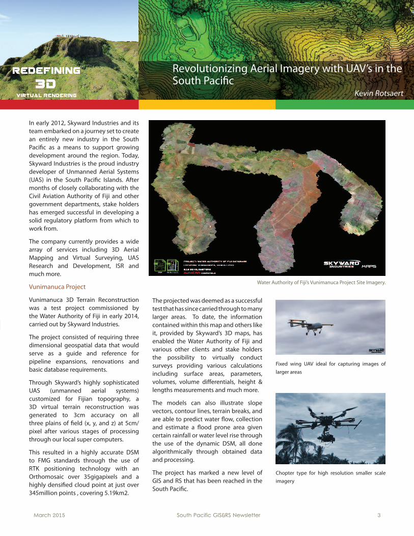
In early 2012, Skyward Industries and its team embarked on a journey set to create an entirely new industry in the South Paci! c as a means to support growing development around the region. Today, Skyward Industries is the proud industry developer of Unmanned Aerial Systems (UAS) in the South Paci! c Islands. After months of closely collaborating with the Civil Aviation Authority of Fiji and other government departments, stake holders has emerged successful in developing a solid regulatory platform from which to work from.
The company currently provides a wide array of services including 3D Aerial Mapping and Virtual Surveying, UAS Research and Development, ISR and much more.
Vunimanuca Project
Vunimanuca 3D Terrain Reconstruction was a test project commissioned by the Water Authority of Fiji in early 2014, carried out by Skyward Industries.
The project consisted of requiring three dimensional geospatial data that would serve as a guide and reference for pipeline expansions, renovations and basic database requirements.
Through Skyward’s highly sophisticated UAS (unmanned aerial systems) customized for Fijian topography, a 3D virtual terrain reconstruction was generated to 3cm accuracy on all three plains of ! eld (x, y, and z) at 5cm/pixel after various stages of processing through our local super computers.
This resulted in a highly accurate DSM to FMG standards through the use of RTK positioning technology with an Orthomosaic over 35gigapixels and a highly densi! ed cloud point at just over 345million points , covering 5.19km2.
1The projected was deemed as a successful test that has since carried through to many larger areas. To date, the information contained within this map and others like it, provided by Skyward’s 3D maps, has enabled the Water Authority of Fiji and various other clients and stake holders the possibility to virtually conduct surveys providing various calculations including surface areas, parameters, volumes, volume di# erentials, height & lengths measurements and much more.
The models can also illustrate slope vectors, contour lines, terrain breaks, and are able to predict water $ ow, collection and estimate a $ ood prone area given certain rainfall or water level rise through the use of the dynamic DSM, all done algorithmically through obtained data and processing.
The project has marked a new level of GIS and RS that has been reached in the South Paci! c.
Fixed wing UAV ideal for capturing images of
larger areas
Chopter type for high resolution smaller scale
imagery
Revolutionizing Aerial Imagery with UAV’s in the South Paci! c
Kevin Rotsaert
Water Authority of Fiji’s Vunimanuca Project Site Imagery.
March 2015 South Pacific GIS&RS Newsletter 3

At the end of November 2014 and in February 2015, SPC organised two workshops to share experience in establishing National Forest Monitoring Systems and creating the link to the Regional Forest Monitoring Facility (RFMF) based at the secretariat of the Paci! c Community (SPC). SPC is a regional organisation with a very good network within the 22 member countries. FAO ! nanced the RFMF and these workshops as part of a series of activities supported by the UN-REDD Programme in this case through the FAO regional project “Strengthening regional support to national forest monitoring systems for REDD+ in the Paci! c”. The workshops trained data collection of land use and land use change in a transparent and statistical sound way and they introduced the assistance of UN-REDD.
The RFMF at SPC decided to have one workshop for low lying or atoll islands and separate workshop for volcanic islands as both types of Paci! c Island Countries (PIC) have di# erent forest cover binding the on land carbon. While volcanic islands are still covered with substantial amount of rain forest of high biodiversity carbon of atoll
islands is mainly bound in coconut palms only few pockets of forests can be found.
The two workshops gave an introduction to the project, outlined the needs to create transparent and statistically sound data, documented the land use classi! cation schemes of the countries, discussed the progress of national forest monitoring systems, explained the assistance provided by the RFMF and showed the already available parts of the regional forest monitoring portal. However, the best received part of the training was the land cover and land cover change data collection and the data analysis through
Collect Earth tools. PICs have very few people experienced in remote sensing (RS) and GIS, the RS software is very limited and ! nances to purchase satellite image data are extremely restricted. Collect Earth was received as a solution to provide activity data required for country reporting without investing in the above mentioned.
Six atoll countries attended the ! rst FAO monitoring workshop in November 2014: Cook Islands, Kiribati, Marshall Islands, Palau, Tonga and Tuvalu. Five countries attended the volcanic islands monitoring workshop in February 2015: Fiji, Papua New Guinea, Samoa, Solomon Islands and Vanuatu. In March this year the RFMF will conduct another workshop focussing on Collect Earth application only. This workshop will be attended by Fiji, Kiribati, Marshall Islands, Palau, Papua New Guinea, Solomon Islands, Tonga, Tuvalu and Vanuatu.
In the new established Regional Forest Monitoring Facility 10,000 sample points will be collected and analysed for Fiji, Solomon Islands and Vanuatu until end of June this year to provide the statistically required data for their country reporting. These are the three Paci! c UNREDD countries besides Papua New Guinea. It is sure that other countries will follow to utilise the newly established RFMF with appropriate computer hardware and suitable Internet connection to create their data source for the biannual reporting to UNFCCC. During the two workshops the need for transparency was discussed and it is very sure that all the countries, which are collecting statistical sound land cover change data, will display the analysis on the regional portal. The response regarding this was very positive during both conducted workshops.
Participants, Resource Persons and Observers pictured above with Deputy Director SPC Geoscience, Dr Ki$ e Khasai (Sitted 3rd from Left); Fiji Permanent Scretary for Fisheries and Forests, Mr Inoke Wainiqolo; Team Leader FAO Forrest Monitoring, Dr Andrew Haywood and Deputy Conservator of Forest, Mr Eliki Seruvatu.
Hands on guided training on Collect Earth, Saiko and Earth Engine forest monitoring tools
Paci! c Island Countries Move to Collect Earth Tools to Prepare Data for Biannual Reporting to UNFCCC Wolf Forstreuter
March 2015 South Pacific GIS&RS Newsletter 4

March 2015 South Pacific GIS&RS Newsletter 5
COLLECT EARTH AN OPEN SOURCE TOOL TO COLLECT COUNTRY DATA OF LAND USE AND LAND USE CHANGE
FAO Rome developed a tool called Collect Earth which creates statistically sound data on land use and land use change. The tool does not map the current land area but establish sample points of one hectare where GIS o" cers interpret the current land use and display historical satellite image data for the same sample plot and record the land use before. Doing this for 10,000 systematic distributed sample points within one country a statistically sound dataset is created allowing to calculate the percentage of land cover belonging to each of six land use categories. The dataset created also allows to determine how many plots have changed from one land use category to another which provides an exact ! gure on deforestation.
The system is based on Google Earth and Bing Maps. The user does not pay for any satellite image and has the latest very high resolution image data available from
DigitalGlobe such as QuickBird, GeoEye, WorldView-2 or WorldView-3 and also from the satellites of Airbus Defense and Spatial.
The user cannot download the satellite images, however, this is not necessary for the interpretation of a plot. In addition, the operator has the nearly complete satellite image archive available when he checks historical data. This again is without any cost.
The system also provides the database and analysis software to calculate current land use and land use change from the dataset created. The statistics created from 10,000 sample points is statistically su" cient for required country reporting to UNFCCC.
In Fiji, GIS o" cers with ! eld experience of Agriculture and Forestry working together at SPC to interpret and analyse 10,000 plots. 1 ½ months are estimated to complete this task.
The GIS&RS unit of SPC as Regional Forest Monitoring Facility provides computer, guidance and Internet access.
Interpretation of a sample plot with Collect Earth using Google to access image data.
Plot distribution in Western Viti Levu, Fiji. To place 10,000 plots in Fiji every few km a plot has to be analyse (yellow dots). Every sample plot has a unique number,
The Agriculture Department in Kiribati wants to map breadfruit to be informed of available resource as this is the traditional main none ! sh food resource. Currently rice replaces breadfruit, however, rice is imported and if import stops this resource has to be re-activated. The request for mapping was addressed more than 10 years ago but there was no capacity to investigate in mapping potential and carry out the mapping.
A thesis provided the opportunity to concentrate on the old demand. In addition, the improvement of spectral coverage supplied by WorldView-2 (WV-2) satellite image data gave a new opportunity to investigate it’s mapping potential.
A WV-2 dataset was ordered and ! eld work conducted. The ! eld work used a precision GPS system with own base station providing 80cm accuracy. Breadfruit trees, pandanus and other vegetation types were mapped in Northern Tarawa. Then, back in Suva the polygons of the mapping task were overlaid over the WV-2 image data. This was done for di# erent of di# erent band combinations of the image data.
The combination near infra-red, red-edge and red created a combination which clearly allows separation breadfruit by is spectral re$ ectance. This allows a mapping using WV-2 satellite image data. Further investigation will detect was causes the di# erence in re$ ection.
Separating Breadfruit from other Vegetation with WorldView-2 Image Data
Litia Gaunavou
Bands: 8,6,5 EnhancedBreadfruit appear yellowish
Bands: 5,3,2 EnhancedBreadfruit hard to make out

Assets Information and Management System (AIMS) using GIS/RS for PNG Power Ltd.
Dominic Afuyave
Utilities in the Paci! c Islands region have adopted Geographical Information System (GIS) and Remote Sensing (RS) as essential tool-sets for planning and development. Likewise PNG PowerLtd has embarked on the same journey to better manage its assets in order to make wellinformed planning and strategic action decisions.PNG Power Ltd has several specialised information systems to empower the services they provide for their customers, suppliers and stakeholders. These include Finance Systems, Cashier, Billing Systems, Assets Register, Schedule Maintenance, Supply and Demand Forecasting and Network Modelling/Simulation, etc. In the mists of all these systems are the GIS/RS tools to support all these segregated systems.
This paper will portray how our GIS/RS unit is at the core of our performance engineering, operations, communications and customer service procedures. The GIS/RS unit will dictate data/information $ ow with operating procedures by providing a Job Card System (JCS) that will integrate all planned/unplanned maintenance schedules/procedures in assets tracking with other corporate systems as one cohesion centralised Management and Decision Support System (MIS/DSS).Currently, all Transmission and Distribution assets for Port Moresby have been captured and mapped together with some high consumption customer meters. Work is in progress to capture all customer meters and to start rolling out data capture to other centres and provinces in PNG.
This is the systems design with regards to architecture, relationships of systems components and the overall setup as in hardware, software, platform, standards and procedures. The PPL MIS/GIS is a
clientserver application whereby the front-end is built on Microsoft Access as per requirements of TOR, while at the back-end is PostgreSQL database engine installed on an IBM Server machine running on Ubuntu Linux 12.04 LTS with QGIS Server, QGIS Web-Client and Lizmap Web-Client. The PostgreSQL database engine is installed together with spatial extension PostGIS to enable storage and management of spatial data. PostgreSQL is well known as the leading FOSS
database management system. On the same token PostGIS is also well known as the leading FOSS spatial extension for storage of spatial data with both vector and raster capabilities. With regards to the front-end, this is where all user interface components for viewing and editing of data are build. They consist of data input forms that are connected through linked-tables via ODBC to the back-end PostGIS/PostgreSQL database where all the MIS/GIS data are held. Microsoft Access provides development capabilities that really helps minimise time on developing the user interface. It also provides reporting facility, SQL queries with macros and programming capabilities for automation of tasks and for required
mathematical calculations. Part of the reasoning for choosing Ms Access for the front-end is that it comes preinstalled on all PPL computers as per requirement of ICT standards and procedures. The PPL MIS/GIS front-end is like a one-stop-shop whereby all other systems components will be launched from a click of a button.Data capture/collection is carried out using four (4) units of IkeGPS with onging plans for acquiring more units in the future. Data upload and handling of spatial
data, as per TOR is done using QGIS and MapInfo software application with tailor made MapBasic programs to automate repetitive tasks with complex algorithms such as network tracing, generic assets numbering and connecting generation components, transmission components and distribution components all the way to the customer meters.
Finally is web mapping and web GIS, both are handled by QGIS Server with QGIS Web-Client and Lizmap Web-Client for WMS and WFS. QGIS Desktop is used with plugins to upload data into PostgreSQL/PostGIS, likewise for updating the QGIS Web-Client and Lizmap Web-Client.
March 2015 South Pacific GIS&RS Newsletter 6

The majority of the Paci! c’s underwater charts are outdated with some of them dating back to Captain James Cook’s expeditions to the region in the 18th century. Acting Deputy Director of SPC’s Geoscience for Development Programme Jens Kruger said the majority of nautical charts in the Paci! c are out of date and no longer useful. “Some charts are just sketches dating back to the days of Captain Cook, and most have not have not had any new information added since World War II,” he said. Kruger was responding to queries on their latest e# orts to update the underwater charts of Vanuatu.
Starting this month, the International Maritime Organisation’s Safety of Life at Sea Convention regulations will require member countries to move toward using electronic navigational charts. Failure to update nautical charts will result in their withdrawal from circulation. This in turn, would cause cruise ships to stop visiting certain Paci! c destinations, severely impacting local tourism as a consequence.
Kruger said the relevant legal instrument that enforces the standards for safety of maritime transport through the provision of hydrographic services is the Safety of Life at Sea (SOLAS) Convention.
He said the latest version of SOLAS adopted in 2002 made it mandatory for large ships to have digital systems for navigation.
All states wishing to operate in the international maritime community are therefore required to:
• map their seabed (carry out hydrographic surveys)
• make new charts or modernise existing
charts (produce electronic naviga tional
charts);
• communicate ma rine safety infor- mation.
The Cook Islands, Fjii, Kiribati, Marshall Islands, Niue, Palau, Papua New Guinea, Samoa, Solomon Islands, Tonga, Tuvalu, Vanuatu have all rati! ed their SOLAS convention obligations in December 2, 2013.
He said the majority of Paci! c island countries and territories did not have the capacity or resources to ful! ll their obligations under the SOLAS convention.
A recent regional meeting of the Paci! c ministers of energy and transport recognised this as a major impediment to maritime safety and economic development and has urged the SPC to set up a dedicated hydrographic unit. They also want the regional organisation to develop a regional strategy that would enhances regional hydrographic services to member countries.
SPC estimates that AU$924,000 per year will be required to set up and operate this unit and assist Paci! c Island countries
ful! ll their obligations under SOLAS and improve navigational and maritime safety in the Paci! c.
In the case of Vanuatu, SOPAC is currently updating the nation’s navigational charts.
Kruger said Luganville Harbour on the Vanuatu island of Espirito Santo was identi! ed as a priority area to survey through a New Zealand funded hydrographic risk assessment study.
They have also selected popular cruise destinations like:
•Hog Harbour, Santo Island•Wala, Malekula Island•Homo Bay, Pentecost Island
Luganville Harbour is 126 square kilometres in area and would take 30 days to survey whilst the other areas are smaller and require approximately one week each.
“We are currently in Port Vila busy with the mobilisation of the vessel,” he said.
“The Government of Vanuatu has provided the SPC with the Vanuatu Police Patrol Boat RVS Turoroa, and we are currently installing our survey system on the boat.
“The survey is undertaken using a multi-beam echo-sounder with an integrated inertial navigation system.
“This specialised equipment will enable us to meet the Special Order survey requirements stipulated by the UK Hydrographics O" ce, who are the Principal Charting Authority for Vanuatu.
March 2015 South Pacific GIS&RS Newsletter 7
Paci! c Islands work on updating their Sea Charts Robert Matau

Negotiations for Paci! c Island Countries Maritime Borders
Emily Artack
The Paci! c region leads the way in successful negotiations for its maritime borders using latest geospatial tools and technologyUnder international law, namely the United Nations Convention on the Law of the Sea (UNCLOS), all exclusive sovereignty claims over areas of ocean space must be based upon sound technical data and meet the requirements prescribed within the Convention.
Over the past decade, the technical and legal teams from the Paci! c Island Countries have been using the latest geospatial tools and technology to develop accurate solutions to meet the requirements under UNCLOS. One of the requirements is to develop the “baselines” which is usually characterised as the line drawn around the outer reef edges of an island, or a group of islands (for those countries with archipelagic baselines) at the lowest astronomical tide (LAT). The baselines are important for calculating the maritime zones, including the 200-nautical miles Exclusive Economic Zones (EEZs). Baselines are also critical during negotiations and establishing the formal maritime borders between opposite or adjacent coastal states.
In the Paci! c region, there are approximately 48 shared EEZs between neighbouring countries. Refer to regional map on the left.In the last 2- 3 years, the Paci! c region has been making remarkable progress in concluding a number of successful negotiations and formally establishing its maritime borders with each other. A total of sixteen (16) maritime boundary agreements have been o" cially signed by the leaders of Paci! c island countries since the Paci! c Maritime Boundaries Unit was established within the Geoscience Division of the Secretariat of the Paci! c
Community (SPC). The treaties are shown as black lines on the above regional map.
The Maritime Boundaries Unit within SPC and its partner agencies, Geoscience Australia, the Government of Australia’s Attorney General’s Department, the Commonwealth Secretariat, the Paci! c Forum Fisheries Agency and GRID Arendal have been supporting the geospatial and legal teams from the Paci! c Island countries in this Project since 2002.During last year’s annual Paci! c Islands Regional GIS & RS Conference in Suva, Spatial Industries Business Association (SIBA) awarded the geospatial teams
from Fiji and Kiribati with certi! cates of excellence for 2 awards: an award for spatial enablement and an award for technical excellence. This is in recognition of their outstanding e# orts to use spatial technology and methodology and overcome technical challenges to deliver outcomes and products in their countries. High resolution satellite imagery (WorldView -2 and Geo-eye) have been acquired by the project teams to develop its baseline solutions, and verify the positioning of the critical islands used for negotiations with each other.
In February this year, SPC and its partners organised the 13th Paci! c Islands Regional Maritime Boundaries workshop in Sydney, Australia. This workshop allowed the technical and legal teams from the Paci! c countries to continue to progress its national e# orts and facilitate further informal discussions between countries with unresolved boundaries. The Unit’s activities are supported by the Government of Australia.
For any further information: please contact the Maritime Boundaries Unit team at the Geoscience Division of SPC.
Regional technical and legal maritime boundaries teams from the paci! c island countries with the Project Unit team and its partners at the 13th Paci! c Islands Workshop in Sydney in February 2015.
Mr Tion Uriam, GIS o" cer within the Minerals Division of the Ministry of Fisheries, Marine Resources Development from Kiribati receiving his award from Mr Jens Kruger, Manager of the Oceans & Coastal Geoscience Unit of the Geoscience for Development Programme, SPC
March 2015 South Pacific GIS&RS Newsletter 8

UAV Mounted LiDAR – A Solution for the Paci! c? Teja Kattenborn
Teja Kattenborn (Karlsruher Institute of Technology, and partner of company GeoCopter, www. GeoCopter.eu).1 Since the last 1 ½ years Teja Kattenborn is in close collaboration with the Fraunhofer Institute within the development of a UAV compatible LiDAR sensor. The GIS&RS unit at SPC is linked.Light Detection and Ranging Systems (LiDAR) are known to be the most accurate and robust data source for the 3D representation of complex sites, e.g. vegetation or urban areas. As being an active sensor, LiDAR o# ers a high $ exibility with regard to illumination conditions. Hence, data acquisition can be performed at any time of the day and is independent of shadows, e.g. within or below vegetation canopies.
Therefore airborne LiDAR has already a long history in the ! eld of remote sensing. Due to high transportation costs and low area sizes traditional airborne LiDAR campaigns do not o# er a cost e" cient or long term solution for islands of the South Paci! c. However, recent developments in the ! eld of unmanned aerial vehicles (UAV) lead to $ exible airborne platforms and therefore e" cient remote sensing solutions. Accordingly the Fraunhofer IPM Institute, a leading European research Institution, is currently developing a feasible LiDAR solution for UAV platforms. After several $ ight campaigns with the German UAV company GeoCopter the UAV-based LiDAR solution is close to become operational (see attached images of a recent test campaign).
The current system setup will allow for the automatic acquisition and processing of 3D point clouds with a spatial resolution and accuracy below 10 cm² and an area coverage of up to 8 hectares per $ ight (costs for UAV and sensor will range from 25.000 to 35.0000 USD). Together with SOPAC, SPC further tests and application developments in the south paci! c are currently targeted by the Fraunhofer IPM for 2015.
Close-ups of a point cloud (xyz measurements) of a test campaign, March 2015.
Left: Area (approx. 6 hectares) targeted during one test $ ight. Although the test campaign was situated on an industrial complex, the results show the high potential for other applications.
The high point density and accuracy enables to map vertical and horizontal vegetation struc-tures, i.e. forest canopy structure or layers as well as the underlying terrain surface to derive abso-lute vegetation heights. Thus, the system could not only facilitate mapping and monitoring de-forestation, but also spatially complex process-es, such as forest degradation
1 GIZ ! nanced Teja Kattenborn to bring his copter UAV to the Paci! c to support the ! xed wing UAV survey for the post cyclone disaster assessment carried out by SPC in Vanuatu.
March 2015 South Pacific GIS&RS Newsletter 9

March 2015 South Pacific GIS&RS Newsletter 10
ANNOUNCEMENTSMEETINGS:
Fiji GIS&RS User Monthly Meetings1st meeting completed at Lands Department on 07 April, 2015
Meeting Schedule: 05 May - Fiji Sugar Tribunal, Lautoka 04 August - Lands Department, Suva 02 June - Geoscience Division (SPC), Suva 01 September - University of the South Paci! c, Suva07 July - iTaukei Lands Trust Board, Suva 06 October - Lands Department, Suva
CONFERENCE:
14-17 July 2015: IGNSS, Gold Coast AustraliaWebsite: https://www.ignss.org
24 – 26 August 2015, SKYCITY Auckland Convention Centre, New ZealandWebsite: http://www.eagle.co.nz
24-27 November 2015, Paci! c Island countries GIS/RSWebsite: http://picgisrs.appspot.com/
MEET THE EDITORIAL TEAM
Dr Wolf Forstreuter GIS&RS Specialist and Team LeaderGIS&RS Unit - Geoscience Division (GSD) of SPC (Formerly SOPAC)Phone: +679-3249-237 (O" ce))Phone: +679-9272462 (Cellphone)E-mail: [email protected]
Isireli Buwawa GIS&RS O" cer and Deputy Team Leader GIS&RS Unit -Geoscience Division (GSD) of SPCPh: +679 324 9219 (O" ce)Ph: +679 976 3425 (Cellphone)Email: [email protected]
Naomi Jackson GIS\RS Project AssistantGIS&RS Unit - Geoscience Division of SPCPh: +679-338 1377 ext 224 (O" ce)Ph: +679-324 9224 (Cellphone)Email: [email protected]
Call for Articles:If you have anything to share with our Paci! c Island GIS&RS Group kindly forward your articles to the editorial team for publishing in the June Issue of the Paci! c Islands GIS&RS Newsletter.